SANEEDS - CSAH - Segment Report Roadway Segment Status ... · County Name : RAMSEY Segment Nbr :...
636
SANEEDS - CSAH - Segment Report Roadway Segment Information Status : Revised County Name : RAMSEY Segment Nbr : 062-601-010 Original Current SHOREVIEW Municipality SHOREVIEW 1.15 Segment Length 1.15 MIXED BITUMINOUS Existing Surface Type MIXED BITUMINOUS 2 Existing Surface Lanes 2 NOT DIVIDED Existing Lane Description NOT DIVIDED 1.15 MI W TO CSAH 49 Termini 1.15 MI W TO CSAH 49 10300 Present AADT 10300 2013 Year of Count 2015 1 Projection Factor 1 10300 Projected Traffic 10300 URBAN Design Type URBAN 6 - URBAN : 10000 - 19999 Design Group 6 ( URBAN : 10000 - 19999 ) 2016 Latest Year SA funds 2016 1 Number of Signal Legs 1 No Special Message Special Message Code No Special Message Comments Interchange Override Segment Override Bridge Information Status: Original Original Current 02558 Structure Number 02558 0 Milepoint 0 1992 Year Built 1992 RICE CREEK Feature Crossed RICE CREEK STREAM CROSSING Type of Service STREAM CROSSING 1 Number of Spans 1 21 Bridge Length 21 74.7 Bridge Width 74.7 50% Shared Structure 50% Comments 1 ( 0-149 ) Bridge Group Code 1 ( 0-149 ) Segment Cost Information Computation Factor Computation Formula Values Used For Calculation Computation Result Signal Leg TrafficSignalLegs * UnitCost / SignalLifeCycle * StatutoryNeedsYear 1 * 56250 / 40 * 25 $35,156 Construction Length * UnitCost / ConstrLifeCycle * StatutoryNeedsYear * DevelopmentCost 1.15 * 4225495.41 / 60 * 25 * 1.15 $2,328,424 Preservation Length * Quantity * UnitCost / PreservationLifeCycle * StatutoryNeedsYear 1.15 * 3696 * 65.52 / 15 * 25 $464,144 ROW Length * UnitCost / ROWLifeCycle * StatutoryNeedsYear 1.15 * 566370.18 / 60 * 25 $271,386 Bridge BridgeLength * BridgeWidth * UnitCost / BridgeLifeCycle * StatutoryNeedsYear * DevelopmentCost * PercentOfCost 21 * 74.7 * 152 / 80 * 25 * 1.15 * 50% $42,845 Total Segment Cost Signal Leg + Construction + Preservation + ROW + Bridge $35,156 + $2,328,424 + $464,144 + $271,386 + $42,845 $3,141,955
Transcript of SANEEDS - CSAH - Segment Report Roadway Segment Status ... · County Name : RAMSEY Segment Nbr :...

SANEEDS - CSAH - Segment Report
Roadway SegmentInformation
Status : Revised
County Name : RAMSEY Segment Nbr : 062-601-010
Original Current
SHOREVIEW Municipality SHOREVIEW
1.15 Segment Length 1.15
MIXED BITUMINOUS Existing Surface Type MIXED BITUMINOUS
2 Existing Surface Lanes 2
NOT DIVIDED Existing Lane Description NOT DIVIDED
1.15 MI W TO CSAH 49 Termini 1.15 MI W TO CSAH 49
10300 Present AADT 10300
2013 Year of Count 2015
1 Projection Factor 1
10300 Projected Traffic 10300
URBAN Design Type URBAN
6 - URBAN : 10000 - 19999 Design Group 6 ( URBAN : 10000 - 19999 )
2016 Latest Year SA funds 2016
1 Number of Signal Legs 1
No Special Message Special Message Code No Special Message
Comments
Interchange Override
Segment Override
Bridge Information Status: Original
Original Current
02558 Structure Number 02558
0 Milepoint 0
1992 Year Built 1992
RICE CREEK Feature Crossed RICE CREEK
STREAM CROSSING Type of Service STREAM CROSSING
1 Number of Spans 1
21 Bridge Length 21
74.7 Bridge Width 74.7
50% Shared Structure 50%
Comments
1 ( 0-149 ) Bridge Group Code 1 ( 0-149 )
Segment CostInformation
Computation Factor Computation Formula Values Used ForCalculation
Computation Result
Signal Leg TrafficSignalLegs *UnitCost / SignalLifeCycle* StatutoryNeedsYear
1 * 56250 / 40 * 25 $35,156
Construction Length * UnitCost /ConstrLifeCycle *StatutoryNeedsYear *DevelopmentCost
1.15 * 4225495.41 / 60 * 25* 1.15
$2,328,424
Preservation Length * Quantity *UnitCost /PreservationLifeCycle *StatutoryNeedsYear
1.15 * 3696 * 65.52 / 15 * 25 $464,144
ROW Length * UnitCost /ROWLifeCycle *StatutoryNeedsYear
1.15 * 566370.18 / 60 * 25 $271,386
Bridge BridgeLength *BridgeWidth * UnitCost /BridgeLifeCycle *StatutoryNeedsYear *DevelopmentCost *PercentOfCost
21 * 74.7 * 152 / 80 * 25 *1.15 * 50%
$42,845
Total Segment Cost Signal Leg + Construction+ Preservation + ROW +Bridge
$35,156 + $2,328,424 +$464,144 + $271,386 +$42,845
$3,141,955

SANEEDS - CSAH - Segment Report
Roadway SegmentInformation
Status : Original
County Name : RAMSEY Segment Nbr : 062-601-011
Original Current
SHOREVIEW Municipality SHOREVIEW
1 Segment Length 1
MIXED BITUMINOUS Existing Surface Type MIXED BITUMINOUS
2 Existing Surface Lanes 2
NOT DIVIDED Existing Lane Description NOT DIVIDED
CSAH 49 TO 1.0 MI E Termini CSAH 49 TO 1.0 MI E
6700 Present AADT 6700
2013 Year of Count 2015
1 Projection Factor 1
6700 Projected Traffic 6700
RURAL Design Type RURAL
3 - RURAL : 1500 - 6999 Design Group 3 ( RURAL : 1500 - 6999 )
2000 Latest Year SA funds 2000
1 Number of Signal Legs 1
No Special Message Special Message Code No Special Message
Comments
Interchange Override
Segment Override
Segment CostInformation
Computation Factor Computation Formula Values Used ForCalculation
Computation Result
Signal Leg TrafficSignalLegs *UnitCost / SignalLifeCycle* StatutoryNeedsYear
1 * 56250 / 40 * 25 $35,156
Construction Length * UnitCost /ConstrLifeCycle *StatutoryNeedsYear *DevelopmentCost
1 * 1021937.01 / 60 * 25 *1.1
$468,388
Preservation Length * Quantity *UnitCost /PreservationLifeCycle *StatutoryNeedsYear
1 * 2376 * 65.52 / 20 * 25 $194,594
ROW Length * UnitCost /ROWLifeCycle *StatutoryNeedsYear
1 * 85357.87 / 60 * 25 $35,566
Total Segment Cost Signal Leg + Construction+ Preservation + ROW
$35,156 + $468,388 +$194,594 + $35,566
$733,704

SANEEDS - CSAH - Segment Report
Roadway SegmentInformation
Status : Original
County Name : RAMSEY Segment Nbr : 062-601-020
Original Current
Unassigned/Unknown Municipality Unassigned/Unknown
1 Segment Length 1
MIXED BITUMINOUS Existing Surface Type MIXED BITUMINOUS
2 Existing Surface Lanes 2
NOT DIVIDED Existing Lane Description NOT DIVIDED
1.0 MI E TO 2.0 MI E OF TH 49 Termini 1.0 MI E TO 2.0 MI E OF TH 49
6700 Present AADT 6700
2013 Year of Count 2015
1 Projection Factor 1
6700 Projected Traffic 6700
RURAL Design Type RURAL
3 - RURAL : 1500 - 6999 Design Group 3 ( RURAL : 1500 - 6999 )
2000 Latest Year SA funds 2000
0 Number of Signal Legs 0
No Special Message Special Message Code No Special Message
Comments
Interchange Override
Segment Override
Segment CostInformation
Computation Factor Computation Formula Values Used ForCalculation
Computation Result
Signal Leg TrafficSignalLegs *UnitCost / SignalLifeCycle* StatutoryNeedsYear
0 * 56250 / 40 * 25 $0
Construction Length * UnitCost /ConstrLifeCycle *StatutoryNeedsYear *DevelopmentCost
1 * 1021937.01 / 60 * 25 *1.1
$468,388
Preservation Length * Quantity *UnitCost /PreservationLifeCycle *StatutoryNeedsYear
1 * 2376 * 65.52 / 20 * 25 $194,594
ROW Length * UnitCost /ROWLifeCycle *StatutoryNeedsYear
1 * 85357.87 / 60 * 25 $35,566
Total Segment Cost Signal Leg + Construction+ Preservation + ROW
$0 + $468,388 + $194,594+ $35,566
$698,548

SANEEDS - CSAH - Segment Report
Roadway SegmentInformation
Status : Original
County Name : RAMSEY Segment Nbr : 062-601-030
Original Current
NORTH OAKS Municipality NORTH OAKS
0.75 Segment Length 0.75
MIXED BITUMINOUS Existing Surface Type MIXED BITUMINOUS
2 Existing Surface Lanes 2
NOT DIVIDED Existing Lane Description NOT DIVIDED
2.0 MI E TO 2.75 MI E OF TH 49 Termini 2.0 MI E TO 2.75 MI E OF TH 49
5500 Present AADT 5500
2013 Year of Count 2015
1 Projection Factor 1
5500 Projected Traffic 5500
RURAL Design Type RURAL
3 - RURAL : 1500 - 6999 Design Group 3 ( RURAL : 1500 - 6999 )
2000 Latest Year SA funds 2000
0 Number of Signal Legs 0
No Special Message Special Message Code No Special Message
Comments
Interchange Override
Segment Override
Segment CostInformation
Computation Factor Computation Formula Values Used ForCalculation
Computation Result
Signal Leg TrafficSignalLegs *UnitCost / SignalLifeCycle* StatutoryNeedsYear
0 * 56250 / 40 * 25 $0
Construction Length * UnitCost /ConstrLifeCycle *StatutoryNeedsYear *DevelopmentCost
0.75 * 1021937.01 / 60 * 25* 1.1
$351,291
Preservation Length * Quantity *UnitCost /PreservationLifeCycle *StatutoryNeedsYear
0.75 * 2376 * 65.52 / 20 * 25 $145,946
ROW Length * UnitCost /ROWLifeCycle *StatutoryNeedsYear
0.75 * 85357.87 / 60 * 25 $26,674
Total Segment Cost Signal Leg + Construction+ Preservation + ROW
$0 + $351,291 + $145,946+ $26,674
$523,911

SANEEDS - CSAH - Segment Report
Roadway SegmentInformation
Status : Original
County Name : RAMSEY Segment Nbr : 062-602-010
Original Current
Unassigned/Unknown Municipality Unassigned/Unknown
0.1 Segment Length 0.1
SURFACE TREATED Existing Surface Type SURFACE TREATED
2 Existing Surface Lanes 2
NOT DIVIDED Existing Lane Description NOT DIVIDED
CSAH 71 TO EAST COUNTY LINE Termini CSAH 71 TO EAST COUNTY LINE
3450 Present AADT 3450
2013 Year of Count 2015
1 Projection Factor 1
3450 Projected Traffic 3450
RURAL Design Type RURAL
3 - RURAL : 1500 - 6999 Design Group 3 ( RURAL : 1500 - 6999 )
2013 Latest Year SA funds 2013
0 Number of Signal Legs 0
No Special Message Special Message Code No Special Message
2013 SAP 062-602-016 M&OL TIEDTO WASH CO WORK - SHORT ST
Comments 2013 SAP 062-602-016 M&OL TIEDTO WASH CO WORK - SHORT ST
Interchange Override
Segment Override
Segment CostInformation
Computation Factor Computation Formula Values Used ForCalculation
Computation Result
Signal Leg TrafficSignalLegs *UnitCost / SignalLifeCycle* StatutoryNeedsYear
0 * 56250 / 40 * 25 $0
Construction Length * UnitCost /ConstrLifeCycle *StatutoryNeedsYear *DevelopmentCost
0.1 * 1021937.01 / 60 * 25 *1.1
$46,839
Preservation Length * Quantity *UnitCost /PreservationLifeCycle *StatutoryNeedsYear
0.1 * 2376 * 65.52 / 20 * 25 $19,459
ROW Length * UnitCost /ROWLifeCycle *StatutoryNeedsYear
0.1 * 85357.87 / 60 * 25 $3,557
Total Segment Cost Signal Leg + Construction+ Preservation + ROW
$0 + $46,839 + $19,459 +$3,557
$69,855

SANEEDS - CSAH - Segment Report
Roadway SegmentInformation
Status : Revised
County Name : RAMSEY Segment Nbr : 062-603-010
Original Current
MOUNDS VIEW Municipality MOUNDS VIEW
1.06 Segment Length 1.06
PORT CEMENT CONC Existing Surface Type PORT CEMENT CONC
4 Existing Surface Lanes 4
NOT DIVIDED Existing Lane Description NOT DIVIDED
TH 10 TO .08 MILES EAST OFQUINCY
Termini TH 10 TO .08 MILES EAST OFQUINCY
6800 Present AADT 6800
2013 Year of Count 2015
1 Projection Factor 1
6800 Projected Traffic 6800
URBAN Design Type URBAN
5 - URBAN : 0 - 9999 Design Group 5 ( URBAN : 0 - 9999 )
1987 Latest Year SA funds 2016
3 Number of Signal Legs 3
No Special Message Special Message Code No Special Message
Comments SAP 062-030-021 2016
Interchange Override
Segment Override
Segment CostInformation
Computation Factor Computation Formula Values Used ForCalculation
Computation Result
Signal Leg TrafficSignalLegs *UnitCost / SignalLifeCycle* StatutoryNeedsYear
3 * 56250 / 40 * 25 $105,469
Construction Length * UnitCost /ConstrLifeCycle *StatutoryNeedsYear *DevelopmentCost
1.06 * 2738635.28 / 60 * 25* 1.15
$1,390,999
Preservation Length * Quantity *UnitCost /PreservationLifeCycle *StatutoryNeedsYear
1.06 * 2904 * 65.52 / 15 * 25 $336,144
ROW Length * UnitCost /ROWLifeCycle *StatutoryNeedsYear
1.06 * 436504.07 / 60 * 25 $192,789
Total Segment Cost Signal Leg + Construction+ Preservation + ROW
$105,469 + $1,390,999 +$336,144 + $192,789
$2,025,401

SANEEDS - CSAH - Segment Report
Roadway SegmentInformation
Status : Revised
County Name : RAMSEY Segment Nbr : 062-603-011
Original Current
MOUNDS VIEW Municipality MOUNDS VIEW
0.18 Segment Length 0.18
MIXED BITUMINOUS Existing Surface Type MIXED BITUMINOUS
4 Existing Surface Lanes 4
NOT DIVIDED Existing Lane Description NOT DIVIDED
CO RD I -FROM 0.08 MILES EASTOF QUINCY TO FAI 35W
Termini CO RD I -FROM 0.08 MILES EASTOF QUINCY TO FAI 35W
6800 Present AADT 6800
2013 Year of Count 2015
1 Projection Factor 1
6800 Projected Traffic 6800
URBAN Design Type URBAN
5 - URBAN : 0 - 9999 Design Group 5 ( URBAN : 0 - 9999 )
2000 Latest Year SA funds 2000
4 Number of Signal Legs 4
No Special Message Special Message Code No Special Message
Comments SAP 062-030-021 2016
Interchange Override
Segment Override
Segment CostInformation
Computation Factor Computation Formula Values Used ForCalculation
Computation Result
Signal Leg TrafficSignalLegs *UnitCost / SignalLifeCycle* StatutoryNeedsYear
4 * 56250 / 40 * 25 $140,625
Construction Length * UnitCost /ConstrLifeCycle *StatutoryNeedsYear *DevelopmentCost
0.18 * 2738635.28 / 60 * 25* 1.15
$236,207
Preservation Length * Quantity *UnitCost /PreservationLifeCycle *StatutoryNeedsYear
0.18 * 2904 * 65.52 / 15 * 25 $57,081
ROW Length * UnitCost /ROWLifeCycle *StatutoryNeedsYear
0.18 * 436504.07 / 60 * 25 $32,738
Total Segment Cost Signal Leg + Construction+ Preservation + ROW
$140,625 + $236,207 +$57,081 + $32,738
$466,651

SANEEDS - CSAH - Segment Report
Roadway SegmentInformation
Status : Original
County Name : RAMSEY Segment Nbr : 062-603-020
Original Current
SHOREVIEW Municipality SHOREVIEW
0.49 Segment Length 0.49
MIXED BITUMINOUS Existing Surface Type MIXED BITUMINOUS
4 Existing Surface Lanes 4
NOT DIVIDED Existing Lane Description NOT DIVIDED
FAI 35W TO SHUTTA RD Termini FAI 35W TO SHUTTA RD
7500 Present AADT 7500
2013 Year of Count 2015
1 Projection Factor 1
7500 Projected Traffic 7500
URBAN Design Type URBAN
5 - URBAN : 0 - 9999 Design Group 5 ( URBAN : 0 - 9999 )
2000 Latest Year SA funds 2000
0 Number of Signal Legs 0
No Special Message Special Message Code No Special Message
Comments
Interchange Override
Segment Override
Bridge Information Status: Original
Original Current
62539 Structure Number 62539
1.38 Milepoint 1.38
2000 Year Built 2000
Rice Creek Feature Crossed Rice Creek
STREAM CROSSING Type of Service STREAM CROSSING
1 Number of Spans 1
51.2 Bridge Length 51.2
56 Bridge Width 56
100% Shared Structure 100%
Comments
1 ( 0-149 ) Bridge Group Code 1 ( 0-149 )
Segment CostInformation
Computation Factor Computation Formula Values Used ForCalculation
Computation Result
Signal Leg TrafficSignalLegs *UnitCost / SignalLifeCycle* StatutoryNeedsYear
0 * 56250 / 40 * 25 $0
Construction Length * UnitCost /ConstrLifeCycle *StatutoryNeedsYear *DevelopmentCost
0.49 * 2738635.28 / 60 * 25* 1.15
$643,009
Preservation Length * Quantity *UnitCost /PreservationLifeCycle *StatutoryNeedsYear
0.49 * 2904 * 65.52 / 15 * 25 $155,387
ROW Length * UnitCost /ROWLifeCycle *StatutoryNeedsYear
0.49 * 436504.07 / 60 * 25 $89,120
Bridge BridgeLength *BridgeWidth * UnitCost /BridgeLifeCycle *StatutoryNeedsYear *DevelopmentCost
51.2 * 56 * 152 / 80 * 25 *1.15
$156,621
Total Segment Cost Signal Leg + Construction+ Preservation + ROW +Bridge
$0 + $643,009 + $155,387+ $89,120 + $156,621
$1,044,137

SANEEDS - CSAH - Segment Report
Roadway SegmentInformation
Status : Original
County Name : RAMSEY Segment Nbr : 062-603-030
Original Current
SHOREVIEW Municipality SHOREVIEW
0.26 Segment Length 0.26
MIXED BITUMINOUS Existing Surface Type MIXED BITUMINOUS
2 Existing Surface Lanes 2
NOT DIVIDED Existing Lane Description NOT DIVIDED
SHUTTA RD. TO 0.75 M W OFHAMLINE
Termini SHUTTA RD. TO 0.75 M W OFHAMLINE
7500 Present AADT 7500
2013 Year of Count 2015
1 Projection Factor 1
7500 Projected Traffic 7500
RURAL Design Type RURAL
4 - RURAL : 7000 - 999999 Design Group 4 ( RURAL : 7000 - 999999 )
2005 Latest Year SA funds 2005
0 Number of Signal Legs 0
No Special Message Special Message Code No Special Message
CONST. SAP 62-603-17, 2005 Comments CONST. SAP 62-603-17, 2005
Interchange Override
Segment Override
Segment CostInformation
Computation Factor Computation Formula Values Used ForCalculation
Computation Result
Signal Leg TrafficSignalLegs *UnitCost / SignalLifeCycle* StatutoryNeedsYear
0 * 56250 / 40 * 25 $0
Construction Length * UnitCost /ConstrLifeCycle *StatutoryNeedsYear *DevelopmentCost
0.26 * 1996892.57 / 60 * 25* 1.1
$237,963
Preservation Length * Quantity *UnitCost /PreservationLifeCycle *StatutoryNeedsYear
0.26 * 3564 * 65.52 / 20 * 25 $75,892
ROW Length * UnitCost /ROWLifeCycle *StatutoryNeedsYear
0.26 * 181173.68 / 60 * 25 $19,627
Total Segment Cost Signal Leg + Construction+ Preservation + ROW
$0 + $237,963 + $75,892 +$19,627
$333,482

SANEEDS - CSAH - Segment Report
Roadway SegmentInformation
Status : Original
County Name : RAMSEY Segment Nbr : 062-603-040
Original Current
ARDEN HILLS Municipality ARDEN HILLS
0.75 Segment Length 0.75
MIXED BITUMINOUS Existing Surface Type MIXED BITUMINOUS
2 Existing Surface Lanes 2
NOT DIVIDED Existing Lane Description NOT DIVIDED
HAMLINE AVE. TO 0.75 MI W Termini HAMLINE AVE. TO 0.75 MI W
6200 Present AADT 6200
2013 Year of Count 2015
1 Projection Factor 1
6200 Projected Traffic 6200
RURAL Design Type RURAL
3 - RURAL : 1500 - 6999 Design Group 3 ( RURAL : 1500 - 6999 )
2005 Latest Year SA funds 2005
0 Number of Signal Legs 0
No Special Message Special Message Code No Special Message
CONST. SAP 62-603-17, 2005 Comments CONST. SAP 62-603-17, 2005
Interchange Override
Segment Override
Segment CostInformation
Computation Factor Computation Formula Values Used ForCalculation
Computation Result
Signal Leg TrafficSignalLegs *UnitCost / SignalLifeCycle* StatutoryNeedsYear
0 * 56250 / 40 * 25 $0
Construction Length * UnitCost /ConstrLifeCycle *StatutoryNeedsYear *DevelopmentCost
0.75 * 1021937.01 / 60 * 25* 1.1
$351,291
Preservation Length * Quantity *UnitCost /PreservationLifeCycle *StatutoryNeedsYear
0.75 * 2376 * 65.52 / 20 * 25 $145,946
ROW Length * UnitCost /ROWLifeCycle *StatutoryNeedsYear
0.75 * 85357.87 / 60 * 25 $26,674
Total Segment Cost Signal Leg + Construction+ Preservation + ROW
$0 + $351,291 + $145,946+ $26,674
$523,911

SANEEDS - CSAH - Segment Report
Roadway SegmentInformation
Status : Original
County Name : RAMSEY Segment Nbr : 062-603-050
Original Current
SHOREVIEW Municipality SHOREVIEW
0.22 Segment Length 0.22
MIXED BITUMINOUS Existing Surface Type MIXED BITUMINOUS
2 Existing Surface Lanes 2
NOT DIVIDED Existing Lane Description NOT DIVIDED
HAMLINE AVE. TO 0.22 MI E Termini HAMLINE AVE. TO 0.22 MI E
4700 Present AADT 4700
2013 Year of Count 2015
1 Projection Factor 1
4700 Projected Traffic 4700
RURAL Design Type RURAL
3 - RURAL : 1500 - 6999 Design Group 3 ( RURAL : 1500 - 6999 )
2004 Latest Year SA funds 2004
0 Number of Signal Legs 0
No Special Message Special Message Code No Special Message
RECONSTRUCTED UNDER 62-603-15
Comments RECONSTRUCTED UNDER 62-603-15
Interchange Override
Segment Override
Segment CostInformation
Computation Factor Computation Formula Values Used ForCalculation
Computation Result
Signal Leg TrafficSignalLegs *UnitCost / SignalLifeCycle* StatutoryNeedsYear
0 * 56250 / 40 * 25 $0
Construction Length * UnitCost /ConstrLifeCycle *StatutoryNeedsYear *DevelopmentCost
0.22 * 1021937.01 / 60 * 25* 1.1
$103,045
Preservation Length * Quantity *UnitCost /PreservationLifeCycle *StatutoryNeedsYear
0.22 * 2376 * 65.52 / 20 * 25 $42,811
ROW Length * UnitCost /ROWLifeCycle *StatutoryNeedsYear
0.22 * 85357.87 / 60 * 25 $7,824
Total Segment Cost Signal Leg + Construction+ Preservation + ROW
$0 + $103,045 + $42,811 +$7,824
$153,680

SANEEDS - CSAH - Segment Report
Roadway SegmentInformation
Status : Original
County Name : RAMSEY Segment Nbr : 062-603-060
Original Current
SHOREVIEW Municipality SHOREVIEW
0.39 Segment Length 0.39
MIXED BITUMINOUS Existing Surface Type MIXED BITUMINOUS
4 Existing Surface Lanes 4
NOT DIVIDED Existing Lane Description NOT DIVIDED
0.22 MI E OF HAMLINE AVE. TO.10MILES EASTOF LEXINGTON AVE.
Termini 0.22 MI E OF HAMLINE AVE. TO.10MILES EASTOF LEXINGTON AVE.
6700 Present AADT 6700
2013 Year of Count 2015
1 Projection Factor 1
6700 Projected Traffic 6700
URBAN Design Type URBAN
5 - URBAN : 0 - 9999 Design Group 5 ( URBAN : 0 - 9999 )
2004 Latest Year SA funds 2004
2 Number of Signal Legs 2
No Special Message Special Message Code No Special Message
SAP 62-603-15 Comments SAP 62-603-15
Interchange Override
Segment Override
Segment CostInformation
Computation Factor Computation Formula Values Used ForCalculation
Computation Result
Signal Leg TrafficSignalLegs *UnitCost / SignalLifeCycle* StatutoryNeedsYear
2 * 56250 / 40 * 25 $70,313
Construction Length * UnitCost /ConstrLifeCycle *StatutoryNeedsYear *DevelopmentCost
0.39 * 2738635.28 / 60 * 25* 1.15
$511,782
Preservation Length * Quantity *UnitCost /PreservationLifeCycle *StatutoryNeedsYear
0.39 * 2904 * 65.52 / 15 * 25 $123,676
ROW Length * UnitCost /ROWLifeCycle *StatutoryNeedsYear
0.39 * 436504.07 / 60 * 25 $70,932
Total Segment Cost Signal Leg + Construction+ Preservation + ROW
$70,313 + $511,782 +$123,676 + $70,932
$776,703

SANEEDS - CSAH - Segment Report
Roadway SegmentInformation
Status : Original
County Name : RAMSEY Segment Nbr : 062-603-070
Original Current
SHOREVIEW Municipality SHOREVIEW
0.9 Segment Length 0.9
BIT CONC OR ASPH Existing Surface Type BIT CONC OR ASPH
2 Existing Surface Lanes 2
NOT DIVIDED Existing Lane Description NOT DIVIDED
.10 MILES EAST OFLEXINGTONAVE. TO .CSAH 49.
Termini .10 MILES EAST OFLEXINGTONAVE. TO .CSAH 49.
6700 Present AADT 6700
2013 Year of Count 2015
1 Projection Factor 1
6700 Projected Traffic 6700
URBAN Design Type URBAN
5 - URBAN : 0 - 9999 Design Group 5 ( URBAN : 0 - 9999 )
1994 Latest Year SA funds 1994
1 Number of Signal Legs 1
No Special Message Special Message Code No Special Message
Comments
Interchange Override
Segment Override
Segment CostInformation
Computation Factor Computation Formula Values Used ForCalculation
Computation Result
Signal Leg TrafficSignalLegs *UnitCost / SignalLifeCycle* StatutoryNeedsYear
1 * 56250 / 40 * 25 $35,156
Construction Length * UnitCost /ConstrLifeCycle *StatutoryNeedsYear *DevelopmentCost
0.9 * 2738635.28 / 60 * 25 *1.15
$1,181,036
Preservation Length * Quantity *UnitCost /PreservationLifeCycle *StatutoryNeedsYear
0.9 * 2904 * 65.52 / 15 * 25 $285,405
ROW Length * UnitCost /ROWLifeCycle *StatutoryNeedsYear
0.9 * 436504.07 / 60 * 25 $163,689
Total Segment Cost Signal Leg + Construction+ Preservation + ROW
$35,156 + $1,181,036 +$285,405 + $163,689
$1,665,286

SANEEDS - CSAH - Segment Report
Roadway SegmentInformation
Status : Original
County Name : RAMSEY Segment Nbr : 062-604-030
Original Current
SHOREVIEW Municipality SHOREVIEW
0.46 Segment Length 0.46
MIXED BITUMINOUS Existing Surface Type MIXED BITUMINOUS
2 Existing Surface Lanes 2
NOT DIVIDED Existing Lane Description NOT DIVIDED
SHERWOOD FROM TURTLE LK.RD. TO 0.46 MILES EAST OF TLKRD.
Termini SHERWOOD FROM TURTLE LK.RD. TO 0.46 MILES EAST OF TLKRD.
620 Present AADT 620
2013 Year of Count 2015
1 Projection Factor 1
620 Projected Traffic 620
RURAL Design Type RURAL
2 - RURAL : 150 - 1499 Design Group 2 ( RURAL : 150 - 1499 )
2000 Latest Year SA funds 2000
0 Number of Signal Legs 0
No Special Message Special Message Code No Special Message
Comments
Interchange Override
Segment Override
Segment CostInformation
Computation Factor Computation Formula Values Used ForCalculation
Computation Result
Signal Leg TrafficSignalLegs *UnitCost / SignalLifeCycle* StatutoryNeedsYear
0 * 56250 / 40 * 25 $0
Construction Length * UnitCost /ConstrLifeCycle *StatutoryNeedsYear *DevelopmentCost
0.46 * 610216.45 / 60 * 25 *1.1
$128,654
Preservation Length * Quantity *UnitCost /PreservationLifeCycle *StatutoryNeedsYear
0.46 * 2112 * 65.52 / 20 * 25 $79,567
ROW Length * UnitCost /ROWLifeCycle *StatutoryNeedsYear
0.46 * 27775.28 / 60 * 25 $5,324
Total Segment Cost Signal Leg + Construction+ Preservation + ROW
$0 + $128,654 + $79,567 +$5,324
$213,545

SANEEDS - CSAH - Segment Report
Roadway SegmentInformation
Status : Original
County Name : RAMSEY Segment Nbr : 062-604-040
Original Current
NORTH OAKS Municipality NORTH OAKS
0.75 Segment Length 0.75
MIXED BITUMINOUS Existing Surface Type MIXED BITUMINOUS
2 Existing Surface Lanes 2
NOT DIVIDED Existing Lane Description NOT DIVIDED
0.46 MILE EAST OF TURTLE LAKERD TO 1.21MILES E OF TLK RD
Termini 0.46 MILE EAST OF TURTLE LAKERD TO 1.21MILES E OF TLK RD
620 Present AADT 620
2013 Year of Count 2015
1 Projection Factor 1
620 Projected Traffic 620
RURAL Design Type RURAL
2 - RURAL : 150 - 1499 Design Group 2 ( RURAL : 150 - 1499 )
2000 Latest Year SA funds 2000
0 Number of Signal Legs 0
No Special Message Special Message Code No Special Message
Comments
Interchange Override
Segment Override
Segment CostInformation
Computation Factor Computation Formula Values Used ForCalculation
Computation Result
Signal Leg TrafficSignalLegs *UnitCost / SignalLifeCycle* StatutoryNeedsYear
0 * 56250 / 40 * 25 $0
Construction Length * UnitCost /ConstrLifeCycle *StatutoryNeedsYear *DevelopmentCost
0.75 * 610216.45 / 60 * 25 *1.1
$209,762
Preservation Length * Quantity *UnitCost /PreservationLifeCycle *StatutoryNeedsYear
0.75 * 2112 * 65.52 / 20 * 25 $129,730
ROW Length * UnitCost /ROWLifeCycle *StatutoryNeedsYear
0.75 * 27775.28 / 60 * 25 $8,680
Total Segment Cost Signal Leg + Construction+ Preservation + ROW
$0 + $209,762 + $129,730+ $8,680
$348,172

SANEEDS - CSAH - Segment Report
Roadway SegmentInformation
Status : Original
County Name : RAMSEY Segment Nbr : 062-604-050
Original Current
Unassigned/Unknown Municipality Unassigned/Unknown
0.3 Segment Length 0.3
MIXED BITUMINOUS Existing Surface Type MIXED BITUMINOUS
2 Existing Surface Lanes 2
NOT DIVIDED Existing Lane Description NOT DIVIDED
1.21 MILES EAST OF TLR TO NOCO LINE
Termini 1.21 MILES EAST OF TLR TO NOCO LINE
620 Present AADT 620
2013 Year of Count 2015
1 Projection Factor 1
620 Projected Traffic 620
RURAL Design Type RURAL
2 - RURAL : 150 - 1499 Design Group 2 ( RURAL : 150 - 1499 )
2000 Latest Year SA funds 2000
0 Number of Signal Legs 0
No Special Message Special Message Code No Special Message
Comments
Interchange Override
Segment Override
Segment CostInformation
Computation Factor Computation Formula Values Used ForCalculation
Computation Result
Signal Leg TrafficSignalLegs *UnitCost / SignalLifeCycle* StatutoryNeedsYear
0 * 56250 / 40 * 25 $0
Construction Length * UnitCost /ConstrLifeCycle *StatutoryNeedsYear *DevelopmentCost
0.3 * 610216.45 / 60 * 25 *1.1
$83,905
Preservation Length * Quantity *UnitCost /PreservationLifeCycle *StatutoryNeedsYear
0.3 * 2112 * 65.52 / 20 * 25 $51,892
ROW Length * UnitCost /ROWLifeCycle *StatutoryNeedsYear
0.3 * 27775.28 / 60 * 25 $3,472
Total Segment Cost Signal Leg + Construction+ Preservation + ROW
$0 + $83,905 + $51,892 +$3,472
$139,269

SANEEDS - CSAH - Segment Report
Roadway SegmentInformation
Status : Original
County Name : RAMSEY Segment Nbr : 062-605-020
Original Current
Unassigned/Unknown Municipality Unassigned/Unknown
1 Segment Length 1
MIXED BITUMINOUS Existing Surface Type MIXED BITUMINOUS
2 Existing Surface Lanes 2
NOT DIVIDED Existing Lane Description NOT DIVIDED
CENTERVILLE RD. TO OTTERLAKE RD.
Termini CENTERVILLE RD. TO OTTERLAKE RD.
3950 Present AADT 3950
2013 Year of Count 2015
1 Projection Factor 1
3950 Projected Traffic 3950
RURAL Design Type RURAL
3 - RURAL : 1500 - 6999 Design Group 3 ( RURAL : 1500 - 6999 )
2000 Latest Year SA funds 2000
0 Number of Signal Legs 0
No Special Message Special Message Code No Special Message
Comments
Interchange Override
Segment Override
Segment CostInformation
Computation Factor Computation Formula Values Used ForCalculation
Computation Result
Signal Leg TrafficSignalLegs *UnitCost / SignalLifeCycle* StatutoryNeedsYear
0 * 56250 / 40 * 25 $0
Construction Length * UnitCost /ConstrLifeCycle *StatutoryNeedsYear *DevelopmentCost
1 * 1021937.01 / 60 * 25 *1.1
$468,388
Preservation Length * Quantity *UnitCost /PreservationLifeCycle *StatutoryNeedsYear
1 * 2376 * 65.52 / 20 * 25 $194,594
ROW Length * UnitCost /ROWLifeCycle *StatutoryNeedsYear
1 * 85357.87 / 60 * 25 $35,566
Total Segment Cost Signal Leg + Construction+ Preservation + ROW
$0 + $468,388 + $194,594+ $35,566
$698,548

SANEEDS - CSAH - Segment Report
Roadway SegmentInformation
Status : Original
County Name : RAMSEY Segment Nbr : 062-605-030
Original Current
Unassigned/Unknown Municipality Unassigned/Unknown
0.5 Segment Length 0.5
MIXED BITUMINOUS Existing Surface Type MIXED BITUMINOUS
2 Existing Surface Lanes 2
NOT DIVIDED Existing Lane Description NOT DIVIDED
OTTER LAKE ROAD TO BALDEAGLE BLVD. W
Termini OTTER LAKE ROAD TO BALDEAGLE BLVD. W
3200 Present AADT 3200
2013 Year of Count 2015
1 Projection Factor 1
3200 Projected Traffic 3200
RURAL Design Type RURAL
3 - RURAL : 1500 - 6999 Design Group 3 ( RURAL : 1500 - 6999 )
2000 Latest Year SA funds 2000
0 Number of Signal Legs 0
No Special Message Special Message Code No Special Message
Comments
Interchange Override
Segment Override
Segment CostInformation
Computation Factor Computation Formula Values Used ForCalculation
Computation Result
Signal Leg TrafficSignalLegs *UnitCost / SignalLifeCycle* StatutoryNeedsYear
0 * 56250 / 40 * 25 $0
Construction Length * UnitCost /ConstrLifeCycle *StatutoryNeedsYear *DevelopmentCost
0.5 * 1021937.01 / 60 * 25 *1.1
$234,194
Preservation Length * Quantity *UnitCost /PreservationLifeCycle *StatutoryNeedsYear
0.5 * 2376 * 65.52 / 20 * 25 $97,297
ROW Length * UnitCost /ROWLifeCycle *StatutoryNeedsYear
0.5 * 85357.87 / 60 * 25 $17,783
Total Segment Cost Signal Leg + Construction+ Preservation + ROW
$0 + $234,194 + $97,297 +$17,783
$349,274

SANEEDS - CSAH - Segment Report
Roadway SegmentInformation
Status : Original
County Name : RAMSEY Segment Nbr : 062-606-010
Original Current
Unassigned/Unknown Municipality Unassigned/Unknown
0.4 Segment Length 0.4
MIXED BITUMINOUS Existing Surface Type MIXED BITUMINOUS
2 Existing Surface Lanes 2
NOT DIVIDED Existing Lane Description NOT DIVIDED
CO. RD. H 2 TO 0.3 MI W OF BALDEAGLE BLVD. E
Termini CO. RD. H 2 TO 0.3 MI W OF BALDEAGLE BLVD. E
2550 Present AADT 2550
2013 Year of Count 2015
1 Projection Factor 1
2550 Projected Traffic 2550
RURAL Design Type RURAL
3 - RURAL : 1500 - 6999 Design Group 3 ( RURAL : 1500 - 6999 )
2000 Latest Year SA funds 2000
0 Number of Signal Legs 0
No Special Message Special Message Code No Special Message
Comments
Interchange Override
Segment Override
Segment CostInformation
Computation Factor Computation Formula Values Used ForCalculation
Computation Result
Signal Leg TrafficSignalLegs *UnitCost / SignalLifeCycle* StatutoryNeedsYear
0 * 56250 / 40 * 25 $0
Construction Length * UnitCost /ConstrLifeCycle *StatutoryNeedsYear *DevelopmentCost
0.4 * 1021937.01 / 60 * 25 *1.1
$187,355
Preservation Length * Quantity *UnitCost /PreservationLifeCycle *StatutoryNeedsYear
0.4 * 2376 * 65.52 / 20 * 25 $77,838
ROW Length * UnitCost /ROWLifeCycle *StatutoryNeedsYear
0.4 * 85357.87 / 60 * 25 $14,226
Total Segment Cost Signal Leg + Construction+ Preservation + ROW
$0 + $187,355 + $77,838 +$14,226
$279,419

SANEEDS - CSAH - Segment Report
Roadway SegmentInformation
Status : Original
County Name : RAMSEY Segment Nbr : 062-606-015
Original Current
Unassigned/Unknown Municipality Unassigned/Unknown
0.3 Segment Length 0.3
BIT CONC OR ASPH Existing Surface Type BIT CONC OR ASPH
2 Existing Surface Lanes 2
NOT DIVIDED Existing Lane Description NOT DIVIDED
0.3 MI W TO CSAH 7 Termini 0.3 MI W TO CSAH 7
2550 Present AADT 2550
2013 Year of Count 2015
1 Projection Factor 1
2550 Projected Traffic 2550
RURAL Design Type RURAL
3 - RURAL : 1500 - 6999 Design Group 3 ( RURAL : 1500 - 6999 )
2000 Latest Year SA funds 2000
0 Number of Signal Legs 0
No Special Message Special Message Code No Special Message
Comments
Interchange Override
Segment Override
Segment CostInformation
Computation Factor Computation Formula Values Used ForCalculation
Computation Result
Signal Leg TrafficSignalLegs *UnitCost / SignalLifeCycle* StatutoryNeedsYear
0 * 56250 / 40 * 25 $0
Construction Length * UnitCost /ConstrLifeCycle *StatutoryNeedsYear *DevelopmentCost
0.3 * 1021937.01 / 60 * 25 *1.1
$140,516
Preservation Length * Quantity *UnitCost /PreservationLifeCycle *StatutoryNeedsYear
0.3 * 2376 * 65.52 / 20 * 25 $58,378
ROW Length * UnitCost /ROWLifeCycle *StatutoryNeedsYear
0.3 * 85357.87 / 60 * 25 $10,670
Total Segment Cost Signal Leg + Construction+ Preservation + ROW
$0 + $140,516 + $58,378 +$10,670
$209,564

SANEEDS - CSAH - Segment Report
Roadway SegmentInformation
Status : Original
County Name : RAMSEY Segment Nbr : 062-607-010
Original Current
Unassigned/Unknown Municipality Unassigned/Unknown
0.3 Segment Length 0.3
PORT CEMENT CONC Existing Surface Type PORT CEMENT CONC
2 Existing Surface Lanes 2
NOT DIVIDED Existing Lane Description NOT DIVIDED
BALD EAGLE BLVD. TO PARKAVE.
Termini BALD EAGLE BLVD. TO PARKAVE.
2550 Present AADT 2700
2013 Year of Count 2015
1 Projection Factor 1
2550 Projected Traffic 2700
RURAL Design Type RURAL
3 - RURAL : 1500 - 6999 Design Group 3 ( RURAL : 1500 - 6999 )
2000 Latest Year SA funds 2000
0 Number of Signal Legs 0
No Special Message Special Message Code No Special Message
Comments
Interchange Override
Segment Override
Segment CostInformation
Computation Factor Computation Formula Values Used ForCalculation
Computation Result
Signal Leg TrafficSignalLegs *UnitCost / SignalLifeCycle* StatutoryNeedsYear
0 * 56250 / 40 * 25 $0
Construction Length * UnitCost /ConstrLifeCycle *StatutoryNeedsYear *DevelopmentCost
0.3 * 1021937.01 / 60 * 25 *1.1
$140,516
Preservation Length * Quantity *UnitCost /PreservationLifeCycle *StatutoryNeedsYear
0.3 * 2376 * 65.52 / 20 * 25 $58,378
ROW Length * UnitCost /ROWLifeCycle *StatutoryNeedsYear
0.3 * 85357.87 / 60 * 25 $10,670
Total Segment Cost Signal Leg + Construction+ Preservation + ROW
$0 + $140,516 + $58,378 +$10,670
$209,564

SANEEDS - CSAH - Segment Report
Roadway SegmentInformation
Status : Original
County Name : RAMSEY Segment Nbr : 062-607-020
Original Current
Unassigned/Unknown Municipality Unassigned/Unknown
0.3 Segment Length 0.3
MIXED BITUMINOUS Existing Surface Type MIXED BITUMINOUS
2 Existing Surface Lanes 2
NOT DIVIDED Existing Lane Description NOT DIVIDED
PARK AVE. TO BUFFALO ST. Termini PARK AVE. TO BUFFALO ST.
1150 Present AADT 1150
2013 Year of Count 2015
1 Projection Factor 1
1150 Projected Traffic 1150
RURAL Design Type RURAL
2 - RURAL : 150 - 1499 Design Group 2 ( RURAL : 150 - 1499 )
2000 Latest Year SA funds 2000
0 Number of Signal Legs 0
No Special Message Special Message Code No Special Message
Comments
Interchange Override
Segment Override
Segment CostInformation
Computation Factor Computation Formula Values Used ForCalculation
Computation Result
Signal Leg TrafficSignalLegs *UnitCost / SignalLifeCycle* StatutoryNeedsYear
0 * 56250 / 40 * 25 $0
Construction Length * UnitCost /ConstrLifeCycle *StatutoryNeedsYear *DevelopmentCost
0.3 * 610216.45 / 60 * 25 *1.1
$83,905
Preservation Length * Quantity *UnitCost /PreservationLifeCycle *StatutoryNeedsYear
0.3 * 2112 * 65.52 / 20 * 25 $51,892
ROW Length * UnitCost /ROWLifeCycle *StatutoryNeedsYear
0.3 * 27775.28 / 60 * 25 $3,472
Total Segment Cost Signal Leg + Construction+ Preservation + ROW
$0 + $83,905 + $51,892 +$3,472
$139,269

SANEEDS - CSAH - Segment Report
Roadway SegmentInformation
Status : Original
County Name : RAMSEY Segment Nbr : 062-608-010
Original Current
Unassigned/Unknown Municipality Unassigned/Unknown
0.3 Segment Length 0.3
MIXED BITUMINOUS Existing Surface Type MIXED BITUMINOUS
2 Existing Surface Lanes 2
NOT DIVIDED Existing Lane Description NOT DIVIDED
BALD EAGLE BLVD. TO HUGOROAD
Termini BALD EAGLE BLVD. TO HUGOROAD
1300 Present AADT 1300
2013 Year of Count 2015
1 Projection Factor 1
1300 Projected Traffic 1300
RURAL Design Type RURAL
2 - RURAL : 150 - 1499 Design Group 2 ( RURAL : 150 - 1499 )
2000 Latest Year SA funds 2000
0 Number of Signal Legs 0
No Special Message Special Message Code No Special Message
Comments
Interchange Override
Segment Override
Segment CostInformation
Computation Factor Computation Formula Values Used ForCalculation
Computation Result
Signal Leg TrafficSignalLegs *UnitCost / SignalLifeCycle* StatutoryNeedsYear
0 * 56250 / 40 * 25 $0
Construction Length * UnitCost /ConstrLifeCycle *StatutoryNeedsYear *DevelopmentCost
0.3 * 610216.45 / 60 * 25 *1.1
$83,905
Preservation Length * Quantity *UnitCost /PreservationLifeCycle *StatutoryNeedsYear
0.3 * 2112 * 65.52 / 20 * 25 $51,892
ROW Length * UnitCost /ROWLifeCycle *StatutoryNeedsYear
0.3 * 27775.28 / 60 * 25 $3,472
Total Segment Cost Signal Leg + Construction+ Preservation + ROW
$0 + $83,905 + $51,892 +$3,472
$139,269

SANEEDS - CSAH - Segment Report
Roadway SegmentInformation
Status : Original
County Name : RAMSEY Segment Nbr : 062-608-011
Original Current
Unassigned/Unknown Municipality Unassigned/Unknown
0.2 Segment Length 0.2
MIXED BITUMINOUS Existing Surface Type MIXED BITUMINOUS
2 Existing Surface Lanes 2
NOT DIVIDED Existing Lane Description NOT DIVIDED
CO RD 154 (HUGO ROAD) TONORTHWEST AVE.
Termini CO RD 154 (HUGO ROAD) TONORTHWEST AVE.
3200 Present AADT 3200
2013 Year of Count 2015
1 Projection Factor 1
3200 Projected Traffic 3200
RURAL Design Type RURAL
3 - RURAL : 1500 - 6999 Design Group 3 ( RURAL : 1500 - 6999 )
2014 Latest Year SA funds 2014
2 Number of Signal Legs 2
No Special Message Special Message Code No Special Message
2014 CSAH EXPENDITUREMNDOT/RAMSEY COUNTYCOOPERATIVE AGREEMENT NO.00227
Comments 2014 CSAH EXPENDITUREMNDOT/RAMSEY COUNTYCOOPERATIVE AGREEMENT NO.00227
Interchange Override
Segment Override
RailRoadCrossingInformation
Status: Original
Original Current
BURLINGTON NORTHERN SANTAFE RAILWAY
RailRoad Name BURLINGTON NORTHERN SANTAFE RAILWAY
082582G USDOT Number 082582G
0.1 Located at Milepoint 0.1
1 Mainline Tracks 1
SIGNALS ONLY Protection Type SIGNALS ONLY
Last Year Protection Upgraded
54 Crossing Length 54
Last Year Surfaced
100% Percentage of Cost 100%
Comments
Segment CostInformation
Computation Factor Computation Formula Values Used ForCalculation
Computation Result
Signal Leg TrafficSignalLegs *UnitCost / SignalLifeCycle* StatutoryNeedsYear
2 * 56250 / 40 * 25 $70,313
Construction Length * UnitCost /ConstrLifeCycle *StatutoryNeedsYear *DevelopmentCost
0.2 * 1021937.01 / 60 * 25 *1.1
$93,678
Preservation Length * Quantity *UnitCost /PreservationLifeCycle *StatutoryNeedsYear
0.2 * 2376 * 65.52 / 20 * 25 $38,919
ROW Length * UnitCost /ROWLifeCycle *StatutoryNeedsYear
0.2 * 85357.87 / 60 * 25 $7,113
RR Crossing Protection UnitCost /RRCrossingLifeCycle *StatutoryNeedsYear
275000 / 25 * 25 $275,000
RR Crossing Surface SurfaceLength * UnitCost/ RRCrossingLifeCycle *StatutoryNeedsYear
54 * 1350 / 25 * 25 $72,900

Total Segment Cost Signal Leg + Construction+ Preservation + ROW +RR Crossing Protection +RR Crossing Surface
$70,313 + $93,678 +$38,919 + $7,113 +$275,000 + $72,900
$557,923

SANEEDS - CSAH - Segment Report
Roadway SegmentInformation
Status : Original
County Name : RAMSEY Segment Nbr : 062-608-020
Original Current
Unassigned/Unknown Municipality Unassigned/Unknown
0.4 Segment Length 0.4
MIXED BITUMINOUS Existing Surface Type MIXED BITUMINOUS
2 Existing Surface Lanes 2
NOT DIVIDED Existing Lane Description NOT DIVIDED
NORTHWEST AVE. TO PORTLANDAVE.
Termini NORTHWEST AVE. TO PORTLANDAVE.
1500 Present AADT 1500
2013 Year of Count 2015
1 Projection Factor 1
1500 Projected Traffic 1500
RURAL Design Type RURAL
3 - RURAL : 1500 - 6999 Design Group 3 ( RURAL : 1500 - 6999 )
2000 Latest Year SA funds 2000
0 Number of Signal Legs 0
No Special Message Special Message Code No Special Message
Comments
Interchange Override
Segment Override
Segment CostInformation
Computation Factor Computation Formula Values Used ForCalculation
Computation Result
Signal Leg TrafficSignalLegs *UnitCost / SignalLifeCycle* StatutoryNeedsYear
0 * 56250 / 40 * 25 $0
Construction Length * UnitCost /ConstrLifeCycle *StatutoryNeedsYear *DevelopmentCost
0.4 * 1021937.01 / 60 * 25 *1.1
$187,355
Preservation Length * Quantity *UnitCost /PreservationLifeCycle *StatutoryNeedsYear
0.4 * 2376 * 65.52 / 20 * 25 $77,838
ROW Length * UnitCost /ROWLifeCycle *StatutoryNeedsYear
0.4 * 85357.87 / 60 * 25 $14,226
Total Segment Cost Signal Leg + Construction+ Preservation + ROW
$0 + $187,355 + $77,838 +$14,226
$279,419

SANEEDS - CSAH - Segment Report
Roadway SegmentInformation
Status : Original
County Name : RAMSEY Segment Nbr : 062-609-010
Original Current
NEW BRIGHTON Municipality NEW BRIGHTON
0.25 Segment Length 0.25
MIXED BITUMINOUS Existing Surface Type MIXED BITUMINOUS
2 Existing Surface Lanes 2
NOT DIVIDED Existing Lane Description NOT DIVIDED
SILVER LAKE RD. TO 0.25 MI EAST Termini SILVER LAKE RD. TO 0.25 MI EAST
4350 Present AADT 4350
2013 Year of Count 2015
1 Projection Factor 1
4350 Projected Traffic 4350
RURAL Design Type RURAL
3 - RURAL : 1500 - 6999 Design Group 3 ( RURAL : 1500 - 6999 )
2000 Latest Year SA funds 2000
1 Number of Signal Legs 1
No Special Message Special Message Code No Special Message
Comments
Interchange Override
Segment Override
Segment CostInformation
Computation Factor Computation Formula Values Used ForCalculation
Computation Result
Signal Leg TrafficSignalLegs *UnitCost / SignalLifeCycle* StatutoryNeedsYear
1 * 56250 / 40 * 25 $35,156
Construction Length * UnitCost /ConstrLifeCycle *StatutoryNeedsYear *DevelopmentCost
0.25 * 1021937.01 / 60 * 25* 1.1
$117,097
Preservation Length * Quantity *UnitCost /PreservationLifeCycle *StatutoryNeedsYear
0.25 * 2376 * 65.52 / 20 * 25 $48,649
ROW Length * UnitCost /ROWLifeCycle *StatutoryNeedsYear
0.25 * 85357.87 / 60 * 25 $8,891
Total Segment Cost Signal Leg + Construction+ Preservation + ROW
$35,156 + $117,097 +$48,649 + $8,891
$209,793

SANEEDS - CSAH - Segment Report
Roadway SegmentInformation
Status : Original
County Name : RAMSEY Segment Nbr : 062-609-020
Original Current
MOUNDS VIEW Municipality MOUNDS VIEW
0.25 Segment Length 0.25
MIXED BITUMINOUS Existing Surface Type MIXED BITUMINOUS
2 Existing Surface Lanes 2
NOT DIVIDED Existing Lane Description NOT DIVIDED
0.25 MI E OF SILVER LAKE RD. TOLONG LAKE RD.
Termini 0.25 MI E OF SILVER LAKE RD. TOLONG LAKE RD.
4350 Present AADT 4350
2013 Year of Count 2015
1 Projection Factor 1
4350 Projected Traffic 4350
RURAL Design Type RURAL
3 - RURAL : 1500 - 6999 Design Group 3 ( RURAL : 1500 - 6999 )
2000 Latest Year SA funds 2000
0 Number of Signal Legs 0
No Special Message Special Message Code No Special Message
Comments
Interchange Override
Segment Override
Segment CostInformation
Computation Factor Computation Formula Values Used ForCalculation
Computation Result
Signal Leg TrafficSignalLegs *UnitCost / SignalLifeCycle* StatutoryNeedsYear
0 * 56250 / 40 * 25 $0
Construction Length * UnitCost /ConstrLifeCycle *StatutoryNeedsYear *DevelopmentCost
0.25 * 1021937.01 / 60 * 25* 1.1
$117,097
Preservation Length * Quantity *UnitCost /PreservationLifeCycle *StatutoryNeedsYear
0.25 * 2376 * 65.52 / 20 * 25 $48,649
ROW Length * UnitCost /ROWLifeCycle *StatutoryNeedsYear
0.25 * 85357.87 / 60 * 25 $8,891
Total Segment Cost Signal Leg + Construction+ Preservation + ROW
$0 + $117,097 + $48,649 +$8,891
$174,637

SANEEDS - CSAH - Segment Report
Roadway SegmentInformation
Status : Original
County Name : RAMSEY Segment Nbr : 062-609-030
Original Current
MOUNDS VIEW Municipality MOUNDS VIEW
0.25 Segment Length 0.25
MIXED BITUMINOUS Existing Surface Type MIXED BITUMINOUS
2 Existing Surface Lanes 2
NOT DIVIDED Existing Lane Description NOT DIVIDED
LONG LAKE RD. TO 0.25 MI EAST Termini LONG LAKE RD. TO 0.25 MI EAST
6000 Present AADT 6000
2013 Year of Count 2015
1 Projection Factor 1
6000 Projected Traffic 6000
RURAL Design Type RURAL
3 - RURAL : 1500 - 6999 Design Group 3 ( RURAL : 1500 - 6999 )
2000 Latest Year SA funds 2000
0 Number of Signal Legs 0
No Special Message Special Message Code No Special Message
Comments
Interchange Override
Segment Override
Segment CostInformation
Computation Factor Computation Formula Values Used ForCalculation
Computation Result
Signal Leg TrafficSignalLegs *UnitCost / SignalLifeCycle* StatutoryNeedsYear
0 * 56250 / 40 * 25 $0
Construction Length * UnitCost /ConstrLifeCycle *StatutoryNeedsYear *DevelopmentCost
0.25 * 1021937.01 / 60 * 25* 1.1
$117,097
Preservation Length * Quantity *UnitCost /PreservationLifeCycle *StatutoryNeedsYear
0.25 * 2376 * 65.52 / 20 * 25 $48,649
ROW Length * UnitCost /ROWLifeCycle *StatutoryNeedsYear
0.25 * 85357.87 / 60 * 25 $8,891
Total Segment Cost Signal Leg + Construction+ Preservation + ROW
$0 + $117,097 + $48,649 +$8,891
$174,637

SANEEDS - CSAH - Segment Report
Roadway SegmentInformation
Status : Original
County Name : RAMSEY Segment Nbr : 062-609-040
Original Current
NEW BRIGHTON Municipality NEW BRIGHTON
0.25 Segment Length 0.25
MIXED BITUMINOUS Existing Surface Type MIXED BITUMINOUS
2 Existing Surface Lanes 2
NOT DIVIDED Existing Lane Description NOT DIVIDED
0.25 MI E OF LONG LAKE RD TOWEST MOUNDS VIEW LIMITS
Termini 0.25 MI E OF LONG LAKE RD TOWEST MOUNDS VIEW LIMITS
6000 Present AADT 6000
2013 Year of Count 2015
1 Projection Factor 1
6000 Projected Traffic 6000
RURAL Design Type RURAL
3 - RURAL : 1500 - 6999 Design Group 3 ( RURAL : 1500 - 6999 )
2000 Latest Year SA funds 2000
0 Number of Signal Legs 0
No Special Message Special Message Code No Special Message
Comments
Interchange Override
Segment Override
Segment CostInformation
Computation Factor Computation Formula Values Used ForCalculation
Computation Result
Signal Leg TrafficSignalLegs *UnitCost / SignalLifeCycle* StatutoryNeedsYear
0 * 56250 / 40 * 25 $0
Construction Length * UnitCost /ConstrLifeCycle *StatutoryNeedsYear *DevelopmentCost
0.25 * 1021937.01 / 60 * 25* 1.1
$117,097
Preservation Length * Quantity *UnitCost /PreservationLifeCycle *StatutoryNeedsYear
0.25 * 2376 * 65.52 / 20 * 25 $48,649
ROW Length * UnitCost /ROWLifeCycle *StatutoryNeedsYear
0.25 * 85357.87 / 60 * 25 $8,891
Total Segment Cost Signal Leg + Construction+ Preservation + ROW
$0 + $117,097 + $48,649 +$8,891
$174,637

SANEEDS - CSAH - Segment Report
Roadway SegmentInformation
Status : Revised
County Name : RAMSEY Segment Nbr : 062-609-050
Original Current
MOUNDS VIEW Municipality MOUNDS VIEW
0.28 Segment Length 0.28
PORT CEMENT CONC Existing Surface Type PORT CEMENT CONC
4 Existing Surface Lanes 4
DIVIDED Existing Lane Description DIVIDED
W MOUNDS VIEW LIMS TO TH10/CSAH 10
Termini W MOUNDS VIEW LIMS TO TH10/CSAH 10
11000 Present AADT 11000
2013 Year of Count 2015
1 Projection Factor 1
11000 Projected Traffic 11000
URBAN Design Type URBAN
6 - URBAN : 10000 - 19999 Design Group 6 ( URBAN : 10000 - 19999 )
2016 Latest Year SA funds 2016
0 Number of Signal Legs 0
No Special Message Special Message Code No Special Message
RECONSTRUCTED IN 2016- SP062-609-003
Comments RECONSTRUCTED IN 2016- SP062-609-003
Interchange Override
Segment Override
Segment CostInformation
Computation Factor Computation Formula Values Used ForCalculation
Computation Result
Signal Leg TrafficSignalLegs *UnitCost / SignalLifeCycle* StatutoryNeedsYear
0 * 56250 / 40 * 25 $0
Construction Length * UnitCost /ConstrLifeCycle *StatutoryNeedsYear *DevelopmentCost
0.28 * 4225495.41 / 60 * 25* 1.15
$566,921
Preservation Length * Quantity *UnitCost /PreservationLifeCycle *StatutoryNeedsYear
0.28 * 3696 * 65.52 / 15 * 25 $113,009
ROW Length * UnitCost /ROWLifeCycle *StatutoryNeedsYear
0.28 * 566370.18 / 60 * 25 $66,077
Total Segment Cost Signal Leg + Construction+ Preservation + ROW
$0 + $566,921 + $113,009+ $66,077
$746,007

SANEEDS - CSAH - Segment Report
Roadway SegmentInformation
Status : Revised
County Name : RAMSEY Segment Nbr : 062-609-060
Original Current
MOUNDS VIEW Municipality MOUNDS VIEW
0.22 Segment Length 0.22
PORT CEMENT CONC Existing Surface Type PORT CEMENT CONC
4 Existing Surface Lanes 4
DIVIDED Existing Lane Description DIVIDED
TH 10/CSAH 10 TH 35W Termini TH 10/CSAH 10 TH 35W
11000 Present AADT 11000
2013 Year of Count 2015
1 Projection Factor 1
11000 Projected Traffic 11000
URBAN Design Type URBAN
6 - URBAN : 10000 - 19999 Design Group 6 ( URBAN : 10000 - 19999 )
1900 Latest Year SA funds 1900
0 Number of Signal Legs 0
No Special Message Special Message Code No Special Message
RECONSTRUCTED IN 2016- SP062-609-006 AND SP 6284-162
Comments RECONSTRUCTED IN 2016- SP062-609-006 AND SP 6284-162
Interchange Override
Segment Override
Bridge Information Status: New
Original Current
62732 Structure Number 62732
1.4 Milepoint 1.4
2016 Year Built 2016
I-35W Feature Crossed I-35W
HWY INTERCHANGE Type of Service HWY INTERCHANGE
2 Number of Spans 2
251.67 Bridge Length 251.67
79.25 Bridge Width 79.25
100% Shared Structure 100%
CONSTRUCTED IN 2016- SP 062-609-006 AND SP 6284-162
Comments CONSTRUCTED IN 2016- SP 062-609-006 AND SP 6284-162
2 ( 150-999,999 ) Bridge Group Code 2 ( 150-999,999 )
Segment CostInformation
Computation Factor Computation Formula Values Used ForCalculation
Computation Result
Signal Leg TrafficSignalLegs *UnitCost / SignalLifeCycle* StatutoryNeedsYear
0 * 56250 / 40 * 25 $0
Construction Length * UnitCost /ConstrLifeCycle *StatutoryNeedsYear *DevelopmentCost
0.22 * 4225495.41 / 60 * 25* 1.15
$445,438
Preservation Length * Quantity *UnitCost /PreservationLifeCycle *StatutoryNeedsYear
0.22 * 3696 * 65.52 / 15 * 25 $88,793
ROW Length * UnitCost /ROWLifeCycle *StatutoryNeedsYear
0.22 * 566370.18 / 60 * 25 $51,917
Bridge BridgeLength *BridgeWidth * UnitCost /BridgeLifeCycle *StatutoryNeedsYear *DevelopmentCost
251.67 * 79.25 * 138 / 80 *25 * 1.15
$989,140
Total Segment Cost Signal Leg + Construction+ Preservation + ROW +Bridge
$0 + $445,438 + $88,793 +$51,917 + $989,140
$1,575,288

SANEEDS - CSAH - Segment Report
Roadway SegmentInformation
Status : Revised
County Name : RAMSEY Segment Nbr : 062-609-070
Original Current
ARDEN HILLS Municipality ARDEN HILLS
0.06 Segment Length 0.06
PORT CEMENT CONC Existing Surface Type PORT CEMENT CONC
4 Existing Surface Lanes 4
NOT DIVIDED Existing Lane Description NOT DIVIDED
TH 35W TO NB RAMP Termini TH 35W TO NB RAMP
11000 Present AADT 11000
2013 Year of Count 2015
1 Projection Factor 1
11000 Projected Traffic 11000
URBAN Design Type URBAN
6 - URBAN : 10000 - 19999 Design Group 6 ( URBAN : 10000 - 19999 )
2016 Latest Year SA funds 2016
0 Number of Signal Legs 0
No Special Message Special Message Code No Special Message
CONSTRUCTED IN 2016- SP 062-609-006
Comments CONSTRUCTED IN 2016- SP 062-609-006
Interchange Override
Segment Override
Segment CostInformation
Computation Factor Computation Formula Values Used ForCalculation
Computation Result
Signal Leg TrafficSignalLegs *UnitCost / SignalLifeCycle* StatutoryNeedsYear
0 * 56250 / 40 * 25 $0
Construction Length * UnitCost /ConstrLifeCycle *StatutoryNeedsYear *DevelopmentCost
0.06 * 4225495.41 / 60 * 25* 1.15
$121,483
Preservation Length * Quantity *UnitCost /PreservationLifeCycle *StatutoryNeedsYear
0.06 * 3696 * 65.52 / 15 * 25 $24,216
ROW Length * UnitCost /ROWLifeCycle *StatutoryNeedsYear
0.06 * 566370.18 / 60 * 25 $14,159
Total Segment Cost Signal Leg + Construction+ Preservation + ROW
$0 + $121,483 + $24,216 +$14,159
$159,858

SANEEDS - CSAH - Segment Report
Roadway SegmentInformation
Status : Original
County Name : RAMSEY Segment Nbr : 062-610-010
Original Current
MOUNDS VIEW Municipality MOUNDS VIEW
0.61 Segment Length 0.61
MIXED BITUMINOUS Existing Surface Type MIXED BITUMINOUS
4 Existing Surface Lanes 4
DIVIDED Existing Lane Description DIVIDED
TH 10 TO SILVER LK RD. Termini TH 10 TO SILVER LK RD.
21400 Present AADT 21400
2013 Year of Count 2015
1 Projection Factor 1
21400 Projected Traffic 21400
URBAN Design Type URBAN
7 - URBAN : 20000 - 34999 Design Group 7 ( URBAN : 20000 - 34999 )
2013 Latest Year SA funds 2013
1 Number of Signal Legs 1
THTB-RECONSTRUCTED WITH TBFUNDS
Special Message Code THTB-RECONSTRUCTED WITH TBFUNDS
2013 SP 062-610-003 SIGNAL @SILVER LAKE RD
LUMP SUM PAYMENT 2006
Comments 2013 SP 062-610-003 SIGNAL @SILVER LAKE RD
LUMP SUM PAYMENT 2006
Interchange Override
Segment Override
Segment CostInformation
Computation Factor Computation Formula Values Used ForCalculation
Computation Result
Signal Leg TrafficSignalLegs *UnitCost / SignalLifeCycle* StatutoryNeedsYear
1 * 56250 / 40 * 25 $35,156
Construction Length * UnitCost /ConstrLifeCycle *StatutoryNeedsYear *DevelopmentCost
0.61 * 5259942.61 / 60 * 25* 1.15
$1,537,437
Preservation Length * Quantity *UnitCost /PreservationLifeCycle *StatutoryNeedsYear
0.61 * 4488 * 65.52 / 15 * 25 $298,955
ROW Length * UnitCost /ROWLifeCycle *StatutoryNeedsYear
0.61 * 883293.09 / 60 * 25 $224,504
Total Segment Cost Signal Leg + Construction+ Preservation + ROW
$35,156 + $1,537,437 +$298,955 + $224,504
$2,096,052

SANEEDS - CSAH - Segment Report
Roadway SegmentInformation
Status : Original
County Name : RAMSEY Segment Nbr : 062-610-020
Original Current
MOUNDS VIEW Municipality MOUNDS VIEW
1.68 Segment Length 1.68
MIXED BITUMINOUS Existing Surface Type MIXED BITUMINOUS
4 Existing Surface Lanes 4
DIVIDED Existing Lane Description DIVIDED
FROM SILVER LAKE RD TO CORD H.
Termini FROM SILVER LAKE RD TO CORD H.
20900 Present AADT 20900
2013 Year of Count 2015
1 Projection Factor 1
20900 Projected Traffic 20900
URBAN Design Type URBAN
7 - URBAN : 20000 - 34999 Design Group 7 ( URBAN : 20000 - 34999 )
2013 Latest Year SA funds 2013
0 Number of Signal Legs 0
THTB-RECONSTRUCTED WITH TBFUNDS
Special Message Code THTB-RECONSTRUCTED WITH TBFUNDS
2013 SP 062-610-003 SIGNAL @SILVER LAKE RD
COMBINED WITH SEGMENTS 030& 040 IN 2005
LUMP SUM PAYMENT 2006
Comments 2013 SP 062-610-003 SIGNAL @SILVER LAKE RD
COMBINED WITH SEGMENTS 030& 040 IN 2005
LUMP SUM PAYMENT 2006
Interchange Override
Segment Override
Segment CostInformation
Computation Factor Computation Formula Values Used ForCalculation
Computation Result
Signal Leg TrafficSignalLegs *UnitCost / SignalLifeCycle* StatutoryNeedsYear
0 * 56250 / 40 * 25 $0
Construction Length * UnitCost /ConstrLifeCycle *StatutoryNeedsYear *DevelopmentCost
1.68 * 5259942.61 / 60 * 25* 1.15
$4,234,254
Preservation Length * Quantity *UnitCost /PreservationLifeCycle *StatutoryNeedsYear
1.68 * 4488 * 65.52 / 15 * 25 $823,351
ROW Length * UnitCost /ROWLifeCycle *StatutoryNeedsYear
1.68 * 883293.09 / 60 * 25 $618,305
Total Segment Cost Signal Leg + Construction+ Preservation + ROW
$0 + $4,234,254 + $823,351+ $618,305
$5,675,910

SANEEDS - CSAH - Segment Report
Roadway SegmentInformation
Status : Original
County Name : RAMSEY Segment Nbr : 062-611-010
Original Current
NEW BRIGHTON Municipality NEW BRIGHTON
0.8 Segment Length 0.8
MIXED BITUMINOUS Existing Surface Type MIXED BITUMINOUS
2 Existing Surface Lanes 2
NOT DIVIDED Existing Lane Description NOT DIVIDED
WEST COUNTY LINE TO LONGLAKE RD.
Termini WEST COUNTY LINE TO LONGLAKE RD.
5200 Present AADT 5200
2013 Year of Count 2015
1 Projection Factor 1
5200 Projected Traffic 5200
RURAL Design Type RURAL
3 - RURAL : 1500 - 6999 Design Group 3 ( RURAL : 1500 - 6999 )
2005 Latest Year SA funds 2005
2 Number of Signal Legs 2
No Special Message Special Message Code No Special Message
CONST. SAP 147-020-32 Comments CONST. SAP 147-020-32
Interchange Override
Segment Override
Segment CostInformation
Computation Factor Computation Formula Values Used ForCalculation
Computation Result
Signal Leg TrafficSignalLegs *UnitCost / SignalLifeCycle* StatutoryNeedsYear
2 * 56250 / 40 * 25 $70,313
Construction Length * UnitCost /ConstrLifeCycle *StatutoryNeedsYear *DevelopmentCost
0.8 * 1021937.01 / 60 * 25 *1.1
$374,710
Preservation Length * Quantity *UnitCost /PreservationLifeCycle *StatutoryNeedsYear
0.8 * 2376 * 65.52 / 20 * 25 $155,676
ROW Length * UnitCost /ROWLifeCycle *StatutoryNeedsYear
0.8 * 85357.87 / 60 * 25 $28,453
Total Segment Cost Signal Leg + Construction+ Preservation + ROW
$70,313 + $374,710 +$155,676 + $28,453
$629,152

SANEEDS - CSAH - Segment Report
Roadway SegmentInformation
Status : Original
County Name : RAMSEY Segment Nbr : 062-612-010
Original Current
NEW BRIGHTON Municipality NEW BRIGHTON
0.29 Segment Length 0.29
BIT CONC OR ASPH Existing Surface Type BIT CONC OR ASPH
4 Existing Surface Lanes 4
NOT DIVIDED Existing Lane Description NOT DIVIDED
LONG LAKE RD. TO OLDHIGHWAY 8
Termini LONG LAKE RD. TO OLDHIGHWAY 8
9200 Present AADT 9200
2013 Year of Count 2015
1 Projection Factor 1
9200 Projected Traffic 9200
URBAN Design Type URBAN
5 - URBAN : 0 - 9999 Design Group 5 ( URBAN : 0 - 9999 )
1980 Latest Year SA funds 1980
3 Number of Signal Legs 3
No Special Message Special Message Code No Special Message
Comments
Interchange Override
Segment Override
RailRoadCrossingInformation
Status: Original
Original Current
MINNESOTA COMMERCIALRAILWAY COMPANY
RailRoad Name MINNESOTA COMMERCIALRAILWAY COMPANY
463542M USDOT Number 463542M
0.13 Located at Milepoint 0.13
0 Mainline Tracks 0
SIGNS ONLY Protection Type SIGNS ONLY
1981 Last Year Protection Upgraded 1981
70 Crossing Length 70
Last Year Surfaced
100% Percentage of Cost 100%
Comments
Segment CostInformation
Computation Factor Computation Formula Values Used ForCalculation
Computation Result
Signal Leg TrafficSignalLegs *UnitCost / SignalLifeCycle* StatutoryNeedsYear
3 * 56250 / 40 * 25 $105,469
Construction Length * UnitCost /ConstrLifeCycle *StatutoryNeedsYear *DevelopmentCost
0.29 * 2738635.28 / 60 * 25* 1.15
$380,556
Preservation Length * Quantity *UnitCost /PreservationLifeCycle *StatutoryNeedsYear
0.29 * 2904 * 65.52 / 15 * 25 $91,964
ROW Length * UnitCost /ROWLifeCycle *StatutoryNeedsYear
0.29 * 436504.07 / 60 * 25 $52,744
RR Crossing Protection UnitCost /RRCrossingLifeCycle *StatutoryNeedsYear
1500 / 25 * 25 $1,500
RR Crossing Surface SurfaceLength * UnitCost/ RRCrossingLifeCycle *StatutoryNeedsYear
70 * 1350 / 25 * 25 $94,500

Total Segment Cost Signal Leg + Construction+ Preservation + ROW +RR Crossing Protection +RR Crossing Surface
$105,469 + $380,556 +$91,964 + $52,744 + $1,500+ $94,500
$726,733

SANEEDS - CSAH - Segment Report
Roadway SegmentInformation
Status : Original
County Name : RAMSEY Segment Nbr : 062-612-030
Original Current
ARDEN HILLS Municipality ARDEN HILLS
0.51 Segment Length 0.51
MIXED BITUMINOUS Existing Surface Type MIXED BITUMINOUS
2 Existing Surface Lanes 2
NOT DIVIDED Existing Lane Description NOT DIVIDED
COUNTY ROAD F - HAMLINE AVE.TO LEXINGTON AVE.
Termini COUNTY ROAD F - HAMLINE AVE.TO LEXINGTON AVE.
4800 Present AADT 4800
2013 Year of Count 2015
1 Projection Factor 1
4800 Projected Traffic 4800
URBAN Design Type URBAN
5 - URBAN : 0 - 9999 Design Group 5 ( URBAN : 0 - 9999 )
2000 Latest Year SA funds 2000
2 Number of Signal Legs 2
No Special Message Special Message Code No Special Message
Comments
Interchange Override
Segment Override
Segment CostInformation
Computation Factor Computation Formula Values Used ForCalculation
Computation Result
Signal Leg TrafficSignalLegs *UnitCost / SignalLifeCycle* StatutoryNeedsYear
2 * 56250 / 40 * 25 $70,313
Construction Length * UnitCost /ConstrLifeCycle *StatutoryNeedsYear *DevelopmentCost
0.51 * 2738635.28 / 60 * 25* 1.15
$669,254
Preservation Length * Quantity *UnitCost /PreservationLifeCycle *StatutoryNeedsYear
0.51 * 2904 * 65.52 / 15 * 25 $161,730
ROW Length * UnitCost /ROWLifeCycle *StatutoryNeedsYear
0.51 * 436504.07 / 60 * 25 $92,757
Total Segment Cost Signal Leg + Construction+ Preservation + ROW
$70,313 + $669,254 +$161,730 + $92,757
$994,054

SANEEDS - CSAH - Segment Report
Roadway SegmentInformation
Status : Original
County Name : RAMSEY Segment Nbr : 062-612-040
Original Current
SHOREVIEW Municipality SHOREVIEW
0.24 Segment Length 0.24
BIT CONC OR ASPH Existing Surface Type BIT CONC OR ASPH
4 Existing Surface Lanes 4
NOT DIVIDED Existing Lane Description NOT DIVIDED
LEXINGTON AVE. TOCHATSWORTH ST.
Termini LEXINGTON AVE. TOCHATSWORTH ST.
5100 Present AADT 5100
2013 Year of Count 2015
1 Projection Factor 1
5100 Projected Traffic 5100
URBAN Design Type URBAN
5 - URBAN : 0 - 9999 Design Group 5 ( URBAN : 0 - 9999 )
1994 Latest Year SA funds 1994
1 Number of Signal Legs 1
No Special Message Special Message Code No Special Message
Comments
Interchange Override
Segment Override
Segment CostInformation
Computation Factor Computation Formula Values Used ForCalculation
Computation Result
Signal Leg TrafficSignalLegs *UnitCost / SignalLifeCycle* StatutoryNeedsYear
1 * 56250 / 40 * 25 $35,156
Construction Length * UnitCost /ConstrLifeCycle *StatutoryNeedsYear *DevelopmentCost
0.24 * 2738635.28 / 60 * 25* 1.15
$314,943
Preservation Length * Quantity *UnitCost /PreservationLifeCycle *StatutoryNeedsYear
0.24 * 2904 * 65.52 / 15 * 25 $76,108
ROW Length * UnitCost /ROWLifeCycle *StatutoryNeedsYear
0.24 * 436504.07 / 60 * 25 $43,650
Total Segment Cost Signal Leg + Construction+ Preservation + ROW
$35,156 + $314,943 +$76,108 + $43,650
$469,857

SANEEDS - CSAH - Segment Report
Roadway SegmentInformation
Status : Original
County Name : RAMSEY Segment Nbr : 062-612-045
Original Current
SHOREVIEW Municipality SHOREVIEW
0.51 Segment Length 0.51
BIT CONC OR ASPH Existing Surface Type BIT CONC OR ASPH
2 Existing Surface Lanes 2
NOT DIVIDED Existing Lane Description NOT DIVIDED
CHATSWORTH ST. TO VICTORIAST.
Termini CHATSWORTH ST. TO VICTORIAST.
5100 Present AADT 5100
2013 Year of Count 2015
1 Projection Factor 1
5100 Projected Traffic 5100
URBAN Design Type URBAN
5 - URBAN : 0 - 9999 Design Group 5 ( URBAN : 0 - 9999 )
1994 Latest Year SA funds 1994
0 Number of Signal Legs 0
No Special Message Special Message Code No Special Message
Comments
Interchange Override
Segment Override
Segment CostInformation
Computation Factor Computation Formula Values Used ForCalculation
Computation Result
Signal Leg TrafficSignalLegs *UnitCost / SignalLifeCycle* StatutoryNeedsYear
0 * 56250 / 40 * 25 $0
Construction Length * UnitCost /ConstrLifeCycle *StatutoryNeedsYear *DevelopmentCost
0.51 * 2738635.28 / 60 * 25* 1.15
$669,254
Preservation Length * Quantity *UnitCost /PreservationLifeCycle *StatutoryNeedsYear
0.51 * 2904 * 65.52 / 15 * 25 $161,730
ROW Length * UnitCost /ROWLifeCycle *StatutoryNeedsYear
0.51 * 436504.07 / 60 * 25 $92,757
Total Segment Cost Signal Leg + Construction+ Preservation + ROW
$0 + $669,254 + $161,730+ $92,757
$923,741

SANEEDS - CSAH - Segment Report
Roadway SegmentInformation
Status : Original
County Name : RAMSEY Segment Nbr : 062-612-050
Original Current
SHOREVIEW Municipality SHOREVIEW
0.19 Segment Length 0.19
SURFACE TREATED Existing Surface Type SURFACE TREATED
2 Existing Surface Lanes 2
NOT DIVIDED Existing Lane Description NOT DIVIDED
TH 49 TO RICE ST. Termini TH 49 TO RICE ST.
820 Present AADT 820
2013 Year of Count 2015
1 Projection Factor 1
820 Projected Traffic 820
RURAL Design Type RURAL
2 - RURAL : 150 - 1499 Design Group 2 ( RURAL : 150 - 1499 )
2000 Latest Year SA funds 2000
0 Number of Signal Legs 0
No Special Message Special Message Code No Special Message
Comments
Interchange Override
Segment Override
Segment CostInformation
Computation Factor Computation Formula Values Used ForCalculation
Computation Result
Signal Leg TrafficSignalLegs *UnitCost / SignalLifeCycle* StatutoryNeedsYear
0 * 56250 / 40 * 25 $0
Construction Length * UnitCost /ConstrLifeCycle *StatutoryNeedsYear *DevelopmentCost
0.19 * 610216.45 / 60 * 25 *1.1
$53,140
Preservation Length * Quantity *UnitCost /PreservationLifeCycle *StatutoryNeedsYear
0.19 * 2112 * 65.52 / 20 * 25 $32,865
ROW Length * UnitCost /ROWLifeCycle *StatutoryNeedsYear
0.19 * 27775.28 / 60 * 25 $2,199
Total Segment Cost Signal Leg + Construction+ Preservation + ROW
$0 + $53,140 + $32,865 +$2,199
$88,204

SANEEDS - CSAH - Segment Report
Roadway SegmentInformation
Status : Original
County Name : RAMSEY Segment Nbr : 062-612-060
Original Current
VADNAIS HEIGHTS Municipality VADNAIS HEIGHTS
1 Segment Length 1
MIXED BITUMINOUS Existing Surface Type MIXED BITUMINOUS
2 Existing Surface Lanes 2
NOT DIVIDED Existing Lane Description NOT DIVIDED
RICE ST. TO MC MENEMY ST. Termini RICE ST. TO MC MENEMY ST.
4850 Present AADT 4850
2013 Year of Count 2015
1 Projection Factor 1
4850 Projected Traffic 4850
RURAL Design Type RURAL
3 - RURAL : 1500 - 6999 Design Group 3 ( RURAL : 1500 - 6999 )
2006 Latest Year SA funds 2006
0 Number of Signal Legs 0
No Special Message Special Message Code No Special Message
SAP 62-612-20, 2006 CONST Comments SAP 62-612-20, 2006 CONST
Interchange Override
Segment Override
RailRoadCrossingInformation
Status: Original
Original Current
CANADIAN PACIFIC RAILWAY RailRoad Name CANADIAN PACIFIC RAILWAY
691413A USDOT Number 691413A
0.3 Located at Milepoint 0.3
1 Mainline Tracks 1
SIGNALS ONLY Protection Type SIGNALS ONLY
2004 Last Year Protection Upgraded 2004
88 Crossing Length 88
Last Year Surfaced
100% Percentage of Cost 100%
Comments
Segment CostInformation
Computation Factor Computation Formula Values Used ForCalculation
Computation Result
Signal Leg TrafficSignalLegs *UnitCost / SignalLifeCycle* StatutoryNeedsYear
0 * 56250 / 40 * 25 $0
Construction Length * UnitCost /ConstrLifeCycle *StatutoryNeedsYear *DevelopmentCost
1 * 1021937.01 / 60 * 25 *1.1
$468,388
Preservation Length * Quantity *UnitCost /PreservationLifeCycle *StatutoryNeedsYear
1 * 2376 * 65.52 / 20 * 25 $194,594
ROW Length * UnitCost /ROWLifeCycle *StatutoryNeedsYear
1 * 85357.87 / 60 * 25 $35,566
RR Crossing Protection UnitCost /RRCrossingLifeCycle *StatutoryNeedsYear
275000 / 25 * 25 $275,000
RR Crossing Surface SurfaceLength * UnitCost/ RRCrossingLifeCycle *StatutoryNeedsYear
88 * 1350 / 25 * 25 $118,800
Total Segment Cost Signal Leg + Construction+ Preservation + ROW +RR Crossing Protection +RR Crossing Surface
$0 + $468,388 + $194,594+ $35,566 + $275,000 +$118,800
$1,092,348

SANEEDS - CSAH - Segment Report
Roadway SegmentInformation
Status : Original
County Name : RAMSEY Segment Nbr : 062-612-070
Original Current
VADNAIS HEIGHTS Municipality VADNAIS HEIGHTS
0.23 Segment Length 0.23
MIXED BITUMINOUS Existing Surface Type MIXED BITUMINOUS
2 Existing Surface Lanes 2
NOT DIVIDED Existing Lane Description NOT DIVIDED
MC MENEMY ST. TO 0.23 MI EAST Termini MC MENEMY ST. TO 0.23 MI EAST
3700 Present AADT 3700
2013 Year of Count 2015
1 Projection Factor 1
3700 Projected Traffic 3700
RURAL Design Type RURAL
3 - RURAL : 1500 - 6999 Design Group 3 ( RURAL : 1500 - 6999 )
2006 Latest Year SA funds 2006
0 Number of Signal Legs 0
No Special Message Special Message Code No Special Message
SAP 62-612-20, 2006 CONST Comments SAP 62-612-20, 2006 CONST
Interchange Override
Segment Override
Segment CostInformation
Computation Factor Computation Formula Values Used ForCalculation
Computation Result
Signal Leg TrafficSignalLegs *UnitCost / SignalLifeCycle* StatutoryNeedsYear
0 * 56250 / 40 * 25 $0
Construction Length * UnitCost /ConstrLifeCycle *StatutoryNeedsYear *DevelopmentCost
0.23 * 1021937.01 / 60 * 25* 1.1
$107,729
Preservation Length * Quantity *UnitCost /PreservationLifeCycle *StatutoryNeedsYear
0.23 * 2376 * 65.52 / 20 * 25 $44,757
ROW Length * UnitCost /ROWLifeCycle *StatutoryNeedsYear
0.23 * 85357.87 / 60 * 25 $8,180
Total Segment Cost Signal Leg + Construction+ Preservation + ROW
$0 + $107,729 + $44,757 +$8,180
$160,666

SANEEDS - CSAH - Segment Report
Roadway SegmentInformation
Status : Original
County Name : RAMSEY Segment Nbr : 062-612-080
Original Current
VADNAIS HEIGHTS Municipality VADNAIS HEIGHTS
1.12 Segment Length 1.12
MIXED BITUMINOUS Existing Surface Type MIXED BITUMINOUS
2 Existing Surface Lanes 2
NOT DIVIDED Existing Lane Description NOT DIVIDED
0.23 MI E OF MC MENEMY ST. TO0.15 MI W OF CENTERVILLE RD.
Termini 0.23 MI E OF MC MENEMY ST. TO0.15 MI W OF CENTERVILLE RD.
3700 Present AADT 3700
2013 Year of Count 2015
1 Projection Factor 1
3700 Projected Traffic 3700
RURAL Design Type RURAL
3 - RURAL : 1500 - 6999 Design Group 3 ( RURAL : 1500 - 6999 )
1994 Latest Year SA funds 1994
0 Number of Signal Legs 0
No Special Message Special Message Code No Special Message
Comments
Interchange Override
Segment Override
Segment CostInformation
Computation Factor Computation Formula Values Used ForCalculation
Computation Result
Signal Leg TrafficSignalLegs *UnitCost / SignalLifeCycle* StatutoryNeedsYear
0 * 56250 / 40 * 25 $0
Construction Length * UnitCost /ConstrLifeCycle *StatutoryNeedsYear *DevelopmentCost
1.12 * 1021937.01 / 60 * 25* 1.1
$524,594
Preservation Length * Quantity *UnitCost /PreservationLifeCycle *StatutoryNeedsYear
1.12 * 2376 * 65.52 / 20 * 25 $217,946
ROW Length * UnitCost /ROWLifeCycle *StatutoryNeedsYear
1.12 * 85357.87 / 60 * 25 $39,834
Total Segment Cost Signal Leg + Construction+ Preservation + ROW
$0 + $524,594 + $217,946+ $39,834
$782,374

SANEEDS - CSAH - Segment Report
Roadway SegmentInformation
Status : Original
County Name : RAMSEY Segment Nbr : 062-612-085
Original Current
VADNAIS HEIGHTS Municipality VADNAIS HEIGHTS
0.15 Segment Length 0.15
MIXED BITUMINOUS Existing Surface Type MIXED BITUMINOUS
2 Existing Surface Lanes 2
NOT DIVIDED Existing Lane Description NOT DIVIDED
0.15 W OF CENTERVILLE RD. TOCENTERVILLE RD
Termini 0.15 W OF CENTERVILLE RD. TOCENTERVILLE RD
3700 Present AADT 3700
2013 Year of Count 2015
1 Projection Factor 1
3700 Projected Traffic 3700
URBAN Design Type URBAN
5 - URBAN : 0 - 9999 Design Group 5 ( URBAN : 0 - 9999 )
2001 Latest Year SA funds 2001
0 Number of Signal Legs 0
No Special Message Special Message Code No Special Message
Comments
Interchange Override
Segment Override
Segment CostInformation
Computation Factor Computation Formula Values Used ForCalculation
Computation Result
Signal Leg TrafficSignalLegs *UnitCost / SignalLifeCycle* StatutoryNeedsYear
0 * 56250 / 40 * 25 $0
Construction Length * UnitCost /ConstrLifeCycle *StatutoryNeedsYear *DevelopmentCost
0.15 * 2738635.28 / 60 * 25* 1.15
$196,839
Preservation Length * Quantity *UnitCost /PreservationLifeCycle *StatutoryNeedsYear
0.15 * 2904 * 65.52 / 15 * 25 $47,568
ROW Length * UnitCost /ROWLifeCycle *StatutoryNeedsYear
0.15 * 436504.07 / 60 * 25 $27,282
Total Segment Cost Signal Leg + Construction+ Preservation + ROW
$0 + $196,839 + $47,568 +$27,282
$271,689

SANEEDS - CSAH - Segment Report
Roadway SegmentInformation
Status : Original
County Name : RAMSEY Segment Nbr : 062-612-090
Original Current
WHITE BEAR LAKE Municipality WHITE BEAR LAKE
1 Segment Length 1
MIXED BITUMINOUS Existing Surface Type MIXED BITUMINOUS
2 Existing Surface Lanes 2
NOT DIVIDED Existing Lane Description NOT DIVIDED
TH 61 TO MCKNIGHT RD Termini TH 61 TO MCKNIGHT RD
5300 Present AADT 5300
2013 Year of Count 2015
1 Projection Factor 1
5300 Projected Traffic 5300
URBAN Design Type URBAN
5 - URBAN : 0 - 9999 Design Group 5 ( URBAN : 0 - 9999 )
2003 Latest Year SA funds 2003
3 Number of Signal Legs 3
No Special Message Special Message Code No Special Message
Comments
Interchange Override
Segment Override
Segment CostInformation
Computation Factor Computation Formula Values Used ForCalculation
Computation Result
Signal Leg TrafficSignalLegs *UnitCost / SignalLifeCycle* StatutoryNeedsYear
3 * 56250 / 40 * 25 $105,469
Construction Length * UnitCost /ConstrLifeCycle *StatutoryNeedsYear *DevelopmentCost
1 * 2738635.28 / 60 * 25 *1.15
$1,312,263
Preservation Length * Quantity *UnitCost /PreservationLifeCycle *StatutoryNeedsYear
1 * 2904 * 65.52 / 15 * 25 $317,117
ROW Length * UnitCost /ROWLifeCycle *StatutoryNeedsYear
1 * 436504.07 / 60 * 25 $181,877
Total Segment Cost Signal Leg + Construction+ Preservation + ROW
$105,469 + $1,312,263 +$317,117 + $181,877
$1,916,726

SANEEDS - CSAH - Segment Report
Roadway SegmentInformation
Status : Original
County Name : RAMSEY Segment Nbr : 062-612-100
Original Current
WHITE BEAR LAKE Municipality WHITE BEAR LAKE
0.6 Segment Length 0.6
SURFACE TREATED Existing Surface Type SURFACE TREATED
2 Existing Surface Lanes 2
NOT DIVIDED Existing Lane Description NOT DIVIDED
MCKNIGHT RD TO E LIMITS OFWBL.
Termini MCKNIGHT RD TO E LIMITS OFWBL.
2850 Present AADT 2850
2013 Year of Count 2015
1 Projection Factor 1
2850 Projected Traffic 2850
RURAL Design Type RURAL
3 - RURAL : 1500 - 6999 Design Group 3 ( RURAL : 1500 - 6999 )
2000 Latest Year SA funds 2000
0 Number of Signal Legs 0
No Special Message Special Message Code No Special Message
COMBINED WITH SEG 110 IN 2005 Comments COMBINED WITH SEG 110 IN 2005
Interchange Override
Segment Override
Segment CostInformation
Computation Factor Computation Formula Values Used ForCalculation
Computation Result
Signal Leg TrafficSignalLegs *UnitCost / SignalLifeCycle* StatutoryNeedsYear
0 * 56250 / 40 * 25 $0
Construction Length * UnitCost /ConstrLifeCycle *StatutoryNeedsYear *DevelopmentCost
0.6 * 1021937.01 / 60 * 25 *1.1
$281,033
Preservation Length * Quantity *UnitCost /PreservationLifeCycle *StatutoryNeedsYear
0.6 * 2376 * 65.52 / 20 * 25 $116,757
ROW Length * UnitCost /ROWLifeCycle *StatutoryNeedsYear
0.6 * 85357.87 / 60 * 25 $21,339
Total Segment Cost Signal Leg + Construction+ Preservation + ROW
$0 + $281,033 + $116,757+ $21,339
$419,129
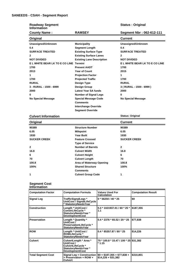
SANEEDS - CSAH - Segment Report
Roadway SegmentInformation
Status : Original
County Name : RAMSEY Segment Nbr : 062-612-111
Original Current
Unassigned/Unknown Municipality Unassigned/Unknown
0.4 Segment Length 0.4
SURFACE TREATED Existing Surface Type SURFACE TREATED
2 Existing Surface Lanes 2
NOT DIVIDED Existing Lane Description NOT DIVIDED
E L WHITE BEAR LK TO E CO LINE Termini E L WHITE BEAR LK TO E CO LINE
1700 Present AADT 1700
2013 Year of Count 2015
1 Projection Factor 1
1700 Projected Traffic 1700
RURAL Design Type RURAL
3 - RURAL : 1500 - 6999 Design Group 3 ( RURAL : 1500 - 6999 )
2000 Latest Year SA funds 2000
0 Number of Signal Legs 0
No Special Message Special Message Code No Special Message
Comments
Interchange Override
Segment Override
Culvert Information Status: Original
Original Current
90389 Structure Number 90389
6.05 Milepoint 6.05
1930 Year Built 1930
SUCKER CREEK Feature Crossed SUCKER CREEK
Type of Service
2 Number of Barrels 2
16.8 Culvert Width 16.8
6 Culvert Height 6
70 Culvert Length 70
100.8 Area of Waterway Opening 100.8
100% Shared Structure 100%
Comments
1 Culvert Group Code 1
Segment CostInformation
Computation Factor Computation Formula Values Used ForCalculation
Computation Result
Signal Leg TrafficSignalLegs *UnitCost / SignalLifeCycle* StatutoryNeedsYear
0 * 56250 / 40 * 25 $0
Construction Length * UnitCost /ConstrLifeCycle *StatutoryNeedsYear *DevelopmentCost
0.4 * 1021937.01 / 60 * 25 *1.1
$187,355
Preservation Length * Quantity *UnitCost /PreservationLifeCycle *StatutoryNeedsYear
0.4 * 2376 * 65.52 / 20 * 25 $77,838
ROW Length * UnitCost /ROWLifeCycle *StatutoryNeedsYear
0.4 * 85357.87 / 60 * 25 $14,226
Culvert CulvertLength * Area *UnitCost /CulvertLifeCycle *StatutoryNeedsYear *DevelopmentCost
70 * 100.8 * 15.47 / 100 * 25* 1.15
$31,382
Total Segment Cost Signal Leg + Construction+ Preservation + ROW +Culvert
$0 + $187,355 + $77,838 +$14,226 + $31,382
$310,801

SANEEDS - CSAH - Segment Report
Roadway SegmentInformation
Status : Original
County Name : RAMSEY Segment Nbr : 062-614-010
Original Current
VADNAIS HEIGHTS Municipality VADNAIS HEIGHTS
0.6 Segment Length 0.6
MIXED BITUMINOUS Existing Surface Type MIXED BITUMINOUS
2 Existing Surface Lanes 2
NOT DIVIDED Existing Lane Description NOT DIVIDED
MC MENEMY ST. TO EDGERTONST.
Termini MC MENEMY ST. TO EDGERTONST.
2950 Present AADT 2950
2013 Year of Count 2015
1 Projection Factor 1
2950 Projected Traffic 2950
RURAL Design Type RURAL
3 - RURAL : 1500 - 6999 Design Group 3 ( RURAL : 1500 - 6999 )
2000 Latest Year SA funds 2000
0 Number of Signal Legs 0
No Special Message Special Message Code No Special Message
COMBINED WITH SEG 020 IN 2005 Comments COMBINED WITH SEG 020 IN 2005
Interchange Override
Segment Override
Segment CostInformation
Computation Factor Computation Formula Values Used ForCalculation
Computation Result
Signal Leg TrafficSignalLegs *UnitCost / SignalLifeCycle* StatutoryNeedsYear
0 * 56250 / 40 * 25 $0
Construction Length * UnitCost /ConstrLifeCycle *StatutoryNeedsYear *DevelopmentCost
0.6 * 1021937.01 / 60 * 25 *1.1
$281,033
Preservation Length * Quantity *UnitCost /PreservationLifeCycle *StatutoryNeedsYear
0.6 * 2376 * 65.52 / 20 * 25 $116,757
ROW Length * UnitCost /ROWLifeCycle *StatutoryNeedsYear
0.6 * 85357.87 / 60 * 25 $21,339
Total Segment Cost Signal Leg + Construction+ Preservation + ROW
$0 + $281,033 + $116,757+ $21,339
$419,129

SANEEDS - CSAH - Segment Report
Roadway SegmentInformation
Status : Original
County Name : RAMSEY Segment Nbr : 062-614-030
Original Current
VADNAIS HEIGHTS Municipality VADNAIS HEIGHTS
0.35 Segment Length 0.35
MIXED BITUMINOUS Existing Surface Type MIXED BITUMINOUS
2 Existing Surface Lanes 2
NOT DIVIDED Existing Lane Description NOT DIVIDED
EDGERTON ST. TO .11MI WEST OFCENTERVILLE RD
Termini EDGERTON ST. TO .11MI WEST OFCENTERVILLE RD
3550 Present AADT 3550
2013 Year of Count 2015
1 Projection Factor 1
3550 Projected Traffic 3550
RURAL Design Type RURAL
3 - RURAL : 1500 - 6999 Design Group 3 ( RURAL : 1500 - 6999 )
2000 Latest Year SA funds 2000
0 Number of Signal Legs 0
No Special Message Special Message Code No Special Message
Comments
Interchange Override
Segment Override
Segment CostInformation
Computation Factor Computation Formula Values Used ForCalculation
Computation Result
Signal Leg TrafficSignalLegs *UnitCost / SignalLifeCycle* StatutoryNeedsYear
0 * 56250 / 40 * 25 $0
Construction Length * UnitCost /ConstrLifeCycle *StatutoryNeedsYear *DevelopmentCost
0.35 * 1021937.01 / 60 * 25* 1.1
$163,936
Preservation Length * Quantity *UnitCost /PreservationLifeCycle *StatutoryNeedsYear
0.35 * 2376 * 65.52 / 20 * 25 $68,108
ROW Length * UnitCost /ROWLifeCycle *StatutoryNeedsYear
0.35 * 85357.87 / 60 * 25 $12,448
Total Segment Cost Signal Leg + Construction+ Preservation + ROW
$0 + $163,936 + $68,108 +$12,448
$244,492

SANEEDS - CSAH - Segment Report
Roadway SegmentInformation
Status : Original
County Name : RAMSEY Segment Nbr : 062-614-040
Original Current
VADNAIS HEIGHTS Municipality VADNAIS HEIGHTS
0.11 Segment Length 0.11
MIXED BITUMINOUS Existing Surface Type MIXED BITUMINOUS
2 Existing Surface Lanes 2
NOT DIVIDED Existing Lane Description NOT DIVIDED
KOHLER RD-.11MI WEST OFCENTERVILLE TO CENTERVILLERD
Termini KOHLER RD-.11MI WEST OFCENTERVILLE TO CENTERVILLERD
3550 Present AADT 3550
2013 Year of Count 2015
1 Projection Factor 1
3550 Projected Traffic 3550
URBAN Design Type URBAN
5 - URBAN : 0 - 9999 Design Group 5 ( URBAN : 0 - 9999 )
2006 Latest Year SA funds 2006
1 Number of Signal Legs 1
No Special Message Special Message Code No Special Message
CHANGED PROPOSED ROADWAYWIIDTH TO MAX ALLOWED BYDESIGN GUIDELINES. 4/17/07 SL
SAP 62-614-02
Comments CHANGED PROPOSED ROADWAYWIIDTH TO MAX ALLOWED BYDESIGN GUIDELINES. 4/17/07 SL
SAP 62-614-02
Interchange Override
Segment Override
Segment CostInformation
Computation Factor Computation Formula Values Used ForCalculation
Computation Result
Signal Leg TrafficSignalLegs *UnitCost / SignalLifeCycle* StatutoryNeedsYear
1 * 56250 / 40 * 25 $35,156
Construction Length * UnitCost /ConstrLifeCycle *StatutoryNeedsYear *DevelopmentCost
0.11 * 2738635.28 / 60 * 25* 1.15
$144,349
Preservation Length * Quantity *UnitCost /PreservationLifeCycle *StatutoryNeedsYear
0.11 * 2904 * 65.52 / 15 * 25 $34,883
ROW Length * UnitCost /ROWLifeCycle *StatutoryNeedsYear
0.11 * 436504.07 / 60 * 25 $20,006
Total Segment Cost Signal Leg + Construction+ Preservation + ROW
$35,156 + $144,349 +$34,883 + $20,006
$234,394

SANEEDS - CSAH - Segment Report
Roadway SegmentInformation
Status : Original
County Name : RAMSEY Segment Nbr : 062-614-050
Original Current
VADNAIS HEIGHTS Municipality VADNAIS HEIGHTS
0.16 Segment Length 0.16
MIXED BITUMINOUS Existing Surface Type MIXED BITUMINOUS
2 Existing Surface Lanes 2
NOT DIVIDED Existing Lane Description NOT DIVIDED
GOOSE LAKE ROAD -CENTERVILLE ROAD TO LABOREROAD
Termini GOOSE LAKE ROAD -CENTERVILLE ROAD TO LABOREROAD
4450 Present AADT 4450
2013 Year of Count 2015
1 Projection Factor 1
4450 Projected Traffic 4450
RURAL Design Type RURAL
3 - RURAL : 1500 - 6999 Design Group 3 ( RURAL : 1500 - 6999 )
2000 Latest Year SA funds 2000
0 Number of Signal Legs 0
No Special Message Special Message Code No Special Message
CHANGED PROPOSED ROADBEDWIDTH TO 28 FEET PER MAXALLOWED BY DESIGN CHART. SL3/31/08
Comments CHANGED PROPOSED ROADBEDWIDTH TO 28 FEET PER MAXALLOWED BY DESIGN CHART. SL3/31/08
Interchange Override
Segment Override
Segment CostInformation
Computation Factor Computation Formula Values Used ForCalculation
Computation Result
Signal Leg TrafficSignalLegs *UnitCost / SignalLifeCycle* StatutoryNeedsYear
0 * 56250 / 40 * 25 $0
Construction Length * UnitCost /ConstrLifeCycle *StatutoryNeedsYear *DevelopmentCost
0.16 * 1021937.01 / 60 * 25* 1.1
$74,942
Preservation Length * Quantity *UnitCost /PreservationLifeCycle *StatutoryNeedsYear
0.16 * 2376 * 65.52 / 20 * 25 $31,135
ROW Length * UnitCost /ROWLifeCycle *StatutoryNeedsYear
0.16 * 85357.87 / 60 * 25 $5,691
Total Segment Cost Signal Leg + Construction+ Preservation + ROW
$0 + $74,942 + $31,135 +$5,691
$111,768

SANEEDS - CSAH - Segment Report
Roadway SegmentInformation
Status : Original
County Name : RAMSEY Segment Nbr : 062-614-060
Original Current
VADNAIS HEIGHTS Municipality VADNAIS HEIGHTS
0.04 Segment Length 0.04
MIXED BITUMINOUS Existing Surface Type MIXED BITUMINOUS
2 Existing Surface Lanes 2
NOT DIVIDED Existing Lane Description NOT DIVIDED
LABORE ROAD - GOOSE LAKEROAD TO GOOSE LAKE ROAD
Termini LABORE ROAD - GOOSE LAKEROAD TO GOOSE LAKE ROAD
4450 Present AADT 4450
2013 Year of Count 2015
1 Projection Factor 1
4450 Projected Traffic 4450
RURAL Design Type RURAL
3 - RURAL : 1500 - 6999 Design Group 3 ( RURAL : 1500 - 6999 )
2000 Latest Year SA funds 2000
0 Number of Signal Legs 0
No Special Message Special Message Code No Special Message
CHANGED PROPOSED ROADBEDWIDTH TO 28 FEET PER MAXALLOWED BY DESIGN CHART. SL3/31/08
Comments CHANGED PROPOSED ROADBEDWIDTH TO 28 FEET PER MAXALLOWED BY DESIGN CHART. SL3/31/08
Interchange Override
Segment Override
RailRoadCrossingInformation
Status: Original
Original Current
BURLINGTON NORTHERN SANTAFE RAILWAY
RailRoad Name BURLINGTON NORTHERN SANTAFE RAILWAY
061374X USDOT Number 061374X
0.02 Located at Milepoint 0.02
1 Mainline Tracks 1
SIGNS ONLY Protection Type SIGNS ONLY
Last Year Protection Upgraded
38 Crossing Length 38
Last Year Surfaced
100% Percentage of Cost 100%
Comments
Segment CostInformation
Computation Factor Computation Formula Values Used ForCalculation
Computation Result
Signal Leg TrafficSignalLegs *UnitCost / SignalLifeCycle* StatutoryNeedsYear
0 * 56250 / 40 * 25 $0
Construction Length * UnitCost /ConstrLifeCycle *StatutoryNeedsYear *DevelopmentCost
0.04 * 1021937.01 / 60 * 25* 1.1
$18,736
Preservation Length * Quantity *UnitCost /PreservationLifeCycle *StatutoryNeedsYear
0.04 * 2376 * 65.52 / 20 * 25 $7,784
ROW Length * UnitCost /ROWLifeCycle *StatutoryNeedsYear
0.04 * 85357.87 / 60 * 25 $1,423
RR Crossing Protection UnitCost /RRCrossingLifeCycle *StatutoryNeedsYear
1500 / 25 * 25 $1,500
RR Crossing Surface SurfaceLength * UnitCost/ RRCrossingLifeCycle *StatutoryNeedsYear
38 * 1350 / 25 * 25 $51,300
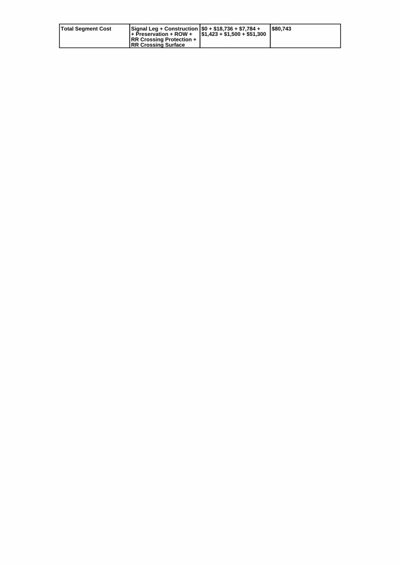
Total Segment Cost Signal Leg + Construction+ Preservation + ROW +RR Crossing Protection +RR Crossing Surface
$0 + $18,736 + $7,784 +$1,423 + $1,500 + $51,300
$80,743

SANEEDS - CSAH - Segment Report
Roadway SegmentInformation
Status : Original
County Name : RAMSEY Segment Nbr : 062-614-070
Original Current
GEM LAKE Municipality GEM LAKE
1.39 Segment Length 1.39
MIXED BITUMINOUS Existing Surface Type MIXED BITUMINOUS
2 Existing Surface Lanes 2
NOT DIVIDED Existing Lane Description NOT DIVIDED
GOOSE LAKE ROAD - LABOREROAD TO OTTER LAKE ROAD
Termini GOOSE LAKE ROAD - LABOREROAD TO OTTER LAKE ROAD
3050 Present AADT 3050
2013 Year of Count 2015
1 Projection Factor 1
3050 Projected Traffic 3050
RURAL Design Type RURAL
3 - RURAL : 1500 - 6999 Design Group 3 ( RURAL : 1500 - 6999 )
2000 Latest Year SA funds 2000
0 Number of Signal Legs 0
No Special Message Special Message Code No Special Message
CHANGED PROPOSED ROADBEDWIDTH TO 28 FEET PER MAXALLOWED BY DESIGN CHART. SL3/31/08
Comments CHANGED PROPOSED ROADBEDWIDTH TO 28 FEET PER MAXALLOWED BY DESIGN CHART. SL3/31/08
Interchange Override
Segment Override
Segment CostInformation
Computation Factor Computation Formula Values Used ForCalculation
Computation Result
Signal Leg TrafficSignalLegs *UnitCost / SignalLifeCycle* StatutoryNeedsYear
0 * 56250 / 40 * 25 $0
Construction Length * UnitCost /ConstrLifeCycle *StatutoryNeedsYear *DevelopmentCost
1.39 * 1021937.01 / 60 * 25* 1.1
$651,059
Preservation Length * Quantity *UnitCost /PreservationLifeCycle *StatutoryNeedsYear
1.39 * 2376 * 65.52 / 20 * 25 $270,486
ROW Length * UnitCost /ROWLifeCycle *StatutoryNeedsYear
1.39 * 85357.87 / 60 * 25 $49,436
Total Segment Cost Signal Leg + Construction+ Preservation + ROW
$0 + $651,059 + $270,486+ $49,436
$970,981

SANEEDS - CSAH - Segment Report
Roadway SegmentInformation
Status : Original
County Name : RAMSEY Segment Nbr : 062-615-010
Original Current
ST ANTHONY Municipality ST ANTHONY
0.23 Segment Length 0.23
SURFACE TREATED Existing Surface Type SURFACE TREATED
2 Existing Surface Lanes 2
NOT DIVIDED Existing Lane Description NOT DIVIDED
W CO LINE TO 0.23 MI E Termini W CO LINE TO 0.23 MI E
4650 Present AADT 4650
2013 Year of Count 2015
1 Projection Factor 1
4650 Projected Traffic 4650
RURAL Design Type RURAL
3 - RURAL : 1500 - 6999 Design Group 3 ( RURAL : 1500 - 6999 )
2000 Latest Year SA funds 2000
0 Number of Signal Legs 0
No Special Message Special Message Code No Special Message
Comments
Interchange Override
Segment Override
Segment CostInformation
Computation Factor Computation Formula Values Used ForCalculation
Computation Result
Signal Leg TrafficSignalLegs *UnitCost / SignalLifeCycle* StatutoryNeedsYear
0 * 56250 / 40 * 25 $0
Construction Length * UnitCost /ConstrLifeCycle *StatutoryNeedsYear *DevelopmentCost
0.23 * 1021937.01 / 60 * 25* 1.1
$107,729
Preservation Length * Quantity *UnitCost /PreservationLifeCycle *StatutoryNeedsYear
0.23 * 2376 * 65.52 / 20 * 25 $44,757
ROW Length * UnitCost /ROWLifeCycle *StatutoryNeedsYear
0.23 * 85357.87 / 60 * 25 $8,180
Total Segment Cost Signal Leg + Construction+ Preservation + ROW
$0 + $107,729 + $44,757 +$8,180
$160,666

SANEEDS - CSAH - Segment Report
Roadway SegmentInformation
Status : Original
County Name : RAMSEY Segment Nbr : 062-615-020
Original Current
NEW BRIGHTON Municipality NEW BRIGHTON
0.23 Segment Length 0.23
SURFACE TREATED Existing Surface Type SURFACE TREATED
2 Existing Surface Lanes 2
NOT DIVIDED Existing Lane Description NOT DIVIDED
0.23 MI E OF W CO LINE TOSILVER LAKE RD.
Termini 0.23 MI E OF W CO LINE TOSILVER LAKE RD.
4650 Present AADT 4650
2013 Year of Count 2015
1 Projection Factor 1
4650 Projected Traffic 4650
RURAL Design Type RURAL
3 - RURAL : 1500 - 6999 Design Group 3 ( RURAL : 1500 - 6999 )
2000 Latest Year SA funds 2000
1 Number of Signal Legs 1
No Special Message Special Message Code No Special Message
Comments
Interchange Override
Segment Override
Segment CostInformation
Computation Factor Computation Formula Values Used ForCalculation
Computation Result
Signal Leg TrafficSignalLegs *UnitCost / SignalLifeCycle* StatutoryNeedsYear
1 * 56250 / 40 * 25 $35,156
Construction Length * UnitCost /ConstrLifeCycle *StatutoryNeedsYear *DevelopmentCost
0.23 * 1021937.01 / 60 * 25* 1.1
$107,729
Preservation Length * Quantity *UnitCost /PreservationLifeCycle *StatutoryNeedsYear
0.23 * 2376 * 65.52 / 20 * 25 $44,757
ROW Length * UnitCost /ROWLifeCycle *StatutoryNeedsYear
0.23 * 85357.87 / 60 * 25 $8,180
Total Segment Cost Signal Leg + Construction+ Preservation + ROW
$35,156 + $107,729 +$44,757 + $8,180
$195,822

SANEEDS - CSAH - Segment Report
Roadway SegmentInformation
Status : Original
County Name : RAMSEY Segment Nbr : 062-615-030
Original Current
NEW BRIGHTON Municipality NEW BRIGHTON
0.95 Segment Length 0.95
MIXED BITUMINOUS Existing Surface Type MIXED BITUMINOUS
2 Existing Surface Lanes 2
NOT DIVIDED Existing Lane Description NOT DIVIDED
SILVER LAKE RD. TO OLDHIGHWAY 8
Termini SILVER LAKE RD. TO OLDHIGHWAY 8
6200 Present AADT 6200
2013 Year of Count 2015
1 Projection Factor 1
6200 Projected Traffic 6200
RURAL Design Type RURAL
3 - RURAL : 1500 - 6999 Design Group 3 ( RURAL : 1500 - 6999 )
2000 Latest Year SA funds 2000
0 Number of Signal Legs 0
No Special Message Special Message Code No Special Message
Comments
Interchange Override
Segment Override
Culvert Information Status: Original
Original Current
93532 Structure Number 93532
1.3 Milepoint 1.3
1968 Year Built 1968
CO DITCH # 2 Feature Crossed CO DITCH # 2
Type of Service
4 Number of Barrels 4
4 Culvert Width 4
4 Culvert Height 4
114 Culvert Length 114
50.00046828 Area of Waterway Opening 50.00046828
100% Shared Structure 100%
Comments
1 Culvert Group Code 1
Segment CostInformation
Computation Factor Computation Formula Values Used ForCalculation
Computation Result
Signal Leg TrafficSignalLegs *UnitCost / SignalLifeCycle* StatutoryNeedsYear
0 * 56250 / 40 * 25 $0
Construction Length * UnitCost /ConstrLifeCycle *StatutoryNeedsYear *DevelopmentCost
0.95 * 1021937.01 / 60 * 25* 1.1
$444,968
Preservation Length * Quantity *UnitCost /PreservationLifeCycle *StatutoryNeedsYear
0.95 * 2376 * 65.52 / 20 * 25 $184,865
ROW Length * UnitCost /ROWLifeCycle *StatutoryNeedsYear
0.95 * 85357.87 / 60 * 25 $33,787
Culvert CulvertLength * Area *UnitCost /CulvertLifeCycle *StatutoryNeedsYear *DevelopmentCost
114 * 50.00046828 * 15.47 /100 * 25 * 1.15
$25,352

Total Segment Cost Signal Leg + Construction+ Preservation + ROW +Culvert
$0 + $444,968 + $184,865+ $33,787 + $25,352
$688,972

SANEEDS - CSAH - Segment Report
Roadway SegmentInformation
Status : Original
County Name : RAMSEY Segment Nbr : 062-615-031
Original Current
ARDEN HILLS Municipality ARDEN HILLS
0.3 Segment Length 0.3
MIXED BITUMINOUS Existing Surface Type MIXED BITUMINOUS
4 Existing Surface Lanes 4
NOT DIVIDED Existing Lane Description NOT DIVIDED
SNELLING AVE. TO E JCT NEWT.H. 51
Termini SNELLING AVE. TO E JCT NEWT.H. 51
10500 Present AADT 10500
2013 Year of Count 2015
1 Projection Factor 1
10500 Projected Traffic 10500
URBAN Design Type URBAN
6 - URBAN : 10000 - 19999 Design Group 6 ( URBAN : 10000 - 19999 )
2000 Latest Year SA funds 2000
3 Number of Signal Legs 3
THTB-RECONSTRUCTED WITH TBFUNDS
Special Message Code THTB-RECONSTRUCTED WITH TBFUNDS
Comments
Interchange Override
Segment Override
Segment CostInformation
Computation Factor Computation Formula Values Used ForCalculation
Computation Result
Signal Leg TrafficSignalLegs *UnitCost / SignalLifeCycle* StatutoryNeedsYear
3 * 56250 / 40 * 25 $105,469
Construction Length * UnitCost /ConstrLifeCycle *StatutoryNeedsYear *DevelopmentCost
0.3 * 4225495.41 / 60 * 25 *1.15
$607,415
Preservation Length * Quantity *UnitCost /PreservationLifeCycle *StatutoryNeedsYear
0.3 * 3696 * 65.52 / 15 * 25 $121,081
ROW Length * UnitCost /ROWLifeCycle *StatutoryNeedsYear
0.3 * 566370.18 / 60 * 25 $70,796
Total Segment Cost Signal Leg + Construction+ Preservation + ROW
$105,469 + $607,415 +$121,081 + $70,796
$904,761

SANEEDS - CSAH - Segment Report
Roadway SegmentInformation
Status : Original
County Name : RAMSEY Segment Nbr : 062-615-032
Original Current
ARDEN HILLS Municipality ARDEN HILLS
0.5 Segment Length 0.5
MIXED BITUMINOUS Existing Surface Type MIXED BITUMINOUS
5 Existing Surface Lanes 5
NOT DIVIDED Existing Lane Description NOT DIVIDED
E JCT NEW TH 51 TO LEXINGTONAVE.
Termini E JCT NEW TH 51 TO LEXINGTONAVE.
15300 Present AADT 15300
2013 Year of Count 2015
1 Projection Factor 1
15300 Projected Traffic 15300
URBAN Design Type URBAN
6 - URBAN : 10000 - 19999 Design Group 6 ( URBAN : 10000 - 19999 )
2000 Latest Year SA funds 2000
4 Number of Signal Legs 4
THTB-RECONSTRUCTED WITH TBFUNDS
Special Message Code THTB-RECONSTRUCTED WITH TBFUNDS
Comments
Interchange Override
Segment Override
Segment CostInformation
Computation Factor Computation Formula Values Used ForCalculation
Computation Result
Signal Leg TrafficSignalLegs *UnitCost / SignalLifeCycle* StatutoryNeedsYear
4 * 56250 / 40 * 25 $140,625
Construction Length * UnitCost /ConstrLifeCycle *StatutoryNeedsYear *DevelopmentCost
0.5 * 4225495.41 / 60 * 25 *1.15
$1,012,358
Preservation Length * Quantity *UnitCost /PreservationLifeCycle *StatutoryNeedsYear
0.5 * 3696 * 65.52 / 15 * 25 $201,802
ROW Length * UnitCost /ROWLifeCycle *StatutoryNeedsYear
0.5 * 566370.18 / 60 * 25 $117,994
Total Segment Cost Signal Leg + Construction+ Preservation + ROW
$140,625 + $1,012,358 +$201,802 + $117,994
$1,472,779

SANEEDS - CSAH - Segment Report
Roadway SegmentInformation
Status : Original
County Name : RAMSEY Segment Nbr : 062-615-040
Original Current
SHOREVIEW Municipality SHOREVIEW
0.68 Segment Length 0.68
MIXED BITUMINOUS Existing Surface Type MIXED BITUMINOUS
2 Existing Surface Lanes 2
NOT DIVIDED Existing Lane Description NOT DIVIDED
LEXINGTON AVE. TO VICTORIAST.
Termini LEXINGTON AVE. TO VICTORIAST.
9700 Present AADT 9700
2013 Year of Count 2015
1 Projection Factor 1
9700 Projected Traffic 9700
RURAL Design Type RURAL
4 - RURAL : 7000 - 999999 Design Group 4 ( RURAL : 7000 - 999999 )
2014 Latest Year SA funds 2014
2 Number of Signal Legs 2
No Special Message Special Message Code No Special Message
2014 EXPENDITURE ISSAP 062-615-029
Comments 2014 EXPENDITURE ISSAP 062-615-029
Interchange Override
Segment Override
Segment CostInformation
Computation Factor Computation Formula Values Used ForCalculation
Computation Result
Signal Leg TrafficSignalLegs *UnitCost / SignalLifeCycle* StatutoryNeedsYear
2 * 56250 / 40 * 25 $70,313
Construction Length * UnitCost /ConstrLifeCycle *StatutoryNeedsYear *DevelopmentCost
0.68 * 1996892.57 / 60 * 25* 1.1
$622,365
Preservation Length * Quantity *UnitCost /PreservationLifeCycle *StatutoryNeedsYear
0.68 * 3564 * 65.52 / 20 * 25 $198,486
ROW Length * UnitCost /ROWLifeCycle *StatutoryNeedsYear
0.68 * 181173.68 / 60 * 25 $51,333
Total Segment Cost Signal Leg + Construction+ Preservation + ROW
$70,313 + $622,365 +$198,486 + $51,333
$942,497

SANEEDS - CSAH - Segment Report
Roadway SegmentInformation
Status : Original
County Name : RAMSEY Segment Nbr : 062-615-045
Original Current
VADNAIS HEIGHTS Municipality VADNAIS HEIGHTS
0.3 Segment Length 0.3
MIXED BITUMINOUS Existing Surface Type MIXED BITUMINOUS
4 Existing Surface Lanes 4
DIVIDED Existing Lane Description DIVIDED
COUNTY ROAD E-CENTERVILLERD TO ARCADE ST
Termini COUNTY ROAD E-CENTERVILLERD TO ARCADE ST
10400 Present AADT 10400
2013 Year of Count 2015
1 Projection Factor 1
10400 Projected Traffic 10400
URBAN Design Type URBAN
6 - URBAN : 10000 - 19999 Design Group 6 ( URBAN : 10000 - 19999 )
2006 Latest Year SA funds 2006
2 Number of Signal Legs 2
No Special Message Special Message Code No Special Message
CHANGED PROPOSED ROADWAYWIDTH TO MAX ALLOWED BYDESIGN GUIDELINES. 4/17/07 SL
Comments CHANGED PROPOSED ROADWAYWIDTH TO MAX ALLOWED BYDESIGN GUIDELINES. 4/17/07 SL
Interchange Override
Segment Override
Segment CostInformation
Computation Factor Computation Formula Values Used ForCalculation
Computation Result
Signal Leg TrafficSignalLegs *UnitCost / SignalLifeCycle* StatutoryNeedsYear
2 * 56250 / 40 * 25 $70,313
Construction Length * UnitCost /ConstrLifeCycle *StatutoryNeedsYear *DevelopmentCost
0.3 * 4225495.41 / 60 * 25 *1.15
$607,415
Preservation Length * Quantity *UnitCost /PreservationLifeCycle *StatutoryNeedsYear
0.3 * 3696 * 65.52 / 15 * 25 $121,081
ROW Length * UnitCost /ROWLifeCycle *StatutoryNeedsYear
0.3 * 566370.18 / 60 * 25 $70,796
Total Segment Cost Signal Leg + Construction+ Preservation + ROW
$70,313 + $607,415 +$121,081 + $70,796
$869,605
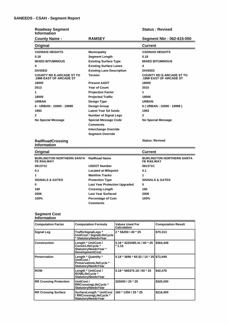
SANEEDS - CSAH - Segment Report
Roadway SegmentInformation
Status : Revised
County Name : RAMSEY Segment Nbr : 062-615-050
Original Current
VADNAIS HEIGHTS Municipality VADNAIS HEIGHTS
0.18 Segment Length 0.18
MIXED BITUMINOUS Existing Surface Type MIXED BITUMINOUS
4 Existing Surface Lanes 4
DIVIDED Existing Lane Description DIVIDED
COUNTY RD E-ARCADE ST TO.18MI EAST OF ARCADE ST
Termini COUNTY RD E-ARCADE ST TO.18MI EAST OF ARCADE ST
18000 Present AADT 18000
2013 Year of Count 2015
1 Projection Factor 1
18000 Projected Traffic 18000
URBAN Design Type URBAN
6 - URBAN : 10000 - 19999 Design Group 6 ( URBAN : 10000 - 19999 )
1993 Latest Year SA funds 1993
2 Number of Signal Legs 2
No Special Message Special Message Code No Special Message
Comments
Interchange Override
Segment Override
RailRoadCrossingInformation
Status: Revised
Original Current
BURLINGTON NORTHERN SANTAFE RAILWAY
RailRoad Name BURLINGTON NORTHERN SANTAFE RAILWAY
061371C USDOT Number 061371C
0.1 Located at Milepoint 0.1
1 Mainline Tracks 1
SIGNALS & GATES Protection Type SIGNALS & GATES
0 Last Year Protection Upgraded 0
160 Crossing Length 160
2006 Last Year Surfaced 2006
100% Percentage of Cost 100%
Comments
Segment CostInformation
Computation Factor Computation Formula Values Used ForCalculation
Computation Result
Signal Leg TrafficSignalLegs *UnitCost / SignalLifeCycle* StatutoryNeedsYear
2 * 56250 / 40 * 25 $70,313
Construction Length * UnitCost /ConstrLifeCycle *StatutoryNeedsYear *DevelopmentCost
0.18 * 4225495.41 / 60 * 25* 1.15
$364,449
Preservation Length * Quantity *UnitCost /PreservationLifeCycle *StatutoryNeedsYear
0.18 * 3696 * 65.52 / 15 * 25 $72,649
ROW Length * UnitCost /ROWLifeCycle *StatutoryNeedsYear
0.18 * 566370.18 / 60 * 25 $42,478
RR Crossing Protection UnitCost /RRCrossingLifeCycle *StatutoryNeedsYear
325000 / 25 * 25 $325,000
RR Crossing Surface SurfaceLength * UnitCost/ RRCrossingLifeCycle *StatutoryNeedsYear
160 * 1350 / 25 * 25 $216,000

Total Segment Cost Signal Leg + Construction+ Preservation + ROW +RR Crossing Protection +RR Crossing Surface
$70,313 + $364,449 +$72,649 + $42,478 +$325,000 + $216,000
$1,090,889

SANEEDS - CSAH - Segment Report
Roadway SegmentInformation
Status : Original
County Name : RAMSEY Segment Nbr : 062-615-051
Original Current
VADNAIS HEIGHTS Municipality VADNAIS HEIGHTS
0.26 Segment Length 0.26
MIXED BITUMINOUS Existing Surface Type MIXED BITUMINOUS
4 Existing Surface Lanes 4
DIVIDED Existing Lane Description DIVIDED
0.48 MI E OF CENTERVILLE RD. TOWILLOW LAKE BLVD.
Termini 0.48 MI E OF CENTERVILLE RD. TOWILLOW LAKE BLVD.
23000 Present AADT 23000
2013 Year of Count 2015
1 Projection Factor 1
23000 Projected Traffic 23000
URBAN Design Type URBAN
7 - URBAN : 20000 - 34999 Design Group 7 ( URBAN : 20000 - 34999 )
1993 Latest Year SA funds 1993
6 Number of Signal Legs 6
No Special Message Special Message Code No Special Message
Comments
Interchange Override
Segment Override
Segment CostInformation
Computation Factor Computation Formula Values Used ForCalculation
Computation Result
Signal Leg TrafficSignalLegs *UnitCost / SignalLifeCycle* StatutoryNeedsYear
6 * 56250 / 40 * 25 $210,938
Construction Length * UnitCost /ConstrLifeCycle *StatutoryNeedsYear *DevelopmentCost
0.26 * 5259942.61 / 60 * 25* 1.15
$655,301
Preservation Length * Quantity *UnitCost /PreservationLifeCycle *StatutoryNeedsYear
0.26 * 4488 * 65.52 / 15 * 25 $127,423
ROW Length * UnitCost /ROWLifeCycle *StatutoryNeedsYear
0.26 * 883293.09 / 60 * 25 $95,690
Total Segment Cost Signal Leg + Construction+ Preservation + ROW
$210,938 + $655,301 +$127,423 + $95,690
$1,089,352

SANEEDS - CSAH - Segment Report
Roadway SegmentInformation
Status : Original
County Name : RAMSEY Segment Nbr : 062-615-060
Original Current
GEM LAKE Municipality GEM LAKE
0.36 Segment Length 0.36
MIXED BITUMINOUS Existing Surface Type MIXED BITUMINOUS
4 Existing Surface Lanes 4
DIVIDED Existing Lane Description DIVIDED
CO RD E . WILLOW LAKE BLVD TOBIG FOX RD.
Termini CO RD E . WILLOW LAKE BLVD TOBIG FOX RD.
23000 Present AADT 23000
2013 Year of Count 2015
1 Projection Factor 1
23000 Projected Traffic 23000
URBAN Design Type URBAN
7 - URBAN : 20000 - 34999 Design Group 7 ( URBAN : 20000 - 34999 )
2002 Latest Year SA funds 2002
3 Number of Signal Legs 3
No Special Message Special Message Code No Special Message
Comments
Interchange Override
Segment Override
Segment CostInformation
Computation Factor Computation Formula Values Used ForCalculation
Computation Result
Signal Leg TrafficSignalLegs *UnitCost / SignalLifeCycle* StatutoryNeedsYear
3 * 56250 / 40 * 25 $105,469
Construction Length * UnitCost /ConstrLifeCycle *StatutoryNeedsYear *DevelopmentCost
0.36 * 5259942.61 / 60 * 25* 1.15
$907,340
Preservation Length * Quantity *UnitCost /PreservationLifeCycle *StatutoryNeedsYear
0.36 * 4488 * 65.52 / 15 * 25 $176,432
ROW Length * UnitCost /ROWLifeCycle *StatutoryNeedsYear
0.36 * 883293.09 / 60 * 25 $132,494
Total Segment Cost Signal Leg + Construction+ Preservation + ROW
$105,469 + $907,340 +$176,432 + $132,494
$1,321,735

SANEEDS - CSAH - Segment Report
Roadway SegmentInformation
Status : Original
County Name : RAMSEY Segment Nbr : 062-615-070
Original Current
VADNAIS HEIGHTS Municipality VADNAIS HEIGHTS
0.56 Segment Length 0.56
MIXED BITUMINOUS Existing Surface Type MIXED BITUMINOUS
5 Existing Surface Lanes 5
NOT DIVIDED Existing Lane Description NOT DIVIDED
CO RD E BIG FOX RD TO TH 61 Termini CO RD E BIG FOX RD TO TH 61
18300 Present AADT 18300
2013 Year of Count 2015
1 Projection Factor 1
18300 Projected Traffic 18300
URBAN Design Type URBAN
6 - URBAN : 10000 - 19999 Design Group 6 ( URBAN : 10000 - 19999 )
1996 Latest Year SA funds 1996
3 Number of Signal Legs 3
No Special Message Special Message Code No Special Message
Comments
Interchange Override
Segment Override
Segment CostInformation
Computation Factor Computation Formula Values Used ForCalculation
Computation Result
Signal Leg TrafficSignalLegs *UnitCost / SignalLifeCycle* StatutoryNeedsYear
3 * 56250 / 40 * 25 $105,469
Construction Length * UnitCost /ConstrLifeCycle *StatutoryNeedsYear *DevelopmentCost
0.56 * 4225495.41 / 60 * 25* 1.15
$1,133,841
Preservation Length * Quantity *UnitCost /PreservationLifeCycle *StatutoryNeedsYear
0.56 * 3696 * 65.52 / 15 * 25 $226,018
ROW Length * UnitCost /ROWLifeCycle *StatutoryNeedsYear
0.56 * 566370.18 / 60 * 25 $132,153
Total Segment Cost Signal Leg + Construction+ Preservation + ROW
$105,469 + $1,133,841 +$226,018 + $132,153
$1,597,481

SANEEDS - CSAH - Segment Report
Roadway SegmentInformation
Status : Original
County Name : RAMSEY Segment Nbr : 062-615-080
Original Current
WHITE BEAR LAKE Municipality WHITE BEAR LAKE
0.5 Segment Length 0.5
MIXED BITUMINOUS Existing Surface Type MIXED BITUMINOUS
3 Existing Surface Lanes 3
NOT DIVIDED Existing Lane Description NOT DIVIDED
CO RD E. TH61 TO WILLOW AVE Termini CO RD E. TH61 TO WILLOW AVE
13800 Present AADT 13800
2013 Year of Count 2015
1 Projection Factor 1
13800 Projected Traffic 13800
URBAN Design Type URBAN
6 - URBAN : 10000 - 19999 Design Group 6 ( URBAN : 10000 - 19999 )
2000 Latest Year SA funds 2000
2 Number of Signal Legs 2
THTB-NOT ELIGIBLE FOR TBFUNDS
Special Message Code THTB-NOT ELIGIBLE FOR TBFUNDS
TURNED BACK TO RAMSEYCOUNTY IN 2002.
Comments TURNED BACK TO RAMSEYCOUNTY IN 2002.
Interchange Override
Segment Override
Bridge Information Status: Original
Original Current
62079 Structure Number 62079
9.621 Milepoint 9.621
1977 Year Built 1977
Feature Crossed
HWY / R.R. Type of Service HWY / R.R.
3 Number of Spans 3
154 Bridge Length 154
86.3 Bridge Width 86.3
100% Shared Structure 100%
Comments
2 ( 150-999,999 ) Bridge Group Code 2 ( 150-999,999 )
Segment CostInformation
Computation Factor Computation Formula Values Used ForCalculation
Computation Result
Signal Leg TrafficSignalLegs *UnitCost / SignalLifeCycle* StatutoryNeedsYear
2 * 56250 / 40 * 25 $70,313
Construction Length * UnitCost /ConstrLifeCycle *StatutoryNeedsYear *DevelopmentCost
0.5 * 4225495.41 / 60 * 25 *1.15
$1,012,358
Preservation Length * Quantity *UnitCost /PreservationLifeCycle *StatutoryNeedsYear
0.5 * 3696 * 65.52 / 15 * 25 $201,802
ROW Length * UnitCost /ROWLifeCycle *StatutoryNeedsYear
0.5 * 566370.18 / 60 * 25 $117,994
Bridge BridgeLength *BridgeWidth * UnitCost /BridgeLifeCycle *StatutoryNeedsYear *DevelopmentCost
154 * 86.3 * 138 / 80 * 25 *1.15
$659,111
Total Segment Cost Signal Leg + Construction+ Preservation + ROW +Bridge
$70,313 + $1,012,358 +$201,802 + $117,994 +$659,111
$2,061,578

SANEEDS - CSAH - Segment Report
Roadway SegmentInformation
Status : Original
County Name : RAMSEY Segment Nbr : 062-615-090
Original Current
WHITE BEAR LAKE Municipality WHITE BEAR LAKE
1.5 Segment Length 1.5
MIXED BITUMINOUS Existing Surface Type MIXED BITUMINOUS
3 Existing Surface Lanes 3
NOT DIVIDED Existing Lane Description NOT DIVIDED
CO RD E- WILLOW AVE TOBELAIRE ABE.
Termini CO RD E- WILLOW AVE TOBELAIRE ABE.
14600 Present AADT 14600
2013 Year of Count 2015
1 Projection Factor 1
14600 Projected Traffic 14600
URBAN Design Type URBAN
6 - URBAN : 10000 - 19999 Design Group 6 ( URBAN : 10000 - 19999 )
2000 Latest Year SA funds 2000
6 Number of Signal Legs 6
THTB-NOT ELIGIBLE FOR TBFUNDS
Special Message Code THTB-NOT ELIGIBLE FOR TBFUNDS
TURNED BACK TO RAMSEYCOUNTY IN 2002.COMBINED WITH SEG 100 & 110 IN2005
Comments TURNED BACK TO RAMSEYCOUNTY IN 2002.COMBINED WITH SEG 100 & 110 IN2005
Interchange Override
Segment Override
Segment CostInformation
Computation Factor Computation Formula Values Used ForCalculation
Computation Result
Signal Leg TrafficSignalLegs *UnitCost / SignalLifeCycle* StatutoryNeedsYear
6 * 56250 / 40 * 25 $210,938
Construction Length * UnitCost /ConstrLifeCycle *StatutoryNeedsYear *DevelopmentCost
1.5 * 4225495.41 / 60 * 25 *1.15
$3,037,075
Preservation Length * Quantity *UnitCost /PreservationLifeCycle *StatutoryNeedsYear
1.5 * 3696 * 65.52 / 15 * 25 $605,405
ROW Length * UnitCost /ROWLifeCycle *StatutoryNeedsYear
1.5 * 566370.18 / 60 * 25 $353,981
Total Segment Cost Signal Leg + Construction+ Preservation + ROW
$210,938 + $3,037,075 +$605,405 + $353,981
$4,207,399

SANEEDS - CSAH - Segment Report
Roadway SegmentInformation
Status : Original
County Name : RAMSEY Segment Nbr : 062-615-120
Original Current
WHITE BEAR LAKE Municipality WHITE BEAR LAKE
0.5 Segment Length 0.5
MIXED BITUMINOUS Existing Surface Type MIXED BITUMINOUS
3 Existing Surface Lanes 3
NOT DIVIDED Existing Lane Description NOT DIVIDED
CO RD E. BELAIRE AVE TO TH 120 Termini CO RD E. BELAIRE AVE TO TH 120
14600 Present AADT 14600
2013 Year of Count 2015
1 Projection Factor 1
14600 Projected Traffic 14600
URBAN Design Type URBAN
6 - URBAN : 10000 - 19999 Design Group 6 ( URBAN : 10000 - 19999 )
2000 Latest Year SA funds 2000
2 Number of Signal Legs 2
THTB-NOT ELIGIBLE FOR TBFUNDS
Special Message Code THTB-NOT ELIGIBLE FOR TBFUNDS
TURNED BACK TO RAMSEYCOUNTY IN 2002.
Comments TURNED BACK TO RAMSEYCOUNTY IN 2002.
Interchange Override
Segment Override
Segment CostInformation
Computation Factor Computation Formula Values Used ForCalculation
Computation Result
Signal Leg TrafficSignalLegs *UnitCost / SignalLifeCycle* StatutoryNeedsYear
2 * 56250 / 40 * 25 $70,313
Construction Length * UnitCost /ConstrLifeCycle *StatutoryNeedsYear *DevelopmentCost
0.5 * 4225495.41 / 60 * 25 *1.15
$1,012,358
Preservation Length * Quantity *UnitCost /PreservationLifeCycle *StatutoryNeedsYear
0.5 * 3696 * 65.52 / 15 * 25 $201,802
ROW Length * UnitCost /ROWLifeCycle *StatutoryNeedsYear
0.5 * 566370.18 / 60 * 25 $117,994
Total Segment Cost Signal Leg + Construction+ Preservation + ROW
$70,313 + $1,012,358 +$201,802 + $117,994
$1,402,467

SANEEDS - CSAH - Segment Report
Roadway SegmentInformation
Status : Original
County Name : RAMSEY Segment Nbr : 062-616-015
Original Current
VADNAIS HEIGHTS Municipality VADNAIS HEIGHTS
0.15 Segment Length 0.15
MIXED BITUMINOUS Existing Surface Type MIXED BITUMINOUS
4 Existing Surface Lanes 4
DIVIDED Existing Lane Description DIVIDED
VADNAIS BLVD - RICE ST TO .15MILES EAST
Termini VADNAIS BLVD - RICE ST TO .15MILES EAST
3750 Present AADT 3750
2013 Year of Count 2015
1 Projection Factor 1
3750 Projected Traffic 3750
URBAN Design Type URBAN
5 - URBAN : 0 - 9999 Design Group 5 ( URBAN : 0 - 9999 )
2007 Latest Year SA funds 2007
1 Number of Signal Legs 1
No Special Message Special Message Code No Special Message
ST 62-616-002, 2007 COMPLETECONST.
Comments ST 62-616-002, 2007 COMPLETECONST.
Interchange Override
Segment Override
Segment CostInformation
Computation Factor Computation Formula Values Used ForCalculation
Computation Result
Signal Leg TrafficSignalLegs *UnitCost / SignalLifeCycle* StatutoryNeedsYear
1 * 56250 / 40 * 25 $35,156
Construction Length * UnitCost /ConstrLifeCycle *StatutoryNeedsYear *DevelopmentCost
0.15 * 2738635.28 / 60 * 25* 1.15
$196,839
Preservation Length * Quantity *UnitCost /PreservationLifeCycle *StatutoryNeedsYear
0.15 * 2904 * 65.52 / 15 * 25 $47,568
ROW Length * UnitCost /ROWLifeCycle *StatutoryNeedsYear
0.15 * 436504.07 / 60 * 25 $27,282
Total Segment Cost Signal Leg + Construction+ Preservation + ROW
$35,156 + $196,839 +$47,568 + $27,282
$306,845

SANEEDS - CSAH - Segment Report
Roadway SegmentInformation
Status : Original
County Name : RAMSEY Segment Nbr : 062-616-020
Original Current
VADNAIS HEIGHTS Municipality VADNAIS HEIGHTS
0.92 Segment Length 0.92
MIXED BITUMINOUS Existing Surface Type MIXED BITUMINOUS
2 Existing Surface Lanes 2
NOT DIVIDED Existing Lane Description NOT DIVIDED
0.15 MILES EAST OF RICE ST TO .1MI E OF EAST TWIN LK BLVD
Termini 0.15 MILES EAST OF RICE ST TO .1MI E OF EAST TWIN LK BLVD
3750 Present AADT 3750
2013 Year of Count 2015
1 Projection Factor 1
3750 Projected Traffic 3750
RURAL Design Type RURAL
3 - RURAL : 1500 - 6999 Design Group 3 ( RURAL : 1500 - 6999 )
2000 Latest Year SA funds 2000
0 Number of Signal Legs 0
No Special Message Special Message Code No Special Message
Comments
Interchange Override
Segment Override
Segment CostInformation
Computation Factor Computation Formula Values Used ForCalculation
Computation Result
Signal Leg TrafficSignalLegs *UnitCost / SignalLifeCycle* StatutoryNeedsYear
0 * 56250 / 40 * 25 $0
Construction Length * UnitCost /ConstrLifeCycle *StatutoryNeedsYear *DevelopmentCost
0.92 * 1021937.01 / 60 * 25* 1.1
$430,917
Preservation Length * Quantity *UnitCost /PreservationLifeCycle *StatutoryNeedsYear
0.92 * 2376 * 65.52 / 20 * 25 $179,027
ROW Length * UnitCost /ROWLifeCycle *StatutoryNeedsYear
0.92 * 85357.87 / 60 * 25 $32,721
Total Segment Cost Signal Leg + Construction+ Preservation + ROW
$0 + $430,917 + $179,027+ $32,721
$642,665

SANEEDS - CSAH - Segment Report
Roadway SegmentInformation
Status : Original
County Name : RAMSEY Segment Nbr : 062-616-030
Original Current
LITTLE CANADA Municipality LITTLE CANADA
0.1 Segment Length 0.1
MIXED BITUMINOUS Existing Surface Type MIXED BITUMINOUS
2 Existing Surface Lanes 2
NOT DIVIDED Existing Lane Description NOT DIVIDED
0.1 MI TO 0.2 MI E OF E JCT TWINLAKE BLVD.
Termini 0.1 MI TO 0.2 MI E OF E JCT TWINLAKE BLVD.
3850 Present AADT 3850
2013 Year of Count 2015
1 Projection Factor 1
3850 Projected Traffic 3850
RURAL Design Type RURAL
3 - RURAL : 1500 - 6999 Design Group 3 ( RURAL : 1500 - 6999 )
2000 Latest Year SA funds 2000
0 Number of Signal Legs 0
No Special Message Special Message Code No Special Message
Comments
Interchange Override
Segment Override
Segment CostInformation
Computation Factor Computation Formula Values Used ForCalculation
Computation Result
Signal Leg TrafficSignalLegs *UnitCost / SignalLifeCycle* StatutoryNeedsYear
0 * 56250 / 40 * 25 $0
Construction Length * UnitCost /ConstrLifeCycle *StatutoryNeedsYear *DevelopmentCost
0.1 * 1021937.01 / 60 * 25 *1.1
$46,839
Preservation Length * Quantity *UnitCost /PreservationLifeCycle *StatutoryNeedsYear
0.1 * 2376 * 65.52 / 20 * 25 $19,459
ROW Length * UnitCost /ROWLifeCycle *StatutoryNeedsYear
0.1 * 85357.87 / 60 * 25 $3,557
Total Segment Cost Signal Leg + Construction+ Preservation + ROW
$0 + $46,839 + $19,459 +$3,557
$69,855

SANEEDS - CSAH - Segment Report
Roadway SegmentInformation
Status : Original
County Name : RAMSEY Segment Nbr : 062-616-040
Original Current
VADNAIS HEIGHTS Municipality VADNAIS HEIGHTS
0.5 Segment Length 0.5
MIXED BITUMINOUS Existing Surface Type MIXED BITUMINOUS
2 Existing Surface Lanes 2
NOT DIVIDED Existing Lane Description NOT DIVIDED
0.2 MI E OF E JCT TWIN LAKEBLVD. TO EDGERTON ST.
Termini 0.2 MI E OF E JCT TWIN LAKEBLVD. TO EDGERTON ST.
3850 Present AADT 3850
2013 Year of Count 2015
1 Projection Factor 1
3850 Projected Traffic 3850
RURAL Design Type RURAL
3 - RURAL : 1500 - 6999 Design Group 3 ( RURAL : 1500 - 6999 )
2000 Latest Year SA funds 2000
0 Number of Signal Legs 0
No Special Message Special Message Code No Special Message
Comments
Interchange Override
Segment Override
Segment CostInformation
Computation Factor Computation Formula Values Used ForCalculation
Computation Result
Signal Leg TrafficSignalLegs *UnitCost / SignalLifeCycle* StatutoryNeedsYear
0 * 56250 / 40 * 25 $0
Construction Length * UnitCost /ConstrLifeCycle *StatutoryNeedsYear *DevelopmentCost
0.5 * 1021937.01 / 60 * 25 *1.1
$234,194
Preservation Length * Quantity *UnitCost /PreservationLifeCycle *StatutoryNeedsYear
0.5 * 2376 * 65.52 / 20 * 25 $97,297
ROW Length * UnitCost /ROWLifeCycle *StatutoryNeedsYear
0.5 * 85357.87 / 60 * 25 $17,783
Total Segment Cost Signal Leg + Construction+ Preservation + ROW
$0 + $234,194 + $97,297 +$17,783
$349,274

SANEEDS - CSAH - Segment Report
Roadway SegmentInformation
Status : Original
County Name : RAMSEY Segment Nbr : 062-618-030
Original Current
SHOREVIEW Municipality SHOREVIEW
0.11 Segment Length 0.11
BIT CONC OR ASPH Existing Surface Type BIT CONC OR ASPH
2 Existing Surface Lanes 2
NOT DIVIDED Existing Lane Description NOT DIVIDED
N OWASSO BLVD - SOO ST TOHWY 49
Termini N OWASSO BLVD - SOO ST TOHWY 49
6400 Present AADT 6400
2013 Year of Count 2015
1 Projection Factor 1
6400 Projected Traffic 6400
URBAN Design Type URBAN
5 - URBAN : 0 - 9999 Design Group 5 ( URBAN : 0 - 9999 )
2000 Latest Year SA funds 2000
1 Number of Signal Legs 1
No Special Message Special Message Code No Special Message
Comments
Interchange Override
Segment Override
RailRoadCrossingInformation
Status: Original
Original Current
CANADIAN PACIFIC RAILWAY RailRoad Name CANADIAN PACIFIC RAILWAY
689011T USDOT Number 689011T
0.01 Located at Milepoint 0.01
10 Mainline Tracks 10
SIGNALS ONLY Protection Type SIGNALS ONLY
2002 Last Year Protection Upgraded 2002
80 Crossing Length 80
Last Year Surfaced
100% Percentage of Cost 100%
Comments
Segment CostInformation
Computation Factor Computation Formula Values Used ForCalculation
Computation Result
Signal Leg TrafficSignalLegs *UnitCost / SignalLifeCycle* StatutoryNeedsYear
1 * 56250 / 40 * 25 $35,156
Construction Length * UnitCost /ConstrLifeCycle *StatutoryNeedsYear *DevelopmentCost
0.11 * 2738635.28 / 60 * 25* 1.15
$144,349
Preservation Length * Quantity *UnitCost /PreservationLifeCycle *StatutoryNeedsYear
0.11 * 2904 * 65.52 / 15 * 25 $34,883
ROW Length * UnitCost /ROWLifeCycle *StatutoryNeedsYear
0.11 * 436504.07 / 60 * 25 $20,006
RR Crossing Protection UnitCost /RRCrossingLifeCycle *StatutoryNeedsYear
275000 / 25 * 25 $275,000
RR Crossing Surface SurfaceLength * UnitCost/ RRCrossingLifeCycle *StatutoryNeedsYear
80 * 1350 / 25 * 25 $108,000
Total Segment Cost Signal Leg + Construction+ Preservation + ROW +RR Crossing Protection +RR Crossing Surface
$35,156 + $144,349 +$34,883 + $20,006 +$275,000 + $108,000
$617,394

SANEEDS - CSAH - Segment Report
Roadway SegmentInformation
Status : Original
County Name : RAMSEY Segment Nbr : 062-619-010
Original Current
ST ANTHONY Municipality ST ANTHONY
0.25 Segment Length 0.25
MIXED BITUMINOUS Existing Surface Type MIXED BITUMINOUS
4 Existing Surface Lanes 4
NOT DIVIDED Existing Lane Description NOT DIVIDED
0.25 MI TO 0.50 MI E OF SILVERLAKE RD.
Termini 0.25 MI TO 0.50 MI E OF SILVERLAKE RD.
13900 Present AADT 13900
2013 Year of Count 2015
1 Projection Factor 1
13900 Projected Traffic 13900
URBAN Design Type URBAN
6 - URBAN : 10000 - 19999 Design Group 6 ( URBAN : 10000 - 19999 )
1985 Latest Year SA funds 1985
1 Number of Signal Legs 1
No Special Message Special Message Code No Special Message
CONST. SAP 62-619-026 Comments CONST. SAP 62-619-026
Interchange Override
Segment Override
Segment CostInformation
Computation Factor Computation Formula Values Used ForCalculation
Computation Result
Signal Leg TrafficSignalLegs *UnitCost / SignalLifeCycle* StatutoryNeedsYear
1 * 56250 / 40 * 25 $35,156
Construction Length * UnitCost /ConstrLifeCycle *StatutoryNeedsYear *DevelopmentCost
0.25 * 4225495.41 / 60 * 25* 1.15
$506,179
Preservation Length * Quantity *UnitCost /PreservationLifeCycle *StatutoryNeedsYear
0.25 * 3696 * 65.52 / 15 * 25 $100,901
ROW Length * UnitCost /ROWLifeCycle *StatutoryNeedsYear
0.25 * 566370.18 / 60 * 25 $58,997
Total Segment Cost Signal Leg + Construction+ Preservation + ROW
$35,156 + $506,179 +$100,901 + $58,997
$701,233

SANEEDS - CSAH - Segment Report
Roadway SegmentInformation
Status : Original
County Name : RAMSEY Segment Nbr : 062-619-020
Original Current
ROSEVILLE Municipality ROSEVILLE
0.5 Segment Length 0.5
MIXED BITUMINOUS Existing Surface Type MIXED BITUMINOUS
4 Existing Surface Lanes 4
NOT DIVIDED Existing Lane Description NOT DIVIDED
0.50 MI E OF SILVER LAKE RD. TO0.50 MI W OF CLEVELAND AVE.
Termini 0.50 MI E OF SILVER LAKE RD. TO0.50 MI W OF CLEVELAND AVE.
18900 Present AADT 18900
2013 Year of Count 2015
1 Projection Factor 1
18900 Projected Traffic 18900
URBAN Design Type URBAN
6 - URBAN : 10000 - 19999 Design Group 6 ( URBAN : 10000 - 19999 )
1985 Latest Year SA funds 1985
5 Number of Signal Legs 5
No Special Message Special Message Code No Special Message
Comments
Interchange Override
Segment Override
RailRoadCrossingInformation
Status: Original
Original Current
MINNESOTA COMMERCIALRAILWAY COMPANY
RailRoad Name MINNESOTA COMMERCIALRAILWAY COMPANY
463540Y USDOT Number 463540Y
0.5 Located at Milepoint 0.5
1 Mainline Tracks 1
SIGNALS ONLY Protection Type SIGNALS ONLY
2001 Last Year Protection Upgraded 2001
98 Crossing Length 98
Last Year Surfaced
100% Percentage of Cost 100%
Comments
Segment CostInformation
Computation Factor Computation Formula Values Used ForCalculation
Computation Result
Signal Leg TrafficSignalLegs *UnitCost / SignalLifeCycle* StatutoryNeedsYear
5 * 56250 / 40 * 25 $175,781
Construction Length * UnitCost /ConstrLifeCycle *StatutoryNeedsYear *DevelopmentCost
0.5 * 4225495.41 / 60 * 25 *1.15
$1,012,358
Preservation Length * Quantity *UnitCost /PreservationLifeCycle *StatutoryNeedsYear
0.5 * 3696 * 65.52 / 15 * 25 $201,802
ROW Length * UnitCost /ROWLifeCycle *StatutoryNeedsYear
0.5 * 566370.18 / 60 * 25 $117,994
RR Crossing Protection UnitCost /RRCrossingLifeCycle *StatutoryNeedsYear
275000 / 25 * 25 $275,000
RR Crossing Surface SurfaceLength * UnitCost/ RRCrossingLifeCycle *StatutoryNeedsYear
98 * 1350 / 25 * 25 $132,300

Total Segment Cost Signal Leg + Construction+ Preservation + ROW +RR Crossing Protection +RR Crossing Surface
$175,781 + $1,012,358 +$201,802 + $117,994 +$275,000 + $132,300
$1,915,235

SANEEDS - CSAH - Segment Report
Roadway SegmentInformation
Status : Original
County Name : RAMSEY Segment Nbr : 062-619-030
Original Current
NEW BRIGHTON Municipality NEW BRIGHTON
0.37 Segment Length 0.37
MIXED BITUMINOUS Existing Surface Type MIXED BITUMINOUS
4 Existing Surface Lanes 4
NOT DIVIDED Existing Lane Description NOT DIVIDED
0.5 MI W OF CLEVELAND TO I35W. Termini 0.5 MI W OF CLEVELAND TO I35W.
18700 Present AADT 18700
2013 Year of Count 2015
1 Projection Factor 1
18700 Projected Traffic 18700
URBAN Design Type URBAN
6 - URBAN : 10000 - 19999 Design Group 6 ( URBAN : 10000 - 19999 )
1985 Latest Year SA funds 1985
1 Number of Signal Legs 1
No Special Message Special Message Code No Special Message
COMBINED WITH SEG 040 IN 2005 Comments COMBINED WITH SEG 040 IN 2005
Interchange Override
Segment Override
Segment CostInformation
Computation Factor Computation Formula Values Used ForCalculation
Computation Result
Signal Leg TrafficSignalLegs *UnitCost / SignalLifeCycle* StatutoryNeedsYear
1 * 56250 / 40 * 25 $35,156
Construction Length * UnitCost /ConstrLifeCycle *StatutoryNeedsYear *DevelopmentCost
0.37 * 4225495.41 / 60 * 25* 1.15
$749,145
Preservation Length * Quantity *UnitCost /PreservationLifeCycle *StatutoryNeedsYear
0.37 * 3696 * 65.52 / 15 * 25 $149,333
ROW Length * UnitCost /ROWLifeCycle *StatutoryNeedsYear
0.37 * 566370.18 / 60 * 25 $87,315
Total Segment Cost Signal Leg + Construction+ Preservation + ROW
$35,156 + $749,145 +$149,333 + $87,315
$1,020,949

SANEEDS - CSAH - Segment Report
Roadway SegmentInformation
Status : Original
County Name : RAMSEY Segment Nbr : 062-619-041
Original Current
NEW BRIGHTON Municipality NEW BRIGHTON
0.13 Segment Length 0.13
BIT CONC OR ASPH Existing Surface Type BIT CONC OR ASPH
4 Existing Surface Lanes 4
NOT DIVIDED Existing Lane Description NOT DIVIDED
FAI 35W TO CLEVELAND AVE. Termini FAI 35W TO CLEVELAND AVE.
14200 Present AADT 14200
2013 Year of Count 2015
1 Projection Factor 1
14200 Projected Traffic 14200
URBAN Design Type URBAN
6 - URBAN : 10000 - 19999 Design Group 6 ( URBAN : 10000 - 19999 )
1996 Latest Year SA funds 1996
4 Number of Signal Legs 4
No Special Message Special Message Code No Special Message
Comments
Interchange Override
Segment Override
Segment CostInformation
Computation Factor Computation Formula Values Used ForCalculation
Computation Result
Signal Leg TrafficSignalLegs *UnitCost / SignalLifeCycle* StatutoryNeedsYear
4 * 56250 / 40 * 25 $140,625
Construction Length * UnitCost /ConstrLifeCycle *StatutoryNeedsYear *DevelopmentCost
0.13 * 4225495.41 / 60 * 25* 1.15
$263,213
Preservation Length * Quantity *UnitCost /PreservationLifeCycle *StatutoryNeedsYear
0.13 * 3696 * 65.52 / 15 * 25 $52,468
ROW Length * UnitCost /ROWLifeCycle *StatutoryNeedsYear
0.13 * 566370.18 / 60 * 25 $30,678
Total Segment Cost Signal Leg + Construction+ Preservation + ROW
$140,625 + $263,213 +$52,468 + $30,678
$486,984

SANEEDS - CSAH - Segment Report
Roadway SegmentInformation
Status : Original
County Name : RAMSEY Segment Nbr : 062-619-050
Original Current
ARDEN HILLS Municipality ARDEN HILLS
0.25 Segment Length 0.25
MIXED BITUMINOUS Existing Surface Type MIXED BITUMINOUS
2 Existing Surface Lanes 2
NOT DIVIDED Existing Lane Description NOT DIVIDED
CLEVELAND AVE. TO 0.25 MIEAST
Termini CLEVELAND AVE. TO 0.25 MIEAST
7900 Present AADT 7900
2013 Year of Count 2015
1 Projection Factor 1
7900 Projected Traffic 7900
RURAL Design Type RURAL
4 - RURAL : 7000 - 999999 Design Group 4 ( RURAL : 7000 - 999999 )
2000 Latest Year SA funds 2000
1 Number of Signal Legs 1
No Special Message Special Message Code No Special Message
Comments
Interchange Override
Segment Override
Segment CostInformation
Computation Factor Computation Formula Values Used ForCalculation
Computation Result
Signal Leg TrafficSignalLegs *UnitCost / SignalLifeCycle* StatutoryNeedsYear
1 * 56250 / 40 * 25 $35,156
Construction Length * UnitCost /ConstrLifeCycle *StatutoryNeedsYear *DevelopmentCost
0.25 * 1996892.57 / 60 * 25* 1.1
$228,811
Preservation Length * Quantity *UnitCost /PreservationLifeCycle *StatutoryNeedsYear
0.25 * 3564 * 65.52 / 20 * 25 $72,973
ROW Length * UnitCost /ROWLifeCycle *StatutoryNeedsYear
0.25 * 181173.68 / 60 * 25 $18,872
Total Segment Cost Signal Leg + Construction+ Preservation + ROW
$35,156 + $228,811 +$72,973 + $18,872
$355,812

SANEEDS - CSAH - Segment Report
Roadway SegmentInformation
Status : Original
County Name : RAMSEY Segment Nbr : 062-619-060
Original Current
ROSEVILLE Municipality ROSEVILLE
0.25 Segment Length 0.25
MIXED BITUMINOUS Existing Surface Type MIXED BITUMINOUS
2 Existing Surface Lanes 2
NOT DIVIDED Existing Lane Description NOT DIVIDED
0.25 MI E OF CSAH 46 TO CSAH 48 Termini 0.25 MI E OF CSAH 46 TO CSAH 48
7900 Present AADT 7900
2013 Year of Count 2015
1 Projection Factor 1
7900 Projected Traffic 7900
RURAL Design Type RURAL
4 - RURAL : 7000 - 999999 Design Group 4 ( RURAL : 7000 - 999999 )
2000 Latest Year SA funds 2000
0 Number of Signal Legs 0
No Special Message Special Message Code No Special Message
Comments
Interchange Override
Segment Override
Segment CostInformation
Computation Factor Computation Formula Values Used ForCalculation
Computation Result
Signal Leg TrafficSignalLegs *UnitCost / SignalLifeCycle* StatutoryNeedsYear
0 * 56250 / 40 * 25 $0
Construction Length * UnitCost /ConstrLifeCycle *StatutoryNeedsYear *DevelopmentCost
0.25 * 1996892.57 / 60 * 25* 1.1
$228,811
Preservation Length * Quantity *UnitCost /PreservationLifeCycle *StatutoryNeedsYear
0.25 * 3564 * 65.52 / 20 * 25 $72,973
ROW Length * UnitCost /ROWLifeCycle *StatutoryNeedsYear
0.25 * 181173.68 / 60 * 25 $18,872
Total Segment Cost Signal Leg + Construction+ Preservation + ROW
$0 + $228,811 + $72,973 +$18,872
$320,656

SANEEDS - CSAH - Segment Report
Roadway SegmentInformation
Status : Revised
County Name : RAMSEY Segment Nbr : 062-619-065
Original Current
LITTLE CANADA Municipality LITTLE CANADA
1.33 Segment Length 1.33
MIXED BITUMINOUS Existing Surface Type MIXED BITUMINOUS
2 Existing Surface Lanes 2
NOT DIVIDED Existing Lane Description NOT DIVIDED
LITTLE CANADA ROAD TOEDGERTON ST. ON CENTERVILLERD
Termini LITTLE CANADA ROAD TOEDGERTON ST. ON CENTERVILLERD
8400 Present AADT 8400
2013 Year of Count 2015
1 Projection Factor 1
8400 Projected Traffic 8400
URBAN Design Type URBAN
5 - URBAN : 0 - 9999 Design Group 5 ( URBAN : 0 - 9999 )
2016 Latest Year SA funds 2016
0 Number of Signal Legs 0
No Special Message Special Message Code No Special Message
RECONSTRUCTED UNDER SAP062-619-034 AND SAP 200-020-011.
Comments RECONSTRUCTED UNDER SAP062-619-034 AND SAP 200-020-011.
Interchange Override
Segment Override
Segment CostInformation
Computation Factor Computation Formula Values Used ForCalculation
Computation Result
Signal Leg TrafficSignalLegs *UnitCost / SignalLifeCycle* StatutoryNeedsYear
0 * 56250 / 40 * 25 $0
Construction Length * UnitCost /ConstrLifeCycle *StatutoryNeedsYear *DevelopmentCost
1.33 * 2738635.28 / 60 * 25* 1.15
$1,745,309
Preservation Length * Quantity *UnitCost /PreservationLifeCycle *StatutoryNeedsYear
1.33 * 2904 * 65.52 / 15 * 25 $421,765
ROW Length * UnitCost /ROWLifeCycle *StatutoryNeedsYear
1.33 * 436504.07 / 60 * 25 $241,896
Total Segment Cost Signal Leg + Construction+ Preservation + ROW
$0 + $1,745,309 + $421,765+ $241,896
$2,408,970

SANEEDS - CSAH - Segment Report
Roadway SegmentInformation
Status : Original
County Name : RAMSEY Segment Nbr : 062-619-070
Original Current
LITTLE CANADA Municipality LITTLE CANADA
0.5 Segment Length 0.5
SURFACE TREATED Existing Surface Type SURFACE TREATED
2 Existing Surface Lanes 2
NOT DIVIDED Existing Lane Description NOT DIVIDED
EDGERTON ST. TO ARCADE ST. Termini EDGERTON ST. TO ARCADE ST.
4200 Present AADT 4200
2013 Year of Count 2015
1 Projection Factor 1
4200 Projected Traffic 4200
RURAL Design Type RURAL
3 - RURAL : 1500 - 6999 Design Group 3 ( RURAL : 1500 - 6999 )
2000 Latest Year SA funds 2000
0 Number of Signal Legs 0
No Special Message Special Message Code No Special Message
Comments
Interchange Override
Segment Override
Segment CostInformation
Computation Factor Computation Formula Values Used ForCalculation
Computation Result
Signal Leg TrafficSignalLegs *UnitCost / SignalLifeCycle* StatutoryNeedsYear
0 * 56250 / 40 * 25 $0
Construction Length * UnitCost /ConstrLifeCycle *StatutoryNeedsYear *DevelopmentCost
0.5 * 1021937.01 / 60 * 25 *1.1
$234,194
Preservation Length * Quantity *UnitCost /PreservationLifeCycle *StatutoryNeedsYear
0.5 * 2376 * 65.52 / 20 * 25 $97,297
ROW Length * UnitCost /ROWLifeCycle *StatutoryNeedsYear
0.5 * 85357.87 / 60 * 25 $17,783
Total Segment Cost Signal Leg + Construction+ Preservation + ROW
$0 + $234,194 + $97,297 +$17,783
$349,274

SANEEDS - CSAH - Segment Report
Roadway SegmentInformation
Status : Original
County Name : RAMSEY Segment Nbr : 062-619-080
Original Current
VADNAIS HEIGHTS Municipality VADNAIS HEIGHTS
0.4 Segment Length 0.4
SURFACE TREATED Existing Surface Type SURFACE TREATED
2 Existing Surface Lanes 2
NOT DIVIDED Existing Lane Description NOT DIVIDED
ARCADE ST. TO LA BORE RD. Termini ARCADE ST. TO LA BORE RD.
4200 Present AADT 4200
2013 Year of Count 2015
1 Projection Factor 1
4200 Projected Traffic 4200
RURAL Design Type RURAL
3 - RURAL : 1500 - 6999 Design Group 3 ( RURAL : 1500 - 6999 )
2000 Latest Year SA funds 2000
0 Number of Signal Legs 0
No Special Message Special Message Code No Special Message
Comments
Interchange Override
Segment Override
Segment CostInformation
Computation Factor Computation Formula Values Used ForCalculation
Computation Result
Signal Leg TrafficSignalLegs *UnitCost / SignalLifeCycle* StatutoryNeedsYear
0 * 56250 / 40 * 25 $0
Construction Length * UnitCost /ConstrLifeCycle *StatutoryNeedsYear *DevelopmentCost
0.4 * 1021937.01 / 60 * 25 *1.1
$187,355
Preservation Length * Quantity *UnitCost /PreservationLifeCycle *StatutoryNeedsYear
0.4 * 2376 * 65.52 / 20 * 25 $77,838
ROW Length * UnitCost /ROWLifeCycle *StatutoryNeedsYear
0.4 * 85357.87 / 60 * 25 $14,226
Total Segment Cost Signal Leg + Construction+ Preservation + ROW
$0 + $187,355 + $77,838 +$14,226
$279,419

SANEEDS - CSAH - Segment Report
Roadway SegmentInformation
Status : Original
County Name : RAMSEY Segment Nbr : 062-619-090
Original Current
VADNAIS HEIGHTS Municipality VADNAIS HEIGHTS
0.1 Segment Length 0.1
MIXED BITUMINOUS Existing Surface Type MIXED BITUMINOUS
2 Existing Surface Lanes 2
NOT DIVIDED Existing Lane Description NOT DIVIDED
LA BORE ROAD TO 0.1 MI E Termini LA BORE ROAD TO 0.1 MI E
5300 Present AADT 5300
2013 Year of Count 2015
1 Projection Factor 1
5300 Projected Traffic 5300
RURAL Design Type RURAL
3 - RURAL : 1500 - 6999 Design Group 3 ( RURAL : 1500 - 6999 )
2000 Latest Year SA funds 2000
0 Number of Signal Legs 0
No Special Message Special Message Code No Special Message
Comments
Interchange Override
Segment Override
Segment CostInformation
Computation Factor Computation Formula Values Used ForCalculation
Computation Result
Signal Leg TrafficSignalLegs *UnitCost / SignalLifeCycle* StatutoryNeedsYear
0 * 56250 / 40 * 25 $0
Construction Length * UnitCost /ConstrLifeCycle *StatutoryNeedsYear *DevelopmentCost
0.1 * 1021937.01 / 60 * 25 *1.1
$46,839
Preservation Length * Quantity *UnitCost /PreservationLifeCycle *StatutoryNeedsYear
0.1 * 2376 * 65.52 / 20 * 25 $19,459
ROW Length * UnitCost /ROWLifeCycle *StatutoryNeedsYear
0.1 * 85357.87 / 60 * 25 $3,557
Total Segment Cost Signal Leg + Construction+ Preservation + ROW
$0 + $46,839 + $19,459 +$3,557
$69,855

SANEEDS - CSAH - Segment Report
Roadway SegmentInformation
Status : Original
County Name : RAMSEY Segment Nbr : 062-619-100
Original Current
VADNAIS HEIGHTS Municipality VADNAIS HEIGHTS
0.32 Segment Length 0.32
MIXED BITUMINOUS Existing Surface Type MIXED BITUMINOUS
2 Existing Surface Lanes 2
NOT DIVIDED Existing Lane Description NOT DIVIDED
0.10 MI E OF LA BORE ROAD TO0.42 MI E OF LA BORE ROAD
Termini 0.10 MI E OF LA BORE ROAD TO0.42 MI E OF LA BORE ROAD
5300 Present AADT 5300
2013 Year of Count 2015
1 Projection Factor 1
5300 Projected Traffic 5300
RURAL Design Type RURAL
3 - RURAL : 1500 - 6999 Design Group 3 ( RURAL : 1500 - 6999 )
2000 Latest Year SA funds 2000
0 Number of Signal Legs 0
No Special Message Special Message Code No Special Message
Comments
Interchange Override
Segment Override
Segment CostInformation
Computation Factor Computation Formula Values Used ForCalculation
Computation Result
Signal Leg TrafficSignalLegs *UnitCost / SignalLifeCycle* StatutoryNeedsYear
0 * 56250 / 40 * 25 $0
Construction Length * UnitCost /ConstrLifeCycle *StatutoryNeedsYear *DevelopmentCost
0.32 * 1021937.01 / 60 * 25* 1.1
$149,884
Preservation Length * Quantity *UnitCost /PreservationLifeCycle *StatutoryNeedsYear
0.32 * 2376 * 65.52 / 20 * 25 $62,270
ROW Length * UnitCost /ROWLifeCycle *StatutoryNeedsYear
0.32 * 85357.87 / 60 * 25 $11,381
Total Segment Cost Signal Leg + Construction+ Preservation + ROW
$0 + $149,884 + $62,270 +$11,381
$223,535

SANEEDS - CSAH - Segment Report
Roadway SegmentInformation
Status : Original
County Name : RAMSEY Segment Nbr : 062-619-110
Original Current
MAPLEWOOD Municipality MAPLEWOOD
0.41 Segment Length 0.41
MIXED BITUMINOUS Existing Surface Type MIXED BITUMINOUS
2 Existing Surface Lanes 2
DIVIDED Existing Lane Description DIVIDED
0.42 MI E OF LA BORE ROAD TO TH 61
Termini 0.42 MI E OF LA BORE ROAD TO TH 61
5300 Present AADT 5300
2013 Year of Count 2015
1 Projection Factor 1
5300 Projected Traffic 5300
URBAN Design Type URBAN
5 - URBAN : 0 - 9999 Design Group 5 ( URBAN : 0 - 9999 )
2005 Latest Year SA funds 2005
1 Number of Signal Legs 1
No Special Message Special Message Code No Special Message
Comments
Interchange Override
Segment Override
Segment CostInformation
Computation Factor Computation Formula Values Used ForCalculation
Computation Result
Signal Leg TrafficSignalLegs *UnitCost / SignalLifeCycle* StatutoryNeedsYear
1 * 56250 / 40 * 25 $35,156
Construction Length * UnitCost /ConstrLifeCycle *StatutoryNeedsYear *DevelopmentCost
0.41 * 2738635.28 / 60 * 25* 1.15
$538,028
Preservation Length * Quantity *UnitCost /PreservationLifeCycle *StatutoryNeedsYear
0.41 * 2904 * 65.52 / 15 * 25 $130,018
ROW Length * UnitCost /ROWLifeCycle *StatutoryNeedsYear
0.41 * 436504.07 / 60 * 25 $74,569
Total Segment Cost Signal Leg + Construction+ Preservation + ROW
$35,156 + $538,028 +$130,018 + $74,569
$777,771

SANEEDS - CSAH - Segment Report
Roadway SegmentInformation
Status : Original
County Name : RAMSEY Segment Nbr : 062-619-125
Original Current
MAPLEWOOD Municipality MAPLEWOOD
1.05 Segment Length 1.05
MIXED BITUMINOUS Existing Surface Type MIXED BITUMINOUS
4 Existing Surface Lanes 4
DIVIDED Existing Lane Description DIVIDED
COUNTY ROAD D - TH 61 TOFLANDRAU ST
Termini COUNTY ROAD D - TH 61 TOFLANDRAU ST
5400 Present AADT 5400
2013 Year of Count 2015
1 Projection Factor 1
5400 Projected Traffic 5400
URBAN Design Type URBAN
5 - URBAN : 0 - 9999 Design Group 5 ( URBAN : 0 - 9999 )
2000 Latest Year SA funds 2000
2 Number of Signal Legs 2
No Special Message Special Message Code No Special Message
Comments
Interchange Override
Segment Override
Segment CostInformation
Computation Factor Computation Formula Values Used ForCalculation
Computation Result
Signal Leg TrafficSignalLegs *UnitCost / SignalLifeCycle* StatutoryNeedsYear
2 * 56250 / 40 * 25 $70,313
Construction Length * UnitCost /ConstrLifeCycle *StatutoryNeedsYear *DevelopmentCost
1.05 * 2738635.28 / 60 * 25* 1.15
$1,377,876
Preservation Length * Quantity *UnitCost /PreservationLifeCycle *StatutoryNeedsYear
1.05 * 2904 * 65.52 / 15 * 25 $332,973
ROW Length * UnitCost /ROWLifeCycle *StatutoryNeedsYear
1.05 * 436504.07 / 60 * 25 $190,971
Total Segment Cost Signal Leg + Construction+ Preservation + ROW
$70,313 + $1,377,876 +$332,973 + $190,971
$1,972,133

SANEEDS - CSAH - Segment Report
Roadway SegmentInformation
Status : Original
County Name : RAMSEY Segment Nbr : 062-619-135
Original Current
MAPLEWOOD Municipality MAPLEWOOD
0.32 Segment Length 0.32
PORT CEMENT CONC Existing Surface Type PORT CEMENT CONC
4 Existing Surface Lanes 4
DIVIDED Existing Lane Description DIVIDED
COUNTY ROAD D - FLANDRAU STARIEL ST
Termini COUNTY ROAD D - FLANDRAU STARIEL ST
9500 Present AADT 9500
2013 Year of Count 2015
1 Projection Factor 1
9500 Projected Traffic 9500
URBAN Design Type URBAN
5 - URBAN : 0 - 9999 Design Group 5 ( URBAN : 0 - 9999 )
2009 Latest Year SA funds 2009
6 Number of Signal Legs 6
No Special Message Special Message Code No Special Message
SP 62-619-030, RECONSTRUCTED2009, ECON RECOVERY & STATEAID FUNDS. PLAN SIGNED SEPT.2009 WORK DONE IN 2010.
Comments SP 62-619-030, RECONSTRUCTED2009, ECON RECOVERY & STATEAID FUNDS. PLAN SIGNED SEPT.2009 WORK DONE IN 2010.
Interchange Override
Segment Override
Segment CostInformation
Computation Factor Computation Formula Values Used ForCalculation
Computation Result
Signal Leg TrafficSignalLegs *UnitCost / SignalLifeCycle* StatutoryNeedsYear
6 * 56250 / 40 * 25 $210,938
Construction Length * UnitCost /ConstrLifeCycle *StatutoryNeedsYear *DevelopmentCost
0.32 * 2738635.28 / 60 * 25* 1.15
$419,924
Preservation Length * Quantity *UnitCost /PreservationLifeCycle *StatutoryNeedsYear
0.32 * 2904 * 65.52 / 15 * 25 $101,477
ROW Length * UnitCost /ROWLifeCycle *StatutoryNeedsYear
0.32 * 436504.07 / 60 * 25 $58,201
Total Segment Cost Signal Leg + Construction+ Preservation + ROW
$210,938 + $419,924 +$101,477 + $58,201
$790,540

SANEEDS - CSAH - Segment Report
Roadway SegmentInformation
Status : Original
County Name : RAMSEY Segment Nbr : 062-619-145
Original Current
MAPLEWOOD Municipality MAPLEWOOD
0.13 Segment Length 0.13
PORT CEMENT CONC Existing Surface Type PORT CEMENT CONC
4 Existing Surface Lanes 4
DIVIDED Existing Lane Description DIVIDED
COUNTY ROAD D 700' WEST OFWHITE BEAR AVE TO WHITEBEAR AVE
Termini COUNTY ROAD D 700' WEST OFWHITE BEAR AVE TO WHITEBEAR AVE
9500 Present AADT 9500
2013 Year of Count 2015
1 Projection Factor 1
9500 Projected Traffic 9500
URBAN Design Type URBAN
5 - URBAN : 0 - 9999 Design Group 5 ( URBAN : 0 - 9999 )
2009 Latest Year SA funds 2009
1 Number of Signal Legs 1
No Special Message Special Message Code No Special Message
SP 62-619-030, RECONSTRUCTED2009, ECON RECOVERY & STATEAID FUNDS
Comments SP 62-619-030, RECONSTRUCTED2009, ECON RECOVERY & STATEAID FUNDS
Interchange Override
Segment Override
Segment CostInformation
Computation Factor Computation Formula Values Used ForCalculation
Computation Result
Signal Leg TrafficSignalLegs *UnitCost / SignalLifeCycle* StatutoryNeedsYear
1 * 56250 / 40 * 25 $35,156
Construction Length * UnitCost /ConstrLifeCycle *StatutoryNeedsYear *DevelopmentCost
0.13 * 2738635.28 / 60 * 25* 1.15
$170,594
Preservation Length * Quantity *UnitCost /PreservationLifeCycle *StatutoryNeedsYear
0.13 * 2904 * 65.52 / 15 * 25 $41,225
ROW Length * UnitCost /ROWLifeCycle *StatutoryNeedsYear
0.13 * 436504.07 / 60 * 25 $23,644
Total Segment Cost Signal Leg + Construction+ Preservation + ROW
$35,156 + $170,594 +$41,225 + $23,644
$270,619

SANEEDS - CSAH - Segment Report
Roadway SegmentInformation
Status : Original
County Name : RAMSEY Segment Nbr : 062-619-160
Original Current
MAPLEWOOD Municipality MAPLEWOOD
0.38 Segment Length 0.38
MIXED BITUMINOUS Existing Surface Type MIXED BITUMINOUS
4 Existing Surface Lanes 4
NOT DIVIDED Existing Lane Description NOT DIVIDED
LYDIA AVE-WHITE BEAR AVE TO0.25 MI W OF MC KNIGHT RD.
Termini LYDIA AVE-WHITE BEAR AVE TO0.25 MI W OF MC KNIGHT RD.
3600 Present AADT 3600
2013 Year of Count 2015
1 Projection Factor 1
3600 Projected Traffic 3600
URBAN Design Type URBAN
5 - URBAN : 0 - 9999 Design Group 5 ( URBAN : 0 - 9999 )
2009 Latest Year SA funds 2009
3 Number of Signal Legs 3
No Special Message Special Message Code No Special Message
Comments
Interchange Override
Segment Override
Segment CostInformation
Computation Factor Computation Formula Values Used ForCalculation
Computation Result
Signal Leg TrafficSignalLegs *UnitCost / SignalLifeCycle* StatutoryNeedsYear
3 * 56250 / 40 * 25 $105,469
Construction Length * UnitCost /ConstrLifeCycle *StatutoryNeedsYear *DevelopmentCost
0.38 * 2738635.28 / 60 * 25* 1.15
$498,660
Preservation Length * Quantity *UnitCost /PreservationLifeCycle *StatutoryNeedsYear
0.38 * 2904 * 65.52 / 15 * 25 $120,504
ROW Length * UnitCost /ROWLifeCycle *StatutoryNeedsYear
0.38 * 436504.07 / 60 * 25 $69,113
Total Segment Cost Signal Leg + Construction+ Preservation + ROW
$105,469 + $498,660 +$120,504 + $69,113
$793,746

SANEEDS - CSAH - Segment Report
Roadway SegmentInformation
Status : Original
County Name : RAMSEY Segment Nbr : 062-619-170
Original Current
MAPLEWOOD Municipality MAPLEWOOD
0.25 Segment Length 0.25
MIXED BITUMINOUS Existing Surface Type MIXED BITUMINOUS
2 Existing Surface Lanes 2
NOT DIVIDED Existing Lane Description NOT DIVIDED
0.25 MI W OF MC KNIGHT RD. TOMC KNIGHT RD.
Termini 0.25 MI W OF MC KNIGHT RD. TOMC KNIGHT RD.
3600 Present AADT 3600
2013 Year of Count 2015
1 Projection Factor 1
3600 Projected Traffic 3600
URBAN Design Type URBAN
5 - URBAN : 0 - 9999 Design Group 5 ( URBAN : 0 - 9999 )
2009 Latest Year SA funds 2009
0 Number of Signal Legs 0
No Special Message Special Message Code No Special Message
Comments
Interchange Override
Segment Override
Segment CostInformation
Computation Factor Computation Formula Values Used ForCalculation
Computation Result
Signal Leg TrafficSignalLegs *UnitCost / SignalLifeCycle* StatutoryNeedsYear
0 * 56250 / 40 * 25 $0
Construction Length * UnitCost /ConstrLifeCycle *StatutoryNeedsYear *DevelopmentCost
0.25 * 2738635.28 / 60 * 25* 1.15
$328,066
Preservation Length * Quantity *UnitCost /PreservationLifeCycle *StatutoryNeedsYear
0.25 * 2904 * 65.52 / 15 * 25 $79,279
ROW Length * UnitCost /ROWLifeCycle *StatutoryNeedsYear
0.25 * 436504.07 / 60 * 25 $45,469
Total Segment Cost Signal Leg + Construction+ Preservation + ROW
$0 + $328,066 + $79,279 +$45,469
$452,814

SANEEDS - CSAH - Segment Report
Roadway SegmentInformation
Status : Original
County Name : RAMSEY Segment Nbr : 062-619-180
Original Current
MAPLEWOOD Municipality MAPLEWOOD
0.5 Segment Length 0.5
BIT CONC OR ASPH Existing Surface Type BIT CONC OR ASPH
2 Existing Surface Lanes 2
NOT DIVIDED Existing Lane Description NOT DIVIDED
MC KNIGHT RD. TO BELLAIREAVE.
Termini MC KNIGHT RD. TO BELLAIREAVE.
2450 Present AADT 2450
2013 Year of Count 2015
1 Projection Factor 1
2450 Projected Traffic 2450
URBAN Design Type URBAN
5 - URBAN : 0 - 9999 Design Group 5 ( URBAN : 0 - 9999 )
1987 Latest Year SA funds 1987
0 Number of Signal Legs 0
No Special Message Special Message Code No Special Message
Comments
Interchange Override
Segment Override
Segment CostInformation
Computation Factor Computation Formula Values Used ForCalculation
Computation Result
Signal Leg TrafficSignalLegs *UnitCost / SignalLifeCycle* StatutoryNeedsYear
0 * 56250 / 40 * 25 $0
Construction Length * UnitCost /ConstrLifeCycle *StatutoryNeedsYear *DevelopmentCost
0.5 * 2738635.28 / 60 * 25 *1.15
$656,131
Preservation Length * Quantity *UnitCost /PreservationLifeCycle *StatutoryNeedsYear
0.5 * 2904 * 65.52 / 15 * 25 $158,558
ROW Length * UnitCost /ROWLifeCycle *StatutoryNeedsYear
0.5 * 436504.07 / 60 * 25 $90,938
Total Segment Cost Signal Leg + Construction+ Preservation + ROW
$0 + $656,131 + $158,558+ $90,938
$905,627

SANEEDS - CSAH - Segment Report
Roadway SegmentInformation
Status : Original
County Name : RAMSEY Segment Nbr : 062-620-130
Original Current
MAPLEWOOD Municipality MAPLEWOOD
0.38 Segment Length 0.38
MIXED BITUMINOUS Existing Surface Type MIXED BITUMINOUS
4 Existing Surface Lanes 4
NOT DIVIDED Existing Lane Description NOT DIVIDED
TH 61 TO 0.38 MI E Termini TH 61 TO 0.38 MI E
19200 Present AADT 19200
2013 Year of Count 2015
1 Projection Factor 1
19200 Projected Traffic 19200
URBAN Design Type URBAN
6 - URBAN : 10000 - 19999 Design Group 6 ( URBAN : 10000 - 19999 )
1989 Latest Year SA funds 1989
2 Number of Signal Legs 2
No Special Message Special Message Code No Special Message
Comments
Interchange Override
Segment Override
Segment CostInformation
Computation Factor Computation Formula Values Used ForCalculation
Computation Result
Signal Leg TrafficSignalLegs *UnitCost / SignalLifeCycle* StatutoryNeedsYear
2 * 56250 / 40 * 25 $70,313
Construction Length * UnitCost /ConstrLifeCycle *StatutoryNeedsYear *DevelopmentCost
0.38 * 4225495.41 / 60 * 25* 1.15
$769,392
Preservation Length * Quantity *UnitCost /PreservationLifeCycle *StatutoryNeedsYear
0.38 * 3696 * 65.52 / 15 * 25 $153,369
ROW Length * UnitCost /ROWLifeCycle *StatutoryNeedsYear
0.38 * 566370.18 / 60 * 25 $89,675
Total Segment Cost Signal Leg + Construction+ Preservation + ROW
$70,313 + $769,392 +$153,369 + $89,675
$1,082,749

SANEEDS - CSAH - Segment Report
Roadway SegmentInformation
Status : Original
County Name : RAMSEY Segment Nbr : 062-620-140
Original Current
MAPLEWOOD Municipality MAPLEWOOD
0.15 Segment Length 0.15
MIXED BITUMINOUS Existing Surface Type MIXED BITUMINOUS
4 Existing Surface Lanes 4
NOT DIVIDED Existing Lane Description NOT DIVIDED
0.38 MI E OF TH 61 TO HAELWOODAVE
Termini 0.38 MI E OF TH 61 TO HAELWOODAVE
19200 Present AADT 19200
2013 Year of Count 2015
1 Projection Factor 1
19200 Projected Traffic 19200
RURAL Design Type RURAL
4 - RURAL : 7000 - 999999 Design Group 4 ( RURAL : 7000 - 999999 )
1989 Latest Year SA funds 1989
2 Number of Signal Legs 2
No Special Message Special Message Code No Special Message
Comments
Interchange Override
Segment Override
Bridge Information Status: Original
Original Current
62529 Structure Number 62529
9.366 Milepoint 9.366
1973 Year Built 1973
Feature Crossed
Type of Service
Number of Spans
265.5 Bridge Length 265.5
20 Bridge Width 20
100% Shared Structure 100%
Comments
2 ( 150-999,999 ) Bridge Group Code 2 ( 150-999,999 )
Segment CostInformation
Computation Factor Computation Formula Values Used ForCalculation
Computation Result
Signal Leg TrafficSignalLegs *UnitCost / SignalLifeCycle* StatutoryNeedsYear
2 * 56250 / 40 * 25 $70,313
Construction Length * UnitCost /ConstrLifeCycle *StatutoryNeedsYear *DevelopmentCost
0.15 * 1996892.57 / 60 * 25* 1.1
$137,286
Preservation Length * Quantity *UnitCost /PreservationLifeCycle *StatutoryNeedsYear
0.15 * 3564 * 65.52 / 20 * 25 $43,784
ROW Length * UnitCost /ROWLifeCycle *StatutoryNeedsYear
0.15 * 181173.68 / 60 * 25 $11,323
Bridge BridgeLength *BridgeWidth * UnitCost /BridgeLifeCycle *StatutoryNeedsYear *DevelopmentCost
265.5 * 20 * 138 / 80 * 25 *1.15
$263,343
Total Segment Cost Signal Leg + Construction+ Preservation + ROW +Bridge
$70,313 + $137,286 +$43,784 + $11,323 +$263,343
$526,049

SANEEDS - CSAH - Segment Report
Roadway SegmentInformation
Status : Original
County Name : RAMSEY Segment Nbr : 062-620-150
Original Current
MAPLEWOOD Municipality MAPLEWOOD
0.9 Segment Length 0.9
MIXED BITUMINOUS Existing Surface Type MIXED BITUMINOUS
4 Existing Surface Lanes 4
DIVIDED Existing Lane Description DIVIDED
HAZELWOOD AVE TO WHITEBEAR AVE
Termini HAZELWOOD AVE TO WHITEBEAR AVE
15000 Present AADT 15000
2013 Year of Count 2015
1 Projection Factor 1
15000 Projected Traffic 15000
URBAN Design Type URBAN
6 - URBAN : 10000 - 19999 Design Group 6 ( URBAN : 10000 - 19999 )
2006 Latest Year SA funds 2006
8 Number of Signal Legs 8
No Special Message Special Message Code No Special Message
SAP 62-619-029, 2006 CONST Comments SAP 62-619-029, 2006 CONST
Interchange Override
Segment Override
Segment CostInformation
Computation Factor Computation Formula Values Used ForCalculation
Computation Result
Signal Leg TrafficSignalLegs *UnitCost / SignalLifeCycle* StatutoryNeedsYear
8 * 56250 / 40 * 25 $281,250
Construction Length * UnitCost /ConstrLifeCycle *StatutoryNeedsYear *DevelopmentCost
0.9 * 4225495.41 / 60 * 25 *1.15
$1,822,245
Preservation Length * Quantity *UnitCost /PreservationLifeCycle *StatutoryNeedsYear
0.9 * 3696 * 65.52 / 15 * 25 $363,243
ROW Length * UnitCost /ROWLifeCycle *StatutoryNeedsYear
0.9 * 566370.18 / 60 * 25 $212,389
Total Segment Cost Signal Leg + Construction+ Preservation + ROW
$281,250 + $1,822,245 +$363,243 + $212,389
$2,679,127

SANEEDS - CSAH - Segment Report
Roadway SegmentInformation
Status : Original
County Name : RAMSEY Segment Nbr : 062-621-020
Original Current
LITTLE CANADA Municipality LITTLE CANADA
0.17 Segment Length 0.17
MIXED BITUMINOUS Existing Surface Type MIXED BITUMINOUS
4 Existing Surface Lanes 4
NOT DIVIDED Existing Lane Description NOT DIVIDED
COUNTY ROAD C TO W RAMP OFFAI 35E
Termini COUNTY ROAD C TO W RAMP OFFAI 35E
13000 Present AADT 13000
2013 Year of Count 2015
1 Projection Factor 1
13000 Projected Traffic 13000
URBAN Design Type URBAN
6 - URBAN : 10000 - 19999 Design Group 6 ( URBAN : 10000 - 19999 )
1987 Latest Year SA funds 1987
3 Number of Signal Legs 3
No Special Message Special Message Code No Special Message
Comments
Interchange Override
Segment Override
Segment CostInformation
Computation Factor Computation Formula Values Used ForCalculation
Computation Result
Signal Leg TrafficSignalLegs *UnitCost / SignalLifeCycle* StatutoryNeedsYear
3 * 56250 / 40 * 25 $105,469
Construction Length * UnitCost /ConstrLifeCycle *StatutoryNeedsYear *DevelopmentCost
0.17 * 4225495.41 / 60 * 25* 1.15
$344,202
Preservation Length * Quantity *UnitCost /PreservationLifeCycle *StatutoryNeedsYear
0.17 * 3696 * 65.52 / 15 * 25 $68,613
ROW Length * UnitCost /ROWLifeCycle *StatutoryNeedsYear
0.17 * 566370.18 / 60 * 25 $40,118
Total Segment Cost Signal Leg + Construction+ Preservation + ROW
$105,469 + $344,202 +$68,613 + $40,118
$558,402

SANEEDS - CSAH - Segment Report
Roadway SegmentInformation
Status : Original
County Name : RAMSEY Segment Nbr : 062-621-021
Original Current
LITTLE CANADA Municipality LITTLE CANADA
0.1 Segment Length 0.1
MIXED BITUMINOUS Existing Surface Type MIXED BITUMINOUS
4 Existing Surface Lanes 4
NOT DIVIDED Existing Lane Description NOT DIVIDED
W RAMP TO E RAMP OF FAI 35E Termini W RAMP TO E RAMP OF FAI 35E
13000 Present AADT 13000
2013 Year of Count 2015
1 Projection Factor 1
13000 Projected Traffic 13000
URBAN Design Type URBAN
6 - URBAN : 10000 - 19999 Design Group 6 ( URBAN : 10000 - 19999 )
2013 Latest Year SA funds 2013
2 Number of Signal Legs 2
No Special Message Special Message Code No Special Message
2013 SAP 062-621-010 RECONST Comments 2013 SAP 062-621-010 RECONST
Interchange Override
Segment Override
Segment CostInformation
Computation Factor Computation Formula Values Used ForCalculation
Computation Result
Signal Leg TrafficSignalLegs *UnitCost / SignalLifeCycle* StatutoryNeedsYear
2 * 56250 / 40 * 25 $70,313
Construction Length * UnitCost /ConstrLifeCycle *StatutoryNeedsYear *DevelopmentCost
0.1 * 4225495.41 / 60 * 25 *1.15
$202,472
Preservation Length * Quantity *UnitCost /PreservationLifeCycle *StatutoryNeedsYear
0.1 * 3696 * 65.52 / 15 * 25 $40,360
ROW Length * UnitCost /ROWLifeCycle *StatutoryNeedsYear
0.1 * 566370.18 / 60 * 25 $23,599
Total Segment Cost Signal Leg + Construction+ Preservation + ROW
$70,313 + $202,472 +$40,360 + $23,599
$336,744

SANEEDS - CSAH - Segment Report
Roadway SegmentInformation
Status : Original
County Name : RAMSEY Segment Nbr : 062-621-022
Original Current
LITTLE CANADA Municipality LITTLE CANADA
0.22 Segment Length 0.22
MIXED BITUMINOUS Existing Surface Type MIXED BITUMINOUS
2 Existing Surface Lanes 2
NOT DIVIDED Existing Lane Description NOT DIVIDED
E RAMP FAI 35E TO 0.08 M W OFMC MENEMY ST.
Termini E RAMP FAI 35E TO 0.08 M W OFMC MENEMY ST.
6700 Present AADT 6700
2013 Year of Count 2015
1 Projection Factor 1
6700 Projected Traffic 6700
URBAN Design Type URBAN
5 - URBAN : 0 - 9999 Design Group 5 ( URBAN : 0 - 9999 )
2013 Latest Year SA funds 2013
3 Number of Signal Legs 3
No Special Message Special Message Code No Special Message
2013 SAP 062-621-010 RECONST Comments 2013 SAP 062-621-010 RECONST
Interchange Override
Segment Override
Segment CostInformation
Computation Factor Computation Formula Values Used ForCalculation
Computation Result
Signal Leg TrafficSignalLegs *UnitCost / SignalLifeCycle* StatutoryNeedsYear
3 * 56250 / 40 * 25 $105,469
Construction Length * UnitCost /ConstrLifeCycle *StatutoryNeedsYear *DevelopmentCost
0.22 * 2738635.28 / 60 * 25* 1.15
$288,698
Preservation Length * Quantity *UnitCost /PreservationLifeCycle *StatutoryNeedsYear
0.22 * 2904 * 65.52 / 15 * 25 $69,766
ROW Length * UnitCost /ROWLifeCycle *StatutoryNeedsYear
0.22 * 436504.07 / 60 * 25 $40,013
Total Segment Cost Signal Leg + Construction+ Preservation + ROW
$105,469 + $288,698 +$69,766 + $40,013
$503,946

SANEEDS - CSAH - Segment Report
Roadway SegmentInformation
Status : Original
County Name : RAMSEY Segment Nbr : 062-621-030
Original Current
LITTLE CANADA Municipality LITTLE CANADA
0.08 Segment Length 0.08
MIXED BITUMINOUS Existing Surface Type MIXED BITUMINOUS
2 Existing Surface Lanes 2
NOT DIVIDED Existing Lane Description NOT DIVIDED
0.08 M W TO MC MENEMY ST. Termini 0.08 M W TO MC MENEMY ST.
6700 Present AADT 6700
2013 Year of Count 2015
1 Projection Factor 1
6700 Projected Traffic 6700
RURAL Design Type RURAL
3 - RURAL : 1500 - 6999 Design Group 3 ( RURAL : 1500 - 6999 )
2013 Latest Year SA funds 2013
0 Number of Signal Legs 0
No Special Message Special Message Code No Special Message
2013 SAP 062-621-010 RECONST Comments 2013 SAP 062-621-010 RECONST
Interchange Override
Segment Override
Segment CostInformation
Computation Factor Computation Formula Values Used ForCalculation
Computation Result
Signal Leg TrafficSignalLegs *UnitCost / SignalLifeCycle* StatutoryNeedsYear
0 * 56250 / 40 * 25 $0
Construction Length * UnitCost /ConstrLifeCycle *StatutoryNeedsYear *DevelopmentCost
0.08 * 1021937.01 / 60 * 25* 1.1
$37,471
Preservation Length * Quantity *UnitCost /PreservationLifeCycle *StatutoryNeedsYear
0.08 * 2376 * 65.52 / 20 * 25 $15,568
ROW Length * UnitCost /ROWLifeCycle *StatutoryNeedsYear
0.08 * 85357.87 / 60 * 25 $2,845
Total Segment Cost Signal Leg + Construction+ Preservation + ROW
$0 + $37,471 + $15,568 +$2,845
$55,884

SANEEDS - CSAH - Segment Report
Roadway SegmentInformation
Status : Original
County Name : RAMSEY Segment Nbr : 062-621-040
Original Current
LITTLE CANADA Municipality LITTLE CANADA
0.25 Segment Length 0.25
MIXED BITUMINOUS Existing Surface Type MIXED BITUMINOUS
2 Existing Surface Lanes 2
NOT DIVIDED Existing Lane Description NOT DIVIDED
MC MENEMY ST. TO EDGERTONST.
Termini MC MENEMY ST. TO EDGERTONST.
5700 Present AADT 5700
2013 Year of Count 2015
1 Projection Factor 1
5700 Projected Traffic 5700
URBAN Design Type URBAN
5 - URBAN : 0 - 9999 Design Group 5 ( URBAN : 0 - 9999 )
2013 Latest Year SA funds 2013
0 Number of Signal Legs 0
No Special Message Special Message Code No Special Message
2013 SAP 062-621-010 RECONST Comments 2013 SAP 062-621-010 RECONST
Interchange Override
Segment Override
Segment CostInformation
Computation Factor Computation Formula Values Used ForCalculation
Computation Result
Signal Leg TrafficSignalLegs *UnitCost / SignalLifeCycle* StatutoryNeedsYear
0 * 56250 / 40 * 25 $0
Construction Length * UnitCost /ConstrLifeCycle *StatutoryNeedsYear *DevelopmentCost
0.25 * 2738635.28 / 60 * 25* 1.15
$328,066
Preservation Length * Quantity *UnitCost /PreservationLifeCycle *StatutoryNeedsYear
0.25 * 2904 * 65.52 / 15 * 25 $79,279
ROW Length * UnitCost /ROWLifeCycle *StatutoryNeedsYear
0.25 * 436504.07 / 60 * 25 $45,469
Total Segment Cost Signal Leg + Construction+ Preservation + ROW
$0 + $328,066 + $79,279 +$45,469
$452,814

SANEEDS - CSAH - Segment Report
Roadway SegmentInformation
Status : Original
County Name : RAMSEY Segment Nbr : 062-622-010
Original Current
LITTLE CANADA Municipality LITTLE CANADA
0.8 Segment Length 0.8
MIXED BITUMINOUS Existing Surface Type MIXED BITUMINOUS
2 Existing Surface Lanes 2
NOT DIVIDED Existing Lane Description NOT DIVIDED
EDGERTON ST. TO ARCADE ST. Termini EDGERTON ST. TO ARCADE ST.
2100 Present AADT 2000
2013 Year of Count 2015
1 Projection Factor 1
2100 Projected Traffic 2000
RURAL Design Type RURAL
3 - RURAL : 1500 - 6999 Design Group 3 ( RURAL : 1500 - 6999 )
2000 Latest Year SA funds 2000
0 Number of Signal Legs 0
No Special Message Special Message Code No Special Message
Comments
Interchange Override
Segment Override
Culvert Information Status: Original
Original Current
93626 Structure Number 93626
0.233 Milepoint 0.233
1973 Year Built 1973
CO DITCH # 1 Feature Crossed CO DITCH # 1
Type of Service
2 Number of Barrels 2
9 Culvert Width 9
5 Culvert Height 5
53 Culvert Length 53
68.99982817 Area of Waterway Opening 68.99982817
100% Shared Structure 100%
Comments
1 Culvert Group Code 1
Segment CostInformation
Computation Factor Computation Formula Values Used ForCalculation
Computation Result
Signal Leg TrafficSignalLegs *UnitCost / SignalLifeCycle* StatutoryNeedsYear
0 * 56250 / 40 * 25 $0
Construction Length * UnitCost /ConstrLifeCycle *StatutoryNeedsYear *DevelopmentCost
0.8 * 1021937.01 / 60 * 25 *1.1
$374,710
Preservation Length * Quantity *UnitCost /PreservationLifeCycle *StatutoryNeedsYear
0.8 * 2376 * 65.52 / 20 * 25 $155,676
ROW Length * UnitCost /ROWLifeCycle *StatutoryNeedsYear
0.8 * 85357.87 / 60 * 25 $28,453
Culvert CulvertLength * Area *UnitCost /CulvertLifeCycle *StatutoryNeedsYear *DevelopmentCost
53 * 68.99982817 * 15.47 /100 * 25 * 1.15
$16,265
Total Segment Cost Signal Leg + Construction+ Preservation + ROW +Culvert
$0 + $374,710 + $155,676+ $28,453 + $16,265
$575,104

SANEEDS - CSAH - Segment Report
Roadway SegmentInformation
Status : Original
County Name : RAMSEY Segment Nbr : 062-622-020
Original Current
MAPLEWOOD Municipality MAPLEWOOD
0.25 Segment Length 0.25
MIXED BITUMINOUS Existing Surface Type MIXED BITUMINOUS
2 Existing Surface Lanes 2
NOT DIVIDED Existing Lane Description NOT DIVIDED
ARCADE ST. TO 0.25 MI NO OFCOUNTY ROAD C
Termini ARCADE ST. TO 0.25 MI NO OFCOUNTY ROAD C
2100 Present AADT 2100
2013 Year of Count 2015
1 Projection Factor 1
2100 Projected Traffic 2100
RURAL Design Type RURAL
3 - RURAL : 1500 - 6999 Design Group 3 ( RURAL : 1500 - 6999 )
2000 Latest Year SA funds 2000
0 Number of Signal Legs 0
No Special Message Special Message Code No Special Message
Comments
Interchange Override
Segment Override
Segment CostInformation
Computation Factor Computation Formula Values Used ForCalculation
Computation Result
Signal Leg TrafficSignalLegs *UnitCost / SignalLifeCycle* StatutoryNeedsYear
0 * 56250 / 40 * 25 $0
Construction Length * UnitCost /ConstrLifeCycle *StatutoryNeedsYear *DevelopmentCost
0.25 * 1021937.01 / 60 * 25* 1.1
$117,097
Preservation Length * Quantity *UnitCost /PreservationLifeCycle *StatutoryNeedsYear
0.25 * 2376 * 65.52 / 20 * 25 $48,649
ROW Length * UnitCost /ROWLifeCycle *StatutoryNeedsYear
0.25 * 85357.87 / 60 * 25 $8,891
Total Segment Cost Signal Leg + Construction+ Preservation + ROW
$0 + $117,097 + $48,649 +$8,891
$174,637

SANEEDS - CSAH - Segment Report
Roadway SegmentInformation
Status : Original
County Name : RAMSEY Segment Nbr : 062-622-021
Original Current
MAPLEWOOD Municipality MAPLEWOOD
0.15 Segment Length 0.15
MIXED BITUMINOUS Existing Surface Type MIXED BITUMINOUS
2 Existing Surface Lanes 2
NOT DIVIDED Existing Lane Description NOT DIVIDED
0.25 MI N TO 0.10 MI N OF COUNTYROAD C
Termini 0.25 MI N TO 0.10 MI N OF COUNTYROAD C
2100 Present AADT 2100
2013 Year of Count 2015
1 Projection Factor 1
2100 Projected Traffic 2100
URBAN Design Type URBAN
5 - URBAN : 0 - 9999 Design Group 5 ( URBAN : 0 - 9999 )
1982 Latest Year SA funds 1982
0 Number of Signal Legs 0
No Special Message Special Message Code No Special Message
Comments
Interchange Override
Segment Override
Bridge Information Status: Original
Original Current
62537 Structure Number 62537
1.07 Milepoint 1.07
1982 Year Built 1982
KOHLMAN CREEK Feature Crossed KOHLMAN CREEK
Type of Service
Number of Spans
75.3 Bridge Length 75.3
46.4 Bridge Width 46.4
100% Shared Structure 100%
Comments
1 ( 0-149 ) Bridge Group Code 1 ( 0-149 )
Segment CostInformation
Computation Factor Computation Formula Values Used ForCalculation
Computation Result
Signal Leg TrafficSignalLegs *UnitCost / SignalLifeCycle* StatutoryNeedsYear
0 * 56250 / 40 * 25 $0
Construction Length * UnitCost /ConstrLifeCycle *StatutoryNeedsYear *DevelopmentCost
0.15 * 2738635.28 / 60 * 25* 1.15
$196,839
Preservation Length * Quantity *UnitCost /PreservationLifeCycle *StatutoryNeedsYear
0.15 * 2904 * 65.52 / 15 * 25 $47,568
ROW Length * UnitCost /ROWLifeCycle *StatutoryNeedsYear
0.15 * 436504.07 / 60 * 25 $27,282
Bridge BridgeLength *BridgeWidth * UnitCost /BridgeLifeCycle *StatutoryNeedsYear *DevelopmentCost
75.3 * 46.4 * 152 / 80 * 25 *1.15
$190,855
Total Segment Cost Signal Leg + Construction+ Preservation + ROW +Bridge
$0 + $196,839 + $47,568 +$27,282 + $190,855
$462,544

SANEEDS - CSAH - Segment Report
Roadway SegmentInformation
Status : Original
County Name : RAMSEY Segment Nbr : 062-622-022
Original Current
MAPLEWOOD Municipality MAPLEWOOD
0.1 Segment Length 0.1
MIXED BITUMINOUS Existing Surface Type MIXED BITUMINOUS
2 Existing Surface Lanes 2
NOT DIVIDED Existing Lane Description NOT DIVIDED
0.1 MI NO OF COUNTY ROAD C TOCOUNTY ROAD C
Termini 0.1 MI NO OF COUNTY ROAD C TOCOUNTY ROAD C
2100 Present AADT 2100
2013 Year of Count 2015
1 Projection Factor 1
2100 Projected Traffic 2100
RURAL Design Type RURAL
3 - RURAL : 1500 - 6999 Design Group 3 ( RURAL : 1500 - 6999 )
2000 Latest Year SA funds 2000
0 Number of Signal Legs 0
No Special Message Special Message Code No Special Message
Comments
Interchange Override
Segment Override
Segment CostInformation
Computation Factor Computation Formula Values Used ForCalculation
Computation Result
Signal Leg TrafficSignalLegs *UnitCost / SignalLifeCycle* StatutoryNeedsYear
0 * 56250 / 40 * 25 $0
Construction Length * UnitCost /ConstrLifeCycle *StatutoryNeedsYear *DevelopmentCost
0.1 * 1021937.01 / 60 * 25 *1.1
$46,839
Preservation Length * Quantity *UnitCost /PreservationLifeCycle *StatutoryNeedsYear
0.1 * 2376 * 65.52 / 20 * 25 $19,459
ROW Length * UnitCost /ROWLifeCycle *StatutoryNeedsYear
0.1 * 85357.87 / 60 * 25 $3,557
Total Segment Cost Signal Leg + Construction+ Preservation + ROW
$0 + $46,839 + $19,459 +$3,557
$69,855

SANEEDS - CSAH - Segment Report
Roadway SegmentInformation
Status : Original
County Name : RAMSEY Segment Nbr : 062-623-010
Original Current
ROSEVILLE Municipality ROSEVILLE
0.75 Segment Length 0.75
BIT CONC OR ASPH Existing Surface Type BIT CONC OR ASPH
4 Existing Surface Lanes 4
DIVIDED Existing Lane Description DIVIDED
W CO LINE TO LONG LAKE RD Termini W CO LINE TO LONG LAKE RD
13600 Present AADT 13600
2013 Year of Count 2015
1 Projection Factor 1
13600 Projected Traffic 13600
URBAN Design Type URBAN
6 - URBAN : 10000 - 19999 Design Group 6 ( URBAN : 10000 - 19999 )
2004 Latest Year SA funds 2004
2 Number of Signal Legs 2
No Special Message Special Message Code No Special Message
Comments
Interchange Override
Segment Override
RailRoadCrossingInformation
Status: Original
Original Current
MINNESOTA COMMERCIALRAILWAY COMPANY
RailRoad Name MINNESOTA COMMERCIALRAILWAY COMPANY
463562Y USDOT Number 463562Y
0.5 Located at Milepoint 0.5
1 Mainline Tracks 1
SIGNALS ONLY Protection Type SIGNALS ONLY
2001 Last Year Protection Upgraded 2001
91 Crossing Length 91
Last Year Surfaced
100% Percentage of Cost 100%
NEW CONCRETE SURFACE IN2000.
Comments NEW CONCRETE SURFACE IN2000.
Segment CostInformation
Computation Factor Computation Formula Values Used ForCalculation
Computation Result
Signal Leg TrafficSignalLegs *UnitCost / SignalLifeCycle* StatutoryNeedsYear
2 * 56250 / 40 * 25 $70,313
Construction Length * UnitCost /ConstrLifeCycle *StatutoryNeedsYear *DevelopmentCost
0.75 * 4225495.41 / 60 * 25* 1.15
$1,518,537
Preservation Length * Quantity *UnitCost /PreservationLifeCycle *StatutoryNeedsYear
0.75 * 3696 * 65.52 / 15 * 25 $302,702
ROW Length * UnitCost /ROWLifeCycle *StatutoryNeedsYear
0.75 * 566370.18 / 60 * 25 $176,991
RR Crossing Protection UnitCost /RRCrossingLifeCycle *StatutoryNeedsYear
275000 / 25 * 25 $275,000
RR Crossing Surface SurfaceLength * UnitCost/ RRCrossingLifeCycle *StatutoryNeedsYear
91 * 1350 / 25 * 25 $122,850

Total Segment Cost Signal Leg + Construction+ Preservation + ROW +RR Crossing Protection +RR Crossing Surface
$70,313 + $1,518,537 +$302,702 + $176,991 +$275,000 + $122,850
$2,466,393

SANEEDS - CSAH - Segment Report
Roadway SegmentInformation
Status : Original
County Name : RAMSEY Segment Nbr : 062-623-020
Original Current
ROSEVILLE Municipality ROSEVILLE
0.25 Segment Length 0.25
PORT CEMENT CONC Existing Surface Type PORT CEMENT CONC
4 Existing Surface Lanes 4
DIVIDED Existing Lane Description DIVIDED
LONG LAKE RD TO CLEVELANDAVE.
Termini LONG LAKE RD TO CLEVELANDAVE.
17000 Present AADT 17000
2013 Year of Count 2015
1 Projection Factor 1
17000 Projected Traffic 17000
URBAN Design Type URBAN
6 - URBAN : 10000 - 19999 Design Group 6 ( URBAN : 10000 - 19999 )
2004 Latest Year SA funds 2004
2 Number of Signal Legs 2
No Special Message Special Message Code No Special Message
CONSTRUCTION UNDER 62-623-40 Comments CONSTRUCTION UNDER 62-623-40
Interchange Override
Segment Override
Segment CostInformation
Computation Factor Computation Formula Values Used ForCalculation
Computation Result
Signal Leg TrafficSignalLegs *UnitCost / SignalLifeCycle* StatutoryNeedsYear
2 * 56250 / 40 * 25 $70,313
Construction Length * UnitCost /ConstrLifeCycle *StatutoryNeedsYear *DevelopmentCost
0.25 * 4225495.41 / 60 * 25* 1.15
$506,179
Preservation Length * Quantity *UnitCost /PreservationLifeCycle *StatutoryNeedsYear
0.25 * 3696 * 65.52 / 15 * 25 $100,901
ROW Length * UnitCost /ROWLifeCycle *StatutoryNeedsYear
0.25 * 566370.18 / 60 * 25 $58,997
Total Segment Cost Signal Leg + Construction+ Preservation + ROW
$70,313 + $506,179 +$100,901 + $58,997
$736,390

SANEEDS - CSAH - Segment Report
Roadway SegmentInformation
Status : Original
County Name : RAMSEY Segment Nbr : 062-623-030
Original Current
ROSEVILLE Municipality ROSEVILLE
0.84 Segment Length 0.84
PORT CEMENT CONC Existing Surface Type PORT CEMENT CONC
4 Existing Surface Lanes 4
DIVIDED Existing Lane Description DIVIDED
CLEVELAND AVE. TO 0.16 MI W OFT.H. 51
Termini CLEVELAND AVE. TO 0.16 MI W OFT.H. 51
18100 Present AADT 18100
2013 Year of Count 2015
1 Projection Factor 1
18100 Projected Traffic 18100
URBAN Design Type URBAN
6 - URBAN : 10000 - 19999 Design Group 6 ( URBAN : 10000 - 19999 )
2004 Latest Year SA funds 2004
5 Number of Signal Legs 5
No Special Message Special Message Code No Special Message
CONSTRUCTION 62-623-40, 2004 Comments CONSTRUCTION 62-623-40, 2004
Interchange Override
Segment Override
Segment CostInformation
Computation Factor Computation Formula Values Used ForCalculation
Computation Result
Signal Leg TrafficSignalLegs *UnitCost / SignalLifeCycle* StatutoryNeedsYear
5 * 56250 / 40 * 25 $175,781
Construction Length * UnitCost /ConstrLifeCycle *StatutoryNeedsYear *DevelopmentCost
0.84 * 4225495.41 / 60 * 25* 1.15
$1,700,762
Preservation Length * Quantity *UnitCost /PreservationLifeCycle *StatutoryNeedsYear
0.84 * 3696 * 65.52 / 15 * 25 $339,027
ROW Length * UnitCost /ROWLifeCycle *StatutoryNeedsYear
0.84 * 566370.18 / 60 * 25 $198,230
Total Segment Cost Signal Leg + Construction+ Preservation + ROW
$175,781 + $1,700,762 +$339,027 + $198,230
$2,413,800

SANEEDS - CSAH - Segment Report
Roadway SegmentInformation
Status : Original
County Name : RAMSEY Segment Nbr : 062-623-035
Original Current
ROSEVILLE Municipality ROSEVILLE
0.16 Segment Length 0.16
PORT CEMENT CONC Existing Surface Type PORT CEMENT CONC
4 Existing Surface Lanes 4
DIVIDED Existing Lane Description DIVIDED
0.16 MI W TO TH 51 Termini 0.16 MI W TO TH 51
18100 Present AADT 18100
2013 Year of Count 2015
1 Projection Factor 1
18100 Projected Traffic 18100
URBAN Design Type URBAN
6 - URBAN : 10000 - 19999 Design Group 6 ( URBAN : 10000 - 19999 )
2004 Latest Year SA funds 2004
3 Number of Signal Legs 3
No Special Message Special Message Code No Special Message
CONST 62-623-040, 2004 Comments CONST 62-623-040, 2004
Interchange Override
Segment Override
Segment CostInformation
Computation Factor Computation Formula Values Used ForCalculation
Computation Result
Signal Leg TrafficSignalLegs *UnitCost / SignalLifeCycle* StatutoryNeedsYear
3 * 56250 / 40 * 25 $105,469
Construction Length * UnitCost /ConstrLifeCycle *StatutoryNeedsYear *DevelopmentCost
0.16 * 4225495.41 / 60 * 25* 1.15
$323,955
Preservation Length * Quantity *UnitCost /PreservationLifeCycle *StatutoryNeedsYear
0.16 * 3696 * 65.52 / 15 * 25 $64,577
ROW Length * UnitCost /ROWLifeCycle *StatutoryNeedsYear
0.16 * 566370.18 / 60 * 25 $37,758
Total Segment Cost Signal Leg + Construction+ Preservation + ROW
$105,469 + $323,955 +$64,577 + $37,758
$531,759
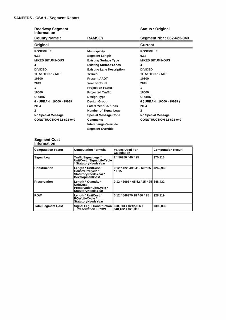
SANEEDS - CSAH - Segment Report
Roadway SegmentInformation
Status : Original
County Name : RAMSEY Segment Nbr : 062-623-040
Original Current
ROSEVILLE Municipality ROSEVILLE
0.12 Segment Length 0.12
MIXED BITUMINOUS Existing Surface Type MIXED BITUMINOUS
4 Existing Surface Lanes 4
DIVIDED Existing Lane Description DIVIDED
TH 51 TO 0.12 MI E Termini TH 51 TO 0.12 MI E
10600 Present AADT 10600
2013 Year of Count 2015
1 Projection Factor 1
10600 Projected Traffic 10600
URBAN Design Type URBAN
6 - URBAN : 10000 - 19999 Design Group 6 ( URBAN : 10000 - 19999 )
2004 Latest Year SA funds 2004
2 Number of Signal Legs 2
No Special Message Special Message Code No Special Message
CONSTRUCTION 62-623-040 Comments CONSTRUCTION 62-623-040
Interchange Override
Segment Override
Segment CostInformation
Computation Factor Computation Formula Values Used ForCalculation
Computation Result
Signal Leg TrafficSignalLegs *UnitCost / SignalLifeCycle* StatutoryNeedsYear
2 * 56250 / 40 * 25 $70,313
Construction Length * UnitCost /ConstrLifeCycle *StatutoryNeedsYear *DevelopmentCost
0.12 * 4225495.41 / 60 * 25* 1.15
$242,966
Preservation Length * Quantity *UnitCost /PreservationLifeCycle *StatutoryNeedsYear
0.12 * 3696 * 65.52 / 15 * 25 $48,432
ROW Length * UnitCost /ROWLifeCycle *StatutoryNeedsYear
0.12 * 566370.18 / 60 * 25 $28,319
Total Segment Cost Signal Leg + Construction+ Preservation + ROW
$70,313 + $242,966 +$48,432 + $28,319
$390,030

SANEEDS - CSAH - Segment Report
Roadway SegmentInformation
Status : Original
County Name : RAMSEY Segment Nbr : 062-623-045
Original Current
ROSEVILLE Municipality ROSEVILLE
0.38 Segment Length 0.38
MIXED BITUMINOUS Existing Surface Type MIXED BITUMINOUS
2 Existing Surface Lanes 2
NOT DIVIDED Existing Lane Description NOT DIVIDED
0.12 MI E TH 51 TO HAMLINE AVE. Termini 0.12 MI E TH 51 TO HAMLINE AVE.
10600 Present AADT 10600
2013 Year of Count 2015
1 Projection Factor 1
10600 Projected Traffic 10600
URBAN Design Type URBAN
6 - URBAN : 10000 - 19999 Design Group 6 ( URBAN : 10000 - 19999 )
2006 Latest Year SA funds 2006
2 Number of Signal Legs 2
No Special Message Special Message Code No Special Message
SP 62-623-041, 2006 CONST Comments SP 62-623-041, 2006 CONST
Interchange Override
Segment Override
Segment CostInformation
Computation Factor Computation Formula Values Used ForCalculation
Computation Result
Signal Leg TrafficSignalLegs *UnitCost / SignalLifeCycle* StatutoryNeedsYear
2 * 56250 / 40 * 25 $70,313
Construction Length * UnitCost /ConstrLifeCycle *StatutoryNeedsYear *DevelopmentCost
0.38 * 4225495.41 / 60 * 25* 1.15
$769,392
Preservation Length * Quantity *UnitCost /PreservationLifeCycle *StatutoryNeedsYear
0.38 * 3696 * 65.52 / 15 * 25 $153,369
ROW Length * UnitCost /ROWLifeCycle *StatutoryNeedsYear
0.38 * 566370.18 / 60 * 25 $89,675
Total Segment Cost Signal Leg + Construction+ Preservation + ROW
$70,313 + $769,392 +$153,369 + $89,675
$1,082,749

SANEEDS - CSAH - Segment Report
Roadway SegmentInformation
Status : Original
County Name : RAMSEY Segment Nbr : 062-623-050
Original Current
ROSEVILLE Municipality ROSEVILLE
0.62 Segment Length 0.62
MIXED BITUMINOUS Existing Surface Type MIXED BITUMINOUS
2 Existing Surface Lanes 2
DIVIDED Existing Lane Description DIVIDED
HAMLINE AVE. TO 0.12 MI E OFLEXINGTON AVE.
Termini HAMLINE AVE. TO 0.12 MI E OFLEXINGTON AVE.
10600 Present AADT 10600
2013 Year of Count 2015
1 Projection Factor 1
10600 Projected Traffic 10600
URBAN Design Type URBAN
6 - URBAN : 10000 - 19999 Design Group 6 ( URBAN : 10000 - 19999 )
2006 Latest Year SA funds 2006
3 Number of Signal Legs 3
No Special Message Special Message Code No Special Message
SP 62-623-041, 2006 CONST Comments SP 62-623-041, 2006 CONST
Interchange Override
Segment Override
Segment CostInformation
Computation Factor Computation Formula Values Used ForCalculation
Computation Result
Signal Leg TrafficSignalLegs *UnitCost / SignalLifeCycle* StatutoryNeedsYear
3 * 56250 / 40 * 25 $105,469
Construction Length * UnitCost /ConstrLifeCycle *StatutoryNeedsYear *DevelopmentCost
0.62 * 4225495.41 / 60 * 25* 1.15
$1,255,324
Preservation Length * Quantity *UnitCost /PreservationLifeCycle *StatutoryNeedsYear
0.62 * 3696 * 65.52 / 15 * 25 $250,234
ROW Length * UnitCost /ROWLifeCycle *StatutoryNeedsYear
0.62 * 566370.18 / 60 * 25 $146,312
Total Segment Cost Signal Leg + Construction+ Preservation + ROW
$105,469 + $1,255,324 +$250,234 + $146,312
$1,757,339

SANEEDS - CSAH - Segment Report
Roadway SegmentInformation
Status : Original
County Name : RAMSEY Segment Nbr : 062-623-051
Original Current
ROSEVILLE Municipality ROSEVILLE
0.32 Segment Length 0.32
BIT CONC OR ASPH Existing Surface Type BIT CONC OR ASPH
4 Existing Surface Lanes 4
DIVIDED Existing Lane Description DIVIDED
0.12 MI E OF LEXINGTON AVE. TOVICTORIA ST.
Termini 0.12 MI E OF LEXINGTON AVE. TOVICTORIA ST.
10600 Present AADT 10600
2013 Year of Count 2015
1 Projection Factor 1
10600 Projected Traffic 10600
RURAL Design Type RURAL
4 - RURAL : 7000 - 999999 Design Group 4 ( RURAL : 7000 - 999999 )
1987 Latest Year SA funds 1987
0 Number of Signal Legs 0
No Special Message Special Message Code No Special Message
Comments
Interchange Override
Segment Override
Bridge Information Status: Original
Original Current
62519 Structure Number 62519
3.3 Milepoint 3.3
1970 Year Built 1970
BNSF RR Feature Crossed BNSF RR
Type of Service
Number of Spans
224.9 Bridge Length 224.9
64.7 Bridge Width 64.7
100% Shared Structure 100%
Comments
2 ( 150-999,999 ) Bridge Group Code 2 ( 150-999,999 )
Segment CostInformation
Computation Factor Computation Formula Values Used ForCalculation
Computation Result
Signal Leg TrafficSignalLegs *UnitCost / SignalLifeCycle* StatutoryNeedsYear
0 * 56250 / 40 * 25 $0
Construction Length * UnitCost /ConstrLifeCycle *StatutoryNeedsYear *DevelopmentCost
0.32 * 1996892.57 / 60 * 25* 1.1
$292,878
Preservation Length * Quantity *UnitCost /PreservationLifeCycle *StatutoryNeedsYear
0.32 * 3564 * 65.52 / 20 * 25 $93,405
ROW Length * UnitCost /ROWLifeCycle *StatutoryNeedsYear
0.32 * 181173.68 / 60 * 25 $24,156
Bridge BridgeLength *BridgeWidth * UnitCost /BridgeLifeCycle *StatutoryNeedsYear *DevelopmentCost
224.9 * 64.7 * 138 / 80 * 25* 1.15
$721,640
Total Segment Cost Signal Leg + Construction+ Preservation + ROW +Bridge
$0 + $292,878 + $93,405 +$24,156 + $721,640
$1,132,079

SANEEDS - CSAH - Segment Report
Roadway SegmentInformation
Status : Original
County Name : RAMSEY Segment Nbr : 062-623-060
Original Current
ROSEVILLE Municipality ROSEVILLE
0.59 Segment Length 0.59
BIT CONC OR ASPH Existing Surface Type BIT CONC OR ASPH
4 Existing Surface Lanes 4
NOT DIVIDED Existing Lane Description NOT DIVIDED
VICTORIA ST. TO DALE ST. Termini VICTORIA ST. TO DALE ST.
8600 Present AADT 8600
2013 Year of Count 2015
1 Projection Factor 1
8600 Projected Traffic 8600
URBAN Design Type URBAN
5 - URBAN : 0 - 9999 Design Group 5 ( URBAN : 0 - 9999 )
1972 Latest Year SA funds 1972
0 Number of Signal Legs 0
No Special Message Special Message Code No Special Message
Comments
Interchange Override
Segment Override
Segment CostInformation
Computation Factor Computation Formula Values Used ForCalculation
Computation Result
Signal Leg TrafficSignalLegs *UnitCost / SignalLifeCycle* StatutoryNeedsYear
0 * 56250 / 40 * 25 $0
Construction Length * UnitCost /ConstrLifeCycle *StatutoryNeedsYear *DevelopmentCost
0.59 * 2738635.28 / 60 * 25* 1.15
$774,235
Preservation Length * Quantity *UnitCost /PreservationLifeCycle *StatutoryNeedsYear
0.59 * 2904 * 65.52 / 15 * 25 $187,099
ROW Length * UnitCost /ROWLifeCycle *StatutoryNeedsYear
0.59 * 436504.07 / 60 * 25 $107,307
Total Segment Cost Signal Leg + Construction+ Preservation + ROW
$0 + $774,235 + $187,099+ $107,307
$1,068,641

SANEEDS - CSAH - Segment Report
Roadway SegmentInformation
Status : Original
County Name : RAMSEY Segment Nbr : 062-623-070
Original Current
ROSEVILLE Municipality ROSEVILLE
1 Segment Length 1
MIXED BITUMINOUS Existing Surface Type MIXED BITUMINOUS
2 Existing Surface Lanes 2
NOT DIVIDED Existing Lane Description NOT DIVIDED
DALE ST.TO CSAH 49 Termini DALE ST.TO CSAH 49
7900 Present AADT 7900
2013 Year of Count 2015
1 Projection Factor 1
7900 Projected Traffic 7900
URBAN Design Type URBAN
5 - URBAN : 0 - 9999 Design Group 5 ( URBAN : 0 - 9999 )
2005 Latest Year SA funds 2005
1 Number of Signal Legs 1
No Special Message Special Message Code No Special Message
CONST. SAP 62-623-050, 2005 Comments CONST. SAP 62-623-050, 2005
Interchange Override
Segment Override
Segment CostInformation
Computation Factor Computation Formula Values Used ForCalculation
Computation Result
Signal Leg TrafficSignalLegs *UnitCost / SignalLifeCycle* StatutoryNeedsYear
1 * 56250 / 40 * 25 $35,156
Construction Length * UnitCost /ConstrLifeCycle *StatutoryNeedsYear *DevelopmentCost
1 * 2738635.28 / 60 * 25 *1.15
$1,312,263
Preservation Length * Quantity *UnitCost /PreservationLifeCycle *StatutoryNeedsYear
1 * 2904 * 65.52 / 15 * 25 $317,117
ROW Length * UnitCost /ROWLifeCycle *StatutoryNeedsYear
1 * 436504.07 / 60 * 25 $181,877
Total Segment Cost Signal Leg + Construction+ Preservation + ROW
$35,156 + $1,312,263 +$317,117 + $181,877
$1,846,413

SANEEDS - CSAH - Segment Report
Roadway SegmentInformation
Status : Original
County Name : RAMSEY Segment Nbr : 062-623-080
Original Current
LITTLE CANADA Municipality LITTLE CANADA
0.7 Segment Length 0.7
MIXED BITUMINOUS Existing Surface Type MIXED BITUMINOUS
4 Existing Surface Lanes 4
NOT DIVIDED Existing Lane Description NOT DIVIDED
CSAH 49 TO LITTLE CANADA RD. Termini CSAH 49 TO LITTLE CANADA RD.
7400 Present AADT 7400
2013 Year of Count 2015
1 Projection Factor 1
7400 Projected Traffic 7400
URBAN Design Type URBAN
5 - URBAN : 0 - 9999 Design Group 5 ( URBAN : 0 - 9999 )
2005 Latest Year SA funds 2005
1 Number of Signal Legs 1
No Special Message Special Message Code No Special Message
Comments
Interchange Override
Segment Override
Bridge Information Status: Original
Original Current
62520 Structure Number 62520
5.52 Milepoint 5.52
1971 Year Built 1971
Feature Crossed
Type of Service
0 Number of Spans 0
99 Bridge Length 99
23.3 Bridge Width 23.3
100% Shared Structure 100%
Comments
1 ( 0-149 ) Bridge Group Code 1 ( 0-149 )
Segment CostInformation
Computation Factor Computation Formula Values Used ForCalculation
Computation Result
Signal Leg TrafficSignalLegs *UnitCost / SignalLifeCycle* StatutoryNeedsYear
1 * 56250 / 40 * 25 $35,156
Construction Length * UnitCost /ConstrLifeCycle *StatutoryNeedsYear *DevelopmentCost
0.7 * 2738635.28 / 60 * 25 *1.15
$918,584
Preservation Length * Quantity *UnitCost /PreservationLifeCycle *StatutoryNeedsYear
0.7 * 2904 * 65.52 / 15 * 25 $221,982
ROW Length * UnitCost /ROWLifeCycle *StatutoryNeedsYear
0.7 * 436504.07 / 60 * 25 $127,314
Bridge BridgeLength *BridgeWidth * UnitCost /BridgeLifeCycle *StatutoryNeedsYear *DevelopmentCost
99 * 23.3 * 152 / 80 * 25 *1.15
$126,003
Total Segment Cost Signal Leg + Construction+ Preservation + ROW +Bridge
$35,156 + $918,584 +$221,982 + $127,314 +$126,003
$1,429,039

SANEEDS - CSAH - Segment Report
Roadway SegmentInformation
Status : Original
County Name : RAMSEY Segment Nbr : 062-623-090
Original Current
MAPLEWOOD Municipality MAPLEWOOD
0.6 Segment Length 0.6
MIXED BITUMINOUS Existing Surface Type MIXED BITUMINOUS
2 Existing Surface Lanes 2
NOT DIVIDED Existing Lane Description NOT DIVIDED
KELLER PARKWAY TO 0.10 MIWEST OF T.H. 61
Termini KELLER PARKWAY TO 0.10 MIWEST OF T.H. 61
3050 Present AADT 3050
2013 Year of Count 2015
1 Projection Factor 1
3050 Projected Traffic 3050
RURAL Design Type RURAL
3 - RURAL : 1500 - 6999 Design Group 3 ( RURAL : 1500 - 6999 )
2000 Latest Year SA funds 2000
0 Number of Signal Legs 0
No Special Message Special Message Code No Special Message
Comments
Interchange Override
Segment Override
Segment CostInformation
Computation Factor Computation Formula Values Used ForCalculation
Computation Result
Signal Leg TrafficSignalLegs *UnitCost / SignalLifeCycle* StatutoryNeedsYear
0 * 56250 / 40 * 25 $0
Construction Length * UnitCost /ConstrLifeCycle *StatutoryNeedsYear *DevelopmentCost
0.6 * 1021937.01 / 60 * 25 *1.1
$281,033
Preservation Length * Quantity *UnitCost /PreservationLifeCycle *StatutoryNeedsYear
0.6 * 2376 * 65.52 / 20 * 25 $116,757
ROW Length * UnitCost /ROWLifeCycle *StatutoryNeedsYear
0.6 * 85357.87 / 60 * 25 $21,339
Total Segment Cost Signal Leg + Construction+ Preservation + ROW
$0 + $281,033 + $116,757+ $21,339
$419,129

SANEEDS - CSAH - Segment Report
Roadway SegmentInformation
Status : Original
County Name : RAMSEY Segment Nbr : 062-623-098
Original Current
MAPLEWOOD Municipality MAPLEWOOD
0.1 Segment Length 0.1
BIT CONC OR ASPH Existing Surface Type BIT CONC OR ASPH
2 Existing Surface Lanes 2
NOT DIVIDED Existing Lane Description NOT DIVIDED
0.10 MI WEST OF T.H. 61 TO T.H.61
Termini 0.10 MI WEST OF T.H. 61 TO T.H.61
3050 Present AADT 3050
2013 Year of Count 2015
1 Projection Factor 1
3050 Projected Traffic 3050
URBAN Design Type URBAN
5 - URBAN : 0 - 9999 Design Group 5 ( URBAN : 0 - 9999 )
1993 Latest Year SA funds 1993
1 Number of Signal Legs 1
No Special Message Special Message Code No Special Message
Comments
Interchange Override
Segment Override
Segment CostInformation
Computation Factor Computation Formula Values Used ForCalculation
Computation Result
Signal Leg TrafficSignalLegs *UnitCost / SignalLifeCycle* StatutoryNeedsYear
1 * 56250 / 40 * 25 $35,156
Construction Length * UnitCost /ConstrLifeCycle *StatutoryNeedsYear *DevelopmentCost
0.1 * 2738635.28 / 60 * 25 *1.15
$131,226
Preservation Length * Quantity *UnitCost /PreservationLifeCycle *StatutoryNeedsYear
0.1 * 2904 * 65.52 / 15 * 25 $31,712
ROW Length * UnitCost /ROWLifeCycle *StatutoryNeedsYear
0.1 * 436504.07 / 60 * 25 $18,188
Total Segment Cost Signal Leg + Construction+ Preservation + ROW
$35,156 + $131,226 +$31,712 + $18,188
$216,282

SANEEDS - CSAH - Segment Report
Roadway SegmentInformation
Status : Original
County Name : RAMSEY Segment Nbr : 062-623-100
Original Current
MAPLEWOOD Municipality MAPLEWOOD
0.78 Segment Length 0.78
MIXED BITUMINOUS Existing Surface Type MIXED BITUMINOUS
2 Existing Surface Lanes 2
NOT DIVIDED Existing Lane Description NOT DIVIDED
TH 61 TO HAZELWOOD ST. Termini TH 61 TO HAZELWOOD ST.
5400 Present AADT 5400
2013 Year of Count 2015
1 Projection Factor 1
5400 Projected Traffic 5400
URBAN Design Type URBAN
5 - URBAN : 0 - 9999 Design Group 5 ( URBAN : 0 - 9999 )
2010 Latest Year SA funds 2010
1 Number of Signal Legs 1
No Special Message Special Message Code No Special Message
SURFACED UNDER SAP 62-623-52,2010.
Comments SURFACED UNDER SAP 62-623-52,2010.
Interchange Override
Segment Override
Bridge Information Status: Original
Original Current
62563 Structure Number 62563
7.685 Milepoint 7.685
1993 Year Built 1993
REC TRAIL Feature Crossed REC TRAIL
HWY / R.R. Type of Service HWY / R.R.
1 Number of Spans 1
51.8 Bridge Length 51.8
52.8 Bridge Width 52.8
100% Shared Structure 100%
Comments
1 ( 0-149 ) Bridge Group Code 1 ( 0-149 )
Segment CostInformation
Computation Factor Computation Formula Values Used ForCalculation
Computation Result
Signal Leg TrafficSignalLegs *UnitCost / SignalLifeCycle* StatutoryNeedsYear
1 * 56250 / 40 * 25 $35,156
Construction Length * UnitCost /ConstrLifeCycle *StatutoryNeedsYear *DevelopmentCost
0.78 * 2738635.28 / 60 * 25* 1.15
$1,023,565
Preservation Length * Quantity *UnitCost /PreservationLifeCycle *StatutoryNeedsYear
0.78 * 2904 * 65.52 / 15 * 25 $247,351
ROW Length * UnitCost /ROWLifeCycle *StatutoryNeedsYear
0.78 * 436504.07 / 60 * 25 $141,864
Bridge BridgeLength *BridgeWidth * UnitCost /BridgeLifeCycle *StatutoryNeedsYear *DevelopmentCost
51.8 * 52.8 * 152 / 80 * 25 *1.15
$149,402
Total Segment Cost Signal Leg + Construction+ Preservation + ROW +Bridge
$35,156 + $1,023,565 +$247,351 + $141,864 +$149,402
$1,597,338

SANEEDS - CSAH - Segment Report
Roadway SegmentInformation
Status : Original
County Name : RAMSEY Segment Nbr : 062-623-105
Original Current
MAPLEWOOD Municipality MAPLEWOOD
0.12 Segment Length 0.12
MIXED BITUMINOUS Existing Surface Type MIXED BITUMINOUS
2 Existing Surface Lanes 2
NOT DIVIDED Existing Lane Description NOT DIVIDED
HAZELWOOD ST. TO .12 MILESEAST OF HAZELWOOD ST.
Termini HAZELWOOD ST. TO .12 MILESEAST OF HAZELWOOD ST.
4100 Present AADT 4100
2013 Year of Count 2015
1 Projection Factor 1
4100 Projected Traffic 4100
URBAN Design Type URBAN
5 - URBAN : 0 - 9999 Design Group 5 ( URBAN : 0 - 9999 )
1993 Latest Year SA funds 1993
0 Number of Signal Legs 0
No Special Message Special Message Code No Special Message
SPLIT OFF FROM SEGMENT 62-623-100 IN 2010, MPK.
Comments SPLIT OFF FROM SEGMENT 62-623-100 IN 2010, MPK.
Interchange Override
Segment Override
Segment CostInformation
Computation Factor Computation Formula Values Used ForCalculation
Computation Result
Signal Leg TrafficSignalLegs *UnitCost / SignalLifeCycle* StatutoryNeedsYear
0 * 56250 / 40 * 25 $0
Construction Length * UnitCost /ConstrLifeCycle *StatutoryNeedsYear *DevelopmentCost
0.12 * 2738635.28 / 60 * 25* 1.15
$157,472
Preservation Length * Quantity *UnitCost /PreservationLifeCycle *StatutoryNeedsYear
0.12 * 2904 * 65.52 / 15 * 25 $38,054
ROW Length * UnitCost /ROWLifeCycle *StatutoryNeedsYear
0.12 * 436504.07 / 60 * 25 $21,825
Total Segment Cost Signal Leg + Construction+ Preservation + ROW
$0 + $157,472 + $38,054 +$21,825
$217,351

SANEEDS - CSAH - Segment Report
Roadway SegmentInformation
Status : Original
County Name : RAMSEY Segment Nbr : 062-623-110
Original Current
MAPLEWOOD Municipality MAPLEWOOD
0.74 Segment Length 0.74
MIXED BITUMINOUS Existing Surface Type MIXED BITUMINOUS
2 Existing Surface Lanes 2
NOT DIVIDED Existing Lane Description NOT DIVIDED
0.12 MI E OF HAZELWOOD TO 0.5MI W OF WHITE BEAR AVE.
Termini 0.12 MI E OF HAZELWOOD TO 0.5MI W OF WHITE BEAR AVE.
4100 Present AADT 4100
2013 Year of Count 2015
1 Projection Factor 1
4100 Projected Traffic 4100
RURAL Design Type RURAL
3 - RURAL : 1500 - 6999 Design Group 3 ( RURAL : 1500 - 6999 )
2006 Latest Year SA funds 2006
0 Number of Signal Legs 0
No Special Message Special Message Code No Special Message
SAP 60-623-051, 2006 CONST Comments SAP 60-623-051, 2006 CONST
Interchange Override
Segment Override
Segment CostInformation
Computation Factor Computation Formula Values Used ForCalculation
Computation Result
Signal Leg TrafficSignalLegs *UnitCost / SignalLifeCycle* StatutoryNeedsYear
0 * 56250 / 40 * 25 $0
Construction Length * UnitCost /ConstrLifeCycle *StatutoryNeedsYear *DevelopmentCost
0.74 * 1021937.01 / 60 * 25* 1.1
$346,607
Preservation Length * Quantity *UnitCost /PreservationLifeCycle *StatutoryNeedsYear
0.74 * 2376 * 65.52 / 20 * 25 $144,000
ROW Length * UnitCost /ROWLifeCycle *StatutoryNeedsYear
0.74 * 85357.87 / 60 * 25 $26,319
Total Segment Cost Signal Leg + Construction+ Preservation + ROW
$0 + $346,607 + $144,000+ $26,319
$516,926
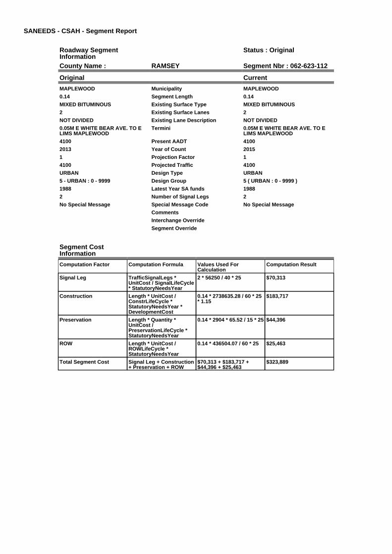
SANEEDS - CSAH - Segment Report
Roadway SegmentInformation
Status : Original
County Name : RAMSEY Segment Nbr : 062-623-112
Original Current
MAPLEWOOD Municipality MAPLEWOOD
0.14 Segment Length 0.14
MIXED BITUMINOUS Existing Surface Type MIXED BITUMINOUS
2 Existing Surface Lanes 2
NOT DIVIDED Existing Lane Description NOT DIVIDED
0.05M E WHITE BEAR AVE. TO ELIMS MAPLEWOOD
Termini 0.05M E WHITE BEAR AVE. TO ELIMS MAPLEWOOD
4100 Present AADT 4100
2013 Year of Count 2015
1 Projection Factor 1
4100 Projected Traffic 4100
URBAN Design Type URBAN
5 - URBAN : 0 - 9999 Design Group 5 ( URBAN : 0 - 9999 )
1988 Latest Year SA funds 1988
2 Number of Signal Legs 2
No Special Message Special Message Code No Special Message
Comments
Interchange Override
Segment Override
Segment CostInformation
Computation Factor Computation Formula Values Used ForCalculation
Computation Result
Signal Leg TrafficSignalLegs *UnitCost / SignalLifeCycle* StatutoryNeedsYear
2 * 56250 / 40 * 25 $70,313
Construction Length * UnitCost /ConstrLifeCycle *StatutoryNeedsYear *DevelopmentCost
0.14 * 2738635.28 / 60 * 25* 1.15
$183,717
Preservation Length * Quantity *UnitCost /PreservationLifeCycle *StatutoryNeedsYear
0.14 * 2904 * 65.52 / 15 * 25 $44,396
ROW Length * UnitCost /ROWLifeCycle *StatutoryNeedsYear
0.14 * 436504.07 / 60 * 25 $25,463
Total Segment Cost Signal Leg + Construction+ Preservation + ROW
$70,313 + $183,717 +$44,396 + $25,463
$323,889

SANEEDS - CSAH - Segment Report
Roadway SegmentInformation
Status : Original
County Name : RAMSEY Segment Nbr : 062-623-120
Original Current
NORTH ST PAUL Municipality NORTH ST PAUL
0.49 Segment Length 0.49
MIXED BITUMINOUS Existing Surface Type MIXED BITUMINOUS
2 Existing Surface Lanes 2
NOT DIVIDED Existing Lane Description NOT DIVIDED
E LIMS MAPLEWOOD TO MCKNIGHT RD.
Termini E LIMS MAPLEWOOD TO MCKNIGHT RD.
4100 Present AADT 4100
2013 Year of Count 2015
1 Projection Factor 1
4100 Projected Traffic 4100
URBAN Design Type URBAN
5 - URBAN : 0 - 9999 Design Group 5 ( URBAN : 0 - 9999 )
1988 Latest Year SA funds 1988
0 Number of Signal Legs 0
No Special Message Special Message Code No Special Message
Comments
Interchange Override
Segment Override
Segment CostInformation
Computation Factor Computation Formula Values Used ForCalculation
Computation Result
Signal Leg TrafficSignalLegs *UnitCost / SignalLifeCycle* StatutoryNeedsYear
0 * 56250 / 40 * 25 $0
Construction Length * UnitCost /ConstrLifeCycle *StatutoryNeedsYear *DevelopmentCost
0.49 * 2738635.28 / 60 * 25* 1.15
$643,009
Preservation Length * Quantity *UnitCost /PreservationLifeCycle *StatutoryNeedsYear
0.49 * 2904 * 65.52 / 15 * 25 $155,387
ROW Length * UnitCost /ROWLifeCycle *StatutoryNeedsYear
0.49 * 436504.07 / 60 * 25 $89,120
Total Segment Cost Signal Leg + Construction+ Preservation + ROW
$0 + $643,009 + $155,387+ $89,120
$887,516

SANEEDS - CSAH - Segment Report
Roadway SegmentInformation
Status : Original
County Name : RAMSEY Segment Nbr : 062-623-130
Original Current
NORTH ST PAUL Municipality NORTH ST PAUL
1 Segment Length 1
MIXED BITUMINOUS Existing Surface Type MIXED BITUMINOUS
2 Existing Surface Lanes 2
NOT DIVIDED Existing Lane Description NOT DIVIDED
MC KNIGHT RD. TO E COUNTYLINE
Termini MC KNIGHT RD. TO E COUNTYLINE
3500 Present AADT 3500
2013 Year of Count 2015
1 Projection Factor 1
3500 Projected Traffic 3500
URBAN Design Type URBAN
5 - URBAN : 0 - 9999 Design Group 5 ( URBAN : 0 - 9999 )
1985 Latest Year SA funds 1985
0 Number of Signal Legs 0
No Special Message Special Message Code No Special Message
Comments
Interchange Override
Segment Override
Segment CostInformation
Computation Factor Computation Formula Values Used ForCalculation
Computation Result
Signal Leg TrafficSignalLegs *UnitCost / SignalLifeCycle* StatutoryNeedsYear
0 * 56250 / 40 * 25 $0
Construction Length * UnitCost /ConstrLifeCycle *StatutoryNeedsYear *DevelopmentCost
1 * 2738635.28 / 60 * 25 *1.15
$1,312,263
Preservation Length * Quantity *UnitCost /PreservationLifeCycle *StatutoryNeedsYear
1 * 2904 * 65.52 / 15 * 25 $317,117
ROW Length * UnitCost /ROWLifeCycle *StatutoryNeedsYear
1 * 436504.07 / 60 * 25 $181,877
Total Segment Cost Signal Leg + Construction+ Preservation + ROW
$0 + $1,312,263 + $317,117+ $181,877
$1,811,257

SANEEDS - CSAH - Segment Report
Roadway SegmentInformation
Status : Original
County Name : RAMSEY Segment Nbr : 062-624-011
Original Current
ROSEVILLE Municipality ROSEVILLE
0.23 Segment Length 0.23
PORT CEMENT CONC Existing Surface Type PORT CEMENT CONC
4 Existing Surface Lanes 4
NOT DIVIDED Existing Lane Description NOT DIVIDED
TH 36/280 TO TERMINAL ROAD ONST. CROIX STREET
Termini TH 36/280 TO TERMINAL ROAD ONST. CROIX STREET
3950 Present AADT 3950
2013 Year of Count 2015
1 Projection Factor 1
3950 Projected Traffic 3950
URBAN Design Type URBAN
5 - URBAN : 0 - 9999 Design Group 5 ( URBAN : 0 - 9999 )
2000 Latest Year SA funds 2000
0 Number of Signal Legs 0
No Special Message Special Message Code No Special Message
Comments
Interchange Override
Segment Override
Segment CostInformation
Computation Factor Computation Formula Values Used ForCalculation
Computation Result
Signal Leg TrafficSignalLegs *UnitCost / SignalLifeCycle* StatutoryNeedsYear
0 * 56250 / 40 * 25 $0
Construction Length * UnitCost /ConstrLifeCycle *StatutoryNeedsYear *DevelopmentCost
0.23 * 2738635.28 / 60 * 25* 1.15
$301,820
Preservation Length * Quantity *UnitCost /PreservationLifeCycle *StatutoryNeedsYear
0.23 * 2904 * 65.52 / 15 * 25 $72,937
ROW Length * UnitCost /ROWLifeCycle *StatutoryNeedsYear
0.23 * 436504.07 / 60 * 25 $41,832
Total Segment Cost Signal Leg + Construction+ Preservation + ROW
$0 + $301,820 + $72,937 +$41,832
$416,589

SANEEDS - CSAH - Segment Report
Roadway SegmentInformation
Status : Original
County Name : RAMSEY Segment Nbr : 062-624-020
Original Current
ROSEVILLE Municipality ROSEVILLE
0.42 Segment Length 0.42
BIT CONC OR ASPH Existing Surface Type BIT CONC OR ASPH
4 Existing Surface Lanes 4
NOT DIVIDED Existing Lane Description NOT DIVIDED
ST CROIX STREET TO LONG LAKEROAD ON TERMINAL ROAD
Termini ST CROIX STREET TO LONG LAKEROAD ON TERMINAL ROAD
6300 Present AADT 6300
2013 Year of Count 2015
1 Projection Factor 1
6300 Projected Traffic 6300
URBAN Design Type URBAN
5 - URBAN : 0 - 9999 Design Group 5 ( URBAN : 0 - 9999 )
2007 Latest Year SA funds 2007
0 Number of Signal Legs 0
No Special Message Special Message Code No Special Message
SAP 62-624-003, 2007MILL & OVERLAY
Comments SAP 62-624-003, 2007MILL & OVERLAY
Interchange Override
Segment Override
Segment CostInformation
Computation Factor Computation Formula Values Used ForCalculation
Computation Result
Signal Leg TrafficSignalLegs *UnitCost / SignalLifeCycle* StatutoryNeedsYear
0 * 56250 / 40 * 25 $0
Construction Length * UnitCost /ConstrLifeCycle *StatutoryNeedsYear *DevelopmentCost
0.42 * 2738635.28 / 60 * 25* 1.15
$551,150
Preservation Length * Quantity *UnitCost /PreservationLifeCycle *StatutoryNeedsYear
0.42 * 2904 * 65.52 / 15 * 25 $133,189
ROW Length * UnitCost /ROWLifeCycle *StatutoryNeedsYear
0.42 * 436504.07 / 60 * 25 $76,388
Total Segment Cost Signal Leg + Construction+ Preservation + ROW
$0 + $551,150 + $133,189+ $76,388
$760,727

SANEEDS - CSAH - Segment Report
Roadway SegmentInformation
Status : Original
County Name : RAMSEY Segment Nbr : 062-624-030
Original Current
ROSEVILLE Municipality ROSEVILLE
0.3 Segment Length 0.3
BIT CONC OR ASPH Existing Surface Type BIT CONC OR ASPH
4 Existing Surface Lanes 4
NOT DIVIDED Existing Lane Description NOT DIVIDED
LONG LAKE ROAD TOCLEVELAND AVENUE ON CO. RD.B2
Termini LONG LAKE ROAD TOCLEVELAND AVENUE ON CO. RD.B2
5600 Present AADT 5600
2013 Year of Count 2015
1 Projection Factor 1
5600 Projected Traffic 5600
URBAN Design Type URBAN
5 - URBAN : 0 - 9999 Design Group 5 ( URBAN : 0 - 9999 )
2007 Latest Year SA funds 2007
1 Number of Signal Legs 1
No Special Message Special Message Code No Special Message
SAP 62-624-003, 2007MILL & OVERLAY
Comments SAP 62-624-003, 2007MILL & OVERLAY
Interchange Override
Segment Override
Segment CostInformation
Computation Factor Computation Formula Values Used ForCalculation
Computation Result
Signal Leg TrafficSignalLegs *UnitCost / SignalLifeCycle* StatutoryNeedsYear
1 * 56250 / 40 * 25 $35,156
Construction Length * UnitCost /ConstrLifeCycle *StatutoryNeedsYear *DevelopmentCost
0.3 * 2738635.28 / 60 * 25 *1.15
$393,679
Preservation Length * Quantity *UnitCost /PreservationLifeCycle *StatutoryNeedsYear
0.3 * 2904 * 65.52 / 15 * 25 $95,135
ROW Length * UnitCost /ROWLifeCycle *StatutoryNeedsYear
0.3 * 436504.07 / 60 * 25 $54,563
Total Segment Cost Signal Leg + Construction+ Preservation + ROW
$35,156 + $393,679 +$95,135 + $54,563
$578,533

SANEEDS - CSAH - Segment Report
Roadway SegmentInformation
Status : Original
County Name : RAMSEY Segment Nbr : 062-625-020
Original Current
ROSEVILLE Municipality ROSEVILLE
0.9 Segment Length 0.9
MIXED BITUMINOUS Existing Surface Type MIXED BITUMINOUS
4 Existing Surface Lanes 4
DIVIDED Existing Lane Description DIVIDED
CLEVELAND AVE TO 0 .1 MILEWEST OF SNELLING.
Termini CLEVELAND AVE TO 0 .1 MILEWEST OF SNELLING.
5400 Present AADT 5400
2013 Year of Count 2015
1 Projection Factor 1
5400 Projected Traffic 5400
URBAN Design Type URBAN
5 - URBAN : 0 - 9999 Design Group 5 ( URBAN : 0 - 9999 )
2008 Latest Year SA funds 2008
2 Number of Signal Legs 2
No Special Message Special Message Code No Special Message
COMBINED WITH 030 IN 2005
OVERLAY 62-625-29 IN 2008. MPK4/27/09
Comments COMBINED WITH 030 IN 2005
OVERLAY 62-625-29 IN 2008. MPK4/27/09
Interchange Override
Segment Override
Segment CostInformation
Computation Factor Computation Formula Values Used ForCalculation
Computation Result
Signal Leg TrafficSignalLegs *UnitCost / SignalLifeCycle* StatutoryNeedsYear
2 * 56250 / 40 * 25 $70,313
Construction Length * UnitCost /ConstrLifeCycle *StatutoryNeedsYear *DevelopmentCost
0.9 * 2738635.28 / 60 * 25 *1.15
$1,181,036
Preservation Length * Quantity *UnitCost /PreservationLifeCycle *StatutoryNeedsYear
0.9 * 2904 * 65.52 / 15 * 25 $285,405
ROW Length * UnitCost /ROWLifeCycle *StatutoryNeedsYear
0.9 * 436504.07 / 60 * 25 $163,689
Total Segment Cost Signal Leg + Construction+ Preservation + ROW
$70,313 + $1,181,036 +$285,405 + $163,689
$1,700,443

SANEEDS - CSAH - Segment Report
Roadway SegmentInformation
Status : Original
County Name : RAMSEY Segment Nbr : 062-625-031
Original Current
ROSEVILLE Municipality ROSEVILLE
0.1 Segment Length 0.1
MIXED BITUMINOUS Existing Surface Type MIXED BITUMINOUS
4 Existing Surface Lanes 4
DIVIDED Existing Lane Description DIVIDED
0.10 MI W TO TH 51 Termini 0.10 MI W TO TH 51
9400 Present AADT 9400
2013 Year of Count 2015
1 Projection Factor 1
9400 Projected Traffic 9400
URBAN Design Type URBAN
5 - URBAN : 0 - 9999 Design Group 5 ( URBAN : 0 - 9999 )
2008 Latest Year SA funds 2008
1 Number of Signal Legs 1
No Special Message Special Message Code No Special Message
SAP 62-625-29, 2008 Comments SAP 62-625-29, 2008
Interchange Override
Segment Override
Segment CostInformation
Computation Factor Computation Formula Values Used ForCalculation
Computation Result
Signal Leg TrafficSignalLegs *UnitCost / SignalLifeCycle* StatutoryNeedsYear
1 * 56250 / 40 * 25 $35,156
Construction Length * UnitCost /ConstrLifeCycle *StatutoryNeedsYear *DevelopmentCost
0.1 * 2738635.28 / 60 * 25 *1.15
$131,226
Preservation Length * Quantity *UnitCost /PreservationLifeCycle *StatutoryNeedsYear
0.1 * 2904 * 65.52 / 15 * 25 $31,712
ROW Length * UnitCost /ROWLifeCycle *StatutoryNeedsYear
0.1 * 436504.07 / 60 * 25 $18,188
Total Segment Cost Signal Leg + Construction+ Preservation + ROW
$35,156 + $131,226 +$31,712 + $18,188
$216,282

SANEEDS - CSAH - Segment Report
Roadway SegmentInformation
Status : Original
County Name : RAMSEY Segment Nbr : 062-625-040
Original Current
ROSEVILLE Municipality ROSEVILLE
0.5 Segment Length 0.5
PORT CEMENT CONC Existing Surface Type PORT CEMENT CONC
4 Existing Surface Lanes 4
DIVIDED Existing Lane Description DIVIDED
TH 51 TO HAMLINE AVE. Termini TH 51 TO HAMLINE AVE.
13900 Present AADT 13900
2013 Year of Count 2015
1 Projection Factor 1
13900 Projected Traffic 13900
URBAN Design Type URBAN
6 - URBAN : 10000 - 19999 Design Group 6 ( URBAN : 10000 - 19999 )
2000 Latest Year SA funds 2000
4 Number of Signal Legs 4
No Special Message Special Message Code No Special Message
Comments
Interchange Override
Segment Override
Segment CostInformation
Computation Factor Computation Formula Values Used ForCalculation
Computation Result
Signal Leg TrafficSignalLegs *UnitCost / SignalLifeCycle* StatutoryNeedsYear
4 * 56250 / 40 * 25 $140,625
Construction Length * UnitCost /ConstrLifeCycle *StatutoryNeedsYear *DevelopmentCost
0.5 * 4225495.41 / 60 * 25 *1.15
$1,012,358
Preservation Length * Quantity *UnitCost /PreservationLifeCycle *StatutoryNeedsYear
0.5 * 3696 * 65.52 / 15 * 25 $201,802
ROW Length * UnitCost /ROWLifeCycle *StatutoryNeedsYear
0.5 * 566370.18 / 60 * 25 $117,994
Total Segment Cost Signal Leg + Construction+ Preservation + ROW
$140,625 + $1,012,358 +$201,802 + $117,994
$1,472,779

SANEEDS - CSAH - Segment Report
Roadway SegmentInformation
Status : Original
County Name : RAMSEY Segment Nbr : 062-625-050
Original Current
ROSEVILLE Municipality ROSEVILLE
0.5 Segment Length 0.5
PORT CEMENT CONC Existing Surface Type PORT CEMENT CONC
4 Existing Surface Lanes 4
NOT DIVIDED Existing Lane Description NOT DIVIDED
HAMLINE AVE. TO LEXINGTONAVE.
Termini HAMLINE AVE. TO LEXINGTONAVE.
8900 Present AADT 8900
2013 Year of Count 2015
1 Projection Factor 1
8900 Projected Traffic 8900
URBAN Design Type URBAN
5 - URBAN : 0 - 9999 Design Group 5 ( URBAN : 0 - 9999 )
1966 Latest Year SA funds 1966
2 Number of Signal Legs 2
No Special Message Special Message Code No Special Message
Comments
Interchange Override
Segment Override
Segment CostInformation
Computation Factor Computation Formula Values Used ForCalculation
Computation Result
Signal Leg TrafficSignalLegs *UnitCost / SignalLifeCycle* StatutoryNeedsYear
2 * 56250 / 40 * 25 $70,313
Construction Length * UnitCost /ConstrLifeCycle *StatutoryNeedsYear *DevelopmentCost
0.5 * 2738635.28 / 60 * 25 *1.15
$656,131
Preservation Length * Quantity *UnitCost /PreservationLifeCycle *StatutoryNeedsYear
0.5 * 2904 * 65.52 / 15 * 25 $158,558
ROW Length * UnitCost /ROWLifeCycle *StatutoryNeedsYear
0.5 * 436504.07 / 60 * 25 $90,938
Total Segment Cost Signal Leg + Construction+ Preservation + ROW
$70,313 + $656,131 +$158,558 + $90,938
$975,940

SANEEDS - CSAH - Segment Report
Roadway SegmentInformation
Status : Original
County Name : RAMSEY Segment Nbr : 062-625-060
Original Current
ROSEVILLE Municipality ROSEVILLE
1 Segment Length 1
BIT CONC OR ASPH Existing Surface Type BIT CONC OR ASPH
4 Existing Surface Lanes 4
NOT DIVIDED Existing Lane Description NOT DIVIDED
LEXINGTON AVE. TO DALE ST. Termini LEXINGTON AVE. TO DALE ST.
7800 Present AADT 7800
2013 Year of Count 2015
1 Projection Factor 1
7800 Projected Traffic 7800
URBAN Design Type URBAN
5 - URBAN : 0 - 9999 Design Group 5 ( URBAN : 0 - 9999 )
2001 Latest Year SA funds 2001
4 Number of Signal Legs 4
No Special Message Special Message Code No Special Message
Comments
Interchange Override
Segment Override
Segment CostInformation
Computation Factor Computation Formula Values Used ForCalculation
Computation Result
Signal Leg TrafficSignalLegs *UnitCost / SignalLifeCycle* StatutoryNeedsYear
4 * 56250 / 40 * 25 $140,625
Construction Length * UnitCost /ConstrLifeCycle *StatutoryNeedsYear *DevelopmentCost
1 * 2738635.28 / 60 * 25 *1.15
$1,312,263
Preservation Length * Quantity *UnitCost /PreservationLifeCycle *StatutoryNeedsYear
1 * 2904 * 65.52 / 15 * 25 $317,117
ROW Length * UnitCost /ROWLifeCycle *StatutoryNeedsYear
1 * 436504.07 / 60 * 25 $181,877
Total Segment Cost Signal Leg + Construction+ Preservation + ROW
$140,625 + $1,312,263 +$317,117 + $181,877
$1,951,882

SANEEDS - CSAH - Segment Report
Roadway SegmentInformation
Status : Original
County Name : RAMSEY Segment Nbr : 062-625-070
Original Current
ROSEVILLE Municipality ROSEVILLE
0.22 Segment Length 0.22
BIT CONC OR ASPH Existing Surface Type BIT CONC OR ASPH
4 Existing Surface Lanes 4
NOT DIVIDED Existing Lane Description NOT DIVIDED
DALE ST.TO SANDHURST DR. Termini DALE ST.TO SANDHURST DR.
4600 Present AADT 4600
2013 Year of Count 2015
1 Projection Factor 1
4600 Projected Traffic 4600
URBAN Design Type URBAN
5 - URBAN : 0 - 9999 Design Group 5 ( URBAN : 0 - 9999 )
2001 Latest Year SA funds 2001
1 Number of Signal Legs 1
No Special Message Special Message Code No Special Message
Comments
Interchange Override
Segment Override
Segment CostInformation
Computation Factor Computation Formula Values Used ForCalculation
Computation Result
Signal Leg TrafficSignalLegs *UnitCost / SignalLifeCycle* StatutoryNeedsYear
1 * 56250 / 40 * 25 $35,156
Construction Length * UnitCost /ConstrLifeCycle *StatutoryNeedsYear *DevelopmentCost
0.22 * 2738635.28 / 60 * 25* 1.15
$288,698
Preservation Length * Quantity *UnitCost /PreservationLifeCycle *StatutoryNeedsYear
0.22 * 2904 * 65.52 / 15 * 25 $69,766
ROW Length * UnitCost /ROWLifeCycle *StatutoryNeedsYear
0.22 * 436504.07 / 60 * 25 $40,013
Total Segment Cost Signal Leg + Construction+ Preservation + ROW
$35,156 + $288,698 +$69,766 + $40,013
$433,633

SANEEDS - CSAH - Segment Report
Roadway SegmentInformation
Status : Original
County Name : RAMSEY Segment Nbr : 062-625-075
Original Current
ROSEVILLE Municipality ROSEVILLE
0.62 Segment Length 0.62
BIT CONC OR ASPH Existing Surface Type BIT CONC OR ASPH
2 Existing Surface Lanes 2
NOT DIVIDED Existing Lane Description NOT DIVIDED
SANDHURST DR. TO 850' WESTOF RICE STREET (CSAH 49)
Termini SANDHURST DR. TO 850' WESTOF RICE STREET (CSAH 49)
4600 Present AADT 4600
2013 Year of Count 2015
1 Projection Factor 1
4600 Projected Traffic 4600
URBAN Design Type URBAN
5 - URBAN : 0 - 9999 Design Group 5 ( URBAN : 0 - 9999 )
1991 Latest Year SA funds 1991
1 Number of Signal Legs 1
No Special Message Special Message Code No Special Message
Comments
Interchange Override
Segment Override
Segment CostInformation
Computation Factor Computation Formula Values Used ForCalculation
Computation Result
Signal Leg TrafficSignalLegs *UnitCost / SignalLifeCycle* StatutoryNeedsYear
1 * 56250 / 40 * 25 $35,156
Construction Length * UnitCost /ConstrLifeCycle *StatutoryNeedsYear *DevelopmentCost
0.62 * 2738635.28 / 60 * 25* 1.15
$813,603
Preservation Length * Quantity *UnitCost /PreservationLifeCycle *StatutoryNeedsYear
0.62 * 2904 * 65.52 / 15 * 25 $196,612
ROW Length * UnitCost /ROWLifeCycle *StatutoryNeedsYear
0.62 * 436504.07 / 60 * 25 $112,764
Total Segment Cost Signal Leg + Construction+ Preservation + ROW
$35,156 + $813,603 +$196,612 + $112,764
$1,158,135

SANEEDS - CSAH - Segment Report
Roadway SegmentInformation
Status : Original
County Name : RAMSEY Segment Nbr : 062-625-076
Original Current
ROSEVILLE Municipality ROSEVILLE
0.16 Segment Length 0.16
MIXED BITUMINOUS Existing Surface Type MIXED BITUMINOUS
2 Existing Surface Lanes 2
DIVIDED Existing Lane Description DIVIDED
850 WEST OF CSAH 49 TO CSAH49
Termini 850 WEST OF CSAH 49 TO CSAH49
4350 Present AADT 4350
2013 Year of Count 2015
1 Projection Factor 1
4350 Projected Traffic 4350
URBAN Design Type URBAN
5 - URBAN : 0 - 9999 Design Group 5 ( URBAN : 0 - 9999 )
1991 Latest Year SA funds 1991
1 Number of Signal Legs 1
No Special Message Special Message Code No Special Message
RECONSTRUCTED 2010 SAP 62-649-27, TB FUNDS
Comments RECONSTRUCTED 2010 SAP 62-649-27, TB FUNDS
Interchange Override
Segment Override
Segment CostInformation
Computation Factor Computation Formula Values Used ForCalculation
Computation Result
Signal Leg TrafficSignalLegs *UnitCost / SignalLifeCycle* StatutoryNeedsYear
1 * 56250 / 40 * 25 $35,156
Construction Length * UnitCost /ConstrLifeCycle *StatutoryNeedsYear *DevelopmentCost
0.16 * 2738635.28 / 60 * 25* 1.15
$209,962
Preservation Length * Quantity *UnitCost /PreservationLifeCycle *StatutoryNeedsYear
0.16 * 2904 * 65.52 / 15 * 25 $50,739
ROW Length * UnitCost /ROWLifeCycle *StatutoryNeedsYear
0.16 * 436504.07 / 60 * 25 $29,100
Total Segment Cost Signal Leg + Construction+ Preservation + ROW
$35,156 + $209,962 +$50,739 + $29,100
$324,957

SANEEDS - CSAH - Segment Report
Roadway SegmentInformation
Status : Original
County Name : RAMSEY Segment Nbr : 062-625-078
Original Current
MAPLEWOOD Municipality MAPLEWOOD
0.24 Segment Length 0.24
MIXED BITUMINOUS Existing Surface Type MIXED BITUMINOUS
2 Existing Surface Lanes 2
DIVIDED Existing Lane Description DIVIDED
CSAH 49 TO 0.24 MILES EAST Termini CSAH 49 TO 0.24 MILES EAST
5400 Present AADT 5400
2013 Year of Count 2015
1 Projection Factor 1
5400 Projected Traffic 5400
URBAN Design Type URBAN
5 - URBAN : 0 - 9999 Design Group 5 ( URBAN : 0 - 9999 )
1991 Latest Year SA funds 1991
1 Number of Signal Legs 1
No Special Message Special Message Code No Special Message
RECONSTRUCTED 2010 SAP 62-649-27, TB FUNDS
Comments RECONSTRUCTED 2010 SAP 62-649-27, TB FUNDS
Interchange Override
Segment Override
Segment CostInformation
Computation Factor Computation Formula Values Used ForCalculation
Computation Result
Signal Leg TrafficSignalLegs *UnitCost / SignalLifeCycle* StatutoryNeedsYear
1 * 56250 / 40 * 25 $35,156
Construction Length * UnitCost /ConstrLifeCycle *StatutoryNeedsYear *DevelopmentCost
0.24 * 2738635.28 / 60 * 25* 1.15
$314,943
Preservation Length * Quantity *UnitCost /PreservationLifeCycle *StatutoryNeedsYear
0.24 * 2904 * 65.52 / 15 * 25 $76,108
ROW Length * UnitCost /ROWLifeCycle *StatutoryNeedsYear
0.24 * 436504.07 / 60 * 25 $43,650
Total Segment Cost Signal Leg + Construction+ Preservation + ROW
$35,156 + $314,943 +$76,108 + $43,650
$469,857

SANEEDS - CSAH - Segment Report
Roadway SegmentInformation
Status : Original
County Name : RAMSEY Segment Nbr : 062-625-080
Original Current
MAPLEWOOD Municipality MAPLEWOOD
0.24 Segment Length 0.24
MIXED BITUMINOUS Existing Surface Type MIXED BITUMINOUS
2 Existing Surface Lanes 2
NOT DIVIDED Existing Lane Description NOT DIVIDED
0.24 MILES EAST OF CSAH 49 TOSOO LINE RR
Termini 0.24 MILES EAST OF CSAH 49 TOSOO LINE RR
5400 Present AADT 5400
2013 Year of Count 2015
1 Projection Factor 1
5400 Projected Traffic 5400
RURAL Design Type RURAL
3 - RURAL : 1500 - 6999 Design Group 3 ( RURAL : 1500 - 6999 )
2009 Latest Year SA funds 2009
0 Number of Signal Legs 0
No Special Message Special Message Code No Special Message
SURFACED 2009 SP 62-625-030 Comments SURFACED 2009 SP 62-625-030
Interchange Override
Segment Override
Segment CostInformation
Computation Factor Computation Formula Values Used ForCalculation
Computation Result
Signal Leg TrafficSignalLegs *UnitCost / SignalLifeCycle* StatutoryNeedsYear
0 * 56250 / 40 * 25 $0
Construction Length * UnitCost /ConstrLifeCycle *StatutoryNeedsYear *DevelopmentCost
0.24 * 1021937.01 / 60 * 25* 1.1
$112,413
Preservation Length * Quantity *UnitCost /PreservationLifeCycle *StatutoryNeedsYear
0.24 * 2376 * 65.52 / 20 * 25 $46,703
ROW Length * UnitCost /ROWLifeCycle *StatutoryNeedsYear
0.24 * 85357.87 / 60 * 25 $8,536
Total Segment Cost Signal Leg + Construction+ Preservation + ROW
$0 + $112,413 + $46,703 +$8,536
$167,652

SANEEDS - CSAH - Segment Report
Roadway SegmentInformation
Status : Original
County Name : RAMSEY Segment Nbr : 062-625-090
Original Current
LITTLE CANADA Municipality LITTLE CANADA
0.28 Segment Length 0.28
MIXED BITUMINOUS Existing Surface Type MIXED BITUMINOUS
2 Existing Surface Lanes 2
NOT DIVIDED Existing Lane Description NOT DIVIDED
SOO LINE RR TO I 35 E Termini SOO LINE RR TO I 35 E
5400 Present AADT 5400
2013 Year of Count 2015
1 Projection Factor 1
5400 Projected Traffic 5400
RURAL Design Type RURAL
3 - RURAL : 1500 - 6999 Design Group 3 ( RURAL : 1500 - 6999 )
2009 Latest Year SA funds 2009
0 Number of Signal Legs 0
No Special Message Special Message Code No Special Message
SURFACED 2009, SP 62-625-030 Comments SURFACED 2009, SP 62-625-030
Interchange Override
Segment Override
RailRoadCrossingInformation
Status: Original
Original Current
CANADIAN PACIFIC RAILWAY RailRoad Name CANADIAN PACIFIC RAILWAY
689025B USDOT Number 689025B
5.32 Located at Milepoint 5.32
1 Mainline Tracks 1
SIGNALS & GATES Protection Type SIGNALS & GATES
2016 Last Year Protection Upgraded 2016
40 Crossing Length 40
0 Last Year Surfaced 0
100% Percentage of Cost 100%
2016 - UPDATED CROSSING INFOAND 100% SHARED INFO
Comments 2016 - UPDATED CROSSING INFOAND 100% SHARED INFO
Segment CostInformation
Computation Factor Computation Formula Values Used ForCalculation
Computation Result
Signal Leg TrafficSignalLegs *UnitCost / SignalLifeCycle* StatutoryNeedsYear
0 * 56250 / 40 * 25 $0
Construction Length * UnitCost /ConstrLifeCycle *StatutoryNeedsYear *DevelopmentCost
0.28 * 1021937.01 / 60 * 25* 1.1
$131,149
Preservation Length * Quantity *UnitCost /PreservationLifeCycle *StatutoryNeedsYear
0.28 * 2376 * 65.52 / 20 * 25 $54,486
ROW Length * UnitCost /ROWLifeCycle *StatutoryNeedsYear
0.28 * 85357.87 / 60 * 25 $9,958
RR Crossing Protection UnitCost /RRCrossingLifeCycle *StatutoryNeedsYear
325000 / 25 * 25 $325,000
RR Crossing Surface SurfaceLength * UnitCost/ RRCrossingLifeCycle *StatutoryNeedsYear
40 * 1350 / 25 * 25 $54,000

Total Segment Cost Signal Leg + Construction+ Preservation + ROW +RR Crossing Protection +RR Crossing Surface
$0 + $131,149 + $54,486 +$9,958 + $325,000 +$54,000
$574,593

SANEEDS - CSAH - Segment Report
Roadway SegmentInformation
Status : Original
County Name : RAMSEY Segment Nbr : 062-625-095
Original Current
LITTLE CANADA Municipality LITTLE CANADA
0.2 Segment Length 0.2
MIXED BITUMINOUS Existing Surface Type MIXED BITUMINOUS
2 Existing Surface Lanes 2
NOT DIVIDED Existing Lane Description NOT DIVIDED
I 35 E TO MC MENEMY ST. Termini I 35 E TO MC MENEMY ST.
4800 Present AADT 4800
2013 Year of Count 2015
1 Projection Factor 1
4800 Projected Traffic 4800
RURAL Design Type RURAL
3 - RURAL : 1500 - 6999 Design Group 3 ( RURAL : 1500 - 6999 )
2010 Latest Year SA funds 2010
0 Number of Signal Legs 0
No Special Message Special Message Code No Special Message
SURFACED 2010, SP 62-625-032 Comments SURFACED 2010, SP 62-625-032
Interchange Override
Segment Override
Segment CostInformation
Computation Factor Computation Formula Values Used ForCalculation
Computation Result
Signal Leg TrafficSignalLegs *UnitCost / SignalLifeCycle* StatutoryNeedsYear
0 * 56250 / 40 * 25 $0
Construction Length * UnitCost /ConstrLifeCycle *StatutoryNeedsYear *DevelopmentCost
0.2 * 1021937.01 / 60 * 25 *1.1
$93,678
Preservation Length * Quantity *UnitCost /PreservationLifeCycle *StatutoryNeedsYear
0.2 * 2376 * 65.52 / 20 * 25 $38,919
ROW Length * UnitCost /ROWLifeCycle *StatutoryNeedsYear
0.2 * 85357.87 / 60 * 25 $7,113
Total Segment Cost Signal Leg + Construction+ Preservation + ROW
$0 + $93,678 + $38,919 +$7,113
$139,710

SANEEDS - CSAH - Segment Report
Roadway SegmentInformation
Status : Original
County Name : RAMSEY Segment Nbr : 062-625-100
Original Current
MAPLEWOOD Municipality MAPLEWOOD
0.5 Segment Length 0.5
MIXED BITUMINOUS Existing Surface Type MIXED BITUMINOUS
2 Existing Surface Lanes 2
NOT DIVIDED Existing Lane Description NOT DIVIDED
MC MENEMY ST. TO EGERTON ST. Termini MC MENEMY ST. TO EGERTON ST.
4800 Present AADT 4800
2013 Year of Count 2015
1 Projection Factor 1
4800 Projected Traffic 4800
RURAL Design Type RURAL
3 - RURAL : 1500 - 6999 Design Group 3 ( RURAL : 1500 - 6999 )
2010 Latest Year SA funds 2010
0 Number of Signal Legs 0
No Special Message Special Message Code No Special Message
COMBINED WITH SEG 110 IN 2005
SURFACED 2010 UNDER SAP 062-625-032
Comments COMBINED WITH SEG 110 IN 2005
SURFACED 2010 UNDER SAP 062-625-032
Interchange Override
Segment Override
Segment CostInformation
Computation Factor Computation Formula Values Used ForCalculation
Computation Result
Signal Leg TrafficSignalLegs *UnitCost / SignalLifeCycle* StatutoryNeedsYear
0 * 56250 / 40 * 25 $0
Construction Length * UnitCost /ConstrLifeCycle *StatutoryNeedsYear *DevelopmentCost
0.5 * 1021937.01 / 60 * 25 *1.1
$234,194
Preservation Length * Quantity *UnitCost /PreservationLifeCycle *StatutoryNeedsYear
0.5 * 2376 * 65.52 / 20 * 25 $97,297
ROW Length * UnitCost /ROWLifeCycle *StatutoryNeedsYear
0.5 * 85357.87 / 60 * 25 $17,783
Total Segment Cost Signal Leg + Construction+ Preservation + ROW
$0 + $234,194 + $97,297 +$17,783
$349,274

SANEEDS - CSAH - Segment Report
Roadway SegmentInformation
Status : Original
County Name : RAMSEY Segment Nbr : 062-625-130
Original Current
MAPLEWOOD Municipality MAPLEWOOD
0.55 Segment Length 0.55
MIXED BITUMINOUS Existing Surface Type MIXED BITUMINOUS
2 Existing Surface Lanes 2
NOT DIVIDED Existing Lane Description NOT DIVIDED
TH 61 TO ENGLISH ST Termini TH 61 TO ENGLISH ST
4650 Present AADT 4650
2013 Year of Count 2015
1 Projection Factor 1
4650 Projected Traffic 4650
RURAL Design Type RURAL
3 - RURAL : 1500 - 6999 Design Group 3 ( RURAL : 1500 - 6999 )
2012 Latest Year SA funds 2012
1 Number of Signal Legs 1
No Special Message Special Message Code No Special Message
2012 SAP 062-625-036 RECON Comments 2012 SAP 062-625-036 RECON
Interchange Override
Segment Override
Segment CostInformation
Computation Factor Computation Formula Values Used ForCalculation
Computation Result
Signal Leg TrafficSignalLegs *UnitCost / SignalLifeCycle* StatutoryNeedsYear
1 * 56250 / 40 * 25 $35,156
Construction Length * UnitCost /ConstrLifeCycle *StatutoryNeedsYear *DevelopmentCost
0.55 * 1021937.01 / 60 * 25* 1.1
$257,613
Preservation Length * Quantity *UnitCost /PreservationLifeCycle *StatutoryNeedsYear
0.55 * 2376 * 65.52 / 20 * 25 $107,027
ROW Length * UnitCost /ROWLifeCycle *StatutoryNeedsYear
0.55 * 85357.87 / 60 * 25 $19,561
Total Segment Cost Signal Leg + Construction+ Preservation + ROW
$35,156 + $257,613 +$107,027 + $19,561
$419,357

SANEEDS - CSAH - Segment Report
Roadway SegmentInformation
Status : Original
County Name : RAMSEY Segment Nbr : 062-625-140
Original Current
MAPLEWOOD Municipality MAPLEWOOD
0.53 Segment Length 0.53
MIXED BITUMINOUS Existing Surface Type MIXED BITUMINOUS
2 Existing Surface Lanes 2
NOT DIVIDED Existing Lane Description NOT DIVIDED
ENGLISH ST TO HAZELWOOD AVE Termini ENGLISH ST TO HAZELWOOD AVE
5800 Present AADT 5800
2013 Year of Count 2015
1 Projection Factor 1
5800 Projected Traffic 5800
RURAL Design Type RURAL
3 - RURAL : 1500 - 6999 Design Group 3 ( RURAL : 1500 - 6999 )
2010 Latest Year SA funds 2010
0 Number of Signal Legs 0
No Special Message Special Message Code No Special Message
SURFACED 2010 UNDER SAP 062-625-033
Comments SURFACED 2010 UNDER SAP 062-625-033
Interchange Override
Segment Override
Segment CostInformation
Computation Factor Computation Formula Values Used ForCalculation
Computation Result
Signal Leg TrafficSignalLegs *UnitCost / SignalLifeCycle* StatutoryNeedsYear
0 * 56250 / 40 * 25 $0
Construction Length * UnitCost /ConstrLifeCycle *StatutoryNeedsYear *DevelopmentCost
0.53 * 1021937.01 / 60 * 25* 1.1
$248,246
Preservation Length * Quantity *UnitCost /PreservationLifeCycle *StatutoryNeedsYear
0.53 * 2376 * 65.52 / 20 * 25 $103,135
ROW Length * UnitCost /ROWLifeCycle *StatutoryNeedsYear
0.53 * 85357.87 / 60 * 25 $18,850
Total Segment Cost Signal Leg + Construction+ Preservation + ROW
$0 + $248,246 + $103,135+ $18,850
$370,231

SANEEDS - CSAH - Segment Report
Roadway SegmentInformation
Status : Original
County Name : RAMSEY Segment Nbr : 062-625-150
Original Current
MAPLEWOOD Municipality MAPLEWOOD
0.5 Segment Length 0.5
MIXED BITUMINOUS Existing Surface Type MIXED BITUMINOUS
2 Existing Surface Lanes 2
NOT DIVIDED Existing Lane Description NOT DIVIDED
HAZELWOOD AVE TO WHITEBEAR AVE.
Termini HAZELWOOD AVE TO WHITEBEAR AVE.
3950 Present AADT 3950
2013 Year of Count 2015
1 Projection Factor 1
3950 Projected Traffic 3950
RURAL Design Type RURAL
3 - RURAL : 1500 - 6999 Design Group 3 ( RURAL : 1500 - 6999 )
2010 Latest Year SA funds 2010
1 Number of Signal Legs 1
No Special Message Special Message Code No Special Message
SURFACED 2010 UNDER SAP 062-625-033
Comments SURFACED 2010 UNDER SAP 062-625-033
Interchange Override
Segment Override
Segment CostInformation
Computation Factor Computation Formula Values Used ForCalculation
Computation Result
Signal Leg TrafficSignalLegs *UnitCost / SignalLifeCycle* StatutoryNeedsYear
1 * 56250 / 40 * 25 $35,156
Construction Length * UnitCost /ConstrLifeCycle *StatutoryNeedsYear *DevelopmentCost
0.5 * 1021937.01 / 60 * 25 *1.1
$234,194
Preservation Length * Quantity *UnitCost /PreservationLifeCycle *StatutoryNeedsYear
0.5 * 2376 * 65.52 / 20 * 25 $97,297
ROW Length * UnitCost /ROWLifeCycle *StatutoryNeedsYear
0.5 * 85357.87 / 60 * 25 $17,783
Total Segment Cost Signal Leg + Construction+ Preservation + ROW
$35,156 + $234,194 +$97,297 + $17,783
$384,430

SANEEDS - CSAH - Segment Report
Roadway SegmentInformation
Status : Original
County Name : RAMSEY Segment Nbr : 062-625-160
Original Current
MAPLEWOOD Municipality MAPLEWOOD
0.5 Segment Length 0.5
MIXED BITUMINOUS Existing Surface Type MIXED BITUMINOUS
2 Existing Surface Lanes 2
NOT DIVIDED Existing Lane Description NOT DIVIDED
WHITE BEAR AVE. TO E LIMSMAPLEWOOD
Termini WHITE BEAR AVE. TO E LIMSMAPLEWOOD
4850 Present AADT 4850
2013 Year of Count 2015
1 Projection Factor 1
4850 Projected Traffic 4850
RURAL Design Type RURAL
3 - RURAL : 1500 - 6999 Design Group 3 ( RURAL : 1500 - 6999 )
2000 Latest Year SA funds 2000
0 Number of Signal Legs 0
No Special Message Special Message Code No Special Message
Comments
Interchange Override
Segment Override
Segment CostInformation
Computation Factor Computation Formula Values Used ForCalculation
Computation Result
Signal Leg TrafficSignalLegs *UnitCost / SignalLifeCycle* StatutoryNeedsYear
0 * 56250 / 40 * 25 $0
Construction Length * UnitCost /ConstrLifeCycle *StatutoryNeedsYear *DevelopmentCost
0.5 * 1021937.01 / 60 * 25 *1.1
$234,194
Preservation Length * Quantity *UnitCost /PreservationLifeCycle *StatutoryNeedsYear
0.5 * 2376 * 65.52 / 20 * 25 $97,297
ROW Length * UnitCost /ROWLifeCycle *StatutoryNeedsYear
0.5 * 85357.87 / 60 * 25 $17,783
Total Segment Cost Signal Leg + Construction+ Preservation + ROW
$0 + $234,194 + $97,297 +$17,783
$349,274

SANEEDS - CSAH - Segment Report
Roadway SegmentInformation
Status : Original
County Name : RAMSEY Segment Nbr : 062-625-170
Original Current
NORTH ST PAUL Municipality NORTH ST PAUL
0.5 Segment Length 0.5
MIXED BITUMINOUS Existing Surface Type MIXED BITUMINOUS
2 Existing Surface Lanes 2
NOT DIVIDED Existing Lane Description NOT DIVIDED
E LIMS MAPLEWOOD TO MCKNIGHT RD.
Termini E LIMS MAPLEWOOD TO MCKNIGHT RD.
4400 Present AADT 4400
2013 Year of Count 2015
1 Projection Factor 1
4400 Projected Traffic 4400
RURAL Design Type RURAL
3 - RURAL : 1500 - 6999 Design Group 3 ( RURAL : 1500 - 6999 )
2000 Latest Year SA funds 2000
1 Number of Signal Legs 1
No Special Message Special Message Code No Special Message
Comments
Interchange Override
Segment Override
Segment CostInformation
Computation Factor Computation Formula Values Used ForCalculation
Computation Result
Signal Leg TrafficSignalLegs *UnitCost / SignalLifeCycle* StatutoryNeedsYear
1 * 56250 / 40 * 25 $35,156
Construction Length * UnitCost /ConstrLifeCycle *StatutoryNeedsYear *DevelopmentCost
0.5 * 1021937.01 / 60 * 25 *1.1
$234,194
Preservation Length * Quantity *UnitCost /PreservationLifeCycle *StatutoryNeedsYear
0.5 * 2376 * 65.52 / 20 * 25 $97,297
ROW Length * UnitCost /ROWLifeCycle *StatutoryNeedsYear
0.5 * 85357.87 / 60 * 25 $17,783
Total Segment Cost Signal Leg + Construction+ Preservation + ROW
$35,156 + $234,194 +$97,297 + $17,783
$384,430

SANEEDS - CSAH - Segment Report
Roadway SegmentInformation
Status : Revised
County Name : RAMSEY Segment Nbr : 062-625-180
Original Current
NORTH ST PAUL Municipality NORTH ST PAUL
0.99 Segment Length 0.99
BIT CONC OR ASPH Existing Surface Type BIT CONC OR ASPH
2 Existing Surface Lanes 2
NOT DIVIDED Existing Lane Description NOT DIVIDED
MC KNIGHT RD. TO E CO LINE Termini MC KNIGHT RD. TO E CO LINE
4850 Present AADT 4850
2013 Year of Count 2015
1 Projection Factor 1
4850 Projected Traffic 4850
URBAN Design Type URBAN
5 - URBAN : 0 - 9999 Design Group 5 ( URBAN : 0 - 9999 )
2016 Latest Year SA funds 2016
2 Number of Signal Legs 2
No Special Message Special Message Code No Special Message
COUNTY CONTRIBUTION TO SP6227-74, UNDER SAP 062-625-038.
Comments COUNTY CONTRIBUTION TO SP6227-74, UNDER SAP 062-625-038.
Interchange Override
Segment Override
Segment CostInformation
Computation Factor Computation Formula Values Used ForCalculation
Computation Result
Signal Leg TrafficSignalLegs *UnitCost / SignalLifeCycle* StatutoryNeedsYear
2 * 56250 / 40 * 25 $70,313
Construction Length * UnitCost /ConstrLifeCycle *StatutoryNeedsYear *DevelopmentCost
0.99 * 2738635.28 / 60 * 25* 1.15
$1,299,140
Preservation Length * Quantity *UnitCost /PreservationLifeCycle *StatutoryNeedsYear
0.99 * 2904 * 65.52 / 15 * 25 $313,946
ROW Length * UnitCost /ROWLifeCycle *StatutoryNeedsYear
0.99 * 436504.07 / 60 * 25 $180,058
Total Segment Cost Signal Leg + Construction+ Preservation + ROW
$70,313 + $1,299,140 +$313,946 + $180,058
$1,863,457

SANEEDS - CSAH - Segment Report
Roadway SegmentInformation
Status : Original
County Name : RAMSEY Segment Nbr : 062-626-001
Original Current
LAUDERDALE Municipality LAUDERDALE
0.42 Segment Length 0.42
BIT CONC OR ASPH Existing Surface Type BIT CONC OR ASPH
2 Existing Surface Lanes 2
NOT DIVIDED Existing Lane Description NOT DIVIDED
TH 280 TO FULHAM ST. Termini TH 280 TO FULHAM ST.
1700 Present AADT 1700
2013 Year of Count 2015
1 Projection Factor 1
1700 Projected Traffic 1700
URBAN Design Type URBAN
5 - URBAN : 0 - 9999 Design Group 5 ( URBAN : 0 - 9999 )
1987 Latest Year SA funds 1987
0 Number of Signal Legs 0
No Special Message Special Message Code No Special Message
Comments
Interchange Override
Segment Override
Segment CostInformation
Computation Factor Computation Formula Values Used ForCalculation
Computation Result
Signal Leg TrafficSignalLegs *UnitCost / SignalLifeCycle* StatutoryNeedsYear
0 * 56250 / 40 * 25 $0
Construction Length * UnitCost /ConstrLifeCycle *StatutoryNeedsYear *DevelopmentCost
0.42 * 2738635.28 / 60 * 25* 1.15
$551,150
Preservation Length * Quantity *UnitCost /PreservationLifeCycle *StatutoryNeedsYear
0.42 * 2904 * 65.52 / 15 * 25 $133,189
ROW Length * UnitCost /ROWLifeCycle *StatutoryNeedsYear
0.42 * 436504.07 / 60 * 25 $76,388
Total Segment Cost Signal Leg + Construction+ Preservation + ROW
$0 + $551,150 + $133,189+ $76,388
$760,727
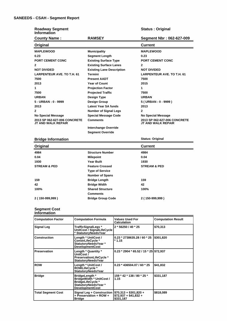
SANEEDS - CSAH - Segment Report
Roadway SegmentInformation
Status : Original
County Name : RAMSEY Segment Nbr : 062-627-009
Original Current
MAPLEWOOD Municipality MAPLEWOOD
0.23 Segment Length 0.23
PORT CEMENT CONC Existing Surface Type PORT CEMENT CONC
2 Existing Surface Lanes 2
NOT DIVIDED Existing Lane Description NOT DIVIDED
LARPENTEUR AVE. TO T.H. 61 Termini LARPENTEUR AVE. TO T.H. 61
7500 Present AADT 7500
2013 Year of Count 2015
1 Projection Factor 1
7500 Projected Traffic 7500
URBAN Design Type URBAN
5 - URBAN : 0 - 9999 Design Group 5 ( URBAN : 0 - 9999 )
2013 Latest Year SA funds 2013
2 Number of Signal Legs 2
No Special Message Special Message Code No Special Message
2013 SP 062-627-006 CONCRETEJT AND WALK REPAIR
Comments 2013 SP 062-627-006 CONCRETEJT AND WALK REPAIR
Interchange Override
Segment Override
Bridge Information Status: Original
Original Current
4984 Structure Number 4984
0.04 Milepoint 0.04
1930 Year Built 1930
STREAM & PED Feature Crossed STREAM & PED
Type of Service
Number of Spans
159 Bridge Length 159
42 Bridge Width 42
100% Shared Structure 100%
Comments
2 ( 150-999,999 ) Bridge Group Code 2 ( 150-999,999 )
Segment CostInformation
Computation Factor Computation Formula Values Used ForCalculation
Computation Result
Signal Leg TrafficSignalLegs *UnitCost / SignalLifeCycle* StatutoryNeedsYear
2 * 56250 / 40 * 25 $70,313
Construction Length * UnitCost /ConstrLifeCycle *StatutoryNeedsYear *DevelopmentCost
0.23 * 2738635.28 / 60 * 25* 1.15
$301,820
Preservation Length * Quantity *UnitCost /PreservationLifeCycle *StatutoryNeedsYear
0.23 * 2904 * 65.52 / 15 * 25 $72,937
ROW Length * UnitCost /ROWLifeCycle *StatutoryNeedsYear
0.23 * 436504.07 / 60 * 25 $41,832
Bridge BridgeLength *BridgeWidth * UnitCost /BridgeLifeCycle *StatutoryNeedsYear *DevelopmentCost
159 * 42 * 138 / 80 * 25 *1.15
$331,187
Total Segment Cost Signal Leg + Construction+ Preservation + ROW +Bridge
$70,313 + $301,820 +$72,937 + $41,832 +$331,187
$818,089

SANEEDS - CSAH - Segment Report
Roadway SegmentInformation
Status : Original
County Name : RAMSEY Segment Nbr : 062-629-010
Original Current
MAPLEWOOD Municipality MAPLEWOOD
0.26 Segment Length 0.26
PORT CEMENT CONC Existing Surface Type PORT CEMENT CONC
4 Existing Surface Lanes 4
NOT DIVIDED Existing Lane Description NOT DIVIDED
WHITE BEAR AVE. TO RIPLEY ST. Termini WHITE BEAR AVE. TO RIPLEY ST.
3250 Present AADT 3250
2013 Year of Count 2015
1 Projection Factor 1
3250 Projected Traffic 3250
URBAN Design Type URBAN
5 - URBAN : 0 - 9999 Design Group 5 ( URBAN : 0 - 9999 )
1969 Latest Year SA funds 1969
0 Number of Signal Legs 0
No Special Message Special Message Code No Special Message
Comments
Interchange Override
Segment Override
Segment CostInformation
Computation Factor Computation Formula Values Used ForCalculation
Computation Result
Signal Leg TrafficSignalLegs *UnitCost / SignalLifeCycle* StatutoryNeedsYear
0 * 56250 / 40 * 25 $0
Construction Length * UnitCost /ConstrLifeCycle *StatutoryNeedsYear *DevelopmentCost
0.26 * 2738635.28 / 60 * 25* 1.15
$341,188
Preservation Length * Quantity *UnitCost /PreservationLifeCycle *StatutoryNeedsYear
0.26 * 2904 * 65.52 / 15 * 25 $82,450
ROW Length * UnitCost /ROWLifeCycle *StatutoryNeedsYear
0.26 * 436504.07 / 60 * 25 $47,288
Total Segment Cost Signal Leg + Construction+ Preservation + ROW
$0 + $341,188 + $82,450 +$47,288
$470,926

SANEEDS - CSAH - Segment Report
Roadway SegmentInformation
Status : Original
County Name : RAMSEY Segment Nbr : 062-629-020
Original Current
MAPLEWOOD Municipality MAPLEWOOD
0.44 Segment Length 0.44
MIXED BITUMINOUS Existing Surface Type MIXED BITUMINOUS
2 Existing Surface Lanes 2
NOT DIVIDED Existing Lane Description NOT DIVIDED
RIPLEY ST. TO E LIMMAPLEWOOD
Termini RIPLEY ST. TO E LIMMAPLEWOOD
4250 Present AADT 4250
2013 Year of Count 2015
1 Projection Factor 1
4250 Projected Traffic 4250
RURAL Design Type RURAL
3 - RURAL : 1500 - 6999 Design Group 3 ( RURAL : 1500 - 6999 )
2000 Latest Year SA funds 2000
0 Number of Signal Legs 0
No Special Message Special Message Code No Special Message
Comments
Interchange Override
Segment Override
Segment CostInformation
Computation Factor Computation Formula Values Used ForCalculation
Computation Result
Signal Leg TrafficSignalLegs *UnitCost / SignalLifeCycle* StatutoryNeedsYear
0 * 56250 / 40 * 25 $0
Construction Length * UnitCost /ConstrLifeCycle *StatutoryNeedsYear *DevelopmentCost
0.44 * 1021937.01 / 60 * 25* 1.1
$206,091
Preservation Length * Quantity *UnitCost /PreservationLifeCycle *StatutoryNeedsYear
0.44 * 2376 * 65.52 / 20 * 25 $85,622
ROW Length * UnitCost /ROWLifeCycle *StatutoryNeedsYear
0.44 * 85357.87 / 60 * 25 $15,649
Total Segment Cost Signal Leg + Construction+ Preservation + ROW
$0 + $206,091 + $85,622 +$15,649
$307,362

SANEEDS - CSAH - Segment Report
Roadway SegmentInformation
Status : Original
County Name : RAMSEY Segment Nbr : 062-629-030
Original Current
NORTH ST PAUL Municipality NORTH ST PAUL
0.65 Segment Length 0.65
PORT CEMENT CONC Existing Surface Type PORT CEMENT CONC
2 Existing Surface Lanes 2
NOT DIVIDED Existing Lane Description NOT DIVIDED
E LIMS MAPLEWOOD TO MCKNIGHT RD.
Termini E LIMS MAPLEWOOD TO MCKNIGHT RD.
3500 Present AADT 3500
2013 Year of Count 2015
1 Projection Factor 1
3500 Projected Traffic 3500
RURAL Design Type RURAL
3 - RURAL : 1500 - 6999 Design Group 3 ( RURAL : 1500 - 6999 )
2000 Latest Year SA funds 2000
1 Number of Signal Legs 1
No Special Message Special Message Code No Special Message
Comments
Interchange Override
Segment Override
Segment CostInformation
Computation Factor Computation Formula Values Used ForCalculation
Computation Result
Signal Leg TrafficSignalLegs *UnitCost / SignalLifeCycle* StatutoryNeedsYear
1 * 56250 / 40 * 25 $35,156
Construction Length * UnitCost /ConstrLifeCycle *StatutoryNeedsYear *DevelopmentCost
0.65 * 1021937.01 / 60 * 25* 1.1
$304,452
Preservation Length * Quantity *UnitCost /PreservationLifeCycle *StatutoryNeedsYear
0.65 * 2376 * 65.52 / 20 * 25 $126,486
ROW Length * UnitCost /ROWLifeCycle *StatutoryNeedsYear
0.65 * 85357.87 / 60 * 25 $23,118
Total Segment Cost Signal Leg + Construction+ Preservation + ROW
$35,156 + $304,452 +$126,486 + $23,118
$489,212

SANEEDS - CSAH - Segment Report
Roadway SegmentInformation
Status : Original
County Name : RAMSEY Segment Nbr : 062-630-010
Original Current
LAUDERDALE Municipality LAUDERDALE
0.13 Segment Length 0.13
PORT CEMENT CONC Existing Surface Type PORT CEMENT CONC
4 Existing Surface Lanes 4
DIVIDED Existing Lane Description DIVIDED
W CO LINE TO TH 280 Termini W CO LINE TO TH 280
15100 Present AADT 15100
2013 Year of Count 2015
1 Projection Factor 1
15100 Projected Traffic 15100
URBAN Design Type URBAN
6 - URBAN : 10000 - 19999 Design Group 6 ( URBAN : 10000 - 19999 )
2000 Latest Year SA funds 2000
1 Number of Signal Legs 1
No Special Message Special Message Code No Special Message
Comments
Interchange Override
Segment Override
Bridge Information Status: Original
Original Current
62049 Structure Number 62049
0.06 Milepoint 0.06
2009 Year Built 2009
Feature Crossed
Type of Service
Number of Spans
43.21 Bridge Length 43.21
97.75 Bridge Width 97.75
100% Shared Structure 100%
Comments
1 ( 0-149 ) Bridge Group Code 1 ( 0-149 )
Segment CostInformation
Computation Factor Computation Formula Values Used ForCalculation
Computation Result
Signal Leg TrafficSignalLegs *UnitCost / SignalLifeCycle* StatutoryNeedsYear
1 * 56250 / 40 * 25 $35,156
Construction Length * UnitCost /ConstrLifeCycle *StatutoryNeedsYear *DevelopmentCost
0.13 * 4225495.41 / 60 * 25* 1.15
$263,213
Preservation Length * Quantity *UnitCost /PreservationLifeCycle *StatutoryNeedsYear
0.13 * 3696 * 65.52 / 15 * 25 $52,468
ROW Length * UnitCost /ROWLifeCycle *StatutoryNeedsYear
0.13 * 566370.18 / 60 * 25 $30,678
Bridge BridgeLength *BridgeWidth * UnitCost /BridgeLifeCycle *StatutoryNeedsYear *DevelopmentCost
43.21 * 97.75 * 152 / 80 * 25* 1.15
$230,724
Total Segment Cost Signal Leg + Construction+ Preservation + ROW +Bridge
$35,156 + $263,213 +$52,468 + $30,678 +$230,724
$612,239

SANEEDS - CSAH - Segment Report
Roadway SegmentInformation
Status : Original
County Name : RAMSEY Segment Nbr : 062-630-020
Original Current
LAUDERDALE Municipality LAUDERDALE
0.06 Segment Length 0.06
MIXED BITUMINOUS Existing Surface Type MIXED BITUMINOUS
4 Existing Surface Lanes 4
DIVIDED Existing Lane Description DIVIDED
TH 280 TO MALVERN Termini TH 280 TO MALVERN
15100 Present AADT 15100
2013 Year of Count 2015
1 Projection Factor 1
15100 Projected Traffic 15100
URBAN Design Type URBAN
6 - URBAN : 10000 - 19999 Design Group 6 ( URBAN : 10000 - 19999 )
2000 Latest Year SA funds 2000
3 Number of Signal Legs 3
No Special Message Special Message Code No Special Message
Comments
Interchange Override
Segment Override
Segment CostInformation
Computation Factor Computation Formula Values Used ForCalculation
Computation Result
Signal Leg TrafficSignalLegs *UnitCost / SignalLifeCycle* StatutoryNeedsYear
3 * 56250 / 40 * 25 $105,469
Construction Length * UnitCost /ConstrLifeCycle *StatutoryNeedsYear *DevelopmentCost
0.06 * 4225495.41 / 60 * 25* 1.15
$121,483
Preservation Length * Quantity *UnitCost /PreservationLifeCycle *StatutoryNeedsYear
0.06 * 3696 * 65.52 / 15 * 25 $24,216
ROW Length * UnitCost /ROWLifeCycle *StatutoryNeedsYear
0.06 * 566370.18 / 60 * 25 $14,159
Total Segment Cost Signal Leg + Construction+ Preservation + ROW
$105,469 + $121,483 +$24,216 + $14,159
$265,327

SANEEDS - CSAH - Segment Report
Roadway SegmentInformation
Status : Original
County Name : RAMSEY Segment Nbr : 062-630-022
Original Current
LAUDERDALE Municipality LAUDERDALE
0.06 Segment Length 0.06
PORT CEMENT CONC Existing Surface Type PORT CEMENT CONC
4 Existing Surface Lanes 4
DIVIDED Existing Lane Description DIVIDED
MALVERN TO EUSTIS Termini MALVERN TO EUSTIS
15100 Present AADT 15100
2013 Year of Count 2015
1 Projection Factor 1
15100 Projected Traffic 15100
URBAN Design Type URBAN
6 - URBAN : 10000 - 19999 Design Group 6 ( URBAN : 10000 - 19999 )
1997 Latest Year SA funds 1997
1 Number of Signal Legs 1
No Special Message Special Message Code No Special Message
Comments
Interchange Override
Segment Override
Segment CostInformation
Computation Factor Computation Formula Values Used ForCalculation
Computation Result
Signal Leg TrafficSignalLegs *UnitCost / SignalLifeCycle* StatutoryNeedsYear
1 * 56250 / 40 * 25 $35,156
Construction Length * UnitCost /ConstrLifeCycle *StatutoryNeedsYear *DevelopmentCost
0.06 * 4225495.41 / 60 * 25* 1.15
$121,483
Preservation Length * Quantity *UnitCost /PreservationLifeCycle *StatutoryNeedsYear
0.06 * 3696 * 65.52 / 15 * 25 $24,216
ROW Length * UnitCost /ROWLifeCycle *StatutoryNeedsYear
0.06 * 566370.18 / 60 * 25 $14,159
Total Segment Cost Signal Leg + Construction+ Preservation + ROW
$35,156 + $121,483 +$24,216 + $14,159
$195,014

SANEEDS - CSAH - Segment Report
Roadway SegmentInformation
Status : Original
County Name : RAMSEY Segment Nbr : 062-630-024
Original Current
LAUDERDALE Municipality LAUDERDALE
0.13 Segment Length 0.13
PORT CEMENT CONC Existing Surface Type PORT CEMENT CONC
4 Existing Surface Lanes 4
NOT DIVIDED Existing Lane Description NOT DIVIDED
EUSTIS TO PLEASANT Termini EUSTIS TO PLEASANT
14300 Present AADT 14300
2013 Year of Count 2015
1 Projection Factor 1
14300 Projected Traffic 14300
URBAN Design Type URBAN
6 - URBAN : 10000 - 19999 Design Group 6 ( URBAN : 10000 - 19999 )
1997 Latest Year SA funds 1997
1 Number of Signal Legs 1
No Special Message Special Message Code No Special Message
Comments
Interchange Override
Segment Override
Segment CostInformation
Computation Factor Computation Formula Values Used ForCalculation
Computation Result
Signal Leg TrafficSignalLegs *UnitCost / SignalLifeCycle* StatutoryNeedsYear
1 * 56250 / 40 * 25 $35,156
Construction Length * UnitCost /ConstrLifeCycle *StatutoryNeedsYear *DevelopmentCost
0.13 * 4225495.41 / 60 * 25* 1.15
$263,213
Preservation Length * Quantity *UnitCost /PreservationLifeCycle *StatutoryNeedsYear
0.13 * 3696 * 65.52 / 15 * 25 $52,468
ROW Length * UnitCost /ROWLifeCycle *StatutoryNeedsYear
0.13 * 566370.18 / 60 * 25 $30,678
Total Segment Cost Signal Leg + Construction+ Preservation + ROW
$35,156 + $263,213 +$52,468 + $30,678
$381,515

SANEEDS - CSAH - Segment Report
Roadway SegmentInformation
Status : Original
County Name : RAMSEY Segment Nbr : 062-630-026
Original Current
LAUDERDALE Municipality LAUDERDALE
0.12 Segment Length 0.12
PORT CEMENT CONC Existing Surface Type PORT CEMENT CONC
4 Existing Surface Lanes 4
DIVIDED Existing Lane Description DIVIDED
PLEASANT TO FULHAM Termini PLEASANT TO FULHAM
14300 Present AADT 14300
2013 Year of Count 2015
1 Projection Factor 1
14300 Projected Traffic 14300
URBAN Design Type URBAN
6 - URBAN : 10000 - 19999 Design Group 6 ( URBAN : 10000 - 19999 )
1997 Latest Year SA funds 1997
0 Number of Signal Legs 0
No Special Message Special Message Code No Special Message
Comments
Interchange Override
Segment Override
Segment CostInformation
Computation Factor Computation Formula Values Used ForCalculation
Computation Result
Signal Leg TrafficSignalLegs *UnitCost / SignalLifeCycle* StatutoryNeedsYear
0 * 56250 / 40 * 25 $0
Construction Length * UnitCost /ConstrLifeCycle *StatutoryNeedsYear *DevelopmentCost
0.12 * 4225495.41 / 60 * 25* 1.15
$242,966
Preservation Length * Quantity *UnitCost /PreservationLifeCycle *StatutoryNeedsYear
0.12 * 3696 * 65.52 / 15 * 25 $48,432
ROW Length * UnitCost /ROWLifeCycle *StatutoryNeedsYear
0.12 * 566370.18 / 60 * 25 $28,319
Total Segment Cost Signal Leg + Construction+ Preservation + ROW
$0 + $242,966 + $48,432 +$28,319
$319,717

SANEEDS - CSAH - Segment Report
Roadway SegmentInformation
Status : Original
County Name : RAMSEY Segment Nbr : 062-630-040
Original Current
FALCON HEIGHTS Municipality FALCON HEIGHTS
0.5 Segment Length 0.5
PORT CEMENT CONC Existing Surface Type PORT CEMENT CONC
4 Existing Surface Lanes 4
DIVIDED Existing Lane Description DIVIDED
FULHAM ST TO CLEVELAND AVE Termini FULHAM ST TO CLEVELAND AVE
14300 Present AADT 14300
2013 Year of Count 2015
1 Projection Factor 1
14300 Projected Traffic 14300
URBAN Design Type URBAN
6 - URBAN : 10000 - 19999 Design Group 6 ( URBAN : 10000 - 19999 )
1997 Latest Year SA funds 1997
1 Number of Signal Legs 1
No Special Message Special Message Code No Special Message
Comments
Interchange Override
Segment Override
Culvert Information Status: Original
Original Current
62J06 Structure Number 62J06
0.72 Milepoint 0.72
1999 Year Built 1999
Feature Crossed
OTHER Type of Service OTHER
1 Number of Barrels 1
11.3 Culvert Width 11.3
10 Culvert Height 10
96 Culvert Length 96
113 Area of Waterway Opening 113
100% Shared Structure 100%
Comments
1 Culvert Group Code 1
Segment CostInformation
Computation Factor Computation Formula Values Used ForCalculation
Computation Result
Signal Leg TrafficSignalLegs *UnitCost / SignalLifeCycle* StatutoryNeedsYear
1 * 56250 / 40 * 25 $35,156
Construction Length * UnitCost /ConstrLifeCycle *StatutoryNeedsYear *DevelopmentCost
0.5 * 4225495.41 / 60 * 25 *1.15
$1,012,358
Preservation Length * Quantity *UnitCost /PreservationLifeCycle *StatutoryNeedsYear
0.5 * 3696 * 65.52 / 15 * 25 $201,802
ROW Length * UnitCost /ROWLifeCycle *StatutoryNeedsYear
0.5 * 566370.18 / 60 * 25 $117,994
Culvert CulvertLength * Area *UnitCost /CulvertLifeCycle *StatutoryNeedsYear *DevelopmentCost
96 * 113 * 15.47 / 100 * 25 *1.15
$48,248
Total Segment Cost Signal Leg + Construction+ Preservation + ROW +Culvert
$35,156 + $1,012,358 +$201,802 + $117,994 +$48,248
$1,415,558

SANEEDS - CSAH - Segment Report
Roadway SegmentInformation
Status : Original
County Name : RAMSEY Segment Nbr : 062-630-050
Original Current
FALCON HEIGHTS Municipality FALCON HEIGHTS
1 Segment Length 1
PORT CEMENT CONC Existing Surface Type PORT CEMENT CONC
4 Existing Surface Lanes 4
DIVIDED Existing Lane Description DIVIDED
LARPENTEUR AVE.: CLEVELANDAVE. TO TH. 51
Termini LARPENTEUR AVE.: CLEVELANDAVE. TO TH. 51
20300 Present AADT 20300
2013 Year of Count 2015
1 Projection Factor 1
20300 Projected Traffic 20300
URBAN Design Type URBAN
7 - URBAN : 20000 - 34999 Design Group 7 ( URBAN : 20000 - 34999 )
1998 Latest Year SA funds 1998
6 Number of Signal Legs 6
No Special Message Special Message Code No Special Message
Comments
Interchange Override
Segment Override
Segment CostInformation
Computation Factor Computation Formula Values Used ForCalculation
Computation Result
Signal Leg TrafficSignalLegs *UnitCost / SignalLifeCycle* StatutoryNeedsYear
6 * 56250 / 40 * 25 $210,938
Construction Length * UnitCost /ConstrLifeCycle *StatutoryNeedsYear *DevelopmentCost
1 * 5259942.61 / 60 * 25 *1.15
$2,520,389
Preservation Length * Quantity *UnitCost /PreservationLifeCycle *StatutoryNeedsYear
1 * 4488 * 65.52 / 15 * 25 $490,090
ROW Length * UnitCost /ROWLifeCycle *StatutoryNeedsYear
1 * 883293.09 / 60 * 25 $368,039
Total Segment Cost Signal Leg + Construction+ Preservation + ROW
$210,938 + $2,520,389 +$490,090 + $368,039
$3,589,456

SANEEDS - CSAH - Segment Report
Roadway SegmentInformation
Status : Revised
County Name : RAMSEY Segment Nbr : 062-630-060
Original Current
FALCON HEIGHTS Municipality FALCON HEIGHTS
0.1 Segment Length 0.1
PORT CEMENT CONC Existing Surface Type PORT CEMENT CONC
4 Existing Surface Lanes 4
DIVIDED Existing Lane Description DIVIDED
TH 51 TO 0.10 MI E Termini TH 51 TO 0.10 MI E
15600 Present AADT 15600
2013 Year of Count 2015
1 Projection Factor 1
15600 Projected Traffic 15600
URBAN Design Type URBAN
6 - URBAN : 10000 - 19999 Design Group 6 ( URBAN : 10000 - 19999 )
1987 Latest Year SA funds 2016
2 Number of Signal Legs 2
No Special Message Special Message Code No Special Message
Comments SAP 062-030-021 2016
Interchange Override
Segment Override
Segment CostInformation
Computation Factor Computation Formula Values Used ForCalculation
Computation Result
Signal Leg TrafficSignalLegs *UnitCost / SignalLifeCycle* StatutoryNeedsYear
2 * 56250 / 40 * 25 $70,313
Construction Length * UnitCost /ConstrLifeCycle *StatutoryNeedsYear *DevelopmentCost
0.1 * 4225495.41 / 60 * 25 *1.15
$202,472
Preservation Length * Quantity *UnitCost /PreservationLifeCycle *StatutoryNeedsYear
0.1 * 3696 * 65.52 / 15 * 25 $40,360
ROW Length * UnitCost /ROWLifeCycle *StatutoryNeedsYear
0.1 * 566370.18 / 60 * 25 $23,599
Total Segment Cost Signal Leg + Construction+ Preservation + ROW
$70,313 + $202,472 +$40,360 + $23,599
$336,744

SANEEDS - CSAH - Segment Report
Roadway SegmentInformation
Status : Revised
County Name : RAMSEY Segment Nbr : 062-630-070
Original Current
FALCON HEIGHTS Municipality FALCON HEIGHTS
0.4 Segment Length 0.4
PORT CEMENT CONC Existing Surface Type PORT CEMENT CONC
4 Existing Surface Lanes 4
DIVIDED Existing Lane Description DIVIDED
0.10 MI E OF TH 51 TO E LIMSFALCON HEIGHTS
Termini 0.10 MI E OF TH 51 TO E LIMSFALCON HEIGHTS
15600 Present AADT 15600
2013 Year of Count 2015
1 Projection Factor 1
15600 Projected Traffic 15600
URBAN Design Type URBAN
6 - URBAN : 10000 - 19999 Design Group 6 ( URBAN : 10000 - 19999 )
2000 Latest Year SA funds 2016
2 Number of Signal Legs 2
No Special Message Special Message Code No Special Message
Comments SAP 062-030-021 2016
Interchange Override
Segment Override
Segment CostInformation
Computation Factor Computation Formula Values Used ForCalculation
Computation Result
Signal Leg TrafficSignalLegs *UnitCost / SignalLifeCycle* StatutoryNeedsYear
2 * 56250 / 40 * 25 $70,313
Construction Length * UnitCost /ConstrLifeCycle *StatutoryNeedsYear *DevelopmentCost
0.4 * 4225495.41 / 60 * 25 *1.15
$809,887
Preservation Length * Quantity *UnitCost /PreservationLifeCycle *StatutoryNeedsYear
0.4 * 3696 * 65.52 / 15 * 25 $161,441
ROW Length * UnitCost /ROWLifeCycle *StatutoryNeedsYear
0.4 * 566370.18 / 60 * 25 $94,395
Total Segment Cost Signal Leg + Construction+ Preservation + ROW
$70,313 + $809,887 +$161,441 + $94,395
$1,136,036

SANEEDS - CSAH - Segment Report
Roadway SegmentInformation
Status : Revised
County Name : RAMSEY Segment Nbr : 062-630-080
Original Current
ST PAUL Municipality ST PAUL
0.25 Segment Length 0.25
PORT CEMENT CONC Existing Surface Type PORT CEMENT CONC
4 Existing Surface Lanes 4
DIVIDED Existing Lane Description DIVIDED
E LIMS FALCON HEIGHTS TOFERNWOOD AVE
Termini E LIMS FALCON HEIGHTS TOFERNWOOD AVE
16600 Present AADT 16600
2013 Year of Count 2015
1 Projection Factor 1
16600 Projected Traffic 16600
URBAN Design Type URBAN
6 - URBAN : 10000 - 19999 Design Group 6 ( URBAN : 10000 - 19999 )
2000 Latest Year SA funds 2016
2 Number of Signal Legs 2
No Special Message Special Message Code No Special Message
Comments SAP 062-030-021 2016
Interchange Override
Segment Override
Segment CostInformation
Computation Factor Computation Formula Values Used ForCalculation
Computation Result
Signal Leg TrafficSignalLegs *UnitCost / SignalLifeCycle* StatutoryNeedsYear
2 * 56250 / 40 * 25 $70,313
Construction Length * UnitCost /ConstrLifeCycle *StatutoryNeedsYear *DevelopmentCost
0.25 * 4225495.41 / 60 * 25* 1.15
$506,179
Preservation Length * Quantity *UnitCost /PreservationLifeCycle *StatutoryNeedsYear
0.25 * 3696 * 65.52 / 15 * 25 $100,901
ROW Length * UnitCost /ROWLifeCycle *StatutoryNeedsYear
0.25 * 566370.18 / 60 * 25 $58,997
Total Segment Cost Signal Leg + Construction+ Preservation + ROW
$70,313 + $506,179 +$100,901 + $58,997
$736,390

SANEEDS - CSAH - Segment Report
Roadway SegmentInformation
Status : Revised
County Name : RAMSEY Segment Nbr : 062-630-090
Original Current
ROSEVILLE Municipality ROSEVILLE
0.36 Segment Length 0.36
PORT CEMENT CONC Existing Surface Type PORT CEMENT CONC
4 Existing Surface Lanes 4
DIVIDED Existing Lane Description DIVIDED
FERNWOOD AVE TO 0.11 MILESEAST OF LEXINGTON AVE.
Termini FERNWOOD AVE TO 0.11 MILESEAST OF LEXINGTON AVE.
16600 Present AADT 16600
2013 Year of Count 2015
1 Projection Factor 1
16600 Projected Traffic 16600
URBAN Design Type URBAN
6 - URBAN : 10000 - 19999 Design Group 6 ( URBAN : 10000 - 19999 )
2013 Latest Year SA funds 2016
3 Number of Signal Legs 3
No Special Message Special Message Code No Special Message
2013 SP 062-630-058 CONCRETEJT & WALK REPAIR
Comments 2013 SP 062-630-058 CONCRETEJT & WALK REPAIR: SAP 062-030-021 2016
Interchange Override
Segment Override
Segment CostInformation
Computation Factor Computation Formula Values Used ForCalculation
Computation Result
Signal Leg TrafficSignalLegs *UnitCost / SignalLifeCycle* StatutoryNeedsYear
3 * 56250 / 40 * 25 $105,469
Construction Length * UnitCost /ConstrLifeCycle *StatutoryNeedsYear *DevelopmentCost
0.36 * 4225495.41 / 60 * 25* 1.15
$728,898
Preservation Length * Quantity *UnitCost /PreservationLifeCycle *StatutoryNeedsYear
0.36 * 3696 * 65.52 / 15 * 25 $145,297
ROW Length * UnitCost /ROWLifeCycle *StatutoryNeedsYear
0.36 * 566370.18 / 60 * 25 $84,956
Total Segment Cost Signal Leg + Construction+ Preservation + ROW
$105,469 + $728,898 +$145,297 + $84,956
$1,064,620

SANEEDS - CSAH - Segment Report
Roadway SegmentInformation
Status : Original
County Name : RAMSEY Segment Nbr : 062-630-105
Original Current
ROSEVILLE Municipality ROSEVILLE
0.24 Segment Length 0.24
PORT CEMENT CONC Existing Surface Type PORT CEMENT CONC
4 Existing Surface Lanes 4
DIVIDED Existing Lane Description DIVIDED
0.11 M E OF LEXINGTON AVE. TOW JCT VICTORIA ST.
Termini 0.11 M E OF LEXINGTON AVE. TOW JCT VICTORIA ST.
15700 Present AADT 15700
2013 Year of Count 2015
1 Projection Factor 1
15700 Projected Traffic 15700
URBAN Design Type URBAN
6 - URBAN : 10000 - 19999 Design Group 6 ( URBAN : 10000 - 19999 )
2013 Latest Year SA funds 2013
2 Number of Signal Legs 2
No Special Message Special Message Code No Special Message
2013 SP 062-630-058 CONCRETEJT & WALK REPAIR
Comments 2013 SP 062-630-058 CONCRETEJT & WALK REPAIR
Interchange Override
Segment Override
Segment CostInformation
Computation Factor Computation Formula Values Used ForCalculation
Computation Result
Signal Leg TrafficSignalLegs *UnitCost / SignalLifeCycle* StatutoryNeedsYear
2 * 56250 / 40 * 25 $70,313
Construction Length * UnitCost /ConstrLifeCycle *StatutoryNeedsYear *DevelopmentCost
0.24 * 4225495.41 / 60 * 25* 1.15
$485,932
Preservation Length * Quantity *UnitCost /PreservationLifeCycle *StatutoryNeedsYear
0.24 * 3696 * 65.52 / 15 * 25 $96,865
ROW Length * UnitCost /ROWLifeCycle *StatutoryNeedsYear
0.24 * 566370.18 / 60 * 25 $56,637
Total Segment Cost Signal Leg + Construction+ Preservation + ROW
$70,313 + $485,932 +$96,865 + $56,637
$709,747

SANEEDS - CSAH - Segment Report
Roadway SegmentInformation
Status : Original
County Name : RAMSEY Segment Nbr : 062-630-110
Original Current
ST PAUL Municipality ST PAUL
0.65 Segment Length 0.65
PORT CEMENT CONC Existing Surface Type PORT CEMENT CONC
4 Existing Surface Lanes 4
DIVIDED Existing Lane Description DIVIDED
W JCT VICTORIA ST. TO DALE ST. Termini W JCT VICTORIA ST. TO DALE ST.
15700 Present AADT 15700
2013 Year of Count 2015
1 Projection Factor 1
15700 Projected Traffic 15700
URBAN Design Type URBAN
6 - URBAN : 10000 - 19999 Design Group 6 ( URBAN : 10000 - 19999 )
2013 Latest Year SA funds 2013
0 Number of Signal Legs 0
No Special Message Special Message Code No Special Message
2013 SP 062-630-058 CONCRETEJT & WALK REPAIR
Comments 2013 SP 062-630-058 CONCRETEJT & WALK REPAIR
Interchange Override
Segment Override
Segment CostInformation
Computation Factor Computation Formula Values Used ForCalculation
Computation Result
Signal Leg TrafficSignalLegs *UnitCost / SignalLifeCycle* StatutoryNeedsYear
0 * 56250 / 40 * 25 $0
Construction Length * UnitCost /ConstrLifeCycle *StatutoryNeedsYear *DevelopmentCost
0.65 * 4225495.41 / 60 * 25* 1.15
$1,316,066
Preservation Length * Quantity *UnitCost /PreservationLifeCycle *StatutoryNeedsYear
0.65 * 3696 * 65.52 / 15 * 25 $262,342
ROW Length * UnitCost /ROWLifeCycle *StatutoryNeedsYear
0.65 * 566370.18 / 60 * 25 $153,392
Total Segment Cost Signal Leg + Construction+ Preservation + ROW
$0 + $1,316,066 + $262,342+ $153,392
$1,731,800

SANEEDS - CSAH - Segment Report
Roadway SegmentInformation
Status : Original
County Name : RAMSEY Segment Nbr : 062-630-120
Original Current
ST PAUL Municipality ST PAUL
0.5 Segment Length 0.5
MIXED BITUMINOUS Existing Surface Type MIXED BITUMINOUS
4 Existing Surface Lanes 4
NOT DIVIDED Existing Lane Description NOT DIVIDED
DALE ST.TO 0.50 MI EAST Termini DALE ST.TO 0.50 MI EAST
13000 Present AADT 13000
2013 Year of Count 2015
1 Projection Factor 1
13000 Projected Traffic 13000
RURAL Design Type RURAL
4 - RURAL : 7000 - 999999 Design Group 4 ( RURAL : 7000 - 999999 )
2014 Latest Year SA funds 2014
1 Number of Signal Legs 1
No Special Message Special Message Code No Special Message
SAP 062-630-014CONCRETE JOINT REPAIR
Comments SAP 062-630-014CONCRETE JOINT REPAIR
Interchange Override
Segment Override
Segment CostInformation
Computation Factor Computation Formula Values Used ForCalculation
Computation Result
Signal Leg TrafficSignalLegs *UnitCost / SignalLifeCycle* StatutoryNeedsYear
1 * 56250 / 40 * 25 $35,156
Construction Length * UnitCost /ConstrLifeCycle *StatutoryNeedsYear *DevelopmentCost
0.5 * 1996892.57 / 60 * 25 *1.1
$457,621
Preservation Length * Quantity *UnitCost /PreservationLifeCycle *StatutoryNeedsYear
0.5 * 3564 * 65.52 / 20 * 25 $145,946
ROW Length * UnitCost /ROWLifeCycle *StatutoryNeedsYear
0.5 * 181173.68 / 60 * 25 $37,745
Total Segment Cost Signal Leg + Construction+ Preservation + ROW
$35,156 + $457,621 +$145,946 + $37,745
$676,468

SANEEDS - CSAH - Segment Report
Roadway SegmentInformation
Status : Original
County Name : RAMSEY Segment Nbr : 062-630-130
Original Current
ROSEVILLE Municipality ROSEVILLE
0.5 Segment Length 0.5
MIXED BITUMINOUS Existing Surface Type MIXED BITUMINOUS
4 Existing Surface Lanes 4
NOT DIVIDED Existing Lane Description NOT DIVIDED
0.50 MI E OF DALE ST.TO CSAH 49 Termini 0.50 MI E OF DALE ST.TO CSAH 49
13000 Present AADT 13000
2013 Year of Count 2015
1 Projection Factor 1
13000 Projected Traffic 13000
RURAL Design Type RURAL
4 - RURAL : 7000 - 999999 Design Group 4 ( RURAL : 7000 - 999999 )
2011 Latest Year SA funds 2011
1 Number of Signal Legs 1
No Special Message Special Message Code No Special Message
Comments
Interchange Override
Segment Override
Segment CostInformation
Computation Factor Computation Formula Values Used ForCalculation
Computation Result
Signal Leg TrafficSignalLegs *UnitCost / SignalLifeCycle* StatutoryNeedsYear
1 * 56250 / 40 * 25 $35,156
Construction Length * UnitCost /ConstrLifeCycle *StatutoryNeedsYear *DevelopmentCost
0.5 * 1996892.57 / 60 * 25 *1.1
$457,621
Preservation Length * Quantity *UnitCost /PreservationLifeCycle *StatutoryNeedsYear
0.5 * 3564 * 65.52 / 20 * 25 $145,946
ROW Length * UnitCost /ROWLifeCycle *StatutoryNeedsYear
0.5 * 181173.68 / 60 * 25 $37,745
Total Segment Cost Signal Leg + Construction+ Preservation + ROW
$35,156 + $457,621 +$145,946 + $37,745
$676,468

SANEEDS - CSAH - Segment Report
Roadway SegmentInformation
Status : Original
County Name : RAMSEY Segment Nbr : 062-630-140
Original Current
MAPLEWOOD Municipality MAPLEWOOD
0.22 Segment Length 0.22
MIXED BITUMINOUS Existing Surface Type MIXED BITUMINOUS
2 Existing Surface Lanes 2
NOT DIVIDED Existing Lane Description NOT DIVIDED
CSAH 49 TO 0.22 MI E Termini CSAH 49 TO 0.22 MI E
16100 Present AADT 16100
2013 Year of Count 2015
1 Projection Factor 1
16100 Projected Traffic 16100
URBAN Design Type URBAN
6 - URBAN : 10000 - 19999 Design Group 6 ( URBAN : 10000 - 19999 )
2011 Latest Year SA funds 2011
1 Number of Signal Legs 1
No Special Message Special Message Code No Special Message
Comments
Interchange Override
Segment Override
Segment CostInformation
Computation Factor Computation Formula Values Used ForCalculation
Computation Result
Signal Leg TrafficSignalLegs *UnitCost / SignalLifeCycle* StatutoryNeedsYear
1 * 56250 / 40 * 25 $35,156
Construction Length * UnitCost /ConstrLifeCycle *StatutoryNeedsYear *DevelopmentCost
0.22 * 4225495.41 / 60 * 25* 1.15
$445,438
Preservation Length * Quantity *UnitCost /PreservationLifeCycle *StatutoryNeedsYear
0.22 * 3696 * 65.52 / 15 * 25 $88,793
ROW Length * UnitCost /ROWLifeCycle *StatutoryNeedsYear
0.22 * 566370.18 / 60 * 25 $51,917
Total Segment Cost Signal Leg + Construction+ Preservation + ROW
$35,156 + $445,438 +$88,793 + $51,917
$621,304

SANEEDS - CSAH - Segment Report
Roadway SegmentInformation
Status : Original
County Name : RAMSEY Segment Nbr : 062-630-150
Original Current
MAPLEWOOD Municipality MAPLEWOOD
0.22 Segment Length 0.22
MIXED BITUMINOUS Existing Surface Type MIXED BITUMINOUS
2 Existing Surface Lanes 2
NOT DIVIDED Existing Lane Description NOT DIVIDED
0.22 MI E OF CSAH 49 TOJACKSON ST.
Termini 0.22 MI E OF CSAH 49 TOJACKSON ST.
16100 Present AADT 16100
2013 Year of Count 2015
1 Projection Factor 1
16100 Projected Traffic 16100
URBAN Design Type URBAN
6 - URBAN : 10000 - 19999 Design Group 6 ( URBAN : 10000 - 19999 )
2014 Latest Year SA funds 2014
2 Number of Signal Legs 2
No Special Message Special Message Code No Special Message
SAP 062-630-014CONCRETE JOINT REPAIR
Comments SAP 062-630-014CONCRETE JOINT REPAIR
Interchange Override
Segment Override
Segment CostInformation
Computation Factor Computation Formula Values Used ForCalculation
Computation Result
Signal Leg TrafficSignalLegs *UnitCost / SignalLifeCycle* StatutoryNeedsYear
2 * 56250 / 40 * 25 $70,313
Construction Length * UnitCost /ConstrLifeCycle *StatutoryNeedsYear *DevelopmentCost
0.22 * 4225495.41 / 60 * 25* 1.15
$445,438
Preservation Length * Quantity *UnitCost /PreservationLifeCycle *StatutoryNeedsYear
0.22 * 3696 * 65.52 / 15 * 25 $88,793
ROW Length * UnitCost /ROWLifeCycle *StatutoryNeedsYear
0.22 * 566370.18 / 60 * 25 $51,917
Total Segment Cost Signal Leg + Construction+ Preservation + ROW
$70,313 + $445,438 +$88,793 + $51,917
$656,461
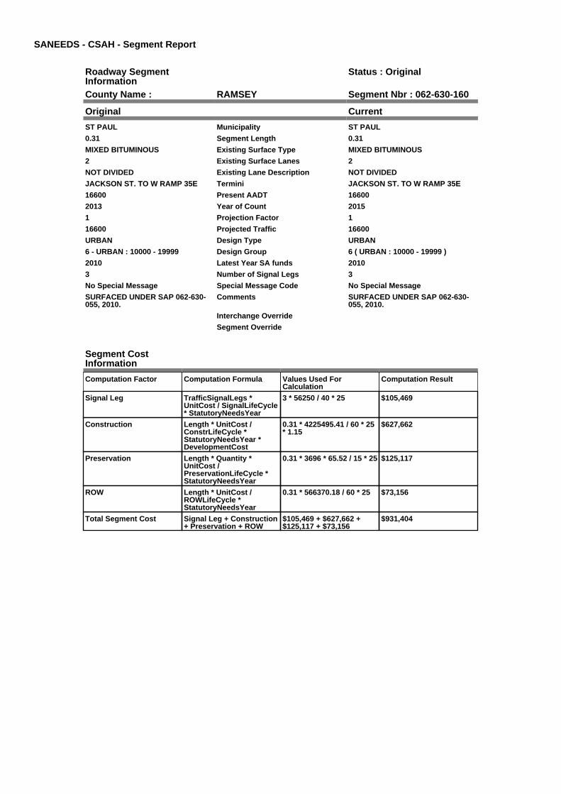
SANEEDS - CSAH - Segment Report
Roadway SegmentInformation
Status : Original
County Name : RAMSEY Segment Nbr : 062-630-160
Original Current
ST PAUL Municipality ST PAUL
0.31 Segment Length 0.31
MIXED BITUMINOUS Existing Surface Type MIXED BITUMINOUS
2 Existing Surface Lanes 2
NOT DIVIDED Existing Lane Description NOT DIVIDED
JACKSON ST. TO W RAMP 35E Termini JACKSON ST. TO W RAMP 35E
16600 Present AADT 16600
2013 Year of Count 2015
1 Projection Factor 1
16600 Projected Traffic 16600
URBAN Design Type URBAN
6 - URBAN : 10000 - 19999 Design Group 6 ( URBAN : 10000 - 19999 )
2010 Latest Year SA funds 2010
3 Number of Signal Legs 3
No Special Message Special Message Code No Special Message
SURFACED UNDER SAP 062-630-055, 2010.
Comments SURFACED UNDER SAP 062-630-055, 2010.
Interchange Override
Segment Override
Segment CostInformation
Computation Factor Computation Formula Values Used ForCalculation
Computation Result
Signal Leg TrafficSignalLegs *UnitCost / SignalLifeCycle* StatutoryNeedsYear
3 * 56250 / 40 * 25 $105,469
Construction Length * UnitCost /ConstrLifeCycle *StatutoryNeedsYear *DevelopmentCost
0.31 * 4225495.41 / 60 * 25* 1.15
$627,662
Preservation Length * Quantity *UnitCost /PreservationLifeCycle *StatutoryNeedsYear
0.31 * 3696 * 65.52 / 15 * 25 $125,117
ROW Length * UnitCost /ROWLifeCycle *StatutoryNeedsYear
0.31 * 566370.18 / 60 * 25 $73,156
Total Segment Cost Signal Leg + Construction+ Preservation + ROW
$105,469 + $627,662 +$125,117 + $73,156
$931,404

SANEEDS - CSAH - Segment Report
Roadway SegmentInformation
Status : Original
County Name : RAMSEY Segment Nbr : 062-630-162
Original Current
ST PAUL Municipality ST PAUL
0.08 Segment Length 0.08
MIXED BITUMINOUS Existing Surface Type MIXED BITUMINOUS
2 Existing Surface Lanes 2
NOT DIVIDED Existing Lane Description NOT DIVIDED
WEST I-35E RAMP TO EAST I-35ERAMP
Termini WEST I-35E RAMP TO EAST I-35ERAMP
16600 Present AADT 16600
2013 Year of Count 2015
1 Projection Factor 1
16600 Projected Traffic 16600
URBAN Design Type URBAN
6 - URBAN : 10000 - 19999 Design Group 6 ( URBAN : 10000 - 19999 )
2014 Latest Year SA funds 2014
3 Number of Signal Legs 3
No Special Message Special Message Code No Special Message
SURFACED UNDER SAP 062-630-055, 2010.2014- SAP 062-630-057, MNDOTCOOP. CONST. AGREEMENT NO.03438
Comments SURFACED UNDER SAP 062-630-055, 2010.2014- SAP 062-630-057, MNDOTCOOP. CONST. AGREEMENT NO.03438
Interchange Override
Segment Override
Segment CostInformation
Computation Factor Computation Formula Values Used ForCalculation
Computation Result
Signal Leg TrafficSignalLegs *UnitCost / SignalLifeCycle* StatutoryNeedsYear
3 * 56250 / 40 * 25 $105,469
Construction Length * UnitCost /ConstrLifeCycle *StatutoryNeedsYear *DevelopmentCost
0.08 * 4225495.41 / 60 * 25* 1.15
$161,977
Preservation Length * Quantity *UnitCost /PreservationLifeCycle *StatutoryNeedsYear
0.08 * 3696 * 65.52 / 15 * 25 $32,288
ROW Length * UnitCost /ROWLifeCycle *StatutoryNeedsYear
0.08 * 566370.18 / 60 * 25 $18,879
Total Segment Cost Signal Leg + Construction+ Preservation + ROW
$105,469 + $161,977 +$32,288 + $18,879
$318,613

SANEEDS - CSAH - Segment Report
Roadway SegmentInformation
Status : Original
County Name : RAMSEY Segment Nbr : 062-630-165
Original Current
ST PAUL Municipality ST PAUL
0.11 Segment Length 0.11
BIT CONC OR ASPH Existing Surface Type BIT CONC OR ASPH
4 Existing Surface Lanes 4
NOT DIVIDED Existing Lane Description NOT DIVIDED
FROM E RAMP I35E TO MCMENEMY ST.
Termini FROM E RAMP I35E TO MCMENEMY ST.
10600 Present AADT 10600
2013 Year of Count 2015
1 Projection Factor 1
10600 Projected Traffic 10600
URBAN Design Type URBAN
6 - URBAN : 10000 - 19999 Design Group 6 ( URBAN : 10000 - 19999 )
2000 Latest Year SA funds 2000
2 Number of Signal Legs 2
No Special Message Special Message Code No Special Message
CONSTRUCTED BY MN DOT IN2014
Comments CONSTRUCTED BY MN DOT IN2014
Interchange Override
Segment Override
Segment CostInformation
Computation Factor Computation Formula Values Used ForCalculation
Computation Result
Signal Leg TrafficSignalLegs *UnitCost / SignalLifeCycle* StatutoryNeedsYear
2 * 56250 / 40 * 25 $70,313
Construction Length * UnitCost /ConstrLifeCycle *StatutoryNeedsYear *DevelopmentCost
0.11 * 4225495.41 / 60 * 25* 1.15
$222,719
Preservation Length * Quantity *UnitCost /PreservationLifeCycle *StatutoryNeedsYear
0.11 * 3696 * 65.52 / 15 * 25 $44,396
ROW Length * UnitCost /ROWLifeCycle *StatutoryNeedsYear
0.11 * 566370.18 / 60 * 25 $25,959
Total Segment Cost Signal Leg + Construction+ Preservation + ROW
$70,313 + $222,719 +$44,396 + $25,959
$363,387

SANEEDS - CSAH - Segment Report
Roadway SegmentInformation
Status : Original
County Name : RAMSEY Segment Nbr : 062-630-170
Original Current
MAPLEWOOD Municipality MAPLEWOOD
0.25 Segment Length 0.25
BIT CONC OR ASPH Existing Surface Type BIT CONC OR ASPH
2 Existing Surface Lanes 2
NOT DIVIDED Existing Lane Description NOT DIVIDED
MC MENEMY ST. TO DESOTO ST. Termini MC MENEMY ST. TO DESOTO ST.
10600 Present AADT 10600
2013 Year of Count 2015
1 Projection Factor 1
10600 Projected Traffic 10600
URBAN Design Type URBAN
6 - URBAN : 10000 - 19999 Design Group 6 ( URBAN : 10000 - 19999 )
2014 Latest Year SA funds 2014
0 Number of Signal Legs 0
No Special Message Special Message Code No Special Message
2014 SP 062-630-059, STRIPING,WALKWAY+C&G, REDUCE AREATO 2 THRU LANES.
SURFACED WITH LOCAL FUNDS,2007
Comments 2014 SP 062-630-059, STRIPING,WALKWAY+C&G, REDUCE AREATO 2 THRU LANES.
SURFACED WITH LOCAL FUNDS,2007
Interchange Override
Segment Override
Segment CostInformation
Computation Factor Computation Formula Values Used ForCalculation
Computation Result
Signal Leg TrafficSignalLegs *UnitCost / SignalLifeCycle* StatutoryNeedsYear
0 * 56250 / 40 * 25 $0
Construction Length * UnitCost /ConstrLifeCycle *StatutoryNeedsYear *DevelopmentCost
0.25 * 4225495.41 / 60 * 25* 1.15
$506,179
Preservation Length * Quantity *UnitCost /PreservationLifeCycle *StatutoryNeedsYear
0.25 * 3696 * 65.52 / 15 * 25 $100,901
ROW Length * UnitCost /ROWLifeCycle *StatutoryNeedsYear
0.25 * 566370.18 / 60 * 25 $58,997
Total Segment Cost Signal Leg + Construction+ Preservation + ROW
$0 + $506,179 + $100,901+ $58,997
$666,077

SANEEDS - CSAH - Segment Report
Roadway SegmentInformation
Status : Original
County Name : RAMSEY Segment Nbr : 062-630-180
Original Current
ST PAUL Municipality ST PAUL
0.25 Segment Length 0.25
BIT CONC OR ASPH Existing Surface Type BIT CONC OR ASPH
2 Existing Surface Lanes 2
NOT DIVIDED Existing Lane Description NOT DIVIDED
DESOTO ST TO EDGERTON ST. Termini DESOTO ST TO EDGERTON ST.
10600 Present AADT 10600
2013 Year of Count 2015
1 Projection Factor 1
10600 Projected Traffic 10600
URBAN Design Type URBAN
6 - URBAN : 10000 - 19999 Design Group 6 ( URBAN : 10000 - 19999 )
2014 Latest Year SA funds 2014
1 Number of Signal Legs 1
No Special Message Special Message Code No Special Message
2014 SP 062-630-059, STRIPING,WALKWAY+C&G, REDUCE AREATO 2 THRU LANES
SURFACED WITH LOCAL FUNDS,2007
Comments 2014 SP 062-630-059, STRIPING,WALKWAY+C&G, REDUCE AREATO 2 THRU LANES
SURFACED WITH LOCAL FUNDS,2007
Interchange Override
Segment Override
Bridge Information Status: Original
Original Current
62554 Structure Number 62554
6.23 Milepoint 6.23
1992 Year Built 1992
DNR TRAIL Feature Crossed DNR TRAIL
Type of Service
Number of Spans
38.4 Bridge Length 38.4
81 Bridge Width 81
100% Shared Structure 100%
Comments
1 ( 0-149 ) Bridge Group Code 1 ( 0-149 )
Segment CostInformation
Computation Factor Computation Formula Values Used ForCalculation
Computation Result
Signal Leg TrafficSignalLegs *UnitCost / SignalLifeCycle* StatutoryNeedsYear
1 * 56250 / 40 * 25 $35,156
Construction Length * UnitCost /ConstrLifeCycle *StatutoryNeedsYear *DevelopmentCost
0.25 * 4225495.41 / 60 * 25* 1.15
$506,179
Preservation Length * Quantity *UnitCost /PreservationLifeCycle *StatutoryNeedsYear
0.25 * 3696 * 65.52 / 15 * 25 $100,901
ROW Length * UnitCost /ROWLifeCycle *StatutoryNeedsYear
0.25 * 566370.18 / 60 * 25 $58,997
Bridge BridgeLength *BridgeWidth * UnitCost /BridgeLifeCycle *StatutoryNeedsYear *DevelopmentCost
38.4 * 81 * 152 / 80 * 25 *1.15
$169,906

Total Segment Cost Signal Leg + Construction+ Preservation + ROW +Bridge
$35,156 + $506,179 +$100,901 + $58,997 +$169,906
$871,139

SANEEDS - CSAH - Segment Report
Roadway SegmentInformation
Status : Original
County Name : RAMSEY Segment Nbr : 062-630-190
Original Current
MAPLEWOOD Municipality MAPLEWOOD
0.06 Segment Length 0.06
BIT CONC OR ASPH Existing Surface Type BIT CONC OR ASPH
2 Existing Surface Lanes 2
NOT DIVIDED Existing Lane Description NOT DIVIDED
EDGERTON ST. TO 0.06 MI EAST Termini EDGERTON ST. TO 0.06 MI EAST
8000 Present AADT 8000
2013 Year of Count 2015
1 Projection Factor 1
8000 Projected Traffic 8000
URBAN Design Type URBAN
5 - URBAN : 0 - 9999 Design Group 5 ( URBAN : 0 - 9999 )
2014 Latest Year SA funds 2014
1 Number of Signal Legs 1
No Special Message Special Message Code No Special Message
2014 SP 062-630-059, STRIPING,WALKWAY+C&G, REDUCE AREATO 2 THRU LANES
Comments 2014 SP 062-630-059, STRIPING,WALKWAY+C&G, REDUCE AREATO 2 THRU LANES
Interchange Override
Segment Override
Segment CostInformation
Computation Factor Computation Formula Values Used ForCalculation
Computation Result
Signal Leg TrafficSignalLegs *UnitCost / SignalLifeCycle* StatutoryNeedsYear
1 * 56250 / 40 * 25 $35,156
Construction Length * UnitCost /ConstrLifeCycle *StatutoryNeedsYear *DevelopmentCost
0.06 * 2738635.28 / 60 * 25* 1.15
$78,736
Preservation Length * Quantity *UnitCost /PreservationLifeCycle *StatutoryNeedsYear
0.06 * 2904 * 65.52 / 15 * 25 $19,027
ROW Length * UnitCost /ROWLifeCycle *StatutoryNeedsYear
0.06 * 436504.07 / 60 * 25 $10,913
Total Segment Cost Signal Leg + Construction+ Preservation + ROW
$35,156 + $78,736 +$19,027 + $10,913
$143,832

SANEEDS - CSAH - Segment Report
Roadway SegmentInformation
Status : Original
County Name : RAMSEY Segment Nbr : 062-630-200
Original Current
ST PAUL Municipality ST PAUL
0.18 Segment Length 0.18
BIT CONC OR ASPH Existing Surface Type BIT CONC OR ASPH
2 Existing Surface Lanes 2
NOT DIVIDED Existing Lane Description NOT DIVIDED
0.06 MI E OF EDGERTON ST. TO 0.12 MI E OF PAYNE AVE.
Termini 0.06 MI E OF EDGERTON ST. TO 0.12 MI E OF PAYNE AVE.
8000 Present AADT 8000
2013 Year of Count 2015
1 Projection Factor 1
8000 Projected Traffic 8000
URBAN Design Type URBAN
5 - URBAN : 0 - 9999 Design Group 5 ( URBAN : 0 - 9999 )
2014 Latest Year SA funds 2014
0 Number of Signal Legs 0
No Special Message Special Message Code No Special Message
2014 SP 062-630-059, STRIPING,WALKWAY+C&G, REDUCE AREATO 2 THRU LANES
COMBINED WITH SEG 210 IN 2005
Comments 2014 SP 062-630-059, STRIPING,WALKWAY+C&G, REDUCE AREATO 2 THRU LANES
COMBINED WITH SEG 210 IN 2005
Interchange Override
Segment Override
Segment CostInformation
Computation Factor Computation Formula Values Used ForCalculation
Computation Result
Signal Leg TrafficSignalLegs *UnitCost / SignalLifeCycle* StatutoryNeedsYear
0 * 56250 / 40 * 25 $0
Construction Length * UnitCost /ConstrLifeCycle *StatutoryNeedsYear *DevelopmentCost
0.18 * 2738635.28 / 60 * 25* 1.15
$236,207
Preservation Length * Quantity *UnitCost /PreservationLifeCycle *StatutoryNeedsYear
0.18 * 2904 * 65.52 / 15 * 25 $57,081
ROW Length * UnitCost /ROWLifeCycle *StatutoryNeedsYear
0.18 * 436504.07 / 60 * 25 $32,738
Total Segment Cost Signal Leg + Construction+ Preservation + ROW
$0 + $236,207 + $57,081 +$32,738
$326,026

SANEEDS - CSAH - Segment Report
Roadway SegmentInformation
Status : Original
County Name : RAMSEY Segment Nbr : 062-630-220
Original Current
MAPLEWOOD Municipality MAPLEWOOD
0.12 Segment Length 0.12
BIT CONC OR ASPH Existing Surface Type BIT CONC OR ASPH
4 Existing Surface Lanes 4
NOT DIVIDED Existing Lane Description NOT DIVIDED
0.12 MI E OF PAYNE AVENUE TOPARKWAY DR.
Termini 0.12 MI E OF PAYNE AVENUE TOPARKWAY DR.
8000 Present AADT 8000
2013 Year of Count 2015
1 Projection Factor 1
8000 Projected Traffic 8000
URBAN Design Type URBAN
5 - URBAN : 0 - 9999 Design Group 5 ( URBAN : 0 - 9999 )
1987 Latest Year SA funds 1987
1 Number of Signal Legs 1
No Special Message Special Message Code No Special Message
Comments
Interchange Override
Segment Override
Segment CostInformation
Computation Factor Computation Formula Values Used ForCalculation
Computation Result
Signal Leg TrafficSignalLegs *UnitCost / SignalLifeCycle* StatutoryNeedsYear
1 * 56250 / 40 * 25 $35,156
Construction Length * UnitCost /ConstrLifeCycle *StatutoryNeedsYear *DevelopmentCost
0.12 * 2738635.28 / 60 * 25* 1.15
$157,472
Preservation Length * Quantity *UnitCost /PreservationLifeCycle *StatutoryNeedsYear
0.12 * 2904 * 65.52 / 15 * 25 $38,054
ROW Length * UnitCost /ROWLifeCycle *StatutoryNeedsYear
0.12 * 436504.07 / 60 * 25 $21,825
Total Segment Cost Signal Leg + Construction+ Preservation + ROW
$35,156 + $157,472 +$38,054 + $21,825
$252,507

SANEEDS - CSAH - Segment Report
Roadway SegmentInformation
Status : Original
County Name : RAMSEY Segment Nbr : 062-630-230
Original Current
ST PAUL Municipality ST PAUL
0.15 Segment Length 0.15
MIXED BITUMINOUS Existing Surface Type MIXED BITUMINOUS
2 Existing Surface Lanes 2
NOT DIVIDED Existing Lane Description NOT DIVIDED
EAST SHORE DR. TO 0.15 MI EAST Termini EAST SHORE DR. TO 0.15 MI EAST
1850 Present AADT 1850
2013 Year of Count 2015
1 Projection Factor 1
1850 Projected Traffic 1850
URBAN Design Type URBAN
5 - URBAN : 0 - 9999 Design Group 5 ( URBAN : 0 - 9999 )
2006 Latest Year SA funds 2006
0 Number of Signal Legs 0
No Special Message Special Message Code No Special Message
SAP 62-630-051, 2006 CONST Comments SAP 62-630-051, 2006 CONST
Interchange Override
Segment Override
Segment CostInformation
Computation Factor Computation Formula Values Used ForCalculation
Computation Result
Signal Leg TrafficSignalLegs *UnitCost / SignalLifeCycle* StatutoryNeedsYear
0 * 56250 / 40 * 25 $0
Construction Length * UnitCost /ConstrLifeCycle *StatutoryNeedsYear *DevelopmentCost
0.15 * 2738635.28 / 60 * 25* 1.15
$196,839
Preservation Length * Quantity *UnitCost /PreservationLifeCycle *StatutoryNeedsYear
0.15 * 2904 * 65.52 / 15 * 25 $47,568
ROW Length * UnitCost /ROWLifeCycle *StatutoryNeedsYear
0.15 * 436504.07 / 60 * 25 $27,282
Total Segment Cost Signal Leg + Construction+ Preservation + ROW
$0 + $196,839 + $47,568 +$27,282
$271,689

SANEEDS - CSAH - Segment Report
Roadway SegmentInformation
Status : Original
County Name : RAMSEY Segment Nbr : 062-630-240
Original Current
MAPLEWOOD Municipality MAPLEWOOD
0.65 Segment Length 0.65
MIXED BITUMINOUS Existing Surface Type MIXED BITUMINOUS
2 Existing Surface Lanes 2
NOT DIVIDED Existing Lane Description NOT DIVIDED
0.15 MI E EAST SHORE DR. TO 0.5MILE EAST OF ENGLISH
Termini 0.15 MI E EAST SHORE DR. TO 0.5MILE EAST OF ENGLISH
3750 Present AADT 3750
2013 Year of Count 2015
1 Projection Factor 1
3750 Projected Traffic 3750
URBAN Design Type URBAN
5 - URBAN : 0 - 9999 Design Group 5 ( URBAN : 0 - 9999 )
2006 Latest Year SA funds 2006
0 Number of Signal Legs 0
No Special Message Special Message Code No Special Message
COMBINED WITH SEG 250 IN 2005
SAP 62-630-051, 2006 CONST
Comments COMBINED WITH SEG 250 IN 2005
SAP 62-630-051, 2006 CONST
Interchange Override
Segment Override
Segment CostInformation
Computation Factor Computation Formula Values Used ForCalculation
Computation Result
Signal Leg TrafficSignalLegs *UnitCost / SignalLifeCycle* StatutoryNeedsYear
0 * 56250 / 40 * 25 $0
Construction Length * UnitCost /ConstrLifeCycle *StatutoryNeedsYear *DevelopmentCost
0.65 * 2738635.28 / 60 * 25* 1.15
$852,971
Preservation Length * Quantity *UnitCost /PreservationLifeCycle *StatutoryNeedsYear
0.65 * 2904 * 65.52 / 15 * 25 $206,126
ROW Length * UnitCost /ROWLifeCycle *StatutoryNeedsYear
0.65 * 436504.07 / 60 * 25 $118,220
Total Segment Cost Signal Leg + Construction+ Preservation + ROW
$0 + $852,971 + $206,126+ $118,220
$1,177,317

SANEEDS - CSAH - Segment Report
Roadway SegmentInformation
Status : Original
County Name : RAMSEY Segment Nbr : 062-630-260
Original Current
ST PAUL Municipality ST PAUL
0.5 Segment Length 0.5
MIXED BITUMINOUS Existing Surface Type MIXED BITUMINOUS
4 Existing Surface Lanes 4
NOT DIVIDED Existing Lane Description NOT DIVIDED
0.50 MI E OF ENGLISH ST TOWHITE BEAR AVE.
Termini 0.50 MI E OF ENGLISH ST TOWHITE BEAR AVE.
5800 Present AADT 5800
2013 Year of Count 2015
1 Projection Factor 1
5800 Projected Traffic 5800
URBAN Design Type URBAN
5 - URBAN : 0 - 9999 Design Group 5 ( URBAN : 0 - 9999 )
2006 Latest Year SA funds 2006
1 Number of Signal Legs 1
No Special Message Special Message Code No Special Message
SAP 62-630-051, 2006 CONST Comments SAP 62-630-051, 2006 CONST
Interchange Override
Segment Override
Segment CostInformation
Computation Factor Computation Formula Values Used ForCalculation
Computation Result
Signal Leg TrafficSignalLegs *UnitCost / SignalLifeCycle* StatutoryNeedsYear
1 * 56250 / 40 * 25 $35,156
Construction Length * UnitCost /ConstrLifeCycle *StatutoryNeedsYear *DevelopmentCost
0.5 * 2738635.28 / 60 * 25 *1.15
$656,131
Preservation Length * Quantity *UnitCost /PreservationLifeCycle *StatutoryNeedsYear
0.5 * 2904 * 65.52 / 15 * 25 $158,558
ROW Length * UnitCost /ROWLifeCycle *StatutoryNeedsYear
0.5 * 436504.07 / 60 * 25 $90,938
Total Segment Cost Signal Leg + Construction+ Preservation + ROW
$35,156 + $656,131 +$158,558 + $90,938
$940,783

SANEEDS - CSAH - Segment Report
Roadway SegmentInformation
Status : Original
County Name : RAMSEY Segment Nbr : 062-630-270
Original Current
ST PAUL Municipality ST PAUL
0.14 Segment Length 0.14
PORT CEMENT CONC Existing Surface Type PORT CEMENT CONC
4 Existing Surface Lanes 4
DIVIDED Existing Lane Description DIVIDED
WHITE BEAR AVE. TO 0.14 MIEAST
Termini WHITE BEAR AVE. TO 0.14 MIEAST
8300 Present AADT 8300
2013 Year of Count 2015
1 Projection Factor 1
8300 Projected Traffic 8300
URBAN Design Type URBAN
5 - URBAN : 0 - 9999 Design Group 5 ( URBAN : 0 - 9999 )
1969 Latest Year SA funds 1969
1 Number of Signal Legs 1
No Special Message Special Message Code No Special Message
Comments
Interchange Override
Segment Override
Segment CostInformation
Computation Factor Computation Formula Values Used ForCalculation
Computation Result
Signal Leg TrafficSignalLegs *UnitCost / SignalLifeCycle* StatutoryNeedsYear
1 * 56250 / 40 * 25 $35,156
Construction Length * UnitCost /ConstrLifeCycle *StatutoryNeedsYear *DevelopmentCost
0.14 * 2738635.28 / 60 * 25* 1.15
$183,717
Preservation Length * Quantity *UnitCost /PreservationLifeCycle *StatutoryNeedsYear
0.14 * 2904 * 65.52 / 15 * 25 $44,396
ROW Length * UnitCost /ROWLifeCycle *StatutoryNeedsYear
0.14 * 436504.07 / 60 * 25 $25,463
Total Segment Cost Signal Leg + Construction+ Preservation + ROW
$35,156 + $183,717 +$44,396 + $25,463
$288,732

SANEEDS - CSAH - Segment Report
Roadway SegmentInformation
Status : Original
County Name : RAMSEY Segment Nbr : 062-630-271
Original Current
ST PAUL Municipality ST PAUL
0.11 Segment Length 0.11
MIXED BITUMINOUS Existing Surface Type MIXED BITUMINOUS
4 Existing Surface Lanes 4
DIVIDED Existing Lane Description DIVIDED
0.14 MI E TO 0.25 MI E OF WHITEBEAR AVE.
Termini 0.14 MI E TO 0.25 MI E OF WHITEBEAR AVE.
8300 Present AADT 8300
2013 Year of Count 2015
1 Projection Factor 1
8300 Projected Traffic 8300
URBAN Design Type URBAN
5 - URBAN : 0 - 9999 Design Group 5 ( URBAN : 0 - 9999 )
1986 Latest Year SA funds 1986
1 Number of Signal Legs 1
No Special Message Special Message Code No Special Message
Comments
Interchange Override
Segment Override
Segment CostInformation
Computation Factor Computation Formula Values Used ForCalculation
Computation Result
Signal Leg TrafficSignalLegs *UnitCost / SignalLifeCycle* StatutoryNeedsYear
1 * 56250 / 40 * 25 $35,156
Construction Length * UnitCost /ConstrLifeCycle *StatutoryNeedsYear *DevelopmentCost
0.11 * 2738635.28 / 60 * 25* 1.15
$144,349
Preservation Length * Quantity *UnitCost /PreservationLifeCycle *StatutoryNeedsYear
0.11 * 2904 * 65.52 / 15 * 25 $34,883
ROW Length * UnitCost /ROWLifeCycle *StatutoryNeedsYear
0.11 * 436504.07 / 60 * 25 $20,006
Total Segment Cost Signal Leg + Construction+ Preservation + ROW
$35,156 + $144,349 +$34,883 + $20,006
$234,394

SANEEDS - CSAH - Segment Report
Roadway SegmentInformation
Status : Original
County Name : RAMSEY Segment Nbr : 062-630-272
Original Current
ST PAUL Municipality ST PAUL
0.25 Segment Length 0.25
MIXED BITUMINOUS Existing Surface Type MIXED BITUMINOUS
4 Existing Surface Lanes 4
NOT DIVIDED Existing Lane Description NOT DIVIDED
0.25 TO 0.50 MILES EAST OFWHITE BEAR AVE.
Termini 0.25 TO 0.50 MILES EAST OFWHITE BEAR AVE.
8300 Present AADT 8300
2013 Year of Count 2015
1 Projection Factor 1
8300 Projected Traffic 8300
URBAN Design Type URBAN
5 - URBAN : 0 - 9999 Design Group 5 ( URBAN : 0 - 9999 )
1986 Latest Year SA funds 1986
1 Number of Signal Legs 1
No Special Message Special Message Code No Special Message
Comments
Interchange Override
Segment Override
Segment CostInformation
Computation Factor Computation Formula Values Used ForCalculation
Computation Result
Signal Leg TrafficSignalLegs *UnitCost / SignalLifeCycle* StatutoryNeedsYear
1 * 56250 / 40 * 25 $35,156
Construction Length * UnitCost /ConstrLifeCycle *StatutoryNeedsYear *DevelopmentCost
0.25 * 2738635.28 / 60 * 25* 1.15
$328,066
Preservation Length * Quantity *UnitCost /PreservationLifeCycle *StatutoryNeedsYear
0.25 * 2904 * 65.52 / 15 * 25 $79,279
ROW Length * UnitCost /ROWLifeCycle *StatutoryNeedsYear
0.25 * 436504.07 / 60 * 25 $45,469
Total Segment Cost Signal Leg + Construction+ Preservation + ROW
$35,156 + $328,066 +$79,279 + $45,469
$487,970

SANEEDS - CSAH - Segment Report
Roadway SegmentInformation
Status : Original
County Name : RAMSEY Segment Nbr : 062-630-280
Original Current
MAPLEWOOD Municipality MAPLEWOOD
0.19 Segment Length 0.19
MIXED BITUMINOUS Existing Surface Type MIXED BITUMINOUS
4 Existing Surface Lanes 4
NOT DIVIDED Existing Lane Description NOT DIVIDED
0.50 TO 0.69 MILES EAST OFWHITE BEAR AVE.
Termini 0.50 TO 0.69 MILES EAST OFWHITE BEAR AVE.
8300 Present AADT 8300
2013 Year of Count 2015
1 Projection Factor 1
8300 Projected Traffic 8300
URBAN Design Type URBAN
5 - URBAN : 0 - 9999 Design Group 5 ( URBAN : 0 - 9999 )
1986 Latest Year SA funds 1986
0 Number of Signal Legs 0
No Special Message Special Message Code No Special Message
Comments
Interchange Override
Segment Override
Segment CostInformation
Computation Factor Computation Formula Values Used ForCalculation
Computation Result
Signal Leg TrafficSignalLegs *UnitCost / SignalLifeCycle* StatutoryNeedsYear
0 * 56250 / 40 * 25 $0
Construction Length * UnitCost /ConstrLifeCycle *StatutoryNeedsYear *DevelopmentCost
0.19 * 2738635.28 / 60 * 25* 1.15
$249,330
Preservation Length * Quantity *UnitCost /PreservationLifeCycle *StatutoryNeedsYear
0.19 * 2904 * 65.52 / 15 * 25 $60,252
ROW Length * UnitCost /ROWLifeCycle *StatutoryNeedsYear
0.19 * 436504.07 / 60 * 25 $34,557
Total Segment Cost Signal Leg + Construction+ Preservation + ROW
$0 + $249,330 + $60,252 +$34,557
$344,139

SANEEDS - CSAH - Segment Report
Roadway SegmentInformation
Status : Original
County Name : RAMSEY Segment Nbr : 062-630-281
Original Current
MAPLEWOOD Municipality MAPLEWOOD
0.31 Segment Length 0.31
MIXED BITUMINOUS Existing Surface Type MIXED BITUMINOUS
2 Existing Surface Lanes 2
NOT DIVIDED Existing Lane Description NOT DIVIDED
0.69 MI E OF WHITE BEAR AVE. TOMC KNIGHT RD.
Termini 0.69 MI E OF WHITE BEAR AVE. TOMC KNIGHT RD.
8300 Present AADT 8300
2013 Year of Count 2015
1 Projection Factor 1
8300 Projected Traffic 8300
URBAN Design Type URBAN
5 - URBAN : 0 - 9999 Design Group 5 ( URBAN : 0 - 9999 )
2006 Latest Year SA funds 2006
1 Number of Signal Legs 1
No Special Message Special Message Code No Special Message
SAP 62-630-052, 2006 CONST Comments SAP 62-630-052, 2006 CONST
Interchange Override
Segment Override
Segment CostInformation
Computation Factor Computation Formula Values Used ForCalculation
Computation Result
Signal Leg TrafficSignalLegs *UnitCost / SignalLifeCycle* StatutoryNeedsYear
1 * 56250 / 40 * 25 $35,156
Construction Length * UnitCost /ConstrLifeCycle *StatutoryNeedsYear *DevelopmentCost
0.31 * 2738635.28 / 60 * 25* 1.15
$406,801
Preservation Length * Quantity *UnitCost /PreservationLifeCycle *StatutoryNeedsYear
0.31 * 2904 * 65.52 / 15 * 25 $98,306
ROW Length * UnitCost /ROWLifeCycle *StatutoryNeedsYear
0.31 * 436504.07 / 60 * 25 $56,382
Total Segment Cost Signal Leg + Construction+ Preservation + ROW
$35,156 + $406,801 +$98,306 + $56,382
$596,645

SANEEDS - CSAH - Segment Report
Roadway SegmentInformation
Status : Original
County Name : RAMSEY Segment Nbr : 062-630-290
Original Current
MAPLEWOOD Municipality MAPLEWOOD
0.49 Segment Length 0.49
MIXED BITUMINOUS Existing Surface Type MIXED BITUMINOUS
2 Existing Surface Lanes 2
NOT DIVIDED Existing Lane Description NOT DIVIDED
MC KNIGHT RD. TO STERLINGAVE
Termini MC KNIGHT RD. TO STERLINGAVE
7200 Present AADT 7200
2013 Year of Count 2015
1 Projection Factor 1
7200 Projected Traffic 7200
RURAL Design Type RURAL
4 - RURAL : 7000 - 999999 Design Group 4 ( RURAL : 7000 - 999999 )
2000 Latest Year SA funds 2000
1 Number of Signal Legs 1
No Special Message Special Message Code No Special Message
Comments
Interchange Override
Segment Override
Segment CostInformation
Computation Factor Computation Formula Values Used ForCalculation
Computation Result
Signal Leg TrafficSignalLegs *UnitCost / SignalLifeCycle* StatutoryNeedsYear
1 * 56250 / 40 * 25 $35,156
Construction Length * UnitCost /ConstrLifeCycle *StatutoryNeedsYear *DevelopmentCost
0.49 * 1996892.57 / 60 * 25* 1.1
$448,469
Preservation Length * Quantity *UnitCost /PreservationLifeCycle *StatutoryNeedsYear
0.49 * 3564 * 65.52 / 20 * 25 $143,027
ROW Length * UnitCost /ROWLifeCycle *StatutoryNeedsYear
0.49 * 181173.68 / 60 * 25 $36,990
Total Segment Cost Signal Leg + Construction+ Preservation + ROW
$35,156 + $448,469 +$143,027 + $36,990
$663,642

SANEEDS - CSAH - Segment Report
Roadway SegmentInformation
Status : Original
County Name : RAMSEY Segment Nbr : 062-630-295
Original Current
MAPLEWOOD Municipality MAPLEWOOD
0.5 Segment Length 0.5
MIXED BITUMINOUS Existing Surface Type MIXED BITUMINOUS
2 Existing Surface Lanes 2
NOT DIVIDED Existing Lane Description NOT DIVIDED
STERLING AVE TO TH 120. Termini STERLING AVE TO TH 120.
7300 Present AADT 7300
2013 Year of Count 2015
1 Projection Factor 1
7300 Projected Traffic 7300
RURAL Design Type RURAL
4 - RURAL : 7000 - 999999 Design Group 4 ( RURAL : 7000 - 999999 )
2006 Latest Year SA funds 2006
1 Number of Signal Legs 1
No Special Message Special Message Code No Special Message
SAP 62-630-052, 2006 CONST Comments SAP 62-630-052, 2006 CONST
Interchange Override
Segment Override
Segment CostInformation
Computation Factor Computation Formula Values Used ForCalculation
Computation Result
Signal Leg TrafficSignalLegs *UnitCost / SignalLifeCycle* StatutoryNeedsYear
1 * 56250 / 40 * 25 $35,156
Construction Length * UnitCost /ConstrLifeCycle *StatutoryNeedsYear *DevelopmentCost
0.5 * 1996892.57 / 60 * 25 *1.1
$457,621
Preservation Length * Quantity *UnitCost /PreservationLifeCycle *StatutoryNeedsYear
0.5 * 3564 * 65.52 / 20 * 25 $145,946
ROW Length * UnitCost /ROWLifeCycle *StatutoryNeedsYear
0.5 * 181173.68 / 60 * 25 $37,745
Total Segment Cost Signal Leg + Construction+ Preservation + ROW
$35,156 + $457,621 +$145,946 + $37,745
$676,468

SANEEDS - CSAH - Segment Report
Roadway SegmentInformation
Status : Original
County Name : RAMSEY Segment Nbr : 062-631-004
Original Current
ST PAUL Municipality ST PAUL
0.5 Segment Length 0.5
MIXED BITUMINOUS Existing Surface Type MIXED BITUMINOUS
2 Existing Surface Lanes 2
NOT DIVIDED Existing Lane Description NOT DIVIDED
COMO AVE. - SNELLING AVE. TOHAMLINE AVE.
Termini COMO AVE. - SNELLING AVE. TOHAMLINE AVE.
7200 Present AADT 7200
2013 Year of Count 2015
1 Projection Factor 1
7200 Projected Traffic 7200
URBAN Design Type URBAN
5 - URBAN : 0 - 9999 Design Group 5 ( URBAN : 0 - 9999 )
2000 Latest Year SA funds 2000
0 Number of Signal Legs 0
No Special Message Special Message Code No Special Message
RELOCATED STRUCTURES TOCORRECT SEG 041
Comments RELOCATED STRUCTURES TOCORRECT SEG 041
Interchange Override
Segment Override
Segment CostInformation
Computation Factor Computation Formula Values Used ForCalculation
Computation Result
Signal Leg TrafficSignalLegs *UnitCost / SignalLifeCycle* StatutoryNeedsYear
0 * 56250 / 40 * 25 $0
Construction Length * UnitCost /ConstrLifeCycle *StatutoryNeedsYear *DevelopmentCost
0.5 * 2738635.28 / 60 * 25 *1.15
$656,131
Preservation Length * Quantity *UnitCost /PreservationLifeCycle *StatutoryNeedsYear
0.5 * 2904 * 65.52 / 15 * 25 $158,558
ROW Length * UnitCost /ROWLifeCycle *StatutoryNeedsYear
0.5 * 436504.07 / 60 * 25 $90,938
Total Segment Cost Signal Leg + Construction+ Preservation + ROW
$0 + $656,131 + $158,558+ $90,938
$905,627

SANEEDS - CSAH - Segment Report
Roadway SegmentInformation
Status : Original
County Name : RAMSEY Segment Nbr : 062-631-007
Original Current
ST PAUL Municipality ST PAUL
0.52 Segment Length 0.52
BIT CONC OR ASPH Existing Surface Type BIT CONC OR ASPH
2 Existing Surface Lanes 2
NOT DIVIDED Existing Lane Description NOT DIVIDED
HORTON AVE. - HAMLINE AVE. TOLEXINGTON AVE.
Termini HORTON AVE. - HAMLINE AVE. TOLEXINGTON AVE.
11800 Present AADT 11800
2013 Year of Count 2015
1 Projection Factor 1
11800 Projected Traffic 11800
URBAN Design Type URBAN
6 - URBAN : 10000 - 19999 Design Group 6 ( URBAN : 10000 - 19999 )
2000 Latest Year SA funds 2000
1 Number of Signal Legs 1
No Special Message Special Message Code No Special Message
Comments
Interchange Override
Segment Override
Segment CostInformation
Computation Factor Computation Formula Values Used ForCalculation
Computation Result
Signal Leg TrafficSignalLegs *UnitCost / SignalLifeCycle* StatutoryNeedsYear
1 * 56250 / 40 * 25 $35,156
Construction Length * UnitCost /ConstrLifeCycle *StatutoryNeedsYear *DevelopmentCost
0.52 * 4225495.41 / 60 * 25* 1.15
$1,052,853
Preservation Length * Quantity *UnitCost /PreservationLifeCycle *StatutoryNeedsYear
0.52 * 3696 * 65.52 / 15 * 25 $209,874
ROW Length * UnitCost /ROWLifeCycle *StatutoryNeedsYear
0.52 * 566370.18 / 60 * 25 $122,714
Total Segment Cost Signal Leg + Construction+ Preservation + ROW
$35,156 + $1,052,853 +$209,874 + $122,714
$1,420,597

SANEEDS - CSAH - Segment Report
Roadway SegmentInformation
Status : Original
County Name : RAMSEY Segment Nbr : 062-631-015
Original Current
ST PAUL Municipality ST PAUL
0.5 Segment Length 0.5
PORT CEMENT CONC Existing Surface Type PORT CEMENT CONC
2 Existing Surface Lanes 2
NOT DIVIDED Existing Lane Description NOT DIVIDED
MARYLAND AVE. - DALE ST.TOWESTERN AVE.
Termini MARYLAND AVE. - DALE ST.TOWESTERN AVE.
8200 Present AADT 8200
2013 Year of Count 2015
1 Projection Factor 1
8200 Projected Traffic 8200
URBAN Design Type URBAN
5 - URBAN : 0 - 9999 Design Group 5 ( URBAN : 0 - 9999 )
2000 Latest Year SA funds 2000
1 Number of Signal Legs 1
No Special Message Special Message Code No Special Message
Comments
Interchange Override
Segment Override
Segment CostInformation
Computation Factor Computation Formula Values Used ForCalculation
Computation Result
Signal Leg TrafficSignalLegs *UnitCost / SignalLifeCycle* StatutoryNeedsYear
1 * 56250 / 40 * 25 $35,156
Construction Length * UnitCost /ConstrLifeCycle *StatutoryNeedsYear *DevelopmentCost
0.5 * 2738635.28 / 60 * 25 *1.15
$656,131
Preservation Length * Quantity *UnitCost /PreservationLifeCycle *StatutoryNeedsYear
0.5 * 2904 * 65.52 / 15 * 25 $158,558
ROW Length * UnitCost /ROWLifeCycle *StatutoryNeedsYear
0.5 * 436504.07 / 60 * 25 $90,938
Total Segment Cost Signal Leg + Construction+ Preservation + ROW
$35,156 + $656,131 +$158,558 + $90,938
$940,783

SANEEDS - CSAH - Segment Report
Roadway SegmentInformation
Status : Original
County Name : RAMSEY Segment Nbr : 062-631-020
Original Current
ST PAUL Municipality ST PAUL
0.55 Segment Length 0.55
MIXED BITUMINOUS Existing Surface Type MIXED BITUMINOUS
2 Existing Surface Lanes 2
NOT DIVIDED Existing Lane Description NOT DIVIDED
WESTERN TO CSAH 49 Termini WESTERN TO CSAH 49
11300 Present AADT 11300
2013 Year of Count 2015
1 Projection Factor 1
11300 Projected Traffic 11300
URBAN Design Type URBAN
6 - URBAN : 10000 - 19999 Design Group 6 ( URBAN : 10000 - 19999 )
2000 Latest Year SA funds 2000
1 Number of Signal Legs 1
No Special Message Special Message Code No Special Message
Comments
Interchange Override
Segment Override
Segment CostInformation
Computation Factor Computation Formula Values Used ForCalculation
Computation Result
Signal Leg TrafficSignalLegs *UnitCost / SignalLifeCycle* StatutoryNeedsYear
1 * 56250 / 40 * 25 $35,156
Construction Length * UnitCost /ConstrLifeCycle *StatutoryNeedsYear *DevelopmentCost
0.55 * 4225495.41 / 60 * 25* 1.15
$1,113,594
Preservation Length * Quantity *UnitCost /PreservationLifeCycle *StatutoryNeedsYear
0.55 * 3696 * 65.52 / 15 * 25 $221,982
ROW Length * UnitCost /ROWLifeCycle *StatutoryNeedsYear
0.55 * 566370.18 / 60 * 25 $129,793
Total Segment Cost Signal Leg + Construction+ Preservation + ROW
$35,156 + $1,113,594 +$221,982 + $129,793
$1,500,525

SANEEDS - CSAH - Segment Report
Roadway SegmentInformation
Status : Original
County Name : RAMSEY Segment Nbr : 062-631-030
Original Current
ST PAUL Municipality ST PAUL
0.3 Segment Length 0.3
MIXED BITUMINOUS Existing Surface Type MIXED BITUMINOUS
2 Existing Surface Lanes 2
NOT DIVIDED Existing Lane Description NOT DIVIDED
CSAH 49 TO ABELL ST Termini CSAH 49 TO ABELL ST
15100 Present AADT 15100
2013 Year of Count 2015
1 Projection Factor 1
15100 Projected Traffic 15100
URBAN Design Type URBAN
6 - URBAN : 10000 - 19999 Design Group 6 ( URBAN : 10000 - 19999 )
2000 Latest Year SA funds 2000
2 Number of Signal Legs 2
No Special Message Special Message Code No Special Message
Comments
Interchange Override
Segment Override
Segment CostInformation
Computation Factor Computation Formula Values Used ForCalculation
Computation Result
Signal Leg TrafficSignalLegs *UnitCost / SignalLifeCycle* StatutoryNeedsYear
2 * 56250 / 40 * 25 $70,313
Construction Length * UnitCost /ConstrLifeCycle *StatutoryNeedsYear *DevelopmentCost
0.3 * 4225495.41 / 60 * 25 *1.15
$607,415
Preservation Length * Quantity *UnitCost /PreservationLifeCycle *StatutoryNeedsYear
0.3 * 3696 * 65.52 / 15 * 25 $121,081
ROW Length * UnitCost /ROWLifeCycle *StatutoryNeedsYear
0.3 * 566370.18 / 60 * 25 $70,796
Total Segment Cost Signal Leg + Construction+ Preservation + ROW
$70,313 + $607,415 +$121,081 + $70,796
$869,605

SANEEDS - CSAH - Segment Report
Roadway SegmentInformation
Status : Original
County Name : RAMSEY Segment Nbr : 062-631-040
Original Current
ST PAUL Municipality ST PAUL
0.17 Segment Length 0.17
MIXED BITUMINOUS Existing Surface Type MIXED BITUMINOUS
2 Existing Surface Lanes 2
NOT DIVIDED Existing Lane Description NOT DIVIDED
ABELL TO 0.04 M E OF JACKSON Termini ABELL TO 0.04 M E OF JACKSON
19900 Present AADT 19900
2013 Year of Count 2015
1 Projection Factor 1
19900 Projected Traffic 19900
URBAN Design Type URBAN
6 - URBAN : 10000 - 19999 Design Group 6 ( URBAN : 10000 - 19999 )
2000 Latest Year SA funds 2000
2 Number of Signal Legs 2
No Special Message Special Message Code No Special Message
Comments
Interchange Override
Segment Override
Segment CostInformation
Computation Factor Computation Formula Values Used ForCalculation
Computation Result
Signal Leg TrafficSignalLegs *UnitCost / SignalLifeCycle* StatutoryNeedsYear
2 * 56250 / 40 * 25 $70,313
Construction Length * UnitCost /ConstrLifeCycle *StatutoryNeedsYear *DevelopmentCost
0.17 * 4225495.41 / 60 * 25* 1.15
$344,202
Preservation Length * Quantity *UnitCost /PreservationLifeCycle *StatutoryNeedsYear
0.17 * 3696 * 65.52 / 15 * 25 $68,613
ROW Length * UnitCost /ROWLifeCycle *StatutoryNeedsYear
0.17 * 566370.18 / 60 * 25 $40,118
Total Segment Cost Signal Leg + Construction+ Preservation + ROW
$70,313 + $344,202 +$68,613 + $40,118
$523,246

SANEEDS - CSAH - Segment Report
Roadway SegmentInformation
Status : Revised
County Name : RAMSEY Segment Nbr : 062-631-041
Original Current
ST PAUL Municipality ST PAUL
0.19 Segment Length 0.19
MIXED BITUMINOUS Existing Surface Type MIXED BITUMINOUS
4 Existing Surface Lanes 4
DIVIDED Existing Lane Description DIVIDED
0.04 M E OF JACKSON TO 200FEET WEST OF LORIENT ST
Termini 0.04 M E OF JACKSON TO 200FEET WEST OF LORIENT ST
19900 Present AADT 19900
2013 Year of Count 2015
1 Projection Factor 1
19900 Projected Traffic 19900
URBAN Design Type URBAN
6 - URBAN : 10000 - 19999 Design Group 6 ( URBAN : 10000 - 19999 )
2016 Latest Year SA funds 2016
3 Number of Signal Legs 3
No Special Message Special Message Code No Special Message
2014 SP 062-631-015 BRIDGEREHAB ON #62525 - ALSORELOCATE BR#S TO CORRECTSEGMENTS
SP 062-631-007, BRIDGE REHAB.
CORRECTION: 2016 STATE AIDEXPENDITURE- SAP 062-631-015PROJECT WAS NOT COMPLETEDIN 2014 BIDS WERE REJECTEDAND IT WAS RE-BID AND DONE IN2016.
Comments 2014 SP 062-631-015 BRIDGEREHAB ON #62525 - ALSORELOCATE BR#S TO CORRECTSEGMENTS
SP 062-631-007, BRIDGE REHAB.
CORRECTION: 2016 STATE AIDEXPENDITURE- SAP 062-631-015PROJECT WAS NOT COMPLETEDIN 2014 BIDS WERE REJECTEDAND IT WAS RE-BID AND DONE IN2016.
Interchange Override
Segment Override
Bridge Information Status: Revised
Original Current
62525 Structure Number 62525
3.661 Milepoint 3.661
1973 Year Built 1973
CP Rail Feature Crossed CP Rail
HWY / R.R. Type of Service HWY / R.R.
3 Number of Spans 3
109.7 Bridge Length 111.9
48 Bridge Width 48
100% Shared Structure 100%
2014 - MOVED TO CORRECTSEGMENT
Comments 2014 - MOVED TO CORRECTSEGMENT; rehab 2016 062-631-015
1 ( 0-149 ) Bridge Group Code 1 ( 0-149 )
Bridge Information Status: Original
Original Current
6599 Structure Number 6599
3.661 Milepoint 3.661
1953 Year Built 1953
CP Rail Feature Crossed CP Rail
HWY / R.R. Type of Service HWY / R.R.
3 Number of Spans 3
110.8 Bridge Length 110.8
39.1 Bridge Width 39.1
100% Shared Structure 100%
2014 - RELOCATED STRUCTURESTO SEG 041
Comments 2014 - RELOCATED STRUCTURESTO SEG 041

1 ( 0-149 ) Bridge Group Code 1 ( 0-149 )
Bridge Information Status: Original
Original Current
6600 Structure Number 6600
3.871 Milepoint 3.871
1953 Year Built 1953
BNSF RR&ST Feature Crossed BNSF RR&ST
HWY / R.R. Type of Service HWY / R.R.
3 Number of Spans 3
226.6 Bridge Length 226.6
39.1 Bridge Width 39.1
100% Shared Structure 100%
2014 - RELOCATED STRUCTURE Comments 2014 - RELOCATED STRUCTURE
2 ( 150-999,999 ) Bridge Group Code 2 ( 150-999,999 )
Bridge Information Status: Original
Original Current
62526 Structure Number 62526
0.048 Milepoint 0.048
1973 Year Built 1973
BNSF RR & ST Feature Crossed BNSF RR & ST
HWY / R.R. Type of Service HWY / R.R.
3 Number of Spans 3
218.2 Bridge Length 218.2
58.1 Bridge Width 58.1
100% Shared Structure 100%
2014 - RELOCATED STRUCTURE Comments 2014 - RELOCATED STRUCTURE
2 ( 150-999,999 ) Bridge Group Code 2 ( 150-999,999 )
Segment CostInformation
Computation Factor Computation Formula Values Used ForCalculation
Computation Result
Signal Leg TrafficSignalLegs *UnitCost / SignalLifeCycle* StatutoryNeedsYear
3 * 56250 / 40 * 25 $105,469
Construction Length * UnitCost /ConstrLifeCycle *StatutoryNeedsYear *DevelopmentCost
0.19 * 4225495.41 / 60 * 25* 1.15
$384,696
Preservation Length * Quantity *UnitCost /PreservationLifeCycle *StatutoryNeedsYear
0.19 * 3696 * 65.52 / 15 * 25 $76,685
ROW Length * UnitCost /ROWLifeCycle *StatutoryNeedsYear
0.19 * 566370.18 / 60 * 25 $44,838
Bridge BridgeLength *BridgeWidth * UnitCost /BridgeLifeCycle *StatutoryNeedsYear *DevelopmentCost
111.9 * 48 * 152 / 80 * 25 *1.15
$293,402
Bridge BridgeLength *BridgeWidth * UnitCost /BridgeLifeCycle *StatutoryNeedsYear *DevelopmentCost
110.8 * 39.1 * 152 / 80 * 25* 1.15
$236,651
Bridge BridgeLength *BridgeWidth * UnitCost /BridgeLifeCycle *StatutoryNeedsYear *DevelopmentCost
226.6 * 39.1 * 138 / 80 * 25* 1.15
$439,404
Bridge BridgeLength *BridgeWidth * UnitCost /BridgeLifeCycle *StatutoryNeedsYear *DevelopmentCost
218.2 * 58.1 * 138 / 80 * 25* 1.15
$628,721
Total Segment Cost Signal Leg + Construction+ Preservation + ROW +Bridge + Bridge + Bridge+ Bridge
$105,469 + $384,696 +$76,685 + $44,838 +$293,402 + $236,651 +$439,404 + $628,721
$2,209,866

SANEEDS - CSAH - Segment Report
Roadway SegmentInformation
Status : Original
County Name : RAMSEY Segment Nbr : 062-631-042
Original Current
ST PAUL Municipality ST PAUL
0.29 Segment Length 0.29
PORT CEMENT CONC Existing Surface Type PORT CEMENT CONC
2 Existing Surface Lanes 2
NOT DIVIDED Existing Lane Description NOT DIVIDED
200 FEET WEST F LORIENT ST TOWESTMINSTER ST
Termini 200 FEET WEST F LORIENT ST TOWESTMINSTER ST
28500 Present AADT 28500
2013 Year of Count 2015
1 Projection Factor 1
28500 Projected Traffic 28500
URBAN Design Type URBAN
7 - URBAN : 20000 - 34999 Design Group 7 ( URBAN : 20000 - 34999 )
2012 Latest Year SA funds 2012
4 Number of Signal Legs 4
No Special Message Special Message Code No Special Message
RECONSTRUCT WITH MARYLANDAVE BRIDGE OVER FAI 35E
Comments RECONSTRUCT WITH MARYLANDAVE BRIDGE OVER FAI 35E
Interchange Override
Segment Override
Segment CostInformation
Computation Factor Computation Formula Values Used ForCalculation
Computation Result
Signal Leg TrafficSignalLegs *UnitCost / SignalLifeCycle* StatutoryNeedsYear
4 * 56250 / 40 * 25 $140,625
Construction Length * UnitCost /ConstrLifeCycle *StatutoryNeedsYear *DevelopmentCost
0.29 * 5259942.61 / 60 * 25* 1.15
$730,913
Preservation Length * Quantity *UnitCost /PreservationLifeCycle *StatutoryNeedsYear
0.29 * 4488 * 65.52 / 15 * 25 $142,126
ROW Length * UnitCost /ROWLifeCycle *StatutoryNeedsYear
0.29 * 883293.09 / 60 * 25 $106,731
Total Segment Cost Signal Leg + Construction+ Preservation + ROW
$140,625 + $730,913 +$142,126 + $106,731
$1,120,395

SANEEDS - CSAH - Segment Report
Roadway SegmentInformation
Status : Original
County Name : RAMSEY Segment Nbr : 062-631-050
Original Current
ST PAUL Municipality ST PAUL
0.63 Segment Length 0.63
BIT CONC OR ASPH Existing Surface Type BIT CONC OR ASPH
2 Existing Surface Lanes 2
NOT DIVIDED Existing Lane Description NOT DIVIDED
WESTMINSTER ST TO PAYNE AVE Termini WESTMINSTER ST TO PAYNE AVE
28500 Present AADT 28500
2013 Year of Count 2015
1 Projection Factor 1
28500 Projected Traffic 28500
RURAL Design Type RURAL
4 - RURAL : 7000 - 999999 Design Group 4 ( RURAL : 7000 - 999999 )
2013 Latest Year SA funds 2013
5 Number of Signal Legs 5
No Special Message Special Message Code No Special Message
2013 SP 062-631-010 RECONST @ARKWRIGHT
SURFACED WITH LOCAL FUNDS,2007
Comments 2013 SP 062-631-010 RECONST @ARKWRIGHT
SURFACED WITH LOCAL FUNDS,2007
Interchange Override
Segment Override
Segment CostInformation
Computation Factor Computation Formula Values Used ForCalculation
Computation Result
Signal Leg TrafficSignalLegs *UnitCost / SignalLifeCycle* StatutoryNeedsYear
5 * 56250 / 40 * 25 $175,781
Construction Length * UnitCost /ConstrLifeCycle *StatutoryNeedsYear *DevelopmentCost
0.63 * 1996892.57 / 60 * 25* 1.1
$576,603
Preservation Length * Quantity *UnitCost /PreservationLifeCycle *StatutoryNeedsYear
0.63 * 3564 * 65.52 / 20 * 25 $183,892
ROW Length * UnitCost /ROWLifeCycle *StatutoryNeedsYear
0.63 * 181173.68 / 60 * 25 $47,558
Total Segment Cost Signal Leg + Construction+ Preservation + ROW
$175,781 + $576,603 +$183,892 + $47,558
$983,834

SANEEDS - CSAH - Segment Report
Roadway SegmentInformation
Status : Original
County Name : RAMSEY Segment Nbr : 062-631-060
Original Current
ST PAUL Municipality ST PAUL
0.4 Segment Length 0.4
MIXED BITUMINOUS Existing Surface Type MIXED BITUMINOUS
2 Existing Surface Lanes 2
NOT DIVIDED Existing Lane Description NOT DIVIDED
PAYNE AVE TO TH 61 Termini PAYNE AVE TO TH 61
22100 Present AADT 22100
2013 Year of Count 2015
1 Projection Factor 1
22100 Projected Traffic 22100
URBAN Design Type URBAN
7 - URBAN : 20000 - 34999 Design Group 7 ( URBAN : 20000 - 34999 )
2014 Latest Year SA funds 2014
2 Number of Signal Legs 2
No Special Message Special Message Code No Special Message
2014 - RELOCATED STRUCTURESTO CORRECT SEG 0412014 - SP 062-631-009 WIDING,SIGNALS, STORM SEWERIMPROVEMENTS
SURFACED WITH LOCAL FUNDS,2007
Comments 2014 - RELOCATED STRUCTURESTO CORRECT SEG 0412014 - SP 062-631-009 WIDING,SIGNALS, STORM SEWERIMPROVEMENTS
SURFACED WITH LOCAL FUNDS,2007
Interchange Override
Segment Override
Segment CostInformation
Computation Factor Computation Formula Values Used ForCalculation
Computation Result
Signal Leg TrafficSignalLegs *UnitCost / SignalLifeCycle* StatutoryNeedsYear
2 * 56250 / 40 * 25 $70,313
Construction Length * UnitCost /ConstrLifeCycle *StatutoryNeedsYear *DevelopmentCost
0.4 * 5259942.61 / 60 * 25 *1.15
$1,008,156
Preservation Length * Quantity *UnitCost /PreservationLifeCycle *StatutoryNeedsYear
0.4 * 4488 * 65.52 / 15 * 25 $196,036
ROW Length * UnitCost /ROWLifeCycle *StatutoryNeedsYear
0.4 * 883293.09 / 60 * 25 $147,216
Total Segment Cost Signal Leg + Construction+ Preservation + ROW
$70,313 + $1,008,156 +$196,036 + $147,216
$1,421,721

SANEEDS - CSAH - Segment Report
Roadway SegmentInformation
Status : Original
County Name : RAMSEY Segment Nbr : 062-631-070
Original Current
ST PAUL Municipality ST PAUL
0.75 Segment Length 0.75
MIXED BITUMINOUS Existing Surface Type MIXED BITUMINOUS
2 Existing Surface Lanes 2
NOT DIVIDED Existing Lane Description NOT DIVIDED
TH 61 TO DULUTH ST Termini TH 61 TO DULUTH ST
18400 Present AADT 15700
2013 Year of Count 2015
1 Projection Factor 1
18400 Projected Traffic 15700
URBAN Design Type URBAN
6 - URBAN : 10000 - 19999 Design Group 6 ( URBAN : 10000 - 19999 )
2000 Latest Year SA funds 2000
5 Number of Signal Legs 5
No Special Message Special Message Code No Special Message
Comments
Interchange Override
Segment Override
Segment CostInformation
Computation Factor Computation Formula Values Used ForCalculation
Computation Result
Signal Leg TrafficSignalLegs *UnitCost / SignalLifeCycle* StatutoryNeedsYear
5 * 56250 / 40 * 25 $175,781
Construction Length * UnitCost /ConstrLifeCycle *StatutoryNeedsYear *DevelopmentCost
0.75 * 4225495.41 / 60 * 25* 1.15
$1,518,537
Preservation Length * Quantity *UnitCost /PreservationLifeCycle *StatutoryNeedsYear
0.75 * 3696 * 65.52 / 15 * 25 $302,702
ROW Length * UnitCost /ROWLifeCycle *StatutoryNeedsYear
0.75 * 566370.18 / 60 * 25 $176,991
Total Segment Cost Signal Leg + Construction+ Preservation + ROW
$175,781 + $1,518,537 +$302,702 + $176,991
$2,174,011

SANEEDS - CSAH - Segment Report
Roadway SegmentInformation
Status : Original
County Name : RAMSEY Segment Nbr : 062-631-080
Original Current
ST PAUL Municipality ST PAUL
0.1 Segment Length 0.1
BIT CONC OR ASPH Existing Surface Type BIT CONC OR ASPH
4 Existing Surface Lanes 4
NOT DIVIDED Existing Lane Description NOT DIVIDED
DULUTH ST TO BURNQUIST ST Termini DULUTH ST TO BURNQUIST ST
15600 Present AADT 15700
2013 Year of Count 2015
1 Projection Factor 1
15600 Projected Traffic 15700
URBAN Design Type URBAN
6 - URBAN : 10000 - 19999 Design Group 6 ( URBAN : 10000 - 19999 )
2000 Latest Year SA funds 2000
0 Number of Signal Legs 0
No Special Message Special Message Code No Special Message
Comments
Interchange Override
Segment Override
Segment CostInformation
Computation Factor Computation Formula Values Used ForCalculation
Computation Result
Signal Leg TrafficSignalLegs *UnitCost / SignalLifeCycle* StatutoryNeedsYear
0 * 56250 / 40 * 25 $0
Construction Length * UnitCost /ConstrLifeCycle *StatutoryNeedsYear *DevelopmentCost
0.1 * 4225495.41 / 60 * 25 *1.15
$202,472
Preservation Length * Quantity *UnitCost /PreservationLifeCycle *StatutoryNeedsYear
0.1 * 3696 * 65.52 / 15 * 25 $40,360
ROW Length * UnitCost /ROWLifeCycle *StatutoryNeedsYear
0.1 * 566370.18 / 60 * 25 $23,599
Total Segment Cost Signal Leg + Construction+ Preservation + ROW
$0 + $202,472 + $40,360 +$23,599
$266,431

SANEEDS - CSAH - Segment Report
Roadway SegmentInformation
Status : Original
County Name : RAMSEY Segment Nbr : 062-631-081
Original Current
ST PAUL Municipality ST PAUL
0.13 Segment Length 0.13
BIT CONC OR ASPH Existing Surface Type BIT CONC OR ASPH
4 Existing Surface Lanes 4
DIVIDED Existing Lane Description DIVIDED
BURNQUIST TO 0.06 MI E OFJOHNSON PKWY
Termini BURNQUIST TO 0.06 MI E OFJOHNSON PKWY
15600 Present AADT 15700
2013 Year of Count 2015
1 Projection Factor 1
15600 Projected Traffic 15700
URBAN Design Type URBAN
6 - URBAN : 10000 - 19999 Design Group 6 ( URBAN : 10000 - 19999 )
2000 Latest Year SA funds 2000
2 Number of Signal Legs 2
No Special Message Special Message Code No Special Message
Comments
Interchange Override
Segment Override
Segment CostInformation
Computation Factor Computation Formula Values Used ForCalculation
Computation Result
Signal Leg TrafficSignalLegs *UnitCost / SignalLifeCycle* StatutoryNeedsYear
2 * 56250 / 40 * 25 $70,313
Construction Length * UnitCost /ConstrLifeCycle *StatutoryNeedsYear *DevelopmentCost
0.13 * 4225495.41 / 60 * 25* 1.15
$263,213
Preservation Length * Quantity *UnitCost /PreservationLifeCycle *StatutoryNeedsYear
0.13 * 3696 * 65.52 / 15 * 25 $52,468
ROW Length * UnitCost /ROWLifeCycle *StatutoryNeedsYear
0.13 * 566370.18 / 60 * 25 $30,678
Total Segment Cost Signal Leg + Construction+ Preservation + ROW
$70,313 + $263,213 +$52,468 + $30,678
$416,672

SANEEDS - CSAH - Segment Report
Roadway SegmentInformation
Status : Original
County Name : RAMSEY Segment Nbr : 062-631-090
Original Current
ST PAUL Municipality ST PAUL
0.17 Segment Length 0.17
BIT CONC OR ASPH Existing Surface Type BIT CONC OR ASPH
2 Existing Surface Lanes 2
NOT DIVIDED Existing Lane Description NOT DIVIDED
0.06 MI E OF JOHNSON PKWY TOCLARENCE ST.
Termini 0.06 MI E OF JOHNSON PKWY TOCLARENCE ST.
15600 Present AADT 15600
2013 Year of Count 2015
1 Projection Factor 1
15600 Projected Traffic 15600
URBAN Design Type URBAN
6 - URBAN : 10000 - 19999 Design Group 6 ( URBAN : 10000 - 19999 )
2000 Latest Year SA funds 2000
1 Number of Signal Legs 1
No Special Message Special Message Code No Special Message
Comments
Interchange Override
Segment Override
Segment CostInformation
Computation Factor Computation Formula Values Used ForCalculation
Computation Result
Signal Leg TrafficSignalLegs *UnitCost / SignalLifeCycle* StatutoryNeedsYear
1 * 56250 / 40 * 25 $35,156
Construction Length * UnitCost /ConstrLifeCycle *StatutoryNeedsYear *DevelopmentCost
0.17 * 4225495.41 / 60 * 25* 1.15
$344,202
Preservation Length * Quantity *UnitCost /PreservationLifeCycle *StatutoryNeedsYear
0.17 * 3696 * 65.52 / 15 * 25 $68,613
ROW Length * UnitCost /ROWLifeCycle *StatutoryNeedsYear
0.17 * 566370.18 / 60 * 25 $40,118
Total Segment Cost Signal Leg + Construction+ Preservation + ROW
$35,156 + $344,202 +$68,613 + $40,118
$488,089

SANEEDS - CSAH - Segment Report
Roadway SegmentInformation
Status : Original
County Name : RAMSEY Segment Nbr : 062-631-100
Original Current
ST PAUL Municipality ST PAUL
0.88 Segment Length 0.88
BIT CONC OR ASPH Existing Surface Type BIT CONC OR ASPH
2 Existing Surface Lanes 2
NOT DIVIDED Existing Lane Description NOT DIVIDED
CLARENCE ST TO WHITE BEARAVE.
Termini CLARENCE ST TO WHITE BEARAVE.
14500 Present AADT 14500
2013 Year of Count 2015
1 Projection Factor 1
14500 Projected Traffic 14500
URBAN Design Type URBAN
6 - URBAN : 10000 - 19999 Design Group 6 ( URBAN : 10000 - 19999 )
2000 Latest Year SA funds 2000
6 Number of Signal Legs 6
No Special Message Special Message Code No Special Message
Comments
Interchange Override
Segment Override
Segment CostInformation
Computation Factor Computation Formula Values Used ForCalculation
Computation Result
Signal Leg TrafficSignalLegs *UnitCost / SignalLifeCycle* StatutoryNeedsYear
6 * 56250 / 40 * 25 $210,938
Construction Length * UnitCost /ConstrLifeCycle *StatutoryNeedsYear *DevelopmentCost
0.88 * 4225495.41 / 60 * 25* 1.15
$1,781,751
Preservation Length * Quantity *UnitCost /PreservationLifeCycle *StatutoryNeedsYear
0.88 * 3696 * 65.52 / 15 * 25 $355,171
ROW Length * UnitCost /ROWLifeCycle *StatutoryNeedsYear
0.88 * 566370.18 / 60 * 25 $207,669
Total Segment Cost Signal Leg + Construction+ Preservation + ROW
$210,938 + $1,781,751 +$355,171 + $207,669
$2,555,529

SANEEDS - CSAH - Segment Report
Roadway SegmentInformation
Status : Original
County Name : RAMSEY Segment Nbr : 062-631-120
Original Current
MAPLEWOOD Municipality MAPLEWOOD
0.75 Segment Length 0.75
MIXED BITUMINOUS Existing Surface Type MIXED BITUMINOUS
2 Existing Surface Lanes 2
NOT DIVIDED Existing Lane Description NOT DIVIDED
MARYLAND AVE-LAKEWOOD DRTO CENTURY AVE
Termini MARYLAND AVE-LAKEWOOD DRTO CENTURY AVE
3050 Present AADT 3050
2013 Year of Count 2015
1 Projection Factor 1
3050 Projected Traffic 3050
URBAN Design Type URBAN
5 - URBAN : 0 - 9999 Design Group 5 ( URBAN : 0 - 9999 )
1979 Latest Year SA funds 1979
1 Number of Signal Legs 1
No Special Message Special Message Code No Special Message
COMBINED WITH SEG 130 & 140 IN2005
Comments COMBINED WITH SEG 130 & 140 IN2005
Interchange Override
Segment Override
Segment CostInformation
Computation Factor Computation Formula Values Used ForCalculation
Computation Result
Signal Leg TrafficSignalLegs *UnitCost / SignalLifeCycle* StatutoryNeedsYear
1 * 56250 / 40 * 25 $35,156
Construction Length * UnitCost /ConstrLifeCycle *StatutoryNeedsYear *DevelopmentCost
0.75 * 2738635.28 / 60 * 25* 1.15
$984,197
Preservation Length * Quantity *UnitCost /PreservationLifeCycle *StatutoryNeedsYear
0.75 * 2904 * 65.52 / 15 * 25 $237,838
ROW Length * UnitCost /ROWLifeCycle *StatutoryNeedsYear
0.75 * 436504.07 / 60 * 25 $136,408
Total Segment Cost Signal Leg + Construction+ Preservation + ROW
$35,156 + $984,197 +$237,838 + $136,408
$1,393,599

SANEEDS - CSAH - Segment Report
Roadway SegmentInformation
Status : Original
County Name : RAMSEY Segment Nbr : 062-632-002
Original Current
ST PAUL Municipality ST PAUL
0.32 Segment Length 0.32
MIXED BITUMINOUS Existing Surface Type MIXED BITUMINOUS
2 Existing Surface Lanes 2
NOT DIVIDED Existing Lane Description NOT DIVIDED
ENERGY PARK DR. - T.H. 280 E.R/W TO 650 FT. W OF RAYMONDAV
Termini ENERGY PARK DR. - T.H. 280 E.R/W TO 650 FT. W OF RAYMONDAV
13400 Present AADT 13400
2013 Year of Count 2015
1 Projection Factor 1
13400 Projected Traffic 13400
URBAN Design Type URBAN
6 - URBAN : 10000 - 19999 Design Group 6 ( URBAN : 10000 - 19999 )
1978 Latest Year SA funds 1978
0 Number of Signal Legs 0
No Special Message Special Message Code No Special Message
Comments
Interchange Override
Segment Override
Segment CostInformation
Computation Factor Computation Formula Values Used ForCalculation
Computation Result
Signal Leg TrafficSignalLegs *UnitCost / SignalLifeCycle* StatutoryNeedsYear
0 * 56250 / 40 * 25 $0
Construction Length * UnitCost /ConstrLifeCycle *StatutoryNeedsYear *DevelopmentCost
0.32 * 4225495.41 / 60 * 25* 1.15
$647,909
Preservation Length * Quantity *UnitCost /PreservationLifeCycle *StatutoryNeedsYear
0.32 * 3696 * 65.52 / 15 * 25 $129,153
ROW Length * UnitCost /ROWLifeCycle *StatutoryNeedsYear
0.32 * 566370.18 / 60 * 25 $75,516
Total Segment Cost Signal Leg + Construction+ Preservation + ROW
$0 + $647,909 + $129,153+ $75,516
$852,578

SANEEDS - CSAH - Segment Report
Roadway SegmentInformation
Status : Original
County Name : RAMSEY Segment Nbr : 062-632-003
Original Current
ST PAUL Municipality ST PAUL
0.12 Segment Length 0.12
MIXED BITUMINOUS Existing Surface Type MIXED BITUMINOUS
2 Existing Surface Lanes 2
NOT DIVIDED Existing Lane Description NOT DIVIDED
ENERGY PARK DR. - 650 FT. W OFRAYMOND AVE. TO RAYMONDAVE.
Termini ENERGY PARK DR. - 650 FT. W OFRAYMOND AVE. TO RAYMONDAVE.
13400 Present AADT 13400
2013 Year of Count 2015
1 Projection Factor 1
13400 Projected Traffic 13400
URBAN Design Type URBAN
6 - URBAN : 10000 - 19999 Design Group 6 ( URBAN : 10000 - 19999 )
1989 Latest Year SA funds 1989
3 Number of Signal Legs 3
No Special Message Special Message Code No Special Message
Comments
Interchange Override
Segment Override
Segment CostInformation
Computation Factor Computation Formula Values Used ForCalculation
Computation Result
Signal Leg TrafficSignalLegs *UnitCost / SignalLifeCycle* StatutoryNeedsYear
3 * 56250 / 40 * 25 $105,469
Construction Length * UnitCost /ConstrLifeCycle *StatutoryNeedsYear *DevelopmentCost
0.12 * 4225495.41 / 60 * 25* 1.15
$242,966
Preservation Length * Quantity *UnitCost /PreservationLifeCycle *StatutoryNeedsYear
0.12 * 3696 * 65.52 / 15 * 25 $48,432
ROW Length * UnitCost /ROWLifeCycle *StatutoryNeedsYear
0.12 * 566370.18 / 60 * 25 $28,319
Total Segment Cost Signal Leg + Construction+ Preservation + ROW
$105,469 + $242,966 +$48,432 + $28,319
$425,186
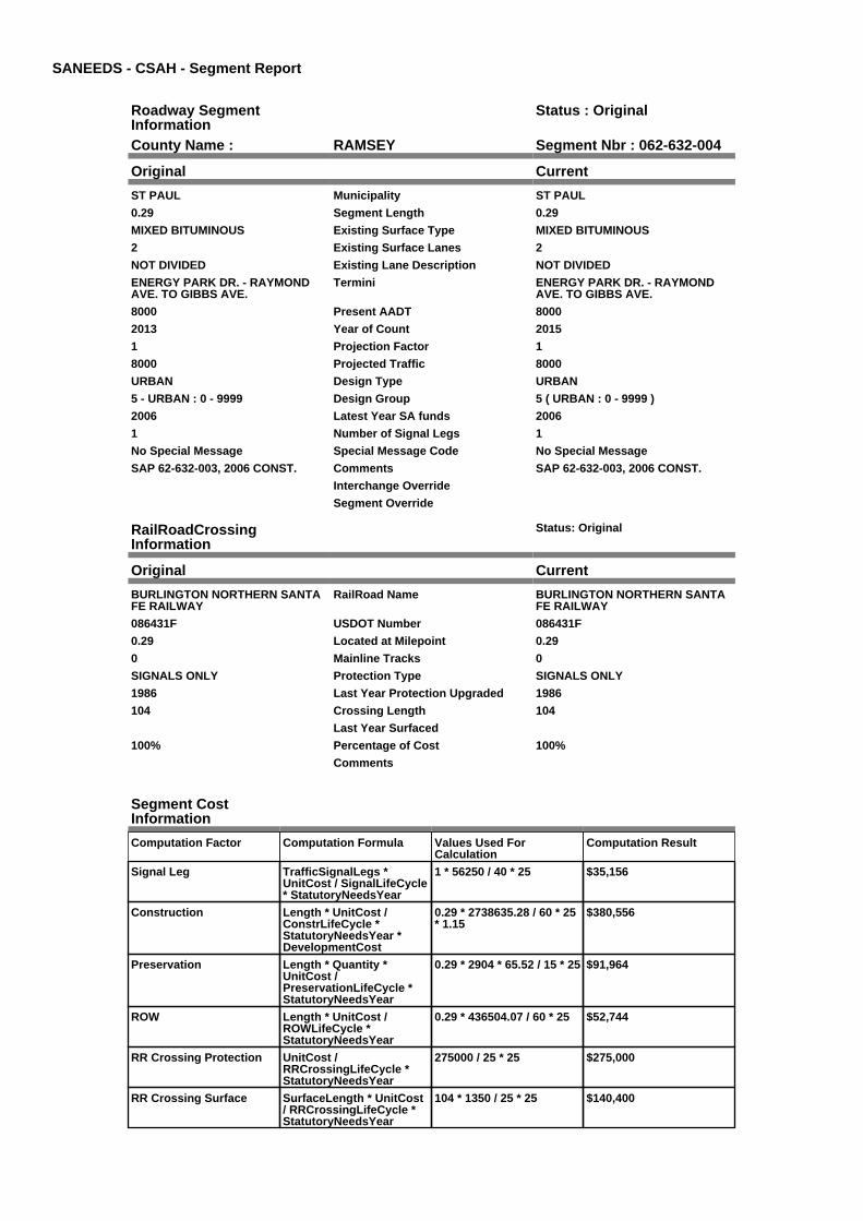
SANEEDS - CSAH - Segment Report
Roadway SegmentInformation
Status : Original
County Name : RAMSEY Segment Nbr : 062-632-004
Original Current
ST PAUL Municipality ST PAUL
0.29 Segment Length 0.29
MIXED BITUMINOUS Existing Surface Type MIXED BITUMINOUS
2 Existing Surface Lanes 2
NOT DIVIDED Existing Lane Description NOT DIVIDED
ENERGY PARK DR. - RAYMONDAVE. TO GIBBS AVE.
Termini ENERGY PARK DR. - RAYMONDAVE. TO GIBBS AVE.
8000 Present AADT 8000
2013 Year of Count 2015
1 Projection Factor 1
8000 Projected Traffic 8000
URBAN Design Type URBAN
5 - URBAN : 0 - 9999 Design Group 5 ( URBAN : 0 - 9999 )
2006 Latest Year SA funds 2006
1 Number of Signal Legs 1
No Special Message Special Message Code No Special Message
SAP 62-632-003, 2006 CONST. Comments SAP 62-632-003, 2006 CONST.
Interchange Override
Segment Override
RailRoadCrossingInformation
Status: Original
Original Current
BURLINGTON NORTHERN SANTAFE RAILWAY
RailRoad Name BURLINGTON NORTHERN SANTAFE RAILWAY
086431F USDOT Number 086431F
0.29 Located at Milepoint 0.29
0 Mainline Tracks 0
SIGNALS ONLY Protection Type SIGNALS ONLY
1986 Last Year Protection Upgraded 1986
104 Crossing Length 104
Last Year Surfaced
100% Percentage of Cost 100%
Comments
Segment CostInformation
Computation Factor Computation Formula Values Used ForCalculation
Computation Result
Signal Leg TrafficSignalLegs *UnitCost / SignalLifeCycle* StatutoryNeedsYear
1 * 56250 / 40 * 25 $35,156
Construction Length * UnitCost /ConstrLifeCycle *StatutoryNeedsYear *DevelopmentCost
0.29 * 2738635.28 / 60 * 25* 1.15
$380,556
Preservation Length * Quantity *UnitCost /PreservationLifeCycle *StatutoryNeedsYear
0.29 * 2904 * 65.52 / 15 * 25 $91,964
ROW Length * UnitCost /ROWLifeCycle *StatutoryNeedsYear
0.29 * 436504.07 / 60 * 25 $52,744
RR Crossing Protection UnitCost /RRCrossingLifeCycle *StatutoryNeedsYear
275000 / 25 * 25 $275,000
RR Crossing Surface SurfaceLength * UnitCost/ RRCrossingLifeCycle *StatutoryNeedsYear
104 * 1350 / 25 * 25 $140,400

Total Segment Cost Signal Leg + Construction+ Preservation + ROW +RR Crossing Protection +RR Crossing Surface
$35,156 + $380,556 +$91,964 + $52,744 +$275,000 + $140,400
$975,820

SANEEDS - CSAH - Segment Report
Roadway SegmentInformation
Status : Original
County Name : RAMSEY Segment Nbr : 062-632-005
Original Current
ST PAUL Municipality ST PAUL
0.9 Segment Length 0.9
MIXED BITUMINOUS Existing Surface Type MIXED BITUMINOUS
2 Existing Surface Lanes 2
NOT DIVIDED Existing Lane Description NOT DIVIDED
ENERGY PARK DR. - GIBBS AVE.TO 1016 FT. W OF SNELLING AVE.
Termini ENERGY PARK DR. - GIBBS AVE.TO 1016 FT. W OF SNELLING AVE.
8000 Present AADT 8000
2013 Year of Count 2015
1 Projection Factor 1
8000 Projected Traffic 8000
URBAN Design Type URBAN
5 - URBAN : 0 - 9999 Design Group 5 ( URBAN : 0 - 9999 )
2006 Latest Year SA funds 2006
0 Number of Signal Legs 0
No Special Message Special Message Code No Special Message
SAP 62-632-003, 2006 CONST. Comments SAP 62-632-003, 2006 CONST.
Interchange Override
Segment Override
Segment CostInformation
Computation Factor Computation Formula Values Used ForCalculation
Computation Result
Signal Leg TrafficSignalLegs *UnitCost / SignalLifeCycle* StatutoryNeedsYear
0 * 56250 / 40 * 25 $0
Construction Length * UnitCost /ConstrLifeCycle *StatutoryNeedsYear *DevelopmentCost
0.9 * 2738635.28 / 60 * 25 *1.15
$1,181,036
Preservation Length * Quantity *UnitCost /PreservationLifeCycle *StatutoryNeedsYear
0.9 * 2904 * 65.52 / 15 * 25 $285,405
ROW Length * UnitCost /ROWLifeCycle *StatutoryNeedsYear
0.9 * 436504.07 / 60 * 25 $163,689
Total Segment Cost Signal Leg + Construction+ Preservation + ROW
$0 + $1,181,036 + $285,405+ $163,689
$1,630,130

SANEEDS - CSAH - Segment Report
Roadway SegmentInformation
Status : Original
County Name : RAMSEY Segment Nbr : 062-632-006
Original Current
ST PAUL Municipality ST PAUL
0.19 Segment Length 0.19
BIT CONC OR ASPH Existing Surface Type BIT CONC OR ASPH
2 Existing Surface Lanes 2
NOT DIVIDED Existing Lane Description NOT DIVIDED
KASOTA AVE. - 1016 FT. W OFSNELLING AVE. TO SNELLINGAVE.
Termini KASOTA AVE. - 1016 FT. W OFSNELLING AVE. TO SNELLINGAVE.
8000 Present AADT 8000
2013 Year of Count 2015
1 Projection Factor 1
8000 Projected Traffic 8000
URBAN Design Type URBAN
5 - URBAN : 0 - 9999 Design Group 5 ( URBAN : 0 - 9999 )
2006 Latest Year SA funds 2006
0 Number of Signal Legs 0
No Special Message Special Message Code No Special Message
SAP 62-632-003, 2006 CONST. Comments SAP 62-632-003, 2006 CONST.
Interchange Override
Segment Override
Segment CostInformation
Computation Factor Computation Formula Values Used ForCalculation
Computation Result
Signal Leg TrafficSignalLegs *UnitCost / SignalLifeCycle* StatutoryNeedsYear
0 * 56250 / 40 * 25 $0
Construction Length * UnitCost /ConstrLifeCycle *StatutoryNeedsYear *DevelopmentCost
0.19 * 2738635.28 / 60 * 25* 1.15
$249,330
Preservation Length * Quantity *UnitCost /PreservationLifeCycle *StatutoryNeedsYear
0.19 * 2904 * 65.52 / 15 * 25 $60,252
ROW Length * UnitCost /ROWLifeCycle *StatutoryNeedsYear
0.19 * 436504.07 / 60 * 25 $34,557
Total Segment Cost Signal Leg + Construction+ Preservation + ROW
$0 + $249,330 + $60,252 +$34,557
$344,139

SANEEDS - CSAH - Segment Report
Roadway SegmentInformation
Status : Original
County Name : RAMSEY Segment Nbr : 062-632-007
Original Current
ST PAUL Municipality ST PAUL
1.03 Segment Length 1.03
BIT CONC OR ASPH Existing Surface Type BIT CONC OR ASPH
4 Existing Surface Lanes 4
DIVIDED Existing Lane Description DIVIDED
ENERGY PARK DR. - SNELLINGAVE. TO LEXINGTON PKWY.
Termini ENERGY PARK DR. - SNELLINGAVE. TO LEXINGTON PKWY.
11800 Present AADT 11800
2013 Year of Count 2015
1 Projection Factor 1
11800 Projected Traffic 11800
URBAN Design Type URBAN
6 - URBAN : 10000 - 19999 Design Group 6 ( URBAN : 10000 - 19999 )
1984 Latest Year SA funds 1984
3 Number of Signal Legs 3
No Special Message Special Message Code No Special Message
Comments
Interchange Override
Segment Override
Segment CostInformation
Computation Factor Computation Formula Values Used ForCalculation
Computation Result
Signal Leg TrafficSignalLegs *UnitCost / SignalLifeCycle* StatutoryNeedsYear
3 * 56250 / 40 * 25 $105,469
Construction Length * UnitCost /ConstrLifeCycle *StatutoryNeedsYear *DevelopmentCost
1.03 * 4225495.41 / 60 * 25* 1.15
$2,085,458
Preservation Length * Quantity *UnitCost /PreservationLifeCycle *StatutoryNeedsYear
1.03 * 3696 * 65.52 / 15 * 25 $415,711
ROW Length * UnitCost /ROWLifeCycle *StatutoryNeedsYear
1.03 * 566370.18 / 60 * 25 $243,067
Total Segment Cost Signal Leg + Construction+ Preservation + ROW
$105,469 + $2,085,458 +$415,711 + $243,067
$2,849,705

SANEEDS - CSAH - Segment Report
Roadway SegmentInformation
Status : Original
County Name : RAMSEY Segment Nbr : 062-632-008
Original Current
ST PAUL Municipality ST PAUL
1 Segment Length 1
PORT CEMENT CONC Existing Surface Type PORT CEMENT CONC
2 Existing Surface Lanes 2
NOT DIVIDED Existing Lane Description NOT DIVIDED
FRONT AVE. - LEXINGTON PKWY.TO DALE ST.
Termini FRONT AVE. - LEXINGTON PKWY.TO DALE ST.
9400 Present AADT 9400
2013 Year of Count 2015
1 Projection Factor 1
9400 Projected Traffic 9400
URBAN Design Type URBAN
5 - URBAN : 0 - 9999 Design Group 5 ( URBAN : 0 - 9999 )
2000 Latest Year SA funds 2000
2 Number of Signal Legs 2
No Special Message Special Message Code No Special Message
Comments
Interchange Override
Segment Override
Segment CostInformation
Computation Factor Computation Formula Values Used ForCalculation
Computation Result
Signal Leg TrafficSignalLegs *UnitCost / SignalLifeCycle* StatutoryNeedsYear
2 * 56250 / 40 * 25 $70,313
Construction Length * UnitCost /ConstrLifeCycle *StatutoryNeedsYear *DevelopmentCost
1 * 2738635.28 / 60 * 25 *1.15
$1,312,263
Preservation Length * Quantity *UnitCost /PreservationLifeCycle *StatutoryNeedsYear
1 * 2904 * 65.52 / 15 * 25 $317,117
ROW Length * UnitCost /ROWLifeCycle *StatutoryNeedsYear
1 * 436504.07 / 60 * 25 $181,877
Total Segment Cost Signal Leg + Construction+ Preservation + ROW
$70,313 + $1,312,263 +$317,117 + $181,877
$1,881,570

SANEEDS - CSAH - Segment Report
Roadway SegmentInformation
Status : Original
County Name : RAMSEY Segment Nbr : 062-632-100
Original Current
ST PAUL Municipality ST PAUL
0.63 Segment Length 0.63
MIXED BITUMINOUS Existing Surface Type MIXED BITUMINOUS
4 Existing Surface Lanes 4
NOT DIVIDED Existing Lane Description NOT DIVIDED
DALE ST TO WESTERN AVE Termini DALE ST TO WESTERN AVE
7200 Present AADT 7200
2013 Year of Count 2015
1 Projection Factor 1
7200 Projected Traffic 7200
URBAN Design Type URBAN
5 - URBAN : 0 - 9999 Design Group 5 ( URBAN : 0 - 9999 )
2005 Latest Year SA funds 2005
2 Number of Signal Legs 2
No Special Message Special Message Code No Special Message
Comments
Interchange Override
Segment Override
Segment CostInformation
Computation Factor Computation Formula Values Used ForCalculation
Computation Result
Signal Leg TrafficSignalLegs *UnitCost / SignalLifeCycle* StatutoryNeedsYear
2 * 56250 / 40 * 25 $70,313
Construction Length * UnitCost /ConstrLifeCycle *StatutoryNeedsYear *DevelopmentCost
0.63 * 2738635.28 / 60 * 25* 1.15
$826,726
Preservation Length * Quantity *UnitCost /PreservationLifeCycle *StatutoryNeedsYear
0.63 * 2904 * 65.52 / 15 * 25 $199,784
ROW Length * UnitCost /ROWLifeCycle *StatutoryNeedsYear
0.63 * 436504.07 / 60 * 25 $114,582
Total Segment Cost Signal Leg + Construction+ Preservation + ROW
$70,313 + $826,726 +$199,784 + $114,582
$1,211,405
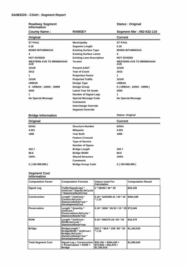
SANEEDS - CSAH - Segment Report
Roadway SegmentInformation
Status : Original
County Name : RAMSEY Segment Nbr : 062-632-110
Original Current
ST PAUL Municipality ST PAUL
0.18 Segment Length 0.18
MIXED BITUMINOUS Existing Surface Type MIXED BITUMINOUS
4 Existing Surface Lanes 4
NOT DIVIDED Existing Lane Description NOT DIVIDED
WESTERN AVE TO MINNEHAHAAVE
Termini WESTERN AVE TO MINNEHAHAAVE
10100 Present AADT 10100
2013 Year of Count 2015
1 Projection Factor 1
10100 Projected Traffic 10100
URBAN Design Type URBAN
6 - URBAN : 10000 - 19999 Design Group 6 ( URBAN : 10000 - 19999 )
2005 Latest Year SA funds 2005
1 Number of Signal Legs 1
No Special Message Special Message Code No Special Message
Comments
Interchange Override
Segment Override
Bridge Information Status: Original
Original Current
62541 Structure Number 62541
4.501 Milepoint 4.501
1985 Year Built 1985
Feature Crossed
Type of Service
Number of Spans
342.7 Bridge Length 342.7
68.6 Bridge Width 68.6
100% Shared Structure 100%
Comments
2 ( 150-999,999 ) Bridge Group Code 2 ( 150-999,999 )
Segment CostInformation
Computation Factor Computation Formula Values Used ForCalculation
Computation Result
Signal Leg TrafficSignalLegs *UnitCost / SignalLifeCycle* StatutoryNeedsYear
1 * 56250 / 40 * 25 $35,156
Construction Length * UnitCost /ConstrLifeCycle *StatutoryNeedsYear *DevelopmentCost
0.18 * 4225495.41 / 60 * 25* 1.15
$364,449
Preservation Length * Quantity *UnitCost /PreservationLifeCycle *StatutoryNeedsYear
0.18 * 3696 * 65.52 / 15 * 25 $72,649
ROW Length * UnitCost /ROWLifeCycle *StatutoryNeedsYear
0.18 * 566370.18 / 60 * 25 $42,478
Bridge BridgeLength *BridgeWidth * UnitCost /BridgeLifeCycle *StatutoryNeedsYear *DevelopmentCost
342.7 * 68.6 * 138 / 80 * 25* 1.15
$1,165,910
Total Segment Cost Signal Leg + Construction+ Preservation + ROW +Bridge
$35,156 + $364,449 +$72,649 + $42,478 +$1,165,910
$1,680,642

SANEEDS - CSAH - Segment Report
Roadway SegmentInformation
Status : Original
County Name : RAMSEY Segment Nbr : 062-633-050
Original Current
ST PAUL Municipality ST PAUL
0.75 Segment Length 0.75
MIXED BITUMINOUS Existing Surface Type MIXED BITUMINOUS
4 Existing Surface Lanes 4
NOT DIVIDED Existing Lane Description NOT DIVIDED
TRANSFER ROAD - UNIVERSITYAVE. TO PRIOR AVE.
Termini TRANSFER ROAD - UNIVERSITYAVE. TO PRIOR AVE.
6200 Present AADT 6200
2013 Year of Count 2015
1 Projection Factor 1
6200 Projected Traffic 6200
URBAN Design Type URBAN
5 - URBAN : 0 - 9999 Design Group 5 ( URBAN : 0 - 9999 )
2000 Latest Year SA funds 2000
1 Number of Signal Legs 1
No Special Message Special Message Code No Special Message
Comments
Interchange Override
Segment Override
Bridge Information Status: Original
Original Current
62527 Structure Number 62527
0.634 Milepoint 0.634
1974 Year Built 1974
MC RY Feature Crossed MC RY
Type of Service
Number of Spans
368.6 Bridge Length 368.6
78 Bridge Width 78
100% Shared Structure 100%
Comments
2 ( 150-999,999 ) Bridge Group Code 2 ( 150-999,999 )
Segment CostInformation
Computation Factor Computation Formula Values Used ForCalculation
Computation Result
Signal Leg TrafficSignalLegs *UnitCost / SignalLifeCycle* StatutoryNeedsYear
1 * 56250 / 40 * 25 $35,156
Construction Length * UnitCost /ConstrLifeCycle *StatutoryNeedsYear *DevelopmentCost
0.75 * 2738635.28 / 60 * 25* 1.15
$984,197
Preservation Length * Quantity *UnitCost /PreservationLifeCycle *StatutoryNeedsYear
0.75 * 2904 * 65.52 / 15 * 25 $237,838
ROW Length * UnitCost /ROWLifeCycle *StatutoryNeedsYear
0.75 * 436504.07 / 60 * 25 $136,408
Bridge BridgeLength *BridgeWidth * UnitCost /BridgeLifeCycle *StatutoryNeedsYear *DevelopmentCost
368.6 * 78 * 138 / 80 * 25 *1.15
$1,425,860
Total Segment Cost Signal Leg + Construction+ Preservation + ROW +Bridge
$35,156 + $984,197 +$237,838 + $136,408 +$1,425,860
$2,819,459

SANEEDS - CSAH - Segment Report
Roadway SegmentInformation
Status : Original
County Name : RAMSEY Segment Nbr : 062-633-060
Original Current
ST PAUL Municipality ST PAUL
0.8 Segment Length 0.8
MIXED BITUMINOUS Existing Surface Type MIXED BITUMINOUS
2 Existing Surface Lanes 2
NOT DIVIDED Existing Lane Description NOT DIVIDED
PIERCE BUTLER ROUTE - PRIORAVE. TO SNELLING AVE.
Termini PIERCE BUTLER ROUTE - PRIORAVE. TO SNELLING AVE.
12700 Present AADT 12700
2013 Year of Count 2015
1 Projection Factor 1
12700 Projected Traffic 12700
URBAN Design Type URBAN
6 - URBAN : 10000 - 19999 Design Group 6 ( URBAN : 10000 - 19999 )
2000 Latest Year SA funds 2000
0 Number of Signal Legs 0
No Special Message Special Message Code No Special Message
Comments
Interchange Override
Segment Override
Segment CostInformation
Computation Factor Computation Formula Values Used ForCalculation
Computation Result
Signal Leg TrafficSignalLegs *UnitCost / SignalLifeCycle* StatutoryNeedsYear
0 * 56250 / 40 * 25 $0
Construction Length * UnitCost /ConstrLifeCycle *StatutoryNeedsYear *DevelopmentCost
0.8 * 4225495.41 / 60 * 25 *1.15
$1,619,773
Preservation Length * Quantity *UnitCost /PreservationLifeCycle *StatutoryNeedsYear
0.8 * 3696 * 65.52 / 15 * 25 $322,883
ROW Length * UnitCost /ROWLifeCycle *StatutoryNeedsYear
0.8 * 566370.18 / 60 * 25 $188,790
Total Segment Cost Signal Leg + Construction+ Preservation + ROW
$0 + $1,619,773 + $322,883+ $188,790
$2,131,446

SANEEDS - CSAH - Segment Report
Roadway SegmentInformation
Status : Original
County Name : RAMSEY Segment Nbr : 062-633-070
Original Current
ST PAUL Municipality ST PAUL
1.8 Segment Length 1.8
BIT CONC OR ASPH Existing Surface Type BIT CONC OR ASPH
4 Existing Surface Lanes 4
NOT DIVIDED Existing Lane Description NOT DIVIDED
PIERCE BUTLER ROUTE -SNELLING AVE. TO GROTTO ST.
Termini PIERCE BUTLER ROUTE -SNELLING AVE. TO GROTTO ST.
9400 Present AADT 9400
2013 Year of Count 2015
1 Projection Factor 1
9400 Projected Traffic 9400
URBAN Design Type URBAN
5 - URBAN : 0 - 9999 Design Group 5 ( URBAN : 0 - 9999 )
2000 Latest Year SA funds 2000
0 Number of Signal Legs 0
No Special Message Special Message Code No Special Message
Comments
Interchange Override
Segment Override
Segment CostInformation
Computation Factor Computation Formula Values Used ForCalculation
Computation Result
Signal Leg TrafficSignalLegs *UnitCost / SignalLifeCycle* StatutoryNeedsYear
0 * 56250 / 40 * 25 $0
Construction Length * UnitCost /ConstrLifeCycle *StatutoryNeedsYear *DevelopmentCost
1.8 * 2738635.28 / 60 * 25 *1.15
$2,362,073
Preservation Length * Quantity *UnitCost /PreservationLifeCycle *StatutoryNeedsYear
1.8 * 2904 * 65.52 / 15 * 25 $570,810
ROW Length * UnitCost /ROWLifeCycle *StatutoryNeedsYear
1.8 * 436504.07 / 60 * 25 $327,378
Total Segment Cost Signal Leg + Construction+ Preservation + ROW
$0 + $2,362,073 + $570,810+ $327,378
$3,260,261

SANEEDS - CSAH - Segment Report
Roadway SegmentInformation
Status : Original
County Name : RAMSEY Segment Nbr : 062-633-080
Original Current
ST PAUL Municipality ST PAUL
0.21 Segment Length 0.21
BIT CONC OR ASPH Existing Surface Type BIT CONC OR ASPH
4 Existing Surface Lanes 4
NOT DIVIDED Existing Lane Description NOT DIVIDED
PIERCE BUTLER ROUTE -GROTTO ST. TO MINNEHAHA AVE.
Termini PIERCE BUTLER ROUTE -GROTTO ST. TO MINNEHAHA AVE.
7800 Present AADT 7800
2013 Year of Count 2015
1 Projection Factor 1
7800 Projected Traffic 7800
URBAN Design Type URBAN
5 - URBAN : 0 - 9999 Design Group 5 ( URBAN : 0 - 9999 )
2000 Latest Year SA funds 2000
1 Number of Signal Legs 1
No Special Message Special Message Code No Special Message
Comments
Interchange Override
Segment Override
Segment CostInformation
Computation Factor Computation Formula Values Used ForCalculation
Computation Result
Signal Leg TrafficSignalLegs *UnitCost / SignalLifeCycle* StatutoryNeedsYear
1 * 56250 / 40 * 25 $35,156
Construction Length * UnitCost /ConstrLifeCycle *StatutoryNeedsYear *DevelopmentCost
0.21 * 2738635.28 / 60 * 25* 1.15
$275,575
Preservation Length * Quantity *UnitCost /PreservationLifeCycle *StatutoryNeedsYear
0.21 * 2904 * 65.52 / 15 * 25 $66,595
ROW Length * UnitCost /ROWLifeCycle *StatutoryNeedsYear
0.21 * 436504.07 / 60 * 25 $38,194
Total Segment Cost Signal Leg + Construction+ Preservation + ROW
$35,156 + $275,575 +$66,595 + $38,194
$415,520

SANEEDS - CSAH - Segment Report
Roadway SegmentInformation
Status : Original
County Name : RAMSEY Segment Nbr : 062-633-090
Original Current
ST PAUL Municipality ST PAUL
0.04 Segment Length 0.04
MIXED BITUMINOUS Existing Surface Type MIXED BITUMINOUS
2 Existing Surface Lanes 2
NOT DIVIDED Existing Lane Description NOT DIVIDED
MINNEHAHA AVE. W. - PIERCEBUTLER ROUTE TO DALE ST.
Termini MINNEHAHA AVE. W. - PIERCEBUTLER ROUTE TO DALE ST.
15700 Present AADT 15700
2013 Year of Count 2015
1 Projection Factor 1
15700 Projected Traffic 15700
URBAN Design Type URBAN
6 - URBAN : 10000 - 19999 Design Group 6 ( URBAN : 10000 - 19999 )
1970 Latest Year SA funds 1970
3 Number of Signal Legs 3
No Special Message Special Message Code No Special Message
Comments
Interchange Override
Segment Override
Segment CostInformation
Computation Factor Computation Formula Values Used ForCalculation
Computation Result
Signal Leg TrafficSignalLegs *UnitCost / SignalLifeCycle* StatutoryNeedsYear
3 * 56250 / 40 * 25 $105,469
Construction Length * UnitCost /ConstrLifeCycle *StatutoryNeedsYear *DevelopmentCost
0.04 * 4225495.41 / 60 * 25* 1.15
$80,989
Preservation Length * Quantity *UnitCost /PreservationLifeCycle *StatutoryNeedsYear
0.04 * 3696 * 65.52 / 15 * 25 $16,144
ROW Length * UnitCost /ROWLifeCycle *StatutoryNeedsYear
0.04 * 566370.18 / 60 * 25 $9,440
Total Segment Cost Signal Leg + Construction+ Preservation + ROW
$105,469 + $80,989 +$16,144 + $9,440
$212,042

SANEEDS - CSAH - Segment Report
Roadway SegmentInformation
Status : Original
County Name : RAMSEY Segment Nbr : 062-633-100
Original Current
ST PAUL Municipality ST PAUL
0.65 Segment Length 0.65
BIT CONC OR ASPH Existing Surface Type BIT CONC OR ASPH
2 Existing Surface Lanes 2
NOT DIVIDED Existing Lane Description NOT DIVIDED
MINNEHAHA AVE - DALE ST. TOCOMO AVE.
Termini MINNEHAHA AVE - DALE ST. TOCOMO AVE.
6500 Present AADT 6500
2013 Year of Count 2015
1 Projection Factor 1
6500 Projected Traffic 6500
URBAN Design Type URBAN
5 - URBAN : 0 - 9999 Design Group 5 ( URBAN : 0 - 9999 )
2000 Latest Year SA funds 2000
3 Number of Signal Legs 3
No Special Message Special Message Code No Special Message
Comments
Interchange Override
Segment Override
Segment CostInformation
Computation Factor Computation Formula Values Used ForCalculation
Computation Result
Signal Leg TrafficSignalLegs *UnitCost / SignalLifeCycle* StatutoryNeedsYear
3 * 56250 / 40 * 25 $105,469
Construction Length * UnitCost /ConstrLifeCycle *StatutoryNeedsYear *DevelopmentCost
0.65 * 2738635.28 / 60 * 25* 1.15
$852,971
Preservation Length * Quantity *UnitCost /PreservationLifeCycle *StatutoryNeedsYear
0.65 * 2904 * 65.52 / 15 * 25 $206,126
ROW Length * UnitCost /ROWLifeCycle *StatutoryNeedsYear
0.65 * 436504.07 / 60 * 25 $118,220
Total Segment Cost Signal Leg + Construction+ Preservation + ROW
$105,469 + $852,971 +$206,126 + $118,220
$1,282,786

SANEEDS - CSAH - Segment Report
Roadway SegmentInformation
Status : Original
County Name : RAMSEY Segment Nbr : 062-633-110
Original Current
ST PAUL Municipality ST PAUL
0.46 Segment Length 0.46
MIXED BITUMINOUS Existing Surface Type MIXED BITUMINOUS
4 Existing Surface Lanes 4
NOT DIVIDED Existing Lane Description NOT DIVIDED
COMO AVE. - MINNEHAHA AVE.TO RICE ST.
Termini COMO AVE. - MINNEHAHA AVE.TO RICE ST.
15100 Present AADT 15100
2013 Year of Count 2015
1 Projection Factor 1
15100 Projected Traffic 15100
URBAN Design Type URBAN
6 - URBAN : 10000 - 19999 Design Group 6 ( URBAN : 10000 - 19999 )
2005 Latest Year SA funds 2005
3 Number of Signal Legs 3
THTB-RECONSTRUCTED WITH TBFUNDS
Special Message Code THTB-RECONSTRUCTED WITH TBFUNDS
Comments
Interchange Override
Segment Override
Segment CostInformation
Computation Factor Computation Formula Values Used ForCalculation
Computation Result
Signal Leg TrafficSignalLegs *UnitCost / SignalLifeCycle* StatutoryNeedsYear
3 * 56250 / 40 * 25 $105,469
Construction Length * UnitCost /ConstrLifeCycle *StatutoryNeedsYear *DevelopmentCost
0.46 * 4225495.41 / 60 * 25* 1.15
$931,370
Preservation Length * Quantity *UnitCost /PreservationLifeCycle *StatutoryNeedsYear
0.46 * 3696 * 65.52 / 15 * 25 $185,657
ROW Length * UnitCost /ROWLifeCycle *StatutoryNeedsYear
0.46 * 566370.18 / 60 * 25 $108,554
Total Segment Cost Signal Leg + Construction+ Preservation + ROW
$105,469 + $931,370 +$185,657 + $108,554
$1,331,050

SANEEDS - CSAH - Segment Report
Roadway SegmentInformation
Status : Original
County Name : RAMSEY Segment Nbr : 062-633-120
Original Current
ST PAUL Municipality ST PAUL
0.11 Segment Length 0.11
BIT CONC OR ASPH Existing Surface Type BIT CONC OR ASPH
3 Existing Surface Lanes 3
NOT DIVIDED Existing Lane Description NOT DIVIDED
LAFOND AVE. - COMO AVE. TORICE ST.
Termini LAFOND AVE. - COMO AVE. TORICE ST.
14800 Present AADT 14800
2013 Year of Count 2015
1 Projection Factor 1
14800 Projected Traffic 14800
URBAN Design Type URBAN
6 - URBAN : 10000 - 19999 Design Group 6 ( URBAN : 10000 - 19999 )
2000 Latest Year SA funds 2000
2 Number of Signal Legs 2
No Special Message Special Message Code No Special Message
Comments
Interchange Override
Segment Override
Segment CostInformation
Computation Factor Computation Formula Values Used ForCalculation
Computation Result
Signal Leg TrafficSignalLegs *UnitCost / SignalLifeCycle* StatutoryNeedsYear
2 * 56250 / 40 * 25 $70,313
Construction Length * UnitCost /ConstrLifeCycle *StatutoryNeedsYear *DevelopmentCost
0.11 * 4225495.41 / 60 * 25* 1.15
$222,719
Preservation Length * Quantity *UnitCost /PreservationLifeCycle *StatutoryNeedsYear
0.11 * 3696 * 65.52 / 15 * 25 $44,396
ROW Length * UnitCost /ROWLifeCycle *StatutoryNeedsYear
0.11 * 566370.18 / 60 * 25 $25,959
Total Segment Cost Signal Leg + Construction+ Preservation + ROW
$70,313 + $222,719 +$44,396 + $25,959
$363,387

SANEEDS - CSAH - Segment Report
Roadway SegmentInformation
Status : Original
County Name : RAMSEY Segment Nbr : 062-633-130
Original Current
ST PAUL Municipality ST PAUL
0.39 Segment Length 0.39
PORT CEMENT CONC Existing Surface Type PORT CEMENT CONC
4 Existing Surface Lanes 4
DIVIDED Existing Lane Description DIVIDED
ARCH ST. AND CAPITOL HTS. -RICE ST. TO JACKSON ST.
Termini ARCH ST. AND CAPITOL HTS. -RICE ST. TO JACKSON ST.
14800 Present AADT 14800
2013 Year of Count 2015
1 Projection Factor 1
14800 Projected Traffic 14800
URBAN Design Type URBAN
6 - URBAN : 10000 - 19999 Design Group 6 ( URBAN : 10000 - 19999 )
2000 Latest Year SA funds 2000
1 Number of Signal Legs 1
No Special Message Special Message Code No Special Message
Comments
Interchange Override
Segment Override
Segment CostInformation
Computation Factor Computation Formula Values Used ForCalculation
Computation Result
Signal Leg TrafficSignalLegs *UnitCost / SignalLifeCycle* StatutoryNeedsYear
1 * 56250 / 40 * 25 $35,156
Construction Length * UnitCost /ConstrLifeCycle *StatutoryNeedsYear *DevelopmentCost
0.39 * 4225495.41 / 60 * 25* 1.15
$789,639
Preservation Length * Quantity *UnitCost /PreservationLifeCycle *StatutoryNeedsYear
0.39 * 3696 * 65.52 / 15 * 25 $157,405
ROW Length * UnitCost /ROWLifeCycle *StatutoryNeedsYear
0.39 * 566370.18 / 60 * 25 $92,035
Total Segment Cost Signal Leg + Construction+ Preservation + ROW
$35,156 + $789,639 +$157,405 + $92,035
$1,074,235

SANEEDS - CSAH - Segment Report
Roadway SegmentInformation
Status : Original
County Name : RAMSEY Segment Nbr : 062-633-140
Original Current
ST PAUL Municipality ST PAUL
0.4 Segment Length 0.4
PORT CEMENT CONC Existing Surface Type PORT CEMENT CONC
4 Existing Surface Lanes 4
DIVIDED Existing Lane Description DIVIDED
PENNSYLVANIA AVE. - JACKSONST. TO MISSISSIPPI ST.
Termini PENNSYLVANIA AVE. - JACKSONST. TO MISSISSIPPI ST.
14500 Present AADT 14500
2013 Year of Count 2015
1 Projection Factor 1
14500 Projected Traffic 14500
URBAN Design Type URBAN
6 - URBAN : 10000 - 19999 Design Group 6 ( URBAN : 10000 - 19999 )
2014 Latest Year SA funds 2014
3 Number of Signal Legs 3
No Special Message Special Message Code No Special Message
2014 CSAH EXPENDITURE-RAMSEY COUNTY CONTRIBUTIONTO SP 6208-308; COOPERATIVEAGREEMENT NO. 01607
Comments 2014 CSAH EXPENDITURE-RAMSEY COUNTY CONTRIBUTIONTO SP 6208-308; COOPERATIVEAGREEMENT NO. 01607
Interchange Override
Segment Override
Segment CostInformation
Computation Factor Computation Formula Values Used ForCalculation
Computation Result
Signal Leg TrafficSignalLegs *UnitCost / SignalLifeCycle* StatutoryNeedsYear
3 * 56250 / 40 * 25 $105,469
Construction Length * UnitCost /ConstrLifeCycle *StatutoryNeedsYear *DevelopmentCost
0.4 * 4225495.41 / 60 * 25 *1.15
$809,887
Preservation Length * Quantity *UnitCost /PreservationLifeCycle *StatutoryNeedsYear
0.4 * 3696 * 65.52 / 15 * 25 $161,441
ROW Length * UnitCost /ROWLifeCycle *StatutoryNeedsYear
0.4 * 566370.18 / 60 * 25 $94,395
Total Segment Cost Signal Leg + Construction+ Preservation + ROW
$105,469 + $809,887 +$161,441 + $94,395
$1,171,192
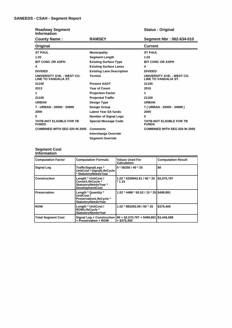
SANEEDS - CSAH - Segment Report
Roadway SegmentInformation
Status : Original
County Name : RAMSEY Segment Nbr : 062-634-010
Original Current
ST PAUL Municipality ST PAUL
1.02 Segment Length 1.02
BIT CONC OR ASPH Existing Surface Type BIT CONC OR ASPH
4 Existing Surface Lanes 4
DIVIDED Existing Lane Description DIVIDED
UNIVERSITY AVE. - WEST CO.LINE TO VANDALIA ST.
Termini UNIVERSITY AVE. - WEST CO.LINE TO VANDALIA ST.
21100 Present AADT 21100
2013 Year of Count 2015
1 Projection Factor 1
21100 Projected Traffic 21100
URBAN Design Type URBAN
7 - URBAN : 20000 - 34999 Design Group 7 ( URBAN : 20000 - 34999 )
2000 Latest Year SA funds 2000
0 Number of Signal Legs 0
THTB-NOT ELIGIBLE FOR TBFUNDS
Special Message Code THTB-NOT ELIGIBLE FOR TBFUNDS
COMBINED WITH SEG 020 IN 2005 Comments COMBINED WITH SEG 020 IN 2005
Interchange Override
Segment Override
Segment CostInformation
Computation Factor Computation Formula Values Used ForCalculation
Computation Result
Signal Leg TrafficSignalLegs *UnitCost / SignalLifeCycle* StatutoryNeedsYear
0 * 56250 / 40 * 25 $0
Construction Length * UnitCost /ConstrLifeCycle *StatutoryNeedsYear *DevelopmentCost
1.02 * 5259942.61 / 60 * 25* 1.15
$2,570,797
Preservation Length * Quantity *UnitCost /PreservationLifeCycle *StatutoryNeedsYear
1.02 * 4488 * 65.52 / 15 * 25 $499,891
ROW Length * UnitCost /ROWLifeCycle *StatutoryNeedsYear
1.02 * 883293.09 / 60 * 25 $375,400
Total Segment Cost Signal Leg + Construction+ Preservation + ROW
$0 + $2,570,797 + $499,891+ $375,400
$3,446,088

SANEEDS - CSAH - Segment Report
Roadway SegmentInformation
Status : Original
County Name : RAMSEY Segment Nbr : 062-634-030
Original Current
ST PAUL Municipality ST PAUL
0.13 Segment Length 0.13
BIT CONC OR ASPH Existing Surface Type BIT CONC OR ASPH
4 Existing Surface Lanes 4
DIVIDED Existing Lane Description DIVIDED
UNIVERSITY AVE. - VANDALIA ST.TO CLEVELAND AVE.
Termini UNIVERSITY AVE. - VANDALIA ST.TO CLEVELAND AVE.
12600 Present AADT 12600
2013 Year of Count 2015
1 Projection Factor 1
12600 Projected Traffic 12600
URBAN Design Type URBAN
6 - URBAN : 10000 - 19999 Design Group 6 ( URBAN : 10000 - 19999 )
2000 Latest Year SA funds 2000
2 Number of Signal Legs 2
THTB-NOT ELIGIBLE FOR TBFUNDS
Special Message Code THTB-NOT ELIGIBLE FOR TBFUNDS
Comments
Interchange Override
Segment Override
Segment CostInformation
Computation Factor Computation Formula Values Used ForCalculation
Computation Result
Signal Leg TrafficSignalLegs *UnitCost / SignalLifeCycle* StatutoryNeedsYear
2 * 56250 / 40 * 25 $70,313
Construction Length * UnitCost /ConstrLifeCycle *StatutoryNeedsYear *DevelopmentCost
0.13 * 4225495.41 / 60 * 25* 1.15
$263,213
Preservation Length * Quantity *UnitCost /PreservationLifeCycle *StatutoryNeedsYear
0.13 * 3696 * 65.52 / 15 * 25 $52,468
ROW Length * UnitCost /ROWLifeCycle *StatutoryNeedsYear
0.13 * 566370.18 / 60 * 25 $30,678
Total Segment Cost Signal Leg + Construction+ Preservation + ROW
$70,313 + $263,213 +$52,468 + $30,678
$416,672

SANEEDS - CSAH - Segment Report
Roadway SegmentInformation
Status : Original
County Name : RAMSEY Segment Nbr : 062-634-040
Original Current
ST PAUL Municipality ST PAUL
0.17 Segment Length 0.17
BIT CONC OR ASPH Existing Surface Type BIT CONC OR ASPH
4 Existing Surface Lanes 4
DIVIDED Existing Lane Description DIVIDED
UNIVERSITY AVE. - CLEVELANDAVE. TO 900 FT. EAST
Termini UNIVERSITY AVE. - CLEVELANDAVE. TO 900 FT. EAST
12600 Present AADT 12600
2013 Year of Count 2015
1 Projection Factor 1
12600 Projected Traffic 12600
URBAN Design Type URBAN
6 - URBAN : 10000 - 19999 Design Group 6 ( URBAN : 10000 - 19999 )
2000 Latest Year SA funds 2000
2 Number of Signal Legs 2
THTB-NOT ELIGIBLE FOR TBFUNDS
Special Message Code THTB-NOT ELIGIBLE FOR TBFUNDS
Comments
Interchange Override
Segment Override
Bridge Information Status: Original
Original Current
5371 Structure Number 5371
1.26 Milepoint 1.26
1935 Year Built 1935
Feature Crossed
Type of Service
Number of Spans
141.4 Bridge Length 141.4
38 Bridge Width 38
100% Shared Structure 100%
Comments
1 ( 0-149 ) Bridge Group Code 1 ( 0-149 )
Segment CostInformation
Computation Factor Computation Formula Values Used ForCalculation
Computation Result
Signal Leg TrafficSignalLegs *UnitCost / SignalLifeCycle* StatutoryNeedsYear
2 * 56250 / 40 * 25 $70,313
Construction Length * UnitCost /ConstrLifeCycle *StatutoryNeedsYear *DevelopmentCost
0.17 * 4225495.41 / 60 * 25* 1.15
$344,202
Preservation Length * Quantity *UnitCost /PreservationLifeCycle *StatutoryNeedsYear
0.17 * 3696 * 65.52 / 15 * 25 $68,613
ROW Length * UnitCost /ROWLifeCycle *StatutoryNeedsYear
0.17 * 566370.18 / 60 * 25 $40,118
Bridge BridgeLength *BridgeWidth * UnitCost /BridgeLifeCycle *StatutoryNeedsYear *DevelopmentCost
141.4 * 38 * 152 / 80 * 25 *1.15
$293,511
Total Segment Cost Signal Leg + Construction+ Preservation + ROW +Bridge
$70,313 + $344,202 +$68,613 + $40,118 +$293,511
$816,757
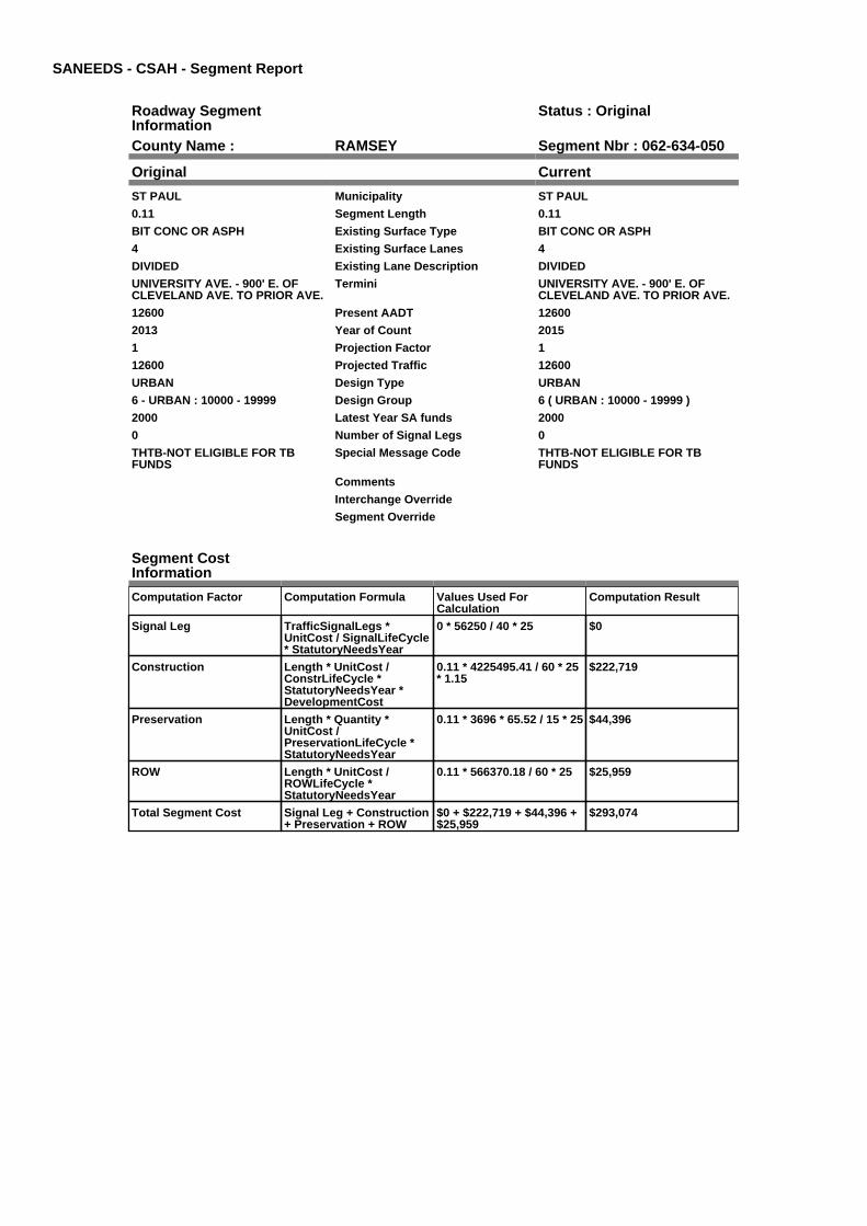
SANEEDS - CSAH - Segment Report
Roadway SegmentInformation
Status : Original
County Name : RAMSEY Segment Nbr : 062-634-050
Original Current
ST PAUL Municipality ST PAUL
0.11 Segment Length 0.11
BIT CONC OR ASPH Existing Surface Type BIT CONC OR ASPH
4 Existing Surface Lanes 4
DIVIDED Existing Lane Description DIVIDED
UNIVERSITY AVE. - 900' E. OFCLEVELAND AVE. TO PRIOR AVE.
Termini UNIVERSITY AVE. - 900' E. OFCLEVELAND AVE. TO PRIOR AVE.
12600 Present AADT 12600
2013 Year of Count 2015
1 Projection Factor 1
12600 Projected Traffic 12600
URBAN Design Type URBAN
6 - URBAN : 10000 - 19999 Design Group 6 ( URBAN : 10000 - 19999 )
2000 Latest Year SA funds 2000
0 Number of Signal Legs 0
THTB-NOT ELIGIBLE FOR TBFUNDS
Special Message Code THTB-NOT ELIGIBLE FOR TBFUNDS
Comments
Interchange Override
Segment Override
Segment CostInformation
Computation Factor Computation Formula Values Used ForCalculation
Computation Result
Signal Leg TrafficSignalLegs *UnitCost / SignalLifeCycle* StatutoryNeedsYear
0 * 56250 / 40 * 25 $0
Construction Length * UnitCost /ConstrLifeCycle *StatutoryNeedsYear *DevelopmentCost
0.11 * 4225495.41 / 60 * 25* 1.15
$222,719
Preservation Length * Quantity *UnitCost /PreservationLifeCycle *StatutoryNeedsYear
0.11 * 3696 * 65.52 / 15 * 25 $44,396
ROW Length * UnitCost /ROWLifeCycle *StatutoryNeedsYear
0.11 * 566370.18 / 60 * 25 $25,959
Total Segment Cost Signal Leg + Construction+ Preservation + ROW
$0 + $222,719 + $44,396 +$25,959
$293,074

SANEEDS - CSAH - Segment Report
Roadway SegmentInformation
Status : Original
County Name : RAMSEY Segment Nbr : 062-634-060
Original Current
ST PAUL Municipality ST PAUL
1.03 Segment Length 1.03
BIT CONC OR ASPH Existing Surface Type BIT CONC OR ASPH
4 Existing Surface Lanes 4
DIVIDED Existing Lane Description DIVIDED
UNIVERSITY AVE. - PRIOR AVE.TO PASCAL AVE.
Termini UNIVERSITY AVE. - PRIOR AVE.TO PASCAL AVE.
16300 Present AADT 16300
2013 Year of Count 2015
1 Projection Factor 1
16300 Projected Traffic 16300
URBAN Design Type URBAN
6 - URBAN : 10000 - 19999 Design Group 6 ( URBAN : 10000 - 19999 )
2000 Latest Year SA funds 2000
0 Number of Signal Legs 0
THTB-NOT ELIGIBLE FOR TBFUNDS
Special Message Code THTB-NOT ELIGIBLE FOR TBFUNDS
COMBINED WITH SEG 070 & 080 IN2005
Comments COMBINED WITH SEG 070 & 080 IN2005
Interchange Override
Segment Override
Segment CostInformation
Computation Factor Computation Formula Values Used ForCalculation
Computation Result
Signal Leg TrafficSignalLegs *UnitCost / SignalLifeCycle* StatutoryNeedsYear
0 * 56250 / 40 * 25 $0
Construction Length * UnitCost /ConstrLifeCycle *StatutoryNeedsYear *DevelopmentCost
1.03 * 4225495.41 / 60 * 25* 1.15
$2,085,458
Preservation Length * Quantity *UnitCost /PreservationLifeCycle *StatutoryNeedsYear
1.03 * 3696 * 65.52 / 15 * 25 $415,711
ROW Length * UnitCost /ROWLifeCycle *StatutoryNeedsYear
1.03 * 566370.18 / 60 * 25 $243,067
Total Segment Cost Signal Leg + Construction+ Preservation + ROW
$0 + $2,085,458 + $415,711+ $243,067
$2,744,236

SANEEDS - CSAH - Segment Report
Roadway SegmentInformation
Status : Original
County Name : RAMSEY Segment Nbr : 062-634-090
Original Current
ST PAUL Municipality ST PAUL
0.63 Segment Length 0.63
BIT CONC OR ASPH Existing Surface Type BIT CONC OR ASPH
4 Existing Surface Lanes 4
DIVIDED Existing Lane Description DIVIDED
UNIVERSITY AVE. - PASCAL AVE.TO DUNLAP AVE.
Termini UNIVERSITY AVE. - PASCAL AVE.TO DUNLAP AVE.
17100 Present AADT 17100
2013 Year of Count 2015
1 Projection Factor 1
17100 Projected Traffic 17100
URBAN Design Type URBAN
6 - URBAN : 10000 - 19999 Design Group 6 ( URBAN : 10000 - 19999 )
2000 Latest Year SA funds 2000
2 Number of Signal Legs 2
THTB-NOT ELIGIBLE FOR TBFUNDS
Special Message Code THTB-NOT ELIGIBLE FOR TBFUNDS
Comments
Interchange Override
Segment Override
Segment CostInformation
Computation Factor Computation Formula Values Used ForCalculation
Computation Result
Signal Leg TrafficSignalLegs *UnitCost / SignalLifeCycle* StatutoryNeedsYear
2 * 56250 / 40 * 25 $70,313
Construction Length * UnitCost /ConstrLifeCycle *StatutoryNeedsYear *DevelopmentCost
0.63 * 4225495.41 / 60 * 25* 1.15
$1,275,571
Preservation Length * Quantity *UnitCost /PreservationLifeCycle *StatutoryNeedsYear
0.63 * 3696 * 65.52 / 15 * 25 $254,270
ROW Length * UnitCost /ROWLifeCycle *StatutoryNeedsYear
0.63 * 566370.18 / 60 * 25 $148,672
Total Segment Cost Signal Leg + Construction+ Preservation + ROW
$70,313 + $1,275,571 +$254,270 + $148,672
$1,748,826

SANEEDS - CSAH - Segment Report
Roadway SegmentInformation
Status : Original
County Name : RAMSEY Segment Nbr : 062-634-100
Original Current
ST PAUL Municipality ST PAUL
1.12 Segment Length 1.12
BIT CONC OR ASPH Existing Surface Type BIT CONC OR ASPH
4 Existing Surface Lanes 4
DIVIDED Existing Lane Description DIVIDED
UNIVERSITY AVE. - DUNLAP AVE.TO DALE ST.
Termini UNIVERSITY AVE. - DUNLAP AVE.TO DALE ST.
17300 Present AADT 17300
2013 Year of Count 2015
1 Projection Factor 1
17300 Projected Traffic 17300
URBAN Design Type URBAN
6 - URBAN : 10000 - 19999 Design Group 6 ( URBAN : 10000 - 19999 )
2000 Latest Year SA funds 2000
6 Number of Signal Legs 6
THTB-NOT ELIGIBLE FOR TBFUNDS
Special Message Code THTB-NOT ELIGIBLE FOR TBFUNDS
COMBINED WITH SEG 110 IN 2005 Comments COMBINED WITH SEG 110 IN 2005
Interchange Override
Segment Override
Segment CostInformation
Computation Factor Computation Formula Values Used ForCalculation
Computation Result
Signal Leg TrafficSignalLegs *UnitCost / SignalLifeCycle* StatutoryNeedsYear
6 * 56250 / 40 * 25 $210,938
Construction Length * UnitCost /ConstrLifeCycle *StatutoryNeedsYear *DevelopmentCost
1.12 * 4225495.41 / 60 * 25* 1.15
$2,267,683
Preservation Length * Quantity *UnitCost /PreservationLifeCycle *StatutoryNeedsYear
1.12 * 3696 * 65.52 / 15 * 25 $452,036
ROW Length * UnitCost /ROWLifeCycle *StatutoryNeedsYear
1.12 * 566370.18 / 60 * 25 $264,306
Total Segment Cost Signal Leg + Construction+ Preservation + ROW
$210,938 + $2,267,683 +$452,036 + $264,306
$3,194,963
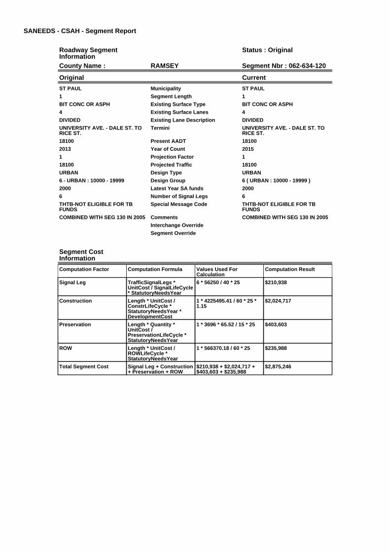
SANEEDS - CSAH - Segment Report
Roadway SegmentInformation
Status : Original
County Name : RAMSEY Segment Nbr : 062-634-120
Original Current
ST PAUL Municipality ST PAUL
1 Segment Length 1
BIT CONC OR ASPH Existing Surface Type BIT CONC OR ASPH
4 Existing Surface Lanes 4
DIVIDED Existing Lane Description DIVIDED
UNIVERSITY AVE. - DALE ST. TORICE ST.
Termini UNIVERSITY AVE. - DALE ST. TORICE ST.
18100 Present AADT 18100
2013 Year of Count 2015
1 Projection Factor 1
18100 Projected Traffic 18100
URBAN Design Type URBAN
6 - URBAN : 10000 - 19999 Design Group 6 ( URBAN : 10000 - 19999 )
2000 Latest Year SA funds 2000
6 Number of Signal Legs 6
THTB-NOT ELIGIBLE FOR TBFUNDS
Special Message Code THTB-NOT ELIGIBLE FOR TBFUNDS
COMBINED WITH SEG 130 IN 2005 Comments COMBINED WITH SEG 130 IN 2005
Interchange Override
Segment Override
Segment CostInformation
Computation Factor Computation Formula Values Used ForCalculation
Computation Result
Signal Leg TrafficSignalLegs *UnitCost / SignalLifeCycle* StatutoryNeedsYear
6 * 56250 / 40 * 25 $210,938
Construction Length * UnitCost /ConstrLifeCycle *StatutoryNeedsYear *DevelopmentCost
1 * 4225495.41 / 60 * 25 *1.15
$2,024,717
Preservation Length * Quantity *UnitCost /PreservationLifeCycle *StatutoryNeedsYear
1 * 3696 * 65.52 / 15 * 25 $403,603
ROW Length * UnitCost /ROWLifeCycle *StatutoryNeedsYear
1 * 566370.18 / 60 * 25 $235,988
Total Segment Cost Signal Leg + Construction+ Preservation + ROW
$210,938 + $2,024,717 +$403,603 + $235,988
$2,875,246

SANEEDS - CSAH - Segment Report
Roadway SegmentInformation
Status : Original
County Name : RAMSEY Segment Nbr : 062-634-140
Original Current
ST PAUL Municipality ST PAUL
0.09 Segment Length 0.09
BIT CONC OR ASPH Existing Surface Type BIT CONC OR ASPH
4 Existing Surface Lanes 4
DIVIDED Existing Lane Description DIVIDED
UNIVERSITY AVE. - RICE ST TOPARK ST.
Termini UNIVERSITY AVE. - RICE ST TOPARK ST.
12400 Present AADT 12400
2013 Year of Count 2015
1 Projection Factor 1
12400 Projected Traffic 12400
URBAN Design Type URBAN
6 - URBAN : 10000 - 19999 Design Group 6 ( URBAN : 10000 - 19999 )
2004 Latest Year SA funds 2004
2 Number of Signal Legs 2
THTB-RECONSTRUCTED WITH TBFUNDS
Special Message Code THTB-RECONSTRUCTED WITH TBFUNDS
SURF UNDER 62-634-004, 2004 Comments SURF UNDER 62-634-004, 2004
Interchange Override
Segment Override
Segment CostInformation
Computation Factor Computation Formula Values Used ForCalculation
Computation Result
Signal Leg TrafficSignalLegs *UnitCost / SignalLifeCycle* StatutoryNeedsYear
2 * 56250 / 40 * 25 $70,313
Construction Length * UnitCost /ConstrLifeCycle *StatutoryNeedsYear *DevelopmentCost
0.09 * 4225495.41 / 60 * 25* 1.15
$182,224
Preservation Length * Quantity *UnitCost /PreservationLifeCycle *StatutoryNeedsYear
0.09 * 3696 * 65.52 / 15 * 25 $36,324
ROW Length * UnitCost /ROWLifeCycle *StatutoryNeedsYear
0.09 * 566370.18 / 60 * 25 $21,239
Total Segment Cost Signal Leg + Construction+ Preservation + ROW
$70,313 + $182,224 +$36,324 + $21,239
$310,100

SANEEDS - CSAH - Segment Report
Roadway SegmentInformation
Status : Original
County Name : RAMSEY Segment Nbr : 062-634-150
Original Current
ST PAUL Municipality ST PAUL
0.24 Segment Length 0.24
BIT CONC OR ASPH Existing Surface Type BIT CONC OR ASPH
4 Existing Surface Lanes 4
NOT DIVIDED Existing Lane Description NOT DIVIDED
UNIVERSITY AVE. - PARK ST TOROBERT ST.
Termini UNIVERSITY AVE. - PARK ST TOROBERT ST.
12400 Present AADT 12400
2013 Year of Count 2015
1 Projection Factor 1
12400 Projected Traffic 12400
URBAN Design Type URBAN
6 - URBAN : 10000 - 19999 Design Group 6 ( URBAN : 10000 - 19999 )
2004 Latest Year SA funds 2004
2 Number of Signal Legs 2
THTB-RECONSTRUCTED WITH TBFUNDS
Special Message Code THTB-RECONSTRUCTED WITH TBFUNDS
SURFACED UNDER 62-634-004 IN2004
Comments SURFACED UNDER 62-634-004 IN2004
Interchange Override
Segment Override
Bridge Information Status: Original
Original Current
9250 Structure Number 9250
0.91 Milepoint 0.91
1922 Year Built 1922
Feature Crossed
Type of Service
Number of Spans
160 Bridge Length 160
49 Bridge Width 49
100% Shared Structure 100%
Comments
2 ( 150-999,999 ) Bridge Group Code 2 ( 150-999,999 )
Segment CostInformation
Computation Factor Computation Formula Values Used ForCalculation
Computation Result
Signal Leg TrafficSignalLegs *UnitCost / SignalLifeCycle* StatutoryNeedsYear
2 * 56250 / 40 * 25 $70,313
Construction Length * UnitCost /ConstrLifeCycle *StatutoryNeedsYear *DevelopmentCost
0.24 * 4225495.41 / 60 * 25* 1.15
$485,932
Preservation Length * Quantity *UnitCost /PreservationLifeCycle *StatutoryNeedsYear
0.24 * 3696 * 65.52 / 15 * 25 $96,865
ROW Length * UnitCost /ROWLifeCycle *StatutoryNeedsYear
0.24 * 566370.18 / 60 * 25 $56,637
Bridge BridgeLength *BridgeWidth * UnitCost /BridgeLifeCycle *StatutoryNeedsYear *DevelopmentCost
160 * 49 * 138 / 80 * 25 *1.15
$388,815
Total Segment Cost Signal Leg + Construction+ Preservation + ROW +Bridge
$70,313 + $485,932 +$96,865 + $56,637 +$388,815
$1,098,562

SANEEDS - CSAH - Segment Report
Roadway SegmentInformation
Status : Original
County Name : RAMSEY Segment Nbr : 062-634-160
Original Current
ST PAUL Municipality ST PAUL
0.25 Segment Length 0.25
BIT CONC OR ASPH Existing Surface Type BIT CONC OR ASPH
2 Existing Surface Lanes 2
NOT DIVIDED Existing Lane Description NOT DIVIDED
ROBERT ST - UNIVERSITY TO12TH
Termini ROBERT ST - UNIVERSITY TO12TH
4100 Present AADT 4100
2013 Year of Count 2015
1 Projection Factor 1
4100 Projected Traffic 4100
URBAN Design Type URBAN
5 - URBAN : 0 - 9999 Design Group 5 ( URBAN : 0 - 9999 )
2000 Latest Year SA funds 2000
4 Number of Signal Legs 4
THTB-MILES ONLY-NO NEEDS-ELIGIBLE FOR 100% TB FUNDS
Special Message Code THTB-MILES ONLY-NO NEEDS-ELIGIBLE FOR 100% TB FUNDS
Comments
Interchange Override
Segment Override
Segment CostInformation
Computation Factor Computation Formula Values Used ForCalculation
Computation Result
Signal Leg TrafficSignalLegs *UnitCost / SignalLifeCycle* StatutoryNeedsYear
4 * 56250 / 40 * 25 $140,625
Construction Length * UnitCost /ConstrLifeCycle *StatutoryNeedsYear *DevelopmentCost
0.25 * 2738635.28 / 60 * 25* 1.15
$328,066
Preservation Length * Quantity *UnitCost /PreservationLifeCycle *StatutoryNeedsYear
0.25 * 2904 * 65.52 / 15 * 25 $79,279
ROW Length * UnitCost /ROWLifeCycle *StatutoryNeedsYear
0.25 * 436504.07 / 60 * 25 $45,469
Total Segment Cost Signal Leg + Construction+ Preservation + ROW
$140,625 + $328,066 +$79,279 + $45,469
$593,439

SANEEDS - CSAH - Segment Report
Roadway SegmentInformation
Status : Original
County Name : RAMSEY Segment Nbr : 062-634-210
Original Current
MAPLEWOOD Municipality MAPLEWOOD
1 Segment Length 1
MIXED BITUMINOUS Existing Surface Type MIXED BITUMINOUS
2 Existing Surface Lanes 2
NOT DIVIDED Existing Lane Description NOT DIVIDED
MC KNIGHT RD. TO EAST CO. LINE Termini MC KNIGHT RD. TO EAST CO. LINE
9700 Present AADT 9700
2013 Year of Count 2015
1 Projection Factor 1
9700 Projected Traffic 9700
RURAL Design Type RURAL
4 - RURAL : 7000 - 999999 Design Group 4 ( RURAL : 7000 - 999999 )
2000 Latest Year SA funds 2000
2 Number of Signal Legs 2
No Special Message Special Message Code No Special Message
Comments
Interchange Override
Segment Override
Segment CostInformation
Computation Factor Computation Formula Values Used ForCalculation
Computation Result
Signal Leg TrafficSignalLegs *UnitCost / SignalLifeCycle* StatutoryNeedsYear
2 * 56250 / 40 * 25 $70,313
Construction Length * UnitCost /ConstrLifeCycle *StatutoryNeedsYear *DevelopmentCost
1 * 1996892.57 / 60 * 25 *1.1
$915,242
Preservation Length * Quantity *UnitCost /PreservationLifeCycle *StatutoryNeedsYear
1 * 3564 * 65.52 / 20 * 25 $291,892
ROW Length * UnitCost /ROWLifeCycle *StatutoryNeedsYear
1 * 181173.68 / 60 * 25 $75,489
Total Segment Cost Signal Leg + Construction+ Preservation + ROW
$70,313 + $915,242 +$291,892 + $75,489
$1,352,936

SANEEDS - CSAH - Segment Report
Roadway SegmentInformation
Status : Original
County Name : RAMSEY Segment Nbr : 062-635-003
Original Current
ST PAUL Municipality ST PAUL
0.45 Segment Length 0.45
BIT CONC OR ASPH Existing Surface Type BIT CONC OR ASPH
3 Existing Surface Lanes 3
NOT DIVIDED Existing Lane Description NOT DIVIDED
MARSHALL AVE. - W CO LINE TOCRETIN AVE.
Termini MARSHALL AVE. - W CO LINE TOCRETIN AVE.
20000 Present AADT 20000
2013 Year of Count 2015
1 Projection Factor 1
20000 Projected Traffic 20000
RURAL Design Type RURAL
4 - RURAL : 7000 - 999999 Design Group 4 ( RURAL : 7000 - 999999 )
1992 Latest Year SA funds 1992
3 Number of Signal Legs 3
THTB-RECONSTRUCTED WITH TBFUNDS
Special Message Code THTB-RECONSTRUCTED WITH TBFUNDS
Comments
Interchange Override
Segment Override
Bridge Information Status: Original
Original Current
62082 Structure Number 62082
0.01 Milepoint 0.01
1989 Year Built 1989
MISSISSIPPI R & CITY STS Feature Crossed MISSISSIPPI R & CITY STS
Type of Service
2 Number of Spans 2
1483.7 Bridge Length 1483.7
83 Bridge Width 83
100% Shared Structure 100%
Comments
2 ( 150-999,999 ) Bridge Group Code 2 ( 150-999,999 )
Segment CostInformation
Computation Factor Computation Formula Values Used ForCalculation
Computation Result
Signal Leg TrafficSignalLegs *UnitCost / SignalLifeCycle* StatutoryNeedsYear
3 * 56250 / 40 * 25 $105,469
Construction Length * UnitCost /ConstrLifeCycle *StatutoryNeedsYear *DevelopmentCost
0.45 * 1996892.57 / 60 * 25* 1.1
$411,859
Preservation Length * Quantity *UnitCost /PreservationLifeCycle *StatutoryNeedsYear
0.45 * 3564 * 65.52 / 20 * 25 $131,351
ROW Length * UnitCost /ROWLifeCycle *StatutoryNeedsYear
0.45 * 181173.68 / 60 * 25 $33,970
Bridge BridgeLength *BridgeWidth * UnitCost /BridgeLifeCycle *StatutoryNeedsYear *DevelopmentCost
1483.7 * 83 * 138 / 80 * 25 *1.15
$6,107,326
Total Segment Cost Signal Leg + Construction+ Preservation + ROW +Bridge
$105,469 + $411,859 +$131,351 + $33,970 +$6,107,326
$6,789,975

SANEEDS - CSAH - Segment Report
Roadway SegmentInformation
Status : Original
County Name : RAMSEY Segment Nbr : 062-635-006
Original Current
ST PAUL Municipality ST PAUL
1.14 Segment Length 1.14
MIXED BITUMINOUS Existing Surface Type MIXED BITUMINOUS
2 Existing Surface Lanes 2
NOT DIVIDED Existing Lane Description NOT DIVIDED
MARSHALL AVE. - CRETIN AVE.TO FRY AVE.
Termini MARSHALL AVE. - CRETIN AVE.TO FRY AVE.
18100 Present AADT 18100
2013 Year of Count 2015
1 Projection Factor 1
18100 Projected Traffic 18100
URBAN Design Type URBAN
6 - URBAN : 10000 - 19999 Design Group 6 ( URBAN : 10000 - 19999 )
1993 Latest Year SA funds 1993
7 Number of Signal Legs 7
THTB-RECONSTRUCTED WITH TBFUNDS
Special Message Code THTB-RECONSTRUCTED WITH TBFUNDS
Comments
Interchange Override
Segment Override
Segment CostInformation
Computation Factor Computation Formula Values Used ForCalculation
Computation Result
Signal Leg TrafficSignalLegs *UnitCost / SignalLifeCycle* StatutoryNeedsYear
7 * 56250 / 40 * 25 $246,094
Construction Length * UnitCost /ConstrLifeCycle *StatutoryNeedsYear *DevelopmentCost
1.14 * 4225495.41 / 60 * 25* 1.15
$2,308,177
Preservation Length * Quantity *UnitCost /PreservationLifeCycle *StatutoryNeedsYear
1.14 * 3696 * 65.52 / 15 * 25 $460,108
ROW Length * UnitCost /ROWLifeCycle *StatutoryNeedsYear
1.14 * 566370.18 / 60 * 25 $269,026
Total Segment Cost Signal Leg + Construction+ Preservation + ROW
$246,094 + $2,308,177 +$460,108 + $269,026
$3,283,405

SANEEDS - CSAH - Segment Report
Roadway SegmentInformation
Status : Original
County Name : RAMSEY Segment Nbr : 062-635-007
Original Current
ST PAUL Municipality ST PAUL
0.11 Segment Length 0.11
MIXED BITUMINOUS Existing Surface Type MIXED BITUMINOUS
4 Existing Surface Lanes 4
NOT DIVIDED Existing Lane Description NOT DIVIDED
MARSHALL AVE. - FRY AVE. TOSNELLING AVE.
Termini MARSHALL AVE. - FRY AVE. TOSNELLING AVE.
19100 Present AADT 19100
2013 Year of Count 2015
1 Projection Factor 1
19100 Projected Traffic 19100
URBAN Design Type URBAN
6 - URBAN : 10000 - 19999 Design Group 6 ( URBAN : 10000 - 19999 )
2000 Latest Year SA funds 2000
1 Number of Signal Legs 1
THTB-NOT ELIGIBLE FOR TBFUNDS
Special Message Code THTB-NOT ELIGIBLE FOR TBFUNDS
TIME LAPSED ON TB,MADE CHANGES TO TBMAINTENANCE CHART 1/08OK'ED PER CYRUS KNUTSON
Comments TIME LAPSED ON TB,MADE CHANGES TO TBMAINTENANCE CHART 1/08OK'ED PER CYRUS KNUTSON
Interchange Override
Segment Override
Segment CostInformation
Computation Factor Computation Formula Values Used ForCalculation
Computation Result
Signal Leg TrafficSignalLegs *UnitCost / SignalLifeCycle* StatutoryNeedsYear
1 * 56250 / 40 * 25 $35,156
Construction Length * UnitCost /ConstrLifeCycle *StatutoryNeedsYear *DevelopmentCost
0.11 * 4225495.41 / 60 * 25* 1.15
$222,719
Preservation Length * Quantity *UnitCost /PreservationLifeCycle *StatutoryNeedsYear
0.11 * 3696 * 65.52 / 15 * 25 $44,396
ROW Length * UnitCost /ROWLifeCycle *StatutoryNeedsYear
0.11 * 566370.18 / 60 * 25 $25,959
Total Segment Cost Signal Leg + Construction+ Preservation + ROW
$35,156 + $222,719 +$44,396 + $25,959
$328,230

SANEEDS - CSAH - Segment Report
Roadway SegmentInformation
Status : Original
County Name : RAMSEY Segment Nbr : 062-635-008
Original Current
ST PAUL Municipality ST PAUL
1 Segment Length 1
MIXED BITUMINOUS Existing Surface Type MIXED BITUMINOUS
2 Existing Surface Lanes 2
NOT DIVIDED Existing Lane Description NOT DIVIDED
MARSHALL - SNELLING AVE TOLEXINGTON AVE
Termini MARSHALL - SNELLING AVE TOLEXINGTON AVE
7000 Present AADT 7000
2013 Year of Count 2015
1 Projection Factor 1
7000 Projected Traffic 7000
URBAN Design Type URBAN
5 - URBAN : 0 - 9999 Design Group 5 ( URBAN : 0 - 9999 )
2000 Latest Year SA funds 2000
6 Number of Signal Legs 6
No Special Message Special Message Code No Special Message
Comments
Interchange Override
Segment Override
Segment CostInformation
Computation Factor Computation Formula Values Used ForCalculation
Computation Result
Signal Leg TrafficSignalLegs *UnitCost / SignalLifeCycle* StatutoryNeedsYear
6 * 56250 / 40 * 25 $210,938
Construction Length * UnitCost /ConstrLifeCycle *StatutoryNeedsYear *DevelopmentCost
1 * 2738635.28 / 60 * 25 *1.15
$1,312,263
Preservation Length * Quantity *UnitCost /PreservationLifeCycle *StatutoryNeedsYear
1 * 2904 * 65.52 / 15 * 25 $317,117
ROW Length * UnitCost /ROWLifeCycle *StatutoryNeedsYear
1 * 436504.07 / 60 * 25 $181,877
Total Segment Cost Signal Leg + Construction+ Preservation + ROW
$210,938 + $1,312,263 +$317,117 + $181,877
$2,022,195

SANEEDS - CSAH - Segment Report
Roadway SegmentInformation
Status : Original
County Name : RAMSEY Segment Nbr : 062-635-009
Original Current
ST PAUL Municipality ST PAUL
1 Segment Length 1
MIXED BITUMINOUS Existing Surface Type MIXED BITUMINOUS
2 Existing Surface Lanes 2
NOT DIVIDED Existing Lane Description NOT DIVIDED
SELBY LEXINGTON AVE TO DALEST
Termini SELBY LEXINGTON AVE TO DALEST
5600 Present AADT 5600
2013 Year of Count 2015
1 Projection Factor 1
5600 Projected Traffic 5600
URBAN Design Type URBAN
5 - URBAN : 0 - 9999 Design Group 5 ( URBAN : 0 - 9999 )
2000 Latest Year SA funds 2000
2 Number of Signal Legs 2
No Special Message Special Message Code No Special Message
Comments
Interchange Override
Segment Override
Segment CostInformation
Computation Factor Computation Formula Values Used ForCalculation
Computation Result
Signal Leg TrafficSignalLegs *UnitCost / SignalLifeCycle* StatutoryNeedsYear
2 * 56250 / 40 * 25 $70,313
Construction Length * UnitCost /ConstrLifeCycle *StatutoryNeedsYear *DevelopmentCost
1 * 2738635.28 / 60 * 25 *1.15
$1,312,263
Preservation Length * Quantity *UnitCost /PreservationLifeCycle *StatutoryNeedsYear
1 * 2904 * 65.52 / 15 * 25 $317,117
ROW Length * UnitCost /ROWLifeCycle *StatutoryNeedsYear
1 * 436504.07 / 60 * 25 $181,877
Total Segment Cost Signal Leg + Construction+ Preservation + ROW
$70,313 + $1,312,263 +$317,117 + $181,877
$1,881,570

SANEEDS - CSAH - Segment Report
Roadway SegmentInformation
Status : Original
County Name : RAMSEY Segment Nbr : 062-635-010
Original Current
ST PAUL Municipality ST PAUL
0.06 Segment Length 0.06
MIXED BITUMINOUS Existing Surface Type MIXED BITUMINOUS
2 Existing Surface Lanes 2
NOT DIVIDED Existing Lane Description NOT DIVIDED
UPPER AFTON RD. - T.H. 61 TOBURNS AVE.
Termini UPPER AFTON RD. - T.H. 61 TOBURNS AVE.
2200 Present AADT 2200
2013 Year of Count 2015
1 Projection Factor 1
2200 Projected Traffic 2200
RURAL Design Type RURAL
3 - RURAL : 1500 - 6999 Design Group 3 ( RURAL : 1500 - 6999 )
2000 Latest Year SA funds 2000
1 Number of Signal Legs 1
No Special Message Special Message Code No Special Message
Comments
Interchange Override
Segment Override
Segment CostInformation
Computation Factor Computation Formula Values Used ForCalculation
Computation Result
Signal Leg TrafficSignalLegs *UnitCost / SignalLifeCycle* StatutoryNeedsYear
1 * 56250 / 40 * 25 $35,156
Construction Length * UnitCost /ConstrLifeCycle *StatutoryNeedsYear *DevelopmentCost
0.06 * 1021937.01 / 60 * 25* 1.1
$28,103
Preservation Length * Quantity *UnitCost /PreservationLifeCycle *StatutoryNeedsYear
0.06 * 2376 * 65.52 / 20 * 25 $11,676
ROW Length * UnitCost /ROWLifeCycle *StatutoryNeedsYear
0.06 * 85357.87 / 60 * 25 $2,134
Total Segment Cost Signal Leg + Construction+ Preservation + ROW
$35,156 + $28,103 +$11,676 + $2,134
$77,069
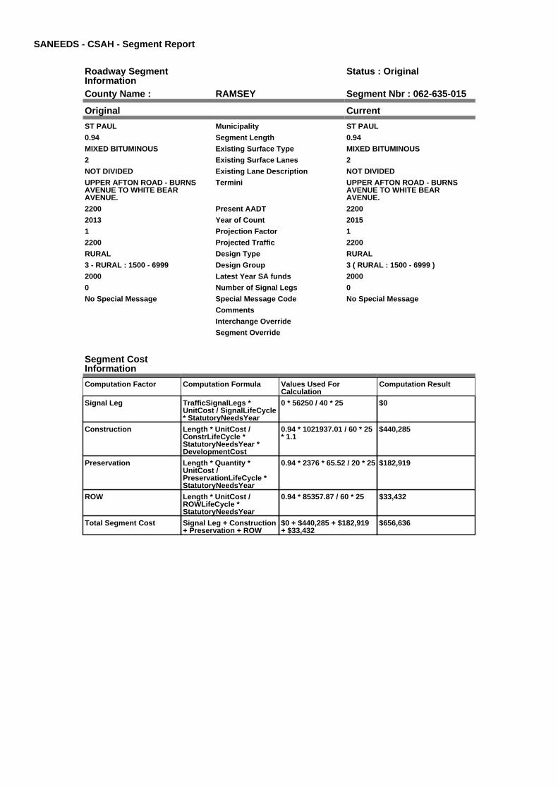
SANEEDS - CSAH - Segment Report
Roadway SegmentInformation
Status : Original
County Name : RAMSEY Segment Nbr : 062-635-015
Original Current
ST PAUL Municipality ST PAUL
0.94 Segment Length 0.94
MIXED BITUMINOUS Existing Surface Type MIXED BITUMINOUS
2 Existing Surface Lanes 2
NOT DIVIDED Existing Lane Description NOT DIVIDED
UPPER AFTON ROAD - BURNSAVENUE TO WHITE BEARAVENUE.
Termini UPPER AFTON ROAD - BURNSAVENUE TO WHITE BEARAVENUE.
2200 Present AADT 2200
2013 Year of Count 2015
1 Projection Factor 1
2200 Projected Traffic 2200
RURAL Design Type RURAL
3 - RURAL : 1500 - 6999 Design Group 3 ( RURAL : 1500 - 6999 )
2000 Latest Year SA funds 2000
0 Number of Signal Legs 0
No Special Message Special Message Code No Special Message
Comments
Interchange Override
Segment Override
Segment CostInformation
Computation Factor Computation Formula Values Used ForCalculation
Computation Result
Signal Leg TrafficSignalLegs *UnitCost / SignalLifeCycle* StatutoryNeedsYear
0 * 56250 / 40 * 25 $0
Construction Length * UnitCost /ConstrLifeCycle *StatutoryNeedsYear *DevelopmentCost
0.94 * 1021937.01 / 60 * 25* 1.1
$440,285
Preservation Length * Quantity *UnitCost /PreservationLifeCycle *StatutoryNeedsYear
0.94 * 2376 * 65.52 / 20 * 25 $182,919
ROW Length * UnitCost /ROWLifeCycle *StatutoryNeedsYear
0.94 * 85357.87 / 60 * 25 $33,432
Total Segment Cost Signal Leg + Construction+ Preservation + ROW
$0 + $440,285 + $182,919+ $33,432
$656,636

SANEEDS - CSAH - Segment Report
Roadway SegmentInformation
Status : Original
County Name : RAMSEY Segment Nbr : 062-635-020
Original Current
ST PAUL Municipality ST PAUL
1 Segment Length 1
MIXED BITUMINOUS Existing Surface Type MIXED BITUMINOUS
2 Existing Surface Lanes 2
NOT DIVIDED Existing Lane Description NOT DIVIDED
UPPER AFTON RD. - WHITE BEARAVE. TO MC KNIGHT RD.
Termini UPPER AFTON RD. - WHITE BEARAVE. TO MC KNIGHT RD.
3550 Present AADT 3550
2013 Year of Count 2015
1 Projection Factor 1
3550 Projected Traffic 3550
RURAL Design Type RURAL
3 - RURAL : 1500 - 6999 Design Group 3 ( RURAL : 1500 - 6999 )
1998 Latest Year SA funds 1998
0 Number of Signal Legs 0
No Special Message Special Message Code No Special Message
Comments
Interchange Override
Segment Override
Segment CostInformation
Computation Factor Computation Formula Values Used ForCalculation
Computation Result
Signal Leg TrafficSignalLegs *UnitCost / SignalLifeCycle* StatutoryNeedsYear
0 * 56250 / 40 * 25 $0
Construction Length * UnitCost /ConstrLifeCycle *StatutoryNeedsYear *DevelopmentCost
1 * 1021937.01 / 60 * 25 *1.1
$468,388
Preservation Length * Quantity *UnitCost /PreservationLifeCycle *StatutoryNeedsYear
1 * 2376 * 65.52 / 20 * 25 $194,594
ROW Length * UnitCost /ROWLifeCycle *StatutoryNeedsYear
1 * 85357.87 / 60 * 25 $35,566
Total Segment Cost Signal Leg + Construction+ Preservation + ROW
$0 + $468,388 + $194,594+ $35,566
$698,548

SANEEDS - CSAH - Segment Report
Roadway SegmentInformation
Status : Revised
County Name : RAMSEY Segment Nbr : 062-636-010
Original Current
ST PAUL Municipality ST PAUL
0.42 Segment Length 0.42
PORT CEMENT CONC Existing Surface Type PORT CEMENT CONC
4 Existing Surface Lanes 4
DIVIDED Existing Lane Description DIVIDED
WARNER RD. - SIBLEY ST. TO 0.42MI EAST
Termini WARNER RD. - SIBLEY ST. TO 0.42MI EAST
14900 Present AADT 14900
2013 Year of Count 2015
1 Projection Factor 1
14900 Projected Traffic 14900
URBAN Design Type URBAN
6 - URBAN : 10000 - 19999 Design Group 6 ( URBAN : 10000 - 19999 )
1992 Latest Year SA funds 2016
1 Number of Signal Legs 1
No Special Message Special Message Code No Special Message
Comments SAP 062-030-021 2016
Interchange Override
Segment Override
Segment CostInformation
Computation Factor Computation Formula Values Used ForCalculation
Computation Result
Signal Leg TrafficSignalLegs *UnitCost / SignalLifeCycle* StatutoryNeedsYear
1 * 56250 / 40 * 25 $35,156
Construction Length * UnitCost /ConstrLifeCycle *StatutoryNeedsYear *DevelopmentCost
0.42 * 4225495.41 / 60 * 25* 1.15
$850,381
Preservation Length * Quantity *UnitCost /PreservationLifeCycle *StatutoryNeedsYear
0.42 * 3696 * 65.52 / 15 * 25 $169,513
ROW Length * UnitCost /ROWLifeCycle *StatutoryNeedsYear
0.42 * 566370.18 / 60 * 25 $99,115
Total Segment Cost Signal Leg + Construction+ Preservation + ROW
$35,156 + $850,381 +$169,513 + $99,115
$1,154,165

SANEEDS - CSAH - Segment Report
Roadway SegmentInformation
Status : Revised
County Name : RAMSEY Segment Nbr : 062-636-015
Original Current
ST PAUL Municipality ST PAUL
0.44 Segment Length 0.44
PORT CEMENT CONC Existing Surface Type PORT CEMENT CONC
4 Existing Surface Lanes 4
DIVIDED Existing Lane Description DIVIDED
WARNER RD. - 0.42 MI TO 0.86 MIE OF SIBLEY ST.
Termini WARNER RD. - 0.42 MI TO 0.86 MIE OF SIBLEY ST.
14900 Present AADT 14900
2013 Year of Count 2015
1 Projection Factor 1
14900 Projected Traffic 14900
URBAN Design Type URBAN
6 - URBAN : 10000 - 19999 Design Group 6 ( URBAN : 10000 - 19999 )
1992 Latest Year SA funds 2016
0 Number of Signal Legs 0
No Special Message Special Message Code No Special Message
Comments SAP 062-030-021 2016
Interchange Override
Segment Override
Segment CostInformation
Computation Factor Computation Formula Values Used ForCalculation
Computation Result
Signal Leg TrafficSignalLegs *UnitCost / SignalLifeCycle* StatutoryNeedsYear
0 * 56250 / 40 * 25 $0
Construction Length * UnitCost /ConstrLifeCycle *StatutoryNeedsYear *DevelopmentCost
0.44 * 4225495.41 / 60 * 25* 1.15
$890,875
Preservation Length * Quantity *UnitCost /PreservationLifeCycle *StatutoryNeedsYear
0.44 * 3696 * 65.52 / 15 * 25 $177,585
ROW Length * UnitCost /ROWLifeCycle *StatutoryNeedsYear
0.44 * 566370.18 / 60 * 25 $103,835
Total Segment Cost Signal Leg + Construction+ Preservation + ROW
$0 + $890,875 + $177,585+ $103,835
$1,172,295

SANEEDS - CSAH - Segment Report
Roadway SegmentInformation
Status : Revised
County Name : RAMSEY Segment Nbr : 062-636-020
Original Current
ST PAUL Municipality ST PAUL
0.51 Segment Length 0.51
PORT CEMENT CONC Existing Surface Type PORT CEMENT CONC
4 Existing Surface Lanes 4
DIVIDED Existing Lane Description DIVIDED
WARNER RD. - 0.86 MI E OFSIBLEY ST. TO CHILDS RD.
Termini WARNER RD. - 0.86 MI E OFSIBLEY ST. TO CHILDS RD.
14900 Present AADT 14900
2013 Year of Count 2015
1 Projection Factor 1
14900 Projected Traffic 14900
URBAN Design Type URBAN
6 - URBAN : 10000 - 19999 Design Group 6 ( URBAN : 10000 - 19999 )
2013 Latest Year SA funds 2016
0 Number of Signal Legs 0
No Special Message Special Message Code No Special Message
2013 SP 062-636-005 EB BRREPLACE
Comments 2013 SP 062-636-005 EB BRREPLACE; SAP 062-030-021 2016
Interchange Override
Segment Override
Bridge Information Status: Original
Original Current
62634 Structure Number 62634
1.25 Milepoint 1.25
2013 Year Built 2013
RAILROADS AND STR Feature Crossed RAILROADS AND STR
Type of Service
7 Number of Spans 7
840 Bridge Length 840
39 Bridge Width 39
100% Shared Structure 100%
2013 SP 062-636-005 EB BRREPLACE W/ 62634 - NO PED BRSON THIS SEGMENT
Comments 2013 SP 062-636-005 EB BRREPLACE W/ 62634 - NO PED BRSON THIS SEGMENT
2 ( 150-999,999 ) Bridge Group Code 2 ( 150-999,999 )
Bridge Information Status: Original
Original Current
62531 Structure Number 62531
1.26 Milepoint 1.26
1977 Year Built 1977
RAILROADS & CHILDS RD Feature Crossed RAILROADS & CHILDS RD
Type of Service
Number of Spans
986.3 Bridge Length 986.3
31.5 Bridge Width 31.5
100% Shared Structure 100%
Comments
2 ( 150-999,999 ) Bridge Group Code 2 ( 150-999,999 )
Segment CostInformation
Computation Factor Computation Formula Values Used ForCalculation
Computation Result
Signal Leg TrafficSignalLegs *UnitCost / SignalLifeCycle* StatutoryNeedsYear
0 * 56250 / 40 * 25 $0
Construction Length * UnitCost /ConstrLifeCycle *StatutoryNeedsYear *DevelopmentCost
0.51 * 4225495.41 / 60 * 25* 1.15
$1,032,605
Preservation Length * Quantity *UnitCost /PreservationLifeCycle *StatutoryNeedsYear
0.51 * 3696 * 65.52 / 15 * 25 $205,838
ROW Length * UnitCost /ROWLifeCycle *StatutoryNeedsYear
0.51 * 566370.18 / 60 * 25 $120,354
Bridge BridgeLength *BridgeWidth * UnitCost /BridgeLifeCycle *StatutoryNeedsYear *DevelopmentCost
840 * 39 * 138 / 80 * 25 *1.15
$1,624,691
Bridge BridgeLength *BridgeWidth * UnitCost /BridgeLifeCycle *StatutoryNeedsYear *DevelopmentCost
986.3 * 31.5 * 138 / 80 * 25* 1.15
$1,540,801
Total Segment Cost Signal Leg + Construction+ Preservation + ROW +Bridge + Bridge
$0 + $1,032,605 + $205,838+ $120,354 + $1,624,691 +$1,540,801
$4,524,289

SANEEDS - CSAH - Segment Report
Roadway SegmentInformation
Status : Original
County Name : RAMSEY Segment Nbr : 062-636-030
Original Current
ST PAUL Municipality ST PAUL
0.72 Segment Length 0.72
MIXED BITUMINOUS Existing Surface Type MIXED BITUMINOUS
4 Existing Surface Lanes 4
DIVIDED Existing Lane Description DIVIDED
WARNER RD. - CHILDS RD. TOFISH HATCHERY RD.
Termini WARNER RD. - CHILDS RD. TOFISH HATCHERY RD.
17700 Present AADT 17700
2013 Year of Count 2015
1 Projection Factor 1
17700 Projected Traffic 17700
URBAN Design Type URBAN
6 - URBAN : 10000 - 19999 Design Group 6 ( URBAN : 10000 - 19999 )
2000 Latest Year SA funds 2000
0 Number of Signal Legs 0
No Special Message Special Message Code No Special Message
Comments
Interchange Override
Segment Override
Segment CostInformation
Computation Factor Computation Formula Values Used ForCalculation
Computation Result
Signal Leg TrafficSignalLegs *UnitCost / SignalLifeCycle* StatutoryNeedsYear
0 * 56250 / 40 * 25 $0
Construction Length * UnitCost /ConstrLifeCycle *StatutoryNeedsYear *DevelopmentCost
0.72 * 4225495.41 / 60 * 25* 1.15
$1,457,796
Preservation Length * Quantity *UnitCost /PreservationLifeCycle *StatutoryNeedsYear
0.72 * 3696 * 65.52 / 15 * 25 $290,594
ROW Length * UnitCost /ROWLifeCycle *StatutoryNeedsYear
0.72 * 566370.18 / 60 * 25 $169,911
Total Segment Cost Signal Leg + Construction+ Preservation + ROW
$0 + $1,457,796 + $290,594+ $169,911
$1,918,301

SANEEDS - CSAH - Segment Report
Roadway SegmentInformation
Status : Original
County Name : RAMSEY Segment Nbr : 062-636-040
Original Current
ST PAUL Municipality ST PAUL
0.4 Segment Length 0.4
MIXED BITUMINOUS Existing Surface Type MIXED BITUMINOUS
4 Existing Surface Lanes 4
DIVIDED Existing Lane Description DIVIDED
WARNER RD. - FISH HATCHERYRD. TO T.H. 61
Termini WARNER RD. - FISH HATCHERYRD. TO T.H. 61
17700 Present AADT 17700
2013 Year of Count 2015
1 Projection Factor 1
17700 Projected Traffic 17700
URBAN Design Type URBAN
6 - URBAN : 10000 - 19999 Design Group 6 ( URBAN : 10000 - 19999 )
2013 Latest Year SA funds 2013
1 Number of Signal Legs 1
No Special Message Special Message Code No Special Message
2013 SAP 062-636-008 WASHOUTREPAIR
Comments 2013 SAP 062-636-008 WASHOUTREPAIR
Interchange Override
Segment Override
Segment CostInformation
Computation Factor Computation Formula Values Used ForCalculation
Computation Result
Signal Leg TrafficSignalLegs *UnitCost / SignalLifeCycle* StatutoryNeedsYear
1 * 56250 / 40 * 25 $35,156
Construction Length * UnitCost /ConstrLifeCycle *StatutoryNeedsYear *DevelopmentCost
0.4 * 4225495.41 / 60 * 25 *1.15
$809,887
Preservation Length * Quantity *UnitCost /PreservationLifeCycle *StatutoryNeedsYear
0.4 * 3696 * 65.52 / 15 * 25 $161,441
ROW Length * UnitCost /ROWLifeCycle *StatutoryNeedsYear
0.4 * 566370.18 / 60 * 25 $94,395
Total Segment Cost Signal Leg + Construction+ Preservation + ROW
$35,156 + $809,887 +$161,441 + $94,395
$1,100,879

SANEEDS - CSAH - Segment Report
Roadway SegmentInformation
Status : Revised
County Name : RAMSEY Segment Nbr : 062-637-041
Original Current
ST PAUL Municipality ST PAUL
0.14 Segment Length 0.14
BIT CONC OR ASPH Existing Surface Type BIT CONC OR ASPH
3 Existing Surface Lanes 3
DIVIDED Existing Lane Description DIVIDED
SHEPARD RD. - RANDOLPH AVE.TO JAMES AVE.
Termini SHEPARD RD. - RANDOLPH AVE.TO JAMES AVE.
17600 Present AADT 17600
2013 Year of Count 2015
1 Projection Factor 1
17600 Projected Traffic 17600
URBAN Design Type URBAN
6 - URBAN : 10000 - 19999 Design Group 6 ( URBAN : 10000 - 19999 )
2000 Latest Year SA funds 2016
1 Number of Signal Legs 1
No Special Message Special Message Code No Special Message
Comments SAP 062-030-021 2016
Interchange Override
Segment Override
Segment CostInformation
Computation Factor Computation Formula Values Used ForCalculation
Computation Result
Signal Leg TrafficSignalLegs *UnitCost / SignalLifeCycle* StatutoryNeedsYear
1 * 56250 / 40 * 25 $35,156
Construction Length * UnitCost /ConstrLifeCycle *StatutoryNeedsYear *DevelopmentCost
0.14 * 4225495.41 / 60 * 25* 1.15
$283,460
Preservation Length * Quantity *UnitCost /PreservationLifeCycle *StatutoryNeedsYear
0.14 * 3696 * 65.52 / 15 * 25 $56,504
ROW Length * UnitCost /ROWLifeCycle *StatutoryNeedsYear
0.14 * 566370.18 / 60 * 25 $33,038
Total Segment Cost Signal Leg + Construction+ Preservation + ROW
$35,156 + $283,460 +$56,504 + $33,038
$408,158

SANEEDS - CSAH - Segment Report
Roadway SegmentInformation
Status : Revised
County Name : RAMSEY Segment Nbr : 062-637-050
Original Current
ST PAUL Municipality ST PAUL
0.69 Segment Length 0.69
BIT CONC OR ASPH Existing Surface Type BIT CONC OR ASPH
3 Existing Surface Lanes 3
DIVIDED Existing Lane Description DIVIDED
SHEPARD RD. - JAMES AVE. TOWILKIN ST.
Termini SHEPARD RD. - JAMES AVE. TOWILKIN ST.
17600 Present AADT 17600
2013 Year of Count 2015
1 Projection Factor 1
17600 Projected Traffic 17600
URBAN Design Type URBAN
6 - URBAN : 10000 - 19999 Design Group 6 ( URBAN : 10000 - 19999 )
2000 Latest Year SA funds 2016
0 Number of Signal Legs 0
No Special Message Special Message Code No Special Message
Comments SAP 062-030-021 2016
Interchange Override
Segment Override
Bridge Information Status: Original
Original Current
62560 Structure Number 62560
0.146 Milepoint 0.146
1993 Year Built 1993
Feature Crossed
Type of Service
Number of Spans
58 Bridge Length 58
510.3 Bridge Width 510.3
100% Shared Structure 100%
Comments
1 ( 0-149 ) Bridge Group Code 1 ( 0-149 )
Segment CostInformation
Computation Factor Computation Formula Values Used ForCalculation
Computation Result
Signal Leg TrafficSignalLegs *UnitCost / SignalLifeCycle* StatutoryNeedsYear
0 * 56250 / 40 * 25 $0
Construction Length * UnitCost /ConstrLifeCycle *StatutoryNeedsYear *DevelopmentCost
0.69 * 4225495.41 / 60 * 25* 1.15
$1,397,054
Preservation Length * Quantity *UnitCost /PreservationLifeCycle *StatutoryNeedsYear
0.69 * 3696 * 65.52 / 15 * 25 $278,486
ROW Length * UnitCost /ROWLifeCycle *StatutoryNeedsYear
0.69 * 566370.18 / 60 * 25 $162,831
Bridge BridgeLength *BridgeWidth * UnitCost /BridgeLifeCycle *StatutoryNeedsYear *DevelopmentCost
58 * 510.3 * 152 / 80 * 25 *1.15
$1,616,758
Total Segment Cost Signal Leg + Construction+ Preservation + ROW +Bridge
$0 + $1,397,054 + $278,486+ $162,831 + $1,616,758
$3,455,129

SANEEDS - CSAH - Segment Report
Roadway SegmentInformation
Status : Revised
County Name : RAMSEY Segment Nbr : 062-637-060
Original Current
ST PAUL Municipality ST PAUL
0.28 Segment Length 0.28
BIT CONC OR ASPH Existing Surface Type BIT CONC OR ASPH
3 Existing Surface Lanes 3
DIVIDED Existing Lane Description DIVIDED
SHEPARD RD. - WILKIN ST. TOELM ST.
Termini SHEPARD RD. - WILKIN ST. TOELM ST.
17600 Present AADT 17600
2013 Year of Count 2015
1 Projection Factor 1
17600 Projected Traffic 17600
URBAN Design Type URBAN
6 - URBAN : 10000 - 19999 Design Group 6 ( URBAN : 10000 - 19999 )
2000 Latest Year SA funds 2016
2 Number of Signal Legs 2
No Special Message Special Message Code No Special Message
Comments SAP 062-030-021 2016
Interchange Override
Segment Override
Segment CostInformation
Computation Factor Computation Formula Values Used ForCalculation
Computation Result
Signal Leg TrafficSignalLegs *UnitCost / SignalLifeCycle* StatutoryNeedsYear
2 * 56250 / 40 * 25 $70,313
Construction Length * UnitCost /ConstrLifeCycle *StatutoryNeedsYear *DevelopmentCost
0.28 * 4225495.41 / 60 * 25* 1.15
$566,921
Preservation Length * Quantity *UnitCost /PreservationLifeCycle *StatutoryNeedsYear
0.28 * 3696 * 65.52 / 15 * 25 $113,009
ROW Length * UnitCost /ROWLifeCycle *StatutoryNeedsYear
0.28 * 566370.18 / 60 * 25 $66,077
Total Segment Cost Signal Leg + Construction+ Preservation + ROW
$70,313 + $566,921 +$113,009 + $66,077
$816,320

SANEEDS - CSAH - Segment Report
Roadway SegmentInformation
Status : Revised
County Name : RAMSEY Segment Nbr : 062-637-070
Original Current
ST PAUL Municipality ST PAUL
0.43 Segment Length 0.43
BIT CONC OR ASPH Existing Surface Type BIT CONC OR ASPH
3 Existing Surface Lanes 3
DIVIDED Existing Lane Description DIVIDED
SHEPARD RD. - ELM ST. TOONTARIO ST
Termini SHEPARD RD. - ELM ST. TOONTARIO ST
17600 Present AADT 17600
2013 Year of Count 2015
1 Projection Factor 1
17600 Projected Traffic 17600
URBAN Design Type URBAN
6 - URBAN : 10000 - 19999 Design Group 6 ( URBAN : 10000 - 19999 )
2000 Latest Year SA funds 2016
3 Number of Signal Legs 3
No Special Message Special Message Code No Special Message
Comments SAP 062-030-021 2016
Interchange Override
Segment Override
Segment CostInformation
Computation Factor Computation Formula Values Used ForCalculation
Computation Result
Signal Leg TrafficSignalLegs *UnitCost / SignalLifeCycle* StatutoryNeedsYear
3 * 56250 / 40 * 25 $105,469
Construction Length * UnitCost /ConstrLifeCycle *StatutoryNeedsYear *DevelopmentCost
0.43 * 4225495.41 / 60 * 25* 1.15
$870,628
Preservation Length * Quantity *UnitCost /PreservationLifeCycle *StatutoryNeedsYear
0.43 * 3696 * 65.52 / 15 * 25 $173,549
ROW Length * UnitCost /ROWLifeCycle *StatutoryNeedsYear
0.43 * 566370.18 / 60 * 25 $101,475
Total Segment Cost Signal Leg + Construction+ Preservation + ROW
$105,469 + $870,628 +$173,549 + $101,475
$1,251,121

SANEEDS - CSAH - Segment Report
Roadway SegmentInformation
Status : Revised
County Name : RAMSEY Segment Nbr : 062-637-075
Original Current
ST PAUL Municipality ST PAUL
0.52 Segment Length 0.52
PORT CEMENT CONC Existing Surface Type PORT CEMENT CONC
4 Existing Surface Lanes 4
DIVIDED Existing Lane Description DIVIDED
SHEPARD RD. ONTARIO ST TOJACKSON ST
Termini SHEPARD RD. ONTARIO ST TOJACKSON ST
17600 Present AADT 17600
2013 Year of Count 2015
1 Projection Factor 1
17600 Projected Traffic 17600
URBAN Design Type URBAN
6 - URBAN : 10000 - 19999 Design Group 6 ( URBAN : 10000 - 19999 )
2002 Latest Year SA funds 2016
2 Number of Signal Legs 2
No Special Message Special Message Code No Special Message
Comments SAP 062-030-021 2016
Interchange Override
Segment Override
Segment CostInformation
Computation Factor Computation Formula Values Used ForCalculation
Computation Result
Signal Leg TrafficSignalLegs *UnitCost / SignalLifeCycle* StatutoryNeedsYear
2 * 56250 / 40 * 25 $70,313
Construction Length * UnitCost /ConstrLifeCycle *StatutoryNeedsYear *DevelopmentCost
0.52 * 4225495.41 / 60 * 25* 1.15
$1,052,853
Preservation Length * Quantity *UnitCost /PreservationLifeCycle *StatutoryNeedsYear
0.52 * 3696 * 65.52 / 15 * 25 $209,874
ROW Length * UnitCost /ROWLifeCycle *StatutoryNeedsYear
0.52 * 566370.18 / 60 * 25 $122,714
Total Segment Cost Signal Leg + Construction+ Preservation + ROW
$70,313 + $1,052,853 +$209,874 + $122,714
$1,455,754

SANEEDS - CSAH - Segment Report
Roadway SegmentInformation
Status : Revised
County Name : RAMSEY Segment Nbr : 062-637-080
Original Current
ST PAUL Municipality ST PAUL
0.1 Segment Length 0.1
BIT CONC OR ASPH Existing Surface Type BIT CONC OR ASPH
4 Existing Surface Lanes 4
DIVIDED Existing Lane Description DIVIDED
SHEPARD RD. JACKSON ST. TOSIBLEY ST.
Termini SHEPARD RD. JACKSON ST. TOSIBLEY ST.
17000 Present AADT 17000
2013 Year of Count 2015
1 Projection Factor 1
17000 Projected Traffic 17000
URBAN Design Type URBAN
6 - URBAN : 10000 - 19999 Design Group 6 ( URBAN : 10000 - 19999 )
1992 Latest Year SA funds 2016
2 Number of Signal Legs 2
No Special Message Special Message Code No Special Message
Comments SAP 062-030-021 2016
Interchange Override
Segment Override
Bridge Information Status: Original
Original Current
6837 Structure Number 6837
1.98 Milepoint 1.98
1956 Year Built 1956
Feature Crossed
Type of Service
0 Number of Spans 0
110.3 Bridge Length 110.3
16.7 Bridge Width 16.7
100% Shared Structure 100%
Comments
1 ( 0-149 ) Bridge Group Code 1 ( 0-149 )
Segment CostInformation
Computation Factor Computation Formula Values Used ForCalculation
Computation Result
Signal Leg TrafficSignalLegs *UnitCost / SignalLifeCycle* StatutoryNeedsYear
2 * 56250 / 40 * 25 $70,313
Construction Length * UnitCost /ConstrLifeCycle *StatutoryNeedsYear *DevelopmentCost
0.1 * 4225495.41 / 60 * 25 *1.15
$202,472
Preservation Length * Quantity *UnitCost /PreservationLifeCycle *StatutoryNeedsYear
0.1 * 3696 * 65.52 / 15 * 25 $40,360
ROW Length * UnitCost /ROWLifeCycle *StatutoryNeedsYear
0.1 * 566370.18 / 60 * 25 $23,599
Bridge BridgeLength *BridgeWidth * UnitCost /BridgeLifeCycle *StatutoryNeedsYear *DevelopmentCost
110.3 * 16.7 * 152 / 80 * 25* 1.15
$100,620
Total Segment Cost Signal Leg + Construction+ Preservation + ROW +Bridge
$70,313 + $202,472 +$40,360 + $23,599 +$100,620
$437,364

SANEEDS - CSAH - Segment Report
Roadway SegmentInformation
Status : Original
County Name : RAMSEY Segment Nbr : 062-638-004
Original Current
ST PAUL Municipality ST PAUL
0.77 Segment Length 0.77
BIT CONC OR ASPH Existing Surface Type BIT CONC OR ASPH
2 Existing Surface Lanes 2
NOT DIVIDED Existing Lane Description NOT DIVIDED
CLEVELAND TO DAVERN Termini CLEVELAND TO DAVERN
8100 Present AADT 8100
2013 Year of Count 2015
1 Projection Factor 1
8100 Projected Traffic 8100
URBAN Design Type URBAN
5 - URBAN : 0 - 9999 Design Group 5 ( URBAN : 0 - 9999 )
1982 Latest Year SA funds 1982
3 Number of Signal Legs 3
No Special Message Special Message Code No Special Message
Comments
Interchange Override
Segment Override
Segment CostInformation
Computation Factor Computation Formula Values Used ForCalculation
Computation Result
Signal Leg TrafficSignalLegs *UnitCost / SignalLifeCycle* StatutoryNeedsYear
3 * 56250 / 40 * 25 $105,469
Construction Length * UnitCost /ConstrLifeCycle *StatutoryNeedsYear *DevelopmentCost
0.77 * 2738635.28 / 60 * 25* 1.15
$1,010,442
Preservation Length * Quantity *UnitCost /PreservationLifeCycle *StatutoryNeedsYear
0.77 * 2904 * 65.52 / 15 * 25 $244,180
ROW Length * UnitCost /ROWLifeCycle *StatutoryNeedsYear
0.77 * 436504.07 / 60 * 25 $140,045
Total Segment Cost Signal Leg + Construction+ Preservation + ROW
$105,469 + $1,010,442 +$244,180 + $140,045
$1,500,136

SANEEDS - CSAH - Segment Report
Roadway SegmentInformation
Status : Revised
County Name : RAMSEY Segment Nbr : 062-638-007
Original Current
ST PAUL Municipality ST PAUL
0.25 Segment Length 0.25
BIT CONC OR ASPH Existing Surface Type BIT CONC OR ASPH
2 Existing Surface Lanes 2
NOT DIVIDED Existing Lane Description NOT DIVIDED
DAVERN TO SNELLING Termini DAVERN TO SNELLING
12700 Present AADT 12700
2013 Year of Count 2015
1 Projection Factor 1
12700 Projected Traffic 12700
URBAN Design Type URBAN
6 - URBAN : 10000 - 19999 Design Group 6 ( URBAN : 10000 - 19999 )
2015 Latest Year SA funds 2015
1 Number of Signal Legs 1
No Special Message Special Message Code No Special Message
RECONSTRUCTED UNDER SAP062-638-004
Comments RECONSTRUCTED UNDER SAP062-638-004
Interchange Override
Segment Override
Segment CostInformation
Computation Factor Computation Formula Values Used ForCalculation
Computation Result
Signal Leg TrafficSignalLegs *UnitCost / SignalLifeCycle* StatutoryNeedsYear
1 * 56250 / 40 * 25 $35,156
Construction Length * UnitCost /ConstrLifeCycle *StatutoryNeedsYear *DevelopmentCost
0.25 * 4225495.41 / 60 * 25* 1.15
$506,179
Preservation Length * Quantity *UnitCost /PreservationLifeCycle *StatutoryNeedsYear
0.25 * 3696 * 65.52 / 15 * 25 $100,901
ROW Length * UnitCost /ROWLifeCycle *StatutoryNeedsYear
0.25 * 566370.18 / 60 * 25 $58,997
Total Segment Cost Signal Leg + Construction+ Preservation + ROW
$35,156 + $506,179 +$100,901 + $58,997
$701,233

SANEEDS - CSAH - Segment Report
Roadway SegmentInformation
Status : Revised
County Name : RAMSEY Segment Nbr : 062-638-010
Original Current
ST PAUL Municipality ST PAUL
0.6 Segment Length 0.6
BIT CONC OR ASPH Existing Surface Type BIT CONC OR ASPH
2 Existing Surface Lanes 2
NOT DIVIDED Existing Lane Description NOT DIVIDED
RANDOLPH AVE. - T.H. 51 TO 0.60MI EAST
Termini RANDOLPH AVE. - T.H. 51 TO 0.60MI EAST
15600 Present AADT 15600
2013 Year of Count 2015
1 Projection Factor 1
15600 Projected Traffic 15600
URBAN Design Type URBAN
6 - URBAN : 10000 - 19999 Design Group 6 ( URBAN : 10000 - 19999 )
2015 Latest Year SA funds 2015
1 Number of Signal Legs 1
No Special Message Special Message Code No Special Message
RECONSTRUCTED UNDER SAP062-638-004
Comments RECONSTRUCTED UNDER SAP062-638-004
Interchange Override
Segment Override
Segment CostInformation
Computation Factor Computation Formula Values Used ForCalculation
Computation Result
Signal Leg TrafficSignalLegs *UnitCost / SignalLifeCycle* StatutoryNeedsYear
1 * 56250 / 40 * 25 $35,156
Construction Length * UnitCost /ConstrLifeCycle *StatutoryNeedsYear *DevelopmentCost
0.6 * 4225495.41 / 60 * 25 *1.15
$1,214,830
Preservation Length * Quantity *UnitCost /PreservationLifeCycle *StatutoryNeedsYear
0.6 * 3696 * 65.52 / 15 * 25 $242,162
ROW Length * UnitCost /ROWLifeCycle *StatutoryNeedsYear
0.6 * 566370.18 / 60 * 25 $141,593
Total Segment Cost Signal Leg + Construction+ Preservation + ROW
$35,156 + $1,214,830 +$242,162 + $141,593
$1,633,741

SANEEDS - CSAH - Segment Report
Roadway SegmentInformation
Status : Revised
County Name : RAMSEY Segment Nbr : 062-638-020
Original Current
ST PAUL Municipality ST PAUL
0.51 Segment Length 0.51
BIT CONC OR ASPH Existing Surface Type BIT CONC OR ASPH
2 Existing Surface Lanes 2
NOT DIVIDED Existing Lane Description NOT DIVIDED
RANDOLPH AVE. - 0.60 MI E OFT.H. 51 TO FAI 35E
Termini RANDOLPH AVE. - 0.60 MI E OFT.H. 51 TO FAI 35E
18550 Present AADT 18550
2016 Year of Count 2015
1 Projection Factor 1
18550 Projected Traffic 18550
URBAN Design Type URBAN
6 - URBAN : 10000 - 19999 Design Group 6 ( URBAN : 10000 - 19999 )
2000 Latest Year SA funds 2000
9 Number of Signal Legs 9
No Special Message Special Message Code No Special Message
RECONSTRUCTED UNDER SAP062-638-006
Comments RECONSTRUCTED UNDER SAP062-638-006
Interchange Override
Segment Override
Segment CostInformation
Computation Factor Computation Formula Values Used ForCalculation
Computation Result
Signal Leg TrafficSignalLegs *UnitCost / SignalLifeCycle* StatutoryNeedsYear
9 * 56250 / 40 * 25 $316,406
Construction Length * UnitCost /ConstrLifeCycle *StatutoryNeedsYear *DevelopmentCost
0.51 * 4225495.41 / 60 * 25* 1.15
$1,032,605
Preservation Length * Quantity *UnitCost /PreservationLifeCycle *StatutoryNeedsYear
0.51 * 3696 * 65.52 / 15 * 25 $205,838
ROW Length * UnitCost /ROWLifeCycle *StatutoryNeedsYear
0.51 * 566370.18 / 60 * 25 $120,354
Total Segment Cost Signal Leg + Construction+ Preservation + ROW
$316,406 + $1,032,605 +$205,838 + $120,354
$1,675,203

SANEEDS - CSAH - Segment Report
Roadway SegmentInformation
Status : Original
County Name : RAMSEY Segment Nbr : 062-638-030
Original Current
ST PAUL Municipality ST PAUL
0.79 Segment Length 0.79
MIXED BITUMINOUS Existing Surface Type MIXED BITUMINOUS
2 Existing Surface Lanes 2
NOT DIVIDED Existing Lane Description NOT DIVIDED
RANDOLPH AVE. - FAI 35E TO 7TH. ST.
Termini RANDOLPH AVE. - FAI 35E TO 7TH. ST.
18550 Present AADT 18550
2013 Year of Count 2015
1 Projection Factor 1
18550 Projected Traffic 18550
URBAN Design Type URBAN
6 - URBAN : 10000 - 19999 Design Group 6 ( URBAN : 10000 - 19999 )
1994 Latest Year SA funds 1994
6 Number of Signal Legs 6
No Special Message Special Message Code No Special Message
Comments
Interchange Override
Segment Override
Segment CostInformation
Computation Factor Computation Formula Values Used ForCalculation
Computation Result
Signal Leg TrafficSignalLegs *UnitCost / SignalLifeCycle* StatutoryNeedsYear
6 * 56250 / 40 * 25 $210,938
Construction Length * UnitCost /ConstrLifeCycle *StatutoryNeedsYear *DevelopmentCost
0.79 * 4225495.41 / 60 * 25* 1.15
$1,599,526
Preservation Length * Quantity *UnitCost /PreservationLifeCycle *StatutoryNeedsYear
0.79 * 3696 * 65.52 / 15 * 25 $318,847
ROW Length * UnitCost /ROWLifeCycle *StatutoryNeedsYear
0.79 * 566370.18 / 60 * 25 $186,430
Total Segment Cost Signal Leg + Construction+ Preservation + ROW
$210,938 + $1,599,526 +$318,847 + $186,430
$2,315,741

SANEEDS - CSAH - Segment Report
Roadway SegmentInformation
Status : Original
County Name : RAMSEY Segment Nbr : 062-638-040
Original Current
ST PAUL Municipality ST PAUL
0.4 Segment Length 0.4
BIT CONC OR ASPH Existing Surface Type BIT CONC OR ASPH
2 Existing Surface Lanes 2
NOT DIVIDED Existing Lane Description NOT DIVIDED
RANDOLPH AVE. - 7 TH. ST. TOSHEPARD RD.
Termini RANDOLPH AVE. - 7 TH. ST. TOSHEPARD RD.
4350 Present AADT 4350
2013 Year of Count 2015
1 Projection Factor 1
4350 Projected Traffic 4350
URBAN Design Type URBAN
5 - URBAN : 0 - 9999 Design Group 5 ( URBAN : 0 - 9999 )
2000 Latest Year SA funds 2000
2 Number of Signal Legs 2
No Special Message Special Message Code No Special Message
Comments
Interchange Override
Segment Override
Segment CostInformation
Computation Factor Computation Formula Values Used ForCalculation
Computation Result
Signal Leg TrafficSignalLegs *UnitCost / SignalLifeCycle* StatutoryNeedsYear
2 * 56250 / 40 * 25 $70,313
Construction Length * UnitCost /ConstrLifeCycle *StatutoryNeedsYear *DevelopmentCost
0.4 * 2738635.28 / 60 * 25 *1.15
$524,905
Preservation Length * Quantity *UnitCost /PreservationLifeCycle *StatutoryNeedsYear
0.4 * 2904 * 65.52 / 15 * 25 $126,847
ROW Length * UnitCost /ROWLifeCycle *StatutoryNeedsYear
0.4 * 436504.07 / 60 * 25 $72,751
Total Segment Cost Signal Leg + Construction+ Preservation + ROW
$70,313 + $524,905 +$126,847 + $72,751
$794,816

SANEEDS - CSAH - Segment Report
Roadway SegmentInformation
Status : Original
County Name : RAMSEY Segment Nbr : 062-639-010
Original Current
ST PAUL Municipality ST PAUL
0.4 Segment Length 0.4
MIXED BITUMINOUS Existing Surface Type MIXED BITUMINOUS
2 Existing Surface Lanes 2
NOT DIVIDED Existing Lane Description NOT DIVIDED
TH 61 TO 0.40 MI E Termini TH 61 TO 0.40 MI E
9600 Present AADT 9600
2013 Year of Count 2015
1 Projection Factor 1
9600 Projected Traffic 9600
URBAN Design Type URBAN
5 - URBAN : 0 - 9999 Design Group 5 ( URBAN : 0 - 9999 )
2000 Latest Year SA funds 2000
1 Number of Signal Legs 1
No Special Message Special Message Code No Special Message
Comments
Interchange Override
Segment Override
Segment CostInformation
Computation Factor Computation Formula Values Used ForCalculation
Computation Result
Signal Leg TrafficSignalLegs *UnitCost / SignalLifeCycle* StatutoryNeedsYear
1 * 56250 / 40 * 25 $35,156
Construction Length * UnitCost /ConstrLifeCycle *StatutoryNeedsYear *DevelopmentCost
0.4 * 2738635.28 / 60 * 25 *1.15
$524,905
Preservation Length * Quantity *UnitCost /PreservationLifeCycle *StatutoryNeedsYear
0.4 * 2904 * 65.52 / 15 * 25 $126,847
ROW Length * UnitCost /ROWLifeCycle *StatutoryNeedsYear
0.4 * 436504.07 / 60 * 25 $72,751
Total Segment Cost Signal Leg + Construction+ Preservation + ROW
$35,156 + $524,905 +$126,847 + $72,751
$759,659

SANEEDS - CSAH - Segment Report
Roadway SegmentInformation
Status : Original
County Name : RAMSEY Segment Nbr : 062-639-020
Original Current
ST PAUL Municipality ST PAUL
0.6 Segment Length 0.6
MIXED BITUMINOUS Existing Surface Type MIXED BITUMINOUS
2 Existing Surface Lanes 2
NOT DIVIDED Existing Lane Description NOT DIVIDED
0.60 MI W OF MC KNIGHT RD TOMCKNIGHT RD
Termini 0.60 MI W OF MC KNIGHT RD TOMCKNIGHT RD
10300 Present AADT 10300
2013 Year of Count 2015
1 Projection Factor 1
10300 Projected Traffic 10300
URBAN Design Type URBAN
6 - URBAN : 10000 - 19999 Design Group 6 ( URBAN : 10000 - 19999 )
2000 Latest Year SA funds 2000
1 Number of Signal Legs 1
No Special Message Special Message Code No Special Message
Comments
Interchange Override
Segment Override
Segment CostInformation
Computation Factor Computation Formula Values Used ForCalculation
Computation Result
Signal Leg TrafficSignalLegs *UnitCost / SignalLifeCycle* StatutoryNeedsYear
1 * 56250 / 40 * 25 $35,156
Construction Length * UnitCost /ConstrLifeCycle *StatutoryNeedsYear *DevelopmentCost
0.6 * 4225495.41 / 60 * 25 *1.15
$1,214,830
Preservation Length * Quantity *UnitCost /PreservationLifeCycle *StatutoryNeedsYear
0.6 * 3696 * 65.52 / 15 * 25 $242,162
ROW Length * UnitCost /ROWLifeCycle *StatutoryNeedsYear
0.6 * 566370.18 / 60 * 25 $141,593
Total Segment Cost Signal Leg + Construction+ Preservation + ROW
$35,156 + $1,214,830 +$242,162 + $141,593
$1,633,741

SANEEDS - CSAH - Segment Report
Roadway SegmentInformation
Status : Original
County Name : RAMSEY Segment Nbr : 062-639-030
Original Current
MAPLEWOOD Municipality MAPLEWOOD
1.04 Segment Length 1.04
MIXED BITUMINOUS Existing Surface Type MIXED BITUMINOUS
2 Existing Surface Lanes 2
NOT DIVIDED Existing Lane Description NOT DIVIDED
MC KNIGHT RD. TO EAST CO. LINE Termini MC KNIGHT RD. TO EAST CO. LINE
8900 Present AADT 8900
2013 Year of Count 2015
1 Projection Factor 1
8900 Projected Traffic 8900
URBAN Design Type URBAN
5 - URBAN : 0 - 9999 Design Group 5 ( URBAN : 0 - 9999 )
1983 Latest Year SA funds 1983
2 Number of Signal Legs 2
No Special Message Special Message Code No Special Message
Comments
Interchange Override
Segment Override
Segment CostInformation
Computation Factor Computation Formula Values Used ForCalculation
Computation Result
Signal Leg TrafficSignalLegs *UnitCost / SignalLifeCycle* StatutoryNeedsYear
2 * 56250 / 40 * 25 $70,313
Construction Length * UnitCost /ConstrLifeCycle *StatutoryNeedsYear *DevelopmentCost
1.04 * 2738635.28 / 60 * 25* 1.15
$1,364,753
Preservation Length * Quantity *UnitCost /PreservationLifeCycle *StatutoryNeedsYear
1.04 * 2904 * 65.52 / 15 * 25 $329,801
ROW Length * UnitCost /ROWLifeCycle *StatutoryNeedsYear
1.04 * 436504.07 / 60 * 25 $189,152
Total Segment Cost Signal Leg + Construction+ Preservation + ROW
$70,313 + $1,364,753 +$329,801 + $189,152
$1,954,019

SANEEDS - CSAH - Segment Report
Roadway SegmentInformation
Status : Original
County Name : RAMSEY Segment Nbr : 062-640-030
Original Current
ST PAUL Municipality ST PAUL
0.14 Segment Length 0.14
BIT CONC OR ASPH Existing Surface Type BIT CONC OR ASPH
4 Existing Surface Lanes 4
DIVIDED Existing Lane Description DIVIDED
PLATO BLVD. - WATER ST. TOOHIO ST.
Termini PLATO BLVD. - WATER ST. TOOHIO ST.
2750 Present AADT 2750
2013 Year of Count 2015
1 Projection Factor 1
2750 Projected Traffic 2750
URBAN Design Type URBAN
5 - URBAN : 0 - 9999 Design Group 5 ( URBAN : 0 - 9999 )
2001 Latest Year SA funds 2001
0 Number of Signal Legs 0
No Special Message Special Message Code No Special Message
Comments
Interchange Override
Segment Override
Segment CostInformation
Computation Factor Computation Formula Values Used ForCalculation
Computation Result
Signal Leg TrafficSignalLegs *UnitCost / SignalLifeCycle* StatutoryNeedsYear
0 * 56250 / 40 * 25 $0
Construction Length * UnitCost /ConstrLifeCycle *StatutoryNeedsYear *DevelopmentCost
0.14 * 2738635.28 / 60 * 25* 1.15
$183,717
Preservation Length * Quantity *UnitCost /PreservationLifeCycle *StatutoryNeedsYear
0.14 * 2904 * 65.52 / 15 * 25 $44,396
ROW Length * UnitCost /ROWLifeCycle *StatutoryNeedsYear
0.14 * 436504.07 / 60 * 25 $25,463
Total Segment Cost Signal Leg + Construction+ Preservation + ROW
$0 + $183,717 + $44,396 +$25,463
$253,576

SANEEDS - CSAH - Segment Report
Roadway SegmentInformation
Status : Original
County Name : RAMSEY Segment Nbr : 062-640-040
Original Current
ST PAUL Municipality ST PAUL
0.31 Segment Length 0.31
BIT CONC OR ASPH Existing Surface Type BIT CONC OR ASPH
4 Existing Surface Lanes 4
DIVIDED Existing Lane Description DIVIDED
OHIO ST TO WABASHA Termini OHIO ST TO WABASHA
4900 Present AADT 4900
2013 Year of Count 2015
1 Projection Factor 1
4900 Projected Traffic 4900
URBAN Design Type URBAN
5 - URBAN : 0 - 9999 Design Group 5 ( URBAN : 0 - 9999 )
2001 Latest Year SA funds 2001
1 Number of Signal Legs 1
No Special Message Special Message Code No Special Message
Comments
Interchange Override
Segment Override
Segment CostInformation
Computation Factor Computation Formula Values Used ForCalculation
Computation Result
Signal Leg TrafficSignalLegs *UnitCost / SignalLifeCycle* StatutoryNeedsYear
1 * 56250 / 40 * 25 $35,156
Construction Length * UnitCost /ConstrLifeCycle *StatutoryNeedsYear *DevelopmentCost
0.31 * 2738635.28 / 60 * 25* 1.15
$406,801
Preservation Length * Quantity *UnitCost /PreservationLifeCycle *StatutoryNeedsYear
0.31 * 2904 * 65.52 / 15 * 25 $98,306
ROW Length * UnitCost /ROWLifeCycle *StatutoryNeedsYear
0.31 * 436504.07 / 60 * 25 $56,382
Total Segment Cost Signal Leg + Construction+ Preservation + ROW
$35,156 + $406,801 +$98,306 + $56,382
$596,645
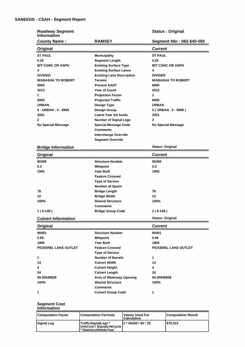
SANEEDS - CSAH - Segment Report
Roadway SegmentInformation
Status : Original
County Name : RAMSEY Segment Nbr : 062-640-050
Original Current
ST PAUL Municipality ST PAUL
0.25 Segment Length 0.25
BIT CONC OR ASPH Existing Surface Type BIT CONC OR ASPH
4 Existing Surface Lanes 4
DIVIDED Existing Lane Description DIVIDED
WABASHA TO ROBERT Termini WABASHA TO ROBERT
6900 Present AADT 6900
2013 Year of Count 2015
1 Projection Factor 1
6900 Projected Traffic 6900
URBAN Design Type URBAN
5 - URBAN : 0 - 9999 Design Group 5 ( URBAN : 0 - 9999 )
2001 Latest Year SA funds 2001
2 Number of Signal Legs 2
No Special Message Special Message Code No Special Message
Comments
Interchange Override
Segment Override
Bridge Information Status: Original
Original Current
90399 Structure Number 90399
0.3 Milepoint 0.3
1905 Year Built 1905
Feature Crossed
Type of Service
Number of Spans
78 Bridge Length 78
12 Bridge Width 12
100% Shared Structure 100%
Comments
1 ( 0-149 ) Bridge Group Code 1 ( 0-149 )
Culvert Information Status: Original
Original Current
90401 Structure Number 90401
0.69 Milepoint 0.69
1894 Year Built 1894
PICKEREL LAKE OUTLET Feature Crossed PICKEREL LAKE OUTLET
Type of Service
1 Number of Barrels 1
14 Culvert Width 14
4 Culvert Height 4
24 Culvert Length 24
50.00046828 Area of Waterway Opening 50.00046828
100% Shared Structure 100%
Comments
1 Culvert Group Code 1
Segment CostInformation
Computation Factor Computation Formula Values Used ForCalculation
Computation Result
Signal Leg TrafficSignalLegs *UnitCost / SignalLifeCycle* StatutoryNeedsYear
2 * 56250 / 40 * 25 $70,313

Construction Length * UnitCost /ConstrLifeCycle *StatutoryNeedsYear *DevelopmentCost
0.25 * 2738635.28 / 60 * 25* 1.15
$328,066
Preservation Length * Quantity *UnitCost /PreservationLifeCycle *StatutoryNeedsYear
0.25 * 2904 * 65.52 / 15 * 25 $79,279
ROW Length * UnitCost /ROWLifeCycle *StatutoryNeedsYear
0.25 * 436504.07 / 60 * 25 $45,469
Bridge BridgeLength *BridgeWidth * UnitCost /BridgeLifeCycle *StatutoryNeedsYear *DevelopmentCost
78 * 12 * 152 / 80 * 25 *1.15
$51,129
Culvert CulvertLength * Area *UnitCost /CulvertLifeCycle *StatutoryNeedsYear *DevelopmentCost
24 * 50.00046828 * 15.47 /100 * 25 * 1.15
$5,337
Total Segment Cost Signal Leg + Construction+ Preservation + ROW +Bridge + Culvert
$70,313 + $328,066 +$79,279 + $45,469 +$51,129 + $5,337
$579,593

SANEEDS - CSAH - Segment Report
Roadway SegmentInformation
Status : Original
County Name : RAMSEY Segment Nbr : 062-640-060
Original Current
ST PAUL Municipality ST PAUL
0.34 Segment Length 0.34
BIT CONC OR ASPH Existing Surface Type BIT CONC OR ASPH
4 Existing Surface Lanes 4
DIVIDED Existing Lane Description DIVIDED
ROBERT TO LAFAYETTE Termini ROBERT TO LAFAYETTE
12500 Present AADT 12500
2013 Year of Count 2015
1 Projection Factor 1
12500 Projected Traffic 12500
URBAN Design Type URBAN
6 - URBAN : 10000 - 19999 Design Group 6 ( URBAN : 10000 - 19999 )
2001 Latest Year SA funds 2001
3 Number of Signal Legs 3
No Special Message Special Message Code No Special Message
Comments
Interchange Override
Segment Override
Segment CostInformation
Computation Factor Computation Formula Values Used ForCalculation
Computation Result
Signal Leg TrafficSignalLegs *UnitCost / SignalLifeCycle* StatutoryNeedsYear
3 * 56250 / 40 * 25 $105,469
Construction Length * UnitCost /ConstrLifeCycle *StatutoryNeedsYear *DevelopmentCost
0.34 * 4225495.41 / 60 * 25* 1.15
$688,404
Preservation Length * Quantity *UnitCost /PreservationLifeCycle *StatutoryNeedsYear
0.34 * 3696 * 65.52 / 15 * 25 $137,225
ROW Length * UnitCost /ROWLifeCycle *StatutoryNeedsYear
0.34 * 566370.18 / 60 * 25 $80,236
Total Segment Cost Signal Leg + Construction+ Preservation + ROW
$105,469 + $688,404 +$137,225 + $80,236
$1,011,334

SANEEDS - CSAH - Segment Report
Roadway SegmentInformation
Status : Original
County Name : RAMSEY Segment Nbr : 062-640-070
Original Current
ST PAUL Municipality ST PAUL
0.29 Segment Length 0.29
BIT CONC OR ASPH Existing Surface Type BIT CONC OR ASPH
4 Existing Surface Lanes 4
DIVIDED Existing Lane Description DIVIDED
LAFAYETTE TO FILLMORE AVE Termini LAFAYETTE TO FILLMORE AVE
12500 Present AADT 12500
2013 Year of Count 2015
1 Projection Factor 1
12500 Projected Traffic 12500
URBAN Design Type URBAN
6 - URBAN : 10000 - 19999 Design Group 6 ( URBAN : 10000 - 19999 )
2001 Latest Year SA funds 2001
2 Number of Signal Legs 2
No Special Message Special Message Code No Special Message
Comments
Interchange Override
Segment Override
Segment CostInformation
Computation Factor Computation Formula Values Used ForCalculation
Computation Result
Signal Leg TrafficSignalLegs *UnitCost / SignalLifeCycle* StatutoryNeedsYear
2 * 56250 / 40 * 25 $70,313
Construction Length * UnitCost /ConstrLifeCycle *StatutoryNeedsYear *DevelopmentCost
0.29 * 4225495.41 / 60 * 25* 1.15
$587,168
Preservation Length * Quantity *UnitCost /PreservationLifeCycle *StatutoryNeedsYear
0.29 * 3696 * 65.52 / 15 * 25 $117,045
ROW Length * UnitCost /ROWLifeCycle *StatutoryNeedsYear
0.29 * 566370.18 / 60 * 25 $68,436
Total Segment Cost Signal Leg + Construction+ Preservation + ROW
$70,313 + $587,168 +$117,045 + $68,436
$842,962
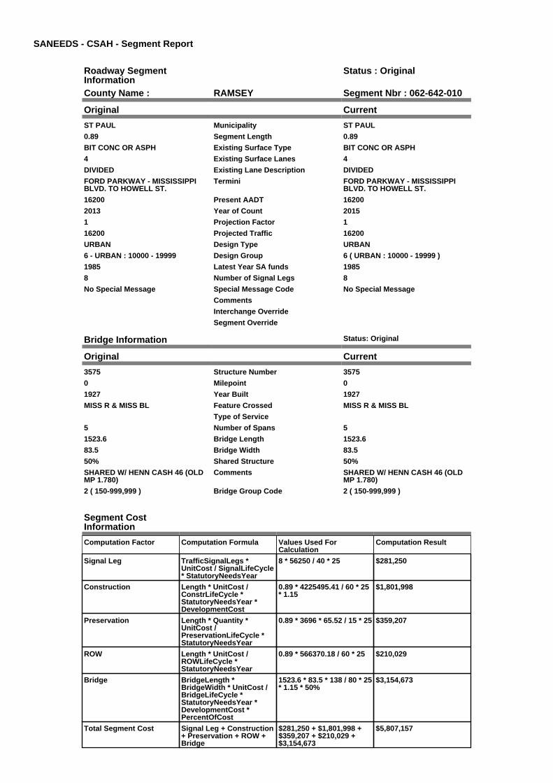
SANEEDS - CSAH - Segment Report
Roadway SegmentInformation
Status : Original
County Name : RAMSEY Segment Nbr : 062-642-010
Original Current
ST PAUL Municipality ST PAUL
0.89 Segment Length 0.89
BIT CONC OR ASPH Existing Surface Type BIT CONC OR ASPH
4 Existing Surface Lanes 4
DIVIDED Existing Lane Description DIVIDED
FORD PARKWAY - MISSISSIPPIBLVD. TO HOWELL ST.
Termini FORD PARKWAY - MISSISSIPPIBLVD. TO HOWELL ST.
16200 Present AADT 16200
2013 Year of Count 2015
1 Projection Factor 1
16200 Projected Traffic 16200
URBAN Design Type URBAN
6 - URBAN : 10000 - 19999 Design Group 6 ( URBAN : 10000 - 19999 )
1985 Latest Year SA funds 1985
8 Number of Signal Legs 8
No Special Message Special Message Code No Special Message
Comments
Interchange Override
Segment Override
Bridge Information Status: Original
Original Current
3575 Structure Number 3575
0 Milepoint 0
1927 Year Built 1927
MISS R & MISS BL Feature Crossed MISS R & MISS BL
Type of Service
5 Number of Spans 5
1523.6 Bridge Length 1523.6
83.5 Bridge Width 83.5
50% Shared Structure 50%
SHARED W/ HENN CASH 46 (OLDMP 1.780)
Comments SHARED W/ HENN CASH 46 (OLDMP 1.780)
2 ( 150-999,999 ) Bridge Group Code 2 ( 150-999,999 )
Segment CostInformation
Computation Factor Computation Formula Values Used ForCalculation
Computation Result
Signal Leg TrafficSignalLegs *UnitCost / SignalLifeCycle* StatutoryNeedsYear
8 * 56250 / 40 * 25 $281,250
Construction Length * UnitCost /ConstrLifeCycle *StatutoryNeedsYear *DevelopmentCost
0.89 * 4225495.41 / 60 * 25* 1.15
$1,801,998
Preservation Length * Quantity *UnitCost /PreservationLifeCycle *StatutoryNeedsYear
0.89 * 3696 * 65.52 / 15 * 25 $359,207
ROW Length * UnitCost /ROWLifeCycle *StatutoryNeedsYear
0.89 * 566370.18 / 60 * 25 $210,029
Bridge BridgeLength *BridgeWidth * UnitCost /BridgeLifeCycle *StatutoryNeedsYear *DevelopmentCost *PercentOfCost
1523.6 * 83.5 * 138 / 80 * 25* 1.15 * 50%
$3,154,673
Total Segment Cost Signal Leg + Construction+ Preservation + ROW +Bridge
$281,250 + $1,801,998 +$359,207 + $210,029 +$3,154,673
$5,807,157

SANEEDS - CSAH - Segment Report
Roadway SegmentInformation
Status : Original
County Name : RAMSEY Segment Nbr : 062-642-020
Original Current
ST PAUL Municipality ST PAUL
0.63 Segment Length 0.63
BRICK Existing Surface Type BRICK
2 Existing Surface Lanes 2
NOT DIVIDED Existing Lane Description NOT DIVIDED
FORD PARKWAY - HOWELL ST.TO SNELLING AVE.
Termini FORD PARKWAY - HOWELL ST.TO SNELLING AVE.
12900 Present AADT 12900
2013 Year of Count 2015
1 Projection Factor 1
12900 Projected Traffic 12900
URBAN Design Type URBAN
6 - URBAN : 10000 - 19999 Design Group 6 ( URBAN : 10000 - 19999 )
2002 Latest Year SA funds 2002
2 Number of Signal Legs 2
No Special Message Special Message Code No Special Message
Comments
Interchange Override
Segment Override
Segment CostInformation
Computation Factor Computation Formula Values Used ForCalculation
Computation Result
Signal Leg TrafficSignalLegs *UnitCost / SignalLifeCycle* StatutoryNeedsYear
2 * 56250 / 40 * 25 $70,313
Construction Length * UnitCost /ConstrLifeCycle *StatutoryNeedsYear *DevelopmentCost
0.63 * 4225495.41 / 60 * 25* 1.15
$1,275,571
Preservation Length * Quantity *UnitCost /PreservationLifeCycle *StatutoryNeedsYear
0.63 * 3696 * 65.52 / 15 * 25 $254,270
ROW Length * UnitCost /ROWLifeCycle *StatutoryNeedsYear
0.63 * 566370.18 / 60 * 25 $148,672
Total Segment Cost Signal Leg + Construction+ Preservation + ROW
$70,313 + $1,275,571 +$254,270 + $148,672
$1,748,826

SANEEDS - CSAH - Segment Report
Roadway SegmentInformation
Status : Original
County Name : RAMSEY Segment Nbr : 062-643-010
Original Current
ST PAUL Municipality ST PAUL
0.3 Segment Length 0.3
PORT CEMENT CONC Existing Surface Type PORT CEMENT CONC
2 Existing Surface Lanes 2
NOT DIVIDED Existing Lane Description NOT DIVIDED
T.H. 61 TO MC KNIGHT RD. Termini T.H. 61 TO MC KNIGHT RD.
1600 Present AADT 1600
2013 Year of Count 2015
1 Projection Factor 1
1600 Projected Traffic 1600
RURAL Design Type RURAL
3 - RURAL : 1500 - 6999 Design Group 3 ( RURAL : 1500 - 6999 )
2000 Latest Year SA funds 2000
0 Number of Signal Legs 0
No Special Message Special Message Code No Special Message
Comments
Interchange Override
Segment Override
Segment CostInformation
Computation Factor Computation Formula Values Used ForCalculation
Computation Result
Signal Leg TrafficSignalLegs *UnitCost / SignalLifeCycle* StatutoryNeedsYear
0 * 56250 / 40 * 25 $0
Construction Length * UnitCost /ConstrLifeCycle *StatutoryNeedsYear *DevelopmentCost
0.3 * 1021937.01 / 60 * 25 *1.1
$140,516
Preservation Length * Quantity *UnitCost /PreservationLifeCycle *StatutoryNeedsYear
0.3 * 2376 * 65.52 / 20 * 25 $58,378
ROW Length * UnitCost /ROWLifeCycle *StatutoryNeedsYear
0.3 * 85357.87 / 60 * 25 $10,670
Total Segment Cost Signal Leg + Construction+ Preservation + ROW
$0 + $140,516 + $58,378 +$10,670
$209,564

SANEEDS - CSAH - Segment Report
Roadway SegmentInformation
Status : Original
County Name : RAMSEY Segment Nbr : 062-643-020
Original Current
MAPLEWOOD Municipality MAPLEWOOD
0.52 Segment Length 0.52
SURFACE TREATED Existing Surface Type SURFACE TREATED
2 Existing Surface Lanes 2
NOT DIVIDED Existing Lane Description NOT DIVIDED
MC KNIGHT RD. TO W. JCT.STERLING ST.
Termini MC KNIGHT RD. TO W. JCT.STERLING ST.
720 Present AADT 720
2013 Year of Count 2015
1 Projection Factor 1
720 Projected Traffic 720
RURAL Design Type RURAL
2 - RURAL : 150 - 1499 Design Group 2 ( RURAL : 150 - 1499 )
2000 Latest Year SA funds 2000
0 Number of Signal Legs 0
No Special Message Special Message Code No Special Message
Comments
Interchange Override
Segment Override
Segment CostInformation
Computation Factor Computation Formula Values Used ForCalculation
Computation Result
Signal Leg TrafficSignalLegs *UnitCost / SignalLifeCycle* StatutoryNeedsYear
0 * 56250 / 40 * 25 $0
Construction Length * UnitCost /ConstrLifeCycle *StatutoryNeedsYear *DevelopmentCost
0.52 * 610216.45 / 60 * 25 *1.1
$145,435
Preservation Length * Quantity *UnitCost /PreservationLifeCycle *StatutoryNeedsYear
0.52 * 2112 * 65.52 / 20 * 25 $89,946
ROW Length * UnitCost /ROWLifeCycle *StatutoryNeedsYear
0.52 * 27775.28 / 60 * 25 $6,018
Total Segment Cost Signal Leg + Construction+ Preservation + ROW
$0 + $145,435 + $89,946 +$6,018
$241,399

SANEEDS - CSAH - Segment Report
Roadway SegmentInformation
Status : Original
County Name : RAMSEY Segment Nbr : 062-643-030
Original Current
MAPLEWOOD Municipality MAPLEWOOD
0.5 Segment Length 0.5
SURFACE TREATED Existing Surface Type SURFACE TREATED
2 Existing Surface Lanes 2
NOT DIVIDED Existing Lane Description NOT DIVIDED
W. JCT. STERLING ST. TO EASTCO LINE.
Termini W. JCT. STERLING ST. TO EASTCO LINE.
780 Present AADT 780
2013 Year of Count 2015
1 Projection Factor 1
780 Projected Traffic 780
RURAL Design Type RURAL
2 - RURAL : 150 - 1499 Design Group 2 ( RURAL : 150 - 1499 )
2000 Latest Year SA funds 2000
0 Number of Signal Legs 0
No Special Message Special Message Code No Special Message
Comments
Interchange Override
Segment Override
Segment CostInformation
Computation Factor Computation Formula Values Used ForCalculation
Computation Result
Signal Leg TrafficSignalLegs *UnitCost / SignalLifeCycle* StatutoryNeedsYear
0 * 56250 / 40 * 25 $0
Construction Length * UnitCost /ConstrLifeCycle *StatutoryNeedsYear *DevelopmentCost
0.5 * 610216.45 / 60 * 25 *1.1
$139,841
Preservation Length * Quantity *UnitCost /PreservationLifeCycle *StatutoryNeedsYear
0.5 * 2112 * 65.52 / 20 * 25 $86,486
ROW Length * UnitCost /ROWLifeCycle *StatutoryNeedsYear
0.5 * 27775.28 / 60 * 25 $5,787
Total Segment Cost Signal Leg + Construction+ Preservation + ROW
$0 + $139,841 + $86,486 +$5,787
$232,114

SANEEDS - CSAH - Segment Report
Roadway SegmentInformation
Status : Original
County Name : RAMSEY Segment Nbr : 062-644-005
Original Current
ST ANTHONY Municipality ST ANTHONY
0.1 Segment Length 0.1
BIT CONC OR ASPH Existing Surface Type BIT CONC OR ASPH
4 Existing Surface Lanes 4
DIVIDED Existing Lane Description DIVIDED
COUNTY ROAD D TO 0.10 MI N. Termini COUNTY ROAD D TO 0.10 MI N.
18100 Present AADT 18100
2013 Year of Count 2015
1 Projection Factor 1
18100 Projected Traffic 18100
URBAN Design Type URBAN
6 - URBAN : 10000 - 19999 Design Group 6 ( URBAN : 10000 - 19999 )
1989 Latest Year SA funds 1989
1 Number of Signal Legs 1
No Special Message Special Message Code No Special Message
Comments
Interchange Override
Segment Override
Bridge Information Status: Original
Original Current
62588 Structure Number 62588
0.091 Milepoint 0.091
2001 Year Built 2001
CP RAIL Feature Crossed CP RAIL
Type of Service
Number of Spans
139.6 Bridge Length 139.6
84.6 Bridge Width 84.6
100% Shared Structure 100%
Comments
1 ( 0-149 ) Bridge Group Code 1 ( 0-149 )
Segment CostInformation
Computation Factor Computation Formula Values Used ForCalculation
Computation Result
Signal Leg TrafficSignalLegs *UnitCost / SignalLifeCycle* StatutoryNeedsYear
1 * 56250 / 40 * 25 $35,156
Construction Length * UnitCost /ConstrLifeCycle *StatutoryNeedsYear *DevelopmentCost
0.1 * 4225495.41 / 60 * 25 *1.15
$202,472
Preservation Length * Quantity *UnitCost /PreservationLifeCycle *StatutoryNeedsYear
0.1 * 3696 * 65.52 / 15 * 25 $40,360
ROW Length * UnitCost /ROWLifeCycle *StatutoryNeedsYear
0.1 * 566370.18 / 60 * 25 $23,599
Bridge BridgeLength *BridgeWidth * UnitCost /BridgeLifeCycle *StatutoryNeedsYear *DevelopmentCost
139.6 * 84.6 * 152 / 80 * 25* 1.15
$645,130
Total Segment Cost Signal Leg + Construction+ Preservation + ROW +Bridge
$35,156 + $202,472 +$40,360 + $23,599 +$645,130
$946,717

SANEEDS - CSAH - Segment Report
Roadway SegmentInformation
Status : Original
County Name : RAMSEY Segment Nbr : 062-644-010
Original Current
ST ANTHONY Municipality ST ANTHONY
0.4 Segment Length 0.4
MIXED BITUMINOUS Existing Surface Type MIXED BITUMINOUS
4 Existing Surface Lanes 4
DIVIDED Existing Lane Description DIVIDED
0.101 MI N. OF CO. RD. D TOSILVER LANE
Termini 0.101 MI N. OF CO. RD. D TOSILVER LANE
18100 Present AADT 18100
2013 Year of Count 2015
1 Projection Factor 1
18100 Projected Traffic 18100
URBAN Design Type URBAN
6 - URBAN : 10000 - 19999 Design Group 6 ( URBAN : 10000 - 19999 )
1989 Latest Year SA funds 1989
3 Number of Signal Legs 3
No Special Message Special Message Code No Special Message
Comments
Interchange Override
Segment Override
Segment CostInformation
Computation Factor Computation Formula Values Used ForCalculation
Computation Result
Signal Leg TrafficSignalLegs *UnitCost / SignalLifeCycle* StatutoryNeedsYear
3 * 56250 / 40 * 25 $105,469
Construction Length * UnitCost /ConstrLifeCycle *StatutoryNeedsYear *DevelopmentCost
0.4 * 4225495.41 / 60 * 25 *1.15
$809,887
Preservation Length * Quantity *UnitCost /PreservationLifeCycle *StatutoryNeedsYear
0.4 * 3696 * 65.52 / 15 * 25 $161,441
ROW Length * UnitCost /ROWLifeCycle *StatutoryNeedsYear
0.4 * 566370.18 / 60 * 25 $94,395
Total Segment Cost Signal Leg + Construction+ Preservation + ROW
$105,469 + $809,887 +$161,441 + $94,395
$1,171,192

SANEEDS - CSAH - Segment Report
Roadway SegmentInformation
Status : Original
County Name : RAMSEY Segment Nbr : 062-644-020
Original Current
NEW BRIGHTON Municipality NEW BRIGHTON
0.25 Segment Length 0.25
BIT CONC OR ASPH Existing Surface Type BIT CONC OR ASPH
4 Existing Surface Lanes 4
DIVIDED Existing Lane Description DIVIDED
SILVER LANE TO O.25 MI N Termini SILVER LANE TO O.25 MI N
17400 Present AADT 17400
2013 Year of Count 2015
1 Projection Factor 1
17400 Projected Traffic 17400
URBAN Design Type URBAN
6 - URBAN : 10000 - 19999 Design Group 6 ( URBAN : 10000 - 19999 )
1995 Latest Year SA funds 1995
1 Number of Signal Legs 1
No Special Message Special Message Code No Special Message
Comments
Interchange Override
Segment Override
Segment CostInformation
Computation Factor Computation Formula Values Used ForCalculation
Computation Result
Signal Leg TrafficSignalLegs *UnitCost / SignalLifeCycle* StatutoryNeedsYear
1 * 56250 / 40 * 25 $35,156
Construction Length * UnitCost /ConstrLifeCycle *StatutoryNeedsYear *DevelopmentCost
0.25 * 4225495.41 / 60 * 25* 1.15
$506,179
Preservation Length * Quantity *UnitCost /PreservationLifeCycle *StatutoryNeedsYear
0.25 * 3696 * 65.52 / 15 * 25 $100,901
ROW Length * UnitCost /ROWLifeCycle *StatutoryNeedsYear
0.25 * 566370.18 / 60 * 25 $58,997
Total Segment Cost Signal Leg + Construction+ Preservation + ROW
$35,156 + $506,179 +$100,901 + $58,997
$701,233

SANEEDS - CSAH - Segment Report
Roadway SegmentInformation
Status : Original
County Name : RAMSEY Segment Nbr : 062-644-030
Original Current
ST ANTHONY Municipality ST ANTHONY
0.25 Segment Length 0.25
BIT CONC OR ASPH Existing Surface Type BIT CONC OR ASPH
4 Existing Surface Lanes 4
DIVIDED Existing Lane Description DIVIDED
0.25 MI N OF SILVER LANE TO CORD E
Termini 0.25 MI N OF SILVER LANE TO CORD E
17400 Present AADT 17400
2013 Year of Count 2015
1 Projection Factor 1
17400 Projected Traffic 17400
URBAN Design Type URBAN
6 - URBAN : 10000 - 19999 Design Group 6 ( URBAN : 10000 - 19999 )
1995 Latest Year SA funds 1995
3 Number of Signal Legs 3
No Special Message Special Message Code No Special Message
Comments
Interchange Override
Segment Override
Segment CostInformation
Computation Factor Computation Formula Values Used ForCalculation
Computation Result
Signal Leg TrafficSignalLegs *UnitCost / SignalLifeCycle* StatutoryNeedsYear
3 * 56250 / 40 * 25 $105,469
Construction Length * UnitCost /ConstrLifeCycle *StatutoryNeedsYear *DevelopmentCost
0.25 * 4225495.41 / 60 * 25* 1.15
$506,179
Preservation Length * Quantity *UnitCost /PreservationLifeCycle *StatutoryNeedsYear
0.25 * 3696 * 65.52 / 15 * 25 $100,901
ROW Length * UnitCost /ROWLifeCycle *StatutoryNeedsYear
0.25 * 566370.18 / 60 * 25 $58,997
Total Segment Cost Signal Leg + Construction+ Preservation + ROW
$105,469 + $506,179 +$100,901 + $58,997
$771,546

SANEEDS - CSAH - Segment Report
Roadway SegmentInformation
Status : Original
County Name : RAMSEY Segment Nbr : 062-644-040
Original Current
NEW BRIGHTON Municipality NEW BRIGHTON
1 Segment Length 1
BIT CONC OR ASPH Existing Surface Type BIT CONC OR ASPH
4 Existing Surface Lanes 4
DIVIDED Existing Lane Description DIVIDED
CO RD E TO I 694 Termini CO RD E TO I 694
21400 Present AADT 21400
2013 Year of Count 2015
1 Projection Factor 1
21400 Projected Traffic 21400
URBAN Design Type URBAN
7 - URBAN : 20000 - 34999 Design Group 7 ( URBAN : 20000 - 34999 )
1995 Latest Year SA funds 1995
9 Number of Signal Legs 9
No Special Message Special Message Code No Special Message
Comments
Interchange Override
Segment Override
Segment CostInformation
Computation Factor Computation Formula Values Used ForCalculation
Computation Result
Signal Leg TrafficSignalLegs *UnitCost / SignalLifeCycle* StatutoryNeedsYear
9 * 56250 / 40 * 25 $316,406
Construction Length * UnitCost /ConstrLifeCycle *StatutoryNeedsYear *DevelopmentCost
1 * 5259942.61 / 60 * 25 *1.15
$2,520,389
Preservation Length * Quantity *UnitCost /PreservationLifeCycle *StatutoryNeedsYear
1 * 4488 * 65.52 / 15 * 25 $490,090
ROW Length * UnitCost /ROWLifeCycle *StatutoryNeedsYear
1 * 883293.09 / 60 * 25 $368,039
Total Segment Cost Signal Leg + Construction+ Preservation + ROW
$316,406 + $2,520,389 +$490,090 + $368,039
$3,694,924

SANEEDS - CSAH - Segment Report
Roadway SegmentInformation
Status : Original
County Name : RAMSEY Segment Nbr : 062-644-050
Original Current
NEW BRIGHTON Municipality NEW BRIGHTON
0.69 Segment Length 0.69
MIXED BITUMINOUS Existing Surface Type MIXED BITUMINOUS
4 Existing Surface Lanes 4
DIVIDED Existing Lane Description DIVIDED
I 694 TO 15TH ST NW Termini I 694 TO 15TH ST NW
23500 Present AADT 23500
2013 Year of Count 2015
1 Projection Factor 1
23500 Projected Traffic 23500
URBAN Design Type URBAN
7 - URBAN : 20000 - 34999 Design Group 7 ( URBAN : 20000 - 34999 )
2002 Latest Year SA funds 2002
6 Number of Signal Legs 6
No Special Message Special Message Code No Special Message
Comments
Interchange Override
Segment Override
Segment CostInformation
Computation Factor Computation Formula Values Used ForCalculation
Computation Result
Signal Leg TrafficSignalLegs *UnitCost / SignalLifeCycle* StatutoryNeedsYear
6 * 56250 / 40 * 25 $210,938
Construction Length * UnitCost /ConstrLifeCycle *StatutoryNeedsYear *DevelopmentCost
0.69 * 5259942.61 / 60 * 25* 1.15
$1,739,069
Preservation Length * Quantity *UnitCost /PreservationLifeCycle *StatutoryNeedsYear
0.69 * 4488 * 65.52 / 15 * 25 $338,162
ROW Length * UnitCost /ROWLifeCycle *StatutoryNeedsYear
0.69 * 883293.09 / 60 * 25 $253,947
Total Segment Cost Signal Leg + Construction+ Preservation + ROW
$210,938 + $1,739,069 +$338,162 + $253,947
$2,542,116

SANEEDS - CSAH - Segment Report
Roadway SegmentInformation
Status : Original
County Name : RAMSEY Segment Nbr : 062-644-051
Original Current
NEW BRIGHTON Municipality NEW BRIGHTON
0.96 Segment Length 0.96
MIXED BITUMINOUS Existing Surface Type MIXED BITUMINOUS
4 Existing Surface Lanes 4
DIVIDED Existing Lane Description DIVIDED
SILVER LAKE RD. 15TH ST NW TO650 FT N OF MISSISSIPPI ST.
Termini SILVER LAKE RD. 15TH ST NW TO650 FT N OF MISSISSIPPI ST.
14900 Present AADT 14900
2013 Year of Count 2015
1 Projection Factor 1
14900 Projected Traffic 14900
URBAN Design Type URBAN
6 - URBAN : 10000 - 19999 Design Group 6 ( URBAN : 10000 - 19999 )
2002 Latest Year SA funds 2002
4 Number of Signal Legs 4
No Special Message Special Message Code No Special Message
Comments
Interchange Override
Segment Override
Segment CostInformation
Computation Factor Computation Formula Values Used ForCalculation
Computation Result
Signal Leg TrafficSignalLegs *UnitCost / SignalLifeCycle* StatutoryNeedsYear
4 * 56250 / 40 * 25 $140,625
Construction Length * UnitCost /ConstrLifeCycle *StatutoryNeedsYear *DevelopmentCost
0.96 * 4225495.41 / 60 * 25* 1.15
$1,943,728
Preservation Length * Quantity *UnitCost /PreservationLifeCycle *StatutoryNeedsYear
0.96 * 3696 * 65.52 / 15 * 25 $387,459
ROW Length * UnitCost /ROWLifeCycle *StatutoryNeedsYear
0.96 * 566370.18 / 60 * 25 $226,548
Total Segment Cost Signal Leg + Construction+ Preservation + ROW
$140,625 + $1,943,728 +$387,459 + $226,548
$2,698,360

SANEEDS - CSAH - Segment Report
Roadway SegmentInformation
Status : Original
County Name : RAMSEY Segment Nbr : 062-644-060
Original Current
NEW BRIGHTON Municipality NEW BRIGHTON
0.23 Segment Length 0.23
MIXED BITUMINOUS Existing Surface Type MIXED BITUMINOUS
2 Existing Surface Lanes 2
DIVIDED Existing Lane Description DIVIDED
SILVER LAKE RD. 650 FT N OFMISSISSIPPI TO CO.RD. H
Termini SILVER LAKE RD. 650 FT N OFMISSISSIPPI TO CO.RD. H
10000 Present AADT 10000
2013 Year of Count 2015
1 Projection Factor 1
10000 Projected Traffic 10000
URBAN Design Type URBAN
6 - URBAN : 10000 - 19999 Design Group 6 ( URBAN : 10000 - 19999 )
2003 Latest Year SA funds 2003
1 Number of Signal Legs 1
No Special Message Special Message Code No Special Message
CONST. SAP 62-644-028 Comments CONST. SAP 62-644-028
Interchange Override
Segment Override
Culvert Information Status: Original
Original Current
62516 Structure Number 62516
3.66 Milepoint 3.66
1965 Year Built 1965
RICE CREEK Feature Crossed RICE CREEK
Type of Service
3 Number of Barrels 3
10 Culvert Width 10
6 Culvert Height 6
64 Culvert Length 64
180.00039414 Area of Waterway Opening 180.00039414
100% Shared Structure 100%
Comments
1 Culvert Group Code 1
RailRoadCrossingInformation
Status: Original
Original Current
MINNESOTA COMMERCIALRAILWAY COMPANY
RailRoad Name MINNESOTA COMMERCIALRAILWAY COMPANY
463571X USDOT Number 463571X
0.08 Located at Milepoint 0.08
1 Mainline Tracks 1
SIGNALS ONLY Protection Type SIGNALS ONLY
2000 Last Year Protection Upgraded 2000
60 Crossing Length 60
Last Year Surfaced
100% Percentage of Cost 100%
Comments
Segment CostInformation
Computation Factor Computation Formula Values Used ForCalculation
Computation Result

Signal Leg TrafficSignalLegs *UnitCost / SignalLifeCycle* StatutoryNeedsYear
1 * 56250 / 40 * 25 $35,156
Construction Length * UnitCost /ConstrLifeCycle *StatutoryNeedsYear *DevelopmentCost
0.23 * 4225495.41 / 60 * 25* 1.15
$465,685
Preservation Length * Quantity *UnitCost /PreservationLifeCycle *StatutoryNeedsYear
0.23 * 3696 * 65.52 / 15 * 25 $92,829
ROW Length * UnitCost /ROWLifeCycle *StatutoryNeedsYear
0.23 * 566370.18 / 60 * 25 $54,277
Culvert CulvertLength * Area *UnitCost /CulvertLifeCycle *StatutoryNeedsYear *DevelopmentCost
64 * 180.00039414 * 15.47 /100 * 25 * 1.15
$51,237
RR Crossing Protection UnitCost /RRCrossingLifeCycle *StatutoryNeedsYear
275000 / 25 * 25 $275,000
RR Crossing Surface SurfaceLength * UnitCost/ RRCrossingLifeCycle *StatutoryNeedsYear
60 * 1350 / 25 * 25 $81,000
Total Segment Cost Signal Leg + Construction+ Preservation + ROW +Culvert + RR CrossingProtection + RR CrossingSurface
$35,156 + $465,685 +$92,829 + $54,277 +$51,237 + $275,000 +$81,000
$1,055,184

SANEEDS - CSAH - Segment Report
Roadway SegmentInformation
Status : Original
County Name : RAMSEY Segment Nbr : 062-644-070
Original Current
MOUNDS VIEW Municipality MOUNDS VIEW
0.5 Segment Length 0.5
MIXED BITUMINOUS Existing Surface Type MIXED BITUMINOUS
2 Existing Surface Lanes 2
NOT DIVIDED Existing Lane Description NOT DIVIDED
SILVER LAKE RD. CO RD H TO CORD H2
Termini SILVER LAKE RD. CO RD H TO CORD H2
7700 Present AADT 7700
2013 Year of Count 2015
1 Projection Factor 1
7700 Projected Traffic 7700
URBAN Design Type URBAN
5 - URBAN : 0 - 9999 Design Group 5 ( URBAN : 0 - 9999 )
2004 Latest Year SA funds 2004
1 Number of Signal Legs 1
No Special Message Special Message Code No Special Message
CONST. SAP 62-644-029 Comments CONST. SAP 62-644-029
Interchange Override
Segment Override
Segment CostInformation
Computation Factor Computation Formula Values Used ForCalculation
Computation Result
Signal Leg TrafficSignalLegs *UnitCost / SignalLifeCycle* StatutoryNeedsYear
1 * 56250 / 40 * 25 $35,156
Construction Length * UnitCost /ConstrLifeCycle *StatutoryNeedsYear *DevelopmentCost
0.5 * 2738635.28 / 60 * 25 *1.15
$656,131
Preservation Length * Quantity *UnitCost /PreservationLifeCycle *StatutoryNeedsYear
0.5 * 2904 * 65.52 / 15 * 25 $158,558
ROW Length * UnitCost /ROWLifeCycle *StatutoryNeedsYear
0.5 * 436504.07 / 60 * 25 $90,938
Total Segment Cost Signal Leg + Construction+ Preservation + ROW
$35,156 + $656,131 +$158,558 + $90,938
$940,783

SANEEDS - CSAH - Segment Report
Roadway SegmentInformation
Status : Original
County Name : RAMSEY Segment Nbr : 062-644-075
Original Current
MOUNDS VIEW Municipality MOUNDS VIEW
0.5 Segment Length 0.5
MIXED BITUMINOUS Existing Surface Type MIXED BITUMINOUS
2 Existing Surface Lanes 2
NOT DIVIDED Existing Lane Description NOT DIVIDED
SILVER LAKE RD. CO RD H2 TOCO RD I
Termini SILVER LAKE RD. CO RD H2 TOCO RD I
7700 Present AADT 7700
2013 Year of Count 2015
1 Projection Factor 1
7700 Projected Traffic 7700
URBAN Design Type URBAN
5 - URBAN : 0 - 9999 Design Group 5 ( URBAN : 0 - 9999 )
2004 Latest Year SA funds 2004
0 Number of Signal Legs 0
No Special Message Special Message Code No Special Message
CONST. SAP 62-644-029 Comments CONST. SAP 62-644-029
Interchange Override
Segment Override
Segment CostInformation
Computation Factor Computation Formula Values Used ForCalculation
Computation Result
Signal Leg TrafficSignalLegs *UnitCost / SignalLifeCycle* StatutoryNeedsYear
0 * 56250 / 40 * 25 $0
Construction Length * UnitCost /ConstrLifeCycle *StatutoryNeedsYear *DevelopmentCost
0.5 * 2738635.28 / 60 * 25 *1.15
$656,131
Preservation Length * Quantity *UnitCost /PreservationLifeCycle *StatutoryNeedsYear
0.5 * 2904 * 65.52 / 15 * 25 $158,558
ROW Length * UnitCost /ROWLifeCycle *StatutoryNeedsYear
0.5 * 436504.07 / 60 * 25 $90,938
Total Segment Cost Signal Leg + Construction+ Preservation + ROW
$0 + $656,131 + $158,558+ $90,938
$905,627

SANEEDS - CSAH - Segment Report
Roadway SegmentInformation
Status : Original
County Name : RAMSEY Segment Nbr : 062-644-080
Original Current
MOUNDS VIEW Municipality MOUNDS VIEW
0.2 Segment Length 0.2
MIXED BITUMINOUS Existing Surface Type MIXED BITUMINOUS
2 Existing Surface Lanes 2
NOT DIVIDED Existing Lane Description NOT DIVIDED
CO. RD. I TO CSAH 10 Termini CO. RD. I TO CSAH 10
6600 Present AADT 6600
2013 Year of Count 2015
1 Projection Factor 1
6600 Projected Traffic 6600
URBAN Design Type URBAN
5 - URBAN : 0 - 9999 Design Group 5 ( URBAN : 0 - 9999 )
2013 Latest Year SA funds 2013
1 Number of Signal Legs 1
No Special Message Special Message Code No Special Message
2013 SP 062-644-033 SIGNALSYSTEM @ CSAH 10
CONST. SAP 62-644-029
Comments 2013 SP 062-644-033 SIGNALSYSTEM @ CSAH 10
CONST. SAP 62-644-029
Interchange Override
Segment Override
Segment CostInformation
Computation Factor Computation Formula Values Used ForCalculation
Computation Result
Signal Leg TrafficSignalLegs *UnitCost / SignalLifeCycle* StatutoryNeedsYear
1 * 56250 / 40 * 25 $35,156
Construction Length * UnitCost /ConstrLifeCycle *StatutoryNeedsYear *DevelopmentCost
0.2 * 2738635.28 / 60 * 25 *1.15
$262,453
Preservation Length * Quantity *UnitCost /PreservationLifeCycle *StatutoryNeedsYear
0.2 * 2904 * 65.52 / 15 * 25 $63,423
ROW Length * UnitCost /ROWLifeCycle *StatutoryNeedsYear
0.2 * 436504.07 / 60 * 25 $36,375
Total Segment Cost Signal Leg + Construction+ Preservation + ROW
$35,156 + $262,453 +$63,423 + $36,375
$397,407

SANEEDS - CSAH - Segment Report
Roadway SegmentInformation
Status : Original
County Name : RAMSEY Segment Nbr : 062-645-020
Original Current
NEW BRIGHTON Municipality NEW BRIGHTON
0.2 Segment Length 0.2
BIT CONC OR ASPH Existing Surface Type BIT CONC OR ASPH
4 Existing Surface Lanes 4
DIVIDED Existing Lane Description DIVIDED
10TH ST NW TO FAI 694 Termini 10TH ST NW TO FAI 694
11500 Present AADT 11500
2013 Year of Count 2015
1 Projection Factor 1
11500 Projected Traffic 11500
URBAN Design Type URBAN
6 - URBAN : 10000 - 19999 Design Group 6 ( URBAN : 10000 - 19999 )
1980 Latest Year SA funds 1980
0 Number of Signal Legs 0
No Special Message Special Message Code No Special Message
Comments
Interchange Override
Segment Override
Segment CostInformation
Computation Factor Computation Formula Values Used ForCalculation
Computation Result
Signal Leg TrafficSignalLegs *UnitCost / SignalLifeCycle* StatutoryNeedsYear
0 * 56250 / 40 * 25 $0
Construction Length * UnitCost /ConstrLifeCycle *StatutoryNeedsYear *DevelopmentCost
0.2 * 4225495.41 / 60 * 25 *1.15
$404,943
Preservation Length * Quantity *UnitCost /PreservationLifeCycle *StatutoryNeedsYear
0.2 * 3696 * 65.52 / 15 * 25 $80,721
ROW Length * UnitCost /ROWLifeCycle *StatutoryNeedsYear
0.2 * 566370.18 / 60 * 25 $47,198
Total Segment Cost Signal Leg + Construction+ Preservation + ROW
$0 + $404,943 + $80,721 +$47,198
$532,862

SANEEDS - CSAH - Segment Report
Roadway SegmentInformation
Status : Original
County Name : RAMSEY Segment Nbr : 062-645-030
Original Current
NEW BRIGHTON Municipality NEW BRIGHTON
0.67 Segment Length 0.67
BIT CONC OR ASPH Existing Surface Type BIT CONC OR ASPH
4 Existing Surface Lanes 4
NOT DIVIDED Existing Lane Description NOT DIVIDED
FAI 694 TO 14 TH ST NW Termini FAI 694 TO 14 TH ST NW
7200 Present AADT 7200
2013 Year of Count 2015
1 Projection Factor 1
7200 Projected Traffic 7200
URBAN Design Type URBAN
5 - URBAN : 0 - 9999 Design Group 5 ( URBAN : 0 - 9999 )
1989 Latest Year SA funds 1989
0 Number of Signal Legs 0
No Special Message Special Message Code No Special Message
Comments
Interchange Override
Segment Override
Culvert Information Status: Original
Original Current
62522 Structure Number 62522
0.65 Milepoint 0.65
1967 Year Built 1967
CO DITCH # 2 Feature Crossed CO DITCH # 2
Type of Service
2 Number of Barrels 2
10 Culvert Width 10
5 Culvert Height 5
91 Culvert Length 91
99.99986017 Area of Waterway Opening 99.99986017
100% Shared Structure 100%
Comments
1 Culvert Group Code 1
Segment CostInformation
Computation Factor Computation Formula Values Used ForCalculation
Computation Result
Signal Leg TrafficSignalLegs *UnitCost / SignalLifeCycle* StatutoryNeedsYear
0 * 56250 / 40 * 25 $0
Construction Length * UnitCost /ConstrLifeCycle *StatutoryNeedsYear *DevelopmentCost
0.67 * 2738635.28 / 60 * 25* 1.15
$879,216
Preservation Length * Quantity *UnitCost /PreservationLifeCycle *StatutoryNeedsYear
0.67 * 2904 * 65.52 / 15 * 25 $212,468
ROW Length * UnitCost /ROWLifeCycle *StatutoryNeedsYear
0.67 * 436504.07 / 60 * 25 $121,857
Culvert CulvertLength * Area *UnitCost /CulvertLifeCycle *StatutoryNeedsYear *DevelopmentCost
91 * 99.99986017 * 15.47 /100 * 25 * 1.15
$40,473
Total Segment Cost Signal Leg + Construction+ Preservation + ROW +Culvert
$0 + $879,216 + $212,468+ $121,857 + $40,473
$1,254,014

SANEEDS - CSAH - Segment Report
Roadway SegmentInformation
Status : Original
County Name : RAMSEY Segment Nbr : 062-645-040
Original Current
NEW BRIGHTON Municipality NEW BRIGHTON
0.7 Segment Length 0.7
BIT CONC OR ASPH Existing Surface Type BIT CONC OR ASPH
2 Existing Surface Lanes 2
NOT DIVIDED Existing Lane Description NOT DIVIDED
14TH ST NW TO 19TH ST NW Termini 14TH ST NW TO 19TH ST NW
5400 Present AADT 5400
2013 Year of Count 2015
1 Projection Factor 1
5400 Projected Traffic 5400
URBAN Design Type URBAN
5 - URBAN : 0 - 9999 Design Group 5 ( URBAN : 0 - 9999 )
1989 Latest Year SA funds 1989
0 Number of Signal Legs 0
No Special Message Special Message Code No Special Message
Comments
Interchange Override
Segment Override
Segment CostInformation
Computation Factor Computation Formula Values Used ForCalculation
Computation Result
Signal Leg TrafficSignalLegs *UnitCost / SignalLifeCycle* StatutoryNeedsYear
0 * 56250 / 40 * 25 $0
Construction Length * UnitCost /ConstrLifeCycle *StatutoryNeedsYear *DevelopmentCost
0.7 * 2738635.28 / 60 * 25 *1.15
$918,584
Preservation Length * Quantity *UnitCost /PreservationLifeCycle *StatutoryNeedsYear
0.7 * 2904 * 65.52 / 15 * 25 $221,982
ROW Length * UnitCost /ROWLifeCycle *StatutoryNeedsYear
0.7 * 436504.07 / 60 * 25 $127,314
Total Segment Cost Signal Leg + Construction+ Preservation + ROW
$0 + $918,584 + $221,982+ $127,314
$1,267,880

SANEEDS - CSAH - Segment Report
Roadway SegmentInformation
Status : Original
County Name : RAMSEY Segment Nbr : 062-645-050
Original Current
NEW BRIGHTON Municipality NEW BRIGHTON
0.98 Segment Length 0.98
BIT CONC OR ASPH Existing Surface Type BIT CONC OR ASPH
2 Existing Surface Lanes 2
NOT DIVIDED Existing Lane Description NOT DIVIDED
19TH ST NW TO NO LIMS NEWBRIGHTON
Termini 19TH ST NW TO NO LIMS NEWBRIGHTON
5700 Present AADT 5700
2013 Year of Count 2015
1 Projection Factor 1
5700 Projected Traffic 5700
URBAN Design Type URBAN
5 - URBAN : 0 - 9999 Design Group 5 ( URBAN : 0 - 9999 )
1987 Latest Year SA funds 1987
0 Number of Signal Legs 0
No Special Message Special Message Code No Special Message
Comments
Interchange Override
Segment Override
Bridge Information Status: Original
Original Current
4513 Structure Number 4513
1.75 Milepoint 1.75
1926 Year Built 1926
RICE CREEK Feature Crossed RICE CREEK
STREAM CROSSING Type of Service STREAM CROSSING
1 Number of Spans 1
47 Bridge Length 47
52.8 Bridge Width 52.8
100% Shared Structure 100%
Comments
1 ( 0-149 ) Bridge Group Code 1 ( 0-149 )
RailRoadCrossingInformation
Status: Original
Original Current
MINNESOTA COMMERCIALRAILWAY COMPANY
RailRoad Name MINNESOTA COMMERCIALRAILWAY COMPANY
463546P USDOT Number 463546P
0.52 Located at Milepoint 0.52
1 Mainline Tracks 1
SIGNS ONLY Protection Type SIGNS ONLY
2005 Last Year Protection Upgraded 2005
57 Crossing Length 57
Last Year Surfaced
100% Percentage of Cost 100%
Comments
Segment CostInformation
Computation Factor Computation Formula Values Used ForCalculation
Computation Result
Signal Leg TrafficSignalLegs *UnitCost / SignalLifeCycle* StatutoryNeedsYear
0 * 56250 / 40 * 25 $0
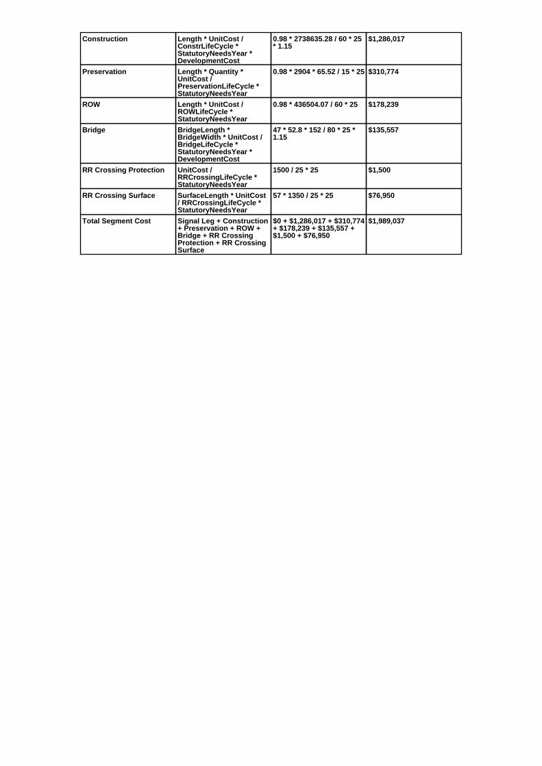
Construction Length * UnitCost /ConstrLifeCycle *StatutoryNeedsYear *DevelopmentCost
0.98 * 2738635.28 / 60 * 25* 1.15
$1,286,017
Preservation Length * Quantity *UnitCost /PreservationLifeCycle *StatutoryNeedsYear
0.98 * 2904 * 65.52 / 15 * 25 $310,774
ROW Length * UnitCost /ROWLifeCycle *StatutoryNeedsYear
0.98 * 436504.07 / 60 * 25 $178,239
Bridge BridgeLength *BridgeWidth * UnitCost /BridgeLifeCycle *StatutoryNeedsYear *DevelopmentCost
47 * 52.8 * 152 / 80 * 25 *1.15
$135,557
RR Crossing Protection UnitCost /RRCrossingLifeCycle *StatutoryNeedsYear
1500 / 25 * 25 $1,500
RR Crossing Surface SurfaceLength * UnitCost/ RRCrossingLifeCycle *StatutoryNeedsYear
57 * 1350 / 25 * 25 $76,950
Total Segment Cost Signal Leg + Construction+ Preservation + ROW +Bridge + RR CrossingProtection + RR CrossingSurface
$0 + $1,286,017 + $310,774+ $178,239 + $135,557 +$1,500 + $76,950
$1,989,037

SANEEDS - CSAH - Segment Report
Roadway SegmentInformation
Status : Original
County Name : RAMSEY Segment Nbr : 062-645-060
Original Current
MOUNDS VIEW Municipality MOUNDS VIEW
0.5 Segment Length 0.5
BIT CONC OR ASPH Existing Surface Type BIT CONC OR ASPH
2 Existing Surface Lanes 2
NOT DIVIDED Existing Lane Description NOT DIVIDED
SOUTH LIMITS OF MOUNDSVIEWTO CO. RD. H2
Termini SOUTH LIMITS OF MOUNDSVIEWTO CO. RD. H2
4350 Present AADT 4350
2013 Year of Count 2015
1 Projection Factor 1
4350 Projected Traffic 4350
URBAN Design Type URBAN
5 - URBAN : 0 - 9999 Design Group 5 ( URBAN : 0 - 9999 )
1992 Latest Year SA funds 1992
0 Number of Signal Legs 0
No Special Message Special Message Code No Special Message
Comments
Interchange Override
Segment Override
Segment CostInformation
Computation Factor Computation Formula Values Used ForCalculation
Computation Result
Signal Leg TrafficSignalLegs *UnitCost / SignalLifeCycle* StatutoryNeedsYear
0 * 56250 / 40 * 25 $0
Construction Length * UnitCost /ConstrLifeCycle *StatutoryNeedsYear *DevelopmentCost
0.5 * 2738635.28 / 60 * 25 *1.15
$656,131
Preservation Length * Quantity *UnitCost /PreservationLifeCycle *StatutoryNeedsYear
0.5 * 2904 * 65.52 / 15 * 25 $158,558
ROW Length * UnitCost /ROWLifeCycle *StatutoryNeedsYear
0.5 * 436504.07 / 60 * 25 $90,938
Total Segment Cost Signal Leg + Construction+ Preservation + ROW
$0 + $656,131 + $158,558+ $90,938
$905,627

SANEEDS - CSAH - Segment Report
Roadway SegmentInformation
Status : Original
County Name : RAMSEY Segment Nbr : 062-645-070
Original Current
MOUNDS VIEW Municipality MOUNDS VIEW
0.29 Segment Length 0.29
BIT CONC OR ASPH Existing Surface Type BIT CONC OR ASPH
2 Existing Surface Lanes 2
NOT DIVIDED Existing Lane Description NOT DIVIDED
CO. RD. H2 TO T.H. 10 Termini CO. RD. H2 TO T.H. 10
4800 Present AADT 4800
2013 Year of Count 2015
1 Projection Factor 1
4800 Projected Traffic 4800
URBAN Design Type URBAN
5 - URBAN : 0 - 9999 Design Group 5 ( URBAN : 0 - 9999 )
1992 Latest Year SA funds 1992
1 Number of Signal Legs 1
No Special Message Special Message Code No Special Message
Comments
Interchange Override
Segment Override
Segment CostInformation
Computation Factor Computation Formula Values Used ForCalculation
Computation Result
Signal Leg TrafficSignalLegs *UnitCost / SignalLifeCycle* StatutoryNeedsYear
1 * 56250 / 40 * 25 $35,156
Construction Length * UnitCost /ConstrLifeCycle *StatutoryNeedsYear *DevelopmentCost
0.29 * 2738635.28 / 60 * 25* 1.15
$380,556
Preservation Length * Quantity *UnitCost /PreservationLifeCycle *StatutoryNeedsYear
0.29 * 2904 * 65.52 / 15 * 25 $91,964
ROW Length * UnitCost /ROWLifeCycle *StatutoryNeedsYear
0.29 * 436504.07 / 60 * 25 $52,744
Total Segment Cost Signal Leg + Construction+ Preservation + ROW
$35,156 + $380,556 +$91,964 + $52,744
$560,420

SANEEDS - CSAH - Segment Report
Roadway SegmentInformation
Status : Original
County Name : RAMSEY Segment Nbr : 062-645-080
Original Current
MOUNDS VIEW Municipality MOUNDS VIEW
0.21 Segment Length 0.21
BIT CONC OR ASPH Existing Surface Type BIT CONC OR ASPH
2 Existing Surface Lanes 2
NOT DIVIDED Existing Lane Description NOT DIVIDED
TH 10 TO CO. RD. I Termini TH 10 TO CO. RD. I
3850 Present AADT 3850
2013 Year of Count 2015
1 Projection Factor 1
3850 Projected Traffic 3850
URBAN Design Type URBAN
5 - URBAN : 0 - 9999 Design Group 5 ( URBAN : 0 - 9999 )
1992 Latest Year SA funds 1992
1 Number of Signal Legs 1
No Special Message Special Message Code No Special Message
Comments
Interchange Override
Segment Override
Segment CostInformation
Computation Factor Computation Formula Values Used ForCalculation
Computation Result
Signal Leg TrafficSignalLegs *UnitCost / SignalLifeCycle* StatutoryNeedsYear
1 * 56250 / 40 * 25 $35,156
Construction Length * UnitCost /ConstrLifeCycle *StatutoryNeedsYear *DevelopmentCost
0.21 * 2738635.28 / 60 * 25* 1.15
$275,575
Preservation Length * Quantity *UnitCost /PreservationLifeCycle *StatutoryNeedsYear
0.21 * 2904 * 65.52 / 15 * 25 $66,595
ROW Length * UnitCost /ROWLifeCycle *StatutoryNeedsYear
0.21 * 436504.07 / 60 * 25 $38,194
Total Segment Cost Signal Leg + Construction+ Preservation + ROW
$35,156 + $275,575 +$66,595 + $38,194
$415,520

SANEEDS - CSAH - Segment Report
Roadway SegmentInformation
Status : Original
County Name : RAMSEY Segment Nbr : 062-645-090
Original Current
MOUNDS VIEW Municipality MOUNDS VIEW
1.26 Segment Length 1.26
BIT CONC OR ASPH Existing Surface Type BIT CONC OR ASPH
2 Existing Surface Lanes 2
NOT DIVIDED Existing Lane Description NOT DIVIDED
CO. RD. I TO 1.26 MI NORTH Termini CO. RD. I TO 1.26 MI NORTH
3150 Present AADT 3150
2013 Year of Count 2015
1 Projection Factor 1
3150 Projected Traffic 3150
URBAN Design Type URBAN
5 - URBAN : 0 - 9999 Design Group 5 ( URBAN : 0 - 9999 )
1992 Latest Year SA funds 1992
0 Number of Signal Legs 0
No Special Message Special Message Code No Special Message
Comments
Interchange Override
Segment Override
Segment CostInformation
Computation Factor Computation Formula Values Used ForCalculation
Computation Result
Signal Leg TrafficSignalLegs *UnitCost / SignalLifeCycle* StatutoryNeedsYear
0 * 56250 / 40 * 25 $0
Construction Length * UnitCost /ConstrLifeCycle *StatutoryNeedsYear *DevelopmentCost
1.26 * 2738635.28 / 60 * 25* 1.15
$1,653,451
Preservation Length * Quantity *UnitCost /PreservationLifeCycle *StatutoryNeedsYear
1.26 * 2904 * 65.52 / 15 * 25 $399,567
ROW Length * UnitCost /ROWLifeCycle *StatutoryNeedsYear
1.26 * 436504.07 / 60 * 25 $229,165
Total Segment Cost Signal Leg + Construction+ Preservation + ROW
$0 + $1,653,451 + $399,567+ $229,165
$2,282,183

SANEEDS - CSAH - Segment Report
Roadway SegmentInformation
Status : Original
County Name : RAMSEY Segment Nbr : 062-645-100
Original Current
MOUNDS VIEW Municipality MOUNDS VIEW
0.23 Segment Length 0.23
BIT CONC OR ASPH Existing Surface Type BIT CONC OR ASPH
2 Existing Surface Lanes 2
NOT DIVIDED Existing Lane Description NOT DIVIDED
1.26 MILES NORTH OF CO. RD. ITO AIRPORT RD
Termini 1.26 MILES NORTH OF CO. RD. ITO AIRPORT RD
3000 Present AADT 3000
2013 Year of Count 2015
1 Projection Factor 1
3000 Projected Traffic 3000
URBAN Design Type URBAN
5 - URBAN : 0 - 9999 Design Group 5 ( URBAN : 0 - 9999 )
1992 Latest Year SA funds 1992
0 Number of Signal Legs 0
No Special Message Special Message Code No Special Message
Comments
Interchange Override
Segment Override
Segment CostInformation
Computation Factor Computation Formula Values Used ForCalculation
Computation Result
Signal Leg TrafficSignalLegs *UnitCost / SignalLifeCycle* StatutoryNeedsYear
0 * 56250 / 40 * 25 $0
Construction Length * UnitCost /ConstrLifeCycle *StatutoryNeedsYear *DevelopmentCost
0.23 * 2738635.28 / 60 * 25* 1.15
$301,820
Preservation Length * Quantity *UnitCost /PreservationLifeCycle *StatutoryNeedsYear
0.23 * 2904 * 65.52 / 15 * 25 $72,937
ROW Length * UnitCost /ROWLifeCycle *StatutoryNeedsYear
0.23 * 436504.07 / 60 * 25 $41,832
Total Segment Cost Signal Leg + Construction+ Preservation + ROW
$0 + $301,820 + $72,937 +$41,832
$416,589

SANEEDS - CSAH - Segment Report
Roadway SegmentInformation
Status : Original
County Name : RAMSEY Segment Nbr : 062-645-110
Original Current
MOUNDS VIEW Municipality MOUNDS VIEW
0.03 Segment Length 0.03
BIT CONC OR ASPH Existing Surface Type BIT CONC OR ASPH
2 Existing Surface Lanes 2
DIVIDED Existing Lane Description DIVIDED
AIRPORT RD - FROM LONG LAKERD TO 85TH AVE NE
Termini AIRPORT RD - FROM LONG LAKERD TO 85TH AVE NE
12900 Present AADT 12900
2013 Year of Count 2015
1 Projection Factor 1
12900 Projected Traffic 12900
URBAN Design Type URBAN
6 - URBAN : 10000 - 19999 Design Group 6 ( URBAN : 10000 - 19999 )
1992 Latest Year SA funds 1992
1 Number of Signal Legs 1
No Special Message Special Message Code No Special Message
Comments
Interchange Override
Segment Override
Segment CostInformation
Computation Factor Computation Formula Values Used ForCalculation
Computation Result
Signal Leg TrafficSignalLegs *UnitCost / SignalLifeCycle* StatutoryNeedsYear
1 * 56250 / 40 * 25 $35,156
Construction Length * UnitCost /ConstrLifeCycle *StatutoryNeedsYear *DevelopmentCost
0.03 * 4225495.41 / 60 * 25* 1.15
$60,741
Preservation Length * Quantity *UnitCost /PreservationLifeCycle *StatutoryNeedsYear
0.03 * 3696 * 65.52 / 15 * 25 $12,108
ROW Length * UnitCost /ROWLifeCycle *StatutoryNeedsYear
0.03 * 566370.18 / 60 * 25 $7,080
Total Segment Cost Signal Leg + Construction+ Preservation + ROW
$35,156 + $60,741 +$12,108 + $7,080
$115,085

SANEEDS - CSAH - Segment Report
Roadway SegmentInformation
Status : Original
County Name : RAMSEY Segment Nbr : 062-646-015
Original Current
ST PAUL Municipality ST PAUL
0.3 Segment Length 0.3
PORT CEMENT CONC Existing Surface Type PORT CEMENT CONC
2 Existing Surface Lanes 2
NOT DIVIDED Existing Lane Description NOT DIVIDED
EDGECUMBE RD. - MUNSTERAVE. TO ST. PAUL AVE.
Termini EDGECUMBE RD. - MUNSTERAVE. TO ST. PAUL AVE.
14400 Present AADT 14400
2013 Year of Count 2015
1 Projection Factor 1
14400 Projected Traffic 14400
URBAN Design Type URBAN
6 - URBAN : 10000 - 19999 Design Group 6 ( URBAN : 10000 - 19999 )
2000 Latest Year SA funds 2000
3 Number of Signal Legs 3
No Special Message Special Message Code No Special Message
Comments
Interchange Override
Segment Override
RailRoadCrossingInformation
Status: Original
Original Current
CANADIAN PACIFIC RAILWAY RailRoad Name CANADIAN PACIFIC RAILWAY
379589E USDOT Number 379589E
0.24 Located at Milepoint 0.24
1 Mainline Tracks 1
SIGNALS ONLY Protection Type SIGNALS ONLY
1988 Last Year Protection Upgraded 1988
54 Crossing Length 54
Last Year Surfaced
100% Percentage of Cost 100%
Comments
Segment CostInformation
Computation Factor Computation Formula Values Used ForCalculation
Computation Result
Signal Leg TrafficSignalLegs *UnitCost / SignalLifeCycle* StatutoryNeedsYear
3 * 56250 / 40 * 25 $105,469
Construction Length * UnitCost /ConstrLifeCycle *StatutoryNeedsYear *DevelopmentCost
0.3 * 4225495.41 / 60 * 25 *1.15
$607,415
Preservation Length * Quantity *UnitCost /PreservationLifeCycle *StatutoryNeedsYear
0.3 * 3696 * 65.52 / 15 * 25 $121,081
ROW Length * UnitCost /ROWLifeCycle *StatutoryNeedsYear
0.3 * 566370.18 / 60 * 25 $70,796
RR Crossing Protection UnitCost /RRCrossingLifeCycle *StatutoryNeedsYear
275000 / 25 * 25 $275,000
RR Crossing Surface SurfaceLength * UnitCost/ RRCrossingLifeCycle *StatutoryNeedsYear
54 * 1350 / 25 * 25 $72,900
Total Segment Cost Signal Leg + Construction+ Preservation + ROW +RR Crossing Protection +RR Crossing Surface
$105,469 + $607,415 +$121,081 + $70,796 +$275,000 + $72,900
$1,252,661

SANEEDS - CSAH - Segment Report
Roadway SegmentInformation
Status : Original
County Name : RAMSEY Segment Nbr : 062-646-021
Original Current
ST PAUL Municipality ST PAUL
0.3 Segment Length 0.3
BIT CONC OR ASPH Existing Surface Type BIT CONC OR ASPH
4 Existing Surface Lanes 4
DIVIDED Existing Lane Description DIVIDED
ST. PAUL AVE. - CLEVELAND AVE.TO MONTREAL AVE.
Termini ST. PAUL AVE. - CLEVELAND AVE.TO MONTREAL AVE.
8800 Present AADT 8800
2013 Year of Count 2015
1 Projection Factor 1
8800 Projected Traffic 8800
URBAN Design Type URBAN
5 - URBAN : 0 - 9999 Design Group 5 ( URBAN : 0 - 9999 )
2000 Latest Year SA funds 2000
0 Number of Signal Legs 0
No Special Message Special Message Code No Special Message
Comments
Interchange Override
Segment Override
Segment CostInformation
Computation Factor Computation Formula Values Used ForCalculation
Computation Result
Signal Leg TrafficSignalLegs *UnitCost / SignalLifeCycle* StatutoryNeedsYear
0 * 56250 / 40 * 25 $0
Construction Length * UnitCost /ConstrLifeCycle *StatutoryNeedsYear *DevelopmentCost
0.3 * 2738635.28 / 60 * 25 *1.15
$393,679
Preservation Length * Quantity *UnitCost /PreservationLifeCycle *StatutoryNeedsYear
0.3 * 2904 * 65.52 / 15 * 25 $95,135
ROW Length * UnitCost /ROWLifeCycle *StatutoryNeedsYear
0.3 * 436504.07 / 60 * 25 $54,563
Total Segment Cost Signal Leg + Construction+ Preservation + ROW
$0 + $393,679 + $95,135 +$54,563
$543,377

SANEEDS - CSAH - Segment Report
Roadway SegmentInformation
Status : Original
County Name : RAMSEY Segment Nbr : 062-646-031
Original Current
ST PAUL Municipality ST PAUL
0.52 Segment Length 0.52
BIT CONC OR ASPH Existing Surface Type BIT CONC OR ASPH
4 Existing Surface Lanes 4
DIVIDED Existing Lane Description DIVIDED
ST. PAUL AVE. - MONTREAL AVE.TO DOROTHEA AVE.
Termini ST. PAUL AVE. - MONTREAL AVE.TO DOROTHEA AVE.
8800 Present AADT 8800
2013 Year of Count 2015
1 Projection Factor 1
8800 Projected Traffic 8800
URBAN Design Type URBAN
5 - URBAN : 0 - 9999 Design Group 5 ( URBAN : 0 - 9999 )
1995 Latest Year SA funds 1995
0 Number of Signal Legs 0
No Special Message Special Message Code No Special Message
Comments
Interchange Override
Segment Override
Segment CostInformation
Computation Factor Computation Formula Values Used ForCalculation
Computation Result
Signal Leg TrafficSignalLegs *UnitCost / SignalLifeCycle* StatutoryNeedsYear
0 * 56250 / 40 * 25 $0
Construction Length * UnitCost /ConstrLifeCycle *StatutoryNeedsYear *DevelopmentCost
0.52 * 2738635.28 / 60 * 25* 1.15
$682,377
Preservation Length * Quantity *UnitCost /PreservationLifeCycle *StatutoryNeedsYear
0.52 * 2904 * 65.52 / 15 * 25 $164,901
ROW Length * UnitCost /ROWLifeCycle *StatutoryNeedsYear
0.52 * 436504.07 / 60 * 25 $94,576
Total Segment Cost Signal Leg + Construction+ Preservation + ROW
$0 + $682,377 + $164,901+ $94,576
$941,854

SANEEDS - CSAH - Segment Report
Roadway SegmentInformation
Status : Original
County Name : RAMSEY Segment Nbr : 062-646-041
Original Current
ST PAUL Municipality ST PAUL
0.18 Segment Length 0.18
PORT CEMENT CONC Existing Surface Type PORT CEMENT CONC
2 Existing Surface Lanes 2
DIVIDED Existing Lane Description DIVIDED
ST. PAUL AVE. - DOROTHEA AVE.TO EDGECUMBE RD.
Termini ST. PAUL AVE. - DOROTHEA AVE.TO EDGECUMBE RD.
8800 Present AADT 8800
2013 Year of Count 2015
1 Projection Factor 1
8800 Projected Traffic 8800
URBAN Design Type URBAN
5 - URBAN : 0 - 9999 Design Group 5 ( URBAN : 0 - 9999 )
2000 Latest Year SA funds 2000
1 Number of Signal Legs 1
No Special Message Special Message Code No Special Message
Comments
Interchange Override
Segment Override
Segment CostInformation
Computation Factor Computation Formula Values Used ForCalculation
Computation Result
Signal Leg TrafficSignalLegs *UnitCost / SignalLifeCycle* StatutoryNeedsYear
1 * 56250 / 40 * 25 $35,156
Construction Length * UnitCost /ConstrLifeCycle *StatutoryNeedsYear *DevelopmentCost
0.18 * 2738635.28 / 60 * 25* 1.15
$236,207
Preservation Length * Quantity *UnitCost /PreservationLifeCycle *StatutoryNeedsYear
0.18 * 2904 * 65.52 / 15 * 25 $57,081
ROW Length * UnitCost /ROWLifeCycle *StatutoryNeedsYear
0.18 * 436504.07 / 60 * 25 $32,738
Total Segment Cost Signal Leg + Construction+ Preservation + ROW
$35,156 + $236,207 +$57,081 + $32,738
$361,182

SANEEDS - CSAH - Segment Report
Roadway SegmentInformation
Status : Original
County Name : RAMSEY Segment Nbr : 062-646-050
Original Current
ST PAUL Municipality ST PAUL
0.11 Segment Length 0.11
MIXED BITUMINOUS Existing Surface Type MIXED BITUMINOUS
2 Existing Surface Lanes 2
NOT DIVIDED Existing Lane Description NOT DIVIDED
ST PAUL AVE TO FORD PKWY Termini ST PAUL AVE TO FORD PKWY
14200 Present AADT 14200
2013 Year of Count 2015
1 Projection Factor 1
14200 Projected Traffic 14200
URBAN Design Type URBAN
6 - URBAN : 10000 - 19999 Design Group 6 ( URBAN : 10000 - 19999 )
2000 Latest Year SA funds 2000
1 Number of Signal Legs 1
No Special Message Special Message Code No Special Message
Comments
Interchange Override
Segment Override
Segment CostInformation
Computation Factor Computation Formula Values Used ForCalculation
Computation Result
Signal Leg TrafficSignalLegs *UnitCost / SignalLifeCycle* StatutoryNeedsYear
1 * 56250 / 40 * 25 $35,156
Construction Length * UnitCost /ConstrLifeCycle *StatutoryNeedsYear *DevelopmentCost
0.11 * 4225495.41 / 60 * 25* 1.15
$222,719
Preservation Length * Quantity *UnitCost /PreservationLifeCycle *StatutoryNeedsYear
0.11 * 3696 * 65.52 / 15 * 25 $44,396
ROW Length * UnitCost /ROWLifeCycle *StatutoryNeedsYear
0.11 * 566370.18 / 60 * 25 $25,959
Total Segment Cost Signal Leg + Construction+ Preservation + ROW
$35,156 + $222,719 +$44,396 + $25,959
$328,230

SANEEDS - CSAH - Segment Report
Roadway SegmentInformation
Status : Original
County Name : RAMSEY Segment Nbr : 062-646-060
Original Current
ST PAUL Municipality ST PAUL
0.65 Segment Length 0.65
MIXED BITUMINOUS Existing Surface Type MIXED BITUMINOUS
4 Existing Surface Lanes 4
NOT DIVIDED Existing Lane Description NOT DIVIDED
FORD PKWY TO RANDOLPH AVE Termini FORD PKWY TO RANDOLPH AVE
12200 Present AADT 12200
2013 Year of Count 2015
1 Projection Factor 1
12200 Projected Traffic 12200
URBAN Design Type URBAN
6 - URBAN : 10000 - 19999 Design Group 6 ( URBAN : 10000 - 19999 )
2000 Latest Year SA funds 2000
4 Number of Signal Legs 4
No Special Message Special Message Code No Special Message
Comments
Interchange Override
Segment Override
Segment CostInformation
Computation Factor Computation Formula Values Used ForCalculation
Computation Result
Signal Leg TrafficSignalLegs *UnitCost / SignalLifeCycle* StatutoryNeedsYear
4 * 56250 / 40 * 25 $140,625
Construction Length * UnitCost /ConstrLifeCycle *StatutoryNeedsYear *DevelopmentCost
0.65 * 4225495.41 / 60 * 25* 1.15
$1,316,066
Preservation Length * Quantity *UnitCost /PreservationLifeCycle *StatutoryNeedsYear
0.65 * 3696 * 65.52 / 15 * 25 $262,342
ROW Length * UnitCost /ROWLifeCycle *StatutoryNeedsYear
0.65 * 566370.18 / 60 * 25 $153,392
Total Segment Cost Signal Leg + Construction+ Preservation + ROW
$140,625 + $1,316,066 +$262,342 + $153,392
$1,872,425

SANEEDS - CSAH - Segment Report
Roadway SegmentInformation
Status : Original
County Name : RAMSEY Segment Nbr : 062-646-070
Original Current
ST PAUL Municipality ST PAUL
1 Segment Length 1
MIXED BITUMINOUS Existing Surface Type MIXED BITUMINOUS
2 Existing Surface Lanes 2
NOT DIVIDED Existing Lane Description NOT DIVIDED
RANDOLPH TO SUMMIT AVE Termini RANDOLPH TO SUMMIT AVE
8800 Present AADT 8800
2013 Year of Count 2015
1 Projection Factor 1
8800 Projected Traffic 8800
URBAN Design Type URBAN
5 - URBAN : 0 - 9999 Design Group 5 ( URBAN : 0 - 9999 )
2000 Latest Year SA funds 2000
6 Number of Signal Legs 6
No Special Message Special Message Code No Special Message
Comments
Interchange Override
Segment Override
Segment CostInformation
Computation Factor Computation Formula Values Used ForCalculation
Computation Result
Signal Leg TrafficSignalLegs *UnitCost / SignalLifeCycle* StatutoryNeedsYear
6 * 56250 / 40 * 25 $210,938
Construction Length * UnitCost /ConstrLifeCycle *StatutoryNeedsYear *DevelopmentCost
1 * 2738635.28 / 60 * 25 *1.15
$1,312,263
Preservation Length * Quantity *UnitCost /PreservationLifeCycle *StatutoryNeedsYear
1 * 2904 * 65.52 / 15 * 25 $317,117
ROW Length * UnitCost /ROWLifeCycle *StatutoryNeedsYear
1 * 436504.07 / 60 * 25 $181,877
Total Segment Cost Signal Leg + Construction+ Preservation + ROW
$210,938 + $1,312,263 +$317,117 + $181,877
$2,022,195

SANEEDS - CSAH - Segment Report
Roadway SegmentInformation
Status : Original
County Name : RAMSEY Segment Nbr : 062-646-080
Original Current
ST PAUL Municipality ST PAUL
0.5 Segment Length 0.5
BIT CONC OR ASPH Existing Surface Type BIT CONC OR ASPH
2 Existing Surface Lanes 2
NOT DIVIDED Existing Lane Description NOT DIVIDED
SUMMIT AVE. TO MARSHALL AVE. Termini SUMMIT AVE. TO MARSHALL AVE.
9200 Present AADT 9200
2013 Year of Count 2015
1 Projection Factor 1
9200 Projected Traffic 9200
URBAN Design Type URBAN
5 - URBAN : 0 - 9999 Design Group 5 ( URBAN : 0 - 9999 )
2000 Latest Year SA funds 2000
2 Number of Signal Legs 2
No Special Message Special Message Code No Special Message
Comments
Interchange Override
Segment Override
Segment CostInformation
Computation Factor Computation Formula Values Used ForCalculation
Computation Result
Signal Leg TrafficSignalLegs *UnitCost / SignalLifeCycle* StatutoryNeedsYear
2 * 56250 / 40 * 25 $70,313
Construction Length * UnitCost /ConstrLifeCycle *StatutoryNeedsYear *DevelopmentCost
0.5 * 2738635.28 / 60 * 25 *1.15
$656,131
Preservation Length * Quantity *UnitCost /PreservationLifeCycle *StatutoryNeedsYear
0.5 * 2904 * 65.52 / 15 * 25 $158,558
ROW Length * UnitCost /ROWLifeCycle *StatutoryNeedsYear
0.5 * 436504.07 / 60 * 25 $90,938
Total Segment Cost Signal Leg + Construction+ Preservation + ROW
$70,313 + $656,131 +$158,558 + $90,938
$975,940

SANEEDS - CSAH - Segment Report
Roadway SegmentInformation
Status : Original
County Name : RAMSEY Segment Nbr : 062-646-090
Original Current
ST ANTHONY Municipality ST ANTHONY
0.37 Segment Length 0.37
BIT CONC OR ASPH Existing Surface Type BIT CONC OR ASPH
2 Existing Surface Lanes 2
NOT DIVIDED Existing Lane Description NOT DIVIDED
MARSHALL AVE. TO ST.ANTHONY AVE.
Termini MARSHALL AVE. TO ST.ANTHONY AVE.
7700 Present AADT 7700
2013 Year of Count 2015
1 Projection Factor 1
7700 Projected Traffic 7700
URBAN Design Type URBAN
5 - URBAN : 0 - 9999 Design Group 5 ( URBAN : 0 - 9999 )
2000 Latest Year SA funds 2000
1 Number of Signal Legs 1
No Special Message Special Message Code No Special Message
Comments
Interchange Override
Segment Override
Segment CostInformation
Computation Factor Computation Formula Values Used ForCalculation
Computation Result
Signal Leg TrafficSignalLegs *UnitCost / SignalLifeCycle* StatutoryNeedsYear
1 * 56250 / 40 * 25 $35,156
Construction Length * UnitCost /ConstrLifeCycle *StatutoryNeedsYear *DevelopmentCost
0.37 * 2738635.28 / 60 * 25* 1.15
$485,537
Preservation Length * Quantity *UnitCost /PreservationLifeCycle *StatutoryNeedsYear
0.37 * 2904 * 65.52 / 15 * 25 $117,333
ROW Length * UnitCost /ROWLifeCycle *StatutoryNeedsYear
0.37 * 436504.07 / 60 * 25 $67,294
Total Segment Cost Signal Leg + Construction+ Preservation + ROW
$35,156 + $485,537 +$117,333 + $67,294
$705,320

SANEEDS - CSAH - Segment Report
Roadway SegmentInformation
Status : Original
County Name : RAMSEY Segment Nbr : 062-646-140
Original Current
ST PAUL Municipality ST PAUL
0.59 Segment Length 0.59
BIT CONC OR ASPH Existing Surface Type BIT CONC OR ASPH
2 Existing Surface Lanes 2
NOT DIVIDED Existing Lane Description NOT DIVIDED
RAYMOND AVE. - UNIVERSITYAVE. TO BNSF RAILROADCROSSING.
Termini RAYMOND AVE. - UNIVERSITYAVE. TO BNSF RAILROADCROSSING.
9000 Present AADT 9000
2013 Year of Count 2015
1 Projection Factor 1
9000 Projected Traffic 9000
URBAN Design Type URBAN
5 - URBAN : 0 - 9999 Design Group 5 ( URBAN : 0 - 9999 )
2013 Latest Year SA funds 2013
3 Number of Signal Legs 3
No Special Message Special Message Code No Special Message
2013 SAP 062-646-022 RECONST Comments 2013 SAP 062-646-022 RECONST
Interchange Override
Segment Override
Segment CostInformation
Computation Factor Computation Formula Values Used ForCalculation
Computation Result
Signal Leg TrafficSignalLegs *UnitCost / SignalLifeCycle* StatutoryNeedsYear
3 * 56250 / 40 * 25 $105,469
Construction Length * UnitCost /ConstrLifeCycle *StatutoryNeedsYear *DevelopmentCost
0.59 * 2738635.28 / 60 * 25* 1.15
$774,235
Preservation Length * Quantity *UnitCost /PreservationLifeCycle *StatutoryNeedsYear
0.59 * 2904 * 65.52 / 15 * 25 $187,099
ROW Length * UnitCost /ROWLifeCycle *StatutoryNeedsYear
0.59 * 436504.07 / 60 * 25 $107,307
Total Segment Cost Signal Leg + Construction+ Preservation + ROW
$105,469 + $774,235 +$187,099 + $107,307
$1,174,110

SANEEDS - CSAH - Segment Report
Roadway SegmentInformation
Status : Original
County Name : RAMSEY Segment Nbr : 062-646-145
Original Current
ST PAUL Municipality ST PAUL
0.56 Segment Length 0.56
BIT CONC OR ASPH Existing Surface Type BIT CONC OR ASPH
2 Existing Surface Lanes 2
NOT DIVIDED Existing Lane Description NOT DIVIDED
RAYMOND AVE. - FROM BNSFRAILROAD CROSSING TO COMOAVE.
Termini RAYMOND AVE. - FROM BNSFRAILROAD CROSSING TO COMOAVE.
10400 Present AADT 10400
2013 Year of Count 2015
1 Projection Factor 1
10400 Projected Traffic 10400
URBAN Design Type URBAN
6 - URBAN : 10000 - 19999 Design Group 6 ( URBAN : 10000 - 19999 )
2000 Latest Year SA funds 2000
3 Number of Signal Legs 3
No Special Message Special Message Code No Special Message
Comments
Interchange Override
Segment Override
Bridge Information Status: Original
Original Current
90403 Structure Number 90403
5.76 Milepoint 5.76
1905 Year Built 1905
Feature Crossed
Type of Service
0 Number of Spans 0
75.8 Bridge Length 75.8
27 Bridge Width 27
100% Shared Structure 100%
Comments
1 ( 0-149 ) Bridge Group Code 1 ( 0-149 )
Segment CostInformation
Computation Factor Computation Formula Values Used ForCalculation
Computation Result
Signal Leg TrafficSignalLegs *UnitCost / SignalLifeCycle* StatutoryNeedsYear
3 * 56250 / 40 * 25 $105,469
Construction Length * UnitCost /ConstrLifeCycle *StatutoryNeedsYear *DevelopmentCost
0.56 * 4225495.41 / 60 * 25* 1.15
$1,133,841
Preservation Length * Quantity *UnitCost /PreservationLifeCycle *StatutoryNeedsYear
0.56 * 3696 * 65.52 / 15 * 25 $226,018
ROW Length * UnitCost /ROWLifeCycle *StatutoryNeedsYear
0.56 * 566370.18 / 60 * 25 $132,153
Bridge BridgeLength *BridgeWidth * UnitCost /BridgeLifeCycle *StatutoryNeedsYear *DevelopmentCost
75.8 * 27 * 152 / 80 * 25 *1.15
$111,796
Total Segment Cost Signal Leg + Construction+ Preservation + ROW +Bridge
$105,469 + $1,133,841 +$226,018 + $132,153 +$111,796
$1,709,277

SANEEDS - CSAH - Segment Report
Roadway SegmentInformation
Status : Original
County Name : RAMSEY Segment Nbr : 062-646-150
Original Current
ST PAUL Municipality ST PAUL
0.1 Segment Length 0.1
MIXED BITUMINOUS Existing Surface Type MIXED BITUMINOUS
4 Existing Surface Lanes 4
NOT DIVIDED Existing Lane Description NOT DIVIDED
RAYMOND AVE. - COMO AVE. TOSCUDDER ST.
Termini RAYMOND AVE. - COMO AVE. TOSCUDDER ST.
7100 Present AADT 7100
2013 Year of Count 2015
1 Projection Factor 1
7100 Projected Traffic 7100
URBAN Design Type URBAN
5 - URBAN : 0 - 9999 Design Group 5 ( URBAN : 0 - 9999 )
2000 Latest Year SA funds 2000
1 Number of Signal Legs 1
No Special Message Special Message Code No Special Message
2010 OVERLAY WITH LOCALFUNDS
Comments 2010 OVERLAY WITH LOCALFUNDS
Interchange Override
Segment Override
Segment CostInformation
Computation Factor Computation Formula Values Used ForCalculation
Computation Result
Signal Leg TrafficSignalLegs *UnitCost / SignalLifeCycle* StatutoryNeedsYear
1 * 56250 / 40 * 25 $35,156
Construction Length * UnitCost /ConstrLifeCycle *StatutoryNeedsYear *DevelopmentCost
0.1 * 2738635.28 / 60 * 25 *1.15
$131,226
Preservation Length * Quantity *UnitCost /PreservationLifeCycle *StatutoryNeedsYear
0.1 * 2904 * 65.52 / 15 * 25 $31,712
ROW Length * UnitCost /ROWLifeCycle *StatutoryNeedsYear
0.1 * 436504.07 / 60 * 25 $18,188
Total Segment Cost Signal Leg + Construction+ Preservation + ROW
$35,156 + $131,226 +$31,712 + $18,188
$216,282
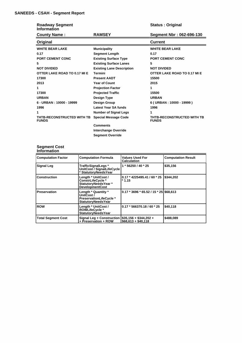
SANEEDS - CSAH - Segment Report
Roadway SegmentInformation
Status : Original
County Name : RAMSEY Segment Nbr : 062-696-130
Original Current
WHITE BEAR LAKE Municipality WHITE BEAR LAKE
0.17 Segment Length 0.17
PORT CEMENT CONC Existing Surface Type PORT CEMENT CONC
5 Existing Surface Lanes 5
NOT DIVIDED Existing Lane Description NOT DIVIDED
OTTER LAKE ROAD TO 0.17 MI E Termini OTTER LAKE ROAD TO 0.17 MI E
17300 Present AADT 15500
2013 Year of Count 2015
1 Projection Factor 1
17300 Projected Traffic 15500
URBAN Design Type URBAN
6 - URBAN : 10000 - 19999 Design Group 6 ( URBAN : 10000 - 19999 )
1996 Latest Year SA funds 1996
1 Number of Signal Legs 1
THTB-RECONSTRUCTED WITH TBFUNDS
Special Message Code THTB-RECONSTRUCTED WITH TBFUNDS
Comments
Interchange Override
Segment Override
Segment CostInformation
Computation Factor Computation Formula Values Used ForCalculation
Computation Result
Signal Leg TrafficSignalLegs *UnitCost / SignalLifeCycle* StatutoryNeedsYear
1 * 56250 / 40 * 25 $35,156
Construction Length * UnitCost /ConstrLifeCycle *StatutoryNeedsYear *DevelopmentCost
0.17 * 4225495.41 / 60 * 25* 1.15
$344,202
Preservation Length * Quantity *UnitCost /PreservationLifeCycle *StatutoryNeedsYear
0.17 * 3696 * 65.52 / 15 * 25 $68,613
ROW Length * UnitCost /ROWLifeCycle *StatutoryNeedsYear
0.17 * 566370.18 / 60 * 25 $40,118
Total Segment Cost Signal Leg + Construction+ Preservation + ROW
$35,156 + $344,202 +$68,613 + $40,118
$488,089

SANEEDS - CSAH - Segment Report
Roadway SegmentInformation
Status : Original
County Name : RAMSEY Segment Nbr : 062-696-140
Original Current
WHITE BEAR LAKE Municipality WHITE BEAR LAKE
0.81 Segment Length 0.81
PORT CEMENT CONC Existing Surface Type PORT CEMENT CONC
3 Existing Surface Lanes 3
NOT DIVIDED Existing Lane Description NOT DIVIDED
0.17 MI E OF OTTER LAKE ROADTO T H 61
Termini 0.17 MI E OF OTTER LAKE ROADTO T H 61
17300 Present AADT 15500
2013 Year of Count 2015
1 Projection Factor 1
17300 Projected Traffic 15500
URBAN Design Type URBAN
6 - URBAN : 10000 - 19999 Design Group 6 ( URBAN : 10000 - 19999 )
1996 Latest Year SA funds 1996
1 Number of Signal Legs 1
THTB-RECONSTRUCTED WITH TBFUNDS
Special Message Code THTB-RECONSTRUCTED WITH TBFUNDS
Comments
Interchange Override
Segment Override
RailRoadCrossingInformation
Status: Original
Original Current
CANADIAN PACIFIC RAILWAY RailRoad Name CANADIAN PACIFIC RAILWAY
082816H USDOT Number 082816H
0.72 Located at Milepoint 0.72
1 Mainline Tracks 1
SIGNALS ONLY Protection Type SIGNALS ONLY
2005 Last Year Protection Upgraded 2005
99 Crossing Length 99
Last Year Surfaced
100% Percentage of Cost 100%
Comments
Segment CostInformation
Computation Factor Computation Formula Values Used ForCalculation
Computation Result
Signal Leg TrafficSignalLegs *UnitCost / SignalLifeCycle* StatutoryNeedsYear
1 * 56250 / 40 * 25 $35,156
Construction Length * UnitCost /ConstrLifeCycle *StatutoryNeedsYear *DevelopmentCost
0.81 * 4225495.41 / 60 * 25* 1.15
$1,640,020
Preservation Length * Quantity *UnitCost /PreservationLifeCycle *StatutoryNeedsYear
0.81 * 3696 * 65.52 / 15 * 25 $326,919
ROW Length * UnitCost /ROWLifeCycle *StatutoryNeedsYear
0.81 * 566370.18 / 60 * 25 $191,150
RR Crossing Protection UnitCost /RRCrossingLifeCycle *StatutoryNeedsYear
275000 / 25 * 25 $275,000
RR Crossing Surface SurfaceLength * UnitCost/ RRCrossingLifeCycle *StatutoryNeedsYear
99 * 1350 / 25 * 25 $133,650

Total Segment Cost Signal Leg + Construction+ Preservation + ROW +RR Crossing Protection +RR Crossing Surface
$35,156 + $1,640,020 +$326,919 + $191,150 +$275,000 + $133,650
$2,601,895

SANEEDS - CSAH - Segment Report
Roadway SegmentInformation
Status : Original
County Name : RAMSEY Segment Nbr : 062-749-010
Original Current
ARDEN HILLS Municipality ARDEN HILLS
0.5 Segment Length 0.5
BIT CONC OR ASPH Existing Surface Type BIT CONC OR ASPH
4 Existing Surface Lanes 4
NOT DIVIDED Existing Lane Description NOT DIVIDED
LAKE JOHANNA BLVD. - CO. RD. DTO STOWE AVE.
Termini LAKE JOHANNA BLVD. - CO. RD. DTO STOWE AVE.
4300 Present AADT 4300
2013 Year of Count 2015
1 Projection Factor 1
4300 Projected Traffic 4300
URBAN Design Type URBAN
5 - URBAN : 0 - 9999 Design Group 5 ( URBAN : 0 - 9999 )
2007 Latest Year SA funds 2007
0 Number of Signal Legs 0
No Special Message Special Message Code No Special Message
SAP 62-749-001, 2007MILL & OVERLAY
Comments SAP 62-749-001, 2007MILL & OVERLAY
Interchange Override
Segment Override
Segment CostInformation
Computation Factor Computation Formula Values Used ForCalculation
Computation Result
Signal Leg TrafficSignalLegs *UnitCost / SignalLifeCycle* StatutoryNeedsYear
0 * 56250 / 40 * 25 $0
Construction Length * UnitCost /ConstrLifeCycle *StatutoryNeedsYear *DevelopmentCost
0.5 * 2738635.28 / 60 * 25 *1.15
$656,131
Preservation Length * Quantity *UnitCost /PreservationLifeCycle *StatutoryNeedsYear
0.5 * 2904 * 65.52 / 15 * 25 $158,558
ROW Length * UnitCost /ROWLifeCycle *StatutoryNeedsYear
0.5 * 436504.07 / 60 * 25 $90,938
Total Segment Cost Signal Leg + Construction+ Preservation + ROW
$0 + $656,131 + $158,558+ $90,938
$905,627

SANEEDS - CSAH - Segment Report
Roadway SegmentInformation
Status : Original
County Name : RAMSEY Segment Nbr : 062-749-020
Original Current
ARDEN HILLS Municipality ARDEN HILLS
0.3 Segment Length 0.3
BIT CONC OR ASPH Existing Surface Type BIT CONC OR ASPH
4 Existing Surface Lanes 4
NOT DIVIDED Existing Lane Description NOT DIVIDED
LAKE JOHANNA BLVD. - STOWEAVE. TO CO. RD. E
Termini LAKE JOHANNA BLVD. - STOWEAVE. TO CO. RD. E
4300 Present AADT 4300
2013 Year of Count 2015
1 Projection Factor 1
4300 Projected Traffic 4300
URBAN Design Type URBAN
5 - URBAN : 0 - 9999 Design Group 5 ( URBAN : 0 - 9999 )
2007 Latest Year SA funds 2007
0 Number of Signal Legs 0
No Special Message Special Message Code No Special Message
SAP 62-749-001, 2007MILL & OVERLAY
Comments SAP 62-749-001, 2007MILL & OVERLAY
Interchange Override
Segment Override
Segment CostInformation
Computation Factor Computation Formula Values Used ForCalculation
Computation Result
Signal Leg TrafficSignalLegs *UnitCost / SignalLifeCycle* StatutoryNeedsYear
0 * 56250 / 40 * 25 $0
Construction Length * UnitCost /ConstrLifeCycle *StatutoryNeedsYear *DevelopmentCost
0.3 * 2738635.28 / 60 * 25 *1.15
$393,679
Preservation Length * Quantity *UnitCost /PreservationLifeCycle *StatutoryNeedsYear
0.3 * 2904 * 65.52 / 15 * 25 $95,135
ROW Length * UnitCost /ROWLifeCycle *StatutoryNeedsYear
0.3 * 436504.07 / 60 * 25 $54,563
Total Segment Cost Signal Leg + Construction+ Preservation + ROW
$0 + $393,679 + $95,135 +$54,563
$543,377

SANEEDS - CSAH - Segment Report
Roadway SegmentInformation
Status : Original
County Name : RAMSEY Segment Nbr : 062-749-030
Original Current
ARDEN HILLS Municipality ARDEN HILLS
0.3 Segment Length 0.3
BIT CONC OR ASPH Existing Surface Type BIT CONC OR ASPH
2 Existing Surface Lanes 2
NOT DIVIDED Existing Lane Description NOT DIVIDED
LAKE JOHANNA BLVD. - CO. RD. ETO 0.3 MI NE
Termini LAKE JOHANNA BLVD. - CO. RD. ETO 0.3 MI NE
5000 Present AADT 4750
2013 Year of Count 2015
1 Projection Factor 1
5000 Projected Traffic 4750
RURAL Design Type RURAL
3 - RURAL : 1500 - 6999 Design Group 3 ( RURAL : 1500 - 6999 )
2007 Latest Year SA funds 2007
0 Number of Signal Legs 0
No Special Message Special Message Code No Special Message
SAP 62-749-001, 2007MILL & OVERLAY
Comments SAP 62-749-001, 2007MILL & OVERLAY
Interchange Override
Segment Override
Segment CostInformation
Computation Factor Computation Formula Values Used ForCalculation
Computation Result
Signal Leg TrafficSignalLegs *UnitCost / SignalLifeCycle* StatutoryNeedsYear
0 * 56250 / 40 * 25 $0
Construction Length * UnitCost /ConstrLifeCycle *StatutoryNeedsYear *DevelopmentCost
0.3 * 1021937.01 / 60 * 25 *1.1
$140,516
Preservation Length * Quantity *UnitCost /PreservationLifeCycle *StatutoryNeedsYear
0.3 * 2376 * 65.52 / 20 * 25 $58,378
ROW Length * UnitCost /ROWLifeCycle *StatutoryNeedsYear
0.3 * 85357.87 / 60 * 25 $10,670
Total Segment Cost Signal Leg + Construction+ Preservation + ROW
$0 + $140,516 + $58,378 +$10,670
$209,564

SANEEDS - CSAH - Segment Report
Roadway SegmentInformation
Status : Original
County Name : RAMSEY Segment Nbr : 062-749-040
Original Current
ARDEN HILLS Municipality ARDEN HILLS
0.45 Segment Length 0.45
BIT CONC OR ASPH Existing Surface Type BIT CONC OR ASPH
2 Existing Surface Lanes 2
NOT DIVIDED Existing Lane Description NOT DIVIDED
LAKE JOHANNA BLVD. - 0.3 M NWOF CO RD E TO SNELLING AVE
Termini LAKE JOHANNA BLVD. - 0.3 M NWOF CO RD E TO SNELLING AVE
5000 Present AADT 4750
2013 Year of Count 2015
1 Projection Factor 1
5000 Projected Traffic 4750
RURAL Design Type RURAL
3 - RURAL : 1500 - 6999 Design Group 3 ( RURAL : 1500 - 6999 )
2007 Latest Year SA funds 2007
0 Number of Signal Legs 0
No Special Message Special Message Code No Special Message
SAP 62-749-001, 2007MILL & OVERLAY
Comments SAP 62-749-001, 2007MILL & OVERLAY
Interchange Override
Segment Override
Segment CostInformation
Computation Factor Computation Formula Values Used ForCalculation
Computation Result
Signal Leg TrafficSignalLegs *UnitCost / SignalLifeCycle* StatutoryNeedsYear
0 * 56250 / 40 * 25 $0
Construction Length * UnitCost /ConstrLifeCycle *StatutoryNeedsYear *DevelopmentCost
0.45 * 1021937.01 / 60 * 25* 1.1
$210,775
Preservation Length * Quantity *UnitCost /PreservationLifeCycle *StatutoryNeedsYear
0.45 * 2376 * 65.52 / 20 * 25 $87,567
ROW Length * UnitCost /ROWLifeCycle *StatutoryNeedsYear
0.45 * 85357.87 / 60 * 25 $16,005
Total Segment Cost Signal Leg + Construction+ Preservation + ROW
$0 + $210,775 + $87,567 +$16,005
$314,347

SANEEDS - CSAH - Segment Report
Roadway SegmentInformation
Status : Original
County Name : RAMSEY Segment Nbr : 062-646-160
Original Current
ST PAUL Municipality ST PAUL
0.32 Segment Length 0.32
MIXED BITUMINOUS Existing Surface Type MIXED BITUMINOUS
4 Existing Surface Lanes 4
NOT DIVIDED Existing Lane Description NOT DIVIDED
CLEVELAND AVE. - SCUDDER ST.TO 0.32 MI N
Termini CLEVELAND AVE. - SCUDDER ST.TO 0.32 MI N
7100 Present AADT 7100
2013 Year of Count 2015
1 Projection Factor 1
7100 Projected Traffic 7100
URBAN Design Type URBAN
5 - URBAN : 0 - 9999 Design Group 5 ( URBAN : 0 - 9999 )
2000 Latest Year SA funds 2000
0 Number of Signal Legs 0
No Special Message Special Message Code No Special Message
2010 OVERLAY WITH LOCALFUNDS
Comments 2010 OVERLAY WITH LOCALFUNDS
Interchange Override
Segment Override
Segment CostInformation
Computation Factor Computation Formula Values Used ForCalculation
Computation Result
Signal Leg TrafficSignalLegs *UnitCost / SignalLifeCycle* StatutoryNeedsYear
0 * 56250 / 40 * 25 $0
Construction Length * UnitCost /ConstrLifeCycle *StatutoryNeedsYear *DevelopmentCost
0.32 * 2738635.28 / 60 * 25* 1.15
$419,924
Preservation Length * Quantity *UnitCost /PreservationLifeCycle *StatutoryNeedsYear
0.32 * 2904 * 65.52 / 15 * 25 $101,477
ROW Length * UnitCost /ROWLifeCycle *StatutoryNeedsYear
0.32 * 436504.07 / 60 * 25 $58,201
Total Segment Cost Signal Leg + Construction+ Preservation + ROW
$0 + $419,924 + $101,477+ $58,201
$579,602

SANEEDS - CSAH - Segment Report
Roadway SegmentInformation
Status : Original
County Name : RAMSEY Segment Nbr : 062-646-170
Original Current
FALCON HEIGHTS Municipality FALCON HEIGHTS
0.32 Segment Length 0.32
MIXED BITUMINOUS Existing Surface Type MIXED BITUMINOUS
2 Existing Surface Lanes 2
NOT DIVIDED Existing Lane Description NOT DIVIDED
0.32 MI NO OF SCUDDER TO HOYT Termini 0.32 MI NO OF SCUDDER TO HOYT
7100 Present AADT 7100
2013 Year of Count 2015
1 Projection Factor 1
7100 Projected Traffic 7100
RURAL Design Type RURAL
4 - RURAL : 7000 - 999999 Design Group 4 ( RURAL : 7000 - 999999 )
2000 Latest Year SA funds 2000
2 Number of Signal Legs 2
No Special Message Special Message Code No Special Message
2010 OVERLAY WITH LOCALFUNDS
Comments 2010 OVERLAY WITH LOCALFUNDS
Interchange Override
Segment Override
Bridge Information Status: Original
Original Current
62546 Structure Number 62546
5.551 Milepoint 5.551
1988 Year Built 1988
BNSF RR & MC RY YARDS Feature Crossed BNSF RR & MC RY YARDS
Type of Service
Number of Spans
403.9 Bridge Length 403.9
62.3 Bridge Width 62.3
100% Shared Structure 100%
Comments
2 ( 150-999,999 ) Bridge Group Code 2 ( 150-999,999 )
Segment CostInformation
Computation Factor Computation Formula Values Used ForCalculation
Computation Result
Signal Leg TrafficSignalLegs *UnitCost / SignalLifeCycle* StatutoryNeedsYear
2 * 56250 / 40 * 25 $70,313
Construction Length * UnitCost /ConstrLifeCycle *StatutoryNeedsYear *DevelopmentCost
0.32 * 1996892.57 / 60 * 25* 1.1
$292,878
Preservation Length * Quantity *UnitCost /PreservationLifeCycle *StatutoryNeedsYear
0.32 * 3564 * 65.52 / 20 * 25 $93,405
ROW Length * UnitCost /ROWLifeCycle *StatutoryNeedsYear
0.32 * 181173.68 / 60 * 25 $24,156
Bridge BridgeLength *BridgeWidth * UnitCost /BridgeLifeCycle *StatutoryNeedsYear *DevelopmentCost
403.9 * 62.3 * 138 / 80 * 25* 1.15
$1,247,926
Total Segment Cost Signal Leg + Construction+ Preservation + ROW +Bridge
$70,313 + $292,878 +$93,405 + $24,156 +$1,247,926
$1,728,678

SANEEDS - CSAH - Segment Report
Roadway SegmentInformation
Status : Original
County Name : RAMSEY Segment Nbr : 062-646-180
Original Current
FALCON HEIGHTS Municipality FALCON HEIGHTS
0.3 Segment Length 0.3
PORT CEMENT CONC Existing Surface Type PORT CEMENT CONC
2 Existing Surface Lanes 2
NOT DIVIDED Existing Lane Description NOT DIVIDED
HOYT AVE. TO LARPENTEUR AVE. Termini HOYT AVE. TO LARPENTEUR AVE.
7100 Present AADT 7100
2013 Year of Count 2015
1 Projection Factor 1
7100 Projected Traffic 7100
RURAL Design Type RURAL
4 - RURAL : 7000 - 999999 Design Group 4 ( RURAL : 7000 - 999999 )
2000 Latest Year SA funds 2000
1 Number of Signal Legs 1
No Special Message Special Message Code No Special Message
2010 OVERLAY WITH LOCALFUNDS
Comments 2010 OVERLAY WITH LOCALFUNDS
Interchange Override
Segment Override
Segment CostInformation
Computation Factor Computation Formula Values Used ForCalculation
Computation Result
Signal Leg TrafficSignalLegs *UnitCost / SignalLifeCycle* StatutoryNeedsYear
1 * 56250 / 40 * 25 $35,156
Construction Length * UnitCost /ConstrLifeCycle *StatutoryNeedsYear *DevelopmentCost
0.3 * 1996892.57 / 60 * 25 *1.1
$274,573
Preservation Length * Quantity *UnitCost /PreservationLifeCycle *StatutoryNeedsYear
0.3 * 3564 * 65.52 / 20 * 25 $87,567
ROW Length * UnitCost /ROWLifeCycle *StatutoryNeedsYear
0.3 * 181173.68 / 60 * 25 $22,647
Total Segment Cost Signal Leg + Construction+ Preservation + ROW
$35,156 + $274,573 +$87,567 + $22,647
$419,943

SANEEDS - CSAH - Segment Report
Roadway SegmentInformation
Status : Original
County Name : RAMSEY Segment Nbr : 062-646-190
Original Current
FALCON HEIGHTS Municipality FALCON HEIGHTS
0.5 Segment Length 0.5
BIT CONC OR ASPH Existing Surface Type BIT CONC OR ASPH
2 Existing Surface Lanes 2
DIVIDED Existing Lane Description DIVIDED
LARPENTEUR AVE. TOROSELAWN AVE.
Termini LARPENTEUR AVE. TOROSELAWN AVE.
10400 Present AADT 10400
2013 Year of Count 2015
1 Projection Factor 1
10400 Projected Traffic 10400
URBAN Design Type URBAN
6 - URBAN : 10000 - 19999 Design Group 6 ( URBAN : 10000 - 19999 )
1992 Latest Year SA funds 1992
2 Number of Signal Legs 2
No Special Message Special Message Code No Special Message
Comments
Interchange Override
Segment Override
Segment CostInformation
Computation Factor Computation Formula Values Used ForCalculation
Computation Result
Signal Leg TrafficSignalLegs *UnitCost / SignalLifeCycle* StatutoryNeedsYear
2 * 56250 / 40 * 25 $70,313
Construction Length * UnitCost /ConstrLifeCycle *StatutoryNeedsYear *DevelopmentCost
0.5 * 4225495.41 / 60 * 25 *1.15
$1,012,358
Preservation Length * Quantity *UnitCost /PreservationLifeCycle *StatutoryNeedsYear
0.5 * 3696 * 65.52 / 15 * 25 $201,802
ROW Length * UnitCost /ROWLifeCycle *StatutoryNeedsYear
0.5 * 566370.18 / 60 * 25 $117,994
Total Segment Cost Signal Leg + Construction+ Preservation + ROW
$70,313 + $1,012,358 +$201,802 + $117,994
$1,402,467

SANEEDS - CSAH - Segment Report
Roadway SegmentInformation
Status : Original
County Name : RAMSEY Segment Nbr : 062-646-200
Original Current
ROSEVILLE Municipality ROSEVILLE
0.5 Segment Length 0.5
BIT CONC OR ASPH Existing Surface Type BIT CONC OR ASPH
2 Existing Surface Lanes 2
NOT DIVIDED Existing Lane Description NOT DIVIDED
ROSELAWN AVE. TO CO. RD. B Termini ROSELAWN AVE. TO CO. RD. B
10000 Present AADT 10000
2013 Year of Count 2015
1 Projection Factor 1
10000 Projected Traffic 10000
URBAN Design Type URBAN
6 - URBAN : 10000 - 19999 Design Group 6 ( URBAN : 10000 - 19999 )
1992 Latest Year SA funds 1992
2 Number of Signal Legs 2
No Special Message Special Message Code No Special Message
Comments
Interchange Override
Segment Override
Segment CostInformation
Computation Factor Computation Formula Values Used ForCalculation
Computation Result
Signal Leg TrafficSignalLegs *UnitCost / SignalLifeCycle* StatutoryNeedsYear
2 * 56250 / 40 * 25 $70,313
Construction Length * UnitCost /ConstrLifeCycle *StatutoryNeedsYear *DevelopmentCost
0.5 * 4225495.41 / 60 * 25 *1.15
$1,012,358
Preservation Length * Quantity *UnitCost /PreservationLifeCycle *StatutoryNeedsYear
0.5 * 3696 * 65.52 / 15 * 25 $201,802
ROW Length * UnitCost /ROWLifeCycle *StatutoryNeedsYear
0.5 * 566370.18 / 60 * 25 $117,994
Total Segment Cost Signal Leg + Construction+ Preservation + ROW
$70,313 + $1,012,358 +$201,802 + $117,994
$1,402,467

SANEEDS - CSAH - Segment Report
Roadway SegmentInformation
Status : Original
County Name : RAMSEY Segment Nbr : 062-646-205
Original Current
ROSEVILLE Municipality ROSEVILLE
0.22 Segment Length 0.22
BIT CONC OR ASPH Existing Surface Type BIT CONC OR ASPH
2 Existing Surface Lanes 2
NOT DIVIDED Existing Lane Description NOT DIVIDED
W. COUNTY ROAD B2 TOOAKCREST AVENUE ONCLEVELAND AVE.
Termini W. COUNTY ROAD B2 TOOAKCREST AVENUE ONCLEVELAND AVE.
9100 Present AADT 9100
2013 Year of Count 2015
1 Projection Factor 1
9100 Projected Traffic 9100
URBAN Design Type URBAN
5 - URBAN : 0 - 9999 Design Group 5 ( URBAN : 0 - 9999 )
2010 Latest Year SA funds 2010
1 Number of Signal Legs 1
No Special Message Special Message Code No Special Message
SURFACED UNDER SAP 62-646-21.2010.
Comments SURFACED UNDER SAP 62-646-21.2010.
Interchange Override
Segment Override
Segment CostInformation
Computation Factor Computation Formula Values Used ForCalculation
Computation Result
Signal Leg TrafficSignalLegs *UnitCost / SignalLifeCycle* StatutoryNeedsYear
1 * 56250 / 40 * 25 $35,156
Construction Length * UnitCost /ConstrLifeCycle *StatutoryNeedsYear *DevelopmentCost
0.22 * 2738635.28 / 60 * 25* 1.15
$288,698
Preservation Length * Quantity *UnitCost /PreservationLifeCycle *StatutoryNeedsYear
0.22 * 2904 * 65.52 / 15 * 25 $69,766
ROW Length * UnitCost /ROWLifeCycle *StatutoryNeedsYear
0.22 * 436504.07 / 60 * 25 $40,013
Total Segment Cost Signal Leg + Construction+ Preservation + ROW
$35,156 + $288,698 +$69,766 + $40,013
$433,633

SANEEDS - CSAH - Segment Report
Roadway SegmentInformation
Status : Original
County Name : RAMSEY Segment Nbr : 062-646-210
Original Current
ROSEVILLE Municipality ROSEVILLE
0.16 Segment Length 0.16
BIT CONC OR ASPH Existing Surface Type BIT CONC OR ASPH
2 Existing Surface Lanes 2
NOT DIVIDED Existing Lane Description NOT DIVIDED
OAKCREST AVENUE TO COUNTYROAD C ON CLEVELAND AVE.
Termini OAKCREST AVENUE TO COUNTYROAD C ON CLEVELAND AVE.
9100 Present AADT 9100
2013 Year of Count 2015
1 Projection Factor 1
9100 Projected Traffic 9100
URBAN Design Type URBAN
5 - URBAN : 0 - 9999 Design Group 5 ( URBAN : 0 - 9999 )
2010 Latest Year SA funds 2010
1 Number of Signal Legs 1
No Special Message Special Message Code No Special Message
SURFACED UNDER SAP 62-646-21.2010.
Comments SURFACED UNDER SAP 62-646-21.2010.
Interchange Override
Segment Override
Segment CostInformation
Computation Factor Computation Formula Values Used ForCalculation
Computation Result
Signal Leg TrafficSignalLegs *UnitCost / SignalLifeCycle* StatutoryNeedsYear
1 * 56250 / 40 * 25 $35,156
Construction Length * UnitCost /ConstrLifeCycle *StatutoryNeedsYear *DevelopmentCost
0.16 * 2738635.28 / 60 * 25* 1.15
$209,962
Preservation Length * Quantity *UnitCost /PreservationLifeCycle *StatutoryNeedsYear
0.16 * 2904 * 65.52 / 15 * 25 $50,739
ROW Length * UnitCost /ROWLifeCycle *StatutoryNeedsYear
0.16 * 436504.07 / 60 * 25 $29,100
Total Segment Cost Signal Leg + Construction+ Preservation + ROW
$35,156 + $209,962 +$50,739 + $29,100
$324,957

SANEEDS - CSAH - Segment Report
Roadway SegmentInformation
Status : Original
County Name : RAMSEY Segment Nbr : 062-646-220
Original Current
ROSEVILLE Municipality ROSEVILLE
1.06 Segment Length 1.06
MIXED BITUMINOUS Existing Surface Type MIXED BITUMINOUS
4 Existing Surface Lanes 4
NOT DIVIDED Existing Lane Description NOT DIVIDED
CO. RD C TO CO. RD. D Termini CO. RD C TO CO. RD. D
8000 Present AADT 8000
2013 Year of Count 2015
1 Projection Factor 1
8000 Projected Traffic 8000
URBAN Design Type URBAN
5 - URBAN : 0 - 9999 Design Group 5 ( URBAN : 0 - 9999 )
1996 Latest Year SA funds 1996
4 Number of Signal Legs 4
No Special Message Special Message Code No Special Message
Comments
Interchange Override
Segment Override
Segment CostInformation
Computation Factor Computation Formula Values Used ForCalculation
Computation Result
Signal Leg TrafficSignalLegs *UnitCost / SignalLifeCycle* StatutoryNeedsYear
4 * 56250 / 40 * 25 $140,625
Construction Length * UnitCost /ConstrLifeCycle *StatutoryNeedsYear *DevelopmentCost
1.06 * 2738635.28 / 60 * 25* 1.15
$1,390,999
Preservation Length * Quantity *UnitCost /PreservationLifeCycle *StatutoryNeedsYear
1.06 * 2904 * 65.52 / 15 * 25 $336,144
ROW Length * UnitCost /ROWLifeCycle *StatutoryNeedsYear
1.06 * 436504.07 / 60 * 25 $192,789
Total Segment Cost Signal Leg + Construction+ Preservation + ROW
$140,625 + $1,390,999 +$336,144 + $192,789
$2,060,557

SANEEDS - CSAH - Segment Report
Roadway SegmentInformation
Status : Original
County Name : RAMSEY Segment Nbr : 062-646-230
Original Current
NEW BRIGHTON Municipality NEW BRIGHTON
0.06 Segment Length 0.06
MIXED BITUMINOUS Existing Surface Type MIXED BITUMINOUS
2 Existing Surface Lanes 2
NOT DIVIDED Existing Lane Description NOT DIVIDED
CO. RD. D TO 0.06 MI N Termini CO. RD. D TO 0.06 MI N
3500 Present AADT 3500
2013 Year of Count 2015
1 Projection Factor 1
3500 Projected Traffic 3500
RURAL Design Type RURAL
3 - RURAL : 1500 - 6999 Design Group 3 ( RURAL : 1500 - 6999 )
1996 Latest Year SA funds 1996
1 Number of Signal Legs 1
No Special Message Special Message Code No Special Message
Comments
Interchange Override
Segment Override
Segment CostInformation
Computation Factor Computation Formula Values Used ForCalculation
Computation Result
Signal Leg TrafficSignalLegs *UnitCost / SignalLifeCycle* StatutoryNeedsYear
1 * 56250 / 40 * 25 $35,156
Construction Length * UnitCost /ConstrLifeCycle *StatutoryNeedsYear *DevelopmentCost
0.06 * 1021937.01 / 60 * 25* 1.1
$28,103
Preservation Length * Quantity *UnitCost /PreservationLifeCycle *StatutoryNeedsYear
0.06 * 2376 * 65.52 / 20 * 25 $11,676
ROW Length * UnitCost /ROWLifeCycle *StatutoryNeedsYear
0.06 * 85357.87 / 60 * 25 $2,134
Total Segment Cost Signal Leg + Construction+ Preservation + ROW
$35,156 + $28,103 +$11,676 + $2,134
$77,069

SANEEDS - CSAH - Segment Report
Roadway SegmentInformation
Status : Original
County Name : RAMSEY Segment Nbr : 062-646-235
Original Current
NEW BRIGHTON Municipality NEW BRIGHTON
0.19 Segment Length 0.19
MIXED BITUMINOUS Existing Surface Type MIXED BITUMINOUS
2 Existing Surface Lanes 2
NOT DIVIDED Existing Lane Description NOT DIVIDED
0.06 M N TO 0.25 M N OF CO RD D Termini 0.06 M N TO 0.25 M N OF CO RD D
3500 Present AADT 3500
2013 Year of Count 2015
1 Projection Factor 1
3500 Projected Traffic 3500
RURAL Design Type RURAL
3 - RURAL : 1500 - 6999 Design Group 3 ( RURAL : 1500 - 6999 )
2009 Latest Year SA funds 2009
0 Number of Signal Legs 0
No Special Message Special Message Code No Special Message
SURFACED 2009 SAP 62-646-20 Comments SURFACED 2009 SAP 62-646-20
Interchange Override
Segment Override
Segment CostInformation
Computation Factor Computation Formula Values Used ForCalculation
Computation Result
Signal Leg TrafficSignalLegs *UnitCost / SignalLifeCycle* StatutoryNeedsYear
0 * 56250 / 40 * 25 $0
Construction Length * UnitCost /ConstrLifeCycle *StatutoryNeedsYear *DevelopmentCost
0.19 * 1021937.01 / 60 * 25* 1.1
$88,994
Preservation Length * Quantity *UnitCost /PreservationLifeCycle *StatutoryNeedsYear
0.19 * 2376 * 65.52 / 20 * 25 $36,973
ROW Length * UnitCost /ROWLifeCycle *StatutoryNeedsYear
0.19 * 85357.87 / 60 * 25 $6,757
Total Segment Cost Signal Leg + Construction+ Preservation + ROW
$0 + $88,994 + $36,973 +$6,757
$132,724

SANEEDS - CSAH - Segment Report
Roadway SegmentInformation
Status : Original
County Name : RAMSEY Segment Nbr : 062-646-240
Original Current
ARDEN HILLS Municipality ARDEN HILLS
0.25 Segment Length 0.25
BIT CONC OR ASPH Existing Surface Type BIT CONC OR ASPH
2 Existing Surface Lanes 2
NOT DIVIDED Existing Lane Description NOT DIVIDED
0.25 TO 0.50 M N OF CO. RD. D Termini 0.25 TO 0.50 M N OF CO. RD. D
3500 Present AADT 3500
2013 Year of Count 2015
1 Projection Factor 1
3500 Projected Traffic 3500
RURAL Design Type RURAL
3 - RURAL : 1500 - 6999 Design Group 3 ( RURAL : 1500 - 6999 )
2009 Latest Year SA funds 2009
0 Number of Signal Legs 0
No Special Message Special Message Code No Special Message
SURFACED 2009, SAP 62-646-20 Comments SURFACED 2009, SAP 62-646-20
Interchange Override
Segment Override
Segment CostInformation
Computation Factor Computation Formula Values Used ForCalculation
Computation Result
Signal Leg TrafficSignalLegs *UnitCost / SignalLifeCycle* StatutoryNeedsYear
0 * 56250 / 40 * 25 $0
Construction Length * UnitCost /ConstrLifeCycle *StatutoryNeedsYear *DevelopmentCost
0.25 * 1021937.01 / 60 * 25* 1.1
$117,097
Preservation Length * Quantity *UnitCost /PreservationLifeCycle *StatutoryNeedsYear
0.25 * 2376 * 65.52 / 20 * 25 $48,649
ROW Length * UnitCost /ROWLifeCycle *StatutoryNeedsYear
0.25 * 85357.87 / 60 * 25 $8,891
Total Segment Cost Signal Leg + Construction+ Preservation + ROW
$0 + $117,097 + $48,649 +$8,891
$174,637

SANEEDS - CSAH - Segment Report
Roadway SegmentInformation
Status : Original
County Name : RAMSEY Segment Nbr : 062-646-250
Original Current
NEW BRIGHTON Municipality NEW BRIGHTON
0.47 Segment Length 0.47
MIXED BITUMINOUS Existing Surface Type MIXED BITUMINOUS
2 Existing Surface Lanes 2
NOT DIVIDED Existing Lane Description NOT DIVIDED
0.5 MI N OF CO. RD. D TO 1ST STSE
Termini 0.5 MI N OF CO. RD. D TO 1ST STSE
3500 Present AADT 3500
2013 Year of Count 2015
1 Projection Factor 1
3500 Projected Traffic 3500
RURAL Design Type RURAL
3 - RURAL : 1500 - 6999 Design Group 3 ( RURAL : 1500 - 6999 )
2009 Latest Year SA funds 2009
0 Number of Signal Legs 0
No Special Message Special Message Code No Special Message
SURFACED 2009, SAP 62-646-20 Comments SURFACED 2009, SAP 62-646-20
Interchange Override
Segment Override
Segment CostInformation
Computation Factor Computation Formula Values Used ForCalculation
Computation Result
Signal Leg TrafficSignalLegs *UnitCost / SignalLifeCycle* StatutoryNeedsYear
0 * 56250 / 40 * 25 $0
Construction Length * UnitCost /ConstrLifeCycle *StatutoryNeedsYear *DevelopmentCost
0.47 * 1021937.01 / 60 * 25* 1.1
$220,142
Preservation Length * Quantity *UnitCost /PreservationLifeCycle *StatutoryNeedsYear
0.47 * 2376 * 65.52 / 20 * 25 $91,459
ROW Length * UnitCost /ROWLifeCycle *StatutoryNeedsYear
0.47 * 85357.87 / 60 * 25 $16,716
Total Segment Cost Signal Leg + Construction+ Preservation + ROW
$0 + $220,142 + $91,459 +$16,716
$328,317

SANEEDS - CSAH - Segment Report
Roadway SegmentInformation
Status : Original
County Name : RAMSEY Segment Nbr : 062-646-260
Original Current
ARDEN HILLS Municipality ARDEN HILLS
0.27 Segment Length 0.27
BIT CONC OR ASPH Existing Surface Type BIT CONC OR ASPH
2 Existing Surface Lanes 2
NOT DIVIDED Existing Lane Description NOT DIVIDED
FROM 1ST ST SE TO THOM DRIVE Termini FROM 1ST ST SE TO THOM DRIVE
3500 Present AADT 3500
2013 Year of Count 2015
1 Projection Factor 1
3500 Projected Traffic 3500
URBAN Design Type URBAN
5 - URBAN : 0 - 9999 Design Group 5 ( URBAN : 0 - 9999 )
2000 Latest Year SA funds 2000
0 Number of Signal Legs 0
No Special Message Special Message Code No Special Message
Comments
Interchange Override
Segment Override
Bridge Information Status: Original
Original Current
62569 Structure Number 62569
11.298 Milepoint 11.298
2001 Year Built 2001
CP RAIL Feature Crossed CP RAIL
HWY / R.R. Type of Service HWY / R.R.
1 Number of Spans 1
46.9 Bridge Length 46.9
48.8 Bridge Width 48.8
100% Shared Structure 100%
Comments
1 ( 0-149 ) Bridge Group Code 1 ( 0-149 )
Segment CostInformation
Computation Factor Computation Formula Values Used ForCalculation
Computation Result
Signal Leg TrafficSignalLegs *UnitCost / SignalLifeCycle* StatutoryNeedsYear
0 * 56250 / 40 * 25 $0
Construction Length * UnitCost /ConstrLifeCycle *StatutoryNeedsYear *DevelopmentCost
0.27 * 2738635.28 / 60 * 25* 1.15
$354,311
Preservation Length * Quantity *UnitCost /PreservationLifeCycle *StatutoryNeedsYear
0.27 * 2904 * 65.52 / 15 * 25 $85,622
ROW Length * UnitCost /ROWLifeCycle *StatutoryNeedsYear
0.27 * 436504.07 / 60 * 25 $49,107
Bridge BridgeLength *BridgeWidth * UnitCost /BridgeLifeCycle *StatutoryNeedsYear *DevelopmentCost
46.9 * 48.8 * 152 / 80 * 25 *1.15
$125,021
Total Segment Cost Signal Leg + Construction+ Preservation + ROW +Bridge
$0 + $354,311 + $85,622 +$49,107 + $125,021
$614,061

SANEEDS - CSAH - Segment Report
Roadway SegmentInformation
Status : Original
County Name : RAMSEY Segment Nbr : 062-646-265
Original Current
ARDEN HILLS Municipality ARDEN HILLS
0.27 Segment Length 0.27
BIT CONC OR ASPH Existing Surface Type BIT CONC OR ASPH
2 Existing Surface Lanes 2
NOT DIVIDED Existing Lane Description NOT DIVIDED
CLEVELAND FROM THOM DRIVETO CO RD E2
Termini CLEVELAND FROM THOM DRIVETO CO RD E2
2650 Present AADT 2650
2013 Year of Count 2015
1 Projection Factor 1
2650 Projected Traffic 2650
RURAL Design Type RURAL
3 - RURAL : 1500 - 6999 Design Group 3 ( RURAL : 1500 - 6999 )
2009 Latest Year SA funds 2009
0 Number of Signal Legs 0
No Special Message Special Message Code No Special Message
SURFACED 2009, SAP 62-646-20 Comments SURFACED 2009, SAP 62-646-20
Interchange Override
Segment Override
Segment CostInformation
Computation Factor Computation Formula Values Used ForCalculation
Computation Result
Signal Leg TrafficSignalLegs *UnitCost / SignalLifeCycle* StatutoryNeedsYear
0 * 56250 / 40 * 25 $0
Construction Length * UnitCost /ConstrLifeCycle *StatutoryNeedsYear *DevelopmentCost
0.27 * 1021937.01 / 60 * 25* 1.1
$126,465
Preservation Length * Quantity *UnitCost /PreservationLifeCycle *StatutoryNeedsYear
0.27 * 2376 * 65.52 / 20 * 25 $52,540
ROW Length * UnitCost /ROWLifeCycle *StatutoryNeedsYear
0.27 * 85357.87 / 60 * 25 $9,603
Total Segment Cost Signal Leg + Construction+ Preservation + ROW
$0 + $126,465 + $52,540 +$9,603
$188,608

SANEEDS - CSAH - Segment Report
Roadway SegmentInformation
Status : Original
County Name : RAMSEY Segment Nbr : 062-646-270
Original Current
NEW BRIGHTON Municipality NEW BRIGHTON
0.22 Segment Length 0.22
BIT CONC OR ASPH Existing Surface Type BIT CONC OR ASPH
4 Existing Surface Lanes 4
NOT DIVIDED Existing Lane Description NOT DIVIDED
5 TH. AVE. NW - CO.RD. E2 TOOLD HIGHWAY 8
Termini 5 TH. AVE. NW - CO.RD. E2 TOOLD HIGHWAY 8
6800 Present AADT 6800
2013 Year of Count 2015
1 Projection Factor 1
6800 Projected Traffic 6800
URBAN Design Type URBAN
5 - URBAN : 0 - 9999 Design Group 5 ( URBAN : 0 - 9999 )
1991 Latest Year SA funds 1991
1 Number of Signal Legs 1
No Special Message Special Message Code No Special Message
Comments
Interchange Override
Segment Override
Segment CostInformation
Computation Factor Computation Formula Values Used ForCalculation
Computation Result
Signal Leg TrafficSignalLegs *UnitCost / SignalLifeCycle* StatutoryNeedsYear
1 * 56250 / 40 * 25 $35,156
Construction Length * UnitCost /ConstrLifeCycle *StatutoryNeedsYear *DevelopmentCost
0.22 * 2738635.28 / 60 * 25* 1.15
$288,698
Preservation Length * Quantity *UnitCost /PreservationLifeCycle *StatutoryNeedsYear
0.22 * 2904 * 65.52 / 15 * 25 $69,766
ROW Length * UnitCost /ROWLifeCycle *StatutoryNeedsYear
0.22 * 436504.07 / 60 * 25 $40,013
Total Segment Cost Signal Leg + Construction+ Preservation + ROW
$35,156 + $288,698 +$69,766 + $40,013
$433,633

SANEEDS - CSAH - Segment Report
Roadway SegmentInformation
Status : Original
County Name : RAMSEY Segment Nbr : 062-647-010
Original Current
ARDEN HILLS Municipality ARDEN HILLS
0.6 Segment Length 0.6
PORT CEMENT CONC Existing Surface Type PORT CEMENT CONC
2 Existing Surface Lanes 2
NOT DIVIDED Existing Lane Description NOT DIVIDED
CO. RD. D TO STOWE AVE. Termini CO. RD. D TO STOWE AVE.
1900 Present AADT 1900
2013 Year of Count 2015
1 Projection Factor 1
1900 Projected Traffic 1900
RURAL Design Type RURAL
3 - RURAL : 1500 - 6999 Design Group 3 ( RURAL : 1500 - 6999 )
2000 Latest Year SA funds 2000
0 Number of Signal Legs 0
No Special Message Special Message Code No Special Message
Comments
Interchange Override
Segment Override
Segment CostInformation
Computation Factor Computation Formula Values Used ForCalculation
Computation Result
Signal Leg TrafficSignalLegs *UnitCost / SignalLifeCycle* StatutoryNeedsYear
0 * 56250 / 40 * 25 $0
Construction Length * UnitCost /ConstrLifeCycle *StatutoryNeedsYear *DevelopmentCost
0.6 * 1021937.01 / 60 * 25 *1.1
$281,033
Preservation Length * Quantity *UnitCost /PreservationLifeCycle *StatutoryNeedsYear
0.6 * 2376 * 65.52 / 20 * 25 $116,757
ROW Length * UnitCost /ROWLifeCycle *StatutoryNeedsYear
0.6 * 85357.87 / 60 * 25 $21,339
Total Segment Cost Signal Leg + Construction+ Preservation + ROW
$0 + $281,033 + $116,757+ $21,339
$419,129

SANEEDS - CSAH - Segment Report
Roadway SegmentInformation
Status : Original
County Name : RAMSEY Segment Nbr : 062-647-020
Original Current
NEW BRIGHTON Municipality NEW BRIGHTON
0.25 Segment Length 0.25
PORT CEMENT CONC Existing Surface Type PORT CEMENT CONC
2 Existing Surface Lanes 2
NOT DIVIDED Existing Lane Description NOT DIVIDED
STOWE AVE. TO 0.25 MI N Termini STOWE AVE. TO 0.25 MI N
1900 Present AADT 1900
2013 Year of Count 2015
1 Projection Factor 1
1900 Projected Traffic 1900
RURAL Design Type RURAL
3 - RURAL : 1500 - 6999 Design Group 3 ( RURAL : 1500 - 6999 )
2000 Latest Year SA funds 2000
0 Number of Signal Legs 0
No Special Message Special Message Code No Special Message
Comments
Interchange Override
Segment Override
Segment CostInformation
Computation Factor Computation Formula Values Used ForCalculation
Computation Result
Signal Leg TrafficSignalLegs *UnitCost / SignalLifeCycle* StatutoryNeedsYear
0 * 56250 / 40 * 25 $0
Construction Length * UnitCost /ConstrLifeCycle *StatutoryNeedsYear *DevelopmentCost
0.25 * 1021937.01 / 60 * 25* 1.1
$117,097
Preservation Length * Quantity *UnitCost /PreservationLifeCycle *StatutoryNeedsYear
0.25 * 2376 * 65.52 / 20 * 25 $48,649
ROW Length * UnitCost /ROWLifeCycle *StatutoryNeedsYear
0.25 * 85357.87 / 60 * 25 $8,891
Total Segment Cost Signal Leg + Construction+ Preservation + ROW
$0 + $117,097 + $48,649 +$8,891
$174,637

SANEEDS - CSAH - Segment Report
Roadway SegmentInformation
Status : Original
County Name : RAMSEY Segment Nbr : 062-647-030
Original Current
ARDEN HILLS Municipality ARDEN HILLS
0.25 Segment Length 0.25
PORT CEMENT CONC Existing Surface Type PORT CEMENT CONC
2 Existing Surface Lanes 2
NOT DIVIDED Existing Lane Description NOT DIVIDED
0.25 TO 0.50 MI N OF STOWE AVE. Termini 0.25 TO 0.50 MI N OF STOWE AVE.
2050 Present AADT 2050
2013 Year of Count 2015
1 Projection Factor 1
2050 Projected Traffic 2050
RURAL Design Type RURAL
3 - RURAL : 1500 - 6999 Design Group 3 ( RURAL : 1500 - 6999 )
2000 Latest Year SA funds 2000
0 Number of Signal Legs 0
No Special Message Special Message Code No Special Message
Comments
Interchange Override
Segment Override
Bridge Information Status: Original
Original Current
90407 Structure Number 90407
1.09 Milepoint 1.09
1900 Year Built 1900
Feature Crossed
Type of Service
0 Number of Spans 0
80 Bridge Length 80
26.3 Bridge Width 26.3
100% Shared Structure 100%
Comments
1 ( 0-149 ) Bridge Group Code 1 ( 0-149 )
Segment CostInformation
Computation Factor Computation Formula Values Used ForCalculation
Computation Result
Signal Leg TrafficSignalLegs *UnitCost / SignalLifeCycle* StatutoryNeedsYear
0 * 56250 / 40 * 25 $0
Construction Length * UnitCost /ConstrLifeCycle *StatutoryNeedsYear *DevelopmentCost
0.25 * 1021937.01 / 60 * 25* 1.1
$117,097
Preservation Length * Quantity *UnitCost /PreservationLifeCycle *StatutoryNeedsYear
0.25 * 2376 * 65.52 / 20 * 25 $48,649
ROW Length * UnitCost /ROWLifeCycle *StatutoryNeedsYear
0.25 * 85357.87 / 60 * 25 $8,891
Bridge BridgeLength *BridgeWidth * UnitCost /BridgeLifeCycle *StatutoryNeedsYear *DevelopmentCost
80 * 26.3 * 152 / 80 * 25 *1.15
$114,931
Total Segment Cost Signal Leg + Construction+ Preservation + ROW +Bridge
$0 + $117,097 + $48,649 +$8,891 + $114,931
$289,568

SANEEDS - CSAH - Segment Report
Roadway SegmentInformation
Status : Original
County Name : RAMSEY Segment Nbr : 062-647-040
Original Current
ARDEN HILLS Municipality ARDEN HILLS
0.5 Segment Length 0.5
PORT CEMENT CONC Existing Surface Type PORT CEMENT CONC
2 Existing Surface Lanes 2
NOT DIVIDED Existing Lane Description NOT DIVIDED
0.50 MI S TO CO. RD. E2 Termini 0.50 MI S TO CO. RD. E2
2050 Present AADT 2050
2013 Year of Count 2015
1 Projection Factor 1
2050 Projected Traffic 2050
RURAL Design Type RURAL
3 - RURAL : 1500 - 6999 Design Group 3 ( RURAL : 1500 - 6999 )
2000 Latest Year SA funds 2000
0 Number of Signal Legs 0
No Special Message Special Message Code No Special Message
Comments
Interchange Override
Segment Override
Segment CostInformation
Computation Factor Computation Formula Values Used ForCalculation
Computation Result
Signal Leg TrafficSignalLegs *UnitCost / SignalLifeCycle* StatutoryNeedsYear
0 * 56250 / 40 * 25 $0
Construction Length * UnitCost /ConstrLifeCycle *StatutoryNeedsYear *DevelopmentCost
0.5 * 1021937.01 / 60 * 25 *1.1
$234,194
Preservation Length * Quantity *UnitCost /PreservationLifeCycle *StatutoryNeedsYear
0.5 * 2376 * 65.52 / 20 * 25 $97,297
ROW Length * UnitCost /ROWLifeCycle *StatutoryNeedsYear
0.5 * 85357.87 / 60 * 25 $17,783
Total Segment Cost Signal Leg + Construction+ Preservation + ROW
$0 + $234,194 + $97,297 +$17,783
$349,274

SANEEDS - CSAH - Segment Report
Roadway SegmentInformation
Status : Original
County Name : RAMSEY Segment Nbr : 062-648-010
Original Current
FALCON HEIGHTS Municipality FALCON HEIGHTS
0.5 Segment Length 0.5
MIXED BITUMINOUS Existing Surface Type MIXED BITUMINOUS
2 Existing Surface Lanes 2
NOT DIVIDED Existing Lane Description NOT DIVIDED
LARPENTEUR AVE. TOROSELAWN AVE.
Termini LARPENTEUR AVE. TOROSELAWN AVE.
5400 Present AADT 5400
2013 Year of Count 2015
1 Projection Factor 1
5400 Projected Traffic 5400
RURAL Design Type RURAL
3 - RURAL : 1500 - 6999 Design Group 3 ( RURAL : 1500 - 6999 )
2000 Latest Year SA funds 2000
1 Number of Signal Legs 1
No Special Message Special Message Code No Special Message
Comments
Interchange Override
Segment Override
Segment CostInformation
Computation Factor Computation Formula Values Used ForCalculation
Computation Result
Signal Leg TrafficSignalLegs *UnitCost / SignalLifeCycle* StatutoryNeedsYear
1 * 56250 / 40 * 25 $35,156
Construction Length * UnitCost /ConstrLifeCycle *StatutoryNeedsYear *DevelopmentCost
0.5 * 1021937.01 / 60 * 25 *1.1
$234,194
Preservation Length * Quantity *UnitCost /PreservationLifeCycle *StatutoryNeedsYear
0.5 * 2376 * 65.52 / 20 * 25 $97,297
ROW Length * UnitCost /ROWLifeCycle *StatutoryNeedsYear
0.5 * 85357.87 / 60 * 25 $17,783
Total Segment Cost Signal Leg + Construction+ Preservation + ROW
$35,156 + $234,194 +$97,297 + $17,783
$384,430

SANEEDS - CSAH - Segment Report
Roadway SegmentInformation
Status : Original
County Name : RAMSEY Segment Nbr : 062-648-020
Original Current
ROSEVILLE Municipality ROSEVILLE
0.5 Segment Length 0.5
MIXED BITUMINOUS Existing Surface Type MIXED BITUMINOUS
2 Existing Surface Lanes 2
NOT DIVIDED Existing Lane Description NOT DIVIDED
ROSELAWN AVE. TO CO. RD. B Termini ROSELAWN AVE. TO CO. RD. B
6400 Present AADT 6400
2013 Year of Count 2015
1 Projection Factor 1
6400 Projected Traffic 6400
RURAL Design Type RURAL
3 - RURAL : 1500 - 6999 Design Group 3 ( RURAL : 1500 - 6999 )
2000 Latest Year SA funds 2000
1 Number of Signal Legs 1
No Special Message Special Message Code No Special Message
Comments
Interchange Override
Segment Override
Segment CostInformation
Computation Factor Computation Formula Values Used ForCalculation
Computation Result
Signal Leg TrafficSignalLegs *UnitCost / SignalLifeCycle* StatutoryNeedsYear
1 * 56250 / 40 * 25 $35,156
Construction Length * UnitCost /ConstrLifeCycle *StatutoryNeedsYear *DevelopmentCost
0.5 * 1021937.01 / 60 * 25 *1.1
$234,194
Preservation Length * Quantity *UnitCost /PreservationLifeCycle *StatutoryNeedsYear
0.5 * 2376 * 65.52 / 20 * 25 $97,297
ROW Length * UnitCost /ROWLifeCycle *StatutoryNeedsYear
0.5 * 85357.87 / 60 * 25 $17,783
Total Segment Cost Signal Leg + Construction+ Preservation + ROW
$35,156 + $234,194 +$97,297 + $17,783
$384,430

SANEEDS - CSAH - Segment Report
Roadway SegmentInformation
Status : Original
County Name : RAMSEY Segment Nbr : 062-648-025
Original Current
ROSEVILLE Municipality ROSEVILLE
0.44 Segment Length 0.44
MIXED BITUMINOUS Existing Surface Type MIXED BITUMINOUS
4 Existing Surface Lanes 4
DIVIDED Existing Lane Description DIVIDED
CO. RD. B TO N ENT/EXIT RAMPT.H. 36
Termini CO. RD. B TO N ENT/EXIT RAMPT.H. 36
11400 Present AADT 11400
2013 Year of Count 2015
1 Projection Factor 1
11400 Projected Traffic 11400
URBAN Design Type URBAN
6 - URBAN : 10000 - 19999 Design Group 6 ( URBAN : 10000 - 19999 )
2004 Latest Year SA funds 2004
6 Number of Signal Legs 6
No Special Message Special Message Code No Special Message
Comments
Interchange Override
Segment Override
Segment CostInformation
Computation Factor Computation Formula Values Used ForCalculation
Computation Result
Signal Leg TrafficSignalLegs *UnitCost / SignalLifeCycle* StatutoryNeedsYear
6 * 56250 / 40 * 25 $210,938
Construction Length * UnitCost /ConstrLifeCycle *StatutoryNeedsYear *DevelopmentCost
0.44 * 4225495.41 / 60 * 25* 1.15
$890,875
Preservation Length * Quantity *UnitCost /PreservationLifeCycle *StatutoryNeedsYear
0.44 * 3696 * 65.52 / 15 * 25 $177,585
ROW Length * UnitCost /ROWLifeCycle *StatutoryNeedsYear
0.44 * 566370.18 / 60 * 25 $103,835
Total Segment Cost Signal Leg + Construction+ Preservation + ROW
$210,938 + $890,875 +$177,585 + $103,835
$1,383,233

SANEEDS - CSAH - Segment Report
Roadway SegmentInformation
Status : Original
County Name : RAMSEY Segment Nbr : 062-648-030
Original Current
ROSEVILLE Municipality ROSEVILLE
0.19 Segment Length 0.19
MIXED BITUMINOUS Existing Surface Type MIXED BITUMINOUS
6 Existing Surface Lanes 6
DIVIDED Existing Lane Description DIVIDED
N ENT./EXIT RAMP T.H. 36 TO CO.RD. B2
Termini N ENT./EXIT RAMP T.H. 36 TO CO.RD. B2
23200 Present AADT 23200
2013 Year of Count 2015
1 Projection Factor 1
23200 Projected Traffic 23200
URBAN Design Type URBAN
7 - URBAN : 20000 - 34999 Design Group 7 ( URBAN : 20000 - 34999 )
2004 Latest Year SA funds 2004
4 Number of Signal Legs 4
No Special Message Special Message Code No Special Message
Comments
Interchange Override
Segment Override
Segment CostInformation
Computation Factor Computation Formula Values Used ForCalculation
Computation Result
Signal Leg TrafficSignalLegs *UnitCost / SignalLifeCycle* StatutoryNeedsYear
4 * 56250 / 40 * 25 $140,625
Construction Length * UnitCost /ConstrLifeCycle *StatutoryNeedsYear *DevelopmentCost
0.19 * 5259942.61 / 60 * 25* 1.15
$478,874
Preservation Length * Quantity *UnitCost /PreservationLifeCycle *StatutoryNeedsYear
0.19 * 4488 * 65.52 / 15 * 25 $93,117
ROW Length * UnitCost /ROWLifeCycle *StatutoryNeedsYear
0.19 * 883293.09 / 60 * 25 $69,927
Total Segment Cost Signal Leg + Construction+ Preservation + ROW
$140,625 + $478,874 +$93,117 + $69,927
$782,543

SANEEDS - CSAH - Segment Report
Roadway SegmentInformation
Status : Original
County Name : RAMSEY Segment Nbr : 062-648-031
Original Current
ROSEVILLE Municipality ROSEVILLE
0.5 Segment Length 0.5
MIXED BITUMINOUS Existing Surface Type MIXED BITUMINOUS
4 Existing Surface Lanes 4
NOT DIVIDED Existing Lane Description NOT DIVIDED
CO RD B-2 TO CO. RD. C Termini CO RD B-2 TO CO. RD. C
13600 Present AADT 13600
2013 Year of Count 2015
1 Projection Factor 1
13600 Projected Traffic 13600
URBAN Design Type URBAN
6 - URBAN : 10000 - 19999 Design Group 6 ( URBAN : 10000 - 19999 )
2004 Latest Year SA funds 2004
2 Number of Signal Legs 2
No Special Message Special Message Code No Special Message
Comments
Interchange Override
Segment Override
RailRoadCrossingInformation
Status: Original
Original Current
BURLINGTON NORTHERN SANTAFE RAILWAY
RailRoad Name BURLINGTON NORTHERN SANTAFE RAILWAY
061346U USDOT Number 061346U
0.42 Located at Milepoint 0.42
1 Mainline Tracks 1
SIGNS ONLY Protection Type SIGNS ONLY
1972 Last Year Protection Upgraded 1972
106 Crossing Length 106
Last Year Surfaced
100% Percentage of Cost 100%
Comments
Segment CostInformation
Computation Factor Computation Formula Values Used ForCalculation
Computation Result
Signal Leg TrafficSignalLegs *UnitCost / SignalLifeCycle* StatutoryNeedsYear
2 * 56250 / 40 * 25 $70,313
Construction Length * UnitCost /ConstrLifeCycle *StatutoryNeedsYear *DevelopmentCost
0.5 * 4225495.41 / 60 * 25 *1.15
$1,012,358
Preservation Length * Quantity *UnitCost /PreservationLifeCycle *StatutoryNeedsYear
0.5 * 3696 * 65.52 / 15 * 25 $201,802
ROW Length * UnitCost /ROWLifeCycle *StatutoryNeedsYear
0.5 * 566370.18 / 60 * 25 $117,994
RR Crossing Protection UnitCost /RRCrossingLifeCycle *StatutoryNeedsYear
1500 / 25 * 25 $1,500
RR Crossing Surface SurfaceLength * UnitCost/ RRCrossingLifeCycle *StatutoryNeedsYear
106 * 1350 / 25 * 25 $143,100
Total Segment Cost Signal Leg + Construction+ Preservation + ROW +RR Crossing Protection +RR Crossing Surface
$70,313 + $1,012,358 +$201,802 + $117,994 +$1,500 + $143,100
$1,547,067

SANEEDS - CSAH - Segment Report
Roadway SegmentInformation
Status : Original
County Name : RAMSEY Segment Nbr : 062-648-040
Original Current
ROSEVILLE Municipality ROSEVILLE
0.5 Segment Length 0.5
MIXED BITUMINOUS Existing Surface Type MIXED BITUMINOUS
4 Existing Surface Lanes 4
NOT DIVIDED Existing Lane Description NOT DIVIDED
CO. RD. C TO CO. RD. C2 Termini CO. RD. C TO CO. RD. C2
7200 Present AADT 7200
2013 Year of Count 2015
1 Projection Factor 1
7200 Projected Traffic 7200
URBAN Design Type URBAN
5 - URBAN : 0 - 9999 Design Group 5 ( URBAN : 0 - 9999 )
1989 Latest Year SA funds 1989
1 Number of Signal Legs 1
No Special Message Special Message Code No Special Message
Comments
Interchange Override
Segment Override
Segment CostInformation
Computation Factor Computation Formula Values Used ForCalculation
Computation Result
Signal Leg TrafficSignalLegs *UnitCost / SignalLifeCycle* StatutoryNeedsYear
1 * 56250 / 40 * 25 $35,156
Construction Length * UnitCost /ConstrLifeCycle *StatutoryNeedsYear *DevelopmentCost
0.5 * 2738635.28 / 60 * 25 *1.15
$656,131
Preservation Length * Quantity *UnitCost /PreservationLifeCycle *StatutoryNeedsYear
0.5 * 2904 * 65.52 / 15 * 25 $158,558
ROW Length * UnitCost /ROWLifeCycle *StatutoryNeedsYear
0.5 * 436504.07 / 60 * 25 $90,938
Total Segment Cost Signal Leg + Construction+ Preservation + ROW
$35,156 + $656,131 +$158,558 + $90,938
$940,783

SANEEDS - CSAH - Segment Report
Roadway SegmentInformation
Status : Original
County Name : RAMSEY Segment Nbr : 062-648-050
Original Current
ROSEVILLE Municipality ROSEVILLE
0.5 Segment Length 0.5
PORT CEMENT CONC Existing Surface Type PORT CEMENT CONC
2 Existing Surface Lanes 2
NOT DIVIDED Existing Lane Description NOT DIVIDED
CO RD C-2 TO CO. RD. D Termini CO RD C-2 TO CO. RD. D
7200 Present AADT 7200
2013 Year of Count 2015
1 Projection Factor 1
7200 Projected Traffic 7200
URBAN Design Type URBAN
5 - URBAN : 0 - 9999 Design Group 5 ( URBAN : 0 - 9999 )
2011 Latest Year SA funds 2011
0 Number of Signal Legs 0
No Special Message Special Message Code No Special Message
Comments
Interchange Override
Segment Override
Segment CostInformation
Computation Factor Computation Formula Values Used ForCalculation
Computation Result
Signal Leg TrafficSignalLegs *UnitCost / SignalLifeCycle* StatutoryNeedsYear
0 * 56250 / 40 * 25 $0
Construction Length * UnitCost /ConstrLifeCycle *StatutoryNeedsYear *DevelopmentCost
0.5 * 2738635.28 / 60 * 25 *1.15
$656,131
Preservation Length * Quantity *UnitCost /PreservationLifeCycle *StatutoryNeedsYear
0.5 * 2904 * 65.52 / 15 * 25 $158,558
ROW Length * UnitCost /ROWLifeCycle *StatutoryNeedsYear
0.5 * 436504.07 / 60 * 25 $90,938
Total Segment Cost Signal Leg + Construction+ Preservation + ROW
$0 + $656,131 + $158,558+ $90,938
$905,627

SANEEDS - CSAH - Segment Report
Roadway SegmentInformation
Status : Original
County Name : RAMSEY Segment Nbr : 062-649-010
Original Current
ST PAUL Municipality ST PAUL
0.62 Segment Length 0.62
MIXED BITUMINOUS Existing Surface Type MIXED BITUMINOUS
4 Existing Surface Lanes 4
NOT DIVIDED Existing Lane Description NOT DIVIDED
UNIVERSITY TO SYCAMORE ST. Termini UNIVERSITY TO SYCAMORE ST.
15700 Present AADT 15700
2013 Year of Count 2015
1 Projection Factor 1
15700 Projected Traffic 15700
URBAN Design Type URBAN
6 - URBAN : 10000 - 19999 Design Group 6 ( URBAN : 10000 - 19999 )
2000 Latest Year SA funds 2000
6 Number of Signal Legs 6
THTB-MILES ONLY-NO NEEDS-ELIGIBLE FOR 100% TB FUNDS
Special Message Code THTB-MILES ONLY-NO NEEDS-ELIGIBLE FOR 100% TB FUNDS
Comments
Interchange Override
Segment Override
Bridge Information Status: Original
Original Current
62008 Structure Number 62008
0.489 Milepoint 0.489
1976 Year Built 1976
BNSF RR Feature Crossed BNSF RR
Type of Service
Number of Spans
295.2 Bridge Length 295.2
66.3 Bridge Width 66.3
100% Shared Structure 100%
Comments
2 ( 150-999,999 ) Bridge Group Code 2 ( 150-999,999 )
Segment CostInformation
Computation Factor Computation Formula Values Used ForCalculation
Computation Result
Signal Leg TrafficSignalLegs *UnitCost / SignalLifeCycle* StatutoryNeedsYear
6 * 56250 / 40 * 25 $210,938
Construction Length * UnitCost /ConstrLifeCycle *StatutoryNeedsYear *DevelopmentCost
0.62 * 4225495.41 / 60 * 25* 1.15
$1,255,324
Preservation Length * Quantity *UnitCost /PreservationLifeCycle *StatutoryNeedsYear
0.62 * 3696 * 65.52 / 15 * 25 $250,234
ROW Length * UnitCost /ROWLifeCycle *StatutoryNeedsYear
0.62 * 566370.18 / 60 * 25 $146,312
Bridge BridgeLength *BridgeWidth * UnitCost /BridgeLifeCycle *StatutoryNeedsYear *DevelopmentCost
295.2 * 66.3 * 138 / 80 * 25* 1.15
$970,637
Total Segment Cost Signal Leg + Construction+ Preservation + ROW +Bridge
$210,938 + $1,255,324 +$250,234 + $146,312 +$970,637
$2,833,445
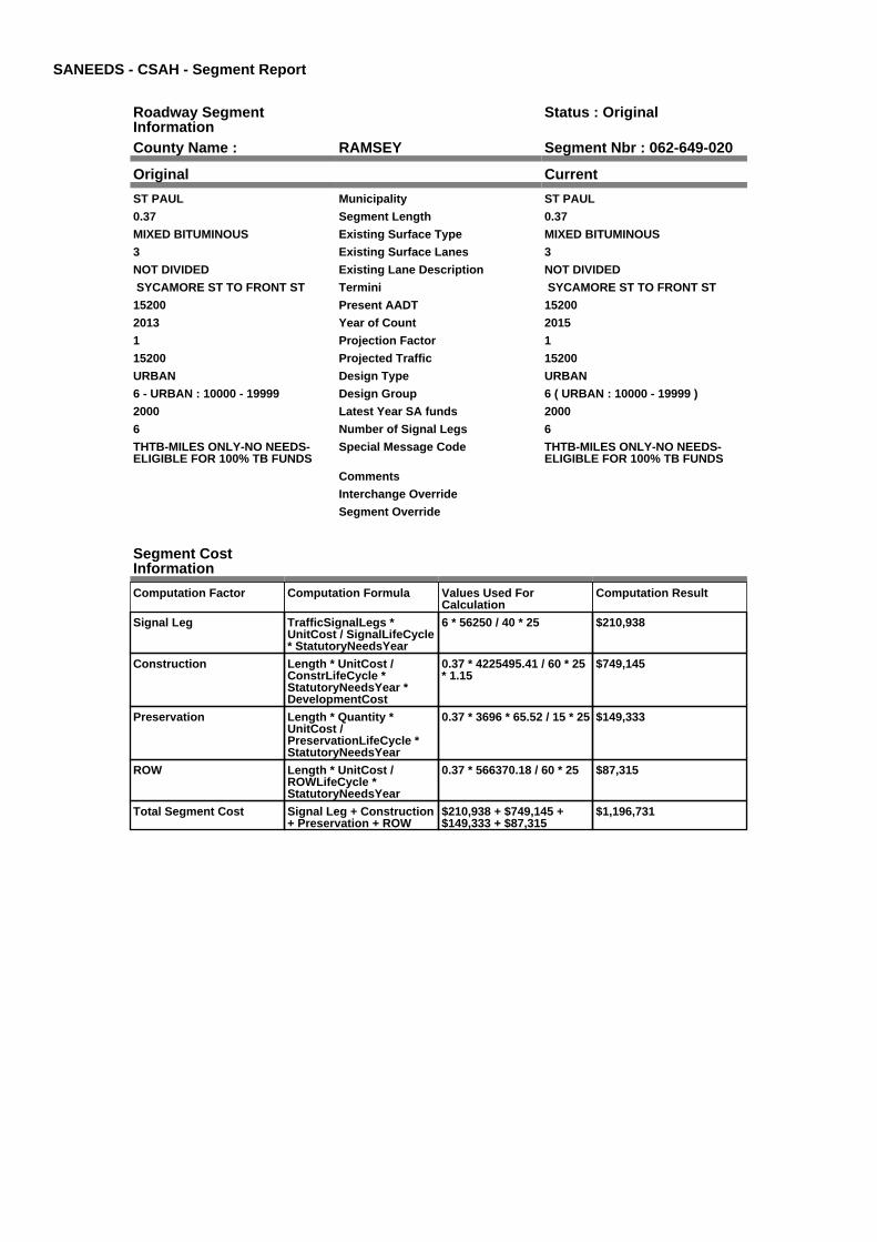
SANEEDS - CSAH - Segment Report
Roadway SegmentInformation
Status : Original
County Name : RAMSEY Segment Nbr : 062-649-020
Original Current
ST PAUL Municipality ST PAUL
0.37 Segment Length 0.37
MIXED BITUMINOUS Existing Surface Type MIXED BITUMINOUS
3 Existing Surface Lanes 3
NOT DIVIDED Existing Lane Description NOT DIVIDED
SYCAMORE ST TO FRONT ST Termini SYCAMORE ST TO FRONT ST
15200 Present AADT 15200
2013 Year of Count 2015
1 Projection Factor 1
15200 Projected Traffic 15200
URBAN Design Type URBAN
6 - URBAN : 10000 - 19999 Design Group 6 ( URBAN : 10000 - 19999 )
2000 Latest Year SA funds 2000
6 Number of Signal Legs 6
THTB-MILES ONLY-NO NEEDS-ELIGIBLE FOR 100% TB FUNDS
Special Message Code THTB-MILES ONLY-NO NEEDS-ELIGIBLE FOR 100% TB FUNDS
Comments
Interchange Override
Segment Override
Segment CostInformation
Computation Factor Computation Formula Values Used ForCalculation
Computation Result
Signal Leg TrafficSignalLegs *UnitCost / SignalLifeCycle* StatutoryNeedsYear
6 * 56250 / 40 * 25 $210,938
Construction Length * UnitCost /ConstrLifeCycle *StatutoryNeedsYear *DevelopmentCost
0.37 * 4225495.41 / 60 * 25* 1.15
$749,145
Preservation Length * Quantity *UnitCost /PreservationLifeCycle *StatutoryNeedsYear
0.37 * 3696 * 65.52 / 15 * 25 $149,333
ROW Length * UnitCost /ROWLifeCycle *StatutoryNeedsYear
0.37 * 566370.18 / 60 * 25 $87,315
Total Segment Cost Signal Leg + Construction+ Preservation + ROW
$210,938 + $749,145 +$149,333 + $87,315
$1,196,731

SANEEDS - CSAH - Segment Report
Roadway SegmentInformation
Status : Original
County Name : RAMSEY Segment Nbr : 062-649-030
Original Current
ST PAUL Municipality ST PAUL
0.49 Segment Length 0.49
MIXED BITUMINOUS Existing Surface Type MIXED BITUMINOUS
3 Existing Surface Lanes 3
NOT DIVIDED Existing Lane Description NOT DIVIDED
FRONT ST TO MARYLAND AVE Termini FRONT ST TO MARYLAND AVE
15200 Present AADT 15200
2013 Year of Count 2015
1 Projection Factor 1
15200 Projected Traffic 15200
URBAN Design Type URBAN
6 - URBAN : 10000 - 19999 Design Group 6 ( URBAN : 10000 - 19999 )
2000 Latest Year SA funds 2000
4 Number of Signal Legs 4
THTB-MILES ONLY-NO NEEDS-ELIGIBLE FOR 100% TB FUNDS
Special Message Code THTB-MILES ONLY-NO NEEDS-ELIGIBLE FOR 100% TB FUNDS
Comments
Interchange Override
Segment Override
Segment CostInformation
Computation Factor Computation Formula Values Used ForCalculation
Computation Result
Signal Leg TrafficSignalLegs *UnitCost / SignalLifeCycle* StatutoryNeedsYear
4 * 56250 / 40 * 25 $140,625
Construction Length * UnitCost /ConstrLifeCycle *StatutoryNeedsYear *DevelopmentCost
0.49 * 4225495.41 / 60 * 25* 1.15
$992,111
Preservation Length * Quantity *UnitCost /PreservationLifeCycle *StatutoryNeedsYear
0.49 * 3696 * 65.52 / 15 * 25 $197,766
ROW Length * UnitCost /ROWLifeCycle *StatutoryNeedsYear
0.49 * 566370.18 / 60 * 25 $115,634
Total Segment Cost Signal Leg + Construction+ Preservation + ROW
$140,625 + $992,111 +$197,766 + $115,634
$1,446,136

SANEEDS - CSAH - Segment Report
Roadway SegmentInformation
Status : Original
County Name : RAMSEY Segment Nbr : 062-649-040
Original Current
ST PAUL Municipality ST PAUL
0.5 Segment Length 0.5
MIXED BITUMINOUS Existing Surface Type MIXED BITUMINOUS
4 Existing Surface Lanes 4
NOT DIVIDED Existing Lane Description NOT DIVIDED
MARYLAND AVE TO ARLINGTONAVE.
Termini MARYLAND AVE TO ARLINGTONAVE.
15400 Present AADT 15400
2013 Year of Count 2015
1 Projection Factor 1
15400 Projected Traffic 15400
URBAN Design Type URBAN
6 - URBAN : 10000 - 19999 Design Group 6 ( URBAN : 10000 - 19999 )
2000 Latest Year SA funds 2000
2 Number of Signal Legs 2
THTB-MILES ONLY-NO NEEDS-ELIGIBLE FOR 100% TB FUNDS
Special Message Code THTB-MILES ONLY-NO NEEDS-ELIGIBLE FOR 100% TB FUNDS
Comments
Interchange Override
Segment Override
Bridge Information Status: Original
Original Current
9470 Structure Number 9470
1.802 Milepoint 1.802
1958 Year Built 1958
BNSF RR Feature Crossed BNSF RR
Type of Service
Number of Spans
143 Bridge Length 143
62.3 Bridge Width 62.3
100% Shared Structure 100%
Comments
1 ( 0-149 ) Bridge Group Code 1 ( 0-149 )
Segment CostInformation
Computation Factor Computation Formula Values Used ForCalculation
Computation Result
Signal Leg TrafficSignalLegs *UnitCost / SignalLifeCycle* StatutoryNeedsYear
2 * 56250 / 40 * 25 $70,313
Construction Length * UnitCost /ConstrLifeCycle *StatutoryNeedsYear *DevelopmentCost
0.5 * 4225495.41 / 60 * 25 *1.15
$1,012,358
Preservation Length * Quantity *UnitCost /PreservationLifeCycle *StatutoryNeedsYear
0.5 * 3696 * 65.52 / 15 * 25 $201,802
ROW Length * UnitCost /ROWLifeCycle *StatutoryNeedsYear
0.5 * 566370.18 / 60 * 25 $117,994
Bridge BridgeLength *BridgeWidth * UnitCost /BridgeLifeCycle *StatutoryNeedsYear *DevelopmentCost
143 * 62.3 * 152 / 80 * 25 *1.15
$486,649
Total Segment Cost Signal Leg + Construction+ Preservation + ROW +Bridge
$70,313 + $1,012,358 +$201,802 + $117,994 +$486,649
$1,889,116

SANEEDS - CSAH - Segment Report
Roadway SegmentInformation
Status : Original
County Name : RAMSEY Segment Nbr : 062-649-050
Original Current
ST PAUL Municipality ST PAUL
0.5 Segment Length 0.5
MIXED BITUMINOUS Existing Surface Type MIXED BITUMINOUS
4 Existing Surface Lanes 4
NOT DIVIDED Existing Lane Description NOT DIVIDED
FROM: HWY 49 - ARLINGTON AVETO LARPENTEUR AVE.
Termini FROM: HWY 49 - ARLINGTON AVETO LARPENTEUR AVE.
14500 Present AADT 14500
2013 Year of Count 2015
1 Projection Factor 1
14500 Projected Traffic 14500
URBAN Design Type URBAN
6 - URBAN : 10000 - 19999 Design Group 6 ( URBAN : 10000 - 19999 )
2000 Latest Year SA funds 2000
6 Number of Signal Legs 6
THTB-MILES ONLY-NO NEEDS-ELIGIBLE FOR 100% TB FUNDS
Special Message Code THTB-MILES ONLY-NO NEEDS-ELIGIBLE FOR 100% TB FUNDS
Comments
Interchange Override
Segment Override
Segment CostInformation
Computation Factor Computation Formula Values Used ForCalculation
Computation Result
Signal Leg TrafficSignalLegs *UnitCost / SignalLifeCycle* StatutoryNeedsYear
6 * 56250 / 40 * 25 $210,938
Construction Length * UnitCost /ConstrLifeCycle *StatutoryNeedsYear *DevelopmentCost
0.5 * 4225495.41 / 60 * 25 *1.15
$1,012,358
Preservation Length * Quantity *UnitCost /PreservationLifeCycle *StatutoryNeedsYear
0.5 * 3696 * 65.52 / 15 * 25 $201,802
ROW Length * UnitCost /ROWLifeCycle *StatutoryNeedsYear
0.5 * 566370.18 / 60 * 25 $117,994
Total Segment Cost Signal Leg + Construction+ Preservation + ROW
$210,938 + $1,012,358 +$201,802 + $117,994
$1,543,092

SANEEDS - CSAH - Segment Report
Roadway SegmentInformation
Status : Original
County Name : RAMSEY Segment Nbr : 062-649-060
Original Current
MAPLEWOOD Municipality MAPLEWOOD
0.5 Segment Length 0.5
MIXED BITUMINOUS Existing Surface Type MIXED BITUMINOUS
3 Existing Surface Lanes 3
NOT DIVIDED Existing Lane Description NOT DIVIDED
LARPENTEUR AVE AVE TOROSELAWN AVE.
Termini LARPENTEUR AVE AVE TOROSELAWN AVE.
14200 Present AADT 14200
2013 Year of Count 2015
1 Projection Factor 1
14200 Projected Traffic 14200
URBAN Design Type URBAN
6 - URBAN : 10000 - 19999 Design Group 6 ( URBAN : 10000 - 19999 )
2000 Latest Year SA funds 2000
2 Number of Signal Legs 2
THTB-MILES ONLY-NO NEEDS-ELIGIBLE FOR 100% TB FUNDS
Special Message Code THTB-MILES ONLY-NO NEEDS-ELIGIBLE FOR 100% TB FUNDS
Comments
Interchange Override
Segment Override
Segment CostInformation
Computation Factor Computation Formula Values Used ForCalculation
Computation Result
Signal Leg TrafficSignalLegs *UnitCost / SignalLifeCycle* StatutoryNeedsYear
2 * 56250 / 40 * 25 $70,313
Construction Length * UnitCost /ConstrLifeCycle *StatutoryNeedsYear *DevelopmentCost
0.5 * 4225495.41 / 60 * 25 *1.15
$1,012,358
Preservation Length * Quantity *UnitCost /PreservationLifeCycle *StatutoryNeedsYear
0.5 * 3696 * 65.52 / 15 * 25 $201,802
ROW Length * UnitCost /ROWLifeCycle *StatutoryNeedsYear
0.5 * 566370.18 / 60 * 25 $117,994
Total Segment Cost Signal Leg + Construction+ Preservation + ROW
$70,313 + $1,012,358 +$201,802 + $117,994
$1,402,467

SANEEDS - CSAH - Segment Report
Roadway SegmentInformation
Status : Original
County Name : RAMSEY Segment Nbr : 062-649-070
Original Current
ROSEVILLE Municipality ROSEVILLE
0.38 Segment Length 0.38
MIXED BITUMINOUS Existing Surface Type MIXED BITUMINOUS
3 Existing Surface Lanes 3
NOT DIVIDED Existing Lane Description NOT DIVIDED
RICE ST - ROSELAWN AVE TO 680'S OF CO RD B.
Termini RICE ST - ROSELAWN AVE TO 680'S OF CO RD B.
16500 Present AADT 16500
2013 Year of Count 2015
1 Projection Factor 1
16500 Projected Traffic 16500
URBAN Design Type URBAN
6 - URBAN : 10000 - 19999 Design Group 6 ( URBAN : 10000 - 19999 )
2000 Latest Year SA funds 2000
1 Number of Signal Legs 1
THTB-MILES ONLY-NO NEEDS-ELIGIBLE FOR 100% TB FUNDS
Special Message Code THTB-MILES ONLY-NO NEEDS-ELIGIBLE FOR 100% TB FUNDS
TB, NOT ELIGIBLE FORCOMPLETE NEEDS THEREFORECURB & GUTTER REMOVED. 2010MPK
Comments TB, NOT ELIGIBLE FORCOMPLETE NEEDS THEREFORECURB & GUTTER REMOVED. 2010MPK
Interchange Override
Segment Override
Segment CostInformation
Computation Factor Computation Formula Values Used ForCalculation
Computation Result
Signal Leg TrafficSignalLegs *UnitCost / SignalLifeCycle* StatutoryNeedsYear
1 * 56250 / 40 * 25 $35,156
Construction Length * UnitCost /ConstrLifeCycle *StatutoryNeedsYear *DevelopmentCost
0.38 * 4225495.41 / 60 * 25* 1.15
$769,392
Preservation Length * Quantity *UnitCost /PreservationLifeCycle *StatutoryNeedsYear
0.38 * 3696 * 65.52 / 15 * 25 $153,369
ROW Length * UnitCost /ROWLifeCycle *StatutoryNeedsYear
0.38 * 566370.18 / 60 * 25 $89,675
Total Segment Cost Signal Leg + Construction+ Preservation + ROW
$35,156 + $769,392 +$153,369 + $89,675
$1,047,592
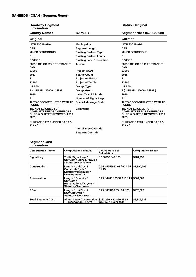
SANEEDS - CSAH - Segment Report
Roadway SegmentInformation
Status : Original
County Name : RAMSEY Segment Nbr : 062-649-080
Original Current
LITTLE CANADA Municipality LITTLE CANADA
0.75 Segment Length 0.75
MIXED BITUMINOUS Existing Surface Type MIXED BITUMINOUS
3 Existing Surface Lanes 3
DIVIDED Existing Lane Description DIVIDED
680' S OF CO RD B TO TRANSITAVE
Termini 680' S OF CO RD B TO TRANSITAVE
23900 Present AADT 23900
2013 Year of Count 2015
1 Projection Factor 1
23900 Projected Traffic 23900
URBAN Design Type URBAN
7 - URBAN : 20000 - 34999 Design Group 7 ( URBAN : 20000 - 34999 )
2010 Latest Year SA funds 2010
8 Number of Signal Legs 8
THTB-RECONSTRUCTED WITH TBFUNDS
Special Message Code THTB-RECONSTRUCTED WITH TBFUNDS
TB, NOT ELIGIBLE FORCOMPLETE NEEDS THEREFORECURB & GUTTER REMOVED. 2010MPK
SURFACED 2010 UNDER SAP 62-649-27
Comments TB, NOT ELIGIBLE FORCOMPLETE NEEDS THEREFORECURB & GUTTER REMOVED. 2010MPK
SURFACED 2010 UNDER SAP 62-649-27
Interchange Override
Segment Override
Segment CostInformation
Computation Factor Computation Formula Values Used ForCalculation
Computation Result
Signal Leg TrafficSignalLegs *UnitCost / SignalLifeCycle* StatutoryNeedsYear
8 * 56250 / 40 * 25 $281,250
Construction Length * UnitCost /ConstrLifeCycle *StatutoryNeedsYear *DevelopmentCost
0.75 * 5259942.61 / 60 * 25* 1.15
$1,890,292
Preservation Length * Quantity *UnitCost /PreservationLifeCycle *StatutoryNeedsYear
0.75 * 4488 * 65.52 / 15 * 25 $367,567
ROW Length * UnitCost /ROWLifeCycle *StatutoryNeedsYear
0.75 * 883293.09 / 60 * 25 $276,029
Total Segment Cost Signal Leg + Construction+ Preservation + ROW
$281,250 + $1,890,292 +$367,567 + $276,029
$2,815,138

SANEEDS - CSAH - Segment Report
Roadway SegmentInformation
Status : Original
County Name : RAMSEY Segment Nbr : 062-649-090
Original Current
ROSEVILLE Municipality ROSEVILLE
0.37 Segment Length 0.37
MIXED BITUMINOUS Existing Surface Type MIXED BITUMINOUS
3 Existing Surface Lanes 3
NOT DIVIDED Existing Lane Description NOT DIVIDED
RICE ST - TRANSIT TO CO RD C. Termini RICE ST - TRANSIT TO CO RD C.
15700 Present AADT 15700
2013 Year of Count 2015
1 Projection Factor 1
15700 Projected Traffic 15700
URBAN Design Type URBAN
6 - URBAN : 10000 - 19999 Design Group 6 ( URBAN : 10000 - 19999 )
2000 Latest Year SA funds 2000
1 Number of Signal Legs 1
THTB-MILES ONLY-NO NEEDS-ELIGIBLE FOR 100% TB FUNDS
Special Message Code THTB-MILES ONLY-NO NEEDS-ELIGIBLE FOR 100% TB FUNDS
TB, NOT ELIGIBLE FORCOMPLETE NEEDS THEREFORECURB & GUTTER REMOVED. 2010M
Comments TB, NOT ELIGIBLE FORCOMPLETE NEEDS THEREFORECURB & GUTTER REMOVED. 2010M
Interchange Override
Segment Override
Segment CostInformation
Computation Factor Computation Formula Values Used ForCalculation
Computation Result
Signal Leg TrafficSignalLegs *UnitCost / SignalLifeCycle* StatutoryNeedsYear
1 * 56250 / 40 * 25 $35,156
Construction Length * UnitCost /ConstrLifeCycle *StatutoryNeedsYear *DevelopmentCost
0.37 * 4225495.41 / 60 * 25* 1.15
$749,145
Preservation Length * Quantity *UnitCost /PreservationLifeCycle *StatutoryNeedsYear
0.37 * 3696 * 65.52 / 15 * 25 $149,333
ROW Length * UnitCost /ROWLifeCycle *StatutoryNeedsYear
0.37 * 566370.18 / 60 * 25 $87,315
Total Segment Cost Signal Leg + Construction+ Preservation + ROW
$35,156 + $749,145 +$149,333 + $87,315
$1,020,949

SANEEDS - CSAH - Segment Report
Roadway SegmentInformation
Status : Original
County Name : RAMSEY Segment Nbr : 062-649-100
Original Current
ROSEVILLE Municipality ROSEVILLE
0.52 Segment Length 0.52
MIXED BITUMINOUS Existing Surface Type MIXED BITUMINOUS
3 Existing Surface Lanes 3
NOT DIVIDED Existing Lane Description NOT DIVIDED
CO RD C TO 0.52 MI N Termini CO RD C TO 0.52 MI N
16200 Present AADT 16200
2013 Year of Count 2015
1 Projection Factor 1
16200 Projected Traffic 16200
URBAN Design Type URBAN
6 - URBAN : 10000 - 19999 Design Group 6 ( URBAN : 10000 - 19999 )
2000 Latest Year SA funds 2000
1 Number of Signal Legs 1
THTB-MILES ONLY-NO NEEDS-ELIGIBLE FOR 100% TB FUNDS
Special Message Code THTB-MILES ONLY-NO NEEDS-ELIGIBLE FOR 100% TB FUNDS
Comments
Interchange Override
Segment Override
Segment CostInformation
Computation Factor Computation Formula Values Used ForCalculation
Computation Result
Signal Leg TrafficSignalLegs *UnitCost / SignalLifeCycle* StatutoryNeedsYear
1 * 56250 / 40 * 25 $35,156
Construction Length * UnitCost /ConstrLifeCycle *StatutoryNeedsYear *DevelopmentCost
0.52 * 4225495.41 / 60 * 25* 1.15
$1,052,853
Preservation Length * Quantity *UnitCost /PreservationLifeCycle *StatutoryNeedsYear
0.52 * 3696 * 65.52 / 15 * 25 $209,874
ROW Length * UnitCost /ROWLifeCycle *StatutoryNeedsYear
0.52 * 566370.18 / 60 * 25 $122,714
Total Segment Cost Signal Leg + Construction+ Preservation + ROW
$35,156 + $1,052,853 +$209,874 + $122,714
$1,420,597

SANEEDS - CSAH - Segment Report
Roadway SegmentInformation
Status : Original
County Name : RAMSEY Segment Nbr : 062-649-110
Original Current
LITTLE CANADA Municipality LITTLE CANADA
0.52 Segment Length 0.52
MIXED BITUMINOUS Existing Surface Type MIXED BITUMINOUS
3 Existing Surface Lanes 3
NOT DIVIDED Existing Lane Description NOT DIVIDED
0.52 MI N OF CO RD C TO N LIMSROSEVILLE
Termini 0.52 MI N OF CO RD C TO N LIMSROSEVILLE
14800 Present AADT 14800
2013 Year of Count 2015
1 Projection Factor 1
14800 Projected Traffic 14800
URBAN Design Type URBAN
6 - URBAN : 10000 - 19999 Design Group 6 ( URBAN : 10000 - 19999 )
2000 Latest Year SA funds 2000
2 Number of Signal Legs 2
THTB-MILES ONLY-NO NEEDS-ELIGIBLE FOR 100% TB FUNDS
Special Message Code THTB-MILES ONLY-NO NEEDS-ELIGIBLE FOR 100% TB FUNDS
OVERLAY 2009 LOCAL $'S Comments OVERLAY 2009 LOCAL $'S
Interchange Override
Segment Override
Segment CostInformation
Computation Factor Computation Formula Values Used ForCalculation
Computation Result
Signal Leg TrafficSignalLegs *UnitCost / SignalLifeCycle* StatutoryNeedsYear
2 * 56250 / 40 * 25 $70,313
Construction Length * UnitCost /ConstrLifeCycle *StatutoryNeedsYear *DevelopmentCost
0.52 * 4225495.41 / 60 * 25* 1.15
$1,052,853
Preservation Length * Quantity *UnitCost /PreservationLifeCycle *StatutoryNeedsYear
0.52 * 3696 * 65.52 / 15 * 25 $209,874
ROW Length * UnitCost /ROWLifeCycle *StatutoryNeedsYear
0.52 * 566370.18 / 60 * 25 $122,714
Total Segment Cost Signal Leg + Construction+ Preservation + ROW
$70,313 + $1,052,853 +$209,874 + $122,714
$1,455,754

SANEEDS - CSAH - Segment Report
Roadway SegmentInformation
Status : Original
County Name : RAMSEY Segment Nbr : 062-649-115
Original Current
SHOREVIEW Municipality SHOREVIEW
0.07 Segment Length 0.07
MIXED BITUMINOUS Existing Surface Type MIXED BITUMINOUS
3 Existing Surface Lanes 3
NOT DIVIDED Existing Lane Description NOT DIVIDED
N LIMS ROSEVILLE TO EASTAWASSO LANE
Termini N LIMS ROSEVILLE TO EASTAWASSO LANE
12800 Present AADT 12800
2013 Year of Count 2015
1 Projection Factor 1
12800 Projected Traffic 12800
URBAN Design Type URBAN
6 - URBAN : 10000 - 19999 Design Group 6 ( URBAN : 10000 - 19999 )
2000 Latest Year SA funds 2000
1 Number of Signal Legs 1
THTB-MILES ONLY-NO NEEDS-ELIGIBLE FOR 100% TB FUNDS
Special Message Code THTB-MILES ONLY-NO NEEDS-ELIGIBLE FOR 100% TB FUNDS
OVERLAY 2009 LOCAL $'S Comments OVERLAY 2009 LOCAL $'S
Interchange Override
Segment Override
Bridge Information Status: Original
Original Current
62001 Structure Number 62001
5.513 Milepoint 5.513
1986 Year Built 1986
Feature Crossed
Type of Service
Number of Spans
134.5 Bridge Length 134.5
71.3 Bridge Width 71.3
100% Shared Structure 100%
Comments
1 ( 0-149 ) Bridge Group Code 1 ( 0-149 )
Segment CostInformation
Computation Factor Computation Formula Values Used ForCalculation
Computation Result
Signal Leg TrafficSignalLegs *UnitCost / SignalLifeCycle* StatutoryNeedsYear
1 * 56250 / 40 * 25 $35,156
Construction Length * UnitCost /ConstrLifeCycle *StatutoryNeedsYear *DevelopmentCost
0.07 * 4225495.41 / 60 * 25* 1.15
$141,730
Preservation Length * Quantity *UnitCost /PreservationLifeCycle *StatutoryNeedsYear
0.07 * 3696 * 65.52 / 15 * 25 $28,252
ROW Length * UnitCost /ROWLifeCycle *StatutoryNeedsYear
0.07 * 566370.18 / 60 * 25 $16,519
Bridge BridgeLength *BridgeWidth * UnitCost /BridgeLifeCycle *StatutoryNeedsYear *DevelopmentCost
134.5 * 71.3 * 152 / 80 * 25* 1.15
$523,846
Total Segment Cost Signal Leg + Construction+ Preservation + ROW +Bridge
$35,156 + $141,730 +$28,252 + $16,519 +$523,846
$745,503

SANEEDS - CSAH - Segment Report
Roadway SegmentInformation
Status : Original
County Name : RAMSEY Segment Nbr : 062-649-120
Original Current
SHOREVIEW Municipality SHOREVIEW
0.17 Segment Length 0.17
MIXED BITUMINOUS Existing Surface Type MIXED BITUMINOUS
3 Existing Surface Lanes 3
NOT DIVIDED Existing Lane Description NOT DIVIDED
EAST AWASSO LANE TO 0.17 MI N Termini EAST AWASSO LANE TO 0.17 MI N
12800 Present AADT 12800
2013 Year of Count 2015
1 Projection Factor 1
12800 Projected Traffic 12800
URBAN Design Type URBAN
6 - URBAN : 10000 - 19999 Design Group 6 ( URBAN : 10000 - 19999 )
2000 Latest Year SA funds 2000
1 Number of Signal Legs 1
THTB-MILES ONLY-NO NEEDS-ELIGIBLE FOR 100% TB FUNDS
Special Message Code THTB-MILES ONLY-NO NEEDS-ELIGIBLE FOR 100% TB FUNDS
OVERLAY 2009 LOCAL $'S Comments OVERLAY 2009 LOCAL $'S
Interchange Override
Segment Override
Segment CostInformation
Computation Factor Computation Formula Values Used ForCalculation
Computation Result
Signal Leg TrafficSignalLegs *UnitCost / SignalLifeCycle* StatutoryNeedsYear
1 * 56250 / 40 * 25 $35,156
Construction Length * UnitCost /ConstrLifeCycle *StatutoryNeedsYear *DevelopmentCost
0.17 * 4225495.41 / 60 * 25* 1.15
$344,202
Preservation Length * Quantity *UnitCost /PreservationLifeCycle *StatutoryNeedsYear
0.17 * 3696 * 65.52 / 15 * 25 $68,613
ROW Length * UnitCost /ROWLifeCycle *StatutoryNeedsYear
0.17 * 566370.18 / 60 * 25 $40,118
Total Segment Cost Signal Leg + Construction+ Preservation + ROW
$35,156 + $344,202 +$68,613 + $40,118
$488,089
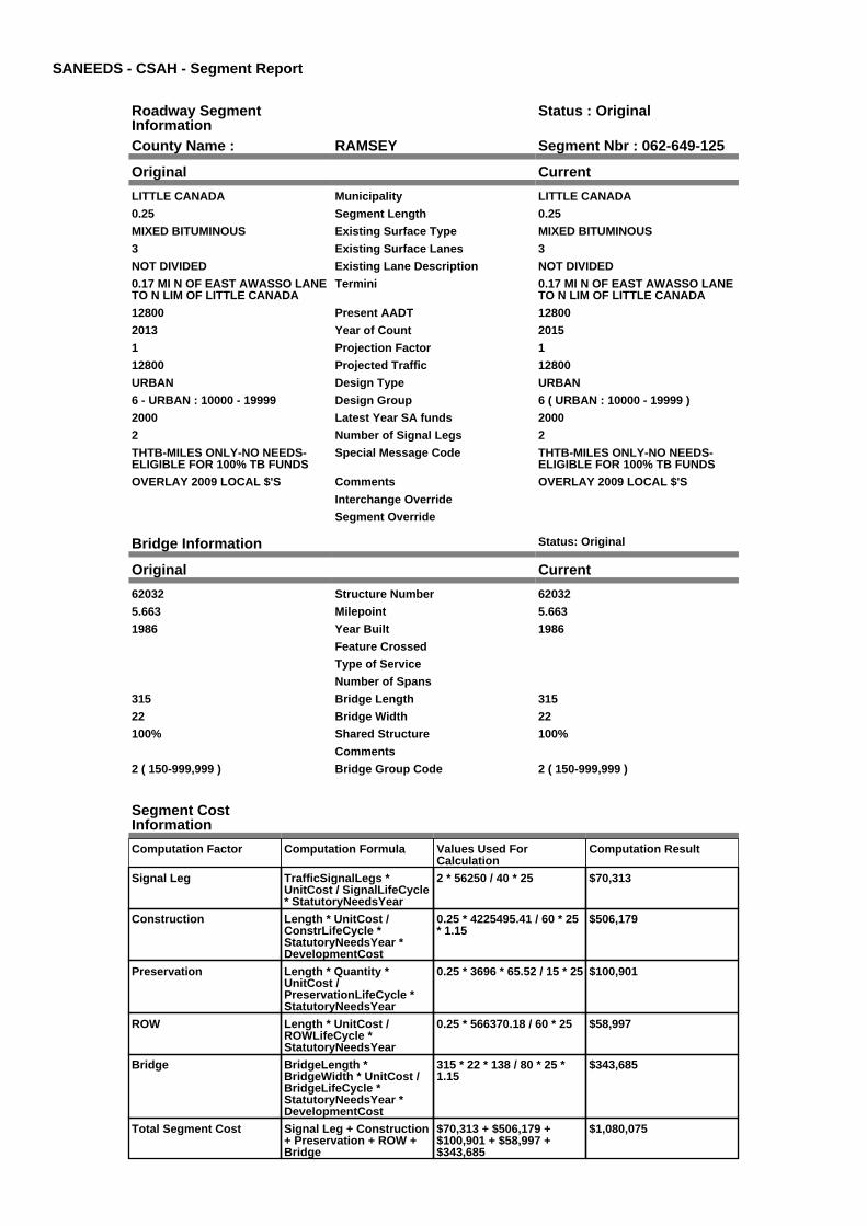
SANEEDS - CSAH - Segment Report
Roadway SegmentInformation
Status : Original
County Name : RAMSEY Segment Nbr : 062-649-125
Original Current
LITTLE CANADA Municipality LITTLE CANADA
0.25 Segment Length 0.25
MIXED BITUMINOUS Existing Surface Type MIXED BITUMINOUS
3 Existing Surface Lanes 3
NOT DIVIDED Existing Lane Description NOT DIVIDED
0.17 MI N OF EAST AWASSO LANETO N LIM OF LITTLE CANADA
Termini 0.17 MI N OF EAST AWASSO LANETO N LIM OF LITTLE CANADA
12800 Present AADT 12800
2013 Year of Count 2015
1 Projection Factor 1
12800 Projected Traffic 12800
URBAN Design Type URBAN
6 - URBAN : 10000 - 19999 Design Group 6 ( URBAN : 10000 - 19999 )
2000 Latest Year SA funds 2000
2 Number of Signal Legs 2
THTB-MILES ONLY-NO NEEDS-ELIGIBLE FOR 100% TB FUNDS
Special Message Code THTB-MILES ONLY-NO NEEDS-ELIGIBLE FOR 100% TB FUNDS
OVERLAY 2009 LOCAL $'S Comments OVERLAY 2009 LOCAL $'S
Interchange Override
Segment Override
Bridge Information Status: Original
Original Current
62032 Structure Number 62032
5.663 Milepoint 5.663
1986 Year Built 1986
Feature Crossed
Type of Service
Number of Spans
315 Bridge Length 315
22 Bridge Width 22
100% Shared Structure 100%
Comments
2 ( 150-999,999 ) Bridge Group Code 2 ( 150-999,999 )
Segment CostInformation
Computation Factor Computation Formula Values Used ForCalculation
Computation Result
Signal Leg TrafficSignalLegs *UnitCost / SignalLifeCycle* StatutoryNeedsYear
2 * 56250 / 40 * 25 $70,313
Construction Length * UnitCost /ConstrLifeCycle *StatutoryNeedsYear *DevelopmentCost
0.25 * 4225495.41 / 60 * 25* 1.15
$506,179
Preservation Length * Quantity *UnitCost /PreservationLifeCycle *StatutoryNeedsYear
0.25 * 3696 * 65.52 / 15 * 25 $100,901
ROW Length * UnitCost /ROWLifeCycle *StatutoryNeedsYear
0.25 * 566370.18 / 60 * 25 $58,997
Bridge BridgeLength *BridgeWidth * UnitCost /BridgeLifeCycle *StatutoryNeedsYear *DevelopmentCost
315 * 22 * 138 / 80 * 25 *1.15
$343,685
Total Segment Cost Signal Leg + Construction+ Preservation + ROW +Bridge
$70,313 + $506,179 +$100,901 + $58,997 +$343,685
$1,080,075

SANEEDS - CSAH - Segment Report
Roadway SegmentInformation
Status : Original
County Name : RAMSEY Segment Nbr : 062-649-130
Original Current
SHOREVIEW Municipality SHOREVIEW
0.09 Segment Length 0.09
MIXED BITUMINOUS Existing Surface Type MIXED BITUMINOUS
4 Existing Surface Lanes 4
NOT DIVIDED Existing Lane Description NOT DIVIDED
NORTH LIM LITTLE CANADA TO0.09 MI N
Termini NORTH LIM LITTLE CANADA TO0.09 MI N
18100 Present AADT 18100
2013 Year of Count 2015
1 Projection Factor 1
18100 Projected Traffic 18100
URBAN Design Type URBAN
6 - URBAN : 10000 - 19999 Design Group 6 ( URBAN : 10000 - 19999 )
2000 Latest Year SA funds 2000
1 Number of Signal Legs 1
THTB-MILES ONLY-NO NEEDS-ELIGIBLE FOR 100% TB FUNDS
Special Message Code THTB-MILES ONLY-NO NEEDS-ELIGIBLE FOR 100% TB FUNDS
Comments
Interchange Override
Segment Override
Segment CostInformation
Computation Factor Computation Formula Values Used ForCalculation
Computation Result
Signal Leg TrafficSignalLegs *UnitCost / SignalLifeCycle* StatutoryNeedsYear
1 * 56250 / 40 * 25 $35,156
Construction Length * UnitCost /ConstrLifeCycle *StatutoryNeedsYear *DevelopmentCost
0.09 * 4225495.41 / 60 * 25* 1.15
$182,224
Preservation Length * Quantity *UnitCost /PreservationLifeCycle *StatutoryNeedsYear
0.09 * 3696 * 65.52 / 15 * 25 $36,324
ROW Length * UnitCost /ROWLifeCycle *StatutoryNeedsYear
0.09 * 566370.18 / 60 * 25 $21,239
Total Segment Cost Signal Leg + Construction+ Preservation + ROW
$35,156 + $182,224 +$36,324 + $21,239
$274,943

SANEEDS - CSAH - Segment Report
Roadway SegmentInformation
Status : Original
County Name : RAMSEY Segment Nbr : 062-649-135
Original Current
VADNAIS HEIGHTS Municipality VADNAIS HEIGHTS
0.09 Segment Length 0.09
MIXED BITUMINOUS Existing Surface Type MIXED BITUMINOUS
4 Existing Surface Lanes 4
NOT DIVIDED Existing Lane Description NOT DIVIDED
0.09 MI N OF N LIM LITTLECANADA TO VADNAIS BLVD.
Termini 0.09 MI N OF N LIM LITTLECANADA TO VADNAIS BLVD.
14000 Present AADT 14000
2013 Year of Count 2015
1 Projection Factor 1
14000 Projected Traffic 14000
URBAN Design Type URBAN
6 - URBAN : 10000 - 19999 Design Group 6 ( URBAN : 10000 - 19999 )
2000 Latest Year SA funds 2000
4 Number of Signal Legs 4
THTB-MILES ONLY-NO NEEDS-ELIGIBLE FOR 100% TB FUNDS
Special Message Code THTB-MILES ONLY-NO NEEDS-ELIGIBLE FOR 100% TB FUNDS
Comments
Interchange Override
Segment Override
Segment CostInformation
Computation Factor Computation Formula Values Used ForCalculation
Computation Result
Signal Leg TrafficSignalLegs *UnitCost / SignalLifeCycle* StatutoryNeedsYear
4 * 56250 / 40 * 25 $140,625
Construction Length * UnitCost /ConstrLifeCycle *StatutoryNeedsYear *DevelopmentCost
0.09 * 4225495.41 / 60 * 25* 1.15
$182,224
Preservation Length * Quantity *UnitCost /PreservationLifeCycle *StatutoryNeedsYear
0.09 * 3696 * 65.52 / 15 * 25 $36,324
ROW Length * UnitCost /ROWLifeCycle *StatutoryNeedsYear
0.09 * 566370.18 / 60 * 25 $21,239
Total Segment Cost Signal Leg + Construction+ Preservation + ROW
$140,625 + $182,224 +$36,324 + $21,239
$380,412

SANEEDS - CSAH - Segment Report
Roadway SegmentInformation
Status : Original
County Name : RAMSEY Segment Nbr : 062-649-140
Original Current
SHOREVIEW Municipality SHOREVIEW
0.15 Segment Length 0.15
MIXED BITUMINOUS Existing Surface Type MIXED BITUMINOUS
2 Existing Surface Lanes 2
NOT DIVIDED Existing Lane Description NOT DIVIDED
RICE ST. - VADNAIS BLVD. TO 0.15MILE NORTH
Termini RICE ST. - VADNAIS BLVD. TO 0.15MILE NORTH
14000 Present AADT 14000
2013 Year of Count 2015
1 Projection Factor 1
14000 Projected Traffic 14000
RURAL Design Type RURAL
4 - RURAL : 7000 - 999999 Design Group 4 ( RURAL : 7000 - 999999 )
2007 Latest Year SA funds 2007
1 Number of Signal Legs 1
THTB-RECONSTRUCTED WITH TBFUNDS
Special Message Code THTB-RECONSTRUCTED WITH TBFUNDS
Comments
Interchange Override
Segment Override
Segment CostInformation
Computation Factor Computation Formula Values Used ForCalculation
Computation Result
Signal Leg TrafficSignalLegs *UnitCost / SignalLifeCycle* StatutoryNeedsYear
1 * 56250 / 40 * 25 $35,156
Construction Length * UnitCost /ConstrLifeCycle *StatutoryNeedsYear *DevelopmentCost
0.15 * 1996892.57 / 60 * 25* 1.1
$137,286
Preservation Length * Quantity *UnitCost /PreservationLifeCycle *StatutoryNeedsYear
0.15 * 3564 * 65.52 / 20 * 25 $43,784
ROW Length * UnitCost /ROWLifeCycle *StatutoryNeedsYear
0.15 * 181173.68 / 60 * 25 $11,323
Total Segment Cost Signal Leg + Construction+ Preservation + ROW
$35,156 + $137,286 +$43,784 + $11,323
$227,549

SANEEDS - CSAH - Segment Report
Roadway SegmentInformation
Status : Original
County Name : RAMSEY Segment Nbr : 062-649-145
Original Current
VADNAIS HEIGHTS Municipality VADNAIS HEIGHTS
0.15 Segment Length 0.15
BIT CONC OR ASPH Existing Surface Type BIT CONC OR ASPH
2 Existing Surface Lanes 2
NOT DIVIDED Existing Lane Description NOT DIVIDED
RICE ST - 0.15 MI N OF VADNAISBLVD TO ST MARIE ST
Termini RICE ST - 0.15 MI N OF VADNAISBLVD TO ST MARIE ST
14000 Present AADT 14000
2013 Year of Count 2015
1 Projection Factor 1
14000 Projected Traffic 14000
RURAL Design Type RURAL
4 - RURAL : 7000 - 999999 Design Group 4 ( RURAL : 7000 - 999999 )
2000 Latest Year SA funds 2000
0 Number of Signal Legs 0
THTB-MILES ONLY-NO NEEDS-ELIGIBLE FOR 100% TB FUNDS
Special Message Code THTB-MILES ONLY-NO NEEDS-ELIGIBLE FOR 100% TB FUNDS
Comments
Interchange Override
Segment Override
Segment CostInformation
Computation Factor Computation Formula Values Used ForCalculation
Computation Result
Signal Leg TrafficSignalLegs *UnitCost / SignalLifeCycle* StatutoryNeedsYear
0 * 56250 / 40 * 25 $0
Construction Length * UnitCost /ConstrLifeCycle *StatutoryNeedsYear *DevelopmentCost
0.15 * 1996892.57 / 60 * 25* 1.1
$137,286
Preservation Length * Quantity *UnitCost /PreservationLifeCycle *StatutoryNeedsYear
0.15 * 3564 * 65.52 / 20 * 25 $43,784
ROW Length * UnitCost /ROWLifeCycle *StatutoryNeedsYear
0.15 * 181173.68 / 60 * 25 $11,323
Total Segment Cost Signal Leg + Construction+ Preservation + ROW
$0 + $137,286 + $43,784 +$11,323
$192,393

SANEEDS - CSAH - Segment Report
Roadway SegmentInformation
Status : Original
County Name : RAMSEY Segment Nbr : 062-649-150
Original Current
SHOREVIEW Municipality SHOREVIEW
0.22 Segment Length 0.22
BIT CONC OR ASPH Existing Surface Type BIT CONC OR ASPH
2 Existing Surface Lanes 2
NOT DIVIDED Existing Lane Description NOT DIVIDED
RICE ST. - ST. MARIE ST. TO 0.22MI NORTH
Termini RICE ST. - ST. MARIE ST. TO 0.22MI NORTH
14000 Present AADT 14000
2013 Year of Count 2015
1 Projection Factor 1
14000 Projected Traffic 14000
RURAL Design Type RURAL
4 - RURAL : 7000 - 999999 Design Group 4 ( RURAL : 7000 - 999999 )
2000 Latest Year SA funds 2000
0 Number of Signal Legs 0
THTB-MILES ONLY-NO NEEDS-ELIGIBLE FOR 100% TB FUNDS
Special Message Code THTB-MILES ONLY-NO NEEDS-ELIGIBLE FOR 100% TB FUNDS
Comments
Interchange Override
Segment Override
Segment CostInformation
Computation Factor Computation Formula Values Used ForCalculation
Computation Result
Signal Leg TrafficSignalLegs *UnitCost / SignalLifeCycle* StatutoryNeedsYear
0 * 56250 / 40 * 25 $0
Construction Length * UnitCost /ConstrLifeCycle *StatutoryNeedsYear *DevelopmentCost
0.22 * 1996892.57 / 60 * 25* 1.1
$201,353
Preservation Length * Quantity *UnitCost /PreservationLifeCycle *StatutoryNeedsYear
0.22 * 3564 * 65.52 / 20 * 25 $64,216
ROW Length * UnitCost /ROWLifeCycle *StatutoryNeedsYear
0.22 * 181173.68 / 60 * 25 $16,608
Total Segment Cost Signal Leg + Construction+ Preservation + ROW
$0 + $201,353 + $64,216 +$16,608
$282,177

SANEEDS - CSAH - Segment Report
Roadway SegmentInformation
Status : Original
County Name : RAMSEY Segment Nbr : 062-649-155
Original Current
VADNAIS HEIGHTS Municipality VADNAIS HEIGHTS
0.22 Segment Length 0.22
BIT CONC OR ASPH Existing Surface Type BIT CONC OR ASPH
2 Existing Surface Lanes 2
NOT DIVIDED Existing Lane Description NOT DIVIDED
RICE ST - 0.22 MI N OF ST MARIEST TO RUSTIC PLACE
Termini RICE ST - 0.22 MI N OF ST MARIEST TO RUSTIC PLACE
14000 Present AADT 14000
2013 Year of Count 2015
1 Projection Factor 1
14000 Projected Traffic 14000
RURAL Design Type RURAL
4 - RURAL : 7000 - 999999 Design Group 4 ( RURAL : 7000 - 999999 )
2000 Latest Year SA funds 2000
0 Number of Signal Legs 0
THTB-MILES ONLY-NO NEEDS-ELIGIBLE FOR 100% TB FUNDS
Special Message Code THTB-MILES ONLY-NO NEEDS-ELIGIBLE FOR 100% TB FUNDS
Comments
Interchange Override
Segment Override
Segment CostInformation
Computation Factor Computation Formula Values Used ForCalculation
Computation Result
Signal Leg TrafficSignalLegs *UnitCost / SignalLifeCycle* StatutoryNeedsYear
0 * 56250 / 40 * 25 $0
Construction Length * UnitCost /ConstrLifeCycle *StatutoryNeedsYear *DevelopmentCost
0.22 * 1996892.57 / 60 * 25* 1.1
$201,353
Preservation Length * Quantity *UnitCost /PreservationLifeCycle *StatutoryNeedsYear
0.22 * 3564 * 65.52 / 20 * 25 $64,216
ROW Length * UnitCost /ROWLifeCycle *StatutoryNeedsYear
0.22 * 181173.68 / 60 * 25 $16,608
Total Segment Cost Signal Leg + Construction+ Preservation + ROW
$0 + $201,353 + $64,216 +$16,608
$282,177
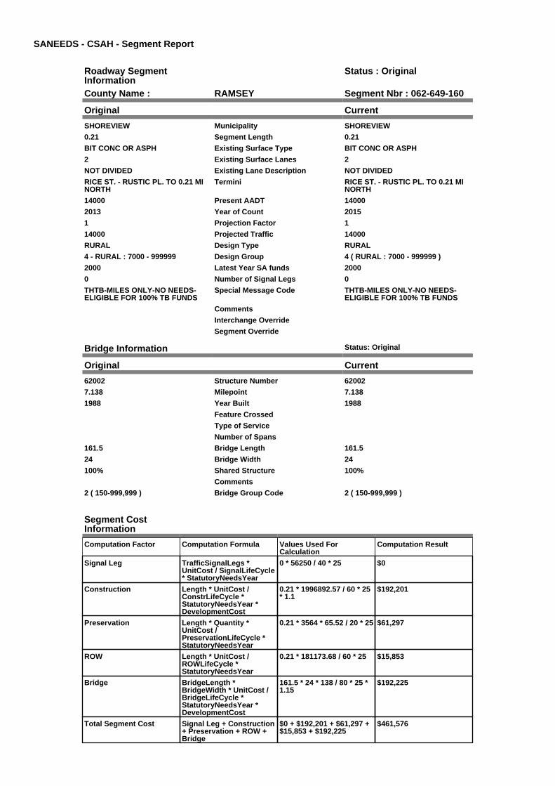
SANEEDS - CSAH - Segment Report
Roadway SegmentInformation
Status : Original
County Name : RAMSEY Segment Nbr : 062-649-160
Original Current
SHOREVIEW Municipality SHOREVIEW
0.21 Segment Length 0.21
BIT CONC OR ASPH Existing Surface Type BIT CONC OR ASPH
2 Existing Surface Lanes 2
NOT DIVIDED Existing Lane Description NOT DIVIDED
RICE ST. - RUSTIC PL. TO 0.21 MINORTH
Termini RICE ST. - RUSTIC PL. TO 0.21 MINORTH
14000 Present AADT 14000
2013 Year of Count 2015
1 Projection Factor 1
14000 Projected Traffic 14000
RURAL Design Type RURAL
4 - RURAL : 7000 - 999999 Design Group 4 ( RURAL : 7000 - 999999 )
2000 Latest Year SA funds 2000
0 Number of Signal Legs 0
THTB-MILES ONLY-NO NEEDS-ELIGIBLE FOR 100% TB FUNDS
Special Message Code THTB-MILES ONLY-NO NEEDS-ELIGIBLE FOR 100% TB FUNDS
Comments
Interchange Override
Segment Override
Bridge Information Status: Original
Original Current
62002 Structure Number 62002
7.138 Milepoint 7.138
1988 Year Built 1988
Feature Crossed
Type of Service
Number of Spans
161.5 Bridge Length 161.5
24 Bridge Width 24
100% Shared Structure 100%
Comments
2 ( 150-999,999 ) Bridge Group Code 2 ( 150-999,999 )
Segment CostInformation
Computation Factor Computation Formula Values Used ForCalculation
Computation Result
Signal Leg TrafficSignalLegs *UnitCost / SignalLifeCycle* StatutoryNeedsYear
0 * 56250 / 40 * 25 $0
Construction Length * UnitCost /ConstrLifeCycle *StatutoryNeedsYear *DevelopmentCost
0.21 * 1996892.57 / 60 * 25* 1.1
$192,201
Preservation Length * Quantity *UnitCost /PreservationLifeCycle *StatutoryNeedsYear
0.21 * 3564 * 65.52 / 20 * 25 $61,297
ROW Length * UnitCost /ROWLifeCycle *StatutoryNeedsYear
0.21 * 181173.68 / 60 * 25 $15,853
Bridge BridgeLength *BridgeWidth * UnitCost /BridgeLifeCycle *StatutoryNeedsYear *DevelopmentCost
161.5 * 24 * 138 / 80 * 25 *1.15
$192,225
Total Segment Cost Signal Leg + Construction+ Preservation + ROW +Bridge
$0 + $192,201 + $61,297 +$15,853 + $192,225
$461,576

SANEEDS - CSAH - Segment Report
Roadway SegmentInformation
Status : Original
County Name : RAMSEY Segment Nbr : 062-649-165
Original Current
VADNAIS HEIGHTS Municipality VADNAIS HEIGHTS
0.21 Segment Length 0.21
BIT CONC OR ASPH Existing Surface Type BIT CONC OR ASPH
2 Existing Surface Lanes 2
NOT DIVIDED Existing Lane Description NOT DIVIDED
RICE ST - 0.21 MI NO OF RUSTICPLACE TO GRAMSIE RD
Termini RICE ST - 0.21 MI NO OF RUSTICPLACE TO GRAMSIE RD
14000 Present AADT 14000
2013 Year of Count 2015
1 Projection Factor 1
14000 Projected Traffic 14000
RURAL Design Type RURAL
4 - RURAL : 7000 - 999999 Design Group 4 ( RURAL : 7000 - 999999 )
2000 Latest Year SA funds 2000
1 Number of Signal Legs 1
THTB-MILES ONLY-NO NEEDS-ELIGIBLE FOR 100% TB FUNDS
Special Message Code THTB-MILES ONLY-NO NEEDS-ELIGIBLE FOR 100% TB FUNDS
Comments
Interchange Override
Segment Override
Segment CostInformation
Computation Factor Computation Formula Values Used ForCalculation
Computation Result
Signal Leg TrafficSignalLegs *UnitCost / SignalLifeCycle* StatutoryNeedsYear
1 * 56250 / 40 * 25 $35,156
Construction Length * UnitCost /ConstrLifeCycle *StatutoryNeedsYear *DevelopmentCost
0.21 * 1996892.57 / 60 * 25* 1.1
$192,201
Preservation Length * Quantity *UnitCost /PreservationLifeCycle *StatutoryNeedsYear
0.21 * 3564 * 65.52 / 20 * 25 $61,297
ROW Length * UnitCost /ROWLifeCycle *StatutoryNeedsYear
0.21 * 181173.68 / 60 * 25 $15,853
Total Segment Cost Signal Leg + Construction+ Preservation + ROW
$35,156 + $192,201 +$61,297 + $15,853
$304,507

SANEEDS - CSAH - Segment Report
Roadway SegmentInformation
Status : Original
County Name : RAMSEY Segment Nbr : 062-649-170
Original Current
SHOREVIEW Municipality SHOREVIEW
0.95 Segment Length 0.95
BIT CONC OR ASPH Existing Surface Type BIT CONC OR ASPH
2 Existing Surface Lanes 2
NOT DIVIDED Existing Lane Description NOT DIVIDED
HODGSON RD. - GRAMSIE RD. TOSNAIL LAKE RD.
Termini HODGSON RD. - GRAMSIE RD. TOSNAIL LAKE RD.
11600 Present AADT 11600
2013 Year of Count 2015
1 Projection Factor 1
11600 Projected Traffic 11600
RURAL Design Type RURAL
4 - RURAL : 7000 - 999999 Design Group 4 ( RURAL : 7000 - 999999 )
2000 Latest Year SA funds 2000
2 Number of Signal Legs 2
THTB-MILES ONLY-NO NEEDS-ELIGIBLE FOR 100% TB FUNDS
Special Message Code THTB-MILES ONLY-NO NEEDS-ELIGIBLE FOR 100% TB FUNDS
Comments
Interchange Override
Segment Override
Segment CostInformation
Computation Factor Computation Formula Values Used ForCalculation
Computation Result
Signal Leg TrafficSignalLegs *UnitCost / SignalLifeCycle* StatutoryNeedsYear
2 * 56250 / 40 * 25 $70,313
Construction Length * UnitCost /ConstrLifeCycle *StatutoryNeedsYear *DevelopmentCost
0.95 * 1996892.57 / 60 * 25* 1.1
$869,480
Preservation Length * Quantity *UnitCost /PreservationLifeCycle *StatutoryNeedsYear
0.95 * 3564 * 65.52 / 20 * 25 $277,297
ROW Length * UnitCost /ROWLifeCycle *StatutoryNeedsYear
0.95 * 181173.68 / 60 * 25 $71,715
Total Segment Cost Signal Leg + Construction+ Preservation + ROW
$70,313 + $869,480 +$277,297 + $71,715
$1,288,805

SANEEDS - CSAH - Segment Report
Roadway SegmentInformation
Status : Original
County Name : RAMSEY Segment Nbr : 062-649-180
Original Current
SHOREVIEW Municipality SHOREVIEW
0.3 Segment Length 0.3
BIT CONC OR ASPH Existing Surface Type BIT CONC OR ASPH
2 Existing Surface Lanes 2
NOT DIVIDED Existing Lane Description NOT DIVIDED
HODGSON RD. - SNAIL LAKE RD.TO 560 FT SOUTH OF HWY 96
Termini HODGSON RD. - SNAIL LAKE RD.TO 560 FT SOUTH OF HWY 96
11600 Present AADT 11600
2013 Year of Count 2015
1 Projection Factor 1
11600 Projected Traffic 11600
RURAL Design Type RURAL
4 - RURAL : 7000 - 999999 Design Group 4 ( RURAL : 7000 - 999999 )
2000 Latest Year SA funds 2000
1 Number of Signal Legs 1
THTB-MILES ONLY-NO NEEDS-ELIGIBLE FOR 100% TB FUNDS
Special Message Code THTB-MILES ONLY-NO NEEDS-ELIGIBLE FOR 100% TB FUNDS
Comments
Interchange Override
Segment Override
Segment CostInformation
Computation Factor Computation Formula Values Used ForCalculation
Computation Result
Signal Leg TrafficSignalLegs *UnitCost / SignalLifeCycle* StatutoryNeedsYear
1 * 56250 / 40 * 25 $35,156
Construction Length * UnitCost /ConstrLifeCycle *StatutoryNeedsYear *DevelopmentCost
0.3 * 1996892.57 / 60 * 25 *1.1
$274,573
Preservation Length * Quantity *UnitCost /PreservationLifeCycle *StatutoryNeedsYear
0.3 * 3564 * 65.52 / 20 * 25 $87,567
ROW Length * UnitCost /ROWLifeCycle *StatutoryNeedsYear
0.3 * 181173.68 / 60 * 25 $22,647
Total Segment Cost Signal Leg + Construction+ Preservation + ROW
$35,156 + $274,573 +$87,567 + $22,647
$419,943

SANEEDS - CSAH - Segment Report
Roadway SegmentInformation
Status : Original
County Name : RAMSEY Segment Nbr : 062-649-185
Original Current
SHOREVIEW Municipality SHOREVIEW
0.11 Segment Length 0.11
MIXED BITUMINOUS Existing Surface Type MIXED BITUMINOUS
4 Existing Surface Lanes 4
NOT DIVIDED Existing Lane Description NOT DIVIDED
560' S OF HWY 96 TO HWY 96 Termini 560' S OF HWY 96 TO HWY 96
11600 Present AADT 11600
2013 Year of Count 2015
1 Projection Factor 1
11600 Projected Traffic 11600
RURAL Design Type RURAL
4 - RURAL : 7000 - 999999 Design Group 4 ( RURAL : 7000 - 999999 )
2002 Latest Year SA funds 2002
1 Number of Signal Legs 1
THTB-RECONSTRUCTED WITH TBFUNDS
Special Message Code THTB-RECONSTRUCTED WITH TBFUNDS
SPLIT THE SEGMENT TO KEEPCORRECT MILEAGE INSHOREVIEW
Comments SPLIT THE SEGMENT TO KEEPCORRECT MILEAGE INSHOREVIEW
Interchange Override
Segment Override
Segment CostInformation
Computation Factor Computation Formula Values Used ForCalculation
Computation Result
Signal Leg TrafficSignalLegs *UnitCost / SignalLifeCycle* StatutoryNeedsYear
1 * 56250 / 40 * 25 $35,156
Construction Length * UnitCost /ConstrLifeCycle *StatutoryNeedsYear *DevelopmentCost
0.11 * 1996892.57 / 60 * 25* 1.1
$100,677
Preservation Length * Quantity *UnitCost /PreservationLifeCycle *StatutoryNeedsYear
0.11 * 3564 * 65.52 / 20 * 25 $32,108
ROW Length * UnitCost /ROWLifeCycle *StatutoryNeedsYear
0.11 * 181173.68 / 60 * 25 $8,304
Total Segment Cost Signal Leg + Construction+ Preservation + ROW
$35,156 + $100,677 +$32,108 + $8,304
$176,245

SANEEDS - CSAH - Segment Report
Roadway SegmentInformation
Status : Original
County Name : RAMSEY Segment Nbr : 062-649-190
Original Current
NORTH OAKS Municipality NORTH OAKS
0.13 Segment Length 0.13
MIXED BITUMINOUS Existing Surface Type MIXED BITUMINOUS
4 Existing Surface Lanes 4
DIVIDED Existing Lane Description DIVIDED
HWY 96 TO 0.13 MI NORTH Termini HWY 96 TO 0.13 MI NORTH
14100 Present AADT 14100
2013 Year of Count 2015
1 Projection Factor 1
14100 Projected Traffic 14100
RURAL Design Type RURAL
4 - RURAL : 7000 - 999999 Design Group 4 ( RURAL : 7000 - 999999 )
2002 Latest Year SA funds 2002
1 Number of Signal Legs 1
THTB-RECONSTRUCTED WITH TBFUNDS
Special Message Code THTB-RECONSTRUCTED WITH TBFUNDS
Comments
Interchange Override
Segment Override
Segment CostInformation
Computation Factor Computation Formula Values Used ForCalculation
Computation Result
Signal Leg TrafficSignalLegs *UnitCost / SignalLifeCycle* StatutoryNeedsYear
1 * 56250 / 40 * 25 $35,156
Construction Length * UnitCost /ConstrLifeCycle *StatutoryNeedsYear *DevelopmentCost
0.13 * 1996892.57 / 60 * 25* 1.1
$118,982
Preservation Length * Quantity *UnitCost /PreservationLifeCycle *StatutoryNeedsYear
0.13 * 3564 * 65.52 / 20 * 25 $37,946
ROW Length * UnitCost /ROWLifeCycle *StatutoryNeedsYear
0.13 * 181173.68 / 60 * 25 $9,814
Total Segment Cost Signal Leg + Construction+ Preservation + ROW
$35,156 + $118,982 +$37,946 + $9,814
$201,898

SANEEDS - CSAH - Segment Report
Roadway SegmentInformation
Status : Original
County Name : RAMSEY Segment Nbr : 062-649-195
Original Current
SHOREVIEW Municipality SHOREVIEW
0.54 Segment Length 0.54
BIT CONC OR ASPH Existing Surface Type BIT CONC OR ASPH
2 Existing Surface Lanes 2
NOT DIVIDED Existing Lane Description NOT DIVIDED
HODGSON RD - 0.13 MILES N OF96 TO N LIM SHOREVIEW.
Termini HODGSON RD - 0.13 MILES N OF96 TO N LIM SHOREVIEW.
14100 Present AADT 14100
2013 Year of Count 2015
1 Projection Factor 1
14100 Projected Traffic 14100
URBAN Design Type URBAN
6 - URBAN : 10000 - 19999 Design Group 6 ( URBAN : 10000 - 19999 )
2002 Latest Year SA funds 2002
2 Number of Signal Legs 2
THTB-RECONSTRUCTED WITH TBFUNDS
Special Message Code THTB-RECONSTRUCTED WITH TBFUNDS
Comments
Interchange Override
Segment Override
Segment CostInformation
Computation Factor Computation Formula Values Used ForCalculation
Computation Result
Signal Leg TrafficSignalLegs *UnitCost / SignalLifeCycle* StatutoryNeedsYear
2 * 56250 / 40 * 25 $70,313
Construction Length * UnitCost /ConstrLifeCycle *StatutoryNeedsYear *DevelopmentCost
0.54 * 4225495.41 / 60 * 25* 1.15
$1,093,347
Preservation Length * Quantity *UnitCost /PreservationLifeCycle *StatutoryNeedsYear
0.54 * 3696 * 65.52 / 15 * 25 $217,946
ROW Length * UnitCost /ROWLifeCycle *StatutoryNeedsYear
0.54 * 566370.18 / 60 * 25 $127,433
Total Segment Cost Signal Leg + Construction+ Preservation + ROW
$70,313 + $1,093,347 +$217,946 + $127,433
$1,509,039

SANEEDS - CSAH - Segment Report
Roadway SegmentInformation
Status : Original
County Name : RAMSEY Segment Nbr : 062-649-200
Original Current
NORTH OAKS Municipality NORTH OAKS
0.66 Segment Length 0.66
BIT CONC OR ASPH Existing Surface Type BIT CONC OR ASPH
2 Existing Surface Lanes 2
NOT DIVIDED Existing Lane Description NOT DIVIDED
HODGSON RD. - N LIMSHOREVIEW TO BIRCH LN NORTH
Termini HODGSON RD. - N LIMSHOREVIEW TO BIRCH LN NORTH
12200 Present AADT 12200
2013 Year of Count 2015
1 Projection Factor 1
12200 Projected Traffic 12200
URBAN Design Type URBAN
6 - URBAN : 10000 - 19999 Design Group 6 ( URBAN : 10000 - 19999 )
2002 Latest Year SA funds 2002
2 Number of Signal Legs 2
THTB-RECONSTRUCTED WITH TBFUNDS
Special Message Code THTB-RECONSTRUCTED WITH TBFUNDS
Comments
Interchange Override
Segment Override
Segment CostInformation
Computation Factor Computation Formula Values Used ForCalculation
Computation Result
Signal Leg TrafficSignalLegs *UnitCost / SignalLifeCycle* StatutoryNeedsYear
2 * 56250 / 40 * 25 $70,313
Construction Length * UnitCost /ConstrLifeCycle *StatutoryNeedsYear *DevelopmentCost
0.66 * 4225495.41 / 60 * 25* 1.15
$1,336,313
Preservation Length * Quantity *UnitCost /PreservationLifeCycle *StatutoryNeedsYear
0.66 * 3696 * 65.52 / 15 * 25 $266,378
ROW Length * UnitCost /ROWLifeCycle *StatutoryNeedsYear
0.66 * 566370.18 / 60 * 25 $155,752
Total Segment Cost Signal Leg + Construction+ Preservation + ROW
$70,313 + $1,336,313 +$266,378 + $155,752
$1,828,756

SANEEDS - CSAH - Segment Report
Roadway SegmentInformation
Status : Original
County Name : RAMSEY Segment Nbr : 062-649-203
Original Current
NORTH OAKS Municipality NORTH OAKS
0.07 Segment Length 0.07
BIT CONC OR ASPH Existing Surface Type BIT CONC OR ASPH
2 Existing Surface Lanes 2
NOT DIVIDED Existing Lane Description NOT DIVIDED
HODGSON RD. - BIRCH LANENORTH TO 0.73 MI S OF COUNTYRD. I
Termini HODGSON RD. - BIRCH LANENORTH TO 0.73 MI S OF COUNTYRD. I
12200 Present AADT 12200
2013 Year of Count 2015
1 Projection Factor 1
12200 Projected Traffic 12200
RURAL Design Type RURAL
4 - RURAL : 7000 - 999999 Design Group 4 ( RURAL : 7000 - 999999 )
2000 Latest Year SA funds 2000
0 Number of Signal Legs 0
THTB-MILES ONLY-NO NEEDS-ELIGIBLE FOR 100% TB FUNDS
Special Message Code THTB-MILES ONLY-NO NEEDS-ELIGIBLE FOR 100% TB FUNDS
Comments
Interchange Override
Segment Override
Segment CostInformation
Computation Factor Computation Formula Values Used ForCalculation
Computation Result
Signal Leg TrafficSignalLegs *UnitCost / SignalLifeCycle* StatutoryNeedsYear
0 * 56250 / 40 * 25 $0
Construction Length * UnitCost /ConstrLifeCycle *StatutoryNeedsYear *DevelopmentCost
0.07 * 1996892.57 / 60 * 25* 1.1
$64,067
Preservation Length * Quantity *UnitCost /PreservationLifeCycle *StatutoryNeedsYear
0.07 * 3564 * 65.52 / 20 * 25 $20,432
ROW Length * UnitCost /ROWLifeCycle *StatutoryNeedsYear
0.07 * 181173.68 / 60 * 25 $5,284
Total Segment Cost Signal Leg + Construction+ Preservation + ROW
$0 + $64,067 + $20,432 +$5,284
$89,783

SANEEDS - CSAH - Segment Report
Roadway SegmentInformation
Status : Original
County Name : RAMSEY Segment Nbr : 062-649-205
Original Current
SHOREVIEW Municipality SHOREVIEW
0.73 Segment Length 0.73
BIT CONC OR ASPH Existing Surface Type BIT CONC OR ASPH
2 Existing Surface Lanes 2
NOT DIVIDED Existing Lane Description NOT DIVIDED
HODGSON RD - 0.73 MI S TOCOUNTY RD I
Termini HODGSON RD - 0.73 MI S TOCOUNTY RD I
12200 Present AADT 12200
2013 Year of Count 2015
1 Projection Factor 1
12200 Projected Traffic 12200
RURAL Design Type RURAL
4 - RURAL : 7000 - 999999 Design Group 4 ( RURAL : 7000 - 999999 )
2000 Latest Year SA funds 2000
1 Number of Signal Legs 1
THTB-MILES ONLY-NO NEEDS-ELIGIBLE FOR 100% TB FUNDS
Special Message Code THTB-MILES ONLY-NO NEEDS-ELIGIBLE FOR 100% TB FUNDS
Comments
Interchange Override
Segment Override
Segment CostInformation
Computation Factor Computation Formula Values Used ForCalculation
Computation Result
Signal Leg TrafficSignalLegs *UnitCost / SignalLifeCycle* StatutoryNeedsYear
1 * 56250 / 40 * 25 $35,156
Construction Length * UnitCost /ConstrLifeCycle *StatutoryNeedsYear *DevelopmentCost
0.73 * 1996892.57 / 60 * 25* 1.1
$668,127
Preservation Length * Quantity *UnitCost /PreservationLifeCycle *StatutoryNeedsYear
0.73 * 3564 * 65.52 / 20 * 25 $213,081
ROW Length * UnitCost /ROWLifeCycle *StatutoryNeedsYear
0.73 * 181173.68 / 60 * 25 $55,107
Total Segment Cost Signal Leg + Construction+ Preservation + ROW
$35,156 + $668,127 +$213,081 + $55,107
$971,471
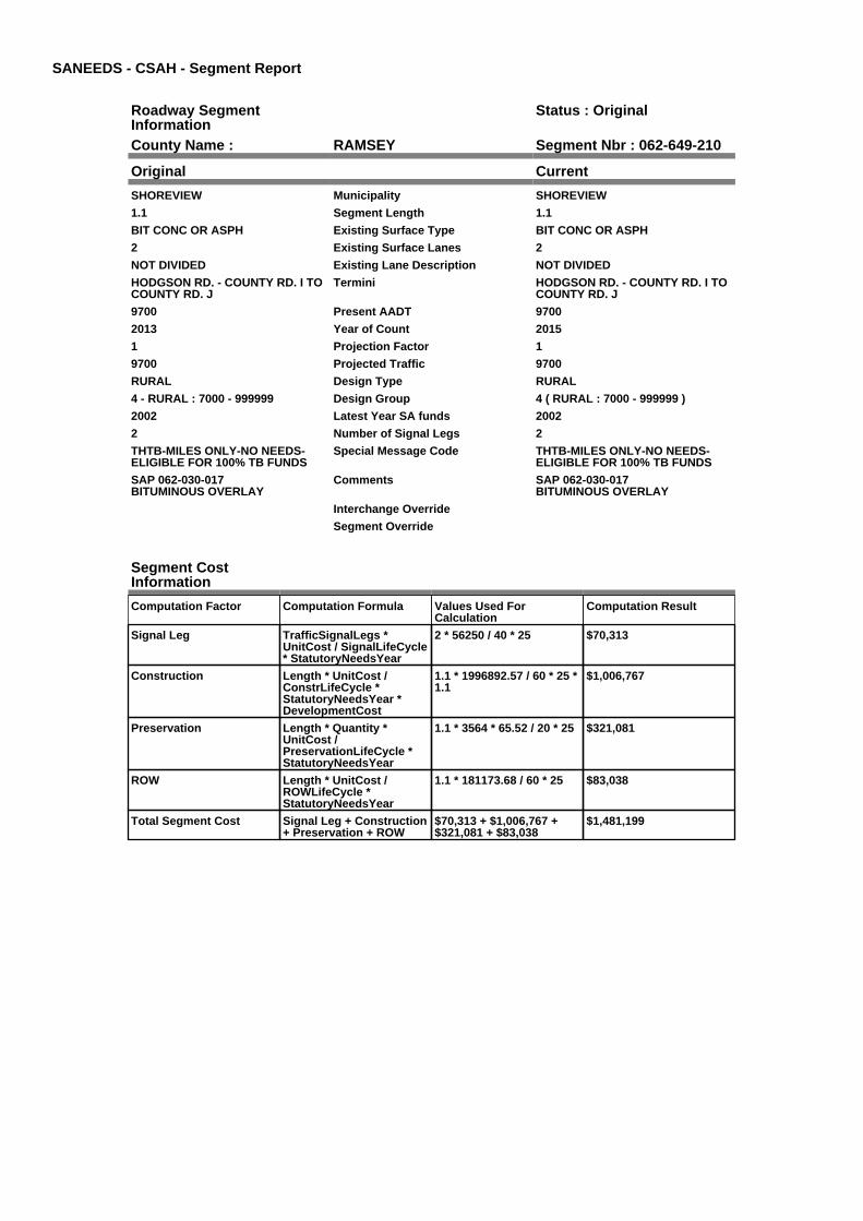
SANEEDS - CSAH - Segment Report
Roadway SegmentInformation
Status : Original
County Name : RAMSEY Segment Nbr : 062-649-210
Original Current
SHOREVIEW Municipality SHOREVIEW
1.1 Segment Length 1.1
BIT CONC OR ASPH Existing Surface Type BIT CONC OR ASPH
2 Existing Surface Lanes 2
NOT DIVIDED Existing Lane Description NOT DIVIDED
HODGSON RD. - COUNTY RD. I TOCOUNTY RD. J
Termini HODGSON RD. - COUNTY RD. I TOCOUNTY RD. J
9700 Present AADT 9700
2013 Year of Count 2015
1 Projection Factor 1
9700 Projected Traffic 9700
RURAL Design Type RURAL
4 - RURAL : 7000 - 999999 Design Group 4 ( RURAL : 7000 - 999999 )
2002 Latest Year SA funds 2002
2 Number of Signal Legs 2
THTB-MILES ONLY-NO NEEDS-ELIGIBLE FOR 100% TB FUNDS
Special Message Code THTB-MILES ONLY-NO NEEDS-ELIGIBLE FOR 100% TB FUNDS
SAP 062-030-017BITUMINOUS OVERLAY
Comments SAP 062-030-017BITUMINOUS OVERLAY
Interchange Override
Segment Override
Segment CostInformation
Computation Factor Computation Formula Values Used ForCalculation
Computation Result
Signal Leg TrafficSignalLegs *UnitCost / SignalLifeCycle* StatutoryNeedsYear
2 * 56250 / 40 * 25 $70,313
Construction Length * UnitCost /ConstrLifeCycle *StatutoryNeedsYear *DevelopmentCost
1.1 * 1996892.57 / 60 * 25 *1.1
$1,006,767
Preservation Length * Quantity *UnitCost /PreservationLifeCycle *StatutoryNeedsYear
1.1 * 3564 * 65.52 / 20 * 25 $321,081
ROW Length * UnitCost /ROWLifeCycle *StatutoryNeedsYear
1.1 * 181173.68 / 60 * 25 $83,038
Total Segment Cost Signal Leg + Construction+ Preservation + ROW
$70,313 + $1,006,767 +$321,081 + $83,038
$1,481,199

SANEEDS - CSAH - Segment Report
Roadway SegmentInformation
Status : Original
County Name : RAMSEY Segment Nbr : 062-650-010
Original Current
FALCON HEIGHTS Municipality FALCON HEIGHTS
0.25 Segment Length 0.25
BIT CONC OR ASPH Existing Surface Type BIT CONC OR ASPH
4 Existing Surface Lanes 4
NOT DIVIDED Existing Lane Description NOT DIVIDED
LARPENTEUR AVE. TO GARDENAVE.
Termini LARPENTEUR AVE. TO GARDENAVE.
6700 Present AADT 6700
2013 Year of Count 2015
1 Projection Factor 1
6700 Projected Traffic 6700
URBAN Design Type URBAN
5 - URBAN : 0 - 9999 Design Group 5 ( URBAN : 0 - 9999 )
1991 Latest Year SA funds 1991
1 Number of Signal Legs 1
No Special Message Special Message Code No Special Message
Comments
Interchange Override
Segment Override
Segment CostInformation
Computation Factor Computation Formula Values Used ForCalculation
Computation Result
Signal Leg TrafficSignalLegs *UnitCost / SignalLifeCycle* StatutoryNeedsYear
1 * 56250 / 40 * 25 $35,156
Construction Length * UnitCost /ConstrLifeCycle *StatutoryNeedsYear *DevelopmentCost
0.25 * 2738635.28 / 60 * 25* 1.15
$328,066
Preservation Length * Quantity *UnitCost /PreservationLifeCycle *StatutoryNeedsYear
0.25 * 2904 * 65.52 / 15 * 25 $79,279
ROW Length * UnitCost /ROWLifeCycle *StatutoryNeedsYear
0.25 * 436504.07 / 60 * 25 $45,469
Total Segment Cost Signal Leg + Construction+ Preservation + ROW
$35,156 + $328,066 +$79,279 + $45,469
$487,970

SANEEDS - CSAH - Segment Report
Roadway SegmentInformation
Status : Original
County Name : RAMSEY Segment Nbr : 062-650-020
Original Current
ROSEVILLE Municipality ROSEVILLE
0.25 Segment Length 0.25
BIT CONC OR ASPH Existing Surface Type BIT CONC OR ASPH
4 Existing Surface Lanes 4
NOT DIVIDED Existing Lane Description NOT DIVIDED
GARDEN AVE TO ROSELAWNAVE.
Termini GARDEN AVE TO ROSELAWNAVE.
6700 Present AADT 6700
2013 Year of Count 2015
1 Projection Factor 1
6700 Projected Traffic 6700
URBAN Design Type URBAN
5 - URBAN : 0 - 9999 Design Group 5 ( URBAN : 0 - 9999 )
1991 Latest Year SA funds 1991
0 Number of Signal Legs 0
No Special Message Special Message Code No Special Message
Comments
Interchange Override
Segment Override
Segment CostInformation
Computation Factor Computation Formula Values Used ForCalculation
Computation Result
Signal Leg TrafficSignalLegs *UnitCost / SignalLifeCycle* StatutoryNeedsYear
0 * 56250 / 40 * 25 $0
Construction Length * UnitCost /ConstrLifeCycle *StatutoryNeedsYear *DevelopmentCost
0.25 * 2738635.28 / 60 * 25* 1.15
$328,066
Preservation Length * Quantity *UnitCost /PreservationLifeCycle *StatutoryNeedsYear
0.25 * 2904 * 65.52 / 15 * 25 $79,279
ROW Length * UnitCost /ROWLifeCycle *StatutoryNeedsYear
0.25 * 436504.07 / 60 * 25 $45,469
Total Segment Cost Signal Leg + Construction+ Preservation + ROW
$0 + $328,066 + $79,279 +$45,469
$452,814

SANEEDS - CSAH - Segment Report
Roadway SegmentInformation
Status : Original
County Name : RAMSEY Segment Nbr : 062-650-030
Original Current
ROSEVILLE Municipality ROSEVILLE
0.5 Segment Length 0.5
BIT CONC OR ASPH Existing Surface Type BIT CONC OR ASPH
4 Existing Surface Lanes 4
NOT DIVIDED Existing Lane Description NOT DIVIDED
ROSELAWN AVE. TO CO. RD. B Termini ROSELAWN AVE. TO CO. RD. B
8100 Present AADT 8100
2013 Year of Count 2015
1 Projection Factor 1
8100 Projected Traffic 8100
URBAN Design Type URBAN
5 - URBAN : 0 - 9999 Design Group 5 ( URBAN : 0 - 9999 )
1991 Latest Year SA funds 1991
1 Number of Signal Legs 1
No Special Message Special Message Code No Special Message
Comments
Interchange Override
Segment Override
Segment CostInformation
Computation Factor Computation Formula Values Used ForCalculation
Computation Result
Signal Leg TrafficSignalLegs *UnitCost / SignalLifeCycle* StatutoryNeedsYear
1 * 56250 / 40 * 25 $35,156
Construction Length * UnitCost /ConstrLifeCycle *StatutoryNeedsYear *DevelopmentCost
0.5 * 2738635.28 / 60 * 25 *1.15
$656,131
Preservation Length * Quantity *UnitCost /PreservationLifeCycle *StatutoryNeedsYear
0.5 * 2904 * 65.52 / 15 * 25 $158,558
ROW Length * UnitCost /ROWLifeCycle *StatutoryNeedsYear
0.5 * 436504.07 / 60 * 25 $90,938
Total Segment Cost Signal Leg + Construction+ Preservation + ROW
$35,156 + $656,131 +$158,558 + $90,938
$940,783

SANEEDS - CSAH - Segment Report
Roadway SegmentInformation
Status : Original
County Name : RAMSEY Segment Nbr : 062-650-035
Original Current
ROSEVILLE Municipality ROSEVILLE
0.5 Segment Length 0.5
BIT CONC OR ASPH Existing Surface Type BIT CONC OR ASPH
4 Existing Surface Lanes 4
NOT DIVIDED Existing Lane Description NOT DIVIDED
CO. RD. B TO CO. RD. B2 Termini CO. RD. B TO CO. RD. B2
12000 Present AADT 12000
2013 Year of Count 2015
1 Projection Factor 1
12000 Projected Traffic 12000
URBAN Design Type URBAN
6 - URBAN : 10000 - 19999 Design Group 6 ( URBAN : 10000 - 19999 )
1994 Latest Year SA funds 1994
6 Number of Signal Legs 6
No Special Message Special Message Code No Special Message
Comments
Interchange Override
Segment Override
Segment CostInformation
Computation Factor Computation Formula Values Used ForCalculation
Computation Result
Signal Leg TrafficSignalLegs *UnitCost / SignalLifeCycle* StatutoryNeedsYear
6 * 56250 / 40 * 25 $210,938
Construction Length * UnitCost /ConstrLifeCycle *StatutoryNeedsYear *DevelopmentCost
0.5 * 4225495.41 / 60 * 25 *1.15
$1,012,358
Preservation Length * Quantity *UnitCost /PreservationLifeCycle *StatutoryNeedsYear
0.5 * 3696 * 65.52 / 15 * 25 $201,802
ROW Length * UnitCost /ROWLifeCycle *StatutoryNeedsYear
0.5 * 566370.18 / 60 * 25 $117,994
Total Segment Cost Signal Leg + Construction+ Preservation + ROW
$210,938 + $1,012,358 +$201,802 + $117,994
$1,543,092

SANEEDS - CSAH - Segment Report
Roadway SegmentInformation
Status : Original
County Name : RAMSEY Segment Nbr : 062-650-040
Original Current
ROSEVILLE Municipality ROSEVILLE
0.49 Segment Length 0.49
BIT CONC OR ASPH Existing Surface Type BIT CONC OR ASPH
4 Existing Surface Lanes 4
NOT DIVIDED Existing Lane Description NOT DIVIDED
CO. RD. B2 TO CO. RD. C Termini CO. RD. B2 TO CO. RD. C
8100 Present AADT 8100
2013 Year of Count 2015
1 Projection Factor 1
8100 Projected Traffic 8100
URBAN Design Type URBAN
5 - URBAN : 0 - 9999 Design Group 5 ( URBAN : 0 - 9999 )
1994 Latest Year SA funds 1994
2 Number of Signal Legs 2
No Special Message Special Message Code No Special Message
Comments
Interchange Override
Segment Override
Segment CostInformation
Computation Factor Computation Formula Values Used ForCalculation
Computation Result
Signal Leg TrafficSignalLegs *UnitCost / SignalLifeCycle* StatutoryNeedsYear
2 * 56250 / 40 * 25 $70,313
Construction Length * UnitCost /ConstrLifeCycle *StatutoryNeedsYear *DevelopmentCost
0.49 * 2738635.28 / 60 * 25* 1.15
$643,009
Preservation Length * Quantity *UnitCost /PreservationLifeCycle *StatutoryNeedsYear
0.49 * 2904 * 65.52 / 15 * 25 $155,387
ROW Length * UnitCost /ROWLifeCycle *StatutoryNeedsYear
0.49 * 436504.07 / 60 * 25 $89,120
Total Segment Cost Signal Leg + Construction+ Preservation + ROW
$70,313 + $643,009 +$155,387 + $89,120
$957,829
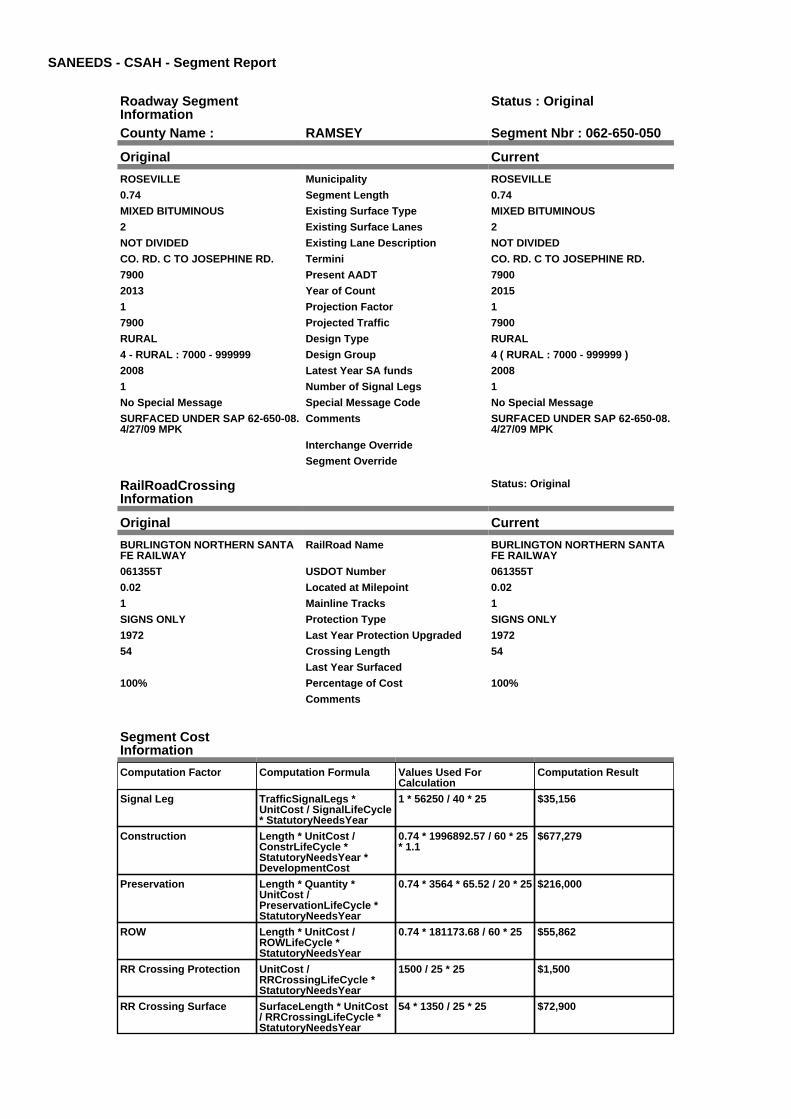
SANEEDS - CSAH - Segment Report
Roadway SegmentInformation
Status : Original
County Name : RAMSEY Segment Nbr : 062-650-050
Original Current
ROSEVILLE Municipality ROSEVILLE
0.74 Segment Length 0.74
MIXED BITUMINOUS Existing Surface Type MIXED BITUMINOUS
2 Existing Surface Lanes 2
NOT DIVIDED Existing Lane Description NOT DIVIDED
CO. RD. C TO JOSEPHINE RD. Termini CO. RD. C TO JOSEPHINE RD.
7900 Present AADT 7900
2013 Year of Count 2015
1 Projection Factor 1
7900 Projected Traffic 7900
RURAL Design Type RURAL
4 - RURAL : 7000 - 999999 Design Group 4 ( RURAL : 7000 - 999999 )
2008 Latest Year SA funds 2008
1 Number of Signal Legs 1
No Special Message Special Message Code No Special Message
SURFACED UNDER SAP 62-650-08.4/27/09 MPK
Comments SURFACED UNDER SAP 62-650-08.4/27/09 MPK
Interchange Override
Segment Override
RailRoadCrossingInformation
Status: Original
Original Current
BURLINGTON NORTHERN SANTAFE RAILWAY
RailRoad Name BURLINGTON NORTHERN SANTAFE RAILWAY
061355T USDOT Number 061355T
0.02 Located at Milepoint 0.02
1 Mainline Tracks 1
SIGNS ONLY Protection Type SIGNS ONLY
1972 Last Year Protection Upgraded 1972
54 Crossing Length 54
Last Year Surfaced
100% Percentage of Cost 100%
Comments
Segment CostInformation
Computation Factor Computation Formula Values Used ForCalculation
Computation Result
Signal Leg TrafficSignalLegs *UnitCost / SignalLifeCycle* StatutoryNeedsYear
1 * 56250 / 40 * 25 $35,156
Construction Length * UnitCost /ConstrLifeCycle *StatutoryNeedsYear *DevelopmentCost
0.74 * 1996892.57 / 60 * 25* 1.1
$677,279
Preservation Length * Quantity *UnitCost /PreservationLifeCycle *StatutoryNeedsYear
0.74 * 3564 * 65.52 / 20 * 25 $216,000
ROW Length * UnitCost /ROWLifeCycle *StatutoryNeedsYear
0.74 * 181173.68 / 60 * 25 $55,862
RR Crossing Protection UnitCost /RRCrossingLifeCycle *StatutoryNeedsYear
1500 / 25 * 25 $1,500
RR Crossing Surface SurfaceLength * UnitCost/ RRCrossingLifeCycle *StatutoryNeedsYear
54 * 1350 / 25 * 25 $72,900

Total Segment Cost Signal Leg + Construction+ Preservation + ROW +RR Crossing Protection +RR Crossing Surface
$35,156 + $677,279 +$216,000 + $55,862 +$1,500 + $72,900
$1,058,697

SANEEDS - CSAH - Segment Report
Roadway SegmentInformation
Status : Original
County Name : RAMSEY Segment Nbr : 062-650-051
Original Current
ROSEVILLE Municipality ROSEVILLE
0.35 Segment Length 0.35
MIXED BITUMINOUS Existing Surface Type MIXED BITUMINOUS
2 Existing Surface Lanes 2
NOT DIVIDED Existing Lane Description NOT DIVIDED
JOSEPHINE ROAD TO NO LIMROSEVILLE
Termini JOSEPHINE ROAD TO NO LIMROSEVILLE
4000 Present AADT 4000
2013 Year of Count 2015
1 Projection Factor 1
4000 Projected Traffic 4000
RURAL Design Type RURAL
3 - RURAL : 1500 - 6999 Design Group 3 ( RURAL : 1500 - 6999 )
2008 Latest Year SA funds 2008
0 Number of Signal Legs 0
No Special Message Special Message Code No Special Message
SURFACED UNDER SAP 62-650-08.4/27/09 MPK
Comments SURFACED UNDER SAP 62-650-08.4/27/09 MPK
Interchange Override
Segment Override
Segment CostInformation
Computation Factor Computation Formula Values Used ForCalculation
Computation Result
Signal Leg TrafficSignalLegs *UnitCost / SignalLifeCycle* StatutoryNeedsYear
0 * 56250 / 40 * 25 $0
Construction Length * UnitCost /ConstrLifeCycle *StatutoryNeedsYear *DevelopmentCost
0.35 * 1021937.01 / 60 * 25* 1.1
$163,936
Preservation Length * Quantity *UnitCost /PreservationLifeCycle *StatutoryNeedsYear
0.35 * 2376 * 65.52 / 20 * 25 $68,108
ROW Length * UnitCost /ROWLifeCycle *StatutoryNeedsYear
0.35 * 85357.87 / 60 * 25 $12,448
Total Segment Cost Signal Leg + Construction+ Preservation + ROW
$0 + $163,936 + $68,108 +$12,448
$244,492

SANEEDS - CSAH - Segment Report
Roadway SegmentInformation
Status : Original
County Name : RAMSEY Segment Nbr : 062-650-060
Original Current
ARDEN HILLS Municipality ARDEN HILLS
0.14 Segment Length 0.14
MIXED BITUMINOUS Existing Surface Type MIXED BITUMINOUS
2 Existing Surface Lanes 2
NOT DIVIDED Existing Lane Description NOT DIVIDED
S LIM ARDEN HILLS TO TH 51 Termini S LIM ARDEN HILLS TO TH 51
4000 Present AADT 4000
2013 Year of Count 2015
1 Projection Factor 1
4000 Projected Traffic 4000
RURAL Design Type RURAL
3 - RURAL : 1500 - 6999 Design Group 3 ( RURAL : 1500 - 6999 )
2008 Latest Year SA funds 2008
0 Number of Signal Legs 0
No Special Message Special Message Code No Special Message
SURFACED UNDER SAP 62-650-08.4/27/09 MPK
Comments SURFACED UNDER SAP 62-650-08.4/27/09 MPK
Interchange Override
Segment Override
Segment CostInformation
Computation Factor Computation Formula Values Used ForCalculation
Computation Result
Signal Leg TrafficSignalLegs *UnitCost / SignalLifeCycle* StatutoryNeedsYear
0 * 56250 / 40 * 25 $0
Construction Length * UnitCost /ConstrLifeCycle *StatutoryNeedsYear *DevelopmentCost
0.14 * 1021937.01 / 60 * 25* 1.1
$65,574
Preservation Length * Quantity *UnitCost /PreservationLifeCycle *StatutoryNeedsYear
0.14 * 2376 * 65.52 / 20 * 25 $27,243
ROW Length * UnitCost /ROWLifeCycle *StatutoryNeedsYear
0.14 * 85357.87 / 60 * 25 $4,979
Total Segment Cost Signal Leg + Construction+ Preservation + ROW
$0 + $65,574 + $27,243 +$4,979
$97,796

SANEEDS - CSAH - Segment Report
Roadway SegmentInformation
Status : Original
County Name : RAMSEY Segment Nbr : 062-650-063
Original Current
ARDEN HILLS Municipality ARDEN HILLS
0.26 Segment Length 0.26
BIT CONC OR ASPH Existing Surface Type BIT CONC OR ASPH
2 Existing Surface Lanes 2
NOT DIVIDED Existing Lane Description NOT DIVIDED
HAMLINE AVE. - FLORAL DR TO0.15 MI NORTH
Termini HAMLINE AVE. - FLORAL DR TO0.15 MI NORTH
10300 Present AADT 10300
2013 Year of Count 2015
1 Projection Factor 1
10300 Projected Traffic 10300
URBAN Design Type URBAN
6 - URBAN : 10000 - 19999 Design Group 6 ( URBAN : 10000 - 19999 )
2012 Latest Year SA funds 2012
4 Number of Signal Legs 4
No Special Message Special Message Code No Special Message
RECONSTRUCT WITH FAI 694PROJECT
Comments RECONSTRUCT WITH FAI 694PROJECT
Interchange Override
Segment Override
Segment CostInformation
Computation Factor Computation Formula Values Used ForCalculation
Computation Result
Signal Leg TrafficSignalLegs *UnitCost / SignalLifeCycle* StatutoryNeedsYear
4 * 56250 / 40 * 25 $140,625
Construction Length * UnitCost /ConstrLifeCycle *StatutoryNeedsYear *DevelopmentCost
0.26 * 4225495.41 / 60 * 25* 1.15
$526,426
Preservation Length * Quantity *UnitCost /PreservationLifeCycle *StatutoryNeedsYear
0.26 * 3696 * 65.52 / 15 * 25 $104,937
ROW Length * UnitCost /ROWLifeCycle *StatutoryNeedsYear
0.26 * 566370.18 / 60 * 25 $61,357
Total Segment Cost Signal Leg + Construction+ Preservation + ROW
$140,625 + $526,426 +$104,937 + $61,357
$833,345

SANEEDS - CSAH - Segment Report
Roadway SegmentInformation
Status : Original
County Name : RAMSEY Segment Nbr : 062-650-067
Original Current
ARDEN HILLS Municipality ARDEN HILLS
0.74 Segment Length 0.74
BIT CONC OR ASPH Existing Surface Type BIT CONC OR ASPH
4 Existing Surface Lanes 4
NOT DIVIDED Existing Lane Description NOT DIVIDED
HAMLINE AVE. - FLORAL DR TOCSAH 96
Termini HAMLINE AVE. - FLORAL DR TOCSAH 96
10300 Present AADT 10300
2013 Year of Count 2015
1 Projection Factor 1
10300 Projected Traffic 10300
URBAN Design Type URBAN
6 - URBAN : 10000 - 19999 Design Group 6 ( URBAN : 10000 - 19999 )
2001 Latest Year SA funds 2001
1 Number of Signal Legs 1
No Special Message Special Message Code No Special Message
Comments
Interchange Override
Segment Override
Segment CostInformation
Computation Factor Computation Formula Values Used ForCalculation
Computation Result
Signal Leg TrafficSignalLegs *UnitCost / SignalLifeCycle* StatutoryNeedsYear
1 * 56250 / 40 * 25 $35,156
Construction Length * UnitCost /ConstrLifeCycle *StatutoryNeedsYear *DevelopmentCost
0.74 * 4225495.41 / 60 * 25* 1.15
$1,498,290
Preservation Length * Quantity *UnitCost /PreservationLifeCycle *StatutoryNeedsYear
0.74 * 3696 * 65.52 / 15 * 25 $298,666
ROW Length * UnitCost /ROWLifeCycle *StatutoryNeedsYear
0.74 * 566370.18 / 60 * 25 $174,631
Total Segment Cost Signal Leg + Construction+ Preservation + ROW
$35,156 + $1,498,290 +$298,666 + $174,631
$2,006,743

SANEEDS - CSAH - Segment Report
Roadway SegmentInformation
Status : Original
County Name : RAMSEY Segment Nbr : 062-650-070
Original Current
SHOREVIEW Municipality SHOREVIEW
0.12 Segment Length 0.12
MIXED BITUMINOUS Existing Surface Type MIXED BITUMINOUS
2 Existing Surface Lanes 2
NOT DIVIDED Existing Lane Description NOT DIVIDED
CO. RD. I W. BOUND TO CO. RD. IEAST BOUND
Termini CO. RD. I W. BOUND TO CO. RD. IEAST BOUND
6200 Present AADT 6200
2013 Year of Count 2015
1 Projection Factor 1
6200 Projected Traffic 6200
RURAL Design Type RURAL
3 - RURAL : 1500 - 6999 Design Group 3 ( RURAL : 1500 - 6999 )
2005 Latest Year SA funds 2005
0 Number of Signal Legs 0
No Special Message Special Message Code No Special Message
CONST. SAP 62-650-06, 2005 Comments CONST. SAP 62-650-06, 2005
Interchange Override
Segment Override
Segment CostInformation
Computation Factor Computation Formula Values Used ForCalculation
Computation Result
Signal Leg TrafficSignalLegs *UnitCost / SignalLifeCycle* StatutoryNeedsYear
0 * 56250 / 40 * 25 $0
Construction Length * UnitCost /ConstrLifeCycle *StatutoryNeedsYear *DevelopmentCost
0.12 * 1021937.01 / 60 * 25* 1.1
$56,207
Preservation Length * Quantity *UnitCost /PreservationLifeCycle *StatutoryNeedsYear
0.12 * 2376 * 65.52 / 20 * 25 $23,351
ROW Length * UnitCost /ROWLifeCycle *StatutoryNeedsYear
0.12 * 85357.87 / 60 * 25 $4,268
Total Segment Cost Signal Leg + Construction+ Preservation + ROW
$0 + $56,207 + $23,351 +$4,268
$83,826

SANEEDS - CSAH - Segment Report
Roadway SegmentInformation
Status : Original
County Name : RAMSEY Segment Nbr : 062-651-001
Original Current
ST PAUL Municipality ST PAUL
1.1 Segment Length 1.1
MIXED BITUMINOUS Existing Surface Type MIXED BITUMINOUS
2 Existing Surface Lanes 2
NOT DIVIDED Existing Lane Description NOT DIVIDED
W 7TH ST TO JAMES Termini W 7TH ST TO JAMES
13300 Present AADT 13300
2013 Year of Count 2015
1 Projection Factor 1
13300 Projected Traffic 13300
URBAN Design Type URBAN
6 - URBAN : 10000 - 19999 Design Group 6 ( URBAN : 10000 - 19999 )
1984 Latest Year SA funds 1984
3 Number of Signal Legs 3
No Special Message Special Message Code No Special Message
Comments
Interchange Override
Segment Override
Bridge Information Status: Original
Original Current
62511 Structure Number 62511
1.355 Milepoint 1.355
1964 Year Built 1964
Feature Crossed
HWY / R.R. Type of Service HWY / R.R.
4 Number of Spans 4
265.4 Bridge Length 265.4
58.8 Bridge Width 58.8
100% Shared Structure 100%
Comments
2 ( 150-999,999 ) Bridge Group Code 2 ( 150-999,999 )
Segment CostInformation
Computation Factor Computation Formula Values Used ForCalculation
Computation Result
Signal Leg TrafficSignalLegs *UnitCost / SignalLifeCycle* StatutoryNeedsYear
3 * 56250 / 40 * 25 $105,469
Construction Length * UnitCost /ConstrLifeCycle *StatutoryNeedsYear *DevelopmentCost
1.1 * 4225495.41 / 60 * 25 *1.15
$2,227,188
Preservation Length * Quantity *UnitCost /PreservationLifeCycle *StatutoryNeedsYear
1.1 * 3696 * 65.52 / 15 * 25 $443,964
ROW Length * UnitCost /ROWLifeCycle *StatutoryNeedsYear
1.1 * 566370.18 / 60 * 25 $259,586
Bridge BridgeLength *BridgeWidth * UnitCost /BridgeLifeCycle *StatutoryNeedsYear *DevelopmentCost
265.4 * 58.8 * 138 / 80 * 25* 1.15
$773,936
Total Segment Cost Signal Leg + Construction+ Preservation + ROW +Bridge
$105,469 + $2,227,188 +$443,964 + $259,586 +$773,936
$3,810,143
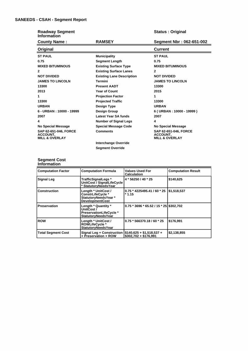
SANEEDS - CSAH - Segment Report
Roadway SegmentInformation
Status : Original
County Name : RAMSEY Segment Nbr : 062-651-002
Original Current
ST PAUL Municipality ST PAUL
0.75 Segment Length 0.75
MIXED BITUMINOUS Existing Surface Type MIXED BITUMINOUS
2 Existing Surface Lanes 2
NOT DIVIDED Existing Lane Description NOT DIVIDED
JAMES TO LINCOLN Termini JAMES TO LINCOLN
13300 Present AADT 13300
2013 Year of Count 2015
1 Projection Factor 1
13300 Projected Traffic 13300
URBAN Design Type URBAN
6 - URBAN : 10000 - 19999 Design Group 6 ( URBAN : 10000 - 19999 )
2007 Latest Year SA funds 2007
4 Number of Signal Legs 4
No Special Message Special Message Code No Special Message
SAP 62-651-046, FORCEACCOUNT,MILL & OVERLAY
Comments SAP 62-651-046, FORCEACCOUNT,MILL & OVERLAY
Interchange Override
Segment Override
Segment CostInformation
Computation Factor Computation Formula Values Used ForCalculation
Computation Result
Signal Leg TrafficSignalLegs *UnitCost / SignalLifeCycle* StatutoryNeedsYear
4 * 56250 / 40 * 25 $140,625
Construction Length * UnitCost /ConstrLifeCycle *StatutoryNeedsYear *DevelopmentCost
0.75 * 4225495.41 / 60 * 25* 1.15
$1,518,537
Preservation Length * Quantity *UnitCost /PreservationLifeCycle *StatutoryNeedsYear
0.75 * 3696 * 65.52 / 15 * 25 $302,702
ROW Length * UnitCost /ROWLifeCycle *StatutoryNeedsYear
0.75 * 566370.18 / 60 * 25 $176,991
Total Segment Cost Signal Leg + Construction+ Preservation + ROW
$140,625 + $1,518,537 +$302,702 + $176,991
$2,138,855

SANEEDS - CSAH - Segment Report
Roadway SegmentInformation
Status : Original
County Name : RAMSEY Segment Nbr : 062-651-003
Original Current
ST PAUL Municipality ST PAUL
0.53 Segment Length 0.53
BIT CONC OR ASPH Existing Surface Type BIT CONC OR ASPH
4 Existing Surface Lanes 4
DIVIDED Existing Lane Description DIVIDED
LINCOLN TO SELBY Termini LINCOLN TO SELBY
22100 Present AADT 22100
2013 Year of Count 2015
1 Projection Factor 1
22100 Projected Traffic 22100
URBAN Design Type URBAN
7 - URBAN : 20000 - 34999 Design Group 7 ( URBAN : 20000 - 34999 )
1993 Latest Year SA funds 1993
5 Number of Signal Legs 5
No Special Message Special Message Code No Special Message
Comments
Interchange Override
Segment Override
Segment CostInformation
Computation Factor Computation Formula Values Used ForCalculation
Computation Result
Signal Leg TrafficSignalLegs *UnitCost / SignalLifeCycle* StatutoryNeedsYear
5 * 56250 / 40 * 25 $175,781
Construction Length * UnitCost /ConstrLifeCycle *StatutoryNeedsYear *DevelopmentCost
0.53 * 5259942.61 / 60 * 25* 1.15
$1,335,806
Preservation Length * Quantity *UnitCost /PreservationLifeCycle *StatutoryNeedsYear
0.53 * 4488 * 65.52 / 15 * 25 $259,747
ROW Length * UnitCost /ROWLifeCycle *StatutoryNeedsYear
0.53 * 883293.09 / 60 * 25 $195,061
Total Segment Cost Signal Leg + Construction+ Preservation + ROW
$175,781 + $1,335,806 +$259,747 + $195,061
$1,966,395

SANEEDS - CSAH - Segment Report
Roadway SegmentInformation
Status : Original
County Name : RAMSEY Segment Nbr : 062-651-004
Original Current
ST PAUL Municipality ST PAUL
0.14 Segment Length 0.14
BIT CONC OR ASPH Existing Surface Type BIT CONC OR ASPH
4 Existing Surface Lanes 4
DIVIDED Existing Lane Description DIVIDED
SELBY TO MARSHALL Termini SELBY TO MARSHALL
22100 Present AADT 22100
2013 Year of Count 2015
1 Projection Factor 1
22100 Projected Traffic 22100
URBAN Design Type URBAN
7 - URBAN : 20000 - 34999 Design Group 7 ( URBAN : 20000 - 34999 )
1993 Latest Year SA funds 1993
2 Number of Signal Legs 2
No Special Message Special Message Code No Special Message
Comments
Interchange Override
Segment Override
Segment CostInformation
Computation Factor Computation Formula Values Used ForCalculation
Computation Result
Signal Leg TrafficSignalLegs *UnitCost / SignalLifeCycle* StatutoryNeedsYear
2 * 56250 / 40 * 25 $70,313
Construction Length * UnitCost /ConstrLifeCycle *StatutoryNeedsYear *DevelopmentCost
0.14 * 5259942.61 / 60 * 25* 1.15
$352,854
Preservation Length * Quantity *UnitCost /PreservationLifeCycle *StatutoryNeedsYear
0.14 * 4488 * 65.52 / 15 * 25 $68,613
ROW Length * UnitCost /ROWLifeCycle *StatutoryNeedsYear
0.14 * 883293.09 / 60 * 25 $51,525
Total Segment Cost Signal Leg + Construction+ Preservation + ROW
$70,313 + $352,854 +$68,613 + $51,525
$543,305

SANEEDS - CSAH - Segment Report
Roadway SegmentInformation
Status : Original
County Name : RAMSEY Segment Nbr : 062-651-005
Original Current
ST PAUL Municipality ST PAUL
0.3 Segment Length 0.3
BIT CONC OR ASPH Existing Surface Type BIT CONC OR ASPH
4 Existing Surface Lanes 4
DIVIDED Existing Lane Description DIVIDED
MARSHALL TO CENTRAL Termini MARSHALL TO CENTRAL
34500 Present AADT 34500
2013 Year of Count 2015
1 Projection Factor 1
34500 Projected Traffic 34500
URBAN Design Type URBAN
7 - URBAN : 20000 - 34999 Design Group 7 ( URBAN : 20000 - 34999 )
1993 Latest Year SA funds 1993
5 Number of Signal Legs 5
No Special Message Special Message Code No Special Message
Comments
Interchange Override
Segment Override
Segment CostInformation
Computation Factor Computation Formula Values Used ForCalculation
Computation Result
Signal Leg TrafficSignalLegs *UnitCost / SignalLifeCycle* StatutoryNeedsYear
5 * 56250 / 40 * 25 $175,781
Construction Length * UnitCost /ConstrLifeCycle *StatutoryNeedsYear *DevelopmentCost
0.3 * 5259942.61 / 60 * 25 *1.15
$756,117
Preservation Length * Quantity *UnitCost /PreservationLifeCycle *StatutoryNeedsYear
0.3 * 4488 * 65.52 / 15 * 25 $147,027
ROW Length * UnitCost /ROWLifeCycle *StatutoryNeedsYear
0.3 * 883293.09 / 60 * 25 $110,412
Total Segment Cost Signal Leg + Construction+ Preservation + ROW
$175,781 + $756,117 +$147,027 + $110,412
$1,189,337

SANEEDS - CSAH - Segment Report
Roadway SegmentInformation
Status : Original
County Name : RAMSEY Segment Nbr : 062-651-006
Original Current
ST PAUL Municipality ST PAUL
0.2 Segment Length 0.2
BIT CONC OR ASPH Existing Surface Type BIT CONC OR ASPH
6 Existing Surface Lanes 6
DIVIDED Existing Lane Description DIVIDED
CENTRAL TO UNIVERSITY Termini CENTRAL TO UNIVERSITY
34500 Present AADT 34500
2013 Year of Count 2015
1 Projection Factor 1
34500 Projected Traffic 34500
URBAN Design Type URBAN
7 - URBAN : 20000 - 34999 Design Group 7 ( URBAN : 20000 - 34999 )
1993 Latest Year SA funds 1993
1 Number of Signal Legs 1
No Special Message Special Message Code No Special Message
Comments
Interchange Override
Segment Override
Segment CostInformation
Computation Factor Computation Formula Values Used ForCalculation
Computation Result
Signal Leg TrafficSignalLegs *UnitCost / SignalLifeCycle* StatutoryNeedsYear
1 * 56250 / 40 * 25 $35,156
Construction Length * UnitCost /ConstrLifeCycle *StatutoryNeedsYear *DevelopmentCost
0.2 * 5259942.61 / 60 * 25 *1.15
$504,078
Preservation Length * Quantity *UnitCost /PreservationLifeCycle *StatutoryNeedsYear
0.2 * 4488 * 65.52 / 15 * 25 $98,018
ROW Length * UnitCost /ROWLifeCycle *StatutoryNeedsYear
0.2 * 883293.09 / 60 * 25 $73,608
Total Segment Cost Signal Leg + Construction+ Preservation + ROW
$35,156 + $504,078 +$98,018 + $73,608
$710,860

SANEEDS - CSAH - Segment Report
Roadway SegmentInformation
Status : Original
County Name : RAMSEY Segment Nbr : 062-651-007
Original Current
ST PAUL Municipality ST PAUL
0.7 Segment Length 0.7
BIT CONC OR ASPH Existing Surface Type BIT CONC OR ASPH
4 Existing Surface Lanes 4
DIVIDED Existing Lane Description DIVIDED
UNIVERSITY TO 80 FT NORTH OFHUBBARD
Termini UNIVERSITY TO 80 FT NORTH OFHUBBARD
29000 Present AADT 29000
2013 Year of Count 2015
1 Projection Factor 1
29000 Projected Traffic 29000
URBAN Design Type URBAN
7 - URBAN : 20000 - 34999 Design Group 7 ( URBAN : 20000 - 34999 )
1993 Latest Year SA funds 1993
5 Number of Signal Legs 5
No Special Message Special Message Code No Special Message
Comments
Interchange Override
Segment Override
Segment CostInformation
Computation Factor Computation Formula Values Used ForCalculation
Computation Result
Signal Leg TrafficSignalLegs *UnitCost / SignalLifeCycle* StatutoryNeedsYear
5 * 56250 / 40 * 25 $175,781
Construction Length * UnitCost /ConstrLifeCycle *StatutoryNeedsYear *DevelopmentCost
0.7 * 5259942.61 / 60 * 25 *1.15
$1,764,272
Preservation Length * Quantity *UnitCost /PreservationLifeCycle *StatutoryNeedsYear
0.7 * 4488 * 65.52 / 15 * 25 $343,063
ROW Length * UnitCost /ROWLifeCycle *StatutoryNeedsYear
0.7 * 883293.09 / 60 * 25 $257,627
Total Segment Cost Signal Leg + Construction+ Preservation + ROW
$175,781 + $1,764,272 +$343,063 + $257,627
$2,540,743

SANEEDS - CSAH - Segment Report
Roadway SegmentInformation
Status : Original
County Name : RAMSEY Segment Nbr : 062-651-008
Original Current
ST PAUL Municipality ST PAUL
0.18 Segment Length 0.18
BIT CONC OR ASPH Existing Surface Type BIT CONC OR ASPH
4 Existing Surface Lanes 4
NOT DIVIDED Existing Lane Description NOT DIVIDED
80 FT NO OF HUBBARD TOBURGESS
Termini 80 FT NO OF HUBBARD TOBURGESS
23700 Present AADT 23700
2013 Year of Count 2015
1 Projection Factor 1
23700 Projected Traffic 23700
URBAN Design Type URBAN
7 - URBAN : 20000 - 34999 Design Group 7 ( URBAN : 20000 - 34999 )
1993 Latest Year SA funds 1993
0 Number of Signal Legs 0
No Special Message Special Message Code No Special Message
Comments
Interchange Override
Segment Override
Bridge Information Status: Original
Original Current
5583 Structure Number 5583
3.825 Milepoint 3.825
1936 Year Built 1936
BNSF RR Feature Crossed BNSF RR
HWY / R.R. Type of Service HWY / R.R.
5 Number of Spans 5
251.3 Bridge Length 251.3
62.3 Bridge Width 62.3
100% Shared Structure 100%
Comments
2 ( 150-999,999 ) Bridge Group Code 2 ( 150-999,999 )
Bridge Information Status: Original
Original Current
7276 Structure Number 7276
3.77 Milepoint 3.77
1959 Year Built 1959
CSAH 33(PIERCE BUTLER) Feature Crossed CSAH 33(PIERCE BUTLER)
HWY SEPARATION Type of Service HWY SEPARATION
3 Number of Spans 3
122.9 Bridge Length 122.9
62.3 Bridge Width 62.3
100% Shared Structure 100%
Comments
1 ( 0-149 ) Bridge Group Code 1 ( 0-149 )
Segment CostInformation
Computation Factor Computation Formula Values Used ForCalculation
Computation Result
Signal Leg TrafficSignalLegs *UnitCost / SignalLifeCycle* StatutoryNeedsYear
0 * 56250 / 40 * 25 $0

Construction Length * UnitCost /ConstrLifeCycle *StatutoryNeedsYear *DevelopmentCost
0.18 * 5259942.61 / 60 * 25* 1.15
$453,670
Preservation Length * Quantity *UnitCost /PreservationLifeCycle *StatutoryNeedsYear
0.18 * 4488 * 65.52 / 15 * 25 $88,216
ROW Length * UnitCost /ROWLifeCycle *StatutoryNeedsYear
0.18 * 883293.09 / 60 * 25 $66,247
Bridge BridgeLength *BridgeWidth * UnitCost /BridgeLifeCycle *StatutoryNeedsYear *DevelopmentCost
251.3 * 62.3 * 138 / 80 * 25* 1.15
$776,439
Bridge BridgeLength *BridgeWidth * UnitCost /BridgeLifeCycle *StatutoryNeedsYear *DevelopmentCost
122.9 * 62.3 * 152 / 80 * 25* 1.15
$418,246
Total Segment Cost Signal Leg + Construction+ Preservation + ROW +Bridge + Bridge
$0 + $453,670 + $88,216 +$66,247 + $776,439 +$418,246
$1,802,818

SANEEDS - CSAH - Segment Report
Roadway SegmentInformation
Status : Original
County Name : RAMSEY Segment Nbr : 062-651-009
Original Current
ST PAUL Municipality ST PAUL
0.28 Segment Length 0.28
BIT CONC OR ASPH Existing Surface Type BIT CONC OR ASPH
4 Existing Surface Lanes 4
DIVIDED Existing Lane Description DIVIDED
BURGESS TO ORCHARD Termini BURGESS TO ORCHARD
23700 Present AADT 23700
2013 Year of Count 2015
1 Projection Factor 1
23700 Projected Traffic 23700
URBAN Design Type URBAN
7 - URBAN : 20000 - 34999 Design Group 7 ( URBAN : 20000 - 34999 )
1993 Latest Year SA funds 1993
3 Number of Signal Legs 3
No Special Message Special Message Code No Special Message
Comments
Interchange Override
Segment Override
Segment CostInformation
Computation Factor Computation Formula Values Used ForCalculation
Computation Result
Signal Leg TrafficSignalLegs *UnitCost / SignalLifeCycle* StatutoryNeedsYear
3 * 56250 / 40 * 25 $105,469
Construction Length * UnitCost /ConstrLifeCycle *StatutoryNeedsYear *DevelopmentCost
0.28 * 5259942.61 / 60 * 25* 1.15
$705,709
Preservation Length * Quantity *UnitCost /PreservationLifeCycle *StatutoryNeedsYear
0.28 * 4488 * 65.52 / 15 * 25 $137,225
ROW Length * UnitCost /ROWLifeCycle *StatutoryNeedsYear
0.28 * 883293.09 / 60 * 25 $103,051
Total Segment Cost Signal Leg + Construction+ Preservation + ROW
$105,469 + $705,709 +$137,225 + $103,051
$1,051,454

SANEEDS - CSAH - Segment Report
Roadway SegmentInformation
Status : Original
County Name : RAMSEY Segment Nbr : 062-651-011
Original Current
ST PAUL Municipality ST PAUL
1.2 Segment Length 1.2
BIT CONC OR ASPH Existing Surface Type BIT CONC OR ASPH
2 Existing Surface Lanes 2
NOT DIVIDED Existing Lane Description NOT DIVIDED
ORCHARD TO W MONTANA Termini ORCHARD TO W MONTANA
14200 Present AADT 14200
2013 Year of Count 2015
1 Projection Factor 1
14200 Projected Traffic 14200
URBAN Design Type URBAN
6 - URBAN : 10000 - 19999 Design Group 6 ( URBAN : 10000 - 19999 )
1988 Latest Year SA funds 1988
4 Number of Signal Legs 4
No Special Message Special Message Code No Special Message
Comments
Interchange Override
Segment Override
Bridge Information Status: Original
Original Current
62599 Structure Number 62599
Milepoint
2003 Year Built 2003
Feature Crossed
Type of Service
Number of Spans
271 Bridge Length 271
16 Bridge Width 16
100% Shared Structure 100%
Comments
2 ( 150-999,999 ) Bridge Group Code 2 ( 150-999,999 )
Bridge Information Status: Original
Original Current
90405 Structure Number 90405
4.25 Milepoint 4.25
1907 Year Built 1907
Feature Crossed
Type of Service
0 Number of Spans 0
110 Bridge Length 110
73 Bridge Width 73
100% Shared Structure 100%
Comments
1 ( 0-149 ) Bridge Group Code 1 ( 0-149 )
Bridge Information Status: Original
Original Current
92247 Structure Number 92247
4.61 Milepoint 4.61
1903 Year Built 1903
RECREATIONAL TRAIL Feature Crossed RECREATIONAL TRAIL
Type of Service
Number of Spans

47 Bridge Length 47
53 Bridge Width 53
100% Shared Structure 100%
Comments
1 ( 0-149 ) Bridge Group Code 1 ( 0-149 )
Segment CostInformation
Computation Factor Computation Formula Values Used ForCalculation
Computation Result
Signal Leg TrafficSignalLegs *UnitCost / SignalLifeCycle* StatutoryNeedsYear
4 * 56250 / 40 * 25 $140,625
Construction Length * UnitCost /ConstrLifeCycle *StatutoryNeedsYear *DevelopmentCost
1.2 * 4225495.41 / 60 * 25 *1.15
$2,429,660
Preservation Length * Quantity *UnitCost /PreservationLifeCycle *StatutoryNeedsYear
1.2 * 3696 * 65.52 / 15 * 25 $484,324
ROW Length * UnitCost /ROWLifeCycle *StatutoryNeedsYear
1.2 * 566370.18 / 60 * 25 $283,185
Bridge BridgeLength *BridgeWidth * UnitCost /BridgeLifeCycle *StatutoryNeedsYear *DevelopmentCost
271 * 16 * 138 / 80 * 25 *1.15
$215,039
Bridge BridgeLength *BridgeWidth * UnitCost /BridgeLifeCycle *StatutoryNeedsYear *DevelopmentCost
110 * 73 * 152 / 80 * 25 *1.15
$438,639
Bridge BridgeLength *BridgeWidth * UnitCost /BridgeLifeCycle *StatutoryNeedsYear *DevelopmentCost
47 * 53 * 152 / 80 * 25 *1.15
$136,071
Total Segment Cost Signal Leg + Construction+ Preservation + ROW +Bridge + Bridge + Bridge
$140,625 + $2,429,660 +$484,324 + $283,185 +$215,039 + $438,639 +$136,071
$4,127,543

SANEEDS - CSAH - Segment Report
Roadway SegmentInformation
Status : Original
County Name : RAMSEY Segment Nbr : 062-651-013
Original Current
ST PAUL Municipality ST PAUL
0.39 Segment Length 0.39
MIXED BITUMINOUS Existing Surface Type MIXED BITUMINOUS
2 Existing Surface Lanes 2
NOT DIVIDED Existing Lane Description NOT DIVIDED
W MONTANA TO LARPENTER Termini W MONTANA TO LARPENTER
14200 Present AADT 14200
2013 Year of Count 2015
1 Projection Factor 1
14200 Projected Traffic 14200
URBAN Design Type URBAN
6 - URBAN : 10000 - 19999 Design Group 6 ( URBAN : 10000 - 19999 )
2000 Latest Year SA funds 2000
7 Number of Signal Legs 7
No Special Message Special Message Code No Special Message
Comments
Interchange Override
Segment Override
Segment CostInformation
Computation Factor Computation Formula Values Used ForCalculation
Computation Result
Signal Leg TrafficSignalLegs *UnitCost / SignalLifeCycle* StatutoryNeedsYear
7 * 56250 / 40 * 25 $246,094
Construction Length * UnitCost /ConstrLifeCycle *StatutoryNeedsYear *DevelopmentCost
0.39 * 4225495.41 / 60 * 25* 1.15
$789,639
Preservation Length * Quantity *UnitCost /PreservationLifeCycle *StatutoryNeedsYear
0.39 * 3696 * 65.52 / 15 * 25 $157,405
ROW Length * UnitCost /ROWLifeCycle *StatutoryNeedsYear
0.39 * 566370.18 / 60 * 25 $92,035
Total Segment Cost Signal Leg + Construction+ Preservation + ROW
$246,094 + $789,639 +$157,405 + $92,035
$1,285,173

SANEEDS - CSAH - Segment Report
Roadway SegmentInformation
Status : Original
County Name : RAMSEY Segment Nbr : 062-651-015
Original Current
ROSEVILLE Municipality ROSEVILLE
0.12 Segment Length 0.12
BIT CONC OR ASPH Existing Surface Type BIT CONC OR ASPH
4 Existing Surface Lanes 4
DIVIDED Existing Lane Description DIVIDED
LARPENTEUR AVE TO DIONNE ST Termini LARPENTEUR AVE TO DIONNE ST
14900 Present AADT 16800
2013 Year of Count 2015
1 Projection Factor 1
14900 Projected Traffic 16800
URBAN Design Type URBAN
6 - URBAN : 10000 - 19999 Design Group 6 ( URBAN : 10000 - 19999 )
1997 Latest Year SA funds 1997
1 Number of Signal Legs 1
THTB-RECONSTRUCTED WITH TBFUNDS
Special Message Code THTB-RECONSTRUCTED WITH TBFUNDS
CANT RUN COMPS Comments CANT RUN COMPS
Interchange Override
Segment Override
Segment CostInformation
Computation Factor Computation Formula Values Used ForCalculation
Computation Result
Signal Leg TrafficSignalLegs *UnitCost / SignalLifeCycle* StatutoryNeedsYear
1 * 56250 / 40 * 25 $35,156
Construction Length * UnitCost /ConstrLifeCycle *StatutoryNeedsYear *DevelopmentCost
0.12 * 4225495.41 / 60 * 25* 1.15
$242,966
Preservation Length * Quantity *UnitCost /PreservationLifeCycle *StatutoryNeedsYear
0.12 * 3696 * 65.52 / 15 * 25 $48,432
ROW Length * UnitCost /ROWLifeCycle *StatutoryNeedsYear
0.12 * 566370.18 / 60 * 25 $28,319
Total Segment Cost Signal Leg + Construction+ Preservation + ROW
$35,156 + $242,966 +$48,432 + $28,319
$354,873

SANEEDS - CSAH - Segment Report
Roadway SegmentInformation
Status : Revised
County Name : RAMSEY Segment Nbr : 062-651-020
Original Current
ROSEVILLE Municipality ROSEVILLE
1.13 Segment Length 1.13
BIT CONC OR ASPH Existing Surface Type BIT CONC OR ASPH
4 Existing Surface Lanes 4
NOT DIVIDED Existing Lane Description NOT DIVIDED
DIONNE ST TO TH 36 Termini DIONNE ST TO TH 36
15900 Present AADT 18100
2013 Year of Count 2015
1 Projection Factor 1
15900 Projected Traffic 18100
URBAN Design Type URBAN
6 - URBAN : 10000 - 19999 Design Group 6 ( URBAN : 10000 - 19999 )
2016 Latest Year SA funds 2016
5 Number of Signal Legs 5
THTB-RECONSTRUCTED WITH TBFUNDS
Special Message Code THTB-RECONSTRUCTED WITH TBFUNDS
COUNTY CONTRIBUTION TO SP6212-148 UNDER SAP 062-651-049
Comments COUNTY CONTRIBUTION TO SP6212-148 UNDER SAP 062-651-049
Interchange Override
Segment Override
Segment CostInformation
Computation Factor Computation Formula Values Used ForCalculation
Computation Result
Signal Leg TrafficSignalLegs *UnitCost / SignalLifeCycle* StatutoryNeedsYear
5 * 56250 / 40 * 25 $175,781
Construction Length * UnitCost /ConstrLifeCycle *StatutoryNeedsYear *DevelopmentCost
1.13 * 4225495.41 / 60 * 25* 1.15
$2,287,930
Preservation Length * Quantity *UnitCost /PreservationLifeCycle *StatutoryNeedsYear
1.13 * 3696 * 65.52 / 15 * 25 $456,072
ROW Length * UnitCost /ROWLifeCycle *StatutoryNeedsYear
1.13 * 566370.18 / 60 * 25 $266,666
Total Segment Cost Signal Leg + Construction+ Preservation + ROW
$175,781 + $2,287,930 +$456,072 + $266,666
$3,186,449

SANEEDS - CSAH - Segment Report
Roadway SegmentInformation
Status : Revised
County Name : RAMSEY Segment Nbr : 062-651-030
Original Current
ROSEVILLE Municipality ROSEVILLE
0.75 Segment Length 0.75
BIT CONC OR ASPH Existing Surface Type BIT CONC OR ASPH
4 Existing Surface Lanes 4
NOT DIVIDED Existing Lane Description NOT DIVIDED
TH 36 TO CO. RD. C Termini TH 36 TO CO. RD. C
15900 Present AADT 17500
2013 Year of Count 2015
1 Projection Factor 1
15900 Projected Traffic 17500
URBAN Design Type URBAN
6 - URBAN : 10000 - 19999 Design Group 6 ( URBAN : 10000 - 19999 )
2016 Latest Year SA funds 2016
6 Number of Signal Legs 6
THTB-RECONSTRUCTED WITH TBFUNDS
Special Message Code THTB-RECONSTRUCTED WITH TBFUNDS
COUNTY CONTRIBUTION TO SP6212-148 UNDER SAP 062-651-049
Comments COUNTY CONTRIBUTION TO SP6212-148 UNDER SAP 062-651-049
Interchange Override
Segment Override
Segment CostInformation
Computation Factor Computation Formula Values Used ForCalculation
Computation Result
Signal Leg TrafficSignalLegs *UnitCost / SignalLifeCycle* StatutoryNeedsYear
6 * 56250 / 40 * 25 $210,938
Construction Length * UnitCost /ConstrLifeCycle *StatutoryNeedsYear *DevelopmentCost
0.75 * 4225495.41 / 60 * 25* 1.15
$1,518,537
Preservation Length * Quantity *UnitCost /PreservationLifeCycle *StatutoryNeedsYear
0.75 * 3696 * 65.52 / 15 * 25 $302,702
ROW Length * UnitCost /ROWLifeCycle *StatutoryNeedsYear
0.75 * 566370.18 / 60 * 25 $176,991
Total Segment Cost Signal Leg + Construction+ Preservation + ROW
$210,938 + $1,518,537 +$302,702 + $176,991
$2,209,168

SANEEDS - CSAH - Segment Report
Roadway SegmentInformation
Status : Original
County Name : RAMSEY Segment Nbr : 062-651-040
Original Current
ROSEVILLE Municipality ROSEVILLE
0.98 Segment Length 0.98
BIT CONC OR ASPH Existing Surface Type BIT CONC OR ASPH
4 Existing Surface Lanes 4
NOT DIVIDED Existing Lane Description NOT DIVIDED
CO. RD. C TO 0.08 MI S OF CO. RD.D
Termini CO. RD. C TO 0.08 MI S OF CO. RD.D
13500 Present AADT 12300
2013 Year of Count 2015
1 Projection Factor 1
13500 Projected Traffic 12300
URBAN Design Type URBAN
6 - URBAN : 10000 - 19999 Design Group 6 ( URBAN : 10000 - 19999 )
1997 Latest Year SA funds 1997
1 Number of Signal Legs 1
THTB-RECONSTRUCTED WITH TBFUNDS
Special Message Code THTB-RECONSTRUCTED WITH TBFUNDS
Comments
Interchange Override
Segment Override
Segment CostInformation
Computation Factor Computation Formula Values Used ForCalculation
Computation Result
Signal Leg TrafficSignalLegs *UnitCost / SignalLifeCycle* StatutoryNeedsYear
1 * 56250 / 40 * 25 $35,156
Construction Length * UnitCost /ConstrLifeCycle *StatutoryNeedsYear *DevelopmentCost
0.98 * 4225495.41 / 60 * 25* 1.15
$1,984,222
Preservation Length * Quantity *UnitCost /PreservationLifeCycle *StatutoryNeedsYear
0.98 * 3696 * 65.52 / 15 * 25 $395,531
ROW Length * UnitCost /ROWLifeCycle *StatutoryNeedsYear
0.98 * 566370.18 / 60 * 25 $231,268
Total Segment Cost Signal Leg + Construction+ Preservation + ROW
$35,156 + $1,984,222 +$395,531 + $231,268
$2,646,177

SANEEDS - CSAH - Segment Report
Roadway SegmentInformation
Status : Original
County Name : RAMSEY Segment Nbr : 062-651-041
Original Current
ROSEVILLE Municipality ROSEVILLE
0.08 Segment Length 0.08
MIXED BITUMINOUS Existing Surface Type MIXED BITUMINOUS
4 Existing Surface Lanes 4
NOT DIVIDED Existing Lane Description NOT DIVIDED
0.08 MI S TO CO RD D Termini 0.08 MI S TO CO RD D
12300 Present AADT 12300
2013 Year of Count 2015
1 Projection Factor 1
12300 Projected Traffic 12300
URBAN Design Type URBAN
6 - URBAN : 10000 - 19999 Design Group 6 ( URBAN : 10000 - 19999 )
1997 Latest Year SA funds 1997
1 Number of Signal Legs 1
THTB-RECONSTRUCTED WITH TBFUNDS
Special Message Code THTB-RECONSTRUCTED WITH TBFUNDS
Comments
Interchange Override
Segment Override
Segment CostInformation
Computation Factor Computation Formula Values Used ForCalculation
Computation Result
Signal Leg TrafficSignalLegs *UnitCost / SignalLifeCycle* StatutoryNeedsYear
1 * 56250 / 40 * 25 $35,156
Construction Length * UnitCost /ConstrLifeCycle *StatutoryNeedsYear *DevelopmentCost
0.08 * 4225495.41 / 60 * 25* 1.15
$161,977
Preservation Length * Quantity *UnitCost /PreservationLifeCycle *StatutoryNeedsYear
0.08 * 3696 * 65.52 / 15 * 25 $32,288
ROW Length * UnitCost /ROWLifeCycle *StatutoryNeedsYear
0.08 * 566370.18 / 60 * 25 $18,879
Total Segment Cost Signal Leg + Construction+ Preservation + ROW
$35,156 + $161,977 +$32,288 + $18,879
$248,300

SANEEDS - CSAH - Segment Report
Roadway SegmentInformation
Status : Original
County Name : RAMSEY Segment Nbr : 062-651-050
Original Current
SHOREVIEW Municipality SHOREVIEW
0.5 Segment Length 0.5
MIXED BITUMINOUS Existing Surface Type MIXED BITUMINOUS
4 Existing Surface Lanes 4
NOT DIVIDED Existing Lane Description NOT DIVIDED
CO RD D TO 0.5 MI N Termini CO RD D TO 0.5 MI N
12300 Present AADT 13000
2013 Year of Count 2015
1 Projection Factor 1
12300 Projected Traffic 13000
URBAN Design Type URBAN
6 - URBAN : 10000 - 19999 Design Group 6 ( URBAN : 10000 - 19999 )
1997 Latest Year SA funds 1997
1 Number of Signal Legs 1
THTB-RECONSTRUCTED WITH TBFUNDS
Special Message Code THTB-RECONSTRUCTED WITH TBFUNDS
Comments
Interchange Override
Segment Override
Segment CostInformation
Computation Factor Computation Formula Values Used ForCalculation
Computation Result
Signal Leg TrafficSignalLegs *UnitCost / SignalLifeCycle* StatutoryNeedsYear
1 * 56250 / 40 * 25 $35,156
Construction Length * UnitCost /ConstrLifeCycle *StatutoryNeedsYear *DevelopmentCost
0.5 * 4225495.41 / 60 * 25 *1.15
$1,012,358
Preservation Length * Quantity *UnitCost /PreservationLifeCycle *StatutoryNeedsYear
0.5 * 3696 * 65.52 / 15 * 25 $201,802
ROW Length * UnitCost /ROWLifeCycle *StatutoryNeedsYear
0.5 * 566370.18 / 60 * 25 $117,994
Total Segment Cost Signal Leg + Construction+ Preservation + ROW
$35,156 + $1,012,358 +$201,802 + $117,994
$1,367,310

SANEEDS - CSAH - Segment Report
Roadway SegmentInformation
Status : Original
County Name : RAMSEY Segment Nbr : 062-651-060
Original Current
ARDEN HILLS Municipality ARDEN HILLS
0.5 Segment Length 0.5
MIXED BITUMINOUS Existing Surface Type MIXED BITUMINOUS
4 Existing Surface Lanes 4
NOT DIVIDED Existing Lane Description NOT DIVIDED
0.5 MI N OF CO RD D TO CO. RD. E Termini 0.5 MI N OF CO RD D TO CO. RD. E
12300 Present AADT 13000
2013 Year of Count 2015
1 Projection Factor 1
12300 Projected Traffic 13000
URBAN Design Type URBAN
6 - URBAN : 10000 - 19999 Design Group 6 ( URBAN : 10000 - 19999 )
1997 Latest Year SA funds 1997
1 Number of Signal Legs 1
THTB-RECONSTRUCTED WITH TBFUNDS
Special Message Code THTB-RECONSTRUCTED WITH TBFUNDS
Comments
Interchange Override
Segment Override
Segment CostInformation
Computation Factor Computation Formula Values Used ForCalculation
Computation Result
Signal Leg TrafficSignalLegs *UnitCost / SignalLifeCycle* StatutoryNeedsYear
1 * 56250 / 40 * 25 $35,156
Construction Length * UnitCost /ConstrLifeCycle *StatutoryNeedsYear *DevelopmentCost
0.5 * 4225495.41 / 60 * 25 *1.15
$1,012,358
Preservation Length * Quantity *UnitCost /PreservationLifeCycle *StatutoryNeedsYear
0.5 * 3696 * 65.52 / 15 * 25 $201,802
ROW Length * UnitCost /ROWLifeCycle *StatutoryNeedsYear
0.5 * 566370.18 / 60 * 25 $117,994
Total Segment Cost Signal Leg + Construction+ Preservation + ROW
$35,156 + $1,012,358 +$201,802 + $117,994
$1,367,310
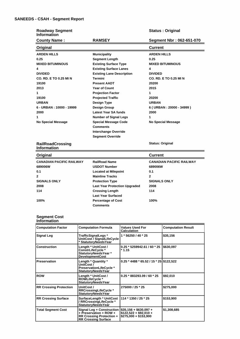
SANEEDS - CSAH - Segment Report
Roadway SegmentInformation
Status : Original
County Name : RAMSEY Segment Nbr : 062-651-070
Original Current
ARDEN HILLS Municipality ARDEN HILLS
0.25 Segment Length 0.25
MIXED BITUMINOUS Existing Surface Type MIXED BITUMINOUS
4 Existing Surface Lanes 4
DIVIDED Existing Lane Description DIVIDED
CO. RD. E TO 0.25 MI N Termini CO. RD. E TO 0.25 MI N
19100 Present AADT 20200
2013 Year of Count 2015
1 Projection Factor 1
19100 Projected Traffic 20200
URBAN Design Type URBAN
6 - URBAN : 10000 - 19999 Design Group 6 ( URBAN : 20000 - 34999 )
2000 Latest Year SA funds 2000
1 Number of Signal Legs 1
No Special Message Special Message Code No Special Message
Comments
Interchange Override
Segment Override
RailRoadCrossingInformation
Status: Original
Original Current
CANADIAN PACIFIC RAILWAY RailRoad Name CANADIAN PACIFIC RAILWAY
689006W USDOT Number 689006W
0.1 Located at Milepoint 0.1
2 Mainline Tracks 2
SIGNALS ONLY Protection Type SIGNALS ONLY
2008 Last Year Protection Upgraded 2008
114 Crossing Length 114
Last Year Surfaced
100% Percentage of Cost 100%
Comments
Segment CostInformation
Computation Factor Computation Formula Values Used ForCalculation
Computation Result
Signal Leg TrafficSignalLegs *UnitCost / SignalLifeCycle* StatutoryNeedsYear
1 * 56250 / 40 * 25 $35,156
Construction Length * UnitCost /ConstrLifeCycle *StatutoryNeedsYear *DevelopmentCost
0.25 * 5259942.61 / 60 * 25* 1.15
$630,097
Preservation Length * Quantity *UnitCost /PreservationLifeCycle *StatutoryNeedsYear
0.25 * 4488 * 65.52 / 15 * 25 $122,522
ROW Length * UnitCost /ROWLifeCycle *StatutoryNeedsYear
0.25 * 883293.09 / 60 * 25 $92,010
RR Crossing Protection UnitCost /RRCrossingLifeCycle *StatutoryNeedsYear
275000 / 25 * 25 $275,000
RR Crossing Surface SurfaceLength * UnitCost/ RRCrossingLifeCycle *StatutoryNeedsYear
114 * 1350 / 25 * 25 $153,900
Total Segment Cost Signal Leg + Construction+ Preservation + ROW +RR Crossing Protection +RR Crossing Surface
$35,156 + $630,097 +$122,522 + $92,010 +$275,000 + $153,900
$1,308,685

SANEEDS - CSAH - Segment Report
Roadway SegmentInformation
Status : Original
County Name : RAMSEY Segment Nbr : 062-651-080
Original Current
ARDEN HILLS Municipality ARDEN HILLS
0.4 Segment Length 0.4
MIXED BITUMINOUS Existing Surface Type MIXED BITUMINOUS
4 Existing Surface Lanes 4
DIVIDED Existing Lane Description DIVIDED
0.25 MI N OF CO. RD. E TO FAI 694 Termini 0.25 MI N OF CO. RD. E TO FAI 694
19100 Present AADT 20200
2013 Year of Count 2015
1 Projection Factor 1
19100 Projected Traffic 20200
URBAN Design Type URBAN
6 - URBAN : 10000 - 19999 Design Group 6 ( URBAN : 20000 - 34999 )
2000 Latest Year SA funds 2000
5 Number of Signal Legs 5
No Special Message Special Message Code No Special Message
Comments
Interchange Override
Segment Override
Segment CostInformation
Computation Factor Computation Formula Values Used ForCalculation
Computation Result
Signal Leg TrafficSignalLegs *UnitCost / SignalLifeCycle* StatutoryNeedsYear
5 * 56250 / 40 * 25 $175,781
Construction Length * UnitCost /ConstrLifeCycle *StatutoryNeedsYear *DevelopmentCost
0.4 * 5259942.61 / 60 * 25 *1.15
$1,008,156
Preservation Length * Quantity *UnitCost /PreservationLifeCycle *StatutoryNeedsYear
0.4 * 4488 * 65.52 / 15 * 25 $196,036
ROW Length * UnitCost /ROWLifeCycle *StatutoryNeedsYear
0.4 * 883293.09 / 60 * 25 $147,216
Total Segment Cost Signal Leg + Construction+ Preservation + ROW
$175,781 + $1,008,156 +$196,036 + $147,216
$1,527,189

SANEEDS - CSAH - Segment Report
Roadway SegmentInformation
Status : Original
County Name : RAMSEY Segment Nbr : 062-651-090
Original Current
SHOREVIEW Municipality SHOREVIEW
0.5 Segment Length 0.5
MIXED BITUMINOUS Existing Surface Type MIXED BITUMINOUS
4 Existing Surface Lanes 4
DIVIDED Existing Lane Description DIVIDED
FAI 694 TO 0.15 MI N OF CO. RD. F Termini FAI 694 TO 0.15 MI N OF CO. RD. F
20500 Present AADT 21900
2013 Year of Count 2015
1 Projection Factor 1
20500 Projected Traffic 21900
URBAN Design Type URBAN
7 - URBAN : 20000 - 34999 Design Group 7 ( URBAN : 20000 - 34999 )
2000 Latest Year SA funds 2000
5 Number of Signal Legs 5
No Special Message Special Message Code No Special Message
Comments
Interchange Override
Segment Override
Segment CostInformation
Computation Factor Computation Formula Values Used ForCalculation
Computation Result
Signal Leg TrafficSignalLegs *UnitCost / SignalLifeCycle* StatutoryNeedsYear
5 * 56250 / 40 * 25 $175,781
Construction Length * UnitCost /ConstrLifeCycle *StatutoryNeedsYear *DevelopmentCost
0.5 * 5259942.61 / 60 * 25 *1.15
$1,260,195
Preservation Length * Quantity *UnitCost /PreservationLifeCycle *StatutoryNeedsYear
0.5 * 4488 * 65.52 / 15 * 25 $245,045
ROW Length * UnitCost /ROWLifeCycle *StatutoryNeedsYear
0.5 * 883293.09 / 60 * 25 $184,019
Total Segment Cost Signal Leg + Construction+ Preservation + ROW
$175,781 + $1,260,195 +$245,045 + $184,019
$1,865,040

SANEEDS - CSAH - Segment Report
Roadway SegmentInformation
Status : Original
County Name : RAMSEY Segment Nbr : 062-651-100
Original Current
ARDEN HILLS Municipality ARDEN HILLS
0.35 Segment Length 0.35
MIXED BITUMINOUS Existing Surface Type MIXED BITUMINOUS
4 Existing Surface Lanes 4
DIVIDED Existing Lane Description DIVIDED
0.15 MI NO OF CO.RD. F TOVICTORIA ST.
Termini 0.15 MI NO OF CO.RD. F TOVICTORIA ST.
17500 Present AADT 17500
2013 Year of Count 2015
1 Projection Factor 1
17500 Projected Traffic 17500
URBAN Design Type URBAN
6 - URBAN : 10000 - 19999 Design Group 6 ( URBAN : 10000 - 19999 )
2005 Latest Year SA funds 2005
3 Number of Signal Legs 3
No Special Message Special Message Code No Special Message
CONST. SAP 62-651-38 Comments CONST. SAP 62-651-38
Interchange Override
Segment Override
Segment CostInformation
Computation Factor Computation Formula Values Used ForCalculation
Computation Result
Signal Leg TrafficSignalLegs *UnitCost / SignalLifeCycle* StatutoryNeedsYear
3 * 56250 / 40 * 25 $105,469
Construction Length * UnitCost /ConstrLifeCycle *StatutoryNeedsYear *DevelopmentCost
0.35 * 4225495.41 / 60 * 25* 1.15
$708,651
Preservation Length * Quantity *UnitCost /PreservationLifeCycle *StatutoryNeedsYear
0.35 * 3696 * 65.52 / 15 * 25 $141,261
ROW Length * UnitCost /ROWLifeCycle *StatutoryNeedsYear
0.35 * 566370.18 / 60 * 25 $82,596
Total Segment Cost Signal Leg + Construction+ Preservation + ROW
$105,469 + $708,651 +$141,261 + $82,596
$1,037,977

SANEEDS - CSAH - Segment Report
Roadway SegmentInformation
Status : Original
County Name : RAMSEY Segment Nbr : 062-651-110
Original Current
SHOREVIEW Municipality SHOREVIEW
0.38 Segment Length 0.38
MIXED BITUMINOUS Existing Surface Type MIXED BITUMINOUS
4 Existing Surface Lanes 4
DIVIDED Existing Lane Description DIVIDED
VICTORIA ST. TO 0.12 MI S OF T.H.96
Termini VICTORIA ST. TO 0.12 MI S OF T.H.96
17500 Present AADT 17500
2013 Year of Count 2015
1 Projection Factor 1
17500 Projected Traffic 17500
URBAN Design Type URBAN
6 - URBAN : 10000 - 19999 Design Group 6 ( URBAN : 10000 - 19999 )
2005 Latest Year SA funds 2005
1 Number of Signal Legs 1
No Special Message Special Message Code No Special Message
CONST. SAP 62-651-38 Comments CONST. SAP 62-651-38
Interchange Override
Segment Override
Segment CostInformation
Computation Factor Computation Formula Values Used ForCalculation
Computation Result
Signal Leg TrafficSignalLegs *UnitCost / SignalLifeCycle* StatutoryNeedsYear
1 * 56250 / 40 * 25 $35,156
Construction Length * UnitCost /ConstrLifeCycle *StatutoryNeedsYear *DevelopmentCost
0.38 * 4225495.41 / 60 * 25* 1.15
$769,392
Preservation Length * Quantity *UnitCost /PreservationLifeCycle *StatutoryNeedsYear
0.38 * 3696 * 65.52 / 15 * 25 $153,369
ROW Length * UnitCost /ROWLifeCycle *StatutoryNeedsYear
0.38 * 566370.18 / 60 * 25 $89,675
Total Segment Cost Signal Leg + Construction+ Preservation + ROW
$35,156 + $769,392 +$153,369 + $89,675
$1,047,592

SANEEDS - CSAH - Segment Report
Roadway SegmentInformation
Status : Original
County Name : RAMSEY Segment Nbr : 062-651-120
Original Current
ARDEN HILLS Municipality ARDEN HILLS
0.25 Segment Length 0.25
MIXED BITUMINOUS Existing Surface Type MIXED BITUMINOUS
4 Existing Surface Lanes 4
NOT DIVIDED Existing Lane Description NOT DIVIDED
0.12 MI SO OF TH 96 TO 0.13 MI NOOF TH 96
Termini 0.12 MI SO OF TH 96 TO 0.13 MI NOOF TH 96
17500 Present AADT 17500
2013 Year of Count 2015
1 Projection Factor 1
17500 Projected Traffic 17500
URBAN Design Type URBAN
6 - URBAN : 10000 - 19999 Design Group 6 ( URBAN : 10000 - 19999 )
1983 Latest Year SA funds 1983
2 Number of Signal Legs 2
No Special Message Special Message Code No Special Message
Comments
Interchange Override
Segment Override
Segment CostInformation
Computation Factor Computation Formula Values Used ForCalculation
Computation Result
Signal Leg TrafficSignalLegs *UnitCost / SignalLifeCycle* StatutoryNeedsYear
2 * 56250 / 40 * 25 $70,313
Construction Length * UnitCost /ConstrLifeCycle *StatutoryNeedsYear *DevelopmentCost
0.25 * 4225495.41 / 60 * 25* 1.15
$506,179
Preservation Length * Quantity *UnitCost /PreservationLifeCycle *StatutoryNeedsYear
0.25 * 3696 * 65.52 / 15 * 25 $100,901
ROW Length * UnitCost /ROWLifeCycle *StatutoryNeedsYear
0.25 * 566370.18 / 60 * 25 $58,997
Total Segment Cost Signal Leg + Construction+ Preservation + ROW
$70,313 + $506,179 +$100,901 + $58,997
$736,390

SANEEDS - CSAH - Segment Report
Roadway SegmentInformation
Status : Original
County Name : RAMSEY Segment Nbr : 062-651-130
Original Current
SHOREVIEW Municipality SHOREVIEW
0.37 Segment Length 0.37
MIXED BITUMINOUS Existing Surface Type MIXED BITUMINOUS
4 Existing Surface Lanes 4
NOT DIVIDED Existing Lane Description NOT DIVIDED
0.13 MI NO OF TH 96 TOTANGLEWOOD DRIVE
Termini 0.13 MI NO OF TH 96 TOTANGLEWOOD DRIVE
16700 Present AADT 15700
2013 Year of Count 2015
1 Projection Factor 1
16700 Projected Traffic 15700
URBAN Design Type URBAN
6 - URBAN : 10000 - 19999 Design Group 6 ( URBAN : 10000 - 19999 )
2002 Latest Year SA funds 2002
1 Number of Signal Legs 1
No Special Message Special Message Code No Special Message
Comments
Interchange Override
Segment Override
Segment CostInformation
Computation Factor Computation Formula Values Used ForCalculation
Computation Result
Signal Leg TrafficSignalLegs *UnitCost / SignalLifeCycle* StatutoryNeedsYear
1 * 56250 / 40 * 25 $35,156
Construction Length * UnitCost /ConstrLifeCycle *StatutoryNeedsYear *DevelopmentCost
0.37 * 4225495.41 / 60 * 25* 1.15
$749,145
Preservation Length * Quantity *UnitCost /PreservationLifeCycle *StatutoryNeedsYear
0.37 * 3696 * 65.52 / 15 * 25 $149,333
ROW Length * UnitCost /ROWLifeCycle *StatutoryNeedsYear
0.37 * 566370.18 / 60 * 25 $87,315
Total Segment Cost Signal Leg + Construction+ Preservation + ROW
$35,156 + $749,145 +$149,333 + $87,315
$1,020,949

SANEEDS - CSAH - Segment Report
Roadway SegmentInformation
Status : Original
County Name : RAMSEY Segment Nbr : 062-651-140
Original Current
ARDEN HILLS Municipality ARDEN HILLS
0.75 Segment Length 0.75
MIXED BITUMINOUS Existing Surface Type MIXED BITUMINOUS
4 Existing Surface Lanes 4
NOT DIVIDED Existing Lane Description NOT DIVIDED
TANGLEWOOD DRIVE TO 0.75 MINO
Termini TANGLEWOOD DRIVE TO 0.75 MINO
14800 Present AADT 14100
2013 Year of Count 2015
1 Projection Factor 1
14800 Projected Traffic 14100
URBAN Design Type URBAN
6 - URBAN : 10000 - 19999 Design Group 6 ( URBAN : 10000 - 19999 )
2002 Latest Year SA funds 2002
1 Number of Signal Legs 1
No Special Message Special Message Code No Special Message
Comments
Interchange Override
Segment Override
Segment CostInformation
Computation Factor Computation Formula Values Used ForCalculation
Computation Result
Signal Leg TrafficSignalLegs *UnitCost / SignalLifeCycle* StatutoryNeedsYear
1 * 56250 / 40 * 25 $35,156
Construction Length * UnitCost /ConstrLifeCycle *StatutoryNeedsYear *DevelopmentCost
0.75 * 4225495.41 / 60 * 25* 1.15
$1,518,537
Preservation Length * Quantity *UnitCost /PreservationLifeCycle *StatutoryNeedsYear
0.75 * 3696 * 65.52 / 15 * 25 $302,702
ROW Length * UnitCost /ROWLifeCycle *StatutoryNeedsYear
0.75 * 566370.18 / 60 * 25 $176,991
Total Segment Cost Signal Leg + Construction+ Preservation + ROW
$35,156 + $1,518,537 +$302,702 + $176,991
$2,033,386

SANEEDS - CSAH - Segment Report
Roadway SegmentInformation
Status : Original
County Name : RAMSEY Segment Nbr : 062-651-150
Original Current
SHOREVIEW Municipality SHOREVIEW
0.75 Segment Length 0.75
MIXED BITUMINOUS Existing Surface Type MIXED BITUMINOUS
4 Existing Surface Lanes 4
NOT DIVIDED Existing Lane Description NOT DIVIDED
0.75 MI NO OF TANGLEWOODDRIVE TO E JCT. CO. RD. I
Termini 0.75 MI NO OF TANGLEWOODDRIVE TO E JCT. CO. RD. I
14800 Present AADT 14100
2013 Year of Count 2015
1 Projection Factor 1
14800 Projected Traffic 14100
URBAN Design Type URBAN
6 - URBAN : 10000 - 19999 Design Group 6 ( URBAN : 10000 - 19999 )
2002 Latest Year SA funds 2002
1 Number of Signal Legs 1
No Special Message Special Message Code No Special Message
Comments
Interchange Override
Segment Override
Segment CostInformation
Computation Factor Computation Formula Values Used ForCalculation
Computation Result
Signal Leg TrafficSignalLegs *UnitCost / SignalLifeCycle* StatutoryNeedsYear
1 * 56250 / 40 * 25 $35,156
Construction Length * UnitCost /ConstrLifeCycle *StatutoryNeedsYear *DevelopmentCost
0.75 * 4225495.41 / 60 * 25* 1.15
$1,518,537
Preservation Length * Quantity *UnitCost /PreservationLifeCycle *StatutoryNeedsYear
0.75 * 3696 * 65.52 / 15 * 25 $302,702
ROW Length * UnitCost /ROWLifeCycle *StatutoryNeedsYear
0.75 * 566370.18 / 60 * 25 $176,991
Total Segment Cost Signal Leg + Construction+ Preservation + ROW
$35,156 + $1,518,537 +$302,702 + $176,991
$2,033,386

SANEEDS - CSAH - Segment Report
Roadway SegmentInformation
Status : Original
County Name : RAMSEY Segment Nbr : 062-651-160
Original Current
SHOREVIEW Municipality SHOREVIEW
0.2 Segment Length 0.2
MIXED BITUMINOUS Existing Surface Type MIXED BITUMINOUS
4 Existing Surface Lanes 4
NOT DIVIDED Existing Lane Description NOT DIVIDED
E JCT. CO. RD. I TO 0.20 MI N Termini E JCT. CO. RD. I TO 0.20 MI N
10800 Present AADT 10800
2013 Year of Count 2015
1 Projection Factor 1
10800 Projected Traffic 10800
URBAN Design Type URBAN
6 - URBAN : 10000 - 19999 Design Group 6 ( URBAN : 10000 - 19999 )
1990 Latest Year SA funds 1990
1 Number of Signal Legs 1
No Special Message Special Message Code No Special Message
Comments
Interchange Override
Segment Override
Segment CostInformation
Computation Factor Computation Formula Values Used ForCalculation
Computation Result
Signal Leg TrafficSignalLegs *UnitCost / SignalLifeCycle* StatutoryNeedsYear
1 * 56250 / 40 * 25 $35,156
Construction Length * UnitCost /ConstrLifeCycle *StatutoryNeedsYear *DevelopmentCost
0.2 * 4225495.41 / 60 * 25 *1.15
$404,943
Preservation Length * Quantity *UnitCost /PreservationLifeCycle *StatutoryNeedsYear
0.2 * 3696 * 65.52 / 15 * 25 $80,721
ROW Length * UnitCost /ROWLifeCycle *StatutoryNeedsYear
0.2 * 566370.18 / 60 * 25 $47,198
Total Segment Cost Signal Leg + Construction+ Preservation + ROW
$35,156 + $404,943 +$80,721 + $47,198
$568,018

SANEEDS - CSAH - Segment Report
Roadway SegmentInformation
Status : Original
County Name : RAMSEY Segment Nbr : 062-651-161
Original Current
SHOREVIEW Municipality SHOREVIEW
0.8 Segment Length 0.8
BIT CONC OR ASPH Existing Surface Type BIT CONC OR ASPH
4 Existing Surface Lanes 4
NOT DIVIDED Existing Lane Description NOT DIVIDED
0.2 MI NO OF E JCT. CO. RD. I TOHAMLINE AVE.
Termini 0.2 MI NO OF E JCT. CO. RD. I TOHAMLINE AVE.
10800 Present AADT 10800
2013 Year of Count 2015
1 Projection Factor 1
10800 Projected Traffic 10800
URBAN Design Type URBAN
6 - URBAN : 10000 - 19999 Design Group 6 ( URBAN : 10000 - 19999 )
1991 Latest Year SA funds 1991
0 Number of Signal Legs 0
No Special Message Special Message Code No Special Message
Comments
Interchange Override
Segment Override
Segment CostInformation
Computation Factor Computation Formula Values Used ForCalculation
Computation Result
Signal Leg TrafficSignalLegs *UnitCost / SignalLifeCycle* StatutoryNeedsYear
0 * 56250 / 40 * 25 $0
Construction Length * UnitCost /ConstrLifeCycle *StatutoryNeedsYear *DevelopmentCost
0.8 * 4225495.41 / 60 * 25 *1.15
$1,619,773
Preservation Length * Quantity *UnitCost /PreservationLifeCycle *StatutoryNeedsYear
0.8 * 3696 * 65.52 / 15 * 25 $322,883
ROW Length * UnitCost /ROWLifeCycle *StatutoryNeedsYear
0.8 * 566370.18 / 60 * 25 $188,790
Total Segment Cost Signal Leg + Construction+ Preservation + ROW
$0 + $1,619,773 + $322,883+ $188,790
$2,131,446

SANEEDS - CSAH - Segment Report
Roadway SegmentInformation
Status : Original
County Name : RAMSEY Segment Nbr : 062-651-170
Original Current
SHOREVIEW Municipality SHOREVIEW
0.34 Segment Length 0.34
BIT CONC OR ASPH Existing Surface Type BIT CONC OR ASPH
4 Existing Surface Lanes 4
NOT DIVIDED Existing Lane Description NOT DIVIDED
HAMLINE AVE. TO 0.34 MI N Termini HAMLINE AVE. TO 0.34 MI N
10200 Present AADT 10200
2013 Year of Count 2015
1 Projection Factor 1
10200 Projected Traffic 10200
URBAN Design Type URBAN
6 - URBAN : 10000 - 19999 Design Group 6 ( URBAN : 10000 - 19999 )
1991 Latest Year SA funds 1991
0 Number of Signal Legs 0
No Special Message Special Message Code No Special Message
Comments
Interchange Override
Segment Override
Segment CostInformation
Computation Factor Computation Formula Values Used ForCalculation
Computation Result
Signal Leg TrafficSignalLegs *UnitCost / SignalLifeCycle* StatutoryNeedsYear
0 * 56250 / 40 * 25 $0
Construction Length * UnitCost /ConstrLifeCycle *StatutoryNeedsYear *DevelopmentCost
0.34 * 4225495.41 / 60 * 25* 1.15
$688,404
Preservation Length * Quantity *UnitCost /PreservationLifeCycle *StatutoryNeedsYear
0.34 * 3696 * 65.52 / 15 * 25 $137,225
ROW Length * UnitCost /ROWLifeCycle *StatutoryNeedsYear
0.34 * 566370.18 / 60 * 25 $80,236
Total Segment Cost Signal Leg + Construction+ Preservation + ROW
$0 + $688,404 + $137,225+ $80,236
$905,865

SANEEDS - CSAH - Segment Report
Roadway SegmentInformation
Status : Original
County Name : RAMSEY Segment Nbr : 062-651-180
Original Current
SHOREVIEW Municipality SHOREVIEW
0.32 Segment Length 0.32
MIXED BITUMINOUS Existing Surface Type MIXED BITUMINOUS
4 Existing Surface Lanes 4
NOT DIVIDED Existing Lane Description NOT DIVIDED
0.34 MI N OF HAMLINE AVE. TOCO. RD. J
Termini 0.34 MI N OF HAMLINE AVE. TOCO. RD. J
10200 Present AADT 10200
2013 Year of Count 2015
1 Projection Factor 1
10200 Projected Traffic 10200
URBAN Design Type URBAN
6 - URBAN : 10000 - 19999 Design Group 6 ( URBAN : 10000 - 19999 )
1993 Latest Year SA funds 1993
1 Number of Signal Legs 1
No Special Message Special Message Code No Special Message
Comments
Interchange Override
Segment Override
Bridge Information Status: Original
Original Current
62566 Structure Number 62566
15.33 Milepoint 15.33
1993 Year Built 1993
RICE CREEK Feature Crossed RICE CREEK
Type of Service
Number of Spans
41 Bridge Length 41
66.8 Bridge Width 66.8
100% Shared Structure 100%
Comments
1 ( 0-149 ) Bridge Group Code 1 ( 0-149 )
Segment CostInformation
Computation Factor Computation Formula Values Used ForCalculation
Computation Result
Signal Leg TrafficSignalLegs *UnitCost / SignalLifeCycle* StatutoryNeedsYear
1 * 56250 / 40 * 25 $35,156
Construction Length * UnitCost /ConstrLifeCycle *StatutoryNeedsYear *DevelopmentCost
0.32 * 4225495.41 / 60 * 25* 1.15
$647,909
Preservation Length * Quantity *UnitCost /PreservationLifeCycle *StatutoryNeedsYear
0.32 * 3696 * 65.52 / 15 * 25 $129,153
ROW Length * UnitCost /ROWLifeCycle *StatutoryNeedsYear
0.32 * 566370.18 / 60 * 25 $75,516
Bridge BridgeLength *BridgeWidth * UnitCost /BridgeLifeCycle *StatutoryNeedsYear *DevelopmentCost
41 * 66.8 * 152 / 80 * 25 *1.15
$149,607
Total Segment Cost Signal Leg + Construction+ Preservation + ROW +Bridge
$35,156 + $647,909 +$129,153 + $75,516 +$149,607
$1,037,341

SANEEDS - CSAH - Segment Report
Roadway SegmentInformation
Status : Original
County Name : RAMSEY Segment Nbr : 062-652-030
Original Current
ROSEVILLE Municipality ROSEVILLE
0.25 Segment Length 0.25
BIT CONC OR ASPH Existing Surface Type BIT CONC OR ASPH
4 Existing Surface Lanes 4
NOT DIVIDED Existing Lane Description NOT DIVIDED
CO. RD. B TO 0.25 MI N Termini CO. RD. B TO 0.25 MI N
4200 Present AADT 3750
2013 Year of Count 2015
1 Projection Factor 1
4200 Projected Traffic 3750
URBAN Design Type URBAN
5 - URBAN : 0 - 9999 Design Group 5 ( URBAN : 0 - 9999 )
2000 Latest Year SA funds 2000
1 Number of Signal Legs 1
No Special Message Special Message Code No Special Message
Comments
Interchange Override
Segment Override
Segment CostInformation
Computation Factor Computation Formula Values Used ForCalculation
Computation Result
Signal Leg TrafficSignalLegs *UnitCost / SignalLifeCycle* StatutoryNeedsYear
1 * 56250 / 40 * 25 $35,156
Construction Length * UnitCost /ConstrLifeCycle *StatutoryNeedsYear *DevelopmentCost
0.25 * 2738635.28 / 60 * 25* 1.15
$328,066
Preservation Length * Quantity *UnitCost /PreservationLifeCycle *StatutoryNeedsYear
0.25 * 2904 * 65.52 / 15 * 25 $79,279
ROW Length * UnitCost /ROWLifeCycle *StatutoryNeedsYear
0.25 * 436504.07 / 60 * 25 $45,469
Total Segment Cost Signal Leg + Construction+ Preservation + ROW
$35,156 + $328,066 +$79,279 + $45,469
$487,970

SANEEDS - CSAH - Segment Report
Roadway SegmentInformation
Status : Original
County Name : RAMSEY Segment Nbr : 062-652-031
Original Current
ROSEVILLE Municipality ROSEVILLE
0.55 Segment Length 0.55
BIT CONC OR ASPH Existing Surface Type BIT CONC OR ASPH
2 Existing Surface Lanes 2
NOT DIVIDED Existing Lane Description NOT DIVIDED
0.25 MI N CO. RD. B TO 0.2 MI S OFCO. RD. C
Termini 0.25 MI N CO. RD. B TO 0.2 MI S OFCO. RD. C
1850 Present AADT 3750
2013 Year of Count 2015
1 Projection Factor 1
1850 Projected Traffic 3750
RURAL Design Type RURAL
3 - RURAL : 1500 - 6999 Design Group 3 ( RURAL : 1500 - 6999 )
2010 Latest Year SA funds 2010
0 Number of Signal Legs 0
No Special Message Special Message Code No Special Message
SURFACED UNDER SAP 62-652-18IN 2010.
Comments SURFACED UNDER SAP 62-652-18IN 2010.
Interchange Override
Segment Override
Segment CostInformation
Computation Factor Computation Formula Values Used ForCalculation
Computation Result
Signal Leg TrafficSignalLegs *UnitCost / SignalLifeCycle* StatutoryNeedsYear
0 * 56250 / 40 * 25 $0
Construction Length * UnitCost /ConstrLifeCycle *StatutoryNeedsYear *DevelopmentCost
0.55 * 1021937.01 / 60 * 25* 1.1
$257,613
Preservation Length * Quantity *UnitCost /PreservationLifeCycle *StatutoryNeedsYear
0.55 * 2376 * 65.52 / 20 * 25 $107,027
ROW Length * UnitCost /ROWLifeCycle *StatutoryNeedsYear
0.55 * 85357.87 / 60 * 25 $19,561
Total Segment Cost Signal Leg + Construction+ Preservation + ROW
$0 + $257,613 + $107,027+ $19,561
$384,201

SANEEDS - CSAH - Segment Report
Roadway SegmentInformation
Status : Original
County Name : RAMSEY Segment Nbr : 062-652-032
Original Current
ROSEVILLE Municipality ROSEVILLE
0.2 Segment Length 0.2
BIT CONC OR ASPH Existing Surface Type BIT CONC OR ASPH
4 Existing Surface Lanes 4
NOT DIVIDED Existing Lane Description NOT DIVIDED
0.20 MI S TO CO. RD. C Termini 0.20 MI S TO CO. RD. C
4850 Present AADT 4350
2013 Year of Count 2015
1 Projection Factor 1
4850 Projected Traffic 4350
URBAN Design Type URBAN
5 - URBAN : 0 - 9999 Design Group 5 ( URBAN : 0 - 9999 )
2010 Latest Year SA funds 2010
0 Number of Signal Legs 0
No Special Message Special Message Code No Special Message
SURFACED UNDER SAP 62-652-18IN 2010.
Comments SURFACED UNDER SAP 62-652-18IN 2010.
Interchange Override
Segment Override
Segment CostInformation
Computation Factor Computation Formula Values Used ForCalculation
Computation Result
Signal Leg TrafficSignalLegs *UnitCost / SignalLifeCycle* StatutoryNeedsYear
0 * 56250 / 40 * 25 $0
Construction Length * UnitCost /ConstrLifeCycle *StatutoryNeedsYear *DevelopmentCost
0.2 * 2738635.28 / 60 * 25 *1.15
$262,453
Preservation Length * Quantity *UnitCost /PreservationLifeCycle *StatutoryNeedsYear
0.2 * 2904 * 65.52 / 15 * 25 $63,423
ROW Length * UnitCost /ROWLifeCycle *StatutoryNeedsYear
0.2 * 436504.07 / 60 * 25 $36,375
Total Segment Cost Signal Leg + Construction+ Preservation + ROW
$0 + $262,453 + $63,423 +$36,375
$362,251

SANEEDS - CSAH - Segment Report
Roadway SegmentInformation
Status : Original
County Name : RAMSEY Segment Nbr : 062-652-040
Original Current
ROSEVILLE Municipality ROSEVILLE
0.53 Segment Length 0.53
MIXED BITUMINOUS Existing Surface Type MIXED BITUMINOUS
2 Existing Surface Lanes 2
NOT DIVIDED Existing Lane Description NOT DIVIDED
CO. RD. C TO 0.53 MI N Termini CO. RD. C TO 0.53 MI N
6400 Present AADT 6400
2013 Year of Count 2015
1 Projection Factor 1
6400 Projected Traffic 6400
RURAL Design Type RURAL
3 - RURAL : 1500 - 6999 Design Group 3 ( RURAL : 1500 - 6999 )
2005 Latest Year SA funds 2005
0 Number of Signal Legs 0
No Special Message Special Message Code No Special Message
CONSTR. SAP 62-652-016 Comments CONSTR. SAP 62-652-016
Interchange Override
Segment Override
RailRoadCrossingInformation
Status: Original
Original Current
BURLINGTON NORTHERN SANTAFE RAILWAY
RailRoad Name BURLINGTON NORTHERN SANTAFE RAILWAY
061358N USDOT Number 061358N
0.05 Located at Milepoint 0.05
1 Mainline Tracks 1
SIGNALS ONLY Protection Type SIGNALS ONLY
2005 Last Year Protection Upgraded 2005
50 Crossing Length 50
Last Year Surfaced
100% Percentage of Cost 100%
Comments
Segment CostInformation
Computation Factor Computation Formula Values Used ForCalculation
Computation Result
Signal Leg TrafficSignalLegs *UnitCost / SignalLifeCycle* StatutoryNeedsYear
0 * 56250 / 40 * 25 $0
Construction Length * UnitCost /ConstrLifeCycle *StatutoryNeedsYear *DevelopmentCost
0.53 * 1021937.01 / 60 * 25* 1.1
$248,246
Preservation Length * Quantity *UnitCost /PreservationLifeCycle *StatutoryNeedsYear
0.53 * 2376 * 65.52 / 20 * 25 $103,135
ROW Length * UnitCost /ROWLifeCycle *StatutoryNeedsYear
0.53 * 85357.87 / 60 * 25 $18,850
RR Crossing Protection UnitCost /RRCrossingLifeCycle *StatutoryNeedsYear
275000 / 25 * 25 $275,000
RR Crossing Surface SurfaceLength * UnitCost/ RRCrossingLifeCycle *StatutoryNeedsYear
50 * 1350 / 25 * 25 $67,500
Total Segment Cost Signal Leg + Construction+ Preservation + ROW +RR Crossing Protection +RR Crossing Surface
$0 + $248,246 + $103,135+ $18,850 + $275,000 +$67,500
$712,731

SANEEDS - CSAH - Segment Report
Roadway SegmentInformation
Status : Original
County Name : RAMSEY Segment Nbr : 062-652-050
Original Current
ROSEVILLE Municipality ROSEVILLE
0.59 Segment Length 0.59
MIXED BITUMINOUS Existing Surface Type MIXED BITUMINOUS
2 Existing Surface Lanes 2
NOT DIVIDED Existing Lane Description NOT DIVIDED
0.53 MI NO OF CO. RD. C TO CO.RD. D
Termini 0.53 MI NO OF CO. RD. C TO CO.RD. D
6400 Present AADT 6500
2013 Year of Count 2015
1 Projection Factor 1
6400 Projected Traffic 6500
RURAL Design Type RURAL
3 - RURAL : 1500 - 6999 Design Group 3 ( RURAL : 1500 - 6999 )
2005 Latest Year SA funds 2005
0 Number of Signal Legs 0
No Special Message Special Message Code No Special Message
CONST. SAP 62-652-016 Comments CONST. SAP 62-652-016
Interchange Override
Segment Override
Segment CostInformation
Computation Factor Computation Formula Values Used ForCalculation
Computation Result
Signal Leg TrafficSignalLegs *UnitCost / SignalLifeCycle* StatutoryNeedsYear
0 * 56250 / 40 * 25 $0
Construction Length * UnitCost /ConstrLifeCycle *StatutoryNeedsYear *DevelopmentCost
0.59 * 1021937.01 / 60 * 25* 1.1
$276,349
Preservation Length * Quantity *UnitCost /PreservationLifeCycle *StatutoryNeedsYear
0.59 * 2376 * 65.52 / 20 * 25 $114,811
ROW Length * UnitCost /ROWLifeCycle *StatutoryNeedsYear
0.59 * 85357.87 / 60 * 25 $20,984
Total Segment Cost Signal Leg + Construction+ Preservation + ROW
$0 + $276,349 + $114,811+ $20,984
$412,144

SANEEDS - CSAH - Segment Report
Roadway SegmentInformation
Status : Original
County Name : RAMSEY Segment Nbr : 062-652-060
Original Current
SHOREVIEW Municipality SHOREVIEW
0.75 Segment Length 0.75
MIXED BITUMINOUS Existing Surface Type MIXED BITUMINOUS
2 Existing Surface Lanes 2
NOT DIVIDED Existing Lane Description NOT DIVIDED
CO. RD. D TO 0.75 MI N Termini CO. RD. D TO 0.75 MI N
5100 Present AADT 4800
2013 Year of Count 2015
1 Projection Factor 1
5100 Projected Traffic 4800
RURAL Design Type RURAL
3 - RURAL : 1500 - 6999 Design Group 3 ( RURAL : 1500 - 6999 )
2000 Latest Year SA funds 2000
0 Number of Signal Legs 0
No Special Message Special Message Code No Special Message
Comments
Interchange Override
Segment Override
Segment CostInformation
Computation Factor Computation Formula Values Used ForCalculation
Computation Result
Signal Leg TrafficSignalLegs *UnitCost / SignalLifeCycle* StatutoryNeedsYear
0 * 56250 / 40 * 25 $0
Construction Length * UnitCost /ConstrLifeCycle *StatutoryNeedsYear *DevelopmentCost
0.75 * 1021937.01 / 60 * 25* 1.1
$351,291
Preservation Length * Quantity *UnitCost /PreservationLifeCycle *StatutoryNeedsYear
0.75 * 2376 * 65.52 / 20 * 25 $145,946
ROW Length * UnitCost /ROWLifeCycle *StatutoryNeedsYear
0.75 * 85357.87 / 60 * 25 $26,674
Total Segment Cost Signal Leg + Construction+ Preservation + ROW
$0 + $351,291 + $145,946+ $26,674
$523,911

SANEEDS - CSAH - Segment Report
Roadway SegmentInformation
Status : Original
County Name : RAMSEY Segment Nbr : 062-652-070
Original Current
SHOREVIEW Municipality SHOREVIEW
0.19 Segment Length 0.19
MIXED BITUMINOUS Existing Surface Type MIXED BITUMINOUS
2 Existing Surface Lanes 2
NOT DIVIDED Existing Lane Description NOT DIVIDED
0.75 MI TO 0.94 MI N OF CO. RD. D Termini 0.75 MI TO 0.94 MI N OF CO. RD. D
5100 Present AADT 4800
2013 Year of Count 2015
1 Projection Factor 1
5100 Projected Traffic 4800
URBAN Design Type URBAN
5 - URBAN : 0 - 9999 Design Group 5 ( URBAN : 0 - 9999 )
2000 Latest Year SA funds 2000
0 Number of Signal Legs 0
No Special Message Special Message Code No Special Message
Comments
Interchange Override
Segment Override
Segment CostInformation
Computation Factor Computation Formula Values Used ForCalculation
Computation Result
Signal Leg TrafficSignalLegs *UnitCost / SignalLifeCycle* StatutoryNeedsYear
0 * 56250 / 40 * 25 $0
Construction Length * UnitCost /ConstrLifeCycle *StatutoryNeedsYear *DevelopmentCost
0.19 * 2738635.28 / 60 * 25* 1.15
$249,330
Preservation Length * Quantity *UnitCost /PreservationLifeCycle *StatutoryNeedsYear
0.19 * 2904 * 65.52 / 15 * 25 $60,252
ROW Length * UnitCost /ROWLifeCycle *StatutoryNeedsYear
0.19 * 436504.07 / 60 * 25 $34,557
Total Segment Cost Signal Leg + Construction+ Preservation + ROW
$0 + $249,330 + $60,252 +$34,557
$344,139
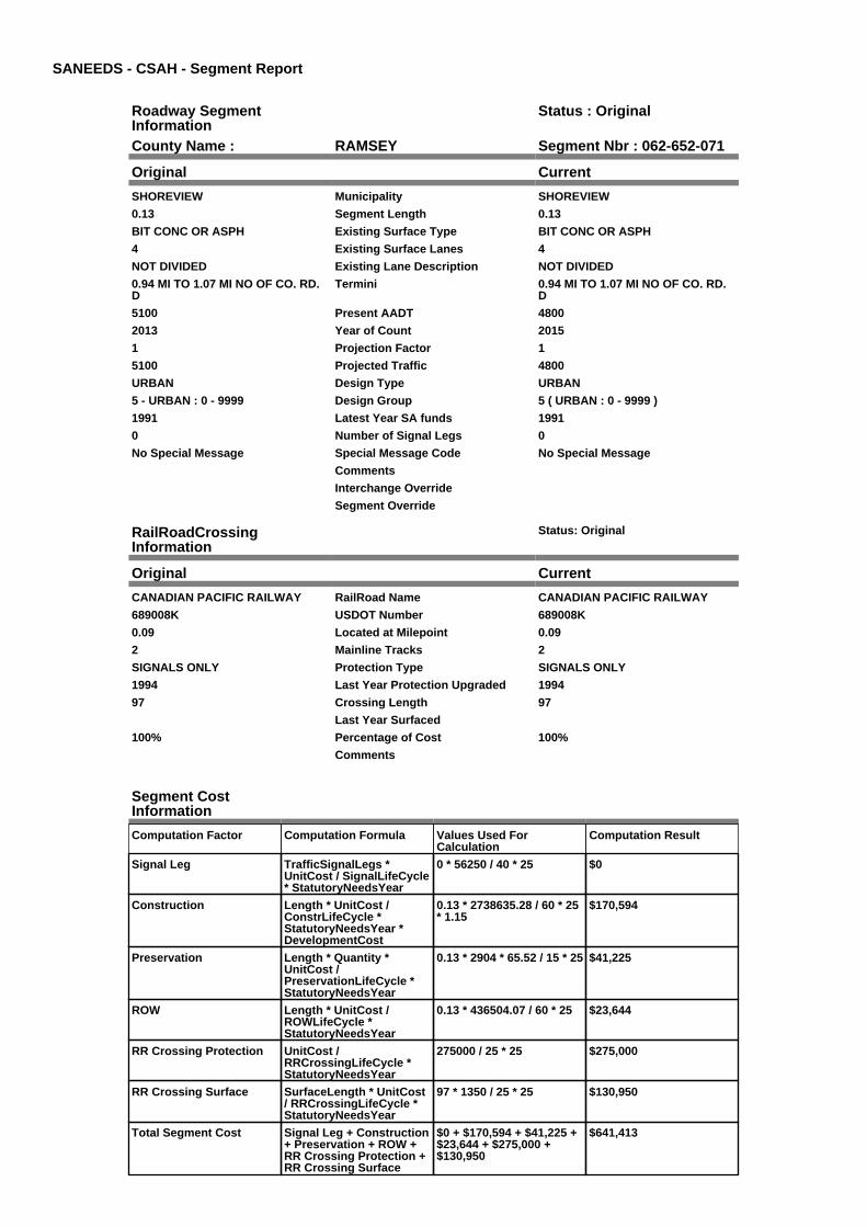
SANEEDS - CSAH - Segment Report
Roadway SegmentInformation
Status : Original
County Name : RAMSEY Segment Nbr : 062-652-071
Original Current
SHOREVIEW Municipality SHOREVIEW
0.13 Segment Length 0.13
BIT CONC OR ASPH Existing Surface Type BIT CONC OR ASPH
4 Existing Surface Lanes 4
NOT DIVIDED Existing Lane Description NOT DIVIDED
0.94 MI TO 1.07 MI NO OF CO. RD.D
Termini 0.94 MI TO 1.07 MI NO OF CO. RD.D
5100 Present AADT 4800
2013 Year of Count 2015
1 Projection Factor 1
5100 Projected Traffic 4800
URBAN Design Type URBAN
5 - URBAN : 0 - 9999 Design Group 5 ( URBAN : 0 - 9999 )
1991 Latest Year SA funds 1991
0 Number of Signal Legs 0
No Special Message Special Message Code No Special Message
Comments
Interchange Override
Segment Override
RailRoadCrossingInformation
Status: Original
Original Current
CANADIAN PACIFIC RAILWAY RailRoad Name CANADIAN PACIFIC RAILWAY
689008K USDOT Number 689008K
0.09 Located at Milepoint 0.09
2 Mainline Tracks 2
SIGNALS ONLY Protection Type SIGNALS ONLY
1994 Last Year Protection Upgraded 1994
97 Crossing Length 97
Last Year Surfaced
100% Percentage of Cost 100%
Comments
Segment CostInformation
Computation Factor Computation Formula Values Used ForCalculation
Computation Result
Signal Leg TrafficSignalLegs *UnitCost / SignalLifeCycle* StatutoryNeedsYear
0 * 56250 / 40 * 25 $0
Construction Length * UnitCost /ConstrLifeCycle *StatutoryNeedsYear *DevelopmentCost
0.13 * 2738635.28 / 60 * 25* 1.15
$170,594
Preservation Length * Quantity *UnitCost /PreservationLifeCycle *StatutoryNeedsYear
0.13 * 2904 * 65.52 / 15 * 25 $41,225
ROW Length * UnitCost /ROWLifeCycle *StatutoryNeedsYear
0.13 * 436504.07 / 60 * 25 $23,644
RR Crossing Protection UnitCost /RRCrossingLifeCycle *StatutoryNeedsYear
275000 / 25 * 25 $275,000
RR Crossing Surface SurfaceLength * UnitCost/ RRCrossingLifeCycle *StatutoryNeedsYear
97 * 1350 / 25 * 25 $130,950
Total Segment Cost Signal Leg + Construction+ Preservation + ROW +RR Crossing Protection +RR Crossing Surface
$0 + $170,594 + $41,225 +$23,644 + $275,000 +$130,950
$641,413

SANEEDS - CSAH - Segment Report
Roadway SegmentInformation
Status : Original
County Name : RAMSEY Segment Nbr : 062-652-072
Original Current
SHOREVIEW Municipality SHOREVIEW
0.41 Segment Length 0.41
BIT CONC OR ASPH Existing Surface Type BIT CONC OR ASPH
4 Existing Surface Lanes 4
NOT DIVIDED Existing Lane Description NOT DIVIDED
1.07 NO OF CO. RD. D TO SORAMP I694
Termini 1.07 NO OF CO. RD. D TO SORAMP I694
12500 Present AADT 10700
2013 Year of Count 2015
1 Projection Factor 1
12500 Projected Traffic 10700
URBAN Design Type URBAN
6 - URBAN : 10000 - 19999 Design Group 6 ( URBAN : 10000 - 19999 )
1991 Latest Year SA funds 1991
5 Number of Signal Legs 5
No Special Message Special Message Code No Special Message
Comments
Interchange Override
Segment Override
Segment CostInformation
Computation Factor Computation Formula Values Used ForCalculation
Computation Result
Signal Leg TrafficSignalLegs *UnitCost / SignalLifeCycle* StatutoryNeedsYear
5 * 56250 / 40 * 25 $175,781
Construction Length * UnitCost /ConstrLifeCycle *StatutoryNeedsYear *DevelopmentCost
0.41 * 4225495.41 / 60 * 25* 1.15
$830,134
Preservation Length * Quantity *UnitCost /PreservationLifeCycle *StatutoryNeedsYear
0.41 * 3696 * 65.52 / 15 * 25 $165,477
ROW Length * UnitCost /ROWLifeCycle *StatutoryNeedsYear
0.41 * 566370.18 / 60 * 25 $96,755
Total Segment Cost Signal Leg + Construction+ Preservation + ROW
$175,781 + $830,134 +$165,477 + $96,755
$1,268,147

SANEEDS - CSAH - Segment Report
Roadway SegmentInformation
Status : Original
County Name : RAMSEY Segment Nbr : 062-652-073
Original Current
SHOREVIEW Municipality SHOREVIEW
0.17 Segment Length 0.17
MIXED BITUMINOUS Existing Surface Type MIXED BITUMINOUS
2 Existing Surface Lanes 2
NOT DIVIDED Existing Lane Description NOT DIVIDED
SO. RAMP I694 TO NO. RAMP I694 Termini SO. RAMP I694 TO NO. RAMP I694
12500 Present AADT 10700
2013 Year of Count 2015
1 Projection Factor 1
12500 Projected Traffic 10700
URBAN Design Type URBAN
6 - URBAN : 10000 - 19999 Design Group 6 ( URBAN : 10000 - 19999 )
2000 Latest Year SA funds 2000
2 Number of Signal Legs 2
No Special Message Special Message Code No Special Message
Comments
Interchange Override
Segment Override
Segment CostInformation
Computation Factor Computation Formula Values Used ForCalculation
Computation Result
Signal Leg TrafficSignalLegs *UnitCost / SignalLifeCycle* StatutoryNeedsYear
2 * 56250 / 40 * 25 $70,313
Construction Length * UnitCost /ConstrLifeCycle *StatutoryNeedsYear *DevelopmentCost
0.17 * 4225495.41 / 60 * 25* 1.15
$344,202
Preservation Length * Quantity *UnitCost /PreservationLifeCycle *StatutoryNeedsYear
0.17 * 3696 * 65.52 / 15 * 25 $68,613
ROW Length * UnitCost /ROWLifeCycle *StatutoryNeedsYear
0.17 * 566370.18 / 60 * 25 $40,118
Total Segment Cost Signal Leg + Construction+ Preservation + ROW
$70,313 + $344,202 +$68,613 + $40,118
$523,246

SANEEDS - CSAH - Segment Report
Roadway SegmentInformation
Status : Original
County Name : RAMSEY Segment Nbr : 062-652-074
Original Current
SHOREVIEW Municipality SHOREVIEW
0.52 Segment Length 0.52
BIT CONC OR ASPH Existing Surface Type BIT CONC OR ASPH
4 Existing Surface Lanes 4
NOT DIVIDED Existing Lane Description NOT DIVIDED
NO. RAMP I694 TO CO. RD. F Termini NO. RAMP I694 TO CO. RD. F
9300 Present AADT 8000
2013 Year of Count 2015
1 Projection Factor 1
9300 Projected Traffic 8000
URBAN Design Type URBAN
5 - URBAN : 0 - 9999 Design Group 5 ( URBAN : 0 - 9999 )
1991 Latest Year SA funds 1991
3 Number of Signal Legs 3
No Special Message Special Message Code No Special Message
Comments
Interchange Override
Segment Override
Segment CostInformation
Computation Factor Computation Formula Values Used ForCalculation
Computation Result
Signal Leg TrafficSignalLegs *UnitCost / SignalLifeCycle* StatutoryNeedsYear
3 * 56250 / 40 * 25 $105,469
Construction Length * UnitCost /ConstrLifeCycle *StatutoryNeedsYear *DevelopmentCost
0.52 * 2738635.28 / 60 * 25* 1.15
$682,377
Preservation Length * Quantity *UnitCost /PreservationLifeCycle *StatutoryNeedsYear
0.52 * 2904 * 65.52 / 15 * 25 $164,901
ROW Length * UnitCost /ROWLifeCycle *StatutoryNeedsYear
0.52 * 436504.07 / 60 * 25 $94,576
Total Segment Cost Signal Leg + Construction+ Preservation + ROW
$105,469 + $682,377 +$164,901 + $94,576
$1,047,323

SANEEDS - CSAH - Segment Report
Roadway SegmentInformation
Status : Original
County Name : RAMSEY Segment Nbr : 062-653-001
Original Current
ST PAUL Municipality ST PAUL
0.09 Segment Length 0.09
MIXED BITUMINOUS Existing Surface Type MIXED BITUMINOUS
2 Existing Surface Lanes 2
NOT DIVIDED Existing Lane Description NOT DIVIDED
GRAND AVE TO SUMMIT AVE Termini GRAND AVE TO SUMMIT AVE
7900 Present AADT 7900
2013 Year of Count 2015
1 Projection Factor 1
7900 Projected Traffic 7900
URBAN Design Type URBAN
5 - URBAN : 0 - 9999 Design Group 5 ( URBAN : 0 - 9999 )
2000 Latest Year SA funds 2000
2 Number of Signal Legs 2
No Special Message Special Message Code No Special Message
Comments
Interchange Override
Segment Override
Segment CostInformation
Computation Factor Computation Formula Values Used ForCalculation
Computation Result
Signal Leg TrafficSignalLegs *UnitCost / SignalLifeCycle* StatutoryNeedsYear
2 * 56250 / 40 * 25 $70,313
Construction Length * UnitCost /ConstrLifeCycle *StatutoryNeedsYear *DevelopmentCost
0.09 * 2738635.28 / 60 * 25* 1.15
$118,104
Preservation Length * Quantity *UnitCost /PreservationLifeCycle *StatutoryNeedsYear
0.09 * 2904 * 65.52 / 15 * 25 $28,541
ROW Length * UnitCost /ROWLifeCycle *StatutoryNeedsYear
0.09 * 436504.07 / 60 * 25 $16,369
Total Segment Cost Signal Leg + Construction+ Preservation + ROW
$70,313 + $118,104 +$28,541 + $16,369
$233,327

SANEEDS - CSAH - Segment Report
Roadway SegmentInformation
Status : Original
County Name : RAMSEY Segment Nbr : 062-653-002
Original Current
ST PAUL Municipality ST PAUL
0.36 Segment Length 0.36
MIXED BITUMINOUS Existing Surface Type MIXED BITUMINOUS
2 Existing Surface Lanes 2
NOT DIVIDED Existing Lane Description NOT DIVIDED
SUMMIT AVE TO SELBY AVE Termini SUMMIT AVE TO SELBY AVE
11200 Present AADT 11200
2013 Year of Count 2015
1 Projection Factor 1
11200 Projected Traffic 11200
URBAN Design Type URBAN
6 - URBAN : 10000 - 19999 Design Group 6 ( URBAN : 10000 - 19999 )
2000 Latest Year SA funds 2000
2 Number of Signal Legs 2
No Special Message Special Message Code No Special Message
Comments
Interchange Override
Segment Override
Segment CostInformation
Computation Factor Computation Formula Values Used ForCalculation
Computation Result
Signal Leg TrafficSignalLegs *UnitCost / SignalLifeCycle* StatutoryNeedsYear
2 * 56250 / 40 * 25 $70,313
Construction Length * UnitCost /ConstrLifeCycle *StatutoryNeedsYear *DevelopmentCost
0.36 * 4225495.41 / 60 * 25* 1.15
$728,898
Preservation Length * Quantity *UnitCost /PreservationLifeCycle *StatutoryNeedsYear
0.36 * 3696 * 65.52 / 15 * 25 $145,297
ROW Length * UnitCost /ROWLifeCycle *StatutoryNeedsYear
0.36 * 566370.18 / 60 * 25 $84,956
Total Segment Cost Signal Leg + Construction+ Preservation + ROW
$70,313 + $728,898 +$145,297 + $84,956
$1,029,464

SANEEDS - CSAH - Segment Report
Roadway SegmentInformation
Status : Original
County Name : RAMSEY Segment Nbr : 062-653-003
Original Current
ST PAUL Municipality ST PAUL
0.39 Segment Length 0.39
MIXED BITUMINOUS Existing Surface Type MIXED BITUMINOUS
2 Existing Surface Lanes 2
NOT DIVIDED Existing Lane Description NOT DIVIDED
SELBY AVE TO ST ANTHONY AVE Termini SELBY AVE TO ST ANTHONY AVE
17900 Present AADT 18000
2013 Year of Count 2015
1 Projection Factor 1
17900 Projected Traffic 18000
URBAN Design Type URBAN
6 - URBAN : 10000 - 19999 Design Group 6 ( URBAN : 10000 - 19999 )
2000 Latest Year SA funds 2000
6 Number of Signal Legs 6
No Special Message Special Message Code No Special Message
Comments
Interchange Override
Segment Override
Segment CostInformation
Computation Factor Computation Formula Values Used ForCalculation
Computation Result
Signal Leg TrafficSignalLegs *UnitCost / SignalLifeCycle* StatutoryNeedsYear
6 * 56250 / 40 * 25 $210,938
Construction Length * UnitCost /ConstrLifeCycle *StatutoryNeedsYear *DevelopmentCost
0.39 * 4225495.41 / 60 * 25* 1.15
$789,639
Preservation Length * Quantity *UnitCost /PreservationLifeCycle *StatutoryNeedsYear
0.39 * 3696 * 65.52 / 15 * 25 $157,405
ROW Length * UnitCost /ROWLifeCycle *StatutoryNeedsYear
0.39 * 566370.18 / 60 * 25 $92,035
Total Segment Cost Signal Leg + Construction+ Preservation + ROW
$210,938 + $789,639 +$157,405 + $92,035
$1,250,017

SANEEDS - CSAH - Segment Report
Roadway SegmentInformation
Status : Original
County Name : RAMSEY Segment Nbr : 062-653-004
Original Current
ST PAUL Municipality ST PAUL
0.3 Segment Length 0.3
MIXED BITUMINOUS Existing Surface Type MIXED BITUMINOUS
4 Existing Surface Lanes 4
DIVIDED Existing Lane Description DIVIDED
ST ANTHONY AVE TOSHERBURNE AVE
Termini ST ANTHONY AVE TOSHERBURNE AVE
23200 Present AADT 23200
2013 Year of Count 2015
1 Projection Factor 1
23200 Projected Traffic 23200
URBAN Design Type URBAN
7 - URBAN : 20000 - 34999 Design Group 7 ( URBAN : 20000 - 34999 )
2000 Latest Year SA funds 2000
3 Number of Signal Legs 3
No Special Message Special Message Code No Special Message
Comments
Interchange Override
Segment Override
Segment CostInformation
Computation Factor Computation Formula Values Used ForCalculation
Computation Result
Signal Leg TrafficSignalLegs *UnitCost / SignalLifeCycle* StatutoryNeedsYear
3 * 56250 / 40 * 25 $105,469
Construction Length * UnitCost /ConstrLifeCycle *StatutoryNeedsYear *DevelopmentCost
0.3 * 5259942.61 / 60 * 25 *1.15
$756,117
Preservation Length * Quantity *UnitCost /PreservationLifeCycle *StatutoryNeedsYear
0.3 * 4488 * 65.52 / 15 * 25 $147,027
ROW Length * UnitCost /ROWLifeCycle *StatutoryNeedsYear
0.3 * 883293.09 / 60 * 25 $110,412
Total Segment Cost Signal Leg + Construction+ Preservation + ROW
$105,469 + $756,117 +$147,027 + $110,412
$1,119,025

SANEEDS - CSAH - Segment Report
Roadway SegmentInformation
Status : Original
County Name : RAMSEY Segment Nbr : 062-653-005
Original Current
ST PAUL Municipality ST PAUL
0.38 Segment Length 0.38
MIXED BITUMINOUS Existing Surface Type MIXED BITUMINOUS
2 Existing Surface Lanes 2
NOT DIVIDED Existing Lane Description NOT DIVIDED
SHERBURNE AVE TO VAN BURENAVE
Termini SHERBURNE AVE TO VAN BURENAVE
19900 Present AADT 19900
2013 Year of Count 2015
1 Projection Factor 1
19900 Projected Traffic 19900
URBAN Design Type URBAN
6 - URBAN : 10000 - 19999 Design Group 6 ( URBAN : 10000 - 19999 )
2000 Latest Year SA funds 2000
4 Number of Signal Legs 4
No Special Message Special Message Code No Special Message
Comments
Interchange Override
Segment Override
Segment CostInformation
Computation Factor Computation Formula Values Used ForCalculation
Computation Result
Signal Leg TrafficSignalLegs *UnitCost / SignalLifeCycle* StatutoryNeedsYear
4 * 56250 / 40 * 25 $140,625
Construction Length * UnitCost /ConstrLifeCycle *StatutoryNeedsYear *DevelopmentCost
0.38 * 4225495.41 / 60 * 25* 1.15
$769,392
Preservation Length * Quantity *UnitCost /PreservationLifeCycle *StatutoryNeedsYear
0.38 * 3696 * 65.52 / 15 * 25 $153,369
ROW Length * UnitCost /ROWLifeCycle *StatutoryNeedsYear
0.38 * 566370.18 / 60 * 25 $89,675
Total Segment Cost Signal Leg + Construction+ Preservation + ROW
$140,625 + $769,392 +$153,369 + $89,675
$1,153,061

SANEEDS - CSAH - Segment Report
Roadway SegmentInformation
Status : Original
County Name : RAMSEY Segment Nbr : 062-653-006
Original Current
ST PAUL Municipality ST PAUL
0.56 Segment Length 0.56
MIXED BITUMINOUS Existing Surface Type MIXED BITUMINOUS
6 Existing Surface Lanes 6
DIVIDED Existing Lane Description DIVIDED
VAN BURAN AVE TO COMO AVE Termini VAN BURAN AVE TO COMO AVE
19900 Present AADT 19900
2013 Year of Count 2015
1 Projection Factor 1
19900 Projected Traffic 19900
URBAN Design Type URBAN
6 - URBAN : 10000 - 19999 Design Group 6 ( URBAN : 10000 - 19999 )
1977 Latest Year SA funds 1977
4 Number of Signal Legs 4
No Special Message Special Message Code No Special Message
Comments
Interchange Override
Segment Override
Bridge Information Status: Original
Original Current
62523 Structure Number 62523
1.79 Milepoint 1.79
1970 Year Built 1970
Feature Crossed
Type of Service
Number of Spans
233.7 Bridge Length 233.7
94.3 Bridge Width 94.3
100% Shared Structure 100%
Comments
2 ( 150-999,999 ) Bridge Group Code 2 ( 150-999,999 )
Segment CostInformation
Computation Factor Computation Formula Values Used ForCalculation
Computation Result
Signal Leg TrafficSignalLegs *UnitCost / SignalLifeCycle* StatutoryNeedsYear
4 * 56250 / 40 * 25 $140,625
Construction Length * UnitCost /ConstrLifeCycle *StatutoryNeedsYear *DevelopmentCost
0.56 * 4225495.41 / 60 * 25* 1.15
$1,133,841
Preservation Length * Quantity *UnitCost /PreservationLifeCycle *StatutoryNeedsYear
0.56 * 3696 * 65.52 / 15 * 25 $226,018
ROW Length * UnitCost /ROWLifeCycle *StatutoryNeedsYear
0.56 * 566370.18 / 60 * 25 $132,153
Bridge BridgeLength *BridgeWidth * UnitCost /BridgeLifeCycle *StatutoryNeedsYear *DevelopmentCost
233.7 * 94.3 * 138 / 80 * 25* 1.15
$1,092,943
Total Segment Cost Signal Leg + Construction+ Preservation + ROW +Bridge
$140,625 + $1,133,841 +$226,018 + $132,153 +$1,092,943
$2,725,580

SANEEDS - CSAH - Segment Report
Roadway SegmentInformation
Status : Original
County Name : RAMSEY Segment Nbr : 062-653-010
Original Current
ST PAUL Municipality ST PAUL
0.48 Segment Length 0.48
BIT CONC OR ASPH Existing Surface Type BIT CONC OR ASPH
2 Existing Surface Lanes 2
NOT DIVIDED Existing Lane Description NOT DIVIDED
DALE STREET-COMO TOMARYLAND.
Termini DALE STREET-COMO TOMARYLAND.
15400 Present AADT 16200
2013 Year of Count 2015
1 Projection Factor 1
15400 Projected Traffic 16200
URBAN Design Type URBAN
6 - URBAN : 10000 - 19999 Design Group 6 ( URBAN : 10000 - 19999 )
2000 Latest Year SA funds 2000
2 Number of Signal Legs 2
No Special Message Special Message Code No Special Message
Comments
Interchange Override
Segment Override
Bridge Information Status: Original
Original Current
5560 Structure Number 5560
2.41 Milepoint 2.41
1908 Year Built 1908
Feature Crossed
Type of Service
0 Number of Spans 0
101 Bridge Length 101
35 Bridge Width 35
100% Shared Structure 100%
Comments
1 ( 0-149 ) Bridge Group Code 1 ( 0-149 )
Segment CostInformation
Computation Factor Computation Formula Values Used ForCalculation
Computation Result
Signal Leg TrafficSignalLegs *UnitCost / SignalLifeCycle* StatutoryNeedsYear
2 * 56250 / 40 * 25 $70,313
Construction Length * UnitCost /ConstrLifeCycle *StatutoryNeedsYear *DevelopmentCost
0.48 * 4225495.41 / 60 * 25* 1.15
$971,864
Preservation Length * Quantity *UnitCost /PreservationLifeCycle *StatutoryNeedsYear
0.48 * 3696 * 65.52 / 15 * 25 $193,730
ROW Length * UnitCost /ROWLifeCycle *StatutoryNeedsYear
0.48 * 566370.18 / 60 * 25 $113,274
Bridge BridgeLength *BridgeWidth * UnitCost /BridgeLifeCycle *StatutoryNeedsYear *DevelopmentCost
101 * 35 * 152 / 80 * 25 *1.15
$193,099
Total Segment Cost Signal Leg + Construction+ Preservation + ROW +Bridge
$70,313 + $971,864 +$193,730 + $113,274 +$193,099
$1,542,280

SANEEDS - CSAH - Segment Report
Roadway SegmentInformation
Status : Original
County Name : RAMSEY Segment Nbr : 062-653-015
Original Current
ST PAUL Municipality ST PAUL
0.25 Segment Length 0.25
BIT CONC OR ASPH Existing Surface Type BIT CONC OR ASPH
2 Existing Surface Lanes 2
NOT DIVIDED Existing Lane Description NOT DIVIDED
DALE STREET-MARYLAND TOWHEELOCK PARKWAY.
Termini DALE STREET-MARYLAND TOWHEELOCK PARKWAY.
13100 Present AADT 13100
2013 Year of Count 2015
1 Projection Factor 1
13100 Projected Traffic 13100
URBAN Design Type URBAN
6 - URBAN : 10000 - 19999 Design Group 6 ( URBAN : 10000 - 19999 )
2000 Latest Year SA funds 2000
2 Number of Signal Legs 2
No Special Message Special Message Code No Special Message
Comments
Interchange Override
Segment Override
Segment CostInformation
Computation Factor Computation Formula Values Used ForCalculation
Computation Result
Signal Leg TrafficSignalLegs *UnitCost / SignalLifeCycle* StatutoryNeedsYear
2 * 56250 / 40 * 25 $70,313
Construction Length * UnitCost /ConstrLifeCycle *StatutoryNeedsYear *DevelopmentCost
0.25 * 4225495.41 / 60 * 25* 1.15
$506,179
Preservation Length * Quantity *UnitCost /PreservationLifeCycle *StatutoryNeedsYear
0.25 * 3696 * 65.52 / 15 * 25 $100,901
ROW Length * UnitCost /ROWLifeCycle *StatutoryNeedsYear
0.25 * 566370.18 / 60 * 25 $58,997
Total Segment Cost Signal Leg + Construction+ Preservation + ROW
$70,313 + $506,179 +$100,901 + $58,997
$736,390

SANEEDS - CSAH - Segment Report
Roadway SegmentInformation
Status : Original
County Name : RAMSEY Segment Nbr : 062-653-020
Original Current
ST PAUL Municipality ST PAUL
0.25 Segment Length 0.25
BIT CONC OR ASPH Existing Surface Type BIT CONC OR ASPH
2 Existing Surface Lanes 2
NOT DIVIDED Existing Lane Description NOT DIVIDED
DALE STREET - WHEELOCK TOARLINGTON AVENUE.
Termini DALE STREET - WHEELOCK TOARLINGTON AVENUE.
13100 Present AADT 13100
2013 Year of Count 2015
1 Projection Factor 1
13100 Projected Traffic 13100
URBAN Design Type URBAN
6 - URBAN : 10000 - 19999 Design Group 6 ( URBAN : 10000 - 19999 )
2000 Latest Year SA funds 2000
2 Number of Signal Legs 2
No Special Message Special Message Code No Special Message
Comments
Interchange Override
Segment Override
Segment CostInformation
Computation Factor Computation Formula Values Used ForCalculation
Computation Result
Signal Leg TrafficSignalLegs *UnitCost / SignalLifeCycle* StatutoryNeedsYear
2 * 56250 / 40 * 25 $70,313
Construction Length * UnitCost /ConstrLifeCycle *StatutoryNeedsYear *DevelopmentCost
0.25 * 4225495.41 / 60 * 25* 1.15
$506,179
Preservation Length * Quantity *UnitCost /PreservationLifeCycle *StatutoryNeedsYear
0.25 * 3696 * 65.52 / 15 * 25 $100,901
ROW Length * UnitCost /ROWLifeCycle *StatutoryNeedsYear
0.25 * 566370.18 / 60 * 25 $58,997
Total Segment Cost Signal Leg + Construction+ Preservation + ROW
$70,313 + $506,179 +$100,901 + $58,997
$736,390

SANEEDS - CSAH - Segment Report
Roadway SegmentInformation
Status : Original
County Name : RAMSEY Segment Nbr : 062-653-025
Original Current
ST PAUL Municipality ST PAUL
0.5 Segment Length 0.5
MIXED BITUMINOUS Existing Surface Type MIXED BITUMINOUS
4 Existing Surface Lanes 4
DIVIDED Existing Lane Description DIVIDED
DALE ST. - ARLINGTON AVENUETO LARPENTEUR AVENUE.
Termini DALE ST. - ARLINGTON AVENUETO LARPENTEUR AVENUE.
13300 Present AADT 13700
2013 Year of Count 2015
1 Projection Factor 1
13300 Projected Traffic 13700
URBAN Design Type URBAN
6 - URBAN : 10000 - 19999 Design Group 6 ( URBAN : 10000 - 19999 )
2000 Latest Year SA funds 2000
2 Number of Signal Legs 2
No Special Message Special Message Code No Special Message
Comments
Interchange Override
Segment Override
Segment CostInformation
Computation Factor Computation Formula Values Used ForCalculation
Computation Result
Signal Leg TrafficSignalLegs *UnitCost / SignalLifeCycle* StatutoryNeedsYear
2 * 56250 / 40 * 25 $70,313
Construction Length * UnitCost /ConstrLifeCycle *StatutoryNeedsYear *DevelopmentCost
0.5 * 4225495.41 / 60 * 25 *1.15
$1,012,358
Preservation Length * Quantity *UnitCost /PreservationLifeCycle *StatutoryNeedsYear
0.5 * 3696 * 65.52 / 15 * 25 $201,802
ROW Length * UnitCost /ROWLifeCycle *StatutoryNeedsYear
0.5 * 566370.18 / 60 * 25 $117,994
Total Segment Cost Signal Leg + Construction+ Preservation + ROW
$70,313 + $1,012,358 +$201,802 + $117,994
$1,402,467

SANEEDS - CSAH - Segment Report
Roadway SegmentInformation
Status : Original
County Name : RAMSEY Segment Nbr : 062-653-030
Original Current
ROSEVILLE Municipality ROSEVILLE
0.49 Segment Length 0.49
MIXED BITUMINOUS Existing Surface Type MIXED BITUMINOUS
2 Existing Surface Lanes 2
NOT DIVIDED Existing Lane Description NOT DIVIDED
LARPENTEUR AVE. TOROSELAWN AVE.
Termini LARPENTEUR AVE. TOROSELAWN AVE.
10600 Present AADT 12400
2013 Year of Count 2015
1 Projection Factor 1
10600 Projected Traffic 12400
URBAN Design Type URBAN
6 - URBAN : 10000 - 19999 Design Group 6 ( URBAN : 10000 - 19999 )
2003 Latest Year SA funds 2003
1 Number of Signal Legs 1
No Special Message Special Message Code No Special Message
Comments
Interchange Override
Segment Override
Segment CostInformation
Computation Factor Computation Formula Values Used ForCalculation
Computation Result
Signal Leg TrafficSignalLegs *UnitCost / SignalLifeCycle* StatutoryNeedsYear
1 * 56250 / 40 * 25 $35,156
Construction Length * UnitCost /ConstrLifeCycle *StatutoryNeedsYear *DevelopmentCost
0.49 * 4225495.41 / 60 * 25* 1.15
$992,111
Preservation Length * Quantity *UnitCost /PreservationLifeCycle *StatutoryNeedsYear
0.49 * 3696 * 65.52 / 15 * 25 $197,766
ROW Length * UnitCost /ROWLifeCycle *StatutoryNeedsYear
0.49 * 566370.18 / 60 * 25 $115,634
Total Segment Cost Signal Leg + Construction+ Preservation + ROW
$35,156 + $992,111 +$197,766 + $115,634
$1,340,667
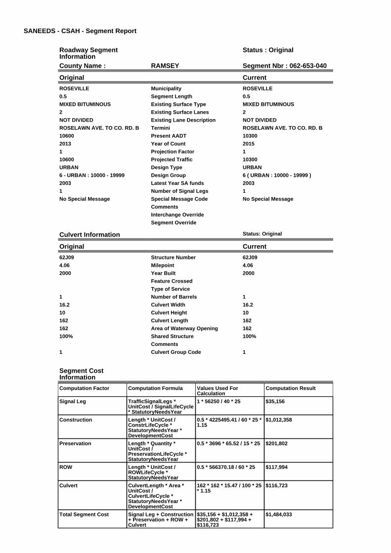
SANEEDS - CSAH - Segment Report
Roadway SegmentInformation
Status : Original
County Name : RAMSEY Segment Nbr : 062-653-040
Original Current
ROSEVILLE Municipality ROSEVILLE
0.5 Segment Length 0.5
MIXED BITUMINOUS Existing Surface Type MIXED BITUMINOUS
2 Existing Surface Lanes 2
NOT DIVIDED Existing Lane Description NOT DIVIDED
ROSELAWN AVE. TO CO. RD. B Termini ROSELAWN AVE. TO CO. RD. B
10600 Present AADT 10300
2013 Year of Count 2015
1 Projection Factor 1
10600 Projected Traffic 10300
URBAN Design Type URBAN
6 - URBAN : 10000 - 19999 Design Group 6 ( URBAN : 10000 - 19999 )
2003 Latest Year SA funds 2003
1 Number of Signal Legs 1
No Special Message Special Message Code No Special Message
Comments
Interchange Override
Segment Override
Culvert Information Status: Original
Original Current
62J09 Structure Number 62J09
4.06 Milepoint 4.06
2000 Year Built 2000
Feature Crossed
Type of Service
1 Number of Barrels 1
16.2 Culvert Width 16.2
10 Culvert Height 10
162 Culvert Length 162
162 Area of Waterway Opening 162
100% Shared Structure 100%
Comments
1 Culvert Group Code 1
Segment CostInformation
Computation Factor Computation Formula Values Used ForCalculation
Computation Result
Signal Leg TrafficSignalLegs *UnitCost / SignalLifeCycle* StatutoryNeedsYear
1 * 56250 / 40 * 25 $35,156
Construction Length * UnitCost /ConstrLifeCycle *StatutoryNeedsYear *DevelopmentCost
0.5 * 4225495.41 / 60 * 25 *1.15
$1,012,358
Preservation Length * Quantity *UnitCost /PreservationLifeCycle *StatutoryNeedsYear
0.5 * 3696 * 65.52 / 15 * 25 $201,802
ROW Length * UnitCost /ROWLifeCycle *StatutoryNeedsYear
0.5 * 566370.18 / 60 * 25 $117,994
Culvert CulvertLength * Area *UnitCost /CulvertLifeCycle *StatutoryNeedsYear *DevelopmentCost
162 * 162 * 15.47 / 100 * 25* 1.15
$116,723
Total Segment Cost Signal Leg + Construction+ Preservation + ROW +Culvert
$35,156 + $1,012,358 +$201,802 + $117,994 +$116,723
$1,484,033

SANEEDS - CSAH - Segment Report
Roadway SegmentInformation
Status : Original
County Name : RAMSEY Segment Nbr : 062-653-050
Original Current
ROSEVILLE Municipality ROSEVILLE
0.2 Segment Length 0.2
MIXED BITUMINOUS Existing Surface Type MIXED BITUMINOUS
2 Existing Surface Lanes 2
NOT DIVIDED Existing Lane Description NOT DIVIDED
CO. RD. B TO T.H. 36 Termini CO. RD. B TO T.H. 36
12600 Present AADT 12600
2013 Year of Count 2015
1 Projection Factor 1
12600 Projected Traffic 12600
URBAN Design Type URBAN
6 - URBAN : 10000 - 19999 Design Group 6 ( URBAN : 10000 - 19999 )
2003 Latest Year SA funds 2003
2 Number of Signal Legs 2
No Special Message Special Message Code No Special Message
Comments
Interchange Override
Segment Override
Segment CostInformation
Computation Factor Computation Formula Values Used ForCalculation
Computation Result
Signal Leg TrafficSignalLegs *UnitCost / SignalLifeCycle* StatutoryNeedsYear
2 * 56250 / 40 * 25 $70,313
Construction Length * UnitCost /ConstrLifeCycle *StatutoryNeedsYear *DevelopmentCost
0.2 * 4225495.41 / 60 * 25 *1.15
$404,943
Preservation Length * Quantity *UnitCost /PreservationLifeCycle *StatutoryNeedsYear
0.2 * 3696 * 65.52 / 15 * 25 $80,721
ROW Length * UnitCost /ROWLifeCycle *StatutoryNeedsYear
0.2 * 566370.18 / 60 * 25 $47,198
Total Segment Cost Signal Leg + Construction+ Preservation + ROW
$70,313 + $404,943 +$80,721 + $47,198
$603,175

SANEEDS - CSAH - Segment Report
Roadway SegmentInformation
Status : Original
County Name : RAMSEY Segment Nbr : 062-653-051
Original Current
ROSEVILLE Municipality ROSEVILLE
0.3 Segment Length 0.3
MIXED BITUMINOUS Existing Surface Type MIXED BITUMINOUS
2 Existing Surface Lanes 2
NOT DIVIDED Existing Lane Description NOT DIVIDED
TH 36 TO CO. RD. B2 Termini TH 36 TO CO. RD. B2
12600 Present AADT 7800
2013 Year of Count 2015
1 Projection Factor 1
12600 Projected Traffic 7800
RURAL Design Type RURAL
4 - RURAL : 7000 - 999999 Design Group 4 ( RURAL : 7000 - 999999 )
2000 Latest Year SA funds 2000
3 Number of Signal Legs 3
No Special Message Special Message Code No Special Message
Comments
Interchange Override
Segment Override
Segment CostInformation
Computation Factor Computation Formula Values Used ForCalculation
Computation Result
Signal Leg TrafficSignalLegs *UnitCost / SignalLifeCycle* StatutoryNeedsYear
3 * 56250 / 40 * 25 $105,469
Construction Length * UnitCost /ConstrLifeCycle *StatutoryNeedsYear *DevelopmentCost
0.3 * 1996892.57 / 60 * 25 *1.1
$274,573
Preservation Length * Quantity *UnitCost /PreservationLifeCycle *StatutoryNeedsYear
0.3 * 3564 * 65.52 / 20 * 25 $87,567
ROW Length * UnitCost /ROWLifeCycle *StatutoryNeedsYear
0.3 * 181173.68 / 60 * 25 $22,647
Total Segment Cost Signal Leg + Construction+ Preservation + ROW
$105,469 + $274,573 +$87,567 + $22,647
$490,256

SANEEDS - CSAH - Segment Report
Roadway SegmentInformation
Status : Original
County Name : RAMSEY Segment Nbr : 062-653-060
Original Current
ROSEVILLE Municipality ROSEVILLE
0.5 Segment Length 0.5
MIXED BITUMINOUS Existing Surface Type MIXED BITUMINOUS
2 Existing Surface Lanes 2
NOT DIVIDED Existing Lane Description NOT DIVIDED
CO. RD. B2 TO CO. RD. C Termini CO. RD. B2 TO CO. RD. C
5800 Present AADT 5200
2013 Year of Count 2015
1 Projection Factor 1
5800 Projected Traffic 5200
RURAL Design Type RURAL
3 - RURAL : 1500 - 6999 Design Group 3 ( RURAL : 1500 - 6999 )
2000 Latest Year SA funds 2000
0 Number of Signal Legs 0
No Special Message Special Message Code No Special Message
Comments
Interchange Override
Segment Override
Segment CostInformation
Computation Factor Computation Formula Values Used ForCalculation
Computation Result
Signal Leg TrafficSignalLegs *UnitCost / SignalLifeCycle* StatutoryNeedsYear
0 * 56250 / 40 * 25 $0
Construction Length * UnitCost /ConstrLifeCycle *StatutoryNeedsYear *DevelopmentCost
0.5 * 1021937.01 / 60 * 25 *1.1
$234,194
Preservation Length * Quantity *UnitCost /PreservationLifeCycle *StatutoryNeedsYear
0.5 * 2376 * 65.52 / 20 * 25 $97,297
ROW Length * UnitCost /ROWLifeCycle *StatutoryNeedsYear
0.5 * 85357.87 / 60 * 25 $17,783
Total Segment Cost Signal Leg + Construction+ Preservation + ROW
$0 + $234,194 + $97,297 +$17,783
$349,274

SANEEDS - CSAH - Segment Report
Roadway SegmentInformation
Status : Original
County Name : RAMSEY Segment Nbr : 062-654-010
Original Current
SHOREVIEW Municipality SHOREVIEW
0.07 Segment Length 0.07
MIXED BITUMINOUS Existing Surface Type MIXED BITUMINOUS
4 Existing Surface Lanes 4
DIVIDED Existing Lane Description DIVIDED
TH 49 TO 0.08 MI SO OF CO. RD. F Termini TH 49 TO 0.08 MI SO OF CO. RD. F
2950 Present AADT 6600
2013 Year of Count 2015
1 Projection Factor 1
2950 Projected Traffic 6600
URBAN Design Type URBAN
5 - URBAN : 0 - 9999 Design Group 5 ( URBAN : 0 - 9999 )
1981 Latest Year SA funds 1981
0 Number of Signal Legs 0
No Special Message Special Message Code No Special Message
Comments
Interchange Override
Segment Override
Segment CostInformation
Computation Factor Computation Formula Values Used ForCalculation
Computation Result
Signal Leg TrafficSignalLegs *UnitCost / SignalLifeCycle* StatutoryNeedsYear
0 * 56250 / 40 * 25 $0
Construction Length * UnitCost /ConstrLifeCycle *StatutoryNeedsYear *DevelopmentCost
0.07 * 2738635.28 / 60 * 25* 1.15
$91,858
Preservation Length * Quantity *UnitCost /PreservationLifeCycle *StatutoryNeedsYear
0.07 * 2904 * 65.52 / 15 * 25 $22,198
ROW Length * UnitCost /ROWLifeCycle *StatutoryNeedsYear
0.07 * 436504.07 / 60 * 25 $12,731
Total Segment Cost Signal Leg + Construction+ Preservation + ROW
$0 + $91,858 + $22,198 +$12,731
$126,787

SANEEDS - CSAH - Segment Report
Roadway SegmentInformation
Status : Original
County Name : RAMSEY Segment Nbr : 062-654-011
Original Current
SHOREVIEW Municipality SHOREVIEW
0.5 Segment Length 0.5
BIT CONC OR ASPH Existing Surface Type BIT CONC OR ASPH
2 Existing Surface Lanes 2
NOT DIVIDED Existing Lane Description NOT DIVIDED
0.08 MI SO OF CO. RD. F TO 0.42MI NO OF CO. RD. F
Termini 0.08 MI SO OF CO. RD. F TO 0.42MI NO OF CO. RD. F
3200 Present AADT 6600
2013 Year of Count 2015
1 Projection Factor 1
3200 Projected Traffic 6600
URBAN Design Type URBAN
5 - URBAN : 0 - 9999 Design Group 5 ( URBAN : 0 - 9999 )
2000 Latest Year SA funds 2000
0 Number of Signal Legs 0
No Special Message Special Message Code No Special Message
Comments
Interchange Override
Segment Override
Segment CostInformation
Computation Factor Computation Formula Values Used ForCalculation
Computation Result
Signal Leg TrafficSignalLegs *UnitCost / SignalLifeCycle* StatutoryNeedsYear
0 * 56250 / 40 * 25 $0
Construction Length * UnitCost /ConstrLifeCycle *StatutoryNeedsYear *DevelopmentCost
0.5 * 2738635.28 / 60 * 25 *1.15
$656,131
Preservation Length * Quantity *UnitCost /PreservationLifeCycle *StatutoryNeedsYear
0.5 * 2904 * 65.52 / 15 * 25 $158,558
ROW Length * UnitCost /ROWLifeCycle *StatutoryNeedsYear
0.5 * 436504.07 / 60 * 25 $90,938
Total Segment Cost Signal Leg + Construction+ Preservation + ROW
$0 + $656,131 + $158,558+ $90,938
$905,627

SANEEDS - CSAH - Segment Report
Roadway SegmentInformation
Status : Original
County Name : RAMSEY Segment Nbr : 062-654-020
Original Current
VADNAIS HEIGHTS Municipality VADNAIS HEIGHTS
0.58 Segment Length 0.58
PORT CEMENT CONC Existing Surface Type PORT CEMENT CONC
2 Existing Surface Lanes 2
NOT DIVIDED Existing Lane Description NOT DIVIDED
0.42 MI N OF CO. RD. F TO T.H. 96 Termini 0.42 MI N OF CO. RD. F TO T.H. 96
3200 Present AADT 3050
2013 Year of Count 2015
1 Projection Factor 1
3200 Projected Traffic 3050
RURAL Design Type RURAL
3 - RURAL : 1500 - 6999 Design Group 3 ( RURAL : 1500 - 6999 )
2000 Latest Year SA funds 2000
1 Number of Signal Legs 1
No Special Message Special Message Code No Special Message
Comments
Interchange Override
Segment Override
Segment CostInformation
Computation Factor Computation Formula Values Used ForCalculation
Computation Result
Signal Leg TrafficSignalLegs *UnitCost / SignalLifeCycle* StatutoryNeedsYear
1 * 56250 / 40 * 25 $35,156
Construction Length * UnitCost /ConstrLifeCycle *StatutoryNeedsYear *DevelopmentCost
0.58 * 1021937.01 / 60 * 25* 1.1
$271,665
Preservation Length * Quantity *UnitCost /PreservationLifeCycle *StatutoryNeedsYear
0.58 * 2376 * 65.52 / 20 * 25 $112,865
ROW Length * UnitCost /ROWLifeCycle *StatutoryNeedsYear
0.58 * 85357.87 / 60 * 25 $20,628
Total Segment Cost Signal Leg + Construction+ Preservation + ROW
$35,156 + $271,665 +$112,865 + $20,628
$440,314

SANEEDS - CSAH - Segment Report
Roadway SegmentInformation
Status : Original
County Name : RAMSEY Segment Nbr : 062-655-055
Original Current
ST PAUL Municipality ST PAUL
0.33 Segment Length 0.33
PORT CEMENT CONC Existing Surface Type PORT CEMENT CONC
2 Existing Surface Lanes 2
NOT DIVIDED Existing Lane Description NOT DIVIDED
S RAMP PENNSYLANIA AVE TOACKER ST
Termini S RAMP PENNSYLANIA AVE TOACKER ST
7300 Present AADT 7300
2013 Year of Count 2015
1 Projection Factor 1
7300 Projected Traffic 7300
URBAN Design Type URBAN
5 - URBAN : 0 - 9999 Design Group 5 ( URBAN : 0 - 9999 )
2000 Latest Year SA funds 2000
0 Number of Signal Legs 0
No Special Message Special Message Code No Special Message
Comments
Interchange Override
Segment Override
Bridge Information Status: Original
Original Current
5664 Structure Number 5664
0.11 Milepoint 0.11
1939 Year Built 1939
BNSF RR Feature Crossed BNSF RR
Type of Service
Number of Spans
485.7 Bridge Length 485.7
57 Bridge Width 57
100% Shared Structure 100%
Comments
2 ( 150-999,999 ) Bridge Group Code 2 ( 150-999,999 )
Bridge Information Status: Original
Original Current
62508 Structure Number 62508
0 Milepoint 0
1963 Year Built 1963
PENNSYLVANIA AVE Feature Crossed PENNSYLVANIA AVE
Type of Service
Number of Spans
173 Bridge Length 173
58.3 Bridge Width 58.3
100% Shared Structure 100%
Comments
2 ( 150-999,999 ) Bridge Group Code 2 ( 150-999,999 )
Segment CostInformation
Computation Factor Computation Formula Values Used ForCalculation
Computation Result
Signal Leg TrafficSignalLegs *UnitCost / SignalLifeCycle* StatutoryNeedsYear
0 * 56250 / 40 * 25 $0

Construction Length * UnitCost /ConstrLifeCycle *StatutoryNeedsYear *DevelopmentCost
0.33 * 2738635.28 / 60 * 25* 1.15
$433,047
Preservation Length * Quantity *UnitCost /PreservationLifeCycle *StatutoryNeedsYear
0.33 * 2904 * 65.52 / 15 * 25 $104,649
ROW Length * UnitCost /ROWLifeCycle *StatutoryNeedsYear
0.33 * 436504.07 / 60 * 25 $60,019
Bridge BridgeLength *BridgeWidth * UnitCost /BridgeLifeCycle *StatutoryNeedsYear *DevelopmentCost
485.7 * 57 * 138 / 80 * 25 *1.15
$1,372,998
Bridge BridgeLength *BridgeWidth * UnitCost /BridgeLifeCycle *StatutoryNeedsYear *DevelopmentCost
173 * 58.3 * 138 / 80 * 25 *1.15
$500,198
Total Segment Cost Signal Leg + Construction+ Preservation + ROW +Bridge + Bridge
$0 + $433,047 + $104,649+ $60,019 + $1,372,998 +$500,198
$2,470,911

SANEEDS - CSAH - Segment Report
Roadway SegmentInformation
Status : Original
County Name : RAMSEY Segment Nbr : 062-655-060
Original Current
ST PAUL Municipality ST PAUL
0.9 Segment Length 0.9
PORT CEMENT CONC Existing Surface Type PORT CEMENT CONC
2 Existing Surface Lanes 2
NOT DIVIDED Existing Lane Description NOT DIVIDED
ACKER ST TO MARYLAND AVE Termini ACKER ST TO MARYLAND AVE
6000 Present AADT 7300
2013 Year of Count 2015
1 Projection Factor 1
6000 Projected Traffic 7300
URBAN Design Type URBAN
5 - URBAN : 0 - 9999 Design Group 5 ( URBAN : 0 - 9999 )
2000 Latest Year SA funds 2000
1 Number of Signal Legs 1
No Special Message Special Message Code No Special Message
Comments
Interchange Override
Segment Override
Segment CostInformation
Computation Factor Computation Formula Values Used ForCalculation
Computation Result
Signal Leg TrafficSignalLegs *UnitCost / SignalLifeCycle* StatutoryNeedsYear
1 * 56250 / 40 * 25 $35,156
Construction Length * UnitCost /ConstrLifeCycle *StatutoryNeedsYear *DevelopmentCost
0.9 * 2738635.28 / 60 * 25 *1.15
$1,181,036
Preservation Length * Quantity *UnitCost /PreservationLifeCycle *StatutoryNeedsYear
0.9 * 2904 * 65.52 / 15 * 25 $285,405
ROW Length * UnitCost /ROWLifeCycle *StatutoryNeedsYear
0.9 * 436504.07 / 60 * 25 $163,689
Total Segment Cost Signal Leg + Construction+ Preservation + ROW
$35,156 + $1,181,036 +$285,405 + $163,689
$1,665,286

SANEEDS - CSAH - Segment Report
Roadway SegmentInformation
Status : Original
County Name : RAMSEY Segment Nbr : 062-655-070
Original Current
ST PAUL Municipality ST PAUL
0.54 Segment Length 0.54
PORT CEMENT CONC Existing Surface Type PORT CEMENT CONC
2 Existing Surface Lanes 2
NOT DIVIDED Existing Lane Description NOT DIVIDED
MARYLAND TO ARLINGTON Termini MARYLAND TO ARLINGTON
5200 Present AADT 5200
2013 Year of Count 2015
1 Projection Factor 1
5200 Projected Traffic 5200
URBAN Design Type URBAN
5 - URBAN : 0 - 9999 Design Group 5 ( URBAN : 0 - 9999 )
2000 Latest Year SA funds 2000
2 Number of Signal Legs 2
No Special Message Special Message Code No Special Message
Comments
Interchange Override
Segment Override
Bridge Information Status: Original
Original Current
90408 Structure Number 90408
1.46 Milepoint 1.46
1952 Year Built 1952
BNSF RR Feature Crossed BNSF RR
Type of Service
Number of Spans
143.5 Bridge Length 143.5
41.1 Bridge Width 41.1
100% Shared Structure 100%
Comments
1 ( 0-149 ) Bridge Group Code 1 ( 0-149 )
Bridge Information Status: Original
Original Current
90409 Structure Number 90409
1.32 Milepoint 1.32
1959 Year Built 1959
CP RAIL Feature Crossed CP RAIL
Type of Service
Number of Spans
109.5 Bridge Length 109.5
42 Bridge Width 42
100% Shared Structure 100%
Comments
1 ( 0-149 ) Bridge Group Code 1 ( 0-149 )
Segment CostInformation
Computation Factor Computation Formula Values Used ForCalculation
Computation Result
Signal Leg TrafficSignalLegs *UnitCost / SignalLifeCycle* StatutoryNeedsYear
2 * 56250 / 40 * 25 $70,313

Construction Length * UnitCost /ConstrLifeCycle *StatutoryNeedsYear *DevelopmentCost
0.54 * 2738635.28 / 60 * 25* 1.15
$708,622
Preservation Length * Quantity *UnitCost /PreservationLifeCycle *StatutoryNeedsYear
0.54 * 2904 * 65.52 / 15 * 25 $171,243
ROW Length * UnitCost /ROWLifeCycle *StatutoryNeedsYear
0.54 * 436504.07 / 60 * 25 $98,213
Bridge BridgeLength *BridgeWidth * UnitCost /BridgeLifeCycle *StatutoryNeedsYear *DevelopmentCost
143.5 * 41.1 * 152 / 80 * 25* 1.15
$322,170
Bridge BridgeLength *BridgeWidth * UnitCost /BridgeLifeCycle *StatutoryNeedsYear *DevelopmentCost
109.5 * 42 * 152 / 80 * 25 *1.15
$251,220
Total Segment Cost Signal Leg + Construction+ Preservation + ROW +Bridge + Bridge
$70,313 + $708,622 +$171,243 + $98,213 +$322,170 + $251,220
$1,621,781

SANEEDS - CSAH - Segment Report
Roadway SegmentInformation
Status : Original
County Name : RAMSEY Segment Nbr : 062-655-080
Original Current
ST PAUL Municipality ST PAUL
0.5 Segment Length 0.5
MIXED BITUMINOUS Existing Surface Type MIXED BITUMINOUS
2 Existing Surface Lanes 2
NOT DIVIDED Existing Lane Description NOT DIVIDED
ARLINGTON AVE TOLARPENTEUR AVE.
Termini ARLINGTON AVE TOLARPENTEUR AVE.
4650 Present AADT 5600
2013 Year of Count 2015
1 Projection Factor 1
4650 Projected Traffic 5600
URBAN Design Type URBAN
5 - URBAN : 0 - 9999 Design Group 5 ( URBAN : 0 - 9999 )
2000 Latest Year SA funds 2000
1 Number of Signal Legs 1
No Special Message Special Message Code No Special Message
Comments
Interchange Override
Segment Override
Segment CostInformation
Computation Factor Computation Formula Values Used ForCalculation
Computation Result
Signal Leg TrafficSignalLegs *UnitCost / SignalLifeCycle* StatutoryNeedsYear
1 * 56250 / 40 * 25 $35,156
Construction Length * UnitCost /ConstrLifeCycle *StatutoryNeedsYear *DevelopmentCost
0.5 * 2738635.28 / 60 * 25 *1.15
$656,131
Preservation Length * Quantity *UnitCost /PreservationLifeCycle *StatutoryNeedsYear
0.5 * 2904 * 65.52 / 15 * 25 $158,558
ROW Length * UnitCost /ROWLifeCycle *StatutoryNeedsYear
0.5 * 436504.07 / 60 * 25 $90,938
Total Segment Cost Signal Leg + Construction+ Preservation + ROW
$35,156 + $656,131 +$158,558 + $90,938
$940,783

SANEEDS - CSAH - Segment Report
Roadway SegmentInformation
Status : Original
County Name : RAMSEY Segment Nbr : 062-656-020
Original Current
ST PAUL Municipality ST PAUL
0.1 Segment Length 0.1
BIT CONC OR ASPH Existing Surface Type BIT CONC OR ASPH
4 Existing Surface Lanes 4
DIVIDED Existing Lane Description DIVIDED
MARION ST. - CONCORDIA AVE.TO RAVOUX.
Termini MARION ST. - CONCORDIA AVE.TO RAVOUX.
16000 Present AADT 16000
2013 Year of Count 2015
1 Projection Factor 1
16000 Projected Traffic 16000
URBAN Design Type URBAN
6 - URBAN : 10000 - 19999 Design Group 6 ( URBAN : 10000 - 19999 )
2000 Latest Year SA funds 2000
4 Number of Signal Legs 4
No Special Message Special Message Code No Special Message
Comments
Interchange Override
Segment Override
Segment CostInformation
Computation Factor Computation Formula Values Used ForCalculation
Computation Result
Signal Leg TrafficSignalLegs *UnitCost / SignalLifeCycle* StatutoryNeedsYear
4 * 56250 / 40 * 25 $140,625
Construction Length * UnitCost /ConstrLifeCycle *StatutoryNeedsYear *DevelopmentCost
0.1 * 4225495.41 / 60 * 25 *1.15
$202,472
Preservation Length * Quantity *UnitCost /PreservationLifeCycle *StatutoryNeedsYear
0.1 * 3696 * 65.52 / 15 * 25 $40,360
ROW Length * UnitCost /ROWLifeCycle *StatutoryNeedsYear
0.1 * 566370.18 / 60 * 25 $23,599
Total Segment Cost Signal Leg + Construction+ Preservation + ROW
$140,625 + $202,472 +$40,360 + $23,599
$407,056

SANEEDS - CSAH - Segment Report
Roadway SegmentInformation
Status : Original
County Name : RAMSEY Segment Nbr : 062-656-030
Original Current
ST PAUL Municipality ST PAUL
0.12 Segment Length 0.12
BIT CONC OR ASPH Existing Surface Type BIT CONC OR ASPH
4 Existing Surface Lanes 4
DIVIDED Existing Lane Description DIVIDED
MARION ST. - RAVOUX. TOFULLER AVE.
Termini MARION ST. - RAVOUX. TOFULLER AVE.
16000 Present AADT 16000
2013 Year of Count 2015
1 Projection Factor 1
16000 Projected Traffic 16000
URBAN Design Type URBAN
6 - URBAN : 10000 - 19999 Design Group 6 ( URBAN : 10000 - 19999 )
2004 Latest Year SA funds 2004
0 Number of Signal Legs 0
No Special Message Special Message Code No Special Message
CONST. SAP 62-656-02 Comments CONST. SAP 62-656-02
Interchange Override
Segment Override
Segment CostInformation
Computation Factor Computation Formula Values Used ForCalculation
Computation Result
Signal Leg TrafficSignalLegs *UnitCost / SignalLifeCycle* StatutoryNeedsYear
0 * 56250 / 40 * 25 $0
Construction Length * UnitCost /ConstrLifeCycle *StatutoryNeedsYear *DevelopmentCost
0.12 * 4225495.41 / 60 * 25* 1.15
$242,966
Preservation Length * Quantity *UnitCost /PreservationLifeCycle *StatutoryNeedsYear
0.12 * 3696 * 65.52 / 15 * 25 $48,432
ROW Length * UnitCost /ROWLifeCycle *StatutoryNeedsYear
0.12 * 566370.18 / 60 * 25 $28,319
Total Segment Cost Signal Leg + Construction+ Preservation + ROW
$0 + $242,966 + $48,432 +$28,319
$319,717
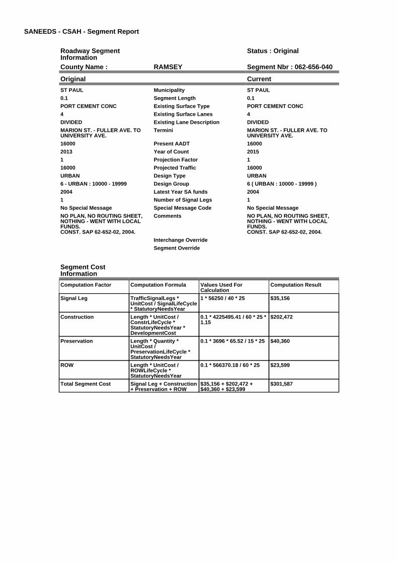
SANEEDS - CSAH - Segment Report
Roadway SegmentInformation
Status : Original
County Name : RAMSEY Segment Nbr : 062-656-040
Original Current
ST PAUL Municipality ST PAUL
0.1 Segment Length 0.1
PORT CEMENT CONC Existing Surface Type PORT CEMENT CONC
4 Existing Surface Lanes 4
DIVIDED Existing Lane Description DIVIDED
MARION ST. - FULLER AVE. TOUNIVERSITY AVE.
Termini MARION ST. - FULLER AVE. TOUNIVERSITY AVE.
16000 Present AADT 16000
2013 Year of Count 2015
1 Projection Factor 1
16000 Projected Traffic 16000
URBAN Design Type URBAN
6 - URBAN : 10000 - 19999 Design Group 6 ( URBAN : 10000 - 19999 )
2004 Latest Year SA funds 2004
1 Number of Signal Legs 1
No Special Message Special Message Code No Special Message
NO PLAN, NO ROUTING SHEET,NOTHING - WENT WITH LOCALFUNDS.CONST. SAP 62-652-02, 2004.
Comments NO PLAN, NO ROUTING SHEET,NOTHING - WENT WITH LOCALFUNDS.CONST. SAP 62-652-02, 2004.
Interchange Override
Segment Override
Segment CostInformation
Computation Factor Computation Formula Values Used ForCalculation
Computation Result
Signal Leg TrafficSignalLegs *UnitCost / SignalLifeCycle* StatutoryNeedsYear
1 * 56250 / 40 * 25 $35,156
Construction Length * UnitCost /ConstrLifeCycle *StatutoryNeedsYear *DevelopmentCost
0.1 * 4225495.41 / 60 * 25 *1.15
$202,472
Preservation Length * Quantity *UnitCost /PreservationLifeCycle *StatutoryNeedsYear
0.1 * 3696 * 65.52 / 15 * 25 $40,360
ROW Length * UnitCost /ROWLifeCycle *StatutoryNeedsYear
0.1 * 566370.18 / 60 * 25 $23,599
Total Segment Cost Signal Leg + Construction+ Preservation + ROW
$35,156 + $202,472 +$40,360 + $23,599
$301,587

SANEEDS - CSAH - Segment Report
Roadway SegmentInformation
Status : Original
County Name : RAMSEY Segment Nbr : 062-656-050
Original Current
ST PAUL Municipality ST PAUL
0.33 Segment Length 0.33
MIXED BITUMINOUS Existing Surface Type MIXED BITUMINOUS
4 Existing Surface Lanes 4
DIVIDED Existing Lane Description DIVIDED
MARION ST. - UNIVERSITY AVE.TO COMO AVE.
Termini MARION ST. - UNIVERSITY AVE.TO COMO AVE.
11400 Present AADT 11700
2013 Year of Count 2015
1 Projection Factor 1
11400 Projected Traffic 11700
URBAN Design Type URBAN
6 - URBAN : 10000 - 19999 Design Group 6 ( URBAN : 10000 - 19999 )
1970 Latest Year SA funds 1970
1 Number of Signal Legs 1
No Special Message Special Message Code No Special Message
CONST. SAP 62-656-02, 2004 Comments CONST. SAP 62-656-02, 2004
Interchange Override
Segment Override
Segment CostInformation
Computation Factor Computation Formula Values Used ForCalculation
Computation Result
Signal Leg TrafficSignalLegs *UnitCost / SignalLifeCycle* StatutoryNeedsYear
1 * 56250 / 40 * 25 $35,156
Construction Length * UnitCost /ConstrLifeCycle *StatutoryNeedsYear *DevelopmentCost
0.33 * 4225495.41 / 60 * 25* 1.15
$668,156
Preservation Length * Quantity *UnitCost /PreservationLifeCycle *StatutoryNeedsYear
0.33 * 3696 * 65.52 / 15 * 25 $133,189
ROW Length * UnitCost /ROWLifeCycle *StatutoryNeedsYear
0.33 * 566370.18 / 60 * 25 $77,876
Total Segment Cost Signal Leg + Construction+ Preservation + ROW
$35,156 + $668,156 +$133,189 + $77,876
$914,377

SANEEDS - CSAH - Segment Report
Roadway SegmentInformation
Status : Original
County Name : RAMSEY Segment Nbr : 062-657-020
Original Current
VADNAIS HEIGHTS Municipality VADNAIS HEIGHTS
0.49 Segment Length 0.49
MIXED BITUMINOUS Existing Surface Type MIXED BITUMINOUS
2 Existing Surface Lanes 2
NOT DIVIDED Existing Lane Description NOT DIVIDED
KOEHLER RD. TO COLLEEN DR Termini KOEHLER RD. TO COLLEEN DR
2900 Present AADT 2800
2013 Year of Count 2015
1 Projection Factor 1
2900 Projected Traffic 2800
RURAL Design Type RURAL
3 - RURAL : 1500 - 6999 Design Group 3 ( RURAL : 1500 - 6999 )
2000 Latest Year SA funds 2000
0 Number of Signal Legs 0
No Special Message Special Message Code No Special Message
Comments
Interchange Override
Segment Override
Segment CostInformation
Computation Factor Computation Formula Values Used ForCalculation
Computation Result
Signal Leg TrafficSignalLegs *UnitCost / SignalLifeCycle* StatutoryNeedsYear
0 * 56250 / 40 * 25 $0
Construction Length * UnitCost /ConstrLifeCycle *StatutoryNeedsYear *DevelopmentCost
0.49 * 1021937.01 / 60 * 25* 1.1
$229,510
Preservation Length * Quantity *UnitCost /PreservationLifeCycle *StatutoryNeedsYear
0.49 * 2376 * 65.52 / 20 * 25 $95,351
ROW Length * UnitCost /ROWLifeCycle *StatutoryNeedsYear
0.49 * 85357.87 / 60 * 25 $17,427
Total Segment Cost Signal Leg + Construction+ Preservation + ROW
$0 + $229,510 + $95,351 +$17,427
$342,288

SANEEDS - CSAH - Segment Report
Roadway SegmentInformation
Status : Original
County Name : RAMSEY Segment Nbr : 062-657-025
Original Current
VADNAIS HEIGHTS Municipality VADNAIS HEIGHTS
0.26 Segment Length 0.26
MIXED BITUMINOUS Existing Surface Type MIXED BITUMINOUS
2 Existing Surface Lanes 2
NOT DIVIDED Existing Lane Description NOT DIVIDED
COLLEEN DR TO CO RD F Termini COLLEEN DR TO CO RD F
2900 Present AADT 2800
2013 Year of Count 2015
1 Projection Factor 1
2900 Projected Traffic 2800
RURAL Design Type RURAL
3 - RURAL : 1500 - 6999 Design Group 3 ( RURAL : 1500 - 6999 )
2000 Latest Year SA funds 2000
0 Number of Signal Legs 0
No Special Message Special Message Code No Special Message
Comments
Interchange Override
Segment Override
Segment CostInformation
Computation Factor Computation Formula Values Used ForCalculation
Computation Result
Signal Leg TrafficSignalLegs *UnitCost / SignalLifeCycle* StatutoryNeedsYear
0 * 56250 / 40 * 25 $0
Construction Length * UnitCost /ConstrLifeCycle *StatutoryNeedsYear *DevelopmentCost
0.26 * 1021937.01 / 60 * 25* 1.1
$121,781
Preservation Length * Quantity *UnitCost /PreservationLifeCycle *StatutoryNeedsYear
0.26 * 2376 * 65.52 / 20 * 25 $50,595
ROW Length * UnitCost /ROWLifeCycle *StatutoryNeedsYear
0.26 * 85357.87 / 60 * 25 $9,247
Total Segment Cost Signal Leg + Construction+ Preservation + ROW
$0 + $121,781 + $50,595 +$9,247
$181,623

SANEEDS - CSAH - Segment Report
Roadway SegmentInformation
Status : Original
County Name : RAMSEY Segment Nbr : 062-657-030
Original Current
VADNAIS HEIGHTS Municipality VADNAIS HEIGHTS
0.5 Segment Length 0.5
MIXED BITUMINOUS Existing Surface Type MIXED BITUMINOUS
2 Existing Surface Lanes 2
NOT DIVIDED Existing Lane Description NOT DIVIDED
CO. RD. F TO RAILROAD TRACKS Termini CO. RD. F TO RAILROAD TRACKS
4150 Present AADT 4150
2013 Year of Count 2015
1 Projection Factor 1
4150 Projected Traffic 4150
RURAL Design Type RURAL
3 - RURAL : 1500 - 6999 Design Group 3 ( RURAL : 1500 - 6999 )
2006 Latest Year SA funds 2006
0 Number of Signal Legs 0
No Special Message Special Message Code No Special Message
SAP 62-657-006, 2006 CONST Comments SAP 62-657-006, 2006 CONST
Interchange Override
Segment Override
RailRoadCrossingInformation
Status: Original
Original Current
CANADIAN PACIFIC RAILWAY RailRoad Name CANADIAN PACIFIC RAILWAY
691414G USDOT Number 691414G
0.5 Located at Milepoint 0.5
1 Mainline Tracks 1
SIGNS ONLY Protection Type SIGNS ONLY
1980 Last Year Protection Upgraded 1980
72 Crossing Length 72
Last Year Surfaced
100% Percentage of Cost 100%
NEW CONCRETE SURFACE IN2000.
Comments NEW CONCRETE SURFACE IN2000.
Segment CostInformation
Computation Factor Computation Formula Values Used ForCalculation
Computation Result
Signal Leg TrafficSignalLegs *UnitCost / SignalLifeCycle* StatutoryNeedsYear
0 * 56250 / 40 * 25 $0
Construction Length * UnitCost /ConstrLifeCycle *StatutoryNeedsYear *DevelopmentCost
0.5 * 1021937.01 / 60 * 25 *1.1
$234,194
Preservation Length * Quantity *UnitCost /PreservationLifeCycle *StatutoryNeedsYear
0.5 * 2376 * 65.52 / 20 * 25 $97,297
ROW Length * UnitCost /ROWLifeCycle *StatutoryNeedsYear
0.5 * 85357.87 / 60 * 25 $17,783
RR Crossing Protection UnitCost /RRCrossingLifeCycle *StatutoryNeedsYear
1500 / 25 * 25 $1,500
RR Crossing Surface SurfaceLength * UnitCost/ RRCrossingLifeCycle *StatutoryNeedsYear
72 * 1350 / 25 * 25 $97,200
Total Segment Cost Signal Leg + Construction+ Preservation + ROW +RR Crossing Protection +RR Crossing Surface
$0 + $234,194 + $97,297 +$17,783 + $1,500 + $97,200
$447,974

SANEEDS - CSAH - Segment Report
Roadway SegmentInformation
Status : Original
County Name : RAMSEY Segment Nbr : 062-657-040
Original Current
VADNAIS HEIGHTS Municipality VADNAIS HEIGHTS
0.38 Segment Length 0.38
MIXED BITUMINOUS Existing Surface Type MIXED BITUMINOUS
2 Existing Surface Lanes 2
NOT DIVIDED Existing Lane Description NOT DIVIDED
RAILROAD TRACKS TO 0.12 M SOF TH 96
Termini RAILROAD TRACKS TO 0.12 M SOF TH 96
4150 Present AADT 4150
2013 Year of Count 2015
1 Projection Factor 1
4150 Projected Traffic 4150
RURAL Design Type RURAL
3 - RURAL : 1500 - 6999 Design Group 3 ( RURAL : 1500 - 6999 )
2006 Latest Year SA funds 2006
0 Number of Signal Legs 0
No Special Message Special Message Code No Special Message
SAP 62-657-006, 2006 CONST Comments SAP 62-657-006, 2006 CONST
Interchange Override
Segment Override
Segment CostInformation
Computation Factor Computation Formula Values Used ForCalculation
Computation Result
Signal Leg TrafficSignalLegs *UnitCost / SignalLifeCycle* StatutoryNeedsYear
0 * 56250 / 40 * 25 $0
Construction Length * UnitCost /ConstrLifeCycle *StatutoryNeedsYear *DevelopmentCost
0.38 * 1021937.01 / 60 * 25* 1.1
$177,987
Preservation Length * Quantity *UnitCost /PreservationLifeCycle *StatutoryNeedsYear
0.38 * 2376 * 65.52 / 20 * 25 $73,946
ROW Length * UnitCost /ROWLifeCycle *StatutoryNeedsYear
0.38 * 85357.87 / 60 * 25 $13,515
Total Segment Cost Signal Leg + Construction+ Preservation + ROW
$0 + $177,987 + $73,946 +$13,515
$265,448

SANEEDS - CSAH - Segment Report
Roadway SegmentInformation
Status : Original
County Name : RAMSEY Segment Nbr : 062-657-050
Original Current
VADNAIS HEIGHTS Municipality VADNAIS HEIGHTS
0.12 Segment Length 0.12
MIXED BITUMINOUS Existing Surface Type MIXED BITUMINOUS
2 Existing Surface Lanes 2
NOT DIVIDED Existing Lane Description NOT DIVIDED
RAILROAD TRACKS TO TH 96 Termini RAILROAD TRACKS TO TH 96
4150 Present AADT 4150
2013 Year of Count 2015
1 Projection Factor 1
4150 Projected Traffic 4150
URBAN Design Type URBAN
5 - URBAN : 0 - 9999 Design Group 5 ( URBAN : 0 - 9999 )
1997 Latest Year SA funds 1997
1 Number of Signal Legs 1
No Special Message Special Message Code No Special Message
Comments
Interchange Override
Segment Override
Segment CostInformation
Computation Factor Computation Formula Values Used ForCalculation
Computation Result
Signal Leg TrafficSignalLegs *UnitCost / SignalLifeCycle* StatutoryNeedsYear
1 * 56250 / 40 * 25 $35,156
Construction Length * UnitCost /ConstrLifeCycle *StatutoryNeedsYear *DevelopmentCost
0.12 * 2738635.28 / 60 * 25* 1.15
$157,472
Preservation Length * Quantity *UnitCost /PreservationLifeCycle *StatutoryNeedsYear
0.12 * 2904 * 65.52 / 15 * 25 $38,054
ROW Length * UnitCost /ROWLifeCycle *StatutoryNeedsYear
0.12 * 436504.07 / 60 * 25 $21,825
Total Segment Cost Signal Leg + Construction+ Preservation + ROW
$35,156 + $157,472 +$38,054 + $21,825
$252,507

SANEEDS - CSAH - Segment Report
Roadway SegmentInformation
Status : Original
County Name : RAMSEY Segment Nbr : 062-658-010
Original Current
ST PAUL Municipality ST PAUL
0.2 Segment Length 0.2
BIT CONC OR ASPH Existing Surface Type BIT CONC OR ASPH
4 Existing Surface Lanes 4
NOT DIVIDED Existing Lane Description NOT DIVIDED
PAYNE AVE. - 7TH ST. TO NORTHST.
Termini PAYNE AVE. - 7TH ST. TO NORTHST.
9500 Present AADT 9500
2013 Year of Count 2015
1 Projection Factor 1
9500 Projected Traffic 9500
URBAN Design Type URBAN
5 - URBAN : 0 - 9999 Design Group 5 ( URBAN : 0 - 9999 )
2000 Latest Year SA funds 2000
0 Number of Signal Legs 0
No Special Message Special Message Code No Special Message
Comments
Interchange Override
Segment Override
Segment CostInformation
Computation Factor Computation Formula Values Used ForCalculation
Computation Result
Signal Leg TrafficSignalLegs *UnitCost / SignalLifeCycle* StatutoryNeedsYear
0 * 56250 / 40 * 25 $0
Construction Length * UnitCost /ConstrLifeCycle *StatutoryNeedsYear *DevelopmentCost
0.2 * 2738635.28 / 60 * 25 *1.15
$262,453
Preservation Length * Quantity *UnitCost /PreservationLifeCycle *StatutoryNeedsYear
0.2 * 2904 * 65.52 / 15 * 25 $63,423
ROW Length * UnitCost /ROWLifeCycle *StatutoryNeedsYear
0.2 * 436504.07 / 60 * 25 $36,375
Total Segment Cost Signal Leg + Construction+ Preservation + ROW
$0 + $262,453 + $63,423 +$36,375
$362,251

SANEEDS - CSAH - Segment Report
Roadway SegmentInformation
Status : Original
County Name : RAMSEY Segment Nbr : 062-658-020
Original Current
ST PAUL Municipality ST PAUL
0.2 Segment Length 0.2
BIT CONC OR ASPH Existing Surface Type BIT CONC OR ASPH
4 Existing Surface Lanes 4
NOT DIVIDED Existing Lane Description NOT DIVIDED
PAYNE AVE. - NORTH ST. TOEDGERTON ST.
Termini PAYNE AVE. - NORTH ST. TOEDGERTON ST.
11600 Present AADT 11600
2013 Year of Count 2015
1 Projection Factor 1
11600 Projected Traffic 11600
URBAN Design Type URBAN
6 - URBAN : 10000 - 19999 Design Group 6 ( URBAN : 10000 - 19999 )
2000 Latest Year SA funds 2000
2 Number of Signal Legs 2
No Special Message Special Message Code No Special Message
Comments
Interchange Override
Segment Override
Segment CostInformation
Computation Factor Computation Formula Values Used ForCalculation
Computation Result
Signal Leg TrafficSignalLegs *UnitCost / SignalLifeCycle* StatutoryNeedsYear
2 * 56250 / 40 * 25 $70,313
Construction Length * UnitCost /ConstrLifeCycle *StatutoryNeedsYear *DevelopmentCost
0.2 * 4225495.41 / 60 * 25 *1.15
$404,943
Preservation Length * Quantity *UnitCost /PreservationLifeCycle *StatutoryNeedsYear
0.2 * 3696 * 65.52 / 15 * 25 $80,721
ROW Length * UnitCost /ROWLifeCycle *StatutoryNeedsYear
0.2 * 566370.18 / 60 * 25 $47,198
Total Segment Cost Signal Leg + Construction+ Preservation + ROW
$70,313 + $404,943 +$80,721 + $47,198
$603,175

SANEEDS - CSAH - Segment Report
Roadway SegmentInformation
Status : Original
County Name : RAMSEY Segment Nbr : 062-658-023
Original Current
ST PAUL Municipality ST PAUL
0.16 Segment Length 0.16
MIXED BITUMINOUS Existing Surface Type MIXED BITUMINOUS
2 Existing Surface Lanes 2
NOT DIVIDED Existing Lane Description NOT DIVIDED
PAYNE AVE TO REANEY AVE Termini PAYNE AVE TO REANEY AVE
4600 Present AADT 4600
2013 Year of Count 2015
1 Projection Factor 1
4600 Projected Traffic 4600
URBAN Design Type URBAN
5 - URBAN : 0 - 9999 Design Group 5 ( URBAN : 0 - 9999 )
2000 Latest Year SA funds 2000
0 Number of Signal Legs 0
No Special Message Special Message Code No Special Message
Comments
Interchange Override
Segment Override
Segment CostInformation
Computation Factor Computation Formula Values Used ForCalculation
Computation Result
Signal Leg TrafficSignalLegs *UnitCost / SignalLifeCycle* StatutoryNeedsYear
0 * 56250 / 40 * 25 $0
Construction Length * UnitCost /ConstrLifeCycle *StatutoryNeedsYear *DevelopmentCost
0.16 * 2738635.28 / 60 * 25* 1.15
$209,962
Preservation Length * Quantity *UnitCost /PreservationLifeCycle *StatutoryNeedsYear
0.16 * 2904 * 65.52 / 15 * 25 $50,739
ROW Length * UnitCost /ROWLifeCycle *StatutoryNeedsYear
0.16 * 436504.07 / 60 * 25 $29,100
Total Segment Cost Signal Leg + Construction+ Preservation + ROW
$0 + $209,962 + $50,739 +$29,100
$289,801

SANEEDS - CSAH - Segment Report
Roadway SegmentInformation
Status : Original
County Name : RAMSEY Segment Nbr : 062-658-027
Original Current
ST PAUL Municipality ST PAUL
0.2 Segment Length 0.2
MIXED BITUMINOUS Existing Surface Type MIXED BITUMINOUS
2 Existing Surface Lanes 2
NOT DIVIDED Existing Lane Description NOT DIVIDED
REANEY TO WHITALL Termini REANEY TO WHITALL
4600 Present AADT 4600
2013 Year of Count 2015
1 Projection Factor 1
4600 Projected Traffic 4600
URBAN Design Type URBAN
5 - URBAN : 0 - 9999 Design Group 5 ( URBAN : 0 - 9999 )
1998 Latest Year SA funds 1998
0 Number of Signal Legs 0
No Special Message Special Message Code No Special Message
Comments
Interchange Override
Segment Override
Segment CostInformation
Computation Factor Computation Formula Values Used ForCalculation
Computation Result
Signal Leg TrafficSignalLegs *UnitCost / SignalLifeCycle* StatutoryNeedsYear
0 * 56250 / 40 * 25 $0
Construction Length * UnitCost /ConstrLifeCycle *StatutoryNeedsYear *DevelopmentCost
0.2 * 2738635.28 / 60 * 25 *1.15
$262,453
Preservation Length * Quantity *UnitCost /PreservationLifeCycle *StatutoryNeedsYear
0.2 * 2904 * 65.52 / 15 * 25 $63,423
ROW Length * UnitCost /ROWLifeCycle *StatutoryNeedsYear
0.2 * 436504.07 / 60 * 25 $36,375
Total Segment Cost Signal Leg + Construction+ Preservation + ROW
$0 + $262,453 + $63,423 +$36,375
$362,251

SANEEDS - CSAH - Segment Report
Roadway SegmentInformation
Status : Original
County Name : RAMSEY Segment Nbr : 062-658-030
Original Current
ST PAUL Municipality ST PAUL
0.25 Segment Length 0.25
MIXED BITUMINOUS Existing Surface Type MIXED BITUMINOUS
2 Existing Surface Lanes 2
NOT DIVIDED Existing Lane Description NOT DIVIDED
WHITALL AVE TO CASE ST Termini WHITALL AVE TO CASE ST
4600 Present AADT 4600
2013 Year of Count 2015
1 Projection Factor 1
4600 Projected Traffic 4600
URBAN Design Type URBAN
5 - URBAN : 0 - 9999 Design Group 5 ( URBAN : 0 - 9999 )
2000 Latest Year SA funds 2000
0 Number of Signal Legs 0
No Special Message Special Message Code No Special Message
Comments
Interchange Override
Segment Override
Segment CostInformation
Computation Factor Computation Formula Values Used ForCalculation
Computation Result
Signal Leg TrafficSignalLegs *UnitCost / SignalLifeCycle* StatutoryNeedsYear
0 * 56250 / 40 * 25 $0
Construction Length * UnitCost /ConstrLifeCycle *StatutoryNeedsYear *DevelopmentCost
0.25 * 2738635.28 / 60 * 25* 1.15
$328,066
Preservation Length * Quantity *UnitCost /PreservationLifeCycle *StatutoryNeedsYear
0.25 * 2904 * 65.52 / 15 * 25 $79,279
ROW Length * UnitCost /ROWLifeCycle *StatutoryNeedsYear
0.25 * 436504.07 / 60 * 25 $45,469
Total Segment Cost Signal Leg + Construction+ Preservation + ROW
$0 + $328,066 + $79,279 +$45,469
$452,814

SANEEDS - CSAH - Segment Report
Roadway SegmentInformation
Status : Original
County Name : RAMSEY Segment Nbr : 062-658-031
Original Current
ST PAUL Municipality ST PAUL
0.49 Segment Length 0.49
SURFACE TREATED Existing Surface Type SURFACE TREATED
2 Existing Surface Lanes 2
NOT DIVIDED Existing Lane Description NOT DIVIDED
CASE ST TO MARYLAND AVE Termini CASE ST TO MARYLAND AVE
4350 Present AADT 4350
2013 Year of Count 2015
1 Projection Factor 1
4350 Projected Traffic 4350
URBAN Design Type URBAN
5 - URBAN : 0 - 9999 Design Group 5 ( URBAN : 0 - 9999 )
2000 Latest Year SA funds 2000
2 Number of Signal Legs 2
No Special Message Special Message Code No Special Message
Comments
Interchange Override
Segment Override
Segment CostInformation
Computation Factor Computation Formula Values Used ForCalculation
Computation Result
Signal Leg TrafficSignalLegs *UnitCost / SignalLifeCycle* StatutoryNeedsYear
2 * 56250 / 40 * 25 $70,313
Construction Length * UnitCost /ConstrLifeCycle *StatutoryNeedsYear *DevelopmentCost
0.49 * 2738635.28 / 60 * 25* 1.15
$643,009
Preservation Length * Quantity *UnitCost /PreservationLifeCycle *StatutoryNeedsYear
0.49 * 2904 * 65.52 / 15 * 25 $155,387
ROW Length * UnitCost /ROWLifeCycle *StatutoryNeedsYear
0.49 * 436504.07 / 60 * 25 $89,120
Total Segment Cost Signal Leg + Construction+ Preservation + ROW
$70,313 + $643,009 +$155,387 + $89,120
$957,829

SANEEDS - CSAH - Segment Report
Roadway SegmentInformation
Status : Original
County Name : RAMSEY Segment Nbr : 062-658-040
Original Current
ST PAUL Municipality ST PAUL
0.25 Segment Length 0.25
SURFACE TREATED Existing Surface Type SURFACE TREATED
2 Existing Surface Lanes 2
NOT DIVIDED Existing Lane Description NOT DIVIDED
MARYLAND AVE TO IVY AVE Termini MARYLAND AVE TO IVY AVE
4200 Present AADT 4200
2013 Year of Count 2015
1 Projection Factor 1
4200 Projected Traffic 4200
URBAN Design Type URBAN
5 - URBAN : 0 - 9999 Design Group 5 ( URBAN : 0 - 9999 )
2000 Latest Year SA funds 2000
0 Number of Signal Legs 0
No Special Message Special Message Code No Special Message
Comments
Interchange Override
Segment Override
Segment CostInformation
Computation Factor Computation Formula Values Used ForCalculation
Computation Result
Signal Leg TrafficSignalLegs *UnitCost / SignalLifeCycle* StatutoryNeedsYear
0 * 56250 / 40 * 25 $0
Construction Length * UnitCost /ConstrLifeCycle *StatutoryNeedsYear *DevelopmentCost
0.25 * 2738635.28 / 60 * 25* 1.15
$328,066
Preservation Length * Quantity *UnitCost /PreservationLifeCycle *StatutoryNeedsYear
0.25 * 2904 * 65.52 / 15 * 25 $79,279
ROW Length * UnitCost /ROWLifeCycle *StatutoryNeedsYear
0.25 * 436504.07 / 60 * 25 $45,469
Total Segment Cost Signal Leg + Construction+ Preservation + ROW
$0 + $328,066 + $79,279 +$45,469
$452,814

SANEEDS - CSAH - Segment Report
Roadway SegmentInformation
Status : Original
County Name : RAMSEY Segment Nbr : 062-658-041
Original Current
ST PAUL Municipality ST PAUL
0.75 Segment Length 0.75
MIXED BITUMINOUS Existing Surface Type MIXED BITUMINOUS
2 Existing Surface Lanes 2
NOT DIVIDED Existing Lane Description NOT DIVIDED
IVY AVE TO LARPENTEUR AVE Termini IVY AVE TO LARPENTEUR AVE
4300 Present AADT 4300
2013 Year of Count 2015
1 Projection Factor 1
4300 Projected Traffic 4300
URBAN Design Type URBAN
5 - URBAN : 0 - 9999 Design Group 5 ( URBAN : 0 - 9999 )
2000 Latest Year SA funds 2000
2 Number of Signal Legs 2
No Special Message Special Message Code No Special Message
Comments
Interchange Override
Segment Override
Segment CostInformation
Computation Factor Computation Formula Values Used ForCalculation
Computation Result
Signal Leg TrafficSignalLegs *UnitCost / SignalLifeCycle* StatutoryNeedsYear
2 * 56250 / 40 * 25 $70,313
Construction Length * UnitCost /ConstrLifeCycle *StatutoryNeedsYear *DevelopmentCost
0.75 * 2738635.28 / 60 * 25* 1.15
$984,197
Preservation Length * Quantity *UnitCost /PreservationLifeCycle *StatutoryNeedsYear
0.75 * 2904 * 65.52 / 15 * 25 $237,838
ROW Length * UnitCost /ROWLifeCycle *StatutoryNeedsYear
0.75 * 436504.07 / 60 * 25 $136,408
Total Segment Cost Signal Leg + Construction+ Preservation + ROW
$70,313 + $984,197 +$237,838 + $136,408
$1,428,756

SANEEDS - CSAH - Segment Report
Roadway SegmentInformation
Status : Original
County Name : RAMSEY Segment Nbr : 062-658-050
Original Current
MAPLEWOOD Municipality MAPLEWOOD
1 Segment Length 1
BIT CONC OR ASPH Existing Surface Type BIT CONC OR ASPH
2 Existing Surface Lanes 2
NOT DIVIDED Existing Lane Description NOT DIVIDED
LARPENTEUR AVE. TO CO. RD. B Termini LARPENTEUR AVE. TO CO. RD. B
5100 Present AADT 5100
2013 Year of Count 2015
1 Projection Factor 1
5100 Projected Traffic 5100
RURAL Design Type RURAL
3 - RURAL : 1500 - 6999 Design Group 3 ( RURAL : 1500 - 6999 )
2000 Latest Year SA funds 2000
3 Number of Signal Legs 3
No Special Message Special Message Code No Special Message
Comments
Interchange Override
Segment Override
Segment CostInformation
Computation Factor Computation Formula Values Used ForCalculation
Computation Result
Signal Leg TrafficSignalLegs *UnitCost / SignalLifeCycle* StatutoryNeedsYear
3 * 56250 / 40 * 25 $105,469
Construction Length * UnitCost /ConstrLifeCycle *StatutoryNeedsYear *DevelopmentCost
1 * 1021937.01 / 60 * 25 *1.1
$468,388
Preservation Length * Quantity *UnitCost /PreservationLifeCycle *StatutoryNeedsYear
1 * 2376 * 65.52 / 20 * 25 $194,594
ROW Length * UnitCost /ROWLifeCycle *StatutoryNeedsYear
1 * 85357.87 / 60 * 25 $35,566
Total Segment Cost Signal Leg + Construction+ Preservation + ROW
$105,469 + $468,388 +$194,594 + $35,566
$804,017

SANEEDS - CSAH - Segment Report
Roadway SegmentInformation
Status : Original
County Name : RAMSEY Segment Nbr : 062-658-060
Original Current
MAPLEWOOD Municipality MAPLEWOOD
0.23 Segment Length 0.23
MIXED BITUMINOUS Existing Surface Type MIXED BITUMINOUS
2 Existing Surface Lanes 2
NOT DIVIDED Existing Lane Description NOT DIVIDED
CO. RD. B TO 0.23 MI N Termini CO. RD. B TO 0.23 MI N
7900 Present AADT 7900
2013 Year of Count 2015
1 Projection Factor 1
7900 Projected Traffic 7900
RURAL Design Type RURAL
4 - RURAL : 7000 - 999999 Design Group 4 ( RURAL : 7000 - 999999 )
2000 Latest Year SA funds 2000
0 Number of Signal Legs 0
No Special Message Special Message Code No Special Message
Comments
Interchange Override
Segment Override
Segment CostInformation
Computation Factor Computation Formula Values Used ForCalculation
Computation Result
Signal Leg TrafficSignalLegs *UnitCost / SignalLifeCycle* StatutoryNeedsYear
0 * 56250 / 40 * 25 $0
Construction Length * UnitCost /ConstrLifeCycle *StatutoryNeedsYear *DevelopmentCost
0.23 * 1996892.57 / 60 * 25* 1.1
$210,506
Preservation Length * Quantity *UnitCost /PreservationLifeCycle *StatutoryNeedsYear
0.23 * 3564 * 65.52 / 20 * 25 $67,135
ROW Length * UnitCost /ROWLifeCycle *StatutoryNeedsYear
0.23 * 181173.68 / 60 * 25 $17,362
Total Segment Cost Signal Leg + Construction+ Preservation + ROW
$0 + $210,506 + $67,135 +$17,362
$295,003

SANEEDS - CSAH - Segment Report
Roadway SegmentInformation
Status : Original
County Name : RAMSEY Segment Nbr : 062-658-070
Original Current
LITTLE CANADA Municipality LITTLE CANADA
0.07 Segment Length 0.07
PORT CEMENT CONC Existing Surface Type PORT CEMENT CONC
2 Existing Surface Lanes 2
NOT DIVIDED Existing Lane Description NOT DIVIDED
0.23 MI N OF CO. RD. B TO 0.3 MI N Termini 0.23 MI N OF CO. RD. B TO 0.3 MI N
7900 Present AADT 7900
2013 Year of Count 2015
1 Projection Factor 1
7900 Projected Traffic 7900
RURAL Design Type RURAL
4 - RURAL : 7000 - 999999 Design Group 4 ( RURAL : 7000 - 999999 )
2000 Latest Year SA funds 2000
0 Number of Signal Legs 0
No Special Message Special Message Code No Special Message
Comments
Interchange Override
Segment Override
Segment CostInformation
Computation Factor Computation Formula Values Used ForCalculation
Computation Result
Signal Leg TrafficSignalLegs *UnitCost / SignalLifeCycle* StatutoryNeedsYear
0 * 56250 / 40 * 25 $0
Construction Length * UnitCost /ConstrLifeCycle *StatutoryNeedsYear *DevelopmentCost
0.07 * 1996892.57 / 60 * 25* 1.1
$64,067
Preservation Length * Quantity *UnitCost /PreservationLifeCycle *StatutoryNeedsYear
0.07 * 3564 * 65.52 / 20 * 25 $20,432
ROW Length * UnitCost /ROWLifeCycle *StatutoryNeedsYear
0.07 * 181173.68 / 60 * 25 $5,284
Total Segment Cost Signal Leg + Construction+ Preservation + ROW
$0 + $64,067 + $20,432 +$5,284
$89,783

SANEEDS - CSAH - Segment Report
Roadway SegmentInformation
Status : Original
County Name : RAMSEY Segment Nbr : 062-658-080
Original Current
LITTLE CANADA Municipality LITTLE CANADA
0.7 Segment Length 0.7
BIT CONC OR ASPH Existing Surface Type BIT CONC OR ASPH
2 Existing Surface Lanes 2
NOT DIVIDED Existing Lane Description NOT DIVIDED
0.30 MI N CO. RD. B TO LITTLECANADA RD.
Termini 0.30 MI N CO. RD. B TO LITTLECANADA RD.
6800 Present AADT 6800
2013 Year of Count 2015
1 Projection Factor 1
6800 Projected Traffic 6800
RURAL Design Type RURAL
3 - RURAL : 1500 - 6999 Design Group 3 ( RURAL : 1500 - 6999 )
2000 Latest Year SA funds 2000
0 Number of Signal Legs 0
No Special Message Special Message Code No Special Message
Comments
Interchange Override
Segment Override
Culvert Information Status: Original
Original Current
93625 Structure Number 93625
4.434 Milepoint 4.434
1973 Year Built 1973
CO DITCH # 16 Feature Crossed CO DITCH # 16
Type of Service
2 Number of Barrels 2
9 Culvert Width 9
5 Culvert Height 5
82 Culvert Length 82
68.99982817 Area of Waterway Opening 68.99982817
100% Shared Structure 100%
Comments
1 Culvert Group Code 1
Segment CostInformation
Computation Factor Computation Formula Values Used ForCalculation
Computation Result
Signal Leg TrafficSignalLegs *UnitCost / SignalLifeCycle* StatutoryNeedsYear
0 * 56250 / 40 * 25 $0
Construction Length * UnitCost /ConstrLifeCycle *StatutoryNeedsYear *DevelopmentCost
0.7 * 1021937.01 / 60 * 25 *1.1
$327,871
Preservation Length * Quantity *UnitCost /PreservationLifeCycle *StatutoryNeedsYear
0.7 * 2376 * 65.52 / 20 * 25 $136,216
ROW Length * UnitCost /ROWLifeCycle *StatutoryNeedsYear
0.7 * 85357.87 / 60 * 25 $24,896
Culvert CulvertLength * Area *UnitCost /CulvertLifeCycle *StatutoryNeedsYear *DevelopmentCost
82 * 68.99982817 * 15.47 /100 * 25 * 1.15
$25,165

Total Segment Cost Signal Leg + Construction+ Preservation + ROW +Culvert
$0 + $327,871 + $136,216+ $24,896 + $25,165
$514,148

SANEEDS - CSAH - Segment Report
Roadway SegmentInformation
Status : Original
County Name : RAMSEY Segment Nbr : 062-658-085
Original Current
LITTLE CANADA Municipality LITTLE CANADA
0.75 Segment Length 0.75
PORT CEMENT CONC Existing Surface Type PORT CEMENT CONC
2 Existing Surface Lanes 2
NOT DIVIDED Existing Lane Description NOT DIVIDED
LITTLE CANADA RD. TO 0.75 MI.NORTH OF LITTLE CANADA RD.
Termini LITTLE CANADA RD. TO 0.75 MI.NORTH OF LITTLE CANADA RD.
6100 Present AADT 6100
2013 Year of Count 2015
1 Projection Factor 1
6100 Projected Traffic 6100
RURAL Design Type RURAL
3 - RURAL : 1500 - 6999 Design Group 3 ( RURAL : 1500 - 6999 )
2000 Latest Year SA funds 2000
0 Number of Signal Legs 0
No Special Message Special Message Code No Special Message
Comments
Interchange Override
Segment Override
Segment CostInformation
Computation Factor Computation Formula Values Used ForCalculation
Computation Result
Signal Leg TrafficSignalLegs *UnitCost / SignalLifeCycle* StatutoryNeedsYear
0 * 56250 / 40 * 25 $0
Construction Length * UnitCost /ConstrLifeCycle *StatutoryNeedsYear *DevelopmentCost
0.75 * 1021937.01 / 60 * 25* 1.1
$351,291
Preservation Length * Quantity *UnitCost /PreservationLifeCycle *StatutoryNeedsYear
0.75 * 2376 * 65.52 / 20 * 25 $145,946
ROW Length * UnitCost /ROWLifeCycle *StatutoryNeedsYear
0.75 * 85357.87 / 60 * 25 $26,674
Total Segment Cost Signal Leg + Construction+ Preservation + ROW
$0 + $351,291 + $145,946+ $26,674
$523,911

SANEEDS - CSAH - Segment Report
Roadway SegmentInformation
Status : Original
County Name : RAMSEY Segment Nbr : 062-658-090
Original Current
LITTLE CANADA Municipality LITTLE CANADA
0.25 Segment Length 0.25
MIXED BITUMINOUS Existing Surface Type MIXED BITUMINOUS
2 Existing Surface Lanes 2
NOT DIVIDED Existing Lane Description NOT DIVIDED
LITTLE CANADA RD. TO CO. RD. D Termini LITTLE CANADA RD. TO CO. RD. D
3650 Present AADT 3650
2013 Year of Count 2015
1 Projection Factor 1
3650 Projected Traffic 3650
RURAL Design Type RURAL
3 - RURAL : 1500 - 6999 Design Group 3 ( RURAL : 1500 - 6999 )
2004 Latest Year SA funds 2004
0 Number of Signal Legs 0
No Special Message Special Message Code No Special Message
CONSTR. SAP 62-658-010, 2004. Comments CONSTR. SAP 62-658-010, 2004.
Interchange Override
Segment Override
Segment CostInformation
Computation Factor Computation Formula Values Used ForCalculation
Computation Result
Signal Leg TrafficSignalLegs *UnitCost / SignalLifeCycle* StatutoryNeedsYear
0 * 56250 / 40 * 25 $0
Construction Length * UnitCost /ConstrLifeCycle *StatutoryNeedsYear *DevelopmentCost
0.25 * 1021937.01 / 60 * 25* 1.1
$117,097
Preservation Length * Quantity *UnitCost /PreservationLifeCycle *StatutoryNeedsYear
0.25 * 2376 * 65.52 / 20 * 25 $48,649
ROW Length * UnitCost /ROWLifeCycle *StatutoryNeedsYear
0.25 * 85357.87 / 60 * 25 $8,891
Total Segment Cost Signal Leg + Construction+ Preservation + ROW
$0 + $117,097 + $48,649 +$8,891
$174,637

SANEEDS - CSAH - Segment Report
Roadway SegmentInformation
Status : Original
County Name : RAMSEY Segment Nbr : 062-658-095
Original Current
VADNAIS HEIGHTS Municipality VADNAIS HEIGHTS
0.25 Segment Length 0.25
MIXED BITUMINOUS Existing Surface Type MIXED BITUMINOUS
2 Existing Surface Lanes 2
NOT DIVIDED Existing Lane Description NOT DIVIDED
CO. RD. D TO WITT COURT Termini CO. RD. D TO WITT COURT
5500 Present AADT 5200
2013 Year of Count 2015
1 Projection Factor 1
5500 Projected Traffic 5200
RURAL Design Type RURAL
3 - RURAL : 1500 - 6999 Design Group 3 ( RURAL : 1500 - 6999 )
2004 Latest Year SA funds 2004
0 Number of Signal Legs 0
No Special Message Special Message Code No Special Message
CONST. SAP 62-658-020, 2004 Comments CONST. SAP 62-658-020, 2004
Interchange Override
Segment Override
Segment CostInformation
Computation Factor Computation Formula Values Used ForCalculation
Computation Result
Signal Leg TrafficSignalLegs *UnitCost / SignalLifeCycle* StatutoryNeedsYear
0 * 56250 / 40 * 25 $0
Construction Length * UnitCost /ConstrLifeCycle *StatutoryNeedsYear *DevelopmentCost
0.25 * 1021937.01 / 60 * 25* 1.1
$117,097
Preservation Length * Quantity *UnitCost /PreservationLifeCycle *StatutoryNeedsYear
0.25 * 2376 * 65.52 / 20 * 25 $48,649
ROW Length * UnitCost /ROWLifeCycle *StatutoryNeedsYear
0.25 * 85357.87 / 60 * 25 $8,891
Total Segment Cost Signal Leg + Construction+ Preservation + ROW
$0 + $117,097 + $48,649 +$8,891
$174,637

SANEEDS - CSAH - Segment Report
Roadway SegmentInformation
Status : Original
County Name : RAMSEY Segment Nbr : 062-658-100
Original Current
VADNAIS HEIGHTS Municipality VADNAIS HEIGHTS
0.35 Segment Length 0.35
PORT CEMENT CONC Existing Surface Type PORT CEMENT CONC
2 Existing Surface Lanes 2
NOT DIVIDED Existing Lane Description NOT DIVIDED
WITT COURT TO CENTERVILLE RD Termini WITT COURT TO CENTERVILLE RD
5500 Present AADT 5200
2013 Year of Count 2015
1 Projection Factor 1
5500 Projected Traffic 5200
RURAL Design Type RURAL
3 - RURAL : 1500 - 6999 Design Group 3 ( RURAL : 1500 - 6999 )
1982 Latest Year SA funds 1982
0 Number of Signal Legs 0
No Special Message Special Message Code No Special Message
Comments
Interchange Override
Segment Override
Bridge Information Status: Original
Original Current
90411 Structure Number 90411
5.82 Milepoint 5.82
1948 Year Built 1948
Feature Crossed
Type of Service
0 Number of Spans 0
137 Bridge Length 137
17 Bridge Width 17
100% Shared Structure 100%
Comments
1 ( 0-149 ) Bridge Group Code 1 ( 0-149 )
Segment CostInformation
Computation Factor Computation Formula Values Used ForCalculation
Computation Result
Signal Leg TrafficSignalLegs *UnitCost / SignalLifeCycle* StatutoryNeedsYear
0 * 56250 / 40 * 25 $0
Construction Length * UnitCost /ConstrLifeCycle *StatutoryNeedsYear *DevelopmentCost
0.35 * 1021937.01 / 60 * 25* 1.1
$163,936
Preservation Length * Quantity *UnitCost /PreservationLifeCycle *StatutoryNeedsYear
0.35 * 2376 * 65.52 / 20 * 25 $68,108
ROW Length * UnitCost /ROWLifeCycle *StatutoryNeedsYear
0.35 * 85357.87 / 60 * 25 $12,448
Bridge BridgeLength *BridgeWidth * UnitCost /BridgeLifeCycle *StatutoryNeedsYear *DevelopmentCost
137 * 17 * 152 / 80 * 25 *1.15
$127,222
Total Segment Cost Signal Leg + Construction+ Preservation + ROW +Bridge
$0 + $163,936 + $68,108 +$12,448 + $127,222
$371,714

SANEEDS - CSAH - Segment Report
Roadway SegmentInformation
Status : Original
County Name : RAMSEY Segment Nbr : 062-659-010
Original Current
VADNAIS HEIGHTS Municipality VADNAIS HEIGHTS
0.46 Segment Length 0.46
BIT CONC OR ASPH Existing Surface Type BIT CONC OR ASPH
2 Existing Surface Lanes 2
NOT DIVIDED Existing Lane Description NOT DIVIDED
VADNAIS BLVD. TO .04 MI SO OFCO. RD. E
Termini VADNAIS BLVD. TO .04 MI SO OFCO. RD. E
6100 Present AADT 4250
2013 Year of Count 2015
1 Projection Factor 1
6100 Projected Traffic 4250
RURAL Design Type RURAL
3 - RURAL : 1500 - 6999 Design Group 3 ( RURAL : 1500 - 6999 )
Latest Year SA funds
0 Number of Signal Legs 0
No Special Message Special Message Code No Special Message
CONST. SAP 62-659-015, 2004
REDUCED STORM SEWER NEEDSTO 0.46 MI TO MATCH SEGMENTLENGTH. 4/17/07 SL
Comments CONST. SAP 62-659-015, 2004
REDUCED STORM SEWER NEEDSTO 0.46 MI TO MATCH SEGMENTLENGTH. 4/17/07 SL
Interchange Override
Segment Override
Segment CostInformation
Computation Factor Computation Formula Values Used ForCalculation
Computation Result
Signal Leg TrafficSignalLegs *UnitCost / SignalLifeCycle* StatutoryNeedsYear
0 * 56250 / 40 * 25 $0
Construction Length * UnitCost /ConstrLifeCycle *StatutoryNeedsYear *DevelopmentCost
0.46 * 1021937.01 / 60 * 25* 1.1
$215,458
Preservation Length * Quantity *UnitCost /PreservationLifeCycle *StatutoryNeedsYear
0.46 * 2376 * 65.52 / 20 * 25 $89,513
ROW Length * UnitCost /ROWLifeCycle *StatutoryNeedsYear
0.46 * 85357.87 / 60 * 25 $16,360
Total Segment Cost Signal Leg + Construction+ Preservation + ROW
$0 + $215,458 + $89,513 +$16,360
$321,331

SANEEDS - CSAH - Segment Report
Roadway SegmentInformation
Status : Original
County Name : RAMSEY Segment Nbr : 062-659-013
Original Current
VADNAIS HEIGHTS Municipality VADNAIS HEIGHTS
0.09 Segment Length 0.09
MIXED BITUMINOUS Existing Surface Type MIXED BITUMINOUS
4 Existing Surface Lanes 4
DIVIDED Existing Lane Description DIVIDED
CENTERVILLE RD-.04 MI SO OFCO RD E TO .05 MI NO OF CO RD E
Termini CENTERVILLE RD-.04 MI SO OFCO RD E TO .05 MI NO OF CO RD E
4850 Present AADT 5100
2013 Year of Count 2015
1 Projection Factor 1
4850 Projected Traffic 5100
URBAN Design Type URBAN
5 - URBAN : 0 - 9999 Design Group 5 ( URBAN : 0 - 9999 )
2006 Latest Year SA funds 2006
2 Number of Signal Legs 2
No Special Message Special Message Code No Special Message
REMOVED CURB & GUTTERNEEDS AS THIS SEGMENT ISADEQUATE. 4/17/07 SL
SAP 62-614-02 & SAP 62-615-25,2006 CONST
Comments REMOVED CURB & GUTTERNEEDS AS THIS SEGMENT ISADEQUATE. 4/17/07 SL
SAP 62-614-02 & SAP 62-615-25,2006 CONST
Interchange Override
Segment Override
Segment CostInformation
Computation Factor Computation Formula Values Used ForCalculation
Computation Result
Signal Leg TrafficSignalLegs *UnitCost / SignalLifeCycle* StatutoryNeedsYear
2 * 56250 / 40 * 25 $70,313
Construction Length * UnitCost /ConstrLifeCycle *StatutoryNeedsYear *DevelopmentCost
0.09 * 2738635.28 / 60 * 25* 1.15
$118,104
Preservation Length * Quantity *UnitCost /PreservationLifeCycle *StatutoryNeedsYear
0.09 * 2904 * 65.52 / 15 * 25 $28,541
ROW Length * UnitCost /ROWLifeCycle *StatutoryNeedsYear
0.09 * 436504.07 / 60 * 25 $16,369
Total Segment Cost Signal Leg + Construction+ Preservation + ROW
$70,313 + $118,104 +$28,541 + $16,369
$233,327

SANEEDS - CSAH - Segment Report
Roadway SegmentInformation
Status : Original
County Name : RAMSEY Segment Nbr : 062-659-015
Original Current
VADNAIS HEIGHTS Municipality VADNAIS HEIGHTS
0.2 Segment Length 0.2
BIT CONC OR ASPH Existing Surface Type BIT CONC OR ASPH
2 Existing Surface Lanes 2
NOT DIVIDED Existing Lane Description NOT DIVIDED
CENTERVILLE RD - .05 MI NO OFCO RD E TO .25MI NO OF CO RD E
Termini CENTERVILLE RD - .05 MI NO OFCO RD E TO .25MI NO OF CO RD E
4850 Present AADT 5100
2013 Year of Count 2015
1 Projection Factor 1
4850 Projected Traffic 5100
RURAL Design Type RURAL
3 - RURAL : 1500 - 6999 Design Group 3 ( RURAL : 1500 - 6999 )
Latest Year SA funds
0 Number of Signal Legs 0
No Special Message Special Message Code No Special Message
CHANGED STORM SEWER NEEDSTO 0.20 MILES TO MATCH NEWSEGMENT LENGTH. 4/17/07 SL
Comments CHANGED STORM SEWER NEEDSTO 0.20 MILES TO MATCH NEWSEGMENT LENGTH. 4/17/07 SL
Interchange Override
Segment Override
Segment CostInformation
Computation Factor Computation Formula Values Used ForCalculation
Computation Result
Signal Leg TrafficSignalLegs *UnitCost / SignalLifeCycle* StatutoryNeedsYear
0 * 56250 / 40 * 25 $0
Construction Length * UnitCost /ConstrLifeCycle *StatutoryNeedsYear *DevelopmentCost
0.2 * 1021937.01 / 60 * 25 *1.1
$93,678
Preservation Length * Quantity *UnitCost /PreservationLifeCycle *StatutoryNeedsYear
0.2 * 2376 * 65.52 / 20 * 25 $38,919
ROW Length * UnitCost /ROWLifeCycle *StatutoryNeedsYear
0.2 * 85357.87 / 60 * 25 $7,113
Total Segment Cost Signal Leg + Construction+ Preservation + ROW
$0 + $93,678 + $38,919 +$7,113
$139,710

SANEEDS - CSAH - Segment Report
Roadway SegmentInformation
Status : Original
County Name : RAMSEY Segment Nbr : 062-659-020
Original Current
VADNAIS HEIGHTS Municipality VADNAIS HEIGHTS
0.67 Segment Length 0.67
BIT CONC OR ASPH Existing Surface Type BIT CONC OR ASPH
2 Existing Surface Lanes 2
NOT DIVIDED Existing Lane Description NOT DIVIDED
0.25 MI N CO. RD. E TO 0..92 MI NOF CO. RD. E
Termini 0.25 MI N CO. RD. E TO 0..92 MI NOF CO. RD. E
8100 Present AADT 7900
2013 Year of Count 2015
1 Projection Factor 1
8100 Projected Traffic 7900
RURAL Design Type RURAL
4 - RURAL : 7000 - 999999 Design Group 4 ( RURAL : 7000 - 999999 )
Latest Year SA funds
0 Number of Signal Legs 0
No Special Message Special Message Code No Special Message
CONST. SAP 62-659-015, 2004. Comments CONST. SAP 62-659-015, 2004.
Interchange Override
Segment Override
Segment CostInformation
Computation Factor Computation Formula Values Used ForCalculation
Computation Result
Signal Leg TrafficSignalLegs *UnitCost / SignalLifeCycle* StatutoryNeedsYear
0 * 56250 / 40 * 25 $0
Construction Length * UnitCost /ConstrLifeCycle *StatutoryNeedsYear *DevelopmentCost
0.67 * 1996892.57 / 60 * 25* 1.1
$613,212
Preservation Length * Quantity *UnitCost /PreservationLifeCycle *StatutoryNeedsYear
0.67 * 3564 * 65.52 / 20 * 25 $195,567
ROW Length * UnitCost /ROWLifeCycle *StatutoryNeedsYear
0.67 * 181173.68 / 60 * 25 $50,578
Total Segment Cost Signal Leg + Construction+ Preservation + ROW
$0 + $613,212 + $195,567+ $50,578
$859,357

SANEEDS - CSAH - Segment Report
Roadway SegmentInformation
Status : Original
County Name : RAMSEY Segment Nbr : 062-659-030
Original Current
VADNAIS HEIGHTS Municipality VADNAIS HEIGHTS
0.16 Segment Length 0.16
BIT CONC OR ASPH Existing Surface Type BIT CONC OR ASPH
2 Existing Surface Lanes 2
NOT DIVIDED Existing Lane Description NOT DIVIDED
0.92 MI N TO 1.08 MI N OF CO. RD.E
Termini 0.92 MI N TO 1.08 MI N OF CO. RD.E
8100 Present AADT 7900
2013 Year of Count 2015
1 Projection Factor 1
8100 Projected Traffic 7900
RURAL Design Type RURAL
4 - RURAL : 7000 - 999999 Design Group 4 ( RURAL : 7000 - 999999 )
Latest Year SA funds
0 Number of Signal Legs 0
No Special Message Special Message Code No Special Message
CONST. SAP 62-659-015, 2004 Comments CONST. SAP 62-659-015, 2004
Interchange Override
Segment Override
Segment CostInformation
Computation Factor Computation Formula Values Used ForCalculation
Computation Result
Signal Leg TrafficSignalLegs *UnitCost / SignalLifeCycle* StatutoryNeedsYear
0 * 56250 / 40 * 25 $0
Construction Length * UnitCost /ConstrLifeCycle *StatutoryNeedsYear *DevelopmentCost
0.16 * 1996892.57 / 60 * 25* 1.1
$146,439
Preservation Length * Quantity *UnitCost /PreservationLifeCycle *StatutoryNeedsYear
0.16 * 3564 * 65.52 / 20 * 25 $46,703
ROW Length * UnitCost /ROWLifeCycle *StatutoryNeedsYear
0.16 * 181173.68 / 60 * 25 $12,078
Total Segment Cost Signal Leg + Construction+ Preservation + ROW
$0 + $146,439 + $46,703 +$12,078
$205,220

SANEEDS - CSAH - Segment Report
Roadway SegmentInformation
Status : Original
County Name : RAMSEY Segment Nbr : 062-659-040
Original Current
VADNAIS HEIGHTS Municipality VADNAIS HEIGHTS
0.78 Segment Length 0.78
MIXED BITUMINOUS Existing Surface Type MIXED BITUMINOUS
2 Existing Surface Lanes 2
NOT DIVIDED Existing Lane Description NOT DIVIDED
01.08 MI N TO 1.86 MI N OF CO.RD. E
Termini 01.08 MI N TO 1.86 MI N OF CO.RD. E
8100 Present AADT 8400
2013 Year of Count 2015
1 Projection Factor 1
8100 Projected Traffic 8400
RURAL Design Type RURAL
4 - RURAL : 7000 - 999999 Design Group 4 ( RURAL : 7000 - 999999 )
2001 Latest Year SA funds 2001
0 Number of Signal Legs 0
No Special Message Special Message Code No Special Message
Comments
Interchange Override
Segment Override
Segment CostInformation
Computation Factor Computation Formula Values Used ForCalculation
Computation Result
Signal Leg TrafficSignalLegs *UnitCost / SignalLifeCycle* StatutoryNeedsYear
0 * 56250 / 40 * 25 $0
Construction Length * UnitCost /ConstrLifeCycle *StatutoryNeedsYear *DevelopmentCost
0.78 * 1996892.57 / 60 * 25* 1.1
$713,889
Preservation Length * Quantity *UnitCost /PreservationLifeCycle *StatutoryNeedsYear
0.78 * 3564 * 65.52 / 20 * 25 $227,675
ROW Length * UnitCost /ROWLifeCycle *StatutoryNeedsYear
0.78 * 181173.68 / 60 * 25 $58,881
Total Segment Cost Signal Leg + Construction+ Preservation + ROW
$0 + $713,889 + $227,675+ $58,881
$1,000,445

SANEEDS - CSAH - Segment Report
Roadway SegmentInformation
Status : Original
County Name : RAMSEY Segment Nbr : 062-659-050
Original Current
VADNAIS HEIGHTS Municipality VADNAIS HEIGHTS
0.25 Segment Length 0.25
MIXED BITUMINOUS Existing Surface Type MIXED BITUMINOUS
2 Existing Surface Lanes 2
NOT DIVIDED Existing Lane Description NOT DIVIDED
1.86 MI N TO 2.11 MI N OF CO. RD.E
Termini 1.86 MI N TO 2.11 MI N OF CO. RD.E
8100 Present AADT 8400
2013 Year of Count 2015
1 Projection Factor 1
8100 Projected Traffic 8400
RURAL Design Type RURAL
4 - RURAL : 7000 - 999999 Design Group 4 ( RURAL : 7000 - 999999 )
2001 Latest Year SA funds 2001
0 Number of Signal Legs 0
No Special Message Special Message Code No Special Message
Comments
Interchange Override
Segment Override
Segment CostInformation
Computation Factor Computation Formula Values Used ForCalculation
Computation Result
Signal Leg TrafficSignalLegs *UnitCost / SignalLifeCycle* StatutoryNeedsYear
0 * 56250 / 40 * 25 $0
Construction Length * UnitCost /ConstrLifeCycle *StatutoryNeedsYear *DevelopmentCost
0.25 * 1996892.57 / 60 * 25* 1.1
$228,811
Preservation Length * Quantity *UnitCost /PreservationLifeCycle *StatutoryNeedsYear
0.25 * 3564 * 65.52 / 20 * 25 $72,973
ROW Length * UnitCost /ROWLifeCycle *StatutoryNeedsYear
0.25 * 181173.68 / 60 * 25 $18,872
Total Segment Cost Signal Leg + Construction+ Preservation + ROW
$0 + $228,811 + $72,973 +$18,872
$320,656

SANEEDS - CSAH - Segment Report
Roadway SegmentInformation
Status : Original
County Name : RAMSEY Segment Nbr : 062-659-060
Original Current
VADNAIS HEIGHTS Municipality VADNAIS HEIGHTS
0.25 Segment Length 0.25
MIXED BITUMINOUS Existing Surface Type MIXED BITUMINOUS
4 Existing Surface Lanes 4
NOT DIVIDED Existing Lane Description NOT DIVIDED
2.11 MI N OF CO. RD. E TO T.H. 96 Termini 2.11 MI N OF CO. RD. E TO T.H. 96
8100 Present AADT 8400
2013 Year of Count 2015
1 Projection Factor 1
8100 Projected Traffic 8400
URBAN Design Type URBAN
5 - URBAN : 0 - 9999 Design Group 5 ( URBAN : 0 - 9999 )
1999 Latest Year SA funds 1999
1 Number of Signal Legs 1
No Special Message Special Message Code No Special Message
Comments
Interchange Override
Segment Override
Segment CostInformation
Computation Factor Computation Formula Values Used ForCalculation
Computation Result
Signal Leg TrafficSignalLegs *UnitCost / SignalLifeCycle* StatutoryNeedsYear
1 * 56250 / 40 * 25 $35,156
Construction Length * UnitCost /ConstrLifeCycle *StatutoryNeedsYear *DevelopmentCost
0.25 * 2738635.28 / 60 * 25* 1.15
$328,066
Preservation Length * Quantity *UnitCost /PreservationLifeCycle *StatutoryNeedsYear
0.25 * 2904 * 65.52 / 15 * 25 $79,279
ROW Length * UnitCost /ROWLifeCycle *StatutoryNeedsYear
0.25 * 436504.07 / 60 * 25 $45,469
Total Segment Cost Signal Leg + Construction+ Preservation + ROW
$35,156 + $328,066 +$79,279 + $45,469
$487,970

SANEEDS - CSAH - Segment Report
Roadway SegmentInformation
Status : Original
County Name : RAMSEY Segment Nbr : 062-659-065
Original Current
WHITE BEAR LAKE Municipality WHITE BEAR LAKE
0.12 Segment Length 0.12
MIXED BITUMINOUS Existing Surface Type MIXED BITUMINOUS
4 Existing Surface Lanes 4
NOT DIVIDED Existing Lane Description NOT DIVIDED
FROM TH 96 TO .12 MI N Termini FROM TH 96 TO .12 MI N
11900 Present AADT 10700
2013 Year of Count 2015
1 Projection Factor 1
11900 Projected Traffic 10700
URBAN Design Type URBAN
6 - URBAN : 10000 - 19999 Design Group 6 ( URBAN : 10000 - 19999 )
1999 Latest Year SA funds 1999
1 Number of Signal Legs 1
No Special Message Special Message Code No Special Message
Comments
Interchange Override
Segment Override
Segment CostInformation
Computation Factor Computation Formula Values Used ForCalculation
Computation Result
Signal Leg TrafficSignalLegs *UnitCost / SignalLifeCycle* StatutoryNeedsYear
1 * 56250 / 40 * 25 $35,156
Construction Length * UnitCost /ConstrLifeCycle *StatutoryNeedsYear *DevelopmentCost
0.12 * 4225495.41 / 60 * 25* 1.15
$242,966
Preservation Length * Quantity *UnitCost /PreservationLifeCycle *StatutoryNeedsYear
0.12 * 3696 * 65.52 / 15 * 25 $48,432
ROW Length * UnitCost /ROWLifeCycle *StatutoryNeedsYear
0.12 * 566370.18 / 60 * 25 $28,319
Total Segment Cost Signal Leg + Construction+ Preservation + ROW
$35,156 + $242,966 +$48,432 + $28,319
$354,873

SANEEDS - CSAH - Segment Report
Roadway SegmentInformation
Status : Original
County Name : RAMSEY Segment Nbr : 062-659-070
Original Current
WHITE BEAR LAKE Municipality WHITE BEAR LAKE
0.38 Segment Length 0.38
MIXED BITUMINOUS Existing Surface Type MIXED BITUMINOUS
2 Existing Surface Lanes 2
NOT DIVIDED Existing Lane Description NOT DIVIDED
FROM 0.12 MI N OF TH 96 TO 0.5MI N OF TH 96.
Termini FROM 0.12 MI N OF TH 96 TO 0.5MI N OF TH 96.
11900 Present AADT 10700
2013 Year of Count 2015
1 Projection Factor 1
11900 Projected Traffic 10700
URBAN Design Type URBAN
6 - URBAN : 10000 - 19999 Design Group 6 ( URBAN : 10000 - 19999 )
1989 Latest Year SA funds 1989
0 Number of Signal Legs 0
No Special Message Special Message Code No Special Message
Comments
Interchange Override
Segment Override
Segment CostInformation
Computation Factor Computation Formula Values Used ForCalculation
Computation Result
Signal Leg TrafficSignalLegs *UnitCost / SignalLifeCycle* StatutoryNeedsYear
0 * 56250 / 40 * 25 $0
Construction Length * UnitCost /ConstrLifeCycle *StatutoryNeedsYear *DevelopmentCost
0.38 * 4225495.41 / 60 * 25* 1.15
$769,392
Preservation Length * Quantity *UnitCost /PreservationLifeCycle *StatutoryNeedsYear
0.38 * 3696 * 65.52 / 15 * 25 $153,369
ROW Length * UnitCost /ROWLifeCycle *StatutoryNeedsYear
0.38 * 566370.18 / 60 * 25 $89,675
Total Segment Cost Signal Leg + Construction+ Preservation + ROW
$0 + $769,392 + $153,369+ $89,675
$1,012,436

SANEEDS - CSAH - Segment Report
Roadway SegmentInformation
Status : Original
County Name : RAMSEY Segment Nbr : 062-659-080
Original Current
Unassigned/Unknown Municipality Unassigned/Unknown
0.1 Segment Length 0.1
BIT CONC OR ASPH Existing Surface Type BIT CONC OR ASPH
2 Existing Surface Lanes 2
NOT DIVIDED Existing Lane Description NOT DIVIDED
0.5 MI NO OF TH 96 TO SO LIMNORTH OAKS
Termini 0.5 MI NO OF TH 96 TO SO LIMNORTH OAKS
11900 Present AADT 10700
2013 Year of Count 2015
1 Projection Factor 1
11900 Projected Traffic 10700
URBAN Design Type URBAN
6 - URBAN : 10000 - 19999 Design Group 6 ( URBAN : 10000 - 19999 )
1989 Latest Year SA funds 1989
0 Number of Signal Legs 0
No Special Message Special Message Code No Special Message
Comments
Interchange Override
Segment Override
RailRoadCrossingInformation
Status: Original
Original Current
CANADIAN PACIFIC RAILWAY RailRoad Name CANADIAN PACIFIC RAILWAY
691419R USDOT Number 691419R
0.09 Located at Milepoint 0.09
1 Mainline Tracks 1
SIGNALS ONLY Protection Type SIGNALS ONLY
1992 Last Year Protection Upgraded 1992
64 Crossing Length 64
Last Year Surfaced
100% Percentage of Cost 100%
Comments
Segment CostInformation
Computation Factor Computation Formula Values Used ForCalculation
Computation Result
Signal Leg TrafficSignalLegs *UnitCost / SignalLifeCycle* StatutoryNeedsYear
0 * 56250 / 40 * 25 $0
Construction Length * UnitCost /ConstrLifeCycle *StatutoryNeedsYear *DevelopmentCost
0.1 * 4225495.41 / 60 * 25 *1.15
$202,472
Preservation Length * Quantity *UnitCost /PreservationLifeCycle *StatutoryNeedsYear
0.1 * 3696 * 65.52 / 15 * 25 $40,360
ROW Length * UnitCost /ROWLifeCycle *StatutoryNeedsYear
0.1 * 566370.18 / 60 * 25 $23,599
RR Crossing Protection UnitCost /RRCrossingLifeCycle *StatutoryNeedsYear
275000 / 25 * 25 $275,000
RR Crossing Surface SurfaceLength * UnitCost/ RRCrossingLifeCycle *StatutoryNeedsYear
64 * 1350 / 25 * 25 $86,400
Total Segment Cost Signal Leg + Construction+ Preservation + ROW +RR Crossing Protection +RR Crossing Surface
$0 + $202,472 + $40,360 +$23,599 + $275,000 +$86,400
$627,831

SANEEDS - CSAH - Segment Report
Roadway SegmentInformation
Status : Original
County Name : RAMSEY Segment Nbr : 062-659-090
Original Current
NORTH OAKS Municipality NORTH OAKS
0.6 Segment Length 0.6
BIT CONC OR ASPH Existing Surface Type BIT CONC OR ASPH
2 Existing Surface Lanes 2
NOT DIVIDED Existing Lane Description NOT DIVIDED
SO LIMS NORTH OAKS TO 0.60 MINORTH
Termini SO LIMS NORTH OAKS TO 0.60 MINORTH
7800 Present AADT 7000
2013 Year of Count 2015
1 Projection Factor 1
7800 Projected Traffic 7000
RURAL Design Type RURAL
4 - RURAL : 7000 - 999999 Design Group 4 ( RURAL : 7000 - 999999 )
1992 Latest Year SA funds 1992
0 Number of Signal Legs 0
No Special Message Special Message Code No Special Message
SURFACE CONSTRUCTION USINGSTATE AID FUNDS WAS MINORSPOT PATCHING ONLY--NOT FULLSURFACING PROJECT. EXISTING2 SCREEN SURFACING DATELEFT AS 1992. 4/19/07 SL
Comments SURFACE CONSTRUCTION USINGSTATE AID FUNDS WAS MINORSPOT PATCHING ONLY--NOT FULLSURFACING PROJECT. EXISTING2 SCREEN SURFACING DATELEFT AS 1992. 4/19/07 SL
Interchange Override
Segment Override
Segment CostInformation
Computation Factor Computation Formula Values Used ForCalculation
Computation Result
Signal Leg TrafficSignalLegs *UnitCost / SignalLifeCycle* StatutoryNeedsYear
0 * 56250 / 40 * 25 $0
Construction Length * UnitCost /ConstrLifeCycle *StatutoryNeedsYear *DevelopmentCost
0.6 * 1996892.57 / 60 * 25 *1.1
$549,145
Preservation Length * Quantity *UnitCost /PreservationLifeCycle *StatutoryNeedsYear
0.6 * 3564 * 65.52 / 20 * 25 $175,135
ROW Length * UnitCost /ROWLifeCycle *StatutoryNeedsYear
0.6 * 181173.68 / 60 * 25 $45,293
Total Segment Cost Signal Leg + Construction+ Preservation + ROW
$0 + $549,145 + $175,135+ $45,293
$769,573

SANEEDS - CSAH - Segment Report
Roadway SegmentInformation
Status : Original
County Name : RAMSEY Segment Nbr : 062-659-100
Original Current
NORTH OAKS Municipality NORTH OAKS
0.3 Segment Length 0.3
BIT CONC OR ASPH Existing Surface Type BIT CONC OR ASPH
2 Existing Surface Lanes 2
NOT DIVIDED Existing Lane Description NOT DIVIDED
0.6 MI N OF S LIMS NORTH OAKSTO CO. RD. H2
Termini 0.6 MI N OF S LIMS NORTH OAKSTO CO. RD. H2
7800 Present AADT 7000
2013 Year of Count 2015
1 Projection Factor 1
7800 Projected Traffic 7000
RURAL Design Type RURAL
4 - RURAL : 7000 - 999999 Design Group 4 ( RURAL : 7000 - 999999 )
1992 Latest Year SA funds 1992
0 Number of Signal Legs 0
No Special Message Special Message Code No Special Message
SURFACE CONSTRUCTION USINGSTATE AID FUNDS WAS MINORSPOT PATCHING ONLY--NOT FULLSURFACING PROJECT. EXISTING2 SCREEN SURFACING DATELEFT AS 1992. 4/19/07 SL
Comments SURFACE CONSTRUCTION USINGSTATE AID FUNDS WAS MINORSPOT PATCHING ONLY--NOT FULLSURFACING PROJECT. EXISTING2 SCREEN SURFACING DATELEFT AS 1992. 4/19/07 SL
Interchange Override
Segment Override
Segment CostInformation
Computation Factor Computation Formula Values Used ForCalculation
Computation Result
Signal Leg TrafficSignalLegs *UnitCost / SignalLifeCycle* StatutoryNeedsYear
0 * 56250 / 40 * 25 $0
Construction Length * UnitCost /ConstrLifeCycle *StatutoryNeedsYear *DevelopmentCost
0.3 * 1996892.57 / 60 * 25 *1.1
$274,573
Preservation Length * Quantity *UnitCost /PreservationLifeCycle *StatutoryNeedsYear
0.3 * 3564 * 65.52 / 20 * 25 $87,567
ROW Length * UnitCost /ROWLifeCycle *StatutoryNeedsYear
0.3 * 181173.68 / 60 * 25 $22,647
Total Segment Cost Signal Leg + Construction+ Preservation + ROW
$0 + $274,573 + $87,567 +$22,647
$384,787

SANEEDS - CSAH - Segment Report
Roadway SegmentInformation
Status : Original
County Name : RAMSEY Segment Nbr : 062-659-130
Original Current
NORTH OAKS Municipality NORTH OAKS
0.3 Segment Length 0.3
MIXED BITUMINOUS Existing Surface Type MIXED BITUMINOUS
2 Existing Surface Lanes 2
NOT DIVIDED Existing Lane Description NOT DIVIDED
CO. RD. H2 TO 0.30 MI N Termini CO. RD. H2 TO 0.30 MI N
5700 Present AADT 5700
2013 Year of Count 2015
1 Projection Factor 1
5700 Projected Traffic 5700
URBAN Design Type URBAN
5 - URBAN : 0 - 9999 Design Group 5 ( URBAN : 0 - 9999 )
1990 Latest Year SA funds 1990
0 Number of Signal Legs 0
No Special Message Special Message Code No Special Message
Comments
Interchange Override
Segment Override
Segment CostInformation
Computation Factor Computation Formula Values Used ForCalculation
Computation Result
Signal Leg TrafficSignalLegs *UnitCost / SignalLifeCycle* StatutoryNeedsYear
0 * 56250 / 40 * 25 $0
Construction Length * UnitCost /ConstrLifeCycle *StatutoryNeedsYear *DevelopmentCost
0.3 * 2738635.28 / 60 * 25 *1.15
$393,679
Preservation Length * Quantity *UnitCost /PreservationLifeCycle *StatutoryNeedsYear
0.3 * 2904 * 65.52 / 15 * 25 $95,135
ROW Length * UnitCost /ROWLifeCycle *StatutoryNeedsYear
0.3 * 436504.07 / 60 * 25 $54,563
Total Segment Cost Signal Leg + Construction+ Preservation + ROW
$0 + $393,679 + $95,135 +$54,563
$543,377

SANEEDS - CSAH - Segment Report
Roadway SegmentInformation
Status : Original
County Name : RAMSEY Segment Nbr : 062-659-140
Original Current
NORTH OAKS Municipality NORTH OAKS
0.3 Segment Length 0.3
MIXED BITUMINOUS Existing Surface Type MIXED BITUMINOUS
2 Existing Surface Lanes 2
NOT DIVIDED Existing Lane Description NOT DIVIDED
0.30 TO 0.60 MI N OF CO. RD. H2 Termini 0.30 TO 0.60 MI N OF CO. RD. H2
5700 Present AADT 5700
2013 Year of Count 2015
1 Projection Factor 1
5700 Projected Traffic 5700
URBAN Design Type URBAN
5 - URBAN : 0 - 9999 Design Group 5 ( URBAN : 0 - 9999 )
1990 Latest Year SA funds 1990
0 Number of Signal Legs 0
No Special Message Special Message Code No Special Message
Comments
Interchange Override
Segment Override
Segment CostInformation
Computation Factor Computation Formula Values Used ForCalculation
Computation Result
Signal Leg TrafficSignalLegs *UnitCost / SignalLifeCycle* StatutoryNeedsYear
0 * 56250 / 40 * 25 $0
Construction Length * UnitCost /ConstrLifeCycle *StatutoryNeedsYear *DevelopmentCost
0.3 * 2738635.28 / 60 * 25 *1.15
$393,679
Preservation Length * Quantity *UnitCost /PreservationLifeCycle *StatutoryNeedsYear
0.3 * 2904 * 65.52 / 15 * 25 $95,135
ROW Length * UnitCost /ROWLifeCycle *StatutoryNeedsYear
0.3 * 436504.07 / 60 * 25 $54,563
Total Segment Cost Signal Leg + Construction+ Preservation + ROW
$0 + $393,679 + $95,135 +$54,563
$543,377

SANEEDS - CSAH - Segment Report
Roadway SegmentInformation
Status : Original
County Name : RAMSEY Segment Nbr : 062-659-150
Original Current
NORTH OAKS Municipality NORTH OAKS
0.37 Segment Length 0.37
MIXED BITUMINOUS Existing Surface Type MIXED BITUMINOUS
2 Existing Surface Lanes 2
NOT DIVIDED Existing Lane Description NOT DIVIDED
0.60 TO 0.97 MI N OF CO. RD. H2 Termini 0.60 TO 0.97 MI N OF CO. RD. H2
5700 Present AADT 5700
2013 Year of Count 2015
1 Projection Factor 1
5700 Projected Traffic 5700
URBAN Design Type URBAN
5 - URBAN : 0 - 9999 Design Group 5 ( URBAN : 0 - 9999 )
1990 Latest Year SA funds 1990
0 Number of Signal Legs 0
No Special Message Special Message Code No Special Message
Comments
Interchange Override
Segment Override
Segment CostInformation
Computation Factor Computation Formula Values Used ForCalculation
Computation Result
Signal Leg TrafficSignalLegs *UnitCost / SignalLifeCycle* StatutoryNeedsYear
0 * 56250 / 40 * 25 $0
Construction Length * UnitCost /ConstrLifeCycle *StatutoryNeedsYear *DevelopmentCost
0.37 * 2738635.28 / 60 * 25* 1.15
$485,537
Preservation Length * Quantity *UnitCost /PreservationLifeCycle *StatutoryNeedsYear
0.37 * 2904 * 65.52 / 15 * 25 $117,333
ROW Length * UnitCost /ROWLifeCycle *StatutoryNeedsYear
0.37 * 436504.07 / 60 * 25 $67,294
Total Segment Cost Signal Leg + Construction+ Preservation + ROW
$0 + $485,537 + $117,333+ $67,294
$670,164

SANEEDS - CSAH - Segment Report
Roadway SegmentInformation
Status : Original
County Name : RAMSEY Segment Nbr : 062-659-160
Original Current
NORTH OAKS Municipality NORTH OAKS
0.38 Segment Length 0.38
MIXED BITUMINOUS Existing Surface Type MIXED BITUMINOUS
2 Existing Surface Lanes 2
NOT DIVIDED Existing Lane Description NOT DIVIDED
0.97 MI N OF CO. RD. H2 TO CO.RD. J
Termini 0.97 MI N OF CO. RD. H2 TO CO.RD. J
5700 Present AADT 5700
2013 Year of Count 2015
1 Projection Factor 1
5700 Projected Traffic 5700
URBAN Design Type URBAN
5 - URBAN : 0 - 9999 Design Group 5 ( URBAN : 0 - 9999 )
1990 Latest Year SA funds 1990
0 Number of Signal Legs 0
No Special Message Special Message Code No Special Message
Comments
Interchange Override
Segment Override
Segment CostInformation
Computation Factor Computation Formula Values Used ForCalculation
Computation Result
Signal Leg TrafficSignalLegs *UnitCost / SignalLifeCycle* StatutoryNeedsYear
0 * 56250 / 40 * 25 $0
Construction Length * UnitCost /ConstrLifeCycle *StatutoryNeedsYear *DevelopmentCost
0.38 * 2738635.28 / 60 * 25* 1.15
$498,660
Preservation Length * Quantity *UnitCost /PreservationLifeCycle *StatutoryNeedsYear
0.38 * 2904 * 65.52 / 15 * 25 $120,504
ROW Length * UnitCost /ROWLifeCycle *StatutoryNeedsYear
0.38 * 436504.07 / 60 * 25 $69,113
Total Segment Cost Signal Leg + Construction+ Preservation + ROW
$0 + $498,660 + $120,504+ $69,113
$688,277

SANEEDS - CSAH - Segment Report
Roadway SegmentInformation
Status : Original
County Name : RAMSEY Segment Nbr : 062-660-050
Original Current
WHITE BEAR LAKE Municipality WHITE BEAR LAKE
0.86 Segment Length 0.86
MIXED BITUMINOUS Existing Surface Type MIXED BITUMINOUS
2 Existing Surface Lanes 2
NOT DIVIDED Existing Lane Description NOT DIVIDED
OTTER LAKE ROAD - HIGHWAY 96TO GOOSE LAKE ROAD
Termini OTTER LAKE ROAD - HIGHWAY 96TO GOOSE LAKE ROAD
7300 Present AADT 8000
2013 Year of Count 2015
1 Projection Factor 1
7300 Projected Traffic 8000
RURAL Design Type RURAL
4 - RURAL : 7000 - 999999 Design Group 4 ( RURAL : 7000 - 999999 )
2000 Latest Year SA funds 2000
1 Number of Signal Legs 1
No Special Message Special Message Code No Special Message
Comments
Interchange Override
Segment Override
RailRoadCrossingInformation
Status: Original
Original Current
BURLINGTON NORTHERN SANTAFE RAILWAY
RailRoad Name BURLINGTON NORTHERN SANTAFE RAILWAY
061375E USDOT Number 061375E
0.77 Located at Milepoint 0.77
2 Mainline Tracks 2
SIGNALS & GATES Protection Type SIGNALS & GATES
1992 Last Year Protection Upgraded 1992
42 Crossing Length 42
Last Year Surfaced
100% Percentage of Cost 100%
Comments
Segment CostInformation
Computation Factor Computation Formula Values Used ForCalculation
Computation Result
Signal Leg TrafficSignalLegs *UnitCost / SignalLifeCycle* StatutoryNeedsYear
1 * 56250 / 40 * 25 $35,156
Construction Length * UnitCost /ConstrLifeCycle *StatutoryNeedsYear *DevelopmentCost
0.86 * 1996892.57 / 60 * 25* 1.1
$787,108
Preservation Length * Quantity *UnitCost /PreservationLifeCycle *StatutoryNeedsYear
0.86 * 3564 * 65.52 / 20 * 25 $251,027
ROW Length * UnitCost /ROWLifeCycle *StatutoryNeedsYear
0.86 * 181173.68 / 60 * 25 $64,921
RR Crossing Protection UnitCost /RRCrossingLifeCycle *StatutoryNeedsYear
325000 / 25 * 25 $325,000
RR Crossing Surface SurfaceLength * UnitCost/ RRCrossingLifeCycle *StatutoryNeedsYear
42 * 1350 / 25 * 25 $56,700
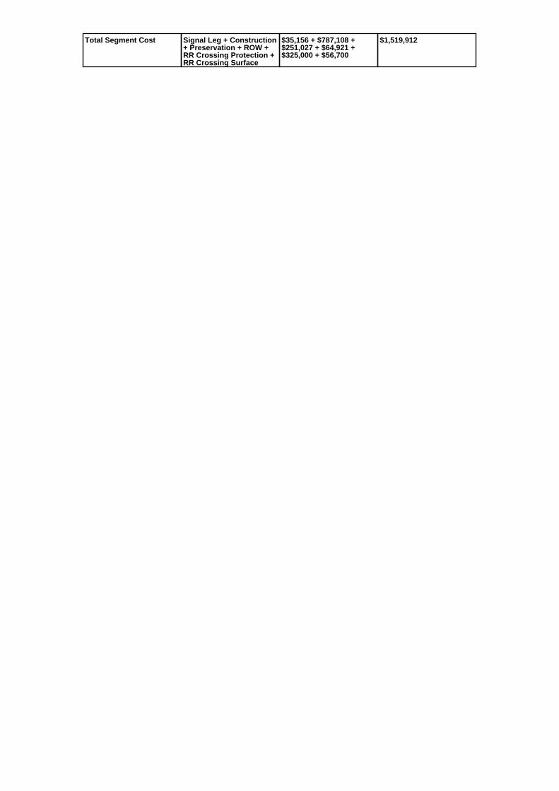
Total Segment Cost Signal Leg + Construction+ Preservation + ROW +RR Crossing Protection +RR Crossing Surface
$35,156 + $787,108 +$251,027 + $64,921 +$325,000 + $56,700
$1,519,912

SANEEDS - CSAH - Segment Report
Roadway SegmentInformation
Status : Original
County Name : RAMSEY Segment Nbr : 062-660-060
Original Current
WHITE BEAR LAKE Municipality WHITE BEAR LAKE
0.42 Segment Length 0.42
MIXED BITUMINOUS Existing Surface Type MIXED BITUMINOUS
2 Existing Surface Lanes 2
NOT DIVIDED Existing Lane Description NOT DIVIDED
OTTER LAKE RD. - T.H. 96 TOBIRCH LAKE BLVD.
Termini OTTER LAKE RD. - T.H. 96 TOBIRCH LAKE BLVD.
8200 Present AADT 8100
2013 Year of Count 2015
1 Projection Factor 1
8200 Projected Traffic 8100
RURAL Design Type RURAL
4 - RURAL : 7000 - 999999 Design Group 4 ( RURAL : 7000 - 999999 )
2000 Latest Year SA funds 2000
1 Number of Signal Legs 1
No Special Message Special Message Code No Special Message
Comments
Interchange Override
Segment Override
Segment CostInformation
Computation Factor Computation Formula Values Used ForCalculation
Computation Result
Signal Leg TrafficSignalLegs *UnitCost / SignalLifeCycle* StatutoryNeedsYear
1 * 56250 / 40 * 25 $35,156
Construction Length * UnitCost /ConstrLifeCycle *StatutoryNeedsYear *DevelopmentCost
0.42 * 1996892.57 / 60 * 25* 1.1
$384,402
Preservation Length * Quantity *UnitCost /PreservationLifeCycle *StatutoryNeedsYear
0.42 * 3564 * 65.52 / 20 * 25 $122,594
ROW Length * UnitCost /ROWLifeCycle *StatutoryNeedsYear
0.42 * 181173.68 / 60 * 25 $31,705
Total Segment Cost Signal Leg + Construction+ Preservation + ROW
$35,156 + $384,402 +$122,594 + $31,705
$573,857

SANEEDS - CSAH - Segment Report
Roadway SegmentInformation
Status : Original
County Name : RAMSEY Segment Nbr : 062-660-065
Original Current
WHITE BEAR LAKE Municipality WHITE BEAR LAKE
0.52 Segment Length 0.52
MIXED BITUMINOUS Existing Surface Type MIXED BITUMINOUS
2 Existing Surface Lanes 2
NOT DIVIDED Existing Lane Description NOT DIVIDED
OTTER LAKE RD. - BIRCH LAKEBLVD. TO SOO LINE RR
Termini OTTER LAKE RD. - BIRCH LAKEBLVD. TO SOO LINE RR
8200 Present AADT 8100
2013 Year of Count 2015
1 Projection Factor 1
8200 Projected Traffic 8100
RURAL Design Type RURAL
4 - RURAL : 7000 - 999999 Design Group 4 ( RURAL : 7000 - 999999 )
2000 Latest Year SA funds 2000
0 Number of Signal Legs 0
No Special Message Special Message Code No Special Message
Comments
Interchange Override
Segment Override
RailRoadCrossingInformation
Status: Original
Original Current
CANADIAN PACIFIC RAILWAY RailRoad Name CANADIAN PACIFIC RAILWAY
691421S USDOT Number 691421S
0.52 Located at Milepoint 0.52
1 Mainline Tracks 1
SIGNALS ONLY Protection Type SIGNALS ONLY
2001 Last Year Protection Upgraded 2001
37 Crossing Length 37
Last Year Surfaced
100% Percentage of Cost 100%
Comments
Segment CostInformation
Computation Factor Computation Formula Values Used ForCalculation
Computation Result
Signal Leg TrafficSignalLegs *UnitCost / SignalLifeCycle* StatutoryNeedsYear
0 * 56250 / 40 * 25 $0
Construction Length * UnitCost /ConstrLifeCycle *StatutoryNeedsYear *DevelopmentCost
0.52 * 1996892.57 / 60 * 25* 1.1
$475,926
Preservation Length * Quantity *UnitCost /PreservationLifeCycle *StatutoryNeedsYear
0.52 * 3564 * 65.52 / 20 * 25 $151,784
ROW Length * UnitCost /ROWLifeCycle *StatutoryNeedsYear
0.52 * 181173.68 / 60 * 25 $39,254
RR Crossing Protection UnitCost /RRCrossingLifeCycle *StatutoryNeedsYear
275000 / 25 * 25 $275,000
RR Crossing Surface SurfaceLength * UnitCost/ RRCrossingLifeCycle *StatutoryNeedsYear
37 * 1350 / 25 * 25 $49,950
Total Segment Cost Signal Leg + Construction+ Preservation + ROW +RR Crossing Protection +RR Crossing Surface
$0 + $475,926 + $151,784+ $39,254 + $275,000 +$49,950
$991,914

SANEEDS - CSAH - Segment Report
Roadway SegmentInformation
Status : Original
County Name : RAMSEY Segment Nbr : 062-660-070
Original Current
Unassigned/Unknown Municipality Unassigned/Unknown
0.9 Segment Length 0.9
MIXED BITUMINOUS Existing Surface Type MIXED BITUMINOUS
2 Existing Surface Lanes 2
NOT DIVIDED Existing Lane Description NOT DIVIDED
SOO LINE RR TO CO. RD. H2 Termini SOO LINE RR TO CO. RD. H2
6700 Present AADT 6900
2013 Year of Count 2015
1 Projection Factor 1
6700 Projected Traffic 6900
RURAL Design Type RURAL
3 - RURAL : 1500 - 6999 Design Group 3 ( RURAL : 1500 - 6999 )
2000 Latest Year SA funds 2000
0 Number of Signal Legs 0
No Special Message Special Message Code No Special Message
Comments
Interchange Override
Segment Override
Segment CostInformation
Computation Factor Computation Formula Values Used ForCalculation
Computation Result
Signal Leg TrafficSignalLegs *UnitCost / SignalLifeCycle* StatutoryNeedsYear
0 * 56250 / 40 * 25 $0
Construction Length * UnitCost /ConstrLifeCycle *StatutoryNeedsYear *DevelopmentCost
0.9 * 1021937.01 / 60 * 25 *1.1
$421,549
Preservation Length * Quantity *UnitCost /PreservationLifeCycle *StatutoryNeedsYear
0.9 * 2376 * 65.52 / 20 * 25 $175,135
ROW Length * UnitCost /ROWLifeCycle *StatutoryNeedsYear
0.9 * 85357.87 / 60 * 25 $32,009
Total Segment Cost Signal Leg + Construction+ Preservation + ROW
$0 + $421,549 + $175,135+ $32,009
$628,693

SANEEDS - CSAH - Segment Report
Roadway SegmentInformation
Status : Original
County Name : RAMSEY Segment Nbr : 062-660-080
Original Current
Unassigned/Unknown Municipality Unassigned/Unknown
1.4 Segment Length 1.4
MIXED BITUMINOUS Existing Surface Type MIXED BITUMINOUS
2 Existing Surface Lanes 2
NOT DIVIDED Existing Lane Description NOT DIVIDED
CO. RD. H2 TO FAI 35 E Termini CO. RD. H2 TO FAI 35 E
7000 Present AADT 4550
2013 Year of Count 2015
1 Projection Factor 1
7000 Projected Traffic 4550
RURAL Design Type RURAL
4 - RURAL : 7000 - 999999 Design Group 4 ( RURAL : 1500 - 6999 )
2000 Latest Year SA funds 2000
0 Number of Signal Legs 0
No Special Message Special Message Code No Special Message
2010 OVERLAY WITH LOCALFUNDS
Comments 2010 OVERLAY WITH LOCALFUNDS
Interchange Override
Segment Override
Segment CostInformation
Computation Factor Computation Formula Values Used ForCalculation
Computation Result
Signal Leg TrafficSignalLegs *UnitCost / SignalLifeCycle* StatutoryNeedsYear
0 * 56250 / 40 * 25 $0
Construction Length * UnitCost /ConstrLifeCycle *StatutoryNeedsYear *DevelopmentCost
1.4 * 1021937.01 / 60 * 25 *1.1
$655,743
Preservation Length * Quantity *UnitCost /PreservationLifeCycle *StatutoryNeedsYear
1.4 * 2376 * 65.52 / 20 * 25 $272,432
ROW Length * UnitCost /ROWLifeCycle *StatutoryNeedsYear
1.4 * 85357.87 / 60 * 25 $49,792
Total Segment Cost Signal Leg + Construction+ Preservation + ROW
$0 + $655,743 + $272,432+ $49,792
$977,967

SANEEDS - CSAH - Segment Report
Roadway SegmentInformation
Status : Original
County Name : RAMSEY Segment Nbr : 062-663-010
Original Current
NEW BRIGHTON Municipality NEW BRIGHTON
0.21 Segment Length 0.21
MIXED BITUMINOUS Existing Surface Type MIXED BITUMINOUS
2 Existing Surface Lanes 2
NOT DIVIDED Existing Lane Description NOT DIVIDED
CO RD E TO 0.21 MI N Termini CO RD E TO 0.21 MI N
1900 Present AADT 1850
2013 Year of Count 2015
1 Projection Factor 1
1900 Projected Traffic 1850
URBAN Design Type URBAN
5 - URBAN : 0 - 9999 Design Group 5 ( URBAN : 0 - 9999 )
2000 Latest Year SA funds 2000
0 Number of Signal Legs 0
No Special Message Special Message Code No Special Message
Comments
Interchange Override
Segment Override
Segment CostInformation
Computation Factor Computation Formula Values Used ForCalculation
Computation Result
Signal Leg TrafficSignalLegs *UnitCost / SignalLifeCycle* StatutoryNeedsYear
0 * 56250 / 40 * 25 $0
Construction Length * UnitCost /ConstrLifeCycle *StatutoryNeedsYear *DevelopmentCost
0.21 * 2738635.28 / 60 * 25* 1.15
$275,575
Preservation Length * Quantity *UnitCost /PreservationLifeCycle *StatutoryNeedsYear
0.21 * 2904 * 65.52 / 15 * 25 $66,595
ROW Length * UnitCost /ROWLifeCycle *StatutoryNeedsYear
0.21 * 436504.07 / 60 * 25 $38,194
Total Segment Cost Signal Leg + Construction+ Preservation + ROW
$0 + $275,575 + $66,595 +$38,194
$380,364

SANEEDS - CSAH - Segment Report
Roadway SegmentInformation
Status : Original
County Name : RAMSEY Segment Nbr : 062-664-003
Original Current
ST PAUL Municipality ST PAUL
0.25 Segment Length 0.25
BIT CONC OR ASPH Existing Surface Type BIT CONC OR ASPH
2 Existing Surface Lanes 2
NOT DIVIDED Existing Lane Description NOT DIVIDED
JOHNSON PKWY. - MINNEHAHAAVE. TO E. 7 TH. ST.
Termini JOHNSON PKWY. - MINNEHAHAAVE. TO E. 7 TH. ST.
11500 Present AADT 11500
2013 Year of Count 2015
1 Projection Factor 1
11500 Projected Traffic 11500
URBAN Design Type URBAN
6 - URBAN : 10000 - 19999 Design Group 6 ( URBAN : 10000 - 19999 )
2000 Latest Year SA funds 2000
2 Number of Signal Legs 2
No Special Message Special Message Code No Special Message
Comments
Interchange Override
Segment Override
Segment CostInformation
Computation Factor Computation Formula Values Used ForCalculation
Computation Result
Signal Leg TrafficSignalLegs *UnitCost / SignalLifeCycle* StatutoryNeedsYear
2 * 56250 / 40 * 25 $70,313
Construction Length * UnitCost /ConstrLifeCycle *StatutoryNeedsYear *DevelopmentCost
0.25 * 4225495.41 / 60 * 25* 1.15
$506,179
Preservation Length * Quantity *UnitCost /PreservationLifeCycle *StatutoryNeedsYear
0.25 * 3696 * 65.52 / 15 * 25 $100,901
ROW Length * UnitCost /ROWLifeCycle *StatutoryNeedsYear
0.25 * 566370.18 / 60 * 25 $58,997
Total Segment Cost Signal Leg + Construction+ Preservation + ROW
$70,313 + $506,179 +$100,901 + $58,997
$736,390

SANEEDS - CSAH - Segment Report
Roadway SegmentInformation
Status : Original
County Name : RAMSEY Segment Nbr : 062-664-005
Original Current
ST PAUL Municipality ST PAUL
0.16 Segment Length 0.16
MIXED BITUMINOUS Existing Surface Type MIXED BITUMINOUS
4 Existing Surface Lanes 4
NOT DIVIDED Existing Lane Description NOT DIVIDED
JOHNSON PKWY. - E. 7 TH. TOCASE AVE.
Termini JOHNSON PKWY. - E. 7 TH. TOCASE AVE.
15800 Present AADT 15800
2013 Year of Count 2015
1 Projection Factor 1
15800 Projected Traffic 15800
URBAN Design Type URBAN
6 - URBAN : 10000 - 19999 Design Group 6 ( URBAN : 10000 - 19999 )
2000 Latest Year SA funds 2000
1 Number of Signal Legs 1
No Special Message Special Message Code No Special Message
Comments
Interchange Override
Segment Override
Segment CostInformation
Computation Factor Computation Formula Values Used ForCalculation
Computation Result
Signal Leg TrafficSignalLegs *UnitCost / SignalLifeCycle* StatutoryNeedsYear
1 * 56250 / 40 * 25 $35,156
Construction Length * UnitCost /ConstrLifeCycle *StatutoryNeedsYear *DevelopmentCost
0.16 * 4225495.41 / 60 * 25* 1.15
$323,955
Preservation Length * Quantity *UnitCost /PreservationLifeCycle *StatutoryNeedsYear
0.16 * 3696 * 65.52 / 15 * 25 $64,577
ROW Length * UnitCost /ROWLifeCycle *StatutoryNeedsYear
0.16 * 566370.18 / 60 * 25 $37,758
Total Segment Cost Signal Leg + Construction+ Preservation + ROW
$35,156 + $323,955 +$64,577 + $37,758
$461,446

SANEEDS - CSAH - Segment Report
Roadway SegmentInformation
Status : Original
County Name : RAMSEY Segment Nbr : 062-664-008
Original Current
ST PAUL Municipality ST PAUL
0.34 Segment Length 0.34
BIT CONC OR ASPH Existing Surface Type BIT CONC OR ASPH
2 Existing Surface Lanes 2
NOT DIVIDED Existing Lane Description NOT DIVIDED
JOHNSON PKWY. - CASE AVE. TOMAGNOLIA AVE.
Termini JOHNSON PKWY. - CASE AVE. TOMAGNOLIA AVE.
15800 Present AADT 15800
2013 Year of Count 2015
1 Projection Factor 1
15800 Projected Traffic 15800
URBAN Design Type URBAN
6 - URBAN : 10000 - 19999 Design Group 6 ( URBAN : 10000 - 19999 )
2000 Latest Year SA funds 2000
0 Number of Signal Legs 0
No Special Message Special Message Code No Special Message
Comments
Interchange Override
Segment Override
Bridge Information Status: Original
Original Current
90423 Structure Number 90423
0.45 Milepoint 0.45
1906 Year Built 1906
Feature Crossed
Type of Service
Number of Spans
73 Bridge Length 73
59.5 Bridge Width 59.5
100% Shared Structure 100%
Comments
1 ( 0-149 ) Bridge Group Code 1 ( 0-149 )
Segment CostInformation
Computation Factor Computation Formula Values Used ForCalculation
Computation Result
Signal Leg TrafficSignalLegs *UnitCost / SignalLifeCycle* StatutoryNeedsYear
0 * 56250 / 40 * 25 $0
Construction Length * UnitCost /ConstrLifeCycle *StatutoryNeedsYear *DevelopmentCost
0.34 * 4225495.41 / 60 * 25* 1.15
$688,404
Preservation Length * Quantity *UnitCost /PreservationLifeCycle *StatutoryNeedsYear
0.34 * 3696 * 65.52 / 15 * 25 $137,225
ROW Length * UnitCost /ROWLifeCycle *StatutoryNeedsYear
0.34 * 566370.18 / 60 * 25 $80,236
Bridge BridgeLength *BridgeWidth * UnitCost /BridgeLifeCycle *StatutoryNeedsYear *DevelopmentCost
73 * 59.5 * 152 / 80 * 25 *1.15
$237,264
Total Segment Cost Signal Leg + Construction+ Preservation + ROW +Bridge
$0 + $688,404 + $137,225+ $80,236 + $237,264
$1,143,129

SANEEDS - CSAH - Segment Report
Roadway SegmentInformation
Status : Original
County Name : RAMSEY Segment Nbr : 062-664-010
Original Current
ST PAUL Municipality ST PAUL
0.25 Segment Length 0.25
MIXED BITUMINOUS Existing Surface Type MIXED BITUMINOUS
2 Existing Surface Lanes 2
NOT DIVIDED Existing Lane Description NOT DIVIDED
JOHNSON PKWY TO MARYLANDAVE.
Termini JOHNSON PKWY TO MARYLANDAVE.
14900 Present AADT 14900
2013 Year of Count 2015
1 Projection Factor 1
14900 Projected Traffic 14900
RURAL Design Type RURAL
4 - RURAL : 7000 - 999999 Design Group 4 ( RURAL : 7000 - 999999 )
2000 Latest Year SA funds 2000
3 Number of Signal Legs 3
No Special Message Special Message Code No Special Message
Comments
Interchange Override
Segment Override
Segment CostInformation
Computation Factor Computation Formula Values Used ForCalculation
Computation Result
Signal Leg TrafficSignalLegs *UnitCost / SignalLifeCycle* StatutoryNeedsYear
3 * 56250 / 40 * 25 $105,469
Construction Length * UnitCost /ConstrLifeCycle *StatutoryNeedsYear *DevelopmentCost
0.25 * 1996892.57 / 60 * 25* 1.1
$228,811
Preservation Length * Quantity *UnitCost /PreservationLifeCycle *StatutoryNeedsYear
0.25 * 3564 * 65.52 / 20 * 25 $72,973
ROW Length * UnitCost /ROWLifeCycle *StatutoryNeedsYear
0.25 * 181173.68 / 60 * 25 $18,872
Total Segment Cost Signal Leg + Construction+ Preservation + ROW
$105,469 + $228,811 +$72,973 + $18,872
$426,125

SANEEDS - CSAH - Segment Report
Roadway SegmentInformation
Status : Original
County Name : RAMSEY Segment Nbr : 062-664-020
Original Current
ST PAUL Municipality ST PAUL
0.55 Segment Length 0.55
MIXED BITUMINOUS Existing Surface Type MIXED BITUMINOUS
2 Existing Surface Lanes 2
NOT DIVIDED Existing Lane Description NOT DIVIDED
MARYLAND AVE. TO ARLINGTONAVE.
Termini MARYLAND AVE. TO ARLINGTONAVE.
7600 Present AADT 7600
2013 Year of Count 2015
1 Projection Factor 1
7600 Projected Traffic 7600
URBAN Design Type URBAN
5 - URBAN : 0 - 9999 Design Group 5 ( URBAN : 0 - 9999 )
2000 Latest Year SA funds 2000
1 Number of Signal Legs 1
No Special Message Special Message Code No Special Message
Comments
Interchange Override
Segment Override
Segment CostInformation
Computation Factor Computation Formula Values Used ForCalculation
Computation Result
Signal Leg TrafficSignalLegs *UnitCost / SignalLifeCycle* StatutoryNeedsYear
1 * 56250 / 40 * 25 $35,156
Construction Length * UnitCost /ConstrLifeCycle *StatutoryNeedsYear *DevelopmentCost
0.55 * 2738635.28 / 60 * 25* 1.15
$721,745
Preservation Length * Quantity *UnitCost /PreservationLifeCycle *StatutoryNeedsYear
0.55 * 2904 * 65.52 / 15 * 25 $174,414
ROW Length * UnitCost /ROWLifeCycle *StatutoryNeedsYear
0.55 * 436504.07 / 60 * 25 $100,032
Total Segment Cost Signal Leg + Construction+ Preservation + ROW
$35,156 + $721,745 +$174,414 + $100,032
$1,031,347

SANEEDS - CSAH - Segment Report
Roadway SegmentInformation
Status : Original
County Name : RAMSEY Segment Nbr : 062-664-030
Original Current
ST PAUL Municipality ST PAUL
0.4 Segment Length 0.4
MIXED BITUMINOUS Existing Surface Type MIXED BITUMINOUS
2 Existing Surface Lanes 2
NOT DIVIDED Existing Lane Description NOT DIVIDED
ARLINGTON TO IDAHO AVE Termini ARLINGTON TO IDAHO AVE
4800 Present AADT 4800
2013 Year of Count 2015
1 Projection Factor 1
4800 Projected Traffic 4800
URBAN Design Type URBAN
5 - URBAN : 0 - 9999 Design Group 5 ( URBAN : 0 - 9999 )
2000 Latest Year SA funds 2000
0 Number of Signal Legs 0
No Special Message Special Message Code No Special Message
Comments
Interchange Override
Segment Override
Segment CostInformation
Computation Factor Computation Formula Values Used ForCalculation
Computation Result
Signal Leg TrafficSignalLegs *UnitCost / SignalLifeCycle* StatutoryNeedsYear
0 * 56250 / 40 * 25 $0
Construction Length * UnitCost /ConstrLifeCycle *StatutoryNeedsYear *DevelopmentCost
0.4 * 2738635.28 / 60 * 25 *1.15
$524,905
Preservation Length * Quantity *UnitCost /PreservationLifeCycle *StatutoryNeedsYear
0.4 * 2904 * 65.52 / 15 * 25 $126,847
ROW Length * UnitCost /ROWLifeCycle *StatutoryNeedsYear
0.4 * 436504.07 / 60 * 25 $72,751
Total Segment Cost Signal Leg + Construction+ Preservation + ROW
$0 + $524,905 + $126,847+ $72,751
$724,503

SANEEDS - CSAH - Segment Report
Roadway SegmentInformation
Status : Original
County Name : RAMSEY Segment Nbr : 062-664-040
Original Current
ST PAUL Municipality ST PAUL
0.15 Segment Length 0.15
MIXED BITUMINOUS Existing Surface Type MIXED BITUMINOUS
2 Existing Surface Lanes 2
NOT DIVIDED Existing Lane Description NOT DIVIDED
IDAHO AVE TO LARPENTEURAVE.
Termini IDAHO AVE TO LARPENTEURAVE.
4800 Present AADT 4800
2013 Year of Count 2015
1 Projection Factor 1
4800 Projected Traffic 4800
URBAN Design Type URBAN
5 - URBAN : 0 - 9999 Design Group 5 ( URBAN : 0 - 9999 )
2000 Latest Year SA funds 2000
0 Number of Signal Legs 0
No Special Message Special Message Code No Special Message
Comments
Interchange Override
Segment Override
Segment CostInformation
Computation Factor Computation Formula Values Used ForCalculation
Computation Result
Signal Leg TrafficSignalLegs *UnitCost / SignalLifeCycle* StatutoryNeedsYear
0 * 56250 / 40 * 25 $0
Construction Length * UnitCost /ConstrLifeCycle *StatutoryNeedsYear *DevelopmentCost
0.15 * 2738635.28 / 60 * 25* 1.15
$196,839
Preservation Length * Quantity *UnitCost /PreservationLifeCycle *StatutoryNeedsYear
0.15 * 2904 * 65.52 / 15 * 25 $47,568
ROW Length * UnitCost /ROWLifeCycle *StatutoryNeedsYear
0.15 * 436504.07 / 60 * 25 $27,282
Total Segment Cost Signal Leg + Construction+ Preservation + ROW
$0 + $196,839 + $47,568 +$27,282
$271,689

SANEEDS - CSAH - Segment Report
Roadway SegmentInformation
Status : Original
County Name : RAMSEY Segment Nbr : 062-665-010
Original Current
ST PAUL Municipality ST PAUL
0.35 Segment Length 0.35
MIXED BITUMINOUS Existing Surface Type MIXED BITUMINOUS
2 Existing Surface Lanes 2
NOT DIVIDED Existing Lane Description NOT DIVIDED
UPPER AFTON RD TO BURNS AVE Termini UPPER AFTON RD TO BURNS AVE
3900 Present AADT 3900
2013 Year of Count 2015
1 Projection Factor 1
3900 Projected Traffic 3900
URBAN Design Type URBAN
5 - URBAN : 0 - 9999 Design Group 5 ( URBAN : 0 - 9999 )
2000 Latest Year SA funds 2000
0 Number of Signal Legs 0
No Special Message Special Message Code No Special Message
Comments
Interchange Override
Segment Override
Segment CostInformation
Computation Factor Computation Formula Values Used ForCalculation
Computation Result
Signal Leg TrafficSignalLegs *UnitCost / SignalLifeCycle* StatutoryNeedsYear
0 * 56250 / 40 * 25 $0
Construction Length * UnitCost /ConstrLifeCycle *StatutoryNeedsYear *DevelopmentCost
0.35 * 2738635.28 / 60 * 25* 1.15
$459,292
Preservation Length * Quantity *UnitCost /PreservationLifeCycle *StatutoryNeedsYear
0.35 * 2904 * 65.52 / 15 * 25 $110,991
ROW Length * UnitCost /ROWLifeCycle *StatutoryNeedsYear
0.35 * 436504.07 / 60 * 25 $63,657
Total Segment Cost Signal Leg + Construction+ Preservation + ROW
$0 + $459,292 + $110,991+ $63,657
$633,940

SANEEDS - CSAH - Segment Report
Roadway SegmentInformation
Status : Original
County Name : RAMSEY Segment Nbr : 062-665-011
Original Current
ST PAUL Municipality ST PAUL
0.21 Segment Length 0.21
BIT CONC OR ASPH Existing Surface Type BIT CONC OR ASPH
4 Existing Surface Lanes 4
NOT DIVIDED Existing Lane Description NOT DIVIDED
BURNS AVE TO I-94 Termini BURNS AVE TO I-94
17100 Present AADT 18300
2013 Year of Count 2015
1 Projection Factor 1
17100 Projected Traffic 18300
URBAN Design Type URBAN
6 - URBAN : 10000 - 19999 Design Group 6 ( URBAN : 10000 - 19999 )
2000 Latest Year SA funds 2000
3 Number of Signal Legs 3
No Special Message Special Message Code No Special Message
Comments
Interchange Override
Segment Override
Segment CostInformation
Computation Factor Computation Formula Values Used ForCalculation
Computation Result
Signal Leg TrafficSignalLegs *UnitCost / SignalLifeCycle* StatutoryNeedsYear
3 * 56250 / 40 * 25 $105,469
Construction Length * UnitCost /ConstrLifeCycle *StatutoryNeedsYear *DevelopmentCost
0.21 * 4225495.41 / 60 * 25* 1.15
$425,190
Preservation Length * Quantity *UnitCost /PreservationLifeCycle *StatutoryNeedsYear
0.21 * 3696 * 65.52 / 15 * 25 $84,757
ROW Length * UnitCost /ROWLifeCycle *StatutoryNeedsYear
0.21 * 566370.18 / 60 * 25 $49,557
Total Segment Cost Signal Leg + Construction+ Preservation + ROW
$105,469 + $425,190 +$84,757 + $49,557
$664,973

SANEEDS - CSAH - Segment Report
Roadway SegmentInformation
Status : Revised
County Name : RAMSEY Segment Nbr : 062-665-012
Original Current
ST PAUL Municipality ST PAUL
0.08 Segment Length 0.08
MIXED BITUMINOUS Existing Surface Type MIXED BITUMINOUS
4 Existing Surface Lanes 4
NOT DIVIDED Existing Lane Description NOT DIVIDED
I-94 TO OLD HUDSON RD Termini I-94 TO OLD HUDSON RD
23600 Present AADT 23600
2013 Year of Count 2015
1 Projection Factor 1
23600 Projected Traffic 23600
URBAN Design Type URBAN
7 - URBAN : 20000 - 34999 Design Group 7 ( URBAN : 20000 - 34999 )
2016 Latest Year SA funds 2016
4 Number of Signal Legs 4
No Special Message Special Message Code No Special Message
RECONSTRUCTED IN 2016- SP062-665-052 AND SP 164-020-138.
Comments RECONSTRUCTED IN 2016- SP062-665-052 AND SP 164-020-138.
Interchange Override
Segment Override
Segment CostInformation
Computation Factor Computation Formula Values Used ForCalculation
Computation Result
Signal Leg TrafficSignalLegs *UnitCost / SignalLifeCycle* StatutoryNeedsYear
4 * 56250 / 40 * 25 $140,625
Construction Length * UnitCost /ConstrLifeCycle *StatutoryNeedsYear *DevelopmentCost
0.08 * 5259942.61 / 60 * 25* 1.15
$201,631
Preservation Length * Quantity *UnitCost /PreservationLifeCycle *StatutoryNeedsYear
0.08 * 4488 * 65.52 / 15 * 25 $39,207
ROW Length * UnitCost /ROWLifeCycle *StatutoryNeedsYear
0.08 * 883293.09 / 60 * 25 $29,443
Total Segment Cost Signal Leg + Construction+ Preservation + ROW
$140,625 + $201,631 +$39,207 + $29,443
$410,906

SANEEDS - CSAH - Segment Report
Roadway SegmentInformation
Status : Revised
County Name : RAMSEY Segment Nbr : 062-665-013
Original Current
ST PAUL Municipality ST PAUL
0.26 Segment Length 0.26
MIXED BITUMINOUS Existing Surface Type MIXED BITUMINOUS
4 Existing Surface Lanes 4
NOT DIVIDED Existing Lane Description NOT DIVIDED
OLD HUDSON RD TO 3RD ST Termini OLD HUDSON RD TO 3RD ST
23600 Present AADT 23600
2013 Year of Count 2015
1 Projection Factor 1
23600 Projected Traffic 23600
URBAN Design Type URBAN
7 - URBAN : 20000 - 34999 Design Group 7 ( URBAN : 20000 - 34999 )
2016 Latest Year SA funds 2016
2 Number of Signal Legs 2
No Special Message Special Message Code No Special Message
RECONSTRUCTED IN 2016- SP062-665-052 AND SP 164-020-138
Comments RECONSTRUCTED IN 2016- SP062-665-052 AND SP 164-020-138
Interchange Override
Segment Override
Segment CostInformation
Computation Factor Computation Formula Values Used ForCalculation
Computation Result
Signal Leg TrafficSignalLegs *UnitCost / SignalLifeCycle* StatutoryNeedsYear
2 * 56250 / 40 * 25 $70,313
Construction Length * UnitCost /ConstrLifeCycle *StatutoryNeedsYear *DevelopmentCost
0.26 * 5259942.61 / 60 * 25* 1.15
$655,301
Preservation Length * Quantity *UnitCost /PreservationLifeCycle *StatutoryNeedsYear
0.26 * 4488 * 65.52 / 15 * 25 $127,423
ROW Length * UnitCost /ROWLifeCycle *StatutoryNeedsYear
0.26 * 883293.09 / 60 * 25 $95,690
Total Segment Cost Signal Leg + Construction+ Preservation + ROW
$70,313 + $655,301 +$127,423 + $95,690
$948,727

SANEEDS - CSAH - Segment Report
Roadway SegmentInformation
Status : Revised
County Name : RAMSEY Segment Nbr : 062-665-020
Original Current
ST PAUL Municipality ST PAUL
0.45 Segment Length 0.45
MIXED BITUMINOUS Existing Surface Type MIXED BITUMINOUS
4 Existing Surface Lanes 4
NOT DIVIDED Existing Lane Description NOT DIVIDED
3RD ST TO MINNEHAHA AVE Termini 3RD ST TO MINNEHAHA AVE
18100 Present AADT 19100
2013 Year of Count 2015
1 Projection Factor 1
18100 Projected Traffic 19100
URBAN Design Type URBAN
6 - URBAN : 10000 - 19999 Design Group 6 ( URBAN : 10000 - 19999 )
2016 Latest Year SA funds 2016
2 Number of Signal Legs 2
No Special Message Special Message Code No Special Message
RECONSTRUCTED IN 2016- SP062-665-052 AND SP 14-020-138
Comments RECONSTRUCTED IN 2016- SP062-665-052 AND SP 14-020-138
Interchange Override
Segment Override
Segment CostInformation
Computation Factor Computation Formula Values Used ForCalculation
Computation Result
Signal Leg TrafficSignalLegs *UnitCost / SignalLifeCycle* StatutoryNeedsYear
2 * 56250 / 40 * 25 $70,313
Construction Length * UnitCost /ConstrLifeCycle *StatutoryNeedsYear *DevelopmentCost
0.45 * 4225495.41 / 60 * 25* 1.15
$911,122
Preservation Length * Quantity *UnitCost /PreservationLifeCycle *StatutoryNeedsYear
0.45 * 3696 * 65.52 / 15 * 25 $181,621
ROW Length * UnitCost /ROWLifeCycle *StatutoryNeedsYear
0.45 * 566370.18 / 60 * 25 $106,194
Total Segment Cost Signal Leg + Construction+ Preservation + ROW
$70,313 + $911,122 +$181,621 + $106,194
$1,269,250

SANEEDS - CSAH - Segment Report
Roadway SegmentInformation
Status : Revised
County Name : RAMSEY Segment Nbr : 062-665-030
Original Current
ST PAUL Municipality ST PAUL
0.6 Segment Length 0.6
MIXED BITUMINOUS Existing Surface Type MIXED BITUMINOUS
4 Existing Surface Lanes 4
NOT DIVIDED Existing Lane Description NOT DIVIDED
MINNEHAHA TO AMES AVE Termini MINNEHAHA TO AMES AVE
19400 Present AADT 19400
2013 Year of Count 2015
1 Projection Factor 1
19400 Projected Traffic 19400
URBAN Design Type URBAN
6 - URBAN : 10000 - 19999 Design Group 6 ( URBAN : 10000 - 19999 )
2000 Latest Year SA funds 2000
5 Number of Signal Legs 5
No Special Message Special Message Code No Special Message
RECONSTRUCTED 2016- SP 062-665-052 AND SP 164-020-138.
Comments RECONSTRUCTED 2016- SP 062-665-052 AND SP 164-020-138.
Interchange Override
Segment Override
Segment CostInformation
Computation Factor Computation Formula Values Used ForCalculation
Computation Result
Signal Leg TrafficSignalLegs *UnitCost / SignalLifeCycle* StatutoryNeedsYear
5 * 56250 / 40 * 25 $175,781
Construction Length * UnitCost /ConstrLifeCycle *StatutoryNeedsYear *DevelopmentCost
0.6 * 4225495.41 / 60 * 25 *1.15
$1,214,830
Preservation Length * Quantity *UnitCost /PreservationLifeCycle *StatutoryNeedsYear
0.6 * 3696 * 65.52 / 15 * 25 $242,162
ROW Length * UnitCost /ROWLifeCycle *StatutoryNeedsYear
0.6 * 566370.18 / 60 * 25 $141,593
Total Segment Cost Signal Leg + Construction+ Preservation + ROW
$175,781 + $1,214,830 +$242,162 + $141,593
$1,774,366

SANEEDS - CSAH - Segment Report
Roadway SegmentInformation
Status : Original
County Name : RAMSEY Segment Nbr : 062-665-040
Original Current
ST PAUL Municipality ST PAUL
0.2 Segment Length 0.2
BIT CONC OR ASPH Existing Surface Type BIT CONC OR ASPH
4 Existing Surface Lanes 4
NOT DIVIDED Existing Lane Description NOT DIVIDED
AMES AVE TO 0.20 MI NO Termini AMES AVE TO 0.20 MI NO
19400 Present AADT 19400
2013 Year of Count 2015
1 Projection Factor 1
19400 Projected Traffic 19400
URBAN Design Type URBAN
6 - URBAN : 10000 - 19999 Design Group 6 ( URBAN : 10000 - 19999 )
2000 Latest Year SA funds 2000
1 Number of Signal Legs 1
No Special Message Special Message Code No Special Message
Comments
Interchange Override
Segment Override
Bridge Information Status: Original
Original Current
62530 Structure Number 62530
2.088 Milepoint 2.088
1975 Year Built 1975
UP RR Feature Crossed UP RR
Type of Service
Number of Spans
135.2 Bridge Length 135.2
70.3 Bridge Width 70.3
100% Shared Structure 100%
Comments
1 ( 0-149 ) Bridge Group Code 1 ( 0-149 )
Segment CostInformation
Computation Factor Computation Formula Values Used ForCalculation
Computation Result
Signal Leg TrafficSignalLegs *UnitCost / SignalLifeCycle* StatutoryNeedsYear
1 * 56250 / 40 * 25 $35,156
Construction Length * UnitCost /ConstrLifeCycle *StatutoryNeedsYear *DevelopmentCost
0.2 * 4225495.41 / 60 * 25 *1.15
$404,943
Preservation Length * Quantity *UnitCost /PreservationLifeCycle *StatutoryNeedsYear
0.2 * 3696 * 65.52 / 15 * 25 $80,721
ROW Length * UnitCost /ROWLifeCycle *StatutoryNeedsYear
0.2 * 566370.18 / 60 * 25 $47,198
Bridge BridgeLength *BridgeWidth * UnitCost /BridgeLifeCycle *StatutoryNeedsYear *DevelopmentCost
135.2 * 70.3 * 152 / 80 * 25* 1.15
$519,187
Total Segment Cost Signal Leg + Construction+ Preservation + ROW +Bridge
$35,156 + $404,943 +$80,721 + $47,198 +$519,187
$1,087,205

SANEEDS - CSAH - Segment Report
Roadway SegmentInformation
Status : Original
County Name : RAMSEY Segment Nbr : 062-665-045
Original Current
ST PAUL Municipality ST PAUL
0.11 Segment Length 0.11
MIXED BITUMINOUS Existing Surface Type MIXED BITUMINOUS
4 Existing Surface Lanes 4
NOT DIVIDED Existing Lane Description NOT DIVIDED
0.2 MI N OF AMES TO 0.31 MI N OFAMES
Termini 0.2 MI N OF AMES TO 0.31 MI N OFAMES
19400 Present AADT 19400
2013 Year of Count 2015
1 Projection Factor 1
19400 Projected Traffic 19400
URBAN Design Type URBAN
6 - URBAN : 10000 - 19999 Design Group 6 ( URBAN : 10000 - 19999 )
2000 Latest Year SA funds 2000
0 Number of Signal Legs 0
No Special Message Special Message Code No Special Message
Comments
Interchange Override
Segment Override
Segment CostInformation
Computation Factor Computation Formula Values Used ForCalculation
Computation Result
Signal Leg TrafficSignalLegs *UnitCost / SignalLifeCycle* StatutoryNeedsYear
0 * 56250 / 40 * 25 $0
Construction Length * UnitCost /ConstrLifeCycle *StatutoryNeedsYear *DevelopmentCost
0.11 * 4225495.41 / 60 * 25* 1.15
$222,719
Preservation Length * Quantity *UnitCost /PreservationLifeCycle *StatutoryNeedsYear
0.11 * 3696 * 65.52 / 15 * 25 $44,396
ROW Length * UnitCost /ROWLifeCycle *StatutoryNeedsYear
0.11 * 566370.18 / 60 * 25 $25,959
Total Segment Cost Signal Leg + Construction+ Preservation + ROW
$0 + $222,719 + $44,396 +$25,959
$293,074

SANEEDS - CSAH - Segment Report
Roadway SegmentInformation
Status : Original
County Name : RAMSEY Segment Nbr : 062-665-047
Original Current
ST PAUL Municipality ST PAUL
0.16 Segment Length 0.16
MIXED BITUMINOUS Existing Surface Type MIXED BITUMINOUS
4 Existing Surface Lanes 4
NOT DIVIDED Existing Lane Description NOT DIVIDED
WHITE BEAR AVE - 0.31 MI NO OFAMES TO 420' N OF MARYLAND
Termini WHITE BEAR AVE - 0.31 MI NO OFAMES TO 420' N OF MARYLAND
19400 Present AADT 19400
2013 Year of Count 2015
1 Projection Factor 1
19400 Projected Traffic 19400
URBAN Design Type URBAN
6 - URBAN : 10000 - 19999 Design Group 6 ( URBAN : 10000 - 19999 )
2007 Latest Year SA funds 2007
2 Number of Signal Legs 2
No Special Message Special Message Code No Special Message
SP 62-665-042, 2007 Comments SP 62-665-042, 2007
Interchange Override
Segment Override
Segment CostInformation
Computation Factor Computation Formula Values Used ForCalculation
Computation Result
Signal Leg TrafficSignalLegs *UnitCost / SignalLifeCycle* StatutoryNeedsYear
2 * 56250 / 40 * 25 $70,313
Construction Length * UnitCost /ConstrLifeCycle *StatutoryNeedsYear *DevelopmentCost
0.16 * 4225495.41 / 60 * 25* 1.15
$323,955
Preservation Length * Quantity *UnitCost /PreservationLifeCycle *StatutoryNeedsYear
0.16 * 3696 * 65.52 / 15 * 25 $64,577
ROW Length * UnitCost /ROWLifeCycle *StatutoryNeedsYear
0.16 * 566370.18 / 60 * 25 $37,758
Total Segment Cost Signal Leg + Construction+ Preservation + ROW
$70,313 + $323,955 +$64,577 + $37,758
$496,603

SANEEDS - CSAH - Segment Report
Roadway SegmentInformation
Status : Original
County Name : RAMSEY Segment Nbr : 062-665-049
Original Current
ST PAUL Municipality ST PAUL
0.8 Segment Length 0.8
MIXED BITUMINOUS Existing Surface Type MIXED BITUMINOUS
4 Existing Surface Lanes 4
NOT DIVIDED Existing Lane Description NOT DIVIDED
WHITE BEAR AVE - 420' N OFMARYLAND AVE TO IDAHO AVE
Termini WHITE BEAR AVE - 420' N OFMARYLAND AVE TO IDAHO AVE
18800 Present AADT 18800
2013 Year of Count 2015
1 Projection Factor 1
18800 Projected Traffic 18800
URBAN Design Type URBAN
6 - URBAN : 10000 - 19999 Design Group 6 ( URBAN : 10000 - 19999 )
2000 Latest Year SA funds 2000
6 Number of Signal Legs 6
No Special Message Special Message Code No Special Message
Comments
Interchange Override
Segment Override
Segment CostInformation
Computation Factor Computation Formula Values Used ForCalculation
Computation Result
Signal Leg TrafficSignalLegs *UnitCost / SignalLifeCycle* StatutoryNeedsYear
6 * 56250 / 40 * 25 $210,938
Construction Length * UnitCost /ConstrLifeCycle *StatutoryNeedsYear *DevelopmentCost
0.8 * 4225495.41 / 60 * 25 *1.15
$1,619,773
Preservation Length * Quantity *UnitCost /PreservationLifeCycle *StatutoryNeedsYear
0.8 * 3696 * 65.52 / 15 * 25 $322,883
ROW Length * UnitCost /ROWLifeCycle *StatutoryNeedsYear
0.8 * 566370.18 / 60 * 25 $188,790
Total Segment Cost Signal Leg + Construction+ Preservation + ROW
$210,938 + $1,619,773 +$322,883 + $188,790
$2,342,384

SANEEDS - CSAH - Segment Report
Roadway SegmentInformation
Status : Original
County Name : RAMSEY Segment Nbr : 062-665-051
Original Current
ST PAUL Municipality ST PAUL
0.12 Segment Length 0.12
MIXED BITUMINOUS Existing Surface Type MIXED BITUMINOUS
4 Existing Surface Lanes 4
DIVIDED Existing Lane Description DIVIDED
IDAHO AVE TO LARPENTEURAVE.
Termini IDAHO AVE TO LARPENTEURAVE.
18800 Present AADT 18800
2013 Year of Count 2015
1 Projection Factor 1
18800 Projected Traffic 18800
URBAN Design Type URBAN
6 - URBAN : 10000 - 19999 Design Group 6 ( URBAN : 10000 - 19999 )
2000 Latest Year SA funds 2000
1 Number of Signal Legs 1
No Special Message Special Message Code No Special Message
Comments
Interchange Override
Segment Override
Segment CostInformation
Computation Factor Computation Formula Values Used ForCalculation
Computation Result
Signal Leg TrafficSignalLegs *UnitCost / SignalLifeCycle* StatutoryNeedsYear
1 * 56250 / 40 * 25 $35,156
Construction Length * UnitCost /ConstrLifeCycle *StatutoryNeedsYear *DevelopmentCost
0.12 * 4225495.41 / 60 * 25* 1.15
$242,966
Preservation Length * Quantity *UnitCost /PreservationLifeCycle *StatutoryNeedsYear
0.12 * 3696 * 65.52 / 15 * 25 $48,432
ROW Length * UnitCost /ROWLifeCycle *StatutoryNeedsYear
0.12 * 566370.18 / 60 * 25 $28,319
Total Segment Cost Signal Leg + Construction+ Preservation + ROW
$35,156 + $242,966 +$48,432 + $28,319
$354,873

SANEEDS - CSAH - Segment Report
Roadway SegmentInformation
Status : Original
County Name : RAMSEY Segment Nbr : 062-665-060
Original Current
MAPLEWOOD Municipality MAPLEWOOD
0.5 Segment Length 0.5
PORT CEMENT CONC Existing Surface Type PORT CEMENT CONC
4 Existing Surface Lanes 4
NOT DIVIDED Existing Lane Description NOT DIVIDED
LARPENTEUR AVE. TO FROSTAVE.
Termini LARPENTEUR AVE. TO FROSTAVE.
19100 Present AADT 19900
2013 Year of Count 2015
1 Projection Factor 1
19100 Projected Traffic 19900
URBAN Design Type URBAN
6 - URBAN : 10000 - 19999 Design Group 6 ( URBAN : 10000 - 19999 )
1992 Latest Year SA funds 1992
4 Number of Signal Legs 4
No Special Message Special Message Code No Special Message
Comments
Interchange Override
Segment Override
Segment CostInformation
Computation Factor Computation Formula Values Used ForCalculation
Computation Result
Signal Leg TrafficSignalLegs *UnitCost / SignalLifeCycle* StatutoryNeedsYear
4 * 56250 / 40 * 25 $140,625
Construction Length * UnitCost /ConstrLifeCycle *StatutoryNeedsYear *DevelopmentCost
0.5 * 4225495.41 / 60 * 25 *1.15
$1,012,358
Preservation Length * Quantity *UnitCost /PreservationLifeCycle *StatutoryNeedsYear
0.5 * 3696 * 65.52 / 15 * 25 $201,802
ROW Length * UnitCost /ROWLifeCycle *StatutoryNeedsYear
0.5 * 566370.18 / 60 * 25 $117,994
Total Segment Cost Signal Leg + Construction+ Preservation + ROW
$140,625 + $1,012,358 +$201,802 + $117,994
$1,472,779

SANEEDS - CSAH - Segment Report
Roadway SegmentInformation
Status : Original
County Name : RAMSEY Segment Nbr : 062-665-070
Original Current
MAPLEWOOD Municipality MAPLEWOOD
0.03 Segment Length 0.03
PORT CEMENT CONC Existing Surface Type PORT CEMENT CONC
4 Existing Surface Lanes 4
DIVIDED Existing Lane Description DIVIDED
FROST AVE. TO 0.03 MI N Termini FROST AVE. TO 0.03 MI N
20800 Present AADT 20600
2013 Year of Count 2015
1 Projection Factor 1
20800 Projected Traffic 20600
URBAN Design Type URBAN
7 - URBAN : 20000 - 34999 Design Group 7 ( URBAN : 20000 - 34999 )
2000 Latest Year SA funds 2000
1 Number of Signal Legs 1
No Special Message Special Message Code No Special Message
Comments
Interchange Override
Segment Override
Segment CostInformation
Computation Factor Computation Formula Values Used ForCalculation
Computation Result
Signal Leg TrafficSignalLegs *UnitCost / SignalLifeCycle* StatutoryNeedsYear
1 * 56250 / 40 * 25 $35,156
Construction Length * UnitCost /ConstrLifeCycle *StatutoryNeedsYear *DevelopmentCost
0.03 * 5259942.61 / 60 * 25* 1.15
$75,612
Preservation Length * Quantity *UnitCost /PreservationLifeCycle *StatutoryNeedsYear
0.03 * 4488 * 65.52 / 15 * 25 $14,703
ROW Length * UnitCost /ROWLifeCycle *StatutoryNeedsYear
0.03 * 883293.09 / 60 * 25 $11,041
Total Segment Cost Signal Leg + Construction+ Preservation + ROW
$35,156 + $75,612 +$14,703 + $11,041
$136,512

SANEEDS - CSAH - Segment Report
Roadway SegmentInformation
Status : Original
County Name : RAMSEY Segment Nbr : 062-665-080
Original Current
MAPLEWOOD Municipality MAPLEWOOD
0.34 Segment Length 0.34
PORT CEMENT CONC Existing Surface Type PORT CEMENT CONC
4 Existing Surface Lanes 4
DIVIDED Existing Lane Description DIVIDED
0.03 MI N FROST AVE. TO 0.13 MI SOF CO. RD. B
Termini 0.03 MI N FROST AVE. TO 0.13 MI SOF CO. RD. B
20800 Present AADT 20800
2013 Year of Count 2015
1 Projection Factor 1
20800 Projected Traffic 20800
URBAN Design Type URBAN
7 - URBAN : 20000 - 34999 Design Group 7 ( URBAN : 20000 - 34999 )
1986 Latest Year SA funds 1986
0 Number of Signal Legs 0
No Special Message Special Message Code No Special Message
Comments
Interchange Override
Segment Override
Bridge Information Status: Original
Original Current
94207 Structure Number 94207
4.07 Milepoint 4.07
1991 Year Built 1991
Feature Crossed
Type of Service
Number of Spans
282 Bridge Length 282
12 Bridge Width 12
100% Shared Structure 100%
Comments
2 ( 150-999,999 ) Bridge Group Code 2 ( 150-999,999 )
Segment CostInformation
Computation Factor Computation Formula Values Used ForCalculation
Computation Result
Signal Leg TrafficSignalLegs *UnitCost / SignalLifeCycle* StatutoryNeedsYear
0 * 56250 / 40 * 25 $0
Construction Length * UnitCost /ConstrLifeCycle *StatutoryNeedsYear *DevelopmentCost
0.34 * 5259942.61 / 60 * 25* 1.15
$856,932
Preservation Length * Quantity *UnitCost /PreservationLifeCycle *StatutoryNeedsYear
0.34 * 4488 * 65.52 / 15 * 25 $166,630
ROW Length * UnitCost /ROWLifeCycle *StatutoryNeedsYear
0.34 * 883293.09 / 60 * 25 $125,133
Bridge BridgeLength *BridgeWidth * UnitCost /BridgeLifeCycle *StatutoryNeedsYear *DevelopmentCost
282 * 12 * 138 / 80 * 25 *1.15
$167,825
Total Segment Cost Signal Leg + Construction+ Preservation + ROW +Bridge
$0 + $856,932 + $166,630+ $125,133 + $167,825
$1,316,520

SANEEDS - CSAH - Segment Report
Roadway SegmentInformation
Status : Original
County Name : RAMSEY Segment Nbr : 062-665-085
Original Current
MAPLEWOOD Municipality MAPLEWOOD
0.23 Segment Length 0.23
PORT CEMENT CONC Existing Surface Type PORT CEMENT CONC
4 Existing Surface Lanes 4
DIVIDED Existing Lane Description DIVIDED
0.13 MI S OF CO. RD. B TO 0.10 MIN OF CO. RD. B
Termini 0.13 MI S OF CO. RD. B TO 0.10 MIN OF CO. RD. B
21900 Present AADT 21600
2013 Year of Count 2015
1 Projection Factor 1
21900 Projected Traffic 21600
URBAN Design Type URBAN
7 - URBAN : 20000 - 34999 Design Group 7 ( URBAN : 20000 - 34999 )
1983 Latest Year SA funds 1983
2 Number of Signal Legs 2
No Special Message Special Message Code No Special Message
Comments
Interchange Override
Segment Override
Segment CostInformation
Computation Factor Computation Formula Values Used ForCalculation
Computation Result
Signal Leg TrafficSignalLegs *UnitCost / SignalLifeCycle* StatutoryNeedsYear
2 * 56250 / 40 * 25 $70,313
Construction Length * UnitCost /ConstrLifeCycle *StatutoryNeedsYear *DevelopmentCost
0.23 * 5259942.61 / 60 * 25* 1.15
$579,690
Preservation Length * Quantity *UnitCost /PreservationLifeCycle *StatutoryNeedsYear
0.23 * 4488 * 65.52 / 15 * 25 $112,721
ROW Length * UnitCost /ROWLifeCycle *StatutoryNeedsYear
0.23 * 883293.09 / 60 * 25 $84,649
Total Segment Cost Signal Leg + Construction+ Preservation + ROW
$70,313 + $579,690 +$112,721 + $84,649
$847,373

SANEEDS - CSAH - Segment Report
Roadway SegmentInformation
Status : Original
County Name : RAMSEY Segment Nbr : 062-665-090
Original Current
MAPLEWOOD Municipality MAPLEWOOD
0.16 Segment Length 0.16
PORT CEMENT CONC Existing Surface Type PORT CEMENT CONC
4 Existing Surface Lanes 4
DIVIDED Existing Lane Description DIVIDED
0.10 MI NO OF CO. RD. B TO COPEAVE.
Termini 0.10 MI NO OF CO. RD. B TO COPEAVE.
21900 Present AADT 21600
2013 Year of Count 2015
1 Projection Factor 1
21900 Projected Traffic 21600
URBAN Design Type URBAN
7 - URBAN : 20000 - 34999 Design Group 7 ( URBAN : 20000 - 34999 )
1983 Latest Year SA funds 1983
1 Number of Signal Legs 1
No Special Message Special Message Code No Special Message
Comments
Interchange Override
Segment Override
Segment CostInformation
Computation Factor Computation Formula Values Used ForCalculation
Computation Result
Signal Leg TrafficSignalLegs *UnitCost / SignalLifeCycle* StatutoryNeedsYear
1 * 56250 / 40 * 25 $35,156
Construction Length * UnitCost /ConstrLifeCycle *StatutoryNeedsYear *DevelopmentCost
0.16 * 5259942.61 / 60 * 25* 1.15
$403,262
Preservation Length * Quantity *UnitCost /PreservationLifeCycle *StatutoryNeedsYear
0.16 * 4488 * 65.52 / 15 * 25 $78,414
ROW Length * UnitCost /ROWLifeCycle *StatutoryNeedsYear
0.16 * 883293.09 / 60 * 25 $58,886
Total Segment Cost Signal Leg + Construction+ Preservation + ROW
$35,156 + $403,262 +$78,414 + $58,886
$575,718

SANEEDS - CSAH - Segment Report
Roadway SegmentInformation
Status : Original
County Name : RAMSEY Segment Nbr : 062-665-095
Original Current
MAPLEWOOD Municipality MAPLEWOOD
0.06 Segment Length 0.06
MIXED BITUMINOUS Existing Surface Type MIXED BITUMINOUS
4 Existing Surface Lanes 4
DIVIDED Existing Lane Description DIVIDED
COPE AVE TO 0.87 MI SO OF CO.RD. C
Termini COPE AVE TO 0.87 MI SO OF CO.RD. C
25000 Present AADT 21600
2013 Year of Count 2015
1 Projection Factor 1
25000 Projected Traffic 21600
URBAN Design Type URBAN
7 - URBAN : 20000 - 34999 Design Group 7 ( URBAN : 20000 - 34999 )
1983 Latest Year SA funds 1983
5 Number of Signal Legs 5
No Special Message Special Message Code No Special Message
Comments
Interchange Override
Segment Override
Segment CostInformation
Computation Factor Computation Formula Values Used ForCalculation
Computation Result
Signal Leg TrafficSignalLegs *UnitCost / SignalLifeCycle* StatutoryNeedsYear
5 * 56250 / 40 * 25 $175,781
Construction Length * UnitCost /ConstrLifeCycle *StatutoryNeedsYear *DevelopmentCost
0.06 * 5259942.61 / 60 * 25* 1.15
$151,223
Preservation Length * Quantity *UnitCost /PreservationLifeCycle *StatutoryNeedsYear
0.06 * 4488 * 65.52 / 15 * 25 $29,405
ROW Length * UnitCost /ROWLifeCycle *StatutoryNeedsYear
0.06 * 883293.09 / 60 * 25 $22,082
Total Segment Cost Signal Leg + Construction+ Preservation + ROW
$175,781 + $151,223 +$29,405 + $22,082
$378,491

SANEEDS - CSAH - Segment Report
Roadway SegmentInformation
Status : Original
County Name : RAMSEY Segment Nbr : 062-665-100
Original Current
MAPLEWOOD Municipality MAPLEWOOD
0.24 Segment Length 0.24
MIXED BITUMINOUS Existing Surface Type MIXED BITUMINOUS
4 Existing Surface Lanes 4
DIVIDED Existing Lane Description DIVIDED
0.87 MI TO 0.63 MI SO OF CO. RD.C
Termini 0.87 MI TO 0.63 MI SO OF CO. RD.C
25000 Present AADT 23600
2013 Year of Count 2015
1 Projection Factor 1
25000 Projected Traffic 23600
URBAN Design Type URBAN
7 - URBAN : 20000 - 34999 Design Group 7 ( URBAN : 20000 - 34999 )
2000 Latest Year SA funds 2000
2 Number of Signal Legs 2
No Special Message Special Message Code No Special Message
Comments
Interchange Override
Segment Override
Segment CostInformation
Computation Factor Computation Formula Values Used ForCalculation
Computation Result
Signal Leg TrafficSignalLegs *UnitCost / SignalLifeCycle* StatutoryNeedsYear
2 * 56250 / 40 * 25 $70,313
Construction Length * UnitCost /ConstrLifeCycle *StatutoryNeedsYear *DevelopmentCost
0.24 * 5259942.61 / 60 * 25* 1.15
$604,893
Preservation Length * Quantity *UnitCost /PreservationLifeCycle *StatutoryNeedsYear
0.24 * 4488 * 65.52 / 15 * 25 $117,622
ROW Length * UnitCost /ROWLifeCycle *StatutoryNeedsYear
0.24 * 883293.09 / 60 * 25 $88,329
Total Segment Cost Signal Leg + Construction+ Preservation + ROW
$70,313 + $604,893 +$117,622 + $88,329
$881,157

SANEEDS - CSAH - Segment Report
Roadway SegmentInformation
Status : Original
County Name : RAMSEY Segment Nbr : 062-665-110
Original Current
MAPLEWOOD Municipality MAPLEWOOD
0.15 Segment Length 0.15
PORT CEMENT CONC Existing Surface Type PORT CEMENT CONC
4 Existing Surface Lanes 4
NOT DIVIDED Existing Lane Description NOT DIVIDED
0.63 MI TO 0.48 MI SO OF CO. RD.C
Termini 0.63 MI TO 0.48 MI SO OF CO. RD.C
25000 Present AADT 23600
2013 Year of Count 2015
1 Projection Factor 1
25000 Projected Traffic 23600
URBAN Design Type URBAN
7 - URBAN : 20000 - 34999 Design Group 7 ( URBAN : 20000 - 34999 )
2000 Latest Year SA funds 2000
2 Number of Signal Legs 2
No Special Message Special Message Code No Special Message
Comments
Interchange Override
Segment Override
Segment CostInformation
Computation Factor Computation Formula Values Used ForCalculation
Computation Result
Signal Leg TrafficSignalLegs *UnitCost / SignalLifeCycle* StatutoryNeedsYear
2 * 56250 / 40 * 25 $70,313
Construction Length * UnitCost /ConstrLifeCycle *StatutoryNeedsYear *DevelopmentCost
0.15 * 5259942.61 / 60 * 25* 1.15
$378,058
Preservation Length * Quantity *UnitCost /PreservationLifeCycle *StatutoryNeedsYear
0.15 * 4488 * 65.52 / 15 * 25 $73,513
ROW Length * UnitCost /ROWLifeCycle *StatutoryNeedsYear
0.15 * 883293.09 / 60 * 25 $55,206
Total Segment Cost Signal Leg + Construction+ Preservation + ROW
$70,313 + $378,058 +$73,513 + $55,206
$577,090

SANEEDS - CSAH - Segment Report
Roadway SegmentInformation
Status : Original
County Name : RAMSEY Segment Nbr : 062-665-113
Original Current
MAPLEWOOD Municipality MAPLEWOOD
0.46 Segment Length 0.46
PORT CEMENT CONC Existing Surface Type PORT CEMENT CONC
5 Existing Surface Lanes 5
NOT DIVIDED Existing Lane Description NOT DIVIDED
0.48 MI TO 0.02 MI SO OF CO. RD.C
Termini 0.48 MI TO 0.02 MI SO OF CO. RD.C
25000 Present AADT 23600
2013 Year of Count 2015
1 Projection Factor 1
25000 Projected Traffic 23600
URBAN Design Type URBAN
7 - URBAN : 20000 - 34999 Design Group 7 ( URBAN : 20000 - 34999 )
1984 Latest Year SA funds 1984
0 Number of Signal Legs 0
No Special Message Special Message Code No Special Message
Comments
Interchange Override
Segment Override
Segment CostInformation
Computation Factor Computation Formula Values Used ForCalculation
Computation Result
Signal Leg TrafficSignalLegs *UnitCost / SignalLifeCycle* StatutoryNeedsYear
0 * 56250 / 40 * 25 $0
Construction Length * UnitCost /ConstrLifeCycle *StatutoryNeedsYear *DevelopmentCost
0.46 * 5259942.61 / 60 * 25* 1.15
$1,159,379
Preservation Length * Quantity *UnitCost /PreservationLifeCycle *StatutoryNeedsYear
0.46 * 4488 * 65.52 / 15 * 25 $225,441
ROW Length * UnitCost /ROWLifeCycle *StatutoryNeedsYear
0.46 * 883293.09 / 60 * 25 $169,298
Total Segment Cost Signal Leg + Construction+ Preservation + ROW
$0 + $1,159,379 + $225,441+ $169,298
$1,554,118

SANEEDS - CSAH - Segment Report
Roadway SegmentInformation
Status : Original
County Name : RAMSEY Segment Nbr : 062-665-115
Original Current
MAPLEWOOD Municipality MAPLEWOOD
0.08 Segment Length 0.08
PORT CEMENT CONC Existing Surface Type PORT CEMENT CONC
4 Existing Surface Lanes 4
NOT DIVIDED Existing Lane Description NOT DIVIDED
0.02 MI SO TO 0.06 MI NO OF CO.RD. C
Termini 0.02 MI SO TO 0.06 MI NO OF CO.RD. C
25000 Present AADT 23600
2013 Year of Count 2015
1 Projection Factor 1
25000 Projected Traffic 23600
URBAN Design Type URBAN
7 - URBAN : 20000 - 34999 Design Group 7 ( URBAN : 20000 - 34999 )
1984 Latest Year SA funds 1984
2 Number of Signal Legs 2
No Special Message Special Message Code No Special Message
Comments
Interchange Override
Segment Override
Segment CostInformation
Computation Factor Computation Formula Values Used ForCalculation
Computation Result
Signal Leg TrafficSignalLegs *UnitCost / SignalLifeCycle* StatutoryNeedsYear
2 * 56250 / 40 * 25 $70,313
Construction Length * UnitCost /ConstrLifeCycle *StatutoryNeedsYear *DevelopmentCost
0.08 * 5259942.61 / 60 * 25* 1.15
$201,631
Preservation Length * Quantity *UnitCost /PreservationLifeCycle *StatutoryNeedsYear
0.08 * 4488 * 65.52 / 15 * 25 $39,207
ROW Length * UnitCost /ROWLifeCycle *StatutoryNeedsYear
0.08 * 883293.09 / 60 * 25 $29,443
Total Segment Cost Signal Leg + Construction+ Preservation + ROW
$70,313 + $201,631 +$39,207 + $29,443
$340,594

SANEEDS - CSAH - Segment Report
Roadway SegmentInformation
Status : Original
County Name : RAMSEY Segment Nbr : 062-665-117
Original Current
MAPLEWOOD Municipality MAPLEWOOD
0.08 Segment Length 0.08
PORT CEMENT CONC Existing Surface Type PORT CEMENT CONC
4 Existing Surface Lanes 4
DIVIDED Existing Lane Description DIVIDED
0.06 MI NO OF CO RD C TOKOHLMAN AVE
Termini 0.06 MI NO OF CO RD C TOKOHLMAN AVE
25000 Present AADT 25000
2013 Year of Count 2015
1 Projection Factor 1
25000 Projected Traffic 25000
URBAN Design Type URBAN
7 - URBAN : 20000 - 34999 Design Group 7 ( URBAN : 20000 - 34999 )
1986 Latest Year SA funds 1986
0 Number of Signal Legs 0
No Special Message Special Message Code No Special Message
Comments
Interchange Override
Segment Override
Segment CostInformation
Computation Factor Computation Formula Values Used ForCalculation
Computation Result
Signal Leg TrafficSignalLegs *UnitCost / SignalLifeCycle* StatutoryNeedsYear
0 * 56250 / 40 * 25 $0
Construction Length * UnitCost /ConstrLifeCycle *StatutoryNeedsYear *DevelopmentCost
0.08 * 5259942.61 / 60 * 25* 1.15
$201,631
Preservation Length * Quantity *UnitCost /PreservationLifeCycle *StatutoryNeedsYear
0.08 * 4488 * 65.52 / 15 * 25 $39,207
ROW Length * UnitCost /ROWLifeCycle *StatutoryNeedsYear
0.08 * 883293.09 / 60 * 25 $29,443
Total Segment Cost Signal Leg + Construction+ Preservation + ROW
$0 + $201,631 + $39,207 +$29,443
$270,281

SANEEDS - CSAH - Segment Report
Roadway SegmentInformation
Status : Original
County Name : RAMSEY Segment Nbr : 062-665-120
Original Current
MAPLEWOOD Municipality MAPLEWOOD
0.24 Segment Length 0.24
PORT CEMENT CONC Existing Surface Type PORT CEMENT CONC
4 Existing Surface Lanes 4
DIVIDED Existing Lane Description DIVIDED
KOHLMAN AVE TO RADATZ Termini KOHLMAN AVE TO RADATZ
25000 Present AADT 25000
2013 Year of Count 2015
1 Projection Factor 1
25000 Projected Traffic 25000
URBAN Design Type URBAN
7 - URBAN : 20000 - 34999 Design Group 7 ( URBAN : 20000 - 34999 )
1986 Latest Year SA funds 1986
0 Number of Signal Legs 0
No Special Message Special Message Code No Special Message
Comments
Interchange Override
Segment Override
Segment CostInformation
Computation Factor Computation Formula Values Used ForCalculation
Computation Result
Signal Leg TrafficSignalLegs *UnitCost / SignalLifeCycle* StatutoryNeedsYear
0 * 56250 / 40 * 25 $0
Construction Length * UnitCost /ConstrLifeCycle *StatutoryNeedsYear *DevelopmentCost
0.24 * 5259942.61 / 60 * 25* 1.15
$604,893
Preservation Length * Quantity *UnitCost /PreservationLifeCycle *StatutoryNeedsYear
0.24 * 4488 * 65.52 / 15 * 25 $117,622
ROW Length * UnitCost /ROWLifeCycle *StatutoryNeedsYear
0.24 * 883293.09 / 60 * 25 $88,329
Total Segment Cost Signal Leg + Construction+ Preservation + ROW
$0 + $604,893 + $117,622+ $88,329
$810,844

SANEEDS - CSAH - Segment Report
Roadway SegmentInformation
Status : Original
County Name : RAMSEY Segment Nbr : 062-665-122
Original Current
MAPLEWOOD Municipality MAPLEWOOD
0.13 Segment Length 0.13
PORT CEMENT CONC Existing Surface Type PORT CEMENT CONC
6 Existing Surface Lanes 6
DIVIDED Existing Lane Description DIVIDED
WHITE BEAR AVE - RADATZ TOBEAM AVE
Termini WHITE BEAR AVE - RADATZ TOBEAM AVE
25000 Present AADT 25000
2013 Year of Count 2015
1 Projection Factor 1
25000 Projected Traffic 25000
URBAN Design Type URBAN
7 - URBAN : 20000 - 34999 Design Group 7 ( URBAN : 20000 - 34999 )
2010 Latest Year SA funds 2010
0 Number of Signal Legs 0
No Special Message Special Message Code No Special Message
RECONSTRUCTED UNDER SAP62-665-44, 2010.
ADQ. THEREFORE C&G NEEDSREMOVED. MPK 2010.
Comments RECONSTRUCTED UNDER SAP62-665-44, 2010.
ADQ. THEREFORE C&G NEEDSREMOVED. MPK 2010.
Interchange Override
Segment Override
Segment CostInformation
Computation Factor Computation Formula Values Used ForCalculation
Computation Result
Signal Leg TrafficSignalLegs *UnitCost / SignalLifeCycle* StatutoryNeedsYear
0 * 56250 / 40 * 25 $0
Construction Length * UnitCost /ConstrLifeCycle *StatutoryNeedsYear *DevelopmentCost
0.13 * 5259942.61 / 60 * 25* 1.15
$327,651
Preservation Length * Quantity *UnitCost /PreservationLifeCycle *StatutoryNeedsYear
0.13 * 4488 * 65.52 / 15 * 25 $63,712
ROW Length * UnitCost /ROWLifeCycle *StatutoryNeedsYear
0.13 * 883293.09 / 60 * 25 $47,845
Total Segment Cost Signal Leg + Construction+ Preservation + ROW
$0 + $327,651 + $63,712 +$47,845
$439,208

SANEEDS - CSAH - Segment Report
Roadway SegmentInformation
Status : Original
County Name : RAMSEY Segment Nbr : 062-665-125
Original Current
MAPLEWOOD Municipality MAPLEWOOD
0.59 Segment Length 0.59
PORT CEMENT CONC Existing Surface Type PORT CEMENT CONC
6 Existing Surface Lanes 6
DIVIDED Existing Lane Description DIVIDED
WHITE BEAR AVE - BEAM AVE TOS RAMPS 694
Termini WHITE BEAR AVE - BEAM AVE TOS RAMPS 694
31000 Present AADT 31500
2013 Year of Count 2015
1 Projection Factor 1
31000 Projected Traffic 31500
URBAN Design Type URBAN
7 - URBAN : 20000 - 34999 Design Group 7 ( URBAN : 20000 - 34999 )
2010 Latest Year SA funds 2010
0 Number of Signal Legs 0
No Special Message Special Message Code No Special Message
RECONSTRUCTED UNDER SAP62-665-44, 2010.
ADQ. THEREFORE C&G NEEDSREMOVED. MPK 2010.
Comments RECONSTRUCTED UNDER SAP62-665-44, 2010.
ADQ. THEREFORE C&G NEEDSREMOVED. MPK 2010.
Interchange Override
Segment Override
Segment CostInformation
Computation Factor Computation Formula Values Used ForCalculation
Computation Result
Signal Leg TrafficSignalLegs *UnitCost / SignalLifeCycle* StatutoryNeedsYear
0 * 56250 / 40 * 25 $0
Construction Length * UnitCost /ConstrLifeCycle *StatutoryNeedsYear *DevelopmentCost
0.59 * 5259942.61 / 60 * 25* 1.15
$1,487,030
Preservation Length * Quantity *UnitCost /PreservationLifeCycle *StatutoryNeedsYear
0.59 * 4488 * 65.52 / 15 * 25 $289,153
ROW Length * UnitCost /ROWLifeCycle *StatutoryNeedsYear
0.59 * 883293.09 / 60 * 25 $217,143
Total Segment Cost Signal Leg + Construction+ Preservation + ROW
$0 + $1,487,030 + $289,153+ $217,143
$1,993,326

SANEEDS - CSAH - Segment Report
Roadway SegmentInformation
Status : Original
County Name : RAMSEY Segment Nbr : 062-665-127
Original Current
WHITE BEAR LAKE Municipality WHITE BEAR LAKE
0.1 Segment Length 0.1
PORT CEMENT CONC Existing Surface Type PORT CEMENT CONC
4 Existing Surface Lanes 4
DIVIDED Existing Lane Description DIVIDED
WHITE BEAR AVE - S RAMPS 694TO N RAMPS 694
Termini WHITE BEAR AVE - S RAMPS 694TO N RAMPS 694
31000 Present AADT 31500
2013 Year of Count 2015
1 Projection Factor 1
31000 Projected Traffic 31500
URBAN Design Type URBAN
7 - URBAN : 20000 - 34999 Design Group 7 ( URBAN : 20000 - 34999 )
1997 Latest Year SA funds 1997
4 Number of Signal Legs 4
No Special Message Special Message Code No Special Message
Comments
82000 Interchange Override 82000
Segment Override
Segment CostInformation
Computation Factor Computation Formula Values Used ForCalculation
Computation Result
Signal Leg TrafficSignalLegs *UnitCost / SignalLifeCycle* StatutoryNeedsYear
4 * 56250 / 40 * 25 $140,625
Construction Length * UnitCost /ConstrLifeCycle *StatutoryNeedsYear *DevelopmentCost
0.1 * 5259942.61 / 60 * 25 *1.15
$252,039
Preservation Length * Quantity *UnitCost /PreservationLifeCycle *StatutoryNeedsYear
0.1 * 4488 * 65.52 / 15 * 25 $49,009
ROW Length * UnitCost /ROWLifeCycle *StatutoryNeedsYear
0.1 * 883293.09 / 60 * 25 $36,804
Interchange Override Override non-preservationcosts if greater
(82000 / 60 * 25) > 429468= false
$0
Total Segment Cost Signal Leg + Construction+ Preservation + ROW +Interchange Override
$140,625 + $252,039 +$49,009 + $36,804 + $0
$478,477

SANEEDS - CSAH - Segment Report
Roadway SegmentInformation
Status : Original
County Name : RAMSEY Segment Nbr : 062-665-130
Original Current
WHITE BEAR LAKE Municipality WHITE BEAR LAKE
0.09 Segment Length 0.09
PORT CEMENT CONC Existing Surface Type PORT CEMENT CONC
4 Existing Surface Lanes 4
DIVIDED Existing Lane Description DIVIDED
WHITE BEAR AVE -N RAMPS 694TO BUERKLE RD
Termini WHITE BEAR AVE -N RAMPS 694TO BUERKLE RD
21500 Present AADT 21300
2013 Year of Count 2015
1 Projection Factor 1
21500 Projected Traffic 21300
URBAN Design Type URBAN
7 - URBAN : 20000 - 34999 Design Group 7 ( URBAN : 20000 - 34999 )
1997 Latest Year SA funds 1997
4 Number of Signal Legs 4
No Special Message Special Message Code No Special Message
Comments
Interchange Override
Segment Override
Segment CostInformation
Computation Factor Computation Formula Values Used ForCalculation
Computation Result
Signal Leg TrafficSignalLegs *UnitCost / SignalLifeCycle* StatutoryNeedsYear
4 * 56250 / 40 * 25 $140,625
Construction Length * UnitCost /ConstrLifeCycle *StatutoryNeedsYear *DevelopmentCost
0.09 * 5259942.61 / 60 * 25* 1.15
$226,835
Preservation Length * Quantity *UnitCost /PreservationLifeCycle *StatutoryNeedsYear
0.09 * 4488 * 65.52 / 15 * 25 $44,108
ROW Length * UnitCost /ROWLifeCycle *StatutoryNeedsYear
0.09 * 883293.09 / 60 * 25 $33,123
Total Segment Cost Signal Leg + Construction+ Preservation + ROW
$140,625 + $226,835 +$44,108 + $33,123
$444,691

SANEEDS - CSAH - Segment Report
Roadway SegmentInformation
Status : Original
County Name : RAMSEY Segment Nbr : 062-665-135
Original Current
WHITE BEAR LAKE Municipality WHITE BEAR LAKE
0.8 Segment Length 0.8
PORT CEMENT CONC Existing Surface Type PORT CEMENT CONC
4 Existing Surface Lanes 4
DIVIDED Existing Lane Description DIVIDED
WHITE BEAR AVE - BUERKLE RDTO CO RD E
Termini WHITE BEAR AVE - BUERKLE RDTO CO RD E
15700 Present AADT 16600
2013 Year of Count 2015
1 Projection Factor 1
15700 Projected Traffic 16600
URBAN Design Type URBAN
6 - URBAN : 10000 - 19999 Design Group 6 ( URBAN : 10000 - 19999 )
1986 Latest Year SA funds 1986
3 Number of Signal Legs 3
No Special Message Special Message Code No Special Message
Comments
Interchange Override
Segment Override
Segment CostInformation
Computation Factor Computation Formula Values Used ForCalculation
Computation Result
Signal Leg TrafficSignalLegs *UnitCost / SignalLifeCycle* StatutoryNeedsYear
3 * 56250 / 40 * 25 $105,469
Construction Length * UnitCost /ConstrLifeCycle *StatutoryNeedsYear *DevelopmentCost
0.8 * 4225495.41 / 60 * 25 *1.15
$1,619,773
Preservation Length * Quantity *UnitCost /PreservationLifeCycle *StatutoryNeedsYear
0.8 * 3696 * 65.52 / 15 * 25 $322,883
ROW Length * UnitCost /ROWLifeCycle *StatutoryNeedsYear
0.8 * 566370.18 / 60 * 25 $188,790
Total Segment Cost Signal Leg + Construction+ Preservation + ROW
$105,469 + $1,619,773 +$322,883 + $188,790
$2,236,915

SANEEDS - CSAH - Segment Report
Roadway SegmentInformation
Status : Original
County Name : RAMSEY Segment Nbr : 062-665-140
Original Current
WHITE BEAR LAKE Municipality WHITE BEAR LAKE
1 Segment Length 1
PORT CEMENT CONC Existing Surface Type PORT CEMENT CONC
4 Existing Surface Lanes 4
DIVIDED Existing Lane Description DIVIDED
CO RD E TO CO RD F Termini CO RD E TO CO RD F
8500 Present AADT 8800
2013 Year of Count 2015
1 Projection Factor 1
8500 Projected Traffic 8800
URBAN Design Type URBAN
5 - URBAN : 0 - 9999 Design Group 5 ( URBAN : 0 - 9999 )
1986 Latest Year SA funds 1986
4 Number of Signal Legs 4
No Special Message Special Message Code No Special Message
Comments
Interchange Override
Segment Override
Segment CostInformation
Computation Factor Computation Formula Values Used ForCalculation
Computation Result
Signal Leg TrafficSignalLegs *UnitCost / SignalLifeCycle* StatutoryNeedsYear
4 * 56250 / 40 * 25 $140,625
Construction Length * UnitCost /ConstrLifeCycle *StatutoryNeedsYear *DevelopmentCost
1 * 2738635.28 / 60 * 25 *1.15
$1,312,263
Preservation Length * Quantity *UnitCost /PreservationLifeCycle *StatutoryNeedsYear
1 * 2904 * 65.52 / 15 * 25 $317,117
ROW Length * UnitCost /ROWLifeCycle *StatutoryNeedsYear
1 * 436504.07 / 60 * 25 $181,877
Total Segment Cost Signal Leg + Construction+ Preservation + ROW
$140,625 + $1,312,263 +$317,117 + $181,877
$1,951,882

SANEEDS - CSAH - Segment Report
Roadway SegmentInformation
Status : Original
County Name : RAMSEY Segment Nbr : 062-665-150
Original Current
WHITE BEAR LAKE Municipality WHITE BEAR LAKE
0.07 Segment Length 0.07
PORT CEMENT CONC Existing Surface Type PORT CEMENT CONC
4 Existing Surface Lanes 4
DIVIDED Existing Lane Description DIVIDED
CO RD F TO FLORAL DRIVE Termini CO RD F TO FLORAL DRIVE
5300 Present AADT 5500
2013 Year of Count 2015
1 Projection Factor 1
5300 Projected Traffic 5500
URBAN Design Type URBAN
5 - URBAN : 0 - 9999 Design Group 5 ( URBAN : 0 - 9999 )
2013 Latest Year SA funds 2013
1 Number of Signal Legs 1
No Special Message Special Message Code No Special Message
2013 SP 062-665-050 CONCRETEJT & WALK REPAIR
Comments 2013 SP 062-665-050 CONCRETEJT & WALK REPAIR
Interchange Override
Segment Override
Segment CostInformation
Computation Factor Computation Formula Values Used ForCalculation
Computation Result
Signal Leg TrafficSignalLegs *UnitCost / SignalLifeCycle* StatutoryNeedsYear
1 * 56250 / 40 * 25 $35,156
Construction Length * UnitCost /ConstrLifeCycle *StatutoryNeedsYear *DevelopmentCost
0.07 * 2738635.28 / 60 * 25* 1.15
$91,858
Preservation Length * Quantity *UnitCost /PreservationLifeCycle *StatutoryNeedsYear
0.07 * 2904 * 65.52 / 15 * 25 $22,198
ROW Length * UnitCost /ROWLifeCycle *StatutoryNeedsYear
0.07 * 436504.07 / 60 * 25 $12,731
Total Segment Cost Signal Leg + Construction+ Preservation + ROW
$35,156 + $91,858 +$22,198 + $12,731
$161,943

SANEEDS - CSAH - Segment Report
Roadway SegmentInformation
Status : Original
County Name : RAMSEY Segment Nbr : 062-665-160
Original Current
WHITE BEAR LAKE Municipality WHITE BEAR LAKE
0.96 Segment Length 0.96
PORT CEMENT CONC Existing Surface Type PORT CEMENT CONC
4 Existing Surface Lanes 4
DIVIDED Existing Lane Description DIVIDED
FLORAL DRIVE TO TH 61 Termini FLORAL DRIVE TO TH 61
9500 Present AADT 9700
2013 Year of Count 2015
1 Projection Factor 1
9500 Projected Traffic 9700
URBAN Design Type URBAN
5 - URBAN : 0 - 9999 Design Group 5 ( URBAN : 0 - 9999 )
2013 Latest Year SA funds 2013
1 Number of Signal Legs 1
No Special Message Special Message Code No Special Message
2013 SP 062-665-050 CONCRETEJT & WALK REPAIR
Comments 2013 SP 062-665-050 CONCRETEJT & WALK REPAIR
Interchange Override
Segment Override
Segment CostInformation
Computation Factor Computation Formula Values Used ForCalculation
Computation Result
Signal Leg TrafficSignalLegs *UnitCost / SignalLifeCycle* StatutoryNeedsYear
1 * 56250 / 40 * 25 $35,156
Construction Length * UnitCost /ConstrLifeCycle *StatutoryNeedsYear *DevelopmentCost
0.96 * 2738635.28 / 60 * 25* 1.15
$1,259,772
Preservation Length * Quantity *UnitCost /PreservationLifeCycle *StatutoryNeedsYear
0.96 * 2904 * 65.52 / 15 * 25 $304,432
ROW Length * UnitCost /ROWLifeCycle *StatutoryNeedsYear
0.96 * 436504.07 / 60 * 25 $174,602
Total Segment Cost Signal Leg + Construction+ Preservation + ROW
$35,156 + $1,259,772 +$304,432 + $174,602
$1,773,962

SANEEDS - CSAH - Segment Report
Roadway SegmentInformation
Status : Original
County Name : RAMSEY Segment Nbr : 062-667-010
Original Current
WHITE BEAR LAKE Municipality WHITE BEAR LAKE
0.4 Segment Length 0.4
PORT CEMENT CONC Existing Surface Type PORT CEMENT CONC
2 Existing Surface Lanes 2
NOT DIVIDED Existing Lane Description NOT DIVIDED
9TH ST TO N LIMS WHITE BEARLAKE
Termini 9TH ST TO N LIMS WHITE BEARLAKE
2800 Present AADT 3100
2013 Year of Count 2015
1 Projection Factor 1
2800 Projected Traffic 3100
RURAL Design Type RURAL
3 - RURAL : 1500 - 6999 Design Group 3 ( RURAL : 1500 - 6999 )
2009 Latest Year SA funds 2009
0 Number of Signal Legs 0
No Special Message Special Message Code No Special Message
SURFACED 2009, SAP 62-667-002 Comments SURFACED 2009, SAP 62-667-002
Interchange Override
Segment Override
RailRoadCrossingInformation
Status: Original
Original Current
CANADIAN PACIFIC RAILWAY RailRoad Name CANADIAN PACIFIC RAILWAY
691422Y USDOT Number 691422Y
0.39 Located at Milepoint 0.39
10 Mainline Tracks 10
SIGNALS ONLY Protection Type SIGNALS ONLY
1997 Last Year Protection Upgraded 1997
37 Crossing Length 37
Last Year Surfaced
100% Percentage of Cost 100%
Comments
Segment CostInformation
Computation Factor Computation Formula Values Used ForCalculation
Computation Result
Signal Leg TrafficSignalLegs *UnitCost / SignalLifeCycle* StatutoryNeedsYear
0 * 56250 / 40 * 25 $0
Construction Length * UnitCost /ConstrLifeCycle *StatutoryNeedsYear *DevelopmentCost
0.4 * 1021937.01 / 60 * 25 *1.1
$187,355
Preservation Length * Quantity *UnitCost /PreservationLifeCycle *StatutoryNeedsYear
0.4 * 2376 * 65.52 / 20 * 25 $77,838
ROW Length * UnitCost /ROWLifeCycle *StatutoryNeedsYear
0.4 * 85357.87 / 60 * 25 $14,226
RR Crossing Protection UnitCost /RRCrossingLifeCycle *StatutoryNeedsYear
275000 / 25 * 25 $275,000
RR Crossing Surface SurfaceLength * UnitCost/ RRCrossingLifeCycle *StatutoryNeedsYear
37 * 1350 / 25 * 25 $49,950
Total Segment Cost Signal Leg + Construction+ Preservation + ROW +RR Crossing Protection +RR Crossing Surface
$0 + $187,355 + $77,838 +$14,226 + $275,000 +$49,950
$604,369

SANEEDS - CSAH - Segment Report
Roadway SegmentInformation
Status : Original
County Name : RAMSEY Segment Nbr : 062-667-020
Original Current
Unassigned/Unknown Municipality Unassigned/Unknown
0.2 Segment Length 0.2
PORT CEMENT CONC Existing Surface Type PORT CEMENT CONC
2 Existing Surface Lanes 2
NOT DIVIDED Existing Lane Description NOT DIVIDED
N LIM WHITE BEAR TO BALDEAGLE BLVD.
Termini N LIM WHITE BEAR TO BALDEAGLE BLVD.
2800 Present AADT 3100
2013 Year of Count 2015
1 Projection Factor 1
2800 Projected Traffic 3100
RURAL Design Type RURAL
3 - RURAL : 1500 - 6999 Design Group 3 ( RURAL : 1500 - 6999 )
2009 Latest Year SA funds 2009
0 Number of Signal Legs 0
No Special Message Special Message Code No Special Message
SURFACED 2009, SAP 62-667-002 Comments SURFACED 2009, SAP 62-667-002
Interchange Override
Segment Override
Segment CostInformation
Computation Factor Computation Formula Values Used ForCalculation
Computation Result
Signal Leg TrafficSignalLegs *UnitCost / SignalLifeCycle* StatutoryNeedsYear
0 * 56250 / 40 * 25 $0
Construction Length * UnitCost /ConstrLifeCycle *StatutoryNeedsYear *DevelopmentCost
0.2 * 1021937.01 / 60 * 25 *1.1
$93,678
Preservation Length * Quantity *UnitCost /PreservationLifeCycle *StatutoryNeedsYear
0.2 * 2376 * 65.52 / 20 * 25 $38,919
ROW Length * UnitCost /ROWLifeCycle *StatutoryNeedsYear
0.2 * 85357.87 / 60 * 25 $7,113
Total Segment Cost Signal Leg + Construction+ Preservation + ROW
$0 + $93,678 + $38,919 +$7,113
$139,710

SANEEDS - CSAH - Segment Report
Roadway SegmentInformation
Status : Original
County Name : RAMSEY Segment Nbr : 062-668-010
Original Current
MAPLEWOOD Municipality MAPLEWOOD
0.74 Segment Length 0.74
MIXED BITUMINOUS Existing Surface Type MIXED BITUMINOUS
2 Existing Surface Lanes 2
NOT DIVIDED Existing Lane Description NOT DIVIDED
CARVER AVE. TO HIGHWOODAVE.
Termini CARVER AVE. TO HIGHWOODAVE.
2000 Present AADT 2100
2013 Year of Count 2015
1 Projection Factor 1
2000 Projected Traffic 2100
URBAN Design Type URBAN
5 - URBAN : 0 - 9999 Design Group 5 ( URBAN : 0 - 9999 )
2008 Latest Year SA funds 2008
0 Number of Signal Legs 0
No Special Message Special Message Code No Special Message
OVERLAY 62-668-48, 2008 Comments OVERLAY 62-668-48, 2008
Interchange Override
Segment Override
Segment CostInformation
Computation Factor Computation Formula Values Used ForCalculation
Computation Result
Signal Leg TrafficSignalLegs *UnitCost / SignalLifeCycle* StatutoryNeedsYear
0 * 56250 / 40 * 25 $0
Construction Length * UnitCost /ConstrLifeCycle *StatutoryNeedsYear *DevelopmentCost
0.74 * 2738635.28 / 60 * 25* 1.15
$971,074
Preservation Length * Quantity *UnitCost /PreservationLifeCycle *StatutoryNeedsYear
0.74 * 2904 * 65.52 / 15 * 25 $234,666
ROW Length * UnitCost /ROWLifeCycle *StatutoryNeedsYear
0.74 * 436504.07 / 60 * 25 $134,589
Total Segment Cost Signal Leg + Construction+ Preservation + ROW
$0 + $971,074 + $234,666+ $134,589
$1,340,329

SANEEDS - CSAH - Segment Report
Roadway SegmentInformation
Status : Original
County Name : RAMSEY Segment Nbr : 062-668-020
Original Current
MAPLEWOOD Municipality MAPLEWOOD
0.5 Segment Length 0.5
MIXED BITUMINOUS Existing Surface Type MIXED BITUMINOUS
2 Existing Surface Lanes 2
NOT DIVIDED Existing Lane Description NOT DIVIDED
HIGHWOOD AVE. TO LINWOODAVE.
Termini HIGHWOOD AVE. TO LINWOODAVE.
3500 Present AADT 3300
2013 Year of Count 2015
1 Projection Factor 1
3500 Projected Traffic 3300
RURAL Design Type RURAL
3 - RURAL : 1500 - 6999 Design Group 3 ( RURAL : 1500 - 6999 )
2007 Latest Year SA funds 2007
0 Number of Signal Legs 0
No Special Message Special Message Code No Special Message
SAP 62-668-047, 2007 Comments SAP 62-668-047, 2007
Interchange Override
Segment Override
Segment CostInformation
Computation Factor Computation Formula Values Used ForCalculation
Computation Result
Signal Leg TrafficSignalLegs *UnitCost / SignalLifeCycle* StatutoryNeedsYear
0 * 56250 / 40 * 25 $0
Construction Length * UnitCost /ConstrLifeCycle *StatutoryNeedsYear *DevelopmentCost
0.5 * 1021937.01 / 60 * 25 *1.1
$234,194
Preservation Length * Quantity *UnitCost /PreservationLifeCycle *StatutoryNeedsYear
0.5 * 2376 * 65.52 / 20 * 25 $97,297
ROW Length * UnitCost /ROWLifeCycle *StatutoryNeedsYear
0.5 * 85357.87 / 60 * 25 $17,783
Total Segment Cost Signal Leg + Construction+ Preservation + ROW
$0 + $234,194 + $97,297 +$17,783
$349,274

SANEEDS - CSAH - Segment Report
Roadway SegmentInformation
Status : Original
County Name : RAMSEY Segment Nbr : 062-668-030
Original Current
MAPLEWOOD Municipality MAPLEWOOD
0.5 Segment Length 0.5
MIXED BITUMINOUS Existing Surface Type MIXED BITUMINOUS
2 Existing Surface Lanes 2
NOT DIVIDED Existing Lane Description NOT DIVIDED
LINWOOD AVE. TO MAILAND RD. Termini LINWOOD AVE. TO MAILAND RD.
5200 Present AADT 5400
2013 Year of Count 2015
1 Projection Factor 1
5200 Projected Traffic 5400
RURAL Design Type RURAL
3 - RURAL : 1500 - 6999 Design Group 3 ( RURAL : 1500 - 6999 )
2007 Latest Year SA funds 2007
0 Number of Signal Legs 0
No Special Message Special Message Code No Special Message
SAP 62-668-047, 2007 Comments SAP 62-668-047, 2007
Interchange Override
Segment Override
Segment CostInformation
Computation Factor Computation Formula Values Used ForCalculation
Computation Result
Signal Leg TrafficSignalLegs *UnitCost / SignalLifeCycle* StatutoryNeedsYear
0 * 56250 / 40 * 25 $0
Construction Length * UnitCost /ConstrLifeCycle *StatutoryNeedsYear *DevelopmentCost
0.5 * 1021937.01 / 60 * 25 *1.1
$234,194
Preservation Length * Quantity *UnitCost /PreservationLifeCycle *StatutoryNeedsYear
0.5 * 2376 * 65.52 / 20 * 25 $97,297
ROW Length * UnitCost /ROWLifeCycle *StatutoryNeedsYear
0.5 * 85357.87 / 60 * 25 $17,783
Total Segment Cost Signal Leg + Construction+ Preservation + ROW
$0 + $234,194 + $97,297 +$17,783
$349,274

SANEEDS - CSAH - Segment Report
Roadway SegmentInformation
Status : Original
County Name : RAMSEY Segment Nbr : 062-668-031
Original Current
MAPLEWOOD Municipality MAPLEWOOD
0.23 Segment Length 0.23
MIXED BITUMINOUS Existing Surface Type MIXED BITUMINOUS
2 Existing Surface Lanes 2
NOT DIVIDED Existing Lane Description NOT DIVIDED
MAILAND RD TO 0.23 MI N Termini MAILAND RD TO 0.23 MI N
6300 Present AADT 6200
2013 Year of Count 2015
1 Projection Factor 1
6300 Projected Traffic 6200
URBAN Design Type URBAN
5 - URBAN : 0 - 9999 Design Group 5 ( URBAN : 0 - 9999 )
2007 Latest Year SA funds 2007
0 Number of Signal Legs 0
No Special Message Special Message Code No Special Message
SAP 62-668-047, 2007 Comments SAP 62-668-047, 2007
Interchange Override
Segment Override
Segment CostInformation
Computation Factor Computation Formula Values Used ForCalculation
Computation Result
Signal Leg TrafficSignalLegs *UnitCost / SignalLifeCycle* StatutoryNeedsYear
0 * 56250 / 40 * 25 $0
Construction Length * UnitCost /ConstrLifeCycle *StatutoryNeedsYear *DevelopmentCost
0.23 * 2738635.28 / 60 * 25* 1.15
$301,820
Preservation Length * Quantity *UnitCost /PreservationLifeCycle *StatutoryNeedsYear
0.23 * 2904 * 65.52 / 15 * 25 $72,937
ROW Length * UnitCost /ROWLifeCycle *StatutoryNeedsYear
0.23 * 436504.07 / 60 * 25 $41,832
Total Segment Cost Signal Leg + Construction+ Preservation + ROW
$0 + $301,820 + $72,937 +$41,832
$416,589

SANEEDS - CSAH - Segment Report
Roadway SegmentInformation
Status : Original
County Name : RAMSEY Segment Nbr : 062-668-040
Original Current
ST PAUL Municipality ST PAUL
0.3 Segment Length 0.3
MIXED BITUMINOUS Existing Surface Type MIXED BITUMINOUS
4 Existing Surface Lanes 4
NOT DIVIDED Existing Lane Description NOT DIVIDED
0.23 MI N MAILAND RD TO.10MILES NORTH OF LOWER AFTONRD.
Termini 0.23 MI N MAILAND RD TO.10MILES NORTH OF LOWER AFTONRD.
10200 Present AADT 10500
2013 Year of Count 2015
1 Projection Factor 1
10200 Projected Traffic 10500
URBAN Design Type URBAN
6 - URBAN : 10000 - 19999 Design Group 6 ( URBAN : 10000 - 19999 )
2004 Latest Year SA funds 2004
2 Number of Signal Legs 2
No Special Message Special Message Code No Special Message
CONST UNDER 62-668-043 Comments CONST UNDER 62-668-043
Interchange Override
Segment Override
Segment CostInformation
Computation Factor Computation Formula Values Used ForCalculation
Computation Result
Signal Leg TrafficSignalLegs *UnitCost / SignalLifeCycle* StatutoryNeedsYear
2 * 56250 / 40 * 25 $70,313
Construction Length * UnitCost /ConstrLifeCycle *StatutoryNeedsYear *DevelopmentCost
0.3 * 4225495.41 / 60 * 25 *1.15
$607,415
Preservation Length * Quantity *UnitCost /PreservationLifeCycle *StatutoryNeedsYear
0.3 * 3696 * 65.52 / 15 * 25 $121,081
ROW Length * UnitCost /ROWLifeCycle *StatutoryNeedsYear
0.3 * 566370.18 / 60 * 25 $70,796
Total Segment Cost Signal Leg + Construction+ Preservation + ROW
$70,313 + $607,415 +$121,081 + $70,796
$869,605

SANEEDS - CSAH - Segment Report
Roadway SegmentInformation
Status : Original
County Name : RAMSEY Segment Nbr : 062-668-050
Original Current
ST PAUL Municipality ST PAUL
0.47 Segment Length 0.47
MIXED BITUMINOUS Existing Surface Type MIXED BITUMINOUS
2 Existing Surface Lanes 2
NOT DIVIDED Existing Lane Description NOT DIVIDED
0.10 MILES NORTH OFLOWERAFTON RD. TO UPPER AFTON RD.
Termini 0.10 MILES NORTH OFLOWERAFTON RD. TO UPPER AFTON RD.
10200 Present AADT 10500
2013 Year of Count 2015
1 Projection Factor 1
10200 Projected Traffic 10500
URBAN Design Type URBAN
6 - URBAN : 10000 - 19999 Design Group 6 ( URBAN : 10000 - 19999 )
2011 Latest Year SA funds 2011
0 Number of Signal Legs 0
No Special Message Special Message Code No Special Message
Comments
Interchange Override
Segment Override
Segment CostInformation
Computation Factor Computation Formula Values Used ForCalculation
Computation Result
Signal Leg TrafficSignalLegs *UnitCost / SignalLifeCycle* StatutoryNeedsYear
0 * 56250 / 40 * 25 $0
Construction Length * UnitCost /ConstrLifeCycle *StatutoryNeedsYear *DevelopmentCost
0.47 * 4225495.41 / 60 * 25* 1.15
$951,617
Preservation Length * Quantity *UnitCost /PreservationLifeCycle *StatutoryNeedsYear
0.47 * 3696 * 65.52 / 15 * 25 $189,694
ROW Length * UnitCost /ROWLifeCycle *StatutoryNeedsYear
0.47 * 566370.18 / 60 * 25 $110,914
Total Segment Cost Signal Leg + Construction+ Preservation + ROW
$0 + $951,617 + $189,694+ $110,914
$1,252,225

SANEEDS - CSAH - Segment Report
Roadway SegmentInformation
Status : Original
County Name : RAMSEY Segment Nbr : 062-668-060
Original Current
ST PAUL Municipality ST PAUL
0.5 Segment Length 0.5
MIXED BITUMINOUS Existing Surface Type MIXED BITUMINOUS
2 Existing Surface Lanes 2
NOT DIVIDED Existing Lane Description NOT DIVIDED
UPPER AFTON RD. TO BURNSAVE.
Termini UPPER AFTON RD. TO BURNSAVE.
11900 Present AADT 12900
2013 Year of Count 2015
1 Projection Factor 1
11900 Projected Traffic 12900
RURAL Design Type RURAL
4 - RURAL : 7000 - 999999 Design Group 4 ( RURAL : 7000 - 999999 )
2014 Latest Year SA funds 2014
1 Number of Signal Legs 1
No Special Message Special Message Code No Special Message
SAP 062-668-050BITUMINOUS OVERLAY
Comments SAP 062-668-050BITUMINOUS OVERLAY
Interchange Override
Segment Override
Culvert Information Status: Original
Original Current
93624 Structure Number 93624
3.01 Milepoint 3.01
1983 Year Built 1983
BATTLE CREEK Feature Crossed BATTLE CREEK
Type of Service
1 Number of Barrels 1
12 Culvert Width 12
8 Culvert Height 8
260 Culvert Length 260
65.99992924 Area of Waterway Opening 65.99992924
100% Shared Structure 100%
Comments
1 Culvert Group Code 1
Segment CostInformation
Computation Factor Computation Formula Values Used ForCalculation
Computation Result
Signal Leg TrafficSignalLegs *UnitCost / SignalLifeCycle* StatutoryNeedsYear
1 * 56250 / 40 * 25 $35,156
Construction Length * UnitCost /ConstrLifeCycle *StatutoryNeedsYear *DevelopmentCost
0.5 * 1996892.57 / 60 * 25 *1.1
$457,621
Preservation Length * Quantity *UnitCost /PreservationLifeCycle *StatutoryNeedsYear
0.5 * 3564 * 65.52 / 20 * 25 $145,946
ROW Length * UnitCost /ROWLifeCycle *StatutoryNeedsYear
0.5 * 181173.68 / 60 * 25 $37,745
Culvert CulvertLength * Area *UnitCost /CulvertLifeCycle *StatutoryNeedsYear *DevelopmentCost
260 * 65.99992924 * 15.47 /100 * 25 * 1.15
$76,321

Total Segment Cost Signal Leg + Construction+ Preservation + ROW +Culvert
$35,156 + $457,621 +$145,946 + $37,745 +$76,321
$752,789

SANEEDS - CSAH - Segment Report
Roadway SegmentInformation
Status : Original
County Name : RAMSEY Segment Nbr : 062-668-070
Original Current
ST PAUL Municipality ST PAUL
0.2 Segment Length 0.2
BIT CONC OR ASPH Existing Surface Type BIT CONC OR ASPH
4 Existing Surface Lanes 4
DIVIDED Existing Lane Description DIVIDED
BURNS AVE TO 0.20 MI N Termini BURNS AVE TO 0.20 MI N
12700 Present AADT 12900
2013 Year of Count 2015
1 Projection Factor 1
12700 Projected Traffic 12900
URBAN Design Type URBAN
6 - URBAN : 10000 - 19999 Design Group 6 ( URBAN : 10000 - 19999 )
1998 Latest Year SA funds 1998
3 Number of Signal Legs 3
No Special Message Special Message Code No Special Message
Comments
Interchange Override
Segment Override
Segment CostInformation
Computation Factor Computation Formula Values Used ForCalculation
Computation Result
Signal Leg TrafficSignalLegs *UnitCost / SignalLifeCycle* StatutoryNeedsYear
3 * 56250 / 40 * 25 $105,469
Construction Length * UnitCost /ConstrLifeCycle *StatutoryNeedsYear *DevelopmentCost
0.2 * 4225495.41 / 60 * 25 *1.15
$404,943
Preservation Length * Quantity *UnitCost /PreservationLifeCycle *StatutoryNeedsYear
0.2 * 3696 * 65.52 / 15 * 25 $80,721
ROW Length * UnitCost /ROWLifeCycle *StatutoryNeedsYear
0.2 * 566370.18 / 60 * 25 $47,198
Total Segment Cost Signal Leg + Construction+ Preservation + ROW
$105,469 + $404,943 +$80,721 + $47,198
$638,331

SANEEDS - CSAH - Segment Report
Roadway SegmentInformation
Status : Original
County Name : RAMSEY Segment Nbr : 062-668-080
Original Current
ST PAUL Municipality ST PAUL
0.3 Segment Length 0.3
BIT CONC OR ASPH Existing Surface Type BIT CONC OR ASPH
4 Existing Surface Lanes 4
DIVIDED Existing Lane Description DIVIDED
0.20 MI N OF BURNS TO CONWAYST
Termini 0.20 MI N OF BURNS TO CONWAYST
18800 Present AADT 21100
2013 Year of Count 2015
1 Projection Factor 1
18800 Projected Traffic 21100
URBAN Design Type URBAN
6 - URBAN : 10000 - 19999 Design Group 6 ( URBAN : 20000 - 34999 )
1987 Latest Year SA funds 1987
3 Number of Signal Legs 3
No Special Message Special Message Code No Special Message
Comments
Interchange Override
Segment Override
Segment CostInformation
Computation Factor Computation Formula Values Used ForCalculation
Computation Result
Signal Leg TrafficSignalLegs *UnitCost / SignalLifeCycle* StatutoryNeedsYear
3 * 56250 / 40 * 25 $105,469
Construction Length * UnitCost /ConstrLifeCycle *StatutoryNeedsYear *DevelopmentCost
0.3 * 5259942.61 / 60 * 25 *1.15
$756,117
Preservation Length * Quantity *UnitCost /PreservationLifeCycle *StatutoryNeedsYear
0.3 * 4488 * 65.52 / 15 * 25 $147,027
ROW Length * UnitCost /ROWLifeCycle *StatutoryNeedsYear
0.3 * 883293.09 / 60 * 25 $110,412
Total Segment Cost Signal Leg + Construction+ Preservation + ROW
$105,469 + $756,117 +$147,027 + $110,412
$1,119,025

SANEEDS - CSAH - Segment Report
Roadway SegmentInformation
Status : Original
County Name : RAMSEY Segment Nbr : 062-668-081
Original Current
ST PAUL Municipality ST PAUL
0.5 Segment Length 0.5
BIT CONC OR ASPH Existing Surface Type BIT CONC OR ASPH
4 Existing Surface Lanes 4
DIVIDED Existing Lane Description DIVIDED
CONWAY ST TO MINNEHAHA AVE. Termini CONWAY ST TO MINNEHAHA AVE.
16400 Present AADT 17900
2013 Year of Count 2015
1 Projection Factor 1
16400 Projected Traffic 17900
URBAN Design Type URBAN
6 - URBAN : 10000 - 19999 Design Group 6 ( URBAN : 10000 - 19999 )
1989 Latest Year SA funds 1989
2 Number of Signal Legs 2
No Special Message Special Message Code No Special Message
Comments
Interchange Override
Segment Override
Segment CostInformation
Computation Factor Computation Formula Values Used ForCalculation
Computation Result
Signal Leg TrafficSignalLegs *UnitCost / SignalLifeCycle* StatutoryNeedsYear
2 * 56250 / 40 * 25 $70,313
Construction Length * UnitCost /ConstrLifeCycle *StatutoryNeedsYear *DevelopmentCost
0.5 * 4225495.41 / 60 * 25 *1.15
$1,012,358
Preservation Length * Quantity *UnitCost /PreservationLifeCycle *StatutoryNeedsYear
0.5 * 3696 * 65.52 / 15 * 25 $201,802
ROW Length * UnitCost /ROWLifeCycle *StatutoryNeedsYear
0.5 * 566370.18 / 60 * 25 $117,994
Total Segment Cost Signal Leg + Construction+ Preservation + ROW
$70,313 + $1,012,358 +$201,802 + $117,994
$1,402,467

SANEEDS - CSAH - Segment Report
Roadway SegmentInformation
Status : Original
County Name : RAMSEY Segment Nbr : 062-668-100
Original Current
MAPLEWOOD Municipality MAPLEWOOD
0.29 Segment Length 0.29
BIT CONC OR ASPH Existing Surface Type BIT CONC OR ASPH
4 Existing Surface Lanes 4
NOT DIVIDED Existing Lane Description NOT DIVIDED
TH 5 TO 0.28 MI S OF MARYLAND Termini TH 5 TO 0.28 MI S OF MARYLAND
11800 Present AADT 13700
2013 Year of Count 2015
1 Projection Factor 1
11800 Projected Traffic 13700
URBAN Design Type URBAN
6 - URBAN : 10000 - 19999 Design Group 6 ( URBAN : 10000 - 19999 )
1989 Latest Year SA funds 1989
3 Number of Signal Legs 3
No Special Message Special Message Code No Special Message
Comments
Interchange Override
Segment Override
Segment CostInformation
Computation Factor Computation Formula Values Used ForCalculation
Computation Result
Signal Leg TrafficSignalLegs *UnitCost / SignalLifeCycle* StatutoryNeedsYear
3 * 56250 / 40 * 25 $105,469
Construction Length * UnitCost /ConstrLifeCycle *StatutoryNeedsYear *DevelopmentCost
0.29 * 4225495.41 / 60 * 25* 1.15
$587,168
Preservation Length * Quantity *UnitCost /PreservationLifeCycle *StatutoryNeedsYear
0.29 * 3696 * 65.52 / 15 * 25 $117,045
ROW Length * UnitCost /ROWLifeCycle *StatutoryNeedsYear
0.29 * 566370.18 / 60 * 25 $68,436
Total Segment Cost Signal Leg + Construction+ Preservation + ROW
$105,469 + $587,168 +$117,045 + $68,436
$878,118

SANEEDS - CSAH - Segment Report
Roadway SegmentInformation
Status : Original
County Name : RAMSEY Segment Nbr : 062-668-110
Original Current
MAPLEWOOD Municipality MAPLEWOOD
0.94 Segment Length 0.94
BIT CONC OR ASPH Existing Surface Type BIT CONC OR ASPH
4 Existing Surface Lanes 4
NOT DIVIDED Existing Lane Description NOT DIVIDED
0.28 MI S OF MARYLAND TO 0.46MI S OF LARPENTEUR AVE.
Termini 0.28 MI S OF MARYLAND TO 0.46MI S OF LARPENTEUR AVE.
12900 Present AADT 13700
2013 Year of Count 2015
1 Projection Factor 1
12900 Projected Traffic 13700
URBAN Design Type URBAN
6 - URBAN : 10000 - 19999 Design Group 6 ( URBAN : 10000 - 19999 )
1987 Latest Year SA funds 1987
2 Number of Signal Legs 2
No Special Message Special Message Code No Special Message
Comments
Interchange Override
Segment Override
Segment CostInformation
Computation Factor Computation Formula Values Used ForCalculation
Computation Result
Signal Leg TrafficSignalLegs *UnitCost / SignalLifeCycle* StatutoryNeedsYear
2 * 56250 / 40 * 25 $70,313
Construction Length * UnitCost /ConstrLifeCycle *StatutoryNeedsYear *DevelopmentCost
0.94 * 4225495.41 / 60 * 25* 1.15
$1,903,234
Preservation Length * Quantity *UnitCost /PreservationLifeCycle *StatutoryNeedsYear
0.94 * 3696 * 65.52 / 15 * 25 $379,387
ROW Length * UnitCost /ROWLifeCycle *StatutoryNeedsYear
0.94 * 566370.18 / 60 * 25 $221,828
Total Segment Cost Signal Leg + Construction+ Preservation + ROW
$70,313 + $1,903,234 +$379,387 + $221,828
$2,574,762

SANEEDS - CSAH - Segment Report
Roadway SegmentInformation
Status : Original
County Name : RAMSEY Segment Nbr : 062-668-130
Original Current
MAPLEWOOD Municipality MAPLEWOOD
0.46 Segment Length 0.46
BIT CONC OR ASPH Existing Surface Type BIT CONC OR ASPH
4 Existing Surface Lanes 4
NOT DIVIDED Existing Lane Description NOT DIVIDED
0.46 MI S TO LARPENTEUR AVE. Termini 0.46 MI S TO LARPENTEUR AVE.
12900 Present AADT 12900
2013 Year of Count 2015
1 Projection Factor 1
12900 Projected Traffic 12900
URBAN Design Type URBAN
6 - URBAN : 10000 - 19999 Design Group 6 ( URBAN : 10000 - 19999 )
1987 Latest Year SA funds 1987
1 Number of Signal Legs 1
No Special Message Special Message Code No Special Message
Comments
Interchange Override
Segment Override
Bridge Information Status: Original
Original Current
62543 Structure Number 62543
5.773 Milepoint 5.773
1988 Year Built 1988
UP RR Feature Crossed UP RR
Type of Service
Number of Spans
188.4 Bridge Length 188.4
79.9 Bridge Width 79.9
100% Shared Structure 100%
Comments
2 ( 150-999,999 ) Bridge Group Code 2 ( 150-999,999 )
Segment CostInformation
Computation Factor Computation Formula Values Used ForCalculation
Computation Result
Signal Leg TrafficSignalLegs *UnitCost / SignalLifeCycle* StatutoryNeedsYear
1 * 56250 / 40 * 25 $35,156
Construction Length * UnitCost /ConstrLifeCycle *StatutoryNeedsYear *DevelopmentCost
0.46 * 4225495.41 / 60 * 25* 1.15
$931,370
Preservation Length * Quantity *UnitCost /PreservationLifeCycle *StatutoryNeedsYear
0.46 * 3696 * 65.52 / 15 * 25 $185,657
ROW Length * UnitCost /ROWLifeCycle *StatutoryNeedsYear
0.46 * 566370.18 / 60 * 25 $108,554
Bridge BridgeLength *BridgeWidth * UnitCost /BridgeLifeCycle *StatutoryNeedsYear *DevelopmentCost
188.4 * 79.9 * 138 / 80 * 25* 1.15
$746,543
Total Segment Cost Signal Leg + Construction+ Preservation + ROW +Bridge
$35,156 + $931,370 +$185,657 + $108,554 +$746,543
$2,007,280

SANEEDS - CSAH - Segment Report
Roadway SegmentInformation
Status : Original
County Name : RAMSEY Segment Nbr : 062-668-160
Original Current
MAPLEWOOD Municipality MAPLEWOOD
0.46 Segment Length 0.46
BIT CONC OR ASPH Existing Surface Type BIT CONC OR ASPH
4 Existing Surface Lanes 4
NOT DIVIDED Existing Lane Description NOT DIVIDED
LARPENTEUR AVE. TOHOLLOWAY AVE.
Termini LARPENTEUR AVE. TOHOLLOWAY AVE.
12900 Present AADT 12400
2013 Year of Count 2015
1 Projection Factor 1
12900 Projected Traffic 12400
URBAN Design Type URBAN
6 - URBAN : 10000 - 19999 Design Group 6 ( URBAN : 10000 - 19999 )
1989 Latest Year SA funds 1989
2 Number of Signal Legs 2
No Special Message Special Message Code No Special Message
Comments
Interchange Override
Segment Override
Segment CostInformation
Computation Factor Computation Formula Values Used ForCalculation
Computation Result
Signal Leg TrafficSignalLegs *UnitCost / SignalLifeCycle* StatutoryNeedsYear
2 * 56250 / 40 * 25 $70,313
Construction Length * UnitCost /ConstrLifeCycle *StatutoryNeedsYear *DevelopmentCost
0.46 * 4225495.41 / 60 * 25* 1.15
$931,370
Preservation Length * Quantity *UnitCost /PreservationLifeCycle *StatutoryNeedsYear
0.46 * 3696 * 65.52 / 15 * 25 $185,657
ROW Length * UnitCost /ROWLifeCycle *StatutoryNeedsYear
0.46 * 566370.18 / 60 * 25 $108,554
Total Segment Cost Signal Leg + Construction+ Preservation + ROW
$70,313 + $931,370 +$185,657 + $108,554
$1,295,894

SANEEDS - CSAH - Segment Report
Roadway SegmentInformation
Status : Original
County Name : RAMSEY Segment Nbr : 062-668-170
Original Current
NORTH ST PAUL Municipality NORTH ST PAUL
0.4 Segment Length 0.4
BIT CONC OR ASPH Existing Surface Type BIT CONC OR ASPH
4 Existing Surface Lanes 4
NOT DIVIDED Existing Lane Description NOT DIVIDED
HOLLOWAY AVE. TO NO. ST.PAUL RD.
Termini HOLLOWAY AVE. TO NO. ST.PAUL RD.
14300 Present AADT 14800
2013 Year of Count 2015
1 Projection Factor 1
14300 Projected Traffic 14800
URBAN Design Type URBAN
6 - URBAN : 10000 - 19999 Design Group 6 ( URBAN : 10000 - 19999 )
1989 Latest Year SA funds 1989
2 Number of Signal Legs 2
No Special Message Special Message Code No Special Message
Comments
Interchange Override
Segment Override
Segment CostInformation
Computation Factor Computation Formula Values Used ForCalculation
Computation Result
Signal Leg TrafficSignalLegs *UnitCost / SignalLifeCycle* StatutoryNeedsYear
2 * 56250 / 40 * 25 $70,313
Construction Length * UnitCost /ConstrLifeCycle *StatutoryNeedsYear *DevelopmentCost
0.4 * 4225495.41 / 60 * 25 *1.15
$809,887
Preservation Length * Quantity *UnitCost /PreservationLifeCycle *StatutoryNeedsYear
0.4 * 3696 * 65.52 / 15 * 25 $161,441
ROW Length * UnitCost /ROWLifeCycle *StatutoryNeedsYear
0.4 * 566370.18 / 60 * 25 $94,395
Total Segment Cost Signal Leg + Construction+ Preservation + ROW
$70,313 + $809,887 +$161,441 + $94,395
$1,136,036

SANEEDS - CSAH - Segment Report
Roadway SegmentInformation
Status : Original
County Name : RAMSEY Segment Nbr : 062-668-180
Original Current
NORTH ST PAUL Municipality NORTH ST PAUL
0.09 Segment Length 0.09
BIT CONC OR ASPH Existing Surface Type BIT CONC OR ASPH
4 Existing Surface Lanes 4
NOT DIVIDED Existing Lane Description NOT DIVIDED
NO.ST. PAUL RD. TO SOUTH AVE Termini NO.ST. PAUL RD. TO SOUTH AVE
14300 Present AADT 20000
2013 Year of Count 2015
1 Projection Factor 1
14300 Projected Traffic 20000
URBAN Design Type URBAN
6 - URBAN : 10000 - 19999 Design Group 6 ( URBAN : 20000 - 34999 )
1989 Latest Year SA funds 1989
2 Number of Signal Legs 2
No Special Message Special Message Code No Special Message
Comments
Interchange Override
Segment Override
Segment CostInformation
Computation Factor Computation Formula Values Used ForCalculation
Computation Result
Signal Leg TrafficSignalLegs *UnitCost / SignalLifeCycle* StatutoryNeedsYear
2 * 56250 / 40 * 25 $70,313
Construction Length * UnitCost /ConstrLifeCycle *StatutoryNeedsYear *DevelopmentCost
0.09 * 5259942.61 / 60 * 25* 1.15
$226,835
Preservation Length * Quantity *UnitCost /PreservationLifeCycle *StatutoryNeedsYear
0.09 * 4488 * 65.52 / 15 * 25 $44,108
ROW Length * UnitCost /ROWLifeCycle *StatutoryNeedsYear
0.09 * 883293.09 / 60 * 25 $33,123
Total Segment Cost Signal Leg + Construction+ Preservation + ROW
$70,313 + $226,835 +$44,108 + $33,123
$374,379

SANEEDS - CSAH - Segment Report
Roadway SegmentInformation
Status : Original
County Name : RAMSEY Segment Nbr : 062-668-183
Original Current
NORTH ST PAUL Municipality NORTH ST PAUL
0.67 Segment Length 0.67
MIXED BITUMINOUS Existing Surface Type MIXED BITUMINOUS
4 Existing Surface Lanes 4
DIVIDED Existing Lane Description DIVIDED
MCKNIGHT ROAD - SOUTH AVETO 12TH AVE
Termini MCKNIGHT ROAD - SOUTH AVETO 12TH AVE
17800 Present AADT 20000
2013 Year of Count 2015
1 Projection Factor 1
17800 Projected Traffic 20000
URBAN Design Type URBAN
6 - URBAN : 10000 - 19999 Design Group 6 ( URBAN : 20000 - 34999 )
2007 Latest Year SA funds 2007
7 Number of Signal Legs 7
No Special Message Special Message Code No Special Message
SP 62-596-01, 2007TH 36 FEDERAL PROJECT
Comments SP 62-596-01, 2007TH 36 FEDERAL PROJECT
Interchange Override
Segment Override
Segment CostInformation
Computation Factor Computation Formula Values Used ForCalculation
Computation Result
Signal Leg TrafficSignalLegs *UnitCost / SignalLifeCycle* StatutoryNeedsYear
7 * 56250 / 40 * 25 $246,094
Construction Length * UnitCost /ConstrLifeCycle *StatutoryNeedsYear *DevelopmentCost
0.67 * 5259942.61 / 60 * 25* 1.15
$1,688,661
Preservation Length * Quantity *UnitCost /PreservationLifeCycle *StatutoryNeedsYear
0.67 * 4488 * 65.52 / 15 * 25 $328,360
ROW Length * UnitCost /ROWLifeCycle *StatutoryNeedsYear
0.67 * 883293.09 / 60 * 25 $246,586
Total Segment Cost Signal Leg + Construction+ Preservation + ROW
$246,094 + $1,688,661 +$328,360 + $246,586
$2,509,701

SANEEDS - CSAH - Segment Report
Roadway SegmentInformation
Status : Original
County Name : RAMSEY Segment Nbr : 062-668-190
Original Current
NORTH ST PAUL Municipality NORTH ST PAUL
0.07 Segment Length 0.07
MIXED BITUMINOUS Existing Surface Type MIXED BITUMINOUS
4 Existing Surface Lanes 4
DIVIDED Existing Lane Description DIVIDED
12 TH. AVE. TO 13 TH. AVE. Termini 12 TH. AVE. TO 13 TH. AVE.
17800 Present AADT 20000
2013 Year of Count 2015
1 Projection Factor 1
17800 Projected Traffic 20000
URBAN Design Type URBAN
6 - URBAN : 10000 - 19999 Design Group 6 ( URBAN : 20000 - 34999 )
1993 Latest Year SA funds 1993
0 Number of Signal Legs 0
No Special Message Special Message Code No Special Message
Comments
Interchange Override
Segment Override
Segment CostInformation
Computation Factor Computation Formula Values Used ForCalculation
Computation Result
Signal Leg TrafficSignalLegs *UnitCost / SignalLifeCycle* StatutoryNeedsYear
0 * 56250 / 40 * 25 $0
Construction Length * UnitCost /ConstrLifeCycle *StatutoryNeedsYear *DevelopmentCost
0.07 * 5259942.61 / 60 * 25* 1.15
$176,427
Preservation Length * Quantity *UnitCost /PreservationLifeCycle *StatutoryNeedsYear
0.07 * 4488 * 65.52 / 15 * 25 $34,306
ROW Length * UnitCost /ROWLifeCycle *StatutoryNeedsYear
0.07 * 883293.09 / 60 * 25 $25,763
Total Segment Cost Signal Leg + Construction+ Preservation + ROW
$0 + $176,427 + $34,306 +$25,763
$236,496

SANEEDS - CSAH - Segment Report
Roadway SegmentInformation
Status : Original
County Name : RAMSEY Segment Nbr : 062-668-200
Original Current
NORTH ST PAUL Municipality NORTH ST PAUL
0.68 Segment Length 0.68
MIXED BITUMINOUS Existing Surface Type MIXED BITUMINOUS
4 Existing Surface Lanes 4
NOT DIVIDED Existing Lane Description NOT DIVIDED
13TH AVE TO 0.06 MI NO OFRADATZ AVE
Termini 13TH AVE TO 0.06 MI NO OFRADATZ AVE
10800 Present AADT 10700
2013 Year of Count 2015
1 Projection Factor 1
10800 Projected Traffic 10700
URBAN Design Type URBAN
6 - URBAN : 10000 - 19999 Design Group 6 ( URBAN : 10000 - 19999 )
1993 Latest Year SA funds 1993
0 Number of Signal Legs 0
No Special Message Special Message Code No Special Message
Comments
Interchange Override
Segment Override
Segment CostInformation
Computation Factor Computation Formula Values Used ForCalculation
Computation Result
Signal Leg TrafficSignalLegs *UnitCost / SignalLifeCycle* StatutoryNeedsYear
0 * 56250 / 40 * 25 $0
Construction Length * UnitCost /ConstrLifeCycle *StatutoryNeedsYear *DevelopmentCost
0.68 * 4225495.41 / 60 * 25* 1.15
$1,376,807
Preservation Length * Quantity *UnitCost /PreservationLifeCycle *StatutoryNeedsYear
0.68 * 3696 * 65.52 / 15 * 25 $274,450
ROW Length * UnitCost /ROWLifeCycle *StatutoryNeedsYear
0.68 * 566370.18 / 60 * 25 $160,472
Total Segment Cost Signal Leg + Construction+ Preservation + ROW
$0 + $1,376,807 + $274,450+ $160,472
$1,811,729

SANEEDS - CSAH - Segment Report
Roadway SegmentInformation
Status : Original
County Name : RAMSEY Segment Nbr : 062-668-210
Original Current
MAPLEWOOD Municipality MAPLEWOOD
0.06 Segment Length 0.06
MIXED BITUMINOUS Existing Surface Type MIXED BITUMINOUS
4 Existing Surface Lanes 4
NOT DIVIDED Existing Lane Description NOT DIVIDED
0.06 MI NO OF RADATZ AVE TOBEAM AVE
Termini 0.06 MI NO OF RADATZ AVE TOBEAM AVE
9100 Present AADT 9200
2013 Year of Count 2015
1 Projection Factor 1
9100 Projected Traffic 9200
URBAN Design Type URBAN
5 - URBAN : 0 - 9999 Design Group 5 ( URBAN : 0 - 9999 )
1993 Latest Year SA funds 1993
0 Number of Signal Legs 0
No Special Message Special Message Code No Special Message
Comments
Interchange Override
Segment Override
Segment CostInformation
Computation Factor Computation Formula Values Used ForCalculation
Computation Result
Signal Leg TrafficSignalLegs *UnitCost / SignalLifeCycle* StatutoryNeedsYear
0 * 56250 / 40 * 25 $0
Construction Length * UnitCost /ConstrLifeCycle *StatutoryNeedsYear *DevelopmentCost
0.06 * 2738635.28 / 60 * 25* 1.15
$78,736
Preservation Length * Quantity *UnitCost /PreservationLifeCycle *StatutoryNeedsYear
0.06 * 2904 * 65.52 / 15 * 25 $19,027
ROW Length * UnitCost /ROWLifeCycle *StatutoryNeedsYear
0.06 * 436504.07 / 60 * 25 $10,913
Total Segment Cost Signal Leg + Construction+ Preservation + ROW
$0 + $78,736 + $19,027 +$10,913
$108,676

SANEEDS - CSAH - Segment Report
Roadway SegmentInformation
Status : Original
County Name : RAMSEY Segment Nbr : 062-668-220
Original Current
MAPLEWOOD Municipality MAPLEWOOD
0.5 Segment Length 0.5
MIXED BITUMINOUS Existing Surface Type MIXED BITUMINOUS
4 Existing Surface Lanes 4
NOT DIVIDED Existing Lane Description NOT DIVIDED
BEAM AVE TO COUNTY ROAD D Termini BEAM AVE TO COUNTY ROAD D
9100 Present AADT 7700
2013 Year of Count 2015
1 Projection Factor 1
9100 Projected Traffic 7700
URBAN Design Type URBAN
5 - URBAN : 0 - 9999 Design Group 5 ( URBAN : 0 - 9999 )
1993 Latest Year SA funds 1993
0 Number of Signal Legs 0
No Special Message Special Message Code No Special Message
Comments
Interchange Override
Segment Override
Bridge Information Status: Original
Original Current
94208 Structure Number 94208
8.67 Milepoint 8.67
1990 Year Built 1990
Feature Crossed
Type of Service
0 Number of Spans 0
300.5 Bridge Length 300.5
12 Bridge Width 12
100% Shared Structure 100%
17.9 VERTICAL CLEARANCE Comments 17.9 VERTICAL CLEARANCE
2 ( 150-999,999 ) Bridge Group Code 2 ( 150-999,999 )
Segment CostInformation
Computation Factor Computation Formula Values Used ForCalculation
Computation Result
Signal Leg TrafficSignalLegs *UnitCost / SignalLifeCycle* StatutoryNeedsYear
0 * 56250 / 40 * 25 $0
Construction Length * UnitCost /ConstrLifeCycle *StatutoryNeedsYear *DevelopmentCost
0.5 * 2738635.28 / 60 * 25 *1.15
$656,131
Preservation Length * Quantity *UnitCost /PreservationLifeCycle *StatutoryNeedsYear
0.5 * 2904 * 65.52 / 15 * 25 $158,558
ROW Length * UnitCost /ROWLifeCycle *StatutoryNeedsYear
0.5 * 436504.07 / 60 * 25 $90,938
Bridge BridgeLength *BridgeWidth * UnitCost /BridgeLifeCycle *StatutoryNeedsYear *DevelopmentCost
300.5 * 12 * 138 / 80 * 25 *1.15
$178,835
Total Segment Cost Signal Leg + Construction+ Preservation + ROW +Bridge
$0 + $656,131 + $158,558+ $90,938 + $178,835
$1,084,462

SANEEDS - CSAH - Segment Report
Roadway SegmentInformation
Status : Original
County Name : RAMSEY Segment Nbr : 062-668-230
Original Current
WHITE BEAR LAKE Municipality WHITE BEAR LAKE
0.25 Segment Length 0.25
MIXED BITUMINOUS Existing Surface Type MIXED BITUMINOUS
4 Existing Surface Lanes 4
NOT DIVIDED Existing Lane Description NOT DIVIDED
COUNTY ROAD D TO 0.25 MI NO Termini COUNTY ROAD D TO 0.25 MI NO
7700 Present AADT 6900
2013 Year of Count 2015
1 Projection Factor 1
7700 Projected Traffic 6900
URBAN Design Type URBAN
5 - URBAN : 0 - 9999 Design Group 5 ( URBAN : 0 - 9999 )
2005 Latest Year SA funds 2005
0 Number of Signal Legs 0
No Special Message Special Message Code No Special Message
Comments
Interchange Override
Segment Override
Segment CostInformation
Computation Factor Computation Formula Values Used ForCalculation
Computation Result
Signal Leg TrafficSignalLegs *UnitCost / SignalLifeCycle* StatutoryNeedsYear
0 * 56250 / 40 * 25 $0
Construction Length * UnitCost /ConstrLifeCycle *StatutoryNeedsYear *DevelopmentCost
0.25 * 2738635.28 / 60 * 25* 1.15
$328,066
Preservation Length * Quantity *UnitCost /PreservationLifeCycle *StatutoryNeedsYear
0.25 * 2904 * 65.52 / 15 * 25 $79,279
ROW Length * UnitCost /ROWLifeCycle *StatutoryNeedsYear
0.25 * 436504.07 / 60 * 25 $45,469
Total Segment Cost Signal Leg + Construction+ Preservation + ROW
$0 + $328,066 + $79,279 +$45,469
$452,814

SANEEDS - CSAH - Segment Report
Roadway SegmentInformation
Status : Original
County Name : RAMSEY Segment Nbr : 062-668-240
Original Current
MAPLEWOOD Municipality MAPLEWOOD
0.25 Segment Length 0.25
MIXED BITUMINOUS Existing Surface Type MIXED BITUMINOUS
2 Existing Surface Lanes 2
NOT DIVIDED Existing Lane Description NOT DIVIDED
MCKNIGHT ROAD - .25 N COUNTYROAD D TO ORCHARD LANE
Termini MCKNIGHT ROAD - .25 N COUNTYROAD D TO ORCHARD LANE
7700 Present AADT 6900
2013 Year of Count 2015
1 Projection Factor 1
7700 Projected Traffic 6900
URBAN Design Type URBAN
5 - URBAN : 0 - 9999 Design Group 5 ( URBAN : 0 - 9999 )
2005 Latest Year SA funds 2005
0 Number of Signal Legs 0
No Special Message Special Message Code No Special Message
Comments
Interchange Override
Segment Override
Segment CostInformation
Computation Factor Computation Formula Values Used ForCalculation
Computation Result
Signal Leg TrafficSignalLegs *UnitCost / SignalLifeCycle* StatutoryNeedsYear
0 * 56250 / 40 * 25 $0
Construction Length * UnitCost /ConstrLifeCycle *StatutoryNeedsYear *DevelopmentCost
0.25 * 2738635.28 / 60 * 25* 1.15
$328,066
Preservation Length * Quantity *UnitCost /PreservationLifeCycle *StatutoryNeedsYear
0.25 * 2904 * 65.52 / 15 * 25 $79,279
ROW Length * UnitCost /ROWLifeCycle *StatutoryNeedsYear
0.25 * 436504.07 / 60 * 25 $45,469
Total Segment Cost Signal Leg + Construction+ Preservation + ROW
$0 + $328,066 + $79,279 +$45,469
$452,814

SANEEDS - CSAH - Segment Report
Roadway SegmentInformation
Status : Original
County Name : RAMSEY Segment Nbr : 062-668-250
Original Current
MAPLEWOOD Municipality MAPLEWOOD
0.25 Segment Length 0.25
MIXED BITUMINOUS Existing Surface Type MIXED BITUMINOUS
2 Existing Surface Lanes 2
NOT DIVIDED Existing Lane Description NOT DIVIDED
MCKNIGHT ROAD - ORCHARDAVE. TO ELM DR.
Termini MCKNIGHT ROAD - ORCHARDAVE. TO ELM DR.
6800 Present AADT 6900
2013 Year of Count 2015
1 Projection Factor 1
6800 Projected Traffic 6900
URBAN Design Type URBAN
5 - URBAN : 0 - 9999 Design Group 5 ( URBAN : 0 - 9999 )
2005 Latest Year SA funds 2005
0 Number of Signal Legs 0
No Special Message Special Message Code No Special Message
Comments
Interchange Override
Segment Override
Segment CostInformation
Computation Factor Computation Formula Values Used ForCalculation
Computation Result
Signal Leg TrafficSignalLegs *UnitCost / SignalLifeCycle* StatutoryNeedsYear
0 * 56250 / 40 * 25 $0
Construction Length * UnitCost /ConstrLifeCycle *StatutoryNeedsYear *DevelopmentCost
0.25 * 2738635.28 / 60 * 25* 1.15
$328,066
Preservation Length * Quantity *UnitCost /PreservationLifeCycle *StatutoryNeedsYear
0.25 * 2904 * 65.52 / 15 * 25 $79,279
ROW Length * UnitCost /ROWLifeCycle *StatutoryNeedsYear
0.25 * 436504.07 / 60 * 25 $45,469
Total Segment Cost Signal Leg + Construction+ Preservation + ROW
$0 + $328,066 + $79,279 +$45,469
$452,814

SANEEDS - CSAH - Segment Report
Roadway SegmentInformation
Status : Original
County Name : RAMSEY Segment Nbr : 062-668-260
Original Current
MAPLEWOOD Municipality MAPLEWOOD
0.24 Segment Length 0.24
MIXED BITUMINOUS Existing Surface Type MIXED BITUMINOUS
2 Existing Surface Lanes 2
NOT DIVIDED Existing Lane Description NOT DIVIDED
MCKNIGHT ROAD - ELM DR. TOCO RD E
Termini MCKNIGHT ROAD - ELM DR. TOCO RD E
6800 Present AADT 6900
2013 Year of Count 2015
1 Projection Factor 1
6800 Projected Traffic 6900
URBAN Design Type URBAN
5 - URBAN : 0 - 9999 Design Group 5 ( URBAN : 0 - 9999 )
2005 Latest Year SA funds 2005
1 Number of Signal Legs 1
No Special Message Special Message Code No Special Message
Comments
Interchange Override
Segment Override
Segment CostInformation
Computation Factor Computation Formula Values Used ForCalculation
Computation Result
Signal Leg TrafficSignalLegs *UnitCost / SignalLifeCycle* StatutoryNeedsYear
1 * 56250 / 40 * 25 $35,156
Construction Length * UnitCost /ConstrLifeCycle *StatutoryNeedsYear *DevelopmentCost
0.24 * 2738635.28 / 60 * 25* 1.15
$314,943
Preservation Length * Quantity *UnitCost /PreservationLifeCycle *StatutoryNeedsYear
0.24 * 2904 * 65.52 / 15 * 25 $76,108
ROW Length * UnitCost /ROWLifeCycle *StatutoryNeedsYear
0.24 * 436504.07 / 60 * 25 $43,650
Total Segment Cost Signal Leg + Construction+ Preservation + ROW
$35,156 + $314,943 +$76,108 + $43,650
$469,857

SANEEDS - CSAH - Segment Report
Roadway SegmentInformation
Status : Original
County Name : RAMSEY Segment Nbr : 062-668-270
Original Current
MAPLEWOOD Municipality MAPLEWOOD
0.5 Segment Length 0.5
MIXED BITUMINOUS Existing Surface Type MIXED BITUMINOUS
2 Existing Surface Lanes 2
NOT DIVIDED Existing Lane Description NOT DIVIDED
MCKNIGHT ROAD - CO RD E TOCEDAR ST.
Termini MCKNIGHT ROAD - CO RD E TOCEDAR ST.
4400 Present AADT 4100
2013 Year of Count 2015
1 Projection Factor 1
4400 Projected Traffic 4100
URBAN Design Type URBAN
5 - URBAN : 0 - 9999 Design Group 5 ( URBAN : 0 - 9999 )
2005 Latest Year SA funds 2005
1 Number of Signal Legs 1
No Special Message Special Message Code No Special Message
Comments
Interchange Override
Segment Override
Segment CostInformation
Computation Factor Computation Formula Values Used ForCalculation
Computation Result
Signal Leg TrafficSignalLegs *UnitCost / SignalLifeCycle* StatutoryNeedsYear
1 * 56250 / 40 * 25 $35,156
Construction Length * UnitCost /ConstrLifeCycle *StatutoryNeedsYear *DevelopmentCost
0.5 * 2738635.28 / 60 * 25 *1.15
$656,131
Preservation Length * Quantity *UnitCost /PreservationLifeCycle *StatutoryNeedsYear
0.5 * 2904 * 65.52 / 15 * 25 $158,558
ROW Length * UnitCost /ROWLifeCycle *StatutoryNeedsYear
0.5 * 436504.07 / 60 * 25 $90,938
Total Segment Cost Signal Leg + Construction+ Preservation + ROW
$35,156 + $656,131 +$158,558 + $90,938
$940,783

SANEEDS - CSAH - Segment Report
Roadway SegmentInformation
Status : Original
County Name : RAMSEY Segment Nbr : 062-668-280
Original Current
MAPLEWOOD Municipality MAPLEWOOD
0.5 Segment Length 0.5
MIXED BITUMINOUS Existing Surface Type MIXED BITUMINOUS
2 Existing Surface Lanes 2
NOT DIVIDED Existing Lane Description NOT DIVIDED
MCKNIGHT ROAD - CEDAR AVETO COUNTY ROAD F
Termini MCKNIGHT ROAD - CEDAR AVETO COUNTY ROAD F
3650 Present AADT 3650
2013 Year of Count 2015
1 Projection Factor 1
3650 Projected Traffic 3650
URBAN Design Type URBAN
5 - URBAN : 0 - 9999 Design Group 5 ( URBAN : 0 - 9999 )
2005 Latest Year SA funds 2005
0 Number of Signal Legs 0
No Special Message Special Message Code No Special Message
Comments
Interchange Override
Segment Override
Segment CostInformation
Computation Factor Computation Formula Values Used ForCalculation
Computation Result
Signal Leg TrafficSignalLegs *UnitCost / SignalLifeCycle* StatutoryNeedsYear
0 * 56250 / 40 * 25 $0
Construction Length * UnitCost /ConstrLifeCycle *StatutoryNeedsYear *DevelopmentCost
0.5 * 2738635.28 / 60 * 25 *1.15
$656,131
Preservation Length * Quantity *UnitCost /PreservationLifeCycle *StatutoryNeedsYear
0.5 * 2904 * 65.52 / 15 * 25 $158,558
ROW Length * UnitCost /ROWLifeCycle *StatutoryNeedsYear
0.5 * 436504.07 / 60 * 25 $90,938
Total Segment Cost Signal Leg + Construction+ Preservation + ROW
$0 + $656,131 + $158,558+ $90,938
$905,627

SANEEDS - CSAH - Segment Report
Roadway SegmentInformation
Status : Original
County Name : RAMSEY Segment Nbr : 062-670-100
Original Current
WHITE BEAR LAKE Municipality WHITE BEAR LAKE
0.4 Segment Length 0.4
MIXED BITUMINOUS Existing Surface Type MIXED BITUMINOUS
2 Existing Surface Lanes 2
NOT DIVIDED Existing Lane Description NOT DIVIDED
CO. RD. E (T.H. 244) TO 0.40 MI N Termini CO. RD. E (T.H. 244) TO 0.40 MI N
3800 Present AADT 3800
2013 Year of Count 2015
1 Projection Factor 1
3800 Projected Traffic 3800
RURAL Design Type RURAL
3 - RURAL : 1500 - 6999 Design Group 3 ( RURAL : 1500 - 6999 )
2000 Latest Year SA funds 2000
1 Number of Signal Legs 1
No Special Message Special Message Code No Special Message
Comments
Interchange Override
Segment Override
Segment CostInformation
Computation Factor Computation Formula Values Used ForCalculation
Computation Result
Signal Leg TrafficSignalLegs *UnitCost / SignalLifeCycle* StatutoryNeedsYear
1 * 56250 / 40 * 25 $35,156
Construction Length * UnitCost /ConstrLifeCycle *StatutoryNeedsYear *DevelopmentCost
0.4 * 1021937.01 / 60 * 25 *1.1
$187,355
Preservation Length * Quantity *UnitCost /PreservationLifeCycle *StatutoryNeedsYear
0.4 * 2376 * 65.52 / 20 * 25 $77,838
ROW Length * UnitCost /ROWLifeCycle *StatutoryNeedsYear
0.4 * 85357.87 / 60 * 25 $14,226
Total Segment Cost Signal Leg + Construction+ Preservation + ROW
$35,156 + $187,355 +$77,838 + $14,226
$314,575

SANEEDS - CSAH - Segment Report
Roadway SegmentInformation
Status : Original
County Name : RAMSEY Segment Nbr : 062-670-110
Original Current
WHITE BEAR LAKE Municipality WHITE BEAR LAKE
0.3 Segment Length 0.3
MIXED BITUMINOUS Existing Surface Type MIXED BITUMINOUS
2 Existing Surface Lanes 2
NOT DIVIDED Existing Lane Description NOT DIVIDED
0.40 TO 0.70 M N OF CO. RD. E(T.H. 244)
Termini 0.40 TO 0.70 M N OF CO. RD. E(T.H. 244)
2800 Present AADT 3800
2013 Year of Count 2015
1 Projection Factor 1
2800 Projected Traffic 3800
RURAL Design Type RURAL
3 - RURAL : 1500 - 6999 Design Group 3 ( RURAL : 1500 - 6999 )
2000 Latest Year SA funds 2000
0 Number of Signal Legs 0
No Special Message Special Message Code No Special Message
Comments
Interchange Override
Segment Override
Segment CostInformation
Computation Factor Computation Formula Values Used ForCalculation
Computation Result
Signal Leg TrafficSignalLegs *UnitCost / SignalLifeCycle* StatutoryNeedsYear
0 * 56250 / 40 * 25 $0
Construction Length * UnitCost /ConstrLifeCycle *StatutoryNeedsYear *DevelopmentCost
0.3 * 1021937.01 / 60 * 25 *1.1
$140,516
Preservation Length * Quantity *UnitCost /PreservationLifeCycle *StatutoryNeedsYear
0.3 * 2376 * 65.52 / 20 * 25 $58,378
ROW Length * UnitCost /ROWLifeCycle *StatutoryNeedsYear
0.3 * 85357.87 / 60 * 25 $10,670
Total Segment Cost Signal Leg + Construction+ Preservation + ROW
$0 + $140,516 + $58,378 +$10,670
$209,564

SANEEDS - CSAH - Segment Report
Roadway SegmentInformation
Status : Original
County Name : RAMSEY Segment Nbr : 062-670-120
Original Current
WHITE BEAR LAKE Municipality WHITE BEAR LAKE
0.3 Segment Length 0.3
MIXED BITUMINOUS Existing Surface Type MIXED BITUMINOUS
2 Existing Surface Lanes 2
NOT DIVIDED Existing Lane Description NOT DIVIDED
0.70 MI N OF CO. RD. E (T.H. 244)TO CO. RD. F
Termini 0.70 MI N OF CO. RD. E (T.H. 244)TO CO. RD. F
2800 Present AADT 2550
2013 Year of Count 2015
1 Projection Factor 1
2800 Projected Traffic 2550
RURAL Design Type RURAL
3 - RURAL : 1500 - 6999 Design Group 3 ( RURAL : 1500 - 6999 )
2000 Latest Year SA funds 2000
0 Number of Signal Legs 0
No Special Message Special Message Code No Special Message
Comments
Interchange Override
Segment Override
Segment CostInformation
Computation Factor Computation Formula Values Used ForCalculation
Computation Result
Signal Leg TrafficSignalLegs *UnitCost / SignalLifeCycle* StatutoryNeedsYear
0 * 56250 / 40 * 25 $0
Construction Length * UnitCost /ConstrLifeCycle *StatutoryNeedsYear *DevelopmentCost
0.3 * 1021937.01 / 60 * 25 *1.1
$140,516
Preservation Length * Quantity *UnitCost /PreservationLifeCycle *StatutoryNeedsYear
0.3 * 2376 * 65.52 / 20 * 25 $58,378
ROW Length * UnitCost /ROWLifeCycle *StatutoryNeedsYear
0.3 * 85357.87 / 60 * 25 $10,670
Total Segment Cost Signal Leg + Construction+ Preservation + ROW
$0 + $140,516 + $58,378 +$10,670
$209,564

SANEEDS - CSAH - Segment Report
Roadway SegmentInformation
Status : Revised
County Name : RAMSEY Segment Nbr : 062-671-010
Original Current
Unassigned/Unknown Municipality Unassigned/Unknown
0.5 Segment Length 0.5
MIXED BITUMINOUS Existing Surface Type MIXED BITUMINOUS
2 Existing Surface Lanes 2
NOT DIVIDED Existing Lane Description NOT DIVIDED
T.H. 96 TO BUFFALO ST. Termini T.H. 96 TO BUFFALO ST.
3900 Present AADT 4150
2013 Year of Count 2015
1 Projection Factor 1
3900 Projected Traffic 4150
RURAL Design Type RURAL
3 - RURAL : 1500 - 6999 Design Group 3 ( RURAL : 1500 - 6999 )
2016 Latest Year SA funds 2016
0 Number of Signal Legs 0
No Special Message Special Message Code No Special Message
Comments
Interchange Override
Segment Override
RailRoadCrossingInformation
Status: Original
Original Current
CANADIAN PACIFIC RAILWAY RailRoad Name CANADIAN PACIFIC RAILWAY
691428P USDOT Number 691428P
0.35 Located at Milepoint 0.35
1 Mainline Tracks 1
SIGNALS & GATES Protection Type SIGNALS & GATES
2006 Last Year Protection Upgraded 2006
32 Crossing Length 32
Last Year Surfaced
100% Percentage of Cost 100%
Comments
Segment CostInformation
Computation Factor Computation Formula Values Used ForCalculation
Computation Result
Signal Leg TrafficSignalLegs *UnitCost / SignalLifeCycle* StatutoryNeedsYear
0 * 56250 / 40 * 25 $0
Construction Length * UnitCost /ConstrLifeCycle *StatutoryNeedsYear *DevelopmentCost
0.5 * 1021937.01 / 60 * 25 *1.1
$234,194
Preservation Length * Quantity *UnitCost /PreservationLifeCycle *StatutoryNeedsYear
0.5 * 2376 * 65.52 / 20 * 25 $97,297
ROW Length * UnitCost /ROWLifeCycle *StatutoryNeedsYear
0.5 * 85357.87 / 60 * 25 $17,783
RR Crossing Protection UnitCost /RRCrossingLifeCycle *StatutoryNeedsYear
325000 / 25 * 25 $325,000
RR Crossing Surface SurfaceLength * UnitCost/ RRCrossingLifeCycle *StatutoryNeedsYear
32 * 1350 / 25 * 25 $43,200
Total Segment Cost Signal Leg + Construction+ Preservation + ROW +RR Crossing Protection +RR Crossing Surface
$0 + $234,194 + $97,297 +$17,783 + $325,000 +$43,200
$717,474

SANEEDS - CSAH - Segment Report
Roadway SegmentInformation
Status : Revised
County Name : RAMSEY Segment Nbr : 062-671-020
Original Current
Unassigned/Unknown Municipality Unassigned/Unknown
1 Segment Length 1
MIXED BITUMINOUS Existing Surface Type MIXED BITUMINOUS
2 Existing Surface Lanes 2
NOT DIVIDED Existing Lane Description NOT DIVIDED
BUFFALO ST. TO SHORT ST. Termini BUFFALO ST. TO SHORT ST.
4100 Present AADT 3900
2013 Year of Count 2015
1 Projection Factor 1
4100 Projected Traffic 3900
RURAL Design Type RURAL
3 - RURAL : 1500 - 6999 Design Group 3 ( RURAL : 1500 - 6999 )
2016 Latest Year SA funds 2016
0 Number of Signal Legs 0
No Special Message Special Message Code No Special Message
Comments
Interchange Override
Segment Override
Segment CostInformation
Computation Factor Computation Formula Values Used ForCalculation
Computation Result
Signal Leg TrafficSignalLegs *UnitCost / SignalLifeCycle* StatutoryNeedsYear
0 * 56250 / 40 * 25 $0
Construction Length * UnitCost /ConstrLifeCycle *StatutoryNeedsYear *DevelopmentCost
1 * 1021937.01 / 60 * 25 *1.1
$468,388
Preservation Length * Quantity *UnitCost /PreservationLifeCycle *StatutoryNeedsYear
1 * 2376 * 65.52 / 20 * 25 $194,594
ROW Length * UnitCost /ROWLifeCycle *StatutoryNeedsYear
1 * 85357.87 / 60 * 25 $35,566
Total Segment Cost Signal Leg + Construction+ Preservation + ROW
$0 + $468,388 + $194,594+ $35,566
$698,548

SANEEDS - CSAH - Segment Report
Roadway SegmentInformation
Status : Original
County Name : RAMSEY Segment Nbr : 062-672-010
Original Current
MAPLEWOOD Municipality MAPLEWOOD
0.6 Segment Length 0.6
MIXED BITUMINOUS Existing Surface Type MIXED BITUMINOUS
2 Existing Surface Lanes 2
NOT DIVIDED Existing Lane Description NOT DIVIDED
CARVER AVE. TO 0.6 MI N Termini CARVER AVE. TO 0.6 MI N
1200 Present AADT 1200
2013 Year of Count 2015
1 Projection Factor 1
1200 Projected Traffic 1200
RURAL Design Type RURAL
2 - RURAL : 150 - 1499 Design Group 2 ( RURAL : 150 - 1499 )
2000 Latest Year SA funds 2000
0 Number of Signal Legs 0
No Special Message Special Message Code No Special Message
Comments
Interchange Override
Segment Override
Segment CostInformation
Computation Factor Computation Formula Values Used ForCalculation
Computation Result
Signal Leg TrafficSignalLegs *UnitCost / SignalLifeCycle* StatutoryNeedsYear
0 * 56250 / 40 * 25 $0
Construction Length * UnitCost /ConstrLifeCycle *StatutoryNeedsYear *DevelopmentCost
0.6 * 610216.45 / 60 * 25 *1.1
$167,810
Preservation Length * Quantity *UnitCost /PreservationLifeCycle *StatutoryNeedsYear
0.6 * 2112 * 65.52 / 20 * 25 $103,784
ROW Length * UnitCost /ROWLifeCycle *StatutoryNeedsYear
0.6 * 27775.28 / 60 * 25 $6,944
Total Segment Cost Signal Leg + Construction+ Preservation + ROW
$0 + $167,810 + $103,784+ $6,944
$278,538

SANEEDS - CSAH - Segment Report
Roadway SegmentInformation
Status : Original
County Name : RAMSEY Segment Nbr : 062-672-020
Original Current
MAPLEWOOD Municipality MAPLEWOOD
0.5 Segment Length 0.5
MIXED BITUMINOUS Existing Surface Type MIXED BITUMINOUS
2 Existing Surface Lanes 2
NOT DIVIDED Existing Lane Description NOT DIVIDED
HIGHWOOD AVE TO 0.03 MI N OFLINWOOD AVE.
Termini HIGHWOOD AVE TO 0.03 MI N OFLINWOOD AVE.
2900 Present AADT 3150
2013 Year of Count 2015
1 Projection Factor 1
2900 Projected Traffic 3150
URBAN Design Type URBAN
5 - URBAN : 0 - 9999 Design Group 5 ( URBAN : 0 - 9999 )
1998 Latest Year SA funds 1998
0 Number of Signal Legs 0
No Special Message Special Message Code No Special Message
Comments
Interchange Override
Segment Override
Segment CostInformation
Computation Factor Computation Formula Values Used ForCalculation
Computation Result
Signal Leg TrafficSignalLegs *UnitCost / SignalLifeCycle* StatutoryNeedsYear
0 * 56250 / 40 * 25 $0
Construction Length * UnitCost /ConstrLifeCycle *StatutoryNeedsYear *DevelopmentCost
0.5 * 2738635.28 / 60 * 25 *1.15
$656,131
Preservation Length * Quantity *UnitCost /PreservationLifeCycle *StatutoryNeedsYear
0.5 * 2904 * 65.52 / 15 * 25 $158,558
ROW Length * UnitCost /ROWLifeCycle *StatutoryNeedsYear
0.5 * 436504.07 / 60 * 25 $90,938
Total Segment Cost Signal Leg + Construction+ Preservation + ROW
$0 + $656,131 + $158,558+ $90,938
$905,627

SANEEDS - CSAH - Segment Report
Roadway SegmentInformation
Status : Original
County Name : RAMSEY Segment Nbr : 062-672-022
Original Current
MAPLEWOOD Municipality MAPLEWOOD
0.6 Segment Length 0.6
MIXED BITUMINOUS Existing Surface Type MIXED BITUMINOUS
2 Existing Surface Lanes 2
DIVIDED Existing Lane Description DIVIDED
CENTURY AVE. WILL LANE TORIDGE DRIVE
Termini CENTURY AVE. WILL LANE TORIDGE DRIVE
8600 Present AADT 8600
2013 Year of Count 2015
1 Projection Factor 1
8600 Projected Traffic 8600
URBAN Design Type URBAN
5 - URBAN : 0 - 9999 Design Group 5 ( URBAN : 0 - 9999 )
2008 Latest Year SA funds 2008
2 Number of Signal Legs 2
THTB-RECONSTRUCTED WITH TBFUNDS
Special Message Code THTB-RECONSTRUCTED WITH TBFUNDS
TURNED BACK TO COUNTIES IN2002. HALF RAMSEY AND HALFWASHINGTON.TH 120 TB FROM LOWER AFTONRD TO WOODBINE AV FOR 1.20 MISPLIT 50/50 WITH WASHINGTONCO
TB CONST SP 62-672-004, 2008
Comments TURNED BACK TO COUNTIES IN2002. HALF RAMSEY AND HALFWASHINGTON.TH 120 TB FROM LOWER AFTONRD TO WOODBINE AV FOR 1.20 MISPLIT 50/50 WITH WASHINGTONCO
TB CONST SP 62-672-004, 2008
Interchange Override
Segment Override
Segment CostInformation
Computation Factor Computation Formula Values Used ForCalculation
Computation Result
Signal Leg TrafficSignalLegs *UnitCost / SignalLifeCycle* StatutoryNeedsYear
2 * 56250 / 40 * 25 $70,313
Construction Length * UnitCost /ConstrLifeCycle *StatutoryNeedsYear *DevelopmentCost
0.6 * 2738635.28 / 60 * 25 *1.15
$787,358
Preservation Length * Quantity *UnitCost /PreservationLifeCycle *StatutoryNeedsYear
0.6 * 2904 * 65.52 / 15 * 25 $190,270
ROW Length * UnitCost /ROWLifeCycle *StatutoryNeedsYear
0.6 * 436504.07 / 60 * 25 $109,126
Total Segment Cost Signal Leg + Construction+ Preservation + ROW
$70,313 + $787,358 +$190,270 + $109,126
$1,157,067

SANEEDS - CSAH - Segment Report
Roadway SegmentInformation
Status : Original
County Name : RAMSEY Segment Nbr : 062-672-030
Original Current
WHITE BEAR LAKE Municipality WHITE BEAR LAKE
0.5 Segment Length 0.5
MIXED BITUMINOUS Existing Surface Type MIXED BITUMINOUS
2 Existing Surface Lanes 2
NOT DIVIDED Existing Lane Description NOT DIVIDED
CEDAR AVE. TO CO. RD. F Termini CEDAR AVE. TO CO. RD. F
5400 Present AADT 5400
2013 Year of Count 2015
1 Projection Factor 1
5400 Projected Traffic 5400
RURAL Design Type RURAL
3 - RURAL : 1500 - 6999 Design Group 3 ( RURAL : 1500 - 6999 )
2000 Latest Year SA funds 2000
0 Number of Signal Legs 0
No Special Message Special Message Code No Special Message
Comments
Interchange Override
Segment Override
Segment CostInformation
Computation Factor Computation Formula Values Used ForCalculation
Computation Result
Signal Leg TrafficSignalLegs *UnitCost / SignalLifeCycle* StatutoryNeedsYear
0 * 56250 / 40 * 25 $0
Construction Length * UnitCost /ConstrLifeCycle *StatutoryNeedsYear *DevelopmentCost
0.5 * 1021937.01 / 60 * 25 *1.1
$234,194
Preservation Length * Quantity *UnitCost /PreservationLifeCycle *StatutoryNeedsYear
0.5 * 2376 * 65.52 / 20 * 25 $97,297
ROW Length * UnitCost /ROWLifeCycle *StatutoryNeedsYear
0.5 * 85357.87 / 60 * 25 $17,783
Total Segment Cost Signal Leg + Construction+ Preservation + ROW
$0 + $234,194 + $97,297 +$17,783
$349,274

SANEEDS - CSAH - Segment Report
Roadway SegmentInformation
Status : Revised
County Name : RAMSEY Segment Nbr : 062-673-010
Original Current
NEW BRIGHTON Municipality NEW BRIGHTON
0.25 Segment Length 0.25
MIXED BITUMINOUS Existing Surface Type MIXED BITUMINOUS
2 Existing Surface Lanes 2
NOT DIVIDED Existing Lane Description NOT DIVIDED
5TH. AVE. NW TO E LIMS NEWBRIGHTON
Termini 5TH. AVE. NW TO E LIMS NEWBRIGHTON
10300 Present AADT 10200
2013 Year of Count 2015
1 Projection Factor 1
10300 Projected Traffic 10200
URBAN Design Type URBAN
6 - URBAN : 10000 - 19999 Design Group 6 ( URBAN : 10000 - 19999 )
2016 Latest Year SA funds 2016
1 Number of Signal Legs 1
No Special Message Special Message Code No Special Message
RECONSTRUCTED UNDER SAP062-673-005
Comments RECONSTRUCTED UNDER SAP062-673-005
Interchange Override
Segment Override
Segment CostInformation
Computation Factor Computation Formula Values Used ForCalculation
Computation Result
Signal Leg TrafficSignalLegs *UnitCost / SignalLifeCycle* StatutoryNeedsYear
1 * 56250 / 40 * 25 $35,156
Construction Length * UnitCost /ConstrLifeCycle *StatutoryNeedsYear *DevelopmentCost
0.25 * 4225495.41 / 60 * 25* 1.15
$506,179
Preservation Length * Quantity *UnitCost /PreservationLifeCycle *StatutoryNeedsYear
0.25 * 3696 * 65.52 / 15 * 25 $100,901
ROW Length * UnitCost /ROWLifeCycle *StatutoryNeedsYear
0.25 * 566370.18 / 60 * 25 $58,997
Total Segment Cost Signal Leg + Construction+ Preservation + ROW
$35,156 + $506,179 +$100,901 + $58,997
$701,233

SANEEDS - CSAH - Segment Report
Roadway SegmentInformation
Status : Original
County Name : RAMSEY Segment Nbr : 062-673-020
Original Current
ARDEN HILLS Municipality ARDEN HILLS
0.25 Segment Length 0.25
PORT CEMENT CONC Existing Surface Type PORT CEMENT CONC
2 Existing Surface Lanes 2
NOT DIVIDED Existing Lane Description NOT DIVIDED
E LIM NEW BRIGHTON TO NEWBRIGHTON RD.
Termini E LIM NEW BRIGHTON TO NEWBRIGHTON RD.
7600 Present AADT 10200
2013 Year of Count 2015
1 Projection Factor 1
7600 Projected Traffic 10200
URBAN Design Type URBAN
5 - URBAN : 0 - 9999 Design Group 5 ( URBAN : 10000 - 19999 )
2001 Latest Year SA funds 2001
0 Number of Signal Legs 0
No Special Message Special Message Code No Special Message
Comments
Interchange Override
Segment Override
Segment CostInformation
Computation Factor Computation Formula Values Used ForCalculation
Computation Result
Signal Leg TrafficSignalLegs *UnitCost / SignalLifeCycle* StatutoryNeedsYear
0 * 56250 / 40 * 25 $0
Construction Length * UnitCost /ConstrLifeCycle *StatutoryNeedsYear *DevelopmentCost
0.25 * 4225495.41 / 60 * 25* 1.15
$506,179
Preservation Length * Quantity *UnitCost /PreservationLifeCycle *StatutoryNeedsYear
0.25 * 3696 * 65.52 / 15 * 25 $100,901
ROW Length * UnitCost /ROWLifeCycle *StatutoryNeedsYear
0.25 * 566370.18 / 60 * 25 $58,997
Total Segment Cost Signal Leg + Construction+ Preservation + ROW
$0 + $506,179 + $100,901+ $58,997
$666,077

SANEEDS - CSAH - Segment Report
Roadway SegmentInformation
Status : Original
County Name : RAMSEY Segment Nbr : 062-673-030
Original Current
ARDEN HILLS Municipality ARDEN HILLS
0.66 Segment Length 0.66
MIXED BITUMINOUS Existing Surface Type MIXED BITUMINOUS
2 Existing Surface Lanes 2
NOT DIVIDED Existing Lane Description NOT DIVIDED
NEW BRIGHTON RD. TOSNELLING AVE.
Termini NEW BRIGHTON RD. TOSNELLING AVE.
5300 Present AADT 5300
2013 Year of Count 2015
1 Projection Factor 1
5300 Projected Traffic 5300
URBAN Design Type URBAN
5 - URBAN : 0 - 9999 Design Group 5 ( URBAN : 0 - 9999 )
2001 Latest Year SA funds 2001
0 Number of Signal Legs 0
No Special Message Special Message Code No Special Message
Comments
Interchange Override
Segment Override
Segment CostInformation
Computation Factor Computation Formula Values Used ForCalculation
Computation Result
Signal Leg TrafficSignalLegs *UnitCost / SignalLifeCycle* StatutoryNeedsYear
0 * 56250 / 40 * 25 $0
Construction Length * UnitCost /ConstrLifeCycle *StatutoryNeedsYear *DevelopmentCost
0.66 * 2738635.28 / 60 * 25* 1.15
$866,093
Preservation Length * Quantity *UnitCost /PreservationLifeCycle *StatutoryNeedsYear
0.66 * 2904 * 65.52 / 15 * 25 $209,297
ROW Length * UnitCost /ROWLifeCycle *StatutoryNeedsYear
0.66 * 436504.07 / 60 * 25 $120,039
Total Segment Cost Signal Leg + Construction+ Preservation + ROW
$0 + $866,093 + $209,297+ $120,039
$1,195,429

SANEEDS - CSAH - Segment Report
Roadway SegmentInformation
Status : Original
County Name : RAMSEY Segment Nbr : 062-675-010
Original Current
ST PAUL Municipality ST PAUL
0.5 Segment Length 0.5
MIXED BITUMINOUS Existing Surface Type MIXED BITUMINOUS
2 Existing Surface Lanes 2
NOT DIVIDED Existing Lane Description NOT DIVIDED
RAYMOND AVE. TO STELLA AVE. Termini RAYMOND AVE. TO STELLA AVE.
9200 Present AADT 8500
2013 Year of Count 2015
1 Projection Factor 1
9200 Projected Traffic 8500
URBAN Design Type URBAN
5 - URBAN : 0 - 9999 Design Group 5 ( URBAN : 0 - 9999 )
2006 Latest Year SA funds 2006
1 Number of Signal Legs 1
No Special Message Special Message Code No Special Message
SAP 62-675-001, 2006 CONST Comments SAP 62-675-001, 2006 CONST
Interchange Override
Segment Override
Segment CostInformation
Computation Factor Computation Formula Values Used ForCalculation
Computation Result
Signal Leg TrafficSignalLegs *UnitCost / SignalLifeCycle* StatutoryNeedsYear
1 * 56250 / 40 * 25 $35,156
Construction Length * UnitCost /ConstrLifeCycle *StatutoryNeedsYear *DevelopmentCost
0.5 * 2738635.28 / 60 * 25 *1.15
$656,131
Preservation Length * Quantity *UnitCost /PreservationLifeCycle *StatutoryNeedsYear
0.5 * 2904 * 65.52 / 15 * 25 $158,558
ROW Length * UnitCost /ROWLifeCycle *StatutoryNeedsYear
0.5 * 436504.07 / 60 * 25 $90,938
Total Segment Cost Signal Leg + Construction+ Preservation + ROW
$35,156 + $656,131 +$158,558 + $90,938
$940,783

SANEEDS - CSAH - Segment Report
Roadway SegmentInformation
Status : Original
County Name : RAMSEY Segment Nbr : 062-675-020
Original Current
FALCON HEIGHTS Municipality FALCON HEIGHTS
0.62 Segment Length 0.62
PORT CEMENT CONC Existing Surface Type PORT CEMENT CONC
4 Existing Surface Lanes 4
NOT DIVIDED Existing Lane Description NOT DIVIDED
STELLA AVE TO SNELLING AVE. Termini STELLA AVE TO SNELLING AVE.
9200 Present AADT 8700
2013 Year of Count 2015
1 Projection Factor 1
9200 Projected Traffic 8700
URBAN Design Type URBAN
5 - URBAN : 0 - 9999 Design Group 5 ( URBAN : 0 - 9999 )
2000 Latest Year SA funds 2000
0 Number of Signal Legs 0
No Special Message Special Message Code No Special Message
Comments
Interchange Override
Segment Override
Segment CostInformation
Computation Factor Computation Formula Values Used ForCalculation
Computation Result
Signal Leg TrafficSignalLegs *UnitCost / SignalLifeCycle* StatutoryNeedsYear
0 * 56250 / 40 * 25 $0
Construction Length * UnitCost /ConstrLifeCycle *StatutoryNeedsYear *DevelopmentCost
0.62 * 2738635.28 / 60 * 25* 1.15
$813,603
Preservation Length * Quantity *UnitCost /PreservationLifeCycle *StatutoryNeedsYear
0.62 * 2904 * 65.52 / 15 * 25 $196,612
ROW Length * UnitCost /ROWLifeCycle *StatutoryNeedsYear
0.62 * 436504.07 / 60 * 25 $112,764
Total Segment Cost Signal Leg + Construction+ Preservation + ROW
$0 + $813,603 + $196,612+ $112,764
$1,122,979

SANEEDS - CSAH - Segment Report
Roadway SegmentInformation
Status : Original
County Name : RAMSEY Segment Nbr : 062-676-025
Original Current
ARDEN HILLS Municipality ARDEN HILLS
0.87 Segment Length 0.87
BIT CONC OR ASPH Existing Surface Type BIT CONC OR ASPH
4 Existing Surface Lanes 4
NOT DIVIDED Existing Lane Description NOT DIVIDED
SNELLING AVE. - COUNTY ROADE TO COUNTY ROAD F
Termini SNELLING AVE. - COUNTY ROADE TO COUNTY ROAD F
6700 Present AADT 6700
2013 Year of Count 2015
1 Projection Factor 1
6700 Projected Traffic 6700
RURAL Design Type RURAL
3 - RURAL : 1500 - 6999 Design Group 3 ( RURAL : 1500 - 6999 )
1971 Latest Year SA funds 1971
0 Number of Signal Legs 0
THTB-RECONSTRUCTED WITH TBFUNDS
Special Message Code THTB-RECONSTRUCTED WITH TBFUNDS
Comments
Interchange Override
Segment Override
Bridge Information Status: Original
Original Current
656 Structure Number 656
0.21 Milepoint 0.21
1927 Year Built 1927
Feature Crossed
Type of Service
Number of Spans
61.7 Bridge Length 61.7
0 Bridge Width 0
100% Shared Structure 100%
Comments
1 ( 0-149 ) Bridge Group Code 1 ( 0-149 )
Segment CostInformation
Computation Factor Computation Formula Values Used ForCalculation
Computation Result
Signal Leg TrafficSignalLegs *UnitCost / SignalLifeCycle* StatutoryNeedsYear
0 * 56250 / 40 * 25 $0
Construction Length * UnitCost /ConstrLifeCycle *StatutoryNeedsYear *DevelopmentCost
0.87 * 1021937.01 / 60 * 25* 1.1
$407,497
Preservation Length * Quantity *UnitCost /PreservationLifeCycle *StatutoryNeedsYear
0.87 * 2376 * 65.52 / 20 * 25 $169,297
ROW Length * UnitCost /ROWLifeCycle *StatutoryNeedsYear
0.87 * 85357.87 / 60 * 25 $30,942
Bridge BridgeLength *BridgeWidth * UnitCost /BridgeLifeCycle *StatutoryNeedsYear *DevelopmentCost
61.7 * 0 * 152 / 80 * 25 *1.15
$0
Total Segment Cost Signal Leg + Construction+ Preservation + ROW +Bridge
$0 + $407,497 + $169,297+ $30,942 + $0
$607,736

SANEEDS - CSAH - Segment Report
Roadway SegmentInformation
Status : Original
County Name : RAMSEY Segment Nbr : 062-676-030
Original Current
ARDEN HILLS Municipality ARDEN HILLS
1.48 Segment Length 1.48
MIXED BITUMINOUS Existing Surface Type MIXED BITUMINOUS
2 Existing Surface Lanes 2
NOT DIVIDED Existing Lane Description NOT DIVIDED
CO RD F TO TH 96 Termini CO RD F TO TH 96
2800 Present AADT 2450
2013 Year of Count 2015
1 Projection Factor 1
2800 Projected Traffic 2450
RURAL Design Type RURAL
3 - RURAL : 1500 - 6999 Design Group 3 ( RURAL : 1500 - 6999 )
2000 Latest Year SA funds 2000
0 Number of Signal Legs 0
THTB-NOT ELIGIBLE FOR TBFUNDS
Special Message Code THTB-NOT ELIGIBLE FOR TBFUNDS
Comments
Interchange Override
Segment Override
Segment CostInformation
Computation Factor Computation Formula Values Used ForCalculation
Computation Result
Signal Leg TrafficSignalLegs *UnitCost / SignalLifeCycle* StatutoryNeedsYear
0 * 56250 / 40 * 25 $0
Construction Length * UnitCost /ConstrLifeCycle *StatutoryNeedsYear *DevelopmentCost
1.48 * 1021937.01 / 60 * 25* 1.1
$693,214
Preservation Length * Quantity *UnitCost /PreservationLifeCycle *StatutoryNeedsYear
1.48 * 2376 * 65.52 / 20 * 25 $288,000
ROW Length * UnitCost /ROWLifeCycle *StatutoryNeedsYear
1.48 * 85357.87 / 60 * 25 $52,637
Total Segment Cost Signal Leg + Construction+ Preservation + ROW
$0 + $693,214 + $288,000+ $52,637
$1,033,851

SANEEDS - CSAH - Segment Report
Roadway SegmentInformation
Status : Original
County Name : RAMSEY Segment Nbr : 062-677-009
Original Current
NEW BRIGHTON Municipality NEW BRIGHTON
0.3 Segment Length 0.3
BIT CONC OR ASPH Existing Surface Type BIT CONC OR ASPH
4 Existing Surface Lanes 4
DIVIDED Existing Lane Description DIVIDED
CO RD D TO 6TH ST SW Termini CO RD D TO 6TH ST SW
11100 Present AADT 11000
2013 Year of Count 2015
1 Projection Factor 1
11100 Projected Traffic 11000
URBAN Design Type URBAN
6 - URBAN : 10000 - 19999 Design Group 6 ( URBAN : 10000 - 19999 )
2005 Latest Year SA funds 2005
1 Number of Signal Legs 1
THTB-RECONSTRUCTED WITH TBFUNDS
Special Message Code THTB-RECONSTRUCTED WITH TBFUNDS
Comments
Interchange Override
Segment Override
Segment CostInformation
Computation Factor Computation Formula Values Used ForCalculation
Computation Result
Signal Leg TrafficSignalLegs *UnitCost / SignalLifeCycle* StatutoryNeedsYear
1 * 56250 / 40 * 25 $35,156
Construction Length * UnitCost /ConstrLifeCycle *StatutoryNeedsYear *DevelopmentCost
0.3 * 4225495.41 / 60 * 25 *1.15
$607,415
Preservation Length * Quantity *UnitCost /PreservationLifeCycle *StatutoryNeedsYear
0.3 * 3696 * 65.52 / 15 * 25 $121,081
ROW Length * UnitCost /ROWLifeCycle *StatutoryNeedsYear
0.3 * 566370.18 / 60 * 25 $70,796
Total Segment Cost Signal Leg + Construction+ Preservation + ROW
$35,156 + $607,415 +$121,081 + $70,796
$834,448

SANEEDS - CSAH - Segment Report
Roadway SegmentInformation
Status : Original
County Name : RAMSEY Segment Nbr : 062-677-010
Original Current
NEW BRIGHTON Municipality NEW BRIGHTON
0.4 Segment Length 0.4
MIXED BITUMINOUS Existing Surface Type MIXED BITUMINOUS
4 Existing Surface Lanes 4
NOT DIVIDED Existing Lane Description NOT DIVIDED
6TH ST SW TO 3RD ST SW Termini 6TH ST SW TO 3RD ST SW
11100 Present AADT 11100
2013 Year of Count 2015
1 Projection Factor 1
11100 Projected Traffic 11100
URBAN Design Type URBAN
6 - URBAN : 10000 - 19999 Design Group 6 ( URBAN : 10000 - 19999 )
2005 Latest Year SA funds 2005
0 Number of Signal Legs 0
THTB-RECONSTRUCTED WITH TBFUNDS
Special Message Code THTB-RECONSTRUCTED WITH TBFUNDS
Comments
Interchange Override
Segment Override
Segment CostInformation
Computation Factor Computation Formula Values Used ForCalculation
Computation Result
Signal Leg TrafficSignalLegs *UnitCost / SignalLifeCycle* StatutoryNeedsYear
0 * 56250 / 40 * 25 $0
Construction Length * UnitCost /ConstrLifeCycle *StatutoryNeedsYear *DevelopmentCost
0.4 * 4225495.41 / 60 * 25 *1.15
$809,887
Preservation Length * Quantity *UnitCost /PreservationLifeCycle *StatutoryNeedsYear
0.4 * 3696 * 65.52 / 15 * 25 $161,441
ROW Length * UnitCost /ROWLifeCycle *StatutoryNeedsYear
0.4 * 566370.18 / 60 * 25 $94,395
Total Segment Cost Signal Leg + Construction+ Preservation + ROW
$0 + $809,887 + $161,441+ $94,395
$1,065,723

SANEEDS - CSAH - Segment Report
Roadway SegmentInformation
Status : Original
County Name : RAMSEY Segment Nbr : 062-677-011
Original Current
NEW BRIGHTON Municipality NEW BRIGHTON
0.5 Segment Length 0.5
MIXED BITUMINOUS Existing Surface Type MIXED BITUMINOUS
4 Existing Surface Lanes 4
DIVIDED Existing Lane Description DIVIDED
3RD ST SW TO 2ND ST NW Termini 3RD ST SW TO 2ND ST NW
11800 Present AADT 11100
2013 Year of Count 2015
1 Projection Factor 1
11800 Projected Traffic 11100
URBAN Design Type URBAN
6 - URBAN : 10000 - 19999 Design Group 6 ( URBAN : 10000 - 19999 )
2013 Latest Year SA funds 2013
0 Number of Signal Legs 0
THTB-RECONSTRUCTED WITH TBFUNDS
Special Message Code THTB-RECONSTRUCTED WITH TBFUNDS
2013 SP 062-677-027 CONCRETEJT & WALK REPAIRS
DELETED RR/HWY BRIDGE 2010
Comments 2013 SP 062-677-027 CONCRETEJT & WALK REPAIRS
DELETED RR/HWY BRIDGE 2010
Interchange Override
Segment Override
Bridge Information Status: Original
Original Current
2937 Structure Number 2937
0.97 Milepoint 0.97
1928 Year Built 1928
Feature Crossed
Type of Service
0 Number of Spans 0
70 Bridge Length 70
37.5 Bridge Width 37.5
100% Shared Structure 100%
Comments
1 ( 0-149 ) Bridge Group Code 1 ( 0-149 )
Culvert Information Status: Original
Original Current
93533 Structure Number 93533
0.99 Milepoint 0.99
1968 Year Built 1968
CO DITCH # 2 Feature Crossed CO DITCH # 2
Type of Service
3 Number of Barrels 3
23 Culvert Width 23
3.333 Culvert Height 3.333
200 Culvert Length 200
76.659 Area of Waterway Opening 76.659
100% Shared Structure 100%
ARCH Comments ARCH
1 Culvert Group Code 1
Segment CostInformation

Computation Factor Computation Formula Values Used ForCalculation
Computation Result
Signal Leg TrafficSignalLegs *UnitCost / SignalLifeCycle* StatutoryNeedsYear
0 * 56250 / 40 * 25 $0
Construction Length * UnitCost /ConstrLifeCycle *StatutoryNeedsYear *DevelopmentCost
0.5 * 4225495.41 / 60 * 25 *1.15
$1,012,358
Preservation Length * Quantity *UnitCost /PreservationLifeCycle *StatutoryNeedsYear
0.5 * 3696 * 65.52 / 15 * 25 $201,802
ROW Length * UnitCost /ROWLifeCycle *StatutoryNeedsYear
0.5 * 566370.18 / 60 * 25 $117,994
Bridge BridgeLength *BridgeWidth * UnitCost /BridgeLifeCycle *StatutoryNeedsYear *DevelopmentCost
70 * 37.5 * 152 / 80 * 25 *1.15
$143,391
Culvert CulvertLength * Area *UnitCost /CulvertLifeCycle *StatutoryNeedsYear *DevelopmentCost
200 * 76.659 * 15.47 / 100 *25 * 1.15
$68,190
Total Segment Cost Signal Leg + Construction+ Preservation + ROW +Bridge + Culvert
$0 + $1,012,358 + $201,802+ $117,994 + $143,391 +$68,190
$1,543,735

SANEEDS - CSAH - Segment Report
Roadway SegmentInformation
Status : Original
County Name : RAMSEY Segment Nbr : 062-677-012
Original Current
NEW BRIGHTON Municipality NEW BRIGHTON
0.57 Segment Length 0.57
MIXED BITUMINOUS Existing Surface Type MIXED BITUMINOUS
4 Existing Surface Lanes 4
DIVIDED Existing Lane Description DIVIDED
2ND ST NW TO MINN TRANSFERRR BRIDGE (4533)
Termini 2ND ST NW TO MINN TRANSFERRR BRIDGE (4533)
11800 Present AADT 5700
2013 Year of Count 2015
1 Projection Factor 1
11800 Projected Traffic 5700
URBAN Design Type URBAN
6 - URBAN : 10000 - 19999 Design Group 6 ( URBAN : 0 - 9999 )
2007 Latest Year SA funds 2007
0 Number of Signal Legs 0
THTB-RECONSTRUCTED WITH TBFUNDS
Special Message Code THTB-RECONSTRUCTED WITH TBFUNDS
Comments
Interchange Override
Segment Override
Segment CostInformation
Computation Factor Computation Formula Values Used ForCalculation
Computation Result
Signal Leg TrafficSignalLegs *UnitCost / SignalLifeCycle* StatutoryNeedsYear
0 * 56250 / 40 * 25 $0
Construction Length * UnitCost /ConstrLifeCycle *StatutoryNeedsYear *DevelopmentCost
0.57 * 2738635.28 / 60 * 25* 1.15
$747,990
Preservation Length * Quantity *UnitCost /PreservationLifeCycle *StatutoryNeedsYear
0.57 * 2904 * 65.52 / 15 * 25 $180,757
ROW Length * UnitCost /ROWLifeCycle *StatutoryNeedsYear
0.57 * 436504.07 / 60 * 25 $103,670
Total Segment Cost Signal Leg + Construction+ Preservation + ROW
$0 + $747,990 + $180,757+ $103,670
$1,032,417

SANEEDS - CSAH - Segment Report
Roadway SegmentInformation
Status : Original
County Name : RAMSEY Segment Nbr : 062-677-013
Original Current
NEW BRIGHTON Municipality NEW BRIGHTON
0.14 Segment Length 0.14
MIXED BITUMINOUS Existing Surface Type MIXED BITUMINOUS
4 Existing Surface Lanes 4
NOT DIVIDED Existing Lane Description NOT DIVIDED
MINN TRANSFER BR TO 7TH STN.W
Termini MINN TRANSFER BR TO 7TH STN.W
9200 Present AADT 8300
2013 Year of Count 2015
1 Projection Factor 1
9200 Projected Traffic 8300
URBAN Design Type URBAN
5 - URBAN : 0 - 9999 Design Group 5 ( URBAN : 0 - 9999 )
2004 Latest Year SA funds 2004
2 Number of Signal Legs 2
No Special Message Special Message Code No Special Message
CONST UNDER 62-677-23 Comments CONST UNDER 62-677-23
Interchange Override
Segment Override
Bridge Information Status: Original
Original Current
4533 Structure Number 4533
1.82 Milepoint 1.82
1926 Year Built 1926
MC RY Feature Crossed MC RY
Type of Service
Number of Spans
65.9 Bridge Length 65.9
63.5 Bridge Width 63.5
100% Shared Structure 100%
Comments
1 ( 0-149 ) Bridge Group Code 1 ( 0-149 )
Segment CostInformation
Computation Factor Computation Formula Values Used ForCalculation
Computation Result
Signal Leg TrafficSignalLegs *UnitCost / SignalLifeCycle* StatutoryNeedsYear
2 * 56250 / 40 * 25 $70,313
Construction Length * UnitCost /ConstrLifeCycle *StatutoryNeedsYear *DevelopmentCost
0.14 * 2738635.28 / 60 * 25* 1.15
$183,717
Preservation Length * Quantity *UnitCost /PreservationLifeCycle *StatutoryNeedsYear
0.14 * 2904 * 65.52 / 15 * 25 $44,396
ROW Length * UnitCost /ROWLifeCycle *StatutoryNeedsYear
0.14 * 436504.07 / 60 * 25 $25,463
Bridge BridgeLength *BridgeWidth * UnitCost /BridgeLifeCycle *StatutoryNeedsYear *DevelopmentCost
65.9 * 63.5 * 152 / 80 * 25 *1.15
$228,587
Total Segment Cost Signal Leg + Construction+ Preservation + ROW +Bridge
$70,313 + $183,717 +$44,396 + $25,463 +$228,587
$552,476

SANEEDS - CSAH - Segment Report
Roadway SegmentInformation
Status : Original
County Name : RAMSEY Segment Nbr : 062-677-014
Original Current
NEW BRIGHTON Municipality NEW BRIGHTON
0.28 Segment Length 0.28
BIT CONC OR ASPH Existing Surface Type BIT CONC OR ASPH
4 Existing Surface Lanes 4
NOT DIVIDED Existing Lane Description NOT DIVIDED
7TH ST NW TO 10TH ST NW Termini 7TH ST NW TO 10TH ST NW
9200 Present AADT 8300
2013 Year of Count 2015
1 Projection Factor 1
9200 Projected Traffic 8300
URBAN Design Type URBAN
5 - URBAN : 0 - 9999 Design Group 5 ( URBAN : 0 - 9999 )
1976 Latest Year SA funds 1976
1 Number of Signal Legs 1
THTB-RECONSTRUCTED WITH TBFUNDS
Special Message Code THTB-RECONSTRUCTED WITH TBFUNDS
Comments
Interchange Override
Segment Override
Segment CostInformation
Computation Factor Computation Formula Values Used ForCalculation
Computation Result
Signal Leg TrafficSignalLegs *UnitCost / SignalLifeCycle* StatutoryNeedsYear
1 * 56250 / 40 * 25 $35,156
Construction Length * UnitCost /ConstrLifeCycle *StatutoryNeedsYear *DevelopmentCost
0.28 * 2738635.28 / 60 * 25* 1.15
$367,434
Preservation Length * Quantity *UnitCost /PreservationLifeCycle *StatutoryNeedsYear
0.28 * 2904 * 65.52 / 15 * 25 $88,793
ROW Length * UnitCost /ROWLifeCycle *StatutoryNeedsYear
0.28 * 436504.07 / 60 * 25 $50,925
Total Segment Cost Signal Leg + Construction+ Preservation + ROW
$35,156 + $367,434 +$88,793 + $50,925
$542,308

SANEEDS - CSAH - Segment Report
Roadway SegmentInformation
Status : Original
County Name : RAMSEY Segment Nbr : 062-677-015
Original Current
NEW BRIGHTON Municipality NEW BRIGHTON
0.13 Segment Length 0.13
MIXED BITUMINOUS Existing Surface Type MIXED BITUMINOUS
4 Existing Surface Lanes 4
NOT DIVIDED Existing Lane Description NOT DIVIDED
10TH ST NW TO FAI 694 Termini 10TH ST NW TO FAI 694
9200 Present AADT 9800
2013 Year of Count 2015
1 Projection Factor 1
9200 Projected Traffic 9800
URBAN Design Type URBAN
5 - URBAN : 0 - 9999 Design Group 5 ( URBAN : 0 - 9999 )
2000 Latest Year SA funds 2000
1 Number of Signal Legs 1
THTB-NOT ELIGIBLE FOR TBFUNDS
Special Message Code THTB-NOT ELIGIBLE FOR TBFUNDS
Comments
Interchange Override
Segment Override
Segment CostInformation
Computation Factor Computation Formula Values Used ForCalculation
Computation Result
Signal Leg TrafficSignalLegs *UnitCost / SignalLifeCycle* StatutoryNeedsYear
1 * 56250 / 40 * 25 $35,156
Construction Length * UnitCost /ConstrLifeCycle *StatutoryNeedsYear *DevelopmentCost
0.13 * 2738635.28 / 60 * 25* 1.15
$170,594
Preservation Length * Quantity *UnitCost /PreservationLifeCycle *StatutoryNeedsYear
0.13 * 2904 * 65.52 / 15 * 25 $41,225
ROW Length * UnitCost /ROWLifeCycle *StatutoryNeedsYear
0.13 * 436504.07 / 60 * 25 $23,644
Total Segment Cost Signal Leg + Construction+ Preservation + ROW
$35,156 + $170,594 +$41,225 + $23,644
$270,619

SANEEDS - CSAH - Segment Report
Roadway SegmentInformation
Status : Original
County Name : RAMSEY Segment Nbr : 062-677-025
Original Current
NEW BRIGHTON Municipality NEW BRIGHTON
0.08 Segment Length 0.08
MIXED BITUMINOUS Existing Surface Type MIXED BITUMINOUS
4 Existing Surface Lanes 4
NOT DIVIDED Existing Lane Description NOT DIVIDED
OLD HIGHWAY 8 - I694 TO .08MILES NORTH
Termini OLD HIGHWAY 8 - I694 TO .08MILES NORTH
10300 Present AADT 9800
2013 Year of Count 2015
1 Projection Factor 1
10300 Projected Traffic 9800
URBAN Design Type URBAN
6 - URBAN : 10000 - 19999 Design Group 6 ( URBAN : 0 - 9999 )
1989 Latest Year SA funds 1989
0 Number of Signal Legs 0
THTB-RECONSTRUCTED WITH TBFUNDS
Special Message Code THTB-RECONSTRUCTED WITH TBFUNDS
ASSUMED LOCAL CONST, DMG2007
Comments ASSUMED LOCAL CONST, DMG2007
Interchange Override
Segment Override
Segment CostInformation
Computation Factor Computation Formula Values Used ForCalculation
Computation Result
Signal Leg TrafficSignalLegs *UnitCost / SignalLifeCycle* StatutoryNeedsYear
0 * 56250 / 40 * 25 $0
Construction Length * UnitCost /ConstrLifeCycle *StatutoryNeedsYear *DevelopmentCost
0.08 * 2738635.28 / 60 * 25* 1.15
$104,981
Preservation Length * Quantity *UnitCost /PreservationLifeCycle *StatutoryNeedsYear
0.08 * 2904 * 65.52 / 15 * 25 $25,369
ROW Length * UnitCost /ROWLifeCycle *StatutoryNeedsYear
0.08 * 436504.07 / 60 * 25 $14,550
Total Segment Cost Signal Leg + Construction+ Preservation + ROW
$0 + $104,981 + $25,369 +$14,550
$144,900

SANEEDS - CSAH - Segment Report
Roadway SegmentInformation
Status : Original
County Name : RAMSEY Segment Nbr : 062-677-026
Original Current
NEW BRIGHTON Municipality NEW BRIGHTON
0.42 Segment Length 0.42
MIXED BITUMINOUS Existing Surface Type MIXED BITUMINOUS
4 Existing Surface Lanes 4
DIVIDED Existing Lane Description DIVIDED
0.08 MILES NORTH OF I694 TO .5MILES NORTH OF I694
Termini 0.08 MILES NORTH OF I694 TO .5MILES NORTH OF I694
10300 Present AADT 9800
2013 Year of Count 2015
1 Projection Factor 1
10300 Projected Traffic 9800
URBAN Design Type URBAN
6 - URBAN : 10000 - 19999 Design Group 6 ( URBAN : 0 - 9999 )
1989 Latest Year SA funds 1989
0 Number of Signal Legs 0
THTB-RECONSTRUCTED WITH TBFUNDS
Special Message Code THTB-RECONSTRUCTED WITH TBFUNDS
ASSUMED LOCAL CONST, DMG2007
Comments ASSUMED LOCAL CONST, DMG2007
Interchange Override
Segment Override
RailRoadCrossingInformation
Status: Original
Original Current
MINNESOTA COMMERCIALRAILWAY COMPANY
RailRoad Name MINNESOTA COMMERCIALRAILWAY COMPANY
463544B USDOT Number 463544B
0.37 Located at Milepoint 0.37
1 Mainline Tracks 1
SIGNS ONLY Protection Type SIGNS ONLY
1981 Last Year Protection Upgraded 1981
75 Crossing Length 75
Last Year Surfaced
100% Percentage of Cost 100%
Comments
Segment CostInformation
Computation Factor Computation Formula Values Used ForCalculation
Computation Result
Signal Leg TrafficSignalLegs *UnitCost / SignalLifeCycle* StatutoryNeedsYear
0 * 56250 / 40 * 25 $0
Construction Length * UnitCost /ConstrLifeCycle *StatutoryNeedsYear *DevelopmentCost
0.42 * 2738635.28 / 60 * 25* 1.15
$551,150
Preservation Length * Quantity *UnitCost /PreservationLifeCycle *StatutoryNeedsYear
0.42 * 2904 * 65.52 / 15 * 25 $133,189
ROW Length * UnitCost /ROWLifeCycle *StatutoryNeedsYear
0.42 * 436504.07 / 60 * 25 $76,388
RR Crossing Protection UnitCost /RRCrossingLifeCycle *StatutoryNeedsYear
1500 / 25 * 25 $1,500
RR Crossing Surface SurfaceLength * UnitCost/ RRCrossingLifeCycle *StatutoryNeedsYear
75 * 1350 / 25 * 25 $101,250

Total Segment Cost Signal Leg + Construction+ Preservation + ROW +RR Crossing Protection +RR Crossing Surface
$0 + $551,150 + $133,189+ $76,388 + $1,500 +$101,250
$863,477

SANEEDS - CSAH - Segment Report
Roadway SegmentInformation
Status : Original
County Name : RAMSEY Segment Nbr : 062-677-027
Original Current
NEW BRIGHTON Municipality NEW BRIGHTON
0.08 Segment Length 0.08
MIXED BITUMINOUS Existing Surface Type MIXED BITUMINOUS
4 Existing Surface Lanes 4
NOT DIVIDED Existing Lane Description NOT DIVIDED
.5 MILES N OF I694 TO .58 MILES NOF I694
Termini .5 MILES N OF I694 TO .58 MILES NOF I694
10300 Present AADT 9800
2013 Year of Count 2015
1 Projection Factor 1
10300 Projected Traffic 9800
RURAL Design Type RURAL
4 - RURAL : 7000 - 999999 Design Group 4 ( RURAL : 7000 - 999999 )
1989 Latest Year SA funds 1989
0 Number of Signal Legs 0
THTB-RECONSTRUCTED WITH TBFUNDS
Special Message Code THTB-RECONSTRUCTED WITH TBFUNDS
ASSUMED LOCAL CONST, DMG2007
Comments ASSUMED LOCAL CONST, DMG2007
Interchange Override
Segment Override
Segment CostInformation
Computation Factor Computation Formula Values Used ForCalculation
Computation Result
Signal Leg TrafficSignalLegs *UnitCost / SignalLifeCycle* StatutoryNeedsYear
0 * 56250 / 40 * 25 $0
Construction Length * UnitCost /ConstrLifeCycle *StatutoryNeedsYear *DevelopmentCost
0.08 * 1996892.57 / 60 * 25* 1.1
$73,219
Preservation Length * Quantity *UnitCost /PreservationLifeCycle *StatutoryNeedsYear
0.08 * 3564 * 65.52 / 20 * 25 $23,351
ROW Length * UnitCost /ROWLifeCycle *StatutoryNeedsYear
0.08 * 181173.68 / 60 * 25 $6,039
Total Segment Cost Signal Leg + Construction+ Preservation + ROW
$0 + $73,219 + $23,351 +$6,039
$102,609

SANEEDS - CSAH - Segment Report
Roadway SegmentInformation
Status : Original
County Name : RAMSEY Segment Nbr : 062-677-028
Original Current
NEW BRIGHTON Municipality NEW BRIGHTON
0.76 Segment Length 0.76
MIXED BITUMINOUS Existing Surface Type MIXED BITUMINOUS
4 Existing Surface Lanes 4
NOT DIVIDED Existing Lane Description NOT DIVIDED
0.58 MI N OF I694 TO 1.34 MI N OFI694
Termini 0.58 MI N OF I694 TO 1.34 MI N OFI694
6500 Present AADT 6400
2013 Year of Count 2015
1 Projection Factor 1
6500 Projected Traffic 6400
URBAN Design Type URBAN
5 - URBAN : 0 - 9999 Design Group 5 ( URBAN : 0 - 9999 )
1993 Latest Year SA funds 1993
0 Number of Signal Legs 0
THTB-RECONSTRUCTED WITH TBFUNDS
Special Message Code THTB-RECONSTRUCTED WITH TBFUNDS
Comments
Interchange Override
Segment Override
RailRoadCrossingInformation
Status: Original
Original Current
MINNESOTA COMMERCIALRAILWAY COMPANY
RailRoad Name MINNESOTA COMMERCIALRAILWAY COMPANY
463570R USDOT Number 463570R
0.75 Located at Milepoint 0.75
1 Mainline Tracks 1
SIGNS ONLY Protection Type SIGNS ONLY
1978 Last Year Protection Upgraded 1978
57 Crossing Length 57
Last Year Surfaced
100% Percentage of Cost 100%
Comments
Segment CostInformation
Computation Factor Computation Formula Values Used ForCalculation
Computation Result
Signal Leg TrafficSignalLegs *UnitCost / SignalLifeCycle* StatutoryNeedsYear
0 * 56250 / 40 * 25 $0
Construction Length * UnitCost /ConstrLifeCycle *StatutoryNeedsYear *DevelopmentCost
0.76 * 2738635.28 / 60 * 25* 1.15
$997,320
Preservation Length * Quantity *UnitCost /PreservationLifeCycle *StatutoryNeedsYear
0.76 * 2904 * 65.52 / 15 * 25 $241,009
ROW Length * UnitCost /ROWLifeCycle *StatutoryNeedsYear
0.76 * 436504.07 / 60 * 25 $138,226
RR Crossing Protection UnitCost /RRCrossingLifeCycle *StatutoryNeedsYear
1500 / 25 * 25 $1,500
RR Crossing Surface SurfaceLength * UnitCost/ RRCrossingLifeCycle *StatutoryNeedsYear
57 * 1350 / 25 * 25 $76,950

Total Segment Cost Signal Leg + Construction+ Preservation + ROW +RR Crossing Protection +RR Crossing Surface
$0 + $997,320 + $241,009+ $138,226 + $1,500 +$76,950
$1,455,005
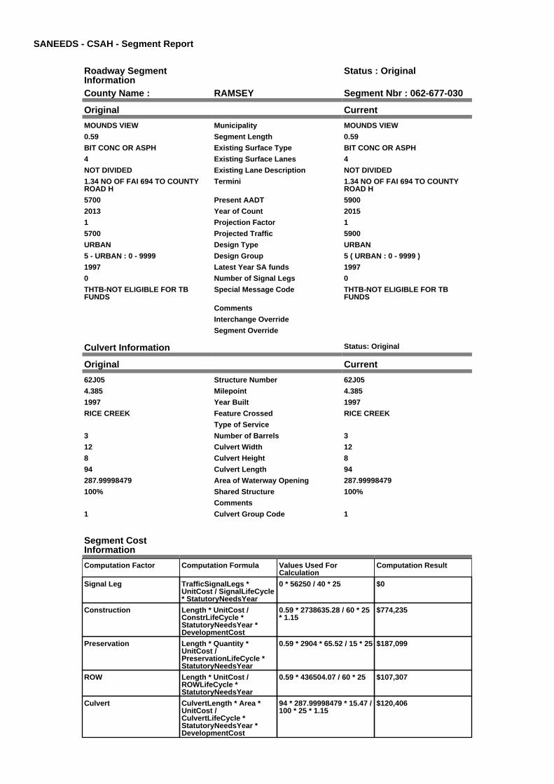
SANEEDS - CSAH - Segment Report
Roadway SegmentInformation
Status : Original
County Name : RAMSEY Segment Nbr : 062-677-030
Original Current
MOUNDS VIEW Municipality MOUNDS VIEW
0.59 Segment Length 0.59
BIT CONC OR ASPH Existing Surface Type BIT CONC OR ASPH
4 Existing Surface Lanes 4
NOT DIVIDED Existing Lane Description NOT DIVIDED
1.34 NO OF FAI 694 TO COUNTYROAD H
Termini 1.34 NO OF FAI 694 TO COUNTYROAD H
5700 Present AADT 5900
2013 Year of Count 2015
1 Projection Factor 1
5700 Projected Traffic 5900
URBAN Design Type URBAN
5 - URBAN : 0 - 9999 Design Group 5 ( URBAN : 0 - 9999 )
1997 Latest Year SA funds 1997
0 Number of Signal Legs 0
THTB-NOT ELIGIBLE FOR TBFUNDS
Special Message Code THTB-NOT ELIGIBLE FOR TBFUNDS
Comments
Interchange Override
Segment Override
Culvert Information Status: Original
Original Current
62J05 Structure Number 62J05
4.385 Milepoint 4.385
1997 Year Built 1997
RICE CREEK Feature Crossed RICE CREEK
Type of Service
3 Number of Barrels 3
12 Culvert Width 12
8 Culvert Height 8
94 Culvert Length 94
287.99998479 Area of Waterway Opening 287.99998479
100% Shared Structure 100%
Comments
1 Culvert Group Code 1
Segment CostInformation
Computation Factor Computation Formula Values Used ForCalculation
Computation Result
Signal Leg TrafficSignalLegs *UnitCost / SignalLifeCycle* StatutoryNeedsYear
0 * 56250 / 40 * 25 $0
Construction Length * UnitCost /ConstrLifeCycle *StatutoryNeedsYear *DevelopmentCost
0.59 * 2738635.28 / 60 * 25* 1.15
$774,235
Preservation Length * Quantity *UnitCost /PreservationLifeCycle *StatutoryNeedsYear
0.59 * 2904 * 65.52 / 15 * 25 $187,099
ROW Length * UnitCost /ROWLifeCycle *StatutoryNeedsYear
0.59 * 436504.07 / 60 * 25 $107,307
Culvert CulvertLength * Area *UnitCost /CulvertLifeCycle *StatutoryNeedsYear *DevelopmentCost
94 * 287.99998479 * 15.47 /100 * 25 * 1.15
$120,406

Total Segment Cost Signal Leg + Construction+ Preservation + ROW +Culvert
$0 + $774,235 + $187,099+ $107,307 + $120,406
$1,189,047

SANEEDS - CSAH - Segment Report
Roadway SegmentInformation
Status : Original
County Name : RAMSEY Segment Nbr : 062-678-005
Original Current
ROSEVILLE Municipality ROSEVILLE
0.5 Segment Length 0.5
MIXED BITUMINOUS Existing Surface Type MIXED BITUMINOUS
2 Existing Surface Lanes 2
NOT DIVIDED Existing Lane Description NOT DIVIDED
CLEVELAND AVE TO FAIRVIEWAVE.
Termini CLEVELAND AVE TO FAIRVIEWAVE.
10500 Present AADT 11500
2013 Year of Count 2015
1 Projection Factor 1
10500 Projected Traffic 11500
URBAN Design Type URBAN
6 - URBAN : 10000 - 19999 Design Group 6 ( URBAN : 10000 - 19999 )
1986 Latest Year SA funds 1986
2 Number of Signal Legs 2
No Special Message Special Message Code No Special Message
Comments
Interchange Override
Segment Override
Segment CostInformation
Computation Factor Computation Formula Values Used ForCalculation
Computation Result
Signal Leg TrafficSignalLegs *UnitCost / SignalLifeCycle* StatutoryNeedsYear
2 * 56250 / 40 * 25 $70,313
Construction Length * UnitCost /ConstrLifeCycle *StatutoryNeedsYear *DevelopmentCost
0.5 * 4225495.41 / 60 * 25 *1.15
$1,012,358
Preservation Length * Quantity *UnitCost /PreservationLifeCycle *StatutoryNeedsYear
0.5 * 3696 * 65.52 / 15 * 25 $201,802
ROW Length * UnitCost /ROWLifeCycle *StatutoryNeedsYear
0.5 * 566370.18 / 60 * 25 $117,994
Total Segment Cost Signal Leg + Construction+ Preservation + ROW
$70,313 + $1,012,358 +$201,802 + $117,994
$1,402,467

SANEEDS - CSAH - Segment Report
Roadway SegmentInformation
Status : Original
County Name : RAMSEY Segment Nbr : 062-678-006
Original Current
ROSEVILLE Municipality ROSEVILLE
0.5 Segment Length 0.5
MIXED BITUMINOUS Existing Surface Type MIXED BITUMINOUS
4 Existing Surface Lanes 4
DIVIDED Existing Lane Description DIVIDED
FAIRVIEW AVE. TO SNELLINGAVE.
Termini FAIRVIEW AVE. TO SNELLINGAVE.
13700 Present AADT 14000
2013 Year of Count 2015
1 Projection Factor 1
13700 Projected Traffic 14000
URBAN Design Type URBAN
6 - URBAN : 10000 - 19999 Design Group 6 ( URBAN : 10000 - 19999 )
1986 Latest Year SA funds 1986
9 Number of Signal Legs 9
No Special Message Special Message Code No Special Message
Comments
Interchange Override
Segment Override
Segment CostInformation
Computation Factor Computation Formula Values Used ForCalculation
Computation Result
Signal Leg TrafficSignalLegs *UnitCost / SignalLifeCycle* StatutoryNeedsYear
9 * 56250 / 40 * 25 $316,406
Construction Length * UnitCost /ConstrLifeCycle *StatutoryNeedsYear *DevelopmentCost
0.5 * 4225495.41 / 60 * 25 *1.15
$1,012,358
Preservation Length * Quantity *UnitCost /PreservationLifeCycle *StatutoryNeedsYear
0.5 * 3696 * 65.52 / 15 * 25 $201,802
ROW Length * UnitCost /ROWLifeCycle *StatutoryNeedsYear
0.5 * 566370.18 / 60 * 25 $117,994
Total Segment Cost Signal Leg + Construction+ Preservation + ROW
$316,406 + $1,012,358 +$201,802 + $117,994
$1,648,560

SANEEDS - CSAH - Segment Report
Roadway SegmentInformation
Status : Original
County Name : RAMSEY Segment Nbr : 062-678-010
Original Current
ROSEVILLE Municipality ROSEVILLE
0.25 Segment Length 0.25
MIXED BITUMINOUS Existing Surface Type MIXED BITUMINOUS
4 Existing Surface Lanes 4
NOT DIVIDED Existing Lane Description NOT DIVIDED
SNELLING AVE TO PASCAL AVE Termini SNELLING AVE TO PASCAL AVE
8900 Present AADT 14000
2013 Year of Count 2015
1 Projection Factor 1
8900 Projected Traffic 14000
URBAN Design Type URBAN
5 - URBAN : 0 - 9999 Design Group 5 ( URBAN : 10000 - 19999 )
1986 Latest Year SA funds 1986
2 Number of Signal Legs 2
No Special Message Special Message Code No Special Message
Comments
Interchange Override
Segment Override
Segment CostInformation
Computation Factor Computation Formula Values Used ForCalculation
Computation Result
Signal Leg TrafficSignalLegs *UnitCost / SignalLifeCycle* StatutoryNeedsYear
2 * 56250 / 40 * 25 $70,313
Construction Length * UnitCost /ConstrLifeCycle *StatutoryNeedsYear *DevelopmentCost
0.25 * 4225495.41 / 60 * 25* 1.15
$506,179
Preservation Length * Quantity *UnitCost /PreservationLifeCycle *StatutoryNeedsYear
0.25 * 3696 * 65.52 / 15 * 25 $100,901
ROW Length * UnitCost /ROWLifeCycle *StatutoryNeedsYear
0.25 * 566370.18 / 60 * 25 $58,997
Total Segment Cost Signal Leg + Construction+ Preservation + ROW
$70,313 + $506,179 +$100,901 + $58,997
$736,390

SANEEDS - CSAH - Segment Report
Roadway SegmentInformation
Status : Original
County Name : RAMSEY Segment Nbr : 062-678-020
Original Current
ROSEVILLE Municipality ROSEVILLE
0.25 Segment Length 0.25
MIXED BITUMINOUS Existing Surface Type MIXED BITUMINOUS
4 Existing Surface Lanes 4
NOT DIVIDED Existing Lane Description NOT DIVIDED
PASCAL AVE TO HAMLINE AVE Termini PASCAL AVE TO HAMLINE AVE
8900 Present AADT 9000
2013 Year of Count 2015
1 Projection Factor 1
8900 Projected Traffic 9000
URBAN Design Type URBAN
5 - URBAN : 0 - 9999 Design Group 5 ( URBAN : 0 - 9999 )
1986 Latest Year SA funds 1986
1 Number of Signal Legs 1
No Special Message Special Message Code No Special Message
Comments
Interchange Override
Segment Override
Segment CostInformation
Computation Factor Computation Formula Values Used ForCalculation
Computation Result
Signal Leg TrafficSignalLegs *UnitCost / SignalLifeCycle* StatutoryNeedsYear
1 * 56250 / 40 * 25 $35,156
Construction Length * UnitCost /ConstrLifeCycle *StatutoryNeedsYear *DevelopmentCost
0.25 * 2738635.28 / 60 * 25* 1.15
$328,066
Preservation Length * Quantity *UnitCost /PreservationLifeCycle *StatutoryNeedsYear
0.25 * 2904 * 65.52 / 15 * 25 $79,279
ROW Length * UnitCost /ROWLifeCycle *StatutoryNeedsYear
0.25 * 436504.07 / 60 * 25 $45,469
Total Segment Cost Signal Leg + Construction+ Preservation + ROW
$35,156 + $328,066 +$79,279 + $45,469
$487,970

SANEEDS - CSAH - Segment Report
Roadway SegmentInformation
Status : Original
County Name : RAMSEY Segment Nbr : 062-678-030
Original Current
ROSEVILLE Municipality ROSEVILLE
1 Segment Length 1
MIXED BITUMINOUS Existing Surface Type MIXED BITUMINOUS
2 Existing Surface Lanes 2
NOT DIVIDED Existing Lane Description NOT DIVIDED
HAMLINE AVE. TO VICTORIA ST. Termini HAMLINE AVE. TO VICTORIA ST.
6300 Present AADT 6900
2013 Year of Count 2015
1 Projection Factor 1
6300 Projected Traffic 6900
RURAL Design Type RURAL
3 - RURAL : 1500 - 6999 Design Group 3 ( RURAL : 1500 - 6999 )
2008 Latest Year SA funds 2008
3 Number of Signal Legs 3
No Special Message Special Message Code No Special Message
CONST SAP 62-678-14, 2008 Comments CONST SAP 62-678-14, 2008
Interchange Override
Segment Override
Segment CostInformation
Computation Factor Computation Formula Values Used ForCalculation
Computation Result
Signal Leg TrafficSignalLegs *UnitCost / SignalLifeCycle* StatutoryNeedsYear
3 * 56250 / 40 * 25 $105,469
Construction Length * UnitCost /ConstrLifeCycle *StatutoryNeedsYear *DevelopmentCost
1 * 1021937.01 / 60 * 25 *1.1
$468,388
Preservation Length * Quantity *UnitCost /PreservationLifeCycle *StatutoryNeedsYear
1 * 2376 * 65.52 / 20 * 25 $194,594
ROW Length * UnitCost /ROWLifeCycle *StatutoryNeedsYear
1 * 85357.87 / 60 * 25 $35,566
Total Segment Cost Signal Leg + Construction+ Preservation + ROW
$105,469 + $468,388 +$194,594 + $35,566
$804,017

SANEEDS - CSAH - Segment Report
Roadway SegmentInformation
Status : Original
County Name : RAMSEY Segment Nbr : 062-678-040
Original Current
ROSEVILLE Municipality ROSEVILLE
0.5 Segment Length 0.5
MIXED BITUMINOUS Existing Surface Type MIXED BITUMINOUS
2 Existing Surface Lanes 2
NOT DIVIDED Existing Lane Description NOT DIVIDED
COUNTY ROAD B2 - VICTORIA STTO DALE ST
Termini COUNTY ROAD B2 - VICTORIA STTO DALE ST
4100 Present AADT 4500
2013 Year of Count 2015
1 Projection Factor 1
4100 Projected Traffic 4500
RURAL Design Type RURAL
3 - RURAL : 1500 - 6999 Design Group 3 ( RURAL : 1500 - 6999 )
2000 Latest Year SA funds 2000
0 Number of Signal Legs 0
No Special Message Special Message Code No Special Message
NEW DESIGNATION, 2007 Comments NEW DESIGNATION, 2007
Interchange Override
Segment Override
Segment CostInformation
Computation Factor Computation Formula Values Used ForCalculation
Computation Result
Signal Leg TrafficSignalLegs *UnitCost / SignalLifeCycle* StatutoryNeedsYear
0 * 56250 / 40 * 25 $0
Construction Length * UnitCost /ConstrLifeCycle *StatutoryNeedsYear *DevelopmentCost
0.5 * 1021937.01 / 60 * 25 *1.1
$234,194
Preservation Length * Quantity *UnitCost /PreservationLifeCycle *StatutoryNeedsYear
0.5 * 2376 * 65.52 / 20 * 25 $97,297
ROW Length * UnitCost /ROWLifeCycle *StatutoryNeedsYear
0.5 * 85357.87 / 60 * 25 $17,783
Total Segment Cost Signal Leg + Construction+ Preservation + ROW
$0 + $234,194 + $97,297 +$17,783
$349,274

SANEEDS - CSAH - Segment Report
Roadway SegmentInformation
Status : Original
County Name : RAMSEY Segment Nbr : 062-678-050
Original Current
ROSEVILLE Municipality ROSEVILLE
1 Segment Length 1
MIXED BITUMINOUS Existing Surface Type MIXED BITUMINOUS
2 Existing Surface Lanes 2
NOT DIVIDED Existing Lane Description NOT DIVIDED
ON COUNTY ROAD B2 - DALE ST TO RICE ST (CSAH 49)
Termini ON COUNTY ROAD B2 - DALE ST TO RICE ST (CSAH 49)
10400 Present AADT 4200
2013 Year of Count 2015
1 Projection Factor 1
10400 Projected Traffic 4200
URBAN Design Type URBAN
6 - URBAN : 10000 - 19999 Design Group 6 ( URBAN : 0 - 9999 )
0 Latest Year SA funds 0
1 Number of Signal Legs 1
No Special Message Special Message Code No Special Message
2014 CO# 94579 SWAP WITH CSAH25
Comments 2014 CO# 94579 SWAP WITH CSAH25
Interchange Override
Segment Override
Segment CostInformation
Computation Factor Computation Formula Values Used ForCalculation
Computation Result
Signal Leg TrafficSignalLegs *UnitCost / SignalLifeCycle* StatutoryNeedsYear
1 * 56250 / 40 * 25 $35,156
Construction Length * UnitCost /ConstrLifeCycle *StatutoryNeedsYear *DevelopmentCost
1 * 2738635.28 / 60 * 25 *1.15
$1,312,263
Preservation Length * Quantity *UnitCost /PreservationLifeCycle *StatutoryNeedsYear
1 * 2904 * 65.52 / 15 * 25 $317,117
ROW Length * UnitCost /ROWLifeCycle *StatutoryNeedsYear
1 * 436504.07 / 60 * 25 $181,877
Total Segment Cost Signal Leg + Construction+ Preservation + ROW
$35,156 + $1,312,263 +$317,117 + $181,877
$1,846,413

SANEEDS - CSAH - Segment Report
Roadway SegmentInformation
Status : Original
County Name : RAMSEY Segment Nbr : 062-688-010
Original Current
ROSEVILLE Municipality ROSEVILLE
0.95 Segment Length 0.95
MIXED BITUMINOUS Existing Surface Type MIXED BITUMINOUS
4 Existing Surface Lanes 4
DIVIDED Existing Lane Description DIVIDED
WEST COUNTY LINE TO COUNTYROAD D
Termini WEST COUNTY LINE TO COUNTYROAD D
10100 Present AADT 9800
2013 Year of Count 2015
1 Projection Factor 1
10100 Projected Traffic 9800
RURAL Design Type RURAL
4 - RURAL : 7000 - 999999 Design Group 4 ( RURAL : 7000 - 999999 )
2007 Latest Year SA funds 2007
3 Number of Signal Legs 3
THTB-RECONSTRUCTED WITH TBFUNDS
Special Message Code THTB-RECONSTRUCTED WITH TBFUNDS
SAP 62-688-003, 2007CTB ONLY SURFACED
Comments SAP 62-688-003, 2007CTB ONLY SURFACED
Interchange Override
Segment Override
Segment CostInformation
Computation Factor Computation Formula Values Used ForCalculation
Computation Result
Signal Leg TrafficSignalLegs *UnitCost / SignalLifeCycle* StatutoryNeedsYear
3 * 56250 / 40 * 25 $105,469
Construction Length * UnitCost /ConstrLifeCycle *StatutoryNeedsYear *DevelopmentCost
0.95 * 1996892.57 / 60 * 25* 1.1
$869,480
Preservation Length * Quantity *UnitCost /PreservationLifeCycle *StatutoryNeedsYear
0.95 * 3564 * 65.52 / 20 * 25 $277,297
ROW Length * UnitCost /ROWLifeCycle *StatutoryNeedsYear
0.95 * 181173.68 / 60 * 25 $71,715
Total Segment Cost Signal Leg + Construction+ Preservation + ROW
$105,469 + $869,480 +$277,297 + $71,715
$1,323,961

SANEEDS - CSAH - Segment Report
Roadway SegmentInformation
Status : Original
County Name : RAMSEY Segment Nbr : 062-696-010
Original Current
NEW BRIGHTON Municipality NEW BRIGHTON
0.29 Segment Length 0.29
MIXED BITUMINOUS Existing Surface Type MIXED BITUMINOUS
4 Existing Surface Lanes 4
DIVIDED Existing Lane Description DIVIDED
OLD HIGHWAY 8 TO ROUND LAKEROAD
Termini OLD HIGHWAY 8 TO ROUND LAKEROAD
10800 Present AADT 13000
2013 Year of Count 2015
1 Projection Factor 1
10800 Projected Traffic 13000
RURAL Design Type RURAL
4 - RURAL : 7000 - 999999 Design Group 4 ( RURAL : 7000 - 999999 )
2000 Latest Year SA funds 2000
0 Number of Signal Legs 0
THTB-MILES ONLY-NO NEEDS-ELIGIBLE FOR 100% TB FUNDS
Special Message Code THTB-MILES ONLY-NO NEEDS-ELIGIBLE FOR 100% TB FUNDS
Comments
Interchange Override
Segment Override
Segment CostInformation
Computation Factor Computation Formula Values Used ForCalculation
Computation Result
Signal Leg TrafficSignalLegs *UnitCost / SignalLifeCycle* StatutoryNeedsYear
0 * 56250 / 40 * 25 $0
Construction Length * UnitCost /ConstrLifeCycle *StatutoryNeedsYear *DevelopmentCost
0.29 * 1996892.57 / 60 * 25* 1.1
$265,420
Preservation Length * Quantity *UnitCost /PreservationLifeCycle *StatutoryNeedsYear
0.29 * 3564 * 65.52 / 20 * 25 $84,649
ROW Length * UnitCost /ROWLifeCycle *StatutoryNeedsYear
0.29 * 181173.68 / 60 * 25 $21,892
Total Segment Cost Signal Leg + Construction+ Preservation + ROW
$0 + $265,420 + $84,649 +$21,892
$371,961

SANEEDS - CSAH - Segment Report
Roadway SegmentInformation
Status : Original
County Name : RAMSEY Segment Nbr : 062-696-020
Original Current
ARDEN HILLS Municipality ARDEN HILLS
0.54 Segment Length 0.54
PORT CEMENT CONC Existing Surface Type PORT CEMENT CONC
4 Existing Surface Lanes 4
DIVIDED Existing Lane Description DIVIDED
ROUND LAKE ROAD TO .25 MILESEAST OF TH 10
Termini ROUND LAKE ROAD TO .25 MILESEAST OF TH 10
14300 Present AADT 18500
2013 Year of Count 2015
1 Projection Factor 1
14300 Projected Traffic 18500
RURAL Design Type RURAL
4 - RURAL : 7000 - 999999 Design Group 4 ( RURAL : 7000 - 999999 )
2013 Latest Year SA funds 2013
2 Number of Signal Legs 2
THTB-MILES ONLY-NO NEEDS-ELIGIBLE FOR 100% TB FUNDS
Special Message Code THTB-MILES ONLY-NO NEEDS-ELIGIBLE FOR 100% TB FUNDS
INTERCHANGE CONSTRUCTION060-696-026CTB 2013
Comments INTERCHANGE CONSTRUCTION060-696-026CTB 2013
15200000 Interchange Override 15200000
Segment Override
Segment CostInformation
Computation Factor Computation Formula Values Used ForCalculation
Computation Result
Signal Leg TrafficSignalLegs *UnitCost / SignalLifeCycle* StatutoryNeedsYear
2 * 56250 / 40 * 25 $70,313
Construction Length * UnitCost /ConstrLifeCycle *StatutoryNeedsYear *DevelopmentCost
0.54 * 1996892.57 / 60 * 25* 1.1
$494,231
Preservation Length * Quantity *UnitCost /PreservationLifeCycle *StatutoryNeedsYear
0.54 * 3564 * 65.52 / 20 * 25 $157,621
ROW Length * UnitCost /ROWLifeCycle *StatutoryNeedsYear
0.54 * 181173.68 / 60 * 25 $40,764
Interchange Override Override non-preservationcosts if greater
(15200000 / 60 * 25) >605308 = true
$5,728,025
Total Segment Cost Signal Leg + Construction+ Preservation + ROW +Interchange Override
$70,313 + $494,231 +$157,621 + $40,764 +$5,728,025
$6,490,954

SANEEDS - CSAH - Segment Report
Roadway SegmentInformation
Status : Original
County Name : RAMSEY Segment Nbr : 062-696-030
Original Current
ARDEN HILLS Municipality ARDEN HILLS
1.01 Segment Length 1.01
PORT CEMENT CONC Existing Surface Type PORT CEMENT CONC
4 Existing Surface Lanes 4
DIVIDED Existing Lane Description DIVIDED
0.25 MILES EAST OF TH 10 TO 0.16MI WEST OF LEXINGTON AVE
Termini 0.25 MILES EAST OF TH 10 TO 0.16MI WEST OF LEXINGTON AVE
24300 Present AADT 27500
2013 Year of Count 2015
1 Projection Factor 1
24300 Projected Traffic 27500
URBAN Design Type URBAN
7 - URBAN : 20000 - 34999 Design Group 7 ( URBAN : 20000 - 34999 )
2003 Latest Year SA funds 2003
3 Number of Signal Legs 3
THTB-RECONSTRUCTED WITH TBFUNDS
Special Message Code THTB-RECONSTRUCTED WITH TBFUNDS
Comments
Interchange Override
Segment Override
Segment CostInformation
Computation Factor Computation Formula Values Used ForCalculation
Computation Result
Signal Leg TrafficSignalLegs *UnitCost / SignalLifeCycle* StatutoryNeedsYear
3 * 56250 / 40 * 25 $105,469
Construction Length * UnitCost /ConstrLifeCycle *StatutoryNeedsYear *DevelopmentCost
1.01 * 5259942.61 / 60 * 25* 1.15
$2,545,593
Preservation Length * Quantity *UnitCost /PreservationLifeCycle *StatutoryNeedsYear
1.01 * 4488 * 65.52 / 15 * 25 $494,990
ROW Length * UnitCost /ROWLifeCycle *StatutoryNeedsYear
1.01 * 883293.09 / 60 * 25 $371,719
Total Segment Cost Signal Leg + Construction+ Preservation + ROW
$105,469 + $2,545,593 +$494,990 + $371,719
$3,517,771

SANEEDS - CSAH - Segment Report
Roadway SegmentInformation
Status : Original
County Name : RAMSEY Segment Nbr : 062-696-035
Original Current
SHOREVIEW Municipality SHOREVIEW
0.81 Segment Length 0.81
PORT CEMENT CONC Existing Surface Type PORT CEMENT CONC
4 Existing Surface Lanes 4
DIVIDED Existing Lane Description DIVIDED
0.16 MI W OF LEXINGTON AVE 0.05MI E OF VICTORIA ST
Termini 0.16 MI W OF LEXINGTON AVE 0.05MI E OF VICTORIA ST
24300 Present AADT 27500
2013 Year of Count 2015
1 Projection Factor 1
24300 Projected Traffic 27500
URBAN Design Type URBAN
7 - URBAN : 20000 - 34999 Design Group 7 ( URBAN : 20000 - 34999 )
2013 Latest Year SA funds 2013
3 Number of Signal Legs 3
THTB-RECONSTRUCTED WITH TBFUNDS
Special Message Code THTB-RECONSTRUCTED WITH TBFUNDS
2013 SP 062-696-029 CONCRETEJT & WALK REPAIRS
Comments 2013 SP 062-696-029 CONCRETEJT & WALK REPAIRS
Interchange Override
Segment Override
Segment CostInformation
Computation Factor Computation Formula Values Used ForCalculation
Computation Result
Signal Leg TrafficSignalLegs *UnitCost / SignalLifeCycle* StatutoryNeedsYear
3 * 56250 / 40 * 25 $105,469
Construction Length * UnitCost /ConstrLifeCycle *StatutoryNeedsYear *DevelopmentCost
0.81 * 5259942.61 / 60 * 25* 1.15
$2,041,515
Preservation Length * Quantity *UnitCost /PreservationLifeCycle *StatutoryNeedsYear
0.81 * 4488 * 65.52 / 15 * 25 $396,973
ROW Length * UnitCost /ROWLifeCycle *StatutoryNeedsYear
0.81 * 883293.09 / 60 * 25 $298,111
Total Segment Cost Signal Leg + Construction+ Preservation + ROW
$105,469 + $2,041,515 +$396,973 + $298,111
$2,842,068

SANEEDS - CSAH - Segment Report
Roadway SegmentInformation
Status : Original
County Name : RAMSEY Segment Nbr : 062-696-040
Original Current
SHOREVIEW Municipality SHOREVIEW
0.57 Segment Length 0.57
PORT CEMENT CONC Existing Surface Type PORT CEMENT CONC
4 Existing Surface Lanes 4
NOT DIVIDED Existing Lane Description NOT DIVIDED
0.05 MI E OF VICTORIA ST TOMACKUBIN ST
Termini 0.05 MI E OF VICTORIA ST TOMACKUBIN ST
21500 Present AADT 24400
2013 Year of Count 2015
1 Projection Factor 1
21500 Projected Traffic 24400
URBAN Design Type URBAN
7 - URBAN : 20000 - 34999 Design Group 7 ( URBAN : 20000 - 34999 )
2013 Latest Year SA funds 2013
1 Number of Signal Legs 1
THTB-RECONSTRUCTED WITH TBFUNDS
Special Message Code THTB-RECONSTRUCTED WITH TBFUNDS
2013 SP 062-696-029 CONCRETEJT & WALK REPAIRS
Comments 2013 SP 062-696-029 CONCRETEJT & WALK REPAIRS
Interchange Override
Segment Override
Culvert Information Status: Original
Original Current
62J07 Structure Number 62J07
2.78 Milepoint 2.78
1997 Year Built 1997
PED PATH Feature Crossed PED PATH
OTHER Type of Service OTHER
1 Number of Barrels 1
12 Culvert Width 12
10 Culvert Height 10
137 Culvert Length 137
120 Area of Waterway Opening 120
100% Shared Structure 100%
Comments
1 Culvert Group Code 1
Segment CostInformation
Computation Factor Computation Formula Values Used ForCalculation
Computation Result
Signal Leg TrafficSignalLegs *UnitCost / SignalLifeCycle* StatutoryNeedsYear
1 * 56250 / 40 * 25 $35,156
Construction Length * UnitCost /ConstrLifeCycle *StatutoryNeedsYear *DevelopmentCost
0.57 * 5259942.61 / 60 * 25* 1.15
$1,436,622
Preservation Length * Quantity *UnitCost /PreservationLifeCycle *StatutoryNeedsYear
0.57 * 4488 * 65.52 / 15 * 25 $279,351
ROW Length * UnitCost /ROWLifeCycle *StatutoryNeedsYear
0.57 * 883293.09 / 60 * 25 $209,782
Culvert CulvertLength * Area *UnitCost /CulvertLifeCycle *StatutoryNeedsYear *DevelopmentCost
137 * 120 * 15.47 / 100 * 25* 1.15
$73,119

Total Segment Cost Signal Leg + Construction+ Preservation + ROW +Culvert
$35,156 + $1,436,622 +$279,351 + $209,782 +$73,119
$2,034,030

SANEEDS - CSAH - Segment Report
Roadway SegmentInformation
Status : Original
County Name : RAMSEY Segment Nbr : 062-696-045
Original Current
SHOREVIEW Municipality SHOREVIEW
0.28 Segment Length 0.28
PORT CEMENT CONC Existing Surface Type PORT CEMENT CONC
4 Existing Surface Lanes 4
DIVIDED Existing Lane Description DIVIDED
MACKUBIN ST TO CSAH 49 Termini MACKUBIN ST TO CSAH 49
21500 Present AADT 24400
2013 Year of Count 2015
1 Projection Factor 1
21500 Projected Traffic 24400
URBAN Design Type URBAN
7 - URBAN : 20000 - 34999 Design Group 7 ( URBAN : 20000 - 34999 )
2013 Latest Year SA funds 2013
2 Number of Signal Legs 2
THTB-RECONSTRUCTED WITH TBFUNDS
Special Message Code THTB-RECONSTRUCTED WITH TBFUNDS
2013 SP 062-696-029 CONCRETEJT & WALK REPAIRS
Comments 2013 SP 062-696-029 CONCRETEJT & WALK REPAIRS
Interchange Override
Segment Override
Segment CostInformation
Computation Factor Computation Formula Values Used ForCalculation
Computation Result
Signal Leg TrafficSignalLegs *UnitCost / SignalLifeCycle* StatutoryNeedsYear
2 * 56250 / 40 * 25 $70,313
Construction Length * UnitCost /ConstrLifeCycle *StatutoryNeedsYear *DevelopmentCost
0.28 * 5259942.61 / 60 * 25* 1.15
$705,709
Preservation Length * Quantity *UnitCost /PreservationLifeCycle *StatutoryNeedsYear
0.28 * 4488 * 65.52 / 15 * 25 $137,225
ROW Length * UnitCost /ROWLifeCycle *StatutoryNeedsYear
0.28 * 883293.09 / 60 * 25 $103,051
Total Segment Cost Signal Leg + Construction+ Preservation + ROW
$70,313 + $705,709 +$137,225 + $103,051
$1,016,298

SANEEDS - CSAH - Segment Report
Roadway SegmentInformation
Status : Original
County Name : RAMSEY Segment Nbr : 062-696-050
Original Current
SHOREVIEW Municipality SHOREVIEW
0.32 Segment Length 0.32
PORT CEMENT CONC Existing Surface Type PORT CEMENT CONC
4 Existing Surface Lanes 4
DIVIDED Existing Lane Description DIVIDED
CSAH 49 TO 0.32 MI E OF CSAH 49 Termini CSAH 49 TO 0.32 MI E OF CSAH 49
19900 Present AADT 20600
2013 Year of Count 2015
1 Projection Factor 1
19900 Projected Traffic 20600
URBAN Design Type URBAN
6 - URBAN : 10000 - 19999 Design Group 6 ( URBAN : 20000 - 34999 )
2013 Latest Year SA funds 2013
3 Number of Signal Legs 3
THTB-RECONSTRUCTED WITH TBFUNDS
Special Message Code THTB-RECONSTRUCTED WITH TBFUNDS
2013 SP 062-696-029 CONCRETEJT & WALK REPAIRS
Comments 2013 SP 062-696-029 CONCRETEJT & WALK REPAIRS
Interchange Override
Segment Override
Segment CostInformation
Computation Factor Computation Formula Values Used ForCalculation
Computation Result
Signal Leg TrafficSignalLegs *UnitCost / SignalLifeCycle* StatutoryNeedsYear
3 * 56250 / 40 * 25 $105,469
Construction Length * UnitCost /ConstrLifeCycle *StatutoryNeedsYear *DevelopmentCost
0.32 * 5259942.61 / 60 * 25* 1.15
$806,525
Preservation Length * Quantity *UnitCost /PreservationLifeCycle *StatutoryNeedsYear
0.32 * 4488 * 65.52 / 15 * 25 $156,829
ROW Length * UnitCost /ROWLifeCycle *StatutoryNeedsYear
0.32 * 883293.09 / 60 * 25 $117,772
Total Segment Cost Signal Leg + Construction+ Preservation + ROW
$105,469 + $806,525 +$156,829 + $117,772
$1,186,595
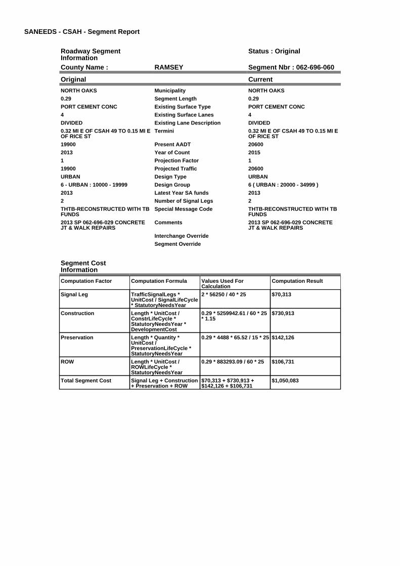
SANEEDS - CSAH - Segment Report
Roadway SegmentInformation
Status : Original
County Name : RAMSEY Segment Nbr : 062-696-060
Original Current
NORTH OAKS Municipality NORTH OAKS
0.29 Segment Length 0.29
PORT CEMENT CONC Existing Surface Type PORT CEMENT CONC
4 Existing Surface Lanes 4
DIVIDED Existing Lane Description DIVIDED
0.32 MI E OF CSAH 49 TO 0.15 MI EOF RICE ST
Termini 0.32 MI E OF CSAH 49 TO 0.15 MI EOF RICE ST
19900 Present AADT 20600
2013 Year of Count 2015
1 Projection Factor 1
19900 Projected Traffic 20600
URBAN Design Type URBAN
6 - URBAN : 10000 - 19999 Design Group 6 ( URBAN : 20000 - 34999 )
2013 Latest Year SA funds 2013
2 Number of Signal Legs 2
THTB-RECONSTRUCTED WITH TBFUNDS
Special Message Code THTB-RECONSTRUCTED WITH TBFUNDS
2013 SP 062-696-029 CONCRETEJT & WALK REPAIRS
Comments 2013 SP 062-696-029 CONCRETEJT & WALK REPAIRS
Interchange Override
Segment Override
Segment CostInformation
Computation Factor Computation Formula Values Used ForCalculation
Computation Result
Signal Leg TrafficSignalLegs *UnitCost / SignalLifeCycle* StatutoryNeedsYear
2 * 56250 / 40 * 25 $70,313
Construction Length * UnitCost /ConstrLifeCycle *StatutoryNeedsYear *DevelopmentCost
0.29 * 5259942.61 / 60 * 25* 1.15
$730,913
Preservation Length * Quantity *UnitCost /PreservationLifeCycle *StatutoryNeedsYear
0.29 * 4488 * 65.52 / 15 * 25 $142,126
ROW Length * UnitCost /ROWLifeCycle *StatutoryNeedsYear
0.29 * 883293.09 / 60 * 25 $106,731
Total Segment Cost Signal Leg + Construction+ Preservation + ROW
$70,313 + $730,913 +$142,126 + $106,731
$1,050,083

SANEEDS - CSAH - Segment Report
Roadway SegmentInformation
Status : Original
County Name : RAMSEY Segment Nbr : 062-696-070
Original Current
NORTH OAKS Municipality NORTH OAKS
0.57 Segment Length 0.57
PORT CEMENT CONC Existing Surface Type PORT CEMENT CONC
4 Existing Surface Lanes 4
NOT DIVIDED Existing Lane Description NOT DIVIDED
0.15 MI E OF RICE ST TO 0.25 MI WOF MCMENEMY ST
Termini 0.15 MI E OF RICE ST TO 0.25 MI WOF MCMENEMY ST
19500 Present AADT 20200
2013 Year of Count 2015
1 Projection Factor 1
19500 Projected Traffic 20200
URBAN Design Type URBAN
6 - URBAN : 10000 - 19999 Design Group 6 ( URBAN : 20000 - 34999 )
2013 Latest Year SA funds 2013
0 Number of Signal Legs 0
THTB-RECONSTRUCTED WITH TBFUNDS
Special Message Code THTB-RECONSTRUCTED WITH TBFUNDS
2013 SP 062-696-029 CONCRETEJT & WALK REPAIRS
Comments 2013 SP 062-696-029 CONCRETEJT & WALK REPAIRS
Interchange Override
Segment Override
Bridge Information Status: Original
Original Current
62590 Structure Number 62590
4.777 Milepoint 4.777
1999 Year Built 1999
SUCKER CREEK UNSTABLE MA Feature Crossed SUCKER CREEK UNSTABLE MA
STREAM CROSSING Type of Service STREAM CROSSING
15 Number of Spans 15
434.7 Bridge Length 434.7
68.1 Bridge Width 68.1
100% Shared Structure 100%
Comments
2 ( 150-999,999 ) Bridge Group Code 2 ( 150-999,999 )
Segment CostInformation
Computation Factor Computation Formula Values Used ForCalculation
Computation Result
Signal Leg TrafficSignalLegs *UnitCost / SignalLifeCycle* StatutoryNeedsYear
0 * 56250 / 40 * 25 $0
Construction Length * UnitCost /ConstrLifeCycle *StatutoryNeedsYear *DevelopmentCost
0.57 * 5259942.61 / 60 * 25* 1.15
$1,436,622
Preservation Length * Quantity *UnitCost /PreservationLifeCycle *StatutoryNeedsYear
0.57 * 4488 * 65.52 / 15 * 25 $279,351
ROW Length * UnitCost /ROWLifeCycle *StatutoryNeedsYear
0.57 * 883293.09 / 60 * 25 $209,782
Bridge BridgeLength *BridgeWidth * UnitCost /BridgeLifeCycle *StatutoryNeedsYear *DevelopmentCost
434.7 * 68.1 * 138 / 80 * 25* 1.15
$1,468,127
Total Segment Cost Signal Leg + Construction+ Preservation + ROW +Bridge
$0 + $1,436,622 + $279,351+ $209,782 + $1,468,127
$3,393,882

SANEEDS - CSAH - Segment Report
Roadway SegmentInformation
Status : Original
County Name : RAMSEY Segment Nbr : 062-696-072
Original Current
VADNAIS HEIGHTS Municipality VADNAIS HEIGHTS
0.15 Segment Length 0.15
PORT CEMENT CONC Existing Surface Type PORT CEMENT CONC
4 Existing Surface Lanes 4
NOT DIVIDED Existing Lane Description NOT DIVIDED
.25 MI W OF TO .10 MI W OFMCMENEMY ST
Termini .25 MI W OF TO .10 MI W OFMCMENEMY ST
19500 Present AADT 20200
2013 Year of Count 2015
1 Projection Factor 1
19500 Projected Traffic 20200
URBAN Design Type URBAN
6 - URBAN : 10000 - 19999 Design Group 6 ( URBAN : 20000 - 34999 )
2013 Latest Year SA funds 2013
0 Number of Signal Legs 0
THTB-RECONSTRUCTED WITH TBFUNDS
Special Message Code THTB-RECONSTRUCTED WITH TBFUNDS
2013 SP 062-696-029 CONCRETEJT & WALK REPAIRS
Comments 2013 SP 062-696-029 CONCRETEJT & WALK REPAIRS
Interchange Override
Segment Override
Segment CostInformation
Computation Factor Computation Formula Values Used ForCalculation
Computation Result
Signal Leg TrafficSignalLegs *UnitCost / SignalLifeCycle* StatutoryNeedsYear
0 * 56250 / 40 * 25 $0
Construction Length * UnitCost /ConstrLifeCycle *StatutoryNeedsYear *DevelopmentCost
0.15 * 5259942.61 / 60 * 25* 1.15
$378,058
Preservation Length * Quantity *UnitCost /PreservationLifeCycle *StatutoryNeedsYear
0.15 * 4488 * 65.52 / 15 * 25 $73,513
ROW Length * UnitCost /ROWLifeCycle *StatutoryNeedsYear
0.15 * 883293.09 / 60 * 25 $55,206
Total Segment Cost Signal Leg + Construction+ Preservation + ROW
$0 + $378,058 + $73,513 +$55,206
$506,777

SANEEDS - CSAH - Segment Report
Roadway SegmentInformation
Status : Original
County Name : RAMSEY Segment Nbr : 062-696-074
Original Current
VADNAIS HEIGHTS Municipality VADNAIS HEIGHTS
0.98 Segment Length 0.98
PORT CEMENT CONC Existing Surface Type PORT CEMENT CONC
4 Existing Surface Lanes 4
DIVIDED Existing Lane Description DIVIDED
.10 MI W OF MCMENEMY TO .04 MIE OF BRAMBLEWOOD
Termini .10 MI W OF MCMENEMY TO .04 MIE OF BRAMBLEWOOD
19600 Present AADT 20200
2013 Year of Count 2015
1 Projection Factor 1
19600 Projected Traffic 20200
URBAN Design Type URBAN
6 - URBAN : 10000 - 19999 Design Group 6 ( URBAN : 20000 - 34999 )
2013 Latest Year SA funds 2013
4 Number of Signal Legs 4
THTB-RECONSTRUCTED WITH TBFUNDS
Special Message Code THTB-RECONSTRUCTED WITH TBFUNDS
2013 SP 062-696-029 CONCRETEJT & WALK REPAIRS
Comments 2013 SP 062-696-029 CONCRETEJT & WALK REPAIRS
Interchange Override
Segment Override
RailRoadCrossingInformation
Status: Original
Original Current
CANADIAN PACIFIC RAILWAY RailRoad Name CANADIAN PACIFIC RAILWAY
691417C USDOT Number 691417C
0.7 Located at Milepoint 0.7
1 Mainline Tracks 1
SIGNALS & GATES Protection Type SIGNALS & GATES
1998 Last Year Protection Upgraded 1998
160 Crossing Length 160
Last Year Surfaced
100% Percentage of Cost 100%
Comments
Segment CostInformation
Computation Factor Computation Formula Values Used ForCalculation
Computation Result
Signal Leg TrafficSignalLegs *UnitCost / SignalLifeCycle* StatutoryNeedsYear
4 * 56250 / 40 * 25 $140,625
Construction Length * UnitCost /ConstrLifeCycle *StatutoryNeedsYear *DevelopmentCost
0.98 * 5259942.61 / 60 * 25* 1.15
$2,469,981
Preservation Length * Quantity *UnitCost /PreservationLifeCycle *StatutoryNeedsYear
0.98 * 4488 * 65.52 / 15 * 25 $480,288
ROW Length * UnitCost /ROWLifeCycle *StatutoryNeedsYear
0.98 * 883293.09 / 60 * 25 $360,678
RR Crossing Protection UnitCost /RRCrossingLifeCycle *StatutoryNeedsYear
325000 / 25 * 25 $325,000
RR Crossing Surface SurfaceLength * UnitCost/ RRCrossingLifeCycle *StatutoryNeedsYear
160 * 1350 / 25 * 25 $216,000

Total Segment Cost Signal Leg + Construction+ Preservation + ROW +RR Crossing Protection +RR Crossing Surface
$140,625 + $2,469,981 +$480,288 + $360,678 +$325,000 + $216,000
$3,992,572

SANEEDS - CSAH - Segment Report
Roadway SegmentInformation
Status : Original
County Name : RAMSEY Segment Nbr : 062-696-080
Original Current
VADNAIS HEIGHTS Municipality VADNAIS HEIGHTS
0.22 Segment Length 0.22
PORT CEMENT CONC Existing Surface Type PORT CEMENT CONC
4 Existing Surface Lanes 4
DIVIDED Existing Lane Description DIVIDED
0.04 MI E OF BRAMBLEWOOD TO0.42 MI W OF CENTERVILLE RD
Termini 0.04 MI E OF BRAMBLEWOOD TO0.42 MI W OF CENTERVILLE RD
18000 Present AADT 19700
2013 Year of Count 2015
1 Projection Factor 1
18000 Projected Traffic 19700
URBAN Design Type URBAN
6 - URBAN : 10000 - 19999 Design Group 6 ( URBAN : 10000 - 19999 )
2013 Latest Year SA funds 2013
0 Number of Signal Legs 0
THTB-RECONSTRUCTED WITH TBFUNDS
Special Message Code THTB-RECONSTRUCTED WITH TBFUNDS
2013 SP 062-696-029 CONCRETEJT & WALK REPAIRS
Comments 2013 SP 062-696-029 CONCRETEJT & WALK REPAIRS
Interchange Override
Segment Override
Segment CostInformation
Computation Factor Computation Formula Values Used ForCalculation
Computation Result
Signal Leg TrafficSignalLegs *UnitCost / SignalLifeCycle* StatutoryNeedsYear
0 * 56250 / 40 * 25 $0
Construction Length * UnitCost /ConstrLifeCycle *StatutoryNeedsYear *DevelopmentCost
0.22 * 4225495.41 / 60 * 25* 1.15
$445,438
Preservation Length * Quantity *UnitCost /PreservationLifeCycle *StatutoryNeedsYear
0.22 * 3696 * 65.52 / 15 * 25 $88,793
ROW Length * UnitCost /ROWLifeCycle *StatutoryNeedsYear
0.22 * 566370.18 / 60 * 25 $51,917
Total Segment Cost Signal Leg + Construction+ Preservation + ROW
$0 + $445,438 + $88,793 +$51,917
$586,148
SANEEDS - CSAH - Segment Report
Roadway SegmentInformation
Status : Original
County Name : RAMSEY Segment Nbr : 062-696-090
Original Current
VADNAIS HEIGHTS Municipality VADNAIS HEIGHTS
0.22 Segment Length 0.22
PORT CEMENT CONC Existing Surface Type PORT CEMENT CONC
4 Existing Surface Lanes 4
DIVIDED Existing Lane Description DIVIDED
0.42 MI W OF CENTERVILLE RD TO0.20 MI W OF CENTERVILLE RD
Termini 0.42 MI W OF CENTERVILLE RD TO0.20 MI W OF CENTERVILLE RD
18000 Present AADT 19700
2013 Year of Count 2015
1 Projection Factor 1
18000 Projected Traffic 19700
URBAN Design Type URBAN
6 - URBAN : 10000 - 19999 Design Group 6 ( URBAN : 10000 - 19999 )
2013 Latest Year SA funds 2013
0 Number of Signal Legs 0
THTB-RECONSTRUCTED WITH TBFUNDS
Special Message Code THTB-RECONSTRUCTED WITH TBFUNDS
2013 SP 062-696-029 CONCRETEJT & WALK REPAIRS
Comments 2013 SP 062-696-029 CONCRETEJT & WALK REPAIRS
Interchange Override
Segment Override
Segment CostInformation
Computation Factor Computation Formula Values Used ForCalculation
Computation Result
Signal Leg TrafficSignalLegs *UnitCost / SignalLifeCycle* StatutoryNeedsYear
0 * 56250 / 40 * 25 $0
Construction Length * UnitCost /ConstrLifeCycle *StatutoryNeedsYear *DevelopmentCost
0.22 * 4225495.41 / 60 * 25* 1.15
$445,438
Preservation Length * Quantity *UnitCost /PreservationLifeCycle *StatutoryNeedsYear
0.22 * 3696 * 65.52 / 15 * 25 $88,793
ROW Length * UnitCost /ROWLifeCycle *StatutoryNeedsYear
0.22 * 566370.18 / 60 * 25 $51,917
Total Segment Cost Signal Leg + Construction+ Preservation + ROW
$0 + $445,438 + $88,793 +$51,917
$586,148

SANEEDS - CSAH - Segment Report
Roadway SegmentInformation
Status : Original
County Name : RAMSEY Segment Nbr : 062-696-100
Original Current
VADNAIS HEIGHTS Municipality VADNAIS HEIGHTS
0.29 Segment Length 0.29
PORT CEMENT CONC Existing Surface Type PORT CEMENT CONC
4 Existing Surface Lanes 4
DIVIDED Existing Lane Description DIVIDED
0.20 MI W OF CENTERVILLE RD TO.09 MI E OF CENTERVILLE RD.
Termini 0.20 MI W OF CENTERVILLE RD TO.09 MI E OF CENTERVILLE RD.
31500 Present AADT 31500
2013 Year of Count 2015
1 Projection Factor 1
31500 Projected Traffic 31500
URBAN Design Type URBAN
7 - URBAN : 20000 - 34999 Design Group 7 ( URBAN : 20000 - 34999 )
2013 Latest Year SA funds 2013
3 Number of Signal Legs 3
THTB-RECONSTRUCTED WITH TBFUNDS
Special Message Code THTB-RECONSTRUCTED WITH TBFUNDS
2013 SP 062-696-029 CONCRETEJT & WALK REPAIRS
DUE TO HIGH PROJECTEDVOLUME ROADWAY DRAWSNEEDS ON FUTURE 6 LANE ROAD.ROADWAY IS ONLY 10 YRS OLDBUT CAN DRAW NEEDS DUE TOHOESCHEN RULES
WIDENING NEEDS DENIED MPK5/14/10
Comments 2013 SP 062-696-029 CONCRETEJT & WALK REPAIRS
DUE TO HIGH PROJECTEDVOLUME ROADWAY DRAWSNEEDS ON FUTURE 6 LANE ROAD.ROADWAY IS ONLY 10 YRS OLDBUT CAN DRAW NEEDS DUE TOHOESCHEN RULES
WIDENING NEEDS DENIED MPK5/14/10
Interchange Override
Segment Override
Segment CostInformation
Computation Factor Computation Formula Values Used ForCalculation
Computation Result
Signal Leg TrafficSignalLegs *UnitCost / SignalLifeCycle* StatutoryNeedsYear
3 * 56250 / 40 * 25 $105,469
Construction Length * UnitCost /ConstrLifeCycle *StatutoryNeedsYear *DevelopmentCost
0.29 * 5259942.61 / 60 * 25* 1.15
$730,913
Preservation Length * Quantity *UnitCost /PreservationLifeCycle *StatutoryNeedsYear
0.29 * 4488 * 65.52 / 15 * 25 $142,126
ROW Length * UnitCost /ROWLifeCycle *StatutoryNeedsYear
0.29 * 883293.09 / 60 * 25 $106,731
Total Segment Cost Signal Leg + Construction+ Preservation + ROW
$105,469 + $730,913 +$142,126 + $106,731
$1,085,239

SANEEDS - CSAH - Segment Report
Roadway SegmentInformation
Status : Original
County Name : RAMSEY Segment Nbr : 062-696-110
Original Current
WHITE BEAR LAKE Municipality WHITE BEAR LAKE
0.21 Segment Length 0.21
MIXED BITUMINOUS Existing Surface Type MIXED BITUMINOUS
4 Existing Surface Lanes 4
DIVIDED Existing Lane Description DIVIDED
FROM 0.09 MI E OF CENTERVILLERD TO WHITE BEAR PARKWAY
Termini FROM 0.09 MI E OF CENTERVILLERD TO WHITE BEAR PARKWAY
32500 Present AADT 31500
2013 Year of Count 2015
1 Projection Factor 1
32500 Projected Traffic 31500
RURAL Design Type RURAL
4 - RURAL : 7000 - 999999 Design Group 4 ( RURAL : 7000 - 999999 )
2000 Latest Year SA funds 2000
4 Number of Signal Legs 4
THTB-RECONSTRUCTED WITH TBFUNDS
Special Message Code THTB-RECONSTRUCTED WITH TBFUNDS
Comments
Interchange Override
Segment Override
Segment CostInformation
Computation Factor Computation Formula Values Used ForCalculation
Computation Result
Signal Leg TrafficSignalLegs *UnitCost / SignalLifeCycle* StatutoryNeedsYear
4 * 56250 / 40 * 25 $140,625
Construction Length * UnitCost /ConstrLifeCycle *StatutoryNeedsYear *DevelopmentCost
0.21 * 1996892.57 / 60 * 25* 1.1
$192,201
Preservation Length * Quantity *UnitCost /PreservationLifeCycle *StatutoryNeedsYear
0.21 * 3564 * 65.52 / 20 * 25 $61,297
ROW Length * UnitCost /ROWLifeCycle *StatutoryNeedsYear
0.21 * 181173.68 / 60 * 25 $15,853
Total Segment Cost Signal Leg + Construction+ Preservation + ROW
$140,625 + $192,201 +$61,297 + $15,853
$409,976

SANEEDS - CSAH - Segment Report
Roadway SegmentInformation
Status : Original
County Name : RAMSEY Segment Nbr : 062-696-120
Original Current
WHITE BEAR LAKE Municipality WHITE BEAR LAKE
0.7 Segment Length 0.7
PORT CEMENT CONC Existing Surface Type PORT CEMENT CONC
4 Existing Surface Lanes 4
DIVIDED Existing Lane Description DIVIDED
WHITE BEAR PARKWAY TOOTTER LAKE ROAD
Termini WHITE BEAR PARKWAY TOOTTER LAKE ROAD
23500 Present AADT 22100
2013 Year of Count 2015
1 Projection Factor 1
23500 Projected Traffic 22100
URBAN Design Type URBAN
7 - URBAN : 20000 - 34999 Design Group 7 ( URBAN : 20000 - 34999 )
1995 Latest Year SA funds 1995
2 Number of Signal Legs 2
THTB-RECONSTRUCTED WITH TBFUNDS
Special Message Code THTB-RECONSTRUCTED WITH TBFUNDS
DUE TO HIGH PROJECTEDVOLUME ROADWAY DRAWSNEEDS ON FUTURE 6 LANE ROAD.ROADWAY IS ONLY 14 YRS OLDBUT CAN DRAW NEEDS DUE TOHOESCHEN RULES
ROADWAY IS ALREADY 90 FEETWIDE. CAN'T REDUCE WIDTHTHEN ASK FOR WIDENING NEEDS.REST ALL REVISIONS TOPREVIOUS CONDITIONS MPK6/10/10.
Comments DUE TO HIGH PROJECTEDVOLUME ROADWAY DRAWSNEEDS ON FUTURE 6 LANE ROAD.ROADWAY IS ONLY 14 YRS OLDBUT CAN DRAW NEEDS DUE TOHOESCHEN RULES
ROADWAY IS ALREADY 90 FEETWIDE. CAN'T REDUCE WIDTHTHEN ASK FOR WIDENING NEEDS.REST ALL REVISIONS TOPREVIOUS CONDITIONS MPK6/10/10.
Interchange Override
Segment Override
Segment CostInformation
Computation Factor Computation Formula Values Used ForCalculation
Computation Result
Signal Leg TrafficSignalLegs *UnitCost / SignalLifeCycle* StatutoryNeedsYear
2 * 56250 / 40 * 25 $70,313
Construction Length * UnitCost /ConstrLifeCycle *StatutoryNeedsYear *DevelopmentCost
0.7 * 5259942.61 / 60 * 25 *1.15
$1,764,272
Preservation Length * Quantity *UnitCost /PreservationLifeCycle *StatutoryNeedsYear
0.7 * 4488 * 65.52 / 15 * 25 $343,063
ROW Length * UnitCost /ROWLifeCycle *StatutoryNeedsYear
0.7 * 883293.09 / 60 * 25 $257,627
Total Segment Cost Signal Leg + Construction+ Preservation + ROW
$70,313 + $1,764,272 +$343,063 + $257,627
$2,435,275