
SANEEDS - CSAH - Segment Report Roadway Segment Status ... · County Name : ROCK Segment Nbr :...
201
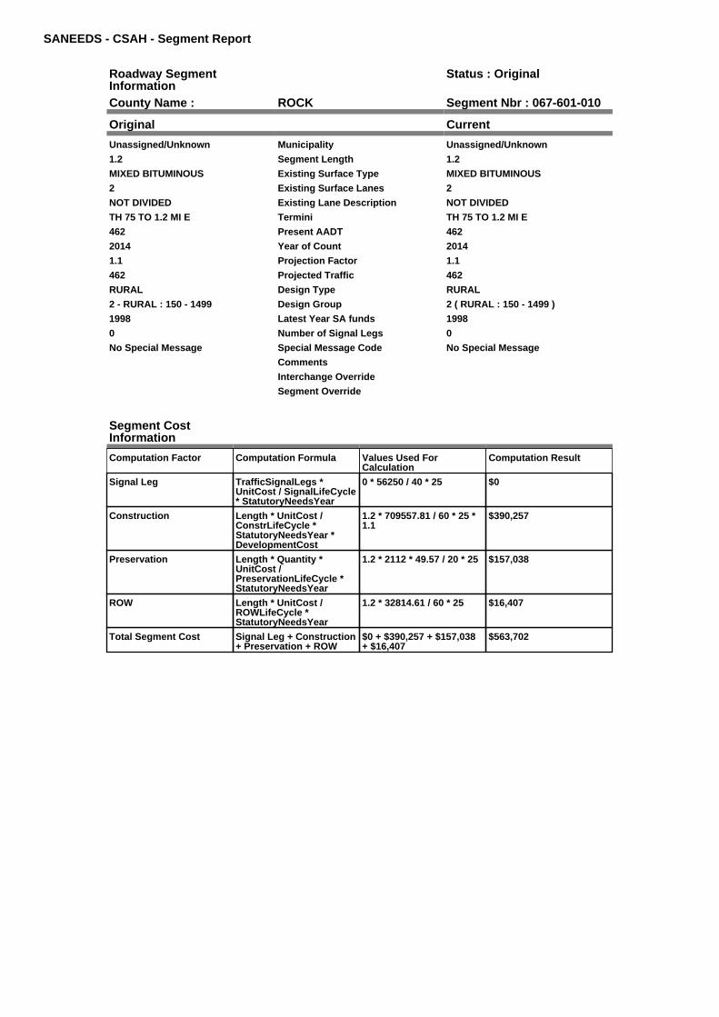
SANEEDS - CSAH - Segment Report Roadway Segment Information Status : Original County Name : ROCK Segment Nbr : 067-601-010 Original Current Unassigned/Unknown Municipality Unassigned/Unknown 1.2 Segment Length 1.2 MIXED BITUMINOUS Existing Surface Type MIXED BITUMINOUS 2 Existing Surface Lanes 2 NOT DIVIDED Existing Lane Description NOT DIVIDED TH 75 TO 1.2 MI E Termini TH 75 TO 1.2 MI E 462 Present AADT 462 2014 Year of Count 2014 1.1 Projection Factor 1.1 462 Projected Traffic 462 RURAL Design Type RURAL 2 - RURAL : 150 - 1499 Design Group 2 ( RURAL : 150 - 1499 ) 1998 Latest Year SA funds 1998 0 Number of Signal Legs 0 No Special Message Special Message Code No Special Message Comments Interchange Override Segment Override Segment Cost Information Computation Factor Computation Formula Values Used For Calculation Computation Result Signal Leg TrafficSignalLegs * UnitCost / SignalLifeCycle * StatutoryNeedsYear 0 * 56250 / 40 * 25 $0 Construction Length * UnitCost / ConstrLifeCycle * StatutoryNeedsYear * DevelopmentCost 1.2 * 709557.81 / 60 * 25 * 1.1 $390,257 Preservation Length * Quantity * UnitCost / PreservationLifeCycle * StatutoryNeedsYear 1.2 * 2112 * 49.57 / 20 * 25 $157,038 ROW Length * UnitCost / ROWLifeCycle * StatutoryNeedsYear 1.2 * 32814.61 / 60 * 25 $16,407 Total Segment Cost Signal Leg + Construction + Preservation + ROW $0 + $390,257 + $157,038 + $16,407 $563,702
Transcript of SANEEDS - CSAH - Segment Report Roadway Segment Status ... · County Name : ROCK Segment Nbr :...
SANEEDS - CSAH - Segment Report
Roadway SegmentInformation
Status : Original
County Name : ROCK Segment Nbr : 067-601-010
Original Current
Unassigned/Unknown Municipality Unassigned/Unknown
1.2 Segment Length 1.2
MIXED BITUMINOUS Existing Surface Type MIXED BITUMINOUS
2 Existing Surface Lanes 2
NOT DIVIDED Existing Lane Description NOT DIVIDED
TH 75 TO 1.2 MI E Termini TH 75 TO 1.2 MI E
462 Present AADT 462
2014 Year of Count 2014
1.1 Projection Factor 1.1
462 Projected Traffic 462
RURAL Design Type RURAL
2 - RURAL : 150 - 1499 Design Group 2 ( RURAL : 150 - 1499 )
1998 Latest Year SA funds 1998
0 Number of Signal Legs 0
No Special Message Special Message Code No Special Message
Comments
Interchange Override
Segment Override
Segment CostInformation
Computation Factor Computation Formula Values Used ForCalculation
Computation Result
Signal Leg TrafficSignalLegs *UnitCost / SignalLifeCycle* StatutoryNeedsYear
0 * 56250 / 40 * 25 $0
Construction Length * UnitCost /ConstrLifeCycle *StatutoryNeedsYear *DevelopmentCost
1.2 * 709557.81 / 60 * 25 *1.1
$390,257
Preservation Length * Quantity *UnitCost /PreservationLifeCycle *StatutoryNeedsYear
1.2 * 2112 * 49.57 / 20 * 25 $157,038
ROW Length * UnitCost /ROWLifeCycle *StatutoryNeedsYear
1.2 * 32814.61 / 60 * 25 $16,407
Total Segment Cost Signal Leg + Construction+ Preservation + ROW
$0 + $390,257 + $157,038+ $16,407
$563,702
SANEEDS - CSAH - Segment Report
Roadway SegmentInformation
Status : Original
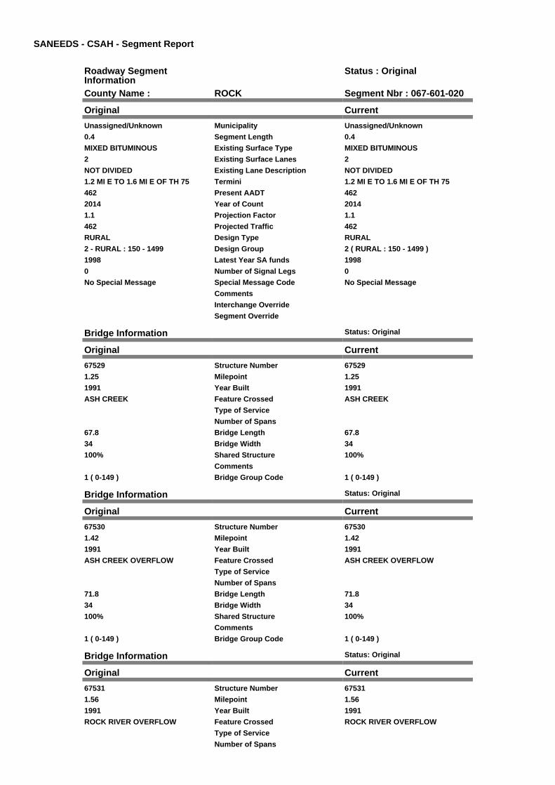
County Name : ROCK Segment Nbr : 067-601-020
Original Current
Unassigned/Unknown Municipality Unassigned/Unknown
0.4 Segment Length 0.4
MIXED BITUMINOUS Existing Surface Type MIXED BITUMINOUS
2 Existing Surface Lanes 2
NOT DIVIDED Existing Lane Description NOT DIVIDED
1.2 MI E TO 1.6 MI E OF TH 75 Termini 1.2 MI E TO 1.6 MI E OF TH 75
462 Present AADT 462
2014 Year of Count 2014
1.1 Projection Factor 1.1
462 Projected Traffic 462
RURAL Design Type RURAL
2 - RURAL : 150 - 1499 Design Group 2 ( RURAL : 150 - 1499 )
1998 Latest Year SA funds 1998
0 Number of Signal Legs 0
No Special Message Special Message Code No Special Message
Comments
Interchange Override
Segment Override
Bridge Information Status: Original
Original Current
67529 Structure Number 67529
1.25 Milepoint 1.25
1991 Year Built 1991
ASH CREEK Feature Crossed ASH CREEK
Type of Service
Number of Spans
67.8 Bridge Length 67.8
34 Bridge Width 34
100% Shared Structure 100%
Comments
1 ( 0-149 ) Bridge Group Code 1 ( 0-149 )
Bridge Information Status: Original
Original Current
67530 Structure Number 67530
1.42 Milepoint 1.42
1991 Year Built 1991
ASH CREEK OVERFLOW Feature Crossed ASH CREEK OVERFLOW
Type of Service
Number of Spans
71.8 Bridge Length 71.8
34 Bridge Width 34
100% Shared Structure 100%
Comments
1 ( 0-149 ) Bridge Group Code 1 ( 0-149 )
Bridge Information Status: Original
Original Current
67531 Structure Number 67531
1.56 Milepoint 1.56
1991 Year Built 1991
ROCK RIVER OVERFLOW Feature Crossed ROCK RIVER OVERFLOW
Type of Service
Number of Spans
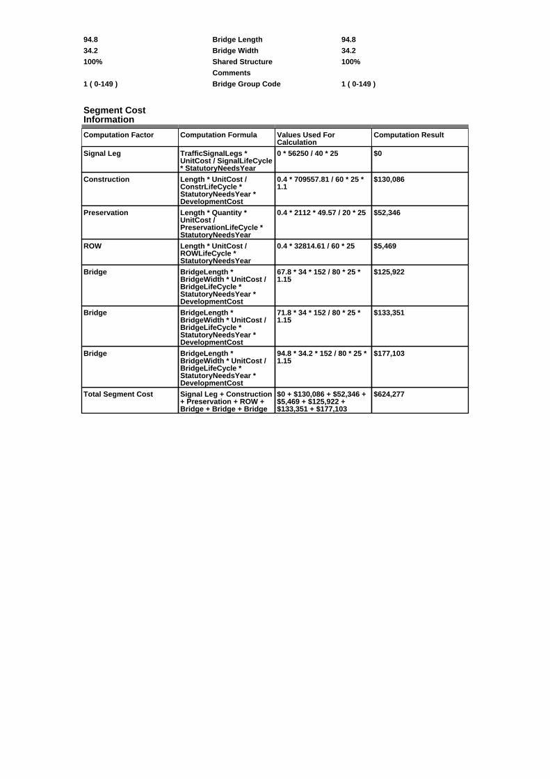
94.8 Bridge Length 94.8
34.2 Bridge Width 34.2
100% Shared Structure 100%
Comments
1 ( 0-149 ) Bridge Group Code 1 ( 0-149 )
Segment CostInformation
Computation Factor Computation Formula Values Used ForCalculation
Computation Result
Signal Leg TrafficSignalLegs *UnitCost / SignalLifeCycle* StatutoryNeedsYear
0 * 56250 / 40 * 25 $0
Construction Length * UnitCost /ConstrLifeCycle *StatutoryNeedsYear *DevelopmentCost
0.4 * 709557.81 / 60 * 25 *1.1
$130,086
Preservation Length * Quantity *UnitCost /PreservationLifeCycle *StatutoryNeedsYear
0.4 * 2112 * 49.57 / 20 * 25 $52,346
ROW Length * UnitCost /ROWLifeCycle *StatutoryNeedsYear
0.4 * 32814.61 / 60 * 25 $5,469
Bridge BridgeLength *BridgeWidth * UnitCost /BridgeLifeCycle *StatutoryNeedsYear *DevelopmentCost
67.8 * 34 * 152 / 80 * 25 *1.15
$125,922
Bridge BridgeLength *BridgeWidth * UnitCost /BridgeLifeCycle *StatutoryNeedsYear *DevelopmentCost
71.8 * 34 * 152 / 80 * 25 *1.15
$133,351
Bridge BridgeLength *BridgeWidth * UnitCost /BridgeLifeCycle *StatutoryNeedsYear *DevelopmentCost
94.8 * 34.2 * 152 / 80 * 25 *1.15
$177,103
Total Segment Cost Signal Leg + Construction+ Preservation + ROW +Bridge + Bridge + Bridge
$0 + $130,086 + $52,346 +$5,469 + $125,922 +$133,351 + $177,103
$624,277

SANEEDS - CSAH - Segment Report
Roadway SegmentInformation
Status : Original
County Name : ROCK Segment Nbr : 067-601-030
Original Current
Unassigned/Unknown Municipality Unassigned/Unknown
4.4 Segment Length 4.4
BIT CONC OR ASPH Existing Surface Type BIT CONC OR ASPH
2 Existing Surface Lanes 2
NOT DIVIDED Existing Lane Description NOT DIVIDED
1.6 MI E TH 75 TO CSAH 3 Termini 1.6 MI E TH 75 TO CSAH 3
506 Present AADT 506
2014 Year of Count 2014
1.1 Projection Factor 1.1
506 Projected Traffic 506
RURAL Design Type RURAL
2 - RURAL : 150 - 1499 Design Group 2 ( RURAL : 150 - 1499 )
1998 Latest Year SA funds 1998
0 Number of Signal Legs 0
No Special Message Special Message Code No Special Message
Comments
Interchange Override
Segment Override
Bridge Information Status: Original
Original Current
67502 Structure Number 67502
1.74 Milepoint 1.74
1968 Year Built 1968
ROCK RIVER Feature Crossed ROCK RIVER
Type of Service
Number of Spans
126.5 Bridge Length 126.5
31.6 Bridge Width 31.6
100% Shared Structure 100%
Comments
1 ( 0-149 ) Bridge Group Code 1 ( 0-149 )
Segment CostInformation
Computation Factor Computation Formula Values Used ForCalculation
Computation Result
Signal Leg TrafficSignalLegs *UnitCost / SignalLifeCycle* StatutoryNeedsYear
0 * 56250 / 40 * 25 $0
Construction Length * UnitCost /ConstrLifeCycle *StatutoryNeedsYear *DevelopmentCost
4.4 * 709557.81 / 60 * 25 *1.1
$1,430,942
Preservation Length * Quantity *UnitCost /PreservationLifeCycle *StatutoryNeedsYear
4.4 * 2112 * 49.57 / 20 * 25 $575,805
ROW Length * UnitCost /ROWLifeCycle *StatutoryNeedsYear
4.4 * 32814.61 / 60 * 25 $60,160
Bridge BridgeLength *BridgeWidth * UnitCost /BridgeLifeCycle *StatutoryNeedsYear *DevelopmentCost
126.5 * 31.6 * 152 / 80 * 25* 1.15
$218,358
Total Segment Cost Signal Leg + Construction+ Preservation + ROW +Bridge
$0 + $1,430,942 + $575,805+ $60,160 + $218,358
$2,285,265
SANEEDS - CSAH - Segment Report
Roadway SegmentInformation
Status : Original
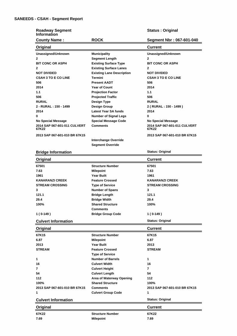
County Name : ROCK Segment Nbr : 067-601-040
Original Current
Unassigned/Unknown Municipality Unassigned/Unknown
2 Segment Length 2
BIT CONC OR ASPH Existing Surface Type BIT CONC OR ASPH
2 Existing Surface Lanes 2
NOT DIVIDED Existing Lane Description NOT DIVIDED
CSAH 3 TO E CO LINE Termini CSAH 3 TO E CO LINE
506 Present AADT 506
2014 Year of Count 2014
1.1 Projection Factor 1.1
506 Projected Traffic 506
RURAL Design Type RURAL
2 - RURAL : 150 - 1499 Design Group 2 ( RURAL : 150 - 1499 )
2014 Latest Year SA funds 2014
0 Number of Signal Legs 0
No Special Message Special Message Code No Special Message
2014 SAP 067-601-011 CULVERT67K22
2013 SAP 067-601-010 BR 67K15
Comments 2014 SAP 067-601-011 CULVERT67K22
2013 SAP 067-601-010 BR 67K15
Interchange Override
Segment Override
Bridge Information Status: Original
Original Current
67501 Structure Number 67501
7.63 Milepoint 7.63
1961 Year Built 1961
KANARANZI CREEK Feature Crossed KANARANZI CREEK
STREAM CROSSING Type of Service STREAM CROSSING
3 Number of Spans 3
121.1 Bridge Length 121.1
29.4 Bridge Width 29.4
100% Shared Structure 100%
Comments
1 ( 0-149 ) Bridge Group Code 1 ( 0-149 )
Culvert Information Status: Original
Original Current
67K15 Structure Number 67K15
6.87 Milepoint 6.87
2013 Year Built 2013
STREAM Feature Crossed STREAM
Type of Service
1 Number of Barrels 1
16 Culvert Width 16
7 Culvert Height 7
54 Culvert Length 54
112 Area of Waterway Opening 112
100% Shared Structure 100%
2013 SAP 067-601-010 BR 67K15 Comments 2013 SAP 067-601-010 BR 67K15
1 Culvert Group Code 1
Culvert Information Status: Original
Original Current
67K22 Structure Number 67K22
7.69 Milepoint 7.69

2014 Year Built 2014
STREAM Feature Crossed STREAM
STREAM CROSSING Type of Service STREAM CROSSING
2 Number of Barrels 2
10 Culvert Width 10
7 Culvert Height 7
56 Culvert Length 56
140 Area of Waterway Opening 140
100% Shared Structure 100%
2014 SAP 067-601-011 CULVERT67K22
Comments 2014 SAP 067-601-011 CULVERT67K22
1 Culvert Group Code 1
Segment CostInformation
Computation Factor Computation Formula Values Used ForCalculation
Computation Result
Signal Leg TrafficSignalLegs *UnitCost / SignalLifeCycle* StatutoryNeedsYear
0 * 56250 / 40 * 25 $0
Construction Length * UnitCost /ConstrLifeCycle *StatutoryNeedsYear *DevelopmentCost
2 * 709557.81 / 60 * 25 * 1.1 $650,428
Preservation Length * Quantity *UnitCost /PreservationLifeCycle *StatutoryNeedsYear
2 * 2112 * 49.57 / 20 * 25 $261,730
ROW Length * UnitCost /ROWLifeCycle *StatutoryNeedsYear
2 * 32814.61 / 60 * 25 $27,346
Bridge BridgeLength *BridgeWidth * UnitCost /BridgeLifeCycle *StatutoryNeedsYear *DevelopmentCost
121.1 * 29.4 * 152 / 80 * 25* 1.15
$194,484
Culvert CulvertLength * Area *UnitCost /CulvertLifeCycle *StatutoryNeedsYear *DevelopmentCost
54 * 112 * 15.47 / 100 * 25 *1.15
$26,899
Culvert CulvertLength * Area *UnitCost /CulvertLifeCycle *StatutoryNeedsYear *DevelopmentCost
56 * 140 * 15.47 / 100 * 25 *1.15
$34,869
Total Segment Cost Signal Leg + Construction+ Preservation + ROW +Bridge + Culvert + Culvert
$0 + $650,428 + $261,730+ $27,346 + $194,484 +$26,899 + $34,869
$1,195,756
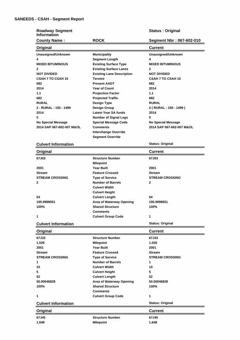
SANEEDS - CSAH - Segment Report
Roadway SegmentInformation
Status : Original
County Name : ROCK Segment Nbr : 067-602-010
Original Current
Unassigned/Unknown Municipality Unassigned/Unknown
4 Segment Length 4
MIXED BITUMINOUS Existing Surface Type MIXED BITUMINOUS
2 Existing Surface Lanes 2
NOT DIVIDED Existing Lane Description NOT DIVIDED
CSAH 7 TO CSAH 10 Termini CSAH 7 TO CSAH 10
682 Present AADT 682
2014 Year of Count 2014
1.1 Projection Factor 1.1
682 Projected Traffic 682
RURAL Design Type RURAL
2 - RURAL : 150 - 1499 Design Group 2 ( RURAL : 150 - 1499 )
2014 Latest Year SA funds 2014
0 Number of Signal Legs 0
No Special Message Special Message Code No Special Message
2014 SAP 067-602-007 M&OL Comments 2014 SAP 067-602-007 M&OL
Interchange Override
Segment Override
Culvert Information Status: Original
Original Current
67J03 Structure Number 67J03
Milepoint
2001 Year Built 2001
Stream Feature Crossed Stream
STREAM CROSSING Type of Service STREAM CROSSING
2 Number of Barrels 2
Culvert Width
Culvert Height
54 Culvert Length 54
195.9998551 Area of Waterway Opening 195.9998551
100% Shared Structure 100%
Comments
1 Culvert Group Code 1
Culvert Information Status: Original
Original Current
67J33 Structure Number 67J33
1.026 Milepoint 1.026
2001 Year Built 2001
Stream Feature Crossed Stream
STREAM CROSSING Type of Service STREAM CROSSING
1 Number of Barrels 1
10 Culvert Width 10
5 Culvert Height 5
52 Culvert Length 52
50.00046828 Area of Waterway Opening 50.00046828
100% Shared Structure 100%
Comments
1 Culvert Group Code 1
Culvert Information Status: Original
Original Current
67J45 Structure Number 67J45
1.648 Milepoint 1.648
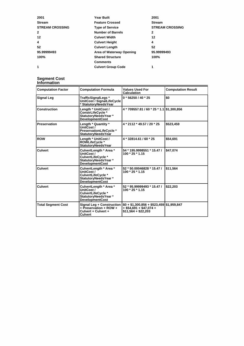
2001 Year Built 2001
Stream Feature Crossed Stream
STREAM CROSSING Type of Service STREAM CROSSING
2 Number of Barrels 2
12 Culvert Width 12
4 Culvert Height 4
52 Culvert Length 52
95.99999493 Area of Waterway Opening 95.99999493
100% Shared Structure 100%
Comments
1 Culvert Group Code 1
Segment CostInformation
Computation Factor Computation Formula Values Used ForCalculation
Computation Result
Signal Leg TrafficSignalLegs *UnitCost / SignalLifeCycle* StatutoryNeedsYear
0 * 56250 / 40 * 25 $0
Construction Length * UnitCost /ConstrLifeCycle *StatutoryNeedsYear *DevelopmentCost
4 * 709557.81 / 60 * 25 * 1.1 $1,300,856
Preservation Length * Quantity *UnitCost /PreservationLifeCycle *StatutoryNeedsYear
4 * 2112 * 49.57 / 20 * 25 $523,459
ROW Length * UnitCost /ROWLifeCycle *StatutoryNeedsYear
4 * 32814.61 / 60 * 25 $54,691
Culvert CulvertLength * Area *UnitCost /CulvertLifeCycle *StatutoryNeedsYear *DevelopmentCost
54 * 195.9998551 * 15.47 /100 * 25 * 1.15
$47,074
Culvert CulvertLength * Area *UnitCost /CulvertLifeCycle *StatutoryNeedsYear *DevelopmentCost
52 * 50.00046828 * 15.47 /100 * 25 * 1.15
$11,564
Culvert CulvertLength * Area *UnitCost /CulvertLifeCycle *StatutoryNeedsYear *DevelopmentCost
52 * 95.99999493 * 15.47 /100 * 25 * 1.15
$22,203
Total Segment Cost Signal Leg + Construction+ Preservation + ROW +Culvert + Culvert +Culvert
$0 + $1,300,856 + $523,459+ $54,691 + $47,074 +$11,564 + $22,203
$1,959,847

SANEEDS - CSAH - Segment Report
Roadway SegmentInformation
Status : Original
County Name : ROCK Segment Nbr : 067-602-020
Original Current
Unassigned/Unknown Municipality Unassigned/Unknown
1 Segment Length 1
MIXED BITUMINOUS Existing Surface Type MIXED BITUMINOUS
2 Existing Surface Lanes 2
NOT DIVIDED Existing Lane Description NOT DIVIDED
CSAH 10 TO NORTH CO LINE Termini CSAH 10 TO NORTH CO LINE
1155 Present AADT 1155
2014 Year of Count 2014
1.1 Projection Factor 1.1
1155 Projected Traffic 1155
RURAL Design Type RURAL
2 - RURAL : 150 - 1499 Design Group 2 ( RURAL : 150 - 1499 )
2013 Latest Year SA funds 2013
0 Number of Signal Legs 0
No Special Message Special Message Code No Special Message
2013 SAP 067-602-006 M&OL Comments 2013 SAP 067-602-006 M&OL
Interchange Override
Segment Override
Segment CostInformation
Computation Factor Computation Formula Values Used ForCalculation
Computation Result
Signal Leg TrafficSignalLegs *UnitCost / SignalLifeCycle* StatutoryNeedsYear
0 * 56250 / 40 * 25 $0
Construction Length * UnitCost /ConstrLifeCycle *StatutoryNeedsYear *DevelopmentCost
1 * 709557.81 / 60 * 25 * 1.1 $325,214
Preservation Length * Quantity *UnitCost /PreservationLifeCycle *StatutoryNeedsYear
1 * 2112 * 49.57 / 20 * 25 $130,865
ROW Length * UnitCost /ROWLifeCycle *StatutoryNeedsYear
1 * 32814.61 / 60 * 25 $13,673
Total Segment Cost Signal Leg + Construction+ Preservation + ROW
$0 + $325,214 + $130,865+ $13,673
$469,752

SANEEDS - CSAH - Segment Report
Roadway SegmentInformation
Status : Original
County Name : ROCK Segment Nbr : 067-603-009
Original Current
Unassigned/Unknown Municipality Unassigned/Unknown
3 Segment Length 3
BIT CONC OR ASPH Existing Surface Type BIT CONC OR ASPH
2 Existing Surface Lanes 2
NOT DIVIDED Existing Lane Description NOT DIVIDED
S STATE LINE TO CSAH 1 Termini S STATE LINE TO CSAH 1
281 Present AADT 281
2014 Year of Count 2014
1.1 Projection Factor 1.1
281 Projected Traffic 281
RURAL Design Type RURAL
2 - RURAL : 150 - 1499 Design Group 2 ( RURAL : 150 - 1499 )
2013 Latest Year SA funds 2013
0 Number of Signal Legs 0
No Special Message Special Message Code No Special Message
2013 SAP 067-603-027 67K11 Comments 2013 SAP 067-603-027 67K11
Interchange Override
Segment Override
Bridge Information Status: Original
Original Current
67540 Structure Number 67540
1.09 Milepoint 1.09
2000 Year Built 2000
KANARANZI CREEK Feature Crossed KANARANZI CREEK
Type of Service
Number of Spans
142.5 Bridge Length 142.5
39.1 Bridge Width 39.1
100% Shared Structure 100%
Comments
1 ( 0-149 ) Bridge Group Code 1 ( 0-149 )
Culvert Information Status: Original
Original Current
67K11 Structure Number 67K11
0.85 Milepoint 0.85
2013 Year Built 2013
STREAM Feature Crossed STREAM
STREAM CROSSING Type of Service STREAM CROSSING
2 Number of Barrels 2
12 Culvert Width 12
8 Culvert Height 8
58 Culvert Length 58
192 Area of Waterway Opening 192
100% Shared Structure 100%
2013 SAP 067-603-027 67K11 Comments 2013 SAP 067-603-027 67K11
1 Culvert Group Code 1
Segment CostInformation
Computation Factor Computation Formula Values Used ForCalculation
Computation Result
Signal Leg TrafficSignalLegs *UnitCost / SignalLifeCycle* StatutoryNeedsYear
0 * 56250 / 40 * 25 $0
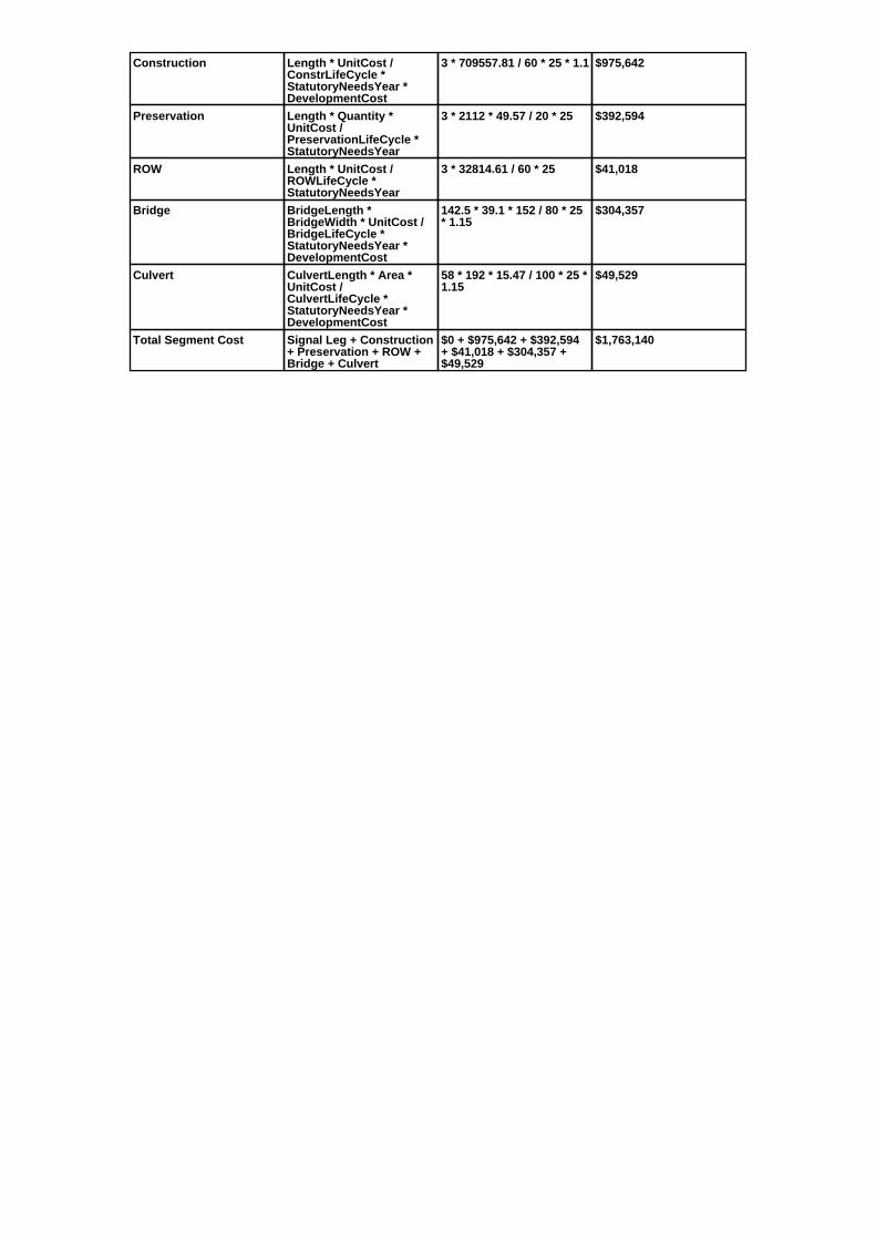
Construction Length * UnitCost /ConstrLifeCycle *StatutoryNeedsYear *DevelopmentCost
3 * 709557.81 / 60 * 25 * 1.1 $975,642
Preservation Length * Quantity *UnitCost /PreservationLifeCycle *StatutoryNeedsYear
3 * 2112 * 49.57 / 20 * 25 $392,594
ROW Length * UnitCost /ROWLifeCycle *StatutoryNeedsYear
3 * 32814.61 / 60 * 25 $41,018
Bridge BridgeLength *BridgeWidth * UnitCost /BridgeLifeCycle *StatutoryNeedsYear *DevelopmentCost
142.5 * 39.1 * 152 / 80 * 25* 1.15
$304,357
Culvert CulvertLength * Area *UnitCost /CulvertLifeCycle *StatutoryNeedsYear *DevelopmentCost
58 * 192 * 15.47 / 100 * 25 *1.15
$49,529
Total Segment Cost Signal Leg + Construction+ Preservation + ROW +Bridge + Culvert
$0 + $975,642 + $392,594+ $41,018 + $304,357 +$49,529
$1,763,140

SANEEDS - CSAH - Segment Report
Roadway SegmentInformation
Status : Original
County Name : ROCK Segment Nbr : 067-603-010
Original Current
Unassigned/Unknown Municipality Unassigned/Unknown
2 Segment Length 2
MIXED BITUMINOUS Existing Surface Type MIXED BITUMINOUS
2 Existing Surface Lanes 2
NOT DIVIDED Existing Lane Description NOT DIVIDED
CSAH 1 TO CSAH 15 Termini CSAH 1 TO CSAH 15
682 Present AADT 682
2014 Year of Count 2014
1.1 Projection Factor 1.1
682 Projected Traffic 682
RURAL Design Type RURAL
2 - RURAL : 150 - 1499 Design Group 2 ( RURAL : 150 - 1499 )
2003 Latest Year SA funds 2003
0 Number of Signal Legs 0
No Special Message Special Message Code No Special Message
Comments
Interchange Override
Segment Override
Culvert Information Status: Original
Original Current
L1990 Structure Number L1990
3.53 Milepoint 3.53
1936 Year Built 1936
STREAM Feature Crossed STREAM
Type of Service
1 Number of Barrels 1
10 Culvert Width 10
8 Culvert Height 8
28 Culvert Length 28
50.00046828 Area of Waterway Opening 50.00046828
100% Shared Structure 100%
Comments
1 Culvert Group Code 1
Segment CostInformation
Computation Factor Computation Formula Values Used ForCalculation
Computation Result
Signal Leg TrafficSignalLegs *UnitCost / SignalLifeCycle* StatutoryNeedsYear
0 * 56250 / 40 * 25 $0
Construction Length * UnitCost /ConstrLifeCycle *StatutoryNeedsYear *DevelopmentCost
2 * 709557.81 / 60 * 25 * 1.1 $650,428
Preservation Length * Quantity *UnitCost /PreservationLifeCycle *StatutoryNeedsYear
2 * 2112 * 49.57 / 20 * 25 $261,730
ROW Length * UnitCost /ROWLifeCycle *StatutoryNeedsYear
2 * 32814.61 / 60 * 25 $27,346
Culvert CulvertLength * Area *UnitCost /CulvertLifeCycle *StatutoryNeedsYear *DevelopmentCost
28 * 50.00046828 * 15.47 /100 * 25 * 1.15
$6,227
Total Segment Cost Signal Leg + Construction+ Preservation + ROW +Culvert
$0 + $650,428 + $261,730+ $27,346 + $6,227
$945,731

SANEEDS - CSAH - Segment Report
Roadway SegmentInformation
Status : Original
County Name : ROCK Segment Nbr : 067-603-011
Original Current
Unassigned/Unknown Municipality Unassigned/Unknown
4.3 Segment Length 4.3
MIXED BITUMINOUS Existing Surface Type MIXED BITUMINOUS
2 Existing Surface Lanes 2
NOT DIVIDED Existing Lane Description NOT DIVIDED
CSAH 15 TO 4.3 MI NORTH Termini CSAH 15 TO 4.3 MI NORTH
682 Present AADT 682
2014 Year of Count 2014
1.1 Projection Factor 1.1
682 Projected Traffic 682
RURAL Design Type RURAL
2 - RURAL : 150 - 1499 Design Group 2 ( RURAL : 150 - 1499 )
2014 Latest Year SA funds 2014
0 Number of Signal Legs 0
No Special Message Special Message Code No Special Message
2014 SAP 067-603-028 M&OL 4.18M
2010 SAP 67-603-025OVERLAY ON 0.3 MILE0.5 MI NO OF CSAH 16 TO 0.30 MINORTH$94,013
Comments 2014 SAP 067-603-028 M&OL 4.18M
2010 SAP 67-603-025OVERLAY ON 0.3 MILE0.5 MI NO OF CSAH 16 TO 0.30 MINORTH$94,013
Interchange Override
Segment Override
Culvert Information Status: Original
Original Current
67J97 Structure Number 67J97
3.6 Milepoint 3.6
2009 Year Built 2009
STREAM Feature Crossed STREAM
STREAM CROSSING Type of Service STREAM CROSSING
2 Number of Barrels 2
10 Culvert Width 10
8 Culvert Height 8
56 Culvert Length 56
160 Area of Waterway Opening 160
100% Shared Structure 100%
Comments
1 Culvert Group Code 1
Culvert Information Status: Original
Original Current
67J98 Structure Number 67J98
3.7 Milepoint 3.7
2009 Year Built 2009
STREAM Feature Crossed STREAM
STREAM CROSSING Type of Service STREAM CROSSING
2 Number of Barrels 2
12 Culvert Width 12
7 Culvert Height 7
51 Culvert Length 51
192 Area of Waterway Opening 192
100% Shared Structure 100%
Comments
1 Culvert Group Code 1

Segment CostInformation
Computation Factor Computation Formula Values Used ForCalculation
Computation Result
Signal Leg TrafficSignalLegs *UnitCost / SignalLifeCycle* StatutoryNeedsYear
0 * 56250 / 40 * 25 $0
Construction Length * UnitCost /ConstrLifeCycle *StatutoryNeedsYear *DevelopmentCost
4.3 * 709557.81 / 60 * 25 *1.1
$1,398,420
Preservation Length * Quantity *UnitCost /PreservationLifeCycle *StatutoryNeedsYear
4.3 * 2112 * 49.57 / 20 * 25 $562,719
ROW Length * UnitCost /ROWLifeCycle *StatutoryNeedsYear
4.3 * 32814.61 / 60 * 25 $58,793
Culvert CulvertLength * Area *UnitCost /CulvertLifeCycle *StatutoryNeedsYear *DevelopmentCost
56 * 160 * 15.47 / 100 * 25 *1.15
$39,851
Culvert CulvertLength * Area *UnitCost /CulvertLifeCycle *StatutoryNeedsYear *DevelopmentCost
51 * 192 * 15.47 / 100 * 25 *1.15
$43,551
Total Segment Cost Signal Leg + Construction+ Preservation + ROW +Culvert + Culvert
$0 + $1,398,420 + $562,719+ $58,793 + $39,851 +$43,551
$2,103,334

SANEEDS - CSAH - Segment Report
Roadway SegmentInformation
Status : Original
County Name : ROCK Segment Nbr : 067-603-012
Original Current
Unassigned/Unknown Municipality Unassigned/Unknown
0.4 Segment Length 0.4
BIT CONC OR ASPH Existing Surface Type BIT CONC OR ASPH
2 Existing Surface Lanes 2
NOT DIVIDED Existing Lane Description NOT DIVIDED
4.3 MI NO OF CSAH 15 TO TH 90 Termini 4.3 MI NO OF CSAH 15 TO TH 90
682 Present AADT 682
2014 Year of Count 2014
1.1 Projection Factor 1.1
682 Projected Traffic 682
RURAL Design Type RURAL
2 - RURAL : 150 - 1499 Design Group 2 ( RURAL : 150 - 1499 )
2000 Latest Year SA funds 2000
0 Number of Signal Legs 0
No Special Message Special Message Code No Special Message
SPLIT DUE TO CONSTRUCTIONUPDATE
Comments SPLIT DUE TO CONSTRUCTIONUPDATE
Interchange Override
Segment Override
Segment CostInformation
Computation Factor Computation Formula Values Used ForCalculation
Computation Result
Signal Leg TrafficSignalLegs *UnitCost / SignalLifeCycle* StatutoryNeedsYear
0 * 56250 / 40 * 25 $0
Construction Length * UnitCost /ConstrLifeCycle *StatutoryNeedsYear *DevelopmentCost
0.4 * 709557.81 / 60 * 25 *1.1
$130,086
Preservation Length * Quantity *UnitCost /PreservationLifeCycle *StatutoryNeedsYear
0.4 * 2112 * 49.57 / 20 * 25 $52,346
ROW Length * UnitCost /ROWLifeCycle *StatutoryNeedsYear
0.4 * 32814.61 / 60 * 25 $5,469
Total Segment Cost Signal Leg + Construction+ Preservation + ROW
$0 + $130,086 + $52,346 +$5,469
$187,901

SANEEDS - CSAH - Segment Report
Roadway SegmentInformation
Status : Original
County Name : ROCK Segment Nbr : 067-603-015
Original Current
Unassigned/Unknown Municipality Unassigned/Unknown
0.4 Segment Length 0.4
BIT CONC OR ASPH Existing Surface Type BIT CONC OR ASPH
2 Existing Surface Lanes 2
NOT DIVIDED Existing Lane Description NOT DIVIDED
TH 90 TO CSAH 4 Termini TH 90 TO CSAH 4
1045 Present AADT 1045
2014 Year of Count 2014
1.1 Projection Factor 1.1
1045 Projected Traffic 1045
RURAL Design Type RURAL
2 - RURAL : 150 - 1499 Design Group 2 ( RURAL : 150 - 1499 )
2008 Latest Year SA funds 2008
0 Number of Signal Legs 0
No Special Message Special Message Code No Special Message
SAP 67-603-19, 2008 OVERLAY Comments SAP 67-603-19, 2008 OVERLAY
Interchange Override
Segment Override
RailRoadCrossingInformation
Status: Original
Original Current
UNION PACIFIC RAILROAD RailRoad Name UNION PACIFIC RAILROAD
185788T USDOT Number 185788T
0.2 Located at Milepoint 0.2
1 Mainline Tracks 1
SIGNS ONLY Protection Type SIGNS ONLY
Last Year Protection Upgraded
32 Crossing Length 32
Last Year Surfaced
100% Percentage of Cost 100%
Comments
Segment CostInformation
Computation Factor Computation Formula Values Used ForCalculation
Computation Result
Signal Leg TrafficSignalLegs *UnitCost / SignalLifeCycle* StatutoryNeedsYear
0 * 56250 / 40 * 25 $0
Construction Length * UnitCost /ConstrLifeCycle *StatutoryNeedsYear *DevelopmentCost
0.4 * 709557.81 / 60 * 25 *1.1
$130,086
Preservation Length * Quantity *UnitCost /PreservationLifeCycle *StatutoryNeedsYear
0.4 * 2112 * 49.57 / 20 * 25 $52,346
ROW Length * UnitCost /ROWLifeCycle *StatutoryNeedsYear
0.4 * 32814.61 / 60 * 25 $5,469
RR Crossing Protection UnitCost /RRCrossingLifeCycle *StatutoryNeedsYear
1500 / 25 * 25 $1,500
RR Crossing Surface SurfaceLength * UnitCost/ RRCrossingLifeCycle *StatutoryNeedsYear
32 * 1350 / 25 * 25 $43,200
Total Segment Cost Signal Leg + Construction+ Preservation + ROW +RR Crossing Protection +RR Crossing Surface
$0 + $130,086 + $52,346 +$5,469 + $1,500 + $43,200
$232,601

SANEEDS - CSAH - Segment Report
Roadway SegmentInformation
Status : Original
County Name : ROCK Segment Nbr : 067-603-020
Original Current
MAGNOLIA Municipality MAGNOLIA
0.55 Segment Length 0.55
MIXED BITUMINOUS Existing Surface Type MIXED BITUMINOUS
2 Existing Surface Lanes 2
NOT DIVIDED Existing Lane Description NOT DIVIDED
CSAH 4 TO N LIMS MAGNOLIA Termini CSAH 4 TO N LIMS MAGNOLIA
281 Present AADT 281
2014 Year of Count 2014
1.1 Projection Factor 1.1
281 Projected Traffic 281
RURAL Design Type RURAL
2 - RURAL : 150 - 1499 Design Group 2 ( RURAL : 150 - 1499 )
2014 Latest Year SA funds 2014
0 Number of Signal Legs 0
No Special Message Special Message Code No Special Message
2014 SAP 067-603-029 M&OL Comments 2014 SAP 067-603-029 M&OL
Interchange Override
Segment Override
Segment CostInformation
Computation Factor Computation Formula Values Used ForCalculation
Computation Result
Signal Leg TrafficSignalLegs *UnitCost / SignalLifeCycle* StatutoryNeedsYear
0 * 56250 / 40 * 25 $0
Construction Length * UnitCost /ConstrLifeCycle *StatutoryNeedsYear *DevelopmentCost
0.55 * 709557.81 / 60 * 25 *1.1
$178,868
Preservation Length * Quantity *UnitCost /PreservationLifeCycle *StatutoryNeedsYear
0.55 * 2112 * 49.57 / 20 * 25 $71,976
ROW Length * UnitCost /ROWLifeCycle *StatutoryNeedsYear
0.55 * 32814.61 / 60 * 25 $7,520
Total Segment Cost Signal Leg + Construction+ Preservation + ROW
$0 + $178,868 + $71,976 +$7,520
$258,364

SANEEDS - CSAH - Segment Report
Roadway SegmentInformation
Status : Revised
County Name : ROCK Segment Nbr : 067-603-030
Original Current
Unassigned/Unknown Municipality Unassigned/Unknown
6.4 Segment Length 6.4
MIXED BITUMINOUS Existing Surface Type MIXED BITUMINOUS
2 Existing Surface Lanes 2
NOT DIVIDED Existing Lane Description NOT DIVIDED
N LIM MAGNOLIA TO S LIMKENNETH
Termini N LIM MAGNOLIA TO S LIMKENNETH
473 Present AADT 473
2014 Year of Count 2014
1.1 Projection Factor 1.1
473 Projected Traffic 473
RURAL Design Type RURAL
2 - RURAL : 150 - 1499 Design Group 2 ( RURAL : 150 - 1499 )
2016 Latest Year SA funds 2016
0 Number of Signal Legs 0
No Special Message Special Message Code No Special Message
2016 SAP 067-603-031 R&RCULVERT 67K28 / 67K28
2014 SAP 067-603-029 M&OL
CULVERT REPLACEMENT 2010,SAP 67-603-024
Comments 2016 SAP 067-603-031 R&RCULVERT 67K28 / 67K28
2014 SAP 067-603-029 M&OL
CULVERT REPLACEMENT 2010,SAP 67-603-024
Interchange Override
Segment Override
Bridge Information Status: Original
Original Current
67538 Structure Number 67538
16.36 Milepoint 16.36
1999 Year Built 1999
CHAMPEPADAN CREEK Feature Crossed CHAMPEPADAN CREEK
Type of Service
Number of Spans
78.2 Bridge Length 78.2
42.5 Bridge Width 42.5
100% Shared Structure 100%
Comments
1 ( 0-149 ) Bridge Group Code 1 ( 0-149 )
Culvert Information Status: Original
Original Current
67K02 Structure Number 67K02
12.1 Milepoint 12.1
2010 Year Built 2010
ELK CREEK Feature Crossed ELK CREEK
STREAM CROSSING Type of Service STREAM CROSSING
3 Number of Barrels 3
14 Culvert Width 14
8 Culvert Height 8
55 Culvert Length 55
336 Area of Waterway Opening 336
100% Shared Structure 100%
Comments
1 Culvert Group Code 1
Culvert Information Status: Original

Original Current
67K01 Structure Number 67K01
11.93 Milepoint 11.93
2010 Year Built 2010
ELK CREEK Feature Crossed ELK CREEK
STREAM CROSSING Type of Service STREAM CROSSING
1 Number of Barrels 1
14 Culvert Width 14
7 Culvert Height 7
53 Culvert Length 53
98 Area of Waterway Opening 98
100% Shared Structure 100%
Comments
1 Culvert Group Code 1
Culvert Information Status: Revised
Original Current
67K26 Structure Number 67K26
15.79 Milepoint 15.79
2016 Year Built 2016
STREAM Feature Crossed STREAM
STREAM CROSSING Type of Service STREAM CROSSING
2 Number of Barrels 2
12 Culvert Width 12
6 Culvert Height 6
58 Culvert Length 58
144 Area of Waterway Opening 144
100% Shared Structure 100%
2016 SAP 067-603-031 R&RCULVERT 67K28 / 67K28
Comments 2016 SAP 067-603-031 R&RCULVERT 67K28 / 67K28
1 Culvert Group Code 1
Culvert Information Status: Revised
Original Current
67K28 Structure Number 67K28
16.02 Milepoint 16.02
2016 Year Built 2016
STREAM Feature Crossed STREAM
STREAM CROSSING Type of Service STREAM CROSSING
1 Number of Barrels 1
10 Culvert Width 10
6 Culvert Height 6
54 Culvert Length 54
60 Area of Waterway Opening 60
100% Shared Structure 100%
2016 SAP 067-603-031 R&RCULVERT 67K28 / 67K28
Comments 2016 SAP 067-603-031 R&RCULVERT 67K28 / 67K28
1 Culvert Group Code 1
Culvert Information Status: Original
Original Current
L2007 Structure Number L2007
16.19 Milepoint 16.19
1934 Year Built 1934
STREAM Feature Crossed STREAM
Type of Service
1 Number of Barrels 1
10 Culvert Width 10
5 Culvert Height 5
48 Culvert Length 48
50.00046828 Area of Waterway Opening 50.00046828
100% Shared Structure 100%
Comments
1 Culvert Group Code 1
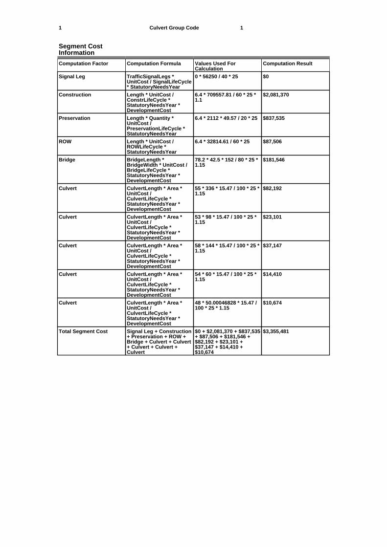
Segment CostInformation
Computation Factor Computation Formula Values Used ForCalculation
Computation Result
Signal Leg TrafficSignalLegs *UnitCost / SignalLifeCycle* StatutoryNeedsYear
0 * 56250 / 40 * 25 $0
Construction Length * UnitCost /ConstrLifeCycle *StatutoryNeedsYear *DevelopmentCost
6.4 * 709557.81 / 60 * 25 *1.1
$2,081,370
Preservation Length * Quantity *UnitCost /PreservationLifeCycle *StatutoryNeedsYear
6.4 * 2112 * 49.57 / 20 * 25 $837,535
ROW Length * UnitCost /ROWLifeCycle *StatutoryNeedsYear
6.4 * 32814.61 / 60 * 25 $87,506
Bridge BridgeLength *BridgeWidth * UnitCost /BridgeLifeCycle *StatutoryNeedsYear *DevelopmentCost
78.2 * 42.5 * 152 / 80 * 25 *1.15
$181,546
Culvert CulvertLength * Area *UnitCost /CulvertLifeCycle *StatutoryNeedsYear *DevelopmentCost
55 * 336 * 15.47 / 100 * 25 *1.15
$82,192
Culvert CulvertLength * Area *UnitCost /CulvertLifeCycle *StatutoryNeedsYear *DevelopmentCost
53 * 98 * 15.47 / 100 * 25 *1.15
$23,101
Culvert CulvertLength * Area *UnitCost /CulvertLifeCycle *StatutoryNeedsYear *DevelopmentCost
58 * 144 * 15.47 / 100 * 25 *1.15
$37,147
Culvert CulvertLength * Area *UnitCost /CulvertLifeCycle *StatutoryNeedsYear *DevelopmentCost
54 * 60 * 15.47 / 100 * 25 *1.15
$14,410
Culvert CulvertLength * Area *UnitCost /CulvertLifeCycle *StatutoryNeedsYear *DevelopmentCost
48 * 50.00046828 * 15.47 /100 * 25 * 1.15
$10,674
Total Segment Cost Signal Leg + Construction+ Preservation + ROW +Bridge + Culvert + Culvert+ Culvert + Culvert +Culvert
$0 + $2,081,370 + $837,535+ $87,506 + $181,546 +$82,192 + $23,101 +$37,147 + $14,410 +$10,674
$3,355,481

SANEEDS - CSAH - Segment Report
Roadway SegmentInformation
Status : Original
County Name : ROCK Segment Nbr : 067-603-040
Original Current
KENNETH Municipality KENNETH
0.39 Segment Length 0.39
MIXED BITUMINOUS Existing Surface Type MIXED BITUMINOUS
2 Existing Surface Lanes 2
NOT DIVIDED Existing Lane Description NOT DIVIDED
S LIM KENNETH TO 0.39 MI N Termini S LIM KENNETH TO 0.39 MI N
473 Present AADT 473
2014 Year of Count 2014
1.1 Projection Factor 1.1
473 Projected Traffic 473
RURAL Design Type RURAL
2 - RURAL : 150 - 1499 Design Group 2 ( RURAL : 150 - 1499 )
2014 Latest Year SA funds 2014
0 Number of Signal Legs 0
No Special Message Special Message Code No Special Message
2014 SAP 067-603-029 M&OL Comments 2014 SAP 067-603-029 M&OL
Interchange Override
Segment Override
Culvert Information Status: Original
Original Current
L2009 Structure Number L2009
17.09 Milepoint 17.09
1934 Year Built 1934
STREAM Feature Crossed STREAM
Type of Service
1 Number of Barrels 1
10 Culvert Width 10
6 Culvert Height 6
36 Culvert Length 36
60.00013138 Area of Waterway Opening 60.00013138
100% Shared Structure 100%
Comments
1 Culvert Group Code 1
Segment CostInformation
Computation Factor Computation Formula Values Used ForCalculation
Computation Result
Signal Leg TrafficSignalLegs *UnitCost / SignalLifeCycle* StatutoryNeedsYear
0 * 56250 / 40 * 25 $0
Construction Length * UnitCost /ConstrLifeCycle *StatutoryNeedsYear *DevelopmentCost
0.39 * 709557.81 / 60 * 25 *1.1
$126,833
Preservation Length * Quantity *UnitCost /PreservationLifeCycle *StatutoryNeedsYear
0.39 * 2112 * 49.57 / 20 * 25 $51,037
ROW Length * UnitCost /ROWLifeCycle *StatutoryNeedsYear
0.39 * 32814.61 / 60 * 25 $5,332
Culvert CulvertLength * Area *UnitCost /CulvertLifeCycle *StatutoryNeedsYear *DevelopmentCost
36 * 60.00013138 * 15.47 /100 * 25 * 1.15
$9,607
Total Segment Cost Signal Leg + Construction+ Preservation + ROW +Culvert
$0 + $126,833 + $51,037 +$5,332 + $9,607
$192,809
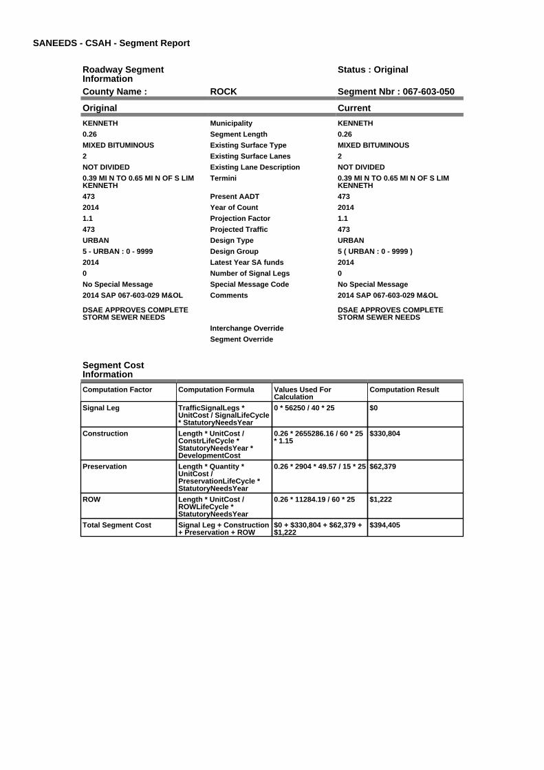
SANEEDS - CSAH - Segment Report
Roadway SegmentInformation
Status : Original
County Name : ROCK Segment Nbr : 067-603-050
Original Current
KENNETH Municipality KENNETH
0.26 Segment Length 0.26
MIXED BITUMINOUS Existing Surface Type MIXED BITUMINOUS
2 Existing Surface Lanes 2
NOT DIVIDED Existing Lane Description NOT DIVIDED
0.39 MI N TO 0.65 MI N OF S LIMKENNETH
Termini 0.39 MI N TO 0.65 MI N OF S LIMKENNETH
473 Present AADT 473
2014 Year of Count 2014
1.1 Projection Factor 1.1
473 Projected Traffic 473
URBAN Design Type URBAN
5 - URBAN : 0 - 9999 Design Group 5 ( URBAN : 0 - 9999 )
2014 Latest Year SA funds 2014
0 Number of Signal Legs 0
No Special Message Special Message Code No Special Message
2014 SAP 067-603-029 M&OL
DSAE APPROVES COMPLETESTORM SEWER NEEDS
Comments 2014 SAP 067-603-029 M&OL
DSAE APPROVES COMPLETESTORM SEWER NEEDS
Interchange Override
Segment Override
Segment CostInformation
Computation Factor Computation Formula Values Used ForCalculation
Computation Result
Signal Leg TrafficSignalLegs *UnitCost / SignalLifeCycle* StatutoryNeedsYear
0 * 56250 / 40 * 25 $0
Construction Length * UnitCost /ConstrLifeCycle *StatutoryNeedsYear *DevelopmentCost
0.26 * 2655286.16 / 60 * 25* 1.15
$330,804
Preservation Length * Quantity *UnitCost /PreservationLifeCycle *StatutoryNeedsYear
0.26 * 2904 * 49.57 / 15 * 25 $62,379
ROW Length * UnitCost /ROWLifeCycle *StatutoryNeedsYear
0.26 * 11284.19 / 60 * 25 $1,222
Total Segment Cost Signal Leg + Construction+ Preservation + ROW
$0 + $330,804 + $62,379 +$1,222
$394,405

SANEEDS - CSAH - Segment Report
Roadway SegmentInformation
Status : Original
County Name : ROCK Segment Nbr : 067-603-060
Original Current
KENNETH Municipality KENNETH
0.6 Segment Length 0.6
BIT CONC OR ASPH Existing Surface Type BIT CONC OR ASPH
2 Existing Surface Lanes 2
NOT DIVIDED Existing Lane Description NOT DIVIDED
0.65 MI N OF S LIMS TO N LIMKENNETH
Termini 0.65 MI N OF S LIMS TO N LIMKENNETH
402 Present AADT 402
2014 Year of Count 2014
1.1 Projection Factor 1.1
402 Projected Traffic 402
RURAL Design Type RURAL
2 - RURAL : 150 - 1499 Design Group 2 ( RURAL : 150 - 1499 )
2014 Latest Year SA funds 2014
0 Number of Signal Legs 0
No Special Message Special Message Code No Special Message
2014 SAP 067-603-029 M&OL Comments 2014 SAP 067-603-029 M&OL
Interchange Override
Segment Override
Segment CostInformation
Computation Factor Computation Formula Values Used ForCalculation
Computation Result
Signal Leg TrafficSignalLegs *UnitCost / SignalLifeCycle* StatutoryNeedsYear
0 * 56250 / 40 * 25 $0
Construction Length * UnitCost /ConstrLifeCycle *StatutoryNeedsYear *DevelopmentCost
0.6 * 709557.81 / 60 * 25 *1.1
$195,128
Preservation Length * Quantity *UnitCost /PreservationLifeCycle *StatutoryNeedsYear
0.6 * 2112 * 49.57 / 20 * 25 $78,519
ROW Length * UnitCost /ROWLifeCycle *StatutoryNeedsYear
0.6 * 32814.61 / 60 * 25 $8,204
Total Segment Cost Signal Leg + Construction+ Preservation + ROW
$0 + $195,128 + $78,519 +$8,204
$281,851

SANEEDS - CSAH - Segment Report
Roadway SegmentInformation
Status : Original
County Name : ROCK Segment Nbr : 067-603-070
Original Current
Unassigned/Unknown Municipality Unassigned/Unknown
0.8 Segment Length 0.8
BIT CONC OR ASPH Existing Surface Type BIT CONC OR ASPH
2 Existing Surface Lanes 2
NOT DIVIDED Existing Lane Description NOT DIVIDED
N LIM KENNETH TO CSAH 7 Termini N LIM KENNETH TO CSAH 7
402 Present AADT 402
2014 Year of Count 2014
1.1 Projection Factor 1.1
402 Projected Traffic 402
RURAL Design Type RURAL
2 - RURAL : 150 - 1499 Design Group 2 ( RURAL : 150 - 1499 )
1999 Latest Year SA funds 1999
0 Number of Signal Legs 0
No Special Message Special Message Code No Special Message
Comments
Interchange Override
Segment Override
Segment CostInformation
Computation Factor Computation Formula Values Used ForCalculation
Computation Result
Signal Leg TrafficSignalLegs *UnitCost / SignalLifeCycle* StatutoryNeedsYear
0 * 56250 / 40 * 25 $0
Construction Length * UnitCost /ConstrLifeCycle *StatutoryNeedsYear *DevelopmentCost
0.8 * 709557.81 / 60 * 25 *1.1
$260,171
Preservation Length * Quantity *UnitCost /PreservationLifeCycle *StatutoryNeedsYear
0.8 * 2112 * 49.57 / 20 * 25 $104,692
ROW Length * UnitCost /ROWLifeCycle *StatutoryNeedsYear
0.8 * 32814.61 / 60 * 25 $10,938
Total Segment Cost Signal Leg + Construction+ Preservation + ROW
$0 + $260,171 + $104,692+ $10,938
$375,801
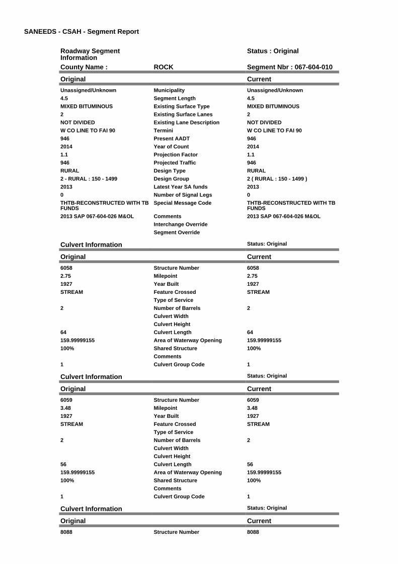
SANEEDS - CSAH - Segment Report
Roadway SegmentInformation
Status : Original
County Name : ROCK Segment Nbr : 067-604-010
Original Current
Unassigned/Unknown Municipality Unassigned/Unknown
4.5 Segment Length 4.5
MIXED BITUMINOUS Existing Surface Type MIXED BITUMINOUS
2 Existing Surface Lanes 2
NOT DIVIDED Existing Lane Description NOT DIVIDED
W CO LINE TO FAI 90 Termini W CO LINE TO FAI 90
946 Present AADT 946
2014 Year of Count 2014
1.1 Projection Factor 1.1
946 Projected Traffic 946
RURAL Design Type RURAL
2 - RURAL : 150 - 1499 Design Group 2 ( RURAL : 150 - 1499 )
2013 Latest Year SA funds 2013
0 Number of Signal Legs 0
THTB-RECONSTRUCTED WITH TBFUNDS
Special Message Code THTB-RECONSTRUCTED WITH TBFUNDS
2013 SAP 067-604-026 M&OL Comments 2013 SAP 067-604-026 M&OL
Interchange Override
Segment Override
Culvert Information Status: Original
Original Current
6058 Structure Number 6058
2.75 Milepoint 2.75
1927 Year Built 1927
STREAM Feature Crossed STREAM
Type of Service
2 Number of Barrels 2
Culvert Width
Culvert Height
64 Culvert Length 64
159.99999155 Area of Waterway Opening 159.99999155
100% Shared Structure 100%
Comments
1 Culvert Group Code 1
Culvert Information Status: Original
Original Current
6059 Structure Number 6059
3.48 Milepoint 3.48
1927 Year Built 1927
STREAM Feature Crossed STREAM
Type of Service
2 Number of Barrels 2
Culvert Width
Culvert Height
56 Culvert Length 56
159.99999155 Area of Waterway Opening 159.99999155
100% Shared Structure 100%
Comments
1 Culvert Group Code 1
Culvert Information Status: Original
Original Current
8088 Structure Number 8088
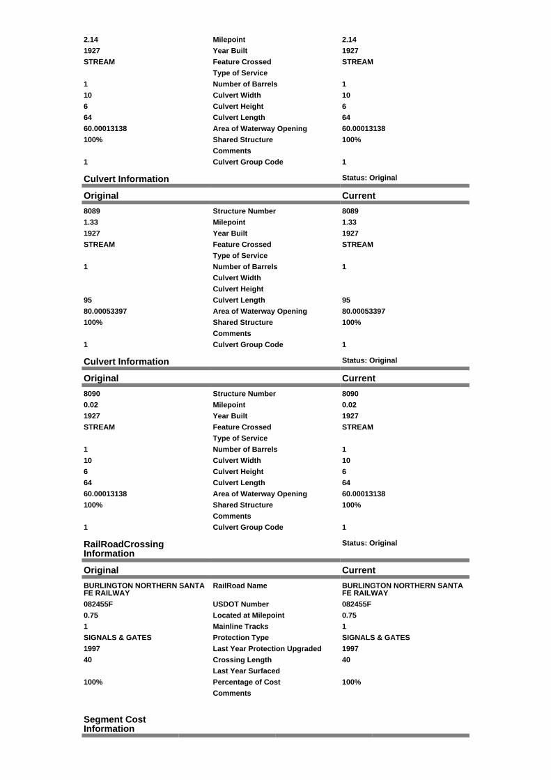
2.14 Milepoint 2.14
1927 Year Built 1927
STREAM Feature Crossed STREAM
Type of Service
1 Number of Barrels 1
10 Culvert Width 10
6 Culvert Height 6
64 Culvert Length 64
60.00013138 Area of Waterway Opening 60.00013138
100% Shared Structure 100%
Comments
1 Culvert Group Code 1
Culvert Information Status: Original
Original Current
8089 Structure Number 8089
1.33 Milepoint 1.33
1927 Year Built 1927
STREAM Feature Crossed STREAM
Type of Service
1 Number of Barrels 1
Culvert Width
Culvert Height
95 Culvert Length 95
80.00053397 Area of Waterway Opening 80.00053397
100% Shared Structure 100%
Comments
1 Culvert Group Code 1
Culvert Information Status: Original
Original Current
8090 Structure Number 8090
0.02 Milepoint 0.02
1927 Year Built 1927
STREAM Feature Crossed STREAM
Type of Service
1 Number of Barrels 1
10 Culvert Width 10
6 Culvert Height 6
64 Culvert Length 64
60.00013138 Area of Waterway Opening 60.00013138
100% Shared Structure 100%
Comments
1 Culvert Group Code 1
RailRoadCrossingInformation
Status: Original
Original Current
BURLINGTON NORTHERN SANTAFE RAILWAY
RailRoad Name BURLINGTON NORTHERN SANTAFE RAILWAY
082455F USDOT Number 082455F
0.75 Located at Milepoint 0.75
1 Mainline Tracks 1
SIGNALS & GATES Protection Type SIGNALS & GATES
1997 Last Year Protection Upgraded 1997
40 Crossing Length 40
Last Year Surfaced
100% Percentage of Cost 100%
Comments
Segment CostInformation

Computation Factor Computation Formula Values Used ForCalculation
Computation Result
Signal Leg TrafficSignalLegs *UnitCost / SignalLifeCycle* StatutoryNeedsYear
0 * 56250 / 40 * 25 $0
Construction Length * UnitCost /ConstrLifeCycle *StatutoryNeedsYear *DevelopmentCost
4.5 * 709557.81 / 60 * 25 *1.1
$1,463,463
Preservation Length * Quantity *UnitCost /PreservationLifeCycle *StatutoryNeedsYear
4.5 * 2112 * 49.57 / 20 * 25 $588,892
ROW Length * UnitCost /ROWLifeCycle *StatutoryNeedsYear
4.5 * 32814.61 / 60 * 25 $61,527
Culvert CulvertLength * Area *UnitCost /CulvertLifeCycle *StatutoryNeedsYear *DevelopmentCost
64 * 159.99999155 * 15.47 /100 * 25 * 1.15
$45,544
Culvert CulvertLength * Area *UnitCost /CulvertLifeCycle *StatutoryNeedsYear *DevelopmentCost
56 * 159.99999155 * 15.47 /100 * 25 * 1.15
$39,851
Culvert CulvertLength * Area *UnitCost /CulvertLifeCycle *StatutoryNeedsYear *DevelopmentCost
64 * 60.00013138 * 15.47 /100 * 25 * 1.15
$17,079
Culvert CulvertLength * Area *UnitCost /CulvertLifeCycle *StatutoryNeedsYear *DevelopmentCost
95 * 80.00053397 * 15.47 /100 * 25 * 1.15
$33,802
Culvert CulvertLength * Area *UnitCost /CulvertLifeCycle *StatutoryNeedsYear *DevelopmentCost
64 * 60.00013138 * 15.47 /100 * 25 * 1.15
$17,079
RR Crossing Protection UnitCost /RRCrossingLifeCycle *StatutoryNeedsYear
325000 / 25 * 25 $325,000
RR Crossing Surface SurfaceLength * UnitCost/ RRCrossingLifeCycle *StatutoryNeedsYear
40 * 1350 / 25 * 25 $54,000
Total Segment Cost Signal Leg + Construction+ Preservation + ROW +Culvert + Culvert +Culvert + Culvert +Culvert + RR CrossingProtection + RR CrossingSurface
$0 + $1,463,463 + $588,892+ $61,527 + $45,544 +$39,851 + $17,079 +$33,802 + $17,079 +$325,000 + $54,000
$2,646,237

SANEEDS - CSAH - Segment Report
Roadway SegmentInformation
Status : Original
County Name : ROCK Segment Nbr : 067-604-021
Original Current
Unassigned/Unknown Municipality Unassigned/Unknown
0.4 Segment Length 0.4
MIXED BITUMINOUS Existing Surface Type MIXED BITUMINOUS
2 Existing Surface Lanes 2
NOT DIVIDED Existing Lane Description NOT DIVIDED
FAI 90 TO W LIM BEAVER CREEK Termini FAI 90 TO W LIM BEAVER CREEK
1067 Present AADT 1067
2014 Year of Count 2014
1.1 Projection Factor 1.1
1067 Projected Traffic 1067
RURAL Design Type RURAL
2 - RURAL : 150 - 1499 Design Group 2 ( RURAL : 150 - 1499 )
2013 Latest Year SA funds 2013
0 Number of Signal Legs 0
THTB-RECONSTRUCTED WITH TBFUNDS
Special Message Code THTB-RECONSTRUCTED WITH TBFUNDS
2013 SAP 067-604-026 M&OL Comments 2013 SAP 067-604-026 M&OL
Interchange Override
Segment Override
Segment CostInformation
Computation Factor Computation Formula Values Used ForCalculation
Computation Result
Signal Leg TrafficSignalLegs *UnitCost / SignalLifeCycle* StatutoryNeedsYear
0 * 56250 / 40 * 25 $0
Construction Length * UnitCost /ConstrLifeCycle *StatutoryNeedsYear *DevelopmentCost
0.4 * 709557.81 / 60 * 25 *1.1
$130,086
Preservation Length * Quantity *UnitCost /PreservationLifeCycle *StatutoryNeedsYear
0.4 * 2112 * 49.57 / 20 * 25 $52,346
ROW Length * UnitCost /ROWLifeCycle *StatutoryNeedsYear
0.4 * 32814.61 / 60 * 25 $5,469
Total Segment Cost Signal Leg + Construction+ Preservation + ROW
$0 + $130,086 + $52,346 +$5,469
$187,901

SANEEDS - CSAH - Segment Report
Roadway SegmentInformation
Status : Original
County Name : ROCK Segment Nbr : 067-604-022
Original Current
BEAVER CREEK Municipality BEAVER CREEK
1.12 Segment Length 1.12
MIXED BITUMINOUS Existing Surface Type MIXED BITUMINOUS
2 Existing Surface Lanes 2
NOT DIVIDED Existing Lane Description NOT DIVIDED
W LIM TO E LIM BEAVER CREEK Termini W LIM TO E LIM BEAVER CREEK
1067 Present AADT 1067
2014 Year of Count 2014
1.1 Projection Factor 1.1
1067 Projected Traffic 1067
RURAL Design Type RURAL
2 - RURAL : 150 - 1499 Design Group 2 ( RURAL : 150 - 1499 )
2013 Latest Year SA funds 2013
0 Number of Signal Legs 0
THTB-RECONSTRUCTED WITH TBFUNDS
Special Message Code THTB-RECONSTRUCTED WITH TBFUNDS
2013 SAP 067-604-026 M&OL Comments 2013 SAP 067-604-026 M&OL
Interchange Override
Segment Override
Culvert Information Status: Original
Original Current
67J30 Structure Number 67J30
5.353 Milepoint 5.353
1999 Year Built 1999
SPRING BROOK Feature Crossed SPRING BROOK
Type of Service
2 Number of Barrels 2
12 Culvert Width 12
9 Culvert Height 9
74 Culvert Length 74
216.00025769 Area of Waterway Opening 216.00025769
100% Shared Structure 100%
Comments
1 Culvert Group Code 1
Segment CostInformation
Computation Factor Computation Formula Values Used ForCalculation
Computation Result
Signal Leg TrafficSignalLegs *UnitCost / SignalLifeCycle* StatutoryNeedsYear
0 * 56250 / 40 * 25 $0
Construction Length * UnitCost /ConstrLifeCycle *StatutoryNeedsYear *DevelopmentCost
1.12 * 709557.81 / 60 * 25 *1.1
$364,240
Preservation Length * Quantity *UnitCost /PreservationLifeCycle *StatutoryNeedsYear
1.12 * 2112 * 49.57 / 20 * 25 $146,569
ROW Length * UnitCost /ROWLifeCycle *StatutoryNeedsYear
1.12 * 32814.61 / 60 * 25 $15,313
Culvert CulvertLength * Area *UnitCost /CulvertLifeCycle *StatutoryNeedsYear *DevelopmentCost
74 * 216.00025769 * 15.47 /100 * 25 * 1.15
$71,091

Total Segment Cost Signal Leg + Construction+ Preservation + ROW +Culvert
$0 + $364,240 + $146,569+ $15,313 + $71,091
$597,213

SANEEDS - CSAH - Segment Report
Roadway SegmentInformation
Status : Original
County Name : ROCK Segment Nbr : 067-604-023
Original Current
Unassigned/Unknown Municipality Unassigned/Unknown
4.2 Segment Length 4.2
MIXED BITUMINOUS Existing Surface Type MIXED BITUMINOUS
2 Existing Surface Lanes 2
NOT DIVIDED Existing Lane Description NOT DIVIDED
E LIM BEAVER CREEK TO CSAH11
Termini E LIM BEAVER CREEK TO CSAH11
1067 Present AADT 1067
2014 Year of Count 2014
1.1 Projection Factor 1.1
1067 Projected Traffic 1067
RURAL Design Type RURAL
2 - RURAL : 150 - 1499 Design Group 2 ( RURAL : 150 - 1499 )
2006 Latest Year SA funds 2006
0 Number of Signal Legs 0
THTB-RECONSTRUCTED WITH TBFUNDS
Special Message Code THTB-RECONSTRUCTED WITH TBFUNDS
RESURFACED UNDER SAP 67-604-024
Comments RESURFACED UNDER SAP 67-604-024
Interchange Override
Segment Override
Culvert Information Status: Original
Original Current
6056 Structure Number 6056
7.901 Milepoint 7.901
1927 Year Built 1927
STREAM Feature Crossed STREAM
Type of Service
2 Number of Barrels 2
Culvert Width
Culvert Height
84 Culvert Length 84
99.99986017 Area of Waterway Opening 99.99986017
100% Shared Structure 100%
Comments
1 Culvert Group Code 1
Culvert Information Status: Original
Original Current
6057 Structure Number 6057
8.939 Milepoint 8.939
1927 Year Built 1927
STREAM Feature Crossed STREAM
Type of Service
2 Number of Barrels 2
Culvert Width
Culvert Height
87 Culvert Length 87
99.99986017 Area of Waterway Opening 99.99986017
100% Shared Structure 100%
Comments
1 Culvert Group Code 1
Culvert Information Status: Original
Original Current
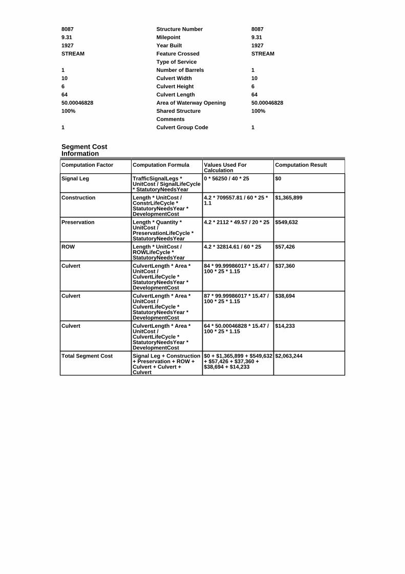
8087 Structure Number 8087
9.31 Milepoint 9.31
1927 Year Built 1927
STREAM Feature Crossed STREAM
Type of Service
1 Number of Barrels 1
10 Culvert Width 10
6 Culvert Height 6
64 Culvert Length 64
50.00046828 Area of Waterway Opening 50.00046828
100% Shared Structure 100%
Comments
1 Culvert Group Code 1
Segment CostInformation
Computation Factor Computation Formula Values Used ForCalculation
Computation Result
Signal Leg TrafficSignalLegs *UnitCost / SignalLifeCycle* StatutoryNeedsYear
0 * 56250 / 40 * 25 $0
Construction Length * UnitCost /ConstrLifeCycle *StatutoryNeedsYear *DevelopmentCost
4.2 * 709557.81 / 60 * 25 *1.1
$1,365,899
Preservation Length * Quantity *UnitCost /PreservationLifeCycle *StatutoryNeedsYear
4.2 * 2112 * 49.57 / 20 * 25 $549,632
ROW Length * UnitCost /ROWLifeCycle *StatutoryNeedsYear
4.2 * 32814.61 / 60 * 25 $57,426
Culvert CulvertLength * Area *UnitCost /CulvertLifeCycle *StatutoryNeedsYear *DevelopmentCost
84 * 99.99986017 * 15.47 /100 * 25 * 1.15
$37,360
Culvert CulvertLength * Area *UnitCost /CulvertLifeCycle *StatutoryNeedsYear *DevelopmentCost
87 * 99.99986017 * 15.47 /100 * 25 * 1.15
$38,694
Culvert CulvertLength * Area *UnitCost /CulvertLifeCycle *StatutoryNeedsYear *DevelopmentCost
64 * 50.00046828 * 15.47 /100 * 25 * 1.15
$14,233
Total Segment Cost Signal Leg + Construction+ Preservation + ROW +Culvert + Culvert +Culvert
$0 + $1,365,899 + $549,632+ $57,426 + $37,360 +$38,694 + $14,233
$2,063,244
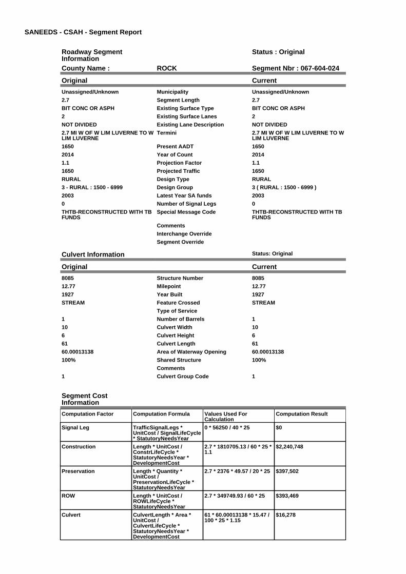
SANEEDS - CSAH - Segment Report
Roadway SegmentInformation
Status : Original
County Name : ROCK Segment Nbr : 067-604-024
Original Current
Unassigned/Unknown Municipality Unassigned/Unknown
2.7 Segment Length 2.7
BIT CONC OR ASPH Existing Surface Type BIT CONC OR ASPH
2 Existing Surface Lanes 2
NOT DIVIDED Existing Lane Description NOT DIVIDED
2.7 MI W OF W LIM LUVERNE TO WLIM LUVERNE
Termini 2.7 MI W OF W LIM LUVERNE TO WLIM LUVERNE
1650 Present AADT 1650
2014 Year of Count 2014
1.1 Projection Factor 1.1
1650 Projected Traffic 1650
RURAL Design Type RURAL
3 - RURAL : 1500 - 6999 Design Group 3 ( RURAL : 1500 - 6999 )
2003 Latest Year SA funds 2003
0 Number of Signal Legs 0
THTB-RECONSTRUCTED WITH TBFUNDS
Special Message Code THTB-RECONSTRUCTED WITH TBFUNDS
Comments
Interchange Override
Segment Override
Culvert Information Status: Original
Original Current
8085 Structure Number 8085
12.77 Milepoint 12.77
1927 Year Built 1927
STREAM Feature Crossed STREAM
Type of Service
1 Number of Barrels 1
10 Culvert Width 10
6 Culvert Height 6
61 Culvert Length 61
60.00013138 Area of Waterway Opening 60.00013138
100% Shared Structure 100%
Comments
1 Culvert Group Code 1
Segment CostInformation
Computation Factor Computation Formula Values Used ForCalculation
Computation Result
Signal Leg TrafficSignalLegs *UnitCost / SignalLifeCycle* StatutoryNeedsYear
0 * 56250 / 40 * 25 $0
Construction Length * UnitCost /ConstrLifeCycle *StatutoryNeedsYear *DevelopmentCost
2.7 * 1810705.13 / 60 * 25 *1.1
$2,240,748
Preservation Length * Quantity *UnitCost /PreservationLifeCycle *StatutoryNeedsYear
2.7 * 2376 * 49.57 / 20 * 25 $397,502
ROW Length * UnitCost /ROWLifeCycle *StatutoryNeedsYear
2.7 * 349749.93 / 60 * 25 $393,469
Culvert CulvertLength * Area *UnitCost /CulvertLifeCycle *StatutoryNeedsYear *DevelopmentCost
61 * 60.00013138 * 15.47 /100 * 25 * 1.15
$16,278

Total Segment Cost Signal Leg + Construction+ Preservation + ROW +Culvert
$0 + $2,240,748 + $397,502+ $393,469 + $16,278
$3,047,997
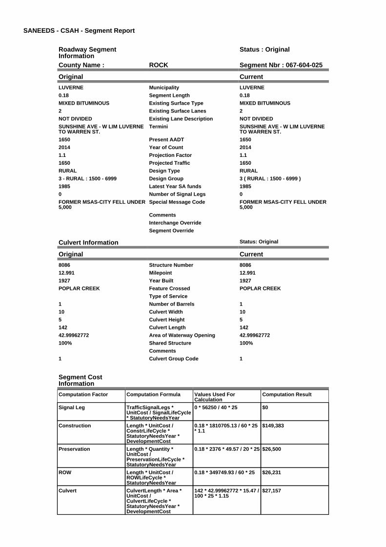
SANEEDS - CSAH - Segment Report
Roadway SegmentInformation
Status : Original
County Name : ROCK Segment Nbr : 067-604-025
Original Current
LUVERNE Municipality LUVERNE
0.18 Segment Length 0.18
MIXED BITUMINOUS Existing Surface Type MIXED BITUMINOUS
2 Existing Surface Lanes 2
NOT DIVIDED Existing Lane Description NOT DIVIDED
SUNSHINE AVE - W LIM LUVERNETO WARREN ST.
Termini SUNSHINE AVE - W LIM LUVERNETO WARREN ST.
1650 Present AADT 1650
2014 Year of Count 2014
1.1 Projection Factor 1.1
1650 Projected Traffic 1650
RURAL Design Type RURAL
3 - RURAL : 1500 - 6999 Design Group 3 ( RURAL : 1500 - 6999 )
1985 Latest Year SA funds 1985
0 Number of Signal Legs 0
FORMER MSAS-CITY FELL UNDER5,000
Special Message Code FORMER MSAS-CITY FELL UNDER5,000
Comments
Interchange Override
Segment Override
Culvert Information Status: Original
Original Current
8086 Structure Number 8086
12.991 Milepoint 12.991
1927 Year Built 1927
POPLAR CREEK Feature Crossed POPLAR CREEK
Type of Service
1 Number of Barrels 1
10 Culvert Width 10
5 Culvert Height 5
142 Culvert Length 142
42.99962772 Area of Waterway Opening 42.99962772
100% Shared Structure 100%
Comments
1 Culvert Group Code 1
Segment CostInformation
Computation Factor Computation Formula Values Used ForCalculation
Computation Result
Signal Leg TrafficSignalLegs *UnitCost / SignalLifeCycle* StatutoryNeedsYear
0 * 56250 / 40 * 25 $0
Construction Length * UnitCost /ConstrLifeCycle *StatutoryNeedsYear *DevelopmentCost
0.18 * 1810705.13 / 60 * 25* 1.1
$149,383
Preservation Length * Quantity *UnitCost /PreservationLifeCycle *StatutoryNeedsYear
0.18 * 2376 * 49.57 / 20 * 25 $26,500
ROW Length * UnitCost /ROWLifeCycle *StatutoryNeedsYear
0.18 * 349749.93 / 60 * 25 $26,231
Culvert CulvertLength * Area *UnitCost /CulvertLifeCycle *StatutoryNeedsYear *DevelopmentCost
142 * 42.99962772 * 15.47 /100 * 25 * 1.15
$27,157

Total Segment Cost Signal Leg + Construction+ Preservation + ROW +Culvert
$0 + $149,383 + $26,500 +$26,231 + $27,157
$229,271

SANEEDS - CSAH - Segment Report
Roadway SegmentInformation
Status : Original
County Name : ROCK Segment Nbr : 067-604-026
Original Current
LUVERNE Municipality LUVERNE
0.11 Segment Length 0.11
MIXED BITUMINOUS Existing Surface Type MIXED BITUMINOUS
2 Existing Surface Lanes 2
NOT DIVIDED Existing Lane Description NOT DIVIDED
SUNSHINE AVE - WARREN ST. TOMAIN ST.
Termini SUNSHINE AVE - WARREN ST. TOMAIN ST.
1650 Present AADT 1650
2014 Year of Count 2014
1.1 Projection Factor 1.1
1650 Projected Traffic 1650
URBAN Design Type URBAN
5 - URBAN : 0 - 9999 Design Group 5 ( URBAN : 0 - 9999 )
1985 Latest Year SA funds 1985
0 Number of Signal Legs 0
FORMER MSAS-CITY FELL UNDER5,000
Special Message Code FORMER MSAS-CITY FELL UNDER5,000
Comments
Interchange Override
Segment Override
Segment CostInformation
Computation Factor Computation Formula Values Used ForCalculation
Computation Result
Signal Leg TrafficSignalLegs *UnitCost / SignalLifeCycle* StatutoryNeedsYear
0 * 56250 / 40 * 25 $0
Construction Length * UnitCost /ConstrLifeCycle *StatutoryNeedsYear *DevelopmentCost
0.11 * 2655286.16 / 60 * 25* 1.15
$139,956
Preservation Length * Quantity *UnitCost /PreservationLifeCycle *StatutoryNeedsYear
0.11 * 2904 * 49.57 / 15 * 25 $26,391
ROW Length * UnitCost /ROWLifeCycle *StatutoryNeedsYear
0.11 * 11284.19 / 60 * 25 $517
Total Segment Cost Signal Leg + Construction+ Preservation + ROW
$0 + $139,956 + $26,391 +$517
$166,864

SANEEDS - CSAH - Segment Report
Roadway SegmentInformation
Status : Original
County Name : ROCK Segment Nbr : 067-604-027
Original Current
LUVERNE Municipality LUVERNE
0.39 Segment Length 0.39
MIXED BITUMINOUS Existing Surface Type MIXED BITUMINOUS
2 Existing Surface Lanes 2
NOT DIVIDED Existing Lane Description NOT DIVIDED
MAIN ST - SUNSHINE AV TO KNISSAVE
Termini MAIN ST - SUNSHINE AV TO KNISSAVE
3135 Present AADT 3135
2014 Year of Count 2014
1.1 Projection Factor 1.1
3135 Projected Traffic 3135
URBAN Design Type URBAN
5 - URBAN : 0 - 9999 Design Group 5 ( URBAN : 0 - 9999 )
1985 Latest Year SA funds 1985
1 Number of Signal Legs 1
No Special Message Special Message Code No Special Message
Comments
Interchange Override
Segment Override
Segment CostInformation
Computation Factor Computation Formula Values Used ForCalculation
Computation Result
Signal Leg TrafficSignalLegs *UnitCost / SignalLifeCycle* StatutoryNeedsYear
1 * 56250 / 40 * 25 $35,156
Construction Length * UnitCost /ConstrLifeCycle *StatutoryNeedsYear *DevelopmentCost
0.39 * 2655286.16 / 60 * 25* 1.15
$496,207
Preservation Length * Quantity *UnitCost /PreservationLifeCycle *StatutoryNeedsYear
0.39 * 2904 * 49.57 / 15 * 25 $93,568
ROW Length * UnitCost /ROWLifeCycle *StatutoryNeedsYear
0.39 * 11284.19 / 60 * 25 $1,834
Total Segment Cost Signal Leg + Construction+ Preservation + ROW
$35,156 + $496,207 +$93,568 + $1,834
$626,765
SANEEDS - CSAH - Segment Report
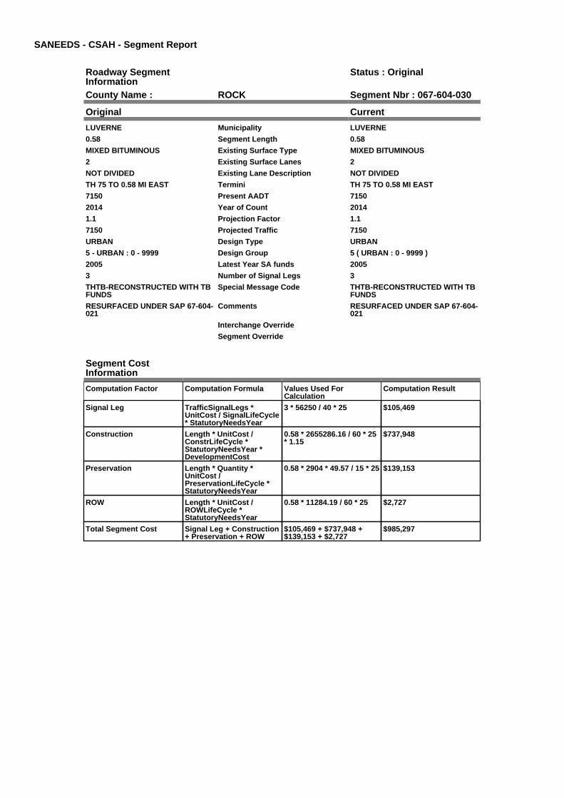
Roadway SegmentInformation
Status : Original
County Name : ROCK Segment Nbr : 067-604-030
Original Current
LUVERNE Municipality LUVERNE
0.58 Segment Length 0.58
MIXED BITUMINOUS Existing Surface Type MIXED BITUMINOUS
2 Existing Surface Lanes 2
NOT DIVIDED Existing Lane Description NOT DIVIDED
TH 75 TO 0.58 MI EAST Termini TH 75 TO 0.58 MI EAST
7150 Present AADT 7150
2014 Year of Count 2014
1.1 Projection Factor 1.1
7150 Projected Traffic 7150
URBAN Design Type URBAN
5 - URBAN : 0 - 9999 Design Group 5 ( URBAN : 0 - 9999 )
2005 Latest Year SA funds 2005
3 Number of Signal Legs 3
THTB-RECONSTRUCTED WITH TBFUNDS
Special Message Code THTB-RECONSTRUCTED WITH TBFUNDS
RESURFACED UNDER SAP 67-604-021
Comments RESURFACED UNDER SAP 67-604-021
Interchange Override
Segment Override
Segment CostInformation
Computation Factor Computation Formula Values Used ForCalculation
Computation Result
Signal Leg TrafficSignalLegs *UnitCost / SignalLifeCycle* StatutoryNeedsYear
3 * 56250 / 40 * 25 $105,469
Construction Length * UnitCost /ConstrLifeCycle *StatutoryNeedsYear *DevelopmentCost
0.58 * 2655286.16 / 60 * 25* 1.15
$737,948
Preservation Length * Quantity *UnitCost /PreservationLifeCycle *StatutoryNeedsYear
0.58 * 2904 * 49.57 / 15 * 25 $139,153
ROW Length * UnitCost /ROWLifeCycle *StatutoryNeedsYear
0.58 * 11284.19 / 60 * 25 $2,727
Total Segment Cost Signal Leg + Construction+ Preservation + ROW
$105,469 + $737,948 +$139,153 + $2,727
$985,297
SANEEDS - CSAH - Segment Report
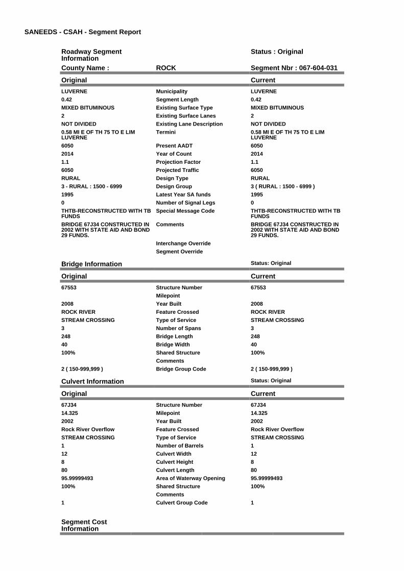
Roadway SegmentInformation
Status : Original
County Name : ROCK Segment Nbr : 067-604-031
Original Current
LUVERNE Municipality LUVERNE
0.42 Segment Length 0.42
MIXED BITUMINOUS Existing Surface Type MIXED BITUMINOUS
2 Existing Surface Lanes 2
NOT DIVIDED Existing Lane Description NOT DIVIDED
0.58 MI E OF TH 75 TO E LIMLUVERNE
Termini 0.58 MI E OF TH 75 TO E LIMLUVERNE
6050 Present AADT 6050
2014 Year of Count 2014
1.1 Projection Factor 1.1
6050 Projected Traffic 6050
RURAL Design Type RURAL
3 - RURAL : 1500 - 6999 Design Group 3 ( RURAL : 1500 - 6999 )
1995 Latest Year SA funds 1995
0 Number of Signal Legs 0
THTB-RECONSTRUCTED WITH TBFUNDS
Special Message Code THTB-RECONSTRUCTED WITH TBFUNDS
BRIDGE 67J34 CONSTRUCTED IN2002 WITH STATE AID AND BOND29 FUNDS.
Comments BRIDGE 67J34 CONSTRUCTED IN2002 WITH STATE AID AND BOND29 FUNDS.
Interchange Override
Segment Override
Bridge Information Status: Original
Original Current
67553 Structure Number 67553
Milepoint
2008 Year Built 2008
ROCK RIVER Feature Crossed ROCK RIVER
STREAM CROSSING Type of Service STREAM CROSSING
3 Number of Spans 3
248 Bridge Length 248
40 Bridge Width 40
100% Shared Structure 100%
Comments
2 ( 150-999,999 ) Bridge Group Code 2 ( 150-999,999 )
Culvert Information Status: Original
Original Current
67J34 Structure Number 67J34
14.325 Milepoint 14.325
2002 Year Built 2002
Rock River Overflow Feature Crossed Rock River Overflow
STREAM CROSSING Type of Service STREAM CROSSING
1 Number of Barrels 1
12 Culvert Width 12
8 Culvert Height 8
80 Culvert Length 80
95.99999493 Area of Waterway Opening 95.99999493
100% Shared Structure 100%
Comments
1 Culvert Group Code 1
Segment CostInformation

Computation Factor Computation Formula Values Used ForCalculation
Computation Result
Signal Leg TrafficSignalLegs *UnitCost / SignalLifeCycle* StatutoryNeedsYear
0 * 56250 / 40 * 25 $0
Construction Length * UnitCost /ConstrLifeCycle *StatutoryNeedsYear *DevelopmentCost
0.42 * 1810705.13 / 60 * 25* 1.1
$348,561
Preservation Length * Quantity *UnitCost /PreservationLifeCycle *StatutoryNeedsYear
0.42 * 2376 * 49.57 / 20 * 25 $61,834
ROW Length * UnitCost /ROWLifeCycle *StatutoryNeedsYear
0.42 * 349749.93 / 60 * 25 $61,206
Bridge BridgeLength *BridgeWidth * UnitCost /BridgeLifeCycle *StatutoryNeedsYear *DevelopmentCost
248 * 40 * 138 / 80 * 25 *1.15
$491,970
Culvert CulvertLength * Area *UnitCost /CulvertLifeCycle *StatutoryNeedsYear *DevelopmentCost
80 * 95.99999493 * 15.47 /100 * 25 * 1.15
$34,158
Total Segment Cost Signal Leg + Construction+ Preservation + ROW +Bridge + Culvert
$0 + $348,561 + $61,834 +$61,206 + $491,970 +$34,158
$997,729

SANEEDS - CSAH - Segment Report
Roadway SegmentInformation
Status : Original
County Name : ROCK Segment Nbr : 067-604-040
Original Current
Unassigned/Unknown Municipality Unassigned/Unknown
2.6 Segment Length 2.6
MIXED BITUMINOUS Existing Surface Type MIXED BITUMINOUS
2 Existing Surface Lanes 2
NOT DIVIDED Existing Lane Description NOT DIVIDED
E LIM LUVERNE TO 2.60 MILESEAST
Termini E LIM LUVERNE TO 2.60 MILESEAST
3190 Present AADT 3190
2014 Year of Count 2014
1.1 Projection Factor 1.1
3190 Projected Traffic 3190
RURAL Design Type RURAL
3 - RURAL : 1500 - 6999 Design Group 3 ( RURAL : 1500 - 6999 )
2014 Latest Year SA funds 2014
0 Number of Signal Legs 0
THTB-RECONSTRUCTED WITH TBFUNDS
Special Message Code THTB-RECONSTRUCTED WITH TBFUNDS
2014 SAP 067-604-027MICROSURFACING
Comments 2014 SAP 067-604-027MICROSURFACING
Interchange Override
Segment Override
Bridge Information Status: Original
Original Current
67544 Structure Number 67544
14.525 Milepoint 14.525
2002 Year Built 2002
Rock River Overflow Feature Crossed Rock River Overflow
STREAM CROSSING Type of Service STREAM CROSSING
3 Number of Spans 3
112.5 Bridge Length 112.5
47.3 Bridge Width 47.3
100% Shared Structure 100%
Comments
1 ( 0-149 ) Bridge Group Code 1 ( 0-149 )
Segment CostInformation
Computation Factor Computation Formula Values Used ForCalculation
Computation Result
Signal Leg TrafficSignalLegs *UnitCost / SignalLifeCycle* StatutoryNeedsYear
0 * 56250 / 40 * 25 $0
Construction Length * UnitCost /ConstrLifeCycle *StatutoryNeedsYear *DevelopmentCost
2.6 * 1810705.13 / 60 * 25 *1.1
$2,157,757
Preservation Length * Quantity *UnitCost /PreservationLifeCycle *StatutoryNeedsYear
2.6 * 2376 * 49.57 / 20 * 25 $382,780
ROW Length * UnitCost /ROWLifeCycle *StatutoryNeedsYear
2.6 * 349749.93 / 60 * 25 $378,896
Bridge BridgeLength *BridgeWidth * UnitCost /BridgeLifeCycle *StatutoryNeedsYear *DevelopmentCost
112.5 * 47.3 * 152 / 80 * 25* 1.15
$290,673
Total Segment Cost Signal Leg + Construction+ Preservation + ROW +Bridge
$0 + $2,157,757 + $382,780+ $378,896 + $290,673
$3,210,106
SANEEDS - CSAH - Segment Report
Roadway SegmentInformation
Status : Original
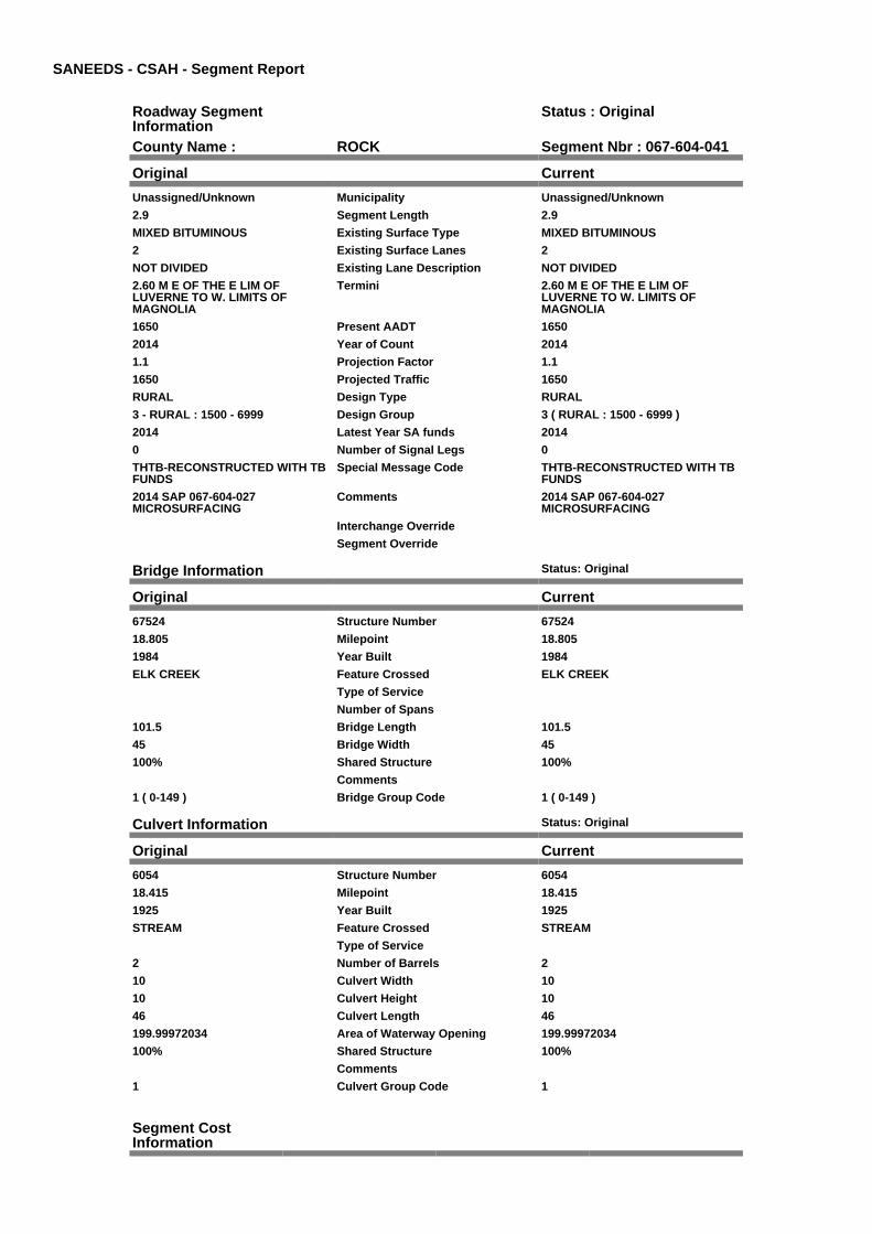
County Name : ROCK Segment Nbr : 067-604-041
Original Current
Unassigned/Unknown Municipality Unassigned/Unknown
2.9 Segment Length 2.9
MIXED BITUMINOUS Existing Surface Type MIXED BITUMINOUS
2 Existing Surface Lanes 2
NOT DIVIDED Existing Lane Description NOT DIVIDED
2.60 M E OF THE E LIM OFLUVERNE TO W. LIMITS OFMAGNOLIA
Termini 2.60 M E OF THE E LIM OFLUVERNE TO W. LIMITS OFMAGNOLIA
1650 Present AADT 1650
2014 Year of Count 2014
1.1 Projection Factor 1.1
1650 Projected Traffic 1650
RURAL Design Type RURAL
3 - RURAL : 1500 - 6999 Design Group 3 ( RURAL : 1500 - 6999 )
2014 Latest Year SA funds 2014
0 Number of Signal Legs 0
THTB-RECONSTRUCTED WITH TBFUNDS
Special Message Code THTB-RECONSTRUCTED WITH TBFUNDS
2014 SAP 067-604-027MICROSURFACING
Comments 2014 SAP 067-604-027MICROSURFACING
Interchange Override
Segment Override
Bridge Information Status: Original
Original Current
67524 Structure Number 67524
18.805 Milepoint 18.805
1984 Year Built 1984
ELK CREEK Feature Crossed ELK CREEK
Type of Service
Number of Spans
101.5 Bridge Length 101.5
45 Bridge Width 45
100% Shared Structure 100%
Comments
1 ( 0-149 ) Bridge Group Code 1 ( 0-149 )
Culvert Information Status: Original
Original Current
6054 Structure Number 6054
18.415 Milepoint 18.415
1925 Year Built 1925
STREAM Feature Crossed STREAM
Type of Service
2 Number of Barrels 2
10 Culvert Width 10
10 Culvert Height 10
46 Culvert Length 46
199.99972034 Area of Waterway Opening 199.99972034
100% Shared Structure 100%
Comments
1 Culvert Group Code 1
Segment CostInformation

Computation Factor Computation Formula Values Used ForCalculation
Computation Result
Signal Leg TrafficSignalLegs *UnitCost / SignalLifeCycle* StatutoryNeedsYear
0 * 56250 / 40 * 25 $0
Construction Length * UnitCost /ConstrLifeCycle *StatutoryNeedsYear *DevelopmentCost
2.9 * 1810705.13 / 60 * 25 *1.1
$2,406,729
Preservation Length * Quantity *UnitCost /PreservationLifeCycle *StatutoryNeedsYear
2.9 * 2376 * 49.57 / 20 * 25 $426,946
ROW Length * UnitCost /ROWLifeCycle *StatutoryNeedsYear
2.9 * 349749.93 / 60 * 25 $422,614
Bridge BridgeLength *BridgeWidth * UnitCost /BridgeLifeCycle *StatutoryNeedsYear *DevelopmentCost
101.5 * 45 * 152 / 80 * 25 *1.15
$249,500
Culvert CulvertLength * Area *UnitCost /CulvertLifeCycle *StatutoryNeedsYear *DevelopmentCost
46 * 199.99972034 * 15.47 /100 * 25 * 1.15
$40,918
Total Segment Cost Signal Leg + Construction+ Preservation + ROW +Bridge + Culvert
$0 + $2,406,729 + $426,946+ $422,614 + $249,500 +$40,918
$3,546,707

SANEEDS - CSAH - Segment Report
Roadway SegmentInformation
Status : Original
County Name : ROCK Segment Nbr : 067-604-050
Original Current
MAGNOLIA Municipality MAGNOLIA
0.08 Segment Length 0.08
MIXED BITUMINOUS Existing Surface Type MIXED BITUMINOUS
2 Existing Surface Lanes 2
NOT DIVIDED Existing Lane Description NOT DIVIDED
W. LIMIT OF MAGNOLIA TO 0.08MILES EAST
Termini W. LIMIT OF MAGNOLIA TO 0.08MILES EAST
1595 Present AADT 1595
2014 Year of Count 2014
1.1 Projection Factor 1.1
1595 Projected Traffic 1595
RURAL Design Type RURAL
3 - RURAL : 1500 - 6999 Design Group 3 ( RURAL : 1500 - 6999 )
2014 Latest Year SA funds 2014
0 Number of Signal Legs 0
THTB-RECONSTRUCTED WITH TBFUNDS
Special Message Code THTB-RECONSTRUCTED WITH TBFUNDS
2014 SAP 067-604-027MICROSURFACING
Comments 2014 SAP 067-604-027MICROSURFACING
Interchange Override
Segment Override
Segment CostInformation
Computation Factor Computation Formula Values Used ForCalculation
Computation Result
Signal Leg TrafficSignalLegs *UnitCost / SignalLifeCycle* StatutoryNeedsYear
0 * 56250 / 40 * 25 $0
Construction Length * UnitCost /ConstrLifeCycle *StatutoryNeedsYear *DevelopmentCost
0.08 * 1810705.13 / 60 * 25* 1.1
$66,393
Preservation Length * Quantity *UnitCost /PreservationLifeCycle *StatutoryNeedsYear
0.08 * 2376 * 49.57 / 20 * 25 $11,778
ROW Length * UnitCost /ROWLifeCycle *StatutoryNeedsYear
0.08 * 349749.93 / 60 * 25 $11,658
Total Segment Cost Signal Leg + Construction+ Preservation + ROW
$0 + $66,393 + $11,778 +$11,658
$89,829
SANEEDS - CSAH - Segment Report
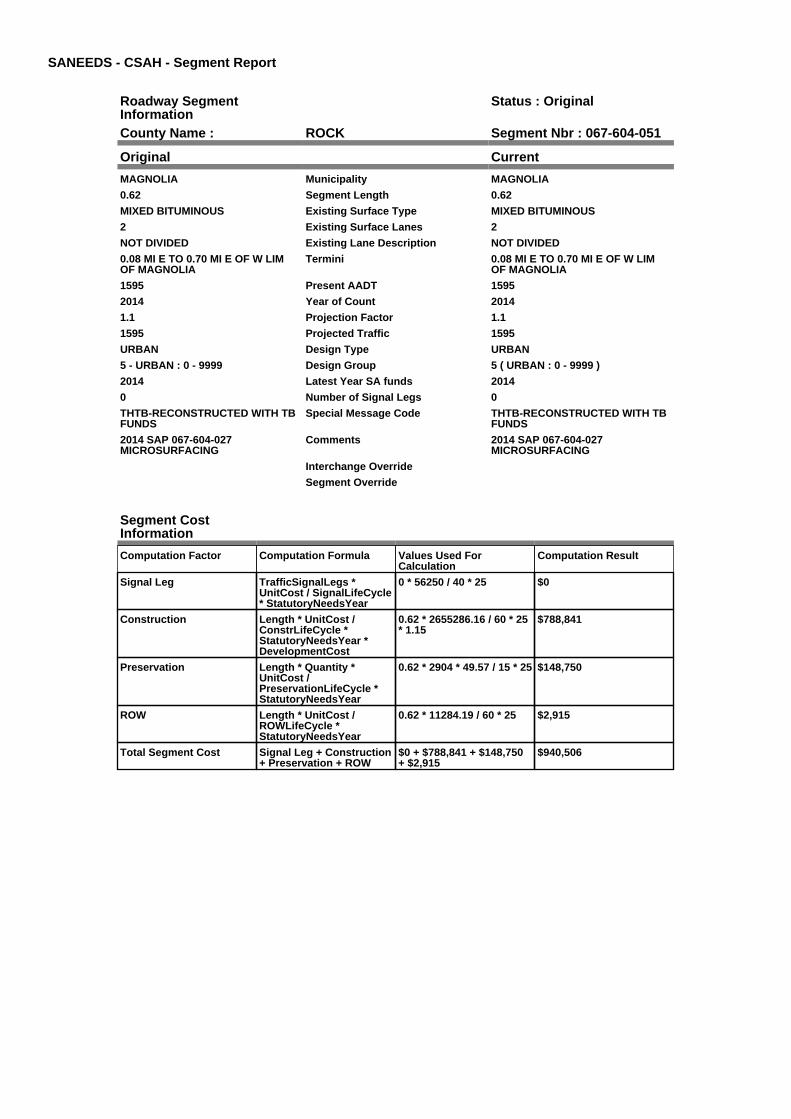
Roadway SegmentInformation
Status : Original
County Name : ROCK Segment Nbr : 067-604-051
Original Current
MAGNOLIA Municipality MAGNOLIA
0.62 Segment Length 0.62
MIXED BITUMINOUS Existing Surface Type MIXED BITUMINOUS
2 Existing Surface Lanes 2
NOT DIVIDED Existing Lane Description NOT DIVIDED
0.08 MI E TO 0.70 MI E OF W LIMOF MAGNOLIA
Termini 0.08 MI E TO 0.70 MI E OF W LIMOF MAGNOLIA
1595 Present AADT 1595
2014 Year of Count 2014
1.1 Projection Factor 1.1
1595 Projected Traffic 1595
URBAN Design Type URBAN
5 - URBAN : 0 - 9999 Design Group 5 ( URBAN : 0 - 9999 )
2014 Latest Year SA funds 2014
0 Number of Signal Legs 0
THTB-RECONSTRUCTED WITH TBFUNDS
Special Message Code THTB-RECONSTRUCTED WITH TBFUNDS
2014 SAP 067-604-027MICROSURFACING
Comments 2014 SAP 067-604-027MICROSURFACING
Interchange Override
Segment Override
Segment CostInformation
Computation Factor Computation Formula Values Used ForCalculation
Computation Result
Signal Leg TrafficSignalLegs *UnitCost / SignalLifeCycle* StatutoryNeedsYear
0 * 56250 / 40 * 25 $0
Construction Length * UnitCost /ConstrLifeCycle *StatutoryNeedsYear *DevelopmentCost
0.62 * 2655286.16 / 60 * 25* 1.15
$788,841
Preservation Length * Quantity *UnitCost /PreservationLifeCycle *StatutoryNeedsYear
0.62 * 2904 * 49.57 / 15 * 25 $148,750
ROW Length * UnitCost /ROWLifeCycle *StatutoryNeedsYear
0.62 * 11284.19 / 60 * 25 $2,915
Total Segment Cost Signal Leg + Construction+ Preservation + ROW
$0 + $788,841 + $148,750+ $2,915
$940,506
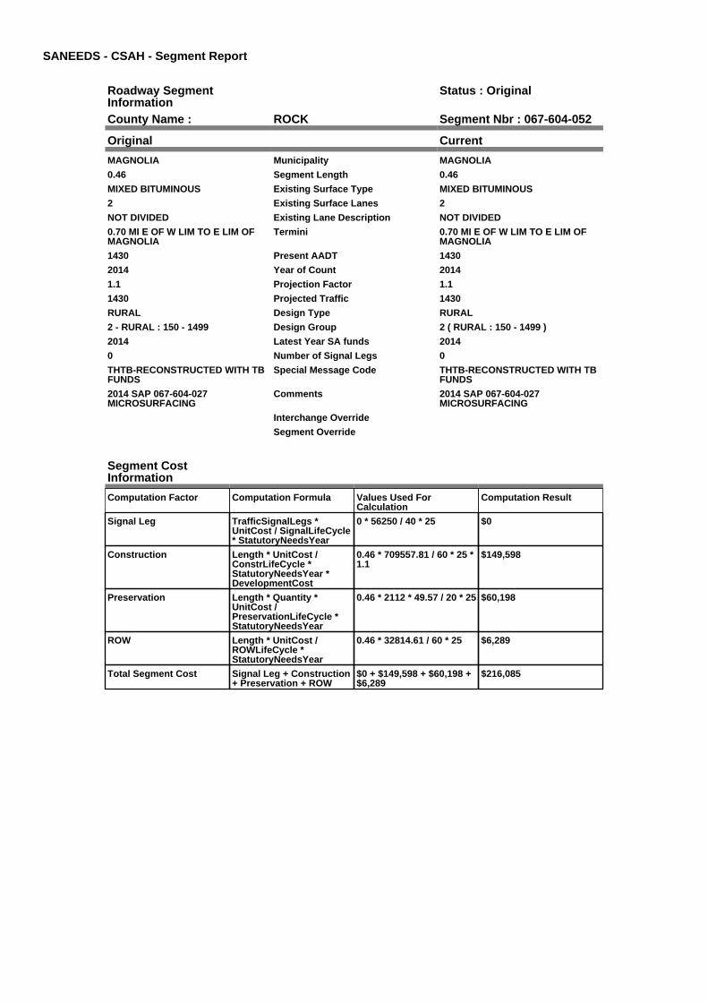
SANEEDS - CSAH - Segment Report
Roadway SegmentInformation
Status : Original
County Name : ROCK Segment Nbr : 067-604-052
Original Current
MAGNOLIA Municipality MAGNOLIA
0.46 Segment Length 0.46
MIXED BITUMINOUS Existing Surface Type MIXED BITUMINOUS
2 Existing Surface Lanes 2
NOT DIVIDED Existing Lane Description NOT DIVIDED
0.70 MI E OF W LIM TO E LIM OFMAGNOLIA
Termini 0.70 MI E OF W LIM TO E LIM OFMAGNOLIA
1430 Present AADT 1430
2014 Year of Count 2014
1.1 Projection Factor 1.1
1430 Projected Traffic 1430
RURAL Design Type RURAL
2 - RURAL : 150 - 1499 Design Group 2 ( RURAL : 150 - 1499 )
2014 Latest Year SA funds 2014
0 Number of Signal Legs 0
THTB-RECONSTRUCTED WITH TBFUNDS
Special Message Code THTB-RECONSTRUCTED WITH TBFUNDS
2014 SAP 067-604-027MICROSURFACING
Comments 2014 SAP 067-604-027MICROSURFACING
Interchange Override
Segment Override
Segment CostInformation
Computation Factor Computation Formula Values Used ForCalculation
Computation Result
Signal Leg TrafficSignalLegs *UnitCost / SignalLifeCycle* StatutoryNeedsYear
0 * 56250 / 40 * 25 $0
Construction Length * UnitCost /ConstrLifeCycle *StatutoryNeedsYear *DevelopmentCost
0.46 * 709557.81 / 60 * 25 *1.1
$149,598
Preservation Length * Quantity *UnitCost /PreservationLifeCycle *StatutoryNeedsYear
0.46 * 2112 * 49.57 / 20 * 25 $60,198
ROW Length * UnitCost /ROWLifeCycle *StatutoryNeedsYear
0.46 * 32814.61 / 60 * 25 $6,289
Total Segment Cost Signal Leg + Construction+ Preservation + ROW
$0 + $149,598 + $60,198 +$6,289
$216,085
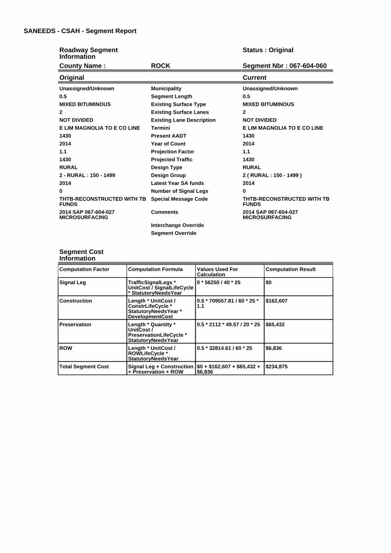
SANEEDS - CSAH - Segment Report
Roadway SegmentInformation
Status : Original
County Name : ROCK Segment Nbr : 067-604-060
Original Current
Unassigned/Unknown Municipality Unassigned/Unknown
0.5 Segment Length 0.5
MIXED BITUMINOUS Existing Surface Type MIXED BITUMINOUS
2 Existing Surface Lanes 2
NOT DIVIDED Existing Lane Description NOT DIVIDED
E LIM MAGNOLIA TO E CO LINE Termini E LIM MAGNOLIA TO E CO LINE
1430 Present AADT 1430
2014 Year of Count 2014
1.1 Projection Factor 1.1
1430 Projected Traffic 1430
RURAL Design Type RURAL
2 - RURAL : 150 - 1499 Design Group 2 ( RURAL : 150 - 1499 )
2014 Latest Year SA funds 2014
0 Number of Signal Legs 0
THTB-RECONSTRUCTED WITH TBFUNDS
Special Message Code THTB-RECONSTRUCTED WITH TBFUNDS
2014 SAP 067-604-027MICROSURFACING
Comments 2014 SAP 067-604-027MICROSURFACING
Interchange Override
Segment Override
Segment CostInformation
Computation Factor Computation Formula Values Used ForCalculation
Computation Result
Signal Leg TrafficSignalLegs *UnitCost / SignalLifeCycle* StatutoryNeedsYear
0 * 56250 / 40 * 25 $0
Construction Length * UnitCost /ConstrLifeCycle *StatutoryNeedsYear *DevelopmentCost
0.5 * 709557.81 / 60 * 25 *1.1
$162,607
Preservation Length * Quantity *UnitCost /PreservationLifeCycle *StatutoryNeedsYear
0.5 * 2112 * 49.57 / 20 * 25 $65,432
ROW Length * UnitCost /ROWLifeCycle *StatutoryNeedsYear
0.5 * 32814.61 / 60 * 25 $6,836
Total Segment Cost Signal Leg + Construction+ Preservation + ROW
$0 + $162,607 + $65,432 +$6,836
$234,875

SANEEDS - CSAH - Segment Report
Roadway SegmentInformation
Status : Original
County Name : ROCK Segment Nbr : 067-605-010
Original Current
Unassigned/Unknown Municipality Unassigned/Unknown
1.1 Segment Length 1.1
MIXED BITUMINOUS Existing Surface Type MIXED BITUMINOUS
2 Existing Surface Lanes 2
NOT DIVIDED Existing Lane Description NOT DIVIDED
W CO LINE TO TH 23 Termini W CO LINE TO TH 23
198 Present AADT 198
2014 Year of Count 2014
1.1 Projection Factor 1.1
198 Projected Traffic 198
RURAL Design Type RURAL
2 - RURAL : 150 - 1499 Design Group 2 ( RURAL : 150 - 1499 )
2001 Latest Year SA funds 2001
0 Number of Signal Legs 0
No Special Message Special Message Code No Special Message
RESURFACED IN 2001: 1 1/2" MILL,2" NON WEAR (2350), 1 1/2" WEAR(2350)
Comments RESURFACED IN 2001: 1 1/2" MILL,2" NON WEAR (2350), 1 1/2" WEAR(2350)
Interchange Override
Segment Override
Segment CostInformation
Computation Factor Computation Formula Values Used ForCalculation
Computation Result
Signal Leg TrafficSignalLegs *UnitCost / SignalLifeCycle* StatutoryNeedsYear
0 * 56250 / 40 * 25 $0
Construction Length * UnitCost /ConstrLifeCycle *StatutoryNeedsYear *DevelopmentCost
1.1 * 709557.81 / 60 * 25 *1.1
$357,735
Preservation Length * Quantity *UnitCost /PreservationLifeCycle *StatutoryNeedsYear
1.1 * 2112 * 49.57 / 20 * 25 $143,951
ROW Length * UnitCost /ROWLifeCycle *StatutoryNeedsYear
1.1 * 32814.61 / 60 * 25 $15,040
Total Segment Cost Signal Leg + Construction+ Preservation + ROW
$0 + $357,735 + $143,951+ $15,040
$516,726

SANEEDS - CSAH - Segment Report
Roadway SegmentInformation
Status : Original
County Name : ROCK Segment Nbr : 067-605-020
Original Current
Unassigned/Unknown Municipality Unassigned/Unknown
4 Segment Length 4
MIXED BITUMINOUS Existing Surface Type MIXED BITUMINOUS
2 Existing Surface Lanes 2
NOT DIVIDED Existing Lane Description NOT DIVIDED
TH 23 TO CSAH 6 Termini TH 23 TO CSAH 6
165 Present AADT 165
2014 Year of Count 2014
1.1 Projection Factor 1.1
165 Projected Traffic 165
RURAL Design Type RURAL
2 - RURAL : 150 - 1499 Design Group 2 ( RURAL : 150 - 1499 )
1998 Latest Year SA funds 1998
0 Number of Signal Legs 0
No Special Message Special Message Code No Special Message
Comments
Interchange Override
Segment Override
Culvert Information Status: Original
Original Current
67J25 Structure Number 67J25
3.86 Milepoint 3.86
1998 Year Built 1998
Spring Water Creek Feature Crossed Spring Water Creek
Type of Service
2 Number of Barrels 2
12 Culvert Width 12
7 Culvert Height 7
68 Culvert Length 68
167.99972203 Area of Waterway Opening 167.99972203
100% Shared Structure 100%
Comments
1 Culvert Group Code 1
Segment CostInformation
Computation Factor Computation Formula Values Used ForCalculation
Computation Result
Signal Leg TrafficSignalLegs *UnitCost / SignalLifeCycle* StatutoryNeedsYear
0 * 56250 / 40 * 25 $0
Construction Length * UnitCost /ConstrLifeCycle *StatutoryNeedsYear *DevelopmentCost
4 * 709557.81 / 60 * 25 * 1.1 $1,300,856
Preservation Length * Quantity *UnitCost /PreservationLifeCycle *StatutoryNeedsYear
4 * 2112 * 49.57 / 20 * 25 $523,459
ROW Length * UnitCost /ROWLifeCycle *StatutoryNeedsYear
4 * 32814.61 / 60 * 25 $54,691
Culvert CulvertLength * Area *UnitCost /CulvertLifeCycle *StatutoryNeedsYear *DevelopmentCost
68 * 167.99972203 * 15.47 /100 * 25 * 1.15
$50,810
Total Segment Cost Signal Leg + Construction+ Preservation + ROW +Culvert
$0 + $1,300,856 + $523,459+ $54,691 + $50,810
$1,929,816
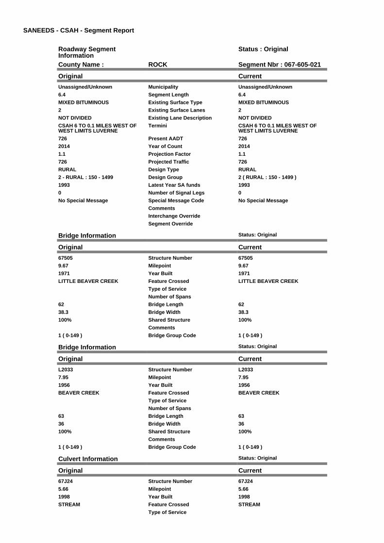
SANEEDS - CSAH - Segment Report
Roadway SegmentInformation
Status : Original
County Name : ROCK Segment Nbr : 067-605-021
Original Current
Unassigned/Unknown Municipality Unassigned/Unknown
6.4 Segment Length 6.4
MIXED BITUMINOUS Existing Surface Type MIXED BITUMINOUS
2 Existing Surface Lanes 2
NOT DIVIDED Existing Lane Description NOT DIVIDED
CSAH 6 TO 0.1 MILES WEST OFWEST LIMITS LUVERNE
Termini CSAH 6 TO 0.1 MILES WEST OFWEST LIMITS LUVERNE
726 Present AADT 726
2014 Year of Count 2014
1.1 Projection Factor 1.1
726 Projected Traffic 726
RURAL Design Type RURAL
2 - RURAL : 150 - 1499 Design Group 2 ( RURAL : 150 - 1499 )
1993 Latest Year SA funds 1993
0 Number of Signal Legs 0
No Special Message Special Message Code No Special Message
Comments
Interchange Override
Segment Override
Bridge Information Status: Original
Original Current
67505 Structure Number 67505
9.67 Milepoint 9.67
1971 Year Built 1971
LITTLE BEAVER CREEK Feature Crossed LITTLE BEAVER CREEK
Type of Service
Number of Spans
62 Bridge Length 62
38.3 Bridge Width 38.3
100% Shared Structure 100%
Comments
1 ( 0-149 ) Bridge Group Code 1 ( 0-149 )
Bridge Information Status: Original
Original Current
L2033 Structure Number L2033
7.95 Milepoint 7.95
1956 Year Built 1956
BEAVER CREEK Feature Crossed BEAVER CREEK
Type of Service
Number of Spans
63 Bridge Length 63
36 Bridge Width 36
100% Shared Structure 100%
Comments
1 ( 0-149 ) Bridge Group Code 1 ( 0-149 )
Culvert Information Status: Original
Original Current
67J24 Structure Number 67J24
5.66 Milepoint 5.66
1998 Year Built 1998
STREAM Feature Crossed STREAM
Type of Service

2 Number of Barrels 2
10 Culvert Width 10
6 Culvert Height 6
60 Culvert Length 60
120.00026276 Area of Waterway Opening 120.00026276
100% Shared Structure 100%
Comments
1 Culvert Group Code 1
Culvert Information Status: Original
Original Current
97436 Structure Number 97436
9.96 Milepoint 9.96
1993 Year Built 1993
STREAM Feature Crossed STREAM
Type of Service
1 Number of Barrels 1
14 Culvert Width 14
8 Culvert Height 8
60 Culvert Length 60
82.00046659 Area of Waterway Opening 82.00046659
100% Shared Structure 100%
Comments
1 Culvert Group Code 1
Segment CostInformation
Computation Factor Computation Formula Values Used ForCalculation
Computation Result
Signal Leg TrafficSignalLegs *UnitCost / SignalLifeCycle* StatutoryNeedsYear
0 * 56250 / 40 * 25 $0
Construction Length * UnitCost /ConstrLifeCycle *StatutoryNeedsYear *DevelopmentCost
6.4 * 709557.81 / 60 * 25 *1.1
$2,081,370
Preservation Length * Quantity *UnitCost /PreservationLifeCycle *StatutoryNeedsYear
6.4 * 2112 * 49.57 / 20 * 25 $837,535
ROW Length * UnitCost /ROWLifeCycle *StatutoryNeedsYear
6.4 * 32814.61 / 60 * 25 $87,506
Bridge BridgeLength *BridgeWidth * UnitCost /BridgeLifeCycle *StatutoryNeedsYear *DevelopmentCost
62 * 38.3 * 152 / 80 * 25 *1.15
$129,713
Bridge BridgeLength *BridgeWidth * UnitCost /BridgeLifeCycle *StatutoryNeedsYear *DevelopmentCost
63 * 36 * 152 / 80 * 25 *1.15
$123,890
Culvert CulvertLength * Area *UnitCost /CulvertLifeCycle *StatutoryNeedsYear *DevelopmentCost
60 * 120.00026276 * 15.47 /100 * 25 * 1.15
$32,023
Culvert CulvertLength * Area *UnitCost /CulvertLifeCycle *StatutoryNeedsYear *DevelopmentCost
60 * 82.00046659 * 15.47 /100 * 25 * 1.15
$21,882
Total Segment Cost Signal Leg + Construction+ Preservation + ROW +Bridge + Bridge + Culvert+ Culvert
$0 + $2,081,370 + $837,535+ $87,506 + $129,713 +$123,890 + $32,023 +$21,882
$3,313,919

SANEEDS - CSAH - Segment Report
Roadway SegmentInformation
Status : Original
County Name : ROCK Segment Nbr : 067-605-022
Original Current
Unassigned/Unknown Municipality Unassigned/Unknown
0.1 Segment Length 0.1
MIXED BITUMINOUS Existing Surface Type MIXED BITUMINOUS
2 Existing Surface Lanes 2
NOT DIVIDED Existing Lane Description NOT DIVIDED
0.1 MILE WEST TO WEST LIMITSLUVERNE
Termini 0.1 MILE WEST TO WEST LIMITSLUVERNE
726 Present AADT 726
2014 Year of Count 2014
1.1 Projection Factor 1.1
726 Projected Traffic 726
RURAL Design Type RURAL
2 - RURAL : 150 - 1499 Design Group 2 ( RURAL : 150 - 1499 )
1993 Latest Year SA funds 1993
0 Number of Signal Legs 0
No Special Message Special Message Code No Special Message
Comments
Interchange Override
Segment Override
Segment CostInformation
Computation Factor Computation Formula Values Used ForCalculation
Computation Result
Signal Leg TrafficSignalLegs *UnitCost / SignalLifeCycle* StatutoryNeedsYear
0 * 56250 / 40 * 25 $0
Construction Length * UnitCost /ConstrLifeCycle *StatutoryNeedsYear *DevelopmentCost
0.1 * 709557.81 / 60 * 25 *1.1
$32,521
Preservation Length * Quantity *UnitCost /PreservationLifeCycle *StatutoryNeedsYear
0.1 * 2112 * 49.57 / 20 * 25 $13,086
ROW Length * UnitCost /ROWLifeCycle *StatutoryNeedsYear
0.1 * 32814.61 / 60 * 25 $1,367
Total Segment Cost Signal Leg + Construction+ Preservation + ROW
$0 + $32,521 + $13,086 +$1,367
$46,974

SANEEDS - CSAH - Segment Report
Roadway SegmentInformation
Status : Original
County Name : ROCK Segment Nbr : 067-605-030
Original Current
LUVERNE Municipality LUVERNE
0.2 Segment Length 0.2
MIXED BITUMINOUS Existing Surface Type MIXED BITUMINOUS
2 Existing Surface Lanes 2
NOT DIVIDED Existing Lane Description NOT DIVIDED
W LIM LUVERNE TO COTTAGEGROVE
Termini W LIM LUVERNE TO COTTAGEGROVE
726 Present AADT 726
2014 Year of Count 2014
1.1 Projection Factor 1.1
726 Projected Traffic 726
RURAL Design Type RURAL
2 - RURAL : 150 - 1499 Design Group 2 ( RURAL : 150 - 1499 )
1993 Latest Year SA funds 1993
0 Number of Signal Legs 0
No Special Message Special Message Code No Special Message
Comments
Interchange Override
Segment Override
Segment CostInformation
Computation Factor Computation Formula Values Used ForCalculation
Computation Result
Signal Leg TrafficSignalLegs *UnitCost / SignalLifeCycle* StatutoryNeedsYear
0 * 56250 / 40 * 25 $0
Construction Length * UnitCost /ConstrLifeCycle *StatutoryNeedsYear *DevelopmentCost
0.2 * 709557.81 / 60 * 25 *1.1
$65,043
Preservation Length * Quantity *UnitCost /PreservationLifeCycle *StatutoryNeedsYear
0.2 * 2112 * 49.57 / 20 * 25 $26,173
ROW Length * UnitCost /ROWLifeCycle *StatutoryNeedsYear
0.2 * 32814.61 / 60 * 25 $2,735
Total Segment Cost Signal Leg + Construction+ Preservation + ROW
$0 + $65,043 + $26,173 +$2,735
$93,951

SANEEDS - CSAH - Segment Report
Roadway SegmentInformation
Status : Original
County Name : ROCK Segment Nbr : 067-605-040
Original Current
LUVERNE Municipality LUVERNE
0.2 Segment Length 0.2
MIXED BITUMINOUS Existing Surface Type MIXED BITUMINOUS
2 Existing Surface Lanes 2
NOT DIVIDED Existing Lane Description NOT DIVIDED
COTTAGE GROVE TO 542' WESTOF US HWY 75
Termini COTTAGE GROVE TO 542' WESTOF US HWY 75
1980 Present AADT 1980
2014 Year of Count 2014
1.1 Projection Factor 1.1
1980 Projected Traffic 1980
URBAN Design Type URBAN
5 - URBAN : 0 - 9999 Design Group 5 ( URBAN : 0 - 9999 )
1993 Latest Year SA funds 1993
0 Number of Signal Legs 0
No Special Message Special Message Code No Special Message
Comments
Interchange Override
Segment Override
Segment CostInformation
Computation Factor Computation Formula Values Used ForCalculation
Computation Result
Signal Leg TrafficSignalLegs *UnitCost / SignalLifeCycle* StatutoryNeedsYear
0 * 56250 / 40 * 25 $0
Construction Length * UnitCost /ConstrLifeCycle *StatutoryNeedsYear *DevelopmentCost
0.2 * 2655286.16 / 60 * 25 *1.15
$254,465
Preservation Length * Quantity *UnitCost /PreservationLifeCycle *StatutoryNeedsYear
0.2 * 2904 * 49.57 / 15 * 25 $47,984
ROW Length * UnitCost /ROWLifeCycle *StatutoryNeedsYear
0.2 * 11284.19 / 60 * 25 $940
Total Segment Cost Signal Leg + Construction+ Preservation + ROW
$0 + $254,465 + $47,984 +$940
$303,389
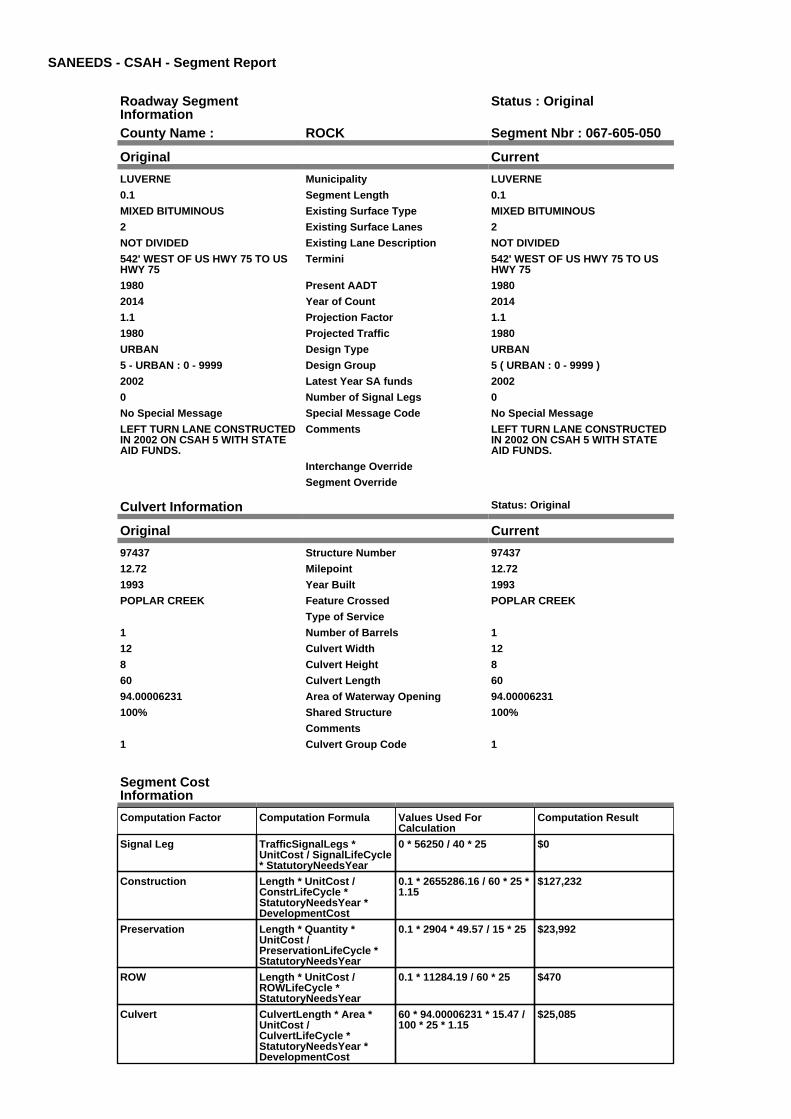
SANEEDS - CSAH - Segment Report
Roadway SegmentInformation
Status : Original
County Name : ROCK Segment Nbr : 067-605-050
Original Current
LUVERNE Municipality LUVERNE
0.1 Segment Length 0.1
MIXED BITUMINOUS Existing Surface Type MIXED BITUMINOUS
2 Existing Surface Lanes 2
NOT DIVIDED Existing Lane Description NOT DIVIDED
542' WEST OF US HWY 75 TO USHWY 75
Termini 542' WEST OF US HWY 75 TO USHWY 75
1980 Present AADT 1980
2014 Year of Count 2014
1.1 Projection Factor 1.1
1980 Projected Traffic 1980
URBAN Design Type URBAN
5 - URBAN : 0 - 9999 Design Group 5 ( URBAN : 0 - 9999 )
2002 Latest Year SA funds 2002
0 Number of Signal Legs 0
No Special Message Special Message Code No Special Message
LEFT TURN LANE CONSTRUCTEDIN 2002 ON CSAH 5 WITH STATEAID FUNDS.
Comments LEFT TURN LANE CONSTRUCTEDIN 2002 ON CSAH 5 WITH STATEAID FUNDS.
Interchange Override
Segment Override
Culvert Information Status: Original
Original Current
97437 Structure Number 97437
12.72 Milepoint 12.72
1993 Year Built 1993
POPLAR CREEK Feature Crossed POPLAR CREEK
Type of Service
1 Number of Barrels 1
12 Culvert Width 12
8 Culvert Height 8
60 Culvert Length 60
94.00006231 Area of Waterway Opening 94.00006231
100% Shared Structure 100%
Comments
1 Culvert Group Code 1
Segment CostInformation
Computation Factor Computation Formula Values Used ForCalculation
Computation Result
Signal Leg TrafficSignalLegs *UnitCost / SignalLifeCycle* StatutoryNeedsYear
0 * 56250 / 40 * 25 $0
Construction Length * UnitCost /ConstrLifeCycle *StatutoryNeedsYear *DevelopmentCost
0.1 * 2655286.16 / 60 * 25 *1.15
$127,232
Preservation Length * Quantity *UnitCost /PreservationLifeCycle *StatutoryNeedsYear
0.1 * 2904 * 49.57 / 15 * 25 $23,992
ROW Length * UnitCost /ROWLifeCycle *StatutoryNeedsYear
0.1 * 11284.19 / 60 * 25 $470
Culvert CulvertLength * Area *UnitCost /CulvertLifeCycle *StatutoryNeedsYear *DevelopmentCost
60 * 94.00006231 * 15.47 /100 * 25 * 1.15
$25,085

Total Segment Cost Signal Leg + Construction+ Preservation + ROW +Culvert
$0 + $127,232 + $23,992 +$470 + $25,085
$176,779

SANEEDS - CSAH - Segment Report
Roadway SegmentInformation
Status : Original
County Name : ROCK Segment Nbr : 067-606-010
Original Current
Unassigned/Unknown Municipality Unassigned/Unknown
1.4 Segment Length 1.4
MIXED BITUMINOUS Existing Surface Type MIXED BITUMINOUS
2 Existing Surface Lanes 2
NOT DIVIDED Existing Lane Description NOT DIVIDED
S CO LINE TO S LIMS HILLS Termini S CO LINE TO S LIMS HILLS
506 Present AADT 506
2014 Year of Count 2014
1.1 Projection Factor 1.1
506 Projected Traffic 506
RURAL Design Type RURAL
2 - RURAL : 150 - 1499 Design Group 2 ( RURAL : 150 - 1499 )
2010 Latest Year SA funds 2010
0 Number of Signal Legs 0
No Special Message Special Message Code No Special Message
OVERLAY 2010, SAP 67-606-012 Comments OVERLAY 2010, SAP 67-606-012
Interchange Override
Segment Override
Segment CostInformation
Computation Factor Computation Formula Values Used ForCalculation
Computation Result
Signal Leg TrafficSignalLegs *UnitCost / SignalLifeCycle* StatutoryNeedsYear
0 * 56250 / 40 * 25 $0
Construction Length * UnitCost /ConstrLifeCycle *StatutoryNeedsYear *DevelopmentCost
1.4 * 709557.81 / 60 * 25 *1.1
$455,300
Preservation Length * Quantity *UnitCost /PreservationLifeCycle *StatutoryNeedsYear
1.4 * 2112 * 49.57 / 20 * 25 $183,211
ROW Length * UnitCost /ROWLifeCycle *StatutoryNeedsYear
1.4 * 32814.61 / 60 * 25 $19,142
Total Segment Cost Signal Leg + Construction+ Preservation + ROW
$0 + $455,300 + $183,211+ $19,142
$657,653

SANEEDS - CSAH - Segment Report
Roadway SegmentInformation
Status : Original
County Name : ROCK Segment Nbr : 067-606-011
Original Current
HILLS Municipality HILLS
0.35 Segment Length 0.35
MIXED BITUMINOUS Existing Surface Type MIXED BITUMINOUS
2 Existing Surface Lanes 2
NOT DIVIDED Existing Lane Description NOT DIVIDED
S LIMS HILLS TO 0.35 MI N Termini S LIMS HILLS TO 0.35 MI N
506 Present AADT 506
2014 Year of Count 2014
1.1 Projection Factor 1.1
506 Projected Traffic 506
RURAL Design Type RURAL
2 - RURAL : 150 - 1499 Design Group 2 ( RURAL : 150 - 1499 )
2010 Latest Year SA funds 2010
0 Number of Signal Legs 0
No Special Message Special Message Code No Special Message
OVERLAY 2010, SAP 67-606-012 Comments OVERLAY 2010, SAP 67-606-012
Interchange Override
Segment Override
Segment CostInformation
Computation Factor Computation Formula Values Used ForCalculation
Computation Result
Signal Leg TrafficSignalLegs *UnitCost / SignalLifeCycle* StatutoryNeedsYear
0 * 56250 / 40 * 25 $0
Construction Length * UnitCost /ConstrLifeCycle *StatutoryNeedsYear *DevelopmentCost
0.35 * 709557.81 / 60 * 25 *1.1
$113,825
Preservation Length * Quantity *UnitCost /PreservationLifeCycle *StatutoryNeedsYear
0.35 * 2112 * 49.57 / 20 * 25 $45,803
ROW Length * UnitCost /ROWLifeCycle *StatutoryNeedsYear
0.35 * 32814.61 / 60 * 25 $4,785
Total Segment Cost Signal Leg + Construction+ Preservation + ROW
$0 + $113,825 + $45,803 +$4,785
$164,413

SANEEDS - CSAH - Segment Report
Roadway SegmentInformation
Status : Original
County Name : ROCK Segment Nbr : 067-606-020
Original Current
HILLS Municipality HILLS
0.23 Segment Length 0.23
MIXED BITUMINOUS Existing Surface Type MIXED BITUMINOUS
2 Existing Surface Lanes 2
NOT DIVIDED Existing Lane Description NOT DIVIDED
0.35 MI N OF S LIMS HILLS TO TH270
Termini 0.35 MI N OF S LIMS HILLS TO TH270
506 Present AADT 506
2014 Year of Count 2014
1.1 Projection Factor 1.1
506 Projected Traffic 506
RURAL Design Type RURAL
2 - RURAL : 150 - 1499 Design Group 2 ( RURAL : 150 - 1499 )
2010 Latest Year SA funds 2010
0 Number of Signal Legs 0
No Special Message Special Message Code No Special Message
OVERLAY 2010, SAP 67-606-012 Comments OVERLAY 2010, SAP 67-606-012
Interchange Override
Segment Override
Segment CostInformation
Computation Factor Computation Formula Values Used ForCalculation
Computation Result
Signal Leg TrafficSignalLegs *UnitCost / SignalLifeCycle* StatutoryNeedsYear
0 * 56250 / 40 * 25 $0
Construction Length * UnitCost /ConstrLifeCycle *StatutoryNeedsYear *DevelopmentCost
0.23 * 709557.81 / 60 * 25 *1.1
$74,799
Preservation Length * Quantity *UnitCost /PreservationLifeCycle *StatutoryNeedsYear
0.23 * 2112 * 49.57 / 20 * 25 $30,099
ROW Length * UnitCost /ROWLifeCycle *StatutoryNeedsYear
0.23 * 32814.61 / 60 * 25 $3,145
Total Segment Cost Signal Leg + Construction+ Preservation + ROW
$0 + $74,799 + $30,099 +$3,145
$108,043

SANEEDS - CSAH - Segment Report
Roadway SegmentInformation
Status : Original
County Name : ROCK Segment Nbr : 067-606-021
Original Current
HILLS Municipality HILLS
0.25 Segment Length 0.25
MIXED BITUMINOUS Existing Surface Type MIXED BITUMINOUS
2 Existing Surface Lanes 2
NOT DIVIDED Existing Lane Description NOT DIVIDED
TH 270 TO N LIM HILLS Termini TH 270 TO N LIM HILLS
1210 Present AADT 1210
2014 Year of Count 2014
1.1 Projection Factor 1.1
1210 Projected Traffic 1210
RURAL Design Type RURAL
2 - RURAL : 150 - 1499 Design Group 2 ( RURAL : 150 - 1499 )
2001 Latest Year SA funds 2001
0 Number of Signal Legs 0
No Special Message Special Message Code No Special Message
RESURFACED IN 2001: 1 1/2" MILL,2" NON-WEAR (2350), 1 1/2" WEAR(2350)
Comments RESURFACED IN 2001: 1 1/2" MILL,2" NON-WEAR (2350), 1 1/2" WEAR(2350)
Interchange Override
Segment Override
Segment CostInformation
Computation Factor Computation Formula Values Used ForCalculation
Computation Result
Signal Leg TrafficSignalLegs *UnitCost / SignalLifeCycle* StatutoryNeedsYear
0 * 56250 / 40 * 25 $0
Construction Length * UnitCost /ConstrLifeCycle *StatutoryNeedsYear *DevelopmentCost
0.25 * 709557.81 / 60 * 25 *1.1
$81,303
Preservation Length * Quantity *UnitCost /PreservationLifeCycle *StatutoryNeedsYear
0.25 * 2112 * 49.57 / 20 * 25 $32,716
ROW Length * UnitCost /ROWLifeCycle *StatutoryNeedsYear
0.25 * 32814.61 / 60 * 25 $3,418
Total Segment Cost Signal Leg + Construction+ Preservation + ROW
$0 + $81,303 + $32,716 +$3,418
$117,437
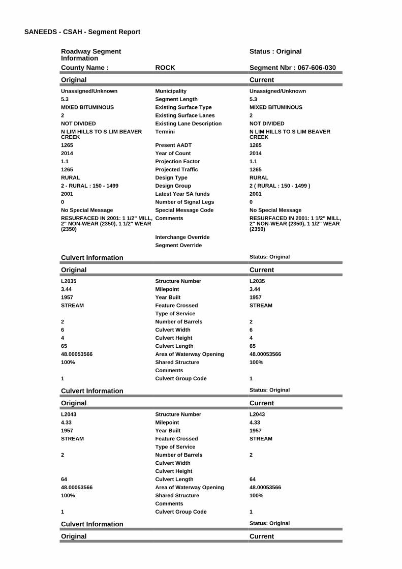
SANEEDS - CSAH - Segment Report
Roadway SegmentInformation
Status : Original
County Name : ROCK Segment Nbr : 067-606-030
Original Current
Unassigned/Unknown Municipality Unassigned/Unknown
5.3 Segment Length 5.3
MIXED BITUMINOUS Existing Surface Type MIXED BITUMINOUS
2 Existing Surface Lanes 2
NOT DIVIDED Existing Lane Description NOT DIVIDED
N LIM HILLS TO S LIM BEAVERCREEK
Termini N LIM HILLS TO S LIM BEAVERCREEK
1265 Present AADT 1265
2014 Year of Count 2014
1.1 Projection Factor 1.1
1265 Projected Traffic 1265
RURAL Design Type RURAL
2 - RURAL : 150 - 1499 Design Group 2 ( RURAL : 150 - 1499 )
2001 Latest Year SA funds 2001
0 Number of Signal Legs 0
No Special Message Special Message Code No Special Message
RESURFACED IN 2001: 1 1/2" MILL,2" NON-WEAR (2350), 1 1/2" WEAR(2350)
Comments RESURFACED IN 2001: 1 1/2" MILL,2" NON-WEAR (2350), 1 1/2" WEAR(2350)
Interchange Override
Segment Override
Culvert Information Status: Original
Original Current
L2035 Structure Number L2035
3.44 Milepoint 3.44
1957 Year Built 1957
STREAM Feature Crossed STREAM
Type of Service
2 Number of Barrels 2
6 Culvert Width 6
4 Culvert Height 4
65 Culvert Length 65
48.00053566 Area of Waterway Opening 48.00053566
100% Shared Structure 100%
Comments
1 Culvert Group Code 1
Culvert Information Status: Original
Original Current
L2043 Structure Number L2043
4.33 Milepoint 4.33
1957 Year Built 1957
STREAM Feature Crossed STREAM
Type of Service
2 Number of Barrels 2
Culvert Width
Culvert Height
64 Culvert Length 64
48.00053566 Area of Waterway Opening 48.00053566
100% Shared Structure 100%
Comments
1 Culvert Group Code 1
Culvert Information Status: Original
Original Current

L2097 Structure Number L2097
4.89 Milepoint 4.89
1957 Year Built 1957
STREAM Feature Crossed STREAM
Type of Service
2 Number of Barrels 2
6 Culvert Width 6
4 Culvert Height 4
64 Culvert Length 64
48.00053566 Area of Waterway Opening 48.00053566
100% Shared Structure 100%
Comments
1 Culvert Group Code 1
Segment CostInformation
Computation Factor Computation Formula Values Used ForCalculation
Computation Result
Signal Leg TrafficSignalLegs *UnitCost / SignalLifeCycle* StatutoryNeedsYear
0 * 56250 / 40 * 25 $0
Construction Length * UnitCost /ConstrLifeCycle *StatutoryNeedsYear *DevelopmentCost
5.3 * 709557.81 / 60 * 25 *1.1
$1,723,634
Preservation Length * Quantity *UnitCost /PreservationLifeCycle *StatutoryNeedsYear
5.3 * 2112 * 49.57 / 20 * 25 $693,583
ROW Length * UnitCost /ROWLifeCycle *StatutoryNeedsYear
5.3 * 32814.61 / 60 * 25 $72,466
Culvert CulvertLength * Area *UnitCost /CulvertLifeCycle *StatutoryNeedsYear *DevelopmentCost
65 * 48.00053566 * 15.47 /100 * 25 * 1.15
$13,877
Culvert CulvertLength * Area *UnitCost /CulvertLifeCycle *StatutoryNeedsYear *DevelopmentCost
64 * 48.00053566 * 15.47 /100 * 25 * 1.15
$13,663
Culvert CulvertLength * Area *UnitCost /CulvertLifeCycle *StatutoryNeedsYear *DevelopmentCost
64 * 48.00053566 * 15.47 /100 * 25 * 1.15
$13,663
Total Segment Cost Signal Leg + Construction+ Preservation + ROW +Culvert + Culvert +Culvert
$0 + $1,723,634 + $693,583+ $72,466 + $13,877 +$13,663 + $13,663
$2,530,886
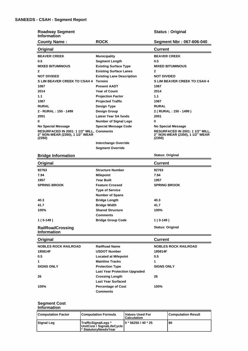
SANEEDS - CSAH - Segment Report
Roadway SegmentInformation
Status : Original
County Name : ROCK Segment Nbr : 067-606-040
Original Current
BEAVER CREEK Municipality BEAVER CREEK
0.5 Segment Length 0.5
MIXED BITUMINOUS Existing Surface Type MIXED BITUMINOUS
2 Existing Surface Lanes 2
NOT DIVIDED Existing Lane Description NOT DIVIDED
S LIM BEAVER CREEK TO CSAH 4 Termini S LIM BEAVER CREEK TO CSAH 4
1067 Present AADT 1067
2014 Year of Count 2014
1.1 Projection Factor 1.1
1067 Projected Traffic 1067
RURAL Design Type RURAL
2 - RURAL : 150 - 1499 Design Group 2 ( RURAL : 150 - 1499 )
2001 Latest Year SA funds 2001
0 Number of Signal Legs 0
No Special Message Special Message Code No Special Message
RESURFACED IN 2001: 1 1/2" MILL,2" NON-WEAR (2350), 1 1/2" WEAR(2350)
Comments RESURFACED IN 2001: 1 1/2" MILL,2" NON-WEAR (2350), 1 1/2" WEAR(2350)
Interchange Override
Segment Override
Bridge Information Status: Original
Original Current
92763 Structure Number 92763
7.94 Milepoint 7.94
1957 Year Built 1957
SPRING BROOK Feature Crossed SPRING BROOK
Type of Service
Number of Spans
40.3 Bridge Length 40.3
41.7 Bridge Width 41.7
100% Shared Structure 100%
Comments
1 ( 0-149 ) Bridge Group Code 1 ( 0-149 )
RailRoadCrossingInformation
Status: Original
Original Current
NOBLES ROCK RAILROAD RailRoad Name NOBLES ROCK RAILROAD
185814F USDOT Number 185814F
0.5 Located at Milepoint 0.5
1 Mainline Tracks 1
SIGNS ONLY Protection Type SIGNS ONLY
Last Year Protection Upgraded
26 Crossing Length 26
Last Year Surfaced
100% Percentage of Cost 100%
Comments
Segment CostInformation
Computation Factor Computation Formula Values Used ForCalculation
Computation Result
Signal Leg TrafficSignalLegs *UnitCost / SignalLifeCycle* StatutoryNeedsYear
0 * 56250 / 40 * 25 $0

Construction Length * UnitCost /ConstrLifeCycle *StatutoryNeedsYear *DevelopmentCost
0.5 * 709557.81 / 60 * 25 *1.1
$162,607
Preservation Length * Quantity *UnitCost /PreservationLifeCycle *StatutoryNeedsYear
0.5 * 2112 * 49.57 / 20 * 25 $65,432
ROW Length * UnitCost /ROWLifeCycle *StatutoryNeedsYear
0.5 * 32814.61 / 60 * 25 $6,836
Bridge BridgeLength *BridgeWidth * UnitCost /BridgeLifeCycle *StatutoryNeedsYear *DevelopmentCost
40.3 * 41.7 * 152 / 80 * 25 *1.15
$91,798
RR Crossing Protection UnitCost /RRCrossingLifeCycle *StatutoryNeedsYear
1500 / 25 * 25 $1,500
RR Crossing Surface SurfaceLength * UnitCost/ RRCrossingLifeCycle *StatutoryNeedsYear
26 * 1350 / 25 * 25 $35,100
Total Segment Cost Signal Leg + Construction+ Preservation + ROW +Bridge + RR CrossingProtection + RR CrossingSurface
$0 + $162,607 + $65,432 +$6,836 + $91,798 + $1,500+ $35,100
$363,273
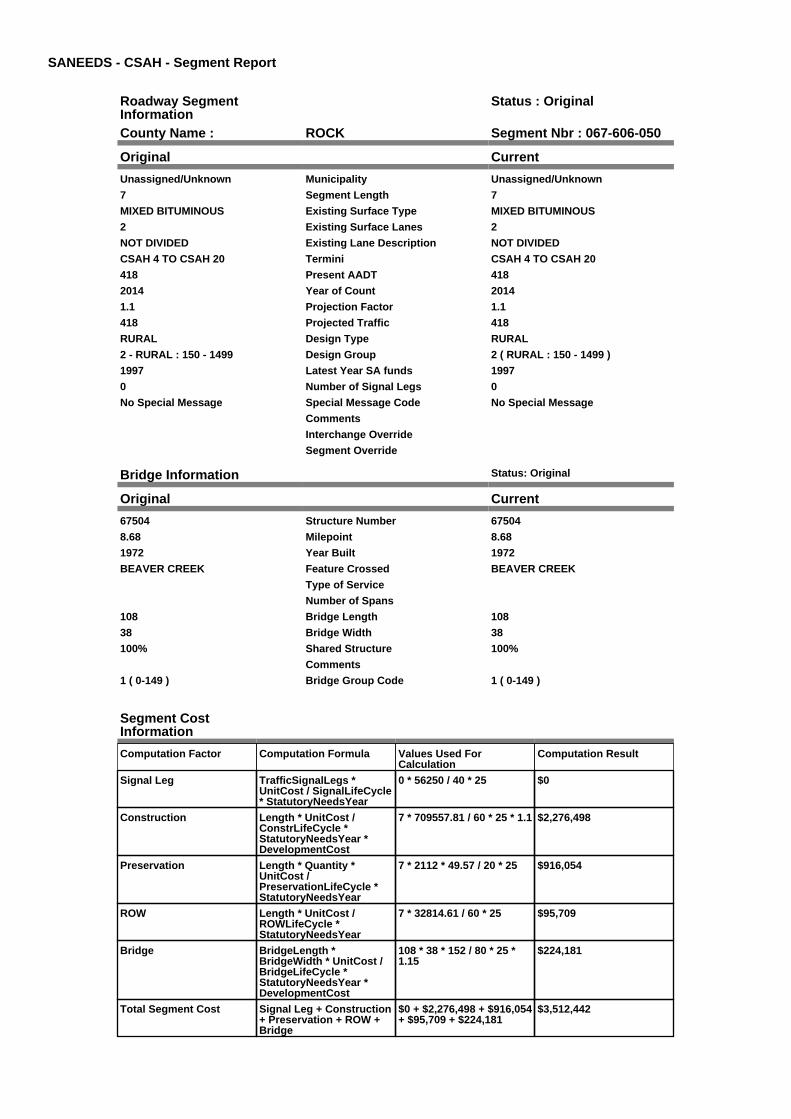
SANEEDS - CSAH - Segment Report
Roadway SegmentInformation
Status : Original
County Name : ROCK Segment Nbr : 067-606-050
Original Current
Unassigned/Unknown Municipality Unassigned/Unknown
7 Segment Length 7
MIXED BITUMINOUS Existing Surface Type MIXED BITUMINOUS
2 Existing Surface Lanes 2
NOT DIVIDED Existing Lane Description NOT DIVIDED
CSAH 4 TO CSAH 20 Termini CSAH 4 TO CSAH 20
418 Present AADT 418
2014 Year of Count 2014
1.1 Projection Factor 1.1
418 Projected Traffic 418
RURAL Design Type RURAL
2 - RURAL : 150 - 1499 Design Group 2 ( RURAL : 150 - 1499 )
1997 Latest Year SA funds 1997
0 Number of Signal Legs 0
No Special Message Special Message Code No Special Message
Comments
Interchange Override
Segment Override
Bridge Information Status: Original
Original Current
67504 Structure Number 67504
8.68 Milepoint 8.68
1972 Year Built 1972
BEAVER CREEK Feature Crossed BEAVER CREEK
Type of Service
Number of Spans
108 Bridge Length 108
38 Bridge Width 38
100% Shared Structure 100%
Comments
1 ( 0-149 ) Bridge Group Code 1 ( 0-149 )
Segment CostInformation
Computation Factor Computation Formula Values Used ForCalculation
Computation Result
Signal Leg TrafficSignalLegs *UnitCost / SignalLifeCycle* StatutoryNeedsYear
0 * 56250 / 40 * 25 $0
Construction Length * UnitCost /ConstrLifeCycle *StatutoryNeedsYear *DevelopmentCost
7 * 709557.81 / 60 * 25 * 1.1 $2,276,498
Preservation Length * Quantity *UnitCost /PreservationLifeCycle *StatutoryNeedsYear
7 * 2112 * 49.57 / 20 * 25 $916,054
ROW Length * UnitCost /ROWLifeCycle *StatutoryNeedsYear
7 * 32814.61 / 60 * 25 $95,709
Bridge BridgeLength *BridgeWidth * UnitCost /BridgeLifeCycle *StatutoryNeedsYear *DevelopmentCost
108 * 38 * 152 / 80 * 25 *1.15
$224,181
Total Segment Cost Signal Leg + Construction+ Preservation + ROW +Bridge
$0 + $2,276,498 + $916,054+ $95,709 + $224,181
$3,512,442

SANEEDS - CSAH - Segment Report
Roadway SegmentInformation
Status : Original
County Name : ROCK Segment Nbr : 067-606-060
Original Current
Unassigned/Unknown Municipality Unassigned/Unknown
4 Segment Length 4
MIXED BITUMINOUS Existing Surface Type MIXED BITUMINOUS
2 Existing Surface Lanes 2
NOT DIVIDED Existing Lane Description NOT DIVIDED
CSAH 20 TO CSAH 7 Termini CSAH 20 TO CSAH 7
242 Present AADT 242
2014 Year of Count 2014
1.1 Projection Factor 1.1
242 Projected Traffic 242
RURAL Design Type RURAL
2 - RURAL : 150 - 1499 Design Group 2 ( RURAL : 150 - 1499 )
2015 Latest Year SA funds 2015
0 Number of Signal Legs 0
No Special Message Special Message Code No Special Message
2015 SAP 067-606-014 M&OL Comments 2015 SAP 067-606-014 M&OL
Interchange Override
Segment Override
Segment CostInformation
Computation Factor Computation Formula Values Used ForCalculation
Computation Result
Signal Leg TrafficSignalLegs *UnitCost / SignalLifeCycle* StatutoryNeedsYear
0 * 56250 / 40 * 25 $0
Construction Length * UnitCost /ConstrLifeCycle *StatutoryNeedsYear *DevelopmentCost
4 * 709557.81 / 60 * 25 * 1.1 $1,300,856
Preservation Length * Quantity *UnitCost /PreservationLifeCycle *StatutoryNeedsYear
4 * 2112 * 49.57 / 20 * 25 $523,459
ROW Length * UnitCost /ROWLifeCycle *StatutoryNeedsYear
4 * 32814.61 / 60 * 25 $54,691
Total Segment Cost Signal Leg + Construction+ Preservation + ROW
$0 + $1,300,856 + $523,459+ $54,691
$1,879,006

SANEEDS - CSAH - Segment Report
Roadway SegmentInformation
Status : Original
County Name : ROCK Segment Nbr : 067-606-070
Original Current
Unassigned/Unknown Municipality Unassigned/Unknown
5 Segment Length 5
MIXED BITUMINOUS Existing Surface Type MIXED BITUMINOUS
2 Existing Surface Lanes 2
NOT DIVIDED Existing Lane Description NOT DIVIDED
CSAH 7 TO NORTH COUNTY LINE Termini CSAH 7 TO NORTH COUNTY LINE
242 Present AADT 242
2014 Year of Count 2014
1.1 Projection Factor 1.1
242 Projected Traffic 242
RURAL Design Type RURAL
2 - RURAL : 150 - 1499 Design Group 2 ( RURAL : 150 - 1499 )
2015 Latest Year SA funds 2015
0 Number of Signal Legs 0
No Special Message Special Message Code No Special Message
2015 SAP 067-606-015 RC&OL Comments 2015 SAP 067-606-015 RC&OL
Interchange Override
Segment Override
Segment CostInformation
Computation Factor Computation Formula Values Used ForCalculation
Computation Result
Signal Leg TrafficSignalLegs *UnitCost / SignalLifeCycle* StatutoryNeedsYear
0 * 56250 / 40 * 25 $0
Construction Length * UnitCost /ConstrLifeCycle *StatutoryNeedsYear *DevelopmentCost
5 * 709557.81 / 60 * 25 * 1.1 $1,626,070
Preservation Length * Quantity *UnitCost /PreservationLifeCycle *StatutoryNeedsYear
5 * 2112 * 49.57 / 20 * 25 $654,324
ROW Length * UnitCost /ROWLifeCycle *StatutoryNeedsYear
5 * 32814.61 / 60 * 25 $68,364
Total Segment Cost Signal Leg + Construction+ Preservation + ROW
$0 + $1,626,070 + $654,324+ $68,364
$2,348,758

SANEEDS - CSAH - Segment Report
Roadway SegmentInformation
Status : Original
County Name : ROCK Segment Nbr : 067-607-003
Original Current
Unassigned/Unknown Municipality Unassigned/Unknown
0.1 Segment Length 0.1
MIXED BITUMINOUS Existing Surface Type MIXED BITUMINOUS
2 Existing Surface Lanes 2
NOT DIVIDED Existing Lane Description NOT DIVIDED
WEST STATE LINE TO 0.10 MILESEAST
Termini WEST STATE LINE TO 0.10 MILESEAST
158 Present AADT 158
2014 Year of Count 2014
1.5 Projection Factor 1.5
158 Projected Traffic 158
RURAL Design Type RURAL
2 - RURAL : 150 - 1499 Design Group 2 ( RURAL : 150 - 1499 )
2001 Latest Year SA funds 2001
0 Number of Signal Legs 0
No Special Message Special Message Code No Special Message
RESURFACED IN 2001: 1 1/2" MILL,3" NON-WEAR (2350), 2" WEAR(2350)
Comments RESURFACED IN 2001: 1 1/2" MILL,3" NON-WEAR (2350), 2" WEAR(2350)
Interchange Override
Segment Override
Segment CostInformation
Computation Factor Computation Formula Values Used ForCalculation
Computation Result
Signal Leg TrafficSignalLegs *UnitCost / SignalLifeCycle* StatutoryNeedsYear
0 * 56250 / 40 * 25 $0
Construction Length * UnitCost /ConstrLifeCycle *StatutoryNeedsYear *DevelopmentCost
0.1 * 709557.81 / 60 * 25 *1.1
$32,521
Preservation Length * Quantity *UnitCost /PreservationLifeCycle *StatutoryNeedsYear
0.1 * 2112 * 49.57 / 20 * 25 $13,086
ROW Length * UnitCost /ROWLifeCycle *StatutoryNeedsYear
0.1 * 32814.61 / 60 * 25 $1,367
Total Segment Cost Signal Leg + Construction+ Preservation + ROW
$0 + $32,521 + $13,086 +$1,367
$46,974
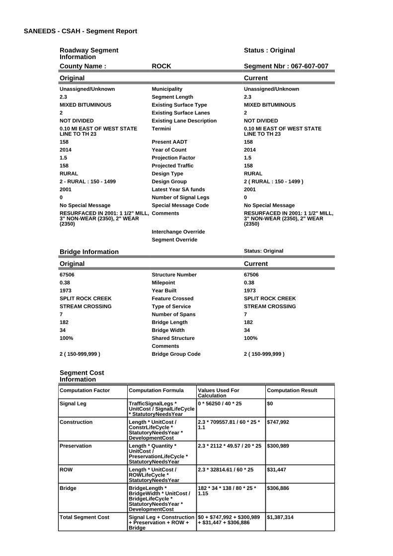
SANEEDS - CSAH - Segment Report
Roadway SegmentInformation
Status : Original
County Name : ROCK Segment Nbr : 067-607-007
Original Current
Unassigned/Unknown Municipality Unassigned/Unknown
2.3 Segment Length 2.3
MIXED BITUMINOUS Existing Surface Type MIXED BITUMINOUS
2 Existing Surface Lanes 2
NOT DIVIDED Existing Lane Description NOT DIVIDED
0.10 MI EAST OF WEST STATELINE TO TH 23
Termini 0.10 MI EAST OF WEST STATELINE TO TH 23
158 Present AADT 158
2014 Year of Count 2014
1.5 Projection Factor 1.5
158 Projected Traffic 158
RURAL Design Type RURAL
2 - RURAL : 150 - 1499 Design Group 2 ( RURAL : 150 - 1499 )
2001 Latest Year SA funds 2001
0 Number of Signal Legs 0
No Special Message Special Message Code No Special Message
RESURFACED IN 2001: 1 1/2" MILL,3" NON-WEAR (2350), 2" WEAR(2350)
Comments RESURFACED IN 2001: 1 1/2" MILL,3" NON-WEAR (2350), 2" WEAR(2350)
Interchange Override
Segment Override
Bridge Information Status: Original
Original Current
67506 Structure Number 67506
0.38 Milepoint 0.38
1973 Year Built 1973
SPLIT ROCK CREEK Feature Crossed SPLIT ROCK CREEK
STREAM CROSSING Type of Service STREAM CROSSING
7 Number of Spans 7
182 Bridge Length 182
34 Bridge Width 34
100% Shared Structure 100%
Comments
2 ( 150-999,999 ) Bridge Group Code 2 ( 150-999,999 )
Segment CostInformation
Computation Factor Computation Formula Values Used ForCalculation
Computation Result
Signal Leg TrafficSignalLegs *UnitCost / SignalLifeCycle* StatutoryNeedsYear
0 * 56250 / 40 * 25 $0
Construction Length * UnitCost /ConstrLifeCycle *StatutoryNeedsYear *DevelopmentCost
2.3 * 709557.81 / 60 * 25 *1.1
$747,992
Preservation Length * Quantity *UnitCost /PreservationLifeCycle *StatutoryNeedsYear
2.3 * 2112 * 49.57 / 20 * 25 $300,989
ROW Length * UnitCost /ROWLifeCycle *StatutoryNeedsYear
2.3 * 32814.61 / 60 * 25 $31,447
Bridge BridgeLength *BridgeWidth * UnitCost /BridgeLifeCycle *StatutoryNeedsYear *DevelopmentCost
182 * 34 * 138 / 80 * 25 *1.15
$306,886
Total Segment Cost Signal Leg + Construction+ Preservation + ROW +Bridge
$0 + $747,992 + $300,989+ $31,447 + $306,886
$1,387,314
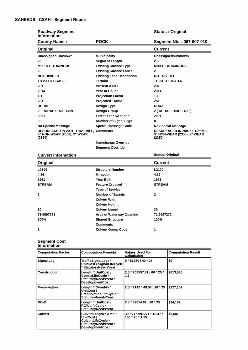
SANEEDS - CSAH - Segment Report
Roadway SegmentInformation
Status : Original
County Name : ROCK Segment Nbr : 067-607-010
Original Current
Unassigned/Unknown Municipality Unassigned/Unknown
2.5 Segment Length 2.5
MIXED BITUMINOUS Existing Surface Type MIXED BITUMINOUS
2 Existing Surface Lanes 2
NOT DIVIDED Existing Lane Description NOT DIVIDED
TH 23 TO CSAH 6 Termini TH 23 TO CSAH 6
281 Present AADT 281
2014 Year of Count 2014
1.1 Projection Factor 1.1
281 Projected Traffic 281
RURAL Design Type RURAL
2 - RURAL : 150 - 1499 Design Group 2 ( RURAL : 150 - 1499 )
2001 Latest Year SA funds 2001
0 Number of Signal Legs 0
No Special Message Special Message Code No Special Message
RESURFACED IN 2001: 1 1/2" MILL,3" NON-WEAR (2350), 2" WEAR(2350)
Comments RESURFACED IN 2001: 1 1/2" MILL,3" NON-WEAR (2350), 2" WEAR(2350)
Interchange Override
Segment Override
Culvert Information Status: Original
Original Current
L2100 Structure Number L2100
4.86 Milepoint 4.86
1961 Year Built 1961
STREAM Feature Crossed STREAM
Type of Service
2 Number of Barrels 2
Culvert Width
Culvert Height
30 Culvert Length 30
71.9997271 Area of Waterway Opening 71.9997271
100% Shared Structure 100%
Comments
1 Culvert Group Code 1
Segment CostInformation
Computation Factor Computation Formula Values Used ForCalculation
Computation Result
Signal Leg TrafficSignalLegs *UnitCost / SignalLifeCycle* StatutoryNeedsYear
0 * 56250 / 40 * 25 $0
Construction Length * UnitCost /ConstrLifeCycle *StatutoryNeedsYear *DevelopmentCost
2.5 * 709557.81 / 60 * 25 *1.1
$813,035
Preservation Length * Quantity *UnitCost /PreservationLifeCycle *StatutoryNeedsYear
2.5 * 2112 * 49.57 / 20 * 25 $327,162
ROW Length * UnitCost /ROWLifeCycle *StatutoryNeedsYear
2.5 * 32814.61 / 60 * 25 $34,182
Culvert CulvertLength * Area *UnitCost /CulvertLifeCycle *StatutoryNeedsYear *DevelopmentCost
30 * 71.9997271 * 15.47 /100 * 25 * 1.15
$9,607

Total Segment Cost Signal Leg + Construction+ Preservation + ROW +Culvert
$0 + $813,035 + $327,162+ $34,182 + $9,607
$1,183,986

SANEEDS - CSAH - Segment Report
Roadway SegmentInformation
Status : Original
County Name : ROCK Segment Nbr : 067-607-020
Original Current
Unassigned/Unknown Municipality Unassigned/Unknown
7 Segment Length 7
MIXED BITUMINOUS Existing Surface Type MIXED BITUMINOUS
2 Existing Surface Lanes 2
NOT DIVIDED Existing Lane Description NOT DIVIDED
CSAH 6 TO TH 75 Termini CSAH 6 TO TH 75
363 Present AADT 363
2014 Year of Count 2014
1.1 Projection Factor 1.1
363 Projected Traffic 363
RURAL Design Type RURAL
2 - RURAL : 150 - 1499 Design Group 2 ( RURAL : 150 - 1499 )
2001 Latest Year SA funds 2001
0 Number of Signal Legs 0
No Special Message Special Message Code No Special Message
RESURFACED IN 2001: 1 1/2" MILL,3" NON-WEAR (2350), 2" WEAR(2350)
Comments RESURFACED IN 2001: 1 1/2" MILL,3" NON-WEAR (2350), 2" WEAR(2350)
Interchange Override
Segment Override
Bridge Information Status: Original
Original Current
92762 Structure Number 92762
8.44 Milepoint 8.44
1959 Year Built 1959
STREAM Feature Crossed STREAM
Type of Service
Number of Spans
24.4 Bridge Length 24.4
29.5 Bridge Width 29.5
100% Shared Structure 100%
Comments
1 ( 0-149 ) Bridge Group Code 1 ( 0-149 )
Culvert Information Status: Original
Original Current
92896 Structure Number 92896
10.8 Milepoint 10.8
1972 Year Built 1972
BEAVER CREEK Feature Crossed BEAVER CREEK
Type of Service
2 Number of Barrels 2
12 Culvert Width 12
7 Culvert Height 7
44 Culvert Length 44
131.99985848 Area of Waterway Opening 131.99985848
100% Shared Structure 100%
Comments
1 Culvert Group Code 1
Segment CostInformation
Computation Factor Computation Formula Values Used ForCalculation
Computation Result

Signal Leg TrafficSignalLegs *UnitCost / SignalLifeCycle* StatutoryNeedsYear
0 * 56250 / 40 * 25 $0
Construction Length * UnitCost /ConstrLifeCycle *StatutoryNeedsYear *DevelopmentCost
7 * 709557.81 / 60 * 25 * 1.1 $2,276,498
Preservation Length * Quantity *UnitCost /PreservationLifeCycle *StatutoryNeedsYear
7 * 2112 * 49.57 / 20 * 25 $916,054
ROW Length * UnitCost /ROWLifeCycle *StatutoryNeedsYear
7 * 32814.61 / 60 * 25 $95,709
Bridge BridgeLength *BridgeWidth * UnitCost /BridgeLifeCycle *StatutoryNeedsYear *DevelopmentCost
24.4 * 29.5 * 152 / 80 * 25 *1.15
$39,319
Culvert CulvertLength * Area *UnitCost /CulvertLifeCycle *StatutoryNeedsYear *DevelopmentCost
44 * 131.99985848 * 15.47 /100 * 25 * 1.15
$25,832
Total Segment Cost Signal Leg + Construction+ Preservation + ROW +Bridge + Culvert
$0 + $2,276,498 + $916,054+ $95,709 + $39,319 +$25,832
$3,353,412

SANEEDS - CSAH - Segment Report
Roadway SegmentInformation
Status : Original
County Name : ROCK Segment Nbr : 067-607-030
Original Current
HARDWICK Municipality HARDWICK
0.49 Segment Length 0.49
MIXED BITUMINOUS Existing Surface Type MIXED BITUMINOUS
2 Existing Surface Lanes 2
NOT DIVIDED Existing Lane Description NOT DIVIDED
TH 75 TO 0.49 M E OF W LIM Termini TH 75 TO 0.49 M E OF W LIM
1155 Present AADT 1155
2014 Year of Count 2014
1.1 Projection Factor 1.1
1155 Projected Traffic 1155
RURAL Design Type RURAL
2 - RURAL : 150 - 1499 Design Group 2 ( RURAL : 150 - 1499 )
2013 Latest Year SA funds 2013
0 Number of Signal Legs 0
No Special Message Special Message Code No Special Message
2013 SAP 067-607-017 M&OL Comments 2013 SAP 067-607-017 M&OL
Interchange Override
Segment Override
Segment CostInformation
Computation Factor Computation Formula Values Used ForCalculation
Computation Result
Signal Leg TrafficSignalLegs *UnitCost / SignalLifeCycle* StatutoryNeedsYear
0 * 56250 / 40 * 25 $0
Construction Length * UnitCost /ConstrLifeCycle *StatutoryNeedsYear *DevelopmentCost
0.49 * 709557.81 / 60 * 25 *1.1
$159,355
Preservation Length * Quantity *UnitCost /PreservationLifeCycle *StatutoryNeedsYear
0.49 * 2112 * 49.57 / 20 * 25 $64,124
ROW Length * UnitCost /ROWLifeCycle *StatutoryNeedsYear
0.49 * 32814.61 / 60 * 25 $6,700
Total Segment Cost Signal Leg + Construction+ Preservation + ROW
$0 + $159,355 + $64,124 +$6,700
$230,179

SANEEDS - CSAH - Segment Report
Roadway SegmentInformation
Status : Original
County Name : ROCK Segment Nbr : 067-607-040
Original Current
HARDWICK Municipality HARDWICK
0.39 Segment Length 0.39
MIXED BITUMINOUS Existing Surface Type MIXED BITUMINOUS
2 Existing Surface Lanes 2
NOT DIVIDED Existing Lane Description NOT DIVIDED
0.49 M E TO 0.88 M E OF W LIM Termini 0.49 M E TO 0.88 M E OF W LIM
1155 Present AADT 1155
2014 Year of Count 2014
1.1 Projection Factor 1.1
1155 Projected Traffic 1155
URBAN Design Type URBAN
5 - URBAN : 0 - 9999 Design Group 5 ( URBAN : 0 - 9999 )
2013 Latest Year SA funds 2013
0 Number of Signal Legs 0
No Special Message Special Message Code No Special Message
2013 SAP 067-607-017 M&OL Comments 2013 SAP 067-607-017 M&OL
Interchange Override
Segment Override
Segment CostInformation
Computation Factor Computation Formula Values Used ForCalculation
Computation Result
Signal Leg TrafficSignalLegs *UnitCost / SignalLifeCycle* StatutoryNeedsYear
0 * 56250 / 40 * 25 $0
Construction Length * UnitCost /ConstrLifeCycle *StatutoryNeedsYear *DevelopmentCost
0.39 * 2655286.16 / 60 * 25* 1.15
$496,207
Preservation Length * Quantity *UnitCost /PreservationLifeCycle *StatutoryNeedsYear
0.39 * 2904 * 49.57 / 15 * 25 $93,568
ROW Length * UnitCost /ROWLifeCycle *StatutoryNeedsYear
0.39 * 11284.19 / 60 * 25 $1,834
Total Segment Cost Signal Leg + Construction+ Preservation + ROW
$0 + $496,207 + $93,568 +$1,834
$591,609

SANEEDS - CSAH - Segment Report
Roadway SegmentInformation
Status : Original
County Name : ROCK Segment Nbr : 067-607-050
Original Current
HARDWICK Municipality HARDWICK
0.62 Segment Length 0.62
MIXED BITUMINOUS Existing Surface Type MIXED BITUMINOUS
2 Existing Surface Lanes 2
NOT DIVIDED Existing Lane Description NOT DIVIDED
0.88 M E OF W LIM TO E LIM Termini 0.88 M E OF W LIM TO E LIM
858 Present AADT 858
2014 Year of Count 2014
1.1 Projection Factor 1.1
858 Projected Traffic 858
RURAL Design Type RURAL
2 - RURAL : 150 - 1499 Design Group 2 ( RURAL : 150 - 1499 )
2013 Latest Year SA funds 2013
0 Number of Signal Legs 0
No Special Message Special Message Code No Special Message
2013 SAP 067-607-017 M&OL Comments 2013 SAP 067-607-017 M&OL
Interchange Override
Segment Override
Bridge Information Status: Original
Original Current
L2106 Structure Number L2106
13.33 Milepoint 13.33
1959 Year Built 1959
MOUND CREEK Feature Crossed MOUND CREEK
Type of Service
Number of Spans
26.3 Bridge Length 26.3
46.6 Bridge Width 46.6
100% Shared Structure 100%
Comments
1 ( 0-149 ) Bridge Group Code 1 ( 0-149 )
Segment CostInformation
Computation Factor Computation Formula Values Used ForCalculation
Computation Result
Signal Leg TrafficSignalLegs *UnitCost / SignalLifeCycle* StatutoryNeedsYear
0 * 56250 / 40 * 25 $0
Construction Length * UnitCost /ConstrLifeCycle *StatutoryNeedsYear *DevelopmentCost
0.62 * 709557.81 / 60 * 25 *1.1
$201,633
Preservation Length * Quantity *UnitCost /PreservationLifeCycle *StatutoryNeedsYear
0.62 * 2112 * 49.57 / 20 * 25 $81,136
ROW Length * UnitCost /ROWLifeCycle *StatutoryNeedsYear
0.62 * 32814.61 / 60 * 25 $8,477
Bridge BridgeLength *BridgeWidth * UnitCost /BridgeLifeCycle *StatutoryNeedsYear *DevelopmentCost
26.3 * 46.6 * 152 / 80 * 25 *1.15
$66,947
Total Segment Cost Signal Leg + Construction+ Preservation + ROW +Bridge
$0 + $201,633 + $81,136 +$8,477 + $66,947
$358,193

SANEEDS - CSAH - Segment Report
Roadway SegmentInformation
Status : Original
County Name : ROCK Segment Nbr : 067-607-060
Original Current
Unassigned/Unknown Municipality Unassigned/Unknown
2.3 Segment Length 2.3
MIXED BITUMINOUS Existing Surface Type MIXED BITUMINOUS
2 Existing Surface Lanes 2
NOT DIVIDED Existing Lane Description NOT DIVIDED
E LIM HARDWICK TO 2.3 MI E Termini E LIM HARDWICK TO 2.3 MI E
858 Present AADT 858
2014 Year of Count 2014
1.1 Projection Factor 1.1
858 Projected Traffic 858
RURAL Design Type RURAL
2 - RURAL : 150 - 1499 Design Group 2 ( RURAL : 150 - 1499 )
2013 Latest Year SA funds 2013
0 Number of Signal Legs 0
No Special Message Special Message Code No Special Message
2013 SAP 067-607-017 M&OL Comments 2013 SAP 067-607-017 M&OL
Interchange Override
Segment Override
Culvert Information Status: Original
Original Current
93208 Structure Number 93208
14.95 Milepoint 14.95
1976 Year Built 1976
STREAM Feature Crossed STREAM
Type of Service
3 Number of Barrels 3
14 Culvert Width 14
8 Culvert Height 8
70 Culvert Length 70
246.00032338 Area of Waterway Opening 246.00032338
100% Shared Structure 100%
Comments
1 Culvert Group Code 1
Segment CostInformation
Computation Factor Computation Formula Values Used ForCalculation
Computation Result
Signal Leg TrafficSignalLegs *UnitCost / SignalLifeCycle* StatutoryNeedsYear
0 * 56250 / 40 * 25 $0
Construction Length * UnitCost /ConstrLifeCycle *StatutoryNeedsYear *DevelopmentCost
2.3 * 709557.81 / 60 * 25 *1.1
$747,992
Preservation Length * Quantity *UnitCost /PreservationLifeCycle *StatutoryNeedsYear
2.3 * 2112 * 49.57 / 20 * 25 $300,989
ROW Length * UnitCost /ROWLifeCycle *StatutoryNeedsYear
2.3 * 32814.61 / 60 * 25 $31,447
Culvert CulvertLength * Area *UnitCost /CulvertLifeCycle *StatutoryNeedsYear *DevelopmentCost
70 * 246.00032338 * 15.47 /100 * 25 * 1.15
$76,588
Total Segment Cost Signal Leg + Construction+ Preservation + ROW +Culvert
$0 + $747,992 + $300,989+ $31,447 + $76,588
$1,157,016

SANEEDS - CSAH - Segment Report
Roadway SegmentInformation
Status : Original
County Name : ROCK Segment Nbr : 067-607-061
Original Current
Unassigned/Unknown Municipality Unassigned/Unknown
0.4 Segment Length 0.4
MIXED BITUMINOUS Existing Surface Type MIXED BITUMINOUS
2 Existing Surface Lanes 2
NOT DIVIDED Existing Lane Description NOT DIVIDED
2.3 M E TO 2.7 M E OF E LIMHARWICK
Termini 2.3 M E TO 2.7 M E OF E LIMHARWICK
726 Present AADT 726
2014 Year of Count 2014
1.1 Projection Factor 1.1
726 Projected Traffic 726
RURAL Design Type RURAL
2 - RURAL : 150 - 1499 Design Group 2 ( RURAL : 150 - 1499 )
2013 Latest Year SA funds 2013
0 Number of Signal Legs 0
No Special Message Special Message Code No Special Message
2013 SAP 067-607-017 M&OL Comments 2013 SAP 067-607-017 M&OL
Interchange Override
Segment Override
Segment CostInformation
Computation Factor Computation Formula Values Used ForCalculation
Computation Result
Signal Leg TrafficSignalLegs *UnitCost / SignalLifeCycle* StatutoryNeedsYear
0 * 56250 / 40 * 25 $0
Construction Length * UnitCost /ConstrLifeCycle *StatutoryNeedsYear *DevelopmentCost
0.4 * 709557.81 / 60 * 25 *1.1
$130,086
Preservation Length * Quantity *UnitCost /PreservationLifeCycle *StatutoryNeedsYear
0.4 * 2112 * 49.57 / 20 * 25 $52,346
ROW Length * UnitCost /ROWLifeCycle *StatutoryNeedsYear
0.4 * 32814.61 / 60 * 25 $5,469
Total Segment Cost Signal Leg + Construction+ Preservation + ROW
$0 + $130,086 + $52,346 +$5,469
$187,901

SANEEDS - CSAH - Segment Report
Roadway SegmentInformation
Status : Original
County Name : ROCK Segment Nbr : 067-607-062
Original Current
Unassigned/Unknown Municipality Unassigned/Unknown
0.8 Segment Length 0.8
MIXED BITUMINOUS Existing Surface Type MIXED BITUMINOUS
2 Existing Surface Lanes 2
NOT DIVIDED Existing Lane Description NOT DIVIDED
2.7 MI E OF E LIM HARDWICK TOCSAH 2
Termini 2.7 MI E OF E LIM HARDWICK TOCSAH 2
726 Present AADT 726
2014 Year of Count 2014
1.1 Projection Factor 1.1
726 Projected Traffic 726
RURAL Design Type RURAL
2 - RURAL : 150 - 1499 Design Group 2 ( RURAL : 150 - 1499 )
2013 Latest Year SA funds 2013
0 Number of Signal Legs 0
No Special Message Special Message Code No Special Message
2013 SAP 067-607-017 M&OL Comments 2013 SAP 067-607-017 M&OL
Interchange Override
Segment Override
Culvert Information Status: Original
Original Current
L2091 Structure Number L2091
16.67 Milepoint 16.67
1926 Year Built 1926
DITCH Feature Crossed DITCH
Type of Service
1 Number of Barrels 1
10 Culvert Width 10
4 Culvert Height 4
76 Culvert Length 76
39.99972879 Area of Waterway Opening 39.99972879
100% Shared Structure 100%
Comments
1 Culvert Group Code 1
Segment CostInformation
Computation Factor Computation Formula Values Used ForCalculation
Computation Result
Signal Leg TrafficSignalLegs *UnitCost / SignalLifeCycle* StatutoryNeedsYear
0 * 56250 / 40 * 25 $0
Construction Length * UnitCost /ConstrLifeCycle *StatutoryNeedsYear *DevelopmentCost
0.8 * 709557.81 / 60 * 25 *1.1
$260,171
Preservation Length * Quantity *UnitCost /PreservationLifeCycle *StatutoryNeedsYear
0.8 * 2112 * 49.57 / 20 * 25 $104,692
ROW Length * UnitCost /ROWLifeCycle *StatutoryNeedsYear
0.8 * 32814.61 / 60 * 25 $10,938
Culvert CulvertLength * Area *UnitCost /CulvertLifeCycle *StatutoryNeedsYear *DevelopmentCost
76 * 39.99972879 * 15.47 /100 * 25 * 1.15
$13,521

Total Segment Cost Signal Leg + Construction+ Preservation + ROW +Culvert
$0 + $260,171 + $104,692+ $10,938 + $13,521
$389,322
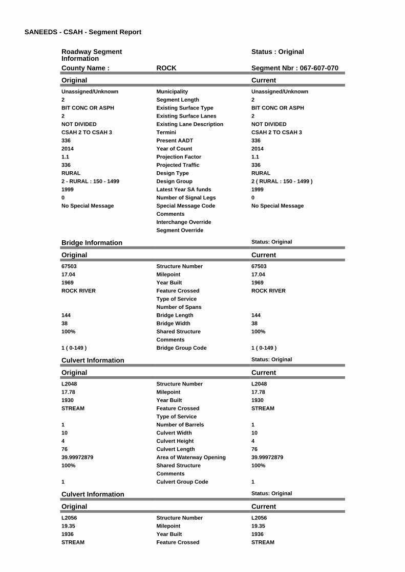
SANEEDS - CSAH - Segment Report
Roadway SegmentInformation
Status : Original
County Name : ROCK Segment Nbr : 067-607-070
Original Current
Unassigned/Unknown Municipality Unassigned/Unknown
2 Segment Length 2
BIT CONC OR ASPH Existing Surface Type BIT CONC OR ASPH
2 Existing Surface Lanes 2
NOT DIVIDED Existing Lane Description NOT DIVIDED
CSAH 2 TO CSAH 3 Termini CSAH 2 TO CSAH 3
336 Present AADT 336
2014 Year of Count 2014
1.1 Projection Factor 1.1
336 Projected Traffic 336
RURAL Design Type RURAL
2 - RURAL : 150 - 1499 Design Group 2 ( RURAL : 150 - 1499 )
1999 Latest Year SA funds 1999
0 Number of Signal Legs 0
No Special Message Special Message Code No Special Message
Comments
Interchange Override
Segment Override
Bridge Information Status: Original
Original Current
67503 Structure Number 67503
17.04 Milepoint 17.04
1969 Year Built 1969
ROCK RIVER Feature Crossed ROCK RIVER
Type of Service
Number of Spans
144 Bridge Length 144
38 Bridge Width 38
100% Shared Structure 100%
Comments
1 ( 0-149 ) Bridge Group Code 1 ( 0-149 )
Culvert Information Status: Original
Original Current
L2048 Structure Number L2048
17.78 Milepoint 17.78
1930 Year Built 1930
STREAM Feature Crossed STREAM
Type of Service
1 Number of Barrels 1
10 Culvert Width 10
4 Culvert Height 4
76 Culvert Length 76
39.99972879 Area of Waterway Opening 39.99972879
100% Shared Structure 100%
Comments
1 Culvert Group Code 1
Culvert Information Status: Original
Original Current
L2056 Structure Number L2056
19.35 Milepoint 19.35
1936 Year Built 1936
STREAM Feature Crossed STREAM

Type of Service
2 Number of Barrels 2
Culvert Width
Culvert Height
51 Culvert Length 51
80.00053397 Area of Waterway Opening 80.00053397
100% Shared Structure 100%
Comments
1 Culvert Group Code 1
Culvert Information Status: Original
Original Current
L2059 Structure Number L2059
19.536 Milepoint 19.536
1936 Year Built 1936
STREAM Feature Crossed STREAM
Type of Service
2 Number of Barrels 2
8 Culvert Width 8
4 Culvert Height 4
41 Culvert Length 41
63.99999662 Area of Waterway Opening 63.99999662
100% Shared Structure 100%
Comments
1 Culvert Group Code 1
Segment CostInformation
Computation Factor Computation Formula Values Used ForCalculation
Computation Result
Signal Leg TrafficSignalLegs *UnitCost / SignalLifeCycle* StatutoryNeedsYear
0 * 56250 / 40 * 25 $0
Construction Length * UnitCost /ConstrLifeCycle *StatutoryNeedsYear *DevelopmentCost
2 * 709557.81 / 60 * 25 * 1.1 $650,428
Preservation Length * Quantity *UnitCost /PreservationLifeCycle *StatutoryNeedsYear
2 * 2112 * 49.57 / 20 * 25 $261,730
ROW Length * UnitCost /ROWLifeCycle *StatutoryNeedsYear
2 * 32814.61 / 60 * 25 $27,346
Bridge BridgeLength *BridgeWidth * UnitCost /BridgeLifeCycle *StatutoryNeedsYear *DevelopmentCost
144 * 38 * 152 / 80 * 25 *1.15
$298,908
Culvert CulvertLength * Area *UnitCost /CulvertLifeCycle *StatutoryNeedsYear *DevelopmentCost
76 * 39.99972879 * 15.47 /100 * 25 * 1.15
$13,521
Culvert CulvertLength * Area *UnitCost /CulvertLifeCycle *StatutoryNeedsYear *DevelopmentCost
51 * 80.00053397 * 15.47 /100 * 25 * 1.15
$18,146
Culvert CulvertLength * Area *UnitCost /CulvertLifeCycle *StatutoryNeedsYear *DevelopmentCost
41 * 63.99999662 * 15.47 /100 * 25 * 1.15
$11,671
Total Segment Cost Signal Leg + Construction+ Preservation + ROW +Bridge + Culvert + Culvert+ Culvert
$0 + $650,428 + $261,730+ $27,346 + $298,908 +$13,521 + $18,146 +$11,671
$1,281,750

SANEEDS - CSAH - Segment Report
Roadway SegmentInformation
Status : Original
County Name : ROCK Segment Nbr : 067-608-010
Original Current
Unassigned/Unknown Municipality Unassigned/Unknown
5.1 Segment Length 5.1
AGGREGATE SURF Existing Surface Type AGGREGATE SURF
2 Existing Surface Lanes 2
NOT DIVIDED Existing Lane Description NOT DIVIDED
W CO LINE TO CSAH 6 Termini W CO LINE TO CSAH 6
275 Present AADT 275
2014 Year of Count 2014
1.1 Projection Factor 1.1
275 Projected Traffic 275
RURAL Design Type RURAL
2 - RURAL : 150 - 1499 Design Group 2 ( RURAL : 150 - 1499 )
2000 Latest Year SA funds 2000
0 Number of Signal Legs 0
No Special Message Special Message Code No Special Message
DSAE APPROVES USE OF ADTFROM THE EAST 4 MILES FORENTIRE SEGMENT. EFFECT ISOFFSET BY USE OF LOWERGRADING COST THAN USUALFOR 24'/32' SECTION.
Comments DSAE APPROVES USE OF ADTFROM THE EAST 4 MILES FORENTIRE SEGMENT. EFFECT ISOFFSET BY USE OF LOWERGRADING COST THAN USUALFOR 24'/32' SECTION.
Interchange Override
Segment Override
Segment CostInformation
Computation Factor Computation Formula Values Used ForCalculation
Computation Result
Signal Leg TrafficSignalLegs *UnitCost / SignalLifeCycle* StatutoryNeedsYear
0 * 56250 / 40 * 25 $0
Construction Length * UnitCost /ConstrLifeCycle *StatutoryNeedsYear *DevelopmentCost
5.1 * 709557.81 / 60 * 25 *1.1
$1,658,591
Preservation Length * Quantity *UnitCost /PreservationLifeCycle *StatutoryNeedsYear
5.1 * 2112 * 49.57 / 20 * 25 $667,410
ROW Length * UnitCost /ROWLifeCycle *StatutoryNeedsYear
5.1 * 32814.61 / 60 * 25 $69,731
Total Segment Cost Signal Leg + Construction+ Preservation + ROW
$0 + $1,658,591 + $667,410+ $69,731
$2,395,732

SANEEDS - CSAH - Segment Report
Roadway SegmentInformation
Status : Original
County Name : ROCK Segment Nbr : 067-608-011
Original Current
Unassigned/Unknown Municipality Unassigned/Unknown
4 Segment Length 4
MIXED BITUMINOUS Existing Surface Type MIXED BITUMINOUS
2 Existing Surface Lanes 2
NOT DIVIDED Existing Lane Description NOT DIVIDED
CSAH 6 TO S JCT CSAH 11 Termini CSAH 6 TO S JCT CSAH 11
275 Present AADT 275
2014 Year of Count 2014
1.1 Projection Factor 1.1
275 Projected Traffic 275
RURAL Design Type RURAL
2 - RURAL : 150 - 1499 Design Group 2 ( RURAL : 150 - 1499 )
2015 Latest Year SA funds 2015
0 Number of Signal Legs 0
No Special Message Special Message Code No Special Message
2015 SAP 067-608-016 M&OL
2014 SAP 067-608-014BR 67568
Comments 2015 SAP 067-608-016 M&OL
2014 SAP 067-608-014BR 67568
Interchange Override
Segment Override
Bridge Information Status: Original
Original Current
67568 Structure Number 67568
8.21 Milepoint 8.21
2014 Year Built 2014
BEAVER CREEK Feature Crossed BEAVER CREEK
Type of Service
1 Number of Spans 1
77.92 Bridge Length 77.92
35.33 Bridge Width 35.33
100% Shared Structure 100%
2014 SAP 067-608-014BR 67568
Comments 2014 SAP 067-608-014BR 67568
1 ( 0-149 ) Bridge Group Code 1 ( 0-149 )
Culvert Information Status: Original
Original Current
92710 Structure Number 92710
8.94 Milepoint 8.94
1970 Year Built 1970
LITTLE BEAVER CREEK Feature Crossed LITTLE BEAVER CREEK
Type of Service
2 Number of Barrels 2
14 Culvert Width 14
8 Culvert Height 8
42 Culvert Length 42
162.99989048 Area of Waterway Opening 162.99989048
100% Shared Structure 100%
Comments
1 Culvert Group Code 1
Segment CostInformation
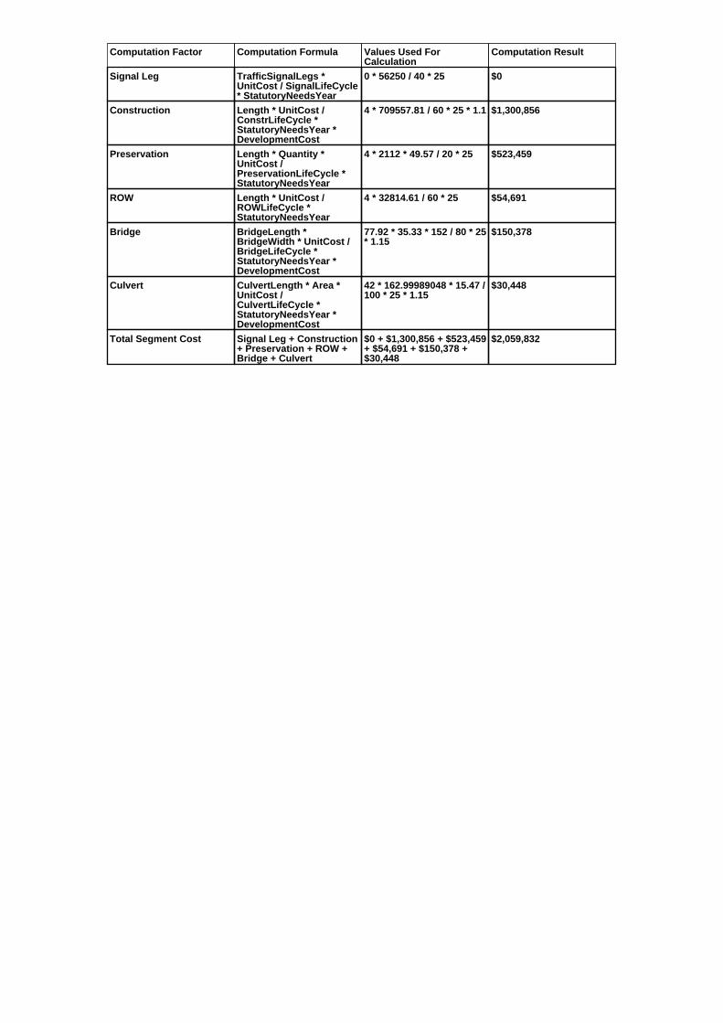
Computation Factor Computation Formula Values Used ForCalculation
Computation Result
Signal Leg TrafficSignalLegs *UnitCost / SignalLifeCycle* StatutoryNeedsYear
0 * 56250 / 40 * 25 $0
Construction Length * UnitCost /ConstrLifeCycle *StatutoryNeedsYear *DevelopmentCost
4 * 709557.81 / 60 * 25 * 1.1 $1,300,856
Preservation Length * Quantity *UnitCost /PreservationLifeCycle *StatutoryNeedsYear
4 * 2112 * 49.57 / 20 * 25 $523,459
ROW Length * UnitCost /ROWLifeCycle *StatutoryNeedsYear
4 * 32814.61 / 60 * 25 $54,691
Bridge BridgeLength *BridgeWidth * UnitCost /BridgeLifeCycle *StatutoryNeedsYear *DevelopmentCost
77.92 * 35.33 * 152 / 80 * 25* 1.15
$150,378
Culvert CulvertLength * Area *UnitCost /CulvertLifeCycle *StatutoryNeedsYear *DevelopmentCost
42 * 162.99989048 * 15.47 /100 * 25 * 1.15
$30,448
Total Segment Cost Signal Leg + Construction+ Preservation + ROW +Bridge + Culvert
$0 + $1,300,856 + $523,459+ $54,691 + $150,378 +$30,448
$2,059,832

SANEEDS - CSAH - Segment Report
Roadway SegmentInformation
Status : Original
County Name : ROCK Segment Nbr : 067-608-012
Original Current
Unassigned/Unknown Municipality Unassigned/Unknown
3 Segment Length 3
MIXED BITUMINOUS Existing Surface Type MIXED BITUMINOUS
2 Existing Surface Lanes 2
NOT DIVIDED Existing Lane Description NOT DIVIDED
CSAH 11 TO TH 75 Termini CSAH 11 TO TH 75
363 Present AADT 363
2014 Year of Count 2014
1.1 Projection Factor 1.1
363 Projected Traffic 363
RURAL Design Type RURAL
2 - RURAL : 150 - 1499 Design Group 2 ( RURAL : 150 - 1499 )
2015 Latest Year SA funds 2015
0 Number of Signal Legs 0
No Special Message Special Message Code No Special Message
2015 SAP 067-608-016 M&OL Comments 2015 SAP 067-608-016 M&OL
Interchange Override
Segment Override
Culvert Information Status: Original
Original Current
92709 Structure Number 92709
11.83 Milepoint 11.83
1970 Year Built 1970
STREAM Feature Crossed STREAM
Type of Service
2 Number of Barrels 2
9 Culvert Width 9
5 Culvert Height 5
48 Culvert Length 48
68.99982817 Area of Waterway Opening 68.99982817
100% Shared Structure 100%
Comments
1 Culvert Group Code 1
Segment CostInformation
Computation Factor Computation Formula Values Used ForCalculation
Computation Result
Signal Leg TrafficSignalLegs *UnitCost / SignalLifeCycle* StatutoryNeedsYear
0 * 56250 / 40 * 25 $0
Construction Length * UnitCost /ConstrLifeCycle *StatutoryNeedsYear *DevelopmentCost
3 * 709557.81 / 60 * 25 * 1.1 $975,642
Preservation Length * Quantity *UnitCost /PreservationLifeCycle *StatutoryNeedsYear
3 * 2112 * 49.57 / 20 * 25 $392,594
ROW Length * UnitCost /ROWLifeCycle *StatutoryNeedsYear
3 * 32814.61 / 60 * 25 $41,018
Culvert CulvertLength * Area *UnitCost /CulvertLifeCycle *StatutoryNeedsYear *DevelopmentCost
48 * 68.99982817 * 15.47 /100 * 25 * 1.15
$14,730
Total Segment Cost Signal Leg + Construction+ Preservation + ROW +Culvert
$0 + $975,642 + $392,594+ $41,018 + $14,730
$1,423,984

SANEEDS - CSAH - Segment Report
Roadway SegmentInformation
Status : Original
County Name : ROCK Segment Nbr : 067-608-020
Original Current
Unassigned/Unknown Municipality Unassigned/Unknown
3.8 Segment Length 3.8
BIT CONC OR ASPH Existing Surface Type BIT CONC OR ASPH
2 Existing Surface Lanes 2
NOT DIVIDED Existing Lane Description NOT DIVIDED
TH 75 TO CSAH 19 Termini TH 75 TO CSAH 19
418 Present AADT 418
2014 Year of Count 2014
1.1 Projection Factor 1.1
418 Projected Traffic 418
RURAL Design Type RURAL
2 - RURAL : 150 - 1499 Design Group 2 ( RURAL : 150 - 1499 )
1999 Latest Year SA funds 1999
0 Number of Signal Legs 0
No Special Message Special Message Code No Special Message
Comments
Interchange Override
Segment Override
Bridge Information Status: Original
Original Current
92759 Structure Number 92759
15.62 Milepoint 15.62
1960 Year Built 1960
MOUND CREEK Feature Crossed MOUND CREEK
Type of Service
Number of Spans
37 Bridge Length 37
29.4 Bridge Width 29.4
100% Shared Structure 100%
Comments
1 ( 0-149 ) Bridge Group Code 1 ( 0-149 )
Culvert Information Status: Original
Original Current
L2117 Structure Number L2117
12.37 Milepoint 12.37
1928 Year Built 1928
STREAM Feature Crossed STREAM
Type of Service
1 Number of Barrels 1
10 Culvert Width 10
4 Culvert Height 4
40 Culvert Length 40
39.99972879 Area of Waterway Opening 39.99972879
100% Shared Structure 100%
Comments
1 Culvert Group Code 1
Segment CostInformation
Computation Factor Computation Formula Values Used ForCalculation
Computation Result
Signal Leg TrafficSignalLegs *UnitCost / SignalLifeCycle* StatutoryNeedsYear
0 * 56250 / 40 * 25 $0
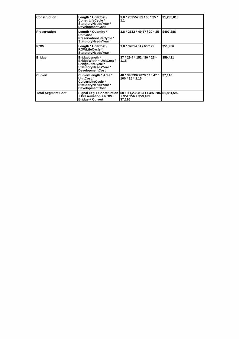
Construction Length * UnitCost /ConstrLifeCycle *StatutoryNeedsYear *DevelopmentCost
3.8 * 709557.81 / 60 * 25 *1.1
$1,235,813
Preservation Length * Quantity *UnitCost /PreservationLifeCycle *StatutoryNeedsYear
3.8 * 2112 * 49.57 / 20 * 25 $497,286
ROW Length * UnitCost /ROWLifeCycle *StatutoryNeedsYear
3.8 * 32814.61 / 60 * 25 $51,956
Bridge BridgeLength *BridgeWidth * UnitCost /BridgeLifeCycle *StatutoryNeedsYear *DevelopmentCost
37 * 29.4 * 152 / 80 * 25 *1.15
$59,421
Culvert CulvertLength * Area *UnitCost /CulvertLifeCycle *StatutoryNeedsYear *DevelopmentCost
40 * 39.99972879 * 15.47 /100 * 25 * 1.15
$7,116
Total Segment Cost Signal Leg + Construction+ Preservation + ROW +Bridge + Culvert
$0 + $1,235,813 + $497,286+ $51,956 + $59,421 +$7,116
$1,851,592
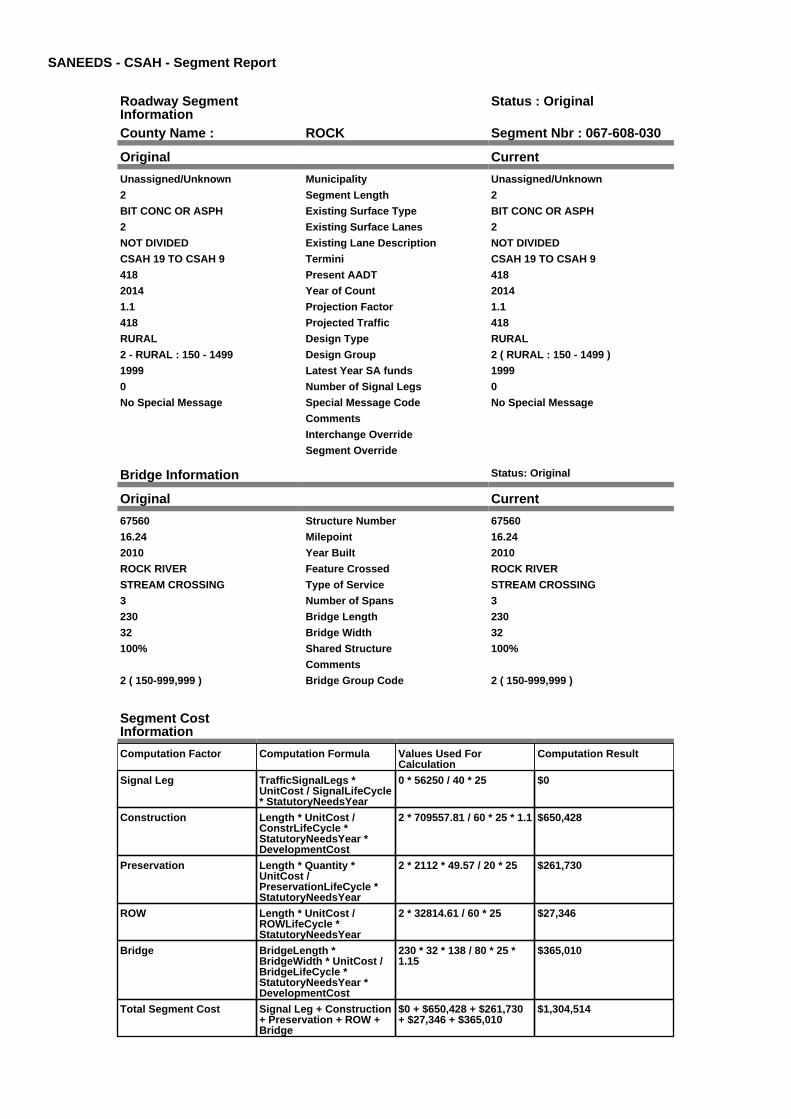
SANEEDS - CSAH - Segment Report
Roadway SegmentInformation
Status : Original
County Name : ROCK Segment Nbr : 067-608-030
Original Current
Unassigned/Unknown Municipality Unassigned/Unknown
2 Segment Length 2
BIT CONC OR ASPH Existing Surface Type BIT CONC OR ASPH
2 Existing Surface Lanes 2
NOT DIVIDED Existing Lane Description NOT DIVIDED
CSAH 19 TO CSAH 9 Termini CSAH 19 TO CSAH 9
418 Present AADT 418
2014 Year of Count 2014
1.1 Projection Factor 1.1
418 Projected Traffic 418
RURAL Design Type RURAL
2 - RURAL : 150 - 1499 Design Group 2 ( RURAL : 150 - 1499 )
1999 Latest Year SA funds 1999
0 Number of Signal Legs 0
No Special Message Special Message Code No Special Message
Comments
Interchange Override
Segment Override
Bridge Information Status: Original
Original Current
67560 Structure Number 67560
16.24 Milepoint 16.24
2010 Year Built 2010
ROCK RIVER Feature Crossed ROCK RIVER
STREAM CROSSING Type of Service STREAM CROSSING
3 Number of Spans 3
230 Bridge Length 230
32 Bridge Width 32
100% Shared Structure 100%
Comments
2 ( 150-999,999 ) Bridge Group Code 2 ( 150-999,999 )
Segment CostInformation
Computation Factor Computation Formula Values Used ForCalculation
Computation Result
Signal Leg TrafficSignalLegs *UnitCost / SignalLifeCycle* StatutoryNeedsYear
0 * 56250 / 40 * 25 $0
Construction Length * UnitCost /ConstrLifeCycle *StatutoryNeedsYear *DevelopmentCost
2 * 709557.81 / 60 * 25 * 1.1 $650,428
Preservation Length * Quantity *UnitCost /PreservationLifeCycle *StatutoryNeedsYear
2 * 2112 * 49.57 / 20 * 25 $261,730
ROW Length * UnitCost /ROWLifeCycle *StatutoryNeedsYear
2 * 32814.61 / 60 * 25 $27,346
Bridge BridgeLength *BridgeWidth * UnitCost /BridgeLifeCycle *StatutoryNeedsYear *DevelopmentCost
230 * 32 * 138 / 80 * 25 *1.15
$365,010
Total Segment Cost Signal Leg + Construction+ Preservation + ROW +Bridge
$0 + $650,428 + $261,730+ $27,346 + $365,010
$1,304,514

SANEEDS - CSAH - Segment Report
Roadway SegmentInformation
Status : Original
County Name : ROCK Segment Nbr : 067-608-040
Original Current
Unassigned/Unknown Municipality Unassigned/Unknown
3 Segment Length 3
BIT CONC OR ASPH Existing Surface Type BIT CONC OR ASPH
2 Existing Surface Lanes 2
NOT DIVIDED Existing Lane Description NOT DIVIDED
CSAH 9 TO CSAH 3 Termini CSAH 9 TO CSAH 3
248 Present AADT 248
2014 Year of Count 2014
1.1 Projection Factor 1.1
248 Projected Traffic 248
RURAL Design Type RURAL
2 - RURAL : 150 - 1499 Design Group 2 ( RURAL : 150 - 1499 )
2013 Latest Year SA funds 2013
0 Number of Signal Legs 0
No Special Message Special Message Code No Special Message
2013 SAP 067-608-013 CULVERT67K13
Comments 2013 SAP 067-608-013 CULVERT67K13
Interchange Override
Segment Override
Bridge Information Status: Original
Original Current
67562 Structure Number 67562
20.63 Milepoint 20.63
2012 Year Built 2012
CHAMPEPADAN CREEK Feature Crossed CHAMPEPADAN CREEK
Type of Service
3 Number of Spans 3
66.6 Bridge Length 66.6
35.3 Bridge Width 35.3
100% Shared Structure 100%
2012 SP 067-608-009 BR# 67562REPLACES 92760
Comments 2012 SP 067-608-009 BR# 67562REPLACES 92760
1 ( 0-149 ) Bridge Group Code 1 ( 0-149 )
Culvert Information Status: Original
Original Current
8692 Structure Number 8692
20.43 Milepoint 20.43
1938 Year Built 1938
STREAM Feature Crossed STREAM
Type of Service
2 Number of Barrels 2
10 Culvert Width 10
4 Culvert Height 4
32 Culvert Length 32
80.00053397 Area of Waterway Opening 80.00053397
100% Shared Structure 100%
Comments
1 Culvert Group Code 1
Culvert Information Status: Original
Original Current
67K13 Structure Number 67K13
20.34 Milepoint 20.34

2013 Year Built 2013
Stream Feature Crossed Stream
STREAM CROSSING Type of Service STREAM CROSSING
1 Number of Barrels 1
10 Culvert Width 10
4 Culvert Height 4
58 Culvert Length 58
40 Area of Waterway Opening 40
100% Shared Structure 100%
2013 SAP 067-608-013 CULVERT67K13
Comments 2013 SAP 067-608-013 CULVERT67K13
1 Culvert Group Code 1
Segment CostInformation
Computation Factor Computation Formula Values Used ForCalculation
Computation Result
Signal Leg TrafficSignalLegs *UnitCost / SignalLifeCycle* StatutoryNeedsYear
0 * 56250 / 40 * 25 $0
Construction Length * UnitCost /ConstrLifeCycle *StatutoryNeedsYear *DevelopmentCost
3 * 709557.81 / 60 * 25 * 1.1 $975,642
Preservation Length * Quantity *UnitCost /PreservationLifeCycle *StatutoryNeedsYear
3 * 2112 * 49.57 / 20 * 25 $392,594
ROW Length * UnitCost /ROWLifeCycle *StatutoryNeedsYear
3 * 32814.61 / 60 * 25 $41,018
Bridge BridgeLength *BridgeWidth * UnitCost /BridgeLifeCycle *StatutoryNeedsYear *DevelopmentCost
66.6 * 35.3 * 152 / 80 * 25 *1.15
$128,422
Culvert CulvertLength * Area *UnitCost /CulvertLifeCycle *StatutoryNeedsYear *DevelopmentCost
32 * 80.00053397 * 15.47 /100 * 25 * 1.15
$11,386
Culvert CulvertLength * Area *UnitCost /CulvertLifeCycle *StatutoryNeedsYear *DevelopmentCost
58 * 40 * 15.47 / 100 * 25 *1.15
$10,318
Total Segment Cost Signal Leg + Construction+ Preservation + ROW +Bridge + Culvert + Culvert
$0 + $975,642 + $392,594+ $41,018 + $128,422 +$11,386 + $10,318
$1,559,380

SANEEDS - CSAH - Segment Report
Roadway SegmentInformation
Status : Original
County Name : ROCK Segment Nbr : 067-609-010
Original Current
Unassigned/Unknown Municipality Unassigned/Unknown
3 Segment Length 3
MIXED BITUMINOUS Existing Surface Type MIXED BITUMINOUS
2 Existing Surface Lanes 2
NOT DIVIDED Existing Lane Description NOT DIVIDED
S CO LINE TO CSAH 1 Termini S CO LINE TO CSAH 1
242 Present AADT 242
2014 Year of Count 2014
1.1 Projection Factor 1.1
242 Projected Traffic 242
RURAL Design Type RURAL
2 - RURAL : 150 - 1499 Design Group 2 ( RURAL : 150 - 1499 )
2008 Latest Year SA funds 2008
0 Number of Signal Legs 0
No Special Message Special Message Code No Special Message
SAP 67-609-16, 2008 OVERLAY Comments SAP 67-609-16, 2008 OVERLAY
Interchange Override
Segment Override
Bridge Information Status: Original
Original Current
92429 Structure Number 92429
1.29 Milepoint 1.29
1965 Year Built 1965
STREAM Feature Crossed STREAM
Type of Service
Number of Spans
24.1 Bridge Length 24.1
32.4 Bridge Width 32.4
100% Shared Structure 100%
Comments
1 ( 0-149 ) Bridge Group Code 1 ( 0-149 )
Segment CostInformation
Computation Factor Computation Formula Values Used ForCalculation
Computation Result
Signal Leg TrafficSignalLegs *UnitCost / SignalLifeCycle* StatutoryNeedsYear
0 * 56250 / 40 * 25 $0
Construction Length * UnitCost /ConstrLifeCycle *StatutoryNeedsYear *DevelopmentCost
3 * 709557.81 / 60 * 25 * 1.1 $975,642
Preservation Length * Quantity *UnitCost /PreservationLifeCycle *StatutoryNeedsYear
3 * 2112 * 49.57 / 20 * 25 $392,594
ROW Length * UnitCost /ROWLifeCycle *StatutoryNeedsYear
3 * 32814.61 / 60 * 25 $41,018
Bridge BridgeLength *BridgeWidth * UnitCost /BridgeLifeCycle *StatutoryNeedsYear *DevelopmentCost
24.1 * 32.4 * 152 / 80 * 25 *1.15
$42,653
Total Segment Cost Signal Leg + Construction+ Preservation + ROW +Bridge
$0 + $975,642 + $392,594+ $41,018 + $42,653
$1,451,907
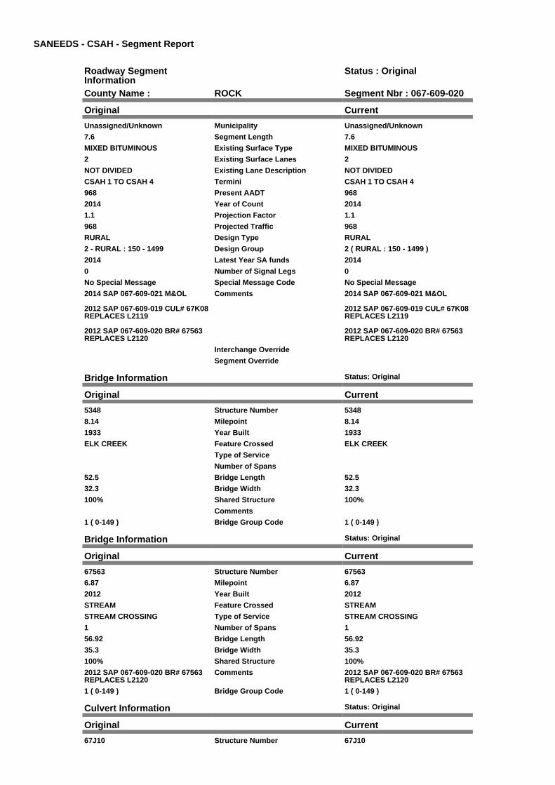
SANEEDS - CSAH - Segment Report
Roadway SegmentInformation
Status : Original
County Name : ROCK Segment Nbr : 067-609-020
Original Current
Unassigned/Unknown Municipality Unassigned/Unknown
7.6 Segment Length 7.6
MIXED BITUMINOUS Existing Surface Type MIXED BITUMINOUS
2 Existing Surface Lanes 2
NOT DIVIDED Existing Lane Description NOT DIVIDED
CSAH 1 TO CSAH 4 Termini CSAH 1 TO CSAH 4
968 Present AADT 968
2014 Year of Count 2014
1.1 Projection Factor 1.1
968 Projected Traffic 968
RURAL Design Type RURAL
2 - RURAL : 150 - 1499 Design Group 2 ( RURAL : 150 - 1499 )
2014 Latest Year SA funds 2014
0 Number of Signal Legs 0
No Special Message Special Message Code No Special Message
2014 SAP 067-609-021 M&OL
2012 SAP 067-609-019 CUL# 67K08REPLACES L2119
2012 SAP 067-609-020 BR# 67563REPLACES L2120
Comments 2014 SAP 067-609-021 M&OL
2012 SAP 067-609-019 CUL# 67K08REPLACES L2119
2012 SAP 067-609-020 BR# 67563REPLACES L2120
Interchange Override
Segment Override
Bridge Information Status: Original
Original Current
5348 Structure Number 5348
8.14 Milepoint 8.14
1933 Year Built 1933
ELK CREEK Feature Crossed ELK CREEK
Type of Service
Number of Spans
52.5 Bridge Length 52.5
32.3 Bridge Width 32.3
100% Shared Structure 100%
Comments
1 ( 0-149 ) Bridge Group Code 1 ( 0-149 )
Bridge Information Status: Original
Original Current
67563 Structure Number 67563
6.87 Milepoint 6.87
2012 Year Built 2012
STREAM Feature Crossed STREAM
STREAM CROSSING Type of Service STREAM CROSSING
1 Number of Spans 1
56.92 Bridge Length 56.92
35.3 Bridge Width 35.3
100% Shared Structure 100%
2012 SAP 067-609-020 BR# 67563REPLACES L2120
Comments 2012 SAP 067-609-020 BR# 67563REPLACES L2120
1 ( 0-149 ) Bridge Group Code 1 ( 0-149 )
Culvert Information Status: Original
Original Current
67J10 Structure Number 67J10

4.48 Milepoint 4.48
1996 Year Built 1996
STREAM Feature Crossed STREAM
STREAM CROSSING Type of Service STREAM CROSSING
2 Number of Barrels 2
12 Culvert Width 12
7 Culvert Height 7
60 Culvert Length 60
163.99985679 Area of Waterway Opening 163.99985679
100% Shared Structure 100%
Comments
1 Culvert Group Code 1
Culvert Information Status: Original
Original Current
67K08 Structure Number 67K08
8.89 Milepoint 8.89
2012 Year Built 2012
Stream Feature Crossed Stream
STREAM CROSSING Type of Service STREAM CROSSING
1 Number of Barrels 1
12 Culvert Width 12
5 Culvert Height 5
54 Culvert Length 54
60 Area of Waterway Opening 60
100% Shared Structure 100%
2012 SAP 067-609-019 CUL# 67K08REPLACES L2119
Comments 2012 SAP 067-609-019 CUL# 67K08REPLACES L2119
1 Culvert Group Code 1
RailRoadCrossingInformation
Status: Original
Original Current
UNION PACIFIC RAILROAD RailRoad Name UNION PACIFIC RAILROAD
185794W USDOT Number 185794W
7.2 Located at Milepoint 7.2
1 Mainline Tracks 1
SIGNS ONLY Protection Type SIGNS ONLY
Last Year Protection Upgraded
26 Crossing Length 26
Last Year Surfaced
100% Percentage of Cost 100%
Comments
Segment CostInformation
Computation Factor Computation Formula Values Used ForCalculation
Computation Result
Signal Leg TrafficSignalLegs *UnitCost / SignalLifeCycle* StatutoryNeedsYear
0 * 56250 / 40 * 25 $0
Construction Length * UnitCost /ConstrLifeCycle *StatutoryNeedsYear *DevelopmentCost
7.6 * 709557.81 / 60 * 25 *1.1
$2,471,626
Preservation Length * Quantity *UnitCost /PreservationLifeCycle *StatutoryNeedsYear
7.6 * 2112 * 49.57 / 20 * 25 $994,572
ROW Length * UnitCost /ROWLifeCycle *StatutoryNeedsYear
7.6 * 32814.61 / 60 * 25 $103,913
Bridge BridgeLength *BridgeWidth * UnitCost /BridgeLifeCycle *StatutoryNeedsYear *DevelopmentCost
52.5 * 32.3 * 152 / 80 * 25 *1.15
$92,630

Bridge BridgeLength *BridgeWidth * UnitCost /BridgeLifeCycle *StatutoryNeedsYear *DevelopmentCost
56.92 * 35.3 * 152 / 80 * 25* 1.15
$109,757
Culvert CulvertLength * Area *UnitCost /CulvertLifeCycle *StatutoryNeedsYear *DevelopmentCost
60 * 163.99985679 * 15.47 /100 * 25 * 1.15
$43,765
Culvert CulvertLength * Area *UnitCost /CulvertLifeCycle *StatutoryNeedsYear *DevelopmentCost
54 * 60 * 15.47 / 100 * 25 *1.15
$14,410
RR Crossing Protection UnitCost /RRCrossingLifeCycle *StatutoryNeedsYear
1500 / 25 * 25 $1,500
RR Crossing Surface SurfaceLength * UnitCost/ RRCrossingLifeCycle *StatutoryNeedsYear
26 * 1350 / 25 * 25 $35,100
Total Segment Cost Signal Leg + Construction+ Preservation + ROW +Bridge + Bridge + Culvert+ Culvert + RR CrossingProtection + RR CrossingSurface
$0 + $2,471,626 + $994,572+ $103,913 + $92,630 +$109,757 + $43,765 +$14,410 + $1,500 + $35,100
$3,867,273

SANEEDS - CSAH - Segment Report
Roadway SegmentInformation
Status : Original
County Name : ROCK Segment Nbr : 067-609-029
Original Current
Unassigned/Unknown Municipality Unassigned/Unknown
1 Segment Length 1
MIXED BITUMINOUS Existing Surface Type MIXED BITUMINOUS
2 Existing Surface Lanes 2
NOT DIVIDED Existing Lane Description NOT DIVIDED
CSAH 4 TO 1.0 MI NORTH Termini CSAH 4 TO 1.0 MI NORTH
156 Present AADT 156
2014 Year of Count 2014
1.3 Projection Factor 1.3
156 Projected Traffic 156
RURAL Design Type RURAL
2 - RURAL : 150 - 1499 Design Group 2 ( RURAL : 150 - 1499 )
2008 Latest Year SA funds 2008
0 Number of Signal Legs 0
No Special Message Special Message Code No Special Message
SAP 67-609-17, 2008 OVERLAY Comments SAP 67-609-17, 2008 OVERLAY
Interchange Override
Segment Override
Segment CostInformation
Computation Factor Computation Formula Values Used ForCalculation
Computation Result
Signal Leg TrafficSignalLegs *UnitCost / SignalLifeCycle* StatutoryNeedsYear
0 * 56250 / 40 * 25 $0
Construction Length * UnitCost /ConstrLifeCycle *StatutoryNeedsYear *DevelopmentCost
1 * 709557.81 / 60 * 25 * 1.1 $325,214
Preservation Length * Quantity *UnitCost /PreservationLifeCycle *StatutoryNeedsYear
1 * 2112 * 49.57 / 20 * 25 $130,865
ROW Length * UnitCost /ROWLifeCycle *StatutoryNeedsYear
1 * 32814.61 / 60 * 25 $13,673
Total Segment Cost Signal Leg + Construction+ Preservation + ROW
$0 + $325,214 + $130,865+ $13,673
$469,752

SANEEDS - CSAH - Segment Report
Roadway SegmentInformation
Status : Original
County Name : ROCK Segment Nbr : 067-609-030
Original Current
Unassigned/Unknown Municipality Unassigned/Unknown
4.3 Segment Length 4.3
MIXED BITUMINOUS Existing Surface Type MIXED BITUMINOUS
2 Existing Surface Lanes 2
NOT DIVIDED Existing Lane Description NOT DIVIDED
1.0 MI N OF CSAH 4 TO 1.0 MI S OFCSAH 8
Termini 1.0 MI N OF CSAH 4 TO 1.0 MI S OFCSAH 8
156 Present AADT 156
2014 Year of Count 2014
1.3 Projection Factor 1.3
156 Projected Traffic 156
RURAL Design Type RURAL
2 - RURAL : 150 - 1499 Design Group 2 ( RURAL : 150 - 1499 )
2008 Latest Year SA funds 2008
0 Number of Signal Legs 0
No Special Message Special Message Code No Special Message
SAP 67-609-17, 2008 OVERLAY Comments SAP 67-609-17, 2008 OVERLAY
Interchange Override
Segment Override
Segment CostInformation
Computation Factor Computation Formula Values Used ForCalculation
Computation Result
Signal Leg TrafficSignalLegs *UnitCost / SignalLifeCycle* StatutoryNeedsYear
0 * 56250 / 40 * 25 $0
Construction Length * UnitCost /ConstrLifeCycle *StatutoryNeedsYear *DevelopmentCost
4.3 * 709557.81 / 60 * 25 *1.1
$1,398,420
Preservation Length * Quantity *UnitCost /PreservationLifeCycle *StatutoryNeedsYear
4.3 * 2112 * 49.57 / 20 * 25 $562,719
ROW Length * UnitCost /ROWLifeCycle *StatutoryNeedsYear
4.3 * 32814.61 / 60 * 25 $58,793
Total Segment Cost Signal Leg + Construction+ Preservation + ROW
$0 + $1,398,420 + $562,719+ $58,793
$2,019,932

SANEEDS - CSAH - Segment Report
Roadway SegmentInformation
Status : Original
County Name : ROCK Segment Nbr : 067-609-031
Original Current
Unassigned/Unknown Municipality Unassigned/Unknown
1 Segment Length 1
MIXED BITUMINOUS Existing Surface Type MIXED BITUMINOUS
2 Existing Surface Lanes 2
NOT DIVIDED Existing Lane Description NOT DIVIDED
1.0 MI S TO CSAH 8 Termini 1.0 MI S TO CSAH 8
1232 Present AADT 1232
2014 Year of Count 2014
1.1 Projection Factor 1.1
1232 Projected Traffic 1232
RURAL Design Type RURAL
2 - RURAL : 150 - 1499 Design Group 2 ( RURAL : 150 - 1499 )
2008 Latest Year SA funds 2008
0 Number of Signal Legs 0
No Special Message Special Message Code No Special Message
SAP 67-609-17, 2008 OVERLAY Comments SAP 67-609-17, 2008 OVERLAY
Interchange Override
Segment Override
Segment CostInformation
Computation Factor Computation Formula Values Used ForCalculation
Computation Result
Signal Leg TrafficSignalLegs *UnitCost / SignalLifeCycle* StatutoryNeedsYear
0 * 56250 / 40 * 25 $0
Construction Length * UnitCost /ConstrLifeCycle *StatutoryNeedsYear *DevelopmentCost
1 * 709557.81 / 60 * 25 * 1.1 $325,214
Preservation Length * Quantity *UnitCost /PreservationLifeCycle *StatutoryNeedsYear
1 * 2112 * 49.57 / 20 * 25 $130,865
ROW Length * UnitCost /ROWLifeCycle *StatutoryNeedsYear
1 * 32814.61 / 60 * 25 $13,673
Total Segment Cost Signal Leg + Construction+ Preservation + ROW
$0 + $325,214 + $130,865+ $13,673
$469,752
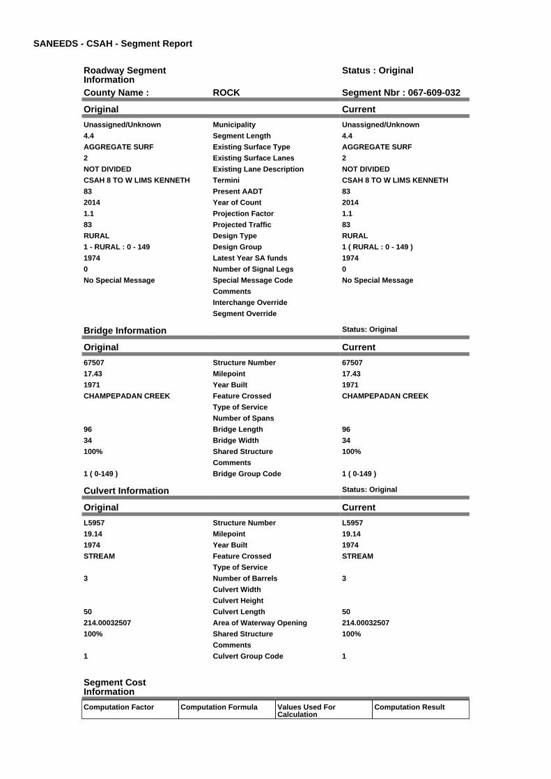
SANEEDS - CSAH - Segment Report
Roadway SegmentInformation
Status : Original
County Name : ROCK Segment Nbr : 067-609-032
Original Current
Unassigned/Unknown Municipality Unassigned/Unknown
4.4 Segment Length 4.4
AGGREGATE SURF Existing Surface Type AGGREGATE SURF
2 Existing Surface Lanes 2
NOT DIVIDED Existing Lane Description NOT DIVIDED
CSAH 8 TO W LIMS KENNETH Termini CSAH 8 TO W LIMS KENNETH
83 Present AADT 83
2014 Year of Count 2014
1.1 Projection Factor 1.1
83 Projected Traffic 83
RURAL Design Type RURAL
1 - RURAL : 0 - 149 Design Group 1 ( RURAL : 0 - 149 )
1974 Latest Year SA funds 1974
0 Number of Signal Legs 0
No Special Message Special Message Code No Special Message
Comments
Interchange Override
Segment Override
Bridge Information Status: Original
Original Current
67507 Structure Number 67507
17.43 Milepoint 17.43
1971 Year Built 1971
CHAMPEPADAN CREEK Feature Crossed CHAMPEPADAN CREEK
Type of Service
Number of Spans
96 Bridge Length 96
34 Bridge Width 34
100% Shared Structure 100%
Comments
1 ( 0-149 ) Bridge Group Code 1 ( 0-149 )
Culvert Information Status: Original
Original Current
L5957 Structure Number L5957
19.14 Milepoint 19.14
1974 Year Built 1974
STREAM Feature Crossed STREAM
Type of Service
3 Number of Barrels 3
Culvert Width
Culvert Height
50 Culvert Length 50
214.00032507 Area of Waterway Opening 214.00032507
100% Shared Structure 100%
Comments
1 Culvert Group Code 1
Segment CostInformation
Computation Factor Computation Formula Values Used ForCalculation
Computation Result

Construction Length * UnitCost /ConstrLifeCycle *StatutoryNeedsYear *DevelopmentCost
4.4 * 354778.91 / 60 * 25 *1.1
$715,471
Preservation Length * Quantity *UnitCost /PreservationLifeCycle *StatutoryNeedsYear
4.4 * 546 * 10.3 / 2 * 25 $309,309
ROW Length * UnitCost /ROWLifeCycle *StatutoryNeedsYear
4.4 * 0 / 60 * 25 $0
Bridge BridgeLength *BridgeWidth * UnitCost /BridgeLifeCycle *StatutoryNeedsYear *DevelopmentCost
96 * 34 * 152 / 80 * 25 *1.15
$178,296
Culvert CulvertLength * Area *UnitCost /CulvertLifeCycle *StatutoryNeedsYear *DevelopmentCost
50 * 214.00032507 * 15.47 /100 * 25 * 1.15
$47,590
Total Segment Cost Construction +Preservation + ROW +Bridge + Culvert
$715,471 + $309,309 + $0+ $178,296 + $47,590
$1,250,666
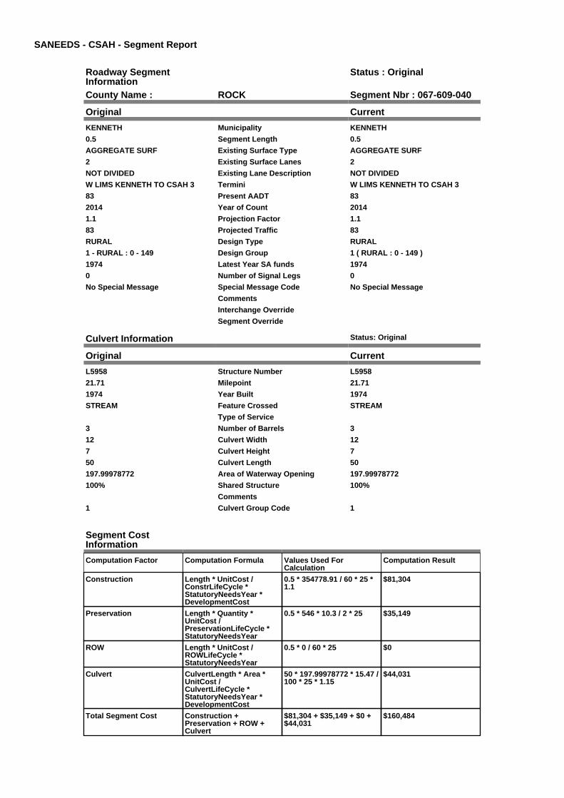
SANEEDS - CSAH - Segment Report
Roadway SegmentInformation
Status : Original
County Name : ROCK Segment Nbr : 067-609-040
Original Current
KENNETH Municipality KENNETH
0.5 Segment Length 0.5
AGGREGATE SURF Existing Surface Type AGGREGATE SURF
2 Existing Surface Lanes 2
NOT DIVIDED Existing Lane Description NOT DIVIDED
W LIMS KENNETH TO CSAH 3 Termini W LIMS KENNETH TO CSAH 3
83 Present AADT 83
2014 Year of Count 2014
1.1 Projection Factor 1.1
83 Projected Traffic 83
RURAL Design Type RURAL
1 - RURAL : 0 - 149 Design Group 1 ( RURAL : 0 - 149 )
1974 Latest Year SA funds 1974
0 Number of Signal Legs 0
No Special Message Special Message Code No Special Message
Comments
Interchange Override
Segment Override
Culvert Information Status: Original
Original Current
L5958 Structure Number L5958
21.71 Milepoint 21.71
1974 Year Built 1974
STREAM Feature Crossed STREAM
Type of Service
3 Number of Barrels 3
12 Culvert Width 12
7 Culvert Height 7
50 Culvert Length 50
197.99978772 Area of Waterway Opening 197.99978772
100% Shared Structure 100%
Comments
1 Culvert Group Code 1
Segment CostInformation
Computation Factor Computation Formula Values Used ForCalculation
Computation Result
Construction Length * UnitCost /ConstrLifeCycle *StatutoryNeedsYear *DevelopmentCost
0.5 * 354778.91 / 60 * 25 *1.1
$81,304
Preservation Length * Quantity *UnitCost /PreservationLifeCycle *StatutoryNeedsYear
0.5 * 546 * 10.3 / 2 * 25 $35,149
ROW Length * UnitCost /ROWLifeCycle *StatutoryNeedsYear
0.5 * 0 / 60 * 25 $0
Culvert CulvertLength * Area *UnitCost /CulvertLifeCycle *StatutoryNeedsYear *DevelopmentCost
50 * 197.99978772 * 15.47 /100 * 25 * 1.15
$44,031
Total Segment Cost Construction +Preservation + ROW +Culvert
$81,304 + $35,149 + $0 +$44,031
$160,484

SANEEDS - CSAH - Segment Report
Roadway SegmentInformation
Status : Original
County Name : ROCK Segment Nbr : 067-609-050
Original Current
KENNETH Municipality KENNETH
0.5 Segment Length 0.5
BIT CONC OR ASPH Existing Surface Type BIT CONC OR ASPH
2 Existing Surface Lanes 2
NOT DIVIDED Existing Lane Description NOT DIVIDED
CSAH 3 TO E LIM KENNETH Termini CSAH 3 TO E LIM KENNETH
319 Present AADT 319
2014 Year of Count 2014
1.1 Projection Factor 1.1
319 Projected Traffic 319
RURAL Design Type RURAL
2 - RURAL : 150 - 1499 Design Group 2 ( RURAL : 150 - 1499 )
1999 Latest Year SA funds 1999
0 Number of Signal Legs 0
No Special Message Special Message Code No Special Message
DSAE APPROVES COMPLETESTORM SEWER NEEDS
Comments DSAE APPROVES COMPLETESTORM SEWER NEEDS
Interchange Override
Segment Override
Segment CostInformation
Computation Factor Computation Formula Values Used ForCalculation
Computation Result
Signal Leg TrafficSignalLegs *UnitCost / SignalLifeCycle* StatutoryNeedsYear
0 * 56250 / 40 * 25 $0
Construction Length * UnitCost /ConstrLifeCycle *StatutoryNeedsYear *DevelopmentCost
0.5 * 709557.81 / 60 * 25 *1.1
$162,607
Preservation Length * Quantity *UnitCost /PreservationLifeCycle *StatutoryNeedsYear
0.5 * 2112 * 49.57 / 20 * 25 $65,432
ROW Length * UnitCost /ROWLifeCycle *StatutoryNeedsYear
0.5 * 32814.61 / 60 * 25 $6,836
Total Segment Cost Signal Leg + Construction+ Preservation + ROW
$0 + $162,607 + $65,432 +$6,836
$234,875

SANEEDS - CSAH - Segment Report
Roadway SegmentInformation
Status : Original
County Name : ROCK Segment Nbr : 067-609-060
Original Current
Unassigned/Unknown Municipality Unassigned/Unknown
0.5 Segment Length 0.5
BIT CONC OR ASPH Existing Surface Type BIT CONC OR ASPH
2 Existing Surface Lanes 2
NOT DIVIDED Existing Lane Description NOT DIVIDED
E LIM KENNETH TO E CO LINE Termini E LIM KENNETH TO E CO LINE
319 Present AADT 319
2014 Year of Count 2014
1.1 Projection Factor 1.1
319 Projected Traffic 319
RURAL Design Type RURAL
2 - RURAL : 150 - 1499 Design Group 2 ( RURAL : 150 - 1499 )
1999 Latest Year SA funds 1999
0 Number of Signal Legs 0
No Special Message Special Message Code No Special Message
Comments
Interchange Override
Segment Override
Segment CostInformation
Computation Factor Computation Formula Values Used ForCalculation
Computation Result
Signal Leg TrafficSignalLegs *UnitCost / SignalLifeCycle* StatutoryNeedsYear
0 * 56250 / 40 * 25 $0
Construction Length * UnitCost /ConstrLifeCycle *StatutoryNeedsYear *DevelopmentCost
0.5 * 709557.81 / 60 * 25 *1.1
$162,607
Preservation Length * Quantity *UnitCost /PreservationLifeCycle *StatutoryNeedsYear
0.5 * 2112 * 49.57 / 20 * 25 $65,432
ROW Length * UnitCost /ROWLifeCycle *StatutoryNeedsYear
0.5 * 32814.61 / 60 * 25 $6,836
Total Segment Cost Signal Leg + Construction+ Preservation + ROW
$0 + $162,607 + $65,432 +$6,836
$234,875

SANEEDS - CSAH - Segment Report
Roadway SegmentInformation
Status : Original
County Name : ROCK Segment Nbr : 067-610-010
Original Current
Unassigned/Unknown Municipality Unassigned/Unknown
3.1 Segment Length 3.1
MIXED BITUMINOUS Existing Surface Type MIXED BITUMINOUS
2 Existing Surface Lanes 2
NOT DIVIDED Existing Lane Description NOT DIVIDED
CSAH 2 TO E CO LINE Termini CSAH 2 TO E CO LINE
946 Present AADT 946
2014 Year of Count 2014
1.1 Projection Factor 1.1
946 Projected Traffic 946
RURAL Design Type RURAL
2 - RURAL : 150 - 1499 Design Group 2 ( RURAL : 150 - 1499 )
2014 Latest Year SA funds 2014
0 Number of Signal Legs 0
No Special Message Special Message Code No Special Message
2014 SAP 067-610-003 M&OL Comments 2014 SAP 067-610-003 M&OL
Interchange Override
Segment Override
Culvert Information Status: Original
Original Current
96675 Structure Number 96675
0.87 Milepoint 0.87
1989 Year Built 1989
STREAM Feature Crossed STREAM
STREAM CROSSING Type of Service STREAM CROSSING
3 Number of Barrels 3
10 Culvert Width 10
6 Culvert Height 6
70 Culvert Length 70
173.99951989 Area of Waterway Opening 173.99951989
100% Shared Structure 100%
Comments
1 Culvert Group Code 1
Culvert Information Status: Original
Original Current
96956 Structure Number 96956
0.24 Milepoint 0.24
1989 Year Built 1989
DITCH Feature Crossed DITCH
STREAM CROSSING Type of Service STREAM CROSSING
2 Number of Barrels 2
Culvert Width
Culvert Height
70 Culvert Length 70
90.00019707 Area of Waterway Opening 90.00019707
100% Shared Structure 100%
Comments
1 Culvert Group Code 1
Segment CostInformation
Computation Factor Computation Formula Values Used ForCalculation
Computation Result
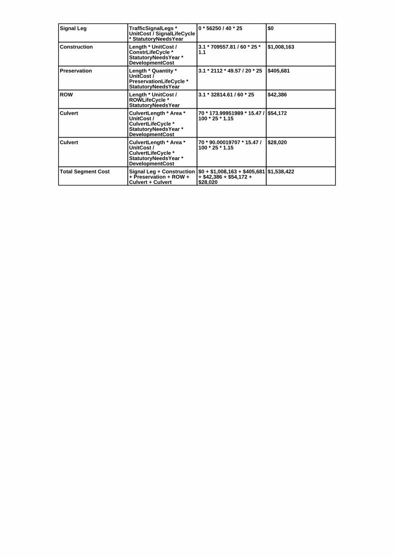
Signal Leg TrafficSignalLegs *UnitCost / SignalLifeCycle* StatutoryNeedsYear
0 * 56250 / 40 * 25 $0
Construction Length * UnitCost /ConstrLifeCycle *StatutoryNeedsYear *DevelopmentCost
3.1 * 709557.81 / 60 * 25 *1.1
$1,008,163
Preservation Length * Quantity *UnitCost /PreservationLifeCycle *StatutoryNeedsYear
3.1 * 2112 * 49.57 / 20 * 25 $405,681
ROW Length * UnitCost /ROWLifeCycle *StatutoryNeedsYear
3.1 * 32814.61 / 60 * 25 $42,386
Culvert CulvertLength * Area *UnitCost /CulvertLifeCycle *StatutoryNeedsYear *DevelopmentCost
70 * 173.99951989 * 15.47 /100 * 25 * 1.15
$54,172
Culvert CulvertLength * Area *UnitCost /CulvertLifeCycle *StatutoryNeedsYear *DevelopmentCost
70 * 90.00019707 * 15.47 /100 * 25 * 1.15
$28,020
Total Segment Cost Signal Leg + Construction+ Preservation + ROW +Culvert + Culvert
$0 + $1,008,163 + $405,681+ $42,386 + $54,172 +$28,020
$1,538,422

SANEEDS - CSAH - Segment Report
Roadway SegmentInformation
Status : Original
County Name : ROCK Segment Nbr : 067-611-010
Original Current
Unassigned/Unknown Municipality Unassigned/Unknown
1 Segment Length 1
MIXED BITUMINOUS Existing Surface Type MIXED BITUMINOUS
2 Existing Surface Lanes 2
NOT DIVIDED Existing Lane Description NOT DIVIDED
S CO LINE TO 1.0 MI S OF TH 270 Termini S CO LINE TO 1.0 MI S OF TH 270
484 Present AADT 484
2014 Year of Count 2014
1.1 Projection Factor 1.1
484 Projected Traffic 484
RURAL Design Type RURAL
2 - RURAL : 150 - 1499 Design Group 2 ( RURAL : 150 - 1499 )
1990 Latest Year SA funds 1990
0 Number of Signal Legs 0
No Special Message Special Message Code No Special Message
Comments
Interchange Override
Segment Override
Culvert Information Status: Original
Original Current
93981 Structure Number 93981
0.01 Milepoint 0.01
1988 Year Built 1988
STREAM Feature Crossed STREAM
Type of Service
1 Number of Barrels 1
12 Culvert Width 12
4 Culvert Height 4
52 Culvert Length 52
45.99952665 Area of Waterway Opening 45.99952665
100% Shared Structure 100%
Comments
1 Culvert Group Code 1
Segment CostInformation
Computation Factor Computation Formula Values Used ForCalculation
Computation Result
Signal Leg TrafficSignalLegs *UnitCost / SignalLifeCycle* StatutoryNeedsYear
0 * 56250 / 40 * 25 $0
Construction Length * UnitCost /ConstrLifeCycle *StatutoryNeedsYear *DevelopmentCost
1 * 709557.81 / 60 * 25 * 1.1 $325,214
Preservation Length * Quantity *UnitCost /PreservationLifeCycle *StatutoryNeedsYear
1 * 2112 * 49.57 / 20 * 25 $130,865
ROW Length * UnitCost /ROWLifeCycle *StatutoryNeedsYear
1 * 32814.61 / 60 * 25 $13,673
Culvert CulvertLength * Area *UnitCost /CulvertLifeCycle *StatutoryNeedsYear *DevelopmentCost
52 * 45.99952665 * 15.47 /100 * 25 * 1.15
$10,639
Total Segment Cost Signal Leg + Construction+ Preservation + ROW +Culvert
$0 + $325,214 + $130,865+ $13,673 + $10,639
$480,391

SANEEDS - CSAH - Segment Report
Roadway SegmentInformation
Status : Original
County Name : ROCK Segment Nbr : 067-611-020
Original Current
Unassigned/Unknown Municipality Unassigned/Unknown
0.2 Segment Length 0.2
MIXED BITUMINOUS Existing Surface Type MIXED BITUMINOUS
2 Existing Surface Lanes 2
NOT DIVIDED Existing Lane Description NOT DIVIDED
1 MI S TO 0.8 MI SO OF TH 270 Termini 1 MI S TO 0.8 MI SO OF TH 270
484 Present AADT 484
2014 Year of Count 2014
1.1 Projection Factor 1.1
484 Projected Traffic 484
RURAL Design Type RURAL
2 - RURAL : 150 - 1499 Design Group 2 ( RURAL : 150 - 1499 )
2008 Latest Year SA funds 2008
0 Number of Signal Legs 0
No Special Message Special Message Code No Special Message
SAP 67-611-06, 2008 MILL &OVERLAY
Comments SAP 67-611-06, 2008 MILL &OVERLAY
Interchange Override
Segment Override
Segment CostInformation
Computation Factor Computation Formula Values Used ForCalculation
Computation Result
Signal Leg TrafficSignalLegs *UnitCost / SignalLifeCycle* StatutoryNeedsYear
0 * 56250 / 40 * 25 $0
Construction Length * UnitCost /ConstrLifeCycle *StatutoryNeedsYear *DevelopmentCost
0.2 * 709557.81 / 60 * 25 *1.1
$65,043
Preservation Length * Quantity *UnitCost /PreservationLifeCycle *StatutoryNeedsYear
0.2 * 2112 * 49.57 / 20 * 25 $26,173
ROW Length * UnitCost /ROWLifeCycle *StatutoryNeedsYear
0.2 * 32814.61 / 60 * 25 $2,735
Total Segment Cost Signal Leg + Construction+ Preservation + ROW
$0 + $65,043 + $26,173 +$2,735
$93,951

SANEEDS - CSAH - Segment Report
Roadway SegmentInformation
Status : Original
County Name : ROCK Segment Nbr : 067-611-025
Original Current
Unassigned/Unknown Municipality Unassigned/Unknown
0.8 Segment Length 0.8
MIXED BITUMINOUS Existing Surface Type MIXED BITUMINOUS
2 Existing Surface Lanes 2
NOT DIVIDED Existing Lane Description NOT DIVIDED
0.8 MI SO OF TH 270 TO TH 270 Termini 0.8 MI SO OF TH 270 TO TH 270
484 Present AADT 484
2014 Year of Count 2014
1.1 Projection Factor 1.1
484 Projected Traffic 484
RURAL Design Type RURAL
2 - RURAL : 150 - 1499 Design Group 2 ( RURAL : 150 - 1499 )
2015 Latest Year SA funds 2015
0 Number of Signal Legs 0
No Special Message Special Message Code No Special Message
2015 SAP 067-611-008 M&OL Comments 2015 SAP 067-611-008 M&OL
Interchange Override
Segment Override
Segment CostInformation
Computation Factor Computation Formula Values Used ForCalculation
Computation Result
Signal Leg TrafficSignalLegs *UnitCost / SignalLifeCycle* StatutoryNeedsYear
0 * 56250 / 40 * 25 $0
Construction Length * UnitCost /ConstrLifeCycle *StatutoryNeedsYear *DevelopmentCost
0.8 * 709557.81 / 60 * 25 *1.1
$260,171
Preservation Length * Quantity *UnitCost /PreservationLifeCycle *StatutoryNeedsYear
0.8 * 2112 * 49.57 / 20 * 25 $104,692
ROW Length * UnitCost /ROWLifeCycle *StatutoryNeedsYear
0.8 * 32814.61 / 60 * 25 $10,938
Total Segment Cost Signal Leg + Construction+ Preservation + ROW
$0 + $260,171 + $104,692+ $10,938
$375,801
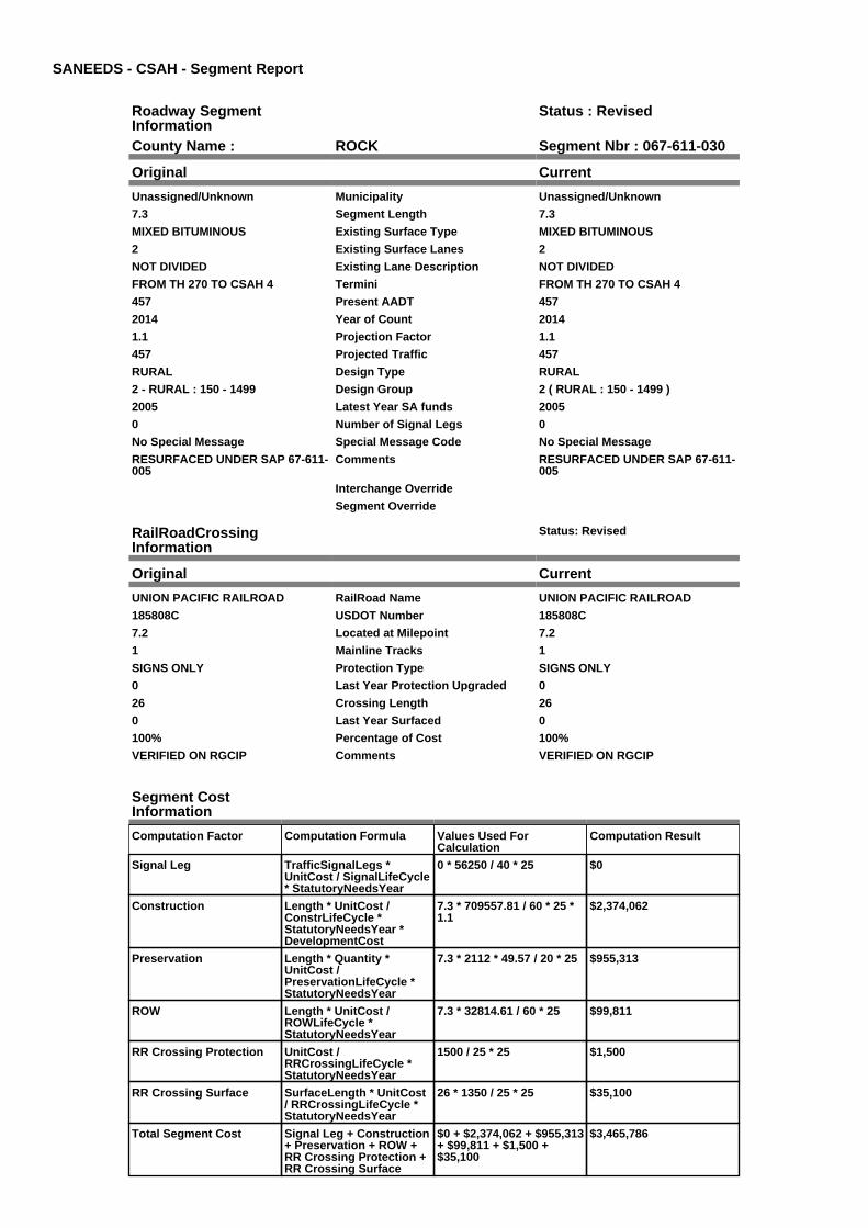
SANEEDS - CSAH - Segment Report
Roadway SegmentInformation
Status : Revised
County Name : ROCK Segment Nbr : 067-611-030
Original Current
Unassigned/Unknown Municipality Unassigned/Unknown
7.3 Segment Length 7.3
MIXED BITUMINOUS Existing Surface Type MIXED BITUMINOUS
2 Existing Surface Lanes 2
NOT DIVIDED Existing Lane Description NOT DIVIDED
FROM TH 270 TO CSAH 4 Termini FROM TH 270 TO CSAH 4
457 Present AADT 457
2014 Year of Count 2014
1.1 Projection Factor 1.1
457 Projected Traffic 457
RURAL Design Type RURAL
2 - RURAL : 150 - 1499 Design Group 2 ( RURAL : 150 - 1499 )
2005 Latest Year SA funds 2005
0 Number of Signal Legs 0
No Special Message Special Message Code No Special Message
RESURFACED UNDER SAP 67-611-005
Comments RESURFACED UNDER SAP 67-611-005
Interchange Override
Segment Override
RailRoadCrossingInformation
Status: Revised
Original Current
UNION PACIFIC RAILROAD RailRoad Name UNION PACIFIC RAILROAD
185808C USDOT Number 185808C
7.2 Located at Milepoint 7.2
1 Mainline Tracks 1
SIGNS ONLY Protection Type SIGNS ONLY
0 Last Year Protection Upgraded 0
26 Crossing Length 26
0 Last Year Surfaced 0
100% Percentage of Cost 100%
VERIFIED ON RGCIP Comments VERIFIED ON RGCIP
Segment CostInformation
Computation Factor Computation Formula Values Used ForCalculation
Computation Result
Signal Leg TrafficSignalLegs *UnitCost / SignalLifeCycle* StatutoryNeedsYear
0 * 56250 / 40 * 25 $0
Construction Length * UnitCost /ConstrLifeCycle *StatutoryNeedsYear *DevelopmentCost
7.3 * 709557.81 / 60 * 25 *1.1
$2,374,062
Preservation Length * Quantity *UnitCost /PreservationLifeCycle *StatutoryNeedsYear
7.3 * 2112 * 49.57 / 20 * 25 $955,313
ROW Length * UnitCost /ROWLifeCycle *StatutoryNeedsYear
7.3 * 32814.61 / 60 * 25 $99,811
RR Crossing Protection UnitCost /RRCrossingLifeCycle *StatutoryNeedsYear
1500 / 25 * 25 $1,500
RR Crossing Surface SurfaceLength * UnitCost/ RRCrossingLifeCycle *StatutoryNeedsYear
26 * 1350 / 25 * 25 $35,100
Total Segment Cost Signal Leg + Construction+ Preservation + ROW +RR Crossing Protection +RR Crossing Surface
$0 + $2,374,062 + $955,313+ $99,811 + $1,500 +$35,100
$3,465,786
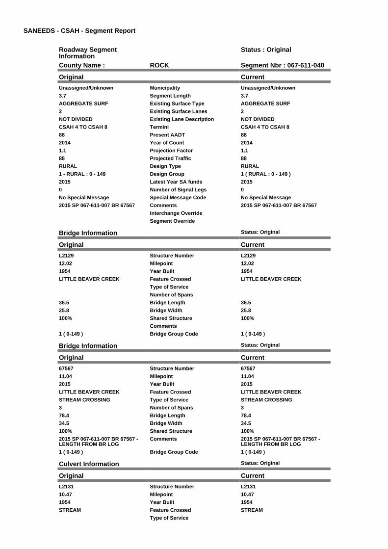
SANEEDS - CSAH - Segment Report
Roadway SegmentInformation
Status : Original
County Name : ROCK Segment Nbr : 067-611-040
Original Current
Unassigned/Unknown Municipality Unassigned/Unknown
3.7 Segment Length 3.7
AGGREGATE SURF Existing Surface Type AGGREGATE SURF
2 Existing Surface Lanes 2
NOT DIVIDED Existing Lane Description NOT DIVIDED
CSAH 4 TO CSAH 8 Termini CSAH 4 TO CSAH 8
88 Present AADT 88
2014 Year of Count 2014
1.1 Projection Factor 1.1
88 Projected Traffic 88
RURAL Design Type RURAL
1 - RURAL : 0 - 149 Design Group 1 ( RURAL : 0 - 149 )
2015 Latest Year SA funds 2015
0 Number of Signal Legs 0
No Special Message Special Message Code No Special Message
2015 SP 067-611-007 BR 67567 Comments 2015 SP 067-611-007 BR 67567
Interchange Override
Segment Override
Bridge Information Status: Original
Original Current
L2129 Structure Number L2129
12.02 Milepoint 12.02
1954 Year Built 1954
LITTLE BEAVER CREEK Feature Crossed LITTLE BEAVER CREEK
Type of Service
Number of Spans
36.5 Bridge Length 36.5
25.8 Bridge Width 25.8
100% Shared Structure 100%
Comments
1 ( 0-149 ) Bridge Group Code 1 ( 0-149 )
Bridge Information Status: Original
Original Current
67567 Structure Number 67567
11.04 Milepoint 11.04
2015 Year Built 2015
LITTLE BEAVER CREEK Feature Crossed LITTLE BEAVER CREEK
STREAM CROSSING Type of Service STREAM CROSSING
3 Number of Spans 3
78.4 Bridge Length 78.4
34.5 Bridge Width 34.5
100% Shared Structure 100%
2015 SP 067-611-007 BR 67567 -LENGTH FROM BR LOG
Comments 2015 SP 067-611-007 BR 67567 -LENGTH FROM BR LOG
1 ( 0-149 ) Bridge Group Code 1 ( 0-149 )
Culvert Information Status: Original
Original Current
L2131 Structure Number L2131
10.47 Milepoint 10.47
1954 Year Built 1954
STREAM Feature Crossed STREAM
Type of Service
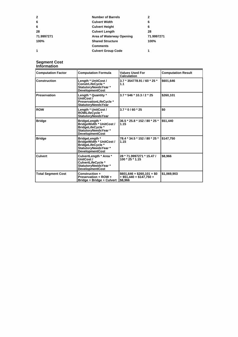
2 Number of Barrels 2
6 Culvert Width 6
6 Culvert Height 6
28 Culvert Length 28
71.9997271 Area of Waterway Opening 71.9997271
100% Shared Structure 100%
Comments
1 Culvert Group Code 1
Segment CostInformation
Computation Factor Computation Formula Values Used ForCalculation
Computation Result
Construction Length * UnitCost /ConstrLifeCycle *StatutoryNeedsYear *DevelopmentCost
3.7 * 354778.91 / 60 * 25 *1.1
$601,646
Preservation Length * Quantity *UnitCost /PreservationLifeCycle *StatutoryNeedsYear
3.7 * 546 * 10.3 / 2 * 25 $260,101
ROW Length * UnitCost /ROWLifeCycle *StatutoryNeedsYear
3.7 * 0 / 60 * 25 $0
Bridge BridgeLength *BridgeWidth * UnitCost /BridgeLifeCycle *StatutoryNeedsYear *DevelopmentCost
36.5 * 25.8 * 152 / 80 * 25 *1.15
$51,440
Bridge BridgeLength *BridgeWidth * UnitCost /BridgeLifeCycle *StatutoryNeedsYear *DevelopmentCost
78.4 * 34.5 * 152 / 80 * 25 *1.15
$147,750
Culvert CulvertLength * Area *UnitCost /CulvertLifeCycle *StatutoryNeedsYear *DevelopmentCost
28 * 71.9997271 * 15.47 /100 * 25 * 1.15
$8,966
Total Segment Cost Construction +Preservation + ROW +Bridge + Bridge + Culvert
$601,646 + $260,101 + $0+ $51,440 + $147,750 +$8,966
$1,069,903
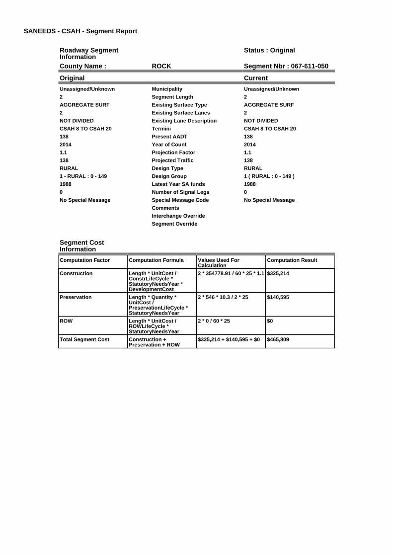
SANEEDS - CSAH - Segment Report
Roadway SegmentInformation
Status : Original
County Name : ROCK Segment Nbr : 067-611-050
Original Current
Unassigned/Unknown Municipality Unassigned/Unknown
2 Segment Length 2
AGGREGATE SURF Existing Surface Type AGGREGATE SURF
2 Existing Surface Lanes 2
NOT DIVIDED Existing Lane Description NOT DIVIDED
CSAH 8 TO CSAH 20 Termini CSAH 8 TO CSAH 20
138 Present AADT 138
2014 Year of Count 2014
1.1 Projection Factor 1.1
138 Projected Traffic 138
RURAL Design Type RURAL
1 - RURAL : 0 - 149 Design Group 1 ( RURAL : 0 - 149 )
1988 Latest Year SA funds 1988
0 Number of Signal Legs 0
No Special Message Special Message Code No Special Message
Comments
Interchange Override
Segment Override
Segment CostInformation
Computation Factor Computation Formula Values Used ForCalculation
Computation Result
Construction Length * UnitCost /ConstrLifeCycle *StatutoryNeedsYear *DevelopmentCost
2 * 354778.91 / 60 * 25 * 1.1 $325,214
Preservation Length * Quantity *UnitCost /PreservationLifeCycle *StatutoryNeedsYear
2 * 546 * 10.3 / 2 * 25 $140,595
ROW Length * UnitCost /ROWLifeCycle *StatutoryNeedsYear
2 * 0 / 60 * 25 $0
Total Segment Cost Construction +Preservation + ROW
$325,214 + $140,595 + $0 $465,809
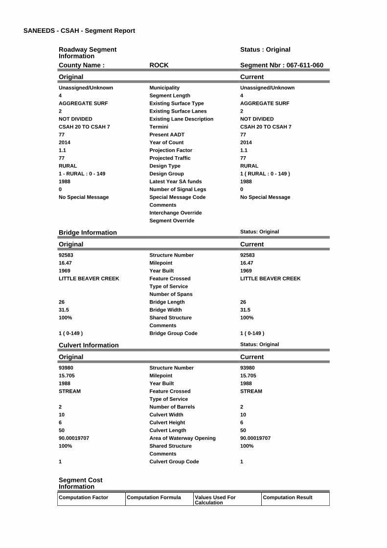
SANEEDS - CSAH - Segment Report
Roadway SegmentInformation
Status : Original
County Name : ROCK Segment Nbr : 067-611-060
Original Current
Unassigned/Unknown Municipality Unassigned/Unknown
4 Segment Length 4
AGGREGATE SURF Existing Surface Type AGGREGATE SURF
2 Existing Surface Lanes 2
NOT DIVIDED Existing Lane Description NOT DIVIDED
CSAH 20 TO CSAH 7 Termini CSAH 20 TO CSAH 7
77 Present AADT 77
2014 Year of Count 2014
1.1 Projection Factor 1.1
77 Projected Traffic 77
RURAL Design Type RURAL
1 - RURAL : 0 - 149 Design Group 1 ( RURAL : 0 - 149 )
1988 Latest Year SA funds 1988
0 Number of Signal Legs 0
No Special Message Special Message Code No Special Message
Comments
Interchange Override
Segment Override
Bridge Information Status: Original
Original Current
92583 Structure Number 92583
16.47 Milepoint 16.47
1969 Year Built 1969
LITTLE BEAVER CREEK Feature Crossed LITTLE BEAVER CREEK
Type of Service
Number of Spans
26 Bridge Length 26
31.5 Bridge Width 31.5
100% Shared Structure 100%
Comments
1 ( 0-149 ) Bridge Group Code 1 ( 0-149 )
Culvert Information Status: Original
Original Current
93980 Structure Number 93980
15.705 Milepoint 15.705
1988 Year Built 1988
STREAM Feature Crossed STREAM
Type of Service
2 Number of Barrels 2
10 Culvert Width 10
6 Culvert Height 6
50 Culvert Length 50
90.00019707 Area of Waterway Opening 90.00019707
100% Shared Structure 100%
Comments
1 Culvert Group Code 1
Segment CostInformation
Computation Factor Computation Formula Values Used ForCalculation
Computation Result
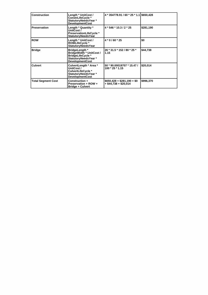
Construction Length * UnitCost /ConstrLifeCycle *StatutoryNeedsYear *DevelopmentCost
4 * 354778.91 / 60 * 25 * 1.1 $650,428
Preservation Length * Quantity *UnitCost /PreservationLifeCycle *StatutoryNeedsYear
4 * 546 * 10.3 / 2 * 25 $281,190
ROW Length * UnitCost /ROWLifeCycle *StatutoryNeedsYear
4 * 0 / 60 * 25 $0
Bridge BridgeLength *BridgeWidth * UnitCost /BridgeLifeCycle *StatutoryNeedsYear *DevelopmentCost
26 * 31.5 * 152 / 80 * 25 *1.15
$44,738
Culvert CulvertLength * Area *UnitCost /CulvertLifeCycle *StatutoryNeedsYear *DevelopmentCost
50 * 90.00019707 * 15.47 /100 * 25 * 1.15
$20,014
Total Segment Cost Construction +Preservation + ROW +Bridge + Culvert
$650,428 + $281,190 + $0+ $44,738 + $20,014
$996,370

SANEEDS - CSAH - Segment Report
Roadway SegmentInformation
Status : Original
County Name : ROCK Segment Nbr : 067-611-070
Original Current
Unassigned/Unknown Municipality Unassigned/Unknown
5 Segment Length 5
AGGREGATE SURF Existing Surface Type AGGREGATE SURF
2 Existing Surface Lanes 2
NOT DIVIDED Existing Lane Description NOT DIVIDED
CSAH 7 TO CSAH 12 Termini CSAH 7 TO CSAH 12
105 Present AADT 105
2014 Year of Count 2014
1.1 Projection Factor 1.1
105 Projected Traffic 105
RURAL Design Type RURAL
1 - RURAL : 0 - 149 Design Group 1 ( RURAL : 0 - 149 )
1986 Latest Year SA funds 1986
0 Number of Signal Legs 0
No Special Message Special Message Code No Special Message
Comments
Interchange Override
Segment Override
Segment CostInformation
Computation Factor Computation Formula Values Used ForCalculation
Computation Result
Construction Length * UnitCost /ConstrLifeCycle *StatutoryNeedsYear *DevelopmentCost
5 * 354778.91 / 60 * 25 * 1.1 $813,035
Preservation Length * Quantity *UnitCost /PreservationLifeCycle *StatutoryNeedsYear
5 * 546 * 10.3 / 2 * 25 $351,488
ROW Length * UnitCost /ROWLifeCycle *StatutoryNeedsYear
5 * 0 / 60 * 25 $0
Total Segment Cost Construction +Preservation + ROW
$813,035 + $351,488 + $0 $1,164,523
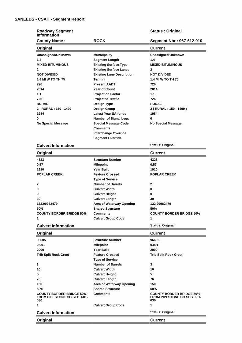
SANEEDS - CSAH - Segment Report
Roadway SegmentInformation
Status : Original
County Name : ROCK Segment Nbr : 067-612-010
Original Current
Unassigned/Unknown Municipality Unassigned/Unknown
1.4 Segment Length 1.4
MIXED BITUMINOUS Existing Surface Type MIXED BITUMINOUS
2 Existing Surface Lanes 2
NOT DIVIDED Existing Lane Description NOT DIVIDED
1.4 MI W TO TH 75 Termini 1.4 MI W TO TH 75
726 Present AADT 726
2014 Year of Count 2014
1.1 Projection Factor 1.1
726 Projected Traffic 726
RURAL Design Type RURAL
2 - RURAL : 150 - 1499 Design Group 2 ( RURAL : 150 - 1499 )
1984 Latest Year SA funds 1984
0 Number of Signal Legs 0
No Special Message Special Message Code No Special Message
Comments
Interchange Override
Segment Override
Culvert Information Status: Original
Original Current
4323 Structure Number 4323
0.57 Milepoint 0.57
1910 Year Built 1910
POPLAR CREEK Feature Crossed POPLAR CREEK
Type of Service
2 Number of Barrels 2
0 Culvert Width 0
0 Culvert Height 0
30 Culvert Length 30
132.99982479 Area of Waterway Opening 132.99982479
50% Shared Structure 50%
COUNTY BORDER BRIDGE 50% Comments COUNTY BORDER BRIDGE 50%
1 Culvert Group Code 1
Culvert Information Status: Original
Original Current
96605 Structure Number 96605
0.001 Milepoint 0.001
2000 Year Built 2000
Trib Split Rock Creet Feature Crossed Trib Split Rock Creet
Type of Service
3 Number of Barrels 3
10 Culvert Width 10
5 Culvert Height 5
76 Culvert Length 76
150 Area of Waterway Opening 150
50% Shared Structure 50%
COUNTY BORDER BRIDGE 50% -FROM PIPESTONE CO SEG. 601-030
Comments COUNTY BORDER BRIDGE 50% -FROM PIPESTONE CO SEG. 601-030
1 Culvert Group Code 1
Culvert Information Status: Original
Original Current
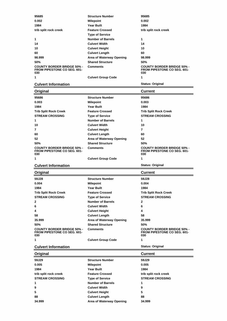
95685 Structure Number 95685
0.002 Milepoint 0.002
1984 Year Built 1984
trib split rock creek Feature Crossed trib split rock creek
Type of Service
1 Number of Barrels 1
14 Culvert Width 14
10 Culvert Height 10
60 Culvert Length 60
98.999 Area of Waterway Opening 98.999
50% Shared Structure 50%
COUNTY BORDER BRIDGE 50% -FROM PIPESTONE CO SEG. 601-030
Comments COUNTY BORDER BRIDGE 50% -FROM PIPESTONE CO SEG. 601-030
1 Culvert Group Code 1
Culvert Information Status: Original
Original Current
95686 Structure Number 95686
0.003 Milepoint 0.003
1984 Year Built 1984
Trib Split Rock Creek Feature Crossed Trib Split Rock Creek
STREAM CROSSING Type of Service STREAM CROSSING
1 Number of Barrels 1
10 Culvert Width 10
7 Culvert Height 7
60 Culvert Length 60
52 Area of Waterway Opening 52
50% Shared Structure 50%
COUNTY BORDER BRIDGE 50% -FROM PIPESTONE CO SEG. 601-030
Comments COUNTY BORDER BRIDGE 50% -FROM PIPESTONE CO SEG. 601-030
1 Culvert Group Code 1
Culvert Information Status: Original
Original Current
59J28 Structure Number 59J28
0.004 Milepoint 0.004
1984 Year Built 1984
Trib Split Rock Creek Feature Crossed Trib Split Rock Creek
STREAM CROSSING Type of Service STREAM CROSSING
2 Number of Barrels 2
6 Culvert Width 6
4 Culvert Height 4
58 Culvert Length 58
35.999 Area of Waterway Opening 35.999
50% Shared Structure 50%
COUNTY BORDER BRIDGE 50% -FROM PIPESTONE CO SEG. 601-030
Comments COUNTY BORDER BRIDGE 50% -FROM PIPESTONE CO SEG. 601-030
1 Culvert Group Code 1
Culvert Information Status: Original
Original Current
59J29 Structure Number 59J29
0.005 Milepoint 0.005
1984 Year Built 1984
trib split rock creek Feature Crossed trib split rock creek
STREAM CROSSING Type of Service STREAM CROSSING
1 Number of Barrels 1
9 Culvert Width 9
5 Culvert Height 5
88 Culvert Length 88
34.999 Area of Waterway Opening 34.999
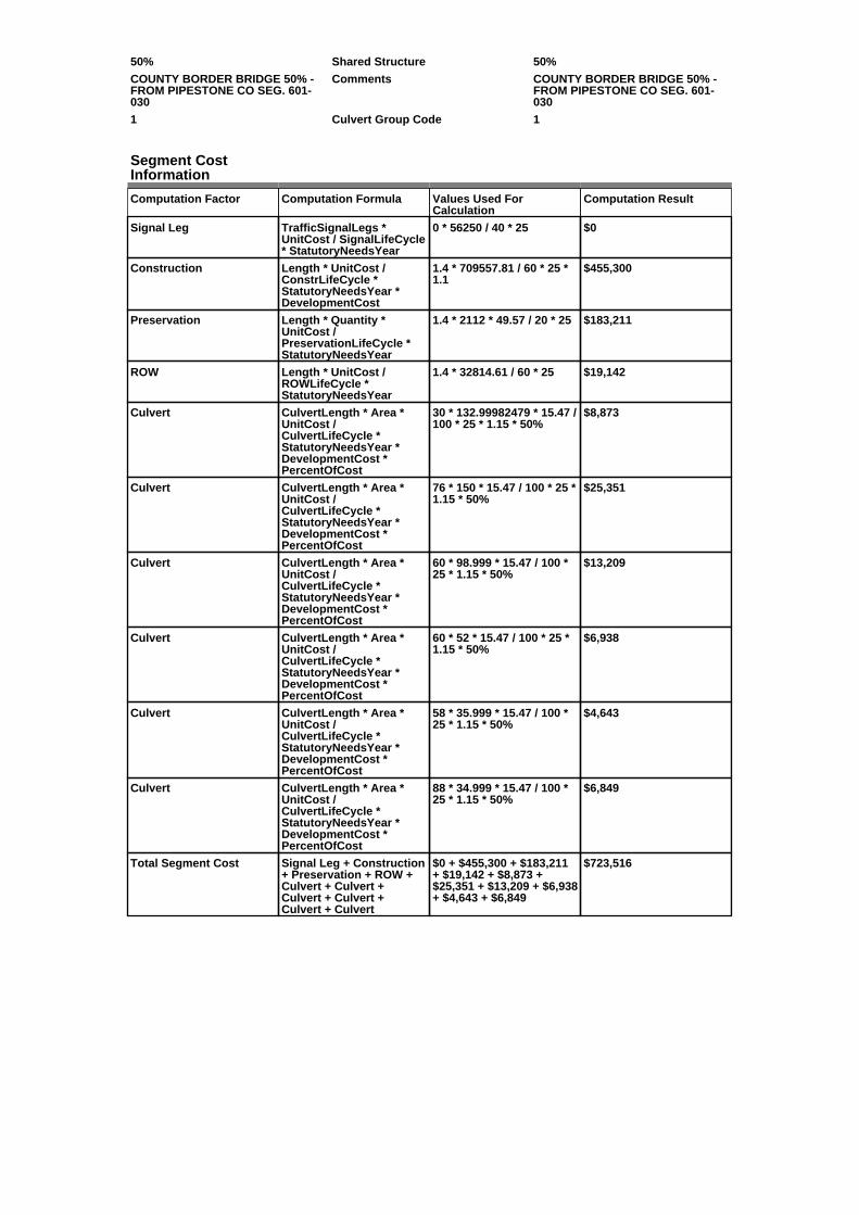
50% Shared Structure 50%
COUNTY BORDER BRIDGE 50% -FROM PIPESTONE CO SEG. 601-030
Comments COUNTY BORDER BRIDGE 50% -FROM PIPESTONE CO SEG. 601-030
1 Culvert Group Code 1
Segment CostInformation
Computation Factor Computation Formula Values Used ForCalculation
Computation Result
Signal Leg TrafficSignalLegs *UnitCost / SignalLifeCycle* StatutoryNeedsYear
0 * 56250 / 40 * 25 $0
Construction Length * UnitCost /ConstrLifeCycle *StatutoryNeedsYear *DevelopmentCost
1.4 * 709557.81 / 60 * 25 *1.1
$455,300
Preservation Length * Quantity *UnitCost /PreservationLifeCycle *StatutoryNeedsYear
1.4 * 2112 * 49.57 / 20 * 25 $183,211
ROW Length * UnitCost /ROWLifeCycle *StatutoryNeedsYear
1.4 * 32814.61 / 60 * 25 $19,142
Culvert CulvertLength * Area *UnitCost /CulvertLifeCycle *StatutoryNeedsYear *DevelopmentCost *PercentOfCost
30 * 132.99982479 * 15.47 /100 * 25 * 1.15 * 50%
$8,873
Culvert CulvertLength * Area *UnitCost /CulvertLifeCycle *StatutoryNeedsYear *DevelopmentCost *PercentOfCost
76 * 150 * 15.47 / 100 * 25 *1.15 * 50%
$25,351
Culvert CulvertLength * Area *UnitCost /CulvertLifeCycle *StatutoryNeedsYear *DevelopmentCost *PercentOfCost
60 * 98.999 * 15.47 / 100 *25 * 1.15 * 50%
$13,209
Culvert CulvertLength * Area *UnitCost /CulvertLifeCycle *StatutoryNeedsYear *DevelopmentCost *PercentOfCost
60 * 52 * 15.47 / 100 * 25 *1.15 * 50%
$6,938
Culvert CulvertLength * Area *UnitCost /CulvertLifeCycle *StatutoryNeedsYear *DevelopmentCost *PercentOfCost
58 * 35.999 * 15.47 / 100 *25 * 1.15 * 50%
$4,643
Culvert CulvertLength * Area *UnitCost /CulvertLifeCycle *StatutoryNeedsYear *DevelopmentCost *PercentOfCost
88 * 34.999 * 15.47 / 100 *25 * 1.15 * 50%
$6,849
Total Segment Cost Signal Leg + Construction+ Preservation + ROW +Culvert + Culvert +Culvert + Culvert +Culvert + Culvert
$0 + $455,300 + $183,211+ $19,142 + $8,873 +$25,351 + $13,209 + $6,938+ $4,643 + $6,849
$723,516

SANEEDS - CSAH - Segment Report
Roadway SegmentInformation
Status : Original
County Name : ROCK Segment Nbr : 067-612-020
Original Current
Unassigned/Unknown Municipality Unassigned/Unknown
4.8 Segment Length 4.8
MIXED BITUMINOUS Existing Surface Type MIXED BITUMINOUS
2 Existing Surface Lanes 2
NOT DIVIDED Existing Lane Description NOT DIVIDED
TH 75 TO AND ALONG N CO LINE Termini TH 75 TO AND ALONG N CO LINE
825 Present AADT 825
2014 Year of Count 2014
1.1 Projection Factor 1.1
825 Projected Traffic 825
RURAL Design Type RURAL
2 - RURAL : 150 - 1499 Design Group 2 ( RURAL : 150 - 1499 )
2010 Latest Year SA funds 2010
0 Number of Signal Legs 0
No Special Message Special Message Code No Special Message
OVERLAY 2010, SAP 67-612-008 Comments OVERLAY 2010, SAP 67-612-008
Interchange Override
Segment Override
Segment CostInformation
Computation Factor Computation Formula Values Used ForCalculation
Computation Result
Signal Leg TrafficSignalLegs *UnitCost / SignalLifeCycle* StatutoryNeedsYear
0 * 56250 / 40 * 25 $0
Construction Length * UnitCost /ConstrLifeCycle *StatutoryNeedsYear *DevelopmentCost
4.8 * 709557.81 / 60 * 25 *1.1
$1,561,027
Preservation Length * Quantity *UnitCost /PreservationLifeCycle *StatutoryNeedsYear
4.8 * 2112 * 49.57 / 20 * 25 $628,151
ROW Length * UnitCost /ROWLifeCycle *StatutoryNeedsYear
4.8 * 32814.61 / 60 * 25 $65,629
Total Segment Cost Signal Leg + Construction+ Preservation + ROW
$0 + $1,561,027 + $628,151+ $65,629
$2,254,807

SANEEDS - CSAH - Segment Report
Roadway SegmentInformation
Status : Original
County Name : ROCK Segment Nbr : 067-613-010
Original Current
Unassigned/Unknown Municipality Unassigned/Unknown
4.3 Segment Length 4.3
MIXED BITUMINOUS Existing Surface Type MIXED BITUMINOUS
2 Existing Surface Lanes 2
NOT DIVIDED Existing Lane Description NOT DIVIDED
W CO LINE TO W. CITY LIMITSHILLS
Termini W CO LINE TO W. CITY LIMITSHILLS
1320 Present AADT 1320
2014 Year of Count 2014
1.1 Projection Factor 1.1
1320 Projected Traffic 1320
RURAL Design Type RURAL
2 - RURAL : 150 - 1499 Design Group 2 ( RURAL : 150 - 1499 )
2015 Latest Year SA funds 2015
0 Number of Signal Legs 0
No Special Message Special Message Code No Special Message
2015 SAP 067-613-006 M&OL
2014 SAP 067-613-005 CULVERT67K24
2014 SAP 067-613-004 CULVERT67K23
DSAE APPROVED TRAFFICCOUNT REVISION.
Comments 2015 SAP 067-613-006 M&OL
2014 SAP 067-613-005 CULVERT67K24
2014 SAP 067-613-004 CULVERT67K23
DSAE APPROVED TRAFFICCOUNT REVISION.
Interchange Override
Segment Override
Culvert Information Status: Original
Original Current
67K23 Structure Number 67K23
3.48 Milepoint 3.48
2014 Year Built 2014
STREAM Feature Crossed STREAM
STREAM CROSSING Type of Service STREAM CROSSING
2 Number of Barrels 2
12 Culvert Width 12
5 Culvert Height 5
59 Culvert Length 59
120 Area of Waterway Opening 120
100% Shared Structure 100%
2014 SAP 067-613-004 CULVERT67K23
Comments 2014 SAP 067-613-004 CULVERT67K23
1 Culvert Group Code 1
Culvert Information Status: Original
Original Current
67K24 Structure Number 67K24
0.56 Milepoint 0.56
2014 Year Built 2014
BLOOD RUN Feature Crossed BLOOD RUN
STREAM CROSSING Type of Service STREAM CROSSING
2 Number of Barrels 2
12 Culvert Width 12
6 Culvert Height 6
63 Culvert Length 63
144 Area of Waterway Opening 144
100% Shared Structure 100%
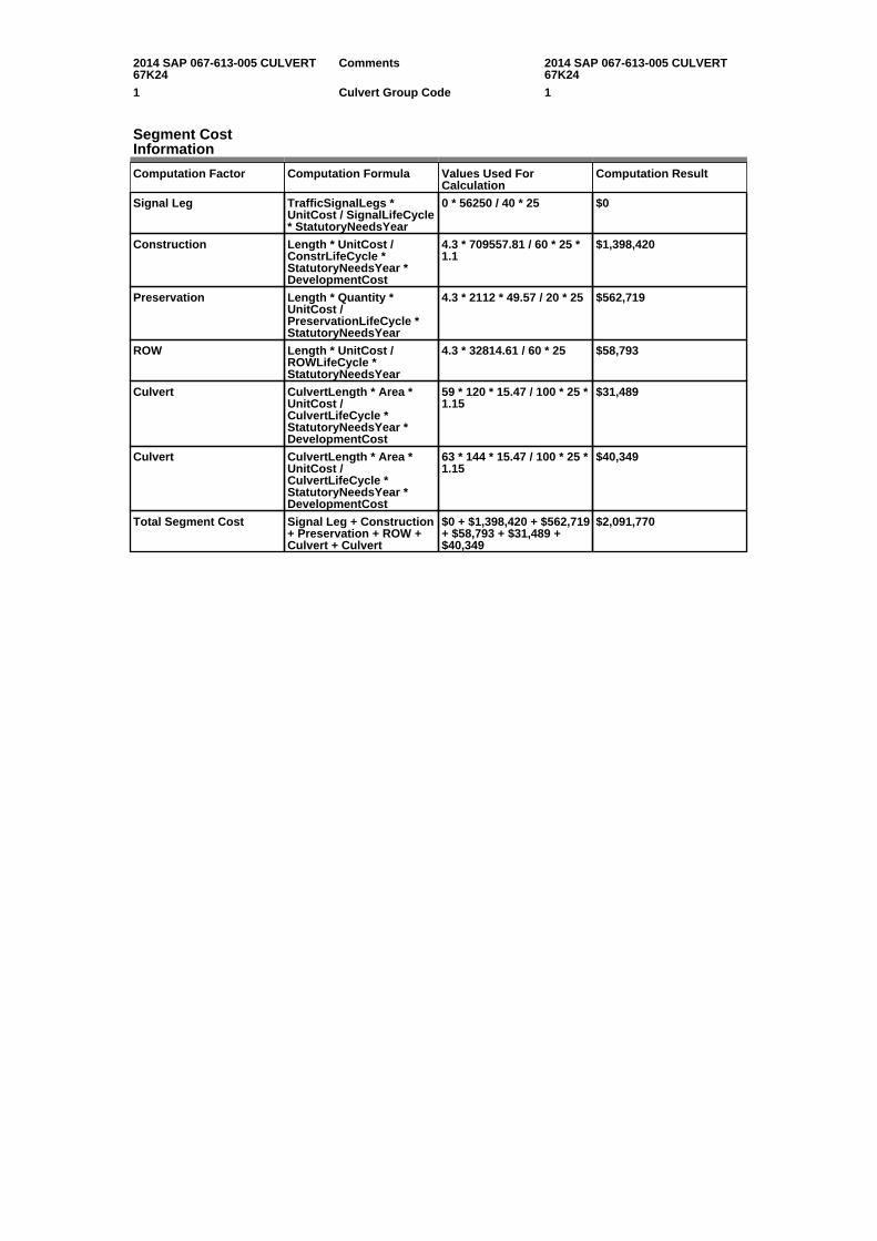
2014 SAP 067-613-005 CULVERT67K24
Comments 2014 SAP 067-613-005 CULVERT67K24
1 Culvert Group Code 1
Segment CostInformation
Computation Factor Computation Formula Values Used ForCalculation
Computation Result
Signal Leg TrafficSignalLegs *UnitCost / SignalLifeCycle* StatutoryNeedsYear
0 * 56250 / 40 * 25 $0
Construction Length * UnitCost /ConstrLifeCycle *StatutoryNeedsYear *DevelopmentCost
4.3 * 709557.81 / 60 * 25 *1.1
$1,398,420
Preservation Length * Quantity *UnitCost /PreservationLifeCycle *StatutoryNeedsYear
4.3 * 2112 * 49.57 / 20 * 25 $562,719
ROW Length * UnitCost /ROWLifeCycle *StatutoryNeedsYear
4.3 * 32814.61 / 60 * 25 $58,793
Culvert CulvertLength * Area *UnitCost /CulvertLifeCycle *StatutoryNeedsYear *DevelopmentCost
59 * 120 * 15.47 / 100 * 25 *1.15
$31,489
Culvert CulvertLength * Area *UnitCost /CulvertLifeCycle *StatutoryNeedsYear *DevelopmentCost
63 * 144 * 15.47 / 100 * 25 *1.15
$40,349
Total Segment Cost Signal Leg + Construction+ Preservation + ROW +Culvert + Culvert
$0 + $1,398,420 + $562,719+ $58,793 + $31,489 +$40,349
$2,091,770

SANEEDS - CSAH - Segment Report
Roadway SegmentInformation
Status : Original
County Name : ROCK Segment Nbr : 067-613-020
Original Current
HILLS Municipality HILLS
0.07 Segment Length 0.07
MIXED BITUMINOUS Existing Surface Type MIXED BITUMINOUS
2 Existing Surface Lanes 2
NOT DIVIDED Existing Lane Description NOT DIVIDED
WEST LIMITS HILLS TO TH 270 Termini WEST LIMITS HILLS TO TH 270
1320 Present AADT 1320
2014 Year of Count 2014
1.1 Projection Factor 1.1
1320 Projected Traffic 1320
RURAL Design Type RURAL
2 - RURAL : 150 - 1499 Design Group 2 ( RURAL : 150 - 1499 )
1989 Latest Year SA funds 1989
0 Number of Signal Legs 0
No Special Message Special Message Code No Special Message
DSAE APPROVES COMPLETESTORM SEWER NEEDS.
Comments DSAE APPROVES COMPLETESTORM SEWER NEEDS.
Interchange Override
Segment Override
Culvert Information Status: Original
Original Current
L8967 Structure Number L8967
4.31 Milepoint 4.31
1967 Year Built 1967
STREAM Feature Crossed STREAM
Type of Service
2 Number of Barrels 2
Culvert Width
Culvert Height
103 Culvert Length 103
71.9997271 Area of Waterway Opening 71.9997271
100% Shared Structure 100%
Comments
1 Culvert Group Code 1
Segment CostInformation
Computation Factor Computation Formula Values Used ForCalculation
Computation Result
Signal Leg TrafficSignalLegs *UnitCost / SignalLifeCycle* StatutoryNeedsYear
0 * 56250 / 40 * 25 $0
Construction Length * UnitCost /ConstrLifeCycle *StatutoryNeedsYear *DevelopmentCost
0.07 * 709557.81 / 60 * 25 *1.1
$22,765
Preservation Length * Quantity *UnitCost /PreservationLifeCycle *StatutoryNeedsYear
0.07 * 2112 * 49.57 / 20 * 25 $9,161
ROW Length * UnitCost /ROWLifeCycle *StatutoryNeedsYear
0.07 * 32814.61 / 60 * 25 $957
Culvert CulvertLength * Area *UnitCost /CulvertLifeCycle *StatutoryNeedsYear *DevelopmentCost
103 * 71.9997271 * 15.47 /100 * 25 * 1.15
$32,983

Total Segment Cost Signal Leg + Construction+ Preservation + ROW +Culvert
$0 + $22,765 + $9,161 +$957 + $32,983
$65,866

SANEEDS - CSAH - Segment Report
Roadway SegmentInformation
Status : Original
County Name : ROCK Segment Nbr : 067-614-010
Original Current
Unassigned/Unknown Municipality Unassigned/Unknown
1.8 Segment Length 1.8
BIT CONC OR ASPH Existing Surface Type BIT CONC OR ASPH
2 Existing Surface Lanes 2
NOT DIVIDED Existing Lane Description NOT DIVIDED
FROM CSAH 4 TO CSAH 9 Termini FROM CSAH 4 TO CSAH 9
154 Present AADT 154
2014 Year of Count 2014
1.1 Projection Factor 1.1
154 Projected Traffic 154
RURAL Design Type RURAL
2 - RURAL : 150 - 1499 Design Group 2 ( RURAL : 150 - 1499 )
2008 Latest Year SA funds 2008
0 Number of Signal Legs 0
No Special Message Special Message Code No Special Message
SAP 67-614-04, 2008 OVERLAY Comments SAP 67-614-04, 2008 OVERLAY
Interchange Override
Segment Override
Segment CostInformation
Computation Factor Computation Formula Values Used ForCalculation
Computation Result
Signal Leg TrafficSignalLegs *UnitCost / SignalLifeCycle* StatutoryNeedsYear
0 * 56250 / 40 * 25 $0
Construction Length * UnitCost /ConstrLifeCycle *StatutoryNeedsYear *DevelopmentCost
1.8 * 709557.81 / 60 * 25 *1.1
$585,385
Preservation Length * Quantity *UnitCost /PreservationLifeCycle *StatutoryNeedsYear
1.8 * 2112 * 49.57 / 20 * 25 $235,557
ROW Length * UnitCost /ROWLifeCycle *StatutoryNeedsYear
1.8 * 32814.61 / 60 * 25 $24,611
Total Segment Cost Signal Leg + Construction+ Preservation + ROW
$0 + $585,385 + $235,557+ $24,611
$845,553
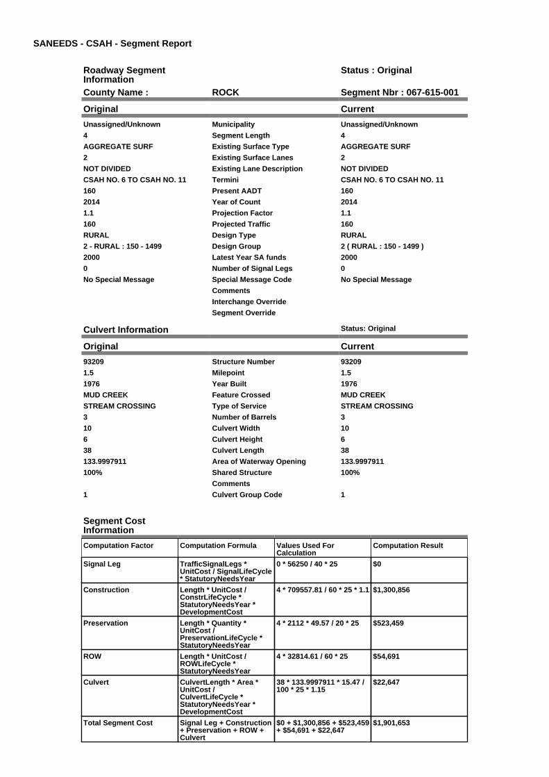
SANEEDS - CSAH - Segment Report
Roadway SegmentInformation
Status : Original
County Name : ROCK Segment Nbr : 067-615-001
Original Current
Unassigned/Unknown Municipality Unassigned/Unknown
4 Segment Length 4
AGGREGATE SURF Existing Surface Type AGGREGATE SURF
2 Existing Surface Lanes 2
NOT DIVIDED Existing Lane Description NOT DIVIDED
CSAH NO. 6 TO CSAH NO. 11 Termini CSAH NO. 6 TO CSAH NO. 11
160 Present AADT 160
2014 Year of Count 2014
1.1 Projection Factor 1.1
160 Projected Traffic 160
RURAL Design Type RURAL
2 - RURAL : 150 - 1499 Design Group 2 ( RURAL : 150 - 1499 )
2000 Latest Year SA funds 2000
0 Number of Signal Legs 0
No Special Message Special Message Code No Special Message
Comments
Interchange Override
Segment Override
Culvert Information Status: Original
Original Current
93209 Structure Number 93209
1.5 Milepoint 1.5
1976 Year Built 1976
MUD CREEK Feature Crossed MUD CREEK
STREAM CROSSING Type of Service STREAM CROSSING
3 Number of Barrels 3
10 Culvert Width 10
6 Culvert Height 6
38 Culvert Length 38
133.9997911 Area of Waterway Opening 133.9997911
100% Shared Structure 100%
Comments
1 Culvert Group Code 1
Segment CostInformation
Computation Factor Computation Formula Values Used ForCalculation
Computation Result
Signal Leg TrafficSignalLegs *UnitCost / SignalLifeCycle* StatutoryNeedsYear
0 * 56250 / 40 * 25 $0
Construction Length * UnitCost /ConstrLifeCycle *StatutoryNeedsYear *DevelopmentCost
4 * 709557.81 / 60 * 25 * 1.1 $1,300,856
Preservation Length * Quantity *UnitCost /PreservationLifeCycle *StatutoryNeedsYear
4 * 2112 * 49.57 / 20 * 25 $523,459
ROW Length * UnitCost /ROWLifeCycle *StatutoryNeedsYear
4 * 32814.61 / 60 * 25 $54,691
Culvert CulvertLength * Area *UnitCost /CulvertLifeCycle *StatutoryNeedsYear *DevelopmentCost
38 * 133.9997911 * 15.47 /100 * 25 * 1.15
$22,647
Total Segment Cost Signal Leg + Construction+ Preservation + ROW +Culvert
$0 + $1,300,856 + $523,459+ $54,691 + $22,647
$1,901,653

SANEEDS - CSAH - Segment Report
Roadway SegmentInformation
Status : Original
County Name : ROCK Segment Nbr : 067-615-003
Original Current
Unassigned/Unknown Municipality Unassigned/Unknown
3.5 Segment Length 3.5
AGGREGATE SURF Existing Surface Type AGGREGATE SURF
2 Existing Surface Lanes 2
NOT DIVIDED Existing Lane Description NOT DIVIDED
CSAH NO. 11 TO 0.5 MILES EASTOF TRUNK HIGHWAY 75
Termini CSAH NO. 11 TO 0.5 MILES EASTOF TRUNK HIGHWAY 75
165 Present AADT 165
2014 Year of Count 2014
1.1 Projection Factor 1.1
165 Projected Traffic 165
RURAL Design Type RURAL
2 - RURAL : 150 - 1499 Design Group 2 ( RURAL : 150 - 1499 )
2000 Latest Year SA funds 2000
0 Number of Signal Legs 0
No Special Message Special Message Code No Special Message
Comments
Interchange Override
Segment Override
Culvert Information Status: Original
Original Current
96019 Structure Number 96019
6.21 Milepoint 6.21
1985 Year Built 1985
STREAM Feature Crossed STREAM
STREAM CROSSING Type of Service STREAM CROSSING
1 Number of Barrels 1
12 Culvert Width 12
6 Culvert Height 6
40 Culvert Length 40
69.99979448 Area of Waterway Opening 69.99979448
100% Shared Structure 100%
Comments
1 Culvert Group Code 1
Culvert Information Status: Original
Original Current
L2195 Structure Number L2195
6.94 Milepoint 6.94
1911 Year Built 1911
STREAM Feature Crossed STREAM
STREAM CROSSING Type of Service STREAM CROSSING
1 Number of Barrels 1
10 Culvert Width 10
4 Culvert Height 4
35 Culvert Length 35
39.99972879 Area of Waterway Opening 39.99972879
100% Shared Structure 100%
Comments
1 Culvert Group Code 1
Segment CostInformation
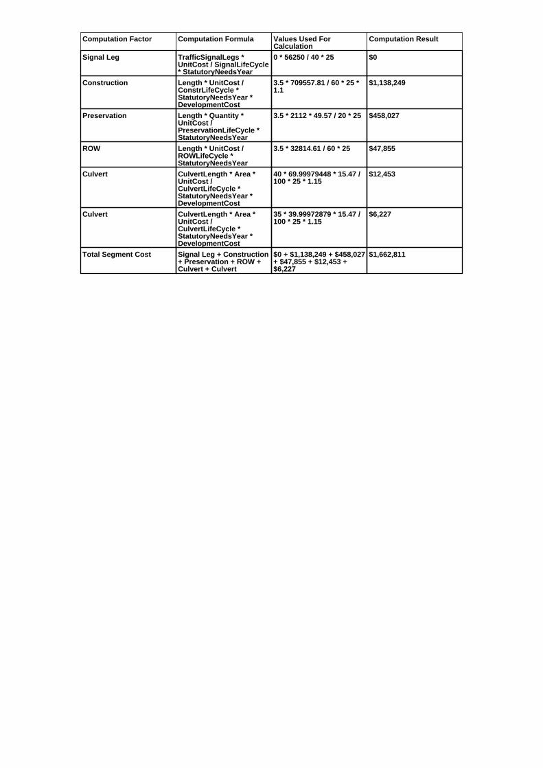
Computation Factor Computation Formula Values Used ForCalculation
Computation Result
Signal Leg TrafficSignalLegs *UnitCost / SignalLifeCycle* StatutoryNeedsYear
0 * 56250 / 40 * 25 $0
Construction Length * UnitCost /ConstrLifeCycle *StatutoryNeedsYear *DevelopmentCost
3.5 * 709557.81 / 60 * 25 *1.1
$1,138,249
Preservation Length * Quantity *UnitCost /PreservationLifeCycle *StatutoryNeedsYear
3.5 * 2112 * 49.57 / 20 * 25 $458,027
ROW Length * UnitCost /ROWLifeCycle *StatutoryNeedsYear
3.5 * 32814.61 / 60 * 25 $47,855
Culvert CulvertLength * Area *UnitCost /CulvertLifeCycle *StatutoryNeedsYear *DevelopmentCost
40 * 69.99979448 * 15.47 /100 * 25 * 1.15
$12,453
Culvert CulvertLength * Area *UnitCost /CulvertLifeCycle *StatutoryNeedsYear *DevelopmentCost
35 * 39.99972879 * 15.47 /100 * 25 * 1.15
$6,227
Total Segment Cost Signal Leg + Construction+ Preservation + ROW +Culvert + Culvert
$0 + $1,138,249 + $458,027+ $47,855 + $12,453 +$6,227
$1,662,811

SANEEDS - CSAH - Segment Report
Roadway SegmentInformation
Status : Original
County Name : ROCK Segment Nbr : 067-615-006
Original Current
Unassigned/Unknown Municipality Unassigned/Unknown
0.5 Segment Length 0.5
AGGREGATE SURF Existing Surface Type AGGREGATE SURF
2 Existing Surface Lanes 2
NOT DIVIDED Existing Lane Description NOT DIVIDED
0.50 MILES EAST OF TH 75 TO 1.0MILES EAST OF TH 75
Termini 0.50 MILES EAST OF TH 75 TO 1.0MILES EAST OF TH 75
165 Present AADT 165
2014 Year of Count 2014
1.1 Projection Factor 1.1
165 Projected Traffic 165
RURAL Design Type RURAL
2 - RURAL : 150 - 1499 Design Group 2 ( RURAL : 150 - 1499 )
2000 Latest Year SA funds 2000
0 Number of Signal Legs 0
No Special Message Special Message Code No Special Message
Comments
Interchange Override
Segment Override
Bridge Information Status: Original
Original Current
67512 Structure Number 67512
7.75 Milepoint 7.75
1991 Year Built 1991
ROCK RIVER Feature Crossed ROCK RIVER
STREAM CROSSING Type of Service STREAM CROSSING
6 Number of Spans 6
399.2 Bridge Length 399.2
31.3 Bridge Width 31.3
100% Shared Structure 100%
Comments
2 ( 150-999,999 ) Bridge Group Code 2 ( 150-999,999 )
Culvert Information Status: Original
Original Current
97043 Structure Number 97043
7.58 Milepoint 7.58
1991 Year Built 1991
DITCH Feature Crossed DITCH
OTHER Type of Service OTHER
1 Number of Barrels 1
12 Culvert Width 12
4 Culvert Height 4
66 Culvert Length 66
45.99952665 Area of Waterway Opening 45.99952665
100% Shared Structure 100%
Comments
1 Culvert Group Code 1
Segment CostInformation
Computation Factor Computation Formula Values Used ForCalculation
Computation Result

Signal Leg TrafficSignalLegs *UnitCost / SignalLifeCycle* StatutoryNeedsYear
0 * 56250 / 40 * 25 $0
Construction Length * UnitCost /ConstrLifeCycle *StatutoryNeedsYear *DevelopmentCost
0.5 * 709557.81 / 60 * 25 *1.1
$162,607
Preservation Length * Quantity *UnitCost /PreservationLifeCycle *StatutoryNeedsYear
0.5 * 2112 * 49.57 / 20 * 25 $65,432
ROW Length * UnitCost /ROWLifeCycle *StatutoryNeedsYear
0.5 * 32814.61 / 60 * 25 $6,836
Bridge BridgeLength *BridgeWidth * UnitCost /BridgeLifeCycle *StatutoryNeedsYear *DevelopmentCost
399.2 * 31.3 * 138 / 80 * 25* 1.15
$619,672
Culvert CulvertLength * Area *UnitCost /CulvertLifeCycle *StatutoryNeedsYear *DevelopmentCost
66 * 45.99952665 * 15.47 /100 * 25 * 1.15
$13,503
Total Segment Cost Signal Leg + Construction+ Preservation + ROW +Bridge + Culvert
$0 + $162,607 + $65,432 +$6,836 + $619,672 +$13,503
$868,050

SANEEDS - CSAH - Segment Report
Roadway SegmentInformation
Status : Original
County Name : ROCK Segment Nbr : 067-615-009
Original Current
Unassigned/Unknown Municipality Unassigned/Unknown
1 Segment Length 1
AGGREGATE SURF Existing Surface Type AGGREGATE SURF
2 Existing Surface Lanes 2
NOT DIVIDED Existing Lane Description NOT DIVIDED
1.00 MILES EAST OF TH 75 TOJUNCTION OF CSAH NO. 9
Termini 1.00 MILES EAST OF TH 75 TOJUNCTION OF CSAH NO. 9
165 Present AADT 165
2014 Year of Count 2014
1.1 Projection Factor 1.1
165 Projected Traffic 165
RURAL Design Type RURAL
2 - RURAL : 150 - 1499 Design Group 2 ( RURAL : 150 - 1499 )
2000 Latest Year SA funds 2000
0 Number of Signal Legs 0
No Special Message Special Message Code No Special Message
Comments
Interchange Override
Segment Override
Segment CostInformation
Computation Factor Computation Formula Values Used ForCalculation
Computation Result
Signal Leg TrafficSignalLegs *UnitCost / SignalLifeCycle* StatutoryNeedsYear
0 * 56250 / 40 * 25 $0
Construction Length * UnitCost /ConstrLifeCycle *StatutoryNeedsYear *DevelopmentCost
1 * 709557.81 / 60 * 25 * 1.1 $325,214
Preservation Length * Quantity *UnitCost /PreservationLifeCycle *StatutoryNeedsYear
1 * 2112 * 49.57 / 20 * 25 $130,865
ROW Length * UnitCost /ROWLifeCycle *StatutoryNeedsYear
1 * 32814.61 / 60 * 25 $13,673
Total Segment Cost Signal Leg + Construction+ Preservation + ROW
$0 + $325,214 + $130,865+ $13,673
$469,752

SANEEDS - CSAH - Segment Report
Roadway SegmentInformation
Status : Revised
County Name : ROCK Segment Nbr : 067-615-010
Original Current
Unassigned/Unknown Municipality Unassigned/Unknown
6 Segment Length 6
MIXED BITUMINOUS Existing Surface Type MIXED BITUMINOUS
2 Existing Surface Lanes 2
NOT DIVIDED Existing Lane Description NOT DIVIDED
CSAH 9 TO E CO LINE Termini CSAH 9 TO E CO LINE
150 Present AADT 150
2014 Year of Count 2014
1.2 Projection Factor 1.2
150 Projected Traffic 150
RURAL Design Type RURAL
2 - RURAL : 150 - 1499 Design Group 2 ( RURAL : 150 - 1499 )
2016 Latest Year SA funds 2016
0 Number of Signal Legs 0
No Special Message Special Message Code No Special Message
2016 SP 067-615-009 BR R&R67571
Comments 2016 SP 067-615-009 BR R&R67571
Interchange Override
Segment Override
Bridge Information Status: Revised
Original Current
67571 Structure Number 67571
15.56 Milepoint 15.56
2016 Year Built 2016
KANARANZI CREEK Feature Crossed KANARANZI CREEK
STREAM CROSSING Type of Service STREAM CROSSING
3 Number of Spans 3
110 Bridge Length 110
32 Bridge Width 32
100% Shared Structure 100%
2016 SP 067-615-009 BR R&R67571
Comments 2016 SP 067-615-009 BR R&R67571
1 ( 0-149 ) Bridge Group Code 1 ( 0-149 )
Bridge Information Status: Original
Original Current
92430 Structure Number 92430
12.27 Milepoint 12.27
1967 Year Built 1967
STREAM Feature Crossed STREAM
Type of Service
Number of Spans
20.1 Bridge Length 20.1
32.1 Bridge Width 32.1
100% Shared Structure 100%
Comments
1 ( 0-149 ) Bridge Group Code 1 ( 0-149 )
Culvert Information Status: Original
Original Current
67J47 Structure Number 67J47
Milepoint
2000 Year Built 2000
STREAM Feature Crossed STREAM

STREAM CROSSING Type of Service STREAM CROSSING
2 Number of Barrels 2
10 Culvert Width 10
4 Culvert Height 4
34 Culvert Length 34
80.00053397 Area of Waterway Opening 80.00053397
100% Shared Structure 100%
Comments
1 Culvert Group Code 1
Culvert Information Status: Original
Original Current
67J55 Structure Number 67J55
Milepoint
2001 Year Built 2001
Feature Crossed
STREAM CROSSING Type of Service STREAM CROSSING
1 Number of Barrels 1
14 Culvert Width 14
5 Culvert Height 5
38 Culvert Length 38
69.99979448 Area of Waterway Opening 69.99979448
100% Shared Structure 100%
Comments
1 Culvert Group Code 1
Segment CostInformation
Computation Factor Computation Formula Values Used ForCalculation
Computation Result
Signal Leg TrafficSignalLegs *UnitCost / SignalLifeCycle* StatutoryNeedsYear
0 * 56250 / 40 * 25 $0
Construction Length * UnitCost /ConstrLifeCycle *StatutoryNeedsYear *DevelopmentCost
6 * 709557.81 / 60 * 25 * 1.1 $1,951,284
Preservation Length * Quantity *UnitCost /PreservationLifeCycle *StatutoryNeedsYear
6 * 2112 * 49.57 / 20 * 25 $785,189
ROW Length * UnitCost /ROWLifeCycle *StatutoryNeedsYear
6 * 32814.61 / 60 * 25 $82,037
Bridge BridgeLength *BridgeWidth * UnitCost /BridgeLifeCycle *StatutoryNeedsYear *DevelopmentCost
110 * 32 * 152 / 80 * 25 *1.15
$192,280
Bridge BridgeLength *BridgeWidth * UnitCost /BridgeLifeCycle *StatutoryNeedsYear *DevelopmentCost
20.1 * 32.1 * 152 / 80 * 25 *1.15
$35,245
Culvert CulvertLength * Area *UnitCost /CulvertLifeCycle *StatutoryNeedsYear *DevelopmentCost
34 * 80.00053397 * 15.47 /100 * 25 * 1.15
$12,098
Culvert CulvertLength * Area *UnitCost /CulvertLifeCycle *StatutoryNeedsYear *DevelopmentCost
38 * 69.99979448 * 15.47 /100 * 25 * 1.15
$11,831
Total Segment Cost Signal Leg + Construction+ Preservation + ROW +Bridge + Bridge + Culvert+ Culvert
$0 + $1,951,284 + $785,189+ $82,037 + $192,280 +$35,245 + $12,098 +$11,831
$3,069,964

SANEEDS - CSAH - Segment Report
Roadway SegmentInformation
Status : Original
County Name : ROCK Segment Nbr : 067-616-005
Original Current
Unassigned/Unknown Municipality Unassigned/Unknown
0.5 Segment Length 0.5
BIT CONC OR ASPH Existing Surface Type BIT CONC OR ASPH
2 Existing Surface Lanes 2
NOT DIVIDED Existing Lane Description NOT DIVIDED
TH 75 TO 134TH AVENUE Termini TH 75 TO 134TH AVENUE
374 Present AADT 374
2014 Year of Count 2014
1.1 Projection Factor 1.1
374 Projected Traffic 374
RURAL Design Type RURAL
2 - RURAL : 150 - 1499 Design Group 2 ( RURAL : 150 - 1499 )
2015 Latest Year SA funds 2015
0 Number of Signal Legs 0
No Special Message Special Message Code No Special Message
2015 SAP 067-616-008 M&OL Comments 2015 SAP 067-616-008 M&OL
Interchange Override
Segment Override
Segment CostInformation
Computation Factor Computation Formula Values Used ForCalculation
Computation Result
Signal Leg TrafficSignalLegs *UnitCost / SignalLifeCycle* StatutoryNeedsYear
0 * 56250 / 40 * 25 $0
Construction Length * UnitCost /ConstrLifeCycle *StatutoryNeedsYear *DevelopmentCost
0.5 * 709557.81 / 60 * 25 *1.1
$162,607
Preservation Length * Quantity *UnitCost /PreservationLifeCycle *StatutoryNeedsYear
0.5 * 2112 * 49.57 / 20 * 25 $65,432
ROW Length * UnitCost /ROWLifeCycle *StatutoryNeedsYear
0.5 * 32814.61 / 60 * 25 $6,836
Total Segment Cost Signal Leg + Construction+ Preservation + ROW
$0 + $162,607 + $65,432 +$6,836
$234,875
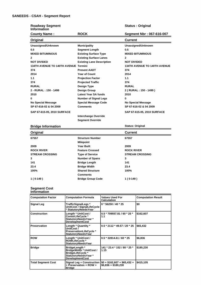
SANEEDS - CSAH - Segment Report
Roadway SegmentInformation
Status : Original
County Name : ROCK Segment Nbr : 067-616-007
Original Current
Unassigned/Unknown Municipality Unassigned/Unknown
0.5 Segment Length 0.5
MIXED BITUMINOUS Existing Surface Type MIXED BITUMINOUS
2 Existing Surface Lanes 2
NOT DIVIDED Existing Lane Description NOT DIVIDED
134TH AVENUE TO 140TH AVENUE Termini 134TH AVENUE TO 140TH AVENUE
374 Present AADT 374
2014 Year of Count 2014
1.1 Projection Factor 1.1
374 Projected Traffic 374
RURAL Design Type RURAL
2 - RURAL : 150 - 1499 Design Group 2 ( RURAL : 150 - 1499 )
2010 Latest Year SA funds 2010
0 Number of Signal Legs 0
No Special Message Special Message Code No Special Message
SP 67-616-02 & 04 2009
SAP 67-615-05, 2010 SURFACE
Comments SP 67-616-02 & 04 2009
SAP 67-615-05, 2010 SURFACE
Interchange Override
Segment Override
Bridge Information Status: Original
Original Current
67557 Structure Number 67557
Milepoint
2009 Year Built 2009
ROCK RIVER Feature Crossed ROCK RIVER
STREAM CROSSING Type of Service STREAM CROSSING
3 Number of Spans 3
141 Bridge Length 141
23.4 Bridge Width 23.4
100% Shared Structure 100%
Comments
1 ( 0-149 ) Bridge Group Code 1 ( 0-149 )
Segment CostInformation
Computation Factor Computation Formula Values Used ForCalculation
Computation Result
Signal Leg TrafficSignalLegs *UnitCost / SignalLifeCycle* StatutoryNeedsYear
0 * 56250 / 40 * 25 $0
Construction Length * UnitCost /ConstrLifeCycle *StatutoryNeedsYear *DevelopmentCost
0.5 * 709557.81 / 60 * 25 *1.1
$162,607
Preservation Length * Quantity *UnitCost /PreservationLifeCycle *StatutoryNeedsYear
0.5 * 2112 * 49.57 / 20 * 25 $65,432
ROW Length * UnitCost /ROWLifeCycle *StatutoryNeedsYear
0.5 * 32814.61 / 60 * 25 $6,836
Bridge BridgeLength *BridgeWidth * UnitCost /BridgeLifeCycle *StatutoryNeedsYear *DevelopmentCost
141 * 23.4 * 152 / 80 * 25 *1.15
$180,230
Total Segment Cost Signal Leg + Construction+ Preservation + ROW +Bridge
$0 + $162,607 + $65,432 +$6,836 + $180,230
$415,105

SANEEDS - CSAH - Segment Report
Roadway SegmentInformation
Status : Original
County Name : ROCK Segment Nbr : 067-616-010
Original Current
Unassigned/Unknown Municipality Unassigned/Unknown
1 Segment Length 1
BIT CONC OR ASPH Existing Surface Type BIT CONC OR ASPH
2 Existing Surface Lanes 2
NOT DIVIDED Existing Lane Description NOT DIVIDED
140TH AVENUE TO CSAH 9 Termini 140TH AVENUE TO CSAH 9
374 Present AADT 374
2014 Year of Count 2014
1.1 Projection Factor 1.1
374 Projected Traffic 374
RURAL Design Type RURAL
2 - RURAL : 150 - 1499 Design Group 2 ( RURAL : 150 - 1499 )
2000 Latest Year SA funds 2000
0 Number of Signal Legs 0
No Special Message Special Message Code No Special Message
Comments
Interchange Override
Segment Override
Segment CostInformation
Computation Factor Computation Formula Values Used ForCalculation
Computation Result
Signal Leg TrafficSignalLegs *UnitCost / SignalLifeCycle* StatutoryNeedsYear
0 * 56250 / 40 * 25 $0
Construction Length * UnitCost /ConstrLifeCycle *StatutoryNeedsYear *DevelopmentCost
1 * 709557.81 / 60 * 25 * 1.1 $325,214
Preservation Length * Quantity *UnitCost /PreservationLifeCycle *StatutoryNeedsYear
1 * 2112 * 49.57 / 20 * 25 $130,865
ROW Length * UnitCost /ROWLifeCycle *StatutoryNeedsYear
1 * 32814.61 / 60 * 25 $13,673
Total Segment Cost Signal Leg + Construction+ Preservation + ROW
$0 + $325,214 + $130,865+ $13,673
$469,752

SANEEDS - CSAH - Segment Report
Roadway SegmentInformation
Status : Original
County Name : ROCK Segment Nbr : 067-616-011
Original Current
Unassigned/Unknown Municipality Unassigned/Unknown
4 Segment Length 4
AGGREGATE SURF Existing Surface Type AGGREGATE SURF
2 Existing Surface Lanes 2
NOT DIVIDED Existing Lane Description NOT DIVIDED
CSAH 9 TO CSAH 3 Termini CSAH 9 TO CSAH 3
72 Present AADT 72
2014 Year of Count 2014
1.1 Projection Factor 1.1
72 Projected Traffic 72
RURAL Design Type RURAL
1 - RURAL : 0 - 149 Design Group 1 ( RURAL : 0 - 149 )
2012 Latest Year SA funds 2012
0 Number of Signal Legs 0
No Special Message Special Message Code No Special Message
2012 SAP 067-616-006 NEW CUL#67K10
Comments 2012 SAP 067-616-006 NEW CUL#67K10
Interchange Override
Segment Override
Bridge Information Status: Original
Original Current
67561 Structure Number 67561
4.32 Milepoint 4.32
2011 Year Built 2011
Elk Creek Feature Crossed Elk Creek
STREAM CROSSING Type of Service STREAM CROSSING
3 Number of Spans 3
74.5 Bridge Length 74.5
32 Bridge Width 32
100% Shared Structure 100%
Comments
1 ( 0-149 ) Bridge Group Code 1 ( 0-149 )
Culvert Information Status: Original
Original Current
67K10 Structure Number 67K10
3.3 Milepoint 3.3
2012 Year Built 2012
Unnamed Stream Feature Crossed Unnamed Stream
STREAM CROSSING Type of Service STREAM CROSSING
2 Number of Barrels 2
10 Culvert Width 10
4 Culvert Height 4
42 Culvert Length 42
80 Area of Waterway Opening 80
100% Shared Structure 100%
2012 SAP 067-616-006 NEW CUL#67K10
Comments 2012 SAP 067-616-006 NEW CUL#67K10
1 Culvert Group Code 1
Segment CostInformation
Computation Factor Computation Formula Values Used ForCalculation
Computation Result
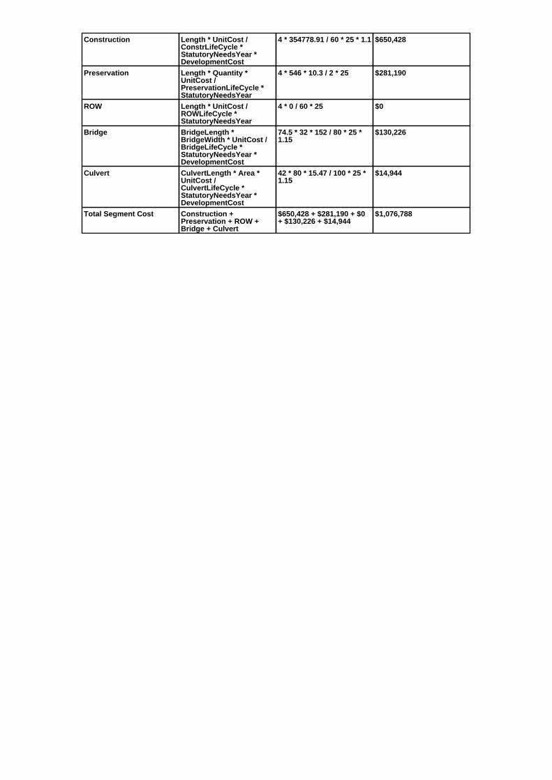
Construction Length * UnitCost /ConstrLifeCycle *StatutoryNeedsYear *DevelopmentCost
4 * 354778.91 / 60 * 25 * 1.1 $650,428
Preservation Length * Quantity *UnitCost /PreservationLifeCycle *StatutoryNeedsYear
4 * 546 * 10.3 / 2 * 25 $281,190
ROW Length * UnitCost /ROWLifeCycle *StatutoryNeedsYear
4 * 0 / 60 * 25 $0
Bridge BridgeLength *BridgeWidth * UnitCost /BridgeLifeCycle *StatutoryNeedsYear *DevelopmentCost
74.5 * 32 * 152 / 80 * 25 *1.15
$130,226
Culvert CulvertLength * Area *UnitCost /CulvertLifeCycle *StatutoryNeedsYear *DevelopmentCost
42 * 80 * 15.47 / 100 * 25 *1.15
$14,944
Total Segment Cost Construction +Preservation + ROW +Bridge + Culvert
$650,428 + $281,190 + $0+ $130,226 + $14,944
$1,076,788
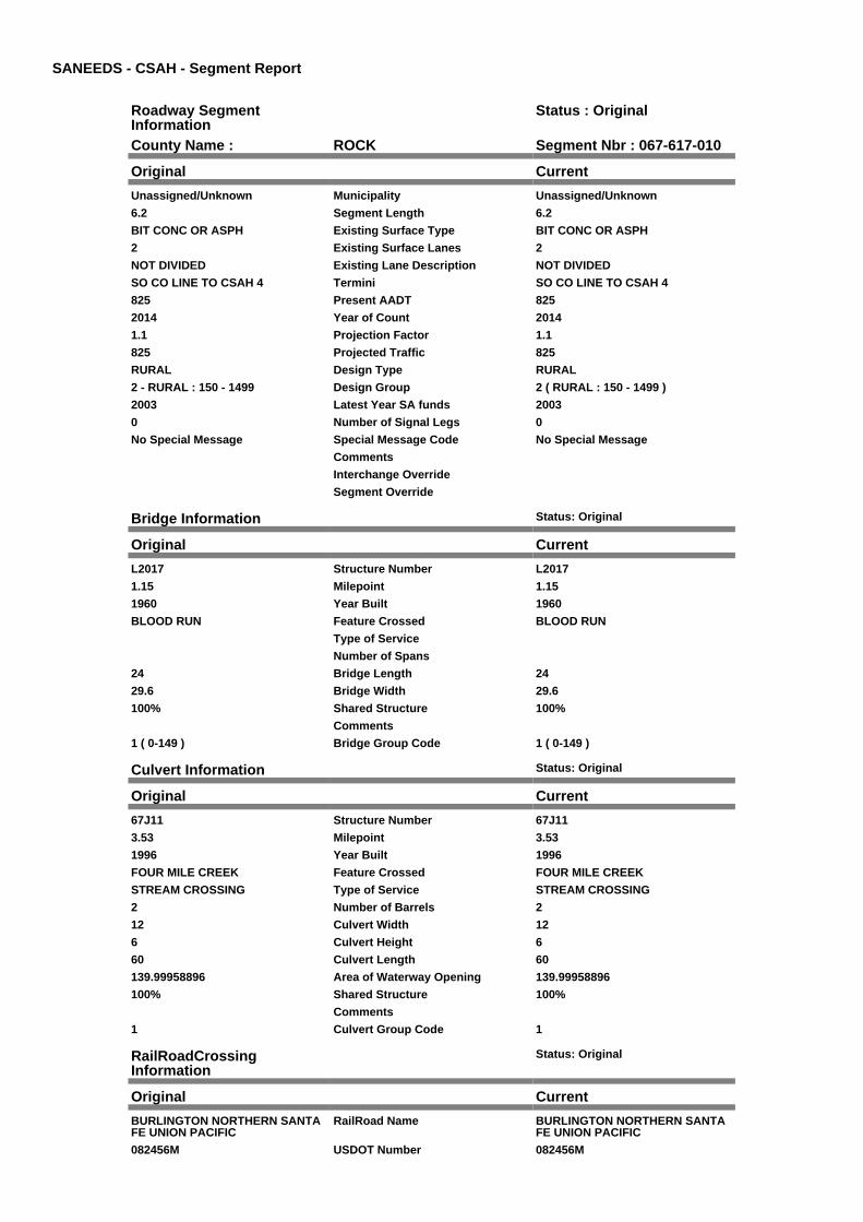
SANEEDS - CSAH - Segment Report
Roadway SegmentInformation
Status : Original
County Name : ROCK Segment Nbr : 067-617-010
Original Current
Unassigned/Unknown Municipality Unassigned/Unknown
6.2 Segment Length 6.2
BIT CONC OR ASPH Existing Surface Type BIT CONC OR ASPH
2 Existing Surface Lanes 2
NOT DIVIDED Existing Lane Description NOT DIVIDED
SO CO LINE TO CSAH 4 Termini SO CO LINE TO CSAH 4
825 Present AADT 825
2014 Year of Count 2014
1.1 Projection Factor 1.1
825 Projected Traffic 825
RURAL Design Type RURAL
2 - RURAL : 150 - 1499 Design Group 2 ( RURAL : 150 - 1499 )
2003 Latest Year SA funds 2003
0 Number of Signal Legs 0
No Special Message Special Message Code No Special Message
Comments
Interchange Override
Segment Override
Bridge Information Status: Original
Original Current
L2017 Structure Number L2017
1.15 Milepoint 1.15
1960 Year Built 1960
BLOOD RUN Feature Crossed BLOOD RUN
Type of Service
Number of Spans
24 Bridge Length 24
29.6 Bridge Width 29.6
100% Shared Structure 100%
Comments
1 ( 0-149 ) Bridge Group Code 1 ( 0-149 )
Culvert Information Status: Original
Original Current
67J11 Structure Number 67J11
3.53 Milepoint 3.53
1996 Year Built 1996
FOUR MILE CREEK Feature Crossed FOUR MILE CREEK
STREAM CROSSING Type of Service STREAM CROSSING
2 Number of Barrels 2
12 Culvert Width 12
6 Culvert Height 6
60 Culvert Length 60
139.99958896 Area of Waterway Opening 139.99958896
100% Shared Structure 100%
Comments
1 Culvert Group Code 1
RailRoadCrossingInformation
Status: Original
Original Current
BURLINGTON NORTHERN SANTAFE UNION PACIFIC
RailRoad Name BURLINGTON NORTHERN SANTAFE UNION PACIFIC
082456M USDOT Number 082456M

6.1 Located at Milepoint 6.1
2 Mainline Tracks 2
SIGNALS & GATES Protection Type SIGNALS & GATES
2002 Last Year Protection Upgraded 2002
40 Crossing Length 40
Last Year Surfaced
100% Percentage of Cost 100%
Comments
Segment CostInformation
Computation Factor Computation Formula Values Used ForCalculation
Computation Result
Signal Leg TrafficSignalLegs *UnitCost / SignalLifeCycle* StatutoryNeedsYear
0 * 56250 / 40 * 25 $0
Construction Length * UnitCost /ConstrLifeCycle *StatutoryNeedsYear *DevelopmentCost
6.2 * 709557.81 / 60 * 25 *1.1
$2,016,327
Preservation Length * Quantity *UnitCost /PreservationLifeCycle *StatutoryNeedsYear
6.2 * 2112 * 49.57 / 20 * 25 $811,362
ROW Length * UnitCost /ROWLifeCycle *StatutoryNeedsYear
6.2 * 32814.61 / 60 * 25 $84,771
Bridge BridgeLength *BridgeWidth * UnitCost /BridgeLifeCycle *StatutoryNeedsYear *DevelopmentCost
24 * 29.6 * 152 / 80 * 25 *1.15
$38,806
Culvert CulvertLength * Area *UnitCost /CulvertLifeCycle *StatutoryNeedsYear *DevelopmentCost
60 * 139.99958896 * 15.47 /100 * 25 * 1.15
$37,360
RR Crossing Protection UnitCost /RRCrossingLifeCycle *StatutoryNeedsYear
325000 / 25 * 25 $325,000
RR Crossing Surface SurfaceLength * UnitCost/ RRCrossingLifeCycle *StatutoryNeedsYear
40 * 1350 / 25 * 25 $54,000
Total Segment Cost Signal Leg + Construction+ Preservation + ROW +Bridge + Culvert + RRCrossing Protection + RRCrossing Surface
$0 + $2,016,327 + $811,362+ $84,771 + $38,806 +$37,360 + $325,000 +$54,000
$3,367,626
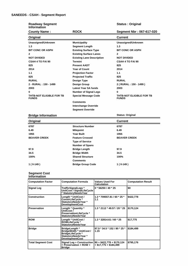
SANEEDS - CSAH - Segment Report
Roadway SegmentInformation
Status : Original
County Name : ROCK Segment Nbr : 067-617-020
Original Current
Unassigned/Unknown Municipality Unassigned/Unknown
1.3 Segment Length 1.3
BIT CONC OR ASPH Existing Surface Type BIT CONC OR ASPH
2 Existing Surface Lanes 2
NOT DIVIDED Existing Lane Description NOT DIVIDED
CSAH 4 TO FAI 90 Termini CSAH 4 TO FAI 90
825 Present AADT 825
2014 Year of Count 2014
1.1 Projection Factor 1.1
825 Projected Traffic 825
RURAL Design Type RURAL
2 - RURAL : 150 - 1499 Design Group 2 ( RURAL : 150 - 1499 )
2003 Latest Year SA funds 2003
0 Number of Signal Legs 0
THTB-NOT ELIGIBLE FOR TBFUNDS
Special Message Code THTB-NOT ELIGIBLE FOR TBFUNDS
Comments
Interchange Override
Segment Override
Bridge Information Status: Original
Original Current
6787 Structure Number 6787
6.49 Milepoint 6.49
1955 Year Built 1955
BEAVER CREEK Feature Crossed BEAVER CREEK
Type of Service
Number of Spans
97.9 Bridge Length 97.9
34.5 Bridge Width 34.5
100% Shared Structure 100%
Comments
1 ( 0-149 ) Bridge Group Code 1 ( 0-149 )
Segment CostInformation
Computation Factor Computation Formula Values Used ForCalculation
Computation Result
Signal Leg TrafficSignalLegs *UnitCost / SignalLifeCycle* StatutoryNeedsYear
0 * 56250 / 40 * 25 $0
Construction Length * UnitCost /ConstrLifeCycle *StatutoryNeedsYear *DevelopmentCost
1.3 * 709557.81 / 60 * 25 *1.1
$422,778
Preservation Length * Quantity *UnitCost /PreservationLifeCycle *StatutoryNeedsYear
1.3 * 2112 * 49.57 / 20 * 25 $170,124
ROW Length * UnitCost /ROWLifeCycle *StatutoryNeedsYear
1.3 * 32814.61 / 60 * 25 $17,775
Bridge BridgeLength *BridgeWidth * UnitCost /BridgeLifeCycle *StatutoryNeedsYear *DevelopmentCost
97.9 * 34.5 * 152 / 80 * 25 *1.15
$184,499
Total Segment Cost Signal Leg + Construction+ Preservation + ROW +Bridge
$0 + $422,778 + $170,124+ $17,775 + $184,499
$795,176
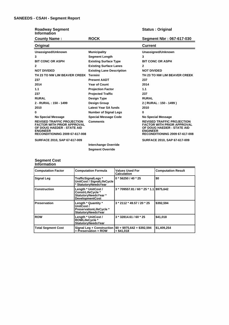
SANEEDS - CSAH - Segment Report
Roadway SegmentInformation
Status : Original
County Name : ROCK Segment Nbr : 067-617-030
Original Current
Unassigned/Unknown Municipality Unassigned/Unknown
3 Segment Length 3
BIT CONC OR ASPH Existing Surface Type BIT CONC OR ASPH
2 Existing Surface Lanes 2
NOT DIVIDED Existing Lane Description NOT DIVIDED
TH 23 TO NW LIM BEAVER CREEK Termini TH 23 TO NW LIM BEAVER CREEK
237 Present AADT 237
2014 Year of Count 2014
1.1 Projection Factor 1.1
237 Projected Traffic 237
RURAL Design Type RURAL
2 - RURAL : 150 - 1499 Design Group 2 ( RURAL : 150 - 1499 )
2010 Latest Year SA funds 2010
0 Number of Signal Legs 0
No Special Message Special Message Code No Special Message
REVISED TRAFFIC PROJECTIONFACTOR WITH PRIOR APPROVALOF DOUG HAEDER - STATE AIDENGINEERRECONDITIONING 2009 67-617-008
SURFACE 2010, SAP 67-617-009
Comments REVISED TRAFFIC PROJECTIONFACTOR WITH PRIOR APPROVALOF DOUG HAEDER - STATE AIDENGINEERRECONDITIONING 2009 67-617-008
SURFACE 2010, SAP 67-617-009
Interchange Override
Segment Override
Segment CostInformation
Computation Factor Computation Formula Values Used ForCalculation
Computation Result
Signal Leg TrafficSignalLegs *UnitCost / SignalLifeCycle* StatutoryNeedsYear
0 * 56250 / 40 * 25 $0
Construction Length * UnitCost /ConstrLifeCycle *StatutoryNeedsYear *DevelopmentCost
3 * 709557.81 / 60 * 25 * 1.1 $975,642
Preservation Length * Quantity *UnitCost /PreservationLifeCycle *StatutoryNeedsYear
3 * 2112 * 49.57 / 20 * 25 $392,594
ROW Length * UnitCost /ROWLifeCycle *StatutoryNeedsYear
3 * 32814.61 / 60 * 25 $41,018
Total Segment Cost Signal Leg + Construction+ Preservation + ROW
$0 + $975,642 + $392,594+ $41,018
$1,409,254
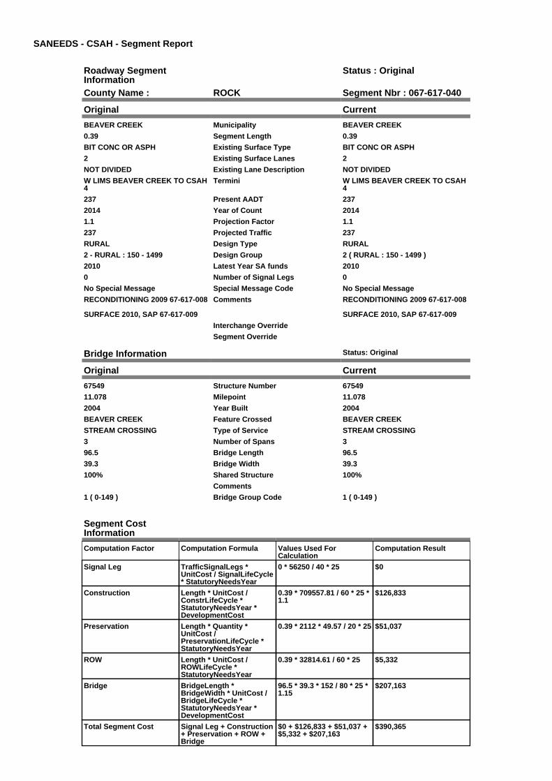
SANEEDS - CSAH - Segment Report
Roadway SegmentInformation
Status : Original
County Name : ROCK Segment Nbr : 067-617-040
Original Current
BEAVER CREEK Municipality BEAVER CREEK
0.39 Segment Length 0.39
BIT CONC OR ASPH Existing Surface Type BIT CONC OR ASPH
2 Existing Surface Lanes 2
NOT DIVIDED Existing Lane Description NOT DIVIDED
W LIMS BEAVER CREEK TO CSAH4
Termini W LIMS BEAVER CREEK TO CSAH4
237 Present AADT 237
2014 Year of Count 2014
1.1 Projection Factor 1.1
237 Projected Traffic 237
RURAL Design Type RURAL
2 - RURAL : 150 - 1499 Design Group 2 ( RURAL : 150 - 1499 )
2010 Latest Year SA funds 2010
0 Number of Signal Legs 0
No Special Message Special Message Code No Special Message
RECONDITIONING 2009 67-617-008
SURFACE 2010, SAP 67-617-009
Comments RECONDITIONING 2009 67-617-008
SURFACE 2010, SAP 67-617-009
Interchange Override
Segment Override
Bridge Information Status: Original
Original Current
67549 Structure Number 67549
11.078 Milepoint 11.078
2004 Year Built 2004
BEAVER CREEK Feature Crossed BEAVER CREEK
STREAM CROSSING Type of Service STREAM CROSSING
3 Number of Spans 3
96.5 Bridge Length 96.5
39.3 Bridge Width 39.3
100% Shared Structure 100%
Comments
1 ( 0-149 ) Bridge Group Code 1 ( 0-149 )
Segment CostInformation
Computation Factor Computation Formula Values Used ForCalculation
Computation Result
Signal Leg TrafficSignalLegs *UnitCost / SignalLifeCycle* StatutoryNeedsYear
0 * 56250 / 40 * 25 $0
Construction Length * UnitCost /ConstrLifeCycle *StatutoryNeedsYear *DevelopmentCost
0.39 * 709557.81 / 60 * 25 *1.1
$126,833
Preservation Length * Quantity *UnitCost /PreservationLifeCycle *StatutoryNeedsYear
0.39 * 2112 * 49.57 / 20 * 25 $51,037
ROW Length * UnitCost /ROWLifeCycle *StatutoryNeedsYear
0.39 * 32814.61 / 60 * 25 $5,332
Bridge BridgeLength *BridgeWidth * UnitCost /BridgeLifeCycle *StatutoryNeedsYear *DevelopmentCost
96.5 * 39.3 * 152 / 80 * 25 *1.15
$207,163
Total Segment Cost Signal Leg + Construction+ Preservation + ROW +Bridge
$0 + $126,833 + $51,037 +$5,332 + $207,163
$390,365

SANEEDS - CSAH - Segment Report
Roadway SegmentInformation
Status : Original
County Name : ROCK Segment Nbr : 067-618-010
Original Current
LUVERNE Municipality LUVERNE
0.9 Segment Length 0.9
MIXED BITUMINOUS Existing Surface Type MIXED BITUMINOUS
2 Existing Surface Lanes 2
NOT DIVIDED Existing Lane Description NOT DIVIDED
CSAH 4 TO 0.9 MI N Termini CSAH 4 TO 0.9 MI N
3685 Present AADT 3685
2014 Year of Count 2014
1.1 Projection Factor 1.1
3685 Projected Traffic 3685
URBAN Design Type URBAN
5 - URBAN : 0 - 9999 Design Group 5 ( URBAN : 0 - 9999 )
2005 Latest Year SA funds 2005
0 Number of Signal Legs 0
No Special Message Special Message Code No Special Message
RESURFACED UNDER PLAN #SAP67-618-007
Comments RESURFACED UNDER PLAN #SAP67-618-007
Interchange Override
Segment Override
Segment CostInformation
Computation Factor Computation Formula Values Used ForCalculation
Computation Result
Signal Leg TrafficSignalLegs *UnitCost / SignalLifeCycle* StatutoryNeedsYear
0 * 56250 / 40 * 25 $0
Construction Length * UnitCost /ConstrLifeCycle *StatutoryNeedsYear *DevelopmentCost
0.9 * 2655286.16 / 60 * 25 *1.15
$1,145,092
Preservation Length * Quantity *UnitCost /PreservationLifeCycle *StatutoryNeedsYear
0.9 * 2904 * 49.57 / 15 * 25 $215,927
ROW Length * UnitCost /ROWLifeCycle *StatutoryNeedsYear
0.9 * 11284.19 / 60 * 25 $4,232
Total Segment Cost Signal Leg + Construction+ Preservation + ROW
$0 + $1,145,092 + $215,927+ $4,232
$1,365,251
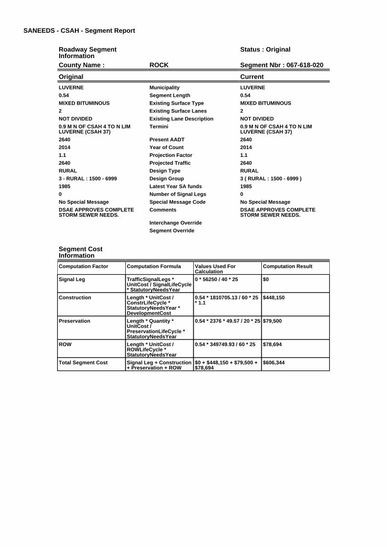
SANEEDS - CSAH - Segment Report
Roadway SegmentInformation
Status : Original
County Name : ROCK Segment Nbr : 067-618-020
Original Current
LUVERNE Municipality LUVERNE
0.54 Segment Length 0.54
MIXED BITUMINOUS Existing Surface Type MIXED BITUMINOUS
2 Existing Surface Lanes 2
NOT DIVIDED Existing Lane Description NOT DIVIDED
0.9 M N OF CSAH 4 TO N LIMLUVERNE (CSAH 37)
Termini 0.9 M N OF CSAH 4 TO N LIMLUVERNE (CSAH 37)
2640 Present AADT 2640
2014 Year of Count 2014
1.1 Projection Factor 1.1
2640 Projected Traffic 2640
RURAL Design Type RURAL
3 - RURAL : 1500 - 6999 Design Group 3 ( RURAL : 1500 - 6999 )
1985 Latest Year SA funds 1985
0 Number of Signal Legs 0
No Special Message Special Message Code No Special Message
DSAE APPROVES COMPLETESTORM SEWER NEEDS.
Comments DSAE APPROVES COMPLETESTORM SEWER NEEDS.
Interchange Override
Segment Override
Segment CostInformation
Computation Factor Computation Formula Values Used ForCalculation
Computation Result
Signal Leg TrafficSignalLegs *UnitCost / SignalLifeCycle* StatutoryNeedsYear
0 * 56250 / 40 * 25 $0
Construction Length * UnitCost /ConstrLifeCycle *StatutoryNeedsYear *DevelopmentCost
0.54 * 1810705.13 / 60 * 25* 1.1
$448,150
Preservation Length * Quantity *UnitCost /PreservationLifeCycle *StatutoryNeedsYear
0.54 * 2376 * 49.57 / 20 * 25 $79,500
ROW Length * UnitCost /ROWLifeCycle *StatutoryNeedsYear
0.54 * 349749.93 / 60 * 25 $78,694
Total Segment Cost Signal Leg + Construction+ Preservation + ROW
$0 + $448,150 + $79,500 +$78,694
$606,344
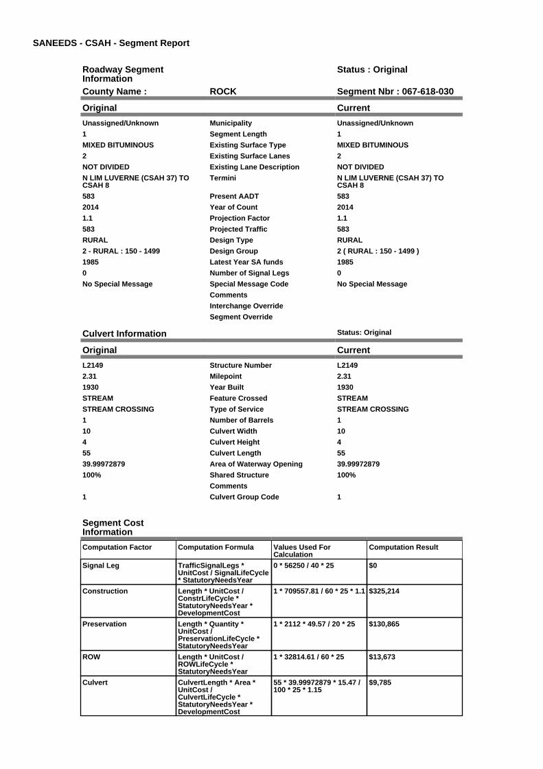
SANEEDS - CSAH - Segment Report
Roadway SegmentInformation
Status : Original
County Name : ROCK Segment Nbr : 067-618-030
Original Current
Unassigned/Unknown Municipality Unassigned/Unknown
1 Segment Length 1
MIXED BITUMINOUS Existing Surface Type MIXED BITUMINOUS
2 Existing Surface Lanes 2
NOT DIVIDED Existing Lane Description NOT DIVIDED
N LIM LUVERNE (CSAH 37) TOCSAH 8
Termini N LIM LUVERNE (CSAH 37) TOCSAH 8
583 Present AADT 583
2014 Year of Count 2014
1.1 Projection Factor 1.1
583 Projected Traffic 583
RURAL Design Type RURAL
2 - RURAL : 150 - 1499 Design Group 2 ( RURAL : 150 - 1499 )
1985 Latest Year SA funds 1985
0 Number of Signal Legs 0
No Special Message Special Message Code No Special Message
Comments
Interchange Override
Segment Override
Culvert Information Status: Original
Original Current
L2149 Structure Number L2149
2.31 Milepoint 2.31
1930 Year Built 1930
STREAM Feature Crossed STREAM
STREAM CROSSING Type of Service STREAM CROSSING
1 Number of Barrels 1
10 Culvert Width 10
4 Culvert Height 4
55 Culvert Length 55
39.99972879 Area of Waterway Opening 39.99972879
100% Shared Structure 100%
Comments
1 Culvert Group Code 1
Segment CostInformation
Computation Factor Computation Formula Values Used ForCalculation
Computation Result
Signal Leg TrafficSignalLegs *UnitCost / SignalLifeCycle* StatutoryNeedsYear
0 * 56250 / 40 * 25 $0
Construction Length * UnitCost /ConstrLifeCycle *StatutoryNeedsYear *DevelopmentCost
1 * 709557.81 / 60 * 25 * 1.1 $325,214
Preservation Length * Quantity *UnitCost /PreservationLifeCycle *StatutoryNeedsYear
1 * 2112 * 49.57 / 20 * 25 $130,865
ROW Length * UnitCost /ROWLifeCycle *StatutoryNeedsYear
1 * 32814.61 / 60 * 25 $13,673
Culvert CulvertLength * Area *UnitCost /CulvertLifeCycle *StatutoryNeedsYear *DevelopmentCost
55 * 39.99972879 * 15.47 /100 * 25 * 1.15
$9,785

Total Segment Cost Signal Leg + Construction+ Preservation + ROW +Culvert
$0 + $325,214 + $130,865+ $13,673 + $9,785
$479,537
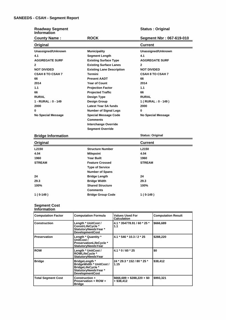
SANEEDS - CSAH - Segment Report
Roadway SegmentInformation
Status : Original
County Name : ROCK Segment Nbr : 067-619-010
Original Current
Unassigned/Unknown Municipality Unassigned/Unknown
4.1 Segment Length 4.1
AGGREGATE SURF Existing Surface Type AGGREGATE SURF
2 Existing Surface Lanes 2
NOT DIVIDED Existing Lane Description NOT DIVIDED
CSAH 8 TO CSAH 7 Termini CSAH 8 TO CSAH 7
66 Present AADT 66
2014 Year of Count 2014
1.1 Projection Factor 1.1
66 Projected Traffic 66
RURAL Design Type RURAL
1 - RURAL : 0 - 149 Design Group 1 ( RURAL : 0 - 149 )
2000 Latest Year SA funds 2000
0 Number of Signal Legs 0
No Special Message Special Message Code No Special Message
Comments
Interchange Override
Segment Override
Bridge Information Status: Original
Original Current
L2150 Structure Number L2150
4.04 Milepoint 4.04
1960 Year Built 1960
STREAM Feature Crossed STREAM
Type of Service
Number of Spans
24 Bridge Length 24
29.3 Bridge Width 29.3
100% Shared Structure 100%
Comments
1 ( 0-149 ) Bridge Group Code 1 ( 0-149 )
Segment CostInformation
Computation Factor Computation Formula Values Used ForCalculation
Computation Result
Construction Length * UnitCost /ConstrLifeCycle *StatutoryNeedsYear *DevelopmentCost
4.1 * 354778.91 / 60 * 25 *1.1
$666,689
Preservation Length * Quantity *UnitCost /PreservationLifeCycle *StatutoryNeedsYear
4.1 * 546 * 10.3 / 2 * 25 $288,220
ROW Length * UnitCost /ROWLifeCycle *StatutoryNeedsYear
4.1 * 0 / 60 * 25 $0
Bridge BridgeLength *BridgeWidth * UnitCost /BridgeLifeCycle *StatutoryNeedsYear *DevelopmentCost
24 * 29.3 * 152 / 80 * 25 *1.15
$38,412
Total Segment Cost Construction +Preservation + ROW +Bridge
$666,689 + $288,220 + $0+ $38,412
$993,321
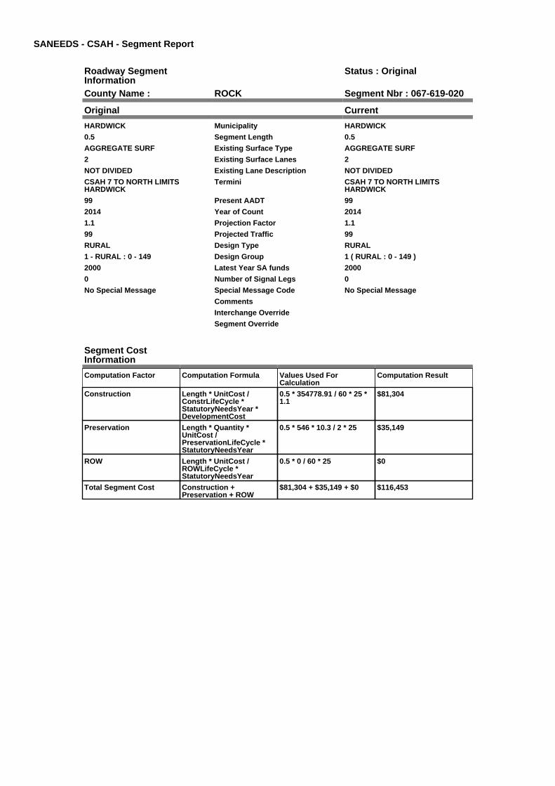
SANEEDS - CSAH - Segment Report
Roadway SegmentInformation
Status : Original
County Name : ROCK Segment Nbr : 067-619-020
Original Current
HARDWICK Municipality HARDWICK
0.5 Segment Length 0.5
AGGREGATE SURF Existing Surface Type AGGREGATE SURF
2 Existing Surface Lanes 2
NOT DIVIDED Existing Lane Description NOT DIVIDED
CSAH 7 TO NORTH LIMITSHARDWICK
Termini CSAH 7 TO NORTH LIMITSHARDWICK
99 Present AADT 99
2014 Year of Count 2014
1.1 Projection Factor 1.1
99 Projected Traffic 99
RURAL Design Type RURAL
1 - RURAL : 0 - 149 Design Group 1 ( RURAL : 0 - 149 )
2000 Latest Year SA funds 2000
0 Number of Signal Legs 0
No Special Message Special Message Code No Special Message
Comments
Interchange Override
Segment Override
Segment CostInformation
Computation Factor Computation Formula Values Used ForCalculation
Computation Result
Construction Length * UnitCost /ConstrLifeCycle *StatutoryNeedsYear *DevelopmentCost
0.5 * 354778.91 / 60 * 25 *1.1
$81,304
Preservation Length * Quantity *UnitCost /PreservationLifeCycle *StatutoryNeedsYear
0.5 * 546 * 10.3 / 2 * 25 $35,149
ROW Length * UnitCost /ROWLifeCycle *StatutoryNeedsYear
0.5 * 0 / 60 * 25 $0
Total Segment Cost Construction +Preservation + ROW
$81,304 + $35,149 + $0 $116,453

SANEEDS - CSAH - Segment Report
Roadway SegmentInformation
Status : Original
County Name : ROCK Segment Nbr : 067-619-030
Original Current
Unassigned/Unknown Municipality Unassigned/Unknown
4.5 Segment Length 4.5
AGGREGATE SURF Existing Surface Type AGGREGATE SURF
2 Existing Surface Lanes 2
NOT DIVIDED Existing Lane Description NOT DIVIDED
N LIM HARDWICK TO CSAH 12 Termini N LIM HARDWICK TO CSAH 12
99 Present AADT 99
2014 Year of Count 2014
1.1 Projection Factor 1.1
99 Projected Traffic 99
RURAL Design Type RURAL
1 - RURAL : 0 - 149 Design Group 1 ( RURAL : 0 - 149 )
2000 Latest Year SA funds 2000
0 Number of Signal Legs 0
No Special Message Special Message Code No Special Message
Comments
Interchange Override
Segment Override
Culvert Information Status: Original
Original Current
L2151 Structure Number L2151
8.4 Milepoint 8.4
1938 Year Built 1938
STREAM Feature Crossed STREAM
Type of Service
2 Number of Barrels 2
10 Culvert Width 10
5 Culvert Height 5
34 Culvert Length 34
99.99986017 Area of Waterway Opening 99.99986017
100% Shared Structure 100%
Comments
1 Culvert Group Code 1
Segment CostInformation
Computation Factor Computation Formula Values Used ForCalculation
Computation Result
Construction Length * UnitCost /ConstrLifeCycle *StatutoryNeedsYear *DevelopmentCost
4.5 * 354778.91 / 60 * 25 *1.1
$731,732
Preservation Length * Quantity *UnitCost /PreservationLifeCycle *StatutoryNeedsYear
4.5 * 546 * 10.3 / 2 * 25 $316,339
ROW Length * UnitCost /ROWLifeCycle *StatutoryNeedsYear
4.5 * 0 / 60 * 25 $0
Culvert CulvertLength * Area *UnitCost /CulvertLifeCycle *StatutoryNeedsYear *DevelopmentCost
34 * 99.99986017 * 15.47 /100 * 25 * 1.15
$15,122
Total Segment Cost Construction +Preservation + ROW +Culvert
$731,732 + $316,339 + $0+ $15,122
$1,063,193

SANEEDS - CSAH - Segment Report
Roadway SegmentInformation
Status : Original
County Name : ROCK Segment Nbr : 067-620-010
Original Current
Unassigned/Unknown Municipality Unassigned/Unknown
1.1 Segment Length 1.1
BIT CONC OR ASPH Existing Surface Type BIT CONC OR ASPH
2 Existing Surface Lanes 2
NOT DIVIDED Existing Lane Description NOT DIVIDED
W CO LINE TO TH 23 Termini W CO LINE TO TH 23
341 Present AADT 341
2014 Year of Count 2014
1.1 Projection Factor 1.1
341 Projected Traffic 341
RURAL Design Type RURAL
2 - RURAL : 150 - 1499 Design Group 2 ( RURAL : 150 - 1499 )
2000 Latest Year SA funds 2000
0 Number of Signal Legs 0
No Special Message Special Message Code No Special Message
Comments
Interchange Override
Segment Override
Segment CostInformation
Computation Factor Computation Formula Values Used ForCalculation
Computation Result
Signal Leg TrafficSignalLegs *UnitCost / SignalLifeCycle* StatutoryNeedsYear
0 * 56250 / 40 * 25 $0
Construction Length * UnitCost /ConstrLifeCycle *StatutoryNeedsYear *DevelopmentCost
1.1 * 709557.81 / 60 * 25 *1.1
$357,735
Preservation Length * Quantity *UnitCost /PreservationLifeCycle *StatutoryNeedsYear
1.1 * 2112 * 49.57 / 20 * 25 $143,951
ROW Length * UnitCost /ROWLifeCycle *StatutoryNeedsYear
1.1 * 32814.61 / 60 * 25 $15,040
Total Segment Cost Signal Leg + Construction+ Preservation + ROW
$0 + $357,735 + $143,951+ $15,040
$516,726

SANEEDS - CSAH - Segment Report
Roadway SegmentInformation
Status : Original
County Name : ROCK Segment Nbr : 067-620-020
Original Current
Unassigned/Unknown Municipality Unassigned/Unknown
6 Segment Length 6
MIXED BITUMINOUS Existing Surface Type MIXED BITUMINOUS
2 Existing Surface Lanes 2
NOT DIVIDED Existing Lane Description NOT DIVIDED
TH 23 TO CO RD 66 Termini TH 23 TO CO RD 66
231 Present AADT 231
2014 Year of Count 2014
1.1 Projection Factor 1.1
231 Projected Traffic 231
RURAL Design Type RURAL
2 - RURAL : 150 - 1499 Design Group 2 ( RURAL : 150 - 1499 )
2005 Latest Year SA funds 2005
0 Number of Signal Legs 0
No Special Message Special Message Code No Special Message
RESURFACED UNDER PLAN # 67-620-010
Comments RESURFACED UNDER PLAN # 67-620-010
Interchange Override
Segment Override
Segment CostInformation
Computation Factor Computation Formula Values Used ForCalculation
Computation Result
Signal Leg TrafficSignalLegs *UnitCost / SignalLifeCycle* StatutoryNeedsYear
0 * 56250 / 40 * 25 $0
Construction Length * UnitCost /ConstrLifeCycle *StatutoryNeedsYear *DevelopmentCost
6 * 709557.81 / 60 * 25 * 1.1 $1,951,284
Preservation Length * Quantity *UnitCost /PreservationLifeCycle *StatutoryNeedsYear
6 * 2112 * 49.57 / 20 * 25 $785,189
ROW Length * UnitCost /ROWLifeCycle *StatutoryNeedsYear
6 * 32814.61 / 60 * 25 $82,037
Total Segment Cost Signal Leg + Construction+ Preservation + ROW
$0 + $1,951,284 + $785,189+ $82,037
$2,818,510

SANEEDS - CSAH - Segment Report
Roadway SegmentInformation
Status : Original
County Name : ROCK Segment Nbr : 067-620-030
Original Current
Unassigned/Unknown Municipality Unassigned/Unknown
5 Segment Length 5
MIXED BITUMINOUS Existing Surface Type MIXED BITUMINOUS
2 Existing Surface Lanes 2
NOT DIVIDED Existing Lane Description NOT DIVIDED
CO RD 66 TO TH 75 Termini CO RD 66 TO TH 75
325 Present AADT 325
2014 Year of Count 2014
1.1 Projection Factor 1.1
325 Projected Traffic 325
RURAL Design Type RURAL
2 - RURAL : 150 - 1499 Design Group 2 ( RURAL : 150 - 1499 )
2005 Latest Year SA funds 2005
0 Number of Signal Legs 0
No Special Message Special Message Code No Special Message
RESURFACED UNDER PLAN #67-620-010
Comments RESURFACED UNDER PLAN #67-620-010
Interchange Override
Segment Override
Bridge Information Status: Original
Original Current
67552 Structure Number 67552
8.45 Milepoint 8.45
2005 Year Built 2005
BEAVER CREEK Feature Crossed BEAVER CREEK
STREAM CROSSING Type of Service STREAM CROSSING
1 Number of Spans 1
75.4 Bridge Length 75.4
39.3 Bridge Width 39.3
100% Shared Structure 100%
Comments
1 ( 0-149 ) Bridge Group Code 1 ( 0-149 )
Culvert Information Status: Original
Original Current
L2152 Structure Number L2152
7.37 Milepoint 7.37
1952 Year Built 1952
STREAM Feature Crossed STREAM
Type of Service
2 Number of Barrels 2
Culvert Width
Culvert Height
32 Culvert Length 32
95.00002862 Area of Waterway Opening 95.00002862
100% Shared Structure 100%
Comments
1 Culvert Group Code 1
Culvert Information Status: Original
Original Current
L2154 Structure Number L2154
9.61 Milepoint 9.61
1952 Year Built 1952

LITTLE BEAVER CREEK Feature Crossed LITTLE BEAVER CREEK
Type of Service
2 Number of Barrels 2
10 Culvert Width 10
6 Culvert Height 6
34 Culvert Length 34
120.00026276 Area of Waterway Opening 120.00026276
100% Shared Structure 100%
Comments
1 Culvert Group Code 1
Segment CostInformation
Computation Factor Computation Formula Values Used ForCalculation
Computation Result
Signal Leg TrafficSignalLegs *UnitCost / SignalLifeCycle* StatutoryNeedsYear
0 * 56250 / 40 * 25 $0
Construction Length * UnitCost /ConstrLifeCycle *StatutoryNeedsYear *DevelopmentCost
5 * 709557.81 / 60 * 25 * 1.1 $1,626,070
Preservation Length * Quantity *UnitCost /PreservationLifeCycle *StatutoryNeedsYear
5 * 2112 * 49.57 / 20 * 25 $654,324
ROW Length * UnitCost /ROWLifeCycle *StatutoryNeedsYear
5 * 32814.61 / 60 * 25 $68,364
Bridge BridgeLength *BridgeWidth * UnitCost /BridgeLifeCycle *StatutoryNeedsYear *DevelopmentCost
75.4 * 39.3 * 152 / 80 * 25 *1.15
$161,866
Culvert CulvertLength * Area *UnitCost /CulvertLifeCycle *StatutoryNeedsYear *DevelopmentCost
32 * 95.00002862 * 15.47 /100 * 25 * 1.15
$13,521
Culvert CulvertLength * Area *UnitCost /CulvertLifeCycle *StatutoryNeedsYear *DevelopmentCost
34 * 120.00026276 * 15.47 /100 * 25 * 1.15
$18,146
Total Segment Cost Signal Leg + Construction+ Preservation + ROW +Bridge + Culvert + Culvert
$0 + $1,626,070 + $654,324+ $68,364 + $161,866 +$13,521 + $18,146
$2,542,291

SANEEDS - CSAH - Segment Report
Roadway SegmentInformation
Status : Original
County Name : ROCK Segment Nbr : 067-620-040
Original Current
Unassigned/Unknown Municipality Unassigned/Unknown
1 Segment Length 1
BIT CONC OR ASPH Existing Surface Type BIT CONC OR ASPH
2 Existing Surface Lanes 2
NOT DIVIDED Existing Lane Description NOT DIVIDED
TH 75 TO 1.0 MI E Termini TH 75 TO 1.0 MI E
165 Present AADT 165
2014 Year of Count 2014
1.1 Projection Factor 1.1
165 Projected Traffic 165
RURAL Design Type RURAL
2 - RURAL : 150 - 1499 Design Group 2 ( RURAL : 150 - 1499 )
1975 Latest Year SA funds 1975
0 Number of Signal Legs 0
No Special Message Special Message Code No Special Message
Comments
Interchange Override
Segment Override
Segment CostInformation
Computation Factor Computation Formula Values Used ForCalculation
Computation Result
Signal Leg TrafficSignalLegs *UnitCost / SignalLifeCycle* StatutoryNeedsYear
0 * 56250 / 40 * 25 $0
Construction Length * UnitCost /ConstrLifeCycle *StatutoryNeedsYear *DevelopmentCost
1 * 709557.81 / 60 * 25 * 1.1 $325,214
Preservation Length * Quantity *UnitCost /PreservationLifeCycle *StatutoryNeedsYear
1 * 2112 * 49.57 / 20 * 25 $130,865
ROW Length * UnitCost /ROWLifeCycle *StatutoryNeedsYear
1 * 32814.61 / 60 * 25 $13,673
Total Segment Cost Signal Leg + Construction+ Preservation + ROW
$0 + $325,214 + $130,865+ $13,673
$469,752

SANEEDS - CSAH - Segment Report
Roadway SegmentInformation
Status : Original
County Name : ROCK Segment Nbr : 067-620-050
Original Current
Unassigned/Unknown Municipality Unassigned/Unknown
0.6 Segment Length 0.6
MIXED BITUMINOUS Existing Surface Type MIXED BITUMINOUS
2 Existing Surface Lanes 2
NOT DIVIDED Existing Lane Description NOT DIVIDED
1.0 M E TO 1.6 M E OF TH 75 Termini 1.0 M E TO 1.6 M E OF TH 75
165 Present AADT 165
2014 Year of Count 2014
1.1 Projection Factor 1.1
165 Projected Traffic 165
RURAL Design Type RURAL
2 - RURAL : 150 - 1499 Design Group 2 ( RURAL : 150 - 1499 )
2008 Latest Year SA funds 2008
0 Number of Signal Legs 0
No Special Message Special Message Code No Special Message
SAP 67-620-12, 2008 OVERLAY Comments SAP 67-620-12, 2008 OVERLAY
Interchange Override
Segment Override
Segment CostInformation
Computation Factor Computation Formula Values Used ForCalculation
Computation Result
Signal Leg TrafficSignalLegs *UnitCost / SignalLifeCycle* StatutoryNeedsYear
0 * 56250 / 40 * 25 $0
Construction Length * UnitCost /ConstrLifeCycle *StatutoryNeedsYear *DevelopmentCost
0.6 * 709557.81 / 60 * 25 *1.1
$195,128
Preservation Length * Quantity *UnitCost /PreservationLifeCycle *StatutoryNeedsYear
0.6 * 2112 * 49.57 / 20 * 25 $78,519
ROW Length * UnitCost /ROWLifeCycle *StatutoryNeedsYear
0.6 * 32814.61 / 60 * 25 $8,204
Total Segment Cost Signal Leg + Construction+ Preservation + ROW
$0 + $195,128 + $78,519 +$8,204
$281,851
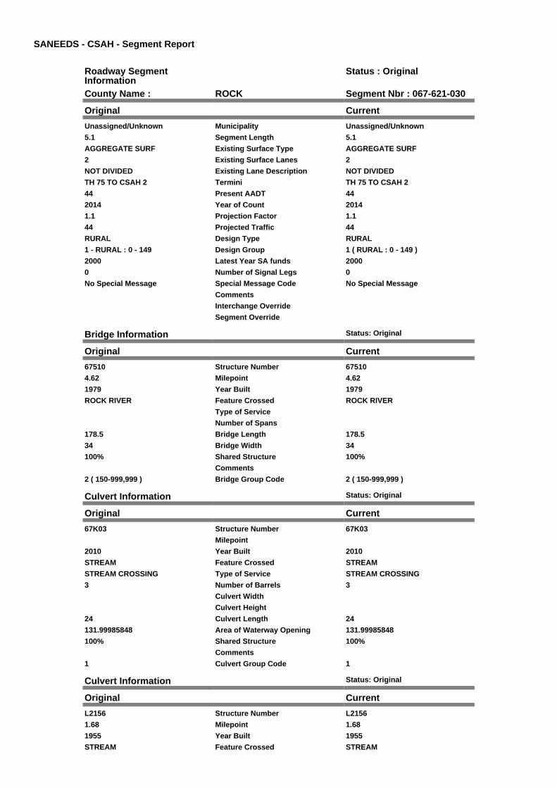
SANEEDS - CSAH - Segment Report
Roadway SegmentInformation
Status : Original
County Name : ROCK Segment Nbr : 067-621-030
Original Current
Unassigned/Unknown Municipality Unassigned/Unknown
5.1 Segment Length 5.1
AGGREGATE SURF Existing Surface Type AGGREGATE SURF
2 Existing Surface Lanes 2
NOT DIVIDED Existing Lane Description NOT DIVIDED
TH 75 TO CSAH 2 Termini TH 75 TO CSAH 2
44 Present AADT 44
2014 Year of Count 2014
1.1 Projection Factor 1.1
44 Projected Traffic 44
RURAL Design Type RURAL
1 - RURAL : 0 - 149 Design Group 1 ( RURAL : 0 - 149 )
2000 Latest Year SA funds 2000
0 Number of Signal Legs 0
No Special Message Special Message Code No Special Message
Comments
Interchange Override
Segment Override
Bridge Information Status: Original
Original Current
67510 Structure Number 67510
4.62 Milepoint 4.62
1979 Year Built 1979
ROCK RIVER Feature Crossed ROCK RIVER
Type of Service
Number of Spans
178.5 Bridge Length 178.5
34 Bridge Width 34
100% Shared Structure 100%
Comments
2 ( 150-999,999 ) Bridge Group Code 2 ( 150-999,999 )
Culvert Information Status: Original
Original Current
67K03 Structure Number 67K03
Milepoint
2010 Year Built 2010
STREAM Feature Crossed STREAM
STREAM CROSSING Type of Service STREAM CROSSING
3 Number of Barrels 3
Culvert Width
Culvert Height
24 Culvert Length 24
131.99985848 Area of Waterway Opening 131.99985848
100% Shared Structure 100%
Comments
1 Culvert Group Code 1
Culvert Information Status: Original
Original Current
L2156 Structure Number L2156
1.68 Milepoint 1.68
1955 Year Built 1955
STREAM Feature Crossed STREAM

Type of Service
3 Number of Barrels 3
Culvert Width
Culvert Height
50 Culvert Length 50
37.99979617 Area of Waterway Opening 37.99979617
100% Shared Structure 100%
Comments
1 Culvert Group Code 1
Culvert Information Status: Original
Original Current
L2158 Structure Number L2158
2.84 Milepoint 2.84
1938 Year Built 1938
STREAM Feature Crossed STREAM
Type of Service
2 Number of Barrels 2
8 Culvert Width 8
4 Culvert Height 4
25 Culvert Length 25
63.99999662 Area of Waterway Opening 63.99999662
100% Shared Structure 100%
Comments
1 Culvert Group Code 1
Segment CostInformation
Computation Factor Computation Formula Values Used ForCalculation
Computation Result
Construction Length * UnitCost /ConstrLifeCycle *StatutoryNeedsYear *DevelopmentCost
5.1 * 354778.91 / 60 * 25 *1.1
$829,296
Preservation Length * Quantity *UnitCost /PreservationLifeCycle *StatutoryNeedsYear
5.1 * 546 * 10.3 / 2 * 25 $358,517
ROW Length * UnitCost /ROWLifeCycle *StatutoryNeedsYear
5.1 * 0 / 60 * 25 $0
Bridge BridgeLength *BridgeWidth * UnitCost /BridgeLifeCycle *StatutoryNeedsYear *DevelopmentCost
178.5 * 34 * 138 / 80 * 25 *1.15
$300,984
Culvert CulvertLength * Area *UnitCost /CulvertLifeCycle *StatutoryNeedsYear *DevelopmentCost
24 * 131.99985848 * 15.47 /100 * 25 * 1.15
$14,090
Culvert CulvertLength * Area *UnitCost /CulvertLifeCycle *StatutoryNeedsYear *DevelopmentCost
50 * 37.99979617 * 15.47 /100 * 25 * 1.15
$8,450
Culvert CulvertLength * Area *UnitCost /CulvertLifeCycle *StatutoryNeedsYear *DevelopmentCost
25 * 63.99999662 * 15.47 /100 * 25 * 1.15
$7,116
Total Segment Cost Construction +Preservation + ROW +Bridge + Culvert + Culvert+ Culvert
$829,296 + $358,517 + $0+ $300,984 + $14,090 +$8,450 + $7,116
$1,518,453

SANEEDS - CSAH - Segment Report
Roadway SegmentInformation
Status : Original
County Name : ROCK Segment Nbr : 067-622-010
Original Current
LUVERNE Municipality LUVERNE
0.23 Segment Length 0.23
MIXED BITUMINOUS Existing Surface Type MIXED BITUMINOUS
2 Existing Surface Lanes 2
NOT DIVIDED Existing Lane Description NOT DIVIDED
WARREN ST, DONALDSON TOKNISS TH75
Termini WARREN ST, DONALDSON TOKNISS TH75
1485 Present AADT 1485
2014 Year of Count 2014
1.1 Projection Factor 1.1
1485 Projected Traffic 1485
URBAN Design Type URBAN
5 - URBAN : 0 - 9999 Design Group 5 ( URBAN : 0 - 9999 )
2012 Latest Year SA funds 2012
0 Number of Signal Legs 0
No Special Message Special Message Code No Special Message
2012 SAP 067-622-004 RECONST
DSAE APPROVES COMPLETESTORM SEWER NEEDS.
Comments 2012 SAP 067-622-004 RECONST
DSAE APPROVES COMPLETESTORM SEWER NEEDS.
Interchange Override
Segment Override
Segment CostInformation
Computation Factor Computation Formula Values Used ForCalculation
Computation Result
Signal Leg TrafficSignalLegs *UnitCost / SignalLifeCycle* StatutoryNeedsYear
0 * 56250 / 40 * 25 $0
Construction Length * UnitCost /ConstrLifeCycle *StatutoryNeedsYear *DevelopmentCost
0.23 * 2655286.16 / 60 * 25* 1.15
$292,635
Preservation Length * Quantity *UnitCost /PreservationLifeCycle *StatutoryNeedsYear
0.23 * 2904 * 49.57 / 15 * 25 $55,181
ROW Length * UnitCost /ROWLifeCycle *StatutoryNeedsYear
0.23 * 11284.19 / 60 * 25 $1,081
Total Segment Cost Signal Leg + Construction+ Preservation + ROW
$0 + $292,635 + $55,181 +$1,081
$348,897

SANEEDS - CSAH - Segment Report
Roadway SegmentInformation
Status : Original
County Name : ROCK Segment Nbr : 067-622-011
Original Current
LUVERNE Municipality LUVERNE
0.25 Segment Length 0.25
MIXED BITUMINOUS Existing Surface Type MIXED BITUMINOUS
2 Existing Surface Lanes 2
NOT DIVIDED Existing Lane Description NOT DIVIDED
KNISS TO CEDAR ON WARREN Termini KNISS TO CEDAR ON WARREN
1485 Present AADT 1485
2014 Year of Count 2014
1.1 Projection Factor 1.1
1485 Projected Traffic 1485
URBAN Design Type URBAN
5 - URBAN : 0 - 9999 Design Group 5 ( URBAN : 0 - 9999 )
1991 Latest Year SA funds 1991
0 Number of Signal Legs 0
No Special Message Special Message Code No Special Message
Comments
Interchange Override
Segment Override
Segment CostInformation
Computation Factor Computation Formula Values Used ForCalculation
Computation Result
Signal Leg TrafficSignalLegs *UnitCost / SignalLifeCycle* StatutoryNeedsYear
0 * 56250 / 40 * 25 $0
Construction Length * UnitCost /ConstrLifeCycle *StatutoryNeedsYear *DevelopmentCost
0.25 * 2655286.16 / 60 * 25* 1.15
$318,081
Preservation Length * Quantity *UnitCost /PreservationLifeCycle *StatutoryNeedsYear
0.25 * 2904 * 49.57 / 15 * 25 $59,980
ROW Length * UnitCost /ROWLifeCycle *StatutoryNeedsYear
0.25 * 11284.19 / 60 * 25 $1,175
Total Segment Cost Signal Leg + Construction+ Preservation + ROW
$0 + $318,081 + $59,980 +$1,175
$379,236

SANEEDS - CSAH - Segment Report
Roadway SegmentInformation
Status : Original
County Name : ROCK Segment Nbr : 067-622-020
Original Current
LUVERNE Municipality LUVERNE
0.1 Segment Length 0.1
MIXED BITUMINOUS Existing Surface Type MIXED BITUMINOUS
2 Existing Surface Lanes 2
NOT DIVIDED Existing Lane Description NOT DIVIDED
WARREN TO MAIN ST ON CEDARST
Termini WARREN TO MAIN ST ON CEDARST
1650 Present AADT 1650
2014 Year of Count 2014
1.1 Projection Factor 1.1
1650 Projected Traffic 1650
URBAN Design Type URBAN
5 - URBAN : 0 - 9999 Design Group 5 ( URBAN : 0 - 9999 )
2005 Latest Year SA funds 2005
1 Number of Signal Legs 1
No Special Message Special Message Code No Special Message
RESURFACED UNDER SAP 67-622-003
Comments RESURFACED UNDER SAP 67-622-003
Interchange Override
Segment Override
Segment CostInformation
Computation Factor Computation Formula Values Used ForCalculation
Computation Result
Signal Leg TrafficSignalLegs *UnitCost / SignalLifeCycle* StatutoryNeedsYear
1 * 56250 / 40 * 25 $35,156
Construction Length * UnitCost /ConstrLifeCycle *StatutoryNeedsYear *DevelopmentCost
0.1 * 2655286.16 / 60 * 25 *1.15
$127,232
Preservation Length * Quantity *UnitCost /PreservationLifeCycle *StatutoryNeedsYear
0.1 * 2904 * 49.57 / 15 * 25 $23,992
ROW Length * UnitCost /ROWLifeCycle *StatutoryNeedsYear
0.1 * 11284.19 / 60 * 25 $470
Total Segment Cost Signal Leg + Construction+ Preservation + ROW
$35,156 + $127,232 +$23,992 + $470
$186,850

SANEEDS - CSAH - Segment Report
Roadway SegmentInformation
Status : Original
County Name : ROCK Segment Nbr : 067-623-010
Original Current
HILLS Municipality HILLS
0.16 Segment Length 0.16
MIXED BITUMINOUS Existing Surface Type MIXED BITUMINOUS
2 Existing Surface Lanes 2
NOT DIVIDED Existing Lane Description NOT DIVIDED
ON MAIN - TH 270 TO 3RD ST Termini ON MAIN - TH 270 TO 3RD ST
704 Present AADT 704
2014 Year of Count 2014
1.1 Projection Factor 1.1
704 Projected Traffic 704
URBAN Design Type URBAN
5 - URBAN : 0 - 9999 Design Group 5 ( URBAN : 0 - 9999 )
1989 Latest Year SA funds 1989
0 Number of Signal Legs 0
No Special Message Special Message Code No Special Message
Comments
Interchange Override
Segment Override
Segment CostInformation
Computation Factor Computation Formula Values Used ForCalculation
Computation Result
Signal Leg TrafficSignalLegs *UnitCost / SignalLifeCycle* StatutoryNeedsYear
0 * 56250 / 40 * 25 $0
Construction Length * UnitCost /ConstrLifeCycle *StatutoryNeedsYear *DevelopmentCost
0.16 * 2655286.16 / 60 * 25* 1.15
$203,572
Preservation Length * Quantity *UnitCost /PreservationLifeCycle *StatutoryNeedsYear
0.16 * 2904 * 49.57 / 15 * 25 $38,387
ROW Length * UnitCost /ROWLifeCycle *StatutoryNeedsYear
0.16 * 11284.19 / 60 * 25 $752
Total Segment Cost Signal Leg + Construction+ Preservation + ROW
$0 + $203,572 + $38,387 +$752
$242,711

SANEEDS - CSAH - Segment Report
Roadway SegmentInformation
Status : Original
County Name : ROCK Segment Nbr : 067-623-020
Original Current
HILLS Municipality HILLS
0.23 Segment Length 0.23
MIXED BITUMINOUS Existing Surface Type MIXED BITUMINOUS
2 Existing Surface Lanes 2
NOT DIVIDED Existing Lane Description NOT DIVIDED
ON 3RD - MAIN TO SUMMIT Termini ON 3RD - MAIN TO SUMMIT
226 Present AADT 226
2014 Year of Count 2014
1.1 Projection Factor 1.1
226 Projected Traffic 226
URBAN Design Type URBAN
5 - URBAN : 0 - 9999 Design Group 5 ( URBAN : 0 - 9999 )
1989 Latest Year SA funds 1989
0 Number of Signal Legs 0
No Special Message Special Message Code No Special Message
Comments
Interchange Override
Segment Override
Segment CostInformation
Computation Factor Computation Formula Values Used ForCalculation
Computation Result
Signal Leg TrafficSignalLegs *UnitCost / SignalLifeCycle* StatutoryNeedsYear
0 * 56250 / 40 * 25 $0
Construction Length * UnitCost /ConstrLifeCycle *StatutoryNeedsYear *DevelopmentCost
0.23 * 2655286.16 / 60 * 25* 1.15
$292,635
Preservation Length * Quantity *UnitCost /PreservationLifeCycle *StatutoryNeedsYear
0.23 * 2904 * 49.57 / 15 * 25 $55,181
ROW Length * UnitCost /ROWLifeCycle *StatutoryNeedsYear
0.23 * 11284.19 / 60 * 25 $1,081
Total Segment Cost Signal Leg + Construction+ Preservation + ROW
$0 + $292,635 + $55,181 +$1,081
$348,897

SANEEDS - CSAH - Segment Report
Roadway SegmentInformation
Status : Original
County Name : ROCK Segment Nbr : 067-623-030
Original Current
HILLS Municipality HILLS
0.08 Segment Length 0.08
MIXED BITUMINOUS Existing Surface Type MIXED BITUMINOUS
2 Existing Surface Lanes 2
NOT DIVIDED Existing Lane Description NOT DIVIDED
ON SUMMIT - 3RD ST TO 2ND ST Termini ON SUMMIT - 3RD ST TO 2ND ST
259 Present AADT 259
2014 Year of Count 2014
1.1 Projection Factor 1.1
259 Projected Traffic 259
URBAN Design Type URBAN
5 - URBAN : 0 - 9999 Design Group 5 ( URBAN : 0 - 9999 )
1989 Latest Year SA funds 1989
0 Number of Signal Legs 0
No Special Message Special Message Code No Special Message
Comments
Interchange Override
Segment Override
Segment CostInformation
Computation Factor Computation Formula Values Used ForCalculation
Computation Result
Signal Leg TrafficSignalLegs *UnitCost / SignalLifeCycle* StatutoryNeedsYear
0 * 56250 / 40 * 25 $0
Construction Length * UnitCost /ConstrLifeCycle *StatutoryNeedsYear *DevelopmentCost
0.08 * 2655286.16 / 60 * 25* 1.15
$101,786
Preservation Length * Quantity *UnitCost /PreservationLifeCycle *StatutoryNeedsYear
0.08 * 2904 * 49.57 / 15 * 25 $19,194
ROW Length * UnitCost /ROWLifeCycle *StatutoryNeedsYear
0.08 * 11284.19 / 60 * 25 $376
Total Segment Cost Signal Leg + Construction+ Preservation + ROW
$0 + $101,786 + $19,194 +$376
$121,356

SANEEDS - CSAH - Segment Report
Roadway SegmentInformation
Status : Original
County Name : ROCK Segment Nbr : 067-623-040
Original Current
HILLS Municipality HILLS
0.08 Segment Length 0.08
MIXED BITUMINOUS Existing Surface Type MIXED BITUMINOUS
2 Existing Surface Lanes 2
NOT DIVIDED Existing Lane Description NOT DIVIDED
ON SUMMIT - 2ND ST TO TH 270 Termini ON SUMMIT - 2ND ST TO TH 270
259 Present AADT 259
2014 Year of Count 2014
1.1 Projection Factor 1.1
259 Projected Traffic 259
URBAN Design Type URBAN
5 - URBAN : 0 - 9999 Design Group 5 ( URBAN : 0 - 9999 )
1989 Latest Year SA funds 1989
0 Number of Signal Legs 0
No Special Message Special Message Code No Special Message
Comments
Interchange Override
Segment Override
Segment CostInformation
Computation Factor Computation Formula Values Used ForCalculation
Computation Result
Signal Leg TrafficSignalLegs *UnitCost / SignalLifeCycle* StatutoryNeedsYear
0 * 56250 / 40 * 25 $0
Construction Length * UnitCost /ConstrLifeCycle *StatutoryNeedsYear *DevelopmentCost
0.08 * 2655286.16 / 60 * 25* 1.15
$101,786
Preservation Length * Quantity *UnitCost /PreservationLifeCycle *StatutoryNeedsYear
0.08 * 2904 * 49.57 / 15 * 25 $19,194
ROW Length * UnitCost /ROWLifeCycle *StatutoryNeedsYear
0.08 * 11284.19 / 60 * 25 $376
Total Segment Cost Signal Leg + Construction+ Preservation + ROW
$0 + $101,786 + $19,194 +$376
$121,356

SANEEDS - CSAH - Segment Report
Roadway SegmentInformation
Status : Original
County Name : ROCK Segment Nbr : 067-624-010
Original Current
STEEN Municipality STEEN
0.22 Segment Length 0.22
MIXED BITUMINOUS Existing Surface Type MIXED BITUMINOUS
2 Existing Surface Lanes 2
NOT DIVIDED Existing Lane Description NOT DIVIDED
RAILWAY AVE TO 0.22 MI N ONMAIN ST
Termini RAILWAY AVE TO 0.22 MI N ONMAIN ST
204 Present AADT 204
2014 Year of Count 2014
1.1 Projection Factor 1.1
204 Projected Traffic 204
URBAN Design Type URBAN
5 - URBAN : 0 - 9999 Design Group 5 ( URBAN : 0 - 9999 )
1990 Latest Year SA funds 1990
0 Number of Signal Legs 0
No Special Message Special Message Code No Special Message
DSAE APPROVES COMPLETESTORM SEWER NEEDS.
Comments DSAE APPROVES COMPLETESTORM SEWER NEEDS.
Interchange Override
Segment Override
Segment CostInformation
Computation Factor Computation Formula Values Used ForCalculation
Computation Result
Signal Leg TrafficSignalLegs *UnitCost / SignalLifeCycle* StatutoryNeedsYear
0 * 56250 / 40 * 25 $0
Construction Length * UnitCost /ConstrLifeCycle *StatutoryNeedsYear *DevelopmentCost
0.22 * 2655286.16 / 60 * 25* 1.15
$279,911
Preservation Length * Quantity *UnitCost /PreservationLifeCycle *StatutoryNeedsYear
0.22 * 2904 * 49.57 / 15 * 25 $52,782
ROW Length * UnitCost /ROWLifeCycle *StatutoryNeedsYear
0.22 * 11284.19 / 60 * 25 $1,034
Total Segment Cost Signal Leg + Construction+ Preservation + ROW
$0 + $279,911 + $52,782 +$1,034
$333,727

SANEEDS - CSAH - Segment Report
Roadway SegmentInformation
Status : Original
County Name : ROCK Segment Nbr : 067-624-020
Original Current
STEEN Municipality STEEN
0.32 Segment Length 0.32
BIT CONC OR ASPH Existing Surface Type BIT CONC OR ASPH
2 Existing Surface Lanes 2
NOT DIVIDED Existing Lane Description NOT DIVIDED
MAIN ST TO W LIMS STEEN Termini MAIN ST TO W LIMS STEEN
204 Present AADT 204
2014 Year of Count 2014
1.1 Projection Factor 1.1
204 Projected Traffic 204
RURAL Design Type RURAL
2 - RURAL : 150 - 1499 Design Group 2 ( RURAL : 150 - 1499 )
2000 Latest Year SA funds 2000
0 Number of Signal Legs 0
No Special Message Special Message Code No Special Message
Comments
Interchange Override
Segment Override
Segment CostInformation
Computation Factor Computation Formula Values Used ForCalculation
Computation Result
Signal Leg TrafficSignalLegs *UnitCost / SignalLifeCycle* StatutoryNeedsYear
0 * 56250 / 40 * 25 $0
Construction Length * UnitCost /ConstrLifeCycle *StatutoryNeedsYear *DevelopmentCost
0.32 * 709557.81 / 60 * 25 *1.1
$104,068
Preservation Length * Quantity *UnitCost /PreservationLifeCycle *StatutoryNeedsYear
0.32 * 2112 * 49.57 / 20 * 25 $41,877
ROW Length * UnitCost /ROWLifeCycle *StatutoryNeedsYear
0.32 * 32814.61 / 60 * 25 $4,375
Total Segment Cost Signal Leg + Construction+ Preservation + ROW
$0 + $104,068 + $41,877 +$4,375
$150,320

SANEEDS - CSAH - Segment Report
Roadway SegmentInformation
Status : Original
County Name : ROCK Segment Nbr : 067-624-030
Original Current
Unassigned/Unknown Municipality Unassigned/Unknown
0.1 Segment Length 0.1
BIT CONC OR ASPH Existing Surface Type BIT CONC OR ASPH
2 Existing Surface Lanes 2
NOT DIVIDED Existing Lane Description NOT DIVIDED
W LIMS STEEN TO CSAH 11 Termini W LIMS STEEN TO CSAH 11
204 Present AADT 204
2014 Year of Count 2014
1.1 Projection Factor 1.1
204 Projected Traffic 204
RURAL Design Type RURAL
2 - RURAL : 150 - 1499 Design Group 2 ( RURAL : 150 - 1499 )
2008 Latest Year SA funds 2008
0 Number of Signal Legs 0
No Special Message Special Message Code No Special Message
SAP 67-624-03, 2008 OVERLAY Comments SAP 67-624-03, 2008 OVERLAY
Interchange Override
Segment Override
Segment CostInformation
Computation Factor Computation Formula Values Used ForCalculation
Computation Result
Signal Leg TrafficSignalLegs *UnitCost / SignalLifeCycle* StatutoryNeedsYear
0 * 56250 / 40 * 25 $0
Construction Length * UnitCost /ConstrLifeCycle *StatutoryNeedsYear *DevelopmentCost
0.1 * 709557.81 / 60 * 25 *1.1
$32,521
Preservation Length * Quantity *UnitCost /PreservationLifeCycle *StatutoryNeedsYear
0.1 * 2112 * 49.57 / 20 * 25 $13,086
ROW Length * UnitCost /ROWLifeCycle *StatutoryNeedsYear
0.1 * 32814.61 / 60 * 25 $1,367
Total Segment Cost Signal Leg + Construction+ Preservation + ROW
$0 + $32,521 + $13,086 +$1,367
$46,974

SANEEDS - CSAH - Segment Report
Roadway SegmentInformation
Status : Original
County Name : ROCK Segment Nbr : 067-625-010
Original Current
BEAVER CREEK Municipality BEAVER CREEK
0.28 Segment Length 0.28
MIXED BITUMINOUS Existing Surface Type MIXED BITUMINOUS
2 Existing Surface Lanes 2
NOT DIVIDED Existing Lane Description NOT DIVIDED
CSAH 6 TO 0.28 MI W Termini CSAH 6 TO 0.28 MI W
473 Present AADT 473
2014 Year of Count 2014
1.1 Projection Factor 1.1
473 Projected Traffic 473
RURAL Design Type RURAL
2 - RURAL : 150 - 1499 Design Group 2 ( RURAL : 150 - 1499 )
2010 Latest Year SA funds 2010
0 Number of Signal Legs 0
No Special Message Special Message Code No Special Message
OVERLAY 2010, SAP 67-625-005 Comments OVERLAY 2010, SAP 67-625-005
Interchange Override
Segment Override
Segment CostInformation
Computation Factor Computation Formula Values Used ForCalculation
Computation Result
Signal Leg TrafficSignalLegs *UnitCost / SignalLifeCycle* StatutoryNeedsYear
0 * 56250 / 40 * 25 $0
Construction Length * UnitCost /ConstrLifeCycle *StatutoryNeedsYear *DevelopmentCost
0.28 * 709557.81 / 60 * 25 *1.1
$91,060
Preservation Length * Quantity *UnitCost /PreservationLifeCycle *StatutoryNeedsYear
0.28 * 2112 * 49.57 / 20 * 25 $36,642
ROW Length * UnitCost /ROWLifeCycle *StatutoryNeedsYear
0.28 * 32814.61 / 60 * 25 $3,828
Total Segment Cost Signal Leg + Construction+ Preservation + ROW
$0 + $91,060 + $36,642 +$3,828
$131,530
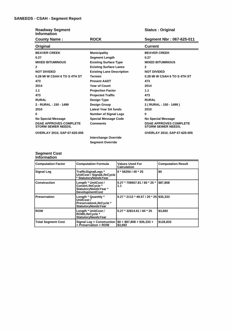
SANEEDS - CSAH - Segment Report
Roadway SegmentInformation
Status : Original
County Name : ROCK Segment Nbr : 067-625-011
Original Current
BEAVER CREEK Municipality BEAVER CREEK
0.27 Segment Length 0.27
MIXED BITUMINOUS Existing Surface Type MIXED BITUMINOUS
2 Existing Surface Lanes 2
NOT DIVIDED Existing Lane Description NOT DIVIDED
0.28 MI W CSAH 6 TO S 4TH ST Termini 0.28 MI W CSAH 6 TO S 4TH ST
473 Present AADT 473
2014 Year of Count 2014
1.1 Projection Factor 1.1
473 Projected Traffic 473
RURAL Design Type RURAL
2 - RURAL : 150 - 1499 Design Group 2 ( RURAL : 150 - 1499 )
2010 Latest Year SA funds 2010
0 Number of Signal Legs 0
No Special Message Special Message Code No Special Message
DSAE APPROVES COMPLETESTORM SEWER NEEDS.
OVERLAY 2010, SAP 67-625-005
Comments DSAE APPROVES COMPLETESTORM SEWER NEEDS.
OVERLAY 2010, SAP 67-625-005
Interchange Override
Segment Override
Segment CostInformation
Computation Factor Computation Formula Values Used ForCalculation
Computation Result
Signal Leg TrafficSignalLegs *UnitCost / SignalLifeCycle* StatutoryNeedsYear
0 * 56250 / 40 * 25 $0
Construction Length * UnitCost /ConstrLifeCycle *StatutoryNeedsYear *DevelopmentCost
0.27 * 709557.81 / 60 * 25 *1.1
$87,808
Preservation Length * Quantity *UnitCost /PreservationLifeCycle *StatutoryNeedsYear
0.27 * 2112 * 49.57 / 20 * 25 $35,333
ROW Length * UnitCost /ROWLifeCycle *StatutoryNeedsYear
0.27 * 32814.61 / 60 * 25 $3,692
Total Segment Cost Signal Leg + Construction+ Preservation + ROW
$0 + $87,808 + $35,333 +$3,692
$126,833

SANEEDS - CSAH - Segment Report
Roadway SegmentInformation
Status : Original
County Name : ROCK Segment Nbr : 067-625-020
Original Current
BEAVER CREEK Municipality BEAVER CREEK
0.35 Segment Length 0.35
MIXED BITUMINOUS Existing Surface Type MIXED BITUMINOUS
2 Existing Surface Lanes 2
NOT DIVIDED Existing Lane Description NOT DIVIDED
ON 4TH ST - 6TH AVE TO 1ST AVE Termini ON 4TH ST - 6TH AVE TO 1ST AVE
473 Present AADT 473
2014 Year of Count 2014
1.1 Projection Factor 1.1
473 Projected Traffic 473
URBAN Design Type URBAN
5 - URBAN : 0 - 9999 Design Group 5 ( URBAN : 0 - 9999 )
1986 Latest Year SA funds 1986
0 Number of Signal Legs 0
No Special Message Special Message Code No Special Message
Comments
Interchange Override
Segment Override
Segment CostInformation
Computation Factor Computation Formula Values Used ForCalculation
Computation Result
Signal Leg TrafficSignalLegs *UnitCost / SignalLifeCycle* StatutoryNeedsYear
0 * 56250 / 40 * 25 $0
Construction Length * UnitCost /ConstrLifeCycle *StatutoryNeedsYear *DevelopmentCost
0.35 * 2655286.16 / 60 * 25* 1.15
$445,314
Preservation Length * Quantity *UnitCost /PreservationLifeCycle *StatutoryNeedsYear
0.35 * 2904 * 49.57 / 15 * 25 $83,972
ROW Length * UnitCost /ROWLifeCycle *StatutoryNeedsYear
0.35 * 11284.19 / 60 * 25 $1,646
Total Segment Cost Signal Leg + Construction+ Preservation + ROW
$0 + $445,314 + $83,972 +$1,646
$530,932

SANEEDS - CSAH - Segment Report
Roadway SegmentInformation
Status : Original
County Name : ROCK Segment Nbr : 067-625-030
Original Current
BEAVER CREEK Municipality BEAVER CREEK
0.14 Segment Length 0.14
MIXED BITUMINOUS Existing Surface Type MIXED BITUMINOUS
2 Existing Surface Lanes 2
NOT DIVIDED Existing Lane Description NOT DIVIDED
ON 1ST AVE - 4TH ST TO 2ND ST Termini ON 1ST AVE - 4TH ST TO 2ND ST
561 Present AADT 561
2014 Year of Count 2014
1.1 Projection Factor 1.1
561 Projected Traffic 561
URBAN Design Type URBAN
5 - URBAN : 0 - 9999 Design Group 5 ( URBAN : 0 - 9999 )
1986 Latest Year SA funds 1986
0 Number of Signal Legs 0
No Special Message Special Message Code No Special Message
Comments
Interchange Override
Segment Override
Segment CostInformation
Computation Factor Computation Formula Values Used ForCalculation
Computation Result
Signal Leg TrafficSignalLegs *UnitCost / SignalLifeCycle* StatutoryNeedsYear
0 * 56250 / 40 * 25 $0
Construction Length * UnitCost /ConstrLifeCycle *StatutoryNeedsYear *DevelopmentCost
0.14 * 2655286.16 / 60 * 25* 1.15
$178,125
Preservation Length * Quantity *UnitCost /PreservationLifeCycle *StatutoryNeedsYear
0.14 * 2904 * 49.57 / 15 * 25 $33,589
ROW Length * UnitCost /ROWLifeCycle *StatutoryNeedsYear
0.14 * 11284.19 / 60 * 25 $658
Total Segment Cost Signal Leg + Construction+ Preservation + ROW
$0 + $178,125 + $33,589 +$658
$212,372
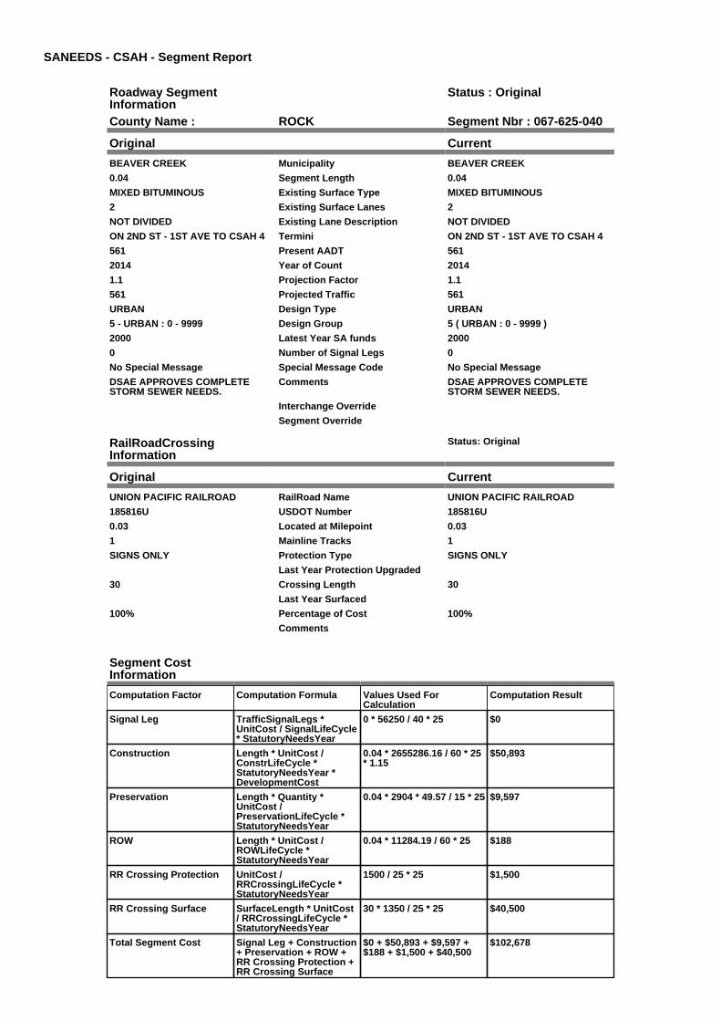
SANEEDS - CSAH - Segment Report
Roadway SegmentInformation
Status : Original
County Name : ROCK Segment Nbr : 067-625-040
Original Current
BEAVER CREEK Municipality BEAVER CREEK
0.04 Segment Length 0.04
MIXED BITUMINOUS Existing Surface Type MIXED BITUMINOUS
2 Existing Surface Lanes 2
NOT DIVIDED Existing Lane Description NOT DIVIDED
ON 2ND ST - 1ST AVE TO CSAH 4 Termini ON 2ND ST - 1ST AVE TO CSAH 4
561 Present AADT 561
2014 Year of Count 2014
1.1 Projection Factor 1.1
561 Projected Traffic 561
URBAN Design Type URBAN
5 - URBAN : 0 - 9999 Design Group 5 ( URBAN : 0 - 9999 )
2000 Latest Year SA funds 2000
0 Number of Signal Legs 0
No Special Message Special Message Code No Special Message
DSAE APPROVES COMPLETESTORM SEWER NEEDS.
Comments DSAE APPROVES COMPLETESTORM SEWER NEEDS.
Interchange Override
Segment Override
RailRoadCrossingInformation
Status: Original
Original Current
UNION PACIFIC RAILROAD RailRoad Name UNION PACIFIC RAILROAD
185816U USDOT Number 185816U
0.03 Located at Milepoint 0.03
1 Mainline Tracks 1
SIGNS ONLY Protection Type SIGNS ONLY
Last Year Protection Upgraded
30 Crossing Length 30
Last Year Surfaced
100% Percentage of Cost 100%
Comments
Segment CostInformation
Computation Factor Computation Formula Values Used ForCalculation
Computation Result
Signal Leg TrafficSignalLegs *UnitCost / SignalLifeCycle* StatutoryNeedsYear
0 * 56250 / 40 * 25 $0
Construction Length * UnitCost /ConstrLifeCycle *StatutoryNeedsYear *DevelopmentCost
0.04 * 2655286.16 / 60 * 25* 1.15
$50,893
Preservation Length * Quantity *UnitCost /PreservationLifeCycle *StatutoryNeedsYear
0.04 * 2904 * 49.57 / 15 * 25 $9,597
ROW Length * UnitCost /ROWLifeCycle *StatutoryNeedsYear
0.04 * 11284.19 / 60 * 25 $188
RR Crossing Protection UnitCost /RRCrossingLifeCycle *StatutoryNeedsYear
1500 / 25 * 25 $1,500
RR Crossing Surface SurfaceLength * UnitCost/ RRCrossingLifeCycle *StatutoryNeedsYear
30 * 1350 / 25 * 25 $40,500
Total Segment Cost Signal Leg + Construction+ Preservation + ROW +RR Crossing Protection +RR Crossing Surface
$0 + $50,893 + $9,597 +$188 + $1,500 + $40,500
$102,678

SANEEDS - CSAH - Segment Report
Roadway SegmentInformation
Status : Original
County Name : ROCK Segment Nbr : 067-626-010
Original Current
LUVERNE Municipality LUVERNE
0.03 Segment Length 0.03
MIXED BITUMINOUS Existing Surface Type MIXED BITUMINOUS
2 Existing Surface Lanes 2
NOT DIVIDED Existing Lane Description NOT DIVIDED
ON WARREN - CSAH 4 TO 180 FTEAST
Termini ON WARREN - CSAH 4 TO 180 FTEAST
1100 Present AADT 1100
2014 Year of Count 2014
1.1 Projection Factor 1.1
1100 Projected Traffic 1100
URBAN Design Type URBAN
5 - URBAN : 0 - 9999 Design Group 5 ( URBAN : 0 - 9999 )
2012 Latest Year SA funds 2012
0 Number of Signal Legs 0
No Special Message Special Message Code No Special Message
2012 SAP 067-626-007 RECONST Comments 2012 SAP 067-626-007 RECONST
Interchange Override
Segment Override
Segment CostInformation
Computation Factor Computation Formula Values Used ForCalculation
Computation Result
Signal Leg TrafficSignalLegs *UnitCost / SignalLifeCycle* StatutoryNeedsYear
0 * 56250 / 40 * 25 $0
Construction Length * UnitCost /ConstrLifeCycle *StatutoryNeedsYear *DevelopmentCost
0.03 * 2655286.16 / 60 * 25* 1.15
$38,170
Preservation Length * Quantity *UnitCost /PreservationLifeCycle *StatutoryNeedsYear
0.03 * 2904 * 49.57 / 15 * 25 $7,198
ROW Length * UnitCost /ROWLifeCycle *StatutoryNeedsYear
0.03 * 11284.19 / 60 * 25 $141
Total Segment Cost Signal Leg + Construction+ Preservation + ROW
$0 + $38,170 + $7,198 +$141
$45,509

SANEEDS - CSAH - Segment Report
Roadway SegmentInformation
Status : Original
County Name : ROCK Segment Nbr : 067-626-011
Original Current
LUVERNE Municipality LUVERNE
0.04 Segment Length 0.04
MIXED BITUMINOUS Existing Surface Type MIXED BITUMINOUS
2 Existing Surface Lanes 2
NOT DIVIDED Existing Lane Description NOT DIVIDED
ON WARREN - 180 FT E CSAH 4 TODAVIDSON
Termini ON WARREN - 180 FT E CSAH 4 TODAVIDSON
1100 Present AADT 1100
2014 Year of Count 2014
1.1 Projection Factor 1.1
1100 Projected Traffic 1100
URBAN Design Type URBAN
5 - URBAN : 0 - 9999 Design Group 5 ( URBAN : 0 - 9999 )
2012 Latest Year SA funds 2012
0 Number of Signal Legs 0
No Special Message Special Message Code No Special Message
2012 SAP 067-626-007 RECONST Comments 2012 SAP 067-626-007 RECONST
Interchange Override
Segment Override
Culvert Information Status: Original
Original Current
L2160 Structure Number L2160
0.03 Milepoint 0.03
1959 Year Built 1959
POPLAR CREEK Feature Crossed POPLAR CREEK
Type of Service
1 Number of Barrels 1
10 Culvert Width 10
6 Culvert Height 6
60 Culvert Length 60
60.00013138 Area of Waterway Opening 60.00013138
100% Shared Structure 100%
Comments
1 Culvert Group Code 1
Segment CostInformation
Computation Factor Computation Formula Values Used ForCalculation
Computation Result
Signal Leg TrafficSignalLegs *UnitCost / SignalLifeCycle* StatutoryNeedsYear
0 * 56250 / 40 * 25 $0
Construction Length * UnitCost /ConstrLifeCycle *StatutoryNeedsYear *DevelopmentCost
0.04 * 2655286.16 / 60 * 25* 1.15
$50,893
Preservation Length * Quantity *UnitCost /PreservationLifeCycle *StatutoryNeedsYear
0.04 * 2904 * 49.57 / 15 * 25 $9,597
ROW Length * UnitCost /ROWLifeCycle *StatutoryNeedsYear
0.04 * 11284.19 / 60 * 25 $188
Culvert CulvertLength * Area *UnitCost /CulvertLifeCycle *StatutoryNeedsYear *DevelopmentCost
60 * 60.00013138 * 15.47 /100 * 25 * 1.15
$16,011

Total Segment Cost Signal Leg + Construction+ Preservation + ROW +Culvert
$0 + $50,893 + $9,597 +$188 + $16,011
$76,689

SANEEDS - CSAH - Segment Report
Roadway SegmentInformation
Status : Original
County Name : ROCK Segment Nbr : 067-626-020
Original Current
LUVERNE Municipality LUVERNE
0.17 Segment Length 0.17
MIXED BITUMINOUS Existing Surface Type MIXED BITUMINOUS
2 Existing Surface Lanes 2
NOT DIVIDED Existing Lane Description NOT DIVIDED
ON WARREN - DAVIDSON TODONALDSON
Termini ON WARREN - DAVIDSON TODONALDSON
1100 Present AADT 1100
2014 Year of Count 2014
1.1 Projection Factor 1.1
1100 Projected Traffic 1100
URBAN Design Type URBAN
5 - URBAN : 0 - 9999 Design Group 5 ( URBAN : 0 - 9999 )
2012 Latest Year SA funds 2012
0 Number of Signal Legs 0
No Special Message Special Message Code No Special Message
2012 SAP 067-626-007 RECONST
DSAE APPROVES COMPLETESTORM SEWER NEEDS.
Comments 2012 SAP 067-626-007 RECONST
DSAE APPROVES COMPLETESTORM SEWER NEEDS.
Interchange Override
Segment Override
Segment CostInformation
Computation Factor Computation Formula Values Used ForCalculation
Computation Result
Signal Leg TrafficSignalLegs *UnitCost / SignalLifeCycle* StatutoryNeedsYear
0 * 56250 / 40 * 25 $0
Construction Length * UnitCost /ConstrLifeCycle *StatutoryNeedsYear *DevelopmentCost
0.17 * 2655286.16 / 60 * 25* 1.15
$216,295
Preservation Length * Quantity *UnitCost /PreservationLifeCycle *StatutoryNeedsYear
0.17 * 2904 * 49.57 / 15 * 25 $40,786
ROW Length * UnitCost /ROWLifeCycle *StatutoryNeedsYear
0.17 * 11284.19 / 60 * 25 $799
Total Segment Cost Signal Leg + Construction+ Preservation + ROW
$0 + $216,295 + $40,786 +$799
$257,880
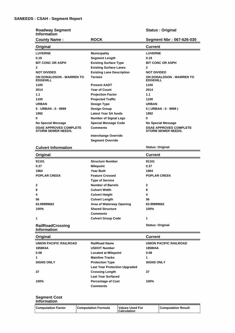
SANEEDS - CSAH - Segment Report
Roadway SegmentInformation
Status : Original
County Name : ROCK Segment Nbr : 067-626-030
Original Current
LUVERNE Municipality LUVERNE
0.19 Segment Length 0.19
BIT CONC OR ASPH Existing Surface Type BIT CONC OR ASPH
2 Existing Surface Lanes 2
NOT DIVIDED Existing Lane Description NOT DIVIDED
ON DONALDSON - WARREN TOEDGEHILL
Termini ON DONALDSON - WARREN TOEDGEHILL
1100 Present AADT 1100
2014 Year of Count 2014
1.1 Projection Factor 1.1
1100 Projected Traffic 1100
URBAN Design Type URBAN
5 - URBAN : 0 - 9999 Design Group 5 ( URBAN : 0 - 9999 )
1992 Latest Year SA funds 1992
0 Number of Signal Legs 0
No Special Message Special Message Code No Special Message
DSAE APPROVES COMPLETESTORM SEWER NEEDS.
Comments DSAE APPROVES COMPLETESTORM SEWER NEEDS.
Interchange Override
Segment Override
Culvert Information Status: Original
Original Current
91101 Structure Number 91101
0.37 Milepoint 0.37
1964 Year Built 1964
POPLAR CREEK Feature Crossed POPLAR CREEK
Type of Service
2 Number of Barrels 2
8 Culvert Width 8
4 Culvert Height 4
56 Culvert Length 56
63.99999662 Area of Waterway Opening 63.99999662
100% Shared Structure 100%
Comments
1 Culvert Group Code 1
RailRoadCrossingInformation
Status: Original
Original Current
UNION PACIFIC RAILROAD RailRoad Name UNION PACIFIC RAILROAD
185804A USDOT Number 185804A
0.08 Located at Milepoint 0.08
1 Mainline Tracks 1
SIGNS ONLY Protection Type SIGNS ONLY
Last Year Protection Upgraded
37 Crossing Length 37
Last Year Surfaced
100% Percentage of Cost 100%
Comments
Segment CostInformation
Computation Factor Computation Formula Values Used ForCalculation
Computation Result
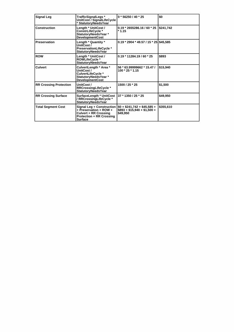
Signal Leg TrafficSignalLegs *UnitCost / SignalLifeCycle* StatutoryNeedsYear
0 * 56250 / 40 * 25 $0
Construction Length * UnitCost /ConstrLifeCycle *StatutoryNeedsYear *DevelopmentCost
0.19 * 2655286.16 / 60 * 25* 1.15
$241,742
Preservation Length * Quantity *UnitCost /PreservationLifeCycle *StatutoryNeedsYear
0.19 * 2904 * 49.57 / 15 * 25 $45,585
ROW Length * UnitCost /ROWLifeCycle *StatutoryNeedsYear
0.19 * 11284.19 / 60 * 25 $893
Culvert CulvertLength * Area *UnitCost /CulvertLifeCycle *StatutoryNeedsYear *DevelopmentCost
56 * 63.99999662 * 15.47 /100 * 25 * 1.15
$15,940
RR Crossing Protection UnitCost /RRCrossingLifeCycle *StatutoryNeedsYear
1500 / 25 * 25 $1,500
RR Crossing Surface SurfaceLength * UnitCost/ RRCrossingLifeCycle *StatutoryNeedsYear
37 * 1350 / 25 * 25 $49,950
Total Segment Cost Signal Leg + Construction+ Preservation + ROW +Culvert + RR CrossingProtection + RR CrossingSurface
$0 + $241,742 + $45,585 +$893 + $15,940 + $1,500 +$49,950
$355,610

SANEEDS - CSAH - Segment Report
Roadway SegmentInformation
Status : Original
County Name : ROCK Segment Nbr : 067-626-040
Original Current
LUVERNE Municipality LUVERNE
0.21 Segment Length 0.21
BIT CONC OR ASPH Existing Surface Type BIT CONC OR ASPH
2 Existing Surface Lanes 2
NOT DIVIDED Existing Lane Description NOT DIVIDED
ON EDGEHILL - DONALDSON TOTH 75
Termini ON EDGEHILL - DONALDSON TOTH 75
506 Present AADT 506
2014 Year of Count 2014
1.1 Projection Factor 1.1
506 Projected Traffic 506
URBAN Design Type URBAN
5 - URBAN : 0 - 9999 Design Group 5 ( URBAN : 0 - 9999 )
1992 Latest Year SA funds 1992
0 Number of Signal Legs 0
No Special Message Special Message Code No Special Message
DSAE APPROVES COMPLETESTORM SEWER NEEDS.
Comments DSAE APPROVES COMPLETESTORM SEWER NEEDS.
Interchange Override
Segment Override
Culvert Information Status: Original
Original Current
L2161 Structure Number L2161
0.602 Milepoint 0.602
1960 Year Built 1960
Feature Crossed
Type of Service
2 Number of Barrels 2
Culvert Width
Culvert Height
65 Culvert Length 65
71.9997271 Area of Waterway Opening 71.9997271
100% Shared Structure 100%
Comments
1 Culvert Group Code 1
Segment CostInformation
Computation Factor Computation Formula Values Used ForCalculation
Computation Result
Signal Leg TrafficSignalLegs *UnitCost / SignalLifeCycle* StatutoryNeedsYear
0 * 56250 / 40 * 25 $0
Construction Length * UnitCost /ConstrLifeCycle *StatutoryNeedsYear *DevelopmentCost
0.21 * 2655286.16 / 60 * 25* 1.15
$267,188
Preservation Length * Quantity *UnitCost /PreservationLifeCycle *StatutoryNeedsYear
0.21 * 2904 * 49.57 / 15 * 25 $50,383
ROW Length * UnitCost /ROWLifeCycle *StatutoryNeedsYear
0.21 * 11284.19 / 60 * 25 $987
Culvert CulvertLength * Area *UnitCost /CulvertLifeCycle *StatutoryNeedsYear *DevelopmentCost
65 * 71.9997271 * 15.47 /100 * 25 * 1.15
$20,815

Total Segment Cost Signal Leg + Construction+ Preservation + ROW +Culvert
$0 + $267,188 + $50,383 +$987 + $20,815
$339,373

SANEEDS - CSAH - Segment Report
Roadway SegmentInformation
Status : Original
County Name : ROCK Segment Nbr : 067-627-010
Original Current
MAGNOLIA Municipality MAGNOLIA
0.07 Segment Length 0.07
MIXED BITUMINOUS Existing Surface Type MIXED BITUMINOUS
2 Existing Surface Lanes 2
NOT DIVIDED Existing Lane Description NOT DIVIDED
CSAH 4 TO STATE ST &BROADWAY
Termini CSAH 4 TO STATE ST &BROADWAY
165 Present AADT 165
2014 Year of Count 2014
1.1 Projection Factor 1.1
165 Projected Traffic 165
URBAN Design Type URBAN
5 - URBAN : 0 - 9999 Design Group 5 ( URBAN : 0 - 9999 )
1989 Latest Year SA funds 1989
0 Number of Signal Legs 0
No Special Message Special Message Code No Special Message
DSAE APPROVES COMPLETESTORM SEWER NEEDS.
Comments DSAE APPROVES COMPLETESTORM SEWER NEEDS.
Interchange Override
Segment Override
Segment CostInformation
Computation Factor Computation Formula Values Used ForCalculation
Computation Result
Signal Leg TrafficSignalLegs *UnitCost / SignalLifeCycle* StatutoryNeedsYear
0 * 56250 / 40 * 25 $0
Construction Length * UnitCost /ConstrLifeCycle *StatutoryNeedsYear *DevelopmentCost
0.07 * 2655286.16 / 60 * 25* 1.15
$89,063
Preservation Length * Quantity *UnitCost /PreservationLifeCycle *StatutoryNeedsYear
0.07 * 2904 * 49.57 / 15 * 25 $16,794
ROW Length * UnitCost /ROWLifeCycle *StatutoryNeedsYear
0.07 * 11284.19 / 60 * 25 $329
Total Segment Cost Signal Leg + Construction+ Preservation + ROW
$0 + $89,063 + $16,794 +$329
$106,186

SANEEDS - CSAH - Segment Report
Roadway SegmentInformation
Status : Original
County Name : ROCK Segment Nbr : 067-627-020
Original Current
MAGNOLIA Municipality MAGNOLIA
0.37 Segment Length 0.37
MIXED BITUMINOUS Existing Surface Type MIXED BITUMINOUS
2 Existing Surface Lanes 2
NOT DIVIDED Existing Lane Description NOT DIVIDED
BROADWAY & STATE TO CSAH 4 Termini BROADWAY & STATE TO CSAH 4
156 Present AADT 156
2014 Year of Count 2014
2.4 Projection Factor 2.4
156 Projected Traffic 156
RURAL Design Type RURAL
2 - RURAL : 150 - 1499 Design Group 2 ( RURAL : 150 - 1499 )
1999 Latest Year SA funds 1999
0 Number of Signal Legs 0
No Special Message Special Message Code No Special Message
DSAE APPROVES COMPLETESTORM SEWER NEEDS.
Comments DSAE APPROVES COMPLETESTORM SEWER NEEDS.
Interchange Override
Segment Override
Segment CostInformation
Computation Factor Computation Formula Values Used ForCalculation
Computation Result
Signal Leg TrafficSignalLegs *UnitCost / SignalLifeCycle* StatutoryNeedsYear
0 * 56250 / 40 * 25 $0
Construction Length * UnitCost /ConstrLifeCycle *StatutoryNeedsYear *DevelopmentCost
0.37 * 709557.81 / 60 * 25 *1.1
$120,329
Preservation Length * Quantity *UnitCost /PreservationLifeCycle *StatutoryNeedsYear
0.37 * 2112 * 49.57 / 20 * 25 $48,420
ROW Length * UnitCost /ROWLifeCycle *StatutoryNeedsYear
0.37 * 32814.61 / 60 * 25 $5,059
Total Segment Cost Signal Leg + Construction+ Preservation + ROW
$0 + $120,329 + $48,420 +$5,059
$173,808

SANEEDS - CSAH - Segment Report
Roadway SegmentInformation
Status : Original
County Name : ROCK Segment Nbr : 067-628-010
Original Current
HARDWICK Municipality HARDWICK
0.15 Segment Length 0.15
MIXED BITUMINOUS Existing Surface Type MIXED BITUMINOUS
2 Existing Surface Lanes 2
NOT DIVIDED Existing Lane Description NOT DIVIDED
RR TR TO ROSS ST IN HARWICK Termini RR TR TO ROSS ST IN HARWICK
154 Present AADT 154
2014 Year of Count 2014
1.1 Projection Factor 1.1
154 Projected Traffic 154
URBAN Design Type URBAN
5 - URBAN : 0 - 9999 Design Group 5 ( URBAN : 0 - 9999 )
2000 Latest Year SA funds 2000
0 Number of Signal Legs 0
No Special Message Special Message Code No Special Message
DSAE APPROVES COMPLETESTORM SEWER NEEDS.
Comments DSAE APPROVES COMPLETESTORM SEWER NEEDS.
Interchange Override
Segment Override
Segment CostInformation
Computation Factor Computation Formula Values Used ForCalculation
Computation Result
Signal Leg TrafficSignalLegs *UnitCost / SignalLifeCycle* StatutoryNeedsYear
0 * 56250 / 40 * 25 $0
Construction Length * UnitCost /ConstrLifeCycle *StatutoryNeedsYear *DevelopmentCost
0.15 * 2655286.16 / 60 * 25* 1.15
$190,849
Preservation Length * Quantity *UnitCost /PreservationLifeCycle *StatutoryNeedsYear
0.15 * 2904 * 49.57 / 15 * 25 $35,988
ROW Length * UnitCost /ROWLifeCycle *StatutoryNeedsYear
0.15 * 11284.19 / 60 * 25 $705
Total Segment Cost Signal Leg + Construction+ Preservation + ROW
$0 + $190,849 + $35,988 +$705
$227,542

SANEEDS - CSAH - Segment Report
Roadway SegmentInformation
Status : Original
County Name : ROCK Segment Nbr : 067-628-020
Original Current
HARDWICK Municipality HARDWICK
0.07 Segment Length 0.07
MIXED BITUMINOUS Existing Surface Type MIXED BITUMINOUS
2 Existing Surface Lanes 2
NOT DIVIDED Existing Lane Description NOT DIVIDED
SUMMIT ST BETWEEN FIRST &MAIN
Termini SUMMIT ST BETWEEN FIRST &MAIN
292 Present AADT 292
2014 Year of Count 2014
1.1 Projection Factor 1.1
292 Projected Traffic 292
URBAN Design Type URBAN
5 - URBAN : 0 - 9999 Design Group 5 ( URBAN : 0 - 9999 )
1990 Latest Year SA funds 1990
0 Number of Signal Legs 0
No Special Message Special Message Code No Special Message
DSAE APPROVES COMPLETESTORM SEWER NEEDS.
Comments DSAE APPROVES COMPLETESTORM SEWER NEEDS.
Interchange Override
Segment Override
Segment CostInformation
Computation Factor Computation Formula Values Used ForCalculation
Computation Result
Signal Leg TrafficSignalLegs *UnitCost / SignalLifeCycle* StatutoryNeedsYear
0 * 56250 / 40 * 25 $0
Construction Length * UnitCost /ConstrLifeCycle *StatutoryNeedsYear *DevelopmentCost
0.07 * 2655286.16 / 60 * 25* 1.15
$89,063
Preservation Length * Quantity *UnitCost /PreservationLifeCycle *StatutoryNeedsYear
0.07 * 2904 * 49.57 / 15 * 25 $16,794
ROW Length * UnitCost /ROWLifeCycle *StatutoryNeedsYear
0.07 * 11284.19 / 60 * 25 $329
Total Segment Cost Signal Leg + Construction+ Preservation + ROW
$0 + $89,063 + $16,794 +$329
$106,186

SANEEDS - CSAH - Segment Report
Roadway SegmentInformation
Status : Original
County Name : ROCK Segment Nbr : 067-628-030
Original Current
HARDWICK Municipality HARDWICK
0.07 Segment Length 0.07
MIXED BITUMINOUS Existing Surface Type MIXED BITUMINOUS
2 Existing Surface Lanes 2
NOT DIVIDED Existing Lane Description NOT DIVIDED
ROSS ST BETWEEN FIRST & MAIN Termini ROSS ST BETWEEN FIRST & MAIN
156 Present AADT 156
2014 Year of Count 2014
1.2 Projection Factor 1.2
156 Projected Traffic 156
URBAN Design Type URBAN
5 - URBAN : 0 - 9999 Design Group 5 ( URBAN : 0 - 9999 )
1990 Latest Year SA funds 1990
0 Number of Signal Legs 0
No Special Message Special Message Code No Special Message
DSAE APPROVES COMPLETESTORM SEWER NEEDS.
Comments DSAE APPROVES COMPLETESTORM SEWER NEEDS.
Interchange Override
Segment Override
Segment CostInformation
Computation Factor Computation Formula Values Used ForCalculation
Computation Result
Signal Leg TrafficSignalLegs *UnitCost / SignalLifeCycle* StatutoryNeedsYear
0 * 56250 / 40 * 25 $0
Construction Length * UnitCost /ConstrLifeCycle *StatutoryNeedsYear *DevelopmentCost
0.07 * 2655286.16 / 60 * 25* 1.15
$89,063
Preservation Length * Quantity *UnitCost /PreservationLifeCycle *StatutoryNeedsYear
0.07 * 2904 * 49.57 / 15 * 25 $16,794
ROW Length * UnitCost /ROWLifeCycle *StatutoryNeedsYear
0.07 * 11284.19 / 60 * 25 $329
Total Segment Cost Signal Leg + Construction+ Preservation + ROW
$0 + $89,063 + $16,794 +$329
$106,186

SANEEDS - CSAH - Segment Report
Roadway SegmentInformation
Status : Original
County Name : ROCK Segment Nbr : 067-630-010
Original Current
LUVERNE Municipality LUVERNE
0.09 Segment Length 0.09
MIXED BITUMINOUS Existing Surface Type MIXED BITUMINOUS
2 Existing Surface Lanes 2
NOT DIVIDED Existing Lane Description NOT DIVIDED
KNISS AVE TO ESTEY ST ONBARCK AVE
Termini KNISS AVE TO ESTEY ST ONBARCK AVE
2035 Present AADT 2035
2014 Year of Count 2014
1.1 Projection Factor 1.1
2035 Projected Traffic 2035
URBAN Design Type URBAN
5 - URBAN : 0 - 9999 Design Group 5 ( URBAN : 0 - 9999 )
2014 Latest Year SA funds 2014
0 Number of Signal Legs 0
FORMER MSAS-CITY FELL UNDER5,000
Special Message Code FORMER MSAS-CITY FELL UNDER5,000
2014 SAP 067-630-002 URBANRECONDITION, M&OL
DSAE APPROVES COMPLETESTORM SEWER NEEDS.
Comments 2014 SAP 067-630-002 URBANRECONDITION, M&OL
DSAE APPROVES COMPLETESTORM SEWER NEEDS.
Interchange Override
Segment Override
Segment CostInformation
Computation Factor Computation Formula Values Used ForCalculation
Computation Result
Signal Leg TrafficSignalLegs *UnitCost / SignalLifeCycle* StatutoryNeedsYear
0 * 56250 / 40 * 25 $0
Construction Length * UnitCost /ConstrLifeCycle *StatutoryNeedsYear *DevelopmentCost
0.09 * 2655286.16 / 60 * 25* 1.15
$114,509
Preservation Length * Quantity *UnitCost /PreservationLifeCycle *StatutoryNeedsYear
0.09 * 2904 * 49.57 / 15 * 25 $21,593
ROW Length * UnitCost /ROWLifeCycle *StatutoryNeedsYear
0.09 * 11284.19 / 60 * 25 $423
Total Segment Cost Signal Leg + Construction+ Preservation + ROW
$0 + $114,509 + $21,593 +$423
$136,525
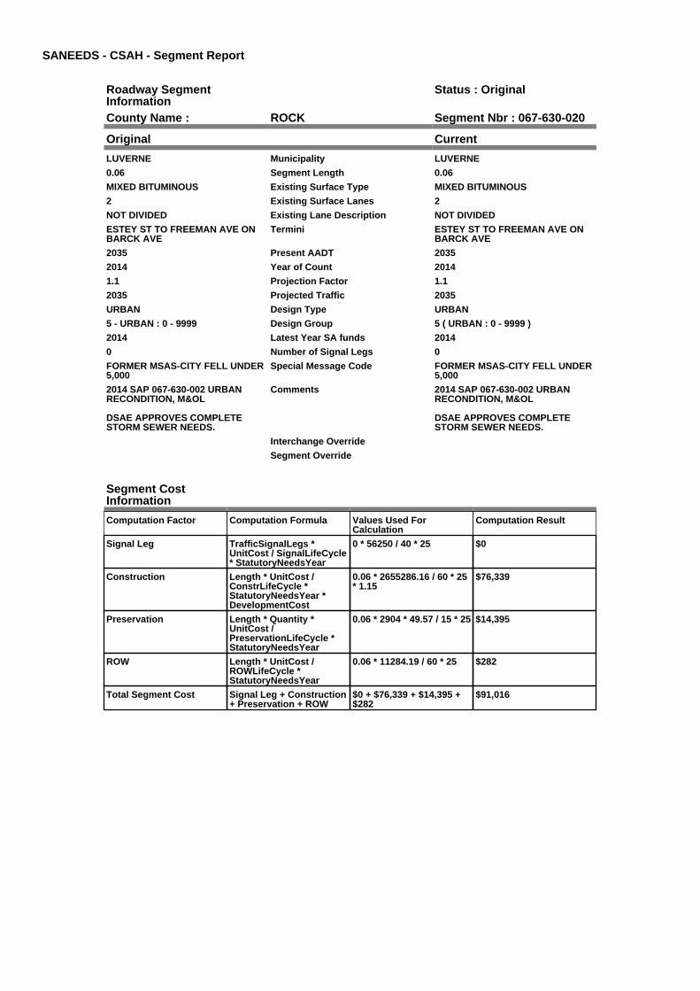
SANEEDS - CSAH - Segment Report
Roadway SegmentInformation
Status : Original
County Name : ROCK Segment Nbr : 067-630-020
Original Current
LUVERNE Municipality LUVERNE
0.06 Segment Length 0.06
MIXED BITUMINOUS Existing Surface Type MIXED BITUMINOUS
2 Existing Surface Lanes 2
NOT DIVIDED Existing Lane Description NOT DIVIDED
ESTEY ST TO FREEMAN AVE ONBARCK AVE
Termini ESTEY ST TO FREEMAN AVE ONBARCK AVE
2035 Present AADT 2035
2014 Year of Count 2014
1.1 Projection Factor 1.1
2035 Projected Traffic 2035
URBAN Design Type URBAN
5 - URBAN : 0 - 9999 Design Group 5 ( URBAN : 0 - 9999 )
2014 Latest Year SA funds 2014
0 Number of Signal Legs 0
FORMER MSAS-CITY FELL UNDER5,000
Special Message Code FORMER MSAS-CITY FELL UNDER5,000
2014 SAP 067-630-002 URBANRECONDITION, M&OL
DSAE APPROVES COMPLETESTORM SEWER NEEDS.
Comments 2014 SAP 067-630-002 URBANRECONDITION, M&OL
DSAE APPROVES COMPLETESTORM SEWER NEEDS.
Interchange Override
Segment Override
Segment CostInformation
Computation Factor Computation Formula Values Used ForCalculation
Computation Result
Signal Leg TrafficSignalLegs *UnitCost / SignalLifeCycle* StatutoryNeedsYear
0 * 56250 / 40 * 25 $0
Construction Length * UnitCost /ConstrLifeCycle *StatutoryNeedsYear *DevelopmentCost
0.06 * 2655286.16 / 60 * 25* 1.15
$76,339
Preservation Length * Quantity *UnitCost /PreservationLifeCycle *StatutoryNeedsYear
0.06 * 2904 * 49.57 / 15 * 25 $14,395
ROW Length * UnitCost /ROWLifeCycle *StatutoryNeedsYear
0.06 * 11284.19 / 60 * 25 $282
Total Segment Cost Signal Leg + Construction+ Preservation + ROW
$0 + $76,339 + $14,395 +$282
$91,016

SANEEDS - CSAH - Segment Report
Roadway SegmentInformation
Status : Original
County Name : ROCK Segment Nbr : 067-630-030
Original Current
LUVERNE Municipality LUVERNE
0.33 Segment Length 0.33
MIXED BITUMINOUS Existing Surface Type MIXED BITUMINOUS
2 Existing Surface Lanes 2
NOT DIVIDED Existing Lane Description NOT DIVIDED
FREEMAN AVE TO BLUE MOUNDAVE ON BARCK AVE
Termini FREEMAN AVE TO BLUE MOUNDAVE ON BARCK AVE
2035 Present AADT 2035
2014 Year of Count 2014
1.1 Projection Factor 1.1
2035 Projected Traffic 2035
URBAN Design Type URBAN
5 - URBAN : 0 - 9999 Design Group 5 ( URBAN : 0 - 9999 )
2014 Latest Year SA funds 2014
0 Number of Signal Legs 0
FORMER MSAS-CITY FELL UNDER5,000
Special Message Code FORMER MSAS-CITY FELL UNDER5,000
2014 SAP 067-630-002 URBANRECONDITION, M&OL
DSAE APPROVES COMPLETESTORM SEWER NEEDS.
Comments 2014 SAP 067-630-002 URBANRECONDITION, M&OL
DSAE APPROVES COMPLETESTORM SEWER NEEDS.
Interchange Override
Segment Override
Segment CostInformation
Computation Factor Computation Formula Values Used ForCalculation
Computation Result
Signal Leg TrafficSignalLegs *UnitCost / SignalLifeCycle* StatutoryNeedsYear
0 * 56250 / 40 * 25 $0
Construction Length * UnitCost /ConstrLifeCycle *StatutoryNeedsYear *DevelopmentCost
0.33 * 2655286.16 / 60 * 25* 1.15
$419,867
Preservation Length * Quantity *UnitCost /PreservationLifeCycle *StatutoryNeedsYear
0.33 * 2904 * 49.57 / 15 * 25 $79,173
ROW Length * UnitCost /ROWLifeCycle *StatutoryNeedsYear
0.33 * 11284.19 / 60 * 25 $1,552
Total Segment Cost Signal Leg + Construction+ Preservation + ROW
$0 + $419,867 + $79,173 +$1,552
$500,592

SANEEDS - CSAH - Segment Report
Roadway SegmentInformation
Status : Original
County Name : ROCK Segment Nbr : 067-631-010
Original Current
LUVERNE Municipality LUVERNE
0.48 Segment Length 0.48
BIT CONC OR ASPH Existing Surface Type BIT CONC OR ASPH
2 Existing Surface Lanes 2
NOT DIVIDED Existing Lane Description NOT DIVIDED
DODGE ST-US HWY 75 TO CSAH18 (BLUE MOUND AVENUE)
Termini DODGE ST-US HWY 75 TO CSAH18 (BLUE MOUND AVENUE)
1045 Present AADT 1045
2014 Year of Count 2014
1.1 Projection Factor 1.1
1045 Projected Traffic 1045
URBAN Design Type URBAN
5 - URBAN : 0 - 9999 Design Group 5 ( URBAN : 0 - 9999 )
2009 Latest Year SA funds 2009
0 Number of Signal Legs 0
FORMER MSAS-CITY FELL UNDER5,000
Special Message Code FORMER MSAS-CITY FELL UNDER5,000
2009 CC SAP67-631-003 & 004 Comments 2009 CC SAP67-631-003 & 004
Interchange Override
Segment Override
Segment CostInformation
Computation Factor Computation Formula Values Used ForCalculation
Computation Result
Signal Leg TrafficSignalLegs *UnitCost / SignalLifeCycle* StatutoryNeedsYear
0 * 56250 / 40 * 25 $0
Construction Length * UnitCost /ConstrLifeCycle *StatutoryNeedsYear *DevelopmentCost
0.48 * 2655286.16 / 60 * 25* 1.15
$610,716
Preservation Length * Quantity *UnitCost /PreservationLifeCycle *StatutoryNeedsYear
0.48 * 2904 * 49.57 / 15 * 25 $115,161
ROW Length * UnitCost /ROWLifeCycle *StatutoryNeedsYear
0.48 * 11284.19 / 60 * 25 $2,257
Total Segment Cost Signal Leg + Construction+ Preservation + ROW
$0 + $610,716 + $115,161+ $2,257
$728,134

SANEEDS - CSAH - Segment Report
Roadway SegmentInformation
Status : Original
County Name : ROCK Segment Nbr : 067-632-010
Original Current
LUVERNE Municipality LUVERNE
0.23 Segment Length 0.23
MIXED BITUMINOUS Existing Surface Type MIXED BITUMINOUS
2 Existing Surface Lanes 2
NOT DIVIDED Existing Lane Description NOT DIVIDED
LUVERNE ST - KNISS AV TOCEDAR ST
Termini LUVERNE ST - KNISS AV TOCEDAR ST
523 Present AADT 523
2014 Year of Count 2014
1.1 Projection Factor 1.1
523 Projected Traffic 523
URBAN Design Type URBAN
5 - URBAN : 0 - 9999 Design Group 5 ( URBAN : 0 - 9999 )
2002 Latest Year SA funds 2002
0 Number of Signal Legs 0
FORMER MSAS-CITY FELL UNDER5,000
Special Message Code FORMER MSAS-CITY FELL UNDER5,000
Comments
Interchange Override
Segment Override
Segment CostInformation
Computation Factor Computation Formula Values Used ForCalculation
Computation Result
Signal Leg TrafficSignalLegs *UnitCost / SignalLifeCycle* StatutoryNeedsYear
0 * 56250 / 40 * 25 $0
Construction Length * UnitCost /ConstrLifeCycle *StatutoryNeedsYear *DevelopmentCost
0.23 * 2655286.16 / 60 * 25* 1.15
$292,635
Preservation Length * Quantity *UnitCost /PreservationLifeCycle *StatutoryNeedsYear
0.23 * 2904 * 49.57 / 15 * 25 $55,181
ROW Length * UnitCost /ROWLifeCycle *StatutoryNeedsYear
0.23 * 11284.19 / 60 * 25 $1,081
Total Segment Cost Signal Leg + Construction+ Preservation + ROW
$0 + $292,635 + $55,181 +$1,081
$348,897
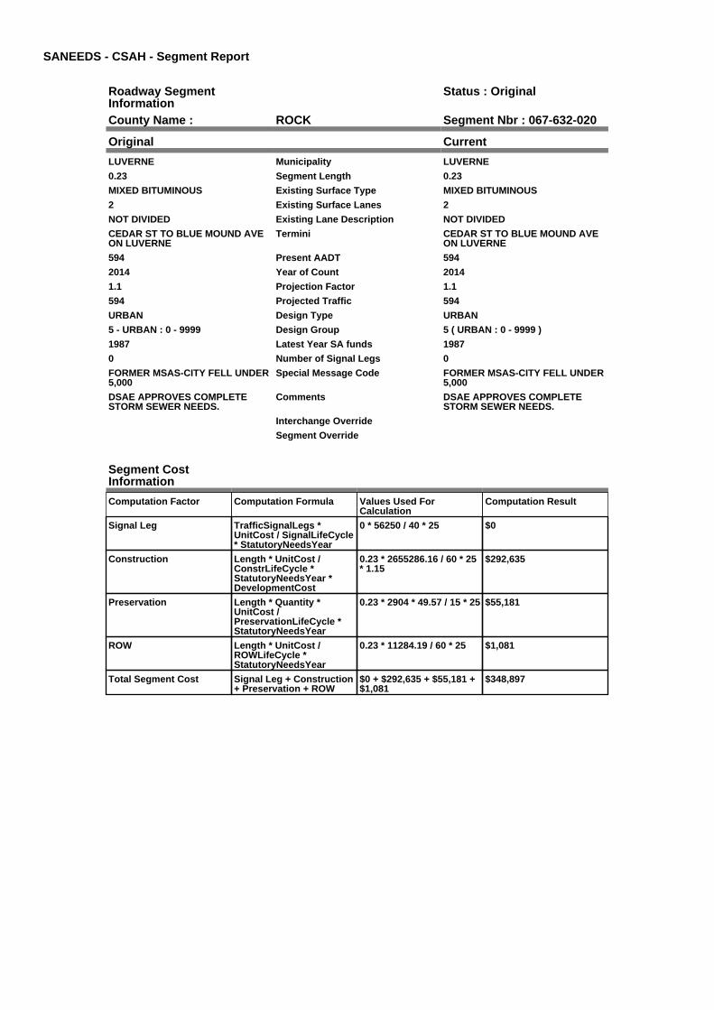
SANEEDS - CSAH - Segment Report
Roadway SegmentInformation
Status : Original
County Name : ROCK Segment Nbr : 067-632-020
Original Current
LUVERNE Municipality LUVERNE
0.23 Segment Length 0.23
MIXED BITUMINOUS Existing Surface Type MIXED BITUMINOUS
2 Existing Surface Lanes 2
NOT DIVIDED Existing Lane Description NOT DIVIDED
CEDAR ST TO BLUE MOUND AVEON LUVERNE
Termini CEDAR ST TO BLUE MOUND AVEON LUVERNE
594 Present AADT 594
2014 Year of Count 2014
1.1 Projection Factor 1.1
594 Projected Traffic 594
URBAN Design Type URBAN
5 - URBAN : 0 - 9999 Design Group 5 ( URBAN : 0 - 9999 )
1987 Latest Year SA funds 1987
0 Number of Signal Legs 0
FORMER MSAS-CITY FELL UNDER5,000
Special Message Code FORMER MSAS-CITY FELL UNDER5,000
DSAE APPROVES COMPLETESTORM SEWER NEEDS.
Comments DSAE APPROVES COMPLETESTORM SEWER NEEDS.
Interchange Override
Segment Override
Segment CostInformation
Computation Factor Computation Formula Values Used ForCalculation
Computation Result
Signal Leg TrafficSignalLegs *UnitCost / SignalLifeCycle* StatutoryNeedsYear
0 * 56250 / 40 * 25 $0
Construction Length * UnitCost /ConstrLifeCycle *StatutoryNeedsYear *DevelopmentCost
0.23 * 2655286.16 / 60 * 25* 1.15
$292,635
Preservation Length * Quantity *UnitCost /PreservationLifeCycle *StatutoryNeedsYear
0.23 * 2904 * 49.57 / 15 * 25 $55,181
ROW Length * UnitCost /ROWLifeCycle *StatutoryNeedsYear
0.23 * 11284.19 / 60 * 25 $1,081
Total Segment Cost Signal Leg + Construction+ Preservation + ROW
$0 + $292,635 + $55,181 +$1,081
$348,897

SANEEDS - CSAH - Segment Report
Roadway SegmentInformation
Status : Original
County Name : ROCK Segment Nbr : 067-633-010
Original Current
LUVERNE Municipality LUVERNE
0.06 Segment Length 0.06
MIXED BITUMINOUS Existing Surface Type MIXED BITUMINOUS
2 Existing Surface Lanes 2
NOT DIVIDED Existing Lane Description NOT DIVIDED
LINCOLN ST - CEDAR ST TOMCKENZIE ST
Termini LINCOLN ST - CEDAR ST TOMCKENZIE ST
1210 Present AADT 1210
2014 Year of Count 2014
1.1 Projection Factor 1.1
1210 Projected Traffic 1210
URBAN Design Type URBAN
5 - URBAN : 0 - 9999 Design Group 5 ( URBAN : 0 - 9999 )
2001 Latest Year SA funds 2001
0 Number of Signal Legs 0
FORMER MSAS-CITY FELL UNDER5,000
Special Message Code FORMER MSAS-CITY FELL UNDER5,000
RESURFACED IN 2001: MILL1 1/2",1 1/2" WEAR (2350)
DSAE APPROVES COMPLETESTORM SEWER NEEDS.
Comments RESURFACED IN 2001: MILL1 1/2",1 1/2" WEAR (2350)
DSAE APPROVES COMPLETESTORM SEWER NEEDS.
Interchange Override
Segment Override
Segment CostInformation
Computation Factor Computation Formula Values Used ForCalculation
Computation Result
Signal Leg TrafficSignalLegs *UnitCost / SignalLifeCycle* StatutoryNeedsYear
0 * 56250 / 40 * 25 $0
Construction Length * UnitCost /ConstrLifeCycle *StatutoryNeedsYear *DevelopmentCost
0.06 * 2655286.16 / 60 * 25* 1.15
$76,339
Preservation Length * Quantity *UnitCost /PreservationLifeCycle *StatutoryNeedsYear
0.06 * 2904 * 49.57 / 15 * 25 $14,395
ROW Length * UnitCost /ROWLifeCycle *StatutoryNeedsYear
0.06 * 11284.19 / 60 * 25 $282
Total Segment Cost Signal Leg + Construction+ Preservation + ROW
$0 + $76,339 + $14,395 +$282
$91,016

SANEEDS - CSAH - Segment Report
Roadway SegmentInformation
Status : Original
County Name : ROCK Segment Nbr : 067-633-020
Original Current
LUVERNE Municipality LUVERNE
0.17 Segment Length 0.17
MIXED BITUMINOUS Existing Surface Type MIXED BITUMINOUS
2 Existing Surface Lanes 2
NOT DIVIDED Existing Lane Description NOT DIVIDED
LINCOLN ST - MCKENZIE ST TOBLUE MOUND AVENUE
Termini LINCOLN ST - MCKENZIE ST TOBLUE MOUND AVENUE
1210 Present AADT 1210
2014 Year of Count 2014
1.1 Projection Factor 1.1
1210 Projected Traffic 1210
URBAN Design Type URBAN
5 - URBAN : 0 - 9999 Design Group 5 ( URBAN : 0 - 9999 )
2001 Latest Year SA funds 2001
0 Number of Signal Legs 0
FORMER MSAS-CITY FELL UNDER5,000
Special Message Code FORMER MSAS-CITY FELL UNDER5,000
Comments
Interchange Override
Segment Override
Segment CostInformation
Computation Factor Computation Formula Values Used ForCalculation
Computation Result
Signal Leg TrafficSignalLegs *UnitCost / SignalLifeCycle* StatutoryNeedsYear
0 * 56250 / 40 * 25 $0
Construction Length * UnitCost /ConstrLifeCycle *StatutoryNeedsYear *DevelopmentCost
0.17 * 2655286.16 / 60 * 25* 1.15
$216,295
Preservation Length * Quantity *UnitCost /PreservationLifeCycle *StatutoryNeedsYear
0.17 * 2904 * 49.57 / 15 * 25 $40,786
ROW Length * UnitCost /ROWLifeCycle *StatutoryNeedsYear
0.17 * 11284.19 / 60 * 25 $799
Total Segment Cost Signal Leg + Construction+ Preservation + ROW
$0 + $216,295 + $40,786 +$799
$257,880

SANEEDS - CSAH - Segment Report
Roadway SegmentInformation
Status : Original
County Name : ROCK Segment Nbr : 067-634-010
Original Current
LUVERNE Municipality LUVERNE
0.24 Segment Length 0.24
MIXED BITUMINOUS Existing Surface Type MIXED BITUMINOUS
2 Existing Surface Lanes 2
NOT DIVIDED Existing Lane Description NOT DIVIDED
WARREN ST - CEDAR ST TO BLUEMOUND AV
Termini WARREN ST - CEDAR ST TO BLUEMOUND AV
1155 Present AADT 1155
2014 Year of Count 2014
1.1 Projection Factor 1.1
1155 Projected Traffic 1155
URBAN Design Type URBAN
5 - URBAN : 0 - 9999 Design Group 5 ( URBAN : 0 - 9999 )
2000 Latest Year SA funds 2000
0 Number of Signal Legs 0
FORMER MSAS-CITY FELL UNDER5,000
Special Message Code FORMER MSAS-CITY FELL UNDER5,000
DSAE APPROVES COMPLETESTORM SEWER NEEDS.
Comments DSAE APPROVES COMPLETESTORM SEWER NEEDS.
Interchange Override
Segment Override
Segment CostInformation
Computation Factor Computation Formula Values Used ForCalculation
Computation Result
Signal Leg TrafficSignalLegs *UnitCost / SignalLifeCycle* StatutoryNeedsYear
0 * 56250 / 40 * 25 $0
Construction Length * UnitCost /ConstrLifeCycle *StatutoryNeedsYear *DevelopmentCost
0.24 * 2655286.16 / 60 * 25* 1.15
$305,358
Preservation Length * Quantity *UnitCost /PreservationLifeCycle *StatutoryNeedsYear
0.24 * 2904 * 49.57 / 15 * 25 $57,581
ROW Length * UnitCost /ROWLifeCycle *StatutoryNeedsYear
0.24 * 11284.19 / 60 * 25 $1,128
Total Segment Cost Signal Leg + Construction+ Preservation + ROW
$0 + $305,358 + $57,581 +$1,128
$364,067
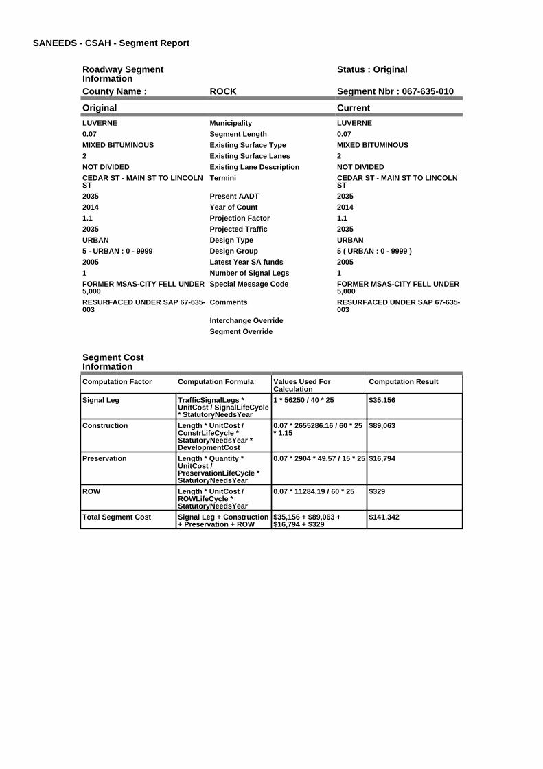
SANEEDS - CSAH - Segment Report
Roadway SegmentInformation
Status : Original
County Name : ROCK Segment Nbr : 067-635-010
Original Current
LUVERNE Municipality LUVERNE
0.07 Segment Length 0.07
MIXED BITUMINOUS Existing Surface Type MIXED BITUMINOUS
2 Existing Surface Lanes 2
NOT DIVIDED Existing Lane Description NOT DIVIDED
CEDAR ST - MAIN ST TO LINCOLNST
Termini CEDAR ST - MAIN ST TO LINCOLNST
2035 Present AADT 2035
2014 Year of Count 2014
1.1 Projection Factor 1.1
2035 Projected Traffic 2035
URBAN Design Type URBAN
5 - URBAN : 0 - 9999 Design Group 5 ( URBAN : 0 - 9999 )
2005 Latest Year SA funds 2005
1 Number of Signal Legs 1
FORMER MSAS-CITY FELL UNDER5,000
Special Message Code FORMER MSAS-CITY FELL UNDER5,000
RESURFACED UNDER SAP 67-635-003
Comments RESURFACED UNDER SAP 67-635-003
Interchange Override
Segment Override
Segment CostInformation
Computation Factor Computation Formula Values Used ForCalculation
Computation Result
Signal Leg TrafficSignalLegs *UnitCost / SignalLifeCycle* StatutoryNeedsYear
1 * 56250 / 40 * 25 $35,156
Construction Length * UnitCost /ConstrLifeCycle *StatutoryNeedsYear *DevelopmentCost
0.07 * 2655286.16 / 60 * 25* 1.15
$89,063
Preservation Length * Quantity *UnitCost /PreservationLifeCycle *StatutoryNeedsYear
0.07 * 2904 * 49.57 / 15 * 25 $16,794
ROW Length * UnitCost /ROWLifeCycle *StatutoryNeedsYear
0.07 * 11284.19 / 60 * 25 $329
Total Segment Cost Signal Leg + Construction+ Preservation + ROW
$35,156 + $89,063 +$16,794 + $329
$141,342
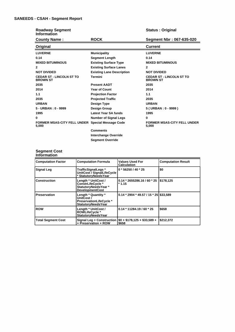
SANEEDS - CSAH - Segment Report
Roadway SegmentInformation
Status : Original
County Name : ROCK Segment Nbr : 067-635-020
Original Current
LUVERNE Municipality LUVERNE
0.14 Segment Length 0.14
MIXED BITUMINOUS Existing Surface Type MIXED BITUMINOUS
2 Existing Surface Lanes 2
NOT DIVIDED Existing Lane Description NOT DIVIDED
CEDAR ST - LINCOLN ST TOBROWN ST
Termini CEDAR ST - LINCOLN ST TOBROWN ST
2035 Present AADT 2035
2014 Year of Count 2014
1.1 Projection Factor 1.1
2035 Projected Traffic 2035
URBAN Design Type URBAN
5 - URBAN : 0 - 9999 Design Group 5 ( URBAN : 0 - 9999 )
1995 Latest Year SA funds 1995
0 Number of Signal Legs 0
FORMER MSAS-CITY FELL UNDER5,000
Special Message Code FORMER MSAS-CITY FELL UNDER5,000
Comments
Interchange Override
Segment Override
Segment CostInformation
Computation Factor Computation Formula Values Used ForCalculation
Computation Result
Signal Leg TrafficSignalLegs *UnitCost / SignalLifeCycle* StatutoryNeedsYear
0 * 56250 / 40 * 25 $0
Construction Length * UnitCost /ConstrLifeCycle *StatutoryNeedsYear *DevelopmentCost
0.14 * 2655286.16 / 60 * 25* 1.15
$178,125
Preservation Length * Quantity *UnitCost /PreservationLifeCycle *StatutoryNeedsYear
0.14 * 2904 * 49.57 / 15 * 25 $33,589
ROW Length * UnitCost /ROWLifeCycle *StatutoryNeedsYear
0.14 * 11284.19 / 60 * 25 $658
Total Segment Cost Signal Leg + Construction+ Preservation + ROW
$0 + $178,125 + $33,589 +$658
$212,372

SANEEDS - CSAH - Segment Report
Roadway SegmentInformation
Status : Original
County Name : ROCK Segment Nbr : 067-635-030
Original Current
LUVERNE Municipality LUVERNE
0.39 Segment Length 0.39
MIXED BITUMINOUS Existing Surface Type MIXED BITUMINOUS
2 Existing Surface Lanes 2
NOT DIVIDED Existing Lane Description NOT DIVIDED
CEDAR ST - BROWN ST TOBARCK ST
Termini CEDAR ST - BROWN ST TOBARCK ST
1595 Present AADT 1595
2014 Year of Count 2014
1.1 Projection Factor 1.1
1595 Projected Traffic 1595
URBAN Design Type URBAN
5 - URBAN : 0 - 9999 Design Group 5 ( URBAN : 0 - 9999 )
1995 Latest Year SA funds 1995
0 Number of Signal Legs 0
FORMER MSAS-CITY FELL UNDER5,000
Special Message Code FORMER MSAS-CITY FELL UNDER5,000
Comments
Interchange Override
Segment Override
Segment CostInformation
Computation Factor Computation Formula Values Used ForCalculation
Computation Result
Signal Leg TrafficSignalLegs *UnitCost / SignalLifeCycle* StatutoryNeedsYear
0 * 56250 / 40 * 25 $0
Construction Length * UnitCost /ConstrLifeCycle *StatutoryNeedsYear *DevelopmentCost
0.39 * 2655286.16 / 60 * 25* 1.15
$496,207
Preservation Length * Quantity *UnitCost /PreservationLifeCycle *StatutoryNeedsYear
0.39 * 2904 * 49.57 / 15 * 25 $93,568
ROW Length * UnitCost /ROWLifeCycle *StatutoryNeedsYear
0.39 * 11284.19 / 60 * 25 $1,834
Total Segment Cost Signal Leg + Construction+ Preservation + ROW
$0 + $496,207 + $93,568 +$1,834
$591,609

SANEEDS - CSAH - Segment Report
Roadway SegmentInformation
Status : Original
County Name : ROCK Segment Nbr : 067-636-010
Original Current
LUVERNE Municipality LUVERNE
0.1 Segment Length 0.1
MIXED BITUMINOUS Existing Surface Type MIXED BITUMINOUS
2 Existing Surface Lanes 2
NOT DIVIDED Existing Lane Description NOT DIVIDED
BLUE MOUND AV - WARREN STTO MAIN ST
Termini BLUE MOUND AV - WARREN STTO MAIN ST
396 Present AADT 396
2014 Year of Count 2014
1.1 Projection Factor 1.1
396 Projected Traffic 396
URBAN Design Type URBAN
5 - URBAN : 0 - 9999 Design Group 5 ( URBAN : 0 - 9999 )
2000 Latest Year SA funds 2000
0 Number of Signal Legs 0
FORMER MSAS-CITY FELL UNDER5,000
Special Message Code FORMER MSAS-CITY FELL UNDER5,000
DSAE APPROVES COMPLETESTORM SEWER NEEDS.
Comments DSAE APPROVES COMPLETESTORM SEWER NEEDS.
Interchange Override
Segment Override
Segment CostInformation
Computation Factor Computation Formula Values Used ForCalculation
Computation Result
Signal Leg TrafficSignalLegs *UnitCost / SignalLifeCycle* StatutoryNeedsYear
0 * 56250 / 40 * 25 $0
Construction Length * UnitCost /ConstrLifeCycle *StatutoryNeedsYear *DevelopmentCost
0.1 * 2655286.16 / 60 * 25 *1.15
$127,232
Preservation Length * Quantity *UnitCost /PreservationLifeCycle *StatutoryNeedsYear
0.1 * 2904 * 49.57 / 15 * 25 $23,992
ROW Length * UnitCost /ROWLifeCycle *StatutoryNeedsYear
0.1 * 11284.19 / 60 * 25 $470
Total Segment Cost Signal Leg + Construction+ Preservation + ROW
$0 + $127,232 + $23,992 +$470
$151,694

SANEEDS - CSAH - Segment Report
Roadway SegmentInformation
Status : Original
County Name : ROCK Segment Nbr : 067-637-010
Original Current
LUVERNE Municipality LUVERNE
0.5 Segment Length 0.5
MIXED BITUMINOUS Existing Surface Type MIXED BITUMINOUS
2 Existing Surface Lanes 2
NOT DIVIDED Existing Lane Description NOT DIVIDED
FROM US HWY 75 TO CSAH 18 Termini FROM US HWY 75 TO CSAH 18
715 Present AADT 715
2014 Year of Count 2014
1.1 Projection Factor 1.1
715 Projected Traffic 715
RURAL Design Type RURAL
2 - RURAL : 150 - 1499 Design Group 2 ( RURAL : 150 - 1499 )
2005 Latest Year SA funds 2005
0 Number of Signal Legs 0
No Special Message Special Message Code No Special Message
RECONSTRUCTED UNDER SAP67-637-001
ROCK COUNTY MADE CO RD 37 ACSAH IN 2003
Comments RECONSTRUCTED UNDER SAP67-637-001
ROCK COUNTY MADE CO RD 37 ACSAH IN 2003
Interchange Override
Segment Override
Culvert Information Status: Original
Original Current
67J68 Structure Number 67J68
0.33 Milepoint 0.33
2005 Year Built 2005
STREAM Feature Crossed STREAM
STREAM CROSSING Type of Service STREAM CROSSING
2 Number of Barrels 2
12 Culvert Width 12
5 Culvert Height 5
78 Culvert Length 78
120.00026276 Area of Waterway Opening 120.00026276
100% Shared Structure 100%
Comments
1 Culvert Group Code 1
Segment CostInformation
Computation Factor Computation Formula Values Used ForCalculation
Computation Result
Signal Leg TrafficSignalLegs *UnitCost / SignalLifeCycle* StatutoryNeedsYear
0 * 56250 / 40 * 25 $0
Construction Length * UnitCost /ConstrLifeCycle *StatutoryNeedsYear *DevelopmentCost
0.5 * 709557.81 / 60 * 25 *1.1
$162,607
Preservation Length * Quantity *UnitCost /PreservationLifeCycle *StatutoryNeedsYear
0.5 * 2112 * 49.57 / 20 * 25 $65,432
ROW Length * UnitCost /ROWLifeCycle *StatutoryNeedsYear
0.5 * 32814.61 / 60 * 25 $6,836
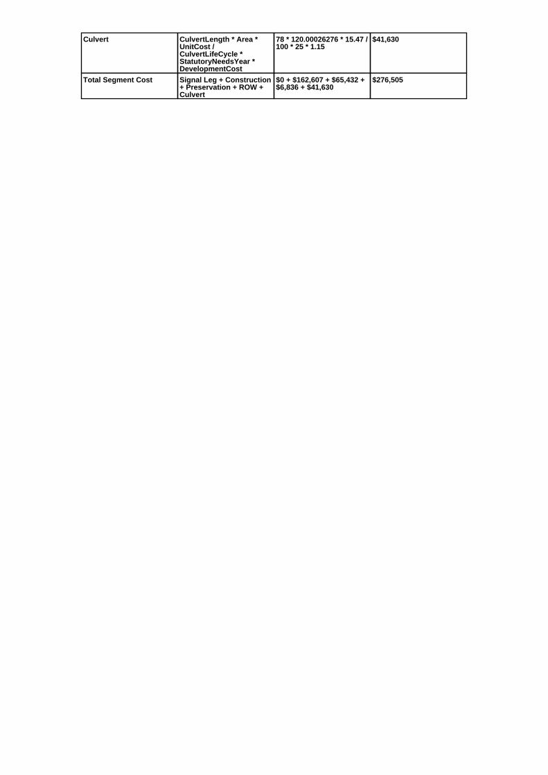
Culvert CulvertLength * Area *UnitCost /CulvertLifeCycle *StatutoryNeedsYear *DevelopmentCost
78 * 120.00026276 * 15.47 /100 * 25 * 1.15
$41,630
Total Segment Cost Signal Leg + Construction+ Preservation + ROW +Culvert
$0 + $162,607 + $65,432 +$6,836 + $41,630
$276,505


![Case [[UNASSIGNED]] U.S. Patent No. 7,856,360 … [[UNASSIGNED]] U.S. Patent No. 7,856,360 6. Claim 27, Branch (A) 80 i. Preamble: A system for providing a service to venues where](https://static.fdocuments.in/doc/165x107/5ac468f07f8b9a333d8d471b/case-unassigned-us-patent-no-7856360-unassigned-us-patent-no.jpg)