SAN PEDRO Community Plan - Los Angelescityplanning.lacity.org/complan/pdf/spdcptxt.pdfSAN PEDRO I-1...
83
SAN PEDRO Community Plan TABLE OF CONTENTS ACTIVITY LOG COMMUNITY MAPS COMMUNITY PLAN I. Introduction II. Function of the Community Plan III. Land Use Policies and Programs IV. Coordination Opportunities for Public Agencies V. Urban Design www.lacity.org/PLN (General Plans) A Part of the General Plans - City of Los Angeles
Transcript of SAN PEDRO Community Plan - Los Angelescityplanning.lacity.org/complan/pdf/spdcptxt.pdfSAN PEDRO I-1...

SAN PEDRO
Community Plan
TABLE OF CONTENTS
ACTIVITY LOG
COMMUNITY MAPS
COMMUNITY PLAN
I. Introduction
II. Function of the Community Plan
III. Land Use Policies and Programs
IV. Coordination Opportunities for Public Agencies
V. Urban Design
www.lacity.org/PLN (General Plans)
A Part of the General Plans - City of Los Angeles

SAN PEDRO
ACTIVITY LOG
ADOPTION DATE PLAN CPC FILE NO. COUNCIL FILE NO.
Mar. 17, 1999 San Pedro Community Plan Update 97-0045 98-1771
Apri. 29, 1986 San Pedro Specific Plan 23923 & 30149 85-0346
ADOPTION AMENDMENT CPC FILE NO. COUNCIL FILE NO.
Sept. 7, 2016 Mobility Plan 2035 Update CPC-2013-910-GPA-SPCA-MSC 15-0719

SAN PEDRO
I-1
SAN PEDRO
Community Plan
Chapter IINTRODUCTION
COMMUNITY BACKGROUND
PLAN AREA The San Pedro Community Plan Area (CPA) is situated in the southernportion of the City of Los Angeles. San Pedro is geographically located onthe Palos Verdes Peninsula at the southern terminus of the Harbor Freeway(I-110). It is adjacent to the planning communities of Wilmington-Harbor City,the Port of Los Angeles, the Pacific Ocean, and the city of Rancho PalosVerdes.
The Community Plan area is generally bounded by: Taper Avenue on thenorth; John Gibson Boulevard, Harbor Boulevard, the West Channel of thePort of Los Angeles, and Cabrillo Beach on the east; the Pacific Ocean onthe south; and the western border of Los Angeles with the city of RanchoPalos Verdes.
The San Pedro CPA contains approximately 3,626 net acres which isapproximately 2 percent of the total land in the City of Los Angeles. Thetopography is varied with level areas to the east adjacent to the Port of LosAngeles, rising to the rolling hillsides of the Palos Verdes Peninsula to thewest with dramatic sea cliffs and shorelines at the Pacific Ocean. Transitcorridors are Western Avenue, Gaffey Street, Pacific Avenue, and HarborBoulevard providing north-south circulation; Capitol Drive, Ninth Street,Twenty-fifth Street and Paseo Del Mar provide east-west circulation.
The predominant land use in the community is residential (63%) with densityranges from Low to High Medium. Residential land uses account for 2,300net acres with approximately 30,230 dwelling units, of which 60% are multi-family units. Most of the housing (69%) is over 30 years old. Higher densitymultiple family residential use is located in the downtown San Pedro area.The Rancho San Pedro Housing Authority facilities are north of the DowntownSan Pedro Regional Commercial Center.
Low density single family residential uses are generally located west of AlmaStreet and South of Twenty-second Street.
Industrial uses of approximately 266 net acres with 1,336,400 square feetof development are mostly concentrated in the northern portion of the CPAbetween Gaffey Street and the Harbor Freeway. Smaller pockets of industrialuses can be found in the eastern portion of the Plan area and the downtown

SAN PEDRO
I-2
San Pedro area. The petroleum and marine supply industries are the primaryuse.
Existing commercial land use in the CPA is 213 net acres with 5,271,000square feet of development. The Regional Commercial Center in downtownSan Pedro provides a central focus of commercial land use intensity andincludes a variety of high-rise office buildings and civic offices including theheadquarters for the Harbor Department, the San Pedro Municipal Court andfacilities for the San Pedro City Hall.
Neighborhood Commercial districts are located in the western portion of theCPA near Western Avenue. The Park Western Shopping Center is locatedon Western Avenue at Capitol Drive with a wide variety of retail shoppingcomprised of banks, grocery stores, apparel, and drug stores. The Districtlocated at Western Avenue and Twenty-fifth Street is slightly less intensive.The Weymouth Corners area has a village character and is comprised ofsmaller businesses, houses of worship, and a post office.
SPECIALBOUNDARIES
C San Pedro Local Coastal Program Specific Plan
The San Pedro Specific Plan and the San Pedro Coastal Land Use Plan(LUP) are components of the Local Coastal Program. Development inthe coastal zone is subject to provisions of the 1976 California CoastalAct. The Specific Plan and the LUP protect, maintain, enhance, andrestore the overall quality of the Coastal Zone environment while meetinga portion of the California Coastal Act. Public access, recreationalopportunities, and visual qualities are to be maximized. The boundariesare generally the western City boundary, Twenty-fifth Street, AnchovyAvenue, Paseo Del Mar, Western Avenue, Twenty-fifth Street, PacificAvenue, Ninth Street, Harbor Boulevard, and Crescent Avenue.
C Community Redevelopment Agency (CRA) Beacon Street Project.
The Beacon Street Project is generally bounded by Second Street,Centre Street, Harbor Boulevard, Seventh Street, Centre Street, FifthStreet and Mesa Street. The project provides a revitalized core ofdowntown San Pedro and the Regional Commercial Center with a hotel,office building, housing, theaters and improved infrastructure.
C Community Redevelopment Agency (CRA) Pacific Avenue Corridor
The Pacific Avenue Corridor is being studied by the CRA with input froma Community Advisory Committee (CAC). The main goal of the projectis to improve the economic vitality and appearance of the Downtown SanPedro area including the Pacific Avenue Corridor. The project area wouldinclude significant sections of the Community Commercial and RegionalCommercial Centers and Mixed Use Boulevards in the Community PlanArea.

SAN PEDRO
I-3
C Community Development Department (CDD) Harbor EnterpriseZone
The Harbor Enterprise Zone provides a variety of State of Californiaincentives until 2004. The incentives include hiring tax credits, sales anduse tax credits, business expense deductions, net interest deductionfor lenders, and provisions to allow net operating loss carryover. Thiszone covers the general areas of the Industrial core located in thenorthern portion of the Plan Area between Gaffey Street and John S.Gibson Boulevard, the Gaffey Street and Pacific Avenue corridors, anda segment of Downtown San Pedro bounded by Fifth Street, HarborBoulevard, Eighth Street, and Pacific Avenue.
COMMUNITYPARTICIPATION
The State of California requires citizen participation in the preparation oramendments of community plans. General Plan Government Code Section65351 reads, "During the preparation or amendment of the general plan theplanning agency shall provide opportunities for the involvement of citizens,public agencies, public utility companies, civic education, and othercommunity groups through public hearings and any other means the city orcounty deems appropriate."
Community participation occurred through focus group meetings, acommunity workshop, open house, and the public hearing process.Community members assisted in identifying major issues and formulatingland use policies and objectives.
COMMUNITY ISSUES AND OPPORTUNITIES
The following summarizes the most significant planning and land use issuesand opportunities which were identified in the San Pedro community.
RESIDENTIAL Issues
C The compatibility of Special Needs Housing with other residential usesmust be studied with regard to their location, concentration, and type.
C Need to maintain the low density character of single familyneighborhoods and protection from incompatible uses.
C Lack of Senior Citizen Housing in appropriate locations.
C Lack of usable open space in multiple family residential projects.
C Need to improve the visual environment of multiple family dwellingsthrough the development of appropriate design criteria and landscaping.
C Lack of maintenance of older existing housing stock particularly rentalmultiple family dwellings.
C Compatibility between lower and higher density residential projects.

SAN PEDRO
I-4
C Compatibility of residential and industrial uses.
C Poor appearance and maintenance of the Rancho San Pedro PublicHousing facilities.
Opportunities
C A variety of available housing types.
C Access and proximity to employment.
C Availability of homeowner programs including loans for maintenance andpurchase.
C Potential for residential and mixed use projects along transit andcommercial corridors.
C Climate with clean air and mild temperatures.
C Proximity to a variety of marine resources and recreational activities.
C Home town community pride and cultural heritage.
COMMERCIAL Issues
C Lack of enforcement of existing codes and adequate design standards.
C Inadequate transition between commercial and residential uses.
C Lack of appropriate accessible parking in commercial areas due torestrictions of physical constraints such as shallow commercial lotdepths.
C Poor physical condition of older commercial areas and proliferation ofunsightly facades.
C Intrusion of poorly designed residential projects that lack adequatesetbacks, landscaping, and on-site open space within the commercialbase.
C Lack of a unifying design theme that supports the idea of San Pedro asa destination.
C Need for developing an integrated relationship with the Port of LosAngeles to improve the vitality of downtown San Pedro, World Crusefacilities, and Ports O’ Call.
Opportunities
C The Community Redevelopment Agency (CRA) is studying DowntownSan Pedro and Pacific Avenue for the establishment of RedevelopmentProject Area.

SAN PEDRO
I-5
C Potential for Mixed Use projects at designated areas along transit andcommercial corridors.
C Develop a distinctive character and cohesive visual identity for thecommunity through the upgrade of commercial areas, especially PacificAvenue, Gaffey Street, and Downtown San Pedro.
C Promote the Harbor Enterprise Zone’s incentives for new businesses.
C Explore the establishment of a Business Improvement District for thevisual improvement of the commercial corridors.
INDUSTRIAL Issues
C Need to maintain and improve the employment base.
C Need to develop better coordination with the Port of Los Angeles whichhas the greatest amount of industrial space and activity.
C Provide adequate buffering and landscaping in industrial areas.
C Access and parking for older industrial lots may be inadequate for currentuses especially loading and unloading of vehicles.
Opportunities
C Abundance of industrially designated lands in the Plan Area and in closeproximity.
C Excellent access of industrial uses to regional freeways, rail service andthe Alameda Corridor project.
TRANSPORTATION Issues
C Heavy peak hour traffic on Gaffey Street between Ninth Street and theI-110 on and off ramps.
C Alternative routes to and from the Harbor Freeway are needed, forexample, by directly linking Twenty-fifth Street with Harbor Boulevardand/or extending Capitol Drive east of Gaffey Street .
C Through traffic is characterized by traffic to and from the Palos VerdesPeninsula.
C Parking supply, facilities, and restrictions must be reviewed forappropriateness to encourage economic vitality in San Pedro.
C Parking facilities appear to be inadequate at recreational sites of CabrilloBeach and Point Fermin particularly during summer tourist months.

SAN PEDRO
I-6
C Parking revenues generated in San Pedro should be reinvested in theCommunity.
Opportunities
C Application of Transportation Systems Management strategies such asAutomated Traffic Surveillance and Control (ATSAC) will improvecirculation on traffic corridors.
C Future study of the Downtown San Pedro Transportation Hub project.The project will consolidate transit and transportation facilities servingthe San Pedro area and includes a future rail trolley along the waterfront.
C Improved vehicular access to the Port of Los Angeles via the West BasinTransportation Improvement Program.
RECREATION, PARKS,ANDOPEN SPACE
Issues
C Need for adequate useable on-site open space for multiple familyresidential projects.
C The northeastern portion of the Plan Area needs a park to service theexisting multiple family residential uses.
C The Cabrillo Beach Bath House and other historic and cultural siteswould benefit from improved maintenance.
C More public recreational water access is needed, e.g. a second boatlaunch.
C Need for adequate parking at public parks to reduce spillover parking intoresidential areas.
Opportunities
C The Los Angeles Unified School District Fort MacArthur Marine MammalCare Center and Marine Bird Care Center provide a unique educationalopportunity for the public.
C Proximity to a variety of quality parks and beaches including Peck Park,Averill Park, Friendship Park, Cabrillo Beach, and Royal Palms StateBeach.
MAJOROPPORTUNITIES
There are few large, vacant parcels in the community. Most changes arelikely to occur from modification or adaptive reuse of buildings. The majorityof new development is expected to be small scale, unless parcels areassembled and existing structures demolished. The CommunityRedevelopment Agency’s study of the Downtown San Pedro commercial andresidential areas increase the possibilities of significant positive changes.The Harbor Department’s West Basin Transportation Improvement Program

SAN PEDRO
I-7
will provide similar positive improvements for the Harbor Subregion thatincludes San Pedro, Wilmington, and Harbor City.
COMMUNITY PROFILE
The community Profile provides an overview of population, housing, andsocio/demographics for the San Pedro Community Plan Area and comparesit to the rest of the City. The following tables contain the statistical data forprevious census dates and rates of growth.


SAN PEDRO
II-1
Chapter IIFUNCTION OF THE COMMUNITY PLAN
Chapter 2 of the Plan Text contains the statutory requirements for theCommunity Plan outlining the mandatory elements that must be addressed.The Chapter contains the explanations of the Role, Purpose, andOrganization of the Community Plan. Chapter 2 shows the relationship toother General Plan elements and provides for Plan Monitoring andConsistency.
STATUTORY REQUIREMENTS
California State Law (Government Code Section 65300) requires that eachcity prepare and adopt a comprehensive, long-term general plan for itsdevelopment. It must contain seven mandatory elements including land use,circulation, housing, conservation, open space, noise, and safety. CaliforniaState law requires that the Land Use Element be prepared as part of the city'sGeneral Plan, and that it correlate with the Circulation Element. In the Cityof Los Angeles thirty-five community plans comprise the City's Land UseElement.
The Land Use Element has the broadest scope of the State required GeneralPlan elements, since it regulates how land is to be utilized. It correlates tomany of the issues and policies contained in all other plan elements.
Government Code Section 65302(a) requires a land use element to designatethe proposed general distribution, general location, and extent of uses of theland for housing, business, industry, open space (including agriculture,natural resources, recreation and enjoyment of scenic beauty), education,public buildings and grounds, solid waste disposal facilities, and othercategories of public and private uses of land. The Land Use Element shallinclude a statement of the standards of population density and buildingintensity recommended for the various communities and other territorycovered by the plan.
The San Pedro community plan is a part of the General Plan of the City ofLos Angeles. It consists of this text and the accompanying map. TheCommunity Plan text states the goals, objectives, policies, and programs.The Community Plan map outlines the arrangement and intensities of landuses, the street system, and the location and characteristics of public servicefacilities.
ROLE OF THE COMMUNITY PLAN
The General Plan is the fundamental policy document of the City ofLos Angeles. It defines the framework by which the City’s physical andeconomic resources are to be managed and utilized over time. The Plan

SAN PEDRO
II-2
guides the City in the use of its land, design and character of buildings andopen spaces, conservation of existing and provision of new housing, provisionof supporting infrastructure and public services, protection of environmentalresources, protection of residents from natural and other known hazards.
The Community Plans are intended to promote an arrangement of land uses,streets, and services which will encourage and contribute to the economic,social and physical health, safety, welfare, and convenience of the peoplewho live and work in the community. The plans are also indented to guidedevelopment in order to create a healthful and pleasant environment. Goals,objectives, policies, and programs are created to meet the existing and futureneeds and desires of the community through the year 2010. The plans areintended to coordinate development among the various parts of the City ofLos Angeles and adjacent municipalities in a fashion both beneficial anddesirable to the residents of the community.
The general plan clarifies and articulates the City’s intentions with respectto the rights and expectations of the general public, property owners, andprospective investors and business interests. Through the Community Plan,the City can inform these groups of its goals, policies, and developmentstandards, thereby communicating what is expected of the City governmentand private sector to meet its objectives.
The Community Plan ensures that sufficient land is designated whichprovides for the housing, commercial, employment, educational, recreational,cultural, social, and aesthetic needs of the residents of the plan area. ThePlan identifies and provides for the maintenance of any significantenvironmental resources within the Plan Area. The Plan also seeks toenhance community identity and recognizes unique neighborhoods withinthe Plan Area.
PURPOSE OF THE COMMUNITY PLAN
The last comprehensive review of the San Pedro Community plan wascompleted September 30, 1980, and revised by the General Plan ZoningConsistency Program required by AB283 in 1987 and through on-goingPeriodic Plan review and other Plan amendments. Since that timeconsiderable growth has occurred, new issues have emerged, and newcommunity objectives regarding the management of new development andcommunity preservation have evolved. Consequently, it is necessary toupdate the Community Plan to reflect current conditions and the prevailingvisions and objectives of the area’s residents, property owners and businessowners.
The San Pedro Community Plan sets forth goals and objectives to maintainthe community's individuality by:
C Preserving and enhancing the positive characteristics of existingresidential neighborhoods while providing a variety of compatible newhousing opportunities.

SAN PEDRO
II-3
C Improving the function, design, and economic vitality of the commercialcorridors and industrial areas.
C Preserving and enhancing the positive characteristics of existing useswhich provide the foundation for community identity, such as scale,height, bulk, setbacks and appearance.
C Maximizing the development opportunities around future transit systemwhile minimizing any adverse impacts.
C Planning the remaining commercial and industrial developmentopportunity sites for needed job producing uses that improve theeconomic and physical condition of the San Pedro Community PlanArea.
ORGANIZATION AND CONTENT OF THE COMMUNITY PLAN
This plan sets forth goals, objectives, policies, and programs that pertain tothe San Pedro Community. Broader issues, goals, objectives, and policiesare provided by the Citywide General Plan Framework.
The Plan is organized and formatted to facilitate periodic updates. The Staterecommends that the entire plan be comprehensively reviewed every fiveyears to reflect new conditions, local attitudes, and technological advances.
The principal method for the implementation of the Land Use Map is theZoning Ordinance. The City's Zoning Map must be updated to remainconsistent with the adopted Land Use Map. Together, the Zoning Ordinanceand the Zoning Map identify specific types of land use and developmentstandards applicable to specific areas and parcels of land within thecommunity.
RELATIONSHIP TO OTHER GENERAL PLAN ELEMENTS
The City of Los Angeles has the responsibility to revise and implement theCity's General Plan. Since State law requires that the General Plan haveinternal consistency, the San Pedro Community Plan, which is a portion ofthe City's Land Use Element, must be consistent with the other elementsand components of the General Plan.
The General Plan Framework, adopted by the City Council on December 11,1996, is a long range, citywide, comprehensive growth strategy. It is aspecial element of the General Plan which looks to the future as required bylaw and replaces Concept Los Angles and the Citywide Plan (adopted in1974).
The Framework provides a citywide context within which local planning takesplace. Both the benefits and challenges of growth are shared. Because itis citywide, the Framework cannot anticipate every detail. Therefore, theCommunity Plans must be looked to for final determinations as to boundaries,

SAN PEDRO
II-4
land use categories, intensities, and height that fall within the rangesdescribed by the Framework.
The Citywide General Plan Framework Element neither overrides norsupersedes the Community Plans. It guides the city’s long range growth anddevelopment policy, establishing citywide standards, goals, policies, andobjectives for citywide elements and community plans. The Framework isflexible, suggesting a range for uses within its land use definitions. Precisedeterminations are made in the Community Plans.
The General Plan Framework forecasts the following population, housing,and employment levels for the San Pedro Community Plan for the year 2010:
Population (persons): 88,927 Employment (units): 35,719 Employment (jobs): 22,660
The above population, employment, and housing numbers are provided asreference during the Community Plan Update. It needs to be recognized,however, that these figures are only best estimates and are derived fromregional data which are disaggregated to the City and then the communitylevel. Population, jobs, and housing could grow more quickly or slowly thananticipated depending on economic trends.
Regional forecasts do not always reflect the adopted community plan landuse capacity or buildout estimated from planned land use. Plan capacityor buildout is also an imprecise estimate and depends on specificassumptions about future density of development and household size, whichmay be more, or less, than actually occur. It should also be noted that thecommunity plan capacity does not include housing in commercial districtsnor the current residential vacancy rate.
In addition to the seven State mandated elements, the City's General Planincludes a service system element, a cultural element, a major publicfacilities areas element and an air quality element. All the provisions andrequirements of these elements apply to the San Pedro Community Plan.
Neighborhood plans involve the preparation of specific plans which blend bothpolicy and implementation function for unique neighborhoods within acommunity. In addition to these specific plans, overlay zones also combinepolicy and implementation functions to address issues peculiar to a specificneighborhood.
The Community Plan includes appropriate policies and implementationmeasures generated from the mitigation measures listed in the environmentalclearance. In many instances these measures encompass the policiescontained in the General Plan Framework.
PLAN CONSISTENCY Each plan land use category indicates the corresponding zones permittedby the Plan unless further restricted by the plan text, footnotes, adopted

SAN PEDRO
II-5
Specific Plans, or other specific limitations on discretionary approvals. ThePlan recognizes that the residential densities, commercial intensities, andindustrial intensities depicted on the Plan map are theoretical and will notoccur due to plan and zone regulations, economic conditions, and designlimitations.
For each plan category, the Plan permits all identified corresponding zones,as well as those zones which are more restrictive, as referenced in Section12.23 of the Los Angeles Municipal Code (LAMC). Any subsequent actionthat modifies the Plan or any monitoring review that results in changes to thePlan must make new Plan consistency findings at the time of that decision.
City actions on most discretionary projects require a finding that the actionis consistent or in conformance with the General Plan. In addition to therequired general finding, decision makers acting on certain projects in theSan Pedro Community Plan Area shall refer to each of the applicableprograms, policies, or objectives which are contained in Chapter III. To furthersubstantiate the consistency findings, decision makers may cite otherprograms, policies, or objectives which would be furthered by the proposedproject.
PLAN MONITORING The Plan has a land use capacity greater than the projected developmentlikely to occur during the Plan period. During the life of the plan, growth willbe monitored and reported in the City’s Annual Report on Growth andInfrastructure which will be submitted to the City Planning Commission,Mayor, and City Council. In the fifth year following Plan adoption (and everyfive years thereafter), the Director shall report to the Commission on therelationship between population, employment, and housing growth and plancapacities. If growth has occurred faster than projected, a revisedenvironmental analysis will be prepared and appropriate changesrecommended to the Community Plan and zoning. These Plan and zoningchanges shall be submitted to the Planning Commission, Mayor, and CityCouncil as specified in the Los Angeles Municipal Code (L.A.M.C.).

SAN PEDRO
III-1
Chapter IIILAND USE POLICIES AND PROGRAMS
Chapter 3 of the Plan Text Contains Goals, Objectives, Policies, andPrograms for all appropriate land use issues, such as residential,commercial, and industrial, as well as public and institutional service systemcategories. The Planning Department has responsibility for the goals,objectives, policies, and the initiation and direct implementation of theprograms contained in Chapter 3.
RESIDENTIAL The quality of life and stability of neighborhoods throughout San Pedrocritically depends on providing infrastructure resources (i.e., police, fire,water, sewerage, parks, traffic circulation, etc.) commensurate with the needsof its population. If population growth occurs faster than projected and withoutneeded infrastructure improvements to keep pace with that growth, theconsequences for livability within San Pedro could be problematic.
Accordingly, the proposed Plan has three fundamental premises. First, islimiting residential densities in various neighborhoods to the prevailing densityof development in these neighborhoods. Second is the monitoring ofpopulation growth and infrastructure improvements through the City’s AnnualReport on Growth and Infrastructure with a report to the City PlanningCommission every five years on the San Pedro Community following Planadoption. Third, if this monitoring finds that population in the Plan area isoccurring faster than projected; and that infrastructure resource capacitiesare threatened, particularly critical resources such as water and sewerage;and that there is not a clear commitment to at least begin the necessaryimprovements within twelve months; then building controls should be put intoeffect, for all or portions of San Pedro, until land use designations for the SanPedro Plan and corresponding zoning are revised to limit development.
Existing residential land use patterns in the San Pedro Plan Area fall withinthe middle ranges of the land use designations, from low to high medium.Single family neighborhoods are located in the southern and western portionof the Community. Multiple family residential uses are located in variousareas with a majority located east of Meyler Street between Oliver Street andTwenty-second Street.
Historically, the majority of the Community Plan area has been designatedfor residential purposes and approximately 2,303 acres are designated forthis use. Of this acreage, 61 percent (1,411 acres) is designated for single-family use. The plan policy is to provide for the continued preservation of theexisting residential neighborhoods throughout the area, retain existing singlefamily districts and multi-family clusters. Approximately one half of thenumber of dwelling units were developed more than 40 years ago.
SAN PEDRO
III-2
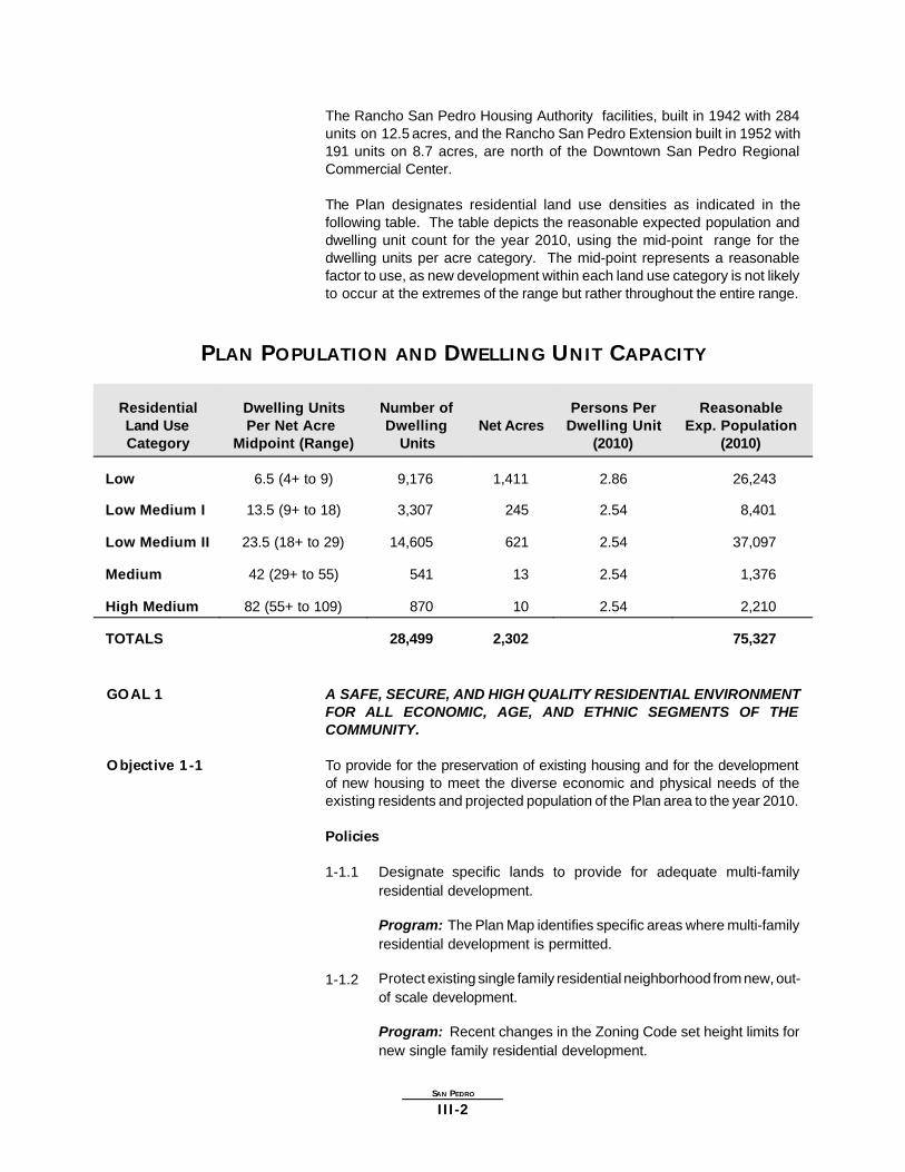
The Rancho San Pedro Housing Authority facilities, built in 1942 with 284units on 12.5 acres, and the Rancho San Pedro Extension built in 1952 with191 units on 8.7 acres, are north of the Downtown San Pedro RegionalCommercial Center.
The Plan designates residential land use densities as indicated in thefollowing table. The table depicts the reasonable expected population anddwelling unit count for the year 2010, using the mid-point range for thedwelling units per acre category. The mid-point represents a reasonablefactor to use, as new development within each land use category is not likelyto occur at the extremes of the range but rather throughout the entire range.
PLAN POPULATION AND DWELLING UNIT CAPACITY
ResidentialLand UseCategory
Dwelling UnitsPer Net Acre
Midpoint (Range)
Number ofDwelling
UnitsNet Acres
Persons PerDwelling Unit
(2010)
ReasonableExp. Population
(2010)
Low 6.5 (4+ to 9) 9,176 1,411 2.86 26,243
Low Medium I 13.5 (9+ to 18) 3,307 245 2.54 8,401
Low Medium II 23.5 (18+ to 29) 14,605 621 2.54 37,097
Medium 42 (29+ to 55) 541 13 2.54 1,376
High Medium 82 (55+ to 109) 870 10 2.54 2,210
TOTALS 28,499 2,302 75,327
GOAL 1 A SAFE, SECURE, AND HIGH QUALITY RESIDENTIAL ENVIRONMENTFOR ALL ECONOMIC, AGE, AND ETHNIC SEGMENTS OF THECOMMUNITY.
Objective 1-1 To provide for the preservation of existing housing and for the developmentof new housing to meet the diverse economic and physical needs of theexisting residents and projected population of the Plan area to the year 2010.
Policies
1-1.1 Designate specific lands to provide for adequate multi-familyresidential development.
Program: The Plan Map identifies specific areas where multi-familyresidential development is permitted.
1-1.2 Protect existing single family residential neighborhood from new, out-of scale development.
Program: Recent changes in the Zoning Code set height limits fornew single family residential development.

SAN PEDRO
III-3
1-1.3 Protect existing stable single family and low density residentialneighborhoods from encroachment by higher density residential andother incompatible uses.
Program: The Plan Map identifies lands where only single familyresidential development is permitted; it protects these areas fromencroachment by designating, where appropriate, transitionalresidential densities which serve as buffers (Transitional HeightOrdinance); and reflects plan amendments and corresponding zonechanges which are directed at minimizing incompatible uses.
1-1.4 Protect the quality of the residential environment through attentionto the appearance of communities, including attention to building andsite design.
Program: The Plan includes an Urban Design Chapter which issupplemented by Design Guidelines and Standards for residentialdevelopment.
1-1.5 Maintain at least 60% of designated residential lands for singlefamily uses.
Program: The Plan designates residential lands to reflect this ratio.
1-1.6 The City should promote neighborhood preservation, particularly inexisting single family neighborhoods, as well as in areas withexisting multiple family residences.
Program: With the implementation of the Community Plan, singlefamily residential land use categories, all zone changes,subdivisions, parcel maps, variances, conditional uses, specificplans, community and neighborhood revitalization programs forresidential projects shall provide for Plan consistency.
Program: The Neighborhood Preservation Program, administeredby the Housing Authority of the City of Los Angeles and by the City’sHousing Department provides financial resources to rehabilitatesingle family homes and multi-family rental housing.
Program: The Homeowner’s Encouragement Loan Program (HELP),administered by the City’s Housing Department providesrehabilitation loans to owners of small buildings (one to four units)to correct code violations.
Program: The Residential Rehabilitation Loan Program,administered by the Community Redevelopment Agency (CRA),makes funds available for the rehabilitation of lower-income multi-family rental housing. The program is partially funded by the UnitedStates Department of Housing and Urban Development (HUD) andrequires matching funds from a private lender with CRA as a lastresort.

SAN PEDRO
III-4
Objective 1-2 To locate new housing in a manner which reduces vehicular trips and makesit accessible to services and facilities.
Policies
1-2.1 Locate higher residential densities near commercial centers andmajor bus routes where public service facilities, utilities, andtopography will accommodate this development.
Program: The plan concentrates most of the higher residentialdensities near transit corridors and the Regional and CommunityCommercial Centers.
Objective 1-3 To preserve and enhance the varied and distinct residential character andintegrity of existing single and multi-family neighborhoods.
Policies
1-3.1 Seek a high degree of architectural compatibility and landscapingfor new infill development to protect the character and scale ofexisting residential neighborhoods.
Program: The Plan includes Design Guidelines for residentialdevelopment to implement this policy.
1-3.2 Consider factors such as neighborhood character and identity,compatibility of land uses, impact on livability, impacts on servicesand public facilities, and impacts on traffic levels when changes inresidential densities are proposes.
Program: The decision maker should adopt a finding whichaddresses these factors as part of any decision relating to changesin planned residential densities.
1-3.3 The location of institutional uses in residential areas shall beconditioned so as to avoid adverse impacts on the surroundingneighborhood.
Program: The Planning and Zoning Code requires Conditional UsePermits for these uses. The decision maker shall include conditionsof approval to mitigate any adverse impacts on the surroundingneighborhood.
Objective 1-4 To preserve and enhance neighborhoods with a distinctive and significanthistorical character.
Policies
1-4.1 Protect distinctive historic residential neighborhoods such as OldSan Pedro.
Program: Develop specific plans, Community Design Overlay (CDO)Zones, Historic Preservation Overlay Zones (HPOZ) or other means

SAN PEDRO
III-5
appropriate for the needs of the individual neighborhood providing fordesignated housing types, height limits, and possible architecturalstyle and development design standards with the establishment ofa review process for new housing development, exterior remodeling,expansion, and major building modification.
Program: The San Pedro Coastal Land Use Plan requires that theestablishment of the HPOZs to protect historic resources shall beconsidered.
1-4.2 Substandard lots in the area bounded by O’Farrell Street, HanfordAvenue, Third Street, Walker Avenue, the westerly extension ofFourth Street, and Harbor View Avenue are to remain merged asdeveloped at the time of Plan adoption in order to retain existingneighborhood scale and characteristics.
Program: The decision maker shall not approve a project unlessa finding is made that the unmerger of substandard lots in this arearetains the existing neighborhood scale and characteristics.
Objective 1-5 To promote and insure the provision of adequate housing for all personsregardless of income, age, or ethnic background.
Policies
1-5.1 Promote greater individual choice in type, quality, price, and locationof housing.
Program: The Plan promotes greater individual choice through itsestablishment of residential design standards and its allocation oflands for a variety of residential densities.
1-5.2 Promote housing in mixed use projects in transit corridors andpedestrian oriented areas.
Program: The Plan identifies mixed-use boulevards on Gaffey Streetand Pacific Avenue, and encourages a bonus in floor area for mixeduse projects in the areas identified in this policy.
1-5.3 The conversion of apartment structures to condominium ownershipshall not be permitted if they would exceed the density designatedby this Plan, or would not have the parking spaces and otheramenities required of newly constructed condominiums.
Program: The decision maker shall apply this policy to anyconversion project.
1-5.4 Provide for development of townhouses and other similarcondominium type housing units to increase home ownershipoptions.
Program: The Plan cannot require that condominium units be builtinstead of rental units; however the Plan encourages such type of

SAN PEDRO
III-6
development by designating specific areas for Low Mediumresidential land use categories.
1-5.5 Provide for livable family housing at higher densities.
Program: The Plan promotes that the Zoning Code be amendedto provide that multiple residential densities should not be limitedby the number of bedrooms per unit in order to facilitate familyhousing.
1-5.6 Housing for the elderly should be conveniently located to publictransportation, commercial services and recreational, cultural andhealth facilities, especially within or adjacent to the CommunityCenter.
Program: The Planning and Zoning Code provides housingincentives/density bonuses to encourage this policy.
1-5.7 Low and moderate-income and senior citizen housing should beimplemented by the private sector, through incentives and byinclusion in condominiums and large projects.
Program: The Planning and Zoning Code includes incentives suchas density bonuses and reduced parking for such housing.
Objective 1-6 Eliminate incompatible and non-conforming uses from existing residentialneighborhoods, to preserve the residential character of these neighborhoodsand protect residents from adverse environmental impacts caused by suchuses.
Policies
1-6.1 The enlargement of nonconforming incompatible commercial andindustrial uses within areas designated on the Plan map forresidential land shall be prohibited, and action shall be taken towardtheir removal on a scheduled basis in conformance with section12.23 of the Municipal Code.
Program: The Department of Building and Safety is responsible foradministering the provisions of Section 12.23 of the Municipal Coderelating to non-conforming uses.
1-6.2 Compatible non-conforming uses that are a recognized part of aneighborhood (e.g., “Mom and Pop” neighborhood stores), shouldbe allowed to continue in accordance with applicable provisions ofthe Municipal Code.
Program: The provisions of Section 12.23 of the Municipal Codeallow a Zoning Administrator to authorized the continuedmaintenance of such uses, if they were legally established and arereasonably compatible and not detrimental to adjacent propertiesand the public welfare.

SAN PEDRO
III-7
Objective 1-7 To minimize housing displacement whenever possible, and in those caseswhere displacement is unavoidable, to provide housing relocation assistanceand services for persons displaced as a result of public or private actions.
Policies
1-7.1 Ensure that new housing opportunities minimize displacement of theresidents.
Program: In all discretionary actions, the decision maker shouldadopt a finding which addresses any potential displacement ofresidents as part of any decision relating to the construction of newhousing.
Objective 1-8 To improve the physical design, condition and security of all public housingunits.
Policies
1-8.1 To rehabilitate and modernize public housing projects to conformwith all applicable health and safety codes.
Program: The Plan promotes that the City should substantiallyrehabilitate, modernize and improve the physical and social livingconditions in the Rancho San Pedro and Rancho San PedroExtension Housing Authority facilities, include usable open spaceand mitigate adverse environmental conditions. Such modernizationprogram may include the establishment of neighborhood commercialsupport activities along Harbor Boulevard.
Objective 1-9 To preserve visual resources in residential areas.
Policies
1-9.1 The preservation of existing scenic views from surrounding residentialuses, public streets and facilities, or designated scenic view sitesbe a major consideration in the approval of zone changes, conditionaluse permits, variances, divisions of land and other discretionarypermits.
Program: The San Pedro Coastal Land Use Plan and the SanPedro Specific Plan provide restriction on heights of structures toprotect these resources.
COMMERCIAL Commercial land use in the San Pedro Community Plan area is in transitiondue to demographic and social changes, and the increase in the amount ofavailable commercial space. There are approximately 215 acres ofcommercial land use in the Plan area. The center of the commercial area isDowntown San Pedro.
The Regional Center in downtown San Pedro is located between Third Street,Harbor Boulevard, Eighth Street and Mesa Street. The boundaries for the

SAN PEDRO
III-8
Community Center are Fourth Street, Mesa Street, Eighth Street, and GaffeyStreet. The three Neighborhood Districts are found at the commercial areaof Western Avenue and Capitol Drive, the commercial area at WesternAvenue and Twenty-fifth Street, and at Weymouth Corners east of WeymouthAvenue between Seventh Street and Eighth Street. Gaffey Street from TenthStreet to Eighteenth Street, Pacific Avenue from O’Farrell Street to FourthStreet, and Pacific Avenue from Tenth Street to Twenty-second Street areMixed Use Boulevards.
The commercial land use policies reflect the need to locate new commercialuses in the community to facilitate convenient shopping and easy accessto professional services. Redevelopment of existing commercial corridorsand areas, and conversion of existing structures to more appropriate usesshould result in the physical and aesthetic upgrading of these areas.
Plan policy provides for the development of single or aggregated parcels formixed use commercial and residential development. These structures would,normally incorporate retail office, and/or parking on lower floors and residentialunits on upper floors. Pacific Avenue has zoning [Q] conditions that prohibitresidential uses on the ground floor of mixed use projects. The intent is toprovide housing in close proximity to jobs, to reduce vehicular trips,congestion, and air pollution, to assure adequate sites for housing, and tostimulate pedestrian oriented areas to enhance the quality of life in the Planarea. While the Plan does not mandate mixed used projects, it encouragesthem in certain commercially designated areas, located along transitcorridors, in pedestrian oriented districts, and in transit oriented districts.
The Land Use Diagram Map shows the general boundaries of Centers,Districts, and Mixed Use Boulevards.
The downtown area has traditionally been the focal point of social andeconomic life in the community. However, the development of several nearbyregional shopping centers in Torrance and Long Beach, and the location ofcommercial facilities on Western Avenue serving the north and west SanPedro areas have added to the decline of the downtown area.
Within the downtown, the Regional Center features the San Pedro MunicipalCourt, the Harbor Department Headquarters, major hotels, office uses,restaurants, theaters and several high-rise buildings. The Community Centeris west of the Regional Center and features lower rise office buildings, varioustypes of retail uses, services and restaurants. The retail commercial useson Sixth Street have been able to develop a pedestrian orientation andfeatures the historic Warner Grand Theater, facade and street scapeimprovements. It is expected that tourism and recreation will play anincreasingly important role in the future economic vitality of San Pedro.Location near the World Cruise Center, the Los Angeles Port, and anentrance to Ports’ O Call should be used to the areas advantage.
The Beacon Street Redevelopment Project is continuing and has achievedmany of the goals that were set for this project. Office space, commercialuses, and a hotel have been developed in this area. The City Council hasdirected the Community Redevelopment Agency (CRA) to prepare aredevelopment plan for the Pacific Avenue Corridor and the adjacent area in

SAN PEDRO
III-9
San Pedro. An Advisory Committee has been appointed by Council DistrictFifteen to guide the redevelopment planning. The proposed redevelopmentproject area is generally bounded by the Los Angeles Port Turning Basin andChannel Street on the north, Gaffey Street on the west, Twenty-second Streetand the East and West Channel properties on the south and the Los AngelesMain Channel on the east.
Several neighborhood commercial areas are located throughout thecommunity which will provide daily convenience services to people living innearby residential areas. Typical establishments which might be found inthese areas would include markets, barber and beauty shops, laundromatsand dry cleaners, restaurants, liquor stores and small professional offices.The Park Plaza shopping area on Western Avenue provides for uses suchas drug store, apparel store, bank, supermarket, bakery, and restaurants.
The commercial area along Pacific Avenue should continue to develop inconformance with existing uses, including retail commercial, commercialservice, office, coastal/recreational uses such as sporting goods, marinesupply and repair, and other similar uses which serve the Community. Newautomobile sales, repair, and service uses are restricted on certain sectionsof Pacific Avenue and Sixth Street.
The plan designates most of Gaffey Street for General Commercial facilitiesto take advantage of commuter traffic utilizing the Harbor Freeway. Serviceslocated in this area include motels, restaurants and coffee shops, fast fooddrive-ins, liquor stores, gas stations, and other similar convenience good andservices.
GOAL 2 A STRONG AND COMPETITIVE COMMERCIAL SECTOR WHICH BESTSERVES THE NEEDS OF THE COMMUNITY THROUGH MAXIMUMEFFICIENCY AND ACCESSIBILITY WHILE PRESERVING THE UNIQUECOMMERCIAL AND CULTURAL CHARACTER OF THE COMMUNITY.
Objective 2-1 To conserve, strengthen, and encourage investment in all commercialdistricts.
Policies
The Community Plan identifies appropriate areas to encourage commercialdevelopment where design guidelines or other planning tools might be appliedto enhance an area. These areas are indicated as either Regional Center,Community Center, Neighborhood District, or Mixed Use Boulevard on theLand Use Diagram map. The intent is to show the location of the area andto provide policies and standards as a guide for development to take place.
2-1.1 New commercial uses shall be located in existing establishedcommercial areas or existing shopping centers.
Program: The Plan Map identifies specific areas where commercialdevelopment is permitted.
SAN PEDRO
III-10
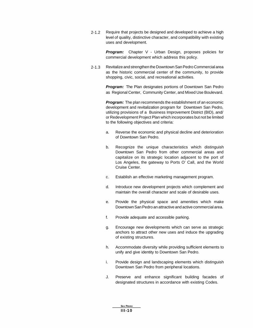
2-1.2 Require that projects be designed and developed to achieve a highlevel of quality, distinctive character, and compatibility with existinguses and development.
Program: Chapter V - Urban Design, proposes policies forcommercial development which address this policy.
2-1.3 Revitalize and strengthen the Downtown San Pedro Commercial areaas the historic commercial center of the community, to provideshopping, civic, social, and recreational activities.
Program: The Plan designates portions of Downtown San Pedroas Regional Center, Community Center, and Mixed Use Boulevard.
Program: The plan recommends the establishment of an economicdevelopment and revitalization program for Downtown San Pedro,utilizing provisions of a Business Improvement District (BID), and/or Redevelopment Project Plan which incorporates but not be limitedto the following objectives and criteria:
a. Reverse the economic and physical decline and deteriorationof Downtown San Pedro.
b. Recognize the unique characteristics which distinguishDowntown San Pedro from other commercial areas andcapitalize on its strategic location adjacent to the port ofLos Angeles, the gateway to Ports O’ Call, and the WorldCruise Center.
c. Establish an effective marketing management program.
d. Introduce new development projects which complement andmaintain the overall character and scale of desirable uses.
e. Provide the physical space and amenities which makeDowntown San Pedro an attractive and active commercial area.
f. Provide adequate and accessible parking.
g. Encourage new developments which can serve as strategicanchors to attract other new uses and induce the upgradingof existing structures.
h. Accommodate diversity while providing sufficient elements tounify and give identity to Downtown San Pedro.
i. Provide design and landscaping elements which distinguishDowntown San Pedro from peripheral locations.
J. Preserve and enhance significant building facades ofdesignated structures in accordance with existing Codes.

SAN PEDRO
III-11
2-1.4 Encourage the use of private and public resources designed tostimulate commercial rehabilitation and new development.
Program: Support legislation and administrative actions whichadequately allows the City to encourage business development suchas taxable bonds, bond pools, historic preservation bonds, seismicrehabilitation bonds and use of bond financing by local economicdevelopment corporations.
Program: Support for legislation and administrative actions whichallow the City to continue to support small business development,including but not limited to, small business revolving loan funds andcommercial corridor rehabilitation program, such as thoseestablished in the City’s Commercial Area Revitalization Effort(CARE) Program.
Objective 2-2 To enhance the aesthetic quality and pedestrian orientation of commercialdevelopments.
Policies
2-2.1 New development in the Regional Center, Community Center,Neighborhood Districts and Mixed Use Boulevards shall enhancethe existing pedestrian street activity.
Program: Development within these areas is subject to the designstandards established in the Design Guidelines in Chapter V forpedestrian oriented areas.
2-2.2 Ensure that commercial infill projects achieve harmony in design withthe best of existing development.
Program: Implementation of the Design Guidelines in Chapter V.
2-2.3 Require that mixed use projects and development in pedestrianoriented districts be designed and developed to achieve a high levelof quality, distinctive character, and compatibility with existing uses.
Program: The Plan includes Design Guidelines in Chapter V whichimplement this policy for commercial projects.
2-2.4 Require that the first floor street frontage of structures, includingmixed use projects and parking structures located in pedestrianoriented districts, incorporate retail and service oriented commercialuses.
Program: Design Guidelines address this policy.
Program: Pacific Avenue zoning [Q] conditions restrict residentialuse of the first floor.

SAN PEDRO
III-12
2-2.5 Promote mixed use projects in proximity to, along transit corridors,and in appropriate commercial areas.
Program: Through this policy and the land use diagram, the planestablishes preferred locations for mixed use projects. The Planallows for floor area bonus and height bonus for mixed use projectswithin commercially planned areas of the plan area.
Objective 2-3 To enhance the design and land use compatibility of commercial districts.
Policies
2-3.1 Require urban design techniques, such as appropriate buildingorientation and scale, transitional building heights, landscaping,buffering and increased setbacks in the development of commercialproperties to improve land use compatibility with adjacent uses andto enhance the physical environment.
Program: Implement conformance with policies identified in theDesign Guidelines of the Plan.
2-3.2 Preserve community character, scale, and architectural diversity.
Program: The Plan establishes design provisions for commercialareas, included in the Design Guidelines of the Plan, to implementthis policy.
2-3.3 Provide adequate employee and public parking for all commercialfacilities and which is screened from public view by landscaping,berms, fencing and/or walls. Locate parking areas betweencommercial and residential areas where appropriate to provide abuffer, and be separated from residential uses by means of at leasta solid wall and/or landscaped setback.
Program: Design policies for parking areas established in theDesign Guidelines implement this policy.
2-3.4 Landscaped corridors should be created and enhanced through theplanting of street trees along segments with no setbacks andthrough median plantings.
Program: The Design Guidelines include a section whichestablishes guidelines for community design and landscaping.These guidelines are intended to serve as a reference to other CityDepartments, public agencies, and any private entities whoparticipate in projects which involve improvements to public spacesand rights-of-way including streetscape and landscaping.
Objective 2-4 To maintain an adequate level of commercial services and increase thecommercial employment base for community residents whenever possible.

SAN PEDRO
III-13
Policies
2-4.1 Protect commercial plan designations so that commercialdevelopment is encouraged.
Program: The Plan maintains the current amounts of commercialland use designations to implement this policy.
INDUSTRIAL Most of the Industrial land use designations in the San Pedro CommunityPlan Area are located along John S. Gibson Boulevard and Gaffey Street inthe northern part of the community. Smaller pockets of industrial land usecan be found near Downtown San Pedro and along Mesa Avenue betweenTwentieth and Twenty-second Streets. Approximately 270 acres aredesignated for industrial land use.
Industrial land use is a valuable commodity that must be maintained due tothe economic benefits and the employment opportunities generated. Usesin these areas include those related to the petroleum and marine industries,and smaller firms such as plumbing and heating companies.
GOAL 3 PROVIDE SUFFICIENT LAND FOR A VARIETY OF INDUSTRIAL USESWITH MAXIMUM EMPLOYMENT OPPORTUNITIES WHICH ARE SAFEFOR THE ENVIRONMENT AND THE WORK FORCE, AND WHICH HAVEMINIMAL ADVERSE IMPACT ON ADJACENT RESIDENTIAL USES.
Objective 3-1 To provide for existing and future industrial uses which contribute jobopportunities for residents and which minimize environmental and visualimpacts to the community.
Policies
3-1.1 Designate lands for the continuation of existing industry anddevelopment of new industrial parks, research and developmentuses, light manufacturing, and similar uses which provideemployment opportunities.
Program: The Plan identifies lands which have industrialdesignations to accommodate a variety of industrial uses.
3-1.2 Define and separate new and/or expanded industrial uses from otheruses by freeways, flood control channels, highways and otherphysical barriers.
Program: The Plan map implements this policy.
3-1.3 Require a transition of industrial uses, from intensive uses to lessintensive uses, in those areas in proximity to residentialneighborhoods.
Program: Land use designations on the Plan map, map footnotesand the corresponding zone implement this.

SAN PEDRO
III-14
3-1.4 Land use compatibility should be achieved through designtreatments, compliance with environmental protection standards andhealth and safety requirements for industrial uses where they adjoinresidential neighborhoods and commercial uses.
Program: The Plan, map and plan footnotes establish transitionalbuffers between residential and industrial uses.
Program: Environmental protection standards and health and safetyrequirements are enforced by other public agencies.
Objective 3-2 To retain industrial plan designations to maintain the industrial employmentbase for the community residents.
Policies
3-2.1 Large industrially planned parcels located in predominantly industrialarea shall not be developed with other uses which do not supportthe industrial base of the City and community.
Program: The Plan retains the existing industrial designations,including large industrially planned parcels.
Objective 3-3 To improve the aesthetic quality and design of industrial areas, eliminateblight and detrimental visual impact on residential areas, and establish astable environment for quality industrial development.
Policies
3-3.1 Require urban design techniques, such as appropriate buildingorientation and scale, landscaping, buffering and increased setbacksin the development of new industrial properties to improve land usecompatibility with adjacent uses and to enhance the physicalenvironment.
Program: New development of industrial uses located adjacent toresidential neighborhoods shall comply with the Industrial/Residentialdesign guidelines found in the Urban Design Chapter (Chapter V,Section I. B.1) of this plan.
PUBLIC AND INSTITUTIONAL LAND USE
Public facilities such as fire stations, libraries, parks, schools, and policestations shown on the San Pedro Community Plan are to be developed insubstantial conformance with the standards of need, site area, design, andgeneral location identified in the Service Systems Element and the SafetyElement of the General Plan. Such development shall be sequenced andtimed to provide an efficient and adequate balance between land use andpublic services.
There is a continuing need for the modernizing of public facilities to improveservices and accommodate changes in the San Pedro Community Plan.

SAN PEDRO
III-15
However, the amenities and environmental quality of the community mustbe adequately protected. Cost and equitable distribution are major issuesin the provisions of public facilities. It is essential that priorities beestablished and new and different sources of revenue be found. Furthermore,public and private development must be fully coordinated, in order to avoidexpensive duplication and to assure a balance among needs, services, andcost.
This plan seeks to utilize the location, characteristics, and timing of publicfacility and utility development as a tool in achieving planned land usepatterns. Further, the intent is to achieve economy and efficiency in theprovision of services and facilities consistent with standards for environmentalquality.
The Community Plan includes appropriate policies and implementationmeasures generated from the mitigation measures listed in the environmentalclearance. In many instances these measures encompass the policiescontained in the General Plan Framework.
The full residential, commercial, and industrial densities and intensitiesproposed by the Plan are predicated upon substantial compliance with thestandards contained in the Public Facilities and Service Element of theGeneral Plan. Such development should be sequenced and timed to providea workable, efficient and adequate balance between land use and servicefacilities.
RECREATION ANDPARK FACILITIES
In the San Pedro Community Plan area public parks and recreational areasare managed by the City of Los Angeles Recreation and Parks Department.There are three types of parks; regional, community, and neighborhood parks.The community parks serve a much wider interest range than those of aneighborhood site, and satisfy the need of the existing population.
GOAL 4 ADEQUATE RECREATION AND PARK FACILITIES WHICH MEET THENEEDS OF THE RESIDENTS IN THE PLAN AREA.
Objective 4-1 To conserve, maintain and better utilize existing recreation and park facilitieswhich promote the recreational experience.
Policies
4-1.1 Preserve and improve the existing recreational facilities and parkspace.
Program: The Plan preserves such recreation facilities and parkspace by designation as Open Space (OS) Zone, which providessuch protection.
Objective 4-2 To provide facilities for specialized recreational needs within the Community,with consideration given to utilizing existing public lands such as flood controlchannels, utility easements, or Department of Water and Power property.
SAN PEDRO
III-16
Policies
4-2.1 Flood control channels and other appropriate public lands should beconsidered for open space purposes. Hiking and bicycle trails inSan Pedro should connect these facilities with the local and regionalsystem.
Program: Implement the proposed hiking and bicycle trails shownon the Community Plan Map, where feasible.
Objective 4-3 To acquire and develop properties as small parks where it is not possible toacquire sufficient acreage for neighborhood parks.
Policies
4-3.1 A small park shall be approximately one-half acre in size and belocated on street corners and cul-de-sacs, where possible.
Program: Park site development is the responsibility of theDepartment of Recreation and Parks.
4-3.2 Small parks shall be designed to meet the particular needs of theresidents in the area they serve.
Program: Park site development is the responsibility of theDepartment of Recreation and Parks, utilizing community input andavailable funds.
4-3.3 Small parks shall be designed to prevent potential negative impactson adjacent residents, and provide high visibility to prevent criminalactivity.
Program: Park site development is the responsibility of theDepartment of Recreation and Parks, utilizing community input andavailable funds.
Objective 4-4 To expand and improve local parks throughout the Plan area on anaccelerated basis, as funds and land become available.
Policies
4-4.1 Develop new neighborhood parks and new community parks in thePlan Area.
Program: Park site development is the responsibility of theDepartment of Recreation and Parks, utilizing community input andavailable funds.
4-4.2 The City should encourage continuous efforts by Federal, State, andCounty agencies to acquire vacant land for publicly owned openspace.

SAN PEDRO
III-17
Program: The open space and parkland purchase programs ofFederal, State, and County agencies.
4-4.3 All park and recreation facilities should be designed, landscaped,and maintained to promote a high quality recreational experience.
Program: Park site development is the responsibility of theDepartment of Recreation and Parks, utilizing community input andavailable funds such as Grants, Quimby Funds, and State and LocalPark Bond Funds.
4-4.4 The expansion of existing facilities on sites and the acquisition ofnew sites should be planned and designed to minimize thedisplacement of housing and the relocation of residents.
Program: Park site development is the responsibility of theDepartment of Recreation and Parks, utilizing community input andavailable funds.
Objective 4-5 To ensure the accessibility, security, and safety of parks by their users,particularly families with children and senior citizens.
Policies
4-5.1 Ensure that parks are adequately illuminated for safe use at nightas appropriate.
Program: Park design, construction, and maintenance is theresponsibility of the Department of Recreation and Parks for Cityowned parks.
OPEN SPACE In the San Pedro Community Plan Area, important open space areas do existseparate from land under the control of the City of Los Angeles Departmentof Recreation and Parks. Open Space is important due to its role in bothphysical and environmental protection. There are approximately 484 acresdesignated for Open Space. There are two classifications for Open Space,publicly owned and privately owned open space.
Open Space is broadly defined as land which is essentially free of structuresand buildings and/or is natural in character and which functions in one ormore of the following ways:
1. Recreational and educational opportunities.2. Scenic, cultural, and historic values.3. Public health and safety.4. Preservation and creation of community identity.5. Rights-of-way for utilities and transportation facilities.6. Preservation of natural resources or ecologically important areas.7. Preservation of physical resources including ridge protection.
Open Space is provided on the south by the ocean and shoreline recreationareas and on the east by the harbor. On the west is the steepest portion

SAN PEDRO
III-18
of the Palos Verdes Peninsula, and the resulting low-density residentialdevelopment tends to maintain an open character which should be preservedand includes Friendship Park. To the north are the the Navy Fuel Depot andHarbor Park which are proposed to be preserved in their present open state.The ancient landslide area in South Shores is also proposed as apredominantly open space area since it is a natural link in the open spacebelt around the Community, and geological studies to date indicate that theremay be some risk if any substantial fixed structures were to placed in thisarea.
GOAL 5 A COMMUNITY WITH SUFFICIENT OPEN SPACE IN BALANCE WITHNEW DEVELOPMENT TO SERVE THE RECREATIONAL,ENVIRONMENTAL, HEALTH AND SAFETY NEEDS OF THE COMMUNITYAND TO PROTECT ENVIRONMENTAL AND AESTHETIC RESOURCES.
Objective 5-1 To preserve existing open space resources and where possible develop newopen space.
Policies
5-1.1 Encourage the retention of passive and visual open space whichprovides a balance to the urban development of the community.
Program: The Plan Map designates areas to be preserved for openspace.
5-1.2 Protect significant environmental resources from environmentalhazards.
Program: The Plan Map designates areas for open space.
Program: Implementation of State and Federal environmental lawsand regulations such as The California Environmental Quality Act(CEQA), the National Environmental Protection Act (NEPA), theClean Air Quality Act, and the Clean Water Quality Act.
Program: Implementation of SCAG's and SCAQMD's Regional AirQuality Management Plan, and SCAG's Growth Management Plan.
Program: Implement the State mandated Congestion ManagementProgram designed to reduce traffic congestion and to improve airquality.
Program: Offshore oil drilling be strictly controlled in the immediatearea off San Pedro so as to safeguard against oil spillage, preventinterference with shipping lanes, preserve the scenic value of thecoastline, and protect ecologically important areas and designatedwildlife refuges.
Program: Any new storm drain system shall not discharge in anyway that could cause the erosion of coastal bluffs. Any new stormdrain system shall minimize impacts on tide pools and any other

SAN PEDRO
III-19
ecologically important areas identified between the projection of theterminus of Fortieth Street and the City of Los Angeles-City ofRancho Palos Verdes border. The discharge from any new stormdrain shall be consistent with the National Pollutant DischargeElimination System (NPDES) permit requirements for storm waterdischarges as set forth in Section 402 of the Clean Water Act.
5-1.3 Accommodate active park lands and other open space uses in areasdesignated and zoned as Open Space.
Program: The Plan Map designates lands for open space asappropriate.
5-1.4 The grading of natural terrain to permit development in hillside areasshall be minimized commensurate with densities designated by thisPlan, the geological stability of the area, and compatibility withadjoining land uses.
Program: The provisions of the San Pedro Coastal Land Use Planand Specific Plan implement this policy.
5-1.5 The alteration of natural drainage patterns, canyons, and watercourses shall be minimized except where improvements arenecessary to protect life and property.
Program: The provisions of the San Pedro Coastal Land Use Planand Specific Plan implement this policy. The Department of Buildingand Safety is responsible for administering the Grading provisionsof the Building and Safety Code of all projects.
5-1.6 Developments be restricted on areas of known geologic hazard,unstable soil conditions or landslides.
Program: The provisions of the San Pedro Coastal Land Use Planand Specific Plan implement this policy. The Department of Buildingand Safety is responsible for administering the Grading provisionsof the Building and Safety Code of all projects.
5-1.7 Offshore oil drilling be strictly controlled in the immediate area offSan Pedro so as to safeguard against oil spillage, preventinterference with shipping lanes, preserve the scenic value of thecoastline, and protect ecologically important areas and designatedwildlife refuges.
Program: Provisions of the Planning and Zoning Code require acomplete review of these projects and implement this policy.
5-1.8 Coastal areas containing ecological or scenic resources bepreserved and protected within State reserves, preserves, parks, ornatural wildlife refuges.
Program: The San Pedro Coastal Land Use Plan and Specific Planimplement this policy.

SAN PEDRO
III-20
SAN PEDRO LOCAL COASTAL PROGRAM SPECIFIC PLAN
Development in the Coastal Zone is subject to the provisions of the CaliforniaCoastal Act of 1976. San Pedro has a Specific Plan and an approved CoastalLand Use Plan (LUP) which guide development in the Coastal Zone. Theboundaries are generally the western City boundary, Twenty-fifth Street,Anchovy Avenue, Paseo Del Mar, Western Avenue, Twenty-fifth Street,Pacific Avenue, Ninth Street, Harbor Boulevard, and Crescent Avenue.
GOAL 6 PRESERVATION OF THE SCENIC AND VISUAL QUALITY OF COASTALAREAS. THE CALIFORNIA COASTAL ACT OF 1976 DECLARED THECALIFORNIA COASTAL ZONE A DISTINCT AND VALUABLE RESOURCEOF VITAL AND ENDURING INTEREST TO ALL PEOPLE AND EXISTSAS A DELICATELY BALANCED ECOSYSTEM.
Objective 6-1 To provide a guide for the Land Use of the policies contained in the CaliforniaCoastal Act of 1976 within the designated Coastal Zone in San Pedro.
Policies
6.1.1 The San Pedro Coastal Land Use Plan constitutes the Land UsePlan portion of the City’s Local Coastal Program (LCP) for SanPedro. Development within the Coastal Zone shall conform to allPolicies and Objectives contained within this Plan.
Program: The Coastal Land Use Plan portion of Local CoastalProgram was adopted by the City Council and approved by theCalifornia Coastal Commission in 1991. The Specific Plan wasadopted in 1986 and amended in 1990 as the implementation portionof the LCP.
Program: The LIP that was denied should be revised for resubmittalto the California Coastal Commission.
Objective 6-2 To protect, maintain and where feasible, enhance and restore the overallquality of the Coastal Zone environment and its natural and man-maderesources.
Policies
6-2.1 That the scenic and visual qualities of San Pedro be protected asa resource of Community as well as regional importance, withpermitted development sited and designed to: protect views to andalong the ocean, harbor, and scenic coastal areas; minimize thealteration of natural landform; be visually compatible with thecharacter of the surrounding area; and prevent the blockage ofexisting views for designated public scenic view areas and ScenicHighways.
Program: The Specific Plan requirements for height and protectionof public views implement this policy.

SAN PEDRO
III-21
Objective 6-3 To assure the orderly and balanced utilization and conservation of CoastalZone resources, taking into account the social and economic needs of thepeople of the region.
Policies
6-3.1 That existing coastal-oriented recreational facilities be maintained,developed, and expanded where needed to provide local as well asregional access to and enjoyment of San Pedro’s unique coastalresources.
Program: The San Pedro Local Coastal Program Specific Plan andthe Port of Los Angeles Plan contain provisions to protect theseresources.
Objective 6-4 To maximize public access and recreational opportunities to and within theCoastal zone consistent with sound resource conservation principles and therights of private property owners.
Policies
6-4.1 That adequate public parking areas serving recreational facilitiesalong the coast be freely available to be public to avoid spill-overparking into residential areas.
Program: The periodic use of the southerly portion of Ft. MacArthuradjacent to Stephen M. White Drive as a spill-over parking area ofCabrillo Beach recreational users is recommended.
6-4.2 Trails and paths should be developed with consideration for theirunique characteristics in keeping with the natural terrain. Othertrails, as indicated in the San Pedro Coastal Land Use Plan, shouldbe improved pursuant to the Specific Plan. All trails, paths andbikeways should be indicated by appropriate signs.
Program: The San Pedro Coastal Land Use Plan will implementthis policy.
Objective 6-5 To assure priority for coastal dependent development over other developmenton the coast.
Policies
6-5.1 That existing coastal-oriented recreational facilities be maintained,developed, and expanded where needed to provide local as well asregional access to and enjoyment of San Pedro’s unique coastalresources.
Program: The San Pedro Coastal Land Use Plan implements thispolicy.
6-5.2 Existing lower cost visitor and recreational facilities shall beprotected where feasible, and new ones, encouraged, by allowing

SAN PEDRO
III-22
them as permitted uses in the appropriate land use categories. Developments providing public recreational opportunities are preferreduses.
Oceanfront land suitable for coastal recreational uses shall beprotected for coastal related recreational use and developmentunless present and foreseeable future demand for public orcommercial recreational activities that could be accommodated inthe property is already adequately provided for in the near vicinity.
The use of private lands suitable for visitor-serving commercialrecreational facilities designed to enhance public opportunities forcoastal recreation shall have priority over private residential, generalindustrial, general commercial development, but not over coastal-dependent industry.
Upland areas necessary to support coastal recreational uses shallbe reserved for such uses where feasible.
Program: The San Pedro Coastal Land Use Plan would allowconditional approval of development in the Coastal Zone to ensurethe implementation of the Coastal Act Policies.
Objective 6-6 To preserve existing scenic views of the ocean and harbor from designatedScenic Highways, scenic view sites, and existing residential structures.
Policies
6-6.1 That visual access to coastal views be provided by means ofappropriately located scenic overlooks, turnouts, view spots andother areas for limited vehicular parking, especially along designatedScenic Highways and Bikeways.
Turn-out and view site areas from Paso del Mar shall provideunobstructed views of the ocean. All development seaward of theturn-out and viewsite areas of Paseo del Mar and Shepard Streetshall be sited, designed and constructed so that public views to andalong the ocean are protected to the maximum extent feasible. Alldevelopment in this area, including public recreation and publicworks, shall be subordinate to their setting and minimize in heightand bulk to the maximum extent feasible to accomplish viewprotection.
Until a “Corridor Plan” is prepared for Scenic Highway, anydevelopment adjacent to a Scenic Highway shall protect public viewsto the ocean to the maximum extent feasible, be adequatelylandscaped to soften the visual impact of the development, and,where appropriate, provide hiking or biking trails, a turnout, vistapoints and other complementary facilities.
Program: The San Pedro Coastal Land Use Plan allows for theconditional approval of development in the Coastal zone to ensurethe implementation of Coastal Act policies.

SAN PEDRO
III-23
6-6.2 The Osgood/Farley Battery site, Lookout Point site, and the KoreanBell site shall be designated as public view sites and anydevelopment which obstructs views from these sites shall beprohibited.
Program: The San Pedro Specific Plan allows for the conditionalapproval of development in the Coastal zone and provides protectionsof these visual resources. The Plan requires new construction orremodeling within the visual corridors extending from these viewsitesbe limited to 24 feet to 26 feet in height.
SCHOOLS In the San Pedro Plan Area, the public schools are administered by the LosAngeles Unified School District (LAUSD).
The number of LAUSD facilities in the Plan area are eleven elementaryschools, one middle school, three high schools, a special education center,and one Occupational Center in the plan area. The names and locations are:Bandini Street School at Bandini Street and Oliver Street; Barton Hill Schoolat Pacific Avenue and O’Farrell Street; Cabrillo Avenue School at CabrilloAvenue and Eighth Street; Fifteenth Street School at Fifteenth Street andMesa Street; Leland Street School at Leland Street and Twenty-first Street;Park Western Place School at Park Western Place and Park Western Drive;Point Fermin School at Carolina Street and Thirty-second Street; SeventhStreet School at Seventh Street and Weymouth Avenue; SouthShores/CSUDH Magnet School at Thirty-fifth Street and Abalone Avenue;Taper Avenue School at Taper Avenue and Westmont Drive; White PointSchool at Silvius Avenue and Thirty-sixth Street; Richard Henry Dana MiddleSchool at Cabrillo Avenue and Fourteenth Street; San Pedro High Schoolat Seventeenth Street and Leland Street; Angels Gate High School near AlmaStreet and Thirtieth Street; James Fenimore Cooper High School at TaperAvenue and Sandwood Place; San Pedro Science Center at BarrywoodAvenue and Statler Street; Ernest P. Willenberg Special Education Centerat Weymouth Avenue and Western Avenue; and the Harbor OccupationalCenter on Pacific Avenue at Upland Avenue.
GOAL 7 APPROPRIATE LOCATIONS AND ADEQUATE FACILITIES FORSCHOOLS TO SERVE THE NEEDS OF THE EXISTING AND FUTUREPOPULATION. PUBLIC SCHOOL THAT PROVIDE A QUALITYEDUCATION FOR ALL OF THE CITY’S CHILDREN, INCLUDING THOSEWITH SPECIAL NEEDS, AND ADEQUATE SCHOOL FACILITIES TOSERVE EVERY NEIGHBORHOOD IN THE CITY.
Objective 7-1 To site schools in locations complementary to existing land uses,recreational opportunities and community identity.
Policies
7-1.1 Encourage compatibility in school locations, site layout andarchitectural design with adjacent land uses and communitycharacter and, as appropriate, use schools to create a logicaltransition and buffer between differing uses.

SAN PEDRO
III-24
Program: Require the decision-maker involved in discretionaryreview of proposed schools to adopt a finding which supports theapplication of this policy.
7-1.2 Site schools in a manner which complements and preserves theexisting stable single family and multiple-family residentialneighborhoods.
Program: The decision-maker involved in discretionary review ofa proposed school should adopt a finding which supports theapplication of this policy.
7-1.3 Proximity to noise sources should be avoided whenever possible orthe school design should buffer classrooms from such noise.
Program: Implement appropriate provisions of the City's NoiseElement.
Program: Incorporate noise mitigation measures to reduce adverseenvironmental impacts in order to comply with CEQA.
7-1.4 Expansion of existing schools should be preferred over theacquisition of new sites.
Program: The Los Angeles Unified School District is theresponsible agency for providing adequate school facilities.
7-1.5 Elementary schools should be located along collector streets.
Program: The Los Angeles Unified School District is the agencyresponsible for the siting, design, and construction of publicelementary schools.
7-1.6 Encourage cooperation to provide recreation facilities for thecommunity.
Program: The Los Angeles Unified School District and the City'sDepartment of Recreation and Parks should work together jointly todevelop programs to fully utilize each of their respective sites.
Objective 7-2 Work constructively with LAUSD to promote the siting and construction ofadequate school facilities phased with growth.
Policies
7-2.1 Explore creative alternatives for providing new school sites in theCity, where appropriate.
Program: Develop plans to address issues of siting and joint useof facilities including strategies for expansion in transit-rich locations.

SAN PEDRO
III-25
Program: Utilize the City’s Annual Report on Growth andInfrastructure to monitor locations for growth and potential newschool sites.
Objective 7-3 Maximize the use of local schools for community use and local open spaceand parks for school use.
Policies
7-3.1 Encourage the siting of community facilities (libraries, parks, schoolsand auditoriums) together.
Program: Formulate/update plans to address issues relating tositing and the joint use of facilities. Identify strategies for theexpansion of school facilities including:
Siting of school and other community facilities (libraries, parks, andauditoriums) within a transit station, center or mixed-use area sothey can complement each other and make the most efficient useof the land provided for these services.
a. Locating middle schools and high schools where possible,close to transit stations and key centers and mixed usedistricts, so students can use the transit system to get to andfrom school.
b. Encouraging private redevelopment of existing school sites inthe immediate vicinity of transit stations and centers so thatthe existing site (a low intensity use) would be replaced by ahigh intensity mixed-use development that would incorporateschool facilities.
LIBRARIES The Plan Area is serviced by the San Pedro Regional Library located at 931S. Gaffey Street. The library has an area of 20,000 square feet and over132,000 catalogued volumes.
GOAL 8 ENSURE THAT ADEQUATE LIBRARY FACILITIES ARE PROVIDED FORTHE COMMUNITY'S RESIDENTS.
Objective 8-1 To encourage the City's Library Department to provide adequate library servicewhich responds to the needs of the community.
Policies
8-1.1 Support construction of new libraries and the rehabilitation andexpansion of the existing library as required to meet the changingneeds of the community.
Program: The existing library site is designated as a public facilityand is to be zoned Public Facilities (PF). This designation gives thelibraries additional protection to retain their existing use and allows

SAN PEDRO
III-26
a greater certainty in obtaining the necessary City approvals whenrehabilitating or expanding.
8-1.2 Encourage flexibility in siting libraries in mixed-use projects,shopping malls, pedestrian-oriented areas, office buildings, andsimilarly accessible facilities.
Program: Through the inclusion of this policy the Plan supportssuch utilization when the Library Department and decision-makersreview and approve sites for new libraries.
8-1.3 Substandard library facilities be upgraded and enlarged to sufficientsize to conform to standards and criteria contained within the PublicLibrary Element of the City’s General Plan.
Program: The replacement of the presently inadequate San PedroRegional Library as funds become available.
POLICE PROTECTION Police protection is provided by the Los Angeles Police Department. TheSan Pedro Community Plan Area is serviced by the Harbor Area Divisionlocated at 2175 John S. Gibson Boulevard.
GOAL 9 A COMMUNITY WITH ADEQUATE POLICE FACILITIES AND SERVICESTO PROTECT THE COMMUNITY'S RESIDENTS FROM CRIMINALACTIVITY, REDUCE THE INCIDENCE OF CRIME AND PROVIDE OTHERNECESSARY LAW ENFORCEMENT SERVICES.
Objective 9-1 To provide adequate police facilities and personnel to correspond withpopulation and service demands in order to provide adequate policeprotection.
Policies
9-1.1 Consult with the Police Department as part of the review of newdevelopment projects and proposed land use changes to determinelaw enforcement needs and demands.
Program: The decision-maker shall include a finding as to theimpact on police protection service demands of the proposed projector land use change. Currently, the Police Department is consultedwith regard to the impacts of plan amendments on law enforcementneeds and demands by the plan amendment review process ofGeneral Plan Advisory Board, of which the Police Department is amember.
9-1.2 Existing police facilities be continually evaluated and upgraded asfunds become available to provide an adequate level of protection tothe Community.

SAN PEDRO
III-27
Program: The parking area at Harbor Division Police Station beexpanded and provisions made for emergency helicopter operations,as funds become available.
Objective 9-2 To increase the community's and the Police Department's ability to minimizecrime and provide security for all residents, buildings, sites, and openspaces.
Policies
9-2.1 Support and encourage community-based crime prevention efforts(such as Neighborhood Watch), through regular interaction andcoordination with existing community-based policing, foot andbicycle patrols, watch programs, and regular communication withneighborhood and civic organizations.
Program: Community-oriented law enforcement programsadministered by the Los Angeles Police Department.
9-2.2 Insure that landscaping around buildings be placed so as not toimpede visibility.
Program: Discretionary land use reviews and approvals by theDepartment of City Planning with consultation from the Los AngelesPolice Department.
9-2.3 Insure adequate lighting around residential, commercial, andindustrial buildings in order to improve security.
Program: Discretionary land use reviews and approvals by theDepartment of City Planning with consultation from the Los AngelesPolice Department.
9-2.4 Insure that recreational facilities in multiple-family residentialcomplexes are designed to provide adequate visibility security.
Program: Discretionary land use reviews and approvals by theDepartment of City Planning with consultation from the Los AngelesPolice Department.
FIRE PROTECTION The Fire Protection and Prevention Plan of the City of Los Angeles providesan official guide to City Departments, other governmental agencies,developers, and interested citizen for the construction maintenance andoperation of fire facilities. It is intended to promote fire prevention bymaximizing fire safety education and minimizing loss of life through fireprevention programs. Pursuant to their plan it may be necessary to expandor relocate existing facilities as land patterns change.
The adequacy of fire protection is based on the required fire-flow (measuredin gallon per minute), response distance from existing fire stations and theFire Department’s judgement for the need in the area. The Los Angeles FireDepartment currently considers portions of the San Pedro Community Plan

SAN PEDRO
III-28
Area inadequate in terms of existing staffing and response distances fromexisting facilities.
GOAL 10 PROTECT THE COMMUNITY THROUGH A COMPREHENSIVE FIRE ANDLIFE SAFETY PROGRAM.
Objective 10-1 Ensure that fire facilities and protective services are sufficient for the existingand future population and land uses.
Policies
10-1.1 Coordinate with the Fire Department as part of the review ofsignificant development projects and General Plan Amendmentsaffecting land use to determine the impact on service demands.
Program: Require a decision maker to include a finding as to theimpact on fire service demands of the proposed project or land usesplan change.
This coordination with the Fire Department is currently in effect forprojects which are subject to the subdivision process and for planamendments which must be reviewed by the General Plan AdvisoryBoard which includes representation from the Fire Department.
10-1.2 Encourage the Fire Department to locate fire services facilities inappropriate locations throughout the community in order to maintainsafety.
Program: The Plan Map identifies general locations for theestablishment of fire services facilities in the community.
TRANSPORTATION
TRANSPORTATIONIMPROVEMENT ANDMITIGATIONPROGRAM (TIMP)
A Transportation Improvement and Mitigation Program (TIMP), was preparedfor the San Pedro Community Plan through an analysis of the land useimpacts on transportation. The TIMP establishes a program of specificmeasures which are recommended to be undertaken during the anticipatedlife of the Community Plan. The TIMP document provides an implementationprogram for the circulation needs of the Plan area. For each of the followingprograms in the plan text, implementation measures taken from the TIMPwill be identified in brackets[] as follows: [TIMP].
The TIMP consists generally of an analysis of the following types ofmeasures: transit improvements, transportation system management (TSM)improvements, neighborhood traffic control plans, transportation demandmanagement (TDM) programs and capital improvements.
PUBLICTRANSPORTATION
Opportunities exist within San Pedro to increase the use of publictransportation.
While it is anticipated that the private automobile will remain the primarymode of transportation within the time frame of the San Pedro Community

SAN PEDRO
III-29
Plan (to the year 2010), bus service and the community "DASH" orparatransit will be the primary public transportation modes through theyear 2010.
GOAL 11 DEVELOP A PUBLIC TRANSIT SYSTEM THAT IMPROVES MOBILITYWITH CONVENIENT ALTERNATIVES TO AUTOMOBILE TRAVEL.
Objective 11-1 To encourage improved local and express bus service through the San Pedrocommunity, and encourage park-and-ride facilities to interface with freeways,high occupancy vehicle (HOV) facilities, and rail facilities.
Policies
11-1.1 Coordinate with the Metropolitan Transportation Authority (MTA) toimprove local bus service to and within the San Pedro area.
Program: Transit improvements
Recommended bus transit improvements [TIMP]:
C Implement the South Bay Transit Restructuring Study whichrecommends public transit improvements;
C Increase bus service along high-demand routes as warrantedreducing the overall travel time.
11-1.2 Encourage the provision of safe, attractive and clearly identifiabletransit stops with user friendly design amenities.
Program: The Plan includes an Urban Design chapter that outlinesdesign guidelines for transit stops.
11-1.3 Encourage the expansion, wherever feasible, of programs aimed atenhancing the mobility of senior citizens, disabled persons, and thetransit-dependent population.
Program: Implementation of the South Bay Transit RestructuringStudy proposals.
11-1.4 Coordinate with the Community Redevelopment Agency (CRA) toimprove transit service.
Program: Encourage the implementation of the recommendationsfrom the Downtown San Pedro Transportation Hub project tointegrate regional and local transit serving downtown San Pedro andthe adjacent Port of Los Angeles. Elements include a multimodalcenter and a fixed-rail trolley linking Ports O’ Call, Downtown SanPedro and the World Cruise Center. Transportation agencies andproviders that would coordinate services at the Hub include:
C Caltrans - Harbor Freeway HOV lane and San Pedro Park andRide lot.

SAN PEDRO
III-30
C MTA - local service and express busses to Downtown LosAngeles and other regional destinations.
C LADOT - community connector to Downtown Long Beach andthe Blue Line.
C Downtown San Pedro Trolley Service.
C Private bus lines serving the World Cruise Center.
Objective 11-2 To increase the work trips and non-work trips made on public transit.
Policies
11-2.1 Transit service should be made more comprehensive, convenient andreliable.
Program: Promote programs to reduce travel time, maintain lowtransit fares and improve adherence to schedule. [TIMP]
Program: Develop an Access Guide to San Pedro identifyinglocations served by transit, pedestrian paths, and bicycling facilities.The Access Guide should indicate travel times by bus, walking, andbicycling to/from the proposed Downtown San Pedro TransportationHub. The Access Guide should be made available at worksites andcommunity facilities. [TIMP]
TRANSPORTATIONDEMANDMANAGEMENT(TDM) PROGRAM
To the extent feasible and consistent with the Mobility Plan 2035’s and the Community Plans’ Policies promoting multimodal transportation and safety; it is the City's objective that the traffic level of service (LOS) on the street system in the community not exceed LOS E. Although studies indicate that most of San Pedro's major street intersections are in compliance with this City policy, the level of trips generated by future development in San Pedro and in the surrounding Harbor Sub-Region area require the implementation of a Transportation Demand Management (TDM) Program to sustain the current level of service on the street system. TDM is a program designed to encourage people to change their mode of travel from single occupancy vehicles to more efficient transportation modes. People are given incentives to utilize TDM measures such as public transit, ridesharing, modified work schedules, van pools, telecommuting, and non-motorized transportation modes such as the bicycle.
A Transportation Demand Management (TDM) Program should include the following:
1. Transportation Management Association Formation/Coordination.
The City should encourage the formation of Transportation ManagementAssociations (TMA's) in order to assist employers in creating andmanaging trip reduction programs.
2. Participation in Regional Transportation Demand ManagementPrograms.

SAN PEDRO
III-31
The City will continue to participate in local and regional TDM programsbeing implemented by the City, other agencies and adjacentjurisdictions and coordinate its TDM program with those of othercommunities, agencies and jurisdictions.
3. TDM Ordinance. The Citywide Ordinance on TDM and trip reductionmeasures will continue to be implemented for the San Pedro area. Thisordinance calls for several measures to be taken in new nonresidentialdevelopments to achieve trip reduction. The City of Los AngelesDepartment of Transportation (LADOT) is responsible for monitoring thecurrent Citywide TDM Ordinance.
4. Bikeways. The City should implement the Bikeways Mater Plan’srecommendations for the area.
5. Telecommuting. Support facilities and businesses that usetelecommunication procedures and electronic communication services.
6. Pedestrian Oriented Areas. The City should encourage the developmentof pedestrian oriented areas as identified in this plan.
7. Parking Management. The City should develop a parking managementstrategy.
GOAL 12 ENCOURAGE ALTERNATIVE MODES OF TRANSPORTATION TO THEUSE OF SINGLE OCCUPANT VEHICLES (SOV) IN ORDER TO REDUCEVEHICULAR TRIPS.
Objective 12-1 To pursue transportation demand management strategies, that can maximizevehicle occupancy, minimize average trip length, and reduce the number ofvehicle trips.
Policies
12-1.1 Encourage non-residential development to provide employeeincentives for utilizing alternatives to the automobile (i.e., carpools,vanpools, buses, flex time, bicycles, and walking, etc.).
Program: TDM Ordinance [TIMP]:
The Citywide Ordinance on TDM and trip reduction measures willcontinue to be implemented for the San Pedro area and monitoredby LADOT.
Program: Offer employers with 25 or more employees an incentivefor participating in the Los Angeles Transit Subsidy ordinance (onlyfirms with 100 or more employees are required to comply), such asreducing the fees for the City’s Business registration License. [TIMP]

SAN PEDRO
III-32
12-1.2 Require that proposals for major new non-residential developmentprojects include submission of a TDM Plan to the City.
Program: Citywide ordinances on TDM and trip reduction measureswill continue to be implemented and monitored by LADOT to addressthis policy.
Program: Condition new developments to limit peak period vehicletrips to 85 percent of expected, or achieve a 1.5 peak hour AverageVehicle Ridership (AVR). Incentives could be provided for exceedingminimum performance levels and monitoring should be required.[TIMP]
Program: Consider measures when developing a regional TDMprogram including:
C Develop and implement public education on carpooling andridesharing.
C Expand employer based commute assistance programs.
C Require new developments to include bicycle facilities.
C Implement shuttle bus programs to serve transit stations.
12-1.3 Encourage development to provide facilities for telecommuting.
Program: Provide incentives for developers of new multiple familyhousing to provide capabilities for telecommunication equipment.[TIMP]
TRANSPORTATIONSYSTEMMANAGEMENT (TSM)
Transportation System Management (TSM) is the manipulation of thetransportation system in order to improve the flow of traffic with low capitalcost projects and minor construction that can be implemented in a short timeframe. TSM incorporates features such as computer based traffic signaltiming facilities, intersection improvements, the implementation of SmartCorridor technologies, preferential parking areas for high occupancy vehicles,park and ride facilities, anti-gridlock measures, and parking managementprograms.
GOAL 13 A WELL MAINTAINED, SAFE, EFFICIENT FREEWAY, HIGHWAY, ANDSTREET NETWORK.
Objective 13-1 Increase capacity on existing transportation systems through enhancements.
Policies
13-1.1 That San Pedro’s signalized intersections on arterial streets areintegrated with the City’s Automated Traffic Surveillance and Control(ATSAC) system by the year 2010.

SAN PEDRO
III-33
Program: Accelerated installation of ATSAC equipment whenfunding becomes available.
Program: Transportation Systems Management (TSM) Strategies[TIMP]
1. Automated Traffic Surveillance and Control (ATSAC) [TIMP]:
A Smart/Corridor, ATSAC computerized system, that directs trafficcontrol operations based on the data collected at each signalizedintersection, should be installed by the year 2010 in the areaincluding Gaffey Street, Harbor Boulevard, Pacific Avenue and theHarbor Freeway I-110 including:
C Interconnected real time traffic control for Gaffey Street, PacificAvenue, Harbor Boulevard, Ninth Street, Sixth Street and FirstStreet.
C Signal system improvements on east-west streets includingFirst Street and Ninth Street.
13-1.2 Implement peak-hour parking restrictions and striping for additionallanes where feasible and warranted. [TIMP]
Program: Additional parking restrictions and/or striping for:
C First Street between Gaffey Street and Harbor Boulevard;
C Gaffey Street between Fifth Street and Ninth Street to extenda six-lane cross section; and
C Harbor Boulevard between the I-110 freeway ramps and NinthStreet.
13-1.3 Provide separate right and/or left turn lanes on arterial streets, wherefeasible.
Program: The Plan supports providing separate right turn and/orleft turn lanes on arterial streets.
13-1.4 Accelerate controller replacement to upgrade and improve signalefficiency.
Program: Implement funding when it becomes available.
Program: Western Avenue is part of the Phase I South Bay SignalSystem Improvement Program to improve signal timing and theinterconnect with other signals. [TIMP]
13-1.5 Provide information to motorists about alternative routes and modesof travel.

SAN PEDRO
III-34
Program: Request that the California Department of Transportation(CALTRANS) install a changeable message sign for southbound I-110 traffic just north of Capitol Drive to provide information onalternate routes and modes of travel. [TIMP]
FREEWAYS,HIGHWAYS ANDSTREETS
GOAL 14
Objective 14-1
The San Pedro Community Plan area is served by the Harbor Freeway (I-110) where its southern terminus is located at O’Farrell Street.
Arterials designated as Boulevards on the Plan Area include Gaffey Street from the Northern end of the Plan Area to 9th St, Channel St between Gaffey St and John S. Gibson Boulevard, Western Ave, and John S. Gibson Boulevard. The Avenues are Westmont Drive between Western Ave and Gaffey St, Pacific Avenue, Summerland Ave, 1st St between Western Ave and Harbor Ave, 5th St between Gaffey Ave and Harbor Blvd, 7th St between Weymouth Ave and Harbor Blvd, 9th St between Western Ave and Pacific Ave, Center Ave between 1st St and 7th St, Weymouth from Western Ave and Pacific Ave, Capitol Drive between Western Ave and Gaffey St, 19th St between Western Ave and Pacific Ave, 22nd St between Gaffey St and Pacfivic Ave, 25th St, Gaffey St between 9th St and Paseo Del Mar, Paseo Del Mar, and Shepard Street.
Streets and arterials shall be developed in accordance with standards and criteria contained in the Mobility Plan 2035 of the General Plan and the City's Standard Street Dimensions except where environmental issues and planning practices warrant alternate standards consistent with street capacity requirement.
The full residential, commercial, and industrial densities and intensities proposed in the plan are predicated upon the eventual development of the designated infrastructure. No increase in density shall be allowed by zone change or subdivision unless it is determined that the transportation infrastructure serving the property can accommodate the traffic generated.
A SYSTEM OF HIGHWAYS, FREEWAYS, AND STREETS THAT PROVIDES A CIRCULATION SYSTEM WHICH SUPPORTS EXISTING, APPROVED, AND PLANNED LAND USES WHILE MAINTAINING A DESIRED LEVEL OF SERVICE AT ALL INTERSECTIONS.
To the extent feasible and consistent with the Mobility Plan 2035’s and the Community Plans’ Policies promoting multimodal transportation and safety; comply with Citywide performance standards for acceptable levels of service (LOS) and insure that necessary road access and street improvements are provided to accommodate traffic generated by all new development.
Policies
14-1.1 Maintain a satisfactory LOS for streets and arterials that shouldnot exceed LOS "D" for arterial and Collector Streets. If existing levels of service are LOS "E" or LOS "F" on a portion of a highway or collector street, then the level of service for future growth should be maintained at LOS "E.”
Program: Improve, to their designated standard specifications, substandard segments of those arterial streets which are expected to experience heavy traffic congestion by the year 2010.

SAN PEDRO
III-35
Program: Capital Improvements [TIMP]
1. Funded capital improvements.
C Widen Twenty-second street between Gaffey Street and MesaStreet to provide 4 lanes of traffic with 1 lane of parking on oneside only.
2. Proposed street widening [TIMP]:
C Gaffey Street at the intersection with the I-110, (HarborFreeway), including the portion south of the ramps where thefreeway transitions to arterial lanes and possible gradeseparations of the most critical movements. [TIMP]
3. Freeway Ramp Connections:
C Initiate a study to add freeway off and on ramps at PacificAvenue [TIMP]. The goal is to improve the economic vitality ofPacific Avenue. Alternatives should be explored to achieve thesame goals if the ramps cannot be constructed at this location;and
C Add freeway on and off ramps at Capitol Drive [TIMP].
14-1.2 Arterial and street dedications shall be developed in accordancewith standards and criteria contained in the Mobility Plan 2035 of the General Plan and the City's Standard Street Dimensions, except where environmental issues and planning practices warrant alternate standards consistent with capacity requirements.
Program: Implementation of the Mobility Plan 2035 supports this policy.
14-1.3 Discourage non-residential traffic flow for streets designed to serveresidential areas only by the use of traffic control measures.
Program: The use of Residential Neighborhood Protection Plansto reduce traffic intrusion and spillover parking into residential areas.
14-1.4 New development projects should be designed to minimizedisturbance to existing flow with proper ingress and egress toparking.
Program: Require that new development projects incorporateadequate driveway access to prevent auto queuing.
14-1.5 Harbor Boulevard and Twenty-fifth Street should be extended asMajor Highways to intersect in the vicinity of Twenty-second Streetto provide improved circulation from the Palos Verdes Peninsula toDowntown San Pedro and the I-110, Harbor Freeway.

SAN PEDRO
III-36
Program: Complete a detailed feasibility study for the connectionof these streets. Critical issues of investigation must include thealignment, availability of right of ways, impacts on local residentialstreets, existing significant grades, and costs of improvements.
Objective 14-2 To ensure that the location, intensity and timing of development is consistent with the provision of adequate transportation infrastructure utilizing the City's streets standards.
Policies
14-2.1 No increase in density and intensity shall be effectuated by zonechange, variance, conditional use, parcel map or subdivision unlessit is determined that the transportation system can accommodatethe increased traffic generated by the project.
Program: The decision-maker shall adopt a finding which addressesthis factor as part of any decision.
Program: Require that new development projects incorporate TSMand/or TDM programs and/or transit improvements.
14-2.2 Driveway access points onto boulevards and avenues, andand collector streets should be limited in number and be located to insure the smooth and safe flow of vehicles and bicycles.
Program: Require that new development projects incorporate such considerations.
NON-MOTORIZEDTRANSPORTATION
GOAL 15
Objective 15-1
The Plan provides for various modes of non-motorized transportation/circulation such as walking and bicycle riding. The Mobility Plan 2035 identifies a backbone bikeway system through San Pedro. The Community Plan establishes policies and standards to facilitate the development of a bicycle network system which is intended to complement other transportation modes.
A SYSTEM OF SAFE, EFFICIENT AND ATTRACTIVE BICYCLE, AND PEDESTRIAN ROUTES.
To promote an adequate system of safe bikeways for commuter, school and recreational use.
Policies
15-1.1 Plan for and encourage funding and construction of bicycle facilitiesconnecting residential neighborhoods to schools, open space areas and employment centers.
Program: The Plan map identifies existing and proposed bikeways. The City Mobility Plan 2035 addresses concerns regarding bicycle use issues.

SAN PEDRO
III-37
Program: Identify and install signs and pavement marking alongdesignated Class II and Class III bikeways [TIMP].
15-1.2 Identify bicycle connections along major and secondary arterials in thecommunity.
Program: Bikeways - The City should implement the proposedBikeway Plan in the Bikeway Five Year Program and the 20-yearPlan for the San Pedro area, which includes the following proposedbikeways [TIMP]:
C Class I bike paths along Cabrillo Beach, John S. GibsonBoulevard, Harbor Boulevard, Palos Verdes Drive North, andWestmont Drive ;
C Class VI bike lanes along bike routes Front Street/HarborBoulevard from Pacific Avenue to Miner Street; Gaffey Streetfrom Anaheim Street to Paseo del Mar; Pacific Avenue fromTwenty-second Street to Shepard Street; Paseo del Mar fromGaffey Street to Kay Fiorentino; Shepard Street from PacificAvenue to Gaffey Street; Summerland Avenue from WesternAvenue to Gaffey Street; Western Avenue from SummerlandAvenue to Paseo del Mar; Westmont Drive from Amalia Streetto Gaffey Street; Ninth Street from Miraleste Drive to GaffeyStreet, and Twenty-second Street from Pacific Avenue to MinerStreet; and
C Commuter (peak hour period) bike lanes on Western Avenuefrom Summerland Avenue to the City limits and Westmont Drivenorth to the City limits..
15-1.3 Assure that local bicycle facilities are linked with the routes ofneighboring areas of the City.
Program: The Plan map identifies bicycle facilities which link with the bicycle facilities of adjacent communities.
15-1.4 Encourage the provision of changing rooms, showers, and bicyclestorage at new and existing and non-residential developments andpublic places.
Program: Provide bicycle storage at the proposed Downtown SanPedro Transportation Hub for residents and commuters when usingtransit services. [TIMP]
Program: Through the inclusion of this policy in the Plan text, thePlan supports the provision of bicycle facilities particularly inpedestrian oriented areas. The Plan recommends that this policybe considered by decision makers when reviewing projects requiringdiscretionary action.

SAN PEDRO
III-38
Objective 15-2 To promote pedestrian-oriented mobility and the utilization of the bicycle forcommuter, school, recreational use, economic activity, and access to transitfacilities.
Policies
15-2.1 Encourage the safe utilization of easements and/or rights-of-wayalong flood control channels, public utilities, railroad rights-of-way and streets wherever feasible for the use of bicycles and/or pedestrians.
Program: The Mobility Plan 2035 addresses bicycle use issues.
Program: Implementation of the Citywide Land Use/Transportation Policy (Guide to Decisions on Design of Public Rights-of-Way) and the City's discretionary project approval process.
Program: Identify, develop and mark pedestrian paths to activity centers and the proposed Downtown San Pedro Transportation Hub that are well lighted, visible, convenient and safe. [TIMP].
Program: Develop an Access Guide identifying locations and travel times by transit, walking and bicycle to the proposed Downtown San Pedro Transportation Hub. This should be made available at work sites and community facilities.
15-2.2 Require the installation of sidewalks with all new roadwayconstruction and significant reconstruction of existing roadways.
Program: The City's Capital Improvement Program, public worksconstruction projects, and the City's discretionary project approvalprocess.
PARKING The Plan supports the City's continuing efforts to develop City owned (off-street) parking facilities in San Pedro so that an adequate supply of parkingcan be provided to meet the demand. City-owned parking lots should belocated in or near commercial areas.
GOAL 16 A SUFFICIENT SYSTEM OF WELL-DESIGNED AND CONVENIENT ON-STREET PARKING AND OFF-STREET PARKING FACILITIESTHROUGHOUT THE PLAN AREA.
Objective 16-1 To provide parking in appropriate locations in accord with Citywide standardsand community needs.
Policies
16-1.1 Consolidate parking, where appropriate, to eliminate the number ofingress and egress points onto arterial.

SAN PEDRO
III-39
Program: The Plan contains an Urban Design chapter whichoutlines guidelines for parking facilities.
16-1.3 New parking lots and garages shall be developed in accordance withdesign standards.
Program: The Plan contains an Urban Design Chapter whichoutlines guidelines for parking facilities.
NEIGHBORHOODTRAFFIC CONTROL
A variety of neighborhood traffic controls exist which can be utilized toregulate, warn and guide movement of pedestrians and vehicular traffic in asafe, efficient and compatible manner. They include stop signs, speedhumps, simi-traffic diverters, truck prohibition signs, and right or left turn onlylanes. In order for these traffic control measures to be effective, they shouldbe clearly understood by motorists and pedestrians. To assure this, trafficcontrol measures need to: (a) convey clear and unambiguous messages; (b)be justified; (c) be enforced; and (d) regulate the traffic for which they areapplied and intended.
Successful implementation of a neighborhood protection plan which wouldinclude traffic controls requires that residents participate in the process, toarticulate their priorities and values, respond to proposed plans, and designsand offer alternatives of their own.
GOAL 17 DISCOURAGE NON-RESIDENTIAL TRAFFIC FLOW ON RESIDENTIALSTREETS AND ENCOURAGE COMMUNITY INVOLVEMENT INDETERMINING NEIGHBORHOOD TRAFFIC CONTROLS.
Objective 17-1 To initiate neighborhood based traffic and parking mitigation plans in theCommunity Plan’s neighborhoods.
Policies
17-1.1 Discourage non-residential traffic flow for local streets designatedto serve residential areas only by use of traffic control measures.
Program: Develop neighborhood protection plans on an areawidebasis. The city should initiate a series of neighborhood meetingsto identify where traffic or parking intrusion is a problem and discusspotential solutions. Through these meetings strategies andprograms would be developed for an effective neighborhood protectionplan. Availability of funding to pay for implementation of programswould also be discussed at these meeting. The Department ofTransportation is encouraged to develop procedures to handlecomplaints and work with neighborhoods to develop these protectionplans. [TIMP]
HISTORIC AND CULTURAL RESOURCES
This section provides a basis to preserve, enhance, and maintain sites and

SAN PEDRO
III-40
structures which have been deemed architecturally and historicallysignificant. The City has designated thirteen sites in the Community asHistoric-Cultural Sites. The sites are listed as follows: Harbor View House,Muller House, Municipal Ferry Building, Maritime Museum, the combinedFire Houses Number 2 and Number 112, Korean Bell & Friendship Belfry,USS Los Angeles Naval Monument, St. Peter's Episcopal Church/HarborView Park, Site of Timm's Landing, Cabrillo Beach Bath House, First BaptistChurch of San Pedro, the Warner Brothers Grand Theater, and BatteryOsgood-Farley/Fort MacArthur Upper Reservation which are identified on thePlan map. San Pedro also contains unique archaeological andpaleontological sites.
For thousands of years the shoreline of what is now Wilmington and SanPedro was home to Indian Communities including the Gabrielinos (aShoshonean group). The favorable environment enabled the groups to thrive.The first European contact with the aboriginal group, later called the Tongva,was in 1542 when Juan Rodriguez Cabrillo was attracted by the many firesof the shore and anchored in the bay, naming it the Bay of Many Smokes.There was no further intrusion until 1784 when the Rancho San Pedro wasgranted.
In 1853, four years after California became a state, San Pedro was nameda U.S. Port of Entry. In the late 1870's streets and tracts were laid out forthe town of San Pedro. The Point Fermin Lighthouse, and Southern PacificRailway track leading to the wharf at the San Pedro waterfront were alsodeveloped.
San Pedro’s population boomed in the 1880's and it became a favorite beachresort for Los Angeles vacationers. In 1897 it became the site of anexpanded deep water harbor and petroleum shipments rapidly increased.
In 1909, the town of San Pedro was annexed to the City of Los Angeles, andin 1913 the City of Los Angeles approved the first bonds for harborimprovements. During the 20's, 30's and 40's the area experienced significantgrowth in the petroleum, fishing, and shipping industries.
The 1950's and 1960's saw the development of the Ports O’ Call retail areaand the completion of the Harbor Freeway, now I-110. This brought moredevelopment and residents.
GOAL 18 PRESERVATION AND RESTORATION OF CULTURAL RESOURCES,NEIGHBORHOODS, AND LANDMARKS WHICH HAVE HISTORICALAND/OR CULTURAL SIGNIFICANCE.
Objective 18-1 To ensure that the community's historically significant resources areprotected, preserved, and/or enhanced.
Policies
18-1.1 Encourage the preservation, maintenance, enhancement, and reuseof existing historically significant buildings and the restoration oforiginal facades.

SAN PEDRO
III-41
Program: Continues identification of appropriate City designatedhistoric and cultural monuments and preservation of those existing.
Objective 18-2 To encourage private owners of historic properties/resources to conserve theintegrity of such resources.
Policies
18-2.1 Assist private owners of existing and future historic resources tomaintain and/or enhance their properties in a manner that willpreserve the integrity of such resources in the best possiblecondition.
Program: Adherence to the City's historic properties preservationordinances and Cultural Heritage Board requirements for preservationand design. Implementation of design standards.
Program: Utilize City historic properties restoration programs whichprovide funding for renovating and/or reusing historic structures.
RELATIONSHIP TO THE PORT OF LOS ANGELES
Although not a part of the Plan area, the Port of Los Angeles cannot easilybe separated from San Pedro; in most respects the prosperity of San Pedrois directly tied to the prosperity of the Port. The Plan recognizes that theprimary function of the harbor is to promote “commerce, navigation, andfisheries”, with a secondary emphasis on providing water-oriented recreationalopportunities. The Plan seeks to coordinate harbor related land uses andcirculation system with those of adjoining areas by providing adequate buffersand transitional uses between the harbor and the rest of the Community.Toward this end, the Plan makes the following recommendations forconsideration by the Harbor Commission, State Coastal Commission, andother decision making bodies having jurisdiction over the Port.
GOAL 19 COORDINATE THE DEVELOPMENT OF THE PORT OF LOS ANGELESWITH SURROUNDING COMMUNITIES TO IMPROVE THE EFFICIENCYAND OPERATIONAL CAPABILITIES OF THE PORT TO BETTER SERVETHE ECONOMIC NEEDS OF LOS ANGELES AND THE REGION, WHILEMINIMIZING ADVERSE ENVIRONMENTAL IMPACTS TO NEIGHBORINGCOMMUNITIES FROM PORT-RELATED ACTIVITIES.
Objective 19-1 To recognize the Port of Los Angeles as a regional resource and thepredominant influence on the economic well-being of the Community and topromote its continued development so as to meet the needs of the fishingindustry, recreational users, the handling of passengers and cargo, withspecial emphasis on the accommodation of increasingly larger ships.
Policies
19-1.1 That Cabrillo Beach and West Channel areas of the Port be devotedto public recreation, commercial sport fishing, and recreationalboating facilities.

SAN PEDRO
III-42
Program: The Port of Los Angeles Plan and Port Master Plandesignate these locations for recreation uses.
19-1.2 That the West Bank of the main Channel (southerly of the VincentThomas Bridge) and East Channel areas of the Port be devoted tocommercial, restaurant, and tourist-oriented facilities, passengerterminals, facilities serving the sport and commercial fishing industry,and such general cargo and container handling facilities as wouldnot create or add to significant traffic congestion problems on HarborBoulevard which may result from the generation of additional railroador industrial traffic.
Program: The Port of Los Angeles Plan and Port Master Plandesignates the West Bank of the Main Channel and the EastChannel for commercial, recreational, commercial fishing and non-hazardous cargo operations and support activities.
Program: The West Basin Transportation Improvement programincludes provisions to improve cargo handling efficiencies, reducetraffic impacts from trains, and improve existing facilities toaccommodate larger vessels and greater numbers of containers.
Objective 19-2 To coordinate the future development of the Port with the San PedroCommunity Plan, the Beacon Street Redevelopment Project, anddevelopment of the Central Business District of San Pedro.
Policies
19-2.1 The underutilized railroad lines in the West Channel/Cabrillo Beachand West Bank areas of the Port should be phased out uponrelocation of the dry and liquid bulk transfer and storage facilities.Any rapid transit terminal serving the adjacent San PedroCommunity should be located convenient to the Beacon StreetRedevelopment area and Ports O’ Call Village , utilizing the railroadright-of-way adjacent to Harbor Boulevard.
Program: The Downtown San Pedro Transportation Hub programof the CRA is a multimodal center that will consolidate transit andtransportation facilities in the San Pedro area linking these areastogether.
19-2.2 Strengthen governmental inter-agency coordination in the planningand implementation of Port projects for the purpose of facilitatinggreater efficiency in Port operations and better serving the interestof adjacent communities.
Program: In all discretionary actions within the San Pedro PlanArea, the decision maker shall consider the effects of the actionrelative to the Port of Los Angeles in making a finding of consistencywith this Plan.
Program: Various State and Federal laws, including the CaliforniaEnvironmental Quality Act and the National Environmental Protection

SAN PEDRO
III-43
Act, provide for inter-agency review of plans for new projects adjacentto other communities.
Program: The Port of Los Angeles Plan remains a part of the City’sGeneral Plan, and the City Planning Department and Port of LosAngeles are responsible for administering it, as it relates to the Portand neighboring communities within the City.
19-2.3 The port should commit resources toward providing public amenities(commercial, recreational and service oriented) that will benefit theSan Pedro community, consistent with the State Tidelands Grant,the California Coastal Act of 1976 and the City Charter.
Program: The World Port Plaza community building at Fifth Streetand Harbor Boulevard provides a location for community activities.
Program: The West Channel area of the Port shall continue to bereserved for recreational uses. This area is the location of CabrilloBeach, Cabrillo Marina, and the Watchorn Basin. This area isdesignated for recreational uses under the Port of Los Angeles Plan.
Objective 19-3 To seek the relocation of potentially hazardous and/or incompatible land usesaway from the adjacent commercial and residential areas of San Pedro.
Policies
19-3.1 Facilities used for the storage, processing, or distribution ofpotentially hazardous petroleum or chemical compounds, locatedin the Cabrillo Beach, East and West Channels or West Bankportions of the main Channel should be phased out and relocatedat Terminal Island or its proposed southerly extension, with no furtherexpansion of existing facilities or the development of new facilitiespermitted.
Program: That the existing Pennzoil/GATX terminal complex, GATXannex, and Union Oil deepwater marine terminal be relocated toTerminal Island or its proposed southerly extension.
Program: AB283 Zoning Ordinance No. 165,406 addresses theuses permitted in the Port and implements this policy.
RELATIONSHIP TO COUNTY UNINCORPORATED TERRITORY
The unincorporated County island of La Rambla is approximately 75 acresand is not part of the Community Plan. As an island, it is directly tied to theSan Pedro Community in almost all respects including land use andeconomics. The area includes residential uses and is the location of the SanPedro Peninsula Hospital.
Objective 20-1 That any unincorporated County areas be annexed to the City of Los Angeles.
Policies

SAN PEDRO
III-44
20-1.1 The unincorporated County island generally known as La Ramblabe annexed to the City of Los Angeles at the earliest possible time.
Program: That the areas annexed to the City of Los Angeles beevaluated vis-a-vis the existing zoning and land use at the time ofannexation and be incorporated into the General Plan.

SAN PEDRO
IV-1
Chapter IVCOORDINATION OPPORTUNITIES FOR
PUBLIC AGENCIES
Chapter 4 identifies actions which are recommended to be promoted by theCity through the appropriate city departments and through other agenciesincluding Federal, State, and private sector entities to further the goals of thePlan. These are objectives or goals that the Planning Department does nothave control over, but which involve issues that should be identified in thecommunity plan and which help to reinforce the intent of the goals andobjectives found in Chapter 3.
RECREATION ANDPARK FACILITIES ANDOPEN SPACE
1. The City Department of Recreation and Parks should work with the LosAngeles Unified School District to develop a program for shared use ofschool sites for recreation and park sites for education.
2. Encourage continuing efforts by County, State, and Federal agenciesto acquire vacant land for publicly-owned open space.
3. Ensure that parks are adequately illuminated and secured for safe useat night, as appropriate.
4. Coordinate with the Department of Recreation and Parks and the PoliceDepartment to ensure adequate police patrols and the utilization of"defensible space", in the design of recreation and park facilities.
5. Promote the supervision of park activities and enforcement of codesrestricting illegal activity.
6. Improve the utilization and development of recreational facilities atexisting parks.
7. Coordinate with City Departments, neighboring cities, and County,State, and Federal agencies to utilize existing public lands such asflood control channels, utility easements, and Department of Water andPower properties for such recreational uses as hiking, and biking.
8. Plan and design the expansion of existing facilities and the acquisitionof new sites to minimize the displacement of housing and the relocationof the residents.
9. Target the provisions of park and recreation facilities in areas with thegreatest deficiencies.
10. Pursue resources to activate land that could be used for publicrecreation.

SAN PEDRO
IV-2
SCHOOLS 1. Consider large vacant parcels as a first alternative to accommodate thedemand for new schools, if they are needed, prior to the displacementof existing uses.
2. Maximize the accessibility of school facilities to neighborhoodorganizations.
LIBRARIES 1. Support the efforts of the Library Department and the San Pedrocommunity to increase the service levels of the libraries so they areappropriate for the San Pedro population.
2. Seek additional resources to maintain and expand library services tosatisfy service demands to the Year 2010.
3. Develop a Citywide policy for locating non-English language permanentcollections.
POLICE PROTECTION 1. Ensure that an adequate number of police stations and police personnelare maintained by periodically evaluating population growth, level-of-service (response time and staffing) and police service within thecommunity.
2. Support and encourage community-based crime prevention efforts (suchas Neighborhood Watch) through coordination with existing community-based policing, foot and bicycle patrols, watch programs, and regularcommunication with neighborhoods and civic organizations.
3. Identify neighborhoods in need of Police protection facilities.
FIRE PROTECTION 1. Ensure that an adequate number and type of fire station and fire servicepersonnel are maintained by periodically evaluating population growth,level-of-service (response time and staffing) and fire hazards within thecommunity.
2. Prioritize the development of fire station sites in neighborhoods deficientin fire facilities and services.
HISTORICPRESERVATION
1. Assist private owners of historic properties/resources to maintain and/orenhance their properties in a manner that will conserve the integrity ofsuch resources in the best possible condition.
2. Assist in the development of a Historic Preservation Overlay Zone orother ordinance for Old San Pedro to identify and preserve thosepreeminent characteristics which collectively have produced the SanPedro image and heritage.
HOUSING 1. Encourage development of housing for senior citizens and the physicallychallenged in proximity to community service facilities, commercial

SAN PEDRO
IV-3
services, public transportation, recreational, cultural and health facilities,especially within or adjacent to the Regional or Community Centers.
2. Maintain and preserve the character and integrity of existingneighborhoods and encourage participation in self-help preventivemaintenance to promote neighborhood conservation, beautification andrehabilitation.
3. Improve the coordination of public services to support neighborhoodconservation activities.
4. Ensure that the location of low and moderate income housing isequitably distributed throughout the Plan area predicated on a fair sharebasis in relationship to all other planning areas.
5. Encourage new and alternative housing concepts, as well as alternativematerials and methods of construction, which are found to becompatible with City codes.
6. Allow for the assembly and trade of public land in order to encouragethe construction of housing in appropriate locations within the Plan area.
7. Ensure that the development of transitional housing units andemergency shelters is equitably distributed throughout the Plan areapredicated on a fair share basis in relationship to all other planningareas.
8. Encourage the development of housing types intended to meet thespecial needs of senior citizens and the physically challenged.
INDUSTRIAL 1. Encourage and assist economic revitalization and reuse of olderindustrial properties for industrial uses through City, State, and Federalprograms.
2. Assist in the aggregation of smaller, older sites to facilitate revitalizationor reuse, where appropriate.
COMMERCIAL 1. The adopted Beacon Street Redevelopment Plan that is administeredby the Community Redevelopment Agency (CRA) serves as thedevelopment plan for the area shown outlined on the Plan Map.
2. Encourage the adoption of the proposed Pacific Avenue CorridorRedevelopment Plan by the CRA and that it serve as the developmentplan for the area generally bounded by Channel Street on the north;Gaffey Street on the west, 22nd Street and the East and West Channelproperties on the south; the Los Angeles Main Channel on the east,and extending through the Turning Basin the Channel Street.
EMPLOYMENT 1. Encourage businesses to participate in job training programs for localresidents.

SAN PEDRO
IV-4
2. Develop employment opportunities for a wide range of jobs, skills, andwages.
3. Encourage and assist economic revitalization and the reuse of olderindustrial properties for industrial uses through City, State and Federalprograms.
UTILITIES Install utilities underground through assessment districts or other funding,when feasible.
PUBLICTRANSPORTATION
1. Coordinate with the Metropolitan Transit Authority (MTA) to improvelocal bus service to and within the San Pedro Plan area.
2. Encourage the expansion of transit programs, wherever feasible, aimedat enhancing the mobility of senior citizens, disabled persons, and thetransit-dependent population.
3. Encourage the Metropolitan Transit Authority and the City's Departmentof Transportation to establish local bus service to connect publicschools, and private schools to the community's major focal points, andto the existing MTA bus routes which serve San Pedro and thesurrounding communities.
4. Any rapid transit terminal or hub serving San Pedro be locatedconveniently to the Regional Center and Ports O’ Call as designatedon the Plan Map utilizing the railroad adjacent to Harbor Boulevard.
5. Park-and Ride , shuttle, or other non-automobile-oriented systemsshould be utilized for transit to the beach to mitigate congestion duringpeak beach days.
NON-MOTORIZEDTRANSPORTATION
Encourage funding and construction of bicycle routes connecting residentialneighborhoods to schools, open space areas and employment centers.
NATURAL DISASTERS Natural disasters such as earthquakes, floods, and fires may impact the SanPedro community. City government, other governmental agencies, the privatesector, disaster relief agencies, and the citizens of San Pedro should beencouraged to work together to minimize the impacts of a disaster in termsof land development practices, providing essential services, preventingtransportation and communication blockages and to ensure that recovery willproceed as expeditiously as possible.
EARTHQUAKEPREPAREDNESS
The 1994 Northridge earthquake devastated portions of the City of LosAngeles, causing extensive and widespread property damage to residences,businesses, nonprofit organizations, public facilities, and infrastructureincluding freeways, water lines, power lines, and natural gas lines. Sinceat least two major faults (Palos Verdes and Newport-Inglewood) are locatedin or near the San Pedro area, the potential exists for similar damage and

SAN PEDRO
IV-5
devastation. Therefore, it is very important that the community prepare forthe possibility of future earthquakes.

SAN PEDRO
V-1
Chapter VURBAN DESIGN
The San Pedro Community Plan is made up of neighborhoods with distinctivecharacteristics. The purpose of this chapter is to lay out policies andstandards for multiple residential, commercial and industrial projects, andfor community design. This chapter identifies general Design Standardsdirected at individual projects. In addition, there is a Community Design andLandscaping section which is directed at the community’s use of streetscapeimprovements and landscaping in public spaces and rights-of-way.
The Design Policies in this chapter establish the minimum level of designthat shall be observed in multiple-residential, commercial and industrialprojects within the entire Plan Area. They also address design issues forparking and landscaping.
Policies and standards specified in this chapter can be accomplished withthe establishment of Community Design Overlay Districts (CDO’s) andPedestrian Overlay Districts (POD’s) or similar ordinances, in accordancewith the Supplemental Use District section (Section 13.00) of the LosAngeles Municipal Code, and Specific Plan design standards and proceduresfor established areas. The following guidelines do not replace the regulationswithin the existing Specific Plan in the San Pedro Community.
GOALS AND PURPOSES
These design policies and standards are to ensure that residential,commercial and industrial projects and public spaces and rights-of-wayincorporate specific elements of good design. The intent is to promote astable and pleasant environment. In commercial corridors, the emphasis ison the provision and maintenance of the visual continuity of streetscapes andthe creation of an environment that encourages pedestrian and economicactivity.
In multiple-family residential areas, the emphasis is on the promotion ofarchitectural design that enhances the quality-of-life, living conditions andneighborhood pride of the residents.
DESIGN POLICIES FOR INDIVIDUAL PROJECTS
COMMERCIAL Site Planning
Structures shall be oriented toward the main commercial street where aparcel is located and shall avoid pedestrian/ vehicular conflicts by:
1. Locating surface parking areas between commercial and residentialareas, where appropriate to provide a buffer, and separate from

SAN PEDRO
V-2
residential uses by means of at least a solid wall and/or landscapedsetback.
2. Minimizing the number of driveways providing access from major orsecondary highways.
3. Maximizing retail and commercial service uses along street levelfrontages of commercial developments.
4. Providing front pedestrian entrances for businesses fronting on maincommercial streets.
5. Providing through arcades from the front of buildings to rear parking forprojects with wide frontages.
6. Providing landscaping strips between driveways and walkways whichaccess the rear of properties.
7. Providing speed bumps for driveways paralleling walkways for more than50 linear feet.
8. Screening of mechanical and electrical equipment from public view.
9. Screening of all roof top equipment and non-architectural buildingappurtenances from public view.
10. Providing, where feasible, the undergrounding of new utility service.
11. Requiring the enclosure of trash areas for all projects.
Pedestrian-Oriented Height and Building Design
In Mixed Use Districts, Neighborhood Districts and Community Centers themass, proportion and scale of all new buildings and remodels shall be at apedestrian scale. The design of all proposed projects shall be articulatedto provide variation and visual interest, and enhance the streetscape byproviding continuity and avoiding opportunities for graffiti.
Building materials shall be employed to provide relief to untreated portionsof exterior building facades. The purpose of these provisions is to ensure thata project does not result in large sterile expanses of building walls, isdesigned in harmony with the surrounding neighborhood, and creates a stableenvironment with a pleasant and desirable character. Accordingly, thefollowing policies are proposed:
1. Heights of Structures
a. Neighborhood Districts shall observe Height District 1XL (2 storiesor 30 feet).
b. Properties located in the Community Center shall observe HeightDistrict 1VL, (3 stories or 45 feet) and Height District 1 in an area

SAN PEDRO
V-3
generally bounded by Fifth Street, Gaffey Street, Ninth Street, andwest of Mesa Street.
c. Mixed Use Boulevards shall observe Height District 1XL (2 storiesor 30 Feet).
d. Commercial properties located in the San Pedro Coastal Zoneshall be limited to Height District 1XL (2 stories or 30 feet) onPacific Avenue between Ninth Street and Thirteenth Street and 26feet as required by the Specific Plan in all other areas.
2. Requiring the use of articulations, recesses, surface perforations, orporticoes to break up long, flat building facades and free standing walls
3. Providing accenting complementary building materials to buildingfacades.
4. Maximizing the applications of architectural features of articulations tobuilding facades.
5. Maximizing the areas of front facades and facades facing rear parkingdevoted to doors, windows, and transparent elements.
6. Locating surface parking in the rear of structures.
Central Business District (CBD) Design
The purpose is to enhance the image of Downtown San Pedro as a coherentand unique district and to create a vital, pedestrian-oriented shopping district.This can be encouraged through the use of urban design standards whichprovide for consistent form, scale and materials. The following policies areproposed and a Community Design Overlay should be considered for the areagenerally bounded by Third Street, Harbor Boulevard, Ninth Street and PacificAvenue.
1. Storefronts on Sixth Street Seventh Street and Pacific Avenue shouldbe used for a broad range of customer oriented uses, including personaland financial services.
2. Parking structures shall be permitted on Sixth Street, Seventh Streetand Pacific Avenue only if ground floor frontages and side frontageswithin 50 feet of the corners are utilized for retail or other pedestrianoriented uses.
3. Live/work spaces such as artist’s lofts and condominiums in the formof Mixed Use projects are encouraged uses. Ground floor uses of theseprojects shall be limited to commercial uses only.
4. To the extent possible, existing buildings with architecturally significantfeatures shall be preserved and restored to their original condition.
5. Restore original buildings where feasible. Restoration shall includeremoving non-original materials that do not enhance the original

SAN PEDRO
V-4
character, repairing or replacing damaged elements and cleaning and/orrefinishing the original materials.
6. For renovations and new construction variety is encouraged as a sourceof visual interest and character, however, the various styles andmaterials used should be compatible enough to be perceived as acoherent place with strong identity.
7. New and renovated buildings shall be designed to be compatible withthe proportions established by the original buildings, with respect to theheights of ground floors.
8. Promote new projects which compliment the scale and character ofexisting buildings. Projects on the south side(s) of Sixth Street, onSeventh Street on Eighth Street shall have setbacks after the third floorlevel if they exceed 30 feet in building height, and for every three floors,etc., an amount equal to one-quarter of the total height.
9. New and renovated buildings shall align their major horizontal elementswith those on adjacent buildings. When the elements with thoseadjacent buildings do not align with each other, the new or renovatedbuilding shall be designed to provide a visual transition from one buildingto the other.
10. All structures shall relate to the predominant or prevailing pedestrianscale. Exterior design features shall show respect for small scale whichis sized for the pedestrian. This scale shall be expressed in the lowerlevels of the building facades. This scale may include any architecturaltreatment, projection, ornamentation, detail, etc. and include all detailsof doors, windows, cornices columns and arcades.
11. Rear yard set backs shall be five (5) feet. If the project is Mixed-Usethe rear yard set back shall be fifteen (15) feet.
12. All major face planes shall parallel the existing street grid, with theexception of corner parcels. A minimum of 66% of each facade withinthe first 20 feet of height must lie on the setback line.
13. Roof style, details and materials shall be consistent with the balanceof the project and the pitch shall not exceed 6 inches in 12 inches.
14. New and renovated buildings shall incorporate three dimensionalelements which break up the facade planes and create a visual play oflight and shadow. Such elements include cornices at the roofline andat the top of the ground floor, pilasters at corners and structural baysand windows set into the wall surface. Ground floor facades shall bedistinguished from upper floors by cornices, changes in material andother architectural devices.
15. Windows in facades above the ground floor shall consist of discreteopenings in the wall surface, rather than continuous areas of glassdivided by mullions. Windows shall comprise from 30 to 50 percent of

SAN PEDRO
V-5
the surface area of facades above ground floors and shall be recessedat least three inches from the exterior wall surface.
16. All exterior lighting shall be designed as an integral part of the buildingfacade in order to highlight architectural divisions, elements and details.Exposed standards and fixtures shall be harmonious with the buildingdesign and its visual environs. All buildings will be required to installexterior lighting in alleys.
17. Signs shall be designed primarily to address the pedestrian, and shallbe located in places where pedestrians can easily read them. Windowsigns, wall signs at transom level and projecting blade or hanging signsare the types encouraged.
18. Awnings shall respect the architectural integrity of the facades on whichthey are placed. They shall be placed below the ground floor corniceor below the sills of second floor windows if no cornice exists anddivided into sections to reflect major vertical divisions in the facade.Metal or other opaque rigid materials are restricted.
19. Masonry, stone and concrete shall be used in their natural colors onmajor building surfaces. Stucco and terra cotta shall have integral colorin warm, muted earthtones. Brightly colored paint and/or glazed tileshall be limited to accents which comprise no more that fifteen percentof any facade. The following materials shall not be used: reflective,heavily tinted or opaque glass, plywood, plastics, fiberglass or asphaltshingles and all imitation materials.
20. Alleys shall be redeveloped as walk street/ alleys to provide commercialfrontage and increased pedestrian activity. Projects on alleys shall bedesigned with attractive entries with 20% of the rear yard landscapedand trash containers enclosed.
Parking Structures
Parking structures shall be integrated with the design of the buildings theyserve through:
1. Designing parking structure exteriors to match the style, materials andcolor of the main building.
2. Maximizing commercial uses on ground floors.
3. Landscaping to screen parking structures not architecturally integratedwith the main building(s).
4. Utilizing decorative walls and landscaping to buffer residential uses fromparking structures.
Surface Parking Landscaping
1. Devoting 7% of total area of surface parking lots to landscaping.

SAN PEDRO
V-6
2. Providing a landscaped buffer along public streets and/or adjoiningresidential uses.
Light and Glare
1. Installing on-site lighting along all pedestrian walkways and vehicularaccess ways, including alleys.
2. Shielding and directing on-site lighting onto driveways and walkways,directed away from adjacent residential uses.
Mixed Use
Maximize commercial uses on the ground floor by requiring 10% ofcommercial development to serve needs of the residential portion of thebuilding.
INDUSTRIAL Structures
The purpose is to create attractive buffers along street frontages of industrialsites, and to serve such practical purposes as security, sound attenuation,the separation of functional areas, and the screening of unsightly nuisances,by:
1. Designing the site and building(s) to convey visual interest and to bevisually compatible with adjacent uses.
2. Treating large expanses of blank walls and tilt-up concrete walls visiblefrom the public right-of-way with contrasting complementary colors,building plane variation, murals, planters and/or other landscapeelements to create visual interest.
3. Screening of mechanical and electrical equipment from public view.
4. Screening of all rooftop equipment and building appurtenances frompublic view.
5. Requiring the enclosure of trash areas for all projects.
6. screening of open storage areas from public view.
7. Requiring freestanding walls to use articulations, surface perforationsor other elements, and to include plantings of vines or tall shrubs ortrees on exterior faces, to relieve long monotonous expanses andmitigate graffiti.
8. Using landscaping effectively to screen parking and loading areas fromroadways, as a surface treatment adjacent to building walls, and toscreen from public view storage areas, trash containers and utilityequipment.

SAN PEDRO
V-7
9. Locating loading facilities at the rear of industrial sites, or alternately,in areas where they can function efficiently yet be screened from thestreet (or adjacent non-industrial uses) by landscaping and offsite fromdriveway and accessways.
10. Providing on-site parking in areas not interfering with other site activitiesand which are screened from public view by landscaping, berms, fencingand/or walls.
11. New and/or expanded industrial sites have the capability of handlingall parking needs, including having adequate on-site areas for trucksawaiting loading or unloading of goods, where applicable, in order toprevent the use of public street for such purposes.
Lighting
Directing exterior lighting onto the project site and locating flood lighting soas not to impact any surrounding residential uses.
Design for Industrial / Residential Interface Areas
In order to mitigate potential negative impacts generated by industrial useswhen they are located adjacent to residentially zoned neighborhood, newdevelopment of industrial uses shall incorporate the following designguidelines:
Loading areas
1. New development of industrial uses located across a local or collectorstreet from a residentially zoned area shall be designed in such amanner that truck loading/unloading is restricted to the rear portion ofthe lot, and/or separated from the street by the structure housing theindustrial use.
2. New development adjacent (abutting) residentially zoned areas shalllocate facilities for loading and unloading or open storage of materialand finished products on the project site and/or street frontage furthestfrom the residential development.
Walls / Landscaping
3. Where vehicle parking, loading, or open storage for a new industrialdevelopment is located within 50 feet of a public street which separatesthe industrial and residential uses, a minimum 3 ½ - foot high soliddecorative masonry wall shall be provided in a front yard, or a minimum5 foot- 9 inch to 8-foot solid decorative masonry wall in a side or rearyard. A minimum 5-foot landscaped setback buffer with an installedautomatic sprinkler system shall be located in front of said wall, alongthe street frontage.
4. New industrial development located directly across a local or collectorstreet from a residential neighborhood shall provide a minimum 5-footlandscaped setback along any portion of the frontage, not required for

SAN PEDRO
V-8
driveways, facing the residential use. Said landscaping shall containa minimum of one 24-inch box tree (with a minimum trunk diameter oftwo inches, a height of eight feet at the time of planting, and with aninstalled automatic sprinkler system) for every 20 feet of street frontage.
5. On any other interior property line which separates an industrial usefrom an abutting residential zone, a minimum 5 foot-9 inch to 8-foot soliddecorative masonry wall shall be provided.
Architectural Guidelines
6. New industrial development located directly across a local or collectorstreet, or with a lot line adjoining a residentially zoned area, shall haveoutdoor, on-site, lighting designed and installed with shielding, suchthat the light source cannot be seen from adjacent residentialproperties.
7. New industrial development on local or collector streets fronting ontoresidentially zoned areas shall be designed with articulated facades (forexample, facades that have architectural details, wall breaks, or otherarchitectural features which provide at least 5 feet of relief to a minimumdepth of 8 inches every 20 feet of length of the building wall) facing theresidential development.
8. New industrial development adjacent to residentially zoned areas shallbe designed with no window openings facing residential properties andthe construction of a 5 foot-9 inch to 8-foot high solid decorativemasonry wall adjacent to these properties if no such wall exists. Thereshall be no window openings higher that the adjacent wall.
9. All exhaust fans and exterior or rooftop mechanical equipment shall beenclosed and sound absorbing and shielding provisions shall beincorporated in the design of the project. Such equipment shall be setback as far as possible from residential property lines.
MULTIPLERESIDENTIAL
Site Planning
All multiple family residential projects of five or more units shall be designedaround a landscaped focal point or courtyard to serve as an amenity forresidents. Toward that goal the following policies are proposed:
1. Providing a pedestrian entrance at the front of each project.
2. Requiring useable open space for outdoor activities, especially forchildren.
Design
The design of all buildings shall be of a quality and character that improvescommunity appearances by avoiding excessive variety or monotonousrepetition. Achievement of this can be accomplished through:
SAN PEDRO
V-9
1. Requiring the use of articulations, recesses, surface perforations and/orporticoes to break up long, flat building facades.
2. Utilizing complementary building materials on building facades.
3. Incorporating varying design to provide definition for each floor.
4. Integrating building fixtures, awnings, or security gates, into the designof building(s).
5. Screening of all roof top equipment and building appurtenances fromadjacent properties.
6. Requiring decorative, masonry walls to enclose trash.
Parking Structures
Parking structures shall be integrated with the design of the buildings theyserve through:1. Designing parking structure exteriors to match the style, materials and
color of the main building.
2. Maximizing commercial uses on ground floors.
3. Landscaping to screen parking structures not architecturally integratedwith the main building.
4. Utilizing decorative walls and/or landscaping to buffer residential usesfrom parking structures.
COMMUNITY DESIGN AND LANDSCAPING GUIDELINES
In addition to the establishment of Design Standards for individual projects,a community’s identity can be enhanced through improvements to thestreetscape and landscaping in public spaces and rights-of-way. It is theintent of this section to establish a set of guidelines that will serve to improvethe environment, both aesthetically and physically, as opportunities in theSan Pedro Community Plan area occur which involve public improvementsor other public and/or private projects that affect public spaces and rights-of-way. These guidelines should be referred to and implemented to the extentfeasible through such projects and should be a guide to other Citydepartments as they develop, update, and implement their respective plans.
A sense of entry should be created for the San Pedro Community fromadjacent cities and communities that serves to define the boundaries andthe edges of the City and the unique attributes of the community. Publicspaces and rights-of-way should capitalize on existing physical access todifferentiate the community as a unique place in the City.
The presence or absence of street trees is an important ingredient in theaesthetic quality of an area. Consistent use of appropriate street trees

SAN PEDRO
V-10
provides shade during hot summer months, emphasizes sidewalk activityby separating vehicle and pedestrian traffic, and creates an area-wide identitywhich distinguishes neighborhoods within San Pedro from each other.
The following improvements are recommended:
ENTRYWAYIMPROVEMENTS
Provide improvements along principal streets and at major identifiedintersections and edges which clearly distinguish these locations as majorstreetscapes and entries. Such improvements may include elements suchas signage, landscaping, vertical pylons and/or other distinctive treatments.
1. Landscape on Sixth Street from Gaffey Street to Pacific Avenue tocreate an entrance to the Central Business District (CBD).
STREETSCAPE 1. Provide for a coordinated streetscape design at identified entries to thePlan Area, the Community Center and the Regional Center that includesstreet lighting, street furniture, and sidewalk/ crosswalk improvementsin the public right-of-way.
2. Establish a comprehensive streetscape and landscape improvementprogram for identified corridors and districts for the selection andinstallation of, but not limited to, the following:
a. street trees
b. street lighting
c. streetscape elements (sidewalk/crosswalk paving, street furniture)
d. public signage
3. Identify locations for, and develop landscaped median strips withincommercial streets, provided that there is adequate space, traffic flow,site access, and the proper street cross section to insert the medians.
STREET TREES 1. Select species which:
a. Enhance the pedestrian character, and convey a distinctive highquality visual image.
b. Are drought and smog tolerant, and fire-resistant.
c. Complement the existing street trees.
2. Establish a hierarchy for street trees which shall include:
a. Major Accent Trees. These trees should be located at entrylocations, intersections, and activity centers.

SAN PEDRO
V-11
b. Street Trees. Select specific species to be the common tree forstreet frontages. A single flowering species may be selected forall residential neighborhoods and commercial districts or differentspecies selected to distinguish one neighborhood, district, orstreet from another. In residential neighborhoods, the trees shouldbe full, to provide shade and color. In commercial districts, thetrees should provide shade, but be more transparent to promoteviews of store fronts and signs.
c. Ornamental or Special Plantings. At special areas along streetfrontages, such as linkages to pedestrian walkways and plazasand outdoor dining areas, ornamental trees providing shade andcolor should be utilized to emphasize and focus attention on thoseplaces.
STREET FURNITURE 1. Install street furniture that encourages pedestrian activity or physicaland visual access to buildings and which is aesthetically pleasing,functional and comfortable. Street furniture may include such elementsas bus and pedestrian benches, bus shelters, kiosks, trashreceptacles, newspaper racks, bicycle racks, public telephones,landscaped planters, drinking fountains, and bollards. Priority shouldbe given to pedestrian-oriented areas.
2. Provide for the use of kiosks or other street furniture.
STREET LIGHTING 1. Install new street lights in commercial districts which are attractivelydesigned, and compatible with facades and other street furniture, toprovide adequate visibility, security, and a festive night timeenvironment.
2. Establish a consistent street lighting type utilizing a light standard thatis compatible with the overall street furniture and graphics/ signageprogram.
3. Any new street lighting or pedestrian lighting system built in the publicright-or way must be designed to currently adopted City standards.Equipment must be tested and approved by the Bureau of StreetLighting.
4. New lighting systems will be designed to minimize glare and “lighttrespass”.
5. No new or replacement street tree shall be planted closer than 20 feetfrom an existing or proposed streetlight. Exceptions will be consideredby the Bureau of Street Lighting after reviewing mature treecharacteristics.
6. All new or replacement lighting systems require due process. Streetlighting is installed through the formation of special assessmentdistricts. Where any increase in special assessment is anticipated,public hearings are required.

SAN PEDRO
V-12
7. Ornamental or historic poles cannot be removed without the priorapproval of the City’s Cultural Affairs Commission.
SIDEWALKS/PAVING 1. Repave existing sidewalks and crosswalks in the San Pedro RegionalCenter and the Community Center with brick pavers, concrete, or othersafe, non-slip materials to create a distinctive pedestrian environmentand, for crosswalks, to visually and physically differentiate these fromvehicle travel lanes and promote continuity between pedestriansidewalks.
2. Develop sidewalk “pull-outs” at intersections, where they do notadversely impact traffic flow or safety or disrupt bus service, byextending the sidewalk to the depth of a parking stall to accommodatelandscaping and street furniture and reduce the crosswalk width.
SIGNAGE 1. Establish a consistent design for all public signage, including fixturetype, lettering, colors, symbols, and logos designed for specific areasor pathways.
2. Provide for distinctive signage which identifies principal entries to uniqueneighborhoods, historic structures, and public buildings and parks.
3. Ensure that public signage complements and does not detract fromadjacent commercial and residential uses.
4. Provide for signage which uniquely identifies principal commercial areas.
PUBLIC OPEN SPACEAND PLAZAS
Establish public open space standards that will guide the design of newpublic plazas and open spaces. These standards should include thefollowing:
1. Consideration of the siting of open space to maximize pedestrianaccessibility and circulation.
2. Solar exposure or protection.
3. Adjacent to pedestrian routes and other open spaces.
4. Appropriate plant and hardscape materials.

RICHARD RIORDAN, Mayor
James Kenneth Hahn, City Attorney
Rick Tuttle, Controller
CITY COUNCIL
John Ferraro, President
Richard Alarcon
Richard Alatorre
Hal Bernson
Laura Chick
Michael Feuer
Ruth Galanter
Jackie Goldberg
Mike Hernandez
Nate Holden
Cindy Miscikowski
Mark Ridley-Thomas
Rudy Svorinich, Jr.
Joel Wachs
Rita Walters
CITY PLANNING COMMISSION
Peter M. Weil, President
Robert L. Scott, Vice-President
Marna Schnabel
Nicholas H. Stonnington
Jorge Jackson
DEPARTMENT OF CITY PLANNING
Con Howe, Director of Planning
Franklin Eberhard, Deputy Director
Gordon B. Hamilton, Deputy Director
Robert H. Sutton, Deputy Director
COMMUNITY PLAN UPDATE
COMMUNITY PLANNING
Jack Sedwick, Principal City Planner
Merryl Edelstein, Senior City Planner
Jim Yoshinaga, City Planner
Kevin Jones, Planning Assistant
Nancy Scrivner, Planning Assistant
Michael LoGrande, Planning Assistant
GEOGRAPHIC INFORMATION SYSTEMS
Paul Burns, GIS Supervisor I
Carmen Miraflor, GIS Supervisor I
Daniel Garcia, GIS Specialist
Cecelia Hernandez, GIS Specialist
PUBLICATION
Gary Booher, City Planner
Jae H. Kim, City Planning Associate
Hilda Garcia, Principal Clerk
Edna Roxas-Zafra, Clerk Typist
Julie Hanaoka, Clerk Typist
P:\DIVISION\Commplan\PlnBk-PA\WPC Formatted Text\San Pedro CPU.wpd
Updated May 2001