SAMUEL TOUCHETT'S FLORIDA PLANTATION, 1771
14
SAMUEL TOUCHETT'S FLORIDA PLANTATION, 1771 By James C. Frazier* During the short British period in Florida, 1763-1783, the govern- ment went to some lengths to develop its newly won lands. As is described earlier in this issue of Tequesta headrights were given to responsible individuals and families who would settle and cultivate them. Grants in 20,000-acre units were offered to men of means who would bring in laborers and establish plantations. 1 The Englishman Samuel Touchett 2 secured the preliminary papers for such a grant on Biscayne Bay in 1771. His stated intention was to grow indigo, sugar, rice and anything that would grow on the supposedly fertile soil up the river and in the marshes along the Bay. The land was surveyed, but no effort at settlement was made because of the outbreak of the American Revolution. Our interest here is in the survey made by Bernard Romans and the location of the grant in present-day terms. The existence of the Touchett grant first came to light locally in 1955, when a Mr. Forest H. Sweet of Battle Creek, Michigan con- tacted the Dade County Courthouse with the photostat of a survey sketch by Bernard Romans, Deputy Surveyor to the British Crown. His letter asked for help in locating the survey of 20,000 acres in relation to modern towns, rivers and other features. The clerks in the Courthouse took one quick look and spotted the River Ratton on the sketch, connected that mentally with Boca Raton and mailed the request to Palm Beach County. The county engineer in Palm Beach examined it and with no difficulty ascertained that it belonged in Dade County. Three items on the sketch made its location positive; distance south of St. Augustine - 270 miles, latitude 25040' and the name on the bay, Biscay Sound. *Professional Land Surveyor, Metropolitan Dade County, Public Works Department.
Transcript of SAMUEL TOUCHETT'S FLORIDA PLANTATION, 1771

SAMUEL TOUCHETT'S FLORIDA PLANTATION, 1771
By James C. Frazier*
During the short British period in Florida, 1763-1783, the govern-ment went to some lengths to develop its newly won lands. As isdescribed earlier in this issue of Tequesta headrights were given toresponsible individuals and families who would settle and cultivatethem. Grants in 20,000-acre units were offered to men of means whowould bring in laborers and establish plantations. 1 The EnglishmanSamuel Touchett 2 secured the preliminary papers for such a grant onBiscayne Bay in 1771. His stated intention was to grow indigo, sugar,rice and anything that would grow on the supposedly fertile soil upthe river and in the marshes along the Bay. The land was surveyed,but no effort at settlement was made because of the outbreak of theAmerican Revolution. Our interest here is in the survey made byBernard Romans and the location of the grant in present-day terms.
The existence of the Touchett grant first came to light locally in1955, when a Mr. Forest H. Sweet of Battle Creek, Michigan con-tacted the Dade County Courthouse with the photostat of a surveysketch by Bernard Romans, Deputy Surveyor to the British Crown.His letter asked for help in locating the survey of 20,000 acres inrelation to modern towns, rivers and other features. The clerks in theCourthouse took one quick look and spotted the River Ratton onthe sketch, connected that mentally with Boca Raton and mailed therequest to Palm Beach County. The county engineer in Palm Beachexamined it and with no difficulty ascertained that it belonged inDade County. Three items on the sketch made its location positive;distance south of St. Augustine - 270 miles, latitude 25040' and thename on the bay, Biscay Sound.
*Professional Land Surveyor, Metropolitan Dade County, Public WorksDepartment.

VA
Romans'map from drawing by author
Romans' map from drawing by author

Samuel Touchett's Florida Plantation, 1771 77
Mr. E. A. Anderson, the Dade County Engineer at that time, wroteand asked Mr. Sweet if he could send the original sketch since thephotostat attached to the original letter was of very poor quality. Mr.Sweet obliged by sending the original of which a high quality photo-stat was made. Mr. Sweet's basic questions were answered afterwhich he offered to sell the original for $15.00 but this offer wasunfortunately refused. Some years later an effort was made to con-tact Mr. Sweet without success and the original is now in the YaleUniversity Library at New Haven.
How this document has managed to remain intact for over twohundred years is not known; many modern survey sketches are lostor destroyed in less than a generation. What is known is that Romanswas not paid for the survey and Samuel Touchett, the prospectivegrantee, may not have gained title, much less developed the grant.Provincial Governor, James Grant, wrote that the Surveyor General
Touchett's map superimposed on map of present-day MiamiS AMUE m o ures GnRANT 1771
78 Tequesta
charged £293 for a survey of 20,000 acres but this must have beennear St. Augustine because the charge made by Romans for theTouchett survey was £ 71 and that for another survey in what is nowDade County by Frederick George Mulcaster was for £100 19s lid.
Romans' description of the Touchett grant gives as a point ofbeginning; "A mastic tree with three blazes at water's edge of theRiver Ratton" (Miami River). This point would be on the south sideof the river at about the present-day NW 27th Avenue which wouldhave been at that time the general location of a falls where the waterfrom the glades spilled over a rock ledge and in effect marked thebeginning of the river. The line of ownership then ran down the riverto the bay and cornered on "A Broad Leaved Coccoloba tree oppo-site the old fields of Pueblo Ratton" (downtown Miami). Over onehundred years later this corner would be the site of Brickell's tradingpost. The next course ran southerly along the bay and cornered atthe beginning of "a rocky steep bluff." This corner would be in thevicinity of today's Point View section. The next course meandereddown the bay, on anything but a straight line, along the "shoals,sands and mud flatts of Biscay Sound" and cornered on "a Cephalan-thus tree in a small hammock in a marsh." This course would havepassed by Vizcaya, Coconut Grove, and Gables Estates, and termi-nated on the shore in the vicinity of Shoal Point opposite ChapmanField. The next course ran inland in a westerly direction to some-where in the vicinity of Ludlam Road and was marked by a stakewith three blazes in a heap of stones. The last course ran northeast-erly through rocky pine land, was marked by many blazed pine treesand terminated at the Mastic tree at water's edge on the RattonRiver.
Prior to running the above exterior traverse, Romans for somereason saw fit to make an exploratory line diagonally through theproperty. This line is mentioned at the beginning of the descriptionthusly: "Began at a Mastic tree by watersedge (same tree as in maindescription) and surveyed a traverse line to inspect the situation S100 W throughly blazed, not to be mistaken for ye boundary." Theamount of work entailed in cutting and blazing over 8 miles of linefor exploratory purposes would indicate that he must have beeninstructed to include only high and usable land in the grant and tokeep out of the glades.
The technical aspects of this survey are somewhat confusing inthat it does not balance geometrically but with certain reasonableassumptions a pattern can be developed to arrive at a solution. Oncethis solution is reached we can plot quite accurately the boundariesof Touchett's grant. Basically we have a five-sided figure, two sides of

Samuel Touchett's Florida Plantation, 1771 79
which were not traversable i.e., the first course down the MiamiRiver and the third course through Biscayne Bay. These courses wererun by meander lines and a straight line and distance then calculatedand therefore suspect. The other three sides were actually run ontrue line and therefore less likely to err, (Appendix B).
The point of beginning up the river can only be at the falls on thenorth fork. This proves true by scaling and was without a doubt,then as in later years, a valuable site because of the power availablefrom the waterfall. The point at the mouth of the river can only beBrickell Point for only from there can the next point," the beginningof a steep rocky bluff" be seen. There is only one other geographicalfeature which can be used and that occurs on the south line wherethe line run from the bay inland intersects "a steep precipice ofrocks." This is the sharp drop on the eastside of Old Cutler Road justnorth of the U.S. Plant Introduction Garden, a part of former Chap-man Field.
Two discrepancies occur on the three "so-called" good sides, oneof which can be resolved while the other can only be given as mostlikely. The line from Brickell Point to Point View (2nd course) isshown as S 100 E but it can only be S 100 W since this is a solidrocky shore and lies on this bearing. The last course, terminating onthe Mastic tree on the river, is given as 810 chains in the descriptionbut 820 chains on the sketch. The larger distance is chosen since itmore nearly agrees with the course south through the bay, (Ap-pendix C).
There is no reason to believe that Samuel Touchett, the grantee,ever visited his estate in Florida. He had received his Order in Councilfor the grant in June 1766 but it was five years later that the surveywas finally made, at which time he would have been 66 years old. Hewas active in both commerce and politics but his business, and it wasworldwide, was conducted through agents while he stayed in Lon-don. 4
He had begun his career along with two brothers, sons of ThomasTouchett of Manchester, in the family business of manufacturingcotton and linen textiles at which they were very successful. Prior to1740, Samuel moved to London, probably as a representative of thefamily business and by the 50s had blossomed forth in many direc-tions. His textile trade was with the Continent, the West and EastIndies, America, and West Africa, but he also became a shipowner,insurance broker, speculator in naval prizes, sugar merchant and slavetrader. As was only natural for a man with such far flung enterprises,he was drawn into politics; first as a government contractor supply-ing garrisons of the expanding empire, loaning money to the govern-

80 Tequesta
ment, and finally as a member of Parliament from Shaftesbury,1761-1768.
Sudden financial success of this magnitude most certainly indi-cated a high degree of rapacity even in an age noted for that qualitybut in Samuel's case it seems to have been overdone. He was repeat-edly accused of trying to secure monopolies in raw materials. A tryfor that in raw cotton and Senegal gum from West Africa is under-standable since they both tied in with his family's textile businessbut why try for an exclusive government charter on furs, whale bone,fish and masts in Labrador or late in his life, an exclusive charter, in agroup with Sir Edward Walpole as figurehead, on all mines and mine-rals in the Lake Superior region. Is it possible that this group foresawthe Mesabi Range in 1768?
Other reasons for criticism was the fact that during his term as MP,he went bankrupt but escaped the normal penalties because of his"parliamentary privilege." Then there was religious opposition tohim since he and his brothers were Dissenters. It is probable thatthey simply did not recognize the Church of England; not the bestformula for social and political success at that time.
From the autumn of 1763 till his death by hanging (suicide) onMay 28, 1773, he lived under reduced circumstances compared to hisformer affluence but curiously even his enemies and detractors ofbetter days were not vindictive and numerous writings of the timerefer to "poor Touchett" and a note of sadness prevailed.
As a final note on Touchett's possible influence on North Amer-ica, mention should be made of the fact that he was often consultedby people in high positions in the government. Although his financialbubble had burst, his contacts in far places remained and his abilityto sense where profits lay was still respected. The North Americancolonies continued to be looked upon in certain circles as an insuf-ficiently tapped source of government revenue. Their raw materialswere appreciated by the merchant classes but cash revenue was whatthe treasury understood. And so in the spring of 1767, we findTouchett advising Charles Townshend, in writing, as to which spe-cific items would bring the best returns in the form of duties to beimposed. Here are the seeds of the coming revolution and "poorTouchett" is knee deep in the affair.
Should the Touchett and other plantations have come to fruition,Touchett would have had as neighbors the Earl of Dartmouth andthe Cape Florida Society to the south and a German of long resi-dence in England to the north across the Miami River, What little isknown of the grant to the north is found in the claims made againstthe British government after Florida was ceded back to Spain in

Samuel Touchett's Florida Plantation, 1771 81
1783. Parliament passed an act which appointed commissioners toinquire into losses suffered by colonists in East Florida and to makepayments on legitimate losses.5
One of these claimants, called memorialists in the proceedings, wasJohn Augustus Ernest, 6 a German of 22 years residence in Englandwho had never been naturalized. In his claims for recompense, he statesthat his land was 20,000 acres "In pine, marsh and savannahs, situateon Gulph Sandwich, bound by Rock Bridge River, North; by a FreshWater River, South - by Biscay Sound, East; - & by Vacant Land west;distant from St. Augustine in said Province of East Florida, about twohundred and Ninety Miles, South."
This description can only be interpreted as running from Arch Creek(Rock Bridge River) south to the Miami River (Fresh Water River) sincethese grants were relatively narrow coastal strips due to the then un-drained Everglades and the Fresh Water River can hardly be today'sLittle River and still encompass 20,000 acres.
To further bear out the probable location of this grant, the amountof pine land shown in the following schedule of property, indicates itwas high land and didn't include much, if any, of the Everglades.
Schedule of the Property of John Augustus Ernest Esqr.7
Pine Land 12,000 acresin Marsh Land 3,000 acres &Savannah 5,000 acresFor which the proprietor refused to receive t 2000 fromMr. Wm. Roberts of the late Plantation Office.
Mr. Ernest therefore values hts loss at t 2000 Os OdActually disbursed by Mr. Ernest for Patent Fees,Surveying, taking possesion & other contingencies. 400 Os Od
t 2400 Os Od.
The following three paragraphs, extracted from Mr. Ernest's me-morial to the claims office, is all that is known of his grant at thistime, including whether or not he was paid the above sum, which isunlikely.
Says that he never cleared any land or paid any quit rent nor compliedwith any conditions of the Grant. That he intended to have settled theLand with foreign Protestants, but was prevented by the breaking out ofthe War. That in 1777 he engaged 17 Swiss and German Protestants, 8 or 9of Whom he sent for over [sic] and the rest of Whom he agreed with inEngland to go over to his plantation. That they were detained in England 3months and more and that he was at the Expense of about t 281 ld inmaintaining them, which he states from memory only and not from anywritten documents.

82 Tequesta
That he applied to Ld Geo. Germaine for passage for them, Who re-fused it on Account of his Agent Mr. Turnbull being disaffected to Gov-ernment, That he thinks he paid t 18 in fees for the Order of Council buthas no receipt or Memorandum to produce for it.
That he paid Mr. Mulcaster t 100 19s lid for locating and Surveying histract of Land and produced a rect from him for that Sum by a Bill ofExchange which appeared to be paid. That his Land was never appraised.8

APPENDIX A
Certification of Survey by Bernard Romans DS for the Samuel Tou-chett grant-1771, as it appears in longhand on the face of the origi-nal document.
East FloridaPursuant to a precept from Frederick George
Mulcaster Esq re Surveyor General for his majestys said province
Directed to any Deputy Surveyor bearing date this tenth day of
December 1770. I have admeasured and laid out unto Samuel
Touchett, Merchant, a tract containing 20,000 acres of land
situate in the province aforesaid upon Ratton River. Distant
South South Eastward from Saint augustine, Two hundred and seventy miles.
Bounding South & West on vacant lands, North on said Ratton River
& East on Shoals Sands &flatts of Biscay Sound & hath suchnatural and artificial Marks as are in the annexed Plott represented.
Certified this 30th day of March 1771
B. Romans DS

This Page Blank in OriginalSource Document

APPENDIX B
Cadastral notes and boundary description by Bernard Romans DS forSamuel Touchett grant-1771, as it appears in longhand on the reverseof the original document.
The Place A contains about 250 acres of as good groundfor a plantain walk as the West Indies afford andalone is capable to maintain 1500 Negroesin that breadkind alone. The situation, as wellas the soil pointing it out for that use & it,sremainder also is fit for guinea or Indian corn,yams, cassado, Eddas or potatoes. B is HammockLand, exceeding good for Indigo. The marsh andButtonwood swamps will certainly produceRice & if drained, no doubt, Beet Sugar.The growth on the Hammock Land is some fewLive Oaks, some Turkey Oak, a good deal of SweetBay. Besides much Broad - Narrow & Oval leavedcoccoloban, some Bastard fustick, much Mad tickEgyptian Bean Trees called Doctor Long a Speciesof Calabash & many other trees to me wholly un-known. The swamps produce some Cypress, someDwarf Elder, many Maho trees, the bark of whichis excellent for rope, many cocoplumbs & those nearthe sea are edged with Buttonwood, also many of theWest India wild cane with many trees and plantsto which I am a stranger. The roks are all aLime Stone.

86 Tequesta
Began at a Mastick Tree by Watersedge &
Surveyed a Traverse Line to inspect the
Situation S 100 W 660 Chains
Then returned and thro' the several windings of
the River, made a traverse which gives a strait
line of 310 chains on a course S 710 E and there
cornered on a Broad Leaved coccoloban and an EgyptianBean Tree opposite to the old field of Pueblo Ratton
at the mouth of Ratton River in Lat 250 40'then along Biscay Sound S 100 E 63 Ch. to a point nearBeginning of a Rocky Steep Bluff.then along sands and flatts of Biscay Soundthro' several coves a course of S 330 W 800 Ch.where cornered on a Cephalanthus in a smallHammock in marsh, then thro' marsh to a steepprecipice of Rocks N 710 W 44 Ch.then thro' Rocky Pine Land N 710 W 80 Ch. to stake 3Xin a heap of stones, then thro' rocky pineLand N 21 0 E to a pine 80 Ch.
to a do 92 do
to a do 74 doto a do 79 doto a do 83 do
to marsh 357 doto creek 11 do
to Mastick 3X on River -34 do
in all N 210 E 810 Chains
Which compleats the Survey
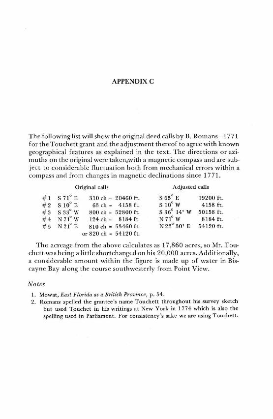
APPENDIX C
The following list will show the original deed calls by B. Romans-1771for the Touchett grant and the adjustment thereof to agree with knowngeographical features as explained in the text. The directions or azi-muths on the original were takenwith a magnetic compass and are sub-ject to considerable fluctuation both from mechanical errors within acompass and from changes in magnetic declinations since 1771.
Original calls Adjusted calls
#1 S710 E 310 ch = 20460 ft. S650 E 19200 ft.
#2 S 100 E 63 ch = 4158 ft. S 100 W 4158 ft.
#3 S 33 0 W 800 ch = 52800 ft. S 360 14' W 50158 ft.
#4 N710 W 124ch = 8184 ft N71 W 8184 ft.#5 N210 E 810 ch = 53460 ft. N 220 30' E 54120 ft.
or 820 ch = 54120 ft.
The acreage from the above calculates as 17,860 acres, so Mr. Tou-chett was being a little shortchanged on his 20,000 acres. Additionally,a considerable amount within the figure is made up of water in Bis-cayne Bay along the course southwesterly from Point View.
Notes
1. Mowat, East Florida as a British Province, p. 54.
2. Romans spelled the grantee's name Touchett throughout his survey sketch
but used Touchet in his writings at New York in 1774 which is also the
spelling used in Parliament. For consistency's sake we are using Touchett.

88 Tequesta
3. Ibid., p. 67.4. Namier, The History of Parliament, Vol. III, p. 533. I had tried unsuccess-
fully for quite a long time to discover the needed information on SamuelTouchet to round out the history of his land grant in Florida. I herebywish to express my appreciation to Dr. Patrick Lipscomb, Assistant Profes-sor of History at Louisiana State University for providing the required data.
5. British archives 20 George III c. 75.
6. Siebert, W. H., Loyalists in East Florida. Vol. II, p. 51.
7. Ibid, Vol. II, p. 52.8. Ibid, Vol. II, p. 53.
Bibliography:
DeVorsey, Louis, Jr., De Brahm's Report of the General Survey of the Southern
District of North America. The University of South Carolina Press. 1971.
Mowat, Charles Loch, East Florida as a British Province, 1763-1784. A facsimile
reprint series. Gainesville, Florida. University of Florida Press, 1964.
Namier, Sir Lewis and Brooke, John, The History of Parliament - The House of
Commons 1754-1790, Vol. III. Published for the History of Parliament
Trust by the Oxford University Press, New York, 1964.Phillips, P. Lee, Notes on the life and works of B. Romans. Florida State Histori-
cal Society, #2, 1924.Romans, Bernard, A Concise Natural History of East and West Florida. New
York 1775. Facsimile, Floridiana reprint series, University of Florida
Press, 1962.Siebert, Wilbur Henry, Loyalists in East Florida, 1774-1785, 2 Vols. Florida
State Historical Society, 1929.