Sammamish-Juanita 115 kV Project Route Siting Project November 2012
42
{ Sammamish-Juanita 115 kV Project Route Siting Project November 2012 Gene Lohrmeyer GeoEngineers
description
Sammamish-Juanita 115 kV Project Route Siting Project November 2012. Gene Lohrmeyer GeoEngineers. GeoRoute Selection Model. GeoRoute Selection Model. GeoRoute Selection Model. Help determine preferred route between substations – need alternatives - PowerPoint PPT Presentation
Transcript of Sammamish-Juanita 115 kV Project Route Siting Project November 2012

{Sammamish-Juanita 115 kV ProjectRoute Siting Project
November 2012
Gene LohrmeyerGeoEngineers
GeoRoute Selection Model

GeoRoute Selection Model

GeoRoute Selection Model
Help determine preferred route between substations – need alternatives
Demonstrate and defend route selection process in public meetings
PSE Needs

GeoRoute Selection Model
Multiple competing values Engineering Community Environment
Other non-GIS efforts by PSE resulted in no consensus
Professional Judgement Criterium
Issues

GeoRoute Selection Model
How would you help PSE with this problem?

GeoRoute Selection Model
Develop a geoprocessing model
Combine datasets using weighted overlay tool
Least cost path analysis using distance tools
Accumulated Cost
GeoEngineers Solution

GeoRoute Selection Model
Allows you to automate GIS tasks and perform spatial analysis and modeling
Everything in the toolbox can be used in a geoprocessing model
What is Geoprocessing?

GeoRoute Selection Model
Geoprocessing Example 20 datasets from various sources Reproject and clip each dataset to a project
boundary
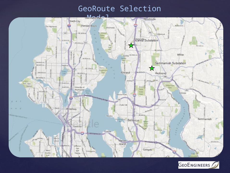
GeoRoute Selection ModelWeighted Overlay Tool
Allows you to combine rasters of varying importance Why rasters? Scale (in = 10, out = 0)

GeoRoute Selection Model
GeoRoute Tasks
Collect existing jurisdictional GIS Data Kirkland, Redmond, Dept of F&W
Clip to project boundary and convert to raster Assign data to either Built, Natural Environment, Engineering or
Opportunity groups More flexibility for analyzing alternatives
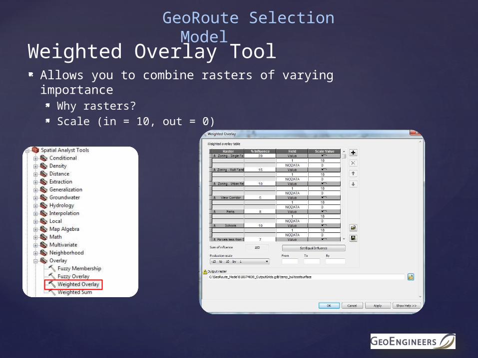
Weighted Overlay Tool Weight and combine datasets in each group Weight and combine Built, Nat Env and Eng groups (Avoidance Areas) Weight and combine Avoidance Areas with Opportunities
Distance Tools Least Cost Path Analysis

GeoRoute Selection ModelConceptual
Model Overview

GeoRoute Selection Model

GeoRoute Selection Model
Built Environment

Built Environment Data Layers
Data Reviewed,Within Study Area
Data Reviewed, Not Within Study Area
Single Family Residential Zoning
Cultural/Historic Resources
Multi Family Residential Zoning
Areas of property disputes
Urban Recreation Zoning Open space taxation parcels
Parcel Size < 5 acres Airports
Local Parks Scenic Highways
Native Growth Protection Areas
Surface Mining
View Corridors (Redmond) Parcels Fronting Local Access Streets
GeoRoute Selection Model

GeoRoute Selection Model
Single Family Residential Zoning

GeoRoute Selection Model
Schools and Parks

NaturalEnvironment
GeoRoute Selection Model

Natural Environment Data LayersData Reviewed,Within Study Area
Data Reviewed,Not within Study Area
Wetlands Shoreline Jurisdiction
WA Natural Heritage Program areas
Landslide Hazards Lakes
Seismic Hazards 100 year floodplain
Erosion Hazards Contiguous Tree Canopy
Streams
Steep Slopes >40%
Sensitive Species (WDFW)
GeoRoute Selection Model

Wetlands
GeoRoute Selection Model
Wetlands

GeoRoute Selection Model
Landslides

Engineering
GeoRoute Selection Model

Engineering Data Layers
Data Reviewed,Within Study Area
Data Reviewed,Not Within Study Area
Curved Streets BPA CrossingStructures within 15’ of R/WParcels not adjacent to Public R/WInterstate Highway CrossingSteep Slopes >40%Future WSDOT Improvement Areas
GeoRoute Selection Model

GeoRoute Selection Model
Street Curves

GeoRoute Selection Model
Steep Slopes >40%

Built Environment Data Layers Weights
Data Reviewed,Within Study Area
Weight (%)
Single Family Residential Zoning
20
Multi Family Residential Zoning
15
Urban Recreation Zoning
10
Parcel Size < 5 acres 7Local Parks 8Native Growth Protection Areas
15
View Corridors (Redmond)
5
Schools 10Native Growth Protection Easement
15
WSDOT Improvements 10
GeoRoute Selection Model

GeoRoute Selection Model
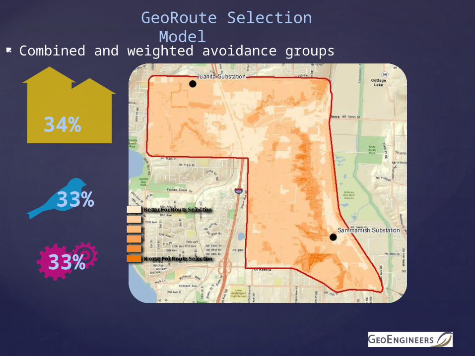
34%
33%
33%Better For Route Selection
Worse For Route Selection
GeoRoute Selection Model
Combined and weighted avoidance groups

Built Environment Criteria
100%
0%
0%Better For Route Selection
Worse For Route Selection
GeoRoute Selection Model

Model Overview
GeoRoute Selection Model

GeoRoute Selection Model

Opportunities Data Layers
Data Reviewed,Used for Modeling
Data Reviewed,Not Used for Modeling
Commercial/Industrial Zoning Open Vegetative Cover
Arterial Street Community Plan Compatibility
Trails R/W
Railroad R/W
Parcel size > 20 acres
Existing PSE Rights-of-Way
Existing Overhead Distribution
GeoRoute Selection Model

GeoRoute Selection Model
Arterial Streets

GeoRoute Selection Model
Industrial/Commercial Zoning

Model Overview
GeoRoute Selection Model

% %
GeoRoute Selection Model

GeoRoute Selection Model
Least Cost Path Model

GeoRoute Selection Model
Full Model

GeoRoute Selection Model
Alternatives can be created by adjusting weights of avoidance rasters Built = 50%, Nat Env = 30%, Engineering = 20% Built = 20%, Nat Env = 70%, Engineering = 10%
Or by adjusting combined avoidance and opportunities Avoidance = 50%, Opportunities = 50% Avoidance = 80%, Opportunities = 20%
Route Examples
Alternate Routes

GeoRoute Selection Model
Model works but has lots of moving parts and can be confusing to an audience
Need to simplify interface
Solution Export model to Python Develop ArcMap extension using C# Extension hooks in to Python
Public Involvement

GeoRoute Selection Model
Model allows PSE to easily compare alternate routes Model is transparent and reproducible Data is from authoritative sources and defensible Solution allows for public input and allows public to see
the results immediately
Conclusion