Salmon Holes & Halibut Hills, a Sport Fishing Atlas …...S. Clarence Strait, Cordova Sound 2 B...
27
SALMON HOLES1\HALIBUT HILLS A SPORT FISHING ATLAS oF j . SOUTHEAST ALASKA
Transcript of Salmon Holes & Halibut Hills, a Sport Fishing Atlas …...S. Clarence Strait, Cordova Sound 2 B...
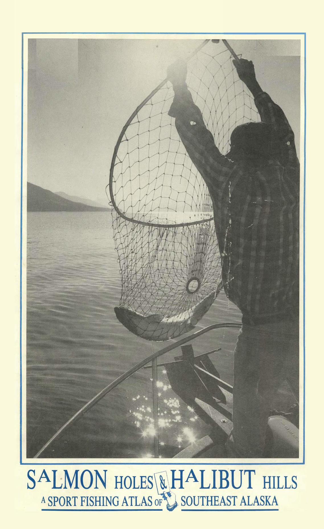
SALMON HOLES1\HALIBUT HILLS A SPORT FISHING ATLAS oF j . SOUTHEAST ALASKA
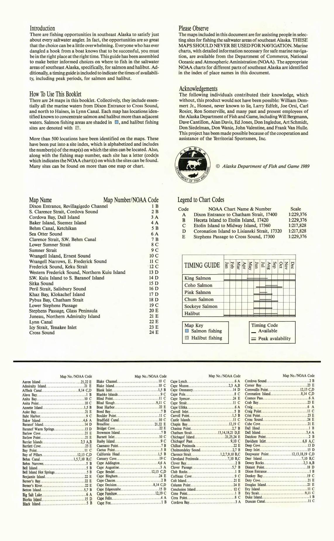
Introduction There are fishing opportunities in southeast Alaska to satisfy just about every saltwater angler. In fact, the opportunities are so great that the choice can be a little overwhelming. Everyone who has ever dangled a hook from a boat knows that to be successful, you must be in the right place at the right time. This guide has been assembled to make better informed choices on where to fish in the saltwater areas of southeast Alaska, specifically, for salmon and halibut. Additionally, a timing guide is included to indicate the times ofavailability, including peak periods, for salmon and halibut.
How To Use This Booklet There are 24 maps in this booklet. Collectively, they include essentially all the marine waters from Dixon Entrance to Cross Sound, and north to Haines, in Lynn Canal. Each map has locations identified known to concentrate salmon and halibut more than adjacent waters. Salmon fishing areas are shaded in D , and halibut fishing sites are denoted with El.
More than 500 locations have been identified on the maps. These have been put into a site index, which is alphabetized and includes the number(s) of the map(s) on which the sites can be located. Also, along with the fishing map number, each site has a letter (code)s which indicates the NOAA chart(s) on which the sites can be found. Many sites can be found on more than one map or chart.
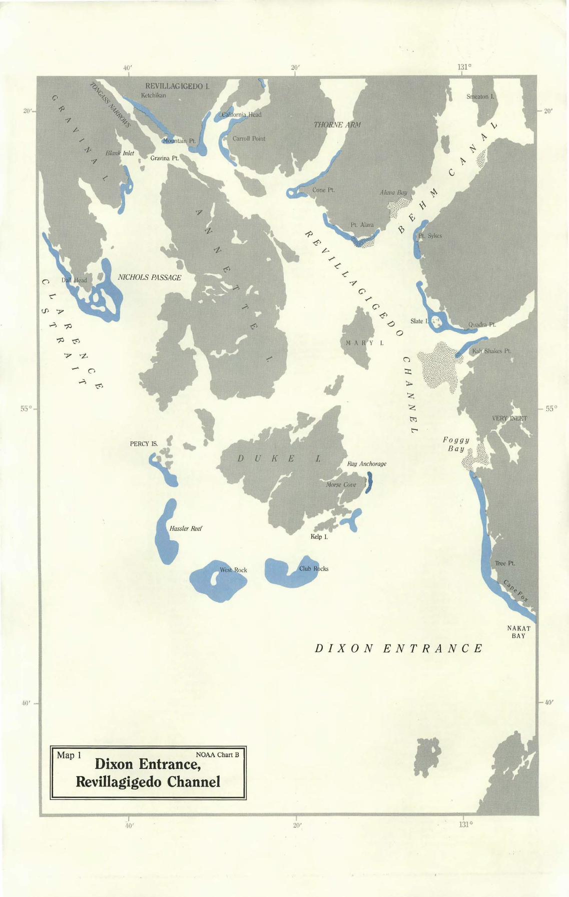
Map Name Map Number/NOAA Code Dixon Entrance, Revillagigedo Channel 1 B S. Clarence Strait, Cordova Sound 2 B Cordova Bay, Dall Island 3 A Baker Island, Suemez Island 4 A Behm Canal, Ketchikan 5 B Sea Otter Sound 6 A Clarence Strait, SW. Behm Canal 7 B Lower Sumner Strait 8 C Sumner Strait 9 C Wrangell Island, Ernest Sound 10 C Wrangell Narrows, E. Frederick Sound 11 C Frederick Sound, Keku Strait · 12 C Western Frederick Sound, Northern Kuiu Island 13 D SW. Kuiu Island to S. Baranof Island 14 D Sitka Sound 15 D Peril Strait, Salisbury Sound 16 D Khaz Bay, Klokachef Island 17 D Pybus Bay, Chatham Strait 18 D Lower Stephens Passage 19 C Stephens Passage, Glass Peninsula 20 E Juneau, Northern Admiralty Island 21 E Lynn Canal 22 E Icy Strait, Tenakee Inlet 23 E Cross Sound 24 E
Please Observe The maps included in this document are for assisting people in selecting sites for fishing the saltwater areas of southeast Alaska. THESE MAPS SHOULD NEVER BE USED FOR NAVIGATION. Marine charts, with detailed information necessary for safe marine navigation, are available from the Department of Commerce, National . Oceanic and Atmospheric Aministration (NOAA). The appropriate NOAA charts for different parts of southeast Alaska are identified in the index of place names in this document.
Acknowledgements The following individuals contributed their knowledge, which without, this product would not have been possible: William Demmert Jr., Honest, never known to lie, Larry Edfelt, Joe Orsi, Carl Rosier, Ron Somerville, and many past and present employees of the Alaska Department ofFish and Game, including Will Bergmann, Dave Cantillon, Alan Davis, Ed Jones, Don lngledue, Art Schmidt, Don Siedelman, Don Wanie, John Valentine, and Frank Van Hulle. This project has been made possible because of the cooperation and assistance of the Territorial Sportsmen, Inc.
© Alaska Department ofFish and Game 1989
Legend to Chart Codes Code NOAA Chart Name & Number Scale
A Dixon Entrance to Chatham Strait, 17400 1:229,376 B Heceta Island to Etolin Island, 17420 1:229,376 c Etolin Island to Midway Island, 17360 1:217,828 D Coronation Island to Lisianski Strait, 17320 1:217,828 E Stephens Passage to Cross Sound, 17300 1:229,376
TIMING GUIDE ~ "rj ~Ill g.::s Ill '"1
King Salmon
Coho Salmon
Pink Salmon
Chum Salmon
Sockeye Salmon
Halibut
Map Key
.G'"1
~ ~ ~ ~ en s:= s:= .g
~ ::s - (IQ
-
Timing Code
0 z 0 ~ 0 (D
< n
_AvailableD Salmon fishing
D Halibut fishing = Peak avalability
Map No./NOAA Code Aaron Island ... . . ... . . . . . . ..... .. .. .. .21,22 E Admiralty Island.... .............. .... .. .21 E Affleck Canal........................ 8,14 C,D Aiava Bay.... . ........ ......... ...... .. .. 1 B Anita Bay...... .. ...................... .10 C Anita Point. ... . ............ . .. . .... ... .. I 0 C Annette Island. .. . .. ... . . . .. . . ........... 1,5 B Auke Bay... . ..... . .. . ..... . ... . . . . . ... . . 21 E Baht Harbor ..............................9 C Baker Island .. . . . ............... ....... .4,6 A Baranof Island........................... 14 D Baranof Warm Springs .................... 13 D Barlow Cove.. .. ....... .. ... .... .. . .. . ...21 E Barlow Point. .. . . . . . .. .. ..... . . ...... ... .21 E Barrier Islands..... . .................. .2,3 A,B Bartlett Cove .............................23 E Bay Point. .............................. 11 C Bay of Pillars .... .... ... ............ 12,13 C,D Behm Canal .. .. . .... . .. .......... 1,5,7,10 B,C Behm Narrows . ... .. .. . .... ... ... . . .. .. .. .5 B Bell Island............... .. ........ .. .....5 B Bell Island Hot Springs .....................5 B Benjamin Island................ .. ....... .22 E Berner's Bay...... . ... . ..... ... ......... .22 E Berner's River. ........................ .. .22 E Betton Island....... ... ..... . . . ..... .... .5,7 B Big Salt Lake . ......... .. ...... . ..........6 A Biorka Island... .. . .... . ..... .. .... . ... .. 15 D Black Island.. . ~ . . . .. . . . ..... . . . .. . . . ... . .s B
Map No./NOAA Code Blake Channel .............. ..... . ....... 10 C Blake Island..................... ........ 10 C Blank Inlet. ..................... .. ...... 1,5 B Blashke Islands .. . .........................9 C Blind Point . ... . ................. .. .... . . 11 C Blind Slough ........... .. ..............9,11 C Boat Harbor......... . . . .............. .. . 22 E Bond Bay . . . .. . . . . . ..... ... . ....... . ......7 B Boulder Point. ...... .. ................... 11 C Bradfield Canal. . ............... . .. . ... . . 10 C Breadline . .... . ..... . . . ... ...... . . . ... 21,22 E Bridget Cove..... . ................. .. .... 22 E Brownson Island... .. ... . ..................7 B Burnett Inlet. ..... ...... ............. .. .. 10 C Busby Island ....... .... ...................9 C Caamano Point. ....... . ..... ..... .........7 B Cactus Point. ..... . . .............. . .. . ....5 B California Head.......... .. ............. 1,5 B Cannery Cove........ . . . . . . . ..... . .. . .... 19 C Cape Addington..... .. .. .. .. .... .. .. . .. . 4,6 A Cape Augustine ...... .... .. .. ........... ..3 A Cape Bendel.. ...................... 12,13 C,D Cape Bingham............... , ...........24 E Cape Chacon .. . . ... . . ... .. ..... . ... .... ...2 B Cape Decision .. ......................8,14 C,D Cape Edgecumbe...... . . .. ......... ...... 15 D Cape Fanshaw....... . ... .... ......... . 12,19 C Cape Felix. . . ...... . . . . . . ... ............ . .4 A Cape Fox .. . . .. . . ............ ..... . .. .. .. . 1 B
Map No./NOAA Code Cape Lynch .. .... . . . .... .... .... .... .. ... . 6 A Cape Muzon ... .. . ... . .. ... ... ........2,3 A,B Cape Ommaney. . ... ..... ............ . ... 14 D Cape Pole... .. . .... . ......... . ....... . . .. 8 C Cape Spencer .. .. .. . ..... . . .. .... ... . .. ..24 E Cape Strait. . . ........... . . . ...... .... ... 11 C Cape Ulitka .... ..... . . .•. . . . ...... .. . . . . . . 6 A Carroll Inlet..... ....................... ..5 B Carroll Point .............. ... . .......... 1,5 B Castle Islands . ........ ... ..... .. ......... 11 C Chapin Bay.. . . .... . ... . .......... . . . .12,19 C Chasina Point.. .. .. ..... . ...............2,7 B Chatham Strait. . . .. . . . . .. ... . .. 13,14,18,21 D,E Chichagof Island.. ... . . . . . .. . ... . .. .21 ,23,24 E Chichagof Pass ..... .. .... .. .. .. ........9,10 C Chilkat Peninsula ........... . . . ...........22 E
· Cholmondeley Sound... . .................2,7 B Clarence Strait. .......... . .... . . . 1,2,7,9,10 B,C Cleveland Peninsula.... . .. . ........ .. . 7,10 B,C Clover Bay . .. .... . . . . . . .. . .. . .... . . . ... . . . 2 B Clover Passage............ .. .. .......... 5,7 B Club Rocks ... ............. . .............. 1 B Coffman Cove. ......... . . . .. . . ... . .......9 C Colt Island . ...... . ... .. ... . . . . . ..........21 E Column Point............ .. ............ ..24 E Conclusion Island.. .. .. . .. .. . . . . .. . .. .. .. 12 C Cone Point. ........ . . .. ....... . .... .. .... 1 B Cora Point. . ... ..... . . . . .... . .. . . . . . ... . . 8 C Cordova Bay.............. .... ............ 3 A
Map No./NOAA Code Cordova Sound......... ..... .. . ........... 2 B Corner Bay . . ............. .. . . . . . ....... .23 E Cornwallis Point ................. .... 12,13 C,D Coronation Island...... . .. . ..........8,14 C,D Cosmos Pass... . . ... . . . . ... .. .... . .. . .....6 A Crab Bay................ ....... ........ .23 E Craig......... .. .... . .. . . .. ..... .... . ... .6 A Craig Point ... ....... . ... .. . . . . .......... 11 C Crist Point. ...... . ... . .... . . . ........... .23 E Cross Sound............... . ....... . . . ...24 E Cube Cove... ... .. .. ...... . . . ............21 E Dall Head.... .... ........ .... ......... . .. 1 B Dall Island .... . . ....... . .. . . . .. .. . . . .... 3,4 A Datzkoo Point ............ ... .. ... . .......2 B Davidson Inlet .. ... . ... ..... ..........6,8 A,C Deep Cove.... , ........... . . . ...... . ..... 13 D Deep Inlet. ............... . . ... ...... . ... 15 D Deepwater Point. .... . . . ...... .12,13,18,19 C,D Deer Island .. . . .. ....................7,10 B,C Dewey Rocks . . . . . . . . . . . . .... . . . . . ..... 2,3 A,B Distant Point.. ............... . .......... 18 D Dixon Entrance. . .. ... ..... . ... . ...... .. ... 1 B Donkey Bay.................... .. ....... 19 C Doty Cove .. . . ................... ... ... . . 21 E Douglas Island . . ... . .. . .... . . ....... . . ...21 E Dry Island ..... ... . ......... .. ........... 11 C Dry Strait. .. .... . .... . .................9,11 C Duke Island . . .. . ...... . .. . . ... ...... .. . ... 1 B Duncan Canal... . ........................ 11 C
Map No./NOAA Code Dundas Bay .............................. 24 E East Point .......................... 16,21 D,E Eastern Passage .......................... 10 C Eaton Point. ...................... . ...... JO C Echo Cove....................... . ....... 22 E Edna Bay ...................... . ...... 6,8 A,C El Capitan Passage ...... . ....... .. ........ 6 A Eldred Rock ............................. 22 E Elena Bay ......... .. ..... .. ......... .. .. 12 C Elfin Cove ............................... 24 E Eliza Harbor ......... .. ........ 12,13,18,19 C,D Emerald Bay ......................... 7,10 B,C Endicott River.. .. . .. . . .................. 22 E
Ernest Sound ......... .. ....... .. ..... 7, 10 B,C Etolin Island .......... ... ........... 7,9,10 B,C Excursion Inlet. ....................... 22,23 E False Point Arden ........................ 21 E Farragut Bay ............................. I I C Fish Bay ............. ... ................ 16 D Fish Egg Island ........................... 6 A Flaw Point ................... .. .......... 19 C Foggy Bay ....... .. .... .. ........ .. ....... I B Fools Inlet. ........ . ..................... 10 C Frederick Point ........................... 11 C Frederick Sound ............. 11,12,13,18,19 C,D Freshwater Bay ................... 16,21,23 D,E Fritz Cove ................... ... ......... 21 E Funter Bay ................ .. ............. 21 E Gambier Bay ........................ 18,19 C,D Gambier Island ...... . .................... 19 C Gap Point. .............................. 14 D Gastineau Channel. .......... .. ........... 21 E Gedney Harbor. ......................... 14 D Gedney Island ............................. 5 B Gedney Pass ............................. I 0 C George Inlet. ....... .. .................... 5 B George Islands ........................... 24 E Gil Harbor .......................... . ... 12 C Gilmer Bay ....... .. . .................... 17 D Glacier Bay ........................... 23,24 E Glass Peninsula ...................... 19,20 C,E Goat Island ............. . ................. 3 A Goddard Hot Springs ... .. ................ 15 D Grand Island .......................... 20,21 E Grant Cove ......... .. .......... .. ........ 7 B Grant Island ........ .. ............ . ....... 5 B Graves Harbor ........................... 24 E Gravina Island ............. .. ............ 1,5 B Gravina Point. ... .. ..................... 1,5 B Greys Island ........ . ........ . . ......... 9, 11 C Grindall Island ...... . . ......... . . . ........ 7 B Gustavus ................. . .............. 23 E Halibut Nose ...................... .. ..... 3 A Hamilton Bay.................. . ......... 12 C Hamilton Island ........................... 8 C Hanus Reef ........... .. .................. 21 E Harbor Island ......... .. ......... .. ...... 19 C Hassler Island ............................. 5 B Hassler Reef .............................. I B Hawk Inlet .............................. 21 E Heceta Island .... .. ................... 6,8 A,C Helm Bay ................................. 7 B Helm Point. ... .. .. ................... 7,8 B,C Hetta Inlet. .... . ..................... 2,3, A,B Hobart Bay .................... . ......... 19 C Holkham Bay........... .. .......... 19,20 C,E Homeshore .............................. 23 E Hoonah ............. . ................... 23 E Hoonah Island ............... .. .......... 23 E Hoonah Sound ...... . .. .......... . ....... 16 D Horse Island ............................. 21 E Icy Point ................................ 21 E Icy Strait .................... .. .......... 23 E Idaho Inlet. .............................. 24 E Ignace Island ................ .. ........... 6 A Inian !~ands .......... . . . ................ 24 E Inner Point. ............................. 21 E Island Point. ........ .. ........ .. .. ........ 7 B Jaw Point ...... .. ..................... 20,21 E Juneau .................. . ............... 21 E Kadake Bay.............. . ............... 12 C Kadin Island ......................... 9,10,11 C Kah Shakes Point .......................... I B Kah Sheets Bay ................ .. ....... 9,11 C Kaigani Strait ......................... 2,3 A,B Kake ............ .. ................. 12,13 C,D Karta Bay................................ 7 B Kasaan Bay ............................... 7 B Kasaan Peninsula .......... . ............... 7 B Kasaan Point .............................. 7 B Kashevarof Passage ........................ 9 C Katlian Bay ........................... 15,16 D Keku Islands ............................. 12 C Keku Strait. ............................ 8,12 C Kelp Bay ........ .. ........ .. ......... 16,18 D Kelp Island ........ .. ..................... I,B Kendrick Bay............................. 2 B Ketchikan .................... .. ......... 1,5 B Khaz Head ............. .. .. .. .. ......... 17 D Khaz Peninsula ...................... . .... 17 D Kilisnoo Island ......... .. .. .. ............ 18 D Kingsmill Point ........ .. .. .. .... .. ...... 13 D
Map No./NOAA Code
Klakas Inlet. .............................. 2 B Klawock .................................. 6 A Klawock Inlet ............................. 6 A Klokachef Island ......................... 17 D Kootznahoo Head ........................ 18 D Kosciusko Island ...................... 6,8 A,C Krestof Island ............................ 15 D Krestof Sound ........ .. ................. 16 D Kruzof Island ......... .. ................. 15 D Kuiu Island ..................... 8,12,13,14 C,D Kupreanof Island ...... .. ............. 8,11,12 C Lake McDonald ...................... 5,10 B,C LeConte Bay .......... . .. ........ . ....... 11 C Lemesurier Island ............ . ...... . ..... 24 E Lemesurier Point .......................... 7 B Lena Point ............................... 21 E Lesnoi Island ............................ 10 C Liesnoi Island ............... ... ....... 12,19 C Lime Point ............................ 2,3 A,B Limestone Inlet .... .. ..................... 20 E Lincoln Island ......................... 21,22 E Lisianski Inlet ........ .. ....... ... ........ 24 E Lisianski Strait ...................... 17,24 D,E Long Bay ....................... . ........ 23 E Long Island ...... . ......... .... ....... 2,3 A,B Low Point. ............................ 9,11 C Lulu Island ..... . .......... . ......... . .. 4,6 A Lynn Canal ............. .. ....... .. ...... 22 E Lynn Sisters ............... .. ....... .. .... 23 E Macnamara Point. ........... . ............ 9 C Mansfield Peninsula ....... . ............... 21 E Marble Island ............... .. ........ 6,8 A,C Marmion Island ..... .. ..... .. . .. ......... 21 E Mary Island ............................... I B Maurelle Islands ...................... . .... 6 A McArthur Reef. ........ .. ........ . ........ 9 C McClean Arm ............................. 2 B McDonald Lake ........................... 7 B McHenry Inlet ........................ 7, 10 B,C McKenzie Inlet. ..... . ................... 2,7 B Meade Point. ...... .. .................... 12 C Meter Bight ............................... 9 C Middle Point ................ ... .......... 21 E Midway Island ............ .. ......... 19,20 C,E Midway Point. .......... . ................ 19 C Mitchell Point .......................... 9,11 C Mitkof Island ............. . ............ 9,11 C Moira Rock ............................... 2 B Moira Sound ................... .. ......... 2 B Mole Harbor ......... . .......... .. ....... 19 C Morse Cove .................. . ............ I B Mountain Point. ......................... 1,5 B Mud Bay ......... . . . .................... 23 E Naha Bay ...... . .. .. ...................... 5 B Nakat Bay ................................ I B Narrow Point ............. . . .............. 7 B Nation Point .................... .. ........ 8 C Neck Point. ......... .. ......... .. ....... 23 E Neets Bay................................. 5 B Niblack Point ...................... . ...... 7 B Nichols Passage .......................... 1,5 B No Name Bay............................ 12 C North Inian Pass ......................... 24 E
North Pass .............. .. ........... 3,21 A,E North Passage ............................ 24 E North Passage Point. ......... . ...... 16,21 D,E Noyes Island .................. .. ........ 4,6 A Nutkwa Inlet. ... . ..................... 2,3 A,B Oliver Inlet. ....... .. .................... 21 E Onslow Island .......... .. ............ 7,10 B,C Orr Island ........ .. ...................... 6 A Outer Point. ............................. 21 E Patterson Island ........................... 7 B Patterson Point ......... . ......... . ...... 13 D Pavlof Harbor ........... .... ............ 21 E Pelican ........... . .. . ................... 24 E Percy Island ............. .. ............... I B Peril Strait ........ . ................... 16,18 D Petersburg ....... . ....................... 11 C Pine Point ................................ 9 C Pinta Point ..................... .. .... 12,19 C Pinta Rocks ..... .. ....................... 12 C Pleasant Bay ............................. 19 C Pleasant Island ................. . ..... . ... 23 E Point Agassiz ....... . .................... 11 C Point Aiava ............................... I B Point Adolphus ........................ . . 23 E Point Alexander. ....... .. .............. 9,11 C Point Arden ............................. 21 E Point Astley ........ .. ................... 19 C Point Augusta .... .. ...................... 21 E Point Baker. ........... .. ................. 8 C Point Barrie ................ .. ............ 8 C Point Bishop ............ .... .......... 20,21 E Point Bridget ............................. 22 E Point Camden...... . ......... . ........... 12 C Point Carolus ............................ 24 E Point Colpoys ............................. 9 C Point Couverden .... . ........ . ........... 23 E
Map No./NOAA Code Point Glass ......................... 19,20 C,E Point Hamilton .......................... 12 C Point Harrington ......... . ................ 9 C Point Hepburn ........................... 21 E Point Higgins ............................. 5 B Point Highfield ........................... 10 C Point Hilda .............................. 21 E Point Hobart ............................ 19 C Point Howard ...................... 8,21,23 C,E Point Howe ............................ 9,11 C Point Hugh .............................. 19 C Point Kruzof ............ . ............. 16,17 D Point Louisa ....... .. .......... ... ....... 21 E Point Macartney ..................... 12,13 C,D Point Marsden ........... .. .............. 21 E Point Marsh .............................. 2 B Point Napean ....... .. ................ 12,19 C Point Nesbitt .............................. 9 C Point Peters ......... . .. ................... 7 B Point Pybus ......................... 18,19 C,D Point Retreat ............................. 21 E Point Salisbury ........................... 21 E Point Sherman ........................... 22 E Point Sophia ............................. 23 E Point St. Albans .... .. ........ .. ...... 8,14 C,D Point St. Mary .......... .. ............... 22 E Point Sta. Gertrudis ....................... 6 A Point Sykes ............... . ......... . ..... I B Point Vandeput. .... .. ...... .. ....... .. .. 11 C
Point Warde ............... . ............. 10 C Point Whidbey ..................... . ..... 22 E Point Young ...................... .. ..... 21 E Polk Inlet. ................ . ............. 2,7 B Porpoise Islands ... .. ....... .. ....... . .... 23 E Port Alice ......... .. ......... . ........... 8 C Port Althorp ............................. 24 E Port Bazan ............................... 3 A Port Beauclerc ............................ 8 C Port Camden ............................ 12 C Port Frederick ..... .. .............. .. ..... 23 E Port Houghton ........... .. .............. 19 C Port Malmesbury ......................... 14 D Port Protection ...... . ....... .. ............ 8 C Port Snettisham .............. .. .......... 20 E Port St. Nicholas ........ .. . .. ............ 3 A Port Stewart. ............................. 7 B Portage Bay ..... .. ...... .. .............. 11 C Portland Island ........................... 21 E Prince of Wales Island ...... 2,3,4,6,7,8,9 A,B,C Prolewy Point. . . . . . . . . . . . . . . . . . . . . . . . . . 11 C Pybus Bay .................... .. .... 18,19 C,D Quadra Point ............................. I B Ratz Harbor. ................. .. .. .... 7,9 B,C Ray Anchorage .......... . .. .. ............. I B Red Bay ....................... . .......... 9 C Reef Point ................................ 9 C Revillagigedo Channel ...................... I B Revillagigedo Island ..... . . . . ......... . ... 1,5 B Round Point .................. . ........... 9 C Rowan Bay ......................... 12,13 C,D Rush Point. ... .. ...... .. ................ 24 E Rynda Island ........................... 9,11 C Saginaw Bay ....... .. ... .. . ......... 12,13 C,D Salisbury Sound ....................... 16,17 D Saltery Bay ............ . ...... . . . ........ 23 E Saltery Cove .............................. 7 B San Christobal Channel ........ . ........... 6 A San Fernando Island ....................... 6 A San Juan Bautista Island ................. 4,6 A San Juan Island .......................... 19 C Santa Anna Inlet. ............... .. ........ 7 B Sarkar Cove ........................ .. .... 6 A Scull Island ...................... .. ...... 21 E Sea Otter Sound ....................... 6,8 A,C Seal Bay ................................. 23 E Security Bay ............... ... ........... 12 C Security Point ............................. 3 A Seduction Point .......................... 22 E Seymour Canal. ....... .. ......... 19,20,21 C,E Shakan Bay ............................... 6 A Shakan Strait ............................. 8 C Shelter Island ............. .. ........... 21,22 E Shinaku Inlet ........... . ................. 6 A Ship Island ............................... 7 B Shipley Bay ............... .. .......... 6,8 A,C Shipwreck Point ....................... 2,3 A,B Shrubby Island ...... . ..................... 9 C Silver Bay .................... . .......... 15 D Sitka..................... . .............. 15 D Sitka Sound ........................... 15,16 D Sitkoh Bay ............................ 16,18 D Skin Island ................ . ............. 2,7 B Skow! Arm ........... . ................... 7 B Skow! Point .... .. ........ . ........ .. ...... 7 B Slate Island ...................... . ........ I B Slocum Arm ..... .. .......... .. .......... 17 D Smeaton Island .............. .. .......... I, 5 B Snow Passage ............................. 9 C Snug Cove ....... . ......... . ............. 19 C Sokolof Island .......................... 9, 11 C South Arm ........ .. .............. .. ...... 2 B
Map No./NOAA Coil'e South Inian Pass ......................... 24 E South Island ............................. 20 E South Pass ........... . . ......... . . ....... 3 A South Passage ................. .... ....... 24 E South Passage Point. ................ 16,21 D,E Spacious Bay ................ .. ..... 5,7,10 B,C Spanish Islands ........................... 8 C Spee! River ....... . ............ . ......... 20 E St. James Bay ............................ 22 E St. Lazaria Islands .............. .. .. ...... 15 D St. Nicholas Channel. ............. .. ....... 6 A Steamer Point. ............................ 9 C Stephens Passage ........... . ...... 19,20,21 C,E Stikine Strait ......... . .................... 9 C Suemez Island ..................... .. ..... .4 A Sukkwan Island .................. .. ....... 3 A Sukkwan Strait. ....................... 2,3 A,B Sukoi Islets ........ . ..................... 11 C Sullivan Island .... . ...................... 22 E Sumner Strait. ..... . .. ....... 6,8,9,11,14 A,C,D Sunset Island ..... .. . .. ................... 19 C Swan Island ........................ .. .... 21 E Table Bay .................. . ............ 14 D Taku Harbor ............................. 20 E Taku Inlet ...... .. .......... .. ........ 20,21 E Taku River. ............ . ................ 20 E Taylor Bay ............. . . . ............... 24 E Tebenkof Bay .................... 12,13,14 C,D Tee Harbor .............................. 21 E Tenakee Inlet. .............. .. .... 16,21,23 D,E Tenakee Springs .......................... 23 E The Brothers ................. . ........... 19 C The Eye Opener ........................... 9 C The Narrows ....... .. ........ . ........... 23 E The Sisters ............................... 23 E Thomas Bay ............................. II C Thorne Arm ............................. 1,5 B Thorne Bay ......................... . .. ... 7 B Thorne Island ............... ... ........... 9 C Three Hill Island .... .. .... .. ............. 24 E Threemile Arm ........................... 12 C Tiedeman Island .......................... 19 C Tlevak Strait ............... . .............. 2 B Tokeen ................. .. ................ 6 A Tokeen Bay .............. .. ........... 6,8 A,C Tolstoi Bay ...... .. ............ .. ......... 7 B Tolstoi Point ........ . ..................... 7 B Tongass Narrows ...... . ................ l,5,7 B Totem Bay .......... .. ........ .... ...... 8,9 C Tracy Arm ................. . ............. 20 E Traitors Cove ............. .. . ............. 5 B Trap Bay ................................ 21 E Tree Point ......... .. .......... .... ....... I B Trocadero Bay ............................ 3 A Turn Point ............................... 3 A Turnabout Island ........... .. ......... 12,19 C Tuxekan Island ............................ 6 A Tuxekan Passage .... . ...... . .............. 6 A Twelvemile Arm ........... .. ....... .. ... 2,7 B Twenty Fathom Bank ..................... 2,7 B Ulloa Channel. ........ .. ................ 3,4 A Union Bay ................................ 7 B Vallenar Bay ........................ .. .... 7 B Vallenar Point ....... .. ...... . .. ........... 7 B Vanderbilt Reef. .................. .. ..... 22 E Vank Island ............................ 9, 11 C Very Inlet ........................ .. ....... I B Vichnefski Rock ........................... 9 C Vixen Inlet ............ .. ....... .. .... 7,10 B,C Vixen Point .......... .... ... . ............ 10 C Wachusett Cove .......................... 21 E Warm Chuck Inlet. .......... .. ............ 6 A Warren Island .................... 6,8,14 A,C,D Watkins Point ..... .. ................. 7,10 B,C Wedge Islands ......... .. .................. 2 B West Arm ....................... . ........ 2 B West Point. ............................. 11 C West Rock ................................ I B Whale Bay ......... .. .......... .. ........ 15 D Whale Head .............................. 8 C Whale Head Island ................ .. ...... 6 A Whitestone Harbor ........... . ........... 23 E Whitewater Bay .......................... 18 D Whiting River ............ . .......... . .... 20 E
Whitney Island ................. .. ..... 12,19 C William Henry Bay ........ .. ...... .. ..... 22 E Windfall Harbor. ........... .. ........... 19 C Windham Bay ........ . . .......... . ....... 19 C Woewodski Island ............ .. .. ........ 11 C Wood Point. ............. .. ............. 11 C Wood Spit ............... .. .............. 19 C Woronkofski Island ..................... 9, 10 C Woronkofski Point .... .. .................. 9 C Wrangell ................................ 10 C Wrangell Island .......................... 10 C Wrangell Narrows .... .. ....... .. .. .. .... 9,11 C Yakobi Island .................. . ......... 24 E Yes Bay ............................ 5,7,10 B,C Young Bay ................. .. .. .. ........ 21 E Zarembo Island ............. . ... . . . ... .... 9 C Zimovia Strait. ..... .. .......... .. ........ I 0 C
.. -
40' 20' 131°
Map 1 Dixon Entrance,
NOAA C hart B
Revillagigedo Channel
!~0 ' 20' 131 °
REVILLAG !GEDO I. Ketchikan
20' 20'
~ El,~fJ~lb ;!::::.
J '< '< 55° tT1
t"""
PERCY IS. t ~
'free Pt.
NAKAT BAY
DIXON ENTRANCE
40' ~,
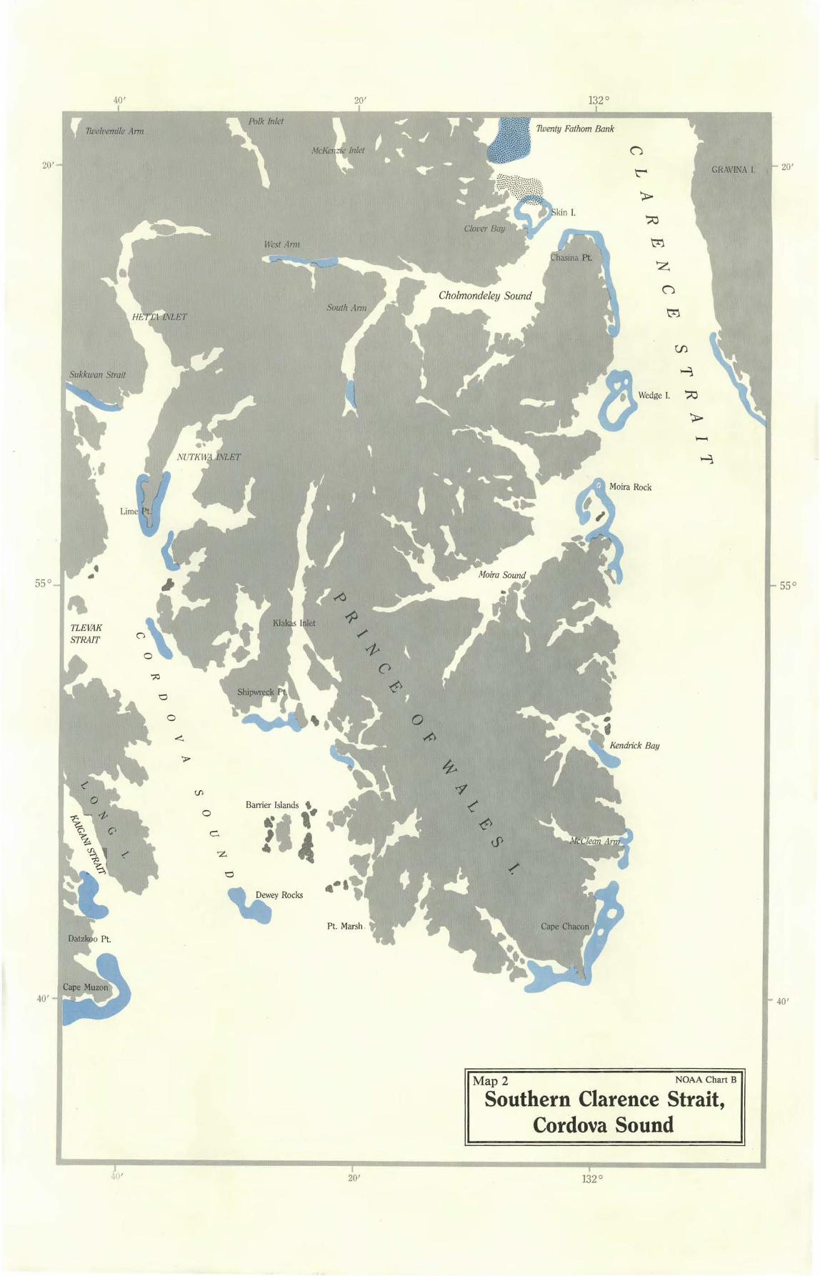
40' 20' 132°
20'
71.velvemile Ann
Sukkwan Strait
TLEVAK STRAIT
West Ami
:·:~H~;:;.:/:'f~: 71.venty Fathom Bank
Barrier Islands '
1«I ~ 0
Y::~;;;~~~~l~::~}1
;:j~~1Jl)]t1.f&!1f) (J
~
> ~
tr1
z (J
20'GRAVINA I.
tr1
55° 55°
40' 40'
Map 2 NOAA Chart B
Southern Clarence Strait, Cordova Sound
20' 132°
13'.~ 0 40' 20'
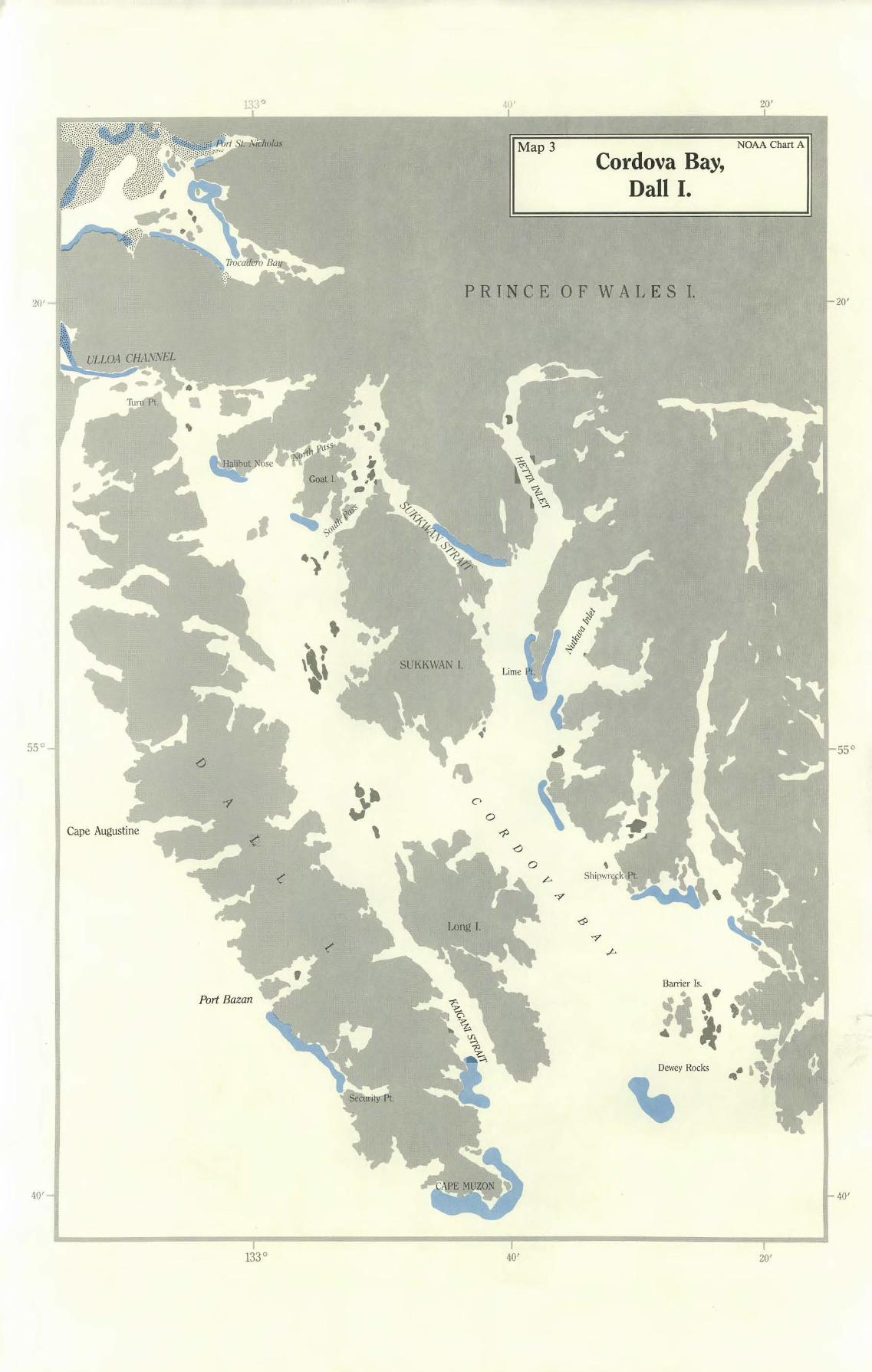
NOAA Chart A Map 3 Cordova Bay,
Dall I.
P R LN C E 0 F W A L E S I. 20'20'
Cape Augustine
Long I.
Barrier Is.
"«. ,. ' # J.. ,__• Dewey Rocks
133°
55° 55°
40' 40'
40' 20'
40' 20'
CAPE ADDI GT
20'20'
55°55°
LULU I.
PRINCE OF WALES I.
.. Forrester I.
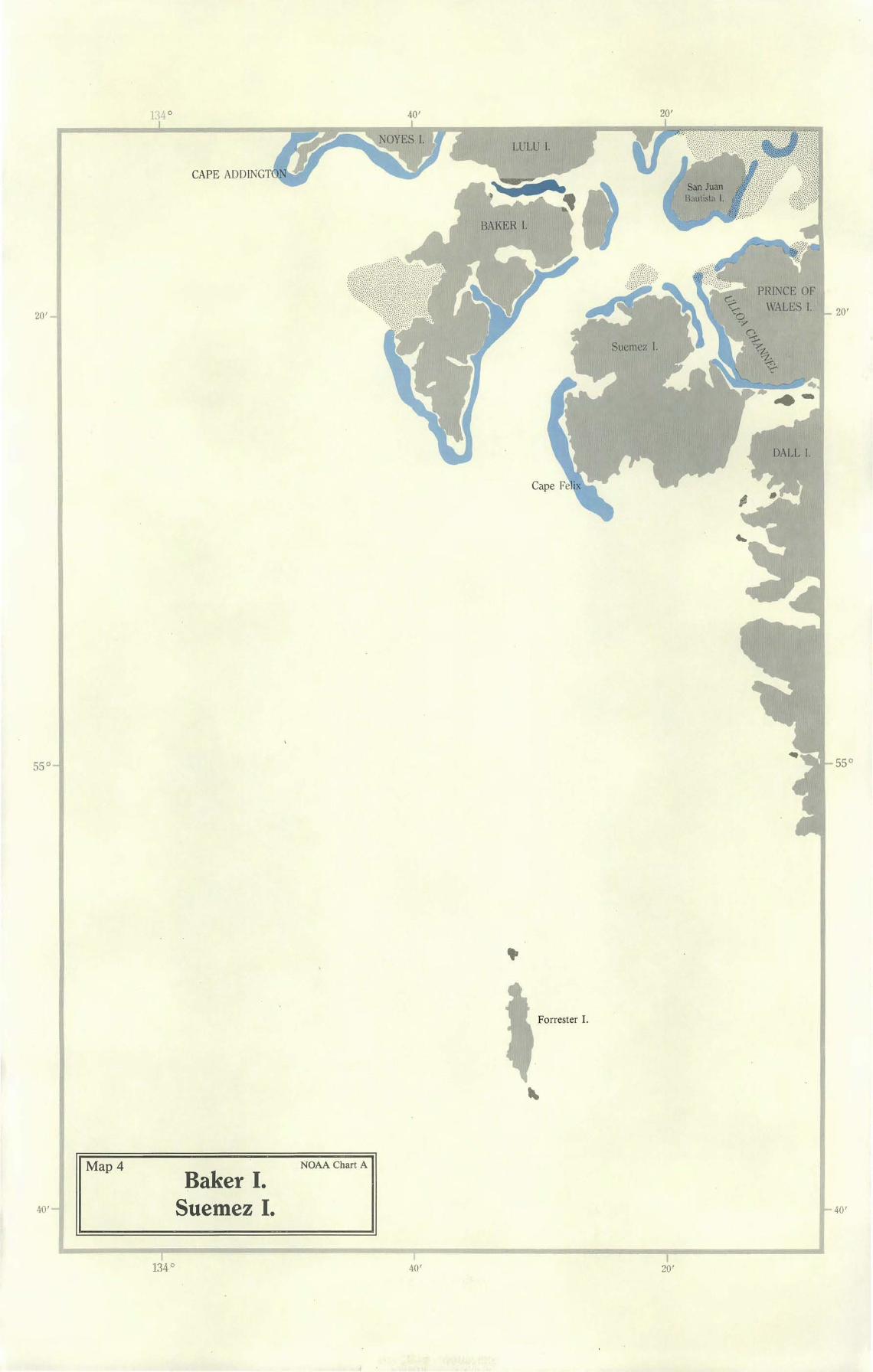
Map4 NOAA Chart A
Baker I. Suemez I. 40'
134° 40' 20'
-~ .
40' 20 ' 131°
56°
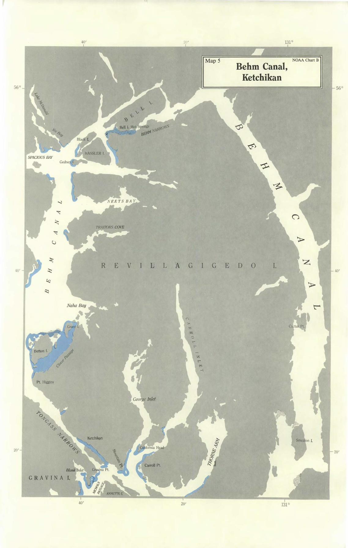
Map 5
R E V I k L A G I G
z
G R AVINA l,
Behm Canal, Ketchikan
NOAA Chart B
E D 0 I. -
56°
40' 40'
20' 20'
40' 20' 131°

40' 20' 133°
NOAA Chart A Map 6 Sea Otter Sound,
Noyes I.
56°
KOSCIUSKO I.
Sea Otter Sound
PRINCE OF WALES I.
NOYES I.
LULU I.
CAPE ADDINGTON
40' 20' 133°
40' 40'
40' 20' 132°
•
E R N E S T
S 0 U N D
PR, INCE OF W A L E S I.
Vallenar Bay .
.,,,ii{tW~~-
20'
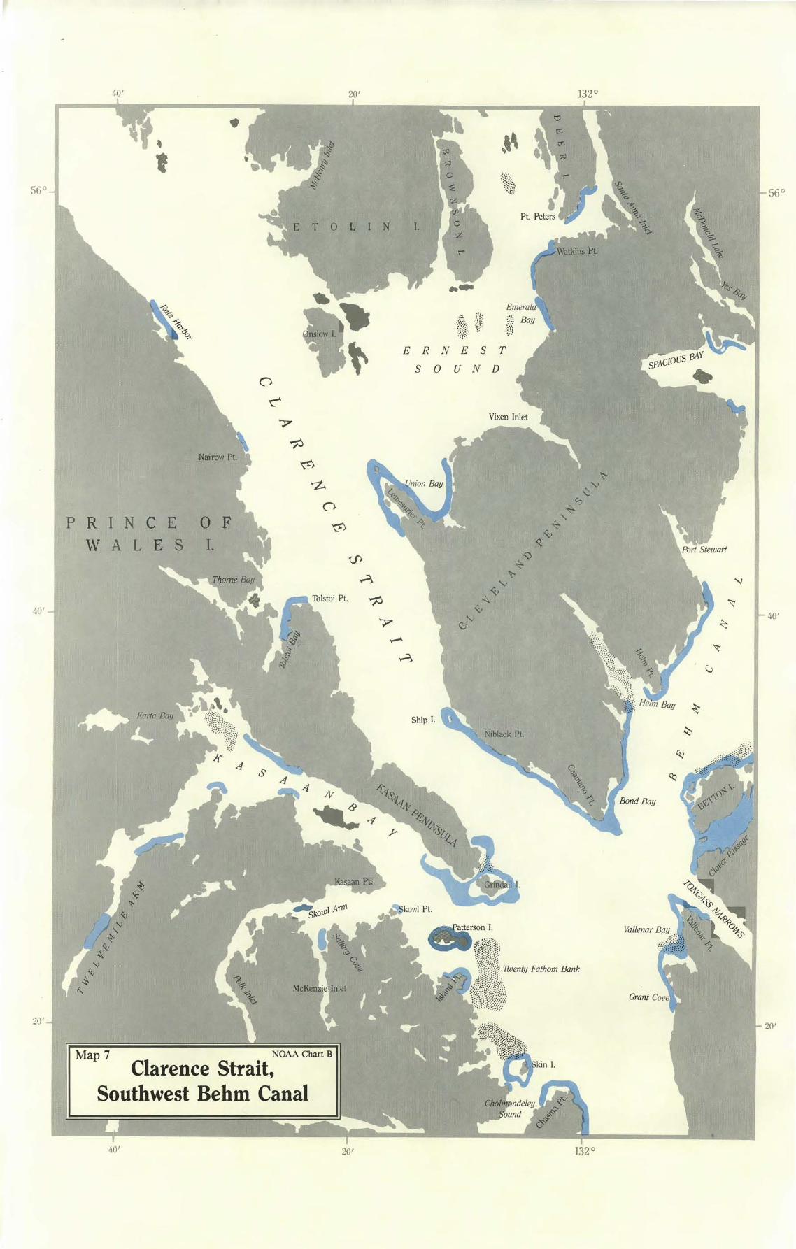
Map 7 NOAA Chart B
Clarence Strait, Southwest Behm Canal
40' 20' 132°
56°
40 '
20'
20' 1 4°
'
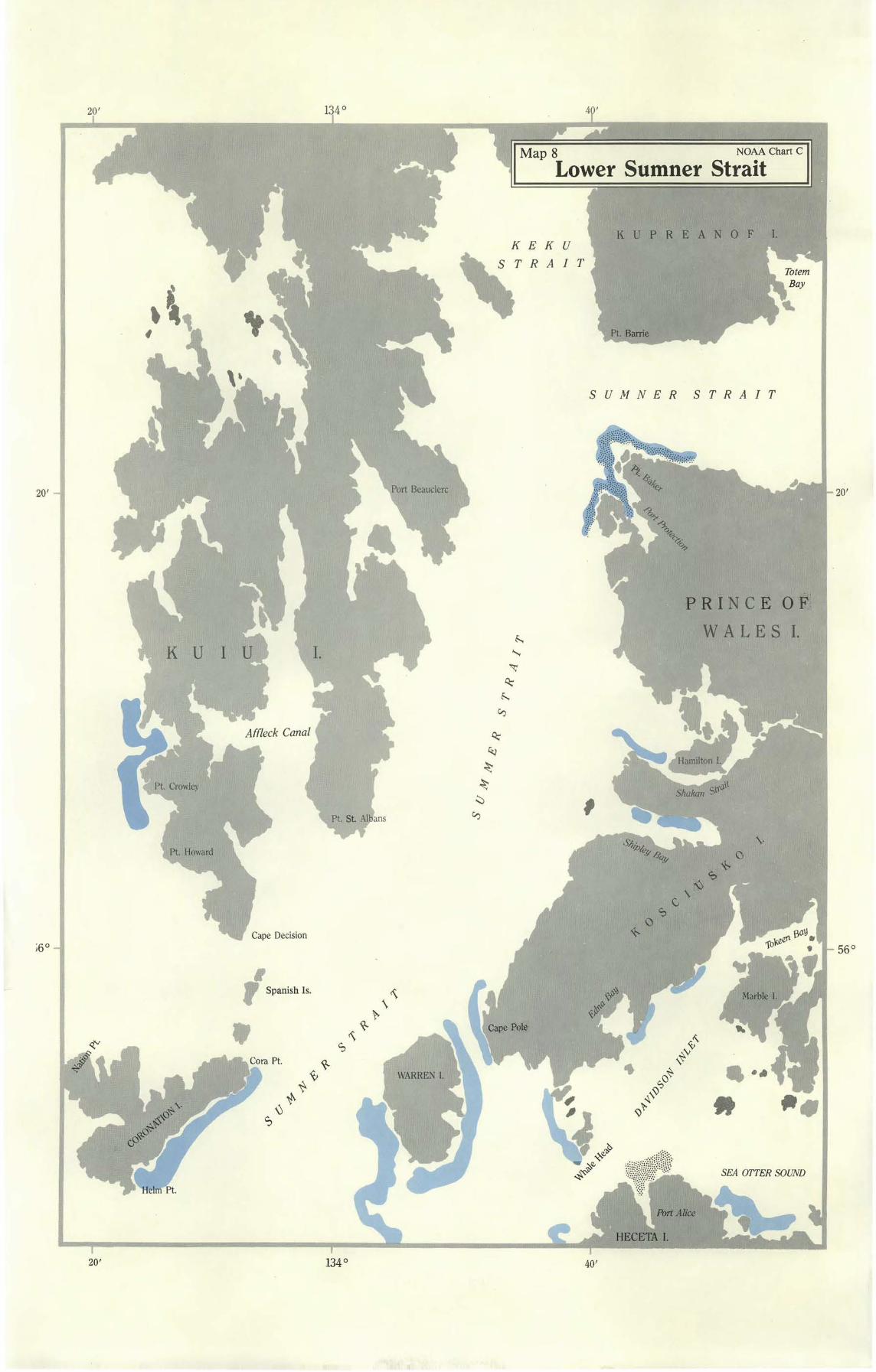
Map 8 NOAA Chart c
Lower Sumner Strait
u I T
K U P R E A N 0 F 1
SUMNE R STRAIT
PRI NC E O F.,
56°
20' 134°
K U I
Cape Decision i6°
•r Spanish Is .
•
WALES I.
SEA OITER SOUND
40'

20'20'
20' 40 '
MITKOF 1.
Kah
ZAREMBO :I.
Round Pt.
E T 0 L I N I.
Map 9 NOAA Chart C
Sumner Strait, Snow Passage
20' 133° 40'
56°56°
20' 132 ° 40'
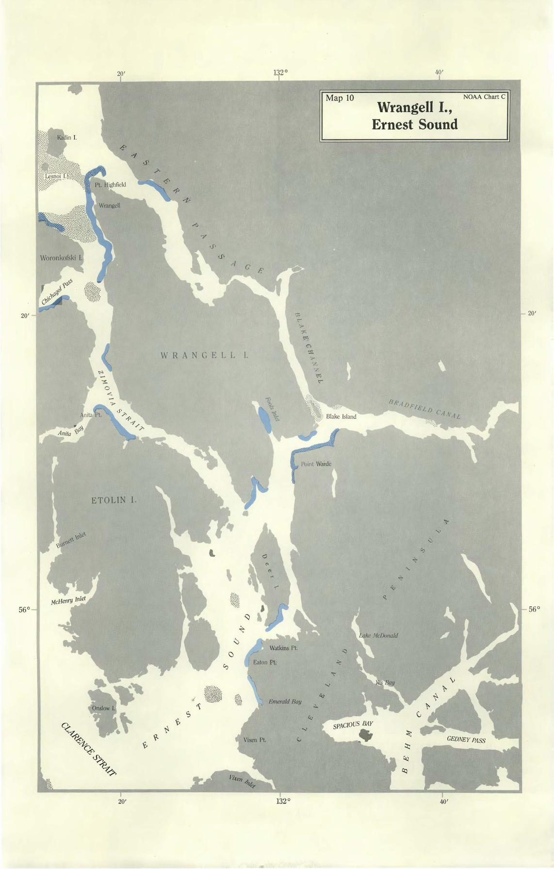
NOAA Chart C Map 10 Wrangell I.,
Ernest Sound
·~ Anita <(,o:
WRANGELL I.
-
ETOLIN I.
20'
·;..-
p
?".
:ti1 0 ':r.
Point Warde
Emerald Bay
132°
'"
ke McDonald
40'
20'20'
56°56 °
Sukoi Islets 1 ,,\~Wi
'14,; ~ .: ).\~ /rl ~ .,,.,~
MIT K OF I.
20' 133 ° 40'
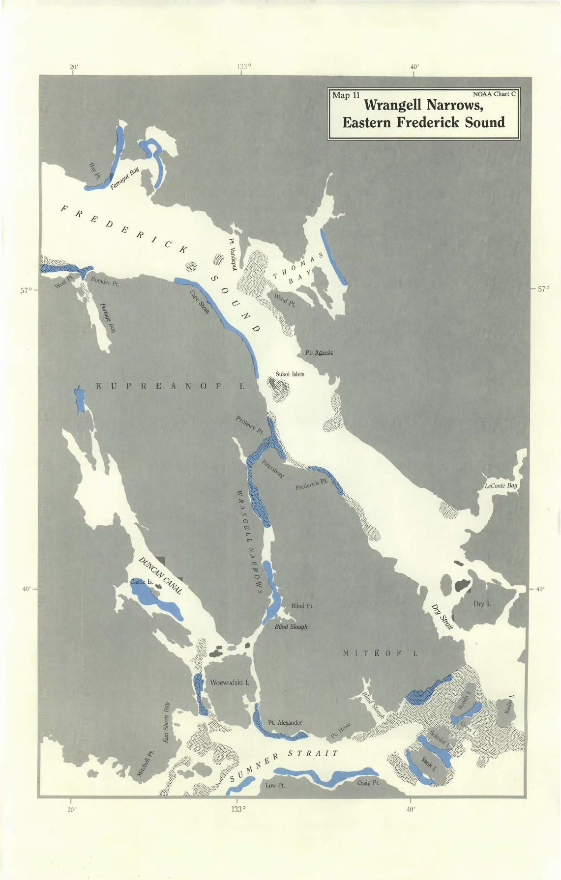
Map 11 NOAA Chart C
Wrangell Narrows, Eastern Frederick Sound
/f' R e lJ
e R / c k
t~H~~· ,&p·
K U P R E A N 0 F l.
::;M:~~:,
~
t"l t"" t""
z
57°57°
40' -l "'- ' ~- u ~ I- 40'
20' 133° 40'
20' 134 ° 40'
Meade Pt.
re.o ~"1--: ~ ~
' ,,~"
~ ~
-..<..
FREDERICK SO U ND
Kake K U P R E A N 0 F I.
ffam;/ton Bay
Gil Harbor
K u I u I.
-
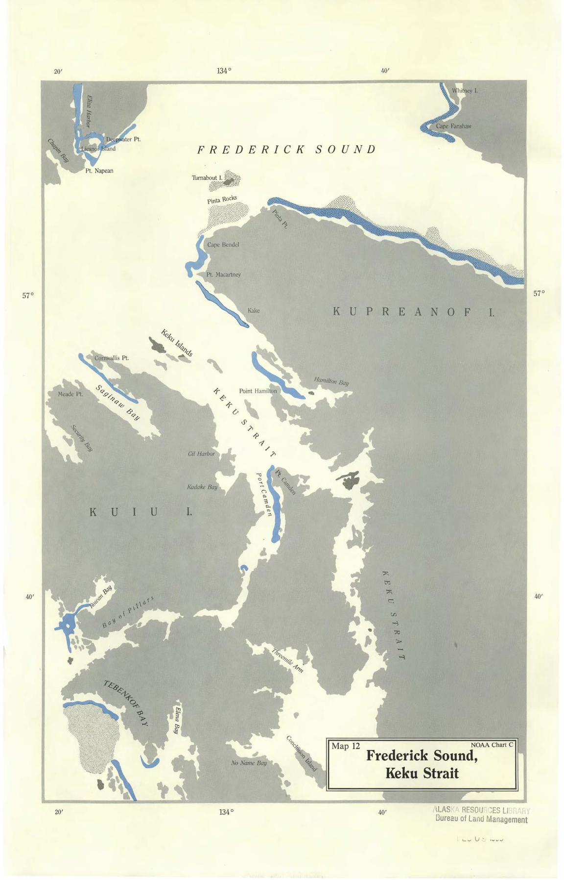
Map 12 NOAA Chart C
Frederick Sound, Keku Strait
57 ° 57°
40' 40'
~LAS RESOIJ ~ES LI20' 134 ° 40' Oureau of l and Management
134°40' 20'
ADMIRALTY I.
Baranof Lake
Patterson Pt.
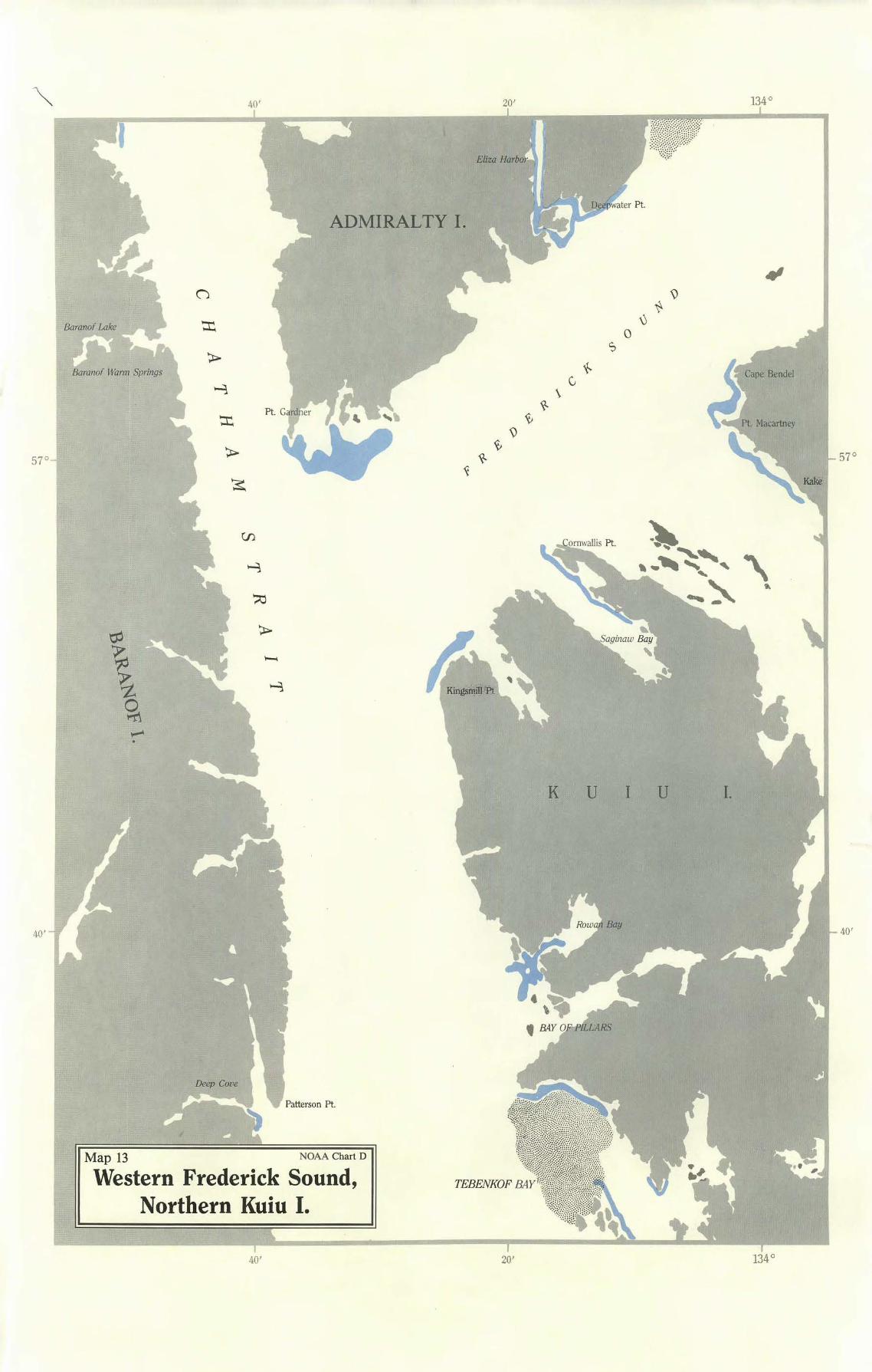
Map 13 NOAA Chart D
Western Frederick Sound, Northern Kuiu I.
57°57°
40'40'
40' 20' 134°
20' 134°40'
20'
56°
cO
~
~
.'7
..z. 0
1"'!l CHA THAM STRAIT
~. Port W.aJter
··~
K U I U I.
........ (::!
I::
(::!
\...)
-le
l.J
~
........ ....... .......
~
20'
I ~~~ "' 56°
( ~\j~
•'
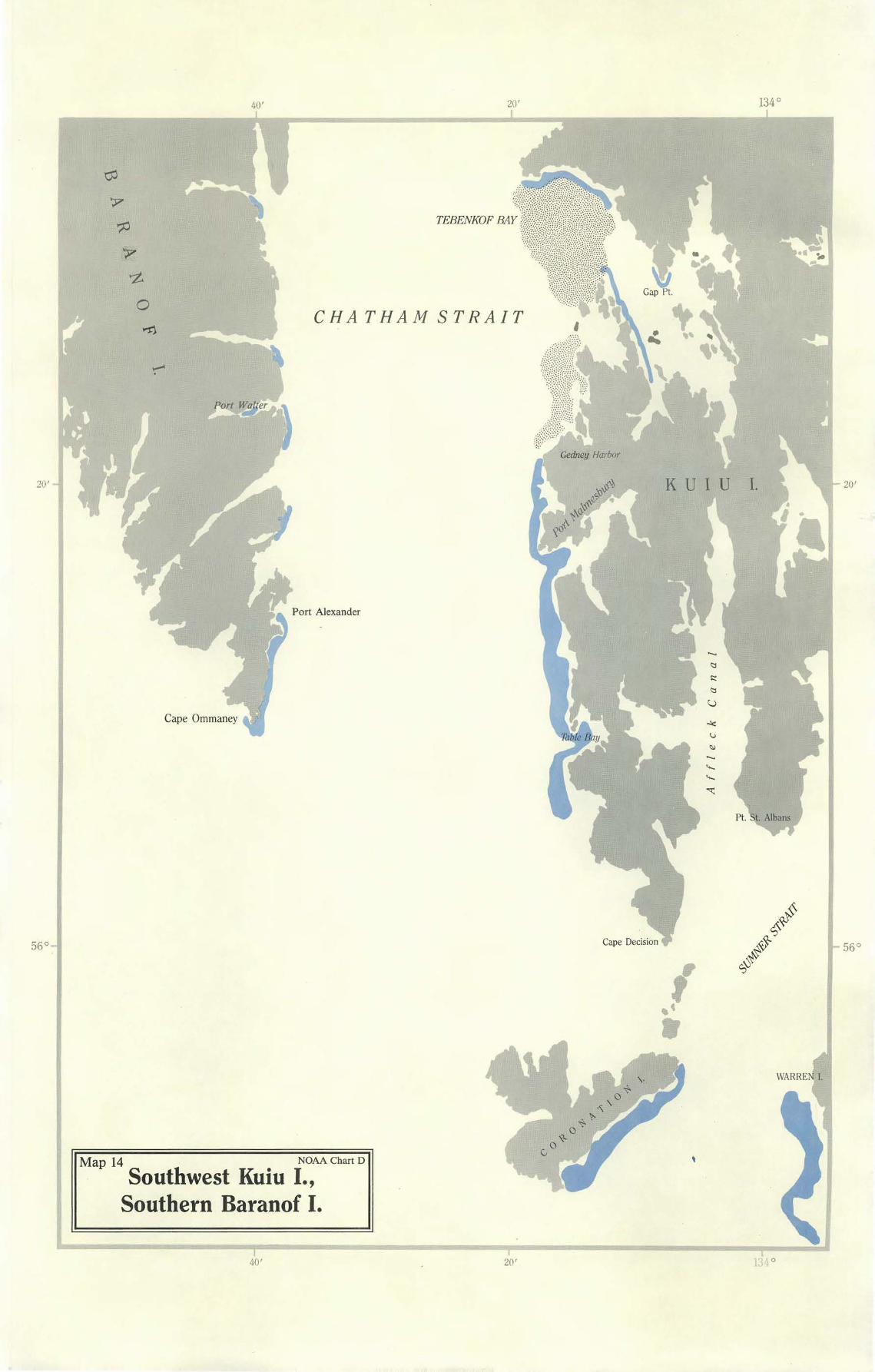
'Map 14 NOAA Chart D
· Southwest Kuiu I., Southern Baranof I.
•
] 040' 20'
57°57°
40'40'
fF=::::=,-----~40'
KRUZOF I.
c,
<\ \
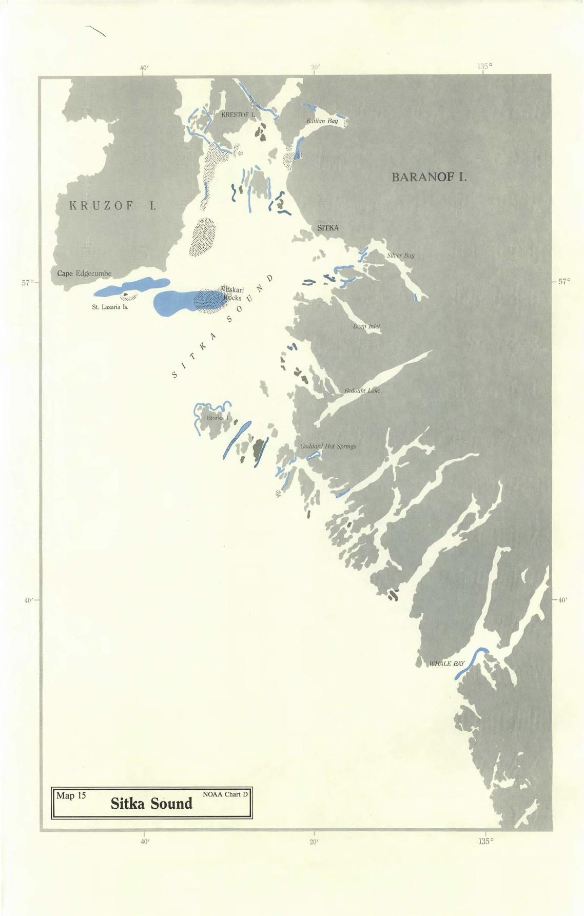
II Map 15 Sitka Sound NoAAcharto lJ
135 °
BARANOF I.
SITKA
40' 135 °
135°40' 20'
SALISBURY SOUND
KRUZOF I.
Sa/tery Ba
Fish Bay
40'
CHICHAGOF I.
B A R A N 0 F I.
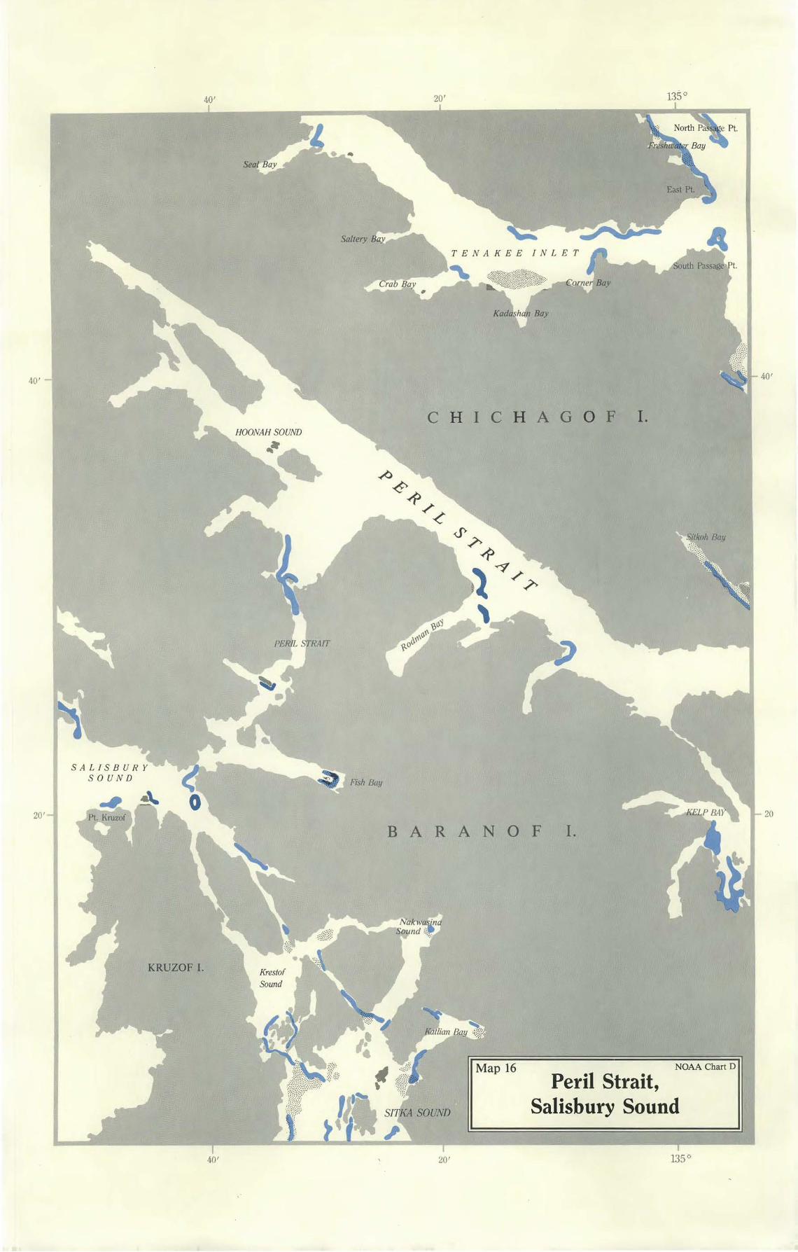
Map 16
40'40'
20'
NOAA Chart D
Peril Strait, Salisbury Sound
20' 135°
20
20' 136°40 1
,. Lisianski Strait
40'40 1
20'20 1
'
' '
CHICHAGOF I.
SALISBURY SOUND
GILMER BAY
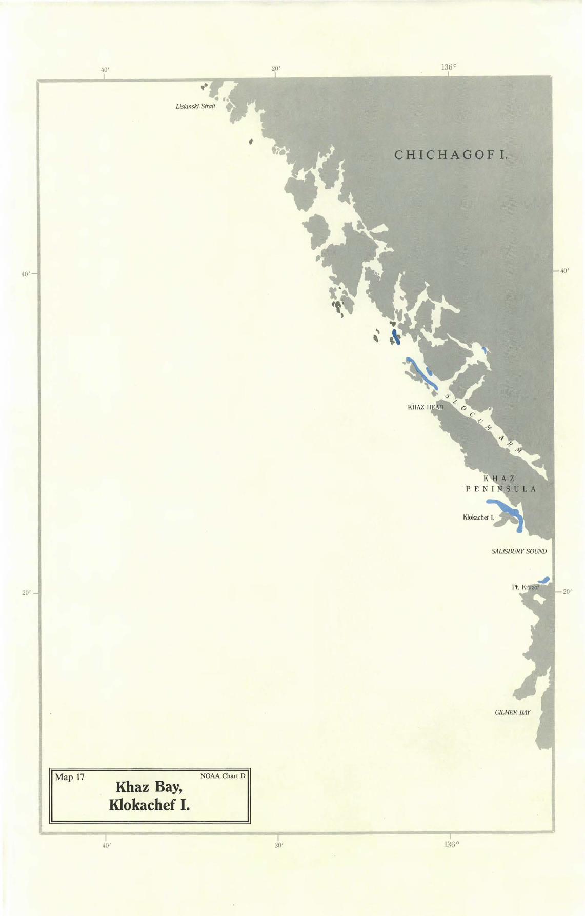
NOAA Chart DMap 17 Khaz Bay,
Klokachef I.
40' 20' B6°
40' 20' 134°
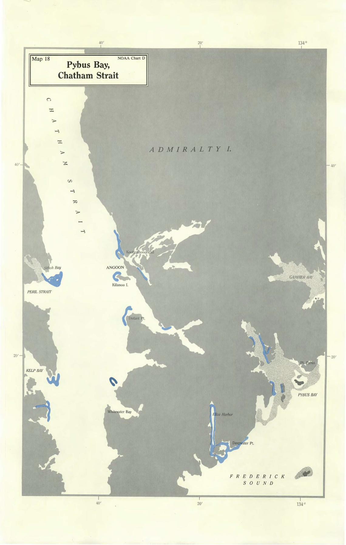
NOAA Chart DMap 18 Pybus Bay,
Chatham Strait
ADMIRALTY I.
40' 40'
PERIL STRAIT
20'
-
ER IC K
UN D
20'
40' 20' 134 °
Cl
c
f./l
f./l
~ <JI
~ ~ -t.
..£... ,_..
~ -t.
0
c.
A D M I R A L T Y I.
PRe
z
lJ
20' 134° 40'
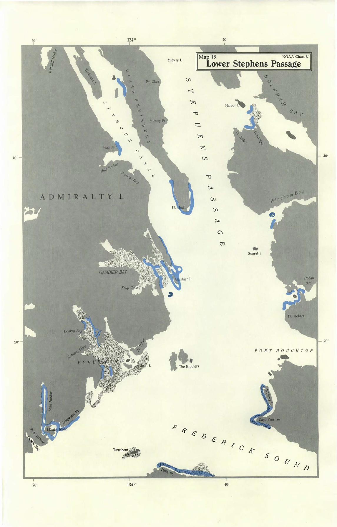
Map 19 NOAA Chart C Midway I.
Lower Stephens Passage
40'40'
20'20'
Ii' R / c
Harbor-
.. Sunset l.
~ 0
-r:" ~ ~
,7 ·~
PORT HOUGHTON...
ff s 0 {/
N lJ
20' 134° 40'
' "\t>
.-t,... <.P
-.-<>
134 ° 40' 20 '
Taku iv er
<.P .A
"\t>
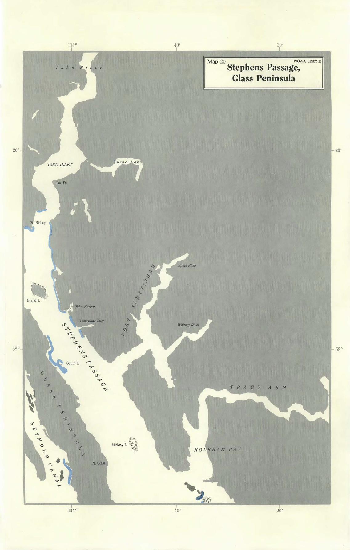
Map 20 NOAA Chart E
Stephens Passage, Glass Peninsula
-.-<>
~
20'
58°
20'
58°
7 <.P
<.P 7
0 "\t> A R M
134° 40' 20'
135° 40' 20'
:··::~g: ·::·~-.=
False l Pt. Retreat
t. Howard
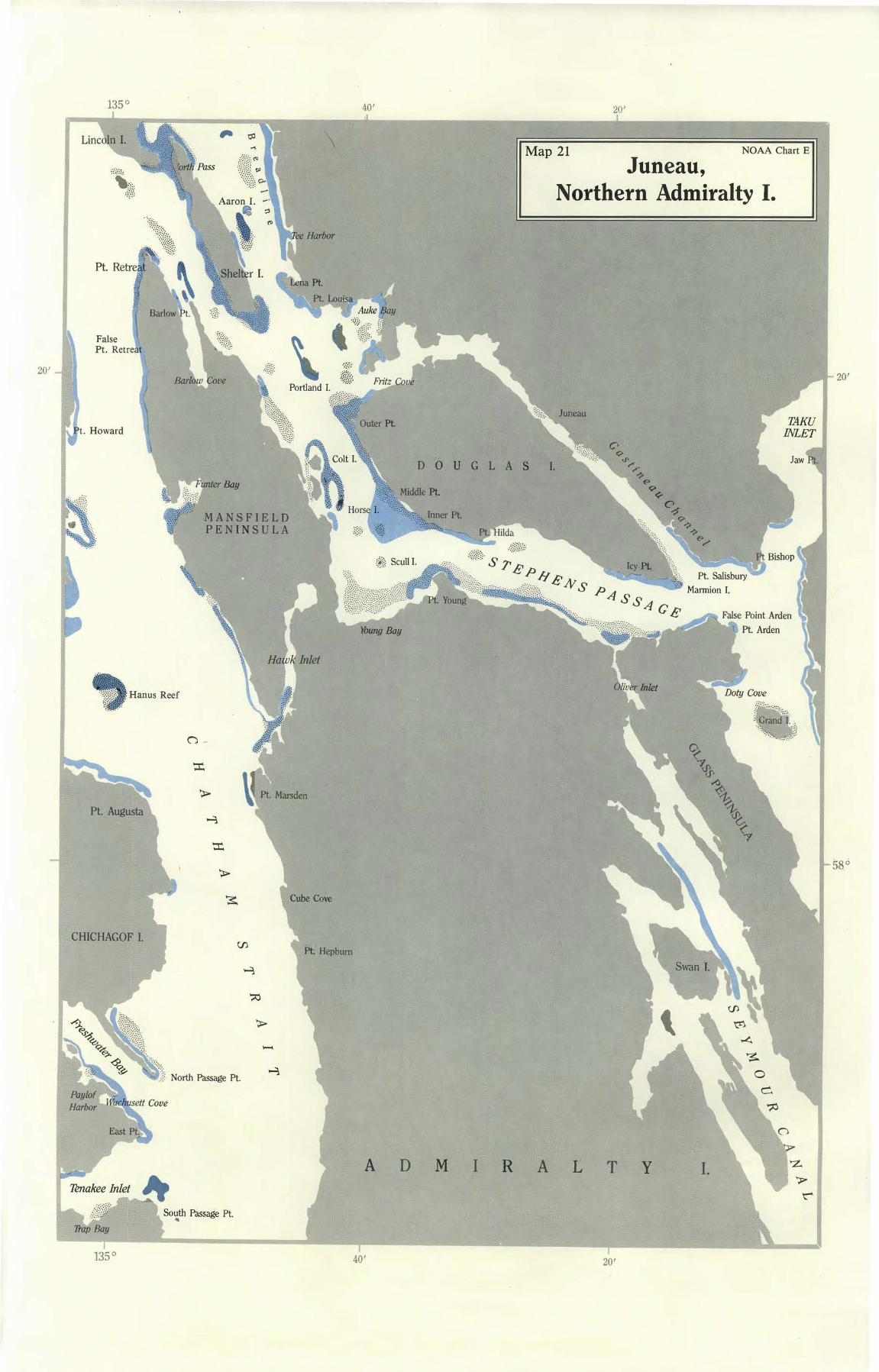
Map 21 NOAA Chart E
Juneau, Northern Admiralty I.
TAKU INLET
20' 20'
unter Bay
MANSFIELD PENINSULA
, Hanus Reef
CHICHAGOF I.
-~:· ..
·.-.::'.} North Passage Pt. ~
South Passage Pt. "'
A D M
U G L A S I.
I R A L T y I.
Jaw Rt.
r
135° 40' 20'
Eldred Rock
Endicott R.
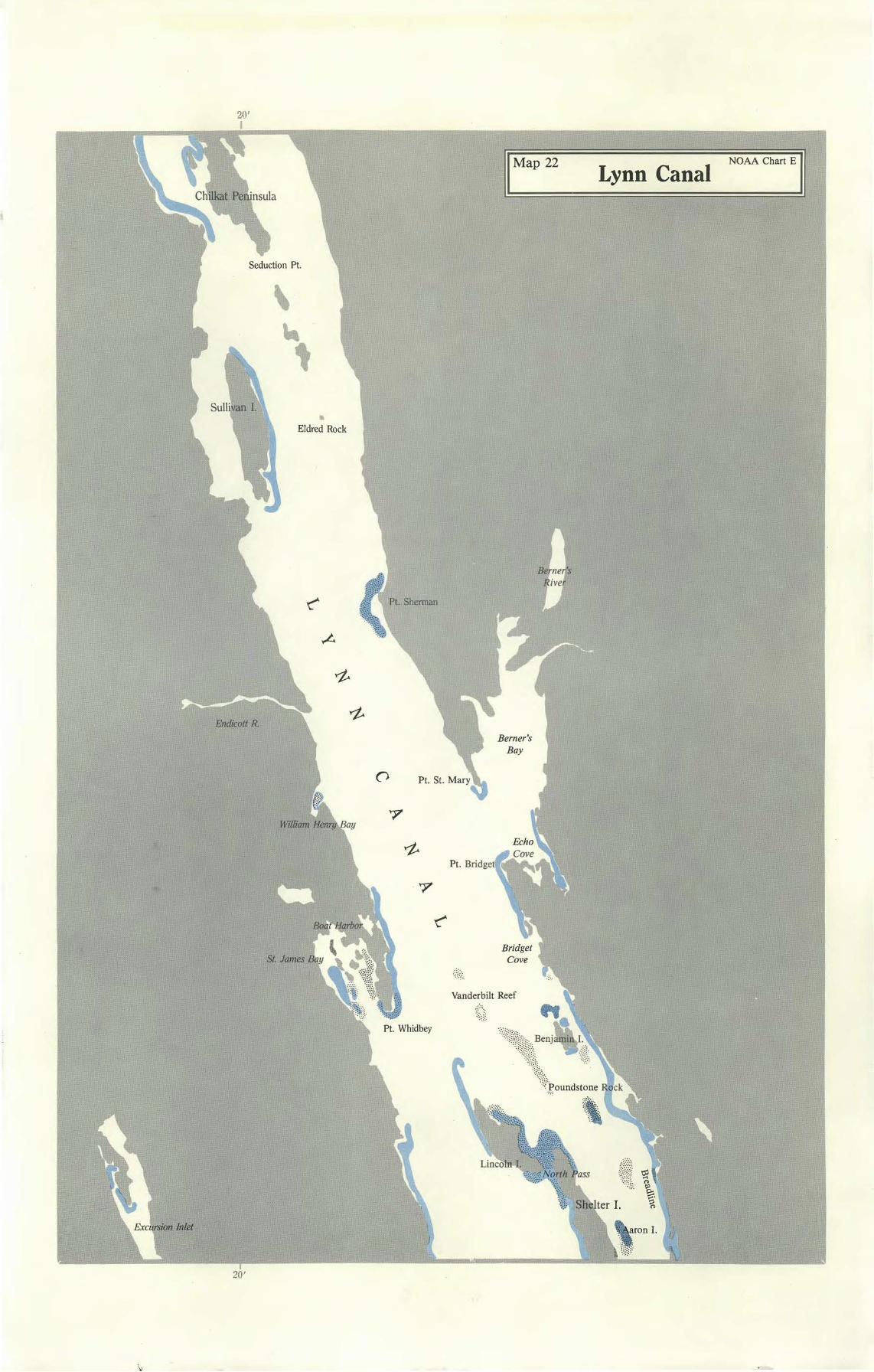
II Map 22
Berner's Bay
Lynn Canal NOAA chart E II
St. James
Pt. Bridge
Vanderbilt Reef
20'
136° 20'
20' 20'
58° 58°
.
GLACIER BAY
Gustavus
PLEASANT I.
Mud Bay
CHICHAGOF I.
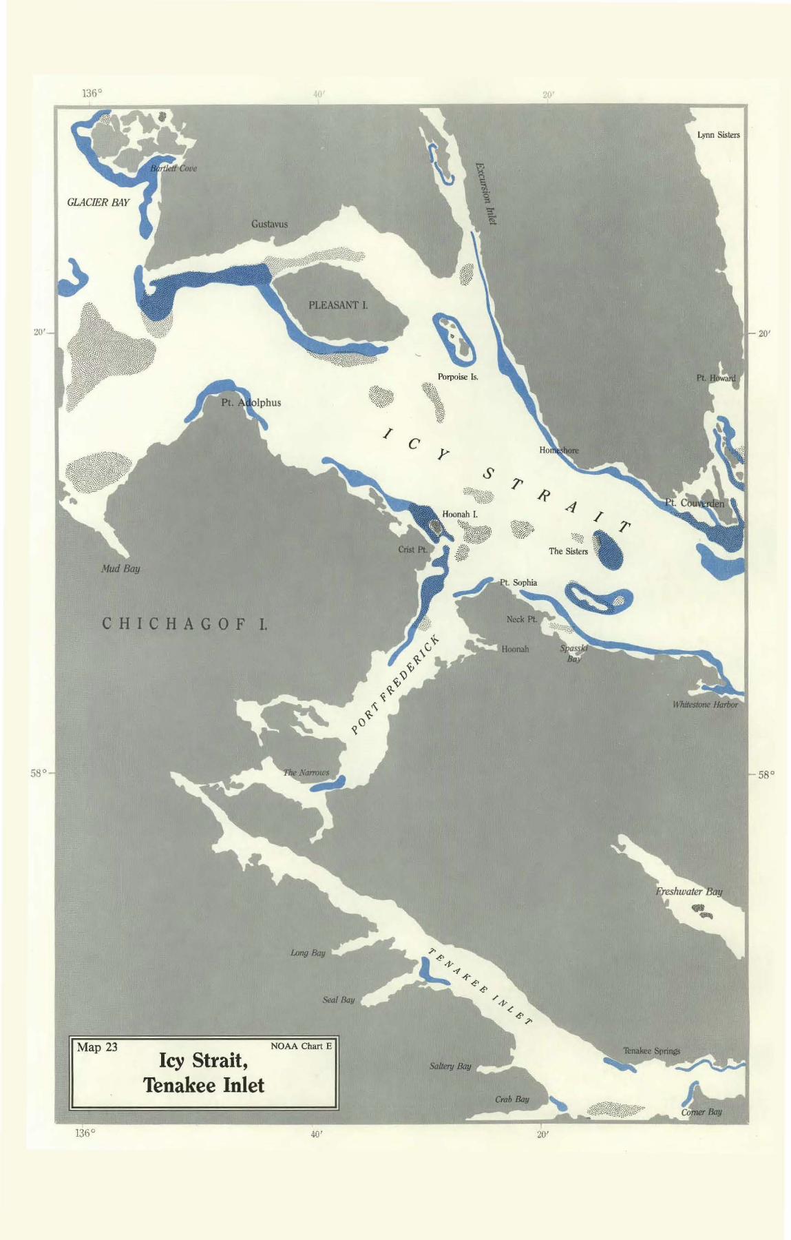
Map 23
136°
Icy Strait, Tenakee Inlet
NOAA Chart E
401
Porpoise Is.
g.{..-;.·;·;·:·.·~:·.·::(:·;__:..:·.;,::~::~·.·:.i:~::·;·~.·.'. '!i!;~m\ ·:tjf.~
/ C'
Saltery Bay
4
TheS~~" '' gt Sophia
Hoonah
20'
Lynn Sisters
lireshwater Bay
•.,,._
40' 20,'
20'
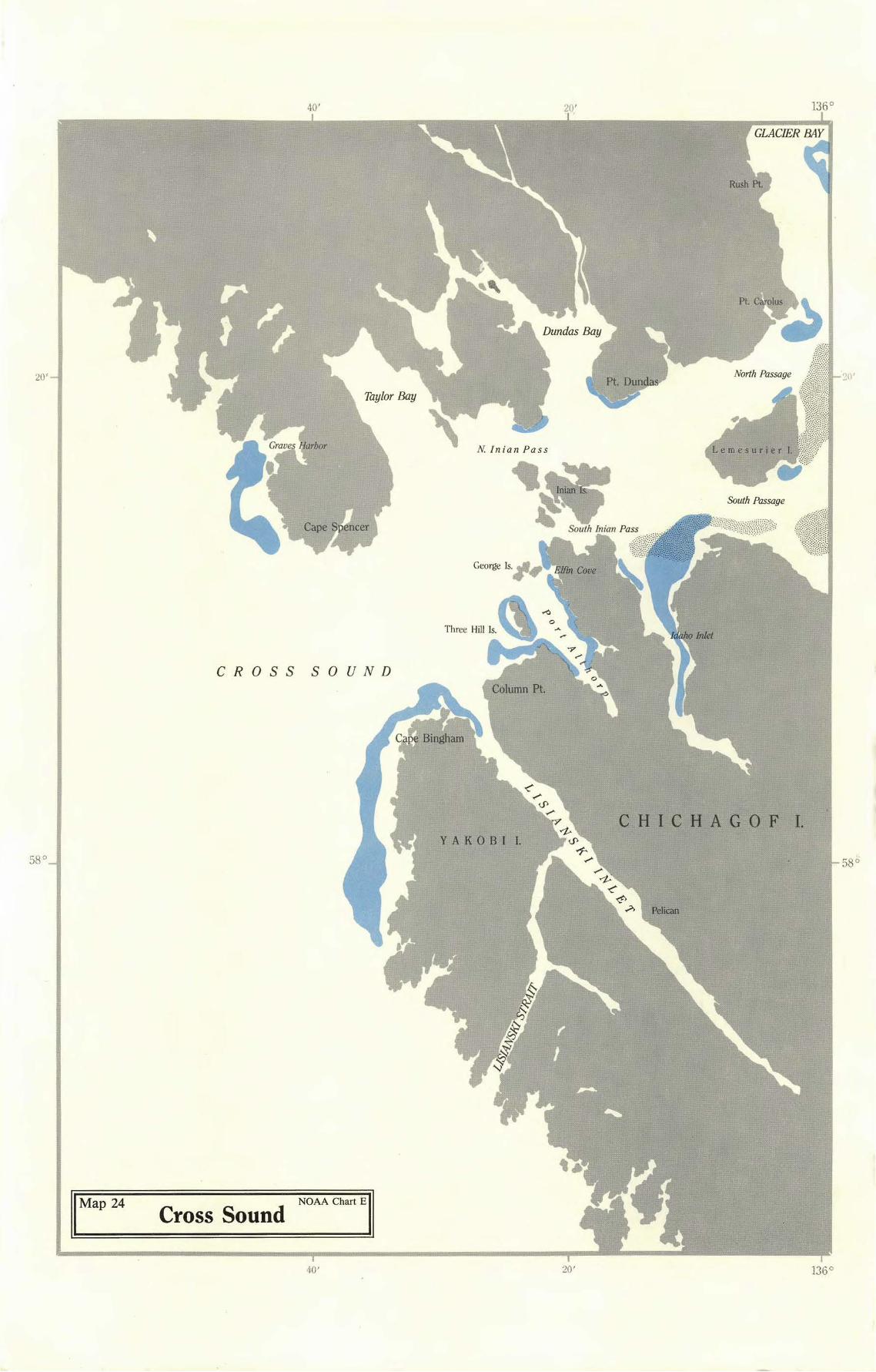
GLACIER BAY
CROSS SOUND
CHICHAGOF I. YAKOBI I.
IMap 24 Cross Sound NoAA c han El
40' 20'


![The Cordova daily times. (Cordova, Alaska). 1922-02-01 [p 2]....Title The Cordova daily times. (Cordova, Alaska). 1922-02-01 [p 2]. Subject Page from The Cordova daily times. (Cordova,](https://static.fdocuments.in/doc/165x107/5f8f03bfcfa04450ab46065f/the-cordova-daily-times-cordova-alaska-1922-02-01-p-2-title-the-cordova.jpg)