Salford Priors, Warwickshire 1 - Cotswold...
16
CONTENTS List of Illustrations 2 Glossary of Archaeological Terms and Abbreviations 3 Summary 4 1. INTRODUCTION 5 2. THE STUDY AREA 5 3. AIMS AND OBJECTIVES 5 4. METHODOLOGY 5 5. DESK ASSESSMENT RESULTS 6 6. GEOPHYSICAL SURVEY RESULTS 8 7. EVALUATION RESULTS 8 7.1 General 7.2 The Trenches 8. CONCLUSIONS AND RECOMMENDATIONS 9 9. ACKNOWLEDGEMENTS 9 10. BIBLIOGRAPHY 9 11. AERIAL PHOTOGRAPHS ACCESSED 9 12. APPENDICES 10 1 Trench descriptions 2 Geophysical survey 3 Project design Salford Priors, Warwickshire 1
Transcript of Salford Priors, Warwickshire 1 - Cotswold...
CONTENTS List of Illustrations 2 Glossary of Archaeological Terms and Abbreviations 3 Summary 4 1. INTRODUCTION 5 2. THE STUDY AREA 5 3. AIMS AND OBJECTIVES 5 4. METHODOLOGY 5 5. DESK ASSESSMENT RESULTS 6 6. GEOPHYSICAL SURVEY RESULTS 8 7. EVALUATION RESULTS 8 7.1 General 7.2 The Trenches 8. CONCLUSIONS AND RECOMMENDATIONS 9 9. ACKNOWLEDGEMENTS 9 10. BIBLIOGRAPHY 9 11. AERIAL PHOTOGRAPHS ACCESSED 9 12. APPENDICES 10 1 Trench descriptions 2 Geophysical survey 3 Project design
Salford Priors, Warwickshire 1

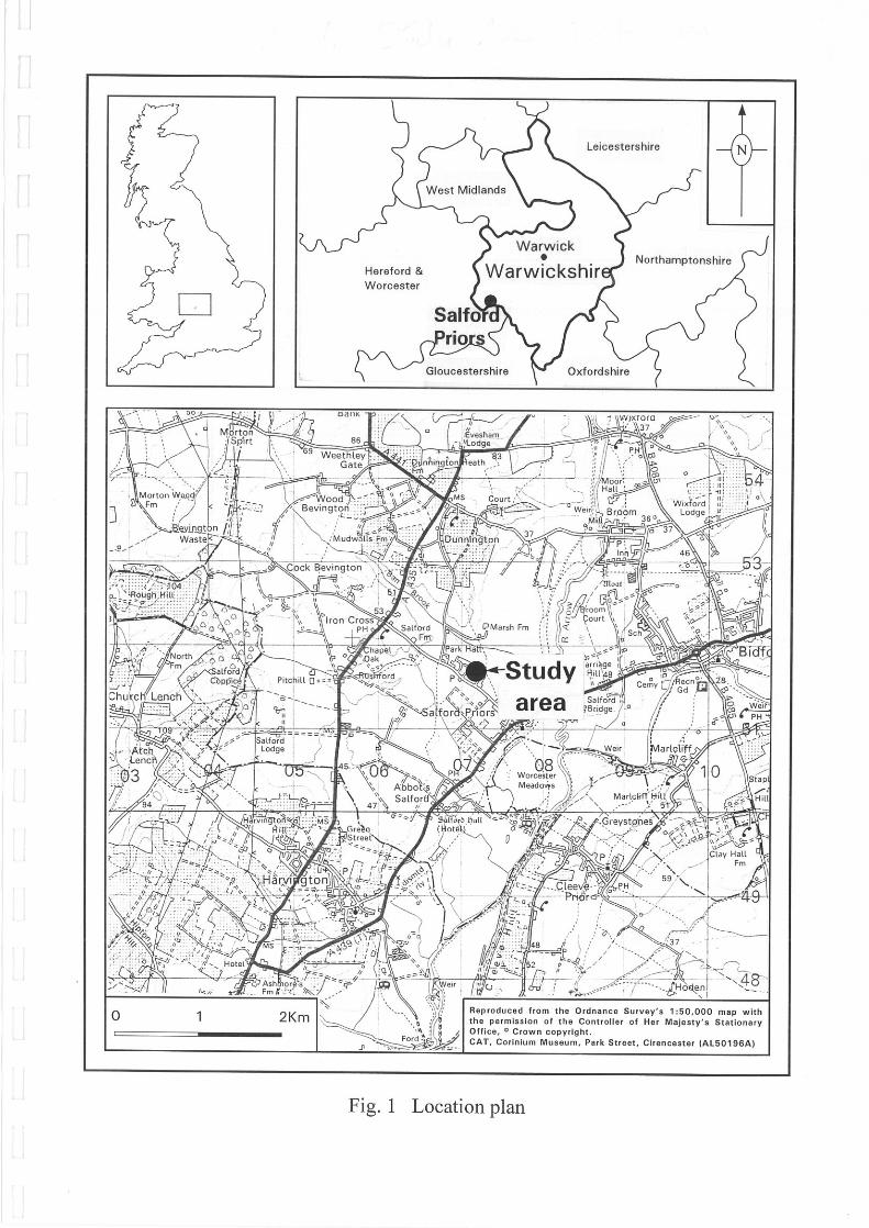
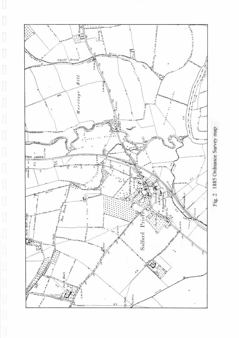
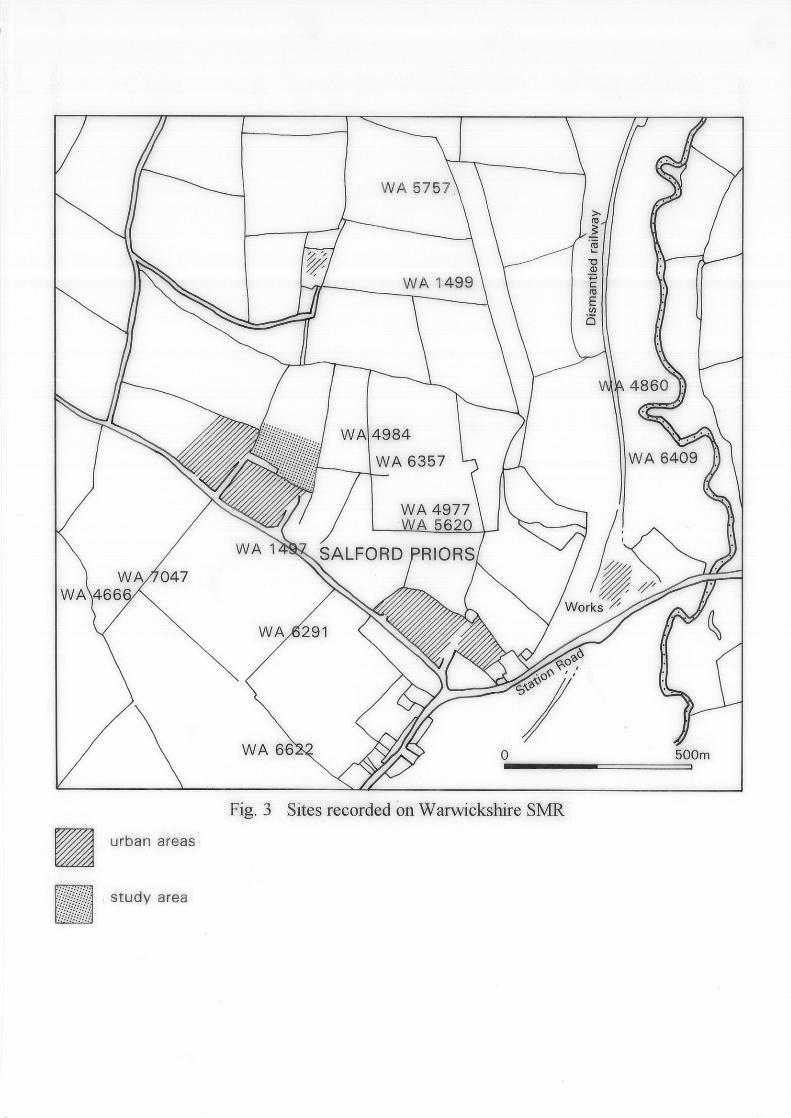
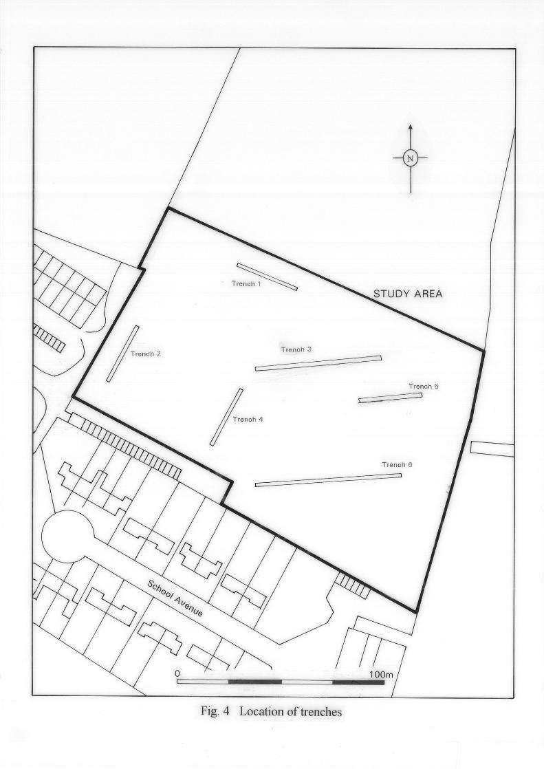
LIST OF ILLUSTRATIONS Fig. 1 Location plan Fig. 2 1885 Ordnance Survey Map Fig. 3 Sites recorded on Warwickshire SMR Fig. 4 Location of trenches
Salford Priors, Warwickshire 2

GLOSSARY OF ARCHAEOLOGICAL TERMS AND ABBREVIATIONS ARCHAEOLOGY For the purpose of this report, archaeology is taken to mean the study of past human societies through their material remains, from prehistoric times to the modern era. No rigid upper date limit has been set, but AD 1900 is used as a general cut-off point. BRONZE AGE A chronological division of the prehistoric period which sees the introduction of copper and eventual widespread adoption of bronze for use in weapons, jewellery, etc. In Britain it is dated between c. 2300 and 700 BC. IRON AGE The first period in which iron was the predominant metal. In Britain it is dated between c. 700 BC and the Roman conquest in AD 43. NATURAL Defined in archaeological terms this refers to the undisturbed natural geology of a site, eg. river terrace gravels etc. OD Ordnance Datum; used to express a given height above sea level. ROMAN The period from the Roman invasion of AD 43 to a date generally agreed to be c. AD 410. SMR Sites and Monument Record SUMMARY
Salford Priors, Warwickshire 3
An archaeological field evaluation was undertaken by Cotswold Archaeological Trust on land north of School Avenue, Salford Priors, Warwickshire. The work was commissioned by Warwickshire County Council, Property Services Department. No archaeological remains were encountered. 1. INTRODUCTION
Salford Priors, Warwickshire 4
1.1 In September 1995 Cotswold Archaeological Trust carried out an archaeological evaluation on land north of School Avenue, Salford Priors, Warwickshire (NGR SP 0725 5160). The work was commissioned by Warwickshire County Council, Property Services Department, in advance of the submission of a planning application to develop the site for housing. 1.2 The evaluation was conducted according to the brief issued by Warwickshire Museum, and a detailed project specification prepared by Cotswold Archaeological Trust (Appendix 3). This was in line with the 'Standards and Guidance for Archaeological Field Evaluations' issued by the Institute of Field Archaeologists. A monitoring visit was made by Douglas Moir of Warwickshire County Council on 13th September 1995. 2. THE STUDY AREA (Fig. 1) 2.1 The area in question lies on the north side of Salford Priors. It is a rectangular field enclosed by a fence on the south, west and north sides and by a hedge on the east side. It is currently used for agriculture. The ground level averages about 40.40m OD. 2.2 The local geology is second terrace river gravels. 3. AIMS AND OBJECTIVES 3.1 A project design for evaluating the archaeological potential of the site was approved by Warwickshire Museum. 3.2 The primary objective of the evaluation was to provide information on the date, character, quality, survival and extent of any archaeological deposits encountered within the study area. 4. METHODOLOGY 4.1 A desk assessment was undertaken prior to fieldwork commencing, to provide an archaeological background to the study area. The sources of information consulted consisted of the Warwickshire SMR, the Warwickshire Public Records Office and aerial photographs held in the National Monument Record. 4.2 A geophysical survey was commissioned and undertaken by Stratascan. A magnetometer survey was selected and deployed across the entire study area, based on a 20m by 20m grid. Readings were taken at 0.5m centres in traverses 1m apart. 4.3 On the basis of the information provided by the desk assessment and the geophysical survey, six trenches totalling 250m in length, or 2% of the study area, were excavated. 4.4 Trenches 1, 2, 4 and 5 were 30m in length. Trench 3 was 60m in length and Trench 5 was 70m in length. The trenches were dug with a mechanical excavator equipped with a toothless bucket, whilst under constant archaeological supervision. The trenches were hand
Salford Priors, Warwickshire 5
cleaned to identify any archaeological features present. 4.4 The site archive will be deposited with Warwickshire Museum. 5. DESK ASSESSMENT RESULTS The SMR Results 5.1 The SMR lists several sites within the immediate vicinity of the study area. These are described below and are preceded by the relevant SMR reference eg. WA 6409. The location of these sites is shown in Fig 2. 5.1.1 Neolithic WA 6409: Twenty-two flints were recovered here during a fieldwalking survey in 1992. These included cores, blades, scrapers, flakes, and a leaf-shaped arrowhead. The assemblage largely dates to the earlier Neolithic. 5.1.2 Iron Age WA 1497: A double ditched rectangular enclosure measuring approximately 60 x 30m with a narrow entrance through both ditches on the south-east. Inside the enclosure are two adjoining enclosures, one irregular and the other a penannular gully with an entrance to the south-east. Also inside the enclosure is a scatter of pits. On morphological grounds this site is probably of Iron Age date. WA 6291: A series of linear features, possibly part of a field system, lie to the south and south-west of enclosure WA 1497. A possible scatter lies alongside one of the linear features and some small, possibly penannular, gullies lie to the south of the area. 5.1.3 Iron Age/Romano-British WA 5757: Two archaeological evaluations were carried out by the Warwickshire Museum in 1992 on a cropmark complex. The excavated features represent the remains of a settlement and a field system appearing to span the Iron Age and Romano-British periods. WA 1499: A large settlement spanning the Iron Age and Romano-British periods exists to the north-east of the study area. An archaeological evaluation has exposed a group of seven shallow banana-shaped gullies. These may represent the truncated remains of foundation trenches or the eaves-drip gullies of Iron Age round houses. Alternatively the gullies may have been the quarry ditches of banks constructed to screen fires or hearths from the wind. Large quantities of burnt pebbles and charcoal were found in the fills of these features. The remains of a ring ditch was also found and may be of ceremonial function. The Iron Age site had an uncertain relationship with a field system represented by small gullies.
Salford Priors, Warwickshire 6
Further evaluation in advance of the A435 Norton-Lenchwick bypass revealed building rubble. This part of the site is considered to be a Roman villa with associated paddocks, confirming the results of a prior geophysical survey. Waterlogged features produced remains of seeds, pollen and beetles, which together with charred plant material have considerable potential for archaeobotanical investigation. 5.1.4 Romano-British WA 4977: Coins of Allectus (AD 293-6), Constans and Constantius II have been recovered through metal detecting. WA 6409: Fourteen sherds of Romano-British pottery were recovered during a fieldwalking survey in 1992 as part of the evaluation for the route of the A435 bypass. 5.1.5 Medieval WA 6622: A collection of artefacts consisting of a 14th-15th century key, a late medieval belt buckle and lead plugs have been reported by metal detectorists. WA 4860: A medieval ?buckle object has been discovered in this area. 5.1.6 Post-medieval WA 5620: A coin of James II (AD 1689) and a decorative bronze fragment, dating to between the 16th and 18th centuries have been reported by a metal detectorist WA 4860: A post-medieval bronze object has been discovered in this area. 5.1.7 Undated WA 4666: Undated linear cropmarks have been identified south of School Road. WA 7047: An undated possible ring ditch has been identified as a cropmark south of School Road. WA 4984: A possible ring ditch and a small rectangular enclosure show as cropmarks. WA 6357: Traces of three rectilinear cropmark enclosures have been identified. Aerial Photographs 5.2 Several aerial photographs held by the National Monuments Record were consulted. Analysis of aerial photographs has shown two further possible sites which lie within the
Salford Priors, Warwickshire 7
study area. Both sites are very faint but one shows up as a possible three sided enclosure with central ?pit. The other shows as a curved line with a ?pit to the east. Both may be modern features, particularly given the alignment of the former which matches the housing development to the south. Cartographic records 5.3 Little information apart from cartographic records was held in the Public Records Office. The earliest cartographic evidence viewed for Salford Priors was the 1831 tithe map. This shows the study area in a predominantly rural environment. The 1st. edition OS map of 1886 shows the study area as a field, with no buildings (Fig 2). 6. GEOPHYSICAL SURVEY RESULTS 6.1 The geophysical survey identified several anomalies. One strong anomaly identified on the western side of the site is thought to be a water meter. The remaining anomalies were weak or very weak in nature. Several of rectilinear anomalies are parallel with land drains known to be in the area, while other rectilinear anomalies which are parallel and at right angles to the land drains were thought to be the results of sub-soiling across the drains. Two possible archaeological features were also identified. Both were interpreted as the possible remains of ring ditches. A full report is enclosed as Appendix 2. 7. EVALUATION RESULTS 7.1 General 7.1.1 The trenches were positioned on the basis of the information gathered during the desk-top and geophysical surveys. Trenches 1 and 2 were positioned over possible features identified on the aerial photographs. The remaining trenches were located across the weak anomalies identified by the geophysical survey (Fig. 4). 7.1.2 The topsoil was composed of an orange-tinged mid grey-brown fine sand and silt with occasional rounded stones. Evidence of ploughing was visible in all the trenches, respecting the existing plough line. In Trench 6 traces of earlier ploughing were visible on a different alignment. 7.1.3 Natural ground was encountered in all the trenches. It consisted of mixed sand, gravel and rounded stones. 7.2 The Trenches 7.2.1 No archaeological features or artefacts were encountered in the evaluation trenches. (See Appendix 1 for general trench descriptions). The two possible features identified in the magnetometer survey were not identified in Trenches 4 or 6, which were positioned to test
Salford Priors, Warwickshire 8
the presence of these features. 8. CONCLUSIONS AND RECOMMENDATIONS 8.1 The archaeological evaluation has indicated that whilst there are archaeological remains in the vicinity of the study area, no archaeological features exist within the study area. 8.2 It would appear that the magnetometer survey identified geological features rather than archaeological features. The geology of the study area, with bands of gravel and stones mixed with pockets of sand could account for anomAlies picked up by the magnetometer survey. 8.3 It is recommended that no further archaeological work be undertaken on the site. 9. ACKNOWLEDGEMENTS 9.1 Cotswold Archaeological Trust would like to thank Warwickshire County Council and Emma Jones (Warwickshire SMR Officer). 9.2 The desk-based assessment was undertaken by Alan Thomas. The fieldwork was carried out by Brona Langton, Mark Brett, Mark Simms and Nick Turner. The report was written by Brona Langton with drawings by Rick Morton. 10. BIBLIOGRAPHY Institute of Field Archaeologists, 1994 Standards and Guidance for Archaeological Field Evaluations. Palmer, S., 1994 Marsh Farm Quarry, Salford Priors, Warwickshire. 3rd Interim Report 11. AERIAL PHOTOGRAPHS ACCESSED Held by the NMR 106G/UK/1348 OS/64175 106G/UK/1354 OS/72014 106G/UK/1698 SPO751/1 58/4596 SPO751/6 OS/67222 SPO751/7 12. APPENDICES APPENDIX 1
Salford Priors, Warwickshire 9

Trench Descriptions Note: All stated depths are given from present ground level. Heights OD are based on the benchmark located on School Road at the junction with School Avenue. The level value was taken to be 39.90m OD. Basic descriptions of all features are retained within the site archive. Topsoil was composed of an orange-tinted mid grey/ brown fine sand and silt with occasional rounded stones. Natural ground was encountered in all the trenches at an average depth of 0.40m below present ground level. Trench 1 Natural ground was encountered at 41.01m OD Trench 2 Natural ground was encountered at 40.98m OD. An E-W narrow modern gulley cut into the natural ground. It was 0.30m in width and 0.15m in depth. Trench 3 Natural ground was encountered at 40.52m OD. Ploughmarks on a NW-SE alignment, respecting the modern plough line, were visible. Trench 4 Natural ground was encountered at 40.44m OD. Ploughmarks were visible on a NW-SE alignment. Trench 5 Natural ground was encountered at 40.04m OD. Ploughmarks were visible on a NW-SE alignment. Trench 6 Natural ground was encountered at 39.68m OD. Ploughmarks were visible on a NW-SE alignment which partially obscured earlier NE-SW aligned ploughmarks. APPENDIX 2: The Geophysical Survey
Salford Priors, Warwickshire 10

APPENDIX 3: Project Design
Salford Priors, Warwickshire 11

Salford Priors, Warwickshire 12