S-68 S-227 over Turkey Creek CE-C 09272016 1 NON-PROGRAMMATIC CATEGORICAL EXCLUSION Project ID No....
206
-
Upload
phungthien -
Category
Documents
-
view
216 -
download
2
Transcript of S-68 S-227 over Turkey Creek CE-C 09272016 1 NON-PROGRAMMATIC CATEGORICAL EXCLUSION Project ID No....

Page 1
NON-PROGRAMMATIC
CATEGORICAL EXCLUSION
Project ID No. 35179 Federal Project No. P035179 County: Edgefield & McCormick Route: S-68 (Key Road) Date: September 28, 2016 To: Federal Highway Administration From: David Kelly, RPG 4 NEPA Coordinator/Architectural Historian; SCDOT Description: Proposed S-68 (Key Road) Bridge Replacement over Turkey Creek
(SEE ATTACHMENT)
The Department is proposing to replace the existing structurally deficient and functionally obsolete S-68 (Key Road) bridge over Turkey Creek. The Department’s environmental assessment has determined the effects of this project are as described in the “Programmatic Agreement Between the Federal Highway Administration, South Carolina Division and the South Carolina Department of Transportation Regarding Approval of Actions Classified as Categorical Exclusions for Federal-Aid Highway Projects” dated May 23, 2016, and is in compliance with the required findings reflected below. The project has been assessed for possible effects on the human and natural environment with a determination that no significant environmental impact will occur. The class of action and impact determination documented by this statement would qualify this project as a categorical exclusion under 23 CFR 771, Section 115(b). A determination has been made that the project may effect, but is not likely to adversely affect one (1) federally-listed species, the Carolina heelsplitter, and its critical habitat. Extra precautions have been incorporated into the project to minimize potential impacts to the species and its habitat in the vicinity of the project. The USFWS concurred with the Department’s determination and implementation of precautions; therefore, no further investigation under Section 7 of the Endangered Species Act is necessary.
The project will not impact waters of the U.S.; therefore, no permit or further coordination under Section 404 of the Clean Water Act (CWA) is necessary. In accordance with Section 401 of the CWA, a Permit for Construction in Navigable Waters has been issued by SCDHEC for the project, which satisfies the requirements for a Water Quality Certification.
In consultation with the SHPO, the project has been determined to affect one (1) property, the
existing S-68 bridge, identified as being on or eligible for inclusion in the National Register of Historic
Places. A Section 4(f) Programmatic Evaluation was performed and a Memorandum of Agreement


SCDOT
NEPA ENVIRONMENTAL COMMITMENTS
FORM
The Environmental Commitment Contractor Responsible measures listed below are to be included in the contract and must be implemented. It is
the responsibility of the Program Manager to make sure the Environmental Commitment SCDOT Responsible measures are adhered to. If there are
questions regarding the commitments listed please contact:
ENVIRONMENTAL COMMITMENTS FOR THE PROJECT
Project ID : 35179 District : District 2County : Edgefield
Project Name: Proposed S-68 (Key Road) Bridge Replacement over Turkey Creek
Date: 09/28/2016
Non-Standard Commitment� � � � � � � � � � � � � � � � � � � � � � � � � � � � � � � � � � � � � � � � � � � � � � � � � � � � � � � � � � � � � � � � � � � � � � � � � � � � � � � � � � � � � � � � � � � � � � � � � � � � � � � � � � � � � � � � � � � � � � � � � � � � � � � � � � � � � � � � �Right-of-Way
Responsibility: SCDOT
Displacements� � � � � � � � � � � � � � � � � � � � � � � � � � � � � � � � � � � � � � � � � � � � � � � � � � � � � � � � � � � � � � � � � � � � � � � � � � � � � � � � � � � � � � � � � �! � � � � � � � � � � � � � � " � � � � � ! � � � � � � � � � � � � � � � � � � ! � � � � # $ % & � � � � � � � ' ( ) � � � � � � ( * & # � � � � � � + � � � � � � � � � � � � � � � � � � � � � � � � � � � � � � � � � � � � � � � � � � � � � � � � � � � � � � � � � � � � � � � � � � � � � � � � � � � � � � � � � � � � � � � � � � � � , � � � � � � � � � � � � � � � � � � � � � � � � � � � � � � � � � � � � � � � � � � � - � � � � � � � � � � � � � � � � � � � � � � � � � � � � � � � � � � � � � � � � � � � � � � � . � � � � � � � � � � � � � � � � � / � � � � � � � � � � � � � � � � � � � � � � � � � � � � � � � � � � � � � � � � � � � � � � � � � � � � � � � � � � � � � � � � � � � � � � � � � � � � � � � � � � � �� � � � � � �Responsibility: SCDOT
Non-Standard Commitment
The following conditions will be implemented to minimize impacts and avoid adverse effects to archaeological site 38MC1945:
# + � � � � � � � � � � � � � � � � � � � � � � � � � � � � � � � � � � � � � � � � � � � � � � � �) + 0 � � � � � � � � � � � � � � � � � � � � � � � � � � � � � � � � � � � � � � � � � � � � � � � � � � �1 + � � � � � � � � � � � � � � � � � � � � � � � � � � � � � � � � � � � � � � � � � � � � � � � � � � � � � � � � � � � � � � � � � � � � � � � � � � � � � � � � � � � � � � � � � � �' � � � � � � � � � � � � � � � � � � � � � � � � � � � � � � � +( + " � / � � � � � � � � � � � � � � � � � � � � � � � � � � � � � � � � � � � � � � 2 � � 3 + � � � � � � � � � � � � � � � � � � / � � � � � � � � � � � � � / � � � � � � � � � � � � �Cultural Resources
Responsibility: CONTRACTOR
CONTACT NAME: Mr. Chris Jordan, P.E. PHONE #: (803) 737-9939
Total # of
Commitments:11Doc Type: CE-C


Project ID : 35179
ENVIRONMENTAL COMMITMENTS FOR THE PROJECT
SCDOT
NEPA ENVIRONMENTAL COMMITMENTS
FORM
Stormwater� � � � � � � � � � � � � � � � � � � � � � � � � � � � � � � � � � � � � � � � � � � � � � � � � � � � � � � � � � � � � � � � � � � � � � � � � � , � � � � � � � � � � � � � � � � � � � � � � 5 � � � � � � � � � � � � � � � / � � � � � � � � � 1 & 1 ' + � 6 � 7 � 8 � � � � � � � � � � � � � � � � � / � � � � � � � � � � � � � � � � � � � �� � � � � � � � 9 � 6 � ( " � � � � � � � � � � � � � � � � � � � � � � � � � � � � � � � � � � � � � � � � � � . � � � � � � � � � � � � � � � � � � � � � � � � � � � � � � �� � � � � � � � � � � � � � � � � � � � � � � � � � � � � � � � � � � � � � � � � � � � � � � � � � � � � � � � � � � � � � � � � � � � � � � � � � � � ) 1 � � * 3 & : � � � � � � � 9 �� � � � � � � � � � � � � � � � � � � � � � � � � � � � � � � � � 0 � � � � � � � � � � � 6 � � � � � � ' � � � � � � � � � � � � + �Water Quality� � � � � � � � � � � � � � � � � � � � � � � � � � � � � � . � � � � � � � � � � � � � � � � � � � � � � � � � � � � � � � � � � � � � � � � � � � � � � � � � � � � � � � � � � � � : 6 " � � � � � � � � � � � � � � � � � � � � � � � � � � � � ) 1 � � * 3 & : � � � � � � � � � � � � � � 9 � � � � � � � � � � � � � � � � � � � � � � � � � � � � � � � � � � � � � 0 � � � � �� � � � � � 6 � � � � � � ' 7 � � � � � 0 � � � � � + � � � � � � � � � � � � � � � � � � � � � � � � � � � � � � � � � � � � � � � � � � � � � � � � � � � � � � � � � � � � � � � � � � � �� � � � � � � � � � � � � � � � � � � � � � � � � � � � � � � � � � � . � � � � � � � � � � 8 � � � ; � � � � � � �Migratory Bird Treaty Act (all bridge and box culvert projects)
The federal Migratory Bird Treaty Act, 16 USC § 703-711, states that it is unlawful to pursue, hunt, take, capture or kill; attempt to take, capture or kill; possess, offer to or
sell, barter, purchase, deliver or cause to be shipped, exported, imported, transported, carried or received any migratory bird, part, nest, egg or product, manufactured
or not.
The Department will comply with the Migratory Bird Treaty Act of 1918 in regard to the avoidance of taking of individual migratory birds and the destruction of their
active nests. Prior to construction/demolition of the bridges the Resident Construction Engineer (RCE) will coordinate with SCDOT Environmental Services Compliance
Office to determine if there are any active nests on the bridge. After this coordination, it will be determined whether construction/demolition can begin. After
construction/demolition has begun, measures can be taken to prevent birds from nesting, such as screens, noise producers, and deterrents etc. If during construction
or demolition a nest is observed on the bridge that was not discovered during the biological surveys, the contractor will cease work and immediately notify the RCE,
who will contact SCDOT Environmental Services Compliance Office. SCDOT biologists will determine whether the nest is active and the species utilizing the nest. After
this coordination, it will be determined whether construction/demolition can resume or whether a temporary moratorium will be put into effect. All costs for
determining the need for, the placing of deterrents, and applying of all special actions including, but not limited to, removing nests and any costs associated with
conducting work in compliance with the Migratory Bird Treaty Act as stated herein will not be paid for separately but will be considered to have been included with
other items of work.
Responsibility: SCDOT
Responsibility: SCDOT
Responsibility: CONTRACTOR

Project ID : 35179
ENVIRONMENTAL COMMITMENTS FOR THE PROJECT
SCDOT
NEPA ENVIRONMENTAL COMMITMENTS
FORM
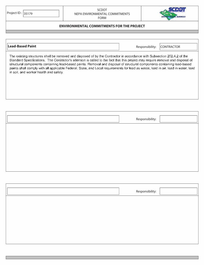
Lead-Based Paint� � � � � � � � � � � � � � � � � � � � � � � � � � � � � � � � � � � � � � � � � � � � � � � � � � � � � � � � � � � � � � � � � � � � � � � � � � � � � � � � � � � � � � � � � �� � � � � � � � � � � � � � � � � � � � � � � � � � � � � � � � � � � � � � � � � � � � � � � � � � � � � � � � � � � � � � � � � � � � � � � � � � � � � � � � � � � � � � � � � � � � � � � � �� � � � � � � � � � � � � � � � � � � � � � � � � � � � � � � � � � � � � � � � ! � � � � � � � � � � � � � � � � � � � � � � � � � � � � � � � � � � � � � � � � � � � � � � � � � �� � � � � � � � � � � � � � � � � � � � � � � � � � � " � � � � # � � � � � # � � � $ � � � � � � � � � � � � � � � � � � � � � � � � # � � � � � � � # � � � � � � � � � # � � �� � � � � # � � � � � % � � � � � � � � � � � � � � � �
Responsibility: CONTRACTOR
Responsibility:
Responsibility:

Non-Programmatic Categorical Exclusion Edgefield and McCormick Counties, South Carolina Proposed S-68 (Key Road) Bridge Replacement over Turkey Creek Project ID No. 35179
Page 1
Project Description: The South Carolina Department of Transportation (SCDOT) proposes to replace the
existing S-68/S-227 (Key Road) bridge over Turkey Creek in Edgefield and McCormick Counties, South
Carolina. Specifically, the project is located within the Sumter National Forest, approximately 12 miles west of
the Town of Edgefield and 12 miles southeast of the Town of McCormick (Appendix A, Figure 1). The
proposed project would include the replacement of the existing bridge with a modern structure on its existing
alignment. The project would also improve the existing roadway approaches to the bridge.
S-68/S-227 (Key Road) and the existing bridge over Turkey Creek currently accommodate two (2) lanes of one-
way traffic. The existing bridge is approximately 304 feet in length and 20.2 feet in width, consisting of eleven
(11) spans. The main span is a 150’-3” riveted Parker steel truss and is flanked by two (2) 16’-8” precast concrete
slab spans and nine (9) 15’ precast concrete approach spans. The existing bridge provides approximately 39’-8”
of vertical clearance over Turkey Creek. Additionally, the existing bridge spans Turkey Creek; no bents or other
bridge supports are located within the stream channel.
Minor amounts of new right-of-way, totaling approximately 0.01 acre would be necessary to accommodate the
wider bridge (Appendix A, Figure 2); however, no displacements would result from the project. The project
proposes to close the bridge during construction and utilize an off-site detour, approximately 11.3 miles in length
(Appendix A, Figure 3).
Purpose and Need: The purpose of the project is to replace the structurally deficient and functionally obsolete S-
68/S-227 (Key Road) bridge over Turkey Creek. The bridge was built in 1925 and relocated from Georgetown to
its current location in 1961. The bridge has a sufficiency rating of 34.7 out of 100, classifying the bridge as
structurally deficient and making it eligible for replacement through the Federal Highway Bridge Replacement
and Rehabilitation Program. Additionally, the bridge is classified as functionally obsolete due to substandard lane
and shoulder widths. Existing (2015) average daily traffic (ADT) on S-68/S-227 (Key Road) is approximately
200 vehicles per day (vpd). By 2035, the ADT is expected to increase to 300 vpd.
Project Funding: The funding for this project is referenced in the Statewide Transportation Improvement
Program, or STIP, (Statewide), Revision 32 (Correction), 08/18/2016, page 24, Bridge Program – line item BRP-
10; S-19-68 over Turkey Creek. The total cost for the project is listed as $5,502,000.00 1.
Proposed Action: The proposed project involves the replacement of the existing S-68/S-227 (Key Road) bridge
over Turkey Creek in Edgefield and McCormick Counties, South Carolina; please see Appendix A for project
location figures. The proposed project would include replacement of the existing bridge with a modern structure
located on its existing alignment. The project would also improve the existing roadway approaches to the bridge.
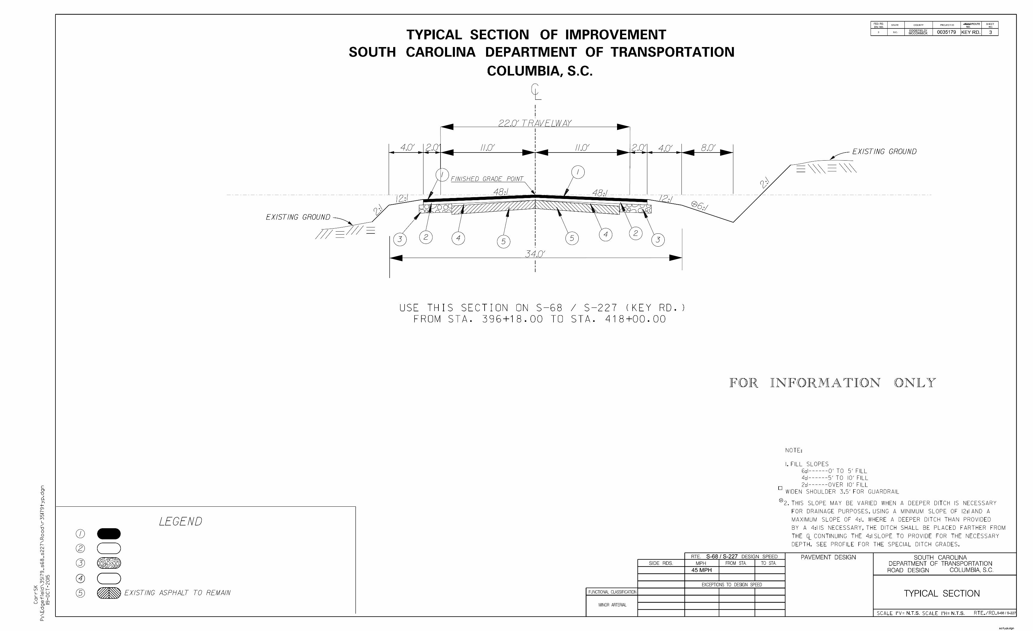
The new bridge would measure 320 feet in length and 37’-3” in width. The structure would accommodate two (2)
11-foot travel lanes, one (1) in each direction, and 6-foot shoulders (see Appendix B for preliminary design plans
of the proposed bridge structure). The proposed bridge is comprised of two (2) spans, including a 215-foot main
span and a 105-foot span. The 215-foot main span would be a simply supported steel girder span with an
expansion joint at the interior bent. The second span would be constructed of concrete beams. Two (2) 20-foot
approach slabs are also proposed, one on each end of the bridge.
1 STIP (Statewide), Revision 32 (Correction), 08/18/2016, page 24-1, Bridge Program – BRP-10; S-19-68 over Turkey Creek line item. Referenced on September 26,2016 at: http://www.scdot.org/inside/pdfs/STIP/Statewide/Bridge.pdf

Non-Programmatic Categorical Exclusion Edgefield and McCormick Counties, South Carolina Proposed S-68 (Key Road) Bridge Replacement over Turkey Creek Project ID No. 35179
Page 2
Approximately 38 feet of vertical clearance will be provided by the new bridge, a slight reduction from the
existing clearance. The minimum horizontal clearance would be expanded to approximately 215 feet, completely
spanning Turkey Creek and providing a greater hydraulic opening. No bents would be located in Turkey Creek.
Roadway approaches would be improved for a total of 2,180 feet, including approximately 1,030 feet on the
Edgefield County side of the bridge and approximately 1,150 feet on the McCormick County side of the bridge.
Including the proposed bridge, the total project length is approximately 2,500 feet in length.
Alternatives Analysis: Five (5) alternatives were developed and considered for the project. The alternatives
considered for the project are the (1) “No-Build”, (2) Rehabilitation Alternative, (3) Replacement Upstream, (4)
Replacement Downstream, and (5) Replacement on Existing Alignment. Each build alternative would be designed
to maintain two (2) lanes of traffic and meet SCDOT current safety and design standards. Additionally, each of
the build alternatives has been designed to transition to the existing horizontal roadway alignment as quickly as
possible to minimize the length of the project while maintaining the desired design criteria. For safety and
navigational reasons, each build alternative would also require the demolition of the existing bridge prior to
construction of the new bridge, and would therefore result in an adverse effect to a historic resource eligible for
listing on the National Register of Historic Places, the S-68/S-227 (Key Road) Bridge over Turkey Creek.
(1) The “No-Build” Alternative was considered in place of the bridge replacement project. This alternative
would neither improve the bridge’s sufficiency rating nor address the bridge’s structurally deficient and
functionally obsolete status. If the “No-Build” Alternative was selected, only routinely scheduled
maintenance operations would occur on the bridge and it would continue to age and deteriorate. It is
likely that SCDOT would eventually be required to post weight restrictions on the bridge, substantially
reducing its ability to serve the motoring public. In future years, the bridge could be closed to vehicular
traffic due to its deteriorated condition, requiring a permanent detour of approximately 11.3 miles for
motorists and area residents. Due to future maintenance challenges and safety hazards posed by the
existing bridge, and the potential intolerable restrictions placed on travel and the transport of goods, the
“No-Build” Alternative was deemed an unacceptable alternative.
(2) The Rehabilitation Alternative was also considered in place of the proposed bridge replacement.
Rehabilitation includes measures that address the structural condition of the bridge in order to maintain
the carrying capacity rating without affecting the historic integrity of the bridge. This would require
ongoing inspections, maintenance, and repairs to allow the bridge to be structurally sufficient without
posting a vehicle weight limit. The rehabilitation measures would not address the functional
obsolescence of the bridge, including the substandard width of travel lanes and absence of adequate
roadway shoulders. Due to the age of and structural condition of the bridge and inability to address the
functional obsolescence of the bridge, the rehabilitation alternative is not the most prudent and feasible
alternative.
(3) The Replacement Upstream Alternative would replace the S-68/S-227 bridge with a new structure
upstream, or east, of the existing alignment (Figure 1). Alternative 3 would involve constructing a new
bridge 50 feet upstream of the existing alignment and realigning the approach roadways to tie in to the
new bridge. Alternative 3 would shift the roadway to the inside of the existing roadway curve, presenting
design challenges, and would likely require a reduction in the design speed of the roadway. This could
result in safety concerns for the motoring public and would not be the best available option for meeting

Non-Programmatic Categorical Exclusion Edgefield and McCormick Counties, South Carolina Proposed S-68 (Key Road) Bridge Replacement over Turkey Creek Project ID No. 35179
Page 3
design requirements. Alternative 3 would require additional roadway construction to realign the roadway
approaches to the bridge and approximately 1.60 acres of additional right-of-way. These factors would
increase the overall project costs and encroachment into the Sumter National Forest. In light of these
factors, Alternative 3 was not considered the most prudent or feasible alternative when compared to
replacement on existing alignment.
(4) The Replacement Downstream Alternative would replace the S-68/S-227 bridge downstream, or west,
of the existing alignment (Figure 1). Alternative 4 would involve constructing a new bridge 50 feet
downstream of the existing alignment and realigning the approach roadways to tie in to the new bridge.
Alternative 4 would shift the roadway to the outside of the existing roadway curve, further increasing
right-of-way acquisition (1.90 acres) and encroachment into the Sumter National Forest. Alternative 4
would also require additional roadway construction to realign the roadway approaches to the bridge,
increasing overall project costs. In light of these factors, Alternative 4 was not considered the most
prudent or feasible alternative when compared to replacement on existing alignment.
Figure 1: Off-Alignment Alternatives

Non-Programmatic Categorical Exclusion Edgefield and McCormick Counties, South Carolina Proposed S-68 (Key Road) Bridge Replacement over Turkey Creek Project ID No. 35179
Page 4
(5) The Replacement on Existing Alignment Alternative would replace the S-68/S-227 bridge on existing
alignment. Replacement of the bridge on existing alignment would require minimal right-of-way
acquisition (0.10 acre) and the least roadway construction. Alternative 5 would also have the lowest
project costs of the three (3) build alternatives, and would have the least encroachment on the Sumter
National Forest.
Alternatives 1 and 2 do not meet the purpose and need of the project, either failing to address the structural
deficiencies and/or the functional obsolescence of the existing bridge. None of the Build Alternatives would
impact Jurisdictional Waters of the U.S., protected species, archaeological resources, or result in any
displacements. Alternatives 3, 4, and 5 would adversely impact one (1) historic resource eligible for listing on the
NRHP. However, the demolition of the resource reduces the likelihood of conflict with the existing bridge during
construction and provides for easier constructability and safer traffic operations during construction.
Of the build alternatives, Alternatives 3 and 4 would result in the greatest encroachment on the Sumter National
Forest and have the highest project costs. Alternative 5 was selected as the Preferred Alternative for the project
due to its compatibility with design requirements, its minimal right of way acquisition (0.10 acre), its lower total
project cost and minimal encroachment on the Sumter National Forest.
Acquisitions / Displacements: After careful review of the proposed projects plans (Appendix B), it has been
determined that the project would not result in the relocation/displacement of any commercial or residential
establishments.
The Preferred Alternative would acquire a minor amount (0.10 acre) of new right-of-way (ROW) from one (1)
parcel in the immediate vicinity of the proposed bridge (Appendix A, Figure 2). This parcel is part of the Sumter
National Forest and managed by the U.S. Forest Service (USFS). In lieu of a federal land transfer, the SCDOT
will obtain easements for the necessary ROW from the USFS for construction access and future maintenance of
the proposed bridge. No additional ROW is necessary for roadway approach improvements.
The SCDOT will acquire all new right-of-way in compliance with the Uniform Relocation Assistance and Real
Property Acquisition policies Ace of 1970, as amended (42 U.S. C. 4601 et seq.). The purpose of these
regulations is to ensure that owners of real property to be acquired for Federal and federally-assisted projects are
treated fairly and consistently, to encourage and expedite acquisition by agreements with such owner, to minimize
litigation and relieve congestion in the courts, and to promote public confidence in Federal and federally-assisted
land acquisition programs.
Public Involvement: Due to the proposed project’s limited environmental impacts, minimal ROW acquisition,
and the low Average Daily Traffic (ADT) of the route (200 vehicle per day), it was determined that no public
meetings for the project would be held. Signs notifying the public of the upcoming bridge replacement project
will be placed in the project area prior to construction. These signs will be posted after the completion of the
environmental document for a period of 15 days, which coincides with SCDOT policy for advertising an
opportunity for a public meeting. The signs will indicate that a bridge closure and detour are anticipated and
contact information will be provided.
Section 106 - Cultural Resources (Archaeological/Historic): In accordance with 36 CFR 800.4, archival
research and coordination with the State Historic Preservation Office (SHPO) was performed to identify and help
predict the locations of significant cultural resources in the vicinity of the proposed project. The archaeological
Non-Programmatic Categorical Exclusion Edgefield and McCormick Counties, South Carolina Proposed S-68 (Key Road) Bridge Replacement over Turkey Creek Project ID No. 35179
Page 5
and architectural surveys performed were designed to provide the necessary management data to allow for the
sites and properties to be evaluated for recommendations of eligibility to the National Register of Historic Places
(NRHP). The project location and findings were coordinated with SHPO, the Catawba Indian Nation Tribal
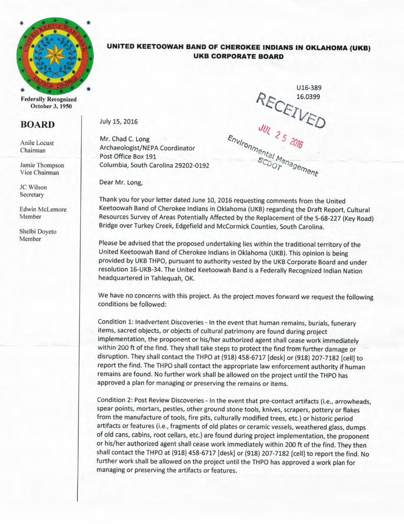
Historic Preservation Office (CIN-THPO), the Eastern Band of the Cherokee Indians, the United Keetoowah
Band of Cherokee Indians (UKB), the Eastern Shawnee Tribe (EST), and the Advisory Council on Historic
Preservation (ACHP).
Archaeology
SCDOT archaeologists documented three (3) new archaeological sites during field surveys, identified as
38ED857, 38ED858, and 38MC2653. Two (2) previously recorded sites (38MC254 and 38MC1945) were also
revisited during field surveys. Sites 38ED857, 38ED858, and 38MC2653 were recommended not eligible for
listing in the NRHP.
Sites 38MC254 and 38MC1945 remain unassessed for NRHP eligibility. The Preferred Alternative would
include minor filling, clearing, and grubbing impacts to the perimeter of both sites. Due to previous disturbance
to site 38MC254, the SCDOT determined that the project would have no adverse effect upon this site. Impacts to
site 38MC1945 are anticipated to be minimal and are not likely to result in the loss of significant information
about the site. Furthermore, the SCDOT plans to minimize impacts and avoid adverse effects to the site by
implementing specific conditions during construction. A list of these conditions can be found in the
Environmental Commitments Form.
Concurrence documents from the CIN-THPO, UKB, and EST regarding the above findings and avoidance
measures are included in Appendix C.
The contractor and subcontractors must notify their workers to watch for the presence of any prehistoric or
historic remains, including but not limited to arrowheads, pottery, ceramics, flakes, bones, graves, gravestones, or
brick concentrations during the construction phase of the project, if any such remains are encountered, the
Resident Construction Engineer (RCE) will be immediately notified and all work in the vicinity of the discovered
materials and site work shall cease until the SCDOT Archaeologist directs otherwise.
Historic Architecture
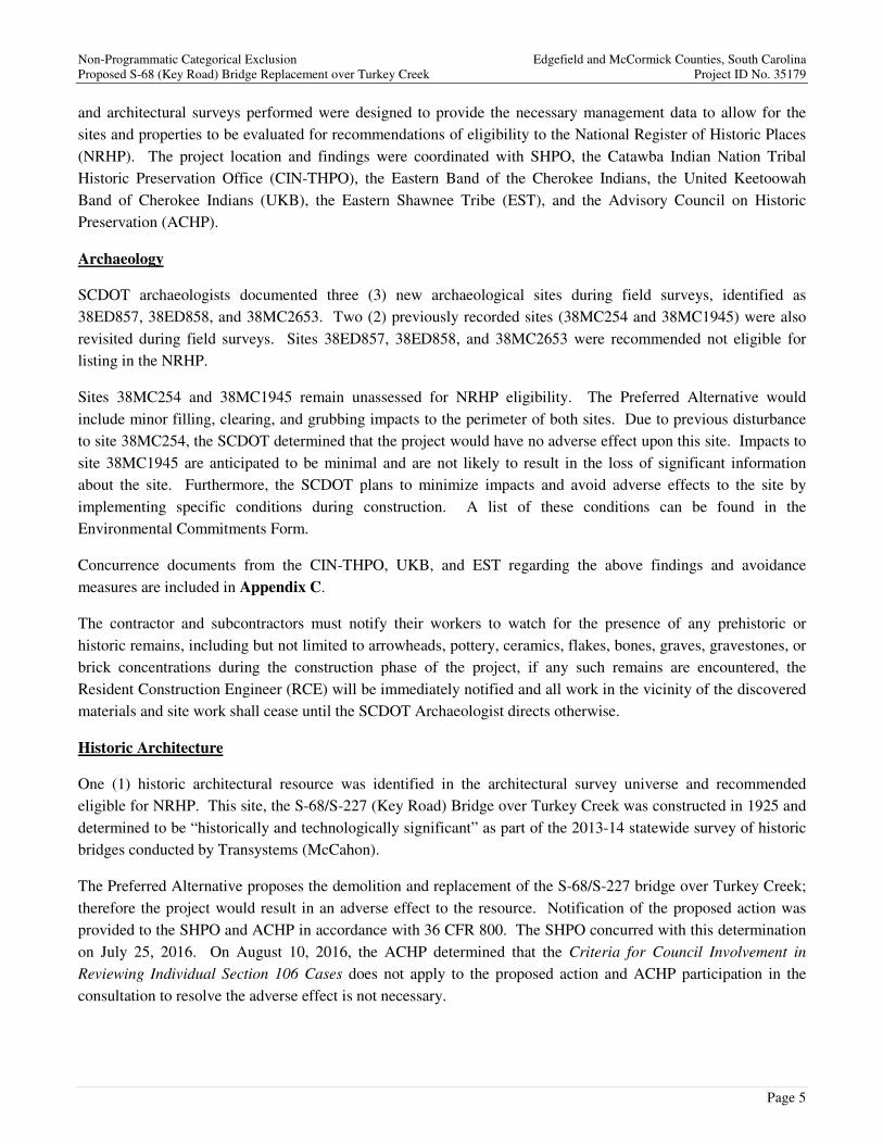
One (1) historic architectural resource was identified in the architectural survey universe and recommended
eligible for NRHP. This site, the S-68/S-227 (Key Road) Bridge over Turkey Creek was constructed in 1925 and
determined to be “historically and technologically significant” as part of the 2013-14 statewide survey of historic
bridges conducted by Transystems (McCahon).
The Preferred Alternative proposes the demolition and replacement of the S-68/S-227 bridge over Turkey Creek;
therefore the project would result in an adverse effect to the resource. Notification of the proposed action was
provided to the SHPO and ACHP in accordance with 36 CFR 800. The SHPO concurred with this determination
on July 25, 2016. On August 10, 2016, the ACHP determined that the Criteria for Council Involvement in
Reviewing Individual Section 106 Cases does not apply to the proposed action and ACHP participation in the
consultation to resolve the adverse effect is not necessary.

Non-Programmatic Categorical Exclusion Edgefield and McCormick Counties, South Carolina Proposed S-68 (Key Road) Bridge Replacement over Turkey Creek Project ID No. 35179
Page 6
As a facility eligible for the NRHP, the S-68/S-227 bridge over Turkey Creek is afforded protection under Section
4(f); please see the Section 4(f)/6(f) chapter of this document for more details. Copies of SHPO’s concurrence and
coordination with ACHP is included in the Programmatic Section 4(f) Evaluation in Appendix D.
Section 4(f)/6(f): No Section 6(f) properties were identified within the project boundaries. Two Section 4(f)
resources are documented within the PSA.
The Wine-Turkey Creek Trail is a 12 mile (one-way) unpaved public-use trail within the Sumter National Forest.
The trail crosses S-68/S-227 (Key Road) approximately 800 feet north of the bridge over Turkey Creek. As a
facility located within the Sumter National Forest, the trail is afforded protections under Section 4(f). Each
alternative was evaluated for the potential impact to the resource. Due to the location of the trail crossing, it was
determined that each build alternative would result in a temporary closing of approximately 60 feet of the trail in
the vicinity of Key Road. The Wine-Turkey Creek Trail bridge over Turkey Creek would also be closed while
being rehabilitated as part of the overall S-68 Bridge Replacement scope.
It is proposed that these portions of the trail be closed during construction and reopened following construction. It
is the intent of SCDOT to fully restore access to the trail; therefore, the project would have no permanent impact
on the use or function of the trail. A concurrence letter from the U.S. Forest Service enables the FHWA to make a
de minimis (minimal impact) finding, which satisfies the requirements of Section 4(f). De minimis impacts on
publicly-owned parks, recreation areas, and wildlife and waterfowl refuges are defined as those that do not
“adversely affect the activities, features and attributes” of the Section 4(f) resource. A copy of the de minimis
determination, and associated agency coordination, is included in Appendix E.
As included in the Section 106 - Cultural Resources (Archaeological/Historic) chapter of this document, one
(1) historic architectural resource was identified in the architectural survey universe and recommended eligible for
the NRHP. This site, the S-68/S-227 (Key Road) Bridge over Turkey Creek was constructed in 1925 and
determined to be “historically and technologically significant” as part of the 2013-14 statewide survey of historic
bridges conducted by Transystems (McCahon). As a facility eligible for the NRHP, the resource is afforded
protection under Section 4(f).
A Programmatic Section 4(f) Evaluation was conducted to consider various alternatives based on potential affects
to the resource as well as the surrounding human and natural environment. The evaluation documents that all
alternatives propose the demolition of the existing S-68/S-227 bridge for safety and navigational reasons prior to
construction of the new bridge. However, replacing the existing bridge on the existing alignment would have the
least impact on the surrounding environment, and was therefore selected as the Preferred Alternative. Based on
the above considerations, there is no prudent and feasible alternative to the Section 4(f) use of the S-68/S-227
(Key Road) bridge over Turkey Creek, and the Preferred Alternative includes all possible planning to minimize
harm to the resource resulting from such use.
The SCDOT and the SHPO considered several potential options for mitigation to offset the adverse effect the
project would have on the Key Road bridge. A Memorandum of Agreement (MOA) was developed and outlines
recommendations concerning mitigation for the bridge. Final approval on the MOA was received on August 25,
2016 and was signed by representatives from the SCDOT, the SHPO, the USFS, and the FHWA. The approved
MOA and supporting documentation were filed with the ACHP in September 2016, thus completing the Section
106 consultation process. The approved mitigation recommendations can be found in the Environmental

Non-Programmatic Categorical Exclusion Edgefield and McCormick Counties, South Carolina Proposed S-68 (Key Road) Bridge Replacement over Turkey Creek Project ID No. 35179
Page 7
Commitments Form and attached MOA. The FHWA and SCDOT will ensure that the agreed-upon stipulations are implemented.
A copy of the Programmatic Section 4(f) Evaluation, including the MOA, is included in Appendix E.
Water Quality: The project is located in the Lower Savannah River Basin (USGS Hydrologic Unit Code [HUC] 03060107), which consists of sixteen (16) watersheds and approximately 2,500 square miles of South Carolina. Specifically, the PSA lies within the Turkey Creek Watershed (HUC 03060107-02), and drains to SCDHEC water quality monitoring station SV-352. Station SV-352 is located on Turkey Creek at S-68/S-227 (Key Road), within the PSA.
The SCDHEC’s Notice of Intent Water Quality Information Tool was accessed on March 17, 2016 to determine if the project drains to an impaired waterbody. According to SCDHEC’s report, Station SV-352 is impaired based on Escherichia coli (ECOLI) levels. A Total Maximum Daily Load (TMDL) has not been established for ECOLI or any other impairment in the project watershed; please see Appendix F for a copy of the SCDHEC Watershed and Water Quality Information Report.
Stormwater control measures, both during construction and post-construction, are required for SCDOT projects constructed in the vicinity of 303(d), TMDL, ORW, tidal, and other sensitive waters in accordance with the SCDOT’s MS4 Permit. Due to the existing water quality impairment within the project watershed, SCDHEC may require additional water quality protection and stormwater treatment measures during and after construction. However, the proposed project is not anticipated to contribute to the existing ECOLI impairment or have long term impacts on water quality within the watershed.
The contractor would also be required to minimize potential impacts through implementation of construction best management practices, reflecting policies contained in 23 CFR 650 B and the latest SCDOT Supplemental Technical Specifications for seeding and erosion control measures (SC-M-810-3 (7/15)).
Wetlands and Streams: Field reviews were conducted within the PSA for the presence of wetlands and other waters of the U.S. in February 2015. One (1) stream, Turkey Creek, was delineated during these field reviews. Jurisdictional determination and verification of delineated waters of the U.S. has been received by the U.S. Army Corps of Engineers (USACE) and issued SAC 2015-00468-DJJ (Appendix G).
Permitting: A Clean Water Act Section 404 permit is required for impacts to waters of the U.S., including wetlands. Section 404 is administered by the U.S. Army Corps of Engineers (USACE). Depending on the type and extent of waters of the U.S., including wetlands, to be impacted, Section 404 permitting requirements can range from activities that are considered exempt or preauthorized to those requiring pre-construction notification (PCN) for a Nationwide Permit (NWP) or Individual Permit (IP) from the USACE. For SCDOT projects, an USACE General Permit (GP) (SAC 2015-1280, SAC 2015-1281, SAC 2015-1282, SAC 2015-1283, SAC 2015-1284, SAC 2015-1285, or SAC 2015-1286) may be applicable depending on the anticipated impacts of the project.
Based on preliminary engineering, the project proposes to span Turkey Creek in its entirety; therefore, a Section 404 Permit is not anticipated. In accordance with Section 401 of the Clean Water Act, a Permit for Construction in Navigable Waters has been issued by SCDHEC for the project, which satisfies the requirements for a Water

Non-Programmatic Categorical Exclusion Edgefield and McCormick Counties, South Carolina Proposed S-68 (Key Road) Bridge Replacement over Turkey Creek Project ID No. 35179
Page 8
Quality Certification. This permit was issued on May 29, 2015 and referenced authorization number SC GP 95-
002 16-001.
Compensatory mitigation is not anticipated to be required due to the avoidance of impacts to waters of the U.S.
In the event project plans are modified and would result in impacts to waters of the U.S., permitting requirements
will be reevaluated and addressed accordingly.
Floodplains: Floodplain and floodway protection is required under several federal, state, and local laws,
including Executive Order 11988, entitled “Floodplain Management,” which requires federal agencies to avoid
making modifications to and supporting development in floodplains wherever practical. Floodplains subject to
inundation by the one-percent-annual-chance (100 year) flood event are regulated by the Federal Emergency
Management Agency (FEMA).
Based upon a review of the floodplain mapping (FIRM Map ID 45065C0300D) of the project study area, the
proposed project crosses the FEMA-regulated Zone A floodplain of Turkey Creek. SCDOT requires all Zone A
crossings to be analyzed for the 100-year flood to insure that the floodplain encroachment does not cause one (1)
foot or more of backwater when compared to unrestricted or natural conditions. A Bridge Scope and Risk
Assessment Form was completed to evaluate potential impacts to the floodplain and indicates that the project
would not impact the Turkey Creek floodplain; please see Appendix H for a copy of the Bridge Scope and Risk
Assessment Form.
Threatened and Endangered Species: Pursuant to Section 7 of the Endangered Species Act (ESA), field
surveys were conducted for federally protected species within the project study area. A search of the U.S. Fish
and Wildlife Service (USFWS) database identified five (5) federally threatened or endangered species known to
occur or to have formerly occurred in Edgefield and/or McCormick Counties, as listed in Table 1. Please note:
Table 1 also includes nine (9) at-risk species (ARS) and the bald eagle (Haliaeetus leucocephalus). The bald
eagle is no longer protected under the ESA, but is afforded protection through the Bald and Golden Eagle
Protection Act (BGEPA) of 1940.
Animal species that are on the South Carolina state protected species list receive protection under the South
Carolina Nongame and Endangered Species Conservation Act (South Carolina Code, Title 50). One (1)
additional species is currently listed as state threatened or endangered in Edgefield and/or McCormick Counties.
This species is listed as Webster’s salamander (Plethodon websteri), as listed in Table 1 below.
Methodology
An area approximately 300 feet in width and 4,200 feet in length, generally centered on the S-68/S-227 (Key
Road) bridge over Turkey Creek, was reviewed for protected species on July 10, 2015 and April 27, 2016. Areas
that matched the descriptions of preferred habitat for protected species were classified as protected species habitat
and were surveyed for the presence of the species. A one-half mile buffer around the PSA was also reviewed for
potential red-cockaded woodpecker nesting habitat. Additionally, a survey was also conducted in December 2015
to identify the presence or absence of freshwater mussels, including Carolina heelsplitter (Lasmigona decorata),
in the vicinity of the project. Mussel surveys were conducted from approximately 400 meters downstream of the
existing bridge crossing to approximately 100 meters upstream of the crossing for a total distance of
approximately 500 meters.

Non-Programmatic Categorical Exclusion Edgefield and McCormick Counties, South Carolina Proposed S-68 (Key Road) Bridge Replacement over Turkey Creek Project ID No. 35179
Page 9
At-Risk Species (ARS) do not receive legal protection from the ESA; therefore, surveys for these species were
not conducted as part of Section 7 compliance.
TABLE 1
THREATENED, ENDANGERED, AND AT-RISK SPECIES
Protected Species County Listed
Protection Status
Common Name Scientific Name Federal State
Bird Species
American wood stork Mycteria americana McCormick T -
Bald eagle Haliaeetus leucocephalus Edgefield & McCormick BGEPA T
Red-cockaded woodpecker Picoides borealis Edgefield & McCormick E E
Fish Species
American eel Anguilla rostrata Edgefield & McCormick ARS -
Blueback herring Alosa aestivalis Edgefield & McCormick ARS -
Robust redhorse Moxostoma robustum Edgefield & McCormick ARS -
Insect Species
Septima's clubtail Gomphus septima McCormick ARS -
Mammal Species
Tri-colored bat Perimyotis subflavus Edgefield & McCormick ARS -
Mollusk Species
Brook floater Alasmidonta varicosa Edgefield & McCormick ARS -
Carolina heelsplitter Lasmigona decorata Edgefield & McCormick E,CH E
Plant Species
Carolina-birds-in-a-nest Macbridea caroliniana Edgefield ARS -
Georgia aster Symphyotrichum
georgianum Edgefield & McCormick ARS -
Miccosukee gooseberry Ribes echinellum Edgefield & McCormick T -
Ocmulgee skullcap Scutellaria ocmulgee Edgefield ARS -
Relict trillium Trillium reliquum Edgefield E -
Reptile Species
Webster’s salamander Plethodon websteri Edgefield & McCormick - E
BGEPA = Bald and Gold Eagle Protection Act; T = Threatened, E = Endangered, CH= Critical Habitat, ARS = At Risk Species

Non-Programmatic Categorical Exclusion Edgefield and McCormick Counties, South Carolina Proposed S-68 (Key Road) Bridge Replacement over Turkey Creek Project ID No. 35179
Page 10
Results / Biological Conclusions
Based on the literature and field reviews, it is determined that the proposed project will have a biological
conclusion of ‘no effect’ on American wood stork, bald eagle, red-cockaded woodpecker, Miccosukee
gooseberry, or relict trillium.
Freshwater mussel surveys identified one (1) individual Carolina heelsplitter approximately 70 feet upstream of
the existing S-68/S-227 (Key Road) bridge. The proposed project is also adjacent to a segment of Turkey Creek
designated as Critical Habitat for the species. The project does not propose bridge supports within the stream
channel, and there will be no temporary disturbance to the stream bottom from in-stream construction causeways,
work pads, or construction within the Turkey Creek. Therefore, a biological conclusion of “May Affect, Not
Likely to Adversely Affect” was provided for both the Carolina heelsplitter and Critical Habitat Unit 5. Based on
the information provided and additional environment commitments (see Environmental Commitments) agreed to
by USFHWA and SCDOT to protect the species and its critical habit, the USFWS concurred with the
determination that the proposed project may affect, but is not likely to adversely affect, the species or its critical
habitat. A copy of the freshwater mussel survey is included in the Natural Resources Technical Memorandum
(NRTM), dated May 2016. The NRTM as well as the USFWS concurrence letter, dated April 20, 2016, can be
found within Appendix I.
No individuals Webster’s salamander were directly observed within the PSA during the July 2015 field reviews;
however, a population of the species was identified in 1983 approximately 250 feet downstream of the PSA. Due
to the proximity of the known population downstream and the similar habitat found within the PSA, it was
determined that Webster’s salamander may inhabit the area of mixed hardwoods along the southern banks of
Turkey Creek. Only one bridge support is proposed in the vicinity of the potential habitat for the species. This
end bent will be constructed at the top of the hill slope, in a transitional area between mixed hardwoods and pine
forest, and within the disturbed footprint of the existing bridge. If present, individuals of Webster’s salamander
may experience temporary disturbance during construction due to noise and vibration associated with the
demolition of the existing bridge and construction of the new bridge. Any individuals of the species temporarily
impacted by these activities would likely reinhabit the area following construction. Therefore, a biological
conclusion of “May Affect, Not Likely to Adversely Affect” was provided for Webster’s salamander.
Federally proposed, endangered, or threatened species, and USFS sensitive (PETS) species: The proposed
project is located within the Sumter National Forest; therefore, the USFHWA and SCDOT are required to
consider PETS species during the project development. The USFS defines sensitive species as species identified
by the Regional Forester as showing significant declines in population numbers, density, or habitat capability that
could reduce the species’ existing distribution.
The USFS provided information regarding PETS species of the Sumter National Forest (last updated September
2015). This database identifies 20 PETS species with potential occurrence within the Long Cane Ranger District,
as listed in Table 2. Please note: Table 2 also includes the Carolina Heelsplitter (Lasmigona decorata),
Miccosukee gooseberry (Ribes echinellum), relict trillium (Trillium reliquum), wood stork (Mycteria americana),
bald eagle (Haliaeetus leucocephalus), and Webster’s salamander (Plethodon websteri). Please see the
Threatened and Endangered Species section of this document for additional details regarding these species,
including the biological conclusion of the project’s construction on each species.

Non-Programmatic Categorical Exclusion Edgefield and McCormick Counties, South Carolina Proposed S-68 (Key Road) Bridge Replacement over Turkey Creek Project ID No. 35179
Page 11
To analyze potential impacts to PETS species associated with the proposed project, SCDOT provided areas of
new right-of-way/easements and potential ground disturbance, including construction limits, clearing/grubbing
limits, and bridge construction access. According to these limits, an area approximately 150 feet in width and
2,200 feet in length, generally centered on the S-68/S-227 (Key Road) bridge over Turkey Creek was reviewed
for PETS species on April 27, 2016.
TABLE 2
PROPOSED, ENDANGERED, THREATENED, AND SENSITIVE (PETS) SPECIES
PETS Species Potential Habitat Protection Status
Common Name Scientific Name
Carolina heelsplitter Lasmigona decorata Yes FE
Miccosukee gooseberry Ribes echinellum Yes FT
Relict trillium Trillium reliquum Yes FE
American wood stork Mycteria americana No FT
Bachman’s sparrow Peucaea aestivalis No Sensitive
Bald eagle Haliaeetus leucocephalus No Sensitive
Brook floater Alasmidonta varicosa Yes Sensitive
Carolina darter Etheostoma collis Yes Sensitive
Georgia Aster Symphyotrichum georgianus Yes Sensitive
Indigo bush Amorpha schwerini Yes Sensitive
Lanceleaf trillium Trillium lancifolium Yes Sensitive
Migrant loggerhead shrike Lanius ludovicia migrans No Sensitive
Nodding trillium Trillium rugelii No Sensitive
Oglethorpe oak Quercus oglethorpensis Yes Sensitive
Piedmont aster Eurybia mirabilis Yes Sensitive
Rayed pink fatmucket Lampsilis splendida Yes Sensitive
Robust redhorse Moxostoma robustrum Yes Sensitive
Shoal’s spider lilly Hymenocallis coronaria No Sensitive
Sweet pinesap Monotropsis odorata No Sensitive
Webster's Salamander Plethodon websteri Yes Sensitive
FE = Federally Endangered; FT = Federally Threatened
No potential habitat for Bachman’s sparrow, migrant loggerhead shrike, nodding trillium, shoal’s spider lily, or
sweet pinesap were identified within the PETS survey limits.
The project does not propose bridge supports within the stream channel, and there will be no temporary
disturbance to the stream bottom from in-stream construction causeways, work pads, or construction within the

Non-Programmatic Categorical Exclusion Edgefield and McCormick Counties, South Carolina Proposed S-68 (Key Road) Bridge Replacement over Turkey Creek Project ID No. 35179
Page 12
stream; therefore, adverse impacts to Carolina darter and robust redhorse are not expected to result from the
project.
Three (3) individual brook floaters were identified during the freshwater mussel survey conducted in December
2015. No bridge supports will be located within the stream channel, and there will be no temporary disturbance to
the stream bottom from in-stream construction causeways, work pads, or construction within the stream.
Additionally, SCDOT has committed to take extra precautions during construction (see Environmental
Commitments) in order to prevent the degradation of the habitat from sedimentation. As such, adverse impacts to
brook floater are not expected to result from the project.
Field surveys did not identify any populations of Georgia aster, indigo bush, lanceleaf trillium, Oglethorpe oak, or
piedmont aster within the PETS species survey limits; therefore, construction of the project will have no effect on
these species. Additionally, no individuals of Rayed pink fatmucket were identified during the freshwater mussel
survey; therefore construction of the project will have no effect on the species.
Additional surveys for Webster’s salamander were conducted within the PETS species survey limits on April 27,
2016. The probability of detection during these field reviews was determined to be low due to the lack of recent
rainfall and higher temperatures during field reviews. Additionally, potential habitat within the PETS species
survey limits is not ideal habitat for the species. The PETS species survey limits are primarily comprised of areas
previously disturbed for the construction of the existing roadway and bridge. The soils in these areas consist of
compacted, clayey fill material with few rocks. This area also lacks an abundance of limbs and other natural
debris favored by the species due to past construction of the bridge and maintenance clearing of vegetation
immediately adjacent to the bridge. No individuals of the species were identified during surveys. As earlier
stated, adverse impacts to this species are not expected to result from the project.
Noise: The proposed improvements do not represent a Substantial Horizontal Alteration. 23 CFR 772 states, “A
substantial horizontal alteration would occur on a project that halves the distance between the traffic noise source
and the closest receptor between the existing condition to the future build condition.” Also, this project does not
include the addition of through traffic lanes, a significant change in vertical alignment or any other conditions that
would qualify it as a Type I project. Therefore, the requirements for conducting noise studies under 23 CFR 772
do not apply.
Air Quality / Mobile Source Air Toxics (MSATs): Edgefield and McCormick Counties are in attainment for
National Ambient Air Quality Standards (NAAQS). As a result, Edgefield and McCormick Counties meet or
exceed the standards established by the Environmental Protection Agency (EPA) for criteria pollutants and air
quality.
The purpose of this project is to replace the existing Key Road bridge over Turkey Creek on its existing
alignment. This project has been determined to generate minimal air quality impacts for Clean Air Act
Amendments (CAAA) criteria pollutants and has not been linked with any special Mobile Source Air Toxic
(MSAT) concerns. As such, this project will not result in any meaningful changes in traffic volumes, vehicle mix,
location of the existing facility, or any other factor that would cause an increase in MSAT impacts of the project
from that of the no-build alternative.
Moreover, EPA regulations for vehicle engines and fuels will cause overall MSAT emissions to decline
significantly over the next several decades. Based on an FHWA analysis using EPA's MOVES2010b model even

Non-Programmatic Categorical Exclusion Edgefield and McCormick Counties, South Carolina Proposed S-68 (Key Road) Bridge Replacement over Turkey Creek Project ID No. 35179
Page 13
if vehicle-miles travelled (VMT) increases by 102 percent as assumed from 2010 to 2050, a combined reduction
of 83 percent in the total annual emissions for the priority MSAT is projected for the same time period. This will
both reduce the background level of MSAT as well as the possibility of even minor MSAT emissions from this
project.
Land Use: The proposed bridge replacement is located in the Sumter National Forest, within a rural portion of
South Carolina. Land use in the surrounding areas is dominated by undeveloped woodlands and sparse residential
establishments. The bridge replacement is not expected to modify existing land use or change the timing or
density of development in the area. The project is not in conflict with any plan, existing land use, or zoning
regulation.
Hazardous Materials: The area directly adjacent to the project predominately consists of undeveloped
woodland associated with the Sumter National Forest and has low potential for underground storage tanks
(USTs). Therefore, there is low potential for uncovering USTs or other hazardous-material-containing sites during
construction activities.
An examination of the project area and records available at the South Carolina Department of Health and
Environmental Control (DHEC) by the Department indicated that there are no USTs located along Key Road in
Edgefield or McCormick County. It is SCDOT’s practice to avoid the acquisition of USTs and other hazardous
waste materials, if at all possible. If soils that appear to be contaminated with petroleum products are encountered
during construction, SCDHEC would be informed. If avoidance were not a viable alternative, tanks and other
hazardous materials would be tested and removed and/or treated in accordance with the USEPA and SCDHEC
requirements. Costs necessary for cleanup would be taken into consideration during the right-of-way appraisal
and acquisition process.
Community Impacts: The area directly adjacent to the project predominately consists of undeveloped woodland
associated with the Sumter National Forest. No commercial or residential developments are located within the
project area or surrounding vicinity; therefore, the project would not result in an adverse impact on public
facilities, businesses, or services nor is the project expected to adversely affect the social environment or local
economy.

Non-Programmatic Categorical Exclusion Edgefield and McCormick Counties, South Carolina Proposed S-68 (Key Road) Bridge Replacement over Turkey Creek Project ID No. 35179
Appendix A
Project Figures

³
0 2 41
Miles
Edgefieldand
McCormickCounties
---APPLICATION BY:
SOUTH CAROLINA DEPARTMENT OF TRANSPORTATION
Mead & Hunt878 South Lake DriveLexington, SC 29072
Tel. 803.996.2900www.meadhunt.com
S-68/S-227 (KEY ROAD) BRIDGE REPLACEMENTOVER TURKEY CREEK
EDGEFIELD AND McCORMICK COUNTIES, SOUTH CAROLINA
M&H PROJ: R3286900-140626.01
SCDOT PIN: 35179
USACE SAC: 2015-00468-DJJ DATE: 03/08/2016
SITE LOCATION MAP
FIGURE 1
DRAWN BY: MTD QAQC BY: JBS
Legend
Project Study Area (30 acres)
County Boundary
Municipality
National Forest
£¤378
McCormick
SOURCE: TIGER 2010 ROAD,
COUNTY, AND MUNICIPALITY DATA
Parksville
£¤221
J. Strom
Thurmond
Lake
Sumter
National
Forest
Lincoln County,
Georgia
£¤221
£¤221
£¤378
Steven'sC
ree
k
Turkey
Creek
Ste
ve
n's
Cre
ek
S-68 (KeyR
d)
S-227(K
eyR
d)
£28
£23
£283
£¤25
£283
£28
£28
£230
£23
S-5
1(N
.M
arti n
tow
nR
oa
d)
McCorm
ick Cou
nty
Edgefield C
ounty

0 100 20050
Feet
---APPLICATION BY:
SOUTH CAROLINA DEPARTMENT OF TRANSPORTATIONS-68/S-227 (KEY ROAD) BRIDGE REPLACEMENT
OVER TURKEY CREEK
EDGEFIELD AND McCORMICK COUNTIES, SOUTH CAROLINA PROPOSED RIGHT-OF-WAY IMPACTS
FIGURE 2
DRAWN BY: MTD QAQC BY: JBSSOURCE: SCDOT PRELIMINARY PLANS
³
McC
ormick
County
Edgefield
County
Turkey Creek
DATE: 04/12/2016
Mead & Hunt878 South Lake DriveLexington, SC 29072
Tel. 803.996.2900www.meadhunt.com
S-68
(Key
Ro
ad)
S-22
7(K
ey
Ro
ad
)
New
75
' R/W
New
75
' R/W
Existing 6
6' R
/W
Existing 6
6' R
/W
Existing
66' R
/W
Existing
66
' R/W
Edgefieldand
McCormickCounties
M&H PROJ: R3286900-140626.01
SCDOT PIN: 35179
USACE SAC: 2015-00468-DJJ
Legend
Existing Right-of-Way
Proposed Right-of-Way
Existing S-68/S-227 Bridge
Proposed S-68/S-227 Bridge
County Boundary

³
0 1.5 30.75
Miles
Edgefieldand
McCormickCounties
---APPLICATION BY:
SOUTH CAROLINA DEPARTMENT OF TRANSPORTATION
Mead & Hunt878 South Lake DriveLexington, SC 29072
Tel. 803.996.2900www.meadhunt.com
S-68/S-227 (KEY ROAD) BRIDGE REPLACEMENTOVER TURKEY CREEK
EDGEFIELD AND McCORMICK COUNTIES, SOUTH CAROLINA
DATE: 03/08/2016
PROPOSED DETOUR MAP
FIGURE 3
DRAWN BY: MTD QAQC BY: JBS
Legend
Project Study Area (30 acres)
Proposed Detour Route
County Boundary
National Forest
SOURCE: TIGER 2010 ROAD,
COUNTY, AND MUNICIPALITY DATA
McCo
rmick Cou
nty
Sumter
National
Forest
Steven
's C reek
Turkey
Creek
S-68 (KeyR
d)
S-227(K
eyR
d)
£283
£¤25
£230
£23
S-5
1(N
.M
arti n
tow
nR
oa
d)
Edgefield Cou
nty
£283
£283
£23
2.9 mi les
5.4
mile
s
3.0 miles
11.3 mile
Proposed Detour
M&H PROJ: R3286900-140626.01
SCDOT PIN: 35179
USACE SAC: 2015-00468-DJJ

Non-Programmatic Categorical Exclusion Edgefield and McCormick Counties, South Carolina Proposed S-68 (Key Road) Bridge Replacement over Turkey Creek Project ID No. 35179
Appendix B
Preliminary Design Plans

South Carolina Department of Transportation
1
DRAWING NO. 700-01
PROJECT ID 0035179ROAD S-68 S-227 (KEY ROAD)
0035179-B01
-N-
%
33 - 47' - 41"
82 - 08' - 41"
181
2015 150
2035 300
0.000
0.060
0.060
0.060
0.000
KL
SR
UR
10-1
5
10. Superstructure Detail (Span 2)9. Superstructure Detail (Span 1)8. Interior Bent 27. End Bent 36. End Bent 15. Bridge Plan and Profile4. Roadway Plan and Profile3. Roadway Typical Section2. General Notes1. Title Sheet
6
b35179ts.dgn
INDEX OF SHEETS
BRIDGE PLANS IDSHEET
NO.
Columbia, SC 29201
955 Park Street - Room 409
Attn: Logistics Coordinator - Shop Plans
Preconstruction Support Engineer
SCDOT
Submit Shop Plans to:
Approximate Location of Bridge is
Latitude
Longitude
RPG - HYDROLOGY
RPG - STRUCTURES
RPG - GEOTECHNICAL
PRECONSTRUCTION SUPPORT - STRUCTURES
RPG - DESIGN M ANAGER
RPG - PROGRAM M ANAGER
INITIAL DATE
FOR CONSTRUCTION
LAYOUT
NET LENGTH OF ROADW AY
NET LENGTH OF BRIDGES
NET LENGTH OF PROJECT
LENGTH OF EXCEPTIONS
GROSS LENGTH OF PROJECT MILES
MILES
MILES
MILES
MILES
TO THE SOUTH CAROLINA DEPARTMENT OF TRANSPORTATION STANDARD
PROVISIONS, ALL M ATERIALS AND W ORKM ANSHIP ON THIS PROJECT SHALL CONFORM
EXCEPT AS M AY OTHERW ISE BE SPECIFIED ON THE PLANS OR IN THE SPECIAL
SPECIFICATIONS FOR HIGHW AY CONSTRUCTION (2007 EDITION) AND THE STANDARD
DRAW INGS FOR ROAD CONSTRUCTION IN EFFECT AT THE TIME OF LETTING.
NOTE:
SOUTH CAROLINA
3 DAYS BEFORE DIGGING IN
CALL 811
ALL UTILITIES M AY NOT BE A MEMBER OF SC811W W W .SC811.COM
SOUTH CAROLINA 811 (SC811)
ASSET ID
TRAFFIC DATA
ADT V.P.D.
V.P.D.ADT
TRUCKS
Pri
nte
d:
Wed
nesd
ay
, N
ov
em
ber
04
, 2
01
5 8
:25
:18
AM
Sta
ple
toK
LD
AT
EC
HK
BY
RE
VIE
WE
D
DR
.
FORPROPOSED PLANS
EDGEFIELD McCORMICK COUNTIES
REPLACE BRIDGE OVER TURKEY CREEK
SITE LOCATION
ENGINEER OF RECORD
FOR CONSTRUCTION :
DATE
Sta.
NOVEMBER 4, 2015PRELIMINARY PLANS

FOR INFORMATION ONLY

FOR INFORMATION ONLY
4

> S-68 & > S-227
Existing Ground @
200
180
220
240
260
280
300
320
BENT NO. 1
2
3
Finished Grade
> S-68
To SC 23
of > S-68 & > S-227
Existing Ground, 20'-0" Left
of > S-68 & > S-227
Existing Ground, 20'-0" Right
To SC 283
> S-227
N
9'-
6"
11
'-0
"
9'-
6"
PT
= 4
05
+6
2.0
1
Beginning of Bridge
Expansion Joint &
Approach Slab
40
6+
00
40
7+
00
40
8+
00
40
9+
00
41
0+
00
41
1+
00
405+00
EDGEFIELD COUNTY
McCORMICK COUNTY
Top of Bank
Approximate
Jurisdictional Stream Limit (Typ.)
1
1
"Removal and Disposal of Existing Bridge".
associated with this work in the Lump Sum price bid for
202.4.2 of the Standard Specifications. Include all cost
and disposed of by the Contractor in accordance with Section
Existing 304' x 20' steel and concrete bridge to be removed
TURKEY CREEK
Flo
w
Approach Slab
(Typ. each corner)
Thrie-Beam Bridge Connector
& End of Bridge
Deflection Joint
Spread Footing
54" Dia. Drilled Shaft
48" Dia. Rock Socket
C
HP 14x73 Steel Piles
Nail in 18" Pine
Elev. = 270.710
146.14' LT of Sta. 406+82.79
Benchmark #3
2:1
Pri
nte
d:
Wednesday, N
ovem
ber
04, 2015 1
:01:2
0 P
M
SOUTH CAROLINA
DEPARTMENT OF TRANSPORTATION
REV.
REV.
REV.
REVIEWED
QUAN.
DR.
DES.
BY CHK. DATECOUNTY ROUTE
SHEETNO.BRIDGE PLANS ID
TURKEY CREEKREPLACE BRIDGE OVER
BRIDGE PLAN & PROFILE
EDGEFIELD / McCORMICK S-68 / S-227
KLS RUR 10-15
160
140 140
160
180
200
220
240
260
280
300
320
409+00 +20 +40 +60 +80
410+00 +20 +40 +60 +80 411+00 +20
+80+60+40+20408+00+80+60+40+20407+00+80+60+40+20406+00+80+60+40+20405+00
b35179bp.dgn
0035179-B01 5
& 1
•" S
lab
E
xt. (T
yp
.)
1'-
6" B
arrier P
arapet
Spacing
Drain
Exp. Joint
> Bent 2 &
Top of Bank
Approximate
Nail in 36" Pine
Elev. = 249.110
137.11' LT of Sta. 410+35.20
Benchmark #4
Elev. = 241.6
2 Yr. H.W.
Elev. = 250.2
25 Yr. H.W.
Elev. = 252.8
100 Yr. H.W.
***
Excavate hatched area
*25 Year High Water Elevation includes 0.19 feet of backwater
*100 Year High Water Elevation includes 0.24 feet of backwater
*
Q = 16,170 CFS
25 YEAR W.S. ELEV. = 249.8 FT
Q = 21,850 CFS
100 YEAR W.S. ELEV. = 252.4 FT
2 YEAR W.S. ELEV. = 241.6 FT
PROBABILITY 0.002
Q = 74,000 CFS
25VEL. = 4.3 FT/SEC
VEL. = 5.1 FT/SEC
HYDROLOGY DATA:
25
100
100
OVERTOPPING FLOOD:
D.A. = 275.6 SQ.MI. = 176,400 AC.
Elev
. =
2
77
.4
48
Sta. 406+
37.00
Begin A
pproach S
lab
Elev
. =
2
77
.2
13
Sta. 406+
57.00
Beg
in
Brid
ge
Elev
. =
2
74
.6
97
Sta. 408+
72.00
> B
en
t 2
Elev
. =
2
73
.4
68
Sta. 409+
77.00
End of B
ridge
Elev
. =
2
73
.2
33
Sta. 409+
97.00
En
d A
pp
ro
ach
Slab
15'-0"
12:1
Notes:
Edge of Shoulder
Shoulder
Edge of Paved
Edge of Lane
Edge of Lane
Shoulder
Edge of Paved
Edge of Shoulder
Edge of Lane
Edge of Shoulder
Shoulder
Edge of Paved
Edge of Lane
Shoulder
Edge of Paved
Edge of Shoulder
(Typ., See Road Plans)
Curb & Gutter with Flume
Bridge Approach Concrete
Scour lines will be provided after completion of Hydraulic Scour Study
Foundation dependant on Geotechnical Report
Fill/Cut (Typ.)
Approximate Toe of
10'-0" 10'-0"
I
XF
X
R = 818.35'
E = 174.98'
L = 986.32'
T = 563.03'
P.I. = 401+38.71
D = 7 00'05"
6 Spaces @ 14'-2" = 85'-0"10 Spaces @ 19'-0" = 190'-0"
CURVE DATA:
37
'-3
"
34
'-0
" R
oad
way
17'-
0"
17
'-0
"
320'-0"
Slab
Approach
20'-0" 215'-0" Span 1 105'-0" Span 2
Slab
Approach
20'-0"
PLAN
= 69 03'23" (RT)
VERTICAL CURVE DATA:
(-)5.98% (-)1.17%
L= 800'
V.P.I.= 400+15.00
Elev.= 284.73
VERTICAL CURVE DATA:
(-)1.17%
L= 500'
V.P.I.= 415+00.00
Elev.= 267.35
(+)3.63%
2'-0" Berm
"X" indicates Expansion Bearing
"F" indicates Fixed Bearing
"I" indicates Integral Bent
SECTION ALONG L SURVEY S-68 S-227
Jurisdictional Stream Limit measured along > Survey.
83'-2" +/-2
2
> Bridge
> Survey &
Keep all construction activity outside of Jurisdictional Stream Limits.
Guardrail not shown, see Road Plans.
Sheets 9 and 10.
For Constant Superelevation see Section Thru Superstructure on
No utilities present.
Notes:
9'-
6"
11
'-0
"
9'-
6"
(See Road Plans)
Riprap to Elev. 255.0,
Sta. 406+56.00
Boring B-2
6'-
0"
Sta. 409+00.00
Boring B-4
45
'-0
"
Sta. 409+80.00
Boring B-5
Sta. 406+47.00
Boring B-11
21
'-0
"
Sta. 406+48.00
Boring B-12
19
'-0
"
Sta. 408+78.00
Boring B-13
19
'-0
"
Sta. 408+78.00
Boring B-14
18
'-0
"
7'-
0"
Sta. 409+82.00
Boring B-15
10'-
0"

Prin
ted
: T
hu
rsd
ay
, O
cto
ber 2
9,
20
15
10
:06
:46
AM
REV.
REV.
REV.
REVIEWED
QUAN.
DR.
DES.
BY DATECHK.
ROUTECOUNTY
DEPARTMENT OF TRANSPORTATION
SOUTH CAROLINA
EDGEFIELD / McCORMICK
NO.SHEETBRIDGE PLANS ID
0035179-B01
b35179eb.dgn
END BENT 1
S-68 / S-227
KLS RUR 3-15
> Bridge
90°-00'-00"
5 %
1'-0" 5'-0" 1'-0"
Level
Level (Typ.)
2'-
6"
5'-
0"
2'-
6"
4'-
10"
PLAN
ELEVATION
Sta
tionin
g
Geotechnical Report
Foundation dependent on Bridge
4'-
10"
3'-
0"
Footing
Spread
3'-
0"
Beginning of Bridge
Wall
Back
1'-3"
Bridge
Beginning of
Top of Cap
Top of Build-Up
Footing
Top of Spread
Bolt (Typ.)
1•" Dia. Anchor > Bearing
> Bent &
Note:
> Bearing
> Bent &
4'-10‚ "
19'-10‚ "
39'-8• "
19'-10‚ "
1'-0"1'-0"
1'-
0"
1'-
0"
6
10'-0" (Typ.)
> Girders
1'-
3"
1'-
3"
1'-3"
(Typ.)
1'-2"
1'-9" 1'-9" (Typ.)
(T
yp.)
2'-
8"
1'-
0"
Ground
Proposed
2'-6" 2'-6"
7'-0"

Prin
ted
: T
hu
rsd
ay
, O
cto
ber 2
9,
20
15
10
:07
:40
AM
REV.
REV.
REV.
REVIEWED
QUAN.
DR.
DES.
BY DATECHK.
ROUTECOUNTY
DEPARTMENT OF TRANSPORTATION
SOUTH CAROLINA
EDGEFIELD / McCORMICK
NO.SHEETBRIDGE PLANS ID
0035179-B01
39'-4• "
19'-8‚ "
4'-2‚ "
19'-8‚ "
> Bridge
7'-9" (Typ.)
> Beams(Typ.)
90°-00'-00"
> Bearing
> Bent &
Level
> Steel Piles
3'-0‚ " 8'-4"
5 4 3 2 1PILE NO.
Geotechnical Report
Foundation dependent on Bridge
PLAN
ELEVATION
2'-
6"
Sta
tionin
g
3'-
4"
1'-
8"
1'-
8"
b35179eb.dgn
END BENT 3
S-68 / S-227
KLS RUR 3-15
12"
8"
direction of stationing.
to left looking in the opposite
Piles are numbered from right
Note:
End of Bridge
Bolt (Typ.)
1•" Dia. Anchor
7
1'-10" 1'-10"
(Typ.)
1'-0"
Wing Wall (Typ.)
(Looking Opposite Direction of Stationing)
(Typ.)

Printed: T
hursday, O
ctober 29, 2015 11:06:22 A
M
REV.
REV.
REV.
REVIEWED
QUAN.
DR.
DES.
BY DATECHK.
ROUTECOUNTY
DEPARTMENT OF TRANSPORTATION
SOUTH CAROLINA
NO.SHEETBRIDGE PLANS ID
4'-
6"
2'-
3"
2'-
3"
5'-
0"
6'-6" 23'-0"
4'-6" 2'-0" 2'-0"
4'-0" 9'-6"
PLAN
ELEVATION
> Rock Socket (Typ.)
> Drilled Shaft &
> Column
> Type IV Beams
> Steel Girder
7'-9" (Typ.)2'-6"
3'-0" 10'-0" (Typ.)
Construction Joint
SHAFT NO. 1 2
right looking in direction of stationing.
Drilled Shafts are numbered from left to
90°-00'-00"
> Bridge
> Bent
Note:
Geotechnical Report
Foundation dependent on Bridge
INTERIOR BENT 2KLS RUR 2-15
S-68 / S-227EDGEFIELD / McCORMICK
0035179-B01
b35179bt.dgn
Stationing
5% Slope (Typ.)
Level (Typ.)
Level
8
4'-6"
4'-0"
5'-
0"
Bolt (Typ.)
1• " Dia. Anchor
> Bearing
(Looking in Direction of Stationing)
11'-6"
END ELEVATION
Build-ups not shown
Construction Joint

Prin
ted
:
Mo
nd
ay
, N
ov
em
ber 0
2,
20
15
3:4
5:3
6 P
M
REV.
REV.
REV.
REVIEWED
QUAN.
DR.
DES.
BY DATECHK.
ROUTECOUNTY
DEPARTMENT OF TRANSPORTATION
SOUTH CAROLINA
EDGEFIELD / McCORMICK
NO.SHEETBRIDGE PLANS ID
DETAIL (SPAN 1)SUPERSTRUCTURE
KLS RUR 3-15
S-68 / S-227
0035179-B01
Looking in Direction of Stationing
1'-7• "
1'-6" 1• "
37'-3"
1'-6"
1'-7• "
1• " 17'-0"17'-0"
8•" (T
yp.)
3'-7• " 10'-0" 10'-0" 3'-7• "
1 2 3 4
> S-68, > S-227, & > Bridge
Finished Grade
48
1
SECTION THRU SUPERSTRUCTURE - SPAN 1
5'-0" 5'-0"
7'-
8" W
eb (T
yp.)
System
Drainage
Closed
Plate Girder (Typ.)
Grade 50W Steel
9.125' S
tructure D
epth
b35179sx.dgn
9
34'-0" (Roadway)
12" (T
yp.)
Parapet (Typ.)
Barrier
2"
span, both sides)
(Entire length of
ƒ " Drip Groove

Prin
ted
: M
on
day
, N
ov
em
ber 0
2,
20
15
3:4
8:5
1 P
M
REV.
REV.
REV.
REVIEWED
QUAN.
DR.
DES.
BY DATECHK.
ROUTECOUNTY
DEPARTMENT OF TRANSPORTATION
SOUTH CAROLINA
EDGEFIELD / McCORMICK
NO.SHEETBRIDGE PLANS ID
1• " 1'-6" 1'-6" 1• "
1'-7• "
37'-3"
1'-7• " 34'-0" (Roadway)
8" (T
yp
.)
11•" (T
yp
.)
17'-0" 17'-0"
3'-1• " 7'-9" 7'-9" 7'-9" 7'-9" 3'-1• "
1 2 3 4 5
Su
perstru
ctu
re D
ep
th
5.7
8'
48
1
Looking in Direction of Stationing
Concrete Beam (Typ.)
Type IV Prestressed System
Drainage
Closed
> S-68, > S-227, & > Bridge
Finished Grade
DETAIL (SPAN 2)SUPERSTRUCTURE
KLS RUR 3-15
S-68 / S-227
0035179-B01
SECTION THRU SUPERSTRUCTURE - SPAN 2
b35179sx.dgn
10
Parapet (Typ.)
Barrier
2"
span, both sides)
(Entire legtgh of
ƒ " Drip Groove

Non-Programmatic Categorical Exclusion Edgefield and McCormick Counties, South Carolina Proposed S-68 (Key Road) Bridge Replacement over Turkey Creek Project ID No. 35179
Appendix C
Concurrence from Tribal Historic Preservation Offices (THPOs)


1
Matt DeWitt
From: Long, Chad C. <[email protected]>
Sent: Wednesday, July 20, 2016 2:43 PM
To: Belcher, Jeffery - FHWA; Jurgelski, Bill M.; Kelly, David P.
Subject: Fwd: 106 reply
FYI
Begin forwarded message: From: Robin Dushane <[email protected]> Subject: 106 reply Date: July 20, 2016 at 12:53:31 PM EDT To: "[email protected]" <[email protected]> Dear Mr. Long,
In accordance with Section 106 of the National Historic Preservation Act of 1966, as amended (16 U.S.C.
470f), and implementing regulation, 36 CFR 800, “Protection of Historic Properties” the Eastern
Shawnee Tribal Historic Preservation Office is responding to your request for the Draft Report of S-68-
227 Bridge over Turkey Creek, in Edgefield and McCormick Counties, SC.
This office has reviewed the report received by our office on June 13, 2016. Thank you for sharing
information of sites nearby this project-both newly documented and previously recorded sites. The
ESTO THPO values SC DOT’s plans to minimize impacts and avoid adverse effects to
38MC1945. Additionally, we concur with SC DOT’s finding of adverse effect to historic properties. We
offer these comments under 36 CFR 800.13.
In future consultations, please feel free to consult by email. Please refer to my email in the signature
below.
Sincerely,
Robin DushanRobin DushanRobin DushanRobin Dushaneeee
Tribal Historic Preservation Officer
Eastern Shawnee Tribe
70500 E 128 Rd.
Wyandotte, OK 74370
918 533 4104-cell
IMPORTANT NOTICE: This e-mail message is intended to be received only by persons entitled to receive the confidential information it may contain. E-mail messages from ESTOO.net may contain information that is confidential and legally privileged. Please do not read, copy, forward, or store this message unless you are an intended recipient of it. If you have received this message in error, please forward it to the sender and delete it completely from your computer system.

Non-Programmatic Categorical Exclusion Edgefield and McCormick Counties, South Carolina Proposed S-68 (Key Road) Bridge Replacement over Turkey Creek Project ID No. 35179
Appendix D
Programmatic Section 4(f) Evaluation,
State Historic Preservation Office (SHPO) Concurrence, and
Advisory Council on Historic Preservation (ACHP) Coordination


Table of Contents
1. Introduction ......................................................................................................................... 1
2. Existing Bridge .................................................................................................................... 1
3. Adjacent Historical Properties ............................................................................................. 3
4. Alternatives and Findings .................................................................................................... 3
4.1. Do Nothing Alternative ................................................................................................. 4
4.2. Rehabilitation Alternative ............................................................................................. 4
4.3. Build Alternatives ......................................................................................................... 4
Preferred Alternative ........................................................................................................... 7
5. Measures to Minimize Harm / Mitigation ............................................................................. 8
6. Coordination ....................................................................................................................... 9
List of Figures Figure 2-1: Exisiting Bridge..........................................................................................................2 Figure 4-1: Alternative A (Upstream Replacement) and B (Downstream Replacement).............5
List of Tables Table 4-1: Alternative Corridor Comparison Matrix .................................................................... 7

S-19-68/S-33-227 Bridge Replacement over Turkey Creek in Edgefield/McCormick Counties: Programmatic Section 4(f)
1
1. INTRODUCTION
The South Carolina Department of Transportation (SCDOT) proposes to replace the existing
1922 steel truss bridge located on S-68/S-227 (Key Road) in Edgefield and McCormick
Counties, South Carolina. The existing bridge is located within the Sumter National Forest and
spans Turkey Creek, a tributary of the Savannah River. The proposed project would also
include roadway improvements at the bridge approaches. The proposed bridge replacement
would affect one (1) site eligible for inclusion on the National Register of Historic Places
(NRHP), the S-68/S-227 (Key Road) bridge over Turkey Creek. This bridge is a 94 year old
steel truss determined to no longer meet SCDOT’s safety and design requirements for its
transportation system. The project and bridge meet the applicability requirements to be
processed as a programmatic Section 4(f) evaluation.
2. EXISTING BRIDGE
S-19-68/S-33-227 (Key Road) provides an
important transportation link for the residents
of Edgefield and McCormick Counties in
meeting daily transportation needs. Currently,
both S-19-68 and S-33-227 are two-lane
roadways with earthen shoulders and
roadside ditches. The S-19-68 roadway in
Edgefield County, south of the bridge, is
generally oriented in an east-west direction.
North of the bridge, in McCormick County, the
S-33-227 roadway transitions to a general
north-south orientation. The project corridor
terrain is sloping to hilly, with the surface runoff drainage flowing to Turkey Creek via roadside
ditches. The existing land use along the project boundaries is dominated by the undeveloped
woodlands of the Sumter National Forest. In 2015 the existing average daily traffic (ADT) on S-
68/S-227 (Key Road) was approximately 200 vehicles per day (vpd) and is expected to increase
to 300 vpd in 2035.
Existing S-68/S-227 Bridge

S-19-68/S-33-227 Bridge Replacement over Turkey Creek in Edgefield/McCormick Counties: Programmatic Section 4(f)
2
The existing bridge over Turkey Creek is an eleven (11) span structure, 303'-7” long and 20.2’
wide bridge. The bridge is comprised of a riveted Parker streel truss main span, 150’-3” in
length, flanked by ten (10) precast concrete slab approach spans; please see a portion of the
original bridge plans in Figure 2-1 below. The existing structure provides approximately 39.75
feet of vertical clearance over Turkey Creek.
Figure 2-1: Existing Bridge
The existing bridge was built in 1925 and originally located on US 17 over Sampitt River in
Georgetown County. In 1961, the bridge was salvaged and relocated to its current location over
Turkey Creek. The existing channel of Turkey Creek is approximately 83’-2” in width at normal
water elevation. The existing right-of-way to either side of the bridge and roadway approaches is
currently 33 feet.
The S-68/S-227 (Key Road) bridge over Turkey Creek was determined to no longer meet the
State’s safety and design requirements for its transportation system. The existing bridge was
evaluated in terms of its structural and functional efficiency and found to be structurally deficient
and functionally obsolete, receiving a sufficiency rating of 34.7 out of 100.
Structures given a sufficiency rating of 50 or less are placed in the state bridge replacement
program and are eligible for replacement through the Federal Highway Bridge Replacement and

S-19-68/S-33-227 Bridge Replacement over Turkey Creek in Edgefield/McCormick Counties:
Programmatic Section 4(f)
3
Rehabilitation Program. Due to the age and condition of the bridge, SCDOT continues to incur
above average maintenance costs to keep the structure protected from natural elements and its
mechanical parts fully functional.
3. ADJACENT HISTORICAL PROPERTIES
In accordance with 36 CFR 800.4, archival research and coordination with the State Historic
Preservation Officer (SHPO) was performed to identify and help predict the locations of
significant cultural resources in the vicinity of the proposed study area. The archaeological and
architectural surveys performed were designed to provide the necessary management data to
allow for the sites and properties to be evaluated for recommendations of eligibility to the
National Register of Historic Places (NRHP).
Cultural resources studies in the vicinity of the S-68/S-227 (Key Road) bridge over Turkey
Creek have been conducted, including areas of potential new right-of-way for the bridge
replacement project. The cultural resources survey was designed to identify and assess all
historic architectural resources, archaeological sites, and underwater sites in the Area of
Potential Effects (APE).
The archaeological and architectural terrestrial surveys documented three (3) new
archaeological sites and revisited two (2) previously recorded archaeological sites. One (1)
historic architectural resource was identified in the architectural survey universe and
recommended eligible for NRHP. This site, the S-68/S-227 (Key Road) Bridge over Turkey
Creek was constructed in 1925 and determined to be “historically and technologically
significant” as part of the 2013-14 statewide survey of historic bridges conducted by
Transystems (McCahon). Its replacement will be an adverse effect to the resource.
4. ALTERNATIVES AND FINDINGS
Various alternatives were developed and considered for the roadway and bridge as it traverses
Turkey Creek. The roadway approaches to the new bridge would be designed to maintain two
(2) lanes of traffic and improved to meet SCDOT current safety and design standards. Based

S-19-68/S-33-227 Bridge Replacement over Turkey Creek in Edgefield/McCormick Counties: Programmatic Section 4(f)
4
upon this concept, alternatives were developed for consideration and evaluation. All of the
alternatives were transitioned to match the existing horizontal roadway alignment as quickly as
possible to minimize the length of the project while maintaining the desired design criteria. The
proposed structure will maintain the existing horizontal clearance and completely span Turkey
Creek. Approximately 38 feet of vertical clearance will be provided by the new bridge, a slight
reduction from the existing clearance.
4.1. Do Nothing Alternative The Do Nothing Alternative was considered in place of the bridge replacement project. This
alternative would neither improve the bridge’s sufficiency rating nor address the bridge’s
structurally deficient and functionally obsolete status. If the Do Nothing Alternative was
selected, only routinely scheduled maintenance operations would occur on the bridge and it
would continue to age and deteriorate. It is likely that SCDOT would eventually be required to
post weight restrictions on the bridge, substantially reducing its ability to serve the motoring
public. In future years, the bridge could be closed to vehicular traffic due to its deteriorated
condition, requiring a permanent detour of approximately 11.3 miles for motorists and area
residents. Due to future maintenance challenges and safety hazards posed by the existing
bridge, and the potential intolerable restrictions placed on travel and the transport of goods, the
Do Nothing Alternative was deemed an unacceptable alternative.
4.2. Rehabilitation Alternative The Rehabilitation Alternative was also considered in place of the proposed bridge replacement
project. Rehabilitation includes measures that address the structural condition of the bridge in
order to maintain the carrying capacity rating without affecting the historic integrity of the bridge.
This would require ongoing inspections, maintenance, and repairs to allow the bridge to be
structurally sufficient without posting a vehicle weight limit. The rehabilitation measures would
not address the functional obsolescence of the bridge, including the substandard width of travel
lanes and absence of roadway shoulders. Due to the age of and structural condition of the
bridge, the rehabilitation alternative is not the most prudent and feasible alternative.
4.3. Build Alternatives
Three (3) Build Alternatives were also considered for the replacement of the S-68/S-227 (Key
Road) Bridge over Turkey Creek. Those alternatives, referenced herein as “Alternative A, B,
and C”, were analyzed as three (3) corridors due to necessary roadway approach work.

S-19-68/S-33-227 Bridge Replacement over Turkey Creek in Edgefield/McCormick Counties: Programmatic Section 4(f)
5
Replacing the bridge with a new structure upstream, or east, of the existing alignment
(Alternative A, Figure 4-1) was an alternative considered. Alternative A would involve
constructing a new bridge 50 feet upstream of the existing alignment and realigning the
approach roadways to tie in to the new bridge. Alternative A would shift the roadway to the
inside of the existing roadway curve, presenting design challenges, and would likely require a
reduction in the design speed of the roadway. This could result in safety concerns for the
motoring public and would not be the best available option for meeting design requirements.
Alternative A would require additional roadway construction to realign the roadway approaches
to the bridge and approximately 1.60 acres of additional right-of-way acquisition. These factors
would increase the overall project costs and encroachment into the Sumter National Forest. In
light of these factors, Alternative A was not considered the most prudent or feasible alternative
when compared to Alternative C (replacing on existing alignment).
Replacing the bridge downstream, or west, of the existing alignment (Alternative B, Figure 4-1)
was another alternative considered. Alternative B would involve constructing a new bridge 50
feet downstream of the existing alignment and realigning the approach roadways to tie in to the
new bridge. Alternative B would shift the roadway to the outside of the existing roadway curve,
further increasing right-of-way acquisition (1.90 acres) and encroachment into the Sumter
National Forest. Alternative B would also require additional roadway construction to realign the
roadway approaches to the bridge, increasing overall project costs. In light of these factors,
Alternative B was not considered the most prudent or feasible alternative when compared to
Alternative C (replacing on existing alignment).
Replacing on existing alignment was another alternative considered (Alternative C).
Replacement of the bridge on existing alignment would require minimal right-of-way acquisition
(less than one-tenth of an acre) and the least roadway construction. Alternative C would also
have the lowest project costs of the three (3) build alternatives, and would have the least
encroachment on the Sumter National Forest. Alternative C would result in an adverse effect to
a historic resource eligible for listing on the National Register of Historic Places, the S-68/S-227
(Key Road) Bridge over Turkey Creek. Despite the adverse effect to the historic bride,
Alternative C was selected as the preferred alternative for the project due to its compatibility
with design requirements, its minimal right of way acquisition (less than one-tenth of an acre), its
lower total project cost, and its minimal encroachment on the Sumter National Forest.

S-19-68/S-33-227 Bridge Replacement over Turkey Creek in Edgefield/McCormick Counties: Programmatic Section 4(f)
6
Figure 4-1: Alternatives A (Upstream Replacement) and B (Downstream Replacement)
Corridor Evaluation
As shown in Table 4-1, Alternative C has fewer impacts to the surrounding human and natural
environment when compared to Alternative A or B. Alternative C also reduces the likelihood of
conflict with the existing bridge during construction, provides for easier constructability and safer
traffic operations during construction, and is less expensive than either Alternative A or B.
Based on this analysis, Alternative C was selected as the best alternative to replace the existing
S-68/S-227 Bridge over Turkey Creek. While Alternative C would have the least impact on the
surrounding environment, all alternatives proposed the demolition of the existing S-68/S-227
(Key Road) Bridge over Turkey Creek for safety and navigational reasons prior to construction
of the new bridge. The demolition of the existing bridge upon the completion of new bridge will
be an adverse effect to the resource.

S-19-68/S-33-227 Bridge Replacement over Turkey Creek in Edgefield/McCormick Counties: Programmatic Section 4(f)
7
Table 4-1: Alternative Corridor Comparison Matrix
CATEGORY ALTERNATIVE A
ALTERNATIVE B
ALTERNATIVE C
New Right of Way Acquisition (acres) 1.60 1.90 0.09
Wetlands (acres) 0 0 0
Relocations 0 0 0
Cultural Resource Impacts 1 1 1
Preferred Alternative
The preferred alternative (Alternative C) will replace the existing bridge on the existing
alignment with a two (2) span bridge with a total length of 320 feet. The main 215-foot main
span will be a simply supported steel girder span with an expansion joint at the interior bent.
The second span will be 105 feet in total length and be constructed of concrete beams. The
preferred alternative would span Turkey Creek; therefore there will be no change in horizontal
clearance. Approximately 38 feet of vertical clearance will be provided by the new bridge, a
slight reduction from the existing clearance.
The proposed bridge would be supported by a single interior bent, providing a greater hydraulic
opening. No bents or other structures will be placed in Turkey Creek. The bridge would be
approximately 37 feet wide in order to accommodate two (2) travel lanes. The roadway and
bridge improvements would extend a total of approximately 2,180 feet, including 1,030 feet on
the Edgefield County side of the bridge and approximately 1,150 feet on the McCormick County
side of the bridge.
The new bridge is proposed to be built on alignment to reduce surrounding impacts on the
human and natural environment.

S-19-68/S-33-227 Bridge Replacement over Turkey Creek in Edgefield/McCormick Counties: Programmatic Section 4(f)
8
5. MEASURES TO MINIMIZE HARM / MITIGATION
SCDOT and the SHPO considered several potential options for mitigation to offset the adverse
effect the project would have on the bridge. Below are the recommendations approved in the
Memorandum of Agreement (MOA) concerning mitigation for the bridge. Final approval on the
MOA was received on August 25, 2016 and was signed by representatives from SCDOT,
SHPO, the United States Forest Service (USFS), and FHWA (See Appendix). The FHWA and
SCDOT will ensure that the following stipulations are implemented:
1. Prior to demolition, the existing bridge will be advertised with a thirty day notice period by
the SCDOT for alternative use as long as a responsible party agrees to maintain and preserve
the bridge. If no third party agrees to maintain and preserve the existing bridge then stipulations
two (2) and three (3) will be carried out.
2. SCDOT’s contractors selected to perform the S-68 (Key Road) Bridge Replacement will
also perform repair/rehabilitation work on the historic truss bridge carrying the USFS
Wine/Turkey Creek Bike Ped Trail located downstream of the S-68 (Key Road) Bridge. This
work will take place within the timeframe of the S-68 (Key Road) Bridge Replacement, will be
concluded before the S-68 (Key Road) Bridge Replacement is completed, and will include the
following items:
a. Replacing/repairing up to thirty percent (30%) of wooden bridge decking.
b. Replacing/repairing damaged sections of handrail as needed.
c. Clearing vegetation from bridge to include clearing tree limbs hanging over
bridge or in immediate proximity of bridge.
d. Replacing/repairing northernmost span of bridge.
e. Replacing/refurbishing interpretive signage on the bridge.
f. Providing trailhead signage at the Prices’ Bottom Trailhead for Wine/Turkey
Creek Trail.
g. Replacing trailhead signage at intersection of Prices’ Bottom Trailhead access
road with S-68 (Key Road).

S-19-68/S-33-227 Bridge Replacement over Turkey Creek in Edgefield/McCormick Counties: Programmatic Section 4(f)
9
3. SCDOT will provide USFS and SHPO plans or detailed work description for the work
listed in Stipulation 2 above. USFS and SHPO will have fifteen (15) days to review this
information and provide comments.
6. COORDINATION
Section 106 consultation with the State Historic Preservation Office (SHPO) and SCDOT is
ongoing with regard to the implementation of the proposed mitigation in accordance with the
MOA.
On July 20, 2016 a letter was sent to the SHPO to initiate the Section 106 consultation process.
The letter recommended the S-68/S-227 (Key Road) Bridge over Turkey Creek as eligible for
the National Register of Historic Places. Additionally, the letter recommended that the proposed
bridge replacement project would have an adverse effect on this site. SHPO concurred with
these findings on July 25, 2016. A Memorandum of Agreement (MOA) to address the adverse
effect to the historic bridge was approved on August 25, 2016. The stipulations of this MOA are
listed in the preceding section of this document.
Due to the proposed project’s low environmental impacts, minimal right of way acquisition, and
the low Average Daily Traffic (ADT) of the route (see Section 2 of this document), it was
determined that no public meetings for the project would be held. However, signs notifying the
public of the upcoming bridge replacement project will be placed in the project area prior to
construction. These signs will be posted after the completion of the environmental document for
a period of 15 days, which coincides with SCDOT policy for advertising an opportunity for a
public meeting. The signs will indicate that a bridge closure and detour are anticipated and
contact information will be provided.

Appendix

‘scrSouth CarolinaDepartment of Transportation
July 20, 2016
Dr. Adrianne DaggettDepartment of Transportation Project LiaisonSouth Carolina Department of Archives & History8301 Parklane RoadColumbia, South Carolina 29223-4905
Re: final Report, Cultural Resources Survey of Areas Potentially Affected by theReplacement of the 5-68-227 (Key Road) Bridge over Turkey Creek, Edgefield andMcCormick Counties, South Carolina
Dear Dr. Daggett:
Please find enclosed a copy of the above-referenced report that describes archaeologicalinvestigations conducted for the proposed S-68-227 (Key Road) bridge replacement over Turkey Creek inEdgefield and McCormick Counties, South Carolina. The final report addresses comments made by youroffice on June 20, 2016 (see attached responses). As part of the survey, SCDOT archaeologistsdocumented three new archaeological sites (3$ED857, 38ED$5$, and 38MC2653) and revisitedpreviously recorded sites 38MC254 and 3$MC1945. Archaeological sites 38ED857, 38ED858, and38MC2653 are recommended not eligible for listing in the National Register of Historic Places (NRHP).Archaeological sites 38MC254 and 3$MC1945 remain unassessed for NRHP eligibility.
The Department has determined that the proposed undertaking will result in an adverse effect toKey Bridge, a NRHP eligible property. The existing Key Bridge was determined to be “historically andtechnologically significant” as part of the 2013-14 statewide survey of historic bridges conducted byTransystems (McCahon). The enclosed Memorandum of Agreement (MOA) has been developed toresolve adverse effects to historic properties in accordance with 36 CFR Part 800.6(b).
Per the terms of the Section 106 Programmatic Agreement executed on August 18, 2014, theDepartment is providing this information on behalf of the Federal Highway Administration. It isrequested that you review the enclosed material and, if appropriate, indicate your concurrence withSCDOT findings. The Department wiii. circulate a copy of the MOA for signature once the AdvisoryCouncil on Historic Properties has been notified of the adverse effect determination. Please respondwithin 30 days if you have any objections or if you have need of additional information.
RPG 4 NEPA Coordinator
I (dwot) conc he above determination.
Signed:
______________________
Date:
_________
ec: Shane Belcher, FHWA cc: Wenona G. Haire, Catawba Nation THPORussell Townsend, EBCI Keith Derting, SCIAALisa Larue-Baker, United KeetowahRobin Dushane, Eastern Shawnee
Post Office Box 191 Phone: (803) 737-2314 AN EQUAL OPPORTUMTYCo’umbia, South CaroNna 29202-0191 TTY: (803) 737-3870 AFFiRMATIVE ACTION EMPLOYER

August 10, 2016 Mr. J. Shane Belcher Environmental Coordinator Federal Highway Administration 1835 Assembly Street, Suite 1270 Columbia, SC 29201 Ref: Proposed S-68 (Key Road) Bridge Replacement over Turkey Creek
Edgefield and McCormick Counties, South Carolina
Dear Mr. Belcher: The Advisory Council on Historic Preservation (ACHP) has received your notification and supporting documentation regarding the adverse effects of the referenced undertaking on a property or properties listed or eligible for listing in the National Register of Historic Places. Based upon the information provided, we have concluded that Appendix A, Criteria for Council Involvement in Reviewing Individual Section 106
Cases, of our regulations, “Protection of Historic Properties” (36 CFR Part 800), does not apply to this undertaking. Accordingly, we do not believe that our participation in the consultation to resolve adverse effects is needed. However, if we receive a request for participation from the State Historic Preservation Officer (SHPO), Tribal Historic Preservation Officer (THPO), affected Indian tribe, a consulting party, or other party, we may reconsider this decision. Additionally, should circumstances change, and it is determined that our participation is needed to conclude the consultation process, please notify us. Pursuant to 36 CFR §800.6(b)(1)(iv), you will need to file the final Memorandum of Agreement (MOA), developed in consultation with the South Carolina State Historic Preservation Office (SHPO), and any other consulting parties, and related documentation with the ACHP at the conclusion of the consultation process. The filing of the MOA, and supporting documentation with the ACHP is required in order to complete the requirements of Section 106 of the National Historic Preservation Act. Thank you for providing us with the notification of adverse effect. If you have any questions or require further assistance, please contact Ms. MaryAnn Naber at 202-517- 0218 or via e-mail at [email protected]. Sincerely, LaShavio Johnson Historic Preservation Technician Office of Federal Agency Programs


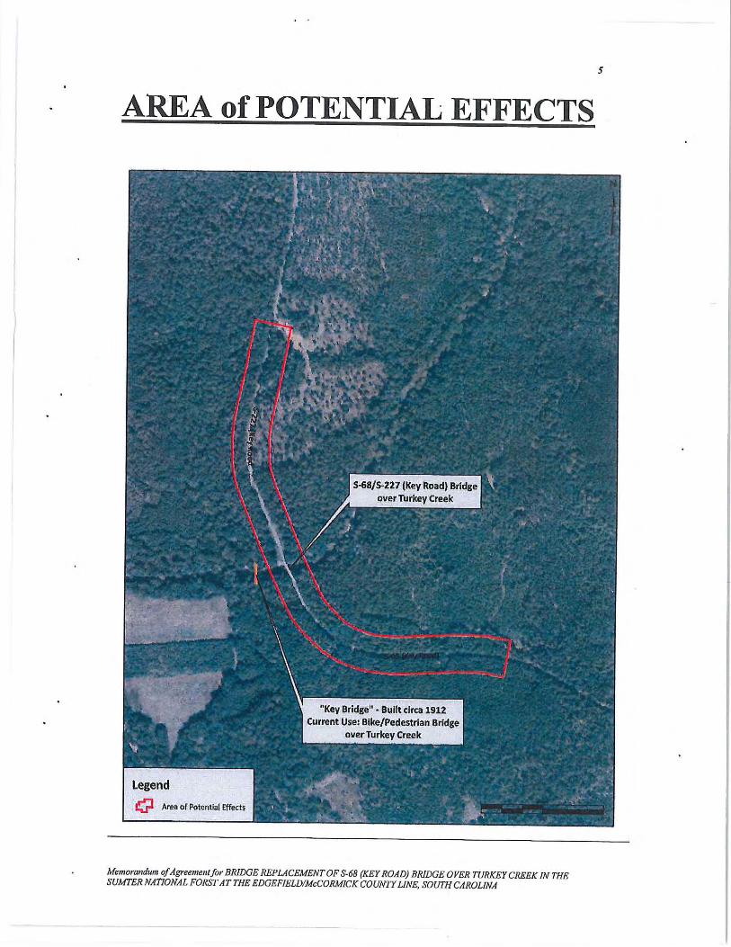

September 16, 2016 Mr. J. Shane Belcher Environmental Coordinator Federal Highway Administration 1835 Assembly Street, Suite 1270 Columbia, SC 29201 Ref: Proposed S-68 (Key Road) Bridge Replacement over Turkey Creek
Edgefield and McCormick Counties, South Carolina
Dear Mr. Belcher: The Advisory Council on Historic Preservation (ACHP) has received the Memorandum of Agreement (MOA) for the above referenced project. In accordance with Section 800.6(b)(1)(iv) of the ACHP’s regulations, the ACHP acknowledges receipt of the MOA. The filing of the MOA, and execution of its terms, completes the requirements of Section 106 of the National Historic Preservation Act and the ACHP’s regulations. We appreciate you providing us with a copy of the MOA and will retain it for inclusion in our records regarding this project. Should you have any questions or require additional assistance, please contact Ms. MaryAnn Naber at (202) 517- 0218 or via e-mail at [email protected]. Sincerely, LaShavio Johnson Historic Preservation Technician Office of Federal Agency Programs

Non-Programmatic Categorical Exclusion Edgefield and McCormick Counties, South Carolina Proposed S-68 (Key Road) Bridge Replacement over Turkey Creek Project ID No. 35179
Appendix E
De minimis determination for the Wine-Turkey Creek Trail


Non-Programmatic Categorical Exclusion Edgefield and McCormick Counties, South Carolina Proposed S-68 (Key Road) Bridge Replacement over Turkey Creek Project ID No. 35179
Appendix F
Watershed and Water Quality Information Report
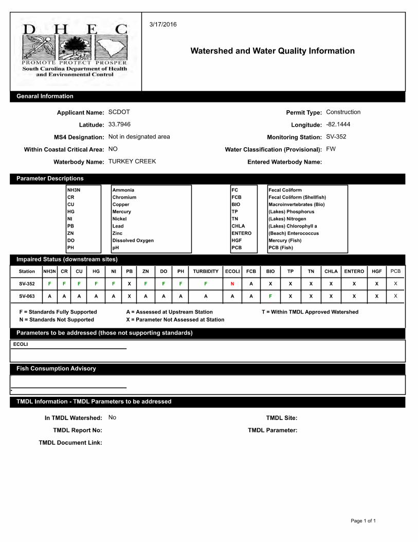

Non-Programmatic Categorical Exclusion Edgefield and McCormick Counties, South Carolina Proposed S-68 (Key Road) Bridge Replacement over Turkey Creek Project ID No. 35179
Appendix G
Jurisdictional Determination Letter and Mapping
(SAC 2015-00468-DJJ)


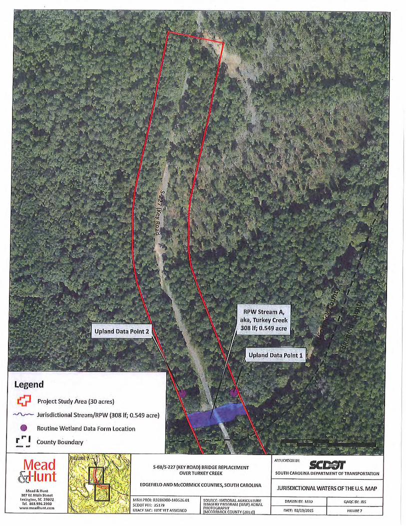


Non-Programmatic Categorical Exclusion Edgefield and McCormick Counties, South Carolina Proposed S-68 (Key Road) Bridge Replacement over Turkey Creek Project ID No. 35179
Appendix H
Bridge Scope and Risk Assessment Form


Non-Programmatic Categorical Exclusion Edgefield and McCormick Counties, South Carolina Proposed S-68 (Key Road) Bridge Replacement over Turkey Creek Project ID No. 35179
Appendix I
Natural Resources Technical Memorandum (NRTM) and
U.S. Fish and Wildlife Service (USFWS) Concurrence

United States Department of the Interior
FISH AND WILDLIFE SERVICE
176 Croghan Spur Road, Suite 200Charleston, South Carolina 29407
April 20, 2016
Ms. Nicole Riddle
South Carolina Department of TransportationP.O. Box 191
Columbia, SC 29202-0191
Re: S-68/S-227 (Key Road) Bridge Replacement over Turkey CreekEdgefield and McCormick Counties, South CarolinaFWS Log No. 2016-1-0367
Dear Ms. Riddle:
U.S.FLSH* WILDLIFE
SERVICE
The U.S. Fish and Wildlife Service (Service) has reviewed the information in yourMarch 31, 2016, letter as well as the attached Biological Assessment (BA), regarding theproposed Federal Highway Administration (FHWA)/South Carolina Department ofTransportation (SCDOT) replacement of the Key Road bridge over Turkey Creek within theLong Cane Ranger District of Sumter National Forest. The current bridge was built in 1925 andis considered structurally deficient and functionally obsolete.
The federally endangered Carolina heelsplitter (Lasmigona decorata) and its designated criticalhabitat are known to occur within the project area. A freshwater mussel survey was conductedby Three Oaks Engineering, Inc., in December of 2015; the associated report documented oneindividual Carolina heelsplitter was found approximately 70 feet upstream of the bridge.Therefore, bridge replacement activities have the potential to affect both critical habitat andindividual heelsplitter located within and downstream of the project area. However, based oninformation provided in the BA, no bridge supports will be located within the stream channel,and there will be no temporary disturbance to the stream bottom from in-stream constructioncauseways, work pads, or construction within the stream. Additionally, SCDOT has committedto take extra precautions during construction and demolition (page 8 of the BA) in order toprevent the degradation of downstream habitat from sedimentation.
Based upon the information provided, including the additional environmental commitmentsagreed to by FHWA and SCDOT to protect the Carolina heelsplitter and its critical habitat inTurkey Creek, the Service concurs with the determination that the proposed project may affect,but is not likely to adversely affect, the Carolina heelsplitter or its designated critical habitat.Please note that obligations under the Endangered Species Act must be reconsidered if: (1) newinformation reveals impacts of this identified action may affect any listed species or criticalhabitat in a manner not previously considered; (2) this action is subsequently modified in a


NATURAL RESOURCES TECHNICAL MEMORANDUM
PROPOSED S-68/S-227 (KEY ROAD) BRIDGE REPLACEMENT OVER TURKEY CREEK
EDGEFIELD AND MCCORMICK COUNTIES, SOUTH CAROLINA SCDOT PROJECT P035179
PREPARED FOR
SOUTH CAROLINA DEPARTMENT OF TRANSPORTATION COLUMBIA, SOUTH CAROLINA
PREPARED BY:
MEAD & HUNT, INC. 878 SOUTH LAKE DRIVE
LEXINGTON, SOUTH CAROLINA 29072
CONTACT: MATT DEWITT, PWS
MAY 2016

Natural Resources Technical Memorandum Proposed S-68/S-227 (Key Road) Bridge Replacement Project
Edgefield and McCormick Counties, South Carolina SCDOT Project P035179
TABLE OF CONTENTS
Page No.
1.0 INTRODUCTION ...................................................................................................................1
1.1 Project Description.......................................................................................................... 1
1.2 Purpose ............................................................................................................................ 1
1.3 Methodology ................................................................................................................... 2
2.0 PHYSICAL RESOURCES ......................................................................................................3
2.1 Land Use ......................................................................................................................... 3
2.2 Physiography and Topography ....................................................................................... 3
2.3 Geology and Soils ........................................................................................................... 4
2.4.1 Water Resources and Water Quality ............................................................................... 6
2.4.2 Water Resources ......................................................................................................... 6
2.4.3 303 (d) List of Impaired Waters .................................................................................. 7
2.4.4 Total Maximum Daily Loads ...................................................................................... 7
2.4.5 National Pollutant Discharge Elimination System ..................................................... 8
2.4.6 Water Quality Summary .............................................................................................. 9
3.0 BIOTIC RESOURCES ............................................................................................................9
3.1 Terrestrial Plant Communities ........................................................................................ 9
3.2 Wetland Plant Communities ......................................................................................... 11
3.3 Aquatic Plant Communities .......................................................................................... 11
4.0. WATERS OF THE U.S. ........................................................................................................11
4.1 Wetlands ....................................................................................................................... 12
4.2 Streams or Tributaries ................................................................................................... 12
4.3 Ponds / Open Waters ..................................................................................................... 13
4.4 Permitting ...................................................................................................................... 13
5.0 FLOODPLAINS ....................................................................................................................14
6.0 THREATENED AND ENDANGERED SPECIES ..............................................................15
6.1 Methodology ................................................................................................................. 19
6.2 Results ........................................................................................................................... 19
6.3 Biological Conclusions ................................................................................................. 21
6.4 Environmental Commitments ....................................................................................... 22
7.0 PROPOSED, ENDANGERED, THREATENED, AND SENSITIVE (PETS) SPECIES ........23
8.0 REFERENCES ......................................................................................................................27
APPENDIX A Figures APPENDIX B Representative Photographs APPENDIX C Watershed and Water Quality Information APPENDIX D Freshwater Mussel Survey Report and Biological Assessment APPENDIX E Agency Coordination APPENDIX F Qualifications of Mead & Hunt Personnel

Natural Resources Technical Memorandum Proposed S-68/S-227 (Key Road) Bridge Replacement Project
Edgefield and McCormick Counties, South Carolina SCDOT Project P035179
Page 1
1.0 INTRODUCTION
1.1 Project Description
The South Carolina Department of Transportation (SCDOT) proposes to replace the existing S-68/S-227 bridge over Turkey Creek in Edgefield and McCormick Counties, South Carolina. Specifically, the project is located within the Sumter National Forest, approximately 12 miles west of the Town of Edgefield and 12 miles southeast of the Town of McCormick; please see Appendix A, Figure 1 for a Site Location Map. The proposed project would include the replacement of the existing bridge on or near its existing alignment. At the request of SCDOT, a Categorical Exclusion Type C (CE-C), is being performed, which outlines potential alignment alternatives. These alternatives are being assessed to determine the least damaging practicable alternative with respect to construction impacts on the human and natural environment, while maintaining appropriate design criteria. In association with the CE-C, Mead & Hunt, Inc. (Mead & Hunt) has been contracted to provide an environmental review of the proposed project study area (PSA), including documentation of existing natural resources within the PSA. This Natural Resources Technical Memorandum (NRTM) summarizes the findings of the environmental review. Mead & Hunt reviewed a PSA totaling approximately thirty (30) acres in size, and is defined as follows: Approximately 2,000 feet in length from each end of the existing S-68/S-227 (Key Road) bridge over Turkey Creek. Furthermore, the PSA is approximately 300 feet in total width, generally centered along the centerline of the existing roadway. Please see Appendix A,
Figures 1 through 8 for the approximate location and extent of the reviewed area and Appendix
B for representative photographs.
This report provides an overall description of the project vicinity, and specifically describes natural resources within the PSA, including wetlands, water resources, plant communities, and protected species. The qualifications of the Mead & Hunt personnel involved in the preparation of this report are located in Appendix F.
1.2 Purpose
The purpose of this project is to replace the structurally deficient and functionally obsolete Key Road bridge. The existing bridge was built in 1925 and was relocated to its current location from Georgetown County in 1961. The bridge has a sufficiency rating of 34.7 out of 100, classifying the bridge as structurally deficient and making it eligible for replacement through the Federal Highway Bridge Replacement and Rehabilitation Program. Additionally, the bridge is classified as functionally obsolete due to substandard lane and shoulder widths.

Natural Resources Technical Memorandum Proposed S-68/S-227 (Key Road) Bridge Replacement Project
Edgefield and McCormick Counties, South Carolina SCDOT Project P035179
Page 2
1.3 Methodology
Prior to conducting fieldwork, Mead & Hunt reviewed the following reference material:
� U.S. Geological Survey (USGS). 7.5 minute topographic quadrangle Parksville, SC (1986).
� USGS. National Hydrography Database (NHD). Subregion 0306. (Last Updated January 2016).
� U.S. Department of Agriculture (USDA). Natural Resource Conservation Service (NRCS). Soil Survey Geographic (SSURGO) Database. Statewide, South Carolina (2015).
� USDA-NRCS. National List of Hydric Soils Database; National List, All States. (Last updated December 2015).
� USDA. Soil Conservation Service (SCS). Soil Survey of Edgefield County, South Carolina (1981).
� USDA-SCS. Soil Survey of Greenwood and McCormick Counties, South Carolina (1980).
� U.S. Fish and Wildlife Service (USFWS). Continental United States (CONUS) National Wetlands Inventory (NWI) Data. Statewide, South Carolina (2015).
� USFWS. South Carolina Field Office. Endangered, Candidate, and At-Risk Species. County Listings. Edgefield County (Last Updated: February 2015).
� USFWS. South Carolina Field Office. Endangered, Candidate, and At-Risk Species. County Listings. McCormick County (Last Updated: February 2015).
� S.C. Department of Natural Resources (SCDNR). Rare, Threatened, and Endangered Species and Communities Known to Occur in Edgefield County (Last Updated June 2014).
� SCDNR. Rare, Threatened, and Endangered Species and Communities Known to Occur in McCormick County (Last Updated June 2014).
� SCDNR. South Carolina Heritage Trust (SCHT). Geographic Database of Rare, Threatened, and Endangered Species Inventory Species Found in Edgefield County (Last Updated January 2006).
� SCDNR-SCHT. Geographic Database of Rare, Threatened, and Endangered Species Inventory Species Found in McCormick County (Last Updated January 2006).
� USDA. National Agriculture Imagery Program (NAIP) Aerial Photography. Edgefield County (2013).
� USDA. NAIP Aerial Photography. McCormick County (2013). Mead & Hunt environmental scientists conducted field reviews of the PSA for the presence of wetlands and other jurisdictional “waters of the U.S.”, community types, and protected species habitat on February 10th, February 13th, and July 10th, 2015. In addition, the boundaries of potential jurisdictional waters of the U.S. were flagged (delineated) in the field at that time. Wetlands were determined using the Routine On-Site Determination Method as defined in the Corps of Engineers Wetland Delineation Manual (Environmental Laboratory, 1987) and the Eastern Mountains and Piedmont Regional Supplement to the Manual (USACE, 2012). Streams, or tributaries, were delineated with a combination of pink flagging tape, pre-printed

Natural Resources Technical Memorandum Proposed S-68/S-227 (Key Road) Bridge Replacement Project
Edgefield and McCormick Counties, South Carolina SCDOT Project P035179
Page 3
with the words “Wetland Delineation” in black letters, and solid blue flagging tape. Delineated waters were subsequently located using a handheld Trimble GeoXH Global Positioning System (GPS) unit capable of sub-meter accuracy. The GPS was used to collect point features with a minimum of 20 counts, using a five-second logging interval and were validated using GPS Analyst and ArcGIS 10.2 software.
2.0 PHYSICAL RESOURCES
2.1 Land Use
The proposed project is located within the Sumter National Forest, in a primarily rural portion of South Carolina between the Towns of Edgefield and McCormick. Land use within the project vicinity, an area defined as extending one mile on all sides of the proposed project, is comprised primarily of undeveloped woodland, small areas of agricultural land, and spare residential development. Land use directly within the project limits is primarily comprised of undeveloped forestland and roadway rights-of-way (R/Ws). Undeveloped forestland within the project limits primarily consist of planted pine, mixed pine-hardwoods, bottomland hardwoods, oak-hickory, and successional scrub-shrub. 2.2 Physiography and Topography
The PSA is located in the Piedmont physiographic province of South Carolina, and is specifically situated within the Piedmont (45) Level III Ecoregion (Griffith, et al., 2002). The Piedmont is a transitional area between the mostly mountainous ecoregions of the Appalachian Mountains to the northwest and the relatively flat coastal plain to the southeast. The landform of the ecoregion is comprised of moderately dissected irregular plains and some hills. Once largely cultivated, much of this ecoregion is in planted pine or has reverted to successional pine and hardwood woodlands. The PSA is further characterized as being situated within the Carolina Slate Belt (45c) Level IV Ecoregion (Griffith, et al., 2002). The Carolina Slate Belt region is characterized by dissected irregular plains, some low hills, and rounded hills and ridges. Streams in the region are typically low to moderate gradient and comprised of mostly cobble, gravel, and sandy substrates. Based on USGS topographic mapping (Appendix A, Figure 2), elevations in the study area range from approximately 220 feet above National Geodetic Vertical Datum (NGVD) to 350 feet NGVD. The highest elevations in the PSA are located along Key Road in the southeastern extent of the PSA. The lowest elevations in the PSA are located within Turkey Creek, in the central portion of the PSA. Hydrology within the PSA drains inward, or towards the center of the PSA, towards Turkey Creek. Turkey Creek flows in a southwesterly direction through the PSA and discharges to Stevens Creek approximately two (2) aerial miles southwest of the PSA. Stevens Creek flows in a general southeasterly direction and discharges to the Savannah River approximately 17 aerial miles southeast of the PSA.

Natural Resources Technical Memorandum Proposed S-68/S-227 (Key Road) Bridge Replacement Project
Edgefield and McCormick Counties, South Carolina SCDOT Project P035179
Page 4
2.3 Geology and Soils
The origins of soil parent materials in Edgefield and McCormick Counties are formed from three sources; material weathered from rock (i.e., residuum), alluvium deposited by streams, and marine deposits. Soils derived from weathered rock comprise the majority of the soil in the county, and are underlined by a variety of rock types, including gneissic granite and rocks known as “Carolina slates.” Carolina slates are metamorphosed shale, dominantly argillite, fine-grained sandstone, and muscovite mica. Weathered products of these rocks are high in silt and very fine sands. Soils derived from alluvium, consist of a mixture of gravel, sand, silt and clay. Marine deposits consist of a mixture of sand, silt and clay, and were deposited by the Atlantic Ocean several thousand years ago. (USDA, 1981). The Farmland Protection Policy (FPPA) Act of 1981 requires evaluation of farmland conversions to nonagricultural uses. Farmland can be prime farmland, unique farmland, or farmland of statewide importance. The proposed project would likely require the acquisition of farmland soils; therefore, the project will be assessed under the provisions of the FPPA during the development of the Environmental Assessment. According to the USDA NRCS Soil Survey Geographic (SSURGO) Database (USDA, 2015), two (2) soil map units (SMUs) are mapped within the Edgefield County portion of the PSA. An additional three (3) SMUs are mapped within the McCormick County portion of the PSA. The SMUs mapped within the PSA are depicted in Appendix A, Figure 3. Farmland Classification and Hydric Rating for each SMU is located in Table 1.
TABLE 1
SOIL MAP UNITS WITHIN THE PROJECT STUDY AREA
Symbol Soil Unit Name Farmland Classification* Hydric Rating*
Edgefield County
GeC Georgeville silt loam, 6 to 10 percent slopes
Farmland of statewide importance Non-hydric
GuE Gundy silt loam, 15 to 25 percent slopes
Not prime farmland Non-hydric
McCormick County
Ca Cartecay and Toccoa soils Prime farmland if drained, not
frequently flooded, or protected from frequent flooding
Predominantly nonhydric
HwC Hiwassee sandy loam, 6 to 10 percent slopes
Not prime farmland Non-hydric
TaD Tatum silt loam, 10 to 15 percent slopes
Not prime farmland Non-hydric
* Reference: USDA-NRCS Web Soil Survey. (http://websoilsurvey.sc.egov.usda.gov/App/WebSoilSurvey.aspx).

Natural Resources Technical Memorandum Proposed S-68/S-227 (Key Road) Bridge Replacement Project
Edgefield and McCormick Counties, South Carolina SCDOT Project P035179
Page 5
A description of each SMU mapped within the PSA can be found below:
Georgeville silt loam, six (6) to ten (10) percent slopes, (GeC), is a deep, well-drained soil found on smooth, narrow ridges and side slopes adjacent to drainageways. GeC soils formed in material weathered from slate rocks. The soil has moderate permeability, and the available water capacity is medium (NRCS, 1981). Within the PSA, GeC soil is mapped in two (2) areas in the southeastern portion of the PSA. The SMU comprises approximately 33 percent of the PSA. GeC soil is classified as farmland of statewide importance, and is not included on the hydric soils list for Edgefield County, South Carolina (USDA, 2015). Gundy silt loam, fifteen (15) to 25 percent slopes, (GuE), is a deep, well-drained soil found on short, smooth slopes adjacent to medium and large streams. GuE soils formed in material weathered from slate rocks. The soil has moderate permeability, and the available water capacity is medium (NRCS, 1981). Within the PSA, GuE soil is mapped in one (1) area adjacent to Turkey Creek and a shallow drainageway in the southeastern portion of the PSA. The SMU comprises approximately 18 percent of the PSA. GuE soil is not classified as a farmland soil, and is not included on the hydric soils list for Edgefield County, South Carolina (USDA, 2015). Cartecay and Toccoa soils, (Ca), are deep, moderately well-drained to somewhat poorly drained soils found adjacent to medium and large streams. Ca soils formed in alluvial sediment deposited by streams that carried residuum soil from granite, gneiss, schist, and basic rocks. The soil has moderately rapid permeable, and the available water capacity is medium (NRCS, 1980). Within the PSA, Ca soils are mapped in one (1) area adjacent to Turkey Creek in the north-central portion of the PSA. The SMU comprises approximately four (4) percent of the PSA. Ca soil is classified as prime farmland if drained, not frequently flooded, or protected from frequent flooding, and is included on the hydric soils list for McCormick County, South Carolina (USDA, 2015). Hiwassee sandy loam, six (6) to ten (10) percent slopes, (HwC), is a deep, well-drained soil found on gently sloping to strongly sloping slopes. HwC soils formed in material weathered from gneiss, schist, and old alluvium. The soil has moderate permeability, and the available water capacity is medium (NRCS, 1980). Within the PSA, HwC soil is mapped in one (1) area in the northernmost portion of the PSA. The SMU comprises approximately 31 percent of the PSA. HwC soil is not classified as a farmland soil, and is not included on the hydric soils list for McCormick County, South Carolina (USDA, 2015). Tatum silt loam, ten (10) to fifteen (15) percent slopes, (TaD), is a moderately deep, well-drained soil found on strongly sloping or moderately steep slopes. TaD soils formed in material weathered from slate rocks. The soil has moderate permeability, and the available water capacity is medium (NRCS, 1980). Within the PSA, TaD soil is mapped in one (1) area in the north-central portion of the PSA. The SMU comprises approximately 12 percent of the PSA. TaD soil is not classified as a farmland soil, and is not included on the hydric soils list for McCormick County, South Carolina (USDA, 2015).

Natural Resources Technical Memorandum Proposed S-68/S-227 (Key Road) Bridge Replacement Project
Edgefield and McCormick Counties, South Carolina SCDOT Project P035179
Page 6
The project will also have both short-term construction related impacts as well as long-term operational impacts on soils in the PSA; however, these impacts are not considered significant. Water, (W), is also mapped within the PSA and accounts for approximately two (2) percent of the PSA. 2.4.1 Water Resources and Water Quality
2.4.2 Water Resources
River Basin
The PSA is located in the Savannah River Basin, as defined by the SC Department of Health and Environmental Control (SCDHEC). The Savannah River Basin extends across Georgia, North Carolina, and South Carolina. Within South Carolina, the Basin flows from the Blue Ridge, through the Piedmont, Sandhills, Upper Coastal Plain, Lower Coastal Plain, and Coastal Zone regions. Mead & Hunt reviewed the Basinwide Watershed Water Quality Assessment Report for the Savannah River Basin (SCDHEC, 2010) and the S.C. List of 303(d) Impaired Waters (SCDHEC, 2014) for information pertaining to water resources and water quality. Sub-Basin
Within South Carolina, the Savannah River Basin is subdivided into three (3) major sub-basins, including the Tugaloo/Seneca Rivers, Upper Savannah River, and Lower Savannah River. Of these, the PSA is located within the Lower Savannah River Sub-Basin. (USGS Hydrologic Unit Code [HUC] 03060107). Lower Savannah River Sub-Basin In South Carolina, the Lower Savannah River Sub-Basin is located in Edgefield, Aiken, Barnwell, Allendale, Greenwood, McCormick, Saluda, Hampton, Jasper, and Beaufort Counties, and encompasses 2,524 square miles. Of these approximately 1,600,000 acres, 56.4% is forested land, 16.4% is forested wetland (swamp), 14.0% is agricultural land, 6.3% is urban land, 3.9% is nonforested wetland (marsh), 2.3% is water, and 0.7% is barren land. The urban land percentage is comprised primarily of North Augusta, Aiken, Bluffton, and a portion of Hilton Head Island. Federal lands, such as the Savannah River Site and the Savannah National Wildlife Refuge, are sizable portions of this basin. There are approximately 6,010 stream miles, 19,349 acres of lake waters, and 24,788 acres of estuarine areas in the sub-basin. The Savannah River flows out of the Thurmond Dam and is restricted again by the Stevens Creek dam, forming Stevens Creek Reservoir. Stevens Creek accepts drainage from Turkey Creek and enters the Savannah River prior to the dam. Downstream of the Stevens Creek dam, the Savannah River accepts drainage from Horse Creek, Hollow Creek, Upper Three Runs, and Lower Three Runs. At the base of the Savannah River Basin, the Calibogue Sound accepts drainage from the May River, the Cooper River, and Broad Creek before joining with the Savannah River as it flows into the Atlantic Ocean near Savannah, Georgia. The Atlantic Intracoastal Waterway (AIWW) connects Calibogue Sound to Port Royal
Natural Resources Technical Memorandum Proposed S-68/S-227 (Key Road) Bridge Replacement Project
Edgefield and McCormick Counties, South Carolina SCDOT Project P035179
Page 7
Sound and to the Savannah River crossing the New River (Great Swamp) and the Wright River (SCDHEC, 2010). Hydrology from the PSA drains into the Sub-Basin through Turkey Creek. Watersheds
Within the Lower Savannah River Sub-Basin, the PSA is located in the Turkey Creek Watershed (HUC 03060107-02). The Turkey Creek Watershed is located in Greenwood, McCormick, Edgefield, and Saluda Counties and consists primarily of Turkey Creek and its tributaries. The watershed occupies 182,781 acres of the Piedmont and Upper Coastal regions of South Carolina. Land use/land cover in the watershed includes: 76.3% forested land, 16.4% agricultural land, 4.4% urban land, 1.9% forested wetland (swamp), 0.6% barren land, and 0.4% water (SCDHEC, 2010). Within the PSA, the Turkey Creek Watershed incorporates Turkey Creek, the only waterbody identified in the PSA. Please see Section 4.0 for complete details of Delineated Waters of the U.S. identified within the PSA. Hydrology from the PSA drains to SCDHEC water-quality monitoring station SV-352. Please see Appendix A, Figure 4 for the location of watershed boundaries and the associated water-quality monitoring station. Station SV-352 is located on Turkey Creek at S-68/S-227 (Key Road), within the PSA. At Station SV-352, aquatic life uses are fully supported; however, there is a significant increasing trend in five-day biochemical oxygen demand. There is also a significant increasing trend in pH at Station SV-352. Recreational uses are partially supported due to fecal coliform bacteria excursions (SCHEC, 2010). Mead & Hunt did not conduct any quantitative water quality sampling within the PSA. 2.4.3 303 (d) List of Impaired Waters In accordance with Section 303(d) of the 1972 Federal Clean Water Act (CWA), SCDHEC evaluates water bodies identified as impaired for appropriate inclusion on the Section 303(d) list. The 303(d) list is a State list of waters that are not meeting water quality standards or have impaired uses. The 303(d) list targets water bodies that do not meet water quality standards set for the state for water quality management, as well as identifying the cause(s) of the impairment and the designated classifications. According to SCDHEC’s 2014 Section 303(d) List of Impaired Waters, Station SV-352 is impaired for recreation uses based on Eschericia coli (ECOLI) levels. 2.4.4 Total Maximum Daily Loads
A TMDL, or Total Maximum Daily Load, is the amount of a single pollutant (e.g., bacteria, nutrients, metals) that can enter a waterbody on a daily basis and still meet water quality
Natural Resources Technical Memorandum Proposed S-68/S-227 (Key Road) Bridge Replacement Project
Edgefield and McCormick Counties, South Carolina SCDOT Project P035179
Page 8
standards set forth by the State. “TMDL” refers to both a calculation of a pollutant entering a waterbody as well as a document which includes this calculation along with source assessments, watershed and land use information, reductions and allocations information, implementation and other relevant information, maps, figures and pictures (SCDHEC, 2007).
TMDLs are a requirement found in Section 303(d) of the 1972 Federal Clean Water Act (CWA). Once a site is included on the 303(d) list of impaired waters, a TMDL must be developed within two (2) to 13 years of initial listing. In South Carolina, TMDLs are developed and proposed by SCDHEC and then forwarded to EPA Region 4 for final approval.
TMDLs are calculated by adding all the point and nonpoint sources for the pollutant causing the impairment. After a TMDL is calculated, the amount of load entering from point and nonpoint sources is compared to the water quality standards for that waterbody. Then this total loading is reduced to the levels where the water quality standards can be met. This reduced loading is then divided among all the point and nonpoint sources.
The goal of a TMDL is to identify potential pollution sources, calculate and quantify the reduction of those sources, and provide general implementation information needed in order to meet water quality standards and improve water quality. After the approval of the TMDL, an implementation plan can be developed to realize the goals of the written TMDL document. Implementation of a TMDL has a potential to reduce sources of pollution within a watershed and a potential to restore the full use of the waterbody.
According to the Basinwide Watershed Water Quality Assessment Report for the Savannah River Basin (SCDHEC, 2010), no TMDLs have been established for the Turkey Creek Watershed (HUC 03060107-02).
2.4.5 National Pollutant Discharge Elimination System
Point source discharge is a discharge which is released to the waters of the State by a discernible, confined and discrete conveyance, including but not limited to a pipe, ditch, channel, tunnel, conduit, well, discrete fissure, container, rolling stock, concentrated animal feeding operation, vessel, or other floating craft from which waste is or may be discharged. The National Pollutant Discharge Elimination System (NPDES) Permit Program was created by Section 402 of the CWA. In 1975, the Bureau of Water received authority from the EPA to administer the NPDES Permit Program in South Carolina. The SCDHEC Bureau of Water is responsible for the permitting, compliance, monitoring and enforcement activities of the program.
Persons with point source discharges to surface waters are required to have NPDES permits. Typical regulated point source discharges are:
� discharges from wastewater treatment systems owned by municipalities, industries, private utilities, State and Federal government, etc.;
� discharges such as cooling water, boiler blow down, etc.; � stormwater discharges from municipal separate storm sewer systems (MS4s);
Natural Resources Technical Memorandum Proposed S-68/S-227 (Key Road) Bridge Replacement Project
Edgefield and McCormick Counties, South Carolina SCDOT Project P035179
Page 9
� stormwater discharges associated with industrial activity; and, � stormwater dischargers from construction sites.
According to the Basinwide Watershed Water Quality Assessment Report for the Savannah River Basin (SCDHEC, 2010), no NPDES permitted facilities are authorized within the PSA. A total of four (4) NPDES facilities are authorized to discharge to the Turkey Creek Watershed. Each of these facilities are located upstream of the PSA, and include one (1) minor domestic facility and three (3) minor industrial facilities. The closest of these is the Boral Bricks Turkey Creek Mine, located approximately 14 river miles upstream of the PSA.
2.4.6 Water Quality Summary
Mead & Hunt reviewed SCDHEC’s Watershed and Water Quality Information, provided by an online query in March 2016. According to these reports, Station SV-352 is impaired based on Escherichia coli (ECOLI) levels. Furthermore, the S-68/S-227 (Key Road) bridge proposed for replacement is not located with an approved TMDL watershed, according to these reports. Please see Appendix C for a copy of the SCDHEC Watershed and Water Quality Information Report.
Due to the existing water quality impairment within the PSA watershed, SCDHEC may require additional water quality protection and stormwater treatment measures during and after construction. However, the proposed project is not anticipated to contribute to these impairments or have long term impacts on water quality within the watershed (HUC 03060107).
During construction activities, temporary siltation may occur in adjacent waters and erosion will be of a greater degree than presently occurring. It is recommended that the contractor minimize this impact through implementation of construction best management practices, reflecting policies contained in 23 CFR 650 B and S.C. Code of Regulations 72-400. The SCDOT has also issued an Engineering Directive Memorandum (Number 23), dated March 10, 2009, regarding Department procedures to be followed in order to ensure compliance with S.C. Code of 72-400, Standards for Stormwater Management and Sediment Reduction. Exposed areas may be stabilized by following the Department’s Supplemental Technical Specification for Seeding (SCDOT Designation SC-M-810 (11-08).
3.0 BIOTIC RESOURCES
3.1 Terrestrial Plant Communities
Vegetative terrestrial communities in the PSA were distinguished by plant species, location in the landscape, past disturbances, and hydrologic characteristics. For the purpose of this report, only habitats located directly within the PSA are summarized. Based on the field review, six (6) terrestrial habitat community/land use types, are present within the PSA, including Mixed Pine/Hardwood Forest, Pine Forest, Oak-Hickory Forest, Successional Forest, Bottomland Hardwood Forest, and Maintained and Disturbed Roadside.

Natural Resources Technical Memorandum Proposed S-68/S-227 (Key Road) Bridge Replacement Project
Edgefield and McCormick Counties, South Carolina SCDOT Project P035179
Page 10
A brief summary of the terrestrial habitat communities found within the PSA follows: Mixed Pine/Hardwood Forest Mixed Pine/Hardwood Forest is the dominant forested community type located throughout much of the PSA, and comprises approximately 37 percent of the PSA. Dominant vegetation consists of pine and hardwood tree species, including sweetgum (Liquidambar styraciflua), red maple (Acer rubrum), loblolly pine (Pinus taeda), water oak (Quercus nigra), eastern redcedar (Juniperus virginiana), and American holly (Ilex opaca). A dense understory is also present and primarily consists of Chinsee privet (Ligustrum sinense) and saplings of overstory species. Pine Forest Pine Forests consist of areas planted for the production of pine trees, and comprise approximately 26 percent of the PSA. The dominant vegetation in pine forests is loblolly pine. Opportunistic tree species, such as red maple and sweetgum, are also present in low densities in the understory. A sparse shrub layer consisting of Chinsee privet and ryegrass is also present. Groundcover vegetation is sparse but may also include a more diverse array of herbaceous and shrub species. Oak-Hickory Forest Oak-Hickory Forests are located throughout portions of the PSA, primarily along the banks of Turkey Creek and other sloping areas that have not been previously converted to pine forests. Approximately 12 percent of the PSA is oak-hickory forest. The dominant vegetation includes white oak (Quercus alba), northern red oak (Quercus rubra), post oak (Quercus stellata), pignut hickory (Carya glabra), mockernut hickory (Carya tomentosa), white ash (Fraxinus americana), tulip-poplar (Liriodendron tulipifera), and American beech (Fagus grandifolia). The understory is sparse and primarily contains saplings of overstory species. Successional Forest A Successional Forest is located in the northern portion of the PSA, east of Key Road. This area has been logged within the past five years and is in the primary stages of forest succession. This community type makes up a small portion of the PSA, approximately five (5) percent. Vegetation in successional forests primarily consists of saplings and shrubs, and include the same species found in a mixed pine/hardwood forest. Successional forests also include a more diverse array of herbaceous species. Bottomland Hardwood Forest A Bottomland Hardwood Forest is located in the floodplain of Turkey Creek, northwest of the S-68/S-227 (Key Road) bridge. This area makes up approximately three (3) percent of the PSA. Dominant vegetation consists of hardwood tree species, including red maple, water oak, tulip poplar, and sweetgum. A sparse shrub layer consisting of Chinese privet and giant cane (Arundinaria gigantea) is also present. Groundcover vegetation is sparse but include a diverse array of herbaceous species and grasses.

Natural Resources Technical Memorandum Proposed S-68/S-227 (Key Road) Bridge Replacement Project
Edgefield and McCormick Counties, South Carolina SCDOT Project P035179
Page 11
Maintained and Disturbed Roadside Maintained and Disturbed Roadside is a dominant community type throughout the PSA, and occurs immediately alongside Key Road. This community type comprises approximately 17 percent of the PSA. Most of the disturbed roadway edges are comprised of herbaceous species and a few shrubs, including various grasses such as common fescue (Festuca sp.), ryegrass (Lolium perenne) and bluegrass (Poa sp.). 3.2 Wetland Plant Communities
No wetland plant communities were observed in the PSA during the field reviews. 3.3 Aquatic Plant Communities
No aquatic plant communities, including submerged aquatic vegetation (SAV), were observed in the PSA during the field reviews.
4.0. WATERS OF THE U.S.
Waters of the U.S. are defined by 33 CFR 328.3(b) and protected by Section 404 of the Clean Water Act (33 U.S.C. 1344), which is administered and enforced in South Carolina by the U.S. Army Corps of Engineers (USACE), Charleston District. The term “waters of the U.S.” is defined in 33 CFR Part 328 as:
1. All waters which are currently used, or were used in the past, or may be susceptible to use in interstate or foreign commerce, including all waters which are subject to the ebb and flow of the tide;
2. All interstate waters including interstate wetlands; 3. All other waters such as intrastate lakes, rivers, streams (including intermittent streams),
mudflats, sandflats, wetlands, sloughs, prairie potholes, wet meadows, playa lakes, or natural ponds, the use, degradation or destruction of which could affect interstate or foreign commerce including any such waters:
� Which are or could be used by interstate or foreign travelers for recreational or other purposes; or
� From which fish or shellfish are or could be taken and sold in interstate or foreign commerce; or
� Which are used or could be used for industrial purpose by industries in interstate commerce;
4. All impoundments of waters otherwise defined as waters of the United States under the definition;
5. Tributaries of waters identified in paragraphs 1 – 4 above; 6. The territorial seas; and 7. Wetlands adjacent to waters (other than waters that are themselves wetlands) identified in
1 – 6 above.
Waste treatment systems, including treatment ponds or lagoons designed to meet the requirements of the Clean Water Act (other than cooling ponds as defined in 40 CFR 123.11(m)

Natural Resources Technical Memorandum Proposed S-68/S-227 (Key Road) Bridge Replacement Project
Edgefield and McCormick Counties, South Carolina SCDOT Project P035179
Page 12
which also meet the criteria of this definition) are not waters of the United States. Waters of the U.S. do not include prior converted cropland. Notwithstanding the determination of an area's status as prior converted cropland by any other federal agency, for the purposes of the Clean Water Act, the final authority regarding Clean Water Act jurisdiction remains with the Environmental Protection Agency. Wetlands are defined as those areas that are inundated or saturated by surface or ground water at a frequency and duration sufficient to support, and that under normal circumstances do support, a prevalence of vegetation typically adapted for life in saturated soil conditions. Wetlands generally include swamps, marshes, bogs, and similar areas. Wetlands are defined in the field as areas that display positive evidence of three environmental parameters including dominance of hydrophytic vegetation, wetland hydrology, and hydric soils (Environmental Laboratory, 1987). The boundaries of waters of the U.S. were delineated on February 10th and 13th, 2015. Potential wetland areas were evaluated using the Routine On-Site Determination Method as defined in the Corps of Engineers Wetland Delineation Manual (Environmental Laboratory, 1987) and the Eastern Mountains and Piedmont Regional Supplement to the Manual (US Army Corps of Engineers, 2012). Streams, or tributaries, were delineated with a combination of the pink pre-printed “Wetland Delineation” flagging tape and solid blue flagging. Furthermore, delineated waters were subsequently located using a handheld Trimble GeoXH Global Positioning System (GPS) unit capable of sub-meter accuracy. Jurisdictional determination and verification of delineated waters of the U.S. has been received by the U.S. Army Corps of Engineers (USACE) and issued SAC 2015-00468-DJJ. A copy of this correspondence is included in Appendix E. 4.1 Wetlands Prior to conducting fieldwork, Mead & Hunt reviewed National Wetlands Inventory (NWI) Seamless Wetlands Data provided by the U.S. Fish and Wildlife Service (USFWS, 2015). No NWI elements are mapped within the PSA; please see Appendix A, Figure 5 for the location and extent of NWI elements in the vicinity of the PSA. Furthermore, no wetland communities were identified within the PSA during site reviews. 4.2 Streams or Tributaries
One stream was identified within the PSA during site reviews. This stream was identified as Turkey Creek (RPW Stream A), a tributary of the Savannah River; please see Appendix A,
Figure 6 for the location and extent of streams delineated in the PSA. RPW Stream A
RPW Stream A, aka, Turkey Creek, is a tributary of Stevens Creek and the Savannah River, and crosses S-68/S-227 (Key Road) in the central portion of the PSA. Turkey Creek originates northeast of the PSA and drains in an easterly direction through the PSA. Beyond the PSA, Turkey Creek drains approximately three (3) river miles and discharges to Stevens Creek. Within the PSA, Turkey Creek is approximately 55 to 80 feet in width, with bank heights of six (6) to 12 feet. Approximately 308 linear feet (0.549 acre) of the stream are located within the

Natural Resources Technical Memorandum Proposed S-68/S-227 (Key Road) Bridge Replacement Project
Edgefield and McCormick Counties, South Carolina SCDOT Project P035179
Page 13
PSA. During field investigations, the stream channel exhibited moderate to high flow, weak sinuosity and a substrate consisting of silt, sand and gravel. Turkey Creek exhibits an ordinary high water mark, inundation, and aquatic life such as fish and amphibians. Within the PSA, the stream accepts drainage from the surrounding upland forests and roadside drainage. Turkey Creek is depicted on USGS topographic mapping as a solid blue-line stream, and is included in the National Hydrography Dataset. Representative photographs of Turkey Creek are included in Appendix B. 4.3 Ponds / Open Waters
No ponds, or other open waters, were identified within the PSA during site reviews. 4.4 Permitting
A Clean Water Act Section 404 permit is required for impacts to waters of the U.S., including wetlands. Section 404 is administered by the U.S. Army Corps of Engineers (USACE). Depending on the type and extent of waters of the U.S., including wetlands, to be impacted, Section 404 permitting requirements can range from activities that are considered exempt or preauthorized to those requiring pre-construction notification (PCN) for a Nationwide Permit (NWP) or Individual Permit (IP) from the USACE. For SCDOT projects, USACE General Permit (GP) 2010-01346 may be applicable if impacts do not exceed 3.0 acres of freshwater wetlands, 0.5 acre of tidal wetlands, and/or 300 linear feet of stream. In addition to the Section 404 permit, SCDHEC must grant, deny, or waive a Water Quality Certification (WQC), in accordance with Section 401 of the Clean Water Act. Waters considered by SCDHEC to be sensitive may also require additional consideration during the 401 WQC process. These include, but are not limited to, Outstanding Resource Waters (ORW), Shellfish Harvesting Waters (SFH), trout waters, areas draining to waters included on the 303(d) list of impaired waters, and areas draining to waters with an approved TMDL. As discussed in Section 2.4.1, the PSA drains to water listed as a water with an EPA approved TMDL. Depending on the type of impairments, extent of the project, and other factors, SCDHEC may require additional water quality protection and stormwater treatment measures during and after construction. The SCDOT GP has been approved by SCDHEC, therefore separate approval for Section 401 WQC is not required. If impacts exceed the GP threshold limits, an IP from the USACE would be required which involves a more rigorous, time-consuming review process. It is not uncommon for the regulatory processing of an IP application to take close to a year. Preliminary design for the project proposes to span Turkey Creek in its entirety; therefore, a Section 404 Permit is not anticipated. In accordance with Section 401 of the Clean Water Act, a Permit for Construction in Navigable Waters has been issued by SCDHEC for the project, which satisfies the requirements for a Water Quality Certification. This permit was issued on May 29, 2015 and references authorization number SC GP 95-002 16-001. A copy of permit is included in Appendix E.

Natural Resources Technical Memorandum Proposed S-68/S-227 (Key Road) Bridge Replacement Project
Edgefield and McCormick Counties, South Carolina SCDOT Project P035179
Page 14
Compensatory Mitigation Compensatory mitigation is normally required to offset unavoidable losses of waters of the U.S. The Council on Environmental Quality (CEQ) has defined mitigation in 40 CFR Part 1508.20 to include: avoiding impacts, minimizing impacts, rectifying impacts, reducing impacts over time, and compensating for impacts. Three general types of mitigation include avoidance, minimization and compensatory mitigation. Compensatory mitigation consists usually of the restoration of existing degraded wetlands or waters, or the creation of wetlands/waters of equal or greater value than those to be impacted. This type of mitigation is only undertaken after avoidance and minimization actions are exhausted and should be undertaken, when practicable, in areas near the impact site (i.e., on-site compensatory mitigation). The USACE typically requires compensatory mitigation for any wetland impacts for which a Section 404 permit application is submitted. Preliminary design for the project proposes to span Turkey Creek in its entirety; therefore, compensatory mitigation is not necessary.
5.0 FLOODPLAINS
Floodplains are low-lying areas adjacent to rivers, streams, and other waterbodies that are susceptible to inundation during rain events. These areas provide important functions in the natural environment such as providing storage for flood waters, protecting the surrounding environment from erosion, and providing habitat for wildlife. As such, agencies are required to take actions that reduce the risk of impacts to floodplains and their associated floodway, or main channel of flow. Floodplain and floodway protection is required under several federal, state, and local laws, including Executive Order 11988, entitled “Floodplain Management,” which requires federal agencies to avoid making modifications to and supporting development in floodplains wherever practical. Floodplains subject to inundation by the one-percent-annual-chance (100 year) flood event are regulated by the Federal Emergency Management Agency (FEMA). FEMA publishes maps which depict areas of regulated floodplains and floodways. The Flood Insurance Rate Map (FIRM) is the most common of these flood maps. FIRMs depict the boundaries of flood hazard areas and differentiates them by Zone. Zone A floodplains are areas subject to inundation by the 1-percent-annual-chance flood event and are generally determined using approximate methodologies. Because detailed hydraulic analyses have not been performed, Base Flood Elevations (BFEs) or flood depths are not available for Zone A floodplains. Zone AE floodplains are areas subject to inundation by the 1-percent-annual-chance flood event and are determined by detailed methods. BFEs are available for Zone AE floodplains and are provided on FIRMs.
Natural Resources Technical Memorandum Proposed S-68/S-227 (Key Road) Bridge Replacement Project
Edgefield and McCormick Counties, South Carolina SCDOT Project P035179
Page 15
Based upon a review of the floodplain mapping (FIRM Map ID 45065C0300D) and a GIS analysis of the project study area, the proposed project crosses the FEMA-regulated Zone A floodplain of Turkey Creek; please see Appendix A, Figure 7 for the location and extent of regulated floodplains in the vicinity of the PSA. In accordance with Executive Order 11988, a hydraulic analysis must be conducted for an encroachment of a FEMA-regulated floodplain. The hydraulic analysis is used to determine if the project is likely to increase the risk of flooding within the floodplain. In order to meet the requirements of a “No-Rise” condition, FEMA requires projects which would encroach on Regulated Floodways and Zone AE floodplains to result in a change no greater than 0.1 feet from the established 100-year flood elevations. Furthermore, SCDOT requires all Zone A crossings to be analyzed for the 100-year flood to insure that the floodplain encroachment does not cause one (1) foot or more of backwater when compared to unrestricted or natural conditions. The encroachment of the FEMA-regulated Zone A floodplain of Turkey Creek is not anticipated to increase the risk of flooding within these floodplains and the proposed project would be designed to meet the “No-Rise” requirements. A preliminary hydraulic analysis will be performed for each encroachment of a FEMA-regulated floodplain and a detailed hydraulic analysis will be performed during final design.
6.0 THREATENED AND ENDANGERED SPECIES
The Federal Endangered Species Act (ESA) of 1973, as amended, is the federal regulatory tool that serves to administer permits, implement recovery plans, and monitor federally protected (endangered and threatened) species. The ESA is administered and regulated by the USFWS and/or National Oceanic and Atmospheric Administration-National Marine Fisheries Service (NOAA-NMFS). Because of the federal nexus of the proposed project, consultation with the USFWS is required under Section 7 of the ESA, as amended (16 USC 1531-1534), for proposed projects that “may affect” federally endangered and threatened species. This assessment analyzes potential impacts to federally endangered and threatened species associated with the proposed project, and is intended to initiate informal consultation, as needed. Federal Protected Species - Species with the federal classification of Endangered (E) or Threatened (T), or Threatened due to Similarity of Appearance (T [S/A]) are protected under the ESA of 1973, as amended (16 U.S.C. 1531 et seq.). The term “endangered species” is defined as “any species which is in danger of extinction throughout all or a significant portion of its range”, and the term “threatened species” is defined as “any species which is likely to become an endangered species within the foreseeable future throughout all or a significant portion of its range” (16 U.S.C. 1532). The term “Proposed” (P) is defined as “any species proposed for official listing as endangered or threatened.” “Candidate” (C) species are taxons under consideration for which there is sufficient information to support listing but development of a proposed listing regulation is precluded by

Natural Resources Technical Memorandum Proposed S-68/S-227 (Key Road) Bridge Replacement Project
Edgefield and McCormick Counties, South Carolina SCDOT Project P035179
Page 16
other higher priority listing activities. “At-Risk Species” (ARS) is an informal term that refers to those species which may be in need of concentrated conservation actions, and have been petitioned for listing as threatened or endangered. The USFWS designations P, C, and ARS do not provide federal protection and require no Section 7 consultation under the ESA. State Protected Species – Animal species that are on the South Carolina state protected species list receive protection under the South Carolina Nongame and Endangered Species Conservation Act (South Carolina Code, Title 50). State endangered species are defined as any species or subspecies of wildlife whose prospects of survival or recruitment within the state are in jeopardy or are likely within the foreseeable future to become so. It is unlawful for any person to take, possess, transport, export, process, sell or offer for sale or ship, and for any common or contract carrier knowingly to transport or receive for shipment any species or subspecies of wildlife appearing on the state list of protected species without appropriate authorization. A search of the USFWS database provided existing information concerning the potential occurrence of threatened or endangered species within Edgefield and McCormick Counties. This database identifies four (4) federally threatened or endangered species known to occur or to have formerly occurred in Edgefield and McCormick Counties, as listed in Table 2 (USFWS, 2015). Please note: Table 2 also includes the bald eagle (Haliaeetus leucocephalus). The bald eagle is no longer protected under the ESA, but is afforded protection through the Bald and Golden Eagle Protection Act (BGEPA) of 1940.
The South Carolina Department of Natural Resources (SCDNR) Rare, Threatened and Endangered Species Inventory database, updated June 11, 2014, was also reviewed for information regarding species with state endangered or threatened status. One (1) additional species is currently listed as state threatened or endangered in Edgefield and McCormick Counties. This species is listed as Webster’s salamander (Plethodon websteri), as listed in Table 2 below.
TABLE 2
ENDANGERED/THREATENED SPECIES
Protected Species County
Listed
Protection Status
Common Name Scientific Name Federal State
Bird Species
American wood stork Mycteria americana McCormick T -
Bald eagle Haliaeetus leucocephalus Edgefield & McCormick
BGEPA T
Red-cockaded woodpecker Picoides borealis Edgefield & McCormick
E E

Natural Resources Technical Memorandum Proposed S-68/S-227 (Key Road) Bridge Replacement Project
Edgefield and McCormick Counties, South Carolina SCDOT Project P035179
Page 17
Mollusk Species
Carolina heelsplitter Lasmigona decorata Edgefield & McCormick
E,CH E
Plant Species
Miccosukee gooseberry Ribes echinellum Edgefield & McCormick
T -
Relict trillium Trillium reliquum Edgefield E -
Reptile Species
Webster's Salamander Plethodon websteri Edgefield & McCormick
- E
BGEPA = Bald and Gold Eagle Protection Act; T = Threatened, E = Endangered, CH= Critical Habitat
State and/or federally-listed endangered and threatened species and their respective habitats are briefly described below: American wood stork (Mycteria americana) – Federal Threatened
The American wood stork is a large, long-legged wading bird, approximately 45 inches in height with a wingspan of 60 to 65 inches. The species has mostly white plumage excluding the black trailing edges of the wings and tail. The neck and head is primarily un-feathered with grayish black skin. The bill is black, thick at the base, and curves downward. The American wood stork prefers freshwater and estuarine wetlands for breeding, feeding, and roosting. These birds are colonial nesters with colonies that range from less than 12 to more than 500 nests. Nests can be located in small or large trees, but these nests typically occur in trees found in standing water or on small islands. Feeding often occurs in water six (6) to ten (10) inches deep.
Bald eagle (Haliaeetus leucocephalus) – Bald and Golden Eagle Protection Act
The bald eagle is a large raptor, with a wingspan of about seven (7) feet, and mainly dark brown in color. Adults have a pure white head and tail. It nests in large, mature live pine or cypress trees. Nests are typically large, up to six (6) feet in width, and constructed of sticks and soft materials, such as dead vegetation, grass, and pine needles. Nesting trees are usually found within two (2) miles of coasts, rivers, and lakes, near the bodies of water in which it feeds. The bald eagle primarily feeds on fish but also takes a variety of bird, mammals and turtles when fish are not readily available. In South Carolina, bald eagles will nest from October 1 through May 15. Red-cockaded woodpecker (Picoides borealis) - Federal/State Endangered
Adult red-cockaded woodpeckers are approximately 18 to 20 centimeters (cm) long with a wingspan of 35 to 38 cm. Adults have a black cap, throat, and stripe on the side of the neck and white cheeks and underparts. The back is barred with black and white horizontal stripes. Adult males have a small red spot on each side of the black cap. The bird is native to southern pine forests and typically nests within open pine stands with trees 80 years or older. Roosting cavities are excavated within live pines, which are often infected with a fungus which causes what is

Natural Resources Technical Memorandum Proposed S-68/S-227 (Key Road) Bridge Replacement Project
Edgefield and McCormick Counties, South Carolina SCDOT Project P035179
Page 18
known as red-heart disease. Foraging may occur in pine and/or mixed pine/hardwood stands 30 years or older with trees ten (10) inches or larger in diameter at breast height (dbh). Carolina heelsplitter (Lasmigona decorata) - Federal/State Endangered & Critical Habitat
The Carolina heelsplitter is a federally and state listed endangered mussel with an ovate, trapezoid shaped shell. The surface of this species is yellowish, greenish, or brownish with greenish, blackish rays. The inner shell ranges from iridescent to mottled pale orange. The average size of the Carolina heelsplitter is 78 millimeters (mm). The Carolina heelsplitter is found in small to large streams and rivers as well as ponds over a variety of substrates usually near stable, well-shaded stream banks. Most individuals are found in undercuts and along shaded banks stabilized with extensive tree roots, a buried log, or rocks. The Carolina heelsplitter requires waterways with well oxygenated clean water. Six (6) populations of this mussel are presently known to exist, four of which occur within South Carolina. Miccosukee gooseberry (Ribes echinellum) - Federal Threatened
Miccosukee gooseberry is a low, spiny shrub growing to approximately 3.5 feet tall and forming small thickets. The shrub is only known to occur only in two (2) counties in the U.S., Jefferson County, Florida and McCormick County, South Carolina. The stems exhibit shredding bark, rooting at the tips where they touch the soil. The leaves are typically less than one (1) inch long. The leaves are simple, alternate and 3-lobbed, with each lobe toothed. Veins within the leaves will spread outward from the top of the leaf stalk into the lobes. Miccosukee gooseberry is deciduous in summer, with new leaves appearing in fall and overwintering. The flowers are pale green, hanging from stalks and usually solitary, with five (5) small petals and five (5) conspicuous, spreading sepals. Stamens of the flower will dangle well below the petals and sepals. The floral tube is a round, granular-hairy structure, and matures into a spiny berry that is less than one (1) inch wide. The Miccosukee gooseberry’s typical habitat is mixed hardwood forest or beech-magnolia forest in bottomlands. Flowers are present in March and fruit is mature in April and May. Leaves (except during summer), spines, and stems are distinctive year round.
Relict trillium (Trillium reliquum) - Federally Endangered
Relict trillium is a perennial herb with mottled leaves at the top of an S-shaped, somewhat flat stem, approximately five (5) to 25 cm in length, often with the leaf whorl resting on the leaf litter. A sessile, three (3) petaled flower appears at the apex of the stem in early spring. The flowers are 22 to 60 mm in length and are less than half as long as the leaves. The flowers range in color from greenish to brownish-purple and, occasionally, to pure yellow. The leaves of relict trillium are elliptic and orbicular, five (5) to 14 cm in length and almost as wide. The leaves have five (5) shades of color ranging from green through blue-green to silver, with a silver colored stripe along the upper central vein. Relict trillium prefers mature, moist, undisturbed hardwood forests with an understory free of thick shrubs and vines. The species occupies soils ranging from alluvial sands to rocky clays, which have high organic content in their upper layer. Habitat is found on slopes of various aspects, inclinations or on bottomlands and floodplains. Webster’s salamander (Plethodon websteri) - State Endangered
Webster’s salamander is a small woodland salamander. The species reaches lengths of seven (7) to 82 cm. The species can be striped or unstriped. Striped individuals typically have a wavy

Natural Resources Technical Memorandum Proposed S-68/S-227 (Key Road) Bridge Replacement Project
Edgefield and McCormick Counties, South Carolina SCDOT Project P035179
Page 19
yellowish brown to orange red dorsal stripe extending from the head to the tail tip. Unstriped specimens are usually evenly colored, ranging from brown to reddish-orange. The belly of this species is blotchy with black, white or reddish-orange. Webster’s salamander has a limited range in South Carolina. It is readily identifiable compared to other salamanders in its range because of size and coloration. Webster’s salamander is usually found in moist, mixed hardwoods on steep north-facing slopes. Preferred habitat for this species has rocky substrate with abundant coarse woody debris. The habitat make-up will also consists of a forest with a relatively dense canopy, which prevents drying of the forest floor substrate. 6.1 Methodology
Mead & Hunt environmental scientists performed literature and field reviews to determine the likelihood of protected species within the PSA and the potential for project-related impacts. The lists of protected species known to occur in Edgefield and McCormick Counties were reviewed, and field reviews were conducted for terrestrial species within the PSA on July 10th, 2015 and April 27, 2016. Areas that matched the descriptions of preferred habitat for protected species were classified as protected species habitat and were surveyed for the presence of protected species. Mead & Hunt reviewed a PSA approximately 300 feet in width and 4,200 feet in length, generally centered on the S-68/S-227 (Key Road) bridge over Turkey Creek. Mead & Hunt also reviewed a one-half mile buffer around the PSA for potential red-cockaded woodpecker nesting habitat; please see Appendix A, Figure 8 for the location and extent of the PSA and buffer area. The natural communities observed in the PSA consisted of mixed pine/hardwood forest, pine forest, oak-hickory forest, successional forest, and bottomland hardwood forest. In addition, the PSA consists of some maintained and disturbed roadside areas. Mussel surveys were conducted from approximately 400 meters downstream of the S-68/S-227 (Key Road) bridge crossing to approximately 100 meters upstream of the crossing for a total distance of approximately 500 meters. The SCDNR South Carolina Heritage Trust (SCHT) Geographic Database of Rare and Endangered Species was also reviewed to determine the presence of known populations of protected species within the vicinity of the project. 6.2 Results
Information obtained from the SCDNR-SCHT database indicates one (1) known population of Carolina heelsplitter (Lasmigona decorata) within the PSA. According to the SCDNR-SCHT records, this occurrence was observed in 1993. The SCDNR-SCHT provides the following description of the occurrence:
SUMTER NATIONAL FOREST, LONG CANE AND EDGEFIELD DISTRICT. TURKEY CREEK. FOUND IN RIVER RUN JUST ABOVE POOL, IN SUBSTRATE COMPRISED PRIMARILY OF SAND AND GRAVEL, BETWEEN COBBLE AND

Natural Resources Technical Memorandum Proposed S-68/S-227 (Key Road) Bridge Replacement Project
Edgefield and McCormick Counties, South Carolina SCDOT Project P035179
Page 20
BEDROCK. RELATIVELY LITTLE FINE SILT PRESENT. OBSERVED WITH LASMIGONA DECORATA, LAMPSILIS CARIOSA, VILLOSA DELUMBIS, AND ELLIPTIO (COMPLANATA AND ICTERINA COMPLEXES). IN TURKEY CREEK ABOVE CR 68 (EDGEFIELD COUNTY)/CR 227 (MCCORMICK COUNTY) BRIDGE (KEY BRIDGE).
The SCDNR-SCHT database also identifies 13 occurrences of Webster’s salamander (Plethodon
websteri) within two miles of the PSA. The closest of these populations is located immediately downstream of the existing S-68/S-227 (Key Road), in the vicinity of “Key Bridge.” Key Bridge, originally built in 1912, is now a pedestrian bridge located approximately 250 feet downstream (west) of S-68/S-227 (Key Road). According to the SCDNR-SCHT records, this occurrence was observed in 1983. The SCDNR-SCHT provides the following description of the occurrence:
SUMTER NATIONAL FOREST, EDGEFIELD DISTRICT. TURKEY CREEK. GOOD POPULATIONS. PLOTTED NEAR KEY BRIDGE.
The SCDNR-SCHT database does not indicate any other known populations of threatened or endangered species within two (2) miles of the PSA, as of January 17, 2006. No suitable habitat for American wood stork is present within the PSA due to the lack of persistent, shallow waterbodies for wading/feeding, or the presence of trees within standing water for nesting. No potential nesting or foraging habitat for bald eagle is present within the PSA due to a lack of any large river or body of water within two (2) miles of the PSA. Potential foraging habitat for red-cockaded woodpecker is found within some portions of pine forests within the PSA. Based on this finding, a one-half mile buffer area was mapped and reviewed for potential roosting habitat for the species. No preferred roosting habitat was identified within the PSA or within the one-half mile buffer area. Habitat is unsuitable due to the age of pine trees in the area, mechanical silvicultural practices, and the relatively dense subcanopy of pine forests. Additionally, no cavities or evidence of the species was identified in the PSA or buffer area. According to SCDNR-SCHT records, no known populations of red-cockaded woodpecker are located within five (5) miles of the PSA. Potential habitat for Carolina heelsplitter (Lasmigona decorata) was identified within one (1) tributary in the PSA, Turkey Creek. The proposed project is also adjacent to a segment of Turkey Creek designated as Critical Habitat for the species. According to 67 FR 44501 – 44522, Critical Habitat Unit 5 includes approximately 11.4 miles of Turkey Creek, from the SC 36 Bridge in Edgefield County, downstream to the S-68/S-227 (Key Road) bridge in Edgefield and McCormick Counties. A freshwater mussel survey was conducted by Three Oaks Engineering, Inc. in December 2015 to identify the presence or absence of the species within the PSA. An associated report entitled Freshwater Mussel Survey Report and Biological Assessment for the

Natural Resources Technical Memorandum Proposed S-68/S-227 (Key Road) Bridge Replacement Project
Edgefield and McCormick Counties, South Carolina SCDOT Project P035179
Page 21
Carolina Heelsplitter was completed on March 7, 2016 (Appendix D). The report documented one (1) individual Carolina heelsplitter found approximately 70 feet upstream of the bridge. Potential habitat for Miccosukee gooseberry (Ribes echinellum) exists in one small (0.89 acre) bottomland hardwood forest located within in the floodplain along the northern banks of Turkey Creek. No individuals of the species were identified during field reviews. Additionally, Miccosukee gooseberry is only known to be found in three (3) locations in South Carolina. The closest of these is located along Stevens Creek, approximately ten (10) miles downstream of the PSA. No potential habitat for relict trillium (Trillium reliquum) exists within the PSA, due to the lack of bottomland hardwood forests in the Edgefield County portion of the PSA. Potential habitat for Webster’s salamander (Plethodon websteri) exists in an area of mixed hardwoods along the southern banks of Turkey Creek. As stated above, a population of the species was identified in 1983, approximately 250 feet downstream of the PSA. No individuals of the species were directly observed within the PSA during field reviews; however, due to the proximity of the known population downstream and the similar habitat found within the PSA, it was determined that Webster’s salamander may inhabit the area of mixed hardwoods along the southern banks of Turkey Creek. 6.3 Biological Conclusions
Based on the literature and field reviews, it is determined that the proposed project will have a biological conclusion of ‘no effect’ on American wood stork, bald eagle, red-cockaded woodpecker, Miccosukee gooseberry, or relict trillium. The Carolina Heelsplitter is present in the project area. However, no bridge supports will be located within the stream channel, and there will be no temporary disturbance to the stream bottom from in-stream construction causeways, work pads, or construction within the stream. Additionally, SCDOT has committed to take extra precautions during construction (Environmental Commitments, Section 6.4) in order to prevent the degradation of the downstream habitat from sedimentation. As such, adverse impacts to this species and its Critical Habitat are not expected to result from project construction. Biological Conclusion-Carolina Heelsplitter: May Affect, Not Likely to Adversely Affect
Given that there will be no substrate disturbance, and stringent erosion control measures (Environmental Commitments, Section 6.4) will be taken to avoid/minimize impacts resulting from sedimentation, potential adverse impacts to instream habitat and the Carolina Heelsplitter are considered insignificant, or discountable (very unlikely to occur). Biological Conclusion-Critical Habitat Unit 5: May Affect, Not Likely to Adversely Affect
The proposed bridge replacement occurs within designated Critical Habitat (Unit 5) for the Carolina Heelsplitter. As discussed above, there will be no in-stream habitat disturbance from project construction. Additionally, adverse impacts to Critical Habitat Unit 5 resulting from

Natural Resources Technical Memorandum Proposed S-68/S-227 (Key Road) Bridge Replacement Project
Edgefield and McCormick Counties, South Carolina SCDOT Project P035179
Page 22
sedimentation are very unlikely to occur due to the avoidance/minimization measures that have been discussed, plus the fact that if sedimentation into Turkey Creek was to occur, it would likely occur downstream of the bridge, which is not designated as Critical Habitat. The Webster’s salamander may be present in the project area. However, only one bridge support is proposed in the vicinity of the potential habitat for the species (mixed hardwoods along the southern banks of Turkey Creek). This end bent will be constructed at the top of the hill slope, in a transitional area between mixed hardwoods and pine forest, and within the disturbed footprint of the existing bridge. If present, individuals of Webster’s salamander may experience temporary disturbance during construction due to noise and vibration associated with the demolition of the existing bridge and construction of the new bridge. Any individuals of the species temporarily impacted by these activities would likely reinhabit the area following construction. As such, adverse impacts to this species are not expected to result from the project. Biological Conclusion-Webster’s salamander: May Affect, Not Likely to Adversely Affect
Concurrence of the determination that the proposed project may affect, but is not likely to adversely affect, the Carolina heelsplitter or its designated critical habitat was received by the USFWS on April 20, 2016 and issued FWS Log No. 2016-I-0367. A copy of this correspondence is included in Appendix E.
6.4 Environmental Commitments
The contractor would be required to minimize potential impacts through implementation of construction best management practices, reflecting policies contained in 23 CFR 650 B and the latest SCDOT Supplemental Technical Specifications for seeding and erosion control measures (SC-M-810-3 (7/15)). Additional Erosion Control Measures have been implemented to include triple row of silt fence with a rip-rap filter berm with Class B rip-rap and #57 stone on each end bents. An increased inspection frequency of the silt fences is also an option with an additional inspection after a storm event with ½” or greater accumulation. Sediment and erosion control measures include triple row silt fences, sediment dams, filter berms, ditch checks, slope interrupters, and inlet structure filters. The sediment and erosion control plan will be designed per the SCDOT’s Stormwater Quality Design Manual. The contractor will also include with the demolition plan, an oil and gas spill contingency plan. Copies of each shall be supplied to the USFWS. The Demolition Plan will address the containment and prevention of debris falling in the creek during demolition. The contractor will not be allowed to place any construction equipment or any materials in Turkey Creek. He also will not be allowed to introduce any silt from the construction site into

Natural Resources Technical Memorandum Proposed S-68/S-227 (Key Road) Bridge Replacement Project
Edgefield and McCormick Counties, South Carolina SCDOT Project P035179
Page 23
Turkey Creek. Furthermore, the contractor will ensure no construction items or debris enters Turkey Creek. It is the contractor’s responsibility to provide a plan to the RCE to ensure adherence to these restrictions. Stormwater shall be directed away from Turkey Creek and shall not be permitted to drain directly from the bridge deck into the creek via cuppers. Stormwater shall instead be directed through vegetative filter strips before entering Turkey Creek. In the event additional species are listed as federally threatened or endangered prior to the construction of the project, SCDOT will consult with USFWS on the results of the surveys performed, if necessary, and will follow any USFWS regulations/requirements resulting from that consultation.
7.0 PROPOSED, ENDANGERED, THREATENED, AND SENSITIVE (PETS) SPECIES
The Land Revision Act of 1891 established the National Forest System, a collective of forested and woodland areas owned by the American people and managed by the U.S. Forest Service (USFS). In July, 1936, President Franklin D. Roosevelt proclaimed the Sumter a National Forest in South Carolina. The Sumter National Forest is an area comprised of nearly 371,000 acres, and is divided into three non-contiguous sections known as Ranger Districts (Enoree, Long Cane and Andrew Pickens). Each ranger district provides habitat for a unique list of federally proposed, endangered, or threatened species, and USFS sensitive (PETS) species. The USFS cooperates with the USFWS in conserving PETS species by conducting activities and programs to assist in the identification and recovery of these species. Sensitive species are species identified by the Regional Forester as showing significant declines in population numbers, density, or habitat capability that could reduce the species’ existing distribution. The management goal for a sensitive species is to prevent it from becoming so rare that it is federally listed. Because of the proposed project’s location within the Sumter National Forest, the USFHWA and SCDOT are required to consider PETS species during the project development. This assessment analyzes potential impacts to PETS species associated with the proposed project. The USFS provided information regarding PETS species of the Sumter National Forest (last updated September 2015). This database identifies 20 PETS species with potential occurrence within the Long Cane Ranger District, as listed in Table 3 (USFS, 2015). Please note: Table 3 also includes the Carolina Heelsplitter (Lasmigona decorata), Miccosukee gooseberry (Ribes
echinellum), relict trillium (Trillium reliquum), wood stork (Mycteria americana), bald eagle (Haliaeetus leucocephalus), and Webster’s salamander (Plethodon websteri). Please see Section 6.0 for additional details regarding these species, including the biological conclusion of the project’s construction on each species. To analyze potential impacts to PETS species associated with the proposed project, SCDOT

Natural Resources Technical Memorandum Proposed S-68/S-227 (Key Road) Bridge Replacement Project
Edgefield and McCormick Counties, South Carolina SCDOT Project P035179
Page 24
provided areas of new right-of-way/easements and potential ground disturbance, including construction limits, clearing/grubbing limits, and bridge construction access. Mead & Hunt environmental scientists subsequently performed field reviews to determine the likelihood of PETS species within the areas of potential ground disturbance. Areas that matched the descriptions of preferred habitat provided by the USFS were identified and surveyed for the presence of PETS species. Mead & Hunt reviewed an area approximately eight (8) acres in size and measuring approximately 150 feet in width and 2,200 feet in length, generally centered on the S-68/S-227 (Key Road) bridge over Turkey Creek; please see Appendix A, Figure 9 for the location and extent of the PETS species survey limits. The natural communities observed in the PETS species survey limits consisted of mixed pine/hardwood forest, pine forest, oak-hickory forest, successional forest, and bottomland hardwood forest. In addition, the survey area includes a considerable amount of maintained and disturbed roadside areas. Mussel surveys were conducted from approximately 400 meters downstream of the S-68/S-227 (Key Road) bridge crossing to approximately 100 meters upstream of the crossing for a total distance of approximately 500 meters.
TABLE 3
PROPOSED, ENDANGERED, THREATENED, AND SENSITIVE (PETS) SPECIES
PETS Species Potential
Habitat
Protection
Status Common Name Scientific Name
Carolina heelsplitter Lasmigona decorata Yes FE
Miccosukee gooseberry Ribes echinellum Yes FT
Relict trillium Trillium reliquum Yes FE
American wood stork Mycteria americana No FT
Bachman’s sparrow Peucaea aestivalis No Sensitive
Bald eagle Haliaeetus leucocephalus No Sensitive
Brook floater Alasmidonta varicosa Yes Sensitive
Carolina darter Etheostoma collis Yes Sensitive
Georgia Aster Symphyotrichum georgianus Yes Sensitive
Indigo bush Amorpha schwerini Yes Sensitive
Lanceleaf trillium Trillium lancifolium Yes Sensitive
Migrant loggerhead shrike Lanius ludovicia migrans No Sensitive

Natural Resources Technical Memorandum Proposed S-68/S-227 (Key Road) Bridge Replacement Project
Edgefield and McCormick Counties, South Carolina SCDOT Project P035179
Page 25
Nodding trillium Trillium rugelii No Sensitive
Oglethorpe oak Quercus oglethorpensis Yes Sensitive
Piedmont aster Eurybia mirabilis Yes Sensitive
Rayed pink fatmucket Lampsilis splendida Yes Sensitive
Robust redhorse Moxostoma robustrum Yes Sensitive
Shoal’s spider lilly Hymenocallis coronaria No Sensitive
Sweet pinesap Monotropsis odorata No Sensitive
Webster's Salamander Plethodon websteri Yes Sensitive
FE = Federally Endangered; FT = Federally Threatened
No potential habitat for American wood stork, Bachman’s sparrow, bald eagle, migrant loggerhead shrike, nodding trillium, shoal’s spider lily, or sweet pinesap were identified within the PETS survey limits. The project does not propose bridge supports within the stream channel, and there will be no temporary disturbance to the stream bottom from in-stream construction causeways, work pads, or construction within the stream; therefore, adverse impacts to Carolina darter and robust redhorse are not expected to result from the project. Field surveys did not identify any populations of Miccosukee gooseberry, relict trillium, Georgia aster, indigo bush, lanceleaf trillium, Oglethorpe oak, or piedmont aster within the PETS species survey limits; therefore, construction of the project will have no effect on these species. Please note: Section 6.2 states that “no potential habitat for relict trillium exists within the PSA, due to the lack of bottomland hardwood forests in the Edgefield County portion of the PSA.” While no habitat was identified in conjunction with Section 7 compliance, potential habitat for the species is found in the McCormick County portion of the PETS species survey limits. Therefore, field surveys were conducted during PETS species surveys. One (1) individual Carolina heelsplitter found approximately 70 feet upstream of the bridge; please see Section 6.0 for complete details regarding USFWS consultation regarding the species. Additionally, three (3) individual brook floaters were identified during the freshwater mussel survey conducted in December 2015. No bridge supports will be located within the stream channel, and there will be no temporary disturbance to the stream bottom from in-stream construction causeways, work pads, or construction within the stream. Additionally, SCDOT has committed to take extra precautions during construction (Environmental Commitments, Section 6.4) in order to prevent the degradation of the habitat from sedimentation. As such, adverse impacts to Carolina Heelsplitter or brook floater are not expected to result from the project. Additionally, no individuals of Rayed pink fatmucket were identified during the freshwater mussel survey; therefore construction of the project will have no effect on the species.

Natural Resources Technical Memorandum Proposed S-68/S-227 (Key Road) Bridge Replacement Project
Edgefield and McCormick Counties, South Carolina SCDOT Project P035179
Page 26
Potential habitat for Webster’s salamander (Plethodon websteri) exists in an area of mixed hardwoods along the southern banks of Turkey Creek. As stated in Section 6.2, a population of the species was identified approximately 250 feet downstream of the PSA in 1983. No individuals of the species were directly observed within the PSA during field reviews in July 2015. Additional surveys for Webster’s salamander were conducted within the PETS species survey limits on April 27, 2016. Two (2) man-hours were committed to surveys for the species within the approximate 0.4 acre of potential habitat. The probability of detection during these field reviews was determined to be low due to the lack of recent rainfall and higher temperatures during field reviews. Additionally, potential habitat within the PETS species survey limits is not ideal habitat for the species. The PETS species survey limits are primarily comprised of areas previously disturbed for the construction of the existing S-68/S-227 roadway and bridge. The soils in these areas consist of compacted, clayey fill material with few rocks. This area also lacks an abundance of limbs and other natural debris favored by the species due to past construction of the bridge and maintenance clearing of vegetation immediately adjacent to the bridge. No individuals of the species were identified during surveys. Although no individuals of Webster’s salamander were observed within the PETS species survey limits, it was determined that the species may inhabit the project area due to the proximity of the known population downstream. However, only one bridge support is proposed in the vicinity of the potential habitat for the species. This end bent will be constructed at the top of the hillslope, in a transitional area between mixed hardwoods and pine forest, and within the disturbed footprint of the existing bridge. If present, individuals of Webster’s salamander may experience temporary disturbance during construction due to noise and vibration associated with the demolition of the existing bridge and construction of the new bridge. Any individuals of the species temporarily impacted by these activities would likely reinhabit the area following construction. As such, adverse impacts to this species are not expected to result from the project.

Natural Resources Technical Memorandum Proposed S-68/S-227 (Key Road) Bridge Replacement Project
Edgefield and McCormick Counties, South Carolina SCDOT Project P035179
Page 27
8.0 REFERENCES Cowardin, L.M., et al., 1979. Classification of U.S. Wetland and Deepwater Habitats of the
United States. Department of the Interior, U.S. Fish and Wildlife Service. Environmental Laboratory. 1987. Corps of Engineers Wetlands Delineation Manual. Technical
Report Y-87-1, US Army Engineer Waterways Experiment Station, Vicksburg, Mississippi.
Griffith, G.E., et al., 2002. Ecoregions of North Carolina and South Carolina, (color poster with
map, descriptive text, summary tables, and photographs): Reston, Virginia, U.S. Geological Survey.
South Carolina Department of Health and Environmental Control (SCDHEC). 2015. 303(d) and
Total Maximum Daily Loads (TMDL). Available at: http://www.scdhec.gov/HomeAndEnvironment/Water/ImpairedWaters/Overview. (Viewed December 2015).
SCDHEC. 2014. State of South Carolina Integrated Report for 2014. Part I: List of Impaired
Waters (Section 303d). SCDHEC. 2010. Watershed Water Quality Assessment: Savannah River Basin. Technical
Report No. 02F-10. Bureau of Water, Columbia, S.C. South Carolina Department of Natural Resources (SCDNR). 2006. South Carolina Rare,
Threatened, & Endangered Species Inventory Species Found In Edgefield and McCormick Counties. Available at: https://www.dnr.sc.gov/pls/heritage/species.login. Accessed July 2015.
U.S. Department Army Corps of Engineers (USACE). 2010. Regional Supplement to the Corps
of Engineers Wetland Delineation Manual: Eastern Mountains and Piedmont Region (Version 2.0). U.S. Army Engineer Research and Development Center.
U.S. Department of Agriculture (USDA). Soil Conservation Service and Forest Service
(SCS/FS). 1981. Soil Survey of Edgefield County, South Carolina. USDA-SCS/FS. 1980. Soil Survey of Greenwood and McCormick Counties, South Carolina USDA. 2014. Natural Resources Conservation Service (NRCS) - National List of Hydric Soils
Database; National List, All States. Available via the Internet at http://soils.usda.gov/use/hydric. (Last updated March 2014; Accessed May 2015).
U.S. Fish and Wildlife Service (USFWS). 2015. National Wetlands Inventory Data. Continental
United States (CONUS). Statewide, SC.

Natural Resources Technical Memorandum Proposed S-68/S-227 (Key Road) Bridge Replacement Project
Edgefield and McCormick Counties, South Carolina SCDOT Project P035179
Page 28
USFWS. 2015. South Carolina List of Endangered, Threatened, and Candidate Species.
Available at: http://www.fws.gov/charleston/EndangeredSpecies_County.html. Accessed June 2015.
U.S. Geological Survey (USGS). 1986. Parksville, South Carolina Topographic Quadrangle.

Natural Resources Technical Memorandum Proposed S-68/S-227 (Key Road) Bridge Replacement Project
Edgefield and McCormick Counties, South Carolina SCDOT Project P035179
APPENDIX A
FIGURES

³
0 2 41
Miles
Edgefieldand
McCormickCounties
---APPLICATION BY:
SOUTH CAROLINA DEPARTMENT OF TRANSPORTATIONS-68/S-227 (KEY ROAD) BRIDGE REPLACEMENT
OVER TURKEY CREEK
EDGEFIELD AND McCORMICK COUNTIES, SOUTH CAROLINA
M&H PROJ: R3286900-140626.01
SCDOT PIN: 35179
USACE SAC: 2015-00468-DJJ
SITE LOCATION MAP
FIGURE 1
DRAWN BY: MTD QAQC BY: JBS
Legend
Project Study Area (30 acres)
County Boundary
Municipality
National Forest
£¤378
McCormick
SOURCE: TIGER 2010 ROAD,
COUNTY, AND MUNICIPALITY DATA
Parksville
£¤221
J. Strom
Thurmond
Lake
Sumter
National
Forest
Lincoln County,
Georgia
£¤221
£¤221
£¤378
Steven'sC
ree
k
Turkey
Creek
Ste
ve
n's
Cre
ek
S-68 (KeyR
d)
S-227(K
eyR
d)
£28
£23
£283
£¤25
£283
£28
£28
£230
£23
S-5
1(N
.M
arti n
tow
nR
oa
d)
McCorm
ick Cou
nty
Edgefield C
ounty
DATE: 03/15/2016
Mead & Hunt878 South Lake DriveLexington, SC 29072
Tel. 803.996.2900www.meadhunt.com

³
0 750 1,500375
Feet
---APPLICATION BY:
SOUTH CAROLINA DEPARTMENT OF TRANSPORTATIONS-68/S-227 (KEY ROAD) BRIDGE REPLACEMENT
OVER TURKEY CREEK
EDGEFIELD AND McCORMICK COUNTIES, SOUTH CAROLINA
M&H PROJ: R3286900-140626.01
SCDOT PIN: 35179
USACE SAC: NOT YET ASSIGNED
USGS TOPOGRAPHY MAP
FIGURE 2
DRAWN BY: MTD QAQC BY: JBS
Legend
Project Study Area (30 acres)
SOURCE: USGS 7.5 MINUTE QUAD
MAP [PARKSVILLE (1986)]
ParksvilleQuad
McCormickCounty
EdgefieldCounty
S-2
27
(Ke
yR
oa
d
S-68 (Key Road)
McC
orm
ick
Coun
tyEd
gefie
ld C
ount
y
DATE: 03/15/2016
Mead & Hunt878 South Lake DriveLexington, SC 29072
Tel. 803.996.2900www.meadhunt.com

Ca
HwCGoF
TaD
TaE
GaC
NaE
GaBGaC
TaE
GaB
TaE
GaB
GaB
GaB
W
NaD
GaC
GeB
GuEGeC
To
Rv
GeB
GuD
GeC
Cw
GeC
GeB
GuD
GuD
GeC
GuD
HrB
HrB
HrC
GeCRv
W
NaD
GuD
NaD
0 750 1,500375
Feet
---APPLICATION BY:
SOUTH CAROLINA DEPARTMENT OF TRANSPORTATIONS-68/S-227 (KEY ROAD) BRIDGE REPLACEMENT
OVER TURKEY CREEK
EDGEFIELD AND McCORMICK COUNTIES, SOUTH CAROLINA
M&H PROJ: R3286900-140626.01
SCDOT PIN: 35179
USACE SAC: NOT YET ASSIGNED
NRCS SOIL MAP UNIT MAP
FIGURE 3
DRAWN BY: MTD QAQC BY: JBS
Legend
Project Study Area (30 acres)
National Hydrography Dataset (NHD) Flowlines
County Boundary
SOURCE: NRCS SOIL MAP UNIT DATA
[EDGEFIELD COUNTY (2002) AND
MCCORMICK COUNTY (2002)]
W
Ca
GuE
GeC
GeB
GuE
TaDTurkeyCreek
BeaverdamCreek
S-2
27
(Ke
yR
oa
d
S-68 (Key Road)
Soil Map Units in Project Study Area
Ca - Cartecay and Toccoa soils
GeC - Georgeville silt loam, 6-10% slopes
GuE - Gundy silt loam, 15-25% slopes
HwC - Hiwassee sandy loam, 6-10% slopes
TaD - Tatum silt loam, 10-15% slopes
W - Water
³
CA SOILS ARE CATEGORIZEDAS PREDOMINANTLY
NONHYDRIC.
ALL OTHER SOILS WITHIN
THE PSA ARE CATEGORIZEDAS NONHYDRIC.
McC
orm
ick
Coun
ty
Edge
field
Cou
nty
DATE: 03/15/2016
Mead & Hunt878 South Lake DriveLexington, SC 29072
Tel. 803.996.2900www.meadhunt.com

0 750 1,500375
Feet
---APPLICATION BY:
SOUTH CAROLINA DEPARTMENT OF TRANSPORTATIONS-68/S-227 (KEY ROAD) BRIDGE REPLACEMENT
OVER TURKEY CREEK
EDGEFIELD AND McCORMICK COUNTIES, SOUTH CAROLINA
M&H PROJ: R3286900-140626.01
SCDOT PIN: 35179
USACE SAC: NOT YET ASSIGNED DATE: 03/15/2016
WATER QUALITY MONITORING STATION MAP
FIGURE 4
DRAWN BY: MTD QAQC BY: JBSSOURCE: SCHEC WATERSHED WATER
QUALITY ASSESSMENT REPORT FOR
THE SALUDA RIVER BASIN (2011)
S-2
27
(Ke
yR
oa
d
S-68 (Key Road)
³
McC
orm
ick
Coun
tyEd
gefie
ld C
ount
y
#SV-352
Watersh
ed03060107-02
Watersh
ed03060107-03
Legend
Project Study Area (30 acres)
SCDHEC Watershed Boundary
# SCDHEC Monitoring Station
County Boundary
Mead & Hunt878 South Lake DriveLexington, SC 29072
Tel. 803.996.2900www.meadhunt.com

PFO1A
PSS1/3A
0 750 1,500375
Feet
---APPLICATION BY:
SOUTH CAROLINA DEPARTMENT OF TRANSPORTATIONS-68/S-227 (KEY ROAD) BRIDGE REPLACEMENT
OVER TURKEY CREEK
EDGEFIELD AND McCORMICK COUNTIES, SOUTH CAROLINA
M&H PROJ: R3286900-140626.01
SCDOT PIN: 35179
USACE SAC: NOT YET ASSIGNED DATE: 03/15/2016
NATIONAL WETLAND INVENTORY (NWI) MAP
FIGURE 5
DRAWN BY: MTD QAQC BY: JBS
Legend
Project Study Area (30 acres)
County Boundary
SOURCE: USFWS CONUS WETLAND
DATA [STATEWIDE (OCTOBER 2015)]
S-2
27
(Ke
yR
oa
d
S-68 (Key Road)
³
McC
orm
ick
Coun
tyEd
gefie
ld C
ount
y
Mead & Hunt878 South Lake DriveLexington, SC 29072
Tel. 803.996.2900www.meadhunt.com

0 750 1,500375
Feet
---APPLICATION BY:
SOUTH CAROLINA DEPARTMENT OF TRANSPORTATIONS-68/S-227 (KEY ROAD) BRIDGE REPLACEMENT
OVER TURKEY CREEK
EDGEFIELD AND McCORMICK COUNTIES, SOUTH CAROLINA
M&H PROJ: R3286900-140626.01
SCDOT PIN: 35179
USACE SAC: NOT YET ASSIGNED
JURISDICTIONAL WATERS OF THE U.S. INDEX
FIGURE 6
DRAWN BY: MTD QAQC BY: JBS
Legend
Project Study Area (30 acres)
Jurisdictional Stream/RPW (308 lf; 0.549 acre)
County Boundary
SOURCE: NATIONAL AGRICULTUREIMAGERY PROGRAM (NAIP) AERIALPHOTOGRAPHY [MCCORMICK COUNTY (2013)]
S-2
27
(Ke
yR
oa
d
S-68 (Key Road)
³
McC
orm
ick
Coun
tyEd
gefie
ld C
ount
y
DATE: 03/15/2016
Mead & Hunt878 South Lake DriveLexington, SC 29072
Tel. 803.996.2900www.meadhunt.com
RPW Stream A,
aka, Turkey Creek
308 lf; 0.549 acre

0 750 1,500375
Feet
---APPLICATION BY:
SOUTH CAROLINA DEPARTMENT OF TRANSPORTATIONS-68/S-227 (KEY ROAD) BRIDGE REPLACEMENT
OVER TURKEY CREEK
EDGEFIELD AND McCORMICK COUNTIES, SOUTH CAROLINA
M&H PROJ: R3286900-140626.01
SCDOT PIN: 35179
USACE SAC: NOT YET ASSIGNED
FEMA 100-YEAR FLOODPLAIN MAP
FIGURE 7
DRAWN BY: MTD QAQC BY: JBS
Legend
Project Study Area (30 acres)
Zone A Floodplains
County Boundary
SOURCE: FEMA NATIONAL FLOOD
HAZARD DATA [PANEL 45065C0300D
(UPDATED 04/04/2011)]
S-2
27
(Ke
yR
oa
d
S-68 (Key Road)
³
McC
orm
ick
Coun
tyEd
gefie
ld C
ount
y
Zone A
DATE: 03/15/2016
Mead & Hunt878 South Lake DriveLexington, SC 29072
Tel. 803.996.2900www.meadhunt.com

0 1,000 2,000500
Feet
---APPLICATION BY:
SOUTH CAROLINA DEPARTMENT OF TRANSPORTATIONS-68/S-227 (KEY ROAD) BRIDGE REPLACEMENT
OVER TURKEY CREEK
EDGEFIELD AND McCORMICK COUNTIES, SOUTH CAROLINA
M&H PROJ: R3286900-140626.01
SCDOT PIN: 35179
USACE SAC: NOT YET ASSIGNED
LANDUSE / ONE-HALF MILE BUFFER MAP
FIGURE 8
DRAWN BY: MTD QAQC BY: JBS
Legend
Project Study Area (30 acres)
One-half Mile Buffer
County Boundary
SOURCE: SCDNR INFRARED DIGITAL
ORTHOPHOTO [PARKSVILLE, SC (2006)]
S-22
7(K
ey
Ro
ad
S-68 (Key Road)
³
McC
orm
ick
Coun
tyEd
gefie
ld C
ount
y
Turkey Creek
DATE: 03/15/2016
Mead & Hunt878 South Lake DriveLexington, SC 29072
Tel. 803.996.2900www.meadhunt.com

0 250 500125
Feet
---APPLICATION BY:
SOUTH CAROLINA DEPARTMENT OF TRANSPORTATIONS-68/S-227 (KEY ROAD) BRIDGE REPLACEMENT
OVER TURKEY CREEK
EDGEFIELD AND McCORMICK COUNTIES, SOUTH CAROLINA
M&H PROJ: R3286900-140626.01
SCDOT PIN: 35179
USACE SAC: NOT YET ASSIGNED
PETS SPECIES SURVEY LIMITS MAP
FIGURE 9
DRAWN BY: MTD QAQC BY: JBS
Legend
PETS Species Survey Limits
County Boundary
SOURCE: SCDNR INFRARED DIGITAL
ORTHOPHOTO [PARKSVILLE, SC (2006)]
S-2
27
(Ke
yR
oa
d
S-68 (Key Road)
³
McC
orm
ick
Co
un
tyEd
gefi
eld
Co
un
ty
Turkey Creek
DATE: 04/12/2016
Mead & Hunt878 South Lake DriveLexington, SC 29072
Tel. 803.996.2900www.meadhunt.com

Natural Resources Technical Memorandum Proposed S-68/S-227 (Key Road) Bridge Replacement Project
Edgefield and McCormick Counties, South Carolina SCDOT Project P035179
APPENDIX B
REPRESENTATIVE PHOTOGRAPHS

Natural Resources Technical Memorandum Representative Photographs
Proposed S-68/S-227 (Key Road) Bridge Replacement Project Edgefield and McCormick Counties, South Carolina
SCDOT Project P035179
Page 1
Date:
August 26, 2014
Taken By:
Matt DeWitt
Photograph 1
Description:
View of the
S-227 (Key Road)
roadway and
adjacent mixed
pine/hardwood
forest north of the
bridge over Turkey
Creek. Photograph
is taken along Key
Road, facing south.
Date:
August 26, 2014
Taken By:
Matt DeWitt
Photograph 2
Description:
View of the
S-227 (Key Road)
roadway and
adjacent
successional forest
and mixed
pine/hardwood
forest north of the
bridge over Turkey
Creek. Photograph
is taken along Key
Road, facing north.

Natural Resources Technical Memorandum Representative Photographs
Proposed S-68/S-227 (Key Road) Bridge Replacement Project Edgefield and McCormick Counties, South Carolina
SCDOT Project P035179
Page 2
Date:
August 26, 2014
Taken By:
Matt DeWitt
Photograph 3
Description:
View of the
S-227 (Key Road)
roadway and
adjacent mixed
pine/hardwood
forest north of the
bridge over Turkey
Creek. Photograph
is taken along Key
Road, facing south.
Date:
August 26, 2014
Taken By:
Matt DeWitt
Photograph 4
Description:
View of the S-68/S-
227 (Key Road)
Bridge over Turkey
Creek and the
mixed hardwood
forest along the
southern bank of
Turkey Creek.
Photograph is
taken from the
northeastern side
of the bridge,
facing south.

Natural Resources Technical Memorandum Representative Photographs
Proposed S-68/S-227 (Key Road) Bridge Replacement Project Edgefield and McCormick Counties, South Carolina
SCDOT Project P035179
Page 3
Date:
August 26, 2014
Taken By:
Matt DeWitt
Photograph 5
Description:
View of a
bottomland
hardwood forest
located within the
floodplain along
the northern bank
of Turkey Creek.
Photograph is
taken within the
floodplain, facing
northwest.
Date:
August 26, 2014
Taken By:
Matt DeWitt
Photograph 6
Description:
View of the S-68/S-
227 (Key Road)
Bridge over Turkey
Creek. Photograph
is taken from the
northwestern side
of the bridge,
facing southeast.

Natural Resources Technical Memorandum Representative Photographs
Proposed S-68/S-227 (Key Road) Bridge Replacement Project Edgefield and McCormick Counties, South Carolina
SCDOT Project P035179
Page 4
Date:
August 26, 2014
Taken By:
Matt DeWitt
Photograph 7
Description:
View of the S-68/S-
227 (Key Road)
bridge over Turkey
Creek. Photograph
is taken from “Key
Bridge” (located
west of the S-68/S-
227 Bridge over
Turkey Creek),
facing east.
Date:
August 26, 2014
Taken By:
Matt DeWitt
Photograph 8
Description:
View of Turkey
Creek, facing west
(downstream).

Natural Resources Technical Memorandum Proposed S-68/S-227 (Key Road) Bridge Replacement Project
Edgefield and McCormick Counties, South Carolina SCDOT Project P035179
APPENDIX C
WATERSHED AND WATER QUALITY INFORMATION


Natural Resources Technical Memorandum Proposed S-68/S-227 (Key Road) Bridge Replacement Project
Edgefield and McCormick Counties, South Carolina SCDOT Project P035179
APPENDIX D
FRESHWATER MUSSEL SURVEY REPORT AND
BIOLOGICAL ASSESSMENT FOR THE CAROLINA HEELSPLITTER

Freshwater Mussel Survey Report and Biological Assessment for the Carolina
Heelsplitter
Bridge Replacement of S- 68 (Key Road) over Turkey Creek, Edgefield and McCormick Counties, South Carolina
Carolina Heelsplitter found at Key Road
Prepared For:
SC Department of Transportation Columbia, South Carolina
March 7, 2016

i
Table of Contents
1.0 INTRODUCTION ............................................................................................................... 1
1.1 Purpose and Need ............................................................................................................. 1
1.2 Construction ..................................................................................................................... 3
1.2.1 Removal of the Existing Bridge ................................................................................ 3
1.2.2 Construction of New Bridge ..................................................................................... 3
1.2.3 Avoidance and Minimization .................................................................................... 3
2.0 WATERS IMPACTED ........................................................................................................ 5
2.1 303(d) Classification ........................................................................................................ 5
2.2 NDPES dischargers .......................................................................................................... 5
3.0 TARGET FEDERALLY PROTECTED SPECIES DESCRIPTION .................................. 6
3.1 Lasmigona decorata (Carolina Heelsplitter) .................................................................... 6
3.1.1 Characteristics ........................................................................................................... 6
3.1.2 Distribution and Habitat Requirements .................................................................... 6
3.1.3 Threats to Species ..................................................................................................... 7
3.1.4 Designated Critical Habitat ....................................................................................... 8
3.2 Survey Efforts ................................................................................................................ 13
3.3 Stream Conditions at Time of Survey: Turkey Creek .................................................... 13
3.4 Methodology .................................................................................................................. 13
3.5 Results ............................................................................................................................ 15
4.0 PROJECT EFFECTS ON CAROLINA HEELSPLITTER AND CRITICAL HABITAT 15
4.1 Direct Effects .................................................................................................................. 16
4.2 Indirect Effects ............................................................................................................... 16
4.3 Cumulative Effects ......................................................................................................... 16
5.0 CONCLUSION OF EFFECTS: CAROLINA HEELSPLITTER/CRITICAL HABITAT 17
6.0 LITERATURE CITED ...................................................................................................... 18
7.0 ENVIRONMENTAL COMMITMENTS .......................................................................... 20
APPENDIX A Preliminary Plans
APPENDIX B Select Photos from Mussel Survey

1
Freshwater Mussel Survey Report and Biological Assessment for the Carolina Heelsplitter for S-68 (Key Road) over Turkey Creek
Edgefield and McCormick Counties
PIN 35179
1.0 INTRODUCTION
The South Carolina Department of Transportation (SCDOT) proposes to replace the S-68 (Key Road) bridge over Turkey Creek in Edgefield and McCormick Counties (Figure 1) on the existing alignment with road closure and detour. The existing bridge accommodates two lanes of two-way traffic and is classified as a Rural Major Collector. In 2015 the existing average daily traffic (ADT) on S-68 was approximately 200 vehicles per day (vpd) and is expected to increase to 300 vpd in 2035.
The project is located in the Sumter National Forest and will impact Turkey Creek which is part of the Savannah River Basin. The federally Endangered Carolina Heelsplitter (Lasmigona decorata) is known to occur within Edgefield and McCormick Counties in the Savannah River Basin, including Turkey Creek. In addition to the Carolina Heelsplitter, there are three other rare freshwater mussel species known to occur in the Savannah River Basin that the Center for Biological Diversity (CBD), a nonprofit conservation organization (www.biologicaldiversity.org), petitioned the USFWS to list as either Threatened or Endangered under the Endangered Species Act (ESA) of 1973, as amended (CBD 2010). Those species are the Atlantic Pigtoe (Fusconaia masoni), Brook Floater (Alasmidonta varicosa), and Savannah Lilliput (Toxolasma pullus).
Much of the Turkey Creek watershed occurs within the Sumter National Forest, Long Cane District, including approximately 13 miles of the main stem Turkey Creek, approximately 8.9 miles of which is designated Critical Habitat for the Carolina Heelsplitter. The Key Road crossing of Turkey Creek occurs at the downstream limits of the Critical Habitat. As part of the federal permitting process that requires an evaluation of potential project-related impacts to federally protected species, Three Oaks Engineering, Inc. (Three Oaks) was contracted by Mead and Hunt to conduct the freshwater mussel surveys targeting the Carolina Heelsplitter, to determine presence/absence of the Carolina Heelsplitter from the immediate project area in order to evaluate potential impacts to this species from project construction. The information collected during this survey is included in this Biological Assessment.
1.1 Purpose and Need
The purpose of this project is to replace a structurally deficient and functionally obsolete bridge. The existing bridge was built in 1925 and was relocated to its current location from Georgetown County in 1961. The bridge has a sufficiency rating of 34.7 out of 100, classifying the bridge as structurally deficient and functionally obsolete, making it eligible for replacement through the Federal Highway Bridge Replacement and Rehabilitation Program. Replacing the bridge will increase safety for the traveling public.

³
0 2 41
Miles
Edgefieldand
McCormickCounties
---APPLICATION BY:
SOUTH CAROLINA DEPARTMENT OF TRANSPORTATION
Mead & Hunt878 South Lake DriveLexington, SC 29072
Tel. 803.996.2900www.meadhunt.com
S-68/S-227 (KEY ROAD) BRIDGE REPLACEMENTOVER TURKEY CREEK
EDGEFIELD AND McCORMICK COUNTIES, SOUTH CAROLINA
M&H PROJ: R3286900-140626.01
SCDOT PIN: 35179
USACE SAC: 2015-00468-DJJ DATE: 03/08/2016
SITE LOCATION MAP
FIGURE 1
DRAWN BY: MTD QAQC BY: JBS
Legend
Project Study Area (30 acres)
County Boundary
Municipality
National Forest
£¤378
McCormick
SOURCE: TIGER 2010 ROAD,
COUNTY, AND MUNICIPALITY DATA
Parksville
£¤221
J. Strom
Thurmond
Lake
Sumter
National
Forest
Lincoln County,
Georgia
£¤221
£¤221
£¤378
Steven'sC
ree
k
Turkey
Creek
Ste
ve
n's
Cre
ek
S-68 (KeyR
d)
S-227(K
eyR
d)
£28
£23
£283
£¤25
£283
£28
£28
£230
£23
S-5
1(N
.M
arti n
tow
nR
oa
d)
McCorm
ick Cou
nty
Edgefield C
ounty

3
1.2 Construction
The existing Key Road bridge over Turkey Creek is a metal truss bridge that is 303 feet long and consists of ten concrete approach spans, each approximately 15 feet in length and founded on steel piles, and one 150-foot steel thru truss main span founded on concrete spread footings on the south bank and a steel pile tower bent on the north bank. During construction, traffic will be detoured onto SC 283 (Plum Branch Road, S-51 (N. Martintown Road), and SC 23. The proposed detour route is 11.3 miles long (Figure 2), and will not require any upgrades, such as shoulder widening to accommodate the increased traffic volume. The bridge will be replaced utilizing top down construction using. There will be no bridge supports constructed in the creek.
1.2.1 Removal of the Existing Bridge
The contractor would likely reverse-launch the truss (existing 150’ main span over the creek). The truss will be picked up with two cranes, set on rollers, and rolled (crane-assisted) towards the low-side (McCormick County side) embankment. All existing bridge supports are located outside of the creek limits and will be removed down to 2-feet below the natural ground line in accordance with SCDOT Standard Specifications. There will be no work or equipment within the creek channel.
1.2.2 Construction of New Bridge
The bridge will be replaced utilizing top down construction. There will be no bridge supports constructed in the creek. The new bridge will be approximately 320 feet long and 38 feet wide. It will consist of 3 bents in total the southernmost bent will be supported by a spread footing. The second bent and closest bent to the creek bank will consist of two 54 inch drilled shafts. This bent will be constructed approximately 50 feet from the jurisdictional stream limit. The third bent is also the northern end bent, and will consist of five driven steel piles. Rip Rap will be placed at both end bents to prevent any scour. (Preliminary Plans, Appendix A). As with the demolition component, no work or equipment will occur within the creek channel.
1.2.3 Avoidance and Minimization
Best management practices are being implemented to avoid any debris to enter into the creek and to ensure that there will be no work within the creek. Extra sediment and erosion control measures will be utilized to avoid any sediment from the construction to get into the creek. That will include triple row of silt fencing, sediment dams, ditch checks slope interrupters, inlet structure filters, and filter berms. However, a netting system cannot be used during demolition. There is an existing 150’ thru-truss main span over the entire jurisdictional creek limits and it will likely be removed by reverse-launching. It cannot be reverse-launched with a netting system attached. Riprap will be placed on proposed embankments as needed to prevent future erosion, but it will not be placed in the creek itself. See attached environmental commitments for all avoidance and minimization efforts.

³
0 1.5 30.75
Miles
Edgefieldand
McCormickCounties
---APPLICATION BY:
SOUTH CAROLINA DEPARTMENT OF TRANSPORTATION
Mead & Hunt878 South Lake DriveLexington, SC 29072
Tel. 803.996.2900www.meadhunt.com
S-68/S-227 (KEY ROAD) BRIDGE REPLACEMENTOVER TURKEY CREEK
EDGEFIELD AND McCORMICK COUNTIES, SOUTH CAROLINA
M&H PROJ: R3286900-140626.01
SCDOT PIN: 35179
USACE SAC: 2015-00468-DJJ DATE: 03/08/2016
PROPOSED DETOUR MAP
FIGURE 2
DRAWN BY: MTD QAQC BY: JBS
Legend
Project Study Area (30 acres)
Proposed Detour Route
County Boundary
National Forest
SOURCE: TIGER 2010 ROAD,
COUNTY, AND MUNICIPALITY DATA
McCo
rmick Cou
nty
Sumter
National
Forest
Steven
's C reek
Turkey
Creek
S-68 (KeyR
d)
S-227(K
eyR
d)
£283
£¤25
£230
£23
S-5
1(N
.M
arti n
tow
nR
oa
d)
Edgefield Cou
nty
£283
£283
£23
2.9 mi les
5.4
mile
s
3.0 miles
11.3 mile
Proposed Detour

5
2.0 WATERS IMPACTED
Turkey Creek is part of the Savannah River basin/ lower Savannah (HUC # 030601070102). Watershed 03060107-02 (formerly 03060107-020, 030) is located in Greenwood, McCormick, Edgefield, and Saluda Counties and consists primarily of Turkey Creek and its tributaries. The watershed occupies 182,781 acres of the Piedmont and Upper Coastal regions of South Carolina. Land use/land cover in the watershed includes: 76.3% forested land, 16.4% agricultural land, 4.4% urban land, 1.9% forested wetland (swamp), 0.6% barren land, and 0.4% water. Turkey Creek originates near the Town of Johnston and accepts drainage from Little Turkey Creek (Bartley Branch), Bubbling Branch, Center Spring Branch, Little Stevens Creek (Rocky Creek), and Sleepy Creek (Flat Rock Branch, Ephriam Branch). Talbert Branch and Mt. Carmel Branch join to form Mountain Creek, which accepts drainage from Catholic Branch, Pickell Branch, Little Mountain Creek, Bell Branch (Quaker Branch), and Hegwood Branch before draining into Turkey Creek. Log Creek (Dunn Creek) enters Turkey Creek next, followed by Jim Branch, Crooked Run, and Rocky Creek (Wiley Branch, Stockman Branch, Wilson Branch, Cartledge Branch, Bailey Branch). Further downstream, Turkey Creek accepts drainage from Pike Branch, Horse Branch, Broadwater Branch, Cyper Creek, Goff Branch, Wine Creek (Church Branch, Mack Branch), Beaverdam Creek (Slade Lake, Little Beaverdam Creek, Chap Branch, White Branch, Moss Branch, Camp Branch, and Red Hill Spring Branch), Coon Creek, Rock Creek, and Blue Branch. Turkey Creek drains into Stevens Creek. There are a total of 626.5 stream miles and 905.4 acres of lake waters in this watershed, all classified FW. The Sumter National Forest extends over a large portion of the watershed.
2.1 303(d) Classification
There are two SCDHEC monitoring stations along Turkey Creek. At the upstream site (SV-729), aquatic life uses are fully supported based on macroinvertebrate community data. At the downstream site (SV-352), aquatic life uses are fully supported; however, there is a significant increasing trend in five-day biochemical oxygen demand. There is a significant increasing trend in pH. Recreational uses are partially supported due to fecal coliform bacteria excursions.
2.2 NDPES dischargers
There is one active, permitted, NPDES discharger located upstream of the survey area on Turkey Creek. Boral Bricks/Turkey Creek (Shale) mine (NPDES permit number SCG730638), a minor industrial discharge. This NPDES discharger is approximately 17 River Miles (RM) upstream. On Beaverdam Creek, which flows into Turkey Creek approximately 0.5 miles upstream of Key Road, there is a minor domestic discharge for the ECW & SA/Brooks St WWTP (NPDES permit number SC 002530), and a minor industrial discharge for Fed. Pacific Electric Co./ Odell Dam (NPDES permit number SC 0047813).

6
3.0 TARGET FEDERALLY PROTECTED SPECIES DESCRIPTION 3.1 Lasmigona decorata (Carolina Heelsplitter) 3.1.1 Characteristics
The Carolina Heelsplitter (Lasmigona decorata), originally described as Unio decoratus by (Lea 1852), synonymized with the Green Floater (Lasmigona subviridis) (Conrad 1835, Johnson 1970), and later separated as a distinct species (Clarke 1985), is a federally Endangered freshwater mussel, historically known from several locations within the Catawba and Pee Dee River systems in North Carolina and the Pee Dee, Savannah, and possibly the Saluda River systems in South Carolina.
The Carolina Heelsplitter is characterized as having an ovate, trapezoid-shaped, un-sculptured shell. The outer surface of the shell ranges from greenish brown to dark brown in color, with younger specimens often having faint greenish brown or black rays. The shell’s nacre is often pearly white to bluish white, grading to orange in the area of the umbo (Keferl 1991). The hinge teeth are well developed and heavy and the beak sculpture is double looped (Keferl and Shelly 1988). Morphologically, the shell of the Carolina Heelsplitter is very similar to the shell of the Green Floater (Clarke 1985), with the exception of a much larger size and thickness in the Carolina Heelsplitter (Keferl and Shelly 1988).
Prior to collections in 1987 and 1990 by Keferl (1991), the Carolina Heelsplitter had not been collected in the 20th century and was known only from shell characteristics. Because of its rarity, very little information of this species’ biology, life history, and habitat requirements was known until very recently. Feeding strategy and reproductive cycle of the Carolina Heelsplitter have not been documented, but are likely similar to other native freshwater mussels (USFWS 1996). Nearly all freshwater mussel species have similar reproductive strategies; a larval stage (glochidium) becomes a temporary obligatory parasite on a fish.
Many mussel species have specific fish hosts, which must be present to complete their life cycle. At the time of listing, very little was known about the host species(s) for the Carolina Heelsplitter (USFWS 1996, Bogan 2002). Starnes and Hogue (2005) identified the most likely fish host candidates (15 species) based on fish community surveys in occupied streams throughout the range of the Carolina Heelsplitter. McMahon and Bogan (2001) and Pennak (1989) should be consulted for a general overview of freshwater mussel reproductive biology.
3.1.2 Distribution and Habitat Requirements
Currently, the Carolina Heelsplitter has a very fragmented, relict distribution. Until recently, it was known to be surviving in only six streams and one small river (USFWS 1996); however, recent discoveries have increased the number of known populations to eleven, including:
Pee Dee River Basin: 1. Duck Creek/Goose Creek –Mecklenburg/Union counties, NC 2. Flat Creek/Lynches River –Lancaster/Chesterfield/Kershaw counties, SC

7
Catawba River Basin: 3. Sixmile Creek (Twelvemile Creek Subbasin) –Lancaster County, SC 4. Waxhaw Creek –Union County, NC and Lancaster County, SC 5. Cane Creek/Gills Creek –Lancaster County, SC 6. Fishing Creek Subbasin –Chester County, SC 7. Rocky Creek Subbasin (Bull Run Creek/UT Bull Run Creek/Beaverdam Creek) –Chester
County, SC Saluda River Basin: 8. Redbank Creek –Saluda County, SC 9. Halfway Swamp Creek –Greenwood/Saluda County, SC Savannah River Basin: 10. Little Stevens Creek/Mountain Creek/Sleep Creek/Turkey Creek (Stevens Creek Subbasin) – Edgefield/McCormick counties, SC 11. Cuffytown Creek (Stevens Creek Subbasin) –Greenwood/McCormick counties, SC
Habitats for these species have been reported from small to large streams and rivers as well as ponds. These ponds are believed to be millponds on some of the smaller streams within the species’ historic range (Keferl 1991). Keferl and Shelly (1988) and Keferl (1991) reported that most individuals have been found along well-shaded stream banks with mud, muddy sand, or muddy gravel substrates. However, numerous individuals in several of the populations have been found in cobble and gravel dominated substrate, usually in close proximity to bedrock outcroppings (Savidge, personal observations). The stability of stream banks appears to be very important to this species (Keferl 1991).
3.1.3 Threats to Species
Habitat degradation, water quality degradation, and changes in stream flow (water quantity) are the primary identified threats to the Carolina Heelsplitter. Specific types of activities that lead to these threats have been documented by the USFWS in the Recovery Plan, Federal Register and other publications (USFWS 1996, 2002a, 2007). These specific threats include the following:
Siltation resulting from poorly implemented agricultural, forestry, and developmental activities;
Golf course construction; Road construction and maintenance; Runoff and discharge of municipal, industrial and agricultural pollutants; Habitat alterations associated with impoundments, channelization, dredging, and sand
mining operations; and Other natural and human-related factors that adversely modify the aquatic
environment.

8
These threats, alone and collectively, have contributed to the loss of the Carolina Heelsplitter in streams previously known to support the species (USFWS 2002a). In addition, many of the remaining populations occur in areas experiencing high rates of urbanization, such as the Charlotte, NC and Augusta, GA greater metropolitan areas. The low numbers of individuals and the restricted range of each of the surviving populations make them extremely vulnerable to extirpation from a single catastrophic event or activity (USFWS 1996). The cumulative effects of several factors, including sedimentation, water quality degradation, habitat modification (impoundments, channelization, etc.), urbanization and associated alteration of natural stream discharge, invasive species, and other causes of habitat degradation have contributed to the decline of this species throughout its range (USFWS 1996).
3.1.4 Designated Critical Habitat
In accordance of Section 4 of the ESA, Critical Habitat for listed species consists of:
(1) The specific areas within the geographical area occupied by the species at the time it is listed in which are found those physical or biological features (constituent elements) that are:
a. essential to the conservation of the species, and
b. which may require special management considerations or protection
(2) Specific areas outside the geographical area occupied by the species at the time it is listed in accordance with the provisions of Section 4 of the Act, upon a determination by the Secretary that such areas are “essential for the conservation of the species.”
When designating Critical Habitat, the USFWS identifies physical and biological features (primary constituent elements) that are essential to the conservation of the species and that may require special management considerations or protection. The primary constituent elements essential for the conservation of the Carolina Heelsplitter (USFWS 2002) include:
1. permanent flowing, cool, clean water
2. geomorphically stable stream and river channels and banks
3. pool, riffle, and run sequences within the channel
4. stable substrates with no more than low amounts of fine sediment
5. moderate stream gradient
6. periodic natural flooding
7. fish hosts, with adequate living, foraging, and spawning areas for them.

9
Critical habitat for the Carolina Heelsplitter was designated in 2002 (USFWS 2002). The designated area totals approximately 92 miles (148 kilometers) of nine creeks and one river in North and South Carolina. These areas are considered essential to the conservation and recovery of the Carolina Heelsplitter. Six areas (Units) have been designated as critical habitat, as shown on Figure 3, and a description of each follows.
Unit 1: Goose Creek and Duck Creek (Pee Dee River System), Union County, NC
Unit 1 encompasses approximately 4.5 miles (7.2 km) of the main stem of Goose Creek, Union County, NC, from the N.C. Highway 218 Bridge, downstream to its confluence with the Rocky River, and approximately 6.4 mi (10.3 km) of the main stem of Duck Creek, Union County, NC, from the Mecklenburg/Union County line downstream to its confluence with Goose Creek. The Carolina Heelsplitter was first discovered in Goose Creek in 1987 (Keferl 1991) and in Duck Creek in 2000 (NCWRC Database). Between 1993 and 1999, a total of 15 live individuals had been recorded in Goose Creek. NCWRC surveys in early 2002, found 16 live individuals in Duck Creek (NCWRC Database); however, following extreme drought conditions in late 2002, where much of the streambed in both creeks was dry, status surveys in Duck Creek yielded only four live and more than 40 fresh-dead.
One fresh-dead shell was also found in Goose Creek during the 2002 drought surveys just below US 601. Pools and wet streambeds were much more common in lower Goose Creek, apparently providing refuge from desiccation during the drought. Between 2004 and 2005, four live individuals were found at two locations within Goose Creek, and 12 live individuals were found at six locations within Duck Creek. Prolonged severe drought conditions persisted in the Goose Creek watershed in 2006 through 2007. A total of nine individuals have been found in Duck Creek between 2006 and 2009. Three of the individuals were found on more than one occasion. Four of these individuals were taken into captivity, as much of the stream channel was dry when they were found. A survey conducted in 2011 of the critical habitat portion of Goose Creek, from the Rocky River confluence to the NC 218 crossing, located a total of 12 live individuals and one fresh dead shell (Catena 2012).
All of the live individuals, the majority of which were estimated to be <5 years of age based on shell condition and growth rests, were taken into captivity for a joint propagation effort between North Carolina State University and the North Carolina Wildlife Resources Commission. Some of the propagated individuals have been released back into Goose and Duck Creeks, and are being monitored by the NCWRC. Status surveys and monitoring of released propagated individuals conducted by NCWRC and USFWS in 2015 found three live resident individuals, and several propagated individuals (T. R. Russ, NCWRC personal communication). Repeated survey efforts in Duck Creek in 2011 and 2012 and 2015 have not located any live individuals post drought; however, released propagated individuals have been alive during monitoring surveys (T. R. Russ, NCWRC personal communication).

Date:
Checked By:
Job No.:
Drawn By:
Scale
3Figure
Prepared For:
Unit 6
Unit 5
Unit 4
Unit 3
Unit 2
Unit 1
_̂Project Location
York
Aiken
Union
Fairfield
Laurens
Richland
Union
Kershaw
Lexington
Chester
Sumter
Spartanburg
Newberry
Saluda
Lancaster
Edgefield
Lee
GastonPolk
Calhoun
Mecklenburg
Cherokee
Cleveland
Greenwood
Rutherford Cabarrus
Stanly
Clarendon
Orangeburg
Chesterfield
Lincoln
Columbia
GreenvilleAnson
Richmond
Henderson
Abbeville
Darlington
Abbeville
Freshwater Mussel Survey:Turkey Creek at Key RoadCarolina Heelsplitter: USFWS
Critical Habitat UnitsSouth and North Carolina
March 2016
15-027
KMS TS
¯
0 105 Miles

11
Unit 2: Waxhaw Creek (Catawba River System), Union County, NC
Unit 2 encompasses approximately 12.2 mi (19.6 km) of the main stem of Waxhaw Creek, Union County, NC, from the N.C. Highway 200 Bridge, downstream to the North Carolina/South Carolina state line. Very few Carolina Heelsplitter individuals have been found in Waxhaw Creek since they were first discovered in 1987. Keferl (1991) found one live individual in 1987 and two in 1990. Subsequent surveys failed to find any individuals until one weathered shell was found in 1996, followed by one live individual in 1998, one weathered shell in 2005, and three live individuals at three separate sites in 2006 (NCWRC Database). Surveys of Waxhaw Creek in South Carolina, conducted in 2004, documented only two live individuals at a single site – one of only a couple of sites in the stream below the North Carolina/South Carolina state line that appeared to provide suitable substrate for the Heelsplitter (USFWS 2007). On-going surveys conducted in 2015 have yielded ten individuals to date (Tim Savidge, personal observations).
Unit 3: Gills Creek (Catawba River System), Lancaster County, SC
Unit 3 encompasses approximately 6.0 mi (9.6 km) of the main stem of Gills Creek, Lancaster County, SC, from the County Route S-29-875, downstream to the SC Route 51 Bridge, east of the City of Lancaster. One 88.0 mm fresh shell and one 67.0 mm live individual discovered in 1998, represent this population (Alderman 1998). No additional surveys have been completed in this section of Gills Creek since 1998. In 2006, Catena discovered the species (two live and one shell) at three sites in Cane Creek, a tributary to Gills Creek (USFWS 2007). One weathered shell was found in 2015 (Tim Savidge, personal observations). While Cane Creek is not within the boundaries of Unit 3, Gills Creek and Cane Creek are considered a single population from a management perspective, as there are no physical barriers that would isolate the two areas. The discovery of the Carolina Heelsplitter in Cane Creek demonstrates that this population has been reduced to small pockets of habitat in the watershed.
Unit 4: Flat Creek (Pee Dee River System), Lancaster County, SC, and the Lynches River (Pee Dee River System), Lancaster, Chesterfield, and Kershaw Counties, SC
Unit 4 encompasses approximately 11.4 mi (18.4 km) of the main stem of Flat Creek, Lancaster County, SC, from the SC Route 204 Bridge, downstream to its confluence with the Lynches River, and approximately 14.6 mi (23.6 km) of the main stem of the Lynches River, Lancaster and Chesterfield Counties, SC, from the confluence of Belk Branch, Lancaster County, northeast (upstream) of the U.S. Highway 601 Bridge, downstream to the SC Highway 903 Bridge in Kershaw County, SC. Within this unit, the Lynches River local population is represented most recently (2005 to 2007) by 14 live and two fresh dead shells (54-87mm) found above SC 265 Chesterfield/Lancaster Co. SC in 2007 (USFWS 2007, USFWS 2012). Between 1994 and 1997, the Flat Creek local population was represented by 28 live individuals ranging in length from 54.15 to 94.1 mm and by four shells ranging in length from 41.0 to 86.1 mm (Alderman 1998). In 2007, Alderman conducted surveys of two reaches of Flat Creek, one in upper Flat Creek and one in middle-lower Flat Creek, and documented 16 live Carolina Heelsplitter individuals, including several age classes, some likely less than five years of age based on shell measurements (USFWS

12
2007). In 2010, Alderman found 42 live and one weathered shell in Flat Creek, with a large number of size classes represented (Alderman 2010, pers. comm.).
Multiple survey efforts have been conducted in 2014 and 2015 in this unit and numerous individuals were found in both Flat Creek and the Lynches River. This data is not readily available at the time of writing this report (Tim Savidge, John Fridell, personal communication).
Unit 5: Mountain and Beaverdam Creeks (Savannah River System), Edgefield County, SC, and Turkey Creek (Savannah River System), Edgefield and McCormick Counties, SC
Unit 5 encompasses approximately 7.0 mi (11.2 km) of the main stem of Mountain Creek, Edgefield County, SC, from the SC Route 36 Bridge, downstream to its confluence with Turkey Creek; approximately 6.7 mi (10.8 km) of Beaverdam Creek, Edgefield County, from the SC Route 51 Bridge, downstream to its confluence with Turkey Creek; and approximately 11.4 mi (18.4 km) of Turkey Creek, from the SC. Route 36 Bridge, Edgefield County, downstream to the SC Route 68 Bridge, Edgefield and McCormick Counties, SC.
The Mountain Creek local population is represented by 15 live individuals ranging in length from 38.7 to 84.9 mm and by 15 shells ranging in length from 53.0 to 98.0 mm (Alderman 1998, 2002). During 2002, two additional local populations of Carolina Heelsplitter were discovered within the Turkey Creek Subbasin, one in Little Stevens Creek represented by a shell fragment, and one in Sleepy Creek represented by seven live individuals ranging in length from 51.1 to 73.0 mm and by three shells ranging in length from 61.4 to 71.0 mm (Alderman 2002). Seven live and one moribund individuals were documented in Little Stevens Creek in 2007 (USFWS 2007).
The Turkey Creek local population is represented by a few shells discovered in 1995, and by one live individual discovered in 1997 (McDougal 1997). Ten 10 individuals were found at eight locations in 2012-2013 (Catena 2013), and one individual was found just above the SC 68 bridge in December 2015 (Tim Savidge, personal communication). Within this unit, only a single shell of the Carolina Heelsplitter has been found in Beaverdam Creek (Alderman 1995) and additional surveys of the stream have failed to locate any individuals (USFWS 2007). This portion of the population may be extirpated or exist only in very low numbers (USFWS 2007).
A single shell of the Carolina Heelsplitter was found in Beaverdam Creek (Alderman 1995) and additional surveys of the stream failed to locate any individuals, and it was suggested that this portion of the population may have extirpated or exist only in very low numbers (USFWS 2007). However, two live individuals and three fresh shells were found in 2015 (Tim Savidge, personal communication).
Unit 6: Cuffytown Creek (Savannah River System), Greenwood and McCormick Counties, SC
Unit 6 encompasses approximately 12.9 mi (20.8 km) of the main stem of Cuffytown Creek, from the confluence of Horsepen Creek, northeast (upstream) of the SC Route 62 Bridge in Greenwood County, SC, downstream to the U.S. Highway 378 Bridge in McCormick County. Within this unit, the population is represented by five live individuals (three discovered in 1998 and two

13
discovered in 2001) with lengths ranging from 53.5 to 71.5 mm and by one shell discovered in 1998 with a length of 63.0 mm (Alderman 1998, 2002).
Five of the eleven Carolina Heelsplitter populations listed in Section 2.2: Sixmile Creek, Fishing Creek, Rocky Creek, Redbank Creek, and Halfway Swamp Creek, were discovered after Critical Habitat was designated. Like most of the other Carolina Heelsplitter populations, these populations are also limited in size and distribution. Live individuals have been found in 2015 in the Sixmile Creek (Tom Dickinson, personal communication), Fishing Creek and Rocky Creek populations (Tim Savidge, personal communication).
Five of the eleven Carolina Heelsplitter populations: Sixmile Creek, Fishing Creek, Rocky Creek, Redbank Creek, and Halfway Swamp Creek, were discovered after Critical Habitat was designated. Like most of the other Carolina Heelsplitter populations, these populations are also limited in size and distribution. Live individuals have been found in 2015 in the Sixmile Creek (Tom Dickinson, personal communication), and in 2015 and 2016 in Fishing Creek and Rocky Creek populations (Tim Savidge, personal communication).
3.2 Survey Efforts
The project site was visited on December 12, 2015, by Tim Savidge, John Roberts and Nathan Howell, and mussel surveys were conducted within Turkey Creek.
3.3 Stream Conditions at Time of Survey: Turkey Creek
The majority of the surveyed reach consisted of run habitat, with a small riffle and pool sequence in the upstream limits. The channel ranged from 36 to 42 feet wide with seven to nine feet high banks. The substrate was dominated by sand and cobble, with scattered bedrock outcrops. Water levels ranged from six inches to three feet, with the exception of the area under the bridge which ranged from six to nine feet in depth.
3.4 Methodology
Mussel surveys were conducted from approximately 1,312 feet (400 meters) downstream of the respective bridge crossing to approximately 328 feet (100 meters) upstream of the crossing for a distance of approximately 1,640 feet (500 meters) (Figure 4). Areas of appropriate habitat were searched, concentrating on the stable habitats preferred by the target species. The survey team spread out across the creek into survey lanes. Visual surveys were conducted in areas three feet or less deep using glass bottom view buckets (bathyscopes). Tactile methods were employed, particularly in streambanks under submerged rootmats. The deep areas under the bridge were surveyed using SCUBA. All freshwater bivalves were recorded and returned to the substrate. Timed survey efforts provided Catch Per Unit Effort (CPUE) data for each species. Relative abundance for freshwater snails and freshwater clam species were estimated using the following criteria:

Date:
Checked By:
Job No.:
Drawn By:
Scale
4Figure
Prepared For:
Turkey Creek
Turkey Creek
Source: Esri, DigitalGlobe, GeoEye, Earthstar Geographics,CNES/Airbus DS, USDA, USGS, AEX, Getmapping, Aerogrid, IGN,IGP, swisstopo, and the GIS User Community, Esri, HERE, DeLorme,TomTom, MapmyIndia, © OpenStreetMap contributors, and the GISuser community
Freshwater Mussel Survey:Turkey Creek at Key Road
Survey Reach
Edgefield and McCormick Counties, South Carolina
March 2016
KMS TS
15-027
Survey Reach
0 200100 Feet
15
(VA) Very abundant > 30 per square meter (A) Abundant 16-30 per square meter (C) Common 6-15 per square meter (U) Uncommon 3-5 per square meter (R) Rare 1-2 per square meter (P-) Ancillary adjective “Patchy” indicates an uneven distribution of the species within
the sampled site.
3.5 Results
A total of 10.22 person hours of survey time were spent in the reach, with seven freshwater mussel species, including one individual Carolina Heelsplitter that was found approximately 70 feet upstream of the bridge (Table 1). Additionally, the introduced Asian Clam, and two aquatic snail species were found.
Table 1. CPUE for Freshwater Mussels in Turkey Creek
Freshwater Mussels Abundance/
CPUE Scientific Name Common Name # live CPUE
Alasmidonta varicosa Brook Floater 3 0.29/hr Elliptio complanata Eastern Elliptio 97 9.49/hr Elliptio icterina Variable Spike 16 1.57 Elliptio product Atlantic Spike 4 0.39 Strophitus undulates Creeper 3 0.29/hr Lasmigona decorata Carolina Heelsplitter 1 0.10/hr Villosa delumbis Eastern Creekshell 20 1.96/hr
Freshwater Snails and Clams Relative
Abundance Scientific Name Common Name
Corbicula fluminea Asian Clam ~ A Campeloma decisum Pointed Campeloma ~ P/U Villosa delumbis Gravel Elimia ~ P/U
Mussels that were found immediately under the bridge included nine Eastern Elliptio and two Eastern Creekshell. Representative photographs of mussel species found during the survey are included in Appendix B.
4.0 PROJECT EFFECTS ON CAROLINA HEELSPLITTER AND CRITICAL HABITAT
As discussed in Section 3.0, and reinforced by the surveys conducted for this project, the Carolina Heelsplitter is known to occur within the project action area. Project-related threats to the Carolina Heelsplitter can be separated into direct, indirect, and cumulative effects. Direct effects refer to consequences that are directly attributed to the construction of the project, such as substrate disturbance, habitat loss (in-stream pilings), land clearing, stream channelization, and erosion.

16
Indirect effects are those effects that are caused by or will result from the proposed action and are later in time, but are still reasonably certain to occur. Cumulative effects are those effects of future State or private activities, not involving Federal activities, that are reasonably certain to occur within the action area of the Federal action subject to consultation [50 CFR §402.02]. Potential direct, indirect, and cumulative effects to the Carolina Heelsplitter which may result from project construction.
4.1 Direct Effects
Under normal conditions, impacts to stream habitat associated with the replacement of a bridge over a stream are relatively minor and temporary, particularly like the case with this project, when the structure can span the streambed; however, construction activities can invariably have some adverse effect on the aquatic habitat by increasing the amount of erosion, siltation, and chemical pollution to the impacted waters. The previously mentioned conservation measures will be incorporated by SCDOT to avoid/minimize effects to Turkey Creek and Critical Habitat for the Carolina Heelsplitter. Strict implementation of these measures will reduce the chance that the effects will be detrimental to the Carolina Heelsplitter or its Critical Habitat.
Given the fact that there will be no construction, equipment, or materials allowed in the creek there should be very minimal direct impacts if any.
4.2 Indirect Effects
The indirect effects of bridge replacement are not well known. The initial construction of a bridge is known to cause changes in the flow of the stream and corresponding erosive processes that can alter the adjacent habitat. Adding, removing, or altering bents and abutments during replacement is likely to change the flow patterns which would require the stream to erode and deposit until reaching a state of semi-equilibrium. These changes are not expected to be as drastic as those caused by initial construction of new structures. With regards to this project, the existing and replacement structures do not contain bents within the stream bed, thus alterations of flow patterns are unlikely to occur.
Because this project involves the replacement of an existing structure with a similar size structure on the same alignment there are no anticipated land use changes associated with this project. Additionally, traffic volume is not expected to change due to project construction.
4.3 Cumulative Effects
No other planned projects, State or private, are known to exist within the action area of this project.
17
5.0 CONCLUSION OF EFFECTS: CAROLINA HEELSPLITTER/CRITICAL HABITAT
The Carolina Heelsplitter is present in the project area. However, no bridge supports will be located within the stream channel, and there will be no temporary disturbance to the stream bottom from in-stream construction causeways, work pads, or construction within the stream. Additionally, SCDOT has committed to take extra precautions during construction in order to prevent the degradation of the downstream habitat from sedimentation. As such, adverse impacts to this species and its Critical Habitat are not expected to result from project construction.
Biological Conclusion-Carolina Heelsplitter: May Affect, Not Likely to Adversely Affect
Given that there will be no substrate disturbance, and stringent erosion control measures will be taken to avoid/minimize impacts resulting from sedimentation, potential adverse impacts to in-stream habitat and the Carolina Heelsplitter are considered insignificant, or discountable (very unlikely to occur).
Biological Conclusion-Critical Habitat Unit 5: May Affect, Not Likely to Adversely Affect
The proposed bridge replacement occurs within designated Critical Habitat (Unit 5) for the Carolina Heelsplitter (See Section 3.1.4). As discussed above, there will be no in-stream habitat disturbance from project construction. Additionally, adverse impacts to Critical Habitat Unit 5 resulting from sedimentation are very unlikely to occur due to the avoidance/minimization measures that have been discussed, plus the fact that if sedimentation into Turkey Creek was to occur, it would likely occur downstream of the bridge, which is not designated as Critical Habitat.

18
6.0 LITERATURE CITED
The Catena Group. (2012). Bridge No. 6 on SR 1600 Duck Creek BA
The Catena Group. (2013). Turkey Creek Sumter National Forest Long Case District – Freshwater Mussel Surveys: Final Report. The Catena Group. July 2013.
Bogan, A.E. (2002). Workbook and key to the freshwater bivalves of North Carolina. North Carolina Freshwater Mussel Conservation Partnership, Raleigh, NC, 101 pp, 10 color plates.
Catena Group. (2007). Freshwater Mussel Survey Final Report. Brewer’s Goldmine Study; Chesterfield, Lancaster and Kershaw Counties. Prepared for the US Fish and Wildlife Service, Charleston, SC, 54 pp.
Center for Biological Diversity. (2010). Petition to List 404 Aquatic, Riparian and Wetland Species from the Southeastern United States as Threatened or Endangered Under the Endangered Species Act.
Clarke, A.H. (1985). The tribe Alasmidontini (Unionidae: Anodontinae), Part II: Lasmigona and Simpsonaias. Smithsonian Contributions to Zoology, 399: 75.
Conrad, T.A. (1835-1840). Monography of the Family Unionidae, or naiades of Lamarck, (fresh water bivalve shells) or North America, illustrated by figures drawn on stone from nature. 108 Chestnut Street, Philadelphia, Pennsylvania: J. Dobson.
Johnson, R.I. (1970). The systematics and zoogeography of the Unionidae (Mollusca: Bivalvia) of the southern Atlantic slope region. Bulletin of the Museum of Comparative Zoology. 140: 263-449.
Keferl, E.P. (1991). "A status survey for the Carolina heelsplitter (Lasmigona decorata). A freshwater mussel endemic to the Carolinas." Unpublished report to US Fish and Wildlife Service.
Keferl, E.P. and R.M. Shelly (1988). The Final Report on a Status Survey of the Carolina Heelsplitter, (Lasmigona decorata), and the Carolina elktoe, (Alasmidonta robusta), Unpublished Report to the U.S. Dept. of the Interior, Fish and Wildlife Service: 47.
Lea, I. (1852). Descriptions of new species of the family Unionidae. Transactions of the American Philosophical Society, 10 (New Series): 253-294, 218 plates.
McMahon, R. F. and A. E. Bogan. (2001). Mollusca: Bivalvia. Pp. 331-429. IN: J.H. Thorpe and A.P. Covich. Ecology and classification of North American freshwater invertebrates. 2
nd
edition. Academic Press.

19
Pennak, R. W. (1989). Fresh-water Invertebrates of the United States, Protozoa to Mollusca. New York, John Wiley & Sons, Inc.
South Carolina Department of Health and Environmental Control (SCDHEC). 2001. National Pollutant Discharge Elimination System Permits (NPDES). http://www.scdhec.gov/HomeAndEnvironment/maps/GIS/GISDataClearinghouse/default.aspx
South Carolina Department of Health and Environmental Control (SCDHEC). 2014. State of South Carolina Integrated Report for 2014 Part I: Section 303(d) List of Impaired Waters. http://www.scdhec.gov/HomeAndEnvironment/Docs/tmdl_14-303d.pdf
South Carolina Division of Natural resources (SCDNR) Heritage Trust Program. 2015. South Carolina Rare, Threatened, and Endangered Species (RTES) GIS Data.
Starnes, W.C. and G.M. Hogue (2005). Investigations into potential fish hosts for the Carolina Heelsplitter Mussel (Lasmigona decorata). Final Draft Unpub. Report to U.S. Fish and Wildlife Service, Asheville, NC. 29 pp. plus appendices.
USFWS (1996). Revised Technical/Agency Draft Carolina Heelsplitter Recovery Plan, Atlanta, GA: 47.
USFWS (2002). Endangered and Threatened Wildlife and Plants; Designation of Critical Habitat for the Carolina Heelsplitter; Final Rule, Dept. of the Interior. Federal Register 67(127):44501-44522.
USFWS (2007). Draft Carolina Heelsplitter (Lasmigona decorata) 5-Year Review: Summary and Evaluation, Asheville, NC, 34 pp.
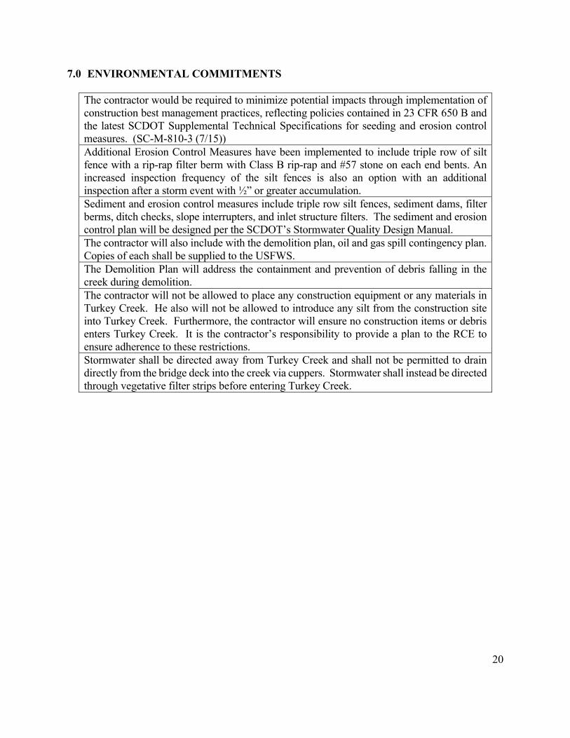
20
7.0 ENVIRONMENTAL COMMITMENTS
The contractor would be required to minimize potential impacts through implementation of construction best management practices, reflecting policies contained in 23 CFR 650 B and the latest SCDOT Supplemental Technical Specifications for seeding and erosion control measures. (SC-M-810-3 (7/15)) Additional Erosion Control Measures have been implemented to include triple row of silt fence with a rip-rap filter berm with Class B rip-rap and #57 stone on each end bents. An increased inspection frequency of the silt fences is also an option with an additional inspection after a storm event with ½” or greater accumulation. Sediment and erosion control measures include triple row silt fences, sediment dams, filter berms, ditch checks, slope interrupters, and inlet structure filters. The sediment and erosion control plan will be designed per the SCDOT’s Stormwater Quality Design Manual. The contractor will also include with the demolition plan, oil and gas spill contingency plan. Copies of each shall be supplied to the USFWS. The Demolition Plan will address the containment and prevention of debris falling in the creek during demolition. The contractor will not be allowed to place any construction equipment or any materials in Turkey Creek. He also will not be allowed to introduce any silt from the construction site into Turkey Creek. Furthermore, the contractor will ensure no construction items or debris enters Turkey Creek. It is the contractor’s responsibility to provide a plan to the RCE to ensure adherence to these restrictions. Stormwater shall be directed away from Turkey Creek and shall not be permitted to drain directly from the bridge deck into the creek via cuppers. Stormwater shall instead be directed through vegetative filter strips before entering Turkey Creek.

APPENDIX A
Preliminary Plans

South Carolina Department of Transportation
1
DRAWING NO. 700-01
PROJECT ID 0035179ROAD S-68 S-227 (KEY ROAD)
0035179-B01
-N-
%
33 - 47' - 41"
82 - 08' - 41"
181
2015 150
2035 300
0.000
0.060
0.060
0.060
0.000
KL
SR
UR
10-1
5
10. Superstructure Detail (Span 2)9. Superstructure Detail (Span 1)8. Interior Bent 27. End Bent 36. End Bent 15. Bridge Plan and Profile4. Roadway Plan and Profile3. Roadway Typical Section2. General Notes1. Title Sheet
6
b35179ts.dgn
INDEX OF SHEETS
BRIDGE PLANS IDSHEET
NO.
Columbia, SC 29201
955 Park Street - Room 409
Attn: Logistics Coordinator - Shop Plans
Preconstruction Support Engineer
SCDOT
Submit Shop Plans to:
Approximate Location of Bridge is
Latitude
Longitude
RPG - HYDROLOGY
RPG - STRUCTURES
RPG - GEOTECHNICAL
PRECONSTRUCTION SUPPORT - STRUCTURES
RPG - DESIGN M ANAGER
RPG - PROGRAM M ANAGER
INITIAL DATE
FOR CONSTRUCTION
LAYOUT
NET LENGTH OF ROADW AY
NET LENGTH OF BRIDGES
NET LENGTH OF PROJECT
LENGTH OF EXCEPTIONS
GROSS LENGTH OF PROJECT MILES
MILES
MILES
MILES
MILES
TO THE SOUTH CAROLINA DEPARTMENT OF TRANSPORTATION STANDARD
PROVISIONS, ALL M ATERIALS AND W ORKM ANSHIP ON THIS PROJECT SHALL CONFORM
EXCEPT AS M AY OTHERW ISE BE SPECIFIED ON THE PLANS OR IN THE SPECIAL
SPECIFICATIONS FOR HIGHW AY CONSTRUCTION (2007 EDITION) AND THE STANDARD
DRAW INGS FOR ROAD CONSTRUCTION IN EFFECT AT THE TIME OF LETTING.
NOTE:
SOUTH CAROLINA
3 DAYS BEFORE DIGGING IN
CALL 811
ALL UTILITIES M AY NOT BE A MEMBER OF SC811W W W .SC811.COM
SOUTH CAROLINA 811 (SC811)
ASSET ID
TRAFFIC DATA
ADT V.P.D.
V.P.D.ADT
TRUCKS
Pri
nte
d:
Wed
nesd
ay
, N
ov
em
ber
04
, 2
01
5 8
:25
:18
AM
Sta
ple
toK
LD
AT
EC
HK
BY
RE
VIE
WE
D
DR
.
FORPROPOSED PLANS
EDGEFIELD McCORMICK COUNTIES
REPLACE BRIDGE OVER TURKEY CREEK
SITE LOCATION
ENGINEER OF RECORD
FOR CONSTRUCTION :
DATE
Sta.
NOVEMBER 4, 2015PRELIMINARY PLANS


FOR INFORMATION ONLY
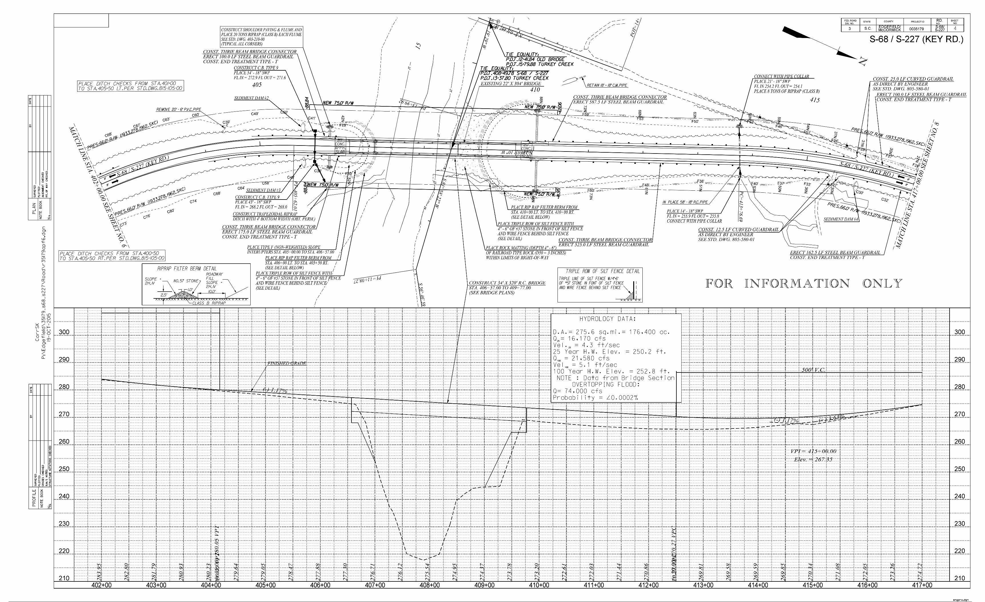
FOR INFORMATION ONLY
4

> S-68 & > S-227
Existing Ground @
200
180
220
240
260
280
300
320
BENT NO. 1
2
3
Finished Grade
> S-68
To SC 23
of > S-68 & > S-227
Existing Ground, 20'-0" Left
of > S-68 & > S-227
Existing Ground, 20'-0" Right
To SC 283
> S-227
N
9'-
6"
11
'-0
"
9'-
6"
PT
= 4
05
+6
2.0
1
Beginning of Bridge
Expansion Joint &
Approach Slab
40
6+
00
40
7+
00
40
8+
00
40
9+
00
41
0+
00
41
1+
00
405+00
EDGEFIELD COUNTY
McCORMICK COUNTY
Top of Bank
Approximate
Jurisdictional Stream Limit (Typ.)
1
1
"Removal and Disposal of Existing Bridge".
associated with this work in the Lump Sum price bid for
202.4.2 of the Standard Specifications. Include all cost
and disposed of by the Contractor in accordance with Section
Existing 304' x 20' steel and concrete bridge to be removed
TURKEY CREEK
Flo
w
Approach Slab
(Typ. each corner)
Thrie-Beam Bridge Connector
& End of Bridge
Deflection Joint
Spread Footing
54" Dia. Drilled Shaft
48" Dia. Rock Socket
C
HP 14x73 Steel Piles
Nail in 18" Pine
Elev. = 270.710
146.14' LT of Sta. 406+82.79
Benchmark #3
2:1
Pri
nte
d:
Wednesday, N
ovem
ber
04, 2015 1
:01:2
0 P
M
SOUTH CAROLINA
DEPARTMENT OF TRANSPORTATION
REV.
REV.
REV.
REVIEWED
QUAN.
DR.
DES.
BY CHK. DATECOUNTY ROUTE
SHEETNO.BRIDGE PLANS ID
TURKEY CREEKREPLACE BRIDGE OVER
BRIDGE PLAN & PROFILE
EDGEFIELD / McCORMICK S-68 / S-227
KLS RUR 10-15
160
140 140
160
180
200
220
240
260
280
300
320
409+00 +20 +40 +60 +80
410+00 +20 +40 +60 +80 411+00 +20
+80+60+40+20408+00+80+60+40+20407+00+80+60+40+20406+00+80+60+40+20405+00
b35179bp.dgn
0035179-B01 5
& 1
•" S
lab
E
xt. (T
yp
.)
1'-
6" B
arrier P
arapet
Spacing
Drain
Exp. Joint
> Bent 2 &
Top of Bank
Approximate
Nail in 36" Pine
Elev. = 249.110
137.11' LT of Sta. 410+35.20
Benchmark #4
Elev. = 241.6
2 Yr. H.W.
Elev. = 250.2
25 Yr. H.W.
Elev. = 252.8
100 Yr. H.W.
***
Excavate hatched area
*25 Year High Water Elevation includes 0.19 feet of backwater
*100 Year High Water Elevation includes 0.24 feet of backwater
*
Q = 16,170 CFS
25 YEAR W.S. ELEV. = 249.8 FT
Q = 21,850 CFS
100 YEAR W.S. ELEV. = 252.4 FT
2 YEAR W.S. ELEV. = 241.6 FT
PROBABILITY 0.002
Q = 74,000 CFS
25VEL. = 4.3 FT/SEC
VEL. = 5.1 FT/SEC
HYDROLOGY DATA:
25
100
100
OVERTOPPING FLOOD:
D.A. = 275.6 SQ.MI. = 176,400 AC.
Elev
. =
2
77
.4
48
Sta. 406+
37.00
Begin A
pproach S
lab
Elev
. =
2
77
.2
13
Sta. 406+
57.00
Beg
in
Brid
ge
Elev
. =
2
74
.6
97
Sta. 408+
72.00
> B
en
t 2
Elev
. =
2
73
.4
68
Sta. 409+
77.00
End of B
ridge
Elev
. =
2
73
.2
33
Sta. 409+
97.00
En
d A
pp
ro
ach
Slab
15'-0"
12:1
Notes:
Edge of Shoulder
Shoulder
Edge of Paved
Edge of Lane
Edge of Lane
Shoulder
Edge of Paved
Edge of Shoulder
Edge of Lane
Edge of Shoulder
Shoulder
Edge of Paved
Edge of Lane
Shoulder
Edge of Paved
Edge of Shoulder
(Typ., See Road Plans)
Curb & Gutter with Flume
Bridge Approach Concrete
Scour lines will be provided after completion of Hydraulic Scour Study
Foundation dependant on Geotechnical Report
Fill/Cut (Typ.)
Approximate Toe of
10'-0" 10'-0"
I
XF
X
R = 818.35'
E = 174.98'
L = 986.32'
T = 563.03'
P.I. = 401+38.71
D = 7 00'05"
6 Spaces @ 14'-2" = 85'-0"10 Spaces @ 19'-0" = 190'-0"
CURVE DATA:
37
'-3
"
34
'-0
" R
oad
way
17'-
0"
17
'-0
"
320'-0"
Slab
Approach
20'-0" 215'-0" Span 1 105'-0" Span 2
Slab
Approach
20'-0"
PLAN
= 69 03'23" (RT)
VERTICAL CURVE DATA:
(-)5.98% (-)1.17%
L= 800'
V.P.I.= 400+15.00
Elev.= 284.73
VERTICAL CURVE DATA:
(-)1.17%
L= 500'
V.P.I.= 415+00.00
Elev.= 267.35
(+)3.63%
2'-0" Berm
"X" indicates Expansion Bearing
"F" indicates Fixed Bearing
"I" indicates Integral Bent
SECTION ALONG L SURVEY S-68 S-227
Jurisdictional Stream Limit measured along > Survey.
83'-2" +/-2
2
> Bridge
> Survey &
Keep all construction activity outside of Jurisdictional Stream Limits.
Guardrail not shown, see Road Plans.
Sheets 9 and 10.
For Constant Superelevation see Section Thru Superstructure on
No utilities present.
Notes:
9'-
6"
11
'-0
"
9'-
6"
(See Road Plans)
Riprap to Elev. 255.0,
Sta. 406+56.00
Boring B-2
6'-
0"
Sta. 409+00.00
Boring B-4
45
'-0
"
Sta. 409+80.00
Boring B-5
Sta. 406+47.00
Boring B-11
21
'-0
"
Sta. 406+48.00
Boring B-12
19
'-0
"
Sta. 408+78.00
Boring B-13
19
'-0
"
Sta. 408+78.00
Boring B-14
18
'-0
"
7'-
0"
Sta. 409+82.00
Boring B-15
10'-
0"

Prin
ted
: T
hu
rsd
ay
, O
cto
ber 2
9,
20
15
10
:06
:46
AM
REV.
REV.
REV.
REVIEWED
QUAN.
DR.
DES.
BY DATECHK.
ROUTECOUNTY
DEPARTMENT OF TRANSPORTATION
SOUTH CAROLINA
EDGEFIELD / McCORMICK
NO.SHEETBRIDGE PLANS ID
0035179-B01
b35179eb.dgn
END BENT 1
S-68 / S-227
KLS RUR 3-15
> Bridge
90°-00'-00"
5 %
1'-0" 5'-0" 1'-0"
Level
Level (Typ.)
2'-
6"
5'-
0"
2'-
6"
4'-
10"
PLAN
ELEVATION
Sta
tionin
g
Geotechnical Report
Foundation dependent on Bridge
4'-
10"
3'-
0"
Footing
Spread
3'-
0"
Beginning of Bridge
Wall
Back
1'-3"
Bridge
Beginning of
Top of Cap
Top of Build-Up
Footing
Top of Spread
Bolt (Typ.)
1•" Dia. Anchor > Bearing
> Bent &
Note:
> Bearing
> Bent &
4'-10‚ "
19'-10‚ "
39'-8• "
19'-10‚ "
1'-0"1'-0"
1'-
0"
1'-
0"
6
10'-0" (Typ.)
> Girders
1'-
3"
1'-
3"
1'-3"
(Typ.)
1'-2"
1'-9" 1'-9" (Typ.)
(T
yp.)
2'-
8"
1'-
0"
Ground
Proposed
2'-6" 2'-6"
7'-0"

Prin
ted
: T
hu
rsd
ay
, O
cto
ber 2
9,
20
15
10
:07
:40
AM
REV.
REV.
REV.
REVIEWED
QUAN.
DR.
DES.
BY DATECHK.
ROUTECOUNTY
DEPARTMENT OF TRANSPORTATION
SOUTH CAROLINA
EDGEFIELD / McCORMICK
NO.SHEETBRIDGE PLANS ID
0035179-B01
39'-4• "
19'-8‚ "
4'-2‚ "
19'-8‚ "
> Bridge
7'-9" (Typ.)
> Beams(Typ.)
90°-00'-00"
> Bearing
> Bent &
Level
> Steel Piles
3'-0‚ " 8'-4"
5 4 3 2 1PILE NO.
Geotechnical Report
Foundation dependent on Bridge
PLAN
ELEVATION
2'-
6"
Sta
tionin
g
3'-
4"
1'-
8"
1'-
8"
b35179eb.dgn
END BENT 3
S-68 / S-227
KLS RUR 3-15
12"
8"
direction of stationing.
to left looking in the opposite
Piles are numbered from right
Note:
End of Bridge
Bolt (Typ.)
1•" Dia. Anchor
7
1'-10" 1'-10"
(Typ.)
1'-0"
Wing Wall (Typ.)
(Looking Opposite Direction of Stationing)
(Typ.)

Printed: T
hursday, O
ctober 29, 2015 11:06:22 A
M
REV.
REV.
REV.
REVIEWED
QUAN.
DR.
DES.
BY DATECHK.
ROUTECOUNTY
DEPARTMENT OF TRANSPORTATION
SOUTH CAROLINA
NO.SHEETBRIDGE PLANS ID
4'-
6"
2'-
3"
2'-
3"
5'-
0"
6'-6" 23'-0"
4'-6" 2'-0" 2'-0"
4'-0" 9'-6"
PLAN
ELEVATION
> Rock Socket (Typ.)
> Drilled Shaft &
> Column
> Type IV Beams
> Steel Girder
7'-9" (Typ.)2'-6"
3'-0" 10'-0" (Typ.)
Construction Joint
SHAFT NO. 1 2
right looking in direction of stationing.
Drilled Shafts are numbered from left to
90°-00'-00"
> Bridge
> Bent
Note:
Geotechnical Report
Foundation dependent on Bridge
INTERIOR BENT 2KLS RUR 2-15
S-68 / S-227EDGEFIELD / McCORMICK
0035179-B01
b35179bt.dgn
Stationing
5% Slope (Typ.)
Level (Typ.)
Level
8
4'-6"
4'-0"
5'-
0"
Bolt (Typ.)
1• " Dia. Anchor
> Bearing
(Looking in Direction of Stationing)
11'-6"
END ELEVATION
Build-ups not shown
Construction Joint

Prin
ted
:
Mo
nd
ay
, N
ov
em
ber 0
2,
20
15
3:4
5:3
6 P
M
REV.
REV.
REV.
REVIEWED
QUAN.
DR.
DES.
BY DATECHK.
ROUTECOUNTY
DEPARTMENT OF TRANSPORTATION
SOUTH CAROLINA
EDGEFIELD / McCORMICK
NO.SHEETBRIDGE PLANS ID
DETAIL (SPAN 1)SUPERSTRUCTURE
KLS RUR 3-15
S-68 / S-227
0035179-B01
Looking in Direction of Stationing
1'-7• "
1'-6" 1• "
37'-3"
1'-6"
1'-7• "
1• " 17'-0"17'-0"
8•" (T
yp.)
3'-7• " 10'-0" 10'-0" 3'-7• "
1 2 3 4
> S-68, > S-227, & > Bridge
Finished Grade
48
1
SECTION THRU SUPERSTRUCTURE - SPAN 1
5'-0" 5'-0"
7'-
8" W
eb (T
yp.)
System
Drainage
Closed
Plate Girder (Typ.)
Grade 50W Steel
9.125' S
tructure D
epth
b35179sx.dgn
9
34'-0" (Roadway)
12" (T
yp.)
Parapet (Typ.)
Barrier
2"
span, both sides)
(Entire length of
ƒ " Drip Groove

Prin
ted
: M
on
day
, N
ov
em
ber 0
2,
20
15
3:4
8:5
1 P
M
REV.
REV.
REV.
REVIEWED
QUAN.
DR.
DES.
BY DATECHK.
ROUTECOUNTY
DEPARTMENT OF TRANSPORTATION
SOUTH CAROLINA
EDGEFIELD / McCORMICK
NO.SHEETBRIDGE PLANS ID
1• " 1'-6" 1'-6" 1• "
1'-7• "
37'-3"
1'-7• " 34'-0" (Roadway)
8" (T
yp
.)
11•" (T
yp
.)
17'-0" 17'-0"
3'-1• " 7'-9" 7'-9" 7'-9" 7'-9" 3'-1• "
1 2 3 4 5
Su
perstru
ctu
re D
ep
th
5.7
8'
48
1
Looking in Direction of Stationing
Concrete Beam (Typ.)
Type IV Prestressed System
Drainage
Closed
> S-68, > S-227, & > Bridge
Finished Grade
DETAIL (SPAN 2)SUPERSTRUCTURE
KLS RUR 3-15
S-68 / S-227
0035179-B01
SECTION THRU SUPERSTRUCTURE - SPAN 2
b35179sx.dgn
10
Parapet (Typ.)
Barrier
2"
span, both sides)
(Entire legtgh of
ƒ " Drip Groove

APPENDIX B
Select Photos from Mussel Survey

Eastern Elliptio (bottom), Creeper (2nd from bottom), Carolina Spike (3rd from bottom), Eastern
Creekshell (all others)

Brook Floater (top)Eastern Creekshell (bottom)

Turkey Creek below Key Road

Natural Resources Technical Memorandum Proposed S-68/S-227 (Key Road) Bridge Replacement Project
Edgefield and McCormick Counties, South Carolina SCDOT Project P035179
APPENDIX E
AGENCY COORDINATION


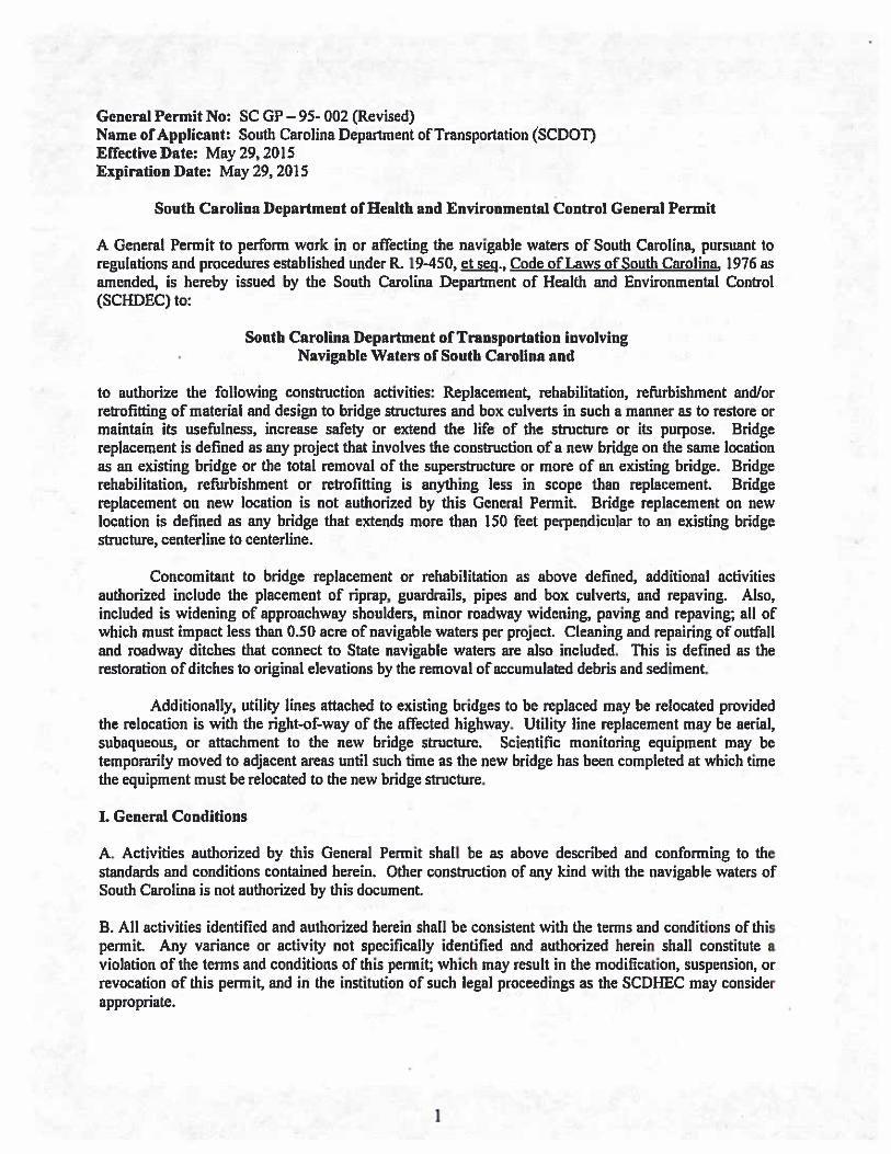


United States Department of the Interior
FISH AND WILDLIFE SERVICE
176 Croghan Spur Road, Suite 200Charleston, South Carolina 29407
April 20, 2016
Ms. Nicole Riddle
South Carolina Department of TransportationP.O. Box 191
Columbia, SC 29202-0191
Re: S-68/S-227 (Key Road) Bridge Replacement over Turkey CreekEdgefield and McCormick Counties, South CarolinaFWS Log No. 2016-1-0367
Dear Ms. Riddle:
U.S.FLSH* WILDLIFE
SERVICE
The U.S. Fish and Wildlife Service (Service) has reviewed the information in yourMarch 31, 2016, letter as well as the attached Biological Assessment (BA), regarding theproposed Federal Highway Administration (FHWA)/South Carolina Department ofTransportation (SCDOT) replacement of the Key Road bridge over Turkey Creek within theLong Cane Ranger District of Sumter National Forest. The current bridge was built in 1925 andis considered structurally deficient and functionally obsolete.
The federally endangered Carolina heelsplitter (Lasmigona decorata) and its designated criticalhabitat are known to occur within the project area. A freshwater mussel survey was conductedby Three Oaks Engineering, Inc., in December of 2015; the associated report documented oneindividual Carolina heelsplitter was found approximately 70 feet upstream of the bridge.Therefore, bridge replacement activities have the potential to affect both critical habitat andindividual heelsplitter located within and downstream of the project area. However, based oninformation provided in the BA, no bridge supports will be located within the stream channel,and there will be no temporary disturbance to the stream bottom from in-stream constructioncauseways, work pads, or construction within the stream. Additionally, SCDOT has committedto take extra precautions during construction and demolition (page 8 of the BA) in order toprevent the degradation of downstream habitat from sedimentation.
Based upon the information provided, including the additional environmental commitmentsagreed to by FHWA and SCDOT to protect the Carolina heelsplitter and its critical habitat inTurkey Creek, the Service concurs with the determination that the proposed project may affect,but is not likely to adversely affect, the Carolina heelsplitter or its designated critical habitat.Please note that obligations under the Endangered Species Act must be reconsidered if: (1) newinformation reveals impacts of this identified action may affect any listed species or criticalhabitat in a manner not previously considered; (2) this action is subsequently modified in a


Natural Resources Technical Memorandum Proposed S-68/S-227 (Key Road) Bridge Replacement Project
Edgefield and McCormick Counties, South Carolina SCDOT Project P035179
APPENDIX F
QUALIFICATIONS OF MEAD & HUNT PERSONNEL

Natural Resources Technical Memorandum Proposed S-68/S-227 (Key Road) Bridge Replacement Project
Edgefield and McCormick Counties, South Carolina SCDOT Project P035179
The following Mead & Hunt employees were responsible for the preparation of this document:
Matthew DeWitt, PWS; Environmental Scientist
B.S. Environmental and Natural Resources
Matt DeWitt is a professional wetland scientist (PWS) with 12 years of experience throughout the southeastern United States working in environmental studies, with an emphasis on matters related to the Clean Water Act (CWA). He holds a bachelor’s degree in environmental and natural resources, with minors in natural resource management and forestry. He specializes in CWA permitting and regulatory agency coordination. Matt has also participated in the preparation of numerous environmental documents pursuant to the National Environmental Policy Act (NEPA), including natural resources technical memorandums, protected species biological assessments, Environmental Assessments (EAs), and Environmental Impact Statements (EISs). Matt also performs natural resources studies, including wetland delineations, threatened and endangered species surveys, water quality sampling, environmental compliance studies, and mitigation site identification, design and monitoring.
Perry Rossa, PWS, PH; Environmental Scientist
B.S. Environmental and Natural Resources; M.S. Water Resources Management
Perry Rossa is a professional hydrologist (PH) and professional wetland scientist (PWS) with more than 20 years of experience in the execution of National Environmental Policy Act (NEPA) compliance documents and state and federal wetland permitting throughout the Upper Midwest. This includes wetland mitigation and the evaluation, design, restoration and management of many of the wetland and upland native plant communities. As project leader for wetland permitting and mitigation design teams, he has been responsible for the coordination of staff in biological and engineering studies, the establishment of restoration objectives and performance standards, the production of plans and specifications to achieve those standards and construction supervision. Perry provided technical quality control and quality assurance (QA/QC) measures for this document.