Route 6/10 Interchange of 25 | RIDOT FASTLANE Grant Application | Route 6/10 Interchange....
27
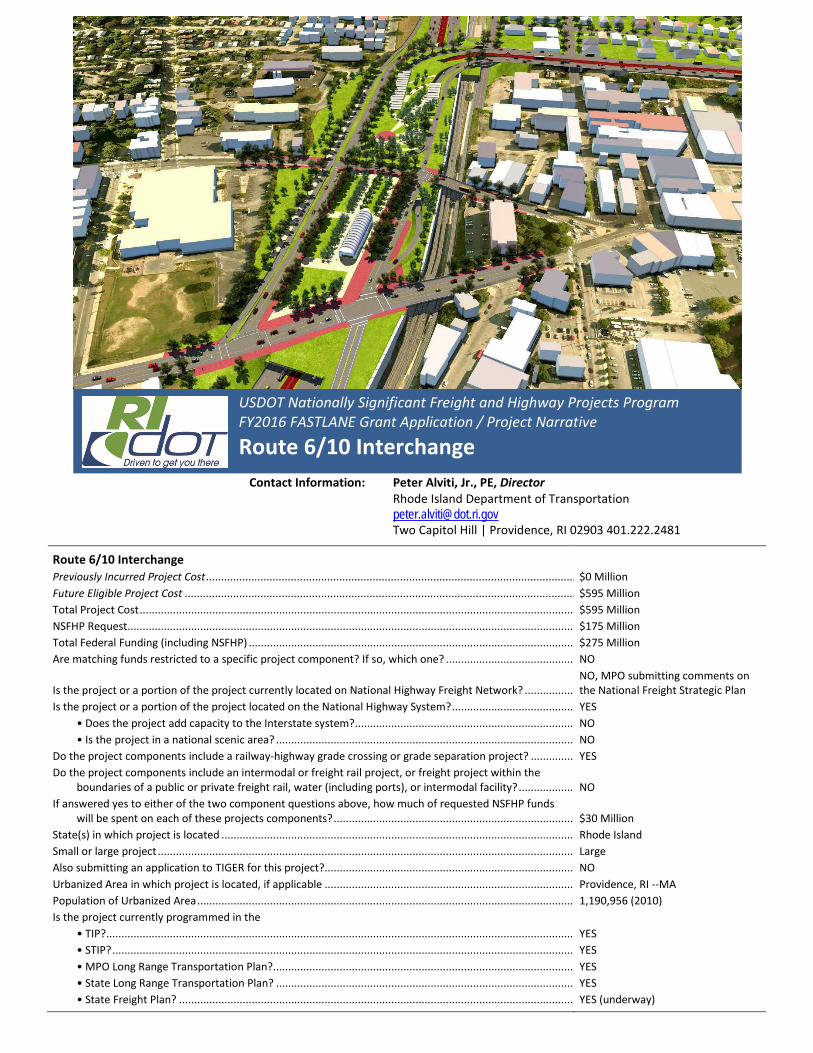
Route 6/10 Interchange Previously Incurred Project Cost .......................................................................................................................... $0 Million Future Eligible Project Cost ................................................................................................................................. $595 Million Total Project Cost ................................................................................................................................................ $595 Million NSFHP Request.................................................................................................................................................... $175 Million Total Federal Funding (including NSFHP) ............................................................................................................ $275 Million Are matching funds restricted to a specific project component? If so, which one? ........................................... NO Is the project or a portion of the project currently located on National Highway Freight Network? ................. NO, MPO submitting comments on the National Freight Strategic Plan Is the project or a portion of the project located on the National Highway System? ......................................... YES • Does the project add capacity to the Interstate system?......................................................................... NO • Is the project in a national scenic area? ................................................................................................... NO Do the project components include a railway-highway grade crossing or grade separation project? ............... YES Do the project components include an intermodal or freight rail project, or freight project within the boundaries of a public or private freight rail, water (including ports), or intermodal facility? ................... NO If answered yes to either of the two component questions above, how much of requested NSFHP funds will be spent on each of these projects components? ................................................................................ $30 Million State(s) in which project is located ..................................................................................................................... Rhode Island Small or large project .......................................................................................................................................... Large Also submitting an application to TIGER for this project?................................................................................... NO Urbanized Area in which project is located, if applicable ................................................................................... Providence, RI --MA Population of Urbanized Area ............................................................................................................................. 1,190,956 (2010) Is the project currently programmed in the • TIP?........................................................................................................................................................... YES • STIP? ......................................................................................................................................................... YES • MPO Long Range Transportation Plan?.................................................................................................... YES • State Long Range Transportation Plan? ................................................................................................... YES • State Freight Plan? ................................................................................................................................... YES (underway) Contact Information: Peter Alviti, Jr., PE, Director Rhode Island Department of Transportation [email protected] Two Capitol Hill | Providence, RI 02903 401.222.2481 USDOT Nationally Significant Freight and Highway Projects Program FY2016 FASTLANE Grant Application / Project Narrative Route 6/10 Interchange
-
Upload
vuongkhuong -
Category
Documents
-
view
217 -
download
2
Transcript of Route 6/10 Interchange of 25 | RIDOT FASTLANE Grant Application | Route 6/10 Interchange....
Route 6/10 Interchange Previously Incurred Project Cost .......................................................................................................................... $0 Million Future Eligible Project Cost ................................................................................................................................. $595 Million Total Project Cost ................................................................................................................................................ $595 Million NSFHP Request.................................................................................................................................................... $175 Million Total Federal Funding (including NSFHP) ............................................................................................................ $275 Million Are matching funds restricted to a specific project component? If so, which one? ........................................... NO
Is the project or a portion of the project currently located on National Highway Freight Network? ................. NO, MPO submitting comments on the National Freight Strategic Plan
Is the project or a portion of the project located on the National Highway System? ......................................... YES • Does the project add capacity to the Interstate system?......................................................................... NO • Is the project in a national scenic area? ................................................................................................... NO Do the project components include a railway-highway grade crossing or grade separation project? ............... YES Do the project components include an intermodal or freight rail project, or freight project within the
boundaries of a public or private freight rail, water (including ports), or intermodal facility? ................... NO If answered yes to either of the two component questions above, how much of requested NSFHP funds
will be spent on each of these projects components? ................................................................................ $30 Million State(s) in which project is located ..................................................................................................................... Rhode Island Small or large project .......................................................................................................................................... Large Also submitting an application to TIGER for this project?................................................................................... NO Urbanized Area in which project is located, if applicable ................................................................................... Providence, RI --MA Population of Urbanized Area ............................................................................................................................. 1,190,956 (2010) Is the project currently programmed in the • TIP? ........................................................................................................................................................... YES • STIP? ......................................................................................................................................................... YES • MPO Long Range Transportation Plan?.................................................................................................... YES • State Long Range Transportation Plan? ................................................................................................... YES • State Freight Plan? ................................................................................................................................... YES (underway)
Contact Information: Peter Alviti, Jr., PE, Director Rhode Island Department of Transportation [email protected] Two Capitol Hill | Providence, RI 02903 401.222.2481
USDOT Nationally Significant Freight and Highway Projects Program FY2016 FASTLANE Grant Application / Project Narrative
Route 6/10 Interchange
ii |
RIDOT FASTLANE Grant Application | Route 6/10 Interchange
Table of Contents Table of Contents .............................................................................................................................ii
Introduction and Project Maps ....................................................................................................... 1
Regional Surface Transportation Network ................................................................................. 3
Project Area and Existing Facilities Map, Greater Providence Metropolitan Area .................... 4
Application Review Criteria............................................................................................................. 5
a. Project Description ................................................................................................................. 7
b. Project Location .................................................................................................................... 14
c. Project Parties ....................................................................................................................... 16
d. Grant Funds, Sources and Uses of Project Funds ................................................................. 17
(i) Future Eligible Cost......................................................................................................... 17
(ii) Availability and Commitment of Funding Sources and Uses ......................................... 17
(iii) Federal Funds and Required Match ............................................................................... 19
(iv) Detailed Project Budget ................................................................................................. 20
(v) Requested NSFHP Funds ................................................................................................ 20
e. Cost-Effectiveness Analysis ................................................................................................... 20
f. Project Readiness .................................................................................................................. 21
(i) Technical Feasibility ....................................................................................................... 22
(ii) Project Schedule ............................................................................................................. 23
(iii) Required Approvals ........................................................................................................ 23
(a) Environmental Permits and Reviews .......................................................................... 23
(b) State and Local Approvals .......................................................................................... 24
(c) State and Local Planning ............................................................................................. 25
(iv) Assessment of Project Risks and Mitigation Strategies ................................................. 25
Supporting Documents Bound Separately
• Benefit-Cost Analysis – Technical Memorandum & Data
• The Route 6/10 Interchange Project Renderings
• Environmental Impact Statement and Record of Decision for Improvements to the U.S. Route 6 / Route 10 Interchange (2006)
• Letters of Support
1 of 25 |
RIDOT FASTLANE Grant Application | Route 6/10 Interchange
Introduction and Project Maps Dear NSFHP/FASTLANE Review Team: On behalf of the Rhode Island Department of Transportation (RIDOT), I am pleased to submit this grant application for the $595 million Route 6/10 Interchange Project. RIDOT is requesting a $175 million contribution (29%) from the FASTLANE program.
Rhode Island is the second most densely populated state in the union and this interchange is a vital link in the state’s highway network. The interchange is located just west of downtown Providence in an area of Providence known as Olneyville. It serves as a critical east-west regional link for automobile and truck traffic between Interstates 295, 95 and 195. Nearly 100,000 trips are made through the trunk of the interchange each day with two thirds of those trips originating or destined for points outside of Providence.
The Route 6/10 Interchange is the entrance to the truck freight “National Network”, as authorized by provisions of the Surface Transportation Assistance Act of 1982 (STAA) as amended, which includes portions of Route 6, formerly RI-195, West and Route 10 South of the Interchange. The bridges and ramps of the interchange also provide a grade separation for Amtrak’s Northeast Corridor (NEC) and an adjacent freight track. The corridor serves a number of freight and industrial concerns in the area, including the steadily growing Port of Providence.
The Route 6/10 Interchange has fallen into a state of disrepair with seven of its nine bridge structures rated structurally deficient. In addition to replacing the bridges and ramps of the interchange itself, this project will also address existing bridges serving local streets that are integrated into the interchange due to their proximity and grades. All will be brought into a state of good repair.
RIDOT is proposing an innovative approach that replaces the existing infrastructure with a new “hybrid” expressway and boulevard. This approach will benefit neighborhoods in the community by reducing massing of physical infrastructure. The new interchange will consist of lower-level express travel lanes for passenger vehicles and freight, over which a city-street-level lane road network will be constructed. Under this approach, existing bridges will be eliminated and replaced with surface streets constructed on a “cap” of the depressed expressway. This approach not only creates 11 new acres of real estate opportunities for economic development or green space, it also begins to knit back together surrounding disadvantaged communities that were separated by the original construction of the highway.
While not part of the cost of this project, the project will be designed so as to not to preclude a future rapid transit or similar transit feature adjacent to the expressway under the cap. This will allow for future benefits to non-auto users. Auto ownership in the host community of Olneyville is approximately 50%, making the area an ideal candidate for future transit use. The project also includes construction of a “missing move” from Route 10 North to Route 6 West. The creation of this missing move will serve to reduce or eliminate through traffic from the streets of Olneyville, thereby improving pedestrian safety in the community.

2 of 25 |
RIDOT FASTLANE Grant Application | Route 6/10 Interchange
RIDOT is proposing that local sources fund a significant portion of the project’s costs -- more than 70%.
• NSFHP Funding - 29% • Local Funding - 71%
All of the local share for this project has been fully authorized by the state legislature, thanks to the passage of the RhodeWorks legislation in February 2016.
The trip time benefits for users, additional real estate, and safety improvements result in a positive benefit cost ratio of 4.97
RIDOT is well positioned to begin this project immediately. Preliminary engineering on this project was completed and a Record of Decision (ROD) was approved in 2006. Since that time, RIDOT has changed the design of the project to allow for a future transit feature and better integrate the streets of neighboring host communities that were impacted by the original highway construction in the 1950s. Given this change, and the age of the ROD, RIDOT expects an updated environmental document will be required and is prepared to update the document, including additional public outreach.
Importantly, RIDOT will be implementing the project using a Design-Build (D/B) procurement. With the approval of this grant application, RIDOT anticipates issuing notice to proceed on a contract for construction by the middle of 2018, immediately following approval under the National Environmental Policy Act (NEPA).
The project is well supported. Letters of support from the Governor, Congressional Delegation, leadership and members of the General Assembly, Mayors, local elected officials and interest groups for this project have been included in the appendix. RIDOT believes this project very closely fits the criteria of the FASTLANE grant program, and with this federal funding in combination with our exceedingly high local share, we can use infrastructure investments to not only rebuild a key regional interchange but also transform a local community. We seek your support in this pursuit.
Sincerely,
Peter Alviti, Jr., PE, Director
Rhode Island Department of Transportation
3 of 25 |
RIDOT FASTLANE Grant Application | Route 6/10 Interchange
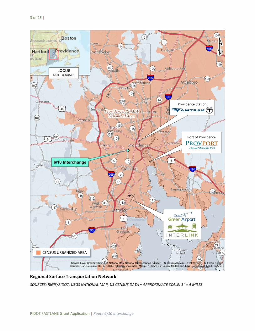
Regional Surface Transportation Network SOURCES: RIGIS/RIDOT, USGS NATIONAL MAP, US CENSUS DATA • APPROXIMATE SCALE: 1” = 4 MILES
Port of Providence
Providence Station
CENSUS URBANIZED AREA
4 of 25 |
RIDOT FASTLANE Grant Application | Route 6/10 Interchange
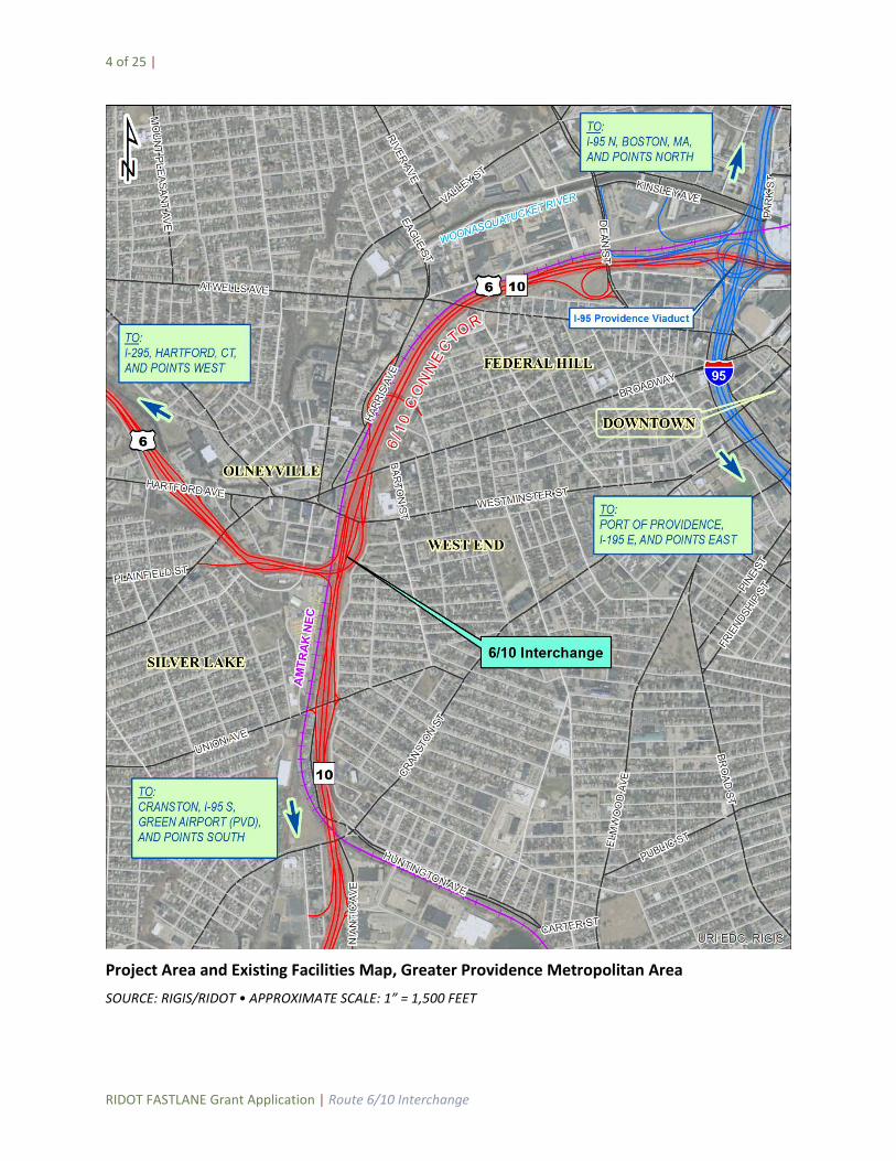
Project Area and Existing Facilities Map, Greater Providence Metropolitan Area SOURCE: RIGIS/RIDOT • APPROXIMATE SCALE: 1” = 1,500 FEET
5 of 25 |
RIDOT FASTLANE Grant Application | Route 6/10 Interchange
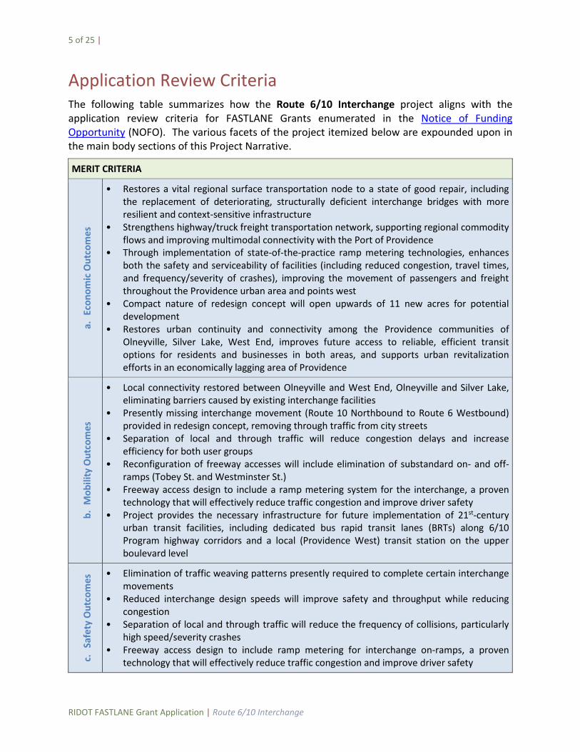
Application Review Criteria The following table summarizes how the Route 6/10 Interchange project aligns with the application review criteria for FASTLANE Grants enumerated in the Notice of Funding Opportunity (NOFO). The various facets of the project itemized below are expounded upon in the main body sections of this Project Narrative.
MERIT CRITERIA
a. E
cono
mic
Out
com
es
• Restores a vital regional surface transportation node to a state of good repair, including the replacement of deteriorating, structurally deficient interchange bridges with more resilient and context-sensitive infrastructure
• Strengthens highway/truck freight transportation network, supporting regional commodity flows and improving multimodal connectivity with the Port of Providence
• Through implementation of state-of-the-practice ramp metering technologies, enhances both the safety and serviceability of facilities (including reduced congestion, travel times, and frequency/severity of crashes), improving the movement of passengers and freight throughout the Providence urban area and points west
• Compact nature of redesign concept will open upwards of 11 new acres for potential development
• Restores urban continuity and connectivity among the Providence communities of Olneyville, Silver Lake, West End, improves future access to reliable, efficient transit options for residents and businesses in both areas, and supports urban revitalization efforts in an economically lagging area of Providence
b. M
obili
ty O
utco
mes
• Local connectivity restored between Olneyville and West End, Olneyville and Silver Lake, eliminating barriers caused by existing interchange facilities
• Presently missing interchange movement (Route 10 Northbound to Route 6 Westbound) provided in redesign concept, removing through traffic from city streets
• Separation of local and through traffic will reduce congestion delays and increase efficiency for both user groups
• Reconfiguration of freeway accesses will include elimination of substandard on- and off-ramps (Tobey St. and Westminster St.)
• Freeway access design to include a ramp metering system for the interchange, a proven technology that will effectively reduce traffic congestion and improve driver safety
• Project provides the necessary infrastructure for future implementation of 21st-century urban transit facilities, including dedicated bus rapid transit lanes (BRTs) along 6/10 Program highway corridors and a local (Providence West) transit station on the upper boulevard level
c. S
afet
y O
utco
mes
• Elimination of traffic weaving patterns presently required to complete certain interchange movements
• Reduced interchange design speeds will improve safety and throughput while reducing congestion
• Separation of local and through traffic will reduce the frequency of collisions, particularly high speed/severity crashes
• Freeway access design to include ramp metering for interchange on-ramps, a proven technology that will effectively reduce traffic congestion and improve driver safety
6 of 25 |
RIDOT FASTLANE Grant Application | Route 6/10 Interchange
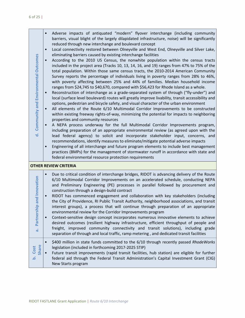
d. C
omm
unity
and
Env
ironm
enta
l Out
com
es
• Adverse impacts of antiquated “modern” flyover interchange (including community barriers, visual blight of the largely dilapidated infrastructure, noise) will be significantly reduced through new interchange and boulevard concept
• Local connectivity restored between Olneyville and West End, Olneyville and Silver Lake, eliminating barriers caused by existing interchange facilities
• According to the 2010 US Census, the nonwhite population within the census tracts included in the project area (Tracks 10, 13, 14, 16, and 19) ranges from 47% to 75% of the total population. Within those same census tracts, the 2010-2014 American Community Survey reports the percentage of individuals living in poverty ranges from 28% to 46%, with poverty affecting between 25% and 44% of families. Median household income ranges from $24,745 to $40,670, compared with $56,423 for Rhode Island as a whole.
• Reconstruction of interchange as a grade-separated system of through (“fly-under”) and local (surface level boulevard) routes will greatly improve livability, transit accessibility and options, pedestrian and bicycle safety, and visual character of the urban environment
• All elements of the Route 6/10 Multimodal Corridor Improvements to be constructed within existing freeway rights-of-way, minimizing the potential for impacts to neighboring properties and community resources
• A NEPA process underway for the full Multimodal Corridor Improvements program, including preparation of an appropriate environmental review (as agreed upon with the lead federal agency) to solicit and incorporate stakeholder input, concerns, and recommendations, identify measures to eliminate/mitigate potential adverse impacts
• Engineering of all interchange and future program elements to include best management practices (BMPs) for the management of stormwater runoff in accordance with state and federal environmental resource protection requirements
OTHER REVIEW CRITERIA
a. P
artn
ersh
ip a
nd In
nova
tion • Due to critical condition of interchange bridges, RIDOT is advancing delivery of the Route
6/10 Multimodal Corridor Improvements on an accelerated schedule, conducting NEPA and Preliminary Engineering (PE) processes in parallel followed by procurement and construction through a design-build contract
• RIDOT has commenced engagement and collaboration with key stakeholders (including the City of Providence, RI Public Transit Authority, neighborhood associations, and transit interest groups), a process that will continue through preparation of an appropriate environmental review for the Corridor Improvements program
• Context-sensitive design concept incorporates numerous innovative elements to achieve desired outcomes (resilient highway infrastructure, efficient throughput of people and freight, improved community connectivity and transit solutions), including grade separation of through and local traffic, ramp metering , and dedicated transit facilities
b. C
ost
Shar
e
• $400 million in state funds committed to the 6/10 through recently passed RhodeWorks legislation (included in forthcoming 2017-2025 STIP)
• Future transit improvements (rapid transit facilities, hub station) are eligible for further federal aid through the Federal Transit Administration’s Capital Investment Grant (CIG) New Starts program
7 of 25 |
RIDOT FASTLANE Grant Application | Route 6/10 Interchange
a. Project Description The U.S. Department of Transportation’s Nationally Significant Freight and Highway Projects (NSFHP) program presents an outstanding opportunity for state and municipal authorities to obtain much-needed funding assistance for critical highway infrastructure projects. Having successfully partnered with the USDOT and the Federal Highway Administration (FHWA) on a number of regionally and nationally significant projects over the past several decades, the Rhode Island Department of Transportation (RIDOT) is now requesting that the Route 6/10 Interchange project be considered for federal funding assistance through award of a NSFHP Fostering Advancements in Shipping and Transportation for the Long-term Achievement of National Efficiencies (FASTLANE) grant.
The proposed action will involve the development and construction of a new bi-level highway interchange and local boulevard system at the junction of U.S. Route 6 and State Route 10 in Providence, Rhode Island, a major node in the regional highway and freight surface transportation network that presently serves nearly 100,000 vehicle trips per day (see Project Maps in the preface of this narrative), of which approximately 5% are trucks (with 2% classified as heavy trucks). With the recent passage of the RhodeWorks program by the State of Rhode Island General Assembly, $400 million in local (State) funds will be programmed in Rhode Island’s State Transportation Improvement Program (STIP) and RIDOT’s 10-Year Plan for the Route 6/10 Multimodal Corridor Improvements program, a multifaceted series of improvements along the existing freeway corridors that will restore highway infrastructure to a state of good repair, strengthen local and regional freight distribution networks, provide state-of-the-art 21st-Century transit and congestion management solutions, and enhance local connectivity and livability. In addition to the interchange project for which FASTLANE funding is sought, future improvements along the program corridors include further rehabilitation/replacement of bridges and other critical infrastructure, improved local access, and the creation of dedicated rapid transit lanes.
Context and Need
The existing system of highways and ramps comprising the interchange was originally constructed in the 1950s as a bypass around Olneyville, which at the time was a distinct urban center in the western section of Providence. Due to steady growth in automobile traffic and increased reliance on heavy trucking for freight, many elements of the interchange soon failed to meet emerging highway safety and serviceability standards. The problem became worse as additional regional highway connections were made with Route 10 and Route 6 (former RI-195) in the 1960s and 1970s. Most all of the now functionally obsolete elements of the interchange (including insufficient merging lengths and curve radii, unusual and substandard on- and off-ramp configurations, and other deficiencies) persist to this day. Furthermore, as the urbanized limits of the capital city have expanded and subsumed Olneyville, the barriers imposed on neighboring communities by these highway corridors – borne largely by Olneyville and the West End, along with the Silver Lake neighborhood south of Route 6 – have become all too apparent.
8 of 25 |
RIDOT FASTLANE Grant Application | Route 6/10 Interchange
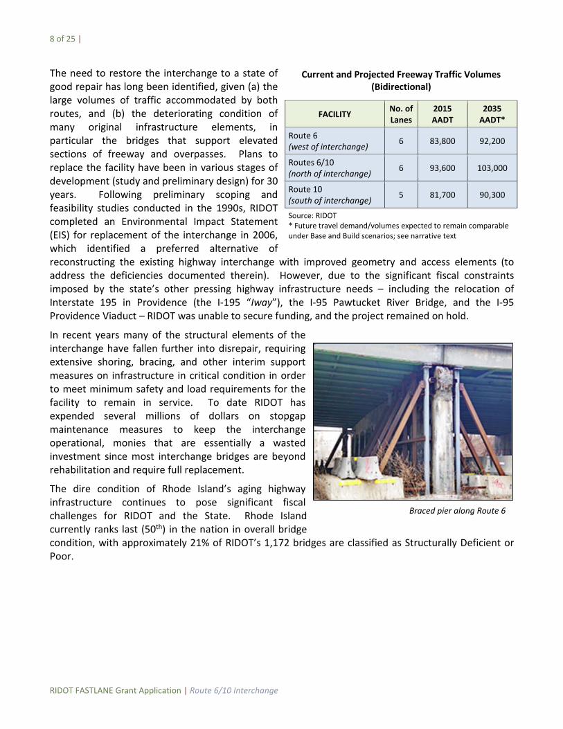
The need to restore the interchange to a state of good repair has long been identified, given (a) the large volumes of traffic accommodated by both routes, and (b) the deteriorating condition of many original infrastructure elements, in particular the bridges that support elevated sections of freeway and overpasses. Plans to replace the facility have been in various stages of development (study and preliminary design) for 30 years. Following preliminary scoping and feasibility studies conducted in the 1990s, RIDOT completed an Environmental Impact Statement (EIS) for replacement of the interchange in 2006, which identified a preferred alternative of reconstructing the existing highway interchange with improved geometry and access elements (to address the deficiencies documented therein). However, due to the significant fiscal constraints imposed by the state’s other pressing highway infrastructure needs – including the relocation of Interstate 195 in Providence (the I-195 “Iway”), the I-95 Pawtucket River Bridge, and the I-95 Providence Viaduct – RIDOT was unable to secure funding, and the project remained on hold.
In recent years many of the structural elements of the interchange have fallen further into disrepair, requiring extensive shoring, bracing, and other interim support measures on infrastructure in critical condition in order to meet minimum safety and load requirements for the facility to remain in service. To date RIDOT has expended several millions of dollars on stopgap maintenance measures to keep the interchange operational, monies that are essentially a wasted investment since most interchange bridges are beyond rehabilitation and require full replacement.
The dire condition of Rhode Island’s aging highway infrastructure continues to pose significant fiscal challenges for RIDOT and the State. Rhode Island currently ranks last (50th) in the nation in overall bridge condition, with approximately 21% of RIDOT’s 1,172 bridges are classified as Structurally Deficient or Poor.
Current and Projected Freeway Traffic Volumes (Bidirectional)
FACILITY No. of Lanes
2015 AADT
2035 AADT*
Route 6 (west of interchange) 6 83,800 92,200
Routes 6/10 (north of interchange) 6 93,600 103,000
Route 10 (south of interchange) 5 81,700 90,300
Source: RIDOT * Future travel demand/volumes expected to remain comparable under Base and Build scenarios; see narrative text
Braced pier along Route 6
9 of 25 |
RIDOT FASTLANE Grant Application | Route 6/10 Interchange
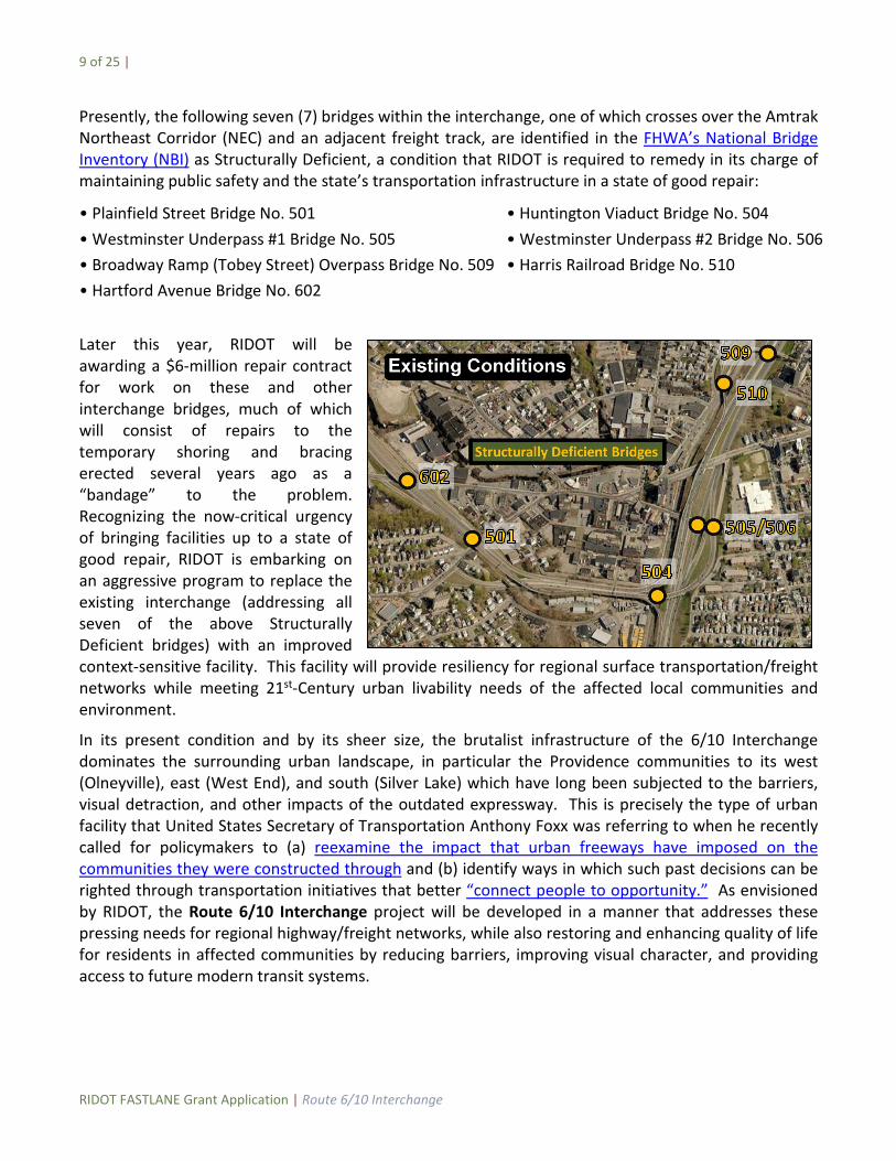
Presently, the following seven (7) bridges within the interchange, one of which crosses over the Amtrak Northeast Corridor (NEC) and an adjacent freight track, are identified in the FHWA’s National Bridge Inventory (NBI) as Structurally Deficient, a condition that RIDOT is required to remedy in its charge of maintaining public safety and the state’s transportation infrastructure in a state of good repair:
• Plainfield Street Bridge No. 501 • Huntington Viaduct Bridge No. 504 • Westminster Underpass #1 Bridge No. 505 • Westminster Underpass #2 Bridge No. 506 • Broadway Ramp (Tobey Street) Overpass Bridge No. 509 • Harris Railroad Bridge No. 510 • Hartford Avenue Bridge No. 602
Later this year, RIDOT will be awarding a $6-million repair contract for work on these and other interchange bridges, much of which will consist of repairs to the temporary shoring and bracing erected several years ago as a “bandage” to the problem. Recognizing the now-critical urgency of bringing facilities up to a state of good repair, RIDOT is embarking on an aggressive program to replace the existing interchange (addressing all seven of the above Structurally Deficient bridges) with an improved context-sensitive facility. This facility will provide resiliency for regional surface transportation/freight networks while meeting 21st-Century urban livability needs of the affected local communities and environment.
In its present condition and by its sheer size, the brutalist infrastructure of the 6/10 Interchange dominates the surrounding urban landscape, in particular the Providence communities to its west (Olneyville), east (West End), and south (Silver Lake) which have long been subjected to the barriers, visual detraction, and other impacts of the outdated expressway. This is precisely the type of urban facility that United States Secretary of Transportation Anthony Foxx was referring to when he recently called for policymakers to (a) reexamine the impact that urban freeways have imposed on the communities they were constructed through and (b) identify ways in which such past decisions can be righted through transportation initiatives that better “connect people to opportunity.” As envisioned by RIDOT, the Route 6/10 Interchange project will be developed in a manner that addresses these pressing needs for regional highway/freight networks, while also restoring and enhancing quality of life for residents in affected communities by reducing barriers, improving visual character, and providing access to future modern transit systems.
10 of 25 |
RIDOT FASTLANE Grant Application | Route 6/10 Interchange
Objectives
RIDOT, through the planned construction of the Route 6/10 Interchange project and future implementation of dedicated transit, bicycle, and pedestrian facilities, intends to re-imagine the junction of Routes 6 and 10 as a state-of-the-art multimodal transportation facility, one that:
• continues to serve needs of regional highway and surface freight transportation networks, (see Project Location section for descriptions) restoring the major urban interchange to a state of good repair and incorporating measures to improve safety and performance, including the addition of the missing Route 10 North-to-Route 6 West interchange movement, separation of local and through traffic, ramp metering, and other elements;
• incorporates modern, flexible dedicated transit facilities to address future urban transportation needs, creating an efficient and reliable rapid transit system that will be fully integrated with existing bus, rail and other modes of transportation through future connection with the planned Providence Station Transit Center; and
• addresses urban livability needs of the communities affected by the urban expressway as originally constructed, replacing the dilapidated conventional interchange and its numerous flyovers with a reconfigured system comprised of lower- (throughway/tunnel) and upper-level (local) elements, including a new city-level corridor reconnecting Olneyville and the West End (providing public amenity and a future station for access to rapid transit), two new local roadway connections under Route 6 through Olneyville (reducing the barriers caused by the existing viaduct), accommodations for a future bicycle path linking the Woonasquatucket River Greenway and the Washington Secondary Bike Path, landscaping and other measures.
Vision
RIDOT is requesting $175 million in FASTLANE grant funds for the final design and construction of the $595 million Route 6/10 Interchange (considered a “large” project under NSFHP eligibility criteria) as described and conceptually depicted herein. As the first phase of the greater Route 6/10 Multimodal Corridor Improvements program, the project will involve complete replacement of existing, deficient highway facilities with a new bi-level interchange system, principal features of which include:
(a) lower-level through lanes extending north from the interchange by short segments of decked-over tunnels;
(b) an upper, city-level system of local access roads flanking both sides of the lower-level freeway and intersecting with the urban arterials (Broadway and Westminster Street) connecting Olneyville with the West End, with the wide decked-over median spanning the “flyunder” freeway lanes for future development of transit facilities and public open space;
(c) accommodation of all interchange movements in the reconfigured system, including provision of the Route 10 North–Route 6 West movement missing in the existing interchange configuration;
(d) a new structure over the NEC railway connecting the reconstructed Route 6 approach freeway with the interchange;
11 of 25 |
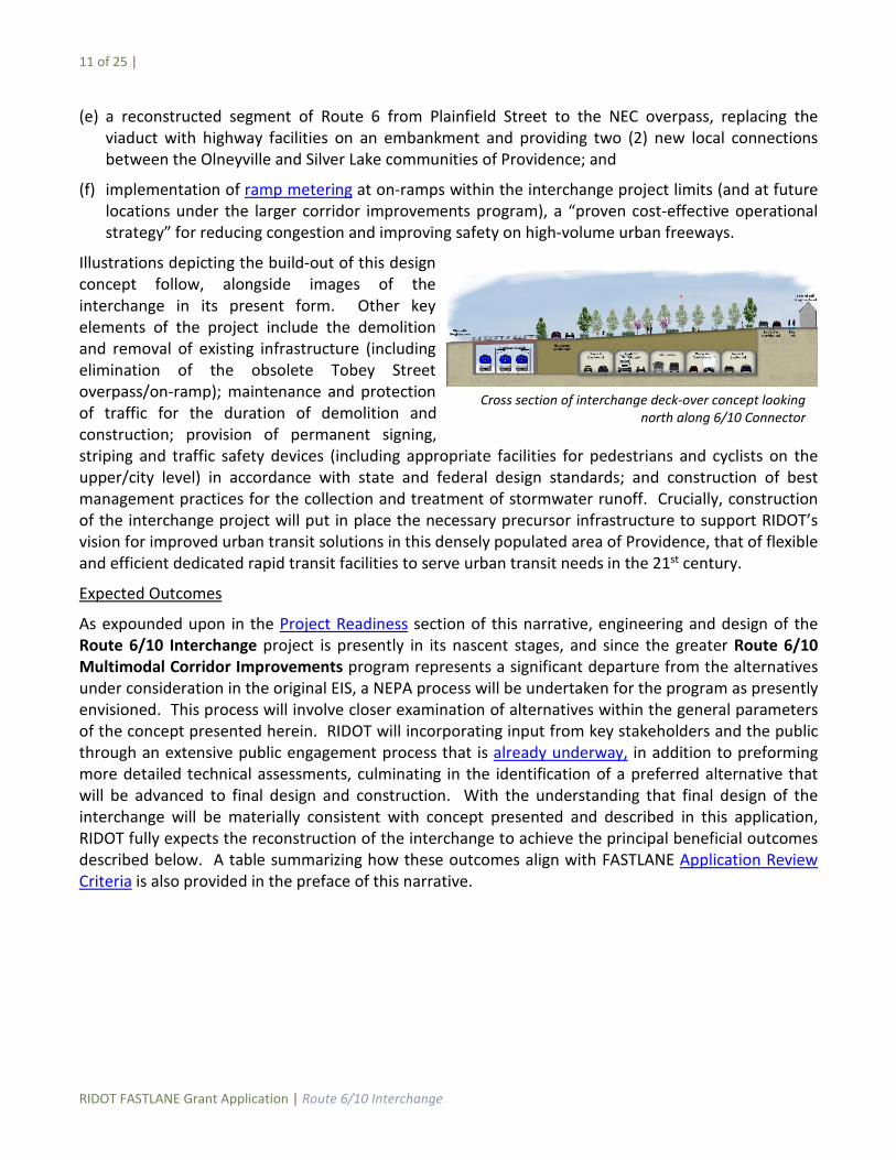
RIDOT FASTLANE Grant Application | Route 6/10 Interchange
Cross section of interchange deck-over concept looking north along 6/10 Connector
(e) a reconstructed segment of Route 6 from Plainfield Street to the NEC overpass, replacing the viaduct with highway facilities on an embankment and providing two (2) new local connections between the Olneyville and Silver Lake communities of Providence; and
(f) implementation of ramp metering at on-ramps within the interchange project limits (and at future locations under the larger corridor improvements program), a “proven cost-effective operational strategy” for reducing congestion and improving safety on high-volume urban freeways.
Illustrations depicting the build-out of this design concept follow, alongside images of the interchange in its present form. Other key elements of the project include the demolition and removal of existing infrastructure (including elimination of the obsolete Tobey Street overpass/on-ramp); maintenance and protection of traffic for the duration of demolition and construction; provision of permanent signing, striping and traffic safety devices (including appropriate facilities for pedestrians and cyclists on the upper/city level) in accordance with state and federal design standards; and construction of best management practices for the collection and treatment of stormwater runoff. Crucially, construction of the interchange project will put in place the necessary precursor infrastructure to support RIDOT’s vision for improved urban transit solutions in this densely populated area of Providence, that of flexible and efficient dedicated rapid transit facilities to serve urban transit needs in the 21st century.
Expected Outcomes
As expounded upon in the Project Readiness section of this narrative, engineering and design of the Route 6/10 Interchange project is presently in its nascent stages, and since the greater Route 6/10 Multimodal Corridor Improvements program represents a significant departure from the alternatives under consideration in the original EIS, a NEPA process will be undertaken for the program as presently envisioned. This process will involve closer examination of alternatives within the general parameters of the concept presented herein. RIDOT will incorporating input from key stakeholders and the public through an extensive public engagement process that is already underway, in addition to preforming more detailed technical assessments, culminating in the identification of a preferred alternative that will be advanced to final design and construction. With the understanding that final design of the interchange will be materially consistent with concept presented and described in this application, RIDOT fully expects the reconstruction of the interchange to achieve the principal beneficial outcomes described below. A table summarizing how these outcomes align with FASTLANE Application Review Criteria is also provided in the preface of this narrative.

12 of 25 |
RIDOT FASTLANE Grant Application | Route 6/10 Interchange
Existing Route 6/10 Interchange Re-imagined Route 6/10 Interchange Concept
13 of 25 |
RIDOT FASTLANE Grant Application | Route 6/10 Interchange
• A cost-effective solution to a pressing regional transportation need – A Benefit-Cost Analysis (BCA, see Cost-Effectiveness Analysis section) has been developed to substantiate the utility of the project, comparing the “Build” concept presented herein to a “Base” case of replacing all interchange facilities to modern design standards. Based on preliminary estimates developed by RIDOT for each scenario and employing conservative assumptions in quantifying benefits, this analysis yields a favorable benefit/cost ratio of 4.97. The BCA also does not take credit for the mobility, societal, and other benefits that will be realized through the future implementation of dedicated rapid transit facilities, which are expected to be significant.
• Restoration of a major NHS interchange and freight network node to a state of good repair – The replacement of existing substandard, structurally deficient facilities with new, efficient, and context-sensitive infrastructure will bring the interchange up to modern safety and serviceability standards, vastly improving the resiliency and reliability of the highway and freight networks it serves.
• Improved safety and serviceability for users of the system – Existing conditions within the interchange proper (particularly deficiencies in paved surfaces and poorly defined traffic merging patterns) are a major factor in the occurrence of crashes in the area. Reconstruction under either the Base or Build scenarios would address structural deficiencies, through which a reduction in the number of crashes occurring is expected. Although the Build concept offers only limited opportunities for new or additional crash countermeasures, preliminary analyses (based on current 5-year accident data, expected growth, and appropriate crash modification factors) do show a modest difference in estimated occurrences within the interchange (78 crashes per year Base vs. 74 crashes per year Build). Additional significant safety benefits are, however, expected to be realized through the implementation of ramp metering at on-ramps along Routes 6 and 10 in the immediate vicinity. The long-term operational benefits are highly touted in the FHWA’s 2014 publication on the practice, which documents that “many regions across the country have reported significant reductions in crash rates after starting ramp metering.”
The project is also expected to realize ancillary benefits in levels of service for users of the facility (reduced congestion and travel times) through ramp metering. As there is no discernable difference in future demand/volumes between the Base and Build scenarios (given their near-identical connectivity, conservatively neglecting the anticipated modal shift that will occur with the future implementation of rapid transit facilities), buildout of the re-envisioned interchange will improve the reliability of freeway facilities in the efficient movement of people and goods.
• Improved Local Access and Urban Livability – Given the core objectives of strengthening local and regional highway/freight networks, the design concept addresses the neighborhood severance imposed by the original infrastructure to the best extent practicable. While the presence of the NEC railroad right-of-way (extant for over 170 years – see discussion under Project Location) will continue to divide the neighborhoods east and west of the railroad, implementation of the Route 6/10 Interchange project represents a major step forward in reuniting the communities affected by highway facilities in their present configuration and condition. According to the 2010 US Census, the nonwhite population within the census tracts included in the project area (Tracks 10, 13, 14, 16, and 19) ranges from 47% to 75% of the total population, with Hispanics comprising 40% to 70% of the total population. Within those same census tracts, the 2010-2014 American Community

14 of 25 |
RIDOT FASTLANE Grant Application | Route 6/10 Interchange
Survey reports the percentage of individuals living in poverty ranges from 28% to 46%, with poverty affecting between 25% and 44% of families. Median household income ranges from $24,745 to $40,670, compared with $56,423 for Rhode Island as a whole. In addition, over 30% of households in the neighborhoods of Olneyville and Silver Lake are carless households according to Rhode Island Public Transit Authority (RIPTA) Providence Metro Transit Enhancement Study Market Analysis. The envisioned decked-over interchange will allow for development of an upper, city-level boulevard system, replacing the existing chasm between the West End and Olneyville with green space and amenities (including future transit facilities) that will restore continuity in the urban landscape. Through early consultations with the City of Providence, the Route 6 approach concept has been refined to also include two new local connections between Olneyville and Silver Lake (in addition to the existing Troy/Pilsudski Street underpass), improvements which are consistent with the City’s Dike Street Special Area Plan currently under development.
b. Project Location The interchange of Routes 6 and 10 is located in the heart of Providence, Rhode Island (41.816° N, 71.439° W – see Project Maps in the preface of this narrative), approximately 1.4 miles southwest of Interstate Route 95 (I-95) as measured along the freeway segment connecting both routes (the “6/10 Connector”) with the interstate facility via the I-95 Viaduct interchange. From the 6/10 Interchange Route 10 continues south, reconnecting with I-95 in the neighboring City of Cranston and completing a beltway-like loop through the City of Providence’s densely inhabited Olneyville, Federal Hill, Silver Lake, and West End neighborhoods. U.S. Route 6 is the primary link between Providence and points west (including the City of Hartford, Connecticut), extending from the 6/10 Interchange to Interstate Route 295 (I-295) along a 4-mile segment of limited access freeway before continuing west into Connecticut as an undivided four-lane highway. Routes 6 and 10 are also both vital links for commuters in and around the Greater Providence area, with the existing interchange facilities accommodating over 100,000 vehicle trips per day. Of this total traffic stream, approximately 5% are trucks, with 2% classified as large commercial trucks.
The NEC runs along the west side of the 6/10 Connector and continues south along Route 10. As the nation’s principal rail right-of-way along the Eastern Seaboard – extending from Richmond, Virginia north to Boston, Massachusetts and servicing New York, Philadelphia, and Washington, DC – this corridor is host to various freight, high-speed, and commuter rail services/uses. Locally, Providence Station (approximately 1.5 miles northeast of the 6/10 Interchange) provides access to intercity (Amtrak) and commuter (Massachusetts Bay Transportation Authority) services, with the MBTA Providence/Stoughton Line providing service to Boston and south to T.F. Green Airport (PVD), the latter via the newly-constructed InterLink Station. In the vicinity of the 6/10 Interchange, the NEC is fully separated from highway and local surface transportation facilities (i.e., no at-grade rail crossings), with a series of bridges carrying Westminster Street, Broadway, and existing interchange ramps over the rail corridor.
As indicated on the cover page chart, the 6/10 Interchange is situated at the core of the Providence, RI--MA Census Urbanized Area, an expansive 545-square mile region of Southern New England that encompasses Greater Providence (including the Rhode Island cities of Pawtucket, North Providence, Cranston, Warwick, East Providence, Woonsocket and Newport) and extends into portions of
15 of 25 |
RIDOT FASTLANE Grant Application | Route 6/10 Interchange
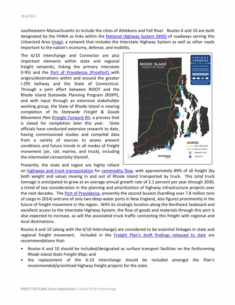
southeastern Massachusetts to include the cities of Attleboro and Fall River. Routes 6 and 10 are both designated by the FHWA as links within the National Highway System (NHS) of roadways serving this Urbanized Area (map), a network that includes the Interstate Highway System as well as other roads important to the nation's economy, defense, and mobility.
The 6/10 Interchange and Connector are also important elements within state and regional freight networks, linking the primary interstate (I-95) and the Port of Providence (ProvPort) with origins/destinations within and around the greater I-295 beltway and the State of Connecticut. Through a joint effort between RIDOT and the Rhode Island Statewide Planning Program (RISPP), and with input through an extensive stakeholder working group, the State of Rhode Island is nearing completion of its Statewide Freight & Goods Movement Plan (Freight Forward RI), a process that is slated for completion later this year. State officials have conducted extensive research to date, having commissioned studies and compiled data from a variety of sources to assess present conditions and future trends in all modes of freight movement (air, rail, marine, and truck), including the intermodal connectivity thereof.
Presently, the state and region are highly reliant on highways and truck transportation for commodity flow, with approximately 89% of all freight (by both weight and value) moving in and out of Rhode Island transported by truck. This total truck tonnage is anticipated to grow at an average annual growth rate of 2.1 percent per year through 2030, a trend of key consideration in the planning and prioritization of highway infrastructure projects over the next decades. The Port of Providence, presently the second busiest (handling over 7.8 million tons of cargo in 2014) and one of only two deep-water ports in New England, also figures prominently in the future of freight movement in the region. With its strategic location along the Northeast Seaboard and excellent access to the Interstate Highway System, the flow of goods and materials through this port is also expected to increase, as will the associated truck traffic connecting this freight with regional and local destinations.
Routes 6 and 10 (along with the 6/10 Interchange) are considered to be essential linkages in state and regional freight movement. Included in the Freight Plan’s draft findings released to date are recommendations that:
• Routes 6 and 10 should be included/designated as surface transport facilities on the forthcoming Rhode Island State Freight Map; and
• the replacement of the 6-10 Interchange should be included amongst the Plan’s recommended/prioritized highway freight projects for the state.
16 of 25 |
RIDOT FASTLANE Grant Application | Route 6/10 Interchange
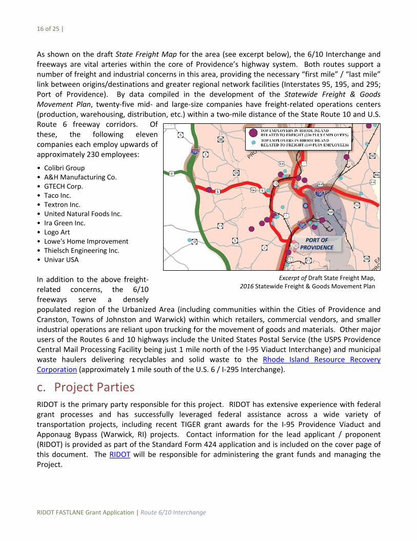
As shown on the draft State Freight Map for the area (see excerpt below), the 6/10 Interchange and freeways are vital arteries within the core of Providence’s highway system. Both routes support a number of freight and industrial concerns in this area, providing the necessary “first mile” / “last mile” link between origins/destinations and greater regional network facilities (Interstates 95, 195, and 295; Port of Providence). By data compiled in the development of the Statewide Freight & Goods Movement Plan, twenty-five mid- and large-size companies have freight-related operations centers (production, warehousing, distribution, etc.) within a two-mile distance of the State Route 10 and U.S. Route 6 freeway corridors. Of these, the following eleven companies each employ upwards of approximately 230 employees:
• Colibri Group • A&H Manufacturing Co. • GTECH Corp. • Taco Inc. • Textron Inc. • United Natural Foods Inc. • Ira Green Inc. • Logo Art • Lowe's Home Improvement • Thielsch Engineering Inc. • Univar USA In addition to the above freight-related concerns, the 6/10 freeways serve a densely populated region of the Urbanized Area (including communities within the Cities of Providence and Cranston, Towns of Johnston and Warwick) within which retailers, commercial vendors, and smaller industrial operations are reliant upon trucking for the movement of goods and materials. Other major users of the Routes 6 and 10 highways include the United States Postal Service (the USPS Providence Central Mail Processing Facility being just 1 mile north of the I-95 Viaduct Interchange) and municipal waste haulers delivering recyclables and solid waste to the Rhode Island Resource Recovery Corporation (approximately 1 mile south of the U.S. 6 / I-295 Interchange).
c. Project Parties RIDOT is the primary party responsible for this project. RIDOT has extensive experience with federal grant processes and has successfully leveraged federal assistance across a wide variety of transportation projects, including recent TIGER grant awards for the I-95 Providence Viaduct and Apponaug Bypass (Warwick, RI) projects. Contact information for the lead applicant / proponent (RIDOT) is provided as part of the Standard Form 424 application and is included on the cover page of this document. The RIDOT will be responsible for administering the grant funds and managing the Project.
Excerpt of Draft State Freight Map, 2016 Statewide Freight & Goods Movement Plan
PORT OF PROVIDENCE
17 of 25 |
RIDOT FASTLANE Grant Application | Route 6/10 Interchange
As discussed under the subheadings of Section f (Project Readiness), RIDOT has already commenced engagement with key stakeholders (including the City of Providence and surrounding communities) on concepts for re-imagining the 6/10 Interchange. Furthermore, RIDOT will continue to solicit input, examine alternatives, and further refine the design of project elements through the development of the appropriate environmental document in accordance with the requirements of the National Environmental Policy Act (NEPA).
d. Grant Funds, Sources and Uses of Project Funds (i) Future Eligible Cost
The future costs of the Route 6/10 Interchange project for which NSFHP grant funds are sought (including environmental analysis, preliminary engineering/design, and final design and construction) are eligible costs as defined under Section C.3.ii-iii (Eligibility Information) of the FASTLANE NOFO. For purposes of evaluating its merits with respect to the program’s review criteria, the project’s estimated total cost of $595 million exceeds prescribed minimum size requirements to be considered a “large” project.
(ii) Availability and Commitment of Funding Sources and Uses
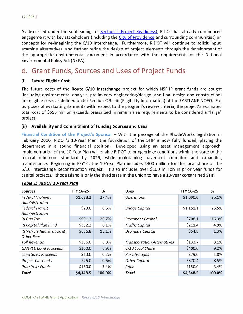
Financial Condition of the Project’s Sponsor – With the passage of the RhodeWorks legislation in February 2016, RIDOT’s 10-Year Plan, the foundation of the STIP is now fully funded, placing the department in a sound financial position. Developed using an asset management approach, implementation of the 10-Year Plan will enable RIDOT to bring bridge conditions within the state to the federal minimum standard by 2025, while maintaining pavement condition and expanding maintenance. Beginning in FFY16, the 10-Year Plan includes $400 million for the local share of the 6/10 Interchange Reconstruction Project. It also includes over $100 million in prior year funds for capital projects. Rhode Island is only the third state in the union to have a 10-year constrained STIP.
Table 1: RIDOT 10-Year Plan
Sources FFY 16-25 % Uses FFY 16-25 % Federal Highway Administration
$1,628.2 37.4% Operations $1,090.0 25.1%
Federal Transit Administration
$28.0 0.6% Bridge Capital $1,151.1 26.5%
RI Gas Tax $901.3 20.7% Pavement Capital $708.1 16.3% RI Capital Plan Fund $352.2 8.1% Traffic Capital $211.4 4.9% RI Vehicle Registration & Other Fees
$656.8 15.1% Drainage Capital $54.8 1.3%
Toll Revenue $296.0 6.8% Transportation Alternatives $133.7 3.1% GARVEE Bond Proceeds $300.0 6.9% 6/10 Local Share $400.0 9.2% Land Sales Proceeds $10.0 0.2% Passthroughs $79.0 1.8% Project Closeouts $26.0 0.6% Other Capital $370.4 8.5% Prior Year Funds $150.0 3.4% Prior $150.0 3.4% Total $4,348.5 100.0% Total $4,348.5 100.0%

18 of 25 |
RIDOT FASTLANE Grant Application | Route 6/10 Interchange
Local Share – RIDOT is contributing a significant amount of local share for the project. RIDOT is proposing that 71% of the project’s cost be funded by non-FASTLANE sources, as demonstrated in the following table:
Source Amount ($M) Percent FASTLANE $175.0 29% GARVEE Funding $195.7 33% Federal Formula $100.0 17% Registration/Gas Tax $124.3 21% Total $595.0 100%
FASTLANE - RIDOT is requesting $175 million from the FASTLANE program in this grant application, less than 30% of the project’s cost.
GARVEE Funding – RhodeWorks, legislation enacted by the General Assembly in February 2016, included authorization for $300 million in new GARVEE bonds restricted to capital infrastructure projects. These would likely to be issued as indirect GARVEEs in the fall of 2016. Of the total $300 million issuance, $195.7 million would be used for this project.
In addition, RIDOT has been authorized to implement a large commercial vehicle toll for the reconstruction of the bridges in this interchange. Once the toll is implemented, revenue collected would be used to reimburse these funding sources for the 6/10 Interchange project and then used for other Title 23 eligible projects. RIDOT is currently in discussions with FHWA for the development of a Memorandum of Understanding (MOU) for the tolling.
Federal Formula – RIDOT would dedicate $100 million of Surface Transportation Block Grant Program (STBG) federal formula funds for the project. These funds are allocated in RIDOT’s constrained 10-Year STIP or from prior year balances.
Vehicle Registration, Gas Tax – RIDOT would dedicate $124.3 million of funds in vehicle registration, surcharges and other dedicated vehicle user fees, along with gas tax and diesel tax revenues. With the passage of State Budget Article 21, these fees are dedicated to RIDOT via formula and restricted to use on transportation infrastructure projects.
Scalability – Should less than $175 million of FASTLANE funding be made available, the project could be scaled back from $595 million to $515 million by deferring the reconstruction of the two Route 6 bridges (Plainfield Street and Hartford Avenue). At $515 million this reduced-scale project could be sufficiently funded with a FASTLANE award of $95 million.
Table 2 – Project Scalability
Scope Cost FASTLANE Request Local Share Percent Local Full Project (Tobey to Hartford) $595 $175 $420 71% Reduced Project (Tobey to Magnolia) $515 $95 $420 82%
19 of 25 |
RIDOT FASTLANE Grant Application | Route 6/10 Interchange
Contingency/Reserves – The current project estimate includes a contingency level of 20 percent. Should the project cost exceed this estimate, RIDOT has a number of available contingencies and reserves. In moving to a 10-Year Plan approach to infrastructure investment, RIDOT and the State Planning Council (the MPO of jurisdiction) have agreed to update the plan on an annual basis. This provides the ability for RIDOT to manage cash flow needs and re-sequence project funding should additional funding be required for the 6/10 Interchange Project. Further, Rhode Island has the ability to restructure debt should additional funds be needed.
Ability to Manage Grants - Prior to the passage of the FAST Act, RIDOT received more than $200 million in federal funding annually. FAST Act will increase federal formula funding by more than $100 million over the five year period. RIDOT is a long-time recipient of FHWA funding and has virtually eliminated inactive FHWA grants. RIDOT recently began holding quarterly meetings with the FHWA District Office and produces a detailed Quarterly Report on active projects. It is also one of only a handful of states to implement a project management approach to capital investment.
Stable and Reliable Funding – At the local level, Rhode Island created the “Intermodal Surface Transportation Fund” (RIGL 31-36-20), which dedicates the collection of gasoline and diesel tax revenues towards transportation purposes. Additionally, beginning July 1, 2015 and every second year thereafter, the gasoline tax has be adjusted by the percentage of CPI-U, an index designed to keep up with inflation. Between FY2016 and FY2025, an estimated $90.1 million will be collected yearly from this source.
Under recent transportation funding reforms through the State Budget process, RIGL 39-17.1-4 created the “Rhode Island Highway Maintenance Account” (also known as “Article 21”) as a special account within the Intermodal Surface Transportation Fund which dedicates the collection of vehicle registration fees, surcharges and other vehicle user fees towards transportation purposes. RIGL 39-18.1-5 mandates that the allocation of these funds “be directed to the Department of Transportation” and utilized exclusively to fund “programs that are designed to eliminate structural deficiencies of the state’s bridge, road and maintenance systems and infrastructure.” Between FY2016 and FY2025, an estimated $83.2 million will be collected yearly from this source. Legislative transportation reforms also allocated additional funding to the Rhode Island Turnpike and Bridge Authority and the RIPTA by formula. With the passage of the RhodeWorks legislation in February 2016, the General Assembly authorized RIDOT to implement a toll on large commercial vehicles on certain bridges throughout the state to fund their reconstruction; among them the bridges of the 6/10 Interchange. RIDOT is expecting annual revenue of $45 million per year from tolls – less than 10% of the total RhodeWorks program.
RhodeWorks also authorized $300 million in new GARVEE bonding, along with a refinancing and restructuring of existing GARVEE debt. This restructuring will provide an additional $120 million benefit to RIDOT in the first three years of the program.
(iii) Federal Funds and Required Match
There are no prior year federal funds dedicated to the project. FASTLANE funding does not exceed 60% of the project’s cost, nor does federal funding exceed 80%. In fact, FASTLANE funding represents less than 30% of the project’s cost.
20 of 25 |
RIDOT FASTLANE Grant Application | Route 6/10 Interchange
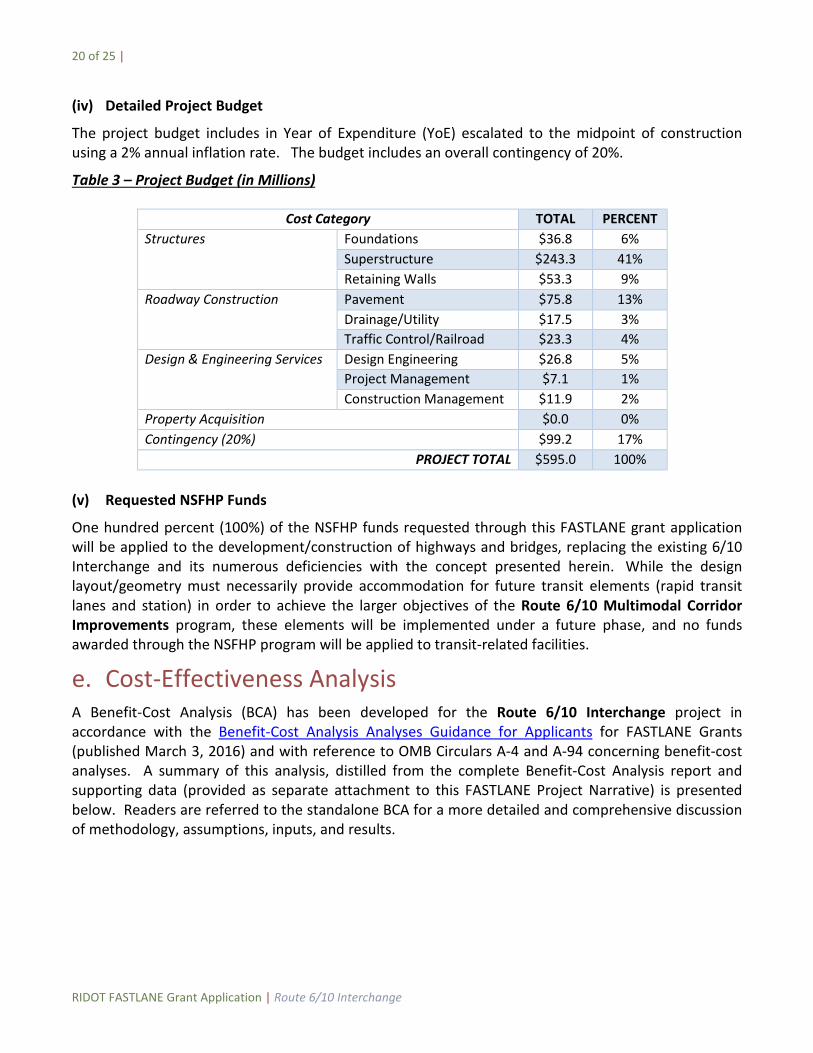
(iv) Detailed Project Budget
The project budget includes in Year of Expenditure (YoE) escalated to the midpoint of construction using a 2% annual inflation rate. The budget includes an overall contingency of 20%.
Table 3 – Project Budget (in Millions)
Cost Category TOTAL PERCENT Structures Foundations $36.8 6%
Superstructure $243.3 41% Retaining Walls $53.3 9%
Roadway Construction Pavement $75.8 13% Drainage/Utility $17.5 3% Traffic Control/Railroad $23.3 4%
Design & Engineering Services Design Engineering $26.8 5% Project Management $7.1 1% Construction Management $11.9 2%
Property Acquisition $0.0 0% Contingency (20%) $99.2 17%
PROJECT TOTAL $595.0 100%
(v) Requested NSFHP Funds
One hundred percent (100%) of the NSFHP funds requested through this FASTLANE grant application will be applied to the development/construction of highways and bridges, replacing the existing 6/10 Interchange and its numerous deficiencies with the concept presented herein. While the design layout/geometry must necessarily provide accommodation for future transit elements (rapid transit lanes and station) in order to achieve the larger objectives of the Route 6/10 Multimodal Corridor Improvements program, these elements will be implemented under a future phase, and no funds awarded through the NSFHP program will be applied to transit-related facilities.
e. Cost-Effectiveness Analysis A Benefit-Cost Analysis (BCA) has been developed for the Route 6/10 Interchange project in accordance with the Benefit-Cost Analysis Analyses Guidance for Applicants for FASTLANE Grants (published March 3, 2016) and with reference to OMB Circulars A-4 and A-94 concerning benefit-cost analyses. A summary of this analysis, distilled from the complete Benefit-Cost Analysis report and supporting data (provided as separate attachment to this FASTLANE Project Narrative) is presented below. Readers are referred to the standalone BCA for a more detailed and comprehensive discussion of methodology, assumptions, inputs, and results.
21 of 25 |
RIDOT FASTLANE Grant Application | Route 6/10 Interchange
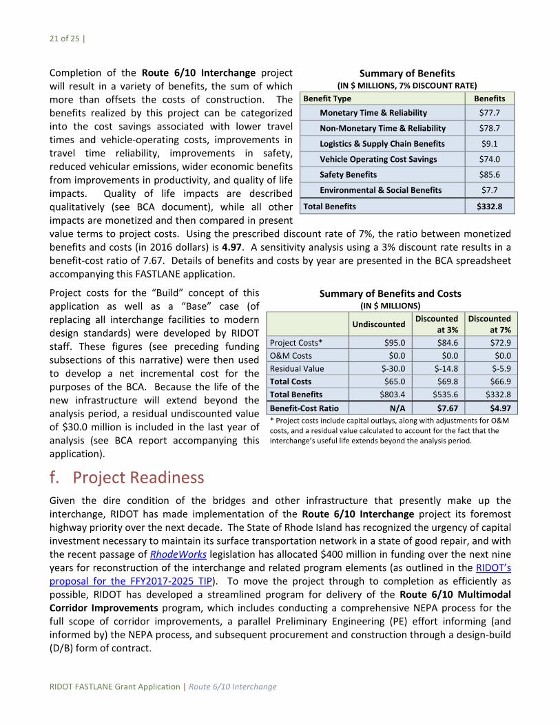
Completion of the Route 6/10 Interchange project will result in a variety of benefits, the sum of which more than offsets the costs of construction. The benefits realized by this project can be categorized into the cost savings associated with lower travel times and vehicle-operating costs, improvements in travel time reliability, improvements in safety, reduced vehicular emissions, wider economic benefits from improvements in productivity, and quality of life impacts. Quality of life impacts are described qualitatively (see BCA document), while all other impacts are monetized and then compared in present value terms to project costs. Using the prescribed discount rate of 7%, the ratio between monetized benefits and costs (in 2016 dollars) is 4.97. A sensitivity analysis using a 3% discount rate results in a benefit-cost ratio of 7.67. Details of benefits and costs by year are presented in the BCA spreadsheet accompanying this FASTLANE application.
Project costs for the “Build” concept of this application as well as a “Base” case (of replacing all interchange facilities to modern design standards) were developed by RIDOT staff. These figures (see preceding funding subsections of this narrative) were then used to develop a net incremental cost for the purposes of the BCA. Because the life of the new infrastructure will extend beyond the analysis period, a residual undiscounted value of $30.0 million is included in the last year of analysis (see BCA report accompanying this application).
f. Project Readiness Given the dire condition of the bridges and other infrastructure that presently make up the interchange, RIDOT has made implementation of the Route 6/10 Interchange project its foremost highway priority over the next decade. The State of Rhode Island has recognized the urgency of capital investment necessary to maintain its surface transportation network in a state of good repair, and with the recent passage of RhodeWorks legislation has allocated $400 million in funding over the next nine years for reconstruction of the interchange and related program elements (as outlined in the RIDOT’s proposal for the FFY2017-2025 TIP). To move the project through to completion as efficiently as possible, RIDOT has developed a streamlined program for delivery of the Route 6/10 Multimodal Corridor Improvements program, which includes conducting a comprehensive NEPA process for the full scope of corridor improvements, a parallel Preliminary Engineering (PE) effort informing (and informed by) the NEPA process, and subsequent procurement and construction through a design-build (D/B) form of contract.
Summary of Benefits (IN $ MILLIONS, 7% DISCOUNT RATE)
Benefit Type Benefits Monetary Time & Reliability $77.7
Non-Monetary Time & Reliability $78.7
Logistics & Supply Chain Benefits $9.1
Vehicle Operating Cost Savings $74.0
Safety Benefits $85.6
Environmental & Social Benefits $7.7
Total Benefits $332.8
Summary of Benefits and Costs (IN $ MILLIONS)
Undiscounted Discounted at 3%
Discounted at 7%
Project Costs* $95.0 $84.6 $72.9 O&M Costs $0.0 $0.0 $0.0 Residual Value $-30.0 $-14.8 $-5.9 Total Costs $65.0 $69.8 $66.9 Total Benefits $803.4 $535.6 $332.8 Benefit-Cost Ratio N/A $7.67 $4.97 * Project costs include capital outlays, along with adjustments for O&M costs, and a residual value calculated to account for the fact that the interchange’s useful life extends beyond the analysis period.
22 of 25 |
RIDOT FASTLANE Grant Application | Route 6/10 Interchange
(i) Technical Feasibility
To date, RIDOT has developed preliminary conceptual designs for the multiple facets of the re-envisioned interchange (including lower-level highway interchange, transit facilities, and surface-level boulevard) to ensure that the project (a) is constructible within the constraints of state and federal funds programmed for the Route 6/10 Multimodal Corridor Improvements, (b) meets modern highway design safety standards and performance criteria, and (c) is consistent with local, regional, and national objectives for transportation efficiency and resiliency in the 21st Century. Importantly, all elements of the project as contemplated will remain within the existing freeway rights-of-way, effectively eliminating potential schedule and cost risks associated with property acquisitions.
Since the re-imagined interchange concept, for which FASTLANE grant funds are sought, is relatively new and represents a significant departure from past plans to reconstruct the interchange, RIDOT is presently soliciting the services of a qualified consultant to advance the Route 6/10 Multimodal Corridor Improvements program through a new NEPA review and documentation process. Given the scope and nature of the program, RIDOT will work with the lead federal agency to ensure the appropriate environmental review and documentation process are followed. The NEPA process will examine alternatives for the various interchange and transit elements, conduct outreach and solicit input from key stakeholders and the public, assess anticipated environmental consequences, and identify measures to mitigate potential adverse impacts. Informed by the data collection, analysis, and outreach components of the NEPA process, RIDOT (in consultation with the federal authorities) will identify and refine the preferred alternative for implementation.
RIDOT is separately soliciting the services of a professional design consultant to provide Preliminary Engineering (PE) for the Route 6/10 Interchange project and future integrated elements of the corridor improvement program. To expedite delivery of the project and program, the PE consultant will be undertaking a number of preliminary design tasks concurrent with the NEPA process, including data collection (survey, geotechnical investigations, utility coordination, etc.) and program development (establishing structural, highway, traffic, and environmental design criteria, project management plan and schedule, etc.). Once the preferred alternative has been established and a conceptual layout has been developed by the NEPA consultant, the PE effort will advance all elements of the project design (including but not limited to, highway, structural, traffic, drainage, utilities) to a level sufficient for RIDOT to let the project as a D/B contract, tantamount to 30% design completion under a conventional design-bid-build procurement approach. The PE consultant will also prepare and submit regulatory permit applications to the federal and state authorities with jurisdiction over the work.
As much of the NEPA and PE processes will be conducted in parallel (see Project Schedule below), it will be imperative that work performed under each is consistent. Any developments/findings in one that may bear on the other (e.g. PE data collected indicating that a particular alternative is not technically feasible) will be readily identified and addressed accordingly. RIDOT, through a focused restructuring towards a life-cycle project management approach, is firmly committed to ensuring that both processes proceed as scheduled and, given the critical condition of the existing interchange, has the internal resources necessary to advance the project to D/B procurement as early as technically feasible.
23 of 25 |
RIDOT FASTLANE Grant Application | Route 6/10 Interchange
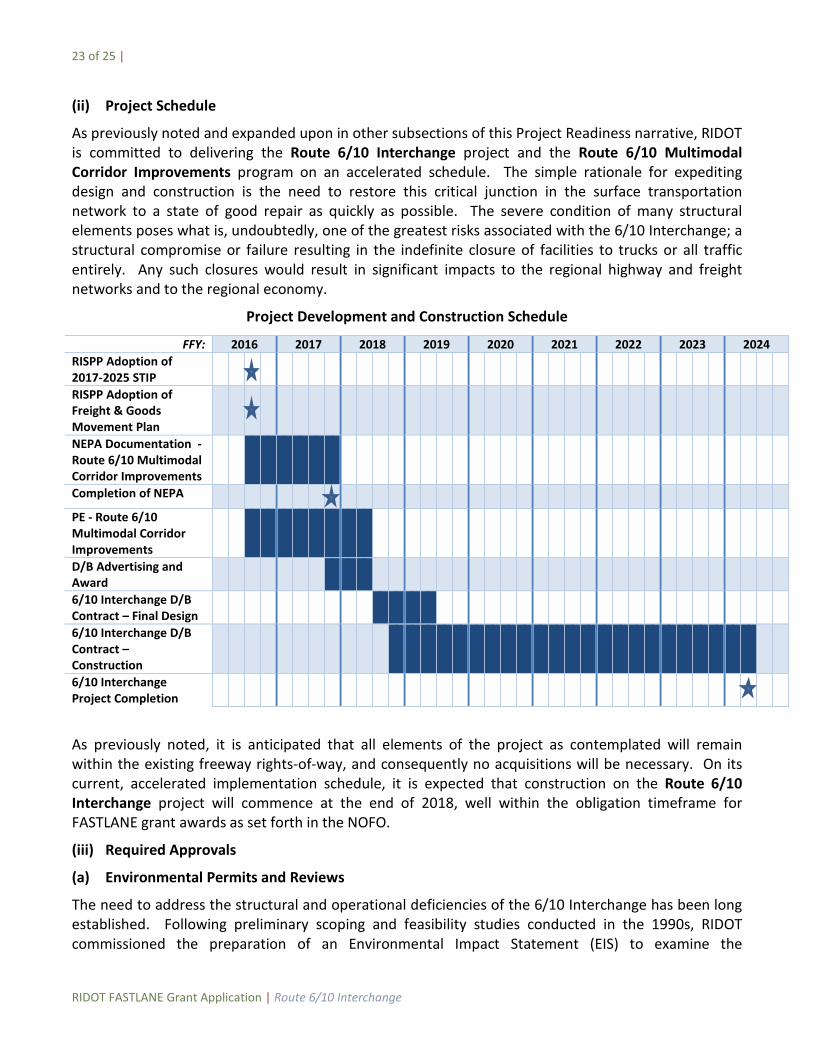
(ii) Project Schedule
As previously noted and expanded upon in other subsections of this Project Readiness narrative, RIDOT is committed to delivering the Route 6/10 Interchange project and the Route 6/10 Multimodal Corridor Improvements program on an accelerated schedule. The simple rationale for expediting design and construction is the need to restore this critical junction in the surface transportation network to a state of good repair as quickly as possible. The severe condition of many structural elements poses what is, undoubtedly, one of the greatest risks associated with the 6/10 Interchange; a structural compromise or failure resulting in the indefinite closure of facilities to trucks or all traffic entirely. Any such closures would result in significant impacts to the regional highway and freight networks and to the regional economy.
Project Development and Construction Schedule
FFY: 2016 2017 2018 2019 2020 2021 2022 2023 2024 RISPP Adoption of 2017-2025 STIP
RISPP Adoption of Freight & Goods Movement Plan
NEPA Documentation - Route 6/10 Multimodal Corridor Improvements
Completion of NEPA
PE - Route 6/10 Multimodal Corridor Improvements
D/B Advertising and Award
6/10 Interchange D/B Contract – Final Design
6/10 Interchange D/B Contract – Construction
6/10 Interchange Project Completion
As previously noted, it is anticipated that all elements of the project as contemplated will remain within the existing freeway rights-of-way, and consequently no acquisitions will be necessary. On its current, accelerated implementation schedule, it is expected that construction on the Route 6/10 Interchange project will commence at the end of 2018, well within the obligation timeframe for FASTLANE grant awards as set forth in the NOFO.
(iii) Required Approvals
(a) Environmental Permits and Reviews
The need to address the structural and operational deficiencies of the 6/10 Interchange has been long established. Following preliminary scoping and feasibility studies conducted in the 1990s, RIDOT commissioned the preparation of an Environmental Impact Statement (EIS) to examine the
24 of 25 |
RIDOT FASTLANE Grant Application | Route 6/10 Interchange
rehabilitation and reconstruction alternatives under consideration at the time. RIDOT and Federal Highway Administration (FHWA) issued the Record of Decision for Improvements to the U.S. Route 6 / Route 10 Interchange in June 2006 (FHWA-RI-EIS-05-01-F), through which the option of reconstructing the interchange along a new alignment was adopted as the preferred alternative. Due to the significant fiscal constraints imposed by other pressing infrastructure needs – including the relocation of I-195 in Providence (“Iway”), the I-95 Pawtucket River Bridge, and the I-95 Providence Viaduct – RIDOT was unable to secure funding for reconstruction of the 6/10 Interchange and the project was placed on hold.
The program of Route 6/10 Multimodal Corridor Improvements (which includes the Route 6/10 Interchange project as its first phase) represents a departure from the alternatives under consideration in the original EIS, and consequently a NEPA process will be undertaken for the program as presently envisioned. This process will involve closer examination of alternatives within the general parameters of the concept presented herein, incorporating input from key stakeholders and the public (through an extensive public engagement process that is already underway) and more detailed assessments, ultimately culminating in the identification of a preferred alternative that will be advanced to final design and construction.
Given the nature and scope of the proposed action, it is understood that either the FHWA or the Federal Transit Administration (FTA) will be the lead agency with oversight of the NEPA process. RIDOT has a proven track record of completing NEPA documentation over a wide range of transportation projects in accordance with USDOT policies, and will work closely with federal and state authorities to ensure that this NEPA process is conducted in a manner that is open, comprehensive, and expeditious.
In the current calendar year, RIDOT has commenced an early program of public outreach and stakeholder meetings to present the re-envisioned interchange and solicit input on its various elements. To date RIDOT officials have held a number of roundtable meetings and public forums on the project, including engagement with the Governor’s Office, representatives of Rhode Island’s federal Congressional Delegation, Rhode Island General Assembly leadership and representatives, RIPTA, the City of Providence, the City of Cranston, the City of Warwick, the Town of Johnston, Grow Smart Rhode Island, the RI Environmental Council, FHWA and the FTA. Along with preliminary project discussions, RIDOT has also embarked on an assertive public outreach effort, including a public forum on March 23 hosted by the City of Providence and the Rhode Island Chapter of the American Planning Association (APA), followed by a series of public meetings at various locations.
(b) State and Local Approvals
As with all major actions of similar magnitude, RIDOT is required to abide by state and federal law in the planning, design, and implementation of such projects, including obtaining all necessary regulatory approvals prior to construction (e.g. those pertaining to environmental protection, historic resources, and health and safety). While the full extent of permitting efforts will be ascertained through the NEPA process, it is presently understood that permits will likely be required from the Rhode Island Department of Environmental Management (RIDEM), through its Freshwater Wetlands, Water Quality Certification, and/or Rhode Island Pollutant Discharge Elimination System programs. The PE consultant will be responsible for the preparation of materials pursuant to these programs, including a comprehensive Stormwater Management Plan for the collection, treatment, and discharge of runoff from new roadway facilities.
25 of 25 |
RIDOT FASTLANE Grant Application | Route 6/10 Interchange
The need to replace the obsolete facilities comprising the 6/10 Interchange has long been established, and following a protracted period during which the State’s other pressing major transportation needs were being addressed, the State of Rhode Island and RIDOT are now committed to seeing this vital node in the regional highway network brought to a state of good repair. As evidenced by the letters of support accompanying this application, RIDOT’s plans to improve the interchange with state-of-the-practice, context-sensitive facilities enjoys broad support from officials at all levels of government, interest groups, and the general public.
(c) State and Local Planning
The Route 6/10 Interchange project has been (and will continue to be) advanced in a manner that is wholly consistent with planning policies of the State of Rhode Island and the City of Providence. The State Planning Council is the MPO for transportation planning purposes, overseeing the Statewide Planning Program (Department of Administration, Division of Planning) in the development of the State’s Long Range Transportation Plan (Transportation 2035) and Transportation Improvement Program (STIP).
The 6/10 Interchange is a component of the comprehensive FFY2016 STIP amendment request, in the soon-expiring FFY 2013-2016 TIP as one of several Study and Development Projects, and, as previously noted, is a central component of RIDOT’s 10-Year Strategic Plan for inclusion in the upcoming FFY 2017-2025 TIP. As expounded upon in the Project Location section of this narrative, the project is also to be included as one several prioritize freight projects in the Statewide Freight & Goods Movement Plan, scheduled to be issued later this year.
RIDOT has (and will continue to) engage with the City of Providence through its Department of Planning and Development regarding the presently envisioned replacement of the interchange and the numerous local considerations that must be addressed in the final design of facilities. Through early coordination and by way of the NEPA process to follow, RIDOT is committed to ensuring that development of the Route 6/10 Interchange project is advanced in a manner that (a) is consistent with current and in-development City plans and policies, and (b) realizes a shared vision for the areas and communities that have been affected by the existing freeway interchange.
(iv) Assessment of Project Risks and Mitigation Strategies
As stated previously, the Route 6/10 Interchange project is being developed such that all facilities can be constructed within the existing state freeway rights-of-way. This element removes any cost or schedule risks associated with the right-of-way acquisition and certification process, components which typically involve a degree of risk to cost and schedule in major construction projects.
The only risks associated with this project are the usual schedule uncertainties and agency coordination elements associated with the NEPA process. RIDOT will continue to take every advance measure possible, including early public outreach, to minimize and mitigate those risks. The preparation of bidding documents for a design-build contract (to be accomplished under the aforementioned Preliminary Engineering effort) is seen as a low-risk endeavor, with the schedule totally under the control of RIDOT and its consultant. Despite the size of the project, its nature and scope are such that the risk associated with the acquisition of required environmental permits is negligible.