Route 3 - Hampshire · E xploring fortunate to have a wealth of 82187 PRINTED BY HAMPSHIRE PRINTING...
2
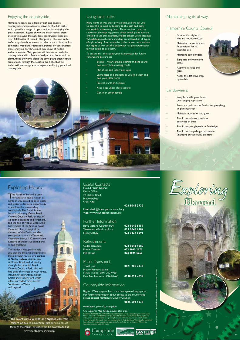
E xploring 82187 PRINTED BY HAMPSHIRE PRINTING SERVICES 01962 870099 Hound Exploring Hound T he Parish of Hound is very fortunate to have a wealth of rights of way, providing both locals and visitors a fantastic opportunity to explore the surrounding countryside. The Parish is also home to the magnificent Royal Victoria Country Park, an area of woodland, parkland and foreshore, and the site of Netley Chapel, the last remains of the famous Royal Victoria Military Hospital. In the west of the Parish, another great place to visit is Westwood Woodland Park, a 150 acre Nature Reserve of ancient woodland and rolling grassland. This leaflet is designed to help you explore the area and provides three circular routes, two starting at Netley Railway Station, one at Hound Road, and all passing through the beautiful Royal Victoria Country Park. You will find sites of interest on each route, including Netley Abbey, Netley Castle and Netley Hard which offers unrivalled views across Southampton Water and beyond. Useful Contacts Hound Parish Council Parish Office 22 Station Road Netley Abbey SO31 5AF 023 8045 373 Email: [email protected] Web: www.houndparishcouncil.org Further Information Royal Victoria Country Park 023 8045 5157 Westwood Woodland Park 023 8045 6484 Netley Abbey 023 9237 8291 Refreshments Cedar Tearooms 023 8043 9280 Prince Consort 023 8045 2676 Mill House 023 8045 5769 Public Transport Travel Line 0871 200 2233 Netley Railway Station (Train Tracker) 0871 200 4950 First Bus Services (16/16A/16X) 0238 022 4854 Countryside Information Rights of Way maps online www.hants.gov.uk/maps/paths For further information about access to the countryside please contact Hampshire County Council: 0845 603 5638 www.hants.gov.uk/countryside OS Explorer Map OL22 covers this area The Solent Way, a 60 mile long-distance walk from Milford-on-Sea to Emsworth Harbour also passes through the Parish. A leaflet can be downloaded at www.hants.gov.uk/walking. 2 Enjoying the countryside Hampshire boasts an extremely rich and diverse countryside and an extensive network of public paths which provide a range of opportunities for enjoying the great outdoors. Rights of way are linear routes, often ancient trackways through deep countryside; there are over 3,000 miles of these in Hampshire. The map in this leaflet may also show access to other areas of land, such as commons, woodland, recreation grounds or conservation areas, and your Parish Council may know of guided walks or events. Many people will be able to reach the countryside within a few hundred yards of home and the plants, trees and views along the same paths often change dramatically through the seasons. We hope that this leaflet will encourage you to explore and enjoy your local countryside. Maintaining rights of way Hampshire County Council: way are not obstructed fit condition for its intended use paths gates up to date Landowners: overhanging vegetation or planting crops deter use of them (including certain bulls) on paths Using local paths Many rights of way cross private land, and we ask you to bear this in mind by keeping to the path and being responsible when using them. There are four types, as shown on the map key; please check which paths you are entitled to use (for example, cyclists cannot use footpaths). Wheelchairs, pushchairs and dogs are allowed on all types of right of way. Any permissive paths or areas marked are not rights of way, but the landowner has given permission for the public to use them. To ensure that the countryside is protected for future generations be sure to: take care when crossing roads take your litter home
Transcript of Route 3 - Hampshire · E xploring fortunate to have a wealth of 82187 PRINTED BY HAMPSHIRE PRINTING...
Exploring
8218
7 P
RIN
TE
D B
Y H
AM
PS
HIR
E P
RIN
TIN
G S
ER
VIC
ES
019
62 8
7009
9
Hound
Exploring Hound
The Parish of Hound is very fortunate to have a wealth of
rights of way, providing both locals and visitors a fantastic opportunity to explore the surrounding countryside. The Parish is also home to the magnificent Royal Victoria Country Park, an area of woodland, parkland and foreshore, and the site of Netley Chapel, the last remains of the famous Royal Victoria Military Hospital. In the west of the Parish, another great place to visit is Westwood Woodland Park, a 150 acre Nature Reserve of ancient woodland and rolling grassland.
This leaflet is designed to help you explore the area and provides three circular routes, two starting at Netley Railway Station, one at Hound Road, and all passing through the beautiful Royal Victoria Country Park. You will find sites of interest on each route, including Netley Abbey, Netley Castle and Netley Hard which offers unrivalled views across Southampton Water and beyond.
Useful ContactsHound Parish Council Parish Office22 Station RoadNetley AbbeySO31 5AF 023 8045 373Email: [email protected] Web: www.houndparishcouncil.org
Further InformationRoyal Victoria Country Park 023 8045 5157 Westwood Woodland Park 023 8045 6484 Netley Abbey 023 9237 8291
RefreshmentsCedar Tearooms 023 8043 9280Prince Consort 023 8045 2676Mill House 023 8045 5769
Public TransportTravel Line 0871 200 2233Netley Railway Station (Train Tracker) 0871 200 4950First Bus Services (16/16A/16X) 0238 022 4854
Countryside Information Rights of Way maps online www.hants.gov.uk/maps/pathsFor further information about access to the countryside please contact Hampshire County Council:
0845 603 5638 www.hants.gov.uk/countryside
OS Explorer Map OL22 covers this area���������� ����������������� ������������������������������������������������������������������������������������������������ �!��������� ���������������"������������������������������������������������������� �!�������������������������������������������������������������������������������#����$���������������%������������������ ��������#����������������������������������������������������������������� ������������������������� ��� ����!��������� �����������������!�������������#�����
The Solent Way, a 60 mile long-distance walk from Milford-on-Sea to Emsworth Harbour also passes
through the Parish. A leaflet can be downloaded at www.hants.gov.uk/walking.
2
Enjoying the countrysideHampshire boasts an extremely rich and diverse countryside and an extensive network of public paths which provide a range of opportunities for enjoying the great outdoors. Rights of way are linear routes, often ancient trackways through deep countryside; there are over 3,000 miles of these in Hampshire. The map in this leaflet may also show access to other areas of land, such as commons, woodland, recreation grounds or conservation areas, and your Parish Council may know of guided walks or events. Many people will be able to reach the countryside within a few hundred yards of home and the plants, trees and views along the same paths often change dramatically through the seasons. We hope that this leaflet will encourage you to explore and enjoy your local countryside.
Maintaining rights of way
Hampshire County Council:
way are not obstructed
fit condition for its intended use
paths
gates
up to date
Landowners:
overhanging vegetation
or planting crops
deter use of them
(including certain bulls) on paths
Using local pathsMany rights of way cross private land, and we ask you to bear this in mind by keeping to the path and being responsible when using them. There are four types, as shown on the map key; please check which paths you are entitled to use (for example, cyclists cannot use footpaths). Wheelchairs, pushchairs and dogs are allowed on all types of right of way. Any permissive paths or areas marked are not rights of way, but the landowner has given permission for the public to use them.
To ensure that the countryside is protected for future generations be sure to:
take care when crossing roads
take your litter home

�
��
��
��
��
�
��
�
����
��
���
��
��
��
��
��
�
��� �
�� �
� �
���
��� �����
��
��
��
�
���
��
��������
��
� �
�����
���
��
��� ��� �
�
�
��
��
1
6
9
5
13
4
16
15
3
14
8a
7
12
8b
19
10
17
18
11b
This map is reproduced from Ordnance Survey material with the permission of Ordnance Survey on behalf of the Controller of Her Majesty's Stationery Office © Crown copyright. Unauthorised reproduction infringes Crown copyright and may lead to prosecution or civil proceedings. HCC 100019180 2011
��� Route 1
��� Route 2
��� Route 3
Footpath
0 0.5 10.25 Mile
STARTRoute 1 & 2
STARTRoute 3
Footpath
Bridleway
Restricted Byway
Byway open to all traffic
Areas believed to offer public access
Circular Walk
The Solent Way
Route 1 (approximately 1.5 miles)
From Netley Railway Station, follow the route directly down Station Road past the Royal British Legion Club. Near the entrance to Netley Lodge Close there is a way marked path (Footpath 17) leading directly into the Seaview Estate. Continue in a direct line through the Estate to its junction with New Road. Turn left and on the opposite side of the road you will find an unmarked path. Follow this and emerge near Sedgemead Flats onto Victoria Road. Here turn left and make your way to the foreshore and Netley Hard. Here you can use the observation platform to enjoy views over Southampton Water. Opposite the Hard you will find Sophie’s Pond where many species of wildfowl can be found. Enter Royal Victoria Country Park and take the turning on the left, up the service road to the rear of the Park. On your right you will see the rather splendid former officers’ mess which once housed 55 officers but is now private dwellings. You will also see Netley Chapel, and the site of
the Military Hospital, built in 1856 under the influence of Florence Nightingale.
Bear left and emerge onto Hound Road via the rear entrance. Upon exiting, locate on your left an unmarked fenced path which will take you back to Netley Railway Station.
Route 2 (approximately 3 miles)
On leaving Netley Railway Station, head directly along Station Road and at the end of the new housing development on your right, turn right onto St Mary’s Road. Cross here and head for the railway bridge, then take a way marked path (Footpath 14) following the railway line. The path emerges onto Grange Road, here turn left, cross the railway bridge and just before the Mill House Pub, turn right into Westwood Woodland Park, a former landfill site. Follow the main track as it turns left over Grange Fields towards the woods. You will see deep ditches, originally conduits dug by the monks from Netley Abbey to provide water for their fish ponds. Take the way marked path (Footpath 16) which runs through Westwood from Abbey Hill to Woolston Road/Newtown Road. The exit point is adjacent to Fountains Park and leads to Abbey Hill. Turn left onto Abbey Hill. Immediately on your left you will see the spectacular ruins of the 13th Century Netley Abbey – an absolute must to visit. Opposite is Netley Castle, now private apartments. After viewing Netley Abbey, turn left and continue along Victoria Road into the village of Netley. On your right you will note a village pump and horse trough which have been refurbished and sited by Hound Local History Society. Via the Ellis Row Cottages, carry on to the Prince Consort pub where you can stop for refreshments, before continuing along Victoria Road to the main gates of Royal Victoria Country Park. Just before the gates and on your right you will see Netley Hard, recently refurbished by the Parish Council. Pause at the observation platform to see unrivalled views of
the activity on Southampton Water. Upon entering Royal Victoria Country Park, take the first turning on the left, up the service road, past the former officers’ mess, towards Hound Gate leading out onto Hound Road. About 100 yards on your left you will see a fenced path which will bring you safely back to your start point at Netley Station.
Route 3 (approximately 2.1 miles)
From Hound Road, pick up a way marked path (Footpath 6) near the railway bridge. The path is well signed at both ends and intermediate points, following the railway line until reaching Hamble Halt. As the path nears Hamble Halt, it divides and the right hand path becomes the Hamble Rail Trail. Continue on this route passing the entrance to the Police Training Centre and Hamble Primary School. On reaching Mount Pleasant Recreation Ground continue until reaching a path at the edge of the ground (Hamble Footpath 13). If you turn right here it will take you to the Military Cemetery which dates back many years and is well worth a quiet visit. To continue on the route however, turn left at the junction onto the causeway, continue along its length and it emerges into the beautiful Royal Victoria Country Park. Here take the opportunity to visit all the excellent amenities, including refreshments from Cedar Tearooms, situated in the old YMCA building which was constructed in 1940 using timber from a hundred different tree species from across the Commonwealth. Exit the Park via Hound Gate back into Hound Road. An excellent, safe walk.
the inflBea
RoU
w
11a
13
1
501