Dog Breeds and Groups. Afghan Hound Hound Group Akita Working Group.

Hound
Hound with Netley
1.0 PARISH Hound with Netley 2.0 HUNDRED Mainsbridge 3.0 NGR Hound: 447100 108700 Old Netley: 445300 109000 Netley Abbey: 445300 109000 4.0 GEOLOGY Hound: Plateau Gravel; Bracklesham Beds to the east. Old Netley: Bracklesham Beds. Netley Abbey: Bracklesham Beds & Plateau Gravel (Valley Gravel). 5.0 SITE CONTEXT (Map 2) 5.1 Hound is on reasonably flat terrain at about 21m AOD and is almost equidistant from Southampton Water (south) and the River Hamble (east). The principal road through the settlement connects the B3397 to the late C19 / C20 development at Netley which is approximately 0.5km distant. This through road has been realigned during the late C20. Immediately west of the enlarged churchyard is a small area of common land that is now managed as a wildlife reserve. C20 housing estates occupy land to the west and north-west of Hound Common. 5.2 Netley Abbey is a monastic site on the shoreline of Southampton Water. The Abbey stands at c. 19m AOD but the land rises gradually north-eastwards and inland. In the early C19 Netley Abbey was an isolated spot but it is now accompanied by high density housing to the east and south-east. Larger properties can be found to the north and west. 5.3 Old Netley is set out along a stretch of winding lane (Grange Road) that leads south-westwards to Netley Abbey, c. 2km distant. The centre of the settlement is 36.4m AOD and at this point it is cut by the A 3025 to Southampton. 6.0 PLAN TYPE & DESCRIPTION (Maps 3 / 1 - 3, 4 / 1 - 3 & 5 / 1 - 3 Church and manor house; monastic house; irregular row Hound CP has three important rural settlements. Both Hound and Netley are mentioned in Domesday Book and so for some time they were separate estates / manors. According to VCH (3: 477) the histories of Hound and Netley manors were identical from 1572. 6.1 Church & manor house / farm house The Domesday entry for Hound is incomplete, only the part that belonged to Warnford is included. A church is alluded to but this was in Warnford, not Hound. It is generally assumed that the church at Hound was built by Hamble Priory c. 1230 (VCH 3: 472) and the Early English style of the building is consistent with this view. Other buildings in the vicinity of the church are C19 or later;
IH/2000 64
Hound
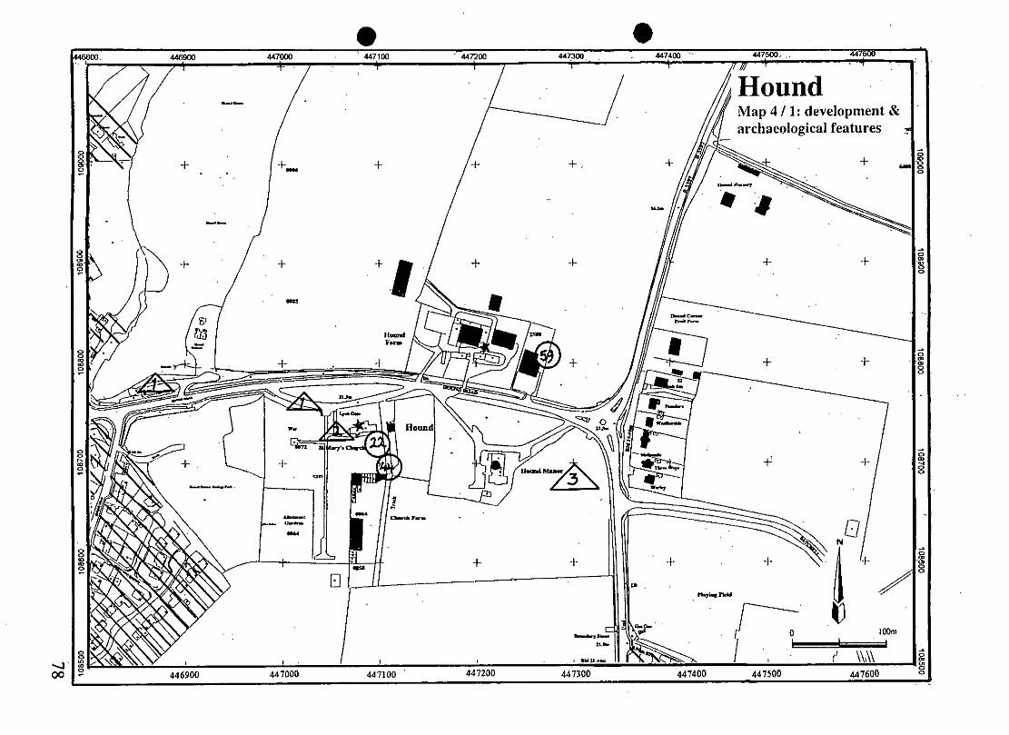
Hound with Netley
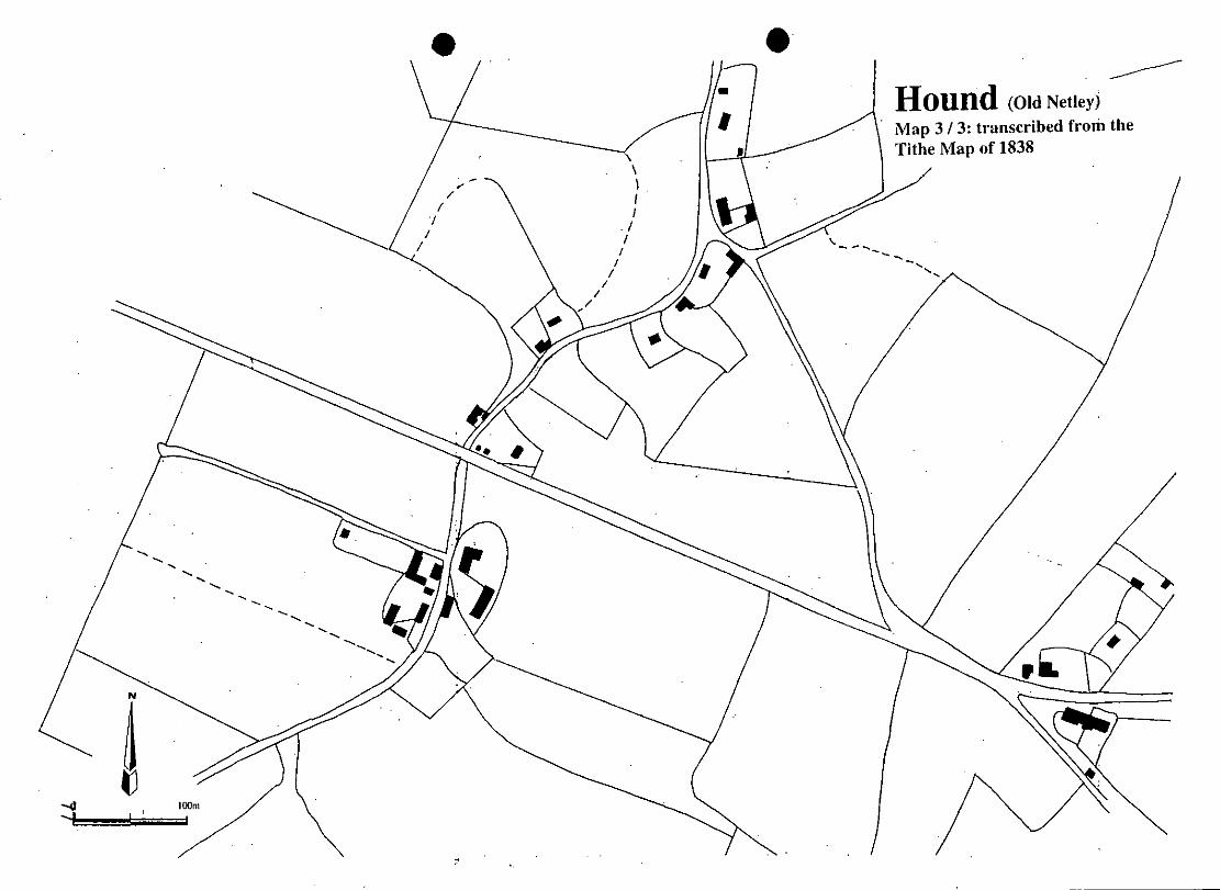
Pevsner and Lloyd (1967: 298) describe none of them. The 1838 (Map 3 / 1) shows no more than the church, a farm and a cottage. 6.1.1 There is no evidence for nucleated settlement at Hound, and even the church is of a relatively late medieval date (C13). There are some possible earthworks close to the junction of Hound Road with the B3397 but they are not extensive and could be Modern. However, unstratified medieval pottery was recovered from Hound in 1960. It is thought to have been found during ground preparations for the construction of a telephone exchange immediately east of Hound Farm yard (paragraph 10.1 no 59 and Map 4 / 1). Five of the shards are illustrated by Hughes and Stamper (1981: 34-5) and these have been dated in the range C12-C13. These dates are compatible with the date for the construction of the church and the pots could have been introduced to the site during the building programme. Alternatively, the present buildings of Hound Farm might occupy the site of a medieval farm or manor house. An electricity sub-station was built in Hound and the SMR identifies this as alternative source for the pottery finds. If this is so, then that site is adjacent to that of a cottage or small holding that has been lost since 1838 (Maps 3 / 1 & 4 / 1 no 4). 6.1.2 The 1838 Tithe Map indicates that Hound Road once opened out into a small green 100m west of the church (Map 3 / 1). 6.2 Monastic house The remains of Netley Abbey (founded 1239) comprise a number of features and these are SAMs (paragraph 10.5). In common with most Cistercian houses, the Abbey was situated in a secluded spot and it continued to be a place of isolation and secrecy until the late C19 when it became squeezed between high density settlement to the east and the development of generously proportioned villas to the north and west. The Abbey should be regarded as more than a set of conventual buildings; it was a total landscape that included a grange (farm), fishponds, a sophisticated water supply and access to marine resources (Southampton Water). It was in every sense a community (a settlement) with a diverse economic base. The Abbey was dissolved in 1536 when it became a mansion house, later to fall into decay. 6.2.1 Netley Castle is 200m south-west of the Abbey. It was built in 1542 and garrisoned until 1627. 6.3 Irregular Row Old Netley was so called in order to distinguish it from the C19 development 1km to the south. At the beginning of the C20 VCH (3: 472) described Old Netley as a picturesque hamlet of timber-framed cottages with trim old-fashioned gardens. It is quite unlike that now for most of the buildings that were extant then have been swept away and, unusually, replaced by others on different sites. Many of the land parcels shown on the Tithe Map have S-shaped boundaries, suggesting that they were set out on, or were residual to, a ploughed field system. The 1838 Tithe Map is essential to any study of Old Netley; when compared to a modern map at the same scale (e.g. Map 4 / 3) only the layout of the roads is instantly recognisable.
IH/2000 65
Hound
Hound with Netley
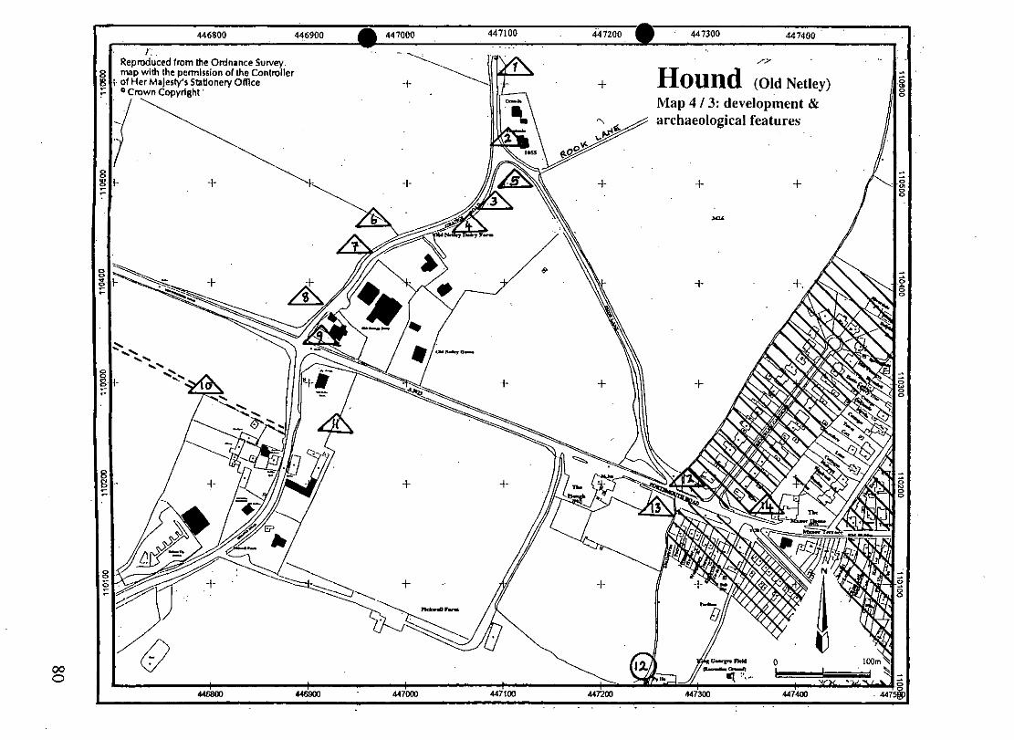
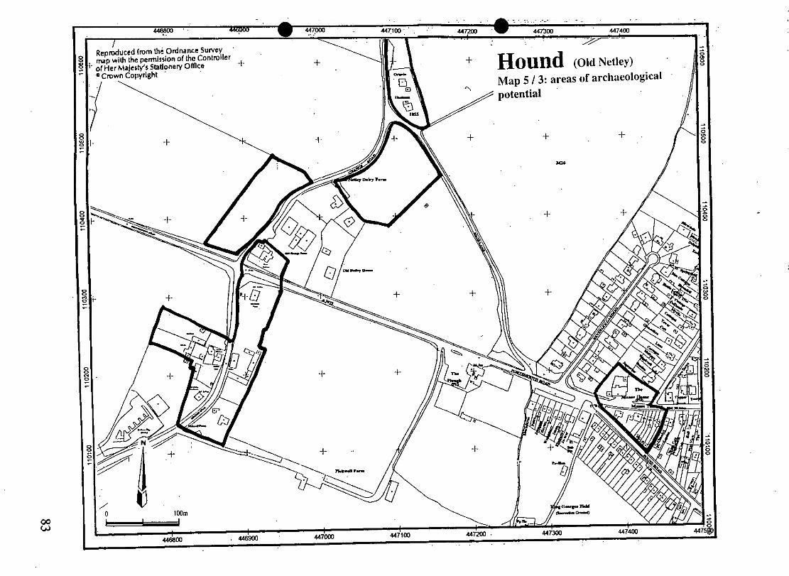
6.3.1 The Old Netley of 1838 (simply Netley at that time) was a fine example of an irregular row, the inhabited plots well spaced and often facing onto an empty enclosure on the opposite side of a road that gently meandered. At the south end of the hamlet was a cluster of buildings that comprised a farm, and it was from this point that the old Southampton Lane had struck out westwards. This road was replaced in 1834 by a turnpike (now the A3025) that effectively cut the settlement into two (Vyner, 1970: 166). 6.3.2 At the north end of the hamlet is a multi-route junction and, buildings apart, this remains much the same today except that Rook Lane has been downgraded to a footpath. Shop Lane crosses the junction from north to south where, after 350m, it joins the A3025. There are traces of a pre-turnpike road system here and the Tithe Map shows that it might have been the site of a green. There is a row of C18 / C19 cottages and behind these was a pound. The public house is called The Manor House. 6.3.3 The Domesday Book refers to a church at Netley (paragraph 14.1) but its location is not known. Amongst the possibilities are that it was situated close to the manor house, perhaps at the south end of Shop Lane. Another possibility is that it stood within the farm complex south of the A3025 and near to the old Southampton Road (Map 3 / 3). It is also feasible that the church at Netley was on the site of the C13 church at Hound which is on the west side of the parish close to the Netley boundary. 6.4 Site visit conditions: strong sun (21.3.2000) 7.0 ARCHAEOLOGICAL POTENTIAL (Maps 5 / 1 - 3) 7.1 AsAP 7.1.1 Hound: church and manor house / farm house This area includes the C13 church and churchyard, and the farm complex. There is not a strong case for nucleated settlement at Hound but the farm was probably the site of the C12 / C13 pottery finds (see paragraph 10.1 no 59). 7.1.2.1 Netley Abbey: monastic house An area that extends from the site of the Abbey buildings, north-eastwards to Grange Farm. This takes into account the wider landscape and economic of the Abbey including fishponds, leats, the monastic farm and precinct boundary. 7.1.2.2 Netley Abbey The site of the C16 castle and grounds. This area may also contain archaeology that relates to the nearby Abbey. .1.1.1 Old Netley: irregular row Four separate zones along Grange Road and Shop Lane that indicate the site of buildings on the 1838 Tithe Map that have been demolished and / or where the arrangement of boundaries has been
substantially altered. Some of the lost buildings must have been timber- framed (see paragraph 6.3).
7.1.3.2 Old Netley An area at the south end of Shop Lane for reasons outlined in paragraphs 6.3.2 and 6.3.3
IH/2000 66
Hound
Hound with Netley
7.2 AsHAP 7.2.1 Hound: church and manor house / farm house The C13 church and the grounds of the so-called Hound Manor and farmyard. 7.2.2.1 Netley Abbey: monastic house The area around the monastery church and buildings as defined by the SAM details but extended eastwards up to the known precinct ditch. 7.2.2.2 Netley Abbey The site of the monastic Grange Farm, its outbuildings and paddocks. 7.2.4 Netley Abbey The C16 castle site and its foreshore. 8.0 CHURCH & CHURCHYARD St Mary C13 nave and chancel C19 lancets except for two on south side; 1959 east window Superseded as the parish church in 1886 by St Edward’s at (new) Netley 9.0 BUILDINGS (Maps 4 / 1 - 3) PRN Details Dates Grade 5774 Bradgate Manor (former vicarage), Abbey Hill late C19 II 393 Netley Castle, Abbey Hill 1542, 1885-90 II* 5775 Abbots Lodge, Abbey Hill See note below II 5777 Church of St Edward the Confessor, Grange Road 1886 II 5778 Netley Grange, Grange Road C18 on earlier site II 1052 Church of St Mary, Hound Road C13 II* 5779 Hound Farmhouse, Hound Road C19 II 5780 Netley Lodge, Netley Lodge Close C16, C19 II 5781 Royal Victoria Hospital: chapel 1856-63 II* 5782 Royal Victoria Hospital: Officers’ Mess c. 1860 II 5783 Royal Victoria Hospital: lodge fronting Victoria Road 1861 II 14689 Royal Victoria Hospital: Victoria House 1866 II 14693 Royal Victoria Country Park: Empire House 1939-40 II 5785 Netley Railway Station, Station Road c. 1867 II 5784 Prince Consort public house, Victoria Road c. 1890 II
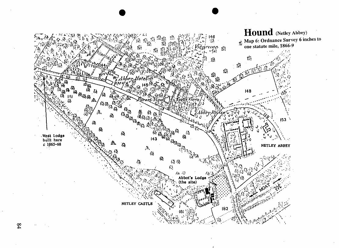
IH/2000 67

Hound
Hound with Netley
NB Abbot’s Lodge (PRN no 5775) is listed as late C19 but it is shown as present on the Tithe Map of 1838. The construction of the building suggests that it is of C18 date (Hewitt, 1996:15). The cottage contains fabric that might have been derived from Netley Abbey opposite. This includes Gothic(k) windows and doorways that are indicative of the association of this cottage with the Romantic Movement and its associations with Netley Abbey in the C18 and early C19. Some of the fenestration and door arches might have been derived from the Abbey. Most of these were removed from the Abbey in the late C19 (probably 1885-90) when the cottage was converted into a lodge and horticultural nursery for Netley Castle. An Early English style ornamental
door remains on the west side of the Lodge. It is possible that this is the cottage where ‘Tea and other provisions’ were ‘furnished’ for those people of Southampton who attended Fountain Court fairs held on Mondays at the Abbey in the 1840s (Sambrook, 1953: 26). The Tithe Map shows no alternative cottage nearby.
10.0 SMR DATA (Maps 4 / 1 - 3) 10.1 Hound SW 446700 108200, NE 447650 109200 SU 40 NE No. 22 447080 108730 Medieval. C13 parish church (see Paragraph 8.0). 44 447100 108700 Medieval. Domesday reference. **m 59 447200 109800 Medieval. Unstratified pottery finds when telephone exchange or electricity sub-station was constructed in 1960. [The entry is unclear as to find spot. The original SMR map reference (447400 108750) favours the sub-station. Location is in favour of the telephone exchange and this has be given the primary map reference for this entry IH / 2000]. 10.2 Old Netley SW 446500 110000, NE 447500 111000 SU 41 SE No. 12 447250 111000 Undated. Cropmark visible on air photographs.
IH/2000 68
Hound
Hound with Netley
10.3 Netley Abbey SW 445000 108400, NE 446000 110000 SU 40 NE No. 30 445120 108850 Medieval. Castle built 1542 and garrisoned until 1627. Extended in 1857 and 1885-90 as a country house. 37 445300 109000 Medieval. Netley Abbey founded 1239, Dissolved 1536 when it was converted into a mansion. Mansion demolished c. 1700. Substantial ruins remain. 38 445300 109000 Medieval. Monastic moat associated with no 37. 39 445500 109200 Medieval fish pond associated with no 37. Two of a suite of 3 survive. They are fed by conduits two miles in length. 40 445480 109550 Two conduits or aqueducts associated with no 39. **m 45 447000 110400 Medieval settlement, Domesday reference. The original NGR (445500 108700) is for a C19, 20 development and it cannot be accurate for the Domesday site. This is far more likely to have been at Old Netley as amended. 52A 445750 109280 Undated. Ditch section observed during a watching brief. 52B 445750 109280 Prehistoric. Single flint flake recovered during a watching brief. 52C 445750 109280 Post-Medieval. Two potsherds recovered during a watching brief. 52D 445750 109280 Post-Medieval. Fragments of clay pipe
recovered during a watching brief. 52E 445750 109280 Post-Medieval. Fragments of brick & slate recovered during a watching brief. 53A 445300 108900 Undated. A largely brick conduit ‘was observed’, presumably during a watching brief. 53B 445300 108900 Post-Medieval. Pottery recovered during a watching brief. 53C 445300 108900 Medieval. Ditch, possibly contemporary with 53A. No associated datable finds. 54 445400 109100 N/A. Negative evidence derived from a
watching brief. 55A 445270 108880 Undated. Two pits observed during a watching brief.
IH/2000 69
Hound
Hound with Netley
** 55B 445270 108880 Medieval. Stone building materials from Netley Abbey recorded during a watching brief. 55C 445270 108880 Post-Medieval floor was observed beneath the stable block of Abbot’s Lodge during a watching brief. 55D 445270 108880 C19. During a watching brief at Abbot’s Lodge a number of floors of demolished outbuildings were observed. 67 445500 108600 Mesolithic pick found at Netley. 10.4 Hampshire Romano-British Settlements survey Hants No. NGR Parish NAR / NMR Nos None listed in the survey. 10.5 Scheduled Ancient Monuments (SAMs) SAM No. NGR Site 5 445400 108900 Netley Abbey 5A 445400 108900 Netley Abbey; precinct wall and moat 233 445100 108800 Netley Castle 24324 445460 109220 to 445640 109840 Western aqueduct near Netley Abbey 24325 445610 109720 to Eastern aqueduct and the water catchment area of the *445720 109900 western aqueduct at Netley Abbey *445780 110130 to *445930 110170 *Denotes that these parts of the feature are now in Southampton. 11.0 ADDITIONAL SITES / FEATURES (Maps 4 / 1 - 3) 11.1 Hound 1 446850 108770 Old course of Hound Road. At 446850 108770 the Tithe Map 447025 108760 suggests that there was once a green. 2 447045 108730 Former western boundary of churchyard visible as an earthwork. 3 447310 108710 Low earthworks visible in low sunlight. 4 447360 108760 Position of cottage shown on the 1838 Tithe Map. The electricity sub-station is 30m to the north-east (see paragraph 10.1 no 59. 11.2 Netley Abbey None.
IH/2000 70

Hound
Hound with Netley
11.3 Old Netley 1 447102 110645 Positions of two former buildings shown as present on 1838 447102 110620 Tithe Map. 2 447120 110540 Positions of two former buildings shown as present on 1838 Tithe Map. A building platform is visible at the front of the
C20 dwelling that occupies the site. 3 447090 110499 Position former building shown as present on 1838 Tithe Map. 4 447075 110470 Position former building shown as present on 1838 Tithe Map. 5 447120 110510 Position former building shown as present on 1838 Tithe Map. 6 446965 110450 Position former building shown as present on 1838 Tithe Map. 7 446955 110425 Position former building shown as present on 1838 Tithe Map. 8 446900 110370 Position former building shown as present on 1838 Tithe Map. 9 446905 110340 Position former building shown as present on 1838 Tithe Map. 10 446970 110285 Part of pre-turnpike Southampton Road as shown on the 1838 Tithe Map. However, this remaining stub of road is straight
and formal. It looks out of place within the overall scheme of the settlement and it is possible that this too was a post- medieval route. It is now untraceable from the Grange Lane end.
11 446930 110250 Remains of curvilinear boundary shown on 1838 Tithe Map but not on Modern OS issues. 12 447300 110200 Traces of pre-turnpike road junction and green. 13 447250 110160 Low earthworks. 14 447370 110170 Earthworks within gardens of The Manor House public house. There was a building close to this point in 1838. 15 447435 110082 Site of Pound in Pound Lane. 12.0 CARTOGRAPHIC SOURCES Tithe Map 21M65/F7/122/2 (1838 / 1840) GSGB 315 Southampton OS 1: 2500 Hound: SW 446700 108200, NE 447650 109200 Old Netley: SW 446500 110000, NE 447500 111000 Netley Abbey: SW 445000 108400, NE 446000 110000 OS 1: 25000 Pathfinder 1303 (SU 40 / 50), Southampton Water & Fareham; Outdoor Leisure 22, New Forest.
IH/2000 71

Hound
Hound with Netley
13.0 BIBLIOGRAPHY Chapman J & Seeliger S 1997 A Guide to Enclosure in Hampshire 1700-1900 Winchester, Hampshire County Council Coates R 1989 Hampshire Place-names London, Batsford. Hewitt I 1996 Abbot’s Lodge, Netley Poole, Bournemouth University report for
Hampshire County Council Sambrook AJ 1953 Netley & Romanticism In AH Thompson Netley Abbey, Hampshire London, Her Majesty’s Stationery Office Thompson AH 1953 Netley Abbey, Hampshire London, Her Majesty’s Stationery
Office VCH 3: 472-478 Viner DJ 1970 The Industrial Archaeology of Hampshire Roads: A Survey Proceedings
of the Hampshire Field Club and Archaeological Society 26: 155-17 14.0 PRIMARY HISTORIC SOURCES 14.1 Domesday Book 23,18 (Land of Hugh of Port). Warnford. Wulfric and Wulfward held it from King Edward jointly. They had 2 halls. Then it answered for four hides; now for 2 hides less 1 virgate. In Hound there are 3 hides and 3 acres of land which belonged to Warnford; they paid tax in Mainsbridge Hundred. In total there are 7 hides. Land for 9 ploughs. In lordship 3 ploughs; 31 villagers and 9 smallholders with 6 ploughs. A church; 6 slaves; 2 mills at 20s; meadow at 20 acres. Value before 1066 and now £14; when acquired £8. 42,1 Richard Poynant holds Netley. Alfward held it from King Edward; he could go whither he would. Then it answered for 3 hides; now for 1 hide. Land for 5 ploughs. In lordship 1; 9 villagers and 2 smallholders with 2 ploughs. A small church; 2 slaves; meadow, 4 acres; woodland at 40 pigs. Value before 1066, 60s; later 40s; now 100s. 14.2 Subsidy Rolls 1334 £2.11.10 (Netley only) 1524 Hound: 1st survey: £1.0.10 (19 taxpayers) 2nd survey: £0.17.10 (16 taxpayers) Netley: 1st survey: Absent 2nd survey: £0.12.10 (11 taxpayers) NB In 1334 there were no returns for Hound and it is possible that it was included with Netley. In 1524 the combined returns for Netley and Hound fall well short of the 1334 figure for Netley. That there might have been some confusion over the tax returns for these two manors is suggested by the absence of Netley from the first survey of 1524.
IH/2000 72
Hound
Hound with Netley
14.3 Manorial Documents On the strength of the Domesday evidence there were two estates; Hound and Netley. According to VCH (3: 477) they were separate manors until 1537. Satchell was a tithing of Hound but it is now represented by Satchell Farm and Satchell Marsh in the north-east of Hamble-le-Rice CP. Scholing was a detached tithing of Hound that is now a suburb of Southampton (Map 1). 14.4 Hearth Tax 1665 Hound & Satchell: 21 hearths chargeable (11 houses) 10 hearths not chargeable (10 houses). Total: 21 houses. Netley: 79 hearths chargeable (16 houses) 8 hearths not chargeable (8 houses) Total: 24 houses. 15.0 PLACE NAME 15.1 Hound: 1086, 1176 Hune. OE hune ‘hoarhound (Marrubium vulgare)’; a place where this plant grows (Coates, 1989: 96). 15.2 Netley: 955 x 958 (C14) æt lætanlia; 1086 Latelei; 1239 Lettelege. OE ‘neglected, abandoned’ or first element lætt + ley ‘wood where the laths were got’ (Coates, 1989: 121). 16.0 PHOTOGRAPHS
None taken. 17.0 OTHER PROJECT ELEMENTS 17.1 Pre-Conquest Charters AD 955 x 958. Will of Ælfsige, bishop, concerning land at...Netley, Hants the
beneficiaries including the King and Old and New Minsters, Winchester (OE, ME and Latin versions (417 / 1491).
17.2 Other parish settlements include: Name MSP No. NGR / map ref. First recorded Badnam HIM SP1 316 1233
IH/2000 73
Hound
Hound with Netley
IH/2000 74
17.3 Enclosures 17.3.1 Hound Parliamentary: NEP No. Act Order Award Details None known. Formal Agreements: NEP No. Agreement Award Details None known. 17.3.2 Netley (including Netley Abbey) Parliamentary: NEP No. Act Order Award Details None known. Formal Agreements: NEP No. Agreement Award Details None known. 17.4 Commons & Greens (residual) A fragment remains as Hound Common, c. 100m west of the enlarged churchyard. However, a nil return was made to the Inclosure and Tithe Commissioners in 1873. 18.0 ILLUSTRATIONS 1 Map 1: Parish location (not to scale) 2 Map 2: Settlement location at 1: 25000 3 Map 3 / 1: Hound (church & manor) 1838 Tithe Map transcription at 1: 2500 reduced to 71% 4 Map 3 / 2: Netley Abbey 1838 Tithe Map transcription at 1: 2500 reduced to 71% 5 Map 3 / 3: Old Netley 1838 Tithe Map transcription at 1: 2500 reduced to 71% 6 Map 4 / 1: Hound (church & manor) Development & archaeological features at 1: 2500 reduced to 71 % 7 Map 4 / 2: Netley Abbey, Development & archaeological features at 1: 2500 reduced to 71 % 8 Map 4 / 3: Old Netley, Development & archaeological features at 1: 2500 reduced to 71 % 9 Map 5 / 1: Hound (church & manor) Areas of archaeological potential at 1: 2500 reduced to 71 % 10 Map 5 / 2: Netley Abbey, Areas of archaeological potential at 1: 2500 reduced to 71 % 11 Map 5 / 3: Old Netley, Areas of archaeological potential at 1: 2500 reduced to 71 % 12 Map 6: Netley Abbey 1866-9 Ordnance Survey 6 inches to the statute mile.