ROAD SAFETY AUDIT - Welcome to MassDOT Safety Audit—Route 20 - Oxford/Charlton, MA . Prepared by...
36
ROAD SAFETY AUDIT Route 20 Town of Oxford/Town of Charlton April 2016 Prepared For: MassDOT Prepared By: McMahon Associates, Inc. 300 Myles Standish Blvd. Suite 201 Taunton, MA 02780
Transcript of ROAD SAFETY AUDIT - Welcome to MassDOT Safety Audit—Route 20 - Oxford/Charlton, MA . Prepared by...
ROAD SAFETY AUDIT
Route 20
Town of Oxford/Town of Charlton
April 2016
Prepared For: MassDOT
Prepared By: McMahon Associates, Inc.
300 Myles Standish Blvd. Suite 201 Taunton, MA 02780

Road Safety Audit—Route 20 - Oxford/Charlton, MA Prepared by McMahon Associates, Inc. FINAL
Table of Contents Background ............................................................................................................................ 1
Project Data ............................................................................................................................ 2
Project Location and Description .......................................................................................... 3
Road Safety Audit Observations and Potential Improvements ............................................ 6
Recommendations ................................................................................................................ 15
Summary of Road Safety Audit ........................................................................................... 15
List of Appendices
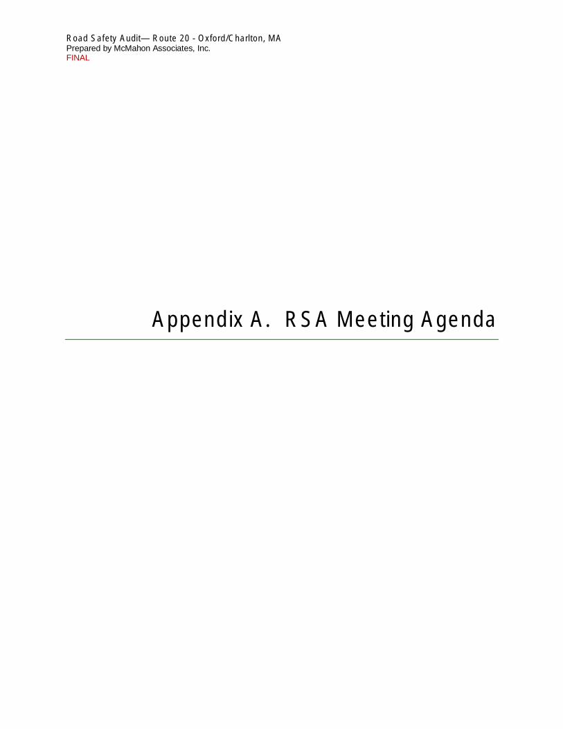
Appendix A. RSA Meeting Agenda Appendix B. RSA Audit Team Contact List Appendix C. Detailed Crash Data
List of Figures
Figure 1: Site Location Map ................................................................................................................. 4
List of Tables
Table 1. Participating Audit Team Members.................................................................................... 2 Table 2. Estimated Time Frame and Costs Breakdown .................................................................. 15 Table 3. Potential Safety Enhancement Summary .......................................................................... 16

Page 1
Background The Federal Highway Administration (FHWA) defines a Road Safety Audit (RSA) as the formal safety examination of an existing or future road or intersection by an independent, multidisciplinary team. The purpose of an RSA is to identify potential safety issues and possible opportunities for safety improvements considering all roadway users. This RSA evaluates the Route 20 corridor in the towns of Oxford and Charlton, MA, from Route 12 to the east to Richardson Corner Road to the west. Within the corridor, the RSA excludes the Route 20 intersections with Route 56 and Route 12, since RSAs were completed in January 2015 and January 2012, respectively, for the two intersections. A safety audit was scheduled for this corridor as part of the proposed redesign of Route 20 and at the request of MassDOT and Town officials.
Within the corridor, there are no HSIP high crash locations with the exception of Route 20 at Route 56, which is not included as part of this RSA. However, there was a fatal crash that occurred within the project corridor at the curved segment just east of the Oxford/Charlton town line during the weekday morning peak hour on October 26, 2015.
Road Safety Audit—Route 20 - Oxford/Charlton, MA Prepared by McMahon Associates, Inc. FINAL
A guardrail was installed at the Oak Drive curve as an interim improvement
A key objective of the RSA is to identify both short-term and long-term safety improvements that can be made at the corridor and incorporated in potential improvements of this corridor. It should be noted that prior to the RSA, interim safety improvements were installed on Route 20, in the vicinity of the location of the fatal crash. The interim improvements were completed in January 2016 and were included as part of the RSA discussion. The improvements include:
• A median guardrail on the section of Route 20 from the Charlton / Oxford town line to the west to the property at 80 Southbridge Road (Route 20) to the east. The roadway has been widened to accommodate the addition of median guardrail.
• Permanent speed feedback signs were installed in advance of the curve near Oak Drive in both the eastbound and westbound direction.
• A curve warning system was installed on the curve at Oak Drive. This system is activated when vehicles approach the curve at high speeds.
• Yellow centerline stanchions were installed on sections of Route 20. At the time of the audit meeting, not all of the proposed stanchions were in place. The remaining locations where they are missing are proposed to be filled in as part of the interim improvements.
Road Safety Audit—Route 20 - Oxford/Charlton, MA Prepared by McMahon Associates, Inc. FINAL
Page 2
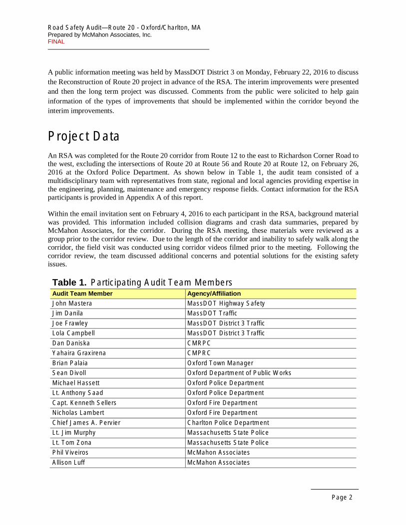
A public information meeting was held by MassDOT District 3 on Monday, February 22, 2016 to discuss the Reconstruction of Route 20 project in advance of the RSA. The interim improvements were presented and then the long term project was discussed. Comments from the public were solicited to help gain information of the types of improvements that should be implemented within the corridor beyond the interim improvements.
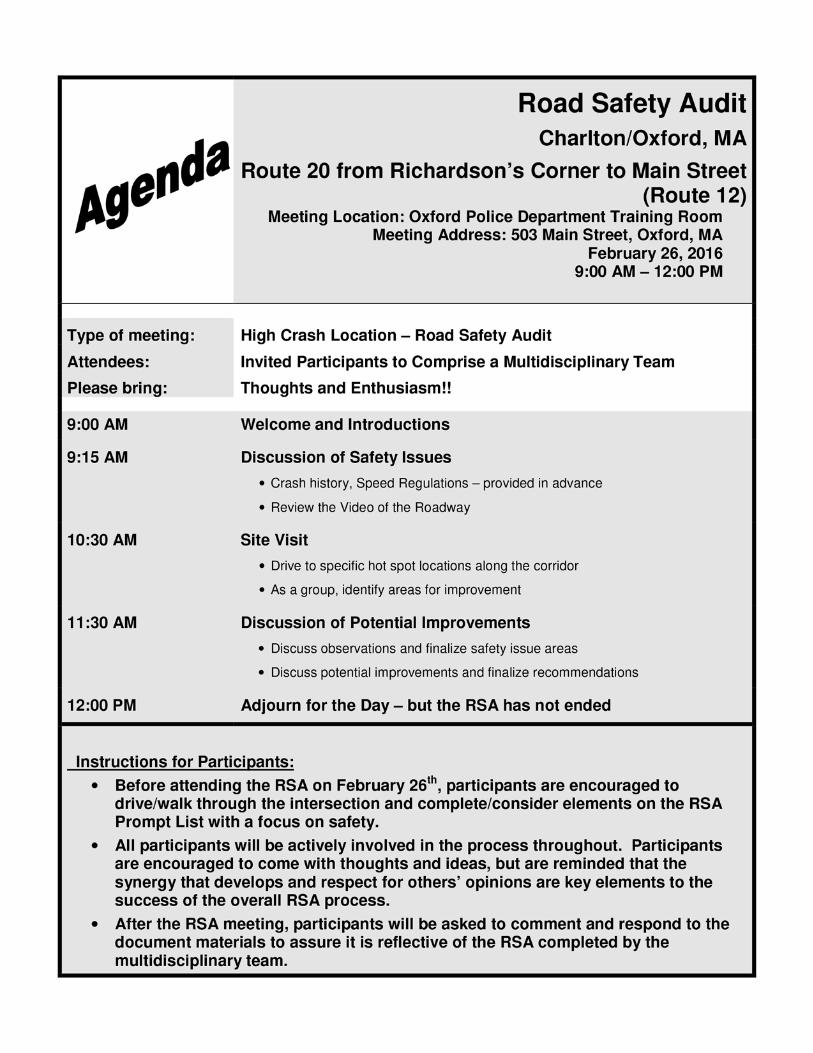
Project Data An RSA was completed for the Route 20 corridor from Route 12 to the east to Richardson Corner Road to the west, excluding the intersections of Route 20 at Route 56 and Route 20 at Route 12, on February 26, 2016 at the Oxford Police Department. As shown below in Table 1, the audit team consisted of a multidisciplinary team with representatives from state, regional and local agencies providing expertise in the engineering, planning, maintenance and emergency response fields. Contact information for the RSA participants is provided in Appendix A of this report.
Within the email invitation sent on February 4, 2016 to each participant in the RSA, background material was provided. This information included collision diagrams and crash data summaries, prepared by McMahon Associates, for the corridor. During the RSA meeting, these materials were reviewed as a group prior to the corridor review. Due to the length of the corridor and inability to safely walk along the corridor, the field visit was conducted using corridor videos filmed prior to the meeting. Following the corridor review, the team discussed additional concerns and potential solutions for the existing safety issues.
Table 1. Participating Audit Team Members Audit Team Member Agency/Affiliation
John Mastera MassDOT Highway Safety
Jim Danila MassDOT Traffic
Joe Frawley MassDOT District 3 Traffic
Lola Campbell MassDOT District 3 Traffic
Dan Daniska CMRPC
Yahaira Graxirena CMPRC
Brian Palaia Oxford Town Manager
Sean Divoll Oxford Department of Public Works
Michael Hassett Oxford Police Department
Lt. Anthony Saad Oxford Police Department
Capt. Kenneth Sellers Oxford Fire Department
Nicholas Lambert Oxford Fire Department
Chief James A. Pervier Charlton Police Department
Lt. Jim Murphy Massachusetts State Police
Lt. Tom Zona Massachusetts State Police
Phil Viveiros McMahon Associates
Allison Luff McMahon Associates

Road Safety Audit—Route 20 - Oxford/Charlton, MA Prepared by McMahon Associates, Inc. FINAL
Page 3
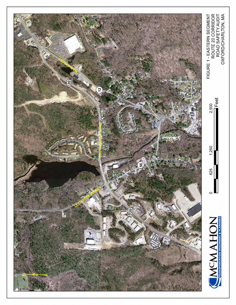
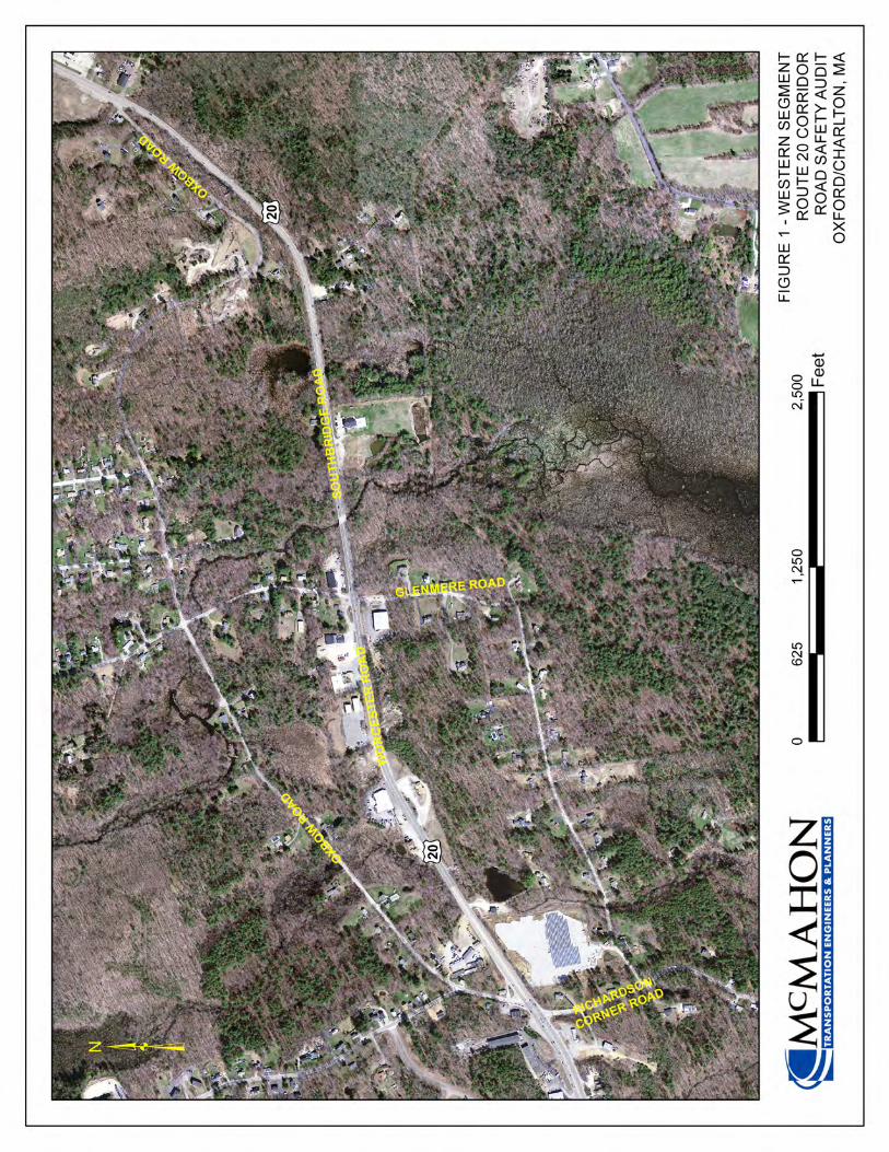
Project Location and Description As shown in Figure 1, Route 20 generally runs in the east/west direction through Oxford and Charlton. Route 20 is classified as an urban principal arterial under MassDOT jurisdiction. The study area begins at the intersection with Route 12 and continues west to the intersection with Richardson Corner Road. The RSA focuses on operations and safety on Route 20 and includes the driveways and intersections along this corridor, excluding the intersection with Route 56 and Route 12.
Route 20 within the project limits is classified as an Urban Principal Arterial and is under MassDOT jurisdiction. The highway is called Worcester Road in Charlton and Southbridge Road in Oxford. Within the study area, it is typically an undivided four-lane facility with a posted speed limit ranging from 40mph to 50mph. The travel lanes are approximately 11-foot wide with one-foot shoulders. Opposing directions of travel are separated by a double yellow centerline painted over a rumble strip throughout the entire project corridor. Delineator posts are also installed along the roadway centerline in several sections of Route 20. As previously noted, guardrail was installed for the segment of Route 20 adjacent to a major curve and extends from approximately the Charlton/Oxford town line to the property located at 80 Southbridge Road, approximately 1,000 feet east of Oxbow Road. A majority of the intersecting roads are collector roads for residential areas. Utility poles line the north and south sides of the corridor at varying locations. Route 20 is abutted by a combination of residential and commercial land uses.
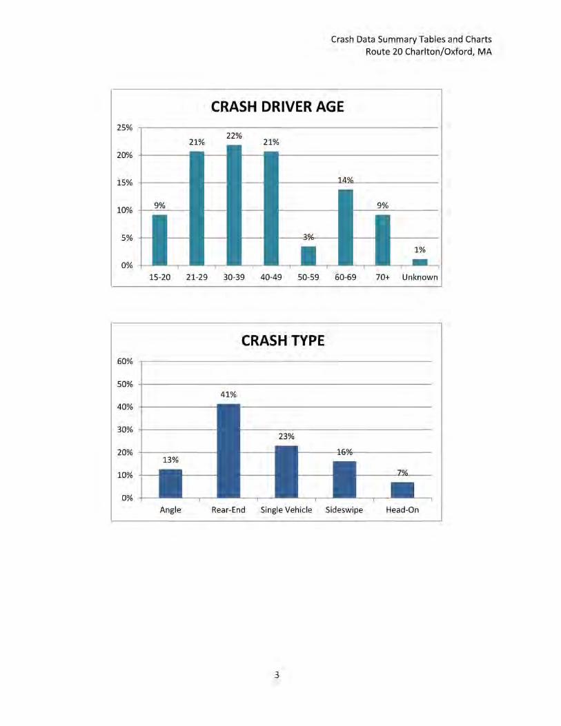
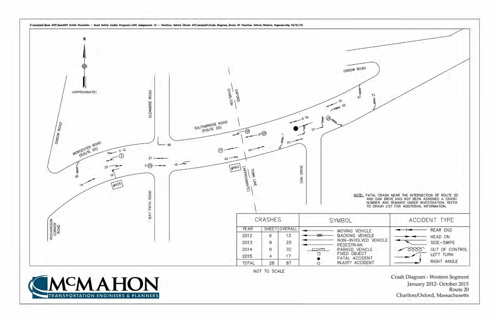
Crash data was received from the MassDOT for the study area intersections from January 2012 through October 2015. Based on this data, there were a total of 87 crashes reported within the study area corridor during the time periods reviewed. Of the 87 crashes that occurred, 40 of the crashes occurred in the eastern segment of the roadway between Route 12 and Route 56, 19 crashes occurred in the middle segment of Route 20 between Route 56 and Oxbow Road, and 28 crashes occurred in the western segment between Oxbow Road and Richardson Corner Road.
The highest crash types along the corridor involved rear-end collisions, which accounted for 40% of crashes. It was noted during the RSA meeting that vehicles stop in the left most lane of Route 20 to turn left onto an unsignalized roadway or driveway, which is a contributing factor to this high number of rear-end collisions. A total of 16% of the crashes were sideswipe collisions, which may be caused by this same condition. Of the crashes, 23% were single vehicle crashes, which may indicate geometric problems within the corridor. While the majority of crashes occurred under clear conditions, 25% of crashes occurred in rain/snow, which may indicate problems with roadway surface, geometry, or drainage.
As noted earlier, there was a fatal crash that occurred within the project corridor at the curved segment adjacent to the Oxford/Charlton town line during the weekday morning peak hour on October 26, 2015. The vehicle heading east crossed over the centerline and collided in the westbound lane with an oncoming truck. The collision impact caused the vehicle to move back into the eastbound lane where it was struck again by another vehicle. This crash is not formally included in the statistics summarized for this report, as the investigation of this crash was ongoing at the time of the RSA; however, the detailed crash diagrams and crash data summary, provided in Appendix C, include information about this crash.
.

Road Safety Audit—Route 20 - Oxford/Charlton, MA Prepared by McMahon Associates, Inc. FINAL
Page 6
Road Safety Audit Observations and Potential Improvements During the RSA meeting prior to the field visit, a brief introduction of the RSA process and a summary of traffic volumes and crash information were presented to the audit participants. Following this brief presentation, the members of the audit team were asked to discuss the existing issues that may affect safety along the Route 20 corridor. The audit team then reviewed the corridor videos as a group, at which time observations of various safety concerns and deficiencies were identified and documented. Provided below is a list of the safety concerns that were identified during the RSA for the corridor and the potential enhancements identified during the RSA.
Safety Issue #1: Interim Improvement Issues
Observations:
As part of the discussion during the RSA, audit team members identified issues within the corridor that pertain directly to the interim improvements installed by MassDOT.
The interim improvements that were installed include radar speed feedback signage. The signs are positioned in the eastbound and westbound direction in advance of the horizontal curve adjacent to Oak Drive. It was noted during the RSA meeting that while the speed feedback signage is a positive improvement to help reduce vehicle speeds, the posted speed limit signage is missing at these locations for drivers to compare actual travel speeds to the posted speed limit.
With the implementation of the guardrail barrier in the vicinity of the curve near Oak Drive, left turns are unavailable, which have raised the issue of where vehicles are able to make an appropriate U-turn. In the westbound direction, the first available intersection to make the U-turn movement is at the signalized intersection with Richardson Corner Road. This location, however, does not have the available space for larger vehicles and trucks to U-turn. Vehicles have been observed at this location making a three-point turn, or U-turning via the channelized right turn onto Oxbow Road to the north to make a left turn back to Route 20 to reverse direction. It was also discussed during the RSA that vehicles are turning left into private properties to make U-turns; the property located across from O’Malley’s Truck and Auto Body shop (426 Worcester Road) was specifically noted as an example.
Speed feedback signage implemented as an interim improvement to the corridor

Road Safety Audit—Route 20 - Oxford/Charlton, MA Prepared by McMahon Associates, Inc. FINAL
Page 7
It should be noted that the currently proposed redesign of Route 20 includes installation of a permanent median barrier within the corridor, with left-turns and U-turns to be accommodated at specific locations. Audit team members noted that
22nd during the February public information meeting, it was discussed that any location to the west of Richardson Corner Road would not be feasible as a U-turn location, as it would be difficult to educate and enforce people to bypass Richardson Corner Road. It was discussed by audit team members that this U-turn location would not be a feasible solution until the reconstruction project is constructed. However, the construction of a U-turn truck turnout as an interim improvement was widely supported by RSA participants.
With the implementation of the guardrail, Oxbow Road is now restricted to right-in/right-out only movements at its intersection with Route 20. Global Positioning System (GPS) directions, however, are still directing people to make left turns at this location.
While the implementation of the guardrail section is generally supported by the first responders participating in the RSA, the addition does present an obstacle to emergency response to quickly respond to calls. Larger emergency response vehicles also have a difficult time making U-turns at the Richardson Corner Road intersection to reverse direction to the eastbound lanes.
The guardrail was also noted to create a hazard at some private driveways for larger vehicle egress back to Route 20. These vehicles used to encroach on the centerline when exiting a driveway, and now are unable to do so.
The guardrail restricts the number of turns that can be made on Route 20
Enhancements: • Consider including the speed limit signage at the two existing speed feedback signs
implemented as part of the interim improvements. • Consider providing advanced signage designating specific areas where U-turns should be
made, particularly for heavy vehicles. • Consider providing truck turn-out areas at designated U-turn locations (such as
Richardson Corner Road) to allow larger vehicles to make the movements. • Update GPS information to be consistent with current roadway conditions.

Page 8
• Evaluate locations for right-of-way acquisition to provide appropriate U-turn locations. Specifically, the property adjacent to Pioneer Drive (a former Chinese restaurant) was identified by audit participants.
• Consider providing breaks in Route 20 barriers to facilitate U-turns for emergency response vehicles as a long-term measure.
• Consider modifications to private driveways to allow for efficient egress of larger vehicles with the addition of the new guardrail.
• Consider installation of additional delineator posts with shorter spacing between posts at both ends of the new guardrail to discourage U-turn movements using private driveways.
Safety Issue #2: Speeds
Observations:
Vehicle speeds were noted as a major problem throughout the Route 20 corridor. The posted speed limit from Route 12 to Route 56 is 40 miles per hour, while the remainder of the corridor is posted at 50 miles per hour. Based on speed data collected as part of the Route 20 reconstruction project, the 85th percentile speeds on Route 20 are approximately 60 miles per hour. The signs appear to be undersized and somewhat faded.
In the eastern segment of the corridor, vehicles move slower due to intersection congestion. The middle and western segments of Route 20, however, experience much less congestion, allowing vehicles to travel at a much higher rate of speed. This becomes a particular problem in areas where there are curves in the roadway, such as the curve adjacent to Oak Drive.
With regard to crash data, single vehicle crashes account for 25% Posted speed limit of 50 MPH on Route 20 eastbound
of the total corridor crashes, which may indicate that there is a geometric problem with the roadway, or that vehicles are traveling too fast to safely traverse the roadway without losing control of their vehicle. Inclement weather may also be a factor as four of these single vehicle crashes occurred in wet/snow conditions. As shown in the crash diagrams, seven crashes occurred at the curve near Oak Street over the crash period reviewed where vehicles lost control of their vehicles and collided into a stationary object or with another vehicle; the fatal crash in October 2015 also occurred within this curve.
During the RSA meeting, representatives from the Town of Oxford, Town of Charlton, and Massachusetts State Police departments agreed that Route 20 is a difficult roadway on which
Road Safety Audit—Route 20 - Oxford/Charlton, MA Prepared by McMahon Associates, Inc. FINAL

Road Safety Audit—Route 20 - Oxford/Charlton, MA Prepared by McMahon Associates, Inc. FINAL
Page 9
to enforce speeds due to the geometric constraints of the roadway and lack of safe places to pull over a vehicle. While Route 20 is under state jurisdiction, the State Police works together with the two municipal police departments to patrol Route 20.
Enhancements:
• Evaluate design improvements for the central and western segments of Route 20 that will reduce vehicle speeds and allow for a speed limit reduction.
• Consider providing larger sized speed limit signage to help alert drivers of the posted speed limit.
• Consider adding additional regulatory signs with speed feedback signs throughout the corridor to alert motorists of their current travel speeds, and include the posted speed limit to supplement the feedback signage.
• Evaluate locations that can be utilized as designated pull-off areas to aid in police enforcement of the posted speed limit.
• Investigate funding sources to provide additional police enforcement. • Consider providing advisory speed warning signage at locations where the roadway
geometry requires vehicles to slow down.
Safety Issue #3: Sight Distance
Observations:
Audit team members discussed several locations where sight distance was an issue within the corridor. The first location is at the entrance to Thayer Pond, a residential development located on Route 20 approximately 750 feet east of Route 56. There is a slight horizontal curve at this location that obstructs sight lines from vehicles exiting the development. Additionally, queues from the westbound approach of the intersection of Route 20 at Route 56 often extend beyond this driveway during the weekday afternoon peak hour. It is difficult for vehicles to see the upcoming queue on Route 20 traveling westbound, which may be a contributing factor in the number of rear-end collisions at this location.
Another area where sight distance was noted to be an issue is at the Mobil gasoline station in the central segment of Route 20, located across from Pioneer Drive, and approximately 500 feet east of the beginning of the recently installed guardrail. There is a horizontal curve approximately 500 feet to the east of the eastern Mobil site driveway. Since vehicle speeds on
Horizontal curve at Thayer Pond on Route 20
Road Safety Audit—Route 20 - Oxford/Charlton, MA Prepared by McMahon Associates, Inc. FINAL
Page 10
Route 20 often exceed the posted speed limit, this horizontal curve causes a sight distance concern at these driveways. Due to the presence of left-turn bays on Route 20 serving the Mobil station and Pioneer Drive, vehicles tuning left out of the site also have to travel across three travel lanes to accept a gap in traffic, which is difficult to judge from the driveway. Both driveways at the Mobil Gas Station are also used as full access driveways due to a lack of guidance regarding driveway operations. The entrance to the Boulder Industrial Park, located to the west of Route 56, was noted by audit participants to have poor sight distance that is obstructed by the horizontal curve at Route 56 as well as overgrown vegetation.
Enhancements: • Evaluate relocating the Thayer Pond driveway to a location on Route 20 with better sight
lines to improve driveway sight distance. • Evaluate improvements, including traffic signal retiming, at the intersection of Route 56
and Route 20 to reduce queuing in the westbound direction on Route 20. • Consider installing dynamic queue (or “Red Signal Ahead”) signage in the westbound
direction approaching Route 56 to alert motorists of queuing conflicts. • Consider designating the eastern Mobil driveway as an entrance only driveway and the
western site driveway as an exit only driveway to simplify access/egress at the Mobil site, reduce conflicts on Route 20, and increase sight distance to the east for vehicles exiting the site.
• Investigate design alternatives to help slow speeds through this corridor. • Trim overgrown vegetation adjacent to the Boulder Industrial Park driveway to improve
sight distance exiting the driveway.
Safety Issue #4: Permissive Left Turns/U-Turns
Observations:
Audit team members noted that a major issue causing conflicts on Route 20 are vehicle stopping in the left most lane to make a permissive left turn onto an unsignalized roadway or into a driveway. Vehicles are in conflict with high speed traffic sharing the left lane and continuing through on Route 20. This was discussed to be a major contributing factor to the number of rear-end and sideswipe collisions that occurred within the study area corridor. Rear-end collisions accounted for 41% of the total crashes while sideswipe collisions accounted for 16% of the total collisions. Permissive left turns at the signalized intersections, specifically at the intersection of Route 20 and Route 56, were also noted to be somewhat of an issue. While the intersection of Route 20 at Route 56 is not included as part of this RSA, some audit participants suggested that this issue should be considered as part of the reconstruction project.

Road Safety Audit—Route 20 - Oxford/Charlton, MA Prepared by McMahon Associates, Inc. FINAL
Page 11
Additionally, it was observed by audit participants that several of these rear-end collisions occur under the condition that drivers stop to yield the right-of-way to a motorist entering the stream of traffic, commonly referred to as “courtesy crashes”.
Enhancements: • Evaluate major left turn movements along Route 20 and determine if an exclusive left
turn lane could be added at various locations to reduce the conflicts with high speed traffic on Route 20.
• Consider decreasing the spacing between the delineating stanchions to reduce the availability for permissive left turns and U-turns at uncontrolled locations.
• Consider providing a jughandle intersection at the intersection with Pioneer Drive to allow for safer maneuvers into and out of the Mobil Station driveways as well as provide a location to perform a U-turn.
• Provide additional signage at private driveways to discourage drivers from utilizing these properties for U-turns.
Safety Issue #5: Emergency Response
Observations:
As previously discussed, police representatives agreed that Route 20 is a difficult roadway to enforce speeds due to the geometric constraints of the roadway and lack of safe places to pull a vehicle over. Additionally, it was noted that in the event of a crash on Route 20, the emergency response requires lane closures since there are no shoulders to move the vehicles involved or to park the emergency vehicles. In the event of a larger crash that requires medical and fire response, Route 20 may have to be completely stopped in one direction to have fire and ambulance response on the roadway. Congestion on the eastern segment was also noted as an issue for first responders to maneuver on Route 20, particularly the westbound queueing from the intersection of Route 20 at Route 56 extending beyond the Thayer Pond Village entrance.
Enhancements: • Evaluate improvements at the intersection of Route 56 and Route 20 to reduce queuing in
the westbound direction on Route 20.
Safety Issue #6: Roadway Geometry
Observations:
There are several locations where roadway geometry was noted to be an issue. At the intersection of Route 20 and Turner Road, there is an issue with the grade of Turner Road as it connects to Route 20. Truck traffic frequently travels this segment from the adjacent Walmart on Route 12 to connect to Route 20, and due to the grade, the trucks bottom out and
Road Safety Audit—Route 20 - Oxford/Charlton, MA Prepared by McMahon Associates, Inc. FINAL
Page 12
get stuck at this intersection. During times where congestion is heavy at the signalized intersection of Route 12 at Route 20, GPS mapping will route vehicles down this road, including truck traffic. Missing shoulders along sections of the Route 20 corridor were also discussed to be an issue and a contributing factor to corridor crashes due to the limited maneuvering space.
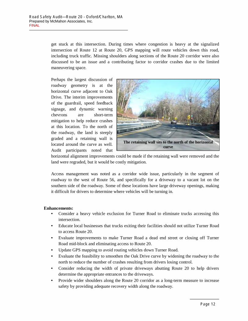
Perhaps the largest discussion of roadway geometry is at the horizontal curve adjacent to Oak Drive. The interim improvements of the guardrail, speed feedback signage, and dynamic warning chevrons are short-term mitigation to help reduce crashes at this location. To the north of the roadway, the land is steeply graded and a retaining wall is located around the curve as well. Audit participants noted that horizontal alignment improvements could be made if the retaining wall were removed and the land were regraded, but it would be costly mitigation.
Access management was noted as a corridor wide issue, particularly in the segment of roadway to the west of Route 56, and specifically for a driveway to a vacant lot on the southern side of the roadway. Some of these locations have large driveway openings, making it difficult for drivers to determine where vehicles will be turning in.
The retaining wall sits to the north of the horizontal curve
Enhancements: • Consider a heavy vehicle exclusion for Turner Road to eliminate trucks accessing this
intersection. • Educate local businesses that trucks exiting their facilities should not utilize Turner Road
to access Route 20. • Evaluate improvements to make Turner Road a dead end street or closing off Turner
Road mid-block and eliminating access to Route 20. • Update GPS mapping to avoid routing vehicles down Turner Road. • Evaluate the feasibility to smoothen the Oak Drive curve by widening the roadway to the
north to reduce the number of crashes resulting from drivers losing control. • Consider reducing the width of private driveways abutting Route 20 to help drivers
determine the appropriate entrances to the driveways. • Provide wider shoulders along the Route 20 corridor as a long-term measure to increase
safety by providing adequate recovery width along the roadway.
Road Safety Audit—Route 20 - Oxford/Charlton, MA Prepared by McMahon Associates, Inc. FINAL
Page 13
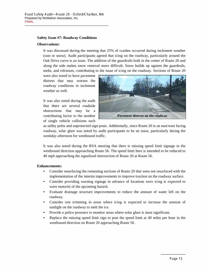
Safety Issue #7: Roadway Conditions
Observations:
It was discussed during the meeting that 25% of crashes occurred during inclement weather (rain or snow). Audit participants agreed that icing on the roadway, particularly around the Oak Drive curve is an issue. The addition of the guardrails both in the center of Route 20 and along the side makes snow removal more difficult. Snow builds up against the guardrails, melts, and refreezes, contributing to the issue of icing on the roadway. Sections of Route 20 were also noted to have pavement distress that may worsen the roadway conditions in inclement weather as well.
It was also noted during the audit that there are several roadside obstructions that may be a contributing factor to the number of single vehicle collisions such as utility poles and unprotected sign posts. Additionally, since Route 20 is an east/west facing roadway, solar glare was noted by audit participants to be an issue, particularly during the weekday afternoon for westbound traffic.
It was also noted during the RSA meeting that there is missing speed limit signage in the westbound direction approaching Route 56. The speed limit here is intended to be reduced to 40 mph approaching the signalized intersection of Route 20 at Route 56.
Enhancements: • Consider resurfacing the remaining sections of Route 20 that were not resurfaced with the
implementation of the interim improvements to improve traction on the roadway surface. • Consider providing warning signage in advance of locations were icing is expected to
warn motorist of the upcoming hazard. • Evaluate drainage structure improvements to reduce the amount of water left on the
roadway. • Consider tree trimming in areas where icing is expected to increase the amount of
sunlight on the roadway to melt the ice. • Provide a police presence to monitor areas where solar glare is most significant. • Replace the missing speed limit sign to post the speed limit at 40 miles per hour in the
westbound direction on Route 20 approaching Route 56.
Pavement distress on the roadway

Road Safety Audit—Route 20 - Oxford/Charlton, MA Prepared by McMahon Associates, Inc. FINAL
Page 14
Safety Issue #8: School Bus Operations
Observations:
An audit participant noted that there is an existing school bus stop located within the Oak Drive curve. Prior to the interim improvements, when the bus stopped on Route 20, all traffic on Route 20 in both directions was required to stop. With the interim improvements in place, only the eastbound lanes (bus stop side) are required to stop since Route 20 is now median-divided. This location does not have any shoulders or any safe pull off for the bus stop. Additionally, there is poor sight distance going around this horizontal curve, and the presence of a stopped vehicle in the traveled way presents a safety hazard to motorists.
Enhancements:
• Evaluate providing a shoulder or turnout location in this segment of Route 20 to provide a safe bus stop.
• Reroute the bus route to relocate this bus stop. • Consider providing a sidewalk or path to the adjacent properties to the west where a bus
would be able to access the roadway off of Route 20.
Road Safety Audit—Route 20 - Oxford/Charlton, MA Prepared by McMahon Associates, Inc. FINAL
Page 15
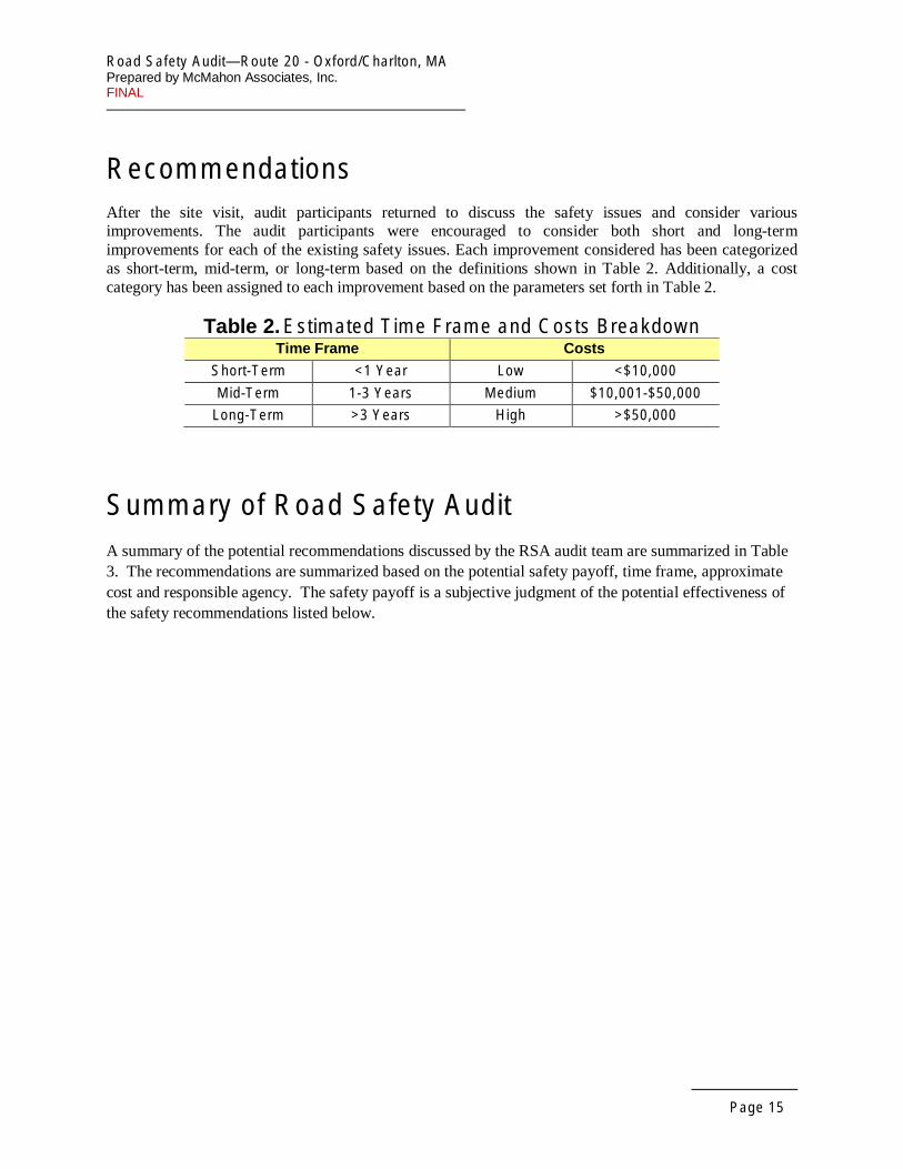
Recommendations After the site visit, audit participants returned to discuss the safety issues and consider various improvements. The audit participants were encouraged to consider both short and long-term improvements for each of the existing safety issues. Each improvement considered has been categorized as short-term, mid-term, or long-term based on the definitions shown in Table 2. Additionally, a cost category has been assigned to each improvement based on the parameters set forth in Table 2.
Table 2. Estimated Time Frame and Costs Breakdown Time Frame Costs
Short-Term <1 Year Low <$10,000
Mid-Term 1-3 Years Medium $10,001-$50,000
Long-Term >3 Years High >$50,000
Summary of Road Safety Audit A summary of the potential recommendations discussed by the RSA audit team are summarized in Table 3. The recommendations are summarized based on the potential safety payoff, time frame, approximate cost and responsible agency. The safety payoff is a subjective judgment of the potential effectiveness of the safety recommendations listed below.

Road Safety Audit— Route 20 - Oxford/Charlton, MA Prepared by McMahon Associates, Inc. FINAL
Page 16
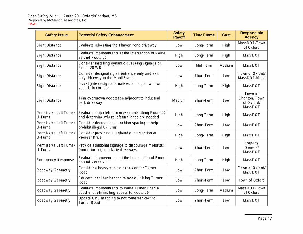
Table 3. Potential Safety Enhancement Summary Safety Issue Potential Safety Enhancement Safety
Payoff Time Frame Cost Responsible Agency
Interim Improvements Consider including regulatory speed limit signage with the speed feedback signage installed Low Short-Term Low MassDOT
Interim Improvements Consider providing advanced warning signage for U-Turns areas, particularly for heavy vehicles Medium Mid-Term Low MassDOT
Interim Improvements Consider providing truck turn out areas at designated U-Turn locations Medium Mid-Term High MassDOT
Interim Improvements Update GPS information to be consistent with current roadway conditions Low Short-Term Low MassDOT
Interim Improvements Evaluate locations for right-of-way acquisition Medium Mid-Term High MassDOT
Interim Improvements Consider providing breaks in the Route 20 barrier for emergency vehicle access Low Long-Term Low MassDOT
Interim Improvements Consider driveway modifications to provide adequate egress from private driveways Low Mid-Term Medium
Property Owners/
MassDOT
Interim Improvements Consider installation of additional delineator posts with shorter spacing between posts at both ends of the new guardrail
Low Short-Term Low MassDOT
Speeds Evaluate design improvements to reduce travel speeds and allow for speed limit reduction High Long-Term High MassDOT
Speeds Consider providing larger speed limit signs Low Short-Term Low MassDOT
Speeds Consider adding additional regulatory signs with speed feedback signage Medium Short-term Medium MassDOT
Speeds Evaluate locations that can be utilized as designated pull-off areas Medium Mid-term Medium
Town of Charlton/ Town
of Oxford/ MassDOT
Speeds Investigate funding sources to provide additional enforcement Low Mid-Term Low
Town of Charlton/ Town
of Oxford/ MassDOT
Speeds Consider providing additional advisory speed warning signage Medium Mid-Term Medium MassDOT
Road Safety Audit— Route 20 - Oxford/Charlton, MA Prepared by McMahon Associates, Inc. FINAL
Page 17
Safety Issue Potential Safety Enhancement Safety Payoff Time Frame Cost Responsible
Agency
Sight Distance Evaluate relocating the Thayer Pond driveway Low Long-Term High MassDOT/Town of Oxford
Sight Distance Evaluate improvements at the intersection of Route 56 and Route 20 High Long-Term High MassDOT
Sight Distance Consider installing dynamic queueing signage on Route 20 WB Low Mid-Term Medium MassDOT
Sight Distance Consider designating an entrance only and exit only driveway to the Mobil Station Low Short-Term Low Town of Oxford/
MassDOT/Mobil
Sight Distance Investigate design alternatives to help slow down speeds in corridor High Long-Term High MassDOT
Sight Distance Trim overgrown vegetation adjacent to industrial park driveway Medium Short-Term Low
Town of Charlton/ Town
of Oxford/ MassDOT
Permissive Left Turns/ U-Turns
Evaluate major left turn movements along Route 20 and determine where left turn lanes are needed High Long-Term High MassDOT
Permissive Left Turns/ U-Turns
Consider decreasing stanchion spacing to help prohibit illegal U-Turns Low Short-Term Low MassDOT
Permissive Left Turns/ U-Turns
Consider providing a jughandle intersection at Pioneer Drive High Long-Term High MassDOT
Permissive Left Turns/ U-Turns
Provide additional signage to discourage motorists from u-turning in private driveways Low Short-Term Low
Property Owners/
MassDOT
Emergency Response Evaluate improvements at the intersection of Route 56 and Route 20 High Long-Term High MassDOT
Roadway Geometry Consider a heavy vehicle exclusion for Turner Road Low Short-Term Low Town of Oxford/
MassDOT
Roadway Geometry Educate local businesses to avoid utilizing Turner Road Low Short-Term Low Town of Oxford
Roadway Geometry Evaluate improvements to make Turner Road a dead-end, eliminating access to Route 20 Low Long-Term Medium MassDOT/Town
of Oxford
Roadway Geometry Update GPS mapping to not route vehicles to Turner Road Low Short-Term Low MassDOT
Road Safety Audit— Route 20 - Oxford/Charlton, MA Prepared by McMahon Associates, Inc. FINAL
Page 18
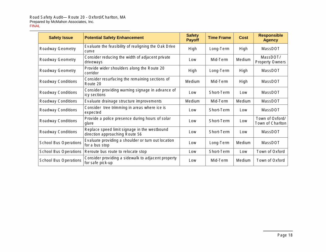
Safety Issue Potential Safety Enhancement Safety Payoff Time Frame Cost Responsible
Agency
Roadway Geometry Evaluate the feasibility of realigning the Oak Drive curve High Long-Term High MassDOT
Roadway Geometry Consider reducing the width of adjacent private driveways Low Mid-Term Medium MassDOT/
Property Owners
Roadway Geometry Provide wider shoulders along the Route 20 corridor High Long-Term High MassDOT
Roadway Conditions Consider resurfacing the remaining sections of Route 20 Medium Mid-Term High MassDOT
Roadway Conditions Consider providing warning signage in advance of icy sections Low Short-Term Low MassDOT
Roadway Conditions Evaluate drainage structure improvements Medium Mid-Term Medium MassDOT
Roadway Conditions Consider tree trimming in areas where ice is expected Low Short-Term Low MassDOT
Roadway Conditions Provide a police presence during hours of solar glare Low Short-Term Low Town of Oxford/
Town of Charlton
Roadway Conditions Replace speed limit signage in the westbound direction approaching Route 56 Low Short-Term Low MassDOT
School Bus Operations Evaluate providing a shoulder or turn out location for a bus stop Low Long-Term Medium MassDOT
School Bus Operations Reroute bus route to relocate stop Low Short-Term Low Town of Oxford
School Bus Operations Consider providing a sidewalk to adjacent property for safe pick-up Low Mid-Term Medium Town of Oxford
Road Safety Audit— Route 20 - Oxford/Charlton, MA Prepared by McMahon Associates, Inc. FINAL
Appendix A. RSA Meeting Agenda

Road Safety Audit— Route 20 - Oxford/Charlton, MA Prepared by McMahon Associates, Inc. FINAL
Appendix B. RSA Audit Team Contact List

Road Safety Audit— Route 20 - Oxford/Charlton, MA Prepared by McMahon Associates, Inc. FINAL
Participating Audit Team Members Date: February 26, 2016 Location: Oxford Police Department
Audit Team Phone Agency/ Affiliation Email Address Members Number
John Mastera MassDOT Highway Safety [email protected] 857-368-9648
Jim Danila MassDOT Traffic & Safety [email protected] 857-368-9640
Joe Frawley MassDOT District 3 [email protected] 508-929-3916
Lola Campbell MassDOT District 3 [email protected] 508-929-3887
Dan Daniska CMRPC [email protected] 508-459-3331
Yahaira Graxirena CMPRC [email protected] 508-459-3321
Brian Palaia Oxford Town Manager [email protected] 508-987-6030
Oxford Department of Public Sean Divoll [email protected] 508-987-6006 Works
Michael H assett Oxford Police Department [email protected]
Lt. Anthony Saad Oxford Police Department [email protected] 508-987-0156
Capt. Kenneth Oxford Fire Department [email protected] 508-987-6012 Sellers
Nicholas Lambert Oxford Fire Department [email protected] 508-723-2818
Chief James A. Charlton Police Department [email protected] 508-248-2251 Pervier
James. Lt. Jim Murphy Massachusetts State Police 508-829-8326 [email protected]
Lt. Tom Zona Massachusetts State Police [email protected] 508-347-3352
Phil Viveiros McMahon Associates [email protected] 508-823-2245
Allison Luff McMahon Associates [email protected] 508-823-2245
Road Safety Audit— Route 20 - Oxford/Charlton, MA Prepared by McMahon Associates, Inc. FINAL
Appendix C. Detailed Crash Data


1
2
3
4
5
6
7
8
9
10
11
12
13
14
15
16
17
18
19
20
21
22
23
24
25
26
27
28
29
30
31
32
33
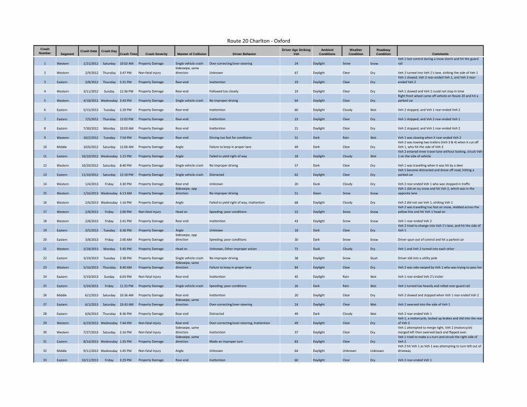
Route 20 Charlton ‐ Oxford Crash
Number Segment Crash Date Crash Day
Crash Time Crash Severity Manner of Collision Driver Behavior Driver Age Striking
Veh Ambient
Conditions Weather
Condition Roadway Condition Comments
Western 1/21/2012 Saturday 10:02 AM Property Damage Single vehicle crash Over‐correcting/over‐steering 24 Daylight Snow Snow Veh 1 lost control during a snow storm and hit the guard rail
Western 2/9/2012 Thursday 3:47 PM Non‐fatal injury Sideswipe, same direction Unknown 67 Daylight Clear Dry Veh 2 turned into Veh 1's lane, striking the side of Veh 1
Eastern 3/8/2012 Thursday 5:31 PM Property Damage Rear‐end Inattention 19 Daylight Clear Dry Veh 1 slowed, Veh 2 rear‐ended Veh 1, and Veh 3 rear‐ended Veh 2
Western 3/11/2012 Sunday 12:36 PM Property Damage Rear‐end Followed too closely 19 Daylight Clear Dry Veh 1 slowed and Veh 2 could not stop in time
Western 4/18/2012 Wednesday 2:43 PM Property Damage Single vehicle crash No improper driving 64 Daylight Clear Dry Right front wheel came off vehicle on Route 20 and hit a parked car
Eastern 5/15/2012 Tuesday 5:29 PM Property Damage Rear‐end Inattention 60 Daylight Cloudy Wet Veh 2 stopped, and Veh 1 rear‐ended Veh 2
Eastern 7/5/2012 Thursday 12:02 PM Property Damage Rear‐end Inattention 23 Daylight Clear Dry Veh 1 stopped, and Veh 2 rear‐ended Veh 1
Eastern 7/30/2012 Monday 10:03 AM Property Damage Rear‐end Inattention 21 Daylight Clear Dry Veh 2 stopped, and Veh 1 rear‐ended Veh 2
Western 10/2/2012 Tuesday 7:54 PM Property Damage Rear‐end Driving too fast for conditions 31 Dark Rain Wet Veh 1 was slowing when it rear‐ended Veh 2
Middle 10/6/2012 Saturday 12:06 AM Property Damage Angle Failure to keep in proper lane 49 Dark Clear Dry Veh 2 was towing two trailers (Veh 3 & 4) when it cut off Veh 1, who hit the side of Veh 3
Eastern 10/10/2012 Wednesday 1:15 PM Property Damage Angle Failed to yield right of way 18 Daylight Cloudy Wet Veh 2 entered inner travel lane without looking, struck Veh 1 on the side of vehicle
Western 10/20/2012 Saturday 8:40 PM Property Damage Single vehicle crash No improper driving 57 Dark Clear Dry Veh 1 was travelling when it was hit by a deer
Eastern 11/10/2012 Saturday 12:10 PM Property Damage Single vehicle crash Distracted 62 Daylight Clear Dry Veh 1 became distracted and drove off road, hitting a parked car
Western 1/4/2013 Friday 3:30 PM Property Damage Rear‐end Unknown 20 Dusk Cloudy Dry Veh 2 rear‐ended Veh 1 who was stopped in traffic
Western 1/16/2013 Wednesday 6:13 AM Property Damage Sideswipe, opp direction No improper driving 51 Dawn Snow Snow
Veh 1 slid on icy snow and hit Veh 2, which was in the opposite lane
Western 2/6/2013 Wednesday 1:16 PM Property Damage Angle Failed to yield right of way, Inattention 68 Daylight Cloudy Dry Veh 2 did not see Veh 1, striking Veh 1
Western 2/8/2013 Friday 2:00 PM Non‐fatal injury Head on Speeding; poor conditions 22 Daylight Snow Snow Veh 2 was travelling too fast on snow, skidded across the yellow line and hit Veh 1 head on
Western 2/8/2013 Friday 2:41 PM Property Damage Rear‐end Inattention 43 Daylight Snow Snow Veh 1 rear‐ended Veh 2
Eastern 3/5/2013 Tuesday 6:36 PM Property Damage Angle Unknown 18 Dark Clear Dry Veh 2 tried to change into Veh 1's lane, and hit the side of Veh 1
Eastern 3/8/2013 Friday 2:00 AM Property Damage Sideswipe, opp direction Speeding; poor conditions 30 Dark Snow Snow Driver spun out of control and hit a parked car
Western 3/18/2013 Monday 5:45 PM Property Damage Head on Unknown, Other improper action 72 Dusk Cloudy Dry Veh 1 and Veh 2 turned into each other
Eastern 3/19/2013 Tuesday 2:38 PM Property Damage Single vehicle crash No improper driving 38 Daylight Snow Slush Driver slid into a utility pole
Western 5/16/2013 Thursday 8:40 AM Property Damage Sideswipe, same direction Failure to keep in proper lane 84 Daylight Clear Dry Veh 2 was side‐swiped by Veh 1 who was trying to pass her
Eastern 5/19/2013 Sunday 6:03 PM Non‐fatal injury Rear‐end Inattention 45 Daylight Rain Wet Veh 1 rear‐ended Veh 2's trailer
Eastern 5/24/2013 Friday 11:25 PM Property Damage Single vehicle crash Speeding; poor conditions 26 Dark Rain Wet Veh 1 turned too heavily and rolled over guard rail
Middle 6/1/2013 Saturday 10:36 AM Property Damage Rear‐end Inattention 20 Daylight Clear Dry Veh 2 slowed and stopped when Veh 1 rear‐ended Veh 2
Eastern 6/1/2013 Saturday 10:43 AM Property Damage Sideswipe, same direction Over‐correcting/over‐steering 24 Daylight Clear Wet Veh 2 swerved into the side of Veh 1
Eastern 6/6/2013 Thursday 8:36 PM Property Damage Rear‐end Distracted 49 Dark Cloudy Wet Veh 2 rear‐ended Veh 1
Western 6/19/2013 Wednesday 7:44 PM Non‐fatal injury Rear‐end Over‐correcting/over‐steering, Inattention 49 Daylight Clear Dry Veh 1, a motorcycle, locked up brakes and slid into the rear of Veh 2
Western 7/27/2013 Saturday 2:16 PM Non‐fatal injury Sideswipe, same direction Inattention 37 Daylight Clear Dry
Veh 1 attempted to merge right, Veh 2 (motorcycle) merged left then swerved back and flipped over.
Eastern 8/14/2013 Wednesday 1:35 PM Property Damage Sideswipe, same direction Made an improper turn 83 Daylight Clear Dry
Veh 1 tried to make a u‐turn and struck the right side of Veh 2
Middle 9/11/2013 Wednesday 1:45 PM Non‐fatal injury Angle Unknown 64 Daylight Unknown Unknown Veh 2 hit Veh 1 as Veh 1 was attempting to turn left out of driveway
Eastern 10/11/2013 Friday 3:29 PM Property Damage Rear‐end Inattention 60 Daylight Clear Dry Veh 2 rear‐ended Veh 1
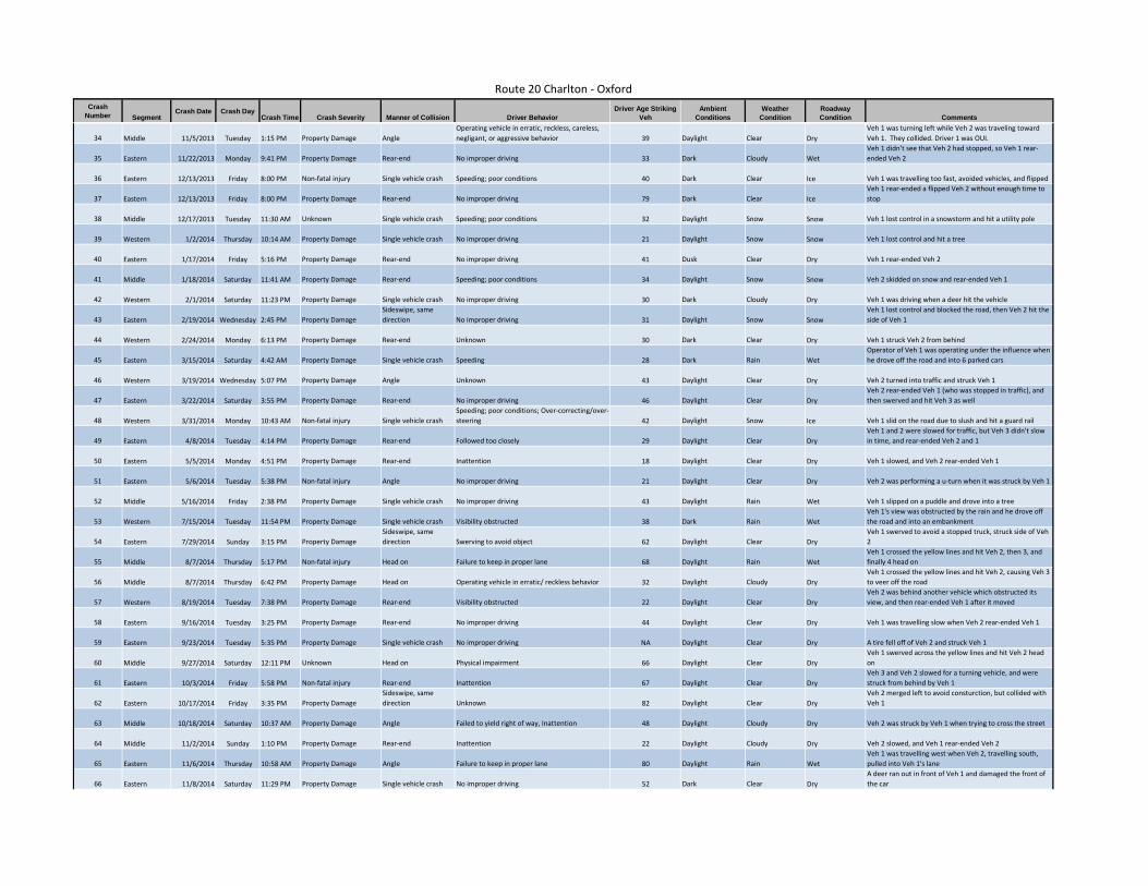
Route 20 Charlton ‐ Oxford Cr ash Driver Age Strikin g Ambient Weather Roadway Crash Date Crash Day Number Segment Crash Time Crash Severity Manner of Collision Driver Behavior Veh Condition s Condition Condition Comments
Operating vehicle in erratic, reckless, careless, Veh 1 was turning left while Veh 2 was traveling toward 34 Middle 11/5/2013 Tuesday 1:15 PM Property Damage Angle negligant, or aggressive behavior 39 Daylight Clear Dry Veh 1. They collided. Driver 1 was OUI.
Veh 1 didn't see that Veh 2 had stopped, so Veh 1 rear‐35 Eastern 11/22/2013 Monday 9:41 PM Property Damage Rear‐end No improper driving 33 Dark Cloudy Wet ended Veh 2
36 Eastern 12/13/2013 Friday 8:00 PM Non‐fatal injury Single vehicle crash Speeding; poor conditions 40 Dark Clear Ice Veh 1 was travelling too fast, avoided vehicles, and flipped Veh 1 rear‐ended a flipped Veh 2 without enough time to
37 Eastern 12/13/2013 Friday 8:00 PM Property Damage Rear‐end No improper driving 79 Dark Clear Ice stop
38 Middle 12/17/2013 Tuesday 11:30 AM Unknown Single vehicle crash Speeding; poor conditions 32 Daylight Snow Snow Veh 1 lost control in a snowstorm and hit a utility pole
39 Western 1/2/2014 Thursday 10:14 AM Property Damage Single vehicle crash No improper driving 21 Daylight Snow Snow Veh 1 lost control and hit a tree
40 Eastern 1/17/2014 Friday 5:16 PM Property Damage Rear‐end No improper driving 41 Dusk Clear Dry Veh 1 rear‐ended Veh 2
41 Middle 1/18/2014 Saturday 11:41 AM Property Damage Rear‐end Speeding; poor conditions 34 Daylight Snow Snow Veh 2 skidded on snow and rear‐ended Veh 1
42 Western 2/1/2014 Saturday 11:23 PM Property Damage Single vehicle crash No improper driving 30 Dark Cloudy Dry Veh 1 was driving when a deer hit the vehicle Sideswipe, same Veh 1 lost control and blocked the road, then Veh 2 hit the
43 Eastern 2/19/2014 Wednesday 2:45 PM Property Damage direction No improper driving 31 Daylight Snow Snow side of Veh 1
44 Western 2/24/2014 Monday 6:13 PM Property Damage Rear‐end Unknown 30 Dark Clear Dry Veh 1 struck Veh 2 from behind Operator of Veh 1 was operating under the influence when
45 Eastern 3/15/2014 Saturday 4:42 AM Property Damage Single vehicle crash Speeding 28 Dark Rain Wet he drove off the road and into 6 parked cars
46 Western 3/19/2014 Wednesday 5:07 PM Property Damage Angle Unknown 43 Daylight Clear Dry Veh 2 turned into traffic and struck Veh 1 Veh 2 rear‐ended Veh 1 (who was stopped in traffic), and
47 Eastern 3/22/2014 Saturday 3:55 PM Property Damage Rear‐end No improper driving 46 Daylight Clear Dry then swerved and hit Veh 3 as well Speeding; poor conditions; Over‐correcting/over‐
48 Western 3/31/2014 Monday 10:43 AM Non‐fatal injury Single vehicle crash steering 42 Daylight Snow Ice Veh 1 slid on the road due to slush and hit a guard rail Veh 1 and 2 were slowed for traffic, but Veh 3 didn't slow
49 Eastern 4/8/2014 Tuesday 4:14 PM Property Damage Rear‐end Followed too closely 29 Daylight Clear Dry in time, and rear‐ended Veh 2 and 1
50 Eastern 5/5/2014 Monday 4:51 PM Property Damage Rear‐end Inattention 18 Daylight Clear Dry Veh 1 slowed, and Veh 2 rear‐ended Veh 1
51 Eastern 5/6/2014 Tuesday 5:38 PM Non‐fatal injury Angle No improper driving 21 Daylight Clear Dry Veh 2 was performing a u‐turn when it was struck by Veh 1
52 Middle 5/16/2014 Friday 2:38 PM Property Damage Single vehicle crash No improper driving 43 Daylight Rain Wet Veh 1 slipped on a puddle and drove into a tree Veh 1's view was obstructed by the rain and he drove off
53 Western 7/15/2014 Tuesday 11:54 PM Property Damage Single vehicle crash Visibility obstructed 38 Dark Rain Wet the road and into an embankment Sideswipe, same Veh 1 swerved to avoid a stopped truck, struck side of Veh
54 Eastern 7/29/2014 Sunday 3:15 PM Property Damage direction Swerving to avoid object 62 Daylight Clear Dry 2 Veh 1 crossed the yellow lines and hit Veh 2, then 3, and
55 Middle 8/7/2014 Thursday 5:17 PM Non‐fatal injury Head on Failure to keep in proper lane 68 Daylight Rain Wet finally 4 head on Veh 1 crossed the yellow lines and hit Veh 2, causing Veh 3
56 Middle 8/7/2014 Thursday 6:42 PM Property Damage Head on Operating vehicle in erratic/ reckless behavior 32 Daylight Cloudy Dry to veer off the road Veh 2 was behind another vehicle which obstructed its
57 Western 8/19/2014 Tuesday 7:38 PM Property Damage Rear‐end Visibility obstructed 22 Daylight Clear Dry view, and then rear‐ended Veh 1 after it moved
58 Eastern 9/16/2014 Tuesday 3:25 PM Property Damage Rear‐end No improper driving 44 Daylight Clear Dry Veh 1 was travelling slow when Veh 2 rear‐ended Veh 1
59 Eastern 9/23/2014 Tuesday 5:35 PM Property Damage Single vehicle crash No improper driving NA Daylight Clear Dry A tire fell off of Veh 2 and struck Veh 1 Veh 1 swerved across the yellow lines and hit Veh 2 head
60 Middle 9/27/2014 Saturday 12:11 PM Unknown Head on Physical impairment 66 Daylight Clear Dry on Veh 3 and Veh 2 slowed for a turning vehicle, and were
61 Eastern 10/3/2014 Friday 5:58 PM Non‐fatal injury Rear‐end Inattention 67 Daylight Clear Dry struck from behind by Veh 1 Sideswipe, same Veh 2 merged left to avoid consturction, but collided with
62 Eastern 10/17/2014 Friday 3:35 PM Property Damage direction Unknown 82 Daylight Clear Dry Veh 1
63 Middle 10/18/2014 Saturday 10:37 AM Property Damage Angle Failed to yield right of way, Inattention 48 Daylight Cloudy Dry Veh 2 was struck by Veh 1 when trying to cross the street
64 Middle 11/2/2014 Sunday 1:10 PM Property Damage Rear‐end Inattention 22 Daylight Cloudy Dry Veh 2 slowed, and Veh 1 rear‐ended Veh 2 Veh 1 was travelling west when Veh 2, travelling south,
65 Eastern 11/6/2014 Thursday 10:58 AM Property Damage Angle Failure to keep in proper lane 80 Daylight Rain Wet pulled into Veh 1's lane A deer ran out in front of Veh 1 and damaged the front of
66 Eastern 11/8/2014 Saturday 11:29 PM Property Damage Single vehicle crash No improper driving 52 Dark Clear Dry the car
Route 20 Charlton ‐ Oxford Cr ash Driver Age Strikin g Ambient Weather Roadway Crash Date Crash Day Number Segment Crash Time Crash Severity Manner of Collision Driver Behavior Veh Condition s Condition Condition Comments
Veh 1 oversteered/overturned across westbound lanes of 67 Western 11/11/2014 Tuesday 10:20 PM Property Damage Single vehicle crash Over‐correcting/over‐steering/overturn 30 Dark Unknown Unknown roadway
Veh 1 slowed, and was hit by Veh 2. Then Veh 2 was hit by 68 Western 12/2/2014 Tuesday 4:49 PM Non‐fatal injury Rear‐end Inattention 60 Dusk Clear Dry Veh 3.
Sideswipe, same 69 Middle 12/4/2014 Thursday 7:05 PM Property Damage direction Inattention, Made an improper turn 33 Dark Clear Dry Veh 1 turned right into Veh 2 without seeing it
Operating vehicle in erratic, reckless, careless, Driver was operating under the influence and went off the 70 Middle 12/6/2014 Saturday 2:09 AM Non‐fatal injury Single vehicle crash negligant, or aggressive behavior 23 Dark Cloudy Wet road and into a utility pole
71 Eastern 12/28/2014 Sunday 12:29 PM Non‐fatal injury Rear‐end Inattention 31 Daylight Cloudy Wet Veh 1 became distracted and rear‐ended Veh 2
72 Middle 1/3/2015 Saturday 5:43 PM Property Damage Single vehicle crash No improper driving 45 Dark Snow Snow Veh 1 spun out of control from the snow and hit a guardrail Veh 1 accelerated around a corner and swerved off the
73 Western 1/16/2015 Friday 8:33 AM Unknown Single vehicle crash Over‐correcting/over‐steering 32 Daylight Clear Dry road into a stone wall
74 Eastern 2/21/2015 Saturday 6:13 PM Property Damage Head on Over‐correcting/over‐steering 35 Dark Clear Ice Veh 2 spun out of control and collided with Veh 1
75 Western 2/26/2015 Thursday 8:36 AM Property Damage Rear‐end Inattention 42 Daylight Cloudy Dry Veh 1 was stopped in traffic when Veh 2 rear‐ended Veh 1
76 Western 2/27/2015 Friday 10:10 AM Property Damage Rear‐end Followed too closely, Inattention 92 Daylight Clear Dry Veh 2 rear‐ended Veh 1
77 Western 3/20/2015 Friday 5:40 PM Property Damage Angle No improper driving 28 Daylight Snow Snow Veh 1 changed lanes and lost control, colliding with Veh 2 Veh 1 stopped for turning vehicle, and Veh 2 struck Veh 1
78 Eastern 4/13/2015 Monday 2:35 PM Property Damage Rear‐end Followed too closely 19 Daylight Clear Dry from behind Sideswipe, same Veh 2 turned into Veh 1's lane, and Veh 1 continued to
79 Middle 5/6/2015 Wednesday 4:48 PM Property Damage direction Unknown 41 Daylight Clear Dry travel forward, striking Veh 2 Veh 2 and Veh 2 were both pulling into moving lane when
80 Eastern 5/22/2015 Friday 10:44 AM Non‐fatal injury Rear‐end Followed too closely 34 Daylight Clear Dry Veh 2 rear‐ended Veh 1 Veh 2 was stopped for construction, while Veh 1 didn't
81 Eastern 6/3/2015 Wednesday 12:14 PM Non‐fatal injury Rear‐end Inattention 24 Daylight Clear Dry notice it, and rear‐ended Veh 2 Sideswipe, same
82 Middle 6/17/2015 Wednesday 4:14 PM Non‐fatal injury direction Failure to keep in proper lane, Unknown 22 Daylight Clear Dry Veh 2 cut off Veh 1; 2 injuries
83 Middle 6/22/2015 Monday 4:50 PM Property Damage Rear‐end Inattention, Followed too closely 25 Daylight Clear Dry Veh 2 rear‐ended Veh 1 Veh 1,2,3 were all stopped in traffic while Veh 4 rear‐ended
84 Eastern 9/25/2015 Friday 5:07 PM Property Damage Rear‐end Inattention 46 Daylight Clear Dry Veh 3, who rear‐ended Veh 2, and then v1 Sideswipe, same Veh 1 tried to cross into Veh 2's lane, and collided with Veh
85 Eastern 9/28/2015 Monday 2:31 PM Property Damage direction Failure to keep in proper lane 26 Daylight Clear Dry 2
86 Middle 9/30/2015 Wednesday 7:27 AM Property Damage Rear‐end Inattention, Unknown 40 Daylight Rain Wet Veh 1 rear‐ended Veh 2
87 Eastern 10/30/2015 Friday 12:02 PM Non‐fatal injury Rear‐end Inattention 74 Daylight Clear Dry Veh 2 struck the rear of Veh 1, who had stopped
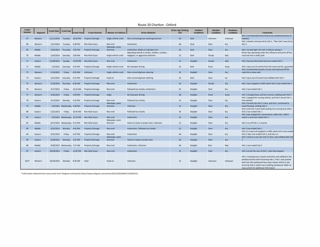
Veh 1 traveling east crossed centerline and collided in the westbound lane with oncoming Veh 2. Veh 1 was pushed
N/A* Western 10/26/2015 Monday 8:30 AM Fatal Head on Unknown 31 Daylight Unknown Unknown back into the eastbound lane upon impact where it was struck by Veh 3, which was travelling eastbound. Refer to news article for additional information
* Information obtained from news article from Telegram and Gazette (http://www.telegram.com/article/20151026/NEWS/151029375)