ROAD SAFETY AUDIT - Welcome to MassDOT MPO making a Road Safety Audit (RSA) ... Susan Hirl VAI Scott...
43
ROAD SAFETY AUDIT Route 113 (Storey Avenue) at Woodman Way and Low Street Newburyport, MA May 27, 2015 Prepared For: MassDOT Prepared By: Bayside Engineering, Inc. 600 Unicorn Park Drive Woburn, MA 01801
Transcript of ROAD SAFETY AUDIT - Welcome to MassDOT MPO making a Road Safety Audit (RSA) ... Susan Hirl VAI Scott...

ROAD SAFETY AUDIT
Route 113 (Storey Avenue) at Woodman Way and Low Street
Newburyport, MA
May 27, 2015
Prepared For: MassDOT
Prepared By: Bayside Engineering, Inc.
600 Unicorn Park Drive Woburn, MA 01801


Road Safety Audit Route 113 (Route 113) at Woodman Way and Low Street, Newburyport, MA Bayside Engineering, Inc.
Table of Contents Background ................................................................................................................................. 1
Project Data ................................................................................................................................. 1
Project Location and Description .............................................................................................. 4
Road SafetyAudit: Observations and Potential Safety Enhancements ................................. 5
Summary of Road Safety Audit ............................................................................................... 19
List of Appendices
Appendix A. RSA Meeting Agenda Appendix B. RSA Audit Team Contact List Appendix C. Detailed Crash Data Appendix D. RSA Procedure
List of Figures
Figure 1. Locus Map .............................................................................................................................. 3 Figure 2. Route 113 (Storey Avenue) at Woodman Way and Low Street..………..………………...…5
List of Tables
Table 1. Participating Audit Team Members ....................................................................................... 2 Table 2. Potential Safety Enhancements Summary ............................................................................ 20

Page 1
Background The Federal Highway Administration defines a Road Safety Audit (RSA) as the formal safety examination of an existing or future road or intersection by an independent, multidisciplinary team. The purpose of an RSA is to identify potential safety issues and possible opportunities for safety improvements considering all roadway users. MassDOT’s RSA procedures are defined in Appendix D.
The four-way intersection of Route 113 (Storey Avenue), Woodman Way and Low Street in the City of Newburyport operates under traffic signal control. Woodman Way and Low Street are offset approximately 70 feet (ft). The intersection has been determined by the Massachusetts Department of Transportation (MassDOT) to be on the top 5% high crash list for the Boston Region MPO making a Road Safety Audit (RSA) a requirement prior to the 25% Design Phase. Tropic Star Development (Developer) is also proposing to redevelop the existing Shell gas station site in the southwest quadrant of the intersection. The Developer is looking to close several existing driveways along Route 113 and construct a CVS pharmacy on the site.
The intersection is located east of the Route 95/Route 113 interchange. The Route 95 ramps with Route 113 are signalized, as well as the Park and Ride driveway. East of the Woodman Way and Low Street intersection, the intersections of Route 113 with Port Plaza and the Market Basket shopping center are also under traffic signal control. The study intersection is shown in Figure 1, Locus Map.
In response to the high incidence of crashes at this intersection, MassDOT requires that this RSA be prepared to identify safety issues and enhancements that may be implemented in conjunction with the redevelopment of the Shell gas station site or as improvements associated with future public and private development projects.
Project Data The RSA meeting was held on Thursday April 16, 2015 at the Mayor’s Conference Room at the Newburyport City Hall located at 60 Pleasant Street in Newburyport. The audit team members and their affiliations that participated in the RSA meeting for the intersection of Route 113 at Woodman Way and Low Street are listed in Table 1.

Page 2
Table 1. Participating Audit Team Members Audit Team Member Agency/Affiliation William Ullom MassDOT Safety Lisa Schletzbaum MassDOT Safety John Mastera MassDOT Safety Jeff Gomes MassDOT District 4 Traffic Jim Terlizzi Merrimack Valley Planning Commission Andrew Port Newburyport Planning Department, City Planner Jim McCarthy Newburyport Planning Board Jon-Eric White Newburyport Engineering Department, City Engineer Wayne Amaral Newburyport Public Services, Deputy Director Mark Murray Newburyport Police Department, Marshal Christopher LaClaire Newburyport Fire Department, Fire Chief Scott Mitchell Tropic Star Development, Developer Susan Hirl VAI Scott Thornton VAI Steve Boudreau VAI Jake Carmody VAI Ken Cram Bayside Engineering
The project locus is shown in Figure 1.

Page 3
Figure 1 Locus Map
The RSA meeting agenda is provided in Appendix A and the audit team contact information is provided in Appendix B.
Prior to the actual RSA meeting on April 16, 2015, the audit team was provided with a collisions diagram and crash data at the intersection of Route 113 at Woodman Way and Low Street (contained in Appendix C). Before attending the RSA, the participants were encouraged to conduct their own site review of the intersection to become familiar with the safety issues to be discussed.
Project Locus

Page 4
The intersection collisions diagram was reconstructed from a review of crash records provided to VAI by the Newburyport Police Department. The records cover the period from 2008 through December 2014 during which time a total of 45 crashes were reported at the intersection. The great majority of accidents were of two types: approximately 45% (20 of 45) were the rear-end type accident and approximately 25% (11 of 50) were the angle type accident, representing 70% (31 of 45) of all accidents. There were no fatalities and one fifth (9 of 45) of the accidents involved personal injury. In general, many of the accidents occurred during daylight hours (77%) under clear weather and dry road surface conditions. This information was reviewed by the team at the meeting in conjunction with aerial photography and street level views afforded by Google Earth.
Project Location and Description Route 113 at Woodman Way and Low Street Woodman Way and Low Street intersect Route 113 from the north and south, respectively, to form this five-legged, off-set intersection under traffic signal control. The Route 113 eastbound approach consists of a 10-foot wide left-turn lane, two 11-foot wide through travel lanes and an 11-foot wide right-turn lane with a 1-foot wide marked shoulder. The Route 113 westbound approach consists of a 10-foot wide left-turn lane and two 12-foot wide general-purpose travel lanes with a 1-foot wide marked shoulder. The directions of travel along Route 113 are separated by a double-yellow centerline. The posted speed limit on Route 113 is 35 miles per hour (mph). The Woodman Way southbound approach consists of a 10-foot wide left-turn/through travel lane and an 11-foot wide right-turn lane with a 1-foot wide marked shoulder. The directions of travel along Woodman Way are separated by a double-yellow centerline. The Low Street northbound approach consists of a 12-foot wide left-turn lane and a 12-foot wide left/right-turn lane with a 1-foot wide marked shoulder. Low Street approaches from the south and the grade is approximately 4 percent. The directions of travel along Low Street are separated by a double-yellow centerline. The fifth leg is the exit only driveway from the Shell gas station in the southwest quadrant of the intersection. The approach is approximately 22-feet wide and permits exiting movements only. Sidewalks are provided along both sides of Route 113 and along the east side of Low Street and Woodman Way. Illumination of Route 113 is provided by way of street lights mounted on wood poles. Land use in the vicinity of the intersection consists of a Dunkin Donuts, a bank, a 7-11 convenience store and the Shell gas station. The traffic signal operates in a coordinated, four-phase, fully-actuated mode, and is interconnected and coordinated with the traffic control signals along the Route 113 corridor between Daniel Lucy Way and the driveway to the Market Basket Plaza. Signal phases are provided for the Route 113 left-turn movements; Route 113 through movements; Low Street movements/Route 113 eastbound right-turn movement; and Woodman Way/Shell gas station drive movement. Pedestrian traffic signal equipment and concurrent (with the non-conflicting vehicle phase) pedestrian phasing are provided as part of the traffic signal system.

Page 5
Figure 2 Route 113 (Route 113) at Woodman Way and Low Street
Road Safety Audit: Observations and Potential Safety Enhancements After the audit team participated in the RSA site visit on April 16, 2015, the audit team members returned to the meeting room at the Newburyport Mayor’s Conference Room and a group discussion was held on the various safety issues that were observed to have an impact on the intersection safety. The safety issues that were observed and discussed include:
1. Left-turns out of Dunkin Donuts exit driveway. 2. Confusion of vehicles exiting Woodman Way and Low Street. 3. Red light running. 4. Eastbound Route 113 right-turns accelerating to Low Street southbound. 5. Pedestrian crossing across west leg of intersection. 6. One fatality approximately eight years ago. 7. Queuing on Low Street. 8. Driveways at intersection/courtesy crashes. 9. Eastbound Route 113 lane usage. 10. Vehicle detection issues. 11. Access into Dunkin Donuts driveway from the east. 12. Pre-emption for emergency response vehicles on Low Street.

Page 6
13. Lack of Bicycle accommodations. 14. Roadway curvature east of the intersection travelling westbound (alignment). 15. Excessive speeds. 16. Visual distractions/blockages. 17. Trucks through intersection to industrial area. 18. Pedestrian/Vehicle conflicts. 19. Pedestrian ramps. 20. Sign placement. 21. Pavement condition.
Each of the safety issues listed above is described in more detail in the following paragraphs along with the potential enhancements discussed during the RSA.
Observed Safety Issue # 1- Left-turns out of Dunkin Donuts Driveway:
The Route 113 at Woodman Way and Low Street intersection is abutted by commercial activity on all four corners with a number of driveways within close proximity to the intersection. The Dunkin Donuts restaurant in the northwest corner has an entrance driveway and a separate exit only driveway on Route 113 and a full access driveway on Woodman Way. In addition, the Shell gas station in the southwest corner has two wide driveways on Route 113 and a driveway on Low Street. The easternmost Shell station driveway is the fifth leg into the intersection and under traffic signal control. A 7-11 convenience store is in the southeast corner and has a driveway on Route 113 and a driveway on Low Street. Located in the northeast corner of the intersection is a bank with an entrance only driveway on Route 113 and a driveway on Woodman Way.
The Dunkin Donuts exit driveway to Route 113 was designed to permit right-turns out only. Town officials familiar with the location have stated that drivers do not obey the intended right-turn only use. The collisions diagram illustrates two rear-end accidents involving vehicles travelling westbound on Route 113. Left-turns out of this driveway creates an issue because exiting vehicles need to cross two lanes of traffic while at the same time causing westbound Route 113 vehicles to slow down or stop, and in some cases causing rear-end crashes on Route 113. “Courtesy crashes” are further discussed under Observed Safety Issue # 8.
Dunkin Donuts Exit to Route 113

Page 7
Potential Safety Enhancements:
1. Review and evaluate possibility of enforcing driveway operation. In particular, check the original Site Plan approval plans for approved signage and/or pavement markings.
2. Install signage at the Dunkin Donuts exit only driveways so that drivers are encouraged to obey intended usage of right-turn out only.
3. Enforce the intended “in” and “out” use of the designated driveways.
Observed Safety Issue # 2 – Confusion of vehicles exiting Woodman Way and Low Street:
The south leg of Low Street and the north leg of Woodman Way are offset and do not align directly opposite each other. The Low Street approach consists of an exclusive left-turn lane and a shared left-turn/right-turn lane. The tracking lines for the double-left turns from Low Street to Route 113 westbound are faded and are located such that vehicles in the right hand left-turn lane tend to make wide, swinging left-turn maneuvers. With the relatively long travel path for these left-turning vehicles, vehicles tend to cross travel lanes while executing the left-turn. This leads to some driver confusion as to ‘where to be’ while executing a left-turn form Low Street. The collisions diagram shows five angle type crashes of westbound vehicles crossing all lanes of traffic and one crossing crashes of the Low Street Left-turning westbound vehicles.
Potential Safety Enhancements:
1. Update signage and replace pavement markings and tracking lines. Check to make sure tracking lines are placed correctly.
2. Upgrade intersection traffic signal control and vehicle detection that will allow the intersection to operate more efficiently.
Low Street to Route 113 Westbound

Page 8
Observed Safety Issue # 3 – Red Light Running:
Travelling along Route 113 eastbound and westbound, it is difficult to discern the Woodman Way and Low Street intersection approaches. Drivers unfamiliar with the intersection may not know that the intersection is as long as it is, particularly for Route 113. Mast arms are currently installed close to the STOP line, making the intersection appear smaller. Three (3) of the crashes resulted from vehicles running the red light. In all three crashes, a vehicle travelling westbound on Route 113 was involved. As a result of the long distance to cross the intersection on Route 113, there is a lengthy clearance interval of six (6) seconds. Also, when following large trucks, it is difficult to see signal heads. Red light-running was also mentioned at the RSA meeting for vehicles exiting Low Street, but the crash data does not indicate if any collisions were specifically related to this approach.
Potential Safety Enhancements:
1. Realign the side street approaches to align opposite one another as this would shorten the distance a vehicle needs to traverse the intersection.
2. Evaluate relocating mast arms with signal heads at the far side of the intersection.
3. Upgrade traffic signal control and provide additional side mounted signal heads on posts for increased visibility.
4. Re-evaluate clearance intervals and retime signal, if necessary.
5. Improve enforcement.
Route 113 Looking West

Page 9
Observed Safety Issue # 4 – Eastbound Route 113 Right-turns Accelerating to Low Street Southbound:
Travelling along Route 113 eastbound to Low Street southbound, there is an exclusive right-turn lane. This right-turn lane crosses the exit only driveway from the Shell gas station, and then has a large radius for the right-turn maneuver onto Low Street. Vehicles tend to accelerate through this lane onto Low Street. The collisions diagram shows one crash at the Shell gas station exit, four rear-end crashes southbound on Low Street and one southbound sideswipe crash. Based on the crash data, Driver Inattention was listed as the primary cause of five of the six crashes.
Potential Safety Enhancements:
1. Relocate the STOP bar for the right-turn lane closer to Low Street (staggered from through lanes on Route 113 eastbound).
2. Consider closing the Shell gas station driveway.
3. Consider eliminating the right-turn overlap phase. Observed Safety Issue # 5 – Pedestrian Crossing Across West Leg of Intersection: Crosswalks exist across the Woodman Way, Low Street and Route 113 eastern leg of the intersection. There is no crosswalk across the Route 113 western leg of the intersection. Across from the Shell gas station is the Dunkin Donuts. Pedestrians have been reported crossing to get to the Dunkin Donuts in front of the Shell gas
Right Turn Radius on Route 113 Eastbound
Looking north to Woodman Way

Page 10
station without crossing Low Street, then Route 113 and then Woodman Way to avoid walking the extra distance.
Potential Safety Enhancements:
1. Consider adding a crosswalk across the Route 113 eastbound approach with pedestrian actuation.
Observed Safety Issue # 6 – One Fatality Approximately Eight Years Ago: The Newburyport Police Department indicated at the RSA that approximately eight years ago there was a fatality involved crash at this intersection. No details were available at this time. It is recommended that this particular crash be researched, and if necessary, incorporate appropriate design into any intersection reconstruction. Observed Safety Issue # 7 – Queuing on Low Street: Observations and anecdotal evidence indicate that there are oftentimes long queues on the Low Street approach to the intersection, particularly during the evening peak hour. It was stated that this may be a 3:00 PM issue associated with industrial park traffic getting out for the day. However, Route 113 traffic is noted to typically experience very little queueing.
Potential Safety Enhancements:
1. Consider additional vehicle detection (queue detectors) on Low Street to allow additional time for the Low Street approach.
2. Consider widening the Low Street approach to include a separate right-turn lane. This will increase capacity on the Low Street approach.
3. Review signal timing and phasing to improve intersection operations.
Low Street Approaching Route 113

Page 11
4. Inform trucking companies within the industrial park of alternate truck routes in order to avoid the Low Street intersection.
Observed Safety Issue # 8 – Driveways at Intersections/Courtesy Crashes: Audit team members discussed and noted on the intersection Crash Data Summary Table that the driveways near the intersection experience a high number of “courtesy” crashes at driveways along Route 113 and along Low Street (particularly Dunkin Donuts and the Institution for Savings bank). That is, crashes resulting when a driver (who is not involved in the crash) stops to allow another driver to enter the roadway who then hits or is hit by a third vehicle who did not see the on-coming vehicle. These types of crashes appear to be common due to the intersection congestion, the offset alignment of the intersection requiring split phasing and typically longer queues, and turning maneuvers into or out of the many driveways near the intersection along an undivided multi-lane roadway. A similar condition could exist under the build scenario for the proposed Shell gas station redevelopment. It was also discussed that measures to eliminate left-turns be considered. This would include providing a median along Route 113. A median would restrict access to developments along Route 113 to right turn in/out only but would prove problematic to the businesses located on Route 113 through potential loss of business. Additionally, provisions would need to be made to safely accommodate U-turn maneuvers. Potential Safety Enhancements: 1. Close driveways at the intersection. This would eliminate the courtesy crash at the
intersection, but would require the City or MassDOT to take the properties in question.
2. Installation of a median along Route 113 to prohibit left-turns. Prohibition of left-turns would reduce the number of vehicle conflicts.
3. Installation of NO LEFT SIGNS and modifying driveway configurations to prohibit left-turns.
Shell Station Driveway to Low Street

Page 12
Observed Safety Issue # 9 – Eastbound Route 113 Right-Turn Lane Usage: Audit team members noted on the day of the RSA that vehicles were observed using the Route 113 eastbound right-turn lane to travel through the intersection and not onto Low Street. Currently, there is no lane designation signage directing drivers to which lanes are for exclusive or through use. Audit team members also commented about the cut-through traffic through the Shell gas station. Potential Safety Enhancements: 1. Review existing signage and lane alignment approaching the intersection to make sure
vehicles travelling through or turning right onto Low Street are in the correct lane.
2. Add diagrammatic lane assignment signage.
3. Install dashed lines at the approach of the right-turn lane to align through vehicles on Route 113.
Observed Safety Issue # 10 – Vehicle Detection Issues: It was observed by the audit team that vehicles turning left onto Woodman Way from Route 113 eastbound are sometimes not detected, and the protected left-turn phase is not called. This leads to vehicles making left-turns when there is clearly a red indication, or, using the Dunkin Donuts driveway to cut-through the Dunkin Donuts site to gain access to Woodman Way. Potential Safety Enhancements: 1. Check the video detection cameras and repair/replace as necessary.
Route 113 Eastbound Approaching Low Street

Page 13
Observed Safety Issue # 11 – Access into Dunkin Donuts Driveway from the East: It was observed that vehicles entering the Dunkin Donuts entrance slow down significantly to negotiate the right-turn maneuver into Dunkin Donuts. This slow down impacts drivers following, which if impatient, may try to get to the left to by-pass vehicles entering Dunkin Donuts or cause rear-end crashes. Potential Safety Enhancements: 1. It was suggested that the possibility of widening the departure leg of Route 113 (westbound)
to allow for a wider shoulder or “pull-out” for Dunkin Donuts entering traffic be considered.
Dunkin Donuts from the Southeast

Page 14
Observed Safety Issue # 12 – Pre-emption for emergency response vehicles on Low Street: Observations from Emergency Response Personnel indicate that the long queues on the Low Street approach to the intersection are problematic for emergency vehicles to clear the intersection in response to an emergency (there is a fire station to the south which would use Low Street to respond to an emergency). Potential Safety Enhancements: 1. Consider additional pre-emption
emitter to the south on Low Street to provide additional time to clear the Low Street approach and allow emergency vehicles to clear the intersection.
Observed Safety Issue # 13 – Lack of Bicycle Accommodations: Observations of the existing intersection indicate that there are currently no bicycle accommodations. The City of Newburyport has indicated that they would like to see some bicycle accommodations as they are actively trying to connect existing bicycle routes through the City, as well as to coordinate/connect with the new bicycle trail incorporated into the Whittier Bridge project. Two crashes involved bicycles. The first was a bicyclist exiting Dunkin Donuts into the path of a car turning left from Low Street. The second involved a bicyclist heading south on Woodman Way and the vehicle was also on Woodman Way heading south and turned right and hit the bicyclist.
Low Street Approaching Route 113
Route 113 Eastbound

Page 15
Potential Safety Enhancements: 1. Consider adding bicycle lanes and associated detection into any intersection re-
design/improvement.
2. Consider adding separated bicycle lanes and associated detection into any intersection re-design/improvement.
Observed Safety Issue # 14 – Roadway Curvature East of the Intersection Travelling Westbound: It was discussed by the audit team that east of the intersection, the Route 113 westbound travel lanes are skewed slightly such that as you travel around a bend in the road, the alignment directs vehicles in the inside travel lane into the outside travel lane at the intersection. This area was not included in the collisions analysis and therefore, any collisions resulting from the skewed alignment are not shown in the collision diagram. Potential Safety Enhancements: 1. Widen and realign this section of Route 113 such that the through lanes on Route 113
westbound align with the Route 113 westbound through lanes at the intersection.
2. It was suggested that advance warning signing or horizontal alignment warning signing be installed to make drivers aware of the road conditions and the alignment more visible.
3. Install new pavement markings to replace existing pavement markings that have faded and
worn out over time. Observed Safety Issue # 15 – Excessive Speeds: Excessive speeds through the intersection were also discussed. Traffic calming was raised at the RSA meeting as a means to reduce speeds. Traffic calming typically incorporates three major design measures, such as narrowing the real or apparent width of the street, deflecting
Route 113 East of Low Street

Page 16
(introducing curvature to) the vehicle path, and/or altering the vertical profile of the vehicle path. These measures are typically used to reduce speeds and increase driver attentiveness. Potential Safety Enhancements: 1. Consider narrowing travel lanes in any intersection re-design.
2. Construct the proposed building closer to the roadway (also a form of traffic calming). Observed Safety Issue # 16 – Visual Distractions/Blockages: It was discussed by the audit team that east of the intersection, the Route 113 westbound signal heads can be blocked by large vehicles. Potential Safety Enhancements: 1. Evaluate relocating mast
arms with signal heads at the far side of the intersection.
2. Provide additional side mounted signal heads on posts for increased visibility.
Observed Safety Issue # 17 – Trucks Through Intersection to Industrial Area: The City requested assistance in obtaining signage to direct trucks to use the Scotland Road exit on I-95 to access the industrial park area versus using the intersection of Route 113 to Low Street. Potential Safety Enhancements: 1. Consider providing signage on I-95 directing trucks to the industrial park area.
Route 113 Westbound at Low Street

Page 17
Observed Safety Issue # 18 – Pedestrian/Vehicle Conflicts: While at the RSA site walk, several conflicts were observed with the concurrent pedestrian phasing at the intersection. For instance, when the right-turn overlap on Route 113 is given for eastbound right-turns, the concurrent pedestrian phase for the Low Street cross walk was also indicated. Also, while a vehicle is in the outside shared left-turn/right-turn lane on Low Street, attempting to make a right-turn suddenly stops (for a pedestrian), the vehicle behind which desires to make a left-turn may rear-end the first vehicle. Potential Safety Enhancements: 1. Review pedestrian phasing and timing in the re-design.
2. Evaluate a right-turn only lane on the Low Street approach. Observed Safety Issue # 19 – Pedestrian ramps: While at the RSA site walk, the pedestrian ramps were observed to be in poor to fair condition and had no detectable warning panels. Potential Safety Enhancements: 1. Check all pedestrian ramps
at the intersection for ADA compliance and upgrade as necessary. Review pedestrian phasing and timing in the re-design.
Existing Pedestrian Ramp on Route 113 Opposite Low Street

Page 18
Observed Safety Issue # 20 – Sign Placement: While at the RSA site walk, it was noted that some signs could be placed in better locations for motorists benefit. It was noted that it was difficult to see the street name signs as they were mounted on telephone poles and visibility was blocked due to traffic signal poles. In addition, R10-11 (No Turn on Red) signs were mounted on mast poles when mounting on mast arms near the signal indication would be clearer for motorists. Potential Safety Enhancements: 1. Review location of street
and regulatory signs and move to locations where they are more visible.
Woodman Way Street Name Sign on Telephone Pole
No Turn on Red Sign Mounted on Mast Arm Pole

Page 19
Observed Safety Issue # 21 – Pavement Condition While at the RSA site walk, it was noted that in several area, the pavement was in poor condition. Cracking, rutting and depressed structures were visible within the intersection. Potential Safety Enhancements: 1. Review pavement as part of
any re-design/improvement and repair/replace as necessary.
Summary of Road Safety Audit The RSA team identified several safety issues and potential safety enhancements for the intersection of Route 113 at Woodman Way and Low Street, based on the on-site field observations, the meeting discussion and a review of the available data. The safety improvements, as is typical, vary from low cost quick fixes to significant improvements with higher costs and a long range time frame to implement. Table 2 lists each safety issue and potential safety enhancement discussed during the audit. For each safety issue, the potential safety enhancement is described; its potential safety payoff, the estimated time frame for completion, the estimated construction cost, and the responsible agency are noted. Safety payoff estimates, categorized as low, medium or high, are subjective and based on engineering judgment and past experience. The time frame is categorized as short-term (<1 year), mid-term (1 to 3 years), or long-term (>3 years). The costs are categorized as low (<$10,000), medium ($10,001 to $50,000), or high (>$50,001).
Existing Manhole, Rutting and Cracking in Intersection

Road Safety Audit Route 113 (Route 113) at Woodman Way and Low Street, Newburyport, MA Bayside Engineering, Inc.
Page 20
Table 2. Potential Safety Enhancement Summary Safety Issue Potential Safety Enhancement Safety Payoff Time Frame Cost Responsible Agency
Left-turns out of Dunkin Donuts Driveway
Review and evaluate possibility to enforce driveway operation. In particular, check the original Site Plan approval plans for approved signage and/or pavement markings.
Low Short-term Low Dunkin Donuts
Install signage at the exit only driveway so that drivers are encouraged to obey intended usage of right-turn out only.
Low Short-term Low Dunkin Donuts
Enforce the intended “in” and “out” use of the designated driveways. Low Short-term Low Dunkin Donuts/Police
Confusion of Vehicles exiting Woodman Way and Low Street
Update signage and replace pavement markings.
Medium Short-term Low MassDOT/Developer
Upgrade intersection traffic signal control and vehicle detection.
Medium Short-term Medium MassDOT/Developer
Red light running
Realign the side street approaches to face each other. High Long-term High MassDOT
Evaluate placing mast arms at the far side of the intersection Medium Long-term Medium MassDOT/Developer
Upgrade traffic signal control and provide additional side mounted signal heads
Medium Long-term High MassDOT/Developer
Re-evaluate clearance intervals and retime signal Medium Short-term Medium MassDOT/Developer
Enforcement Low Short-term Low City of Newburyport

Road Safety Audit Route 113 (Route 113) at Woodman Way and Low Street, Newburyport, MA Bayside Engineering, Inc.
Page 21
Table 2. Potential Safety Enhancement Summary Safety Issue Potential Safety Enhancement Safety Payoff Time Frame Cost Responsible Agency
Eastbound Route 113 right-turns accelerating to Low Street southbound
Relocate STOP bar High Short-term Medium Developer Consider closing Shell gas station driveway into intersection High Short-term Medium Developer
Consider eliminating the right-turn overlap phase. Low Short-term Low MassDOT/City of
Newburyport
Pedestrian crossing across west leg of intersection
Consider adding a crosswalk across Route 113 eastbound approach
Medium Long-term High MassDOT
One fatality approximately eight years ago
Research crash and incorporate into intersection redesign as appropriate
N/A Short-term N/A Developer
Queuing on Low Street
Consider adding additional queue detection Medium Short-term Medium Developer
Consider widening Low Street to include an exclusive right-turn lane to increase capacity
Medium Short-term Medium Developer
Review signal timing and phasing Medium Short-term Low Developer Inform trucking companies of alternate truck routes Low Short-term Low City of Newburyport
Driveways at intersections/Courtesy crashes
Close driveways at intersections Medium Long-term High MassDOT/City of Newburyport
Install a median on Route 113 Medium Short-term High MassDOT/City of Newburyport
Install additional signage Low Long-term Medium MassDOT/City of Newburyport

Road Safety Audit Route 113 (Route 113) at Woodman Way and Low Street, Newburyport, MA Bayside Engineering, Inc.
Page 22
Table 2. Potential Safety Enhancement Summary Safety Issue Potential Safety Enhancement Safety Payoff Time Frame Cost Responsible Agency
Eastbound Route 113 right-turn lane usage
Review existing signage Low Short-term Low Developer Add diagrammatic lane assignment signage Medium Short-term Low Developer
Install dashed lane lines pavement markings. Low Short-term Low Developer
Vehicle detection issues Check the video cameras and repair/replace as necessary Medium Short-term Low MassDOT/Developer
Access into Dunkin Donuts driveway from the east
Consider widening Route 113 westbound in front of Dunkin Donuts to create a wider shoulder or “pull out” lane
Low Long-term High MassDOT
Pre-emption for emergency response vehicles on Low Street
Consider additional pre-emption emitter to the south on Low Street High Short-term Medium Developer/City of
Newburyport
Lack of bicycle accommodations
Consider adding bicycle accommodations at the intersection
High Long-term Medium MassDOT/Developer
Consider adding separated bicycle lane at the intersection High Long-term Medium MassDOT/Developer
Roadway Curvature east of intersection travelling westbound
Widen and realign Route 113 westbound High Long-term High MassDOT
Install advance warning signs Medium Short-term Low MassDOT Replace pavement markings as appropriate Medium Short-term Low MassDOT
Excessive Speeds
Consider narrowing travel lanes in any intersection redesign Low Long-term Medium MassDOT
Construct proposed building close to the roadway Low Short-term Medium Developer

Road Safety Audit Route 113 (Route 113) at Woodman Way and Low Street, Newburyport, MA Bayside Engineering, Inc.
Page 23
Table 2. Potential Safety Enhancement Summary Safety Issue Potential Safety Enhancement Safety Payoff Time Frame Cost Responsible Agency
Visual Distractions/ Blockages
Evaluate relocating mast arms to far side of the intersection High Long-term Medium MassDOT/Developer
Provide additional side mounted signal heads High Short-term Medium MassDOT/Developer
Trucks through intersection to Industrial Area Consider providing signage on I-95 Low Short-term Medium Newburyport/
MassDOT
Pedestrian/Vehicle conflicts
Review pedestrian phasing and timing and include in redesign High Short-term Low Developer
Evaluate a right-turn only lane on the Low Street approach High Long-Term High MassDOT/Developer
Pedestrian ramps ADA compliant?
Check all pedestrian ramps for compliance and upgrade as necessary
Low Short-term Medium Developer
Sign Placement Review location and move for improved visibility Medium Long-term Low MassDOT/City of
Newburyport
Pavement condition Review pavement as part of redesign and repair as necessary Medium Short-term High MassDOT/Developer
Appendix A. RSA Meeting Agenda

C:\Users\kcram\AppData\Local\Microsoft\Windows\Temporary Internet Files\Content.Outlook\ECYY00TD\RSA agenda_Rte113Low.docx 1
Modified Road Safety Audit
Newburyport MEETING LOCATION: Mayors Conference Room, Newburyport City Hall 60 Pleasant Street, Newburyport, MA
DATE: 4/16/15 TIME : 10:30 AM – 12:30 PM
Type of meeting: Attendees:
Modified Road Safety Audit
Invited Participants to Comprise a Multidisciplinary Team
Session I 10:30 - 12:30 Route 113 at Low Street – Newburyport/District 4
• Crash Summary and Diagram– provided in advance • Review aerial and on-the-ground images
Instructions for Participants: • Before attending the RSA meeting on 4/16/2015, participants are
encouraged to drive through the intersection and complete/consider elements on the RSA Prompt List with a focus on safety.
• All participants will be actively involved in the process throughout.
Participants are encouraged to come with thoughts and ideas, but are reminded that the synergy that develops and respect for others’ opinions are key elements to the success of the overall RSA process.
C:\Users\kcram\AppData\Local\Microsoft\Windows\Temporary Internet Files\Content.Outlook\ECYY00TD\RSA agenda_Rte113Low.docx 2
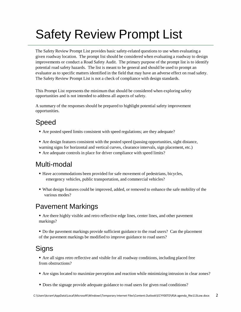
Safety Review Prompt List The Safety Review Prompt List provides basic safety-related questions to use when evaluating a given roadway location. The prompt list should be considered when evaluating a roadway to design improvements or conduct a Road Safety Audit. The primary purpose of the prompt list is to identify potential road safety hazards. The list is meant to be general and should be used to prompt an evaluator as to specific matters identified in the field that may have an adverse effect on road safety. The Safety Review Prompt List is not a check of compliance with design standards.
This Prompt List represents the minimum that should be considered when exploring safety opportunities and is not intended to address all aspects of safety.
A summary of the responses should be prepared to highlight potential safety improvement opportunities.
Speed
Are posted speed limits consistent with speed regulations; are they adequate? Are design features consistent with the posted speed (passing opportunities, sight distance, warning signs for horizontal and vertical curves, clearance intervals, sign placement, etc.) Are adequate controls in place for driver compliance with speed limits?
Multi-modal
Have accommodations been provided for safe movement of pedestrians, bicycles, emergency vehicles, public transportation, and commercial vehicles?
What design features could be improved, added, or removed to enhance the safe mobility of the
various modes?
Pavement Markings
Are there highly visible and retro reflective edge lines, center lines, and other pavement markings?
Do the pavement markings provide sufficient guidance to the road users? Can the placement of the pavement markings be modified to improve guidance to road users?
Signs
Are all signs retro reflective and visible for all roadway conditions, including placed free from obstructions?
Are signs located to maximize perception and reaction while minimizing intrusion in clear zones?
Does the signage provide adequate guidance to road users for given road conditions?

C:\Users\kcram\AppData\Local\Microsoft\Windows\Temporary Internet Files\Content.Outlook\ECYY00TD\RSA agenda_Rte113Low.docx 3
Are pavement markings and signs consistent in effectively guiding road users?
Intersection Control
Do all signs (stop signs, lane assignments, street names, etc.) provide visible, clear, non-conflicting messages?
Is there clear, non-conflicting visibility of traffic control (signal heads, signs, and markings) from
all approach lanes? Has the potential of misrepresentation of intersection control been considered (at closely spaced
intersections or through control that is against expectation)? For signalized intersections, have the implications on safety been considered for the signal
phasing? Is there a safe means by which all modes can travel through the intersection?
Lighting
Is lighting (from headlights and/or streetlights) adequate for specific roadway conditions and/or use?
If glare exists from sunlight or opposing headlights, are there countermeasures that can be
implemented to minimize potentially detrimental effects?
Obstructions
Are there obstructions to sight lines or roadway guidance (signs, markings, etc.) that can be removed, relocated, or minimized as part of this project?
If obstructions or fixed objects exist but cannot be moved, can they be shielded (with guardrails,
etc.) or delineated (with reflectors) to improve road user safety? If so, what can be done?
Pavement
Could the condition of the pavement impact mobility and safety (potholes, edge drop-offs, skid resistance, etc)?
What improvements can be made to minimize safety impacts?
Access Points and Traffic Generators
Is the access control sufficient for the road’s function? Are site access points located to maximize safety while still providing adequate access?
Have impacts of site developments been adequately accommodated for safe mobility of all road users?

C:\Users\kcram\AppData\Local\Microsoft\Windows\Temporary Internet Files\Content.Outlook\ECYY00TD\RSA agenda_Rte113Low.docx 4
Parking
Is parking clearly delineated and in conformance with signs, markings, and regulations? Might parking obstruct mobility/safety of pedestrians and other roadway users?
Weather Conditions
Have accommodations been made for impacts from adverse weather condition (storage of snow, removal of ponding, adequate drainage, signage of low salt areas, maintenance program for snow removal, and catch basin clearing, etc.)?
Auxiliary Lanes
Could taper locations and/or alignments contribute to safety challenges? Could lack of climbing lanes or passing zones cause driver frustration?
Do acceleration/deceleration lane lengths necessitate additional signage and/or markings?
Animals
Do animal migrations impact safety? Can measures be taken to reduce animal-vehicle conflicts?

Appendix B. RSA Audit Team Contact List
Participating Audit Team Members Date: April 16, 2015 Location: Mayors Conference Room Newburyport City Hall,

60 Pleasant Street, Newburyport Audit Team Members Agency/Affiliation Email Address Phone
Number Ken Cram Bayside Engineering [email protected] 7814-932-3201 William Ullom MassDOT Safety [email protected] 857-368-9622 John Mastera MassDOT Safety [email protected] 857-368-9684 Andrew Port City of Newburyport [email protected] 978-465-4400 Lisa Schletzbaum MassDOT Safety [email protected] 857-368-9634 Jim McCarthy City of Newburyport [email protected] 978-417-9373 Mark Murray Newburyport Police Dept. [email protected] 978-423-2066
Jim Terlizzi Merrimack Valley Planning Commission [email protected] 978-688-8197
Christopher LeClaire Newburyport Fire Dept. [email protected] 978-270-8003 Susan Hirl VAI [email protected] 978-474-8800 Scott Thornton VAI [email protected] 978-474-8800 Steve Boudreau VAI [email protected] 978-474-8800 Scott Mitchell Tropic Star Development [email protected] 603-926-7770 Jake Carmody VAI [email protected] 978-474-8800 Jon-Eric White City of Newburyport [email protected] 978-417-1969 Wayne Amaral City of Newburyport [email protected] 978-465-4464 Jeff Gomes MassDOT District 4 [email protected] 781-641-8332

Appendix C. Detailed Crash Data


Route 113 (Storey Ave) at Low St/Woodman Way, Newburyport MA
6.82% 6.82%
4.55%
2.27%
9.09%
6.82%
13.64%13.64%
2.27%
9.09%
18.18%
6.82%
0.00%0.00%
2.00%
4.00%
6.00%
8.00%
10.00%
12.00%
14.00%
16.00%
18.00%
20.00%
JAN FEB MAR APR MAY JUN JUL AUG SEP OCT NOV DEC (blank)
Crashes by Month
Total
4.55%
13.64%
27.27%
6.82%
15.91%
22.73%
9.09%
0.00%0.00%
5.00%
10.00%
15.00%
20.00%
25.00%
30.00%
Crashes by Day of Week
Total
9.09%
22.73%
34.09%
15.91%18.18%
0.00%0.00%
5.00%
10.00%
15.00%
20.00%
25.00%
30.00%
35.00%
40.00%
10-2 AM 10-2 PM 2-6 PM 6-10 AM 6-10 PM (blank)
Crashes by Time of Day
Total
S:\Jobs\6696\Crashes charts RSA Route 113Low Newburyport 6696.docx
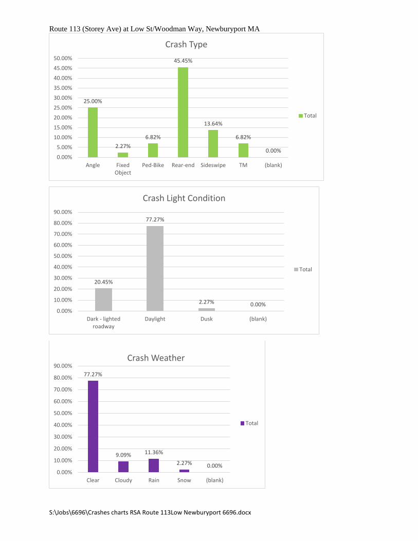
Route 113 (Storey Ave) at Low St/Woodman Way, Newburyport MA
25.00%
2.27%6.82%
45.45%
13.64%
6.82%
0.00%0.00%
5.00%
10.00%
15.00%
20.00%
25.00%
30.00%
35.00%
40.00%
45.00%
50.00%
Angle FixedObject
Ped-Bike Rear-end Sideswipe TM (blank)
Crash Type
Total
20.45%
77.27%
2.27% 0.00%0.00%
10.00%
20.00%
30.00%
40.00%
50.00%
60.00%
70.00%
80.00%
90.00%
Dark - lightedroadway
Daylight Dusk (blank)
Crash Light Condition
Total
77.27%
9.09% 11.36%
2.27% 0.00%0.00%
10.00%
20.00%
30.00%
40.00%
50.00%
60.00%
70.00%
80.00%
90.00%
Clear Cloudy Rain Snow (blank)
Crash Weather
Total
S:\Jobs\6696\Crashes charts RSA Route 113Low Newburyport 6696.docx

Route 113 (Storey Ave) at Low St/Woodman Way, Newburyport MA
81.82%
2.27%
15.91%
0.00%0.00%
10.00%
20.00%
30.00%
40.00%
50.00%
60.00%
70.00%
80.00%
90.00%
Dry Snow Wet (blank)
Crash Surface
Total
S:\Jobs\6696\Crashes charts RSA Route 113Low Newburyport 6696.docx

Appendix D. RSA Procedure

RSA Procedure
The designer will obtain, review and summarize the most recent pertinent available information, including: crash data, traffic volumes, and traffic speed data. Note that the crash data summaries from MassDOT Statewide database are not adequate and that the actual crash reports (including narratives and diagrams), from the police department reporting the crash data, are critical to a successful audit. The actual crash reports should be used to prepare collision diagrams and crash analyses. Details of the crash analyses must be clear because they will be used as the “before” information when an evaluation is performed on the effectiveness of the countermeasures. Other relevant information regarding the location may include, but is not limited to: traffic volumes (including pedestrians and bicycles if available), speed/citation data, available roadway plans, traffic reports and/or signal timings and phasing information (if appropriate).
With input and assistance from the community and/or MassDOT District, the designer will select the RSA team, date, time and location. The team should represent engineering (local and MassDOT), planning, enforcement (local or state police, depending upon jurisdiction), emergency response (fire, ambulance or police that respond to crashes in the project area), MassDOT’s Safety Management Unit, Regional Planning Agency, maintenance (local department of public works or MassDOT maintenance depending upon jurisdiction). Additional members may include representatives of: Town/City Planning Department, Public Officials, or others. The date, time and location will also require input from the local community and MassDOT. It is best for the meetings to take place in close proximity to the project location to save time and be more efficient.
An email invitation should be sent to all RSA team participants and include an attachment with the pertinent available information. (See attached for suggested text of email invite and a copy of a sample agenda).
At the pre-audit meeting, the designer will provide handouts of all pertinent information. It will be the responsibility of the designer to facilitate the audit, take notes and photos and then prepare the report in a timely manner. The RSA participants will meet (pre-audit meeting) to discuss the process and goals for the RSA. The designer will present the existing traffic data and any known related planned projects to the participants in order to provide an introduction to project. General comments, issues and concerns will be solicited about the subject location. Following the pre-audit meeting, the team will conduct a site visit (audit), during which specific issues and concerns will be pointed out by the RSA team (and/or designer) and recorded by the designer. As a minimum, the designer should use the safety review prompt list (see attached) as a reference to ensure that a comprehensive list of safety issues is discussed at the audit site visit.
After the site visit, the RSA participants will meet (post-audit meeting) and the designer will facilitate a group discussion, which would confirm that a complete list of safety issues and potential countermeasures had been identified during the RSA and countermeasures have been identified. The countermeasures may include short-term,

intermediate-term, and long-term improvements and the responsibility for the improvements will be identified. It should be noted that recommendations should be comprehensive and may include engineering, maintenance, enforcement, educational and behavioral countermeasures. If plans are already underway, the plans will be discussed and reviewed to determine whether or not the existing concerns and issues have been adequately addressed.
A RSA Report, based on MassDOT’s report template (see attached), would be prepared describing the deficiencies and countermeasures identified during the RSA. Countermeasures which were not discussed during the RSA may be included, if they are found to be appropriate. Potential countermeasures which do not conform to MassDOT or FHWA standards would be noted as such in the report.
The RSA Report preparation will require the following submissions:
• A Draft Report (the designer will submit, via email, to the participants within 5 days of the audit),
• participants should reply with comments within 5 business days of receipt of Draft report,
• a Final Draft Report (the designer will submit via email, to the community/MassDOT for review, within 5 business days after comment period),
• approval to finalize by entity with jurisdiction (road owners) and
• a Final Report (within 5 days of receipt of comments) in both hard copy and electronic format.
Post RSA Procedure
The designer should work with the roadway owner (community / MassDOT District) on implementing the short-term low cost improvements/maintenance items that can be done prior to the completion of the design process. These should be detailed in the Functional Design Report (including specifically what was done and when the work was completed). In addition, attempts should be made to incorporate all medium and long term countermeasures into the design. Any recommendations that cannot be incorporated into the design should clearly be explained in the Functional Design Report.
MassDOT intends to perform evaluations on the effectiveness of countermeasures used as a result of RSAs. The “before” analysis will be based on the detailed crash analyses presented in the RSA. An “after” study may be performed by MassDOT or others once three years’ worth of crash data have been obtained. This will enable the Commonwealth of Massachusetts to develop state-specific crash reduction factors.