
River Dodder Flood Alleviation Works 2D RDS Wall · Dublin City Council River Dodder Flood...
77
Dublin City Council River Dodder Flood Alleviation Works 2D – RDS Wall Report for Screening for Appropriate Assessment 219346-00 Issue 3 | 10 July 2018 This report takes into account the particular instructions and requirements of our client. It is not intended for and should not be relied upon by any third party and no responsibility is undertaken to any third party. Job number 219346-80 Ove Arup & Partners Ireland Ltd Arup 50 Ringsend Road Dublin 4 D04 T6X0 Ireland www.arup.com
Transcript of River Dodder Flood Alleviation Works 2D RDS Wall · Dublin City Council River Dodder Flood...

Dublin City Council
River Dodder Flood Alleviation
Works 2D – RDS Wall
Report for Screening for Appropriate Assessment
219346-00
Issue 3 | 10 July 2018
This report takes into account the particular
instructions and requirements of our client.
It is not intended for and should not be relied
upon by any third party and no responsibility
is undertaken to any third party.
Job number 219346-80
Ove Arup & Partners Ireland Ltd
Arup
50 Ringsend Road
Dublin 4
D04 T6X0
Ireland
www.arup.com
219346-00 | Issue 3 | 10 July 2018 | Arup
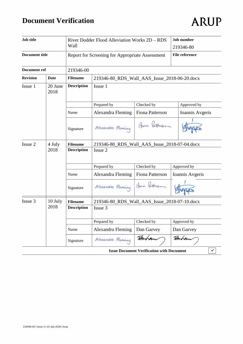
Document Verification
Job title River Dodder Flood Alleviation Works 2D – RDS
Wall
Job number
219346-80
Document title Report for Screening for Appropriate Assessment File reference
Document ref 219346-00
Revision Date Filename 219346-80_RDS_Wall_AAS_Issue_2018-06-20.docx
Issue 1 20 June
2018
Description Issue 1
Prepared by Checked by Approved by
Name Alexandra Fleming Fiona Patterson Ioannis Avgeris
Signature
Issue 2 4 July
2018
Filename 219346-80_RDS_Wall_AAS_Issue_2018-07-04.docx Description Issue 2
Prepared by Checked by Approved by
Name Alexandra Fleming Fiona Patterson Ioannis Avgeris
Signature
Issue 3 10 July
2018 Filename 219346-80_RDS_Wall_AAS_Issue_2018-07-10.docx
Description Issue 3
Prepared by Checked by Approved by
Name Alexandra Fleming Dan Garvey Dan Garvey
Signature
Issue Document Verification with Document
Dublin City Council River Dodder Flood Alleviation Works 2D – RDS Wall
Report for Screening for Appropriate Assessment
219346-00 | Issue 3 | 10 July 2018 | Arup
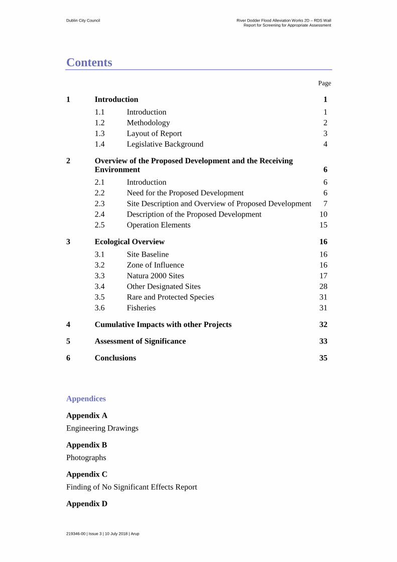
Contents Page
1 Introduction 1
1.1 Introduction 1
1.2 Methodology 2
1.3 Layout of Report 3
1.4 Legislative Background 4
2 Overview of the Proposed Development and the Receiving Environment 6
2.1 Introduction 6
2.2 Need for the Proposed Development 6
2.3 Site Description and Overview of Proposed Development 7
2.4 Description of the Proposed Development 10
2.5 Operation Elements 15
3 Ecological Overview 16
3.1 Site Baseline 16
3.2 Zone of Influence 16
3.3 Natura 2000 Sites 17
3.4 Other Designated Sites 28
3.5 Rare and Protected Species 31
3.6 Fisheries 31
4 Cumulative Impacts with other Projects 32
5 Assessment of Significance 33
6 Conclusions 35
Appendices
Appendix A
Engineering Drawings
Appendix B
Photographs
Appendix C
Finding of No Significant Effects Report
Appendix D

Dublin City Council River Dodder Flood Alleviation Works 2D – RDS Wall
Report for Screening for Appropriate Assessment
219346-00 | Issue 3 | 10 July 2018 | Arup
Ecological Survey Report
Dublin City Council River Dodder Flood Alleviation Works 2D – RDS Wall
Report for Screening for Appropriate Assessment
219346-00 | Issue 3 | 10 July 2018 | Arup
Page 1
1 Introduction
1.1 Introduction
This report contains information required for the competent authority to undertake
screening for Appropriate Assessment (AA) for the proposed construction of a
new reinforced concrete L-wall along a section of the River Dodder in
Ballsbridge, Dublin City (hereafter referred to as the “proposed development”).
The proposed development forms part of the Dodder Flood Alleviation Works
Phase 2D design. Refer to Appendix A for the engineering drawings.
The aims of this report are to:
Provide information on, and assess the potential for the proposed development
to significantly impact on Natura 2000 Sites (also known as European sites);
Determine whether the project is directly connected with, or necessary to, the
conservation management of any Natura 2000 sites; and
Determine whether the project, alone or in combination with other projects, is
likely to have significant effects on Natura 2000 sites in view of their
conservation objectives.
Figure 1 below show the approximate location of the proposed development.
This report for screening for AA was undertaken by an Arup ecologist on behalf
of Dublin City Council.

Dublin City Council River Dodder Flood Alleviation Works 2D – RDS Wall
Report for Screening for Appropriate Assessment
219346-00 | Issue 3 | 10 July 2018 | Arup
Page 2
Figure 1: Location of the proposed development. Source Bing Maps | Not to scale.
1.2 Methodology
1.2.1 Guidance and Data Sources
This report has been prepared with regard to the following guidance documents,
where relevant:
Managing Natura 2000 Sites: The Provision of Article 6 of the Habitats
Directive 92/43/EEC (EC Environment Directorate-General, 2000); [hereafter
referred to as MN 2000];
Assessment of Plans and Projects Significantly Affecting Natura 2000 sites:
Methodical Guidance on the Provisions of Article 6(3) and (4) of the Habitats
Directive 92/43/EEC (European Commission Environment Directorate-
General, 2001);
Guidance Document on Article 6(4) of the Habitats Directive 92/43/EEC.
(European Commission, 2007);
Appropriate Assessment of Plans and Projects in Ireland - Guidance for
Planning Authorities (Department of Environment, Heritage and Local
Government, 2010 revision);
Appropriate Assessment under Article 6 of the Habitats Directive: Guidance
for Planning Authorities. Circular NPW 1/10 and PSSP 2/10;
Guidelines for Good Practice Appropriate Assessment of Plans under Article
6(3) Habitats Directive (International Workshop on Assessment of Plans
under the Habitats Directive, 2011); and

Dublin City Council River Dodder Flood Alleviation Works 2D – RDS Wall
Report for Screening for Appropriate Assessment
219346-00 | Issue 3 | 10 July 2018 | Arup
Page 3
Sources of information that were used to collect data on the Natura 2000 network
of sites and on the existing ecological environment are listed below:
Bing aerial photography;
National Parks and Wildlife Service online data on European Sites and (www.npws.ie) (downloaded on 10 May 2018);
National Parks and Wildlife Service online data on protected flora and fauna (viewed on 10 May 2018);
Information on environmental quality data available from www.epa.ie (EPA Online Environmental Map Viewer) (viewed on 10 May 2018);
Information on environmental water quality data available from (EPA, www.catchments.ie);
Dublin City Development Plan 2016-2022;
Dublin City Development Plan 2016-2022 Appropriate Assessment Screening Report;
Dublin City Biodiversity Action Plan 2015-2020;
Dodder Greenway Ecological Impact Assessment (June 2017) Roughan & O’Donovan Consulting Engineers for South Dublin County Council.
Guidance that has assisted in determining whether impacts are likely to be
significant include:
Guidelines on the Information to be Contained in Environmental Impact Statements (Environmental Protection Agency, 2002);
Revised Guidelines on the Information to be contained in Environmental Impact Assessment Reports (Draft EPA August 2017);
Advice Notes on Current Practice (in the preparation of Environmental Impact Statements) (EPA, 2003);
Draft Advice Notes for preparing Environmental Impact Statements (EPA September 2015) and;
Guidelines for Ecological Impact Assessment in the Britain and Ireland, Marine and Coastal (Institute of Ecology and Environmental Assessment, 2010).
1.3 Layout of Report
This report contains information required for the competent authority, to
undertake screening for Appropriate Assessment (AA) for the proposed
development at Ballsbridge, Dublin City. This report is based on a desk study and
an ecological survey.
The screening information presented in this report is as follows:
Legislative Background, refer to Section 1.4;
Overview of the proposed development and receiving environment, refer to Section 2;

Dublin City Council River Dodder Flood Alleviation Works 2D – RDS Wall
Report for Screening for Appropriate Assessment
219346-00 | Issue 3 | 10 July 2018 | Arup
Page 4
Ecological Overview and Identification of relevant Natura 2000 sites (European sites) within the zone of influence of the proposed development, refer to Section 3;
Assessment of likely significant effects on Natura 2000 Sites, refer to Section 3.3; and
Conclusions, refer to Section 6.
1.4 Legislative Background
According to the EU Habitats Directive (92/43/EEC) and the EU Birds Directive
(79/409/EEC), Member States are required to establish a Natura 2000 network of
sites of highest biodiversity importance for rare and threatened habitats and
species across the EU. In Ireland, the Natura 2000 network of European sites
includes Special Areas of Conservation (SACs) and Special Protection Areas
(SPAs).
SACs are selected for the conservation of Annex I habitats (including priority
types which are in danger of disappearance) and Annex II species (other than
birds). SPAs are selected for the conservation of Annex I birds and all migratory
birds and their habitats. The Annex habitats and species, for which each site is
selected, are the qualifying interests (QI) of the site. Conservation objectives for
the site are defined for these qualifying interests.
A key requirement of the Directives is that the effects of any plan or project,
alone, or in combination with, other plans or projects, on the Natura 2000 site
network, should be assessed before any decision is made to allow that plan or
project to proceed. This process is known as Appropriate Assessment (AA). The
obligation to undertake an Appropriate Assessment derives from Article 6(3) and
6(4) of the Habitats Directive (92/43/EEC), and both involve a number of steps
and tests that need to be applied in sequential order.
Article 6(3) is concerned with the strict protection of sites, while Article 6(4) is
the procedure for allowing derogation from this strict protection in certain
restricted circumstances.
Article 6(3) of the Habitats Directive states:
“Any plan or project not directly connected with, or necessary to, the management of the site but
likely to have a significant effect thereon, either individually or in combination with other plans
or projects, shall be subject to appropriate assessment of its implications for the site in view of
the site’s conservation objectives. In the light of the conclusions of the assessment of the
implications for the site and subject to the provisions of paragraph 4, the competent national
authorities shall agree to the plan or project only after having ascertained that it will not
adversely affect the integrity of the site concerned and, if appropriate, after having obtained the
opinion of the general public”.

Dublin City Council River Dodder Flood Alleviation Works 2D – RDS Wall
Report for Screening for Appropriate Assessment
219346-00 | Issue 3 | 10 July 2018 | Arup
Page 5
Article 6(4) states:
“If, in spite of a negative assessment of the implications for the site and in the absence of
alternative solutions, a plan or project must nevertheless be carried out for imperative reasons
of overriding public interest, including those of social or economic nature, the Member State
shall take all compensatory measures necessary to ensure that the overall coherence of Natura
2000 is protected. It shall inform the Commission of the compensatory measures adopted. Where
the site concerned hosts a priority natural habitat type and/or a priority species, the only
considerations which may be raised are those relating to human health or public safety, to
beneficial consequences of primary importance for the environment or, further to an opinion from
the Commission, to other imperative reasons of overriding public interest.”
The competent authority is required to carry out Appropriate Assessment, as
required by Article 6(3) and 6(4) of the Habitats Directive, as follows:
Stage 1 - Screening for Appropriate Assessment – to assess, in view of best
scientific knowledge, if the development, individually or in combination with
another plan or project is likely to have a significant effect on the Natura 2000
site.
Stage 2 - Appropriate Assessment – This is required if it cannot be excluded,
on the basis of objective information, that the development, individually or in
combination with other plans or projects, will have a significant effect on a
Natura 2000 site. The appropriate assessment must include a final
determination by the competent authority as to whether or not a proposed
development would adversely affect the integrity of a Natura 2000 site. In
order to reach a final determination, the competent authority must undertake
examination, analysis and evaluation, followed by findings, conclusions and a
final determination. The appropriate assessment must contain complete,
precise and definitive findings and conclusions, and may not have lacunae or
gaps.
Stage 3 – Assessment of alternative solutions- the process which examines
alternative ways of achieving the objectives of the project or plan that avoid
adverse impacts on the integrity of the Natura 2000 site.
Stage 4 - Assessment where no alternative solutions exist and where
adverse impacts remain - an assessment of compensatory measures where, in
the light of an assessment of imperative reasons of overriding public interest
(IROPI), it is deemed that the project or plan should proceed.
If, based upon the currently available information, there are aspects of the
proposed development that could have a significant effect on any Natura 2000
sites, then further analysis in the form of an Appropriate Assessment is required.
If the outcome of the screening exercise is that there are no significant impacts
predicted, then an Appropriate Assessment is not required.

Dublin City Council River Dodder Flood Alleviation Works 2D – RDS Wall
Report for Screening for Appropriate Assessment
219346-00 | Issue 3 | 10 July 2018 | Arup
Page 6
2 Overview of the Proposed Development and
the Receiving Environment
2.1 Introduction
Dublin City Council (DCC), on behalf of the Office of Public Works (OPW),
intend to construct a new reinforced concrete L-wall along the right bank of the
River Dodder near the entrance to the Royal Dublin Society (RDS) grounds on
Anglesea Road in Ballsbridge, Dublin City. The proposed development (referred
to as the ‘RDS wall’) is being incorporated into the River Dodder Flood
Alleviation Works Phase 2D project design.
The Office of Public Works (OPW) have been carrying out the construction works
on behalf of DCC for the previous River Dodder Flood Alleviation Works and
will also construct the proposed development at the RDS wall.
As discussed in Section 1.1, the proposed works to the RDS wall are being
incorporated into the River Dodder Flood Alleviation Works Phase 2D design.
Phase 2D is part of the overall Dodder Flood Alleviation Works Phase 2C-2E
which are on-going and carried out under the approved Part 8 Planning
Application 2504/13, issued in 2013.
The approved works (Planning Application 2504/13) under the Phase 2C-2E
design are carried out along sections of the River Dodder from Smurfit Weir to
Landsdowne Railway Bridge, approximately 1.6km in length. This length of the
River Dodder includes the RDS wall. Under the approved Part 8 Planning
Application (Planning No. 2504/13), it was proposed to raise the parapet height of
the RDS wall however during the Phase 2D works the wall was found to have
insufficient wall thickness and hence structural strength to withstand (approved)
design condition.
2.2 Need for the Proposed Development
The Dodder Flood Alleviation Works Phase 2C to 2E include the section of the
River Dodder from Landsdowne Road Railway Bridge and upstream to Smurfit
Weir. This section of the river is referred to as the Lower Dodder APSRs or Area
of Potential Significant Risk in the Dodder CFRAMS Plan. APSRs are existing
urban areas with high degrees of flood risk. The Phase 2D works have been on-
going since 2016 and as a result the river has been modified to facilitate these
works. Dublin City Council intend to carry out works on the on a section of the
River Dodder wall by the RDS (referred to as the RDS wall) in Ballsbridge. The
proposed development is being incorporated into the River Dodder Flood
Alleviation Works Phase 2D project design.
During the Phase 2D works, the wall was found to have insufficient wall thickness
and hence structural strength to withstand design condition. The existing wall has
a number of structural weaknesses that require a new river wall to be built
including:

Dublin City Council River Dodder Flood Alleviation Works 2D – RDS Wall
Report for Screening for Appropriate Assessment
219346-00 | Issue 3 | 10 July 2018 | Arup
Page 7
No foundation or sour protection present;
Significant settlement of the existing wall;
Culverts and outfalls are collapsing;
Spalling (breaking) and cracking evident;
Loss of mortar and large stones recorded throughout;
Upper parapet has become separated from the separated lower wall;
Lower wall was found to have insufficient wall thickness and hence structural
strength of the existing wall is insufficient to withstand design condition; and
Loss of mortar and large stones recorded.
Wall repairs were carried out in November 2017 and May 2018 as part of
emergency works to assist with maintaining the integrity of the existing structure
prior to the construction of a new river wall. These works included vegetation
removal, localised repointing and the filling of significant voids. The emergency
works also include the underpinning of the right wall which is currently underway
and will be completed prior to the construction of the proposed development.
2.3 Site Description and Overview of Proposed
Development
The proposed development site is located on section of the river wall (right bank)
adjacent to Anglesea Road at the entrance to the RDS grounds. Refer to Figure 2.
The section of river where the works will be is non-tidal and approximately 2km
upstream of where the River Dodder discharges into the River Liffey estuary at
Sir John Rogerson’s Quay.
The proposed development area is downstream of the Herbert Park Lane (HPL)
bridge. The existing right bank consists of a low-level haul road, approximately 3-
4m wide that is being used for the Phase 2D on the right river wall. There are a
number of surface water outlets that discharge from Anglesea Road. Refer
Appendix B for photos of the site taken in April 2018. Immediately upstream of
HPL Bridge, there is an existing haul road. Vegetation has previously been
removed from the right bank. There are a number of mature trees along the
adjacent Anglesea Road footpath and these will be retained as part of the works.
The main elements of the proposed development include:
Removal of approximately 200m length of the existing RDS wall above
footpath level between Ballsbridge and just upstream of the HPL Bridge.
Construction of approximately 200m of new RDS river wall on the “wet side”
of the existing RDS wall with a new reinforced concrete L-wall river wall.
The new wall will be clad with thick coursed limestone with lime mortar
pointing and a rounded coping in keeping with surrounding flood defences
Width of footpath along Anglesea Road will increase from 2.8m to a
maximum width of approximately 3.4m wide.

Dublin City Council River Dodder Flood Alleviation Works 2D – RDS Wall
Report for Screening for Appropriate Assessment
219346-00 | Issue 3 | 10 July 2018 | Arup
Page 8
Widening of the existing in-stream right wall haul road to up to a maximum
width of 10m from the RDS wall to facilitate works;
Reinstatement of the original existing riverbed level (existing 2009 levels)
following the completion of the works (as agreed with Inland Fisheries
Ireland;
Retention of the existing trees along the Anglesea Road footpath; and
Services along Anglesea Road will remain unaffected during construction and
operation.
Refer to Figure 2 for the proposed development works areas.

Dublin City Council River Dodder Flood Alleviation Works 2D – RDS Wall
Report for Screening for Appropriate Assessment
219346-00 | Issue 3 | 10 July 2018 | Arup Page 9
Figure 2: Proposed development works areas No.1 & No.2 and main construction compound. Source Bing Maps 2018.

Dublin City Council River Dodder Flood Alleviation Works 2D – RDS Wall
Report for Screening for Appropriate Assessment
219346-00 | Issue 3 | 10 July 2018 | Arup
Page 10
2.4 Description of the Proposed Development
2.4.1 Introduction
The total length of wall to be replaced (the proposed development) is
approximately 200m, shown on the engineering drawings, refer to Drawing No.
D-DR-W-0201 in Appendix A for the engineering drawings.
The river wall under HPL Bridge or the HPL Bridge will not undergo works as
part of the proposed works.
The L-wall will consist of an in-situ reinforced concrete base that extends up to
approximately 5.5m horizontally from the wall underneath the river bed. A shear
key or mini-piles may be required as part of the foundation design. The vertical
reinforced concrete stem will be built in front of the existing river wall with a
concrete infill between the two walls (existing and new). For heritage reasons, the
new wall will be debonded (separated) from the existing wall by means of a
suitable membrane or similar. All concrete will be poured in-situ.
The existing RDS wall will be removed above footpath level. The stone removed
will be re-used as cladding for the new footpath-level wall where possible. This
will extend the footpath to a maximum width of 3.4m, except at tie-in locations to
existing walls, where the current width footpath will be retained. The trees along
the footpath will be retained and the existing utilities under the footpath will also
be retained.
The top of the wall will be approximately 1.4m above street level with rounded
coping (in keeping with the surrounding flood defences) and a maximum of
750mm wide. The wall will be clad with 200mm thick coursed limestone cladding
with lime mortar pointing. The flood wall is designed to withstand a 1 in 100 year
flood event.
In-stream works will be required to carry out the L-wall construction as the base
of the wall will be buried in the riverbed. Services along Anglesea Road and
traffic restrictions that prohibit these works being carried out from Anglesea Road
(dry side) therefore works are carried out in-stream. In-stream works will be
carried out on the existing haul roads adjacent to the right wall. Haul roads will be
extended to a maximum width of 10m from the RDS wall. On completion of the
works, the riverbed will be reinstated to the 2009 levels with agreement of Inland
Fisheries Ireland (IFI).
The proposed development will take approximately ten months to complete.
Construction works will be limited to the hours of 7.30am - 4.30pm Monday to
Friday. Works will not be permitted outside these hours.
2.4.2 Works Areas
There are two works areas and one construction compound that will be used
during the construction phase:

Dublin City Council River Dodder Flood Alleviation Works 2D – RDS Wall
Report for Screening for Appropriate Assessment
219346-00 | Issue 3 | 10 July 2018 | Arup
Page 11
Works Area No. 1 – Upstream of Herbert Park Lane Bridge
This is an existing construction compound that has been used to complete works
upstream of the Herbert Park Lane Bridge. There is an existing river crossing that
will be used to carry out the works described here to the right river wall. The haul
road adjacent to the road will likely require some repair works to facilitate access.
No materials, machinery or equipment will be stored along the haul routes. These
areas will be kept clear when there are no construction works taking place. Refer
to Photo 2 in Appendix B for a photo of the existing haul road.
Works Area No. 2 – Downstream of Herbert Park Lane Bridge to the Old
Toilet Block at Ballsbridge
This existing compound facilities access to the right river wall downstream of the
Herbert Park Lane Bridge. It has been established during the River Dodder Flood
Alleviation Works Phase 2D. Refer to Photo 3 in Appendix B. No materials,
machinery or equipment will be stored along the haul routes. These areas will be
kept clear when there are no construction works.
Construction Compound at Beatty’s Avenue
This is an existing construction compound in for the Phase 2D works, located at
Beatty’s Avenue in Ballsbridge, refer to Figure 2. Materials and equipment as
well as some staff facilities will be located here.
2.4.3 Enabling and Construction Works
2.4.3.1 Haul Roads
In-stream works will be required to carry out the L-wall construction as the base
of the wall will be buried in the river bed. In addition, construction constraints due
to services present on Anglesea Road and traffic restrictions prohibit these works
being carried out from Anglesea Road (dry side). There is an existing haul road
along the right river wall which is being used to carry out the current flood
defence works. It may be necessary to widen the haul road to a maximum width of
10m from the RDS wall to facilitate the construction works. The haul road width
will also depend on the requirement to maintain river flow. Temporary sheet piles
may be installed along the haul road to provide ground stability during excavation
works. The use of temporary sheet piles will reduce water inflow into the
excavation and may reduce the maximum width required for the haul road. Refer
to an example shown in Photo 7 in Appendix B.
Preliminary consultation with Inland Fisheries Ireland (IFI) has indicated that the
haul road widening is acceptable provided that fish passage is maintained in the
river. The riverbed will be reinstated to the existing level (2009 levels) with
agreement of IFI. It is proposed to construct/repair the haul road before the end of
August 2018 and thus avoid any conflict with the fish-spawning season as has
previously been agreed with IFI for such works. Any works that are required
outside this timeframe will be agreed with IFI in advance.

Dublin City Council River Dodder Flood Alleviation Works 2D – RDS Wall
Report for Screening for Appropriate Assessment
219346-00 | Issue 3 | 10 July 2018 | Arup
Page 12
On completion of the works, the haul road will be removed and the riverbed will
be restored to its 2009 level as has been previously agreed with IFI for the
existing flood alleviation works. These 2009 levels have been recorded as part of
the River Dodder catchment flood risk assessment study (CFRAMS).
Repair and widening of the existing haul roads will require the placement of
imported granular material (clean broken stone) approximately 150mm in size.
The haul road will be 300mm above the general bed level. The placement of
granular material will only be carried out at a time of relatively low flows in the
River Dodder.
For works upstream of Herbert Park Lane Bridge, machinery will access the
existing haul road on the right bank from a ramp and river crossing which has
been previously established, refer to Figure 2 and to Photo 1 in Appendix B.
For works downstream of Herbert Park Lane Bridge, machinery will access the
existing haul road from an existing ramp from the old toilet block. Refer to
Figure 2 and Photo 2 in Appendix B.
2.4.3.2 Demolition
The existing flood defence wall will be removed to footpath level. This will be
carried out in stages as the new L-wall is being constructed. Hoarding will be
erected around the works areas for safety and restrict access.
The stone removed from the existing footpath level river wall will be reused for
the construction of the new footpath level wall where possible. Potential dust
generation will be limited as demolition of the wall will take place in stages.
2.4.3.3 Traffic Management
If necessary, a traffic management plan (TMP) will be designed, implemented,
maintained and de-mobilised by Dublin City Council. It is not envisaged that
traffic flow will be interrupted along Anglesea Road. Some parking along
Anglesea Road will temporarily be removed during the works.
2.4.3.4 Pedestrians
Access to the existing footpath adjacent to the RDS wall will be restricted as the
works progress. Pedestrians will be directed to temporarily use the footpath
adjacent to the RDS ground. The final footpath width will increase from
approximately 2.8m to approximately 3.3m wide and will be reinstated following
completion of the RDS wall construction.Sequence of Structural Works
The sequence of structural works is described here.
The proposed flood defence works on the right bank of River Dodder in Phase 2D
(Ballsbridge to Herbert Park Lane Bridge) will be built in stages with each 3m
long unit of wall completed at a time. There will be approximately 60 No.
concrete units over 200 linear meters of the wall over two sections (up and
downstream of HPL Bridge).
Dublin City Council River Dodder Flood Alleviation Works 2D – RDS Wall
Report for Screening for Appropriate Assessment
219346-00 | Issue 3 | 10 July 2018 | Arup
Page 13
Each unit will consist of the following elements:
Excavation for foundation base
Installation of mini-piles or shear key
Construction of wall base
In-situ concentrate wall pour in lifts
2.4.3.5 Excavation
For each works unit, the excavation of the structural base will be required. An
excavator will access the work unit from the haul road. A dumper truck will
access the haul road and remove any excavated material off-site for appropriate
disposal. The excavator will dig out the ground for the base of the existing wall.
Temporary sheet piles may be required to support the excavation, as mentioned in
Section 3.2.2. This will also reduce water ingress into the excavation. A trench
box may also be required for the excavation of the shear key to provide ground
stability, refer to an example of this in Photo 8 in Appendix B.
The 150mm water pump will be installed prior to the excavation works in
anticipation of use immediately afterwards. The area will be pumped continuously
after the excavation for the concrete base to clear all the water from the area and
then turned off.
The water will be discharged through a sediment bag, also known as a “dirt bag”,
prior to being discharged into the watercourse. The sediment bag is a semi-
permeable material that filters the pumped water to remove sediment. The dirt
bags will be placed on the overlying footpath and the filtered ‘clean’ water will be
discharged back into the watercourse. The material collected in the sediment bags
will be emptied into the site dumper truck and stockpiled in the Beatty’s Avenue
construction compound before being exported off-site. A mobile diesel generator
will be used on site to power the water pump.
Dust generation from excavation will be minimal as works will the excavated
material will typically be ‘wet’ riverbed material. Water be pumped to the
sedimentation bag throughout the excavation. Excavation for the concrete base
pours will be done on a staged basis as the wall is constructed in units, refer to
section 2.4.4. Therefore, noise generated from excavation and truck movements
will be limited and on par with the urbanised environment and high volumes of
traffic from Anglesea Road. Piling activity (installation of temporary sheet piles
and mini piles, if required) on the haul road will be carried out in stages as each
unit of the wall as it is being built.
2.4.3.6 Concrete Elements
The ground will be excavated for the base pour. The excavated material will be
placed in the dumper truck and removed for off-site disposal.
Interlocking concrete “Kelly” blocks (1500mm x 600mm x 600mm) will be used
to provide the concrete mould (shutter) the inside face of the base. Refer to an
example in Photo 5 in Appendix B.
Dublin City Council River Dodder Flood Alleviation Works 2D – RDS Wall
Report for Screening for Appropriate Assessment
219346-00 | Issue 3 | 10 July 2018 | Arup
Page 14
The prefabricated reinforcing steel cages will be lifted into position using the
hydraulic excavator. The cages are prefabricated in the construction compound on
Beatty’s Avenue.
Concrete will be poured directly from the concrete truck into the where possible.
Where the concrete truck is not able to access the pour site, concrete will be
poured into concrete buckets that can be filled at the concrete lorry and
transported to the pour site using the excavator. A tap at the base of the bucket
(skip) will be opened and concrete piped by gravity to where is needed. The
excavation, placing of pre-fabricated steel reinforced cage and concreting of the
base will take place in one day.
The base concrete unit will be power washed the following day to provide the
necessary bond to the next pour. This activity is carried out at the base of the new
wall and separated from the river channel by up to 10m of haul road (and
temporary sheet piles within the haul road, if required), which will act as a buffer
if any run-off that is not captured and pumped to the sedimentation bag.
The box section will be shuttered according to the design and concrete will be
poured into the shuttering to set. Shuttering provides the formwork or mould for
the concrete structure. The next day the box section will be power washed as
described for the base unit to prepare for the wall lifts.
Before the wall lifts commence, the voids between the back of the proposed wall
and the existing masonry wall will be filled. The void will be shuttered and will be
concreted as described above. The proposed works will be debonded (separated)
from the existing wall for heritage conservation purposes.
The wall lifts will consist of two or more concrete pours to achieve the required
wall height. Having concreted the voids and installing the membrane for isolating
the existing wall, all reinforcement required for the first concrete lift of the wall
will be tied by the steelfixer (OPW staff). The first lift of the wall will be
shuttered and concrete will be poured using the excavator and bucket. Refer to an
example shown in Photo 6 in Appendix A.
The wall shuttering will then be removed the following day and scaffolding will
be erected at the concrete base of the wall to facilitate further works. Having
concreted the first lift of the wall, the steelfixer will tie all reinforcement required
for the next concrete lift of the wall. The final lift height of the wall will vary in
height depending on the design.
As per the first lift, shuttering will be secured for the subsequent lifts and the
concrete will be poured using the excavator and bucket. The following day the
shutter will be removed. Refer to an example shown in Photo 7 in Appendix B.
2.4.3.7 Wall Cladding
Once the structural elements of the wall are complete, it will be cladded with
coursed limestone with lime mortar pointing. The cladding will be done from the
haul road and scaffolding will be erected where necessary. Where possible the
cladding will re-use the stone removed from the existing footpath level river wall.

Dublin City Council River Dodder Flood Alleviation Works 2D – RDS Wall
Report for Screening for Appropriate Assessment
219346-00 | Issue 3 | 10 July 2018 | Arup
Page 15
2.4.4 Reinstatement Works
Once the construction works are completed the footpath adjacent to the river wall
will be fully reinstated.
On completion of the works the haul roads and any temporary sheet piles will be
removed. The haul road material will be re-used to reinstate the riverbed where
possible, or disposed of off-site to a suitable waste facility. The riverbed will be
reinstated to existing (2009) levels with agreement IFI.
The river crossing up-stream of Herbert Park Lane Bridge will be removed on
completion of all flood alleviation works on this section of the river and normal
flow will be restored to pre-construction levels.
2.5 Operation Elements
Once the construction works are complete, on-going maintenance will be part of
the operational phase of the overall River Dodder Flood Alleviation Works as
necessary.
Under Section 37 of the Arterial Drainage Act 1945, the Office of Public Works
(OPW) is statutorily obliged to maintain all rivers, embankments and urban flood
defences on which it has executed works since the 1945 Act, in “proper repair and
effective\ condition”. These works may include minor repairs to the wall or
removal of any potential blockages at the HPL Bridge. Any in-stream works
required as part of maintenance will be agreed with IFI prior to the works.
Dublin City Council River Dodder Flood Alleviation Works 2D – RDS Wall
Report for Screening for Appropriate Assessment
219346-00 | Issue 3 | 10 July 2018 | Arup
Page 16
3 Ecological Overview
3.1 Site Baseline
The site for the proposed development is located within a dense urban area used
for a mixture of recreation/amenity (Herbert Park), commercial and residential.
The River Dodder is considered tidal downstream of Ballsbridge. The section of
river adjacent to the proposed development is upstream and not tidal. The river
water quality status of the River Dodder for the 2010-2015 monitoring period was
‘moderate’.
The River Dodder is bounded by river walls at the location of the proposed
development. At present, there is a haul road adjacent to the right river wall. This
was constructed as part of the River Dodder Flood Alleviation Works. There is no
vegetation along the right wall downstream of the Herbert Park Lane Bridge.
Upstream of the Herbert Park Lane Bridge there is some vegetation growing in
the river wall. Refer to Photo 4 in Appendix B.
On the left bank, the river wall is set back up from the riverbank. Vegetation is
present along this section with shrubs and some trees. The area has been
landscaped during the apartment development with evidence of planting. There
are no works proposed along the left bank as part of this proposed development.
Refer to Photo 2 in Appendix B.
3.2 Zone of Influence
The zone of influence comprises the area within which the proposed development
may potentially affect the conservation objectives or qualifying interests (QI) of a
Natura 2000 site. There is no recommended zone of influence, and guidance from
the National Parks and Wildlife Service (NPWS) recommends that the distance
should be evaluated on a case-by-case basis with reference to the nature, size and
location of the project, and the sensitivities of the ecological receptors, and the
potential for in-combination effects (cumulative).
In ecological and environmental impact assessment, for an impact to occur there
must be a risk enabled by having a source (e.g. construction works at a proposed
development site), a ‘receptor’ (e.g. a Special Area of Conservation (SAC) or
other ecologically sensitive feature), a pathway between the source and the
receptor (e.g. a watercourse which connects the proposed development site to the
SAC).
Consideration is therefore given to the source-pathway-receptor linkage and
associated risks between the proposed development and Natura 2000 sites. For a
significant effect to occur there needs, to be a risk associated with pollutant
linkages whereby a source (i.e. contaminant or pollutant arising from construction
activities) affects a particular receptor (i.e. Natura 2000 site) through a particular
pathway (e.g. a watercourse which connects the proposed development with the
Natura 2000 site).

Dublin City Council River Dodder Flood Alleviation Works 2D – RDS Wall
Report for Screening for Appropriate Assessment
219346-00 | Issue 3 | 10 July 2018 | Arup
Page 17
The identification of risk does not automatically mean that an effect will occur,
nor that it will be significant. The identification of these risks means that there is a
possibility of environmental or ecological damage occurring. The level and
significance of the effect depends upon the nature of the consequence, likelihood
of the risk and characteristics of the receptor. The precautionary principle is
applied for the purposes of screening to ensure that consideration and pre-emptive
action is undertaken where there is a lack of scientific evidence.
Given the low level of emissions predicted from the proposed development, it was
considered that the zone of influence of the proposed development would not
extend beyond a 15km radius of the site boundary.
3.3 Natura 2000 Sites
Natura 2000 sites (European sites) are only at risk from significant effects where a
source-pathway-receptor link exists between a proposed development and a
Natura 2000 site(s). This can take the form of a direct impact (e.g. where the
proposed development and/or associated construction works are located within the
boundary of the Natura 2000 site(s)), or an indirect impact where impacts outside
of the Natura 2000 site(s) affect ecological receptors within (e.g. impacts to water
quality which can affect riparian habitats at a distance from the impact source).
As a general rule of thumb, it is often considered appropriate to examine all
Natura 2000 sites within 15km as a starting point. In some instances, where there
are hydrological connections, a whole river catchment, a marine area or a
groundwater aquifer may need to be included.
As a starting point, all Natura 2000 sites within 15km of the proposed
development were examined. Given the low level of emissions predicted from the
proposed development and the potential source-pathway-receptors identified, it
was considered that the ZoI of the works would not extend beyond 15km.
Section 3.3.1 and 3.3.2 discusses the direct and indirect impacts of the proposed
development on SAC and SPA sites respectively within the ZoI. Section 3.7
discusses the cumulative impacts of the proposed development.
3.3.1 Special Protection Areas within the Zone of Influence
Table 1 below lists the Special Protection Areas within the Zone of Influence
(ZoI) and the distance of the sites from the proposed development. The distance is
calculated for over land (i.e. as the crow flies) and the hydrological distance
between the River Dodder and the Natura 2000 site boundary.
Dublin City Council River Dodder Flood Alleviation Works 2D – RDS Wall
Report for Screening for Appropriate Assessment
219346-00 | Issue 3 | 10 July 2018 | Arup
Page 18
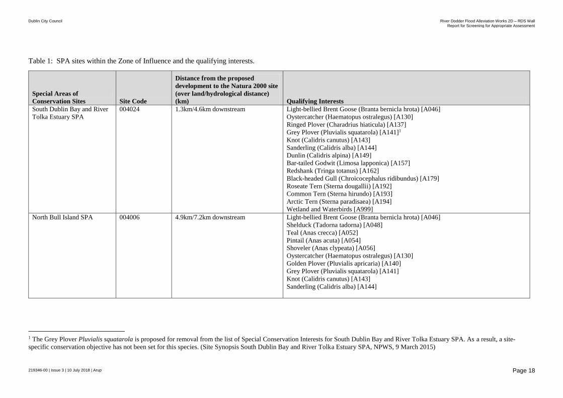
Table 1: SPA sites within the Zone of Influence and the qualifying interests.
Special Areas of
Conservation Sites Site Code
Distance from the proposed
development to the Natura 2000 site
(over land/hydrological distance)
(km) Qualifying Interests
South Dublin Bay and River
Tolka Estuary SPA
004024 1.3km/4.6km downstream
Light-bellied Brent Goose (Branta bernicla hrota) [A046]
Oystercatcher (Haematopus ostralegus) [A130]
Ringed Plover (Charadrius hiaticula) [A137]
Grey Plover (Pluvialis squatarola) [A141]1
Knot (Calidris canutus) [A143]
Sanderling (Calidris alba) [A144]
Dunlin (Calidris alpina) [A149]
Bar-tailed Godwit (Limosa lapponica) [A157]
Redshank (Tringa totanus) [A162]
Black-headed Gull (Chroicocephalus ridibundus) [A179]
Roseate Tern (Sterna dougallii) [A192]
Common Tern (Sterna hirundo) [A193]
Arctic Tern (Sterna paradisaea) [A194]
Wetland and Waterbirds [A999]
North Bull Island SPA 004006 4.9km/7.2km downstream Light-bellied Brent Goose (Branta bernicla hrota) [A046]
Shelduck (Tadorna tadorna) [A048]
Teal (Anas crecca) [A052]
Pintail (Anas acuta) [A054]
Shoveler (Anas clypeata) [A056]
Oystercatcher (Haematopus ostralegus) [A130]
Golden Plover (Pluvialis apricaria) [A140]
Grey Plover (Pluvialis squatarola) [A141]
Knot (Calidris canutus) [A143]
Sanderling (Calidris alba) [A144]
1 The Grey Plover Pluvialis squatarola is proposed for removal from the list of Special Conservation Interests for South Dublin Bay and River Tolka Estuary SPA. As a result, a site-
specific conservation objective has not been set for this species. (Site Synopsis South Dublin Bay and River Tolka Estuary SPA, NPWS, 9 March 2015)

Dublin City Council River Dodder Flood Alleviation Works 2D – RDS Wall
Report for Screening for Appropriate Assessment
219346-00 | Issue 3 | 10 July 2018 | Arup
Page 19
Special Areas of
Conservation Sites Site Code
Distance from the proposed
development to the Natura 2000 site
(over land/hydrological distance)
(km) Qualifying Interests
Dunlin (Calidris alpina) [A149]
Black-tailed Godwit (Limosa limosa) [A156]
Bar-tailed Godwit (Limosa lapponica) [A157]
Curlew (Numenius arquata) [A160]
Redshank (Tringa totanus) [A162]
Turnstone (Arenaria interpres) [A169]
Black-headed Gull (Chroicocephalus ridibundus) [A179]
Wetland and Waterbirds [A999]
Baldoyle Bay SPA 004016 10.4km/24km downstream Light-bellied Brent Goose (Branta bernicla hrota) [A046]
Shelduck (Tadorna tadorna) [A048]
Ringed Plover (Charadrius hiaticula) [A137]
Golden Plover (Pluvialis apricaria) [A140]
Grey Plover (Pluvialis squatarola) [A141]
Bar-tailed Godwit (Limosa lapponica) [A157]
Wetland and Waterbirds [A999]
Dalkey Islands SPA 004172 10.5km/15km downstream Roseate Tern (Sterna dougallii) [A192]
Common Tern (Sterna hirundo) [A193]
Arctic Tern (Sterna paradisaea) [A194]
Wicklow Mountains SPA 004040 10.7km/20km upstream Merlin (Falco columbarius) [A098]
Peregrine (Falco peregrinus) [A103]
Howth Head Coast SPA 004113 12.3km/14.2km downstream Kittiwake (Rissa tridactyla) [A188]
Ireland’s Eye SPA 004117 13.5km/21km downstream Cormorant (Phalacrocorax carbo) [A017]
Herring Gull (Larus argentatus) [A184]
Kittiwake (Rissa tridactyla) [A188]
Guillemot (Uria aalge) [A199]
Razorbill (Alca torda) [A200]

Dublin City Council River Dodder Flood Alleviation Works 2D – RDS Wall
Report for Screening for Appropriate Assessment
219346-00 | Issue 3 | 10 July 2018 | Arup
Page 20
Special Areas of
Conservation Sites Site Code
Distance from the proposed
development to the Natura 2000 site
(over land/hydrological distance)
(km) Qualifying Interests
Broadmeadow/
Swords Estuary SPA
004025 14.5km/27.1km downstream Great Crested Grebe (Podiceps cristatus) [A005]
Light-bellied Brent Goose (Branta bernicla hrota) [A046]
Shelduck (Tadorna tadorna) [A048]
Pintail (Anas acuta) [A054]
Goldeneye (Bucephala clangula) [A067]
Red-breasted Merganser (Mergus serrator) [A069]
Oystercatcher (Haematopus ostralegus) [A130]
Golden Plover (Pluvialis apricaria) [A140]
Grey Plover (Pluvialis squatarola) [A141]
Knot (Calidris canutus) [A143]
Dunlin (Calidris alpina) [A149]
Black-tailed Godwit (Limosa limosa) [A156]
Bar-tailed Godwit (Limosa lapponica) [A157]
Redshank (Tringa totanus) [A162]
Wetland and Waterbirds [A999]
Dublin City Council River Dodder Flood Alleviation Works 2D – RDS Wall
Report for Screening for Appropriate Assessment
219346-00 | Issue 3 | 10 July 2018 | Arup
Page 21
3.3.1.1 Direct Impacts
There will be no direct impacts on any sites designated as Special Protection
Areas. The proposed development works are not within or in proximity to any
Natura 2000 sites, refer to Table 1. The nearest SPA site, South Dublin Bay and
River Tolka Estuary SPA (Site code 004024) is approximately 4.6km downstream
(or 1.3km overland) of the River Dodder. None of the qualifying interest (QI)
species, which form part of the SPAs listed in Table 1, will be directly impacted
by the proposed development during construction or operation.
3.3.1.2 Indirect Impacts
The conservation objectives for the SPAs listed in Table 1, is to maintain
favourable conservation conditions for the species and habitats listed for each
SPA.
The SPA sites listed in Table 1 are predominantly species that are found in
coastal habitats including mud flats, wetlands, intertidal flats, sand flats and areas
of shallow water. These habitats provide areas suitable for feeding, nesting and
feeding in the sheltered shallow waters and organic rich mudflats. These sites are
significant for wintering birds that use the sites such as the Light-bellied Brent
Goose, which are known to move between the south and north Dublin bays.
The area of the proposed development is not an area of significant interest to these
bird species for roosting or foraging. The river is fast flowing and there is only
vegetation along a section of the left bank where works will not be carried out.
The site is in a highly urbanised environment with high volumes of traffic and
associated noise. The existing river channel is highly modified; the flow rates and
lack of shallow water (except during low rainfall) is unsuitable for feeding for
most species listed in Table 1.
There is a hydrological linkage to these SPA sites in Dublin Bay as the works will
be within the River Dodder channel. However, it is not considered that these QI
species would typically use this section of the River Dodder for prey species such
as fish and other aquatic invertebrates due to the unsuitable nature of the river (i.e.
deep, fast flowing water) for such potential prey.
The main potential downstream impacts relate to increased levels of suspended
solids in surface water runoff. The proposed works will generate run-off as a
results of construction activities; pumping of water during the excavation of the
riverbed at the base of the existing RDS wall and power washing of each unit of
set concrete before the next concrete pour. However, it is not expected that the
levels of run-off will be significant due to the nature and short duration of the
proposed works. The length of wall to be constructed is only 200m and will be
constructed in stages. The quantities of daily run-off material that will be
generated as a result of these activities will not be significant. The presence of the
haul road (and temporary sheet piles, if required) will act as a buffer and will
facilitate the drainage of any run-off containing sediment.
Dublin City Council River Dodder Flood Alleviation Works 2D – RDS Wall
Report for Screening for Appropriate Assessment
219346-00 | Issue 3 | 10 July 2018 | Arup
Page 22
The Natura 2000 sites downstream are not sensitive to sediment loading and are
all located in estuarine/ tidal areas in Dublin Bay which are subject to large
diurnal tidal flows carrying substantial volumes of sediment. Any habitats or
species in these areas are well used to varying levels of salinity, flows and
suspended solids. The distance between the proposed development works area and
the closest downstream Natura 2000 sites (4.6km) further reduces the risk of any
significant impact if sediment loading or pollution (e.g. fuel spill) was to occur.
This distance, combined with the considerable assimilative capacity of Dublin
Bay means that the level of suspended solids from the proposed works which
could possibly end up in the Dodder and downstream in the Bay will not have a
significant impact on these Natura 2000 sites.
Therefore, it is concluded that the proposed development works (or operation
phase) will not significantly impact any of the species of conservation interest of
the SPA sites or their prey given the following factors:
The nature of the works in a city centre urban environment.
Unsuitability of the habitats within or in proximity to the works areas.
The low ecological sensitivity of the downstream Natura 2000 sites to
sediment loading
Distance of the works area from the nearest SPA site (South Dublin Bay and
River Tolka Estuary SPA, site code 004024) which is 4.6km downstream of
the proposed works.

Dublin City Council River Dodder Flood Alleviation Works 2D – RDS Wall
Report for Screening for Appropriate Assessment
219346-00 | Issue 3 | 10 July 2018 | Arup
Page 23
Figure 3: Natura 2000 sites in proximity to the proposed development area. Source NPWS | Not to scale.
Dublin City Council River Dodder Flood Alleviation Works 2D – RDS Wall
Report for Screening for Appropriate Assessment
219346-00 | Issue 3 | 10 July 2018 | Arup
Page 24
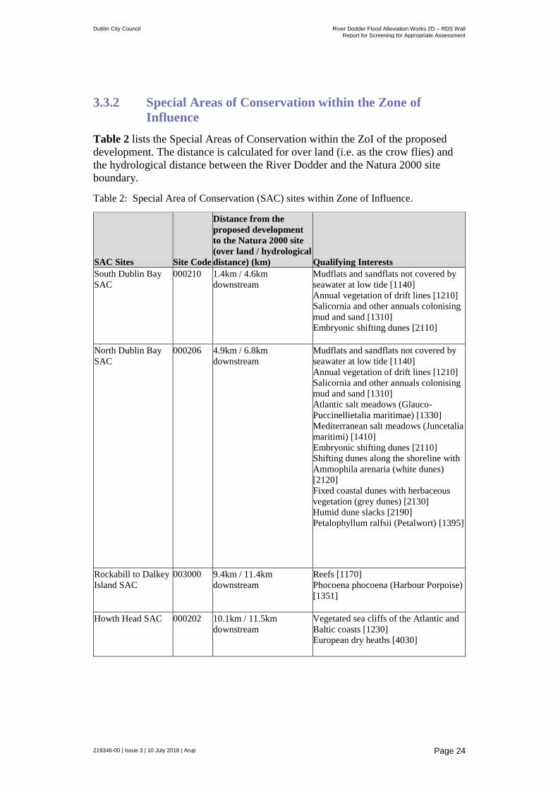
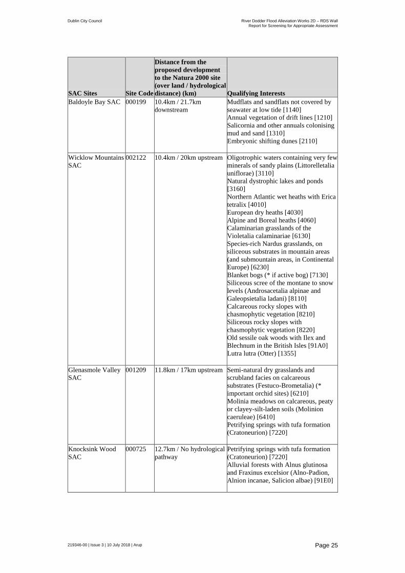
3.3.2 Special Areas of Conservation within the Zone of
Influence
Table 2 lists the Special Areas of Conservation within the ZoI of the proposed
development. The distance is calculated for over land (i.e. as the crow flies) and
the hydrological distance between the River Dodder and the Natura 2000 site
boundary.
Table 2: Special Area of Conservation (SAC) sites within Zone of Influence.
SAC Sites Site Code
Distance from the
proposed development
to the Natura 2000 site
(over land / hydrological
distance) (km) Qualifying Interests
South Dublin Bay
SAC
000210
1.4km / 4.6km
downstream
Mudflats and sandflats not covered by
seawater at low tide [1140]
Annual vegetation of drift lines [1210]
Salicornia and other annuals colonising
mud and sand [1310]
Embryonic shifting dunes [2110]
North Dublin Bay
SAC
000206
4.9km / 6.8km
downstream
Mudflats and sandflats not covered by
seawater at low tide [1140]
Annual vegetation of drift lines [1210]
Salicornia and other annuals colonising
mud and sand [1310]
Atlantic salt meadows (Glauco-
Puccinellietalia maritimae) [1330]
Mediterranean salt meadows (Juncetalia
maritimi) [1410]
Embryonic shifting dunes [2110]
Shifting dunes along the shoreline with
Ammophila arenaria (white dunes)
[2120]
Fixed coastal dunes with herbaceous
vegetation (grey dunes) [2130]
Humid dune slacks [2190]
Petalophyllum ralfsii (Petalwort) [1395]
Rockabill to Dalkey
Island SAC
003000
9.4km / 11.4km
downstream
Reefs [1170]
Phocoena phocoena (Harbour Porpoise)
[1351]
Howth Head SAC
000202
10.1km / 11.5km
downstream
Vegetated sea cliffs of the Atlantic and
Baltic coasts [1230]
European dry heaths [4030]
Dublin City Council River Dodder Flood Alleviation Works 2D – RDS Wall
Report for Screening for Appropriate Assessment
219346-00 | Issue 3 | 10 July 2018 | Arup
Page 25
SAC Sites Site Code
Distance from the
proposed development
to the Natura 2000 site
(over land / hydrological
distance) (km) Qualifying Interests
Baldoyle Bay SAC 000199 10.4km / 21.7km
downstream
Mudflats and sandflats not covered by
seawater at low tide [1140]
Annual vegetation of drift lines [1210]
Salicornia and other annuals colonising
mud and sand [1310]
Embryonic shifting dunes [2110]
Wicklow Mountains
SAC
002122 10.4km / 20km upstream Oligotrophic waters containing very few
minerals of sandy plains (Littorelletalia
uniflorae) [3110]
Natural dystrophic lakes and ponds
[3160]
Northern Atlantic wet heaths with Erica
tetralix [4010]
European dry heaths [4030]
Alpine and Boreal heaths [4060]
Calaminarian grasslands of the
Violetalia calaminariae [6130]
Species-rich Nardus grasslands, on
siliceous substrates in mountain areas
(and submountain areas, in Continental
Europe) [6230]
Blanket bogs (* if active bog) [7130]
Siliceous scree of the montane to snow
levels (Androsacetalia alpinae and
Galeopsietalia ladani) [8110]
Calcareous rocky slopes with
chasmophytic vegetation [8210]
Siliceous rocky slopes with
chasmophytic vegetation [8220]
Old sessile oak woods with Ilex and
Blechnum in the British Isles [91A0]
Lutra lutra (Otter) [1355]
Glenasmole Valley
SAC
001209 11.8km / 17km upstream Semi-natural dry grasslands and
scrubland facies on calcareous
substrates (Festuco-Brometalia) (*
important orchid sites) [6210]
Molinia meadows on calcareous, peaty
or clayey-silt-laden soils (Molinion
caeruleae) [6410]
Petrifying springs with tufa formation
(Cratoneurion) [7220]
Knocksink Wood
SAC
000725 12.7km / No hydrological
pathway
Petrifying springs with tufa formation
(Cratoneurion) [7220]
Alluvial forests with Alnus glutinosa
and Fraxinus excelsior (Alno-Padion,
Alnion incanae, Salicion albae) [91E0]

Dublin City Council River Dodder Flood Alleviation Works 2D – RDS Wall
Report for Screening for Appropriate Assessment
219346-00 | Issue 3 | 10 July 2018 | Arup
Page 26
SAC Sites Site Code
Distance from the
proposed development
to the Natura 2000 site
(over land / hydrological
distance) (km) Qualifying Interests
Malahide Estuary
SAC
000205 13.8km / 28km
downstream
Mudflats and sandflats not covered by
seawater at low tide [1140]
Salicornia and other annuals colonising
mud and sand [1310]
Atlantic salt meadows (Glauco-
Puccinellietalia maritimae) [1330]
Mediterranean salt meadows (Juncetalia
maritimi) [1410]
Shifting dunes along the shoreline with
Ammophila arenaria (white dunes)
[2120]
Fixed coastal dunes with herbaceous
vegetation (grey dunes) [2130]
Ballyman Glen SAC 000713 13.8km / No hydrological
pathway
Petrifying springs with tufa formation
(Cratoneurion) [7220]
Alkaline fens [7230]
Ireland’s Eye SAC 002193 13.8km / 21km
downstream
Perennial vegetation of stony banks
[1220]
Vegetated sea cliffs of the Atlantic and
Baltic coasts [1230]
3.3.2.1 Direct Impacts
There will be no direct impacts on any sites designated as Special Areas of
Conservation. The proposed development works are not within or in proximity to
any SAC sites, refer to Table 2. The nearest SAC site, South Dublin Bay SAC
(site code 000210) is approximately 5km downstream (or 1.4km overland) from
the proposed development. None of the qualifying interest (QI) species, which
form part of the SAC listed in Table 2, will be directly impacted by the proposed
development during construction or operation.
3.3.2.2 Indirect Impacts
The potential pathways for QI species or habitats, which form part of the SACs
listed in Table 2, were assessed within the zone of influence. The only SACs of
relevance are sites that have mobile species that move up and down the River
Dodder and those SACs that are downstream of the proposed development.
Downstream Special Areas of Conservation
Similar to the SPAs discussed above, the main potential downstream impacts
relate to increased levels of suspended solids in surface water runoff.
The proposed works will generate run-off as a results of construction activities;
pumping of water during the excavation of the riverbed at the base of the existing
RDS wall and power washing of each unit of set concrete before the next concrete
pour. However, it is not expected that the levels of run-off will be significant due
Dublin City Council River Dodder Flood Alleviation Works 2D – RDS Wall
Report for Screening for Appropriate Assessment
219346-00 | Issue 3 | 10 July 2018 | Arup
Page 27
to the nature and short duration of the proposed works. The length of wall to be
constructed is just 200m and will be constructed in 3m stages.
The quantities of daily run-off material that will be generated as a result of these
activities will not be significant. The presence of the haul road will act as a buffer
and will facilitate the drainage of any run-off containing sediment.
The Natura 2000 sites downstream are not sensitive to sediment loading and are
all located in estuarine/ tidal areas in Dublin Bay, which are subject to large
diurnal tidal flows carrying substantial volumes of sediment. Any habitats or
species in these areas are subject to varying levels of salinity, flows and
suspended solids. The distance between the proposed development works area and
the closest downstream Natura 2000 sites (4.6km) further reduces the risk of any
significant impact if sediment loading or pollution (e.g. fuel spill) was to occur.
This distance, combined with the considerable assimilative capacity of Dublin
Bay means that the level of suspended solids from the proposed works which
could possibly end up in the Dodder and downstream in the Bay will not have a
significant impact on these Natura 2000 sites.
Mobile species
There are two mobile species of relevance identified:
Harbour Porpoise Phocena, Rockabill to Dalkey Island SAC (Site Code
004172)
Otter Lutra, Wicklow Mountains SAC (Site Code 004040)
The Harbour Porpoise is found in the marine environment in Dublin Bay. It would
not be likely that this species would come into proximity with the proposed
development work site along the River Dodder.
Otters are listed as a species of conservation interest in the Wicklow Mountains
SAC. The Wicklow Mountains SAC is approximately 10.4km overland or 20km
upstream from the proposed development works site. The Dodder tributaries
originate in the Wicklow Mountains, providing a potential hydrological pathway
for otters to travel downstream. Though uncommon, otters are known to move
outside their territories for food.
Otters have been recorded along the River Dodder. Otters are protected species
under Annex II of the Habitats Directive. Their resting place is fully protected and
any interference with a holt (burrow) or access to it is prohibited except under
derogation.
Roughan O’Donovan (ROD) conducted ecological surveys along the River
Dodder as part of the proposed Doddder Greenway. These ecological surveys
included the works areas for the proposed RDS wall works. This assessment
included an otter survey in April-May 2017. No holts were identified within the
proposed development works area. The nearest holts identified were on the
northern (left bank) of the River Dodder approximately 450m upstream of the
Herbert Park Lane Bridge and approximately 730m downstream of Ballsbridge
near the Aviva Stadium.

Dublin City Council River Dodder Flood Alleviation Works 2D – RDS Wall
Report for Screening for Appropriate Assessment
219346-00 | Issue 3 | 10 July 2018 | Arup
Page 28
The online National Biodiversity Data Centre database was checked for
recordings of evidence of otter (holts or spraints) within or in proximity to the
proposed development works site. There was one submission2 (made in 2016) that
recorded otter spraints (otter faeces) along the left bank at Ballsbridge.
In May 2018, an ecological survey was carried out by ecologist Brain Keeley
(Wildlife Surveys Ltd) for the proposed works. The survey included the proposed
works areas and 200m up and downstream of the works area boundary. The area
was surveyed for evidence of otter, badger and kingfisher habitats. The results of
the surveys found no evidence of otter holts (or spraints) within the works area or
within 200m up and downstream of the works area. An ecological report was
prepared as part of the survey and is attached to this report in Appendix D.
During the ecological survey, local residents reported sightings and spraints of
otters within the works area. Otters were reported as using the left bank and haul
roads to move up and down the river during the flood alleviation works at
Ballsbridge. Otters are typically most active in the early mornings and evenings
and therefore will not be disturbed by construction works which will take place
during the daytime. Fish are a food source for the otters and their passage (and
consequently otter passage) will not be impeded by the construction works.
Therefore, it is concluded that the proposed works will not have a significant
impact on otters for the following factors:
There is no evidence of otter holts within or in proximity of the proposed
development.
Reports of otter sightings and spraints suggest the otters have continued the
proposed works area, during the previous construction works that have taken
place along this section of the River Dodder. The proposed works will be no
more intrusive than previous and current operations.
Otter passage will not be impeded by the construction works.
The food source (fish) will not be impeded from moving up and downstream
of the river.
The works will take place during the day and not conflict with the typically
active hours of the species.
The works are unlikely to have a significant negative effect on the water
quality of River Dodder.
3.4 Other Designated Sites
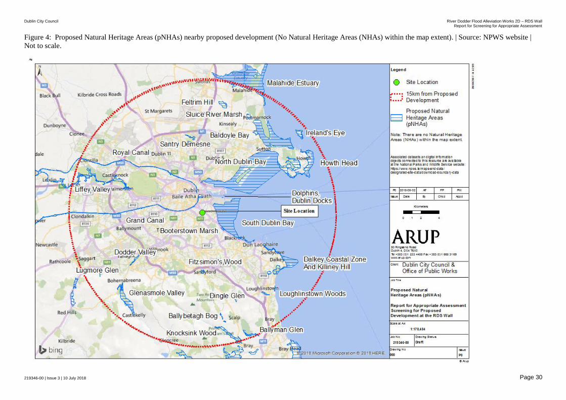
Natural Heritage Areas (NHAs) and Proposed Natural Heritage Areas (pNHAs)
can be considered to be ‘stepping stones’ between Natura 2000 sites and are
therefore considered in this assessment. Consultation of NPWS online data
identified 21 No. pNHA sites and no NHA sites within 15km of the proposed
development site.
2 Recording number O178322, date 27/02/2016
(https://maps.biodiversityireland.ie/Species/119290)

Dublin City Council River Dodder Flood Alleviation Works 2D – RDS Wall
Report for Screening for Appropriate Assessment
219346-00 | Issue 3 | 10 July 2018 | Arup
Page 29
These are listed in Table 3 and the distances from the site of the proposed
development are also provided. Figure 9 shows the location of those in the
immediate vicinity of the proposed development site.
North Dublin Bay pNHA and South Dublin Bay pNHA overlap the North Dublin
SPA and South Dublin Bay and River Tolka Estuary SPA respectively. As
discussed for these sites in Section 3.3.1, the proposed development does not
contain any habitats that would likely be used by bird species at these sites for
nesting or feeding. There is a hydrological link between the proposed
development and these downstream sites, however it is unlikely that the proposed
development will have a significant impact on these habitats or species.
Table 3: Proposed Natural Heritage Areas (pNHAs) within 15km of the proposed
development.
Proposed Natural Heritage Area Site Code
Distance from closest
section of proposed
development (km)
Grand Canal pNHA 002104 1.1
South Dublin Bay pNHA 000210 1.3
Booterstown Marsh pNHA 001205 2.7
Royal Canal pNHA 002103 2.3
Dolphins, Dublin Docks pNHA 000201 2.7
North Dublin Bay pNHA 000206 3.7
Fitzsimon's Wood pNHA 001753 6.4
Dalkey Coastal Zone And Killiney Hill pNHA 001206 7.9
Dodder Valley pNHA 000991 7.9
Santry Demesne pNHA 000178 7.7
Liffey Valley pNHA 000128 8.4
Howth Head pNHA 000202 10.2
Dingle Glen pNHA 001207 10.2
Baldoyle Bay pNHA 000199 10.2
Loughlinstown Woods pNHA 001211 11.2
Ballybetagh Bog pNHA 001202 11.5
Glenasmole Valley pNHA 001209 12.0
Sluice River Marsh pNHA 001763 11.6
Feltrim Hill pNHA 001208 11.9
Knocksink Wood pNHA 000725 13.1
Lugmore Glen pNHA 001212 13.2
Ireland's Eye pNHA 000203 13.7
Malahide Estuary pNHA 000205 13.9
Ballyman Glen pNHA 000713 14.0
Dublin City Council River Dodder Flood Alleviation Works 2D – RDS Wall Report for Screening for Appropriate Assessment
219346-00 | Issue 3 | 10 July 2018 Page 30
Figure 4: Proposed Natural Heritage Areas (pNHAs) nearby proposed development (No Natural Heritage Areas (NHAs) within the map extent). | Source: NPWS website |
Not to scale.
Dublin City Council River Dodder Flood Alleviation Works 2D – RDS Wall
Report for Screening for Appropriate Assessment
219346-00 | Issue 3 | 10 July 2018 | Arup
Page 31
3.5 Rare and Protected Species
The proposed development is located within the NPWS 10 kilometre grid square
013. The National Parks and Wildlife Service database (www.npws.ie) was
consulted with regard to rare species and species protected under the Flora
Protection Order (S.I. No. 356 of 2015) within this square.
A number of species were listed within the 10km grid square however, no species
were recorded in proximity to the proposed development. The nearest recording of
a protected species was Puccinellia fasciculate Tufted Salt-marsh Grass in
Sandymount (1840). This species listed in Schedule A of the Flora Protection
Order (2015). Given the fresh water environment of the proposed development,
the area is unsuitable for this species and unlikely to occur.
3.6 Fisheries
The River Dodder is considered significant regional salmonoid catchments for
species of salmon and trout3. The River Dodder is not listed on the First Schedule
of the European Communities (Quality of Salmonoid Waters) Regulations (S.I.
No. 293 of 1988). The Regulations provide protection to water quality of the
rivers listed and are subject to regular sampling to monitoring.
Under the Eastern River Basin Management Plan 2009-2015, the “Dodder Lower”
is reported as having the following status:
Macroinvertebrate Status - Poor
General Physical Chemical Status - Moderate
Fish Status - Good
Interim Overall Status - Poor
Previous flood alleviation works as part of the overall Dodder Flood Alleviation
Works Phase 2C-2E have been carried out in close consultation with Inland
Fisheries Ireland (IFI) and this will this will continue with these proposed works.
The free passage of fish will be maintained throughout the construction works. On
completion of the proposed works the river crossing and haul roads will be
removed and river channel will be reinstated to 2009 levels.
3 Dublin City Biodiversity Action Plan 2015-2020

Dublin City Council River Dodder Flood Alleviation Works 2D – RDS Wall
Report for Screening for Appropriate Assessment
219346-00 | Issue 3 | 10 July 2018 | Arup
Page 32
4 Cumulative Impacts with other Projects
The proposed Dodder Greenway route will run parallel to the proposed
development utilising the existing path along the southern boundary of Herbert
Park to Herbert Park Lane. Works for the Greenway have been previously
integrated into the flood alleviation works (Phase 2C) along a section of the
Dodder between Anglesea Bridge and Herbert Park.
During the construction of the proposed works this section of the path is closed as
it is required to be used as construction compound and access route from the left
bank of the river to works on the right bank. This access point will also be used
for the proposed development to access the right river wall upstream of Herbert
Park Lane Bridge.
It is likely that the proposed works will be complete prior to any necessary works
to the Greenway route.
As discussed in Section 2.2, the proposed development will be incorporated into
the on-going Dodder Flood Alleviation Works Phase 2C to 2E design. There is
potential that some of the works approved under Phase 2C-2E (Planning
Application 2504/13) will be under construction at the same time as the
construction of the proposed development. However, it is not envisioned that there
will be significant cumulative environmental effects. The proposed works will
utilise existing temporary river crossings and widen the existing haul roads that
have previously been constructed for the on-going Phase 2D works at Ballsbridge.
Any on-going approved Phase 2C to 2E flood alleviation works within or in
proximity to the proposed works area are unlikely to constructed at the same time
as the proposed development given the space constraints within the proposed
works area and limited plant and staff resources (the OPW will carry out all Phase
2C-2E flood alleviation works including the proposed works).

Dublin City Council River Dodder Flood Alleviation Works 2D – RDS Wall
Report for Screening for Appropriate Assessment
219346-00 | Issue 3 | 10 July 2018 | Arup
Page 33
5 Assessment of Significance
The proposed development will not result in any significant direct, indirect or
cumulative impacts on Natura 2000 sites. Refer to Table 4 below, has been used
to determine whether significant impacts are likely.
Table 4: Significant Impacts Checklist
Does the project have the potential to Yes or No
Reduce the area of key habitats? No
Reduce the population of key species? No
Change the balance between key species? No
Reduce diversity of the site? No
Result in disturbance that could affect population size or density or the balance
between key species? No
Result in fragmentation? No
Result in loss or reduction of key features (e.g. tree cover, tidal exposure, annual
flooding, etc.)? No
Cause delays in progress towards achieving the conservation objectives of the site? No
Interrupt progress towards achieving the conservation objectives of the site? No
Disrupt those factors that help to maintain the favourable conditions of the site No
Interfere with the balance, distribution and density of key species that are the
indicators of the favourable condition of the site? No
Cause changes to the vital defining aspects (e.g. nutrient balance) that determine
how the site functions as a habitat or ecosystem? No
Change the dynamics of the relationships (between, for example, soil and water or
plants and animals) that define the structure and/or function of the site? No
Interfere with predicted or expected natural changes to the site (such as water
dynamics or chemical composition)? No
In addition, this judgement has been arrived at on the following basis:
The works area is unlikely to be used by bird species listed as qualifying
interests in the special protection areas in Dublin Bay due to the lack of
suitable habitat for feeding or nesting.
The proposed works are unlikely to disturb otter species that have the potential
to travel downstream from the Wicklow Mountains SAC (site code 002122),
where they are a QI species. The ecological survey (May 2018) concluded that
there is no evidence of otter holts within or in proximity (200m up and
downstream). Any individuals that use the River Dodder within or in
proximity to the works area are likely to be present outside construction hours
due to the times the species is known to be most active. Reports of otters
present within the proposed development works area (including haul roads)
during previous flood alleviation works suggests that the species continues to
use the site despite construction activities and alterations to the river channel
i.e. haul roads.
Dublin City Council River Dodder Flood Alleviation Works 2D – RDS Wall
Report for Screening for Appropriate Assessment
219346-00 | Issue 3 | 10 July 2018 | Arup
Page 34
The Natura 2000 sites downstream are not sensitive to sediment loading and
are all located in estuarine/ tidal areas in Dublin Bay which are subject to large
diurnal tidal flows carrying substantial volumes of sediment. Any habitats or
species in these areas are well used to varying levels of salinity, flows and
suspended solids. The distance between the proposed development works area
and the closest downstream Natura 2000 sites (4.6km) further reduces the risk
of any significant impact if sediment loading or pollution (e.g. fuel spill) was
to occur. This distance, combined with the considerable assimilative capacity
of Dublin Bay means that the level of suspended solids from the proposed
works which could possibly end up in the Dodder and downstream in the Bay
will not have a significant impact on these Natura 2000 sites.
There will be some noise emissions but these will be temporary and on par
with the surrounding urban environment and traffic noise. Dust emissions
generated during demolition of the wall however, these will be limited as these
works will be conducted in stages.

Dublin City Council River Dodder Flood Alleviation Works 2D – RDS Wall
Report for Screening for Appropriate Assessment
219346-00 | Issue 3 | 10 July 2018 | Arup
Page 35
6 Conclusions
The aims of this report were as follows:
Provide information on, and assess the potential for the proposed development
to significantly impact on Natura 2000 Sites (also known as European sites).
Determine whether the proposed development is directly connected with, or
necessary to the conservation management of any Natura 2000 sites.
Determine whether the proposed development, alone or in combination with
other projects, is likely to have significant effects on Natura 2000 sites in view
of their conservation objectives.
It has been objectively concluded by Arup that:
There is no potential for the proposed development to significantly impact on
Natura 2000 Sites.
The proposed development is not directly connected with, or necessary to the
conservation management of any Natura 2000 sites.
The proposed development, alone or in combination with other projects, are
not likely to have significant effects on Natura 2000 sites in view of their
conservation objectives.
It has been determined by Arup that it is possible to rule out likely significant
impacts on any Natura 2000 sites. It is the view of Arup that it is not necessary to
undertake any further stage of the Appropriate Assessment process.
Refer to Appendix C Finding of No Significant Effects Report.

Appendix A
Engineering Drawings

Dublin City Council River Dodder Flood Alleviation Works 2D – RDS Wall
Report for Screening for Appropriate Assessment
219346-00 | Issue 3 | 10 July 2018 | Arup
Page A1
A1 Engineering Drawings
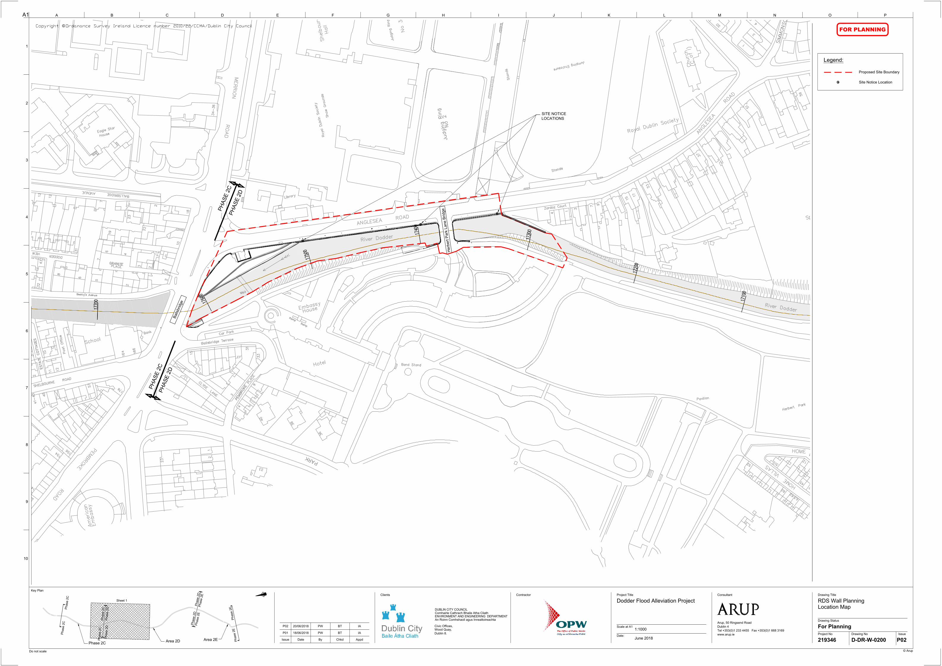
P
H
A
S
E
2
C
P
H
A
S
E
2
D
P
H
A
S
E
2
C
P
H
A
S
E
2
D
H
erbert P
ark Lane B
ridge
B
a
l
l
s
b
r
i
d
g
e
A1 A
9
B C D E F G H I J K L M N O P
Project No
Drawing Status
Date:
Scale at A1
Drawing No Issue
Drawing Title
Issue Date By Chkd Appd
Project TitleContractor
© Arup
Do not scale
10
8
7
6
5
4
2
1
3
Clients Consultant
Arup, 50 Ringsend Road
Dublin 4
Tel +353(0)1 233 4455 Fax +353(0)1 668 3169
www.arup.ie
Key Plan
©
DUBLIN CITY COUNCIL
Comhairle Cathrach Bhaile Atha Cliath
ENVIRONMENT AND ENGINEERING DEPARTMENT
An Roinn Comhshaoil agus Innealtoireachta
Civic Offices,
Wood Quay,
Dublin 8.
FOR PLANNING
Dodder Flood Alleviation Project
1:1000
June 2018
RDS Wall Planning
Location Map
For Planning
219346 D-DR-W-0200 P02
Phase 2C
Area 2D
Area 2E
Sheet 1
P
hase 2C
P
hase 2C
Phase 2D
Phase 2C
Phase 2C
Phase 2D
P
h
a
s
e
2
D
P
h
a
s
e
2
D
P
h
a
s
e
2
E
P
h
a
s
e
2
E
P
h
a
s
e
2
E
P
h
a
s
e
2
E
Legend:
Proposed Site Boundary
Site Notice Location
P01 18/06/2018 PW BT IA
SITE NOTICE
LOCATIONS
P02 20/06/2018 PW BT IA
AutoCAD SHX Text
34-36
AutoCAD SHX Text
Eagle Star
AutoCAD SHX Text
House
AutoCAD SHX Text
MERRION
AutoCAD SHX Text
1
AutoCAD SHX Text
2
AutoCAD SHX Text
22
AutoCAD SHX Text
23
AutoCAD SHX Text
BALLSBRIDGE
AutoCAD SHX Text
43
AutoCAD SHX Text
DODDER
AutoCAD SHX Text
31
AutoCAD SHX Text
VIEW
AutoCAD SHX Text
12
AutoCAD SHX Text
13
AutoCAD SHX Text
7
AutoCAD SHX Text
6
AutoCAD SHX Text
19
AutoCAD SHX Text
7
AutoCAD SHX Text
AVENUE
AutoCAD SHX Text
18
AutoCAD SHX Text
Weir
AutoCAD SHX Text
33
AutoCAD SHX Text
38
AutoCAD SHX Text
ROAD
AutoCAD SHX Text
Show Grounds
AutoCAD SHX Text
Shelbourne
AutoCAD SHX Text
Hall
AutoCAD SHX Text
Library
AutoCAD SHX Text
Hotel
AutoCAD SHX Text
Ramp
AutoCAD SHX Text
House
AutoCAD SHX Text
Embassy
AutoCAD SHX Text
Ramp
AutoCAD SHX Text
PARK
AutoCAD SHX Text
PARK
AutoCAD SHX Text
36
AutoCAD SHX Text
Band Stand
AutoCAD SHX Text
ROAD
AutoCAD SHX Text
Royal Dublin Society
AutoCAD SHX Text
2
AutoCAD SHX Text
3
AutoCAD SHX Text
4
AutoCAD SHX Text
PLACE
AutoCAD SHX Text
2
AutoCAD SHX Text
GRANITE
AutoCAD SHX Text
GRANITE
AutoCAD SHX Text
River
AutoCAD SHX Text
5
AutoCAD SHX Text
10
AutoCAD SHX Text
2
AutoCAD SHX Text
2
AutoCAD SHX Text
11
AutoCAD SHX Text
ESTATE COTTAGES
AutoCAD SHX Text
ESTATE COTTAGES
AutoCAD SHX Text
10
AutoCAD SHX Text
3
AutoCAD SHX Text
7
AutoCAD SHX Text
57
AutoCAD SHX Text
SHELBOURNE
AutoCAD SHX Text
12
AutoCAD SHX Text
School
AutoCAD SHX Text
Post Office
AutoCAD SHX Text
Dodder
AutoCAD SHX Text
6
AutoCAD SHX Text
32
AutoCAD SHX Text
8
AutoCAD SHX Text
31
AutoCAD SHX Text
Car Park
AutoCAD SHX Text
Ballsbridge Terrace
AutoCAD SHX Text
15
AutoCAD SHX Text
Ballsbridge
AutoCAD SHX Text
Bank
AutoCAD SHX Text
166
AutoCAD SHX Text
164
AutoCAD SHX Text
2
AutoCAD SHX Text
1
AutoCAD SHX Text
40
AutoCAD SHX Text
4
AutoCAD SHX Text
PEMBROKE
AutoCAD SHX Text
PEMBROKE
AutoCAD SHX Text
3
AutoCAD SHX Text
CLYDE LANE
AutoCAD SHX Text
PLACE
AutoCAD SHX Text
9
AutoCAD SHX Text
1
AutoCAD SHX Text
American
AutoCAD SHX Text
PEMBROKE
AutoCAD SHX Text
154
AutoCAD SHX Text
156
AutoCAD SHX Text
41-43
AutoCAD SHX Text
45
AutoCAD SHX Text
ROAD
AutoCAD SHX Text
23
AutoCAD SHX Text
7
AutoCAD SHX Text
176
AutoCAD SHX Text
Embassy
AutoCAD SHX Text
ROAD
AutoCAD SHX Text
23
AutoCAD SHX Text
144
AutoCAD SHX Text
ANGLESEA
AutoCAD SHX Text
No 2
AutoCAD SHX Text
Judging Ring
AutoCAD SHX Text
Judging Ring
AutoCAD SHX Text
No 3
AutoCAD SHX Text
River Dodder
AutoCAD SHX Text
23
AutoCAD SHX Text
Pavilion
AutoCAD SHX Text
60
AutoCAD SHX Text
51
AutoCAD SHX Text
52
AutoCAD SHX Text
37
AutoCAD SHX Text
20
AutoCAD SHX Text
ROAD
AutoCAD SHX Text
ANGLESEA
AutoCAD SHX Text
Royal Dublin Society
AutoCAD SHX Text
(C of I)
AutoCAD SHX Text
Church
AutoCAD SHX Text
River Dodder
AutoCAD SHX Text
51
AutoCAD SHX Text
59
AutoCAD SHX Text
SIMMONSCOURT
AutoCAD SHX Text
SIMMONSCOURT
AutoCAD SHX Text
Sports Ground
AutoCAD SHX Text
4
AutoCAD SHX Text
3
AutoCAD SHX Text
HOME VILLAS
AutoCAD SHX Text
12
AutoCAD SHX Text
VILLAS
AutoCAD SHX Text
Herbert Park
AutoCAD SHX Text
45
AutoCAD SHX Text
1
AutoCAD SHX Text
HOME
AutoCAD SHX Text
No 2
AutoCAD SHX Text
Judging Ring
AutoCAD SHX Text
Stands
AutoCAD SHX Text
Stands
AutoCAD SHX Text
Jumping Enclosure
AutoCAD SHX Text
9
AutoCAD SHX Text
7
AutoCAD SHX Text
15
AutoCAD SHX Text
17
AutoCAD SHX Text
3
AutoCAD SHX Text
1
AutoCAD SHX Text
4
AutoCAD SHX Text
Zardoz Court
AutoCAD SHX Text
63
AutoCAD SHX Text
62
AutoCAD SHX Text
42
AutoCAD SHX Text
Beatty's Avenue
AutoCAD SHX Text
17100
AutoCAD SHX Text
17200
AutoCAD SHX Text
17300
AutoCAD SHX Text
17400
AutoCAD SHX Text
17500
AutoCAD SHX Text
17600
AutoCAD SHX Text
17700
AutoCAD SHX Text
Copyright © Ordanance Survey Ireland Licence number 2010/22/CCMA/Dublin City Council Ordanance Survey Ireland Licence number 2010/22/CCMA/Dublin City Council
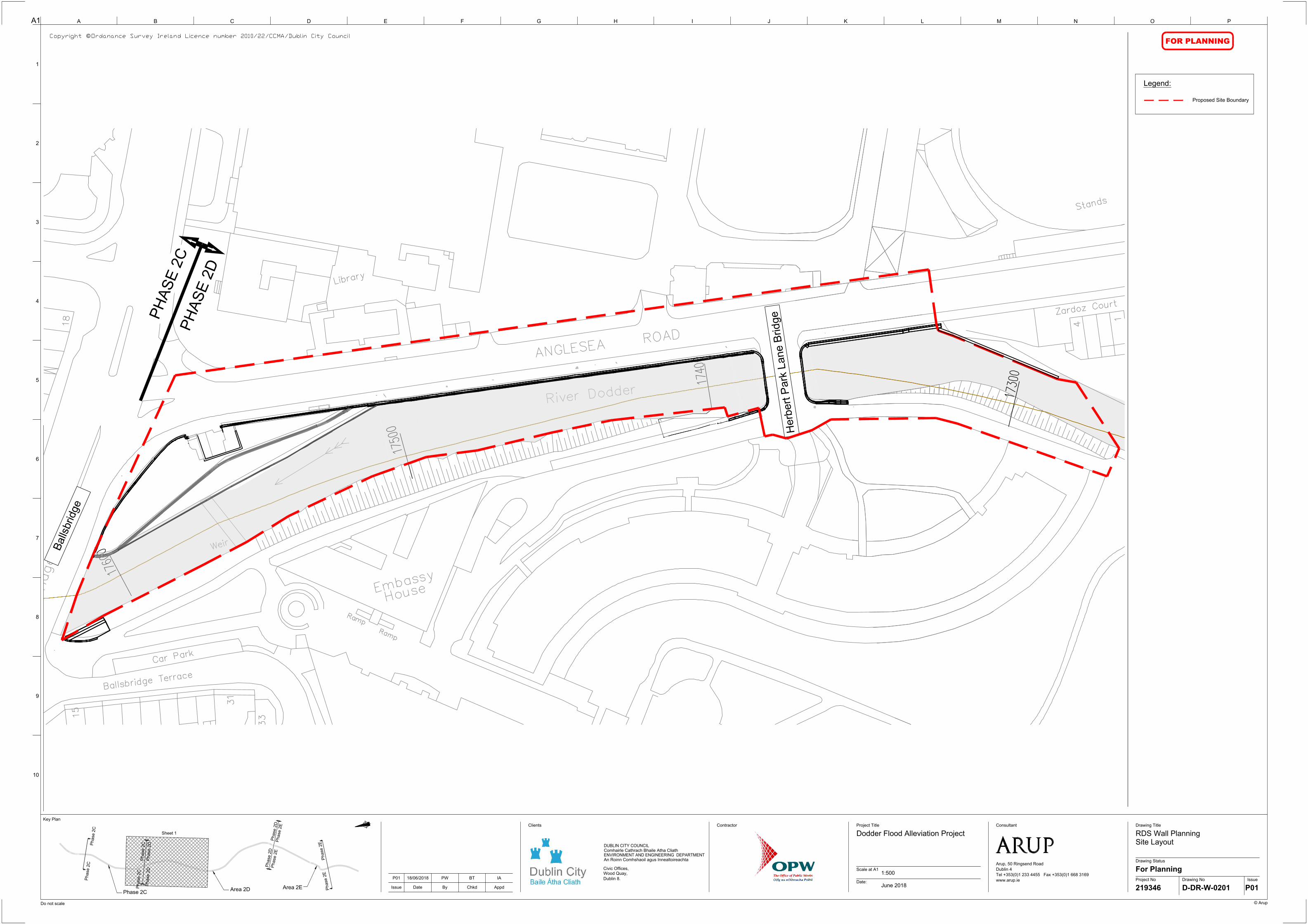
P
H
A
S
E
2
C
P
H
A
S
E
2
D
H
erbert P
ark Lane B
ridge
B
a
l
l
s
b
r
i
d
g
e
A1 A
9
B C D E F G H I J K L M N O P
Project No
Drawing Status
Date:
Scale at A1
Drawing No Issue
Drawing Title
Issue Date By Chkd Appd
Project TitleContractor
© Arup
Do not scale
10
8
7
6
5
4
2
1
3
Clients Consultant
Arup, 50 Ringsend Road
Dublin 4
Tel +353(0)1 233 4455 Fax +353(0)1 668 3169
www.arup.ie
Key Plan
©
DUBLIN CITY COUNCIL
Comhairle Cathrach Bhaile Atha Cliath
ENVIRONMENT AND ENGINEERING DEPARTMENT
An Roinn Comhshaoil agus Innealtoireachta
Civic Offices,
Wood Quay,
Dublin 8.
FOR PLANNING
Dodder Flood Alleviation Project
1:500
June 2018
RDS Wall Planning
Site Layout
For Planning
219346 D-DR-W-0201 P01
Phase 2C
Area 2D
Area 2E
Sheet 1
P
hase 2C
P
hase 2C
Phase 2D
Phase 2C
Phase 2C
Phase 2D
P
h
a
s
e
2
D
P
h
a
s
e
2
D
P
h
a
s
e
2
E
P
h
a
s
e
2
E
P
h
a
s
e
2
E
P
h
a
s
e
2
E
Legend:
Proposed Site Boundary
P01 18/06/2018 PW BT IA
AutoCAD SHX Text
18
AutoCAD SHX Text
Weir
AutoCAD SHX Text
33
AutoCAD SHX Text
Library
AutoCAD SHX Text
Ramp
AutoCAD SHX Text
House
AutoCAD SHX Text
Embassy
AutoCAD SHX Text
Ramp
AutoCAD SHX Text
ROAD
AutoCAD SHX Text
31
AutoCAD SHX Text
Car Park
AutoCAD SHX Text
Ballsbridge Terrace
AutoCAD SHX Text
15
AutoCAD SHX Text
Ballsbridge
AutoCAD SHX Text
ANGLESEA
AutoCAD SHX Text
River Dodder
AutoCAD SHX Text
Stands
AutoCAD SHX Text
1
AutoCAD SHX Text
4
AutoCAD SHX Text
Zardoz Court
AutoCAD SHX Text
17300
AutoCAD SHX Text
17400
AutoCAD SHX Text
17500
AutoCAD SHX Text
17600
AutoCAD SHX Text
Copyright © Ordanance Survey Ireland Licence number 2010/22/CCMA/Dublin City Council Ordanance Survey Ireland Licence number 2010/22/CCMA/Dublin City Council

RAISED GRASS AREA
EXISTING TREES TO
BE RETAINED
WIDENING OF EXISTING
FOOTPATH
EXISTING WALL REMOVED TO
FOOTPATH LEVEL
WALL FOUNDATION TO BE
CONFIRMED AT DETAILED
DESIGN STAGE
NEW RIVER WALL TO MATCH
SLOPE OF EXISTING RIVER
WALL. SEE NOTE 7
PART OF DODDER FRS MAIN WORKS,
TO BE COMPLETED AFTER
CONSTRUCTION OF RDS WALL
EXISTING TREES TO BE RETAINED
Anglesea Road
RIVER DODDER
PART OF DODDER FRS MAIN WORKS,
TO BE CONSTRUCTED AFTER
COMPLETION OF RDS WALL
REFER TO DETAIL A-A ON
DRAWING D-DR-W-2201
LOCATION OF EXISTING CULVERT.
CULVERT APPROXIMATELY 1.5m WIDE.
LOCATION OF EXISTING CULVERT.
CULVERT APPROXIMATELY 1.5m WIDE.
EXISTING TREES TO
BE RETAINED
EXISTING WALL TO BE REMOVED
TO FOOTPATH LEVEL
RIVER DODDER
Anglesea Road
EXISTING TREES TO
BE RETAINED
WALL FOUNDATION TO BE
CONFIRMED AT DETAILED
DESIGN STAGE
NEW RIVER WALL TO MATCH
SLOPE OF EXISTING RIVER
WALL. SEE NOTE 7
Anglesea Road
WIDENING OF EXISTING
FOOTPATH
A1 A
9
B C D E F G H I J K L M N O P
Project No
Drawing Status
Date:
Scale at A1
Drawing No Issue
Drawing Title
Issue Date By Chkd Appd
Project TitleContractor
© Arup
Do not scale
10
8
7
6
5
4
2
1
3
Clients Consultant
Arup, 50 Ringsend Road
Dublin 4
Tel +353(0)1 233 4455 Fax +353(0)1 668 3169
www.arup.ie
Key Plan
©
DUBLIN CITY COUNCIL
Comhairle Cathrach Bhaile Atha Cliath
ENVIRONMENT AND ENGINEERING DEPARTMENT
An Roinn Comhshaoil agus Innealtoireachta
Civic Offices,
Wood Quay,
Dublin 8.
FOR PLANNING
Dodder Flood Alleviation Project
1:100
June 2018
Area 2D - RDS River Wall
Proposed Flood wall
Plan Layout Chainage 17520 - 17420
Planning
219346 D-DR-W-0202 P02
PLAN
Scale 1:100
NOTES :
P01 18/06/2018 PW BT IA
REINFORCED
CONCRETE L-WALL
EXISTING WALL
MASONRY CLADDING
FOOTPATH
Phase 2C
Phase 2C
Phase 2C
Phase 2D
P
h
a
s
e
2
D
P
h
a
s
e
2
E
PLAN
Scale 1:100
P02 21/06/2018 PW BT IA
1. ALL LEVELS ARE IN M ABOVE O.D. MALIN.
2. ALL DIMENSIONS IN mm UNLESS
OTHERWISE NOTED.
3. REFER TO DRAWING NO. D-DR-W-2200 FOR
TYPICAL SECTION
4. CONCRETE CLASS SHALL BE C40/50..
CONCRETE EXPOSURE SHALL BE XS2.
5. DO NOT SCALE FROM DRAWINGS, USE
FIGURED DIMENSIONS ONLY.
7. EXISTING TREES TO BE RETAINED
8. NEW WALL TO BE CLAD WITH 200mm THICK
COURSED LIMESTONE WITH LIME MORTAR
POINTING TO MATCH EXISTING
9. ORIGINAL STONE WALL WILL BE REUSED
WHERE POSSIBLE FOR THE CLADDING.
10. WIDTH AT THE TOP OF THE STEM CAN BE
CURTAILED TO BE A MINIMUM OF 650MM.
11. NEW WALL TO HAVE A ROUNDED COPING IN
KEEPING WITH SURROUNDING FLOOD
DEFENCES
12. ALL EXISTING OUTFALLS WILL BE CARRIED
THROUGH THE NEW RIVER WALL AND WILL
BE FITTED WITH FLAP VALVES. FLAP
VALVES WILL ALSO BE FITTED ON WEEP
HOLES AS REQUIRED.
12. ORIGINAL EXISTING RIVERBED LEVEL TO BE
REINSTATED FOLLOWING CONSTRUCTION
13. DODDER FRS MAIN WORKS REFERS TO THE
PHASE 2D WORKS CURRENTLY UNDERWAY
UNDER A PREVIOUSLY GRANTED PLANNING
PERMIT
14. DIMENSIONS OF WALL FOUNDATION TO BE
CONFIRMED AT DETAILED DESIGN STAGE
AutoCAD SHX Text
CH 17,470
AutoCAD SHX Text
MATCHLINE
AutoCAD SHX Text
CH 17+470
AutoCAD SHX Text
CH 17,470
AutoCAD SHX Text
CH 17,460
AutoCAD SHX Text
CH 17,450
AutoCAD SHX Text
CH 17,440
AutoCAD SHX Text
CH 17,430
AutoCAD SHX Text
CH 17,420
AutoCAD SHX Text
MATCHLINE
AutoCAD SHX Text
CH 17+420
AutoCAD SHX Text
MATCHLINE
AutoCAD SHX Text
CH 17+470
AutoCAD SHX Text
Copyright © Ordanance Survey Ireland Licence number 2010/22/CCMA/Dublin City Council Ordanance Survey Ireland Licence number 2010/22/CCMA/Dublin City Council
AutoCAD SHX Text
LEGEND:

LOCATION OF EXISTING CULVERT.
CULVERT APPROXIMATELY 1.5m WIDE.
LOCATION OF EXISTING CULVERT.
CULVERT APPROXIMATELY 1.5m WIDE.
He
rb
ert P
ark H
ote
l B
rid
ge
EXISTING WALL REMOVED TO
FOOTPATH LEVEL
NEW L-WALL TO TIE INTO
ABUTMENT. REFER TO
DETAIL B-B ON DRAWING
D-DR-W-2201
WALL FOUNDATION TO BE
CONFIRMED AT DETAILED
DESIGN STAGE
2
11
D-D
R-W
-2
20
0
EXISTING TREES TO
BE RETAINED
EXISTING TREES TO
BE RETAINED
NEW RIVER WALL TO MATCH
SLOPE OF EXISTING RIVER
WALL. SEE NOTE 7
Anglesea Road
WIDENING OF EXISTING
FOOTPATH
Anglesea Road
Herbert P
ark H
otel B
ridge
STEM OF NEW REINFORCED
CONCRETE L-WALL
RIVER DODDER
NEW L-WALL TO TIE INTO
ABUTMENT. REFER TO
DETAIL B-B ON DRAWING
D-DR-W-2201
2
D-DR-W-2202
NEW L-WALL TO TIE INTO
ABUTMENT. REFER TO DETAIL
C-C ON DRAWING D-DR-W-2202MASONRY WALL TO TIE IN TO
EXISTING WALL ADJACENT TO
PAVEMENT. REFER TO DETAIL
D-D ON DRAWING D-DR-W-2201
EXISTING TREES TO
BE RETAINED
EXISTING TREES TO
BE RETAINED
EXISTING FLOOD
DEFENCE WALL
NEW WALL TO TIE INTO EXISTING
FLOOD WALL. REFER TO DETAIL
D-D DRAWING D-DR-W-2201
WALL FOUNDATION TO BE
CONFIRMED AT DETAILED
DESIGN STAGE
EXISTING MASONRY
WALL
NEW RIVER WALL TO MATCH
SLOPE OF EXISTING RIVER
WALL. SEE NOTE 7
EXISTING WALL REMOVED TO
FOOTPATH LEVEL
WIDENING OF EXISTING
FOOTPATH
A1 A
9
B C D E F G H I J K L M N O P
Project No
Drawing Status
Date:
Scale at A1
Drawing No Issue
Drawing Title
Issue Date By Chkd Appd
Project TitleContractor
© Arup
Do not scale
10
8
7
6
5
4
2
1
3
Clients Consultant
Arup, 50 Ringsend Road
Dublin 4
Tel +353(0)1 233 4455 Fax +353(0)1 668 3169
www.arup.ie
Key Plan
©
DUBLIN CITY COUNCIL
Comhairle Cathrach Bhaile Atha Cliath
ENVIRONMENT AND ENGINEERING DEPARTMENT
An Roinn Comhshaoil agus Innealtoireachta
Civic Offices,
Wood Quay,
Dublin 8.
FOR PLANNING
Dodder Flood Alleviation Project
1:100
June 2018
Area 2D - RDS River Wall
Proposed Flood wall
Plan Layout Chainage 17440 - 17330
Planning
219346 D-DR-W-0203 P02
PLAN
Scale 1:100
NOTES :
P01 18/06/2018 PW BT IA
REINFORCED
CONCRETE L-WALL
EXISTING WALL
MASONRY CLADDING
FOOTPATH
Phase 2C
Phase 2C
Phase 2C
Phase 2D
P
h
a
s
e
2
D
P
h
a
s
e
2
E
PLAN
Scale 1:100
P02 21/06/2018 PW BT IA
1. ALL LEVELS ARE IN M ABOVE O.D. MALIN.
2. ALL DIMENSIONS IN mm UNLESS
OTHERWISE NOTED.
3. REFER TO DRAWING NO. D-DR-W-2200 FOR
TYPICAL SECTION
4. CONCRETE CLASS SHALL BE C40/50..
CONCRETE EXPOSURE SHALL BE XS2.
5. DO NOT SCALE FROM DRAWINGS, USE
FIGURED DIMENSIONS ONLY.
7. EXISTING TREES TO BE RETAINED
8. NEW WALL TO BE CLAD WITH 200mm THICK
COURSED LIMESTONE WITH LIME MORTAR
POINTING TO MATCH EXISTING
9. ORIGINAL STONE WALL WILL BE REUSED
WHERE POSSIBLE FOR THE CLADDING.
10. WIDTH AT THE TOP OF THE STEM CAN BE
CURTAILED TO BE A MINIMUM OF 650MM.
11. NEW WALL TO HAVE A ROUNDED COPING IN
KEEPING WITH SURROUNDING FLOOD
DEFENCES
12. ALL EXISTING OUTFALLS WILL BE CARRIED
THROUGH THE NEW RIVER WALL AND WILL
BE FITTED WITH FLAP VALVES. FLAP
VALVES WILL ALSO BE FITTED ON WEEP
HOLES AS REQUIRED.
12. ORIGINAL EXISTING RIVERBED LEVEL TO BE
REINSTATED FOLLOWING CONSTRUCTION
13. DODDER FRS MAIN WORKS REFERS TO THE
PHASE 2D WORKS CURRENTLY UNDERWAY
UNDER A PREVIOUSLY GRANTED PLANNING
PERMIT
14. DIMENSIONS OF WALL FOUNDATION TO BE
CONFIRMED AT DETAILED DESIGN STAGE
AutoCAD SHX Text
CH 17,440
AutoCAD SHX Text
CH 17,430
AutoCAD SHX Text
CH 17,420
AutoCAD SHX Text
CH 17,410
AutoCAD SHX Text
CH 17,400
AutoCAD SHX Text
CH 17,390
AutoCAD SHX Text
CH 17,380
AutoCAD SHX Text
MATCHLINE
AutoCAD SHX Text
CH 17+420
AutoCAD SHX Text
MATCHLINE
AutoCAD SHX Text
CH 17+380
AutoCAD SHX Text
CH 17,380
AutoCAD SHX Text
CH 17,370
AutoCAD SHX Text
CH 17,360
AutoCAD SHX Text
CH 17,350
AutoCAD SHX Text
CH 17,340
AutoCAD SHX Text
MATCHLINE
AutoCAD SHX Text
CH 17+380
AutoCAD SHX Text
Copyright © Ordanance Survey Ireland Licence number 2010/22/CCMA/Dublin City Council Ordanance Survey Ireland Licence number 2010/22/CCMA/Dublin City Council
AutoCAD SHX Text
LEGEND:

500mm DIA. CAST IRON FOUL SEWER
25mm DIA. UNIDENTIFIED CABLE
100mm DIA. EIRCOM CABLE
4" DIA. 25Mbar Gas
FLOOD DEFENCE LEVEL 7.1m OD MALIN
50
0
2.4m
EXISTING RIVER
BED LEVEL
2.4m RIVER BED/ BASE OF WALL LEVEL
IN-SITU CONCRETE BEAM
LOCALISED SAND AND
CEMENT BAG REPAIRS
RECENTLY REPAIRED
COURSED LIMESTONE
BATTERED WALL
MIXED MATERIAL
PARAPET WALL
5.7m STREET LEVEL
EXISTING TREE TO
BE RETAINED
FOOTPATH
2800
12
90
(4
ft 3
in
)
THICKNESS VARIES FROM
600mm - 800mm
600
WALL UNDERPINNING
CURRENTLY UNDERWAY
AS PART OF DODDER FRS
MAIN WORKS
5.7m STREET LEVEL
2.4m RIVER BED LEVEL
FOOTPATH TO BE REINSTATED
TO EXISTING FINISH
FLOOD DEFENCE LEVEL 7.1m OD MALIN
RIVER BED REINSTATED TO EXISTING
LEVEL WITH AGREEMENT OF INLAND
FISHERIES IRELAND
REINFORCED CONCRETE L-WALL
EXISTING UTILITIES TO
BE RETAINED
EXISTING TREE TO
BE RETAINED
COURSED LIMESTONE CLADDING WITH
LIME MORTAR POINTING TO MATCH
SLOPE OF EXISTING WALL
8
0
°
SIZE OF FOUNDATION TO
BE CONFIRMED AT
DETAILED DESIGN STAGE
EXISTING WALL REMOVED TO
FOOTPATH LEVEL
WALL UNDERPINNING TO BE
CARRIED OUT AS PART OF
DODDER MAIN WORKS
PROPOSED WALL TO BE
DEBONDED FROM EXISTING
WALL
A1 A
9
B C D E F G H I J K L M N O P
Project No
Drawing Status
Date:
Scale at A1
Drawing No Issue
Drawing Title
Issue Date By Chkd Appd
Project TitleContractor
© Arup
Do not scale
10
8
7
6
5
4
2
1
3
Clients Consultant
Arup, 50 Ringsend Road
Dublin 4
Tel +353(0)1 233 4455 Fax +353(0)1 668 3169
www.arup.ie
Key Plan
©
DUBLIN CITY COUNCIL
Comhairle Cathrach Bhaile Atha Cliath
ENVIRONMENT AND ENGINEERING DEPARTMENT
An Roinn Comhshaoil agus Innealtoireachta
Civic Offices,
Wood Quay,
Dublin 8.
FOR PLANNING
P01 18/06/2018 PW BT IA
Dodder Flood Alleviation Project
1:25
June 2018
Area 2D - RDS River Wall
Proposed Flood Wall
Representative Sections at Ch 17420
For Planning
219346 D-DR-W-2200 P02
NOTES :
PROPOSED REPLACEMENT L WALL IN THE RIVER
(1:50)
COMMENTARY ON PROPOSED REPLACEMENT L-WALL:
· WIDTH OF THE FOOTPATH WILL INCREASE FROM 2.8m
WIDE TO A MAXIMUM OF APPROXIMATELY 3.4m WIDE
· EXISTING TREES WILL BE RETAINED
· EXISTING SERVICES WILL BE UNAFFECTED
· EXISTING WALL TO BE REMOVED ABOVE FOOTPATH LEVEL
· NEW WALL WILL BE CLAD WITH 200mm THICK COURSED
LIMESTONE WITH LIME MORTAR POINTING
· NEW WALL WILL HAVE A ROUNDED COPING IN KEEPING
WITH SURROUNDING FLOOD DEFENCES
· ORIGINAL EXISTING RIVERBED LEVEL WILL BE REINSTATED
FOLLOWING CONSTRUCTION
· CLADDING ON ROADSIDE FACE OF WALL WILL BE ALIGNED
FLUSH WITH ADJACENT RIVER WALL
COMMENTARY ON EXISTING WALL:
· NO FOUNDATION ON EXISTING WALL
· NO SCOUR PROTECTION PRESENT
· SIGNIFICANT SETTLEMENT OF THE EXISTING WALL
· COLLAPSING CULVERT AND OUTFALL
· SPALLING AND CRACKING EVIDENT THROUGHOUT DUE TO
PRESENCE OF TREE ROOTS AND SETTLEMENT
· LOSS OF MORTAR AND LARGE STONES RECORDED
THROUGHOUT
· UPPER PARAPET HAS BECOME SEPARATED FROM THE
SETTLED LOWER WALL
· LOWER WALL WAS FOUND TO HAVE INSUFFICIENT WALL
THICKNESS AND HENCE STRUCTURAL STRENGTH OF THE
EXISTING WALL IS INSUFFICIENT TO WITHSTAND DESIGN
CONDITION
· LOSS OF MORTAR AND LARGE STONES RECORDED
THROUGHOUT
· WALLS REPAIRS WERE CARRIED OUT IN NOVEMBER 2017
AND CONSISTED OF VEGETATION REMOVAL, LOCALISED
REPOINTING AND FILLING OF SIGNIFICANT VOIDS
EXISTING RIVER WALL
(1:50)
P02 21/06/2018 PW BT IA
1. ALL LEVELS ARE IN M ABOVE O.D. MALIN.
2. ALL DIMENSIONS IN mm UNLESS
OTHERWISE NOTED.
3. REFER TO DRAWING NO. D-DR-W-0202 FOR
PLAN LAYOUT
4. CONCRETE CLASS SHALL BE C40/50..
CONCRETE EXPOSURE SHALL BE XS2.
5. DO NOT SCALE FROM DRAWINGS, USE
FIGURED DIMENSIONS ONLY.
7. EXISTING TREES TO BE RETAINED
8. NEW WALL TO BE CLAD WITH 200mm THICK
COURSED LIMESTONE WITH LIME MORTAR
POINTING TO MATCH EXISTING
9. ORIGINAL STONE WALL WILL BE REUSED
WHERE POSSIBLE FOR THE CLADDING.
10. WIDTH AT THE TOP OF THE STEM CAN BE
CURTAILED TO BE A MINIMUM OF 650MM.
11. NEW WALL TO HAVE A ROUNDED COPING IN
KEEPING WITH SURROUNDING FLOOD
DEFENCES
12. ALL EXISTING OUTFALLS WILL BE CARRIED
THROUGH THE NEW RIVER WALL AND WILL
BE FITTED WITH FLAP VALVES. FLAP
VALVES WILL ALSO BE FITTED ON WEEP
HOLES AS REQUIRED.
12. ORIGINAL EXISTING RIVERBED LEVEL TO BE
REINSTATED FOLLOWING CONSTRUCTION
13. DODDER FRS MAIN WORKS REFERS TO THE
PHASE 2D WORKS CURRENTLY UNDERWAY
UNDER A PREVIOUSLY GRANTED PLANNING
PERMIT
14. DIMENSIONS OF WALL FOUNDATION TO BE
CONFIRMED AT DETAILED DESIGN STAGE
AutoCAD SHX Text
Copyright © Ordanance Survey Ireland Licence number 2010/22/CCMA/Dublin City Council Ordanance Survey Ireland Licence number 2010/22/CCMA/Dublin City Council
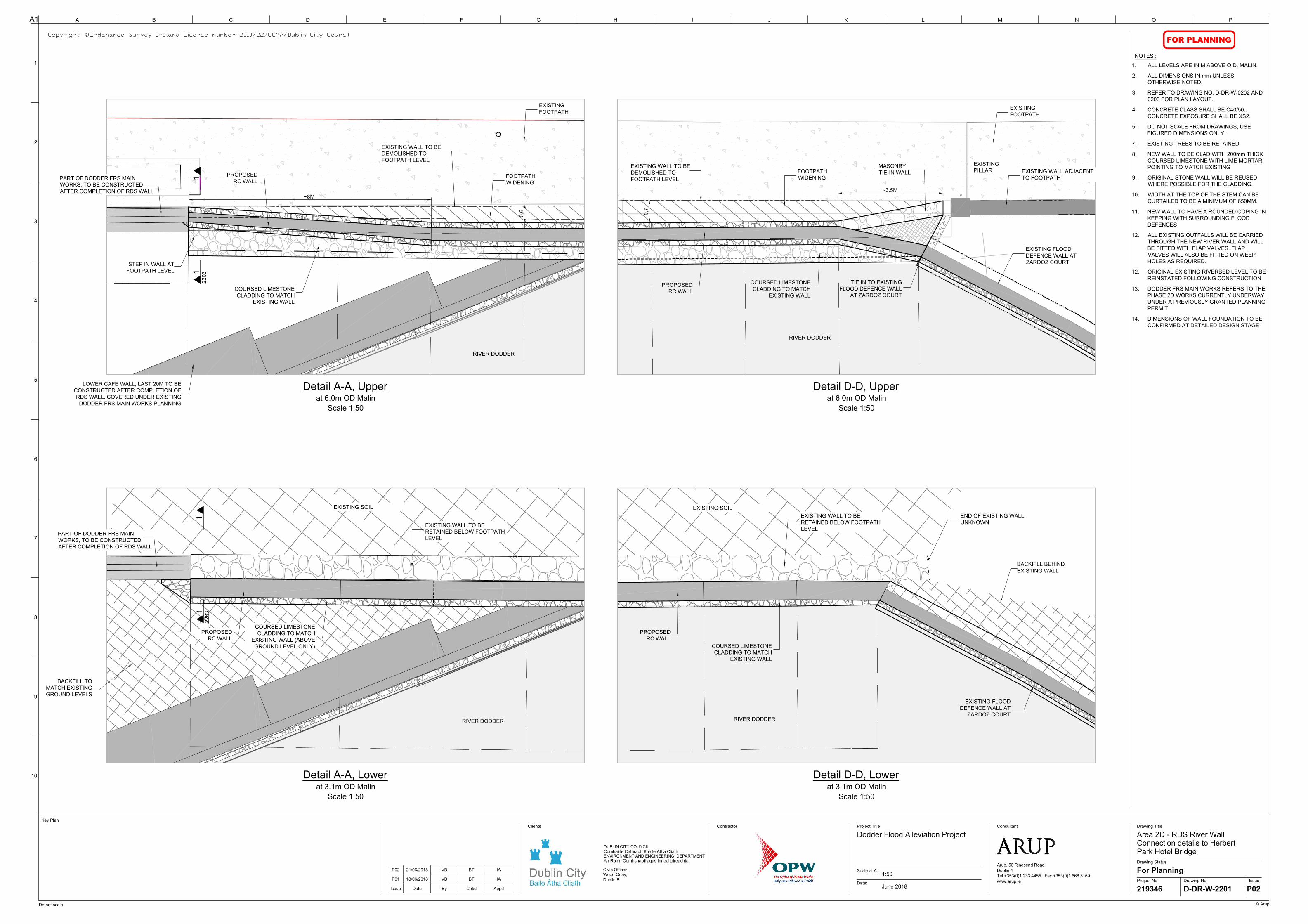
A1 A
9
B C D E F G H I J K L M N O P
Project No
Drawing Status
Date:
Scale at A1
Drawing No Issue
Drawing Title
Issue Date By Chkd Appd
Project TitleContractor
© Arup
Do not scale
10
8
7
6
5
4
2
1
3
Clients Consultant
Arup, 50 Ringsend Road
Dublin 4
Tel +353(0)1 233 4455 Fax +353(0)1 668 3169
www.arup.ie
Key Plan
©
DUBLIN CITY COUNCIL
Comhairle Cathrach Bhaile Atha Cliath
ENVIRONMENT AND ENGINEERING DEPARTMENT
An Roinn Comhshaoil agus Innealtoireachta
Civic Offices,
Wood Quay,
Dublin 8.
FOR PLANNING
P01 18/06/2018 VB BT IA
Dodder Flood Alleviation Project
1:50
June 2018
Area 2D - RDS River Wall
Connection details to Herbert
Park Hotel Bridge
For Planning
219346 D-DR-W-2201 P02
NOTES :
EXISTING WALL TO BE
DEMOLISHED TO
FOOTPATH LEVEL
EXISTING FLOOD
DEFENCE WALL AT
ZARDOZ COURT
TIE IN TO EXISTING
FLOOD DEFENCE WALL
AT ZARDOZ COURT
STEP IN WALL AT
FOOTPATH LEVEL
COURSED LIMESTONE
CLADDING TO MATCH
EXISTING WALL
PROPOSED
RC WALL
Detail A-A, Upper
at 6.0m OD Malin
Scale 1:50
~8M
~3.5M
EXISTING WALL ADJACENT
TO FOOTPATH
FOOTPATH
WIDENING
EXISTING
FOOTPATH
EXISTING
PILLAR
EXISTING FLOOD
DEFENCE WALL AT
ZARDOZ COURT
COURSED LIMESTONE
CLADDING TO MATCH
EXISTING WALL
PROPOSED
RC WALL
EXISTING WALL TO BE
RETAINED BELOW FOOTPATH
LEVEL
FOOTPATH
WIDENING
EXISTING WALL TO BE
DEMOLISHED TO
FOOTPATH LEVEL
PART OF DODDER FRS MAIN
WORKS, TO BE CONSTRUCTED
AFTER COMPLETION OF RDS WALL
COURSED LIMESTONE
CLADDING TO MATCH
EXISTING WALL
PROPOSED
RC WALL
EXISTING
FOOTPATH
LOWER CAFE WALL, LAST 20M TO BE
CONSTRUCTED AFTER COMPLETION OF
RDS WALL. COVERED UNDER EXISTING
DODDER FRS MAIN WORKS PLANNING
COURSED LIMESTONE
CLADDING TO MATCH
EXISTING WALL (ABOVE
GROUND LEVEL ONLY)
PROPOSED
RC WALL
EXISTING WALL TO BE
RETAINED BELOW FOOTPATH
LEVEL
PART OF DODDER FRS MAIN
WORKS, TO BE CONSTRUCTED
AFTER COMPLETION OF RDS WALL
BACKFILL TO
MATCH EXISTING
GROUND LEVELS
0,7
0,6
Detail D-D, Upper
at 6.0m OD Malin
Scale 1:50
Detail A-A, Lower
at 3.1m OD Malin
Scale 1:50
Detail D-D, Lower
at 3.1m OD Malin
Scale 1:50
BACKFILL BEHIND
EXISTING WALL
END OF EXISTING WALL
UNKNOWN
RIVER DODDER
RIVER DODDER
RIVER DODDER
RIVER DODDER
11
22
03
11
220
3
1. ALL LEVELS ARE IN M ABOVE O.D. MALIN.
2. ALL DIMENSIONS IN mm UNLESS
OTHERWISE NOTED.
3. REFER TO DRAWING NO. D-DR-W-0202 AND
0203 FOR PLAN LAYOUT.
4. CONCRETE CLASS SHALL BE C40/50..
CONCRETE EXPOSURE SHALL BE XS2.
5. DO NOT SCALE FROM DRAWINGS, USE
FIGURED DIMENSIONS ONLY.
7. EXISTING TREES TO BE RETAINED
8. NEW WALL TO BE CLAD WITH 200mm THICK
COURSED LIMESTONE WITH LIME MORTAR
POINTING TO MATCH EXISTING
9. ORIGINAL STONE WALL WILL BE REUSED
WHERE POSSIBLE FOR THE CLADDING.
10. WIDTH AT THE TOP OF THE STEM CAN BE
CURTAILED TO BE A MINIMUM OF 650MM.
11. NEW WALL TO HAVE A ROUNDED COPING IN
KEEPING WITH SURROUNDING FLOOD
DEFENCES
12. ALL EXISTING OUTFALLS WILL BE CARRIED
THROUGH THE NEW RIVER WALL AND WILL
BE FITTED WITH FLAP VALVES. FLAP
VALVES WILL ALSO BE FITTED ON WEEP
HOLES AS REQUIRED.
12. ORIGINAL EXISTING RIVERBED LEVEL TO BE
REINSTATED FOLLOWING CONSTRUCTION
13. DODDER FRS MAIN WORKS REFERS TO THE
PHASE 2D WORKS CURRENTLY UNDERWAY
UNDER A PREVIOUSLY GRANTED PLANNING
PERMIT
14. DIMENSIONS OF WALL FOUNDATION TO BE
CONFIRMED AT DETAILED DESIGN STAGE
MASONRY
TIE-IN WALL
P02 21/06/2018 VB BT IA
EXISTING SOIL
EXISTING SOIL
AutoCAD SHX Text
Copyright © Ordanance Survey Ireland Licence number 2010/22/CCMA/Dublin City Council Ordanance Survey Ireland Licence number 2010/22/CCMA/Dublin City Council
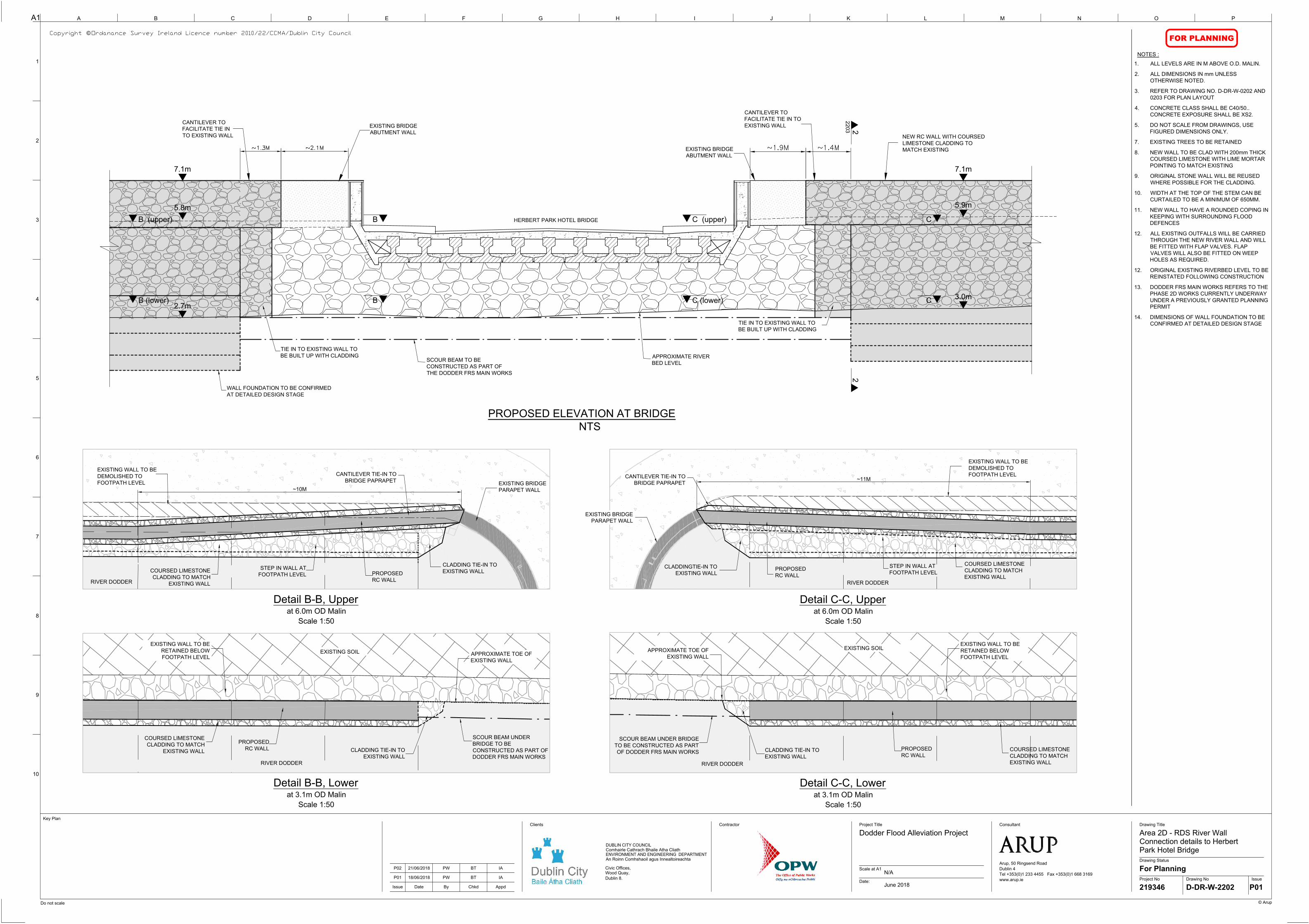
2.7m
7.1m
5.8m
5.9m
7.1m
3.0m
B (upper) B
NEW RC WALL WITH COURSED
LIMESTONE CLADDING TO
MATCH EXISTING
EXISTING BRIDGE
ABUTMENT WALL
TIE IN TO EXISTING WALL TO
BE BUILT UP WITH CLADDING
CANTILEVER TO
FACILITATE TIE IN TO
EXISTING WALL
APPROXIMATE RIVER
BED LEVEL
EXISTING BRIDGE
ABUTMENT WALL
CANTILEVER TO
FACILITATE TIE IN
TO EXISTING WALL
TIE IN TO EXISTING WALL TO
BE BUILT UP WITH CLADDING
HERBERT PARK HOTEL BRIDGE
B (lower) B
C (upper) C
C (lower) C
SCOUR BEAM TO BE
CONSTRUCTED AS PART OF
THE DODDER FRS MAIN WORKS
WALL FOUNDATION TO BE CONFIRMED
AT DETAILED DESIGN STAGE
A1 A
9
B C D E F G H I J K L M N O P
Project No
Drawing Status
Date:
Scale at A1
Drawing No Issue
Drawing Title
Issue Date By Chkd Appd
Project TitleContractor
© Arup
Do not scale
10
8
7
6
5
4
2
1
3
Clients Consultant
Arup, 50 Ringsend Road
Dublin 4
Tel +353(0)1 233 4455 Fax +353(0)1 668 3169
www.arup.ie
Key Plan
©
DUBLIN CITY COUNCIL
Comhairle Cathrach Bhaile Atha Cliath
ENVIRONMENT AND ENGINEERING DEPARTMENT
An Roinn Comhshaoil agus Innealtoireachta
Civic Offices,
Wood Quay,
Dublin 8.
FOR PLANNING
P01 18/06/2018 PW BT IA
Dodder Flood Alleviation Project
N/A
June 2018
Area 2D - RDS River Wall
Connection details to Herbert
Park Hotel Bridge
For Planning
219346 D-DR-W-2202 P01
NOTES :
PROPOSED ELEVATION AT BRIDGE
NTS
EXISTING WALL TO BE
DEMOLISHED TO
FOOTPATH LEVEL
EXISTING BRIDGE
PARAPET WALL
STEP IN WALL AT
FOOTPATH LEVEL
COURSED LIMESTONE
CLADDING TO MATCH
EXISTING WALL
CLADDING TIE-IN TO
EXISTING WALL
EXISTING WALL TO BE
DEMOLISHED TO
FOOTPATH LEVEL
EXISTING BRIDGE
PARAPET WALL
STEP IN WALL AT
FOOTPATH LEVEL
COURSED LIMESTONE
CLADDING TO MATCH
EXISTING WALL
CLADDINGTIE-IN TO
EXISTING WALL
CANTILEVER TIE-IN TO
BRIDGE PAPRAPET
PROPOSED
RC WALL
PROPOSED
RC WALL
CANTILEVER TIE-IN TO
BRIDGE PAPRAPET
EXISTING WALL TO BE
RETAINED BELOW
FOOTPATH LEVEL
COURSED LIMESTONE
CLADDING TO MATCH
EXISTING WALL
SCOUR BEAM UNDER BRIDGE
TO BE CONSTRUCTED AS PART
OF DODDER FRS MAIN WORKS
PROPOSED
RC WALL
Detail B-B, Upper
at 6.0m OD Malin
Scale 1:50
Detail B-B, Lower
at 3.1m OD Malin
Scale 1:50
Detail C-C, Upper
at 6.0m OD Malin
Scale 1:50
Detail C-C, Lower
at 3.1m OD Malin
Scale 1:50
~10M
~11M
APPROXIMATE TOE OF
EXISTING WALL
EXISTING WALL TO BE
RETAINED BELOW
FOOTPATH LEVEL
COURSED LIMESTONE
CLADDING TO MATCH
EXISTING WALL
PROPOSED
RC WALL
APPROXIMATE TOE OF
EXISTING WALL
CLADDING TIE-IN TO
EXISTING WALL
SCOUR BEAM UNDER
BRIDGE TO BE
CONSTRUCTED AS PART OF
DODDER FRS MAIN WORKS
CLADDING TIE-IN TO
EXISTING WALL
RIVER DODDER
RIVER DODDER
RIVER DODDER
RIVER DODDER
22
22
03
EXISTING SOIL
EXISTING SOIL
1. ALL LEVELS ARE IN M ABOVE O.D. MALIN.
2. ALL DIMENSIONS IN mm UNLESS
OTHERWISE NOTED.
3. REFER TO DRAWING NO. D-DR-W-0202 AND
0203 FOR PLAN LAYOUT
4. CONCRETE CLASS SHALL BE C40/50..
CONCRETE EXPOSURE SHALL BE XS2.
5. DO NOT SCALE FROM DRAWINGS, USE
FIGURED DIMENSIONS ONLY.
7. EXISTING TREES TO BE RETAINED
8. NEW WALL TO BE CLAD WITH 200mm THICK
COURSED LIMESTONE WITH LIME MORTAR
POINTING TO MATCH EXISTING
9. ORIGINAL STONE WALL WILL BE REUSED
WHERE POSSIBLE FOR THE CLADDING.
10. WIDTH AT THE TOP OF THE STEM CAN BE
CURTAILED TO BE A MINIMUM OF 650MM.
11. NEW WALL TO HAVE A ROUNDED COPING IN
KEEPING WITH SURROUNDING FLOOD
DEFENCES
12. ALL EXISTING OUTFALLS WILL BE CARRIED
THROUGH THE NEW RIVER WALL AND WILL
BE FITTED WITH FLAP VALVES. FLAP
VALVES WILL ALSO BE FITTED ON WEEP
HOLES AS REQUIRED.
12. ORIGINAL EXISTING RIVERBED LEVEL TO BE
REINSTATED FOLLOWING CONSTRUCTION
13. DODDER FRS MAIN WORKS REFERS TO THE
PHASE 2D WORKS CURRENTLY UNDERWAY
UNDER A PREVIOUSLY GRANTED PLANNING
PERMIT
14. DIMENSIONS OF WALL FOUNDATION TO BE
CONFIRMED AT DETAILED DESIGN STAGE
P02 21/06/2018 PW BT IA
AutoCAD SHX Text
Copyright © Ordanance Survey Ireland Licence number 2010/22/CCMA/Dublin City Council Ordanance Survey Ireland Licence number 2010/22/CCMA/Dublin City Council

5.7m STREET LEVEL
FLOOD DEFENCE LEVEL 7.1m OD MALIN
PROPOSED WALL TO
TIE IN TO BRIDGE
PARAPET
RIVER BED REINSTATED TO
EXISTING LEVEL WITH
AGREEMENT OF INLAND
FISHERIES IRELAND
750mm
See Note 10
REINFORCED
CONCRETE
L-WALL
2.4m RIVER BED/ BASE
OF WALL LEVEL
2800
EXISTING
UTILITIES TO BE
RETAINED
34
20
12
80
COURSED LIMESTONE
CLADDING WITH LIME
MORTAR POINTING. SLOPE
TO MATCH EXISTING WALL
14
30
(4
ft 8
in
)
400
8
0
°
~960
WALL UNDERPINNING
CARRIED OUT AS PART OF
DODDER FRS MAIN WORKS
WALL FOUNDATION
TO BE CONFIRMED
AT DETAILED
DESIGN STAGE
FOOTPATH TO BE
REINSTATED TO
EXISTING FINISH
~550
EXISTING
FOOTPATH
+5.47m
300
650
+2.40m RIVER BED LEVEL
+2.75m APPROX LOW WATER LEVEL
REINFORCED
CONCRETE L-WALL
+4.32m
BACKFILL TO TIE IN
WITH TOP OF MASS
CONCRETE WALL
PART OF DODDER FRS
MAIN WORK, TO BE
CONSTRUCTED AFTER
COMPLETION OF RDS WALL
+5.64m
1360
FOUNDATION DETAIL
OF TO BE CONFIRMED
AT DETAILED DESIGN
STAGE
ASSUMED
FOUNDATION OF
EXISTING WALL
COURSED LIMESTONE
CLADDING WITH LIME
MORTAR POINTING
EXISTING
UTILITIES TO BE
RETAINED
FLOOD DEFENCE LEVEL 7.1m OD MALIN
A1 A
9
B C D E F G H I J K L M N O P
Project No
Drawing Status
Date:
Scale at A1
Drawing No Issue
Drawing Title
Issue Date By Chkd Appd
Project TitleContractor
© Arup
Do not scale
10
8
7
6
5
4
2
1
3
Clients Consultant
Arup, 50 Ringsend Road
Dublin 4
Tel +353(0)1 233 4455 Fax +353(0)1 668 3169
www.arup.ie
Key Plan
©
DUBLIN CITY COUNCIL
Comhairle Cathrach Bhaile Atha Cliath
ENVIRONMENT AND ENGINEERING DEPARTMENT
An Roinn Comhshaoil agus Innealtoireachta
Civic Offices,
Wood Quay,
Dublin 8.
FOR PLANNING
P01 18/06/2018 VB BT IA
Dodder Flood Alleviation Project
N/A
June 2018
Area 2D - RDS River Wall
Connection details to Herbert
Park Hotel Bridge
For Planning
219346 D-DR-W-2203 P02
NOTES :
SECTION 1-1 (CAFE WALL JUNCTION DETAIL)
Scale 1:50
SECTION 2-2 (BRIDGE CONNECTION DETAIL)
Scale 1:50
P02 21/06/2018 PW BT IA
1. ALL LEVELS ARE IN M ABOVE O.D. MALIN.
2. ALL DIMENSIONS IN mm UNLESS
OTHERWISE NOTED.
3. REFER TO DRAWING NO. D-DR-W-2201 AND
2201 FOR SECTION LOCATIONS.
4. CONCRETE CLASS SHALL BE C40/50..
CONCRETE EXPOSURE SHALL BE XS2.
5. DO NOT SCALE FROM DRAWINGS, USE
FIGURED DIMENSIONS ONLY.
7. EXISTING TREES TO BE RETAINED
8. NEW WALL TO BE CLAD WITH 200mm THICK
COURSED LIMESTONE WITH LIME MORTAR
POINTING TO MATCH EXISTING
9. ORIGINAL STONE WALL WILL BE REUSED
WHERE POSSIBLE FOR THE CLADDING.
10. WIDTH AT THE TOP OF THE STEM CAN BE
CURTAILED TO BE A MINIMUM OF 650MM.
11. NEW WALL TO HAVE A ROUNDED COPING IN
KEEPING WITH SURROUNDING FLOOD
DEFENCES
12. ALL EXISTING OUTFALLS WILL BE CARRIED
THROUGH THE NEW RIVER WALL AND WILL
BE FITTED WITH FLAP VALVES. FLAP
VALVES WILL ALSO BE FITTED ON WEEP
HOLES AS REQUIRED.
12. ORIGINAL EXISTING RIVERBED LEVEL TO BE
REINSTATED FOLLOWING CONSTRUCTION
13. DODDER FRS MAIN WORKS REFERS TO THE
PHASE 2D WORKS CURRENTLY UNDERWAY
UNDER A PREVIOUSLY GRANTED PLANNING
PERMIT
14. DIMENSIONS OF WALL FOUNDATION TO BE
CONFIRMED AT DETAILED DESIGN STAGE
AutoCAD SHX Text
Copyright © Ordanance Survey Ireland Licence number 2010/22/CCMA/Dublin City Council Ordanance Survey Ireland Licence number 2010/22/CCMA/Dublin City Council

Appendix B
Photographs

Dublin City Council River Dodder Flood Alleviation Works 2D – RDS Wall
Report for Screening for Appropriate Assessment
219346-00 | Issue 3 | 10 July 2018 | Arup
Page B1
B1 Photographs
River Dodder Flood Alleviation Works 2D – RDS Wall
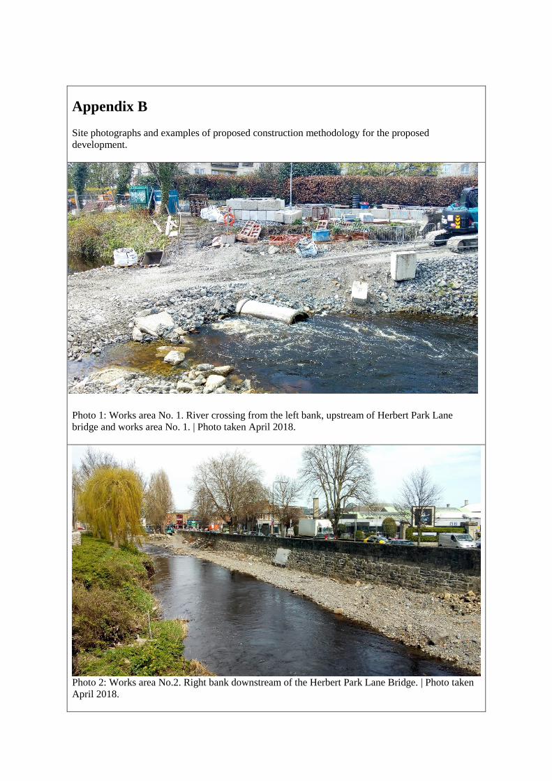
Appendix B Site photographs and examples of proposed construction methodology for the proposed
development.
Photo 1: Works area No. 1. River crossing from the left bank, upstream of Herbert Park Lane
bridge and works area No. 1. | Photo taken April 2018.
Photo 2: Works area No.2. Right bank downstream of the Herbert Park Lane Bridge. | Photo taken
April 2018.
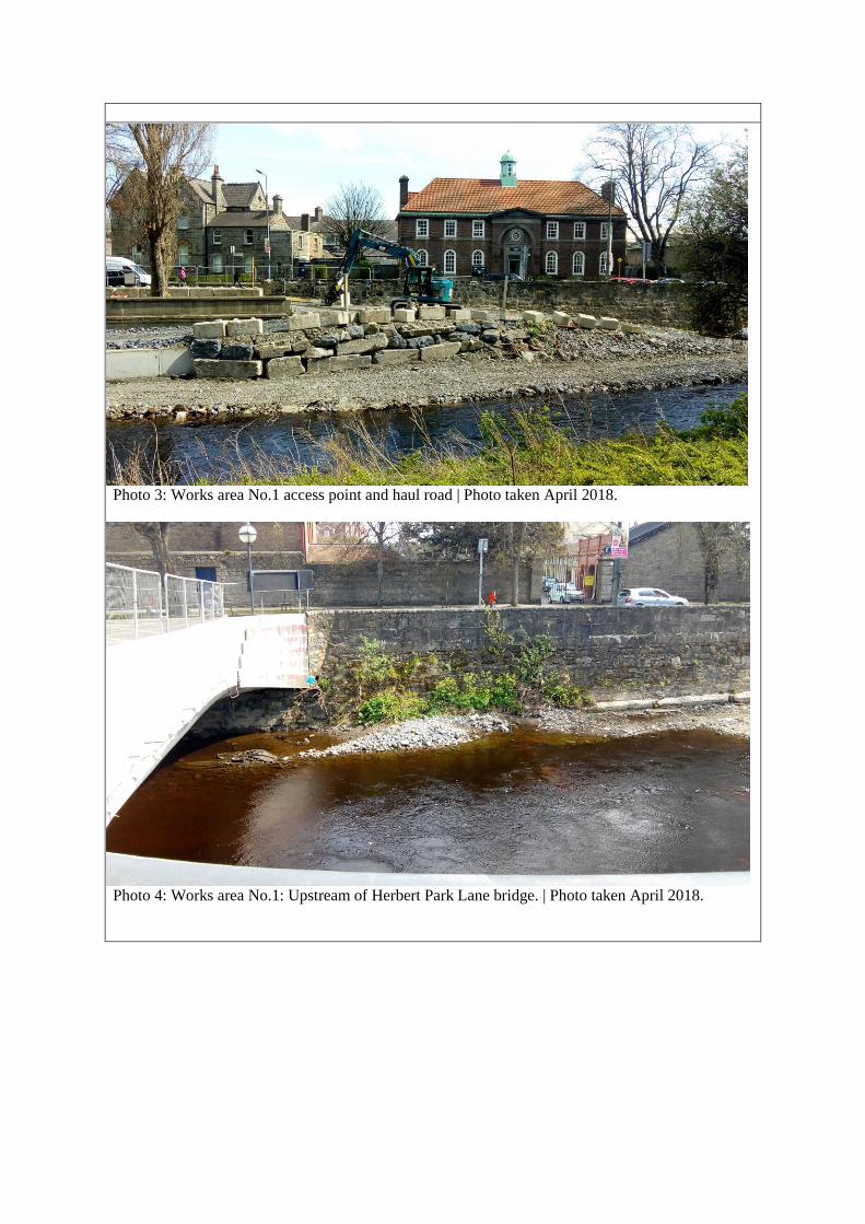
Photo 3: Works area No.1 access point and haul road | Photo taken April 2018.
Photo 4: Works area No.1: Upstream of Herbert Park Lane bridge. | Photo taken April 2018.
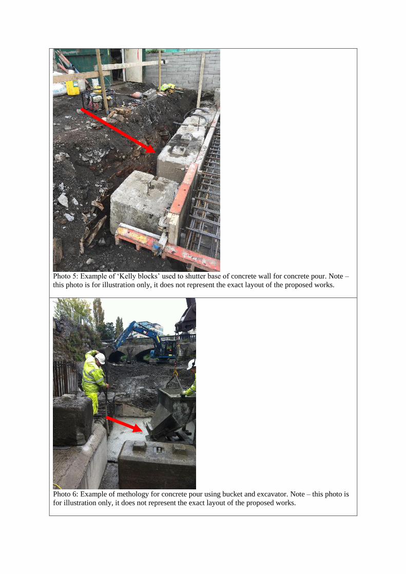
Photo 5: Example of ‘Kelly blocks’ used to shutter base of concrete wall for concrete pour. Note –
this photo is for illustration only, it does not represent the exact layout of the proposed works.
Photo 6: Example of methology for concrete pour using bucket and excavator. Note – this photo is
for illustration only, it does not represent the exact layout of the proposed works.

Photo 7 Example of temporary piles installed in the haul road during works. Note – this photo is for
illustration only, it does not represent the exact layout of the proposed works.
Photo 8 Example of a trench box during construction of the shear key. Note – this photo is for
illustration only, it does not represent the exact layout of the proposed works.

Appendix C
Finding of No Significant
Effects Report
Dublin City Council River Dodder Flood Alleviation Works 2D – RDS Wall
Report for Screening for Appropriate Assessment
219346-00 | Issue 3 | 10 July 2018 | Arup
Page C1
C1 Finding of No Significant Effects Report
Name of Project:
River Dodder Flood Alleviation Works 2D – RDS Wall
Names of Natura 2000 Sites of relevance to the proposed scheme:
Wicklow Mountains SAC (Site Code 002122) is considered to be of relevance in
this report due to the qualifying interest (QI) species of the SPA and the indirect
connection with the works site as a habitat. The Wicklow Mountains SAC is
approximately 10.4km overland or 20km downstream of Dodder tributaries within
the SAC, from the proposed development works site. Otters are a QI species to the
Wicklow Mountains SAC and though uncommon, are known to travel large
distances outside their territory to feed.
The following downstream Natura 2000 sites are considered of relevance to this
report due to the hydrological connection between the proposed development and
the site:
South Dublin Bay and River Tolka Estuary SPA (Site Code 004024),
approximately 4.6km downstream from the proposed development.
North Bull Island SPA (Site Code 004006), approximately 7.2km downstream
from the proposed development.
South Dublin Bay SAC (Site Code 000210), approximately 4.6km
downstream from the proposed development.
North Dublin Bay SAC (Site Code 000206), approximately 6.8km
downstream from the proposed development.
These four Natura 2000 sites are characterised as coastal habitats including mud
flats, wetlands, intertidal flats, sand flats and areas of shallow water. These
habitats provide areas suitable for feeding, nesting and feeding in the sheltered
shallow waters and organic rich mudflats. These sites are significant for wintering
birds that use the sites.
Is the project or plan directly connected with or necessary to the
management of the site?
No
Are there other projects or plans that together with the project or plan being
assessed could affect the site?
No
THE ASSESSMENT OF SIGNIFICANCE OF EFFECTS
Describe how the project or plan (alone or in combination) is likely to affect
the Natura 2000 site.
It has been determined by Arup that it is possible to rule out likely significant
impacts on any Natura 2000 sites.
Dublin City Council River Dodder Flood Alleviation Works 2D – RDS Wall
Report for Screening for Appropriate Assessment
219346-00 | Issue 3 | 10 July 2018 | Arup
Page C2
Explain why these effects are not considered significant.
The ecological survey conducted in May 2018 concluded that there is no
evidence of otter holts within the works area or in proximity to the works site.
The proposed development is within the feeding range for otters from the
Wicklow Mountains SAC however, 20km downstream is considered in the
upper threshold of this feeding range.
The proposed works are unlikely to disturb otter species that have the potential
to travel downstream from the Wicklow Mountains SAC (site code 002122),
where they are a QI species. The ecological survey (May 2018) has concluded
that there is no evidence of otter holts within or in proximity (200m up and
downstream). Any individual otters that use the River Dodder within or in
proximity to the works area are likely to be present outside construction hours
due to the time of day the species is known to be most active (early mornings
and evenings). Reports of otters present within the proposed development
works area (including haul roads) during previous flood alleviation works
suggests that the species continues to use the site despite construction
activities and alterations to the river channel i.e., haul roads.
The Natura 2000 sites downstream are not sensitive to sediment loading and
are all located in estuarine/ tidal areas in Dublin Bay which are subject to large
diurnal tidal flows carrying substantial volumes of sediment. Any habitats or
species in these areas are well used to varying levels of salinity, flows and
suspended solids. The distance between the proposed development works area
and the closest downstream Natura 2000 sites (4.6km) further reduces the risk
of any significant impact if sediment loading or pollution (e.g. fuel spill) was
to occur. This distance, combined with the considerable assimilative capacity
of Dublin Bay means that the level of suspended solids from the proposed
works which could possibly end up in the Dodder and downstream in the Bay
will not have a significant impact on these Natura 2000 sites.
There will be some noise emissions but these will be on par with the
surrounding urban environment and traffic noise. Dust emissions generated
during demolition of the wall however, these will be limited as these works
will be conducted in stages.
List of Agencies consulted
Inland Fisheries Ireland
DATA COLLECTED TO CARRY OUT THE ASSESSMENT
Who carried out the assessment?
The assessment was carried out by an Arup ecologist.
The ecological survey was carried out by Brian Keeley, ecologist of Wildlife
Surveys Ltd.
Sources of Data -
Sources of data included:
Dublin City Council River Dodder Flood Alleviation Works 2D – RDS Wall
Report for Screening for Appropriate Assessment
219346-00 | Issue 3 | 10 July 2018 | Arup
Page C3
Ordnance Survey of Ireland mapping and aerial photography (www.osi.ie) (viewed on 10 May 2018);
Bing aerial photography (viewed on 10 May 2018);
National Parks and Wildlife Service online data on European Sites and (www.npws.ie) (data downloaded on 10 May 2018);
National Parks and Wildlife Service online data on protected flora and fauna (viewed on 10 May 2018);
Information on environmental quality data available from the EPA’s map viewers, Envision Online Environmental Map Viewer (https://gis.epa.ie/EPAMaps/) and www.catchments.ie (viewed on 10 May 2018);
Dublin City Development Plan 2016-2022
Dublin City Development Plan 2016-2022 Appropriate Assessment Screening Report
Dublin City Biodiversity Action Plan 2015-2020
Dodder Greenway Ecological Impact Assessment (June 2017) Roughan & O’Donovan Consulting Engineers for South Dublin County Council
OVERALL CONCLUSIONS
Based on the information provided above, and by applying the precautionary
principle, it has been determined by Arup that it is possible to rule out likely
significant impacts on any Natura 2000 sites and therefore it is the view of Arup
that it is not necessary to undertake any further stage of the Appropriate
Assessment process.

Appendix D
Ecological Survey Report

Dodder Ecological Survey In Advance of Alterations to the Flood Relief Wall at Herbert Park,
Ballsbridge, Dublin 4
Brian Keeley B.SC. (Hons) in Zool. MCIEEM June 2018
Project background:
Approximately 200m of the west river wall along Anglesea Road from Ballsbridge to an area
immediately upstream of Herbert Park Lane bridge requires a new reinforced concrete L-wall to be
built. The existing wall will be removed to footpath level and new wall will be built in front of this. It
is proposed that the proposed works will be carried out under a Part 8 planning application as per
the Planning and Development Regulations 2001-2015, as amended, as part of the overall River
Dodder Flood Alleviation Works Phase 2C-2E.
This assessment examines the potential for the following protected species within or adjacent to the
site and discusses the potential for disturbance to these species from the proposed works: otter,
badger and kingfisher.
Otter Ecology
The otter is a mammal within the order Carnivora and the family Mustelidae related to the badger,
stoat and pine marten (and introduced American mink). Ireland has remained a refuge for otters
through a period when they disappeared from huge areas of Europe. However, this slowing in the
decline of this species in Ireland should not be cause for complacency. In previous surveys across the
island, positive signs of their presence have been found in up to 92% of sites.
A number of subsequent national surveys of otters have been conducted in the Republic of Ireland.
In 1980/81 otter signs were noted at 88% of the sites surveyed. In 1990, otter presence decreased to
75%. The population is estimated to be 10,000 adults (Vincent Wildlife Trust) or up to 12,000
(National Parks and Wildlife Service). The favourable reference population is set at 6464 female
otters, a 10.2% increase on the 2009 level estimated by NPWS. Thus, there is a perceived need in the
Threat Response Plan drawn up by NPWS to improve the conditions for otters.
In the Netherlands, otters became extinct in 1988 and otters disappeared in Belgium, Luxembourg
and Liechtenstein also. Swiss extinction was averted by the introduction of otters from Bulgaria. In
Germany, otters survived best in the former East German state due to lower intensification of
agriculture and industry and the presence of large hunting estates. In England, otters dwindled to a
number of individuals.
By 2015, otters had returned to much of the lost range including England and the Netherlands. The
importance of populations such as those of Ireland has been highlighted by the Council of Europe as
being a vital link in protecting the future of this species. The protection of otters is enhanced by the
inclusion of this species within the list of species requiring special protection measures including
Special Areas of Conservation under Annex II of the Habitats Directive. This provides otters with the
same level of protection as lesser horseshoe bats; found only in the west and south of the island.
This alone identifies the presence of otters in urban areas as a highly significant element of European
biodiversity and conservation measures.
Otters live a mainly aquatic-dependent life, feeding and commuting along rivers, canals, lakes as well
as travelling across land and living along the seashore. In Dublin, rivers and canals are the most
common sites while some lakes (natural and artificial) are also used to feed and shelter.
Otters live in underground burrows (holts) often excavated around tree roots in riverbanks or
burrows of other mammals such as badger setts, fox earths or rabbit warrens.
Otter may also rest above ground in long grass or scrub (including rhododendron, reeds etc.). They
have even been known to clamber on to boats to sleep.
Otters feed mostly on bottom-dwelling fish but will also eat frogs, crayfish, birds, small mammals
and in coastal areas, crabs and marine fish and invertebrates.
Otters are relatively large in terms of Irish mammals with an overall length of 1.2 metres for adult
males and 1 metre for females. Males may weigh around 10 kg (7-16 kg) while females are lighter (7
kg (5-9 kg)).
Otters are solitary and while there may be a loosely affiliated group of females (probably genetically
related to each other) in a single feeding area, males and females do not associate except to mate.
Where more than one otter is seen, it is usually a female and her cubs or the siblings of a litter.
Females establish and protect core areas within the overall territory to breed and other females will
not enter lightly into this area. Males may range over enormous distances with the larger territories
for this species being 80 km of stream.
The otter pregnancy is short; lasting on average 63 days. In comparison, the American mink may
have a spring pregnancy of between 39 and 76 days with shorter pregnancies in late spring. Otter
young are more commonly born in spring or summer in Ireland but throughout their range, otter
cubs may be born at any time in the year.
The natal holt (breeding holt) may be near or far from water and may show no distinctive features to
denote its greater significance in the ecology of this species. There are typically fewer spraints close
to natal holts. Holts may be very simple in freshwater areas but in coastal areas, they may have an
extensive network of tunnels usually 10 to 20 metres in length.
Bedding is introduced to line some of the chambers. Often, there are small pools of fresh water
within holts where freshwater is a limiting factor. The two to three young are born blind and covered
in fur and are suckled for 14 weeks. Solid food starts at 7 weeks. The first swim is at 12 weeks. By 16
weeks, the cubs leave on swimming trips with the mother. The young remain with the mother for 10
months with increasing independence in the last two months.
Otters may range over tens of kilometres with males travelling further than females and all
overlapping the territories of other individuals. Ranges of up to 48 km have been noted for males
but more commonly 20 km and upwards and this brings them into several female group areas. Much
of the information on otters comes from Scottish studies where otters appear to travel further.
Based on Irish studies, females may have home ranges of 7.5 km to 9 km and this is inversely related
to river width.
Otters are very short-lived in the wild with males living on (an European) average 3 years and
females up to 3.6 years. In Ireland, they may live up to 5 years on average. Captive otters can live up
to 15 years and a record of a wild 16 year old female is known from Scotland.
The main risks that otters face in terms of survival include habitat loss, pollution, availability of prey,
road-kill, conflict with fish farmers and gamekeepers and water quality. The three categories habitat
loss, water pollution and illegal and unintentional killing make up almost 75% of the major threats
with habitat loss being the principal threat. River and wetland drainage and Pollution (organic and
industrial) have similarly considerable impacts (17%, and 14% each respectively).
Interruption to an otter’s movement along a river or canal may lead to the individual entering public
roads. This may in turn lead to fatality. In the urban setting, roads are clearly a major challenge while
the presence of many dogs close to their feeding areas and especially their holts may pose a major
risk. In coastal areas, fishing nets may be a major risk while on rivers and canals, fishing line and
hooks may lead to serious injury. Along the River Dodder between Donnybrook and Ballsbridge,
illegal fishing may create some disturbance. But since the commencement of works upon the Flood
Alleviation programme for Dublin City along the Rover Dodder, there has been considerable
disturbance from partial damming of the river, the construction of temporary pontoons and bridges,
construction equipment, human activity, the operation of pumps, generators, lighting in addition to
stonemasonry associated with walls and bridges. These unavoidable activities (to provide safety for
the human population of the area) add to the usual disturbances faced by urban otters.
Otters have been recorded from numerous locations along the Dodder and Grand Canal and are
present in Grand Canal Dock and Basin and where the Dodder meets the River Liffey. Otters have
historically been recorded at O’Connell Bridge and have been photographed at Lansdowne New
Bridge. Sightings for the species include a new rock embankment downriver of Ballsbridge, an access
track opposite Ballsbridge library, the riverbank close to the Dunluce apartments, Smurfit’s Weir
upriver of Donnybrook Bridge. Reports from Waterways Ireland and from Conservation Ranger Terry
Doherty indicate that otters are present within Grand Canal Dock and are breeding here. Discussions
with residents close to Grand Canal Basin also indicate that otters were resident close to a former
naval vessel.
Previously otter spraints have been noted at Grand Canal Dock, the riverbank close to Ballsbridge
library, lock gates along the Grand Canal and within Grand Canal Basin.
Examinations of the riverbank behind Dunluce apartments site in 2015 provided evidence of an otter
holt at this time. However, this was washed away by drainage carried out within the apartments.
Badger Ecology
There is some overlap in the ecology of badgers and otters given their relatedness (as mustelids),
and their creation of burrows within which to rest. This digging is much more advanced and essential
to badgers and the dwelling place (sett) is of huge significance. Badgers do not travel over the same
distances as otters (in particular male otters) and the setts are probably more faithfully used and
maintained. Badgers may establish substantial setts that may have dozens of tunnels and chambers
and with tens of entrances. In an area such as Ballsbridge or Donnybrook or other urban areas, there
may be a greater restriction on the size of sett, the size of territory and the number of badgers.
However, supplementary feeding and exploitation of leftovers and waste may reduce the area
required to sustain badgers. Discussions with residents disclosed that badgers in the area are given
scraps and have been recorded on surveillance cameras to scramble over walls into gardens. Digging
within Herbert Park on football pitches was reported by one resident.
Badgers within this area are known to have established setts within the Dunluce property, within the
grounds of the Licensed Vintners Association, in the grounds of Old Wesley Rugby Club and may be
present over a wider area in surrounding gardens.

Kingfisher Ecology
The kingfisher is an iconic bird species that is well regarded by all but only rarely seen by most. The
population in Ireland is Amber-listed and BirdLife International considers the European population to
be depleted. This species is very sedentary in its habits and would not be long-distance traveller or
migrator. The species avails of vertical banks along streams and rivers to excavate a near-horizontal
tunnel to nest and rear the annual brood. In some areas, a second brood may also be hatched up to
700 metres from the first in a new tunnel. In an extensive study undertaken by the OPW, kingfisher
nests were found predominantly in clay banks (as opposed to sand) or tall vertical loamy banks. This
species is dependent upon a supply of species of small fish such as stickleback, minnow, chub as well
as larger aquatic invertebrates.
Hunting is usually done from an overhanging branch followed by a dive on to the prey and capture
under water. The adult can align several fish in its beak to return to feed the young in the tunnel.
Survey Methodology:
The site as shown in Figure 1 was examined on 23rd May 2018 and was supplemented by
observations prior to this evaluation and also subsequent to it on 25th May 2018. Surveying involved
a thorough inspection of all accessible areas from both riverbanks to identify the presence of otter
or badger signs or holts or setts respectively and the potential for the presence of kingfisher nests or
suitable sites for such nests. The river was examined upriver and downriver of the site to a distance
of 200 metres (minimum) for all of the above signs. Where residents were encountered along the
riverbank, they were questioned on observations of these species. Any other records from
discussions with residents are also included within this report.
Results of surveys for otters, badgers and kingfisher
Otters
There were no otter holts noted within Site 1 or Site 2. There were a number of otter prints that
were less than one week old in Site 1 and it is clear that this species enters the site on a regular
basis. In November 2017, two otters were noted to take cover within a rockpile that formed part of
the access track for OPW equipment level with Ballsbridge library by OPW staff.
Otter prints were noted on the shoreline behind the Dunluce apartments and the Merrion Cricket
Club. An otter was seen in the area beyond Site 1 and level with Site 2 to the rear of Dunluce
apartments within one month of the survey (mid-April). Otters have been noted on an occasional
basis emerging from and standing on rocks on the west bank downriver of Ballsbridge north of the
proposed compound (currently in use as a compound for other flood relief operations.

Otters are noted south of the site at Donnybrook close to Smurfit’s Weir as well as north of the site
where the Dodder joins the River Liffey.
Overall, this area is regularly used by otters but no holts were noted within the area that will be
directly affected by the proposed operations.
Discussions with local wildlife watchers and residents indicates that otters are also regularly seen in
the Milltown to Dartry Park area and holts have been noted in this area. Holts have been reported
along the Greenway route but the presence of otters at these holts was not confirmed.
Badgers
There were no signs of badgers within the site. Badger setts and some evidence of activity were
noted within the LVA grounds, at Old Wesley and a sett was noted close to Anglesea (Donnybrook)
Bridge. This species was reported to visit Herbert Park and has been recorded on camera as still
present at the LVA to the south of the proposed construction site.
Badgers will not be affected by the proposed work.
Kingfisher
There is no suitable river bank within the proposed construction site. No kingfishers were noted on
23rd or 25th May 2018. Kingfisher observations within this stretch have been scarce during
examinations of the river between 2015 and 2018 and discussions with local residents and nature
watchers identify the upriver section of the river as the area known for nesting by this species. The
main area of interest is at Dartry Park and a kingfisher nest was present here in 2017.
Summary of findings
There were no otter holts, badger setts or kingfisher nests within the areas within which the
construction work will be undertaken. There are therefore no direct risk to these protected species
from the proposed work. There will be no loss of dwelling places or protected structures sheltering
these species.
At present, there is constant construction work in the area around Ballsbridge that includes hugely
intrusive operations such as cutting stone with an angle grinder, movement of stones, wall
construction etc. with which the otters in this area have been dealing for over 2 years. The otter holt
provided to the rear of Dunluce has not been occupied to date. The otter holt at Lansdowne, to the
rear of the Aviva Stadium was used prior to 2015 and may be used occasionally but is not in constant
use.
Otters are potentially occupying the rocks placed along the west riverbank approximately 190
metres from the edge of the site and have been seen to hide within rocks within the site when
disturbed.
Badgers have been consistently in areas upriver of the proposed work and are not directly affected
by the works.

Kingfishers are even further upriver towards Milltown and on to Rathfarnham. This species will not
be directly affected on a daily basis and there is very limited impact, if any, upon feeding on a daily
basis.
The habitats within which the works will take place are:
FW2 Depositing/lowland river
BL1 Stone walls and other stonework
BL3 Buildings and artificial surfaces
The riverbank on the west side, south of the hotel holds a Treeline WL2. To the rear of the works
there is Amenity grassland (improved) GA2. The river bank towards the RDS side (east) holds Mixed
broadleaved/conifer woodland WD and amenity grassland GA2 as well as BL1 and BL3 (built
environment).
Recommendations
It is clear that the only species of the three discussed in this report potentially affected by the
proposed work is the otter. This species is not present within the site but is clearly a regular visitor to
the area and may avail of lands adjacent to the site as resting places.
The ongoing operations along this section of the Dodder and including the bridge to Herbert Park
Hotel are intrusive but are being tolerated by the local otters. It is likely that the continuing work will
be no more intrusive than previous and current operations.
It is proposed that a licence to disturb is not required given that this work will not encroach upon
any holts, setts or kingfisher nests.


Otter signs along the River Dodder close to the
proposed operations at Ballsbridge, Dublin 4
Legend
1. Artificial otter holt
2. Artificial otter holt
3. Regular Otter Sightings
4. 2 otters seen November 2017
5. Otter holt destroyed during drainage by
construction company
6. Artificial otter holt
Area within which construction works will
occur
Compound for construction
5
6
3
4
1
2
3
4
5
6
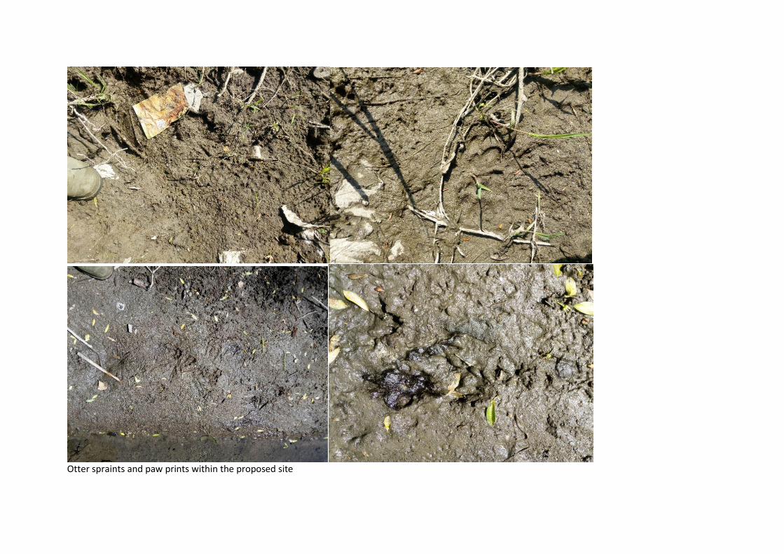
Otter spraints and paw prints within the proposed site
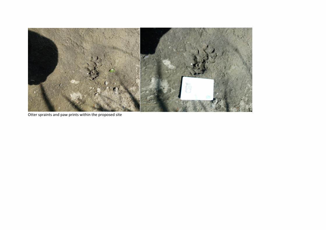
Otter spraints and paw prints within the proposed site

Considerable construction and operations at and around the proposed works crating a disturbance but still visited by otters

Otter spraints and paw prints
Badger setts and tracks upriver of the site
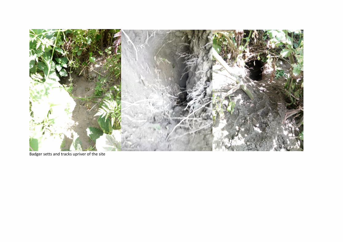
Badger setts and tracks upriver of the site
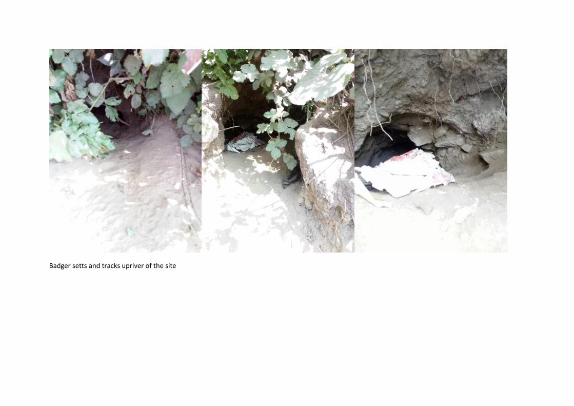
Badger setts and tracks upriver of the site

Badger setts and tracks upriver of the site

Examples of banks with kingfisher nests (not along the River Dodder)


![RDS 323 Restorative Dental Sciences [ RDS]](https://static.fdocuments.in/doc/165x107/6235ee36aafa9c66c73cc0cf/rds-323-restorative-dental-sciences-rds.jpg)