REZ2016-00002 HHHunt - Home - County of Henrico, … HHHunt Staff Report for Board of Supervisors...
33
REZ2016-00002 HHHunt Staff Report for Board of Supervisors Public Hearing Prepared March 31 , 2016 This report is prepared by the Henrico County Planning Staff to provide information to the Planning Commission and the Board of Supervisors to assist them in making a decision on this application. It may also be useful to others interested in this land use matter. I. PUBLIC HEARINGS: Planning Commission: March 10, 2016 Recommended for Approval Board of Supervisors: April 12 , 2016 Pending II. IDENTIFICATION AND LOCATIONAL INFORMATION: Requested Zoning: Existing Zoning: Total Acreage: Proposed Use: Location: Magisterial District: Comprehensive Plan Recommendations: Parcel No.: Zoning of Surrounding Properties: REZ2016-00002 R-3C One-Family Residence District (Conditional) - 31 .94 acres R-5AC General Residence District (Conditional) - 142. 17 acres RTHC Residential Townhouse District (Conditional) - 53.40 acres R-5C General Residence District (Conditional) - 21. 76 R-2AC One-Family Residence District (Conditional) and A-1 Agricultural District 249.27 acres Single-family homes, zero lot line homes, residential townhouse uses, and multi-family units. On the east line of Magnolia Ridge Drive approximately 500' west of its intersection with Brook Road (U .S. Route 1). Fairfield Suburban Residential 1, Suburban Residential 2, Office , Environmental Protection Area , and Prime Economic Development Site #7 779-773-9041 , 780-771-0875, 780-772- 9071 , 780-773-2718, 780- 773-3673, 780-77 4-2957, 781-773-3186, and part of 778-772- 7200 and 782-772-1447 North: South: East: West: Chickahominy River and Hanover County A-1 Agricultural District, R-2C and R-2AC One-Family Residence Districts (Magnolia Ridge) A-1 Agricultural District, R-6C General Residence District (Assisted Living) , 0-2C Office District, B-2C and B-3C Business Districts A-1 Agricultural District Page 1
Transcript of REZ2016-00002 HHHunt - Home - County of Henrico, … HHHunt Staff Report for Board of Supervisors...

REZ2016-00002 HHHunt Staff Report for Board of Supervisors Public Hearing Prepared March 31, 2016
This report is prepared by the Henrico County Planning Staff to provide information to the Planning Commission and the Board of Supervisors to assist them in making a decision on this application. It may also be useful to others interested in this land use matter.
I. PUBLIC HEARINGS:
Planning Commission: March 10, 2016 Recommended for Approval
Board of Supervisors: April 12, 2016 Pending
II. IDENTIFICATION AND LOCATIONAL INFORMATION:
Requested Zoning:
Existing Zoning:
Total Acreage:
Proposed Use:
Location:
Magisterial District:
Comprehensive Plan Recommendations:
Parcel No.:
Zoning of Surrounding Properties:
REZ2016-00002
R-3C One-Family Residence District (Conditional) - 31 .94 acres R-5AC General Residence District (Conditional) - 142.17 acres RTHC Residential Townhouse District (Conditional) - 53.40 acres R-5C General Residence District (Conditional) - 21. 76
R-2AC One-Family Residence District (Conditional) and A-1 Agricultural District
249.27 acres
Single-family homes, zero lot line homes, residential townhouse uses, and multi-family units .
On the east line of Magnolia Ridge Drive approximately 500' west of its intersection with Brook Road (U .S. Route 1 ).
Fairfield
Suburban Residential 1, Suburban Residential 2, Office , Environmental Protection Area , and Prime Economic Development Site #7
779-773-9041 , 780-771-0875, 780-772-9071 , 780-773-2718, 780-773-3673, 780-77 4-2957, 781-773-3186, and part of 778-772-7200 and 782-772-1447
North: South:
East:
West:
Chickahominy River and Hanover County A-1 Agricultural District , R-2C and R-2AC One-Family Residence Districts (Magnolia Ridge) A-1 Agricultural District , R-6C General Residence District (Assisted Living) , 0-2C Office District, B-2C and B-3C Business Districts A-1 Agricultural District
Page 1

Ill. SUMMARY OF STAFF REPORT:
This request is to rezone approximately 250 acres from A-1 and R-2AC to R-3C, R-5AC, RTHC, and R-5C to allow the development of 50 single-family residences, 400 zero lot line detached dwellings, 300 townhomes, and 285 apartment units. The subject property is located on Magnolia Ridge Drive approximately 500' from its intersection with Brook Road (U.S. Route 1 ).
The 2026 Comprehensive Plan recommends Suburban Residential 1, Suburban Residential 2, Office, and Environmental Protection Area for the site. The portion of the site recommended for Office is also listed as Prime Economic Development Site #7. The detached single family and zero lot line portion of the proposal are consistent with these recommendations, but the increased density created by the addition of townhomes and apartments increases the projects density over that which is recommended . While also not consistent with the Office and Prime Economic Development Site recommendations, it is generally consistent with the existing pattern of development which has occurred in the vicinity.
The proffers submitted with this request would provide several conditions which outline the intent of the developer; however, in order to fully evaluate the request staff would need the comments outlined in section IV of this report addressed. At the time this staff report was written, the applicant's revised traffic analysis based on County and VDOT comments has not been received by the County. While significant issues with the revised TIA are not expected, staff cannot support this request until that document has been received and reviewed. If the report is submitted and all relevant comments have been addressed by the time of the public hearing, staff could more fully recommend support of this request based on additional items outlined in Section IV being addressed.
The Planning Commission recommended approval of this request during their March 10, 2016 hearing.
IV. LAND USE ANALYSIS AND IMPLICATIONS:
The subject site consists of seven whole parcels and a portion of two others totaling almost 250 acres located on Magnolia Ridge Drive. The northern property line abuts the Chickahominy River and Henrico County's border with Hanover County. The existing Magnolia Ridge subdivision and some acreage parcels are located south of the proposal. More acreage parcels and A Thyme to Plant Herb Farm border the request to the west. A commercial development, Virginia Center Marketplace, containing a Martin's and a Target store as anchors is east of the development along with an Assisted Living Facility, Verena at Virginia Center. A portion of the property was zoned R-2AC with rezoning case C-6C-05 for a 147 lot subdivision; however, the proposed subdivision, Sweetbay Hill , was never constructed .
It is likely that flood plain exists along the subject sites northern border along the Chickahominy River. An unnamed stream generally flows along the southern border adjacent to the Magnolia Ridge subdivision, runs across Woodman Road (extended) and would then separate the proposed apartments from the remainder of the development. Any flood plain in either of these areas would be required to be rezoned C-1 and protected by proffer #11 . A power line easement bisects the northern portion of the property. The remainder of the property is predominantly wooded with deciduous trees and evergreens.
The property is recommended for Suburban Residential 1, Suburban Residential 2, Office and Environmental Protection Area in the 2026 Comprehensive Plan. The Office designated portion of the parcel is also part of Prime Economic Development Site #7. This request is not fully consistent
REZ2016-00002 Page 2
with the land use recommendations of the 2026 Comprehensive Plan. While the majority of the development would be consistent with the Suburban Residential designations in terms of being detached dwelling units, the overall density of 4.15 units/acre is higher than the density recommendation ranging up to 3.4 units/acre. Additionally, this request is not consistent with the recommendation of Office and the designation as a Prime Economic Development Site on the eastern portion of the site. The applicant's proffer regarding the eventual rezoning of flood plains to C-1 , Conservation District, is consistent with the portion of the property recommended as Environmental Protection Area. While the request is not entirely consistent with all the recommendations of the 2026 Comprehensive Plan, it is generally consistent with the existing pattern of development which has occurred in the vicinity.
The 2026 Comprehensive Plan also contains the county's plans for existing and future road network via the Major Thoroughfare Plan {MTP). The MTP shows a Minor Arterial , Concept Road 133, designated roadway crossing the property to extend Woodman Road from its current termination at Greenwood Road to Brook Road (U .S. Route 1 ). This concept road is essential in providing an adequate road network to serve the planned growth in this area of the county and to relieve Brook Road and provide an alternate point of access to 1-295. The conceptual plan proffered with this request shows the extension of Woodman Road through the property consistent with the general alignment desired by the County. A proffer submitted by the applicant outlines the phasing for construction of different lengths of Woodman Road extended by the developer in conjunction with the phasing of the proposed development. In addition to the access provided by the extension of Woodman Road , the applicant has indicated they would work with the County to provide temporary emergency access to the property as the County deems it is needed.
Cultural resources have been identified on the property by the Department of Recreation and Parks. In addition the remnants of an old mill adjacent to the Chickahominy River, they identified a family cemetery on parcel 779-773-9041 , a domestic Native American camp on parcel 782-772-1447, and parcel 782-772-1447 as part of the Yellow Tavern Battlefield core area. The applicant has stated due to the presence of wetlands requiring federal wetlands permits, the developer will be required to address this issue during that process of acquiring those permits.
The applicant has proffered a maximum number of units for the proposed development. As proffered there would be 50 single-family residences, 400 zero lot line detached dwellings, 300 townhomes, and 285 apartment units. The proffered minimum unit size would be 2,200 sq . ft. for the R-3C units, 1,700 sq . ft. for the R-5AC units, and 1,400 sq . ft. for the townhouse units. The minimum allowed by the code is 1, 100 sq . ft. in the R-3 district and 700 sq . ft . in the R-5A district.
In addition to the conceptual plan , a maximum unit count, minimum square footages and road phasing , the proffers dated December 17, 2015 provide the following :
• A multi-use trail to be constructed along the north side of Woodman Road extended along the entire length of the subject site;
• Sidewalks along the south side of Woodman Road extended, both sides of Magnolia Ridge Drive (within the development) , and along one side of all public roads within the development;
• Greenbelts along the right of way lines and median landscaping of Woodman Road extended and Magnolia Ridge Drive within the subject site;
• Architectural elevations, with the exception that the apartment buildings could be 3, 4, or 5 stories;
• Entrance features ; and • Limits on the hours of construction .
REZ2016-00002 Page 3

Proffers specific to the townhouses and detached residential units include:
• Amenities consisting of a community building , a pool , and recreational amenities, which may include, but are not limited to, walking trails , multi-use courts and a playground;
• Street trees planted every 50' and foundation plantings in the R-3C and R-5AC sections and in the RTHC area on lots with rear facing garages;
• Exterior materials would consist of brick, stone, cultured stone, stone veneer, fiber cement siding, engineered wood, and vinyl. Brick, stone, or stone veneer would be used on 25% of the front exterior of 113 of the R-3C and R-5AC properties, and 15% of the front exterior of 150 of the town homes;
• All detached units to be built on crawl space or basement foundations finished in brick, stone, or stone veneer;
• A two-car garage for each detached unit and a one-car garage for each residential townhouse.
Proffers specific to the apartment development include:
• Exterior materials would consist of brick, stone, cultured stone, stone veneer, fiber cement siding , engineered wood , and vinyl. Brick, stone, or stone veneer would be used on 35% of the front building wall surfaces;
• Parking lot lighting height limits and direction requirements ; and • Recreational amenities containing at a minimum a clubhouse, a pool, a fitness center, and
a playground.
The proposed development is located within the Greenwood Elementary, Hungary Creek Middle, and Glen Allen High school attendance zones. Henrico County Public Schools has indicated these schools are currently operating at 92% , 105%, and 92% of functional capacity respectively. As detailed by HCPS, the ideal capacity ratio is less than 95% of functional capacity. With the addition of the projected student yield from this request at full build out, the functional capacity of the schools would be 128%, 116%, and 100% respectively. The Henrico County Public Schools has indicated with redistricting , the additional students anticipated from the new development can likely be accommodated at the middle and high school levels. The addition of the projected student yield of 235 elementary school children will create the need for a new or expanded facility.
The applicant submitted a Traffic Impact Analysis (TIA) to the county and VDOT on February 151.
The Department of Public Works transmitted comments and questions to the applicant's traffic engineer on the 18th of February, and additional comments were sent to the applicant's traffic engineer at a later date by VDOT. At the time this report was written the County has not received a revised TIA. A revised TIA addressing County and VDOT comments would be helpful to staff in fully evaluating this request.
The applicant has submitted a minimum level of amenities and a phasing plan for the apartment amenities. At the time this report was written , the applicant has submitted proffers which stipulate the minimum level of amenities for the non-apartment portion of the proposal, but there has been no designation of when any of these amenities would be built. The applicant has also submitted a proffer for Greenbelts adjacent to the right of way lines of Woodman Road extended and Magnolia Ridge Drive, but at the time this report was written the contents of such Greenbelts has not been specified. In order for staff to fully evaluate the benefit of these Greenbelts the contents of these areas would need to be known.
REZ2016-00002 Page 4

Due to its density, the proposed development is not entirely consistent with the residential recommendations of the 2026 Comprehensive Plan. While also not consistent with the Office and Prime Economic Development Site recommendations, it is generally consistent with the existing pattern of development which has occurred in the vicinity. The proffers submitted with this request would provide several conditions which outline the intent of the developer; however, in order to fully evaluate the request and to provide clarity for the future, staff would need the comments noted in section IV of this report addressed. At the time this staff report was written, the applicant's revised traffic analysis based on County and VDOT comments has not been received by the County. While significant issues with the revised TIA are not expected, staff cannot support this request until that document has been received and reviewed . If the report is submitted and all relevant comments have been addressed by the time of the public hearing, staff could more fully recommend support of this request based on additional items outlined in Section IV being addressed.
The Planning Commission recommended approval of this request during their March 10, 2016 hearing.
V. COMPREHENSIVE PLAN ANALYSIS:
Land Use Plan Recommendation: The 2026 Comprehensive Plan recommends Suburban Residential 1, Suburban Residential 2, Office, and Environmental Protection Area for the subject property. This request is not entirely consistent with those land use recommendations. The overall density of 4.15 units/acre is not consistent with the Suburban Residential Recommendations, including a density range up to 3.4 units/acre. The area of the request recommended for Office is listed as Prime Economic Development #7 in Chapter 7 of the plan. This request is not consistent with the recommendation of Office or the designation as a Prime Economic Development Site.
Vision, Goal, Objectives, and Policies: This request is generally consistent with the following Goals, Objectives and Policies of the 2026 Comprehensive Plan:
• Land Use and Community Character Objective 4: Promote developments with features that provide a safe pedestrian environment.
• Land Use and Community Character Objective 9: Promote diverse housing types that meet the needs of a demographically diverse population.
• Land Use and Community Character Objective 16: Increase the quantity of housing units near employment centers .
• Land Use and Community Character Objective 24: Encourage development of large tracts which provide space for a variety of housing types and services as opposed to small , segmented growth.
This request is not fully consistent with the following Goals, Objectives and Policies of the 2026 Comprehensive Plan:
• Economic Goal 3: Tax revenues that support the continuation of the highest quality public services and facilities that are generated in a balanced manner between residential and nonresidential uses.
• Economic Objective 3: Identify and preserve Prime Economic Development Sites for regional level growth and encourage the development of these sites for high tax revenue generating uses.
REZ2016-00002 Page 5

VI. PUBLIC SERVICE AND SITE CONSIDERATIONS:
Major Thoroughfare and Transportation: The following is the approximate trips generated by the proposed development:
Total Weekday Trips: 7,712 - (3,856 entering , 3,856 exiting) AM Peak: 131 entering, 462 exiting PM Peak: 468 entering , 261 exiting
The applicant's engineer has responded to Traffic Engineering's comments and is preparing responses to VDOT's comments. Traffic Engineering is currently waiting for the revised Traffic Impact Analysis (TIA) Report . Based on the initial TIA, Traffic Engineering feels that the surrounding roadway network can handle the increase in traffic with the proposed roadway improvements. When the Woodman Road Extension is built, it will divert traffic from the Route 1 corridor which will assist in maintaining acceptable levels of service in this area.
Drainage: • All proposed improvements must comply with all applicable Public Works plan of
development requirements. • The site must comply with applicable water quality requirements. • No more than 50 residential lots are allowed upon a single access point. • No more than 82 residential units are allowed upon a single access point. • Traffic will determine if any right-of-way dedication or road improvements are required . • A County Capital Project (Concept Road 133 - Woodman Road Extended} has been
identified in this area. Development projects on this site must be consistent with the County Capital Project.
• Based on information in the County's GIS, floodplain appears present on the site. • It appears there may be an SPA Stream, an RPA stream, and floodplain on the
property. • Based on GIS, Waters of the U.S. and/or hydric soils are present (indicating possible
wetlands) Corps of Engineers and DEQ permits may be required. • There may be restrictions within existing non-County utility easements.
Public Utilities: County water is located in JEB Stuart Parkway behind Target. County sewer is located in Magnolia Ridge Drive. There is an existing 12" stub at the connection point. This will need to be replaced with a 16" pipe.
Department of Community Revitalization: No comments have been received at the time this report was written.
Schools: Th h e ·11 b . h f II tt d omes w1 e 1n t e o owing a en ance zones: School School Membership Functional Single Town Apartments Student Level Name Caoacitv Family homes Yield*
Elementary Greenwood 584 638 135 40 60 235
Middle Hungary
1,037 986 73 17 21 111 Creek High Glen Allen 1,709 1,850 98 23 24 145
*At complete build-out
The Henrico County Public Schools is working closely with the Henrico Department of Planning to analyze the potential impact of the new development, River Mill, being proposed west of the
REZ2016-00002 Page 6

intersection of Brook Road and Magnolia Ridge. The new development is expected to yield 235 elementary students, 111 middle school students, and 145 high school students to attend Greenwood Elementary, Hungary Creek Middle, and Glen Allen High schools with the current school boundaries.
With redistricting , the additional students anticipated from the new development can likely be accommodated at the middle and high school levels. However, this will require school boundary adjustments. With Hungary Creek Middle School already overcapacity, Henrico County Public Schools staff will be presenting the School Board with several relief options in the fall of 2016, which will not become effective until the 2017-18 school year. If the proposed development is approved, the development's impact will be considered as relief options for Hungary Creek are developed.
At the elementary level , school capacity in the Brookland district to serve additional students from the proposed development is minimal. Facility expansions or new schools may be needed to address current and future capacity needs to accommodate anticipated growth.
Division of Fire: The proposed development is 1.5 miles from Virginia Center Firehouse 21 measuring a straight line from the northern extent of development as shown, to the firehouse. It must be noted, street layout will increase this distance and will increase response time to certain areas of the development. It should not negatively impact the FCR of Class 1.
The division estimates the additional 1,035 residential units proposed would increase the calls for service by 112 per year for the fire planning zone. This number does not include commercial areas of the proposed development as data is not available for this proposal. Of the 112 additional calls for service, 90 calls will be emergency medical in nature. An ambulance is not currently assigned in this fire planning zone, surrounding zones would be utilized for services. The division is addressing anticipated countywide EMS demand increases.
Division of Fire has concerns over limited access to the site which will cause delays in response times to all calls for service. All access to the development appears to be from the southernmost point, additional access should be considered. There is no information on road widths to determine the impact that will have on response times. Narrow road widths and traffic calming features , if included, will increase response times in this development.
The Division of Fire recommends the installation of fire sprinklers in all structures as well as the use of non-combustible siding/facades.
Division of Police: The applicant is encouraged to contact and work with the Community Services Unit within the Division of Police for crime prevention techniques and Crime Prevention Through Environmental Design (CPTED) concepts as a plan of development (POD) is drafted to be submitted for review. Henrico Police Division supports and implements CPTED, which is the theory that the proper design and effective use of the built environment can led to a reduction in the incidence and fear of crime and an improvement in the quality of life. See the case file for more detailed characteristics recommended to be in place at this site.
Recreation and Parks: Parcel 779-773-9041 contains the Schermerhorn Cemetery. There are six headstones and one child statue in two parallel lines. Parcel 780-774-2957 contains archaeological site (44HE0780) a domestic Native American camp, early archaic period-no recommendation for preservation of site.
REZ2016-00002 Page 7

A portion of a parcel , 782-772-1447 falls within the (043-5108) Yellow Tavern Battlefield core area. Much of the battlefield has been lost to development.
Libraries: This request falls in the service area of the Glen Allen Branch Library. The facility should be able to handle this request. As part of the voter approved 2005 bond referendum, the Glen Allen facility was renovated and expanded - from 12,500 sq . ft. to 25,000 sq. ft . - in October 2010. As these types of developments continue to be built and the projected population in the area continues to grow, the expanded Glen Allen Branch Library will be able to meet the increased service demands.
Topography and Land Characteristics Adaptability: The site contains some environmental constraints, including potential areas of 100-year floodplain . The submitted conceptual plan indicates the majority of these areas will be preserved, and staff recommends the applicant minimize any negative impacts to sensitive environmental features.
REZ2016-00002 Page 8

Proffers for Conditional Rezoning County of Henrico, Virginia
. 4301 ~ · Parham. Road, Henrico, Virginia 23228 Henrico Planning Web Site: http"//www beorico us/planning
Mailing Address: Planning Department, P.O. Box 90775, Henrico, VA 23273-0775 Phone (804) 501-4602 Facsimile (804) 501-4379
D Original 0 Amended Rezoning Case No. 2016-00002 Magisterial ·oistrict . ....:.F....::a:.!!.irfi.!!:1e:::..:l:::..d _ _ _ _
Pursuant to Section 24-121 (b) of the County Code, the owner or duly authorized agent* hereby voluntarily proffers the follow/"! conditions which shall be applicable to the property, If rezoned:
/Ci, / Penny Giles, Attorney-in-Fact March 7, 2016 Signature o Owner or Applicant/ Print Name Date
* If appl/cant Is other than Owner, the Spec/al Limited Power of Attorney must be submitted with th is appl/catlon
CASE NO. REZ2016-00002 PROFFERED CONDITIONS
APPLICABLE TO ALL
1. Conceptual Master Plan. Development of the Property shall be in general conformance with Exhibit A attached hereto entitled "River Mill Conceptual Plan" prepared by Cite Design, dated December 1 7, 2015 , which Conceptual Master Plan is conceptual in nature and may vary in detail, unless otherwise requested by the owner and specifically approved by the Director of Planning.
2. Collector Roads. The following shall be constructed and open to traffic prior to the issuance of a certificate of occupancy permit for the R-5C parcel: 1) Proposed Magnolia Ridge Drive from its terminus-west of Route 1 to its terminus north of Peterfield Lane; and 2) Proposed Woodman Road from Magnolia Ridge Drive westward for not less than 1,000', unless otherwise requested by the owner and specifically approved by the Director of Planning. The remaining western portion of Proposed Woodman Road shall be constructed to the western property boundary and the connection from the Proposed Woodman Road and Magnolia Ridge Drive intersection to the JEB Stuart Parkway and Virginia Center Parkway intersection shall be constructed no later than when the remaining portion of Proposed Woodman Road is constructed to Greenwood Road by others, unless otherwise requested by the owner and specifically approved by the Director of Planning.
3. Multi-Use Trail. In lieu of a sidewalk along the northern edge of Proposed Woodman Road, a 1 O' wide asphalt paved multi-use trail shall be constructed along Proposed Woodman Road within the Property limits.
4. Sidewalks. Sidewalks shall be provided along the south side of Proposed Woodman Road and both sides of Proposed Magnolia Ridge Drive. All public streets shall have a sidewalk on at least one side of ~itreebf _
POF-003-10/01/08 P.1

5. Greenbelts. Within the Property, Greenbelts for landscaping, natural open areas and scenic vistas will be provided twenty-five (25) feet in width adjacent to the right of way lines of Proposed Woodman Road and Proposed Magnolia Ridge Drive except to the extent necessary for utility easements, multi-use trails, signage, sidewalks, paths, and other purposes requested and specifically permitted, or ifrequired, at the time of subdivision approval and/or Plan of Development, or by any other governmental body.
6. Median Landscaping. Landscaping will be provided within any unpaved medians of Proposed Woodman Road where adjacent to the Property.
7. Entrance Feature. An entrance feature shall be provided at or near each of the two initial entrances to the Property.
8. Underground Utilities. Except for junction boxes, meters, pedestals, transformers, transmission mains, relocated and/or existing overhead utility lines or for technical or environmental reasons, all new utility lines shall be underground.
9. Best Management Practice. Any Best Management Practice structures shall be located outside of any proffered landscaped buffer within the Property, unless incorporated as a rain-garden type BMP with landscaping.
10. Hours of Construction. The hours of site work construction shall be between 7:00 a.m. and 7:00 p.m. Monday through Saturday, except in emergencies or where unusual circumstances require extending the specific hours in order to complete work such as concrete pours and utility connections. For purposes of this proffer, site work is defined as any construction work shown on approved construction plans for the initial construction of roads, utilities, infrastructure and the respective exteriors of structures. Hours shall be posted in both English and Spanish until the roads are accepted by Henrico County for maintenance.
11. Conservation Areas. Notwithstanding the uses permitted and regulated by the zoning of the Property, such portion(s) of the Property which lie within a one hundred (100) year flood plain as determined by definitive engineering studies approved by the Department of Public Works, and/or such portion(s) of the Property which may be inundated by waters impounded to a maximum elevation determined in a controlled, regulated manner by a structure or structures approved by the Department of Public Works, may only be used for the following purposes:
a. Storm water management and/or retention areas.
b. Ponds, lakes and similar areas intended as aesthetic and/or recreational amenities and/or wildlife habitats.
c. Access drives, utility easements, signage, walkways and recreational facilities installed in a manner to minimize their impacts; and

d. Such additional uses to the uses identified in (a), (b) and (c) above as may be d11emed compatible and of the same general character by the Planning Administrator (Director of Planning) pursuant to Chapters 19 and 24 of the County Code (the "Zoning Ordinance").
The Owner shall, prior to subdivision plat recordation for areas that include such flood plain, apply to rezone such portions of the Property to a C-1 Conservation District.
The location and limits of such portion(s) of said Property shall be established by subdivision plats approved pursuant to the Zoning and/or Subdivision Ordinance.
12. Severance. The unenforceability, elimination, revision or amendment of any proffer set forth herein, in whole or in part, shall not affect the validity or enforceability of the other proffers or the unaffected part of any such proffer.
13. Emergency Access. At such time as additional points of access are required by the County, such requirement can be met by providing temporary emergency access from Route 1 as approved by the Director of Planning.
APPLICABLE TO ALL RESIDENTIAL-ZONED PROPERTY
14. Protective Covenants. Prior to or concurrent with the recordation of a subdivision plat approved by the County, a document shall be recorded in the Clerk's Office of the Circuit Court of Henrico County, Virginia, setting forth controls on the development and maintenance of the Property.
15. Amenities. The Owner shall provide a community building, swimming pool and recreational amenities that may include, but are not limited to walking trails, multi-use court and a playground.
16. Cantilevering. There shall be no cantilevered treatment of any architectural features on the first floor. Items on the upper floors such as balconies, decks, bump-outs, box or baytype windows may be cantilevered, but shall include decorative supports.
17. Driveways. All driveways shall be paved with either exposed aggregate, concrete, asphalt, cobblestone, brick, or pre-cast pavers or other similar materials approved by the Director of Planning. No driveways serving individual dwellings, other than driveways for access drives for major project areas, shall have direct access to Proposed Woodman Road or Magnolia Ridge Drive.
18. Sod and Irrigation. Each front and side yard (to the edge of the rear of the home on comer lots adjacent to streets) shall initially be sodded and irrigated, exclusive of mulched flowerbeds and landscaping.
APPLICABLE TO R-3C-ZONED PROPERTY
19. Minimum Sizes. All homes shall have a minimum of 2,200 square feet of finished floor area.

20. Density. No more than fifty (50) residential lots shall be constructed on the R-3C-zoned Property.
21. Street Trees. Street trees with a minimum two (2) inch caliper shall be planted along the sides of all internal public roads, one tree on each side for every fifty (50) feet of road length. Spacing of trees shall be adjusted as needed to accommodate driveways and underground utilities, including stormwater systems. For example, a 100' road would require six trees total and spaced as allowed by site constraints.
22. Foundations and Front Steps. All foundations shall be constructed on crawl space or basement. The exterior portions of all residential foundations or basement walls visible above grade shall be constructed of brick, stone or stone veneer. Steps to the main entrance of all homes, except for homes with country porches, shall be faced with brick or stone or a cementitious, mortared stone-appearing product. Front stoops, except for homes with country porches, shall be brick or stone or a cementitious, mortared stoneappearing product with finished concrete or exposed aggregate landing. Any country porches shall have brick or stone piers to match the foundation.
23. Chimneys. The exposed portions of all fireplace chimneys shall be of brick or a masonry finish. This proffer shall not apply to direct vent gas fireplaces or appliances. The exposed bases of all chimneys shall be of the same material as the dwelling foundations.
24. Garages. Each home shall include a minimum of a two (2) car garage. All garage doors shall have, at a minimum, one architectural detail including, but not limited to, windows, carriage door handles, exposed hinges or accent columns.
25 . Building Materials. Primary exterior wall materials (exclusive of windows, dormers, gables, doors, trim, soffit and fascia) shall be brick, stone, cultured stone, stone veneer, fiber cement siding, engineered wood, vinyl (a minimum of .042" nominal thickness as ev.idenced by manufacturer's printed literature), or a combination of the foregoing unless different architectural treatment and/or materials are requested by owner and approved by the Director of Planning. A minimum of twenty five percent (25%) of the homes shall have a minimum of twenty five percent (25%) of the visible portion of the front exterior building wall surfaces above normal foundation level and below eaves, exclusive of windows, dormers, gables, doors, trim, soffit, fascia and architectural design features, of brick, stone or cultured stone construction unless an equivalent material is requested by owner and approved by the Director of Planning. Fiberboard (e.g. Masonite) shall not be permitted as an exterior wall material.
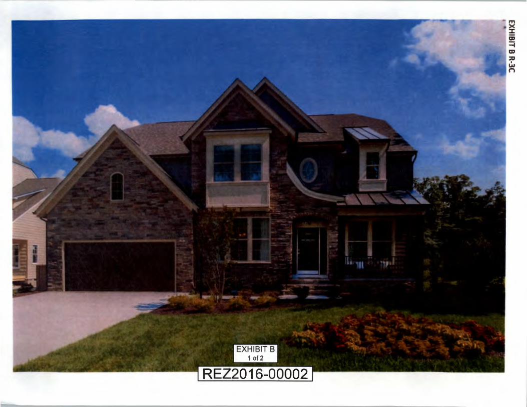
26. Architectural Treatment. Homes constructed on the R-3C-zoned Property shall be generally in conformance with Exhibit B attached hereto, unless otherwise requested by the owner and specifically approved by the Director of Planning. Homes with the same elevations side-by-side shall not be permitted. On comer lots where the side elevation is visible from the street, the side elevation facing the street shall have a minimum of two windows.

27. Foundation Planting. Foundation planting beds are required along the entire front fac;:ade of the house, excluding decks, porches, architectural features and garages, and shall contain a minimum of fifty (50) percent evergreen material. A minimum of one front corner of the house shall be visually softened with a vertical accent shrub or small evergreen trees. For corner lots, foundation beds shall turn and continue 4' down the side facing a street, excluding corners on which there is a garage.
APPLICABLE TO R-5AC-ZONED PROPERTY
28. Minimum Sizes. The minimum finished floor area of each home shall be 1,700 square feet. Of the total units developed on the R-5AC Property, a minimum of sixty five percent ( 65%) shall be a minimum of sixty ( 60) feet in width and a minimum of twenty five percent (25%) shall be a minimum of seventy (70) feet in width, such categories not being exclusive of one another.
29. Density. There shall be no more than four hundred (400) residential units developed on the R-5AC-zoned Property.
30. Architectural Treatment. Homes constructed on the R-5AC-zoned Property shall be generally in conformance with Exhibit C attached hereto, unless otherwise requested by the owner and specifically approved by the Director of Planning. Homes with the same elevations side-by-side shall not be permitted. On corner lots where the side elevation is visible from the street, the side elevation facing the street shall have a minimum of two windows.
31. Building Materials. Primary exterior wall materials (exclusive of windows, dormers, gables, doors, trim, soffit and fascia) shall be brick, stone, cultured stone, stone veneer, fiber cement siding, engineered wood, vinyl (a minimum of .042" nominal thickness as evidenced by manufacturer's printed literature), or a combination of the foregoing unless different architectural treatment and/or materials are requested by owner and approved by the Director of Planning. A minimum of twenty five percent (25%) of the homes shall have a minimum of twenty five percent (25%) of the visible portion of the front exterior building wall surfaces above normal foundation level and below eaves, exclusive of windows, dormers, gables, doors, trim, soffit, fascia and architectural design features, of brick, stone or cultured stone construction unless an equivalent material is requested by owner and approved by the Director of Planning. Fiberboard (e.g. Masonite) shall not be permitted as an exterior wall material.
32. Foundations and Front Steps. All foundations shall be constructed on crawl space or basement. The exterior portions of all residential foundations or basement walls visible above grade shall be constructed of brick, stone or stone veneer. Steps to the main entrance of all homes, except for homes with country porches, shall be faced with brick or stone or a cementitious, mortared stone-appearing product. Front stoops, except for homes with country porches, shall be brick or stone or a cementitious, mortared stoneappearing product with finished concrete or exposed aggregate landing. Any country porches shall have brick or stone piers to match the foundation.

33. Garages. Each home shall include a minimum of a two (2) car garage. All garage doors shall have, at a minimum, one architectural detail including, but not limited to, windows, carriage door handles, exposed hinges or accent columns.
34. Street Trees. Street trees with a minimum two (2) inch caliper shall be planted along the sides of all internal public roads, one tree on each side for every fifty (50) feet of road length. Spacing of trees shall be adjusted as needed to accommodate driveways and underground utilities, including stormwater systems. For example, a 100' road would require six trees total, spaced as allowed by site constraints. For the section of road that crosses the Dominion Virginia Power easement, trees that are acceptable to that utility company shall be planted on fifty (50) foot spacings, unless a written denial from that utility company is submitted to the Director of Planning.
35 . Chimneys. The exposed portions of all fireplace chimneys shall be of brick or a siding similar to the exterior treatment of the dwelling. This proffer shall not apply to direct vent gas fireplaces or appliances. The exposed bases of all chimneys shall be of the same material as the dwelling foundations .
36. Foundation Planting. Foundation planting beds are required along the entire front fa9ade of the house, excluding decks, porches, architectural features and garages, and shall contain a minimum of fifty (50) percent evergreen material. A minimum of one front corner of the house shall be visually softened with a vertical accent shrub or small evergreen trees. For corner lots, foundation beds shall turn and continue 4' down the side facing a street, excluding corners on which there is a garage.
APPLICABLE TO RTHC-ZONED PROPERTY
3 7. Minimum Sizes. The minimum finished floor area of each home shall be 1,400 square feet of finished floor area. The minimum lot width shall be twenty (20) feet.
38. Density. There shall be no more than three hundred (300) residential units developed on the RTHC-zoned Property.
39. Architectural Treatment. Homes constructed on the RTHC-zoned Property shall be generally in conformance with Exhibit D attached hereto, unless otherwise requested by the owner and specifically approved by the Director of Planning.
40. Building Materials. All buildings shall have exposed exterior walls (above grade and exclusive of windows, dormers, gables, doors, trim, soffit and fascia) of stone, stone veneer, brick, fiber cement siding, engineered wood, vinyl (a minimum of .042" nominal thickness as evidenced by manufacturer' s printed literature) or a combination of the foregoing unless different architectural treatment and/or materials are requested by owner and approved by the Director of Planning. A minimum of fifty percent (50%) of the townhome buildings, in the aggregate, shall have a minimum of fifteen percent (15%) of the front exterior wall surfaces constructed of brick or stone, excluding windows, dormers, gables, doors, trim, soffit, fascia and architectural design features .

41 . Sound Suppression Measures. Interior walls between homes shall have a minimum sound transmission coefficient rating of 54. A cross-sectional detail, reviewed and approved by a certified architect or engineer as to the methodology to accomplish the sound coefficient rating, shall be included in the building permit application.
42. Roads. For any private roads on which a dwelling fronts, the applicant shall provide the Planning Department, prior to the issuance of any Certificate of Occupancy, with certification from a licensed engineer that the roadways within the project or phase thereof were constructed according to the approved subdivision plan and Plan of Development, and in compliance with Henrico County road design standards and specifications (except as to pavement width and turning radii), to include proper compaction of the sub-base soils, utility trenches, base stone, and asphalt surface. Any private roadways shall be maintained by a homeowners' association. Any alleys constructed shall have at a minimum, 6" of stone base and 2" of asphalt. Prior to the certificate of occupancy issued for the last home serviced by the alley, the Owner shall submit a licensed engineer' s certification that the alley was built in accordance with the approved construction plans.
43 . Foundations. The exposed exterior portions of all foundations below the first floor level shall be finished with brick, stone or cultured stone. On all front elevations there shall be a minimum of twelve inches (12") of brick, stone or cultured stone visible above grade. On all side and rear elevations, there shall be a minimum of eight inches (8") of brick, stone or cultured stone visible above grade. Where a hardship of the lot prevents compliance with this proffer, the requirements may be modified or waived by the Director of Planning.
44. Garages. Each home shall include a minimum of a one (1) car garage. All garage doors that do not face an alley shall have, at a minimum, one architectural detail including, but not limited to, windows, carriage door handles, exposed hinges or accent columns.
45. Trash. There shall be no central trash receptacles .
46. Units in a Row. There shall be no more than six (6) residential units connected within one building.
47. Marketing. All homes shall be initially marketed for sale as "Owner-occupied."
48. Street Trees. For buildings with rear-loading garages, there shall be a minimum of one (1) tree with a minimum caliper of two and one-half (2 Yi) inches at the time of planting, retained or planted on every other lot.
49. Foundation Plantings. The front comers of buildings shall be visually softened with a vertical accent shrub, and foundation beds shall tum and continue 4' down the side of a building on a street facing side fayade.
50. Exterior Lighting. All townhomes shall have a decorative light at the entrance door. Townhomes with rear-loading garages shall have a decorative light pole in the front of

the townhome. Townhomes with front-loading garages shall have a decorative light over the garage door.
APPLICABLE TO R-5C-ZONED PROPERTY
51. Density. There shall be no more than two hundred eighty-five (285) residential units developed on the R-5C-zoned Property.
52. Architectural Treatment. Multi-family buildings constructed on the R-5C-zoned Property shall be generally in conformance with the elevations attached hereto as Exhibit E except that buildings may be 3, 4 or 5 stories in height, or a combination thereof, unless requested and approved by the Director of Planning at the time of Plan of Development Review.
53. Building Materials. All buildings shall have exposed exterior walls (above grade and exclusive of windows, dormers, gables, doors, trim, soffit and fascia) of stone, stone veneer, brick, fiber cement siding, engineered wood, vinyl (a minimum of .042" nominal thickness as evidenced by manufacturer's printed literature) or a combination of the foregoing unless different architectural treatment and/or materials are requested by owner and approved by the Director of Planning. A minimum of thirty-five (3 5) percent in the aggregate, of the exterior portions of the front building wall surfaces of each building, excluding windows, dormers, gables, doors, trim, soffit, fascia and architectural design features, shall be of brick, stone or stone veneer construction.
54. Sound Suppression. Any walls between units within the R-5C-zoned Property shall be designed to have a minimum sound transmission coefficient rating of 50. A cross section detail, reviewed and approved by a certified architect or engineer as to the methodology accomplishing the sound transmission coefficient rating shall be included in the building permit application.
55. Private Streets. Prior to issuance of a permanent Certificate of Occupancy for any unit, the developer shall provide the Planning Department certification from a licensed engineering firm that the private roadways within the development were constructed according to the approved plan and in compliance with Henrico County road design standards and specifications, to include proper compaction of sub-base soils, utility trenches, base stone and asphalt, but excluding road widths, turning radii, cross over and entrance spacing, sight distance and vertical curves, or a bond in an amount satisfactory to the Director of the Department of Public Works shall be provided to Henrico County for items not yet completed.
56. Parking Lot Lighting. Parking lot lighting fixtures shall not exceed twenty (20) feet in height as measured from the grade at the base of the lighting standard, unless otherwise requested, described and specifically approved, or if required, at the time of Plan of Development. Lighting shall be directed to minimize glare on public roads and adjacent properties.
57. Recreational Amenities. Recreational amenities containing at a minimum a clubhouse, a pool, a fitness center and a playground shall be provided no later than the issuance of a

. .
certificate of occupancy for the one hundredth (lOOth) unit on the R-5C-zoned Property unless otherwise requested and approved by the Planning Commission at the time of Plan of Development and/or subdivision review.
T. PORTER SCHERMERHORN NATALIE W. SCHERMERHORN VILLAGE BANK HERMAN S. FLETCHER ESTATE OF THOMAS STEWART GAMMON EDITH B. SCHERMERHONR
By ~ Penny Giles, Attorney-in-Fact
Date: March 7, 2016

-----------1 RIVER MILL I I EXHIBIT A-I ---~~ + cit esign co~~~!!~7~~1rLAN I REZ2016-00002 tr-;:_J~
EX
HIB
IT 8 R-3C

N·
0 0 0 al
0 1
-N
I al -
CD -0
IN
>< w

EX
HIB
IT C R-SAC
0
N
0 0 0 0 I {
O

N
0 0 0 0 I (0
~
0 N
N
w
~


N
0 0 0 0 I (0
~
0 N
N
w
0::

EX
HIB
IT D R-TH
C


EXHIBIT E
R-SC


oo
o ' A-1 & R-2AC to R-3C
31.938 Ac.
REZ2016-00002 Zoning
Mixed Residential
Fairfield District
800 0 Feet
December 2015 Ref: 780-772-9071

oo 9
' A-1 & R-2AC to R-3C
31.938 Ac.
2026 Land Use Plan Mixed Residential
Fairfield District
800 0 Feet
December 2015 Ref: 780-772-9071