Revolution in Earth Science 3_ES1_TECTO_2018...Continental drift (Alfred Wegener, 1880-1930)A....
55
PLATE TECTONICS Revolution in Earth Science FUNDAMENTALS OF EARTH SCIENCE I FALL SEMESTER 2018
Transcript of Revolution in Earth Science 3_ES1_TECTO_2018...Continental drift (Alfred Wegener, 1880-1930)A....

PLATE TECTONICSRevolution in Earth Science
FUNDAMENTALS OF EARTH SCIENCE I FALL SEMESTER 2018

The Earth System
Understanding Earth 6th edition

CRUST (solid)
MANTLE (solid)
OUTER CORE (liquid)
INNER CORE (solid)
Earth’s layers
Understanding Earth 6th edition

Oceanic crust: av. 7 km
Continental crust: av. 40 km
Tectonic plate
Boundary between crust and mantle = Mohorovicic Discontinuity (or Moho)
~70 km **
Understanding Earth 6th edition

SUPPORTING EVIDENCE
• Computer models
Mantle
Core
Mantle
• Differentiated meteorites
• Seismic waves
• Field observations (ophiolites, xenoliths of
mantle rocks)
• Deep drilling (in 2012, the Japanese drilling vessel Chikyu
retrieved rock samples from around 2200 m below seafloor but has not yet reached the mantle; longest borehole in continental crust was drilled in Russia and is about 12 km long)
• Gravimetry (examines variations in gravitational field due to
density differences resulting from changes in composition of crust and mantle)
• High-pressure experiments (diamond anvil cell)

http://www.jamstec.go.jp/chikyu/e/about/data/

Continental drift (Alfred Wegener, 1880-1930)
A. Snider-Pellegrini (1802-1885), source: USGS
Continent are moving and they once formed one single supercontinent called Pangaea.

1. Jigsaw-puzzle fit of continents around the Atlantic Ocean
Appalachian mountain belt (eastern USA)Caledonian mountain belt (NW Europe)
“Appalachian-Caledonian orogeny”(~500-400 Ma)
Orogeny = episode of mountain formation
Understanding Earth (modified)
2. Similarities in rock types and ages on both sides of the Atlantic
3. Similarities in geological structures (orientation of mountain chains)
SUPPORTING EVIDENCE

4. Geographic distribution of fossils of plants and animals
USGSDistribution of some fossils (Gondwana, 300 106 yr ago)

5. Paleoclimate data Glacial deposits (~300-250 Ma, Permian) found in South America, Africa, India,
Antartica, and Australia
Hamilton and Krinsley (1967)
Tillite = rock composed of unsorted material deposited directly by
glacial ice and showing no stratification
→ Suggests high-lat. location

Glacial erratic
Robert Siegel (Stanford U
ni.)
Wikipedia
USG
S
Glacial striation
Glacial till (moraine) – coarse unsorted sediment
Wikipedia (M
ick Knapton)
Glacial valleyin fine-grained (clay) matrix

Glacial tillite (Smalfjord Fm, 600 106 yr) and pavement, northern Norway
http://www.snowballearth.org

Arthur Holmes (1890-1965) suggested in 1928 that convection currents resultingfrom the heat generated by radioactivity within the Earth’s interior could push andpull continents apart (note: radioactivity discovered in 1896 by Henri Becquerel)
Figure from Holmes’ article published in 1928, source: Gohau (1990)
What is the driving force of continental drift?
BUT LACK OF EVIDENCE… UNTIL…

Understanding Earth

1. Mapping of the Mid-Atlantic Ridge* (MAR) revealed a rift along its axis
2. The seafloor is made of young basaltic rock (getting older away from the ridge)
Seafloor spreading hypothesis: a mechanism explaining continental drift
Harry Hess (1906-1969) and Robert Dietz (1914-1995) suggested in the early 1960s that continents move apart through the creation of new lithosphere at Mid-Ocean Ridges (MORs).
MAR is ~1000-km wide, ~2-km high, discovered in 1872 during the installation of the transatlantic telegraphic cable
*
SUPPORTING EVIDENCE
Note that oceanographic surveys conducted after WWII benefitted from new technologies developed during the war, particularly the SONAR (Sound NAvigationand Ranging) which is used to map the seafloor with great accuracy.

Buck and Poliakov (1998)
RIFT

3. Seismic data: almost all earthquakes in the Atlantic occur along the ridge
Understanding Earth
Black dots = Locations of earthquakes

4. Other Mid-Ocean Ridges discovered in the Pacific and Indian Oceans
Le Pichon (1968)

Understanding Earth

Three types of plate boundaries can be distinguished:
1. Divergent boundaries where plates move apart and new oceanic lithosphere is produced (include Mid-Ocean Ridges)
2. Convergent boundaries where plates come together and form a mountain chain (include Subduction Zones)
3. Transform faults where plates slide horizontally past each other.
Plate tectonics: the unifying theory
The Earth’s surface is divided into rigid plates that are moving relative to one another.

J. T. Wilson (1908-1993) was the first to describe this model in 1965

Understanding Earth

NOAA
Challenger deep (Mariana Trench, depth = ~11 km)Everest (elevation = ~8.8 km)

Weak, ductile asthenosphere (layer of the upper mantle on which tectonic plates slide)
Phase change: olivine → spinel (~400 km)
Phase change: spinel → perovskite(~650 km)
Rigid, brittle lithosphere (crust + uppermost part of mantle) = tectonic plates
p. 376 of Understanding Earth

In the mantle below tectonic plates:hotter material rises, colder material sinks ( CONVECTION )
S.L. Butler simulation (University of Saskatchewan, Canada)
2 main sources of heat: 1. Original heat (meteorite impacts + contraction)
2. Decay of radioactive elements
Think about the “miso soup effect”
Earth’s internal heat engine

1. DIVERGENT BOUNDARIES
MID-OCEAN RIDGES (MOR)
CONTINENTAL RIFTS
Understanding Earth
Plate boundaries

MBARIMBARI
R/V Atlantis, WHOI
Juan de Fuca Ridge
Hydrothermal vents
Faults Pillow lavas
Mid-Ocean Ridge characteristic features

DEEP-SEA VOLCANIC ERUPTION ALONG THE AXIS OF JUAN DE FUCA RIDGE
Video capture by ROV Jason in 2011 (NOAA) – depth: ~1600 m
The eruption occurred a few months earlier before the video was taken

Schuessler et al. (2009) Understanding Earth
The Mid-Atlantic Ridge is cutting Iceland in two.

The East African Rift
Agostini et al. (2011)http://jules.unavco.org
African Plate
Somali Sub-plate
Arabian Plate
Lakes and volcanoes occupy the depression of the rift.

East African Rift – geological features
LAVA FLOWS
4 km
alt. 2280 m
alt. 1730 m→ Volcano height = 550 m
Google Earth

East African Rift – geological features
NORMAL FAULTS
alt. 2130 m
alt. 1800 m
→ Fault scarp height = 330 mGoogle Earth

http://www.geology.com

Gregory Dimijian / Science Photo Library
http://ethiopiaembassy.eu/country-profiles/tourism/www.photovolcanica.com
Google Earth
Ol Doinyo Lengai (Tanzania) Ethiopian Rift Valley
Eastern wall of African Rift (Kenya)Eastern wall of African Rift (Ethiopia)

2. CONVERGENT BOUNDARIES
OCEAN-OCEAN CONVERGENCE
OCEAN-CONTINENT CONVERGENCE
Understanding Earth
Subduction zones

CONTINENT-CONTINENT CONVERGENCE
Understanding Earth

Google Earth
Subduction zone: Japan
Eurasian Pl.
Philippine Sea Pl.
Pacific Pl.
http://usgsprojects.org/fragment/
Okhostk Pl.
Plate boundaries from http://www.earthquakes.bgs.ac.uk/

Deepest earthquakes at subduction zones (no deeper than 700 km)
Scalera (2007)
South American Pl.Nazca Pl.

TED-Ed video 2012 “Deep ocean mysteries and wonders” (David Gallo, Woods Hole Oceanographic Institution)
DEEP-SEA VOLCANIC ERUPTION NEAR A SUBDUCTION ZONE (TONGA TRENCH)
Video capture by ROV Jason in 2009 (NOAA) – depth: 1200 m

USGS
Continental collision: Himalaya
Google Earth

NASA
SOUTH
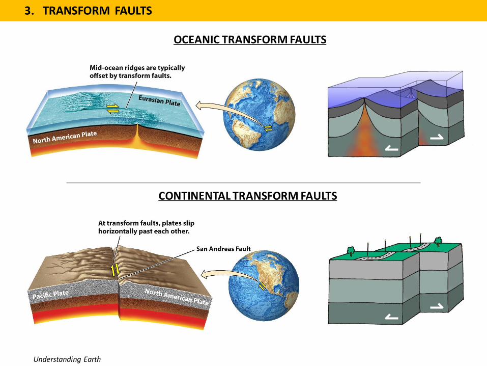
3. TRANSFORM FAULTS
OCEANIC TRANSFORM FAULTS
CONTINENTAL TRANSFORM FAULTS
Understanding Earth

http://www.lostcity.washington.edu
WHOI (Tim Shank)
Oceanic transform faults

North Am. Plate
Pacific Plate
North American Plate
Pacific Plate
USGS
Cont. transform fault: San Andreas Fault

Rates of plate motion
Understanding Earth (p. 389)
The magnetic polarity time scale
Normal Reversed

Physical Geology
Magnetic minerals forming in lava (molten rock) align with Earth’s magnetic field lines and preserve their orientation once the lava cools and becomes a solid rock.
NB: also useful to reconstruct the position of old continents.

Understanding Earth

Wikipedia

Plates moved apart 60 km in 3.3 Ma
= 18 mm/year
Average spreading rate ~50 mm/year
Understanding Earth
Highest spreading rate ~150 mm/year
30 km

Figure and caption from http://pubs.usgs.gov/gip/dynamic/magnetic.html
Magnetic striping mapped by oceanographic surveys offshore of the Pacific Northwest.
This is yet another piece of evidence that has lead to the hypothesis of seafloor spreading and the theory of plate tectonics.

Understanding Earth

Rates of plate movement probably control primarily by 1 and 3
1. Gravitational pull of plates sinking into the mantle (plates with a large portion of their margin subducting are moving faster)
2. Sucking effect of the subducting plates (force acting on overriding plate)3. Gravitational force related to elevated Mid-Ocean Ridges4. Heat rising from the Earth’s interior (may initiate break-up of plates)
Driving forces of plate tectonics
3
1
4
2
Understanding Earth

1. Slow, diffuse rise of magma beneath spreading centers
2. Fast, narrow plumes of magma known as hot spots (e.g. Hawaii)
Two types of rising magma
12
Understanding Earth

Hand, E. (Science, 2015)

Hand, E. (Science, 2015)
Hawaii
Galapagos
Iceland
Yellowstone
Reunion Isl.
Canary isl.