Revised Land Management Plan for the Inyo National Forest
190
United States Department of Agriculture Land Management Plan for the Inyo National Forest Fresno, Inyo, Madera, Mono, and Tulare Counties, California; Esmeralda and Mineral Counties, Nevada Forest Service Pacific Southwest Region R5-MB-303 2018
Transcript of Revised Land Management Plan for the Inyo National Forest
United States Department of Agriculture
Land Management Plan for the Inyo National Forest Fresno, Inyo, Madera, Mono, and Tulare Counties, California; Esmeralda and Mineral Counties, Nevada
Forest Service Pacific Southwest Region R5-MB-303 2018

In accordance with Federal civil rights law and U.S. Department of Agriculture (USDA) civil rights regulations and policies, the USDA, its agencies, offices, and employees, and institutions participating in or administering USDA programs are prohibited from discriminating based on race, color, national origin, religion, sex, gender identity (including gender expression), sexual orientation, disability, age, marital status, family/parental status, income derived from a public assistance program, political beliefs, or reprisal or retaliation for prior civil rights activity, in any program or activity conducted or funded by USDA (not all bases apply to all programs). Remedies and complaint filing deadlines vary by program or incident.
Persons with disabilities who require alternative means of communication for program information (e.g., Braille, large print, audiotape, American Sign Language, etc.) should contact the responsible Agency or USDA’s TARGET Center at (202) 720-2600 (voice and TTY) or contact USDA through the Federal Relay Service at (800) 877-8339. Additionally, program information may be made available in languages other than English.
To file a program discrimination complaint, complete the USDA Program Discrimination Complaint Form, AD-3027, found online at http://www.ascr.usda.gov/complaint_filing_cust.html and at any USDA office or write a letter addressed to USDA and provide in the letter all of the information requested in the form. To request a copy of the complaint form, call (866) 632-9992. Submit your completed form or letter to USDA by: (1) mail: U.S. Department of Agriculture, Office of the Assistant Secretary for Civil Rights, 1400 Independence Avenue, SW, Washington, D.C. 20250-9410; (2) fax: (202) 690-7442; or (3) email: [email protected]. USDA is an equal opportunity provider, employer and lender.
NOTE: If you need assistance with the accessibility of this document, please contact the Pacific Southwest Region Office at (707) 562-9121.
El USDA es un proveedor, empleador y prestamista que ofrece igualdad de oportunidad.
Cover: Upper left photo- American avocet at Mono Lake; Upper right photo – Sunset at Hot Creek during winter; Lower left photo- Ancient bristlecone pines at sunset; Lower right photo- Prickly pear cactus on Mazourka Peak looking at Owen’s Valley. All photos by Leeann Murphy.

Land Management Plan for the
Inyo National Forest Fresno, Inyo, Madera, Mono and
Tulare Counties, California; Esmeralda and Mineral Counties, Nevada
Responsible Official: Tammy Randall-Parker Forest Supervisor Inyo National Forest 351 Pacu Lane, Suite 200 Bishop, CA 93514-3101 (760) 873-2400
For more information contact: Leeann Murphy Resource and Planning Staff Officer (760) 873-2404
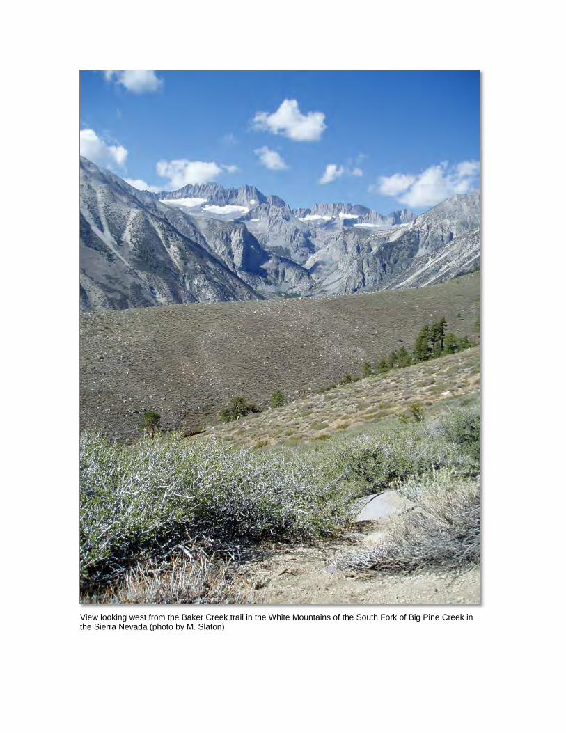
View looking west from the Baker Creek trail in the White Mountains of the South Fork of Big Pine Creek in the Sierra Nevada (photo by M. Slaton)
Land Management Plan for the Inyo National Forest i
Contents Chapter 1. Introduction ................................................................................................................. 1
Location ....................................................................................................................................... 1 Distinctive Roles and Contributions of the Plan Area ................................................................. 1 Purpose of the Forest Plan ........................................................................................................... 5 Adaptive Planning ....................................................................................................................... 6 Plan Structure .............................................................................................................................. 6 Plan Components ......................................................................................................................... 7 Other Plan Content ...................................................................................................................... 8
Chapter 2. Forestwide Desired Conditions and Management Direction .................................. 9 Introduction ................................................................................................................................. 9 Ecological Sustainability and Diversity of Plant and Animal Communities ............................... 9
Air Quality ............................................................................................................................... 9 Watersheds ............................................................................................................................. 10 Terrestrial Ecosystems and Vegetation .................................................................................. 13 Animal and Plant Species ....................................................................................................... 34 Invasive Species ..................................................................................................................... 46 Fire ......................................................................................................................................... 47
Social and Economic Sustainability and Multiple Uses ............................................................ 51 Sustainable Recreation (excludes designated wilderness) ..................................................... 51 Scenery ................................................................................................................................... 55 Timber and Other Forest Products ......................................................................................... 56 Rangeland Livestock Grazing ................................................................................................ 58 Rangeland Vegetation Types ................................................................................................. 59 Geology and Minerals ............................................................................................................ 65 Energy .................................................................................................................................... 66 Cultural Resources ................................................................................................................. 66 Tribal Relations and Uses ...................................................................................................... 68 Local Communities ................................................................................................................ 69 Volunteers, Interpretation, Partnerships and Stewardship ..................................................... 70 Lands ...................................................................................................................................... 72 Infrastructure .......................................................................................................................... 73
Chapter 3. Area-specific Desired Conditions and Management Direction ............................. 75 Management Areas .................................................................................................................... 75
Strategic Fire Management Zones.......................................................................................... 75 Conservation Watersheds ....................................................................................................... 79 Riparian Conservation Areas ................................................................................................. 80 Sustainable Recreation Management Areas ........................................................................... 88 Recommended Wilderness ..................................................................................................... 92 Eligible Wild and Scenic Rivers ............................................................................................ 93 Pacific Crest National Scenic Trail Corridor ......................................................................... 93
Designated Areas ....................................................................................................................... 96 Wilderness .............................................................................................................................. 96 Mono Basin National Forest Scenic Area ............................................................................ 102 Wild and Scenic Rivers ........................................................................................................ 103 Ancient Bristlecone Pine Forest (National Protection Area) ............................................... 105 Pacific Crest National Scenic Trail ...................................................................................... 106 Inventoried Roadless Areas .................................................................................................. 106 National Recreation Trails ................................................................................................... 106

Contents
Land Management Plan for the Inyo National Forest ii
Research Natural Areas ....................................................................................................... 107 Scenic Byways ..................................................................................................................... 108 Wild Horse and Burro Territories ........................................................................................ 108
Chapter 4. Forest Plan Monitoring .......................................................................................... 111 Introduction ............................................................................................................................. 111 Inyo National Forest Plan Monitoring Program ...................................................................... 113
Watershed Conditions .......................................................................................................... 113 Terrestrial Ecosystems ......................................................................................................... 114 Aquatic Ecosystems ............................................................................................................. 115 Focal Species ....................................................................................................................... 115 Ecological Conditions for At-risk Species ........................................................................... 117 Visitor Use, Visitor Satisfaction, and Progress toward Meeting Recreation Objectives ..... 118 Climate Change and Other Stressors ................................................................................... 119 Progress toward Meeting the Desired Conditions, Objectives, or other Plan Components . 120 Productivity of the Land ...................................................................................................... 121
Appendix ..................................................................................................................................... 123 Appendix A: Maps .................................................................................................................. 125
Recreation Opportunity Spectrum ....................................................................................... 125 Scenic Integrity Objectives .................................................................................................. 127 Management Areas .............................................................................................................. 128 Designated Areas ................................................................................................................. 136
Appendix B: Proposed and Possible Actions .......................................................................... 141 Introduction .......................................................................................................................... 141 Air Quality ........................................................................................................................... 141 Water, Soils, and Watershed ................................................................................................ 141 Terrestrial Ecosystems ......................................................................................................... 141 Aquatic and Riparian Ecosystems ....................................................................................... 143 Animal and Plant Species .................................................................................................... 143 Invasive Species ................................................................................................................... 144 Fire ....................................................................................................................................... 144 Local Communities .............................................................................................................. 144 Timber and Other Forest Products ....................................................................................... 145 Range ................................................................................................................................... 145 Sustainable Recreation ......................................................................................................... 145 Scenery ................................................................................................................................ 146 Tribal Relations and Uses .................................................................................................... 146 Cultural Resources ............................................................................................................... 146 Geology and Minerals .......................................................................................................... 146 Energy .................................................................................................................................. 146 Infrastructure ........................................................................................................................ 146 Lands.................................................................................................................................... 147 Designated Areas ................................................................................................................. 147
Appendix C: A Renewed Partnership Focus for the Inyo National Forest ............................. 149 Creating a Partnership Culture ............................................................................................. 149 Forest Capacity for Working in Partnership ........................................................................ 150 Best Practices for Building New Partnerships ..................................................................... 151 Steps for Ensuring Effective Outreach and Communication with Nontraditional Partners and the Public ............................................................................................................................. 154
Appendix D: Timber Suitability and Management ................................................................. 155 Determination of Suitability for Timber Production ........................................................... 155

Contents
Land Management Plan for the Inyo National Forest iii
Planned Timber Sale Program.............................................................................................. 157 Vegetation Management Practices ....................................................................................... 160
Appendix E: Rangeland Management ..................................................................................... 163 Status of Livestock Production Rangelands ......................................................................... 163
Appendix F: Existing Resource Plans ..................................................................................... 167 Glossary ....................................................................................................................................... 169
Tables Table 1. Proportion of seral stage patches (larger than 10 acres) by vegetation type at the
landscape scale (tens of thousands of acres) ................................................................................... 18 Table 2. Structure within forested patches (10s to 100s of acre areas with similar forest) ................... 18 Table 3. Snags and large logs at landscape scale in low to moderate severity burn patches ................ 18 Table 4. Large and old trees at landscape scale (tens of thousands of acres), except where high
severity fires have occurred (greater than 75 percent basal area mortality) .................................... 20 Table 5. Acres of Inyo National Forest by recreation opportunity spectrum class, excluding
designated wilderness ...................................................................................................................... 52 Table 6. Proposed utilization standards for Carex dominated wet meadow by grazing system* ......... 61 Table 7. Proposed utilization standards for Carex-grass dominated moist meadow vegetation
types by grazing system* ................................................................................................................ 62 Table 8. Proposed utilization standards for desert shrub vegetation type by grazing system* ............. 62 Table 9. Proposed utilization standards for sagebrush/bunchgrass vegetation type by grazing
system* ............................................................................................................................................ 63 Table 10. Proposed utilization standards for bitterbrush vegetation type by grazing system* ............. 63 Table 11. Proposed utilization standards for subalpine meadow vegetation type by grazing
system* ............................................................................................................................................ 63 Table 12. Proposed utilization standards for alpine dwarf shrub vegetation type by grazing
system* ............................................................................................................................................ 64 Table 13. Proposed utilization standards for aspen vegetation type by grazing system* ..................... 64 Table 14. Proposed utilization standards for willow vegetation type by grazing system* ................... 64 Table 15. Acres of land within each recreation opportunity spectrum class in the Destination
Recreation Area ............................................................................................................................... 89 Table 16. Acres of land within each recreation opportunity spectrum class in the general
recreation area ................................................................................................................................. 90 Table 17. Acres of land within each recreation opportunity spectrum class in the challenging
backroad recreation area.................................................................................................................. 91 Table 18. Monitoring questions and associated indicators that evaluate select watershed
conditions ...................................................................................................................................... 113 Table 19. Monitoring questions and associated indicators that evaluate select ecological
conditions for key characteristics of terrestrial ecosystems .......................................................... 114 Table 20. Monitoring questions and associated indicators that evaluate select ecological
conditions for key characteristics of aquatic ecosystems .............................................................. 115 Table 21. Monitoring questions and associated indicators that evaluate the status of focal species
to assess the ecological conditions required under section 219.9.................................................. 116 Table 22. Monitoring questions and associated indicators that evaluate the status of a select set of
ecological conditions for at-risk species ....................................................................................... 117 Table 23. Monitoring questions and associated indicators that evaluate the status of visitor use,
visitor satisfaction, and progress toward meeting recreation objectives ....................................... 118 Table 24. Monitoring questions and associated indicators that measure changes on the plan area
related to climate change and other stressors that may be affecting the plan area ........................ 119 Table 25. Monitoring questions and associated indicators that evaluate progress toward meeting
the desired conditions and objectives in the plan, including providing for meeting multiple-use opportunities ........................................................................................................................... 120

Contents
Land Management Plan for the Inyo National Forest iv
Table 26. Monitoring questions and associated indicators that evaluate the effects of each management system to determine that they do not substantially and permanently impair the productivity of the land* ................................................................................................................ 121
Table 27. Inyo National Forest land suitable for timber production ................................................... 158 Table 28. Average volume outputs for the 1st and 2nd decades for Inyo National Forest planned
timber sale program1 ...................................................................................................................... 159 Table 29. Estimated vegetation management practices on the Inyo National Forest in acres
implemented per decade ................................................................................................................ 160 Table 30. Stocking criteria for suitable lands by forest type* ............................................................. 161 Table 31 Summary data of current grazing allotments, Inyo National Forest ..................................... 163
Figures Figure 1. Vicinity map of the Inyo National Forest ................................................................................ 2 Figure 2. A schematic of the relationship of watersheds, riparian conservation areas, and riparian
and aquatic environments ................................................................................................................ 11 Figure 3. Example of desired condition for dry mixed conifer forest of Jeffrey and white pines ......... 27 Figure 4. Example of desired condition in a Jeffrey pine patch ............................................................ 28 Figure 5. Three photos displaying red fir forest heterogeneity.............................................................. 30 Figure 6. Recreation opportunity spectrum map for summer recreation opportunities and setting
on the Inyo National Forest ............................................................................................................ 125 Figure 7. Recreation opportunity spectrum map for winter recreation opportunities and setting on
the Inyo National Forest ................................................................................................................. 126 Figure 8. Scenic integrity objectives map for the Inyo National Forest .............................................. 127 Figure 9. Strategic fire management zones of the Inyo National Forest ............................................. 128 Figure 10. Wilderness management area classes for the Ansel Adams Wilderness of the Inyo
National Forest ............................................................................................................................... 129 Figure 11. Wilderness management area classes for the John Muir Wilderness of the Inyo
National Forest ............................................................................................................................... 130 Figure 12. Wilderness management area classes for the South Sierra Wilderness of the Inyo
National Forest ............................................................................................................................... 131 Figure 13. Wild and scenic river status of the Inyo National Forest ................................................... 132 Figure 14. Riparian conservation areas and conservation watersheds of the Inyo National Forest .... 133 Figure 15. Pacific Crest National Scenic Trail management area of the Inyo National Forest ........... 134 Figure 16. Recreation Management Areas on the Inyo National Forest ............................................. 135 Figure 17. Congressionally designated wilderness areas and proposed recommended wilderness
on the Inyo National Forest ............................................................................................................ 136 Figure 18. Mono Basin National Forest Scenic Area Management Zones on the Inyo National
Forest ............................................................................................................................................. 137 Figure 19. Other designated areas: research natural areas and Ancient Bristlecone Pine Forest on
the Inyo National Forest ................................................................................................................. 138 Figure 20. Wild horse and burro territories on the Inyo National Forest ............................................ 139 Figure 21. Timber suitability map for the Inyo National Forest .......................................................... 156 Figure 22. Livestock grazing allotments and wild horse and burro territories on the Inyo National
Forest 2017 .................................................................................................................................... 165

Land Management Plan for the Inyo National Forest 1
Chapter 1. Introduction
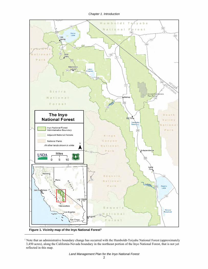
Location The Inyo National Forest (Inyo) is one of 18 national forests in California. The Inyo covers parts of the eastern Sierra Nevada of California and the White Mountains of California and Nevada (figure 1), and spans portions of Fresno, Inyo, Madera, Mono, and Tulare Counties of eastern California, and Esmeralda and Mineral Counties of western Nevada.
The Inyo encompasses approximately 2 million acres, including 26,711 acres of the Sierra and Humboldt-Toiyabe National Forests, managed by the Inyo staff. Mono Lake is within a designated national scenic area on the Inyo, and its waters cover approximately 37,000 acres. There are about 112,000 acres of lands of other ownership within the boundaries of the Inyo National Forest; these include State and private lands, and lands managed by the National Park Service, Bureau of Land Management, Los Angeles Department of Water and Power, and the Army Corp of Engineers.
The Inyo National Forest Supervisor’s Office is centrally located in Bishop, California. The Inyo has four administrative ranger districts; the northern Mono Lake and Mammoth Ranger Districts are managed together as the North Zone; and the southern White Mountain and Mount Whitney Ranger Districts are managed together as the South Zone.
Distinctive Roles and Contributions of the Plan Area The Inyo National Forest was established in 1907 for the purposes of protecting lands needed to build the Los Angeles Aqueduct. The headwaters and tributaries into Mono Lake, the Owens River, and Owens Lake are important for the supply of water to the City of Los Angeles. At a regional level, water runoff from the national forest also flows into the Upper San Joaquin River to the west and the Upper Kern River to the south. About 93 percent of the perennial streams on the Inyo are free flowing and stream flows are functioning within their range of natural variation. An average of 34 percent of the runoff produced into the Owens Lake and Mono Lake watersheds is exported to the City of Los Angeles, a critical component supporting social and economic sustainability in that area. Water on the Inyo is used for development of hydroelectricity that powers homes and businesses in the region. Water from the Inyo is also important to local communities and Tribes, providing drinking water, recreational amenities, and economic and cultural opportunities.
The Inyo National Forest has diverse ecosystems including portions of the Great Basin, Mojave Desert, and Sierra Nevada Bioregions. Elevations range from 3,800 feet in Owens Valley to 14,495 feet at the peak of Mount Whitney, the highest point in the contiguous United States. Geographically, the Inyo National Forest is split in two by Owens Valley and Long Valley Caldera (figure 1). Toward the east, the Glass and White-Inyo Mountain Ranges fall within the Great Basin and Intermountain Desert Bioregions. The changing elevation across the national forest, combined with the variability in aspect and slope, variety of geology and soils, and amount and timing of precipitation creates high diversity in ecosystems inhabited by at least 1,300 plant species, and approximately 300 terrestrial wildlife species. The Inyo National Forest’s contribution to social and economic sustainability depends on resilient ecosystems, with terrestrial and aquatic biodiversity.
Chapter 1. Introduction
Land Management Plan for the Inyo National Forest 2
Figure 1. Vicinity map of the Inyo National Forest1
1 Note that an administrative boundary change has occurred with the Humboldt-Toiyabe National Forest (approximately 3,450 acres), along the California-Nevada boundary in the northeast portion of the Inyo National Forest, that is not yet reflected in this map.

Chapter 1. Introduction
Land Management Plan for the Inyo National Forest 3
The eastern Sierra Nevada is known for large expanses of undeveloped land and is characterized by large magnificent mountains that invite and inspire visitors locally, regionally, nationally, and internationally. This stunning landscape is home to well-known attractions such as Mount Whitney, Mono Lake, the Ancient Bristlecone Pine Forest and the Mammoth Mountain lava dome complex. The Ancient Bristlecone Pine Forest, a congressionally designated area in the White Mountains (figure 19), is set aside for visitor enjoyment and research that has contributed greatly to current science about climate change. These icons, along with the Inyo’s proximity to other recreation attractions, make the Inyo a destination place for visitors. Travelers on routes and trails pass through contrasting landscapes. Year-round trail use provides the means to high quality recreation from hiking, mountain biking and equestrian use, to skiing, snowmobiling, and other motorized uses. Conservation education and interpretation programs focus on developing a land ethic as part of the recreation experience.
The eastern Sierra Nevada offers many benefits both socially and economically, thus establishing a deep-rooted connection between this land and the people of the area. Native Americans, who have inhabited these areas for thousands of years, have deep cultural ties to these lands. Areas of cultural and Tribal value are found throughout the Inyo. The national forest lies in the traditional territories of many Tribes and Tribal Communities:
• The Big Pine Band of Owens Valley Paiute Shoshone Indians of the Big Pine Reservation
• Bridgeport Paiute Indian Colony of California
• Death Valley Timbi-Sha Shoshone Band of California
• Fort Independence Community of Paiute Indians of the Fort Independence Reservation
• Paiute-Shoshone Indians of the Bishop Community of the Bishop Colony
• Paiute-Shoshone Indians of the Lone Pine Community of the Lone Pine Reservation
• Utu Gwaitu Paiute Tribe of the Benton Paiute Reservation
• Walker River Paiute Tribe of the Walker River Reservation
• Antelope Valley Indian Community
• Kawiiasu Tribe
• Kern Valley Indian Community
• Mono Lake Kutzadika’a Tribe
• Tübatulabals of Kern Valley
• Yosemite-Mono Lake Paiute Indian Community
In the past, the presence of different animals, including desert bighorn sheep and pronghorn antelope, shaped Native American use of this land. Cultural opportunities are still an important contribution of national forest lands today. Tribal communities benefit socioeconomically through the use of forest resources for artisan and craft materials, medicines, fuel, traditional foods, and by supporting heritage tourism and recreation. Lands and resources of the Inyo National Forest enhance the sustainability of Tribal communities where opportunities for traditional ceremonies and religious practices strengthen the communities’ sense of place and self. Gathering activities on the Inyo contribute to Tribal social, economic, familial, and religious well-being.
The lands of the Inyo National Forest have a rich ecological and cultural history that differs from other areas of the Sierra Nevada. In particular, historic Euro-American use was more focused on livestock grazing and mineral prospecting than on timber. Mining practices in the surrounding mountains influenced the culture and changed the landscape. A large number of mine operations resulted in the development of a transportation network that brought people into areas not

Chapter 1. Introduction
Land Management Plan for the Inyo National Forest 4
frequently traveled. Logging of pinyon pine and Jeffrey pine was intensive in some areas where the trees were valued as a fuel source for mining operations and growing urban centers.
The Inyo National Forest includes Mono Basin National Forest Scenic Area and almost 1 million acres of designated wilderness. The Inyo shares boundaries with Sequoia, Kings Canyon, Yosemite, and Death Valley National Parks; Devils Postpile National Monument; Manzanar National Historic Site; lands managed by the Bureau of Land Management and Los Angeles Department of Water and Power; private entities; and the Sequoia, Sierra, and Humboldt-Toiyabe National Forests. The communities within and next to the Inyo National Forest are relatively small and discrete, so connectivity between the national forest and similar ecosystems on adjacent lands is relatively intact.
The Inyo National Forest provides a contiguous backdrop for a variety of activities. Developed recreation sites that are concentrated in scenic canyons and lake basins provide recreation opportunities and wilderness access. Scenic routes invite visitors to explore, enjoy the amenities provided by local communities, drive for pleasure, view scenery and wildlife, picnic, and learn about the environment. There are opportunities for fishing, hunting, touring, dispersed camping, climbing and bouldering, hiking, backpacking, mountaineering, horseback riding and packing, and for seeking solitude.
Recreation uses of the Inyo National Forest have changed over the past couple decades. Historic recreation uses such as pack stock use, off-highway vehicle driving, camping, fishing, hunting, backpacking, and mountaineering continue today. Commercial pack stock use, although reduced, still allows for assisted access into wilderness areas in addition to the backcountry of Sequoia, Kings Canyon, and Yosemite National Parks. Some types of recreation uses have expanded and include activities such as hiking, rock climbing and bouldering, off-highway vehicle use, day-use, and winter activities including alpine, cross-country, and backcountry skiing. The breathtaking landscapes also provide opportunities for photography and filming. All these activities provide for vital economic benefits and sustainability to local “gateway” communities, which include Lee Vining, Town of Mammoth Lakes, Bishop, Big Pine, Independence, and Lone Pine, California. Economic contributions occur through visitor spending that supports jobs in local businesses and contributes to county sales and occupancy tax revenues that local governments use to provide important public services in these communities.
The Inyo is within a 4-hour drive of nearly half of the 37 million people who live in California. This large pool of potential visitors is one of the most ethnically diverse in the world, challenging the staff of the Inyo to look at nontraditional methods of providing service. Over 2 million users visit the Inyo National Forest yearly, with the majority of visitors coming from southern California. The Inyo also receives a lot of international visitors. This is due to the opportunities the eastern Sierra Nevada provides with Death Valley National Park, Yosemite National Park, and Mount Whitney all within a day’s drive of each other. The Ansel Adams, John Muir, Owens River Headwaters, White Mountains, Boundary Peak, Golden Trout, and South Sierra Wildernesses also draw many visitors to the area.
Although recreation may be what draws the majority of visitors and their associated economic benefits to this area, other historic uses of the Inyo, such as livestock grazing, mining and renewable energy, and personal and commercial fuelwood gathering continue to provide traditional resources to the local communities, culture, and economy. Livestock grazing has occurred on rangelands of the Inyo National Forest since the late 1800s, and continues to be one of a variety of multiple uses there. Grazing contributes to the economic and social well-being of people by providing opportunities for economic diversity, promoting stability for communities
Chapter 1. Introduction
Land Management Plan for the Inyo National Forest 5
that depend on range resources for their livelihood, and by meeting the public needs for interrelated resource uses such as livestock forage, wildlife food and habitat, outdoor recreation, and other resource values dependent on range vegetation.
To the many people that live in the area year round, the Inyo National Forest feels like home. Most private property is concentrated around small residential communities that have grown within and next to the Inyo National Forest over time. There are also isolated properties scattered throughout the Inyo that support ranching interests, residences, and second homes. Reducing fire hazards to adjacent lands and communities is a key contribution of the Inyo National Forest to local communities. Wildfires are actively suppressed when needed to protect key resources and to prevent intrusion of dangerous fires into communities. Tools used to reduce hazardous fuels and maintain fuel conditions include wildfires managed to meet resource objectives, prescribed burning, and mechanical treatments.
The benefits from Inyo National Forest contributions provide tremendous ecological, social, and economic value. The term “value” is used here to represent something more inclusive than a monetary value, and to capture the idea that all contributions of the Inyo, even when they are not directly relatable to dollars spent or received, still contribute to improving the quality of lives. Some of the benefits from the Inyo are more easily recognized than others. For example, national forest recreation, cultural opportunities, and a clean water supply are enjoyed directly by people and communities as a whole. Other vital national forest ecosystem services provide benefits like biodiversity that are less apparent in people’s daily lives but are important because they support and regulate the ecosystems and social environments in which they live.
Purpose of the Forest Plan Every national forest managed by the Forest Service is required to have a land management plan (commonly referred to as a “forest plan”) that is consistent with the National Forest Management Act2 of 1976 and other laws. The National Forest Management Act directs that these plans be amended as necessary and revised within 15 years. Forest plans are one of three levels of planning and decisionmaking that guide how we manage National Forest System lands.
The first and broadest level of planning occurs at the national level through the United States Department of Agriculture Forest Service Strategic Plan, a 5-year plan that allows public transparency of the agencies goals, objectives, and accomplishments. The second level of planning occurs at the level of National Forest System administrative units through forest plans. The third level of planning includes development of on-the-ground projects and activities, which are designed to achieve the desired conditions and objectives of the forest plan. Projects and activities must be consistent with the forest plan.
Forest plans are intended to be strategic, meaning they identify long-term or overall desired conditions and provide general direction for achieving those desired conditions. Forest plans focus on outcomes and are flexible to allow management to adapt to local conditions. Generally, forest plans are not tactical—they do not specify particular methods that must always be used and do not require resources to be allocated. Forest plans emphasize strategic decision related to “why” and “what,” and to a lesser extent, “when” and “where.” The “how” decision is generally made at the tactical or project-planning level, and includes a set of site-specific details of time, place, and circumstances related to a particular project proposal.
2 See 16 U.S.C. 1604 - National Forest System Land and Resource Management Plans

Chapter 1. Introduction
Land Management Plan for the Inyo National Forest 6
Forest plans themselves do not compel any action, authorize projects or activities, or guarantee specific results. A project might be needed because of a discrepancy between current conditions and desired conditions. Projects may be proposed in response to demands by the public or to respond to forest plan objectives. When a project is proposed, it is first checked against the suitability of areas. If the project is an appropriate use, then relevant design criteria, standards, and guidelines are used. The proposed action for the project is then analyzed using appropriate National Environmental Policy Act procedures. If the project is not consistent with the forest plan, the project may be redesigned or rejected, or a forest plan amendment may be considered. A biennial monitoring evaluation report is required by the plan monitoring program.
A forest plan guides and constrains the actions of Forest Service personnel, not the public. Any constraint on the public can only be imposed by law and regulation, or through an order issued by a Forest Service responsible official.3 In addition to forest plans, management of National Forest System lands is guided and constrained by laws and regulations, and policies, practices, and procedures that are in the Forest Service Directive System. These are generally not repeated in forest plans. Appendix F lists existing resource plans and agreements that also guide management of the Inyo National Forest along with the land management plan.
Adaptive Planning Forest planning is a continuous process that includes a framework of assessment, plan development, amendment, revision, and monitoring. The intent of this forest planning framework is to create an integrated approach to the management of resources and uses, incorporate a landscape-scale context for management, allow the Forest Service to adapt to changing conditions, and improve management based on monitoring and new information.
An adaptive forest plan recognizes there is always uncertainty about the future of natural systems and the timing and type of disturbances. Social conditions and human values regarding the management of national forests are also likely to change. Because the setting for managing a national forest changes over time, the forest plan incorporates an effective monitoring program, capable of detecting change, with an adaptive flexibility to respond to those changes. The forest plan monitoring program asks key management questions and identifies measurable indicators that can provide answers about change. When conditions change beyond what was anticipated in the forest plan, a responsive process using narrow amendments can be used to adjust plans between revisions.
The planning framework creates a structure within which land managers and partners work together to understand what is happening on the land. It is intended to establish a flexible forest plan that allows national forest staff to adapt management to changing conditions and improve management based on new information and monitoring.
Plan Structure In chapter 1 we have introduced the Inyo National Forest plan area, distinctive roles and contributions, and described the purpose and structure of a forest plan. Chapters 2 and 3 provide plan components that establish the framework for integrated resource management and for guiding project and activity decisionmaking.
3 See 36 CFR part 261, Subpart B - Prohibitions in Areas Designated by Order.

Chapter 1. Introduction
Land Management Plan for the Inyo National Forest 7
Chapters 2 and 3 provide management direction in the form of plan components. Plan components that apply forestwide or to land of specific character (such as vegetation types) are located in chapter 2. Plan components that apply to specific parcels of land, such as management areas and designated areas, are consolidated under the respective areas they apply to in chapter 3. Plan components include goals, objectives, suitability of lands, standards, and guidelines. See the next section for definitions of plan components.
Chapter 4 describes the plan monitoring program that forms the basis for continuous improvement and provides information for adaptive management of the plan area. The purpose of monitoring in an adaptive management framework is to facilitate learning to support decisions on necessary changes to the plan. The plan monitoring program consists of a set of monitoring questions and associated indicators to evaluate whether plan components are effective and appropriate and whether management is effective in maintaining or achieving progress toward desired conditions and objectives for the plan area.
The appendix section includes the following: maps (appendix A), proposed and possible actions (appendix B), renewed partnership focus for the Inyo National Forest (appendix C), timber suitability (appendix D), rangeland suitability and management (appendix E), and existing resource plans (appendix F).
Plan Components An integrated plan means that all plan components work together to achieve or maintain desired conditions and are internally consistent. The plan components work together as a whole to meet the requirements of the 2012 Planning Rule (36 CFR 219.8 through 219.11), but this does not mean that all uses must be provided for on all lands.
This plan includes six plan components that guide future project and activity decisionmaking. Five plan components are required: desired conditions, objectives, standards, guidelines, and suitability of lands. Goals are included as an optional plan component. These six plan components, along with other plan content, are organized in chapters 2, 3 and 4 as described above. The six components are described as follows:
A desired condition is a description of specific social, economic, and/or ecological characteristics of the plan area, or a portion of the plan area, toward which management of the land and resources should be directed. A desired condition description is specific enough to allow progress toward achievement to be determined but does not include a completion date.
An objective is a concise, measurable, and time-specific statement of a desired rate of progress toward a desired condition or conditions. Objectives are based on reasonable foreseeable budgets.
A goal is a broad statement of intent, other than desired conditions, usually related to process or interaction with the public. Goals are expressed in broad, general terms, but do not include completion dates. Goals may be used to describe overall desired conditions of the plan area that are also dependent on conditions beyond the plan area or Forest Service authority. Goals may be used in lieu of objectives if the outcome is the result of a partnership between the Forest Service and other landowners within the broader landscape, or if the outcome is uncertain, because it could be beyond the fiscal capability of the national forest. A goal is an optional plan component.

Chapter 1. Introduction
Land Management Plan for the Inyo National Forest 8
The suitability of lands is determined for specific lands within the plan area. The lands are identified as suitable or not suitable for various uses or activities based on desired conditions applicable to those lands. The suitability of lands is not identified for every use or activity. If certain lands are identified as not suitable for a use, then that use or activity may not be authorized. Appendix D identifies the suitability of lands for timber production, and appendix E identifies the suitability of lands for grazing.
A standard is a mandatory constraint on project and activity decisionmaking, established to help achieve or maintain the desired condition or conditions, to avoid or mitigate undesirable effects, or to meet applicable legal requirements.
A guideline is a constraint on project and activity decisionmaking that allows for departure from its terms, so long as the purpose of the guideline is met. Guidelines are established to help achieve or maintain the desired condition or conditions, to avoid or mitigate undesirable effects, or to meet applicable legal requirements.
The forest plan contains a specific coding system to identify plan components and where they apply using the following pattern: AAA-BBB-CCC. The series of letters before the first dash references either a resource area (for example, WTR for watershed conditions) or a type of spatial area (such as MA for management areas). The middle series of letters reference where the plan components apply (for example, FW for forestwide), land of specific character (such as RFIR for the red fir vegetation type), or mapped parcels of land (such as CWPZ for the community wildfire protection zone). The third series of letters references the type of plan components (such as DC for desired conditions). So the unique coding for air resources (AIR) forestwide (FW) desired conditions (DC) begins with AIR-FW-DC, followed by the specific code number; and the codes for the management area (MA) wildfire restoration zone (WRZ) guidelines (GDL) begins with MA-WRZ-GDL.
Other Plan Content Other plan content includes background information, potential management approaches, plan monitoring program, and contextual information. Changes to “other plan content” may be made through an administrative change to the plan. Administrative changes must provide public notice, but do not require a plan amendment, and are not subject to the objection process.
Potential management approaches are included as additional plan content. Potential management approaches are not plan components but are used to describe the principal strategies and program priorities the responsible official intends to use to carry out projects and activities developed under the plan. Potential management approaches can convey a sense of priority and focus among objectives and the likely management emphasis. They should relate to desired conditions and may indicate the future course or direction of change, recognizing budget trends, program demands and accomplishments. Management approaches may discuss potential processes such as analysis, assessment, inventory, project planning, or monitoring. Since potential management approaches are not plan components, they are listed at the end of each relevant resource section of the forest plan but they are not identified by a coding system.
Chapter 2. Forestwide Desired Conditions and Management Direction
Land Management Plan for the Inyo National Forest 9
Chapter 2. Forestwide Desired Conditions and Management Direction
Introduction This chapter contains direction that applies forestwide (across all lands of the Inyo), unless more stringent or restrictive direction is found following forestwide direction. Forestwide direction includes desired conditions, objectives, goals, standards, guidelines, and potential management approaches. Other Forest Service direction, laws, regulations, policies, executive orders, and Forest Service directives (manual and handbook) are generally not contained in the forest plan components.
This chapter is organized by resource, under two broad major categories:
• Ecological Sustainability and Diversity of Plant and Animal Communities
• Social and Economic Sustainability and Multiple Uses
The Inyo National Forest staff intends to move resources and uses toward these forestwide desired conditions over the next 10 to 15 years, although they may not all be achieved for many decades. Some desired conditions may be very difficult to achieve, but it is important to strive to achieve them over time.
Ecological Sustainability and Diversity of Plant and Animal Communities The following topics are grouped under this heading:
• Air Quality • Watershed • Terrestrial Ecosystems and Vegetation • Animal and Plant Species • Invasive Species • Fire
Air Quality Desired conditions and other plan components under this heading apply forestwide or to Class I airsheds, which have the highest standard of air quality. Class I airshed status applies to designated wilderness areas larger than 5,000 acres that have been in existence since 1977. The Ansel Adams, John Muir, and Hoover Wildernesses are Class I areas.
Desired Conditions (AIR-FW-DC) 01 The air quality value of visibility in a Class I airshed is maintained or improved to the
natural background condition specified in the California Regional Haze State Implementation Plan.
02 Wildland fuel loadings resemble natural range of variation conditions, reducing the potential for harmful effects on air quality from high-intensity wildfires.

Chapter 2. Forestwide Desired Conditions and Management Direction
Land Management Plan for the Inyo National Forest 10
Goals (AIR-FW-GOAL) 01 Continue the visibility monitoring program and determine sensitive indicators for each air
quality-related value in Class I areas of the national forest. Protect air quality-related values by reviewing all projects and management activities that may affect those values. Review external prevention of significant deterioration source applications and make recommendations to permitting authorities.
02 Participate in and support interagency collaborative smoke management, including real time smoke monitoring and public messaging to maximize efficiency and relevance of monitoring results.
03 Provide early notification to the public about potential smoke from fire activities to promote awareness and protect human health and safety.
04 Support post-fire analysis of smoke impacts from emissions to help refine smoke dispersion and transport modeling. Include analytical tradeoff and impact information as appropriate in public messaging to show smoke tradeoffs from large landscape-scale fuels treatment projects.
05 Work with State agencies and the public in State-level planning efforts that address air quality concerns.
Guidelines (AIR-FW-GDL) 01 Project design for prescribed burns and strategies for wildfires should incorporate
emission reduction techniques to reduce negative impacts to air quality, subject to economic constraints, technical feasibility, safety criteria, and land management objectives.
02 Decision documents for wildfires and prescribed burns should identify smoke-sensitive areas and include management objectives and courses of action to mitigate impacts to those areas.
Potential Management Approach • Include smoke tradeoff evaluation in project-level planning comparing local (prescribed
fire) and regional (wildfire) scales. Use existing scientific information on large wildfire emissions. Consider downwind communities at the local and regional scales.
Watersheds Plan components found in the watershed condition (WTR) sections of this plan cover the broad area of soils and water throughout the Inyo National Forest at the watershed scale. Watersheds include riparian conservation areas and the riparian and aquatic environments contained within them, such as rivers, streams, meadows, springs, and seeps. Figure 2 shows the relationship among watersheds, riparian conservation areas, and riparian and aquatic environments. Conservation watersheds are a specific subset of watersheds selected by national forest managers to provide for continued high-quality water sources and the long-term persistence of at-risk species. The management area section in chapter 3 presents plan components specific to riparian conservation areas and conservation watersheds. The watershed, conservation watershed, riparian conservation area plan components, and the monitoring indicators (Chapter 4) of this plan form the foundation of a national forest aquatic and riparian strategy. These plan components and monitoring indicators have been integrated to provide for the maintenance and restoration of the ecological integrity of aquatic systems found on the Inyo National Forest.

Chapter 2. Forestwide Desired Conditions and Management Direction
Land Management Plan for the Inyo National Forest 11
Figure 2. A schematic of the relationship of watersheds, riparian conservation areas, and riparian and aquatic environments
The Forest Service’s national Watershed Condition Framework is used to identify priority watersheds for restoration. Priority watersheds are where plan objectives for restoration would concentrate on maintaining or improving watershed condition. Under the framework, the Forest Supervisor is responsible for identifying priority watersheds using an interdisciplinary team process.
The list of priority watersheds can be changed administratively without a forest plan amendment. Watershed Condition Framework priority watersheds are mapped online at the USDA Forest Service’s Watershed Condition and Prioritization Interactive Map at http://www.fs.fed.us/biology/watershed/condition_framework.html.

Chapter 2. Forestwide Desired Conditions and Management Direction
Land Management Plan for the Inyo National Forest 12
Desired Conditions (WTR-FW-DC) 01 Adequate quantity and timing of water flows support ecological structure and functions,
including aquatic species diversity and riparian vegetation. Watersheds are resilient to changes in air temperatures, snowpack, timing of runoff, and other effects of climate change.
02 Water quality supports State-designated beneficial uses of water. Water quality is sustained at a level that retains the biological, physical, and chemical integrity of aquatic systems and benefits the survival, growth, reproduction and migration of native aquatic and riparian species.
03 Watersheds are fully functioning or trending toward fully functioning and resilient; recover from natural and human disturbances at a rate appropriate with the capability of the site; and have a high degree of hydrologic connectivity laterally across the floodplain and valley bottom and vertically between surface and subsurface flows. Physical (geomorphic, hydrologic) connectivity and associated surface processes (such as runoff, flooding, in-stream flow regime, erosion, and sedimentation) are maintained and restored. Watersheds provide important ecosystem services such as high quality water, recharge of streams and shallow groundwater, and maintenance of riparian communities. Watersheds sustain long-term soil productivity.
04 Soil and vegetation functions in upland and riparian areas are sustained and resilient. Healthy soils provide the base for resilient landscapes and nutritive forage for browsing and grazing animals, and support timber production. Healthy upland and riparian areas support healthy fish and wildlife populations, enhance recreation opportunities, and maintain water quality.
05 Infrastructure (administrative sites, recreation facilities, and roads) has minimal adverse effects to riparian and aquatic resources.
06 The sediment regime within waterbodies is within the natural range of variation. Elements of the sediment regime include the timing, volume, rate, and character of sediment input, storage and transport.
Objective (WTR-FW-OBJ) 01 Priority watersheds achieve or are moving toward a higher functioning condition class, as
defined by the national Watershed Condition Framework within 10 years of plan approval.
Goal (WTR-FW-GOAL) 01 Collaborate with Tribes; local, State, and Federal agencies; adjacent landowners; and
other interested parties on watershed restoration across ownership boundaries.
Standards (WTR-FW-STD) 01 Use best management practices as described in agency technical guides and handbooks to
mitigate adverse impacts to soil and water resources during the planning and implementation of national forest management activities.
02 Restoration projects will not result in long-term degradation of aquatic and riparian conditions, including connectivity, at the watershed or subwatershed scale. Adverse

Chapter 2. Forestwide Desired Conditions and Management Direction
Land Management Plan for the Inyo National Forest 13
effects from project activities are acceptable when they are short-term, site-scale, and support or do not diminish long-term recovery of aquatic and riparian resources.
03 For exempt hydroelectric facilities on National Forest System lands, ensure that special use permit language provides adequate in-stream flow requirements to maintain, restore, or recover favorable ecological conditions for local riparian- and aquatic-dependent species.
04 After restoration actions (including soil disturbance or seeding activities), avoid subsequent soil-disturbing management activities until project objectives have been met, unless a resource team determines that disturbance will help achieve project objectives.
Guideline (WTR-FW-GDL) 01 Minimize the effects of stream diversions or other flow modifications on at-risk species
as well as other beneficial uses during relicensing; planning for State and other authorized water use; and water rights. Determine and recommend in-stream flow requirements and habitat conditions that maintain, enhance, or restore all life stages of native aquatic species and maintain or restore riparian resources, channel integrity and aquatic passage.
Potential Management Approaches • Implement restoration projects that promote long-term ecological integrity and resilience
and facilitate attainment of aquatic and riparian desired conditions.
• Consider using natural ecological processes to achieve desired conditions, when appropriate.
Terrestrial Ecosystems and Vegetation Terrestrial (land-based) ecosystems are diverse on the Inyo National Forest due to extreme changes in elevation and moisture across the national forest. The Inyo includes multiple mountain ranges from the Sierra Nevada to the White and Inyo Mountains. Also, three major biological provinces, the Sierra Nevada, the Great Basin, and the Mojave Desert, converge in this area. With elevations ranging from about 3,800 to 14,500 feet, this sets the stage for a wide variety of ecosystems.
Across the Inyo, a variety of dominant ecosystem types occur. At the lower elevations and in drier areas, a mosaic of sagebrush, pinyon-juniper woodlands, and xeric (desert) shrubs occurs. In the arid portions of the national forest, including the Pizona, White, and Inyo Mountains, and even on arid slopes on the eastern escarpment of the Sierra Nevada, sagebrush and pinyon-juniper can extend all the way up into the subalpine zone. In combination, sagebrush and pinyon-juniper are the most common ecosystem types on the Inyo National Forest.
Where there is more precipitation in the Sierra Nevada and Glass Mountains in the montane zone, mixed conifer and open stands of Jeffrey pine forest occur. Red fir forests occur on portions of the Kern Plateau and in the Mammoth Lakes areas. Extensive stands of lodgepole pine cover slightly more arid parts of these areas. Above that, covering at least one-third of the Inyo National Forest in the Sierra Nevada, Glass, White, and Inyo Mountains are subalpine forests and woodlands that differ greatly from one range to another in their mix of whitebark, foxtail, limber and bristlecone pine. Finally, an alpine area without trees covers the highest elevations in each of these mountain ranges.
Chapter 2. Forestwide Desired Conditions and Management Direction
Land Management Plan for the Inyo National Forest 14
The terrestrial ecosystem direction in this section is written for several different levels of vegetation classification. It begins with a general direction for all vegetation. Following that is direction for several zones or groups of ecological types that have common direction because of their disturbance history, risks, or geographic distribution. Finally the major ecological types across the Inyo have specific direction. Ecological zones with specific direction are the Sierra Nevada Montane Zone and the Subalpine and Alpine Zone.
The Sierra Nevada Montane Zone includes timber forests in the Sierra Nevada and Glass Mountains. Within this zone, there has been a history of logging and active fire suppression that has changed fire patterns and frequencies (often referred to as the “fire regime”). The timber forest types in this zone are where active management is focused. There are also two states within the Sierra Nevada Montane Zone with specific plan direction—the old forest state and complex early seral state. The plan components for these seral states apply to the montane zone and the actively managed timber forest types within them. In addition to these plan components that cover the montane zone and specific forest states, there are also plan components for each of the individual major ecosystem types.
The Subalpine and Alpine Zone also has specific plan direction for woodlands which applies to the Sierra Nevada and high elevation areas in the Glass, White and Inyo Mountains. Special habitats, which have small spatial extents but can occur throughout the national forest, also have specific direction.
Following the plan direction for each of these broad areas, there is direction specific to the major ecological types. Where these ecological types occur within the zones described above, the ecological type direction gives more specific information and takes precedence. Additional direction for specific management areas (such as strategic fire management zones, research natural areas, Ancient Bristlecone Pine Forest, Mono Basin Scenic Area) may apply (see chapter 3). Additional direction specific to management of sagebrush and vegetation within the range of the bi-state greater sage-grouse population is described in the “Animal and Plant Species” section on page 34. Where there is overlap, direction for sage-grouse takes precedence.
Terrestrial ecosystem plan components do not apply to administrative or developed recreation sites. Areas covered by special use permits are subject to guidance in their operating plans.
Forestwide Components for Terrestrial Ecosystems and Vegetation
Desired Conditions (TERR-FW-DC) 01 Each vegetation type contains a mosaic of vegetation conditions, densities and structures.
This mosaic, which occurs at a variety of scales across landscapes and watersheds, reflects conditions that provide for ecosystem integrity and ecosystem diversity given the inherent capabilities of the landscape that is shaped by site conditions and disturbance regimes.
02 Vegetation structure and composition provide ecosystem resilience to climate change and other stressors including altered fire regimes, drought, and flooding in riparian systems.
03 Functioning ecosystems retain their essential components, processes and functions.
04 Native insect and disease populations are generally at endemic levels with occasional outbreaks. Vegetation structural diversity usually restricts the scale of insect and disease outbreaks to local levels.

Chapter 2. Forestwide Desired Conditions and Management Direction
Land Management Plan for the Inyo National Forest 15
05 Ecological conditions contribute to the recovery of threatened and endangered species, conserve proposed and candidate species, and support the persistence of species of conservation concern.
06 The landscape contains a mosaic of vegetation types and structures that provide habitat, movement and connectivity for a variety of species including wide-ranging generalists such as bear, mountain lion, and deer; more localized, semi-specialists such as ground-nesting, shrub-nesting, and cavity-nesting birds and various bats; and specialists such as old forest and sagebrush-associated species.
07 The carbon carrying capacity for a given ecosystem is stable or improving, given trends in climate change, fire, and drought.
08 Fire occurs as a key ecological process in fire-adapted ecosystems where it does not pose an unacceptable risk to life and property. Fire occurs within an ecologically appropriate regime of frequency, extent, and severity, and enhances ecosystem heterogeneity and habitat and species diversity.
09 Composition, density, structure, and condition of vegetation help reduce the threat of undesirable wildfires to local communities, ecosystems and scenic character.
10 Terrestrial ecosystems provide a variety of benefits that improve peoples’ economic, social, and physical wellbeing (clean water, forest products, livestock forage, carbon sequestration and storage stability, energy generation, recreational opportunities, landscapes with scenic character and scenic integrity, cultural uses, and biodiversity). Vegetation provides sustainable amounts of forest products (including wood fiber; biomass; forage; firewood; edible and medicinal plants; and boughs, bark, berries and cones) for commercial, Tribal, personal, educational, and scientific uses. These products are provided while sustaining soil and water quality and productivity. Vegetation conditions support the long-term sustainability of these benefits to people by reducing the risk of undesirable fire effects, disease, and tree mortality.
11 Vegetation types and vegetation conditions support continued use by Tribes for traditional, ceremonial and medicinal purposes.
12 Ecological conditions in untrammeled landscapes (such as wilderness and recommended wilderness areas) are primarily the result of natural ecological processes, which occur with little direct human influence across the larger landscape.
Objectives (TERR-FW-OBJ) 01 Restore species composition and structure on at least 20,000 acres of vegetation within 10
to 15 years following plan approval.
02 Restore low and moderate severity fire mosaics using prescribed fire on at least 20,000 acres within 10 to 15 years following plan approval.
03 Implement 1 to 5 restoration or maintenance actions to enhance resource availability for traditional Tribal collection activities (such as pinyon-nuts, piagi, willows, Kutsavi, and acorns) within 10 to 15 years following plan approval.
Chapter 2. Forestwide Desired Conditions and Management Direction
Land Management Plan for the Inyo National Forest 16
Goal (TERR-FW-GOAL) 01 Work cooperatively with researchers and other interested parties who have knowledge of
past and present local ecological conditions and expertise in appropriate restoration measures.
Standards (TERR-FW-STD) 01 Retain conifer trees greater than 30 inches in diameter. Exceptions under which trees
greater than 30 inches in diameter may be removed, felled for coarse woody debris, or girdled for snag creation include:
a. When public or firefighter safety is threatened and cannot be otherwise mitigated. b. When removing trees is needed for aspen, oak, or meadow restoration treatments or
for cultural or Tribal importance. c. When required for equipment operability: individual trees less than 35 inches in
diameter may be removed when they cannot be reasonably and feasibly avoided. d. In overstocked stands to favor retention or promote growth of even larger or older
shade-intolerant trees to more effectively meet tree species composition and forest structure restoration goals.
Guidelines (TERR-FW-GDL) 01 Projects facilitate increasing heterogeneity at all scales, from tree clumps to large
landscapes. Several treatment strategies can be employed: using landscape topography (slope, aspect, and slope position) to vary stand densities; promoting tree clumps and gaps within a stand, increasing the proportion of large to small trees; retaining important habitat structures such as large trees, snags, and trees with broken tops; and increasing diversity by promoting native plant species.
02 Vegetation treatment projects within forested habitats should include a widely distributed but often clumped distribution of snags and downed logs. Along forest edges and within groups and clumps of large trees, snags and downed logs should be retained to provide habitat and roost sites for wildlife species such as small mammals and cavity-nesting birds. When snags need to be removed, retain larger diameter snags with the longest expected standing longevity.
Potential Management Approaches • To protect old forest components from uncharacteristic fire, prioritize restoration in key
old forest areas. Methods of protecting existing old forest components on the landscape may include thinning, selective harvest, prescribed fire, and wildfires managed to meet resource objectives.
• To perpetuate old forest components, encourage the development of old forest conditions in areas where old forest is lacking. Restore patchiness within stands and sustain large trees, pine tree regeneration, and snags over time.
• During post-fire restoration projects, consider the availability of complex early seral forests across the Inyo and region to provide for ecological conditions needed by complex early seral wildlife species. This includes retaining areas of dense, variable, and connected patches of snags across a range of snag sizes; naturally regenerating vegetation; adjacent or intermixed burned and unburned areas; or areas with moderate to high tree survival.

Chapter 2. Forestwide Desired Conditions and Management Direction
Land Management Plan for the Inyo National Forest 17
• Promote native vegetation (conifers, aspen, and shrubs) in complex early seral habitat that supports long-term ecosystem integrity considering climate change, drought, insects, disease, and fire.
• Projects in sagebrush should prioritize restoration treatment to remove trees from shrublands, which include recent expansion areas of pinyon and juniper into sagebrush ecosystems and other adjacent shrublands.
• Use integrated resource planning during projects to respond to changing conditions that affect recreation settings and scenic character and integrity.
• Minimize potential impacts from bark beetles during projects that generate accumulations of green slash.
All Sierra Nevada Montane Zone The montane zone occurs at mid- to higher elevations in the Sierra Nevada and Glass Mountains and receives a high percentage of precipitation as snow. This zone consists primarily of mixed conifer, red fir forests, Jeffrey pine forests, wet and dry lodgepole pine forests, meadows, and riparian areas. These ecosystem types occur in a patchy mosaic across the montane landscape, depending on elevation, topography, soils, climate, and prior disturbance history. Fire is an especially important ecological process in this zone, influencing forest structure and composition, such as canopy patch and gap dynamics. Decades of fire exclusion, past timber harvest, and patterns of increasing high-severity fire have resulted in increasing degrees of structural homogenization in montane forests at the landscape and stand scales.
Desired Conditions (TERR-MONT-DC) 01 At the landscape scale, the Sierra Nevada montane landscape is a heterogeneous mosaic
of patches of red fir forest, mixed conifer, lodgepole pine forests, Jeffrey pine forests, meadows and riparian areas. These ecosystem types occur in a complex mosaic of different densities, sizes, and species mix across large landscapes that vary with topography, soils and snow accumulation. The composition, structure, and function of vegetation make them resilient to fire, drought, insects and pathogens, and climate change. The mix of seral stage patches, and open versus closed canopied areas, varies by forest type as described in table 1 and table 2. Large and old trees are common in most seral stages throughout the landscape and in varying densities (see “Old Forest Habitats” section on page 19).
02 At the landscape scale, fire is a key ecological process restoring and maintaining patchy fuel loads, and increasing heterogeneity and understory plant vigor, except in Jeffery pine and dry mixed conifer forests (see desired conditions specific to those forest types). Fires occur irregularly, generally every 15 to 100 years, averaging about every 40 years. Fires in this zone burn with low, moderate, or mixed severity with minimal patches of high severity (greater than 75 percent basal area mortality) rarely greater than 300 acres in size. The proportion of areas burned at high severity within a fire is generally less than 10 to 15 percent.
03 At the landscape scale, white pines (such as western white pine) are healthy and vigorous with a low incidence of white pine blister rust. Individual trees and the stands they occur in are resilient to moisture stress, drought, and bark beetles. White pine blister rust-resistant trees are regenerating and populations are sustained.
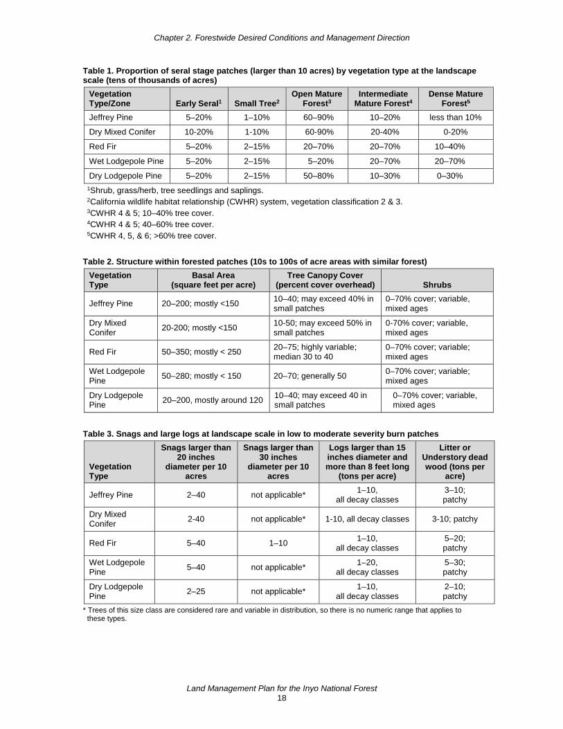
Chapter 2. Forestwide Desired Conditions and Management Direction
Land Management Plan for the Inyo National Forest 18
Table 1. Proportion of seral stage patches (larger than 10 acres) by vegetation type at the landscape scale (tens of thousands of acres)
Vegetation Type/Zone Early Seral1 Small Tree2
Open Mature Forest3
Intermediate Mature Forest4
Dense Mature Forest5
Jeffrey Pine 5–20% 1–10% 60–90% 10–20% less than 10%
Dry Mixed Conifer 10-20% 1-10% 60-90% 20-40% 0-20%
Red Fir 5–20% 2–15% 20–70% 20–70% 10–40%
Wet Lodgepole Pine 5–20% 2–15% 5–20% 20–70% 20–70%
Dry Lodgepole Pine 5–20% 2–15% 50–80% 10–30% 0–30% 1Shrub, grass/herb, tree seedlings and saplings. 2California wildlife habitat relationship (CWHR) system, vegetation classification 2 & 3. 3CWHR 4 & 5; 10–40% tree cover. 4CWHR 4 & 5; 40–60% tree cover. 5CWHR 4, 5, & 6; >60% tree cover.
Table 2. Structure within forested patches (10s to 100s of acre areas with similar forest) Vegetation Type
Basal Area (square feet per acre)
Tree Canopy Cover (percent cover overhead) Shrubs
Jeffrey Pine 20–200; mostly <150 10–40; may exceed 40% in small patches
0–70% cover; variable, mixed ages
Dry Mixed Conifer 20-200; mostly <150 10-50; may exceed 50% in
small patches 0-70% cover; variable, mixed ages
Red Fir 50–350; mostly < 250 20–75; highly variable; median 30 to 40
0–70% cover; variable; mixed ages
Wet Lodgepole Pine 50–280; mostly < 150 20–70; generally 50 0–70% cover; variable;
mixed ages
Dry Lodgepole Pine 20–200, mostly around 120 10–40; may exceed 40 in
small patches 0–70% cover; variable, mixed ages
Table 3. Snags and large logs at landscape scale in low to moderate severity burn patches
Vegetation Type
Snags larger than 20 inches
diameter per 10 acres
Snags larger than 30 inches
diameter per 10 acres
Logs larger than 15 inches diameter and more than 8 feet long
(tons per acre)
Litter or Understory dead wood (tons per
acre)
Jeffrey Pine 2–40 not applicable* 1–10, all decay classes
3–10; patchy
Dry Mixed Conifer 2-40 not applicable* 1-10, all decay classes 3-10; patchy
Red Fir 5–40 1–10 1–10, all decay classes
5–20; patchy
Wet Lodgepole Pine 5–40 not applicable* 1–20,
all decay classes 5–30; patchy
Dry Lodgepole Pine 2–25 not applicable* 1–10,
all decay classes 2–10; patchy
* Trees of this size class are considered rare and variable in distribution, so there is no numeric range that applies to these types.

Chapter 2. Forestwide Desired Conditions and Management Direction
Land Management Plan for the Inyo National Forest 19
Old Forest Habitats The old forest management direction below applies to old forests in the montane zone of the Sierra Nevada and associated ecosystems in the Glass Mountains where most vegetation management has occurred in the past and continues to occur. Old forests within mixed conifer and pine vegetation types are currently more uniformly dense than they were in the past, resulting in increased rates of old growth tree mortality from competition with younger trees, climate change, insect-related mortality, and increased high-severity fire.
Old forest conditions are characterized by the presence of large snags and logs in addition to large live trees. Old forests are mature forests that contain the presence of large and old trees for a given species and site productivity. Old forests vary widely based on forest type, soil condition, topography, and fire history. In mixed conifer, Jeffery pine and red fir forests, and trees greater than 20, 30, or 40 inches in diameter contribute to old forest structure (table 4). Desired densities of trees greater than 20 or 30 inches in diameter are also included for lodgepole pine forests.
Desired Conditions (TERR-OLD-DC) 01 The composition, structure, and functions of old forests and surrounding landscapes are
resilient to fire, drought, insects, pathogens, and climate change. Fire occurs as a key ecological process in forest types that are adapted to fire, creating, restoring and maintaining ecosystem resilience and fire-related composition and structure.
02 The landscape contains a mosaic of vegetation types and structures that provide foraging and breeding habitat, movement, and connectivity for a variety of old forest-associated species.
03 Between 40 and 80 percent of the forested landscape contains old forest areas. Old forest areas are clumps and patches of old forests components such as old trees, snags, and large downed logs. These areas are irregularly distributed across the landscape and interspersed with stands of younger trees, shrubs, meadows, other herbaceous vegetation, and unvegetated patches.
04 The number and density of old trees vary by topographic position and soil moisture. In general, more large and old trees are found on moister sites; on lower slopes, bottoms, and north and east aspects, especially where soils are deeper. Large trees are well distributed but are often clumpy. The densities vary by forest type as shown in table 4. Trees greater than 40 inches in diameter, generally over 150 years old, represent the oldest trees, and comprise a significant proportion of large and old trees. In many areas of high soil productivity, trees grow to large sizes (around 30 inches in diameter) in fewer than 100 years. On low and very low soil productivity sites, the oldest trees may be smaller in diameter. Sufficient numbers of younger trees are present to provide for recruitment of old trees over time.
05 Old forests are composed of both vigorous trees and decadent trees. Clumps of large trees, snags, large logs, and decadent older trees are maintained on the landscape in sufficient numbers to benefit wildlife and are distributed throughout the planning area before and after disturbances.
06 Large snags are scattered across the landscape, generally occurring in clumps rather than uniformly and evenly distributed, meeting the needs of species that use snags and providing for future downed logs.

Chapter 2. Forestwide Desired Conditions and Management Direction
Land Management Plan for the Inyo National Forest 20
07 Coarse woody debris is distributed in patches and the density of large downed logs varies by vegetation type. Surface dead wood levels are sufficient to provide for legacy soil microbial populations.
Table 4. Large and old trees at landscape scale (tens of thousands of acres), except where high severity fires have occurred (greater than 75 percent basal area mortality)
Vegetation Type/Zone
Greater than 20 inches diameter trees per acre
Greater than 30 inches diameter trees per acre
Greater than 40 inches diameter trees per acre
Proportion of the landscape with large and/or old
trees
Dry Mixed Conifer 4–32 2–16 2–7 median 4 40–80%
Jeffrey Pine 2–16 1–8 1–4 40–80%
Red Fir 4–40 4–20 4–12 40–80%
Wet Lodgepole Pine 4–12 4–12 not applicable* 40–80%
Dry Lodgepole Pine 2–6 2–6 not applicable* 40–80% * Trees of this size class are considered rare and variable in distribution, so there is no numeric range that applies to
these types.
Guidelines (TERR-OLD-GDL) 01 When large tree densities meet desired condition levels, thinning to increase
heterogeneity and resilience should emphasize retention of the oldest and largest trees, especially pines. Large trees with deformities, broken tops, large branches, and cavities should be retained for wildlife habitat whenever possible.
02 During burning, firing patterns, burn unit layout, and other firing and holding methods should limit the killing of large old trees and loss of very large snags. Consider preventing delayed tree mortality caused by smoldering at the base of large old trees and consider constructing fireline around large old trees and very large snags to reduce the risk of tree ignition while addressing firefighter safety. Limit fire intensity in areas with large old trees and very large snags where possible.
Complex Early Seral Habitats The complex early seral management direction below applies to actively managed montane forests in the Sierra Nevada and associated ecosystem types in the Glass Mountains including dry mixed conifer, Jeffery pine, lodgepole, and red fir forest types. These forests are where most vegetation management has occurred in the past and continues to occur on the Inyo.
Complex early seral habitat is the stage of forest development following a significant loss of a stand in a mature forest (where the loss is greater than 75 percent basal area) that contains structural, compositional, or functional elements of complexity. Examples of major disturbance events that cause loss of a stand include high-severity fire and wide-scale insect outbreaks.
The death of overstory trees creates a mosaic of openings that allow tree seedlings, shrubs, and herbs to dominate the site. Complex early seral habitat is often characterized by higher but variable densities of snags and logs, spatial variation in vegetation structure and composition, and variability in the timing of functional processes during recovery following a major disturbance.

Chapter 2. Forestwide Desired Conditions and Management Direction
Land Management Plan for the Inyo National Forest 21
Desired Conditions (TERR-CES-DC) 01 Complex early seral habitat contains dense and variable patches of snags and other
habitat elements characteristic of natural succession that are important to early seral forest-associated species. Variable densities of shrubs are managed in more productive sites depending on site potential. Aspen sprouts are well distributed in areas where they occur.
02 Snags, logs, and live trees are widely and variably distributed in large patches (greater than 100 acres when available) where vegetation has been severely burned (greater than 75 percent mortality) to provide habitat while also considering the need for other resource objectives. Such resource objectives could include removal of hazard or salvage trees, reforestation to contribute to future forested conditions and carbon carrying capacity, and strategic fuel treatment, including management of fuels in and adjacent to community wildfire protection zones.
03 Snags that support cavity nesting birds and mammals are sufficiently abundant and well distributed, especially large-diameter snags. Large-diameter snags are retained to mimic natural mortality groups.
Goals (TERR-CES-GOAL) 01 Restoration projects following large stand-replacing events (such as wildfire and bark
beetle infestations) should be designed to consider:
a. safety to people in the short and long terms; b. fuel loads over the long term, including the need to restore fire to the recovering or
restored landscape; c. restoring forested habitat to deforested areas, including restoring connectivity; d. habitat for local wildlife species that use burned forest or habitats with high snag
densities; e. other ecological restoration actions in the affected area; f. opportunities to recover economic value and carbon stored as a harvested wood
product from dead and dying trees; g. the development of restoration strategies that move landscape conditions towards
terrestrial and aquatic ecosystem desired conditions; h. the importance of the larger landscape or watersheds encompassing the impacted
area, including watersheds or landscapes outside the affected area; i. future projections in climate and their influence on ecosystems in the affected area;
and j. long-term maintenance of regional biodiversity in disturbed and adjacent undisturbed
forest landscapes.
Guidelines (TERR-CES-GDL) 01 Post-disturbance restoration projects should be designed to reduce potential soil erosion
and the loss of soil productivity caused by loss of vegetation and ground cover.
02 Post-disturbance restoration projects should be designed to protect and maintain important wildlife habitat.

Chapter 2. Forestwide Desired Conditions and Management Direction
Land Management Plan for the Inyo National Forest 22
03 Post-disturbance restoration projects should be designed to manage the development of fuel profiles over time.
04 Post-disturbance restoration projects should be designed to recover the value of timber killed or severely injured by the disturbance.
05 Large fires with more than 1,000 acres of contiguous blocks of moderate and high vegetation burn severity in forest vegetation types (Jeffery pine, dry mixed conifer, red fir, and lodgepole pine) should retain at least 10 percent of the moderate and high vegetation burn severity area without harvest to provide areas of complex early seral habitat.
Subalpine and Alpine Zones The subalpine and alpine zones of the eastern escarpment of the southern Sierra Nevada are characterized by mostly steep slopes, poorly developed granitic-based soils, and a very high percentage of precipitation that falls as snow. While shrublands and other ecosystems occur in the subalpine zone, the direction below is focused on subalpine forests. Subalpine forests and woodlands in the Sierra Nevada and Glass Mountains are often dominated by high-elevation white pines (whitebark pine, foxtail pine, limber pine). Lodgepole pine, mountain hemlock, red fir, western white pine, and Sierra juniper may also occur.
In the Great Basin ranges, (White and Inyo Mountains) the subalpine and alpine zones are characterized by diverse geologic substrates and a more arid climate than the Sierra Nevada. Subalpine forests and woodlands in these ranges are dominated by Great Basin bristlecone pine and limber pine, and pinyon-juniper woodlands can also occur.
Alpine vegetation in the Sierra Nevada and Great Basin ranges occurs above treeline and is dominated by shrubs and herbs, with occasional patches of krummholz (windblown and stunted) trees.
Desired Conditions (TERR-ALPN-DC) 01 Subalpine woodlands are highly variable in structure and composition. Diverse patch
types vary from open woodlands with scattered trees to small, dense groves.
02 Fires occur infrequently, are mostly very small, and burn with mixed severity. Fire intensity is highly variable, but crown fires are usually limited in size.
03 Subalpine woodlands are resilient to insects, diseases, fire, wind, and climate change. High-elevation white pines (whitebark pine, Great Basin bristlecone pine, limber pine, and foxtail pine) are healthy and vigorous, with a low incidence of white pine blister rust, and resilient to moisture stress and drought. White pine blister rust-resistant trees are regenerating and populations of high elevation white pines have the potential to expand above the tree line.
04 Mature cone-bearing whitebark pine trees are spatially well distributed to produce and protect natural regeneration and conserve genetic diversity.
05 Alpine ecosystems are resilient to climate change, and fires are small and occur infrequently.
Chapter 2. Forestwide Desired Conditions and Management Direction
Land Management Plan for the Inyo National Forest 23
Special Habitats Special habitats are generally small-scale habitat or vegetation types that may support unique assemblages of plants and animals, especially at-risk species. Special habitats typically include uncommon rock types, harsh soils, or rock outcrops. Examples include pumice flats and colluvial aprons (which support dry forb communities), limestone soils, alkali flats or acidic soils, caliche-covered clay mounds, and caves. Given the localized nature of special habitats, they are challenging to address comprehensively at the national forest scale since they may be uniquely affected by different activities or trends in ecological conditions. For example, restoring the composition and structure of sagebrush vegetation surrounding a pumice flat would not necessarily restore desired ecological conditions for dry forb communities adapted to pumice flats.
Aquatic and riparian special habitats (desert springs, seeps, and fens) are considered “special aquatic features” and relevant plan components are in the “Riparian Conservation Area” section.
Desired Conditions (TERR-SH-DC) 01 The integrity of special habitats is maintained or improved from current conditions.
Composition, diversity, and structure are maintained in all areas, including those with multiple-use activities.
02 Microclimate or smaller scale habitat elements provide habitat and refugia for species with a specific geographic or restricted distribution.
03 Conditions remain suitable for long-term sustainability of the suite of native plants adapted to special habitats and their associated insect pollinators.
Goals (TERR-SH-GOAL) 01 Work cooperatively with researchers and interested parties to study, monitor and assist in
appropriate restoration measures of special habitats.
02 Include the location of special habitats in the corporate geographic information system.
Standard (TERR-SH-STD) 01 At the project scale, evaluate and incorporate maintenance and enhancement needs for
special habitats into project design and implementation.
Potential Management Approach • Consider special habitats as a management priority, particularly if at-risk species are
present.
Ecosystem Types
Sagebrush Sagebrush ecosystems are broadly distributed across the Great Basin (often in large and contiguous expanses) and also occur across the eastern Sierra in more arid locations. This ecosystem is dominated by all subspecies of big sagebrush, low sagebrush, bitterbrush, and black sagebrush. In the absence of fire or other disturbance, conifers (especially pinyon and juniper, but also Jeffrey pine) may establish in sagebrush sites. The direction for sagebrush here includes all areas where sagebrush is the site potential under the natural fire regime, including areas that may be currently dominated by wooded shrublands and savannas but would presumably be absent of

Chapter 2. Forestwide Desired Conditions and Management Direction
Land Management Plan for the Inyo National Forest 24
trees under the natural fire regime. Wooded shrublands and savannas differ from persistent woodlands, which have direction under the “Pinyon-Juniper” or “Jeffery Pine” sections below.
Desired Conditions (TERR-SAGE-DC) 01 The sagebrush type has a diversity of age classes, stand structure, cover classes and
native understory composition.
02 Sagebrush ecosystems are resilient to fire and other disturbances including grazing, recreation, invasive species (including cheatgrass), and climate change.
03 Grazed areas have or are trending toward satisfactory soil conditions, functional hydrology, and biotic integrity. Sagebrush ecosystems contain all key elements and conditions, including sagebrush regeneration and recruitment, ecosystem productivity, native perennial grass and forb cover, biological soil crusts, and symbiotic fungal associations.
04 Open sagebrush habitat with no overstory trees (such as pinyon pine, juniper or Jeffrey pine) provides habitat connectivity for sagebrush-dependent species. Fire occurs within the natural range of variation (or in small extents) as a natural process, limiting encroaching conifer trees.
05 Where nonnative annual grasses exist in sagebrush vegetation communities, the native species persist with adequate structural and functional diversity including shrubs, perennial bunchgrasses, and forbs.
Goal (TERR-SAGE-GOAL) 01 Restoration projects following large-scale changes in sagebrush structure or species
composition (type conversion to cheatgrass) from wildfires or other disturbances should be designed to consider:
a. safety to people in the short and long terms; b. restoring habitat, including restoring connectivity; c. other ecological restoration actions in the affected area; d. the development of restoration strategies that move landscape conditions towards
terrestrial and aquatic ecosystem desired conditions; e. the importance of the larger landscape or watersheds encompassing the impacted
area, including watersheds or landscapes outside the affected area; f. future projections in climate and their influence on ecosystems in the affected area;
and g. long-term maintenance of regional biodiversity in disturbed and adjacent undisturbed
landscapes.
Potential Management Approach • Restoration projects should apply design features to reduce impacts to biological soil
crusts, when they are known to occur within the project area.
Pinyon-Juniper Pinyon-juniper vegetation dominates mid-elevations on the eastside of the Inyo National Forest in the Great Basin and also occurs in more arid locations on the east slope of the Sierra Nevada.

Chapter 2. Forestwide Desired Conditions and Management Direction
Land Management Plan for the Inyo National Forest 25
Pinyon-juniper is dominated by single-leaf pinyon and Utah juniper, although many stands in the area are composed exclusively of single-leaf pinyon pine. There are some stands composed of only Utah juniper on the old lakebeds and sand dunes northeast of Mono Lake. Pinyon-juniper types may also be mixed with or located in close proximity to sagebrush, mountain mahogany, and xeric shrublands. In the absence of disturbance, pinyon-juniper may expand into sagebrush sites. The direction here for pinyon-juniper applies to persistent woodlands and does not apply to sagebrush sites in a savannah or woodland state.
Desired Conditions (TERR-PINY-DC) 01 Pinyon-juniper types have a mosaic of trees and open areas that provide wildlife habitat,
contribute to functional soils, and are resilient to disturbances such as fire, invasive species and climate change.
02 Fire frequency and severity is within the natural range of variation.
03 Plant litter and coarse woody debris are present in sufficient quantity to resist accelerated soil erosion and promote nutrient cycling, water retention, and the microclimate conditions necessary for pinyon seed germination. Biological soil crusts are present to improve nutrient cycling and stabilize soils, especially in sandier soils.
04 Pinyon pine regeneration and recruitment ensures persistence of this vegetation type.
05 Mature pinyon pines provide opportunities for traditional collecting of pinyon nuts.
Goals (TERR-PINY-GOAL) 01 Restoration projects following large stand-replacing events (such as wildfire or climate
change impacts) should be designed to consider:
a. safety to people in the short and long terms; b. restoring habitat, including restoring connectivity; c. other ecological restoration actions in the affected area; d. the development of restoration strategies that move landscape conditions towards
terrestrial and aquatic ecosystem desired conditions; e. the importance of the larger landscape or watersheds encompassing the impacted
area, including watersheds or landscapes outside the affected area; f. future projections in climate and their influence on ecosystems in the affected area;
and g. long-term maintenance of regional biodiversity in disturbed and adjacent undisturbed
landscapes.
Potential Management Approach • Restoration projects should apply design features to reduce impacts to biological soil
crusts, when they are known to occur within the project area.
Xeric Shrub and Blackbrush Xeric shrub and blackbrush vegetation occupies the lowest elevations of the planning area. This type is dominated by one or more desert shrub species, including but not limited to blackbrush, saltbush, goldenbush, and horsebrush.

Chapter 2. Forestwide Desired Conditions and Management Direction
Land Management Plan for the Inyo National Forest 26
Desired Conditions (TERR-XER-DC) 01 Xeric shrub vegetation is a mosaic of diverse ecological types with native shrubs and
grasses, commonly blackbrush, sagebrush, saltbush, goldenbush and horsebrush in various age classes and patch sizes.
02 Vegetation conditions are resilient to natural and human disturbances, such as grazing, flooding, fire, invasive species, and climate change.
03 Fires are within the natural range of variation.
04 Flooding event frequency and severity is within the natural range of variation.
Standard (TERR-XER-STD) 01 Restoration projects in xeric shrub and blackbrush must include design measures to avoid
damage to biological soil crusts.
Guideline (TERR-XER-GDL) 01 Restoration projects in xeric shrub and blackbrush should include islands of untreated
vegetation in project design to speed native species regeneration.
Black Oak and Canyon Live Oak Black oak and canyon live oak occur in limited stands in drainages along the southern end of the eastern escarpment of the Sierra Nevada. This vegetation type is limited to areas of relatively higher soil moisture and is dominated by black oak and canyon live oak mixed with variable densities of riparian trees and shrubs.
Desired Conditions (TERR-OAK-DC) 01 Oak trees, snags, and down logs provide habitat for a variety of wildlife species. Oak
snags and live trees with dead limbs, hollow boles, and cavities provide shelter, and resting and nesting habitat. Acorns are plentiful and provide food for wildlife and are available for traditional cultural uses.
Standard (TERR-OAK-STD) 01 During fuel treatments retain all large oaks greater than 12 inches in diameter, except
where they pose a threat to human life or property.
Dry Mixed Conifer Dry mixed conifer forests occur southwest of the Toowa Range on the Kern Plateau and in limited patches on the east side of the Sierra Nevada, primarily around Mammoth and June Lakes. Dry mixed conifer forests are composed of Jeffrey pine and white fir with variable densities of red fir and some lodgepole pine at higher elevations. The understory usually consists of a low to moderate cover of herbaceous plants and shrubs such as greenleaf manzanita, mountain whitethorn, sagebrush, and snowberry (see the Jeffrey Pine ecosystem type below for forests dominated by Jeffrey pine with a limited understory of Great Basin shrub species such as sagebrush and bitterbrush).
Desired Conditions (TERR-DMC-DC) 01 At the landscape scale, the dry mixed conifer vegetation type has a mosaic of patches of
trees of varied sizes and ages. It is dominated by Jeffrey pine and white fir trees, with white fir densities dependent on climate and fire trends (figure 3).

Chapter 2. Forestwide Desired Conditions and Management Direction
Land Management Plan for the Inyo National Forest 27
Figure 3. Example of desired condition for dry mixed conifer forest of Jeffrey and white pines
02 At the landscape-scale, fire is a key ecological process, creating a diversity of vegetation types, lower surface fuels and diverse understory vegetation. Fires occur frequently, on average every 5 to 15 years, with mostly low and moderate severity. Patches burned at high severity (greater than 75 percent basal area mortality) are rarely greater than 200 acres, and the proportion of areas burned with high severity is generally less than 15 percent.
03 At the landscape scale, areas dominated by medium and large-diameter trees comprise more than 60 percent of the landscape. Overstory tree canopy cover is generally 30 percent but ranges widely from 10 to 60 percent at a fine scale. Trees are denser in some locations, such as north-facing slopes and canyon bottoms, but in small patches in limited areas (less than 20 percent of the area). Vigorous shrubs cover 10 percent or more of the area, with density varying by aspect, slope, and soil type.
04 At the mid- to fine scale, vegetation between patches is highly variable. Trees of different sizes and ages are variably spaced and comprise an irregular, uneven-aged forest. Individual trees are variably spaced with some denser groups. Tree stocking (basal area) is highly variable, ranging from 20 to 200 square feet per acre, with most areas having fewer than 150 square feet per acre. Numbers of seedlings and saplings are sufficient to replace old trees over time, but since Jeffrey pine is shade intolerant, they are very patchy in distribution with regeneration occurring when gaps and openings of sufficient size are created.
05 At the mid- to fine scale, small irregularly shaped openings with less than 10 percent tree cover make up from 10 to 50 percent of the area, and contain a mix of grasses, herbaceous plants and shrubs.

Chapter 2. Forestwide Desired Conditions and Management Direction
Land Management Plan for the Inyo National Forest 28
06 At the mid- to fine scale, snags greater than 20 inches in diameter are at densities between 2 to 20 snags per 10 acres, and are well distributed, but highly irregular in spacing providing for future downed logs. Coarse woody debris, including large downed logs in varying states of decay, is irregularly distributed and ranges from 1 to 5 tons per acre. Litter and surface fuel is patchy with fewer than 5 to 10 tons per acre in fuel loading on average over 30 to 70 percent of the area. There are some small areas of up to 30 tons per acre and others with fewer than 5 tons per acre.
Jeffrey Pine Jeffrey pine forests occur in places along the eastern escarpment of the Sierra Nevada, on the Kern Plateau, Glass Mountains, Mono Basin, and Upper Owens River area. This forest type generally occurs on shallow, less productive soils on middle to upper slope positions. Eastside Jeffrey pine forests typically occur in stands dominated by Jeffrey pine (for stands mixed with white fir, red fir, and lodgepole with a relatively abundant understory shrubs such as greenleaf manzanita, mountain whitethorn see “Dry Mixed Conifer” section above). In some areas, Jeffrey pine forests may be mixed with some pinyon pine, lodgepole pine, western white pine, or limber pine. The understory usually consists of a low cover of herbaceous plants or Great Basin shrubs such as sagebrush or bitterbrush.
Desired Conditions (TERR-JEFF-DC) 01 At the landscape scale, the Jeffrey pine type is part of a heterogeneous mosaic of
shrublands, woodlands or other vegetation types. Forests are dominated by Jeffrey pine trees and are generally open. Open-canopied stands dominate the landscape, with generally less than 10 percent of the area having more than 40 percent canopy cover. Open canopies allow shade-intolerant Jeffrey pine tree regeneration (figure 4).
Figure 4. Example of desired condition in a Jeffrey pine patch
02 At the landscape-scale, fire is a key ecological process, creating a diversity of vegetation types, lower surface fuels and diverse understory vegetation. Fires occur frequently, on average every 5 to 15 years, with mostly low and moderate severity. Patches burned at high severity (greater than 75 percent basal area mortality) are rarely greater than 200 acres, and the proportion of areas burned with high severity is generally less than 15 percent.
03 At the mid-scale, Jeffrey pine forests are primarily composed of mostly open canopies, with variable patches of trees and scattered individual trees.
Chapter 2. Forestwide Desired Conditions and Management Direction
Land Management Plan for the Inyo National Forest 29
04 At the mid-scale, Jeffrey pine forest is composed predominantly of vigorous trees, but declining trees are an important component, providing wildlife nesting and denning habitat, future production of snags, down logs, and other coarse woody debris.
05 At the mid-scale, insects and pathogens like dwarf mistletoe, Annosus and Armillaria root diseases, and Jeffrey pine beetle, occur at endemic levels and are restricted to individual stands. Witches’ brooms caused by mistletoe provide habitat for wildlife species.
06 At the fine scale, size and age class diversity is high within Jeffrey pine stands. Individual large trees or tree groups provide nesting and denning habitat for wildlife.
07 At the fine scale, openings of various shapes surround and are intermixed with the trees. These gaps make up from 10 to 70 percent of the area, are typically less than 0.1 to 0.5 acre in size, and contain herbaceous plants, shrubs and tree regeneration.
Red Fir Red fir forests occur in the upper montane zone and are mostly limited to the Kern Plateau and the eastern escarpment between Mammoth and June Lakes. This forest type is dominated by red fir and typically occurs on deeper, more productive soils on most slope positions except ridgetops. Mixed red fir stands may also contain white fir, lodgepole pine, and Jeffrey pine as well as western white pine at higher elevations. The understory may include several species of shrubs and herbaceous plants, including gooseberries, Sierra chinquapin, and snowberry.
Desired Conditions (TERR-RFIR-DC) 01 At the landscape scale, the red fir forest type is part of a heterogeneous mosaic of tree
species and vegetation structures (tree density, size, age and shrub cover), with patches of Jeffrey pine, lodgepole, other forest types, and meadows. It is dominated by red fir trees, with varying amounts of white fir, Jeffrey pine, western white pine, lodgepole pine and sometimes mountain hemlock.
02 Fire occurs as a key ecological process in red fir forests where it does not pose an unacceptable risk to life and property. Fire as an ecological process creates, restores, and maintains ecosystem resilience and increases understory plant vigor, heterogeneity, and habitat diversity.
03 At the landscape scale, areas dominated by medium and large-diameter trees and low to moderate canopy cover (between 10 and 60 percent) comprise most of the landscape (table 1). Trees are denser in some locations such as north-facing slopes and canyon bottoms, near meadows, or where snow accumulates. Early seral vegetation, shrubs, grasses, herbaceous plants, tree seedlings or saplings, mostly occur in very small areas, intermixed within forest stands or patches.
04 At the landscape scale, shrubs, grasses and young trees grow in patches of dead and dying trees with abundant snags and large logs, providing complex early seral habitat.
05 At the mid- to fine scale, trees of different sizes and ages are variably spaced with some tight groups, comprising an irregular, uneven-aged forest (figure 5). Tree stocking (basal area) is highly variable, ranging from 50 to 350 square feet per acre with most areas having fewer than 250 square feet per acre (table 2). Numbers of seedlings and saplings are sufficient to replace old trees as they die, but are very patchy in distribution.

Chapter 2. Forestwide Desired Conditions and Management Direction
Land Management Plan for the Inyo National Forest 30
Figure 5. Three photos displaying red fir forest heterogeneity
06 At the mid- to fine scale, small openings are intermixed within stands of trees. They make up 5 to 20 percent of the area within tree stands, have less than 10 percent tree cover, are irregularly shaped, and often contain herbaceous plants, shrubs, and tree seedlings and saplings. Some openings and the understory of some red fir patches have little to no understory plants but instead have a high diversity of mushrooms and other fungi.
07 At the mid- to fine scale, snags greater than 20 inches in diameter are distributed in patches. An average of 5 to 40 snags per 10 acres (table 3) provide for future downed logs. Coarse woody debris, including large downed logs in varying states of decay, is distributed in patches and ranges from 1 to 10 tons per acre. Litter and surface fuel is patchy with fewer than 5 to 20 tons per acre in fuel loading on average. There may be areas with no fuels and pockets of high fuel accumulation scattered irregularly.
Lodgepole Pine A variety of lodgepole forests occur on the Inyo National Forest. In some of the following plan components, lodgepole pine is further divided into dry versus wet lodgepole pine. Dry lodgepole pine dominates on upper montane dry sites and is often located on benches, upper topographic positions, and moderate slopes. Stands are typically in shallow, drier, and nutrient-poor soils. Western white pine may be present, but mesic tree species (such as red fir) are generally absent or infrequent. Understory herbaceous plant cover is generally less than 30 percent and bare ground and rock cover is generally more than 30 percent.
Chapter 2. Forestwide Desired Conditions and Management Direction
Land Management Plan for the Inyo National Forest 31
Wet lodgepole pine dominates on upper montane wet sites, often located on gently rolling lower slopes and drainage bottoms. Stands are located on relatively productive, moister, and deeper soils in the upper montane zone. Red fir may be present in wet lodgepole pine stands. Understory herbaceous plant cover is generally more than 30 percent and bare ground and rock cover is generally less than 30 percent. Either wet or dry lodgepole may border some meadow ecosystems, depending upon the ecological setting.
Desired Conditions (TERR-LDGP-DC) 01 Lodgepole pine forests are highly variable throughout the landscape, occurring as open
forests on dry sites at higher elevations, and as denser stands in pockets around meadows, lakes or where cold air accumulates. The lodgepole pine type is part of a heterogeneous mosaic of tree species with diverse structural conditions. It is dominated by lodgepole pine, with varying amounts of red fir, white fir, aspen, and sometimes white pine.
02 Fire occurs as a key ecological process in lodgepole pine forests where it does not pose an unacceptable risk to life and property. Fire as an ecological process creates, restores, and maintains ecosystem resilience and increases understory plant vigor, heterogeneity, and habitat diversity.
03 The distribution and structure of wet lodgepole pine forests are variable, ranging from small patches of even-aged trees, with both closed and open canopies, to uneven-aged, irregular patches. Size and age class diversity is high within wet lodgepole pine stands. Individual trees are variably spaced with some tight groups. Irregularly shaped groups of large and intermediate trees are variably sized, with some overlapping tree crowns. Smaller trees are randomly distributed.
04 In wet lodgepole pine forests, areas dominated by medium and large-diameter trees, comprise more than 45 percent of the landscape (table 1). Tree stocking (basal area) is highly variable, ranging from 50 to 280 square feet per acre, with most less than 150 square feet per acre (table 2). Canopy cover ranges from 20 to 70 percent but is generally 50 percent. Small openings with less than 10 percent tree cover are irregular in shape and make up from 5 to 20 percent of the area and contain a mix of grasses, herbaceous plants and shrubs. Sufficient tree regeneration in openings provides for stand replacement.
05 In wet lodgepole pine forests, large snag densities are between 5 and 40 snags per 10 acres (table 3). Snags are well distributed, highly irregular in spacing, and provide for future downed logs. Coarse woody debris, including large downed logs in varying states of decay, is well distributed but irregular in spacing and ranges from 1 to 20 tons per acre. Some small areas contain very high fuel loading of up to 30 tons per acre and other areas have fewer than 5 tons per acre.
06 The distribution and structure of dry lodgepole pine forests are variable but typically open, with irregular patches of trees of different ages and generally few overlapping tree crowns. Smaller trees are randomly distributed. Tree groups may contain other tree species such as western white pine or foxtail pine. Regenerating trees in suitable but irregularly distributed sites eventually create new stands.
07 In dry lodgepole pine forests, areas dominated by medium and large-diameter trees comprise more than 60 percent of the landscape (table 1). Canopy cover is generally 10 to 40 percent but may exceed 40 percent in small patches and moist microsites (table 2).

Chapter 2. Forestwide Desired Conditions and Management Direction
Land Management Plan for the Inyo National Forest 32
08 Within dry lodgepole pine patches, individual trees are variably and often widely spaced. Tree stocking (basal area) is highly variable with most stands having around 120 square feet per acre but ranging from 20 to 200 square feet per acre. Small openings with less than 10 percent tree cover are irregular in shape and make up from 10 to 50 percent of the area and contain a mix of bare ground, rock, grasses, herbaceous plants and shrubs.
09 In dry lodgepole stands, the understory can contain between 0 to 40 percent shrub cover and on very dry, cold rocky sites there may be no shrub cover.
10 In dry lodgepole pine forests, large snag densities are between 2 to 25 snags per 10 acres (table 3). Snags are well distributed, highly irregular in spacing, and provide for future downed logs. Coarse woody debris, including large downed logs in varying states of decay, is well distributed but highly irregular in spacing, ranging from 1 to 10 tons per acre. Surface fuel loads are highly variable and patchy. Some small areas contain higher fuel loading of up to 15 tons per acre and most areas have fewer than 8 tons per acre.
Mountain Mahogany Mountain mahogany generally occurs on steep, rocky, and variable terrain and is frequently mixed with other ecosystem types, such as Jeffrey pine forest, pinyon-juniper woodlands, and sagebrush.
Desired Conditions (TERR-MOMA-DC) 01 Mountain mahogany is composed of native shrub and understory species that reflect the
natural range of variation for the site. This vegetation type has varying age classes and densities that protect against accelerated erosion, with 1 to 10 percent of the type in early seral grass and herbaceous cover, 5 to 20 percent in native herbs and early seral shrubs, and 70 to 95 percent dominated by mountain mahogany cover.
02 The fire return interval is appropriate to allow the soil seed bank of native species to be maintained over the short and long terms. Invasive nonnative plants do not dominate between fires.
Aspen Aspen occurs at moderate to high elevations in many parts of the eastern Sierra Nevada and Great Basin regions of the planning area except the Inyo Mountains. Aspen typically occurs in locations with increased moisture availability, either from subsurface or surface water (often in drainages) and its life cycle is closely tied to fire. Aspen may also occur in drier landscapes, particularly on the eastern slopes of the Sierra Nevada and the eastern slopes of the White Mountains where a water source may not be readily apparent. Aspen stands often support a high level of plant biodiversity, including a diverse understory of forbs, grasses, sedges, and shrubs.
Desired Conditions (TERR-ASPN-DC) 01 The structure, function, and distribution of aspen are within the natural range of variation;
there is a wide age and size class distribution of aspen and it is contributing to habitat and biodiversity. Aspen is successfully regenerating.
02 Fire or silvicultural activity reduces conifer encroachment and competition. Aspen stands are resilient to and periodically regenerated by moderate to high-severity fires or other disturbances such as avalanches, allowing for potential expansion.
Chapter 2. Forestwide Desired Conditions and Management Direction
Land Management Plan for the Inyo National Forest 33
03 Aspen groves contribute to social and economic sustainability by supporting recreational, cultural, and economic opportunities. Aspen groves add visual interest, variety and contrasts in the landscape, providing spiritual respite and enjoyment.
Guidelines (TERR-ASPN-GDL) 01 Where pile burning of material from conifer removal is desired, piles should be kept at
least 4 to 15 feet away from large aspen trees to limit damage to aspen trunks. Larger piles should be farther from aspen trunks than smaller piles.
02 During treatment to manage or restore aspen, aspen trees with historical carvings should be protected or recorded and the historical value appropriately documented.
03 Near developed or heavily managed areas, conifer removal (mechanical or hand thinning) should be the primary initial restorative treatment for aspen stands. To manage residual fuel loading where cut material cannot be removed from the stand, pile burning may be used.
04 The number and size of conifers removed to enhance aspen should meet the following long-term objectives:
a. maximize direct and indirect light (this may require treating beyond the existing aspen stand perimeter);
b. allow aspen expansion; c. reduce conifer seed sources; d. create fuel loads that reflect functioning aspen stands to allow future prescribed
burning; and e. promote wildlife habitat, plant assemblages, and water yields typically found in
functioning aspen communities. 05 Browsing pressure should be reduced where aspen regeneration is not creating larger size
classes.

Chapter 2. Forestwide Desired Conditions and Management Direction
Land Management Plan for the Inyo National Forest 34
Animal and Plant Species This and subsequent sections under this heading include plan direction designed to maintain the diversity of plant and animal communities and support the persistence of native species within the plan area, subject to the extent of Forest Service authority and the inherent capability of the plan area. This section includes plan components that address the needs of at-risk species within the plan area. At-risk species include (1) federally listed threatened, endangered, proposed, or candidate species under the Endangered Species Act, and (2) species of conservation concern.4 This section also includes direction that provides for the sustainable use and enjoyment of fish, wildlife, and plants.
Yosemite toad (photo by R. Perloff)
For each species or group of species, the forest plan considers the extent that plan components provide for ecosystem integrity and diversity to meet the ecological conditions necessary for those species within their range. Species-specific plan components are added as needed. Additional direction is provided for special habitats under the “Terrestrial Ecosystems” section to address unique habitats of some at-risk species.
Forestwide Components for Animal and Plant Species
Desired Conditions (SPEC-FW-DC) 01 Sustainable populations of native and desirable nonnative, plant and animal species are
supported by healthy ecosystems, essential ecological processes, and land stewardship activities, and reflect the diversity, quantity, quality, and capability of natural habitats on the Inyo National Forest. These ecosystems are also resilient to uncharacteristic fire, climate change, and other stressors, and this resilience supports the long-term sustainability of plant and animal communities.
02 Habitats for at-risk species support self-sustaining populations within the inherent capabilities of the plan area. Ecological conditions provide habitat conditions that contribute to the survival, recovery, and delisting of species under the Endangered Species Act; preclude the need for listing new species; improve conditions for species of conservation concern including addressing threats (e.g. minimal impacts from disease); and sustain both common and uncommon native species.
03 Land management activities are designed to maintain or enhance self-sustaining populations of at-risk species within the inherent capabilities of the plan area by considering the relationship of threats (including site-specific threats) and activities to species survival and reproduction.
04 The structure and function of the vegetation, aquatic and riparian system, and associated microclimate and smaller scale elements (like special features such as carbonate rock
4 The Regional Forester’s species of conservation list is dynamic and may be periodically updated. The current
Regional Forester’s species of conservation concern list for the Inyo National Forest can be found on the Pacific Southwest Region’s website at http://www.fs.usda.gov/main/r5/landmanagement/planning.

Chapter 2. Forestwide Desired Conditions and Management Direction
Land Management Plan for the Inyo National Forest 35
outcrops, fens, or pumice flats) exist in adequate quantities within the capability of the plan area to provide habitat and refugia for at-risk species with restricted distributions.
05 The Inyo National Forest provides high quality hunting and fishing opportunities. Habitat for nonnative fish and game species is managed in locations and ways that do not pose substantial risk to native species, while still contributing to economies of local communities.
06 Residents and visitors have ample opportunities to experience, appreciate, and learn about the Inyo National Forest’s wildlife, fish, and plant resources.
Goals (SPEC-FW-GOAL) 01 Cooperate with partners and private landowners to encourage resource protection and
restoration across ownership boundaries.
02 During the planning phase of vegetation management projects, collaborate with the California Department of Fish and Wildlife to assess potential disturbance factors to deer and to consider habitat management opportunities.
03 Work with the California Department of Fish and Wildlife (following the memoranda of understanding), Nevada Department of Wildlife, and U.S. Fish and Wildlife Service to restore and maintain essential habitat for at-risk species and implement other recovery actions according to species recovery plans.
04 Communicate and collaborate with other agencies, Tribes, landowners, and partners to maximize opportunities to improve conditions in the plan area for at-risk species and the habitats and ecological processes on which they depend for survival.
05 Develop a regional whitebark pine conservation and restoration strategy in collaboration with other Federal agencies, research organizations, and other partners.
06 Coordinate with State and Federal agencies and other partners to provide education materials and best management practices information to limit the potential spread of disease to caves and mines used by bats.
Standards (SPEC-FW-STD) 01 Design features, mitigation, and project timing considerations are incorporated into
projects that may affect occupied habitat for at-risk species.
Guidelines (SPEC-FW-GDL) 01 Known nest, roost, or den trees used by species of conservation concern or raptors,
including surrounding trees that provide beneficial thermal or predatory protection, should not be purposefully removed, with the exception of the unavoidable removal of hazard trees and as required to meet other State or Federal regulatory requirements.
02 To minimize disturbance in mule deer holding areas, vegetation treatment projects should not occur from May 1 through June 15, and in key winter range areas from November 15 through March 31. Long-term over short-term benefits should be the deciding factor where conflicts exist.
03 Habitat management objectives and nonhabitat recovery actions from approved recovery plans should be incorporated, if appropriate, in the design of projects that will occur within federally listed species habitat to contribute to recovery of the species.

Chapter 2. Forestwide Desired Conditions and Management Direction
Land Management Plan for the Inyo National Forest 36
04 Habitat management objectives or goals from approved conservation strategies or agreements should be incorporated, if appropriate, in the design of projects that will occur within at-risk species habitat.
05 Water developments (such as a diversion or well) should be avoided near streams, seeps, and springs where there is high risk of dewatering aquatic and riparian habitats where at-risk species occur.
Potential Management Approaches • Develop and implement a consistent, systematic, biologically sound program for plant
species of conservation concern and their habitat so that Federal listing does not occur.
• Incorporate the conservation of at-risk species into all program areas at appropriate times and scales, including but not limited to recreation, fire and fuels, vegetation management, minerals, range, engineering, and special uses.
• Reduce human-caused mortalities associated with illegal marijuana growing and rodenticide use, road-related mortalities, and mortalities associated with water pipes and tanks.
• Protect known bat hibernacula or maternity colonies that may be adversely affected by recreational, management, or other activities by either installing bat gates at the entrances of caves and mines or restricting access by other means.
Bi-State Sage-grouse
Desired Conditions (SPEC-SG-DC) 01 Suitable sage-grouse habitat includes breeding, brood-rearing, and wintering habitats that
are distributed to allow for dispersal and genetic flow.
02 High quality nesting cover, conditions that support high levels of quality pre-laying hen habitat and dietary protein intake needs, and habitat supporting chick-rearing nutritional needs occur throughout breeding habitat in each population management unit.
03 Sage-grouse brood-rearing habitat occurs in the Bodie, South Mono, and White Mountains population management units and includes a range of shrub cover, perennial grass cover, forb density, and meadows.
04 Sage-grouse habitat is maintained or enhanced within and between population management unit corridors and allows for population movement, seasonal movements, and genetic flow.
05 Sage-grouse habitats do not include overstory trees, such as pinyon pine, juniper, or Jeffrey pine.
06 The extent and dominance of nonnative annual grass species, such as cheatgrass, is limited and does not lead toward reduction in the suitability of sage-grouse habitat.
07 Unwanted fire (more frequent, severe, or larger than the natural range of variation) in sage-grouse priority habitat is limited or prevented.
08 At the stand/site scale (10 to 100 acres), sagebrush and understory cover occur in a mosaic across the site, with 1-acre patches meeting the desired conditions for nest sites
Chapter 2. Forestwide Desired Conditions and Management Direction
Land Management Plan for the Inyo National Forest 37
and brood-rearing areas, in areas that are consistent with the site and the sagebrush species potential.
09 Meadows within sage-grouse range provide suitable habitat for sage-grouse, including desirable foraging species (insects and plants), have suitable sagebrush cover around the meadows edge, are hydrologically fully functional and vegetation is within mid-seral conditions. Within livestock allotments in sage-grouse range, meadow condition is trending towards or rated at fully functional based on forestwide range utilization standards.
Objective (SPEC-SG-OBJ) 01 Within 10 years of the plan approval, up to 14,900 acres of sage-grouse habitat, within
and between population management units, will be improved or restored to meet sage-grouse priority habitat desired conditions.
Goals (SPEC-SG-GOAL) 01 Participate in collaborative forums such as the executive oversight committee, technical
advisory committee, and local area working group to ensure agency interests are considered and to collaboratively implement the Bi-State Action Plan to further sage-grouse conservation.
02 Continue to work with researchers, scientists, and partners to collect data sufficient to establish desired conditions for sage-grouse habitats in the Bodie, South Mono, and White Mountain Population Management Units specific to sagebrush species and ecological sites.
03 Continue population and vegetation monitoring efforts within the Bodie, South Mono, and White Mountain Population Management Units with State and Federal partners.
04 Continue coordination and communication with the California Department of Fish and Wildlife, Nevada Department of Wildlife and the U.S. Fish and Wildlife Service during project development for all projects occurring within sage-grouse habitat.
Standards (SPEC-SG-STD) 01 Habitat restoration projects for the sage-grouse shall be designed to meet one or more of
the following habitat needs:
a. Promote the maintenance of extensive, intact sagebrush communities; b. Limit the expansion or dominance of invasive species, including cheatgrass, and the
expansion of pine species, including pinyon-juniper and Jeffrey pine; c. Maintain or improve soil site stability, hydrologic function, and biological integrity;
and d. Enhance the native plant community.
02 Habitat restoration projects for the sage-grouse must include measures to improve suitability of breeding or brood rearing habitat.
03 Within sage-grouse habitat, ensure that habitat restoration activities, vegetation treatments, or other authorized uses on the national forest, maintain or move toward vegetation desired conditions for sage-grouse. Short-term (1 to 10 year) impacts are
Chapter 2. Forestwide Desired Conditions and Management Direction
Land Management Plan for the Inyo National Forest 38
allowed to deviate from these habitat standards, if the long-term (10 to 30 years) project objective is to achieve desired conditions.
04 Mitigate long-term negative impacts to sage-grouse habitat from activities, to the extent practicable and within agency authority.
05 Require site-specific project mitigation if needed to insure no net loss of habitat within the Inyo National Forest due to project disturbance.
06 Establish a limited operating period for the sage-grouse breeding season (which current best available science indicates is March 1 to May 15) within suitable breeding habitat for any activities that would cause disturbances during this time. These dates can be adjusted based on current nesting conditions or risk assessment.
07 Establish a limited operating period for the sage-grouse nesting season (which current best available science indicates is May 1 to June 15) within suitable nesting habitat for any activities that would lead to disturbances during this time. These dates can be adjusted based on current nesting conditions or risk assessment.
08 When conducting livestock grazing allotment assessments, establish key areas in meadow or upland habitats where absent in occupied sage-grouse habitat.
09 Within sage-grouse priority habitat, use genetically and climatically appropriate native plant and seed material when seeding the area.
10 No new tall structures, which could serve as predator perches, will be authorized within 4 miles of an active lek in suitable habitat. If structures are needed within this area then anti-perching devices shall be installed. During the permit renewal process, existing powerlines and other utility structures within 4 miles of active leks in suitable habitat will be retrofitted with perch-deterring devices.
11 All fences and other barriers constructed or replaced within 1.2 miles of a known lek in suitable habitat must be let-down fences and/or marked with fence markers.
12 Within suitable habitat, manage permitted watering facilities to prevent drowning or entrapment and provide mosquito control to reduce the risk of creating a vector for diseases.
13 Do not locate new salting, supplemental feeding locations, livestock watering, and handling facilities on sage-grouse leks.
14 After soil disturbance or seeding, subsequent soil-disturbing management activities shall not occur until desired habitat conditions have been met within sage-grouse habitat unless a resource team determines that disturbance will help achieve desired conditions.
15 Consult a resource advisor during wildfires in sagebrush to identify suitable sage-grouse habitat and to suggest opportunities for retaining and protecting sagebrush stands. When safe and feasible, protect highly valued suitable sage-grouse habitat ahead of burn operations using techniques such as targeted burning and providing direct protection.
Guidelines (SPEC-SG-GDL) 01 Use existing roads to co-locate new powerlines to reduce disturbance footprints (areas)
and habitat fragmentation.

Chapter 2. Forestwide Desired Conditions and Management Direction
Land Management Plan for the Inyo National Forest 39
02 Where feasible, bury utility lines to reduce overhead perches.
03 When agency personnel, contractors, and permit holders are driving off road and working in areas with known noxious weed infestation, the vehicles should be cleaned before entering a different area to reduce the spread of noxious weeds.
04 Vegetation treatments and disturbances that reduce connectivity should be seeded or transplanted with sagebrush to restore patches of sagebrush cover and connect existing patches to improve sage-grouse habitats within and between population management units.
Potential Management Approaches • Prevent unwanted fire in priority habitat by managing sagebrush systems to be resilient,
implementing proactive fire prevention, and limiting nonnative annual grass expansion.
• Use an adaptive management strategy when conducting vegetation treatments within sage-grouse habitat. Determine treatment methods and intensities based on the results of past treatments as information from those past treatments becomes available. If the results of past treatments show that those treatments have caused an increase in nonnative annual grasses and poor sagebrush recruitment, do not use the same prescription for further treatments within sage-grouse habitat.
• When a right-of-way is no longer in use, relinquish the right-of-way and reclaim the site by removing powerlines, reclaiming roads, and removing other infrastructure.
• Where sage-grouse habitat is being degraded due to wild horse and burro use, determine site-specific measures to improve or restore sage-grouse habitat.
Great Gray Owl
Potential Management Approach • Conduct additional surveys using established protocols to follow up on reliable sightings
of great gray owls.
Bighorn Sheep
Desired Conditions (SPEC-SHP-DC) 01 An adequate amount of suitable habitat supports persistent populations of bighorn sheep.
These habitat patches include unforested openings supporting productive plant communities with a variety of forage species in and near adequate steep rocky escape terrain throughout the elevational range of mountain ranges. These areas meet different seasonal needs for each sex for feeding, night beds, birthing sites, lamb rearing, and migration routes between suitable habitat patches.
02 The risk of disease transmission from domestic sheep and goats, including pack goats, to bighorn sheep (based upon the best available risk assessment model) is reduced to the maximum extent practicable.
Goal (SPEC-SHP-GOAL) 01 Coordinate with the California Department of Fish and Wildlife and the U.S. Fish and
Wildlife Service to conduct a risk assessment of pack goat use on the Inyo National

Chapter 2. Forestwide Desired Conditions and Management Direction
Land Management Plan for the Inyo National Forest 40
Forest and develop mitigations strategies to manage the risk of disease transmission, if needed.
Standards (SPEC-SHP-STD) 01 Do not allow domestic sheep or goat grazing or pack goat use where relevant bighorn
sheep risk assessment models show there is a high risk of contact and spread of disease, unless risks can be adequately mitigated.
02 Manage recreation, or other disturbances, where research has found it to cause Sierra Nevada bighorn sheep to avoid important habitat as described in the Sierra Nevada Bighorn Sheep Recovery Plan or other guidance from the U.S. Fish and Wildlife Service.
Suitability (SPEC-SHP-SUIT) 01 Domestic sheep or goats, including pack goats, are not suitable within the high risk area
of disease transmission to Sierra Nevada bighorn sheep identified in the most recent bighorn sheep risk assessment.
Potential Management Approach • If reintroduced bighorn sheep establish themselves in drainages outside the reintroduction
sites, take advantage of opportunities to extend bighorn sheep range, consistent with other resource activities.
Sierra Marten and Pacific Fisher
Desired Conditions (SPEC-SMPF-DC) 01 Risk of large high-severity fire is reduced from current conditions in marten habitat core
areas and fisher Core Area 1 (see glossary).
02 Within marten core habitat and fisher Core Area 1, vegetation is trending toward desired conditions for terrestrial and riparian vegetation.
03 Marten and fisher habitat are well distributed throughout the marten’s range and fisher Core Area 1, providing for foraging, denning, and resting habitat and movement across large landscapes.
04 Essential fisher habitat elements, including large living and dead trees (especially pines and oaks) and structures used by fishers for resting and denning (cavities, deformities), are common and well distributed throughout fisher Core Area 1.
Guidelines (SPEC-SMPF-GDL) 01 Within marten core habitat and fisher Core Area 1, retain overtopping and multi-storied
canopy conditions, including some shade-tolerant understory trees such as firs, especially in drainages, swales and canyon bottoms and on north- and east-facing slopes. Retain a patchy mosaic of shrubs and understory vegetation, separated by more open areas, to reduce fuel continuity, increase habitat heterogeneity, support prey, and provide hiding cover, with a goal of 10 to 20 percent shrub cover at the home range scale.
02 Maintain or increase understory heterogeneity in marten denning habitat and fisher high value reproductive habitat (see glossary) to promote hiding cover such as shrub patches, coarse woody debris, and slash piles following vegetation treatments. Project design should include non-linear edges that decrease susceptibility to predation.

Chapter 2. Forestwide Desired Conditions and Management Direction
Land Management Plan for the Inyo National Forest 41
03 To minimize disturbance to breeding females and their offspring, apply a limited operating period prohibiting mechanical vegetation treatment activities during the breeding season (March 1 to June 30) and prescribed fire activities during the early breeding season (March 1 to May 1) within fisher high value reproductive habitat in fisher Core Area 1. Projects proposed in fisher high value reproductive habitat in Core Area 1 during the breeding season should be assessed by a biologist knowledgeable about fishers to determine whether potential benefits to fishers are likely to outweigh the risks, in which case the activities may be exempt from the LOP restrictions if they are carefully designed and implemented to mitigate risks.
Potential Management Approach • Generally, management in fisher Core Area 1 to favor tree growth, increased canopy
cover, and recruitment of essential fisher habitat elements is likely to benefit the fishers.
California Spotted Owl The following plan components for California spotted owl apply to those areas of the Inyo National Forest that provide suitable habitat, as defined in the desired conditions for protected activity centers and territories (see glossary) or where nesting owls have been identified. On the Inyo, these habitats are found within the west side Sierra Nevada vegetation types on the Kern Plateau and Middle Fork San Joaquin River/Red’s Meadow areas. Forest management activities where these plan components would apply include vegetation, fuels, and fire treatments; restoration activities that require prescribed fire or mechanical removal of forested species; and forest product removal (commercial fuelwood or timber) where suitable habitat has been identified. These plan components are exempt within Destination Recreation Areas, as suitable nesting habitat would not be found within these areas due to the high levels of disturbance.
Desired Conditions (SPEC-CSO-DC) 01 California spotted owl habitat is well distributed within the capability of the plan area and
provides for nesting, roosting, and foraging habitat while promoting movement across large landscapes and adjacent landownerships.
02 California spotted owl protected activity centers encompass the best available 300 acres of contiguous habitat. Best available habitat includes wetter, higher productivity sites bordering or adjacent to the known or suspected nest stand since these areas are most likely to have essential nesting and roosting habitat. Protected activity centers include the highest quality nesting and roosting habitat available near the known or suspected nest stand. Where possible, heterogeneity is incorporated as described in the terrestrial vegetation type desired conditions (see red fir and dry mixed conifer types) appropriate within the protected activity center location. Protected activity centers may include habitat that has dense canopy cover or greater tree density that is outside the natural range of variation and not likely to be sustainable over time.
03 Where dry vegetation types are the majority of a California spotted owl protected activity centers or territories, the vegetation type is trending toward the dry vegetation desired conditions and is resilient towards fire, drought, insects and pathogens.
04 California spotted owl territories include a range of conditions that promote resiliency and heterogeneity such as fine-scale gaps and patches of 0.03 to 2.0 acres (median of 0.1 acre) associated with shrubs, meadows, or low tree and canopy densities consistent with vegetation desired conditions and guided by the natural range of variation. Clumps or
Chapter 2. Forestwide Desired Conditions and Management Direction
Land Management Plan for the Inyo National Forest 42
groups of large trees, some with dense tree cover, are well distributed in an irregular pattern and provide habitat connectivity between protected activity centers. Forest cover varies with the vegetation desired conditions and corresponding vegetation types, and dense canopy cover habitat is dominated by large and very large trees.
05 Within California spotted owl territories, large trees and snags that can provide for nesting and for primary prey species are abundant and have the following characteristics:
a. Moderate signs of decay with large pieces of bark pulling away from the bole that causes safe spaces or pockets for bats and flying squirrels to roost or den.
b. Snags with small to large cavities, especially if they are protected by adjacent overhanging canopy.
c. Whitewash around the base or on the snag, indicating it is currently being used by large birds.
d. Snags with large (5 inches by 3 inches), squared-off, oval-shaped cavities typically created by pileated woodpeckers.
e. Large snags near perennial water that are important to principal spotted owl prey.
Standards (SPEC-CSO-STD) 01 During project planning for projects designed to implement restoration and resilience
treatments, protected activity centers may be re-mapped to avoid intersections with proposed mechanical treatment areas, provided that the re-mapped protected activity centers contain habitat of equal or better quality and do not exclude known recently used nest sites and important roost sites. Treatment-related constraints include the following:
a. Limit mechanical treatments to no more than 25 percent of an individual protected activity center per decade.
b. Mechanical treatment is not allowed within 250 feet of the known nest site or, where the nest site is not known, the most recent known roost site.
c. Retain clumps or groups of large trees, some with dense tree cover, in a well-distributed and irregular pattern. Use individual tree and small group harvest methods when tree removal is needed.
d. Maintain sufficient tree cover within 250 feet of the known nest site or, where the nest site is not known, the most recent known roost site to provide for the life history requirements.
e. Do not remove overstory trees or trees larger than 24 inches in diameter at breast height except when required to provide for human safety.
f. Protect nest and identified important roost trees from incidental damage, including protection of adjacent trees that provide significant protection over nest cavities.
02 Outside community buffers, vegetation treatments in protected activity centers may include prescribed fire and hand treatments. Mechanical treatments are prohibited.
03 For all treatments within protected activity centers, maintain connectivity between the rest of the protected activity center and habitat around the known nest site or, where the nest site is not known, the most recent known roost site.
04 Within protected activity centers, design prescribed fire to achieve low-intensity effects (flame lengths less than 4 feet) so overstory conditions are not significantly modified. In
Chapter 2. Forestwide Desired Conditions and Management Direction
Land Management Plan for the Inyo National Forest 43
areas that do not provide high-quality nesting and roosting habitat, moderate-intensity effects (flame lengths 4 to 8 feet) are allowed as long as overstory conditions are not significantly modified.
05 Where prescribed fire is used in California spotted owl territories, design burns so high-severity burn patches are generally less than 10 acres in size but limit high-severity patch sizes to less than 100 acres to minimize long-term impacts on habitat.
Guidelines (SPEC-CSO-GDL) 01 As necessary to assess the effects of a project, surveys should be conducted in
compliance with survey protocols during the planning process when proposed vegetation treatments are likely to reduce habitat quality in suitable California spotted owl habitat with unknown occupancy. Designate California spotted owl protected activity centers where appropriate based on survey results.
02 When protected activity centers are created, maintain them and territories to support continued owl nesting regardless of California spotted owl occupancy status, except in the following situations:
a. If protocol surveys show no occupancy after at least 3 years of survey and the protected activity center does not meet the protected activity center desired conditions, the protected activity center may be removed from the network.
b. When new owl survey data indicates resident owls are using areas outside the protected activity center boundary, the boundary may be adjusted to include the most heavily used areas and exclude unused areas.
c. After a substantial stand-altering event, evaluate habitat conditions within a 1.5-mile radius around the activity center to identify opportunities for remapping the protected activity center to encompass the best available habitat and exclude degraded areas. Re-mapped habitat should be of equal or higher quality; or if lower quality, have the potential to become nesting and roosting habitat, and it should be adjacent or close to the existing protected activity center.
d. If there is more than 90 percent basal area tree mortality across more than 50 percent of the protected activity center or if less than 100 acres of suitable nesting and roosting habitat remains, the protected activity center may be removed from the network. Under these conditions, no surveys are required before retiring the protected activity center.
03 To minimize disturbance that may lead to breeding failure, apply a limited operating period prohibiting vegetation and fuel treatment and pretreatment activities during the breeding season (March 1 to August 15 or current regional guidance) within approximately 0.25 miles of the known nest site, or where the nest site is not known, the most recent known roost site, unless surveys confirm that California spotted owls are not nesting. Prior to implementing activities within or adjacent to a California spotted owl protected activity center, and the location of the nest site or known roost site is uncertain, conduct surveys to establish or confirm these locations.
a. The limited operating period may be waived for vegetation treatments of limited scope and duration if a biologist determines that such projects are unlikely to result in breeding disturbance considering their intensity, duration, timing and specific location. If a biologist concludes that a nest site would be shielded from planned

Chapter 2. Forestwide Desired Conditions and Management Direction
Land Management Plan for the Inyo National Forest 44
activities by topographic features that would minimize disturbance, the limited operating period buffer distance may be modified.
b. The limited operating period may be waived, where necessary, to allow for early season prescribed fire in up to 5 percent of protected activity centers per year where the protected activity centers are determined to be in non-nesting status.
04 Avoid large areas of high-intensity fire effects to high-quality nesting and roosting habitat within protected activity centers by considering multiple burn entries to achieve fuels and habitat objectives. Consider using spring or wet season burns for the first entries to initially reduce fuels while minimizing damage to desired habitat components.
05 When prescribed burning occurs within protected activity areas during the breeding season, implement mitigation measures to reduce the impact to resident spotted owls such as:
a. When possible, moderate smoke away from known nest cavities. b. Limit thick patches of ground-level stagnant smoke at night by:
• taking topography into account; • taking advantage of down-canyon winds to move smoke; • keeping flame lengths lower near the nest structure; and • minimizing the amount of time fire is burning close to the nest structure.
06 To minimize short-term impacts to high-quality habitat within protected activity centers and territories, prioritize ecological restoration in areas that have departed furthest from desired conditions and promote the greatest ecological resilience of the protected activity center.
07 When designing treatments within and around protected activity centers, consider strategic locations that can interrupt the unwanted spread of wildfire and that facilitate the reintroduction of fire, such as on upper slopes or ridgetops. Consider the risk of large, high-intensity wildfires to clustered protected activity centers, the degree of departure from desired condition, and whether some protected activity centers should be managed to reduce wildfire risk and increase overall resilience of protected activity centers and vegetation in an area.
08 Design treatments within protected activity centers so that they retain habitat function while still meeting the restoration objective to ensure that sufficient habitat remains within the protected activity center.
09 To minimize disturbance that may lead to breeding failure, apply a limited operating period for discretionary aerial equipment use during the breeding season (March 1 to August 15 or current regional guidance), within approximately 0.25 mile of the known nest sites.
The limited operating period may be waived for aerial equipment use of limited scope and duration if a biologist determines that such projects are unlikely to result in substantial breeding disturbance considering their intensity, duration, timing, and specific location. If a biologist concludes that a nest site would be shielded from planned activities by topographic features that would minimize disturbance, the limited operating period buffer distance may be modified.
Chapter 2. Forestwide Desired Conditions and Management Direction
Land Management Plan for the Inyo National Forest 45
10 To minimize disturbance that may lead to breeding failure, apply mitigations for nondiscretionary aerial equipment use during the breeding season (March 1 to August 15 or current regional guidance) to the extent practicable:
c. Minimize flights over nests (and protected activity centers if possible). d. Avoid flying low or hovering over nests. e. Choose flight paths that avoid nest areas. f. Establish landing zones and activity zones at least one half mile away from nest sites. g. The limited operating period may be waived for aerial equipment use of limited
scope and duration, if a biologist determines that such projects are unlikely to result in substantial breeding disturbance considering their intensity, duration, timing and specific location. If a biologist concludes that a nest site would be shielded from planned activities by topographic features that would minimize disturbance, the limited operating period buffer distance may be modified.
11 When designing vegetation treatments within California spotted owl territories, retain a patchy mosaic of shrubs and understory vegetation, separated by more open areas, to reduce fuel continuity, increase habitat heterogeneity, support prey, and provide hiding cover with a goal of 10 to 20 percent shrub and understory cover.
Lahontan Cutthroat Trout
Standard (SPEC-LCT-STD) 01 In stream reaches occupied by or identified as essential habitat in the recovery plan for
the Lahontan cutthroat trout, limit streambank disturbance from livestock to 10 percent of the occupied or essential habitat stream reach. Take corrective action where streambank disturbance limits have been exceeded.
Paiute Cutthroat Trout
Standard (SPEC-PCTR-STD) 01 In stream reaches occupied by or identified as essential habitat in the recovery plan for
the Paiute cutthroat trout, limit streambank disturbance from livestock to 10 percent of the occupied or “essential habitat” stream reach. Take corrective action where streambank disturbance limits have been exceeded.
Golden Trout
Goal (SPEC-GT-GOAL) 01 Continue to coordinate and collaborate with California Department of Fish and Wildlife
to implement and renew the California Golden Trout Conservation Assessment and Strategy.
Standard (SPEC-GT-STD) 01 High quality habitat for all golden trout streams should be managed as best that can be
achieved given the incised conditions of the stream channels as defined by accepted methodologies such as proper functioning condition, stream condition inventory, and desired conditions using the greenline method for riparian vegetation habitat.

Chapter 2. Forestwide Desired Conditions and Management Direction
Land Management Plan for the Inyo National Forest 46
Yosemite Toad and Yellow-Legged Frogs
Standard (SPEC-AMPH-STD) 01 Where pesticide applications are proposed within 500 feet of known occupied sites for
Yosemite toad, Sierra Nevada yellow-legged frog, and Mountain yellow-legged frog, design applications to avoid adverse effects to individuals and their habitats.
Invasive Species Desired conditions and other plan components under this heading address reducing populations of invasive species and minimizing their impacts on native species and ecosystems. Invasive species on the Inyo National Forest comprise all life forms including plants, animals, invertebrates and fungi.
Desired Conditions (INV-FW-DC) 01 Terrestrial and aquatic invasive species are controlled or eradicated when possible, and
establishment of new populations is prevented.
02 The area affected by invasive species and introduction of new invasive species is minimized.
Objectives (INV-FW-OBJ) 01 Within 10 years of plan approval, take action to eliminate nonnative invasive plant
species on at least 800 acres.
02 Within 10 years of plan approval, take action to eradicate at least three species of high priority nonnative invasive plants from the Inyo National Forest.
Goals (INV-FW-GOAL) 01 Coordinate and cooperate with local, State and Federal agencies and Tribes to manage
and control invasive and nonnative species.
02 Work with Tribes to determine priority areas for weed prevention and control, especially focused on traditional gathering areas that are threatened by weed infestations. Consult with Tribes before using pesticides or herbicides that may affect traditional gathering.
03 Coordinate with research and other organizations to evaluate the potential effects of climate change on the spread of invasive and nonnative species.
04 Develop a nonnative annual grass management strategy in collaboration with other Federal agencies, research organizations, Tribes, and other partners.
Standards (INV-FW-STD) 01 When working in waterbodies with known aquatic invasive species, clean equipment and
vehicles before moving to other waterbodies.
02 Select weed-free plant material for seeding and revegetation projects to reduce the risk of introducing noxious weeds to the disturbed area.
03 Use an integrated pest management approach in the planning and implementation of all projects and activities.

Chapter 2. Forestwide Desired Conditions and Management Direction
Land Management Plan for the Inyo National Forest 47
Guidelines (INV-FW-GDL) 01 Projects should be designed to minimize invasive species spread by incorporating
prevention and control measures into ongoing management or maintenance activities that involve ground disturbance, terrestrial or aquatic habitat alteration, or the possibility of spreading invasive species. When feasible, projects should include measures to use invasive species-free gravel, fill, and topsoil; include follow-up inspections as needed and specified in regional or national strategies.
02 Hay, straw, and other crop-related forage or mulch products used for animal feed or bedding, soil stabilization and land rehabilitation, or other purposes should be certified by California or Nevada or the North American Invasive Species Management Association (NAISMA) standards as being weed-free to prevent unintentional introduction of invasive species. Deviations from this guideline may be approved on a case-by-case basis when certified weed-free material is not reasonably available, in consultation with the Inyo National Forest Invasive Species Coordinator.
03 To the extent feasible, plant and seed materials used for revegetation, restoration, and rehabilitation projects should be native, genetically appropriate to the site, and capable of becoming established to restore natural species composition and ecosystem function.
04 Weed control and prevention measures should be included as necessary when issuing, amending or reissuing permits, including but not limited to livestock grazing, special uses, and pack stock operator permits.
05 Vegetation management projects on lands outside of wilderness should include measures to minimize the risk of introducing nonnative invasive species into wilderness.
Potential Management Approaches • Develop a forestwide treatment prioritization strategy for invasive plant species
considering ecological impact, extent and location of populations, and effectiveness of available treatment methods.
Fire Desired conditions and other plan components under this heading apply to forestwide fire management, including reducing damages and enhancing benefits from wildland fire. Other plan direction related to fire management is in chapter 3, under management areas, subsection “Strategic Fire Management Zones.”
Desired Conditions (FIRE-FW-DC) 01 Wildland fires burn with a range of intensity, severity and frequency that allow
ecosystems to function in a healthy and sustainable manner. Wildland fire is a necessary process, integral to the sustainability of fire-adapted ecosystems (see TERR-FW-DC related to fire).
02 The Inyo National Forest contributes to increased awareness and understanding about wildfire risk among community leaders, service providers, homeowners, permittees, and Tribes who are invested in or adjacent to the Inyo National Forest. This includes an understanding about the need to adapt communities, properties, and structures to wildfire while also recognizing that wildland fire is a needed ecological process.

Chapter 2. Forestwide Desired Conditions and Management Direction
Land Management Plan for the Inyo National Forest 48
03 Wildfire threat is reduced in areas where fuel conditions currently pose the highest threat to communities and community assets, such as powerlines, communication towers and developed recreation sites.
04 Education and enforcement reduce the likelihood of human-ignited wildfire.
Goals (FIRE-FW-GOAL) 01 Reduce fuel accumulations, help maintain and protect habitat for a variety of species,
reduce smoke from larger fires, provide added protection for communities, and restore fire on the landscape. These actions are also an integral part of achieving sustainable recreation, particularly by maintaining scenic attractiveness, integrity, and character.
02 Base fire management on an all lands risk-based approach in planning and decisionmaking that is responsive to the latest fire and social sciences and is adaptable to rapidly changing conditions, including climate change. Coordinate wildfire management with relevant State agencies and adjacent Federal agencies. Consider the net gains in benefits in the decisionmaking process.
03 Plan restoration and fire management projects for large landscapes (subwatershed or larger) when and where possible to improve economic feasibility of restoration and effectiveness of changing the negative fire effects from large wildfires.
04 When wildfires affect identified areas of Tribal importance or cultural sites, communicate and collaborate with Tribal leadership during fire incident management to identify Tribal values or areas of Tribal importance.
05 Restore ecosystems to a more fire-resilient condition and lessen the threat of wildfire to communities.
06 Coordinate with other jurisdictions such as communities, Tribes, service providers, and Federal, State, county, and local entities regarding prevention, preparedness, planned activities, and responses to wildland fires. Notify those agencies about upcoming and ongoing fire season and any prescribed fire activity.
07 Help communities become more fire adapted, improving their ability to withstand a fire without loss of life and property.
08 Provide defensible space as defined by the California Public Resource Code 4291.
09 Coordinate with local fire districts in the development of major new structural facilities on National Forest System lands.
10 Coordinate with researchers, partners, and Tribes to help achieve desired conditions in ecosystems that are experiencing (or may experience in the future) more frequent, severe, or large fires than the natural range of variation due to factors such as invasive annual grasses and changing climate.
Standards (FIRE-FW-STD) 01 Fire management activities minimize the risk of loss of life and damage to property or
ecosystem function. Firefighter and public safety is the first priority in every fire management activity. Fire management actions within research natural areas must be planned and carried out in consultation with the Inyo National Forest research natural area coordinator and the fire resource advisor.

Chapter 2. Forestwide Desired Conditions and Management Direction
Land Management Plan for the Inyo National Forest 49
02 If fire management actions are required within designated wilderness areas, research natural areas, the Ancient Bristlecone Pine Forest, or the Pacific Crest National Scenic Trail:
a. Apply minimum impact strategies and tactics to manage wildland fire, unless more direct attack is needed to protect people or adjacent property.
b. When possible, allow naturally ignited wildfires to function in their natural role. c. In cases where fire may damage the ecological values for which a research natural
area was established, measures should be taken to exclude fire from the research natural area.
Guidelines (FIRE-FW-GDL) See also SPEC-SG-GDL 08.
01 Use naturally ignited and prescribed wildland fires to meet multiple resource management objectives where and when conditions permit and risk is within acceptable limits.
02 When managing wildland fire (wildfire and prescribed fire), use a variety of fire management options, including hand and aerial ignitions, to achieve a mix of fire effects. When safe and feasible, limit extensive continuous areas of high-severity fire effects in old forest habitat.
03 When wildfires affect identified areas of Tribal importance or cultural sites, to the extent practical, protect Tribal values and minimize impacts to such sites and areas.
04 When managing wildland fire, allow fire to burn in riparian ecosystems when fire effects are expected to be within the natural range for the ecosystem to improve riparian ecosystem function.
05 Where possible during wildland fire management activities, locate incident bases, camps, helibases, staging areas, helispots and other centers for incident activities outside of riparian conservation areas to avoid impacts to aquatic- and riparian-dependent resources.
06 During wildfires, avoid fire management activities in special habitats (see Terrestrial section, chapter 2) except when necessary to protect life and property. This includes activities such as line construction, staging areas, safety zones, water drafting, and camps. When conducting fire management activities near special habitats, take extra measures to avoid spread of invasive plants.
Potential Management Approaches • When determining the appropriate wildfire management strategy, use spatial support
tools such as wildfire risk assessments, fire management operating plans, and the current Forest Service decision support system for wildfire management. Locations of special habitats and key habitat areas for at-risk species should be readily available in the current Forest Service decision support system for wildfire management ahead of fire season.
• Where feasible and suitable, use grazing, mechanical treatment, prescribed fire, or wildfires managed to meet resource objectives to reduce vegetation buildup to lower the risk of unwanted wildfire.
• Prior to and during the fire season, assess conditional thresholds under which desired conditions can be met for the strategic fire management zones (see “Management Areas”

Chapter 2. Forestwide Desired Conditions and Management Direction
Land Management Plan for the Inyo National Forest 50
section in this chapter). Work with Tribes and adjacent landowners to identify areas and resources of value.
• Assess human-caused fire starts and design prevention activities that reduce the likelihood of the most common human-caused ignition fire sources.
• Work with adjacent land management agencies to identify methods to reduce costs and increase effectiveness of restoring fire to the landscape.
• Prioritize fuel treatments in areas that pose the greatest threat to communities and highly valued resources.
• During ecological restoration treatments, reduce fuels along ridges, roads, or other natural or man-made features that can be useful during large prescribed fires and in managing wildfire, including wildfires managed to meet resource objectives.
• Integrate terrestrial ecosystem desired conditions into spatial patterns for fuel reduction treatments. Incorporate heterogeneity by increasing variation in tree spacing, enhancing tree clumps, creating canopy gaps, promoting fire-resilient tree species, increasing the ratio of large to small trees, and using topographic variation (such as slope, aspect, and position) to guide treatment prescriptions.
• Use integrated resource planning during projects to respond to changing scenery conditions affecting scenic character and integrity.
• Use appropriate wildfire management techniques to limit impacts to sensitive habitat of at-risk species, while considering the safety of people.
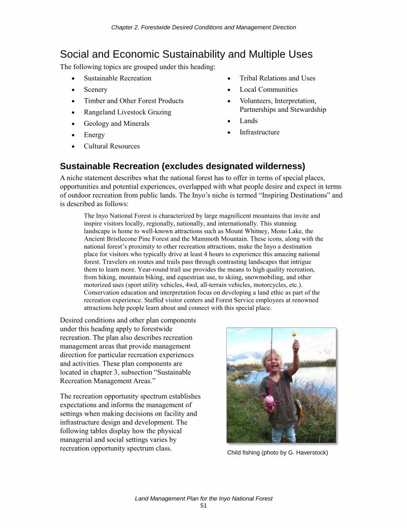
Chapter 2. Forestwide Desired Conditions and Management Direction
Land Management Plan for the Inyo National Forest 51
Social and Economic Sustainability and Multiple Uses The following topics are grouped under this heading:
• Sustainable Recreation • Scenery • Timber and Other Forest Products • Rangeland Livestock Grazing • Geology and Minerals • Energy • Cultural Resources
• Tribal Relations and Uses • Local Communities • Volunteers, Interpretation,
Partnerships and Stewardship • Lands • Infrastructure
Sustainable Recreation (excludes designated wilderness) A niche statement describes what the national forest has to offer in terms of special places, opportunities and potential experiences, overlapped with what people desire and expect in terms of outdoor recreation from public lands. The Inyo’s niche is termed “Inspiring Destinations” and is described as follows:
The Inyo National Forest is characterized by large magnificent mountains that invite and inspire visitors locally, regionally, nationally, and internationally. This stunning landscape is home to well-known attractions such as Mount Whitney, Mono Lake, the Ancient Bristlecone Pine Forest and the Mammoth Mountain. These icons, along with the national forest’s proximity to other recreation attractions, make the Inyo a destination place for visitors who typically drive at least 4 hours to experience this amazing national forest. Travelers on routes and trails pass through contrasting landscapes that intrigue them to learn more. Year-round trail use provides the means to high quality recreation, from hiking, mountain biking, and equestrian use, to skiing, snowmobiling, and other motorized uses (sport utility vehicles, 4wd, all-terrain vehicles, motorcycles, etc.). Conservation education and interpretation focus on developing a land ethic as part of the recreation experience. Staffed visitor centers and Forest Service employees at renowned attractions help people learn about and connect with this special place.
Desired conditions and other plan components under this heading apply to forestwide recreation. The plan also describes recreation management areas that provide management direction for particular recreation experiences and activities. These plan components are located in chapter 3, subsection “Sustainable Recreation Management Areas.”
The recreation opportunity spectrum establishes expectations and informs the management of settings when making decisions on facility and infrastructure design and development. The following tables display how the physical managerial and social settings varies by recreation opportunity spectrum class.
Child fishing (photo by G. Haverstock)

Chapter 2. Forestwide Desired Conditions and Management Direction
Land Management Plan for the Inyo National Forest 52
The recreation opportunity spectrum does not eliminate or allow a specific activity in and of itself, but informs decisions on how the national forest staff will manage overall settings. The plan components for Sustainable Recreation Management Areas (chapter 3) informs management decisions on current and future activities and visitor expectations. The acreage of national forest within each class of the recreation opportunity spectrum, excluding designated wilderness, is displayed in table 5.
Table 5. Acres of Inyo National Forest by recreation opportunity spectrum class, excluding designated wilderness
Recreation Opportunity Spectrum Acres Primitive 90,730
Semi-Primitive Nonmotorized 227,093
Semi-Primitive Motorized 366,899
Roaded Natural 233,632
Roaded Modified 45,562
Rural 19,300
Desired Conditions (REC-FW-DC) 01 The diverse landscapes of the Inyo National Forest offer a variety of recreation settings
for a broad range of year-round, nature-based recreation opportunities. Management focuses on settings that enhance the national forest recreation program niche.
02 The condition, function, and accessibility of recreation facilities accommodate diverse cultures with appropriate activities available to the public.
03 Recreation opportunities provide a high level of visitor satisfaction. The range of recreation activities contribute to social and economic sustainability of local communities.
04 Areas of the national forest provide for a variety of activities with minimal impact on sensitive environments and resources.
05 Visitors can connect with nature, culture, and history through a range of sustainable outdoor recreation opportunities.
06 The management and operation of facilities are place based, integrated, and responsive to changes that may limit or alter access.
07 New developed recreation infrastructure is located in ecologically resilient landscapes, while being financially sustainable, and responsive to public needs.
08 Summer dispersed recreation occurs in areas outside of high visitation, developed facilities, or communities, and does not adversely impact natural or cultural resources.
09 Permitted recreation uses, such as recreation special events or guided activities, are consistent with recreation settings, protect natural and cultural resources, and contribute to the economic sustainability of local communities.
10 Forest recreation information is current, connecting people to the national forest through contemporary means including social media and available technology. Diverse communities are aware of recreation opportunities on the Inyo.
Chapter 2. Forestwide Desired Conditions and Management Direction
Land Management Plan for the Inyo National Forest 53
11 The Inyo National Forest provides a range of year-round developed and dispersed recreation settings that offer a variety of motorized and nonmotorized opportunities and recreation experiences. The location and distribution of desired recreation settings is displayed in figure 6 and figure 7, appendix A.
12 Trails used in summer provide access to destinations, provide for opportunities that connect to a larger trail system, provide linkages from local communities to the national forest, and are compatible with other resources.
13 Trails meet trail management objectives based on trail class and designed use.
Objectives (REC-FW-OBJ) 01 Within 10 years of plan approval, complete fuel treatment restoration activities on 200
acres at recreation sites that are in areas with a high risk of large, high-intensity wildfire.
02 Within 20 years of plan approval, convert 5 percent of existing recreation sites to group sites.
03 Within 10 years of plan approval, maintain to standard 75 percent of the Inyo’s designated trail system.
04 Within 10 years of plan approval, establish community-based partnership programs to address up to 25 percent of the deferred maintenance for core infrastructure needs such as water, sewer, roads, and trails.
Goals (REC-FW-GOAL) 01 Coordinate with local and national partners early in project development to elicit
collaborative input on sustainable recreation opportunities, needs, and potential conflicts.
02 Manage dispersed recreation activities when evidence of impacts to natural resources emerge or are causing damage.
03 Seek to increase summer transportation systems to connect people to nature, improve personal health, and increase access for underserved communities, minorities and urban youth.
04 Promote effective communication with gateway communities to help foster partnerships, inspire volunteers, educate the public, and support stewardship that contributes to funding, implementation of projects, and long-term maintenance of facilities.
05 Improve facilities through the establishment of “adopt a facility” programs. Encourage individual and community stewardship to enhance experiences and connect people to the landscape.
06 Collaborate with a variety of partners to provide stewardship and interpretive services that enhance responsible recreation and increase knowledge of related socioeconomic and environmental issues.
07 Enhance stewardship and monitoring through increased volunteer program activities and partner contributions.
08 Provide accessible trails for individuals with mobility impairments.

Chapter 2. Forestwide Desired Conditions and Management Direction
Land Management Plan for the Inyo National Forest 54
09 Consider local organizations, nongovernmental organizations, and partners who interact with the public to provide interpretive services in addition to maintenance and administrative duties.
10 Work with local organizations to develop a robust trail ambassador corps, a sustainable adopt-a-trail program, and other on-the-ground stewardship and interpretive programs.
11 Work with local partners and municipalities to achieve timely opening and closing of access and facilities based on snowpack and other seasonal considerations rather than a fixed administrative calendar.
12 Manage infrastructure to meet the minimum needs of the associated use and the annual maintenance capabilities of the national forest.
Standard (REC-FW-STD) 01 The recreation opportunity spectrum will be used for decisions on facility and
infrastructure design and development.
Guidelines (REC-FW-GDL) 01 Avoid locating new recreation facilities within environmentally and culturally sensitive
areas, such as at-risk species breeding habitat or at-risk plant species habitat.
02 Create infrastructure that mimics the natural textures and colors of the surrounding landscape to be consistent with the recreation setting.
03 Use integrated resource planning when designing projects to address impacts to at-risk species habitat and changing conditions in recreation settings.
Potential Management Approaches • Redesign, restore, or rehabilitate recreation sites where recreation activities have caused
unacceptable natural or cultural resource damage.
• Decommission recreation facilities when use no longer supports the activity, there is decreased use by the public, or the maintenance demands of the facility exceed the use of the facility.
• Use management methods, such as seasonal road or trail closures, when appropriate to manage and protect resources and infrastructure.
• Consider improving recreation opportunities at existing facilities prior to developing new ones.
• Use informational signs to inform the public on trail etiquette, wildlife awareness, and other responsible behaviors.
• Use available technology, interpretive messages and interactions, and partnerships to educate national forest users and develop sustainable recreation opportunities that are focused on the long-term sustainability of the land, animals, fish, and plant species that support a healthy forest ecosystem.
• Develop a clear and concise process for partnership development and implementation. Communicate the Inyo’s needs in a succinct, easy to understand, and readily available summary. Include the types of agreements, contracts, and mechanisms Inyo staff will use to work with future partners.

Chapter 2. Forestwide Desired Conditions and Management Direction
Land Management Plan for the Inyo National Forest 55
• Consider a “Recreation Users Council” made up of representatives of the various user groups to monitor, mitigate, and resolve any user conflicts if they arise.
• Use trail head hosts or volunteer patrollers to educate and interact with the public to promote responsible and sustainable public use practices.
Scenery Desired conditions and other plan components under this heading apply to the Inyo’s management of scenery. Ecosystems provide the environmental context for a scenery management system, a framework that considers scenic character and aesthetic values, geologic features, and viewsheds. Scenic character is a combination of the physical, biological, and cultural images that gives an area its scenic identity and contributes to its sense of place. Scenic character provides a frame of reference from which to determine scenic attractiveness and to measure scenic integrity.
Aspen in orange and yellow in foreground, Mammoth Rock in background (photo by R. Perloff)
In some situations, providing a high level of scenic integrity may have to be achieved by establishing an ecological aesthetic over time through knowledge and appreciation of how a healthy ecosystem functions. For example, preferred scenic conditions that include the absence of downed woody debris from timber harvest may run counter to the need for woody debris to provide for wildlife food and cover, or nutrient recycling.
Desired Conditions (SCEN-FW-DC) 01 The Inyo National Forest provides a variety of ecologically sound, resilient, and visually
appealing forest landscapes that sustain scenic character, supporting the national forest recreation program niche in ways that contribute to visitors’ sense of place and connection with nature.
02 Scenic character is maintained and/or adapted to changing conditions to support ecological, social, and economic sustainability on the Inyo and in surrounding communities.
03 Scenic integrity is maintained in places people visit for high quality viewing experiences.
04 The Inyo National Forest’s scenic resources complement the recreation settings and experiences, as described by the range of scenery integrity objectives, while reflecting healthy and sustainable ecosystem conditions. The desired distribution of scenic integrity objectives is displayed in figure 8, appendix A.
05 The built environment meets or exceeds scenic integrity objectives and contributes to scenic stability.

Chapter 2. Forestwide Desired Conditions and Management Direction
Land Management Plan for the Inyo National Forest 56
Objective (SCEN-FW-OBJ) 01 Within 10 years of plan approval, improve scenic stability by treating 500 acres of
vegetation in areas with a high likelihood of large, high-severity wildfire that depart from the natural range of variation.
Goal (SCEN-FW-GOAL) 01 The Forest Service works with other agencies and adjacent landowners to maintain
shared vistas.
Guideline (SCEN-FW-GDL) 01 Restoration activities should achieve scenic integrity objectives in the long-term
timeframes.
Potential Management Approaches • Use integrated resource planning during projects to respond to changing scenery
conditions affecting scenic character and integrity.
• Scenic character is sustained by perpetuating and improving scenic attributes through ecological restoration activities that improve scenic stability and integrity.
• Minimize visible lines in landscape areas where vegetation is removed for management objectives. Cleared areas should include edges that reflect the visual character of naturally occurring vegetation openings.
• In vegetation treatment and fuels reduction projects, consider improving scenery resources, especially in areas that do not meet established scenic integrity objectives.
Timber and Other Forest Products Desired conditions and other plan components under this heading cover timber management. Forest management on the Inyo National Forest consists of restoration and fuels reduction treatments designed to achieve desired conditions for the associated terrestrial vegetation type on suitable timber lands. The 2 million acres of the Inyo National Forest includes approximately 84,795 acres that are suitable for timber production, with the majority in the northwest corner the national forest (figure 21 in appendix D). On lands not suited for timber production, timber harvest may occur to protect multiple-use values other than timber production, and for salvage, sanitation, or public health.
Desired Conditions (TIMB-FW-DC) 01 Predictable and sustainable forest product yields contribute to maintaining and improving
local economies and are sufficient to meet the needs of the desired pace and scale of ecological restoration over the next several decades.
02 Production of timber contributes to ecological, social, and economic sustainability and associated desired conditions. A sustainable mix of forest products is offered under a variety of harvest and contract methods in response to market demand and restoration needs.
03 Salvage of dead and dying trees captures as much of the economic value and carbon storage capacity of the wood as possible while retaining key features in quantities that provide for wildlife habitat, soil productivity, and ecosystem functions.

Chapter 2. Forestwide Desired Conditions and Management Direction
Land Management Plan for the Inyo National Forest 57
Objective (TIMB-FW-OBJ) 01 Provide approximately 4 to 6 million cubic feet (MMCF; or 20 to 30 million board feet
(MMBF)) within 10 years of plan approval to contribute to the local forest products infrastructure (see appendix D, “Timber Suitability and Management”).
Goal (TIMB-FW-GOAL) 01 After disturbances occur on lands identified as suitable for timber production, and when
funding is available, adequately restock these areas within 5 years of salvage harvest, if applicable, or, when salvage harvest is not used, within 5 years of site preparation.
Standards (TIMB-FW-STD) 01 Following regulated regeneration harvest (such as group selection) on lands identified as
suitable for timber production, create and maintain planting environments that favor seedling survival and rapid growth rates. Facilitate early and periodic use of fire to reduce future wildfire-related mortality, and provide sufficient tree numbers to meet a variety of ecosystem services, including forest products and carbon storage. Design a site-specific silvicultural prescription to ensure that lands are adequately restocked within 5 years of a regeneration harvest (see appendix D for stocking criteria).
02 In response to wildfire, windthrow, insects, pathogens, or other disturbances occurring on lands identified as suitable for timber production, create and maintain planting environments that favor seedling survival and rapid growth rates, facilitate early and periodic use of fire to reduce future wildfire-related mortality, and provide sufficient tree numbers, considering future changes in climate, to provide a variety of ecosystem services including forest products and carbon storage.
03 Prohibit commercial collection of pine nuts or piagi (Pandora moth larvae) on the Inyo National Forest.
Guidelines (TIMB-FW-GDL) 01 Retention of snags within and immediately adjacent to areas planned for reforestation
should be discouraged to mitigate hazards to workers. High fuel levels should not be retained in plantations that would preclude the use of prescribed burning at appropriate times as the plantation matures.
02 On lands suitable for timber production, reforestation should be designed to achieve stocking levels, spatial arrangements, and species composition to allow for long-term resilience of the developing forest, while considering potential future plantation management, carbon carrying capacity, and climate change adaptation. Competing vegetation, fuel levels, and fire risk should be managed to provide for the long-term survival and vigor of reestablishing forests as they move toward maturity.
03 On lands not suited for timber production, reforestation of deforested lands should contribute to ecological restoration, while providing benefits such as improving scenic character, restoring connectivity for wildlife, increasing carbon storage and improving watershed condition.
Potential Management Approaches • Encourage use of small trees and wood biomass to support a variety of potential uses.

Chapter 2. Forestwide Desired Conditions and Management Direction
Land Management Plan for the Inyo National Forest 58
• Develop landscape-scale projects to increase the pace and scale of ecological restoration, ecosystem resilience, and fire resilience, and to protect the carbon carrying capacity of the national forest.
• Plan vegetation, fuels, and other restoration projects across large landscape areas (greater than 5,000 to 10,000 acres) when it can increase efficiency in planning and support partnership-based approaches, such as stewardship contracts.
Rangeland Livestock Grazing Desired conditions and other plan components under this heading apply to rangeland management, which includes the authorized use and management of National Forest System lands for the purpose of livestock production and utilization of forage resources by livestock. Note additional direction in the sections “Animal and Plant Species,” “Wilderness” (pack stock), and “Riparian Conservation Areas” also applies.
Cattle grazing in a meadow along a creek (photo by L. Sims)
Rangeland utilization is determined for different vegetation types based on similarity to desired vegetation condition and hydrologic function at grazing key areas. Allowable utilization can differ between the grazing systems being implemented. Definitions of the grazing systems are found in the glossary. The standards and guidelines for rangeland utilization are organized by the grazing systems potentially used within each vegetation type. After this initial allowable utilization standard is determined based on vegetation conditions, they are adjusted based on watershed conditions.
Desired Conditions (RANG-FW-DC) 01 Rangelands, along with grazeable forestlands and woodlands, provide large areas of
contiguous space supporting native vegetation that has the potential to be grazed. These grazeable landscapes sustain biological diversity and ecosystem integrity and help to preserve the rural landscape and cultural heritage of the central, southern and eastern Sierra Nevada.
02 Forage, browse, and cover meet the needs of wildlife, and authorized livestock are managed in balance with available forage. Areas that are grazed have, or are trending toward having, satisfactory soils, functional hydrology, and biotic integrity.
03 Domestic livestock grazing maintains the desired rangeland vegetation types represented by diverse plant functional groups, species richness and diversity, and structure and condition of plant communities.
Goals (RANG-FW-GOAL) 01 Develop livestock management strategies for aspen and woody riparian ecosystems that
are grazed and browsed to encourage regeneration of hardwood and riparian woody vegetation.

Chapter 2. Forestwide Desired Conditions and Management Direction
Land Management Plan for the Inyo National Forest 59
02 Develop livestock management strategies that are adaptable to changes in available forage due to wildfire or drought, and to post-fire transitory rangelands. Where feasible and suitable, use grazing to reduce vegetation (fine fuels build-up) to lower the risk of undesirable wildfire effects.
03 Consider the impacts to animals and plants, recreation, watershed, and rangelands when designing rangeland improvements or structures, such as water storage structures.
Rangeland Vegetation Types Within terrestrial ecosystems and riparian conservation areas, there are 10 rangeland vegetation types that are capable of providing sustainable forage and grazing opportunities for domestic livestock. These vegetation types and associated plant lists are described in detail in the regional “Plant Guide for Resource Managers” (R5-TP-042; Lorenzana and others 2017) and “Rangeland Analysis and Planning Guide” (R5-EM-TP-004; USDA Forest Service 1993). Desired plant species have been identified for each of these vegetation types. Desired plant species are a representative of a specific vegetation type in a healthy, functional state. Key species are also identified that are of sufficient abundance and palatability to justify their use as indicators to the degree of utilization for the associated vegetation species. These vegetation types are listed below.
Sedge Dominated Wet Meadow - The desired species within this type include: Nebraska sedge (Carex nebrascensis), water sedge (Carex aquatilis), beaked sedge (Carex utriculata), long-bracted sedge (Carex athrostachya), and spikerush (Eleocharis spp.). Key species include: all desired sedges (Carex spp.).
Sedge-Grass Dominated Moist Meadow - The desired species within this type include: sedges (Carex spp.), clovers (Trifolium spp.), tufted hair grass (Deschampsia caespitosa), northern meadow barley (Hordeum brachyantherum), and miscellaneous forbs. Key species include: All desired sedges.
Douglas’ Sedge-Stipa-Elymus Dominated (Dry) Meadows - The desired species within this type include: Douglas’ sedge (Carex douglassii), needlegrasses (Stipa spp.), other sedges (Carex spp.), slender wheatgrass (Elymus trachycaulus), alkali cordgrass (Spartina gracilia), northern meadow barley (Hordeum brachyantherum), and spiked salt grass (Distichlis spicata). Key species include: needlegrasses, slender wheatgrass, and alkali cordgrass. Based on a site-specific analysis, use the same standards for this type as for the adjacent vegetation types.
Desert Shrub - The desired species within this type include: bluebunch wheatgrass (Pseudoroegneria spicata), white bursage (Ambrosia domosa), Indian ricegrass (Stipa hymenoides), spiny hopsage (Grayia spinosa), shadescale (Atriplex spp.), spiny menodora (Menodora spinescens), winterfat (Krascheninnikovia lanata), desert needlegrass (Stipa speciose), green ephedra (Ephedra viridis), Nevada Mormon tea (Ephedra nevadensis), and Nevada indigobush (Psorothamaus polydenius). Key species include: Indian ricegrass, desert needlegrass, spiny hopsage and winterfat.
Sagebrush/Bunchgrass - The desired species within this type include: all late seral sagebrushes (Artemisia spp.) identified in the Pacific Southwest Region (R5) Plant List (R5-TP-042) for sagebrush steppe, saltbrush (Atriplex spp.), spiny hopsage (Grayia spinosa), needlegrasses (Stipa spp.), bottlebrush squirreltail (Elymus elymoides), Indian ricegrass (Stipa hymenoides) and green ephedra (Ephedra viridis). Key species include: spiny hopsage, needlegrasses, bottlebrush squirreltail and Indian ricegrass.

Chapter 2. Forestwide Desired Conditions and Management Direction
Land Management Plan for the Inyo National Forest 60
Bitterbrush - The desired species within this type include: bitterbrush (Purshia spp), big sagebrush (Artemisia tridentate), needlegrasses (Stipa spp.), bottlebrush squirreltail (Elymus elymoides), Indian ricegrass (Stipa hymenoides), wax currant (Ribes cereium), desert gooseberry (Ribes velutinum), wheatgrasses (Elymus spp.), and Sandberg’s bluegrass (Poa secunda). Key species include: bitterbrush.
Subalpine Meadow - The desired species within this type include: sedges (Carex spp.), wheatgrasses (Elymus spp.), spikerush (Eleocharis spp.), tufted hair grass (Deschampsia caespitosa), oat grass (Danthonia spp.), and bluegrass (Poa spp.). Key species include: sedges, bluegrasses, tufted hair grass, and oat grass.
Alpine Dwarf Shrub - The desired species within this type include: low sagebrush (Artemisia arbuscular), current (Ribes spp.), buckwheat (Eriogonum spp.), Junegrass (Koeleria macrantha), bottlebrush squirreltail (Elymus elymoides), bluegrasses (Poa spp.) identified as late seral in the Pacific Southwest Region (R5) Plant List. Key species include: junegrass and bottlebrush squirreltail.
Aspen - The desired and key species within this type include: American quaking aspen (Populus tremuloides).
Willow - The desired and key species within this type include: willows (Salix spp.).
Standards (RANG-FW-STD) See also MA-RCA-STD 12.
01 Present vegetation conditions and their similarity to desired vegetation conditions are used to determine the base allowable utilization standard following the Inyo National Forest Supplement to the Pacific Southwest Region’s “Rangeland Analysis and Planning Guide” (R5-EM-TP-004).5
02 Forage utilization standard determinations must include an evaluation of hydrologic function during rangeland condition evaluations following the Inyo National Forest Supplement to the Pacific Southwest Region’s “Rangeland Analysis and Planning Guide” (R5-EM-TP-004).
03 An incidental utilization standard is established at 5 percent for all vegetation types. Incidental utilization is described as grazing use by occasionally stray livestock or grazing use by recreational animals.
04 New livestock handling facilities and stock driveways, salting, and supplemental feeding are prohibited in meadow and riparian locations. Placement must be consistent with meeting watershed or water quality best management practices if located in riparian conservation areas.
05 If the results of rangeland condition evaluations indicate the grazing key area is less than fully functional, use an interdisciplinary team to incorporate corrective actions that address specific on-the-ground problems. There may be more than one corrective action needed to achieve a trend towards fully functional watershed condition. No adjustments
5 Vegetation condition assessment protocols and watershed condition rating protocols as described in Forest Plan
Amendment 6 to the 1988 Forest Plan have been moved from the forest plan and retained as Inyo National Forest Supplement to the Pacific Southwest Region’s “Rangeland Analysis and Planning Guide” (R5-EM-TP-004) where it can be periodically updated. The forest supplement to R5-EM-TP-004 can be found on the Inyo National Forest webpage for Forest Planning.

Chapter 2. Forestwide Desired Conditions and Management Direction
Land Management Plan for the Inyo National Forest 61
are needed if the results of a rangeland condition assessment indicate that the grazing key area is fully functional and there are no off-site factors that need to be addressed.
06 Account for mule deer forage when determining livestock animal unit months on key deer winter range and other important habitats such as migration routes, holding areas, and fawning areas.
07 Within riparian conservation areas that are properly functioning or functional at risk with an upward trend, limit annual livestock disturbance to streambanks and shorelines of natural lakes and ponds (caused by trampling and trailing) from exceeding 20 percent of the stream reach, or natural lake and pond shorelines. Disturbance includes bank sloughing, chiseling, trampling, and other means of exposing bare soil or cutting plant roots. Allow no more than 15 to 20 percent disturbance if the riparian conservation area is functional at risk with a downward trend, as defined in the appropriate technical reports.6
Sedge Dominated Wet Meadow Table 6. Proposed utilization standards for Carex dominated wet meadow by grazing system*
Similarity of present to desired vegetation condition
Percentage Continuous
Season Long
Percentage Once Over
(Early Season/ Late Season)
Compressed Season
Rest Rotation
Percentage Deferred Rotation
(Early Season/ Late Season)
At Desired Condition 45 60 / 45 Not recommended
Not applicable 50 / 40
High Similarity 45 45 / 35 Not recommended
Not applicable 50 / 40
Moderate Similarity 25 35 / 25 Not recommended
Not applicable 40 / 30
Low Similarity 15 25 / 15 Not recommended
Not applicable 30 / 20
* Key species include: all desired sedges (Carex spp.); Nebraska sedge (C. nebrascensis), water sedge (C. aquatilis), beaked sedge (C. utriculata), long-bracted sedge (C. athrostachya). Allowable utilization is in percent by weight. If hydrologic function rating7 indicates the site is at risk and has one degraded characteristic or is trending downward, implement management change or reduce the utilization by one utilization class. If hydrologic function ratings indicate the site is degraded and has some nonfunctional characteristics implement management change, reduce the utilization by two utilization classes, or require total rest.
6 Proper functioning condition and functional at risk refer to terminology in technical reports noted below:
USDI Bureau of Land Management. 2003. “Riparian Area Management: A User Guide to Assessing Proper Functioning Condition and Supporting Science for Lentic Areas,” Technical Reference 1737-16. National Applied Resource Sciences Center, Denver, CO. 109 pp. USDI Bureau of Land Management. 2015. “Riparian area management: Proper functioning condition assessment for lotic areas,” Technical Reference 1737-15, Second Edition. National Operations Center, Denver, CO. 174 pp. (cont.) Weixelman, D.A., D.J. Cooper. 2009. “Assessing Proper Functioning Condition for Fen Areas in the Sierra Nevada and Southern Cascade Ranges in California, A User Guide,” R5-TP-028. USDA Forest Service, Pacific Southwest Region 5, Vallejo, CA. 52 pp.
7 The Inyo National Forest has a forest supplement for evaluation of hydrologic function at the site-specific key grazing area. These other protocols are incorporated into the Pacific Southwest Region’s “Rangeland Analysis and Planning Guide” R5-EM-TP-004. Citation: Inyo National Forest Supplement 1-2017 to USDA Forest Service Pacific Southwest Region Rangeland Analysis and Planning Guide R5-EM-TP-004 (March 1997)

Chapter 2. Forestwide Desired Conditions and Management Direction
Land Management Plan for the Inyo National Forest 62
Sedge-Grass Dominated Moist Meadow Table 7. Proposed utilization standards for Carex-grass dominated moist meadow vegetation types by grazing system*
Similarity of present to desired vegetation condition
Percentage Continuous
Season Long
Percentage Once Over
(Early Season/ Late Season)
Percentage Compressed
Season Rest
Rotation
Percentage Deferred Rotation
(Early Season/ Late Season)
At Desired Condition 40 55 / 40 55 / 40 Not applicable 45 / 35
High Similarity 40 40 / 30 40 / 30 Not applicable 45 / 35
Moderate Similarity 20 30 / 25 30 / 25 Not applicable 35 / 25
Low Similarity 10 20 / 10 20 / 10 Not applicable 25 / 15
* Key species include: All desired sedges (Carex spp.); native competitor sedges on mesic meadows identified in the R5 Rangeland Plant List (R5-TP-042). Allowable utilization in percent by weight. If hydrologic function rating (see footnote 7) indicates the site is at risk and has one degraded characteristic or is trending downward implement management change or reduce the utilization by one utilization class. If hydrologic function ratings indicate the site is degraded and has some nonfunctional characteristics implement management change, reduce the utilization by two utilization classes, or require total rest.
Douglas’ Sedge-Stipa-Elymus-dominated (Dry) Meadows Key species include: needlegrass (Stipa spp.), slender wheatgrass (Elymus trachycaulus) and alkali cordgrass (Spartina gracilia). Based on a site-specific analysis, use the same standards for this type as for the adjacent vegetation types.
Desert Shrub Table 8. Proposed utilization standards for desert shrub vegetation type by grazing system*
Similarity of present to desired
vegetation condition
Percentage Continuous
Season Long
Percentage Once Over
(Early Season/ Late Season)
Percent Compressed
Season Rest Rotation
Percentage Deferred Rotation
(Early Season/ Late Season)
At Desired Condition 30 50 /40 50 / 40 Not recommended 40 / 30
High Similarity 30 50 /40 50 / 40 Not recommended 40 / 30
Moderate Similarity 20 30 /20 30 / 20 Not recommended 30 / 20
Low Similarity 10 20 / 10 20 / 10 Not recommended 20 / 10
* Key species include: Indian ricegrass (Stipa hymenoides), desert needlegrass (Stipa speciose), spiny hopsage (Grayia spinosa) and winterfat (Krascheninnikovia lanata). Allowable utilization for this system is defined as: Percent utilization on grasses is by weight. Percent utilization on brush is the percent of the current year’s growth. Whichever vegetation type is utilized first limits the amount of time grazing is allowed. If hydrologic function rating (see footnote 7) indicates the site is at risk and has one degraded characteristic or is trending downward implement management change or reduce the utilization by one utilization class. If hydrologic function ratings indicate the site is degraded and has some nonfunctional characteristics implement management change, reduce the utilization by two utilization classes, or require total rest.

Chapter 2. Forestwide Desired Conditions and Management Direction
Land Management Plan for the Inyo National Forest 63
Sagebrush/Bunchgrass Table 9. Proposed utilization standards for sagebrush/bunchgrass vegetation type by grazing system*
Similarity of present to desired
vegetation condition
Percentage Continuous
Season Long
Percentage Once Over
(Early Season/ Late Season)
Percentage Compressed
Season
Percentage Rest
Rotation
Percentage Deferred Rotation
(Early Season/ Late Season)
At Desired Condition 50 40 / 60 40 / 60 50 40 / 60
High Similarity 50 40 / 60 40 / 60 50 40 / 60
Moderate Similarity 40 30 / 50 30 / 50 40 30 / 50
Low Similarity 20 20 / 40 20 / 40 20 10 / 40 * Key species include: Spiny hopsage (Grayia spinosa), needlegrasses (Stipa spp.), bottlebrush squirreltail (Elymus elymoides) and Indian ricegrass (Stipa hymenoides). Allowable utilization for this system is defined as: percent utilization on grasses is by weight; percent utilization on brush is percent of the current year’s growth. Whichever vegetation type is utilized first limits the amount of time grazing is allowed. If hydrologic function rating (see footnote 7) indicates the site is at risk and has one degraded characteristic or is trending downward implement management change or reduce the utilization by one utilization class. If hydrologic function ratings indicate the site is degraded and has some nonfunctional characteristics implement management change, reduce the utilization by two utilization classes, or require total rest.
Bitterbrush Table 10. Proposed utilization standards for bitterbrush vegetation type by grazing system*
Similarity of present to desired vegetation condition
Percentage Continuous
Season Long
Percentage Once Over
(Early Season/ Late Season)
Percentage Compressed
Season Rest Rotation
Percentage Deferred Rotation (Early Season/ Late
Season) At Desired Condition 40 50 / 40 50 / 40 Not recommended 50 / 40
High Similarity 40 50 / 40 50 / 40 Not recommended 50 / 40
Moderate Similarity 30 40 / 30 40 / 30 Not recommended 40 / 30
Low Similarity 20 30 / 20 30 / 20 Not recommended 30 / 20 * Key species include: bitterbrush (Purshia spp.). Allowable utilization for this system is defined as: bunchgrass standards from the Sagebrush/Bunchgrass site matrix are applied to the herbaceous component of the bitterbrush vegetation type. Percent utilization on bunchgrass is by weight. Percent utilization on bitterbrush is the percent of the current year’s leader growth. Whichever category is utilized first limits the amount of time grazing is permitted in the bitterbrush vegetation type. If hydrologic function rating (see footnote 7) indicates the site is at risk and has one degraded characteristic or is trending downward implement management change or reduce the utilization by one utilization class. If hydrologic function ratings indicate the site is degraded and has some nonfunctional characteristics implement management change, reduce the utilization by two utilization classes, or require total rest.
Subalpine Meadow Table 11. Proposed utilization standards for subalpine meadow vegetation type by grazing system*
Similarity of present to desired vegetation condition
Percentage Continuous
Season Long
Percentage Once Over
(Early Season/ Late Season)
Compressed Season
Percentage Rest
Rotation
Deferred Rotation
(Early Season/ Late Season)
At Desired Condition 30 35 / 30 Not recommended 30 Not recommended
High Similarity 20 30 / 20 Not recommended 20 Not recommended
Moderate Similarity 15 20 / 15 Not recommended 15 Not recommended
Low Similarity 5 10 / 5 Not recommended 5 Not recommended
* Key species include: sedges (Carex spp.), bluegrasses (Poa spp.), tufted hair grass (Deschampsia caespitosa) and oat grass (Danthonia spp.). Allowable utilization is percent by weight. If hydrologic function rating (see footnote 7) indicates the site is at risk and has one degraded characteristic or is trending downward implement management change or reduce the utilization by one utilization class. If hydrologic function ratings indicate the site is degraded and has some nonfunctional characteristics implement management change, reduce the utilization by two utilization classes, or require total rest.

Chapter 2. Forestwide Desired Conditions and Management Direction
Land Management Plan for the Inyo National Forest 64
Alpine Dwarf Shrub Table 12. Proposed utilization standards for alpine dwarf shrub vegetation type by grazing system*
Similarity of present to desired vegetation conditions
Percentage Continuous
Season Long
Percentage Once Over (Late Season
Only) Compressed
Season Percentage
Rest Rotation Deferred Rotation
At Desired Condition 25 30 Not recommended 25 Not
recommended
High Similarity 20 20 Not recommended 20 Not
recommended
Moderate Similarity 15 15 Not recommended 15 Not
recommended
Low Similarity 5 5 Not recommended 5 Not
recommended * Key species include: Junegrass (Koeleria macrantha) and bottlebrush squirreltail (Elymus elymoides). Allowable utilization is by percent weight. If hydrologic function rating (see footnote 7) indicates the site is at risk and has one degraded characteristic or is trending downward implement management change or reduce the utilization by one utilization class. If hydrologic function ratings indicate the site is degraded and has some nonfunctional characteristics implement management change, reduce the utilization by two utilization classes, or require total rest.
Aspen Table 13. Proposed utilization standards for aspen vegetation type by grazing system*
Age ClassA and Regeneration All Grazing Systems 2 or more age classes Adequate regeneration 20 percentB
1 age class and no regeneration No Use * Key species within this type include: American quaking aspen (Populus tremuloides). Allowable utilization is by percent (by number) aspen regeneration utilized (either consumed or trampled) annually. (For understory vegetation use the appropriate vegetation matrix.) If hydrologic function rating (see footnote 7) indicates the site is at risk and has one degraded characteristic or is trending downward implement management change or reduce the utilization by one utilization class. If hydrologic function ratings indicate the site is degraded and has some nonfunctional characteristics implement management change, reduce the utilization by two utilization classes, or require total rest. A. Chapter 4B. BLM TR-1734-3 Utilization Studies & Residual Measurements in PSW Region Rangeland Analysis and
Planning Guide (R5-EM-TP-004) B. Chapter 4C. USDA FS Browsed Plant Method for Young Quaking Aspen in PSW Region Rangeland Analysis and
Planning Guide (R5-EM-TP-004)
Willow Table 14. Proposed utilization standards for willow vegetation type by grazing system*
Age Class** and Regeneration All Grazing Systems Little or no hedging and Upward or static trend in regeneration 11-20%
Moderate hedging and Static trend in regeneration 6-10%
Severe hedging or Downward trend in regeneration 0-5%
* Key species within this type include: willows (Salix spp.). Allowable use for this system is defined as: percent (by volume) available willow twigs and leaves utilized and broken (trampled). (For understory vegetation use the appropriate vegetation matrix.) If hydrologic function rating (see footnote 7) indicates the site is at risk and has one degraded characteristic or is trending downward implement management change or reduce the utilization by one utilization class. If hydrologic function ratings indicate the site is degraded and has some nonfunctional characteristics implement management change, reduce the utilization by two utilization classes, or require total rest. **Late season only.

Chapter 2. Forestwide Desired Conditions and Management Direction
Land Management Plan for the Inyo National Forest 65
Guideline (RANG-FW-GDL) 01 If recovery of desired vegetation conditions and related biophysical resources are
necessary in recently burned areas, then rest from livestock grazing.
Potential Management Approach • Ensure that the most intensive management strategies, such as water developments and
fencing, occur on primary range that is less than 30 percent slope.
Geology and Minerals Uses on National Forest System lands include the extraction and potential development of mineral resources, which are managed in a manner that protects natural resources, public health and safety, and is consistent with National Forest System land and resource management plans. Mineral extraction and development is limited on the Inyo National Forest, although historically mining played an important role in the area. All authorized uses to occupy and use National Forest System lands are evaluated and determined to be in the public interest. Determinations include consultation with other interested parties including Federal, State, and county agencies, Tribes, and nongovernmental interests.
Desired Conditions (GEO-FW-DC) 01 Mineral resources on National Forest System lands provide for public benefit, while
minimizing adverse environmental effects on other national forest resources from mineral exploration, development, and extraction.
Standards (GEO-FW-STD) 01 Conduct appropriate analysis before constructing roads or other permanent developments
in known unstable areas.
02 New and upgraded roads shall be limited to those necessary for mineral development on valid existing claims.
03 Plans of operation, reclamation plans, and reclamation bonds must address the costs of:
a. removing facilities, equipment, and materials; b. isolating and neutralizing or removing toxic or potentially toxic materials; c. salvaging and replacing topsoil; and d. preparing the seed bed and revegetating to meet the objectives of the terrestrial
vegetation in which the operation is located. 04 During mining-related activities, limit the clearing of trees and other vegetation to the
minimum necessary. Clearing of vegetation must be pertinent to the approved phase of mineral exploration and development.
Potential Management Approach • For each common variety materials site, prepare a development and rehabilitation plan
prior to development and use.
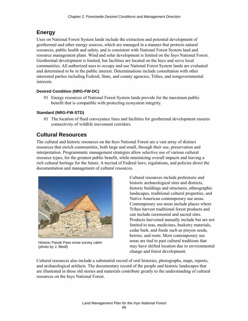
Chapter 2. Forestwide Desired Conditions and Management Direction
Land Management Plan for the Inyo National Forest 66
Energy Uses on National Forest System lands include the extraction and potential development of geothermal and other energy sources, which are managed in a manner that protects natural resources, public health and safety, and is consistent with National Forest System land and resource management plans. Wind and solar development is limited on the Inyo National Forest. Geothermal development is limited, but facilities are located on the Inyo and serve local communities. All authorized uses to occupy and use National Forest System lands are evaluated and determined to be in the public interest. Determinations include consultation with other interested parties including Federal, State, and county agencies, Tribes, and nongovernmental interests.
Desired Condition (NRG-FW-DC) 01 Energy resources of National Forest System lands provide for the maximum public
benefit that is compatible with protecting ecosystem integrity.
Standard (NRG-FW-STD) 01 The location of fluid conveyance lines and facilities for geothermal development ensures
connectivity of wildlife movement corridors.
Cultural Resources The cultural and historic resources on the Inyo National Forest are a vast array of distinct resources that enrich communities, both large and small, through their use, preservation and interpretation. Programmatic management strategies allow selective use of various cultural resource types, for the greatest public benefit, while minimizing overall impacts and leaving a rich cultural heritage for the future. A myriad of Federal laws, regulations, and policies direct the documentation and management of cultural resources.
Historic Paiute Pass snow survey cabin (photo by J. Biedl)
Cultural resources include prehistoric and historic archaeological sites and districts, historic buildings and structures, ethnographic landscapes, traditional cultural properties, and Native American contemporary use areas. Contemporary use areas include places where Tribes harvest traditional forest products and can include ceremonial and sacred sites. Products harvested annually include but are not limited to teas, medicines, basketry materials, cedar bark, and foods such as pinyon seeds, berries, and roots. Most contemporary use areas are tied to past cultural traditions that may have shifted location due to environmental change and forest development.
Cultural resources also include a substantial record of oral histories, photographs, maps, reports, and archaeological artifacts. The documentary record of the people and historic landscapes that are illustrated in these old stories and materials contribute greatly to the understanding of cultural resources on the Inyo National Forest.

Chapter 2. Forestwide Desired Conditions and Management Direction
Land Management Plan for the Inyo National Forest 67
All cultural resources are not amenable to all potential uses, and vary individually and collectively on what they can offer. Preservation and interpretation of these fragile nonrenewable resources educate people of all ages, races, and walks of life about the cultural connections between people and the national forest.
Desired Conditions (CULT-FW-DC) 01 Cultural resources (buildings, sites, districts, structures, and objects) having scientific,
cultural or social values are preserved and protected for their cultural importance. Site integrity and stability are protected and maintained on sites that are susceptible to imminent risks or threats, or where values are rare or unique. Priority heritage assets are stable and their significant values protected; vandalism, looting, theft, and human-caused damage to heritage resources are rare. Site significance and integrity are maintained through conservation and preservation efforts.
02 Cultural resources, traditional cultural properties, and sacred sites are protected through project design and consultation with Indian Tribes, Tribal cultural leaders, and consulting parties.
03 Cultural resources provide educational opportunities that connect people to the land and its history. Through interpretive sites, historic standing structures, and other materials, the national forest provides opportunities for an appreciation of the region’s history and an awareness of preservation efforts. In some cases, historic routes (such as railroad grades) are used for recreation trails with interpretation of their history and historic features. Heritage-based recreation opportunities are connected, where practical, with other recreation opportunities such as trails.
04 Public enjoyment is enhanced by opportunities to visit interpretive cultural resource sites. Archaeological site etiquette information is readily available to national forest visitors. Interpretation of the human history of the Inyo promotes greater public understanding of the communities that have depended on this landscape for their livelihood, recreation, and spiritual wellbeing.
05 Opportunities exist for volunteers to participate in cultural resource conservation activities such as research, site stabilization, protection, conservation and interpretation. Cultural resource programs, interpretive presentations or publications are available to provide the public with opportunities to learn about, understand and experience the Inyo National Forest’s past.
06 Practical opportunities for the rehabilitation and reuse of historic structures to enhance recreation experiences are promoted.
Objective (CULT-FW-OBJ) 01 Within 10 years of plan approval, generate at least five cultural resource products such as
significant interpretation; National Register of Historic Places nominations; thematic contexts; site management plans; 200 acres or more of nonproject surveys; development and testing of predictive models; establishment of formal cultural resource partnerships; and cultural site restoration, stabilization, or adaptive reuse.
Standard (CULT-FW-STD) 01 Include historic property protection provisions in contracts and special use permits.

Chapter 2. Forestwide Desired Conditions and Management Direction
Land Management Plan for the Inyo National Forest 68
Guideline (CULT-FW-GDL) 01 Limit commercial use of heritage-based interpretive sites (e.g. heritage tourism) to
activities that enhance the public understanding of the resource, protect and preserve the resource, and are consistent with Tribal interests.
Potential Management Approach • To protect sites from physical damage and excessive wear and tear, consider user
education, restrictions, and visitation controls.
Tribal Relations and Uses Desired conditions and other plan components under this heading apply to the Inyo National Forest’s recognition that lands and people surrounding the Inyo have an important influence on national forest management. The Inyo National Forest lies in the traditional territories of eight federally recognized Native American Tribes, as well as eight unacknowledged Tribes, Tribal groups, and organizations. Tribal communities are contacted and consulted, and are important partners in national forest management activities.
Desired Conditions (TRIB-FW-DC) 01 The Inyo National Forest staff recognizes Native American needs and viewpoints and
fosters a robust relationship with federally and non-federally recognized Tribes and related groups with which it consults. Inyo National Forest personnel, including but not limited to line officers, departmental staff, archaeologists, historians, and Tribal liaisons, consult and communicate with Tribal leadership, Tribal historic preservation officers, traditional religious practitioners, traditional gatherers, Tribal members and other Tribal organizations.
02 The Inyo staff coordinates with Tribes in managing traditional cultural properties, resources, and sacred sites where historic preservation laws alone may not adequately protect the resources or values.
03 Native Americans have access to areas that provide them an opportunity to practice traditional, cultural, and religious lifeways, such as plant gathering, fishing, hunting, and ceremonial activities that are essential to maintaining their cultural identity and the continuity of their culture.
04 Traditional ecological knowledge is a valued part of the process when developing and implementing restoration projects and other national forest programs.
05 The Inyo National Forest provides a setting for the education of Tribal youth in culture, history and land stewardship and for the exchange of information between Tribal elders and youth.
Goals (TRIB-FW-GOAL) 01 Manage the land in a spirit of shared stewardship with Tribes, supporting Tribal rights
and recognizing the mutual benefits of restoration.
02 Partner with Tribes to contribute to the socioeconomic sustainability of Tribal communities.

Chapter 2. Forestwide Desired Conditions and Management Direction
Land Management Plan for the Inyo National Forest 69
03 Develop memoranda of agreements or other protocols between the national forest and Native American Tribes as appropriate to guide consultation processes, reflect Tribes’ particular perspectives and interests, and protect sacred sites.
04 Meet regularly with Tribes to better understand their needs and viewpoints. Promote the use of national forest-hosted Tribal forums and events, as well as attendance at meetings and events hosted by Tribes as a method to ensure consistent contact, consultation, and collaboration.
Potential Management Approaches • Provide training to Inyo National Forest employees about Federal Tribal trust
responsibilities and ways in which the Inyo honors and implements these responsibilities.
• Consider employee exchange opportunities between the Forest Service and Tribes under agreements or other mechanisms. Provide Inyo staff with detail opportunities to work with Tribes, and provide Tribal staff opportunities to work with the agency, to increase reciprocal understanding and promote use of Tribal programs and legislation that is mutually beneficial.
Local Communities Desired conditions and other plan components under this heading include Inyo National Forest management and communication with local communities and other organizations interested in the management of the plan area and national forest resources.
Desired Conditions (LOC-FW-DC) 01 Inyo National Forest personnel communicate with interested local agency leadership,
business owners, nonprofit organizations, community members, Tribes, and other local organizations on a regular basis to develop mutual understanding regarding national forest management.
02 Inyo personnel manage the land in a spirit of shared stewardship with local people. Local knowledge and input is an important part of the process when developing and implementing projects.
03 National forest uses such as recreation, forest products, mining, and grazing are provided in an ecologically sustainable way that also contributes to economic and social sustainability in local communities.
04 Ecological restoration supports the long-term sustainability of Inyo National Forest resource use and appreciation by communities by reducing the risk of high-severity fires, drought, insects, and diseases, which may impact national forest use opportunities.
05 The Inyo provides interpretation and education opportunities related to culture, history, and land stewardship, and provides ample opportunities to connect people of all ages with nature.
06 Management of the Inyo supports community needs by providing employment and training opportunities.
07 The Inyo is managed in an economically efficient and cost-effective manner, while responding to the economic and social needs of the public and local communities.

Chapter 2. Forestwide Desired Conditions and Management Direction
Land Management Plan for the Inyo National Forest 70
Goals (LOC-FW-GOAL) 01 Develop memoranda of agreements or other protocols between the Inyo and local
governments as appropriate to guide coordination processes and reflect local perspectives and interests.
02 Identify important socioeconomic locations and activities on the Inyo with interested local agencies to promote a common understanding of these important contributions, help identify potential projects that may enhance community benefits, and help identify mitigation measures that may address adverse impacts to these resources.
03 Work with local governments, businesses, and organizations to collect economic data to track changes for businesses in sectors dependent on national forest activities.
04 Continue working with other Federal and State agencies on identifying areas on the Inyo that can be part of restoration mitigation banks. Work with other entities, such as local governments, or private businesses, if they are interested in establishing mitigation banks.
Volunteers, Interpretation, Partnerships and Stewardship Desired conditions and other plan components for interacting and partnering to work together on shared interests with people, organizations, agencies (local, State, and Federal), Tribes, nonprofits, businesses, and communities are included under this heading.
Desired Conditions (VIPS-FW-DC) 01 The Inyo has a network of dependable partners and volunteers who provide additional
capacity to effectively and efficiently meet plan desired conditions and deliver services to the public.
02 The Inyo uses partnerships to build local capacity for providing information and content using the best available methods, including, but not limited to, advances in technology.
03 Interpretation and conservation education materials and activities convey up-to-date and clear messages about natural and cultural resources, climate change, land stewardship, responsible recreation use and etiquette, and Native American heritage and culture.
04 The diverse backgrounds and needs of visitors are considered in the design of communication and interpretive messages.
05 Forest Service projects and management actions, as well as the importance of ecosystem services, are communicated to the public in an understandable fashion to increase public awareness of nature and ecosystems.
06 Nationally registered historic sites and culturally important properties retain their historic and cultural significance when public use and education opportunities are provided.
Goals (VIPS-FW-GOAL) 01 Work with neighboring communities, organizations, State and local agencies, Tribes, and
other Federal agencies to sustain national forest benefits to people across the broader landscape.
02 Regularly report potential projects suitable for partnership and volunteer opportunities to the public.
Chapter 2. Forestwide Desired Conditions and Management Direction
Land Management Plan for the Inyo National Forest 71
03 Maintain and expand contracting and partnering opportunities with local governments, businesses, and organizations. Develop partnerships that leverage different sources of funding to support opportunities to contribute to the economic and social sustainability of local communities.
04 Work with partners and volunteers to provide recreation opportunities, maintain and enhance recreation settings, collect and manage data on recreation use and demand, and contribute to socioeconomic benefits associated with recreation and tourism.
05 Work with skilled stewardship organizations in managing wilderness, wild and scenic rivers, national trails, and other designated areas.
06 Work with partners and volunteers in the coordination, development, and delivery of educational and community outreach programs. Work with partners to provide consistent training to those who engage in educational or community outreach programs. Actively engage urban populations, youth, and underserved communities in programs.
07 Work with partners and volunteers to prioritize and complete deferred maintenance and to engage in resource stewardship and restoration.
08 Work with site stewards, volunteers, Tribal governments, local governments, State and Federal agencies, schools, universities, and nonprofit groups to protect, rehabilitate, and restore cultural resource sites and facilitate development of research, and educational and interpretive opportunities.
09 Develop heritage tourism opportunities with Tribal governments, local organizations, and businesses to provide an economic benefit to the community while fostering long-term sustainability of cultural resources.
10 Prioritize the creation of an Inyo National Forest Partnership and Volunteer Coordinator position, working with partners on providing continuous funding for this position.
Potential Management Approaches • Assess partnership needs and develop priorities to meet those needs using the strategies
and tools described in appendix C.
• Develop a strategy to define the types of projects suitable for partnership and volunteer opportunities, potential partners and volunteers, and the mechanisms for developing partnership and volunteer agreements.
• Provide visitor information services at major entry points and areas of concentrated use.
• Provide and update interpretive signage, wayside exhibits, publications, and programs using a variety of media and methods.
• Develop bilingual communication tools including publications, information boards, and radio spots.
• Emphasize geothermal resources at interpretive sites or in guides where appropriate.
• Provide information to Nordic trail users on potential risks from avalanches and earthquakes.

Chapter 2. Forestwide Desired Conditions and Management Direction
Land Management Plan for the Inyo National Forest 72
Lands Statutory authorities govern land acquisition and disposal, and authorization and administration of special uses. Special uses are managed in a manner that protects natural resources, public health, and safety and are consistent with National Forest System land management plans. Special uses are administered based on sound resource management objectives and sound business principles. All authorized uses to occupy and use National Forest System lands are evaluated and determined to be in the public interest. Determinations include consultation with other interested parties including Federal, State, and county agencies, Tribes, and nongovernmental interests.
Desired Conditions (LAND-FW-DC) 01 Land ownership and access management support authorized activities and uses on
National Forest System lands. Land exchanges promote improved management of National Forest System lands.
02 Coordination of land and resource planning efforts with other Federal, State, Tribal, county, and local governments, and adjacent private landowners, promotes compatible relationships between activities and uses on National Forest System lands and adjacent lands of other ownership.
Guidelines (LAND-FW-GDL) 01 Minimize the creation of new rights-of-way where feasible by using existing public or
private utility rights-of-way to reduce impacts on other resources.
02 Where feasible, bury new or reconstructed power distribution lines (33 kilovolts or less) and telephone lines to reduce impacts to resources such as scenery and at-risk species habitat.
03 Fully develop existing electronic sites before authorizing new sites, unless new sites are determined necessary to fill coverage gaps like cell towers.
Potential Management Approach • Acquire lands by exchange, purchase, or donation in the following priority:
High Priority
1. lands inside the proposed wilderness boundary;
2. lands with water frontage such as lakes, streams, floodplains, wetlands and riparian areas;
3. key game management areas and lands having endangered or threatened fish, wildlife, or plant habitat;
4. lands needed to reduce fire risks;
5. lands needed to prevent soil erosion;
6. lands and easements that ensure access to public lands and resources;
7. lands having unique historical or cultural resources;
8. wilderness inholdings.
Chapter 2. Forestwide Desired Conditions and Management Direction
Land Management Plan for the Inyo National Forest 73
Moderate Priority
1. lands primarily of value for outdoor recreation purposes and lands needed for aesthetic purposes;
2. lands needed for administrative purposes.
Lowest Priority
1. lands need to consolidate existing blocks of National Forest System lands to improve administration of the area
Infrastructure Infrastructure on National Forest System lands includes built property created to support the Inyo National Forest’s use and mission. The five major categories of infrastructure are transportation, recreation facilities, administrative facilities, public utilities, and private uses. Other infrastructure includes range-related facilities, and historic facilities.
Transportation refers to the vehicular movement of goods and services for the use of the national forest. Roads managed by public road agencies such as States, counties and municipalities that help provide access to National Forest System lands, are also part of the transportation system. A recreation facility is a discrete area on a national forest that provides recreation opportunities, receives recreational use, and requires a management investment to operate and maintain to standard. Administrative facilities are typically buildings and their associated facilities necessary to support the employees, equipment, and activities necessary for managing the national forest. Public utility infrastructure is associated with hydroelectric systems licensed by the Federal Energy Regulatory Commission, but also includes cable TV, telephone and internet service, and municipal sewer service. Private infrastructure refers to facilities developed in private ownership used in conjunction with Forest Service special use authorizations. Such facilities include buildings and other kinds of structures and improvements representing a broad range of permitted recreation and land use activities. These activities can serve single purpose use by individuals or families, as well as offer benefits to the public.
Management direction for infrastructure is to provide safe, energy-efficient, accessible, functional, efficient, aesthetically pleasing, and cost-effective administrative buildings and related facilities, while reducing fixed cost through consolidation and decommissioning of obsolete or underutilized buildings; construction of new facilities where and when required; and by conducting proper routine maintenance of existing facilities.
Desired Conditions (INFR-FW-DC) 01 A minimum and efficient national forest transportation system, administrative sites, and
other infrastructure and facilities are in place and maintained at least to the minimum standards appropriate for planned uses and the protection of resources.
02 Management operations on the Inyo National Forest are energy and water efficient.
03 Roads allow for safe and healthy wildlife movement in areas of human development. Vehicular collisions with animals are rare.

This page left intentionally blank

Land Management Plan for the Inyo National Forest 75
Chapter 3. Area-specific Desired Conditions and Management Direction This chapter provides direction for specific management areas or designated areas. Where management areas or designated areas overlap, the more stringent or restrictive direction applies.
Management areas consist of land areas within the planning area that have the same set of applicable plan components. Management areas do not have to be spatially contiguous and typically have a management emphasis. For this plan, management area direction applies to specific geographic boundaries for all management areas except for the strategic fire management zones, which are determined by specific descriptive characteristics. This plan has the following management areas:
• strategic fire management zones, • conservation watersheds, • riparian conservation areas, • sustainable recreation,
• recommended wilderness, • eligible wild and scenic rivers, and • the Pacific Crest Trail National
Scenic Trail corridor.
Designated areas consist of areas or features identified and managed to maintain a special character or purpose. Some are designated by statute (such as wild and scenic rivers or wilderness) and others are administratively designated (like research natural areas). The Inyo National Forest has the following designated areas:
• wilderness, • Mono Basin National Forest Scenic
Area, • wild and scenic rivers, • Ancient Bristlecone Pine Forest
National Protection Area
• Pacific Crest National Scenic Trail • inventoried roadless areas, • national recreation trails, • research natural areas, • scenic byways, and • wild horse and burro territories.
Maps of management areas and designated areas can be viewed in appendix A.
Management Areas Strategic Fire Management Zones The purpose of strategic fire management zones is to support decisionmakers before a fire ignition occurs, by pre-assessing the risk and benefits from wildland fire (both wildfire and prescribed fire) to areas on the landscape. Forest plan guidance aids wildland fire management decisions to meet the full range of forest plan objectives and use the most appropriate wildfire response within all the zones. Wildfire responses include a spectrum of strategies that include full suppression, confine/contain, monitoring, and management to meet resource objectives. The entire spectrum of strategies is available in all the zones and wildland fires will be actively managed in all the zones to meet objectives. The specific boundaries of the fire management zones are determined by conditions on the ground and have the potential to be influenced as the result of development or natural disturbances. The zones are mapped based on current conditions

Chapter 3. Area-specific Desired Conditions and Management Direction
Land Management Plan for the Inyo National Forest 76
and are displayed in appendix A, figure 9. Adjustments to the fire management zone maps may be made to reflect changes on the ground and may be made with an administrative change to the plan. Active management through fuel reduction treatments such as thinning and prescribed fire also reduces fuels and associated fire hazard while mitigating safety hazards for firefighters within all zones.
See plan components in sections AIR-FW-DC-02, TERR-FW-DC-08, TERR-FW-OBJ-02, TERR-MONT-DC-02, TERR-OLD-GDL-02, TERR-CES-GDL-06, TERR-ALPN-DC-02, TERR-PINY-DC-02, TERR-XER-DC-03, TERR-DMC-DC-02, TERR-JEFF-DC-02, TERR-RFIR-DC-02, TERR-LDGP-DC-02, SPEC-SG-DC-07, SPEC-SG-STD-15, SPEC-CSO-STD-02, SPEC-CSO-STD-05, SPEC-CSO-GDL-04, and SPEC-CSO-GDL-05 for additional direction relating to fire management.
Community Wildfire Protection Zone The community wildfire protection zone encompasses locations where communities, community assets, and private land could be at a very high risk of damage from wildfire where high fuel loadings exist. Wildfires that start in this zone contribute more to potential loss of community assets than any other strategic fire management zone.
Within this zone, community buffer areas are identified and used to strategically mitigate vegetation directly adjacent to structures and allow for safer conditions for firefighters. Community buffers are measured from the structures in the community (see glossary). Maximum width of the buffer is based on potential fire behavior in adjacent areas under extreme fire weather conditions. The maximum width is sufficient to provide low radiant heat from areas of untreated fuels.
Although some wildfires that burn in this zone can potentially benefit natural resources and help decrease fuels and threats from future wildfires, these potential benefits are less likely under most weather, fuel moisture, and other environmental conditions due to the very high risk to community assets during the fire season. The long-term focus is to create fire-adapted communities that are less reliant on aggressive wildfire protection. Under most weather and fuel conditions, wildfire mitigation, fuel reduction treatments, and fire protection is needed in the community wildfire protection zone to prevent direct threats to life or property. Wildfire is suppressed under most weather and fuel conditions due to the very significant risk of potential economic loss and public safety concerns posed by a wildfire occurring within this zone.
Desired Conditions (MA-CWPZ-DC) 01 Areas adjacent to communities with current high fire risk have low fuel loadings,
designed to result in less intense fire behavior and to facilitate safe wildland fire operations. In some cases, terrestrial ecosystem desired conditions may not be met.
02 Over time, risk to communities is reduced sufficiently in the community wildfire protection zone to allow some areas to be placed in a lower risk zone including the general wildfire protection or wildfire restoration zones.
Goals (MA-CWPZ-GOAL) 01 Protect communities (life and property) from the negative impacts of wildfire.
02 Reduce the impacts of wildfire by creating fire-adapted communities through fuel reduction treatments, prescribed fire, and managing wildfires that can benefit natural resources while reducing risk.
Chapter 3. Area-specific Desired Conditions and Management Direction
Land Management Plan for the Inyo National Forest 77
Standards (MA-CWPZ-STD) 01 In community buffers, fuels treatments take precedent over riparian conservation area
guidelines when necessary to meet fire behavior objectives. On a site-specific basis, higher levels of large logs may be retained in some areas.
Guidelines (MA-CWPZ-GDL) 01 When planning and implementing projects around communities, manage vegetation in
community buffers to meet the following conditions:
a. Reduce fuel loads to provide for a safe place to apply needed resources to protect communities and allow for firefighter safety during a fire event. After treatment, these areas may not have the same stand structure or densities as described in the terrestrial desired conditions.
b. Minimize snag and log densities to reduce the likelihood of spotting or ember ignitions, maximize fireline production rates, and reduce firefighter safety hazards. • No snags should exist within 2.5 tree lengths of structures.
• Less than 1 large log per acre should exist within 2.5 tree lengths of structures.
02 Locate restoration treatments in areas that pose the greatest fire threat to communities so that there are more tactical opportunities to manage wildfires and reduce the spread rate and intensity of wildfires. Place treatments along ridges, roads, or other natural or man-made features.
General Wildfire Protection Zone The general wildfire protection zone identifies where conditions currently put some natural resource and/or community values at high risk of damage from wildfire. In some areas, wildfires in the general wildfire protection zone may have negative effects on natural resources due to the natural fire regime and condition of the ecosystem. Wildfires that start in the general wildfire protection zone in some areas can contribute to the high fire risk in the community wildfire protection zone. Managing wildfires to meet resource objectives in this zone is often considerably constrained due to fuel conditions, the high risk of loss of natural resources, and the potential adverse impacts to communities threatened by wildfires starting in this zone. Although some wildfires that burn in this zone can potentially benefit some natural resources, high negative impacts to many natural resources are more likely under most weather, fuel moisture, and other environmental conditions during the fire season. Targeted ecological restoration and hazardous fuel reduction are needed in the general wildfire protection zone to safeguard communities and resources.
Desired Conditions (MA-GWPZ-DC) 01 The threat to communities from wildfires starting in this zone is minimal due to
vegetation conditions reaching a balance between excessive fuel loading and terrestrial ecosystem desired conditions.
02 The landscape is resilient and can tolerate varying effects of wildfires. Over time, risk to values is reduced sufficiently in the general wildfire protection zone to allow some areas to be placed in a lower risk zone including the wildfire restoration and wildfire maintenance zones.

Chapter 3. Area-specific Desired Conditions and Management Direction
Land Management Plan for the Inyo National Forest 78
Goals (MA-GWPZ-GOAL) 01 Protect natural resources from the negative impacts of wildfire and prevent direct threats
to life or property in nearby communities.
02 Reduce the threat of wildfire spreading to communities through fuel reduction treatments, prescribed fire, wildfires managed to meet resource objectives, and when appropriate and feasible, livestock grazing, while also reducing risk to natural resources.
Guideline (MA-GWPZ-GDL) 01 To reduce the spread rate and intensity of wildfires, locate restoration treatments in areas
that pose the greatest fire threat to communities and natural resources and use more tactical opportunity areas like along ridges, roads, and other natural or man-made features.
Wildfire Restoration Zone The wildfire restoration zone identifies where conditions currently put some natural resource values at moderate risk of damage from wildfire. In general, wildfires that start in this zone pose a low to moderate threat to communities in average fire season conditions. Wildfires that burn in this zone can potentially benefit natural resources, but only under limited environmental conditions. Managing wildfires to meet resource objectives in this zone can be constrained due to fuel conditions and moderate risk to natural resources from wildfire. This zone is where some ecological restoration may be needed before using wildland fire under a wider range of weather, fuel moisture, and other environmental conditions.
Desired Conditions (MA-WRZ-DC) 01 The landscape is resilient to a range of fire effects, and wildland fire has a predominately
positive benefit to ecosystems and resources.
02 Wildfire is managed to meet resource objectives under a wide range of environmental conditions.
03 The landscape is resilient to the impacts of wildfire. Over time, risk to natural resources is reduced sufficiently in the wildfire restoration zone to allow some areas to be categorized in the wildfire maintenance zone.
Goal (MA-WRZ-GOAL) 01 Create fire resilient landscapes that can be restored and maintained by managing wildfire
to meet resource objectives, and prescribed fire and fuel reduction treatments.
Standard (MA-WRZ-STD) 01 Use natural barriers and features like creeks, old fire footprints, ridges, and man-made
features (such as roads and trails) when managing wildfires to meet resource objectives or managing unwanted wildfires that have surpassed the initial attack phase, unless unsafe or impractical. Heavy equipment use may be limited due to resource and safety concerns. Variation from this standard due to safety or practicality concerns will be documented by the responsible line officer in the current fire decision support system.
Potential Management Approaches • Fuel treatments include prescribed fire, mechanical treatments, and managing wildfire to
meet resource objectives.
Chapter 3. Area-specific Desired Conditions and Management Direction
Land Management Plan for the Inyo National Forest 79
• Areas that historically supported more frequent fire, like Jeffrey pine-dominated forests, and areas with high existing levels of understory fuels are prioritized for treatment.
Wildfire Maintenance Zone The wildfire maintenance zone encompasses areas where wildfire poses a low threat to communities in average fire season conditions and where conditions allow natural resources to benefit from wildland fire. Managing wildfire to meet resource objectives in this zone is the least constrained, and implementing prescribed fire for ecological restoration is favorable. Ecological maintenance can be carried out by the management of wildland fire under a wide range of weather, fuel moisture, and other environmental conditions. Using prescribed fire to meet resource objectives is also appropriate.
Desired Conditions (MA-WMZ-DC) 01 Ecosystems are resilient to the impacts of wildfire and wildland fire has predominantly
positive benefits to ecosystems and resources.
02 Lands within this zone are maintained in a predominately low risk condition, with high potential benefit relative to wildland fire.
Goal (MA-WMZ-GOAL) 01 Manage wildfires to maintain fire resilient landscapes.
Standards (MA-WMZ-STD) 01 Following current wildland fire policy, manage wildfires to meet resource objectives and
restore and maintain fire as an ecological process. The responsible line officer must use the current decision support system for wildfire management to document cases when naturally caused wildfires are promptly suppressed.
02 Use natural barriers and features, such as creeks, old fire footprints, ridges, and man-made lines, such as roads and trails, when managing wildfires to meet resource objectives or unwanted wildfires that have surpassed the initial attack phase, unless unsafe or impractical. Variation from this standard due to safety or practicality concerns will be documented by the responsible line officer in the current fire decision support system.
Conservation Watersheds Conservation watersheds are identified as a network of watersheds (multiple 12-digit hydrological unit codes) that: have been determined to have a functioning or functioning-at-risk rating based on the Watershed Condition Framework; provide for connectivity of species of conservation concern; and provide high quality water for beneficial uses downstream. The management emphasis for conservation watersheds is to maintain or improve, where possible, the functional rating of these systems for the long term and to provide for persistence of species of conservation concern by maintaining connectivity and refugia for these species. The intent of plan direction in conservation watersheds is to focus restoration and monitoring over the long term, while still allowing for other resource uses or activities within these areas.
Desired Conditions (MA-CW-DC) 01 Conservation watersheds provide high-quality habitat and functionally intact ecosystems
that contribute to the persistence of species of conservation concern and the recovery of threatened, endangered, proposed, or candidate species.
Chapter 3. Area-specific Desired Conditions and Management Direction
Land Management Plan for the Inyo National Forest 80
02 Conservation watersheds exhibit long-term (multiple planning cycles) high watershed integrity and have aquatic, riparian, and terrestrial ecosystems resilient to stochastic disturbance events such as wildfires, floods, and landslides.
03 The drainage connections between floodplains, wetlands, upland slopes, headwaters, and tributaries are intact and provide for breeding, dispersal, overwintering, and feeding habitats for at-risk species. These areas provide refugia if other areas of the watershed are disturbed by events such as floods, landslides, and fires.
Objective (MA-CW-OBJ) 01 Within 20 years of plan approval, 5 percent of the indicators within the Watershed
Condition Framework with a condition rating of 2 or 3 will be improved to a higher rating leading to or trending towards a functional condition rating.
Standard (MA-CW-STD) 01 Site-specific activities occurring in the Destination or General Recreation Areas will
promote the maintenance or restoration of Watershed Condition Framework indicators, which are attained at the watershed scale.
Guidelines (MA-CW-GDL) 01 Accept adverse effects from project activities when they are short-term, site-specific, and
support the long-term functionality of aquatic, riparian, and terrestrial systems.
02 Design project activities in conservation watersheds to attain functional Watershed Condition Framework indicators.
03 When building new roads within conservation watersheds, avoid or minimize increases in sediment production; increases in water capture; and loss of stream connectivity unless these actions increase the benefit of ecological function in aquatic ecosystems.
Potential Management Approaches • Within conservation watersheds, restoration projects and actions are given a high priority
for implementation and monitoring.
• Consider Watershed Condition Framework indicators when developing restoration activities within conservation watersheds.
Riparian Conservation Areas Riparian conservation area widths are defined by type:
• perennial streams, 300 feet on each side of the stream, measured from the bankfull edge of the stream;
• seasonally flowing streams (includes intermittent and ephemeral streams), 150 feet on each side of the stream, measured from the bankfull edge of the stream;
• streams in inner gorge (defined by stream adjacent slopes greater than 70 percent gradient), top of inner gorge;
• special aquatic features (including lakes, wet meadows, bogs, fens, wetlands, vernal pools, and springs) or perennial streams with riparian conditions extending more than 150 feet from edge of streambank or seasonally flowing streams with riparian conditions extending more
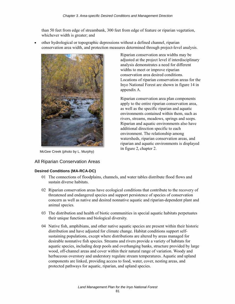
Chapter 3. Area-specific Desired Conditions and Management Direction
Land Management Plan for the Inyo National Forest 81
than 50 feet from edge of streambank, 300 feet from edge of feature or riparian vegetation, whichever width is greater; and
• other hydrological or topographic depressions without a defined channel, riparian conservation area width, and protection measures determined through project-level analysis.
McGee Creek (photo by L. Murphy)
Riparian conservation area widths may be adjusted at the project level if interdisciplinary analysis demonstrates a need for different widths to meet or improve riparian conservation area desired conditions. Locations of riparian conservation areas for the Inyo National Forest are shown in figure 14 in appendix A.
Riparian conservation area plan components apply to the entire riparian conservation area, as well as the specific riparian and aquatic environments contained within them, such as rivers, streams, meadows, springs and seeps. Riparian and aquatic environments also have additional direction specific to each environment. The relationship among watersheds, riparian conservation areas, and riparian and aquatic environments is displayed in figure 2, chapter 2.
All Riparian Conservation Areas
Desired Conditions (MA-RCA-DC) 01 The connections of floodplains, channels, and water tables distribute flood flows and
sustain diverse habitats.
02 Riparian conservation areas have ecological conditions that contribute to the recovery of threatened and endangered species and support persistence of species of conservation concern as well as native and desired nonnative aquatic and riparian-dependent plant and animal species.
03 The distribution and health of biotic communities in special aquatic habitats perpetuates their unique functions and biological diversity.
04 Native fish, amphibians, and other native aquatic species are present within their historic distribution and have adjusted for climate change. Habitat conditions support self-sustaining populations, except where distributions are altered by areas managed for desirable nonnative fish species. Streams and rivers provide a variety of habitats for aquatic species, including deep pools and overhanging banks, structure provided by large wood, off-channel areas and cover within their natural range of variation. Woody and herbaceous overstory and understory regulate stream temperatures. Aquatic and upland components are linked, providing access to food, water, cover, nesting areas, and protected pathways for aquatic, riparian, and upland species.

Chapter 3. Area-specific Desired Conditions and Management Direction
Land Management Plan for the Inyo National Forest 82
05 Riparian areas provide a range of substrates to sustain habitat for a variety of aquatic and terrestrial fauna within their natural capacity of the system.
06 Soil structure and function is sustained to infiltrate and disperse water properly, withstand erosive forces, sustain favorable conditions of stream flow, and cycle nutrients. Associated water tables support riparian vegetation and restrict nonriparian vegetation.
07 Key riparian processes and conditions (including slope stability and associated vegetation root strength, wood delivery to streams and floodplains, input of leaf and organic matter to aquatic and terrestrial systems, solar shading, microclimate, and water quality) operate consistently with local disturbance regimes.
08 The condition of riparian vegetation, including riparian species composition, stand density, and fuel loading, is consistent with healthy riparian systems and reduces risks from high-intensity wildfire in the watershed.
09 Riparian areas in frequent fire landscapes (such as montane areas) have low- to moderate-severity fire restored as an ecological process. Fire effects occur in a mosaic and support restoration and ecological integrity and function of composition, structure, and ecological resilience.
10 Riparian areas protect or improve riparian area-dependent resources while allowing for management of other compatible uses like recreation, vegetation management, or livestock grazing.
11 Along all State-designated wild trout waters (designated as of February 2001), streamside vegetation provides a minimum of 90 percent stream shading and fish cover, based on capability of the site.
Objective (MA-RCA-OBJ) 01 Restore the structure and composition of at least 400 acres in riparian areas within 10
years following plan approval, emphasizing riparian areas that face the most risk from large-scale high-intensity fire, past fire exclusion, or accelerated flooding events associated with climate change.
Goals (MA-RCA-GOAL) 01 Coordinate and collaborate with the State fish and wildlife agencies to address native
aquatic species issues, including evaluating management and monitoring needs to address aquatic species requirements across ownership boundaries.
02 Where invasive species are adversely affecting the persistence of native species, work with the appropriate State and Federal wildlife agencies work to reduce impacts of invasive species to native populations.
Standards (MA-RCA-STD) 01 Ensure that management activities do not adversely affect water temperatures necessary
for local aquatic- and riparian-dependent species assemblages.
02 Limit pesticide applications to cases where project-level analysis indicates that pesticide applications are consistent with riparian conservation area desired conditions.

Chapter 3. Area-specific Desired Conditions and Management Direction
Land Management Plan for the Inyo National Forest 83
03 Prohibit storage of fuels and other toxic materials except at designated administrative sites and sites covered by special use authorization. Prohibit refueling within riparian conservation areas except when there are no other alternatives.
04 Ensure that culverts or other stream crossings do not create barriers to upstream or downstream passage for aquatic-dependent species, except where desired to protect native species.
05 All new or replaced permanent stream crossings shall accommodate at least the 100-year flood, its bedload, and debris. Estimates for 100-year flood potential will reflect the best available science regarding potential effects of climate change.
06 Locate water drafting sites to minimize adverse effects to instream flows and depletion of pool habitat.
07 Prevent disturbance to streambanks and shorelines of lakes and ponds (caused by resource management activities, or factors such as off-highway vehicles or dispersed recreation) from exceeding 20 percent of stream reach, or 20 percent of natural lake and pond shorelines. Disturbance includes bank sloughing, chiseling, trampling, and other means of exposing bare soil or cutting plant roots. This standard may not be met within Destination Recreation Management Areas, sites authorized under special use permits, and designated off-highway vehicle routes, but activities will be designed and managed to reduce the percent of impact to the extent feasible.
08 In fen ecosystems, limit disturbance from livestock and pack stock to no more than 15 to 20 percent annually. Reduce disturbance further if a fen is nonfunctional or functional at risk with a downward trend.
09 Use screening devices for water drafting pumps. (Fire suppression activities are exempt during initial attack.) Use pumps with low entry velocity to minimize removal of aquatic species from aquatic habitats, including juvenile fish, amphibian egg masses and tadpoles.
10 Prohibit or mitigate ground-disturbing activities that adversely affect hydrologic processes that maintain water flow, water quality, or water temperature critical to sustaining fen ecosystems and the plant species that depend on these ecosystems.
11 Prevent activities from causing significant degradation of fens from trampling, such as by livestock, pack stock, wheeled vehicles, and people.
12 Manage livestock grazing to attain desired conditions in riparian conservation areas. Where livestock grazing is found to be contributing to a decline in the function of riparian systems, modify grazing practices as prescribed in the Inyo Forest Supplement to the R5 Rangeland Analysis and Planning Guide. If adjusting practices is not effective, remove livestock from that area using appropriate administrative authorities and procedures.
13 Assess the hydrologic function of riparian areas, meadows, fens, and other special aquatic features during rangeland management analysis. Ensure that characteristics of special

Chapter 3. Area-specific Desired Conditions and Management Direction
Land Management Plan for the Inyo National Forest 84
features are, at a minimum, at proper functioning condition or functioning at risk8 and trending toward proper functioning condition, as defined in appropriate technical reports.9 If systems are functioning at risk, assess appropriate actions to move towards proper functioning condition.
14 Complete initial inventories of fens within active grazing allotments prior to completing the allotment environmental analysis. If more than 10 fens occur on an allotment, ensure at least 25 percent of them are inventoried when completing the initial allotment environmental analysis. Establish a 5-year schedule to complete the remaining uninventoried fens.
15 Designate equipment exclusion zones within riparian conservation areas when designing projects. The default is half of the riparian conservation area width (150 feet for perennial streams, 75 feet for intermittent streams):
a. These widths may be adjusted on a project-by-project basis based on geomorphology, slope, or soil conditions, as long as best management practices and other plan direction are met. Adjustments may be made only after consultation with experts in aquatic ecology, soils, and/or hydrology.
b. If further mechanical incursion is warranted, use methods that limit soil disturbance within the riparian conservation area, such as low ground pressure equipment, helicopters, over-the-snow logging, extra ground cover requirements, or other soil protective actions to achieve desired conditions consistent with best management practices and other plan direction.
c. When vegetation is treated in the near stream area, meet the needs for coarse wood in stream channels where possible.
16 Soil erosion shall be minimized during post-wildfire operations.
17 Locate new livestock handling facilities and stock driveways, salting, and supplemental feeding outside of meadows and riparian areas except where there are no other feasible alternatives and where placement is consistent with meeting watershed or water quality best management practices if located in riparian conservation areas.
18 Avoid construction of new skid trails or temporary roads for access into riparian conservation areas, unless it is the only feasible option to conduct restoration activities for protection and improvement of riparian conservation areas.
19 Ensure that post-wildfire management activities enhance native vegetation cover, stabilize channels, and minimize adverse effects from the existing road network to protect the riparian systems.
8 The Inyo National Forest has a forest supplement for evaluation of hydrologic function at the site-specific key
grazing area. These other protocols are incorporated into the R5 Rangeland Analysis Guide R5-EM-TP-004. Citation: Inyo National Forest Supplement 1-2017 to USDA Forest Service Pacific Southwest Region Rangeland Analysis and Planning Guide R5-EM-TP-004 (March 1997)
9 USDI Bureau of Land Management. 2003. Riparian Area Management: A User Guide to Assessing Proper Functioning Condition and Supporting Science for Lentic Areas, Technical Reference 1737-16. National Applied Resource Sciences Center, Denver, CO. 109 pp.
Chapter 3. Area-specific Desired Conditions and Management Direction
Land Management Plan for the Inyo National Forest 85
Guidelines (MA-RCA-GDL) See also MA-CWPZ-STD 01.
01 Maintain and restore the hydrologic connectivity of streams, meadows, wetlands, and other special aquatic features by identifying roads and trails that intercept, divert, or disrupt natural surface and subsurface water flow paths. Implement corrective actions where necessary to restore connectivity.
02 Minimize impacts from roads, trails, off-highway-vehicle trails, staging areas, developed recreation sites, dispersed campgrounds, special use permits, grazing permits, and day use sites that have been identified as contributing to degradation of water quality or habitat for aquatic and riparian-dependent species.
03 When reissuing permits for livestock, evaluate impacts of facilities on the riparian conservation areas and consider relocating existing livestock facilities outside of meadows and riparian areas.
04 Avoid wildfire control methods and activities that would impact the riparian conservation area, including dozer-built lines, unless alternative control methods are not safe or practical.
05 Stream reaches of all State-designated wild trout waters (designated as of February 2001) should be managed according to the following: Any activity that results in trampling and chiseling should not exceed 10 percent of any given stream reach in order to reduce sedimentation into wild trout waters. A reach is defined as a continuous portion of a stream with homogeneous physical characteristics.
06 Unstable or eroding streambanks should be restored to attain a streambank system that is no more than 10 percent unstable of the reach’s current potential.
07 To prevent impacts to spawning habitat, stream-modifying construction activities within or immediately adjacent to the aquatic zone should be prohibited during the following spawning seasons:
a. In streams with spring spawning species (rainbow, cutthroat, and golden trout), February 15 to August 20.
b. In streams with fall spawning species (brown and brook trout), October 1 to April 15. The Forest Supervisor has the authority to make exceptions to these seasons.
Potential Management Approaches • When conducting proper functioning condition assessments, if information is available to
show the historic potential of an area and the current potential is different from that historical potential, consider restoration measures that would be necessary to attain the historical potential.
• Determine if stream characteristics are within the range of natural variation; if characteristics are outside the range of natural variation, restoration should be considered.
• When rehabilitating fire control sites, emphasize the restoration of dozer impacts within riparian conservation areas.

Chapter 3. Area-specific Desired Conditions and Management Direction
Land Management Plan for the Inyo National Forest 86
Meadows
Desired Conditions (RCA-MEAD-DC) 01 Meadows are hydrologically functional. Sites of accelerated erosion, such as gullies and
headcuts are stabilized, recovering, or within the natural range of variation. Vegetation roots occur throughout the available soil profile. Meadows with perennial and intermittent streams have the following characteristics: (1) stream energy from high flows is dissipated, reducing erosion and improving water quality; (2) streams filter sediment and capture bedload, aiding floodplain development; (3) meadow conditions enhance floodwater retention and groundwater recharge; and (4) root masses stabilize streambanks against cutting action.
02 Wetlands and groundwater-dependent ecosystems (including springs, seeps, fens, wet meadows, and associated wetlands or riparian systems) support stable herbaceous and woody vegetation communities that are resilient to drought, climate change, and other stressors. Root masses stabilize stream channels, shorelines, and soil surfaces. The natural hydrologic, hydraulic, and geomorphic processes in these ecosystems sustain their unique functions and biological diversity.
03 Meadows are resilient and recover rapidly from natural and human disturbances. They exhibit a high degree of hydrologic connectivity laterally across the floodplain and vertically between surface and subsurface flows. They provide important ecosystem services such as high-quality water, recharge of streams and aquifers, and moderation of climate variability and change.
04 Soils in wet and headwater meadows are influenced by a shallow water table and function to filter water. These soils also store and release water over an extended period of time, which helps to maintain streamflow during dry summer months.
05 Meadows have substantive ground cover and a rich and diverse species composition, especially of grasses and forbs. Meadows have high plant functional diversity with multiple successional functional types represented. Perennial streams in meadows contain a diversity of age classes of shrubs along the streambank, where the potential exists for these plants.
06 A complexity of meadow habitat types and successional patterns support native plant and animal communities. Meadow species composition is predominantly native, where graminoid (grass-like) species are well represented and vigorous, and regeneration occurs naturally. Healthy stands of willow, alder, and aspen are present within and adjacent to meadows with suitable physical conditions for these species. Natural disturbances and management activities are sufficient to maintain desired vegetation structure, species diversity, and nutrient cycling.
07 Meadows in montane and upper montane areas have low- to moderate-severity fire restored as an ecological process, especially on meadow edges, limiting conifer encroachment and enhancing native understory plant composition and cover.
08 Fen condition is within the natural range of variation. Fens are resilient with continual peat accumulation and carbon sequestration. The hydrologic regime, and vegetation, soil, and water characteristics sustain the fen’s ability to support unique physical and biological attributes.

Chapter 3. Area-specific Desired Conditions and Management Direction
Land Management Plan for the Inyo National Forest 87
Objective (RCA-MEAD-OBJ) 01 Enhance or improve conditions on at least five meadows of any size, within 10 years
following plan approval.
Rivers and Streams
Desired Conditions (RCA-RIV-DC) 01 Stream ecosystems, riparian corridors, and associated stream courses sustain ecosystem
structure; are resilient to natural disturbances (such as flooding) and climate change; promote the natural movement of water, sediment and woody debris; and provide habitat for native aquatic species or desirable nonnative species.
02 Stream ecosystems, including ephemeral watercourses, exhibit full connectivity where feasible to maintain aquatic species diversity, except where barriers are maintained in good condition to protect native aquatic species. Ephemeral watercourses provide for dispersal, access to new habitats, perpetuation of genetic diversity, and nesting and foraging habitat for riparian and aquatic species.
03 Instream flows are sufficient to sustain desired conditions of riparian, aquatic, wetland, and meadow habitats and retain patterns of sediment, nutrients, and wood routing as close as possible to those with which aquatic and riparian biota evolved. The physical structure and condition of streambanks and shorelines minimize erosion and sustain desired habitat diversity.
04 Streams and rivers maintain seasonal water flow over time, including periodic flooding, which promotes natural movement of water, sediment, nutrients, and woody debris. Flooding creates a mix of stream substrates for fish habitat, including clean gravels for fish spawning, large wood structures, and sites for riparian vegetation to germinate and establish.
05 Stream channel conditions exhibit a sediment regime under which aquatic and riparian ecosystems evolved. Elements of the sediment regime include the timing, volume, rate, and character of sediment input, storage, and transport. The sediment regime should be similar to the natural distribution of reference conditions.
06 Within rivers and streams, the level of coarse large woody debris is within the natural range of variation.
Objectives (RCA-RIV-OBJ) 01 Enhance or restore the structure, composition, or function of habitat for fisheries and
other aquatic species along at least 10 stream miles over a 10-year period.
02 Eliminate or mitigate one priority barrier to aquatic organism passage or ecological connectivity within 10 years following plan approval.
Lakes, Pools, Ponds
Desired Conditions (RCA-LPP-DC) 01 Lakes and ponds retain necessary attributes, such as adequate vegetation and large woody
debris to function properly and support native biotic communities. Attributes include floodwater retention and groundwater recharge, stabilized islands and shoreline features,

Chapter 3. Area-specific Desired Conditions and Management Direction
Land Management Plan for the Inyo National Forest 88
and diverse characteristics to provide for amphibian production, waterfowl breeding, and biodiversity.
Springs and Seeps
Desired Conditions (RCA-SPR-DC) 01 Springs provide sufficient water to maintain healthy habitats for native riparian and
aquatic species.
02 Springs are resilient to natural disturbances, groundwater diversions, and changing climate conditions. Springs function across the landscape within their type and water availability.
03 Springs and associated streams and wetlands have the necessary soil, water, and vegetation attributes to be healthy and functioning at or near potential. Water flow is similar to historic levels and persists over time, within constraints of climate change.
Sustainable Recreation Management Areas
Destination Recreation Area This management area provides the most intensive recreation development within the natural setting of the Inyo National Forest. Iconic destinations and well know attractions create a high demand for recreation experiences at specific locations (areas such as Mammoth Lakes Basin and Whitney Portal). These places, along with the close proximity to other attractions, make these destinations highly desirable to many visitors from all over the world and are often the singular focus of their visit to the Inyo National Forest.
Visitors cross-country skiing in the Rock Creek Destination Recreation Area (photo by J. Biedl)
In summer, the public should expect areas of high-density recreation activity, with high use levels. Recreationists are attracted to this setting because of the variety of opportunities. Motorized access and support facilities (roads, parking lots, water access, amenities, campgrounds, and resorts) are emphasized. Conservation education and interpretation focus on developing a land ethic as part of the recreation experience. In winter, portions of this area provide facilities for winter uses, such as snow-parks. Areas such as Lee Vining Canyon, Reds Meadow, Onion Valley, Whitney Portal, and Horseshoe Meadows would be managed following the Challenging-Backroad Recreation Area direction (see below). This is due to the lower amounts of winter use and lack of facilities supporting winter uses.
The summer recreation opportunity spectrum setting is primarily rural, roaded modified, and roaded natural with some semi-primitive motorized and semi-primitive nonmotorized classes within the area (table 15). Winter recreation opportunity spectrum classes range from roaded

Chapter 3. Area-specific Desired Conditions and Management Direction
Land Management Plan for the Inyo National Forest 89
modified and roaded natural, with more semi-primitive nonmotorized and semi-primitive motorized classes.
Table 15. Acres of land within each recreation opportunity spectrum class in the Destination Recreation Area
Destination Recreation Areas Acres in Summer Classes Acres in Winter Classes Primitive 990 0
Semi-primitive nonmotorized 6,118 11,433
Semi-primitive motorized 1,069 16,707
Roaded Natural 128 1,564
Roaded Modified 23,662 15,006
Rural 11,397 856
Desired Conditions (MA-DRA-DC) 01 The developed area footprint within destination recreation areas is visually appealing and
well maintained.
02 A natural appearing landscape is retained outside the development footprint.
03 Most recreation facilities are highly developed and in close proximity to each other.
04 Developed sites meet national quality standards.
05 Forest roads and trails provide users relatively easy access to destinations.
06 The setting provides amenities and sustainable infrastructure to support a wide variety of recreational activities in close proximity to each other.
07 Available infrastructure and amenities are consistent with user capacity.
08 Interpretation and education activities provide learning opportunities to visitors about the natural and cultural environment and responsible visitor behavior.
09 Traffic and parking does not negatively impact visitor experience.
Potential Management Approaches • Changes in visitor use levels, patterns of use, or the necessity to protect resources may
result in more infrastructure, heavier maintenance, or more controls such as setting capacity limits.
• Consider the future implications of additional infrastructure or development accommodating recreation use in areas adjacent to or within the developed area.
• Consider accommodating additional recreation special use authorizations or partnership agreements to support providing quality recreation experiences, visitor services, and interpretation and education.
General Recreation Area This management area is where the concept of multiple use is most evident. It is the working landscape where fuelwood gathering, vegetation management, livestock grazing, electrical transmission infrastructure, geothermal energy, and mining may occur. In summer, people should expect to see a variety of ecosystem-conservation management activities and some lands
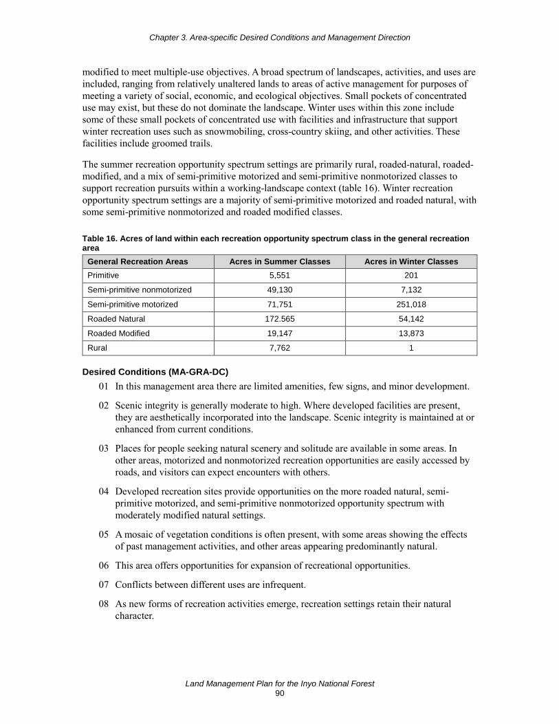
Chapter 3. Area-specific Desired Conditions and Management Direction
Land Management Plan for the Inyo National Forest 90
modified to meet multiple-use objectives. A broad spectrum of landscapes, activities, and uses are included, ranging from relatively unaltered lands to areas of active management for purposes of meeting a variety of social, economic, and ecological objectives. Small pockets of concentrated use may exist, but these do not dominate the landscape. Winter uses within this zone include some of these small pockets of concentrated use with facilities and infrastructure that support winter recreation uses such as snowmobiling, cross-country skiing, and other activities. These facilities include groomed trails.
The summer recreation opportunity spectrum settings are primarily rural, roaded-natural, roaded-modified, and a mix of semi-primitive motorized and semi-primitive nonmotorized classes to support recreation pursuits within a working-landscape context (table 16). Winter recreation opportunity spectrum settings are a majority of semi-primitive motorized and roaded natural, with some semi-primitive nonmotorized and roaded modified classes.
Table 16. Acres of land within each recreation opportunity spectrum class in the general recreation area
General Recreation Areas Acres in Summer Classes Acres in Winter Classes Primitive 5,551 201
Semi-primitive nonmotorized 49,130 7,132
Semi-primitive motorized 71,751 251,018
Roaded Natural 172.565 54,142
Roaded Modified 19,147 13,873
Rural 7,762 1
Desired Conditions (MA-GRA-DC) 01 In this management area there are limited amenities, few signs, and minor development.
02 Scenic integrity is generally moderate to high. Where developed facilities are present, they are aesthetically incorporated into the landscape. Scenic integrity is maintained at or enhanced from current conditions.
03 Places for people seeking natural scenery and solitude are available in some areas. In other areas, motorized and nonmotorized recreation opportunities are easily accessed by roads, and visitors can expect encounters with others.
04 Developed recreation sites provide opportunities on the more roaded natural, semi-primitive motorized, and semi-primitive nonmotorized opportunity spectrum with moderately modified natural settings.
05 A mosaic of vegetation conditions is often present, with some areas showing the effects of past management activities, and other areas appearing predominantly natural.
06 This area offers opportunities for expansion of recreational opportunities.
07 Conflicts between different uses are infrequent.
08 As new forms of recreation activities emerge, recreation settings retain their natural character.
Chapter 3. Area-specific Desired Conditions and Management Direction
Land Management Plan for the Inyo National Forest 91
Objective (MA-GRA-OBJ) 01 Within 10 years of plan approval add up to five new recreation sites in the general
recreation area to provide access to dispersed recreational activities (such as hiking, biking, stock use, and use of off-highway vehicles and over-snow vehicles) if partnerships are available to assist with the maintenance and management of new facilities.
Goal (MA-GRA-GOAL) 01 Highlight quality recreational experiences in this area so visitors are aware of the
recreational opportunities in this area.
Guideline (MA-GRA-GDL) 01 Use direct management techniques to reduce impacts on resources.
Potential Management Approaches • Priority will be given to design new infrastructure and development to manage user
conflict, as needed.
• Consider accommodating recreation special use authorizations to the extent that the natural and cultural resource can sustain the activity.
Challenging Backroad Recreation Area This management area provides largely undeveloped landscapes suited for dispersed summer and winter recreation use. These areas include the more remote parts of the Inyo and access can be challenging. The public should expect to see natural landscapes with few amenities, limited management, low visitor use and density levels, and limited Forest Service presence. Motorized and nonmotorized recreation is often challenging due to terrain and low density of roads and trails.
The summer recreation opportunity spectrum settings in these areas (table 17) are primarily semi-primitive motorized, semi-primitive nonmotorized, and some roaded natural and roaded modified classes to support remote recreation pursuits that require less dependence on development. Winter recreation opportunity spectrum settings are primarily semi-primitive motorized and semi-primitive nonmotorized.
Table 17. Acres of land within each recreation opportunity spectrum class in the challenging backroad recreation area
Challenging Backroad Recreation Areas Acres in Summer
Classes Acres in Winter
Classes Primitive 82,301 23,847
Semi-primitive nonmotorized 149,140 4,791
Semi-primitive motorized 263,360 483,198
Roaded Natural 48,488 30,669
Roaded Modified 52 1,353
Rural 0 0
Chapter 3. Area-specific Desired Conditions and Management Direction
Land Management Plan for the Inyo National Forest 92
Desired Conditions (MA-CBRA-DC) 01 These landscapes provide opportunities for challenging and remote recreation
experiences.
02 These areas contribute to ecosystem and species diversity and sustainability, serve as habitat for fauna and flora, and offer wildlife corridors. These areas provide a diversity of terrestrial and aquatic habitats, and support species dependent on large, undisturbed areas of land.
03 Management that supports recreation activities is minimal.
04 There is a low density of infrastructure and designated roads and trails.
05 Conflicts between different recreation uses are infrequent.
06 There are vast areas for nonmotorized cross-country travel, offering visitors opportunities for exploration and challenge in summer.
07 There is little evidence of cross-country travel in summer.
08 As new forms of recreation emerge, recreation settings retain their natural character.
Standards (MA-CBRA-STD) 01 Authorize new land special use permits only where it is appropriate to the remote setting.
02 Recreation special use permits must be consistent with low-visitor use and the remote setting.
03 Any new recreation development must be the minimum necessary to accommodate the activity.
04 When nonmotorized user-created summer trails become evident due to resource damage, designate or obliterate and restore those trails.
Recommended Wilderness The Inyo National Forest has four areas recommended for wilderness designation:
• White Mountains Wilderness Addition (West) • White Mountains Wilderness Addition (East) • Piper Mountain Wilderness Addition • South Sierra Wilderness Addition
Plan components for recommended wilderness areas are organized under the wilderness management area section above. These recommended wilderness areas are mapped in figure 10, appendix A.
Desired Conditions (MA-RWLD-DC) 01 Areas recommended for wilderness retain their social and ecological wilderness
characteristics and other identified features of value until their designation as wilderness or other use are determined by Congress.
02 Plant and animal communities remain substantially natural.
Chapter 3. Area-specific Desired Conditions and Management Direction
Land Management Plan for the Inyo National Forest 93
03 Ecological processes in recommended areas are generally absent from human intervention.
04 Existing improvements are not a substantial departure from apparent naturalness.
05 The existing opportunities for solitude and primitive recreation are maintained.
Goal (MA-RWLD-GOAL) 01 Rehabilitate areas to address impacts caused by nonconforming activities that may affect
wilderness potential.
Suitability (MA-RWLD-SUIT) 01 Except as provided for in the Wilderness Act including existing private rights, the
following uses are not suitable within recommended wilderness:
a. commercial enterprise; b. temporary roads; c. use of motor vehicles, motorized equipment, or motorboats; d. landing of aircraft; e. mechanical transport; and f. new structures or installations
02 Nonconforming projects or activities may be suitable if they are temporary in nature and are for the purposes of ecological restoration for at-risk species habitat.
Eligible Wild and Scenic Rivers
Desired Condition (MA-EWSR-DC) 01 Eligible or recommended wild and scenic rivers retain their free-flowing condition, water
quality, and specific outstandingly remarkable values. Recommended preliminary classifications remain intact until further study is conducted or until designation by Congress.
Standard (MA-EWSR-STD) 01 For interim management of Forest Service-identified eligible or recommended suitable
rivers, use interim protection measures identified in Forest Service Handbook 1909.12, section 84.3.
Pacific Crest National Scenic Trail Corridor Management direction for the Pacific Crest National Scenic Trail is provided in this plan in terms of both the trail tread itself and the broader management area corridor. When referencing the trail, the plan refers to the approximately 24 inches of trail tread. When referencing the corridor, this refers to the broader management area, up to one-half mile on either side of the trail. The specific width of the corridor varies based on criteria used in the scenery management system.
The management area for the Pacific Crest National Scenic Trail corridor includes the lands in the visible foreground encompassing resources, qualities, values, associated settings, and primary uses (figure 15, appendix A). The visible foreground is the area that is seen from the trail’s
Chapter 3. Area-specific Desired Conditions and Management Direction
Land Management Plan for the Inyo National Forest 94
centerline at a vantage point of 5 feet high and extending up to one-half mile on both sides of the trail, depending on topography.
Management direction listed below is organized according to plan components that apply to sections of the corridor that are within designated wilderness and outside designated wilderness. Some of the management direction applies only to the trail itself versus the entire corridor; these distinctions are indicated below.
Pacific Crest National Scenic Trail in Designated Wilderness The following plan components apply to the corridor within designated wilderness. The one exception is MA-PCTW-STD 01, which only applies to the trail itself.
Desired Conditions (MA-PCTW-DC) 01 The Pacific Crest National Scenic Trail provides for outstanding journeys on foot or on
horseback along the Pacific mountain ranges. Tranquility and closeness with nature can be found consistently along the trail, evoking a feeling of extended retreat from civilization, even if only venturing out for a day.
02 The recreation setting is consistent with or complements the primitive recreation opportunity spectrum.
03 Outstanding panoramic views of natural landscapes in a tranquil scenic environment are provided when possible.
04 Scenic integrity objectives and scenic stability levels are maintained to retain panoramic views and landscape connectivity. Lands viewed beyond the management area meet the scenery integrity objective of at least moderate.
Standard (MA-PCTW-STD) 01 Prohibit heavy equipment line construction on the Pacific Crest National Scenic Trail,
unless necessary for emergency protection of property and safety.
Guideline (MA-PCTW-GDL) 01 To maintain and protect scenic qualities, management activities should be consistent with
a scenic integrity objective of very high (figure 8, appendix A).
Potential Management Approaches • Reconstruct or relocate existing portions of the Pacific Crest National Scenic Trail as
needed to enhance the recreation experience and protect resources. Evaluate proposed trail relocations using the established Pacific Southwest Region process in partnership with adjoining Federal agencies, the Pacific Crest Trail Association, and other partners.
• Use key observation points to evaluate the condition of scenery resources. Analysis of impacts of proposed projects will evaluate what is viewed from the trail.
• Implement visitor use management strategies to minimize impacts to desired conditions for natural resources and visitor experiences through education, site management, regulation, and enforcement.
• Place priority on the purchase of lands or interest in lands necessary to protect the Pacific Crest Trail experience as delineated in the Pacific Crest Trail land acquisition inventory.

Chapter 3. Area-specific Desired Conditions and Management Direction
Land Management Plan for the Inyo National Forest 95
Pacific Crest National Scenic Trail outside Designated Wilderness The following desired conditions and suitability determinations apply to the corridor outside designated wilderness. The one exception is MA-PCT-SUIT 05, which only applies to the trail itself. The following standards and guidelines apply only to the trail itself, except MA-PCT-STD 02, MA-PCT-STD 03, MA-PCT-GDL 01, MA-PCT-GDL 03, and MA-PCT-GDL 04, which apply to the corridor.
Desired Conditions (MA-PCT-DC) 01 The Pacific Crest National Scenic Trail provides for outstanding journeys on foot or on
horseback along the Pacific mountain ranges. These primitive forms of travel, hearken back to a simpler and more rugged time. Tranquility and closeness with nature can be found consistently along the trail, evoking a feeling of extended retreat from civilization, even if only venturing out for a day.
02 The landscape is naturally appearing. The trail provides for the conservation and enjoyment of scenic, historic, natural, and cultural qualities of the areas through which it passes.
03 The recreation experience is consistent with or complements a nonmotorized recreation setting. The trail may intermittently pass through more developed settings to provide for a continuous route. In winter, the trail has a naturally appearing setting with few to no sights, sounds, and resource impacts from motorized use.
04 Panoramic views of natural landscapes in a tranquil and scenic environment are provided along the crest of the Sierra Nevada.
05 Scenic integrity objectives and scenic stability levels are maintained to retain panoramic views and landscape connectivity. Lands viewed beyond the management area meet the scenery integrity objective of at least moderate.
Standards (MA-PCT-STD) 01 Prohibit heavy equipment line construction on the Pacific Crest National Scenic Trail,
unless necessary for emergency protection of property and safety.
02 Project design and mitigation for utility and rights-of-way projects within the corridor must be sufficient to protect trail values. Require mitigation measures including screening, feathering, and other visual management techniques to mitigate visual and other impacts of new or upgraded utility rights-of-way. Avoidance, on-site mitigation, and off-site mitigation are pursued in successive order.
03 New roads (roads that are not designated and there is no existing footprint) within the corridor, are not permitted unless required by law to provide access to private lands or determined to be prudent and feasible.
04 Hauling or skidding along the Pacific Crest National Scenic Trail or using the Pacific Crest National Scenic Trail for landings or temporary roads is prohibited.
Guidelines (MA-PCT-GDL) 01 To maintain and protect the scenic qualities of the Pacific Crest National Scenic Trail,
management activities within the corridor should be consistent with a scenic integrity objective of high (figure 8, Appendix A).
Chapter 3. Area-specific Desired Conditions and Management Direction
Land Management Plan for the Inyo National Forest 96
02 New recreation events on the Pacific Crest National Scenic Trail, such as foot races, horseback endurance events, and fundraising events should be limited to designated crossings only to minimize conflicts with the nature and purposes of the trail. Existing recreation events on the Pacific Crest National Scenic Trail may be allowed to continue at current levels.
03 Designated roads and all trails within the corridor should be designed to minimize impacts to the scenic, natural, and experiential values of the trail. Exemptions may be allowed if required by law to provide access to private lands or determined to be prudent and feasible.
04 New buildings and structures within the corridor that would be visible from the Pacific Crest National Scenic Trail should be designed to minimize impacts to the scenic character of the trail.
Suitability (MA-PCT-SUIT) 01 New commercial communication sites and energy generation sites are not suitable.
02 Locatable and leasable mineral exploration or extraction that causes surface disturbance is not suitable.
03 Commercial extraction of mineral materials such as sand, gravel, pumice, cinders, and other common variety minerals is not suitable.
04 Designated roads and trails within the corridor, including crossings of the Pacific Crest National Scenic Trail are suitable.
05 Year-round motorized or mechanized transport on the Pacific Crest National Scenic Trail is not suitable.
Potential Management Approaches • Reconstruct or relocate existing portions of the Pacific Crest National Scenic Trail as
needed to enhance the recreation experience and protect resources. Evaluate proposed trail relocations using the established Pacific Southwest Region process in partnership with adjoining Federal agencies, the Pacific Crest Trail Association, and other partners.
• Key observation points are used to evaluate the condition of scenery resources. Analysis of impacts of proposed projects will evaluate what is viewed from the trail.
• Prescribed burning, wildfire, herbicides, biological controls, grazing, and timber harvest may be used to manage vegetation.
• Implement visitor use management strategies to minimize impacts to desired conditions for natural resources and visitor experiences through education, site management, regulation, and enforcement.
Designated Areas Wilderness Congress has designated nine wilderness areas that are either in whole or in part within the Inyo National Forest’s administrative boundary and managed by the Forest Service (figure 17,
Chapter 3. Area-specific Desired Conditions and Management Direction
Land Management Plan for the Inyo National Forest 97
appendix A). These wilderness areas comprise about 46 percent of the national forest. They include:
• Ansel Adams Wilderness (shared with the Sierra National Forest),
• Golden Trout Wilderness (shared with the Sequoia National Forest),
• Hoover Wilderness (shared with the Humboldt-Toiyabe National Forest),
• Inyo Mountains Wilderness (shared with Bureau of Land Management)
• John Muir Wilderness (shared with the Sierra National Forest),
• Owens River Headwaters Wilderness,
• South Sierra Wilderness (shared with the Sequoia National Forest),
• Boundary Peak Wilderness, and
• White Mountains Wilderness (shared with Bureau of Land Management).
The Ansel Adams and John Muir Wildernesses (figure 10 and figure 11, pages 129 and 130) have desired conditions specific to three zones called recreation categories. Similarly, the South Sierra Wilderness (figure 12, page 131) has desired conditions that are specific to four zones called opportunity classes that occur across this wilderness. Individual wilderness plans provide wilderness area-specific guidance in addition to the strategic-level guidance provided in this land management plan. In addition to these nine wilderness areas, approximately 3,000 acres of the Inyo National Forest is within Granite Mountain Wilderness, which is managed by the Bureau of Land Management.
All Designated Wilderness Areas
Desired Conditions (DA-WILD-DC) 01 The wilderness character of each wilderness, including the qualities of untrammeled,
natural, undeveloped, opportunities for solitude or primitive recreation, and other features of value (such as ecological, geological, or other features of scientific, educational, scenic, cultural or historical value specific to each wilderness area) are preserved and, when possible, enhanced.
02 Watersheds are functioning properly and exhibit high geomorphic, hydrologic, and biotic integrity relative to their natural and current potential condition.
03 Fire is restored as an ecosystem process and natural disturbance agent in wilderness where possible.
04 The undeveloped character of wilderness is enhanced compared to the time of designation.
05 Each wilderness area accommodates levels of recreation use that are ecologically sustainable.
06 Overall recreation use is maintained at a level that protects opportunities for solitude and wilderness character.
07 Forest visitors find opportunities for primitive recreation and solitude across the wilderness.
08 Forest system trails that access wilderness are part of a high-quality wilderness experience for visitors. Forest system trails meet national quality standards, with minimal deferred maintenance and adhere to the national trail classification system. Trails in

Chapter 3. Area-specific Desired Conditions and Management Direction
Land Management Plan for the Inyo National Forest 98
wilderness are located in resilient areas, and do not cause adverse impacts to at-risk species, water quality, soils, hydrologic connectivity, or cultural resources.
09 Concentrated use and associated resource impacts are directed to more resilient parts of the landscape when possible, and prevented from expanding in fragile areas.
10 Resource impacts of user-created trails are reduced.
11 If a wilderness permit system is in place, the permit system provides equity in access for all authorized and legitimate uses.
Goal (DA-WILD-GOAL) 01 Restore to natural conditions campsites that adversely affect water quality.
Guideline (DA-WILD-GDL) 01 Limit party size and number of stock per party to a level that protects social and natural
resource values. The level may vary within or between wilderness areas.
Suitability (DA-WILD-SUIT) 01 Except as specifically provided for in the Wilderness Act, and subject to existing private
rights, the following uses are not suitable within designated wilderness.
a. commercial enterprise; b. temporary roads; c. use of motor vehicles, motorized equipment or motorboats; d. landing of aircraft; e. mechanical transport; and f. structures or installations.
Ansel Adams and John Muir Wildernesses
Recreation Category 1 Management focuses on sustaining and enhancing the natural ecosystem. Signs are present in very rare cases (for resource protection only) and at system trail junctions. Indirect methods of accomplishing management objectives predominate. Management occasionally includes direct, on-site actions. Site-specific regulations may be in place in unusual cases where resources require higher levels of protection. Trail system management is minimal, focusing on resource protection.
Desired Conditions (DA-WILD-REC1-DC) 01 Opportunities for solitude are highest among the recreation categories. Evidence of
human activities is predominantly absent. Encounters with other visitors while traveling or camping are very infrequent. This environment offers the highest degree of challenge, self-reliance, and risk.
02 An unmodified natural environment characterizes the area. Ecological and natural processes are minimally affected by the action of users. Environmental impacts are low and restricted to minor losses of vegetation where camping occurs and along travel routes. Most impacts recover on an annual basis and are apparent to few visitors.
Chapter 3. Area-specific Desired Conditions and Management Direction
Land Management Plan for the Inyo National Forest 99
03 Campsites are at low density levels and show minor impacts that will rarely persist year to year.
04 There is very little vegetation loss or change in duff and litter layer by human use.
05 Riparian, lakeshore, and stream channel conditions show no measurable degradation due to human uses.
Recreation Category 2 Management emphasizes sustaining and enhancing the natural ecosystem. Signing is minimal, providing for resource protection and direction at major trail intersections. Management may frequently include direct, on-site actions. Site-specific regulations may be in place to meet management objectives for resource protection. Primary trail corridors have highly maintained and constructed trails that support access to popular destinations and travel routes. Secondary trails allow for moderate dispersal of use but are maintained in a manner consistent with a more pristine and primitive experience than primary trail corridors.
Desired Conditions (DA-WILD-REC2-DC) 01 High occasions of solitude are experienced while traveling or camping outside the
primary trail corridors. Along primary trail corridors, encounters with other visitors while traveling or camping is higher than category 1 areas but far less than category 3 areas. This environment offers a high degree of challenge, self-reliance, and risk.
02 A highly unmodified natural environment characterizes the area. In the few concentrated areas of moderate use, natural conditions may be more affected by the actions of users. A higher level of management is present to mitigate these impacts. Impacts may persist from year to year and may be apparent to some visitors. Most visitors will not discern impacts.
03 Concentration of campsites exists at trail junctions and popular destination points. No new sites are forming over time. Campsites may occasionally be within sight and sound of others. Bare mineral soil may exist on some sites and may persist from year to year. Outside these areas, campsites and impacts associated with camping is light.
04 Moderate soil compaction and loss of vegetation occurs. Minimal erosion occurs on disturbed sites.
05 Riparian, lakeshore and stream channel conditions show a temporary change within standards, which could persist from year to year at a few sites. Impacts are mitigated and prevented to reduce long-term impacts.
Recreation Category 3 Management emphasizes sustaining and protecting natural conditions. Management is often direct, and management presence to mitigate visitor use impacts on resources is more noticeable. Campsites may be identified and delineated. Site-specific closures to camping, campfires, and site-specific regulations may be in place. Signs used for resource protection are present in these areas. A moderate density of social trails is present in destination camping areas. The Forest Service has a presence to provide education contact and manage high levels of use.

Chapter 3. Area-specific Desired Conditions and Management Direction
Land Management Plan for the Inyo National Forest 100
Desired Conditions (DA-WILD-REC3-DC) 01 Recreation use levels provide fewer opportunities for solitude than the other two
categories, yet high opportunities for solitude exist outside the peak use season. During peak use season, opportunities for experiencing isolation from the sights, sounds, and impacts of human activities is less than in other recreation categories. The probability of encountering other visitors on the trail and at campsites is more than other areas.
02 A highly unmodified natural environment characterizes the area. In the few concentrated areas of moderate use, natural conditions may be more affected by the actions of users. A higher level of management is present to mitigate these impacts. Impacts may persist from year to year and may be apparent to some visitors. Most visitors will not discern impacts.
03 Concentration of campsites is moderately high at destinations and along travel corridors. The number of sites accommodates peak use to prevent the formation of new sites. Bare mineral soil may exist on some sites and may persist from year to year.
04 Moderate soil compaction and loss of vegetation, litter, and duff occurs on many visitor-created trails, in camp areas, and in areas used by livestock. Minimal erosion occurs on disturbed sites and is mitigated to prevent long-term impacts.
05 Riparian, lakeshore, and stream channel conditions show temporary changes, which could persist from year to year at some sites. Mitigation measures accommodate moderate levels of human recreation impacts.
South Sierra Wilderness
Wilderness Opportunity Class 1 Management strongly emphasizes sustaining and enhancing the natural ecosystem. Communication about rules and regulations occurs outside the area. Indirect methods of accomplishing management objectives predominate, but when needed, management actions can be direct. Site-specific regulations may be in place in unusual cases where resources require higher levels of protection. Maintained trails, signs, or facilities exist only for resource protection. Abandoned off-highway vehicle routes may be present in some areas and native vegetation is recovering naturally.
Desired Conditions (DA-WILD-OC1-DC) 01 Opportunities for solitude and isolation are high. There is little evidence of human
activities. Encounters with other users are infrequent. Contact with other parties is rare to nonexistent while traveling and are very low at campsites. Many opportunities for cross-country travel exist. This environment offers a high degree of challenge, self-reliance, and risk.
02 A highly unmodified natural environment generally characterizes the area. Ecological processes are largely unaffected by direct human actions. Environmental impacts are minimal and are usually restricted to areas along travel corridors. Most impacts recover on an annual basis and are not apparent to most visitors.
Wilderness Opportunity Class 2 Management emphasizes sustaining and enhancing the natural ecosystem. Communication about rules and regulations occurs outside the area. Direct on-site management of visitors is infrequent

Chapter 3. Area-specific Desired Conditions and Management Direction
Land Management Plan for the Inyo National Forest 101
but occurs more frequently than in opportunity class 1. Routes are maintained for resource protection and user safety. Signs provide directions at trail junctions or at geographical passes. Abandoned off-highway vehicle routes may be present in some locations and native vegetation is recovering naturally.
Desired Conditions (DA-WILD-OC2-DC) 01 Many opportunities for exploration and isolation exist. There is some evidence of human
activities, and the probability of encountering other users is low on trails, but other parties may be encountered at campsites. This environment offers a high degree of challenge, self-reliance, and risk.
02 An unmodified natural environment generally characterizes the area, except within trail corridors (50 feet on each side of a trail). Ecological processes are minimally affected by direct human actions. Environmental impacts are low and usually restricted to areas along travel routes and near campsites. Many impacts recover on an annual basis and are not apparent to most visitors.
Wild and Scenic Rivers 1 Management emphasizes maintaining natural conditions and primitive recreation opportunities. Indirect methods of accomplishing management objectives predominate. Direct, on-site management of visitors is rare.
Desired Conditions (DA-WILD-WSR1-DC) 01 Outstanding opportunities for solitude and isolation are high. Encounters with other users
are infrequent. This environment offers a high degree of challenge, self-reliance, and risk.
02 An unmodified natural environment generally characterizes the area. The ecosystem is stable and natural processes generally operate free of human-induced controls. Visitor impacts are minor and typically consist of temporary disturbances of soil and vegetation in camps and along popular hiking trails. Most impacts recover on an annual basis and are not apparent to most visitors.
Wild and Scenic Rivers 2 Management emphasizes maintaining natural conditions and primitive recreation opportunities. Indirect methods of accomplishing management objectives predominate. Direct, on-site management is occasional and occurs more than in other opportunity classes.
Desired Conditions (DA-WILD-WSR2-DC) 01 Some outstanding opportunities for solitude and isolation exist. Encounters with other
users occur during the primary use season. Some off-trail opportunities exist to use primitive outdoor skills and experience challenge, self-reliance, and risk.
02 A primitive environment generally characterizes the area. The environment is generally unmodified with slight human-caused modifications evident in localized areas. The ecosystem is stable with some human-induced controls. Visitor impacts are minor and typically consist of temporary disturbances of soil and vegetation in camps, along river banks, and along popular trails. Disturbances may be visually noticeable along trails and around camps.

Chapter 3. Area-specific Desired Conditions and Management Direction
Land Management Plan for the Inyo National Forest 102
Mono Basin National Forest Scenic Area In 1984, Congress designated the Mono Basin National Forest Scenic Area within the California Wilderness Act (PL 98-925) to protect the geologic, ecologic and cultural resources within the 116,274-acre scenic area surrounding Mono Lake (figure 18, page 137). The legislation also specified that, consistent with this goal, management would provide for recreation use and interpretative facilities (such as trails and campgrounds), permit full use for scientific study or research, and other measures.
A comprehensive Mono Basin Scenic Area Management Plan was completed in 1989 to provide specific management guidance, zoned management mapping of the scenic area, and other management direction. The plan provides for four land use zones: developed recreation zone, general use zone, limited development zone, and a no development zone. The following desired conditions reflect those four zones.
Developed Recreation Zone Lands within this prescription generally have paved or improved transportation routes, modified landscapes, and opportunities consistent with the rural, roaded modified, or roaded natural recreation opportunity spectrum classes. There are few physical challenges since most areas will be accessible by two-wheel drive vehicles and designated paths will be provided.
Desired Conditions (DA-MBDRZ-DC) 01 Services and facilities adequately support visitor use needs.
02 Developed facilities and opportunities are compatible with the visual quality, recreation, and interpretive objectives for the scenic area.
03 Visitors may encounter many people in most places within this zone.
04 Information is provided primarily by signs, displays, or printed material. Interpretation of sites take into account the uniqueness, regional significance, and the ability of the site to withstand public use.
General Use Zone The purpose is to manage for inherent values including range, wildlife, recreation, and visual resources. Lands within this prescription have mostly two-wheel-drive access, although some four-wheel-drive trails are present. Landscapes are slightly modified, and opportunities are consistent with roaded natural or semi-primitive motorized recreation opportunity spectrum classes. There is some degree of physical challenge and risk, since some areas will be accessible only by four-wheel drive or nonmotorized forms of transportation. Trails may be provided but are not a feature of this zone.
Desired Conditions (DA-MBGU-DC) 01 A variety of activities occur with very few conflicts.
02 Improvements do not significantly affect scenic or other natural values. Improvements might include projects to benefit wildlife, grazing, recreation and interpretation.
03 The visitor may encounter other people throughout the zone but concentrations occur only at developed sites.
04 Information is provided primarily by signs, displays, and written interpretive materials.

Chapter 3. Area-specific Desired Conditions and Management Direction
Land Management Plan for the Inyo National Forest 103
05 There is some degree of physical challenge and risk since some areas will be accessible only by four-wheel-drive or nonmotorized forms of transportation. Trails may be provided but are not a feature of this zone.
Limited Development Zone The purpose is to provide for relatively undisturbed areas where human influence is limited and wildlife, visual, and other natural values generally take precedence. Lands within this prescription usually have four-wheel-drive access, maintain natural appearing landscapes, and result in opportunities consistent with semi-primitive motorized, and semi-primitive nonmotorized recreation opportunity spectrum classes.
Desired Conditions (DA-MBLD-DC) 01 Visitor encounters with others is very limited with a few isolated areas where the visitor
may encounter many other people.
02 Information is generally provided by brochures. Generally, onsite interpretive facilities are not provided.
03 A moderate level of physical challenge and risk exists, most areas are accessible only by four-wheel-drive or nonmotorized forms of transportation.
04 Trails allow visitors to reach destination points and provide fishing access.
No Development Zone The purpose is to provide areas free of surface disturbance and to maintain cultural, geologic, ecological, and visual attributes in essentially natural conditions. Lands within this prescription are those where protection is considered to have a higher priority than other uses. These areas have nonmotorized access, natural-appearing landscapes, and provide opportunities consistent with the primitive, semi-primitive nonmotorized, and semi-primitive motorized recreation opportunity spectrum classes.
Desired Conditions (DA-MBND-DC) 01 Natural resources are maintained in a pristine condition.
02 Concentrations of visitors generally do not occur.
03 Encounters with other visitors are rare. Isolation is common and depending on the length of stay, other individuals may not be encountered.
04 Information is discovered by the individual without signs.
05 A high level of physical challenge and risk exists, access is mostly by nonmotorized means. Trails may be provided to protect natural values.
Wild and Scenic Rivers Congress designated three wild and scenic rivers that are either in whole or in part on the Inyo National Forest: the north and south forks of the Kern Wild and Scenic River (shared with the Sequoia National Forest and Sequoia Kings Canyon National Park), Cottonwood Creek Wild and Scenic River (shared with Bureau of Land Management), and the Owens River Headwaters Wild and Scenic River (figure 13, appendix A).
Chapter 3. Area-specific Desired Conditions and Management Direction
Land Management Plan for the Inyo National Forest 104
Desired Conditions (DA-WSR-DC) 01 The free flowing condition, water quality and specific outstandingly remarkable values of
designated wild and scenic rivers are protected or enhanced from current condition. Any development is consistent with the river’s classification, and management is consistent with a current comprehensive river management plan.
02 Public recreation and resource uses are provided that do not adversely impact or degrade the values for which the river was designated.
Goal (DA-WSR-GOAL) 01 Ensure legal access to lands of other ownership.
Standards (DA-WSR-STD) 01 Road and motorized trail access to rivers must be consistent with river classification,
travel management direction and the recreation opportunity spectrum classification.
02 In recreation and scenic segments, expansion of structural improvements may only be authorized outside designated wilderness and must meet assigned scenic integrity objectives and allow for user access.
03 Within the wild segment, structural improvements will be limited to existing structures.
04 Utility rights-of-way within recreation and scenic segments will be authorized only when there are no alternatives.
05 Utility rights-of-way will not be authorized within wild segments.
06 Uses of facilities in existence at the date of designation that do not conform to the river’s classification may be allowed so long as the river’s free-flowing condition, water quality, and outstandingly remarkable values are protected.
07 If new recreation facilities are needed, they must be consistent with river classification, recreation opportunity spectrum classification, and scenic integrity objectives, and located to protect outstandingly remarkable values.
Potential Management Approaches • When evaluating a federally assisted water resources project under the Wild and Scenic
Rivers Act, section 7(a) and where a comprehensive river management plan has not yet been completed, use the documented baseline conditions at date of designation for free flow, water quality, and outstandingly remarkable values to evaluate effects of the project. The river’s classification is not a factor in the evaluation.
• Consider closing and restoring dispersed campsites to natural conditions that are adversely affecting water quality.
• Consider acquiring non-Federal land and easements to implement the Wild and Scenic Rivers Act and to facilitate management of other resources.
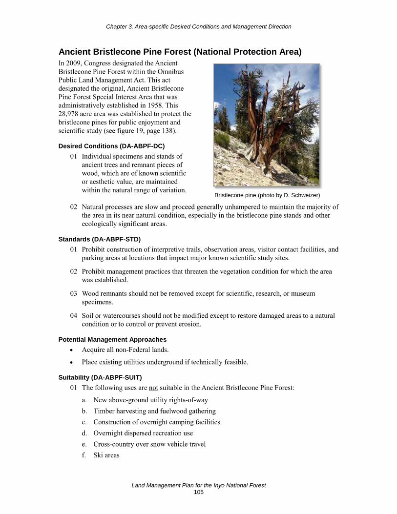
Chapter 3. Area-specific Desired Conditions and Management Direction
Land Management Plan for the Inyo National Forest 105
Ancient Bristlecone Pine Forest (National Protection Area) In 2009, Congress designated the Ancient Bristlecone Pine Forest within the Omnibus Public Land Management Act. This act designated the original, Ancient Bristlecone Pine Forest Special Interest Area that was administratively established in 1958. This 28,978 acre area was established to protect the bristlecone pines for public enjoyment and scientific study (see figure 19, page 138).
Desired Conditions (DA-ABPF-DC) 01 Individual specimens and stands of
ancient trees and remnant pieces of wood, which are of known scientific or aesthetic value, are maintained within the natural range of variation.
Bristlecone pine (photo by D. Schweizer)
02 Natural processes are slow and proceed generally unhampered to maintain the majority of the area in its near natural condition, especially in the bristlecone pine stands and other ecologically significant areas.
Standards (DA-ABPF-STD) 01 Prohibit construction of interpretive trails, observation areas, visitor contact facilities, and
parking areas at locations that impact major known scientific study sites.
02 Prohibit management practices that threaten the vegetation condition for which the area was established.
03 Wood remnants should not be removed except for scientific, research, or museum specimens.
04 Soil or watercourses should not be modified except to restore damaged areas to a natural condition or to control or prevent erosion.
Potential Management Approaches • Acquire all non-Federal lands.
• Place existing utilities underground if technically feasible.
Suitability (DA-ABPF-SUIT) 01 The following uses are not suitable in the Ancient Bristlecone Pine Forest:
a. New above-ground utility rights-of-way b. Timber harvesting and fuelwood gathering c. Construction of overnight camping facilities d. Overnight dispersed recreation use e. Cross-country over snow vehicle travel f. Ski areas
Chapter 3. Area-specific Desired Conditions and Management Direction
Land Management Plan for the Inyo National Forest 106
g. Commercial enterprise sites and major utility corridors h. Commercial harvesting of nontimber forest products i. Mineral resources exploration and development
Pacific Crest National Scenic Trail Plan components for the Pacific Crest National Scenic Trail (also referred to as just the “Pacific Crest Trail”) are organized under the “Pacific Crest National Scenic Trail Corridor” management area section in chapter 3, page 93.
In 1968, Congress designated the Pacific Crest National Scenic Trail, which is a continuous long distance trail from the Mexican border near Campo, California to the Canadian Border at Boundary Monument 78 near Manning Provincial Park, Canada. The Inyo National Forest manages 80 miles of the Pacific Crest Trail, 96 percent of which are in wilderness.
The Pacific Crest National Scenic Trail Comprehensive Plan was signed in 1982 by the Chief of the Forest Service; national forests are expected to integrate the direction and guidance provided by this plan into their land management planning process.
Inventoried Roadless Areas Inventoried roadless areas are the result of an inventory produced by the Forest Service that in 2001, resulted in agency regulations, known collectively as the Roadless Rule. About 26 percent of the Inyo National Forest has been designated as inventoried roadless areas, as governed by the Roadless Area Conservation Rule (36 CFR 294 Subpart B). The Roadless Area Conservation Rule and Forest Service policy guide and restrict management activities within inventoried roadless areas. Subject to the restrictions imposed by the Rule, forestwide plan components apply to inventoried roadless areas, so there are no specific plan components here.
National Recreation Trails The Secretary of Agriculture has designated three national recreation trails on the Inyo National Forest: the Whitney Portal, Discovery, and Methuselah National Recreation Trails. The Whitney Portal National Recreation Trail was established to protect the historic and scenic values of the original trail between the town of Lone Pine and the summit of Mount Whitney. The Discovery and Methuselah National Recreation Trails are located within the Ancient Bristlecone Pine Forest.
Desired Conditions (DA-NRT-DC) 01 National recreation trails meet the intended goals and preserve the values and recreation
opportunities for which they were established.
02 The trail setting provides a variety of opportunities that complement the existing recreation opportunity spectrum class where the trail segment is located.
03 Foreground views from the trail meet a scenic integrity objective at least as high as shown on the minimum scenic integrity map. Middle and background views meet or exceed a scenic integrity objective of at least moderate.
04 National recreation trails meet trail management objectives and the maintenance standards for trail class and managed use.

Chapter 3. Area-specific Desired Conditions and Management Direction
Land Management Plan for the Inyo National Forest 107
Research Natural Areas The regional forester with concurrence of the research station director designates research natural areas. The purpose of research natural areas is to maintain biological diversity and to contribute to a network of representative ecosystems across the nation. Research natural areas are intended to provide ecological baseline data, and to be used for education and research that results in improved management of all National Forest System lands.
The Inyo National Forest has seven established research natural areas: Harvey Monroe Hall, Indiana Summit, Last Chance Meadow, McAfee, Sentinel Meadow, Whippoorwill Flat, and White Mountain Research Natural Areas (see figure 19, page 138). These research natural areas represent specific target elements, including alpine meadows, Sierran mixed subalpine forest, Jeffrey pine, foxtail pine, alpine fell-field, lodgepole pine, pinyon-juniper, and bristlecone pine. Management of research natural areas is guided by individual management plans and by direction provided in the Forest Service Manual (FSM 4063).
Standards and guidelines for constraints on fire management activities within research natural areas are included under the forestwide components for “Fire” in chapter 2.
Desired Conditions (DA-RNA-DC) 01 Research natural areas have excellent examples of the ecological features and values for
which they were established. They are generally natural appearing, and ecological processes such as plant succession, fire, and insect and disease activity function with limited human influences. They serve as areas for the study of ecosystems and ecological processes, including succession, and as baseline areas for measuring ecological change due to disturbances or stressors like climate change.
Goal (DA-RNA-GOAL) 01 All qualified botanical, aquatic and geologic research natural area candidates are
identified and recommended for establishment.
Suitability (DA-RNA-SUIT) 01 The following uses are not suitable in research natural areas:
a. Developed or dispersed recreation sites b. Over-snow vehicle travel c. Timber production or wood gathering d. Developed facilities e. New roads, trails, fences, or signs (unless they contribute to the objectives or
protection of the research natural area) f. Alteration of the groundwater system g. Sales or extraction of common variety minerals h. Livestock grazing (except where grazing is essential for the maintenance of a specific
vegetation types)
Potential Management Approaches • Allow natural processes to prevail, such as avalanches, floods, fires, wind events, and
drought. Manage pests only when necessary to preserve the values for which the research

Chapter 3. Area-specific Desired Conditions and Management Direction
Land Management Plan for the Inyo National Forest 108
natural area was established. Use prescribed fire where it would preserve the values for which the research natural area was established.
• Coordinate with the California Department of Fish and Wildlife to leave all waterways unstocked.
• Recommend and/or maintain withdrawal from mineral entry.
Scenic Byways Two national forest scenic byways have been administratively designated on the Inyo National Forest. Lee Vining Canyon Scenic Byway is located along Highway 120, stretching between Highway 395 (at 6,781 feet in elevation near the town of Lee Vining and Mono Lake) and the Yosemite Park entrance. The Ancient Bristlecone Scenic Byway is located along Route 168 and Forest Road 4S01; this route rises more than 6,000 feet in elevation from Owens Valley to the Patriarch Grove located within the Ancient Bristlecone Pine Forest Botanical Special Interest Area. Management direction for scenic byways is in the “Scenery” section of chapter 2 on page 55.
Wild Horse and Burro Territories Three administratively designated wild horse and burro territories occur on the Inyo National Forest: Montgomery Pass, White Mountain, and Saline Valley Wild Horse and Burro Territories (see figure 20, page 139). These three territories were established with the passage of the Wild Horse and Burro Act of 1971. Management of wild horse and burro territories is guided by individual management plans.
Montgomery Pass Wild Horse Territory comprises an area of 207,921 acres in California and Nevada, including 65,942 acres on the Inyo National Forest. The remaining territory acres occur on the Humboldt-Toiyabe National Forest, and Stillwater and Bishop Field Offices of the Bureau of Land Management. It is located east of Mono Lake, in the southern portion of the Excelsior Mountains, approximately 37 miles north of Bishop, California. It crosses the north end of the White Mountains at Montgomery Pass, and is bounded by State Highway 6 to the southeast. It is situated north of State Highway 120 and bounded by Deep Wells Road to the west. The northern boundary in Nevada extends from Granite Springs southeasterly to State Highway 10. Montgomery Pass Wild Horse Territory is managed for a wild horse herd size of 138 to 230 animals. There are no wild burros in this wild horse joint management area.
White Mountain Wild Horse Territory comprises an area of 265,820 acres in California and Nevada, including 181,820 acres on the Inyo National Forest. The remaining territory acres are associated with the Bureau of Land Management’s Fish Lake Valley Herd Management Area that is administered by the Tonopah Field Office in Nevada. White Mountain Wild Horse Territory is managed for a wild horse herd size of 70 to 80 animals. The territory runs along the east side of the White Mountains crest from Montgomery Pass Wild Horse Territory, along Highway 6 in the north to Highway 168 and Deep Springs in the south. There are no wild burros in this wild horse joint management area.

Chapter 3. Area-specific Desired Conditions and Management Direction
Land Management Plan for the Inyo National Forest 109
Saline Valley Wild Burro Territory includes 27,721 acres along the eastern slopes of the Inyo Mountains and is associated with the Bureau of Land Management’s 23,000 acre Waucoba-Hunter Mountain Herd Management Area, administered by the Ridgecrest Field Office. This burro territory is managed for a small wild burro herd size of 11 animals. The territory management area borders Death Valley National Park, which is known for its hot and dry terrain. A large portion of this joint management area transferred to the National Park Service with passage of the California Desert Protection Act in 1994, but is managed by the Bureau of Land Management. There are no wild horses present in this wild burro joint management area.
Goal (DA-WHT-GOAL) 01 Continue working with other agencies and Forest Service units, such as the Bureau of
Land Management and the Humboldt-Toiyabe National Forest, and other partners or collaborative groups to manage wild horse herds or in the development of wild horse management plans.
Potential Management Approach • Continue to monitor wild horse populations to determine numbers and use.

This page left intentionally blank
Chapter 4. Forest Plan Monitoring
Land Management Plan for the Inyo National Forest 111
Chapter 4. Forest Plan Monitoring
Introduction Monitoring forms the basis for continuous improvement of the forest plan and provides information for adaptive management within the plan area. The forest plan monitoring program enables the responsible official to help determine where and when changes are needed in the forest plan.
The forest plan monitoring program measures management effectiveness and assesses progress toward achieving or maintaining the forest plan desired conditions and objectives through a set of monitoring questions and associated indicators. These are designed to inform management of resources in the plan area, including testing relevant assumptions, tracking relevant changes, and measuring management effectiveness. By using appropriate indicators that can be measured, observed, or described over time, management actions can be evaluated to determine if they are trending conditions toward the anticipated results. Not every plan component will have a corresponding monitoring question or indicator because monitoring in the plan monitoring program is focused on priority management questions and related core information that are achievable within the financial and technical capability of the Inyo National Forest.
The plan monitoring program is just one piece of the monitoring that occurs within the national forest and region; project and activity monitoring, and resource or species monitoring conducted by other agencies and organizations may inform the plan monitoring program and adaptive management of the plan. To address plan monitoring program questions and associated indicators that can best be answered at a broader geographic scale than one plan area, the Regional Forester shall develop a broader-scale monitoring strategy. The intent of the broader-scale monitoring strategy is to inform decisionmaking regarding the effectiveness of the forest plan, within the context of an all-lands approach, and realize efficiencies by coordinating similar monitoring across units, integrating agency protocols and leveraging partner and adjacent landowner monitoring work.
The monitoring program outlined below considers the 2014 science synthesis10 and 2013 forest plan assessment.11 Existing national and regional monitoring programs, like the Forest Inventory and Analysis National Program, the National Visitor Use Monitoring Program, the current forest plan monitoring, and ongoing monitoring with the States contribute to the plan monitoring program. Monitoring is also coordinated with other Forest Service program mission areas (such as Forest Service State and Private Forestry and Research and Development), other Federal and State agencies, Tribes, partners, and the public.
Monitoring information will be collected every year for many, but not all, monitoring questions and evaluated every 2 years. The first evaluation report is anticipated no later than 2 years after the effective date of the forest plan decision. This biennial evaluation includes information
10 Long, Jonathan W.; Quinn-Davidson, Lenya; Skinner, Carl N., eds. 2014. Science synthesis to support
socioecological resilience in the Sierra Nevada and southern Cascade Range. Gen. Tech. Rep. PSW-GTR-247. Albany, CA: U.S. Department of Agriculture, Forest Service, Pacific Southwest Research Station. 723 p.
11 USDA, Forest Service. 2013. Final Inyo National Forest assessment. U.S. Department of Agriculture, Forest Service, Pacific Southwest http://www.fs.usda.gov/detail/r5/landmanagement/planning/?cid=STELPRD3802842

Chapter 4. Forest Plan Monitoring
Land Management Plan for the Inyo National Forest 112
gathered through this plan monitoring program and may include relevant information from the Pacific Southwest Region’s broader-scale monitoring strategy. A written report of the evaluation will be made available to the public. The evaluation will identify if changes are needed to the plan or plan monitoring program, or whether a new assessment is needed, or if no changes are warranted at that time. Where frequency of monitoring is longer than 2 years, evaluation of that information will be made in the next biennial evaluation. For example, a data collection program that takes place once every 5 years, will then be included in every third evaluation report.
The plan monitoring program contains one or more monitoring questions and associated indicators addressing each of the eight following topics:
1. The status of select watershed conditions.
2. The status of select ecological conditions including key characteristics of terrestrial and aquatic ecosystems.
3. The status of focal species to assess the ecological conditions required under the Code of Federal Regulations, specifically 36 CFR 219.9.
4. The status of a select set of ecological conditions required under 36 CFR 219.9 to contribute to the recovery of federally listed threatened and endangered species, conserve proposed and candidate species, and maintain a viable population of each species of conservation concern.
5. The status of visitor use, visitor satisfaction, and progress toward meeting recreation objectives.
6. Measurable changes on the plan area related to climate change and other stressors that may be affecting the plan area.
7. Progress toward meeting the desired conditions and objectives in the plan, including for providing multiple use opportunities.
8. The effects of each management system to determine that they do not substantially and permanently impair the productivity of the land (16 U.S.C. 1604(g)(3)(C)).
Some monitoring questions and associated indicators may address more than one of these required topics. The entire plan monitoring program must be within the financial and technical capability of the Inyo National Forest, augmented by broader-scale monitoring by the Pacific Southwest Region and other monitoring with partners.
The plan monitoring program for the Inyo National Forest is presented below in a set of tables, each related to one of the eight required topics previously listed. For clarity, monitoring questions for terrestrial ecosystems and aquatic ecosystems are presented in separate tables. In the tables, each row represents a single monitoring question and associated indicators used to respond to a selected desired condition or objective. The desired conditions are generally complex statements that cannot be fully monitored. Therefore, the monitoring questions and associated indicators focus on some core aspect of the desired condition related to the required monitoring item and that are practicable to be monitored. Details of the plan monitoring program—including monitoring and analysis protocols, data collection schedules, responsible parties, and data management—will be part of a separate monitoring guide.

Chapter 4. Forest Plan Monitoring
Land Management Plan for the Inyo National Forest 113
Inyo National Forest Plan Monitoring Program
Watershed Conditions These monitoring questions and their associated indicators are related to water resources and watershed conditions in the plan area. The geographic scale may extend beyond the plan area and may include receiving areas for water that flows from the plan area to outside the plan area.
Table 18. Monitoring questions and associated indicators that evaluate select watershed conditions
Code Selected Desired Condition and Objective or Other Plan Component Monitoring Question Associated Indicators
WS01 WTR-FW-DC-03 Watersheds are fully functioning or trending toward fully functioning and resilient; recover from natural and human disturbances at a rate appropriate with the capability of the site; and have a high degree of hydrologic connectivity laterally across the floodplain and valley bottom and vertically between surface and subsurface flows. Physical (geomorphic, hydrologic) connectivity and associated surface processes (such as runoff, flooding, in-stream flow regime, erosion, and sedimentation) are maintained and restored. Watersheds provide important ecosystem services such as high quality water, recharge of streams and shallow groundwater, and maintenance of riparian communities. Watersheds sustain long-term soil productivity.
To what extent are watersheds in proper functioning condition being maintained, and watersheds in altered or impaired condition being improved?
• Watershed Condition Framework classification
WS02 WTR-FW-DC-05 Infrastructure (administrative sites, recreation facilities, and roads) has minimal adverse effects to riparian and aquatic resources.
To what extent has erosion from temporary and permanent roads and trails affected water quality and soil sustainability in the national forest?
• Road and motorized trail condition
• Implementation and effectiveness monitoring results from the Best Management Practice Evaluation Program
• Number and type of stream crossing and bank stabilization projects
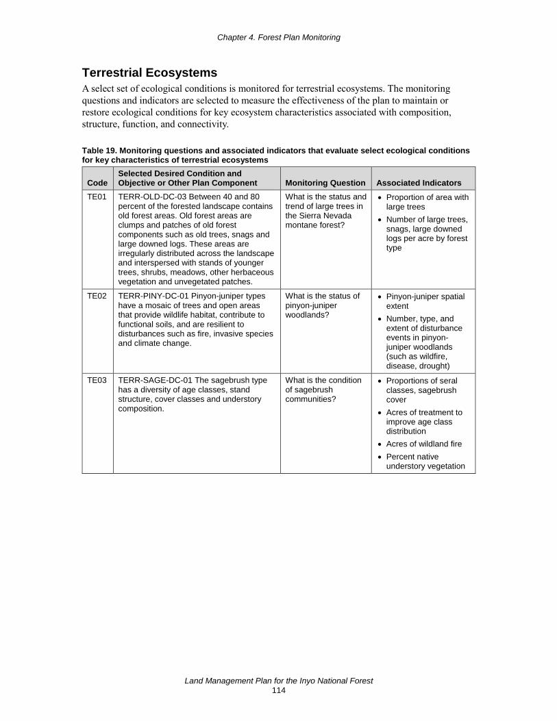
Chapter 4. Forest Plan Monitoring
Land Management Plan for the Inyo National Forest 114
Terrestrial Ecosystems A select set of ecological conditions is monitored for terrestrial ecosystems. The monitoring questions and indicators are selected to measure the effectiveness of the plan to maintain or restore ecological conditions for key ecosystem characteristics associated with composition, structure, function, and connectivity.
Table 19. Monitoring questions and associated indicators that evaluate select ecological conditions for key characteristics of terrestrial ecosystems
Code Selected Desired Condition and Objective or Other Plan Component Monitoring Question Associated Indicators
TE01 TERR-OLD-DC-03 Between 40 and 80 percent of the forested landscape contains old forest areas. Old forest areas are clumps and patches of old forest components such as old trees, snags and large downed logs. These areas are irregularly distributed across the landscape and interspersed with stands of younger trees, shrubs, meadows, other herbaceous vegetation and unvegetated patches.
What is the status and trend of large trees in the Sierra Nevada montane forest?
• Proportion of area with large trees
• Number of large trees, snags, large downed logs per acre by forest type
TE02 TERR-PINY-DC-01 Pinyon-juniper types have a mosaic of trees and open areas that provide wildlife habitat, contribute to functional soils, and are resilient to disturbances such as fire, invasive species and climate change.
What is the status of pinyon-juniper woodlands?
• Pinyon-juniper spatial extent
• Number, type, and extent of disturbance events in pinyon-juniper woodlands (such as wildfire, disease, drought)
TE03 TERR-SAGE-DC-01 The sagebrush type has a diversity of age classes, stand structure, cover classes and understory composition.
What is the condition of sagebrush communities?
• Proportions of seral classes, sagebrush cover
• Acres of treatment to improve age class distribution
• Acres of wildland fire • Percent native
understory vegetation

Chapter 4. Forest Plan Monitoring
Land Management Plan for the Inyo National Forest 115
Aquatic Ecosystems A select set of ecological conditions are monitored for riparian and aquatic ecosystems. The monitoring questions and indicators are selected to measure the effectiveness of the plan to maintain or restore ecological conditions for key ecosystem characteristics associated with composition, structure, function and connectivity.
Table 20. Monitoring questions and associated indicators that evaluate select ecological conditions for key characteristics of aquatic ecosystems
Code Selected Desired Condition and Objective or Other Plan Component
Monitoring Question Associated Indicators
AE01 RCA-MEAD-DC-05 Meadows have substantive ground cover and a rich and diverse species composition, especially of grasses and forbs. Meadows have high plant functional diversity with multiple successional functional types represented. Perennial streams in meadows contain a diversity of age classes of shrubs along the streambank, where the potential exists for these plants.
What is the vegetative condition of selected grazed and ungrazed meadows?
• Rangeland ecological condition
• Species richness, species diversity, and plant functional groups
• Range greenline monitoring
• Vegetation community types
AE02 MA-RCA-DC-05 Riparian areas provide a range of substrates to sustain habitat for a variety of aquatic and terrestrial fauna within the natural capacity of the system. MA-RCA-DC-06 Soil structure and function is sustained to infiltrate and disperse water properly, withstand erosive forces, sustain favorable conditions of stream flow, and cycle nutrients. Associated water tables support riparian vegetation and restrict nonriparian vegetation.
To what extent are riparian areas functioning properly across different management areas and levels of disturbance.
• Vegetation cover, structure, and composition
• Floodplain and channel physical characteristics
AE03 WTR-FW-DC-02. Water quality supports State-designated beneficial uses of water and is sustained at a level that retains the biological, physical, and chemical integrity of aquatic systems and benefits the survival, growth, reproduction and migration of native aquatic and riparian species.
What is the status of water quality in national forest waterbodies?
• Indicator bacteria levels
• 303(d) status
Focal Species Focal species are a small subset of species whose status represents indicators of the integrity of the larger ecological system to which they belong. Focal species monitoring provides information regarding the effectiveness of the plan in providing the ecological conditions necessary to maintain the diversity of plant and animal communities and the persistence of native species in the plan area. They should act as indicators for the attributes of community composition, structure, connectivity or function, or factors that regulate them.
An effective focal species, or assemblage of species, will be sensitive to the ecosystem components or habitat attributes of concern. There are a few key qualities of well-selected focal species: the species is taxonomically well known and stable; the species is specialized within a narrow habitat; and the species is a permanent resident (migrants are subject to a variety of sources of mortality and stress on their wintering grounds and during migration). A focal species could be a keystone species, an ecological engineer, an umbrella species, a link species, or a

Chapter 4. Forest Plan Monitoring
Land Management Plan for the Inyo National Forest 116
species of conservation concern, but need not be any of these species categories. Monitoring questions should relate the species to the ecological condition and reason for its selection, and indicators may include affected attributes of the species, such as presence or occupancy, habitat use, reproductive rate, and population trends. If the focal species’ sensitivity to habitat changes cannot be directly attributable to a cause-and-effect relationship, then the influence of habitat change on the focal species may not be separable from the influence of other factors on the species, such as climate change, predation, disease, or competition.
Focal species, as used by the Forest Service, are not meant to act as surrogates for other species. Focal species monitoring is also not the same as monitoring those species in which we have a particular interest, such as threatened or endangered species, invasive species, or other species for which we deliberately manage the landscape.
Focal species are intended to reduce the cost and effort of ecosystem monitoring and should only be used when direct measurement of resources is not efficient or practical.
Table 21. Monitoring questions and associated indicators that evaluate the status of focal species to assess the ecological conditions required under section 219.9
Code
Selected Desired Condition and Objective or Other Plan Component Monitoring Question Associated Indicators
FS01 TERR-SAGE-DC-02 Sagebrush ecosystems are resilient to fire and other disturbances including grazing, recreation, invasive species (including cheatgrass) and climate change. TERR-PINY-DC-01 Pinyon-juniper types have a mosaic of trees and open areas that provide wildlife habitat, contribute to functional soils, and are resilient to disturbances such as fire, invasive species and climate change. SPEC-SG-DC-06 The extent and dominance of nonnative annual grass species, such as cheatgrass, is limited and does not lead toward reduction in the suitability of sage-grouse habitat.
How is the abundance of Cheatgrass and red brome (nonnative Bromus spp.) changing?
• Spatial extent and percent cover
FS02 WTR-FW-DC-02 Water quality supports State-designated beneficial uses of water. Water quality is sustained at a level that retains the biological, physical, and chemical integrity of aquatic systems and benefits the survival, growth, reproduction and migration of native aquatic and riparian species.
How are aquatic benthic macroinvertebrate communities indicating stream ecosystem integrity is being maintained in high quality waters or improved in degraded waters?
• Benthic macroinvertebrate diversity, species composition, and related metrics
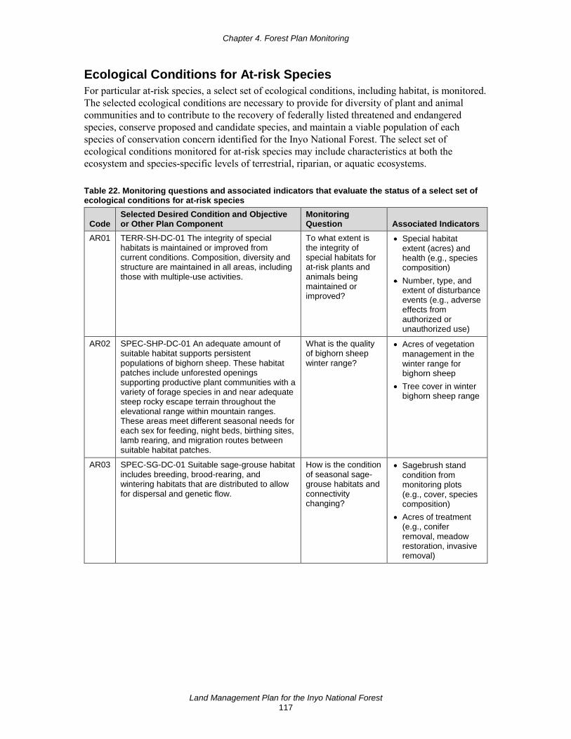
Chapter 4. Forest Plan Monitoring
Land Management Plan for the Inyo National Forest 117
Ecological Conditions for At-risk Species For particular at-risk species, a select set of ecological conditions, including habitat, is monitored. The selected ecological conditions are necessary to provide for diversity of plant and animal communities and to contribute to the recovery of federally listed threatened and endangered species, conserve proposed and candidate species, and maintain a viable population of each species of conservation concern identified for the Inyo National Forest. The select set of ecological conditions monitored for at-risk species may include characteristics at both the ecosystem and species-specific levels of terrestrial, riparian, or aquatic ecosystems.
Table 22. Monitoring questions and associated indicators that evaluate the status of a select set of ecological conditions for at-risk species
Code Selected Desired Condition and Objective or Other Plan Component
Monitoring Question Associated Indicators
AR01 TERR-SH-DC-01 The integrity of special habitats is maintained or improved from current conditions. Composition, diversity and structure are maintained in all areas, including those with multiple-use activities.
To what extent is the integrity of special habitats for at-risk plants and animals being maintained or improved?
• Special habitat extent (acres) and health (e.g., species composition)
• Number, type, and extent of disturbance events (e.g., adverse effects from authorized or unauthorized use)
AR02 SPEC-SHP-DC-01 An adequate amount of suitable habitat supports persistent populations of bighorn sheep. These habitat patches include unforested openings supporting productive plant communities with a variety of forage species in and near adequate steep rocky escape terrain throughout the elevational range within mountain ranges. These areas meet different seasonal needs for each sex for feeding, night beds, birthing sites, lamb rearing, and migration routes between suitable habitat patches.
What is the quality of bighorn sheep winter range?
• Acres of vegetation management in the winter range for bighorn sheep
• Tree cover in winter bighorn sheep range
AR03 SPEC-SG-DC-01 Suitable sage-grouse habitat includes breeding, brood-rearing, and wintering habitats that are distributed to allow for dispersal and genetic flow.
How is the condition of seasonal sage-grouse habitats and connectivity changing?
• Sagebrush stand condition from monitoring plots (e.g., cover, species composition)
• Acres of treatment (e.g., conifer removal, meadow restoration, invasive removal)
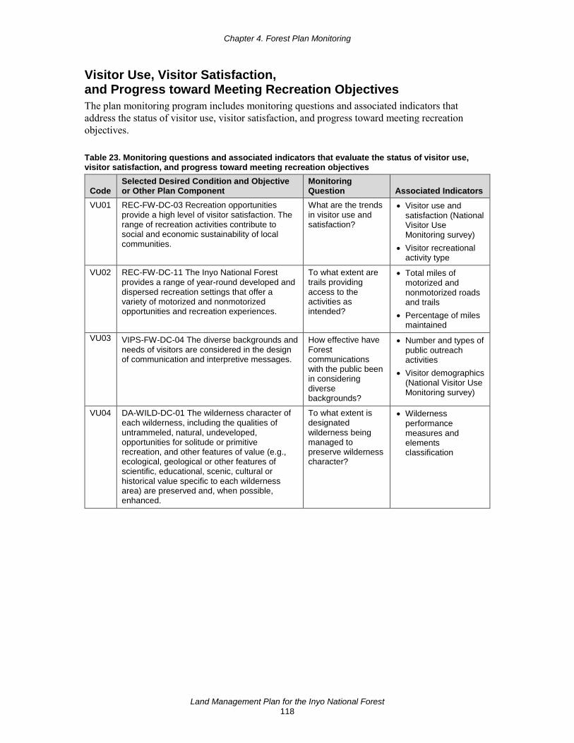
Chapter 4. Forest Plan Monitoring
Land Management Plan for the Inyo National Forest 118
Visitor Use, Visitor Satisfaction, and Progress toward Meeting Recreation Objectives The plan monitoring program includes monitoring questions and associated indicators that address the status of visitor use, visitor satisfaction, and progress toward meeting recreation objectives.
Table 23. Monitoring questions and associated indicators that evaluate the status of visitor use, visitor satisfaction, and progress toward meeting recreation objectives
Code Selected Desired Condition and Objective or Other Plan Component
Monitoring Question Associated Indicators
VU01 REC-FW-DC-03 Recreation opportunities provide a high level of visitor satisfaction. The range of recreation activities contribute to social and economic sustainability of local communities.
What are the trends in visitor use and satisfaction?
• Visitor use and satisfaction (National Visitor Use Monitoring survey)
• Visitor recreational activity type
VU02 REC-FW-DC-11 The Inyo National Forest provides a range of year-round developed and dispersed recreation settings that offer a variety of motorized and nonmotorized opportunities and recreation experiences.
To what extent are trails providing access to the activities as intended?
• Total miles of motorized and nonmotorized roads and trails
• Percentage of miles maintained
VU03 VIPS-FW-DC-04 The diverse backgrounds and needs of visitors are considered in the design of communication and interpretive messages.
How effective have Forest communications with the public been in considering diverse backgrounds?
• Number and types of public outreach activities
• Visitor demographics (National Visitor Use Monitoring survey)
VU04 DA-WILD-DC-01 The wilderness character of each wilderness, including the qualities of untrammeled, natural, undeveloped, opportunities for solitude or primitive recreation, and other features of value (e.g., ecological, geological or other features of scientific, educational, scenic, cultural or historical value specific to each wilderness area) are preserved and, when possible, enhanced.
To what extent is designated wilderness being managed to preserve wilderness character?
• Wilderness performance measures and elements classification

Chapter 4. Forest Plan Monitoring
Land Management Plan for the Inyo National Forest 119
Climate Change and Other Stressors The plan monitoring program includes monitoring questions and associated indicators to determine whether there are measurable changes on the plan area resulting from climate change and other stressors.
Table 24. Monitoring questions and associated indicators that measure changes on the plan area related to climate change and other stressors that may be affecting the plan area
Code Selected Desired Condition and Objective or Other Plan Component
Monitoring Question
Associated Indicators
CC01 TERR-ALPN-DC-03 Subalpine woodlands are resilient to insects, diseases, fire, wind and climate change. High-elevation white pines (e.g., whitebark pine, Great Basin bristlecone pine, limber pine and foxtail pine) are healthy and vigorous, with a low incidence of white pine blister rust, and resilient to moisture stress and drought. White pine blister rust-resistant trees are regenerating and populations of high elevation white pines have the potential to expand above the tree line.
How are high-elevation white pines responding to the effects of climate change and other stressors?
• Spatial extent, by forest type
• Tree mortality, incidence of insects, disease, and pathogens
• Spatial extent of tree regeneration
CC02 WTR-FW-DC-01 Adequate quantity and timing of water flows support ecological structure and functions, including aquatic species diversity and native riparian vegetation. Watersheds are resilient to changes in air temperatures, snowpack, timing of runoff, and other effects of climate change.
What changes have occurred to the timing, amount, and duration of natural and managed runoff into the national forest’s waterways?
• Annual in-stream flow regime for selected waterways (not those regulated by the Federal Energy Regulatory Commission)
CC03 FIRE-FW-DC-01 Wildland fires burn with a range of intensity, severity, and frequency that allows ecosystems to function in a healthy and sustainable manner. Wildland fire is a necessary process, integral to the sustainability of fire-adapted ecosystems.
How are fire regimes changing compared to the desired conditions and the natural range of variation?
• Fire return interval departure
• Number and acres of fire by ecosystem type
• Fire severity by ecosystem type

Chapter 4. Forest Plan Monitoring
Land Management Plan for the Inyo National Forest 120
Progress toward Meeting the Desired Conditions, Objectives, or other Plan Components Progress toward meeting desired conditions, objectives, or other plan components that do not fall under one of the other eight required items are included in the monitoring program. Specifically, the plan monitoring program must contain one or more questions and associated indicators addressing the plan contributions to communities, social and economic sustainability of communities, multiple-use management in the plan area, or progress toward meeting the desired conditions and objectives related to social and economic sustainability.
Table 25. Monitoring questions and associated indicators that evaluate progress toward meeting the desired conditions and objectives in the plan, including providing for meeting multiple-use opportunities
Code Selected Desired Condition and Objective or Other Plan Component Monitoring Question Associated Indicators
PC01 LOC-FW-DC-03 National forest uses such as recreation, forest products, mining, and grazing are provided in an ecologically sustainable way that also contributes to economic and social sustainability in local communities.
What are the economic conditions in local communities that could affect the impact of national forest contributions to local economies?
• Economic health • Economic diversity • Local fiscal
conditions
PC02 LOC-FW-DC-03 National forest uses such as recreation, forest products, mining, and grazing are provided in an ecologically sustainable way that also contributes to economic and social sustainability in local communities.
What economic contributions are national forest-based recreation, forest products, mining and grazing making to local communities?
• Conditions in forest-based sectors
• Forest contributions
PC03 FIRE-FW-GOAL-01 Reduce fuel accumulations, help maintain and protect habitat for a variety of species, reduce smoke from larger fires, provide added protection for communities, and restore fire on the landscape. These actions are also an integral part of achieving sustainable recreation, particularly by maintaining scenic attractiveness, integrity, and character.
What management actions are contributing to the achievement of desired conditions relating to fire regimes?
• Acres of fires managed for resource objectives by ecosystem type
• Acres of fire by objective within each fire management zone
• Acres of prescribed fire
• Acres of mechanical treatment
PC04 VIPS-FW-DC-01 The Inyo has a network of dependable partners and volunteers who provide additional capacity to effectively and efficiently meet plan desired conditions and deliver services to the public.
To what degree is the national forest using partnerships to provide additional capacity for visitor services?
• Number of agreements with partners, by activity type, that are supporting visitor services
• Number and type of projects completed with partners

Chapter 4. Forest Plan Monitoring
Land Management Plan for the Inyo National Forest 121
Productivity of the Land This monitoring requirement comes from the National Forest Management Act requirement that there be research regarding the effects of timber management systems on the productivity of the land, and that such research is to be based on continuous monitoring and assessment in the field. Monitoring is focused on key ecosystem characteristics related to soils and soil productivity.
Table 26. Monitoring questions and associated indicators that evaluate the effects of each management system to determine that they do not substantially and permanently impair the productivity of the land*
Code Selected Desired Condition and Objective or Other Plan Component
Monitoring Question
Associated Indicators
PR01 WTR-FW-DC-04 Soil and vegetation functions in upland and riparian areas are sustained and resilient. Healthy soils provide the base for resilient landscapes and nutritive forage for browsing and grazing animals, and support timber production. Healthy upland and riparian areas support healthy fish and wildlife populations, enhance recreation opportunities, and maintain water quality.
How does soil disturbance differ from pre- and post-activity for timber management?
• Soil compaction, displacement, and erosion
* 16 U.S.C. 1604(g)(3)(C)

This page left intentionally blank

Land Management Plan for the Inyo National Forest 123
Appendix Appendix A: Maps (Note: this appendix is in an 11-inch by 17-inch format) ............................. 125
Appendix B: Proposed and Possible Actions ............................................................................... 141
Appendix C: A Renewed Partnership focus for the Inyo National Forest .................................... 149
Appendix D: Timber Suitability and Management ....................................................................... 155
Appendix E: Rangeland Management .......................................................................................... 163
Appendix F: Existing Resource Plans .......................................................................................... 167

This page left intentionally blank

Land Management Plan for the Inyo National Forest 125
Appendix A: Maps
Recreation Opportunity Spectrum
Figure 6. Recreation opportunity spectrum map for summer recreation opportunities and setting on the Inyo National Forest
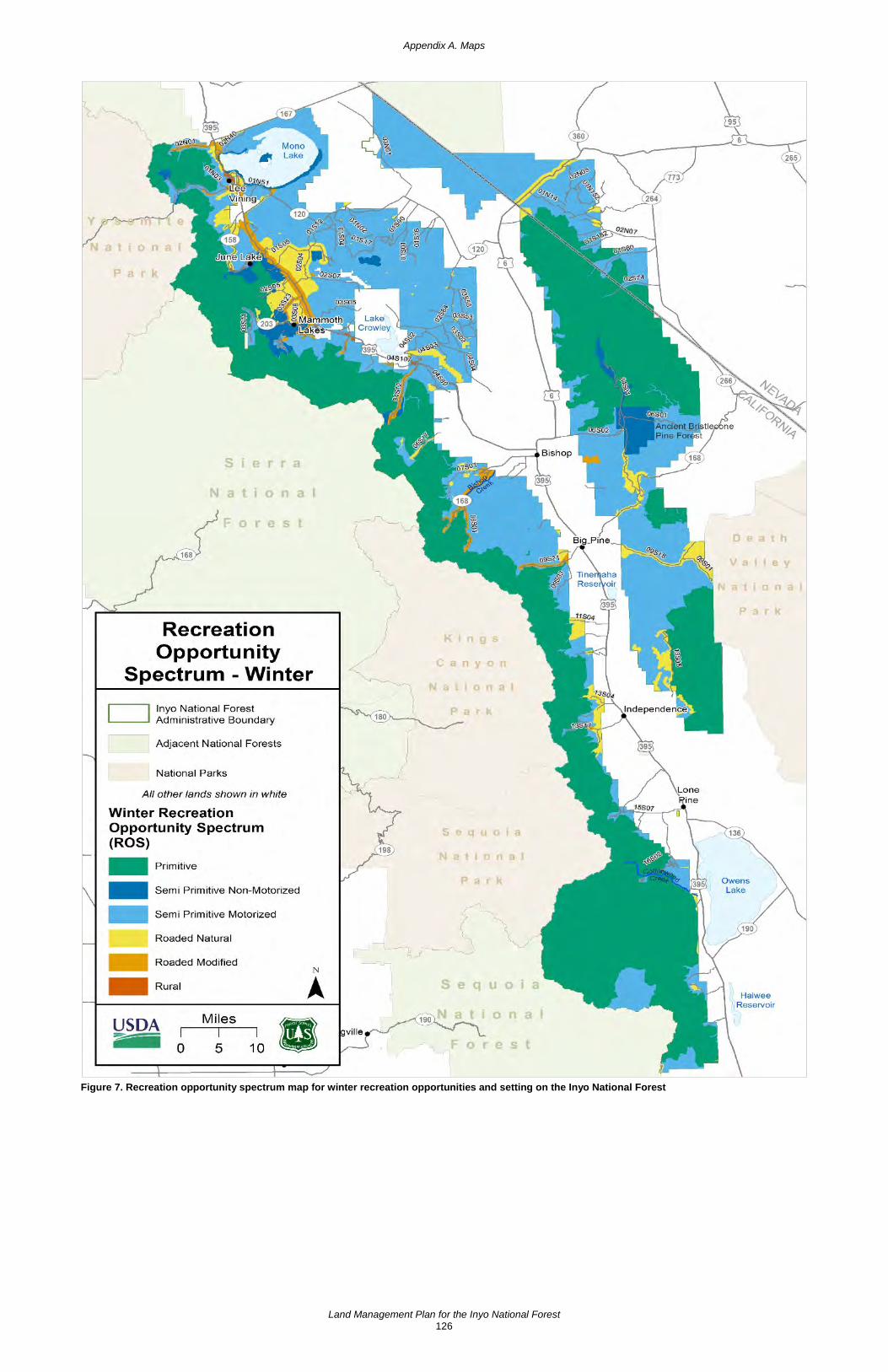
Appendix A. Maps
Land Management Plan for the Inyo National Forest 126
Figure 7. Recreation opportunity spectrum map for winter recreation opportunities and setting on the Inyo National Forest

Appendix A. Maps
Land Management Plan for the Inyo National Forest 127
Scenic Integrity Objectives
Figure 8. Scenic integrity objectives map for the Inyo National Forest
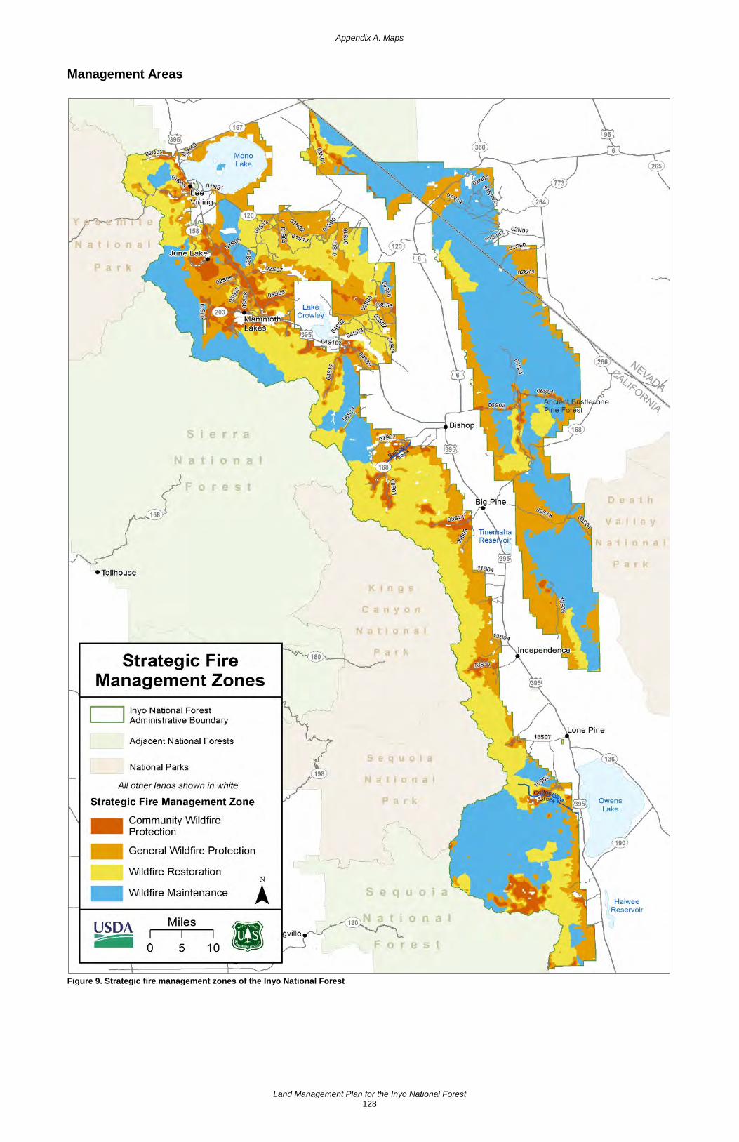
Appendix A. Maps
Land Management Plan for the Inyo National Forest 128
Management Areas
Figure 9. Strategic fire management zones of the Inyo National Forest
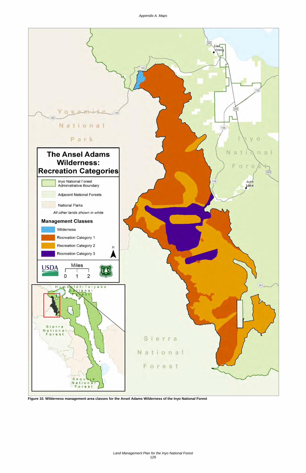
Appendix A. Maps
Land Management Plan for the Inyo National Forest 129
Figure 10. Wilderness management area classes for the Ansel Adams Wilderness of the Inyo National Forest

Appendix A. Maps
Land Management Plan for the Inyo National Forest 130
Figure 11. Wilderness management area classes for the John Muir Wilderness of the Inyo National Forest

Appendix A. Maps
Land Management Plan for the Inyo National Forest 131
Figure 12. Wilderness management area classes for the South Sierra Wilderness of the Inyo National Forest
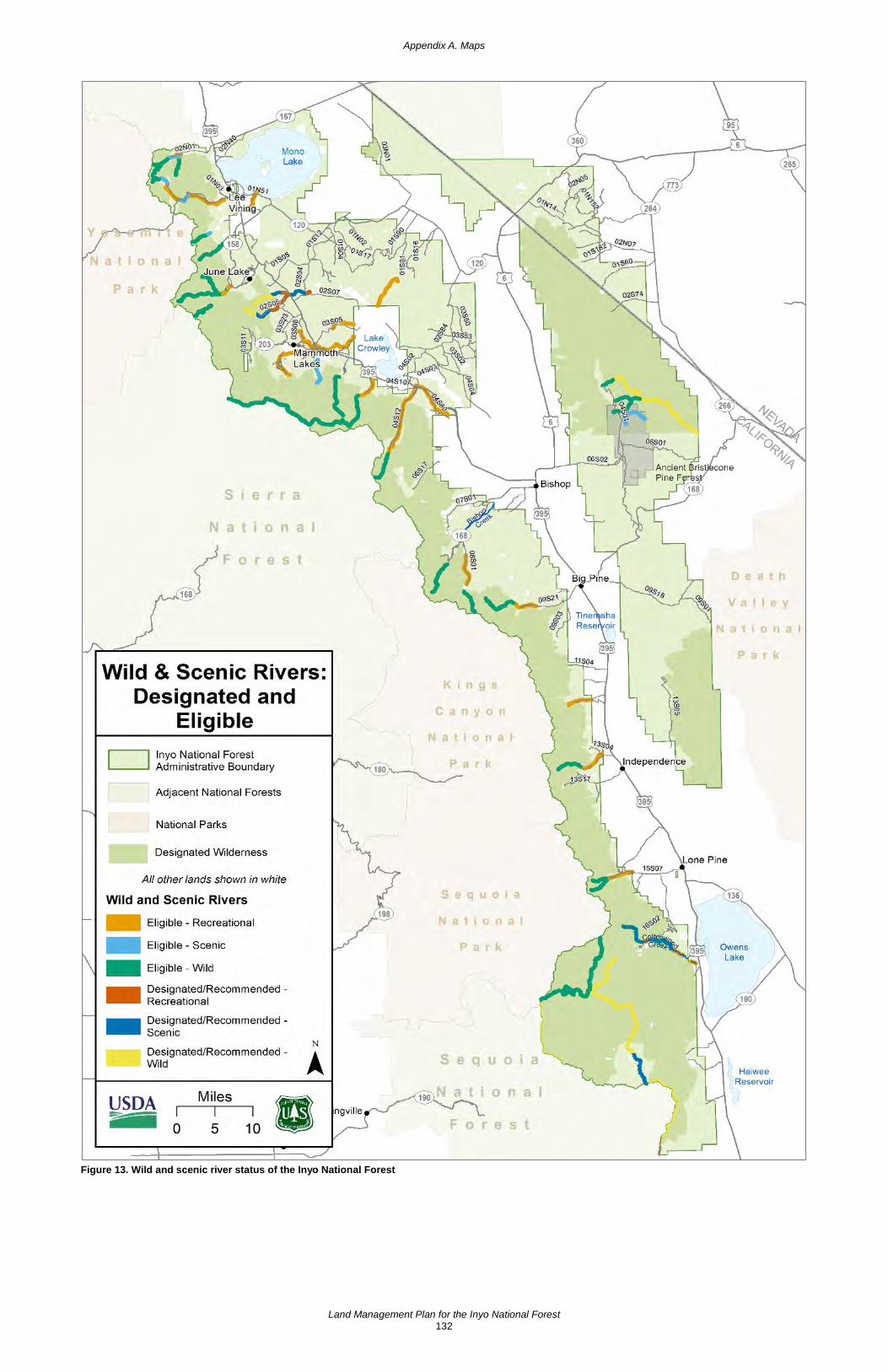
Appendix A. Maps
Land Management Plan for the Inyo National Forest 132
Figure 13. Wild and scenic river status of the Inyo National Forest
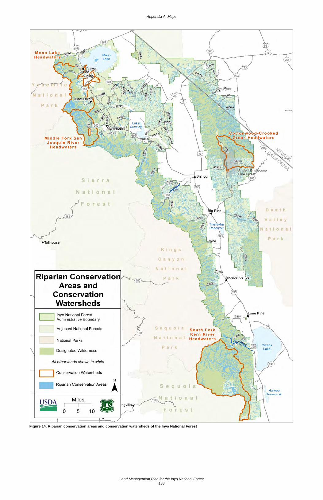
Appendix A. Maps
Land Management Plan for the Inyo National Forest 133
Figure 14. Riparian conservation areas and conservation watersheds of the Inyo National Forest

Appendix A. Maps
Land Management Plan for the Inyo National Forest 134
Figure 15. Pacific Crest National Scenic Trail management area of the Inyo National Forest
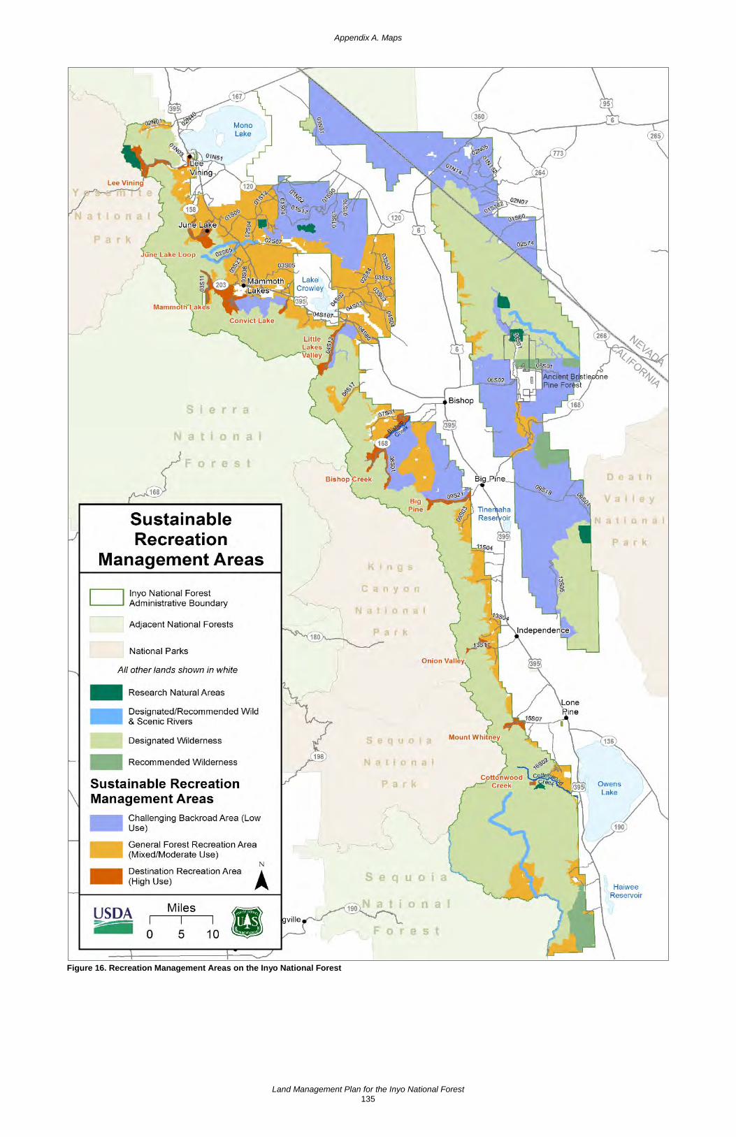
Appendix A. Maps
Land Management Plan for the Inyo National Forest 135
Figure 16. Recreation Management Areas on the Inyo National Forest
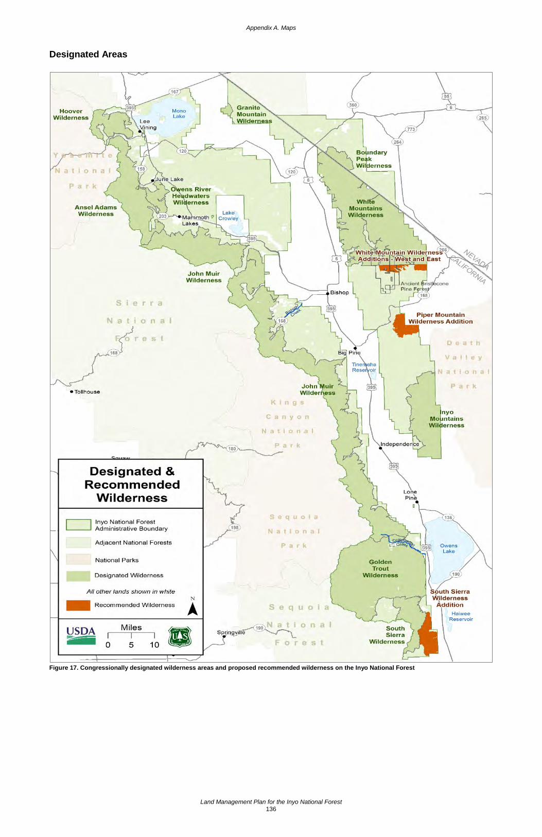
Appendix A. Maps
Land Management Plan for the Inyo National Forest 136
Designated Areas
Figure 17. Congressionally designated wilderness areas and proposed recommended wilderness on the Inyo National Forest
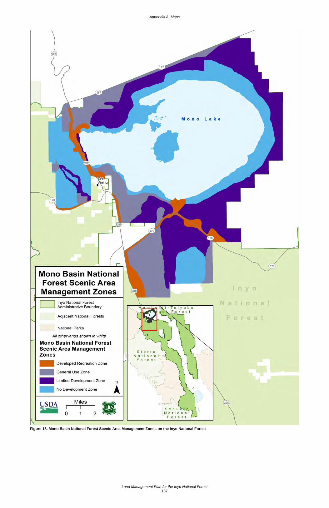
Appendix A. Maps
Land Management Plan for the Inyo National Forest 137
Figure 18. Mono Basin National Forest Scenic Area Management Zones on the Inyo National Forest

Appendix A. Maps
Land Management Plan for the Inyo National Forest 138
Figure 19. Other designated areas: research natural areas and Ancient Bristlecone Pine Forest on the Inyo National Forest

Appendix A. Maps
Land Management Plan for the Inyo National Forest 139
Figure 20. Wild horse and burro territories on the Inyo National Forest

This page left intentionally blank

Land Management Plan for the Inyo National Forest 141
Appendix B: Proposed and Possible Actions
Introduction This appendix describes proposed and probable management practices that may take place on the Inyo National Forest at the project or activity level to help maintain existing conditions or achieve the desired conditions described in the plan. Included are items such as program strategies; inventories, assessments, resource analyses and other planning needs; and ongoing work with partners and cooperating agencies anticipated during the next 3 to 5 years.
The listed proposed and probable practices are neither intended to be all-inclusive, nor intended to be decisions, but simply projections of what actions may take place in the future. A plan amendment is not required to change or modify any proposed and possible actions. The list of these actions can be updated at any time through an administrative correction of the plan. More information may be found under plan objectives and management approaches.
Air Quality • Coordinate with the California Air Resources Board, Air Pollution Control Division and
Air Quality Management District jurisdictions during the implementation of prescribed burns to comply with State and Federal regulatory requirements for authorization and mitigations. Design prescribed burn projects to minimize prolonged smoke impacts to communities and national forest users to the extent possible.
Water, Soils, and Watershed • Plan and implement improvement activities in priority watersheds that are functionally at
risk or impaired.
• Update the priority watershed list to reflect actual needs on the ground.
• Participate and collaborate in all interagency water rights and water use authorizations on National Forest System lands, or those that may affect water quantity on National Forest System lands.
• Maintain and restore the connections of floodplains, channels and water tables to distribute flood flows and sustain diverse habitats.
• Maintain good soil conditions and improvement of fair and poor soil conditions as outlined in the Pacific Southwest Region Forest Service Manual (R5 FSM 2550). Treatments that move Inyo priority 6th-code watersheds toward satisfactory conditions should take precedence.
• Implement resource improvement projects that are beneficial for maintaining and improving soil condition and productivity, and water quality and quantity.
• Complete onsite soil investigations and refine maps for soil-disturbing projects that require site-specific, precise, and highly detailed soil information that is beyond the scale of the current soil surveys.
Terrestrial Ecosystems • Due to the uniqueness of eastside vegetation types, work cooperatively with researchers
and other interested parties who have knowledge of local ecological conditions, past and present, and expertise in appropriate restoration measures.

Appendix B: Proposed and Possible Actions
Land Management Plan for the Inyo National Forest 142
• Maintain or restore habitat connectivity where appropriate to improve adaptive capacity of native plants and animals. Collaborate with partners to establish priority locations for maintaining and restoring habitat connectivity.
• Restore fire to the landscape where conditions are appropriate.
Sierra Nevada Montane Zone • Thin and use prescribed fires and naturally ignited fires to treat upper montane
vegetation.
• Monitor insect and disease infestations, and treat epidemic outbreaks.
• Thin and use prescribed fires and naturally ignited fires to treat dry mixed conifer.
• Monitor insect and disease infestations, and treat epidemic outbreaks.
Complex Early Seral • Continue to monitor black-backed woodpecker populations and habitat use.
Subalpine and Alpine • Cooperate with the Pacific Southwest Region Ecology Program to monitor health of
whitebark pine stands.
• Educate the public about the unique properties of subalpine and alpine ecosystems and the potential impacts of climate change, recreation use, and other stressors.
Special Habitats • Restore off-highway vehicle damage in pumice flats, caliche-covered clay soil mounds,
and other special habitats, and continue monitoring of species of conservation concern in these special habitats.
• Monitor resources in alkali flats, caliche-covered clay soil mounds, and other special habitats to determine ecosystem function, and implement restoration actions if needed.
Sagebrush • Reduce overstory encroachment of pinyon-juniper and Jeffrey pine within sagebrush
stands.
• Conduct vegetation treatments to diversify age-class structure of sagebrush stands.
• Manage fire to limit fire size and intensity within sagebrush stands.
Pinyon-Juniper • Thin and use prescribed fires and naturally ignited fires to treat pinyon-juniper.
• Monitor insect and disease infestations, and treat epidemic outbreaks.
Jeffrey Pine • Thin and use prescribed fires and naturally ignited fires to treat Jeffrey pine.
• Monitor insect and disease infestations, and treat epidemic outbreaks.
Appendix B: Proposed and Possible Actions
Land Management Plan for the Inyo National Forest 143
Red Fir • Thin and use prescribed fires and naturally ignited fires to treat red fir.
• Monitor insect and disease infestations, and treat epidemic outbreaks.
Lodgepole Pine • Thin and use prescribed fires and naturally ignited fires to treat lodgepole pine.
• Monitor insect and disease infestations, and treat epidemic outbreaks.
Aspen • Plan for treatments within highest and high risk aspen stands.
Aquatic and Riparian Ecosystems • Use vegetation treatments to restore the structure and composition of riparian areas and
meadows where encroachment is impacting meadow function.
• Restore nonfunctioning or functioning-at-risk riparian areas so they are in or moving toward proper functioning condition.
Meadows • Design grazing allotment plans to move riparian areas and meadows toward the desired
conditions.
• Continue to work with partners to direct planning and implementation of meadow restoration projects where meadows have impaired hydrologic function.
Rivers and Streams • Use vegetation treatments or other active restoration activities to maintain the structure
and composition of habitat for fisheries and other aquatic species.
• Restore riparian areas from the effects of unauthorized and illegal activities, such as from marijuana cultivation.
Springs and Seeps • For the limited portion of fens that are identified to be in a downward trend, use herding
management strategies before using barriers to restrict livestock from accessing those fens.
• Restore degraded spring sites back to providing functional habitat for spring-dependent species.
• Reconstruct or restore riparian function to springs identified as not in proper functioning condition.
Animal and Plant Species
Sage-grouse • Continue to work with partners on planning and implementing pine encroachment
treatments as identified by the technical advisory committee.
• Continue to fund science advisor and sage-grouse monitoring efforts.
Appendix B: Proposed and Possible Actions
Land Management Plan for the Inyo National Forest 144
Ramshaw Meadows abronia • Implement a conservation agreement, including campsite restoration, conifer
encroachment monitoring and damage monitoring, if necessary.
California Golden Trout • Continue to implement and update the California Golden Trout Conservation Assessment
and Strategy with cooperating agencies.
Invasive Species • Where invasive species are adversely affecting the viability of native species, work
cooperatively with appropriate State and Federal wildlife agencies to reduce impacts to native populations.
• Focus treatment efforts on high priority invasive species and infestations, while developing management goals for lower priority species and infestations. Prioritize areas such as wilderness, research natural areas, botanical areas, wild and scenic areas, and aquatic and riparian areas to maintain the integrity of native species and ecosystems. Prepare control and prevention plans for high priority invasive species, which promote early detection of new populations and rapid management response as an effective approach to minimize spread.
• Plan and implement a new forestwide treatment program for invasive plant species, which expands treatment options, identifies treatment priorities, and includes an early detection-rapid response component.
Fire • Coordinate with local and State agencies for an updated fire prevention program that
coordinates efforts across jurisdictions and supports a unified message. Target audience should include local residents and out of area national forest users.
• Conditions that affect fire behavior may change over the life of the plan due to factors such as changes in climate, natural resource conditions, fuel restoration treatments, and wildfires. Additionally, a new or changed asset or natural resource value may occur on the landscape. All these changes are factors that affect wildfire risk; therefore, they could cause a change to the strategic fire management zones. Fire managers will decide how often risk assessments will be completed based on the magnitude of change on the landscape. Work with Tribes and adjacent landowners to identify areas and resources of value considered in the risk assessments.
Local Communities • Work with local governments, businesses and organizations to assist in permit processes,
including providing technical assistance, processing programmatic environmental clearance, and other measures to streamline the time and expense of permitting.
• Work to maintain and expand contracting and partnering opportunities with local governments, businesses and organizations. Develop partnerships that leverage different sources of funding to support opportunities to contribute to the economic and social sustainability of local communities.

Appendix B: Proposed and Possible Actions
Land Management Plan for the Inyo National Forest 145
• Develop partnerships with local governments, businesses and organizations to collect economic data to track changes for businesses in sectors dependent on national forest activities.
Timber and Other Forest Products • Accomplish vegetation and fuels management restoration projects using a mix of
contracting practices including stewardship contracts, timber sales, service contracts, partnership agreements, and other methods.
• Provide forest products that will sustain opportunities for local workforces and support developing and existing local and regional forest products infrastructure.
• See appendix D for more information on the possible timber sale program and vegetation management practices.
Range • Review active allotment management plans on a regular basis.
• Maintain and replace fencing, waters and other range improvements.
• Implement the Inyo National Forest’s revised Rescissions Act Schedule for grazing allotment environmental analyses (NEPA) to update allotment management plans accordingly.
• Secure and maintain stock water rights for existing water structures and water improvements and proposed stock water or spring development.
Sustainable Recreation • Collaborate with local communities, Tribes, partner organizations, and Federal, State, and
local agencies to restore, maintain, and enhance recreation settings impacted by climate change, declining ecosystem health, wildfire and inappropriate use to improve the quality of outdoor experiences and to promote citizen stewardship of public lands.
• Effectively manage concentrated recreation use; provide a quality visitor experience while managing ecosystem effects within sustainable levels.
• Collaborate with neighboring communities, partner organizations, State and local agencies, Tribes and adjacent Forest Service and National Park Service units to provide recreation opportunities that are economically, socially, and environmentally sustainable. Work to harmonize direction that affects users to the extent practical to minimize confusion when crossing administrative boundaries.
• Actively engage urban populations, youth, and underserved communities in outreach programs, such as conservation education, and recreation and volunteer programs, to help people connect to the benefits of national forests and develop stewardship of public lands.
• Modify existing developed recreation facilities, and develop new facilities to accommodate the diversity of cultures, abilities, family structures, and preferred activities of current populations who could benefit from recreation opportunities.
• Explore partnership opportunities with user groups and seek reliable information sources outside of the agency to improve data collection and data management on recreation use and demand.
Appendix B: Proposed and Possible Actions
Land Management Plan for the Inyo National Forest 146
• Strategically engage volunteers and partners to prioritize and complete deferred maintenance and to engage in resource stewardship and restoration.
• Issue and supervise permits for new special use activities on the Inyo including powerlines, special events, large group gatherings, outfitter-guide activities, and research.
Scenery • In all vegetation treatment and fuels reduction projects, consider improving scenery
resources, especially in areas that do not meet established scenic integrity objectives.
• Consider heritage, and traditional and cultural values for properties and sacred sites in project-level scenery assessments.
Tribal Relations and Uses • Maintain regular and open consultation and communication with Tribes regarding
projects, programs, and activities on the Inyo National Forest.
• Develop partnerships that involve Tribes and Tribal youth in natural resource management.
• Host forums that provide Tribes and national forest staff the opportunity to discuss natural and cultural resource management concerns, approaches, and opportunities.
• Consult annually with Indian Tribes, Tribal cultural leaders and consulting parties; use project design to protect heritage resources, traditional cultural properties, and sacred sites.
Cultural Resources • Promote on and off-site educational enrichment products such as interpretive signing,
classroom programs, heritage celebrations, publications, and field trips.
• Incorporate public volunteers, Tribal youth and Tribal monitors into cultural resource surveys and cultural site identification, protection, monitoring and enhancement efforts.
• Capitalize on opportunities for suitable adaptive reuse of historic buildings.
• Follow up on reports of archaeological looting in conjunction with law enforcement.
• Identify priority cultural sites in need of protection from physical damage.
Geology and Minerals • Coordinate with the Bureau of Land Management to properly process applications for
mineral entry on the Inyo.
• Rehabilitate mineral operations sites that are no longer in use.
Energy • Coordinate with the Bureau of Land Management to properly process applications for
mineral entry on the Inyo.
Infrastructure • Continue to implement energy-efficient operations.

Appendix B: Proposed and Possible Actions
Land Management Plan for the Inyo National Forest 147
• Naturalize or decommission unauthorized roads and system roads to create a more cost-effective road system and to restore natural resources impacted by roads.
• Construct and close new temporary and permanent roads to support ecosystem restoration activities.
• Coordinate with local, State, and Federal agencies to mitigate impacts from community, highway, and interstate road reconstruction and to identify management needs.
Lands • Coordinate with landowners and local and regional governments to encourage private
land uses that are compatible with the Inyo’s desired conditions.
Designated Areas
Wilderness • Rehabilitate wilderness sites or areas that have been impacted by recreation to restore
wilderness character.
• Continue restoration of unauthorized routes in wilderness.
• Reconstruct National Forest System trails to address deferred maintenance or improve watershed conditions.
• Implement the wilderness stewardship performance measure program.
Wild and Scenic Rivers • Complete comprehensive river management plans for the newly designated Cottonwood
Creek and Upper Owens River Wild and Scenic Rivers.
Research Natural Areas • Continue to work with local Native American Tribes in the implementation of the Indiana
Summit treatment project.
Wild Horse and Burro Territories • Update the Montgomery Pass Wild Horse Territory Herd Management Plan.
• Monitor the wild horse populations in the Montgomery Pass Wild Horse Herd and White Mountains Herd.
• Restore ecosystems of designated wild horse territories and herd boundaries.

This page left intentionally blank

Land Management Plan for the Inyo National Forest 149
Appendix C: A Renewed Partnership Focus for the Inyo National Forest Partnerships in land stewardship reflect a growing and important trend: the joining of passion and resources by committed citizens, organizations and government agencies to achieve social, economic and ecological goals. The Forest Service has worked with partners throughout its more than 100-year history. But the challenges of land management have grown more complex, and the needs of the public more varied. The American people today are voicing their strong desire to volunteer and participate in the stewardship of natural resources and in the decisions that affect their communities. The Forest Service has responded by developing partnership strategies at the national and regional levels.12
The mission of the Forest Service is to “sustain the health, diversity, and productivity of the Nation’s forests and grasslands to meet the needs of present and future generations.” Partnerships are essential to carrying out that mission today. Fortunately, there are hundreds of organizations in California whose missions overlap with ours in some way, creating the opportunity to work together toward bigger, better outcomes than each can achieve on its own.
The Inyo National Forest recognizes the value of continuing to develop effective partnerships, wherein we invite public participation, embrace stakeholder proposals, and successfully leverage our resources by working together to achieve the desired conditions set forth in the forest plan.
Creating a Partnership Culture The forest supervisor on the Inyo National Forest responds to the needs of a varied public by empowering employees and communities of place, interest, and culture to create and sustain successful partnerships. The forest supervisor and national forest staff have established the following partnership goals to accomplish the Forest Service mission, implement the forest plan, and build a strong and lasting community of stewardship on the Inyo National Forest:
• Through partnership, sustain the health, diversity and productivity of the Inyo National Forest.
• Partnership is integrated throughout all levels of the agency.
• Identify authorities and mechanisms within the agency to execute partnerships and define the responsibilities of the agency and partners.
• The Inyo should designate a partnership coordinator who will define an easily understood process for becoming a partner as well as expectations for both the Inyo staff and the partner.
• Build community support for and understanding of the Inyo National Forest.
• Enhance opportunities to connect people to the land, especially people of diverse cultures, international visitors, and people from urban areas.
• Expand partnerships with other Federal, State, and local government agencies, as well as Tribes, associations, nongovernment organizations, outfitters and guides, other permittees, local businesses, and other community groups. Enlist them to leverage information (help serve as messengers to the visiting public) and resources for mutual benefit to enhance and improve national forest infrastructure (roads, trails, and
12 See http://www.fs.usda.gov/prc and http://www.fs.usda.gov/main/r5/workingtogether

Appendix C: A Renewed Partnership Focus for the Inyo National Forest
Land Management Plan for the Inyo National Forest 150
campgrounds) and for restoration efforts (such as noxious weed treatments or watershed improvements).
• Foster partnerships dealing with science.
• Create more “citizen stewards” of the Inyo National Forest by establishing a comprehensive volunteer program.
• Support the ongoing efforts of the formal partnership with Eastern Sierra Interpretive Association.
• Develop new partnerships focused on management of the land (such as restoration activities).
• Build and enhance partnerships to protect Tribal sites and interpret cultural and historic assets.
Accomplishing these goals will require new and innovative methods as well as the continuation of investment in ongoing successful partnership efforts. The purpose of this strategy is to outline an iterative process for building and sustaining a strong partnership culture for the Inyo National Forest. The strategy includes the following components: a method for determining the Inyo’s capacity for working in partnership; best practices for building and sustaining new partnerships; and steps for ensuring effective outreach to nontraditional partners.
Forest Capacity for Working in Partnership There are many tools Inyo National Forest staff can use to determine partnership capacity and develop partnership strategies. In this appendix, one tool is described in detail from the National Partnership Office of the Forest Service. Partnership staff should recognize that each community where partnerships may develop are different and the available tools should depend on each of those situations.
The National Partnership Office of the Forest Service has designed a partnership capacity assessment tool13 to help Forest Service units assess, sustain, and improve their abilities to work with partners and continue the Forest Service’s long history of partnership and collaboration in land stewardship.
What is the Partnership Capacity Assessment Tool? The “partnership capacity assessment tool” is essentially a group exercise to reflect on experiences and attitudes about partnerships and collaboration. The tool asks the group to score itself on a series of questions about partnership opportunities, goals, resources, procedures, incentives, barriers, skills, and relationships. The group then uses these scores to chart strengths, analyze positive and negative factors that contribute to partnership capacity, and identify actions to sustain and grow capacity.
Who Should Use the Assessment Tool? The tool is used by Inyo National Forest staff in conjunction with communities of place, interest, and culture that care about the uses and resources within the Inyo National Forest and will benefit from completing the assessment. This tool is designed to generate open dialogue with partners
13 http://www.fs.usda.gov/Internet/FSE_DOCUMENTS/fseprd493263.pdf

Appendix C: A Renewed Partnership Focus for the Inyo National Forest
Land Management Plan for the Inyo National Forest 151
and among staff. It is a useful starting point for assessing current partnership abilities and discussing how to maintain strengths or address needs.
How Can the Assessment Tool Best Meet the Needs of the Inyo? The assessment tool provides the format for a community forum to assess partnership needs and develop priorities to meet those needs. Use of the assessment tool by Forest Service staff can help identify needed resources and changes to better position the Inyo National Forest for successful accomplishment of goals through partnerships; including partners in the process can help promote dialogue and improve relationships. However, the tool is not intended to assess the feasibility of or develop plans for specific partnership opportunities. These details will be identified during project-level planning.
How Long and Where Will the Assessment Take Place? The community forum can expect to complete the assessment in one session. The investment of time will pay off by helping national forest staff and potential partners systematically identify needs and actions to meet those needs. Trained facilitators and recorders can be used to keep the process moving smoothly.
Best Practices for Building New Partnerships Partnerships can be thought of as a type of alliance, where the complex interaction of business and interpersonal activities are essential to successfully achieving mutually beneficial goals. Key characteristics of successful interpersonal relationships include trust, communication, perspective taking, rapport building, and commitment. Partnerships are known to yield better results under certain conditions,14 15 for example: when each partner recognizes the need to have access to capabilities and competencies it cannot develop internally; or when a gradual and sustained approach is preferable in accessing resources, capabilities and competencies, as opposed to faster and shorter-term mechanisms such as contracting.
Keeping these conditions in mind, the following best practices are provided to assist Inyo staff in the identification and development of new partners:
• Identify the need for partnerships within the long-term strategies and desired condition of the national forest
• Define specific objectives of the partnership
• Choose partners
• Evaluate what to offer and what to receive in exchange
• Define and act upon opportunities
14 Mockler, R.J. 1999. Multinational Strategic Alliances. John Wiley & Sons. 266 p. 15 O’Neill, B. (n.d.) Brian O’Neills’ 21 partnership success factors. San Francisco, CA: Golden Gate National
Parks. http://www.nps.gov/partnerships/oneill.htm
• Evaluate the effect on national forest stakeholders
• Determine each partner’s resources and capabilities
• Plan the integration
• Create the partnership
• Take action and achieve objectives
• Recognize and celebrate successes

Appendix C: A Renewed Partnership Focus for the Inyo National Forest
Land Management Plan for the Inyo National Forest 152
Identify the Need for Partnerships within Long-term Strategies and Desired Conditions of the Forest Strategic alliances respond to various long-term strategies of the Inyo National Forest. For example, the interpretive plans for the Inyo established a strategy for the national forest’s interpretive program, featuring the interpretation of objects of interest, both natural and cultural, based upon ranger districts and visitor centers. The Inyo should use Eastern Sierra Interpretive Association’s resources to ensure these interpretive plans remain current and relevant. Interpretive services may be provided onsite or virtually. The specific interpretive products, services and delivery methods are expected to evolve over time, in response to evolving technologies, visitor needs and demands, and available resources. Partnerships are important not only because of the extra resources they provide, but also because they help to enrich a sense of stewardship in both the partners and recipients of interpretive services.
Define Specific Objectives of the Partnership Three aspects of defining objectives are necessary for the success of the partnership:
1. The objective should be compared with the Inyo’s available resources and capabilities and with applicable potential partners. The partnership should bridge the gap of existing resources and capabilities to achieve the objectives. The assessment tool can assist in identifying where gaps occur regarding both the Inyo’s capability to cultivate new partnerships and its resources to accomplish management goals alone.
2. There should be a clear consensus (internally) on why the agency cannot reach particular goals on its own, and why it must seek a partnership with an external organization, rather than internal development or via procurement.
3. It is important to know where the partnership generates mutual advantages within the chain of value, and to clarify why each partner cannot develop these advantages internally.
Choose Partners The right partner in an alliance must have three principal features the following:16
1. The partner must have the resources and capabilities to help the Forest Service achieve its strategic goals, bringing to the partnership what is missing and what the Forest Service is seeking.
2. The partner and national forest must share the same long-term goals for the partnership. Failure is inevitable if the goals are divergent.
3. The partner must not use the alliance to gain know-how, relationships with clients or suppliers, or technology without making contributions of equal strategic weight. Alliances are longer lasting and better when they are considered between partners with a reputation for trustworthiness.
16 Hill C., and G. Jones. 2000. Strategic Management: an Integrated Approach, 5th ed. Boston, MA: Houghton
Mifflin Company.

Appendix C: A Renewed Partnership Focus for the Inyo National Forest
Land Management Plan for the Inyo National Forest 153
Evaluate What to Offer and What to Receive in Exchange Reciprocity is a key component of building trust. Each partner should evaluate which capabilities are critical to the partnership, and then decide what the national forest staff can offer to the others and what it can expect from them.
Define and Act Upon Opportunities Knowing the value of the opportunities that can be achieved with the alliance is an essential guide in negotiation, and subsequent management, of the partnership. Beyond the opportunities, it is also important to examine the possible risks.
Evaluate the Effect on National Forest Stakeholders A key question to consider is, “How will stakeholders, including other partners, react to the partnership?”
Determine each Partner’s Resources and Capabilities Understanding a partner’s abilities and limitations is an important component in creating a successful partnership. A key question to consider is, “What resources and capabilities can the partners realistically bring to the partnership?”
Plan the Integration Develop a partnership business plan, which should:
1. Organize activities and functions
2. Define accounting procedures
3. Define procedures to resolve conflicts
4. Define the relationships between the partnership and the national forest, including duration and renewal process
5. Define the authorizing instrument for the partnership (such as a memorandum of understanding) that will be appropriate to formalize the relationship
Create the Partnership Flexibility is integral to sustaining an effective partnership. Whatever the form of the partnership, some principles apply:
1. Each partner has its own goals that dictate the role of the partnership
2. The role of the partnership changes as internal and external conditions evolve
3. The relationship between the partners is quite dynamic
4. Evaluate the partnership for effectiveness in meeting mutual goals
Take Action and Achieve the Objectives For a partnership to last, both parties must find the partnership to be meaningful and to satisfy the established objectives.

Appendix C: A Renewed Partnership Focus for the Inyo National Forest
Land Management Plan for the Inyo National Forest 154
Recognize and Celebrate Successes Honor the efforts accomplished through the work of partnership. This recognizes the individuals involved and strengthens the relationship between partners.
Steps for Ensuring Effective Outreach and Communication with Nontraditional Partners and the Public The diversity of people using and valuing the Inyo National Forest will continue to increase as the American population grows and becomes more diverse, and as international visitation increases. California’s youth is more culturally diverse than any previous generation. Interpretation and outreach methods designed to connect users to the Inyo need to communicate important resource issues, solicit commitment to conservation, and encourage appropriate behaviors. Use of the national forest by nontraditional user groups, especially Hispanics and Asians, is prevalent and growing.
To assure effective outreach occurs within this growing segment of potential national forest partners, metrics should be designed to monitor and evaluate success, adapting as necessary to continually broaden the circle of involvement. The following steps may be considered, as appropriate, in developing innovative partnerships:
1. Translate major documents (or summaries thereof), provide translators at meetings, or make other efforts as appropriate to ensure that limited English speakers gain understanding of potential partnership opportunities.
2. Provide opportunities for limited English speakers to provide comments and actively engage in partnership opportunities.
3. Provide opportunities for public participation through means other than written communication, such as personal interviews or use of audio or video recording devices to capture oral comments.
4. Use different meeting sizes or formats, or vary the type and number of media used, so that communications are tailored to the particular community or population.
5. Use locations and facilities that are local, convenient and accessible to disabled individuals, low-income and minority communities, and Native American Tribes.
6. Provide assistance to hearing-impaired or sight-impaired individuals.

Land Management Plan for the Inyo National Forest 155
Appendix D: Timber Suitability and Management
Determination of Suitability for Timber Production Timber production is the purposeful growing, tending, harvesting and regeneration of regulated crops of trees to be cut into logs, bolts, or other round sections for industrial or consumer use (36 CFR 219.19). Timber production activities can contribute to social, economic, and ecological sustainability. Timber production may offset some or all of the costs of silvicultural treatments and other national forest management activities that restore ecosystems to desired conditions, lower uncharacteristic fire and insect risk, increase understory plant diversity and abundance, and create employment opportunities.
The National Forest Management Act requires that the Forest Service determine the suitability of National Forest System lands for timber production and has specific requirements for timber suitability analysis in land management plans. Note that there is a distinction between timber harvest as a resource use (timber production) and timber harvest as a management tool to achieve desired conditions. Timber harvest on lands classified as not suitable for timber production may be used as a tool designed to achieve desired conditions.
Lands that May be Suitable for Timber Production Identification of land that may be (tentatively) suitable for timber production is the first step in the process of determining lands that are suited for timber production. This preliminary classification is made prior to the consideration of objectives and desired conditions that are part of the forest plan revision process. It excludes National Forest System lands that are not suitable for timber production based on the following criteria:
• Timber production is prohibited by statute, executive order, regulation or where the Secretary of Agriculture or the Chief of the Forest Service has withdrawn the land from timber production. Examples include designated wilderness areas, designated wild and scenic rivers, research natural areas and other designated areas where timber is specifically prohibited.
• Land that is not forested (nonforest), identified by having less than 10 percent occupation17 by conifer trees of any size or having a nonforest use like powerline clearings, residential or administrative sites, or improved pasture.
• Known environmental factors exist that preclude reasonable assurance that restocking can be achieved within 5 years of final regeneration harvest.18
• Technology to harvest timber is not currently available without causing irreversible damage.
National forest lands that remain after this initial screening are termed “lands that may be suitable for timber production.” Based on this initial suitability analysis, the Inyo National Forest has 85,025 acres that may be suitable for timber production.
17 Ten percent occupation was represented utilizing 10 percent canopy cover during analysis. 18 The following Regional Dominance Types (CalVeg Forest Types) are recognized as capable of adequate
restocking within 5 years: Eastside Pine, Jeffrey Pine, Mixed Conifer-Fir, Mixed Conifer-Pine, Red Fir, and White Fir. In addition, Order 3 soil survey data was used to inform the likelihood of regeneration success.

Appendix D: Timber Suitability and Management
Land Management Plan for the Inyo National Forest 156
Figure 21. Timber suitability map for the Inyo National Forest

Appendix D: Timber Suitability and Management
Land Management Plan for the Inyo National Forest 157
Lands Suitable for Timber Production The final step in determining lands suitable for timber production is to determine which of the lands that may be suitable for timber production, are suited for timber production, based on compatibility with desired conditions and objectives:
• Timber production is a desired primary or secondary use of the land.
• Timber production is anticipated to continue after desired conditions have been achieved.
• A flow of timber can be planned and scheduled on a reasonably predictable basis.
• Regeneration of the stand is intended.
• Timber production is compatible with the desired conditions or objectives for the land.
After subtracting the lands that are suited for timber production from the lands that may be suitable, the remaining lands are not suited for timber production because timber production is not compatible with the land area’s desired conditions and objectives. Categories of lands deemed not suited for timber production include areas recommended for wilderness designation, wild river segments of eligible wild and scenic rivers,19 and California spotted owl protected activity centers. The Pacific Crest Trail Management Area is included in lands suitable for timber production as timber harvest and related management actions would be designed to be compatible with desired conditions and objectives for a naturally appearing landscape surrounding the trail.
On lands not suited for timber production, timber harvest may occur to protect multiple-use values other than timber production, and for salvage, sanitation, public health, or safety. Multiple use values may also include various other restoration activities. For example, meadow restoration may require cutting encroaching trees. These trees may be made available for sale, but the intent is to maintain the meadow.
The Inyo National Forest includes approximately 72,234 acres that are suitable for timber production, with the majority in the northwest corner the national forest (figure 21). The detailed acres of suitability are shown in table 27. Project designs will incorporate actions to meet a variety of objectives, such as riparian area enhancement, habitat maintenance or development, and scenic stability and integrity.
Planned Timber Sale Program The planned timber sale program represents an estimation of treatment types planned to achieve the outcomes described by the plan’s desired conditions and objectives and consistent with the other plan components during the plan period (by decade). The planned practices are based on the projected fiscal capability and organizational capacity of the planning unit, and not a commitment to take an action or to develop a project-specific proposal for such action.
Sustained Yield Limit The sustained yield limit is the amount of timber, meeting applicable utilization standards, “which can be removed from a forest annually in perpetuity on a sustained yield basis.”20 It is the volume that could be produced in perpetuity on lands that may be suitable for timber production. The
19 Area includes a corridor incorporating approximately 0.25 miles on either side of eligible Wild and Scenic
Rivers. 20 See the National Forest Management Act at section 11, 16 U.S.C. 1611; and the Planning Rule at 36 CFR
219.11(d)(6)

Appendix D: Timber Suitability and Management
Land Management Plan for the Inyo National Forest 158
calculation of the sustained yield limit is not limited by the forest plan desired condition, other plan components, or the planning unit's fiscal capability and organizational capacity. The sustained yield limit for the lands that may be suitable for timber production is 40 million cubic feet (MMCF) per decade.
Table 27. Inyo National Forest land suitable for timber production Land Classification Category Acres A. Inyo National Forest System Land 1,990,042
B. Lands non suited for timber production due to legal or technical reasons (1+2+3)
1,905,017*
1. Land withdrawn from timber production 1,555,616
2. Nonforested lands and/or lands where adequate stocking is not assured 349,400
3. Lands where irreversible resource damage is likely 0
C. Lands that may be suitable for timber production (A-B) 85,025
D. Lands where management objectives limit timber harvest 12,792
1. Recommended wilderness areas 11
2. Eligible wild river segments 4,399
3. California spotted owl protected activity centers 0
4. Riparian Conservation Areas 8,382
E. Lands not suitable for timber production (B+D) 1,917,808
F. Lands suitable for timber production (A-E) 72,234 * Small rounding errors present
Projected Wood Sale Quantity and Timber Sale Quantity The estimated quantity of timber and all other wood products that is expected to be sold from the plan area for the plan period is called the “projected wood sale quantity” (PWSQ). The projected wood sale quantity consists of the projected timber sale quantity as well as other woody material such as fuelwood, firewood, or biomass that is also expected to be available for sale. The projected wood sale quantity includes volume from timber harvest, for any purpose, based on expected harvests that would be consistent with the plan components. The projected wood sale quantity is also based on the planning unit’s fiscal capability and organizational capacity. Projected wood sale quantity is neither a target nor a limitation on harvest.
The projected timber sale quantity (PTSQ) is the estimated quantity of timber meeting applicable utilization standards that is expected to be sold during the plan period. As a subset of the projected wood sale quantity, the projected timber sale quantity includes volume from timber harvest for any purpose, from all lands in the plan area, based on expected harvests that would be consistent with the plan components. The projected timber sale quantity is also based on the planning unit’s fiscal capability and organizational capacity. Projected timber sale quantity is neither a target nor a limitation on harvest. Average volume outputs for the first and second decades for the Inyo National Forest planned timber sale program is displayed in table 28.
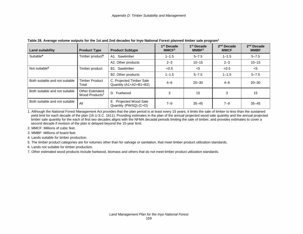
Appendix D: Timber Suitability and Management
Land Management Plan for the Inyo National Forest 159
Table 28. Average volume outputs for the 1st and 2nd decades for Inyo National Forest planned timber sale program1
Land suitability Product Type Product Subtype 1st Decade
MMCF2 1st Decade
MMBF3 2nd Decade
MMCF 2nd Decade
MMBF
Suitable4 Timber product5 A1. Sawtimber 1–1.5 5–7.5 1–1.5 5–7.5
Suitable Timber Product A2. Other products 2–3 10–15 2–3 10–15
Not suitable6 Timber product B1. Sawtimber <0.5 <5 <0.5 <5
Not suitable Timber product B2. Other products 1–1.5 5–7.5 1–1.5 5–7.5
Both suitable and not suitable Timber Product Total
C. Projected Timber Sale Quantity (A1+A2+B1+B2) 4–6 20–30 4–6 20–30
Both suitable and not suitable Other Estimated Wood Products7 D. Fuelwood 3 15 3 15
Both suitable and not suitable All E. Projected Wood Sale Quantity (PWSQ) (C+D) 7–9 35–45 7–9 35–45
1. Although the National Forest Management Act provides that the plan period is at least every 15 years; it limits the sale of timber to less than the sustained yield limit for each decade of the plan (16 U.S.C. 1611). Providing estimates in the plan of the annual projected wood sale quantity and the annual projected timber sale quantity for the each of first two decades aligns with the NFMA decadal periods limiting the sale of timber, and provides estimates to cover a second decade if revision of the plan is delayed beyond the 15-year limit.
2. MMCF: Millions of cubic feet. 3. MMBF: Millions of board feet. 4. Lands suitable for timber production. 5. The timber product categories are for volumes other than for salvage or sanitation, that meet timber product utilization standards. 6. Lands not suitable for timber production. 7. Other estimated wood products include fuelwood, biomass and others that do not meet timber product utilization standards.

Appendix D: Timber Suitability and Management
Land Management Plan for the Inyo National Forest 160
Vegetation Management Practices Harvest of timber on National Forest System lands occurs for many different reasons, including ecological restoration, community protection in wildland-urban interfaces, habitat restoration, protection of municipal water supplies, and to contribute to economic sustainability through the production of timber, pulp for paper, specialty woods for furniture, and fuel as a renewable energy source. Timber harvest, whether for wood production, restoration, or other reasons can support local businesses and employment.
Forest management on the Inyo National Forest consists of restoration and fuels reduction treatments designed to achieve desired conditions for the associated terrestrial vegetation type on suitable timber lands. Most treatments would occur in the Sierra Nevada montane zone. Thinning removes sawtimber and miscellaneous convertible products; however, due to a lack of local existing mill facilities, most treatments yield fuelwood and specialty wood products.
The projected management approach uses uneven-aged management systems. Thinning will be the primary practice, with group selection implemented as the regeneration method. Thinning is used to increase individual tree vigor, increase horizontal heterogeneity, and reduce fuel hazards. Group selection will be used to regenerate suitable lands, increasing vertical heterogeneity and tree species diversity. Table 29 displays estimates of acres of activity implemented by decade and vegetation management type for the Inyo National Forest.
Table 29. Estimated vegetation management practices on the Inyo National Forest in acres implemented per decade
Forestwide vegetation management Practices 1st Decade 2nd Decade Thinning (Intermediate Harvest) 8,000–11,500 8,000–11,500
Regeneration (Group Selection) 1,000–2,000 1,000–2,000
The approach for thinning would be as described in North et al. 2009 (GTR 220) and North 2012 (GTR 237), emphasizing restoration of heterogeneity. Some areas would be thinned more and some areas less or not at all. Thinning could occur across a range of diameters, between small- to medium-diameter trees. Some small openings would be created while clumps of trees would be retained in other areas. There would be retention and creation of heterogeneity in the understory as well. Some patches of dense surface fuel would occur, and other areas would have little to none.
Forest management in wildfire protection zones and strategic ridge tops will be prioritized for treatment. Forest management on unsuitable lands is primarily responsive to safety concerns or disturbance agents such as wildfire, windthrow, insects and diseases, or other restoration objectives.
Silvicultural Treatments Used in Timber Management Prescriptions While an uneven-aged management system will be the primary approach used to achieve desired conditions and restoration objectives, other silvicultural treatments may be used to better meet specific forest health and restoration objectives.
Reforestation Reforestation is the act of renewing forest cover by establishing young trees. This is typically accomplished by planting nursery-grown seedlings, but establishment of seedlings from natural
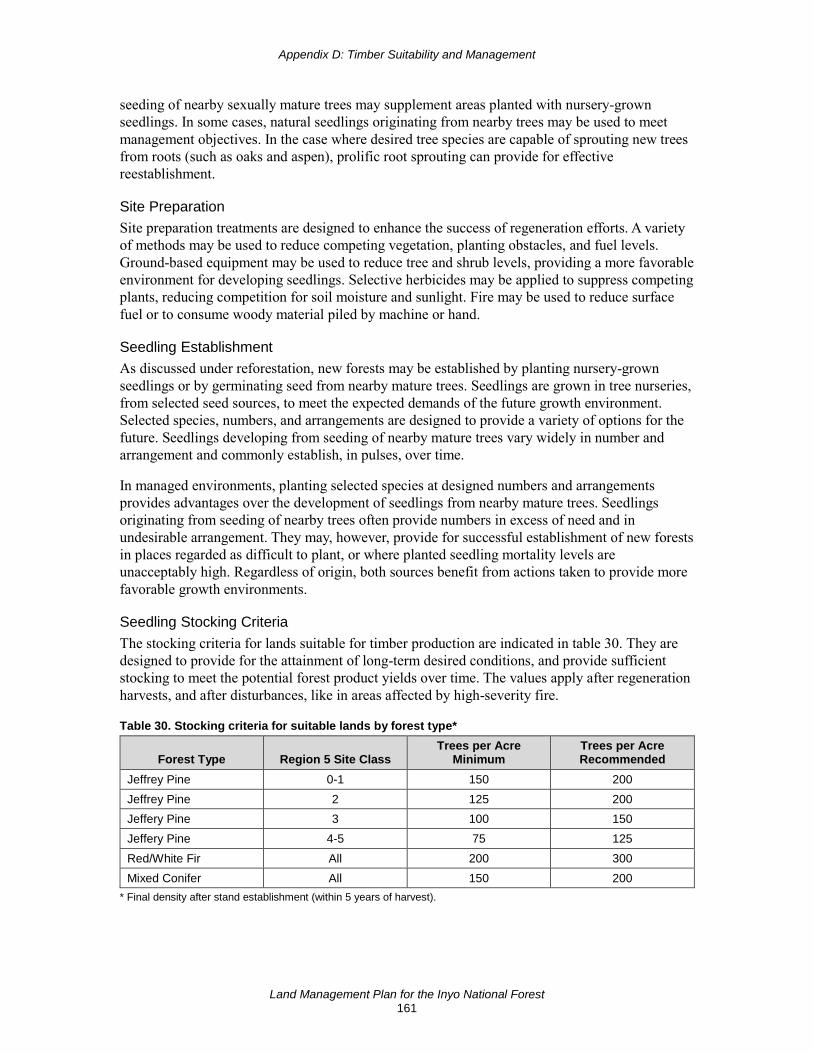
Appendix D: Timber Suitability and Management
Land Management Plan for the Inyo National Forest 161
seeding of nearby sexually mature trees may supplement areas planted with nursery-grown seedlings. In some cases, natural seedlings originating from nearby trees may be used to meet management objectives. In the case where desired tree species are capable of sprouting new trees from roots (such as oaks and aspen), prolific root sprouting can provide for effective reestablishment.
Site Preparation Site preparation treatments are designed to enhance the success of regeneration efforts. A variety of methods may be used to reduce competing vegetation, planting obstacles, and fuel levels. Ground-based equipment may be used to reduce tree and shrub levels, providing a more favorable environment for developing seedlings. Selective herbicides may be applied to suppress competing plants, reducing competition for soil moisture and sunlight. Fire may be used to reduce surface fuel or to consume woody material piled by machine or hand.
Seedling Establishment As discussed under reforestation, new forests may be established by planting nursery-grown seedlings or by germinating seed from nearby mature trees. Seedlings are grown in tree nurseries, from selected seed sources, to meet the expected demands of the future growth environment. Selected species, numbers, and arrangements are designed to provide a variety of options for the future. Seedlings developing from seeding of nearby mature trees vary widely in number and arrangement and commonly establish, in pulses, over time.
In managed environments, planting selected species at designed numbers and arrangements provides advantages over the development of seedlings from nearby mature trees. Seedlings originating from seeding of nearby trees often provide numbers in excess of need and in undesirable arrangement. They may, however, provide for successful establishment of new forests in places regarded as difficult to plant, or where planted seedling mortality levels are unacceptably high. Regardless of origin, both sources benefit from actions taken to provide more favorable growth environments.
Seedling Stocking Criteria The stocking criteria for lands suitable for timber production are indicated in table 30. They are designed to provide for the attainment of long-term desired conditions, and provide sufficient stocking to meet the potential forest product yields over time. The values apply after regeneration harvests, and after disturbances, like in areas affected by high-severity fire.
Table 30. Stocking criteria for suitable lands by forest type*
Forest Type Region 5 Site Class Trees per Acre
Minimum Trees per Acre Recommended
Jeffrey Pine 0-1 150 200 Jeffrey Pine 2 125 200 Jeffery Pine 3 100 150 Jeffery Pine 4-5 75 125 Red/White Fir All 200 300 Mixed Conifer All 150 200
* Final density after stand establishment (within 5 years of harvest).

Appendix D: Timber Suitability and Management
Land Management Plan for the Inyo National Forest 162
Release These treatments are designed to free young trees from undesirable competing vegetation. Treatments are aimed at increasing the availability of moisture, sunlight, and nutrients to planted seedlings, thus increasing survival and favorable growth rates. Depending on conditions, release can be performed using hand tools, herbicides or mechanically.
Precommercial Thinning This treatment removes selected trees to reduce stocking and promote the growth and development of desirable trees. The removed trees are typically small and without sufficient value to cover the cost of the treatment.
Timber Harvest The projected activities associated with scheduled forest management on suitable lands for timber production are geared toward uneven-aged management, a system using a planned sequence of treatments, designed to maintain and regenerate a stand with three or more age classes. The types of treatments used are primarily thinning and group selection:
• Thinning is commonly applied to lower the stand density and improve the health and growth rates of the remaining trees. It may also be designed to alter tree arrangement. Trees of merchantable size are selected for removal; trees of less than merchantable size are selected when the reduction of ladder fuels is an objective. The youngest age classes are typically excluded from thinning.
• Group selection is the most common method used to regenerate an age class. All, or most, of the trees are removed, followed by the establishment of seedlings. The size of the opening is variable, but is designed to provide sufficient site resources for favorable seedling establishment and growth.
In addition to scheduled forest management, management may also occur in response to disturbance events (such as wildfire, windthrow, insects, parasites or pathogen-related decline). Other harvest methods will likely apply to these specific conditions and project objectives. For example, after wildfire, and especially on suitable land, salvage harvests may be implemented to recover the economic value of dead and dying trees and to reduce the fuel environment. Other events, such as windthrow and insect and pathogen-related infestations, may lead to salvage or sanitation harvests, to recover economic value and improve residual stand health.
Safety considerations, although not regarded as a component of a harvest system, will likely lead to the harvest of dead and dying trees, as well as living trees deemed a risk, that may fail along roads and other places where people or property are threatened. This action, commonly referred to as hazard tree removal, or tree risk reduction, may be used extensively along roads and trails within wildfire areas.

Land Management Plan for the Inyo National Forest 163
Appendix E: Rangeland Management
Status of Livestock Production Rangelands As of 2018, 852,200 acres were available for livestock grazing on the Inyo National Forest. Of these, 12 allotments (275,740 acres) were either vacant or in nonuse for resource protection. The remaining acres (576,460 acres) were being grazed by cattle or sheep (table 31 and figure 22).
Determinations of the status of livestock grazing allotments, changes in livestock class, season of use, timing of use, and established utilization standards, are all determined during project-level environmental analysis. The plan components found in the forest plan are used as a baseline for determining utilization standards at the project-level. Vacant allotments would need project-level environmental analysis prior to reactivation.
Table 31 Summary data of current grazing allotments, Inyo National Forest ID Allotment Kind/Class Status Acres
100 Montgomery Pass Wild Horse active 69,265
123 Mcbride Flat Cattle closed 69,265
300 White Mountain Wild Horse active 181,820
400 Saline Valley Wild Burro active 27,764
102 Alger Lake Sheep vacant 2,947
103 Alper's Canyon Cattle active 317
104 Black Canyon Cattle vacant 34,274
105 Bloody Canyon Sheep vacant 5,364
107 Dexter Creek Sheep active 18,557
108 Horse Meadow Sheep vacant 1,531
109 June Lake Sheep active 14,855
111 Long Valley Cattle active 15,539
112 Mono Mills Sheep active 29,101
114 Turner Cattle active 13,257
115 Clark Canyon Cattle active 3,252
120 Mono Sand Flat Cattle active 7,461
121 Mono Lake Cattle closed 1,553
201 Hot Creek Cattle active 10,072
202 Antelope Cattle active 9,085
203 McGee Sheep closed 4,214
204 Sherwin/Deadman Sheep active 29,757
205 Tobacco Flat Cattle active 1,603
303 Buttermilk Cattle active 18,910
304 Casa Diablo Sheep active 49,613
306 Clover Patch Cattle active 9,214
307 Cottonwood Cattle vacant 23,405
308 Crooked Creek Cattle active 40,961

Appendix E: Rangeland Management
Land Management Plan for the Inyo National Forest 164
ID Allotment Kind/Class Status Acres 309 Davis Creek Cattle active 10,820
310 Deep Springs Cattle active 24,438
311 Glass Mountain Cattle active 987
312 Indian Creek Cattle vacant 16,781
314 McMurry Meadows Cattle active 9,753
315 Perry Aiken Cattle vacant 29,386
316 Coyote Cattle active 49,758
317 Rock Creek Sheep active 13,131
319 Shannon Canyon Cattle active 10,152
320 Taboose Creek Cattle active 4,199
321 Trail Canyon Cattle active 27,033
322 Tres Plumas Cattle vacant 40,216
323 Watterson Meadow Sheep active 15,956
325 Wilfred Creek Cattle active 5,229
328 Queen Valley Cattle vacant 15,943
350 Fish Creek Sheep closed 25,765
401 Alabama Hills Cattle active 1,837
402 Ash Creek Cattle active 10,850
403 George Creek Cattle active 1,869
404 Independence Cattle active 15,916
405 Mazourka Cattle active 16,794
406 Monache Cattle active 48,573
407 Mulkey Cattle active 18,622
408 Olancha Cattle active 14,734
409 Templeton Cattle vacant 43,641
410 Tunawee Cattle active 4,250
412 Whitney Cattle vacant 44,972

Appendix E: Rangeland Management
Land Management Plan for the Inyo National Forest 165
Figure 22. Livestock grazing allotments and wild horse and burro territories on the Inyo National Forest 2017

This page left intentionally blank

Land Management Plan for the Inyo National Forest 167
Appendix F: Existing Resource Plans The following is a list of existing resource plans and agreements that also guide management of the Inyo National Forest along with the land management plan. This list is not comprehensive, and there may be other resource plans that are being implemented by the Inyo National Forest.
• Individual research natural area management (RNA) plans for established research natural areas:
♦ Indiana Summit RNA, established 1932
♦ Harvey Monroe Hall RNA, established 1933
♦ White Mountain RNA, established 1953
♦ Last Chance Meadow RNA, established 1982
♦ Sentinel Meadow RNA, established 1983
• Mono Basin Scenic Area Comprehensive Management Plan (1989)
• North and South Forks of the Kern Wild and Scenic River Plan (1994)
• Hoover Wilderness Plan (1977)
• Golden Trout Wilderness Plan (1982)
• South Sierra Wilderness Plan (1991)
• John Muir, Ansel Adam and Dinkey Lakes Wilderness Plan (2001)
• Motorized Travel Management Plan (2009)
• Lahontan Cutthroat Trout (Oncorhynchus clarki hensawi) Recovery Plan (1995)
• Revised Recovery Plan for the Paiute Cutthroat Trout (Oncorhynchus clarkia seleniris) (2004)
• Owen Basin Wetland and Aquatic Species Recovery Plan Inyo and Mono Counties, California (1998)
• Wild Horse Management Plan for White Mountain and Inyo Mountain Herds (1976)
• Saline Valley and Lee Flat Burro Herd Management Plan (1985)
• Montgomery Pass Wild Horse Management Territory Coordinated Resource Plan (1988)
• Sierra Nevada Bighorn Sheep (Ovis candensis sierrae) Recovery Plan (2007)
• Bi-State Action Plan: Conservation of the Greater Sage-Grouse Bi-State Distinct Population Segment (2012)
• Conservation Agreement for Abronia alpina (Ramshaw Meadows abronia) (2015)

This page left intentionally blank

Land Management Plan for the Inyo National Forest 169
Glossary Abiotic means physical, rather than biological; not derived from living organisms. Adaptive capacity is the ability of ecosystems to respond, cope, or adapt to disturbances and stressors, including environmental change, to maintain options for future generations. At-risk species are federally recognized threatened, endangered, proposed, and candidate species and species of conservation concern within a plan area. Best management practices (BMPs) for water quality are methods, measures or practices selected by an agency to reduce or avoid impacts to water quality. Best management practices for water quality include but are not limited to structural and nonstructural controls and operation and maintenance procedures. Best management practices for water quality can be applied before, during, and after pollution-producing activities to reduce or eliminate the introduction of pollutants into receiving waters (36 CFR 219.19). Biotic means having to do with living things, especially in an ecological sense. Biotic integrity refers to habitat that supports viable populations of native and desired nonnative plant, invertebrate, and vertebrate species. Species composition and structural diversity of plant and animal communities provide desired habitat conditions and ecological functions. New introductions of invasive species are prevented. Where invasive species are adversely affecting the viability of native species, the appropriate State and Federal wildlife agencies have reduced impacts to native populations. The distribution and health of biotic communities perpetuates functions and biological diversity. Broader landscape is the plan area and the lands surrounding the plan area. The spatial scale of the broader landscape varies depending upon the social, economic, and ecological issues under consideration. California spotted owl protected activity centers are areas delineated around each territorial owl activity center detected on National Forest System lands since 1986. Owl activity centers are designated for all territorial owls based on the most recent documented nest site, or the most recent known roost site when a nest location remains unknown. Protected activity centers are delineated to include known and suspected nest stands and to encompass the best available 300 acres of habitat in as compact a unit as possible. Aerial photography and field verification are used as needed to delineate protected activity centers. As additional nest location and habitat data become available, boundaries of protected activity centers are reviewed and adjusted as necessary to better include known and suspected nest stands and encompass the best available 300 acres of habitat. When activities are planned next to lands of other ownership, available databases are checked for the presence of nearby California spotted owl activity centers on those lands. A 300-acre circular area, centered on the activity center, is delineated. Any part of the circular 300-acre area that lies on National Forest System lands is designated and managed as a California spotted owl protected activity center. California spotted owl territory is established surrounding each territorial California spotted owl protected activity center. The territory is all National Forest System lands in a 1,000 acre circular area surrounding the best, most recent activity center and includes the protected activity center. Territories may overlap adjacent territories. Candidate species is a species under the purview of the U.S. Fish and Wildlife Service, who possesses sufficient information on vulnerability and threats to support a proposal to list the species as endangered or threatened, but for which no proposed rule has yet been published. For species under the purview of the National Marine Fisheries Service, a candidate species is a species that:
• is the subject of a petition to list as a threatened or endangered and for which the National Marine Fisheries Service has determined that listing may be warranted, pursuant to section 4(b)(3)(A) of the Endangered Species Act (16 U.S.C. 1533(b)(3)(A)), or
• a species that is not the subject of a petition but for which the agency has announced in the Federal Register the initiation of a status review.
Canopy closure is the percentage of the sky obscured by vegetation when viewed from a single point. Canopy cover is the percentage of forest floor covered by the vertical projection of the tree crowns.
Glossary
Land Management Plan for the Inyo National Forest 170
Carbon carrying capacity is the amount of carbon that can be stored in a system as a function of prevailing climatic conditions and natural disturbance regimes, and a potential foundation for carbon management plans.21 Climate change adaptation is an adjustment in natural or human systems in response to actual or expected climatic stimuli or their effects, which moderates harm or exploits beneficial opportunities. This adaptation includes initiatives and measures to reduce the vulnerability of natural and human systems against actual or expected climate change effects (including building resistance to climate-relate stressors; increasing ecological resilience by minimizing the severity of climate change impacts, reducing the vulnerability, and increasing the adaptive capacity of ecosystem elements; and facilitating ecological transitions in response to changing environmental conditions). Collaboration is a structured manner in which a collection of people with diverse interests share knowledge, ideas, and resources, while working together in an inclusive and cooperative manner toward a common purpose. Community buffers are areas around communities that are adjacent to or surrounded by National Forest System lands that currently have high fire risk and where treatments on National Forest System lands are designed to reduce fire behavior and intensity. Human health and safety are the primary values at risk within these areas. Community buffers are within the community wildfire protection zone (see page 76). Community buffers are measured from the structures in the community. Maximum width of a buffer is based on potential fire behavior in adjacent areas under extreme fire weather conditions (97th percentile weather, probable average momentary wind gusts). The maximum width is sufficient to provide low radiant heat from areas of untreated fuels (four times the potential maximum flame length in adjacent areas on slopes less than 40 percent and six times the potential maximum flame length in adjacent areas on slopes greater than 40 percent). Complex early seral habitat is a type of early successional forest habitat that develops following a stand-replacing event (such as high-severity fire) and contains structural, compositional, or functional elements of ecological complexity or integrity. These elements may include biological legacies such as large snags, logs, and isolated live trees or tree clumps, as well as patches of young and diverse native shrubs, hardwoods, herbaceous plants, or tree regeneration. Other characteristic elements of complexity in early seral forests may include spatial heterogeneity in vegetation structure, diversity in vegetation composition, and variability in functional processes (such as nutrient cycling) during post-disturbance recovery. Connectivity refers to the ecological conditions that exist at several spatial and temporal scales to provide landscape linkages to allow: the exchange of flow, sediments, and nutrients; the daily and seasonal movements of animals within home ranges; the dispersal and genetic interchange between populations; and the long distance range shifts of species, such as in response to climate change. Conservation is the protection, preservation, management, or restoration of natural environments, ecological communities, and species. Critical habitat for a threatened or endangered species is:
(1) the specific areas within the geographical area occupied by the species, at the time it is listed and in accordance with the provisions of section 4 of the Endangered Species Act (16 U.S.C. 1533), on which are found those physical or biological features (a) essential to the conservation of the species, and (b) which may require special management considerations or protections; and (2) specific areas outside the geographical area occupied by the species at the time it is listed in accordance with the provisions of section 4 of the Endangered Species Act, upon a determination by the Secretary that such areas are essential for the conservation of the species.22
Critical habitat is designated through rulemaking by the Secretary of the Interior or Commerce.23
21 Hurteau, M.D. and M. L. Brooks. 2011. Short- and long-term effects of fire on carbon in US dry temperate
forest systems. BioScience, 61 (2):139-146. 22 Endangered Species Act, 16 USC 1532 sec. 3 (5)(A) 23 Endangered Species Act, 16 USC 1533 sec. 4 (a)(3) and (b)(2)

Glossary
Land Management Plan for the Inyo National Forest 171
Disturbance refers to any relatively discrete event in time that disrupts ecosystem, watershed, community, or species population structure and/or function, changing resources, substrate availability, or the physical environment. Early season refers to use before range readiness (pre-boot stage: before seedhead is formed) of key species. This is especially hard on perennial grasses physiologically. Ecological conditions are the biological and physical environment that can affect the diversity of plant and animal communities, the persistence of native species, and the productive capacity of ecological systems. Ecological conditions include habitat and other influences on species and the environment. Examples of ecological conditions include the abundance and distribution of aquatic and terrestrial habitats, connectivity, roads and other structural developments, human uses, and invasive species. Ecological integrity is the quality or condition of an ecosystem when its dominant ecological characteristics (such as composition, structure, function, connectivity, and species composition and diversity) occur within the natural range of variation and can withstand and recover from most disturbances imposed by natural environmental dynamics or human influence. Ecological restoration is the process of assisting the recovery of an ecosystem that has been degraded, damaged, or destroyed. Ecological restoration focuses on reestablishing the composition, structure, pattern and ecological processes necessary to facilitate terrestrial and aquatic ecosystem sustainability, resilience, and health under current and future condition. Ecosystem is a spatially explicit, relatively homogeneous unit of the Earth that includes all interacting organisms and elements of the abiotic environment within its boundaries. An ecosystem is commonly described in terms of its: (1) composition or the biological elements within the different levels of biological organization, from genes and species to communities and ecosystems; (2) structure or the organization and physical arrangement of biological elements such as, snags and down woody debris, vertical and horizontal distribution of vegetation, stream habitat complexity, landscape pattern and connectivity; (3) function or the ecological processes that sustain composition and structure, such as energy flow, nutrient cycling and retention, soil development and retention, predation and herbivory, and natural disturbances such as wind, fire and floods; and (4) connectivity. Ecosystem services are benefits people obtain from ecosystems:
• provisioning services, such as clean air and fresh water, energy, food, fuel, forage, wood products or fiber, and minerals;
• regulating services, such as long-term storage of carbon; climate regulation; water filtration, purification, and storage; soil stabilization; flood and drought control; and disease regulation;
• supporting services, such as pollination, seed dispersal, soil formation and nutrient cycling; and • cultural services, such as educational, aesthetic, spiritual, and cultural heritage values,
recreational experiences, and tourism opportunities. Endangered species are any species that the Secretary of the Interior or the Secretary of Commerce has determined is in danger of extinction throughout all or a significant portion of its range. Endangered species are listed at 50 CFR sections 17.11, 17.12, and 224.101. Ephemeral stream is a stream that flows only in direct response to precipitation in the immediate locality (watershed or catchment basin), and whose channel is at all other times above the zone of saturation (typically dry). Even-aged stand refers to a stand of trees composed of a single age class. Federally recognized Indian Tribe is an Indian Tribe or Alaska Native Corporation, band, nation, pueblo, village, or community that the Secretary of the Interior acknowledges to exist as an Indian Tribe under the Federally Recognized Indian Tribe List Act of 1994 (25 U.S.C. 479a). Fens are identified by the presence of at least 40 cm of peat (thickness) in the top 80 cm of soil. Fine-scale refers to areas less than 10 acres. Fire Management includes the entire scope of activities from planning, prevention, fuels or vegetation modification, prescribed fire, hazard mitigation, fire response, rehabilitation, monitoring and evaluation to meet land management objectives.
Glossary
Land Management Plan for the Inyo National Forest 172
Fire restoration refers to the use of fire as a tool for restoration or the restoration of fire to the landscape, within the fire return interval for the associated ecosystem. First half (of the season) refers to grazing during the first half of the growing season (normally refers to a rotation-type system). First-half grazing allows time for regrowth of grasses, sedges, and shrubs when sufficient soil moisture is present, so use standards generally can be a little higher (in percentages of the plant taken) than late season. Use during the first half coupled with a shorter season of use such as “deferred rotation” or “once over” will generally yield higher allowable use standards. Fisher Core Area 1: The Pacific Fisher distribution in the Southern Sierra is mapped into seven core areas (Spencer et al. 2015, 2017). Core areas represent contiguous polygons of modeled suitable fisher habitat large enough to support at least 5 adult females, and informed by the results of spatially explicit habitat models and the landscape genetic and occupancy patterns (Spencer et al. 2015, 2017). The mapped core areas provides a biologically relevant subdivision for planning and management purposes. Core Area 1 occurs on the Kern Plateau, located largely within the Sequoia National Forest. 54.5 km2 of the 429.5 km2 Core 1 occur on the Inyo National Forest. Fisher high value reproductive habitat: California Wildlife Habitat Relationship (CWHR) habitat types: Douglas Fir, Eastside Pine, Jeffrey Pine, Lodgepole Pine, Montane Hardwood-Conifer, Montane Hardwood, Montane Riparian, Ponderosa Pine, Red Fir, Subalpine Conifer, Sierran Mixed Conifer, or White Fir; CWHR size and density classes: 4D, 5M, 5D, and 6. Focal species refers to a small subset of species whose status permits inference to the integrity of the larger ecological system to which it belongs. Focal species provide meaningful information regarding the effectiveness of forest plan direction at maintaining or restoring the ecological conditions needed to maintain a diversity of plant and animal communities in the forest plan area. Focal species are commonly selected on the basis of their functional role in ecosystems. Foreground refers to the scenery management system, detailed in Forest Service Handbook 701, with a distance zone consisting of a detailed landscape generally found from the observer to 0.5 mile away. Forest land is land that is at least 10 percent occupied by forest trees of any size or formerly having had such tree cover and not currently developed for nonforest uses. Land developed for nonforest use includes areas for agricultural crops, improved pasture, residential or administrative areas, roads of any width and adjoining road clearing, and powerline clearing of any width (36 CFR 219.19). Forest recreation program niche is the specific recreation focus of a national forest, incorporating public expectations with unique social and ecological features of the land. It is used to help focus management to create the most public value with limited resources. Forest products is any material derived from a forestry for direct consumption or commercial use, such as lumber, paper, or forage for livestock. See also Special Forest Products. Fuels Management is the act or practice of controlling flammability and reducing resistance to control of wildland fuels through mechanical, chemical, biological, or manual means, or by fire, in support of land management objectives. Fuels reduction refers to the different tools used for treatments including fire, mechanical, or hand treatments to reduce fuels. Fuelwood is wood used for conversion to some form of energy. Functional hydrology refers to perennial and intermittent streams having the following characteristics:
• stream energy during high flows is dissipated, reducing erosion and improving water quality; • streams filter sediment and capture bedload, aiding floodplain development; • meadow conditions enhance floodwater retention and ground water recharge; and • root masses stabilize streambanks against cutting action.
Functional restoration refers to restoration of physical and biological processes in degraded ecosystems. Functional restoration focuses on the underlying processes that may be degraded, regardless of the structural condition of the ecosystem. Functionally restored ecosystems may have a different structure and composition than the historical reference condition. As contrasted with ecological restoration that tends to seek historical reference condition, the functional restoration focuses on the dynamic processes that drive structural and compositional patterns. Functional restoration is the manipulation of interactions among
Glossary
Land Management Plan for the Inyo National Forest 173
process, structure, and composition in a degraded ecosystem to improve its operations. Functional restoration aims to restore functions and improve structures with a long-term goal of restoring interactions between function and structure. It may be, however, that a functionally restored system will look quite different than the reference condition in terms of structure and composition, and these disparities cannot be easily corrected because some threshold of degradation has been crossed or the environmental drivers (such as climate), that influenced structural and (especially) compositional development, have changed. Greenline is a linear grouping of perennial plants at or near the stream channel. Groundwater-dependent ecosystem refers to the community of plants, animals, and other organisms whose extent and life processes depend on groundwater. Examples include wetlands, groundwater-fed lakes and streams, cave and karst systems, aquifer systems, springs, and seeps. Growing stock refers to all trees growing in a forest or in a specified part of it, usually species of commercial value, meeting specified standards of size, quality, and vigor, and generally expressed in terms of trees per acre, density, or volume. Heritage tourism is a branch of tourism oriented towards the cultural heritage of the location where tourism is occurring. The National Trust for Historic Preservation defines heritage tourism as “traveling to experience the places, artifacts and activities that authentically represent the stories and people of the past”. Heritage tourism can include cultural, historic, and natural resources. Heterogeneity is the quality or state of being diverse in character or context. Heterogeneity can be a property of a landscape or a population. In the context of species (vegetation or animal) it refers to the uneven distribution of various concentrations of each species within an area. Inherent capability of the plan area is the ecological capacity or ecological potential of an area characterized by the interrelationship of its physical elements, its climatic regime, and natural disturbances. Integrated pest management is a process to solve pest problems while minimizing risks to people and the environment. It is an ecosystem-based strategy that focuses on long-term prevention of pests or their damage through a combination of techniques such as biological control, habitat manipulation, modification of cultural practices, and use of resistant varieties. Pesticides are used only after monitoring indicates they are needed according to established guidelines, and treatments are made with the goal of removing only the target organism. Pest control materials are selected and applied in a manner that minimizes risks to human health, beneficial and nontarget organisms, and the environment.24 Integrated resource management refers to multiple-use management that recognizes the interdependence of ecological resources and is based on the need for integrated consideration of ecological, social, and economic factors. Intermittent stream is a stream or reach of stream channel that flows in its natural condition only during certain times of the year, or in several years, and is characterized by interspersed, permanent surface water areas containing aquatic flora and fauna adapted to the relatively harsh environmental conditions found in these types of environments. Invasive species are species whose introduction does or is likely to cause economic or environmental harm or harm to human health and that is exotic to the ecosystem it has infested. Invasive species infest both aquatic and terrestrial areas and can be identified within any of the following four taxonomic categories: plants, vertebrates, invertebrates, and pathogens. Landscape refers to a defined area, irrespective of ownership or other artificial boundaries, such as a spatial mosaic of terrestrial and aquatic ecosystems, landforms, and plant communities, repeated in similar form throughout such a defined area. Landscape-scale refers to areas that are greater than 10,000 acres in size. Late season refers to range conditions after seed maturity. Late seral status is a plant community that is composed of “climax” species representing the potential plant community on the site in the absence of disturbance by human activity.
24 Definition is from the University of California Agriculture and Natural Resources Statewide Integrated Pest
Management Program.
Glossary
Land Management Plan for the Inyo National Forest 174
Line officer is a Forest Service official who serves in a direct line of command from the Chief. Maintain refers to an ecological condition to keep in existence or the continuance of the desired ecological condition in terms of its desired composition, structure, and processes. Depending upon the circumstance, ecological conditions may be maintained by active or passive management or both. Management intensities are the set and schedule of management practices typically used for certain forest or timber types to achieve desired conditions that may include timber production. Management practices (vegetation management practices) are silvicultural practices such as reforestation, prescribed fire, thinning to reduce stand density, and other practices designed to facilitate growth and development of trees. Management system is a timber management system including even-aged management and uneven-aged management. Marten habitat core areas are large contiguous areas of marten habitat within which martens can establish home ranges and comingle as a population. Marten core habitat is the forested habitat within the marten habitat core areas.25 Meadows are classified based on multiple environmental factors that include: hydrology, vegetation, soil characteristics, geomorphology, physiography, altitude, and range type. Meadows are broadly defined as groundwater-dependent ecosystems composed of one or more herbaceous plant communities, where woody vegetation is often present, but not dominant. Meadows in the planning area include wetland areas; however, not all meadows are wetlands. Meadows fall along a hydrologic gradient of wet to dry. Peatlands are at the wettest end of this hydrologic spectrum, occurring primarily as fens in the plan area. Dry meadows occur in the most arid topographic positions and are primarily precipitation-dependent. In general, wet meadows tend to have lower amounts of bare soil compared to dry meadows that have a wider spacing of vegetation and more exposed soil. Mid-scale refers to areas that are hundreds to thousands of acres in size. Mitigate is to avoid, minimize, rectify, reduce or compensate the adverse environmental impacts associated with an action. Mitigation banks are areas of National Forest System lands that are restored or enhanced to meet plan desired conditions and address mitigation needs for disturbances that have occurred on lands outside the Forest Service’s jurisdiction; for example, county or state lands. Monitoring is a systematic process of collecting information to evaluate effects of actions or changes in conditions or relationships. Multiple use is the management of all the various renewable surface resources of the National Forest System so that they are used in the combination that will best meet the needs of the American people, consistent with the Multiple-Use Sustained-Yield Act of 1960.26 The multiple-use concept makes the most judicious use of the land for some or all of these resources or related services over areas large enough to provide sufficient latitude for periodic adjustments in use to conform to changing needs and conditions. Some land will be used for less than all of the resources. There is harmonious and coordinated management of the various resources, each with the other, without impairment of the productivity of the land, with consideration being given to the relative values of the various resources, and not necessarily the combination of uses that will give the greatest dollar return or the greatest unit output. National Forest System includes national forests, national grasslands, and the National Tallgrass Prairie. Native species is an organism that is, or was historically, present in a particular ecosystem as a result of natural migratory or evolutionary processes and not as a result of an accidental or deliberate introduction into that ecosystem. An organism’s presence and evolution (adaptation) in an area are determined by climate, soil, biotic and abiotic factors.
25 Spencer, W. and H. Rustigian-Romsos. 2012. Decision-Support Maps and Recommendations for Conserving
Rare Carnivores in the Interior Mountains of California. Unpublished report produced by Conservation Biology Institute
26 16 U.S.C. 528–531

Glossary
Land Management Plan for the Inyo National Forest 175
Natural range of variation is the variation of ecological characteristics and processes over scales of time and space that are appropriate for a given management application. In contrast to the generality of historical ecology, the natural range of variation concept focuses on a distilled subset of past ecological knowledge developed for use by resource managers; it represents an explicit effort to incorporate a past perspective into management and conservation decisions. The pre-European influenced reference period considered should be sufficiently long, often several centuries, to include the full range of variation produced by dominant natural disturbance regimes such as fire and flooding, and should also include short-term variation and cycles in climate. The natural range of variation is a tool for assessing the ecological integrity and does not necessarily constitute a management target or desired condition. The natural range of variation can help identify key structural, functional, compositional, and connectivity characteristics, for which plan components may be important for either maintenance or restoration of such ecological conditions. Nonforest land is land that does not meet the definition of forest land. Patch refers to a relatively homogeneous area that differs from its surroundings. Patches are the basic unit of the landscape that change and fluctuate. Patches have a definite shape and spatial configuration, and can be described compositionally by internal variables such as number of trees, number of tree species, age of trees, height of trees, or other similar measurements. Perennial stream is a stream or reach of a channel that flows continuously, or nearly so, throughout the year and whose upper surface is generally lower than the top of the zone of saturation in areas adjacent to the stream. Persistence is continued existence. Plan components are the parts of a national forest land management plan that guide future project and activity decisionmaking. Specific plan components may apply to the entire plan area, to specific management areas, or to other areas as identified in the plan. Every plan must include the following plan components: desired conditions, objectives, standards, guidelines, and suitability of lands. A plan may also include goals as an optional component. Plan monitoring program is an essential part of the land management plan that, based on plan components, sets out the plan monitoring questions and associated indicators. The plan monitoring program informs management of resources in the plan area and enables the responsible official to determine if a change may be needed in plan components or other plan content that guide management of resources in the plan area. Population management unit is an area that defines subpopulations of sage-grouse geographically. The Bi-State population of greater sage-grouse (of eastern California and western Nevada) is subdivided into seven population management units, two of which are on the Inyo National Forest. Productivity is the capacity of National Forest System lands and their ecological systems to provide various renewable resources in certain amounts in perpetuity. For the purposes of land management planning, productivity is an ecological term, not an economic term (36 CFR part 219). Project refers to an organized effort to achieve an outcome on National Forest System lands identified by location, tasks, outputs, effects, times, and responsibilities for its implementation. Proposed species is any species of fish, wildlife or plant that is proposed by the U. S. Fish and Wildlife Service or the National Marine Fisheries Service in the Federal Register to be listed under section 4 of the Endangered Species Act. Reasonable assurance is a judgment made by the responsible official based on best available scientific information and local professional experience; practices that are based on existing technology and knowledge are likely to deliver the intended results. Reasonable assurance applies to average and foreseeable conditions for the area and does not constitute a guarantee to achieve the intended results. Recovery is a word used with respect to threatened or endangered species to denote the improvement in the status of a listed species to the point at which listing as federally endangered or threatened is no longer appropriate Recreation opportunity is an opportunity to participate in a specific recreation activity in a particular recreation setting and enjoy desired recreation experiences and other benefits that accrue. Recreation
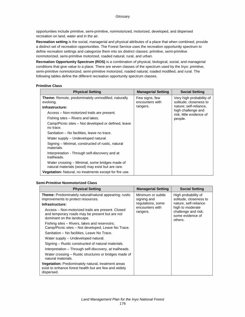
Glossary
Land Management Plan for the Inyo National Forest 176
opportunities include primitive, semi-primitive, nonmotorized, motorized, developed, and dispersed recreation on land, water and in the air. Recreation setting is the social, managerial and physical attributes of a place that when combined, provide a distinct set of recreation opportunities. The Forest Service uses the recreation opportunity spectrum to define recreation settings and categorize them into six distinct classes: primitive, semi-primitive nonmotorized, semi-primitive motorized, roaded natural, rural, and urban. Recreation Opportunity Spectrum (ROS) is a combination of physical, biological, social, and managerial conditions that give value to a place. There are seven classes of the spectrum used by the Inyo: primitive, semi-primitive nonmotorized, semi-primitive motorized, roaded natural, roaded modified, and rural. The following tables define the different recreation opportunity spectrum classes.
Primitive Class Physical Setting Managerial Setting Social Setting
Theme: Remote, predominately unmodified, naturally evolving. Infrastructure:
Access – Non-motorized trails are present. Fishing sites – Rivers and lakes. Camp/Picnic sites – Not developed or defined, leave no trace. Sanitation – No facilities, leave no trace. Water supply – Undeveloped natural. Signing – Minimal, constructed of rustic, natural materials. Interpretation - Through self-discovery and at trailheads. Water crossing – Minimal, some bridges made of natural materials (wood) may exist but are rare.
Vegetation: Natural, no treatments except for fire use.
Few signs, few encounters with rangers.
Very high probability of solitude; closeness to nature; self-reliance, high challenge and risk; little evidence of people.
Semi-Primitive Nonmotorized Class Physical Setting Managerial Setting Social Setting
Theme: Predominately natural/natural appearing; rustic improvements to protect resources. Infrastructure:
Access – Non-motorized trails are present. Closed and temporary roads may be present but are not dominant on the landscape. Fishing sites – Rivers, lakes and reservoirs; Camp/Picnic sites – Not developed, Leave No Trace. Sanitation – No facilities, Leave No Trace. Water supply – Undeveloped natural. Signing – Rustic constructed of natural materials. Interpretation – Through self-discovery, at trailheads. Water crossing – Rustic structures or bridges made of natural materials.
Vegetation: Predominately natural, treatment areas exist to enhance forest health but are few and widely dispersed.
Minimum or subtle signing and regulations, some encounters with rangers.
High probability of solitude, closeness to nature, self-reliance high to moderate challenge and risk; some evidence of others.

Glossary
Land Management Plan for the Inyo National Forest 177
Semi-Primitive Motorized Class Physical Setting Managerial Setting Social Setting
Theme: Predominately natural, natural appearing. Infrastructure:
Access – Motorized trails exist. Fishing sites – Rivers, lakes, and reservoirs with some trails and primitive roads (motorized trails). Camp/Picnic sites – Not developed, leave no trace, some identified dispersed areas. Sanitation – Limited facilities, rustic, may have rustic outhouses available. Water supply – Undeveloped natural, rustic developments. Signing – Rustic, made of natural materials. Interpretation – Self-discovery, some located on site or at trailheads. Water crossing – Rustic structures or bridges made of natural material, some designed for motorized use.
Vegetation: Treatment areas are very small in number, widely disbursed, and consistent with natural vegetation patterns.
Minimum or subtle on-site controls with some restrictions.
Moderate probability of solitude, closeness to nature, high degree of challenge and risk using motorized equipment; motorized use visible and audible.
Roaded Natural Class Physical Setting Managerial Setting Social Setting
Theme: Natural appearing with nodes and corridors of development such as campgrounds, trailheads, boat launches, and rustic, small-scale resorts. Infrastructure:
Access – Classified Road System for highway vehicle use. Fishing sites – Rivers, lakes, reservoirs with some facilities. Camp/picnic sites – Identified dispersed and developed sites. Sanitation – Developed outhouses that blend with setting. Water supply – Often developed. Signing – Rustic with natural materials to more refined using a variety of materials such as fiberglass, metal, etc. Interpretation – Simple roadside signs, some interpretive displays. Water crossing – Bridges constructed of natural materials.
Vegetation: Changes (treatments) to the natural vegetation patterns are evident but in harmony with natural vegetation patterns.
Opportunity to be with other users in developed sites; some obvious signs (information and regulation) and low to moderate likelihood of meeting Forest Service rangers.
Moderate evidence of human sights and sounds; moderate concentration of users at campsites; little challenge or risk.
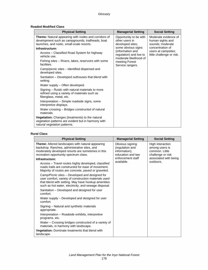
Glossary
Land Management Plan for the Inyo National Forest 178
Roaded Modified Class Physical Setting Managerial Setting Social Setting
Theme: Natural appearing with nodes and corridors of development such as campgrounds, trailheads, boat launches, and rustic, small-scale resorts. Infrastructure:
Access – Classified Road System for highway vehicle use. Fishing sites – Rivers, lakes, reservoirs with some facilities. Camp/picnic sites – Identified dispersed and developed sites. Sanitation – Developed outhouses that blend with setting. Water supply – Often developed. Signing – Rustic with natural materials to more refined using a variety of materials such as fiberglass, metal, etc. Interpretation – Simple roadside signs, some interpretive displays. Water crossing – Bridges constructed of natural materials.
Vegetation: Changes (treatments) to the natural vegetation patterns are evident but in harmony with natural vegetation patterns.
Opportunity to be with other users in developed sites; some obvious signs (information and regulation) and low to moderate likelihood of meeting Forest Service rangers.
Moderate evidence of human sights and sounds; moderate concentration of users at campsites; little challenge or risk.
Rural Class Physical Setting Managerial Setting Social Setting
Theme: Altered landscapes with natural appearing backdrop. Ranches, administrative sites, and moderately developed resorts are sometimes in this recreation opportunity spectrum class. Infrastructure:
Access – Travel routes highly developed, classified roads trails are constructed for ease of movement. Majority of routes are concrete, paved or graveled. Camp/Picnic sites – Developed and designed for user comfort, variety of construction materials used that blend with setting. May have hookup amenities such as hot water, electricity, and sewage disposal. Sanitation – Developed and designed for user comfort. Water supply – Developed and designed for user comfort. Signing – Natural and synthetic materials appropriate. Interpretation – Roadside exhibits, interpretive programs, etc. Water – Crossing bridges constructed of a variety of materials, in harmony with landscape.
Vegetation: Dominate treatments that blend with landscape.
Obvious signing (regulation and information), education and law enforcement staff available.
High interaction among users is common. Little challenge or risk associated with being outdoors.
Glossary
Land Management Plan for the Inyo National Forest 179
Resilience is the ability of an ecosystem and its component parts to absorb or recover from the effects of disturbance through preservation, restoration, or improvement of its essential structures and functions, and redundancy of ecological patterns across the landscape. Restocked refers to having an adequate number of trees reoccupy a site after a disturbance such as timber harvest or fire removes the trees that were there. Riparian areas are areas of land directly influenced by water; an ecosystem that is transitional between land and water ecosystems. Riparian areas usually have visible vegetative or physical characteristics reflecting the influence of water. River sides, lake borders, and marshes are typical riparian areas. Risk is a combination of the likelihood that a negative outcome will occur and the severity of the subsequent negative consequences. Rotation is the number of years (including the regeneration period) required to establish and grow timber under an even-aged management system to a specified condition or maturity for regeneration harvest. Salvage harvest is an intermediate harvest removing trees that are dead or dying because of agents other than competition, to recover economic value that would otherwise be lost. Satisfactory soils are soil conditions with favorable structure and infiltration characteristics to absorb and filter precipitation, and support adequate vegetative cover to minimize erosion and sustain desired habitat diversity. Satisfactory condition for range vegetation is good to excellent vegetation condition or fair vegetation condition with an upward trend. Scenic character is a combination of the physical, biological, and cultural images that give an area its scenic identity and contributes to its sense of place. Scenic character provides a frame of reference from which to determine scenic attractiveness and to measure scenic integrity. Scenic integrity objectives in the context of the forest plan are equivalent to goals or desired conditions. Scenic integrity describes the state of naturalness or a measure of the degree to which a landscape is visually perceived to be “complete.” The highest scenic integrity ratings are given to those landscapes that have little or no deviation from the landscape character valued by constituents for its aesthetic quality. Scenic integrity is the state of naturalness or, conversely, the state of disturbance created by human activities or alteration. Scenic integrity is measured in five levels:
• Very high: landscapes where the valued landscape character “is” intact with only minute, if any deviations. The existing landscape character and sense of place is expressed at the highest possible level.
• High: landscapes where the valued landscape character appears unaltered. Deviations may be present but must repeat the form, line, color, texture and pattern common to the landscape character so completely and at such scale that they are not evident.
• Moderate: landscapes where the valued landscape character appears slightly altered. Noticeable deviations must remain visually subordinate to the landscape character being viewed.
• Low: landscapes where the valued landscape character appears moderately altered. Deviations begin to dominate the valued landscape character being viewed but they borrow valued attributes such as size, shape, edge effect, pattern of natural openings, vegetative type changes or architectural styles outside the landscape being viewed. They should not only appear as valued character outside the landscape being viewed, but compatible or complementary to the character within.
• Very Low: landscapes where the valued landscape character appears heavily altered. Deviations may strongly dominate the valued landscape character. They may not borrow from valued attributes such as size, shape, edge effect, pattern of natural openings, vegetative type changes or architectural styles within or outside the landscape being viewed. However, deviations must be shaped and blended with the natural terrain so that elements such as unnatural edges, roads, landings and structures do not dominate the composition.
Second half (of the season) refers to wet or moist meadows and shrubby species: Grazing during the second half of the growing season allows less time for regrowth before onset of dormancy, so it generally requires a more restrictive standard than first-half grazing. It tends to be particularly hard on browse and
Glossary
Land Management Plan for the Inyo National Forest 180
shrub species such as bitterbrush and willow because by this time of year they are becoming more attractive to livestock as the herbaceous forage begins to dry out. For perennial bunchgrass species, second half grazing of perennial bunchgrass on dry sites is often preferred because regrowth is not always possible anyway due to lack of moisture. In this case it is generally better to wait until the second half to commence grazing, thus allowing adequate time for plants to reach seed maturity and restore root reserves before having their herbage removed. Special forest products are products or natural resources that are not traditional timber and wood products. Examples include such products as moss, Christmas trees and boughs, mushrooms, transplants (trees, shrubs or herbaceous plants), cones, medicinal plants, seeds, nuts, berries and decorative wood. Species of conservation concern are species (other than federally recognized threatened, endangered, proposed, or candidate species), that are known to occur in the plan area and for which the Regional Forester has determined that the best available scientific information indicates substantial concern about the species' capability to persist over the long term in the plan area. Stand refers to a contiguous group of trees sufficiently uniform in age class distribution, composition, and structure growing on a site of sufficiently uniform quality to be a distinguishable unit (such as mixed, pure, even-aged, and uneven-aged stands). Stressors are factors that may directly or indirectly degrade or impair ecosystem composition, structure or ecological process in a manner that may impair its ecological integrity (such as invasive species, loss of connectivity, or the disruption of a natural disturbance regime). Sustainability is the capability to meet the needs of the present generation without compromising the ability of future generations to meet their needs. For the purposes of land management planning regulations at 36 CFR part 219, ecological sustainability refers to the capability of ecosystems to maintain ecological integrity; economic sustainability refers to the capability of society to produce and consume or otherwise benefit from goods and services, including contributions to jobs and market and nonmarket benefits; and social sustainability refers to the capability of society to support the network of relationships, traditions, culture and activities that connect people to the land and to one another, and support vibrant communities. Sustainable recreation refers to the set of recreation settings and opportunities on the National Forest System that is ecologically, economically, and socially sustainable for present and future generations. Threatened species is any species that the Secretary of the Interior or the Secretary of Commerce has determined is likely to become an endangered species within the foreseeable future throughout all or a significant portion of its range. Threatened species are listed at 50 CFR sections 17.11, 17.12, and 223.102. Timber harvest refers to the removal of trees for wood fiber use and other multiple-use purposes. Timber production is the purposeful growing, tending, harvesting, and regeneration of regulated crops of trees to be cut into logs, bolts, or other round sections for industrial or consumer use (36 CFR 219.19). Trail corridor is an allocation established through the land use planning process, pursuant to section 7(a)(2) of the National Trails System Act (“rights-of-way”), for a public land area of sufficient width, within which to encompass national trail resources, qualities, values and associated settings, and the primary use or uses that are present or to be restored. Undesirable wildfire refers to wildfire that does not meet the desired conditions for a specific vegetation type. Utilization standards related to forest products are specifications for merchantable forest products offered in a timber sale. Utilization standards related to livestock grazing is defined as: (1) the proportion of current year's forage production that is consumed or destroyed by grazing animals. May refer either to a single species or to the vegetation as a whole, and (2) utilization of range for a purpose such as grazing, bedding, shelter, trailing, watering, watershed, recreation, forestry, or other uses. Vegetation treatments refer to burning, mechanically removing or thinning vegetation or forest floor material to improve a stand or reduce fuels. Viable population is a population of a species that continues to persist over the long term with sufficient distribution to be resilient and adaptable to stressors and likely future environments (36 CFR 219.19).

Glossary
Land Management Plan for the Inyo National Forest 181
Visible foreground (related to scenery management) is the area within the foreground distance zone (up to 0.5 mile) that is visible from a height of 5 feet on a trail, using terrain to define the boundaries. Watershed is a region or land area drained by a single stream, river, or drainage network; a drainage basin. Watershed condition is the state of a watershed based on physical and biogeochemical characteristics and processes. Watershed condition framework is a national comprehensive and consistent approach for classifying watershed condition, proactively implementing integrated restoration in priority watersheds on national forests and grasslands, and tracking and monitoring outcome-based program accomplishments for performance accountability27. Wild and scenic river is a river designated by Congress as part of the National Wild and Scenic Rivers System that was established in the Wild and Scenic Rivers Act of 1968 (16 U.S.C. 1271 (note), 1271–1287). Wilderness is any area of land designated by Congress as part of the National Wilderness Preservation System that was established in the Wilderness Act of 1964 (16 U.S.C. 1131–1136). Wildland fire refers to wildfire or prescribed fire.
27 USDA, Forest Service. 2011. Watershed Condition Framework; a framework for assessing and tracking
changes to watershed condition. U.S. Department of Agriculture, Forest Service, Washington, Report FS-977

This page left intentionally blank