RESOLUTION MEPC.121(52) Adopted on 15 October …52).pdf · mepc 52/24/add.1...
16
RESOLUTION MEPC.121(52) Adopted on 15 October 2004 DESIGNATION OF THE WESTERN EUROPEAN WATERS AS A PARTICULARLY SENSITIVE SEA AREA
-
Upload
nguyenlien -
Category
Documents
-
view
238 -
download
0
Transcript of RESOLUTION MEPC.121(52) Adopted on 15 October …52).pdf · mepc 52/24/add.1...

RESOLUTION MEPC.121(52) Adopted on 15 October 2004
DESIGNATION OF THE WESTERN EUROPEAN WATERS AS A PARTICULARLY SENSITIVE SEA AREA
MEPC 52/24/Add.1
I:\MEPC\52\24-ADD-1.DOC
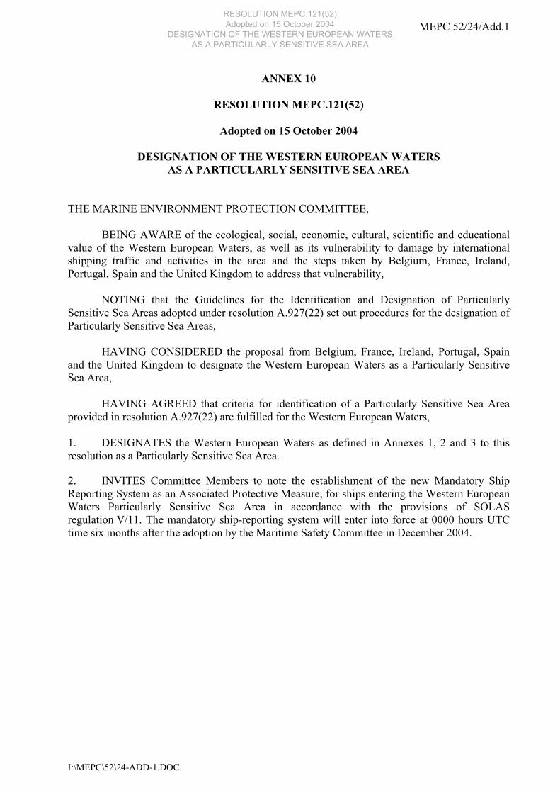
ANNEX 10
RESOLUTION MEPC.121(52)
Adopted on 15 October 2004
DESIGNATION OF THE WESTERN EUROPEAN WATERS AS A PARTICULARLY SENSITIVE SEA AREA
THE MARINE ENVIRONMENT PROTECTION COMMITTEE, BEING AWARE of the ecological, social, economic, cultural, scientific and educational value of the Western European Waters, as well as its vulnerability to damage by international shipping traffic and activities in the area and the steps taken by Belgium, France, Ireland, Portugal, Spain and the United Kingdom to address that vulnerability, NOTING that the Guidelines for the Identification and Designation of Particularly Sensitive Sea Areas adopted under resolution A.927(22) set out procedures for the designation of Particularly Sensitive Sea Areas, HAVING CONSIDERED the proposal from Belgium, France, Ireland, Portugal, Spain and the United Kingdom to designate the Western European Waters as a Particularly Sensitive Sea Area, HAVING AGREED that criteria for identification of a Particularly Sensitive Sea Area provided in resolution A.927(22) are fulfilled for the Western European Waters, 1. DESIGNATES the Western European Waters as defined in Annexes 1, 2 and 3 to this resolution as a Particularly Sensitive Sea Area. 2. INVITES Committee Members to note the establishment of the new Mandatory Ship Reporting System as an Associated Protective Measure, for ships entering the Western European Waters Particularly Sensitive Sea Area in accordance with the provisions of SOLAS regulation V/11. The mandatory ship-reporting system will enter into force at 0000 hours UTC time six months after the adoption by the Maritime Safety Committee in December 2004.
RESOLUTION MEPC.121(52) Adopted on 15 October 2004
DESIGNATION OF THE WESTERN EUROPEAN WATERS AS A PARTICULARLY SENSITIVE SEA AREA

MEPC 52/24/Add.1 ANNEX 10 Page 2
I:\MEPC\52\24-ADD-1.DOC
ANNEX 1
DESCRIPTION OF THE PARTICULARLY SENSITIVE SEA AREA WESTERN EUROPEAN WATERS CO-ORDINATES
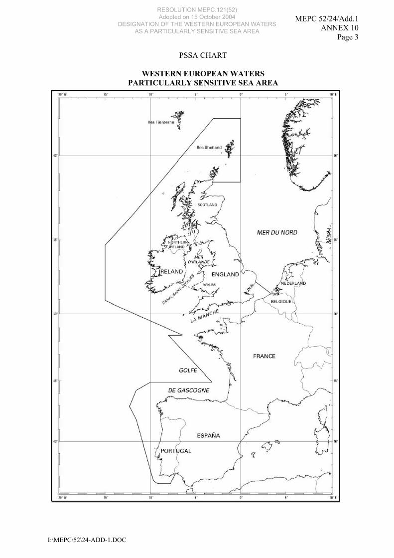
1 Description of the area 1.1 The area covers the Western coasts of the United Kingdom, Ireland, Belgium, France, Spain and Portugal, from the Shetland Islands in the North to Cape S. Vicente in the South, and the English Channel and its approaches, as shown in the map below. 1.2 The PSSA is the area bounded by a line connecting the following geographical co-ordinates (all the co-ordinates are in WGS 84 reference system):
Number Latitude Longitude 1 (UK) 58°30'N UK coast 2 (UK) 58°30'N 000°W 3 (UK) 62°N 000°W 4 (UK) 62°N 003°W
5 (UK+ Irl) 56°30'N 012°W 6 (Irl) 54°40'40.9"N 015°W 7 (Irl) 50°56'45.3"N 015°W
8 (Irl+UK+F) 48°27'N 006°25'W 9 (F) 48°27'N 008°W
10 (F+S) 44°52'N 003°10'W 11 (S) 44°52'N 010°W 12 (S) 44°14'N 011°34'W 13 (S) 42°55'N 012°18'W
14 (S+P) 41°50'N 011°34'W 15(P) 37°00'N 009°49'W 16 (P) 36°20'N 009°00'W 17(P) 36°20'N 007°47'W 18 (P) 37°10'N 007°25'W 19 (B) 51°22'25"N 003°21'52.5"E
20 (UK) 52°12'N UK east coast 21 (IRL) 52°10.3'N 006°21.8'W 22 (UK) 52°01.52'N 005°04.18'W 23 (UK) 54°51.43'N 005°08.47'W 24 (UK) 54°40.39'N 005°34.34'W
1.3 The geographical co-ordinates for the identification of a PSSA are solely for that purpose and must not be interpreted as having any bearing upon issues related with maritime limits and boundaries.
RESOLUTION MEPC.121(52) Adopted on 15 October 2004
DESIGNATION OF THE WESTERN EUROPEAN WATERS AS A PARTICULARLY SENSITIVE SEA AREA
MEPC 52/24/Add.1 ANNEX 10
Page 3
I:\MEPC\52\24-ADD-1.DOC
PSSA CHART
WESTERN EUROPEAN WATERS PARTICULARLY SENSITIVE SEA AREA
RESOLUTION MEPC.121(52) Adopted on 15 October 2004
DESIGNATION OF THE WESTERN EUROPEAN WATERS AS A PARTICULARLY SENSITIVE SEA AREA
MEPC 52/24/Add.1 ANNEX 10 Page 4
I:\MEPC\52\24-ADD-1.DOC
2 Significance of the area 2.1 General 2.1.1 From the North to the South of the PSSA, and within the transition between the bio-geographical moderate heat and boreal areas, there is a rich variety of ecosystems. 2.1.2 The coast of North West Scotland, the Shetland Islands, the Orkney Islands and the Hebrides are environmentally significant, including areas with high concentrations of vulnerable sea birds and with a medium to low level of offshore fishing activity. 2.1.3 The coastline of Western and Southern Ireland is a heavily indented one, screened in parts by outlying islands, rocks and skerries. These coasts (from Donegal in the north-west to Waterford in south-west) measure 5,140 km in length. The west coast in particular has a very high species diversity of both macro-fauna and flora. Offshore waters contain some of the richest fishing grounds in Europe. Prevailing currents (oceanographic and meteorological) are southwesterly. 2.1.4 The water column to the west and south of Ireland lies above continental shelf in the main and is consequently relatively shallow. The body of water is a biologically diverse and highly productive marine environment. These are 10 million pairs of seabirds of 28 species regularly breeding on the Irish coasts of the PSSA. The open water areas support important populations of marine birds, both offshore species such as petrels, gulls, auks and gannets, and inshore species of ducks, divers, cormorants and terns. 2.1.5 Many of these species spend most of their time feeding at sea and are vulnerable to surface pollutants such as oil. 2.1.6 Off the south and west coasts of Ireland there is a very large grey seal population. The west coast of Ireland also supports a wide variety of cetaceans. In particular, the Shannon estuary supports a resident population of Bottlenose Dolphins (Tursiops truncatus). These waters also support 200 species of fish. 2.1.7 The importance of these areas on the coasts of Ireland has been recognized internationally through the creation of marine nature reserves, RAMSAR sites and Special Protected Areas (SPAs). Also particularly noteworthy is the continental shelf break, where upwellings and a front system create high productivity with rich plankton communities and a diverse benthos. 2.1.8 A number of the RAMSAR sites designated in Ireland are along the bays and inlets of the south and west coast and contain a unique and important diversity of marine flora and fauna. 2.1.9 In Belgium, the area is recognized as particularly important for flatfish and brown shrimp fisheries. The coastal zone is an essential spawning and nursery area for these species. It is characterised by the presence of sandbanks, which are slightly covered by seawater all the time, a natural habitat type of community interest under the European Habitat Directive. In 1984, part of these sandbanks were designated as wetlands of international importance under the RAMSAR convention, and in 1996 Belgium designated a Special Area of Conservation in that environment under the Habitat Directive. The Belgium government is now in the process of establishing three Special Protection Areas for seabirds in the area to provide the large seabird populations that concentrate in the winter with better protection. The entire coastline has a high amenity value and is one of the major European tourist resorts.
RESOLUTION MEPC.121(52) Adopted on 15 October 2004
DESIGNATION OF THE WESTERN EUROPEAN WATERS AS A PARTICULARLY SENSITIVE SEA AREA

MEPC 52/24/Add.1 ANNEX 10
Page 5
I:\MEPC\52\24-ADD-1.DOC
2.1.10 In France, the area enjoys great bio-diversity and biological wealth, due to the contrast between the moderate tidal range of Bay of Biscay and the very high tidal range in the English Channel, together with the influence of three large rivers (the Seine, the Loire and the Gironde), which are separated by vast areas of their fluvial deposits. These three large estuaries where the land, fresh water and salt water meet, are areas of particular significance for bio-diversity. 2.1.11 Another characteristic of this shore is the presence of about fifteen islands between the Côttes d’Armor and the Charente-Maritime. Although their surface is low compared to the total surface of the shoreline, they are nevertheless of very great interest from the ecological point of view. 2.1.12 This great ecological interest can be highlighted by the presence of emblematic species such as the marine mammals (seals, dolphins, whales), sea birds (puffins, skuas, terns, gulls, etc.), and fish. 2.1.13 The northeast Atlantic and the Bay of Biscay coasts, because of their rich fauna and flora, beautiful landscapes and interesting geological aspects, have a remarkable cultural, scientific and touristic value to Spain. 2.1.14 It is important to emphasize that in this area the Atlantic Islands National Park is located, which area includes:
a) Cies Islands Area limited by Norte Punta de Monteagudo, Sur Bajosde Carrumeiros, Sur Castros de Agoeiros and Islote de Biduidos, comprising Monte Faro, Monteagudo and San Martiño islands and adjoining islets. This group of islands is placed near the Ria de Vigo (Vigo), and includes about 2,658 sea-hectares or 433 land-hectares.
b) Ons and Onza Islands Area limited by Punta Centolo, Bajos los Camoucos, Balo Laxiña de Galera, Bajo Menguella, Bajo Cabeza del Rico and Bajos de Bastián de Val. Comprising Ons and Onza islands adjoining islets, this group of islands is placed near the Ria de Pontevedra (Bueu) and includes about 2,171 sea-hectares and 470 land-hectares. c) Sávora and adjoining islands Area limited by Islas Sagres, Este del seijo de Vionta and S Punta de Besugueiros. Comprising Sávora and adjoining islets, this group of islands is placed in the west part of Ria de Arousa (Ribeira), and includes about 2,309 sea-hectares and 248 land-hectares.
RESOLUTION MEPC.121(52) Adopted on 15 October 2004
DESIGNATION OF THE WESTERN EUROPEAN WATERS AS A PARTICULARLY SENSITIVE SEA AREA
MEPC 52/24/Add.1 ANNEX 10 Page 6
I:\MEPC\52\24-ADD-1.DOC
d) Cortegada, Milveires and adjoining islands Area limited by high tide maximum equinoctial line and Cortegada, Malveira Grande, Malveira Chica, Briás and Illote de Com. This group of islands is placed in the Ria de Arousa (Villagarcia de Arousa) and includes 43.8 land-hectares. In this area, regional authorities have established additional forms of environmental protection: natural reserves, natural parks, protected landscapes, natural monuments, etc.
2.1.15 Other international protected areas created in the Atlantic Spanish coast are as follows:
- RAMSAR areas; - Special areas for the protection of birds and areas of common European interest,
included within Red Natura 2000, under European Directives on birds (74/409/CEE) and habitats (92/43/CEE);
- Biosphere reserve (Urdaibai) under the UNESCO program on man and biosphere. 2.1.16 Portugal has a mainland coastline of ca. 1,000 Km and an Exclusive Economic Zone of 17,000 Km², the largest in the European Union. More than 50% of the Portuguese population lives near the coastline. 2.1.17 In Portugal, around 50% of mainland coast is classified into one of the following categories: Protected Areas, Special Areas of Conservation, or Natura 2000 sites. They include ecosystems as diverse as marine areas, estuaries, coastal lagoons, sand dunes and rocky cliffs, involving nature’s treasures of great importance, where one can find species of fauna and flora with a high degree of endemicity, as well as particularly sensitive habitats in need of protection. 2.1.18 The uniqueness, significance and diversity of several areas along Portuguese coastline are highly vulnerable to pollution damage. Extended biological productivity of coastal waters allows traditional fishing activities with great economical significance from the north to southeast end of the area. 2.2 Detailed description of significance 2.2.1 Detailed descriptions of the ecological, socio-economic and cultural, scientific and educational criteria are contained in document MEPC 49/8/1. 3 Vulnerability of the area to damage by international shipping activities 3.1 The marine and shore environment of the Belgian, French, Irish, Portuguese, Spanish and United Kingdom coasts, the English Channel and its approaches are particularly vulnerable to the risks induced by the carriage of goods by sea. 3.2 This area constitutes one of the most significant sea routes on an international scale, because of the number of ships and of the quantities of dangerous or polluting goods transported: 25% of the world commercial traffic converge towards the English Channel. It constitutes the main area of maritime transit of commercial flows with destination to the great industrial areas and harbours of Northern Europe.
RESOLUTION MEPC.121(52) Adopted on 15 October 2004
DESIGNATION OF THE WESTERN EUROPEAN WATERS AS A PARTICULARLY SENSITIVE SEA AREA
MEPC 52/24/Add.1 ANNEX 10
Page 7
I:\MEPC\52\24-ADD-1.DOC
3.3 There is also significant cross channel commercial traffic between Ireland and the United Kingdom, between Ireland, the United Kingdom and the mainland of Europe, and North European traffic bound for Western Atlantic Ports. 3.4 A detailed description of the characteristics of the maritime traffic, the transport of harmful substances, and the threats from disasters, including a description of the meteorological, oceanographical and geographical conditions may be found in documents MEPC 49/8/1 together with MEPC 49/8/1 Add.1 and MEPC 49/8/1 Corr.1.
RESOLUTION MEPC.121(52) Adopted on 15 October 2004
DESIGNATION OF THE WESTERN EUROPEAN WATERS AS A PARTICULARLY SENSITIVE SEA AREA

MEPC 52/24/Add.1 ANNEX 10 Page 8
I:\MEPC\52\24-ADD-1.DOC
ANNEX 2
RELEVANT RULES AND REGULATIONS IN FORCE IN THE WESTERN EUROPEAN WATERS PARTICULARLY SENSITIVE SEA AREA
Measures adopted by IMO 1 Conventions • Convention on the International Regulations for Preventing Collisions at Sea, 1972
(COLREGs), as amended • International Convention for the Prevention of Pollution from Ships, 1973, as modified by
the Protocol of 1978 relating thereto (MARPOL 73/78)1 • International Convention for the Safety of Life at Sea (SOLAS), 1974, as amended. 2 Traffic Separation Schemes • West of the Scilly Isles
• South of the Scilly Isles
• Off Lands End, between Seven Stones and Longships
• Off Ushant
• Off Casquets
• In the Strait of Dover and adjacent waters
• Off Fastnet Rock
• Off Smalls
• Off Tuskar Rock
• Off Skerries
• In the North Channel
• Off Finisterre
• Off Berlenga
• Off Cape Roca
• Off Cape S. Vicente 1 The English Channel and its approaches are part of the North-West European Waters Special Area.
RESOLUTION MEPC.121(52) Adopted on 15 October 2004
DESIGNATION OF THE WESTERN EUROPEAN WATERS AS A PARTICULARLY SENSITIVE SEA AREA
MEPC 52/24/Add.1 ANNEX 10
Page 9
I:\MEPC\52\24-ADD-1.DOC
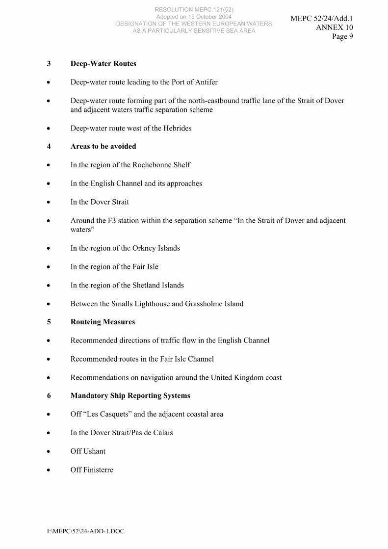
3 Deep-Water Routes • Deep-water route leading to the Port of Antifer • Deep-water route forming part of the north-eastbound traffic lane of the Strait of Dover
and adjacent waters traffic separation scheme
• Deep-water route west of the Hebrides
4 Areas to be avoided • In the region of the Rochebonne Shelf • In the English Channel and its approaches
• In the Dover Strait
• Around the F3 station within the separation scheme “In the Strait of Dover and adjacent
waters”
• In the region of the Orkney Islands • In the region of the Fair Isle
• In the region of the Shetland Islands
• Between the Smalls Lighthouse and Grassholme Island 5 Routeing Measures • Recommended directions of traffic flow in the English Channel
• Recommended routes in the Fair Isle Channel
• Recommendations on navigation around the United Kingdom coast 6 Mandatory Ship Reporting Systems • Off “Les Casquets” and the adjacent coastal area
• In the Dover Strait/Pas de Calais
• Off Ushant
• Off Finisterre
RESOLUTION MEPC.121(52) Adopted on 15 October 2004
DESIGNATION OF THE WESTERN EUROPEAN WATERS AS A PARTICULARLY SENSITIVE SEA AREA

MEPC 52/24/Add.1 ANNEX 10 Page 10
I:\MEPC\52\24-ADD-1.DOC
7 Coastal Vessel Traffic Services (VTS) • Gris-Nez VTS
• Dover, Channel Navigation Information Service (CNIS) • Corsen VTS
• Finisterre VTS
RESOLUTION MEPC.121(52) Adopted on 15 October 2004
DESIGNATION OF THE WESTERN EUROPEAN WATERS AS A PARTICULARLY SENSITIVE SEA AREA
MEPC 52/24/Add.1 ANNEX 10
Page 11
I:\MEPC\52\24-ADD-1.DOC
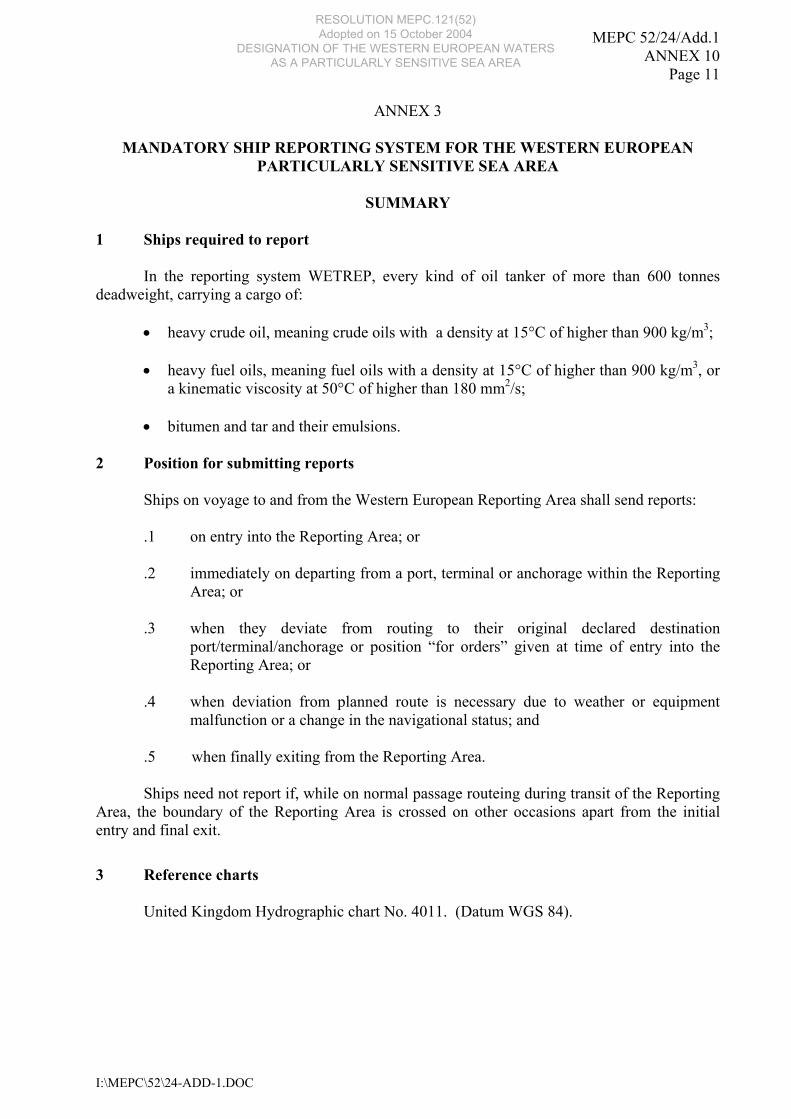
ANNEX 3
MANDATORY SHIP REPORTING SYSTEM FOR THE WESTERN EUROPEAN PARTICULARLY SENSITIVE SEA AREA
SUMMARY
1 Ships required to report
In the reporting system WETREP, every kind of oil tanker of more than 600 tonnes deadweight, carrying a cargo of:
• heavy crude oil, meaning crude oils with a density at 15°C of higher than 900 kg/m3;
• heavy fuel oils, meaning fuel oils with a density at 15°C of higher than 900 kg/m3, or a kinematic viscosity at 50°C of higher than 180 mm2/s;
• bitumen and tar and their emulsions.
2 Position for submitting reports Ships on voyage to and from the Western European Reporting Area shall send reports: .1 on entry into the Reporting Area; or .2 immediately on departing from a port, terminal or anchorage within the Reporting
Area; or .3 when they deviate from routing to their original declared destination
port/terminal/anchorage or position “for orders” given at time of entry into the Reporting Area; or
.4 when deviation from planned route is necessary due to weather or equipment
malfunction or a change in the navigational status; and .5 when finally exiting from the Reporting Area.
Ships need not report if, while on normal passage routeing during transit of the Reporting Area, the boundary of the Reporting Area is crossed on other occasions apart from the initial entry and final exit.
3 Reference charts
United Kingdom Hydrographic chart No. 4011. (Datum WGS 84).
RESOLUTION MEPC.121(52) Adopted on 15 October 2004
DESIGNATION OF THE WESTERN EUROPEAN WATERS AS A PARTICULARLY SENSITIVE SEA AREA
MEPC 52/24/Add.1 ANNEX 10 Page 12
I:\MEPC\52\24-ADD-1.DOC
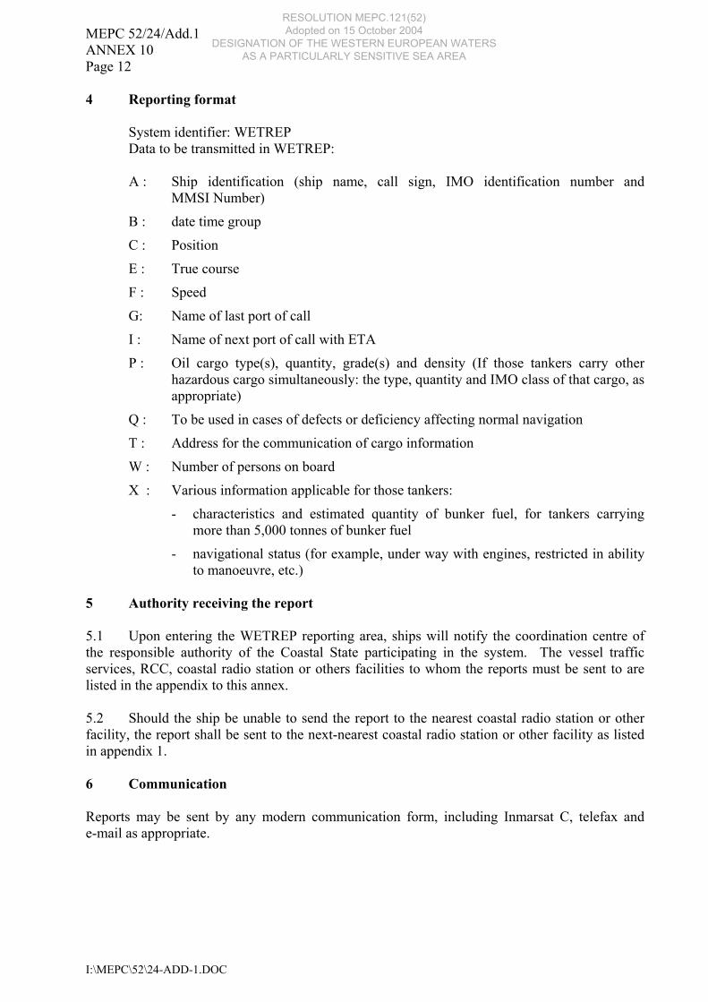
4 Reporting format System identifier: WETREP Data to be transmitted in WETREP:
A : Ship identification (ship name, call sign, IMO identification number and
MMSI Number)
B : date time group
C : Position
E : True course
F : Speed
G: Name of last port of call
I : Name of next port of call with ETA
P : Oil cargo type(s), quantity, grade(s) and density (If those tankers carry other hazardous cargo simultaneously: the type, quantity and IMO class of that cargo, as appropriate)
Q : To be used in cases of defects or deficiency affecting normal navigation
T : Address for the communication of cargo information
W : Number of persons on board
X : Various information applicable for those tankers:
- characteristics and estimated quantity of bunker fuel, for tankers carrying more than 5,000 tonnes of bunker fuel
- navigational status (for example, under way with engines, restricted in ability to manoeuvre, etc.)
5 Authority receiving the report 5.1 Upon entering the WETREP reporting area, ships will notify the coordination centre of the responsible authority of the Coastal State participating in the system. The vessel traffic services, RCC, coastal radio station or others facilities to whom the reports must be sent to are listed in the appendix to this annex. 5.2 Should the ship be unable to send the report to the nearest coastal radio station or other facility, the report shall be sent to the next-nearest coastal radio station or other facility as listed in appendix 1. 6 Communication Reports may be sent by any modern communication form, including Inmarsat C, telefax and e-mail as appropriate.
RESOLUTION MEPC.121(52) Adopted on 15 October 2004
DESIGNATION OF THE WESTERN EUROPEAN WATERS AS A PARTICULARLY SENSITIVE SEA AREA
MEPC 52/24/Add.1 ANNEX 10
Page 13
I:\MEPC\52\24-ADD-1.DOC
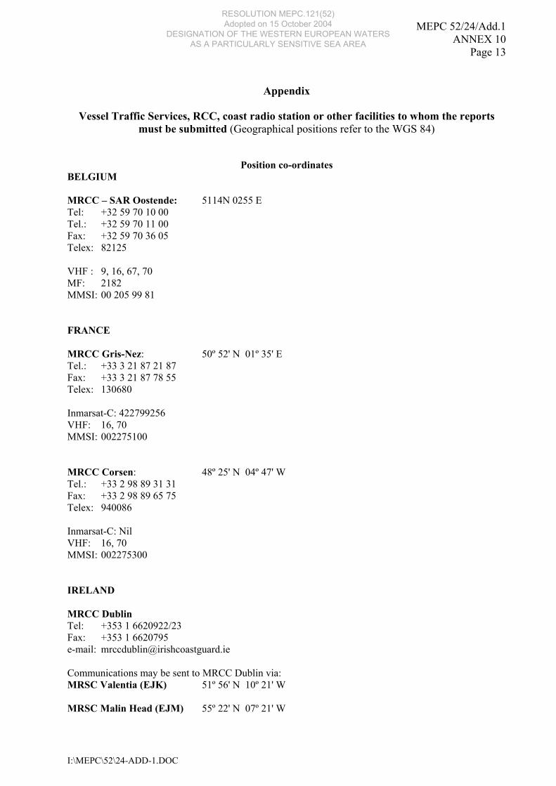
Appendix
Vessel Traffic Services, RCC, coast radio station or other facilities to whom the reports
must be submitted (Geographical positions refer to the WGS 84)
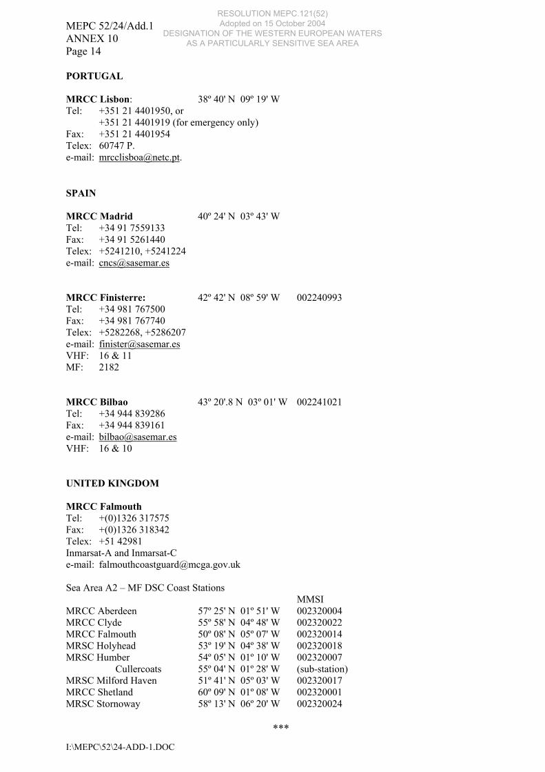
Position co-ordinates BELGIUM MRCC – SAR Oostende: 5114N 0255 E Tel: +32 59 70 10 00 Tel.: +32 59 70 11 00 Fax: +32 59 70 36 05 Telex: 82125 VHF : 9, 16, 67, 70 MF: 2182 MMSI: 00 205 99 81 FRANCE MRCC Gris-Nez: 50º 52' N 01º 35' E Tel.: +33 3 21 87 21 87 Fax: +33 3 21 87 78 55 Telex: 130680 Inmarsat-C: 422799256 VHF: 16, 70 MMSI: 002275100 MRCC Corsen: 48º 25' N 04º 47' W Tel.: +33 2 98 89 31 31 Fax: +33 2 98 89 65 75 Telex: 940086 Inmarsat-C: Nil VHF: 16, 70 MMSI: 002275300 IRELAND MRCC Dublin Tel: +353 1 6620922/23 Fax: +353 1 6620795 e-mail: [email protected] Communications may be sent to MRCC Dublin via: MRSC Valentia (EJK) 51º 56' N 10º 21' W MRSC Malin Head (EJM) 55º 22' N 07º 21' W
RESOLUTION MEPC.121(52) Adopted on 15 October 2004
DESIGNATION OF THE WESTERN EUROPEAN WATERS AS A PARTICULARLY SENSITIVE SEA AREA
MEPC 52/24/Add.1 ANNEX 10 Page 14
I:\MEPC\52\24-ADD-1.DOC
PORTUGAL MRCC Lisbon: 38º 40' N 09º 19' W Tel: +351 21 4401950, or +351 21 4401919 (for emergency only) Fax: +351 21 4401954 Telex: 60747 P. e-mail: [email protected]. SPAIN MRCC Madrid 40º 24' N 03º 43' W Tel: +34 91 7559133 Fax: +34 91 5261440 Telex: +5241210, +5241224 e-mail: [email protected] MRCC Finisterre: 42º 42' N 08º 59' W 002240993 Tel: +34 981 767500 Fax: +34 981 767740 Telex: +5282268, +5286207 e-mail: [email protected] VHF: 16 & 11 MF: 2182 MRCC Bilbao 43º 20'.8 N 03º 01' W 002241021 Tel: +34 944 839286 Fax: +34 944 839161 e-mail: [email protected] VHF: 16 & 10 UNITED KINGDOM MRCC Falmouth Tel: +(0)1326 317575 Fax: +(0)1326 318342 Telex: +51 42981 Inmarsat-A and Inmarsat-C e-mail: [email protected] Sea Area A2 – MF DSC Coast Stations MMSI MRCC Aberdeen 57º 25' N 01º 51' W 002320004 MRCC Clyde 55º 58' N 04º 48' W 002320022 MRCC Falmouth 50º 08' N 05º 07' W 002320014 MRSC Holyhead 53º 19' N 04º 38' W 002320018 MRSC Humber 54º 05' N 01º 10' W 002320007 Cullercoats 55º 04' N 01º 28' W (sub-station) MRSC Milford Haven 51º 41' N 05º 03' W 002320017 MRCC Shetland 60º 09' N 01º 08' W 002320001 MRSC Stornoway 58º 13' N 06º 20' W 002320024
***
RESOLUTION MEPC.121(52) Adopted on 15 October 2004
DESIGNATION OF THE WESTERN EUROPEAN WATERS AS A PARTICULARLY SENSITIVE SEA AREA

RESOLUTION MEPC.121(52) Adopted on 15 October 2004
DESIGNATION OF THE WESTERN EUROPEAN WATERS AS A PARTICULARLY SENSITIVE SEA AREA