Residential Title-24 Lighting & ASHRAE 62.2 Ventilation Codes.
State Planning Policy 3.1 Residential Design Codes
State Planning Policy 3.1 Residential Design Codes
Prepared under section 26 of the Planning and Development Act 2005 by the Western Australian Planning Commission.
© State of Western AustraliaPublished by theDepartment of PlanningGordon Stephenson House140 William StreetPerth WA 6000
Locked Bag 2506Perth WA 6001
Published October 2015
website: www.planning.wa.gov.auemail: [email protected]
tel: 08 6551 9000fax: 08 6551 9001National Relay Service: 13 36 77infoline: 1800 626 477
This document is available in alternative formats on application to Communication Services.
Disclaimer
This document has been published by the Department of Planning on behalf of the Western Australian Planning Commission. Any representation, statement, opinion or advice expressed or implied in this publication is made in good faith and on the basis that the government, its employees and agents are not liable for any damage or loss whatsoever which may occur as a result of action taken or not taken, as the case may be, in respect of any representation, statement, opinion or advice referred to herein. Professional advice should be obtained before applying the information contained in this document to particular circumstances.
2015 R-Codes (incorporating amendments gazetted on 23/10/15)
(Version 1, June 2013)(Version 1, June 2013)
Page 2Part 7 – Local planning framework Part 1 – Preliminary
State Planning Policy 3.1 Residential Design Codes
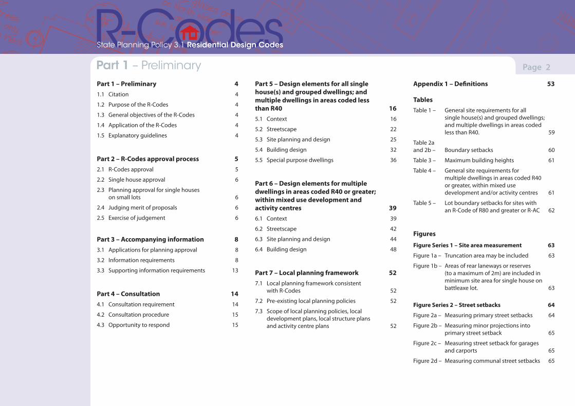
Part 1 – Preliminary 41.1 Citation 4
1.2 Purpose of the R-Codes 4
1.3 General objectives of the R-Codes 4
1.4 Application of the R-Codes 4
1.5 Explanatory guidelines 4
Part 2 – R-Codes approval process 52.1 R-Codes approval 5
2.2 Single house approval 6
2.3 Planning approval for single houses on small lots 6
2.4 Judging merit of proposals 6
2.5 Exercise of judgement 6
Part 3 – Accompanying information 83.1 Applications for planning approval 8
3.2 Information requirements 8
3.3 Supporting information requirements 13
Part 4 – Consultation 144.1 Consultation requirement 14
4.2 Consultation procedure 15
4.3 Opportunity to respond 15
Part 5 – Design elements for all single house(s) and grouped dwellings; and multiple dwellings in areas coded less than R40 165.1 Context 16
5.2 Streetscape 22
5.3 Site planning and design 25
5.4 Building design 32
5.5 Special purpose dwellings 36
Part 6 – Design elements for multiple dwellings in areas coded R40 or greater; within mixed use development and activity centres 396.1 Context 39
6.2 Streetscape 42
6.3 Site planning and design 44
6.4 Building design 48
Part 7 – Local planning framework 527.1 Local planning framework consistent
with R-Codes 52
7.2 Pre-existing local planning policies 52
7.3 Scope of local planning policies, local development plans, local structure plans and activity centre plans 52
Appendix 1 – Definitions 53
Tables Table 1 – General site requirements for all single house(s) and grouped dwellings; and multiple dwellings in areas coded less than R40. 59
Table 2a and 2b – Boundary setbacks 60
Table 3 – Maximum building heights 61
Table 4 – General site requirements for multiple dwellings in areas coded R40 or greater, within mixed use development and/or activity centres 61
Table 5 – Lot boundary setbacks for sites with an R-Code of R80 and greater or R-AC 62
Figures
Figure Series 1 – Site area measurement 63
Figure 1a – Truncation area may be included 63
Figure 1b – Areas of rear laneways or reserves (to a maximum of 2m) are included in minimum site area for single house on battleaxe lot. 63
Figure Series 2 – Street setbacks 64
Figure 2a – Measuring primary street setbacks 64
Figure 2b – Measuring minor projections into primary street setback 65
Figure 2c – Measuring street setback for garages and carports 65
Figure 2d – Measuring communal street setbacks 65
(Version 1, June 2013)(Version 1, June 2013)
Page 3Part 7 – Local planning framework
State Planning Policy 3.1 Residential Design Codes
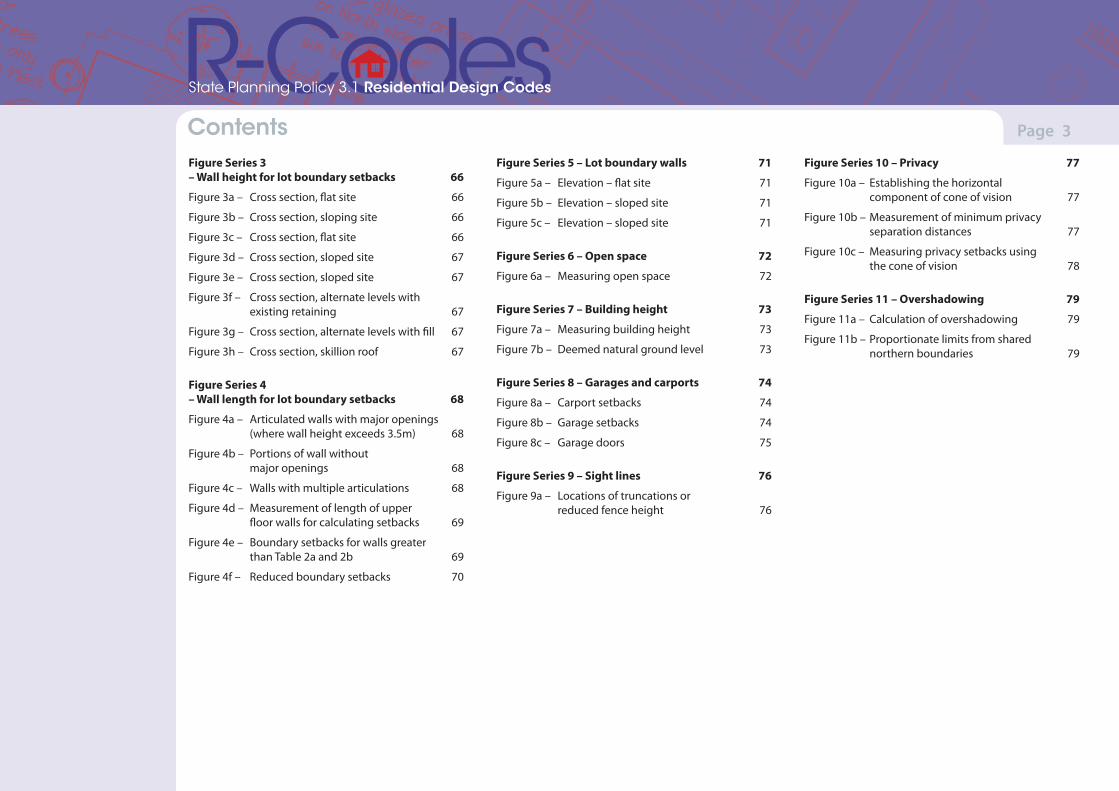
ContentsFigure Series 3 – Wall height for lot boundary setbacks 66
Figure 3a – Cross section, flat site 66
Figure 3b – Cross section, sloping site 66
Figure 3c – Cross section, flat site 66
Figure 3d – Cross section, sloped site 67
Figure 3e – Cross section, sloped site 67
Figure 3f – Cross section, alternate levels with existing retaining 67
Figure 3g – Cross section, alternate levels with fill 67
Figure 3h – Cross section, skillion roof 67
Figure Series 4 – Wall length for lot boundary setbacks 68
Figure 4a – Articulated walls with major openings (where wall height exceeds 3.5m) 68
Figure 4b – Portions of wall without major openings 68
Figure 4c – Walls with multiple articulations 68
Figure 4d – Measurement of length of upper floor walls for calculating setbacks 69
Figure 4e – Boundary setbacks for walls greater than Table 2a and 2b 69
Figure 4f – Reduced boundary setbacks 70
Figure Series 5 – Lot boundary walls 71
Figure 5a – Elevation – flat site 71
Figure 5b – Elevation – sloped site 71
Figure 5c – Elevation – sloped site 71
Figure Series 6 – Open space 72
Figure 6a – Measuring open space 72
Figure Series 7 – Building height 73
Figure 7a – Measuring building height 73
Figure 7b – Deemed natural ground level 73
Figure Series 8 – Garages and carports 74
Figure 8a – Carport setbacks 74
Figure 8b – Garage setbacks 74
Figure 8c – Garage doors 75
Figure Series 9 – Sight lines 76
Figure 9a – Locations of truncations or reduced fence height 76
Figure Series 10 – Privacy 77
Figure 10a – Establishing the horizontal component of cone of vision 77
Figure 10b – Measurement of minimum privacy separation distances 77
Figure 10c – Measuring privacy setbacks using the cone of vision 78
Figure Series 11 – Overshadowing 79
Figure 11a – Calculation of overshadowing 79
Figure 11b – Proportionate limits from shared northern boundaries 79
(Version 1, June 2013)(Version 1, June 2013)
Page 4Part 7 – Local planning framework
State Planning Policy 3.1 Residential Design Codes
Part 1 – Preliminary
1.1 CitationThis state planning policy is made under section 26 of the Planning and Development Act 2005. This policy is cited as State Planning Policy 3.1 Residential Design Codes or R-Codes.
1.2 Purpose of the R-CodesThe purpose of the R-Codes is to provide a comprehensive basis for the control of residential development throughout Western Australia.
1.3 General objectives of the R-CodesThe R-Codes have the following objectives.
1.3.1 Objectives for residential development
(a) To provide residential development of an appropriate design for the intended residential purpose, density, context of place and scheme objectives.
(b) To encourage design consideration of the social, environmental and economic opportunities possible from new housing and an appropriate response to local amenity and place.
(c) To encourage design which considers and respects heritage and local culture.
(d) To facilitate residential development which offers future residents the opportunities for better living choices and affordability.
1.3.2 Objectives for the planning governance and development process
(a) To encourage design which is responsive to site, size and geometry of the development site.
(b) To allow variety and diversity as appropriate where it can be demonstrated this better reflects context or scheme objectives.
(c) To ensure clear scope for scheme objectives to influence the assessment of proposals.
(d) To ensure certainty in timely assessment and determination of proposals applied consistently across State and local government.
1.3.3 Application of objectives
In assessing and determining proposals for residential (including residential component of mixed use development and activity centres), the decision-maker shall have regard to the above general objectives, and any objectives provided in the R-Codes and the scheme.
1.4 Application of the R-CodesThe R-Codes apply throughout Western Australia.
Parts 1 to 4 and 7 of the R-Codes apply to all residential development (including residential components of mixed use development and activity centres).
Part 5 and associated tables and figures apply to:
• all single houses;
• all grouped dwellings; and
• multiple dwellings in areas with a coding of less than R30.
Part 6 and associated tables and figures apply to:
• multiple dwellings in areas with a coding of R30 or greater; and
• mixed use development and activity centres.
Part 7 applies to the local planning framework.
Throughout this document, words written in bold print have a corresponding definition listed in Appendix 1.
1.5 Explanatory guidelinesThe Western Australian Planning Commission (WAPC) may prepare more detailed explanatory guidelines on the matters addressed in the R-Codes, in consultation with local government and relevant stakeholders, to meet the objectives of the R-Codes and, if prepared, these should be taken into account in the determination of proposals.
The guidelines, which may be amended from time to time provide advice and guidance to assist interpretation and assessment of proposals against the design principles and/or deemed-to-comply provisions of the R-Codes.
(Version 1, June 2013)(Version 1, June 2013)
Page 5Part 7 – Local planning framework Part 2 – R-Codes approval process
State Planning Policy 3.1 Residential Design Codes
2.1 R-Codes approval
2.1.1
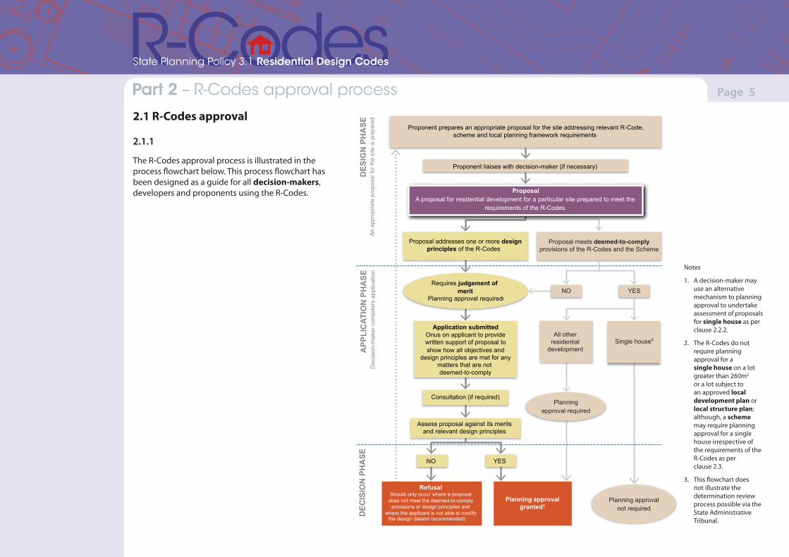
The R-Codes approval process is illustrated in the process flowchart below. This process flowchart has been designed as a guide for all decision-makers, developers and proponents using the R-Codes.
Proposal meets deemed-to-comply provisions of the R-Codes and the Scheme
Proponent prepares an appropriate proposal for the site addressing relevant R-Code,scheme and local planning framework requirements
Application submitted Onus on applicant to provide written support of proposal to show how all objectives and
design principles are met for any matters that are not deemed-to-comply
Assess proposal against its merits and relevant design principles
Proponent liaises with decision-maker (if necessary)
NO YES
Consultation (if required)
Planning approval not required
Proposal addresses one or more designprinciples of the R-Codes
APP
LIC
ATIO
N P
HA
SE
Dec
isio
n-m
aker
con
side
rs a
pplic
atio
n
DEC
ISIO
N P
HA
SE
DES
IGN
PH
ASE
A
n ap
prop
riate
pro
posa
l for
the
site
is p
repa
red
YES
Requires judgement of merit
Planning approval required1
NOTES 1. A decision-maker may use an alternative mechanism to planning approval to undertake assessment of proposals for single houses as per clause 2.2.2.2. The R-Codes do not require planning approval for a single house on a lot greater than 260m2 or a lot subject to an approved local development plan or local structure plan; although, a scheme may require planning approval for a single house irrespective of the requirements of the R-Codes as per clause 2.3.3. This flowchart does not illustrate the determination review process possible via the State Administrative Tribunal.
Single house All other
residential development
Planning approval required
NO
ProposalA proposal for residential development for a particular site prepared to meet the
requirements of the R-Codes
Refusal Should only occur where a proposal
does not meet the deemed-to-comply provisions or design principles and
where the applicant is not able to modify the design (liaison recommended)
Planning approvalgranted1
Notes
1. A decision-maker may use an alternative mechanism to planning approval to undertake assessment of proposals for single house as per clause 2.2.2.
2. The R-Codes do not require planning approval for a single house on a lot greater than 260m2 or a lot subject to an approved local development plan or local structure plan; although, a scheme may require planning approval for a single house irrespective of the requirements of the R-Codes as per clause 2.3.
3. This flowchart does not illustrate the determination review process possible via the State Administrative Tribunal.
(Version 1, June 2013)(Version 1, June 2013)
Page 6Part 7 – Local planning framework Part 2 – R-Codes approval process
State Planning Policy 3.1 Residential Design Codes
2.1.2
Where planning approval is required under a scheme a planning application shall be lodged with the relevant decision-maker for assessment and making a determination.
2.1.3
All applications for planning approval must provide all necessary details required under the scheme for the decision-maker to assess the proposal, including details where the application complies and does not comply with R-Code requirements.
2.1.4
All residential development is to comply with the requirements of the R-Codes. Approval under and in accordance with the R-Codes is required if the proposed residential development:
(a) does not satisfy the deemed-to-comply provisions of Parts 5 and/or 6 of the R-Codes as appropriate; or
(b) proposes to address a design principle of Parts 5 and/or 6 of the R-Codes which therefore requires the exercise of judgement by the decision-maker.
2.2 Single house approval
2.2.1
A proposal for a single house that meets the deemed-to-comply provisions of the R-Codes does not require planning approval, unless otherwise required by the scheme or clause 2.3.
2.2.2
Where a proposal for a single house:
(a) does not satisfy the deemed-to-comply provisions; and
(b) proposes to address a design principle of Part 5 of the R-Codes;
an application for planning approval (or other application as determined by the decision-maker) shall be made and determined prior to the issuing of a building permit.
2.3 Planning approval for single houses on small lotsPlanning approval is required for the erection of a single house on any lot smaller than 260m2, except where the single house complies with a local structure plan or local development plan.
2.4 Judging merit of proposalsWhere a proposal does not meet deemed-to-comply provision(s) of the R-Codes and addresses design principle(s), the decision-maker is required to exercise judgement to determine the proposal.
Judgement of merit is exercised only for specific element(s) of a proposal which do not satisfy the relevant deemed-to-comply provision(s).
2.5 Exercise of judgement
2.5.1
Subject to clauses 2.5.2 and 2.5.3, the decision-maker is to exercise its judgement to consider the merits of proposals having regard to objectives and balancing these with the consideration of design principles provided in the R-Codes.
The decision-maker, in its assessment of a proposal that addresses the design principle(s), should not apply the corresponding deemed-to-comply provision(s).
(Version 1, June 2013)(Version 1, June 2013)
Page 7Part 7 – Local planning framework Part 2 – R-Codes approval process
State Planning Policy 3.1 Residential Design Codes
2.5.2
In making a determination on the suitability of a proposal, the decision-maker shall exercise its judgement, having regard to the following:
(a) any relevant purpose, objectives and provisions of the scheme;
(b) any relevant objectives and provisions of the R-Codes;
(c) a provision of a local planning policy adopted by the decision-maker consistent with and pursuant to the R-Codes; and
(d) orderly and proper planning.
2.5.3
The decision-maker shall not vary the minimum or average site area per dwelling requirements set out in Table 1 (except as provided in the R-Codes or the scheme).
2.5.4
The decision-maker shall not refuse to grant approval to an application where the application satisfies the deemed-to-comply provisions of the R-Codes and the relevant provisions of the scheme and any relevant local planning policy.
2.5.5
For the purpose of the R-Codes, a local structure plan, local development plan or local planning policy, will only be a relevant consideration in the exercise of judgement where it is:
(a) specifically sanctioned by a provision of the R-Codes;
(b) consistent with the design principles of the R-Codes; and
(c) consistent with the objectives of the R-Codes.
(Version 1, June 2013)(Version 1, June 2013)
Page 8Part 7 – Local planning framework Part 3 – Accompanying information
State Planning Policy 3.1 Residential Design Codes
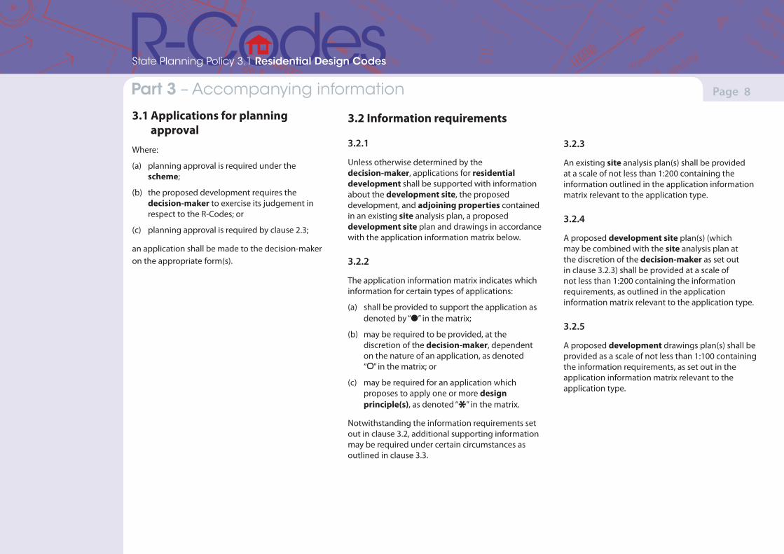
3.1 Applications for planning approvalWhere:
(a) planning approval is required under the scheme;
(b) the proposed development requires the decision-maker to exercise its judgement in respect to the R-Codes; or
(c) planning approval is required by clause 2.3;
an application shall be made to the decision-maker on the appropriate form(s).
3.2 Information requirements
3.2.1
Unless otherwise determined by the decision-maker, applications for residential development shall be supported with information about the development site, the proposed development, and adjoining properties contained in an existing site analysis plan, a proposed development site plan and drawings in accordance with the application information matrix below.
3.2.2
The application information matrix indicates which information for certain types of applications:
(a) shall be provided to support the application as denoted by “l” in the matrix;
(b) may be required to be provided, at the discretion of the decision-maker, dependent on the nature of an application, as denoted “ ” in the matrix; or
(c) may be required for an application which proposes to apply one or more design principle(s), as denoted “*” in the matrix.
Notwithstanding the information requirements set out in clause 3.2, additional supporting information may be required under certain circumstances as outlined in clause 3.3.
3.2.3
An existing site analysis plan(s) shall be provided at a scale of not less than 1:200 containing the information outlined in the application information matrix relevant to the application type.
3.2.4
A proposed development site plan(s) (which may be combined with the site analysis plan at the discretion of the decision-maker as set out in clause 3.2.3) shall be provided at a scale of not less than 1:200 containing the information requirements, as outlined in the application information matrix relevant to the application type.
3.2.5
A proposed development drawings plan(s) shall be provided as a scale of not less than 1:100 containing the information requirements, as set out in the application information matrix relevant to the application type.
(Version 1, June 2013)(Version 1, June 2013)
Page 9Part 7 – Local planning framework Part 3 – Accompanying information
State Planning Policy 3.1 Residential Design Codes
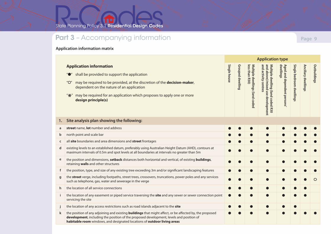
Application information matrix
Application type
Application information
“l” shall be provided to support the application
“ ” may be required to be provided, at the discretion of the decision-maker, dependent on the nature of an application
“*” may be required for an application which proposes to apply one or more design principle(s)
Single house
Grouped dwelling
Multiple dw
ellings (land coded less than R30)
Multiple dw
elling (land coded R30 and above)/m
ixed use development
and activity centres
Aged and dependent persons’ dw
ellings
Single bedroom dw
ellings
Ancillary dwellings
Outbuildings
1. Site analysis plan showing the following:
a street name, lot number and address l l l l l l l l
b north point and scale bar l l l l l l l l
c all site boundaries and area dimensions and street frontages l l l l l l l l
d existing levels to an established datum, preferably using Australian Height Datum (AHD), contours at maximum intervals of 0.5m and spot levels at all boundaries at intervals no greater than 5m l l l l l l l l
e the position and dimensions, setback distances both horizontal and vertical, of existing buildings, retaining walls and other structures l l l l l l l l
f the position, type, and size of any existing tree exceeding 3m and/or significant landscaping features l l l l l l l l
g the street verge, including footpaths, street trees, crossovers, truncations, power poles and any services such as telephone, gas, water and sewerage in the verge l l l l l l l
h the location of all service connections l l l l l l l
i the location of any easement or piped service traversing the site and any sewer or sewer connection point servicing the site
l l l l l l l
j the location of any access restrictions such as road islands adjacent to the site l l l l l l
k the position of any adjoining and existing buildings that might affect, or be affected by, the proposed development, including the position of the proposed development, levels and position of habitable room windows, and designated locations of outdoor living areas
l l l l l l l l
(Version 1, June 2013)(Version 1, June 2013)
Page 10Part 7 – Local planning framework Part 3 – Accompanying information
State Planning Policy 3.1 Residential Design Codes
Application type
Application information
“l” shall be provided to support the application
“ ” may be required to be provided, at the discretion of the decision-maker, dependent on the nature of an application
“*” may be required for an application which proposes to apply one or more design principle(s)
Single house
Grouped dwelling
Multiple dw
ellings (land coded less than R30)
Multiple dw
elling (land coded R30 and above)/m
ixed use development
and activity centres
Aged and dependent persons’ dw
ellings
Single bedroom dw
ellings
Ancillary dwellings
Outbuildings
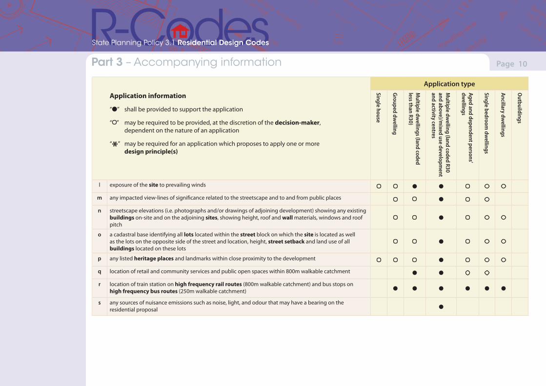
l exposure of the site to prevailing winds l l
m any impacted view-lines of significance related to the streetscape and to and from public places l
n streetscape elevations (i.e. photographs and/or drawings of adjoining development) showing any existing buildings on-site and on the adjoining sites, showing height, roof and wall materials, windows and roof pitch
l
o a cadastral base identifying all lots located within the street block on which the site is located as well as the lots on the opposite side of the street and location, height, street setback and land use of all buildings located on these lots
l
p any listed heritage places and landmarks within close proximity to the development l
q location of retail and community services and public open spaces within 800m walkable catchment l l
r location of train station on high frequency rail routes (800m walkable catchment) and bus stops on high frequency bus routes (250m walkable catchment) l l l l l l
s any sources of nuisance emissions such as noise, light, and odour that may have a bearing on the residential proposal l
(Version 1, June 2013)(Version 1, June 2013)
Page 11Part 7 – Local planning framework Part 3 – Accompanying information
State Planning Policy 3.1 Residential Design Codes
Application type
Application information
“l” shall be provided to support the application
“ ” may be required to be provided, at the discretion of the decision-maker, dependent on the nature of an application
“*” may be required for an application which proposes to apply one or more design principle(s)
Single house
Grouped dwelling
Multiple dw
ellings (land coded less than R30)
Multiple dw
elling (land coded R30 and above)/m
ixed use development
and activity centres
Aged and dependent persons’ dw
ellings
Single bedroom dw
ellings
Ancillary dwellings
Outbuildings
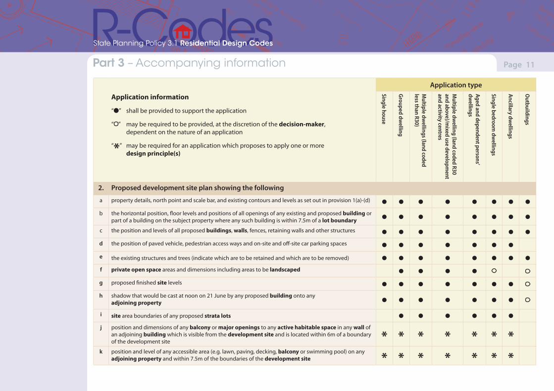
2. Proposed development site plan showing the following
a property details, north point and scale bar, and existing contours and levels as set out in provision 1(a)-(d) l l l l l l l l
b the horizontal position, floor levels and positions of all openings of any existing and proposed building or part of a building on the subject property where any such building is within 7.5m of a lot boundary l l l l l l l l
c the position and levels of all proposed buildings, walls, fences, retaining walls and other structures l l l l l l l l
d the position of paved vehicle, pedestrian access ways and on-site and off-site car parking spaces l l l l l l l
e the existing structures and trees (indicate which are to be retained and which are to be removed) l l l l l l l l
f private open space areas and dimensions including areas to be landscaped l l l l
g proposed finished site levels l l l l l l l
h shadow that would be cast at noon on 21 June by any proposed building onto any adjoining property l l l l l l l
i site area boundaries of any proposed strata lots l l l l l l
j position and dimensions of any balcony or major openings to any active habitable space in any wall of an adjoining building which is visible from the development site and is located within 6m of a boundary of the development site * * * * * * *
k position and level of any accessible area (e.g. lawn, paving, decking, balcony or swimming pool) on any adjoining property and within 7.5m of the boundaries of the development site * * * * * * *
(Version 1, June 2013)(Version 1, June 2013)
Page 12Part 7 – Local planning framework Part 3 – Accompanying information
State Planning Policy 3.1 Residential Design Codes
Application type
Application information
“l” shall be provided to support the application
“ ” may be required to be provided, at the discretion of the decision-maker, dependent on the nature of an application
“*” may be required for an application which proposes to apply one or more design principle(s)
Single house
Grouped dwelling
Multiple dw
ellings (land coded less than R30)
Multiple dw
elling (land coded R30 and above)/m
ixed use development
and activity centres
Aged and dependent persons’ dw
ellings
Single bedroom dw
ellings
Ancillary dwellings
Outbuildings
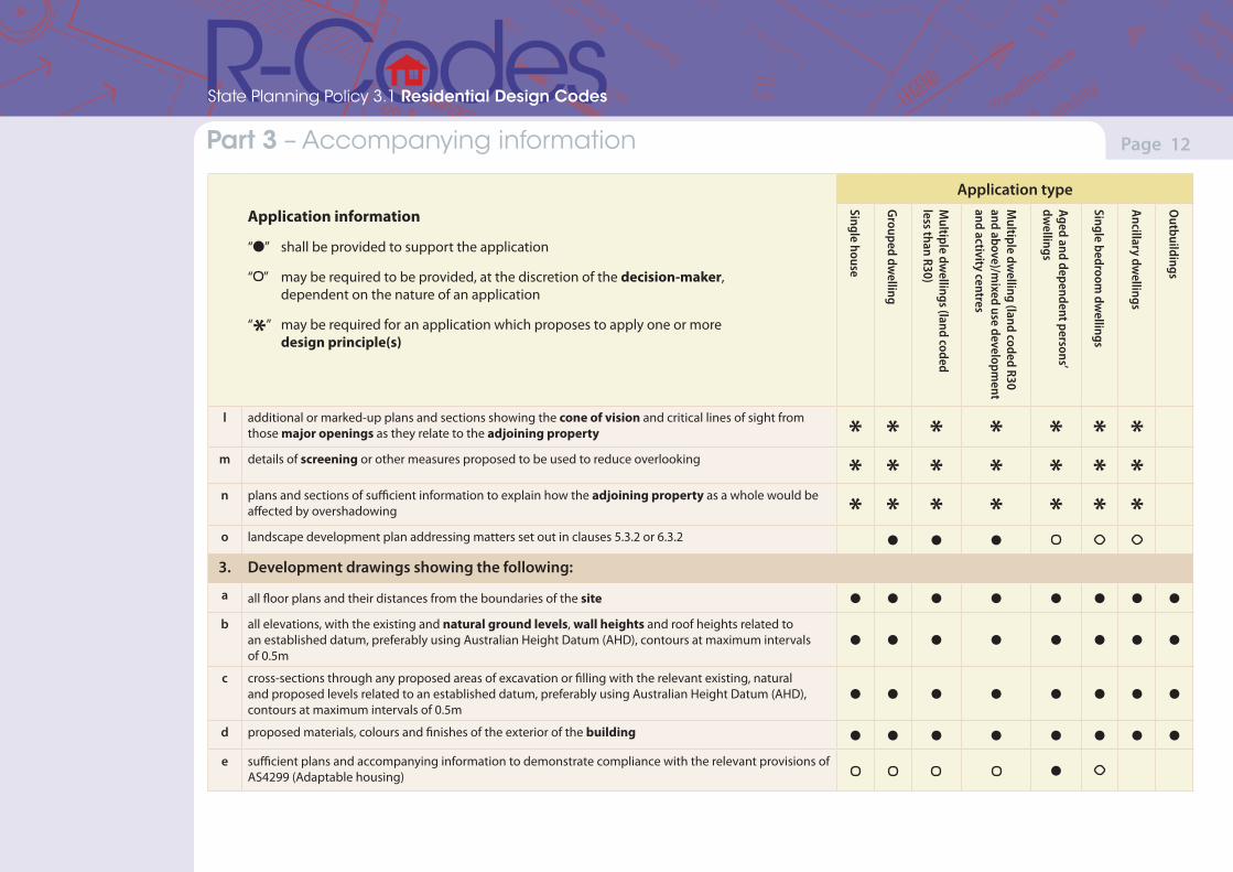
l additional or marked-up plans and sections showing the cone of vision and critical lines of sight from those major openings as they relate to the adjoining property * * * * * * *
m details of screening or other measures proposed to be used to reduce overlooking * * * * * * *n plans and sections of sufficient information to explain how the adjoining property as a whole would be
affected by overshadowing * * * * * * *o landscape development plan addressing matters set out in clauses 5.3.2 or 6.3.2 l l l
3. Development drawings showing the following:
a all floor plans and their distances from the boundaries of the site l l l l l l l l
b all elevations, with the existing and natural ground levels, wall heights and roof heights related to an established datum, preferably using Australian Height Datum (AHD), contours at maximum intervals of 0.5m
l l l l l l l l
c cross-sections through any proposed areas of excavation or filling with the relevant existing, natural and proposed levels related to an established datum, preferably using Australian Height Datum (AHD), contours at maximum intervals of 0.5m
l l l l l l l l
d proposed materials, colours and finishes of the exterior of the building l l l l l l l l
e sufficient plans and accompanying information to demonstrate compliance with the relevant provisions of AS4299 (Adaptable housing) l
(Version 1, June 2013)(Version 1, June 2013)
Page 13Part 7 – Local planning framework Part 3 – Accompanying information
State Planning Policy 3.1 Residential Design Codes
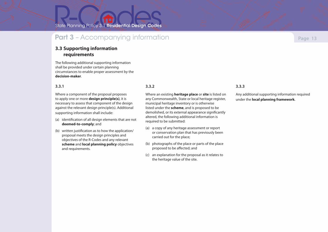
3.3 Supporting information requirementsThe following additional supporting information shall be provided under certain planning circumstances to enable proper assessment by the decision-maker.
3.3.1
Where a component of the proposal proposes to apply one or more design principle(s), it is necessary to assess that component of the design against the relevant design principle(s). Additional supporting information shall include:
(a) identification of all design elements that are not deemed-to-comply; and
(b) written justification as to how the application/proposal meets the design principles and objectives of the R-Codes and any relevant scheme and local planning policy objectives and requirements.
3.3.2
Where an existing heritage place or site is listed on any Commonwealth, State or local heritage register, municipal heritage inventory or is otherwise listed under the scheme, and is proposed to be demolished, or its external appearance significantly altered, the following additional information is required to be submitted:
(a) a copy of any heritage assessment or report or conservation plan that has previously been carried out for the place;
(b) photographs of the place or parts of the place proposed to be affected; and
(c) an explanation for the proposal as it relates to the heritage value of the site.
3.3.3
Any additional supporting information required under the local planning framework.
(Version 1, June 2013)(Version 1, June 2013)
Page 14Part 7 – Local planning framework Part 4 – Consultation
State Planning Policy 3.1 Residential Design Codes
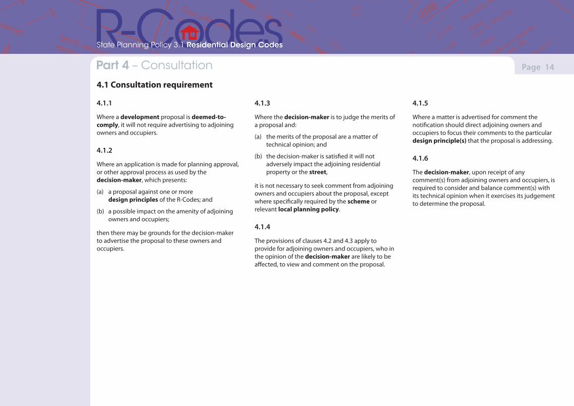
4.1 Consultation requirement
4.1.1
Where a development proposal is deemed-to-comply, it will not require advertising to adjoining owners and occupiers.
4.1.2
Where an application is made for planning approval, or other approval process as used by the decision-maker, which presents:
(a) a proposal against one or more design principles of the R-Codes; and
(b) a possible impact on the amenity of adjoining owners and occupiers;
then there may be grounds for the decision-maker to advertise the proposal to these owners and occupiers.
4.1.3
Where the decision-maker is to judge the merits of a proposal and:
(a) the merits of the proposal are a matter of technical opinion; and
(b) the decision-maker is satisfied it will not adversely impact the adjoining residential property or the street,
it is not necessary to seek comment from adjoining owners and occupiers about the proposal, except where specifically required by the scheme or relevant local planning policy.
4.1.4
The provisions of clauses 4.2 and 4.3 apply to provide for adjoining owners and occupiers, who in the opinion of the decision-maker are likely to be affected, to view and comment on the proposal.
4.1.5
Where a matter is advertised for comment the notification should direct adjoining owners and occupiers to focus their comments to the particular design principle(s) that the proposal is addressing.
4.1.6
The decision-maker, upon receipt of any comment(s) from adjoining owners and occupiers, is required to consider and balance comment(s) with its technical opinion when it exercises its judgement to determine the proposal.
(Version 1, June 2013)(Version 1, June 2013)
Page 15Part 7 – Local planning framework Part 4 – Consultation
State Planning Policy 3.1 Residential Design Codes
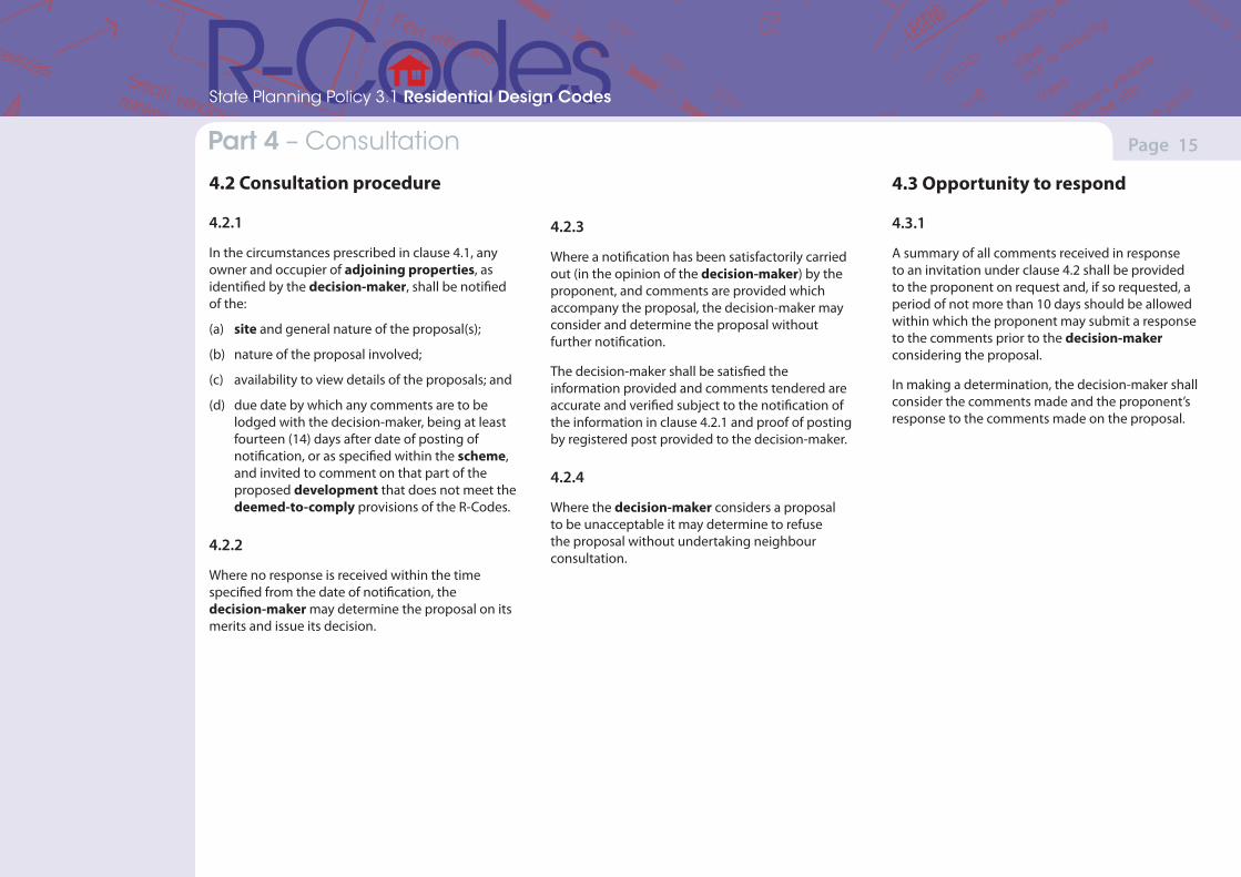
4.2.3
Where a notification has been satisfactorily carried out (in the opinion of the decision-maker) by the proponent, and comments are provided which accompany the proposal, the decision-maker may consider and determine the proposal without further notification.
The decision-maker shall be satisfied the information provided and comments tendered are accurate and verified subject to the notification of the information in clause 4.2.1 and proof of posting by registered post provided to the decision-maker.
4.2.4
Where the decision-maker considers a proposal to be unacceptable it may determine to refuse the proposal without undertaking neighbour consultation.
4.3 Opportunity to respond
4.3.1
A summary of all comments received in response to an invitation under clause 4.2 shall be provided to the proponent on request and, if so requested, a period of not more than 10 days should be allowed within which the proponent may submit a response to the comments prior to the decision-maker considering the proposal.
In making a determination, the decision-maker shall consider the comments made and the proponent’s response to the comments made on the proposal.
4.2 Consultation procedure
4.2.1
In the circumstances prescribed in clause 4.1, any owner and occupier of adjoining properties, as identified by the decision-maker, shall be notified of the:
(a) site and general nature of the proposal(s);
(b) nature of the proposal involved;
(c) availability to view details of the proposals; and
(d) due date by which any comments are to be lodged with the decision-maker, being at least fourteen (14) days after date of posting of notification, or as specified within the scheme, and invited to comment on that part of the proposed development that does not meet the deemed-to-comply provisions of the R-Codes.
4.2.2
Where no response is received within the time specified from the date of notification, the decision-maker may determine the proposal on its merits and issue its decision.
(Version 1, June 2013)(Version 1, June 2013)
Page 16Part 7 – Local planning framework Part 5 – Design elements for all single house(s) and grouped dwellings; and multiple dwellings in areas coded less than R40
State Planning Policy 3.1 Residential Design Codes
5.1 Context
Objectives
(a) To ensure that residential development meets community expectations in regard to appearance, use and density.
(b) To ensure that designs respond to the key natural and built features of the area and respond to the local context in terms of bulk and scale, or in the case of precincts undergoing a transition, will respond to the desired future character as stated in the local planning framework.
(c) To ensure adequate provision of direct sun and ventilation for buildings and to ameliorate the impacts of building bulk, privacy and overshadowing on adjoining properties.
(d) To ensure that open space (private and communal) is provided on site and:
• landscaped to establish streetscapes;
• provide a balanced setting and relationship to buildings; and
• provide privacy, direct sun and recreational opportunities.
(e) To ensure that development and design is appropriately scaled, particularly in respect to bulk and height, and is sympathetic to the scale of the street and surrounding buildings, or in precincts undergoing a transition, development achieves the desired future character of the area identified in local planning framework.
(Version 1, June 2013)(Version 1, June 2013)
Page 17Part 7 – Local planning framework Part 5 – Design elements for all single house(s) and grouped dwellings; and multiple dwellings in areas coded less than R40
State Planning Policy 3.1 Residential Design Codes
Design principlesDevelopment demonstrates compliance with the following design principles (P)
Deemed-to-complyDevelopment satisfies the following deemed-to-comply requirements (C)
Note: The minimum and average site areas stipulated in Table 1 are not subject to variation except as set out in clause 5.1.1 below.
5.1.1 Site area
P1.1 Development of the type and density indicated by the density code designated in the scheme.
P1.2 The WAPC may approve the creation of a lot, survey strata lot or strata lot of a lesser minimum and/or average site area than that specified in Table 1, and the WAPC in consultation with the local government may approve the creation of a survey strata lot or strata lot for a single house or a grouped dwelling of a lesser minimum site area than that specified in Table 1 provided that the proposed variation would be no more than five per cent less in area than that specified in Table 1; and
• facilitate the protection of an environmental or heritage feature;
• facilitate the retention of a significant element that contributes toward an existing streetscape worthy of retention;
• facilitate the development of lots with separate and sufficient frontage to more than one public street;
• overcome a special or unusual limitation on the development of the land imposed by its size, shape or other feature;
• allow land to be developed with housing of the same type and form as land in the vicinity and which would not otherwise be able to be developed; or
• achieve specific objectives of the local planning framework.
P1.3 The WAPC, in consultation with the local government, may approve the creation of a survey strata lot or strata lot for an existing authorised grouped dwelling or multiple dwelling development of a lesser minimum and average site area than that specified in Table 1, where, in the opinion of the WAPC or the local government, the development on the resulting survey strata or strata lots is consistent with the objectives of the relevant design elements of the R-Codes, and the orderly and proper planning of the locality.
C1.1 Development which complies with the dwelling type and site area requirements set out in Table 1 and the following provisions.
C1.2 The minimum site area set out in Table 1 is calculated as follows:
i. in the case of a single house, the area of a green title lot or survey-strata lot;
ii. in the case of a grouped dwelling, the area of land occupied by the dwelling itself, together with all other areas whether contiguous or not, designated for the exclusive use of the occupants of that dwelling; or
iii. in the case of multiple dwellings in areas with a coding of less than R40, the total area of the lot divided by the number of dwellings.
C1.3 For the purposes of assessing compliance of a proposed development with the minimum and average site areas set out in Table 1, the following adjustments for the purposes of calculating the minimum and average site area shall apply:
i. in the case of a lot with a corner truncation, up to a maximum of 20m2 of that truncation shall be added to the area of the adjoining lot, survey strata lot or strata lot as the case may be (refer Figure 1a); or
ii. in the case of a rear battleaxe site, the site area is inclusive of the access leg provided that the area of the access leg contributes no more than 20 per cent of the site area as required by Table 1. Where the battleaxe lot (excluding the access leg) adjoins or abuts a right-of-way or reserve for open space, pedestrian access, school site or equivalent, half the width (up to a maximum depth of 2m) may be added to the site area (refer Figure 1b).
5.1 Context
(Version 1, June 2013)(Version 1, June 2013)
Page 18Part 7 – Local planning framework Part 5 – Design elements for all single house(s) and grouped dwellings; and multiple dwellings in areas coded less than R40
State Planning Policy 3.1 Residential Design Codes
Design principlesDevelopment demonstrates compliance with the following design principles (P)
Deemed-to-complyDevelopment satisfies the following deemed-to-comply requirements (C)
C1.4 Subject to clause 5.1.1 C1.3 only, the following variations to the minimum and average site area set out in Table 1 may be made:
i. for the purposes of an aged or dependent persons’ dwelling or a single bedroom dwelling, the site area may be reduced by up to one third, in accordance with clauses 5.5.2 and 5.5.3 which shall only be applied where development is proposed;
ii. in the case of a single house, grouped dwelling or multiple dwelling; the area of a lot, survey strata lot or strata lot approved by the WAPC; or
iii. the area of any existing lot, survey strata lot or strata lot with permanent legal access to a public road, notwithstanding that it is less than that required in Table 1.
5.1.2 Street setback
P2.1 Buildings set back from street boundaries an appropriate distance to ensure they:
• contribute to, and are consistent with, an established streetscape;
• provide adequate privacy and open space for dwellings;
• accommodate site planning requirements such as parking, landscape and utilities; and
• allow safety clearances for easements for essential service corridors.
P2.2 Buildings mass and form that:
• uses design features to affect the size and scale of the building;
• uses appropriate minor projections that do not detract from the character of the streetscape;
• minimises the proportion of the façade at ground level taken up by building services, vehicle entries and parking supply, blank walls, servicing infrastructure access and meters and the like; and
• positively contributes to the prevailing development context and streetscape.
C2.1 Buildings set back from the primary street boundary:
i. in accordance with Table 1;
ii. corresponding to the average of the setback of existing dwellings on each adjacent property fronting the same street;
iii. reduced by up to 50 per cent provided that the area of any building, including a carport or garage, intruding into the setback area is compensated for by at least an equal area of open space between the setback line and line drawn parallel to it at twice the setback distance (refer Figure 2a, 2b and 2c);
iv. in the case of areas coded R15 or higher, where:
• a grouped dwelling has its main frontage to a secondary street;
• a single house results from subdivision of an original corner lot and has its frontage to the original secondary street; or
• a single house or grouped dwelling (where that grouped dwelling is not adjacent to the primary street), has its main frontage to a communal street, right-of-way or shared pedestrian or vehicle access way;
5.1 Context
(Version 1, June 2013)(Version 1, June 2013)
Page 19Part 7 – Local planning framework Part 5 – Design elements for all single house(s) and grouped dwellings; and multiple dwellings in areas coded less than R40
State Planning Policy 3.1 Residential Design Codes
Design principlesDevelopment demonstrates compliance with the following design principles (P)
Deemed-to-complyDevelopment satisfies the following deemed-to-comply requirements (C)
the street setback may be reduced to 2.5m, or 1.5m to a porch, verandah, balcony or the equivalent (refer Figure 2b and 2d); and
v. to provide for registered easements for essential services.
C2.2 Buildings set back from the secondary street boundary in accordance with Table 1.
C2.3 Buildings set back from the corner truncation boundary in accordance with the secondary street setback in Table 1.
C2.4 A porch, balcony, verandah, chimney or the equivalent may project not more than 1m into the street setback area, and this projection is not subject to a compensating open area under clause 5.1.2 C2.1iii, provided that the total of such projections does not exceed 20 per cent of the frontage at any level (refer Figure 2b).
5.1.3 Lot boundary setback
P3.1 Buildings set back from lot boundaries so as to:
• reduce impacts of building bulk on adjoining properties;
• provide adequate direct sun and ventilation to the building and open spaces on the site and adjoining properties; and
• minimise the extent of overlooking and resultant loss of privacy on adjoining properties.
P3.2 Buildings built up to boundaries (other than the street boundary) where this:
• makes more effective use of space for enhanced privacy for the occupant/s or outdoor living areas;
• does not compromise the design principle contained in clause 5.1.3 P3.1;
• does not have any adverse impact on the amenity of the adjoining property;
• ensures direct sun to major openings to habitable rooms and outdoor living areas for adjoining properties is not restricted; and
• positively contributes to the prevailing development context and streetscape.
C3.1 Buildings which are set back in accordance with the following provisions, subject to any additional measures in other elements of the R-Codes:
i. buildings set back from lot boundaries in accordance with Table 1, Tables 2a and 2b (refer to Figure Series 3 and 4);
ii. unenclosed areas accessible for use as outdoor living areas, elevated 0.5m or more above natural ground level, set back as though they were major openings to habitable rooms with a wall height of 2.4m above their floor level;
iii. separate single house, grouped or multiple dwelling buildings on the same site, or facing portions of the same multiple dwelling building, set back from each other as though there were a boundary between them;
iv. minor projections such as a chimney, other architectural feature or an eaves overhang not projecting more than 0.75m into a setback area; and
v. the stated setback distances may be reduced by half the width of an adjoining right-of-way, pedestrian access way, communal street or battleaxe lot access leg, to a maximum reduction of 2m (refer to figures 2b and 4f).
5.1 Context
(Version 1, June 2013)(Version 1, June 2013)
Page 20Part 7 – Local planning framework Part 5 – Design elements for all single house(s) and grouped dwellings; and multiple dwellings in areas coded less than R40
State Planning Policy 3.1 Residential Design Codes
Design principlesDevelopment demonstrates compliance with the following design principles (P)
Deemed-to-complyDevelopment satisfies the following deemed-to-comply requirements (C)
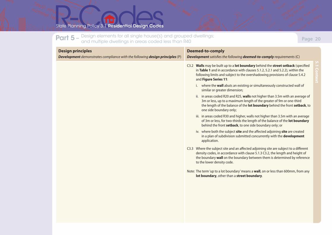
C3.2 Walls may be built up to a lot boundary behind the street setback (specified in Table 1 and in accordance with clauses 5.1.2, 5.2.1 and 5.2.2), within the following limits and subject to the overshadowing provisions of clause 5.4.2 and Figure Series 11:
i. where the wall abuts an existing or simultaneously constructed wall of similar or greater dimension;
ii. in areas coded R20 and R25, walls not higher than 3.5m with an average of 3m or less, up to a maximum length of the greater of 9m or one-third the length of the balance of the lot boundary behind the front setback, to one side boundary only;
iii. in areas coded R30 and higher, walls not higher than 3.5m with an average of 3m or less, for two-thirds the length of the balance of the lot boundary behind the front setback, to one side boundary only; or
iv. where both the subject site and the affected adjoining site are created in a plan of subdivision submitted concurrently with the development application.
C3.3 Where the subject site and an affected adjoining site are subject to a different density codes, in accordance with clause 5.1.3 C3.2, the length and height of the boundary wall on the boundary between them is determined by reference to the lower density code.
Note: The term ‘up to a lot boundary’ means a wall, on or less than 600mm, from any lot boundary, other than a street boundary.
5.1 Context
(Version 1, June 2013)(Version 1, June 2013)
Page 21Part 7 – Local planning framework Part 5 – Design elements for all single house(s) and grouped dwellings; and multiple dwellings in areas coded less than R40
State Planning Policy 3.1 Residential Design Codes
Design principlesDevelopment demonstrates compliance with the following design principles (P)
Deemed-to-complyDevelopment satisfies the following deemed-to-comply requirements (C)
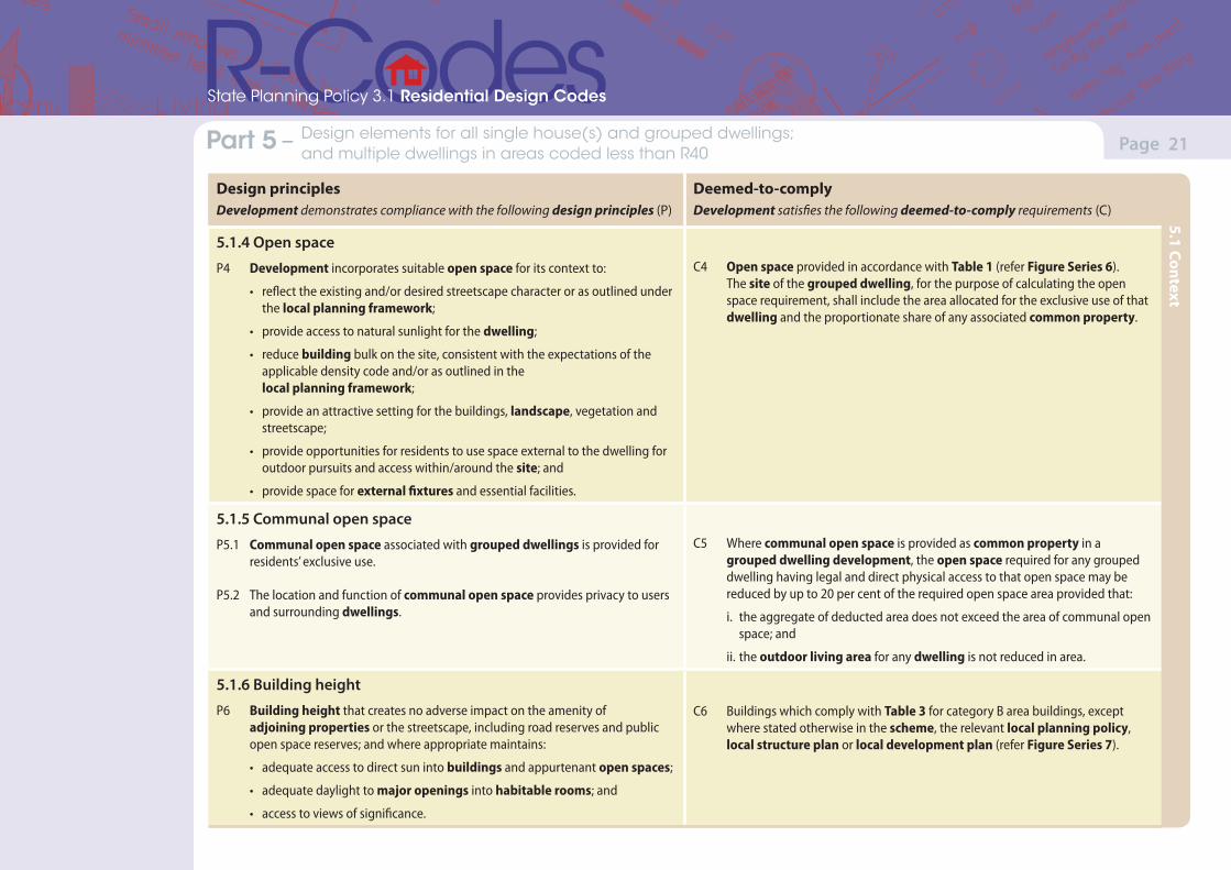
5.1.4 Open space
P4 Development incorporates suitable open space for its context to:
• reflect the existing and/or desired streetscape character or as outlined under the local planning framework;
• provide access to natural sunlight for the dwelling;
• reduce building bulk on the site, consistent with the expectations of the applicable density code and/or as outlined in the local planning framework;
• provide an attractive setting for the buildings, landscape, vegetation and streetscape;
• provide opportunities for residents to use space external to the dwelling for outdoor pursuits and access within/around the site; and
• provide space for external fixtures and essential facilities.
C4 Open space provided in accordance with Table 1 (refer Figure Series 6). The site of the grouped dwelling, for the purpose of calculating the open space requirement, shall include the area allocated for the exclusive use of that dwelling and the proportionate share of any associated common property.
5.1.5 Communal open space
P5.1 Communal open space associated with grouped dwellings is provided for residents’ exclusive use.
P5.2 The location and function of communal open space provides privacy to users and surrounding dwellings.
C5 Where communal open space is provided as common property in a grouped dwelling development, the open space required for any grouped dwelling having legal and direct physical access to that open space may be reduced by up to 20 per cent of the required open space area provided that:
i. the aggregate of deducted area does not exceed the area of communal open space; and
ii. the outdoor living area for any dwelling is not reduced in area.
5.1.6 Building height
P6 Building height that creates no adverse impact on the amenity of adjoining properties or the streetscape, including road reserves and public open space reserves; and where appropriate maintains:
• adequate access to direct sun into buildings and appurtenant open spaces;
• adequate daylight to major openings into habitable rooms; and
• access to views of significance.
C6 Buildings which comply with Table 3 for category B area buildings, except where stated otherwise in the scheme, the relevant local planning policy, local structure plan or local development plan (refer Figure Series 7).
5.1 Context
(Version 1, June 2013)(Version 1, June 2013)
Page 22Part 7 – Local planning framework Part 5 – Design elements for all single house(s) and grouped dwellings; and multiple dwellings in areas coded less than R40
State Planning Policy 3.1 Residential Design Codes
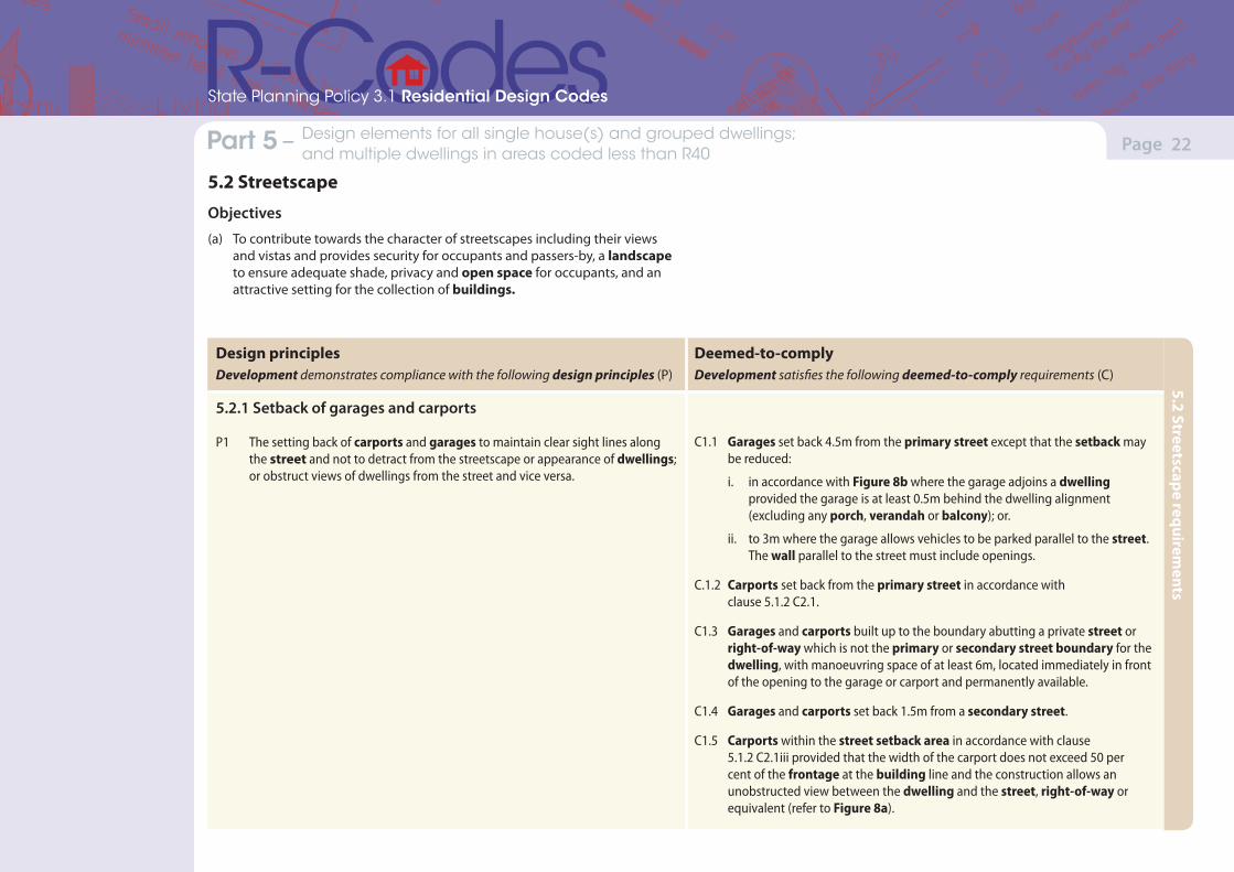
5.2 Streetscape
Objectives
(a) To contribute towards the character of streetscapes including their views and vistas and provides security for occupants and passers-by, a landscape to ensure adequate shade, privacy and open space for occupants, and an attractive setting for the collection of buildings.
Design principlesDevelopment demonstrates compliance with the following design principles (P)
Deemed-to-complyDevelopment satisfies the following deemed-to-comply requirements (C)
5.2.1 Setback of garages and carports
P1 The setting back of carports and garages to maintain clear sight lines along the street and not to detract from the streetscape or appearance of dwellings; or obstruct views of dwellings from the street and vice versa.
C1.1 Garages set back 4.5m from the primary street except that the setback may be reduced:
i. in accordance with Figure 8b where the garage adjoins a dwelling provided the garage is at least 0.5m behind the dwelling alignment (excluding any porch, verandah or balcony); or.
ii. to 3m where the garage allows vehicles to be parked parallel to the street. The wall parallel to the street must include openings.
C.1.2 Carports set back from the primary street in accordance with clause 5.1.2 C2.1.
C1.3 Garages and carports built up to the boundary abutting a private street or right-of-way which is not the primary or secondary street boundary for the dwelling, with manoeuvring space of at least 6m, located immediately in front of the opening to the garage or carport and permanently available.
C1.4 Garages and carports set back 1.5m from a secondary street.
C1.5 Carports within the street setback area in accordance with clause 5.1.2 C2.1iii provided that the width of the carport does not exceed 50 per cent of the frontage at the building line and the construction allows an unobstructed view between the dwelling and the street, right-of-way or equivalent (refer to Figure 8a).
5.2 Streetscape requirements
(Version 1, June 2013)(Version 1, June 2013)
Page 23Part 7 – Local planning framework Part 5 – Design elements for all single house(s) and grouped dwellings; and multiple dwellings in areas coded less than R40
State Planning Policy 3.1 Residential Design Codes
Design principlesDevelopment demonstrates compliance with the following design principles (P)
Deemed-to-complyDevelopment satisfies the following deemed-to-comply requirements (C)
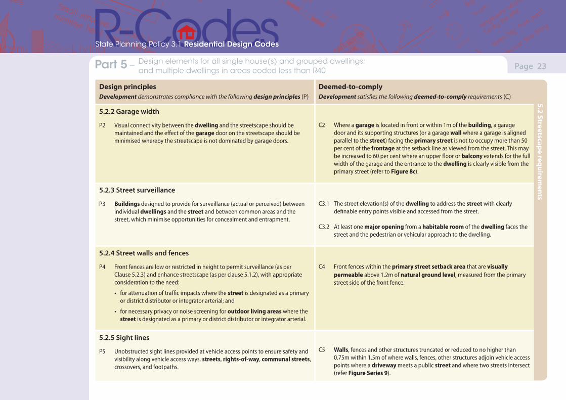
5.2.2 Garage width
P2 Visual connectivity between the dwelling and the streetscape should be maintained and the effect of the garage door on the streetscape should be minimised whereby the streetscape is not dominated by garage doors.
C2 Where a garage is located in front or within 1m of the building, a garage door and its supporting structures (or a garage wall where a garage is aligned parallel to the street) facing the primary street is not to occupy more than 50 per cent of the frontage at the setback line as viewed from the street. This may be increased to 60 per cent where an upper floor or balcony extends for the full width of the garage and the entrance to the dwelling is clearly visible from the primary street (refer to Figure 8c).
5.2.3 Street surveillance
P3 Buildings designed to provide for surveillance (actual or perceived) between individual dwellings and the street and between common areas and the street, which minimise opportunities for concealment and entrapment.
C3.1 The street elevation(s) of the dwelling to address the street with clearly definable entry points visible and accessed from the street.
C3.2 At least one major opening from a habitable room of the dwelling faces the street and the pedestrian or vehicular approach to the dwelling.
5.2.4 Street walls and fences
P4 Front fences are low or restricted in height to permit surveillance (as per Clause 5.2.3) and enhance streetscape (as per clause 5.1.2), with appropriate consideration to the need:
• for attenuation of traffic impacts where the street is designated as a primary or district distributor or integrator arterial; and
• for necessary privacy or noise screening for outdoor living areas where the street is designated as a primary or district distributor or integrator arterial.
C4 Front fences within the primary street setback area that are visually permeable above 1.2m of natural ground level, measured from the primary street side of the front fence.
5.2.5 Sight lines
P5 Unobstructed sight lines provided at vehicle access points to ensure safety and visibility along vehicle access ways, streets, rights-of-way, communal streets, crossovers, and footpaths.
C5 Walls, fences and other structures truncated or reduced to no higher than 0.75m within 1.5m of where walls, fences, other structures adjoin vehicle access points where a driveway meets a public street and where two streets intersect (refer Figure Series 9).
5.2 Streetscape requirements
(Version 1, June 2013)(Version 1, June 2013)
Page 24Part 7 – Local planning framework Part 5 – Design elements for all single house(s) and grouped dwellings; and multiple dwellings in areas coded less than R40
State Planning Policy 3.1 Residential Design Codes
Design principlesDevelopment demonstrates compliance with the following design principles (P)
Deemed-to-complyDevelopment satisfies the following deemed-to-comply requirements (C)
5.2.6 Appearance of retained dwelling
P6 Dwellings retained as part of a grouped or multiple dwelling development, dwelling extension or redevelopment are to:
• enhance the streetscape appearance of the existing dwelling(s) retained; or
• complement established or future built form in the locality as specified within the relevant local planning framework.
C6 Where an existing dwelling is retained as part of a grouped dwelling development, the appearance of the retained dwelling is upgraded externally to an equivalent maintenance standard of the new (or the rest of ) the development.
5.2 Streetscape requirements
(Version 1, June 2013)(Version 1, June 2013)
Page 25Part 7 – Local planning framework Part 5 – Design elements for all single house(s) and grouped dwellings; and multiple dwellings in areas coded less than R40
State Planning Policy 3.1 Residential Design Codes
Design principlesDevelopment demonstrates compliance with the following design principles (P)
Deemed-to-complyDevelopment satisfies the following deemed-to-comply requirements (C)
5.3.1 Outdoor living areas
P1.1 Outdoor living areas which provide spaces:
• capable of use in conjunction with a habitable room of the dwelling;
• open to winter sun and ventilation; and
• optimise use of the northern aspect of the site.
P1.2 Balconies or equivalent outdoor living areas capable of use in conjunction with a habitable room of each dwelling, and if possible, open to winter sun.
C1.1 An outdoor living area to be provided:
• in accordance with Table 1;
• behind the street setback area;
• directly accessible from a habitable room of the dwelling;
• with a minimum length and width dimension of 4m; and
• to have at least two-thirds of the required area without permanent roof cover.
C1.2 Each multiple dwelling is provided with at least one balcony or the equivalent, opening directly from a habitable room and with a minimum area of 10m2 and minimum dimension of 2.4m.
5.3 Site planning and design
Objectives
(a) Landscape design should optimise function, useability, privacy and social opportunity, equitable access, respect neighbours’ amenity and provide for practical establishment and maintenance.
(b) To ensure access to housing provides for security, safety, amenity and legibility to on-site car parking areas and footpaths for residents and visitors.
(c) To ensure each development makes a contribution to a streetscape by respecting the natural topography for each site, adjoining properties and the amenity of the locality.
(d) To reduce the economic, environmental and social impacts associated with site works to facilitate housing development (e.g. via soil disturbance, groundwater impact and water use for dust suppression).
5.3 Site planning and design
(Version 1, June 2013)(Version 1, June 2013)
Page 26Part 7 – Local planning framework Part 5 – Design elements for all single house(s) and grouped dwellings; and multiple dwellings in areas coded less than R40
State Planning Policy 3.1 Residential Design Codes
Design principlesDevelopment demonstrates compliance with the following design principles (P)
Deemed-to-complyDevelopment satisfies the following deemed-to-comply requirements (C)
5.3.2 Landscaping
P2 Landscaping of grouped and multiple dwelling common property and communal open spaces that:
• contribute to the appearance and amenity of the development for the residents;
• contribute to the streetscape;
• enhance security and safety for residents;
• provide for microclimate; and
• retain existing trees to maintain a local sense of place.
C2 Landscaping of grouped and multiple dwelling common property and communal open spaces in accordance with the following:
i. the street setback area developed without car parking, except for visitors’ bays, and with a maximum of 50 per cent hard surface;
ii. separate pedestrian paths providing wheelchair accessibility connecting entries to all buildings with the public footpath and car parking areas;
iii. landscaping between each six consecutive external car parking spaces to include shade trees;
iv. lighting to pathways, and communal open space and car parking areas;
v. bin storage areas conveniently located and screened from view;
vi. trees which are greater than 3m in height shall be retained, in communal open space areas which are provided for the development;
vii. adequate sight lines for pedestrians and vehicles;
viii. clear line of sight between areas designated as communal open space and at least two habitable room windows;
ix. clothes drying areas which are secure and screened from view; and
x. unroofed visitors’ car parking spaces to be effectively screened from the street.
5.3 Site planning and design
(Version 1, June 2013)(Version 1, June 2013)
Page 27Part 7 – Local planning framework Part 5 – Design elements for all single house(s) and grouped dwellings; and multiple dwellings in areas coded less than R40
State Planning Policy 3.1 Residential Design Codes
Design principlesDevelopment demonstrates compliance with the following design principles (P)
Deemed-to-complyDevelopment satisfies the following deemed-to-comply requirements (C)
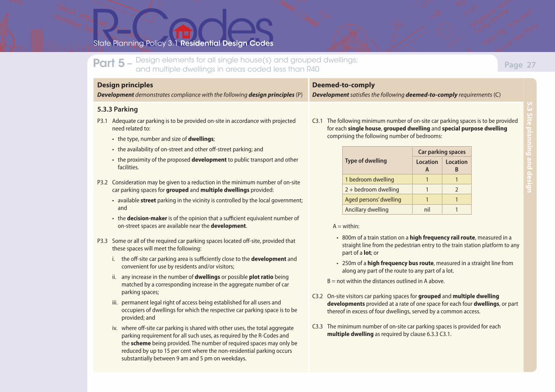
5.3.3 Parking
P3.1 Adequate car parking is to be provided on-site in accordance with projected need related to:
• the type, number and size of dwellings;
• the availability of on-street and other off-street parking; and
• the proximity of the proposed development to public transport and other facilities.
P3.2 Consideration may be given to a reduction in the minimum number of on-site car parking spaces for grouped and multiple dwellings provided:
• available street parking in the vicinity is controlled by the local government; and
• the decision-maker is of the opinion that a sufficient equivalent number of on-street spaces are available near the development.
P3.3 Some or all of the required car parking spaces located off-site, provided that these spaces will meet the following:
i. the off-site car parking area is sufficiently close to the development and convenient for use by residents and/or visitors;
ii. any increase in the number of dwellings or possible plot ratio being matched by a corresponding increase in the aggregate number of car parking spaces;
iii. permanent legal right of access being established for all users and occupiers of dwellings for which the respective car parking space is to be provided; and
iv. where off-site car parking is shared with other uses, the total aggregate parking requirement for all such uses, as required by the R-Codes and the scheme being provided. The number of required spaces may only be reduced by up to 15 per cent where the non-residential parking occurs substantially between 9 am and 5 pm on weekdays.
C3.1 The following minimum number of on-site car parking spaces is to be provided for each single house, grouped dwelling and special purpose dwelling comprising the following number of bedrooms:
Type of dwellingCar parking spaces
Location A
Location B
1 bedroom dwelling 1 1
2 + bedroom dwelling 1 2
Aged persons’ dwelling 1 1
Ancillary dwelling nil 1
A = within:
• 800m of a train station on a high frequency rail route, measured in a straight line from the pedestrian entry to the train station platform to any part of a lot; or
• 250m of a high frequency bus route, measured in a straight line from along any part of the route to any part of a lot.
B = not within the distances outlined in A above.
C3.2 On-site visitors car parking spaces for grouped and multiple dwelling developments provided at a rate of one space for each four dwellings, or part thereof in excess of four dwellings, served by a common access.
C3.3 The minimum number of on-site car parking spaces is provided for each multiple dwelling as required by clause 6.3.3 C3.1.
5.3 Site planning and design
(Version 1, June 2013)(Version 1, June 2013)
Page 28Part 7 – Local planning framework Part 5 – Design elements for all single house(s) and grouped dwellings; and multiple dwellings in areas coded less than R40
State Planning Policy 3.1 Residential Design Codes
Design principlesDevelopment demonstrates compliance with the following design principles (P)
Deemed-to-complyDevelopment satisfies the following deemed-to-comply requirements (C)
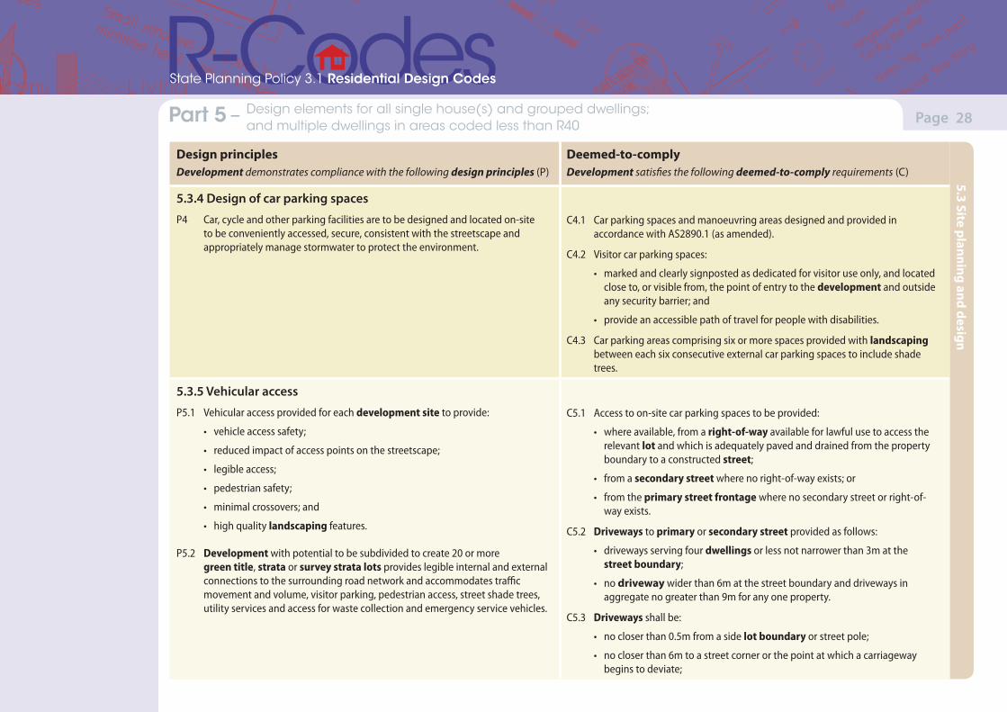
5.3.4 Design of car parking spaces
P4 Car, cycle and other parking facilities are to be designed and located on-site to be conveniently accessed, secure, consistent with the streetscape and appropriately manage stormwater to protect the environment.
C4.1 Car parking spaces and manoeuvring areas designed and provided in accordance with AS2890.1 (as amended).
C4.2 Visitor car parking spaces:
• marked and clearly signposted as dedicated for visitor use only, and located close to, or visible from, the point of entry to the development and outside any security barrier; and
• provide an accessible path of travel for people with disabilities.
C4.3 Car parking areas comprising six or more spaces provided with landscaping between each six consecutive external car parking spaces to include shade trees.
5.3.5 Vehicular access
P5.1 Vehicular access provided for each development site to provide:
• vehicle access safety;
• reduced impact of access points on the streetscape;
• legible access;
• pedestrian safety;
• minimal crossovers; and
• high quality landscaping features.
P5.2 Development with potential to be subdivided to create 20 or more green title, strata or survey strata lots provides legible internal and external connections to the surrounding road network and accommodates traffic movement and volume, visitor parking, pedestrian access, street shade trees, utility services and access for waste collection and emergency service vehicles.
C5.1 Access to on-site car parking spaces to be provided:
• where available, from a right-of-way available for lawful use to access the relevant lot and which is adequately paved and drained from the property boundary to a constructed street;
• from a secondary street where no right-of-way exists; or
• from the primary street frontage where no secondary street or right-of-way exists.
C5.2 Driveways to primary or secondary street provided as follows:
• driveways serving four dwellings or less not narrower than 3m at the street boundary;
• no driveway wider than 6m at the street boundary and driveways in aggregate no greater than 9m for any one property.
C5.3 Driveways shall be:
• no closer than 0.5m from a side lot boundary or street pole;
• no closer than 6m to a street corner or the point at which a carriageway begins to deviate;
5.3 Site planning and design
(Version 1, June 2013)(Version 1, June 2013)
Page 29Part 7 – Local planning framework Part 5 – Design elements for all single house(s) and grouped dwellings; and multiple dwellings in areas coded less than R40
State Planning Policy 3.1 Residential Design Codes
Design principlesDevelopment demonstrates compliance with the following design principles (P)
Deemed-to-complyDevelopment satisfies the following deemed-to-comply requirements (C)
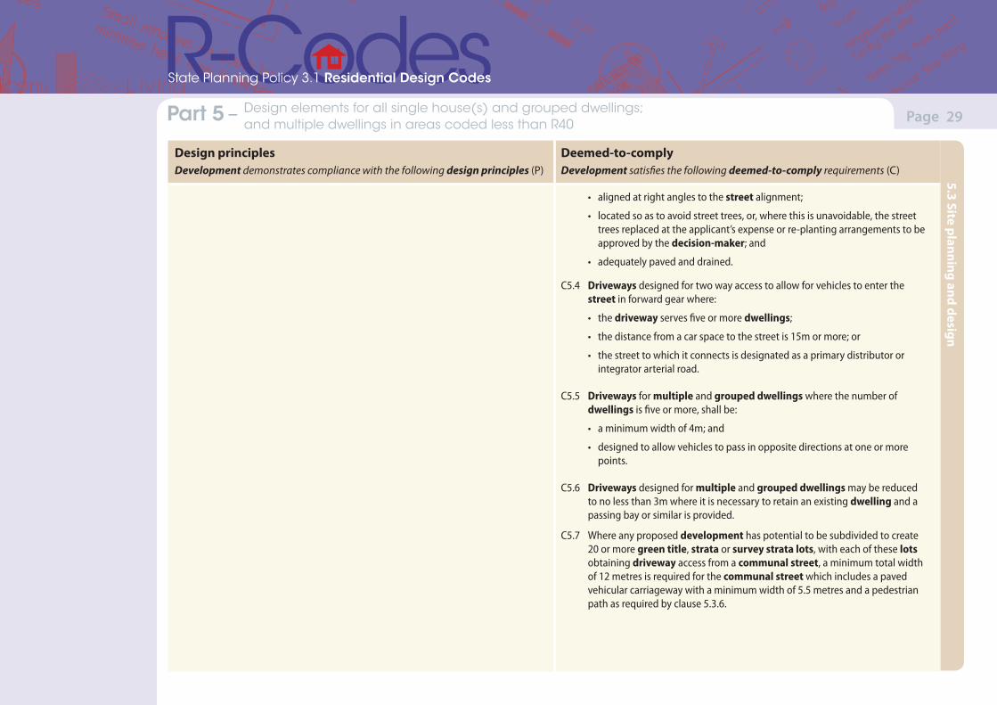
• aligned at right angles to the street alignment;
• located so as to avoid street trees, or, where this is unavoidable, the street trees replaced at the applicant’s expense or re-planting arrangements to be approved by the decision-maker; and
• adequately paved and drained.
C5.4 Driveways designed for two way access to allow for vehicles to enter the street in forward gear where:
• the driveway serves five or more dwellings;
• the distance from a car space to the street is 15m or more; or
• the street to which it connects is designated as a primary distributor or integrator arterial road.
C5.5 Driveways for multiple and grouped dwellings where the number of dwellings is five or more, shall be:
• a minimum width of 4m; and
• designed to allow vehicles to pass in opposite directions at one or more points.
C5.6 Driveways designed for multiple and grouped dwellings may be reduced to no less than 3m where it is necessary to retain an existing dwelling and a passing bay or similar is provided.
C5.7 Where any proposed development has potential to be subdivided to create 20 or more green title, strata or survey strata lots, with each of these lots obtaining driveway access from a communal street, a minimum total width of 12 metres is required for the communal street which includes a paved vehicular carriageway with a minimum width of 5.5 metres and a pedestrian path as required by clause 5.3.6.
5.3 Site planning and design

(Version 1, June 2013)(Version 1, June 2013)
Page 30Part 7 – Local planning framework Part 5 – Design elements for all single house(s) and grouped dwellings; and multiple dwellings in areas coded less than R40
State Planning Policy 3.1 Residential Design Codes
Design principlesDevelopment demonstrates compliance with the following design principles (P)
Deemed-to-complyDevelopment satisfies the following deemed-to-comply requirements (C)
5.3.6 Pedestrian access
P6 Legible, safe, and direct access for pedestrians to move between communal car parking areas or public streets and individual dwellings.
C6.1 Where a group of 10 or more dwellings is served by a communal street, either between a public street or a communal car parking area and individual dwellings; a pedestrian path separate from the vehicular access is provided, designed according to AS1428.1, provides an accessible path of travel and is at least 1.2m in width.
C6.2 Where a communal street serves more than two dwellings and is shared by pedestrians and vehicles, the configuration of the pedestrian and vehicular routes is to provide clear sight lines, adequate lighting and paving surfaces to slow traffic to ensure pedestrian safety.
C6.3 A communal street or pedestrian path is to be no closer than 3m to any wall with a major opening unless privacy screening is provided.
C6.4 For multiple dwellings with only stair access, staircases are designed to access no more than two dwellings per floor level and the stairs, landings and porches are to be protected from the weather.
C6.5 Pedestrian paths provided as required by clause 5.3.2 C2 ii.
5.3.7 Site works
P7.1 Development that considers and responds to the natural features of the site and requires minimal excavation/fill.
P7.2 Where excavation/fill is necessary, all finished levels respecting the natural ground level at the lot boundary of the site and as viewed from the street.
C7.1 Excavation or filling between the street and building, or within 3m of the street alignment, whichever is the lesser, shall not exceed 0.5m, except where necessary to provide for pedestrian or vehicle access, drainage works or natural light for a dwelling.
C7.2 Excavation or filling within a site and behind a street setback line limited by compliance with building height limits and building setback requirements.
C7.3 Subject to subclause C7.2 above, all excavation or filling behind a street setback line and within 1m of a lot boundary, not more than 0.5m above the natural ground level at the lot boundary except where otherwise stated in the scheme, local planning policy, local structure plan or local development plan.
5.3 Site planning and design
(Version 1, June 2013)(Version 1, June 2013)
Page 31Part 7 – Local planning framework Part 5 – Design elements for all single house(s) and grouped dwellings; and multiple dwellings in areas coded less than R40
State Planning Policy 3.1 Residential Design Codes
Design principlesDevelopment demonstrates compliance with the following design principles (P)
Deemed-to-complyDevelopment satisfies the following deemed-to-comply requirements (C)
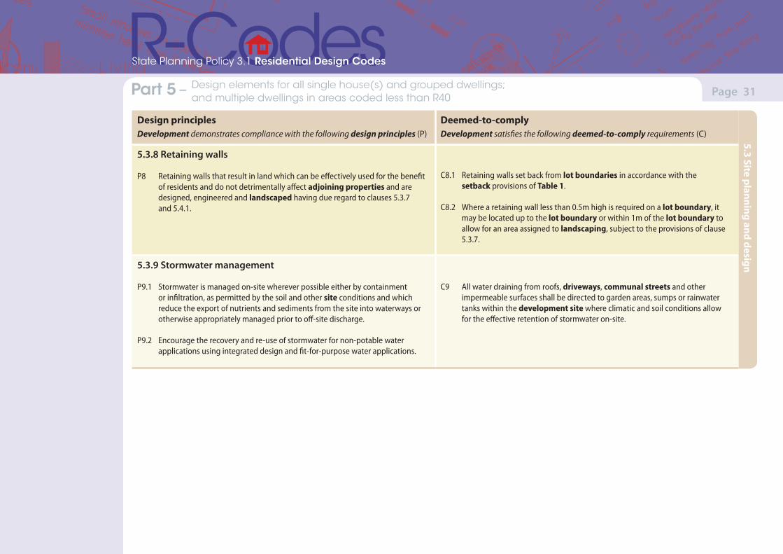
5.3.8 Retaining walls
P8 Retaining walls that result in land which can be effectively used for the benefit of residents and do not detrimentally affect adjoining properties and are designed, engineered and landscaped having due regard to clauses 5.3.7 and 5.4.1.
C8.1 Retaining walls set back from lot boundaries in accordance with the setback provisions of Table 1.
C8.2 Where a retaining wall less than 0.5m high is required on a lot boundary, it may be located up to the lot boundary or within 1m of the lot boundary to allow for an area assigned to landscaping, subject to the provisions of clause 5.3.7.
5.3.9 Stormwater management
P9.1 Stormwater is managed on-site wherever possible either by containment or infiltration, as permitted by the soil and other site conditions and which reduce the export of nutrients and sediments from the site into waterways or otherwise appropriately managed prior to off-site discharge.
P9.2 Encourage the recovery and re-use of stormwater for non-potable water applications using integrated design and fit-for-purpose water applications.
C9 All water draining from roofs, driveways, communal streets and other impermeable surfaces shall be directed to garden areas, sumps or rainwater tanks within the development site where climatic and soil conditions allow for the effective retention of stormwater on-site.
5.3 Site planning and design
(Version 1, June 2013)(Version 1, June 2013)
Page 32Part 7 – Local planning framework Part 5 – Design elements for all single house(s) and grouped dwellings; and multiple dwellings in areas coded less than R40
State Planning Policy 3.1 Residential Design Codes
Design principlesDevelopment demonstrates compliance with the following design principles (P)
Deemed-to-complyDevelopment satisfies the following deemed-to-comply requirements (C)
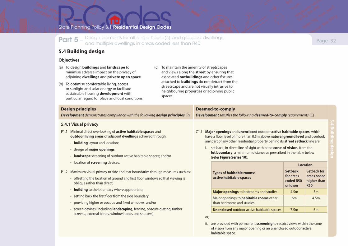
5.4.1 Visual privacy
P1.1 Minimal direct overlooking of active habitable spaces and outdoor living areas of adjacent dwellings achieved through:
• building layout and location;
• design of major openings;
• landscape screening of outdoor active habitable spaces; and/or
• location of screening devices.
P1.2 Maximum visual privacy to side and rear boundaries through measures such as:
• offsetting the location of ground and first floor windows so that viewing is oblique rather than direct;
• building to the boundary where appropriate;
• setting back the first floor from the side boundary;
• providing higher or opaque and fixed windows; and/or
• screen devices (including landscaping, fencing, obscure glazing, timber screens, external blinds, window hoods and shutters).
C1.1 Major openings and unenclosed outdoor active habitable spaces, which have a floor level of more than 0.5m above natural ground level and overlook any part of any other residential property behind its street setback line are:
i. set back, in direct line of sight within the cone of vision, from the lot boundary, a minimum distance as prescribed in the table below (refer Figure Series 10):
Types of habitable rooms/ active habitable spaces
Location
Setback for areas coded R50 or lower
Setback for areas coded higher than R50
Major openings to bedrooms and studies 4.5m 3m
Major openings to habitable rooms other than bedrooms and studies
6m 4.5m
Unenclosed outdoor active habitable spaces 7.5m 6m
or;
ii. are provided with permanent screening to restrict views within the cone of vision from any major opening or an unenclosed outdoor active habitable space.
5.4 Building design
Objectives
(a) To design buildings and landscape to minimise adverse impact on the privacy of adjoining dwellings and private open space.
(b) To optimise comfortable living, access to sunlight and solar energy to facilitate sustainable housing development with particular regard for place and local conditions.
(c) To maintain the amenity of streetscapes and views along the street by ensuring that associated outbuildings and other fixtures attached to buildings do not detract from the streetscape and are not visually intrusive to neighbouring properties or adjoining public spaces.
5.4 Building design
(Version 1, June 2013)(Version 1, June 2013)
Page 33Part 7 – Local planning framework Part 5 – Design elements for all single house(s) and grouped dwellings; and multiple dwellings in areas coded less than R40
State Planning Policy 3.1 Residential Design Codes
Design principlesDevelopment demonstrates compliance with the following design principles (P)
Deemed-to-complyDevelopment satisfies the following deemed-to-comply requirements (C)
C1.2 Screening devices such as obscure glazing, timber screens, external blinds, window hoods and shutters are to be at least 1.6m in height, at least 75 per cent obscure, permanently fixed, made of durable material and restrict view in the direction of overlooking into any adjoining property.
Note: i. Where the subject site and an affected adjoining site are subject to a different R-Codes, the setback distance is determined by reference to the lower density code.
ii. Line of sight setback distances shall be measured by application of the cone of vision set out in Figure Series 10.
iii. Line of sight setback distances include the width of any adjoining right-of-way, communal street or battleaxe leg or the like.
iv. These provisions apply to adjoining sites only where that land is zoned to allow for residential development.
5.4.2 Solar access for adjoining sites
P2.1 Effective solar access for the proposed development and protection of the solar access.
P2.2 Development designed to protect solar access for neighbouring properties taking account the potential to overshadow existing:
• outdoor living areas;
• north facing major openings to habitable rooms, within 15 degrees of north in each direction; or
• roof mounted solar collectors.
C2.1 Notwithstanding the lot boundary setbacks in clause 5.1.3, development in climatic zones 4, 5 and 6 of the State shall be so designed that its shadow cast at midday, 21 June onto any other adjoining property does not exceed the following limits:• on adjoining properties coded R25 and lower – 25 per cent of the site area;• on adjoining properties coded R30 to R40 inclusive – 35 per cent of the
site area; • on adjoining properties coded higher than R40 – 50 per cent of the site area.
C2.2 Where a development site shares its southern boundary with a lot, and that lot is bound to the north by another lot(s), the limit of shading for the development site set out in clause 5.4.2 C2.1 shall be reduced proportionate to the percentage of the affected property’s northern boundary that the development site abuts (refer to Figure 11b).
Note: With regard to clause 5.4.2 C2.1 site area refers to the surface of the adjoining lot and is measured without regard to any building on it but taking into account its natural ground levels.
5.4 Building design
(Version 1, June 2013)(Version 1, June 2013)
Page 34Part 7 – Local planning framework Part 5 – Design elements for all single house(s) and grouped dwellings; and multiple dwellings in areas coded less than R40
State Planning Policy 3.1 Residential Design Codes
Design principlesDevelopment demonstrates compliance with the following design principles (P)
Deemed-to-complyDevelopment satisfies the following deemed-to-comply requirements (C)
5.4.3 Outbuildings
P3 Outbuildings that do not detract from the streetscape or the visual amenity of residents or neighbouring properties.
C3 Outbuildings that:
i. are not attached to a dwelling;
ii. are non-habitable;
iii. collectively do not exceed 60m2 in area or 10 per cent in aggregate of the site area, whichever is the lesser;
iv. do not exceed a wall height of 2.4m;
v. do not exceed ridge height of 4.2m;
vi. are not within the primary or secondary street setback area;
vii. do not reduce the amount of open space required in Table 1; and
viii. are set back in accordance with Tables 2a and 2b.
5.4.4 External fixtures
P4.1 Solar collectors, aerials, antennas, satellite dishes, pipes and external fixtures integrated into the design of the building to not be visually obtrusive when viewed from the street and to protect the visual amenity of surrounding properties.
C4.1 Solar collectors installed on the roof or other parts of buildings.
C4.2 Television aerials of the standard type, essential plumbing vent pipes above the roof line and external roof water down pipes.
C4.3 Other external fixtures provided they are:
i. not visible from the primary street;
ii. are designed to integrate with the building; or
iii. are located so as not to be visually obtrusive.
C4.4 Antennas, satellite dishes and the like not visible from any primary and secondary street.
5.4 Building design
(Version 1, June 2013)(Version 1, June 2013)
Page 35Part 7 – Local planning framework Part 5 – Design elements for all single house(s) and grouped dwellings; and multiple dwellings in areas coded less than R40
State Planning Policy 3.1 Residential Design Codes
Design principlesDevelopment demonstrates compliance with the following design principles (P)
Deemed-to-complyDevelopment satisfies the following deemed-to-comply requirements (C)
5.4.5 Utilities and facilities
P5 External location of storeroom, rubbish collection/bin areas, and clothes drying areas where these are:
• convenient for residents;
• rubbish collection areas which can be accessed by service vehicles;
• screened from view; and
• able to be secured and managed.
C5.1 An enclosed, lockable storage area, constructed in a design and material matching the dwelling where visible from the street, accessible from outside the dwelling, with a minimum dimension of 1.5m with an internal area of at least 4m2, for each grouped or multiple dwelling(s).
C5.2 Where rubbish bins are not collected from the street immediately adjoining a dwelling, there shall be provision of a communal pick-up area or areas which are:
i. conveniently located for rubbish and recycling pick-up;
ii. accessible to residents;
iii. adequate in area to store all rubbish bins; and
iv. fully screened from view from the primary or secondary street.
C5.3 Clothes-drying areas screened from view from the primary and secondary street.
5.4 Building design
(Version 1, June 2013)(Version 1, June 2013)
Page 36Part 7 – Local planning framework Part 5 – Design elements for all single house(s) and grouped dwellings; and multiple dwellings in areas coded less than R40
State Planning Policy 3.1 Residential Design Codes
Design principlesDevelopment demonstrates compliance with the following design principles (P)
Deemed-to-complyDevelopment satisfies the following deemed-to-comply requirements (C)
5.5.1 Ancillary dwellings
P1 Ancillary dwelling for people who live either independently or semi-dependently to the residents of the single house, sharing some site facilities and services and without compromising the amenity of surrounding properties.
C1 Ancillary dwelling associated with a single house and on the same lot where:
i. the lot is not less than 450m2 in area;
ii. there is a maximum plot ratio area of 70m2;
iii. parking provided in accordance with clause 5.3.3 C3.1; and
iv. complies with all other R-Code provisions, only as they apply to single houses, with the exception of clauses:
(a) 5.1.1 Site area;
(b) 5.2.3 Street surveillance (except where located on a lot with secondary street or right-of-way access); and
(c) 5.3.1 Outdoor living areas.
5.5 Special purpose dwellings
Objectives(a) To ensure residential development is provided to accommodate people
with or without special needs.
(b) To provide ancillary accommodation which is independent or semi-independent to residents of the single house.
(c) To ensure that dwellings for the aged and people with special needs can be provided within residential areas.
(d) To provide opportunities for affordable housing.
5.5 Special purpose dwellings
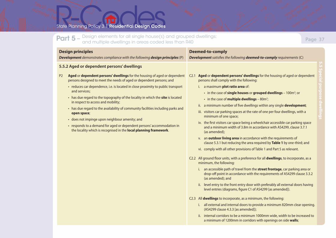
(Version 1, June 2013)(Version 1, June 2013)
Page 37Part 7 – Local planning framework Part 5 – Design elements for all single house(s) and grouped dwellings; and multiple dwellings in areas coded less than R40
State Planning Policy 3.1 Residential Design Codes
Design principlesDevelopment demonstrates compliance with the following design principles (P)
Deemed-to-complyDevelopment satisfies the following deemed-to-comply requirements (C)
5.5.2 Aged or dependent persons’ dwellings
P2 Aged or dependent persons’ dwellings for the housing of aged or dependent persons designed to meet the needs of aged or dependent persons; and
• reduces car dependence, i.e. is located in close proximity to public transport and services;
• has due regard to the topography of the locality in which the site is located in respect to access and mobility;
• has due regard to the availability of community facilities including parks and open space;
• does not impinge upon neighbour amenity; and
• responds to a demand for aged or dependent persons’ accommodation in the locality which is recognised in the local planning framework.
C2.1 Aged or dependent persons’ dwellings for the housing of aged or dependent persons shall comply with the following:
i. a maximum plot ratio area of:
• in the case of single houses or grouped dwellings – 100m2; or
• in the case of multiple dwellings – 80m2;
ii. a minimum number of five dwellings within any single development;
iii. visitors car parking spaces at the rate of one per four dwellings, with a minimum of one space;
iv. the first visitors car space being a wheelchair accessible car parking space and a minimum width of 3.8m in accordance with AS4299, clause 3.7.1 (as amended);
v. an outdoor living area in accordance with the requirements of clause 5.3.1 but reducing the area required by Table 1 by one-third; and
vi. comply with all other provisions of Table 1 and Part 5 as relevant.
C2.2 All ground floor units, with a preference for all dwellings, to incorporate, as a minimum, the following:
i. an accessible path of travel from the street frontage, car parking area or drop-off point in accordance with the requirements of AS4299 clause 3.3.2 (as amended); and
ii. level entry to the front entry door with preferably all external doors having level entries (diagrams, figure C1 of AS4299 [as amended]).
C2.3 All dwellings to incorporate, as a minimum, the following:
i. all external and internal doors to provide a minimum 820mm clear opening. (AS4299 clause 4.3.3 [as amended]);
ii. internal corridors to be a minimum 1000mm wide, width to be increased to a minimum of 1200mm in corridors with openings on side walls;
5.5 Special purpose dwellings
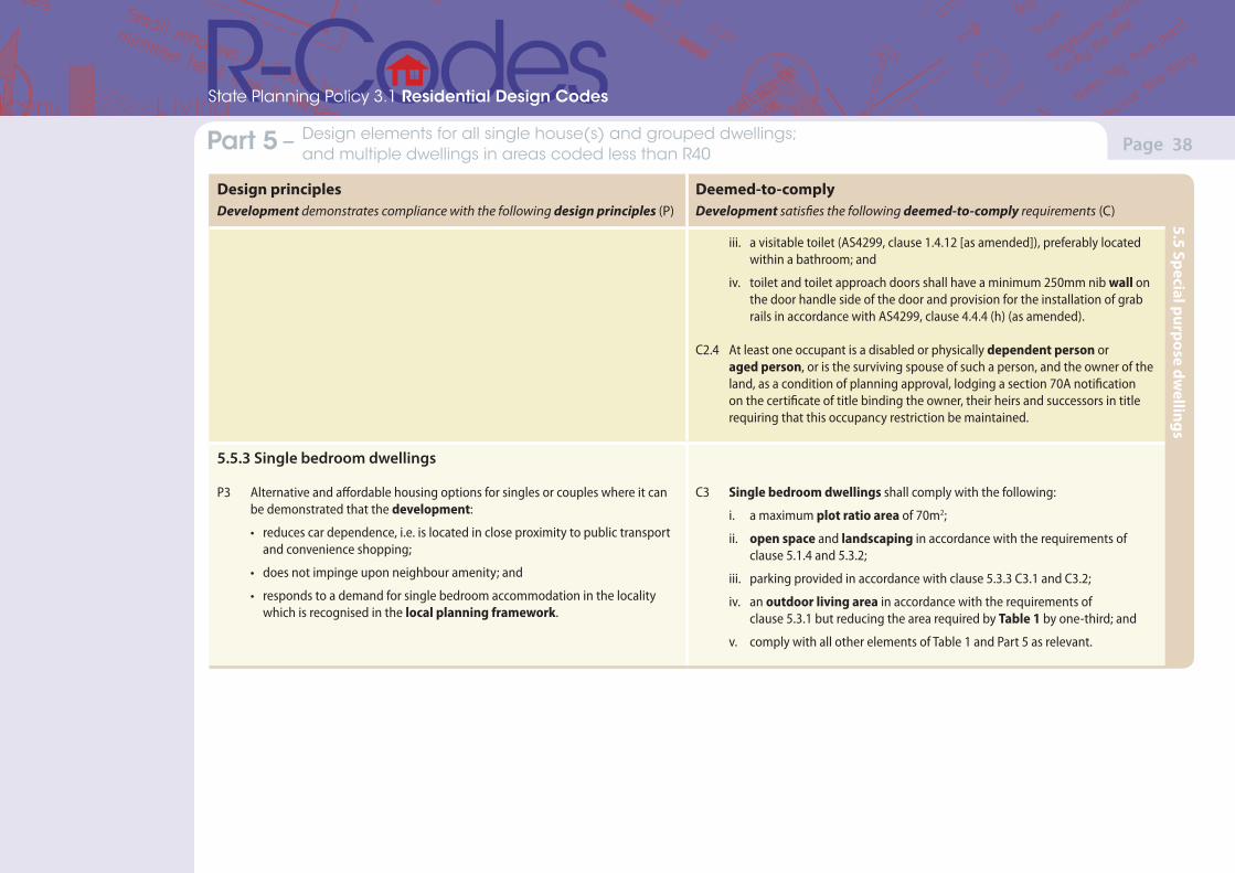
(Version 1, June 2013)(Version 1, June 2013)
Page 38Part 7 – Local planning framework Part 5 – Design elements for all single house(s) and grouped dwellings; and multiple dwellings in areas coded less than R40
State Planning Policy 3.1 Residential Design Codes
Design principlesDevelopment demonstrates compliance with the following design principles (P)
Deemed-to-complyDevelopment satisfies the following deemed-to-comply requirements (C)
iii. a visitable toilet (AS4299, clause 1.4.12 [as amended]), preferably located within a bathroom; and
iv. toilet and toilet approach doors shall have a minimum 250mm nib wall on the door handle side of the door and provision for the installation of grab rails in accordance with AS4299, clause 4.4.4 (h) (as amended).
C2.4 At least one occupant is a disabled or physically dependent person or aged person, or is the surviving spouse of such a person, and the owner of the land, as a condition of planning approval, lodging a section 70A notification on the certificate of title binding the owner, their heirs and successors in title requiring that this occupancy restriction be maintained.
5.5.3 Single bedroom dwellings
P3 Alternative and affordable housing options for singles or couples where it can be demonstrated that the development:
• reduces car dependence, i.e. is located in close proximity to public transport and convenience shopping;
• does not impinge upon neighbour amenity; and
• responds to a demand for single bedroom accommodation in the locality which is recognised in the local planning framework.
C3 Single bedroom dwellings shall comply with the following:
i. a maximum plot ratio area of 70m2;
ii. open space and landscaping in accordance with the requirements of clause 5.1.4 and 5.3.2;
iii. parking provided in accordance with clause 5.3.3 C3.1 and C3.2;
iv. an outdoor living area in accordance with the requirements of clause 5.3.1 but reducing the area required by Table 1 by one-third; and
v. comply with all other elements of Table 1 and Part 5 as relevant.
5.5 Special purpose dwellings
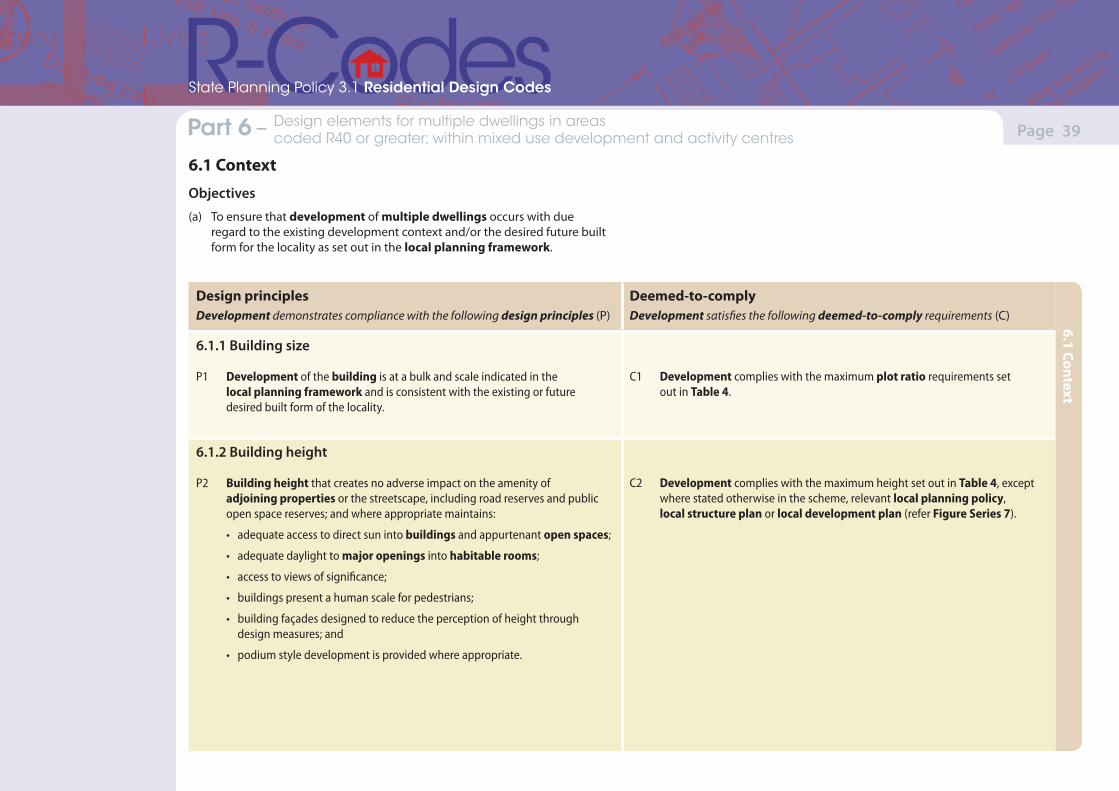
(Version 1, June 2013)(Version 1, June 2013)
Page 39Part 7 – Local planning framework Part 6 – Design elements for multiple dwellings in areas coded R40 or greater; within mixed use development and activity centres
State Planning Policy 3.1 Residential Design Codes
Design principlesDevelopment demonstrates compliance with the following design principles (P)
Deemed-to-complyDevelopment satisfies the following deemed-to-comply requirements (C)
6.1.1 Building size
P1 Development of the building is at a bulk and scale indicated in the local planning framework and is consistent with the existing or future desired built form of the locality.
C1 Development complies with the maximum plot ratio requirements set out in Table 4.
6.1.2 Building height
P2 Building height that creates no adverse impact on the amenity of adjoining properties or the streetscape, including road reserves and public open space reserves; and where appropriate maintains:
• adequate access to direct sun into buildings and appurtenant open spaces;
• adequate daylight to major openings into habitable rooms;
• access to views of significance;
• buildings present a human scale for pedestrians;
• building façades designed to reduce the perception of height through design measures; and
• podium style development is provided where appropriate.
C2 Development complies with the maximum height set out in Table 4, except where stated otherwise in the scheme, relevant local planning policy, local structure plan or local development plan (refer Figure Series 7).
6.1 Context
Objectives
(a) To ensure that development of multiple dwellings occurs with due regard to the existing development context and/or the desired future built form for the locality as set out in the local planning framework.
6.1 Context
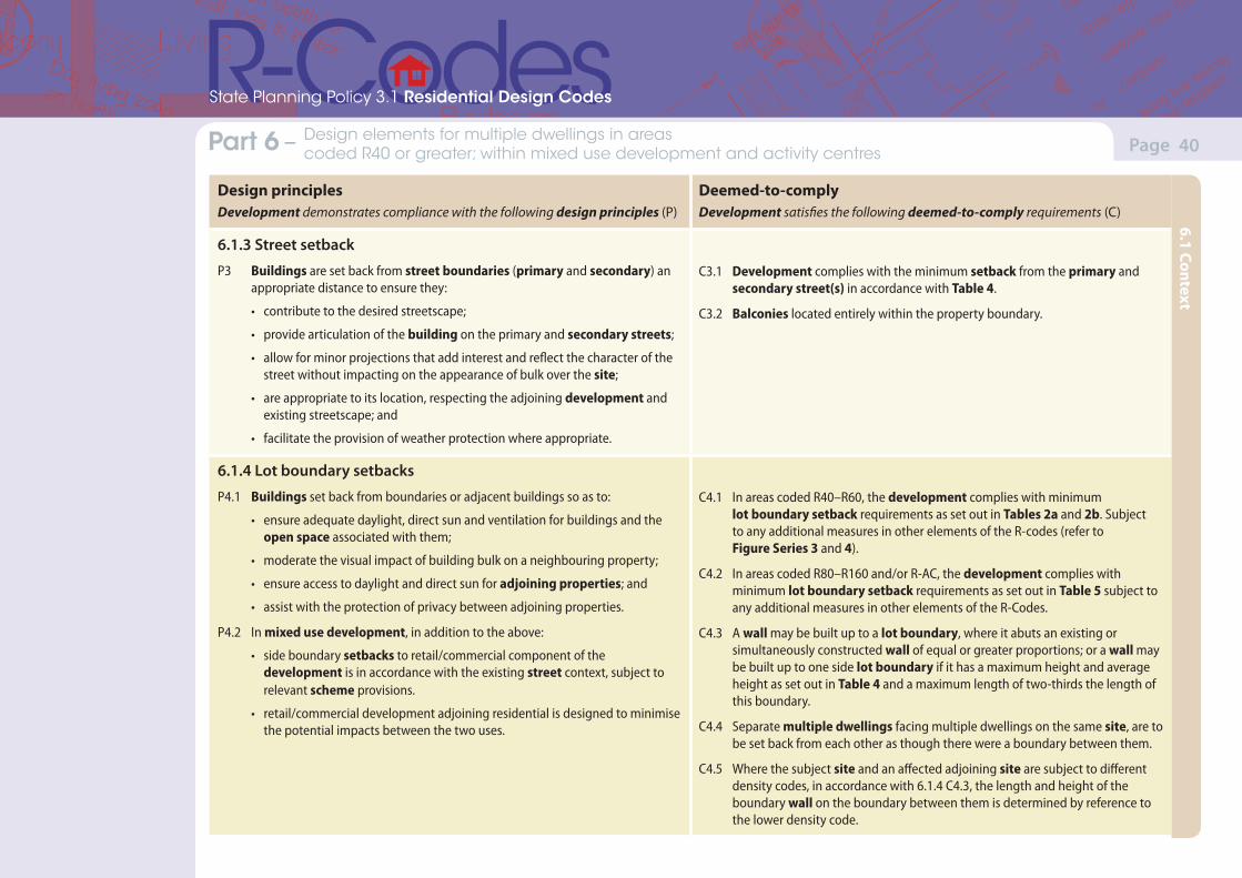
(Version 1, June 2013)(Version 1, June 2013)
Page 40Part 7 – Local planning framework Part 6 – Design elements for multiple dwellings in areas coded R40 or greater; within mixed use development and activity centres
State Planning Policy 3.1 Residential Design Codes
Design principlesDevelopment demonstrates compliance with the following design principles (P)
Deemed-to-complyDevelopment satisfies the following deemed-to-comply requirements (C)
6.1.3 Street setback
P3 Buildings are set back from street boundaries (primary and secondary) an appropriate distance to ensure they:
• contribute to the desired streetscape;
• provide articulation of the building on the primary and secondary streets;
• allow for minor projections that add interest and reflect the character of the street without impacting on the appearance of bulk over the site;
• are appropriate to its location, respecting the adjoining development and existing streetscape; and
• facilitate the provision of weather protection where appropriate.
C3.1 Development complies with the minimum setback from the primary and secondary street(s) in accordance with Table 4.
C3.2 Balconies located entirely within the property boundary.
6.1.4 Lot boundary setbacks
P4.1 Buildings set back from boundaries or adjacent buildings so as to:
• ensure adequate daylight, direct sun and ventilation for buildings and the open space associated with them;
• moderate the visual impact of building bulk on a neighbouring property;
• ensure access to daylight and direct sun for adjoining properties; and
• assist with the protection of privacy between adjoining properties.
P4.2 In mixed use development, in addition to the above:
• side boundary setbacks to retail/commercial component of the development is in accordance with the existing street context, subject to relevant scheme provisions.
• retail/commercial development adjoining residential is designed to minimise the potential impacts between the two uses.
C4.1 In areas coded R40–R60, the development complies with minimum lot boundary setback requirements as set out in Tables 2a and 2b. Subject to any additional measures in other elements of the R-codes (refer to Figure Series 3 and 4).
C4.2 In areas coded R80–R160 and/or R-AC, the development complies with minimum lot boundary setback requirements as set out in Table 5 subject to any additional measures in other elements of the R-Codes.
C4.3 A wall may be built up to a lot boundary, where it abuts an existing or simultaneously constructed wall of equal or greater proportions; or a wall may be built up to one side lot boundary if it has a maximum height and average height as set out in Table 4 and a maximum length of two-thirds the length of this boundary.
C4.4 Separate multiple dwellings facing multiple dwellings on the same site, are to be set back from each other as though there were a boundary between them.
C4.5 Where the subject site and an affected adjoining site are subject to different density codes, in accordance with 6.1.4 C4.3, the length and height of the boundary wall on the boundary between them is determined by reference to the lower density code.
6.1 Context
(Version 1, June 2013)(Version 1, June 2013)
Page 41
State Planning Policy 3.1 Residential Design Codes
6.1 Context
Part 6 – Design elements for multiple dwellings in areas coded R40 or greater; within mixed use development and activity centres
Design principlesDevelopment demonstrates compliance with the following design principles (P)
Deemed-to-complyDevelopment satisfies the following deemed-to-comply requirements (C)
6.1.5 Open space
P5 Open space respects existing or preferred neighbourhood character and responds to the features of the site.
C5 Development complies with minimum open space set out in Table 4 (refer to Figure Series 6).
(Version 1, June 2013)(Version 1, June 2013)
Page 42Part 7 – Local planning framework Part 6 – Design elements for multiple dwellings in areas coded R40 or greater; within mixed use development and activity centres
State Planning Policy 3.1 Residential Design Codes
Design principlesDevelopment demonstrates compliance with the following design principles (P)
Deemed-to-complyDevelopment satisfies the following deemed-to-comply requirements (C)
6.2.1 Street surveillance
P1.1 Buildings designed to provide for surveillance (actual or perceived) between individual dwellings and the street and between common areas and the street, which minimise opportunities for concealment and entrapment.
P1.2 In mixed use development, in addition to the above:
• blank walls minimised at street level, and where practical active frontages incorporated into the development to ensure a suitable level of casual surveillance of the public domain; and
• lengths of street frontage at ground level dedicated to each tenancy limited to discourage large scale uses that reduce the level of activity along the building frontage.
C1.1 The street elevation(s) of the building to address the street, with facades generally parallel to the street and with clearly definable entry points visible and accessed from the street.
C1.2 The building has habitable room windows or balconies that face the street.
C1.3 Basement parking structures between a street frontage and the main front elevation are no more than 1m above natural ground level at any point.
6.2.2 Street walls and fences
P2 Front fences to enable surveillance and enhance streetscape. C2 Front fences within the primary street setback area that are visually permeable to 1.2m above natural ground level.
6.2.3 Sight lines
P3 Unobstructed sight lines provided at vehicle access points to ensure safety and visibility along vehicle access ways, streets, rights-of-way, communal streets, crossovers, and footpaths.
C3 Walls, fences and other structures truncated or reduced to no higher than 0.75m within 1.5m of where walls, fences, other structures adjoin vehicle access points where a driveway meets a public street and where two streets intersect (refer to Figure Series 9).
6.2 Streetscape
Objectives
(a) To respond and reinforce the existing character of the street and locality. Development should contribute towards attractive streetscapes.
6.2 Streetscape
(Version 1, June 2013)(Version 1, June 2013)
Page 43Part 7 – Local planning framework Part 6 – Design elements for multiple dwellings in areas coded R40 or greater; within mixed use development and activity centres
State Planning Policy 3.1 Residential Design Codes
Design principlesDevelopment demonstrates compliance with the following design principles (P)
Deemed-to-complyDevelopment satisfies the following deemed-to-comply requirements (C)
6.2.4 Building appearance
P4.1 Buildings designed to enhance an existing desired streetscape, where the decision-maker has identified the need for design controls.
P4.2 In mixed use development, in addition to the above:
• where mixed use development is proposed in commercial areas, the proportion of the frontage dedicated to the residential entrance is minimised so as to maximise the potential for active commercial frontage.
• the mixed use development is integrated such that the function of the residential and non-residential components do not conflict.
• provide weather protection in commercial areas where appropriate.
C4 Buildings that comply with the provisions of a special control area, with the provisions of a local planning policy made under the scheme or with the provisions of the scheme, in respect of the design of carports and garages, the colour, scale, materials and roof pitch of buildings including outbuildings, the form and materials of retaining walls and the extent to which the upper levels of buildings as viewed from the street should be limited.
6.2 Streetscape
(Version 1, June 2013)(Version 1, June 2013)
Page 44Part 7 – Local planning framework Part 6 – Design elements for multiple dwellings in areas coded R40 or greater; within mixed use development and activity centres
State Planning Policy 3.1 Residential Design Codes
Design principlesDevelopment demonstrates compliance with the following design principles (P)
Deemed-to-complyDevelopment satisfies the following deemed-to-comply requirements (C)
6.3.1 Outdoor living areas
P1 Balconies or equivalent outdoor living areas capable of use in conjunction with a habitable room of each dwelling, and if possible, open to winter sun.
C1 Each unit is to be provided with at least one balcony or equivalent accessed directly from a habitable room with a minimum area of 10m2 and a minimum dimension of 2.4m.
6.3.2 Landscaping
P2 The space around the building is designed to allow for planting. Landscaping of the site is to be undertaken with appropriate planting, paving and other landscaping that:
• meets the projected needs of the residents;
• enhances security and safety for residents; and
• contributes to the streetscape.
C2 Landscaping of open spaces in accordance with the following:
i. the street setback areas developed without car parking, except for visitors’ bays, and with a maximum of 50 per cent hard surface;
ii. separate pedestrian paths providing wheelchair accessibility connecting all entries to buildings with the public footpath and car parking areas;
iii. landscaping between each six consecutive external car parking spaces to include shade trees;
iv. lighting provided to pathways, and communal open space and car-parking areas; and
v. Clear sight lines at pedestrian and vehicle crossings.
6.3 Site planning and design
Objectives
(a) To ensure design considerations are taken into account when the built form is design for the site. Buildings respond to the site conditions and account for the natural attributes of the site. Site planning is visually appropriate, provides for safe and convenient access, and meets the needs of residents, visitors, and neighbours.
6.3 Site planning and design
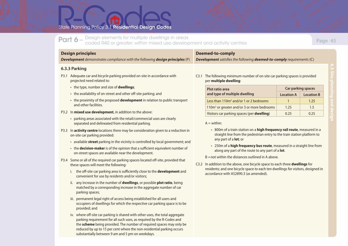
(Version 1, June 2013)(Version 1, June 2013)
Page 45Part 7 – Local planning framework Part 6 – Design elements for multiple dwellings in areas coded R40 or greater; within mixed use development and activity centres
State Planning Policy 3.1 Residential Design Codes
Design principlesDevelopment demonstrates compliance with the following design principles (P)
Deemed-to-complyDevelopment satisfies the following deemed-to-comply requirements (C)
6.3.3 Parking
P3.1 Adequate car and bicycle parking provided on-site in accordance with projected need related to:
• the type, number and size of dwellings;
• the availability of on-street and other off-site parking; and
• the proximity of the proposed development in relation to public transport and other facilities.
P3.2 In mixed use development, in addition to the above:
• parking areas associated with the retail/commercial uses are clearly separated and delineated from residential parking.
P3.3 In activity centre locations there may be consideration given to a reduction in on-site car parking provided:
• available street parking in the vicinity is controlled by local government; and
• the decision-maker is of the opinion that a sufficient equivalent number of on-street spaces are available near the development.
P3.4 Some or all of the required car parking spaces located off-site, provided that these spaces will meet the following:
i. the off-site car parking area is sufficiently close to the development and convenient for use by residents and/or visitors;
ii. any increase in the number of dwellings, or possible plot ratio, being matched by a corresponding increase in the aggregate number of car parking spaces;
iii. permanent legal right of access being established for all users and occupiers of dwellings for which the respective car parking space is to be provided; and
iv. where off-site car parking is shared with other uses, the total aggregate parking requirement for all such uses, as required by the R-Codes and the scheme being provided. The number of required spaces may only be reduced by up to 15 per cent where the non-residential parking occurs substantially between 9 am and 5 pm on weekdays.
C3.1 The following minimum number of on-site car parking spaces is provided per multiple dwelling:
Plot ratio area and type of multiple dwelling
Car parking spaces
Location A Location B
Less than 110m2 and/or 1 or 2 bedrooms 1 1.25
110m2 or greater and/or 3 or more bedrooms 1.25 1.5
Visitors car parking spaces (per dwelling) 0.25 0.25
A = within:
• 800m of a train station on a high frequency rail route, measured in a straight line from the pedestrian entry to the train station platform to any part of a lot; or
• 250m of a high frequency bus route, measured in a straight line from along any part of the route to any part of a lot.
B = not within the distances outlined in A above.
C3.2 In addition to the above, one bicycle space to each three dwellings for residents; and one bicycle space to each ten dwellings for visitors, designed in accordance with AS2890.3 (as amended).
6.3 Site planning and design
(Version 1, June 2013)(Version 1, June 2013)
Page 46Part 7 – Local planning framework Part 6 – Design elements for multiple dwellings in areas coded R40 or greater; within mixed use development and activity centres
State Planning Policy 3.1 Residential Design Codes
Design principlesDevelopment demonstrates compliance with the following design principles (P)
Deemed-to-complyDevelopment satisfies the following deemed-to-comply requirements (C)
6.3.4 Design of car parking spaces
P4 Car, cycle and other parking facilities are to be designed and located on-site to be conveniently accessed, secure, consistent with streetscape and appropriately manage stormwater to protect the environment.
C4.1 Car parking spaces and manoeuvring areas designed and provided in accordance with AS2890.1 (as amended).
C4.2 Visitor car parking spaces:
• marked and clearly signposted as dedicated for visitor use only, and located close to or visible from the point of entry to the development and outside any security barrier; and
• provide an accessible path of travel for people with disabilities.
C4.3 Car parking areas comprising six or more spaces provided with landscaping between each six consecutive external car parking spaces to include shade trees.
C4.4 All car parking spaces except visitors’ car parking spaces fully concealed from the street or public place.
6.3.5 Vehicular access
P5 Vehicular access provided so as to minimise the number of crossovers, to be safe in use and not detract from the streetscape.
C5.1 Vehicle access is limited to one opening per 20m street frontage that is visible from the street.
C5.2 Access to on-site car parking spaces to be provided:
• where available from a right-of-way available for the lawful use to access the relevant lot and which is adequately paved and drained from the property boundary to a constructed street;
• from a secondary street where a right-of-way does not exist, or
• from the primary street frontage where no secondary street or right-of-way exists.
C5.3 Driveways designed for two way access to allow for vehicles to enter the street in forward gear where:
• the driveway serves five or more dwellings;
• the distance from a car space to street alignment is 15m or more; or
• the public street to which it connects is designated as a primary distributor, district distributor or integrated arterial road.
C5.4 Driveways to be adequately paved and drained.
6.3 Site planning and design
(Version 1, June 2013)(Version 1, June 2013)
Page 47Part 7 – Local planning framework Part 6 – Design elements for multiple dwellings in areas coded R40 or greater; within mixed use development and activity centres
State Planning Policy 3.1 Residential Design Codes
Design principlesDevelopment demonstrates compliance with the following design principles (P)
Deemed-to-complyDevelopment satisfies the following deemed-to-comply requirements (C)
6.3.6 Site works
P6.1 Development that considers and responds to the natural features of the site and requires minimal excavation/fill.
P6.2 Where excavation/fill is necessary, all finished levels respecting the natural ground level at the boundary of the site and the adjoining properties and as viewed from the street.
C6.1 Excavation or filling between the street and building, or within 3m of the street alignment, whichever is the lesser, shall not exceed 0.5m, except where necessary to provide for pedestrian or vehicle access, drainage works or natural light for a dwelling.
C6.2 Excavation or filling within a site and behind a street setback line limited by compliance with building height limits and building setback requirements.
C6.3 Subject to clause 6.3.6 C6.2, all excavation or filling behind a street setback line and within 1m of a lot boundary shall not be more than 0.5m above the natural ground level at the lot boundary except where otherwise stated in a local planning policy or local development plan.
6.3.7 Retaining walls
P7 Retaining walls that result in land which can be effectively used for the benefits of residents and do not detrimentally affect adjoining properties and are designed, engineered and adequately landscaped having regard to clauses 6.3.6 and 6.4.1.
C7 Where a retaining wall less than 0.5m high is required on a lot boundary, it may be located up to the lot boundary or within 1m of the lot boundary to allow for an area assigned to landscaping, subject to the provisions of clause 6.3.6.
6.3.8 Stormwater management
P8.1 Stormwater is managed on-site wherever possible either by containment or by infiltration, as permitted by the soil and other site conditions, and which reduce the export of nutrients and sediments from the site into waterways or otherwise appropriately managed, prior to offsite discharge.
P9.2 Encourage recovery and re-use of stormwater for non-potable water applications using integrated design and ‘fit-for-purpose’ water applications.
C8 All water draining from roofs, driveways, communal streets and other impermeable surfaces shall be directed to garden areas, sumps or rainwater tanks within the development site where climatic and soil conditions allow for the effective retention of stormwater on-site.
6.3 Site planning and design
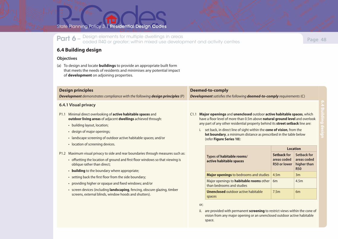
(Version 1, June 2013)(Version 1, June 2013)
Page 48Part 7 – Local planning framework Part 6 – Design elements for multiple dwellings in areas coded R40 or greater; within mixed use development and activity centres
State Planning Policy 3.1 Residential Design Codes
Design principlesDevelopment demonstrates compliance with the following design principles (P)
Deemed-to-complyDevelopment satisfies the following deemed-to-comply requirements (C)
6.4.1 Visual privacy
P1.1 Minimal direct overlooking of active habitable spaces and outdoor living areas of adjacent dwellings achieved through:
• building layout, location;
• design of major openings;
• landscape screening of outdoor active habitable spaces; and/or
• location of screening devices.
P1.2 Maximum visual privacy to side and rear boundaries through measures such as:
• offsetting the location of ground and first floor windows so that viewing is oblique rather than direct;
• building to the boundary where appropriate;
• setting back the first floor from the side boundary;
• providing higher or opaque and fixed windows; and/or
• screen devices (including landscaping, fencing, obscure glazing, timber screens, external blinds, window hoods and shutters).
C1.1 Major openings and unenclosed outdoor active habitable spaces, which have a floor level of more than 0.5m above natural ground level and overlook any part of any other residential property behind its street setback line are:
i. set back, in direct line of sight within the cone of vision, from the lot boundary, a minimum distance as prescribed in the table below (refer Figure Series 10):
Types of habitable rooms/ active habitable spaces
Location
Setback for areas coded R50 or lower
Setback for areas coded higher than R50
Major openings to bedrooms and studies 4.5m 3m
Major openings to habitable rooms other than bedrooms and studies
6m 4.5m
Unenclosed outdoor active habitable spaces
7.5m 6m
or;
ii. are provided with permanent screening to restrict views within the cone of vision from any major opening or an unenclosed outdoor active habitable space.
6.4 Building design
Objectives
(a) To design and locate buildings to provide an appropriate built form that meets the needs of residents and minimises any potential impact of development on adjoining properties.
6.4 Building design
(Version 1, June 2013)(Version 1, June 2013)
Page 49Part 7 – Local planning framework Part 6 – Design elements for multiple dwellings in areas coded R40 or greater; within mixed use development and activity centres
State Planning Policy 3.1 Residential Design Codes
Design principlesDevelopment demonstrates compliance with the following design principles (P)
Deemed-to-complyDevelopment satisfies the following deemed-to-comply requirements (C)
C1.2 Screening devices such as obscure glazing, timber screens, external blinds, window hoods and shutters are to be at least 1.6m in height, at least 75 per cent obscure, permanently fixed, made of durable material and restrict view in the direction of overlooking into any adjoining property.
Note: i. Where the subject site and an affected adjoining site are subject to a different R-Codes, the setback distance is determined by reference to the lower density code.
ii. Line of sight setback distances shall be measured by application of the cone of vision set out in Figure Series 10.
iii. Line of sight setback distances include the width of any adjoining right-of-way, communal street or battleaxe leg or the like.
iv. These provisions apply to adjoining sites only where that land is zoned to allow for residential development.
6.4.2 Solar access for adjoining sites
P2.1 Effective solar access for the proposed development.
P2.2 Development designed to protect solar access for neighbouring properties taking account the potential to overshadow existing:
• outdoor living areas;
• north facing major openings to habitable rooms, within 15 degrees of north in each direction; or
• roof mounted solar collectors.
C2.1 Notwithstanding the lot boundary setbacks in clause 6.1.4, development in climatic zones 4, 5 and 6 of the State shall be so designed that its shadow cast at midday, 21 June onto any other adjoining property does not exceed the following limits:• on adjoining properties coded R25 and lower – 25 per cent of the site area;• on adjoining properties coded R30 to R40 inclusive – 35 per cent of the
site area; • on adjoining properties coded R50 to R60 inclusive – 50 per cent of the
site area.
C2.2 Where a development site shares its southern boundary with a lot, and that lot is bound to the north by another lot(s), the limit of shading for the development site set out in clause 6.4.2 C2.1 shall be reduced proportionate to the percentage of the affected property’s northern boundary that the development site abuts (refer figure 11b).
Note: In this context site area refers to the surface of the adjoining lot and is measured without regard to any building on it but taking into account its natural ground level.
6.4 Building design
(Version 1, June 2013)(Version 1, June 2013)
Page 50Part 7 – Local planning framework Part 6 – Design elements for multiple dwellings in areas coded R40 or greater; within mixed use development and activity centres
State Planning Policy 3.1 Residential Design Codes
Design principlesDevelopment demonstrates compliance with the following design principles (P)
Deemed-to-complyDevelopment satisfies the following deemed-to-comply requirements (C)
6.4.3 Dwelling size
P3 Each dwelling within the development is of a sufficient size to cater for the needs of the residents. The development must provide diversity in dwellings to ensure that a range of types and sizes is provided.
C3.1 Development that contains more than 12 dwellings are to provide diversity in unit types and sizes as follows:
• minimum 20 per cent 1 bedroom dwellings, up to a maximum of 50 per cent of the development; and
• minimum of 40 per cent 2 bedroom dwellings;
and
C3.2 The development does not contain any dwellings smaller than 40m2
plot ratio area.
6.4.4 Outbuildings
P4 Outbuildings that do not detract from the streetscape or the visual amenity of residents or neighbouring properties.
C4 Outbuildings that:i. are not attached to a dwelling;ii. are non-habitable;iii. do not exceed 60m2 in area or 10 per cent in aggregate of the site area,
whichever is the lesser;iv. do not exceed a wall height of 2.4m;v. do not exceed ridge height of 4.2m;vi. are not within the primary or secondary street setback area;vii. do not reduce the amount of open space required in Table 4; andviii. are set back in accordance with Tables 2a and 2b.
6.4 Building design
(Version 1, June 2013)(Version 1, June 2013)
Page 51Part 7 – Local planning framework Part 6 – Design elements for multiple dwellings in areas coded R40 or greater; within mixed use development and activity centres
State Planning Policy 3.1 Residential Design Codes
Design principlesDevelopment demonstrates compliance with the following design principles (P)
Deemed-to-complyDevelopment satisfies the following deemed-to-comply requirements (C)
6.4.5 External fixtures
P5.1 Solar collectors, aerials antennae, satellite dishes, pipes and external fixtures integrated into the design of the building to not be visually obtrusive when viewed from the street and to protect the visual amenity of surrounding properties.
P5.2 Other external fixtures integrated into the design of the building to not be visually obtrusive when viewed from the street and to protect the visual amenity of residents in neighbouring properties.
C5.1 Solar collectors installed on the roof or other parts of buildings.
C5.2 Television aerials of the standard type, essential plumbing vent pipes above the roof line and external roof water down pipes.
C5.3 Other external fixtures provided they are:
i. not visible from the primary street;
ii. are designed to integrate with the building; or
iii. are located so as not to be visually obtrusive.
C5.4 Antennae, satellite dishes and the like not visible from the street.
6.4.6 Utilities and facilities
P6 External location of storeroom, rubbish collection/bin areas, and clothes drying areas where these are:
• convenient for residents;
• rubbish collection areas which can be accessed by service vehicles;
• screened from view; and
• able to be secured and managed.
C6.1 An enclosed, lockable storage area, constructed in a design and material matching the building/dwelling where visible from the street, accessible from outside the dwelling, with a minimum dimension of 1.5m and an internal area of at least 4m2 shall be provided for each multiple dwelling.
C6.2 Where rubbish bins are not collected from the street immediately adjoining a dwelling, there shall be provision of a communal pick-up area or areas which are:
i. conveniently located for rubbish and recycling pick-up;
ii. accessible to residents;
iii. adequate in area to store all rubbish bins; and
iv. fully screened from view from the primary or secondary street.
C6.3 Clothes-drying areas screened from view from the primary or secondary street.
6.4 Building design
(Version 1, June 2013)(Version 1, June 2013)
Page 52Part 7 – Local planning framework
State Planning Policy 3.1 Residential Design Codes
Part 7 – Local planning framework
State Planning Policy 3.1 Residential Design Codes
7.1 Local planning framework consistent with R-CodesThe decision-maker shall not amend or modify the R-Codes, to provide for greater or lesser requirements unless it relates to matters expressly permitted under the R-Codes to be amended or modified.
Subject to clause 7.3, a local planning policy, local development plan, or local structure plan that affects residential development shall be consistent with the provisions of the R-Codes and may provide local objectives for housing design and development in so far as it guides the consideration of the decision-maker to judge proposals.
The local planning policy, local development plan, or local structure plan to have effect, should be available with the scheme where the decision-maker makes the scheme available.
7.2 Pre-existing local planning policiesIf a properly adopted local planning policy which came into effect prior to the gazettal of the R-Codes is inconsistent with the R-Codes, the R-Codes prevail over the policy to the extent of the inconsistency.
7.3 Scope of local planning policies, local development plans, local structure plans and activity centre plans
7.3.1
Local planning policies, local development plans, local structure plans and activity centre plans may contain provisions that:
(a) amend or replace the following deemed-to-comply provisions set out in Part 5 and/or Part 6 of the R-Codes:
Context street setbacks (clauses 5.1.2, 6.1.3) lot boundary setbacks (clauses 5.1.3 C3.2-3.3, 6.1.4 C4.2ii) building height (clauses 5.1.6, 6.1.2)
Streetscape setback of garages and carports (clause 5.2.1) garage width (clause 5.2.2) street surveillance (clauses 5.2.3, 6.2.1) street walls and fences (clauses 5.2.4, 6.2.2) sight lines (clauses 5.2.5, 6.2.3) appearance of retained dwelling (clause 5.2.6)
Site planning and design site works (clauses 5.3.7, 6.3.6 C6.3)
Building design external fixtures (clauses 5.4.4, 6.4.5 C5.3-5.4)
Special purpose dwellings aged and dependent persons’ dwelling(s) (clause 5.5.2 C2.1ii)
(b) augment the R-Codes by providing local housing objectives to guide judgements about the merits of proposals for any aspect of residential development that does not meet the requirements or is not provided for, under the R-Codes.
Amendments or replacements to deemed-to-comply provisions are to be consistent with the relevant design principle.
7.3.2
Notwithstanding clause 7.3.1, the local government may, with the approval of the WAPC, amend any other deemed-to-comply provision within the R-Codes by means of a local planning policy, local structure plan or local development plan where it can be demonstrated to the satisfaction of the WAPC that the proposed amendment:
• is warranted due to a specific need related to that particular locality or region;
• is consistent with the objectives and design principles of the R-Codes; and
• can be properly implemented and audited by the decision-maker as part of the ongoing building approval process.
(Version 1, June 2013)(Version 1, June 2013)
Page 53Part 7 – Local planning framework Appendix 1 – Definitions
State Planning Policy 3.1 Residential Design Codes
Active habitable space
Any habitable room with a floor area greater than 10m2 and any balcony, verandah, terrace or other outdoor living area raised more than 0.5m above natural ground level.
Activity centre
Activity centres are community focal points. They include activities such as commercial, retail, higher density housing, entertainment, tourism, civic/community, higher education, and medical services. Activity centres vary in size and diversity and are designed to be well-serviced by public transport.
Activity centre plan
An activity centre structure plan is a statutory document required by State Planning Policy 4.2 for strategic metropolitan centres, secondary centres, district and specialised centres but not for neighbourhood or local centres (State Planning Policy 4.2 Table 2: Activity Centre Hierarchy). It can be prepared by local government, a landowner, landowner’s representative or a government agency.
Adjoining property
Any lot:
• on which any dwelling for which provision is made in the R-Codes may be constructed under the scheme; and
• which shares a boundary or portion of a boundary with a lot on which there is a proposed residential development site or is separated from that lot by a right-of-way, vehicle access way, pedestrian access way, access leg of a battleaxe lot or the equivalent not more than 6m in width.
Aged person
A person who is aged 55 years or over.
Ancillary dwelling
Self-contained dwelling on the same lot as a single house which may be attached to, integrated with or detached from the single house.
Balcony
A balustraded platform on the outside of a dwelling with access from an upper internal room.
Battleaxe lot
A single house lot that has a frontage for purposes of servicing and access to a public road only through a strip of connecting land containing a pedestrian and/or vehicular access way that is part of the lot. The term excludes a site that has vehicle access from a private or communal street or right-of-way connected to a public road.
Building
Any structure whether fixed or moveable, temporary or permanent, placed or erected on land, and the term includes dwellings and structures appurtenant to dwellings such as carports, garages, verandahs, patios, outbuildings and retaining walls, but excludes boundary fences, pergolas and swimming pools.
Carport
A roofed structure designed to accommodate one or more motor vehicles unenclosed except to the extent that it abuts a dwelling or a property boundary on one side, and being without a door unless that door is visually permeable.
Common property
• So much of the land comprised in a strata plan as from time to time is not comprised in a lot shown on the plan.
• Any leasehold interest acquired by a strata company under section 18 of the Strata Titles Act 1985, as amended.
• The lot or lots shown on a survey strata plan as common property.
Communal open space
Open space set aside for the recreational use of the occupants of the dwellings in a common development and does not include driveways or car parking areas.
In the case of residential development under the R-Codes, unless the context requires otherwise, words and expressions have the meaning given to them below.

(Version 1, June 2013)(Version 1, June 2013)
Page 54Part 7 – Local planning framework Appendix 1 – Definitions
State Planning Policy 3.1 Residential Design Codes
Communal street
A private carriageway providing joint access to two or more dwellings in a residential development.
Cone of vision
The limits of outlook from any given viewpoint, applying a viewing cut off angle not less than 45 degrees, for the purposes of assessing the extent of overlooking from that point outlined in clauses 5.4.1 and 6.4.1 as set out in Figure Series 10.
Decision-maker
That body, organisation or authorised person legally vested with the power to make decisions, pursuant to relevant legislation, in respect of residential development in accordance with the R-Codes.
Deemed-to-comply
A proposal, or a component of a proposal, that complies with the deemed-to-comply provisions of the R-Codes, or an adopted local planning policy.
Dependant person
A person with a recognised form of disability requiring special accommodation for independent living or special care.
Design principles
Specific design objectives for each element of the R-Codes which are to be met by all residential development in Western Australia and are to be used in the preparation, submission and assessment of proposals for the purpose of determining their compliance with the R-Codes. A proposal is required to demonstrate compliance with design principles where it does not satisfy corresponding deemed-to-comply provisions.
Development
As defined under the Planning and Development Act 2005, as amended.
Development site
A parent lot in which development is proposed.
Driveway
The portion of the paved vehicle access way between a car parking area and the property boundary, excluding any associated landscaping or pedestrian path on either side.
Dwelling
A building or portion of a building being used, adapted, or designed or intended to be used for the purpose of human habitation on a permanent basis by a single person, a single family, or no more than six persons who do not comprise a single family.
Enclosed
An area bound on three or more sides by a permanent wall and covered in a water impermeable material.
External fixtures
These are utilities, equipment, plant or other structures which are necessary for a dwelling to achieve efficient, comfortable and environmentally sustainable operating outcomes and may include; solar collectors, rainwater storage tanks, clothes drying structures, communications and power and water infrastructure, letterboxes, or other fixtures as necessary for the residential use of the buildings on-site.
Frontage
The width of a lot at the primary street setback line, provided that in the case of battleaxe or other irregularly shaped lots, it shall be as determined by the decision-maker.
Garage
Any roofed structure, other than a carport, designed to accommodate one or more motor vehicles and attached to the dwelling.
Green title
A lot owned in fee simple issued with a certificate of title under the Transfer of Land Act 1893, as amended, other than a strata lot or a survey strata lot.
Grouped dwelling
A dwelling that is one of a group of two or more dwellings on the same lot such that no dwelling is placed wholly or partly vertically above another, except where special conditions of landscape or topography dictate otherwise, and includes a dwelling on a survey strata with common property.
(Version 1, June 2013)(Version 1, June 2013)
Page 55Part 7 – Local planning framework Appendix 1 – Definitions
State Planning Policy 3.1 Residential Design Codes
Habitable room
A room used for normal domestic activities that includes:
• a bedroom, living room, lounge room, music room, sitting room, television room, kitchen, dining room, sewing room, study, playroom, sunroom, gymnasium, fully enclosed swimming pool or patio; but excludes
• a bathroom, laundry, water closet, food storage pantry, walk-in wardrobe, corridor, hallway, lobby, photographic darkroom, clothes drying room, verandah and unenclosed swimming pool or patio and other spaces of a specialised nature occupied neither frequently nor for extended periods.
Height, building
This is the distance between the point where the base of the wall meets the natural ground level and measured to the highest point of a wall or roof of a building vertically above that point (for measurement guidance refer to Figure Series 7) excluding minor projections.
Height, wall
The vertical distance from the natural ground level at the boundary immediately adjacent to the wall to the roof or parapet at any point in accordance with Figure Series 3 and 5.
Heritage place
A place listed on the Commonwealth or State heritage register or the municipal heritage inventory of the scheme.
High frequency bus route
A public transport route with timed stops that runs a service at least every 15 minutes during week day peak periods (7 to 9am and 5 to 7pm).
High frequency rail route
A public transport route with timed stops that runs a service at least every 15 minutes during week day peak periods (7 to 9am and 5 to 7pm).
Incidental development
Development which is associated with or attached to a dwelling and incidental to its main residential functions.
Internal walls
Those walls which are wholly included within the dwelling including walls that abut covered outdoor living areas but does not include walls which are common to two dwellings in grouped or multiple dwelling developments.
Landscape, landscaping or landscaped
Land developed with garden beds, shrubs and trees, or by the planting of lawns, and includes such features as rockeries, ornamental ponds, swimming pools, barbecue areas or playgrounds and any other such area approved of by the decision-maker as landscaped area.
Local development plan
Also referred to as detailed area plans or similar, adopted by a decision-maker under a scheme and/or a local structure plan, to provide specific and detailed planning to guide and coordinate development, which may include variation(s) to the R-Codes.
Local planning framework
Comprises all strategic, statutory and policy planning documents which collectively outline the planning for an area and development requirements for sites, of the decision-maker and generally include a scheme, local planning strategy (including any housing component), local structure plans, activity centre plans, local development plans and local planning policies.
Local planning policy
Any policy prepared by a local government in accordance with the procedures set out in the scheme.
Local planning strategy
A document which supports the preparation and review of a scheme in accordance with section 12, 12A and 12B of the Town Planning Regulations 1967.
Local structure plan
A statutory planning document prepared and approved under the provisions of the scheme which provides a framework for the planning and coordination of land use, development and subdivision.
Lot
For single houses, a lot as defined under the Planning and Development Act 2005, as amended. For multiple or grouped dwellings, the parent lot.
Lot boundary
The boundary between a lot and any other parcel of land, excluding a street boundary.
(Version 1, June 2013)(Version 1, June 2013)
Page 56Part 7 – Local planning framework Appendix 1 – Definitions
State Planning Policy 3.1 Residential Design Codes
Major opening
A window, door or other opening in the exterior wall of a habitable room that provides external means of light or view for that room or space, but does not include an opening or openings that:
• in aggregate do not exceed 1m2 in any such wall, (provided that adjoining or contiguous windows at the junction of two walls forming an internal angle of 90 degrees or less shall be aggregated); or
• are glazed in an obscure material and are not able to be opened; or have a sill height not less than 1.6m above floor level.
Minor projection
• In relation to the height of a building: a chimney, vent pipe, aerial or other appurtenance of like scale;
• In relation to a wall: a rainwater pipe, vent pipe, eaves overhang, cornice or other moulding or decorative feature, provided that the projection does not exceed 0.75m measured horizontally.
Mixed use development
Buildings that contain commercial and other non-residential uses in conjunction with residential dwellings in a multiple dwelling configuration.
Multiple dwelling
A dwelling in a group of more than one dwelling on a lot where any part of the plot ratio area of a dwelling is vertically above any part of the plot ratio area of any other but:
• does not include a grouped dwelling; and
• includes any dwellings above the ground floor in a mixed use development.
Natural ground level
The levels on a site which precede the proposed development, excluding any site works unless approved by the decision-maker or established as part of subdivision of the land preceding development.
Open space
Generally that area of a lot not occupied by any building and includes:
• open areas of accessible and useable flat roofs and outdoor living areas above natural ground level;
• areas beneath eaves;
• verandahs, patios or other such roofed structures not more than 0.5m above natural ground level, unenclosed on at least two sides, and covering no more than 10 per cent of the site area or 50m2 whichever is the lesser;
• unroofed open structures such as pergolas;
• uncovered driveways (including access aisles in car parking areas) and uncovered car parking spaces;
but excludes:
• non-accessible roofs, verandahs, balconies and outdoor living areas over 0.5m above natural ground level; and/or
• covered car parking spaces and covered walkways, areas for rubbish disposal, stores, outbuildings or plant rooms.
Outdoor living area
The area external to a single house, grouped or multiple dwelling to be used in conjunction with that dwelling such that it is capable of active or passive use and is readily accessible from the dwelling.
Outbuilding
An enclosed non-habitable structure that is detached from any dwelling.
Parent lot
Relating to multiple or grouped dwellings, the lot inclusive of common areas to which the strata scheme, as defined under the Strata Titles Act 1985, as amended, relates.
Patio
An unenclosed structure covered in a water impermeable material which may or may not be attached to a dwelling.
Pergola
An open-framed structure covered in a water permeable material or unroofed, which may or may not be attached to a dwelling.
Plot ratio
The ratio of the gross plot ratio area of buildings on a development site to the area of land in the site boundaries.
(Version 1, June 2013)(Version 1, June 2013)
Page 57Part 7 – Local planning framework Appendix 1 – Definitions
State Planning Policy 3.1 Residential Design Codes
Plot ratio area
The gross total area of all floors of buildings on a development site, including the area of any internal and external walls but not including:
• the areas of any lift shafts;
• stairs or stair landings common to two or more dwellings;
• machinery, air conditioning and equipment rooms;
• space that is wholly below natural ground level;
• areas used exclusively for the parking of wheeled vehicles at or below natural ground level;
• storerooms;
• lobbies, bin storage areas, passageways to bin storage areas or amenities areas common to more than one dwelling; or
• balconies, eaves, verandahs, courtyards and roof terraces.
Primary street
Unless otherwise designated by the local government, the sole or principal public road that provides access to the major entry (front door) to the dwelling.
Private open space
Open space set aside on a lot for the exclusive use of the occupants of the dwelling to which it abuts and excludes car parking spaces and access ways.
Porch
A roofed open platform attached to the front of a dwelling.
Residential building
A building or portion of a building, together with rooms and outbuildings separate from such building but incidental thereto; such building being used or intended, adapted or designed to be used for the purpose of human habitation:
• temporarily by two or more persons; or
• permanently by seven or more persons, who do not comprise a single family, but does not include a hospital or sanatorium, a prison, a hotel, a motel or a residential school.
Residential development
Development of permanent accommodation for people, and may include all dwellings, the residential component of mixed-use development, and residential buildings proposing permanent accommodation.
Right-of-way
A laneway, private street, or other use of land (not being a public street or road) that provides vehicular access to a development site.
Scheme
The local planning scheme that specifies zoning and development standards gazetted pursuant to the Planning and Development Act 2005, as amended.
Screening
Permanently fixed external perforated panels or trellises composed of solid or obscured translucent panels.
Secondary street
In the case of a site that has access from more than one public road, a road that is not the primary street but which intersects with or adjoins that road.
Setback
The horizontal distance between a wall at any point and an adjacent lot boundary, measured at right angles (90 degrees) to the boundary.
Single bedroom dwelling
A dwelling that contains a living room and no more than one other habitable room that is capable of use as a bedroom.
Single house
A dwelling standing wholly on its own green title or survey strata lot, together with any easement over adjoining land for support of a wall or for access or services and excludes dwellings on titles with areas held in common property.
Site
• In the case of a single house, the green title or survey strata lot on which it stands.
• In the case of a grouped dwelling, the area occupied by the dwelling together with any area allocated (whether by way of strata title or otherwise) for the exclusive use or benefit of that dwelling.
• In the case of a multiple dwelling development, the lot (or parent lot where the lot is subdivided under strata title) on which the dwellings stand.
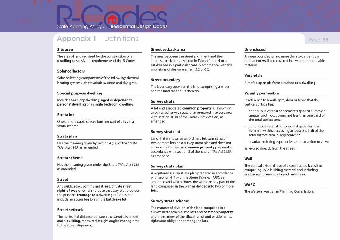
(Version 1, June 2013)(Version 1, June 2013)
Page 58Part 7 – Local planning framework Appendix 1 – Definitions
State Planning Policy 3.1 Residential Design Codes
Site area
The area of land required for the construction of a dwelling to satisfy the requirements of the R-Codes.
Solar collectors
Solar collecting components of the following: thermal heating systems, photovoltaic systems and skylights.
Special purpose dwelling
Includes ancillary dwelling, aged or dependent persons’ dwelling or a single bedroom dwelling.
Strata lot
One or more cubic spaces forming part of a lot in a strata scheme.
Strata plan
Has the meaning given by section 4 (1a) of the Strata Titles Act 1985, as amended.
Strata scheme
Has the meaning given under the Strata Titles Act 1985, as amended.
Street
Any public road, communal street, private street, right-of-way or other shared access way that provides the principal frontage to a dwelling but does not include an access leg to a single battleaxe lot.
Street setback
The horizontal distance between the street alignment and a building, measured at right angles (90 degrees) to the street alignment.
Street setback area
The area between the street alignment and the street setback line as set out in Tables 1 and 4 or as established in a particular case in accordance with the provisions of design element 5.2 or 6.2.
Street boundary
The boundary between the land comprising a street and the land that abuts thereon.
Survey strata
A lot and associated common property as shown on a registered survey strata plan prepared in accordance with section 4(1b) of the Strata Titles Act 1985, as amended.
Survey strata lot
Land that is shown as an ordinary lot consisting of two or more lots on a survey strata plan and does not include a lot shown as common property prepared in accordance with section 3 of the Strata Titles Act 1985, as amended.
Survey strata plan
A registered survey strata plan prepared in accordance with section 4 (1b) of the Strata Titles Act 1985, as amended and which shows the whole or any part of the land comprised in the plan as divided into two or more lots.
Survey strata scheme
The manner of division of the land comprised in a survey strata scheme into lots and common property and the manner of the allocation of unit entitlements, rights and obligations among the lots.
Unenclosed
An area bounded on no more than two sides by a permanent wall and covered in a water impermeable material.
Verandah
A roofed open platform attached to a dwelling.
Visually permeable
In reference to a wall, gate, door or fence that the vertical surface has:
• continuous vertical or horizontal gaps of 50mm or greater width occupying not less than one third of the total surface area;
• continuous vertical or horizontal gaps less than 50mm in width, occupying at least one half of the total surface area in aggregate; or
• a surface offering equal or lesser obstruction to view;
as viewed directly from the street.
Wall
The vertical external face of a constructed building comprising solid building material and including enclosures to verandahs and balconies.
WAPC
The Western Australian Planning Commission.
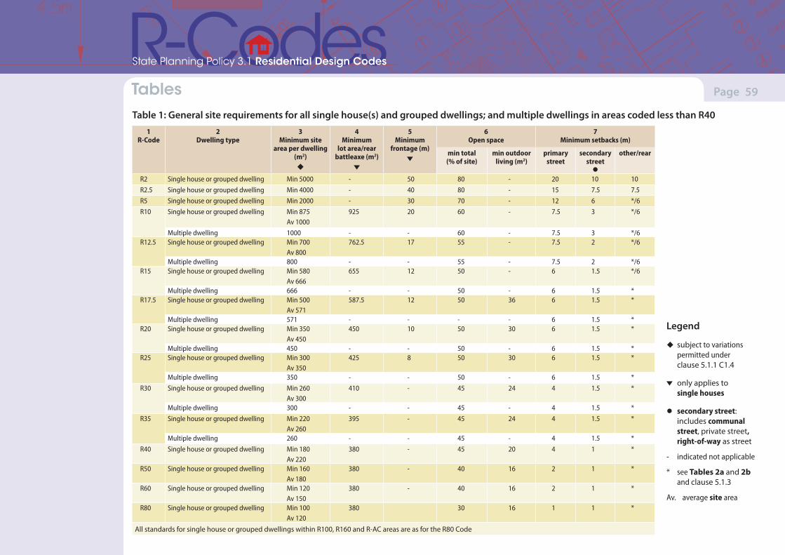
(Version 1, June 2013)(Version 1, June 2013)
Page 59Part 7 – Local planning framework Tables
State Planning Policy 3.1 Residential Design Codes
Table 1: General site requirements for all single house(s) and grouped dwellings; and multiple dwellings in areas coded less than R40
1R-Code
2Dwelling type
3Minimum site
area per dwelling (m2)u
4Minimum
lot area/rear battleaxe (m2)
5Minimum
frontage (m)
6Open space
7Minimum setbacks (m)
min total (% of site)
min outdoor living (m2)
primary street
secondary street •
other/rear
R2 Single house or grouped dwelling Min 5000 - 50 80 - 20 10 10R2.5 Single house or grouped dwelling Min 4000 - 40 80 - 15 7.5 7.5R5 Single house or grouped dwelling Min 2000 - 30 70 - 12 6 */6R10 Single house or grouped dwelling Min 875
Av 1000925 20 60 - 7.5 3 */6
Multiple dwelling 1000 - - 60 - 7.5 3 */6R12.5 Single house or grouped dwelling Min 700
Av 800762.5 17 55 - 7.5 2 */6
Multiple dwelling 800 - - 55 - 7.5 2 */6R15 Single house or grouped dwelling Min 580
Av 666655 12 50 - 6 1.5 */6
Multiple dwelling 666 - - 50 - 6 1.5 *R17.5 Single house or grouped dwelling Min 500
Av 571587.5 12 50 36 6 1.5 *
Multiple dwelling 571 - - - - 6 1.5 *R20 Single house or grouped dwelling Min 350
Av 450450 10 50 30 6 1.5 *
Multiple dwelling 450 - - 50 - 6 1.5 *R25 Single house or grouped dwelling Min 300
Av 350425 8 50 30 6 1.5 *
Multiple dwelling 350 - - 50 - 6 1.5 *R30 Single house or grouped dwelling Min 260
Av 300410 - 45 24 4 1.5 *
Multiple dwelling 300 - - 45 - 4 1.5 *R35 Single house or grouped dwelling Min 220
Av 260395 - 45 24 4 1.5 *
Multiple dwelling 260 - - 45 - 4 1.5 *R40 Single house or grouped dwelling Min 180
Av 220380 - 45 20 4 1 *
R50 Single house or grouped dwelling Min 160Av 180
380 - 40 16 2 1 *
R60 Single house or grouped dwelling Min 120Av 150
380 - 40 16 2 1 *
R80 Single house or grouped dwelling Min 100Av 120
380 30 16 1 1 *
All standards for single house or grouped dwellings within R100, R160 and R-AC areas are as for the R80 Code
Legend
u subject to variations permitted under clause 5.1.1 C1.4
only applies to single houses
• secondary street: includes communal street, private street, right-of-way as street
- indicated not applicable
* see Tables 2a and 2b and clause 5.1.3
Av. average site area
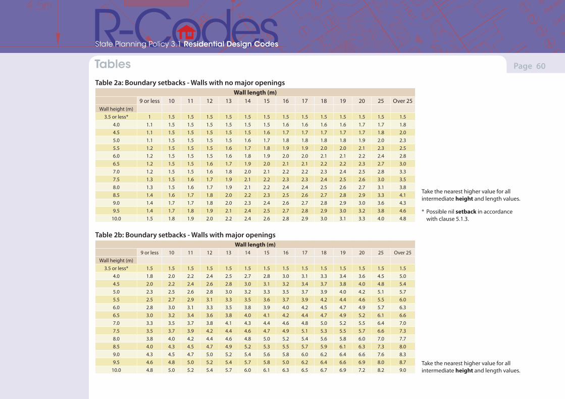
(Version 1, June 2013)(Version 1, June 2013)
Page 60Part 7 – Local planning framework Tables
State Planning Policy 3.1 Residential Design Codes
Table 2a: Boundary setbacks - Walls with no major openingsWall length (m)
9 or less 10 11 12 13 14 15 16 17 18 19 20 25 Over 25Wall height (m)
3.5 or less* 1 1.5 1.5 1.5 1.5 1.5 1.5 1.5 1.5 1.5 1.5 1.5 1.5 1.54.0 1.1 1.5 1.5 1.5 1.5 1.5 1.5 1.6 1.6 1.6 1.6 1.7 1.7 1.84.5 1.1 1.5 1.5 1.5 1.5 1.5 1.6 1.7 1.7 1.7 1.7 1.7 1.8 2.05.0 1.1 1.5 1.5 1.5 1.5 1.6 1.7 1.8 1.8 1.8 1.8 1.9 2.0 2.35.5 1.2 1.5 1.5 1.5 1.6 1.7 1.8 1.9 1.9 2.0 2.0 2.1 2.3 2.56.0 1.2 1.5 1.5 1.5 1.6 1.8 1.9 2.0 2.0 2.1 2.1 2.2 2.4 2.86.5 1.2 1.5 1.5 1.6 1.7 1.9 2.0 2.1 2.1 2.2 2.2 2.3 2.7 3.07.0 1.2 1.5 1.5 1.6 1.8 2.0 2.1 2.2 2.2 2.3 2.4 2.5 2.8 3.37.5 1.3 1.5 1.6 1.7 1.9 2.1 2.2 2.3 2.3 2.4 2.5 2.6 3.0 3.58.0 1.3 1.5 1.6 1.7 1.9 2.1 2.2 2.4 2.4 2.5 2.6 2.7 3.1 3.88.5 1.4 1.6 1.7 1.8 2.0 2.2 2.3 2.5 2.6 2.7 2.8 2.9 3.3 4.19.0 1.4 1.7 1.7 1.8 2.0 2.3 2.4 2.6 2.7 2.8 2.9 3.0 3.6 4.39.5 1.4 1.7 1.8 1.9 2.1 2.4 2.5 2.7 2.8 2.9 3.0 3.2 3.8 4.6
10.0 1.5 1.8 1.9 2.0 2.2 2.4 2.6 2.8 2.9 3.0 3.1 3.3 4.0 4.8
Table 2b: Boundary setbacks - Walls with major openingsWall length (m)
9 or less 10 11 12 13 14 15 16 17 18 19 20 25 Over 25Wall height (m)
3.5 or less* 1.5 1.5 1.5 1.5 1.5 1.5 1.5 1.5 1.5 1.5 1.5 1.5 1.5 1.54.0 1.8 2.0 2.2 2.4 2.5 2.7 2.8 3.0 3.1 3.3 3.4 3.6 4.5 5.04.5 2.0 2.2 2.4 2.6 2.8 3.0 3.1 3.2 3.4 3.7 3.8 4.0 4.8 5.45.0 2.3 2.5 2.6 2.8 3.0 3.2 3.3 3.5 3.7 3.9 4.0 4.2 5.1 5.75.5 2.5 2.7 2.9 3.1 3.3 3.5 3.6 3.7 3.9 4.2 4.4 4.6 5.5 6.06.0 2.8 3.0 3.1 3.3 3.5 3.8 3.9 4.0 4.2 4.5 4.7 4.9 5.7 6.36.5 3.0 3.2 3.4 3.6 3.8 4.0 4.1 4.2 4.4 4.7 4.9 5.2 6.1 6.67.0 3.3 3.5 3.7 3.8 4.1 4.3 4.4 4.6 4.8 5.0 5.2 5.5 6.4 7.07.5 3.5 3.7 3.9 4.2 4.4 4.6 4.7 4.9 5.1 5.3 5.5 5.7 6.6 7.38.0 3.8 4.0 4.2 4.4 4.6 4.8 5.0 5.2 5.4 5.6 5.8 6.0 7.0 7.78.5 4.0 4.3 4.5 4.7 4.9 5.2 5.3 5.5 5.7 5.9 6.1 6.3 7.3 8.09.0 4.3 4.5 4.7 5.0 5.2 5.4 5.6 5.8 6.0 6.2 6.4 6.6 7.6 8.39.5 4.6 4.8 5.0 5.2 5.4 5.7 5.8 5.0 6.2 6.4 6.6 6.9 8.0 8.7
10.0 4.8 5.0 5.2 5.4 5.7 6.0 6.1 6.3 6.5 6.7 6.9 7.2 8.2 9.0
Take the nearest higher value for all intermediate height and length values.
* Possible nil setback in accordance with clause 5.1.3.
Take the nearest higher value for all intermediate height and length values.
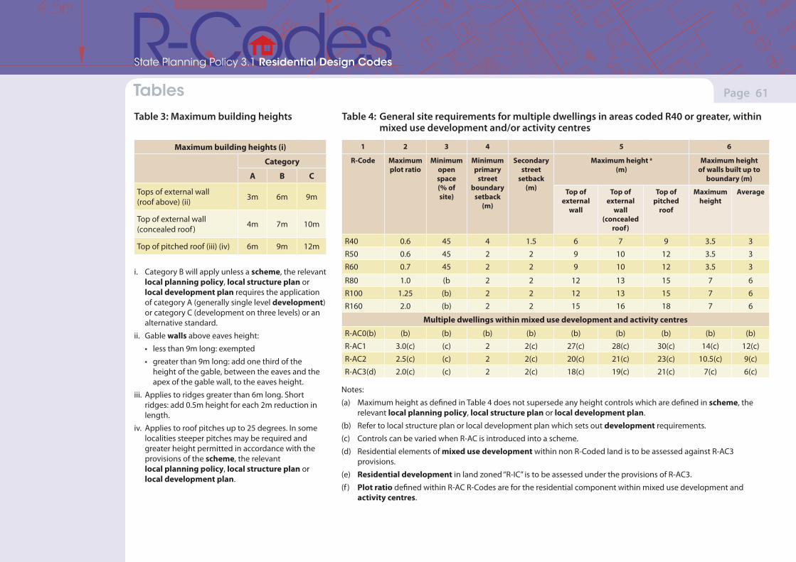
(Version 1, June 2013)(Version 1, June 2013)
Page 61Part 7 – Local planning framework Tables
State Planning Policy 3.1 Residential Design Codes
Table 3: Maximum building heights
Maximum building heights (i)
Category
A B C
Tops of external wall (roof above) (ii) 3m 6m 9m
Top of external wall (concealed roof ) 4m 7m 10m
Top of pitched roof (iii) (iv) 6m 9m 12m
i. Category B will apply unless a scheme, the relevant local planning policy, local structure plan or local development plan requires the application of category A (generally single level development) or category C (development on three levels) or an alternative standard.
ii. Gable walls above eaves height:
• less than 9m long: exempted
• greater than 9m long: add one third of the height of the gable, between the eaves and the apex of the gable wall, to the eaves height.
iii. Applies to ridges greater than 6m long. Short ridges: add 0.5m height for each 2m reduction in length.
iv. Applies to roof pitches up to 25 degrees. In some localities steeper pitches may be required and greater height permitted in accordance with the provisions of the scheme, the relevant local planning policy, local structure plan or local development plan.
1 2 3 4 5 6
R-Code Maximum plot ratio
Minimum open space (% of site)
Minimum primary
street boundary
setback (m)
Secondary street
setback (m)
Maximum height a (m)
Maximum height of walls built up to
boundary (m)
Top of external
wall
Top of external
wall (concealed
roof)
Top of pitched
roof
Maximum height
Average
R40 0.6 45 4 1.5 6 7 9 3.5 3
R50 0.6 45 2 2 9 10 12 3.5 3
R60 0.7 45 2 2 9 10 12 3.5 3
R80 1.0 (b 2 2 12 13 15 7 6
R100 1.25 (b) 2 2 12 13 15 7 6
R160 2.0 (b) 2 2 15 16 18 7 6
Multiple dwellings within mixed use development and activity centres
R-AC0(b) (b) (b) (b) (b) (b) (b) (b) (b) (b)
R-AC1 3.0(c) (c) 2 2(c) 27(c) 28(c) 30(c) 14(c) 12(c)
R-AC2 2.5(c) (c) 2 2(c) 20(c) 21(c) 23(c) 10.5(c) 9(c)
R-AC3(d) 2.0(c) (c) 2 2(c) 18(c) 19(c) 21(c) 7(c) 6(c)
Notes:
(a) Maximum height as defined in Table 4 does not supersede any height controls which are defined in scheme, the relevant local planning policy, local structure plan or local development plan.
(b) Refer to local structure plan or local development plan which sets out development requirements.
(c) Controls can be varied when R-AC is introduced into a scheme.
(d) Residential elements of mixed use development within non R-Coded land is to be assessed against R-AC3 provisions.
(e) Residential development in land zoned “R-IC” is to be assessed under the provisions of R-AC3.
(f ) Plot ratio defined within R-AC R-Codes are for the residential component within mixed use development and activity centres.
Table 4: General site requirements for multiple dwellings in areas coded R40 or greater, within mixed use development and/or activity centres

(Version 1, June 2013)(Version 1, June 2013)
Page 62Part 7 – Local planning framework Tables
State Planning Policy 3.1 Residential Design Codes
Table 5: Lot boundary setbacks for sites with an R-Code of R80 and greater or R-AC
Width of the lot in metres (m)
≤14 15 ≥16
Side setback in metres (m) 3 3.5 4
Notes:
(a) Setbacks do not apply to eaves and sun shading devices.
(b) Setback requirements in Table 5 do not supersede any controls which are defined in a scheme, local structure plan, activity centre plan, local development plan, local planning strategy or local planning policy.
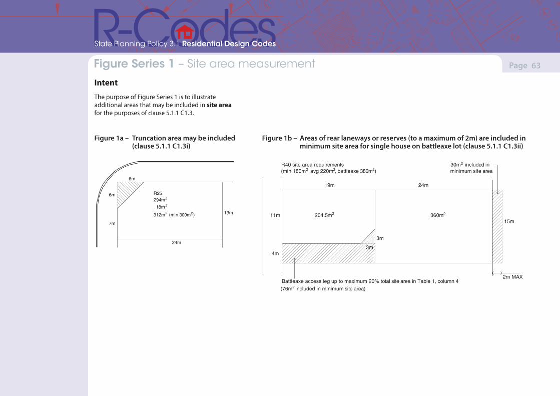
(Version 1, June 2013)(Version 1, June 2013)
Page 63Part 7 – Local planning framework
State Planning Policy 3.1 Residential Design Codes
Figure Series 1 – Site area measurement
Intent
The purpose of Figure Series 1 is to illustrate additional areas that may be included in site area for the purposes of clause 5.1.1 C1.3.
Figure 1a – Truncation area may be included (clause 5.1.1 C1.3i)
R25294m
18m
312m (min 300m )
2
2
2
6m
6m
7m
24m
13m2
Figure 1b – Areas of rear laneways or reserves (to a maximum of 2m) are included in minimum site area for single house on battleaxe lot (clause 5.1.1 C1.3ii)
11m
4m
19m 24m
15m
3m
3m
R40 site area requirements(min 180m avg 220m , battleaxe 380m )2
Battleaxe access leg up to maximum 20% total site area in Table 1, column 4(76m included in minimum site area)2
30m included inminimum site area
2
204.5m 360m
2m MAX
2 2
2 2
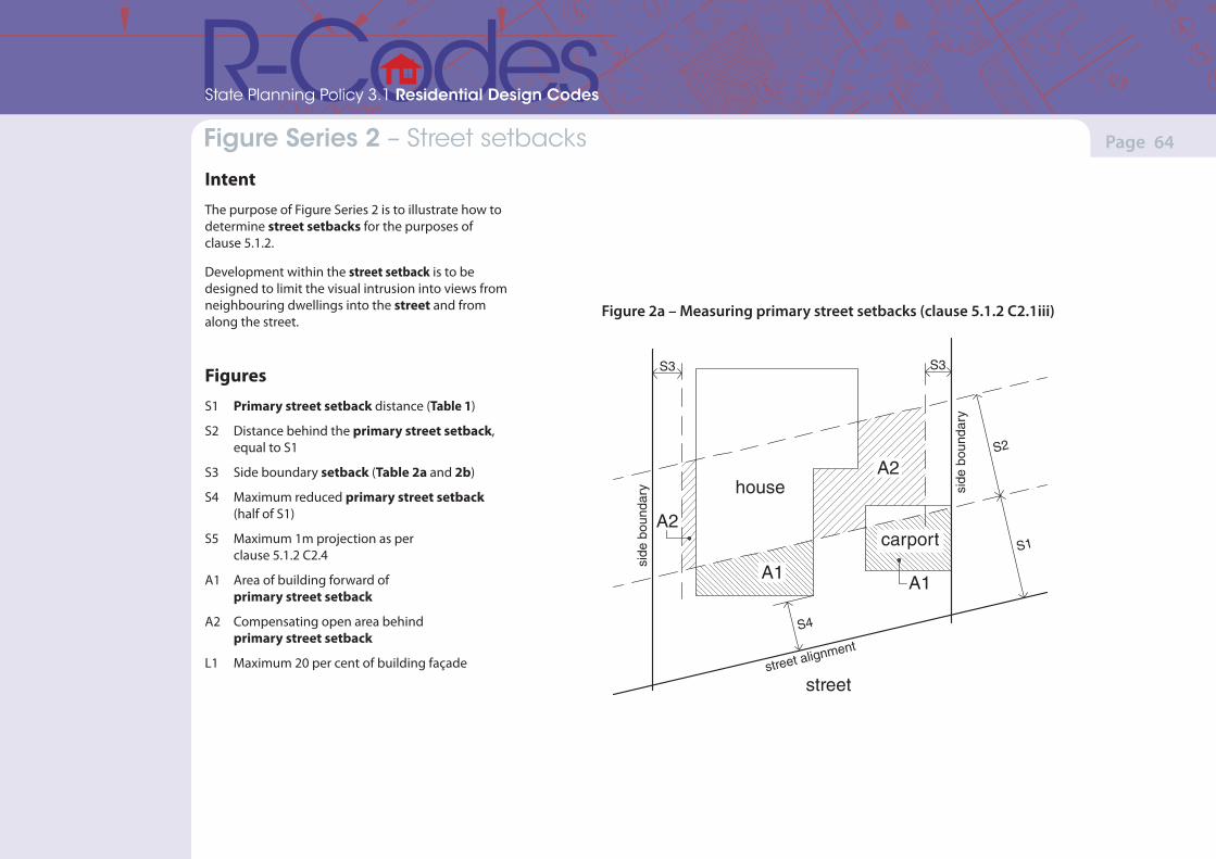
(Version 1, June 2013)(Version 1, June 2013)
Page 64Part 7 – Local planning framework
State Planning Policy 3.1 Residential Design Codes
Figure Series 2 – Street setbacks
IntentThe purpose of Figure Series 2 is to illustrate how to determine street setbacks for the purposes of clause 5.1.2.
Development within the street setback is to be designed to limit the visual intrusion into views from neighbouring dwellings into the street and from along the street.
FiguresS1 Primary street setback distance (Table 1)
S2 Distance behind the primary street setback, equal to S1
S3 Side boundary setback (Table 2a and 2b)
S4 Maximum reduced primary street setback (half of S1)
S5 Maximum 1m projection as per clause 5.1.2 C2.4
A1 Area of building forward of primary street setback
A2 Compensating open area behind primary street setback
L1 Maximum 20 per cent of building façade
Figure 2a – Measuring primary street setbacks (clause 5.1.2 C2.1iii)2a
street
house
carport
street alignment
S4
A2
A1A1
A2
side
bou
ndar
y side
bou
ndar
y
S1
S2
S3 S3
house
house
A1
A2
A2
A1A1
garage
porch
S1
S2
S4
S3
20% maximum
1 m max.
2b 2c
S1
S2
S4
S3
S3
4.5m may be reduced
0.5 min
6.2.3A3.5
S5L1
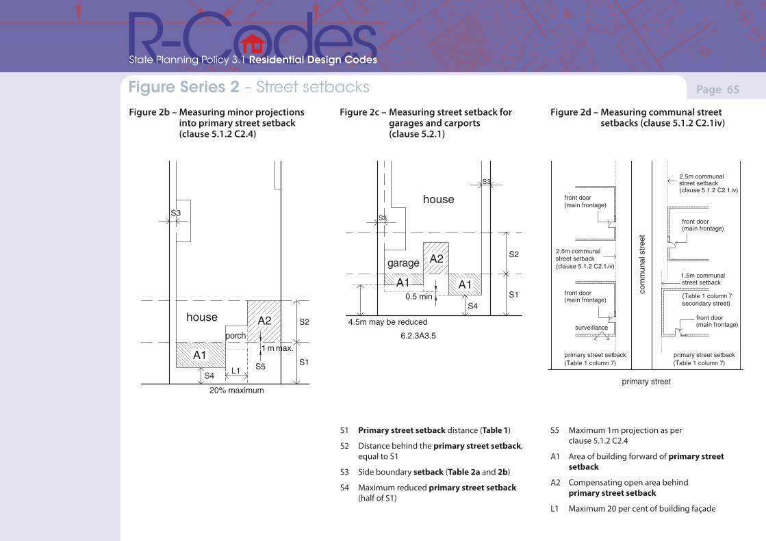
(Version 1, June 2013)(Version 1, June 2013)
Page 65Part 7 – Local planning framework
State Planning Policy 3.1 Residential Design Codes
Figure Series 2 – Street setbacks Figure 2b – Measuring minor projections into primary street setback (clause 5.1.2 C2.4)
Figure 2c – Measuring street setback for garages and carports (clause 5.2.1)
2a
street
house
carport
street alignment
S4
A2
A1A1
A2
side
bou
ndar
y side
bou
ndar
y
S1
S2
S3 S3
house
house
A1
A2
A2
A1A1
garage
porch
S1
S2
S4
S3
20% maximum
1 m max.
2b 2c
S1
S2
S4
S3
S3
4.5m may be reduced
0.5 min
6.2.3A3.5
S5L1
2a
street
house
carport
street alignment
S4
A2
A1A1
A2
side
bou
ndar
y side
bou
ndar
y
S1
S2
S3 S3
house
house
A1
A2
A2
A1A1
garage
porch
S1
S2
S4
S3
20% maximum
1 m max.
2b 2c
S1
S2
S4
S3
S3
4.5m may be reduced
0.5 min
6.2.3A3.5
S5L1
Figure 2d – Measuring communal street setbacks (clause 5.1.2 C2.1iv)
front door(main frontage)
2.5m communal street setback(clause 5.1.2 C2.1.iv)
front door (main frontage)
surveillance
primary street setback (Table 1 column 7)
com
mun
al s
tree
t
primary street
front door(main frontage)
2.5m communal street setback(clause 5.1.2 C2.1.iv)
primary street setback (Table 1 column 7)
front door(main frontage)
1.5m communalstreet setback
(Table 1 column 7 secondary street)
S1 Primary street setback distance (Table 1)
S2 Distance behind the primary street setback, equal to S1
S3 Side boundary setback (Table 2a and 2b)
S4 Maximum reduced primary street setback (half of S1)
S5 Maximum 1m projection as per clause 5.1.2 C2.4
A1 Area of building forward of primary street setback
A2 Compensating open area behind primary street setback
L1 Maximum 20 per cent of building façade
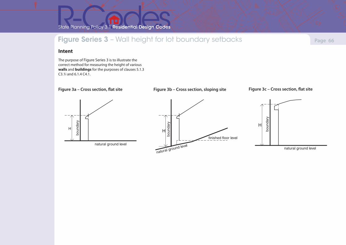
(Version 1, June 2013)(Version 1, June 2013)
Page 66Part 7 – Local planning framework
State Planning Policy 3.1 Residential Design Codes
Figure Series 3 – Wall height for lot boundary setbacks
Intent
The purpose of Figure Series 3 is to illustrate the correct method for measuring the height of various walls and buildings for the purposes of clauses 5.1.3 C3.1i and 6.1.4 C4.1.
Figure 3a – Cross section, flat site Figure 3b – Cross section, sloping site Figure 3c – Cross section, flat site
H
natural ground level
boun
dary
natural ground level
finished floor level
H
boun
dary H
natural ground level
boun
dary
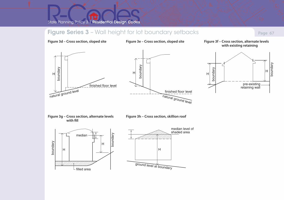
(Version 1, June 2013)(Version 1, June 2013)
Page 67Part 7 – Local planning framework
State Planning Policy 3.1 Residential Design Codes
Figure Series 3 – Wall height for lot boundary setbacks Figure 3f – Cross section, alternate levels with existing retaining
median level ofshaded area
H
ground level at boundary
median
boun
dary
boun
dary
filled area
H
H
boun
dary
boun
dary
HH
pre-existingretaining wall
Figure 3g – Cross section, alternate levels with fill
median level ofshaded area
H
ground level at boundary
median
boun
dary
boun
dary
filled area
H
H
boun
dary
boun
dary
HH
pre-existingretaining wall
Figure 3d – Cross section, sloped site
natural ground level
H
finished floor level
boun
dary
Figure 3e – Cross section, sloped site
H
natural ground level
finished floor level
boun
dary
Figure 3h – Cross section, skillion roof
median level ofshaded area
H
ground level at boundary
median
boun
dary
boun
dary
filled area
H
H
boun
dary
boun
dary
HH
pre-existingretaining wall
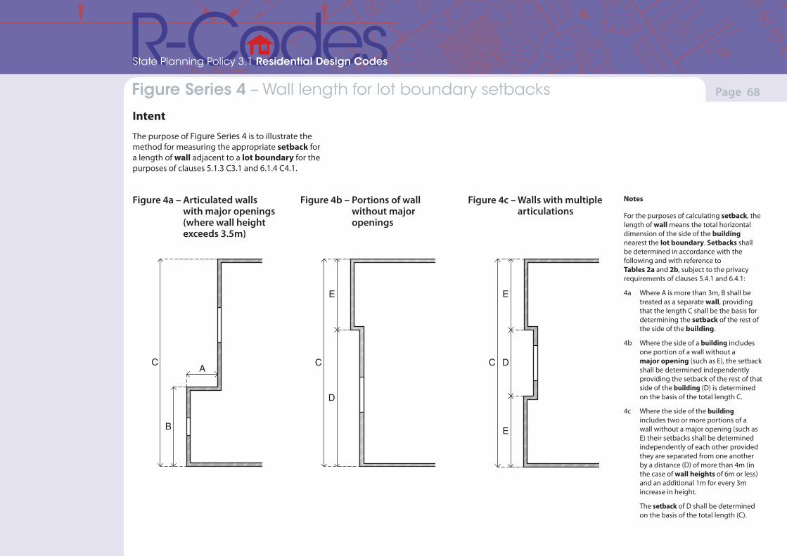
(Version 1, June 2013)(Version 1, June 2013)
Page 68Part 7 – Local planning framework
State Planning Policy 3.1 Residential Design Codes
Figure Series 4 – Wall length for lot boundary setbacks
Intent
The purpose of Figure Series 4 is to illustrate the method for measuring the appropriate setback for a length of wall adjacent to a lot boundary for the purposes of clauses 5.1.3 C3.1 and 6.1.4 C4.1.
Notes
For the purposes of calculating setback, the length of wall means the total horizontal dimension of the side of the building nearest the lot boundary. Setbacks shall be determined in accordance with the following and with reference to Tables 2a and 2b, subject to the privacy requirements of clauses 5.4.1 and 6.4.1:
4a Where A is more than 3m, B shall be treated as a separate wall, providing that the length C shall be the basis for determining the setback of the rest of the side of the building.
4b Where the side of a building includes one portion of a wall without a major opening (such as E), the setback shall be determined independently providing the setback of the rest of that side of the building (D) is determined on the basis of the total length C.
4c Where the side of the building includes two or more portions of a wall without a major opening (such as E) their setbacks shall be determined independently of each other provided they are separated from one another by a distance (D) of more than 4m (in the case of wall heights of 6m or less) and an additional 1m for every 3m increase in height.
The setback of D shall be determined on the basis of the total length (C).
Figure 4a – Articulated walls with major openings (where wall height exceeds 3.5m)
A
B
C C
E
D
Figure 4b – Portions of wall without major openings
D
E
C
E
Figure 4c – Walls with multiple articulations
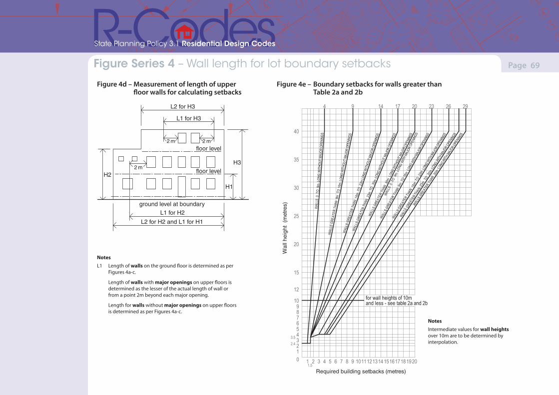
(Version 1, June 2013)(Version 1, June 2013)
Page 69Part 7 – Local planning framework
State Planning Policy 3.1 Residential Design Codes
Figure Series 4 – Wall length for lot boundary setbacks
Figure 4d – Measurement of length of upper floor walls for calculating setbacks
ground level at boundaryL1 for H2
L2 for H2 and L1 for H1
floor level
floor level
H1
H3
H2
L2 for H3
L1 for H3
2 m2 m
2 m
40
35
30
25
20
15
12
109876543210 1 2 3 4 5 6 7 8 9 1011121314 15161718 1920
WAL
LS 0
TO
9m L
ONG
WIT
HOUT
MAJ
OR O
PENI
NGS
WAL
LS G
REAT
ER T
HAN
9m
TO
16m
LONG
WITH
OUT
MAJO
R OP
ENIN
GSW
ALLS
GRE
ATER
THA
N 1
6m T
O 2
3m LO
NG W
ITHOU
T MAJ
OR O
PENI
NGS
WAL
LS G
REAT
ER T
HAN
23m
TO
30m
LON
G W
ITHOU
T MAJ
OR O
PENI
NGS
WALLS
GRE
ATER
THAN
30m
LON
G WITH
OUT M
AJOR
OPEN
INGS
WAL
LS 0
TO
9m L
ONG
WITH M
AJOR
OPE
NINGS
WAL
LS G
REAT
ER TH
AN 9
m TO
16m
LONG
WITH
MAJ
OR O
PENI
NGS
WALLS
GRE
ATER
THAN
16m
TO
23m LO
NG W
ITH M
AJOR
OPEN
INGS
4 9 14 17 20 23 26 29
WALLS
GRE
ATER
THAN
23m
TO 3
0m L
ONG W
ITH MAJ
OR OPE
NINGS
WALLS
GRE
ATER
THAN
30m
LON
G WITH
MAJ
OR OPE
NINGS
1.5
2.43.5
Required building setbacks (metres)
Intermediate values for wall heights over10m are to be obtained by interpolation
1.Notes:
for wall heights of 10mand less - see table 2a and 2b
Wal
l hei
ght
(met
res)
Notes
L1 Length of walls on the ground floor is determined as per Figures 4a-c.
Length of walls with major openings on upper floors is determined as the lesser of the actual length of wall or from a point 2m beyond each major opening.
Length for walls without major openings on upper floors is determined as per Figures 4a-c.
Figure 4e – Boundary setbacks for walls greater than Table 2a and 2b
Notes
Intermediate values for wall heights over 10m are to be determined by interpolation.
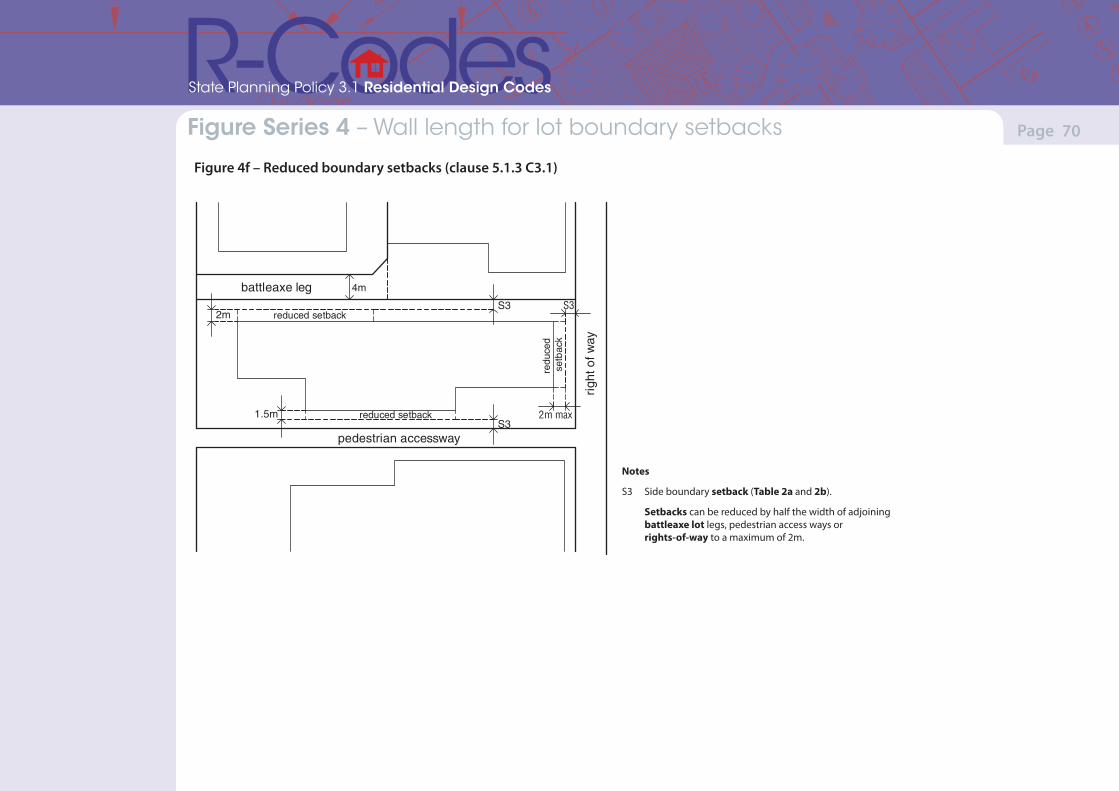
(Version 1, June 2013)(Version 1, June 2013)
Page 70Part 7 – Local planning framework
State Planning Policy 3.1 Residential Design Codes
Figure Series 4 – Wall length for lot boundary setbacks
Figure 4f – Reduced boundary setbacks (clause 5.1.3 C3.1)
4m
2m
2m max
battleaxe leg
1.5m reduced setback
pedestrian accessway
righ
t of w
ay
redu
ced
setb
ack
S3
S3
S3reduced setback
Notes
S3 Side boundary setback (Table 2a and 2b).
Setbacks can be reduced by half the width of adjoining battleaxe lot legs, pedestrian access ways or rights-of-way to a maximum of 2m.

(Version 1, June 2013)(Version 1, June 2013)
Page 71Part 7 – Local planning framework
State Planning Policy 3.1 Residential Design Codes
Figure Series 5 – Lot Boundary walls
IntentThe purpose of Figure Series 5 is to illustrate the correct method for measuring the height of various walls for the purposes of clause 5.1.3.
natural ground level at lot boundary
median heightof parapet
H
Notes
The height of a lot boundary wall shall be measured to the point immediately above the natural ground level below.
5a Where the boundary wall is not consistent in height for its length, or comprises a pitch, the height shall be measured as the midpoint between the lowest point immediately above the natural ground level below and the highest point immediately above the natural ground level below.
Figure 5b – Elevation – sloped site
natural ground level
finished floor level
HbHa
Figure 5c – Elevation – sloped site
natural ground level
finished floor level
H1 H2
H3
5b Where the boundary is sloped the height shall be the average of the heights of the wall at its highest and lowest point above natural ground level (Ha and Hb).
5c Where the boundary is sloped and the boundary wall is not consistent in height for its length, or comprises a pitch, the height shall be the average of H1, H2, and H3, where H2 is the maximum height above natural ground level, and H1 and H3 are the height above natural ground level at each end of the wall.
Figure 5a – Elevation – flat site
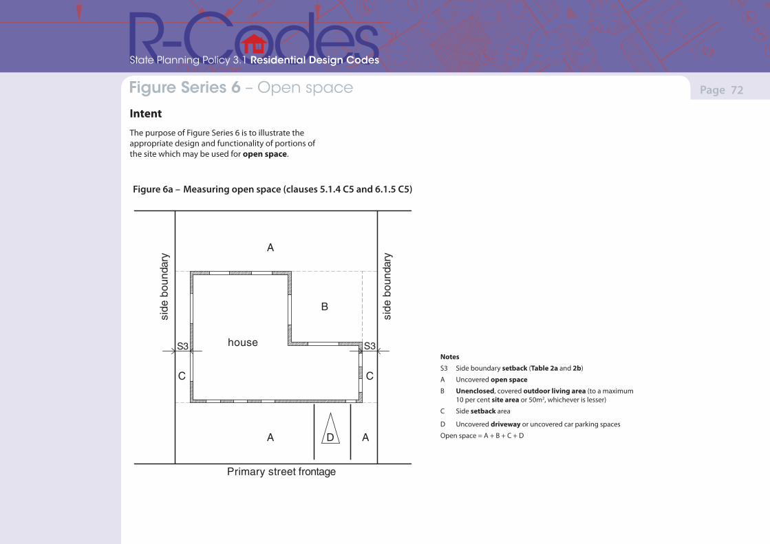
(Version 1, June 2013)(Version 1, June 2013)
Page 72Part 7 – Local planning framework
State Planning Policy 3.1 Residential Design Codes
Figure Series 6 – Open space
IntentThe purpose of Figure Series 6 is to illustrate the appropriate design and functionality of portions of the site which may be used for open space.
Notes
S3 Side boundary setback (Table 2a and 2b)
A Uncovered open space
B Unenclosed, covered outdoor living area (to a maximum 10 per cent site area or 50m2, whichever is lesser)
C Side setback area
D Uncovered driveway or uncovered car parking spaces
Open space = A + B + C + D
house
side
bou
ndar
y
side
bou
ndar
y
A
A
B
C C
S3 S3
Primary street frontage
AD
Figure 6a – Measuring open space (clauses 5.1.4 C5 and 6.1.5 C5)
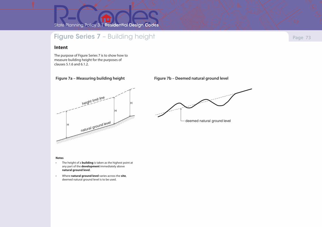
(Version 1, June 2013)(Version 1, June 2013)
Page 73Part 7 – Local planning framework
State Planning Policy 3.1 Residential Design Codes
Figure Series 7 – Building height
IntentThe purpose of Figure Series 7 is to show how to measure building height for the purposes of clauses 5.1.6 and 6.1.2.
Figure 7b – Deemed natural ground level
Notes
• The height of a building is taken as the highest point at any part of the development immediately above natural ground level.
• Where natural ground level varies across the site, deemed natural ground level is to be used.
height limit line
natural ground levelH
H
H
deemed natural ground level
Figure 7a – Measuring building height
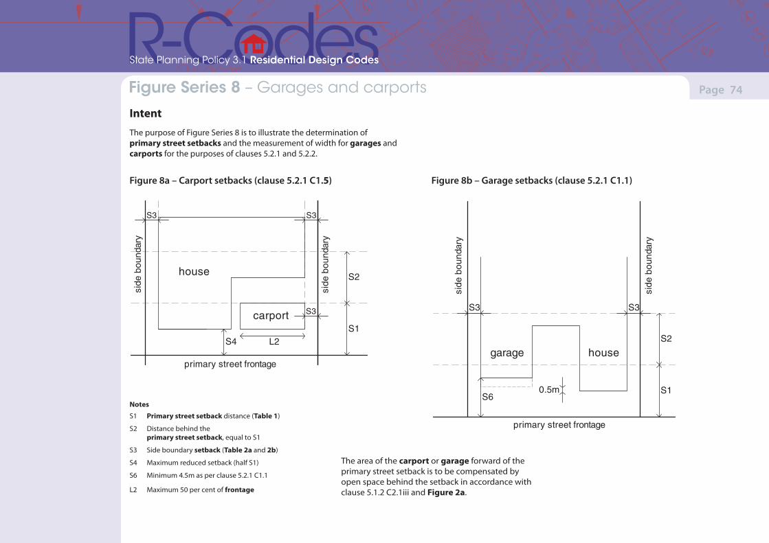
(Version 1, June 2013)(Version 1, June 2013)
Page 74Part 7 – Local planning framework
State Planning Policy 3.1 Residential Design Codes
Figure Series 8 – Garages and carports
IntentThe purpose of Figure Series 8 is to illustrate the determination of primary street setbacks and the measurement of width for garages and carports for the purposes of clauses 5.2.1 and 5.2.2.
S3
house
S3
S4S1
S2
carport S3
L2
side
bou
ndar
y
side
bou
ndar
y
primary street frontage
Figure 8a – Carport setbacks (clause 5.2.1 C1.5) Figure 8b – Garage setbacks (clause 5.2.1 C1.1)
S1
S2
S3 S3
S6
garage
side
bou
ndar
y
side
bou
ndar
y
house
0.5m
primary street frontage
Notes
S1 Primary street setback distance (Table 1)
S2 Distance behind the primary street setback, equal to S1
S3 Side boundary setback (Table 2a and 2b)
S4 Maximum reduced setback (half S1)
S6 Minimum 4.5m as per clause 5.2.1 C1.1
L2 Maximum 50 per cent of frontage
The area of the carport or garage forward of the primary street setback is to be compensated by open space behind the setback in accordance with clause 5.1.2 C2.1iii and Figure 2a.
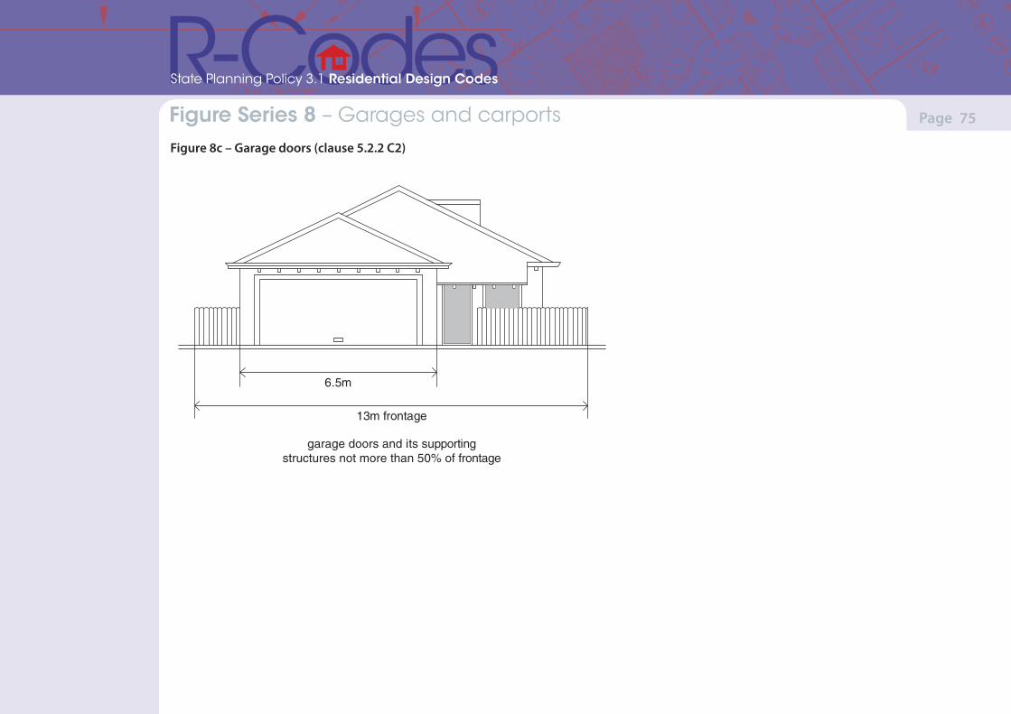
(Version 1, June 2013)(Version 1, June 2013)
Page 75Part 7 – Local planning framework
State Planning Policy 3.1 Residential Design Codes
Figure Series 8 – Garages and carports Figure 8c – Garage doors (clause 5.2.2 C2)
13m frontage
6.5m
garage doors and its supportingstructures not more than 50% of frontage
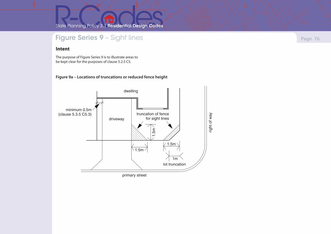
(Version 1, June 2013)(Version 1, June 2013)
Page 76Part 7 – Local planning framework
State Planning Policy 3.1 Residential Design Codes
Figure Series 9 – Sight lines
IntentThe purpose of Figure Series 9 is to illustrate areas to be kept clear for the purposes of clause 5.2.5 C5.
1.5m
1.5m
1m1.
5m
lot truncation
primary street
driveway
dwelling
truncation of fencefor sight lines
minimum 0.5m(clause 5.3.5 C5.3)
right
of w
ay
Figure 9a – Locations of truncations or reduced fence height
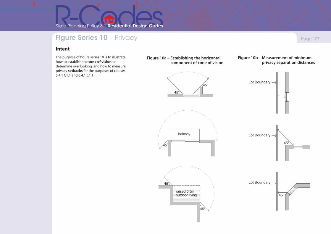
(Version 1, June 2013)(Version 1, June 2013)
Page 77Part 7 – Local planning framework
State Planning Policy 3.1 Residential Design Codes
Figure Series 10 – Privacy
IntentThe purpose of figure series 10 is to illustrate how to establish the cone of vision to determine overlooking, and how to measure privacy setbacks for the purposes of clauses 5.4.1 C1.1 and 6.4.1 C1.1.
Lot Boundary
45°
45°
Lot Boundary
Lot Boundary
45°
45°
45°
45°
balcony
raised 0.5moutdoor living
45°
Figure 10a – Establishing the horizontal component of cone of vision
Figure 10b – Measurement of minimum privacy separation distances
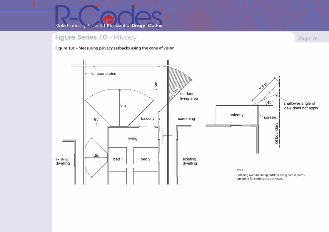
(Version 1, June 2013)(Version 1, June 2013)
Page 78Part 7 – Local planning framework
State Planning Policy 3.1 Residential Design Codes
Figure Series 10 – Privacy Figure 10c – Measuring privacy setbacks using the cone of vision
lot boundaries
living
bed 1 bed 2
balcony
existingdwelling
existingdwelling
screening
7.5
m
45°
4.5m
outdoorliving area
7.5m
6m
Note
Hatching over adjoining outdoor living area requires screening for compliance as shown.
7.5
m
45° shallower angle ofview does not apply
lot b
ound
ary
balconyscreen
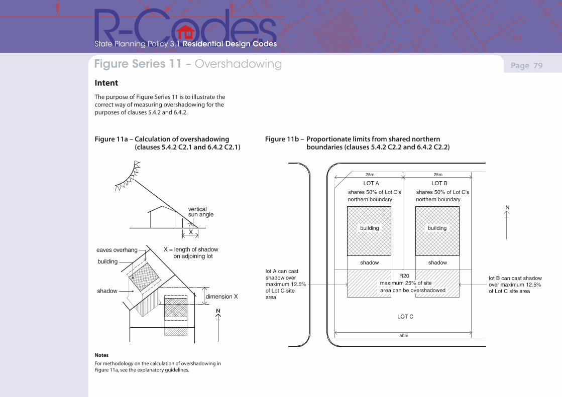
(Version 1, June 2013)(Version 1, June 2013)
Page 79Part 7 – Local planning framework
State Planning Policy 3.1 Residential Design Codes
Figure Series 11 – Overshadowing
IntentThe purpose of Figure Series 11 is to illustrate the correct way of measuring overshadowing for the purposes of clauses 5.4.2 and 6.4.2.
Figure 11a – Calculation of overshadowing (clauses 5.4.2 C2.1 and 6.4.2 C2.1)
Notes
For methodology on the calculation of overshadowing in Figure 11a, see the explanatory guidelines.
Figure 11b – Proportionate limits from shared northern boundaries (clauses 5.4.2 C2.2 and 6.4.2 C2.2)
verticalsun angle
eaves overhang
building
shadow
X = length of shadow on adjoining lot
X
dimension X
25m 25m
50m
N
LOT A
shares 50% of Lot C'snorthern boundary
shadow
LOT B
shares 50% of Lot C'snorthern boundary
shadow
lot B can cast shadowover maximum 12.5%of Lot C site area
lot A can castshadow overmaximum 12.5%of Lot C sitearea
LOT C
R20
building building
maximum 25% of sitearea can be overshadowed