
Research Project: HABITATS REGULATIONS APPRAISAL OF ...
87
1 Research Project: HABITATS REGULATIONS APPRAISAL OF NATIONAL PLANNING FRAMEWORK 4 – BASELINE INFORMATION REPORT 20 th March 2020
Transcript of Research Project: HABITATS REGULATIONS APPRAISAL OF ...

1
Research Project:
HABITATS REGULATIONS APPRAISAL OF NATIONAL PLANNING FRAMEWORK 4 – BASELINE INFORMATION REPORT
20th March 2020

2
Report prepared by: AECOM 1 Tanfield Edinburgh EH3 5DA The opinions expressed in this report are those of the author. Report commissioned by: Planning and Architecture Division Area 2H South Victoria Quay Edinburgh EH6 6QQ e-mail: [email protected] web: http://www.gov.scot/Topics/Built-Environment/planning © Crown Copyright 2020 Applications for reproduction of any part of this publication should be addressed to: Planning and Architecture Division, Directorate for Local Government and Communities, Area 2H (South) Victoria Quay, Edinburgh, EH6 6QQ This report is published electronically to limit the use of paper, but photocopies will be provided on request to Planning and Architecture Division.

3
Contents
1 Executive Summary 4
2 Introduction 5
3 Relevant European Sites 7
4 Plans, Programmes and Strategies Which May Act In Combination 10
5 Review of Published Research 19
6 Ecological Screening Buffers 21
7 References 24
Annex A Review of European Sites Designated Since 2015 25

4
1 Executive Summary
1.1 This document contains collated baseline information potentially relevant to the
Habitats Regulations Appraisal (HRA) of National Planning Framework 4 (NPF4).
1.2 It builds on work done for the HRA of National Planning Framework 3 (NPF3) and does not seek to replicate information provided in relevant associated documents produced at that time, other than to update that information, where necessary.
1.3 This document contains information on:
all European sites (see Section 2 of this document for the definition of a ‘European site’) designated since the publication of NPF3
any changes to European sites included in the HRA of NPF3 which have been made since its publication (e.g. changes to their conservation objectives, changes to qualifying features etc.)
a list and details of all plans and strategies currently identified which will be considered as part of the in-combination assessment of effects on European sites arising from NPF4
a review of all new and potentially relevant research conducted since the publication of NPF3 which may inform the screening or appropriate assessment stages, and
a review of the buffer areas which will be applied as part of the ‘ecological screening’, based on available information from contemporary research.
1.4 The information presented in this document and relevant documents produced for NPF3 will be used to inform the screening and appropriate assessment stages of the HRA, as required.

5
2 Introduction
BACKGROUND AND PURPOSE OF THIS DOCUMENT
2.1 AECOM prepared a Habitats Regulations Appraisal (HRA) Methodology document setting out to Scottish Government and the HRA Steering Group the methods to be adopted when carrying out the HRA of National Planning Framework 4 (NPF4) (hereafter, the HRA of NPF4 is also referred to simply as the ‘HRA’).
2.2 The methodology for the HRA of NPF4 will follow the staged process recommended by Scottish Natural Heritage (SNH, 2015), adapted to respond to subsequent case law. The research stage of this process (also called the pre-screening stage in the SNH guidance) involves the collation of current information and evidence. It
covers stages 1 – 4 in the process described by SNH.
2.3 This document contains collated baseline information relevant to the HRA and which will be required as part of the screening and appropriate assessment stages. It contains information on:
all European sites1 designated since the publication of National Planning Framework 3 (NPF3) in 2014
any changes to European sites included in the HRA of NPF3 which have been made since its publication (e.g. changes to their conservation objectives, changes to qualifying features etc.)
a list and details of all plans and strategies currently identified which will be considered as part of the in-combination assessment of effects on European sites arising from NPF4
a review of all new and potentially relevant research conducted since the publication of NPF3 which may inform the screening or appropriate assessment stages, and
a review of the buffer areas which will be applied as part of the ‘ecological screening’, based on available information from contemporary research.
2.4 It builds on work done for the HRA of National Planning Framework 3 (NPF3) and does not seek to replicate information provided in relevant associated documents produced at that time, other than to update that information, where necessary. The relevant baseline information presented in documents produced for the HRA of NPF3 will also be used during the screening and appropriate assessment stages of the HRA of NPF4.
2.5 It is advised in the SNH guidance document that advice should be sought from relevant stakeholders, in particular SNH. This document will be submitted to the HRA Steering Group and reviewed by relevant staff from SNH. In addition, with approval of
1 In accordance with the HRA Methodology, the term ‘European site’ is used to refer to all fully
designated Special Areas of Conservation (SAC) and Special Protection Areas (SPA), as well as Sites of
Community Interest (SCI), candidate SAC (cSAC), possible / proposed SAC (pSAC), proposed SPA
(pSPA) and Wetlands of International Importance (‘Ramsar sites’).

6
Scottish Government and the HRA Steering Group, this document can also be shared with the Joint Nature Conservation Committee (JNCC), Natural England and other potentially relevant stakeholders, as required.

7
3 Relevant European Sites
3.1 At this stage in the HRA of NPF4, it is not possible to confirm which European sites will be relevant since the assessment itself has not commenced and the relevance of European sites is dictated by the impact pathways identified. However, all potentially relevant European sites designated (or at various stages of designation) in Scotland, Northern Ireland and the north of England since the publication of NPF3 in 2014 have been identified.
EUROPEAN SITES DESIGNATED SINCE PUBLICATION OF NPF3
3.2 In total, 28 sites which could be relevant to the HRA of NPF4 have been fully designated since 2015 or are candidates / proposed for designation. Of these, 26 are in Scotland, one is in Northern Ireland and one is in the north of England. The sites are:
Scotland: Stanton Banks SAC Braemar Pockmarks SAC North West Rockall Bank SAC East Mingulay SAC Anton Dohrn Seamount SAC East Rockall Bank SAC Pobie Bank Reef SAC Solan Bank SAC Inner Hebrides and The Minches SAC Wyville Thomson Ridge SAC Scanner Pockmark SAC Darwin Mounds SAC Hatton Bank cSAC Sound of Barra cSAC Bluemull and Colgrave pSPA Coll and Tiree pSPA East Mainland Coast, Shetland pSPA Moray Firth pSPA North Orkney pSPA Outer First of Forth and St Andrews Bay Complex pSPA Pentland Firth pSPA Scapa Flow pSPA Seas off Foula pSPA Seas off St Kilda pSPA Sound of Gigha pSPA West Coast of the Outer Hebrides pSPA
Northern Ireland: North Channel SAC, and,
north of England: Northumberland Marine SPA.
3.3 Note that although treated as new sites, the Seas off Foula pSPA and the Seas off St Kilda pSPA include some (but not all) of the same qualifying features as the Foula SPA and St Kilda SPA, respectively. These sites would provide protection to the marine environment and the foraging resources on which the current qualifying species rely.

8
3.4 In addition, the following proposed amendments to existing sites have also been made since 2014 (all are located in Scotland, with the Solway Firth SPA being a cross-border site, partly located in England):
Rum SPA (Proposed marine additional feature) Solway Firth SPA (Proposed marine extension and site name change), and Ythan Estuary, Sands of Forvie and Meikle Loch SPA (Proposed marine
extension).
3.5 Rum SPA is already a fully designated site. However, it is currently proposed to add breeding red-throated diver Gavia stellata as an additional marine feature to the existing SPA, as the marine area around the island has been shown to support the island’s breeding population.
3.6 It is currently proposed to extend the boundary of the existing Upper Solway Flats and Marshes SPA to include the adjacent marine environment, and to change the name of the site to the Solway Firth SPA. In addition, a review of the existing SPA identified that the mudflats, saltmarshes and grazing marshes also support important numbers of ringed plover Charadrius hiaticula, lapwing Vanellus vanellus, cormorant Phalacrocorax carbo, black-headed gull Chroicocephalus ridibundus, common gull Larus Larus canus and herring gull Larus argentatus. It is therefore proposed to include these species as qualifying features of the Solway Firth SPA.
3.7 The Ythan Estuary, Sands of Forvie and Meikle Loch SPA (Proposed marine extension) includes an extension to the boundary of the site into the marine environment and the addition of new qualifying species. The qualifying species of the existing SPA which will be protected by the marine extension are breeding sandwich tern Sterna sandvicensis and little tern Sterna albifrons. Lapwing Vanellus vanellus and redshank Tringa totanus are proposed to be added as qualifying features to the existing part of the SPA.
3.8 Full details of all of the above 31 sites, in a similar format as used in the HRA of NPF3, is provided in Annex A of this Baseline Information Report.
CHANGES TO EUROPEAN SITES CONSIDERED BY HRA OF NPF3
3.9 The HRA of NPF3 ‘screened in’ a total of 55 European sites to the appropriate assessment stage. These were included in the appropriate assessment after likely significant effects from the national developments of NPF3 were identified on these sites. A review of these sites has been carried out using the JNCC website and changes to the following sites were made in 2018 and/or 2019:
Cromarty Firth SPA – updates to listed features; species added to bring the Standard Data Form in line with national site citation document; ‘degree of isolation’ grading updated
Firth of Forth SPA – updates to listed features Firth of Tay and Eden Estuary SPA – updates to listed features Forth Islands SPA – updates to listed features Inner Moray Firth SPA – updates to listed features; species added to bring the
Standard Data Form in line with national site citation document; ‘degree of isolation’ grading updated
Loch of Strathbeg SPA – updates to listed features; species added to bring Standard Data Form in line with the national site citation document; ‘population type’ updated

9
Montrose Basin SPA – updates to listed features; species added to bring the Standard Data Form in line with the national site citation document; ‘degree of isolation’ grading updated
Moray and Nairn Coast SPA – updates to listed features; species added to bring the Standard Data Form in line with the national site citation document; ‘degree of isolation’ grading updated
Muirkirk and North Lowther Uplands SPA – extension to site boundary River Spey – Insh Marshes SPA – updates to listed features, and Troup, Pennan and Lions Head SPA – quality and importance information
updated to correspond with the ecological information.
3.10 Should any of these sites be relevant to the HRA of NPF4, consideration will be given to the changes made since publication of NPF3, and the relevant site information will be updated, as necessary.

10
4 Plans, Programmes and Strategies Which May Act In Combination
4.1 It is a requirement of HRA that the impacts of any land use plan being assessed are not considered in isolation but in combination with other plans and/or projects that may affect the European site(s) in question.
4.2 A list of all relevant plans, programmes and strategies in Scotland, Northern Ireland and the north of England which are considered at this stage to have the potential to act in combination with NPF4 is given in Table 1, including summary details of the objectives of those plans. In addition to those listed, local development plans published local planning authorities in Scotland and the north of England are also likely to be relevant.

11
Table 1 Key objectives of other plans, programmes and strategies which may act in combination with NPF4 Plan / programme / strategy Summary of key objectives
Scottish Biodiversity List The Scottish Biodiversity List is a list of animals, plants and habitats that Scottish Ministers consider to be of principal importance for biodiversity conservation in Scotland. By identifying the species and habitats that are of the highest priority for biodiversity conservation, the list helps public bodies carry out their biodiversity duty and is a useful resource for anyone interested in nature conservation in Scotland.
Scotland’s Biodiversity: It’s in Your Hands
Aims to protect and restore biodiversity on land in our seas, and to support healthy ecosystems, connect people with the natural world, for their health and well-being and to involve them more in decision making and maximise the benefits for Scotland of a diverse natural environment and the services it provides, contributing to sustainable economic growth. It supports an ecosystem approach.
The 2020 Challenge for Scotland’s Biodiversity
The 2020 Challenge is Scotland’s response to the United Nations Aichi Targets for 2020 and the European Union Biodiversity Strategy to 2020. The 2020 Challenge supplements the 2004 Scottish Biodiversity Strategy and key aims include preserving and restoring the health of Scotland’s ecosystems at a catchment-scale and promoting climate change resilience.
The Environment Strategy for Scotland: Vision and Outcomes
Sets out a strategic approach on environmental policy, enhancing the environment, safeguarding natural capital and continuing Scotland’s role in addressing environmental challenges.
A More Active Scotland: Scotland’s Physical Activity Delivery Plan
The Plan sets out a commitment to increase physical activity in Scotland. Focus is given to supporting an increased uptake it active travel, including a commitment to invest in active travel infrastructure.
A Connected Scotland: our strategy for tackling social isolation and loneliness and building stronger social connections
Scottish Government’s first national strategy to tackle social isolation and loneliness and build stronger connections. The role of the transport network in building social connections and importance of physical activity is noted in the Strategy.
A Long-term Vision for Active Travel in Scotland 2030 (2014)
Aims to encourage more people to walk and cycle for shorter everyday journeys. Focus on areas such as infrastructure, transport integration, cultural and behavioural change, community ownership and planning.
Homes Fit for the 21st Century Supports affordable homes for all. It assists the building of new, high quality, affordable homes (including social housing) to meet current need and the demand arising from our growing and ageing population and to maximise the sustainable housing options available across all tenures, including for people living on lower incomes, and to significantly improve the quality of the existing housing stock and the places we create.
Housing to 2040 Sets out 15 principles under primary headings of well-functioning housing system, high quality, sustainable

12
homes and communities in tackling issues that include the ageing population, an increasing number of single households, climate change, homelessness, child poverty and managing the impact of the UK’s exit from Europe and UK government welfare reforms. A second round of consultation is underway and a final vision and route map to 2040 are due to be published in spring 2020.
The Climate Change Plan: The Third Report on Policies and Proposals 2018-2032 (2018)
The Climate Change Plan sets out actions that will be taken and considered to ensure commitments to climate change targets are met, building on progress to date across a range of sectors, including electricity and transport, which are key sources of emissions and sets out the path to a low carbon economy. Scottish Government is currently updating the Climate Change Plan, with a commitment to produce an update laid in Parliament by end of April 2020. Updating the existing Climate Change Plan will consider the period of 2019-2032 and key to this will be the level of effort that is likely to be required to meet the new 2032 greenhouse gas emissions target of 78% as set out in the Climate Change (Scotland) Act 2009, in addition to taking account of the future ambition set by the introduction of a net-zero target by 2045. The Plan includes peatland restoration among its suite of policy outcomes aimed at reducing Scotland’s greenhouse gas emissions.
Scottish Climate Change Adaptation Programme 2014 and Climate Ready Scotland: Scotland’s Climate Change Adaptation Programme 2019-2024
The Scottish Climate Change Adaptation Programme provides an overarching framework for adaptation to climate change, setting out Scottish Ministers’ objectives in relation to adaptation to climate change and their policies and proposals for meeting those objectives, as required by the Climate Change (Scotland) Act 2009. The second iteration of the Programme, which builds on the progress of the first, is an outcome-based programme and sets out to address the impacts identified for Scotland by the 2017 UK Climate Change Risk Assessment as well as the Evidence Report Summary for Scotland.
UK Climate Change Risk Assessment 2017
The 2017 Risk Assessment outlines the UK and Devolved Governments’ view on the key climate change risks and opportunities. It endorses six priority risk areas, from flooding to coastal change, pests, diseases and invasive non-native species. Scotland specific evidence has also been collated into an Evidence Report Summary for Scotland.
Air Quality Strategy for England, Scotland, Wales and Northern Ireland and Clean Air Strategy for England 2019
Areas in which measured levels of airborne pollutants exceed the objectives set out in the Air Quality Strategy are designated as Air Quality Management Areas (AQMA). Local Authorities have a duty to develop and implement Air Quality Action Plans in these locations in order to raise air quality to an acceptable level. The Clean Air Strategy sets out plans for dealing with all sources of air pollution, making our air healthier to breather, protecting nature and boosting the economy.
Local Air Quality Management Policy Guidance 2016
Explains the objectives for improving air quality and provides a framework for activities in Local AQMAs.

13
Cleaner Air for Scotland – The Road to a Healthier Future (2015) and current revision of the plan
Notes the importance of clean air for health, wellbeing and the environment and sets out a series of actions and frameworks to improve air quality in Scotland. The revision of the Cleaner Air for Scotland Strategy is currently underway, with a new strategy expected to be in place by the end of 2020.
Scotland’s River Basin Management Plan
The River Basin Management Plans (RBMP) provide an assessment of the condition of Scotland’s water environment, and identify where efforts for protection and improvement must be targeted.
Flood Risk Management Plans and Strategies
Flood Risk Management Plans are designed to minimise negative impacts due to flooding on a range of receptors, including human health, the environment and cultural heritage.
National Flood Risk Assessment 2015-2021
Published by the Scottish Environment Protection Agency (SEPA), the Risk Assessment identifies Potentially Vulnerable Areas and the risk associated with flooding in these areas. Relevant actions will be identified in regional plans.
Scotland’s National Marine Plan 2015
The National Marine Plan fulfils joint requirements under the Marine (Scotland) Act 2010 and Marine and Coastal Access Act 2009 to prepare marine plans, providing a cohesive approach to the management of both inshore and offshore waters in accordance with EU Directive 2014/89/EU on maritime spatial planning. It seeks to promote development in a way that is both compatible with the protection and enhancement of the marine environment. The Plan covers the management of both Scottish inshore waters (out to 12 nautical miles) and offshore waters (12 to 200 nautical miles). The Plan also notes the interaction between marine and terrestrial planning and highlights the importance of alignment between both.
North West Marine Plan and North East Marine Plan
Plans produced by the Marine Management Organisation covering seas in the north-west and north-east of England, up to the border with Scotland.
European Commission’s Thematic Strategy for Soil Protection
The Strategy is founded on the principles of preventing further soil degradation and safeguarding its functions, ensuring responsible soil use and management patterns, mitigating the effects of human activities and environmental phenomena on soil condition, as well as restoring degraded soils to an acceptable level.
Scottish Soil Framework 2009 The Framework acknowledges the multiple functions of soils and includes a vision that soils be recognised as a vital part of our economy, environment, and heritage, and be safeguarded for existing and future generations. It notes that while Scotland’s soils are generally in good health, they face two significant pressures: climate change and the loss of organic matter, and identifies 13 key soil outcomes, such as protecting soil biodiversity, reducing and remediating soil erosion, and tackling greenhouse gas emissions. It also considers that improving the availability of soil data and highlighting the knowledge gaps and research needs in Scotland are both important.
Scotland’s National Peatland The Plan sets out a number of targets regarding the protection and restoration of peatland.

14
Plan
Scottish Government’s draft Peatland and Energy Policy Statement
Seeks to align peatland and energy policy in order to maximise greenhouse gas emissions abatement in a way that delivers multiple benefits.
Getting the best from our land: A Land Use Strategy for Scotland 2016-2021
The Strategy focuses on land as a key natural asset and recognises that it underpins much of Scotland’s economic activity, further noting that the way it is used and managed is therefore of key importance.
Land Rights and Responsibilities Statement
Seeks to inform policy and practice around land issues in Scotland, operating jointly with other relevant strategies and policies. It applies to all urban and rural land, buildings and other infrastructure in Scotland, for land owners, land managers, tenants or land users. The Statement relates to existing strategies that will help to inform future iterations of Scotland’s Economic Strategy, the Land Use Strategy and the National Planning Framework.
Historic Environment Policy for Scotland 2019
Outlines how Scotland has a duty of care for the historic environment and includes six policies which define how the historic environment should be managed. Where detrimental impacts on the historic environment arising from these are identified and unavoidable, steps should be taken to demonstrate that alternatives have been explored and mitigation measures put in place.
Our Place in Time – The Historic Environment Strategy for Scotland 2014
Our Place in Time sets out a 10 year vision for Scotland’s historic environment. The vision is founded upon the fundamental aims of understanding, and valuing our historic environment, ensuring it continues to benefit Scotland’s wellbeing through its cultural, social, environmental and economic contributions.
Historic Environment Scotland’s Managing Change in the Historic Environment
These set out to advise Local Authorities in making decisions on applications for conservation area and listed building consents, and the consideration of planning applications on the potential impacts upon the historic environment and the greater context in which it is found. The guidance notes were developed in line with Scottish Historic Environment Policy and Scottish Planning Policy.
Creating Places: A Policy Statement on Architecture and Place 2013
The policy statement sets out the value good design can deliver, noting that successful places can unlock opportunities, build vibrant communities and contribute to a flourishing community. The important role of maintaining cultural connections is also noted.
Designing Streets: A Policy Statement for Scotland 2010
Designing Streets is the first policy statement in Scotland for street design and marks a change in the emphasis of guidance or street design towards place-making and away from a system focused upon the dominance of motor vehicles.
The National Scenic Areas Programme
The National Scenic Areas (NSA) Programme identifies Scottish landscapes of “outstanding scenic value in a national context” for the purpose of ensuring such areas are afforded due consideration and protection within the Local Authority planning system.
SNH Natural Heritage Futures Natural Heritage Futures aim to guide the sustainable management and use of Scotland’s nature and

15
2002 (updated 2009) landscape up to 2025. They note the importance of the diversity of Scotland’s landscapes and their role inspiring people, creating sense of place and areas for recreation and enjoyment. They emphasise the strong cultural links with the environment and recommend an integrated solutions and spatial plans with sufficient flexibility and clear objectives for natural heritage. The prospectuses were reviewed and updated in 2009 and consider transport, including transport infrastructure, among the factors that can influence the landscape.
SNH Landscape Policy Framework
The Policy Framework sets out an overarching aim for landscapes “to safeguard and enhance the distinct identity, the diverse character and the special qualities of Scotland’s landscapes as a whole, so as to ensure tomorrow’s landscapes contribute positively to people’s environment and are at least as attractive and valued as they are today”.
SNH Landscape Policy – Wild Land Wildness in Scotland’s Countryside: Policy Statement
The SNH Policy Statement describes the main pressures leading loss of wildness and considers how to identify and care for wild land in Scotland. SNH identified 42 wild land areas following a detailed analysis of where wildness can be found across all of Scotland’s landscapes. This is based on four attributes: perceived naturalness of land cover; ruggedness of the terrain; remoteness from public roads or ferries; and lack of buildings, roads, pylons and modern artefacts. This informed the preparation of the 2014 maps of wild land areas. Wild land is not a statutory designation. However, wild land areas as identified on the 2014 SNH map are recognised as nationally important assets.
The Scottish Energy Strategy: The Future of Energy in Scotland 2017
The Scottish Energy Strategy sets out Scottish Government’s vision for energy generation and consumption to 2050. The Strategy centres around three themes: meeting our energy supply needs; transforming Scotland’s energy use; and smart local energy systems. The Strategy builds on a well-established framework for energy policy in Scotland, including Scottish Government’s 2020 Routemap for Renewable Energy, the Electricity Generation Policy Statement, the Heat Policy Statement: Towards Decarbonising Heat – Maximising the Opportunities for Scotland, and the Community Energy Policy Statement.
Blue Seas – Green Energy: A Sectoral Marine Plan for Offshore Wind Energy in Scottish Territorial Waters
Scottish Government’s vision for offshore wind energy development.

16
ScotWind Leasing The Crown Estate Scotland plans to lease areas of seabed in Scottish waters for the development of offshore wind farms.
Offshore Wind Leasing Round 4
The Crown Estate plans to lease areas of seabed in England / Wales for the development of offshore wind farms.
Energy Efficient Scotland: Route Map 2018
The Route Map sets out a vision that by 2040 our homes and buildings are warmer, greener and more efficient. The Route Map sets out a 20 year programme of action with two main objectives: removing poor energy efficiency as a driver for fuel poverty and reduce greenhouse gas emissions through more energy efficient buildings and decarbonising the heat supply.
National Transport Strategy 2 2019
Scotland’s second National Transport Strategy sets out a vision for transport for the next 20 years. Key priorities include the global climate emergency and the role of transport in helping to deliver net-zero emissions by 2045, alongside the role of transport in building a fairer society.
Strategic Transport Project Review 2008 and Strategic Transport Project Review 2 (currently under development)
The Strategic Transport Project Review (STPR) sets out a range of projects that aim to improve journey times and connections, reduce emissions and improve quality, accessibility, and affordability, identifying national, land-based transport priorities for the medium- to long-term (2032). STPR seeks to compliment transport interventions taken forward at regional and local levels. It sets out a tiered approach to transport investment which includes promoting measures that make better use of existing capacity. Scottish Government has committed to aligning the next review of STPR and development of STPR2 with the preparation of NPF4, with both being informed by National Transport Strategy 2.
Scottish Ferry Services: Ferries Plan 2013-2022
The Plan notes the essential role of ferries within Scotland’s transport network for both island and mainland communities and aims to support the economy and communities through reliable, high quality and affordable transport links. It provides a comprehensive review of ferry services alongside short-, medium- and long-term improvements over the next decade, as well as a commitment to retain all existing essential services. The Plan will be reviewed with the intention that a new long-term strategy will be in place in good time for the expiry of the first Ferries Plan in 2022.
Rail Infrastructure Strategy Consultation 2017
The Consultation sought views on a proposed approach to rail infrastructure investment strategy from April 2019. The results from the consultation have helped to shape the Scottish Ministers’ High Level Output Specification (HLOS), which outlines regulated requirements for rail in the period 2019-2024, including performance, reduced journey times and the capability and resilience of the Scottish rail network. The outcomes of the consultation are reflected in the Rail Enhancement and Capital Investment Strategy, published in March 2018, which outlines the future approach to investment in railway improvements.
Scotland’s Railways 2006 Sets out Scottish Ministers’ vision for the rail network over a 20 year period. It sets out how rail can

17
contribute to achieving the three strategic outcomes of: improving journey times and connections; reducing emissions; and improving quality, accessibility and affordability.
Deliver the goods – Scotland’s rail freight strategy 2016
Sets out a vision for a competitive, sustainable rail freight sector playing an increasing role in Scotland’s economic growth by providing a safer, greener and more efficient way of transporting products and materials. The Strategy notes the role of rail freight in tackling climate change and supporting stronger, safer communities.
Infrastructure Investment Plan 2015 (a new Infrastructure Investment Plan is currently in development)
Scottish Government sets out priorities for infrastructure in its Infrastructure Investment Plans. The first was published in 2008, with updates in 2011 and 2015. An Infrastructure Commission has been set up to provide independent, informed advice on the vision, ambition and priorities for infrastructure in Scotland. Advice from the Commission informs the development of the next Infrastructure Investment Plan which will support the delivery of Scottish Government’s National Infrastructure Mission. The 2020 Infrastructure Investment Plan is due to be published in summer 2020. It will cover a five year period and will set out Scottish Government’s commitment to delivering infrastructure projects which will help create the conditions for a fair and green economy.
Scotland’s Forestry Strategy 2019-2029
The Scottish Forestry Strategy 2019-2029 aims to achieve sustainable development of forests and woodlands, through good management and better integration with other land uses. Priorities include ensuring forests and woodlands are managed sustainably, increasing the adaptability and resilience of forests and woodlands and expanding the area of forests and woodlands, recognising wider land-use objectives. The Strategy sets out a vision of “In 2070, Scotland will have more forests and woodlands, sustainably managed and better integrated with other land uses. These will provide a more resilient, adaptable resource, with greater natural capital value, that supports a strong economy, a thriving environment, and healthy flourishing communities”.
Making Things Last: A Circular Economy Strategy for Scotland 2016
Sets out Scotland’s ambitions for changing how waste is seen in our economy. It seeks to reduce waste lost from the economy, and retain the value of materials through repair, reuse, recycling and remanufacturing via a range of policies and proposals. This is noted as fundamental to helping tackle climate change and to preserve natural capital. Four priority areas for action are identified in Making Things Last: food and drink and the broader bio-economy; remanufacture; construction and the built environment; and energy infrastructure. Making Things Last builds upon the progress that has been made to date and integrates key elements of the Zero Waste Plan 2010 and Safeguarding Scotland’s Resources 2013, with a view that, in due course, the Strategy will supersede both.
UK Industrial Strategy 2017 Includes a new series of actions on Circular Economy, including measures to improve production of

18
renewable biological resources and their conversion into bio-based products and bio-energy.
Scotland’s Farmed Fish Health Framework
Aims to plan and respond to new and developing challenges, such as the maintenance of high standards of fish health. It looks to the long-term and continues to evolve as knowledge of fish health challenges and possible mitigation evolves.
A Future Strategy for Scottish Agriculture
Sets out ambitions for Scottish farming. These include aligning agriculture with land and other assets, in all their biophysical diversity, supported by tailored policies that lead to real commercial results, taking action in difficult times to justify spending and support farmer’s stewardship of the countryside.
Common Agricultural Policy (reformed in 2013)
A system of agricultural support and programmes for viable food production, sustainable management of natural resources and climate action, and balanced territorial development. The Common Agricultural Policy (CAP) recognises the beneficial impact of well-managed woodland on natural landscapes and biodiversity.
Scottish Plant Health Strategy This Strategy sets out Scottish Government’s approach to the protection of the health of plants (agricultural and horticultural crops, plants in parks and gardens, forestry and the natural environment) in Scotland.
The Scottish Rural Development Programme 2014-2020
The Scottish Rural Development Programme (SRDP) includes economic, environmental and social measures designed to support rural Scotland. Through SRDP there are a large number of activities which land managers can use in responding to climate change.
Farming for a Better Climate Works with farmers and land managers in Scotland to encourage and advise on the uptake of practices that will help the sector to become more profitable whilst moving towards a low carbon sustainable future and adapting to climate change and securing farm viability for future generations. Its five key action areas involve using electricity and fuels efficiently, the development of renewable energy, locking carbon into soils and vegetation, making the best of nutrients, and optimising livestock management.
Realising Scotland’s full potential in a digital world: A Digital Strategy for Scotland 2017
The Strategy is a refresh of the 2011 Scotland’s Digital Future and sets out how Scottish Government intends to achieve its digital ambition.
National Tourism Strategy Has an ambition to grow visitor spend by £1 billion by 2020. The Strategy has five primary aims related to growing tourism, associated income and employment.
2030 Agenda for Sustainable Development (Sustainable Development Goals) 2015
These are the blueprint to achieve a better and more sustainably future for all. The goals are interconnected and address the global challenges we face, including those related to poverty, inequality, environmental degradation, prosperity, peace and justice.
19
5 Review of Published Research
5.1 The following sources of new data (i.e. since 2014) have been identified that may be relevant to the HRA process, depending on the impact pathways involved once the assessment work commences. This will be kept under review and further relevant new research may be identified once the screening process commences and it becomes clear which European sites need to be the focus of the HRA.
5.2 An increasing number of European sites have had visitor survey work completed with a view to identifying the recreational catchments. These are most useful and relevant where recreationally-sensitive European sites lie in close proximity to significant settlements and are believed to form a locally significant recreational resource. Notably for the HRA, Natural England commissioned a recreational visitor survey of, among other European sites, the Upper Solway Flats and Marshes SPA (as described in Paragraph 3.6, this site is currently subject of a proposed marine extension, the addition of new qualifying species and a change of name to the Solway Firth SPA). However, the survey points were all on the English side of the estuary and that would need to be taken account of in any use of this survey since the population on the English side is larger than that on the Scottish side. Moreover, the mass of visitor surveys of European sites identifies some recurring trends that may be of value in determining the risk to European sites in Scotland. Most notably, these surveys generally indicate that the majority of people who regularly visit European sites from home on foot will rarely travel more than approximately 1.5km to reach the site, while people who regularly drive to such sites may travel approximately 5km (for smaller inland sites) up to 15km or more (for strategically important major sites or coastal sites) (Weitowitz et al, 2019).
5.3 The Royal Society for the Protection of Birds (RSPB) has been progressing their Future of the Atlantic Marine Environment (FAME) and Seabird Tracking and Research (STAR) projects, mapping seabird colony foraging zones. There is a project website2, an associated technical report (Cleasby et al, 2018) and a related journal article (Wakefield et al, 2017). The detailed analyses currently available cover only four species: kittiwakes Rissa tridactyla, guillemots Uria aalge (also known as murres), razorbills Alca torda and shags Phalacrocorax aristotelis. However, several SPAs designated for these species are present around the coast of Scotland. As with visitor surveys, this may be relevant in determining impact risk zones where such data exist for European sites, depending to what extent strategic developments in NPF4 may affect the subtidal zone.
5.4 Scottish Natural Heritage guidance has been published, and updated in 2016,
regarding functionally-linked habitat for birds (SNH, 2016). It presents two tables detailing the foraging ranges of a number of species during the breeding and no-breeding seasons. These data may be useful in determining whether a given national development could indirectly affect a SPA by affecting use of functionally-linked habitat. The tables are replicated below.
2 https://rspb.maps.arcgis.com/apps/Cascade/index.html?appid=d6c3aa1ec7184a2895a01cebf451c7b3&utm_source=rspb.org.ukseabirdtracking&utm_medium=shorturl

20
Table 2 Summary of foraging distances during the breeding season (taken from SNH (2016)) Species Foraging range from nest site during
breeding season
Red-throated diver Generally less than 8km, but regular flights of 11 – 13.5km recorded on Western Isles.
Black-throated diver Gavia arctica Likely to be less than 10km
Red kite Milvus milvus Core range of 4km, with maximum range of up to 6km.
Hen harrier Circus cyaneus Core range of 2km, with maximum range of 10km.
Goshawk Accipiter gentilis Core range of 3km, with maximum range generally less than 10km, and maximum recorded distance of 18km.
Golden eagle Aquila chrysaetos Core range of 6km, with maximum range of up to 9km.
Table 3 Summary of foraging distances during the non-breeding season (taken from SNH (2016)) Species Foraging range from night roost during
non-breeding season
Whooper swan Cygnus cygnus Core range of less than 5km
Greylag goose Anser anser Core range of 15 – 20km*
Pink-footed goose Anser brachyrhncus Core range of 15 – 20km*
Greenland white-fronted goose Anser albifrons flavirostris
Core range of 5 – 8km
Barnacle goose Branta leucopsis Core range of 15km, with maximum recorded distance of up to 25km
* The distribution of feeding Icelandic greylag goose and pink-footed goose in Scotland has been mapped in Mitchell (2012). These maps are another tool which enables the identification of areas where impacts from proposed development on geese may be of concern and, conversely, areas which despite being within 20km of a goose roost SPA have no connectivity with the qualifying feature(s).

21
6 Ecological Screening Buffers
6.1 To provide an initial focus to the assessment, national developments will be subject to an initial sift that examines all European sites within 20km3. Within that zone the screening buffers set out under the subheadings below will be used to narrow down the focus of the assessment. A summary of the proposed screening buffers is provided in Table 4, at the end of this section.
6.2 The impact pathways in this section are not intended to comprehensively cover all impact pathways that may be associated with national development sites. Rather it identifies the most common impact pathways that are likely to be relevant and for which pathway-specific distance criteria can be identified. This therefore excludes hydrological impact pathways for which no general distance criteria exist and the source-pathway-receptor approach must be used.
6.3 Direct habitat loss from European sites will be a highly relevant impact pathway but can be identified by overlaying the footprint of the national development over a map of European sites.
DISTURBANCE
6.4 Where these are available, and the European site is deemed vulnerable, visitor surveys for the specific European site(s) in question will be used to determine the core recreational catchment. However, such information appears to be scarce for Scottish European sites. Therefore, where data do not exist for the sites in question, the general ‘core catchment’ identified in research based on an aggregate sample of European sites (Weitowitz et al, 2019) will be used, at least for initial screening. These indicate that local regular visitors to a site can live up to 15km distant.
6.5 For noise-related disturbance, construction is often the period when developments are noisiest. The noisiest construction activities most frequently encountered (e.g. percussive / impact / driven piling) will typically generate noise levels of approximately 100 – 110dB at 1m distance from source. The Bird Disturbance Toolkit4 is based upon studies around the Humber Estuary in England and indicates that at noise levels in excess of 84dB(A) there is a flight response in waterfowl (i.e. they are flushed away from the source entirely), while at levels below 55dB(A) there is no effect (i.e. not even a ‘head up’ reaction) (Cutts and Allan, 1999). These thresholds therefore define the two extremes: noise being entirely unnoticed and noise being so intolerable as to cause complete displacement (‘scaring off’ the birds). Separate advice from the same authors recommends that ‘ambient construction noise levels should be restricted to below 70dBA [at the bird]; birds will habituate to regular noise below this level’ (Cutts et al, 2009). Atmospheric noise attenuates by 6dB for every doubling of distance from source. Therefore, even when percussive driven piling is undertaken,
3 Note that in some instances, a search distance of more than 20km will be necessary, for example for
European sites located in the marine environment where the qualifying species regularly travel much
greater distances than this. The 20km search distance will be used as a useful ‘starting point’ but will be
subject to change depending on the specific ecology of qualifying features and the nature of national
developments being considered.
4 https://www.tide-toolbox.eu/tidetools/waterbird_disturbance_mitigation_toolkit/

22
noise levels will generally be below 70dB at approximately 100m from source. For atmospheric noise, therefore, 500m is considered a sufficiently cautious screening buffer distance to use. For underwater noise (e.g. piling in the same waterbody as a European site interest feature) much greater distances may apply depending on interest feature(s).
AIR QUALITY
6.6 This encompasses both dust (i.e. particles of sufficiently large size to coat vegetation and interfere with photosynthesis) and atmospheric pollutants that can be toxic to vegetation or contribute to nitrogen deposition (and thus eutrophication). The latter mainly constitutes oxides of nitrogen (NOx) associated with combustion such as exhaust stacks and vehicle exhausts, and ammonia associated particularly with industrial processes and agriculture.
6.7 For HRA screening purposes regarding dust, guidance from the Institute of Air
Quality Management (IAQM, 2016) states that “an assessment will normally be required where there is…an ‘ecological receptor’ within: 50m of the boundary of the site; or 50m of the route(s) used by construction vehicles on the public highway, up to 500m from the site entrance(s)”. It is reasonable therefore for national developments that lie more than 50m from a sensitive European site and do not have scope for large scale production of dust can therefore been ‘screened out’ as being unlikely to contribute significant dust impacts, even without special mitigation such as ‘wetting’.
6.8 For point source stack emissions, such as energy from waste facilities, the UK environmental protection agencies, including the Scottish Environment Protection Agency (SEPA), typically require assessment of impacts on all European sites within 10km of the facility, unless the project is a major emitter in which case 15km may be required. If any such developments are included in NPF4 a 15km screening distance will therefore be used to identify sensitive European sites that could potentially be affected.
6.9 For most national developments in NPF4 road traffic is likely to be the principal source of atmospheric pollution to European sites. According to the Design Manual for Roads and Bridges (DMRB), which is used across the UK as guidance for air quality impact assessment, including by Transport Scotland, roads will significantly elevate pollution at the roadside and up to 200m from the roadside. Beyond 200m (and often within that distance) pollutant levels have generally ceased to be materially elevated by the road and will have reduced to background concentrations. The initial HRA screening of each national development will therefore consider the potential for that development to materially change vehicle flows on roads within 200m of air-quality sensitive European sites.
LOSS OF FUNCTIONALLY-LINKED HABITAT
6.10 For many bird species there are limited data regarding the typical distances from which they typically forage away from the SPAs for which they are designated. However, there are a range of data for several core species available in published SNH guidance (as discussed in Section 5 of this document).

23
SUMMARY OF SCREENING BUFFERS
6.11 Table 4 summarises the proposed screening buffers around national developments for various impact pathways. Buffers for other impact pathways not included will be based on best available scientific evidence and the precautionary principle, as appropriate.
Table 4 Screening buffers for various impact pathways Impact pathway Screening buffer around national
development
Initial screening for all impacts 20km
Disturbance caused by increased visitor pressure
1.5 – 15km
Disturbance caused by noise 500m
Air quality impacts caused by dust generation
50 – 500m
Air quality impacts caused by stack emissions
10 – 15km
Air quality impacts caused by road traffic 200m
Loss of functionally-linked habitat Variable according to species in question. Likely to range from 2 – 20km, although may be further.

24
7 References
7.1 Cleasby, I. R., Owen, E., Wilson, L. J. and Bolton, M. (2018). Combining habitat modelling and hotspot analysis to reveal the location of high-density seabird areas across the UK: Technical Report. RSPB Research Report no. 63. Available online at: https://www.rspb.org.uk/globalassets/downloads/documents/conservation-science/cleasby_owen_wilson_bolton_2018.pdf.
7.2 Cutts, N, and Allan, J. (1999). Avifaunal Disturbance Assessment. Flood
Defence Works: Saltend. Report to Environment Agency.
7.3 Cutts, N., Phelps, A. and Burdon, D. (2009). Construction and waterfowl: Defining Sensitivity, Response, Impacts and Guidance. Report to Humber INCA, Institute of Estuarine and Coastal Studies, University of Hull.
7.4 IAQM (2016). Guidance on the assessment of dust from demolition and construction. The Institute of Air Quality Management. Version 1.1.
7.5 Mitchell, C. (2012). Mapping the distribution of feeding Pink-footed and Iceland
Greylag Geese in Scotland. Wildlife & Wetlands Trust / Scottish Natural Heritage Report, Slimbridge.
7.6 SNH (2015). Habitats Regulations Appraisal of Plans: Guidance for Plan-Making Bodies in Scotland. Version 3.0, January 2015. Available from: https://www.nature.scot/habitats-regulations-appraisal-plans-guidance-plan-making-bodies-scotland-jan-2015.
7.7 SNH (2016). Assessing Connectivity with Special Protection Areas (SPAs).
Guidance. Version 3 – June 2016. Available from: https://www.nature.scot/assessing-connectivity-special-protection-areas.
7.8 Wakefield, E., Owen, E., Baer, J., Carroll, M., Daunt, F., Dodd, S., Green, J., Guildford, T., Mavor, R., Miller, P., Newell, M., Newton, S., Robertson, G., Shoji, A., Soanes, L., Votier, S., Wanless, S. and Bolton, M. (2017). Breeding density, fine-scale tracking, and large-scale modelling reveal the regional distribution of four seabird species. Ecological Applications, 27(7) pp 2074 – 2091.
7.9 Weitowitz, D.C., Panter, C., Hoskin, R. and Liley, D. (2019). The effect of urban development on visitor numbers to nearby protected nature conservation sites. doi: 10.1093/jue/juz019. Journal of Urban Ecology, pp 1 – 12.

25
Annex A Review of European Sites Designated Since 2015

26
Stanton Banks Special Area of Conservation (10110)
Date of designation: 17 December 2015
Relevant local authority: UK Offshore waters (Scotland)
Total area: 817.3 km2
Qualifying feature(s):
Reefs – Stanton Banks are a series of granite rises which outcrop from the seafloor south of the Outer Hebrides. Although rounded by glacial action, they remain deeply fissured and extremely rugged. The inter-connecting gullies are filled with rippled coarse shell sand. The tops of the banks are smooth and characteristically colonised by encrusting red algae and small encrusting sponges. On the slopes, where the rock is less smooth, featherstars, dead man’s fingers and hydroids are abundant. At their edges, the banks are fringed with boulders and cobbles.
Conservation objectives:
For the feature to be in favourable condition thus ensuring site integrity in the long term and contribution to favourable conservation status of Annex I Reefs.
This contribution would be achieved by maintaining or restoring, subject to natural change:
the extent and distribution of the qualifying habitat in the site the structure and function of the qualifying habitat in the site, and the supporting processes on which the qualifying habitat relies.
Feature condition: The JNCC Statements on conservation benefits, condition and conservation measures document states the following feature conditions:
Reefs – Unfavourable (document produced 2018).
There is no direct evidence of damage or deterioration of the reef feature. However, best available evidence indicates that the feature is currently exposed to the use of static (and potentially mobile) fishing gear, which can adversely affect the reef (e.g. through physical disturbance or abrasion).
Existing threats, pressures and activities with impacts on the site: The Natura 2000 Standard Data Form for the site identifies the following negative impacts on the qualifying feature(s) (the ‘rank’ of the impact is given in brackets):
fishing and harvesting of aquatic resources within the site (medium), and shipping movements, both within and outside of the site (low).
Sensitivity of qualifying feature(s): Reef habitats are sensitive to a range of biological, hydrological, physical and chemical changes, including:

27
habitat structure changes – removal of substratum penetration and/or disturbance of the substratum below the surface of the
seabed abrasion / disturbance of the surface of the seabed physical loss of habitat or changes to the habitat changes in suspended solids, affecting water clarity biological changes through extraction of species siltation rate changes, including smothering, and water flow (tidal current) changes, including sediment transportation
considerations.

28
Braemar Pockmarks Special Area of Conservation (10259)
Date of designation: 15 December 2015
Relevant local authority: UK Offshore waters (Scotland)
Total area: 11.4 km2
Qualifying feature(s):
Submarine structures made by leaking gases – The Braemar Pockmarks are a series of crater-like depressions on the sea floor, two of which contain the Annex I habitat ‘submarine structures made by leaking gases’. Methane derived authigenic carbonate provides a habitat for marine fauna usually associated with rocky reef, and very specific chemosynthetic organisms which feed off both methane (seeping from beneath the sea floor) and its by-product, hydrogen sulphide. Larger blocks of carbonate also provide shelter for fish species such as wolf-fish Anarhichas lupus and cod Gadus morhua.
Conservation objectives:
For the feature to be in favourable condition thus ensuring site integrity in the long term and contribution to favourable conservation status of Annex I Submarine structures made by leaking gases.
This contribution would be achieved by maintaining or restoring, subject to natural change:
the extent and distribution of the qualifying habitat in the site the structure and function of the qualifying habitat in the site, and the supporting processes on which the qualifying habitat relies.
Feature condition:
Submarine structures made by leaking gases – Not Assessed.
Existing threats, pressures and activities with impacts on the site: The Natura 2000 Standard Data Form for the site identifies the following negative impacts on the qualifying feature(s) (the ‘rank’ of the impact is given in brackets):
shipping lanes, ports, marine constructions, both within and outside the site (low),
marine water pollution, both within and outside the site (low), utility and service lines, both within and outside the site (low), and fishing and harvesting of aquatic resources, within the site (medium).
Sensitivity of qualifying feature(s) Submarine features made of leaking gases are sensitive, in particular to fishing, licensed activities (in particular oil and gas exploration / extraction, and other activities which directly impact upon the features (e.g. telecommunications cables).
29
North West Rockall Bank Special Area of Conservation (10210)
Date of designation: 29 September 2017
Relevant local authority: UK Offshore waters (Scotland)
Total area: 4,365.3 km2
Qualifying feature(s):
Reefs – situated in the north-east Atlantic, approximately 400 km west of the Outer Hebrides at depths between 200 – 1,000 m and forms a rocky island outcrop which causes the deviation of ocean currents along their flanks, facilitating the colonization of habitat-forming corals.
Conservation objectives:
For the feature to be in favourable condition thus ensuring site integrity in the long term and contribution to favourable conservation status of Annex I Reefs.
This contribution would be achieved by maintaining or restoring, subject to natural change:
the extent and distribution of the qualifying habitat in the site the structure and function of the qualifying habitat in the site, and the supporting processes on which the qualifying habitat relies.
Feature condition: The JNCC Statements on conservation benefits, condition and conservation measures document states the following feature conditions:
Reefs – Unfavourable (document produced 2018).
Existing threats, pressures and activities with impacts on the site: The Natura 2000 Standard Data Form for North West Rockall Bank SAC identifies the sole pressure on the site as being ‘mixed pollutions’.
Sensitivity of qualifying feature(s): Reef habitats are sensitive to a range of biological, hydrological, physical and chemical changes, including:
habitat structure changes – removal of substratum penetration and/or disturbance of the substratum below the surface of the
seabed abrasion / disturbance of the surface of the seabed physical loss of habitat or changes to the habitat changes in suspended solids, affecting water clarity biological changes through extraction of species siltation rate changes, including smothering, and water flow (tidal current) changes, including sediment transportation
considerations.
30
East Mingulay Special Area of Conservation (10232)
Date of designation: 07 February 2019
Relevant local authority: Marine Scotland (inshore), Comhairle nan Eilean Siar
Total area: 115.1 km2
Qualifying feature(s):
Reefs – situated approximately 6 km south of the Outer Hebrides within a wide trench, East Mingulay is the only known area with extensive cold-water coral reefs within UK territorial waters. Over 400 species have been identified there, including a sponge new to science.
Conservation objectives: The SNH Conservation Objectives and Advice to Support Management Document for East Mingulay SAC states the conservation objectives for the site as:
to ensure that the qualifying features of East Mingulay SAC are in favourable condition and make an appropriate contribution to achieving favourable conservation status, and
to ensure that the integrity of East Mingulay SAC is maintained in the context of environmental changes by meeting objectives 2a, 2b and 2c* for each qualifying feature.
* 2a – extent and distribution of the habitat within the site; 2b - structure and function of the habitat and the supporting environment on which it relies; and, 2c - distribution and viability of typical species of the habitat.
Feature condition: The SNH Conservation Objectives and Advice to Support Management Document for East Mingulay SAC states the following feature conditions:
Reefs – Favourable (no date provided).
Existing threats, pressures and activities with impacts on the site: The Natura 2000 Standard Data Form for the site identifies the following negative impacts on the qualifying feature(s) (the ‘rank’ of the impact is given in brackets):
marine and freshwater aquaculture, both within and outside the site (medium),
marine water pollution, both within and outside the site (medium) other human intrusions and disturbances, within the site (low) interspecific faunal relations, within the site (medium) biocenotic evolution, succession within the site (high) outdoor sport, leisure and recreational activities within the site (low) introduced genetic material, outside the site (low) collapse of terrain and landslide within the site (low) human induced changes in hydraulic conditions, both within and outside the
site (low) urbanised areas / human habitation, outside the site (medium), and

31
fishing and harvesting of aquatic resources, within the site (high).
Sensitivity of qualifying feature(s): Reef habitats are sensitive to a range of biological, hydrological, physical and chemical changes, including:
habitat structure changes – removal of substratum penetration and/or disturbance of the substratum below the surface of the
seabed abrasion / disturbance of the surface of the seabed physical loss of habitat or changes to the habitat changes in suspended solids, affecting water clarity biological changes through extraction of species siltation rate changes, including smothering, and water flow (tidal current) changes, including sediment transportation
considerations.

32
Anton Dohrn Seamount Special Area of Conservation (10256)
Date of designation: 29 September 2017
Relevant local authority: UK Offshore waters (Scotland)
Total area: 1,428.6 km2
Qualifying feature(s):
Reefs – an extinct volcano situated 230 km west of the Outer Hebrides which hosts a range of Annex I reef sub-types, including bedrock reef, seamount and stony reefs and biogenic cold-water coral reefs which support species including sea cucumbers, brittlestars, cup corals and sponges.
Conservation objectives:
For the feature to be in favourable condition thus ensuring site integrity in the long term and contribution to favourable conservation status of Annex I Reefs.
This contribution would be achieved by maintaining or restoring, subject to natural change:
the extent and distribution of the qualifying habitat in the site the structure and function of the qualifying habitat in the site, and the supporting processes on which the qualifying habitat relies.
Feature condition: The JNCC Statements on conservation benefits, condition and conservation measures document states the following feature conditions:
Reefs – Unfavourable (document produced 2018).
Existing threats, pressures and activities with impacts on the site: The Natura 2000 Standard Data Form for the site identifies the following negative impacts on the qualifying feature(s) (the ‘rank’ of the impact is given in brackets):
shipping lanes, ports and marine constructions, both within and outside the site (low), and
fishing and harvesting of aquatic resources within the site (medium).
Sensitivity of qualifying feature(s): Reef habitats are sensitive to a range of biological, hydrological, physical and chemical changes, including:
habitat structure changes – removal of substratum penetration and/or disturbance of the substratum below the surface of the
seabed abrasion / disturbance of the surface of the seabed physical loss of habitat or changes to the habitat changes in suspended solids, affecting water clarity biological changes through extraction of species

33
siltation rate changes, including smothering, and water flow (tidal current) changes, including sediment transportation
considerations.

34
East Rockall Bank Special Area of Conservation (10257)
Date of designation: 29 September 2017
Relevant local authority: UK Offshore waters (Scotland)
Total area: 3,694.9 km2
Qualifying feature(s):
Reefs – East Rockall Bank houses bedrock, stony and cold-water coral biogenic reefs which support stylasterid lace corals and lobose sponges. Parasitic cones support sediment in-filled dead Lophelia pertusa framework and live cold-water coral reef, with antipatharians and gorgonians. Canyon features support xenophyophores and decapod shrimps as well as caryophyllid corals and sea pens.
Conservation objectives:
For the feature to be in favourable condition thus ensuring site integrity in the long term and contribution to favourable conservation status of Annex I Reefs.
This contribution would be achieved by maintaining or restoring, subject to natural change:
the extent and distribution of the qualifying habitat in the site the structure and function of the qualifying habitat in the site, and the supporting processes on which the qualifying habitat relies.
Feature condition: The JNCC Statements on conservation benefits, condition and conservation measures document states the following feature conditions:
Reefs – Unfavourable (document produced 2018).
Existing threats, pressures and activities with impacts on the site: The Natura 2000 Standard Data Form for the site identifies the following negative impacts on the qualifying feature(s) (the ‘rank’ of the impact is given in brackets):
utility and service lines within the site (low) fishing and harvesting of aquatic resources within the site (medium), and shipping lanes, ports and marine constructions, both within and outside the
site (low).
Sensitivity of qualifying feature(s): Reef habitats are sensitive to a range of biological, hydrological, physical and chemical changes, including:
habitat structure changes – removal of substratum penetration and/or disturbance of the substratum below the surface of the
seabed abrasion / disturbance of the surface of the seabed

35
physical loss of habitat or changes to the habitat changes in suspended solids, affecting water clarity biological changes through extraction of species siltation rate changes, including smothering, and water flow (tidal current) changes, including sediment transportation
considerations.

36
Pobie Bank Reef Special Area of Conservation (10258)
Date of designation: 29 September 2017
Relevant local authority: UK Offshore waters (Scotland), Marine Scotland (inshore)
Total area: 965.8 km2
Qualifying feature(s):
Reefs – the reef is composed of a combination of stony and bedrock reef and very large, rugged bedrock outcrops. The reef supports an extensive community of encrusting and robust sponges and bryozoans including encrusting coralline algae, cup sponges, and bryozoans in the shallower areas and small erect sponges, cup corals and brittlestars in the deeper areas.
Conservation objectives: The conservation objectives are stated in the JNCC Conservation Objectives and Advice on Operations for Pobie Bank Reef Special Area of Conservation document. Subject to natural change, maintain or restore the reef in/to favourable condition, such that:
the natural environmental quality and processes supporting the habitat the extent of the habitat on site, and the physical structure, community structure, function, diversity and distribution
of the habitat and typical species representative of the reef in the Northern North Sea regional sea
are maintained or restored, thereby ensuring the integrity of the site and also making an appropriate contribution to favourable conservation status of the Annex 1 habitats.
Feature condition: The JNCC Conservation Objectives and Advice on Operations for Pobie Bank Reef SAC states the following feature conditions:
Reefs – Unfavourable (document produced 2013).
Existing threats, pressures and activities with impacts on the site: The Natura 2000 Standard Data Form for the site identifies the following negative impacts on the qualifying feature(s) (the ‘rank’ of the impact is given in brackets):
shipping lanes, ports and marine constructions both within and outside the site (low), and
fishing and harvesting of aquatic resources within the site (low).
Sensitivity of qualifying feature(s): The qualifying feature is considered to be sensitive to:

37
physical damage by disturbance or abrasion during mobile dermal fishing and
through changes in suspended sediment physical loss through removal, obstruction and smothering toxic contamination through the introduction of synthetic and non-synthetic
compounds non-toxic contamination through changes in salinity and changes in thermal
regime, and biological disturbance through extraction of species.

38
Solan Bank Reef Special Area of Conservation (10259)
Date of designation: 29 September 2017
Relevant local authority: UK Offshore waters (Scotland), Marine Scotland (inshore)
Total area: 855.9 km2
Qualifying feature(s):
Reefs – The site represents the Annex I reef sub-types ‘bedrock’ and ‘stony’ reef which are glacial in origin. Bedrock outcrops create areas of high topography, with linear features, thought to be bedrock joint planes, forming cliffs with relief of up to 10 m. Stony reef, comprising boulders and cobbles with a sandy veneer, occurs in ridges to the north-west and south-west of the site. The reefs are characterised by encrusting fauna, mainly encrusting bryozoans and in the shallower areas, encrusting coralline algae. Cup corals, including an as yet unrecognised species of small colonial cup coral, are present throughout the site, and brittlestars are common on both bedrock and stony reef.
Conservation objectives: The conservation objectives are stated in the JNCC Conservation Objectives for Solan Bank Reef SAC document Subject to natural change, maintain or restore the reef in/to favourable condition, such that:
the natural environmental quality and processes supporting the habitat the extent of the habitat on site, and the physical structure, community structure, function, diversity and distribution
of the habitat and typical species representative of the reef in the Northern North Sea regional sea.
are maintained or restored, thereby ensuring the integrity of the site and also making an appropriate contribution to favourable conservation status of the Annex I habitats.
Feature condition:
Reefs – Not Assessed.
Existing threats, pressures and activities with impacts on the site: The Natura 2000 Standard Data Form for the site identifies the following negative impacts on the qualifying feature(s) (the ‘rank’ of the impact is given in brackets):
fishing and harvesting of aquatic resources, within the site (medium), and shipping lanes, ports and marine constructions, both within and outside the
site (low).
Sensitivity of qualifying feature(s) Reef habitats are sensitive to a range of biological, hydrological, physical and

39
chemical changes, including:
habitat structure changes – removal of substratum penetration and/or disturbance of the substratum below the surface of the
seabed abrasion / disturbance of the surface of the seabed physical loss of habitat or changes to the habitat changes in suspended solids, affecting water clarity biological changes through extraction of species siltation rate changes, including smothering, and water flow (tidal current) changes, including sediment transportation
considerations.

40
Inner Hebrides and the Minches Special Area of Conservation (10508)
Date of designation: 17 December 2018
Relevant local authority: Marine Scotland (inshore), Argyll and Bute, Comhairle nan Eilean Siar, Highland
Total area: 13,813.9 km2
Qualifying feature(s):
Harbour porpoise Phocoena phocoena – this site supports approximately 32% of the harbour porpoise population found on the west coast of Scotland and contains the highest density of the species anywhere in the country.
Conservation objectives:
To ensure that the Inner Hebrides and the Minches SAC continues to make an appropriate contribution to harbour porpoise remaining at favourable conservation status.
To ensure for harbour porpoise within the context of environmental changes, that the integrity of the Inner Hebrides and the Minches SAC is maintained through:
harbour porpoise within the Inner Hebrides and the Minches are not at significant risk from injury or killing
the distribution of harbour porpoise throughout the site is maintained by avoiding significant disturbance, and
the condition of supporting habitats and the availability of prey for harbour porpoise are maintained.
Feature condition:
Harbour porpoise – Favourable (last assessed 2018).
Existing threats, pressures and activities with impacts on the site: The Natura 2000 Standard Data Form for the site identifies the following negative impacts on the qualifying feature(s) (the ‘rank’ of the impact is given in brackets):
military use, within and outside the site (medium) renewable abiotic energy use, within and outside the site (low) pollution, within and outside the site (low) fishing and harvesting of aquatic resources, within and outside the site
(medium) exploration and extraction of oil or gas, both within and outside the site (low),
and shipping movements, ports and marine constructions, within and outside the
site (low).
Sensitivity of qualifying feature(s) The harbour porpoise is a wide-ranging species and, particularly when occurring in coastal waters, are exposed to a range of pressures that are both ubiquitous (e.g. pollution) and patch (e.g. entanglement). The species is considered to be sensitive

41
to:
entanglement in fishing gear removal of their prey through fishing activities contaminants, which in turn affect survival and productivity rates underwater noise, and death or injury caused by collision (predominantly with fast-moving vessels
involved in commercial shipping or personal leisure craft, and potentially with tidal turbines).
42
Wyville Thomson Ridge Special Area of Conservation (8675)
Date of designation: 29 September 2017
Relevant local authority: UK Offshore waters (Scotland)
Total area: 1,740 km2
Qualifying feature(s):
Reefs – Wyville Thomson Ridge SAC is located 150 km north-west of Cape Wrath and is composed of extensive areas of stony reef interspersed with gravel areas and bedrock reef. The reefs support diverse biological communities representative of hard substratum in deep water, including a range of sponges; stylasterid, cup and soft corals; brachiopods; cyclostome bryozoans; dense beds of featherstars and brittlestars; sea urchins, sea cucumbers and sea spiders, although communities on the bedrock reef vary in species composition between the two sides of the ridge due to the influences of different water masses.
Conservation objectives:
For the feature to be in favourable condition thus ensuring site integrity in the long term and contribution to favourable conservation status of Annex I Reefs.
This contribution would be achieved by maintaining or restoring, subject to natural change:
the extent and distribution of the qualifying habitat in the site the structure and function of the qualifying habitat in the site, and the supporting processes on which the qualifying habitat relies.
Feature condition: The JNCC Statements on conservation benefits, condition and conservation measures document states the following feature conditions:
Reefs – Unfavourable (document produced 2018).
Existing threats, pressures and activities with impacts on the site: The Natura 2000 Standard Data Form for the site identifies the following negative impacts on the qualifying feature(s) (the ‘rank’ of the impact is given in brackets):
shipping lanes, ports and marine constructions, both within and outside the site (low)
fishing and harvesting of aquatic resources, within the site (medium), and utility and service lines, both within and outside the site (low).
Sensitivity of qualifying feature(s): Reef habitats are sensitive to a range of biological, hydrological, physical and chemical changes, including:
habitat structure changes – removal of substratum

43
penetration and/or disturbance of the substratum below the surface of the seabed
abrasion / disturbance of the surface of the seabed physical loss of habitat or changes to the habitat changes in suspended solids, affecting water clarity biological changes through extraction of species siltation rate changes, including smothering, and water flow (tidal current) changes, including sediment transportation
considerations.

44
Scanner Pockmark Special Area of Conservation (8674)
Date of designation: 17 December 2015
Relevant local authority: UK Offshore waters (Scotland)
Total area: 6.7 km2
Qualifying feature(s):
Submarine structures made by leaking gases – situated approximately 185 km off the north-east coast of Scotland, Scanner Pockmark is a large seabed depression which contains large blocks of the Annex I habitat ‘submarine structures made by leaking gases’. The blocks support fauna more typically associated with rocky reef and are notably colonised by large numbers of anemones (e.g. Urticina felina and Metridium senile), squat lobsters and support micro-organisms known as ‘chemosynthesizers’ which utilise the discharged methane and its by-product, hydrogen sulphide. The gutless nematode Astomonema southwardorum, which may have a symbiotic relationship with chemosynthetic bacteria, is unique to this site and fish also appear to be using the pockmark depressions and the carbonate structures for shelter.
Conservation objectives:
For the feature to be in favourable condition thus ensuring site integrity in the long term and contribution to favourable conservation status of Annex I Submarine structures made by leaking gases.
This contribution would be achieved by maintaining or restoring, subject to natural change:
the extent and distribution of the qualifying habitat in the site the structure and function of the qualifying habitat in the site, and the supporting processes on which the qualifying habitat relies.
Feature condition: The JNCC Statements on conservation benefits, condition and conservation measures document states the following feature conditions:
Submarine structures made by leaking gases – Unfavourable, noting it is not considered feasible to restore some of the feature’s attributes using management intervention (document produced 2018).
Existing threats, pressures and activities with impacts on the site: The Natura 2000 Standard Data Form for the site identifies the following negative impacts on the qualifying feature(s) (the ‘rank’ of the impact is given in brackets):
exploration and extraction of oil or gas within the site (low) fishing and harvesting of aquatic resources, within the site (high) shipping lanes, ports, marine constructions both within and outside the site
(low), and marine water pollution both within and outside the sire (low).

45
Sensitivity of qualifying feature(s): Submarine features made of leaking gases are sensitive, in particular to fishing, licensed activities (in particular oil and gas exploration / extraction, and other activities which directly impact upon the features (e.g. telecommunications cables).

46
Darwin Mounds Special Area of Conservation (8673)
Date of designation: 17 December 2015
Relevant local authority: UK Offshore waters (Scotland)
Total area: 1,377.3 km2
Qualifying feature(s):
Reefs – An extensive area of sandy mounds capped with multiple thickets of Lophelia pertusa, a cold-water coral. The occurrence of Lophelia pertusa reef as thickets capping the mounds is believed to be unique due to the particular geological processes which formed the mounds and the fact that the coral is growing on sand rather than a hard substratum. The individual reefs on each mound provide a habitat for various species of larger invertebrates such as sponges and brisingida starfish.
Conservation objectives:
For the feature to be in favourable condition thus ensuring site integrity in the long term and contribution to favourable conservation status of Annex I Reefs.
This contribution would be achieved by maintaining or restoring, subject to natural change:
the extent and distribution of the qualifying habitat in the site the structure and function of the qualifying habitat in the site, and the supporting processes on which the qualifying habitat relies.
Feature condition: The JNCC Statements on conservation benefits, condition and conservation measures document states the following feature conditions:
Reefs – Unfavourable (document produced 2018).
Existing threats, pressures and activities with impacts on the site: The Natura 2000 Standard Data Form for the site identifies the following negative impacts on the qualifying feature(s) (the ‘rank’ of the impact is given in brackets):
shipping lanes, ports and marine constructions, both within and outside the site (low).
Sensitivity of qualifying feature(s): Reef habitats are sensitive to a range of biological, hydrological, physical and chemical changes, including:
habitat structure changes – removal of substratum penetration and/or disturbance of the substratum below the surface of the
seabed abrasion / disturbance of the surface of the seabed physical loss of habitat or changes to the habitat

47
changes in suspended solids, affecting water clarity biological changes through extraction of species siltation rate changes, including smothering, and water flow (tidal current) changes, including sediment transportation
considerations.

48
Hatton Bank Candidate Special Area of Conservation (10255)
Date of designation: At consultation stage (achieved cSAC status in November 2013)
Relevant local authority: UK Offshore waters (Scotland)
Total area: 15,694.3 km2
Proposed qualifying feature(s):
Reefs – Hatton Bank contains all three subtypes of Annex 1 Reef habitat (bedrock, stony and biogenic). The size and complexity of the site means that it supports a wide diversity of biological communities.
Draft conservation objectives:
For the feature to be in favourable condition thus ensuring site integrity in the long term and contribution to favourable conservation status of Annex I Reefs.
This contribution would be achieved by maintaining or restoring, subject to natural change:
the extent and distribution of the qualifying habitat in the site the structure and function of the qualifying habitat in the site, and the supporting processes on which the qualifying habitat relies.
Feature condition: The JNCC Statements on conservation benefits, condition and conservation measures document states the following feature conditions:
Reefs – Unfavourable (document produced 2018).
Existing threats, pressures and activities with impacts on the site: The Natura 2000 Standard Data Form for Hatton Bank SAC identifies the sole pressure on the site as being ‘mixed pollutions’.
Sensitivity of qualifying feature(s): Reef habitats are sensitive to a range of biological, hydrological, physical and chemical changes, including:
habitat structure changes – removal of substratum penetration and/or disturbance of the substratum below the surface of the
seabed abrasion / disturbance of the surface of the seabed physical loss of habitat or changes to the habitat changes in suspended solids, affecting water clarity biological changes through extraction of species siltation rate changes, including smothering, and water flow (tidal current) changes, including sediment transportation
considerations.

49
Sound of Barra Candidate Special Area of Conservation (10483)
Date of designation: At consultation stage (achieved cSAC status on 03 December 2014)
Relevant local authority: Marine Scotland (inshore), Comhairle nan Eilean Siar
Total area: 125.1 km2
Proposed qualifying feature(s):
Harbour seal Phoca vitulina. Reefs – the reefs are most extensive in the western areas and, to a lesser
extent, in the eastern parts of the sound. They support a range of communities including those of kelp forests and shallow reefs.
Sandbanks which are slightly covered by seawater all the time (subtidal sandbanks) – the range of subtidal sandbank habitat biotopes reflects the environmental conditions within the Sound of Barra. The area is highly exposed in the west (with highly mobile, impoverished sands), tide swept but with reduced exposure in the mid-channel (increased diversity of fauna with some maerl) with deeper more sheltered areas to the east (stable fine sand with a diverse infaunal community).
Draft conservation objectives: To avoid deterioration of the qualifying habitats and habitats of the qualifying species, or significant disturbance to the qualifying species, thus ensuring that the integrity of the site is maintained, and the site makes an appropriate contribution to achieving favourable conservation status for each of the qualifying features; and,
to ensure for the qualifying species that the following are maintained long
term: population of the species as a viable component of the site; distribution of the species within site; distribution and extent of habitats supporting the species; structure, function and supporting processes of habitats supporting the
species; and, no significant disturbance of the species.
To ensure for the qualifying habitats that the following are maintained in the
long term: Extent of the habitat on site; Distribution of the habitat within site; Structure and function of the habitat; Processes supporting the habitat; Distribution of typical species of the habitat; Viability of typical species as components of the habitat; and, No significant disturbance of typical species of the habitat.
Feature condition:
Harbour seal – Not Assessed. Reefs – Not Assessed. Sandbanks that are partly covered by seawater all the time – Not Assessed.

50
Existing threats, pressures and activities with impacts on the site: The Natura 2000 Standard Data Form for the site identifies the following negative impacts on the qualifying feature(s) (the ‘rank’ of the impact is given in brackets):
Abiotic (slow) natural processes within the site (low), Interspecific faunal relations within the site (medium), Marine and Freshwater Aquaculture within and outside the site (medium), Mining and quarrying within and outside the site (low), Biocenotic evolution, succession within the site (high), Military use and civil unrest within and outside the site (low), Excess energy outside the site (medium), Introduced genetic material, GMO outside the site (low), Discharges within and outside the site (low), Human induced changes in hydraulic conditions within and outside the site
(low), Invasive non-native species within and outside the site (medium), Marine water pollution within and outside the site (medium), Utility and service lines within and outside the site (low), Industrial or commercial areas outside the site (low), Urbanised areas, human habitation outside the site (medium), Fishing and harvesting aquatic resources within the site (high), Collapse of terrain, landslide within the site (low), Exploration and extraction of oil or gas outside the site (medium), Other human intrusions and disturbances within the site (medium), Pollution to surface waters (limnic & terrestrial, marine & brackish) within and
outside the site (low), Shipping lanes, ports, marine constructions within and outside the site (high),
and, Outdoor sports and leisure activities, recreational activities within the site
(low).
Sensitivity of qualifying feature(s): All of the qualifying features are sensitive to anthropogenic activities within the Sound of Barra, with fishing and fish farming noted as being particular important.

51
Bluemull and Colgrave Sounds Proposed Special Protection Area (10483)
Date of designation: At consultation stage
Relevant local authority: Marine Scotland (inshore), Shetland Islands
Total area: 38.2 km2
Proposed qualifying feature(s):
Red-throated diver Gavia stellata (breeding) – the site is estimated to support 194 pairs, representing up to 15.4% of the breeding population in Great Britain.
Draft conservation objectives:
To avoid deterioration of the habitats of the qualifying species or significant disturbance to the qualifying species, subject to natural change, thus ensuring that the integrity of the site is maintained in the long term and it continues to make an appropriate contribution to achieving the aims of the Birds Directive for each of the qualifying species.
This contribution will be achieved through delivering the following objectives for each of the site’s qualifying features:
avoid significant mortality, injury and disturbance of the qualifying
features, so that the distribution of the species and ability to use the site are maintained in the long-term, and
to maintain the habitats and food resources of the qualifying features in favourable condition.
Feature condition:
Red-throated diver (breeding) – Not Assessed.
However, the condition of red-throated diver was assessed as Unfavourable Declining in 2013 for the nearby Hermaness, Saxa Vord and Valla Field SPA.
Existing threats, pressures and activities with impacts on the site: The Advice to Support Management document for the Bluemull and Colgrave Sounds pSPA identifies the following activities with the potential to affect the qualifying features of the site:
aquaculture (finfish and shellfish) fishing (e.g. mechanical and hydraulic benthic dredging, benthic trawl, pelagic
trawls and seines, drift nets and bottom set nets) navigational and maintenance dredging new developments in ports and harbours (e.g. Belmont, Burravoe, Cullivoe,
Gutcher, Mid Yell, Oddsta and Uyeasound) recreational users (e.g. angling, boating and kayaking), and tidal and wave energy developments.
Anchorages and moorings and fishing activity with creels and lines are all identified as being unlikely to affect the qualifying features, other than insignificantly.

52
Sensitivity of qualifying feature(s): Red-throated divers are considered sensitive, to varying extents, to:
mortality by entanglement in fishing nets disturbance and displacement by vessel movement, new development and
auditory deterrents removal of prey species by fisheries loss of / damage to habitats for prey species (e.g. by development, abrasion
or smothering) disturbance due to recreational activities mortality by collision with tidal turbines, and displacement from foraging areas by disturbance by tidal turbine
developments.
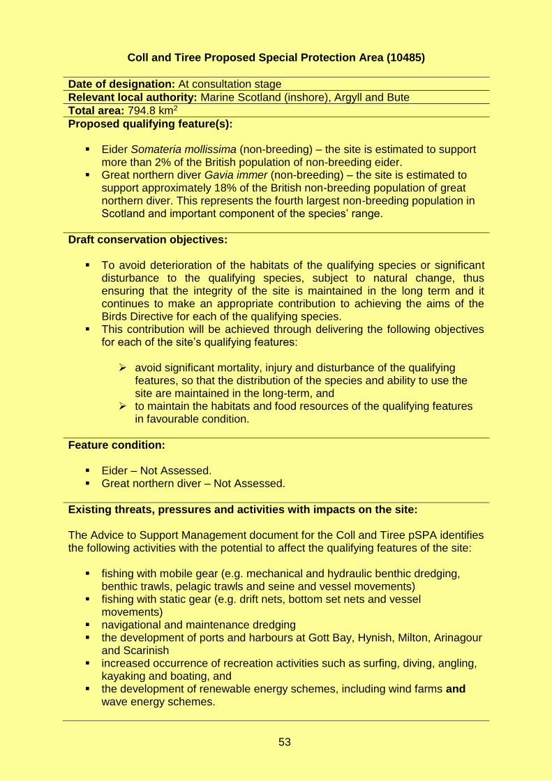
53
Coll and Tiree Proposed Special Protection Area (10485)
Date of designation: At consultation stage
Relevant local authority: Marine Scotland (inshore), Argyll and Bute
Total area: 794.8 km2
Proposed qualifying feature(s):
Eider Somateria mollissima (non-breeding) – the site is estimated to support more than 2% of the British population of non-breeding eider.
Great northern diver Gavia immer (non-breeding) – the site is estimated to support approximately 18% of the British non-breeding population of great northern diver. This represents the fourth largest non-breeding population in Scotland and important component of the species’ range.
Draft conservation objectives:
To avoid deterioration of the habitats of the qualifying species or significant disturbance to the qualifying species, subject to natural change, thus ensuring that the integrity of the site is maintained in the long term and it continues to make an appropriate contribution to achieving the aims of the Birds Directive for each of the qualifying species.
This contribution will be achieved through delivering the following objectives for each of the site’s qualifying features:
avoid significant mortality, injury and disturbance of the qualifying
features, so that the distribution of the species and ability to use the site are maintained in the long-term, and
to maintain the habitats and food resources of the qualifying features in favourable condition.
Feature condition:
Eider – Not Assessed. Great northern diver – Not Assessed.
Existing threats, pressures and activities with impacts on the site: The Advice to Support Management document for the Coll and Tiree pSPA identifies the following activities with the potential to affect the qualifying features of the site:
fishing with mobile gear (e.g. mechanical and hydraulic benthic dredging, benthic trawls, pelagic trawls and seine and vessel movements)
fishing with static gear (e.g. drift nets, bottom set nets and vessel movements)
navigational and maintenance dredging the development of ports and harbours at Gott Bay, Hynish, Milton, Arinagour
and Scarinish increased occurrence of recreation activities such as surfing, diving, angling,
kayaking and boating, and the development of renewable energy schemes, including wind farms and
wave energy schemes.

54
Anchorages and moorings, lobster and crab creels, and line fishing are all identified as being unlikely to affect the qualifying features, other than insignificantly.
Sensitivity of qualifying feature(s): Both species are considered sensitive to:
mortality by entanglement in fishing nets removal of prey species, such as sandeel, directly by fisheries and indirectly
by loss of / damage to suitable prey habitat disturbance by movement of vessels disturbance / loss of prey habitat by new development disturbance by recreational activities mortality through collision with wind turbines and underwater wave energy
devices, and alteration of migration flyways or local flight passes due to artificial structures
such as wind turbines.

55
East Mainland Coast, Shetland Proposed Special Protection Area (10482)
Date of designation: At consultation stage
Relevant local authority: Marine Scotland (inshore), Shetland Islands
Total area: 256.5 km2
Proposed qualifying feature(s):
Great northern diver Gavia immer (non-breeding) – the site is estimated to support 180 birds, representing up to 7% of the non-breeding population in Great Britain.
Red-throated diver Gavia stellata (breeding) – the site is estimated to support 210 pairs, representing up to 17% of the breeding population in Great Britain.
Slavonian grebe Podiceps auritus (non-breeding) – the site is estimated to support 50 birds, representing up to 5% of the non-breeding population in Great Britain.
Long-tailed duck Clangula hyemalis (non-breeding) – the site is estimated to support 160 birds, representing up to 2% of the non-breeding population in Great Britain.
Red-breasted merganser Mergus serrator (non-breeding) – the site is estimated to support 230, birds representing up to 3% of the non-breeding population in Great Britain.
Eider Somateria mollissima (non-breeding) – the site is estimated to support 240 birds, approximately 4% of the British population of non-breeding eider.
Draft conservation objectives:
To avoid deterioration of the habitats of the qualifying species or significant disturbance to the qualifying species, subject to natural change, thus ensuring that the integrity of the site is maintained in the long term and it continues to make an appropriate contribution to achieving the aims of the Birds Directive for each of the qualifying species.
This contribution will be achieved through delivering the following objectives for each of the site’s qualifying features:
avoid significant mortality, injury and disturbance of the qualifying
features, so that the distribution of the species and ability to use the site are maintained in the long-term, and
to maintain the habitats and food resources of the qualifying features in favourable condition.
Feature condition:
Great northern diver – Not Assessed. Red-throated diver – Not Assessed. Slavonian grebe – Not Assessed. Long-tailed duck – Not Assessed. Red-breasted merganser – Not Assessed. Eider – Not Assessed.
Existing threats, pressures and activities with impacts on the site: The Advice to Support Management document for the East Mainland Coast,

56
Shetland pSPA identifies the following activities with the potential to affect the qualifying features of the site:
aquaculture (finfish and shellfish) fishing (e.g. mechanical and hydraulic benthic dredging, benthic trawl, pelagic
trawls and seines, drift nets and bottom set nets) navigational and maintenance dredging new developments in ports and harbours (e.g. Lerwick, Sullom Voe,
Symbister) recreational users (e.g. angling, boating, diving and kayaking), and tidal energy developments
Anchorages and moorings, fishing activity with creels and lines, and infrastructure including cables, pipelines and outfalls are all identified as being unlikely to affect the qualifying features, other than insignificantly.
Sensitivity of qualifying feature(s): All species are considered sensitive, to varying extents, to:
mortality by entanglement in fishing nets disturbance and displacement by vessel movement and auditory deterrents removal of prey species by fisheries loss of / damage to habitats for prey species (e.g. by development, abrasion
or smothering) inability to hunt due to reduced water clarity disturbance due to recreational activities mortality by collision with tidal turbines, and displacement from foraging areas by disturbance by tidal turbine
developments.

57
Moray Firth Proposed Special Protection Area (10490)
Date of designation: At consultation stage
Relevant local authority: Marine Scotland (inshore), Aberdeenshire, Highland, Moray
Total area: 1,762 km2
Proposed qualifying feature(s):
Great northern diver Gavia immer (non-breeding) – the site is estimated to support approximately 5.8% of the British population of non-breeding great northern diver.
Red-throated diver Gavia stellata (non-breeding) – the site is estimated to support approximately 1.9% of the British population of non-breeding red-throated diver.
Slavonian grebe Podiceps auritus (non-breeding) – the site is estimated to support approximately 3.9% of the British population of non-breeding Slavonian grebe.
Scaup Aythya marila (non-breeding) – the site is estimated to support approximately 17.9% of the British population of non-breeding scaup.
Eider Somateria mollissima (non-breeding) – the site is estimated to support approximately 2.9% of the British population of non-breeding eider.
Long-tailed duck Clangula hyemalis (non-breeding) – the site is estimated to support approximately 45.5% of the British population of non-breeding long-tailed duck.
Common scoter Melanitta nigra (non-breeding) – the site is estimated to support approximately 5.5% of the British population of non-breeding common scoter.
Velvet scoter Melanitta fusca (non-breeding) – the site is estimated to support approximately 59.5% of the British population of non-breeding velvet scoter.
Goldeneye Bucephala clangula (non-breeding) – the site is estimated to support approximately 4.5% of the British population of non-breeding goldeneye.
Red-breasted merganser Mergus serrator (non-breeding) – the site is estimated to support approximately 1.8% of the British population of non-breeding red-breasted merganser.
Shag Phalacrocorax aristotelis (breeding and non-breeding) – the site is estimated to support approximately 10.2% of the British population of breeding shag, and 5.9% of the non-breeding population.
Draft conservation objectives:
To avoid deterioration of the habitats of the qualifying species or significant disturbance to the qualifying species, subject to natural change, thus ensuring that the integrity of the site is maintained in the long term and it continues to make an appropriate contribution to achieving the aims of the Birds Directive for each of the qualifying species.
This contribution will be achieved through delivering the following objectives for each of the site’s qualifying features:
avoid significant mortality, injury and disturbance of the qualifying
features, so that the distribution of the species and ability to use the site are maintained in the long-term, and

58
to maintain the habitats and food resources of the qualifying features in favourable condition.
Feature condition*:
Great northern diver – Not Assessed. Red-throated diver – Not Assessed. Slavonian grebe – Not Assessed. Scaup – Favourable Maintained (last assessed 2001). Eider – Not Assessed. Long-tailed duck – Not Assessed. Common scoter – Not Assessed. Velvet scoter – Not Assessed. Goldeneye – Favourable Maintained (last assessed 2001). Red-breasted merganser – Unfavourable No Change (last assessed 2001). Shag – Not Assessed.
*Latest assessed condition as given for the Inner Moray Firth SPA, located adjacent to the pSPA. Unassessed for the Moray Firth pSPA.
Existing threats, pressures and activities with impacts on the site: The Advice to Support Management document for the Moray Firth pSPA identifies the following activities with the potential to affect the proposed qualifying feature of the site:
fishing (e.g. mechanical and hydraulic benthic dredging, benthic trawl, pelagic trawls and seines, drift nets, bottom set nets, fyke nets)
harvesting of intertidal shellfish, bait and blue mussel fishery navigational and maintenance dredging (e.g. existing maintenance dredging,
dredge spoil disposal, capital dredging) new developments at ports and harbours (e.g. Cromarty, Inverness,
Ardersier, Avoch, Balintore, Brora, Buckie, Burghead, Cullen, Findochty, Fortrose, Golspie, Helmsdale, Hopeman, Lossiemouth, Nairn, Portgordon, Portmahomack, Portnockie, Rosemarkie and Sandend) and ship to ship transfers
recreational users (e.g. wildfowling, jet skiing), and renewables (e.g. wind and wave energy developments).
Anchorages and moorings, fishing using creels and lines and infrastructure such as cables, pipelines and outfalls (e.g. power interconnectors, gas and oil pipelines and outfalls), are all identified as being unlikely to affect the qualifying features, other than insignificantly.
Sensitivity of the qualifying feature(s): All species are considered sensitive, to varying extents, to:
mortality by entanglement in fishing nets disturbance and displacement by vessel movement removal of prey species by fisheries loss of or damage to suitable prey habitat (e.g. development, abrasion and
smothering) disturbance by human presence and vehicles during intertidal shellfish and

59
bait harvesting inability to hunt due to reduced water clarity disturbance and displacement by new development (e.g. wind turbines) mortality during oils spills which may occur during ship to ship hydrocarbon
transfers disturbance from recreational activities, and mortality through collision with wind and water turbines.

60
North Orkney Proposed Special Protection Area (10481)
Date of designation: At consultation stage
Relevant local authority: Marine Scotland (inshore), Orkney Islands
Total area: 227 km2
Proposed qualifying feature(s):
Great northern diver Gavia immer (non-breeding) – the site is estimated to support 310 birds, representing up to 12.4% of the non-breeding population in Great Britain.
Red-throated diver Gavia stellata (breeding) – the site is estimated to support 52 pairs, representing up to 4.4% of the breeding population in Great Britain.
Slavonian grebe Podiceps auritus (non-breeding) – the site is estimated to support 120 birds, representing up to 10.9% of the non-breeding population in Great Britain.
Eider Somateria mollissima (non-breeding) – the site is estimated to support 1,453 birds, representing up to 2.4% of the non-breeding population in Great Britain.
Long-tailed duck Clangula hyemalis (non-breeding) – the site is estimated to support 937 birds, representing up to 8.5% of the non-breeding population in Great Britain.
Velvet scoter Melanitta fusca (non-breeding) – the site is estimated to support 147 birds, representing up to 5.9% of the non-breeding population in Great Britain.
Red-breasted merganser Mergus serrator (non-breeding) – the site is estimated to support 344 birds, representing up to 4.1% of the non-breeding population in Great Britain.
Shag Phalacrocorax aristotelis (non-breeding) – the site is estimated to support 1,742 birds, representing up to 1.6% of the non-breeding population in Great Britain.
Draft conservation objectives:
To avoid deterioration of the habitats of the qualifying species or significant disturbance to the qualifying species, subject to natural change, thus ensuring that the integrity of the site is maintained in the long term and it continues to make an appropriate contribution to achieving the aims of the Birds Directive for each of the qualifying species.
This contribution will be achieved through delivering the following objectives for each of the site’s qualifying features:
avoid significant mortality, injury and disturbance of the qualifying
features, so that the distribution of the species and ability to use the site are maintained in the long-term, and
to maintain the habitats and food resources of the qualifying features in favourable condition.
Feature condition:
Great northern diver (non-breeding) – Not Assessed. Red-throated diver (breeding) – Not Assessed. Slavonian grebe (non-breeding) – Not Assessed.

61
Eider (non-breeding) – Not Assessed. Long-tailed duck (non-breeding) – Not Assessed. Velvet scoter (non-breeding) – Not Assessed. Red-breasted merganser (non-breeding) – Not Assessed. Shag (non-breeding) – Not Assessed.
Existing threats, pressures and activities with impacts on the site: The Advice to Support Management document for the North Orkney pSPA identifies the following activities with the potential to affect the qualifying features of the site:
aquaculture (finfish and shellfish) fishing (e.g. mechanical and hydraulic benthic dredging, benthic trawl, pelagic
trawls and seines, drift nets and bottom set nets) navigational and maintenance dredging new developments in ports and harbours (e.g. Wide Firth including Hatston
Pier and Kirkwall Harbour) recreational users (e.g. jet-skiing, wildfowling, angling, boating, wildlife tours
and kayaking), and tidal energy developments
Anchorages and moorings, fishing activity with creels and lines, and infrastructure including cables, pipelines and outfalls are all identified as being unlikely to affect the qualifying features, other than insignificantly.
Sensitivity of qualifying feature(s): All species are considered sensitive, to varying extents, to:
mortality by entanglement in fishing nets disturbance and displacement by vessel movement and auditory deterrents removal of prey species by fisheries loss of / damage to habitats for prey species (e.g. by development, abrasion
or smothering) inability to hunt due to reduced water clarity disturbance due to recreational activities mortality by collision with tidal turbines, and displacement from foraging areas by disturbance by tidal turbine
developments.

62
Outer Firth of Forth and St Andrews Bay Complex Proposed Special Protection Area (10478)
Date of designation: At consultation stage
Relevant local authority: UK Offshore waters (Scotland), Marine Scotland (inshore), Angus, City of Edinburgh, Dundee City, East Lothian, Fife, Scottish Borders
Total area: 2,721 km2
Proposed qualifying feature(s):
Red-throated diver Gavia stellata (non-breeding) – the site is estimated to support approximately 5% of the British population of non-breeding red-throated diver.
Little gull Larus minutus (non-breeding) – the site is estimated to support approximately 126 little gulls. There is no estimate of the British non-breeding population with which to compare this.
Common tern Sterna hirundo (breeding) – the site is estimated to support approximately 8.8% of the British population of breeding common tern.
Arctic tern Sterna paradisaea (breeding) – the site is estimated to support approximately 1% of the British population of breeding common tern.
Slavonian grebe Podiceps auritus (non-breeding) – the site is estimated to support approximately 2.7% of the British population of non-breeding Slavonian grebe.
Eider Somateria mollissima (non-breeding) – the site is estimated to support approximately 35.9% of the British population of non-breeding common eider.
Long-tailed duck Clangula hyemalis (non-breeding) – the site is estimated to support approximately 17.7% of the British population of non-breeding long-tailed duck.
Common scoter Melanitta nigra (non-breeding) – the site is estimated to support approximately 4.7% of the British population of non-breeding common scoter.
Velvet scoter Melanitta fusca (non-breeding) – the site is estimated to support approximately 23.2% of the British population of non-breeding velvet scoter.
Goldeneye Bucephala clangula (non-breeding) – the site is estimated to support approximately 2.9% of the British population of non-breeding goldeneye.
Red-breasted merganser Mergus serrator (non-breeding) – the site is estimated to support approximately 5.1% of the British population of non-breeding red-breasted merganser.
Gannet Morus bassanus (breeding) – the site is estimated to support approximately 2.5% of the British population of breeding Northern gannet.
Manx shearwater Puffinus puffinus (do not breed on site but present during the breeding season) – the site is estimated to support approximately 2,885 Manx shearwaters.
Shag Phalacrocorax aristotelis (breeding and non-breeding) – the site is estimated to support approximately 4.6% of the British population of breeding shag, and 2.2% of the non-breeding population.
Kittiwake Rissa tridactyla (breeding and non-breeding) – the site is estimated to support approximately 1.6% of the British population of non-breeding black-legged kittiwake.
Guillemot Uria aalge (breeding and non-breeding) – the site is estimated to support approximately 1.6% of the British population of breeding common

63
guillemot. Razorbill Alca torda (non-breeding) – the site is estimated to support
approximately 5,481 razorbills. There is no estimate of the British non-breeding population with which to compare this.
Puffin Fratercula arctica (breeding) – the site is estimated to support approximately 5.3% of the British population of breeding puffin.
Black-headed gull Chroicocephalus ridibundus (non-breeding) – the site is estimated to support approximately 1.2% of the British population of non-breeding black-headed gull.
Common gull Larus canus (non-breeding) – the site is estimated to support approximately 2.1% of the British population of non-breeding common gull.
Herring gull Larus argentatus (breeding and non-breeding) – the site is estimated to support approximately 1.1% of the British population of breeding herring gull, and 1.7% of the non-breeding population.
Draft conservation objectives:
To avoid deterioration of the habitats of the qualifying species or significant disturbance to the qualifying species, subject to natural change, thus ensuring that the integrity of the site is maintained in the long term and it continues to make an appropriate contribution to achieving the aims of the Birds Directive for each of the qualifying species.
This contribution will be achieved through delivering the following objectives for each of the site’s qualifying features:
avoid significant mortality, injury and disturbance of the qualifying
features, so that the distribution of the species and ability to use the site are maintained in the long-term, and
to maintain the habitats and food resources of the qualifying features in favourable condition.
Feature condition*:
Red-throated diver – Favourable Maintained (last assessed 2015). Little gull – Not Assessed. Common tern – Unfavourable Declining (last assessed 2017). Arctic tern – Favourable Declining (last assessed 2016). Slavonian grebe – Unfavourable Declining (last assessed 2015). Eider – Favourable Declining (last assessed 2015). Long-tailed duck – Unfavourable Declining (last assessed 2015). Common scoter – Unfavourable Declining (last assessed 2015). Velvet scoter – Favourable Maintained (last assessed 2015). Goldeneye – Unfavourable Declining (last assessed 2015). Red-breasted merganser – Unfavourable Declining (last assessed 2015). Gannet – Favourable Maintained (last assessed 2014). Manx shearwater – Not Assessed. Shag – Unfavourable Declining (last assessed 2016). Kittiwake – Unfavourable Declining (last assessed 2016. Guillemot – Favourable Maintained (last assessed 2016). Razorbill – Favourable Maintained (last assessed 2016). Puffin – Favourable Declining (last assessed 2017). Black-headed gull – Not Assessed. Common gull – Not Assessed. Herring gull – Favourable Maintained (last assessed 2016).

64
*Latest assessed condition as given for the Forth Islands SPA and Firth of Forth SPA, both located in the Firth of Forth, within and adjacent to the Outer Firth of Forth and St Andrews Bay Complex pSPA, respectively. Unassessed for the pSPA.
Existing threats, pressures and activities with impacts on the site: The Advice to Support Management document for the Outer Firth of Forth and St Andrews Bay Complex pSPA identifies the following activities with the potential to affect the proposed qualifying feature of the site:
fishing (e.g. mechanical and hydraulic benthic dredging, benthic trawl, pelagic trawls and seines, drift nets, bottom set nets, fyke nets)
harvesting of intertidal shellfish and bait navigational and maintenance dredging (e.g. existing maintenance dredging,
dredge spoil disposal, capital dredging) new developments at ports and harbours (e.g. St Abbs, Cove, Dunbar, North
Berwick, Port Seton, Fisherrow, Port of Leith, Newhaven, Granton, Burntisland, Pettycur, Kinghorn, Kirkcaldy, Dysart, West Weymss, Methil, Elie, St Monans, Pittenweem, Anstruther, Crail, St Andrews, Port of Dundee, Arbroath) and ship to ship transfers.
recreational users (e.g. wildfowling, jet skiing), and renewables (e.g. wind energy developments).
Anchorages and moorings, aquaculture of finfish (research sites) and of shellfish (North Berwick lobster hatchery), coastal protection and flood defence, fishing activity (e.g. creels and lines), infrastructure such as cables, pipelines and outfalls (e.g. power interconnectors, gas and oil pipelines and outfalls), are all identified as being unlikely to affect the qualifying features, other than insignificantly.
Sensitivity of the qualifying feature(s): All species are considered sensitive, to varying extents, to:
mortality by entanglement in fishing nets disturbance and displacement by vessel movement and new development
(e.g. wind turbines) removal of prey species by fisheries loss of or damage to suitable prey habitat (e.g. development, abrasion and
smothering) disturbance by human presence and vehicles during intertidal shellfish and
bait harvesting inability to hunt due to reduced water clarity mortality by involvement in oil spill, and disturbance from recreational activities.
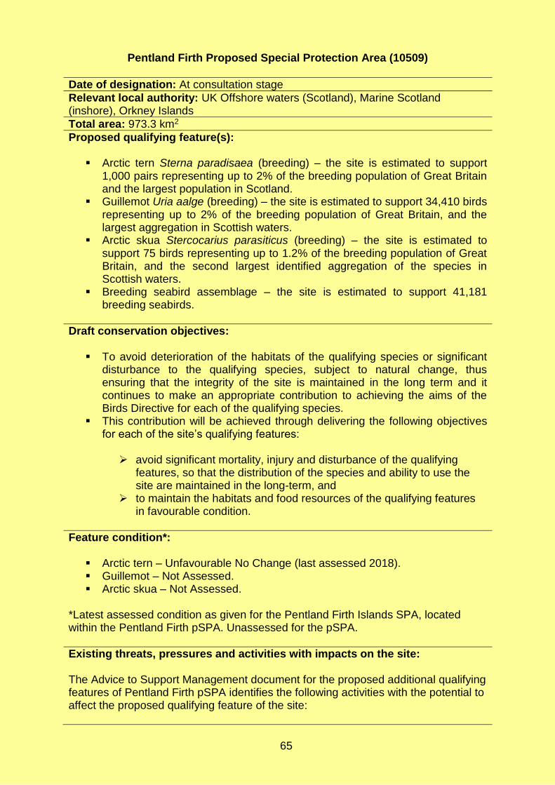
65
Pentland Firth Proposed Special Protection Area (10509)
Date of designation: At consultation stage
Relevant local authority: UK Offshore waters (Scotland), Marine Scotland (inshore), Orkney Islands
Total area: 973.3 km2
Proposed qualifying feature(s):
Arctic tern Sterna paradisaea (breeding) – the site is estimated to support 1,000 pairs representing up to 2% of the breeding population of Great Britain and the largest population in Scotland.
Guillemot Uria aalge (breeding) – the site is estimated to support 34,410 birds representing up to 2% of the breeding population of Great Britain, and the largest aggregation in Scottish waters.
Arctic skua Stercocarius parasiticus (breeding) – the site is estimated to support 75 birds representing up to 1.2% of the breeding population of Great Britain, and the second largest identified aggregation of the species in Scottish waters.
Breeding seabird assemblage – the site is estimated to support 41,181 breeding seabirds.
Draft conservation objectives:
To avoid deterioration of the habitats of the qualifying species or significant disturbance to the qualifying species, subject to natural change, thus ensuring that the integrity of the site is maintained in the long term and it continues to make an appropriate contribution to achieving the aims of the Birds Directive for each of the qualifying species.
This contribution will be achieved through delivering the following objectives for each of the site’s qualifying features:
avoid significant mortality, injury and disturbance of the qualifying
features, so that the distribution of the species and ability to use the site are maintained in the long-term, and
to maintain the habitats and food resources of the qualifying features in favourable condition.
Feature condition*:
Arctic tern – Unfavourable No Change (last assessed 2018). Guillemot – Not Assessed. Arctic skua – Not Assessed.
*Latest assessed condition as given for the Pentland Firth Islands SPA, located within the Pentland Firth pSPA. Unassessed for the pSPA.
Existing threats, pressures and activities with impacts on the site: The Advice to Support Management document for the proposed additional qualifying features of Pentland Firth pSPA identifies the following activities with the potential to affect the proposed qualifying feature of the site:

66
aggregates extraction fishing (e.g. mechanical and hydraulic benthic dredging, benthic trawl, pelagic
trawls and seines, drift nets, bottom set nets, fyke nets) new development of ports and harbours at Burwick and Scapa Flow (e.g.
container transhipment hub), and marine tidal energy developments.
Anchorages and moorings, fishing activity including creels, infrastructure such as cables, pipelines and outfalls, and recreation use (e.g. angling, boating, wildlife tours, surfing and kayaking) are all identified as being unlikely to affect the qualifying features, other than insignificantly.
Sensitivity of the qualifying feature(s): All species are considered sensitive, to varying extents, to:
inability to hunt due to reduced water clarity loss of or damage to suitable prey habitat (e.g. abrasion) mortality by entanglement in fishing nets disturbance and displacement by vessel movement removal of prey species by fisheries mortality through collision with tidal turbines, and disturbance and displacement by tidal turbines.

67
Rum Special Protection Area (Proposed additional marine feature) (8574)
Date of designation: At consultation stage
Relevant local authority: Marine Scotland (inshore), Highland
Total area: 467.2 km2
Proposed qualifying feature(s): It is proposed to make red-throated diver Gavia stellata an additional to the marine feature of the Rum SPA. Red-throated diver is already a qualifying feature of the terrestrial parts of the existing SPA.
Red-throated diver (breeding) – the site is estimated to support 18 pairs, representing up to 1.4% of the breeding population of Great Britain. Red-throated diver is already a qualifying feature of the terrestrial part of the SPA.
Draft conservation objectives:
To avoid deterioration of the habitats of the qualifying species or significant disturbance to the qualifying species, subject to natural change, thus ensuring that the integrity of the site is maintained in the long term and it continues to make an appropriate contribution to achieving the aims of the Birds Directive for each of the qualifying species.
This contribution will be achieved through delivering the following objectives for each of the site’s qualifying features:
avoid significant mortality, injury and disturbance of the qualifying
features, so that the distribution of the species and ability to use the site are maintained in the long-term, and
to maintain the habitats and food resources of the qualifying features in favourable condition.
Feature condition*:
Red-throated diver – Favourable Maintained (last assessed 2013).
*Latest assessed condition as given for the terrestrial part of the fully designated Rum SPA.
Existing threats, pressures and activities with impacts on the site: The Advice to Support Management document for the proposed additional marine feature of Rum SPA identifies the following activities with the potential to affect the proposed qualifying feature of the site:
aquaculture of finfish fishing (e.g. mechanical and hydraulic benthic dredging, benthic trawl, pelagic
trawls and seines, drift nets, bottom set nets and fyke nets), and recreational activity (e.g. angling, boating, diving, wildlife tours and kayaking).
Anchorages and moorings, aquaculture of shellfish, ferry routes, fishing activity including creels, line fishing, marine disposal sites (Sound of Canna and Port Mor, Isle of Muck) and ports and harbours are all identified as being unlikely to affect the

68
qualifying features, other than insignificantly.
Generic sensitivities and potential impacts: Red-throated divers are considered sensitive, to varying extents, to:
mortality by entanglement in fishing nets disturbance and displacement by vessel movement removal of prey species by fisheries loss of or damage to suitable prey habitat (e.g. abrasion), and disturbance during recreational activities.

69
Scapa Flow Proposed Special Protection Area (10510)
Date of designation: At consultation stage
Relevant local authority: Marine Scotland (inshore), Orkney Islands
Total area: 370.7 km2
Proposed qualifying feature(s):
Great northern diver Gavia immer (non-breeding) – the site is estimated to support 506 birds, representing up to 20.2% of the non-breeding population of Great Britain and the third largest population in Scotland.
Red-throated diver Gavia stellata (breeding) – the site is estimated to support 81 pairs, representing up to 7.6% of the breeding population of Great Britain.
Black-throated diver Gavia arctica (non-breeding) – the site is estimated to support 57 birds, representing up to 9.5% of the non-breeding population of Great Britain and the second largest population in Scotland.
Slavonian grebe Podiceps auritus (non-breeding) – the site is estimated to support 135 birds, representing up to 12.3% of the non-breeding population of Great Britain, the largest in Great Britain.
Shag Phalacrocorax aristotelis (non-breeding) – the site is estimated to support 2,929 birds, representing up to 2.9% of the non-breeding population of Great Britain, the second largest population in Scotland.
Eider Somateria mollissima (non-breeding) – the site is estimated to support 1,994 birds, representing up to 3.3% of the non-breeding population of Great Britain, and the fourth largest population in Scotland.
Long-tailed duck Clangula hyemalis (non-breeding) – the site is estimated to support 1,393 birds representing up to 12.7% of the non-breeding population of Great Britain, and the third largest population in Scotland.
Goldeneye Bucephala clangula (non-breeding) – the site is estimated to support 219 birds, representing up to 1.1% of the non-breeding population of Great Britain and the third largest population in Scotland.
Red-breasted merganser Mergus serrator (non-breeding) – the site is estimated to support 539 birds, representing up to 6.4% of the non-breeding population of Great Britain and the largest population in Scotland.
Draft conservation objectives:
To avoid deterioration of the habitats of the qualifying species or significant disturbance to the qualifying species, subject to natural change, thus ensuring that the integrity of the site is maintained in the long term and it continues to make an appropriate contribution to achieving the aims of the Birds Directive for each of the qualifying species.
This contribution will be achieved through delivering the following objectives for each of the site’s qualifying features:
avoid significant mortality, injury and disturbance of the qualifying
features, so that the distribution of the species and ability to use the site are maintained in the long-term, and
to maintain the habitats and food resources of the qualifying features in favourable condition.
Feature condition*:

70
Great northern diver – Not Assessed. Red-throated diver – Favourable Maintained (last assessed 2007) Black-throated diver – Not Assessed. Slavonian grebe – Not Assessed. Shag (non-breeding) – Not Assessed. Eider – Not Assessed. Long-tailed duck – Not Assessed. Goldeneye – Not Assessed. Red-breasted merganser – Not Assessed.
*Latest assessed condition as given for the existing Hoy SPA which is adjacent to and partially overlaps the Scapa Flow pSPA. Unassessed for the pSPA.
Existing threats, pressures and activities with impacts on the site: The Advice to Support Management document for the Scapa Flow pSPA identifies the following activities with the potential to affect the qualifying features of the site:
aquaculture of finfish and shellfish fishing (e.g. mechanical and hydraulic benthic dredging, benthic trawl, pelagic
trawls and seines, drift nets, bottom set nets and fyke nets) navigational and maintenance dredging new port and harbour developments including those at Lyness, Scapa,
Stromness, St Margaret’s Hope and Houton) recreational activity (e.g. jet-skiing, wildfowling, angling, boating, wildlife tours
and kayaking), and renewables (e.g. tidal).
Anchorages and moorings, infrastructure (e.g. cables, pipelines and outfalls) and fishing activity including creels and line fishing are all identified as being unlikely to affect the qualifying features, other than insignificantly.
Generic sensitivities and potential impacts: All species are considered sensitive, to varying extents, to:
mortality by entanglement in fishing nets disturbance and displacement by vessel movement and auditory deterrents removal of prey species by fisheries loss of or damage to suitable prey habitat (e.g. by developments and
abrasion) disturbance by new developments mortality during oils spills which may occur during ship to ship hydrocarbon
transfers disturbance during recreational activities mortality by collision with tidal turbines, and disturbance and displacement from foraging areas by tidal turbines.

71
Seas off Foula Proposed Special Protection Area (10489)
Date of designation: At consultation stage
Relevant local authority: UK Offshore waters (Scotland), Marine Scotland (inshore), Shetland Islands
Total area: 3,412.2 km2
Proposed qualifying feature(s): The Seas off Foula pSPA includes some (but not all) of the same qualifying features as the existing Foula SPA, and would provide protection to the marine environment and foraging resources on which those species rely.
Great skua Stercorarius skua (breeding and non-breeding) – the site is estimated to support breeding 1,594 birds, representing up to 3.3% of the biogeographic population. It is estimated to support 319 non-breeding birds.
Fulmar Fulmarus glacialis (breeding and non-breeding) – the site is estimated to support 8,379 breeding birds and 5,409 non-breeding birds.
Arctic skua Stercorarius parasiticus (breeding) – the site is estimated to support 219 birds.
Guillemot Uria aalge (breeding and non-breeding) – the site is estimated to support 11,142 breeding birds and 8,340 non-breeding birds.
Puffin Fratercula arctica (breeding) – the site is estimated to support 14,886 birds.
Draft conservation objectives:
To avoid deterioration of the habitats of the qualifying species or significant disturbance to the qualifying species, subject to natural change, thus ensuring that the integrity of the site is maintained in the long term and it continues to make an appropriate contribution to achieving the aims of the Birds Directive for each of the qualifying species.
This contribution will be achieved through delivering the following objectives for each of the site’s qualifying features:
avoid significant mortality, injury and disturbance of the qualifying
features, so that the distribution of the species and ability to use the site are maintained in the long-term, and
to maintain the habitats and food resources of the qualifying features in favourable condition.
Feature condition*:
Great skua (breeding) – Favourable Recovered (last assessed 2015). Great skua (non-breeding) – Not Assessed. Fulmar (breeding) – Unfavourable Declining (last assessed 2015). Fulmar (non-breeding) – Not Assessed. Arctic skua – Unfavourable Declining (last assessed 2015). Guillemot (breeding) – Unfavourable Declining (last assessed 2015). Guillemot (non-breeding) – Not Assessed. Puffin – Unfavourable No Change (last assessed 2016). Assemblage of breeding seabirds – Not Assessed. Assemblage of non-breeding seabirds – Not Assessed.

72
*Latest assessed condition as given for the existing Foula SPA which is adjacent to Seas off Foula pSPA. Unassessed for the pSPA.
Threats, pressures and activities with impacts on the site: The Advice to Support Management document for the Seas off Foula pSPA identifies the following activities with the potential to affect the qualifying features of the site:
longline fishing licensed activities (e.g. oil and gas) military activities, and shipping.
Fishing activity including otter trawling, seining netting, static nets and creeling and potting, telecommunication cables and recreational activity (e.g. RYA cruising / recreational boating) are all identified as being unlikely to affect the qualifying features, other than insignificantly.
Sensitivity of qualifying feature(s): All species are considered sensitive, to varying extents, to:
mortality / injury by baited longline hooks disturbance by military activity disturbance by shipping mortality / injury by accidental discharge of hazardous cargo (e.g. oil spill),
and mortality / injury by oil spill from licensed activities.

73
Seas off St Kilda Proposed Special Protection Area (10488)
Date of designation: At consultation stage
Relevant local authority: UK Offshore waters (Scotland), Marine Scotland (inshore)
Total area: 3,995.5 km2
Proposed qualifying feature(s): The Seas off Foula pSPA includes some (but not all) of the same qualifying features as the existing Foula SPA, and would provide protection to the marine environment and foraging resources on which those species rely.
Gannet Morus bassanus (breeding) – the site is estimated to support 50,332 birds representing up to 5.3% of the biogeographic population.
Fulmar Fulmarus glacialis (breeding) – the site is estimated to support 3,310 birds.
Guillimot Uria aalge (breeding) – the site is estimated to support 3,147 birds. Puffin Fratercula arctica (breeding) – the site is estimated to support 6,198
birds. European storm petrel Hydrobates pelagicus (breeding) – the site is
estimated to support 954 birds.
Draft conservation objectives:
To avoid deterioration of the habitats of the qualifying species or significant disturbance to the qualifying species, subject to natural change, thus ensuring that the integrity of the site is maintained in the long term and it continues to make an appropriate contribution to achieving the aims of the Birds Directive for each of the qualifying species.
This contribution will be achieved through delivering the following objectives for each of the site’s qualifying features:
avoid significant mortality, injury and disturbance of the qualifying
features, so that the distribution of the species and ability to use the site are maintained in the long-term, and
to maintain the habitats and food resources of the qualifying features in favourable condition.
Feature condition*:
Fulmar – Unfavourable Declining (last assessed 2016). Gannet – Favourable Maintained (last assessed 2013). Guillemot – Unfavourable Declining (last assessed 2016). Puffin – Favourable Maintained (last assessed 2000). European storm petrel – Favourable Maintained (last assessed 2000).
*Latest assessed condition as given for the existing St Kilda SPA. Unassessed for the Seas off St Kilda pSPA.
Existing threats, pressures and activities with impacts on the site: The Advice to Support Management document for the Seas off St Kilda pSPA

74
identifies the following activities with the potential to affect the qualifying features of the site:
long-line fishing disturbance caused by military activities disturbance caused by shipping, and risk of accident / discharge from vessels carrying hazardous cargo (e.g. oil
spill). Fishing activity such as otter trawling, seining netting, static nets and creeling and potting, and recreational activity (e.g. recreational boating) are all identified as being unlikely to affect the qualifying features, other than insignificantly.
Sensitivity of qualifying feature(s): All species are considered sensitive, to varying extents, to:
mortality and injury by baited longline hooks direct disturbance by military activity (e.g. low-flying aircraft, firing munitions,
exploding ordinance, high speed vessel manoeuvres, military exercises), and mortality / injury due to oil spill or other hazardous cargo spill.

75
Solway Firth Proposed Special Protection Area (Proposed marine extension and site name change) (10487)
Date of designation: At consultation stage
Relevant local authority: Marine Scotland (inshore), Marine Management Organisation (England inshore and offshore), Dumfries and Galloway, Cumbria
Total area: 920.71 km2 (size of extension)
Proposed qualifying feature(s): The Solway Firth pSPA is a proposed marine extension and name change to the existing Upper Solway Flats and Marshes SPA, with the addition of several new species. Species to be included in the proposed marine extension:
Red-throated diver Gavia stellata (non-breeding) – the site is estimated to support 527 birds, representing up to 3.1% of the non-breeding population in Great Britain.
Common scoter Melanitta nigra (non-breeding) – the site is estimated to support 1,590 birds, representing up to 2% of the non-breeding population in Great Britain.
Goosander Mergus merganser (non-breeding) – the site is estimated to support 150 birds, representing up to 1% of the non-breeding population in Great Britain.
Proposed additions to the existing part of the SPA:
Lapwing Vanellus vanellus (non-breeding) – the site is estimated to support 5,040 birds, representing up to 1% of the non-breeding population in Great Britain.
Ringed plover Charadrius hiaticula (non-breeding) – the site is estimated to support 980 birds, representing up to 1% of the non-breeding population in Great Britain.
Cormorant Phalacrocorax carbo (non-breeding) – the site is estimated to support 580 birds, representing up to 2% of the non-breeding population in Great Britain.
Black-headed gull Chroicocephalus ridibundus (non-breeding) – the site is estimated to support 13,730 birds representing up to 1% of the non-breeding population in Great Britain.
Common gull Larus canus (non-breeding) – the site is estimated to support 12,490 birds, representing up to 2% of the non-breeding population in Great Britain.
Herring gull Larus argentatus (non-breeding) – the site is estimated to support 3,030 birds representing up to 0.4% of the non-breeding population in Great Britain.
Draft conservation objectives:
To avoid deterioration of the habitats of the qualifying species or significant disturbance to the qualifying species, subject to natural change, thus ensuring that the integrity of the site is maintained in the long term and it continues to make an appropriate contribution to achieving the aims of the
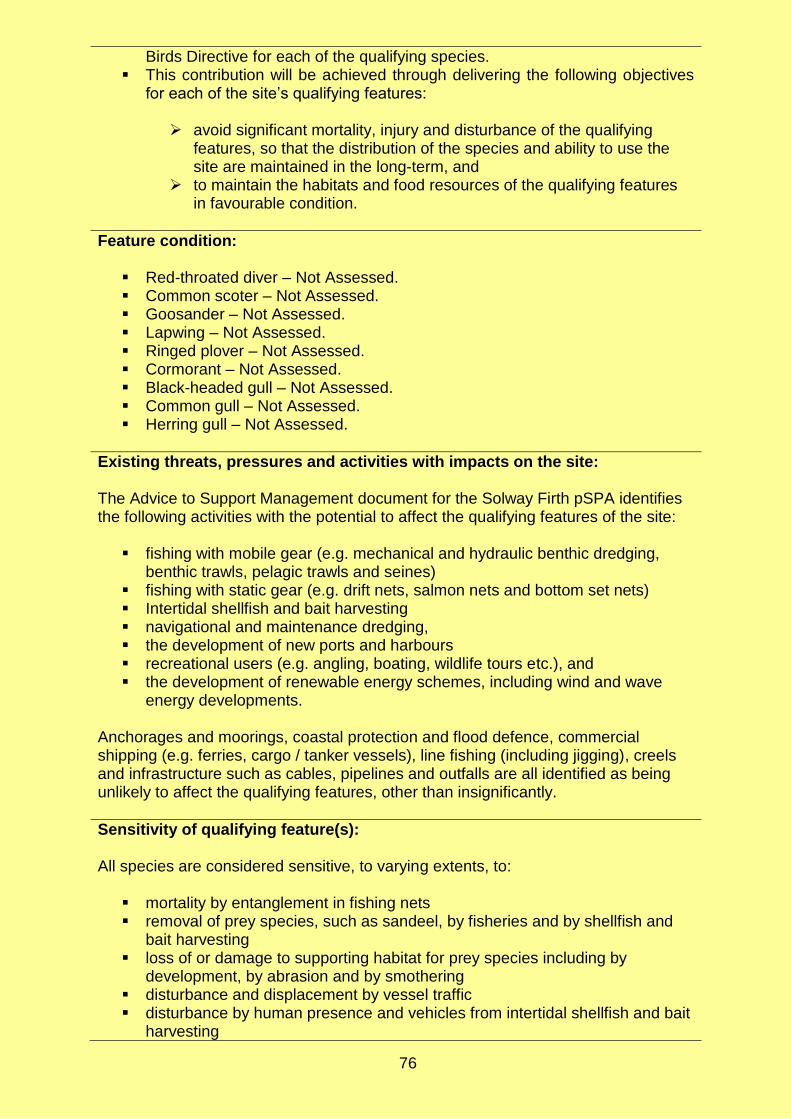
76
Birds Directive for each of the qualifying species. This contribution will be achieved through delivering the following objectives
for each of the site’s qualifying features:
avoid significant mortality, injury and disturbance of the qualifying features, so that the distribution of the species and ability to use the site are maintained in the long-term, and
to maintain the habitats and food resources of the qualifying features in favourable condition.
Feature condition:
Red-throated diver – Not Assessed. Common scoter – Not Assessed. Goosander – Not Assessed. Lapwing – Not Assessed. Ringed plover – Not Assessed. Cormorant – Not Assessed. Black-headed gull – Not Assessed. Common gull – Not Assessed. Herring gull – Not Assessed.
Existing threats, pressures and activities with impacts on the site: The Advice to Support Management document for the Solway Firth pSPA identifies the following activities with the potential to affect the qualifying features of the site:
fishing with mobile gear (e.g. mechanical and hydraulic benthic dredging, benthic trawls, pelagic trawls and seines)
fishing with static gear (e.g. drift nets, salmon nets and bottom set nets) Intertidal shellfish and bait harvesting navigational and maintenance dredging, the development of new ports and harbours recreational users (e.g. angling, boating, wildlife tours etc.), and the development of renewable energy schemes, including wind and wave
energy developments. Anchorages and moorings, coastal protection and flood defence, commercial shipping (e.g. ferries, cargo / tanker vessels), line fishing (including jigging), creels and infrastructure such as cables, pipelines and outfalls are all identified as being unlikely to affect the qualifying features, other than insignificantly.
Sensitivity of qualifying feature(s): All species are considered sensitive, to varying extents, to:
mortality by entanglement in fishing nets removal of prey species, such as sandeel, by fisheries and by shellfish and
bait harvesting loss of or damage to supporting habitat for prey species including by
development, by abrasion and by smothering disturbance and displacement by vessel traffic disturbance by human presence and vehicles from intertidal shellfish and bait
harvesting

77
direct disturbance by new developments such as port expansion and renewable energy developments
disturbance by recreational activities, and mortality through collision with wind and tidal turbines.

78
Sound of Gigha Proposed Special Protection Area (10486)
Date of designation: At consultation stage
Relevant local authority: Marine Scotland (inshore), Argyll and Bute
Total area: 363.3 km2
Proposed qualifying feature(s):
Great northern diver Gavia immer (non-breeding) – the site is estimated to support 505 birds, 20.2% of the non-breeding population in Great Britain, and the second most important site for the species in Scotland.
Eider Somateria mollissima (non-breeding) – the site is estimated to support 1,295 birds, 2.2% of the non-breeding population in Great Britain.
Red-breasted merganser Mergus serrator (non-breeding) – the site is estimated to support 117 birds, 1.4% of the non-breeding population in Great Britain.
Draft conservation objectives:
To avoid deterioration of the habitats of the qualifying species or significant disturbance to the qualifying species, subject to natural change, thus ensuring that the integrity of the site is maintained in the long term and it continues to make an appropriate contribution to achieving the aims of the Birds Directive for each of the qualifying species.
This contribution will be achieved through delivering the following objectives for each of the site’s qualifying features:
avoid significant mortality, injury and disturbance of the qualifying
features, so that the distribution of the species and ability to use the site are maintained in the long-term, and
to maintain the habitats and food resources of the qualifying features in favourable condition.
Feature condition:
Great northern diver – Not Assessed. Eider – Not Assessed. Red-breasted merganser – Not Assessed.
Existing threats, pressures and activities with impacts on the site: The Advice to Support Management document for the Sound of Gigha pSPA identifies the following activities with the potential to affect the qualifying features of the site:
aquaculture of both finfish and shellfish fishing with mobile gear (e.g. mechanical and hydraulic benthic dredging,
benthic trawls, pelagic trawls and seines) fishing with static gear (e.g. drift nets and bottom set nets) navigational and maintenance the development of ports and harbours at Ardminish, Gallochoille, Gigha,
Kennacraig, Machrihanish, Muasdale, Tayinloan and West Loch Tarbert, and increased occurrence of recreation activities such as boating and kayaking.

79
Line fishing, creels and infrastructure such as power interconnectors and telecom cables are all identified as being unlikely to affect the qualifying features, other than insignificantly.
Sensitivity of qualifying feature(s): All species are considered sensitive, to varying extents, to:
mortality by entanglement in fishing nets disturbance and displacement by vessel traffic, and auditory deterrents loss of or damage to supporting habitat for prey species including by
development and by abrasion and smothering removal of prey species by fisheries, and disturbance by recreational activities.

80
West Coast of the Outer Hebrides Proposed Special Protection Area (10484)
Date of designation: At consultation stage
Relevant local authority: Marine Scotland (inshore), Comhairle nan Eilean Siar
Total area: 1,321.7 km2
Proposed qualifying feature(s):
Great northern diver Gavia immer (non-breeding) – the site is estimated to support approximately 52% of the British population of non-breeding great northern diver.
Red-throated diver Gavia stellata (breeding) - the site is estimated to support approximately 4.5% of the British population of breeding red-throated diver.
Black-throated diver Gavia arctica (non-breeding) – the site is estimated to support approximately 7.2% of the British population of non-breeding black-throated diver.
Slavonian grebe Podiceps auritus (non-breeding) – the site is estimated to support approximately 4.6% of the British population of non-breeding Slavonian grebe.
Eider Somateria mollissima (non-breeding) – the site is estimated to support approximately 8.5% of the British population of non-breeding eider.
Long-tailed duck Clangula hyemalis (non-breeding) – the site is estimated to support approximately 7.5% of the British population of non-breeding long-tailed duck.
Red-breasted merganser Mergus serrator (non-breeding) – the site is estimated to approximately 2.8% of the British population of non-breeding red-breasted merganser.
Draft conservation objectives:
To avoid deterioration of the habitats of the qualifying species or significant disturbance to the qualifying species, subject to natural change, thus ensuring that the integrity of the site is maintained in the long term and it continues to make an appropriate contribution to achieving the aims of the Birds Directive for each of the qualifying species.
This contribution will be achieved through delivering the following objectives for each of the site’s qualifying features:
avoid significant mortality, injury and disturbance of the qualifying
features, so that the distribution of the species and ability to use the site are maintained in the long-term, and
to maintain the habitats and food resources of the qualifying features in favourable condition.
Feature condition:
Great northern diver – Not Assessed. Red-throated diver – Not Assessed. Black-throated diver – Not Assessed. Slavonian grebe – Not Assessed. Eider – Not Assessed. Long-tailed duck – Not Assessed. Red-breasted merganser – Not Assessed.
Existing threats, pressures and activities with impacts on the site:

81
The Advice to Support Management document for the West Coast of the Outer Hebrides pSPA identifies the following activities with the potential to affect the qualifying features of the site:
aquaculture of both finfish and shellfish fishing with mobile gear (e.g. mechanical and hydraulic benthic dredging,
benthic trawls, pelagic trawls and seines) fishing with static gear (e.g. drift nets and bottom set nets) navigational and maintenance dredging the development of ports and harbours at Acarsaid, Aird Ma Ruibhe Terminal,
Aird Mhor, Ardhasaig, Ardveenish, Barra, Castlebay, Ceann a Gharaidh, Eriskay, Haunn, Hougharry, Leverburgh, Ludag, Northbay and Pol nan Crann
increased occurrence of recreation activities such as boating and kayaking, and
the development of renewable energy schemes, including wave energy developments.
Anchorages and moorings, line fishing, creels and infrastructure such as cables, pipelines and outfalls are all identified as being unlikely to affect the qualifying features, other than insignificantly.
Sensitivity of qualifying feature(s): All species are considered sensitive, to varying extents, to:
mortality by entanglement in fishing nets and predator deterrent nets disturbance and displacement by vessel traffic and auditory deterrents loss of or damage to supporting habitat for prey species including by
development and by abrasion removal of prey species, such as sandeel, by fisheries inability to hunt due to reduced water clarity disturbance by recreational activities mortality through collision with underwater artificial structures such as wave
devices, and direct disturbance by new developments and wave devices.

82
Ythan Estuary, Sands of Forvie and Meikle Loch Special Protection Area (Proposed marine extension) (10479)
Date of designation: At consultation stage
Relevant local authority: Marine Scotland (inshore), Aberdeen City, Aberdeenshire
Total area: 60.5 km2 (size of extension)
Proposed qualifying feature(s): The Ythan Estuary, Sands of Forvie and Meikle Loch SPA proposed marine extension includes an extension of the boundary of the site into the marine environment and the addition of new qualifying species. The qualifying species of the existing SPA which will be protected by the marine extension are:
Sandwich tern Sterna sandvicensis (breeding) – the existing site is estimated to support approximately 7% of the British population of breeding Sandwich tern and the largest breeding colony in Scotland.
Little tern Sternula albifrons (breeding) – the existing site is estimated to support approximately 1.7% of the British population of breeding little tern, one of the largest breeding colonies in Scotland.
The following species are proposed to be added as qualifying features of the existing part of the SPA:
Lapwing Vanellus vanellus – no further information given. Redshank Tringa totanus – no further information given.
Draft conservation objectives:
To avoid deterioration of the habitats of the qualifying species or significant disturbance to the qualifying species, subject to natural change, thus ensuring that the integrity of the site is maintained in the long term and it continues to make an appropriate contribution to achieving the aims of the Birds Directive for each of the qualifying species.
This contribution will be achieved through delivering the following objectives for each of the site’s qualifying features:
avoid significant mortality, injury and disturbance of the qualifying
features, so that the distribution of the species and ability to use the site are maintained in the long-term, and
to maintain the habitats and food resources of the qualifying features in favourable condition.
Feature condition*:
Little tern – Favourable Maintained (last assessed 2012). Sandwich tern - Favourable Maintained (last assessed 2012). Lapwing – Not Assessed. Redshank – Not Assessed.
*Latest assessed condition as given for the existing Ythan Estuary, Sands of Forvie and Meikle Loch SPA. Unassessed for the extension pSPA.

83
Existing threats, pressures and activities with impacts on the site: The Advice to Support Management document for the site identifies the following activities with the potential to affect the qualifying features of the site:
fishing with mobile gear (e.g. mechanical and hydraulic benthic dredging, benthic trawls, pelagic trawls and seine and vessel movements)
the development of ports and harbours at Aberdeen, Collieston, Newburgh, Port Errol and Whinnyford
increased occurrence of recreation activities such as boating and diving, and the development of renewable energy schemes, including wind farms.
Line fishing, fishing using static gear (including drift nets, bottom set nets and creels), coast protection and flood defence structures and navigational and maintenance dredging are all identified as being unlikely to affect the qualifying features, other than insignificantly.
Sensitivity of qualifying feature(s): Both species are considered sensitive to:
mortality by entanglement in fishing nets removal of prey species, such as herring or sandeel, directly by fisheries and
indirectly by loss of / damage to suitable prey habitat disturbance / loss of prey habitat by new development disturbance by recreational activities direct disturbance by new developments mortality through collision with wind turbines, and alteration of migration flyways or local flight passes due to artificial structures
such as wind turbines.

84
North Channel Special Area of Conservation
Date of designation: March 2019
Relevant local authority: Northern Ireland offshore
Total area: 1,603.7 km2
Qualifying feature(s):
Harbour porpoise Phocoena phocoena – this site is considered to be one of the best areas for harbour porpoise in the United Kingdom.
Conservation objectives:
To ensure that the North Channel SAC continues to make an appropriate contribution to harbour porpoise remaining at favourable conservation status.
To ensure for harbour porpoise within the context of environmental changes, that the integrity of the North Channel SAC is maintained through:
harbour porpoise within the North Channel SAC are not at significant risk from injury or killing
the distribution of harbour porpoise throughout the site is maintained by avoiding significant disturbance, and
the condition of supporting habitats and the availability of prey for harbour porpoise are maintained.
Feature condition:
Harbour porpoise – Favourable (last assessed 2019).
Existing threats, pressures and activities with impacts on the site: The Natura 2000 Standard Data Form for the site identifies the following negative impacts on the qualifying feature(s) (the ‘rank’ of the impact is given in brackets):
marine water pollution (medium) fishing and harvesting aquatic resources (low) exploration and extraction of oil or gas (low) military use and civil unrest (medium), and, shipping lanes, ports and marine constructions (low).
Additional negative impacts were provided in the Conservation Objectives and Advice on Operations document:
underwater sound from anthropogenic sources (e.g. shipping, drilling, dredging), and
collison with ships, recreational boats and tide energy installations.
Sensitivity of qualifying feature(s) The harbour porpoise is a wide-ranging species and, particularly when occurring in coastal waters, are exposed to a range of pressures that are both ubiquitous (e.g. pollution) and patch (e.g. entanglement). The species is considered to be sensitive to:

85
health issues due to poor water quality (e.g. bioaccumulation through contaminated prey)
mortality through entanglement / bycatch in fishing nets mortality / injury / disturbance due to collision with and presence of boats removal of prey species by fisheries loss of or damage to suitable prey habitat (e.g. by development), and mortality / injury / disturbance due to underwater sound.

86
Northumberland Marine Special Protection Area
Date of designation: 29 January 2017
Relevant local authority: Northumberland, Tyne and Wear
Total area: 885 km2
Qualifying feature(s):
Puffin Fratercula arctica (breeding) – the site supports approximately 1.05% of the breeding biogeographic population of puffin.
Little tern Sterna albifrons (breeding) – the site supports approximately 2.37% of the breeding British population of little tern.
Roseate tern Sterna dougallii (breeding) – the site supports approximately 93.02% of the breeding British population of roseate tern.
Common tern Sterna hirundo (breeding) – the site supports approximately 12.86% of the breeding British population of common tern.
Arctic tern Sterna paradisaea (breeding) – the site supports approximately 9.02% of the breeding British population of Arctic tern.
Sandwich tern Sterna sandvicensis (breeding) – the site supports approximately 19.66% of the breeding British population of Sandwich tern.
Guillemot Uria aalge (breeding) – the site supports approximately 1.72% of the breeding biogeographic population guillemot.
Assemblage of breeding seabirds – the site is estimated to support 214,669 breeding seabirds.
Conservation objectives: The conservation objectives are to ensure that, subject to natural change, the integrity of the site is maintained or restored as appropriate, and that the site contributes to achieving the aims of the Birds Directive, by maintaining or restoring:
the extent and distribution of the qualifying features the structure and function of the habitats of the qualifying features the supporting processes on which the habitats of the qualifying features rely the populations of each of the qualifying features, and the distribution of qualifying features within the site. to maintain the habitats and food resources of the qualifying features in
favourable condition.
Feature condition: No features have been formally assessed, however information provided in the Supplementary Advice on Conservation Objectives suggests that there is evidence from survey or monitoring that shows puffin, roseate tern, common tern, Arctic tern, sandwich tern and guillemot are in a good condition and/or currently un-impacted by anthropogenic activities.
Existing threats, pressures and activities with impacts on the site: The Natura 2000 Standard Data Form for the site identifies the following negative impacts on the qualifying feature(s) (the ‘rank’ of the impact is given in brackets):
marine and freshwater aquaculture within the site (low), and

87
outdoor sports and leisure activities and recreational activities within the site (medium).
Sensitivity of qualifying feature(s) All species are considered sensitive, to varying extents, to:
mortality by entanglement in fishing nets disturbance and displacement by vessel movement removal of prey species by fisheries loss of or damage to suitable prey habitat (e.g. by development), disturbance by human presence disturbance and displacement by new development, and disturbance from recreational activities.


![Habitat Regulations Assessment for the Bletsoe Neighbourhood … · 2019-11-27 · 1.1.1 The Conservation of Habitats and Species Regulations 2017 [the Habitats Regulations] require](https://static.fdocuments.in/doc/165x107/5e93cd95f98288519e1851eb/habitat-regulations-assessment-for-the-bletsoe-neighbourhood-2019-11-27-111.jpg)


