RESEARCH Biaamfflffl DE RECHERCHES - Parks Canadaparkscanadahistory.com/series/rb/76.pdf ·...
11
RESEARCH Biaamfflffl DE RECHERCHES NATIONAL HISTORIC PARKS AND SITES BRANCH DIRECTION DES LIEUX ET DES PARCS HISTORIQUES NATIONAUX No. 76 Motherwell Homestead Archaeology Project January 1978 History According to a structural history written for Parks Canada by Ian Clarke (1977), the Motherwell homestead near Abernethy, Saskatchewan was the home of W. R. Motherwell and his descendants from 1883 to the late 1950's. Mr. Motherwell claimed his home quarter in 1883 and built a log house and barn at that time. In 1896 he began to develop a more secure lifestyle by collecting boulders from the Pheasant Creek and Qu'Appelle River valleys and by 1897, he had built a large, two storey, stone bouse and an L-shaped stable of stone. At the same time he began the artificial creation of his own woodland environment reminiscent of the Eastern Townships of Ontario from which he came. In 1907 he constructed a barn over the stable in a Central Ontario style and later constructed a large frame implement shed and a frame hired men's cottage. (Figs. 1, 2.) Motherwell was interested in both his land and home as demonstrated by the care and attention he put into the development of his farmyard. A large garden, an orchard, a sophisticated dugout system, ornamental plantings, flower beds and a tennis lawn were all carefully planned and prepared. In later years he incorporated an experimental field into the west end of his farmyard. He was also an active politician, beooming the first Saskatchewan Minister of Agricxdture in 1905. He later held the same post in the 1922 Federal cabinet of 1922. He died in 1943 but the farm passed on within the family until the late 1950's. The land was then transferred into the hands of the Steuck family until 1967 when the 8 acre homestead plot was purchased as a National Historic Monument by Parks Canada. The size and complexity of the yards was such that the work required to maintain it was always a strain. From the turn of the century there was nearly always hired help or an extended family to add to the labour pool. Motherwell's political salaries did much to support the enterprise. Even so, it was very difficult to maintain the property so repair work Indian and Northern Affairs Parks Canada Affaires indiennes et du Nord Parcs Canada
Transcript of RESEARCH Biaamfflffl DE RECHERCHES - Parks Canadaparkscanadahistory.com/series/rb/76.pdf ·...

RESEARCH Biaamfflffl DE RECHERCHES
NATIONAL HISTORIC PARKS AND SITES BRANCH
DIRECTION DES LIEUX ET DES PARCS HISTORIQUES NATIONAUX
No. 76
Motherwell Homestead Archaeology Project
January 1978
History According to a structural history written for Parks Canada by Ian Clarke (1977), the Motherwell homestead near Abernethy, Saskatchewan was the home of W. R. Motherwell and his descendants from 1883 to the late 1950's. Mr. Motherwell claimed his home quarter in 1883 and built a log house and barn at that time. In 1896 he began to develop a more secure lifestyle by collecting boulders from the Pheasant Creek and Qu'Appelle River valleys and by 1897, he had built a large, two storey, stone bouse and an L-shaped stable of stone. At the same time he began the artificial creation of his own woodland environment reminiscent of the Eastern Townships of Ontario from which he came. In 1907 he constructed a barn over the stable in a Central Ontario style and later constructed a large frame implement shed and a frame hired men's cottage. (Figs. 1, 2.)
Motherwell was interested in both his land and home as demonstrated by the care and attention he put into the development of his farmyard. A large garden, an orchard, a sophisticated dugout system, ornamental plantings, flower beds and a tennis lawn were all carefully planned and prepared. In later years he incorporated an experimental field into the west end of his farmyard. He was also an active politician, beooming the first Saskatchewan Minister of Agricxdture in 1905. He later held the same post in the 1922 Federal cabinet of 1922. He died in 1943 but the farm passed on within the family until the late 1950's. The land was then transferred into the hands of the Steuck family until 1967 when the 8 acre homestead plot was purchased as a National Historic Monument by Parks Canada.
The size and complexity of the yards was such that the work required to maintain it was always a strain. From the turn of the century there was nearly always hired help or an extended family to add to the labour pool. Motherwell's political salaries did much to support the enterprise. Even so, it was very difficult to maintain the property so repair work
Indian and Northern Affairs
Parks Canada
Affaires indiennes et du Nord
Parcs Canada

seldom kept up with construction. When Parks Canada took over, there was much that had disappeared or become unrecognizable with time.
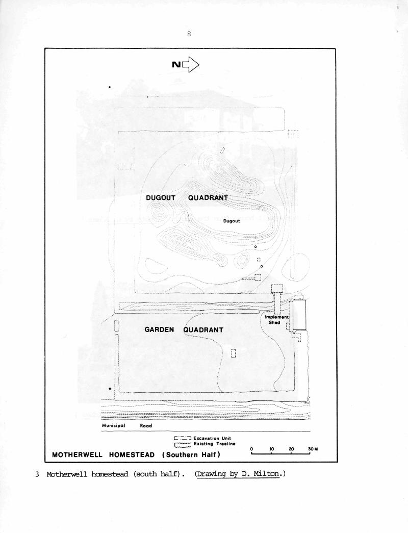
The Archaeological Site Investigation Phase The Motherwell archaeology project was initiated due to the necessity to provide detail to the structural history of the Motherwell Homestead. The overall aims were to assemble information on specific features of uncertain location or construction. Such features included fencelines, treelines, tennis court poles, hotbeds, garbage middens, a wood ramp to gain access to the barn and so on. This form of archaeological probing required that excavations take the form of test pits and trenches scattered throughout the site. (Figs. 3, 4.)
The Motherwell Homestead National Historic Site was completely enclosed by a thick shelter belt of various species of trees and quartered by still other tree rows. The rortheast or shelter quadrant contained a stone house, an orchard, lawns and flower gardens, a lawn tennis court surrounded by a caragana hedge and ornamental shrubbery. The rorthwest or barn quadrant contained the wood and fieldstone bam, chicken coop, caboose, three grainaries, the piggery, barnyard and men's cottage. The southwest or dugout quadrant was completely devoted to the dugout and surrounding hills and tree plantings. These were all arranged in an elaborate system to trap, contain and utilize water. The southeast quadrant, known as the garden, contained an inclement shed, garden, hotbeds and barnyard access road. In order to maintain harmony with original furetions and with the historical report (Clarke 1977), these same quadrants were used by the archaeological field team wherever possible as integrative units.
Excavation was conducted through a series of small operations, each aimed at a specific target feature. The general itethocology was to lay out a grid over the proposed excavation area, tie it in to a datum point and then excavate as warranted. The topsoil in uncultivated areas was often removed by trowel then the supervisor would decide whether the unit should be dug by trowel, shovel shave, shovel shave and screen, or spade. The rrethod, once established, was not rigid and changed to meet altering circumstances.
The archaeological crew involved with excavations at this site included the writer as site supervisor, Susan Glover and Mark Warrack as assistant supervisors and between eight and seventeen workers. A total of 850 man days of work, excavating 896 m^ recovered.approximately 20,000 artifacts. The results of this study are sunTiarized below.
Shelter CAradrant Several units were located around the house to investigate related house features. A unit in the southwest cerner uncovered a pipe through the wall about 10 cm below the surface. A unit in the west wall below the summer kitchen door revealed the foundation of a small 1.0 m by 1.4 m porch while a unit on the northwest corner uncovered the outer wall of an external cistern and a cornec±ing pipe from house to cistern. However, this pipe was not used to drain water.
2

A test unit on the north wall found three subsurface features. The house formed a small "L" on the north wall where the summer kitchen extended north, beyond the house. In this corner a completely buried wooden box measuring 115 cm long by 74 cm wide by 140 cm deep was discovered. It was constructed of upright boards, held in place by cross members. A length of pipe cut through the house wall and this box then extended to a metal drum, filled with charred rocks. From this drum a second pipe length was laid to the surface. These pipes and the interverring rock-filled drum acted as an exhaust, filter and muffler for a Delco generator that had been used to provide electricity for the house since before World War I. Between the drum and the box was a wooden barrel, also filled with charred rocks, that probably acted as a filter before the drum. (Fig. 5.)
Units were excavated in the back yard to determine the location of four concrete blocks that acted as the foundation for a rectangular clothesline. These same four units also uncovered the existence of preparation pits for the planting of an elm tree near each post. The unit at the northeast corner of the clothesline also appeared to contain part of a small garbage midden that probably dated to an early period in the history of the house.
Three excavation units were dug along the north central edge of the tennis court in an attempt to locate post holes. Though no post holes were discovered, three different rows of staples, presumably used to hold cloth border lines in place, were revealed. The existence of three rows strongly indicated that the posts were temporary, perhaps removed each winter.
A series of excavations in the orchard revealed three main features. The orchard proper consisted of three closely planted lines of trees running rorth-south down the centre of the orchard. To either side was a row of shallow pits that were originally some form of hedge, later removed. Also on either side was a fenceline used to keep rabbits out of the orchard.
Other excavation units in the living quadrant were designed to examine the cxrôstruction of the road, the location of front gate posts, the location of specific tree plantings and details on the depth of the house foundation.
Barn ÇAadrant The two largest excavation areas both ocxnrrred in the barn quadrant. Though the men's cottage had been moved to Aberrethy in the late 1950's, the concrete foundation underwent extensive exandnation. The original 1908 foundation which measured 6.4 m north-south by 4.5 m east-west were excavated. To this, there was added a 2.6 m extension to the east and a 2.1 m extension to the south. A third extension consisted of a 6.2 m by 2.7 m basement, detached from the west wall by .8 m. This basement was 1.9 m deep and filled with (discarded concrete and garbage. The front of the larger structure was to the south as indicated by a front doorstep and boardwalk south of the basement, a rock bordered garden along the south extension wall and ornamental shrub plantings along the garden border. A side door was located in the centre of the east
3

extension. There were no construction details except as indicated in the contours of the concrete. (Fig. 6.)
The second major excavation was the earth ramp leading to the main doors in the west wall of the barn. Historic sources revealed that this ramp had been constructed in the late 1930's to replace a rotting wcoden ramp. These sources also indicated that farm irachinery had been used as fill. The ramp was first trenched and then a 5 m wide section closest to the barn was removed. This uncovered a six-bladed breaking plough, four harrows, a mower, a disc plough and several small items. It also uncovered the few remaining fragments of the wood ramp and the animal pens below it. The wood ramp was characterized by fragments of sill beams. (Fig. 7.)
A large block of concrete was exposed and units excavated around it to reveal the piggery. The concrete block was a feeder and sections of fence were found adjacent to both the north and south ends.
Test squares were also dug to the south of both the chicken house and the caboose (cookhouse) . Though the remains of the chicken yard were not located by the coop, remains of a pen were found extending from the caboose. These consisted of chicken wire embedded in a line of cobbles, the southwest corner post and part of the gate.
A dry privy east of the barn caused considerable anxiety. Historical sources indicated that the privy had been located in the same spot for a considerable length of time. Though the superstructure had been knocked over a 1.5 by 1.2 m substructure on skids was found and excavated. However no evidence of a pit was found beneath it. Since extensive testing in the vicinity of the privy failed to reveal any indication of a former pit the tentative conclusion was drawn that the privy had internal containers that were emptied periodically. (Fig. 8 .)
A second ambiguous feature was the barnyard fence. A considerable testing prcxjram was undertaken to determine the location of a former wooden barnyard fence that ran south and east of the barn. These excavations uncovered the east wall, north wall and most of the south wall, but a secondary section to the enclosure, located in the southeast corner and incorporating a p tion of the dugout quadrant, remains conjectural.
An excavation ur was put in to find the location of a driveway running from the bar . the men's cottage between two rows of trees. Other squares were p _n to test a gravel concentration, a coal and artifact concentrât! , tree plantings and a fence line from the barn to the men's cottage.
Dugout Quadrant There was very little work done in the dugout quadrant. A unit was dug to determine the nature of a supposed gravel bed between the well and the dugout. This bed had been intended as a filtration system but the only evidence ever uncovered was of a layer of stones and concrete, too high and too coarse to be of much value.
Other units were inserted to examine the tree plantings between the dugout quadrant and the garden; to look for the extension to the barnyard, and to examine the hills around the dugout.
4

Garden Quadrant Like the dugout quadrant, very little work was done here. The main feature was a hotbed measuring 1.5 by 2.2 m in the south side of the implement shed. It was located 1.2 m out from the iiraplement shed, had board walls and a mulch layer. There was some indication of a second box between the intact example and the implement shed but if this did exist, it had a different purpose as there was very little wood found and no mulch layer.
Other units were put in to examine tree plantings south of the implement shed, east of the implement shed, between the garden and dugout quadrants and between the two halves of the garden.
Outside the Farmyard Permission was received from Mr. Steuck to excavate outside the farmyard where necessary. This enabled several optional projects to be undertaken. The first of these was to find the border of a former experimental field of the north half of the west edge of the yard. An excavation unit uncovered a single row of trees used to border the plot and a fenceline that followed the same path as the trees.
The second problem revolved around the supposed implement graveyard west of the barnyard. Though a few implement pieces were hauled off the surface, testing found no trace of a machiinery graveyard. The only subsurface feature uncovered was a length of wooden fence that may have come from the barnyard fence or may have been part of some other fencing project.
Finally, time was spent looking for the original 1883 log home of W. R. Motherwell but there was no surface ircication of the building in the ploughed fields. As time was a constant limiting factor, this search was abandoned.
Summary As can be observed in the above description, there was very little concentrated excavation, Instead work took the form of a response to particular problems. Seldom was an entire feature excavated, especially since many of these were items such as tree rows, hedges or fencelines. Instead a scheme was adopted where testing could be conducted in a given location for a given feature, then details could be determined by excavation. The overall picture was left to Fngineering and Architecture to determine on the basis of the notes, combined with the structural history, the "as found" report and historic photographs and air photos.
The result of this format was that particular problems were solved but very little unexpected information was found. For instance, there was no previous indication as to the location of a garbage midden. Though several garbage cxricentrations were located in the course of the work, no primary refuse piles were found. Though this method made extremely efficient use of narrower, it was not conducive to good, rotothetic archaeology.
5

Artifacts When analysis is complete, it is expected that the artifacts may provide the best evidence of cultural patterns on the site. Preliminary checks of the approximately 20,000 artifacts have revealed a cross-section of tools related to household, architecture, furniture, farm work, stable, recreation and personal use. Furthermore, there seems to be typological differences associated with different areas of the site. Finally, in uncultivated areas, the stratigraphy seems to be broken into two components, giving an early and late aspect to several of the sub-operations.
Reference Clarke, Ian 1977 'frfotherwell Historic Park Landscape and Outbuildings, Structural and Use History, Final Report." Manuscript on file, Prairie Region, Parks Canada, Winnipeg.
Gary Adams Parks Canada Prairie Region
6

1 Motherwell house from the south. (Photo by G. Adams.)
2 Motherwell barn from the southeast. (Photo by G. Adams.)
7
3 Motherwell homestead (south half). (Drawing by D. Milton.)
8
4 Motherwell homestead (north half). (Drawing by D. Milton.)
9

10
5 Partial excavation of filter systems at north side of house. (Photo by G. Adams.)
6 Excavation of men's cottage from the south. (Photo by G. Adams.)

11
7 Excavation of earth barn ramp. Note implements removed from ramp. (Photo by G. Adams.)
8 Excavation of dry privy floor. (Photo by G. Adams.)