Report of Work - Ontario · Richgold Mines Inc., located in southeast Ogden Township, Porcupine...
21
Report of VLF-EM, and Total Field Magnetic Surveys On the Ogden Grid Ogden Township, Ontario Mining Claim No. 4276213 Porcupine Mining Division For L.B.L. Richgold Mines Inc. November 15, 2014 Matthew Johnston Timmins, Ontario 1226 Gatineau Blvd. Timmins, Ont. P4R 1E3
Transcript of Report of Work - Ontario · Richgold Mines Inc., located in southeast Ogden Township, Porcupine...

Report of VLF-EM, and Total Field Magnetic Surveys
On the
Ogden Grid
Ogden Township, Ontario
Mining Claim No. 4276213
Porcupine Mining Division
For
L.B.L. Richgold Mines Inc.
November 15, 2014 Matthew JohnstonTimmins, Ontario
1226 Gatineau Blvd.Timmins, Ont. P4R 1E3

Table of Contents
Page No.
1.0 Introduction 2
2.0 Location and Access 2
3.0 Summary of 2014 Geophysical and Gridding Program 2
4.0 Discussion of Results 5
5.0 Conclusions and Recommendations 6
Statement of Qualifications
Appendices
Appendix A Geophysical Instruments and Survey Methods
List of MapsMap Scale
Total Field Magnetic Survey - Contours 1:2500Total Field Magnetic Survey – Posted Data 1:2500VLF-EM Profiles – 24.0 kHz. 1:2500

-2-
1.0 Introduction
The Ogden grid is located on the Ogden property which is owned by L.B.L.
Richgold Mines Inc., located in southeast Ogden Township, Porcupine Mining Division.
The Ogden grid in Ogden Township covers portions of or all of mining claim number
4276213. On October 22, 2014; a geophysical survey program consisting of VLF-EM,
and total field magnetic surveys was conducted over a portion of this claim. Yvan
Veronneau of Timmins completed the magnetic and VLF-EM surveys. The geophysical
surveys were performed in order to evaluate and map the presence of disseminated to
massive sulphides with respect to their location, width, and concentrations.
2.0 Location And Access
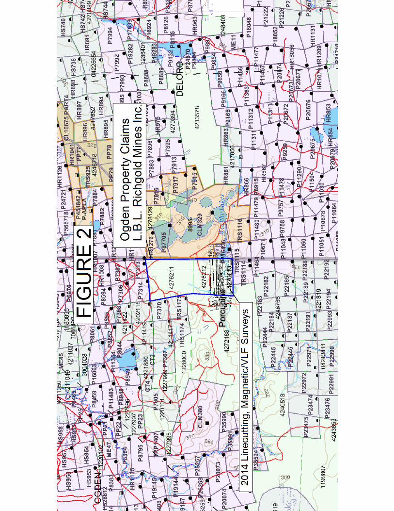
The Ogden property is located approximately 8 kilometers south of the City of
Timmins, Ontario; in southeastern Ogden Township. Access to the grid area is via Pine
St. south from Timmins for approximately 8 kilometers. From this point a number of
bush roads and trails can be accessed by four wheel drive vehicles, ATV, or snowmobiles
for 1 kilometers in a southerly direction to the northern area of the grid (see figures 1 and
2).
3.0 Summary of 2014 Geophysical Program
The geophysical grid totaled 5.24 kilometers, which consisted of a 0.40 kilometer
long baseline striking at approximately 0 degrees. The lines were established every 50
meters along this baseline and surveyed to a lengths of between of 200 and 700 meters.
The base line, grid lines, and all geophysical measurement locations were established via
a cut grid. Line cutting totaled 7.4 km., however only 5.24 km. were available to be
surveyed due to subsequent flooding of parts of the grid area. The grid lines were
measured every 50 meters with measurements recorded at 12.5-meter intervals along all
lines.
The geophysical program consisted of total field magnetic surveying, and VLF-
EM electromagnetic surveying. The total magnetic field survey and VLF-EM survey,

-5-
using a GEM GSM-19 magnetometer/VLF system, totaled 5.24 kilometers with readings
collected every 12.5 meters along all lines. The VLF-EM survey was conducted utilizing
the transmitting station located in Cutler, Maine; which transmits at a frequency of 24.0
kHz. A total of 5.24 kilometers of VLF data was collected at 12.5-meter station intervals.
The geophysical data has been presented on plan maps at a scale of 1:2500,
showing the profiles and postings of the VLF-EM survey, and contours and postings of
the magnetic data (see maps in pocket).
A description of the survey method and equipment used can be found in
Appendix A.
4.0 Discussion of Results
The magnetic survey on the Ogden grid indicates a relatively active magnetic
background disrupted by several anomalous magnetic anomalies with magnetic values
ranging between 55806.22 and 66217.07 nT. The background magnetic field strength is
57726 nT. The isomagnetic contour pattern suggests an underlying lithology striking in
an generally north-westerly (azimuth 120 degrees) direction through the grid area. All of
the anomalies are easily identified and are labeled on the plan maps. The overall
magnetic pattern is disrupted by several strong anomalous magnetic highs striking at
approximately 70 degrees azimuth. These magnetic anomalies have been identified and
labeled as M1 through M4 and are located in the southwest and northeast portions of the
grid area and are easily seen on the magnetic contour map. These magnetic anomalies
may represent mafic diabase dikes, common to this geologic setting or possibly mafic or
ultramafic lithology.
The magnetic data has been presented on plan maps at a scale of 1:2500, showing
the contours and postings, as well as the interpretations (see maps in pocket).
The VLF-EM survey over the Ogden grid was successful in mapping several
electromagnetic conductive trends. Three conductive trends were interpreted and
identified as V1 to V3, and are shown on the VLF profile and magnetic contour maps.
The most significant conductive trends were mapped as V1 and V2. These conductive

-6-
trends may be reflecting faults or structures containing mineralization which may be
significant to the present exploration program. VLF anomaly V2 is adjacent to and
parallel to magnetic anomaly M4. All of the VLF-EM anomalies strike in a direction
parallel to the dominant strike direction indicated by the magnetic survey, of
approximately 120 degrees azimuth.
The VLF-EM geophysical data has been presented on plan maps at a scale of
1:2500, showing the profiles and postings of the VLF-EM survey as well as the
interpreted VLF-EM conductor axis locations.
5.0 Conclusions and Recommendations
The VLF-EM, and magnetic surveys completed over the Ogden grid were
successful in mapping several areas of VLF-EM conductors and magnetic anomalies.
The most significant anomalies appear to be the VLF-EM anomalies V1 and V2. These
anomalies may reflect steeply dipping, weakly to moderately mineralized bedrock
conductive horizons.
It is recommended that a program of induced polarization surveying would
greatly aid in better defining any possible mineralized zones indicated by the magnetic
and VLF survey results. The VLF-EM surveys may be reflecting relatively shallow,
disseminated or semi-massive accumulations of sulphide minerals. The IP surveys would
greatly enhance the understanding these zones as they are often prospective for gold and
base metal deposits. A limited program of either dipole-dipole or pole-dipole IP
surveying with an 'a' spacing of 25 meters and reading levels of n=1 to 6 is recommended
in order to further evaluate the Ogden property.
All of the responses should be investigated further in order to determine the
priority of follow-up needed. The anomalies should be further screened utilizing any
other different types of geophysical surveys that may have been undertaken on the
Ogden grid. This would aid greatly in further refining the interpretation of the I.P. survey.
Any existing geological, diamond drilling or geochemical information that may exist in

-7-
the mining recorder assessment files should be investigated and compiled prior to further
exploration of the Ogden property in order to accurately assess the area of the
current geophysical surveys and to determine the most effective follow-up exploration
method for this property.
Respectively Submitted,
Matthew Johnston

Statement of Qualifications
This is to certify that: MATTHEW JOHNSTON
I am a resident of Timmins; province of Ontario since June 1, 1995.
I am self-employed as a Consulting Geophysicist, based in Timmins, Ontario.
I have received a B.Sc. in geophysics from the University of Saskatchewan; Saskatoon, Saskatchewan in 1986.
I have been employed as a professional geophysicist in mining exploration, environmental and other consulting geophysical techniques since 1986.
Signed in Timmins, Ontario, this November 15, 2014

Appendix A

Introduction The GSM-19 v7.0 Overhauser instrument is the total field magnetometer / gradiometer of choice in today’s earth science environment -representing a unique blend of physics, data quality, operational efficiency, system design and options that clearly differentiate it from other quantum magnetometers.
With data quality exceeding standard proton precession and comparable to costlier optically pumped cesium units, the GSM-19 is a standard (or emerging standard) in many fields, including:
* Mineral exploration (ground and airborne base station)
* Environmental and engineering * Pipeline mapping * Unexploded Ordenance Detencion
* Archeology * Magnetic observatory measurements * Volcanology and earthquake
prediction
Taking Advantage of the Overhauser Effect
GSM-19 v7.0Overhauser
Magnetometer / Gradiometer / VLF
Overhauser effect magnetometers are essentially proton precession devices except that they produce an order-of magnitude greater sensitivity. These "supercharged" quantum magnetometers also deliver high absolute accuracy, rapid cycling (up to 5 readings / second), and exceptionally low power consumption. The Overhauser effect occurs when a special liquid (with unpaired electrons) is combined with hydrogen atoms and then exposed to secondary polarization from a radio frequency (RF) magnetic field. The unpaired electrons transfer their stronger polarization to hydrogen atoms, thereby generating a strong precession signal-- that is ideal for very high-sensitivity total field measurement.
In comparison with proton precession methods, RF signal generation also keeps power consumption to an absolute minimum and reduces noise (i.e. generating RF frequencies are well out of the bandwidth of the precession signal).
In addition, polarization and signal measurement can occur simultaneously - which enables faster, sequential measurements. This, in turn, facilitates advanced statistical averaging over the sampling period and/or increased cycling rates (i.e. sampling speeds).
The unique Overhauser unit blends physics, data quality, operational efficiency, system design and options into an instrumentation package that ... exceeds proton precession and matches costlier optically pumped cesium capabilities. And the latest v7.0 technology up-grades provide even more value, including: - Data export in standard XYZ (i.e. line-oriented) format for easy use in standard commercial software programs - Programmable export format for full control over output
- GPS elevation values provide input for geophysical modeling
- <1.5m standard GPS for high- resolution surveying
- <1.0 OmniStar GPS
- <0.7m for Newly introduced CDGPS
- Multi-sensor capability for advanced surveys to resolve target geometry
- Picket marketing / annotation for capturing related surveying information on the go.
And all of these technologies come complete with the most attractive prices and warranty in the business!
Terraplus Inc. 52 West Beaver Cr. Rd. #12, Richmond Hill, ON. Canada L4B 1L9
Tel: 905-764-5505 Fax: 905-764-8093
Email: [email protected] Website: www.terraplus.ca

MAGNETOMETERS
Maximizing Your Data Quality with the GSM-19
Data quality is a function of five key parameters that have been taken into consideration carefully in the design of the GSM-19. These include sensitivity, resolution, absolute accuracy, sampling rates and gradient tolerance.
Sensitivity is a measure of the signal-to noise ratio of the measuring device and reflects both the underlying physics and electronic design. The physics of the Overhauser effect improves sensitivity by an order of magnitude over conventional proton precession devices. Electronic enhancements, such as high-precision precession frequency counters enhance sensitivity by 25% over previous versions.
The result is high quality data with sensitivities of 0.022 nT / vHz. This sensitivity is alsothe same order-of magnitude as costieroptically pumped cesium systems.
Resolution is a measure of the smallest number that can be displayed on the instrument (or transmitted via the download process). The GSM-19 has unmatched resolution (0.01mT)
This level of resolution translates into well-defined, characteristic anomalies; improved visual display; and enhanced numerical data for processing and modeling.
Absolute accuracy reflects the closeness to the "real value" of the magnetic field -- represented by repeatability of readings either at stations or between different sensors. With an absolute accuracy of +/- 0.1 nT, the GSM-19 delivers repeatable station-to-station results that are reflected in high quality total field results.
Similarly, the system is ideal for gradient installations (readings between different sensors do not differ by more than +/- 0.1 nT) -- maintaining the same high standard
of repeatability.
Data from Kalahari Desert kimberlites. Courtesy of MPH Consulting (project managers), IGS c. c. (geophysical contractor) and Aegis Instruments (Pty) Ltd., Botswana.
The GSM-19 gradiometer data are consistently low in noise and representative of the geologic environment under investigation.
Sampling rates are defined as the fastest speed at which the system can acquire data. This is a particularly important parameter because high sampling rates ensure accurate spatial resolution of anomalies and increase survey efficiency.
The GSM-19 Overhauser system is configured for two "measurement modes" or maximum sampling rates --"Standard" (3 seconds / reading), and"Walking" (0.2 seconds / reading)These sampling rates make the GSM-19 a truly versatile system forall ground applications (including vehicle-borne applications).
Gradient tolerance represents the ability to obtain reliable measurements in the presence of extreme magnetic field variations. GSM-19 gradient tolerance is maintained through internal signal counting algorithms, sensor design and Overhauser physics. For example, the Overhauser effect produces high amplitude, long-duration signals that facilitate measurement in high gradients.
The system's tolerance (10,000 nT / meter) makes it ideal for many challenging environments -- such as highly magnetic rocks in mineral exploration applications, or near cultural objects in environmental, UXO or archeological applications.
Total Field and Stationary Vertical Gradient showing the gradient largely
unaffected by diurnal variation. Absolute accuracy is also shown to be
very high (0.2 nT/meter).
Much like an airborne acquisition system, the GSM19 “Walking” magnetometer option delivers very
highly-sampled, high sensitivity results that enable very accurate target location and / or earth science
decision-making.
Terraplus Inc. Tel: 905-764-5505 Email: [email protected] 52 West Beaver Cr. Rd. #12, Richmond Hill, ON. Canada L4B 1L9 Fax: 905-764-8093 Website: www.terraplus.ca

Increasing Your Operational Efficiency Many organizations have standardized their magnetic geophysical acquisition on the GSM-19 based on high performance and operator preference. This preference reflects performance enhancements such as memory capacity; portability characteristics; GPS and navigation; and dumping and processing. Memory capacity controls the efficient daily acquisition of data, acquisition of positioning results from GPS, and the ability to acquire high resolution results (particularly in GSM-19’s "Walking" mode). V7.0 upgrades have established the GSM19 as the commercial standard for memory with over 1,465,623 readings (based on a basic configuration of 32Mbytes of memory and a survey with time, coordinate, and field values).
Portability characteristics (ruggedness, light weight and power consumption) are essential for operator productivity in both normal and extreme field conditions.
GSM-19 Overhauser magnetometer is established globally as a robust scientific instrument capable of withstanding temperature, humidity and terrain extremes. It also has the reputation as the lightest and lowest power system available -- reflecting Overhauser effect and RF polarization advantages.
In comparison with proton precession and optically pumped cesium systems, the GSM-19 system is the choice of operators as an easy-to-use and robust system.
GPS and navigation options are increasingly critical considerations for earth science professionals.
GPS technologies are revolutionizing data acquisition -- enhancing productivity, increasing spatial resolution, and providing a new level of data quality for informed decision-making.
The GSM-19 is now available with real-time GPS and DGPS options in different survey resolutions. For more details, see the GPS and DGPS section.
The GSM-19 can also be used in a GPS Navigation option with real-time coordinate transformation to UTM, local X-Y coordinate rotations, automatic end of line flag, guidance to the next line, and survey "lane" guidance with cross-track display and audio indicator.
Other enhancements include way point pre-programming of up to 1000 points. Professionals can now define a complete survey before leaving for the field on their PC and download points to the magnetometer via RS-232 connection.
The operator then simply performs the survey using the way points as their survey guide. This capability decreases survey errors, improves efficiency, and ensures more rapid survey completion.
Dumping and processing effectiveness is also a critical consideration today. Historically, up to 60% of an operator's "free" time can be spent on low-return tasks, such as data dumping.
Data dumping times are now significantly reduced through GEM’s implementation of high-speed, digital data links (up to 115 kBaud).
MAGNETOMETERS
This functionality is faciliated through a new RISC processor as well as the new GSM-19 data acquisition / display software. This software serves as a bi-directional RS-232 terminal. It also has integrated processing functionality to streamline key processing steps, including diurnal data reduction. This software is provided free to all GSM19 customers and regular updates are available.
Navigation and Lane Guidance
The figure above shows the Automatic Grid (UTM, Local Grid, and Rotated Grid). With the Rotated Grid, you can apply an arbitrary origin of your own definition. Then, the coordinates are always in reference to axes parallel to the grid. In short, your grid determines the map, and not the NS direction.
The Local Grid is a scaled down, local version of the UTM system, and is based on your own defined origin. It allows you to use smaller numbers or ones that are most relevant to your
The figure below shows how programmable-waypoints can be
waypoints and enter them via PC or the keyboard. In the field, the unit guides you to each point.
While walking between waypoints, lane guidance keeps you within a lane of predefined width using arrows (< - or - >) to indicate left or right. Within the lane, the display uses horizontal bars (- -) to show your relative position in the lane. The display also shows the distance (in meters) to the next waypoint.
survey.
used to plan surveys on a point-by-point basis. Initially, you define
Terraplus Inc. Tel: 905-764-5505 Email: [email protected] 52 West Beaver Cr. Rd. #12, Richmond Hill, ON. Canada L4B 1L9 Fax: 905-764-8093 Website: www.terraplus.ca

Adding Value through Options
When evaluating the GSM-19 as a solution for your geophysical application, we recommend considering the complete range of options described below. These options can be added at time of original purchase or later to expand capabilities as your needs change or grow.
Our approach with options is to provide you with an expandable set of building blocks:
* Gradiometer * *
Walking- Fast Magnetometer / Gradiometer VLF (3 channel)
* GPS (built-in and external)
GSM-19G Gradiometer Option
The GSM-19 gradiometer is a versatile, entry level system that can be upgraded to a full-featured "Walking" unit (model GSM-19WG) in future.
The GSM-19G configuration comprises two sensors and a "Standard" console that reads data to a maximum of 1 reading every three seconds.
An important GSM-19 design feature is that its gradiometer sensors measure the two magnetic fields concurrently to avoid any temporal variations that could distort gradiometer readings. Other features, such as single-button data recording, are included for operator ease-of-use.
GSM-19W / WG "Walking" Magnetometer / Gradiometer Option
The GSM-19 was the first magnetometer to incorporate the innovative "Walking" option which enables the acquisition of nearly continuous data on survey lines. Since its introduction, the GSM-19W / GSM-19WG have become one of the most popular magnetic instruments in the world.
Similar to an airborne survey in principle, the system records data at discrete time intervals (up to 5 readings per second) as the instrument is carried along the line.
At each survey picket (fiducial), the operator touches a designated key. The system automatically assigns a picket coordinate to the reading and linearly interpolates the coordinates of all intervening readings (following survey completion during post-processing).
A main benefit is that the high sample density improves definition of geologic structures and other targets (UXO, archeological relics, drums, etc.).
It also increases survey efficiency because the operator can record data almost continuously. Another productivity feature is the instantaneous recording of data at pickets. This is a basic difference between the “Walking” version and the GSM-19 / GSM-19G (the “Standard” mode version which requires 3 seconds to obtain a reading each time the measurement key is pressed).
GSM-19 "Hands-Free" Backpack Option The "Walking" Magnetometer and Gradiometer can be configured with an optional backpack-supported sensor. The backpack is uniquely constructed permitting measurement of total field or gradient with both hands free. This option provides greater versatility and flexibility, which is particularly valuable for high-productivity surveys orin rough terrain.
MAGNETOMETERS
GSM-19GV "VLF" Option
With its omnidirectional VLF option, up to 3 stations of VLF data can be acquired without orienting. Moreover, the operator is able to record both magnetic and VLF data with a single stroke on the keypad.
3rd Party Software - A One-Stop Solution for Your Potential Field Needs
As part of its complete solution approach, Terraplus offers a selection of proven software packages. These packages let you take data from the field and quality control stage right through to final map preparation and modeling.
Choose from the following packages:
* Contouring and 3D Surface Mapping
* Geophysical Data Processing & Analysis
* Semi-Automated Magnetic Modeling
* Visualization and Modeling / Inversion
Geophysical Data Processing and Analysis from Geosoft Inc.
GSM-19 with internal GPS board. Small receiver attaches above sensor
Terraplus Inc. Tel: 905-764-5505 Email: [email protected] 52 West Beaver Cr. Rd. #12, Richmond Hill, ON. Canada L4B 1L9 Fax: 905-764-8093 Website: www.terraplus.ca

Version 7 -- New Milestones in Magnetometer Technology
The recent release of v7.0 of the GSM-19 system provides many examples of the ways in which we continue to advance magnetics technologies for our customers.
Enhanced data quality:
* 25% improvement in sensitivity (new frequency counting algorithm)
* new intelligent spike-free algo rithms (in comparison with other manufacturers, the GSM-19 does not apply smoothing or filtering to achieve high data quality)
Improved operational efficiency:
* Enhanced positioning (GPS engine with optional integrated / external GPS and real-time navigationl)
* 16 times increase in memory to 32 Mbytes
* 1000 times improvement in processing and display speed (RISC microprocessor with 32-bit data bus) 2 times faster digital data link (115 kBaud through RS-232)
Innovative technologies:
* Battery conservation and survey flexibility (base station scheduling option with 3 modes - daily, flexible and immediate start)
* Survey pre-planning (up to 1000 programmable waypoints that can be entered directly or downloaded from PC for greater efficiency)
* Efficient GPS synchronization of field and base units to Universal Time (UTC)
* Cost saving with firmware up grades that deliver new capabilities via Internet
MAGNETOMETERS More About the Overhauser System
In a standard Proton magnetometer, current is passed through a coil wound around a sensor containing a hydrogenrich fluid. The auxiliary field created by the coil (>100 Gauss) polarizes the protons in the liquid to a higher thermal equilibrium.
When the current, and hence the field, is terminated, polarized protons precess in the Earth's field and decay exponentially until they return to steady state. This process generates precession signals that can be measured as described below.
Overhauser magnetometers use a more efficient method that combines electronproton coupling and an electron-rich liquid (containing unbound electrons in a solvent containing a free radical). An RF magnetic field -- that corresponds to a specific energy level transition -- stimulates the unbound electrons.
Instead of releasing this energy as emitted radiation, the unbound electrons transfer it to the protons in the solvent. The resulting polarization is much larger, leading to stronger precession signals.
Both Overhauser and proton precession, measure the scalar value of the magnetic field based on the proportionality of precession frequency and magnetic flux density (which is linear and known to a high degree of accuracy). Measurement quality is also calculated using signal amplitude and its decay characteristics. Values are averaged over the sampling period and recorded.
With minor modifications (i.e. addition of a small auxiliary magnetic flux density while polarizing), it can also be adapted for high sensitivity readings in low magnetic fields. (ex. for equatorial work)
GPS - Positioning You for Effective Decision Making
The use of Global Positioning Satellite (GPS) technology is increasing in earth science disciplines due to the ability to make better decisions in locating and following up on anomalies, and in improving survey cost effectiveness and time management.
Examples of applications include: Surveying in remote locations with no grid
* High resolution exploration mapping * High productivity ferrous ordnance (UXO) detection * Ground portable magnetic and gradient surveying for environmental
and engineering applications * Base station monitoring for observing diurnal magnetic activity and
disturbances with integrated GPS time
The GSM-19 addresses customer requests for GPS and high-resolution Differential GPS (DGPS) through both the industry’s only built-in GPS (as well as external GPS).
Built-in GPS offers many advantages such as minimizing weight and removing bulky components that can be damaged through normal surveying. The following table summarizes GPS options.
system (for example, in the high Arctic for diamond exploration)
Terraplus Inc. Tel: 905-764-5505 Email: [email protected] 52 West Beaver Cr. Rd. #12, Richmond Hill, ON. Canada L4B 1L9 Fax: 905-764-8093 Website: www.terraplus.ca

MAGNETOMETERS
Key System Components
Key components that differentiate the GSM-19 from other systems on the market include the sensor and data acquisition console. Specifications for components are provided on the right side of this page.
Sensor Technology
Overhauser sensors represent a proprietary innovation that combines advances in electronics design and quantum magnetometer chemistry.
Electronically, the detection assembly includes dual pick-up coils connected in series opposition to suppress far-source electrical interference, such as atmospheric noise. Chemically, the sensor head houses a proprietary hydrogen-rich liquid solvent with free electrons (free radicals) added to increase the signal intensity under RF polarization.
From a physical perspective, the sensor is a small size, light-weight assembly that houses the Overhauser detection system and fluid. A rugged plastic housing protects the internal components during operation and transport.
All sensor components are designed from carefully screened non-magnetic materials to assist in maximization of signal-to-noise. Heading errors are also minimized by ensuring that there are no magnetic inclusions or other defects that could result in variable readings for different orientations of the sensor.
Optional omni-directional sensors are Performance available for operating in regions where the magnetic field is near-horizontal (i.e. Sensitivity: 0.022 nT / vHz@1Hzequatorial regions). These sensors Resolution: 0.01 nT maximize signal strength regardless of Absolute Accuracy: +/- 0.1 nTfield direction. Dynamic Range: 15,000
to 120,000 nTData Acquisition Gradient Tolerance: > 10,000 nT/m Console Technology Sampling Rate: 60+, 3, 2, 1,
0.5, 0.2 sec
Console technology comprises an Operating Temp: -40C to +55C
external keypad / display interface with internal firmware for frequency counting, Operating Modes system control and data storage / retrieval. For operator convenience, the Manual: display provides both monochrome text Coordinates, time, date and reading as well as real-time profile data with an stored automatically at minimum 3 easy to use interactive menu for per- second interval. forming all survey functions. Base Station:
Time, date and reading stored at 3 toThe firmware provides the convenience 60 second intervals. of upgrades over the Internet via its Remote Control: software. The benefit is that instrumen- Optional remote control using RS-232tation can be enhanced with the latest interface.technology without returning the system Input / Output:to us -- resulting in both timely implementation of updates and reduced RS-232 or analog (optional) output
shipping / servicing costs. using 6-pin weatherproof connector
Storage - 32Mbytes (# of Readings) Mobile: 1,465,623Base Station: 5,373,951Gradiometer: 1,240,142Walking Magnetometer: 2,686,975
Dimensions Console: 223 x 69 x 240 mmSensor: 175 x 75mm diameter cylinder
Weights Console: 2.1 kgSensor and Staff Assembly: 1.0 kg
Standard Components GSM-19 console, GEMLinkW software, batteries, harness, charger, sensor with cable, RS-232/USB cable, staff, instruction manual and shipping case.
Optional VLF Frequency Range: Up to 3 stations between 15 to 30.0 kHz Parameters: Vertical in-phase and out-of phase
components as % of total field. 2 components of the horizontal field amplitude and total field strenght in pT Resolution: 0.1% of total field
Terraplus Inc. Tel: 905-764-5505 Email: [email protected] 52 West Beaver Cr. Rd. #12, Richmond Hill, ON. Canada L4B 1L9 Fax: 905-764-8093 Website: www.terraplus.ca
AF
Text Box
GPS Options: Description Range Services Time GPS Option A Reception only GPS Option B <1.5m DGPS* GPS Option C <1.0m Ag 114 DGPS*, OmniStar <0.7m GPS Option D <1.2m CDGPS, DGPS *, <1.0M OmniStar. Output Time, Lat / Long, UTM, Elevation and number of Satellites *DGPS with SBAS (WASS/EGNOS/MSAS)
AF
Text Box
AF
Pencil
AF
Pencil
AF
Pencil
AF
Pencil
AF
Pencil
AF
Pencil
AF
Pencil
AF
Pencil
AF
Pencil
AF
Pencil
AF
Pencil
AF
Pencil
AF
Pencil
AF
Pencil
AF
Pencil
AF
Pencil
AF
Pencil
AF
Pencil
AF
Pencil
AF
Pencil
AF
Pencil
AF
Pencil
AF
Pencil
AF
Pencil
AF
Pencil
AF
Pencil
AF
Pencil
AF
Pencil
AF
Pencil
AF
Pencil
AF
Pencil
AF
Pencil
AF
Pencil

The VLF Method• The very low frequency (VLF) method is a reconnaissance electromagnetic technique used mainly in
mineral exploration • The method makes use of powerful VLF transmitters (3-30 kHz) that are used for military communications • The U.S. Navy operates 11 transmitters that serve as standard VLF sources for geophysical work
• The VLF method is essentially a tilt-angle technique. In the absence of any conductive body, the secondary field is zero, and the resultant (primary) magnetic field is thus horizontal. If a conductor is present, the associated secondary field will cause the resultant to be tilted.
• Flux linkage analysis can be used to show that vertically above the conductor, the tile angle passes through zero (see Reynolds, 1997, p. 656).
• VLF signal strength diminishes rapidly with depth (i.e., the skin depth is small). Consequently, VLF methods are primarily used to detect near-surface features, and not for depth-sounding. Data acquisition:
• The most common field technique (VLF-EM) uses a hand-held antenna. In older systems, an audio signal is nulled to determine the tilt angle. In newer systems, data acquisition is entirely digital (push one button, the electronics do the rest). The measured parameters are tilt angle (in degrees) and quadrature component (in %).
• Another field technique, known as VLF-R, uses an electrical dipole. Measured parameters are apparent resistivity (Ohm-m) and quadrature component (%).

Survey Theory - Total Field Magnetics
Magnetic Survey
Theory:
The magnetic method is based on measuring alteration in the shape and magnitude of the
earth's naturally occurring magnetic field caused by changes in the magnetization of the
rocks in the earth. These changes in magnetization are due mainly to the presence of the
magnetic minerals, of which the most common is magnetite, and to a lesser extent
illuminate, pyrrhotite, and some less common minerals. Magnetic anomalies in the
earth's filed are caused by changes in two types of magnetization: (1) Induced, caused by
the magnetic field being altered and enhanced by increases in the magnetic susceptibility
of the rocks, which is a function of the concentration of the magnetic minerals. (2)
Remanent magnetism is independent of the earth's magnetic field, and is the permanent
magnetization of the magnetic particles (magnetite, etc.) in the rocks. This is created
when these particles orient themselves parallel to the ambient field when cooling. This
magnetization may not be in the same direction as the present earth's field, due to changes
in the orientation of the rock or the field. The unit of measurement (variations in
intensity) is commonly known as the Gamma which is equivalent to the nanotesla (nT).
Method:
The magnetometer, a GEM Systems GSM-19 with an Overhauser sensor measures the
Total Magnetic Field (TFM) perpendicular to the earth's field (horizontal position in the
polar region). The unit has no moving parts, produces an absolute and relatively high
resolution measurement of the field and displays the measurement on a digital lighted
display and is recorded (to memory). Initially, the tuning of the instrument should agree
with the nominal value of the magnetic field for each particular area. The Overhauser
procession magnetometer collected the data with a 0.2 nanoTesla accuracy. The
operator read each and every line at a 12.5 m intervals with the sensor attached to the top
of four (56cm), aluminum tubing sections. The readings were corrected for changes in
the earth's magnetic field (diurnal drift) with a similar GSM-19 magnetometer, acting as a
stationary base station which automatically read and stored the readings at every 15
seconds. The data from both units was then downloaded to PC and base corrected values
were computed.

Interpreted Magnetic Anomaly Location/Trend
Interpreted VLF-EM Conductor Location/Trend
Legend
Interpreted Location of Magnetic Lineament/Fault
57000 57140 57160 57180 57200 57220 57240 57280 57340 57430 57550 57620 57710 57810 57960 58170 58640 59360
Total Field MagneticsnT
0 2 1 7 5
0 4 1 7 5
04
17
5
0 6 1 7 5
06
17
5
5 7 1 6 0
0 8 1 7 5
57180
08 1 7 5
08
17
5
57220
0 2 2 75
0 2 2 7 5
02275
04
27
5
5 7 2 40
0 4 2 7 5
5 7 2 4 0
5 7 2 4 0
06
27
5
04
37
5
04375
5 7 3 6 0
0 2 4 7 5
04475
0 6 4 7 5
04
57
5
04
67
5
04
67
5
57720
57740
0 0 1 7 5
00 1 7 5
0 0 2 7 5
5 7 2 00
5 7 2 0 0
0 0 2 7 5
5 7 2 0 0
0 0 2 7 5
00
37
5
5 7 300
5 7 3 0 0
00
47
5
00575
006
75
00
77
5
57800
V1
V2
V3

50 0 50 100 150
(meters)
NAD83 / UTM zone 17N
Scale 1:2500
L.B.L. RICHGOLD MINES INC.
OGDEN TWP. PROJECT
VLF-EM 24.0 kHz. PROFILES
OCTOBER 22 - 2014
OGDEN TWP. PORCUPINE MINING DIVISIONCLAIM NO. 4276213
VLF-EM OMNI DIRECTIONAL RECEIVERINSTRUMENT: GEM SYSTEMS GSM-19 MAGNETOMTER/VLF
SURVEYED BY: YVAN VERRONEAU
Interpreted VLF-EM Conductor Location/Trend
Legend
VLF PROFILES
1 cm. = 20 %
- PROFILE +
---- IP POSTING Q - - -
-10 -5
-30 -15
30 15
10 5
NAA CUTLER, ME. 24.0 kHz.INSTRUMENT : GEM SYSTEM GSM-19 MAGNETOMETER/VLF
LINE KILOMETERS SURVEYED: 5.24
5360400N
5360500N
5360600N
5360700N
5360800N
5360900N
5360400N
5360500N
5360600N
5360700N
5360800N
5360900N
474500E 474600E 474700E 474800E 474900E 475000E 475100E 475200E
474500E 474600E 474700E 474800E 474900E 475000E 475100E 475200E
V1
V2
V3
-10.7
-16.4
-15.7
-20.0
-19.3
-23.7
-28.2
-33.4
-34.7
-36.3
-29.5
-26.6
-17.7
-12.5
- 3.3
6.6
11.6
4.1
- 0.9
- 2.3
- 6.4
- 8.7
- 7.1
- 7.6
- 5.3
- 3.7
4.4
6.1
5.4
5.0
9.0
13.7
14.3
15.8
17.8
18.8
18.0
16.8
12.6
10.9
2.3
4.7
0.8
3.1
3.1
3.9
8.1
4.2
5.0
4.6
2.5
0.8
0.9
- 1.5
6.2
11.5
4.4
0.3
-10.1
-10.8
-12.3
-5.9
-0.3
6.2
9.8
12.0
14.3
23.9
23.1
26.9
26.2
21.8
24.4
27.1
25.9
23.4
19.0
15.3
10.4
7.0
8.7
3.7
2.8
-0.8
-0.3
2.8
3.3
1.4
1.9
-3.4
-2.8
-3.1
-4.1
-0.6
0.0
2.4
3.1
6.3
8.3
0.3
-11.0
-20.9
-34.4
-32.7
-28.9
-27.3
-25.9
-27.0
-28.9
-29.6
-29.1
-22.8
-21.3
-14.8
-10.4
-18.1
-20.2
-21.3
-25.5
-28.3
-35.0
-35.3
-35.7
-34.8
-36.6
-35.1
-37.2
-37.7
-42.5
-36.0
-23.3
-21.4
-22.2
-25.1
-17.7
-21.6
-20.9
-24.5
-25.8
-29.8
-28.6
-28.1
-24.3
-23.6
-23.8
-23.4
-20.9
-17.7
-15.2
-9.4
-7.5
10.2
6.1
3.6
1.6
-1.4
-6.3
-9.5
-14.1
-15.5
-14.3
-15.2
-19.0
-20.2
-24.9
-30.1
-24.1
-19.6
-11.8
-10.7
-9.2
-6.4
-0.7
1.8
2.0
6.5
5.8
10.2
9.8
11.4
10.2
14.9
15.8
19.1
22.0
27.7
28.6
30.0
27.9
28.9
32.1
-11.2
-9.5
-2.4
7.3
13.6
20.7
22.4
23.2
20.5
16.3
12.6
7.6
3.1
1.1
5.0
4.8
2.8
-2.8
-6.0
-9.6
-12.8
-16.9
-21.5
-15.6
-5.4
-0.9
3.4
6.8
11.4
14.3
16.0
18.3
18.7
17.3
12.0
5.4
-0.4
0.5
-1.6
-6.9
-8.4
-6.7
-8.6
-7.4
-11.0
-6.6
-9.4
-9.2
-11.7
-13.5
-17.0
-18.8
-24.6
-28.5
-34.0
-39.8
-45.0
-33.1
-40.9
-55.6
-32.5
79.6
77.1
63.9
40.1
26.1
17.5
15.4
14.0
12.9
13.7
14.6
10.8
5.8
5.8
3.0
2.3
-2.9
1.3
4.7
-1.1
-3.2
-4.4
-5.0
-2.1
-0.7
0.4
0.0
-4.2
-3.3
1.1
1.4
9.6
15.9
21.0
29.5
37.9
42.7
39.0
-10.3
-21.8
-23.7
-25.7
-23.7
-23.2
-22.4
-12.8
-17.1
-12.2
-10.8
-7.5
-6.1
-5.0
-3.3
-4.9
-6.3
-5.2
-2.6
-2.2
-1.7
1.0
3.8
0.2
0.0
-0.7
2.3
3.6
8.2
15.2
18.3
23.9
21.7
21.7
22.2
24.3
15.9
15.8
13.6
8.2
9.1
11.1
8.4
8.6
5.6
-0.9
-2.4
-5.7
-5.6
-2.4
-4.5
-10.4
-8.4
-12.7
-13.7
-18. 7
-16. 3
-13. 8
-15. 1
-15. 2
-17. 2
-13. 7
-8. 4
-4. 1
-0. 5
6. 0
12. 1
20. 5
18. 6
21. 7
18. 1
20. 7
21. 2
17. 6
14. 0
12. 0
9. 8
11. 4
7. 7
5. 7
3. 8
-6. 3
-13. 3
-11. 2
-11. 2
-6. 2
-5. 8
-15. 5
-10. 8
-8. 2
-10. 1
-6. 8
-6. 0
-5. 0
-2. 2
-0. 2
3. 1
0. 4
1. 2
0. 5
5. 3
6. 2
7. 9
8. 6
14. 8
20. 2
16. 5
17. 9
14. 2
11. 1
8. 0
10. 2
7. 9
8. 9
10. 8
11. 3
14. 2
14. 5
19. 2
20. 8
21. 4
20. 8
18. 1
22. 6
27. 0
30. 3
30. 9
37. 3
27. 4
23. 2
15. 0
12. 6
0. 7
-2. 9
-12. 6
-17. 6
-25. 5
-34. 2
-29. 4
-24. 3
-21. 1
-18. 2
-13. 4
-11. 9
- 4.7
- 2.9
- 3.6
- 3.4
- 4.6
- 3.4
- 3.0
- 3.3
- 1.9
- 1.7
- 0.9
0. 8
0. 6
1. 0
0. 5
2. 0
2. 7
0. 9
- 0.5
- 1.5
- 0.9
- 1.2
- 2.1
- 2.0
- 1.3
- 0.4
- 1.3
- 1.0
- 1.8
- 2.3
- 1.5
- 0.4
0. 0
0. 0
- 1.3
- 0.6
- 0.7
- 0.8
- 1.6
- 2.7
- 4.4
- 5.0
- 3.7
- 3.3
- 1.7
- 1.8
- 0.2
1. 2
1. 8
1. 4
2. 4
3. 0
3. 3
4. 3
7. 8
12. 4
10. 8
9. 0
-3.7
-4.6
-5.7
-4.5
-3.7
-3.9
-4.2
-3.5
-1.8
-3.1
-4.4
-5.8
-5.3
-3.4
-3.5
-3.5
-3.1
-2.8
-2.8
-3.4
-3.7
-4.5
-4.8
-4.2
-4.9
-4.1
-4.3
-3.8
-3.4
-3.1
-3.7
-2.9
-3.5
-3.4
-2.8
-2.8
-2.2
-3.0
-2.4
-1.6
-1.5
-1.5
-2.3
-3.1
-5.1
-4.2
-2.4
-2.0
-1.9
-5.6
-8.5
-11.8
-10.3
-10.2
-8.6
-10.0
-10.3
-7.6
-7.7
-8.1
-9.1
-9.7
-8.1
-6.5
-5.9
-5.6
-4.7
-3.6
-3.6
-5.0
-7.5
-3.8
-1.8
-1.5
-2.7
-2.9
-7.0
-6.0
-6.5
-5.8
-8.3
-11.6
-11.5
-10.3
-11.6
-12.5
-13.5
-14.1
-13.4
-13.5
-12.1
-12.7
-12.4
-2.5
-4.3
-5.3
-5.3
-5.9
-6.4
-6.9
-7.7
-7.1
-7.2
-7.0
-7.1
-6.8
-6.7
-8.2
-4.9
-1.8
-8.3
-9.8
-10.7
-8.0
-8.8
-7.7
-7.0
-7.3
-7.0
-7.3
-7.6
-8.5
-8.1
-8.1
-8.8
-8.4
-7.6
-7.5
-6.7
-8.1
-9.5
-10.7
-9.7
-0.7
-0.1
-0.9
-2.2
-2.7
-2.9
-4.3
-4.7
-4.4
-5.3
-5.4
-6.2
-7.3
-6.5
-7.3
-7.6
-8.1
-9.0
-8.6
-8.8
-9.5
-10.5
-11.9
0.8
-1.3
-3.1
-4.5
-5.3
-6.4
-6.6
-6.5
-6.1
-6.5
-7.1
-8.3
-9.6
-10.7
-11.8
-11.4
-10.3
-9.8
-10.6
-9.7
-10.7
-7.7
-9.2
-7.1
-7.2
-8.1
-7.6
-8.6
-9.8
-11.9
-13.5
-16.8
-17.1
-20.5
-18.8
-13.9
-20.3
-8.5
22.4
15.9
11.5
6.9
5.2
4.0
9.5
9.9
6.6
9.5
11.2
10.8
8.1
7.4
7.8
-3.0
3.3
5.9
8.8
5.0
1.4
0.2
-1.3
-2.8
-3.7
-5.0
-8.3
-10.2
-13.0
-13.1
-10.1
-10.7
-7.9
-5.7
-0.8
3.2
6.8
10.1
-20.3
-19.2
-20.6
-18.7
-16.6
-15.2
-15.5
-3.2
-0.7
0.0
-0.6
-1.6
-0.8
-1.2
-0.6
-2.1
-2.4
-2.8
-3.2
-2.8
-1.8
-1.1
-2.5
-2.7
-3.0
-2.1
-1.9
-1.2
-0.4
0.4
1.7
1.1
6.1
7.4
7.7
4.8
2.3
1.2
0.7
-0.8
-2.6
-3.3
-2.7
-3.5
-4.2
-4.6
-4.5
-2.9
-3.4
-4.4
-4.0
-4.4
-6.3
-6.8
-7.7
0.3
- 0.6
- 0.1
- 0.1
- 1.2
- 1.0
- 1.0
- 1.2
- 1.5
- 0.9
0.1
1.9
1.4
0.6
0.8
- 0.4
- 1.7
- 1.4
- 1.7
- 1.7
- 0.5
0.8
3.5
2.2
0.3
- 1.0
1.2
0.4
- 1.2
- 0.1
1.2
1.1
3.0
3.3
4.4
3.2
1.3
0.5
0.5
0.6
0.8
0.6
0.6
- 1.2
- 2.0
- 3.7
- 2.0
- 1.9
- 1.4
- 0.7
- 0.4
- 1.0
- 1.0
- 2.2
- 2.9
- 4.2
- 3.7
- 4.0
- 4.6
- 4.8
- 5.4
- 4.2
- 4.0
- 4.9
- 4.9
- 4.6
- 5.3
- 5.4
- 4.3
- 3.0
- 2.9
- 2.2
- 1.8
- 5.2
- 6.3
- 6.3
- 6.3
- 3.9
- 3.0
- 2.8
- 4.1
- 4.3
- 10.3
- 9.3
- 11.3
- 11.5
- 9.9
- 11.0
- 10.6

50 0 50 100 150
(meters)
NAD83 / UTM zone 17N
Scale 1:2500
L.B.L. RICHGOLD MINES INC.
OGDEN TWP. PROJECT
TOTAL FIELD MAGNETIC SURVEY - POSTED DATA
OCTOBER 22 - 2014
OGDEN TWP. PORCUPINE MINING DIVISIONCLAIM NO. 4276213
MAGNETIC REFERENCE FIELD: 57000 nTINSTRUMENT: GEM SYSTEMS GSM-19 MAGNETOMTER/VLF
SURVEYED BY: YVAN VERRONEAU
5360400N
5360500N
5360600N
5360700N
5360800N
5360900N
5360400N
5360500N
5360600N
5360700N
5360800N
5360900N
474500E 474600E 474700E 474800E 474900E 475000E 475100E 475200E
474500E 474600E 474700E 474800E 474900E 475000E 475100E 475200E
57647
57544
57517
57490
57461
57403
57363
57276
57244
57213
57191
57182
57188
57200
57196
57199
57178
57173
57137
57160
57155
57172
57176
57191
57190
57195
57172
57202
57184
57148
57133
57133
57121
57128
57126
56793
56738
57106
57182
57285
57661
57928
58782
58980
59431
59500
59527
59662
59570
59405
59304
59299
59068
58851
58480
58123
57739
57566
58357
58173
58089
58081
58064
57975
57883
57751
57676
57509
57433
57356
57290
57240
57233
57188
57167
57174
57182
57170
57164
57160
57173
57183
57183
57192
57196
57200
57227
57198
57205
57204
57207
57191
57190
57186
57182
57195
57191
57280
57534
57889
58094
57954
57744
57619
57640
57798
58090
58724
59521
60460
60915
60247
60219
60174
59553
59484
59768
59965
59897
59609
59163
58998
58956
58896
58351
58043
57955
58022
58225
58371
58634
58114
57447
57316
57241
57253
57259
57384
57864
57882
57930
58082
58016
58027
58030
58011
58041
58096
58160
58176
58230
58184
57701
57620
57628
57624
57609
57586
57509
57492
57473
57470
57435
57553
57288
57252
57299
57244
57667
57736
57649
57299
57201
57214
57295
57392
57455
57460
57487
57493
57492
57701
57502
57776
58072
57806
57727
57635
57611
57623
57611
57627
57654
57703
57685
57694
57702
57737
57788
57865
57959
58134
57740
57720
57497
57584
57519
57571
57566
57689
57529
57640
57612
57589
57765
57771
57744
57725
57716
57696
57703
57827
57857
57855
57693
57632
57676
57732
57754
57818
57825
57966
58260
58908
58912
58150
58152
57811
57873
58024
58117
58060
57912
58034
59645
58324
59131
60323
64121
59486
59524
64317
55806
56854
57004
57101
57142
57176
57176
57201
57227
57269
57271
57302
57232
57311
57310
57309
57310
57313
57322
57327
57345
57357
57365
57369
57367
57368
57364
57355
57343
57328
57303
57248
57172
57082
56995
57060
57230
59478
66217
61390
60032
59179
58630
58093
57890
57210
57190
57200
57198
57189
57189
57185
57175
57166
57172
57163
57152
57162
57174
57189
57203
57200
57206
57212
57223
57224
57213
57203
57218
57226
57232
57227
57214
57167
57154
57151
57260
57279
57273
57271
57271
57256
57248
57253
57255
57260
57259
57264
57262
57256
57258
57274
57263
57238
57231
57221
57239
57237
57210
57229
57221
57168
57182
57177
57175
57189
57184
57183
57208
57208
57211
57222
57237
57254
57269
57287
57304
57321
57350
57375
57351
57353
57358
57372
57374
56763
56768
56798
56977
56801
56841
56853
56897
56946
57086
57274
57650
58128
59202
59449
60349
60450
60651
60800
61064
58954
57656
57297
57005
56950
57018
57031
57205
57105
57139
57170
57188
57199
57195
57201
57202
57219
57207
57211
57249
57289
57366
57394
57405
57377
57299
57279
57270
57261
57263
57263
57261
57243
57255
57250
57259
57280


![The Ogden Standard. (Ogden, Utah) 1909-04-12 [p 8].€¦ · I THE STAHTDAllD OGDEN UTAH MONDAY APRIL 12 190t I SCDROEDEREDITOR OF LUCIFERS LANTERN Visits Ogden and Expresses Himself](https://static.fdocuments.in/doc/165x107/60227bc4237cf7654f16d510/the-ogden-standard-ogden-utah-1909-04-12-p-8-i-the-stahtdalld-ogden-utah.jpg)


![The Ogden Standard. (Ogden, Utah) 1910-02-24 [p ]. ·](https://static.fdocuments.in/doc/165x107/5f7e006c3b94b10d5c568c96/the-ogden-standard-ogden-utah-1910-02-24-p-.jpg)