Payback Period Estimation of Ground-Source and Air-Source ...

REPORT OF THE
GROUND WATER RESOURCE ESTIMATION COMMITTEE (GEC-2015)
METHODOLOGY
Ministry of Water Resources, River Development & Ganga Rejuvenation Government of India
NEW DELHI October, 2017

FOREWORD
Ground water is an important source to meet the water requirements of various
sectors like irrigation, domestic and industries. Groundwater usage if left unregulated may
lead to serious inter-sectoral conflicts. Hence growth in both agriculture and industry is
impingent on how India is able to manage her groundwater resources, particularly the
aquifers in different parts of the country. The sustainable development of ground water
resource requires precise quantitative assessment based on reasonably valid scientific
principles. The fundamental basis for good ground water management is a clear
understanding of aquifers, and the status of ground water accumulation and movement in
these aquifers. The Ground Water Estimation Committee- 1997 has been the basis of
ground water assessment in the country for last two decades. The ground water
development programme implemented in the country was also guided by ground water
resource availability worked out using this methodology. The experience gained in last
more than one decade of employing this methodology supplemented by a number of
research and pilot project studies has brought to focus the need to update this methodology
of ground water resource assessment. The National Water Policy also enunciates periodic
assessment of ground water potential on scientific basis. The Ministry of Water Resources,
Govt. of India, therefore, constituted a committee consisting of experts in the field of
ground water to recommend a revised methodology. This report is the final outcome of the
recommendations of the Committee. The revised methodology as recommended has
incorporated number of changes compared to the recommendations of Ground Water
Estimation Committee - 1997.
The revised methodology GEC 2015 recommends aquifer wise ground water
resource assessment to which demarcation of lateral as well as vertical extent and
disposition of different aquifers is pre-requisite. However, it is recommended that ground
water resources may be assessed to a depth of 100m in hard rock areas and 300m in soft
rock areas till the aquifer geometry is completely established throughout the country
through aquifer mapping.
It also recommends estimation of Replenishable and in-storage ground water
resources for both unconfined and confined aquifers. Keeping in view of the rapid change
in ground water extraction, GEC-2015 recommends resources estimation once in every
three years. This methodology recommends that after the assessment is done, a quality flag
may be added to the assessment unit for parameters salinity, fluoride and arsenic.

In inhabited hilly areas, where surface and sub-surface runoff is high and generally
water level data is missing, it is difficult to compute the various components of water
balance equation. Hence, it is recommended that wherever spring discharge data is
available, the same may be assessed as a proxy for ‘ground water resources’ in hilly areas.
This report is the ultimate culmination of the efforts of the members of the
committee and other experts in the field of ground water who have made significant
contribution in revising this methodology. The group to draft the report of this committee
has done a laudable job in not only preparing the draft report for discussions of the
committee members but has also finalised the same after modifications as desired by them.
I would like to express my appreciation to Shri G.C. Pati, Member Secretary and Member,
Central Ground Water Board who with his untiring efforts and significant contributions has
ably assisted the committee in preparing this report. It is hoped that the recommendations
of the committee would be followed by different states for reassessing the ground water
resources on realistic basis.
Joint Secretary (A & GW), MoWR, RD & GR &
Chairman, Central Ground Water Board

CONTENTS 1.0 INTRODUCTION ................................................................................................... 1
1.1 PREAMBLE ............................................................................................................ 1
1.2 COMPOSITION OF THE COMMITTEE .............................................................. 3
1.3 TERMS OF REFERENCE ..................................................................................... 4
1.4 PROCEEDINGS OF THE COMMITTEE ............................................................. 5
2.0NATIONAL SCENARIO OF GROUND WATER ................................................ 7
2.1 HYDROGEOLOGICAL SETUP ........................................................................... 7
2.2 AQUIFER SYSTEMS OF INDIA .......................................................................... 7
2.3 GROUND WATER QUALITY ............................................................................ 14
2.4 GROUND WATER RESOURCE POTENTIAL ................................................. 14
2.5 GROUND WATER DEVELOPMENT SCENARIO ........................................... 15
2.6 NATIONAL WATER POLICY ........................................................................... 16
3.0RECOMMENDATIONS OF THE EXISTINGMETHODOLOGY (GEC 1997) 18
3.1 REVIEW OF GROUND WATER RESOURCE ASSESSMENT
METHODOLOGIES ................................................................................................... 18
3.2 RECOMMENDATIONS OF GEC 1997 .............................................................. 19
3.3 NORMS RECOMMENDED BY GEC 1997 ....................................................... 29
4.0 REVIEW OF GROUND WATER ESTIMATION METHODOLOGY (1997)
AND RECENT CASE STUDIES ......................................................................... 34
4.1 INTRODUCTION ................................................................................................. 34
4.2 MERITS OF EXISTING METHODOLOGY ...................................................... 35
4.3 LIMITATIONS OF EXISTING METHODOLOGY ........................................... 37
4.4 IMPROVEMENTS IN THE EXISTING METHODOLOGY ............................. 39
4.5 REVISION OF NORMS FOR GROUND WATER ASSESSMENT .................. 40
5.0 PROPOSED METHODOLOGY .......................................................................... 42
5.1 APPROACH OF GEC-2015 ................................................................................. 42
5.2 PERIODICITY OF ASSESSMENT ..................................................................... 42
5.3 GROUND WATER ASSESSMENT UNIT ......................................................... 42

5.4 GROUND WATER ASSESSMENT SUB-UNITS .............................................. 43
5.5 GROUND WATER RESOURCES OF AN ASSESSMENT UNIT .................... 44
5.6 GROUND WATER ASSESSMENT OF UNCONFINED AQUIFER ................ 44
5.7 GROUND WATER ASSESSMENT OF CONFINED AQUIFER SYSTEM ..... 65
5.8 GROUND WATER ASSESSMENT OF SEMI-CONFINED AQUIFER
SYSTEM ..................................................................................................................... 67
5.9 TOTAL GROUND WATER AVAILABILITY OF AN AREA .......................... 68
5.10 GROUND WATER ASSESSMENT IN URBAN AREAS ............................... 68
5.11 GROUND WATER ASSESSMENT IN COASTAL AREAS ........................... 69
5.12 GROUND WATER ASSESSMENT IN WATER LEVEL DEPLETION ZONES
..................................................................................................................................... 70
5.13 MICRO LEVEL STUDY FOR NOTIFIED AREAS ......................................... 70
5.14 NORMS TO BE USED IN THE ASSESSMENT .............................................. 71
5.15 SUMMARY REPORT OF GROUND WATER ASSESSMENT ..................... 81
6.0 PROPOSED DATABASE FOR THE ESTIMATION ......................................... 87
6.1 DATA ELEMENTS USED IN THE ASSESSMENT .......................................... 87
6.2 STANDARDIZATION OF DATA ELEMENTS USED IN THE GROUND
WATER RESOURCES ESTIMATION ..................................................................... 90
6.3 NORMS USED IN THE RESOURCE ESTIMATION ..................................... 107
7.0 FUTURE STRATEGIES .................................................................................... 109
7.1 REFINEMENTS TO THE RECOMMENDED METHODOLOGY ................. 109
7.2 ALTERNATIVE METHODOLOGY ................................................................. 111
7.3 R & D Studies ..................................................................................................... 113
BIBLIOGRAPHY ..................................................................................................... 114
PRINCIPAL CONTRIBUTORS .............................................................................. 116
ANNEXURES……………………………………………………………………...118

1
1 INTRODUCTION
1.1 PREAMBLE
Ground Water is the backbone of India’s agriculture and drinking water security in
urban and rural areas. Nearly 90% of rural domestic water use is based on groundwater while
70% of water used in agriculture is pumped from aquifers. Increasing evidence points to the
fact that 50% of urban water usage is groundwater. Groundwater is also important for the
industrial sector in a large measure and if left unregulated may lead to serious inter-sectoral
conflicts. Hence growth in both agriculture and industry is impingent on how India is able to
manage her groundwater resources, particularly the aquifers in different parts of the country.
A serious groundwater crisis prevails currently in India due to excessive over-extraction and
groundwater contamination covering nearly 60 percent of all districts in India and posing a
risk to drinking water security of the population. In addition to over-extraction and biological
and chemical contamination, excess groundwater and water logging is also a serious problem
in many regions, impacting livelihood security of large sections of society. The acute
problems relating to groundwater warrant a change in both the perspective on our aquifers as
well as the approach in the use and management of groundwater resources. It is necessary to
acknowledge the hydrogeological characteristics of groundwater and its integral link to land,
vegetation and surface water resources and perceive it as a ‘resource’ rather than a ‘source’.
Acknowledging the ubiquity of groundwater usage and its importance to all sections of
society, it is necessary to recognize it as a common pool resource and adopt an aquifer-based
approach to its management. The existing legal framework derived from common law
principles and judicial interpretation that recognises private property rights over water is
inappropriate for the emerging status, conflicts and dynamics of groundwater. It is imperative
to recognise groundwater as a natural resource vital to life, livelihood and environment, and
to change the existing legal status of groundwater. Respect for established fundamental rights
and application of accepted norms and principles of environmental law is another key change
needed to respond to the contemporary challenges. Most importantly, regulation and
improvement of groundwater is inevitable to ensure safe and adequate drinking water for
everyone and thereby for the realisation of the right to water. Given the highly decentralised

2
way in which groundwater is being used, the regulatory and institutional framework need to
apply the principle of decentralisation and participation effectively by replacing the existing
centralised licensing mechanism. However, first and foremost, it is important to back the
above-mentioned reforms in India’s approach to managing aquifers with a more robust
groundwater assessment methodology that is backed not only by data at finer granularity, but
also by improved analysis and synthesis that will enable decisions that are in tune with the
tenets of equitable, efficient and sustainable management of our aquifers.
The primary basis for classification of assessment units (largely administrative units –
blocks/talukas/mandals/ firkas, and in some cases hydrological units - watersheds) into safe,
semi-critical, critical and overexploited categories is the relationship between pumping and
annual replenishment. However, the status of ground water resources in India, presents only a
part of a more complete picture. This is because the problems surrounding ground water
overuse are not just a matter of the share of pumping to the annual replenishment. The
relationship between these two important parameters is complex and depends upon the
“aquifers” from which ground water is tapped by wells, tube wells and bore wells; and, in
many cases, which supply water to springs. The fundamental basis for good ground water
management is a clear understanding of aquifers, and the status of ground water accumulation
and movement in these aquifers.
Understanding aquifers is primarily based on a proper understanding of the geology of
an area– rock types and rock structure (the hydrogeological setting). The geological diversity
in India makes understanding aquifers challenging, but all the more important because local
conditions are important in determining approaches to managing ground water resources.
Moreover, these local conditions also define the implications of ground water overuse,
droughts, floods etc. on how drinking water security is endangered, both in the short and the
long terms. Much of the purpose of the ground water assessment in the country has revolved
around the estimation of potential of ground water resources. Given the seriousness of ground
water related problems, the estimation of ground water potential is no longer restricted to
finding ground water but it also involves understanding aquifers. Many of the states have
moved forward in formulating and legislating Ground water Acts. Proactive implementation
of such legislation, in combination with community-based, participatory forms of
management would require more accurate assessment of ground water resources. The
revision of methodology will enable integration of ground water legislation and participatory
ground water management.

3
Shift from a ground water assessment to an ‘aquifer’ based ground water assessment
has many advantages. First and foremost, it is linked to the National Aquifer Mapping
Programme (NAQUIM) taken up by Central Ground Water Board during XII Five Year Plan.
Though, achieving an aquifer-wise assessment for the entire country in the next few
assessments is difficult, but keeping that as a goal will enable significant improvement in the
current assessment. Improvement is envisaged on the following counts:
• Data and data-base used for the assessment
• Estimation methods, including the use of simple algorithms and models
• Comprehensiveness and granularity of data used in the assessment
1.2 COMPOSITION OF THE COMMITTEE
With the above background in view, the Ministry of Water Resources, River
Development & Ganga Rejuvenation, Government of India, constituted a committee headed
by Chairman, CGWB to review and revise the Ground Water Resource Estimation
Methodology 1997 (GEC-97) and to look into related issues (Annexure I). The committee
consisted of the following members and special invitees:
1 The Chairman, Central Ground Water Board Chairman 2 The Joint Secretary (WSM), Ministry of Rural Development,
Government of India, New Delhi. Member
3 The General Manager, National Bank for Agriculture, & Rural Development(NABARD), Sterling Centre, Shivsagar Estate, Dr. Annie Besant Road, PostBoxNo.6552,Mumbai-400018
Member
4 The Dy. Director General, Geological Survey of India, CGPB Secretariat, Geological Survey of India, Pushpa Bhawan, A-Block, 2nd Floor, Madangir Road, New Delhi – 110062.
Member
5 The Director, State Water Investigation Directorate, Government of West Bengal, Sech. Bhawan (3rd
Member Floor),Salt
Lake, Kolkata – 700 091. 6 The Chief Engineer (PWD), State Ground and Surface Water
Resources Data Centre, Water, Government of Tamil Nadu,IWS Campus, Tharamani, Chennai – 600 113.
Member
7 Superintending Geohydrologist, Government of Madhya Pradesh, Ground Water Survey Circle, Bhopal(MP).
Member
8 The Managing Director, Gujarat Water Resources Development Corporation Ltd., Government of Gujarat, Sector-10 A, Near BijBhawan, Gandhinagar – 382043.
Member
9 The Director, State Ground Water Department, Government of Andhra Pradesh, B.R.K.R. complex, 7th and 8th
Member Floor, B-
Block, Tank Bund Road, Hyderabad – 500063. 10 The Director, Groundwater Survey and Development Agency,
Government of Maharashtra, Bhujal Bhawan, Shivaji Nagar, Pune – 411 005.
Member

4
11 The Director, Water Resources & Environment Directorate, Government of Punjab, SCO- 32-34, Sector-17C Chandigarh.- 160017
Member
12 The Director, UP Ground Water Department, Government of Uttar Pradesh,9th
Member Floor, Indira Bhavan, Ashok Marg, Lucknow
– 226 001. 13 Member(TT&WQ), CGWB, NH-IV, Faridabad Member
Secretary Special Invitees:
1 The Commissioner (SP), Government of India, Ministry of Water Resources, Krishi Bhawan, NewDelhi-110001.
Member
2 The Head, Ground Water Hydrology Division, National Institute of Hydrology, Jalvigyan Bhawan, Roorkee - 247667
Member
3 Professor Dr. N. J. Raju, School of Environmental Sciences, Jawahalal University, New Delhi
Member
4 Prof.Dr. A.K. Gosain, Department of Civil Engineering, IIT Delhi
Member
5 Dr. S. K. Srivastav, IIRS, Dept. of Space, Govt. of India 4, Kalidas Road, Dehradun - 248 001 (India)
Member
6 Dr. Himanshu Kulkarni, Advanced Centre for Water resources Development And Management, Pune, Maharashtra
Member
7 The Member(SAM), Central Ground Water Board, NH-IV, Faridabad
Member
4 The Member (SM&L) and Member Secretary, CGWA, R.K. Puram, New Delhi
Member
Shri Rana Chatterjee, Scientist D will assist the committee
1.3 TERMS OF REFERENCE
The terms of reference of this Committee are as follows: 1. Firming up/updating various parameters and their values currently used in the
assessment of ground water resources based on the scientific work carried out by various organizations.
2. To look into the details of the methodology recommended by Ground Water Estimation Committee (1997) and to suggest aspects which call for a revision. The Committee may, if consider necessary, update the existing or recommend a new methodology for the assessment of ground water resources in different hydrogeological situations and climatic zones.
3. To recommend the smallest assessment unit for assessment of ground water resources based on hydrogeological/hydrological and/or administrative division.
4. To recommend a methodology for assessment of ground water resource in urban areas/specific areas.
5. Suggest alternative approaches for real time assessment of ground water resources. 6. Committee should suggest modality and methodology for incorporating quality
consideration in assessment of ground water resources.

5
7. Review and recommend methodology for assessment of Total Ground Water Availability.
8. Any other aspects relevant to the terms referred to above. 1.4 PROCEEDINGS OF THE COMMITTEE After the constitution of the Committee, views on ground water estimation
methodology were sought from the State Ground water Departments, Scientific and research
organizations dealing with ground water, Universities, NABARD, and Ground water experts.
Based on these views an Approach Paper on “Revision of Ground Water Estimation
Methodology” was prepared for consideration of the Committee. The first meeting of the
Committee was held on 10.02.2015 under the Chairmanship of Shri K.C.Naik, Member (TT
& WQ), CGWB. Minutes of the meeting are enclosed in Annexure II. After reviewing the
Approach Paper, the Committee decided to constitute three sub groups each headed by a
Convenor and assisted by a Resource Person to facilitate working of the committee and
timely completion of the terms of references of the committee. The deliverables of the
subgroups are as follows:
(i) Sub-Group I - Refinement in the Ground Water Assessment Methodology
(ii) Sub-Group II - Database used for Ground Water Resources Estimation
(iii) Sub-Group-III - Alternative approach for Assessment Involving Advanced
Technology
The sub committees consisted of the following members:
Sub-Group I - Refinement in the Ground Water Assessment Methodology
Dr. Himanshu Kulkarni, Director, Advanced Center for Water Resources Development and Management (ACWADAM), Pune
Convener
Sh. E. Sampath Kumar, Member (SM&L), CGWB, New Delhi Member DR. N.J. Raju, Professor, School of Environmental Science, JNU, New Delhi
Member
Dr. K. Venugopal, Director, AP Ground Water Department Member Sh. P.S. Bhogal, Director, Water Resources, Punjab Member Sh. S.K. Sahni, Joint Director, Ground Water Department, UP Member Sh. Rana Chatterjee, Scientist D, CGWB, New Delhi Resource Person
Sub-Group II - Database used for Ground Water Resources Estimation
Dr. A.R. Khan, Deputy General Manager, NABARD Convener Dr. Dipankar Saha, Member(RGI), CGWB Member Dr. S.K. Srivastava, Group Head, Remote Sensing & Geoinformatics Group, IIRS, Dehradun
Member
DDG & National Mission Head II, Geological Survey of India, Maharashtra
Member
Shri Vimal Chaurasia, SE, Ground Water Survey Circle, Madhya Pradesh, Bhopal
Member
Dr S. Suresh, Scientist D, CGWB, Faridabad Member

6
Shri A.V.S.S. Anand, Scientist C, RGNGWTRI, CGWB, Raipur. Resource Person Sub-Group-III - Alternative approach for Assessment Involving Advanced Technology
Dr. A.K. Gosain, Professor, IIT, Delhi Convener Shri. K.C. Naik, Member (SAM), CGWB, Faridabad Member Dr. N.C. Ghosh, Scientist ‘G’ and Head, Groundwater hydrology division, NIH, Roorkee
Member
Shri. Vivek Kapadia, MD, GWRDC, Govt. of Gujarat Member Shri. V. Shanmugan, Chief Engineer, SG&SWRDC, Tamil Nadu Member Shri. S. K. Sinha, Scientist ‘D’, CGWB, Faridabad Member Shri. R.K. Ray, Scientist ‘C’, CGWB, Faridabad Resource Person
The second meeting exclusively for the sub group members was convened on 03.07.2015 under the Chairmanship of Shri K.B.Biswas Chairman, CGWB, Minutes of the meeting are enclosed in Annexure III. During the meeting, the reports submitted by the three Sub Groups were discussed and a few modifications were suggested. Another meeting of the committee to review and revise GEC 97 Methodology was convened on 18.09.2015. During the meeting final reports of the Sub Groups were approved. A drafting committee headed by Shri G.C. Pati, Member (TT & WQ), CGWB was constituted for compilation of the final report. The Drafting Committee consisted of the following members:
Shri. G.C. Pati, Member (TT & WQ), Central Ground Water Board, CHQ, Faridabad Dr.B.C. Joshi, Scientist-D, Central Ground Water Board, CHQ, Faridabad Shri A.V.S.S. Anand, Scientist-D, Central Ground Water Board, NGWTRI, Raipur. Ms. Rumi Mukherjee, Scientist-C, Central Ground Water Board, CHQ, Faridabad. Ms. Parveen Kaur, Scientist-B, Central Ground Water Board, CHQ, Faridabad The group finalised its report and the draft report was circulated to all the members of
the Committee for their views. During the fourth meeting of the committee, held on 03-12-2015 under the Chairmanship of Shri K.B. Biswas, Chairman, CGWB, the draft report of “Ground Water Resource Estimation Committee - 2015 (GEC 2015) was discussed in detail. The views expressed by the members for revised methodology were considered and necessary modifications were made and report of the Committee was finalised. The minutes of the meeting are enclosed as Annexure IV.
As decided in the meeting held on 09.02.2016 at New Delhi on Revision of Ground water estimation Methodology-97, a workshop on “Ground Water Resource Estimation Methodology - 2015” was held on 24th January 2017 at CWPRS, Khadakwasla, Pune involving stakeholders and experts. The major changes proposed in the workshop were (i) to change the criteria for categorization of assessment units and (ii) to remove the potentiality tag. The recommendations have been suitably incorporated in the present report.
* * *.

7
2 NATIONAL SCENARIO OF GROUND WATER
2.1 HYDROGEOLOGICAL SETUP
India is a vast country with varied hydrogeological situations resulting from diversified
geological, climatological and topographic setups. The rock formations, ranging in age from
Archaean to Recent, control occurrence and movement of ground water, widely vary in
composition and structure. Physiography varies from rugged mountainous terrains of
Himalayas, Eastern and Western Ghats and Deccan plateau to the flat alluvial plains of the
river valleys and coastal tracts, and the aeolian deserts in western part.
Based on ground water bearing properties the geological formations of the country are
broadly classified into following two categories.
1. Porous rock formations
(a) Unconsolidated formations.
(b) Semi - consolidated formations.
2. Hard rock/consolidated formations
2.2 AQUIFER SYSTEMS OF INDIA
The various rock formations with distinctive hydrogeological characteristics act as
different aquifer systems of various dimensions. The various major rock formations of India
can be broadly categorized in to 14 Principal aquifer Systems based on their broad
hydrogeological properties. A brief account of the Principal Aquifer Systems is discussed in
the following paragraphs. The principal Aquifer systems as identified by Central Ground
Water Board are shown in Fig 1.The Principal Aquifers are further divided into 42 Major
Aquifers(Fig 2)depending on their distinctive hydrological characteristics and their spatial
distribution.The details are given as Table 1.
2.2.1 Alluvial Aquifers
The unconsolidated Quaternary sediments comprising Recent Alluvium, Older
Alluvium, Aeolian and Coastal Alluvium along the eastern coast of India, by and large forms

8
the major Alluvial Aquifers. These sediments are essentially composed of clays, silts, sands,
pebbles, Kankar etc.
Fig 1. Principal Aquifer Systems of India

9
Alluvial Aquifers are the most significant ground water reservoirs which support large
scale and extensive development of the country. The Indo-Ganga-Brahmaputra basin having
distinctive hydrogeological environment and ground water regime conditions have enormous
fresh ground water potential. Bestowed with high incidence of rainfall and underlain by a
thick sequence of porous sediments, the alluvial aquifers in Indo-Ganga-Brahmaputra basin
get replenished every year and are being used extensively. In addition to the Annual
Replenishable Ground Water Resources in the zone of Water Level Fluctuation (Dynamic
Ground Water Resource), a huge ground water reserve occurs below the zone of fluctuation
in unconfined aquifers and as well as in the deeper confined aquifers. The coastal aquifers
though have replenishable ground water resources show wide variation in the water quality,
both laterally and vertically, thus imposing quality constraints for ground water development.
2.2.2 Laterite Aquifer
Laterites are formed due toleaching (chemical weathering) of parent sedimentary rocks
(sandstones, clays, limestones); metamorphic rocks (schists, gneisses, migmatites) and
igneous rocks (granites, basalts, gabbros, peridotites) under hot and humid climatic
conditions. Laterites rich in iron and aluminium contents are the most wide spread and
extensively developed aquifer especially in the peninsular states of India. Laterite forms
potential aquifers along valleys and topographic lows where thick saturated zone sustain large
diameter open wells for domestic and irrigation use.
2.2.3 Sand Stone, Shale Aquifer
The sand stone and shale generally belong to the group of rocks ranging in age from
Carboniferous to Mio-Pliocene forms this aquifer. The terrestrial freshwater deposits
belonging to Gondwana System and the Tertiary deposits along the west and east coast of the
peninsular region are included under this category. The Gondwana sandstones form highly
potential aquifers, locally. Elsewhere, they have moderate potential and in places they yield
meagre supplies. The Gondwanas, Lathis, Tipams, Cuddalore sandstones and their
equivalents are the most extensive productive aquifers.
2.2.4 Limestone Aquifer
The consolidated sedimentary rocks include carbonate rocks such as limestone,
dolomite and marble. Limestone is the dominating rock type among the carbonate rocks,
which is widely distributed in the country. In the carbonate rocks the secondary porosity like
fractures and solution cavities form the aquifer. Consolidated sedimentary rocks of Cuddapah
and Vindhyan subgroups and their equivalents consist of limestone/dolomites apart from

10
other major litho-units such as conglomerates, sandstones, shale, slates and quartzite form
this principal aquifer.
2.2.5 Basalt aquifers
Basalt is the basic volcanic rock which forms alternate layers of compact and vesicular
beds of lava flows as seen in the Deccan trap area. The ground water occurrence in the basalts
are controlled by nature and extent of weathering, presence of vesicles and lava tubes,
thickness, number of flows and the nature of inter-trappean layers . The basalts have usually
medium to low permeability. Ground water occurrence in the Deccan Traps is controlled by
the contrasting water bearing properties of different flow units, thus, resulted in multiple
aquifer system, at places. The water bearing zones are the weathered and fractured zones.
2.2.6 Crystalline Aquifers
The crystalline hard rock aquifers such as granite, gneisses and high grade metamorphic
rocks viz. charnockite and khondalite constitute moderate to good repository of ground water.
Hard rocks generally neither receive nor transmit water, due to negligible or limited primary
porosity. However, these may form good aquifers if weathered and/or have good secondary
porosity in the form of faults, fractures, joints and bedding planes The crystalline rocks also
form the aquifers with weathered zone or the fracture system. The weathered mantle cover
and associated secondary porosity do not occur uniformly, but are rather localised
phenomena. The weathered zone is underlain by semi-weathered saprolite zone followed by
fractured and massive rock.
In these aquifers, ground water occurs under phreatic condition in the weathered mantle
cover and under semi-confined to confined state in underlying fissured, fractured, and jointed
hard rock. The volume of ground water stored under semi-confined condition within the body
of the hard rock is much lower than the storage in the overlying phreatic aquifer which is
often much greater. Hydraulically connected fissures and fractures underlying weathered
mantle cover generally serves as a permeable conduit feeding the deeper wells. Ground water
flow rarely occurs across the topographical water divides so far as the unconfined aquifer is
concerned and each basin or sub-basin can be treated as a separate hydro geological unit for
planning the development of ground water resources.

11
Fig 2. Major Aquifer Systems of India

12
Table 1. Description of Major Aquifer Systems of India S.No
Principal Aquifer Systems Yield (m3/ day)
Major Aquifers Area Covered (Sq km)
Age
Code Name Code Name
1 AL Alluvium (945753 sq km) (29.82 %)
10-6500 AL01 Younger Alluvium (Clay/Silt/Sand/ Calcareous concretions)
339298 Quaternary
2 AL02 Pebble / Gravel/ Bazada/ Kandi
5203 Quaternary
3 AL03 Older Alluvium (Silt/Sand/Gravel/Lithomargic clay)
407490 Quaternary
4 AL04 Aeolian Alluvium (Silt/ Sand)
149208 Quaternary
5 AL05 Coastal Alluvium (Sand/Silt/Clay)
40661 Quaternary
6 AL06 Valley Fills 3864 Quaternary
7 AL07 Glacial Deposits 31 Quaternary
8 LT Laterite (40925 sq km) (1.29 %)
5 - 6000 LT01 Laterite / Ferruginous concretions
40926 Quaternary
9 BS Basalt (512302 sq km) (16.15 %)
1-480 BS01 Basic Rocks (Basalt) 512290 Mesozoic to Cenozoic
10 BS02 Ultra-Basic 12 Mesozoic to Cenozoic
11 ST Sandstone (260415 sqkm ) (8.21 %)
5 - 3700 ST01 Sandstone/Conglomerate
50026 Upper Palaeozoic to Cenozoic
12 ST02 Sandstone with Shale 75355 Upper Palaeozoic to Cenozoic
13 ST03 Sandstone with Shale/ Coal beds
37720 Upper Palaeozoic to Cenozoic
14 ST04 Sandstone with Clay 21540 Upper Palaeozoic to Cenozoic
15 ST05 Sandstone/Conglomerate
56354 Proterozoic to Cenozoic
16 ST06 Sandstone with Shale 19420 Proterozoic to Cenozoic
17 SH Shale (225397 sqkm ) (7.11 %)
8 -2900 SH01 Shale with Limestone 3784 Upper Palaeozoic to Cenozoic
18 SH02 Shale with Sandstone 87771 Upper Palaeozoic to Cenozoic
19 SH03 Shale, Limestone and Sandstone
45539 Upper Palaeozoic to Cenozoic
20 SH04 Shale 5938 Upper Palaeozoic to Cenozoic
21 SH05 Shale/Shale with Sandstone
64265 Proterozoic to Cenozoic

13
S.No
Principal Aquifer Systems Yield (m3/ day)
Major Aquifers Area Covered (Sq km)
Age
Code Name Code Name
22 SH06 Shale with Limestone 18100 Proterozoic to Cenozoic
23 LS Limestone (62898 sqkm ) (1.98 %)
4 - 2100 LS01 Miliolitic Limestone 2946 Quaternary
24 LS02 Limestone / Dolomite 19747 Upper Palaeozoic to Cenozoic
25 LS03 Limestone/Dolomite 34708 Proterozoic
26 LS04 Limestone with Shale 5499 Proterozoic
27 LS05 Marble 995 Azoic to Proterozoic
28 GR Granite (100991 sqkm ) (3.18 %)
10-1440 GR01 Acidic Rocks (Granite,Syenite, Rhyolite etc.)
133 Mesozoic to Cenozoic
29 GR02 Acidic Rocks (Pegmatite, Granite, Syenite, Rhyolite etc.)
100858 Proterozoic to Cenozoic
30 SC Schist (140934.90 sqkm ) (4.44%)
3-550 SC01 Schist 93026 Azoic to Proterozoic
31 SC02 Phyllite 31589 Azoic to Proterozoic
32 SC03 Slate 16321 Azoic to Proterozoic
33 QZ Quartzite (46904 sqkm ) (1.48%)
2 - 400 QZ01 Quartzite 20830 Proterozoic to Cenozoic
34 QZ02 Quartzite 26074 Azoic to Proterozoic
35 CK Charnockite (76359 sq km ) (2.41%)
1 - 3000 CK01 Charnockite 76360 Azoic
36 KH Khondalite (32913 sq km ) (1.04 %)
20-1500 KH01 Khondalite, Granulite 32914 Azoic
37 BG Banded Gneissic Complex (478382 sq km ) (15.09 %)
2 - 3600 BG01 Banded Gneissic Complex
478383 Azoic
38 GN Gneiss (158753 sq km ) (5.01 %)
10 - 2500 GN01 Undifferentiated metasedimentaries/ Undifferentiated metamorphic
59260 Azoic to Proterozoic
39 GN02 Gneiss 43266 Azoic to Proterozoic
40 GN03 Migmatitic Gneiss 56228 Azoic
41 IN Intrusive (19895 sqkm) (0.63 %)
Low Yield IN01 Basic Rocks (Dolerite, Anorthosite etc.)
11167 Proterozoic to Cenozoic
42 IN02 Ultra-Basics (Epidiorite, Granophyre etc.)
8729 Proterozoic to Cenozoic

14
2.3 GROUND WATER QUALITY
Ground water quality data generated in various scientific studies and the data of
National Quality Monitoring Stations of Central Ground Water Board indicate that the
ground water in major part of the country is potable.However,some parts of various states
arecontaminated by inland & coastal Salinity, Arsenic, Fluoride, Iron and Nitrate.Higher
concentration of arsenic in ground water is generally geogenic and partlyoccur due to
anthropogenic activities like application of fertilizers, burning of coal, leaching from coal-ash
tailings and from mining activity.Arsenicin ground water beyond the permissible limit of 10
ppb has been reported from 10 states namely West Bengal, Bihar, Uttar Pradesh, Assam,
Manipur, Jharkhand, Punjab, Haryana, Chhattisgarh and Karnataka. Mostly the Indo-
Gangetic alluvium and the Brahmaputra alluvium have higher concentration of arsenic in
localized pockets. Fluoride contamination (more than 1.5 mg/l)in ground water is widely
prevalent in different parts of India mostly in the states of Telangana, Andhra Pradesh,
Rajasthan, Maharashtra, Madhya Pradesh, West Bengal, Bihar, Odisha, Punjab, Haryana,
Tamil Nadu, Uttar Pradesh, Karnataka and Gujarat. Some parts of Chhattisgarh, Delhi and
Kerala are also affected by Fluoride contamination. Salinity in ground water is found mainly
in western, north western and southern parts of India. Salinity has been observed in all major
aquifer systems. Inland salinity caused by high sulphate in ground water has also been
reported from some parts of the country. Besides salinity originated from saline water
intrusion in coastal areas due to over pumping of ground water in various scales has been
reported in the states of Tamil Nadu, West Bengal, Odisha, Gujarat and Andhra Pradesh.
High levels of iron in ground water (more than 1 mg/l) have been reported from many
states. Pollution due to human and animal wastes and fertilizer application has resulted in
higher levels of nitrate and potassium in ground water in some parts of the country. Ground
water pollution due to indiscriminate disposal of industrial effluents has been observed as
localised contamination in major industrial zones.
2.4 GROUND WATER RESOURCE POTENTIAL
The dynamic ground water resources are also known as the Annual Replenishable
Ground Water Resources since it gets replenished/ recharged every year. The Annual
Replenishable Ground Water Resource for the entire country has been assessed as 433 billion
cubic meter (bcm). The major source of ground water recharge is the monsoon rainfall. About
58% of the annual replenishable resources i.e. 253 bcm are contributed by monsoon rainfall
recharge. The overall contribution of rainfall to country’s Annual Replenishable Ground

15
Water Resource is 68% and the share of other sources viz. canal seepage, return flow from
irrigation, recharge from tanks, ponds, and water conservations structures taken together is
32%. The contribution from other sources such as canal seepage , return flow from irrigation,
seepage from water bodies etc. in Annual Replenishable Ground Water Resource is more
than of 33% in the states of Andhra Pradesh, Delhi, Haryana, Gujarat, Goa, Jammu &
Kashmir, Karnataka and Punjab,
In spite of the national scenario that the availability of ground water being favourable,
there are pockets in certain areas in the country that face scarcity of water. This may happen
due to non-uniform ground water development, being quite intensive in some areas resulting
in over-exploitation leading to fall in water levels and even salinity ingress in coastal areas.
The declining water levels have resulted in failure of wells or deepening of extraction
structures leading to additional burden on the farmers.
Out of 6607 number of assessed administrative units (Blocks/ Taluks/ Mandals/
Districts), 1071 units are Over-exploited, 217 units are Critical, 697 units are Semi-critical,
and 4530 units are Safe(Ground Water Assessment, 2011). Apart from these, there are 92
assessment units which are completely saline. Number of Over-exploited and Critical
administrative units are significantly higher (more than 15% of the total assessed units) in
Delhi, Haryana, Himachal Pradesh, Karnataka, Punjab, Rajasthan,Tamil Nadu and Uttar
Pradesh and also the Union Territories of Daman& Diu and Puducherry.
2.5 GROUND WATER DEVELOPMENT SCENARIO
During the past four-five decades, there has been a phenomenal increase in the growth
of ground water abstraction structures due to implementation of technically viable schemes
for development of the resource, backed by liberal funding from institutional finance
agencies, improvement in availability of electric power and diesel, good quality seeds,
fertilisers, government subsidies, etc. The net irrigated area tripled from 21 million hectares
in 1950–51 to 63 million hectares in 2008–09; the share of ground water irrigation through
wells rose substantially from 28 per cent to 61 per cent. The main contribution in this came
from rapid growth in tube well irrigation, the share of which rose from zero in 1950–51 to
over 41 per cent by 2008–09. This shows that ground water irrigation with the advent of tube
well irrigation technology has made a huge contribution to irrigation growth in India. This
could also be assessed from the facts that during the period 1951-92, the number of dug wells
increased from 3.86 million to 10.12 million that of shallow tube wells from 3000 to 5.38
million and public bore/tube wells from negligible to 68000. The number of electric pump

16
sets has increased from negligible to 9.34 million and the diesel pump sets from 66,000 to
about 4.59 million. Such a magnitude of ground water development requires realistic
assessment of ground water resources to avoid any deleterious effects on ground water
regime and to provide sustainability to the ground water development process.
2.6 NATIONAL WATER POLICY
The ‘National Water Policy (2012) adopted by the Government of India regards water as a
scarce natural resource, fundamental to life, livelihood, food security and sustainable
development. It emphasizes that the efforts to develop, conserve, utilise and manage this
resource have to be guided by national perspective. The concerns related to water are
generally the skewed accessibility to safe water for drinking and other domestic needs,
general perception that ground water is an individual’s property rather than community
resource, encroachment of river channels, blockage of recharge zones and inter regional
disputes in sharing water etc. Safe water for drinking and sanitation should be considered as
pre-emptive needs, followed by high priority allocation for other basic domestic needs
including needs of animals, achieving food security, supporting sustenance agriculture and
minimum eco-system needs. The National Water Policy enunciates the following guidelines
for ground water in particular.
The availability of water resources and its use by various sectors in various basins and
states in the country need to be assessed scientifically and reviewed at periodic
intervals, say every five years.
Water is essential for sustenance of eco-system and therefore, minimum ecological
needs should be given due consideration.
The anticipated increase in variability in availability of water because of climate
change should be dealt with by increasing water storage in its various forms, namely
soil moisture, ponds, ground water, small and large reservoirs and their combination.
There is a need to map the aquifers so as to know the quantum and quality of ground
water resources replenishable as well as non replenishable in the country.
Quality conservation and improvement is very important for ground water since
cleaning of it is very difficult.
Declining ground water levels in over exploited areas need to be arrested by
introducing improved technologies of water use, incentivizing efficient water use and
encouraging community based management of aquifers.

17
Watershed development activities with ground water perspectives need to be taken up
in a comprehensive manner to increase soil moisture, reduce sediment yield and
increase overall land& water productivity.
The present action of revising the ground water estimation methodology is a sequel to the
tenets of the National Water Policy for periodic reassessment of ground water potential on
scientific basis.
* * *.

18
3 RECOMMENDATIONS OF THE
EXISTINGMETHODOLOGY (GEC 1997)
3.1 REVIEW OF GROUND WATER RESOURCE ASSESSMENT
METHODOLOGIES
Attempts have been made from time to time byvarious Working
Groups/Committees/Task Force, constituted by Government of India to estimate the ground
water resources of the country based on status of available data and in response to
developmental needs. But, due to paucity of scientific data and incomplete understanding of
the parameters involved in recharge and discharge processes, all these early estimations were
tentative and at best approximation.In 1972, guidelines for an approximate evaluation of
ground water potential was circulated by the Ministry of Agriculture, Government of India to
all the State Governments and financial institutions. The guidelines recommended norms for
ground water recharge from rainfall and from other sources.
The first attempt to estimate the ground water resources on a scientific basis was made
in 1979. A High Level Committee, known as Ground Water Over Exploitation Committee
was constituted by the then Agriculture Refinance and Development Corporation (ARDC).
The committee was headed by the Chairman, CGWB and representatives from the state
ground water organizations and financial institutionswere included as its members. This
Committee recommended definite norms for ground water resources computations.
In the year 1982, Government of India constituted “Ground Water Estimation
Committee” (GEC) with the members drawn from various organizations engaged in
hydrogeological studies and ground water development. In 1984 this Committee, after
reviewing the data collected by central and state agencies, research organisations,
universities, etc. recommended the methods for ground water recharge estimation. This is
popularly known as GEC 1984.This was the first methodology which dealt with the subject
exhaustively and assessed the resources on a fool proof methodology. This methodology was
in practice for next 12 years.

19
In the year 1996, Government of India again constituted “Ground Water Estimation
Committee” (GEC) with the members taken from various organizations engaged in
hydrogeological studies and ground water development. In 1997 this Committee, after
reviewing the data collected by central and state agencies, research organisations,
universities, etc. recommended the methods for ground water recharge estimation. This is
popularly known as GEC 1997. The recommendations of this Committee are summarised in
this chapter.
3.2 RECOMMENDATIONS OF GEC 1997
Two basic approaches recommended by the GEC - 1984,namely ground water level
fluctuation method and rainfall infiltration factor method, still form the basis for ground
water assessment. In GEC 1997 methodology, distinctions such as hard rock areas and
alluvial areas, canal command areas and non-command areas and recharge in monsoon
season and non-monsoon season, are kept in view. The resources are estimated based on the
Ground water balance equation.
3.2.1 Unit for Ground Water Recharge Assessment
Watershed with well-defined hydrological boundaries is an appropriate hydrological
unit for ground water resource estimation. In hard rock areas, the hydrogeological and
hydrological units normally coincide, which may not be the case in alluvial areas where the
aquifers traverse the basin boundaries. In hard rock areas which occupy about 2/3rd
3.2.2 Delineation of Subareas in the Assessment Unit
area of
the country, assessment of ground water resources on watershed as a unit is more desirable.
In many states where the development unit is either a block, taluka or a mandal, the ground
water resources worked out on watershed as a unit, may be apportioned and presented finally
on block/taluka/mandal-wise basis, for planning of development programmes. In case of
alluvial areas where it is difficult to identify watershed considering the trans-boundary
aquifer system, assessment of ground water potential on block/taluka/mandal-wise basis may
prevail.
GEC - 1997 recommends identifying hilly areas where slope is more than 20% as these
areas are likely to contribute more to run off than to ground water recharge. Such hilly areas
should be subtracted from the total geographical area of the unit. The areas where the quality
of ground water is beyond the usable limits, should also be identified and handled
separately.The remaining area need to be re-delineated as (a) Non-command areas which do

20
not come under major/medium surface water irrigation schemes and (b) Command areas
which come under major/medium surface water irrigation schemes.
3.2.3 Season-Wise Assessment of Ground Water Resources
Ground water recharge assessment is to be made separately for the non-command,
command areas and poor ground water quality areas in the assessment unit. For each of these
subareas, recharge in the monsoon season and non-monsoon season is to be estimated
separately. For most parts of the country receiving the main rainfall from South west
monsoon, the monsoon season would pertain to kharifperiod of cultivation. In areas, such as
Tamil Nadu, where the primary monsoon season is the North east monsoon, the period of
monsoon season should be suitably modified. For the purposes of recharge assessment using
water level fluctuation method, the monsoon season may be taken as May/June to
October/November for all areas, except those where the predominant rainfall is due to the
North east monsoon. In areas where the predominant rainfall is due to North east monsoon,
the period for recharge assessment may be based on pre-monsoon (October) to post monsoon
(February) water level fluctuations.
3.2.4 Estimation of Ground Water Draft
Ground water draft is estimated for all the ground water uses viz. Domestic, Irrigation
and Industrial. Domestic draft can be estimated based on well census method or requirement
method. Irrigation draft can be estimated using well census method, cropping pattern method
or power consumption method. Industrial draft can be estimated using well census method,
power consumption method or requirement method. Sum of all these drafts is the Gross
ground water draft.
3.2.5 Estimation of Ground Water Recharges
Ground water recharge due to rainfall is to be estimated using ground water level
fluctuation method and rainfall infiltration factor method.
3.2.5.1 Ground water level fluctuation method
The water level fluctuation method is applied for the monsoon season to estimate the
recharge using ground water balance equation. The ground water balance equation for the
monsoon season is expressed as,
RG - DG - B + IS + I = ∆S
Where
RG = gross recharge due to rainfall and other sources including recycled water DG = gross ground water draft B = base flow into streams from the area

21
IS = recharge from streams into ground water body I = net ground water inflow into the area across the boundary (inflow - outflow) ∆S = increase in ground water storage
In the above equation, if the area under consideration is a watershed, the net ground
water inflow (I) may be taken as zero. If there is inflow and outflow across the boundary,
theoretically, the net inflow may be calculated using Darcy law, by delineating the inflow and
outflow sections of the boundary. Besides such delineation, the calculation also requires
estimate of transmissivity and hydraulic gradient across the inflow and outflow sections. For
the present ground water assessment as prescribed in these recommendations, the net inflow
may be dropped. There are similar difficulties in estimating the base flow and recharge from
streams in the above equation. Hence, it is recommended that the base flow and recharge
from stream in the above equation may also be dropped.After deleting net inflow and base
flow the equation is now rewritten as,
R = ∆S + DG= h x Sy x A + DG
Where
R= Possible recharge, which is gross recharge minus the natural discharges in the area in the
monsoon season (RG - B + I +IS)
h = rise in water level in the monsoon season
A = area for computation of recharge
Sy = specific yield
∆S = increase in ground water storage
DG = gross ground water draft
The recharge calculated from the above equation gives the available recharge from
rainfall and other sources for the particular monsoon season. For non-command areas, the
recharge from other sources may be recharge from recycled water from ground water
irrigation, recharge from tanks and ponds and recharge from water conservation structures,
The recharge from rainfall is given by,
Rrf = R - Rgw - Rwc - Rt= hxSy x A + DG - Rgw - Rt- Rwc
Where
Rrf = recharge from rainfall
Rgw = recharge from ground water irrigation in the area
Rwc = recharge from water conservation structures
Rt = Recharge from tanks and ponds

22
In command areas there are two more components in recharge due to other sources viz.
recharge due to canals and return flow from surface water irrigation. Hence the rainfall
recharge can be estimated using the following formula.
Rrf = h x Sy x A + DG - Rc - Rsw- Rgw- Rt - Rwc
Where,
Rrf= rainfall recharge
h = rise in water level in the monsoon season
Sy= specific yield
A = area for computation of recharge
DG= gross ground water draft in the monsoon season
Rc= recharge due to seepage from canals
Rsw= recharge from surface water irrigation
Rgw = recharge from ground water irrigation
Rt= recharge from tanks and ponds
Rwc
3.2.5.2. Estimation of normal rainfall recharge during monsoon season
= recharge from water conservation structures
The rainfall recharge obtained by using above equations provide the recharge in any
particular monsoon season for the associated monsoon season rainfall. This estimate is to be
normalised for the normal monsoon season rainfall which in turn is obtained as the average of
the monsoon season rainfall for the recent 30 to 50 years. The normalisation procedure
requires that, a set of pairs of data on recharge and associated rainfall are first obtained. To
eliminate the effects of drought or surplus years, it is recommended that the rainfall recharge
during monsoon season is estimated not only for the current year for which assessment is
being made, but also for at least four more preceding years.
Two possible methods are recommended for the normalisation procedure. The first
method is based on a linear relationship between recharge and rainfall of the form,
R = a r
Where,
R = rainfall recharge during monsoon season
r = monsoon season rainfall
a = a constant
The computational procedure to be followed in the first method is as given below:

23
N
N
1i(normal)Rrf
r(normal)Ri∑=
=
×
ir
The second method is also based on a linear relation between recharge and rainfall.
However, this linear relationship is of the form,
R = ar + b
Where,
R = rainfall recharge
r = rainfall
a and b = constants.
The two constants ‘a’ and ‘b’ in the above equation are obtained through a linear regression
analysis.
The computational procedure to be followed in the second method is as given below:
aNS S SNS S
=−−
4 1 2
3 12
bS aS
N=
−2 1
Where
N= No. of datasets and
1 iS ri 1
N=
=∑ ∑
==
N
1iRiS2 3 i
2S r
i 1
N=
=∑ 4 i iS rR
i 1
N=
=∑
The rainfall recharge during monsoon season for normal monsoon rainfall condition is
computed as below:
Rrf
3.2.5.3 Rainfall Infiltration Factor Method
(normal) = a x r(normal) + b
Recharge from rainfall in monsoon season can also be estimated based on the Rainfall
Infiltration Factor method and is estimated using the following equation
Rrf = f x A x Normal rainfall in monsoon season
Where
f = rainfall infiltration factor
A = area for computation of recharge

24
3.2.5.4 Percent Deviation
After the estimation of rainfall recharge for normal monsoon season rainfall using the
water table fluctuation method and rainfall infiltration factor method, Percent Deviation(PD)
which is the difference between the two methods expressed as a percentage of the latter is
computed as,
100),(
),(),(= PD
Rrf
×−
rifmnormal
rifmnormalwtfmnormal RR rfrf
Where,
Rrf (normal, wtfm) = Rainfall recharge for normal monsoon season rainfall
estimated by the water table fluctuation method
Rrf (normal, rifm) = Rainfall recharge for normal monsoon season rainfall
estimated by the rainfall infiltration factor method
The rainfall recharge for normal monsoon season rainfall is finally adopted as per criteria given below: If PD is greater than or equal to -20%, and less than or equal to +20%, Rrf (normal) is taken as the value estimated by the water table fluctuation method. If PD is less than -20%, Rrf (normal) is taken as equal to 0.8 times the value estimated by the rainfall infiltration factor method. If PD is greater than +20%,Rrf
3.2.5.5 Recharge due to Other Sources
(normal) is taken as equal to 1.2 times the value estimated by the rainfall infiltration factor method.
Recharge due to other sources constitute recharges from Canals, Applied Surface Water irrigation, Applied Ground Water Irrigation, Tanks& Ponds and Water Conservation Structures in Command areas. Whereas in Non-command areas only the recharge due to Applied Ground Water Irrigation, Tanks & Ponds and Water Conservation Structures are possible. 3.2.5.5.1 Recharge due to Canal: Recharge due to canals is estimated based on the following formula:
RC=WA * SF * Days Where: RC= Recharge Due to Canals WA=Wetted Area SF= Seepage Factor Days= Number of Canal Running Days.

25
3.2.5.5.2 Recharge due to Applied Surface Water Irrigation: Recharge due to applied surface water irrigation is estimated based on the following formula:
RSWI =AD*Days*RFF Where: RSWI = Recharge due to applied surface water irrigation AD= Average Discharge Days=Number of days water is discharged to the Fields RFF= Return Flow Factor
3.2.5.5.3 Recharge due to Applied Ground Water Irrigation: Recharge due to applied
ground water irrigation is estimated based on the following formula:
RGWI =GDI*RFF
Where:
RGWI = Recharge due to applied ground water irrigation
GDI= Gross Ground Water Draft For Irrigation
RFF= Return Flow Factor
3.2.5.5.4 Recharge due to Tanks & Ponds: Recharge due to Tanks & Ponds is estimated
based on the following formula:
RTP =AWSA*R *RF
Where:
RTP = Recharge due to Tanks & Ponds
AWSA= Average Water Spread Area
N=Number of days Water is available in the Tank/Pond
RF= Recharge Factor
3.2.5.5.5 Recharge due to Water Conservation Structures: Recharge due to Water
Conservation Structures is estimated based on the following formula:
RWCS =GS*RF
Where:
RWCS = Recharge due to Water Conservation Structures
GS= Gross Storage= Storage Capacity X No. of Fillings.
RF= Recharge Factor

26
3.2.5.6 Recharge during Monsoon Season
The sum of Normalized Monsoon Rainfall Recharge and the recharge due to other
sources during monsoon season is the total recharge during Monsoon season.
3.2.5.7 Recharge during Non-Monsoon Season
The rainfall recharge during non monsoon season is estimated using Rainfall
Infiltration factor Method only when the non monsoon season rainfall is more than 10% of
normal annual rainfall. The sum of Non-Monsoon Rainfall Recharge and the recharge due to
other sources during non monsoon season is the total recharge during Non-Monsoon season.
3.2.5.8 Total Annual Ground Water Recharge
The sum of the recharge during monsoon season and Non monsoon season is the Total
Annual Ground Water Recharge.
3.2.6 Unaccounted Natural Discharges
The Unaccounted Natural Discharges are estimated based on the method with which
rainfall recharge is estimated during monsoon season. If the rainfall recharge is computed
using water table fluctuation method,5% of the Total Annual Ground Water Recharge is
taken as unaccounted Natural discharges else it is 10%of the Total Annual Ground Water
Recharge.
3.2.7 Net Annual Ground Water Availability
The difference between total annual ground water recharge and the unaccounted natural
discharges is the net annual ground water availability.
3.2.8 Stage of Ground Water Development
Stage of Ground Water Development is to be computed using the following formula.
100tyavailabili waterground annual Net
uses all for draft watergroundgrossExisting×=tDevelopmenWaterGroundofStage
3.2.9 Ground Water Level Trends
GEC 1997Methodology links the categorization to Dual criteria: one is the Stage of
Ground Water Development and the other is Ground water level trends. For each assessment
sub unit the long term ground water level trends are to be determined for categorizing the
assessment sub unit.

27
3.2.10 Categorization
Based on the dual criteria shown in the Table below the assessment sub unit is
categorized. The original categorization provided by GEC 1997 is not complete hence GEC
2004 has modified the categorization and provided the following Table 2.
Table 2. CATEGORIZATION OF ASSESSMENT SUB UNITS AS PER GEC-2004.
Stage
Declining Pre-Monsoon Trend
Declining Post-Monsoon Trend
Category
<=70% No No Safe
<=70% No Yes To Be Reassessed
<=70% Yes No To Be Reassessed
<=70% Yes Yes To Be Reassessed
>70% and <=90% No No Safe
>70% and <=90% No Yes Semi-Critical
>70% and <=90% Yes No Semi-Critical
>70% and <=90% Yes Yes To Be Reassessed
>90% and <=100% No No To Be Reassessed
>90% and <=100% No Yes Semi-Critical
>90% and <=100% Yes No Semi-Critical
>90% and <=100% Yes Yes Critical
>100% No No To Be Reassessed
>100% No Yes Over-Exploited
>100% Yes No Over-Exploited
>100% Yes Yes Over-Exploited
3.2.11 Allocation for Future Domestic and Industrial Needs
Allocation is estimated based on the following formula for the future domestic and Industrial needs.A = 22 * N * Lg

28
Where A = Allocation for domestic and Industrial water Requirement in mm/year. N = Projected Population density of the sub unit in thousands per square kilometer.
Lg
3.2.12 Net Annual Ground Water Availability for Future Irrigation Use
= Fractional Load on ground water for domestic and industrial water supply (≤ 1.0)
The net Annual Ground Water availability for future irrigation use is computed by
subtracting current Gross Ground Water draft for Irrigation and Future Allocation for
Domestic and Industrial Needs from the Net Ground Water Availability.
3.2.13 Potential Resource Due to Shallow Water Table Areas
Potential Resource Due to Shallow Water Table areas is a onetime resource which is
available in the aquifers above 5.0m bgl. This can be computed using the following formula.
PRWL = (5-DTW)* A * S
Where
Y
PRWL = Potential Resource in Water Logged and Shallow Water Table Areas
DTW = Average Depth to Water Level
A = Area of the Water logged Zone
SY
3.2.14 Potential Resource in the Flood Prone Area
= Specific Yield in the zone upto 5.0m bgl.
Potential Resource in the Flood Prone Area is a onetime resource which is available in
the Flood Prone Areas only. This can be computed using the following formula.
PRFL = 1.4 * N * A/1000
Where
PRFL = Potential Recharge in Flood Prone Areas
N = No of Days Water is Retained in the Area
A = Flood Prone Area
3.2.15 Static Ground Water Resources
Static Ground Water Resources of an area are the resources which remain available
below the dynamic zone of water table fluctuation. This is not replenished every year and
extracting this water is ground water mining. This can be computed using the following
formula.

29
SGWR = A *(Z2 - Z1) * SY
Where
SGWR = Static Ground Water Resources
A = Area of the Assessment Unit
Z2 = Bottom of Unconfined Aquifer
Z1 = Maximum extension of Zone of Water Table Fluctuation
SY
3.2.16 Apportioning
= Specific Yield in the Zone of static ground water resources
Wherever the resources are computed hydrological unit wise. This should be
apportioned to development units i.e. block, so that management plans can easily be
developed. Hence GEC 1997 recommends to apportion all these resources to development
units.
3.2.17 Confined Aquifer
There are two types of situations of occurrence of confined aquifers. In hard rock
areas, the upper water table aquifer in the weathered zone is connected to the deeper fracture
zone, which is semi-confined. In such situations, the assessment procedure already given for
unconfined aquifer accounts for the full recharge, and hence no separate assessment is to be
made for the confined aquifer.
In specific alluvial areas, resource from a deep confined aquifer may be important. If
the confined aquifer is hydraulically connected to the overlying shallow water table aquifer, it
is a semi-confined aquifer, and not strictly a confined aquifer. If there is no hydraulic
connection to the overlying water table aquifer, the resource may have to be estimated by
specific detailed investigations, taking care to avoid duplication of resource assessment from
the upper unconfined aquifers.
3.3 NORMS RECOMMENDED BY GEC 1997
3.3.1 Norms for specific yield
The norms for Specific yield as recommended by GEC 1997 are given in Table 3.

30
Table 3. NORMS FOR SPECIFIC YIELDAS RECOMMENDED BY GEC 1997
S.No Formation Recommended
Value
Minimum Value Maximum Value
(%) (%) (%)
(a) Alluvial areas
Sandy alluvium 16.0 12.0 20.0
Silty alluvium 10.0 8.0 12.0
Clayey alluvium 6.0 4.0 8.0
(b) Hard rock areas
Weathered granite, gneiss and
schist with low clay content
3.0 2.0 4.0
Weathered granite, gneiss
and schist with significant clay
content
1.5 1.0 2.0
Weathered or vesicular, jointed
basalt
2.0 1.0 3.0
Laterite 2.5 2.0 3.0
Sandstone 3.0 1.0 5.0
Quartzite 1.5 1.0 2.0
Limestone 2.0 1.0 3.0
Karstified limestone 8.0 5.0 15.0
Phyllites, Shales 1.5 1.0 2.0
Massive poorly fractured rock 0.3 0.2 0.5
Note : Usually the recommended values should be used for assessment, unless sufficient data based
on field study is available to justify the minimum, maximum or other intermediate values.

31
3.3.2 Norms for Rainfall Infiltration Factor
The norms for Rainfall Infiltration factor as recommended by GEC 1997 are given
below in Table 4.
Table 4. NORMS FOR RAINFALL INFILTRATION FACTOR AS RECOMMENDED
BY GEC 1997
S.No Formation Recommended Value (%)
Minimum Value (%)
Maximum Value (%)
(a) Alluvial areas Indo-Gangetic and inland
areas 22 20 25
East coast 16 14 18 West coast 10 8 12 (b) Hard rock areas Weathered granite, gneiss
and schist with low clay content
11 10 12
Weathered granite, gneiss and schist with significant clay content
8 5 9
Granulite facies like charnockite etc.
5 4 6
Vesicular and jointed basalt 13 12 14 Weathered basalt 7 6 8 Laterite 7 6 8 Semi-consolidated
sandstone 12 10 14
Consolidated sandstone, quartzite ,limestone (except cavernous limestone)
6 5 7
Phyllites, shales 4 3 5 Massive poorly fractured
rock 1 1 3
Note:1. Usually, the recommended values should be used for assessment, unless sufficient information is
available to justify the use of minimum, maximum or other intermediate values.
2. An additional 2% of rainfall recharge factor may be used in such areas or part of the areas where
watershed development with associated soil conservation measures are implemented. This additional
factor is subjective and is separate from the contribution due to the water conservation structures such
as check dams, nalla bunds, percolation tanks etc. The norms for the estimation of recharge due to
these structures are provided separately. This additional factor of 2% is, at this stage, only provisional,
and will need revision based on pilot studies.

32
3.3.3 Norms for Recharge due to seepage from canals
The norms for Recharge due to seepage from canals as recommended by GEC 1997 are
given below in Table 5.
Table 5. NORMS FOR RECHARGE DUE TO SEEPAGE FROM CANALS AS
RECOMMENDED BY GEC 1997
(a) Unlined canals in normal soils with some clay content along with sand
1.8 to 2.5 cumecs per million sq m of wetted area (or) 15 to 20 ham/day/million sq m of wetted area
(b) Unlined canals in sandy soil with some silt content
3.0 to 3.5 cumecs per million sq m of wetted area (or) 25 to 30 ham/day/million sq m of wetted area
(c) Lined canals and canals in hard rock area
20% of above values for unlined canals
Notes:
1. The above values are valid if the water table is relatively deep. In shallow water table and
waterlogged areas, the recharge from canal seepage may be suitably reduced.
2. Where specific results are available from case studies in some states, the adhoc norms are to be
replaced by norms evolved from these results.
3.3.4 Norms for Return flow from irrigation
The recharge due to return flow from irrigation may be estimated, based on the source
of irrigation (ground water or surface water), the type of crop (paddy, non-paddy) and the
depth of water table below ground level. The norms for Return flow from irrigation as
recommended by GEC 1997 are given below in Table 6.
Table 6. NORMS FOR RETURN FLOW FROM IRRIGATION AS RECOMMENDED
BY GEC 1997
Source of Type of Water table below ground level irrigation crop <10m 10-25 m >25m Ground water Non-paddy 25 15 5 Surface water Non-paddy 30 20 10 Ground water Paddy 45 35 20 Surface water Paddy 50 40 25
Notes:
1. For surface water, the recharge is to be estimated based on water released at the outlet. For
ground water, the recharge is to be estimated based on gross draft.
2. Where continuous supply is used instead of rotational supply, an additional recharge of 5% of
application may be used.
3. Where specific results are available from case studies in some states, the adhoc norms are to be
replaced by norms evolved from these results.

33
3.3.5 Recharge from Storage Tanks and Ponds
1.4 mm/day for the period in which the tank has water, based on the average area of
water spread. If data on the average area of water spread is not available, 60% of the
maximum water spread area may be used instead of average area of the water spread.
3.3.6 Recharge from Percolation Tanks
50% of gross storage, considering the number of fillings, with half of this recharge
occurring in the monsoon season, and the balance in the non-monsoon season.
3.3.7 Recharge due to Check Dams and Nala Bunds
50% of gross storage (assuming annual de-silting maintenance exists) with half of this
recharge occurring in the monsoon season, and the balance in the non-monsoon season.
* * *

34
4 REVIEW OF GROUND WATER
ESTIMATIONMETHODOLOGY (1997) AND RECENT CASESTUDIES
4.1 INTRODUCTION
Ground water estimation methodology, 1997 is based on water balance theory. Various
input and output components of ground water balance are computed to estimate the Ground
Water Recharge. The Ground Water Draft is estimated and assessment unit is also
categorised based on the percentage of ground water draft with respect to ground water
recharge. The methodology is robust and is reflective of field conditions. However, with
time, the ground water scenario of the country has changed significantly. The extraction of
ground water resources has increased manifold. As a consequence, the storage of ground
water resources have depleted in over-exploited areas. National Water Policy, 2012 suggests
that assessment of ground water resource should take into consideration the base flow as well
as other elements of water cycle. Assessment of the ground water resources should also
include information on quality of ground water along with its quantity which should be based
on the knowledge of aquifer disposition and characteristics in different hydrogeological
settings of the country.
Improvement in the existing methodology requires a relook on the concepts and details
of the methodology applied as well as evaluation and incorporation of the findings of the case
studies of ground water assessment carried out in recent years in different parts of the
country. While going through such a review process, one may also keep in view the status of
current data available for ground water resource evaluation. The methodology as
recommended by the GEC - 1997 is reviewed here both on its merits and limitations. The
chapter also provides a review of recent case studies on ground water assessment in various
parts of the country and the type of data that is available, both from routine observations and
from special studies.

35
4.2 MERITS OF EXISTING METHODOLOGY
The existing methodology outlined in Chapter 3 has many basic merits. This
methodology is conceptually best suited to the situation of the day taking into account the
limitations of the data available with the State and Central Government Organizations. Even
though conceptual thoroughness was categorically mentioned in the methodology, some
components were ignored depending on the complexities of the estimation procedure. This
has many improvements over earlier methodology like deciding on the hydrogeological
assessment unit for hard rock areas, dividing the unit into sub units and assessing the
resources for monsoon and non monsoon seasons etc.
4.2.1 Unit for Ground Water Resource Assessment
Even though an administrative unit is convenient for assessing the resources from
development angle, GEC 1997 recommends watershed as an assessment unit in hard rock
areas. In contrast to hard rock areas where surface and subsurface water divides coincide, in
alluvial areas, there may be ground water flow across watershed boundaries also. Hence, it is
recommended to continue with the administrative unit (block/Taluka/ Mandal) as an
assessment unit in alluvial areas..
4.2.2 Delineation of Areas within an Assessment Unit
The estimation of ground water recharge as per GEC-1997 has basically two
components: (a) recharge from rainfall (b) recharge from other sources. Among these, the
recharge from rainfall is the only component which is available in a distributed way over the
entire block or taluka. Recharge from other sources viz. recharge from canals and recharge
due to applied surface water irrigation are mainly relevant only to canal command areas.
Hence GEC1997 methodology recommends separate assessment for command areas and non
command areas. To some extent assessment based on quality of ground water is also
considered in this methodology by way of separating quality affected area as Poor Ground
Water Quality area.
4.2.3 Season-wise Assessment of Ground Water Resources
The water availability in any area is not uniform. It depends on time.GEC 1997
recommends the assessment of ground water resources in two annual seasons viz. monsoon
season and non monsoon season.
4.2.4 Ground Water Resource Estimation in Confined Aquifer
GEC -1997 has made a brief mention regarding ground water resource estimation in
confined aquifers based on Darcy’s law where it is proven that the resources are not

36
duplicated in semi-confined aquifers where part of the recharge is contributed from the
unconfined aquifer as leakage.
4.2.5 Estimation of Specific Yield
The ground water level fluctuation method requires the use of specific yield value as a
key input for assessment of ground water recharge. The specific yield determined by the
pumping test is for the aquifer material which occurs within the cone of depression created
during the pumping test. It may introduce an error in computation unless and until there are
sufficient number of pumping tests conducted in the assessment sub unit. Secondly, pumping
tests are more useful for estimating transmissivity value than specific yield value. Small
duration pumping tests on dug wells are not suitable for the estimation of specific yield.
Thirdly, an estimation of parameters (including specific yield) from long duration pumping
tests in hard rock areas, requires the use of fairly sophisticated modelling techniques.
Simplified estimates based on Theis curve (or some other simple models) may result in
wrong assessment of specific yield. Hence, GEC 1997 recommends using dry season ground
water balance method for estimating specific yield which represents entire area of the
assessment sub unit.
4.2.6 Ground Water Draft Estimation
Ground water draft refers to the quantity of ground water that is being withdrawn from
the aquifer. Ground water draft is a key input in ground water resource estimation. Hence,
accurate estimation of ground water draft is highly essential to calculate the actual ground
water balance available. The following three methods are normally used in the country for
ground water draft estimation.
(a) Based on well census data: In this method, the ground water draft is estimated by
multiplying the number of wells of different types available in the area with the unit
draft fixed for each type of abstraction structure in that area. This method is being
widely practiced in the country.
(b) Based on electrical power consumption: In this method, the ground water draft
estimation is done by multiplying the number of units of power consumed for
agricultural pump sets with that of the quantity of water pumped for unit power.
(c) Based on the ground water irrigated area statistics: In this method, the ground water
draft is estimated by multiplying the acreage of different irrigated crops (cultivated
using ground water) with that of the crop water requirement for each crop.

37
4.2.7 Return flow from ground water Irrigation
Unlike the earlier methodology, GEC-1997 recommends to separately estimate return
flow from ground water irrigation. In the earlier methodology, it was suggested to use a
resulting term of gross draft and return flow from ground water irrigation as net ground water
draft.
4.2.8 Separating Potential Resources from Normal Assessment
In the earlier methodologies, the computation of potential resource because of shallow
water table and flood prone areas were linked to the normal ground water resources and even
categorization of the area. This methodology explained that the availability of potential
resources is not regular. The potential resource in shallow water table areas is only one time
resource and even the potential resource in the flood prone areas is also not regular and is not
available every year. Hence, GEC 1997 recommended separating the estimation of the
potential resource from the regular assessment and emphasized that it should not be used in
the categorization.
4.2.9 Detailed Guidelines for the Estimation
The GEC 1997 methodology provides detailed guidelines; even though it is not part of
the final recommendations. The methodology provides the procedures to be followed. The
computational complexities were explained in detail and the recommended formats were also
provided in the report. This makes the implementation of the methodology easy without any
difficulty in the country.
4.2.10 Constitution of R&D Advisory Committee
Based on the recommendations of the GEC 1997 and supported by GEC 2004, an R&D
Advisory committee was constituted with the ultimate powers in modifying the methodology
without waiting for the constitution of another estimation committee. This is a permanent
body, which will solve the day to day problems in the assessment by studying the merits of
the proposal without affecting the overall purpose of the estimation.
4.3 LIMITATIONS OF EXISTING METHODOLOGY
Even though this methodology was built on a robust concept, strong theoretical base
and with the support of detailed guidelines, there are certain issues which need to be modified
with the advent of fast computing systems and availability of data. The limitations of the
existing methodology are summarised as follows.

38
4.3.1 Quality Based Assessment
GEC 1997 methodology recommends assessing the resources for poor ground water
quality sub units separately. But it doesn’t provide any clarity as to what is meant by poor
ground water quality. It is left for the states to decide on this. Presently this assessment is
carried out only for areas where electrical conductivity is more than 3000µS/cm at 25°C.
Though, the poor ground water quality area can be an area where Fluoride and Arsenic are
also not within the permissible limits. Present methodology recommends not to categorize
these areas as there is no extraction for these waters. But as on now, there are users even for
brines and hence the categorization of these sub units is also important.
4.3.2 No Importance to the Aquifer wise Assessment
GEC 1997 methodology mentions about the resources of confined aquifers. However, it
has not stressed upon the aquifer wise resource estimation. Central Ground Water Board has
taken up country wide programme for aquifer mapping which will provide hydrogeological
information on major aquifer systems of the country. Assessing ground water resources
aquifer wise may become a reality in near future.
4.3.3 Spring Discharges are Ignored
GEC 1997 Methodology recommends to remove hilly area from the assessed areas
where the runoff will be more than the infiltration. In most of the hilly areas there occurs
isolated aquifers which occasionally manifest in the form of springs. These springs can
sustain the water needs of the inhabitants for the time being or forever. There is no provision
in the existing methodology to account for this resource.
4.3.4 Base Flows are not Estimated
GEC 1997 Methodology recommends to ignore the base flow component as it is
difficult to assess. Even though one can use the data if available, however, the same has not
been used in the present studies undertaken for resource assessment. Though GEC 1997
methodology recommends having at least one stream gauge station at the mouth of the
watershed, it has never been practiced.
4.3.5 Directly Linking Trends to Categorization
GEC 1997 Methodology recommends to categorize the assessment sub unit on dual
criteria viz. Stage of ground water development and Ground water level trends. There are
serious objections on this.
If there is no observation well in the sub unit, at least for another 10 years, one cannot
assess the resources and categorize.

39
If the percent deviation of rainfall recharge computed using water level fluctuation
method and rainfall infiltration factor method is more that 20% or less than -20%,
finally one has to depend on the estimate made using rainfall infiltration factor
method. However the trend of the same wells is used for categorization.
In case of command areas where rejected recharge is more and hence the percent
deviation is within the required range, the trends of these wells are also not truly
reflecting the situation.
4.3.6 No Direct Reflection of Ground Water Mining
The ground water resources of the country have been assessed three times using this
methodology during the years 2003-2004, 2008-2009 and 2010-2011 and 2012-2013. The
ground water resources of the country are always estimated around 430bcm. Common man
cannot understand why the resources are constant even though there is over exploitation in
certain parts of the country. The reason being normalised rainfall data is used for resource
estimation which does not change annually. The normal rainfall data gets affected in a span
of 20-30 years, even though the annual rainfall figures are different. The effect of annual
rainfall is not reflected in resources computed on normalised rainfall data. Even though the
water levels are declining day by day in over exploited areas, it is difficult to explain the
effects of ground water mining in these areas because of the lacuna in this methodology.
Unless and until the availability of total ground water resources i.e. dynamic and in storage/
static resources of confined and unconfined aquifers in an area is estimated, this cannot be
answered.
4.3.7 No Database Structure
Even though the guidelines have provided very good procedural details, it has not
mentioned about the type of data and its precision and how it is to be stored in computer
compatible format.
4.3.8 Detailed Methodology for Estimating the Resources in Confined Aquifer
Even though GEC 1997 methodology indicates that the resources of the confined
aquifer are to be assessed using flow concept, it has not provided any compulsions or detailed
procedures to compute the resources in the confined aquifer.
4.4 IMPROVEMENTS IN THE EXISTING METHODOLOGY
After due consideration of the limitations discussed above, several improvements are proposed in the existing methodology. These are as follows.
40
The frequency of assessment is proposed to be increased from once in every five years as proposed in GEC 1997 to once in every three years.
Estimation of base flow in the ground water balance equation wherever possible. Estimation of lateral flow or through flow wherever possible. Estimation of Aquifer-wise Exploitable GW Resources and In-storage Resources
wherever Aquifer Geometry have been established. Till such time general guidelines are provided for assessing the resources up to a certain predetermined depth.
Recommends to compute Potential Resource due to springs in hilly areas wherever possible.
Ground Water Level Trends are proposed to be used as Validation of the exercise instead of one of the criterion for categorization.
Categorisation of Assessment units is based on ground water quantity and there will be ground water quality tag wherever the ground water is of poor quality i.e. effected by salinity, arsenic or fluoride.
Proposed to assess Total Ground Water Availability which can reflect Ground Water Mining
Database Structure is proposed which is to be followed. Detailed Methodology for Estimating the Resources in Confined Aquifers is also
provided. Refinement of Norms of parameters used in computation of ground water resources. It
is proposed to have some field studies before conducting periodical assessment. The data of the field studies should be maintained with proper documentation for future reference.
4.5 REVISION OF NORMS FOR GROUND WATER ASSESSMENT
As stated earlier, there is a need to apply the recommended norms for recharge
assessment in situations where adequate field data is not available. However, these norms
need to be revised periodically on basis of the results and observations of ground water
assessment studies carried out in various parts of the country by a number of central and state
government agencies, research institutions, universities, non-government organisations etc.
These studies are varied in nature; consultation and analysis of these require considerable
time. In the limited time available for the committee, only some of these studies could be
consulted. While it is reasonable to adopt a specific standardised methodology of ground water
assessment, it is necessary to update the norms on regular basis, considering the results of
case studies. For this, it is recommended that the R& D Advisory committee may be revived
and strengthened with additional members and supporting staff. This committee may be

41
authorised to revise the norms periodically and circulate it to the different states. The present
committee has made a limited review of case studies of ground water assessment in the last
10 to 15 years, in order to revise the norms for ground water assessment.
4.5.1 Case Studies of Ground Water Assessment
The studies carried out on ground water assessment in recent years can be broadly
categorised as follows:
(a) Ground water assessment by State Ground Water Agencies and Central Ground
Water Board, based on the recommendations of the GEC - 1997.
(b) Pilot Aquifer Mapping by Central Ground Water Board
(c) Ground water assessment through modelling as part of the pilot studies referred
above or otherwise.
(d) Special Studies carried out by Central Ground Water Board and State Ground Water
Departments.
The committee recommends that all the agencies involved in Ground Water Resource Estimation should be encouraged to conduct field studies and use the norms thus computed in the assessment. Even though every user agency follows the methodology suggested, there is a possibility of error cropping in at various levels in the field study and hence the committee is of the opinion that maximum and minimum values for all the norms be suggested which can be used in the estimation. If the agency has not computed the norms through their own field studies, the norms suggested and values given in chapter 5 may be used for the assessment of resources.
* * *

42
5 PROPOSED METHODOLOGY
5.1 APPROACH OF GEC-2015
The revised methodology GEC 2015 recommends aquifer wise ground water resource
assessment. Ground water resources have two components – Replenishable ground water
resources or Dynamic ground water resources and In-storage resources or Static
resources.GEC 2015 recommends estimation of Replenishable and in-storage ground water
resources for both unconfined and confined aquifers. Wherever the aquifer geometry has not
been firmly established for the unconfined aquifer, the in-storage ground water resources
have to be assessed in the alluvial areas up to the depth of bed rock or 300m whichever is
less. In case of hard rock aquifers, the depth of assessment would be limited to 100m. In case
of confined aquifers, if it is known that ground water extraction is being taken place from this
aquifer,the dynamic as well as in-storage resources are to be estimated. If it is firmly
established that there is no ground water extraction from this confined aquifer, then only in-
storage resources of that aquifer has to be estimated
5.2 PERIODICITY OF ASSESSMENT
Keeping in view of the rapid change in ground water extraction, the committee
recommends more frequent estimation of ground water resources. The committee observes
that the comprehensive assessment of ground water resources is a time intensive exercise.
Hence as a trade-off, it recommends that the resources should be assessed once in every three
years. As per the present practice, there is a considerable time lag between assessment and
publication of the results. Hence the committee recommends to make all out efforts to reduce
the time lag and the results may be reported within the successive water year.
5.3 GROUND WATER ASSESSMENT UNIT
This methodology recommends aquifer wise ground water resource assessment. An
essential requirement for this is to demarcate lateral as well as vertical extent and disposition
of different aquifers. A watershed with well-defined hydrological boundaries is an
appropriate unit for ground water resource estimation if the principal aquifer is other than

43
alluvium. Ground water resources worked out on watershed as a unit, may be apportioned
and presented on administrative units (block/taluka/mandal/ firka). This would facilitate local
administration in planning of ground water management programmes. Areas occupied by
unconsolidated sediments (alluvial deposits, aeolian deposits, coastal deposits etc.) usually
have flat topography and demarcation of watershed boundaries may be difficult in such areas.
Even if the demarcation is done, this may lead to trans boundary movement of ground water
because of excessive pumping in one of the watersheds. Until Aquifer Geometry is
established on appropriate scale, the existing practice of using watershed in hard rock areas
and blocks/mandals/ firkas in soft rock areas may be continued.
5.4 GROUND WATER ASSESSMENT SUB-UNITS
It is recommended that ground water recharge may be estimated for the entire
assessment unit. Out of the total geographical area of the unit, hilly areas wherever slope is
greater than 20%,are to be identified and subtracted as these areas have more runoff than
infiltration. The hilly areas wherever slope is more than 20% may be demarcated using DEM
data and geomorphological maps. This would allow the valleys, terraces, plateaus occurring
within >20% slope zone to be considered for recharge computations. It is quite likely that
with hilly areas, densely forested area may also be excluded; this may affect to some extent
ground water losses caused due to transpiration by deep rooted trees in the area of
assessment. Apart from this it is also important that the areas where the quality of ground
water is beyond the usable limits (for drinking water in particular) in terms of salinity is to be
identified and handled separately. This methodology recommends that after the assessment is
done, a quality flag may be added to the assessment unit for parameters salinity, fluoride and
arsenic.
In inhabited hilly areas, where surface and sub-surface runoff is high and generally
water level data is missing, it is difficult to compute the various components of water balance
equation. Hence, it is recommended that wherever spring discharge data is available, the
same may be assessed as a proxy for ‘ground water resources’ in hilly areas. The assessment
of spring discharge would constitute the ‘replenishable potential ground water resource’ but it
will not be accounted for in the categorisation of ground water assessment, at least not in the
near future.
The ground water resource beyond the permissible quality limits in terms of the salinity
has to be computed separately. The remaining area after excluding the area with poor ground
water quality is to be delineated as follows:

44
(a) Non-command areas which do not come under major/medium surface water
irrigation schemes. (command area <100 Ha in the assessment unit should be
ignored)
(b) Command areas which come under major/medium surface water irrigation schemes
which are actually supplying water (>100 Ha of command area in the assessment
unit.)
It is proposed to have all these areas of an assessment unit in integer hectares to make it
national database with uniform precision.
5.5 GROUND WATER RESOURCES OF AN ASSESSMENT UNIT
The ground water resources of any assessment unit is the sum of the total ground water
availability in the principal aquifer (mostly unconfined aquifer) and the total ground water
availability of semi-confined and confined aquifers existing in that assessment unit. The total
ground water availability of any aquifer is the sum of dynamic ground water resources and
the in-storage or static resources of the aquifer.
5.6GROUND WATER ASSESSMENT OF UNCONFINED AQUIFER
As mentioned earlier, assessment of ground water includes assessment of dynamic and
in-storage ground water resources. The development planning should mainly depend on
dynamic resource only as it gets replenished every year. Changes in static or in-storage
resources reflect impacts of ground water mining. Such resources may not be replenishable
annually and may be allowed to be extracted only during exigencies with proper recharge
planning in the succeeding excess rainfall years.
5.6.1 Assessment of Annually Replenishable or Dynamic Ground Water Resources
The methodology for ground water resources estimation is based on the principle of
water balance as given below –
Inflow – Outflow = Change in Storage (of an aquifer) 1
Equation 1 can be further elaborated as -
∆S= RRF+RSTR+RC+RSWI+RGWI+RTP+RWCS 2 ±VF ± LF -GE-T-E-B
Where,
∆S – Change is storage
RRF – Rainfall recharge
RSTR- Recharge from stream channels
Rc – Recharge from canals
45
RSWI – Recharge from surface water irrigation
RGWI- Recharge from ground water irrigation
RTP- Recharge from Tanks& Ponds
RWCS
5.6.1.1 Rainfall Recharge
– Recharge from water conservation structures
VF – Vertical inter aquifer flow
LF- Lateral flow along the aquifer system (throughflow)
GE-Ground Water Extraction
T- Transpiration
E- Evaporation
B-Base flow
It is preferred that all the components of water balance equation should be estimated in
an assessment unit. The present status of database available with government and non-
government agencies is not adequate to carry out detailed ground water budgeting in most of
the assessment units. Therefore, it is proposed that at present the water budget may be
restricted to the major components only taking into consideration certain reasonable
assumptions. The estimation is to be carried out using lumped parameter estimation approach
keeping in mind that data from many more sources if available may be used for refining the
assessment.
It is recommended that ground water recharge should be estimated on ground water
level fluctuation and specific yield approach since this method takes into account the
response of ground water levels to ground water input and output components. This,
however, requires adequately spaced representative water level measurement for a
sufficiently long period. It is proposed that there should be at least three spatially well
distributed observation wells in the assessment unit, or one observation well per 100 sq. Km.
Water level data should also be available for a minimum period of 5 years (preferably
10years), along with corresponding rainfall data. Regarding frequency of water level data,
two water level readings, during pre and post monsoon seasons, are the minimum
requirement. It would be ideal to have monthly water level measurements to record the peak
rise and maximum fall in the ground water levels. In units or subareas where adequate data
on ground water level fluctuations are not available as specified above, ground water
recharge may be estimated using rainfall infiltration factor method only. The rainfall recharge
during non-monsoon season may be estimated using rainfall infiltration factor method only.

46
5.6.1.1.1 Ground water level fluctuation method
The ground water level fluctuation method is to be used for assessment of rainfall
recharge in the monsoon season. The ground water balance equation in non-command areas
is given by
∆S= RRF+RSTR+RSWI+RGWI+RTP+RWCS 3 ±VF ± LF -GE-T-E-B
Where,
∆S – Change is storage
RRF – Rainfall recharge
RSTR- Recharge from stream channels
RSWI – Recharge from surface water irrigation (Lift Irrigation)
RGWI- Recharge from ground water irrigation
RTP- Recharge from tanks& ponds
RWCS – Recharge from water conservation structures
VF – Vertical inter aquifer flow
LF- Lateral flow along the aquifer system (throughflow)
GE-Ground water Extraction
T- Transpiration
E- Evaporation
B-Base flow
Whereas the water balance equation in command area will have another term i,e,
Recharge due to canals (RC
∆S= R
) and the equation will be as follows:
RF+RSTR+RC+RSWI+RGWI+RTP+RWCS 4 ±VF ± LF -GE-T-E-B
A couple of important observations in the context of water level measurement must be
followed. It is important to bear in mind that while estimating the quantum of ground water
extraction, the depth from which ground water is being extracted should be considered. One
should consider only the draft from the same aquifer for which the resource is being
estimated.
The change in storage can be estimated using the following equation:
∆S= ∆h*A*S 5 Y
Where
∆S – Change is storage
∆h - rise in water level in the monsoon season
A - area for computation of recharge
Sy - Specific Yield

47
Substituting the expression in equation 5 for increase in storage i.e. ∆S in terms of
water level fluctuation and specific yield, the equations 3 &4 becomes,
RRF= h x Sy x A -RSTR -RSWI- RGWI- RTP - RWCS 6 ± VF ± LF + GE + T + E + B
RRF= h x Sy x A - RSTR - RC- RSWI- RGWI-RTP -RWCS 7 ±VF ±LF +GE +T +E + B
The recharge calculated from equation 6 in case of non-command sub units and
equation 7 in case of command sub units and poor ground water quality sub units gives the
rainfall recharge for the particular monsoon season. However, it may be noted that in case
base flow/ recharge from stream and through flow have not been estimated, the same may be
assumed to be zero.
The rainfall recharge obtained by using equation 6 & equation 7 provides the recharge
in any particular monsoon season for the associated monsoon season rainfall. This estimate
is to be normalised for the normal monsoon season rainfall as per the procedure indicated
below.
Normalization of Rainfall Recharge
Let Ri be the rainfall recharge and ri be the associated rainfall. The subscript i takes
values 1 to N where N is the number of years for which data is available. This should be at
least 5. The rainfall recharge, Ri is obtained as per equation 6 & equation 7 depending on the
sub unit for which the normalization is being done.
Ri= hi x Sy x A- RSTR -RSWI- RGWI- RTP - RWCS 8 ± VF ± LF + GE + T + E + B
Ri= hi x Sy x A- RSTR - RC-RSWI- RGWI-RTP -RWCS 9 ±VF ±LF +GE +T +E + B
where,
Ri = Rainfall recharge estimated in the monsoon season for the ith particular year
hi = Rise in ground water level in the monsoon season for the ith particular year
Sy =Specific yield
A = Area for computation of recharge
RSTR = Recharge from stream channels in the monsoon season for ith particular
year
RC = Recharge from canals in the monsoon season for ith particular year

48
RSWI = Recharge from surface water irrigation including lift irrigation in the monsoon season for the ith particular year
RGWI= Recharge from ground water irrigation in the monsoon season for the ith particular year
RTP= Recharge from tanks and ponds in the monsoon season for the ith particular year
RWCS =Recharge from water conservation structures in the monsoon season for the ith particular year
LF = Recharge through Lateral flow/ Through flow across assessment unit boundary in the monsoon season for the ith particular year
VF – Vertical inter aquifer flow in the monsoon seasonfor the ith particular year T- Transpiration in the monsoon season for the ith particular year E- Evaporation in the monsoon season for the ith particular year GE = Ground water extraction in monsoon season for the ith particular year
B = Base flow the monsoon season for the ith
R = ar
particular year
After the pairs of data on Ri and ri have been obtained as described above, a
normalisation procedure is to be carried out for obtaining the rainfall recharge corresponding
to the normal monsoon season rainfall. Let r(normal) be the normal monsoon season rainfall
obtained as the average of recent 30 to 50 years of monsoon season rainfall. Two methods
are possible for the normalisation procedure.
The first method is based on a linear relationship between recharge and rainfall of the
form
10
where,
R = Rainfall recharge during monsoon season r = Monsoon season rainfall a = a constant
The computational procedure to be followed in the first method is as given below:
N
N
1i
(normal)Rrf
r(normal)Ri∑=
=
×
ir 11
Where,
(normal)Rrf - Normalized Rainfall Recharge in the monsoon season.
Ri - Rainfall Recharge in the monsoon season for the ith year. r(normal) - Normal monsoon Season rainfall.

49
ri - Rainfall in the monsoon season for the ith
R = ar+b
year. N - No, of years for which data is available.
The second method is also based on a linear relation between recharge and rainfall.
However, this linear relationship is of the form,
12
where, R = Rainfall recharge during monsoon season r = Monsoon season rainfall a and b = constants.
The two constants ‘a’ and ‘b’ in the above equation are obtained through a linear
regression analysis.
The computational procedure to be followed in the second method is as given below:
aNS S SNS S
=−−
4 1 2
3 12
13
NaSSb 12−= 14
Where
1 iS ri 1
N=
=∑ ∑
==
N
1iRiS2 3 i
2S r
i 1
N=
=∑ 4 i iS rR
i 1
N=
=∑
The rainfall recharge during monsoon season for normal monsoon rainfall condition is
computed as below:
Rrf 15 (normal) = a x r(normal) + b
5.6.1.1.2 Rainfall Infiltration Factor method
The rainfall recharge estimation based on Water level fluctuation method reflects actual
field conditions since it takes into account the response of ground water level. However the
ground water extraction estimation included in the computation of rainfall recharge using
water level fluctuation approach is often subject to uncertainties. Therefore, it is
recommended to compare the rainfall recharge obtained from water level fluctuation
approach with that estimated using rainfall infiltration factor method.
Recharge from rainfall is estimated by using the following relationship -
Rrf 16 = RFIF * A* (R – a)/1000 Where, Rrf= Rainfall recharge in ham A = Area in Hectares RFIF = Rainfall Infiltration Factor

50
R = Rainfall in mm a = Minimum threshold value above which rainfall induces ground water recharge
in mm The relationship between rainfall and ground water recharge is a complex phenomenon
depending on several factors like runoff coefficient, moisture balance, hydraulic conductivity
and Storativity/Specific yield of the aquifer etc. In this report, certain assumptions have been
adopted for computation of Rainfall recharge factor. These assumptions may be replaced with
actual data in case such area specific studies are available. At the same time, it is important to
bring in elements of rainfall distribution and variability into sharpening the estimates of
precipitation. Average rainfall data from nearby rain gauge stations may be considered for the
ground water assessment unit and the average rainfall may be estimated by the Theisen
polygon or isohyet method. Alternatively, other advanced methods may also be used.
The threshold limit of minimum and maximum rainfall event which can induce
recharge to the aquifer is to be considered while estimating ground water recharge using
rainfall infiltration factor method. The minimum threshold limit is in accordance with the
relation shown in equation 16 and the maximum threshold limit is based on the premise that
after a certain limit, the rate of storm rains is too high to contribute to infiltration and they
will only contribute to surface runoff. It is suggested that 10% of Normal annual rainfall may
be taken as minimum rainfall threshold and 3000 mm as maximum rainfall limit. While
computing the rainfall recharge, 10% of the normal annual rainfall is to be deducted from the
monsoon rainfall and balance rainfall would be considered for computation of rainfall
recharge. The same recharge factor may be used for both monsoon and non-monsoon rainfall,
with the condition that the recharge due to non-monsoon rainfall may be taken as zero, if the
normal rainfall during the non-monsoon season is less than 10% of normal annual rainfall. In
using the method based on the specified norms, recharge due to both monsoon and non-
monsoon rainfall may be estimated for normal rainfall, based on recent 30 to 50 years of data.
5.6.1.1.3 Percent Deviation
After computing the rainfall recharge for normal monsoon season rainfall using the
ground water level fluctuation method and rainfall infiltration factor method these two
estimates have to be compared with each other. A term, Percent Deviation (PD) which is the
difference between the two expressed as a percentage of the later is computed as
100),(
),(),(= PD
Rrf
×−
rifmnormal
rifmnormalwtfmnormal RR rfrf 17
where,

51
Rrf (normal, wlfm) = Rainfall recharge for normal monsoon season rainfall estimated by the ground water level fluctuation method
Rrf (normal, rifm) = Rainfall recharge for normal monsoon season rainfall estimated by the rainfall infiltration factor method
The rainfall recharge for normal monsoon season rainfall is finally adopted as per the
criteria given below:
If PD is greater than or equal to -20%, and less than or equal to +20%,Rrf (normal) is
taken as the value estimated by the ground water level fluctuation method.
If PD is less than -20%, Rrf (normal) is taken as equal to 0.8 times the value estimated
by the rainfall infiltration factor method.
If PD is greater than +20%, Rrf (normal) is taken as equal to 1.2 times the value
estimated by the rainfall infiltration factor method.
5.6.1.2 Recharge from other Sources
Recharge from other sources constitutes recharges from canals, surface water irrigation,
ground water irrigation, tanks & ponds and water conservation structures in command areas
where as in non-command areas it constitutes the recharge due to surface water irrigation,
ground water irrigation, tanks & ponds and water conservation structures are possible.
5.6.1.2.1 Recharge from Canals: Recharge due to canals is to be estimated based on the
following formula:
RC 18 =WA * SF * Days
Where:
RC
R
= Recharge from Canals
WA=Wetted Area = Wetted Perimeter X Length of Canal Reach.
SF= Seepage Factor
Days= Number of Canal Running Days.
5.6.1.2.2 Recharge from Surface Water Irrigation: Recharge due to applied surface water
irrigation, either by means of canal outlets or by lift irrigation schemes is to be estimated
based on the following formula:
SWI 19 =AD*Days*RFF
Where:
RSWI = Recharge due to applied surface water irrigation
AD= Average Discharge
Days=Number of days water is discharged to the Fields

52
RFF= Return Flow Factor
5.6.1.2.3 Recharge from Ground Water Irrigation: Recharge due to applied ground water
irrigation isto be estimated based on the following formula:
RGWI =GEIRR 20 *RFF
Where:
RGWI = Recharge due to applied ground water irrigation
GEIRR
R
= Ground Water Extraction for Irrigation
RFF= Return Flow Factor
5.6.1.2.4 Recharge due to Tanks & Ponds: Recharge due to Tanks &Ponds isto be
estimated based on the following formula:
TP 21 =AWSA*N *RF
Where:
RTP
R
= Recharge due to Tanks & Ponds
AWSA= Average Water Spread Area
N=Number of days Water is available in the Tank/Pond
RF= Recharge Factor
5.6.1.2.5 Recharge due to Water Conservation Structures: Recharge due to Water
Conservation Structures isto be estimated based on the following formula:
WCS 22 =GS*RF
Where:
RWCS
5.6.1.3. Lateral flow along the aquifer system (Throughflow)
= Recharge due to Water Conservation Structures
GS= Gross Storage = Storage Capacity multiplied by number of
fillings.
RF= Recharge Factor
In equations 6 & 7, if the area under consideration is a watershed, the lateral flow
across boundaries can be considered as zero in case such estimates are not available. If there
is inflow and outflow across the boundary, theoretically, the net inflow may be calculated
using Darcy law, by delineating the inflow and outflow sections of the boundary. Besides
such delineation, the calculation also requires estimate of transmissivity and hydraulic
gradient across the inflow and outflow sections. These calculations are most conveniently
done in a computer model. It is recommended to initiate regional scale modelling with well-
defined flow boundaries. Once the modelling is complete, the lateral throughflows (LF)
across boundaries for any assessment unit can be obtained from the model. In case Lateral

53
Flow is calculated using computer model, the same should be included in the water balance
equation.
5.6.1.4Baseflow and Stream Recharge
If stream gauge stations are located in the assessment unit, the base flow and recharge
from streams can be computed using Stream Hydrograph Separation method, Numerical
Modelling and Analytical solutions. If the assessment unit is a watershed, a single stream
monitoring station at the mouth of the watershed can provide the required data for the
calculation of base flow. Any other information on local-level base flows such as those
collected by research centres, educational institutes or NGOs may also be used to improve the
estimates on base flows.
Base flow separation methods can be divided into two main types: non-tracer-based and
tracer-based separation methods. Non-tracer methods include Stream hydrograph analysis,
water balance method and numerical ground water modelling techniques. Digital filters are
available for separating base flow component of the stream hydrograph.
Hydro-chemical tracers and environmental isotope methods also use hydrograph
separation techniques based on mass balance approach. Stream recharge can be computed
either using modelling techniques or simply by applying the Darcy Law.
Base flow assessment and Stream recharge should be carried out in consultation with
Central Water Commission in order to avoid any duplicity in the estimation of total water
availability in a river basin.
5.6.1.5 Vertical Inter Aquifer Flow
This can be estimated provided aquifer geometry and aquifer parameters are known.
This can be calculated using the Darcy’s law if the hydraulic heads in both aquifers and the
hydraulic conductivity and thickness of the aquitard separating both the aquifers are known.
Ground water flow modelling is an important tool to estimate such flows. As envisaged in
this report regional scale modelling studies will help in refining vertical inter aquifer flow
estimates.
5.6.1.6 Evaporation and Transpiration
Evaporation can be estimated for the aquifer in the assessment unit if water levels in the
aquifer are within the capillary zone. It is recommended to compute the evaporation through
field studies. If field studies are not possible, for areas with water levels within
1.0mbgl,evaporation can be estimated using the evaporation rates available for other
adjoining areas. If depth to water level is more than 1.0mbgl, the evaporation losses from the
aquifer should be taken as zero.

54
Transpiration through vegetation can be estimated if water levels in the aquifer are
within the maximum root zone of the local vegetation. It is recommended to compute the
transpiration through field studies. Even though it varies from place to place depending on
type of soil &vegetation, in the absence of field studies the following estimation can be
followed. If water levels are within3.5m bgl, transpiration can be estimated using the
transpiration rates available for other areas. If it is greater than3.5m bgl, the transpiration
should be taken as zero.
For estimating evapotranspiration, field tools like Lysimeters can be used to estimate
actual evapotranspiration. Usually agricultural universities and IMD carry out lysimeter
experiments and archive the evapotranspiration data. Remote sensing based techniques like
SEBAL (Surface Energy Balance Algorithm for Land) can be used for estimation of actual
evapotranspiration. Assessing offices may apply available lysimeter data or other techniques
for estimation of evapotranspiration. In case where such data is not available,
evapotranspiration losses can be empirically estimated from PET data provided by IMD.
5.6.1.7 Recharge/ Accumulations during Monsoon Season
The sum of normalized monsoon rainfall recharge and the recharge from other sources
and lateral and vertical flows into & out of the sub unit and stream inflows & outflows during
monsoon season is the total recharge/ accumulation during monsoon season for the sub unit.
Similarly, this is to be computed for all the sub units available in the assessment unit.
5.6.1.8 Recharge/ Accumulations during Non-Monsoon Season
The rainfall recharge during non-monsoon season is estimated using rainfall infiltration
factor Method only when the non-monsoon season rainfall is more than 10% of normal
annual rainfall. The sum of non-monsoon rainfall recharge and the recharge from other
sources and lateral and vertical flows into & out of the sub unit and stream inflows &
outflows during non-monsoon season is the total recharge/ accumulation during non-
monsoon season for the sub unit. Similarly, this is to be computed for all the sub units
available in the assessment unit.
5.6.1.9 Total Annual Ground Water Recharge
The sum of the recharge/ accumulations during monsoon and non-monsoon seasons is
the total annual ground water recharge/ accumulations for the sub unit. Similarly, this is to be
computed for all the sub units available in the assessment unit.
5.6.1.10 Annual Extractable Ground Water Resource (EGR)
The Total Annual Ground Water Recharge cannot be utilised for human consumption,
since ecological commitments need to be fulfilled, before the extractable resources is defined.

55
The National Water Policy, 2012 stresses that the ecological flow of rivers should be
maintained. Therefore, ground water base flow contribution limited to the ecological flow of
the river should be determined which will be deducted from Annual Ground Water Recharge
to determine Annual Extractable Ground Water Resources (EGR). The ecological flows of
the rivers are to be determined in consultation with Central Water Commission and other
concerned river basin agencies.
In case base flow contribution to the ecological flow of rivers is not determined then
following assumption is to be followed. In the water level fluctuation method, a significant
portion of base flow is already accounted for by taking the post monsoon water level one
month after the end of rainfall. The base flow in the remaining non-monsoon period is likely
to be small, especially in hard rock areas. In the assessment units, where river stage data are
not available and neither the detailed data for quantitative assessment of the natural discharge
are available, present practice (GEC 1997) of allocation of unaccountable natural discharges
to 5% or 10% of annual recharge may be retained. If the rainfall recharge is assessed using
water level fluctuation method this will be 5% of the annual recharge and if it is assessed
using rainfall infiltration factor method, it will be 10% of the annual recharge. The balance
will account for Annual Extractable Ground Water Resources (EGR).
5.6.1.11 Estimation of Ground Water Extraction
Ground water draft or extraction is to be assessed as follows.
GEALL = GEIRR + GEDOM + GE 23 IND
Where,
GEALL=Ground water extraction for all uses
GEIRR=Ground water extraction for irrigation
GEDOM =Ground water extraction for domestic uses
GEIND = Ground water extraction for industrial uses

56
5.6.1.11.1 Ground Water Extraction for Irrigation(GEIRR
Unit Draft Method: – In this method, season-wise unit draft of each type of well in an
assessment unit is estimated. The unit draft of different types (eg. Dug well, Dug cum bore
well, shallow tube well, deep tube well, bore well etc.) is multiplied with the number of wells
of that particular type to obtain season-wise ground water extraction by that particular
structure. This method is being widely practiced in the country. There are several sources
which maintain records on well census. These include Minor Irrigation Census conducted by
MoWR, RD, GR, Government of India, and data maintained at the Tehsil level. It is
recommended that a single source of well census should be maintained for resources
computation at all India level. Minor Irrigation Census of MoWR, RD, GR would be the
preferred option.
Crop Water Requirement Method: – For each crop, the season-wise net irrigation water
requirement is determined. This is then multiplied with the area irrigated by ground water
abstraction structures. The database on crop area is obtained from Revenue records in Tehsil
office, Agriculture Census and also by using Remote Sensing techniques.
Power Consumption Method: –Ground water extraction for unit power consumption
(electric) is determined. Extraction per unit power consumption is then multiplied with
number of units of power consumed for agricultural pump sets to obtain total ground water
extraction for irrigation.
Direct metering of ground water draft in select irrigation and domestic wells and in all
wells established for industrial purpose may be initiated. Enforcing fitting of water meters
and recording draft in all govt. funded wells could also be a feasible option. The unit drafts
obtained from these sample surveys can be used to assess ground water extraction. In
addition to metering, dedicated field sample surveys (instantaneous discharge measurements)
can also be taken up.
5.6.1.11.2Ground Water Extraction for Domestic Use(GE
): The single largest component
of the ground water balance equation in large regions of India is the ground water extraction
and the precise estimation of ground water extraction is riddled with uncertainties. Therefore
it is recommended that at least two of the three methods for estimation of ground water
extraction maybe employed in each assessment sub unit. The methods for estimation of
ground water extraction are as follows.
DOM):There are several methods
for estimation of extraction for domestic use(GEDOM). Some of the commonly adopted
methods are described here.

57
Unit Draft Method: – In this method, unit draft of each type of well is multiplied by the
number of wells used for domestic purpose to obtain the domestic ground water extraction.
Consumptive Use Method: – In this method, population is multiplied with per capita
consumption usually expressed in litre per capita per day (lpcd). It can be expressed using
following equation.
GEDOM 24 = Population X Consumptive Requirement X Lg
Where,
Lg = Fractional Load on Ground Water for Domestic Water Supply
The Load on Ground water can be obtained from the Information based on Civic water
supply agencies in urban areas.
5.6.1.11.3Ground water Extraction for Industrial use (GEIND
GE
): The commonly adopted
methods for estimating the extraction for industrial use are as below:
Unit Draft Method: - In this method, unit draft of each type of well is multiplied by the
number of wells used for industrial purpose to obtain the industrial ground water extraction.
Consumptive Use Pattern Method: – In this method, water consumption of different
industrial units is determined. Number of Industrial units which are dependent on ground
water are multiplied with unit water consumption to obtain ground water extraction for
industrial use.
IND 25 = Number of industrial units X Unit Water Consumption X Lg
Where,
Lg = Fractional load on ground water for industrial water supply
The load on ground water for industrial water supply can be obtained from water
supply agencies in the Industrial belt. Other important sources of data on ground water
extraction for industrial uses are- Central Ground Water Authority, State Ground Water
Authority, National Green Tribunal and other Environmental Regulatory Authorities.
Ground water extraction obtained from different methods need to be compared and
based on field checks, the seemingly best value may be adopted. At times, ground water
extraction obtained by different methods may vary widely. In such cases, the value matching
the field situation should be considered. The storage depletion during a season, where other
recharges are negligible can be taken as ground water extraction during that particular period.
5.6.1.12 Stage of Ground Water Extraction
The stage of ground water extraction is defined by,

58
100uses all for extraction watergroundgross Existing
×=Resources water Ground eExtractabl Annual
(%)ExtractionWaterGroundofStage 26
The existing gross ground water extraction for all uses refers to the total of existing
gross ground water extraction for irrigation and all other purposes. The stage of ground water
extraction should be obtained separately for command areas, non-command areas and poor
ground water quality areas.
5.6.1.13 Validation of Stage of Ground Water Extraction
The assessment based on the stage of ground water extraction has inherent
uncertainties. The estimation of ground water extraction is likely to be associated with
considerable uncertainties as it is based on indirect assessment using factors such as
electricity consumption, well census and area irrigated from ground water. The denominator
in equation 26, namely Annual Extractable Ground Water Resources also has uncertainties
due to limitations in the assessment methodology, as well as uncertainties in the data. In
view of this, it is desirable to validate the ‘Stage of Ground Water Extraction’ with long term
trend of ground water levels.
Long term water level trends are to be prepared for a minimum period of 10 years for
both pre-monsoon and post-monsoon period. The water level trend would be average water
level trend as obtained from the different observation wells in the area.
In interpreting the long-term trend of ground water levels, the following points may be
kept in view. If the pre and post monsoon water levels show a fairly stable trend, it does not
necessarily mean that there is no scope for further ground water development. Such a trend
indicates that there is a balance between recharge, extraction and natural discharge in the unit.
However, further ground water development may be possible, which may result in a new
stable trend at a lower ground water level with associated reduced natural discharge.
If the ground water resource assessment and the trend of long term water levels
contradict each other, this anomalous situation requires a review of the ground water resource
computation, as well as the reliability of water level data. The mismatch conditions are
enumerated below.
SOGWE Ground Water Level Trend Remarks
≤70% Significant decline in trend in both pre-monsoon and post-monsoon Not acceptable and needs reassessment
>100% No significant decline in both pre-monsoon and post-monsoon long term trend
Not acceptable and needs reassessment

59
In case, the category does not match with the water level trend given above, a
‘reassessment’ should be attempted. If the mismatch persists even after reassessment, the sub
unit may be categorized based on Stage of Ground Water Extraction of the reassessment.
However, the sub unit should be flagged for strengthening of observation well network and
parameter estimation.
5.6.1.14 Categorisation of Assessment Units
As emphasised in the National Water Policy, 2012, a convergence of Quantity and
Quality of ground water resources is required while assessing the ground water status in an
assessment unit. Therefore, it is recommended to separate estimation of resources where
water quality is beyond permissible limits for the parameter salinity.

60
5.6.1.14.1 Categorisation of Assessment Units Based on Quantity: The categorisation
based on status of ground water quantity is defined by Stage of Ground Water Extractionas
given below:
Stage of Ground Water Extraction Category
≤70% Safe
>70%and ≤90% Semi-Critical
>90%and ≤100% Critical
> 100% Over Exploited
5.6.1.14.2 Categorisation of Assessment Units Based on Quality
GEC 1997 proposed categorisation of assessment units based on ground water
extraction only. To adequately inform management decisions, quality of ground water is also
an essential criterion. The committee deliberated upon the possible ways of categorizing the
assessment units based on ground water quality in the assessment units. It was realised that
based on the available water quality monitoring mechanism and available database on ground
water quality it may not be possible to categorise the assessment units in terms of the extent
of quality hazard. As a trade-off, the committee recommends that each assessment unit, in
addition to the quantity based categorisation (safe, semi-critical, critical and over-exploited)
should bear a quality hazard identifier. Such quality hazards are to be based on available
ground water monitoring data of State Ground Water Departments and/or Central Ground
Water Board. If any of the three quality hazards in terms of Arsenic, Fluoride and Salinity are
encountered in the assessment sub unit in mappable units, the assessment sub unit may be
tagged with the particular quality hazard.
5.6.1.15 Allocation of Ground Water Resource for Utilisation
The Annual Extractable Ground Water Resources are to be apportioned between
domestic, industrial and irrigation uses. Among these, as per the National Water Policy,
requirement for domestic water supply is to be accorded priority. This requirement has to be
based on population as projected to the year 2025, per capita requirement of water for
domestic use, and relative load on ground water for urban and rural water supply. The
estimate of allocation for domestic water requirement may vary for one sub unit to the other
in different states. In situations where adequate data is not available to make this estimate,
the following empirical relation is recommended.
Alloc = 22 X N X Lg 27 mm per year

61
Where
Alloc=Allocation for domestic water requirement
N = population density in the unit in thousands per sq. km.
Lg
5.6.1.16 Net Annual Ground Water Availability for Future Use
= fractional load on ground water for domestic water supply (≤ 1.0)
In deriving equation 27, it is assumed that the requirement of water for domestic use is
60 lpd per head. The equation can be suitably modified in case per capita requirement is
different. If by chance, the estimation of projected allocation for future domestic needs is less
than the current domestic extraction due to any reason, the allocation must be equal to the
present day extraction. It can never be less than the present day extraction as it is unrealistic.
The water available for future use is obtained by deducting the allocation for domestic
use and current extraction for Irrigation and Industrial uses from the Annual Extractable
Ground Water Recharge. The resulting ground water potential is termed as the net annual
ground water availability for future use. The Net annual ground water availability for future
use should be calculated separately for non-command areas and command areas. As per the
recommendations of the R&D Advisory committee, the ground water available for future use
can never be negative. If it becomes negative, the future allocation of Domestic needs can be
reduced to current extraction for domestic use. Even then if it is still negative, then the
ground water available for future uses will be zero.
5.6.1.17 Additional Potential Resources under Specific Conditions
5.6.1.17.1 Potential Resource Due to Spring Discharge: Spring discharge constitutes an
additional source of ground water in hilly areas which emerges at the places where ground
water level cuts the surface topography. The spring discharge is equal to the ground water
recharge minus the outflow through evaporation and evapotranspiration and vertical and
lateral sub-surface flow. Thus, Spring Discharge is a form of ‘Annual Extractable Ground
Water Recharge’. It is a renewable resource, though not to be used for Categorisation. Spring
discharge measurement is to be carried out by volumetric measurement of discharge of the
springs. Spring discharges multiplied with time in days of each season will give the quantum
of spring resources available during that season. The committee recommends that in hilly
areas with substantial potential of spring discharges, the discharge measurement should be
made at least 4 times a year in parity with the existing water level monitoring schedule.

62
Potential ground water resource due to springs = Q x No of days 28 Where
Q= Spring Discharge
No of days= No of days spring yields.
5.6.1.17.2 Potential Resource in Waterlogged and Shallow Water Table Areas: The
quantum of water available for development is usually restricted to long term average
recharge or in other words “Dynamic Resources”. But the resource calculated by water level
fluctuation approach is likely to lead to under-estimation of recharge in areas with shallow
water table, particularly in discharge areas of sub-basin/watershed/block/taluka/ Firka and
waterlogged areas. In such cases rejected recharge may be substantial and water level
fluctuations are subdued resulting in under-estimation of recharge component. It is therefore,
desirable that the ground water reservoir should be drawn to optimum limit before the onset
of monsoon, to provide adequate scope for its recharge during the following monsoon period.
In the area where the ground water level is less than 5m below ground level or in
waterlogged areas, the resources up to 5m below ground level are potential and would be
available for development in addition to the annual recharge in the area. It is therefore
recommended that in such areas, ground water resources may be estimated up to 5m bgl only
assuming that where water level is less than 5m bgl, the same could be depressed by pumping
to create space to receive recharge from natural resources. It is further evident that this
potential recharge would be available mostly in the shallow water table areas which would
have to be demarcated in each sub-basin/watershed/block/taluka/ mandal/ Firka.The
computation of potential resource of the ground water reservoir can be done by adopting the
following equation:
Potential ground water resource in shallow water table areas = (5-D) x A x S 29 Y
Where
D = Depth to water table below ground surface in pre-monsoon period in shallow
aquifers.
A = Area of shallow water table zone.
SY
The planning of future minor irrigation works in the waterlogged and shallow water
table areas as indicated above should be done in such a way that there should be no long term
adverse effects of lowering of water table up to 5m and the water level does not decline much
= Specific Yield

63
below 5m in such areas. The behaviour of water table in the adjoining area which is not
water logged should be taken as a bench mark for development purposes.
This potential resource of ground water is available only after depression of water level
up to 5m bgl. This is not an annual resource and should be recommended for development on
a very cautious approach so that it does not adversely affect the ground water potentials in the
overall area.
5.6.1.17.3 Potential Resource in Flood Prone Areas: Ground water recharge from a flood
plain is mainly the function of the following parameters-
Areal extent of flood plain
Retention period of flood
Type of sub-soil strata and silt charge in the river water which gets deposited and
controls seepage
Since collection of data on all these factors is time taking and difficult, in the meantime,
the potential resource from flood plain may be estimated on the same norms as for ponds,
tanks and lakes. This has to be calculated over the water spread area and only for the
retention period using the following formula.
Potential ground water resource in Flood Prone Areas = 1.4 x N x A/1000 30
Where
N = No of Days Water is Retained in the Area
A = Flood Prone Area
5.6.1.18 Apportioning of Ground Water Assessment from Watershed to Development
Unit:
Where the assessment unit is a watershed, there is a need to convert the ground water
assessment in terms of an administrative unit such as block/taluka/mandal/ firka. This may
be done as follows.
A block may comprise of one or more watersheds, in part or full. First, the ground
water assessment in the subareas, command, non-command and poor ground water quality
areas of the watershed may be converted into depth unit (mm), by dividing the annual
recharge by the respective area. The contribution of this subarea of the watershed to the
block, is now calculated by multiplying this depth with the area in the block occupied by this
sub-area. This procedure must be followed to calculate the contribution from the sub-areas of
all watersheds occurring in the block, to work out the total ground water resource of the
block.

64
The total ground water resource of the block should be presented separately for each
type of sub-area, namely for command areas, non-command areas and poor ground water
quality areas, as in the case of the individual watersheds.
5.6.2 Assessment of In-Storage Ground Water Resources or Static Ground Water
Resources
The quantum of ground water available for development is usually restricted to long
term average recharge or dynamic resources. Presently there is no fine demarcation to
distinguish the dynamic resources from the static resources. While water table hydrograph
could be an indicator to distinguish dynamic resources, at times it is difficult when water
tables are deep. For sustainable ground water development, it is necessary to restrict it to the
dynamic resources. Static or in-storage ground water resources could be considered for
development during exigencies that also for drinking water purposes. It is also recommended
that no irrigation development schemes based on static or in-storage ground water resources
be taken up at this stage.
Assessment of In-storage ground water resources has assumed greater significance in
the present context, when an estimation of Storage Depletion needs to be carried out in Over-
exploited areas. Recently Remote Sensing techniques have been used in GRACE studies, to
estimate the depletion of Ground Water Resources in North West India. Such estimation
presents larger scale scenario. More precise estimation of ground water depletion in the over-
exploited area based on actual field data can be obtained by estimating the Change in In-
storage during successive assessments. Thus In-storage computation is necessary not only for
estimation of emergency storage available for utilisation in case of natural extremities (like
drought) but also for an assessment of storage depletion in over-exploited areas for
sensitising stakeholders about the damage done to the environment.
The computation of the static or in-storage ground water resources may be done after
delineating the aquifer thickness and specific yield of the aquifer material. The computations
can be done as follows: -
SGWR = A *( Z2 - Z1) * S 31 Y Where,
SGWR = Static or in-storage Ground Water Resources
A = Area of the Assessment Unit
Z2 = Bottom of Unconfined Aquifer
Z1 = Pre-monsoon water level
SY = Specific Yield in the In storage Zone

65
5.6.3 Assessment of Total Ground Water Availability in Unconfined Aquifer
The sum of Annual Exploitable Ground Water Resource and the In storage ground
water resources of an unconfined aquifer is the Total Ground Water Availability of that
aquifer.
5.7 GROUND WATER ASSESSMENT OF CONFINED AQUIFER
SYSTEM
Assessment of ground water resources of confined aquifers assumes crucial importance,
since over-exploitation of these aquifers may lead to far more detrimental consequences than
to those of shallow unconfined aquifers. If the piezometric surface of the confined aquifer is
lowered below the upper confining layer so that desaturation of the aquifer occurs, the
coefficient of storage is no longer related to the elasticity of the aquifer but to its specific
yield. In view of the small amounts of water released from storage in the confined aquifers,
large scale pumpage from confined aquifers may cause decline in piezometric levels
amounting to over a hundred metre and subsidence of land surface posing serious
geotectonical problems.
It is recommended to use ground water storage approach to assess the ground water
resources of the confined aquifers. The co-efficient of storage or storativity of an aquifer is
defined as the volume of water it releases or takes into storage per unit surface area of the
aquifer per unit change in head. Hence the quantity of water added to or released from the
aquifer (∆V) can be calculated as follows
∆V = S ∆h 32 If the areal extent of the confined aquifer is A then the total quantity of water added to
or released from the entire aquifer is
Q = A ∆V = SA∆h 33 Where
Q = Quantity of water confined aquifer can release (m3)
S = Storativity
A = Areal extent of the confined aquifer (m2
Most of the storage in confined aquifer is associated with compressibility of the aquifer
matrix and compressibility of water. Once the piezometric head reaches below the top
confining bed, it behaves like an unconfined aquifer and directly dewaters the aquifer and
there is a possibility of damage to the aquifer as well as topography. Hence ground water
)
∆h= Change in Piezometric head (m)

66
potential of a confined aquifer is nothing but the water available for use without damaging
the aquifer. Hence the resources available under pressure are only considered as the ground
water potential. The quantity of water released in confined aquifer due to change in pressure
can be computed between piezometric head (ht) at any given time 't' and the bottom of the top
confining layer (ho
Q
) by using the following equation.
p = SA∆h = SA (ht – h0 34 ) Where
QP = Ground Water Potential of Confined Aquifer
S = Storativity
A = Areal extent of the confined aquifer
∆h = Change in Piezometric head
ht =Piezometric head at any particular time
h0
5.7.1 Dynamic Ground Water Resources of Confined Aquifer
=Bottom of the top Confining Layer
If any development activity is started in the confined aquifer, then there is a need to
assess the dynamic as well as in storage resources of the confined aquifer. To assess the
ground water resources of the confined aquifer, there is a need to have sufficient number of
observation wells tapping exclusively that particular aquifer and proper monitoring of the
piezometric heads is also needed.
To assess the dynamic ground water resources of the confined aquifer the following
equation can be used with the pre and post monsoon piezometric heads of the particular
aquifer.
QD = SA∆h = SA (hPOST – hPRE 35 ) Where
QD = Dynamic Ground Water Resource of Confined Aquifer (m3)
S = Storativity
A = Areal extent of the confined aquifer (m2)
∆h = Change in Piezometric head (m)
hpost =Piezometric head during post-monsoon period( m amsl)
hPRE
5.7.2 In storage Ground Water Resources of Confined Aquifer
= Piezometric head during pre-monsoon period(m amsl)
For assessing the in- storage ground water potential of a confined aquifer, one has to
compute the resources between the pre monsoon piezometric head and bottom of the top
confining layer. That can be assessed using the following formula:

67
QI= SA∆h = SA (hPRE – h0 36 ) Where
QI =In storage Ground Water Resource of Confined Aquifer (m3)
S = Storativity
A = Areal extent of the confined aquifer (m2)
∆h = Change in Piezometric head (m)
h0 = Bottom level of the top confining layer (m amsl)
hPRE
Q
= Piezometric head during pre-monsoon period(m amsl)
If the confined aquifer is not being exploited for any purpose, the dynamic and static
resources of the confined aquifer need not be estimated separately. Instead the in storage of
the aquifer can be computed using the following formula.
p = SA∆h = SA (hPOST – h0 37 ) Where Qp = In -storage Ground Water Resource of the confined aquifer or the Quantity
of water under pressure (m3) S = Storativity A = Areal extent of the confined aquifer (m2)
∆h = Change in Piezometric head (m) HPOST =Piezometric head during post-monsoon period (m amsl) h0
5.7.3 Assessment of Total Ground Water Availability of Confined Aquifer
= Bottom of the Top Confining Layer (m amsl) The calculated resource includes small amount of dynamic resource of the confined
aquifer also, which replenishes every year. But to make it simpler this was also computed as
part of the static or in-storage resource of the confined aquifer.
If the confined aquifer is being exploited, the Total Ground Water Availability of the
confined aquifer is the sum of Dynamic Ground Water Resources and the In storage ground
water resources of that confined aquifer whereas if it is not being exploited, the Total Ground
Water Availability of the confined aquifer comprises of only one component i.e. the In-
storage of that confined aquifer.
5.8 GROUND WATER ASSESSMENT OF SEMI-CONFINED AQUIFER
SYSTEM
The Assessment of Ground Water Resources of a semi-confined aquifer has some more
complications. Unless and until, it is well studied that the recharge to this is not computed
either in the over lying unconfined aquifer or underlying/overlying semi confined aquifers, it

68
should not be assessed separately. If it is assessed separately, there is a possibility of
duplication of estimating the same resource by direct computation in one aquifer and as
leakage in the other aquifer. As it is advisable to under estimate rather than to overestimate
the resources, it is recommended not to assess these resources separately as long as there is
no study indicating its non-estimation. If it is found through field studies that the resources
are not assessed in any of the aquifers in the area, these resources are to be assessed following
the methodology similar to that used in assessing the resources of Confined aquifers.
5.9TOTAL GROUND WATER AVAILABILITY OF AN AREA
The Total Ground Water Availability in any area is the Sum of Dynamic Ground Water
Resources, the static/in-storage ground water resources in the unconfined aquifer and the
dynamic and In-storage resources of the Confined aquifers and semi confined aquifers in the
area.
5.10 GROUND WATER ASSESSMENT IN URBAN AREAS
The Assessment of Ground Water Resources in urban areas is similar to that of rural
areas. Because of the availability of draft data and slightly different infiltration process and
recharge due to other sources, the following few points are to be considered.
Even though the data on existing ground water abstraction structures are available,
accuracy is somewhat doubtful and individuals cannot even enumerate the well
census in urban areas. Hence it is recommended to use the difference of the actual
demand and the supply by surface water sources as the withdrawal from the ground
water resources.
The urban areas are sometimes concrete jungles and rainfall infiltration is not equal to
that of rural areas unless and until special measures are taken in the construction of
roads and pavements. Hence, it is proposed to use 30% of the rainfall infiltration
factor proposed for urban areas as an adhoc arrangement till field studies in these
areas are done and documented field studies are available.
Because of the water supply schemes, there are many pipelines available in the urban
areas and the seepages from these channels or pipes are huge in some areas. Hence
this component is also to be included in the other resources and the recharge may be
estimated. The percent losses may be collected from the individual water supply
agencies, 50% of which can be taken as recharge to the ground water system.

69
In the urban areas in India, normally, there is no separate channels either open or sub
surface for the drainage and flash floods. These channels also recharge to some extent
the ground water reservoir. As on today, there is no documented field study to assess
the recharge. The seepages from the sewerages, which normally contaminate the
ground water resources with nitrate also contribute to the quantity of resources and
hence same percent as in the case of water supply pipes may be taken as norm for the
recharge on the quantity of sewerage when there is sub surface drainage system. If
estimated flash flood data is available the same percent can be used on the quantum of
flash floods to estimate the recharge from the flash floods. Even when the drainage
system is open channels, till further documented field studies are done same
procedure may be followed.
It is proposed to have a separate ground water assessment for urban areas with
population more than 10 lakhs.
5.11 GROUND WATER ASSESSMENT IN COASTAL AREAS
The Assessment of Ground Water Resources in coastal areas is similar to that of other
areas. Because of the nature of hydraulic equilibrium of ground water with sea water care
should be taken in assessing the ground water resources of this area. While assessing the
resources in these areas, following few points are to be considered.
The ground water resources assessment in coastal areas include the areas where the
influence of sea water has an effect on the existence of fresh water in the area. It can
be demarcated from the Coastal Regulatory zone or the Geomorphological maps or
from the maps where sea water influences are demarcated..
Wherever, the pre monsoon and post monsoon water levels are above mean sea level
the dynamic component of the estimation will be same as other areas.
If both these water levels are below sea level, the dynamic component should be taken
as zero.
Wherever, the post monsoon water table is above sea level and pre monsoon water
table is below sea level the pre monsoon water table should be taken as at sea level
and fluctuation is to be computed.
The static or in storage resources are to be restricted to the minimum of 40 times the
pre monsoon water table or the bottom of the aquifer.

70
5.12 GROUND WATER ASSESSMENT IN WATER LEVEL DEPLETION
ZONES
There may be areas where ground water level shows a decline even in the monsoon
season. The reasons for this may be any one of the following : (a) There is a genuine
depletion in the ground water regime, with ground water extraction and natural ground water
discharge in the monsoon season(outflow from the region and base flow) exceeding the
recharge. (b) There may be an error in water level data due to inadequacy of observation
wells.
If it is concluded that the water level data is erroneous, recharge assessment may be
made based on rainfall infiltration factor method. If, on the other hand, water level data is
assessed as reliable, the ground water level fluctuation method may be applied for recharge
estimation. As ∆S in equation 3& 4 is negative, the estimated recharge will be less than the
gross ground water extraction in the monsoon season. It must be noted that this recharge is
the gross recharge minus the natural discharges in the monsoon season. The immediate
conclusion from such an assessment in water depletion zones will be that the area falls under
the over-exploited category which requires micro level study.
5.13 MICRO LEVEL STUDY FOR NOTIFIED AREAS
In all areas which are ‘Notified’ for ground water regulation by the Central and/ or
State Ground Water Authorities, it is necessary to increase the density of observation wells
for carrying out micro-level studies to reassess the ground water recharge and draft.
Following approach may be adopted:
1. The area may be sub-divided into different hydrogeological sub-areas and into
recharge area, discharge area and transition zone and also on quality terms.
2. The number of observation wells should be increased to represent each such sub-areas
with at least one observation well with continuous monitoring of water levels.
3. Hydrological and hydrogeological parameters particularly the specific yield should be
collected for different formations in each sub-area.
4. Details regarding other parameters like seepage factor from canals and other surface
water projects should be collected after field studies, instead of adopting
recommended norms. Base flow should be estimated based on stream gauge
measurement.
71
5. The data of number of existing structures and unit draft should be reassessed after
fresh surveys and should match with the actual irrigation pattern in the sub-area.
6. All data available with Central Ground Water Board, State Ground Water
Departments and other agencies including research institutions and universities etc.
should be collected for the watershed/sub-areas and utilised for reassessment.
7. Ground water assessment for each sub-area may be computed adopting the
recommended methodology and freshly collected values of different parameters. The
assessment may be made separately for monsoon and non-monsoon period as well as
for command,non-command and poor ground water quality areas.
8. The ground water potential so worked out may be cross-checked with behaviour of
ground water levels in the observation wells and both should match. If it does not, the
factor that causes such an anomaly should be identified and the revised assessment
should be re-examined.
9. Based on the micro-level studies, the sub-areas within the unit and the unit as a whole
may be classified adopting norms for categorisation as recommended elsewhere in the
methodology.
5.14 NORMS TO BE USED IN THE ASSESSMENT
The committee recommends that the state agencies should be encouraged to conduct
field studies and use these computed norms in the assessment. For conducting field studies, it
is recommended to follow the field-tested procedures for computing the norms. There is the
possibility of error creeping in at various levels in the field study and hence the committee is
of the opinion to give a maximum and minimum values for all the norms used in the
estimation. The committee can foresee the handicap of the state agencies which are not able
to compute the norms by their own field study. In such cases, it suggests an average of the
range of norms to be used as the recommended value for the norm. This has been further
clarified in the following paragraphs.
Recently under Aquifer Mapping Project, Central Ground Water Board has classified
all the aquifers into 16 Principal Aquifers which in turn were divided into 42 Major Aquifers.
Hence, it is required to assign Specific Yield values to all these aquifer units. The values
recommended in the Table 7 may be followed in the future assessments. The Major aquifer
map can be obtained from Regional offices of Central Ground Water Board.
5.14.1 Specific Yield

72
The recommended Specific Yield values are to be used for assessment, unless sufficient
data based on field studies are available to justify the minimum, maximum or other
intermediate values. The Norms suggested below are nothing but the redistribution of norms
suggested by GEC-1997 methodology and hence people are encouraged to conduct field
studies and strengthen the Norms database.
TABLE 7: NORMS RECOMMENDED FOR THE SPECIFIC YIELD
Sl.No Principal Aquifer
Major Aquifers Age
Recommended (%)
Minimum (%)
Maximum (%) Code Name
1 Alluvium AL01 Younger Alluvium (Clay/Silt/Sand/ Calcareous concretions)
Quaternary 10 8 12
2 Alluvium AL02 Pebble / Gravel/ Bazada/ Kandi Quaternary 16 12 20
3 Alluvium AL03 Older Alluvium (Silt/Sand/Gravel/Lithomargic clay)
Quaternary 6 4 8
4 Alluvium AL04 Aeolian Alluvium (Silt/ Sand) Quaternary 16 12 20 5 Alluvium AL05 Coastal Alluvium
(Sand/Silt/Clay) Quaternary 10 8 12 6 Alluvium AL06 Valley Fills Quaternary 16 12 20 7 Alluvium AL07 Glacial Deposits Quaternary 16 12 20 8 Laterite LT01 Laterite / Ferruginous
concretions Quaternary 2.5 2 3
9 Basalt BS01 Basic Rocks (Basalt) - Weathered, Vesicular or Jointed
Mesozoic to Cenozoic 2 1 3
10 Basalt BS01 Basic Rocks (Basalt) - Massive Poorly Jointed
Mesozoic to Cenozoic 0.35 0.2 0.5
11 Basalt BS02 Ultra Basic - Weathered, Vesicular or Jointed
Mesozoic to Cenozoic 2 1 3
12 Basalt BS02 Ultra Basic - Massive Poorly Jointed
Mesozoic to Cenozoic 0.35 0.2 0.5
13 Sandstone ST01 Sandstone/Conglomerate Upper Palaeozoic to Cenozoic
3 1 5
14 Sandstone ST02 Sandstone with Shale Upper Palaeozoic to Cenozoic
3 1 5
15 Sandstone ST03 Sandstone with shale/ coal beds
Upper Palaeozoic to Cenozoic
3 1 5
16 Sandstone ST04 Sandstone with Clay Upper Palaeozoic to Cenozoic
3 1 5
17 Sandstone ST05 Sandstone/Conglomerate Proterozoic to Cenozoic 3 1 5
18 Sandstone ST06 Sandstone with Shale Proterozoic to Cenozoic 3 1 5
19 Shale SH01 Shale with limestone Upper Palaeozoic to Cenozoic
1.5 1 2
20 Shale SH02 Shale with Sandstone Upper Palaeozoic to Cenozoic
1.5 1 2
21 Shale SH03 Shale, limestone and sandstone
Upper Palaeozoic to Cenozoic
1.5 1 2

73
Sl.No Principal Aquifer
Major Aquifers Age
Recommended (%)
Minimum (%)
Maximum (%) Code Name
22 Shale SH04 Shale Upper Palaeozoic to Cenozoic
1.5 1 2
23 Shale SH05 Shale/Shale with Sandstone Proterozoic to Cenozoic 1.5 1 2
24 Shale SH06 Shale with Limestone Proterozoic to Cenozoic 1.5 1 2
25 Limestone LS01 Miliolitic Limestone Quarternary 2 1 3 26 Limestone LS01 KarstifiedMiliolitic Limestone Quarternary 10 5 15
27 Limestone LS02 Limestone / Dolomite Upper Palaeozoic to Cenozoic
2 1 3
28 Limestone LS02 KarstifiedLimestone / Dolomite
Upper Palaeozoic to Cenozoic
10 5 15
29 Limestone LS03 Limestone/Dolomite Proterozoic 2 1 3 30 Limestone LS03 KarstifiedLimestone/Dolomite Proterozoic 10 5 15 31 Limestone LS04 Limestone with Shale Proterozoic 2 1 3 32 Limestone LS04 KarstifiedLimestone with
Shale Proterozoic 10 5 15
33 Limestone LS05 Marble Azoic to Proterozoic 2 1 3
34 Limestone LS05 KarstifiedMarble Azoic to Proterozoic 10 5 15
35 Granite GR01 Acidic Rocks (Granite,Syenite, Rhyolite etc.) - Weathered , Jointed
Mesozoic to Cenozoic 1.5 1 2
36 Granite GR01 Acidic Rocks (Granite,Syenite, Rhyolite etc.)-Massive or Poorly Fractured
Mesozoic to Cenozoic 0.35 0.2 0.5
37 Granite GR02 Acidic Rocks (Pegmatite, Granite, Syenite, Rhyolite etc.) - Weathered, Jointed
Proterozoic to Cenozoic 3 2 4
38 Granite GR02
Acidic Rocks (Pegmatite, Granite, Syenite, Rhyolite etc.) - Massive, Poorly Fractured
Proterozoic to Cenozoic 0.35 0.2 0.5
39 Schist SC01 Schist - Weathered, Jointed Azoic to Proterozoic 1.5 1 2
40 Schist SC01 Schist - Massive, Poorly Fractured
Azoic to Proterozoic 0.35 0.2 0.5
41 Schist SC02 Phyllite Azoic to Proterozoic 1.5 1 2
42 Schist SC03 Slate Azoic to Proterozoic 1.5 1 2
43 Quartzite QZ01 Quartzite - Weathered, Jointed
Proterozoic to Cenozoic 1.5 1 2
44 Quartzite QZ01 Quartzite - Massive, Poorly Fractured
Proterozoic to Cenozoic 0.3 0.2 0.4
45 Quartzite QZ02 Quartzite - Weathered, Jointed
Azoic to Proterozoic 1.5 1 2
46 Quartzite QZ02 Quartzite- Massive, Poorly Fractured
Azoic to Proterozoic 0.3 0.2 0.4
47 Charnockite CK01 Charnockite - Weathered, Jointed Azoic 3 2 4
48 Charnockite CK01 Charnockite - Massive, Poorly Fractured Azoic 0.3 0.2 0.4
49 Khondalite KH01 Khondalites, Granulites - Weathered, Jointed Azoic 1.5 1 2
50 Khondalite KH01 Khondalites, Granulites - Mssive, Poorly Fractured Azoic 0.3 0.2 0.4
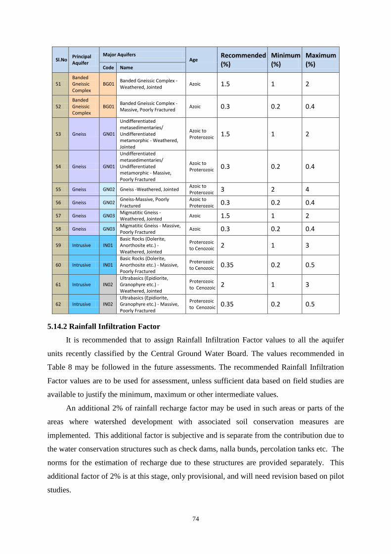
74
Sl.No Principal Aquifer
Major Aquifers Age
Recommended (%)
Minimum (%)
Maximum (%) Code Name
51 Banded Gneissic Complex
BG01 Banded Gneissic Complex - Weathered, Jointed Azoic 1.5 1 2
52 Banded Gneissic Complex
BG01 Banded Gneissic Complex - Massive, Poorly Fractured Azoic 0.3 0.2 0.4
53 Gneiss GN01
Undifferentiated metasedimentaries/ Undifferentiated metamorphic - Weathered, Jointed
Azoic to Proterozoic 1.5 1 2
54 Gneiss GN01
Undifferentiated metasedimentaries/ Undifferentiated metamorphic - Massive, Poorly Fractured
Azoic to Proterozoic 0.3 0.2 0.4
55 Gneiss GN02 Gneiss -Weathered, Jointed Azoic to Proterozoic 3 2 4
56 Gneiss GN02 Gneiss-Massive, Poorly Fractured
Azoic to Proterozoic 0.3 0.2 0.4
57 Gneiss GN03 Migmatitic Gneiss - Weathered, Jointed Azoic 1.5 1 2
58 Gneiss GN03 Migmatitic Gneiss - Massive, Poorly Fractured Azoic 0.3 0.2 0.4
59 Intrusive IN01 Basic Rocks (Dolerite, Anorthosite etc.) - Weathered, Jointed
Proterozoic to Cenozoic 2 1 3
60 Intrusive IN01 Basic Rocks (Dolerite, Anorthosite etc.) - Massive, Poorly Fractured
Proterozoic to Cenozoic 0.35 0.2 0.5
61 Intrusive IN02 Ultrabasics (Epidiorite, Granophyre etc.) - Weathered, Jointed
Proterozoic to Cenozoic 2 1 3
62 Intrusive IN02 Ultrabasics (Epidiorite, Granophyre etc.) - Massive, Poorly Fractured
Proterozoic to Cenozoic 0.35 0.2 0.5
It is recommended that to assign Rainfall Infiltration Factor values to all the aquifer
units recently classified by the Central Ground Water Board. The values recommended in
Table 8 may be followed in the future assessments. The recommended Rainfall Infiltration
Factor values are to be used for assessment, unless sufficient data based on field studies are
available to justify the minimum, maximum or other intermediate values.
An additional 2% of rainfall recharge factor may be used in such areas or parts of the
areas where watershed development with associated soil conservation measures are
implemented. This additional factor is subjective and is separate from the contribution due to
the water conservation structures such as check dams, nalla bunds, percolation tanks etc. The
norms for the estimation of recharge due to these structures are provided separately. This
additional factor of 2% is at this stage, only provisional, and will need revision based on pilot
studies.
5.14.2 Rainfall Infiltration Factor

75
The Norms suggested below are nothing but the redistribution of norms suggested by
GEC-1997 methodology and hence people are encouraged to conduct field studies and
strengthen the Norms database.
TABLE 8: NORMS RECOMMENDED FOR THE RAINFALL
INFILTRATION FACTOR
Sl.No Principal Aquifer
Major Aquifers Age
Recommended (%)
Minimum (%)
Maximum (%) Code Name
1 Alluvium AL01 Younger Alluvium (Clay/Silt/Sand/ Calcareous concretions)
Quaternary 22 20 24
2 Alluvium AL02 Pebble / Gravel/ Bazada/ Kandi Quaternary 22 20 24
3 Alluvium AL03 Older Alluvium (Silt/Sand/Gravel/Lithomargic clay)
Quaternary 22 20 24
4 Alluvium AL04 Aeolian Alluvium (Silt/ Sand) Quaternary 22 20 24 5 Alluvium AL05 Coastal Alluvium
(Sand/Silt/Clay) -East Coast Quaternary 16 14 18
5 Alluvium AL05 Coastal Alluvium (Sand/Silt/Clay) - West Coast Quaternary 10 8 12
6 Alluvium AL06 Valley Fills Quaternary 22 20 24 7 Alluvium AL07 Glacial Deposits Quaternary 22 20 24 8 Laterite LT01 Laterite / Ferruginous
concretions Quaternary 7 6 8
9 Basalt BS01 Basic Rocks (Basalt) - Vesicular or Jointed
Mesozoic to Cenozoic 13 12 14
9 Basalt BS01 Basic Rocks (Basalt) - Weathered
Mesozoic to Cenozoic 7 6 8
10 Basalt BS01 Basic Rocks (Basalt) - Massive Poorly Jointed
Mesozoic to Cenozoic 2 1 3
11 Basalt BS02 Ultra Basic - Vesicular or Jointed
Mesozoic to Cenozoic 13 12 14
11 Basalt BS02 Ultra Basic - Weathered Mesozoic to Cenozoic 7 6 8
12 Basalt BS02 Ultra Basic - Massive Poorly Jointed
Mesozoic to Cenozoic 2 1 3
13 Sandstone ST01 Sandstone/Conglomerate Upper Palaeozoic to Cenozoic
12 10 14
14 Sandstone ST02 Sandstone with Shale Upper Palaeozoic to Cenozoic
12 10 14
15 Sandstone ST03 Sandstone with shale/ coal beds
Upper Palaeozoic to Cenozoic
12 10 14
16 Sandstone ST04 Sandstone with Clay Upper Palaeozoic to Cenozoic
12 10 14
17 Sandstone ST05 Sandstone/Conglomerate Proterozoic to Cenozoic 6 5 7
18 Sandstone ST06 Sandstone with Shale Proterozoic to Cenozoic 6 5 7
19 Shale SH01 Shale with limestone Upper Palaeozoic to Cenozoic
4 3 5
20 Shale SH02 Shale with Sandstone Upper Palaeozoic to Cenozoic
4 3 5

76
Sl.No Principal Aquifer
Major Aquifers Age
Recommended (%)
Minimum (%)
Maximum (%) Code Name
21 Shale SH03 Shale, limestone and sandstone
Upper Palaeozoic to Cenozoic
4 3 5
22 Shale SH04 Shale Upper Palaeozoic to Cenozoic
4 3 5
23 Shale SH05 Shale/Shale with Sandstone Proterozoic to Cenozoic 4 3 5
24 Shale SH06 Shale with Limestone Proterozoic to Cenozoic 4 3 5
25 Limestone LS01 Miliolitic Limestone Quarternary 6 5 7
27 Limestone LS02 Limestone / Dolomite Upper Palaeozoic to Cenozoic
6 5 7
29 Limestone LS03 Limestone/Dolomite Proterozoic 6 5 7 31 Limestone LS04 Limestone with Shale Proterozoic 6 5 7 33 Limestone LS05 Marble Azoic to
Proterozoic 6 5 7
35 Granite GR01 Acidic Rocks (Granite,Syenite, Rhyolite etc.) - Weathered , Jointed
Mesozoic to Cenozoic 7 5 9
36 Granite GR01 Acidic Rocks (Granite,Syenite, Rhyolite etc.)-Massive or Poorly Fractured
Mesozoic to Cenozoic 2 1 3
37 Granite GR02 Acidic Rocks (Pegmatite, Granite, Syenite, Rhyolite etc.) - Weathered, Jointed
Proterozoic to Cenozoic 11 10 12
38 Granite GR02
Acidic Rocks (Pegmatite, Granite, Syenite, Rhyolite etc.) - Massive, Poorly Fractured
Proterozoic to Cenozoic 2 1 3
39 Schist SC01 Schist - Weathered, Jointed Azoic to Proterozoic 7 5 9
40 Schist SC01 Schist - Massive, Poorly Fractured
Azoic to Proterozoic 2 1 3
41 Schist SC02 Phyllite Azoic to Proterozoic 4 3 5
42 Schist SC03 Slate Azoic to Proterozoic 4 3 5
43 Quartzite QZ01 Quartzite - Weathered, Jointed
Proterozoic to Cenozoic 6 5 7
44 Quartzite QZ01 Quartzite - Massive, Poorly Fractured
Proterozoic to Cenozoic 2 1 3
45 Quartzite QZ02 Quartzite - Weathered, Jointed
Azoic to Proterozoic 6 5 7
46 Quartzite QZ02 Quartzite- Massive, Poorly Fractured
Azoic to Proterozoic 2 1 3
47 Charnockite CK01 Charnockite - Weathered, Jointed Azoic 5 4 6
48 Charnockite CK01 Charnockite - Massive, Poorly Fractured Azoic 2 1 3
49 Khondalite KH01 Khondalites, Granulites - Weathered, Jointed Azoic 7 5 9
50 Khondalite KH01 Khondalites, Granulites - Mssive, Poorly Fractured Azoic 2 1 3
51 Banded Gneissic Complex
BG01 Banded Gneissic Complex - Weathered, Jointed Azoic 7 5 9
52 Banded Gneissic Complex
BG01 Banded Gneissic Complex - Massive, Poorly Fractured Azoic 2 1 3

77
Sl.No Principal Aquifer
Major Aquifers Age
Recommended (%)
Minimum (%)
Maximum (%) Code Name
53 Gneiss GN01
Undifferentiated metasedimentaries/ Undifferentiated metamorphic - Weathered, Jointed
Azoic to Proterozoic 7 5 9
54 Gneiss GN01
Undifferentiated metasedimentaries/ Undifferentiated metamorphic - Massive, Poorly Fractured
Azoic to Proterozoic 2 1 3
55 Gneiss GN02 Gneiss -Weathered, Jointed Azoic to Proterozoic 11 10 12
56 Gneiss GN02 Gneiss-Massive, Poorly Fractured
Azoic to Proterozoic 2 1 3
57 Gneiss GN03 Migmatitic Gneiss - Weathered, Jointed Azoic 7 5 9
58 Gneiss GN03 Migmatitic Gneiss - Massive, Poorly Fractured Azoic 2 1 3
59 Intrusive IN01 Basic Rocks (Dolerite, Anorthosite etc.) - Weathered, Jointed
Proterozoic to Cenozoic 7 6 8
60 Intrusive IN01 Basic Rocks (Dolerite, Anorthosite etc.) - Massive, Poorly Fractured
Proterozoic to Cenozoic 2 1 3
61 Intrusive IN02 Ulrta Basics (Epidiorite, Granophyre etc.) - Weathered, Jointed
Proterozoic to Cenozoic 7 6 8
62 Intrusive IN02 Ulrta Basics (Epidiorite, Granophyre etc.) - Massive, Poorly Fractured
Proterozoic to Cenozoic 2 1 3
Unlike other norms, the Recharge factor for calculating Recharge due to canals is given
in two units viz. ham/million m
5.14.3 Norms for Canal Recharge
2 of wetted area/day and cumecs per million m2 of wetted
area. As all other norms are in ham, the committee recommends the norm in ham/million m2
The Norms suggested in Table 9below are nothing but the rationalization and
redistribution of norms suggested by GEC-1997 methodology and hence people are
encouraged to conduct field studies and strengthen the Norms database.
of wetted area for computing the recharge due to canals.
There is a wide variation in the values of the recharge norms proposed by GEC
1997.The Canal seepage norm is approximately 150times the other recharge norms. In the
absence of any field studies to refine the norms it is decided by the committee to continue
with the same norms. The committee strongly recommends that each state agency must
conduct one filed study at least one in each district before completing the first assessment
using this methodology. The committee also suggests a recommended value and minimum
and maximum values as in the case of other norms. Where specific results are available from
case studies in some states, the adhoc norms are to be replaced by norms evolved from these
results.

78
TABLE9: NORMS RECOMMENDED FOR THE RECHARGE DUE TO CANAL
Formation S
Canal Seepage factor ham/day/million Square meters of wetted Area Recommended Minimum Maximum
Unlined canals in normal soils with some clay content along with sand
17.5 15 20
Unlined canals in sandy soil with some silt content
27.5 25 30
Lined canals in normal soils with some clay content along with sand
3.5 3 4
Lined canals in sandy soil with some silt content
5.5 5 6
All canals in hard rock area 3.5 3 4
The Norms Suggested by GEC-1997 gives for only three ranges of water levels and it
creates a problem in the boundary conditions. For instance,as a result of the variation in water
level from 24.9 to 25.1m bgl in the adjoining blocks, change occurs in the return flow from
irrigation in the range of 10% to 15%. Hence to reduce the discrepancy it is recommended to
have linear relationship of the norms in between 10m bgl water level and 25m bgl water
level. It is proposed to have the same norm of 10m bgl zone for all the water levels less than
10m. Similarly, the norm recommended for 25m may be used for the water levels more than
25m as well. The Recommended Norms are presented in Table 10.
For surface water, the recharge is to be estimated based on water released at the outlet. For
ground water, the recharge is to be estimated based on gross draft. Where continuous supply
is used instead of rotational supply, an additional recharge of 5% of application may be used.
Where specific results are available from case studies in some states, the adhoc norms are to
be replaced by norms evolved from these results.
5.14.4 Norms for Recharge Due to Irrigation
DTW m bgl
TABLE10: NORMS RECOMMENDED FOR THE RECHARGE FROM
IRRIGATION
Ground Water Surface Water Paddy Non Paddy Paddy Non Paddy
<=10 45 25 50 30 11 43.3 23.7 48.3 28.7 12 41.7 22.3 46.7 27.3 13 40 21 45 26

79
14 38.3 19.7 43.3 24.7 15 36.7 18.3 41.7 23.3 16 35 17 40 22 17 33.3 15.7 38.3 20.7 18 31.7 14.3 36.7 19.3 19 30 13 35 18 20 28.3 11.7 33.3 16.7 21 26.7 10.3 31.7 15.3 22 25 9 30 14 23 23.3 7.7 28.3 12.7 24 21.7 6.3 26.7 11.3 >=25 20 5 25 10
As the data on the field studies for computing recharge from Tanks & Ponds are very
limited, it is recommended to follow the same norm as followed in GEC 1997in future
assessments also. Hence the norm recommended by GEC-2015 for Seepage from Tanks &
Ponds is 1.4 mm / day.
5.14.5 Norms for Recharge due to Tanks & Ponds
Even though the data on the field studies for computing recharge from Water
Conservation Structures are very limited, it is recommended that the Recharge from the water
conservation structures is 40% of the Gross Storage based on the field studies by Non
Government Organizations. Hence, the norm recommended by GEC-2015 for the seepage
from Water Conservation Structures is40% of gross storage during a year which means 20%
during monsoon season and 20% during non-monsoon Season.
5.14.6 Norms for Recharge due to Water Conservation Structures
As the option is given to use the actual requirement for domestic needs, the
Requirement Norm recommended by the committee is 60 lpcd for domestic needs. This can
be modified if the actual requirement is known.
5.14.7 Norm for Per Capita Requirement
The Discharge Norm used in computing Unaccounted Natural Discharge is 5% if water
table fluctuation method is used or 10% if rainfall infiltration factor method is used for
assessing the Rainfall recharge. This committee recommends to compute the base flow for
each assessment unit. Wherever, there is no assessment of base flow, earlier norms
recommended by GEC 1997ie. 5% or 10% of the Total Annual Ground Water Recharge as
the Natural Discharges may be continued.
5.14.8 Norm for Natural Discharges

80
GEC-1997 methodology recommends to use well census method for computing the
ground water draft. The norm used for computing ground water draft is the unit draft. The
unit draft can be computed by field studies. This method involves selecting representative
abstraction structure and calculating the discharge from that particular type of structure and
collecting the information on how many hours of pumping is being done in various seasons
and number of such days during each season. The Unit Draft during a particular season can
be computed using the following equation:
5.14.9 Unit Draft
daysofNodayainhrsPumpingofNohrmineDischDraftUnit ..arg 3 ××= 38
One basic drawback in the methodology of computing unit draft is that there is no
normalization procedure for the same. As per GEC-1997 guidelines, the recharge from
rainfall is normalized for a normal rainfall. It means that even though the resources are
estimated in a surplus rainfall year or in a deficit rainfall year, the assessment is normalised
for a normal rainfall which is required for planning. For recharge from other sources,
average figures/ values are taken. If the average figures are not available for any reason,60%
of the design figures are taken. This procedure is very much essential as the planning should
be for average resources rather than for the recharge due to excess rainfall or deficit rainfall.
But the procedure that is being followed for computing unit draft does not have any
normalization procedure. Normally, if the year in which one collects the draft data in the field
is an excess rainfall year, the abstraction from ground water will be less. Similarly, if the year
of the computation of unit draft is a drought year the unit draft will be high. Hence, there is a
requirement to devise a methodology that can be used for the normalization of unit draft
figures. The following are the two simple techniques, which can be followed. If the unit draft
values for one rainfall cycle are available for at least 10 years second method shown in
equation 40 is to be followed or else the first method shown in equation 39 may be used.
allRaNormalYeartheforallRaDraftUnitDraftUnitNormalized
infinf×
= 39
YearsofNumber
DraftUnitDraftUnitNormalized
n
ii∑
== 1 40
Although GEC-1997 methodology recommends a default value for the unit drafts, each
State is using its own values, generally after conducting field studies, even though without a

81
documentation. Hence, it is felt that this norm may be computed by the state agency, which
is going to assess the norms before commencement of the assessment. But it is strongly
recommended that the field studies should be documented and submitted along with the
results of the assessment.
5.15 SUMMARY REPORT OF GROUND WATER ASSESSMENT
A summary for each unit adopted for ground water assessment is to be presented in the
formats given in the following tables. These tables should also be accompanied by one
graphical plot showing the ground water level trend during pre monsoon and post monsoon
seasons for each of the sub unit assessed. The committee also recommends that there should
be two reports for each state one with the results of the Dynamic Ground Water Resources
which can be used for planning for future ground water management. Whereas the other
report should contain the Total Availability of the resources which will indicate the ground
water mining taking place in the country for sensitizing stakeholders about the damage being
done to the environment and for planning the remedial measures there upon for rectifying the
damage.

82
TABLE 11: SUMMARY REPORT IN RESPECT OF THE DYNAMIC
GROUND WATER RESOURCES OF EACH GROUND WATER
ASSESSMENT UNIT
A. Dynamic Ground Water Resources of Unconfined Aquifer: 1. Command and Non - command Areas
S. No.
Description of item Non - command area
Command area
in hectare metres
in mm in hectare metres
in mm
1 Recharge from ‘Rainfall’ during monsoon season
2 Recharge from ‘Other Sources’ during monsoon season
3 Resultant Ground Water Inflow during monsoon season
4 Recharge from ‘Rainfall’ during non - monsoon season
5 Recharge from ‘Other Sources’ during non - monsoon season
6 Resultant Ground Water Inflow during non-monsoon season
7 Annual ground water recharge [ (1) + (2) + (3) + (4)+(5)+(6) ]
8 Estimated Base Flow Restricted to ecological Flow
9 If Base flow is estimated separately, Estimated Evapotranspiration Losses
10 If Base flow is not estimated separately Unaccounted annual natural discharges
11 Total Natural Discharges [(8)+(9)) or (10)
12 Annual Extractable Ground Water Resource [ (7) - (11) ]
13 Current annual gross ground water extraction for ‘All Uses’
14 Current annual gross ground water extraction for ‘Domestic

83
S. No.
Description of item Non - command area
Command area
in hectare metres
in mm in hectare metres
in mm
Use’ 15 Current annual gross ground
water extraction for ‘Irrigation’
16 Current annual gross ground water extraction for ‘Industrial use'’
17 Annual ground water allocation for domestic water supply as on 20 25.
18 Net annual ground water availability for ‘Future Use’ [ (12) - (15) - (16) -(17)]
S. No.
Description of item Non - command area
Command area
19 Stage of ground water Extraction as a percentage [ ( (13) / (12) ) * 100 ]
20 Quantity Categorisation for future ground water development ( Safe / Semi-Critical/ Critical / Over exploited )
21 Quality Tagging (if any) 22 Does the water table during pre
and post monsoon seasons show a significant falling trend ( Yes / No )
23 Validation of Assessment Using Ground Water level trends (Valid/ To Be Reassessed)
2. Poor Ground Water Quality Area S.
No. Description of item in hectare metres in mm
1 Recharge from ‘Rainfall’ during monsoon season
2 Recharge from ‘Other Sources’ during monsoon season
3 Resultant Ground Water Inflow during monsoon season
4 Recharge from ‘Rainfall’ during non - monsoon season
5 Recharge from ‘Other Sources’

84
S. No.
Description of item in hectare metres in mm
during non - mon4soon season 6 Resultant Ground Water Inflow
during non-monsoon season
7 Annual ground water recharge [ (1) + (2) + (3) + (4) +(5)+(6)]
8 Estimated Base Flow Restricted to Ecological Flow
9 If Base flow is estimated separately, Estimated Evapotranspiration Losses
10 If Base flow is not estimated separately Unaccounted annual natural discharges
11 Total Natural Discharges [(8)+(9)) or (10)]
12 Annual Extractable ground water Resource [ (7) - (11) ]
13 Current annual gross ground water extraction for ‘All Uses’
14 Current annual gross ground water extraction for ‘Domestic Use’
15 Current annual gross ground water extraction for ‘Irrigation’
16 Current annual gross ground water extraction for ‘Industrial use'’
17 Annual ground water allocation for domestic water supply as on 20 25.
18 Net annual ground water availability for ‘Future Use’ [ (12) - (15) - (16) -(17)]
S. No
Description of item Poor Ground Water Quality Area
19 Stage of ground water Extraction as a percentage [ ( (13) / (2 ) * 100 ]
20 Quantity Categorisation for future ground water development ( Safe / Semi-Critical/ Critical /

85
S. No
Description of item Poor Ground Water Quality Area
Over exploited ) 21 Quality Tagging 22 Does the water table during pre
and post monsoon interval show a significant falling trend ( Yes / No )
23 Validation of Assessment Using Ground Water level trends (Valid/ To Be Reassessed)
3. Potential Resources (If any)in Ground Water Assessment Unit
a. Potential resource due to Springs in hectare meters
=
b. Potential resource in waterlogged and shallow water table areas in hectare metres
=
c. Potential resource in flood prone area in hectare metres
=
d. Total potential recharge in hectare metres [ (a) + (b) + (c) ]
=
B. Dynamic Ground Water Resources of Confined/ Semi-Confined Aquifers: (If the aquifer is being exploited) S.No Aquifer Number & Name Type Dynamic Ground Water
Resources in ham 1 2 3

86
TABLE 12: SUMMARY REPORT IN RESPECT OF THE TOTAL GROUND
WATER AVAILABILITY OF EACH GROUND WATER ASSESSMENT
UNIT
A. In storage Ground Water Resources of Unconfined Aquifer in Ground Water
Assessment Unit a. In storage / Static ground water resource
in hectare metres =
B. In storage Ground Water Resources of Confined/ Semi-Confined Aquifers: S.No Aquifer Number & Name Type In storage Ground Water
Resources in ham 1 2 3
C. Total Extractable Ground Water Availability in the Assessment Unit S.No Aquifer Number & Name Type Extractable Ground
Water Resources in ham 1 2 3
(Note: For Unconfined Aquifer - it is Annual Extractable Ground Water Resources and for other aquifers it is the dynamic resources computed) D. Total Ground Water Availability in the Assessment Unit 1 Total Extractable Ground Water
Resources in ham :
2 Total In storage Ground Water Resources in ham
:
3 Total Ground Water Availability in ham :
Apart from this, it is recommended to create a GIS based village wise database of all
primary information and data related to estimation of ground water resources. The final
output is recommended to be depicted on maps and should be accessible using web based
interactive tools.
* * *

87
6 PROPOSED DATABASE FOR THE ESTIMATION
The database for ground water resource assessment has two components which are
equally important viz., data elements like water level, rainfall etc. and the norms like specific
yield, rainfall infiltration factor etc. The committee studied the database maintained by the
various states. Most of the states maintain their database either in MS-Excel or in MS-Access
format. The database capabilities of MS-Excel are limited for handling such a huge database
especially for a State or country. Hence it is recommended to use MS-Access for future
Ground Water Resources Estimation exercise in all levels from an assessment unit to the
country.
The detailed guidelines published as an annexure to the GEC 1997 report has
meticulously described each of the data element used in the methodology. This helped to
clarify the concept behind the computations. However the document failed to specify the
structure of data elements and their required precision. There is no common structure of the
data elements in GEC 1997 report. Hence it is difficult to combine the data sets to make it a
national dataset. The central level expert group during 2009 assessment suggested certain
annexure for making a unified database, still the required level of uniformity in the data
elements could not be achieved. There is a need to devise the data structure of all the
elements with its name, type of data and its precision. The broad data elements used in the
ground water resource estimation are given in Table 13:
6.1 DATA ELEMENTS USED IN THE ASSESSMENT
Component
TABLE 13.BROAD DATA ELEMENTS USED IN THE GROUND WATER
RESOURCES ESTIMATION
Parameter Unit Data type Source Assessment Sub Units
Total Geographic Area
Hectares Integer Revenue Census
Hilly Area Hectares Integer DEM/ Geomorphological Maps
Poor Ground Water Quality
Hectares Integer SGWD

88
Component Parameter Unit Data type Source Area Command Area Hectares Integer Irrigation Department Non Command Area
Hectares Integer Irrigation Department
Ground Water Extraction
Well Census Number Integer MI Census Number of days Number Integer Field Studies Cropping Pattern
Acres Float(7,2) Agriculture Department/ Block Office
Power Consumed
Kilo Watt Hours
Integer Electricity Department
Base Flow & Recharge From Streams
River Stage Meters Float(7,2) Central Water Commission & Irrigation Department
River Discharge Cumecs Float(7,2) Central Water Commission & Irrigation Department
Ground Water Level Heads
Meters Float(7,2) CGWB/SGWD
Transmissivity Square meters/day
Float(7,2) CGWB/SGWD
Lateral Flows Ground Water Level Heads
Meters Float(7,2) CGWB/SGWD
Transmissivity Square meters/day
Float(7,2) CGWB/SGWD
Width of the Seepage Face
Meters Integer Field Studies
Vertical Flows Ground Water Level Heads
Meters Float(7,2) CGWB/SGWD
Hydrualic Conductivity of the Aquitard
meters/day Float(7,2) CGWB/SGWD
Thickness of the Aquitard
Meters Float(7,2) Field Studies
Evaporation Evaporating Area
Hectares Integer Field Studies
Evaporation rate mm/day Float(6,2) IMD Transpiration Transpiring
Area Hectares Integer Field Studies
Transpiration rate
mm/day Float(6,2) IMD/ Agricultural Universities
Canal Seepage Reach Length Meters Integer Irrigation Department Full Supply Depth
Meters Float(5,2) Irrigation Department
Side Angle Degrees Float(5,2) Irrigation Department Base Width Meters Float(5,2) Irrigation Department Number of Days No Integer Irrigation Department
Recharge Due Cropping Acres Float(7,2) Agriculture

89
Component Parameter Unit Data type Source to Ground Water Irrigation
Pattern Department / Block Office
Recharge Due to Surface Water Irrigation
Design Discharge of the Outlet
Cumecs Float(6,2) Irrigation Department
Number of Days Number Integer Irrigation Department Cropping Pattern
Acres Float(7,2) Irrigation Department/ Agriculture Department / Block Office
Recharge Due to Tanks/Ponds
Water Spread Area
Hectares Float(7,2) Irrigation Department/Remote Sensing
Number of Days Number Integer Irrigation Department/Remote Sensing
Recharge Due to Water Conservation Structures
Gross Storage Hectare meters
Float(7,2) Irrigation Department/Watershed Management
Number of Refills
Number Float(3,1) Irrigation Department/Watershed Management/ Field Studies
Rainfall Infiltration Factor Method
Rainfall millimeter Float(5,1) IMD/Revenue Department
Water Table Fluctuation Method
Water Level Meter Float(6,2) CGWB/SGWD
Allocation Population as on base year
Number Integer Population census
Population Growth rate
Percent Float(5,2) Population census
Dependency on Ground Water
Ratio Float(5,2) Water Supply Departments
Ground Water Level Trend
Water Level Meters Float(6,2) CGWB/SGWD
Apportioning Block areas Hectares Integer SGWD In Storage Resources of Unconfined Aquifer
Area Hectares Integer CGWB/SGWD Bottom of Dynamic Zone
Meters above MSL
Float(7,2) CGWB/SGWD
Bottom of unconfined Aquifer
Meters above MSL
Float(7,2) CGWB/SGWD
Dynamic Resources of Confined/ semi
Area Hectares Integer CGWB/SGWD Pre monsoon Piezometric
Meters above
Float(7,2) CGWB/SGWD
90
Component Parameter Unit Data type Source confined Aquifer
head. MSL Post monsoon Piezometric head.
Meters above MSL
Float(7,2) CGWB/SGWD
In storage Resources of Confined/ semi confined Aquifer
Area Hectares Integer CGWB/SGWD Pre monsoon Piezometric head.
Meters above MSL
Float(7,2) CGWB/SGWD
Post monsoon Piezometric head.
Meters above MSL
Float(7,2) CGWB/SGWD
Bottom of Top Confining Layer
Meters above MSL
Float(7,2) CGWB/SGWD
Note: The number in the bracket indicates total number of digits and number of required decimals.
6.2 STANDARDIZATION OF DATA ELEMENTS USED IN THE
GROUND WATER RESOURCES ESTIMATION
Considering the existing limitations, the committee recommends the following standards and precisions for data elements. This standardization is envisaged to maintain uniformity in reporting and improve comparability of the assessment figures.
S.No
6.2.1 Region Specific Data Elements (Chapter - I) Parameter Type Size Decimals
1 Predominant Rock Terrain Text 30 2 Predominant Monsoon Text 30 3 Type of Assessment Unit Text 10 4 Ground Water Year Text 20 5 Monsoon Season Text 20 6 Non Monsoon Season Text 20 7 Pre-Monsoon Monitoring Month Text 10 8 Post-Monsoon Monitoring Month Text 10
S.No
6.2.2 Data Elements Pertaining To Sub Units (Chapter - II)
Parameter Type Size Decimals 1 Toposheet Numbers Text 50 2 Starting Latitude Text 10 3 Ending Latitude Text 10 4 Starting Longitude Text 10 5 Ending Longitude Text 10 6 Total Area Number 7 0 7 Hilly Area Number 7 0 8 Recharge Worthy Area Number 7 0 9 Poor Ground Water Quality Area Number 7 0 10 Command Area Number 7 0 11 Non Command Area Number 7 0

91
6.2.3 Data Elements Pertaining to the Estimation of Ground Water Extraction Using
Unit DraftMethod (Chapter - III)
S.No Parameter Type Size Decimals 1 Type of Structure Text 50 2 Assessment Sub Unit Text 20 3 Draft Per day Number 3 0 4 Monsoon Days Number 3 0 5 Non Monsoon Days Number 3 0 6 Monsoon Unit Draft Number 5 2 7 Non Monsoon Unit Draft Number 5 2 8 Annual Unit Draft Number 5 2 9 Extraction Type Text 10 0 10 Total No. of Structures Number 5 0 11 Total No. of Structures in Use Number 5 0 12 Total Structure Monsoon Extraction Number 7 2 13 Total Structure Non Monsoon Extraction Number 7 2 14 Total Structure Annual Extraction Number 7 2 15 Total Sub Unit Monsoon Extraction Number 7 0 16 Total Sub Unit Non Monsoon Extraction Number 7 0 17 Total Sub Unit Annual Extraction Number 7 0 18 Total Sub Unit Domestic Monsoon Extraction Number 7 0 19 Total Sub Unit Domestic Non Monsoon Extraction Number 7 0 20 Total Sub Unit Domestic Annual Extraction Number 7 0 21 Total Sub Unit Irrigation Monsoon Extraction Number 7 0 22 Total Sub Unit Irrigation Non Monsoon Extraction Number 7 0 20 Total Sub Unit Irrigation Annual Extraction Number 7 0 21 Total Sub Unit Industrial Monsoon Extraction Number 7 0 22 Total Sub Unit Industrial Non Monsoon Extraction Number 7 0 23 Total Sub Unit Industrial Annual Extraction Number 7 0 24 Total Sub Unit All Uses Monsoon Extraction Number 8 0 25 Total Sub Unit All Uses Non Monsoon Extraction Number 8 0 26 Total Sub Unit All Uses Annual Extraction Number 8 0 27 Total Sub Unit All Uses Monsoon Extraction m Number 5 3 28 Total Sub Unit All Uses Non Monsoon Extraction m Number 5 3 29 Total Sub Unit All Uses Annual Extraction m Number 5 3
S.No
6.2.4 Data Elements Pertaining to the Estimation of Ground Water Extraction Using
Crop Water Requirement Method (Chapter - III)
Parameter Type Size Decimals 1 Assessment Sub Unit Text 20 2 Crop Type Text 10 3 Crop Name Text 20 4 Crop Season Text 10 5 Crop Acreage Number 8 2 6 Crop Water Requirement Number 6 2 7 Extraction for the Crop During Monsoon Number 7 2 8 Extraction for the Crop During Non Monsoon Season Number 7 2 9 Annual Extraction for the Crop Number 7 2
92
S.No Parameter Type Size Decimals 10 Draft Type Text 10 0 11 Total Sub Unit Extraction During Monsoon Number 8 0 12 Total Sub Unit Extraction During Non Monsoon Number 8 0 13 Total Sub Unit Annual Extraction Number 8 0
S.No
6.2.5 Data Elements Pertaining to the Estimation of Ground Water Extraction Using
Power Consumption Method (Chapter - III)
Parameter Type Size Decimals 1 Assessment Sub Unit Text 20 2 Domestic Power consumption in Monsoon Season Number 8 0 3 Domestic Power Consumption in Non Monsoon Season Number 8 0 4 Annual Domestic Power Consumption Number 8 0 5 Irrigation Power consumption in Monsoon Season Number 8 0 6 Irrigation Power Consumption in Non Monsoon Season Number 8 0 7 Irrigation Domestic Power Consumption Number 8 0 8 Domestic Extraction For Unit Power Consumption During
Monsoon Season Number 7 2
9 Domestic Extraction For Unit Power Consumption DuringNon MonsoonSeason
Number 7 2
10 Irrigation Extraction For Unit Power Consumption During Monsoon Season
Number 7 2
11 Irrigation Extraction For Unit Power Consumption DuringNon MonsoonSeason
Number 7 2
12 Domestic Extraction using Power Consumption During Monsoon
Number 8 0
13 Domestic Extraction using Power Consumption During Non Monsoon
Number 8 0
14 Irrigation Extraction using Power Consumption During Monsoon
Number 8 0
15 Irrigation Extraction using Power Consumption During Non Monsoon
Number 8 0
S.No
6.2.6 Data Elements Pertaining to the Estimation of Ground Water Extraction Using
Consumptive Use Method (Chapter - III)
Parameter Type Size Decimals 1 Assessment Sub Unit Text 20 2 Population as on base year Number 6 0 3 Growth Rate of Population per year Number 5 0 4 Population as the Assessment Year Number 6 0 5 Per capita daily requirement for Domestic Needs Number 3 0 6 Fractional Load on Ground Water Number 4 2 7 Domestic extraction During Monsoon Season Number 8 0 8 Domestic extraction During Non Monsoon Season Number 8 0 9 Annual Domestic extraction Number 8 0
S.No
6.2.7 Data Elements Pertaining to the Estimation of Ground Water Extraction Using
Consumptive Use Pattern Method (Chapter - III)
Parameter Type Size Decimals 1 Assessment Sub Unit Text 20

93
S.No Parameter Type Size Decimals 2 Type of Industry Text 20 3 No of Such Units Number 4 0 4 Ground Water Requirement of the Industry During
Monsoon Number 6 0
5 Ground Water Requirement of the Industry During Non Monsoon
Number 6 0
6 Annual Ground Water Requirement of the Industry Number 6 0 7 Fractional Load on Ground Water Number 4 2 8 Industrial Extraction For the Type of Industry During
Monsoon Season Number 8 0
9 Industrial Extraction For the Type of Industry During Monsoon Season
Number 8 0
10 Annual Industrial Extraction For the Type of Industry Number 8 0 11 Industrial Extraction For the Sub Unit During Monsoon
Season Number 8 0
12 Industrial Extraction For the Sub Unit During Monsoon Season
Number 8 0
13 Annual Industrial Extraction For the Sub Unit Number 8 0
6.2.8 Data Elements Pertaining to Estimation of Recharge from Canals (Chapter - IV)
S.No Parameter Type Size Decimals 1 Assessment Sub Unit Text 20 2 Name of Canal Segment Text 50 3 Type of Canal Text 10 4 Canal Length Number 6 0 5 Starting Latitude Text 10 6 Ending Latitude Text 10 7 Starting Longitude Text 10 8 Ending Longitude Text 10 9 Full Supply Depth Number 5 2 10 Base Width Number 5 2 11 Side Slope Number 4 1 12 Wetted Perimeter Number 6 2 13 Wetted Area million sq m Number 8 5 14 Lining Text 10 15 Soil Type Text 10 16 Canal Seepage factor Number 4 1 17 Monsoon Days Number 3 0 18 Non Monsoon Days Number 3 0 19 Monsoon Canal Recharge Number 7 2 20 Non Monsoon Canal Recharge Number 7 2 21 Total Sub Unit Monsoon Canal Recharge Number 7 0 22 Total Sub Unit Non Monsoon Canal Recharge Number 7 0 23 Total Sub Unit Annual Canal Recharge Number 7 0

94
6.2.9 Data Elements Pertaining to the Estimation of Recharge from Surface Water
Irrigation (Chapter - V)
S.No Parameter Type Size Decimals 1 Assessment Sub Unit Text 20 2 Name of Outlet Text 50 3 Name of the Canal Text 50 4 Latitude Text 10 5 Longitude Text 10 6 Design Discharge Number 6 3 7 Monsoon Days Number 3 0 8 Non Monsoon Days Number 3 0 9 Monsoon Water Released Number 7 2 10 Non Monsoon Water released Number 7 2 11 Total Sub Unit Monsoon Water Released Number 7 0 12 Total Sub Unit Non Monsoon Water Released Number 7 0 13 Total Sub Unit Annual Water Released Number 7 0 14 Name of the Observation Well Text 50 15 Previous Post Monsoon Water level Number 6 2 16 Current Pre Monsoon Water level Number 6 2 17 Current Post Monsoon Water level Number 6 2 18 Average Previous Post Monsoon Water level Number 6 2 19 Average Current Pre Monsoon Water level Number 6 2 20 Average Current Post Monsoon Water level Number 6 2 21 Water level During Monsoon Number 6 2 22 Water level During Non Monsoon Number 6 2 23 Name of the Crop Text 20 24 Area of Crop Monsoon Number 7 2 25 Area of Crop Non Monsoon Number 7 2 26 Total Area of Paddy Monsoon Number 8 2 27 Total Area of Paddy Non Monsoon Number 8 2 28 Total Area of Non Paddy Monsoon Number 8 2 29 Total Area of Non Paddy Non Monsoon Number 8 2 30 Type of Irrigation Water Monsoon Text 10 31 Return Flow Factor Paddy Monsoon Number 5 2 32 Return Flow Factor Non Paddy Monsoon Number 5 2 33 Weighted Average Return Flow Factor Monsoon Number 5 2 34 Type of Irrigation Water Non Monsoon Text 10 35 Return Flow Factor Paddy Non Monsoon Number 5 2 36 Return Flow Factor Non Paddy Non Monsoon Number 5 2 37 Weighted Average Return Flow Factor Non Monsoon Number 5 2 38 Total Sub Unit Monsoon Recharge due to SWI Number 7 0 39 Total Sub Unit Non Monsoon Recharge due to SWI Number 7 0 40 Total Sub Unit Annual Recharge due to SWI Number 7 0

95
6.2.10 Data Elements Pertaining to the Estimation of Recharge from Ground Water
Irrigation (Chapter - VI)
S.No Parameter Type Size Decimals 1 Assessment Sub Unit Text 20 2 Ground Water Applied Monsoon Number 7 2 3 Ground Water Applied Non Monsoon Number 7 2 4 Name of the Observation Well Text 50 5 Previous Post Monsoon Water level Number 6 2 6 Current Pre Monsoon Water level Number 6 2 7 Current Post Monsoon Water level Number 6 2 8 Average Previous Post Monsoon Water level Number 6 2 9 Average Current Pre Monsoon Water level Number 6 2 10 Average Current Post Monsoon Water level Number 6 2 11 Water level During Monsoon Number 6 2 12 Water level During Non Monsoon Number 6 2 13 Name of the Crop Text 20 14 Area of Crop Monsoon Number 7 2 15 Area of Crop Non Monsoon Number 7 2 16 Total Area of Paddy Monsoon Number 8 2 17 Total Area of Paddy Non Monsoon Number 8 2 18 Return Flow Factor Paddy Monsoon Number 5 2 19 Return Flow Factor Non Paddy Monsoon Number 5 2 20 Weighted Average Return Flow Factor Monsoon Number 5 2 21 Return Flow Factor Paddy Non Monsoon Number 5 2 22 Return Flow Factor Non Paddy Non Monsoon Number 5 2 23 Weighted Average Return Flow Factor Non Monsoon Number 5 2 24 Total Sub Unit Monsoon Recharge due to GWI Number 7 0 25 Total Sub Unit Non Monsoon Recharge due to GWI Number 7 0 26 Total Sub Unit Annual Recharge due to GWI Number 7 0
6.2.11 Data Elements Pertaining to the Estimation of Recharge from Tanks & Ponds
(Chapter - VII)
S.No Parameter Type Size Decimals 1 Assessment Sub Unit Text 20 2 Name of Tank Text 50 3 Latitude Text 10 4 Longitude Text 10 5 Year of Construction Text 9 6 Monsoon Water Spread Area Number 5 0 7 Non Monsoon Water Spread Area Number 5 0 8 Monsoon Days Number 3 0 9 Non Monsoon Days Number 3 0 9 Monsoon Recharge TP Number 7 2 10 Non Monsoon Recharge TP Number 7 2 11 Total Sub Unit Monsoon Recharge TP Number 7 0 12 Total Sub Unit Non Monsoon Recharge TP Number 7 0 13 Total Sub Unit Annual Recharge TP Number 7 0

96
6.2.12Data Elements Pertaining to the Estimation of Recharge from Water
Conservation Structures (Chapter - VIII)
S.No Parameter Type Size Decimals 1 Assessment Sub Unit Text 20 2 Name of Water Conservation Structure Text 50 3 Type of Water Conservation Structure Text 20 4 Latitude Text 10 5 Longitude Text 10 6 Year of Construction Text 9 7 Storage Capacity Number 5 0 8 No Fillings Number 3 1 9 Gross Storage Number 6 0 10 Monsoon Recharge WCS Number 7 2 11 Non Monsoon Recharge WCS Number 7 2 12 Total Sub Unit Monsoon Recharge WCS Number 7 0 13 Total Sub Unit Non Monsoon Recharge WCS Number 7 0 14 Total Sub Unit Annual Recharge WCS Number 7 0
6.2.13 Data Elements Pertaining to the Estimation of Recharge from Other Sources
(Chapter - IX)
S.No Parameter Type Size Decimals 1 Assessment Sub Unit Text 20 2 Total Sub Unit Monsoon Canal Recharge Number 7 0 3 Total Sub Unit Non Monsoon Canal Recharge Number 7 0 4 Total Sub Unit Annual Canal Recharge Number 7 0 5 Total Sub Unit Monsoon Recharge due to SWI Number 7 0 6 Total Sub Unit Non Monsoon Recharge due to SWI Number 7 0 7 Total Sub Unit Annual Recharge due to SWI Number 7 0 8 Total Sub Unit Monsoon Recharge due to GWI Number 7 0 9 Total Sub Unit Non Monsoon Recharge due to GWI Number 7 0 10 Total Sub Unit Annual Recharge due to GWI Number 7 0 11 Total Sub Unit Monsoon Recharge TP Number 7 0 12 Total Sub Unit Non Monsoon Recharge TP Number 7 0 13 Total Sub Unit Annual Recharge TP Number 7 0 14 Total Sub Unit Monsoon Recharge WCS Number 7 0 15 Total Sub Unit Non Monsoon Recharge WCS Number 7 0 16 Total Sub Unit Annual Recharge WCS Number 7 0 17 Total Sub Unit Monsoon Recharge Other Sources Number 8 0 18 Total Sub Unit Non Monsoon Recharge Other Sources Number 8 0 19 Total Sub Unit Annual Recharge Other Sources Number 8 0
S.No
6.2.14 Data Elements Pertaining to Estimation of Lateral Flow (Chapter - X)
Parameter Type Size Decimals 1 Assessment Sub Unit Text 20 2 Through Flow section ID Text 20 3 Average Hydraulic gradient Through seepage face During
monsoon Season Number 7 2
4 Average Hydraulic gradient Through seepage face During Non-Monsoon Season
Number 7 2

97
5 Transmissivity of the Aquifer Number 8 2 6 Length of Seepage Section Number 8 2 7 Through flow During Monsoon Season Number 8 0 8 Through flow During Non-Monsoon Season Number 8 0 9 Sub Unit Resultant Through flow During Monsoon Season Number 8 0 10 Sub Unit Resultant Through flow During Non-Monsoon
Season Number 8 0
S.No
6.2.15 Data Elements Pertaining to Estimation of Vertical Flow (Chapter -XI)
Parameter Type Size Decimals 1 Assessment Sub Unit Text 20 2 Leakage section ID Text 20 3 Average Head in the Aquifer During monsoon Season Number 7 2 4 Average Head in the Aquifer During Non-Monsoon
Season Number 7 2
5 Average Head in the Top/Bottom Aquifer During Monsoon Season
Number 7 2
6 Average Head in the Top/Bottom Aquifer During Non-Monsoon Season
Number 7 2
7 Hydraulic Conductivity of the Aquitard Number 8 2 8 Thickness of the Aquitard Number 8 2 9 Seepage Effected Area Number 7 0 10 Vertical flow During Monsoon Season Number 8 0 11 Vertical flow During Non-Monsoon Season Number 8 0 12 Sub Unit Resultant Vertical flow During Monsoon
Season Number 8 0
13 Sub Unit Resultant Vertical flow During Non-Monsoon Season
Number 8 0
S.No
6.2.16 Data Elements Pertaining to Estimation of Base Flow(Chapter - XII) Parameter Type Size Decimals
1 Assessment Sub Unit Text 20 2 River Segment ID Text 20 3 Stream Flow Number 8 2 4 Base Flow Number 8 2 5 Total Base flow During Monsoon Season Number 9 2 6 Total Base flow During Monsoon Season Number 9 2 7 Sub Unit Base flow During Monsoon Season Number 9 2 8 Sub Unit Base flow During Non Monsoon Season Number 9 2
S.No
6.2.17 Data Elements Pertaining to Estimation of Recharge from Streams (Chapter -
XIII)
Parameter Type Size Decimals 1 Assessment Sub Unit Text 20 2 Flow section ID Text 20 3 Average Head in the Aquifer During monsoon Season Number 7 2 4 Average Head in the Aquifer During Non-Monsoon Season Number 7 2 5 Average Stage in the Stream During Monsoon Season Number 7 2 6 Average Stage in the Stream During Non-Monsoon Season Number 7 2 7 Transmissivity of the Aquifer Number 8 2

98
8 Length of Recharge Section During Monsoon Season Number 8 2 9 Length of Recharge Section During Non-Monsoon Season Number 8 2 10 Recharge Due to Streams During Monsoon Season Number 8 0 11 Recharge Due to Streams During Non-Monsoon Season Number 8 0 12 Sub Unit Resultant Recharge Due to Streams During
Monsoon Season Number 8 0
13 Sub Unit Resultant Recharge Due to Streams During Non-Monsoon Season
Number 8 0
S.No
6.2.18 Data Elements Pertaining to Evaporation & Transpiration (Chapter - XIV) Parameter Type Size Decimals
1 Assessment Sub Unit Text 20 2 Evaporating Area During Monsoon Season Number 7 0 3 Evaporating Area During Non Monsoon Season Number 7 0 4 Evaporation Rate During Monsoon Season Number 7 2 5 Evaporation Rate During Non Monsoon Season Number 7 2 6 Sub Unit Evaporation During Monsoon Season Number 8 0 7 Sub Unit Evaporation During Monsoon Season Number 8 0 8 Transpiring Area During Monsoon Season Number 7 0 9 Transpiring Area During Non Monsoon Season Number 7 0 10 Transpiration Rate During Monsoon Season Number 7 2 11 Transpiration Rate During Non Monsoon Season Number 7 2 12 Sub Unit Transpiration During Monsoon Season Number 8 0 13 Sub Unit Transpiration During Non Monsoon Season Number 8 0
S.No
6.2.19 Data Elements Pertaining to the Estimation of Rainfall Recharge By Rainfall
Infiltration Factor Method (Chapter - XV) Parameter Type Size Decimals
1 Assessment Sub Unit Text 20 2 Name of Raingauge Text 50 3 Latitude Text 10 4 Longitude Text 10 5 No. of Years Data Available Number 3 0 6 Start Year Number 4 0 7 End Year Number 4 0 8 Normal Monsoon Rainfall Number 7 2 9 Normal Non Monsoon Rainfall Number 7 2 10 Normal Annual Rainfall Number 7 2 11 Average Normal Monsoon Rainfall Number 7 2 12 Average Normal Non Monsoon Rainfall Number 7 2 13 Average Normal Annual Rainfall Number 7 2 14 Percentage of Non Monsoon rainfall Number 5 2 15 Predominant Rock Terrain Text 30 16 Geographic location Text 20 17 Hard rock type Text 30 18 Watershed Development Activity Present Logical 19 Rainfall Infiltration Factor Number 5 2 20 Area Number 7 0 11 Total Sub Unit Monsoon RF Recharge RFIF Number 8 0 12 Total Sub Unit Non Monsoon RF Recharge RFIF Number 8 0

99
S.No Parameter Type Size Decimals 13 Total Sub Unit Annual RF Recharge RFIF Number 8 0 14 Total Sub Unit Monsoon RF Recharge RFIF m Number 7 3 15 Total Sub Unit Non Monsoon RF Recharge RFIF m Number 7 3 16 Total Sub Unit Annual RF Recharge RFIF m Number 7 3
6.2.20 Data Elements Pertaining to the Estimation of Rainfall Recharge by Ground
Water Level Fluctuation Method (Chapter - XVI)
S.No Parameter Type Size Decimals 1 Assessment Sub Unit Text 20 2 Name of Raingauge Text 50 3 Current year Monsoon Rainfall Number 7 2 4 Average Current Year Monsoon Rainfall Number 7 2 5 Name of Observation well Text 50 6 Current year Pre Monsoon WL Number 6 2 7 Current year Post Monsoon WL Number 6 2 8 Average Current Year Pre Monsoon WL Number 6 2 9 Average Current Year Post Monsoon WL Number 6 2 10 Average Current Year WL Fluctuation Number 6 2 11 Predominant Rock Terrain Text 30 12 Soil Type Text 20 13 Hard rock type Text 30 14 Specific Yield Number 5 2 15 Area Number 7 0 16 Total Sub Unit Monsoon Recharge Other Sources Number 8 0 17 Total Sub Unit All Uses Monsoon Draft Number 8 0 18 Total Sub Unit Monsoon Change in GW Storage Number 8 0 19 Total Sub Unit Monsoon RF Recharge WTFM Number 8 0 20 Ground Water year Number 4 0 21 Monsoon Rainfall m Number 7 3 22 Corresponding Monsoon RF Recharge WTFM THam Number 7 3 23 Deviation Monsoon RF with Normal Number 5 2 24 Normal RF RechargeY=mX Number 7 3 25 Average Normal RF RechargeY=mX Number 7 3 26 Rainfall Square Number 7 3 27 Product of Rainfall and Recharge Number 7 3 28 Sum Rainfall Number 7 3 29 Sum Recharge Number 7 3 30 Sum Rainfall Square Number 7 3 31 Sum Product Number 7 3 32 Number of Data Points Number 2 0 33 Slope Number 7 3 34 Intercept Number 7 3 35 Normal RF RechargeY=mX+C Number 7 3 36 Percent Difference Number 6 2 37 Noramlized RF Recharge Number 7 0 38 Final RF Recharge Monsoon Number 7 0 39 Final RF Recharge Monsoon m Number 7 3 40 Final RF Recharge Non Monsoon Number 7 0 41 Final RF Recharge Non Monsoon m Number 7 3 42 Final RF Recharge Annual Number 7 0 43 Final RF Recharge Annual m Number 7 3

100
S.No
6.2.21 Data Elements Pertaining to the Estimation of Annual Extractable Ground
Water Resources (Chapter - XVII) Parameter Type Size Decimals
1 Assessment Sub Unit Text 20 2 Total Sub Unit Monsoon Recharge Other Sources Number 8 0 3 Total Sub Unit Non Monsoon Recharge Other Sources Number 8 0 4 Total Sub Unit Annual Recharge Other Sources Number 8 0 5 Total Sub Unit Resultant Inflows During Monsoon
Season Number 8 0
6 Total Sub Unit Resultant Inflows During Non Monsoon Season
Number 8 0
7 Final RF Recharge Monsoon Number 7 0 8 Final RF Recharge Non Monsoon Number 7 0 9 Final RF Recharge Annual Number 7 0 10 Total Annual Ground Water recharge Number 8 0 11 Base Flows restricting to Ecological Flows Number 8 0 12 Unaccounted Natural Discharges Number 8 0 13 Annual Extractable Ground Water Resources Number 8 0 11 Area Number 7 0 12 Annual Extractable Ground Water Resources Number 8 0
S.No
6.2.22 Data Elements Pertaining to the Estimation of Stage of Ground Water Extraction
(Chapter - XVIII) Parameter Type Size Decimals
1 Assessment Sub Unit Text 20 2 Annual Extractable Ground Water Resource Number 8 0 3 Total Sub Unit All Uses Annual Extraction Number 8 0 4 Stage of Ground Water Extraction Number 6 2
6.2.23 Data Elements Pertaining to the Estimation of Ground Water Level Trends
(Chapter - XIX)
S.No Parameter Type Size Decimals 1 Assessment Sub Unit Text 20 2 Name of Observation Well Text 50 3 Latitude Text 10 4 Longitude Text 10 5 No of Years Data Available Number 3 0 6 Start Year Number 4 0 7 End Year Number 4 0 8 Year Number 4 0 9 Pre-Monsoon Water Level Number 6 2 10 Post-Monsoon Water Level Number 6 2 11 Year X Number 2 0 12 WL Number 6 2 13 Year X Square Number 4 0 14 Product of Year and WL Number 7 3 15 Sum Year X Number 7 3 16 Sum WL Number 7 3 17 Sum Year X Square Number 7 3

101
18 Sum Product Number 7 3 19 Number of Data Points Number 2 0 20 Slope Number 7 3 21 Intercept Number 7 3 22 Trend Text 20 23 Stage of Ground Water extraction Number 6 2 24 Validity Text 10
S.No
6.2.24 Data Elements Pertaining to the Categorization (Chapter - XX) Parameter Type Size Decimals
1 Assessment Sub Unit Text 20 2 Stage of Ground Water Extraction Number 6 2 3 Validity Text 10 4 Quantity Category Text 20 5 Quality Tag Text 10
S.No
6.2.25Data Elements Pertaining to the Allocation (Chapter - XXI) Parameter Type Size Decimals
1 Assessment Sub Unit Text 20 2 Population Number 7 0 3 Year of Census Number 4 0 4 Growth Rate Number 5 2 5 Projected Population Number 7 0 6 Dependency on GW Number 3 2 7 Percapita requirement Number 3 0 8 Annual Allocation Number 8 0 9 Area Number 7 0 10 Annual Allocation m Number 7 3
S.No
6.2.26 Data Elements Pertaining to the Estimation of Net Ground Water Availability for
Future Use (Chapter - XXII) Parameter Type Size Decimals
1 Assessment Sub Unit Text 20 2 Area Number 7 0 3 Annual Extractable Ground Water Resource Number 8 0 4 Total Sub Unit Irrigation Annual Extraction Number 7 0 5 Total Sub Unit Industrial Annual Extraction Number 7 0 5 Annual Allocation for Domestic needs Number 8 0 6 Net Ground Water Availability For Future Use Number 8 0 7 Net Ground Water Availability For Future Use m Number 7 3
S.No
6.2.27 Data Elements Pertaining to the Estimation of Additional Potential Resources
(Chapter - XXIII)
Parameter Type Size Decimals 1 Assessment Unit Text 20 2 Spring discharge During Monsoon Number 5 2 3 Spring Discharge During Non Monsoon Number 5 2

102
4 Average Monsoon Days Spring Yields in the unit Number 3 0 5 Average Non Monsoon Days Spring Yields in the unit Number 3 0 6 Annual Spring Discharge in the Unit Number 5 2 7 No of Such Springs in the Unit Number 4 0 8 Potential resource Due to Spring Discharges Number 8 0 9 Water Logged Area Number 7 0 10 Average Depth to Water level Number 6 2 11 Specific Yield Number 5 2 12 Potential Resources Shallow WT Number 8 0 13 Flood Prone Area Number 7 0 14 No of Days Area is Submerged Number 3 0 15 Potential Resources in Flood Prone Areas Number 8 0 16 Total Potential Resources Number 8 0
S.No
6.2.28 Data Elements Pertaining to the Dynamic Ground Water Resources of Confined/
Semi-Confined Aquifer (Chapter - XXIV) Parameter Type Size Decimals
1 Name of the Assessment Unit Text 20 2 Area of the Confined Aquifer Number 7 0 3 Storativity Number 10 8 4 Pre monsoon Piezometric head Number 7 2 5 Post monsoon Piezometric head Number 7 2 6 Total Dynamic Resource of Confined Aquifer Number 8 0
S.No
6.2.29 Data Elements Pertaining to the Preparation of Summary Report (Chapter -
XXV)
Parameter Type Size Decimals 1 State Text 50 2 Assessment Unit Text 20 3 Type of Assessment Unit Text 20 4 Predominant Rock Terrain Text 30 5 Total Area Number 7 0 6 Poor Ground Water Quality Area Number 7 0 7 Command Area Number 7 0 8 Non Command Area Number 7 0 9 Ground Water Assessment year Text 9 0 10 Final Monsoon Recharge Other Sources NC Number 8 0 11 Final Non Monsoon Recharge Other Sources NC Number 8 0 12 Base Flow During Monsoon NC Number 8 0 13 Recharge Due to Streams Monsoon NC Number 8 0 14 Lateral Flows During Monsoon NC Number 8 0 15 Vertical Flows During Monsoon NC Number 8 0 16 Evaporation During Monsoon NC Number 8 0 17 Transpiration During Monsoon NC Number 8 0 18 Recharge Due to Streams Non Monsoon NC Number 8 0 19 Lateral Flows During Non Monsoon NC Number 8 0 20 Vertical Flows During Non Monsoon NC Number 8 0 21 Evaporation During Non MonsoonNC Number 8 0 22 Transpiration During Non MonsoonNC Number 8 0 23 Final RF Recharge Monsoon NC Number 7 0

103
S.No Parameter Type Size Decimals 24 Final RF Recharge Non Monsoon NC Number 7 0 25 Total Annual Ground Water recharge NC Number 8 0 26 Unaccounted Natural Discharges NC Number 8 0 27 Annual Extractable Ground Water Recharge NC Number 8 0 28 Total Sub Unit All Uses Annual Extraction NC Number 8 0 29 Stage of Ground Water Extraction NC Number 6 2 30 Total Sub Unit Irrigation Annual Extraction NC Number 8 0 31 Total Sub Unit Industrial Annual Extraction NC Number 8 0 32 Annual Allocation NC Number 8 0 33 Net Ground Water Availability For Future Use NC Number 8 0 34 Final Monsoon Recharge Other Sources C Number 8 0 35 Final Non Monsoon Recharge Other Sources C Number 8 0 36 Recharge Due to Streams Monsoon C Number 8 0 37 Lateral Flows During Monsoon C Number 8 0 38 Vertical Flows During Monsoon C Number 8 0 39 Evaporation During Monsoon C Number 8 0 40 Transpiration During Monsoon C Number 8 0 41 Recharge Due to Streams Non Monsoon C Number 8 0 42 Lateral Flows During Non Monsoon C Number 8 0 43 Vertical Flows During Non Monsoon C Number 8 0 44 Evaporation During Non Monsoon C Number 8 0 45 Transpiration During Non Monsoon C Number 8 0 46 Final RF Recharge Monsoon C Number 8 0 47 Final RF Recharge Non Monsoon C Number 8 0 48 Total Annual Ground Water recharge C Number 8 0 49 Unaccounted Natural Discharges C Number 8 0 50 Annual Extractable Ground Water Recharge C Number 8 0 51 Total Sub Unit All Uses Annual Extraction C Number 8 0 52 Stage of Ground Water Extraction C Number 6 2 53 Total Sub Unit Irrigation Annual Extraction C Number 8 0 54 Total Sub Unit Industrial Annual Extraction C Number 8 0 55 Annual Allocation C Number 8 0 56 Net Ground Water Availability For Future Use C Number 8 0 57 WTFM Used NC Logical 1 58 WTFM Used C Logical 1 59 Method For SY Determination NC Text 20 60 Method For SY Determination C Text 20 61 Declining Pre and Post WL NC Logical 62 Category NC Text 15 63 Validity NC Text 10 64 Declining Pre and Post WL C Logical 65 Category C Text 15 66 Validity C Text 10 67 Final Monsoon Recharge Other Sources PQ Number 8 0 68 Final Non Monsoon Recharge Other Sources PQ Number 8 0 69 Recharge Due to Streams Monsoon PQ Number 8 0 70 Lateral Flows During Monsoon PQ Number 8 0 71 Vertical Flows During Monsoon PQ Number 8 0 72 Evaporation During Monsoon PQ Number 8 0 73 Transpiration During Monsoon PQ Number 8 0 74 Recharge Due to Streams Non Monsoon PQ Number 8 0 75 Lateral Flows During Non Monsoon PQ Number 8 0 76 Vertical Flows During Non Monsoon PQ Number 8 0

104
S.No Parameter Type Size Decimals 77 Evaporation During Non Monsoon PQ Number 8 0 78 Transpiration During Non Monsoon PQ Number 8 0 79 Final RF Recharge Monsoon PQ Number 7 0 80 Final RF Recharge Non Monsoon PQ Number 7 0 81 Total Annual Ground Water Recharge PQ Number 8 0 82 Unaccounted Natural Discharges PQ Number 8 0 83 Annual Extractable Ground Water Recharge PQ Number 8 0 84 Total Sub Unit Irrigation Annual Extraction PQ Number 8 0 85 Total Sub Unit Industrial Annual Extraction PQ Number 8 0 86 Net Ground Water Availability For Future Use PQ Number 8 0 87 WTFM Used PQ Logical 1 88 Method For SY Determination PQ Text 20 89 Declining Pre and Post WL PQ Logical 90 Category PQ Text 15 91 Validity PQ Text 10 92 Potential Resources Due to Spring Discharges Number 8 0 93 Potential Resources Due to Shallow WT Number 8 0 94 Potential Resources Due to Flood Prone Area Number 8 0 95 Total Potential Resources Number 8 0
S.No
6.230. Data Elements Pertaining to the Apportioning (Chapter - XXVI) Parameter Type Size Decimals
1 State Text 50 2 Administrative Unit Text 20 3 Type of Administrative Unit Text 20 4 Toposheet Numbers Text 50 5 Starting Latitude Text 10 6 Ending Latitude Text 10 7 Starting Longitude Text 10 8 Ending Longitude Text 10 9 Total Area Number 7 0 10 Hilly Area Number 7 0 11 Recharge Worthy Area Number 7 0 12 Poor Ground Water Quality Area Number 7 0 13 Command Area Number 7 0 14 Non Command Area Number 7 0 15 Name of the Assessment Unit Text 20 16 Annual Extractable Ground Water Recharge NC Number 8 0 17 Area of Assessment Sub Unit in the Admin Unit NC Number 7 0 18 Annual Extractable Ground Water Recharge in Admin
NC Number 8 0
19 Total Area of Assessment Unit in the Admin Unit NC Number 7 0 20 Total Annual Extractable Ground Water Recharge in
Admin NC Number 8 0
21 Total Annual Extractable Ground Water Recharge in Admin NC m
Number 8 3
22 Sub Unit All Uses Annual Extraction NC Number 8 0 23 Sub Unit All Uses Annual Extraction in Admin NC Number 8 0 24 Total Sub Unit All Uses Annual Extraction Admin NC Number 8 0 25 Total Sub Unit All Uses Annual Extraction Admin NC m Number 8 3 26 Sub Unit Irrigation Annual Extraction NC Number 8 0 27 Sub Unit Irrigation Annual Extraction in Admin NC Number 8 0 28 Total Sub Unit Irrigation Annual Extraction Admin NC Number 8 0

105
S.No Parameter Type Size Decimals 29 Total Sub Unit Irrigation Annual Extraction Admin NC
m Number 8 3
30 Sub Unit Industrial Annual Extraction NC Number 8 0 31 Sub Unit Industrial Annual Extraction in Admin NC Number 8 0 32 Total Sub Unit Industrial Annual Extraction Admin NC Number 8 0 33 Total Sub Unit Industrial Annual Extraction Admin NC
m Number 8 3
34 Sub Unit Allocation NC Number 8 0 35 Sub Unit Allocation in Admin NC Number 8 0 36 Total Sub Unit Allocation Admin NC Number 8 0 37 Total Sub Unit Allocation Admin NC m Number 8 3 38 Sub Unit Pretrend NC Number 8 0 39 Sub Unit Pretrend in Admin NC Number 8 0 40 Total Sub Unit Pretrend Admin NC Number 8 0 41 Sub Unit Posttrend NC Number 8 0 42 Sub Unit Pretrend in Admin NC Number 8 0 43 Total Sub Unit Posttrend Admin NC Number 8 0 44 Stage of Ground Water Extraction NC Number 6 2 45 Annual Extractable Ground Water Resource C Number 8 0 46 Area of Assessment Sub Unit in the Admin Unit C Number 7 0 47 Annual Extractable Ground Water Resourcein Admin C Number 8 0 48 Total Area of Assessment Unit in the Admin Unit C Number 7 0 49 Total Annual Extractable Ground Water Resource in
Admin C Number 8 0
50 Total Annual Extractable Ground Water Resource in Admin C m
Number 8 3
51 Sub Unit All Uses Annual Extraction C Number 8 0 52 Sub Unit All Uses Annual Extraction in Admin C Number 8 0 53 Total Sub Unit All Uses Annual Extraction Admin C Number 8 0 54 Total Sub Unit All Uses Annual Extraction Admin C m Number 8 3 55 Sub Unit Irrigation Annual Extraction C Number 8 0 56 Sub Unit Irrigation Annual Extraction in Admin C Number 8 0 57 Total Sub Unit Irrigation Annual Extraction Admin C Number 8 0 58 Total Sub Unit Irrigation Annual Extraction Admin C m Number 8 3 59 Sub Unit Industrial Annual Extraction C Number 8 0 60 Sub Unit Industrial Annual Extraction in Admin C Number 8 0 61 Total Sub Unit Industrial Annual Extraction Admin C Number 8 0 62 Total Sub Unit Industrial Annual Extraction Admin C m Number 8 3 63 Sub Unit Allocation C Number 8 0 64 Sub Unit Allocation in Admin C Number 8 0 65 Total Sub Unit Allocation Admin C Number 8 0 66 Total Sub Unit Allocation Admin C m Number 8 3 67 Sub Unit Pretrend C Number 8 0 68 Sub Unit Pretrend in Admin C Number 8 0 69 Total Sub Unit Pretrend Admin C Number 8 0 70 Sub Unit Posttrend C Number 8 0 71 Sub Unit Pretrend in Admin C Number 8 0 72 Total Sub Unit Posttrend Admin C Number 8 0 73 Stage of Ground Water Extraction C Number 6 2 74 Annual Extractable Ground Water Resource PQ Number 8 0 75 Area of Assessment Sub Unit in the Admin Unit PQ Number 7 0 76 Annual Extractable Ground Water Resource in Admin
PQ Number 8 0
77 Total Area of Assessment Unit in the Admin Unit PQ Number 7 0

106
S.No Parameter Type Size Decimals 78 Total Annual Extractable Ground Water Resource in
Admin PQ Number 8 0
79 Total Annual Extractable Ground Water Resource in Admin PQ m
Number 8 3
80 Sub Unit All Uses Annual Extraction PQ Number 8 0 81 Sub Unit All Uses Annual Extraction in Admin PQ Number 8 0 82 Total Sub Unit All Uses Annual Extraction Admin PQ Number 8 0 83 Total Sub Unit All Uses Annual Extraction Admin PQ m Number 8 3 84 Sub Unit Irrigation Annual Extraction PQ Number 8 0 85 Sub Unit Irrigation Annual Extraction in Admin PQ Number 8 0 86 Total Sub Unit Irrigation Annual Extraction Admin PQ Number 8 0 87 Total Sub Unit Irrigation Annual Extraction Admin PQ
m Number 8 3
88 Sub Unit Industrial Annual Extraction PQ Number 8 0 89 Sub Unit Industrial Annual Extraction in Admin PQ Number 8 0 90 Total Sub Unit Industrial Annual Extraction Admin PQ Number 8 0 91 Total Sub Unit Industrial Annual Extraction Admin PQ
m Number 8 3
92 Sub Unit Allocation PQ Number 8 0 93 Sub Unit Allocation in Admin PQ Number 8 0 94 Total Sub Unit Allocation Admin PQ Number 8 0 95 Total Sub Unit Allocation Admin PQ m Number 8 3 96 Sub Unit Pre trend PQ Number 8 0 97 Sub Unit Pre trend in Admin PQ Number 8 0 98 Total Sub Unit Pre trend Admin PQ Number 8 0 99 Sub Unit Post trend PQ Number 8 0 100 Sub Unit Pre trend in Admin PQ Number 8 0 101 Total Sub Unit Post trend Admin PQ Number 8 0 102 Stage of Ground Water Extraction PQ Number 6 2
S.No
6.2.31 Data Elements Pertaining to the Static/ In Storage Ground Water Resources of
Unconfined Aquifer (Chapter - XXVII) Parameter Type Size Decimals
1 Name of the Assessment Unit Text 20 2 Static Resources Area Number 7 0 3 Average Depth of Fluctuation Number 6 2 4 Bottom of Aquifer Number 7 2 5 Bottom of Aquifer for Computation Number 7 2 6 Specific Yield Number 5 2 7 Total Static Resources Unconfined Number 8 0
S.No
6.2.32 Data Elements Pertaining to the In storage Ground Water Resources of
Confined/ Semi-Confined Aquifer (Chapter - XXVIII) Parameter Type Size Decimals
1 Name of the Assessment Unit Text 20 2 Area of the Confined Aquifer Number 7 0 3 Storativity Number 10 8 4 Pre monsoon Piezometric head Number 7 2 5 Post monsoon Piezometric head Number 7 2

107
S.No Parameter Type Size Decimals 6 Bottom of Top Confined Layer Number 7 2 6 Total In Storage Resource of Confined Aquifer Number 8 0
S.No
6.2.33 Data Elements Pertaining to the Total Ground Water Availability (Chapter -
XXIX) Parameter Type Size Decimals
1 Name of the Assessment Unit Text 20 2 Annual Extractable Ground Water Resource Number 8 0 3 In storage Ground Water Resources of Unconfined
Aquifer Number 8 0
4 Total Ground Water Availability of Unconfined Aquifer Number 8 0 5 Dynamic Ground Water Resources of Confined Aquifers Number 8 0 6 In storage Ground Water Resources of Confined
Aquifers Number 8 0
7 Total Ground Water Availability of Confined Aquifers Number 8 0 8 Dynamic Ground Water Resources of Semi-Confined
Aquifers Number 8 0
9 In storage Ground Water Resources of Semi-Confined Aquifers
Number 8 0
10 Total Ground Water Availability of Semi-Confined Aquifers
Number 8 0
11 Total Ground Water Availability of the Assessment Unit Number 8 0
In assessing the ground water resources five categories of norms are being used as
recommended by the current methodology. These are Storage Norms, Infiltration Norms,
Abstraction Norms, Requirement Norms and Discharge Norms. The storage norm is
represented as specific yield, which is expressed as a fraction or percent. The requirement
norm for the domestic and industrial water requirement is expressed in litres per capita per
day (lpcd). The abstraction norm is expressed in hectare metres (ham). The discharge norm is
expressed as a percentage. The Infiltration norms which make a major chunk of the norms are
expressed as percent as in the case of Rainfall Infiltration Factor, Return Flow Factor for
irrigation and Seepage Factor for water conservation structures. In the case of Return Flow
Factor for tanks and ponds it is expressed as mm/day and as ham/day/million m
6.3 NORMS USED IN THE RESOURCE ESTIMATION
2
of wetted
area for the Canal Seepage Factor. The different norms proposed for ground water resource
estimation is given in Table 14.

108
Type Of Norm
TABLE14. TYPES OF NORMS USED IN THE GROUND WATER
RESOURCE ESTIMATION USING GEC-2015.
Parameter Unit
Storage Norm Specific Yield Percent Infiltration Norms Rainfall Infiltration Factor Percent
Canal Seepage Ham/day/106m2 of wetted area
Return Flow Factor For Irrigation Percent Infiltration Factor For Tanks & Ponds mm/day Seepage Factor For Water Conservation Structures
Percent
Requirement Norms Per capita Requirement For Domestic and Industrial Needs
lpcd
Abstraction Norm Unit Draft Ham Discharge Norm Unaccounted Natural Discharges Percent
* * *

109
7 FUTURE STRATEGIES
7.1 REFINEMENTS TO THE RECOMMENDED METHODOLOGY
7.1.1 Introduction
The methodology for ground water resource estimation as described in Chapter 5 is
based on relatively sound scientific basis. It also meets the practical requirements for
formulating rational ground water development strategies. This methodology commensurate
with available human resources, their level of technical skills and infrastructure facilities
available with the state level ground water organisations for formulating rational ground
water development strategies. However, the methodology still has considerable scope for
refinement and improvement which can be planned and achieved in a time bound and phased
manner for future assessments. Some of these essential refinements are briefly described
below.
7.1.2 Aquifer wise Assessment
One of the major recommendations in the present (GEC-2015) methodology is to assess
the ground water resources aquifer wise. The major issues are estimating recharge for shallow
aquifer, extraction for the deeper aquifer and categorization of assessment units based on the
results so obtained. It is recommended that ground water resources may be assessed to a
depth of 100m in hard rock areas and 300m in soft rock areas till the aquifer geometry is
completely established throughout the country through aquifer mapping.
7.1.3 Switching Over to Watershed as an assessment unit in areas other than alluvium
As per the recommendations of GEC-97, watershed should be taken as the assessment
unit in areas other than alluvium. However, even now many states dominated by hard rock
areas are still assessing the resources administrative unit wise. Hence, GEC 2015 also
recommends a switch over to watershed as the unit for resource assessment in the areas
dominated by lithology other than Alluvium.

110
7.1.4 Employing Remote Sensing Techniques
Remote sensing techniques can be profitably employed for quantifying various
components of the methodology described in Chapter 5. The Digital Elevation Models
(DEM) DEM data can be utilized for delineating hilly areas where slope is more than 20%. If
the temporal data of the area is available, these techniques can also be used for delineating
the water spread area of tanks & ponds and the number of days water is available in such
structures. Similarly the technique can also be used for assessing the cropped area and the
mode of irrigation (either ground water or surface water) predominantly employed.
7.1.5 Computerization of the Ground Water Resource Estimation Methodology
In most states, the application of the methodology for ground water resource estimation
is predominantly carried out using MS-Excel or MS-Access. Even though automated system
like GWA Module in GEMS is available, it is not utilized to the fullest due to lack of basic
knowledge of the system in a client-server environment and Oracle database. Hence, there is
a need to develop a simple, user friendly application that can be used even in the basic
models of personal computers.
7.1.6 Data monitoring
The availability of adequate data is the key to the successful application of GEC-2015
methodology of ground water resource estimation as given in Chapter 5. This will be
achieved when a switch over is made to an aquifer wise assessment and all the components in
the ground water balance equation are utilized. Following are the prerequisites:
Aquifer mapping to establish aquifer geometry and aquifer parameters. Establishment of appropriate grid of observation wells for monitoring water
table fluctuations and quality. Establishment of at least one rain gauge station in each assessment unit for monitoring
daily rainfall. Establishment of at least one pan evaporimeter in each assessment unit for
evaporation measurements. Establishment of one stream gauge at the mouth of the watershed with emphasis on
base flow measurements. Adequate number of field level experiments are to be conducted for measurement of
aquifer parameters, seepage losses, infiltration rates and other norms used in the estimation.
7.1.7 Norms for the Estimation of Recharge
Norms for Ground water resource estimation provided in section 5.14may be used in
situations where field studies could not be conducted. An attempt has been made in Chapter 5
to specify these norms in as realistic manner as possible most of which are the redistribution

111
of the norms suggested by GEC 1997 methodology. It is however, necessary that a proper
mechanism be evolved through which these norms can be periodically evaluated and refined
based on field level studies.
7.1.8 Distributed Parameter Modelling
The methodology described in Chapter 5 is essentially a lumped parameter system
approach. Although the physical ground water unit has been categorised into a few distinct
and relevant sub-units but spatial variations are not adequately represented. A need therefore
arises to consciously employ computer based distributed parameter system approach using
techniques like finite difference, finite element and boundary integral equation methods.
Such application for a few selected hydrogeologic units should be undertaken in a phased and
time bound manner.
7.2 ALTERNATIVE METHODOLOGY
The methodology described in Chapter 5 for ground water resource estimation for the
unconfined aquifer is essentially a water balance approach in which:
The physical system for which the water balance is carried out is a lumped system
representing the ground water regime (below the water table). It has a number of
input and output components. This is true even in aquifer wise resource estimation,
Only one of the input components i.e. recharge from rainfall is considered to be
unknown. All other components can be either directly estimated individually, or
ignored due to some reasonably valid factor or accounted for in some indirect manner.
The algebraic sum of all input and output components is equated to the change in
storage within the ground water regime as reflected by the water table fluctuation.
This in turn results in estimating the single unknown component i.e. recharge from
rainfall.
There is a genuine need for an alternative methodology for computing the recharge
from rainfall which does not make use of the water table fluctuation. This need has also been
emphasised in the GEC 1997 methodology and the approach paper on the Hydrology Project.
One direct advantage of the application of such an alternative methodology is that the
recharge from rainfall thus estimated can be used to corroborate the estimate obtained by the
water table fluctuation method and thereby gain confidence in the validity of the estimate. In
case there is a discrepancy in the two estimates, it is also advantageous in the sense that it can
motivate practicing hydrogeologists to look more closely into the discrepancies and seek
112
scientific explanations. This, in turn, can considerably enhance their understanding on all
issues related to ground water resource estimation.
7.2.1Soil Water Balance Method
The soil water balance method has been widely applied in many watersheds in North
America, Europe and Israel. The main characteristics of the soil-water-balance method are
briefly mentioned below:
a) It is essentially a water balance approach similar to the methodology presented in
Chapter 5. However, it significantly differs in the sense that the physical system for
which the water balance is applied comprises of the zone above the water table. This
system is again divided into two sub-units- an upper zone representing the vegetative
surfaces, leaf litter and ground surface and a lower zone representing the vertical soil
profile above the water table.
b) The sub-system representing the upper zone has a number of input and output
components. The algebraic sum of these components is equated to the change in soil
moisture. Given a rainfall input P in mm/day and potential evapotranspiration Ep
c) The lower zone also has a number of input and output components. The algebraic sum
of these components is equated to the change in soil moisture within the lower zone.
Given the value of PEM in mm/day, and the evaporation, E
in
mm/day, the output component of excess rainfall, PM in mm/day is obtained. PM
contributes to surface runoff Q in mm/day and to replenishment to the lower zone,
PEM in mm/day. Determination of Q requires the use of a suitable method such as
SCS method.
a
d) The application of the method yields reliable results only if the water balance is
carried out over a number of very small discrete time periods. The recommended
time duration is one day. On the other hand, the methodology presented in Chapter 5
allows much larger duration of time period in which the water balance is carried out.
For instance, one year has been divided into only two discrete time durations.
in mm/day, the output
component of natural replenishment to the ground water system below, GW in
mm/day is finally obtained. GW represents the recharge from rainfall to the ground
water regime.
e) The method also requires calibration of the water budget model with actual field data
before it is applied.
The alternative methodology described above has significant advantages. However,
given the limitations of lack of data on meteorological, hydrologic and soil characteristics on

113
a watershed basis obtained through a comprehensive system of field level instrumentation, it
is probably not practical to immediately apply the method on a very wide scale. The state
level ground water organisations may also not have the required infrastructure facilities.
Under these circumstances, it is recommended that this method can be used as a validating
process rather than the method for estimation.
7.3 R & D Studies
Norms given in the Chapter 5 may be used in the estimations of ground water resources
for situations as GEC-2015 has made an attempt to specify the norms used for estimation of
ground water resources in as realistic manner as possible. The norms can be used for
situations where data from field studies is not available. To strengthen and to refine various
parameters used for the ground water resources estimation special R & D studies must be
carried out. Some of these broad areas where special R&D studies are to be done on priority
include: Return flow from irrigation/ micro irrigation.
Seepage from canals
Flows across Command and non-command areas.
Spring discharge and spring hydrology.
Aquifers in waterlogged areas.
Aquifers and soil water balance
Confined aquifer systems.
Coastal studies in different hydrogeological settings.
Urban ground water balance.
Aquifers of arid regions.
Urban Ground Water Balance Studies may be taken up in Lucknow and Hyderabad and
study of spring discharge and spring hydrology may be taken up in the state of Sikkim.

114
8 BIBLIOGRAPHY
Agricultural and Refinance Development Corporation, 1979, Report of the Ground Water Over-Exploitation Committee. New Delhi. Central Ground Water Board. 2009. Report of the working group on methodology for Assessment of development potential of deeper aquifers. Ministry of Water Resources, Govt. of India Central Ground Water Board. 2006. Dynamic Ground Water Resources of India (As on 31st March 2004), Ministry of Water Resources, Govt. of India Central Ground Water Board. 2011. Dynamic Ground Water Resources of India (As on 31st March 2009), Ministry of Water Resources, Govt. of India Central Ground Water Board. 2012. Aquifer Systems of India, Ministry of Water Resources, Govt. of India Central Ground Water Board. 2012. Specific Yield Studies For Planning & Designing Of Artificial Recharge Structures in Sub Urban Areas Of Chennai, Tamil Nadu PDS, (HP II) Infiltration Studies, Ministry of Water Resources, River Development and Ganga Rejuvenation, Govt. of India Central Ground Water Board. 2014. Determination of Rainfall Infiltration Factor using CRD Method, Machilipatnam, Krishna District, Andhra Pradesh, Ministry of Water Resources, River Development and Ganga Rejuvenation, Govt. of India Central Ground Water Board. 2014. Dynamic Ground Water Resources of India (As on 31st March 2011), Ministry of Water Resources, River Development and Ganga Rejuvenation, Govt. of India Central Ground Water Board. 2015. Report on Pilot Project on Aquifer Mapping & Management in Ramgarh Area, Thar Desert, Jaisalmer district, Rajasthan, Ministry of Water Resources, River Development and Ganga Rejuvenation, Govt. of India Central Ground Water Board. 2015. Report on Pilot Project on Aquifer Mapping in Ankasandra Watershed, Parts of Tiptur&C.N.Halli Taluks, Tumkur District, Karnataka, Ministry of Water Resources, River Development and Ganga Rejuvenation, Govt. of India.

115
Central Ground Water Board. 2015. Report On Pilot Project On Aquifer Mapping in Baswa-Bandiqui Area, Dausa District, Rajasthan, Ministry of Water Resources, River Development and Ganga Rejuvenation, Govt. Of India Central Ground Water Board. 2015. Report on Pilot Project on Aquifer Mapping in Chandrabhaga Watershed (WGKKC-2), Nagpur District, Maharashtra, Ministry of Water Resources, River Development and Ganga Rejuvenation, Govt. of India Central Ground Water Board. 2015. Report on Pilot project on Aquifer mapping in Lower Vellar watershed, Cuddaloredistrict,Tamilnadu, Ministry of Water Resources, River Development and Ganga Rejuvenation, Govt. of India Central Ground Water Board. 2015. Report on Pilot Project on Aquifer Mapping in Maner-Khagaul Area, Patna District Bihar (Watershed -GNDK013), Ministry of Water Resources, River Development and Ganga Rejuvenation, Govt. of India Chatterjee, Rana and Ray, R.K. 2014. Assessment of Ground water Resources – A review of International Practices. Central Ground Water Board, Ministry of Water Resources, River Development and Ganga Rejuvenation, Govt. of India Jain, R.C., Bhatia, A.K., Biswas, K.B., Srivastava, C.P., Saha, D., Chatterjee, Rana, Marwah, S. 2013. First Approximation Report – Ground Water Resources in the Alluvial Aquifers of Indo-Gangetic Basin. Central Ground Water Board, Ministry of Water Resources, Govt. of India. Kaushik, Y.B., Nandkumaran, N., Keshri, A, Chatterjee, R. (ed.) 2010. Workshop on Ground Water Resources Estimation. Central Ground Water Board, Ministry of Water Resources, Govt of India Kulkarni, H., Dhiman, S.C., Garg, Sudhir, Vijay Sankar, P.S., Vijay Bhaskar, T.M., Kunar, S. et. al. 2011. Report of the Working Group on Sustainable Ground Water Management- report submitted to Planning Commission for XIIth Five Year Plan. Planning Commission, Govt. of India Ministry of Water Resources, 1984, Report of the Ground Water Estimation Committee. Govt. of India. Ministry of Water Resources. 1997. Ground Water Resource Estimation Methodology – 1997. Govt. of India Ministry of Water Resources. 1998. Detailed Guidelines on Ground Water Resources Estimation Methodology – 1997. Govt. of India Ministry of Water Resources. 2004. Methodology For Ground Water Resource Estimation Methodology in Hard Rock Terrain –2004. Govt. of India Ministry of Water Resources. 2012. National Water Policy. Govt. of India NABARD, 2006, Review of methodologies for estimation of Ground Water Resources in India.

116
9 PRINCIPAL CONTRIBUTORS
1 Dr. A.K. Gosain, Professor, Dept. of Civil Engineering, IIT Delhi. 2 Sh. A.K. Madhukar, Superintending Geophysicist, Central Ground Water Board,
CHQ, Faridabad. 3 Dr. A.R. Khan, Dy. General Manager, National Bank for Agriculture, & Rural
Development (NABARD), 4 Sh. A.V.S.S. Anand, Scientist-D Central Ground Water Board, RGNGWTRI, Raipur. 5 Sh. Amit Kumar, Director, Department of land resources, Ministry of Rural
Development, New Delhi 6 Dr. B.C. Joshi, Scientist-D, Central Ground Water Board, CHQ, Faridabad 7 Sh. B.Jaya Kumar, Regional Director (Retd), CGWB, Pune 8 Sh. BimalJeet Bhandari, Executive Engineer (Agronomist), Director, Water
Resources, Punjab, Sector-68, Mohali, Punjab 9 Sh. D.Venkateswaran, Scientist –D, CGWB, Nagpur
10 DDG & National Mission Head II, Geological Survey of India, Maharashtra 11 Sh. Dharamveer Singh Rathore, Directorate (Lucknow), A.E. (Mechanical), Ground
water Department, Uttar Pradesh 12 Dr. Dipankar Saha, Member (SAM), Central Ground Water Board, CHQ, Faridabad. 13 Dr. E. Sampath Kumar, Member (SM&L), Central Ground Water Board, R.K Puram,
New Delhi 14 Sh. G.C. Pati, Member (TT & WQ), Central Ground Water Board, CHQ, Faridabad 15 Sh. H.B.Shelat, Geologist, Gujarat Water Resources and Development Corporation
Limited, Gandhi Nagar, Gujarat 16 Dr. Himanshu Kulkarni, Director, Advanced Centre for Water Resources
Development and Management. 17 Dr. J.S.Mehta, Director, Geological Survey India, New Delhi. 18 Dr. Jyoti P. Patil, Scientist C, NIH, Roorkee 19 Dr. K. Venugopal, Director, AP Ground Water Department 20 Sh. K.B. Biswas, Chairman, Central Ground Water Board, CHQ, Faridabad 21 Sh. K.C. Naik, Member (RGI), Central Ground Water Board, CHQ, Faridabad 22 Sh.. K.S.Sastry, Deputy Director, APSGWD, Govt. of Andhra Pradesh,
Visakhapatnam 23 Dr. N.C.Ghosh, Scientist ‘G’ and Head, Groundwater Hydrology division, NIH,

117
Roorkee 24 Prof. N.J. Raju School of Environmental Sciences, Jawaharlal Nehru University, New
Delhi. 25 Sh. N.Srinivasu, Deputy Director, APSGWD, Govt. of Andhra Pradesh, Hyderabad 26 Dr. Nandakumaran.P., Regional Director, Central Ground Water Board, CHQ,
Faridabad. 27 Er. P.S. Bhogal, Director, Water Resources & Environment Directorate, Govt. of
Punjab, Chandigarh. 28 Ms. Parveen Kaur, Scientist B, Central Ground Water Board, CHQ, Faridabad 29 Dr. Prahlad Ram, Asstt. Hydrogeologist, Central Ground Water Board, CHQ,
Faridabad. 30 Sh. R.S.Garkhal, DDG, Geological Survey of India, New Delhi 31 Sh. Rana Chatterjee, Scientist D, Central Ground Water Board, Jamnagar House, New
Delhi 32 Sh. Ranjan Kumar Ray, Scientist-C, Central Ground Water Board, CHQ, Faridabad. 33 Sh. Ravi Kant Singh, Senior Hydrogeologist, Ground water Department, Uttar
Pradesh. 34 Ms. Rumi Mukherjee, Scientist-C, Central Ground Water Board, CHQ, Faridabad. 35 Dr. S. Suresh, Scientist D, Central Ground Water Board, CHQ, Faridabad 36 Sh. S.K. Sinha, Scietnist-D, Central Ground Water Board, CHQ, Faridabad. 37 Dr. S.K. Srivastava, Head, Geoinformatics Department, IIRS, Dehradun 38 Sh. S.K.Sahni, Joint Director, Ground Water Department, Uttar Pradesh, Lucknow. 39 Sh. Sanjay Marwaha, Regional Director, Central Ground Water Board, CHQ,
Faridabad. 40 Sh Sushil Gupta, Ex Chairman, Central Ground Water Board, CHQ, Faridabad 41 Ms. Uma Kapoor, OIC, CGWB,SUO, Delhi 42 Sh. V.Shanmugam, Chief Engineer, State Ground & Surface Water Resources Data
Centre, PWD(WRO), Chennai, Tamilnadu. 43 Sh. Vimal Kumar Chaurasia, SE, Ground Water Survey Circle, Madhya Pradesh,
Bhopal 44 Sh. Vivek P Kapadia, Managing Director, Gujarat Water resources and development
Corporation, Gandhinagar, Gujarat.

118
ANNEXURE I
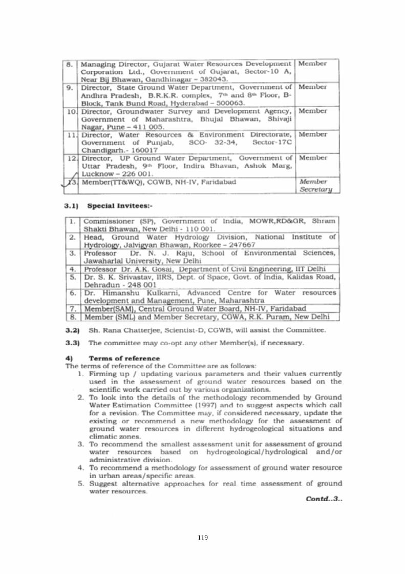
119

120

121
ANNEXURE II

122

123
ANNEXURE III

124

125

126

127
ANNEXURE IV No.40/CGWB/M(TT&WQ)/Res./ 2015 Central Ground Water Board Ministry of Water Resources, River Development & Ganga Rejuvenation BhujalBhawan, Faridabad Dated: 16.07.2015
To (As per the list)
Sub: Minutes of the Meeting on “Revision of GEC-97 Methodology” held under the Chairmanship of Chairman CGWB, at Jamnagar house, New Delhi on 3rd July, 2015 at 12.00 hrs Kindly find enclosed herewith a the Minutes of the Meeting on “Revision of GEC-97 Methodology” held under the Chairmanship of Chairman CGWB, at Jamnagar House, New Delhi on 3rd July, 2015 at 12.00 hrs.
This is for your kind information and necessary action.
Encl.: As above
Yours faithfully
(G.C. Pati) Member (TT & WQ)

128
MINUTES OF THE MEETING ON “REVISION OF GEC-97 METHODOLOGY” HELD UNDER THE CHAIRMANSHIP OF CHAIRMAN CGWB, AT JAMNAGAR HOUSE, NEW DELHI ON 3rd
1. The subgroups will submit a base report on their recommendation for revision of GEC-97 Methodology to the Chairman within one month from the date of issue of the minutes of the meeting.
JULY, 2015 AT 12.00 HRS Shri K.B.Biswas, Chairman, Central Ground Water Board (CGWB) and Chairman of the committee to review and revise the GEC-97 Methodology welcomed all the Members of the committee and informed that the revised GEC Methodology needs to be very precise taking into consideration the public information and ground water regulation. Shri G.C. Pati, Member (TT & WQ), CGWB informed that the three subgroups constituted to facilitate the working and timely completion of terms of references of the committeeto review and revise the GEC-97 Methodology were supposed to submit their report by 06.07.2015. The meeting was called to discuss upon the progress of work done by the subgroups and what new parameter/factors can be used for refinement of GEC-97 methodology. With the permission of the Chair, Dr.Himanshu Kulkarni, Executive Director, ACWADAM, and convener of the Sub Group-I, AVSS Anand, Scientist C RGNGWT & RI and Resource Person for Subgroup-II and Ranjan K Ray, Scientist C and Resource Person for Subgroup III made presentations on work done for the revision of the GEC Methodology. List of participants is annexed. Following points emerged from the deliberations during the meeting:
2. Another meeting may be held to discuss and finalize the Base Report.
3. Pilot studies may be taken up to test the implementation of the
recommendations of the three subgroups.
4. After finalization of the methodology, the detailed guidelines for implementation of the methodology will be prepared.
Meeting ended with vote of thanks.

129
List of Participants
Sl.No Participants 1. Chairman, Central Ground Water Board, CHQ, Faridabad
2. Member (SAM), Central Ground Water Board, CHQ, Faridabad
3. Member (TT & WQ), Central Ground Water Board, CHQ, Faridabad
4. Member (RGI), Central Ground Water Board, CHQ, Faridabad.
5. Member (SM&L), Central Ground Water Board, R.K Puram, New Delhi
6. Dr.Himanshu Kulkarni, Director, Advanced Centre for Water Resources Development and Management.
7. Dr.A.R.Khan, Dy. General Manager, NABARD 8. Dr. A.K. Gosain, Professor, IIT Delhi.
9. Shri. A.K. Madhukar, Superintending Geophysicist, Central Ground Water Board, CHQ, Faridabad.
10. Dr. S. Suresh, Scientist D, Central Ground Water Board, CHQ, Faridabad. 11. Shri S.K. Sinha, Scientist D, Central Ground Water Board, CHQ, Faridabad. 12. Shri. Rana Chatterjee, Scientist D, Central Ground Water Board, Jamnagar
House, New Delhi 13. Dr. B.C. Joshi, Scientist D, Central Ground Water Board, CHQ, Faridabad 14. Shri AVSS Anand, Scientist C, Central Ground Water Board, RGNGWTRI,
Raipur. 15. Shri. Ranjan Kumar Ray, Scientist C, Central Ground Water Board, CHQ,
Faridabad. 16. Ms. Rumi Mukherjee, Scientist C, Central Ground Water Board, CHQ,
Faridabad. 17. Ms. Parveen Kaur, Scientist B, Central Ground Water Board, CHQ, Faridabad

130
ANNEXURE V No.40/CGWB/M(TT&WQ)/Res./ 2015 Central Ground Water Board Ministry of Water Resources, River Development & Ganga Rejuvenation BhujalBhawan, Faridabad Dated: 22.09.2015
To (As per the list)
Sub: Minutes of the Meeting on “Revision of GEC-97 Methodology” held under the Chairmanship of Chairman CGWB, at Jamnagar house, New Delhi on 18th Sept, 2015 at 2.30 P.M Kindly find enclosed herewith the Minutes of the Meeting on “Revision of GEC-97 Methodology” held under the Chairmanship of Chairman CGWB, at Jamnagar House, New Delhi on 18th Sept, 2015 at 2.30 P.M
This is for your kind information and necessary action.
Encl.: As above
Yours faithfully
(G.C. Pati) Member (TT & WQ)

131
MINUTES OF THE MEETING ON “REVISION OF GEC-97 METHODOLOGY” HELD UNDER THE CHAIRMANSHIP OF CHAIRMAN CGWB, AT JAMNAGAR HOUSE, NEW DELHION 18TH
1. As per the recommendations of the Subgroup I, the term Ground water development may be exchanged with Ground water exploitation.
SEPT, 2015 AT 2.30 P.M Shri K.B.Biswas, Chairman, Central Ground Water Board (CGWB) and Chairman of the committee to review and revise the GEC-97 Methodology welcomed all the Members of the committee and sought recommendation from the three subgroups. Shri G.C. Pati, Member (TT & WQ), CGWB informed that the report of the committee to review and revise the GEC-97 Methodology will be finalized on the basis of the recommendation of the three subgroups constituted to facilitate the timely completion of terms of references of the committee. Dr.Himanshu Kulkarni, Executive Director, ACWADAM, and convener of the Sub Group-I, AVSS Anand, Scientist C RGNGWT & RI and Resource Person for Subgroup-II and Ranjan K Ray, Scientist C and Resource Person for Subgroup III made presentations on recommendations of the respective subgroups. List of participants is annexed. Following points emerged from the deliberations during the meeting:
2. Ground water resources assessment may be done once in 5 years.
3. Resource assessment is done quantitatively but simultaneously quality may
also be added. It was decided to consider Stage of Ground water Exploitation for categorization of assessment units. Categorization of Assessment units which are affected by Arsenic or fluoride, the term respective Hazard Areas may be used. The assessment of for salinity affected areas in practice may continue.
4. Committee members agreed upon the recommendations of the subgroup II that Pilot studies need to be conducted to determine base flow factor in the proposed methodology.
5. Digital Elevation Models (DEM) may be used for determining the hilly area over a region which is considered not suitable for ground water recharge.
6. Recommendations of all the Subgroups were deliberated upon during the meeting and there was a broad agreement over these recommendations.
7. A committee is constituted to prepare the final report on the Revised GEC- Methodology and detailed Guidelines for calculation of Ground water Resources Assessment.

132
Following are the Member of the Committee:
Sl. No
Members
1 Shri. G.C. Pati, Member (TT & WQ), Central Ground Water Board, CHQ, Faridabad
2 Dr. B.C. Joshi, Scientist-D, Central Ground Water Board, CHQ, Faridabad 3 Shri AVSS Anand, Scientist-C, Central Ground Water Board, RGNGWTRI,
Raipur. 4 Ms. Rumi Mukherjee, Scientist-C, Central Ground Water Board, CHQ,
Faridabad. 5 Ms. Parveen Kaur, Scientist-B, Central Ground Water Board, CHQ,
Faridabad Meeting ended with vote of thanks.

133
List of participants: Sl.No Participants
1 Shri. K.B. Biswas, Chairman,Central Ground Water Board, CHQ, Faridabad
2 Shri. K.C. Naik, Member (SAM), Central Ground Water Board, CHQ, Faridabad
3 Shri G.C. Pati, Member (TT & WQ), Central Ground Water Board, CHQ, Faridabad
4 Dr.DipankarSaha, Member (RGI), Central Ground Water Board, CHQ, Faridabad.
5 Dr. E. Sampath Kumar, Member (SM&L), Central Ground Water Board, R.K Puram, New Delhi
6 Dr.Himanshu Kulkarni, Director, Advanced Centre for Water Resources Development and Management.
7 Dr. A.R.Khan, Dy. General Manager, NABARD 8 Dr. A.K. Gosain, Professor, IIT Delhi.
9 Dr.J.S.Mehta, Director, Geological Survey India, New Delhi.
10 Shri. A.K. Madhukar, Superintending Geophysicist, Central Ground Water Board, CHQ, Faridabad.
11 Dr. S.K. Srivastava, Head, Geoinformatics Department, IIRS, Dehradun 12 Shri. BimalJeet Bhandari, Executive Engineer (Agronomist), Director, Water
Resources, Punjab, Sector-68, Mohali, Punjab 13 Shri. Rana Chatterjee, Scientist-D, Central Ground Water Board, Jamnagar
House, New Delhi 14 Dr. B.C. Joshi, Scientist-D, Central Ground Water Board, CHQ, Faridabad 15 Shri AVSS Anand, Scientist-C, Central Ground Water Board, RGNGWTRI,
Raipur. 16 Dr.Jyoti P. Patil, Scientist C, NIH, Roorkee 17 Shri. Ranjan Kumar Ray, Scientist-C, Central Ground Water Board, CHQ,
Faridabad. 18 Ms. Rumi Mukherjee, Scientist-C, Central Ground Water Board, CHQ,
Faridabad. 19 Ms. Parveen Kaur, Scientist-B, Central Ground Water Board, CHQ,
Faridabad

134
ANNEXURE VI
No.40/CGWB/M(TT&WQ)/Res./ 2015 Central Ground Water Board Ministry of Water Resources, River Development & Ganga Rejuvenation BhujalBhawan, Faridabad Dated: 10.12.2015
To
(As per the list) Sub: Minutes of the Meeting on “Revision of GEC-97 Methodology” held under the Chairmanship of Chairman CGWB, at Jamnagar house, New Delhi on 3rd Dec, 2015 at 11.30 A.M Kindly find enclosed herewith the Minutes of the Meeting on “Revision of GEC-97 Methodology” held under the Chairmanship of Chairman CGWB, at Jamnagar House, New Delhi on 3rdDec, 2015 at 11.30 A.M
This is for your kind information and necessary action.
Encl.: As above
Yours faithfully
(G.C. Pati) Member (TT & WQ)

135
MINUTES OF THE MEETING ON “REVISION OF GEC-97 METHODOLOGY” HELD UNDER THE CHAIRMANSHIP OF CHAIRMAN CGWB, AT JAMNAGAR HOUSE, NEW DELHI ON 3rd
1. As per the recommendations of the committee, the term ‘Ground water development’ will be replaced with the term ‘Ground water extraction’.
DEC, 2015 AT 11.30 A.M Shri K.B.Biswas, Chairman, Central Ground Water Board (CGWB) and Chairman of the committee to review and revise the GEC-97 Methodology welcomed all the Members of the committee. Shri G.C. Pati, Member (TT & WQ), CGWB informed that the drafting committee has prepared the final draft report on GEC-2015. Shri AVSS Anand, Scientist D RGNGWT & RI and Resource Person for Subgroup-II made presentation on highlights of the final draft report for discussion. List of participants is annexed. Following points emerged from the deliberations during the meeting:
2. The GEC-2015 recommends aquifer wise ground water resource assessment
of both Replenishable ground water resources or Dynamic Ground Water Resources and In-storage Resources or Static Resources for all aquifers after a period of 3 years. However, the presently used assessment units may continue till the aquifers are fully deciphered. Only the report on Dynamic Ground Water Resources assessment will be shared with the States or with public.
3. The Ground water resources worked out Aquifer wise may be apportioned and presented on administrative units such as block/taluka/mandal/ firka as well as higher administrative units like Districts/State.
4. Water year is to be considered as the base for ground water resources assessment.
5. The GEC-2015 recommends classification of assessment units into 4 categories i.e. Safe, Semi-Critical, Critical, Over-Exploited on the basis of Stage of Ground water extraction. The criteria for categorization of Assessment units will be: 0 to <= 65 Safe; >65 to <=85 Semi-critical; >85 to <= 100 Critical and >100 Over Exploited. The results will be validated using the Long term ground water level trends.
6. The Quality aspect of Ground water will also be considered during the
resources assessment and assessment units with poor ground water quality will be tagged for salinity, Fluoride and Arsenic Hazard.

136
7. Special studies need to be taken up for refinement of norms on various factors such as return flow from irrigation taking into account the micro irrigation, seepage from canal, spring discharge, aquifer and soil water balance. Immediate studies may be taken up in Lucknow, Sikkim and Hyderabad for different hydrogeological terrains.
Over all there was a broad consensus on the recommendations of the report on GEC-2015. It was deliberated that there is a need to conduct R & D studies for refinement of various parameters used for resource assessment. List of participants: Sl.No Participants
1. Shri. K.B. Biswas, Chairman, Central Ground Water Board, CHQ, Faridabad
2. Shri. K.C. Naik, Member (RGI), Central Ground Water Board, CHQ, Faridabad
3. Shri. G.C. Pati, Member (TT & WQ), Central Ground Water Board, CHQ, Faridabad
4. Dr. Dipankar Saha, Member (SAM), Central Ground Water Board, CHQ, Faridabad.
5. Dr. E. Sampath Kumar, Member (SM&L), Central Ground Water Board, R.K Puram, New Delhi
6. Dr. Himanshu Kulkarni, Director, Advanced Centre for Water Resources Development and Management.
7. Dr. A.R. Khan, Dy. General Manager, National Bank for Agriculture, & Rural Development(NABARD),
8. Dr. Nandakumaran. P., Regional Director, Central Ground Water Board, CHQ, Faridabad.
9. Shri. Sanjay Marwaha, Regional Director, Central Ground Water Board, CHQ, Faridabad.
10. Professor N.J. Raju School of Environmental Sciences, Jawaharlal University, New Delhi.
11. Dr. S.K. Srivastava, Head, Geoinformatics Department, IIRS, Dehradun
12. Shri. S.K. Sinha, Central Ground Water Board, CHQ, Faridabad. 13. Dr. S. Suresh, Scientist D, Central Ground Water Board, CHQ, Faridabad 14. Shri. Ravi Kant Singh, Senior Hydrogeologist, Ground water Department, Uttar
Pradesh. 15. Shri. Dharamveer Singh Rathore, Directorate (Lucknow), A.E. (Mechanical),
Ground water Department, Uttar Pradesh

137
16. Dr. B.C. Joshi, Scientist-D, Central Ground Water Board, CHQ, Faridabad 17. Shri AVSS Anand, Scientist-D Central Ground Water Board, RGNGWTRI,
Raipur. 18. Shri. Ranjan Kumar Ray, Scientist-C, Central Ground Water Board, CHQ,
Faridabad. 19. Ms. Parveen Kaur, Scientist-B, Central Ground Water Board, CHQ, Faridabad