Report - Full - Hamilton · Ruakura Interchange Assessment of Air Quality Effects . ... 2...
19
Waikato Expressway: Hamilton Section Ruakura Interchange Assessment of Air Quality Effects
Transcript of Report - Full - Hamilton · Ruakura Interchange Assessment of Air Quality Effects . ... 2...

Waikato Expressway: Hamilton Section
Ruakura Interchange Assessment of Air Quality Effects
Waikato Expressway: Hamilton Section
Ruakura Interchange
Assessment of Air Quality Effects
© Opus International Consultants Ltd 2014
Prepared By
Opus International Consultants Ltd
Igor Kvatch Hamilton Environmental Office
Environmental Scientist Opus House, Princes Street
Private Bag 3057, Waikato Mail Centre,
Hamilton 3240
New Zealand
Reviewed By
Vince Dravitzki
Research Manager
Material & Environmental Science
Telephone:
Facsimile:
+64 7 838 9344
+64 7 838 9324
Date: 29 August 2014
Reference: 2-31695.00
Status: Final
Approved for
Release By
Dave Heine
Opus Team Leader
Ruakura Interchange i
2-31695.00 | 29 August 2014 Opus International Consultants Ltd
Contents
1 Introduction ....................................................................................................... 1
1.1 Overview ............................................................................................................................ 1 1.2 Background ....................................................................................................................... 1 1.3 Context .............................................................................................................................. 3 1.4 Proposal ............................................................................................................................ 6
2 Assessment of Air Quality Effects ....................................................................... 9 2.1 Methodology ..................................................................................................................... 9
2.2 Assessment of Roadside Ambient Air Quality ................................................................ 12 2.3 Assessment of Construction Dust Emissions .................................................................. 12 2.4 Potential Cumulative Effects ........................................................................................... 13
2.5 Conclusion ....................................................................................................................... 14

Ruakura Interchange 1
2-31695.00 | 29 August 2014 Opus International Consultants Ltd
1 Introduction
1.1 Overview
The New Zealand Transport Agency (the Transport Agency) proposes to alter the existing
designation for the Hamilton Section of the Waikato Expressway (Hamilton Section) and obtain
additional resource consents from Waikato Regional Council (WRC) in order to construct, operate
and maintain the Ruakura Interchange and connecting roads. The Ruakura Interchange was omitted
from the recent round of alterations to the designation, whilst the Transport Agency awaited the
Board of Inquiry’s decision on the Ruakura Development Private Plan Change, by Tainui Group
Holdings.
1.2 Background
1.2.1 Roads of National Significance
In May 2009, the Government Policy Statement on Land Transport Funding (GPS) was released,
which identified seven Roads of National Significance (RoNS), which are considered by the
Government to be New Zealand’s most important transport routes requiring significant development
to reduce congestion, improve safety and support economic growth. The Waikato Expressway is one
of the seven RoNS.
The purpose of listing particular roads as nationally significant was to ensure these priority roading
projects are fully taken into account in the development of the National Land Transport Programme.
The Government expects that planning for the future development of the land transport network
should reflect the importance of these roads from a national perspective and the need to advance
them quickly.
1.2.2 Waikato Expressway
The Expressway will extend from the Bombay Hills in the north to just south of Cambridge. The
Expressway has been divided into 12 sections. It is expected the Expressway will:
» Improve economic growth and productivity for Auckland, Waikato and Bay of Plenty through
more efficient movement of people and freight between Auckland, Hamilton, Tauranga and
Rotorua;
» Improve the reliability of the transport network by providing a more robust and safer road
network between Auckland, Hamilton, Tauranga and Rotorua;
» Reduce travel times between Waikato and Auckland; and
» Support the growth strategy for the central Waikato.
1.2.3 Hamilton Section
The Hamilton Section is located on the eastern side of the city of Hamilton. The Hamilton Section
adjoins the recently completed Ngaruawahia Section to the north, and the existing Tamahere
Interchange to the south. It is approximately 22km in length. Figure 1-1 shows the scope of the
Hamilton Section.

Ruakura Interchange 2
2-31695.00 | 29 August 2014 Opus International Consultants Ltd
Figure 1-1: Proposed Scope of Works - Waikato Expressway Hamilton Section

Ruakura Interchange 3
2-31695.00 | 29 August 2014 Opus International Consultants Ltd
1.3 Context
1.3.1 Current designation and resource consents
The Hamilton Section was first designated in 2005, following an appeal before the Environment
Court in 2004. In October 2013, the Transport Agency lodged Notices of Requirement (NORs) to
alter the designation in a number of discrete locations. Applications for resource consent to
construct, operate and maintain the Hamilton Section were also lodged at that time. Both resource
consents and NORs were heard by independent Commissioners at a joint hearing in April/May 2014.
The Commissioners’ decision on the resource consents was notified on 1 July 2014, granting all
consents applied for, subject to conditions. A recommendation from the Commissioners was released
on 30 June 2014 with respect to the NORs. The recommendation was that the NORs be granted
subject to a set of recommended conditions. On 8 July 2014, the Transport Agency accepted the
recommendation with only minor modifications. Two appeals have been made by submitters, one
in relation to Alteration U, and the other in relation to Alteration Z.
1.3.2 Ruakura Structure Plan (RSP)
Boundary changes between Hamilton City Council (HCC) and Waikato District Council (WDC) have
meant that a significant area of land at Ruakura is now within the jurisdiction of HCC. The
development of this land is identified in a number of high level documents including: the Hamilton
Urban Growth Strategy, the Access Hamilton Transport Strategy and the Waikato Proposed Regional
Policy Statement.
To enable the progressive development of this area, the Ruakura Structure Plan (RSP) was developed
and notified as part of the Hamilton City Proposed District Plan (PDP) in December 2012. The RSP
(as notified) includes an inland port, freight and logistics hub and other industrial land. The inland
port as proposed in the RSP has an intermodal facility so that freight can be transferred to and from
road and rail. The RSP also provides for research and innovation activities, and residential areas for
an eventual population of approximately 1,800 households, including the development of a
neighbourhood centre.
Submissions and further submissions have been received on the RSP, however hearings and a
decision have been deferred, pending the outcome the Ruakura Private Plan Change (PPC).
1.3.3 Ruakura Private Plan Change (PPC)
Tainui Group Holdings Limited (TGH) is the predominant landowner affected by the RSP. It was
identified that rules in the Hamilton District Plan: Waikato Section (as transferred over from the
WDC’s District Plan) prohibit any application being made for urban development within this area.
Given that the WDC rules are currently operative, they continue to apply until the PDP (including
the RSP) is made operative. Given the potential for lengthy delays, TGH have sought a PPC for what
is known as the Ruakura Development, through the Environmental Protection Authority (EPA). The
PPC affects some, but not all, of the land subject to the RSP.
The PPC does not re-zone any land, rather it proposes to adopt mechanisms providing an overlying
‘schedule’. This allows a range of activities to be undertaken in identified areas, as well as existing
rural activities.
The key aspects of the PPC are as follows:

Ruakura Interchange 4
2-31695.00 | 29 August 2014 Opus International Consultants Ltd
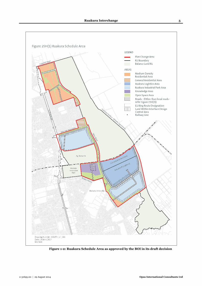
A new ‘Schedule 25H Ruakura’ inserted into Chapter 25: Rural of the PDP, which provides a
Ruakura Logistics Area (incorporating the Inland Port), Ruakura Industrial Park Area,
Knowledge Area, Residential Areas and Open Space Areas along with indicative roads (refer to
Figure 1-2 below).
Amendments to the Prohibited Activity rules to enable the planning and development of the land
covered by Schedule 25H, including the future roading network.
On 31 July 2013, a ministerial direction was released, referring the PPC request to a Board of Inquiry
(BOI) which was held over a number of weeks during May/June 2014. On 5 August 2014, the BOI
issued its draft decision approving the PPC, subject to a number of amendments to the proposed
objectives, policies and rules, as they would apply to the Ruakura Development. Comments on the
draft decision close during the week commencing 1 September 2014, and a final decision is due on
11 September 2014.
he PPC will enable development to occur in the interim, but it is intended that the PPC will also be
incorporated into the framework of the PDP, once the PPC has been confirmed. Accordingly, the
RSP contained within the notified PDP is likely to be superseded by the Board’s decision on the PPC.
Ruakura Interchange 5
2-31695.00 | 29 August 2014 Opus International Consultants Ltd
Figure 1-2: Ruakura Schedule Area as approved by the BOI in its draft decision

Ruakura Interchange 6
2-31695.00 | 29 August 2014 Opus International Consultants Ltd
1.4 Proposal
1.4.1 NOR – Alteration to Designation
The Transport Agency is now proposing to alter the designations for the Hamilton Section to include
a new interchange at Ruakura and encompass associated connecting roads (being the relocated and
the existing Ruakura Road). The scope of the designation sought is shown in Figure 1-3 below.
Figure 1-3: Diagram of Proposed Alteration to Designation
The altered designation includes the following:
» Widening of the existing Expressway designation to accommodate the Ruakura Interchange
ramps, connecting roundabouts, and stormwater wetland;
» Closure of the existing Ruakura Road either side of the Expressway and consequently
shortening of the proposed bridge over the East Coast Main Trunk (ECMT) rail line;
» Retention of the existing Ruakura Road either side of the closure at the Expressway in order to
provide continued property access to residents on Ruakura Road, including access to Percival
and Ryburn Roads as currently provided;
» Relocation of Ruakura Road between the Ruakura Road/Silverdale Road intersection and the
existing Ruakura Road near the Vaile Road intersection to connect with the proposed Ruakura
Interchange, including:
Existing Ruakura Road/Silverdale Road intersection closed, with Silverdale Road
terminating in a cul-de-sac (road retained for access) and creation of a new signalised

Ruakura Interchange 7
2-31695.00 | 29 August 2014 Opus International Consultants Ltd
relocated Ruakura Road/Silverdale Road intersection that will also provide a key access
point to the Ruakura Development Logistics Area;
New relocated Ruakura Road/Existing Ruakura Road (west) priority controlled tee
intersection;
A signalised intersection along the relocated Ruakura Road to provide a second key access
point to the Ruakura Development Logistics Area;
Provision of a tee intersection where the relocated Ruakura Road meets the existing
Ruakura Road (east);
Upgrading the existing Ruakura Road, largely within its existing boundaries, between the new intersection with the relocated Ruakura Road (east) and the Ruakura Road/SH26 intersection (this will include shape correction of the roadway, carriageway widening, provision of a footpath and drainage improvements;
Extension of the designation to cover the existing Ruakura Road (from the intersection
with the relocated Ruakura Road up to SH 26) so upgrading works can be undertaken;
Provision for the relocated Ruakura Road to pass either over or under the Expressway; and
Provision for stormwater attenuation and disposal from the relocated Ruakura Road and
Ruakura Interchange.
Detailed designation plans are provided as Appendix C to the NOR.
Subject to the Ruakura Interchange proceeding, the proposed north facing ramps where the
Expressway passes under SH26 would not be required. Accordingly, a condition is proposed that
would result in the north facing ramps being removed from the Waikato Expressway, once the
Ruakura Interchange is under construction.
The relocated Ruakura Rd west of the Expressway will become a local road, whereas the link formed
by the relocated and existing Ruakura Roads east of the Expressway as far as State Highway 26 will
become state highway.
1.4.2 Resource Consents
The Transport Agency is also seeking additional resource consents from the WRC to construct,
operate and maintain the connecting roads (being the relocated and existing Ruakura Road). The
interchange ramps and associated earthworks are covered by the existing consents granted 1 July
2014. Water and discharge permit applications will be lodged with the WRC shortly.
1.4.3 Existing Environment
The Resource Management Act 1991 (RMA) requires an assessment of the actual and potential effects
on the environment of allowing the activity (s104(1)(a)). This report forms part of that assessment.
Consideration therefore needs to be given to what defines the existing environment, as this is what
the effects of the proposal will be assessed against.
1.4.3.1 Waikato Expressway
The Hamilton Section of the Waikato Expressway designations pass to the east of Hamilton City in
a generally north-south direction and enable the construction of a four-lane Expressway and

Ruakura Interchange 8
2-31695.00 | 29 August 2014 Opus International Consultants Ltd
associated on/off ramps to connect with the local road network (excluding the Ruakura Interchange).
The development of the Expressway is also supported by a number of consents granted by the WRC.
For the purpose of assessing this NOR, the Expressway as currently designated is considered part of
the existing environment.
1.4.3.2 West of the Expressway
The land immediately to the west of the Expressway is currently zoned Rural in the Hamilton District
Plan: Waikato Section. This area adjoining the Expressway is in pasture, with scattered dwellings
and farm buildings. The Waikato University is located to the west of Silverdale Road, and is
surrounded by residential development. There is also residential development to the east of
Silverdale Road, which juts out towards the Expressway and is bounded by a gully (Nevada Road).
North of Ruakura Road is an area of land zoned Country Living, which contains a cluster of
approximately 30 rural residential dwellings.
The environment immediately to the west of the Expressway is subject to a PPC, which a BOI has
approved in its draft decision. Consideration of this NOR by the territorial authority should be in
the context of the future development enabled by the PPC. The need for the Ruakura Interchange is
a direct result of development occurring in this area in accordance with the PPC. Without the PPC
proceeding, the Agency would revert back to the approved north facing ramps at SH26, unless an
alternative justification was provided for establishing an interchange at Ruakura.
It is reasonable to assume that the existing environment for the purpose of assessing the effects of
this NOR will consist of the land use activities indicated in Figure 1-2 of this report, and supported
by the BOI decision. The BOI has already heard evidence in relation to the associated effects of these
land use activities and their ruling on the PPC has taken such effects into consideration. It is for this
reason that for the purposes of the overall effects assessment the PPC has been adopted as the
existing environment.
1.4.3.3 East of the Expressway
The land to the east of the Expressway is zoned Rural in the Waikato District Plan. The portion of
land between the ECMT and Davison Road is characterised by large open paddocks and scattered
buildings, including some dwellings. From Davison Road south, there is significantly more rural-
residential development. The Dairy NZ/LIC site is located on the corner of Ruakura Road and SH26.
Ruakura Road itself is identified as an Arterial Road in the Waikato District Plan (WDP). The
function of Arterial Roads is described in the WDP as roads that:
» Form a strategic network of regional importance
» Provide for the collection and distribution of goods significant to the regional economy
» Rural roads that typically provide for more than 2,500 vehicle movements per day
» Include rest areas; and
» The through traffic function predominates.

Ruakura Interchange 9
2-31695.00 | 29 August 2014 Opus International Consultants Ltd
2 Assessment of Air Quality Effects
The assessment of impacts on the local air quality was undertaken for the proposed Ruakura
Interchange (the Interchange) and associated connecting roads. It is a desktop investigation of
potential discharges to air from this Project, including fugitive dust emissions from earthworks
during construction, vehicle emissions from traffic flows on the Interchange and connecting roads,
and cumulative effects taking into account the Inland Port development.
The assessment predicts impacts of vehicle emissions on properties with residential dwellings
located in the vicinity of Interchange and along Ruakura Road, Silverdale Road and SH26. The
assessment applies a Tier 2 approach recommended in the Good Practice Guide for Assessing
Discharges to Air from Land Transport (MfE June 2008), and the draft New Zealand Transport
Agency’s (NZTA) Guide to Assessing Air Quality Effects for State Highway Asset Improvement
Projects (NZTA, September 2012).
There are three levels of the air quality assessment (Tier 1, Tier 2 and Tier 3) specified in these guides.
A Tier 2 screening assessment provides conservative estimates of likely air quality impacts. This
means the assessment can provide confidence that a project will not result in significant air quality
impacts.
2.1 Methodology
The Tier 2 screening approach was applied to assess ambient air roadside concentrations depending
on the distance from the road edge and the volume of traffic flow. This screening methodology
requires the following input data to calculate roadside concentrations of vehicle emitted
contaminants.
Annual average daily traffic flow and vehicle speed
Percentage of heavy vehicles in traffic flow
Vehicle emission rates (calculated using Vehicle Emission Prediction Model (VEPM
5.0)Distance to the nearest receptor (potentially affected residential dwellings or other
sensitive receivers such as schools)
The ambient air concentrations were calculated for the nearest receptor sites using equations
provided in the MfE Good Practice Guide (MfE June 2008). Calculated concentrations were
compared with the significance criteria shown in Table 1. The NZTA Guide (September 2012)
provides air quality significance criteria, which includes three contaminants: fine particulate matter
(PM10 and PM2.5) and nitrogen dioxide (NO2).
2.1.1 Assessment Criteria
Several documents are available to establish the assessment criteria for Interchange effects including
the National Environmental Standards for Air Quality (MfE October 2005), Ambient Air Quality
Guidelines (MfE 2002), and the Waikato Regional Council’s Regional Ambient Air Quality
Guidelines (Waikato Regional Plan reprinted, April 2012). These documents are discussed in the
AEE report and are applicable for a comprehensive Tier 3 assessment. The Tier 2 screening
assessment assumes that the air quality in the investigation area will remain within the standard and
guideline limits and provides the indication on the significance of changes in local air quality.

Ruakura Interchange 10
2-31695.00 | 29 August 2014 Opus International Consultants Ltd
The significance criteria shown in Table 1 are set at 5% of the national ambient air quality standard
and guidelines in accordance with the MfE Good Practice Guide (MfE, June 2008) . “These
thresholds are not intended to define an acceptable or insignificant increase in actual ambient air
quality. Instead, they are intended to provide an indication of the likely significance of predicted
ground-level concentrations. If these criteria are exceeded, this does not necessarily mean that air
quality impacts will be significant; it simply means a more accurate assessment should be
undertaken” (MfE, June 2008).
The assessment criteria does not have any statutory basis, however it provides the data for air quality
specialists “to determine whether a Tier 3 detailed assessment is required or not” (NZTA, September
2012). If the predicted concentrations are within the criteria limits, then the conclusion can be made
that further assessment is not required.
Table 1: Tier 2 air quality significance criteria
Pollutant Standard/guideline Limit
Averaging time Significance criteria
PM10 50 µg/m3 24 hour 2.5 µg/ m3
PM2.5 25 µg/m3 24 hour 1.25 µg/ m3
NO2 40 µg/ m3 annual 2.0 µg/ m3
Source: draft Guide to assessing air quality effects for state highway asset improvement projects (NZTA
September 2012).
For vehicle emissions the following assumption can be made. If the screening assessment shows that
the levels of PM10, PM2.5 and NO2 are within the significance criteria, then the levels of other road
transport related contaminants will be acceptable, (MfE, June 2008 and NZTA, September 2012).
2.1.2 Existing Air Quality
The Interchange and connecting roads are located in rural and suburban environment, and there is
no air quality monitoring data specific for this area. However there are several available reports on
air quality monitoring in Hamilton and small rural towns of the Waikato region such as Matamata,
Turangi, and Ngaruawahia. The data from these locations have been used to assess the existing air
quality with adjustments to Ruakura meteorological conditions and the intensity of traffic flows on
local roads.
The existing local air quality was also assessed in the Opus Research report “Waikato Expressway:
Assessment of Air Quality Effects” (Opus Research, August 2013) prepared for AEE. Results of this
assessment are applicable for the Interchange and they show that the existing air quality in the
Ruakura area is within the air quality standards and guidelines.
2.1.3 Daily Traffic Flow
The daily traffic flow data predicted for the year 2021 and 2041 and used for the assessment is shown
in Table 2. The year 2041 assessment was carried out using the predicted traffic data for 2041, but
the emission rates obtained from the VEPM 5.0 model were for the year 2030. It was the latest year
available in the model.

Ruakura Interchange 11
2-31695.00 | 29 August 2014 Opus International Consultants Ltd
Taking into account this assumption, the predicted roadside concentrations for 2041 should be
considered as conservative, exceeding the real values anticipated in the future, because vehicle
emission rates will decrease with time resulting in decreased roadside concentrations.
The “baseline” traffic flows were predicted for the Expressway and connecting roads without
Ruakura Interchange, the “scheme” data takes into account associated changes with the Interchange
in place.
Table 2: Predicted annual average daily traffic flow (Daily/heavy)
Route Speed limit km/h
2021 2041
Baseline Scheme Baseline Scheme
Waikato Expressway 100
19200/3700 13500/3000
21800/2900 20700/440
Ruakura Rd north of the Interchange
50 5400/100 300/50 n/a n/a
Ruakura-Silverdale Rd corner 50 11400/500 10400/300 10800/500 11000/400
Ruakura Rd (Vaile Rd – SH26) 80 1500/100 4200/800 2500/300 4300/500
New link west of Expressway 80 800/600 6200/700 4700/400 12700/3500
New link east of Expressway 80 n/a 6200/900 n/a 6600/700
SH26 west of Expressway 80 12300/1500 9600/120o 14900/800 10800/700
SH26 east of Expressway 80 9600/1900 9600/1200 12100/900 10800/700
2.1.4 Location of the Receptor Sites used in the Assessment
The construction of Ruakura Interchange will include, on/off ramps, north and south bound and the
new road coming from the Ruakura – Silverdale Road intersection located about 1 km west of the
Expressway. This road will cross the Expressway and extends to the intersection with Ruakura Road,
about 800 metres east of the Interchange.
The Interchange and new connecting roads will be constructed within farmland at a distance of
several hundred metres from the nearest residential dwellings. There is only one house located at
495 Ruakura Road, which could be affected by vehicle emissions from the new road. The house at
480 Ruakura Road will be removed.
The construction of the Interchange will not directly affect any residential dwellings in this area,
because it will be located far away from the nearest houses. An effect may occur along some other
roads due to the changes of traffic flows on these roads (e.g. Ruakura Road between Vaile Road and
SH26). To assess potential effects from changed traffic flows, several residential dwellings (receptor
sites) in different areas have been chosen for the assessment of air quality effects. The location of
these receptor sites is shown in the following section in Table 3.

Ruakura Interchange 12
2-31695.00 | 29 August 2014 Opus International Consultants Ltd
2.2 Assessment of Roadside Ambient Air Quality
Several houses chosen for the assessment are located at distances of 15 – 20 metres from the
carriageway, other houses are located close to the road edge at distances of 12 – 15 metres. The
assessment was carried out for the distances shown in Table 3, determined between the edge of
carriageway and the nearest exposed side of the house. The predicted concentrations shown in the
table do not include background levels of air pollution in the assessment area.
Table 3: Ambient air concentrations predicted at receptor sites
Receptor site Dist. (m)
PM10 µg/m3 PM2.5 µg/m3 NO2 µg/m3
2021 2041 2021 2041 2021 2041
495 Ruakura Rd 13 0.8 0.5 0.5 0.3 0.7 0.6
295 Ruakura Rd 16 0.7 0.5 0.5 0.3 0.7 0.6
Ruakura-Silverdale Rd corner 17 1.1 0.7 0.7 0.5 1.3 1.3
199 Silverdale Rd 20 0.7 0.6 0.4 0.4 0.9 0.9
159 Silverdale Rd 12 0.9 0.8 0.6 0.5 0.9 0.9
3 Vaile Rd 20 0.2 0.2 0.1 0.1 0.3 0.2
188 Morrinsville Rd (SH26) 15 1.1 0.8 0.7 0.5 1.4 1.4
The assessment shows that calculated concentrations for the year 2021 and 2041 at all receptor sites
are below the significance criteria shown in Table 1. This means that the operational Interchange and
changes to traffic flows on existing roads will have a minimal impact on the local environment in
terms of air quality. Accordingly, the effects of vehicle emissions on local air quality will be less than
minor, and further detailed assessment is not required (see Section 2.1).
2.3 Assessment of Construction Dust Emissions
The assessment of construction dust emissions from the Interchange applied the same methodology
used in the Opus Research “Waikato Expressway: Assessment of Air Quality Effects” report (see
AEE). This assessment was reviewed by Dr Bruce Graham for the Waikato Regional Council and Dr
Graham’s recommendations were taken into account in setting dust conditions for the Expressway
(Waikato Regional Council Decision of Hearings Commissioners, 30th June 2014). These conditions
will apply to the construction of the Interchange.
The assessment of construction dust emissions was based on the results of several studies and used
recommendations provided by the MfE “Good Practice Guide for Assessing and Managing the
Environmental Effects of Dust Emissions” (MfE September 2001). The assessment shows that the
deposition of large airborne particles appears within 100 metres from the source, to perhaps 300
metres from the source under dry and windy conditions. The nearest residential dwellings will be
located more than 300 metres from the Interchange, and it can be assumed that there will be no dust
effects beyond the distance of 300 metres from the Interchange.
Ruakura Interchange 13
2-31695.00 | 29 August 2014 Opus International Consultants Ltd
The fugitive dust emissions could potentially occur in the vicinity of the construction sites along the
connecting roads. These dust emissions and potential effects can be controlled by a range of
mitigation measures. If dust mitigation measures are implemented as necessary during construction,
fugitive dust emissions from construction activities will be appropriately mitigated.
Effective dust management will be achieved through the Construction Management Plan that will be
used by all contractors to manage, mitigate and minimise dust effects. Examples of such appropriate
measures to minimise or eliminate potential impacts on local air quality will include, but not be
limited to, the following:
• Design the construction site to minimise top soil disturbing areas, stockpiles and distances
travelled on unpaved roads.
• Site access roads can be constructed of pavement materials that minimise dust disturbance.
• Water trucks or similar water spraying facilities should be available on the site to keep soil
handling areas and unpaved roads damp in the case of windy and dry weather conditions.
• Wind fencing can be used as a wind control measure.
• Dampening down soil material that needs to be moved or transported during dry and windy
weather conditions.
• Earthworks should be limited as far as practical, or suspended if necessary during dry and
windy weather conditions.
• Vehicle speed within the construction site and on access roads should be controlled and
limited as far as practical.
• Trucks used for topsoil stripping and moving soil materials need to be washed down, when
leaving construction sites, particularly in dry and windy weather conditions. In the case of
potential fugitive dust emissions, all loaded material should be covered.
• Liaison with local residents in case of fugitive dust emission complaints, with measures in
place to address complaints as received.
It is anticipated that construction dust emissions and their nuisance effects can be adequately
managed if contractors implement the above measures.
2.4 Potential Cumulative Effects
The Interchange and development of the Inland Port may have a cumulative effect on the local air
quality. At this stage, an accurate assessment of this cumulative effect cannot be undertaken due to
the lack of information on the potential emission sources. However potential effects from the Inland
Port can be estimated preliminary, considering emissions from the following activities: transport
emissions over the period of development, dust emissions from construction sites, and transport
emissions after development.
The effect of vehicle emissions on local air quality can be assessed using the data on predicted traffic
volumes through the Interchange and connecting roads, and anticipated traffic intensity within the

Ruakura Interchange 14
2-31695.00 | 29 August 2014 Opus International Consultants Ltd
Inland Port area. The predicted traffic volumes for year 2041 on the Expressway and local roads
including the Inland Port area is unlikely to exceed 25,000 vehicles per day.
The results of vehicle emission dispersion modelling undertaken by Opus Research for a number of
transportation projects show, that the effect of vehicle emissions may be a concern in central urban
areas with high traffic volumes (i.e. traffic volumes in the range of 40,000 – 50,000 vehicles per day,
coinciding with congestion and calm weather conditions. There is no reason to expect that any such
conditions will occur within the assessment area. The traffic modelling shows that anticipated traffic
volumes through the assessment area are not sufficient enough to generate emissions to create any
significant effects on local air quality.
At this stage, the cumulative effect of construction dust emissions cannot be assessed accurately,
because location of construction sites, weather conditions and dust emission rates are unknown. The
assessment is based on the assumption that dust emission control measures will be implemented
properly at construction sites, and if so, cumulative effects of fugitive dust emissions would be
appropriately mitigated. Most of the Interchange and Inland Port construction sites will be located
at a distance from residential properties.
2.5 Conclusion
2.5.1 Vehicle Emissions with Operational Interchange
The assessment shows that the proposed Interchange has no air quality risk for residential properties
located in the Project area. It is anticipated that the ambient air concentrations at the assessment
sites will remain at approximately the same levels after construction of the Interchange.
The assessed effect of vehicle emissions from the Interchange and new roads on the nearest dwellings
will be less than minor due to the free flowing traffic conditions, moderate traffic volumes and the
long distance from the carriageway. Beyond the areas adjacent to the project, air quality will
generally remain the same depending on the amount of traffic on local roads and further residential
development in these areas.
This assessment considers a conservative scenario, when poor meteorological conditions coincide
with high traffic volumes.
2.5.2 Dust Emissions from Construction Sites
Fugitive dust emissions could potentially occur in the vicinity of the construction activities and could
affect properties and residential dwellings within a distance of approximately 300 m from the source.
The actual deposition rates will depend on the amount of dust disturbed at the source. These dust
emissions and potential effects will be controlled by a range of mitigation measures included in a
Construction Management Plan.
If mitigation measures are implemented as necessary during construction, dust emissions from
construction activities will be appropriately mitigated. It is anticipated that the effect of these
emissions on the local environment will be minor.
Ruakura Interchange 15
2-31695.00 | 29 August 2014 Opus International Consultants Ltd
2.5.3 Cumulative Effects
The cumulative effect of construction dust emissions from the Interchange and Inland Port
construction sites will be minor. This conclusion is based on the assumption that all required dust
mitigation measures will be implemented at construction sites.

Opus International Consultants Ltd Opus House, Princes Street Private Bag 3057, Waikato Mail Centre, Hamilton 3240 New Zealand t: +64 7 838 9344 f: +64 7 838 9324 w: www.opus.co.nz