Assessment of Ecological Effects - Bats
40
Assessment of Ecological Effects - Bats December 2017 Ecology NZ Ltd Technical Report 7f
Transcript of Assessment of Ecological Effects - Bats
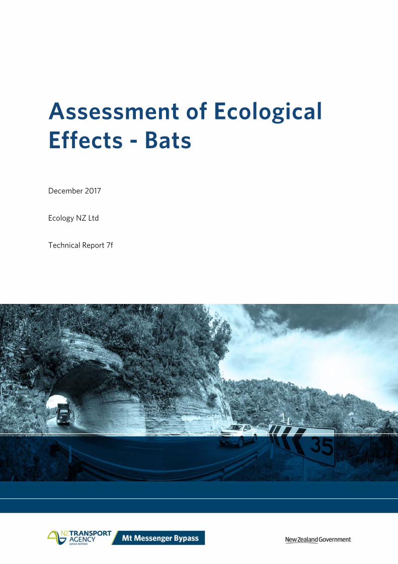
Assessment of Ecological Effects - Bats
December 2017
Ecology NZ Ltd
Technical Report 7f
Assessment of Ecological Effects - Bats | Technical Report 7f
Quality Assurance Statement
Prepared by: Simon Chapman
Marc Choromanski
Ecology NZ
Ecology NZ
Reviewed by: Liz Deakin Tonkin & Taylor Limited
Approved for release: Duncan Kenderdine Mt Messenger Alliance
Revision schedule
Rev. Number Date Description
0 December 2017 Final for lodgement
ISBN: 978-1-98-851272-3
Disclaimer
This report has been prepared by the Mt Messenger Alliance for the benefit of the NZ Transport Agency. No liability is accepted by the Alliance Partners or any employee of or sub-consultant to the Alliance Partners companies with respect to its use by any other person. This disclaimer shall apply notwithstanding that the report may be made available to other persons for an application for permission or approval or to fulfil a legal requirement.
Assessment of Ecological Effects - Bats | Technical Report 7f
Contents 1 Introduction 1
1.1 Purpose and scope of this report 1
1.2 Project description 1
1.3 Ecological aim for the Project 2
1.4 Background to the ecological assessment of the Project 3
1.5 The wider Project area 5
1.5.1 Parininihi 7
1.5.2 Eastern Ngāti Tama forest block 7
2 Assessment methods 8
2.1 Desktop review 8
2.2 Bat field surveys 8
2.2.1 Survey species 8
2.2.2 Survey method 9
2.3 Assessment of effects methodology 12
2.3.1 Assessment of Ecological Values (Step 1) 12
2.3.2 Magnitude of unmitigated Effect assessment (Step 2) 13
2.3.3 Level of effects assessment in the absence of mitigation (Step 3) 14
3 Bat characteristics and values in the wider Project area 16
3.1 Historic bat distributions 16
3.1.1 Bat habitat within the Project footprint 16
3.1.2 ABM survey results 17
4 Assessment of unmitigated effects on bat values 22
4.1 Bat values assessment 22
4.2 Potential adverse effects on bats 22
4.2.1 Loss of roosts and impacts on roosting bats 23
4.2.2 Loss of foraging habitat 24
4.2.3 Habitat Fragmentation 24
4.2.4 Night Works and Lighting 25
4.3 Overall Magnitude of unmitigated effects on bats 25
Assessment of Ecological Effects - Bats | Technical Report 7f
4.4 Overall level of unmitigated effects assessment 26
5 Recommendations for addressing potential adverse effects 27
5.1 Overview 27
5.2 Project measures to avoid or minimise effects 27
5.2.1 Avoidance through the options selection process 27
5.2.2 Avoidance or minimisation of effects through optimisation of the Project footprint 28
5.3 Species-specific measures to avoid or minimise effects 29
5.3.1 Vegetation clearance protocols 29
5.3.2 Identify important bat habitats 29
5.3.3 Impacts on bats of proposed offset programme 29
5.3.4 Pest management 29
5.3.5 Revegetation 30
5.3.6 Monitoring 30
6 Conclusions 31
7 References 32
Assessment of Ecological Effects - Bats | Technical Report 7f
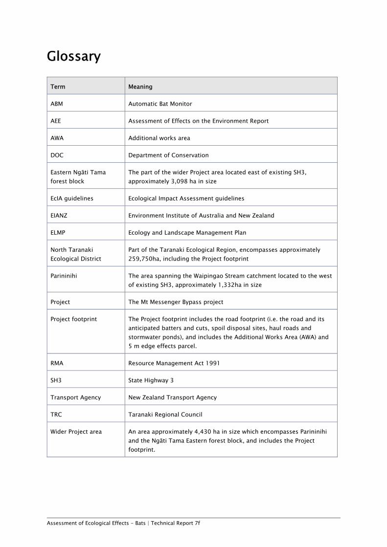
Glossary
Term Meaning
ABM Automatic Bat Monitor
AEE Assessment of Effects on the Environment Report
AWA Additional works area
DOC Department of Conservation
Eastern Ngāti Tama forest block
The part of the wider Project area located east of existing SH3, approximately 3,098 ha in size
EcIA guidelines Ecological Impact Assessment guidelines
EIANZ Environment Institute of Australia and New Zealand
ELMP Ecology and Landscape Management Plan
North Taranaki Ecological District
Part of the Taranaki Ecological Region, encompasses approximately 259,750ha, including the Project footprint
Parininihi The area spanning the Waipingao Stream catchment located to the west of existing SH3, approximately 1,332ha in size
Project The Mt Messenger Bypass project
Project footprint The Project footprint includes the road footprint (i.e. the road and its anticipated batters and cuts, spoil disposal sites, haul roads and stormwater ponds), and includes the Additional Works Area (AWA) and 5 m edge effects parcel.
RMA Resource Management Act 1991
SH3 State Highway 3
Transport Agency New Zealand Transport Agency
TRC Taranaki Regional Council
Wider Project area An area approximately 4,430 ha in size which encompasses Parininihi and the Ngāti Tama Eastern forest block, and includes the Project footprint.
Assessment of Ecological Effects - Bats | Technical Report 7f
Executive Summary The NZ Transport Agency (Transport Agency) is proposing to develop a new section of SH3, north of New Plymouth, to bypass the existing steep, narrow and winding section of highway at Mt Messenger. The Project comprises a new section of two lane highway, some 6km in length, located to the east of the existing SH3 alignment.
The overarching ecological aim for the Project is to ensure no net loss of biodiversity values, or to achieve a net benefit of biodiversity values, in the medium term.
To assess the ecological effects of the Project on bats, this report:
a Identifies and describes values of bats in the Project footprint and wider Project area; b Describes the potential effects of the Project on bats arising from construction,
operation and maintenance; and c Recommends measures to avoid, remedy or mitigate potential adverse effects.
This report broadly follows Ecological Impact Assessment (EcIA) guidelines developed by the Environment Institute of Australia and New Zealand. Professional judgement and expertise have also been applied in the assessment process to reflect good practice. Bat characteristics and values within the Project area were assessed by reviewing existing information and data, and by undertaking field surveys within the wider Project area.
A bat survey comprised of automatic bat monitors set at 84 sites within the Project footprint and wider Project area confirmed the presence of ‘Nationally Vulnerable’ long-tailed bats at 79 (94%) of the survey locations. The distribution and levels of long-tailed bat activity recorded during the survey indicate that a significant population is present in the wider Project area, including the Project footprint.
No short-tailed bats were detected within the Project footprint or wider Project area during the survey, therefore it is considered unlikely that they are present within the Project footprint. However, for the purposes of the EcIA assessment, it has been conservatively assumed that short-tailed bats are present within the Project footprint.
The ecological values of bats within the Project footprint (and the wider Project area) were considered to be ‘Very High’ for long-tailed bats, and ‘High’ for short-tailed bats (based on the conservative assumption short-tailed bats are present). The lower rating for short-tailed bats reflected the lower conservation status of this sub-species.
The potential adverse effects of the Project on bats included direct removal of roosting and foraging habitat; direct mortality from construction activities; habitat fragmentation; and construction noise disturbance, particularly during breeding and dispersal.
Applying the EcIA guidelines and professional judgement, the magnitude of unmitigated effects of the Project on bats has been assessed as ‘Low’ for both long-tailed and short-tailed bats. This conclusion was made with the proviso that if any maternity roost trees were felled within the Project footprint, the effects on bats would be higher than ‘Low’.
Assessment of Ecological Effects - Bats | Technical Report 7f
Combined with the value assessment, this leads to an overall assessment of the effects of the Project in the absence of mitigation as 'Moderate' for long-tailed bats, and 'Low' for short-tailed bats.
Recommended specific measures to mitigate potential adverse effects on bats includes the implementation of vegetation clearance protocols (as is standard practice, and required under the Wildlife Act 1953) to ensure that no occupied bat roosts are felled.
In addition, the ecological offset programme proposed for the Project, which includes extensive pest control, as well as restoration planting and habitat revegetation, will benefit bats.
While bat surveys with ABMs are ongoing, and a bat trapping and radio tracking programme to help refine bat-specific mitigation methods is scheduled for late 2017, this assessment provides a strong indication that the Project’s potential adverse effects on native bats can be appropriately addressed and managed.
Overall, taking into account these measures, it is considered that any effects of the Project on bats are likely to be negligible in the medium term.
Assessment of Ecological Effects - Bats | Technical Report 7f Page 1
1 Introduction 1.1 Purpose and scope of this report This report forms part of a suite of technical reports prepared for the NZ Transport Agency's (Transport Agency) Mt Messenger Bypass project (the Project). Its purpose is to inform the Assessment of Effects on the Environment Report (AEE) and to support the resource consent applications and Notice of Requirement to alter the existing State Highway designation, which are required to enable the Project to proceed.
This report is focused on assessing the ecological effects of the Project on bats as shown on the Project Drawings (AEE Volume 2: Drawing Set).
To assess the ecological effects of the Project on bats this report will:
a Identify and describe bat activity and habitat values within the Project footprint (which is defined for the purposes of this assessment of effects on bats in Section 4 below) and wider Project area (Section 3);
b Describe the potential effects of the Project on bats arising from construction, operation and maintenance (Section 4); and
c Recommend measures to avoid, remedy or mitigate potential adverse effects (Section 5).
1.2 Project description The Project involves the construction and ongoing operation of a new section of State Highway 3 (SH3), generally between Uruti and Ahititi to the north of New Plymouth. This new section of SH3 will bypass the existing steep, narrow and winding section of highway at Mt Messenger. The Project comprises a new section of two lane highway, approximately 6km in length, located to the east of the existing SH3 alignment.
The primary objectives of the Project are to enhance the safety, resilience and journey time reliability of travel on SH3 and contribute to enhanced local and regional economic growth and productivity for people and freight.
A full description of the Project including its design, construction and operation is provided in the AEE (Volume 1) and the accompanying Drawing Set (Volume 2).

Assessment of Ecological Effects - Bats | Technical Report 7f Page 2
Figure 1.1 - Location of the Project in the Taranaki Region
1.3 Ecological aim for the Project The overarching ecological aim for the Project is to ensure no net loss of biodiversity values, or to achieve a net benefit of biodiversity values, within the medium term. The ecologists engaged to provide advice and assessments in respect of the Project have been closely involved in recommending measures, including route selection and design features, to achieve this aim. The ecological aim for the Project will ultimately be achieved through a range of measures to avoid, remedy or mitigate effects on ecological values, including in particular through:
• A robust and transparent understanding of effects through detailed desktop and field assessments, as well as inputs from key stakeholders including Ngāti Tama, the Department of Conservation and New Plymouth District Council;

Assessment of Ecological Effects - Bats | Technical Report 7f Page 3
• Demonstrable efforts to avoid, remedy or mitigate potential adverse effects, through: o The selection of a route option that avoids the generally higher ecological
value land to the west of the existing SH3. The Project ecologists played an important role in the route selection process.
o The use of structures (i.e. a tunnel and bridge) to minimise habitat loss and severance.
o Within the Project footprint, alignment optimisations through changes to design and construction methodologies that produce the best ecological outcomes (e.g. avoidance of wetlands).
o Intensive monitoring programmes that minimise the potential for vulnerable species being harmed during road construction (e.g. radio-tracking of kiwi).
o Salvaging and relocation of important biodiversity values (e.g. lizards, large felled trees).
o The establishment and operation of a long term pest mammal control programme to mitigate for residual adverse effects on indigenous biodiversity values.
These measures, as they relate to effects on bats, are discussed in more detail in section 5 of this report.
1.4 Background to the ecological assessment of the Project In 2016, through the earlier stages of the Project, consideration of options for the Project focused on land located to the west of SH3, known as Parininihi (refer Figure 1.2 below). As a consequence, much of the initial fieldwork (until mid-2017) was focused on assessing ecological values to the west of SH3 along the previously proposed ‘MC23’ alignment (Figure 1.2). Nonetheless, much of the information gained from the initial surveys is relevant to this assessment because both routes pass through broadly similar ecosystem types, and the distance between the two routes is relatively small (<5km).
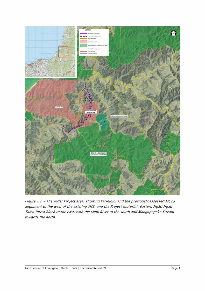
Assessment of Ecological Effects - Bats | Technical Report 7f Page 4
Figure 1.2 - The wider Project area, showing Parininihi and the previously assessed MC23 alignment to the west of the existing SH3, and the Project footprint, Eastern Ngāti Ngati Tama forest Block to the east, with the Mimi River to the south and Mangapepeke Stream towards the north.
Assessment of Ecological Effects - Bats | Technical Report 7f Page 5
Where possible, within seasonal survey constraints, data have been gathered along the Project footprint during the 2017 autumn and winter periods to augment this earlier survey information obtained to the west, and to inform the assessment of the likely nature and scale of effects of the Project. Importantly, the detailed vegetation and ecosystem mapping that has been undertaken for the wider Project area (Assessment of Ecological Effects – Vegetation (Technical Report 7a, Volume 3 of the AEE) (Vegetation Technical Report) provides a robust baseline habitat assessment for predicting the fauna species that are potentially present.
While the land to the west of SH3 has had the benefit of some 20 years of intensive pest management, this has not occurred to the east of SH3. In addition, large parts of the Project footprint have been used for pastoral farming or have otherwise been subject to browsing by stock. Accordingly, the biodiversity values associated with Parininihi are recognised as being higher than those of the Project footprint.
In the absence of detailed baseline fauna surveys undertaken during the optimal season within the Project footprint, it has been conservatively assumed that species recorded west of SH3 are also present in similar habitats to the east of SH3, except where there are particular reasons to conclude that this is unlikely to be the case. With respect to bats, while some further survey work is to be undertaken to help refine mitigation options and provide baseline measurements for monitoring programmes, the data obtained to date are sufficient for assessing the likely effects of the Project on bats living within and near the Project footprint.
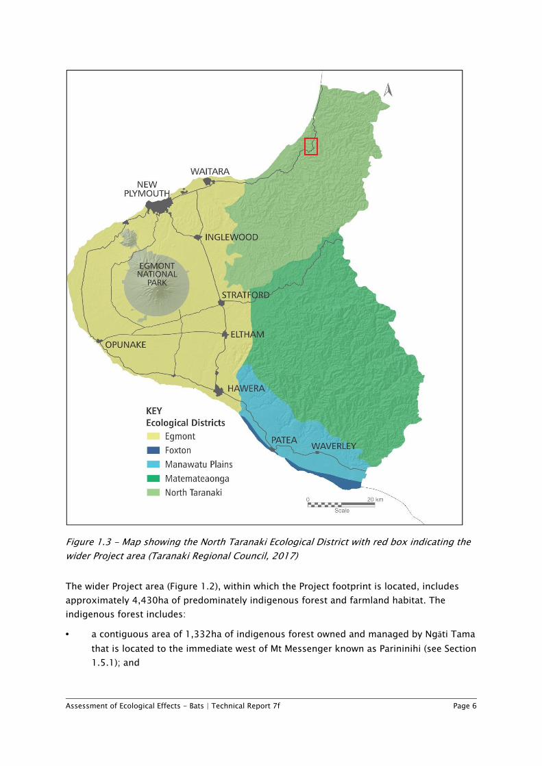
1.5 The wider Project area The wider Project area (i.e. the area in Figure 1.2 above) is situated in the North Taranaki Ecological District1 (shown in Figure 1.3 below). The Ecological District includes a moderately diverse range of habitats, from stream flats and surrounding high productivity farmland to less developed steep hill country, through to high-diversity indigenous forest on hill country. The forest often occupies steep hillslopes with sparsely vegetated bluffs as well as a series of densely vegetated interconnected ridge systems. Warm, humid summers and mild, wet winters create conditions suitable for dense broadleaved dominant forest, with an abundance of lianes and epiphytic plants over mostly hill country land, and kahikatea (Dacrycarpus dacrydioides), pukatea (Laurelia novae-zelandiae) and swamp maire (Syzygium maire) forest and associated wetlands in valley floor areas.
1 http://www.doc.govt.nz/Documents/science-and-technical/Ecoregions1.pdf
Assessment of Ecological Effects - Bats | Technical Report 7f Page 6
Figure 1.3 - Map showing the North Taranaki Ecological District with red box indicating the wider Project area (Taranaki Regional Council, 2017)
The wider Project area (Figure 1.2), within which the Project footprint is located, includes approximately 4,430ha of predominately indigenous forest and farmland habitat. The indigenous forest includes:
• a contiguous area of 1,332ha of indigenous forest owned and managed by Ngāti Tama that is located to the immediate west of Mt Messenger known as Parininihi (see Section 1.5.1); and
Assessment of Ecological Effects - Bats | Technical Report 7f Page 7
• a contiguous forest (approximately 3,098ha in size) immediately adjacent to Mt Messenger and to the east of SH3 (see Section 1.5.2). This area is referred to as the Eastern Ngāti Tama forest block (but also includes land owned by the Department of Conservation and private landowners).
1.5.1 Parininihi Parininihi, previously known as “Whitecliffs Conservation Area” is a large tract (1,332ha) of mainly primary forest centred on the Waipingao Stream catchment (shown to the west of SH3 in Figure 1.2 above). This area is classified as “Rimu tawa forest” within the New Zealand Forest Service class map (NZFSMS6). The area encompasses a rare continuous forest sequence through coastal, semi-coastal and lowland bioclimatic zones. As such, the area is regarded as being ecologically significant, and has been described as “the best example of primary coastal hardwood-podocarp forest on the west coast of the North Island” by eminent forest ecologist John Nicholls (Bayfield et al. 1991).
Ecological management of Parininihi was started in the early 1990s by the Department of Conservation, and involved possum and goat pest control activities. Since the return of this land to Ngāti Tama in 2003, management of these pests has continued, and control of rodents, mustelids and feral cats has also occurred. Consequently, the health and ecological integrity of the area is now improving, with browse-sensitive plants regenerating and various predation-sensitive birds increasing in abundance.
Parininihi (and all land to the west of the existing SH3) is being avoided by the Project footprint, following the route selection process carried out in 2017.
1.5.2 Eastern Ngāti Tama forest block The dominant ecosystem to the east of the existing SH3 corridor is approximately 3,098ha of native forest (shown in Figure 1.2 above) that would have originally been very similar forest type to the eastern part of Parininihi; however, it has not had consistent pest control. Consequently, the ecological condition of this area is poorer, with fewer palatable canopy trees remaining, such as thin-barked totara and northern rata. Within the Mangapepeke Stream catchment to the east of existing SH3 (shown in Figure 1.2 adjacent to and within the northern end of the Project footprint), vegetation communities are more modified and have been affected by stock grazing, fire and logging.
Of greatest ecological significance in this area is the hydrologically intact swamp forest and non-forest wetland areas in the valley floor of the northern Mimi River catchment (shown in Figure 1.2 towards the southern end of the Project footprint), potential habitats of various threatened wetland birds. The valley floor sequence within the northern tributary of the Mimi River represents a full range of swamp forest, scrub and non-forest wetland communities.
Assessment of Ecological Effects - Bats | Technical Report 7f Page 8
2 Assessment methods Bat distribution, activity patterns, and habitat values within the wider Project area were assessed by reviewing existing information and data, and by undertaking field surveys within the Project footprint and the wider Project area.
This report broadly follows Ecological Impact Assessment (EcIA) guidelines developed by the Environment Institute of Australia and New Zealand (EIANZ 2015). As described in section 1.3 2.3, professional ecological judgement and expertise have also been applied in the assessment process to reflect good practice.
2.1 Desktop review The desktop review focused on the following websites, publications and reports:
• Opus (2017a). Mount Messenger Bypass Investigation. Bat Baseline Survey and Preliminary Assessment of Effects, April 2017. New Zealand Transport Agency;
• Opus (2017b). Mount Messenger Bypass: Option MC23 - Bat Survey Addendum, Memo dated 25 July 2017;
• Department of Conservation bat distribution database; and • Recent bat reports from the Taranaki Region (e.g. Bell 2016).
Additional information was also obtained through discussions with:
• Ngāti Tama (Conrad O’Carroll, Ngāti Tama Trust); • Department of Conservation (Moira Pryde, Bat specialist); and • Local residents including Bill Anglesey, John Washer and Tony Pascoe.
2.2 Bat field surveys 2.2.1 Survey species New Zealand has two extant native bat species, the long-tailed bat (Chalinolobus tuberculatus) and the lesser short-tailed bat (Mystacina tuberculata), both of which are endemic microbat species. The two species are further classified as comprising of two subspecies of long-tailed bats and three subspecies of short-tailed bats. The bat subspecies present within the Taranaki Region are recognised as the central lesser short-tailed bat (Mystacina tuberculata rhyacobia) and the North Island long-tailed bat (Chalinolobus tuberculatus “North Island”), although the latter is classified as taxonomically indeterminate as it has not yet been formally described.
Confirmed recent records (since 2012) of both of long-tailed and short-tailed bats within 15km of the Project footprint, in combination with the occurrence of suitable habitat (primarily old growth native forest), indicates that these species may be present within the
Assessment of Ecological Effects - Bats | Technical Report 7f Page 9
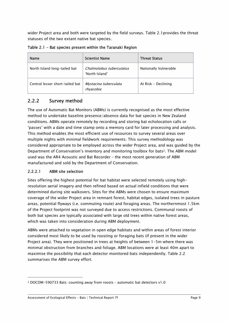
wider Project area and both were targeted by the field surveys. Table 2.1provides the threat statuses of the two extant native bat species.
Table 2.1 - Bat species present within the Taranaki Region
Name Scientist Name Threat Status
North Island long-tailed bat Chalinolobus tuberculatus ‘North Island’
Nationally Vulnerable
Central lesser short-tailed bat Mystacina tuberculata rhyacobia
At Risk - Declining
2.2.2 Survey method The use of Automatic Bat Monitors (ABMs) is currently recognised as the most effective method to undertake baseline presence/absence data for bat species in New Zealand conditions. ABMs operate remotely by recording and storing bat echolocation calls or ‘passes’ with a date and time stamp onto a memory card for later processing and analysis. This method enables the most efficient use of resources to survey several areas over multiple nights with minimal fieldwork requirements. This survey methodology was considered appropriate to be employed across the wider Project area, and was guided by the Department of Conservation’s inventory and monitoring toolbox for bats2. The ABM model used was the AR4 Acoustic and Bat Recorder – the most recent generation of ABM manufactured and sold by the Department of Conservation.
2.2.2.1 ABM site selection
Sites offering the highest potential for bat habitat were selected remotely using high-resolution aerial imagery and then refined based on actual infield conditions that were determined during site walkovers. Sites for the ABMs were chosen to ensure maximum coverage of the wider Project area in remnant forest, habitat edges, isolated trees in pasture areas, potential flyways (i.e. commuting route) and foraging areas. The northernmost 1.5km of the Project footprint was not surveyed due to access restrictions. Communal roosts of both bat species are typically associated with large old trees within native forest areas, which was taken into consideration during ABM deployment.
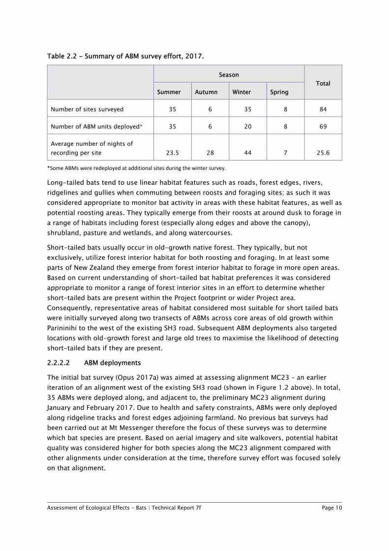
ABMs were attached to vegetation in open edge habitats and within areas of forest interior considered most likely to be used by roosting or foraging bats (if present in the wider Project area). They were positioned in trees at heights of between 1-5m where there was minimal obstruction from branches and foliage. ABM locations were at least 40m apart to maximise the possibility that each detector monitored bats independently. Table 2.2 summarises the ABM survey effort.
2 DOCDM-590733 Bats: counting away from roosts – automatic bat detectors v1.0
Assessment of Ecological Effects - Bats | Technical Report 7f Page 10
Table 2.2 - Summary of ABM survey effort, 2017.
Season Total
Summer Autumn Winter Spring
Number of sites surveyed 35 6 35 8 84
Number of ABM units deployed* 35 6 20 8 69
Average number of nights of recording per site 23.5 28 44 7 25.6
*Some ABMs were redeployed at additional sites during the winter survey.
Long-tailed bats tend to use linear habitat features such as roads, forest edges, rivers, ridgelines and gullies when commuting between roosts and foraging sites; as such it was considered appropriate to monitor bat activity in areas with these habitat features, as well as potential roosting areas. They typically emerge from their roosts at around dusk to forage in a range of habitats including forest (especially along edges and above the canopy), shrubland, pasture and wetlands, and along watercourses.
Short-tailed bats usually occur in old-growth native forest. They typically, but not exclusively, utilize forest interior habitat for both roosting and foraging. In at least some parts of New Zealand they emerge from forest interior habitat to forage in more open areas. Based on current understanding of short-tailed bat habitat preferences it was considered appropriate to monitor a range of forest interior sites in an effort to determine whether short-tailed bats are present within the Project footprint or wider Project area. Consequently, representative areas of habitat considered most suitable for short tailed bats were initially surveyed along two transects of ABMs across core areas of old growth within Parininihi to the west of the existing SH3 road. Subsequent ABM deployments also targeted locations with old-growth forest and large old trees to maximise the likelihood of detecting short-tailed bats if they are present.
2.2.2.2 ABM deployments
The initial bat survey (Opus 2017a) was aimed at assessing alignment MC23 – an earlier iteration of an alignment west of the existing SH3 road (shown in Figure 1.2 above). In total, 35 ABMs were deployed along, and adjacent to, the preliminary MC23 alignment during January and February 2017. Due to health and safety constraints, ABMs were only deployed along ridgeline tracks and forest edges adjoining farmland. No previous bat surveys had been carried out at Mt Messenger therefore the focus of these surveys was to determine which bat species are present. Based on aerial imagery and site walkovers, potential habitat quality was considered higher for both species along the MC23 alignment compared with other alignments under consideration at the time, therefore survey effort was focused solely on that alignment.
Assessment of Ecological Effects - Bats | Technical Report 7f Page 11
A second deployment – comprised of six ABMs – was implemented, again along the MC23 alignment to the west of SH3, during April and May 2017. The aim of this survey was to ensure that native forest valley habitats were surveyed as these appeared to represent the most likely habitat for short-tailed bats along the previous MC23 alignment. The six ABMs were deployed in what were considered suitable habitats for both short-tailed and long-tailed bats in the upper catchment of the Waipingao Stream in the vicinity of its intersection with the MC23 alignment.
The third and fourth ABM deployments were carried out during winter 2017. Winter is not the ideal time for bat surveys in New Zealand as both native species utilise torpor (periods of substantially reduced activity best described as short-term hibernation) to conserve energy during periods of cold weather. However, these deployments were considered necessary given that the first and second deployments were focused to the west of the Project footprint. The winter surveys were focused on deploying ABMs in core areas of old-growth native forest within the Waipingao Valley, and within a range of habitats along the Project footprint.
The fifth ABM deployment was carried out during the first two weeks of spring 2017. During spring bat activity typically increases with the rise in temperatures. The spring deployment was carried out at a subset of eight of the winter ABM sites with a focus on identifying potential roost sites within the core areas of old-growth native forest within the Waipingao Valley, and along the Project footprint.
ABMs were also installed at the two control sites along the MC23 alignment as part of the winter and spring deployments, which were selected as they were the sites where the most consistent and highest levels of long-tailed bat activity were recorded during the summer survey. This control site provided a primary data source for bat activity during suboptimal weather conditions that could be used to reflect the validity of a survey night for other ABMs set throughout the wider Project area.
2.2.2.3 Data processing and analysis
Recorded sound files from each ABM were processed using the latest version of bat call analysis software developed by the Department of Conservation (BatSearch version 3.11). Bat echolocation passes were distinguished from noise files (e.g. wind, rain, insect noise), which were disregarded. Total number of bat passes were noted, along with time and date of recording, and any activity indicative of feeding or roosting.
Data extracted with the BatSearch software processing was analysed, summarised and interpreted to provide assessments of:
• Presence/absence of long-tailed and short-tailed bats in the wider Project area; • Distribution of bat activity in the wider Project area; • Levels of activity at each site (if activity is detected); and • Whether any activity is indicative of roosting.
Assessment of Ecological Effects - Bats | Technical Report 7f Page 12
2.3 Assessment of effects methodology The assessment of ecological effects broadly follows the Ecological Impact Assessment (EcIA) guidelines (EIANZ, 2015), with some adaptation, including allowance for expert opinion to be applied within the context of the EIANZ framework.3
The guidelines are useful in that they enable effects to be assessed in a systematic and transparent way.
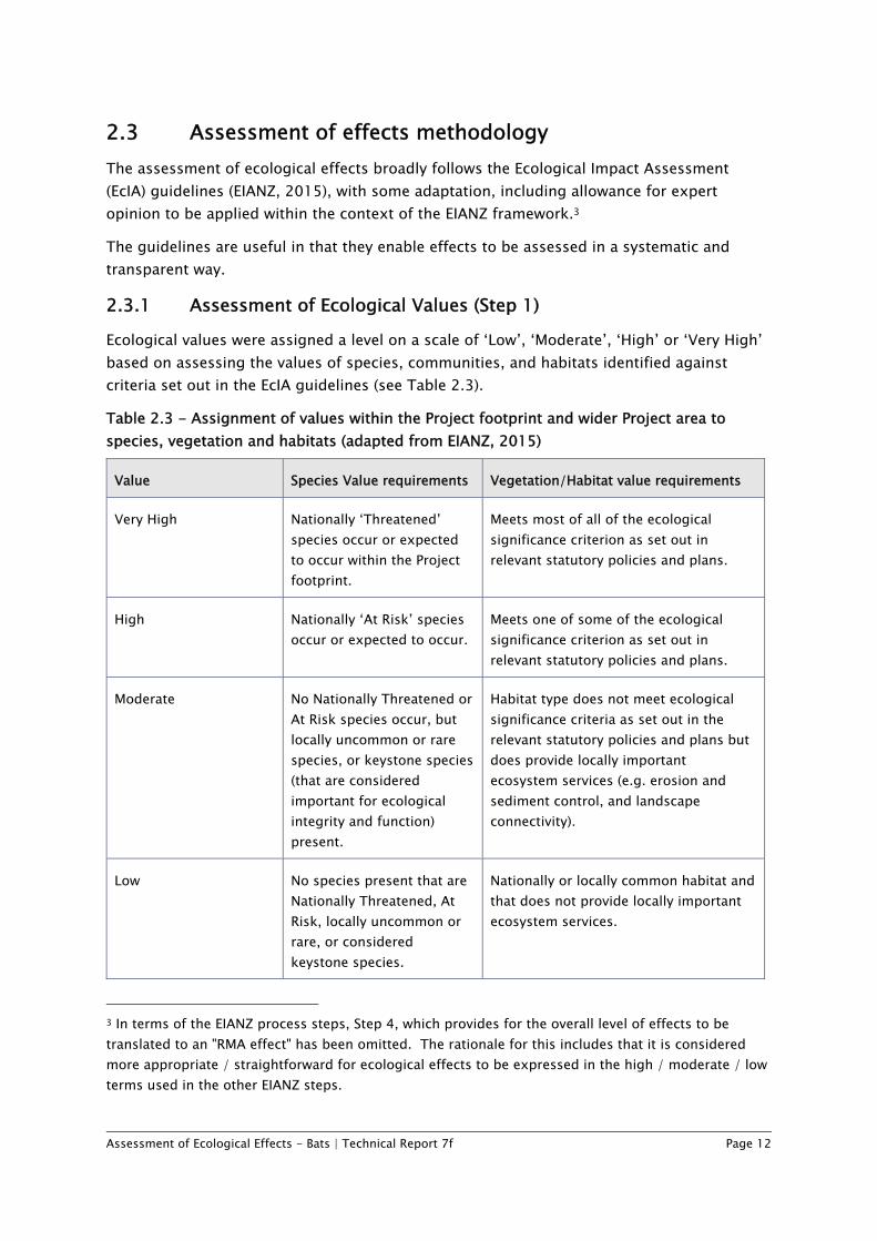
2.3.1 Assessment of Ecological Values (Step 1) Ecological values were assigned a level on a scale of ‘Low’, ‘Moderate’, ‘High’ or ‘Very High’ based on assessing the values of species, communities, and habitats identified against criteria set out in the EcIA guidelines (see Table 2.3).
Table 2.3 - Assignment of values within the Project footprint and wider Project area to species, vegetation and habitats (adapted from EIANZ, 2015)
Value Species Value requirements Vegetation/Habitat value requirements
Very High Nationally ‘Threatened’ species occur or expected to occur within the Project footprint.
Meets most of all of the ecological significance criterion as set out in relevant statutory policies and plans.
High Nationally ‘At Risk’ species occur or expected to occur.
Meets one of some of the ecological significance criterion as set out in relevant statutory policies and plans.
Moderate No Nationally Threatened or At Risk species occur, but locally uncommon or rare species, or keystone species (that are considered important for ecological integrity and function) present.
Habitat type does not meet ecological significance criteria as set out in the relevant statutory policies and plans but does provide locally important ecosystem services (e.g. erosion and sediment control, and landscape connectivity).
Low No species present that are Nationally Threatened, At Risk, locally uncommon or rare, or considered keystone species.
Nationally or locally common habitat and that does not provide locally important ecosystem services.
3 In terms of the EIANZ process steps, Step 4, which provides for the overall level of effects to be translated to an "RMA effect" has been omitted. The rationale for this includes that it is considered more appropriate / straightforward for ecological effects to be expressed in the high / moderate / low terms used in the other EIANZ steps.
Assessment of Ecological Effects - Bats | Technical Report 7f Page 13
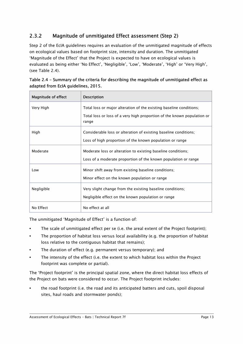
2.3.2 Magnitude of unmitigated Effect assessment (Step 2) Step 2 of the EcIA guidelines requires an evaluation of the unmitigated magnitude of effects on ecological values based on footprint size, intensity and duration. The unmitigated ‘Magnitude of the Effect’ that the Project is expected to have on ecological values is evaluated as being either ‘No Effect’, ‘Negligible’, ‘Low’, ‘Moderate’, ‘High’ or ‘Very High’, (see Table 2.4).
Table 2.4 - Summary of the criteria for describing the magnitude of unmitigated effect as adapted from EcIA guidelines, 2015.
Magnitude of effect Description
Very High Total loss or major alteration of the existing baseline conditions;
Total loss or loss of a very high proportion of the known population or range
High Considerable loss or alteration of existing baseline conditions;
Loss of high proportion of the known population or range
Moderate Moderate loss or alteration to existing baseline conditions;
Loss of a moderate proportion of the known population or range
Low Minor shift away from existing baseline conditions;
Minor effect on the known population or range
Negligible Very slight change from the existing baseline conditions;
Negligible effect on the known population or range
No Effect No effect at all
The unmitigated ‘Magnitude of Effect’ is a function of:
• The scale of unmitigated effect per se (i.e. the areal extent of the Project footprint); • The proportion of habitat loss versus local availability (e.g. the proportion of habitat
loss relative to the contiguous habitat that remains); • The duration of effect (e.g. permanent versus temporary); and • The intensity of the effect (i.e. the extent to which habitat loss within the Project
footprint was complete or partial).
The ‘Project footprint’ is the principal spatial zone, where the direct habitat loss effects of the Project on bats were considered to occur. The Project footprint includes:
• the road footprint (i.e. the road and its anticipated batters and cuts, spoil disposal sites, haul roads and stormwater ponds);
Assessment of Ecological Effects - Bats | Technical Report 7f Page 14
• the Additional Works Area (AWA), accounting for additional habitat loss for construction access, laydown areas and temporary stormwater drains (see detailed plans in Volume 2: Drawing Set); and
• a 5m edge effects parcel.
Note that the AWA includes a smaller allowance for temporary works in habitats with ‘High’ ‘Ecological Values’ because temporary work activities will be focused on the road footprint and immediately adjacent areas, and more precautions will be taken in managing construction effects, in order to mitigate potential adverse effects on the surrounding habitat. These measures will be set out in the Construction and Environmental Management Plan (Volume 5 of the AEE), which will include the Ecology and Landscape Management Plan (ELMP).
Edge effects are difficult to quantify for individual species (including bats), and the unmitigated magnitude of edge effects is likely to vary specifically for each species and within each habitat type (Ruffell & Didham 2016). Edge effects could potentially have a positive effect on bats. For example, new edge habitat may benefit long-tailed bats by increasing foraging habitat availability. In contrast, increased light penetration and air movement into forest interiors may adversely impact short-tailed bats. In the absence of adequate or conclusive information on the impacts of edge effects on bats, and the recognised variability of edge effects on other flora/fauna, the inclusion of a 5m zone as a habitat loss equivalent (that has been factored into the ecological offset package described in the Ecological Effects Assessment – Ecological Mitigation and Offset (Technical Report 7h, Volume 3 of the AEE) is considered to be appropriate for addressing potential edge effects.
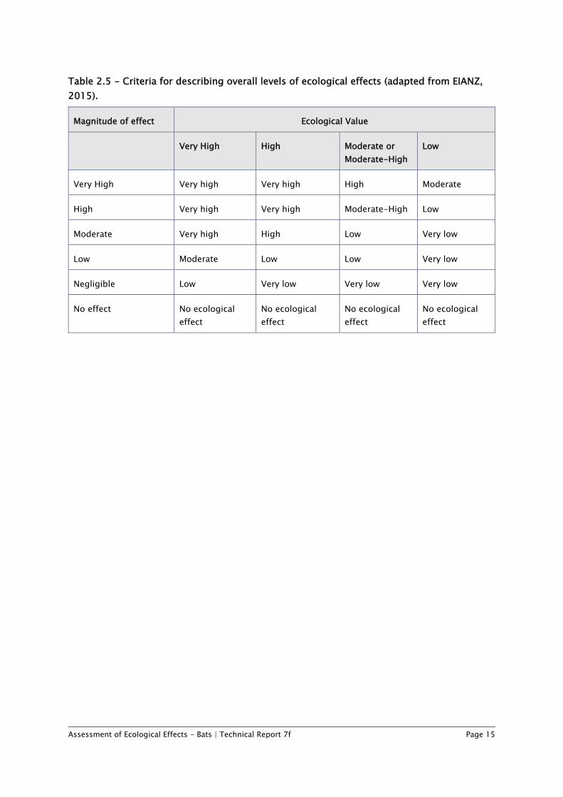
2.3.3 Level of effects assessment in the absence of mitigation (Step 3) Step 3 of the EIANZ guidelines requires the overall level of effect to be determined using a matrix that is based on the ecological values and the magnitude of effects on these values in the absence of any efforts to avoid, remedy or mitigate for potential effects. Level of effect categories include No Ecological Effect, Very Low, Low, Moderate, Moderate/High, High and Very High. Table 2.5 shows the matrix of criteria used to describe the overall level of ecological effects in this assessment (adapted from EIANZ, 2015).
Assessment of Ecological Effects - Bats | Technical Report 7f Page 15
Table 2.5 - Criteria for describing overall levels of ecological effects (adapted from EIANZ, 2015).
Magnitude of effect Ecological Value
Very High High Moderate or Moderate-High
Low
Very High Very high Very high High Moderate
High Very high Very high Moderate-High Low
Moderate Very high High Low Very low
Low Moderate Low Low Very low
Negligible Low Very low Very low Very low
No effect No ecological effect
No ecological effect
No ecological effect
No ecological effect
Assessment of Ecological Effects - Bats | Technical Report 7f Page 16
3 Bat characteristics and values in the wider Project area
3.1 Historic bat distributions Bat distribution data obtained from the Department of Conservation’s bat distribution database identify the historical presence of bats within the wider Project area. The records describe two unconfirmed reports of bats observed in 1988 and 1990. Annual bat studies within the Taranaki Region carried out since 2012 provide insight into the current state of bat distribution within the vicinity of the wider Project area (Bell 2016). The findings of those reports confirmed the presence of both bat species to the south and east of the Project footprint, with the nearest observations of both species approximately 5-6km of the Project footprint. Those observations are considered relevant as both species are capable of flying such distances within a single night.
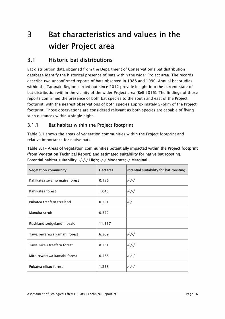
3.1.1 Bat habitat within the Project footprint Table 3.1 shows the areas of vegetation communities within the Project footprint and relative importance for native bats.
Table 3.1- Areas of vegetation communities potentially impacted within the Project footprint (from Vegetation Technical Report) and estimated suitability for native bat roosting. Potential habitat suitability: √√√ High; √√ Moderate; √ Marginal.
Vegetation community Hectares Potential suitability for bat roosting
Kahikatea swamp maire forest 0.186 √√√
Kahikatea forest 1.045 √√√
Pukatea treefern treeland 0.721 √√
Manuka scrub 0.372
Rushland sedgeland mosaic 11.117
Tawa rewarewa kamahi forest 6.509 √√√
Tawa nikau treefern forest 8.731 √√√
Miro rewarewa kamahi forest 0.536 √√√
Pukatea nikau forest 1.258 √√√
Assessment of Ecological Effects - Bats | Technical Report 7f Page 17
Vegetation community Hectares Potential suitability for bat roosting
Secondary mixed broadleaved forest 2.221 √√
Manuka succession 0.451
Hard beech forest 0.081 √√
Manuka treefern rewarewa forest 3.599 √
Manuka treefern scrub 6.075 √
Manuka scrub 1.108
Dry cliff 0.399
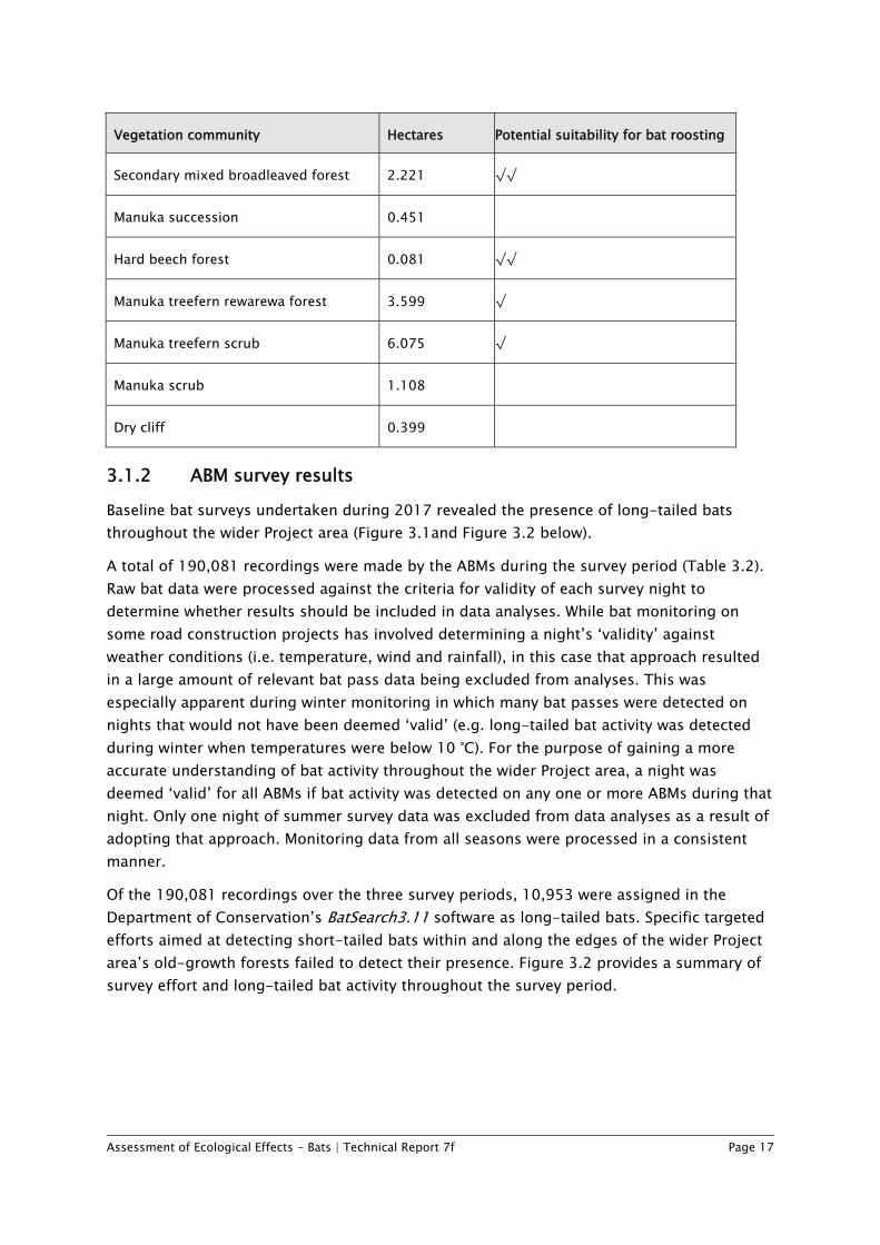
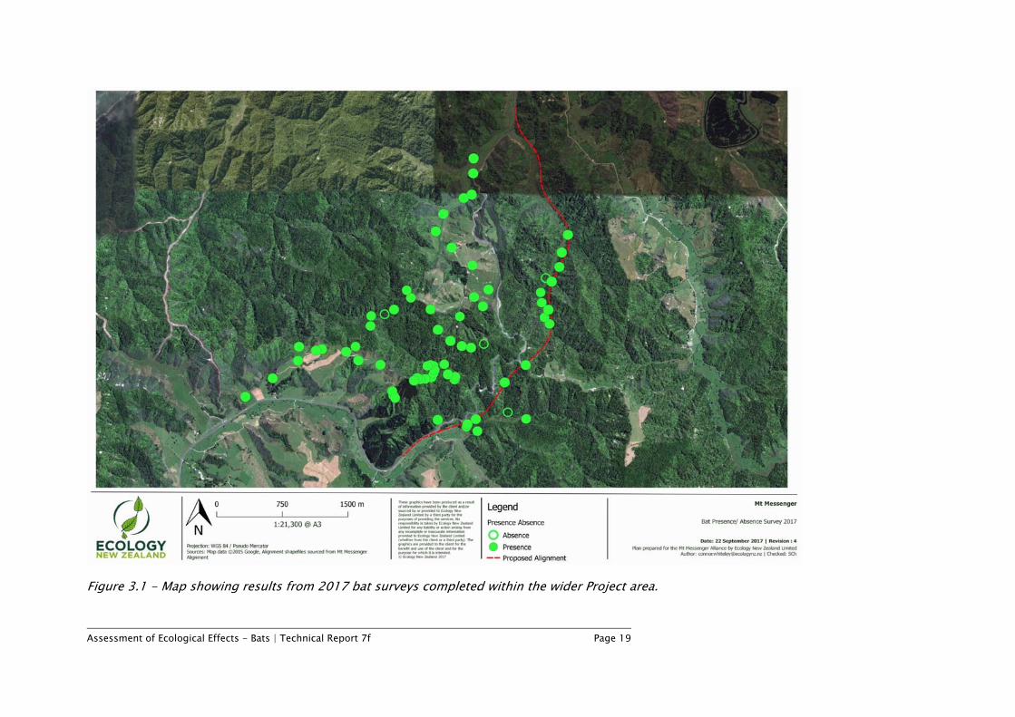
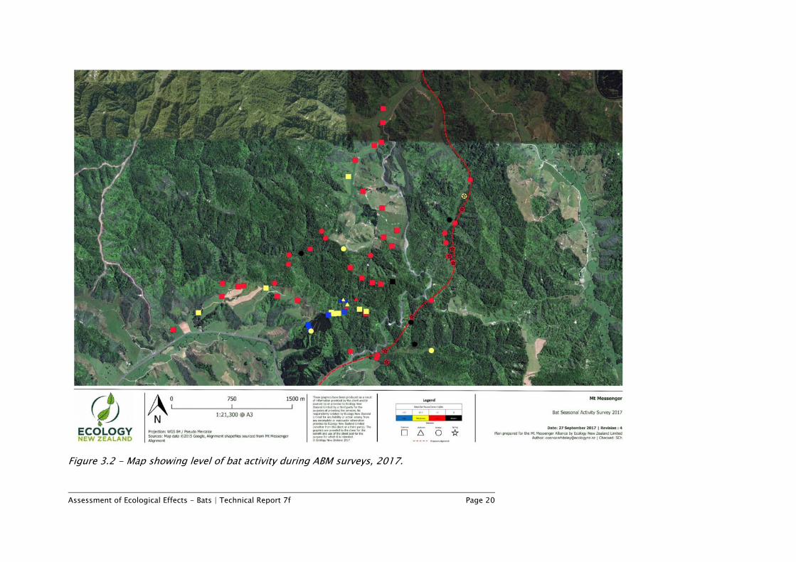
3.1.2 ABM survey results Baseline bat surveys undertaken during 2017 revealed the presence of long-tailed bats throughout the wider Project area (Figure 3.1and Figure 3.2 below).
A total of 190,081 recordings were made by the ABMs during the survey period (Table 3.2). Raw bat data were processed against the criteria for validity of each survey night to determine whether results should be included in data analyses. While bat monitoring on some road construction projects has involved determining a night’s ‘validity’ against weather conditions (i.e. temperature, wind and rainfall), in this case that approach resulted in a large amount of relevant bat pass data being excluded from analyses. This was especially apparent during winter monitoring in which many bat passes were detected on nights that would not have been deemed ‘valid’ (e.g. long-tailed bat activity was detected during winter when temperatures were below 10 °C). For the purpose of gaining a more accurate understanding of bat activity throughout the wider Project area, a night was deemed ‘valid’ for all ABMs if bat activity was detected on any one or more ABMs during that night. Only one night of summer survey data was excluded from data analyses as a result of adopting that approach. Monitoring data from all seasons were processed in a consistent manner.
Of the 190,081 recordings over the three survey periods, 10,953 were assigned in the Department of Conservation’s BatSearch3.11 software as long-tailed bats. Specific targeted efforts aimed at detecting short-tailed bats within and along the edges of the wider Project area’s old-growth forests failed to detect their presence. Figure 3.2 provides a summary of survey effort and long-tailed bat activity throughout the survey period.
Assessment of Ecological Effects - Bats | Technical Report 7f Page 18
Table 3.2 - Summary of survey effort and ABM results for long-tailed bat activity.
Season Total
Summer Autumn Winter Spring
Number of sites surveyed 35 6 35 8 84
Number of sites where bats detected 34 6 31 8 79
Number of recordings 109,228 29,319 49,467 2,067 190,081
Number of bat detections 7,464 1,777 1,621 91 10,953
Bat activity was variable across the wider Project area and, as expected, it reduced during winter months when conditions become suboptimal for bat activity (Figure 3.2). An average 80-90% reduction in bat activity was observed across all ABMs deployed during winter compared to summer. This 80-90% reduction was again observed with the difference in activity levels within the high activity summer/winter ABM control site whereby average nightly bat pass rates decreased from 66 passes/valid night in summer, to 8 passes per valid night in winter.
The highest bat activity detected during the survey occurred within the forested areas west of the existing state highway, and specifically within the control site which comprised of a small block of pine sheltered by a belt of eucalypts (Figure 3.2). The second noteworthy area of bat activity occurred within the wetland area of the upper Mimi River catchment. Despite only being classified as showing ‘average’ levels of activity within Figure 3.2, these detections were made in winter where activity levels are indicatively 80-90% lower than summer. Furthermore, feeding buzzes were noted within this area which indicates its suitability for foraging. ABMs that are currently deployed or soon to be deployed along the Project footprint, and more specifically the northern Mangapepeke Stream, are likely to provide further insight into bat activity in this area.
Assessment of Ecological Effects - Bats | Technical Report 7f Page 19
Figure 3.1 - Map showing results from 2017 bat surveys completed within the wider Project area.
Assessment of Ecological Effects - Bats | Technical Report 7f Page 20
Figure 3.2 - Map showing level of bat activity during ABM surveys, 2017.
Assessment of Ecological Effects - Bats | Technical Report 7f Page 21
The results of ABM detections provide insight into which species are present and an index of their relative activity. Based on these findings, it is likely that long-tailed bats are common within the wider Project area. Short-tailed bats have not been detected anywhere within the wider Project area but their presence cannot be completely discounted; although given the survey efforts to date it seems increasingly unlikely that any short-tailed bat roosts are present within the Project footprint.
The results of the surveys undertaken to date are sufficient to determine in broad terms the characteristics and values of bats in the wider Project area. However, finer scale field investigations are required to identify roosting habitat, and, more specifically, maternity roosts, in order to refine specific mitigation for bats. This would require capture and tracking of bats through the use of radio telemetry.
Table 3.3 summarises the ecological value of the wider Project area for bats:
• The Long-tailed bat is a Nationally Threatened species. The survey results confirmed that a long-tailed bat population is present within the wider Project area including the Project footprint. Applying the criteria in Table 2.3 this leads to a 'Very High' value rating.
• The Short-tailed bat is a Nationally At Risk species. Surveys have not detected this species within the Project footprint, or the wider Project area; and as noted above it seems highly unlikely they are present within the Project footprint. However, as it is not possible to completely rule out their presence, this assessment takes a conservative approach which assumes that they are present within the wider Project area, and possibly the Project footprint. This leads to a 'High' value rating.
Table 3.3 - Ecological value for bats:
Species Value
Long-tailed bat Very High
Short-tailed bat High
Assessment of Ecological Effects - Bats | Technical Report 7f Page 22
4 Assessment of unmitigated effects on bat values
This assessment is broadly based on the EcIA guidelines (EIANZ, 2015), adapted based on expert opinion as described in Section 2.3 to determine the overall unmitigated ‘level of effect’ of the Project on bat communities.
4.1 Bat values assessment The ecological value of bats affected by the Project was determined using Step 1, Table 2.3 (Section 2.3). The ecological value of the bat species confirmed or assumed for the purposes of this report to be present within the wider Project area have been weighted with consideration to their current threat status (Table 2.3) and habitat availability within the wider Project area (Section 3.1.1). As summarised in Table 3.2, bat values within the Project footprint are considered ‘Very High’ for long tailed bats and ‘High’ for short-tailed bats. This is a conservative approach, which is considered appropriate given the uncertainties around the presence of these species, as described in Section 3.
4.2 Potential adverse effects on bats In general terms, new roads have the potential to adversely impact bats, both during construction (e.g. as a result of direct physical disturbance) and on an ongoing basis from road operation and maintenance.
Potential adverse construction effects of new roads in relation to bats are:
• Direct removal of habitat for roosting or foraging; • Direct injury or mortality during vegetation removal; • The creation of habitat edge effects, altering the composition and habitat value of
adjacent vegetation; • Habitat fragmentation, severance and isolation; and • Construction noise, vibration and light disturbance, particularly during breeding.
Potential ongoing adverse effects of roads (in general) on bats, without mitigation, could include:
• Effect of vehicle noise and light on bats (e.g. resulting in reduced breeding success and dispersal);
• Decreased landscape and habitat connectivity through fragmentation, permanently affecting movement of some bats, with possible effects on meta-population dynamics and increased vulnerability to population declines;
• Mortality or injury on roads through vehicle strike;
Assessment of Ecological Effects - Bats | Technical Report 7f Page 23
• The increased presence of people and introduced species in previously less accessible areas; and
• Lost opportunities for creating wildlife corridors.
The key issues of those listed above are discussed in respect of the potential effects of the Project below.
4.2.1 Loss of roosts and impacts on roosting bats It is likely the largest potential adverse effect of the Project on the resident bat population(s) would occur during construction within native forest areas, and especially in areas of old-growth forest. Some roost trees may need to be removed for road construction and this could reduce roost availability.
Long-tailed bats utilise a large ‘pool’ of roost trees across the landscape, switching roost trees often (approximately every two days on average), with low rates of reuse in the short- to medium-term (O’Donnell 2010). Furthermore, populations are typically spread across a number of roosts on any given day. Those factors are likely to reduce the susceptibility of long-tailed bats to population level impacts potentially occurring as a result of the loss of a small number of unoccupied roost trees. However, it is possible that one or more occupied bat roosts may be impacted if appropriate mitigation is not implemented.
Short-tailed bats, however, are far less mobile with their roosting behaviour. Although the local short-tailed bat subspecies is classified as less threatened than long-tailed bats, their relatively higher degree of roost fidelity and more strongly communal roosting behaviour potentially makes them more susceptible to population level impacts if habitat features such as roost trees are removed. During the breeding season, both long-tailed and short-tailed bats typically congregate in communal breeding roosts (usually in large mature native trees) which provide suitable environmental conditions for birthing and rearing pups. These ‘maternity roosts’ may support a substantial proportion of a bat population at any one time.
There is a possibility that some of the older, emergent trees within the Project footprint such as rimu, totara and northern rata could be occupied by bats during tree felling. Native bats and their breeding habitats are ‘Absolutely Protected’ under the Wildlife Act 1953 (Wildlife Act), therefore given the potential for bats to be killed during tree removal for the Project, a Wildlife Act Permit will be required prior to the commencement of construction. The conditions of the permit are likely to require implementation of site-specific vegetation clearance protocols in order to minimise the risk of killing or injuring bats during tree felling.
Given that there are many large emergent trees (and standing dead trees) within the wider Project area, it is unlikely that roost availability is a limiting factor for the bat population(s) in this area. Furthermore, the small number of large trees proposed to be removed for road construction is likely to represent a small proportion of the pool of available roost trees. On that basis, effects on bat roosts and roosting bats are assessed as ‘Low’ provided that no occupied roost trees are felled.
Assessment of Ecological Effects - Bats | Technical Report 7f Page 24
4.2.2 Loss of foraging habitat Long-tailed bat foraging habitat will likely be impacted during construction and potentially during the post construction operational phase. Within the Project footprint, these habitats predominantly consist of manuka scrub, forest margins, wetlands and the relatively open gully floors adjacent to the Mangapepeke and Mimi streams. There is an abundance of similar habitat throughout the wider Project area that can be utilised by bats for foraging. Replacement planting, both within and adjacent to construction areas, is expected to provide adequate mitigation. Provided that these new plantings include components likely to increase habitat for the invertebrates upon which bats prey, they are likely to provide foraging habitat in the medium- to long-term.
As well as areas within the Project footprint, potential foraging habitats such as adjacent wetlands and open gully areas may be impacted during the operational phase. Suitability for foraging may be reduced as long-tailed bat activity has been found in one study to decrease as traffic volume approaches and exceeds 1000 vehicles per night (Borkin et al 2016). With the exception of one ‘feeding buzz’ indicating bat foraging, no significant feeding activity has yet been noted within these areas. Effects of foraging habitat removal on long-tailed bats are likely to be ‘Low’ given the abundance of similar habitats in the wider Project area, however additional monitoring scheduled for the 4th quarter of 2017 is expected to provide further information on the relative importance of these areas for bat foraging.
Short-tailed bats forage predominantly within and along the edges of old-growth native forest. If short-tailed bats are present, the amount of foraging habitat available to them across the wider Project may decrease slightly, and individuals may need to seek out alternative foraging areas. The potential adverse effects of foraging habitat removal on lesser short-tailed bats (if they are present) are likely to be ‘Low’ because the amount of foraging habitat likely to be impacted by the Project represents a very small proportion (approximately 1%) of habitats within the wider Project area.
4.2.3 Habitat Fragmentation Though both long-tailed and short-tailed bats should be able to cross the new road, short-tailed bats (if present) could be more impacted by habitat fragmentation from the Project due to their preference for roosting and foraging in less open habitats.
Long-tailed bats often use linear features (e.g., bush edges, ridges and stream corridors) and contiguous woody habitat to navigate across the landscape. While bats can cross open landscapes, habitat fragmentation may adversely affect native bat populations if such features are lost. Some recent research suggests that long-tailed bat activity decreases near roads with high vehicle traffic volumes, indicating that roads may produce a fragmentation effect (Borkin et al 2016). However, preliminary findings from this study, as well as results from the SH1 Waikato Expressway studies, indicate that long-tailed bats are active close to major rural highways. Borkin et al (2016) concluded that long-tailed bat activity declines rapidly as traffic volume approaches and exceeds 1000 vehicles per night. These contrasting findings suggest that effects are site- and context-specific. In this case, the Project will
Assessment of Ecological Effects - Bats | Technical Report 7f Page 25
produce a relatively localised fragmentation of habitat in relation to the much larger area of surrounding foraging and roosting habitat.
The presence of long-tailed bats to the west of the existing state highway and to the east of the Project footprint demonstrates that fragmentation is probably not currently a significant issue for the resident bat population. Population sub-structuring has been documented in at least one long-tailed bat population (Eglinton Valley, Fiordland; O’Donnell, 2010) and if the population present within the wider Project area comprises multiple populations, the impact of potential adverse effects such as fragmentation may be exacerbated. However, the potential cumulative adverse effects of creating another road in proximity to the existing state highway are not expected to be significant on bats as the existing road would be in effect decommissioned (with little to no traffic volumes), essentially shifting traffic from one road to another. As traffic volumes on the existing road significantly reduce, the road is likely to be utilised more by commuting bats in a similar fashion to low-use roads seen in national and regional parks and in remote forestry areas. The Project also shifts this potential fragmenting feature in the environment to the east away from the more contiguous and highly valued forested areas of Parininihi. Compared to the existing road, the Project design is likely to present less of a barrier for bat movements as it incorporates a tunnel and a bridge. In addition, the Project may provide long-tailed bats an opportunity to utilise the bush margins of the existing road edge for foraging.
Overall, the adverse effects of habitat fragmentation potentially arising as a result of the Project are expected to be ‘Low’.
4.2.4 Night Works and Lighting While the impacts of lighting, noise and vibration on bats are relatively understudied in New Zealand, there is considered to be potential for adverse effects from construction-phase lighting, vibration and noise during night works. For this assessment, it has been assumed that night-time works will occasionally be carried out over the construction period. The Project will also have associated operational lighting, from nightly vehicle movements and likely lighting to be in the tunnel (operated by sensors) and alongside the areas of road adjacent to the tunnel.
However, appropriate mitigation can be implemented to minimise the potential effects of light, noise and vibration on the bat population. For example, the use of directional lighting has been used on other linear infrastructure projects to mitigate adverse effects on bats. Overall, the level of adverse effects of lighting and night works on bats is considered to be ‘Low’, given night works will be temporary and accompanied by the implementation of measures such as directional lighting.
4.3 Overall Magnitude of unmitigated effects on bats The magnitude of unmitigated effects of the Project on bats was determined using the methodology set out in Section 2.3.2. Following Table 2.4, the magnitude of effects on long-tailed bats is considered ‘Low’ (Table 4.1). Short-tailed bats have not been detected in
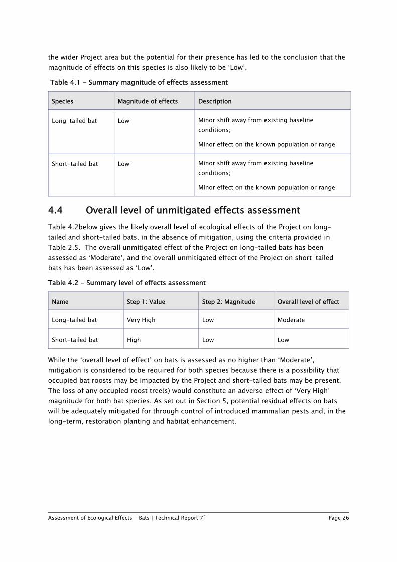
Assessment of Ecological Effects - Bats | Technical Report 7f Page 26
the wider Project area but the potential for their presence has led to the conclusion that the magnitude of effects on this species is also likely to be ‘Low’.
Table 4.1 - Summary magnitude of effects assessment
Species Magnitude of effects Description
Long-tailed bat Low Minor shift away from existing baseline conditions;
Minor effect on the known population or range
Short-tailed bat Low Minor shift away from existing baseline conditions;
Minor effect on the known population or range
4.4 Overall level of unmitigated effects assessment Table 4.2below gives the likely overall level of ecological effects of the Project on long-tailed and short-tailed bats, in the absence of mitigation, using the criteria provided in Table 2.5. The overall unmitigated effect of the Project on long-tailed bats has been assessed as ‘Moderate’, and the overall unmitigated effect of the Project on short-tailed bats has been assessed as ‘Low’.
Table 4.2 - Summary level of effects assessment
Name Step 1: Value Step 2: Magnitude Overall level of effect
Long-tailed bat Very High Low Moderate
Short-tailed bat High Low Low
While the ‘overall level of effect’ on bats is assessed as no higher than ‘Moderate’, mitigation is considered to be required for both species because there is a possibility that occupied bat roosts may be impacted by the Project and short-tailed bats may be present. The loss of any occupied roost tree(s) would constitute an adverse effect of ‘Very High’ magnitude for both bat species. As set out in Section 5, potential residual effects on bats will be adequately mitigated for through control of introduced mammalian pests and, in the long-term, restoration planting and habitat enhancement.
Assessment of Ecological Effects - Bats | Technical Report 7f Page 27
5 Recommendations for addressing potential adverse effects
5.1 Overview Extensive and ongoing effort has been made to avoid potential adverse ecological effects of the Project on bats. The ecologists engaged to advise on the Project, and provide expert assessments of the potential effects of the Project on ecological values, have been closely involved in the alignment option selection and design processes.
Through the process of selecting the alignment, the inclusion of structures (a tunnel and bridge), and design and construction methods for the Project, ecological effects on bats have been either avoided or reduced in magnitude. To mitigate for residual effects that cannot be avoided, the Project will include vegetation clearance protocols, restoration planting and habitat enhancement, and most importantly, a large-scale, long-term pest management programme. Through these efforts, and in line with the overarching ecological aim for the Project, it is expected that there will be no net loss (and possibly a net benefit) for the bat population(s) potentially affected by the Project.
Measures that will avoid, remedy or mitigate potential adverse effects on bats are set out below. These measures will be detailed and actioned through the development and implementation of an Ecology and Landscape Management Plan (ELMP) that includes a section that sets out bat management requirements and provides further detail on all measures discussed below.
5.2 Project measures to avoid or minimise effects A number of potential adverse ecological effects on bats (and other ecological values) have been avoided through the selection of the Project alignment, which (unlike many other options considered) completely avoids the generally higher value land to the west of the existing SH3. The Project alignment has been optimised to further reduce effects on bats.
5.2.1 Avoidance through the options selection process The options considered included alignments to the west of SH3 which traversed areas with significant biodiversity values, including the Waipingao catchment and adjacent Parininihi land. Potential adverse effects identified for options to west of SH3 are described in the options assessment reports (attached in Volume 4 of the AEE). These effects include loss of significant habitats, severance of a nationally important vegetation sequence and effects on associated regionally and nationally significant flora, and potentially significant effects on bats. Moreover, half of these options excluded the use of structures (a bridge and tunnel) and had large cuts and fills, which would have resulted in much more significant ecological effects on bats as a result of substantially increased impacts of habitat loss and fragmentation.
Assessment of Ecological Effects - Bats | Technical Report 7f Page 28
5.2.2 Avoidance or minimisation of effects through optimisation of the Project footprint
The Project footprint traverses areas of significant habitat and vegetation types to the east of Mt Messenger, as described in the various technical reports (attached in Volume 3 of the AEE). All vegetation types and significant trees (Assessment of Ecological Effects – Vegetation (Technical Report 7a, Volume 3 of the AEE) have been mapped and delineated to identify the most ecologically significant areas and large old trees within and adjacent to the Project footprint. Project ecologists have worked closely with design and construction engineers to avoid or minimise ecological effects on these significant habitat types. Such efforts include:
• Inclusion of a 235m long tunnel through the ridge dividing the Mangapepeke and Mimi catchments. The tunnel has greatly reduced the size of the cut and fill area that would otherwise have been required and has preserved an east-west habitat linkage that is likely to be an important flight path for bats.
• Incorporation of a 120m bridge across a tributary valley to the Mimi River on the south side of the route. This bridge sits very close to the ecologically significant wetland area and has substantially reduced the impact that a cut and fill approach would have had on the wetland and will preserve east-west ecological connectivity and maintain a likely flight path for bats.
• Minor adjustments to the route to avoid the need to fell significant trees, which can be key bat habitat. The number of trees potentially needing to be felled has been reduced considerably by this means.
• Avoidance or minimisation of effects on significant ecological values (i.e. significant vegetation/habitat types and trees through): o Realignment of the corridor, including shifting part of the corridor further from
the ecologically significant wetland area that is likely to be important bat foraging habitat.
o Location of construction yards, laydown areas, construction access tracks and haul roads away from ecologically sensitive/significant areas to minimise the extent of disturbance and vegetation clearance.
o Use of retaining walls to avoid loss of significant trees where possible. o Undertaking vegetation/habitat clearance in accordance with the Construction
Environmental Management Plan (CEMP) and the ELMP to further reduce effects on significant habitat. The CEMP (attached in Volume 5 of the AEE) is supported by a suite of sub-plans, which outline the management of specific construction effects such as construction-related ecological effects in more detail.
Assessment of Ecological Effects - Bats | Technical Report 7f Page 29
5.3 Species-specific measures to avoid or minimise effects Further measures to avoid or minimise effects on bats have been developed, including following discussions with the Department of Conservation. These are included in Sections 5.3.1-5.3.2 below.
5.3.1 Vegetation clearance protocols Potential impacts on bats will be mitigated primarily with the implementation of vegetation clearance protocols (VCP). The protocols would be applied when removing vegetation which could potentially support bat roosts. Further detail on tree removal protocols will be included in the Ecology and Landscape Management Plan. Vegetation clearance protocols are also likely to form part of the conditions of the Wildlife Act permit. The primary mechanism by which the protocols mitigate effects on bats is the application of a suite of techniques (e.g. ABM monitoring and visual inspections) to ensure that any trees that represent potential bat roosting habitat are only felled when it can be confirmed that they are not occupied by bats.
5.3.2 Identify important bat habitats Trapping, banding and radio tracking of bats is scheduled to be carried out during late 2017 to locate and describe bat roosts, and identify important foraging areas. An understanding of the characteristics of the roosts selected by bats will assist generally in ensuring that the VCP are applied as effectively as possible. Any maternity roosts located outside the Project footprint could also be targeted with additional predator control to further benefit the bat population. If successful, the bat trapping and radio tracking programme could potentially also provide information on population size, structure (and sub-structuring), breeding, etc.
5.3.3 Impacts on bats of proposed offset programme A comprehensive offset programme is proposed for the Project and described in the Ecological Effects Assessment – Ecological Mitigation and Offset (Technical Report 7h, Volume 3 of the AEE). That programme will benefit bat populations in the area, as discussed below.
5.3.4 Pest management The most beneficial long-term form of mitigation to offset loss of habitat is likely to be the proposed pest management within the forested areas in the wider Project area where pest management is not currently planned or being implemented. A recent published paper (O’Donnell et al 2017) provides evidence that managing mammalian predators such as mustelids and rats enhances the long-term survival of long-tailed bats. In many parts of New Zealand long-tailed bats are declining in the absence of predator management – even where large areas of otherwise suitable habitat are present.
The details of the proposed pest control are provided in the Ecological Effects Assessment – Ecological Mitigation and Offset (Technical Report 7h, Volume 3 of the AEE). Pest
Assessment of Ecological Effects - Bats | Technical Report 7f Page 30
management should ideally be undertaken on an indefinite basis as a fixed period could result in a vacuum effect whereby once pest management ceases, pest populations may irrupt and adversely affect native bats.
5.3.5 Revegetation Revegetation within the disturbed areas along the Project footprint will likely be undertaken as part of landscape and ecological mitigation. This mitigation planting would ideally reflect the vegetation communities that would be removed during the construction phase on the Project. The recreation of the mature forest is not possible in the short- to medium-term, due to the lengthy timeframes required for vegetation to mature. The species palette chosen to mitigate the impacts of the Project on vegetation communities should, where appropriate, eventually provide bat habitat once established. Appropriate secondary successional canopy species could be included in the mitigation planting (or follow-up enrichment planting) to ensure that tree species known to eventually develop the characteristics preferred by bats for roosting are present within the revegetated areas. The details of the proposed revegetation programme are detailed in the Ecological Effects Assessment – Ecological Mitigation and Offset (Technical Report 7h, Volume 3 of the AEE).
5.3.6 Monitoring Post-construction bat monitoring with ABMs is not considered necessary or appropriate because monitoring bats with ABMs does not provide any information on population size or trends. An extensive trapping and mark-recapture programme would be required to monitor bat population size and trends. Given that the Project footprint represents only a relatively small proportion of the available habitat for bats in the wider Project area, and the benefits of large-scale long-term predator management for bats have been confirmed by a published study (O’Donnell et al 2017), a post-construction programme is not considered necessary.
Assessment of Ecological Effects - Bats | Technical Report 7f Page 31
6 Conclusions While bat surveys with ABMs are ongoing, and a bat trapping and radio tracking programme to help refine bat-specific mitigation methods is scheduled for late 2017, this assessment provides a strong indication that the Project’s potential adverse effects on native bats can be appropriately addressed and managed. The most significant potential effect identified is the potential loss of occupied roost trees.
Recommended ecological management to mitigate potential adverse effects on bats includes:
a the implementation of vegetation clearance protocols to ensure that no occupied bat roosts are felled, and
b a long-term pest management programme to mitigate residual effects as described in the Ecological Effects Assessment – Ecological Mitigation and Offset Report (Technical Report 7h, Volume 3 of the AEE).
Overall, taking into account these measures, it is considered that any effects of the Project on bats are likely to be negligible in the medium term.
Assessment of Ecological Effects - Bats | Technical Report 7f Page 32
7 References Bayfield, M.A., Courtney, S.P, Wiessing, M.I. 1991. North Taranaki Ecological District. Survey report for the Protected Natural Areas Programme No. 16. Department of Conservation, Wanganui
Bell, D. 2016. Bat Surveying in Taranaki 2015-16 Report. Native Birds Taranaki, New Plymouth. 14 p.
Borkin, K., Smith, D., & Shaw, W. 2016. Did the bat cross the road? More traffic, less bat activity. New Zealand Ecological Society, 2016 Conference Presentation. Hamilton, New Zealand.
EIANZ, 2015. Ecological impact assessment (EcIA): EIANZ guidelines for use in New Zealand: Terrestrial and freshwater ecosystems. Melbourne: Environment Institute of Australia and New Zealand. 100 p.
O’Donnell, C.F.J., Pryde, M.A., van Dam-Bates, P., Elliott, G.P., (2017). Controlling invasive predators enhances the long-term survival of endangered New Zealand long-tailed bats (Chalinolobus tuberculatus): Implications for conservation of bats on oceanic islands. Biological Conservation 214 (2017), 156–167.
O’Donnell, C.F.J. 2010. The ecology and conservation of New Zealand bats. In: Island bats: evolution, ecology and conservation. Chicago University Press, Chicago. 460-495 pp.
Opus International Consultants Limited, 2017a. Mt Messenger Bypass Investigation - Bat Baseline Survey, April 2017. Unpublished Report prepared for the NZ Transport Agency.
Opus International Consultants Limited, 2017b. Mt Messenger Bypass: Option MC23 - Bat Survey Addendum. Unpublished Memo dated 25 July 2017.
Ruffell, J., Didham, R. 2016, 'Towards a better mechanistic understanding of edge effects', Landscape Ecology, 31, 10, pp. 2205-2213.