Report 02-201 bulk log carrier - Latest updates | TAIC
52
Report 02-201 bulk log carrier Jody F Millennium grounding Gisborne 6 February 2002 Abstract On Wednesday 6 February 2002, at about 2152, the log carrier Jody F Millennium with a master and 18 crew on board, grounded in the Gisborne approach channel when it encountered large swells as it left the relative shelter of the breakwater while departing from the port. The ship was subsequently driven by the swell on to the shelving shoal area to the north of the channel, where it remained for 18 days before being re-floated. At the time of the grounding the ship was still within the pilotage area, but the pilot had disembarked a few minutes earlier. Safety issues identified included: • adequacy of interpretation and dissemination of weather forecasts and actual weather at remote locations • adequacy of mooring system for expected conditions • adequacy of communication between master and pilot • adherence to minimum criteria for safe departure with regards to under keel clearance calculated from tide times and heights • appropriateness of early pilot disembarkation • difficulty of a pilot working alone, without the benefit of peer discussion or challenge, leading to a one-man decision without full exploration of possible alternatives • appropriateness of limiting dimensions of ships able to use Port of Gisborne • adequacy of the management and employment system practised by Port of Gisborne. Safety recommendations were made to the General Manager of Eastland Port Limited, the Chief Executive of Gisborne District Council, the General Manager of Adsteam Port Services Limited and the Gisborne Adsteam Port Services Limited pilot.
Transcript of Report 02-201 bulk log carrier - Latest updates | TAIC
Report 02-201
bulk log carrier
Jody F Millennium
grounding
Gisborne
6 February 2002
Abstract
On Wednesday 6 February 2002, at about 2152, the log carrier Jody F Millennium with a master and 18crew on board, grounded in the Gisborne approach channel when it encountered large swells as it left therelative shelter of the breakwater while departing from the port. The ship was subsequently driven by theswell on to the shelving shoal area to the north of the channel, where it remained for 18 days before beingre-floated. At the time of the grounding the ship was still within the pilotage area, but the pilot haddisembarked a few minutes earlier.
Safety issues identified included:• adequacy of interpretation and dissemination of weather forecasts and actual
weather at remote locations• adequacy of mooring system for expected conditions• adequacy of communication between master and pilot
• adherence to minimum criteria for safe departure with regards to under keelclearance calculated from tide times and heights
• appropriateness of early pilot disembarkation
• difficulty of a pilot working alone, without the benefit of peer discussion orchallenge, leading to a one-man decision without full exploration of possiblealternatives
• appropriateness of limiting dimensions of ships able to use Port of Gisborne• adequacy of the management and employment system practised by Port of
Gisborne.
Safety recommendations were made to the General Manager of Eastland Port Limited, the ChiefExecutive of Gisborne District Council, the General Manager of Adsteam Port Services Limited and theGisborne Adsteam Port Services Limited pilot.
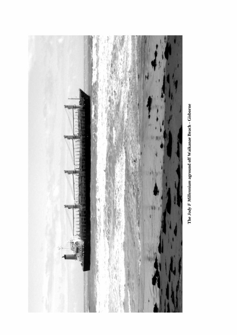
The
Jod
y F
Mill
enni
um a
grou
nd o
ff W
aika
nae
Bea
ch -
Gis
born
e
Contents
Abbreviations ................................................................................................................................................ii
Glossary....................................................................................................................................................... iii
Data Summary..............................................................................................................................................iv
1. Factual Information .......................................................................................................................1
1.1 History of event ..............................................................................................................11.2 Approach channel to the port of Gisborne .....................................................................51.3 The Permanent International Association of Navigation Congresses (PIANC).............81.4 Interaction.......................................................................................................................91.5 The decision to sail.......................................................................................................101.6 Pilot disembarkation.....................................................................................................131.7 Position of grounding ...................................................................................................13
Analysis 1.....................................................................................................................15Approach channel.........................................................................................................15Decision to sail .............................................................................................................16Pilot disembarkation.....................................................................................................18Grounding position.......................................................................................................19
1.8 Port organisation and port services including pilot and pilotage examination.............191.9 Mooring systems, mooring configuration and wharves ...............................................22
Analysis 2.....................................................................................................................25Port Gisborne Limited, Gisborne District Council, the pilot and the ...........................25harbourmaster...............................................................................................................25Mooring system, wharves and fendering......................................................................27
1.10 Vessel Information .......................................................................................................291.11 Weather and Forecasting ..............................................................................................301.12 Damage.........................................................................................................................321.13 Human Factors .............................................................................................................33
Analysis 3.....................................................................................................................33
2. Findings .......................................................................................................................................36
3. Safety recommendations..............................................................................................................39
Index............................................................................................................................................................45
Figures
Figure 1 Jody F Millennium estimated grounding positions...................................................................3
Figure 2 Swinging basin and breakwater configuration showing approximate track of theJody F Millennium....................................................................................................................4
Figure 3 Aerial photo of the port of Gisborne with Jody F Millennium aground off Waikanae Beach..6
Figure 4 Draught criteria as used by pilot and supplied by him to Port Gisborne Limited ....................7
Figure 5 Illustration of determination of under keel clearance .............................................................11
Figure 6 Illustration of increase in draught due to heel.........................................................................12
Figure 7 Photograph of part of the ship’s navigational chart (NZ 5613) showing positions andtimes as recorded by ship’s crew............................................................................................14
Figure 8 Simplified diagram of operational relationships.....................................................................22
Figure 9 Shore mooring line .................................................................................................................23
Figure 10 Shore mooring line configuration...........................................................................................24
Figure 11 Fendering at number 8 wharf..................................................................................................25 page i
Abbreviations
GM metacentric height (measure of a vessel’s statical stability)GPS global positioning system
hp horsepowerhPa hectoPascal(s)
kt(s) knot(s)km(s) kilometre(s)kW kilowatt
m metre(s)m3 cubic metresmm millimetre(s)
NIWA National Institute of Water and Atmospheric Research Limitednm nautical mile(s)
PFD personal floatation devicePIANC The Permanent International Association of Navigation Congresses
rpm revolutions per minute
t tonne(s)
UKC under keel clearanceUTC Coordinated Universal Time
VHF very high frequency
Glossary
abeam direction at right angles to the length of a shipaft rear of the vessel
ballast weight, usually sea water, put into a ship to improve stabilitybeam width of a vesselbollard pull measure of the static pull a vessel can exert
cable 0.1 of a nautical milechart datum zero height referred to on a marine chartclass category in classification registerconduct (con) in control of the vessel
dead reckoning calculation of position considering courses steered, distance logged, set and leeway
double bottom tank at the bottom of a ship formed by the inner and outer bottom plating ofhull
draught depth in water at which a ship floats
fetch the distance travelled by wind or waves across open waterforecastle raised structure on the bow of a ship
gross tonnage a measure of the internal capacity of a ship; enclosed spaces are measured incubic metres and the tonnage derived by formula
heel angle of tilt caused by external forces
knot one nautical mile per hour
leading light(s) light(s) that identify the safest track in a channellongitudinal pertaining to length. Applied to any fore and aft member of a ship structure
port left-hand side when facing forward
range of tide difference in height between successive high and low watersranging fore and aft movement of a ship alongside its berth
sounding measure of the depth of a liquidsquat increase in draught, trim or both due to the movement of a ship through the
waterstarboard right-hand side when facing forwardstability property of a ship by which it maintains a position of equilibrium, or
returns to that position when a force that has displaced it ceases to actsurge water movement created by long waves travelling large distances from
distant storms, and sometimes exacerbated by local swell wavessurging movement of a ship at its berth caused by surge in a harbour. Surging
includes ranging along the berth, vertical lift at the berth and movementaway from the berth
track the path intended or actually travelled by a ship page iii

Data Summary
Vessel Particulars:
Name: Jody F Millennium
Type: bulk log carrier
Class: Nippon Kaiji Kyokai
Length (overall): 159.94 m
Breadth (extreme): 26.00 m
Gross tonnage: 15 071 t
Built: 2000
Propulsion: a single 6156 kW Mitsui B&W 6S42MC (MarkVI) diesel engine, driving a single fixed-pitchpropeller
Service speed: 14.5 kts
Owner: Twin Bright Shipping Company Limited ofPanama, Panama
Manager: Soki Kisen Company Limited, Japan
Operator/Sub time charterer: Hyundai Merchant Marine Company LimitedSeoul, Korea
Voyage charterer: Rayonier, New Zealand Limited
Time charterer: News Maritime Company LimitedTokyo, Japan
Crew: 19
Date and time: 6 February 2002 at 21521
Location: Gisborne
crew: 19Persons on board:passengers: nil
crew: nilInjuries:passengers: nil
Damage: substantial to ship
Investigator-in-charge: Captain John Mockett
1 All times in this report are New Zealand Daylight Time (UTC + 13 hours) and are expressed in the 24-hour mode
1. Factual Information
1.1 History of event
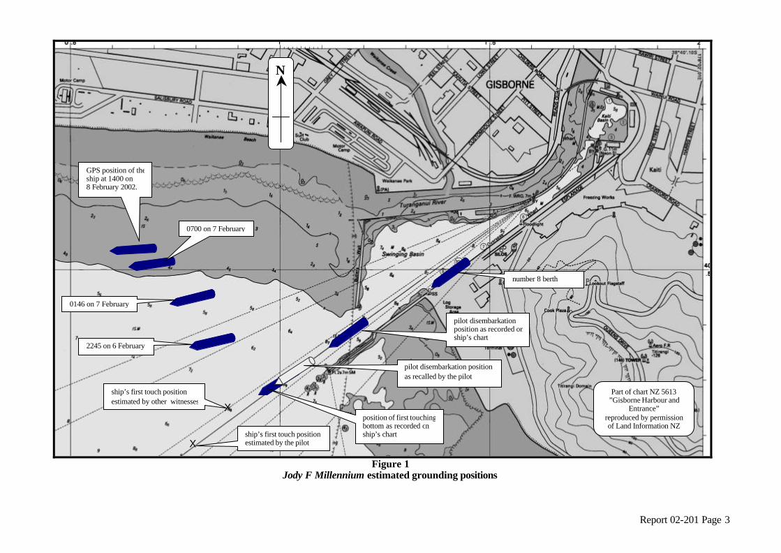
1.1.1 On 6 February 2002, the bulk log carrier Jody F Millennium departed from Gisborne because asevere surge in the harbour created by a deep depression to the south and an increasing swelloutside the harbour, was causing the ship to move violently alongside the wharf and break some ofits shore mooring lines. As it passed the breakwater, the ship was struck by the swell and touchedbottom in the approach channel, slowing and effectively disabling the ship, which was then drivenby the sea and swell further on to the shoal area to the north of the channel where it remained hardaground for 18 days (see Figure 1).
1.1.2 The Jody F Millennium had arrived at Gisborne on 3 February 2002. The pilot boarded in thenominated pilot boarding area. He stated that on his arrival on the bridge, he indicated to themaster the intended courses into the port, using the ship’s chart, and gave the master a photocopyof part of the chart depicting the swinging basin and the way the ship was to be berthed, togetherwith a drawing of how the ship would be secured alongside.
1.1.3 The master of the Jody F Millennium stated that he was not given any information on the port or apassage plan for entering the port. Neither was he given a set of port guidelines. Thedocumentation referred to by the pilot could not be found aboard the ship.
1.1.4 The Jody F Millennium berthed at 2320 on 3 February 2002, port side alongside number 8 wharf,after being swung through 180° in the swinging basin. It was made fast using a combination ofship’s mooring lines and shore mooring lines. The ship was initially scheduled to depart fromGisborne at about 1400 on 5 February.
1.1.5 Cargo loading operations began using the ship’s cranes at 0700 on 4 February and, because ofsome delays, continued throughout until the afternoon of 6 February.
1.1.6 At 0955 on the 5 February, another ship, the Asian Briar, berthed at number 7 wharf behind theJody F Millennium, to load squash. Because it was scheduled to remain alongside for just 24 hoursthe Asian Briar was secured using ship’s mooring lines only.
1.1.7 On the afternoon of 6 February, with a deep depression to the south and a southerly swell buildingoutside the harbour, conditions inside the harbour began to deteriorate with a moderate surgedeveloping. The surge caused both ships and other smaller vessels in the port to move at theirberths, ranging up and down the wharves, rolling and surging off the wharves. The agent for theAsian Briar requested the supervisor of the shore mooring gang to run shore mooring lines to theship. At about 1400, the supervisor of the shore mooring gang contacted the pilot and told himabout the surge in the harbour. The pilot came to the port at that time. Two shore mooring lineswere secured to each end of the Asian Briar.
1.1.8 At about 1420, shortly after the shore mooring lines had been secured on the Asian Briar, one ofthe after shore mooring lines on the Jody F Millennium parted. The shore mooring gang replaced itand while doing that, one of the forward lines parted, which they also replaced. At about 1430 thepilot informed the general manager of Port Gisborne Limited of the situation and, through thegeneral manager and the ships’ agents, instructed the masters of both ships to ready their enginesand be on immediate readiness for sea. The Jody F Millennium continued to move at the wharf andat about 1500 the pilot called out the harbour tug, Turihaua, to push on the ship in an attempt todampen the movement. The tug arrived at the ship at about 1510. The crew of Jody F Millenniumraised the gangway to prevent damage to it.
1.1.9 During the remainder of the afternoon, both ships continued to move violently at times and thesecond harbour tug, the Titirangi, was called out. It was initially to push on the Asian Briar atnumber 7 wharf but went straight to the Jody F Millennium because that ship was moving more andcausing greater concern. page 1
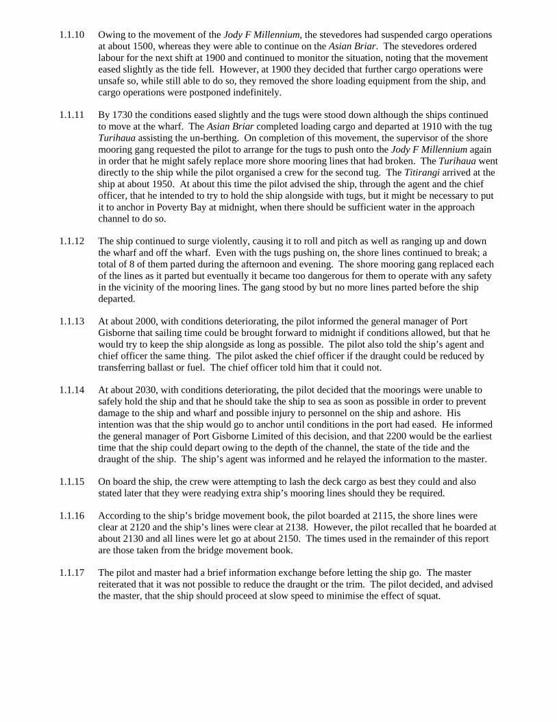
1.1.10 Owing to the movement of the Jody F Millennium, the stevedores had suspended cargo operationsat about 1500, whereas they were able to continue on the Asian Briar. The stevedores orderedlabour for the next shift at 1900 and continued to monitor the situation, noting that the movementeased slightly as the tide fell. However, at 1900 they decided that further cargo operations wereunsafe so, while still able to do so, they removed the shore loading equipment from the ship, andcargo operations were postponed indefinitely.
1.1.11 By 1730 the conditions eased slightly and the tugs were stood down although the ships continuedto move at the wharf. The Asian Briar completed loading cargo and departed at 1910 with the tugTurihaua assisting the un-berthing. On completion of this movement, the supervisor of the shoremooring gang requested the pilot to arrange for the tugs to push onto the Jody F Millennium againin order that he might safely replace more shore mooring lines that had broken. The Turihaua wentdirectly to the ship while the pilot organised a crew for the second tug. The Titirangi arrived at theship at about 1950. At about this time the pilot advised the ship, through the agent and the chiefofficer, that he intended to try to hold the ship alongside with tugs, but it might be necessary to putit to anchor in Poverty Bay at midnight, when there should be sufficient water in the approachchannel to do so.
1.1.12 The ship continued to surge violently, causing it to roll and pitch as well as ranging up and downthe wharf and off the wharf. Even with the tugs pushing on, the shore lines continued to break; atotal of 8 of them parted during the afternoon and evening. The shore mooring gang replaced eachof the lines as it parted but eventually it became too dangerous for them to operate with any safetyin the vicinity of the mooring lines. The gang stood by but no more lines parted before the shipdeparted.
1.1.13 At about 2000, with conditions deteriorating, the pilot informed the general manager of PortGisborne that sailing time could be brought forward to midnight if conditions allowed, but that hewould try to keep the ship alongside as long as possible. The pilot also told the ship’s agent andchief officer the same thing. The pilot asked the chief officer if the draught could be reduced bytransferring ballast or fuel. The chief officer told him that it could not.
1.1.14 At about 2030, with conditions deteriorating, the pilot decided that the moorings were unable tosafely hold the ship and that he should take the ship to sea as soon as possible in order to preventdamage to the ship and wharf and possible injury to personnel on the ship and ashore. Hisintention was that the ship would go to anchor until conditions in the port had eased. He informedthe general manager of Port Gisborne Limited of this decision, and that 2200 would be the earliesttime that the ship could depart owing to the depth of the channel, the state of the tide and thedraught of the ship. The ship’s agent was informed and he relayed the information to the master.
1.1.15 On board the ship, the crew were attempting to lash the deck cargo as best they could and alsostated later that they were readying extra ship’s mooring lines should they be required.
1.1.16 According to the ship’s bridge movement book, the pilot boarded at 2115, the shore lines wereclear at 2120 and the ship’s lines were clear at 2138. However, the pilot recalled that he boarded atabout 2130 and all lines were let go at about 2150. The times used in the remainder of this reportare those taken from the bridge movement book.
1.1.17 The pilot and master had a brief information exchange before letting the ship go. The masterreiterated that it was not possible to reduce the draught or the trim. The pilot decided, and advisedthe master, that the ship should proceed at slow speed to minimise the effect of squat.
Report 02-201 Page 3
Figure 1
Jody F Millennium estimated grounding positions
X ship’s first touch position estimated by the pilot
position of first touching bottom as recorded on ship’s chart
2245 on 6 February
0146 on 7 February
0700 on 7 February
GPS position of the ship at 1400 on 8 February 2002.
X
ship’s first touch position estimated by other witnesses
Part of chart NZ 5613 ”Gisborne Harbour and
Entrance” reproduced by permission of Land Information NZ
N
number 8 berth
pilot disembarkation position as recorded on ship’s chart
pilot disembarkation position as recalled by the pilot
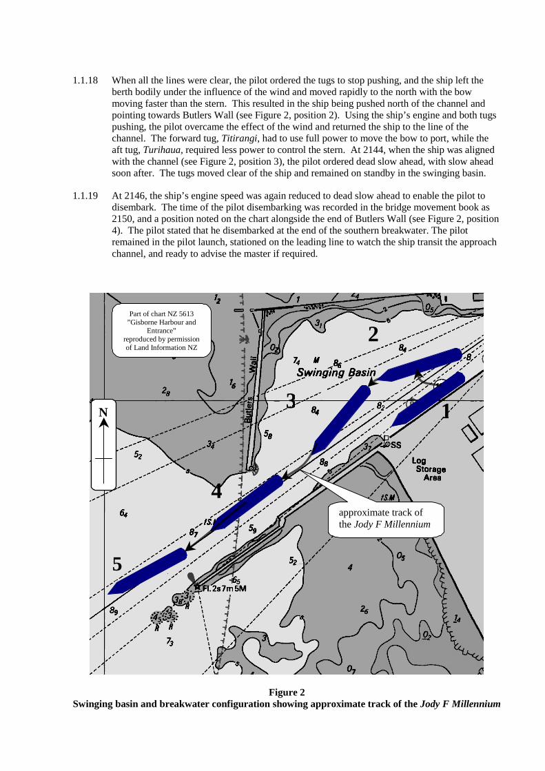
1.1.18 When all the lines were clear, the pilot ordered the tugs to stop pushing, and the ship left theberth bodily under the influence of the wind and moved rapidly to the north with the bowmoving faster than the stern. This resulted in the ship being pushed north of the channel andpointing towards Butlers Wall (see Figure 2, position 2). Using the ship’s engine and both tugspushing, the pilot overcame the effect of the wind and returned the ship to the line of thechannel. The forward tug, Titirangi, had to use full power to move the bow to port, while theaft tug, Turihaua, required less power to control the stern. At 2144, when the ship was alignedwith the channel (see Figure 2, position 3), the pilot ordered dead slow ahead, with slow aheadsoon after. The tugs moved clear of the ship and remained on standby in the swinging basin.
1.1.19 At 2146, the ship’s engine speed was again reduced to dead slow ahead to enable the pilot todisembark. The time of the pilot disembarking was recorded in the bridge movement book as2150, and a position noted on the chart alongside the end of Butlers Wall (see Figure 2, position4). The pilot stated that he disembarked at the end of the southern breakwater. The pilotremained in the pilot launch, stationed on the leading line to watch the ship transit the approachchannel, and ready to advise the master if required.
Figure 2Swinging basin and breakwater configuration showing approximate track of the Jody F Millennium
1
2
3
4
5
approximate track ofthe Jody F Millennium
Part of chart NZ 5613”Gisborne Harbour and
Entrance”reproduced by permissionof Land Information NZ
N
1.1.20 At 2152, as the ship, on a course of 235° (T), emerged from behind the southern breakwater, alarge swell struck the port shoulder of the ship pushing the bow to starboard and causing theship to roll, first to starboard and then to port (see Figure 2, position 5). The master said he feltthat the ship touched bottom forward, initially on the port side and then on the starboard,whereas the chief officer on the forecastle thought it had touched aft. The master increasedspeed and ordered the helm hard to port in an attempt to maintain position in the channel but theship had lost forward momentum and was pushed by the wind and sea towards the starboardside of the channel.
1.1.21 Without sufficient forward momentum, the master was unable to steer the ship and it was drivenfurther on to shoal ground outside the channel, despite attempts to free it using the main engine.The master informed the pilot, on the VHF radio, that the ship had grounded. The pilotsuggested that the master put the engine astern, but when this was done, there was excessivevibration and so it was again stopped. The pilot instructed both tugs and the pilot launch to goout to the ship but owing to the weather conditions, which were observed by the pilot andservice vessel crews to be 6-metre swells, they were unable to get alongside the ship and wereunable to provide any effective assistance. The pilot suggested that the master drop the anchors.The master ordered the mate on the forecastle to let go the port anchor; this was soon followedby the order to drop the starboard anchor. Shortly after letting go the anchors, the forward crewhad to abandon the forecastle because of waves crashing over the bow.
1.1.22 At some time during the night, both anchor cables parted and the ship was driven further to thenorth and towards Waikanae Beach, where it remained for 18 days before it was re-floated andtowed off.
1.1.23 Temporary repairs were carried out in Tauranga before the ship was towed to Japan to undergofull repairs in dry-dock.
1.2 Approach channel to the port of Gisborne
1.2.1 The approach channel extended for about 0.9 nm from a starboard-hand arrival buoy to theharbour entrance between the southern breakwater and Butlers Wall (see Figure 1). The gapbetween the breakwater and the wall was about 100 m, with the leading line bisecting the gap.The leading line in the channel was 57 m from the southern breakwater, which was steep too.
1.2.2 The channel bottom was of hard mudstone, locally known as “papa”, which had an overlay ofsedimentary sand and silt. Between 1997 and 2000, dredging was carried out to deepen thechannel. Initially, the suction dredge Pelican was used to remove the sedimentary sand and siltin the area and then a barge with a backhoe was used to dig out the hard, rock-like mudstone.The swinging basin inside the harbour was not dredged as part of this project. A hydrographiccompany monitored the dredging by taking bottom surveys during the operation. Oncompletion, a final survey was carried out between 15 and 20 March 2000 and a chart wasproduced showing the new channel depths; the least depth being 10.5 m. A follow-uphydrographic survey was undertaken in August 2001, which showed a least depth of 9.7 m.
1.2.3 The pilot received a copy of the sounding chart for the survey completed on 20 March 2000 butmaintained that he had asked Port Gisborne Limited for another survey to be carried out. Hesaid that he was not aware of the August 2001 survey nor was he given a copy of the chart forthat survey. Port Gisborne Limited maintained that the pilot was given a copy of both charts.
1.2.4 The depth of the channel was continuously reduced as sedimentary sand and silt was depositedin it by tidal flows. Port Gisborne Limited attempted to maintain the channel depth by regularuse of the dumb suction dredge Pukanui, which was towed by one of the harbour tugs. The portcompany estimated that the Pukanui removed between 100 000 and 130 000 m3 of sand peryear, predominately from the approach channel. At the time of the accident the Pukanui was onthe slipway undergoing survey work. The last maintenance dredging of the channel had beenundertaken between some time in September and 4 December 2001, some 2 months before thegrounding. page 5
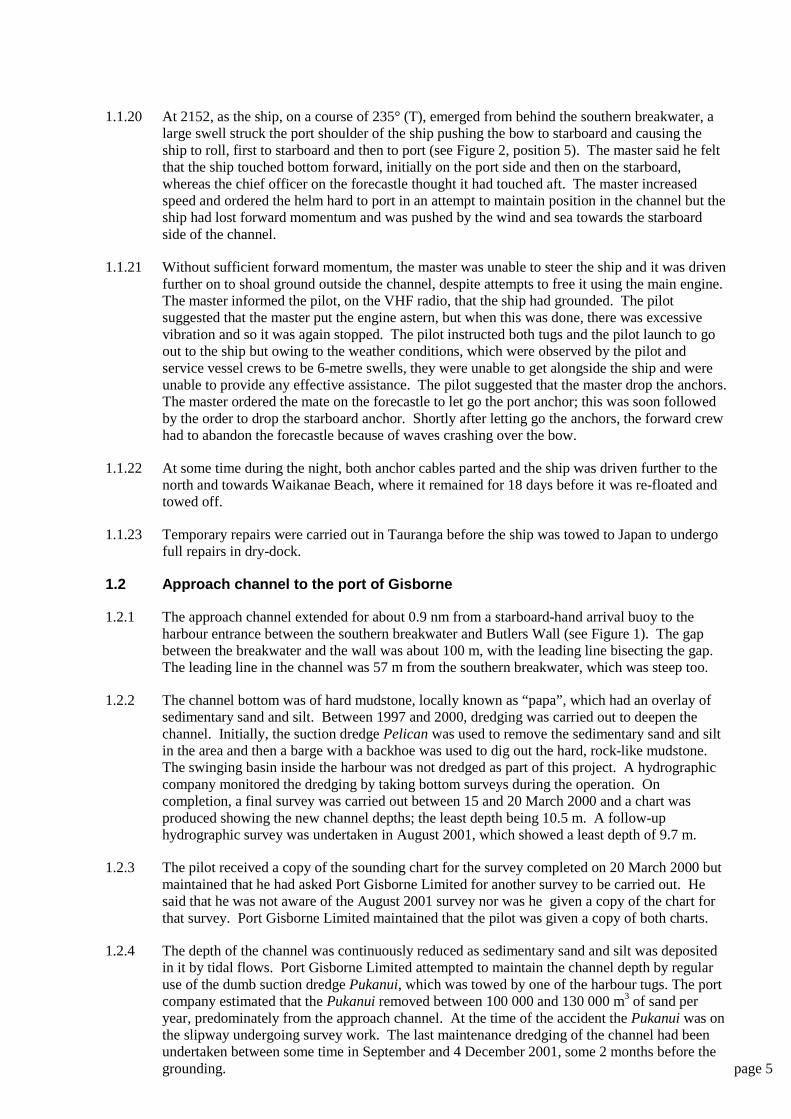
1.2.5 The maintenance dredging completed in December 2001 was unlikely to have increased thedepth of water in the channel to the original 10.5 m but no soundings were available to verifywhat depth was actually achieved. In the 2 months between the dredging and the grounding ofthe Jody F Millennium, the channel would have partially in-filled with sand and silt. As noaccurate figure could be determined for the depth in the channel on the night of 6 February2002, the Commission estimated the maximum depth of water at 10 m.
Figure 3Aerial photo of the port of Gisborne with Jody F Millennium aground off Waikanae Beach
1.2.6 Before the approach channel was deepened, a new deep-water berth, number 8 wharf, was builtand the existing deep-water berth, number 7 wharf, refurbished.
1.2.7 Prior to the channel being deepened and the new wharf being built as part of a long-term majorredevelopment of the port, a field and modelling study was carried out in 1996/97. This was todetermine the wave performance inside and outside the port to provide a reference forcalibrating the performance of the model of the harbour in its existing configuration with a viewto simulating wave behaviour in the hypothetical harbour designs. The study report concludedthat for the existing port, wave heights along the deep-water berths were higher than those in theturning basin. The report did not come to any conclusions regarding changes to the wavebehaviour for the projected changes in port configuration.
1.2.8 The New Zealand Pilot (Admiralty Sailing Directions NP51) reported that the port of Gisborneapproach channel was dredged to a depth of 10.5 m over a width of about .05 nm (half a cableor 93 m) about the leading line. The New Zealand Pilot also advised that depths in the dredgedareas might not be regularly maintained and that the latest depths should be obtained from thePort Authority. Other than the depth soundings, no reference to the maximum depth of thechannel was made on navigational chart NZ 5613.
Butlers Wall
breakwater
WaikanaeBeach
Number8 wharf
Jody F Millennium
swinging basin
training wall
1.2.9 The swinging basin was stated to have a maximum width of 250 m and the bottom shelvedrapidly towards Butlers Wall and the Training Wall between the harbour and the TuranganuiRiver. For a ship of length similar to the Jody F Millennium (160 m), the pilot at the time of theaccident used a maximum forward draught of 7.5 m on a 2.0 m high tide when swinging avessel.
1.2.10 In between hydrographic surveys, the port relied upon echo sounder readings obtained from theharbour tug used to position the dumb dredge, and the pilot launch. Neither of these vessels wasfitted with a heave compensator to allow for the rise and fall of the vessel due to the seaconditions and therefore gave only an approximate reading of the depth.
1.2.11 Based on the results of the March 2000 survey, the pilot gave the general manager of PortGisborne Limited a chart of the draught criteria he used when deciding on whether a ship wasable to transit the approach channel (see Figure 4). He used a maximum draught of 10.2 m andallowed an under keel clearance of 2.0 m subject to swell and wind conditions. He noted thatthe maximum wind allowable for berthing would be 15 knots and the maximum swell would be2.0 m.
Table of drafts for various tide times
Tidal Height Max Draft
Neap Tide Spring Tide Neap Tide Spring Tide
Time from HW
LW 0.7 0.3 8.7 8.3
5hrs before 0.8 0.5 8.8 8.5
4hrs before 0.9 0.7 8.9 8.7
3hrs before 1.2 1.2 9.2 9.2
2hrs before 1.4 1.9 9.4 9.9
1 hr before 1.6 2.1 9.5 10.1
HW 1.7 2.2 9.7 10.2
1hr after 1.6 2.1 9.6 10.1
2hrs after 1.4 1.9 9.4 9.9
3hrs after 1.2 1.2 9.2 9.2
4hrs after 0.9 0.7 8.9 8.7
5hrs after 0.8 0.5 8.8 8.5
LW 0.7 0.3 8.7 8.3
These calculations are based on a dredged depth of 10.0 mts and allowing a keelclearance of 2.0 metres. They are to be taken only as an indication of the
limitations of draft as both swell and weather conditions have also to be taken intoaccount. Also steaming time to and from the berth
Figure 4Draught criteria as used by pilot and supplied by him to Port Gisborne Limited
1.2.12 After the accident, the Maritime Safety Authority of New Zealand commissioned ahydrographic survey that showed there was considerably less water than that detailed in thesurveys of March 2000 and August 2001. A least depth of 9.5 m (+/- 0.2 m) was found on theleading line over an area between 160 and 400 m south-west from the south breakwater head.
1.2.13 In July 1999, the general manager of Port Gisborne Limited received a letter from the GisborneDistrict Council voicing concern over the safety systems with respect to the shore mooringsbecause of the expected alteration in surge in the harbour from dredging. The surge effect wasnever quantified or measured for the dredging alone, although a study had been carried out for thefull-scale re-development of the port, which was not completed.. In May 2000 the pilot, who wasthe local manager of Adsteam Port Services Limited, wrote to his New Zealand general managerin Auckland commenting on the increased surge in the harbour caused by the deeper channel. Hementioned that a bulk log ship, the New Baroness, 167 m in length, had broken several shoremooring lines while alongside.
1.3 The Permanent International Association of Navigation Congresses (PIANC)
1.3.1 PIANC was founded in 1885 and was an international non-profit making and non-politicaltechnical and scientific organisation. The objective of PIANC was:
to promote the maintenance and operation of both inland and maritimenavigation by fostering progress in the planning, design, construction,improvement, maintenance and operation of inland and maritime waterways andports and of coastal areas for general use in industrialised as well as inindustrialising countries.
Its intention is to provide practising engineers with guidelines and data whichwill allow them to design a channel for a given ship or mix of ships types or,alternatively enable assessment of the suitability of an existing channel for theproposed change in ship type or operation.
1.3.2 Since 1973 PIANC had been studying and making recommendations on the optimum designand dimensions of shipping channels, taking into account the advances in knowledge, analyticalmethods and technology over the years.
1.3.3 In 1997, PIANC published a document called “Approach Channels: A Guide for Design.”PIANC recognised that in order to design the approach channel to a port to an acceptable levelof navigability and safety, a number of factors must be taken into account, including:
• vessel size
• manoeuvrability
• ship handling characteristics
• human factors in ship handling
• effects of the physical environment
• maritime engineering
• cost.
1.3.4 From the guide it was possible to calculate the optimum dimensions for straight and curvedchannels as well as swinging basins and other design aspects of a port. The method utilisedvessel dimensions and fractions or multiples of them. In determining the optimum size of awaterway, the guide used the dimensions of the largest vessel expected to use the channel.
1.3.5 For straight sections of a channel, such as in Gisborne, the manoeuvrability of the vesseldictated the basic width of the channel. Depending whether the channel was exposed or aninner harbour channel, the following criteria multiplied by factors of the beam were added to thebasic width:
• vessel speed and manoeuvrability
• prevailing cross wind
• prevailing cross and longitudinal current
• significant wave height and length
• availability of aids to navigation
• bottom surface
• depth of waterway
• cargo hazard level
• bank clearance
• under keel clearance.
1.3.6 When the optimum width of channel was calculated from the recommended values of thesecriteria, and using the characteristics and dimensions of the Jody F Millennium and the approachchannel to the port of Gisborne, a manoeuvring lane width of 164 m was obtained.
1.3.7 The PIANC guidelines recommended that areas used to turn vessels through 180 degrees shouldconsist of a circular swinging area having a diameter of between 1.8 and 2 times the length ofthe ship.
1.4 Interaction
1.4.1 When a vessel is travelling in calm, open, deep water, the water pressure system around the hullreaches equilibrium. If the vessel moves into shallow or confined water, this equilibrium canbecome upset as the pressure system around the hull interacts with the seabed or sides of achannel.
1.4.2 Vessels operating in shallow water are affected by what is known as the Bernoulli effect. Waterpassing a ship in shallow water has to accelerate due to the restriction. The increase in velocityresults in higher drag, which reduces the forward momentum of the ship. This effect is the basisof all interaction, including squat.
1.4.3 Squat is the term given to an increase in draught, trim or both experienced by a vessel due to itsmovement through the water. The water accelerates as it flows past the hull to fill the hole thevessel has left in its wake. This increase in velocity causes a decrease in water pressure underthe vessel and a resultant loss of buoyancy. The effect is usually more pronounced in shallowwater where the flow of water past the hull can be restricted by the seabed.
1.4.4 In much the same way as a ship squats towards the seabed, a ship travelling close to the side ofa channel can experience bank effect. An increase in water pressure at the bow forms a cushionbetween the bow and the bank, deflecting the bow away from the bank. At the same time, aft ofthe pivot point, the flow of water accelerates between the bank and the side of the ship, drawingthe stern of the ship towards the bank. If not counteracted with helm movements, the resultantforces may cause the ship to sheer across to the other side of the channel.
1.4.5 The influence that squat and bank effect have on a vessel varies exponentially with the speed ofthe vessel. Therefore, a small reduction in speed will dramatically reduce the effects of squatand bank effect. page 9
1.4.6 Under keel clearance (UKC) is the separation between a ship’s keel and the sea bottom. Theminimum clearance depends on many factors and should allow for squat, the vertical motion ofthe ship in the water and the increase in draught through heel (see Figures 5 and 6). In a paperprepared for the United Kingdom Pilots Association (Marine) technical committee, Captain AMcKinnon states:
It is widely appreciated by mariners that ship manoeuvrability rapidlydeteriorates when the UKC is reduced below 20 per cent of the draught, and aminimum UKC of 10 per cent is recommended as safe practice only when thespeed required for steering can be kept under five knots with the charted depthreliable through frequent surveys. These restrictions assume that the wind willnot greatly affect the steering at low speed and the ship is unaffected by sea orswell.
1.5 The decision to sail
1.5.1 During the afternoon of 6 February, the pilot requested, via the ships’ agents, that both the JodyF Millennium and the Asian Briar ready their main engines for immediate use. The Jody FMillennium’s engine was not made ready until about 2030 when the agent told the master of thedecision to sail the ship. It appeared that the initial request was received by a crew member at atime when the master was ashore, and the message was not given to the master on his return.
1.5.2 The stevedores decided that the movement of the ship made it unsafe to continue loading logsand ceased work at about 1500. They reassessed the situation at 1700 but decided that nofurther work was possible for the remainder of that shift. They returned at the start of the nextshift at 1900 at which time they removed the loading equipment from the ship while still able todo so.
1.5.3 When loading was postponed, there were still about 2000 t of logs to be loaded. Because of thetonnage of logs already loaded, if the ship went out to anchor it would not have been able toreturn and turn around to berth because of the available depth of water in the swinging basin. Inorder to berth, the ship would have had to be manoeuvred into the port stern first, a verydifficult manoeuvre requiring near perfect conditions.
1.5.4 During 6 February, the Jody F Millennium continued to move at the wharf. The intensity of themovement increased in the early evening and the shorelines started to break more frequently.The shore mooring gang and the ship’s crew found it impossible to keep the vessel steady, evenwith the assistance of the 2 tugs. The supervisor of the shore mooring gang considered thesituation to be extremely hazardous to his men because of the risk of injury from the parts of theshore mooring system as they parted under tension. One line did break as the lines gang wereheaving on it. The supervisor later likened the situation to “a war zone”. The safety of theship’s crew was also jeopardized by the risk of injury from the breaking lines and the fact thatthey had to walk over the slippery logs on deck to gain access to the forecastle. One of themooring gang went aboard the ship to assist with the attachment of the shipboard end of theshore moorings that were replaced. With regard to the ship’s moorings, there was a markeddifference in the memories of those concerned. The master and ship’s crew recall their offer toput out more lines being refused by the mooring gang, whereas the mooring gang recall theirrequest for more mooring lines being refused by the ship’s crew.
1.5.5 Of the total of 8 shorelines that parted, 5 parted at the wire and 3 parted at the lanyard. The hullof the ship was pounding against the wharf fenders with the potential for damage to both theship and the wharf. In light of the foregoing, the pilot thought that the only possible solution toprevent damage to the ship or wharf, or possible injury to the personnel, was for the ship to sailinto the bay, anchor and wait until the conditions improved. The ship’s agent communicatedthis decision to the master, who thought that this decision was an order from the port authoritiesto leave the berth. However, the master later said that he could see no alternative to leaving theberth and was also concerned that he would be held responsible for any damage to the portfacilities had he remained alongside in contravention of this perceived order. page 11
1.5.6 Until the pilot boarded the ship for departure, there was no direct discussion between him andthe master of the Jody F Millennium. Prior to that, all shore to ship communications, includingthe pilot’s requests and requirements, were conducted by the ship’s agent by mobile telephoneand through the chief officer. Once on board, the exchange between the pilot and master wasbrief and only involved the pilot outlining the sailing plan. The master recalled that the pilottold him that the depth of water in the channel was 11.5 m, whereas the pilot recalled telling themaster there was an under keel clearance of about 1.5 m, which was less than desired but shouldbe enough. The pilot showed the master the courses on the chart. The pilot recalled telling themaster where he would disembark and assuring that he would advise him from the pilot launch,if required. The master recalled that the pilot did not tell him he was disembarking until afterletting go from the wharf and heading towards the entrance. From that briefing, the master’sperception that he was being ordered from the port was reinforced. However, neither the pilotnor the master thought that there was any alternative action that could have been taken toprevent damage to the ship and wharf and possible injury to the personnel, so no discussion ofpossible alternatives took place. The master stated later that he thought it was impossible forthe ship to remain alongside.
1.5.7 Thinking there was a depth of water of 11.5 m, the master of the Jody F Millennium made asimple arithmetical error when he calculated the under keel clearance of the ship. He quicklymentally subtracted 9.5, the deepest draught, from 11.5 by counting 9.5 equals 1, 10.5 equals 2and 11.5 equals 3, concluding that he had an under keel clearance of 3 m.
1.5.8 On its departure, the under keel clearance of the ship, using the draught observed by the chiefofficer and the pilot, and making no allowance for squat or vertical movement of the ship in theseaway, was:
estimated minimum channel depth 10.0 mplus height of tide 0.8 m
---------total depth of water 10.8 m
minus ship’s maximum draught 9.5 m---------
estimated under keel clearance 1.3 m
Figure 5Illustration of determination of under keel clearance
1.5.9 In a seaway, a ship is partially supported along its length by a number of waves and does notrise and fall the entire height of the waves. The loss of draught through sea and swell isestimated to be one third of the significant wave height. Estimates of the sea and swell height
Seabed
Sea Level
static under keel clearance(no allowance for squat orvertical movement in aseaway)
draught of ship
height of tide
charted depth of water
Ship
were between 2 to 3 m and 6 m on the evening of the accident, an average of 4.25 m.Therefore, the estimated increase in draught due to the sea and swell would be 1.4 m. Whenapplied to the under keel clearance, a negative 0.1 m clearance results.
1.5.10 The pilot estimated that at the time of departure from the wharf, the swell was 2 to 3 m.Allowing a height of 2.5 m and a corresponding increase in draught of 0.83m, there would be anunder keel clearance of only 0.47 m, less than 5 percent of the maximum draught.
1.5.11 Increases in the ship’s draught could be expected due to squat and heel, further increasing thenegative clearance. The increase due to squat is difficult to calculate and dependent on speedand vessel characteristics. Generally a master estimates the squat though experience with hisvessel. At the speeds used, squat would be minimal. The increase in draught due to heelhowever is more easily calculated. An angle of heel of 5 degrees would increase the draught ofthe Jody F Millennium by almost a metre.
Figure 6Illustration of increase in draught due to heel
1.5.12 The pilot made a miscalculation when calculating the time the ship could safely sail. He haddetermined that the earliest time that the ship could safely sail was 2200 but his stated criteriafor a ship with the draught of the Jody F Millennium, were up to 2 hours either side of highwater, with the possibility of sailing a ship up to 3 hours either side of high water in exceptionalcircumstances. The time of high water was 0226 on 7 February so, by his own criteria theearliest time the ship could safely sail was 0026 under normal circumstances or 2326 inexceptional circumstances. The ship sailed over 4 and a half hours before high water at a timewhen, from the pilot’s draught criteria, the maximum draught for sailing was 8.6 m to give anunder keel clearance of 2.0 m. Sailing at a draught of 9.5 m reduced the clearance to 1.1 m withno allowance for swell and weather conditions.
1.5.13 After the event, several persons suggested alternative action that might have been taken otherthan sailing the Jody F Millennium. These were:
• ballast the ship down to sit on the bottom alongside the berth. To accomplish this theship’s crew needed to fill all the available ballast tanks and possibly other tanks notdesignated for clean ballast
water level
depth of water
channel bottom
new draught afterheeling to starboard
increase in draughtdue to heel
original draught
• move the ship further into the port, to number 7 wharf where the surge had been observedto be less severe
• stream an anchor to dampen the ship’s movement
• use the tugs to hold the ship off the wharf, against the moorings, thereby tightening themoorings and keeping the vessel away from the fenders
• use the ship’s engine at low power (dead slow ahead) to place weight on the aftermoorings and forward backsprings. Together with use of the tugs, this would havehelped keep the vessel alongside against the surge.
1.5.13 A total of 8 shore mooring lines broke alongside the berth. Some of the lines that broke werethose that had already been replaced. Although the mooring gang supervisor thought heremembered one ship’s line breaking, the ship’s crew said that all the ship's lines remainedintact.
1.6 Pilot disembarkation
1.6.1 When the pilot boarded the ship for the departure, he requested that the pilot ladder be madeready on the starboard side of the ship. The pilot informed the master that he would have todisembark the ship while in the safety of sheltered water near the breakwater as it would be toorough for the pilot launch to operate safely outside the breakwater. Exactly when this wasconveyed to the master was unclear. The master assumed this to be an order and, as this was themaster’s first time to Gisborne, he thought it was probably normal practice.
1.6.2 Once the pilot considered the ship to be safely on the leading line, he told the tug masters tostand by in the swinging basin. He then left the ship and boarded the waiting pilot launch afterinstructing the master that he would guide him out down the channel from the pilot launch usingVHF radio, channel 12.
1.6.3 To enable the pilot to disembark, the master reduced the ship’s engine speed to dead slowahead, and to ensure that the pilot disembarked safely the master watched him from thestarboard bridge wing until the pilot launch was clear of the ship. Before the master couldincrease the engine speed, the bow of the ship emerged from the relative shelter of thebreakwater and the port bow of the ship was struck by a wave.
1.6.4 Earlier that evening, when the pilot sailed the smaller and less deeply laden Asian Briar, he haddisembarked at or near the end of the breakwater. That ship’s master successfully navigated theapproach channel on his own. The pilot noted that the swell outside the breakwater at this timewas about 2 to 3 m.
1.6.5 When the pilot worked in Napier, some 6 years before this accident, it was common practice inadverse weather for pilots to disembark a ship inside the breakwater.
1.7 Position of grounding
1.7.1 The position of first touching the bottom was recorded by the ship at 2152, and was 100 mbearing 259°(T) from the southern breakwater light (see Figure 1).
1.7.2 Once the second officer came to the bridge after letting go aft, he was monitoring the ship’sprogress using parallel indexing on the radar. The positions recorded by the ship from radar andglobal positioning system (GPS) were relative to the position of the scanners or aerials, whichwere mounted above the wheelhouse near the stern of the ship.
1.7.3 From vantage points on the port service vessels and ashore, several witnesses estimated theship’s grounding position. The average of those positions, excluding that estimated by the pilot,was centred on a point 300 m bearing 249°(T) from the southern breakwater light. These page 13
estimates were made by eye without the aid of instruments, and after the VHF radio call camefrom the master that the ship had touched bottom and was in difficulty.
1.7.4 The pilot was under the impression that the time elapsed between him disembarking and the callfrom the master was considerably longer than that estimated by the other witnesses.Consequently, his estimation of the ship’s position at the time of grounding was further downthe channel in a position 510 m bearing 242°(T) from the southern breakwater light.
Figure 7Photograph of part of the ship’s navigational chart (NZ 5613) showing positions and times as
recorded by ship’s crew
1.7.5 The estimated position of the ship by both the pilot and the majority of the other witnesses wasbased on the time the master informed the pilot that the ship had grounded. The call wasoverheard by the crews of the pilot launch and the tugs, and by the lines gang supervisor.However, immediately after first touching bottom, the master spent several minutes takingcorrective action attempting to regain control of the ship before he called the pilot.
1.7.6 Once the grounding had halted the ship’s forward progress, the Jody F Millennium was set bythe sea and swell on to the shoal ground to the northern side of the channel and continued to bedriven further on to the shoal, despite dropping its anchors.
1.7.7 By the afternoon of the 7 February 2002, the ship had moved to a position approximately 320 moff Waikanae Beach. The ship continued to move in a generally northern direction over thenext few days bringing it closer to Waikanae Beach (see Figure 1).
1.7.8 An extensive salvage and pollution control operation was mounted. Some heavy fuel oilescaped from ruptured double bottom tanks but it was successfully contained and cleaned up.The ship was re-floated on 24 February 2002.
Analysis 1
Approach channel
1 The study carried out prior to the channel being deepened and the new wharf builtdetermined the wave characteristics of the port as it existed, but had not predicted theconditions for post redevelopment because the full redevelopment was not completed.Consequently there was no appreciation of the effect those changes that were madewould have on the water flow and the movement of the ships in the port. It wouldhave been beneficial for Port of Gisborne Limited to have more fully explored theconsequences of deepening the channel and approaches to the berths.
2 The swinging basin had not been dredged at the time the channel depth was increasedbecause Port Gisborne Limited anticipated that the majority of ships would enter theport lightly laden and then load to their limiting draught for departure. The Jody FMillennium was too deeply laden for it to re-enter the port and be turned around.Although this eventuality was mentioned between the agent and the pilot, it did notinfluence the pilot’s decision to sail the ship.
3 The water depth in the approach channel effectively captured deeply-laden ships in theport during low water periods of the tidal range. The state of the weather had to betaken into consideration when determining whether it was safe to negotiate thechannel. Seas and wind across the channel would make it difficult for a ship to remainwithin the deepest part of the channel, which extended only about 50 m either side ofthe leading line. The combination of channel depth and weather could prevent deeply-laden ships from leaving the port.
4 There was little passage planning done by either the pilot or the ship’s crew. Courseswere shown to the master on the ship’s chart by the pilot. The pilot said that on theship’s arrival, he had explained the turning manoeuvre, the positioning of the tugs andberthing arrangement to the master, whereas the master said he had been given noinformation. It could not be established to what extent a master/pilot exchangecovered the intended movements into or out of the port. Under such exceptionalcircumstances of this departure, as much planning and agreement between allconcerned should have been in place.
5 The beam of the Jody F Millennium was 26 m, a quarter of the gap between ButlersWall and the breakwater. When passing through this gap, the ship had to push a plugof water through the gap and the resistance would have reduced the ship’s forwardmomentum.
6 The width of channel recommended by the PIANC guidelines for a ship of themanoeuvrability and size of the Jody F Millennium was 164 m. The actual navigablewidth of channel was about 93 m. The channel was therefore only 57% of the widthrecommended by PIANC.
7 To comply with the PIANC guidelines, a swinging basin for a ship the length of JodyF Millennium needed to be circular and 288 m in diameter. The Gisborne swingingbasin was a maximum of 250 m, was triangular and surrounded by solid structures. Inaddition, if a ship was alongside number 8 wharf, the width of the swinging basin wasfurther reduced by the beam of that ship.
8 The PIANC guidelines are considered to be best practice and many ports in NewZealand are unable to meet all the recommendations.
9 The ship would have interacted with the breakwater close on its port side, potentiallycausing the bow to fall off to starboard. The speed of the Jody F Millennium was slowand consequently the effect of any interaction, which increases exponentially with thespeed, would have been small, but in combination with the southerly swell waspossibly sufficient, at dead slow ahead, to push the ship off course into the shallowerwater at the northern side of the channel.
10 Different people used diverse values for the least depth of the channel. The portcompany, in order to attract more ships, had promoted a limiting depth of 10.5 m.From his observations of the depth from the pilot launch’s echo sounder, theanticipated silting of the channel, and the least depth shown on the March 2000 surveychart, the pilot had reduced his operating maximum draught to 10.2 m. Thehydrographic survey undertaken between July and August 2001, showed least depthsof 9.7m on or about the leading line. While the maintenance dredging carried outbetween September and December 2001 would have increased the available depth inthe channel, the in-filling since the dredging probably meant a channel depth of about10 m. The hydrographic survey undertaken after the accident, between 22 and 25February 2002, showed least depths of 9.5 m (+/- 0.2 m). The storm conditions on 6February and the following days would have produced significant in-filling. Beforethe storm there was probably a greater depth of water available in the channel on theevening of 6 February 2002, again probably about 10 m.
11 The pilot maintained that the hydrographic survey chart dated March 2000 was thelatest information available to him. As sole pilot in the port he should have beenaware that another survey had been carried out in August 2001, but had not sought norbeen informed of the results from Port Gisborne Limited. Knowing that a survey hadbeen completed, the pilot of a port with such a limited access, which had a portcompany that was promoting the use of the port by larger ships, would have beenprudent to gain all information that might assist him to safely discharge his duty.Similarly, Port Gisborne Limited should have recognized, for the safety of the port,that it was essential the pilot be fully informed, although it maintained that the pilotwas informed of the survey result.
12 The pilot realised from occasional soundings obtained by the pilot launch and tugs, hisonly up to date source of information on the depth of the channel, that the channel wasbeing filled with sand and silt and he reduced the draught limitations to what heconsidered a safe margin. Had he had access to the August 2001 survey he might wellhave reduced his operating depth to 9.7 m and that might have made him realise thatthere was insufficient water for the Jody F Millennium to negotiate the channel in theprevailing conditions.
Decision to sail
13 The pilot based his decision to sail on the perceived inability to keep the ship mooredsafely alongside in the deteriorating conditions. The motion of the ship and thepossible damage that might occur influenced his decision.
14 The master was not involved in the decision-making process of whether the shipshould sail. All communications with the ship were by the agent via cellulartelephone, or with the chief officer. It would have been prudent and beneficial for thepilot to discuss the situation directly with the master, even if that was by cellulartelephone or VHF radio.
15 On the evening of 6 February, the pilot and the master were separately deeplyconcerned about the prevailing conditions and neither could think of an alternatesolution to the problem. As the situation developed there were lulls in the movement
of the ship, and the pilot missed the opportunity to get on board and have meaningfuldiscussions with the master before the haste of departure. The master also could haverequested a meeting with the pilot but he too did not take the opportunity.
16 The pilot sailed the ship outside his usual criteria for a ship as deeply laden as the JodyF Millennium. Both the pilot and master misinterpreted critical data, almost certainlybecause they were placed under severe pressure by the prevailing conditions.
17 Once the decision to sail the ship was made, its continued violent motion furtherpressured the pilot into taking immediate action. In what he saw as an emergencysituation, he thought that getting the ship away quickly would prevent damage to itand the wharf, ignoring the lack of water in the channel.
18 When taking the swell and its effect on the ship into account, the under keel clearanceof the ship was probably negative. Simply put, the ship did not have sufficient waterto transit the channel at that time.
19 Alternatives to sailing were proposed by various persons following the accident:
• To ballast the ship down on to the seabed at the berth would have taken manyhours of flooding the double bottoms and pumping the side tanks. The bottomalongside the berths had been dredged using a backhoe that left ridges andpinnacles in the bedrock. Had the ship been sunk onto this, the hull may havebeen punctured. The amount of ballast necessary to hold the ship on the bottomwould have overloaded the ship and possibly caused structural damage.Additionally, this action would have been contrary to the charter party underwhich the master was working.
• To move the ship to number 7 wharf would have required letting go all the shoreand the majority of the ship lines before moving the ship along the wharf underthe control of the main engine, tugs and the ship’s lines. To do this would haveexposed the shore mooring gang and the ship’s crew to more danger than theywere already facing from breaking lines. The ship and the shore installationswould have been vulnerable during such an operation.
• To stream an anchor and for it have any effect, it would need to have been placedat some distance from the ship before the cable was hove tight. Mudstone doesnot provide good holding ground and so it would be doubtful whether the anchorwould “bite” into the bottom. A tug would have had to carry the anchor awayfrom the ship to provide a reasonable lead; such an operation would have beenhazardous in the conditions prevailing at the time, and would also have taken onetug away from the attempt to hold the ship alongside.
• Use of the tugs to hold the ship off the wharf might have prevented damage to theship, but had the lines parted the ship would have been adrift in the port.
• Similarly if the engines had been used to drive the ship ahead at low poweragainst the sternlines and forward backsprings, there was the potential for themoorings to part and the ship to break adrift.
20 At the time the decision was made to put the ship to anchor, the aim was to preventany damage to the ship or wharves. The biggest immediate threat was that the shipwould break adrift and be driven into the shallow water inside the port, with thepossibility of damage, pollution and the port becoming blocked. The possibility of theship grounding in the channel with the resultant pollution and damage seems not tohave been considered.
21 With the ship’s lines still intact, the broken shore moorings replaced and the tugspushing on, it is possible that the ship might have been able to stay alongside forlonger than it did. Extra lines might have been secured during the slight lulls in theweather, although this operation was potentially as dangerous as replacing the shoremooring lines. As a minimum, the ship might have been able to remain alongsideuntil the tide had risen sufficiently to increase the possibility that the ship mightnegotiate the channel successfully.
Pilot disembarkation
22 The pilot decided that the severity of the weather and the limitations of the pilotlaunch made it necessary for him to leave the ship in the lee afforded by thebreakwater, instead of remaining with the ship until the designated pilot station. Hadhe stayed on board to the anchorage, he would have had to remain on board until theconditions eased. Once clear of the harbour, the owner or charterer might havedecided to proceed overseas rather than try to re-enter Gisborne. In that case, the pilotmight have been over carried to another New Zealand port where the ship would havebeen able to complete clearance formalities.
23 As the sole pilot for the port, he might have been concerned about either beingconfined to the ship at the anchorage or being over carried to another port. However,once the Jody F Millennium had left, the port would have been effectively closed andso he would not have been needed for pilotage duties.
24 To disembark the pilot safely, the ship was required to slow its already ponderousheadway. After the pilot was clear, and before the master had been able to increase theengine speed, a large wave struck the ship on the port bow as it emerged from therelative shelter of the breakwater.
25 When the pilot disembarked, the master observed the operation from the starboardbridge wing to ensure the pilot’s safe disembarkation. In so doing the master wasdistracted from the critical task of navigating the ship during the disembarkationprocess. This standard practice of ship’s masters would not normally present aproblem, but in this situation where precise navigation in difficult conditions wasessential, such a distraction should not have been imposed on the master.
26 The pilot was conditioned to disembark ships early in adverse weather. It had been aroutine operation in Napier while he was working there, a work practice he continuedin Gisborne. Having earlier disembarked the Asian Briar in a similar position, thepilot did not consider disembarking the Jody F Millennium inappropriate.
27 Had the pilot remained on board, the engine speed would not have needed to bereduced, so the ship would have had more forward momentum when it emerged fromthe shelter of the breakwater. It would most probably have still touched bottom butmight have had sufficient momentum to continue down the channel. With greaterspeed, the steering and directional stability of the ship would have been maintained.In addition, had the pilot continued with the control of the ship, continuity would haveremained.
28 Using speeds of 4 knots and 6 knots, for dead slow ahead and slow ahead, assuminginstantaneous changes in speed and allowing for the time taken to manoeuvre the shipclear of the berth, the distance travelled until pilot disembarkation was calculated as432 m, a position inside of the southern breakwater. This position was commensuratewith those given by the pilot launch and the ship’s crew but not with that given by thepilot.
Grounding position
29 The time of the grounding recorded on the navigational chart corresponded to the timeof grounding recorded in the bridge movement book. Using the same ship speedcriteria as above, the dead reckoning position at 2152 was within a few metres of theinitial position of touching bottom recorded by the ship’s bridge team.
30 The ship would not have stopped immediately it touched bottom. The masterincreased the engine speed to half ahead and then full ahead in the minute followingthe initial grounding. It is therefore probable that the ship travelled a short distancefurther down the channel before it became fully aground.
31 Positions are difficult to determine at night without the use of navigation aids. Theposition estimated by the pilot and witnesses might have been affected by the darknessof the night, the brightness and dazzle of the lights on the ship’s after deck andaccommodation block, and those from the shore.
32 The small distances involved, the variations in timing and difficulty of assessingpositions at night would have affected the accuracy of the positions indicated by thewitnesses and would explain the discrepancy in estimated positions.
1.8 Port organisation and port services including pilot and pilotage examination
1.8.1 In 1988, the New Zealand Parliament passed legislation to dissolve harbour boards throughoutthe country. The boards were divided into 2 entities, one with a commercial function and theother a regulatory function. In Gisborne, the commercial arm was Port Gisborne Limited, acompany wholly owned by the Gisborne District Council, and operated since 1997 through aholding company, Gisborne Holdings Limited. Port Gisborne Limited had 2 business units, afarming operation, which was insular within the company and was operated as a separatebusiness unit and a port operation to service vessels operating into the port. The regulatoryfunction was entrusted to the Gisborne District Council, which was responsible for theappointment of the harbourmaster. Until the Adsteam Port Services Limited pilot wasappointed, the incumbent pilot of the time was also the harbourmaster.
1.8.2 In 1995, Port Gisborne Limited embarked on a long-term port development and expansion planfor which it obtained loans totalling $16.5 million. Land was bought to improve the log storagefacility, an extra wharf was to be built, the existing deep-water berth to be refurbished and theapproach channel dredged to enable larger ships to access the port. The 1997 Asian Crisishalted the expected increase in cargo throughput and the port struggled financially. PortGisborne Limited sought leave from its shareholder to sell its farming assets. The sale wasapproved by the shareholder but was challenged through the courts by local Iwi, thus delayingthe start of the sale process until 2001. In addition to the proposed sale of the farmingoperation, which was not completed, Port Gisborne Limited economised by restructuring itsworkforce, choosing to casualise the labour force by making the majority of the permanent staffredundant. Development work that was underway was finished but there was no further capitalexpenditure.
1.8.3 To compound the financial pressure facing Port Gisborne Limited, the New Zealand oil tankeroperating company placed operating demands on the port. In 1998, it carried out a riskassessment study of the operation of its ships in the port of Gisborne, and concluded that theprincipal risk occurred while they were being turned in the swinging basin due to the minimalclearing distances and the unforgiving rock and solid structures at those extremities. This riskwas considered “unacceptably high”. In order to reduce that risk, the report recommended thatthe maximum length of ship should be limited to 150 m. However all the company’s ships werein excess of 170 m. As an interim measure, for a period of no longer than 2 years, the reportrecommended that the port needed to provide an additional tug of at least 30 t bollard pull. Forthe tanker company to continue using the port after 2 years, the report recommended that the page 19

port be re-configured in such a way to provide a facility in which its ships could be manoeuvredwith minimal risk. Port Gisborne Limited had plans in place to re-model the port but itsfinancial status did not allow those plans to proceed. In May 2000, the tanker operatingcompany carried out a follow up review of the risk assessment, which resulted in itsannouncing, in June 2000, that it was to cease trading to Gisborne.
1.8.4 In 1998, after the tanker company’s risk assessment, Adsteam Port Services Limited approachedPort Gisborne Limited offering to provide port services on a contractual arrangement. As partof their contract with Port Gisborne Limited, Adsteam Port Services Limited agreed to provideanother tug, thus negating the need for Port Gisborne Limited to make a large capital outlay fora second tug. The parties entered into a 10-year agreement on 8 December 1998. The PortGisborne Limited owned tug Turihaua and the pilot launch Takitimu were demise chartered toAdsteam Port Services Limited and in turn Adsteam Port Services Limited supplied anadditional tug, the Titirangi.
1.8.5 Adsteam Port Services Limited also agreed to provide a licensed pilot and mooring gang.Adsteam Port Services Limited did not usually provide pilots; it therefore had to employ onespecifically for the port of Gisborne. In January 1999, the pilot involved in this accident wasappointed. He had gone to sea in 1959 and had gained his Foreign Going Master’s Certificatein 1972. In 1975 he joined the Port of Napier, initially working as a tug master while he trainedas a pilot. He gained his pilot’s licence in 1981 and was employed as a full time pilot until 1996when he left to return to sea.
1.8.6 On his appointment as pilot designate for Gisborne, he carried out a number of familiarisationtrips, 4 with the incumbent pilot and 3 with a relief pilot. The incumbent pilot, who wasjustifiably concerned over his own continued employment, refused to allow the pilot designateto handle the vessels during those familiarisation trips and, eventually, refused to allow the pilotdesignate to accompany him at all. The pilot designate carried out the remaining familiarisationtrips with the relief pilot, who was at that time based in Nelson. Following the familiarisationtrips, the pilot designate sat and passed the examination for a pilot’s licence. On 28 January1999, the Gisborne District Council appointed and licensed him as pilot for the port ofGisborne; the licence being issued on 2 February 1999.
1.8.7 Around the time of the examination, concerns were raised by the then harbourmaster and theNew Zealand Maritime Pilots Association, over the validity of the examination board and itscompliance with the provisions of part IX of the General Harbour (Nautical and Miscellaneous)Regulations 1968, section 58. The concerns were that the examination had been carried outwithout approval and that one of the master mariners on the examination board was theAdsteam Port Services Limited manager responsible for the pilot. In addition, there was aquestion over the validity of the pilot designate’s local knowledge and familiarisation.
1.8.8 In line with the regulations, the examination board was made up of 2 master mariners, one ofwhom had to have extensive local knowledge. However, approval of the board by the Directorof Maritime Safety was not sought and the examination was carried out without his knowledge.The Maritime Safety Authority investigated each of these concerns and retrospectivelyapproved the composition of the examination board, thus validating the examination and thelicence.
1.8.9 The relief pilot for Gisborne indicated that when he was examined for his pilot’s licence in1991, the examination board was not convened under the provisions of part IX of the GeneralHarbour (Nautical and Miscellaneous) Regulations 1968, section 58 but was retrospectivelyempowered by the Maritime Transport division of the Ministry of Transport, in a similar fashionto that of the pilot designate.
1.8.10 In 1998, because Port Gisborne Limited had contracts with its employees that still had 12months to run, Adsteam Port Services Limited was required to use those personnel until the endof that contractual period. The shore mooring gang at that time comprised people from the page 21
general stevedoring workforce. At the conclusion of the employees’ contracts, Adsteam PortServices Limited sub-contracted the mooring services to a newly formed company calledEastland Moorings Limited commencing on 1 January 2001.
1.8.11 When Adsteam Port Services Limited started its operation, the incumbent pilot was supersededby the Adsteam Port Services Limited’s own pilot. The incumbent pilot lodged a personalgrievance claim against Port Gisborne Limited and set up a competing pilotage service in theport. There was insufficient shipping for 2 pilots and the incumbent pilot retired from pilotageduties in 1999. He eventually won the personal grievance case against Port Gisborne Limitedand was awarded financial restitution. After retiring from pilotage duties, the incumbent pilotcontinued as harbourmaster until 2001.
1.8.12 In 1999, in preparation for the millennium festivities and the potential problems that wereforecast to occur at the change of the year, Gisborne District Council approached Hawkes BayRegional Council for the option to deputise the Napier harbourmaster to assist the Gisborneharbourmaster during this period. This was an informal arrangement put in place on 15December 1999, which continued until a more formal agreement was finalised. In addition tothe deputising the Napier harbourmaster, Gisborne District Council appointed 4 enforcementofficers from the existing non-marine council staff to administer the harbour bylaws.
1.8.13 Part VIII of the General Harbour (Nautical and Miscellaneous) Regulations 1968 required that afull-time harbourmaster hold a certificate of competency as master of a foreign ship, but a part-time harbourmaster needed no such certificate.
1.8.14 When the Gisborne harbourmaster retired in February 2001, the non-marine enforcementofficers continued their duties and the Napier harbourmaster continued as before under theinformal arrangement. On 20 September 2001, the Napier harbourmaster conditionallyaccepted the role of part time harbourmaster for Gisborne in addition to his role in Napier.However, contract negotiations were not completed for some time with the agreement beingsigned by the Napier harbourmaster on 1 February 2002, 5 days before the accident and by theGisborne District Council on 5 February, the day before the accident.
1.8.15 The powers of a harbourmaster are laid down in Part VIII of the General Harbour (Nautical andMiscellaneous) Regulations 1968. Among the duties and powers of the harbourmaster are thecontrol of vessels within the harbour for the safety and preservation of vessels and theinfrastructure of the port. Should he see fit, he may require a vessel to remove itself from awharf and even from the port.
1.8.16 The contractual arrangement between Gisborne District Council and the Napier harbourmasterrequired that he work those hours required to perform the duties expected of the position and beavailable for 6 days per annum to administer the regulatory function of the harbourmaster plus30 hours of other activities per year with authorised work in excess of that to be paid at aspecified minimum daily rate, other than that he was not required to visit Gisborne. Theharbourmaster was therefore not required to be resident in Gisborne.
1.8.17 The Gisborne pilot and the part-time harbourmaster had previously worked together in Napier.However, in the short time since the appointment of the harbourmaster, no working relationshiphad been established between him and the pilot or other employees of Port Gisborne Limitedand Adsteam Port Services Limited. Consequently, when the problem arose on 6 February, itdid not occur to the pilot, or others in the port, to discuss the situation with the harbourmaster.
1.8.18 For many years the previous pilot in Gisborne also fulfilled the role of harbourmaster andtherefore acted as the marine authority within the port. While the pilot/harbourmaster did notalways reside in Gisborne, by virtue of being present as pilot when ships entered the port, hewas also able to fulfil the role of harbourmaster.
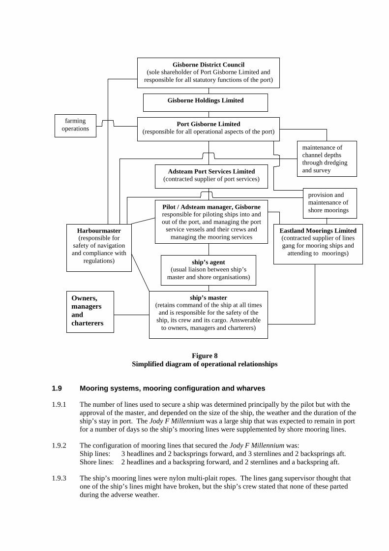
Figure 8Simplified diagram of operational relationships
1.9 Mooring systems, mooring configuration and wharves
1.9.1 The number of lines used to secure a ship was determined principally by the pilot but with theapproval of the master, and depended on the size of the ship, the weather and the duration of theship’s stay in port. The Jody F Millennium was a large ship that was expected to remain in portfor a number of days so the ship’s mooring lines were supplemented by shore mooring lines.
1.9.2 The configuration of mooring lines that secured the Jody F Millennium was:Ship lines: 3 headlines and 2 backsprings forward, and 3 sternlines and 2 backsprings aft.Shore lines: 2 headlines and a backspring forward, and 2 sternlines and a backspring aft.
1.9.3 The ship’s mooring lines were nylon multi-plait ropes. The lines gang supervisor thought thatone of the ship’s lines might have broken, but the ship’s crew stated that none of these partedduring the adverse weather.
Gisborne District Council(sole shareholder of Port Gisborne Limited and
responsible for all statutory functions of the port)
Gisborne Holdings Limited
Port Gisborne Limited(responsible for all operational aspects of the port)
farmingoperations
Adsteam Port Services Limited(contracted supplier of port services)
Pilot / Adsteam manager, Gisborneresponsible for piloting ships into andout of the port, and managing the port
service vessels and their crews andmanaging the mooring services
Eastland Moorings Limited(contracted supplier of linesgang for mooring ships and
attending to moorings)
Harbourmaster(responsible for
safety of navigationand compliance with
regulations)
provision andmaintenance ofshore moorings
maintenance ofchannel depthsthrough dredgingand survey
ship’s master(retains command of the ship at all times
and is responsible for the safety of theship, its crew and its cargo. Answerable
to owners, managers and charterers)
ship’s agent(usual liaison between ship’s
master and shore organisations)
Owners,managersandcharterers
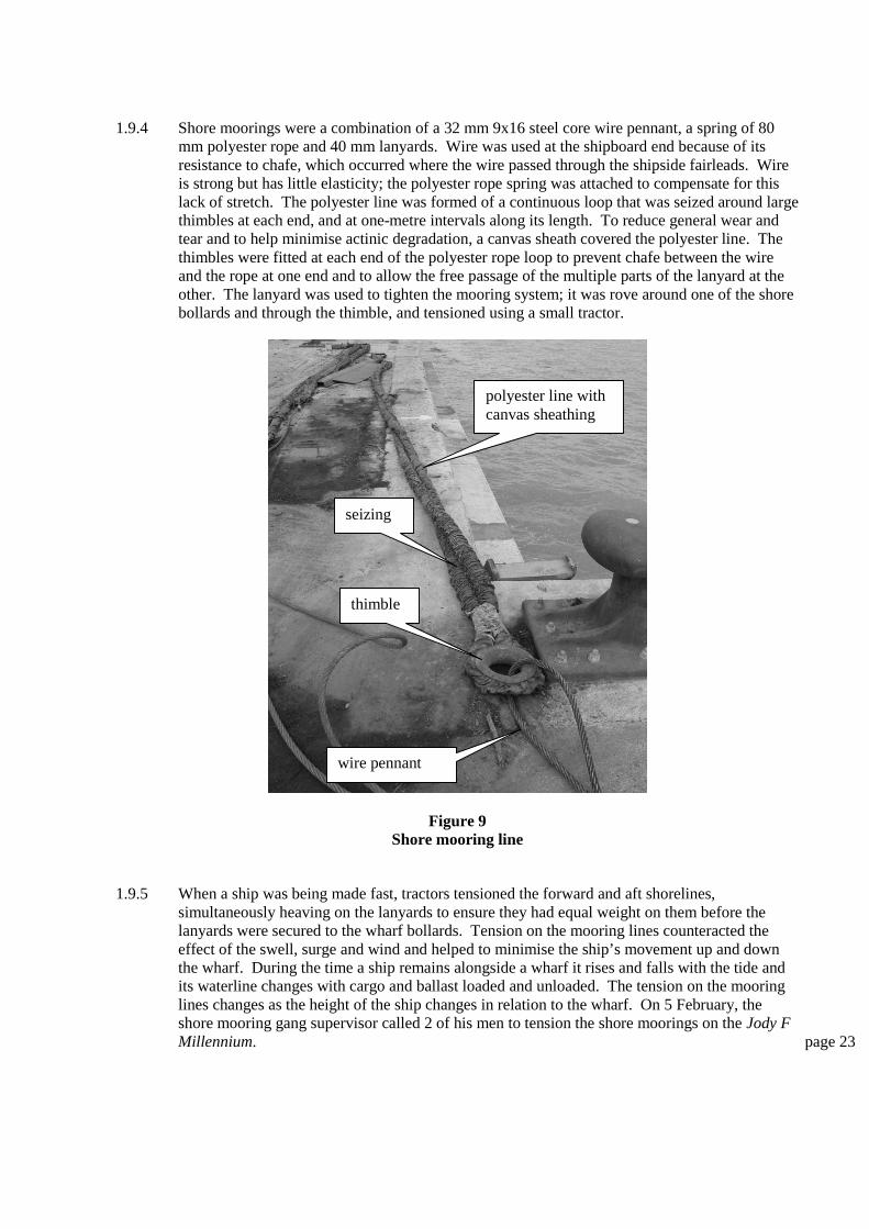
1.9.4 Shore moorings were a combination of a 32 mm 9x16 steel core wire pennant, a spring of 80mm polyester rope and 40 mm lanyards. Wire was used at the shipboard end because of itsresistance to chafe, which occurred where the wire passed through the shipside fairleads. Wireis strong but has little elasticity; the polyester rope spring was attached to compensate for thislack of stretch. The polyester line was formed of a continuous loop that was seized around largethimbles at each end, and at one-metre intervals along its length. To reduce general wear andtear and to help minimise actinic degradation, a canvas sheath covered the polyester line. Thethimbles were fitted at each end of the polyester rope loop to prevent chafe between the wireand the rope at one end and to allow the free passage of the multiple parts of the lanyard at theother. The lanyard was used to tighten the mooring system; it was rove around one of the shorebollards and through the thimble, and tensioned using a small tractor.
Figure 9Shore mooring line
1.9.5 When a ship was being made fast, tractors tensioned the forward and aft shorelines,simultaneously heaving on the lanyards to ensure they had equal weight on them before thelanyards were secured to the wharf bollards. Tension on the mooring lines counteracted theeffect of the swell, surge and wind and helped to minimise the ship’s movement up and downthe wharf. During the time a ship remains alongside a wharf it rises and falls with the tide andits waterline changes with cargo and ballast loaded and unloaded. The tension on the mooringlines changes as the height of the ship changes in relation to the wharf. On 5 February, theshore mooring gang supervisor called 2 of his men to tension the shore moorings on the Jody FMillennium. page 23
polyester line withcanvas sheathing
seizing
thimble
wire pennant
Figure 10Shore mooring line configuration
1.9.6 Port Gisborne Limited owned the shore moorings and was responsible for their maintenance.Spare items of mooring equipment were kept in a storage shed. Eastland Moorings Limited,which was contracted to Adsteam Port Services Limited to supply the shore mooring gang, wasresponsible for the setting of the lines and had access to the store for parts to replace brokenitems. There was no inventory or planned inspection regime in place for the parts of themooring system. The moorings remained on the wharf when not being used to secure a ship.After each use, the mooring gang inspected the moorings and arranged repair or replacement toPort Gisborne Limited account.
1.9.7 Since Port Gisborne Limited contracted out the mooring service, the labour for the lines gangwas on call but not necessarily on the wharf during normal working hours. Consequently, therewas no routine for the shore lines to be adjusted during a ship’s stay in port. However, the pilotchecked lines whenever he was on the wharf, and the supervisor of the shore mooring ganginspected the lines each morning and if they required adjustment he would mobilise his staff tocarry this out. It was not usual for the shore mooring gang to attend ships at regular intervals toadjust the lines.
1.9.8 Number 8 wharf was of mixed construction; the outer or seaward half was of solid fill, similarto that of the adjoining breakwater. The remainder of number 8 wharf and all of number 7wharf were of a concrete pile construction.
1.9.9 Large, sprung, flat-faced fenders protected number 7 and number 8 wharves. The outer face ofthe fender was constructed of a hard, rubber-like composition that, although providingprotection for the wharf and ship, allowed the ship to slide across the face of the fender. Springwas provided by large rubber mountings which compressed to absorb the lateral energy of aship when it bounced against the fender.
1.9.10 A breast line is the most effective means to hold a ship alongside. However, the spacing andposition of bollards on the wharf did not always allow such a line to be set correctly. Themooring bollards were spaced at regular intervals along the outer edge of the wharf. Thecurrent and previous pilots and several ships’ masters had voiced complaints that there wereinsufficient bollards, particularly where the bow and stern of ships were positioned, and theywere not of the correct design. Once a bollard was used for a shore mooring it could not beused for another line.
Ship
Wharf
polyester line
thimbles
lanyard
wire pennant
Figure 11Fendering at number 8 wharf
Analysis 2
Port Gisborne Limited, Gisborne District Council, the pilot and theharbourmaster
1 The port of Gisborne had gone through a period of development during the previous 5years. It had been identified that there were large volumes of logs to be exported butthe port infrastructure was unable to efficiently handle the size ships used to transportthat type of cargo. The development of the port cost in excess of $16.5 million, whichwas financed through loans secured by the assets in the farming and port operations.The Asian crisis in 1997 prevented the increase in throughput that the port developershad planned for, resulting in the port being financial constrained and needing to reduceits expenditure. Cost cutting measures were taken by contracting out non-coreservices and restructuring the labour force. This resulted in casualisation and thedilution of maritime experience at the port. In order to reduce its debt, Port GisborneLimited had sought to sell its farming operation, which had received shareholderagreement, but the legal challenges by Iwi had delayed the process. The port wasconsequently under financial and commercial pressure to improve its economicstanding, which required a push for improved throughputs and maximising the size ofvessels using the port.
2 The risk assessment carried out by the tanker operator required immediateimprovements to be made by the port. At that time, Port Gisborne Limited was not ina financial position to purchase a second tug. The contract with Adsteam PortServices to provide port services, including a second tug, fulfilled this need.
3 Although involving a small percentage of the overall tonnage through the port, thewithdrawal, in 2000, of the tanker service into Gisborne nevertheless represented anincome loss, adding to the financial problems that Port Gisborne Limited was facingand made the proposed sale of the farm operation more urgent to ease the financialburden of the port company.
4 The casualisation of the majority of the labour force at the port of Gisborne resulted inmany redundancies. Some of the personnel continued to work at the port on an “asrequired” basis, while others found full-time employment elsewhere. The dilution ofthe experience and skill base of the port employees inevitably followed. The part-timeand irregular nature of the work at the port meant that workers had to have alternativeforms of income, which resulted in people sometimes being unavailable for work atthe port when required.
5 On his appointment, the pilot designate was put into a working environment, whichwas not conducive to his becoming familiar with local conditions. The incumbentpilot refused to train him or latterly allow him on ships that he was piloting.Consequently, the pilot designate was forced to complete his local knowledge trainingunder the guidance of the relief pilot. The examination board and the Maritime SafetyAuthority were ultimately satisfied with the extent of his local knowledge at the timeof his examination.
6 The pilot designate’s local knowledge might have been rudimentary when hecommenced piloting in Gisborne in 1999, but after 3 years and over 600 successfulpilotage acts, his local knowledge at the time of this grounding would almost certainlyhave been better than that of any other person.
7 The composition of the examination board and the method of examination were notunique in New Zealand. The volume of shipping using the port of Gisborne wassufficient to provide employment for only one pilot at any one time. The pilotinvolved in this accident was appointed because of his previous pilotage experience atNapier, so he only needed to gain local knowledge rather than learning the art ofpiloting ships from first principles.
8 Being a sole pilot posed other logistical problems. The pilot had difficulty takingleave and should he be incapacitated the port was effectively closed until a relief pilotcould be brought in. In addition, it was difficult to provide continuity of pilotageexperience, with no junior pilot gaining experience and available as a relief or to be aneventual successor.
9 Within the port, there was no one of comparable seniority or experience with whomthe pilot was able to discuss the situation he faced on 6 February. Had the part-timeharbourmaster for Gisborne forged a working arrangement with the personnel atGisborne, it might have occurred to the pilot that he was not as isolated as he thought.Any assistance that the harbourmaster would have been able to give would only havebeen as good as the communication skills of the person passing the local informationand observations to him.
10 A remote harbourmaster would have difficulty carrying out the day-to-day duties andresponsibilities required by the appointment. He had therefore to rely heavily on theco-operation, ability, and trust of the personnel who monitor the activities of the portand carry out these duties for him in absentia. Gisborne was 40 minutes by air, or 3hours by road from Napier, distances that would render the harbourmaster temporarilyunavailable in the case of an emergency. Air travel was dependent upon the weatherconditions and aircraft availability.
11 The part time harbourmaster appointed by Gisborne District Council was not requiredunder Part VIII of the General Harbour (Nautical and Miscellaneous) Regulations1968 to hold a certificate of competency as master of a foreign ship but the councildecided it was important to have a harbourmaster with the certificate even if it was foran extremely limited period each year. However, the harbourmaster being based
remote from Gisborne and holding the full-time position as harbourmaster for the portof Napier meant that he was unlikely to be able to effectively supervise the safety ofnavigation in Gisborne, or to attend promptly to an emergency.
12 The pilot did not have the authority to order the Jody F Millennium to leave the berth;such authority was only vested in the harbourmaster. However, the movement of theship caused him sufficient anxiety that he decided the only action available to him wasto sail the ship. The shore mooring gang supervisor’s concern for the safety of hisworkers prevented him from replacing any more shore moorings that might havebroken, contributing to the urgency for the pilot to resolve the situation by sailing theship sooner than he intended.
13 Previously in Gisborne, the pilot had traditionally also been the harbourmaster. Manyof those who had worked within the port for some time, such as Port Gisborne Limitedemployees, agents, lines gang supervisors and stevedores probably deferred, withoutquestion, to the pilot as the marine authority.
Mooring system, wharves and fendering
14 When the Jody F Millennium berthed at number 8 wharf on 3 February, because it wasa large ship and expected to remain alongside for 3 days, it was secured by both shipand shore moorings. Conversely, the Asian Briar was a relatively small ship and wasexpected to remain alongside for only 24 hours, so it was secured using ship’s linesonly. Each of these decisions complied with the normal operating practice of the port.
15 When the Jody F Millennium was initially secured, all the ship and shore mooringlines would have been tensioned but during the ship’s stay in port its draught wouldhave increased as loading progressed so changing its height in relation to the wharf.Inevitably, the mooring lines would have become slack and unequally tensioned. Theshore moorings had to be tensioned from ashore, whereas the ship’s moorings weretensioned from on board.
16 The shore mooring lines were re-tensioned on 5 February and inspected again on themorning of 6 February, but it is unclear at what times the ship’s lines were re-tensioned during the stay in port, as this is an ongoing duty of the watchkeeping crew.When shorelines are used, it is usual that they are expected to take the majority of theshock loading caused by the ship moving at the wharf, while the ship’s lines are lesstight and not necessarily under constant tension. This might partially explain why theshore lines parted but the ship’s lines remained intact throughout. In thecircumstances of 6 February it would have been prudent to have tensioned the ship’snylon lines to share the loading. There was conflicting evidence regarding whetheradditional ship’s lines were offered by the ship’s crew and refused by the mooringgang, or were requested by the mooring gang and refused by the ship’s crew.
17 On the afternoon of 6 February, while the shore mooring gang were tightening theshore lines on the Jody F Millennium, the supervisor indicated that they were movingbetween forward and aft, tightening one line at a time. The forward and aft lines werenot simultaneously tensioned, which would have led to unequal load being on theindividual lines, making each of them more susceptible to uneven shock loading andliable to break.
18 The position and number of the bollards on the wharf did not always allow theoptimum mooring system to be used. For a comparatively new wharf in a port subjectto surge conditions, the mooring arrangement for number 8 wharf was not as effectiveas it could have been.
19 Shore mooring lines similar to those used in Gisborne were used effectively in portsthroughout the world where surge was experienced. The effectiveness of suchsystems relies heavily on the quality of the equipment and the people charged withsecuring and managing it.
20 Since the casualisation of labour in the port, the mooring gang had been made up oftemporary and part-time labour. The mooring system had come in for criticism fromship’s masters and pilots on numerous occasions. The composition of the mooringgang had changed over recent years and at the time of this occurrence the pilotconsidered that an effective team was being developed. The lack of a dedicatedemployed mooring gang detracted from the efficiency of the mooring system andlimited regular monitoring of the tautness of the shore mooring lines during a ship’sstay.
21 The shore mooring lines were left lying on the wharves when not being used, exposingthem to physical damage, the effects of the sun, the salt-laden atmosphere and anycontaminating substances that might be on the wharf. This would have resulted intheir degrading more quickly than if they had been stored under cover when not in use.Individual parts of the system were not identified and marked nor was there aninventory. Consequently, their age, when they were put into service, the materialsused and their safe working certificates were not consolidated. The suppliers of thewire rope did have its original manufacturer’s certificate, but it was impossible toaudit that against the made-up parts through the lack of inventory and marking.Notwithstanding the above, there was no evidence that the shore moorings partedbecause they were in poor condition.
22 The fenders fitted to the wharves in Gisborne were sufficiently robust to prevent shipsdamaging the face of the wharves. The hard rubber-like composition surface of thefenders provided little friction and did little to reduce the movement of ships rangingalong the wharf. In addition, the sprung rubber mountings of the fenders allowedships to bounce off them and thus possibly perpetuate the athwartships movement ofthe ships.
23 There was hearsay evidence that the different construction of numbers 7 and 8wharves caused the ships secured to them to react differently. It was suggested thatthe solid construction of the outer half of number 8 wharf prevented the surge fromdissipating under the wharf and therefore caused ships to range violently. The openwharf construction at the inner end allowed the surge to flow under the wharves andonto the graduated shore thus reducing its effect.
24 The organisational structure of the port should have allowed for an efficient operationhad all the separate parts been able to fulfil their respective roles, carried out thoseroles in an effective manner and maintained timely effective communication with theother parts of the organization. The port did not operate effectively as evidenced by:
� area weather and swell forecasts were obtained separately by Gisborne DistrictCouncil, Port Gisborne Limited and the pilot, but those forecasts were notshared
� weather, sea and swell conditions were estimates only, with no instrumentationto monitor and possibly assist prediction of severe conditions
� because of his remote location and limited contractual time dedicated toGisborne, the harbourmaster was unlikely to be able to effectively monitor orsupervise the safety of navigation or compliance with regulations in the port
� no working relationship had been built between the harbourmaster, the pilot andPort Gisborne Limited which led to a complete lack of communication at thetime when critical safety decisions needed to be made
� there was no direct communication between the master and the pilot to co-ordinate a plan of action to manage the exceptional circumstances faced on 6February 2002
� There was no contingency planning to cover such extraordinary circumstances
� The shore mooring gang and the ship’s crew were not co-ordinated in an effortto set a combination of moorings which might have reduced the movement ofthe ship alongside
� there were no clearly defined areas of responsibility with regards to theinventory, maintenance and repair of those parts making up the shore moorings
� there was conflicting evidence whether the pilot had received the latesthydrographic survey results from August 2001, whereas those results shouldhave been given to him as a matter of course
� Although maintenance dredging was carried out after the August 2001 survey,no further survey was carried out to determine the results of that dredging.
1.10 Vessel Information
1.10.1 The Jody F Millennium was a geared bulk carrier, powered by a 6156 kW diesel engine, with asingle propeller and a single rudder. It was built in Japan and delivered to the owners inFebruary 2000. The ship was Panamanian owned and registered and operated by a Koreancompany. It was on a time charter to News Maritime Company Limited, to load pinus radiatalogs at Wellington and Gisborne for discharge in South Korea and China.
1.10.2 The ship was under Nippon Kaiji Kyokai classification society (Class NK). Its certification wascurrent at the time of the accident.
1.10.3 The ship had an overall length of 159.94 m, a beam of 26.00 m and a summer load draught of9.815 m with a corresponding deadweight of 25 369 t and a summer displacement of 30 869 t.
1.10.4 The manoeuvring speeds of the Jody F Millennium were as follows:
Speed in knotsR.P.M.
Loaded BallastFull ahead (harbour) 100 11.6 12.3Half ahead 85 9.9 10.7Slow ahead 62 7.4 8.2Dead slow ahead 45 5.5 6.1Dead slow astern 45Slow astern 62Half astern 85Full astern 100
1.10.5 The steerage of a ship is dependent on water passing the rudder. All ships lose the ability tosteer at low speeds. The actual speed at which a ship loses steering depends on the shape of theunderwater hull, the size and design of the rudder, and the number and configuration ofpropellers and rudders. The effectiveness of a rudder diminishes with the reduction of the underkeel clearance and requires more helm to be applied. The master of the Jody F Millenniumestimated that the ship would lose steerage below about 4 knots.
1.10.6 The Jody F Millennium had a crew complement of 19, which was 5 above the minimumrequired by the safe manning certificate. All officers were correctly certificated for theirpositions. The master and chief engineer were Korean and the remainder of the crew wereFilipino. page 29

1.10.7 The master of the Jody F Millennium obtained his Korean masters certificate in 1974 and hadsailed in the capacity of master since then. His certificate had been re-validated under theInternational Convention on Standard of Training, Certification and Watchkeeping forSeafarers1995 (STCW 95). In his capacity as master, he had sailed on a variety of ship typeswith both Korean and international companies but had never been to Gisborne before. He hadbeen on the Jody F Millennium for a continuous period of 13 months and was due to go on leavethe following month.
1.10.8 Prior to sailing, the chief officer and third officer read the draught, which was 8.8 m forwardand 9.5 m aft. The chief officer calculated the ship’s stability, and determined a GM of 1.5 m.The master timed the ship’s period of roll; from which he was able to calculate the GM to bebetween 1.7 m and 1.9 m. The master considered this to be a large GM and thought the shipwas stiff. With such a large GM, a larger moment was required to incline the ship but, onceinclined it would return quickly and its momentum would carry it through the upright to roll tothe other side. As a result, the ship would have a short period of roll, which might have beenviolent.
1.10.9 When a ship rolls and pitches, there is an increase in draught at its extremities. In the case ofthe Jody F Millennium, a heel angle of 5° increased the draught by approximately 1.0 m (seeFigure 6). This is one of the factors that had to be allowed for when determining a safe underkeel clearance.
1.10.10 Resulting from the risk analysis carried out by the tanker company, and Port Gisborne Limited’swish to service larger vessels, the port had provided an extra tug and was serviced by 2azimuthing propeller tractor tugs. The Turihaua was of the Schottel type with its 2 units in theforepart of the vessel. It was 25 m long, had engine power of 820 kW (1100 hp), whichdeveloped 18.6 t bollard pull. The Titirangi had a length of 30 m and used azimuth stern drives.It had 1342 kW (1800 hp) engine power, which developed 30 t bollard pull. Owing to therestrictive nature of the swinging basin, large ships had to be accurately controlled whileturning, which required 2 powerful manoeuvrable tugs. The tugs were operated and crewed byAdsteam Port Services Limited.
1.10.11 The pilot considered the Turihaua, although the smaller and less powerful of the 2 tugs, to bemore suitable to manoeuvring in the tight constraints of the port than the Titirangi.
1.11 Weather and Forecasting
1.11.1 Tidal information for Gisborne for 6 and 7 February 2002 is tabulated below. The range of tidewas approximately that of the spring range. The calculation to obtain the height of tide for 2152on 6 February was carried out using the graphical method contained in the New ZealandNautical Almanac.
High Water Low WaterDateTime Height (m) Time Height (m)0136 2.0 0742 0.66 February1353 2.0 2012 0.5
7 February 0226 1.9 0835 0.6
High water 7 February: 0226 1.9 mLow water 6 February: 2012 0.5 m
-------Range of tide: 1.4 m
Height at 2152, 6 February 0.80 m above chart datum
The tide gauge reading at Gisborne was observed by the pilot to be 0.8 m about 20 minutesbefore sailing.
1.11.2 Gisborne was in the sea area Portland weather area, which covered the east coast of NorthIsland from Cape Turnagain in the south to Cape Runaway in the north, a distance of 200 nmthat encompassed the north Wairarapa, Hawkes Bay, Poverty Bay and East Cape.
1.11.3 The weather and sea state as forecasted by the meteorological service of New Zealand for seaarea Portland was as follows:
Issued 06/02/2002 0029 valid until 2400 06/02/02*GALE WARNING IN FORCE*Westerly 30 knots, rising to southwest 35 knots south of CapeKidnappers this morning. Sea becoming very rough in south. Southwestswell rising to 4 metres this afternoon. Easterly swell 1 metre.Fair visibility in showers, mainly south of Cape Kidnappers.OUTLOOK FOLLOWING 12 HOURS: Southwest easing to 25 knots.
Issued 06/02/2002 0421 valid until 2400 06/02/2002*GALE WARNING IN FORCE*Westerly 25 knots, rising to southwest 35 knots south of CapeKidnappers this morning. Sea becoming very rough in south. Southwestswell rising to 4 metres this afternoon. Easterly swell 1 metre.Fair visibility in showers, mainly south of Cape Kidnappers.OUTLOOK FOLLOWING 12 HOURS: Southwest easing to 25 knots.Issued 06/02/2002 1240 valid until 1200 07/02/2002*GALE WARNING IN FORCE*Westerly 25 knots, but southwest 35 knots south of Cape Kidnappers,becoming southwest 25 knots throughout overnight. Very rough sea inthe south easing. Southerly swell rising to 4 metres. Easterlyswell 1 metre. Fair visibility in showers, south of Cape Kidnappers.OUTLOOK FOLLOWING 12 HOURS: Southwest 20 knots.
Issued 06/02/2002 1606 valid until 1200 07/02/2002*GALE WARNING IN FORCE*Westerly 25 knots, but southwest 35 knots south of Cape Kidnappers,becoming southwest 25 knots throughout overnight. Very rough sea inthe south easing. Southwest swell rising to 5 metres. Fairvisibility in showers in south.OUTLOOK FOLLOWING 12 HOURS: Southwest 20 knots.
1.11.4 The metrological notes in the New Zealand Almanac for 2002/2003 stated that coastal weatherforecasts are a general indication of average conditions expected in a particular coastal area.The forecasts are for open waters to within 60 nm of the coast and do not apply to enclosedareas such as small bays and harbours. There was no weather forecast specifically for the portof Gisborne.
1.11.5 Observations at the Gisborne automatic weather station showed that the mean wind between2100 and 2200 on 6 February was 250° at 4 km/h (2 kts) with an air temperature of 16.0°C.Observations by the ship’s crew, the pilot, port service vessels’ crew and the mooring gangsupervisor indicated that the wind was more than that recorded but not as strong as thatforecasted.
1.11.6 An intense low pressure system situated to the east of the south island was slowly moving to thesouth east, bringing gales to the central east coast areas.
1.11.7 On 6 February 2002 the Baring Head wave rider buoy, off Wellington Harbour entrance,recorded a maximum wave height of about 13 m with an average of about 11 m. The averagesignificant wave height during 6 February was of about 7.5 m. page 31
1.11.8 The Gisborne District Council had an arrangement with Meteorological Service of New Zealandthat it would be supplied with swell forecasts in excess of 3.5 m for the Gisborne coast. Thisforecast was primarily used to warn of possible coastal erosion. A forecast issued at 1305 on 6February was sent by facsimile to the Gisborne District Council. The forecast stated:
Southerly swell expected to rise to 4-5 metres late Wednesday or early Thursday, then slowlyease during Friday.
The forecast was not passed to Port Gisborne Limited, the harbourmaster or the pilot.
1.11.9 Sea waves are usually caused by wind, their height being dependent on the duration, the speedand the fetch of the wind. Swell and surge develop from prolonged sea wave action often at adistance from the immediate sea region. When a swell reaches shallow water it steepensabruptly, increases in height and sweeps ashore as rollers.
1.11.10 Swell forecasts were issued by the meteorological service of New Zealand as part of the coastalweather forecasts. Swell warnings were only issued when the swell was expected to be above acertain threshold, usually one metre. Significant wave height was not measured except at thewave rider buoys at Baring Head and Taharoa Terminal on the west coast of North Island.
1.11.11 The pilot’s office was equipped with a facsimile machine, that was programmed to receive theNew Zealand Meteorological Office coastal forecasts and warnings for the Portland areatogether with analysis and prognosis isobaric weather maps. The general manager of PortGisborne Limited independently monitored the weather using information accessed via theinternet and from the interactive weather service provided on Sky Television. There was noestablished communication between the pilot and the general manager regarding weatherinformation.
1.11.12 At about 1100 on 6 February, the pilot checked the sea state and noted there was minimalsignificant swell. He was aware that the weather conditions were forecast to deteriorate and thatthere was a severe storm to the south, around Wellington.
1.11.13 When the Asian Briar departed, in daylight hours, the pilot observed the swell at the breakwaterto be 2 to 3 m. When the Jody F Millennium departed, in darkness, the pilot thought that theswell was about the same, but increased rapidly to 6 m during the departure. Other witnessesvariously thought that the swell was between 3 and 6 m. The wind was reported to be from thesouth at about 15 knots when the Jody F Millennium left the berth but increased dramatically asit left the harbour. A large percentage of those people spoken to were of the opinion that theconditions in the afternoon and evening of 6 February were the worst they could remember.
1.12 Damage
1.12.1 While alongside, the Jody F Millennium was ranging along and rolling against the fenders. Thisresulted in sections of paint being rubbed from its hull. The only other damage noted was to aporthole and the washplate above it as a result of contact with the wire section of a shoremooring line.
1.12.2 The damage suffered by the Jody F Millennium during the grounding was extensive, varied andconsistent with that of a ship having stranded and worked hard on a sand and mud bottom for aperiod of nearly 3 weeks. The rudder had been set up and rotated to an approximate angle of120° to starboard. The propeller had been damaged by the rudder being rotated and hitting 2 ofthe stationary blades. The ship’s hull plating had been set up between the frames in way of theengine room space and throughout the mid body section of the bottom with the severest damageon the starboard side. The forepart was also set in between the frames to a less severe extent,but once again with the severest damage to the starboard side. Both bilge keels had beenflattened against the ship’s hull. No. 3 centre double bottom fuel oil tank had split in severalplaces where the plating had been set up. No. 5 starboard double bottom water ballast tank had
been split and holed with the internal framing separated from the hull plating. Nos. 2, 3 and 4starboard water ballast tanks had small holes along the turn of bilge, which was indented, andthe tanks were probably common at the joining bulkheads.
1.13 Human Factors
1.13.1 The shipping in Gisborne was sporadic with about 200 movements per year; consequently thepilot was not usually overworked. In the days preceding the incident the pilot had berthed theJody F Millennium on Sunday and the Asian Briar on Monday. He was the sole manager forAdsteam Port Services in Gisborne and was responsible for the tug crews and the general day-to-day administration. Wednesday 6 February was Waitangi Day, a public holiday in NewZealand, so the pilot was not required to carry out any administrative duties during that day.
1.13.2 The pilot had been at the port for nearly 3 years and had taken only short periods of leave duringthat time. As a sole pilot it was difficult to arrange any absence from the port, and unless arelief pilot could be employed, his leave had to be arranged during times of no shippingmovements. His last extended period of leave was between 21 September 2001 and 4 October2001 and he stated that he had 116 days annual leave outstanding.
1.13.3 The process of decision-making falls into 2 main categories: analytical and intuitive. Analyticaldecisions are based on rules and are used primarily by operators who are unfamiliar orinexperienced in a particular task. Intuitive decisions are based on an operator’s knowledge andexperience. They are usually accomplished quickly and do not require in-depth thought.Unfortunately, intuitive decisions are subject to biases, which allow errors to occur.Confirmation bias relates to the human response when information is sought to confirm aparticular decision and information that negates the decision is rejected.
1.13.4 In addition to biases, human thought processes also affect the standard of decision-making.Bridge Resource Management training emphasises the need to recognise “hazardous thoughts”and replace them with opposite “safe thoughts”. Three hazardous thoughts and their oppositesafe thoughts, as used in Bridge Resource Management concepts, that were relevant to thedecisions made prior to the Jody F Millennium sailing were:
Hazardous Thought Safe Thought
It won’t happen to me It could happen to me
I can do it Why take chances
Do something quickly Not so fast, think
Analysis 3
1. The Jody F Millennium was only 2 years old. As with most modern ships, it wasdesigned to spend the majority of its life at sea with minimal time in port;consequently, it was not built for frequent manoeuvring in restricted harbours. It wastypically powered for a bulk carrier, with steering adequate for harbour transits. Aswith similar vessels, variations in speed could be slow to take effect and steerage atlow speeds was slow.. Notwithstanding these characteristics, the ship had adequatemanoeuvrability. As with any other ship, the handling characteristics deterioratedwhen the under keel clearance was small.
2. The sea and the tidal conditions were outside the pilot’s own criteria for a large shipsuch as the Jody F Millennium at its draught of 9.5 m to negotiate the approachchannel, yet he chose to discount this information, concentrating on getting the shipout of the port.
3. The ship had adequate stability, and was possibly a little stiff. As a result, its period ofroll was short.
4. The 2 tugs, in addition to the ship and shore moorings, were unable to prevent theJody-F Millennium from ranging along the wharf and were unable to stabilize the shipsufficiently to enable the shore lines gang to safely run mooring lines to replace thosethat had broken. To run additional ship’s moorings, regardless of the conflictingevidence of them being offered and refused, the mooring gang would have had towork in close proximity to the shore mooring lines, a situation already deemed asunsafe.
5. The forecast weather for the Portland area during 6 February was for westerly windsof about 25 knots becoming south-west overnight and the swell forecast was easterly1 m and between south-westerly and south 4 to 5 m. The actual wind recorded at theGisborne automatic weather station at 2200 was 250° at 4 km/h (2 knots). Reportsfrom observers indicated that the wind was light but the swell was between 3 and 6 m.After the grounding, when the pilot launch and tugs went out to the ship to attemptassistance, the swell was reported to be about 6 m in height. An intense low pressuresystem to the east of the south island was responsible for the exceptional swellsexperienced in Wellington and the severe surge experienced in Gisborne about 12hours later.
6. The Portland weather area covered a considerable length of coastline and while givinga good general overview of the expected weather could not hope to accurately forecastthe localized weather for each of the bays within that area. No wave monitoringequipment was established in Poverty Bay, neither was there any system that wouldwarn the port of impending storm surges.
7. The pilot, while aware of the adverse Portland weather forecast and also the storm thatwas occurring to the south in Cook Strait, was unsure what impact, if any, that weatherwould have on the ships in Gisborne and was unable to identify what measures couldbe taken to minimize the effect of the weather.
8. The presence of unusually high significant wave heights at Baring Head, although asignificant distance to the south of Gisborne, should have acted as a warning of theincrease in swell and surge at Gisborne. However, there was no system in place thatallowed for such warnings to be noticed and promulgated. The pilot was aware thatthere were heavy swells further south, but there was no established formula fordetermining how long it may take for the swell affecting other parts of the NewZealand coast to begin to influence the sea state at Gisborne. A swell in Poverty Baywould not necessarily produce surge in Gisborne harbour. The direction of that swelland the continued presence of an off-lying storm would decide the magnitude, if any,of the surge.
9. The Gisborne District Council had received a forecast specifically for Gisborneindicating 4 to 5 m swells. Although this forecast was received to warn againstpossible coastal erosion, it would have been prudent for the Council to immediatelyshare the information with the harbourmaster, the pilot and Port Gisborne Limited.
10. A possible preventative action that the pilot could have taken was to have put the shipto anchor on the high water at 1353 on 6 February. Such a decision would have had tobe made in sufficient time to remove the loading equipment, secure the deck cargo andcranes, and prepare the ship for sea. Depending on the condition at the time, such a
process could take several hours. The ship was still loading cargo and the weatherconditions during the morning were not sufficiently bad, nor was the weather forecastadequately certain, for the pilot to reasonably make that decision in sufficient time.Consequently, once the high water in the afternoon had passed, the ship was capturedin the port.
11. Communication between the pilot and the ship’s staff was made difficult by the lack ofeasy access to the ship, and the ship’s agent relayed messages by cellular telephone.This form of communication was susceptible to misunderstanding, and mistakeninferences and inflections could be conveyed. It would have been prudent of the pilotto have at least spoken directly to the master using cellular telephone or VHF radio.
12. For whatever reason, the pilot made no attempt to board the vessel to speak with themaster, nor did the master attempt to go ashore to speak with the pilot. Had eitherdone so, they could have discussed the situation in a less hurried manner than in theheat of departure. There were times when others had boarded or left the ship duringthe late afternoon and early evening, by which time the pilot had made up his mindthat the ship had to leave the berth, and conveyed that decision to the master throughthe agent. An unhurried discussion between the pilot and master would have beenprudent and led to a joint decision as to the earliest possible time of departure and themeasures to be taken in the meantime.
13. The pilot carried out on average of less than one pilotage act per day and the 2movements in the 3 days leading up to the accident support this statistic.Administrative duties did take up some time but did not require him to remain at theoffice continuously throughout the day. He was able to structure his workload aroundshipping movements. The duties and workload of the pilot did not indicate thatfatigue was a contributory factor in this incident.
14. The pilot was the only experienced person with relevant nautical qualificationsemployed at the port of Gisborne. He assumed that he had to make decisionsregarding the safety of ships in the port. He was aware of the appointment of the parttime harbourmaster but considered him too remote to consult over the day-to-dayactivities of the port. The pilot was also aware that he was not empowered to order theship from the port and assumed his role to be that of an adviser to the master throughthe agent.
15. As with all decision-making, the process by the pilot was to assimilate all theinformation to hand and formulate a plan that would best serve all the partiesconcerned. Decision-making is a fluid process that evolves as more informationbecomes available. Protection of the port infrastructure was of paramount concern tothe pilot and he was also concerned for the safety of the ship and its crew. He wasusing his experience and knowledge as best he could to accomplish this.
16. Initially the ship was scheduled to complete cargo and sail in the afternoon of6 February. Had it done so the grounding would not have occurred. However, cargooperations were delayed and sailing postponed until the 0226 high tide on 7 February.
17. The conditions for the shore mooring gang were dangerous. The pilot was aware ofthe danger, which probably increased the pressure for him to do something quickly torelieve the situation. Had the pilot been able to detach himself and discuss thesituation with a peer ashore, he might have realised that the ship could not possiblynegotiate the channel more than 4 hours before high water, particularly with the seaconditions as they were.
18. The pilot discussed the situation with the ship’s agent and the general manager of PortGisborne Limited, neither of whom had any marine experience or could be aware ofthe difficulties that could be experienced sailing the ship in such conditions. Having
decided that the ship was to sail, the pilot closed his mind to any other possibilities andthen proceeded to ignore his own minimum criteria resulting in his bringing thedeparture time forward. It is likely he justified these decisions to himself by thinkingthat the ship would be safer outside, consequently, ignoring the problem of actuallygetting it there.
19. Not having any other senior or experienced mariners ashore with whom to discuss thesituation, and having chosen not to communicate directly with the master, the pilotwas subject to one-man error, making decisions in isolation without anyone else tochallenge the assumptions made and confirm that the decisions were prudent in thesituation.
20. Where possible, there is always the desire to remove a problem from one’s immediatevicinity. This might have been one of the subconscious factors that persuaded thepilot that the ship had to leave the port.
21. There was a considerable cultural and language gap between the master and the pilot.This may have led to some misunderstanding and a difference between the pilot’sintentions and the master’s interpretation of them, and might have contributed to thelack of communication between them.
22. The master deferred to the pilot, assuming him to be the spokesperson for the portauthority. The pilot was under the impression that, through the agent, he had“discussed” the situation fully with the master who had willingly agreed to sail hisship and was happy with the proposed pilotage plan. The master, however, was of theopinion that he had been “ordered” to sail from the port by the port authority and wasunable to question that order. Notwithstanding the foregoing, the master and pilotboth considered sailing the ship was the only solution to prevent damage to the shipand wharf and injuries to the personnel. Direct discussion between the master andpilot did not occur until the pilot boarded the ship, at which time only the sailing planwas briefly discussed. Whether or not the ship should sail was not discussed; that wasa foregone conclusion.
23. The pilot had spent many years piloting in Napier. It was usual practice in Napier thatin adverse weather the pilot disembarked a departing ship shortly after passing thebreakwater. While Napier and Gisborne are similar in that each has a breakwater andthey are subject to surge, the approach to Napier is less restrictive, being open with agreater depth of water.
24. Another factor that may have influenced the pilot to leave the ship at the breakwaterwas that he had disembarked the Asian Briar in a similar position a few hours earlierand that vessel had successfully negotiated the channel. Also, being the sole pilot inthe port might also have influenced the pilot’s decision to leave the ship early, notwanting to be either confined to the ship until the weather abated or over-carried toanother port.
2. Findings
Findings and safety recommendations are listed in order of development and not in order of priority.
2.1 Heavy swells off the port of Gisborne and a deep depression to the south caused surge in theharbour creating movement of ships moored there to such an extent that shore mooring linesparted on the Jody F Millennium.
2.2 The Jody F Millennium was moored, in accordance with the standard practices of the port, witha combination of shore and ship’s mooring lines.
2.3 The shore mooring gang replaced lines as they broke but were unable to continue working in thevicinity as the ship continued to move violently against the wharf, despite the assistance of the 2harbour tugs.
2.4 The pilot made the decision to remove the ship to an anchorage outside the port to preventdamage to the ship and wharf and possible injury to personnel.
2.5 The pilot conned the ship off the wharf and lined it up with the channel before passing the conto the master and disembarking when the ship was abeam of Butlers Wall.
2.6 As the Jody F Millennium left the shelter of the southern breakwater, large swells hit its portbow, pushing it to starboard and as the ship rolled and pitched, it touched bottom in the channeljust after clearing the breakwater.
2.7 After initially touching bottom, the ship lost steerage and the master was unable to regaincontrol. The ship travelled a short distance further down the channel before being driven by thesea and swell on to the shoal ground to the north of the channel.
2.8 The decision to remove a vessel from the port was outside the pilot’s authority, but his assumingcontrol was understandable owing to the absence of other appropriately senior experienced andqualified mariners employed within the port. The pilot made the decision to sail the ship inisolation, with no one to challenge such a decision.
2.9 The authority to remove a ship from a port lay with that port’s harbourmaster. Theharbourmaster for Gisborne was recently appointed, part-time and resident in Napier. He wasnot consulted regarding the decision to remove the Jody F Millennium from the port.
2.10 The master considered that the ship was being ordered from the port by the port authority so didnot challenge the decision believing that, had he refused, he would have been liable for anydamage that occurred to the infrastructure. Given the prevailing conditions, it would have beenprudent of the master to have at least challenged the need for immediate departure.
2.11 At no time, other than immediately before departure, did the pilot and master discuss adeparture plan.
2.12 Both the ship and the pilot’s passage planning was rudimentary at best.
2.13 The pilot and master were separately operating under extreme pressure causing them to excludeor misinterpret information that would have made them realise the ship could not safelynegotiate the channel at the state of the tide at the time the ship actually left the wharf.
2.14 The master and pilot independently believed that the ship could not safely remain alongside.
2.15 The ship was too deeply laden to negotiate the approach channel more than 4 hours before highwater.
2.16 Because the depth of available water in the channel on the evening of 6 February 2002 could notbe established with certainty, the actual under keel clearance of the Jody F Millennium couldalso not be established with certainty, but whatever its actual value, it was insufficient for theconditions prevailing at the time of departure.
2.17 The pilot’s decision to disembark the ship early was inappropriate and the subsequent slowingof the ship removed any remaining possibility that the ship might negotiate the channelsuccessfully. By disembarking within pilotage limits, the pilot deprived the master of pilotageassistance at a time of particular need.
2.18 Surge was not uncommon in the harbour at Gisborne but that experienced on 6 February wasmore severe than previously experienced. page 37
2.19 Since the channel was deepened in 2000, the effect of the surge alongside the wharves hadbecome more pronounced.
2.20 The pilot did not have a copy of the most recent hydrographic survey and so was working fromdated information and was using as a reference a greater channel depth than was available. Insome cases the actual depth was 0.7 m less than the limiting draught used by the pilot. Forwhatever reason, the results of the maintenance dredging completed on 4 December 2001 werenot measured and therefore not available.
2.21 A number of factors influenced the pilot’s decision making process that concluded with theship’s departure:
• no ship had previously grounded in the channel and so grounding was not considered asa possibility
• the urgency to fix one problem without the possible consequences being fullyinvestigated
• the ship would be safer in the bay rather than being pounded alongside the wharf
• the limited number of replacement shore moorings remaining, and anyway the situationwas too dangerous to replace any more that may break
• the danger that the ship would break adrift and ground in the harbour.
2.22 The ship’s mooring lines, with one possible exception, remained intact throughout. Had thecombination of the ship and shore moorings been suitably tensioned then, together with theassistance of the 2 harbour tugs, the ship might have been able remain alongside at least untilthere was sufficient water to increase the possibility that the ship might negotiate the channelsuccessfully. This possibility was overlooked in the urgency to depart.
2.23 The care and maintenance system for the shore mooring lines was inadequate, but there was noevidence to suggest that the lines were defective on 6 February 2002.
2.24 The pilot’s local knowledge was questioned at the time of his appointment, but after 3 years’experience in the port he was probably the person most conversant with local conditions at thetime of the accident.
2.25 The port company promoted the port as being suitable for ships, the size of which was in excessof the recommended PIANC guidelines when applied to the Port of Gisborne.
2.26 The ship was adequately crewed by appropriately certificated master and officers.
2.27 The Gisborne District Council complied with the Part VIII of the General Harbour (Nauticaland Miscellaneous) Regulations 1968 in relation to the appointment of a part time harbourmaster. However, the conditions of his employment and his remote location made it unlikelythat he could adequately carry out the statutory and regulatory functions as harbourmaster forGisborne or attend promptly in the event of an emergency.
2.28 The Portland weather forecast area covered a large coastal area and was not necessarily accuratewith respect to the effect the weather would have on ships in the port of Gisborne.
2.29 There was no established procedure to forecast adverse surge conditions at the port.
2.30 The organisations responsible for managing and operating the port did not interact in aneffective manner.

3. Safety recommendations
3.1 On 31 January 2003 the Commission made preliminary recommendations to the GeneralManager of Port Gisborne Limited. However, on 1 March 2003 Eastland Port Limited boughtthe Port Gisborne Limited operation and took over the running of the port. Accordingly, on24 April 2003 the Commission made the same recommendations, as final, to the GeneralManager of Eastland Port Limited, and were that he:
3.1.1 investigate and improve the mooring system so that it is effective for the size and typeof vessels expected to utilise the port. Such improvement should include the provisionof sufficient adequately trained personnel to operate the system (060/02).
3.1.2 create an auditable system for the inventory, care and maintenance of the shoremooring lines and associated spares, to ensure that the equipment is in a serviceablecondition at all times (061/02).
3.1.3 install suitable weather, tide and swell monitoring equipment to better forecast adverseconditions. For such a system to be effective, it should be monitored and theinformation gathered, disseminated to the relevant persons (062/02).
3.1.4 review the limiting dimensions of ships allowed to use the port to better reflect thePIANC guidelines (063/02).
3.1.5 institute standard operating procedures for maritime based activities in the port. Theseprocedures should be prepared in conjunction with the port marine services provider.Items to be covered, but not limited to, should include limiting conditions, criticaldecision processes and chain of command (064/02).
3.1.6 determine the least depth of the channel to establish the maximum size of vessels.Channel depths should be confirmed at sufficiently regular intervals to provide earlyindication of in-filling, and maintained by regular dredging. Changes in least depthshould be promulgated to all appropriate persons at the earliest opportunity (065/02).
3.2 On 5 May 2003 the Acting Operations Manager of Eastland Port Limited responded, in part, asfollows:
3.2.1 Whilst Eastland Port Limited acquired the operating assets of PortGisborne Limited on 1st March 2003, we are cognisant of a number ofsafety issues identified by the Commission and Maritime SafetyAuthority in their draft and final reports into the grounding of the JodyF Millennium.
To this end, Eastland Ports are presently considering a number oftenders from Independent Marine Experts to carry out a RiskAssessment of the Port.
In the interim, Eastland Port Limited comment as follows in responseto the Commission’s recommendations.
3.2.2 Commission Recommendation 060/02:
Eastland Port intends to implement this recommendation. Asindicated below, timing for complete implementation is uncertain. Itis dependent upon investigation reports yet to be received.
A team comprised of CentrePort marine consultants, Gisborne Pilotand linesmen, intend to visit New Plymouth port during May andreview the mooring system employed by Westgate, with a view toformulating a best practice mooring and linesmen training system for page 39
Gisborne.
Eastland Port believe that it would be prudent to defer anyimplementation of such a revised system until the Independent RiskAssessment is carried out, during which the present practice and anyproposed revision to that practice will be critically analysed.
Once a best practice system has been determined and criticallyreviewed, Eastland Port intend to replace all existing ships lines(except Lanyards – see item 2 below) and purchase sufficient lines ofthe appropriate configuration to enable such a system to beintroduced.
3.2.3 Commission Recommendation 061/02:
Eastland Port intends to implement this recommendation. Asindicated below, implementation is partially completed. The timing offull completion of the implementation will be dependent on aninvestigation report which is yet to be received.
A maintenance and recording system, as recommended in 061/02, wasimplemented in February 2003, when the previous owners purchasednew lanyards and has continued under new ownership.
This system will be extended to encompass the new ships lines whenacquired.
3.2.4 Commission Recommendation 062/02:
Eastland Port intends to implement this recommendation. Timing forcompletion of the implementation will depend on an investigationreport yet to be received.
Eastland Port’s marine consultants CentrePort have identified 2possible sources for such equipment and are presently reviewing thesecond. We have requested that their recommendations are availableby 31st May 2003.
3.2.5 Commission Recommendation 063/02
Eastland Port needs to carry out further work before deciding whetherto implement this recommendation.
Eastland Port has reservations about the appropriateness of PIANCGuidelines in this regard and, as indicated above, is commissioningindependent marine experts to carry out a Risk Assessment for the portwhich will address these issues.
It is not possible at this stage to indicate when Eastland Port will be in aposition to decide whether or not to implement the recommendation.That will depend on the timing and contents of the Risk Assessmentreport.
However, it is important to record that Eastland Port has adopted thefollowing requirement, which was promulgated by Port GisborneLimited on 20th February 2003 to all port users. It will continue toremain in force until Eastland Port has taken decisions following thecompletion of the Risk Assessment.

That, Ships of 150 m LOA and above are required to be assisted bytwo tugs unless otherwise directed by the Pilot.
That, Ships greater than 175 LOA but less than 200 LOA maytransit in and out of port if the following criteria are all satisfied:
i. Swell conditions in the channel and port are less than 2metres in height; and
ii. The cross wind conditions in the channel less than 15knots; and
iii. There is an under-keel clearance of at least 2 metres; andiv. The ship’s transit is during daylight hours; andv. Conditions of unrestricted visibility prevail: andvi. The Harbourmaster is in attendance at the port of
Gisborne and the Pilot and the Harbourmaster haveconducted a risk assessment of weather conditions andship particulars before the vessel enters or departs theport of Gisborne; and
vii. The Harbourmaster is to closely monitor weather and seaconditions and the weather and swell forecast while theship is berthed at the port of Gisborne in order todetermine whether there is any risk from weather whichmay result in the ship being unable to leave the port.
3.2.6 Commission Recommendation 064/02Eastland Port accepts this recommendation. Implementation is nowcomplete.
Such standard operating procedures for maritime based activities wasintroduced on 28th April 2003 as the Eastland Port LimitedProcedures Manual and encompasses 33 Standard OperatingProcedures (SOP’s).
3.2.7 Commission Recommendation 065/02Eastland Port accepts this recommendation. Implementation is nowcomplete.
Eastland Port in conjunction with the Harbour Master, has determinedthe depth limits for the channel at 10.3m. On 17th April 2003 this waspromulgated to all relevant parties, including Pilot, Agents and portusers.
This limit was established after:
a dredging program conducted by NZ Dredging and General Worksbetween 20th March and 9th April 2003.
a survey carried out by Hunter Hydrographic on 9th April 2003, whichconfirms the depth in the channel was between 10.3 and 11m. TheHarbourmaster and Pilot are in receipt of these surveys.
Included in the Procedures Manual previously referred is a stipulationthat surveys be carried out by in-house personnel at the end of eachmonth, and that a monthly program of 5-6 days dredging be performedby the dredge owned by Eastland Port to remedy any in-filling whichhas occurred at the commencement of each month.
Additionally, the Procedures Manual stipulates that Eastland Port willcontract an independent hydrographic surveyor at 4-month intervals. page 41
It is anticipated that these measures will ensure that the channel remainsat an operation depth of at least 10.3m on an ongoing basis, and providethe new owners with a data base of hydrographic surveys goingforward.
3.3 On 24 April 2003 the Commission recommended to the Chief Executive of the GisborneDistrict Council that he:
ensure that the duly appointed harbourmaster for the Port of Gisborne is employed onterms and conditions which enable him or her to properly fulfil the statutory function ofthe position at all material times (066/02).
3.4 On 19 May 2003 the Chief Executive of the Gisborne District Council responded, in part, asfollows:
As the result of surge conditions in the Port of Gisborne on 19 January2003 and their effect on the vessel “Lyra”, the Maritime SafetyAuthority (MSA) conducted a safety audit at the Port under Section 54of the Maritime Transport Act 1954. As a consequence of that audit theMSA made certain recommendations regarding the organisation ofHarbourmaster services at Gisborne.
Council is co-operating with the MSA to ensure that a satisfactorysolution to Harbourmaster issues is put in place and is continuing towork on those issues.
In particular, Council sought expressions of interest from suitablyqualified persons by advertising both in Gisborne and on a nationalbasis. There was limited response. Only one Gisborne resident withsuitable experience responded. While there were responses from twoMaster Mariners, one lived in Tauranga and the other in Kati Kati andneither was prepared to move to Gisborne to take up limited part timeemployment.
On 12 May 2003 Council engaged the services of [the Gisborneapplicant] to assist the Harbourmaster by providing local representation.[The Gisborne applicant’s] credentials are as follows:
1) he has recently retired after 25 years’ service with the Royal NewZealand Navy having reached the rank of warrant officer and helda Grade 3 Bridge Watchkeeping Certificate for the last sevenyears.
2) he has extensive OOW experience over the last seven years aroundthe New Zealand coast.
3) he has considerable experience in hydrographic survey work withthe Royal New Zealand Navy and as a consequence has expertknowledge in this area and useful contacts with the relevantGovernment agencies.
[He] has been engaged on a retainer but directed to work on an “asrequired” basis without any restriction being placed on his hours ofwork. He will have assistance from the Harbourmaster and ChiefEnvironmental Health Officer who is also an enforcement officer at thePort. It is proposed that over the next three months [he] will undergotraining and gain experience which may result in it being appropriate toappoint him as Deputy Harbourmaster.
Ongoing steps are being taken to ensure that the Harbourmaster issupported by at least a Deputy Harbourmaster based in Gisborne.Council will continue to monitor the availability of suitable personnelwho may be sufficiently qualified and experienced to be appointed as

Deputy Harbourmaster should [he] not for any reason ultimately fill thatrole.
I trust from the above the Commission will accept that the provision ofadditional support for the Harbourmaster at Gisborne will enable him tobe employed on terms and conditions which enable him to properlyfulfill the statutory function of the position at all material times.
3.5 On 24 April 2003 the Commission recommended to the General Manager of Adsteam PortServices Limited (New Zealand) that he:
3.5.1 investigate the role of a sole pilot and provide sufficient assistance for that pilot,including regular relief pilot(s) and a system of peer support (067/02).
3.5.2 arrange for the Gisborne pilot to attend a Bridge Resource Management course(068/02).
3.6 On 24 April 2003 the Commission recommended to the Gisborne Adsteam Port ServicesLimited pilot that he:
prepare and use a comprehensive pilotage passage plan. The plan should be readilyunderstandable and have sufficient detail to inform visiting ship’s masters ofprocedures and operating criteria, in order that they are able to safety navigate theport. Such a plan should be given to and explained to masters before commencing anytransit (069/02).
3.7 On 12 May 2003 the Gisborne Adsteam Port Services Limited pilot responded, in part, asfollows:
I accept the recommendations made in the report. A new passage planhas been forwarded to you and is being used in the port. Ongoingreviews of this plan are being carried out and will be forwarded to youwhen completed.
Approved for publication 12 May 2003 Hon. W P JeffriesChief Commissioner
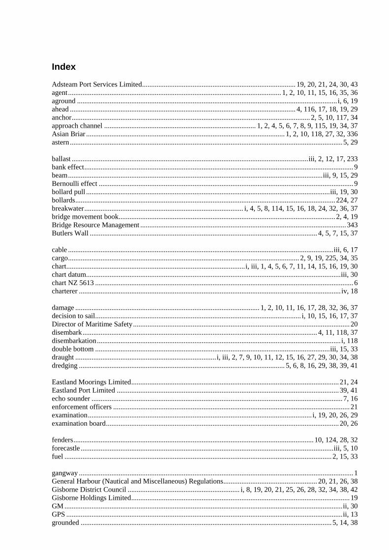
Index
Adsteam Port Services Limited..................................................................................... 19, 20, 21, 24, 30, 43agent...................................................................................................................... 1, 2, 10, 11, 15, 16, 35, 36aground ................................................................................................................................................ i, 6, 19ahead ............................................................................................................................. 4, 116, 17, 18, 19, 29anchor.................................................................................................................................... 2, 5, 10, 117, 34approach channel .................................................................................... 1, 2, 4, 5, 6, 7, 8, 9, 115, 19, 34, 37Asian Briar .............................................................................................................. 1, 2, 10, 118, 27, 32, 336astern ....................................................................................................................................................... 5, 29
ballast ...................................................................................................................................iii, 2, 12, 17, 233bank effect..................................................................................................................................................... 9beam.............................................................................................................................................iii, 9, 15, 29Bernoulli effect ............................................................................................................................................. 9bollard pull .......................................................................................................................................iii, 19, 30bollards................................................................................................................................................ 224, 27breakwater........................................................................................ i, 4, 5, 8, 114, 15, 16, 18, 24, 32, 36, 37bridge movement book........................................................................................................................ 2, 4, 19Bridge Resource Management .................................................................................................................. 343Butlers Wall .............................................................................................................................. 4, 5, 7, 15, 37
cable ...................................................................................................................................................iii, 6, 17cargo................................................................................................................................ 2, 9, 19, 225, 34, 35chart...................................................................................................i, iii, 1, 4, 5, 6, 7, 11, 14, 15, 16, 19, 30chart datum.............................................................................................................................................iii, 30chart NZ 5613 ............................................................................................................................................... 6charterer ................................................................................................................................................. iv, 18
damage ...................................................................................................... 1, 2, 10, 11, 16, 17, 28, 32, 36, 37decision to sail.................................................................................................................. i, 10, 15, 16, 17, 37Director of Maritime Safety........................................................................................................................ 20disembark.................................................................................................................................. 4, 11, 118, 37disembarkation....................................................................................................................................... i, 118double bottom ..................................................................................................................................iii, 15, 33draught ..............................................................................i, iii, 2, 7, 9, 10, 11, 12, 15, 16, 27, 29, 30, 34, 38dredging .................................................................................................................. 5, 6, 8, 16, 29, 38, 39, 41
Eastland Moorings Limited................................................................................................................... 21, 24Eastland Port Limited ........................................................................................................................... 39, 41echo sounder ........................................................................................................................................... 7, 16enforcement officers ................................................................................................................................... 21examination............................................................................................................................ i, 19, 20, 26, 29examination board................................................................................................................................. 20, 26
fenders..................................................................................................................................... 10, 124, 28, 32forecastle ............................................................................................................................................iii, 5, 10fuel .................................................................................................................................................... 2, 15, 33
gangway ........................................................................................................................................................ 1General Harbour (Nautical and Miscellaneous) Regulations.................................................... 20, 21, 26, 38Gisborne District Council .............................................................. i, 8, 19, 20, 21, 25, 26, 28, 32, 34, 38, 42Gisborne Holdings Limited......................................................................................................................... 19GM ..........................................................................................................................................................ii, 30GPS .........................................................................................................................................................ii, 13grounded ........................................................................................................................................... 5, 14, 38
grounding ....................................................................................... i, 5, 6, 114, 17, 19, 26, 32, 34, 35, 38, 39grounding position ...................................................................................................................................... 13
harbourmaster .................................................................. i, 19, 20, 21, 25, 26, 27, 28, 32, 34, 35, 37, 38, 42Hawkes Bay Regional Council ................................................................................................................... 21heave compensator........................................................................................................................................ 7heel..........................................................................................................................................i, iii, 10, 12, 30helm..................................................................................................................................................... 5, 9, 29hydrographic survey................................................................................................................ 5, 8, 16, 29, 38Hyundai Merchant Marine Company........................................................................................................... iv
interaction ............................................................................................................................................... 9, 16Interaction .................................................................................................................................................. i, 9
lanyard................................................................................................................................................... 10, 23leading line.......................................................................................................................... 4, 5, 6, 8, 115, 16local knowledge .............................................................................................................................. 20, 26, 38
manoeuvring lane.......................................................................................................................................... 9Maritime Safety Authority .......................................................................................................... 8, 20, 26, 39master/pilot exchange ................................................................................................................................. 15mooring gang ........................................................................................................ 10, 120, 24, 27, 28, 31, 34mooring system................................................................................................................. 10, 224, 27, 28, 39
Napier.................................................................................................................... 118, 20, 21, 26, 27, 36, 37New Zealand Almanac................................................................................................................................ 31New Zealand Maritime Pilots Association ................................................................................................. 20New Zealand Meteorological Office........................................................................................................... 32New Zealand Pilot......................................................................................................................................... 6News Maritime Company Limited ........................................................................................................ iv, 29Nippon Kaiji Kyokai.............................................................................................................................. iv, 29NIWA............................................................................................................................................................iinumber 7 wharf ........................................................................................................................... 1, 6, 117, 24number 8 wharf ....................................................................................................................... 1, 6, 24, 27, 28
papa ............................................................................................................................................................... 5passage plan ............................................................................................................................................ 1, 43Pelican........................................................................................................................................................... 5PIANC........................................................................................................................i, ii, 8, 9, 15, 38, 39, 40pilot boarding area ........................................................................................................................................ 1pilot launch...................................................................................................... 4, 5, 7, 11, 114, 16, 18, 20, 34pilotage........................................................................................................... i, 18, 19, 21, 26, 35, 36, 37, 43pollution ................................................................................................................................................ 15, 17Port Gisborne Limited.......................... i, 2, 5, 7, 8, 15, 16, 19, 20, 21, 24, 25, 27, 28, 30, 32, 34, 35, 39, 40Port of Gisborne.............................................................................................................................. 15, 38, 42Portland weather area............................................................................................................................ 31, 34Poverty Bay....................................................................................................................................... 2, 31, 34Pukanui ......................................................................................................................................................... 5
radar ............................................................................................................................................................ 13ranging ...............................................................................................................................iii, 1, 2, 28, 32, 34Rayonier, New Zealand Limited.................................................................................................................. ivrelief pilot...................................................................................................................................... 20, 26, 343repairs............................................................................................................................................................ 5risk assessment.......................................................................................................................... 19, 20, 25, 41rudder .................................................................................................................................................... 29, 32
ship’s mooring lines ................................................................................................................ 1, 2, 22, 36, 38shore mooring ................................... 1, 2, 8, 10, 117, 18, 20, 22, 224, 27, 28, 29, 32, 34, 35, 36, 37, 38, 39shore mooring gang........................................................................................................................... 1, 10, 24significant wave height ..................................................................................................................... 9, 11, 32Soki Kisen Company Limited...................................................................................................................... ivsounding chart ............................................................................................................................................... 5soundings ................................................................................................................................................ 6, 16squat ...................................................................................................................................iii, 2, 9, 10, 11, 12stability.................................................................................................................................. ii, iii, 18, 30, 34STCW 95 .................................................................................................................................................... 30steerage ............................................................................................................................................... 29, 337stevedores.......................................................................................................................................... 2, 10, 27surge......................................................................................................... iii, 1, 2, 8, 1227, 28, 32, 34, 36, 38swell .................................................................... 1, 5, 7, 10, 11, 12, 114, 16, 17, 228, 31, 32, 34, 37, 39, 41swinging basin ........................................................................................................ 1, 4, 5, 7, 10, 115, 19, 30
Takitimu...................................................................................................................................................... 20Tauranga ....................................................................................................................................................... 5tide................................................................................................................. 2, 7, 11, 18, 230, 31, 35, 37, 39Titirangi..................................................................................................................................... 1, 2, 4, 20, 30touched bottom.................................................................................................................. 1, 5, 14, 18, 19, 37Training Wall ................................................................................................................................................ 7trim.......................................................................................................................................................iii, 2, 9Turihaua .................................................................................................................................... 1, 2, 4, 20, 30Twin Bright Shipping Company Limited .................................................................................................... iv
UKC ........................................................................................................................................................ii, 10under keel clearance..................................................................................... i, ii, 7, 9, 11, 12, 17, 29, 30, 337
VHF.......................................................................................................................................ii, 5, 114, 16, 35
Waikanae Beach............................................................................................................................... i, 5, 6, 14wave rider buoy........................................................................................................................................... 32weather conditions ...................................................................................................... 5, 7, 12, 26, 32, 35, 41weather forecasts................................................................................................................................... 31, 32Wellington....................................................................................................................................... 29, 32, 34wire pennant................................................................................................................................................ 23