REMEDIAL ACTION COMPLETION REPORT FINAL · 2017-03-28 · Remedial Action Completion Report...
83
REMEDIAL ACTION COMPLETION REPORT FINAL GREAT LAKES LEGACY ACT LOWER MENOMINEE RIVER TYCO SITE Great Lakes National Program Office Cleanup Services (GLNPOCS) Contract No. EP-R5-11-04 Task Order No. 0005 Prepared for: USEPA Region 5 ATTN: Heather Williams 77 West Jackson Boulevard (G-17J) Chicago, IL 60604 Prepared by: Environmental Quality Management, Inc. 1800 Carillon Boulevard Cincinnati, Ohio 45240-2788 (800) 229-7495 www.eqm.com EQM PN: 030301.0005 December 14, 2015
Transcript of REMEDIAL ACTION COMPLETION REPORT FINAL · 2017-03-28 · Remedial Action Completion Report...
REMEDIAL ACTION COMPLETION REPORT
FINAL
GREAT LAKES LEGACY ACT
LOWER MENOMINEE RIVER TYCO SITE
Great Lakes National Program
Office Cleanup Services (GLNPOCS)
Contract No. EP-R5-11-04
Task Order No. 0005
Prepared for:
USEPA Region 5
ATTN: Heather Williams
77 West Jackson Boulevard (G-17J)
Chicago, IL 60604
Prepared by:
Environmental Quality Management, Inc.
1800 Carillon Boulevard
Cincinnati, Ohio 45240-2788
(800) 229-7495
www.eqm.com
EQM PN: 030301.0005
December 14, 2015

Remedial Action Completion Report Environmental Quality Management, Inc. Great Lakes Legacy Act Lower Menominee River Tyco Site
ii December 14, 2015
CONTENTS
Section Page
1. Introduction ...................................................................................................................... 1-1
1.1 Project and Scope.................................................................................................... 1-1
1.2 Project Objectives ................................................................................................... 1-2
1.3 Project Organization ............................................................................................... 1-3
1.4 Report Organization ................................................................................................ 1-5
2. Background ...................................................................................................................... 2-1
2.1 Site Information ...................................................................................................... 2-1
2.1.1 Description .................................................................................................. 2-1
2.1.2 Historical Site Arsenic Storage ................................................................... 2-2
2.1.3 Historical Dredging Activities .................................................................... 2-2
2.2 Summary of Remedial Action Objectives (RAOs) ................................................. 2-3
2.3 Summary of Planned Remedial Design Work Activities ....................................... 2-4
2.4 Modifications to Remedial Design ......................................................................... 2-4
3. Construction Activities .................................................................................................... 3-1
3.1 Preconstruction Activities and Mobilization .......................................................... 3-1
3.1.1 Pre-Construction Meetings ......................................................................... 3-1
3.1.2 Pre-Construction Plans................................................................................ 3-1
3.1.3 Licenses, Permits, and Other Submittals .................................................... 3-2
3.2 Site Preparation and Temporary Facilities .............................................................. 3-4
3.3 Operation and Maintenance of Temporary Facilities ............................................. 3-5
3.3.1 Standard Operations of Temporary Facilities ............................................. 3-5
3.3.2 Winter Shutdown and Operation/Maintenance of Temporary Facilities .... 3-6
3.4 Dredging Activities ................................................................................................. 3-6
3.5 Re-Dredging Activities ........................................................................................... 3-8
3.6 Bathymetric Surveys ............................................................................................... 3-8
3.7 Relocation of Equipment for Other Use of the Turning Basin ............................... 3-9
3.8 Dredge Material Handling and Stabilization .......................................................... 3-9
3.8.1 Dredge Material Offloading and Handling ............................................... 3-10
3.8.2 Dredge Material Stabilization ................................................................... 3-10
3.9 Debris Material Shredding, Loading, and Disposal .............................................. 3-13
3.10 Water Treatment Geotextile Tube Handling and Stabilization ............................ 3-14
3.11 Non-Hazardous Stabilized Material Loading, Transportation
and Offsite Disposal.............................................................................................. 3-14
3.12 Repair and Restored 6th Street Dock and Landing ............................................... 3-15
3.13 Placement of Subaqueous Cover Material ............................................................ 3-16
3.13.1 Cover Placement Requirements ................................................................ 3-16
3.13.2 Turbidity Control, Monitoring, and Contingency BMPss ........................ 3-16
3.13.3 Cover Material Delivery, Blending, and Placement ................................. 3-18
Remedial Action Completion Report Environmental Quality Management, Inc. Great Lakes Legacy Act Lower Menominee River Tyco Site
iii December 14, 2015
CONTENTS (continued)
Section Page
3.13.4 Cover Placement Verification - Pan Testing and Pre-/Post-Cover
Bathymetric Surveys ................................................................................. 3-20
3.13.5 Decontaminate and Demobilization .......................................................... 3-22
3.14 Control/Removal of Vegetative Invasive Species ................................................ 3-22
3.15 Installation of Rip Rap .......................................................................................... 3-23
3.16 Demobilization and Site Restoration .................................................................... 3-23
3.17 Repair and Site Restoration of Tyco Sediment Processing Asphalt Pad .............. 3-26
3.17.1 Work Planning and Coordination Activities ............................................. 3-26
3.17.2 Removal of Asphalt Overlayment ............................................................ 3-27
3.17.3 Asphalt Patching and Crack Repairs ......................................................... 3-27
3.17.4 Milling of process pad surface ................................................................. 3-27
3.17.5 Top Coat Surface ...................................................................................... 3-28
3.17.6 Work Inspection and Approval ................................................................. 3-28
4. Performance Standards and Construction Quality Controls ............................................ 4-1
4.1 Construction Quality Assurance/Quality Control Program .................................... 4-1
4.2 Summary of Sediment Excavations ........................................................................ 4-1
4.3 Quality Control Procedures .................................................................................... 4-2
4.3.1 Sediment Dredging ..................................................................................... 4-2
4.3.2 Bathymetric Surveys ................................................................................... 4-3
4.3.3 Phase Inspections ........................................................................................ 4-3
5. Final Inspection ................................................................................................................ 5-1
5.1 Punch-List Development ........................................................................................ 5-1
5.2 Site Work Inspections and H&S Audits ................................................................. 5-1
5.3 Final Close-Out Inspections.................................................................................... 5-2
6. Operation and Maintenance Activities ............................................................................. 6-1
7. Contact Information ......................................................................................................... 7-1
8. References ........................................................................................................................ 8-1

Remedial Action Completion Report Environmental Quality Management, Inc. Great Lakes Legacy Act Lower Menominee River Tyco Site
iv December 14, 2015
APPENDICES
Appendix A Figures
Appendix B Photographs
Appendix C Permits
Appendix D Sediment Volume Calculation Data
Appendix E Bathymetric Survey Data
Appendix F Debris Calculations
Appendix G Invasive Species Control Project Report
Appendix H Daily Reports
Appendix I Inspections
Appendix J Punchlist
TABLES
No. Page
Table 2-1. Modifications ............................................................................................................. 2-5
Table 3-1. Menominee Project Submittals Status and Tracking ................................................. 3-2
Table 3-2. Summary of Sediment Dredge Volumes by Area and Material Type ....................... 3-8
Table 3-3. Projected Production Rates ...................................................................................... 3-12
Table 3-4. Quantities of Materials Disposed Offsite ................................................................ 3-15
Table 4-1. Summary of Sediment Dredge Volumes by Area and Material Type ....................... 4-2
Table 7-1. Primary Project Contact Information ........................................................................ 7-1

Remedial Action Completion Report Environmental Quality Management, Inc. Great Lakes Legacy Act Lower Menominee River Tyco Site
December 14, 2015
LISTS OF ACROYMS AND ABBREVIATIONS
AOC Area Of Concern
BMP Best Management Practice
CD-ROM compact disk - read only memory
CCQAPP Construction Contractor Quality Assurance Project Plan
CQCP Construction Quality Control Plan
CQC construction quality control
CFR code of federal regulations
CY cubic yards
DMU dredge management units
DQCSR daily quality construction summary reports
ECCS Environmental Chemistry Consulting Services
EQM Environmental Quality Management, Inc.
EPA Environmental Protection Agency
ft feet
FTP file transfer protocol
GAC granulated activated carbon
GLLA Great Lakes
GLNPO Great Lakes National Program Office
GLNPOCS Great Lakes National Program Office Cleanup Services
GPS global positioning system
HDPE high-density polyethylene
KK KK Integrated Logistics
mg/kg milligram per kilogram
MSDS Material Safety Data Sheet
NTP notice to proceed
PVC polyvinyl chloride
QA quality assurance
QC quality control
RACR Remedial Action Completion Report
RAO remedial action objectives
REA request for equitable adjustment
RFTOP request for task order proposal
RG remedial goals
RTK real-time kinematic
SCM semi-consolidated materials
SES Sevenson Environmental Services, Inc.
SOP standard operating procedure
SOW scope of work
sq. ft. square feet
SY square yard
T&D transportation and disposal

Remedial Action Completion Report Environmental Quality Management, Inc. Great Lakes Legacy Act Lower Menominee River Tyco Site
i December 14, 2015
LIST OF ACROYMS (CONTINUED)
TCLP toxicity characteristic leaching procedure
TOCOR task order contracting officer’s representative
Tyco Tyco Fire Products LP
US United States
USACE United States Army Corps of Engineer
WDNR Wisconsin Department of Natural Resources
WPDES Wisconsin Pollutant Discharge Elimination System
WWTP waste water treatment plant

Remedial Action Completion Report Environmental Quality Management, Inc. Great Lakes Legacy Act Lower Menominee River Tyco Site
1-1 December 14, 2015
1. INTRODUCTION
Environmental Quality Management, Inc. (EQM) has prepared this Remedial Action
Completion Report (RACR) for the environmental remediation work conducted at the Lower
Menominee River Sediment Removal Project, Marinette, Wisconsin. The EQM Team conducted
this Great Lakes Legacy Act (GLLA) contaminated sediment cleanup project for the U.S. Envi-
ronmental Protection Agency (EPA) and its project partners, Tyco Fire Products LP (Tyco) and
Wisconsin Department of Natural Resources (WDNR). This was a betterment remediation pro-
ject to accelerate the achievement of lower arsenic levels in the Lower Menominee River. Fig-
ure 1 presents a location map for the Lower Menominee River Area of Concern.
1.1 Project and Scope
This project was performed for the EPA under EQM's Great Lakes National Program Of-
fice Cleanup Services (GLNPOCS) contract (Contract No. EP-R5-11-04). The project was
awarded to EQM on August 27, 2014 as Task Order 0005 (Menominee River Sediment Removal
Project, Marinette, Wisconsin). EQM Team subcontractor Sevenson Environmental Services,
Inc. (SES) (Niagara Falls, NY) performed various marine and landside work tasks under this pro-
ject. Work was performed along areas of the Lower Menominee River adjacent to and near the
Tyco manufacturing operation. The Menominee/Tyco project site is an active manufacturing
facility in the City of Marinette in northeastern Wisconsin, adjacent to the south shore of the
Menominee River. The property is bordered by the Menominee River to the north; the 6th Street
Slip and City of Marinette property to the east; Water Street, City of Marinette property, Mari-
nette School District property, and residential properties to the south; and Stanton Street and Ma-
rinette Marine Corporation to the west. The facility consists of approximately 63 acres, includ-
ing a manufacturing area on the western part of the property and an undeveloped area to the east,
referred to as the “wetlands area.” A fence surrounds both parts of the facility, and access is re-
stricted.

Remedial Action Completion Report Environmental Quality Management, Inc. Great Lakes Legacy Act Lower Menominee River Tyco Site
1-2 December 14, 2015
EQM’s work activities consisted of dredging, surveying, materials handling (processing,
stabilization, debris shredding), loading and transportation of processed sediment and debris,
subaqueous cover placement, vegetative invasive species removal, rip rap construction, site res-
toration, and related mobilization and demobilization activities. Work was performed in ac-
cordance with the applicable EQM task order Scope of Work (SOW), the project specifications,
the Tyco Hazardous Waste Variance permit, the Tyco Site Access Agreement, and the associated
Project Work Plans developed for the project site. Work and mobilization of equipment and ma-
terials to the site began in September 2014, with the in-water remediation work (i.e., dredging)
occurring between early September and late November 2014. Decontamination and demobiliza-
tion of most of the marine equipment was performed in late November 2014 following the com-
pletion of dredging. Decontamination of the staging area was required to be performed prior to
the winter shutdown per the Hazardous Waste Remediation Variance. Subaqueous cover place-
ment and site restoration began in April 2015 and was completed in June 2015.
Vegetative invasive species removal work, specifically for Phragmites, was added to the
project SOW in May of 2015, and involved the treatment, cutting, and removal of the invasive
species in selected areas of the project site. The invasive species control work began in August
2015 and final cutting and removal was completed in late November. Additional repairs and res-
toration of the Tyco sediment processing pad was also added to the SOW and this work was
completed between August and September 2015. The general site restoration and final demobili-
zation was completed in September 2015, with the exception of final cutting and removal of the
treated invasive species grasses.
All work activities were conducted in compliance with applicable Federal, State of Wis-
consin, and local laws and requirements, including compliance with 49 CFR and State of Wis-
consin and Michigan requirements for highway transportation.
1.2 Project Objectives
EQM was tasked to complete work associated with contaminated sediment cleanup and
habitat restoration along the Lower Menominee River in Marinette, Wisconsin. Work was per-
formed in accordance with the applicable EQM task order SOW, the project specifications, and

Remedial Action Completion Report Environmental Quality Management, Inc. Great Lakes Legacy Act Lower Menominee River Tyco Site
1-3 December 14, 2015
the associated Project Work Plans developed for the project site. EQM’s primary work activities
are listed below:
Mobilization and site setup.
Implementation of erosion control and sediment re-suspension control measures including
monitoring, as necessary.
Operation and maintenance of a temporary sediment staging/stabilization area.
Bathymetric and land surveys of areas to be dredged or disturbed prior to starting work and
after completion of each phase of work.
Mechanically dredging arsenic contaminated sediment from the Lower Menominee River
(engineering estimate of 44,777 cubic yards (CY), including 37,070 CY neat line plus 7,770
CY over-dredge allowance.)
Transportation of dredged materials to the stabilization/staging area.
Pumping water from dredge scows to the Water Treatment Facility.
Off-loading of dredge materials at the soil stabilization area.
Stabilization and handling of material from dredging activities.
If necessary, re-stabilizing of previously stabilized material that failed to meet criteria for
disposal at the off-site landfill.
Assisting the Tyco representative with collection of various samples for analysis.
Loading and transportation of the stabilized sediment material from the site to an off-site li-
censed landfill disposal facility (Waste Management, Menominee, MI).
Placement of in situ, subaqueous cover material in the Turning Basin and Transition Area.
Restoration of portions of the site impacted by remedial activities, including the water treat-
ment area at the 6th Street slip and the Tyco asphalt pad.
Control/Removal of vegetative invasive species (Phragmites).
Cleanup and demobilization from site.
1.3 Project Organization
Implementing the Lower Menominee River Sediment Removal Project in Marinette,
Wisconsin involved collaboration among several organizations. The primary organizations that
participated in this remedial action are listed below:
United States (US) EPA Great Lakes National Program Office (GLNPO)—Lead Federal
agency responsible for funding and managing the Lower Menominee River Sediment Re-
moval Project

Remedial Action Completion Report Environmental Quality Management, Inc. Great Lakes Legacy Act Lower Menominee River Tyco Site
1-4 December 14, 2015
Wisconsin Department of Natural Resources—GLLA nonfederal partner and project stake-
holder responsible for oversight of remediation and construction work, particularly regarding
compliance with state regulations and permit requirements
Tyco—GLLA nonfederal partner for the Lower Menominee River Sediment Removal Pro-
ject
City of Marinette—Lead City agency and Project Stakeholder
CH2M Hill—Engineer of Record and construction oversite contractor for Tyco
Environmental Chemistry Consulting Services (ECCS)—Tyco on-site laboratory subcontrac-
tor
EQM—Prime contractor to USEPA under EPA GLNPOCS I contract, responsible for overall
project and on-site management, reporting, construction quality control (CQC), health and
safety, procurement, cost and schedule control, and off-site transportation and disposal of
waste materials
SES—Team subcontractor to EQM under the EPA GLNPOCS I contract, responsible for
dredging/excavation, debris removal and disposal, and site setup and related construction
support activities
Luedtke Engineering Company, Inc. (Luedtke) (Frankfort, MI)—Subcontractor to SES, per-
formed deep-area sediment re-dredging of the Turning Basin.
As noted above, EQM was supported on this project by SES, one of EQM’s GLNPOCS
Team subcontractors. As the prime contractor, EQM was responsible for: project and on-site
management, preparation of project preconstruction plans and documents, reporting, CQC and
Health & Safety, bathymetric surveying, delivery of the Portland cement stabilization reagent,
off-site T&D of the solidified sediment and debris materials, invasive species control efforts, res-
toration of the Tyco asphalt processing pad, and cost and schedule control. SES was responsible
for: site preparation and maintenance of temporary facilities, debris removal and dredg-
ing/excavation of all contaminated sediment, transportation of debris and sediment to the pro-
cessing pad, sediment processing and solidification, and load-out of solidified sediment for off-
site transportation and disposal.
Tyco, as EPA’s nonfederal partner, was responsible for providing the sediment treatment
agents (ferric sulfate), operating the on-site wastewater treatment plant, environmental monitor-
ing, and post-dredge confirmatory sampling and analysis. Tyco’s On-site Engineer, CH2M Hill,
was assisting Tyco in the performance of these various tasks. EQM and SES provided support
and assistance to Tyco and CH2M Hill in the execution of their various project work tasks.

Remedial Action Completion Report Environmental Quality Management, Inc. Great Lakes Legacy Act Lower Menominee River Tyco Site
1-5 December 14, 2015
1.4 Report Organization
This RACR is organized in the following sections:
Section 1 – Introduction
Section 2 – Background
Section 3 – Construction Activities
Section 4 – Performance Standards and Construction Quality Control
Section 5 – Final Inspection
Section 6 – Operation and Maintenance Activities
Section 7 – Contact Information
Section 8 – References
Appendix A – Figures
Appendix B – Photographs
Appendix C – Permits
Appendix D – Sediment Volume Calculation Data
Appendix E – Bathymetric Survey Data
Appendix F – Debris Calculations
Appendix G – Invasive Species Control Project Report
Appendix H – Daily Reports
Appendix I – Inspection
Appendix J – Punch-list

Remedial Action Completion Report Environmental Quality Management, Inc. Great Lakes Legacy Act Lower Menominee River Tyco Site
2-1 December 14, 2015
2. BACKGROUND
2.1 Site Information
This section provides a description of the Menominee project site and a summary of his-
torical work at the site. Figure 1 presents the Lower Menominee River Area of Concern, and
Figure 2 presents the Tyco facility and GLLA project area. Note that all figures are presented in
Appendix A.
2.1.1 Description
Work was performed along areas of the Lower Menominee River adjacent to and near the
Tyco manufacturing operation. The Menominee/Tyco project site is an active manufacturing
facility in the City of Marinette in northeastern Wisconsin, adjacent to the south shore of the
Menominee River. The property is bordered by the Menominee River to the north; the 6th Street
Slip and City of Marinette property to the east; Water Street, City of Marinette property, Mari-
nette School District property, and residential properties to the south; and Stanton Street and Ma-
rinette Marine Corporation to the west.
The facility consists of approximately 63 acres, including a manufacturing area on the
western part of the property and an undeveloped area to the east, referred to as the “wetlands ar-
ea.” A fence surrounds both parts of the facility, and access is restricted. Figure 3 presents the
existing Site Plan.
A total final volume of 41,010 CY of soft sediment and semi-consolidated materials
(SCM) contaminated with arsenic greater than 20 milligrams per kilogram (mg/kg) were me-
chanically removed from the work area in the Menominee River. The thickness of the soft sedi-
ments mechanically dredged ranged from less than 1 foot to a maximum of 8 feet. The SCM
ranged from a depth of 6 to 27 feet. Six (6) inches of over-dredge allowance was included in the
total volumes for soft sediment (in areas not underlain with SCM targeted for removal) and
SCM. The estimated volume of sediment associated with the 6-inch over-dredge from the origi-
nal project design was 7,770 CY. The actual final quantity of sediment associated with the
over-dredge allowance was 6,725 CY.

Remedial Action Completion Report Environmental Quality Management, Inc. Great Lakes Legacy Act Lower Menominee River Tyco Site
2-2 December 14, 2015
Note that all photographs depicting site activities described throughout the report are pre-
sented in Appendix B.
2.1.2 Historical Site Arsenic Storage
The facility began operations in 1915 to produce cattle feed, refrigerants, and specialty
chemicals. Arsenic-based agricultural herbicides were manufactured at the facility between 1957
and 1977. A byproduct of the manufacturing of this herbicide was a salt that contained approxi-
mately 2 percent arsenic by weight and was stockpiled at several locations on the property. Some
of this arsenic subsequently entered the site's soil, water and river sediments. By 1978, the facili-
ty ceased production of arsenic-based herbicides, and since 1983 has produced only fire extin-
guishers and fire-suppression systems.
2.1.3 Historical Dredging Activities
Prior sediment remediation work was conducted at the Menominee project site under a
separate contract procured and managed directly by Tyco. The primary environmen-
tal/construction activities preformed during 2012 and 2013 are described below.
2012 Work Activities:
Site preparation for dredging, processing, and disposal operations.
Installation of temporary water treatment system at the 6th Street Slip area.
Installation of turbidity controls and monitoring equipment.
Bathymetric survey to document pre-dredging sediment elevations.
Mechanical dredging, stabilization, and disposal of soft sediments in Turning Basin.
Collection and treatment of wastewater through the temporary water treatment system.
Ongoing monitoring activities consisting of monitoring turbidity and arsenic concentrations
in the river, arsenic concentrations at two nearby drinking water plant intakes, arsenic con-
centrations in the water treatment system effluent, and stabilized sediment disposal parame-
ters (mainly, total and toxicity characteristic leaching procedure (TCLP) for arsenic, paint fil-
ter, and field soil strength testing).
Bathymetric survey to document the subsurface elevations at the end of the 2012 work sea-
son.

Remedial Action Completion Report Environmental Quality Management, Inc. Great Lakes Legacy Act Lower Menominee River Tyco Site
2-3 December 14, 2015
Installation of the wastewater stabilization support system through 2012/2013 winter months
to prepare for 2013 dredge season.
2013 Work Activities:
Completed installation of wastewater stabilization support system.
Re-paved entire former Salt Vault area for use as a staging pad. Original asphalt was re-
moved during the wastewater stabilization structure installation.
Modifications to the site layout for the 2013 dredge season to more efficiently manage the
sediment following treatment and allow for more storage capacity.
Start-up activities for the temporary water treatment system in the 6th Street Slip area.
Bathymetric survey to document pre-dredging sediment elevations.
Re-Installation of turbidity control devices (such as silt curtains) in the river.
Mechanical dredging, stabilization, and disposal of soft sediments and SCM in Turning Ba-
sin, Transition Areas, and South Channel.
Collection and treatment of wastewater through the temporary water treatment system.
Ongoing monitoring activities consisting of monitoring turbidity and arsenic concentrations
in the river, arsenic concentrations at two nearby drinking water plant intakes, arsenic con-
centrations in the water treatment system effluent, and stabilized sediment disposal parame-
ters (mainly, total and TCLP arsenic, paint filter, and field soil strength testing).
Installation of bedding stone and rip-rap for long-term support of vertical barrier wall.
Decontamination of site and equipment following dredging activities as weather permitted.
Shutdown of site in December 2013. Partial decontamination, restoration, and demobilization
activities resumed as weather allowed in spring 2014. Full demobilization was not complet-
ed as the Legacy Project (EQM contracted) commenced September 4, 2014.
2.2 Summary of Remedial Action Objectives (RAOs)
As stated in Section 1.2, the objective of the Lower Menominee River AOC Sediment
Removal Project was to remediate the Menominee River by a combination of sediment removal,
cover placement, and habitat restoration. The Remedial Action Objectives (RAOs) for the
GLLA Lower Menominee River AOC Remediation Tyco Site project were as follows:
RAO 1: Reduce human exposures for direct sediment contact from the Lower Menominee
River by reducing the availability and/or concentration of arsenic in sediment.
RAO 2: Reduce the exposure of wildlife populations and the aquatic community to sediment
arsenic concentrations that are above 20 mg/kg.

Remedial Action Completion Report Environmental Quality Management, Inc. Great Lakes Legacy Act Lower Menominee River Tyco Site
2-4 December 14, 2015
RAO 3: Implement a remedy that was compatible with the Menominee River Remedial Ac-
tion Plan’s goal of protecting and restoring habitat and supporting wildlife.
2.3 Summary of Planned Remedial Design Work Activities
The planned approach was based on the EPA Request for Task Order Proposal (RFTOP)
specifications and the specific Menominee River RAOs and Remedial Goals (RGs) developed by
EPA and its partners. The planned means, methods, and equipment for successfully completing
the planned remedial design consisted of six major project tasks: 1) dredging an engineering es-
timate of 44,777 CY of sediment contaminated with arsenic above 20 mg/kg (37,007 Neat Line
and 7,770 overdredge allowance); 2) dewatering, processing, and stabilizing the arsenic-
contaminated sediment and debris as required for off-site disposal at a licensed non-hazardous
waste landfill; 3) loading and transporting the processed sediments and debris to a licensed non-
hazardous waste landfill; 4) option for disposal of stabilized sediments at a licensed landfill; 5)
option for in situ cover placement of approximately 2-3 acres of exposed glacial till with arsenic
concentrations > 20 mg/kg; and 6) site restoration.
During the course of performing the project work in 2013 under the Tyco/SES contract,
the City of Grand Haven shipwreck was located in the project area. The schooner was originally
abandoned at the moorings near the foot of 6th Street and left to decay. Historically in 2013, the
shipwreck area was dredged and remnants of the ship were recovered. Remnants from the ship-
wreck were saved and an attraction is on display at the Marinette County Historical Society Mu-
seum. Prior to starting the 2014 EPA GLLA remediation project (the EQM contract), the na-
tional historic society was notified by CH2M Hill regarding the performance of activities in the
area of ship wreck. No shipwreck debris was encountered during the dredging activities under
the EPA GLLA 2014 project.
2.4 Modifications to Remedial Design
During the course of the remedial activities, several minor design and operational modifi-
cations were implemented. All modifications were approved by USEPA GLNPO prior to im-
plementation. During the performance of this project, a total of 10 task order modifications were
issued by EPA. Table 2-1 presents these modifications. The primary purpose of these modifica-

Remedial Action Completion Report Environmental Quality Management, Inc. Great Lakes Legacy Act Lower Menominee River Tyco Site
2-5 December 14, 2015
tions was to reconcile work quantities, add or move funding between the various work line items,
and add additional scope of work items.
Table 2-1. Modifications Mod. No. Description Date
001 Added Delivery of Type II Portland Cement 10/17/2014
002 Add Subaqueous Cover Placement 3/30/2015
003 Line item funds transfer 4/9/2015
004 Alter Dredging/Redredging CY & Materials Handling/Shredding Tons, Cement Delay / Shortage 4/21/2015
005 Additional Site Restoration at the Tyco Asphalt Pad 6/4/2015
006 Line item funds transfer 8/13/2015
007 Line item funds transfer 8/25/2015
008 Line item funds transfer 9/4/2015
009 Adjust Line Item Quantities and Adjust Line Item Funding 9/10/2015
010 Add Invasive Species Control / Removal, and Line item funds transfer 9/28/2015
A brief description of the modifications that involved changes to the scope of work and
required services is provided below.
On October 17, 2014 EPA awarded Modification 001 to the task order, which required
EQM to supply and deliver the Type II Portland cement stabilization agent for use in the sedi-
ment stabilization operations.
During March 2015, EPA awarded Modification 002 to the task order which required the
placement of a subaqueous cap within the Turning Basin and Transition Area. In early March
2015, Tyco received the Section 408 final approval from the U.S. Army Corps of Engineers
(USACE) for installation of the subaqueous cover. This delayed approval for the cover place-
ment work resulted in installation of the cover materials in the spring/early summer of 2015, ra-
ther than following the completion of dredging at the end of the 2014 construction season.. A
Request for Equitable Adjustment (REA) was submitted to EPA including revisions after receipt
of the cover placement mod due to the aforementioned delay of this work. A subaqueous cover
core sampling effort was conducted in June 2015 to evaluate and confirm the thickness of the
subaqueous cover that was placed by SES, and to collect other pertinent information related to
the cover placement work. EPA, their project partners Tyco and the WDNR, and the Tyco pro-
ject engineer CH2M Hill developed a diver-assisted core sampling program to collect the desired
data in an effort to verify the thickness of the cover material that was previously placed.
EPA issued Modification 003 and 004 which allocated/transferred funds for the final
quantity of Portland cement delivered to the site and for the related REA that was required due to

Remedial Action Completion Report Environmental Quality Management, Inc. Great Lakes Legacy Act Lower Menominee River Tyco Site
2-6 December 14, 2015
an unavoidable temporary delay in the delivery of Portland during a portion of the project work.
The delay REA was due to adequate supplies of the Portland agent not being available on Octo-
ber 23, 2014 and October 28, 2014 due to circumstances beyond the control of EQM and SES.
As a result of the shortage of available Portland cement, certain on-site operations (sediment
processing on the dewatering/processing pad, sediment off-loading from the scows, and sediment
dredging) were temporarily impacted (i.e., the production rates for these operations were de-
creased on some days, resulting in the operating time being substantially reduced; on other days,
the operations were completely shut down due solely to the lack of available Portland).
During June 2015, EPA awarded Modification 005, Asphalt Pad Repair & Restoration
which was related to the SOW for Task Order Line Item 16, Demobilization and Site Restora-
tion. This modification included direction to perform additional repair and paving work on the
Tyco sediment processing pad. The modification also included de-scoping of several restoration
items that were included with the original project SOW and budget. The firm selected for the
pad restoration and repair work was Peshtigo Paving. Peshtigo began work in late July 2015 and
completed all work in September 2015.
Modifications 006, 007, and 008 involved allocation/transfer of funds among various line
items. The EPA issued modification 009 to alter the funding for the stabilizing materials and ad-
ditional cover placement work.
During fall of 2015 the EPA issued modification 010 which added the control of the in-
vasive species Giant Reed Grass (Phragmites australis) to the task order. The invasive species
work included chemical treatment and cutting of the invasive species grass, and removal and
disposal of the cut grass from some of the areas treated.

Remedial Action Completion Report Environmental Quality Management, Inc. Great Lakes Legacy Act Lower Menominee River Tyco Site
3-1 December 14, 2015
3. CONSTRUCTION ACTIVITIES
The environmental construction and related activities performed under the EPA GLLA
project are described in this section.
3.1 Preconstruction Activities and Mobilization
This section presents a summary of the preconstruction activities.
3.1.1 Pre-Construction Meetings
USEPA GLNPO awarded the Lower Menominee River AOC Sediment Removal Project,
Marinette, Wisconsin to EQM under Contract EP-R5-11-04, Task Order 0005, on Au-
gust 27, 2014.
A project kick-off meeting was held on September 3, 2014. The meeting was convened
at the USEPA GLNPO office in Chicago, Illinois. Representatives from USEPA GLNPO, EQM,
SES, Tyco, and CH2M Hill attended the meeting. Key topics discussed during the meeting in-
cluded the work SOW, planned schedule, roles of the various interested parties, access agree-
ment, and project submittals. The key submittals discussed during the meeting included the CQC
Plan, Health Safety & Emergency Response Plan, Dredging Operations Plan, and Schedule of
Submittals.
3.1.2 Pre-Construction Plans
The project RFTOP and specifications required preparation of a number of pre-
construction plans and other submittals. The primary required project plans and documents are
listed in Table 3-1. A first draft of all of the plans was prepared and submitted for each required
submittal in September, with the exception of the Environmental Control and Stormwater Pollu-
tion Prevention Plan, which was submitted on October 6, 2014. Comments were received from
EPA and other involved parties (e.g., Tyco and WDNR) during the September reporting period
(with the exception of the Environmental and Stormwater Pollution Prevention Plan). All sub-
mittals were revised in response to the comments received and resubmitted to EPA with the ex-
Remedial Action Completion Report Environmental Quality Management, Inc. Great Lakes Legacy Act Lower Menominee River Tyco Site
3-2 December 14, 2015
ception of the Erosion Control and Stormwater Pollution Prevention Plan (no comments were
received on the draft plan). These plans were further revised and resubmitted to EPA if deemed
necessary and as directed by the EPA.
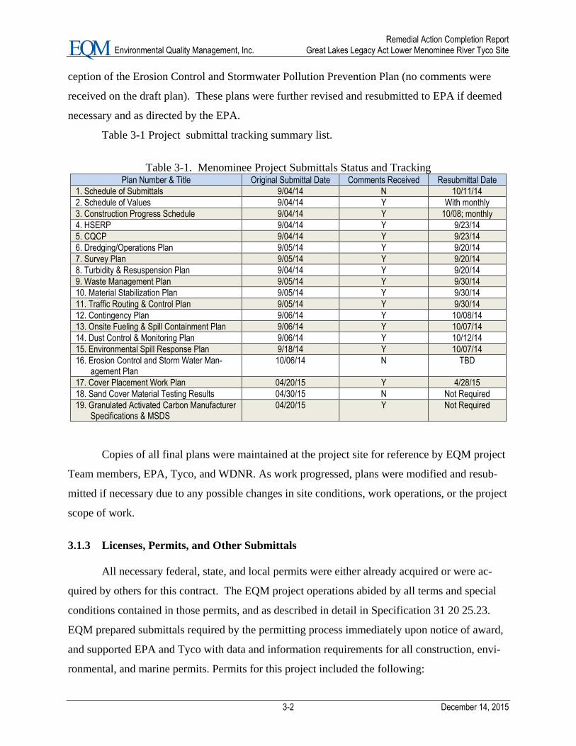
Table 3-1 Project submittal tracking summary list.
Table 3-1. Menominee Project Submittals Status and Tracking Plan Number & Title Original Submittal Date Comments Received Resubmittal Date
1. Schedule of Submittals 9/04/14 N 10/11/14
2. Schedule of Values 9/04/14 Y With monthly
3. Construction Progress Schedule 9/04/14 Y 10/08; monthly
4. HSERP 9/04/14 Y 9/23/14
5. CQCP 9/04/14 Y 9/23/14
6. Dredging/Operations Plan 9/05/14 Y 9/20/14
7. Survey Plan 9/05/14 Y 9/20/14
8. Turbidity & Resuspension Plan 9/04/14 Y 9/20/14
9. Waste Management Plan 9/05/14 Y 9/30/14
10. Material Stabilization Plan 9/05/14 Y 9/30/14
11. Traffic Routing & Control Plan 9/05/14 Y 9/30/14
12. Contingency Plan 9/06/14 Y 10/08/14
13. Onsite Fueling & Spill Containment Plan 9/06/14 Y 10/07/14
14. Dust Control & Monitoring Plan 9/06/14 Y 10/12/14
15. Environmental Spill Response Plan 9/18/14 Y 10/07/14
16. Erosion Control and Storm Water Man-agement Plan
10/06/14 N TBD
17. Cover Placement Work Plan 04/20/15 Y 4/28/15
18. Sand Cover Material Testing Results 04/30/15 N Not Required
19. Granulated Activated Carbon Manufacturer Specifications & MSDS
04/20/15 Y Not Required
Copies of all final plans were maintained at the project site for reference by EQM project
Team members, EPA, Tyco, and WDNR. As work progressed, plans were modified and resub-
mitted if necessary due to any possible changes in site conditions, work operations, or the project
scope of work.
3.1.3 Licenses, Permits, and Other Submittals
All necessary federal, state, and local permits were either already acquired or were ac-
quired by others for this contract. The EQM project operations abided by all terms and special
conditions contained in those permits, and as described in detail in Specification 31 20 25.23.
EQM prepared submittals required by the permitting process immediately upon notice of award,
and supported EPA and Tyco with data and information requirements for all construction, envi-
ronmental, and marine permits. Permits for this project included the following:

Remedial Action Completion Report Environmental Quality Management, Inc. Great Lakes Legacy Act Lower Menominee River Tyco Site
3-3 December 14, 2015
WPDES Wastewater Permit
Ch. 30 Dredging Permit
NR 216 Construction Site Storm Water Discharge Permit
NR 107 Chemical Aquatic Plant Management Control Permit
USACE Section 404 Dredging Permit
USACE Section 408 Subaqueous Cover Approval
City of Marinette Erosion & Storm Water Management per Ordinance
WDNR Hazardous Waste Remediation variance
During the EPA GLNPO GLLA contract, the hazardous waste remediation variance ex-
pired. This remediation variance was renewed or extended after the opportunity for a public
hearing. Due to the expiration date of Tyco’s Site Waste Variance (12-31-14), a Modification
Request letter was submitted by Tyco’s consultant CH2M Hill on November 25, 2015 to the
Wisconsin Department of Natural Resources for extension of the Water Variance permit to De-
cember 31, 2015. On December 10, 2014 the WDNR replied, approving the extension request
with a contingency that all decontamination activities must be completed by June 15, 2015. Ap-
pendix C presents the variance permit and extension.
Other submittals that were part of the project included the Tyco Site Access Agreement,
Subaqueous Cover Placement Plan, Sand Cover Material Testing Results, and the Granulated
Activated Carbon Manufacturer Specifications and MSDS. As part of the implementation of
Remedial Action and Restoration of portions of the Lower Menominee River, the Tyco Site Ac-
cess Agreement granted access to EQM and its personnel, employees, agents, contractors, and
consultants, to enter the property for the purpose of performing remediation and restoration ac-
tivities as described in GLNPOCS Task Order. This agreement was signed September 5, 2014.
The other required preconstruction submittals were for the cover placement work and included a
Cover Placement Work Plan and specification/testing procedures for the cover materials. The
Draft Cover Plan was submitted to EPA on April 20, 2015. EPA provided comments to the
Draft plan on April 21, 2015, and a revised plan and response to comments were submitted to
EPA on April 28, 2015. Cover material specification and testing information were provided to
EPA in April. The revised Cover Plan and cover material information were acceptable to EPA,
and therefore final cover material ordering and placement work proceeded accordingly.
EPA added a new element of work to this task order that involved the control of invasive
vegetative species. The field work for this effort was performed from early September through
late November 2015.

Remedial Action Completion Report Environmental Quality Management, Inc. Great Lakes Legacy Act Lower Menominee River Tyco Site
3-4 December 14, 2015
3.2 Site Preparation and Temporary Facilities
EQM received the official Notice to Proceed (NTP) from EPA on September 4, 2014, and
mobilization of project resources began on September 5, with equipment and materials delivery
beginning on September 6, 2014, and continued throughout early September. Upon arriving on
site in early September, office trailers, guard trailers, on-site sediment handling and processing
facilities, and site controls were restored and put into service. Site general cleanup and mainte-
nance was also performed to ready all operations for startup. Some equipment modification
work and retrofitting were performed to meet work task requirements. Mobilization of all prima-
ry equipment, personnel, and materials was completed by mid-September. Minor equipment and
personnel adjustments were made on an as-needed basis as work activity fluctuated. Specific
tasks completed to support startup of site operations included the following:
Pugmills and process pad equipment were set up and put back into service.
Dredging equipment was set up and positioned.
Standing water was removed from sediment bins and the bins were cleaned.
Following cleaning, sediment bins were sealed with foam.
Turbidity curtain/controls were installed and positioned.
The sediment pad was repaired and sealed.
Maintenance and repair of silt fencing was performed.
Coal Dock loading platform was prepared to support dry ferric delivery operations.
Crane mats were placed along the South Channel to create a platform for dredging.
Additional stone was added to the temporary S Channel Road so that vehicles could access
high water areas without risk of contamination to the waterway.
A derrick crane type dredge plant was mobilized to the project site from Luedtke Marine
in November to perform the required re-dredge of the deeper areas of the river. Some minor im-
provements and adjustments/refinements of the infrastructure were made, and regular mainte-
nance of the temporary facilities was performed to keep all facilities in good operating order.
Photograph 1 depicts the mobilization of the dredging barge. Note that all photographs are pre-
sented in Appendix B.
Some site preparation was required during the remobe back to the site in the spring of
2015 for performing the cover placement work and remaining site restoration work. EQM mobi-
lized personnel, equipment, and materials to the site for the cover placement work in the spring
of 2015 after receipt of the modification from EPA for this work. Minor equipment and person-

Remedial Action Completion Report Environmental Quality Management, Inc. Great Lakes Legacy Act Lower Menominee River Tyco Site
3-5 December 14, 2015
nel adjustments were made on an as-needed basis as the cover placement work activity pro-
gressed and fluctuated. Figure 4 presents the Overall Conceptual Temporary Facilities.
3.3 Operation and Maintenance of Temporary Facilities
3.3.1 Standard Operations of Temporary Facilities
Personnel, equipment, and materials were made available throughout the project to sup-
port the operation of all temporary facilities (sediment handling/transport, sediment treatment
pad, Portland and ferric storage operations, pug mills, curing bins, wastewater treatment plant,
scales, sediment off-loading operations, site controls, etc.). Procedures and tracking logs were
maintained for inspection and maintenance of all temporary operations. Monitoring, tracking,
and documenting the Quality Control of all temporary operations continued during the project.
Some minor improvements and adjustments/refinements of the infrastructure were made, and
regular maintenance of the temporary facilities was performed to keep all facilities in good oper-
ating order.
Decontamination and demobilization of dredging and sediment processing equipment
was performed in November and December 2014. Following completion of dredging activities
on November 17, decontamination and dismantling of some of the temporary facilities were ini-
tiated. On November 20, the extreme cold weather conditions caused major problems with de-
contamination efforts. Because of the below-freezing temperatures, the use of water for a decon-
tamination agent was no longer an option. The EQM/SES field team utilized the best available
techniques to decontaminate the facility (including shifting to dry techniques); however, the de-
contamination of the entire site was not complete at the end of the 2014 construction period. On
April 15, 2015 the field crew and equipment were re-mobilized to the site, and crews began the
task of decontaminating the items that were not completed in 2014 due to the below-freezing
temperatures. Site restoration activities were also started in mid-April. A security trailer at the
6th Street Slip was demobilized as part of the final site restoration/demobe for that area. Other
tasks performed included final decontamination of the process pad and sediment bin walls, de-
mobilization of equipment that was no longer required, placement of subaqueous cover material,
removal of the temporary S Channel Road, removal of material on the Haul Road between 6th &
8th Street to pre-construction condition and general site restoration.
Remedial Action Completion Report Environmental Quality Management, Inc. Great Lakes Legacy Act Lower Menominee River Tyco Site
3-6 December 14, 2015
3.3.2 Winter Shutdown and Operation/Maintenance of Temporary Facilities
On December 10, demobilization was completed and the Winter Shutdown phase of the
project started. Since the wastewater treatment plant (WWTP) was removed, alternate operations
were implemented to handle the water collected inside the process pad area. All water collected
in that area was pumped into a vacuum truck and transported to Tyco’s on-site WWTP. This in-
cluded snow and rain water resulting from weather events. Snow removal outside of the process
pad was also started to comply with Tyco’s site emergency procedures. EQM completely re-
moved all sediment waste material from all scows and deconned the scows. In addition, EQM:
Finished processing all sediment waste material and cleaned the pug mills.
Completed off-site disposal of all sediment waste material and geotextile tubes from the
WWTP.
Removed equipment and those temporary facilities that had been properly decontaminated.
Shut down, dismantled, and removed the WWTP.
During February through the first part of April 2015, resources were provided to monitor
and manage contact water associated with the treatment pad, which could not be removed at the
end of the 2014 season due to cold weather and the inability to properly decon the pad. As need-
ed, contact water was removed from the sump/collection areas and temporarily stored in frac
tanks. The collected water was then transferred to the Tyco on-site WWTP for treatment. Water
management and treatment activities were closely coordinated with the appropriate Tyco repre-
sentatives. A total of 80,000 gallons of contact water was collected and sent to the Tyco WWTP
during the winter shutdown period.
3.4 Dredging Activities
An engineering estimated total volume of approximately 44,777 CY (37,070 CY Neat
Line plus the 7,770 CY over-dredge allowance) of soft sediment and SCM contaminated with
arsenic greater than 20 mg/kg were to be mechanically removed from the work area in the Me-
nominee River. An actual total volume of 41,010 CY of soft and SCM contaminated sediment
was dredged during this project, including 6,725 CY of over-dredge allowance. The total dredge
Remedial Action Completion Report Environmental Quality Management, Inc. Great Lakes Legacy Act Lower Menominee River Tyco Site
3-7 December 14, 2015
quantity of 41,010 consisted of 36,713 CY initially dredged sediment and 4,297 CY of re-
dredged sediment. (See Figures 5a, b, and c, Dredge Elevations.)
Daily operations for dredging work and material disposal at the landfill were controlled
by several interrelated factors including: the specific tasks being performed (debris removal,
dredging, dewatering/solidification, etc.), the specific Dredge Management Units (DMUs) being
dredged, time of year, local weather and river conditions, and the proximity of work activities to
sensitive structures and local business operations activities.
The project work schedule during the 2014 season was generally 24/6 (two 12-hour shifts
Monday to Saturday, 7 am - 7 pm and 7 pm - 7 am). Routine maintenance was scheduled
throughout the work week, with major planned maintenance work performed on Sundays. Sun-
days were also used as makeup days for dredging and other work activities to meet schedule re-
quirements (i.e., dredging operations were conducted 7 days a week during the 2014 construction
season when necessary to maximize weekly production).
Dredging operations began on September 10 in the South Channel, and dredging was
then initiated in the Turning Basin and the Transition area. Photograph 2 depicts dredging at
night along the South Channel. Photographs 3 and 4 illustrate other dredging activities. Dredging
ended in November 2014, and the final quantities were reported to EPA as follows:
100% of all dredging to contract design depths was completed on November 17.
Initially total volume of dredged sediment claimed in the November reporting period was
considered an “interim” volume, prior to final post-dredging survey results and final volume
approval of survey results and quantity calculations by the Tyco project engineer and the
EPA TOCOR.
The final quantities for dredging (36,713 CY) and re-dredging (4,297 CY) reflected final ap-
provals and agreements reached between EPA and EQM concerning the “over-dredging”
matter.
Table 3-2 presents the final approved quantities for dredging and re-dredging activities.
Appendix D presents the Sediment Volume Calculations.

Remedial Action Completion Report Environmental Quality Management, Inc. Great Lakes Legacy Act Lower Menominee River Tyco Site
3-8 December 14, 2015
Table 3-2. Summary of Sediment Dredge Volumes by Area and Material Type
Dredge Area Sediment Type
Dredge Volumes (CY)
Initial Redredge Total
Transition Area & Turn-
ing Basin
Soft Sediment &
SCM
31,976
4,297
36,273
South Channel Soft Sediment 4,737 0 4,737
Total Soft and SCM 36,713 4,297 41,010* *(includes the 6,725 CY over-dredge allowance)
3.5 Re-Dredging Activities
Re-dredging was performed in DMUs as necessary based on the post-dredge survey re-
sults and sampling/analysis results. The re-dredging work performed is summarized below:
On November 10, 2014 the results from post-dredging confirmation sampling showed con-
tamination below design depths in DMUs L8C, L8D, L10C, L10C, L11A, and L11D. The in-
terim reported volume of sediment removed during re-dredging in these DMUs was 2,057
CY.
On November 11, the results from the post-dredge confirmation sampling showed contami-
nation below design depths in DMUs L12B and L12C. The interim reported volume of sedi-
ment removed during re-dredging in these DMUs was 890 CY.
On November 13, the results from confirmation sampling showed contamination below de-
sign depths in DMU L14A. The interim reported volume of sediment removed during re-
dredging in this DMU was 475 CY.
All re-dredging was completed on November 17. Based on the confirmation sampling results
and the bathymetric survey, it was determined that a total of 4,297 CY was dredged.
Re-dredging in L8 is represented in Photograph 5, and the Confirmation Sampling Crew is
shown in Photograph 6.
3.6 Bathymetric Surveys
Pre-dredge surveys were completed for the South Channel, Turning Basin, and Transition
areas by independent surveying professionals. Hydrographics Consultants, Ltd (Hydrographics)
conducted the pre-dredge surveys in the Turing Basin and Transition Area. Affiliated, Inc. con-
ducted the pre-dredge surveys in the South Channel area. Progress/check surveys were conduct-
ed on a daily basis by a SES survey crew as dredging operations progressed. Plans and schedules
were established for conducting post-survey events as sub DMUs were completed.. Hy-
drographics conducted all post surveys and was responsible for producing all survey results
packages, QC reports, maps, and volume calculations.

Remedial Action Completion Report Environmental Quality Management, Inc. Great Lakes Legacy Act Lower Menominee River Tyco Site
3-9 December 14, 2015
Following completion of the initial dredging activities on November 14, and the required
re-dredging of selected DMUs which was completed on November 17, the final project post-
dredge bathymetric survey was conducted in the Transition Area and Turning Basin on Novem-
ber 18. The final surveying package for the Phase I-V areas and the re-dig was provided for EPA
and Tyco review on November 24.
Hydrographics finalized all survey data packages, maps, and volume calculations for the
2014 construction season, and this information was uploaded to the project FTP site. Final sur-
vey results and related calculations were approved by EPA, and final adjustments were made to
the quantities for dredging and sediment loading, transport, and disposal. All bathymetric sur-
veys, presentation of results, and volume calculations were performed in accordance with the
EPA approved Dredging and Operations plan. Appendix E presents the final survey packages.
Photographs 7 and 8 depict post-dredging survey operations.
A pre- and post-cover placement bathymetric survey was also performed to verify cover
placement. The pan and bathymetric survey measurements of cover thickness were not the only
method of confirming cover thickness. The placement bathymetric survey was used as a general
guide to identify areas where the cover was possibly thin, but potential errors associated with ba-
thymetry surveys precluded its sole use to determine cover thickness. More details are provided
for subaqueous cover placement and verification in section 3.13 of this report.
3.7 Relocation of Equipment for Other Use of the Turning Basin
During the project, no ships needed to use the Turning Basin and therefore there was no
interruption of operations (i.e., no work was performed or billed on this task).
3.8 Dredge Material Handling and Stabilization
The in-water sediment remediation work (i.e., dredging) was performed between early
September and late November 2014. The dredged contaminated sediment materials were staged,
sampled, decanted, off-loaded, and then transported to the processing pad for stabilization with
Portland cement, dry ferric sulfate, and liquid ferric sulfate. The procedures used to process and
stabilize the contaminated sediment are discussed in the following subsections.

Remedial Action Completion Report Environmental Quality Management, Inc. Great Lakes Legacy Act Lower Menominee River Tyco Site
3-10 December 14, 2015
3.8.1 Dredge Material Offloading and Handling
Loaded sediment barges were staged at the sediment barge unloading station for decant-
ing water and off-loading the sediment. Prior to off-loading the Tyco project representative
(CH2M Hill) sampled the barges, with the assistance of EQM and SES, for dredged material wa-
ter content and constituents. Unloading was performed using a material handling excavator with
a clamshell bucket located on shore. This off-loading processing is illustrated in Photograph 9.
As material was unloaded, CH2M Hill representatives took samples directly from the excavator
bucket. The project representative then advised the EPA TOCOR and EQM on the appropriate
dosage of reagents (Portland cement and Ferric Sulfate) to mix with the dredged material follow-
ing laboratory testing of the samples and analysis of the sampling results.
A trash pump was used to decant/remove water from the sediment barge, and the decant
water was pumped to frac tanks for settling and treatment by the WWTP at 6th Street. Both the
SCM and Soft Materials were unloaded from the barges using this equipment and approach. Ma-
terials were placed onto a Warrior power screen type system to remove debris. Sediment fell
through the Warrior screens and into a feed pit. Photographs 10 and 11 represent off-loading to
the Warrior screens and separating of debris into piles.
All work was completed in compliance with the project Hazardous Waste Remediation
Variance.
3.8.2 Dredge Material Stabilization
The sediment material stabilization operations are described in the following subsections.
Processing/Stabilization
Screened material was loaded into the pug mill feed hopper using an excavator. As mate-
rial entered into the hopper, it was weighed to determine appropriate reagent dosages. The ap-
propriate dosage of reagents was added to the materials as mixing began. Two RapidMix
400CW pug mills (supplied by Tyco) were operated and maintained by SES to stabilize all exca-
vated sediments. One of the pug mills served as a standby system if the other malfunctioned or
became clogged with debris. The strategic use of the pug mills was based on the overall sedi-
ment dredging and handling operations, particularly the dredging production rate and the availa-
bility of one or both pug mill units. The two processing trains were set up to provide redundancy

Remedial Action Completion Report Environmental Quality Management, Inc. Great Lakes Legacy Act Lower Menominee River Tyco Site
3-11 December 14, 2015
protection against regularly scheduled maintenance shutdowns and unexpected breakdowns.
Proper maintenance and the strategic operations of the two trains minimized the impact of any
shutdowns.
As noted previously, the contaminated sediment was solidified using proper dosages of
Portland cement, dry ferric sulfate, and liquid ferric sulfate. Both pug mill systems had two bulk
silos that held the Portland cement reagent. Each pug mill system also had chemical feed pumps
for ferric sulfate solution dosing. Upon completion of pug mill usage, the pug mills were fully
restored to pre-legacy season working order at no cost to Tyco and turned over to Tyco for sale
and recovery of market value. The projects teams’ familiarity with the proper and effective op-
eration of pug mills at the Tyco site and other similar sediment processing sites ensured that the
sediment processing operation and general project schedule was not adversely impacted by this
critical operation.
Storage tanks (pigs) were used to provide additional Portland cement storage capacity. A
2-day supply of Portland cement was kept on site to minimize any disruption of operations due to
availability of cement deliveries. Seven 21,000-gallon frac tanks were installed on the pro-
cessing pad adjacent to the pug mills with enough capacity for a 5-day supply of liquid ferric sul-
fate to minimize any potential disruptions to on-site operations due to the required chemical us-
age rates and/or the timely delivery of the cement and chemical treatment agents. The delivery,
stockpiling, and use of the cement and ferric sulfate additives were dependent on the mix design
required for each barge. EQM closely monitored the dosage rates and adjusted the delivery,
storage equipment and capacity, and use of reagents accordingly. A daily materials management
meeting was held to review reagent usage, inventory, and projected needs in order to keep Tyco
informed of the need to purchase reagents. The available storage of reagents on site was based
on the projected production rates and originally estimated dredge volumes identified in Table
3-3. These production rates were based on previous dredging operations at the Menominee/Tyco
Site.

Remedial Action Completion Report Environmental Quality Management, Inc. Great Lakes Legacy Act Lower Menominee River Tyco Site
3-12 December 14, 2015
Table 3-3. Projected Production Rates
Sediment Material Type Total Proposed
Volume, CY
Projected Daily Production Rate,
CY/day
Soft Sediment 12,852 1,600
SCM – outside previously dredged areas 6,242 1,200
SCM – within previously dredged areas 16,735 800
South Channel Soft Sediment 4,866 400 (single shift)
*Projected values were based on previous dredging operations at the Menominee/Tyco Site
Actual production rates for this project depended on the depth and characteristics of sed-
iment material encountered. Photograph 12 and 13 show dry ferric being loaded into the hopper,
and Photographs 14 depicts the liquid ferric offloading operations.
Quantity of Reagents Used
The total quantities of reagents used consisted of 3,866.87 tons of Portland cement,
478,045 gallons of liquid ferric sulfate, and 2,508.11 tons of dry ferric. All sediment handling
and processing were performed in accordance with the Tyco waste variance permit and all ap-
plicable project plans.
Curing, Sampling, and Testing
Processed sediment material was stockpiled at the end of the pug mill conveyor where a
Komatsu 450 front-end loader transported the materials from the pug mill discharge to the curing
bins. Ten (10) curing bins were operated for the processed sediment material and one bin was
dedicated to temporary debris storage and process area access, as shown on the contract draw-
ings and detailed in the Hazardous Waste Variance. The bins were approximately 8 feet tall and
were contained on 3 sides. The entrance had a wide curb to contain any wet materials and was
open for the loaders to deliver the treated sediment. The bins were regularly inspected, sealed,
and repaired as necessary to ensure proper containment of the processed sediment. Photographs
15 and 16 show processed sediment being loaded into a bin and the first load of sediment pro-
cessed.
Stabilized materials were segregated into bins based on the individual treatment recipes
(one bin per recipe) and allowed to cure prior to testing. Additional material was not added to
any bins that had been sampled and were awaiting final analysis results and approval for off-site

Remedial Action Completion Report Environmental Quality Management, Inc. Great Lakes Legacy Act Lower Menominee River Tyco Site
3-13 December 14, 2015
disposal. All treated material samples met the performance criteria for non-hazardous disposal,
and therefore retreatment was not necessary. Based on experience at the Tyco site and similar
sites, it was determined that a curing time of ½ to 4 days was required to complete the stabiliza-
tion reaction and to meet the Hazardous Waste Variance and landfill disposal requirements. The
materials in the bins were tracked on a white board within the on-site trailer and on a spreadsheet
that was updated with the Daily Work Reports. CH2M Hill used the information on the board
and in the Daily Reports to provide EPA and Tyco with an independent spreadsheet form for
tracking the materials in the bins. This information was reviewed daily by on-site personnel dur-
ing the daily work meetings. Photographs 17 and 18 demonstrate the curing process. The final
quantities of processed sediment material that were transported and disposed of at the Menomi-
nee Waste Management offsite disposal landfill are provided in section 3.11.
3.9 Debris Material Shredding, Loading, and Disposal
Debris was removed from materials as the sediment fell through screens and into a feed
pit. Oversized materials not passing through the Warrior screen were deposited on the process
pad and stockpiled for later shredding using a crusher and/or tub grinder. The shredded material
was either reintroduced with sediments that were processed through the pug mill or decontami-
nated and staged for off-site disposal. The debris stockpile was managed to ensure that the de-
bris pile never exceeded 400 CY. The debris consisted mostly of wood with some rocks/cobble
stone. All debris was sized and processed with the sediment to meet all requirements for disposal
of the material in the same licensed landfill that received the processed sediment waste (Waste
Management Menominee Landfill). The shredded debris material was reintroduced with sedi-
ments that were processed through the pug mill or decontaminated and staged for off-site dispos-
al. Following the required testing and documentation, a total of 38 loads, containing 567 tons of
debris, were disposed of. See Appendix F for Debris Calculations.
A considerable amount of wire debris was recovered during dredging operations. The
EPA and WDNR determined that this wire material did not need to be shredded, but the material
was tested to determine proper disposal. Material that was below the specified regulatory limits
did not require treatment and was disposed of accordingly, but any debris above the specified
limits was treated and retested before disposal.

Remedial Action Completion Report Environmental Quality Management, Inc. Great Lakes Legacy Act Lower Menominee River Tyco Site
3-14 December 14, 2015
3.10 Water Treatment Geotextile Tube Handling and Stabilization
The WWTP included a series of processes to treat water including pretreatment using co-
agulation/filtration in geotextile tube filters. The geotextile tubes from the WWTP were handled
and stabilized during this project. After the geotextile tube was confirmed as non-hazardous, it
was processed through the pug mill for disposal with the processed sediment at the Waste Man-
agement Menominee Landfill. Due to the extreme cold weather during November, the WWTP
had been placed out of service and demobilization was started. The geotextile tube material was
disposed of at the completion of all dredging in November 2014, which was a part of the
wastewater treatment system decontamination and dismantling process.
3.11 Non-Hazardous Stabilized Material Loading, Transportation and Offsite Disposal
Following final approval of the stabilized sediment for disposal, the bin was scheduled
for load-out and off-site transportation and disposal at the Waste Management Menominee land-
fill. The Waste Management Plan and the Dredging and Operations Plan provided additional
information on load-out operations and off-site T&D of the solidified sediment.
Off-site transport and disposal of processed sediment that met the project and landfill
disposal criteria began in mid-September of 2014 and continued on a daily basis. The number of
loads transported off site to the Waste Management Menominee Landfill ranged between 3 and
105 truckloads per day. Additional cleaning and decontaminating of the sediment processing
pad created additional material that was loaded and transported to the landfill. The material was
transported to the Waste Management Menominee Landfill under a current profile from the pre-
vious year. The geotextile tubes from the WWTP were stabilized with the dredged sediments as
tubes were changed out during this project. After the geotextile tube materials were confirmed as
non-hazardous, the tubes were processed through the pug mill for disposal with the processed
sediment at the Waste Management Menominee Landfill. During the site restoration efforts, the
sand used for the excavator pad where the treated sediment was loaded from the bins into the
trucks for off-site disposal was tested, and based on the testing results the WDNR determined
that this material must be removed and transported to off-site disposal. The sand was loaded and
transported to the Waste Management Menominee Landfill along with the processed sediment.
Remedial Action Completion Report Environmental Quality Management, Inc. Great Lakes Legacy Act Lower Menominee River Tyco Site
3-15 December 14, 2015
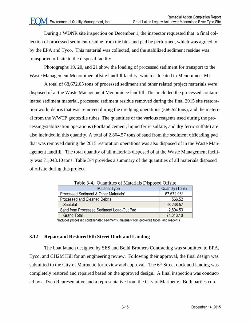
During a WDNR site inspection on December 1, the inspector requested that a final col-
lection of processed sediment residue from the bins and pad be performed, which was agreed to
by the EPA and Tyco. This material was collected, and the stabilized sediment residue was
transported off site to the disposal facility.
Photographs 19, 20, and 21 show the loading of processed sediment for transport to the
Waste Management Menominee offsite landfill facility, which is located in Menominee, MI.
A total of 68,672.05 tons of processed sediment and other related project materials were
disposed of at the Waste Management Menominee landfill. This included the processed contam-
inated sediment material, processed sediment residue removed during the final 2015 site restora-
tion work, debris that was removed during the dredging operations (566.52 tons), and the materi-
al from the WWTP geotextile tubes. The quantities of the various reagents used during the pro-
cessing/stabilization operations (Portland cement, liquid ferric sulfate, and dry ferric sulfate) are
also included in this quantity. A total of 2,804.57 tons of sand from the sediment offloading pad
that was removed during the 2015 restoration operations was also disposed of in the Waste Man-
agement landfill. The total quantity of all materials disposed of at the Waste Management facili-
ty was 71,043.10 tons. Table 3-4 provides a summary of the quantities of all materials disposed
of offsite during this project.
Table 3-4. Quantities of Materials Disposed Offsite Material Type Quantity (Tons)
Processed Sediment & Other Materials* 67,672.05*
Processed and Cleaned Debris 566.52
Subtotal 68,238.57
Sand from Processed Sediment Load-Out Pad 2,804.53
Grand Total 71,043.10 *Includes processed contaminated sediments, materials from geotextile tubes, and reagents
3.12 Repair and Restored 6th Street Dock and Landing
The boat launch designed by SES and Beihl Brothers Contracting was submitted to EPA,
Tyco, and CH2M Hill for an engineering review. Following their approval, the final design was
submitted to the City of Marinette for review and approval. The 6th Street dock and landing was
completely restored and repaired based on the approved design. A final inspection was conduct-
ed by a Tyco Representative and a representative from the City of Marinette. Both parties con-

Remedial Action Completion Report Environmental Quality Management, Inc. Great Lakes Legacy Act Lower Menominee River Tyco Site
3-16 December 14, 2015
firmed the work was performed in accordance with the approved design, and the repair work
was approved.
3.13 Placement of Subaqueous Cover Material
In March of 2015 EPA amended the Menominee River AOC Remediation project SOW
with modification 002, which required placement of a subaqueous cover in selected portions of
the river. Modification 002 required placement of subaqueous cover material in the turning basin
and transition area over those areas of glacial till that exceeded post dredging arsenic concentra-
tions of >20ppm. The subaqueous cover placement work was completed between May 12 and
June 25, 2015. Cover material preparation (i.e., blending), placement, and verification were all
performed in accordance with the project specifications and the approved cover placement work
plan. The subaqueous cover consisted of a sand/activated carbon mixture. The following subsec-
tions describe the cover material requirements and procedures used for blending, placement, and
verification of the cover materials.
3.13.1 Cover Placement Requirements
The design cover required a minimum placement of 10 inches of sand cover (average of
12 inches thick) with 0.77 pound per square foot of activated carbon. As detailed in the EQM
Cover Placement Work Plan, an alternative material that was more readily available and less ex-
pensive than the AquaGate + PAC (10%) was used. The alternate material, Granulated Activated
Carbon (GAC) supplied by Calgon Carbon, met the objectives and specifications for the cover
placement effort [Specification Section 11 54 00, Part 1.02B]. (See Figure 6, Cover Elevations
in Appendix A.)
3.13.2 Turbidity Control, Monitoring, and Contingency BMPs
Our proposed environmental protection procedures related to the cover placement opera-
tions were compliant with contract requirements, and they were designed to minimize the migra-
tion of cover materials outside of the cover placement area. Our project management team, Site
Environmental Controls Manager, and cover placement equipment operators developed Best
Management Practices (BMPs) for the Menominee River cover placement operation to control

Remedial Action Completion Report Environmental Quality Management, Inc. Great Lakes Legacy Act Lower Menominee River Tyco Site
3-17 December 14, 2015
turbidity levels and to protect local water quality and the local flora and fauna. EQM also em-
ployed monitoring procedures to observe turbidity levels and the migration of the turbidity/cover
materials during installation, and developed specific contingencies that were employed if turbid-
ity became an issue. Turbidity was created in the water column during cover placement opera-
tions due to introduction of the cover material into the water column. The objective of our BMPs
was two-fold: 1) minimize the level of turbidity in the water column at any given time to the
greatest degree practical, and 2) minimize migration of the cover materials outside of the cover
placement work areas. See Photograph 22 - Deploying turbidity curtain.
The primary BMP for containing the migration of cover materials during the placement
operation was the use of a mobile turbidity barrier (also referred to as a “Moon Pool”) that was
designed and constructed specifically for the Menominee cover placement operation. The tur-
bidity barrier was attached to the front of the working barge and also to the side of the material
scow for stability. Cover materials were placed over the surface of the river within the perimeter
of the barrier. The final turbidity barrier design, size, and attachment strategy was developed to
maximize turbidity control without inhibiting either the cover placement operation (i.e., the de-
sired casting and fanning out effect of spreading the sand) or the cover performance results (i.e.,
the desired cover thickness). EQM and SES used this Moon Pool structure approach to control
turbidity levels as seen in Photographs 23 and 24, Moon Pool.
The primary design, construction, and operational features of the turbidity barrier/moon
pool were as follows:
The mobile barrier was secured to a rigid 16-in. HDPE pipe to create a 40-ft-wide by 30-ft-
long “Moon Pool.”
The barrier was deployed to fully contain the cover placement work area extending through
the top 1/3 to 1/2 of the water column to promote cover material settling and to minimize
downstream migration of cover materials. The turbidity barrier length was adjustable to ex-
tend to a depth between 10 and 15 feet in the water column.
Cover material was placed only from inside the Moon Pool.
The Moon Pool was maintained in place for the duration of the cover placement operation
within the specific area where the cover was placed, and the barrier was not relocated to the
next work area until the cover material was sufficiently settled to the river bottom and water
quality returned to background levels.
The turbidity barrier material was constructed of a Type 3 impermeable heavy-duty fab-
ric. Other barrier fabric specifics were as follows:

Remedial Action Completion Report Environmental Quality Management, Inc. Great Lakes Legacy Act Lower Menominee River Tyco Site
3-18 December 14, 2015
22-oz PVC-coated polyester fabric membrane
Dual 5/16-in. coated top tension cable
12-in.-dia. EPS foam floatation
Reinforced anchor points for post anchoring
3/8-in. upper ballast chain installed 2 ft above lower ballast chain
3/8-in. lower ballast chain
Reefing lines
Tool-free aluminum top-end connectors/lacing skirt
Adjustable length between 10 and 15 feet with 2 ft sandbag tail per WDNR specifications.
In addition to the mobile turbidity barrier BMP, several operational BMPs were also used
to control turbidity levels and migration. These include the following:
Release material only over the intended cover placement zone and within the perimeter of the
turbidity barrier structure described above.
Avoid overloading the clam bucket when taking cover material from the material barge.
Use controlled swings of the clam bucket to eliminate unnecessary spillage.
Release the cover material near the water surface (approximately 1 ft or less) to minimize
splashing and to maximize faster settling of the cover material through the water column.
(This approach allowed the excavator operator to make clear visual observations of the
placement process and turbidity levels.)
The operator controls the speed of the material entering the water by slowly opening the
bucket and releasing the material.
Cover material was not placed during heavy thunderstorms or high wind events because
these events and related changes in river conditions (i.e., flow rate and volume) may increase
turbidity levels and the migration of cover materials outside of the cover placement work ar-
ea.
3.13.3 Cover Material Delivery, Blending, and Placement
Three basic operations were performed in connection with the cover placement task: 1)
cover material delivery and staging; 2) cover material blending; and 3) loading, transport and
placement of the blended cover material.
Cover Material Delivery and Staging—Prior to beginning cover blending and placement
operations, the cover sand material was sampled and tested, and results were provided to EPA
for review. Material specifications were also provided for the sand and GAC materials. Testing
results and specification data were approved and the sand and GAC materials were ordered. Sand
and granular activated carbon were delivered to the coal dock located on Tyco’s property. The
procedures and restrictions described in the Menominee project Traffic Route and Control Plan
were followed for all deliveries. The GAC was delivered and placed into large totes, and soaked

Remedial Action Completion Report Environmental Quality Management, Inc. Great Lakes Legacy Act Lower Menominee River Tyco Site
3-19 December 14, 2015
with water for 1-2 hours. Mixing bins were constructed at the coal dock. Prior to starting the
actual cover placement operations, the mixing pad and bin were sized based on a batch test. Re-
sults of the batch test were used to refine the blending operations and to ensure the specified sand
and carbon ratio requirements were met.
Material Blending—The sand and GAC materials were blended to the proper design mix
ratios and other specifications using a long-reach excavator at the staging area located at the Ty-
co coal dock. Two (2) mixing bins were used, each holding 250 CY of sand. Based on a con-
version factor of 1.6 for sand, each bin was loaded with 400 tons of sand. Then 2 supersacks or
4,000 lbs GAC was added to each bin and mixed with the long-reach excavator. This was based
on 10 pounds of GAC per ton of sand. Once the sand and GAC were blended together, the mix-
ture became a single-phase granular product. Then the initial (pre-specified) mat of sand was
placed within the confines of the bin. The saturated GAC from the totes were added on top of
the initial mat of sand. The remaining sand was added to maintain the required material ratios.
The contents of the bin were mixed with a loader and consolidated into a larger pile. The Site
QA Manager and the blending and placement operators made continuous visual observations
during the blending, transport, and placement operations to ensure that the blended material pos-
sessed the desired homogeneity at all steps in the operation. If any materials were observed not
to be homogeneous, those materials were not placed, but returned to the mixing operation for re-
blending.
Loading/Transport and Placement—The blended cover material was mechanically load-
ed into hopper scows. The two 100-CY scows were transported by tug to the cover placement
barge. A 2.5-CY clamshell bucket mounted on a long-reach excavator was positioned on a 60-ft
by 40-ft spud barge. The sand scow was positioned for placement, and then the long-reach exca-
vator was used to remove the blended cover material from the scow and mechanically place the
cover material The barge-mounted excavator was guided by a real-time kinematic (RTK) GPS
system to place the cover material.
The positioning system for the excavator was the Hypack Dredgepack system with a few
modifications. The position and heading of the excavator was determined by RTK GPS. An
RTK base station was established at the project site in order to provide consistent corrections for
the various equipment and survey vessels on the project. The total positional accuracy of the en-

Remedial Action Completion Report Environmental Quality Management, Inc. Great Lakes Legacy Act Lower Menominee River Tyco Site
3-20 December 14, 2015
tire system at the clam bucket lip was capable of being achieved to within approximately 3-6
centimeters.
During the cover placement process the operator conducted a visual inspection to ensure
the mixture was uniform throughout the barge. Cover materials were released at the water sur-
face so the operator could visually see how much material was coming out of the bucket at one
time. The operator slowly opened the bucket to release the materials, and then gently swung the
bucket to distribute the material over a small area. See Photographs 25 and 26 for cover place-
ment.
3.13.4 Cover Placement Verification - Pan Testing and Pre-/Post-Cover
Bathymetric Surveys
Cover thickness was verified using a variety of methods, including the initial “pan”
method, which was to be the primary cover placement verification method. Pans were 2 ft by 2
ft by 1 ft in dimension, and were placed on the bottom of the area to receive cover material (pans
were weighted so they would sink through the water column). After placement of the material,
the pans were retrieved using a cable to verify the thickness of material placed. A minimum of
two pan checks were performed per 5,000 sq. ft. of cover placed. If a pan was retrieved and re-
sults indicated that the required thickness specification (minimum thickness of 10 inches) had
not been met, then the entire 5,000-sq. ft. area represented by the pan was assumed to be defi-
cient by the observed shortage. After verification of cover shortages, the additional cover mate-
rial was placed in the general location of the pan check. (See Figures 27a, b, and c, Pan Testing.)
Interim bathymetric survey results from surveys performed on May 18 and 19 revealed
that the pan verification method was not providing accurate consistent results and alternate
methods (e.g., bathymetric surveys) were used to provide additional verification information.
The extent and thickness of the final cover was further verified by comparing the pre-
placement bathymetric survey and the post-placement bathymetric survey results and correlating
these results to the pan method results. The pre-cover bathymetric survey was completed by Hy-
drographics. As noted above, actual cover placement work began in early May, and continued
through early June. Interim surveys were taken by SES in May 2015. Initial cover placement
was completed in early June and a post placement survey was conducted on 6/2/15 by SES. All
bathymetric survey data and the data from the supplemental thickness measurement techniques

Remedial Action Completion Report Environmental Quality Management, Inc. Great Lakes Legacy Act Lower Menominee River Tyco Site
3-21 December 14, 2015
were transmitted to the EPA electronically. When applicable, data was provided in raw and pro-
cessed formats. Survey field notes were scanned and also provided electronically.
Due to potential issues in verifying the thickness of the initially placed cover in early
June, EPA required that additional cover material be added. Additional cover material was
placed in those areas that EPA did not approve as completed. Verification testing continued to
be performed during June, and results were provided to EPA for approval. SES performed daily
surveys on the additional cover placement effort between 6/17/15 and 6/25/15. The final cover
placement work was completed on June 24, and the thickness verification results were provided
to EPA.
The pan and bathymetric survey measurements of cover thickness were not the only
method of confirming cover thickness. The placement bathymetric survey was used as a general
guide to identify areas where the cover was potentially thin, but possible errors associated with
bathymetry surveys precluded its sole use to determine cover thickness. The thickness of the
cover layer was also verified by analyzing weight tickets and density estimates for the GAC and
sand materials.
In addition to the cover placement confirmatory testing procedures described above,
Specification 11 54 00-7, 3.03 required the collection of core samples from the placed cover to
confirm that the vertical and horizontal tolerance requirements had been met. Following consid-
erable discussion related to the cover placement information provided by EQM and SES, EPA
decided to perform diver-assisted core sampling to verify cover placement thickness; based on
these results, EPA identified certain areas where it asserted that the minimum cover thickness
specification (10 inches) was not met.
The delay in cover placement from the end of the 2014 construction season to the late
spring of 2015 appeared to have created several circumstances that affected the placement and
verification of the cover material. The second effort (or additional placement of cover material)
was performed with daily bathymetric survey support verifying the required cover thickness was
present. Daily bathymetric survey support during the second effort was a major change from the
cover placement operation approved by the EPA in the EQM/SES Cover Placement Operation
Plan.
Final post-placement bathymetric survey results and other cover thickness verification
data (material balance data and pan test results) were submitted on a daily basis during the

Remedial Action Completion Report Environmental Quality Management, Inc. Great Lakes Legacy Act Lower Menominee River Tyco Site
3-22 December 14, 2015
placement of additional cover material as work progressed. Final cover placement work was
completed on June 25, 2015, and the final survey results and material quantity data were provid-
ed to EPA. EPA accepted the final cover placement work on June 26, and the final approved
quantity reported was 12,867 SY.
3.13.5 Decontaminate and Demobilization
At the completion of the cover placement work, the specific equipment used during activ-
ities was decontaminated and demobed in accordance with project specifications and all applica-
ble project plans. All landside equipment used for the preparation and loading of the cover mate-
rial and all marine equipment used in the placement of the cover material were properly decon-
taminated. Following inspection and approval of the decontaminated equipment, all items were
immediately demobed from the project site.
3.14 Control/Removal of Vegetative Invasive Species
On May 12, 2015, EPA informed EQM that it intended to add additional work to the Me-
nominee project that involved the treatment, cutting, and removal of vegetative invasive species.
EQM submitted a technical and cost proposal for this new work on June 23, 2015. Revisions 1
and 2 to our proposal were submitted on July 23, 2015 (added removal and disposal of the cut
grasses in certain areas) and August 13, 2015 (updated cost proposal to include specific bid pric-
ing provide by EQM’s specialty vendor), respectively.
Preliminary work performed included the development of Technical and Cost proposal
(including related revised proposals), specialty vendors selections, project team and property
owner coordination, community involvement and right-to-know, and obtaining the WDNR
WPDES Permit. The planning and preconstruction efforts for the invasive species work contin-
ued during early September. Initial treatment of the invasive species grasses began the week of
September 21, 2015. The spraying of herbicide chemical treatment on the undesirable grass was
completed in 8 work days. The chemical treatment effort was followed by mechanical cutting of
the sprayed vegetation in November. Removal of cut grasses was completed on November 23,
2015.

Remedial Action Completion Report Environmental Quality Management, Inc. Great Lakes Legacy Act Lower Menominee River Tyco Site
3-23 December 14, 2015
The vegetation control work was performed in designated areas within the 32-acre wet-
land and riparian areas of the project site. Any other invasive species co-occurring with the Gi-
ant Reed Grass (Phragmites australis) in the designated control area was also targeted for spot
chemical treatment. The invasive species were removed/controlled within the designated man-
agement areas with the goal of eradicating the identified populations to provide long-term con-
trol and removal of populations of the species.
Per the technical specifications, a final report summarizing the invasive species work per-
formed was prepared and is included as Appendix G of this RACR.
3.15 Installation of Rip Rap
During operations in the Turning Basin, parts of the toe supporting the vertical barrier
wall were removed. Rip rap was placed to maintain the support of the vertical barrier wall in are-
as where sediment was removed. The rip rap stone was procured based on the specifications
listed in the Tyco composite Specs Section 31 23 23, Part 2.05, Rip Rap. Rip rap was placed in
two phases. The first phase was completed by stockpiling the stone on the process pad and plac-
ing the stone with a long-reach excavator from the edge of the process pad area. The second
phase was completed by loading the rip rap into a scow and placing the stone from a working
barge with a long-reach excavator from the water. Placement of the rip rap elevations was veri-
fied by the actual placement of each excavator bucket. The rip rap placement met the objectives
and specifications for the placement effort [Specification Section 31 23 23, Part 2.05]. Figure 7
presents the Rip Rap Placement Elevation Final Map for the approved final design.
3.16 Demobilization and Site Restoration
Planning for the initial November 2014 decontamination and demobilization was con-
ducted during October 2014. Equipment activities for the 2014 construction season were per-
formed in November and December 2014. Following completion of dredging activities on No-
vember 17, decontamination and dismantling efforts were initiated for some of the temporary
facilities. On November 20, the extreme cold weather conditions caused major problems with
decontamination efforts.

Remedial Action Completion Report Environmental Quality Management, Inc. Great Lakes Legacy Act Lower Menominee River Tyco Site
3-24 December 14, 2015
During January 2015, the remaining equipment and personnel were demobilized for the
2014 construction season, except the pugmills which remained onsite. All of the equipment used
during the dredging and sediment processing operations and the water treatment operations was
decontaminated, tested and demobed from the site. Because of the below-freezing temperatures,
the water could no longer be used as a decontamination agent. The EQM/SES field team utilized
the best available techniques to decontaminate the facility (including shifting to dry techniques);
however, personnel were not able to completely decontaminate the entire site at the end of the
2014 construction period. The decontamination of the remaining bin walls and the asphalt pad
was completed in 2015, when weather conditions improved. Photograph 28 shows truck decon-
tamination during the loading-out process. Photograph 29 shows the decontamination of bin
walls.
Final decontamination and site restoration resumed in mid-April 2015 following remobi-
lization back to the site. The site restoration plan is included as Figure 8 in Appendix A. Upon
arriving on site, crews immediately started to decontaminate bin walls, Jersey barriers, equip-
ment, and the process pad. After the items were cleaned, they were staged for testing. Tyco’s
engineer collected wipe samples on all items scheduled to leave the site. As soon as testing re-
sults were received and the items were cleared to be removed, items were transported off site.
The following provides a summary of site restoration and demobe work performed:
Jersey Barriers (approximately 500 ) - 33% tested and removed from the site
Bin Walls (approximately 10+) - 100% tested and removed
Water containment structures and catch basins - 100% tested and removed
Truck Scale, Tire Wash, and Scale House Building - 100% tested and removed
Haul Road between 6th & 8th Street - 100% tested and removed
6th Street Guard Building and Temporary Fencing - 100% tested and removed
Water Treatment Plant Pipeline - 100% tested and removed
Process Pad and Truck Turnaround Area - 100% cleaned and tested
Frac Tanks and Conex Boxes -100% tested and removed
Heavy Equipment (not needed for cover placement work) - 100% tested and removed
Bin Walls (25+) - tested and removed
Storage Boxes -100% tested and removed
Temporary Fencing (8th Street Entrance) - 100% tested and removed
Permanent Fencing (6th Street Entrance) - 100% tested and removed
Asphalt Ramps on Process Pad - 100% tested and removed
6th Street Guard House - removed
6th Street Area -
– Filled in sumps and paved over with asphalt

Remedial Action Completion Report Environmental Quality Management, Inc. Great Lakes Legacy Act Lower Menominee River Tyco Site
3-25 December 14, 2015
– Removed curbing along west end of parking lot and graded toward river bed to support
water drainage
– Removed transformer and electrical wiring
– Removed silt fence
– Graded and seeded areas on west, north, and southwest of parking lot, see Photograph 30
– Patched and filled cracks in asphalt paving in areas needing repair as outlined by the City
of Marinette
– Restored the launch
– Installed shipwreck display
– Removed silt fence
– Added paint markings for parking spaces
– Demobilized guard trailer
8th Street Site-
– Removed three site trailers
– Started the asphalt paving and repairs on the process pad and associated areas
– Demobilized barges, boats, and other heavy equipment utilized for the cover placement
operations
Coal Dock Area
– Removed excess cover sand
– Removed blocks and mats, and cleaned area
– Restored storm water outfall at coal dock
Repaired fencing along 8th Street Haul Road and Building 59 parking lot
Repaired wetlands area including grading and hydroseeding, see Photograph 31
Installed fencing along sea wall (wetlands, truck turnaround, and salt vault riverfront area)
Removed turbidity curtain in South Channel at Odgen St
Repaired Coal Dock Haul road
Restored “No Anchoring” signs at Coal Dock and 8th Street Slip
Removed all contractor signs at Stanton St, 8th & 6th Street
General site cleanup
Cleaned base of Ship Wreck sign on 6th Street (removed hydroseeding overspray)
Cleaned asphalt from well covers on processing pad
Repaired two damaged tie rods at sea wall
Continued crack filling on coal dock area and truck turnaround area
Decontamination was completed in all work zone areas including the processing pad, and
all equipment not scheduled to be utilized for remaining work tasks has been demobilized from
the site. The EPA Legacy Project Team members inspected these areas, and all work and areas
have been approved. Final site restoration and demobilization was completed during September
2015, with the exception of the Control/Removal of Vegetative Invasive Species. Following the
final site inspection, any punch-list items were addressed in the September.

Remedial Action Completion Report Environmental Quality Management, Inc. Great Lakes Legacy Act Lower Menominee River Tyco Site
3-26 December 14, 2015
3.17 Repair and Site Restoration of Tyco Sediment Processing Asphalt Pad
As noted previously, EPA added additional repair and restoration work for the Tyco as-
phalt processing pad site under Modification 005. This modification specified the final repair
and restoration requirements for the asphalt processing pad located at the Tyco project property
site. This pad was an existing asphalt structure on the Tyco property, which had been used for
the staging, treatment (solidification), and load-out of the sediment dredged from the Menominee
River. No repairs were performed on the pad following completion of the Tyco/SES remediation
contract work at the end of the 2013 construction season.
The field work for this portion of the project began after all dredging, sediment pro-
cessing, and off-site disposal of the processed sediment were complete. This restoration and re-
pair work was performed from July 2015 to September 2015. Work was performed in accord-
ance with the Asphalt Paving Repair and Restoration Plan submitted to EPA. The primary work
tasks included: work planning and coordination with EPA and Tyco; removal of overlayment
asphalt (i.e., asphalt stripping) in selected areas of the pad that had been placed in the area of the
processed sediment storage bins; asphalt patching and crack repairs; milling the surface of the
pad to prepare it for the surface top coat layer; placement of the asphalt top coat layer; and work
inspection and approval. The means and methods employed to complete these work tasks are
described below.
3.17.1 Work Planning and Coordination Activities
Work planning and coordination activities included:
meetings and conference calls with EPA, WDNR and Tyco to review the work scope and ar-
eas, work schedule and working hours, site access requirements and compliance with Tyco
health and safety requirements, etc.;
solicitation of a qualified asphalt vendor; and,
coordination with the Tyco engineer in regards to review and approval of work performed.
Once work began daily meetings were held with Tyco and Tyco’s engineer to review
completed and planned work, the schedule, and any issues that may have arisen. Work progress
was documented in Daily Work Reports and included photographic documentation.

Remedial Action Completion Report Environmental Quality Management, Inc. Great Lakes Legacy Act Lower Menominee River Tyco Site
3-27 December 14, 2015
3.17.2 Removal of Asphalt Overlayment
All asphalt overlayment that was placed during site preparation activities was stripped
from the pad using hand tools and where necessary a skid steer with forks. The removed material
was stockpiled onsite and eventually combined with the material removed during the milling
process and then transported to an offsite recycling facility.
3.17.3 Asphalt Patching and Crack Repairs
There were 12 areas within the processing pad area and related project work areas which
required patching and crack repairs as outlined in the attachment A drawing provided with the
EPA task order modification.
All areas requiring asphalt repair prior to milling had the edges saw cut to provide a clean
and fully adhered asphalt joint. Areas of substantial cracking and damage were removed to at
least the top of the gravel or paving sub base of the original asphalt surface. Exposure of the sub
base was necessary to assess the integrity and determine if sub base removal and replacement
was also required. All removed areas were saw-cut to provide a straight edge for repair.
Areas with minor cracking and damage outside the process pad area (e.g., the truck turna-
round area, coal dock area, Building 59 parking lot, and the 8th Street Slip area) were patched
and sealed in accordance with project specification 32 12 16, paragraph 3.0.
3.17.4 Milling of process pad surface
The process pad area was milled to a minimum of 1.5 inches. A commercial grade mill-
ing machine was used for this process. The milled material was trucked offsite to a local asphalt
recycling facility (Northeast Asphalt Plant).
The process pad consists of 3 distinct areas (salt vault, 8th street slip and seawall apron),
and each of these areas have specific slopes requirements to allow for proper water drainage
from all areas. The milling process was conducted so that when the top coat was applied these
critical slopes were maintained. In the salt vault area the slope was maintained to drain to the
west into the existing outfall drain. Care was taken to insure the 8th street slip area was sloped to
the east into the river. The sea wall apron area slope was maintained to insure drainage to the
north into the river.

Remedial Action Completion Report Environmental Quality Management, Inc. Great Lakes Legacy Act Lower Menominee River Tyco Site
3-28 December 14, 2015
3.17.5 Top Coat Surface
A new top coat layer minimum of 1.5 inches thick was placed over the entire outlined ar-
ea in accordance with asphalt paving specifications 32 12 1. The asphalt top coat was applied to
produce a smooth surface and to prevent water pooling in uneven areas. A tack coat and sealing
of edges was also required. The area requiring new asphalt was approximately 275,000 square
feet as determined by the project engineer. The new top coat was applied to the height of the sea
wall so water can drain directly into the river. Some areas needed to be filled before applying the
top coat to maintain proper slopes and drainage. A total of 2,010.25 tons were placed during the
top coating operation.
3.17.6 Work Inspection and Approval
Prior to beginning work, a site walk was conducted to review the work areas, scope,
schedule and the work performance requirements and expectations. All phases of work were in-
spected daily by EQM, Tyco and the project engineer prior to the start of the next stage of work.
Work progress and work quality were reviewed with EPA during regularly scheduled conference
calls. Written and photographic documentation of work was provided with the Daily Project Re-
ports and Monthly Project Reports. A final site walk and inspection was conducted with EPA,
WDNR, and Tyco, and the final asphalt repair and restoration work was approved by all in-
volved parties.

Remedial Action Completion Report Environmental Quality Management, Inc. Great Lakes Legacy Act Lower Menominee River Tyco Site
4-1 December 14, 2015
4. PERFORMANCE STANDARDS AND
CONSTRUCTION QUALITY CONTROLS
This section presents a summary of the performance standards and construction quality
control results.
4.1 Construction Quality Assurance/Quality Control Program
The Construction Quality Assurance/Quality Control (QA/QC) program used throughout
the remedial action was defined in the approved Contractor Construction Quality Assurance
Project Plan (CCQAPP) and Construction Quality Control Plan (CQCP). Specific quality con-
trol procedures are outlined in Section 4.3 of this RACR. In order to ensure collected data was
of known and acceptable quality, the EQM Team prepared a project-specific CCQAPP. The
CCQAPP provided: guidelines to be followed by the EQM Team to complete the remedial action
by describing samples that the EQM Team was to collect during the remedial action: how the
samples were to be analyzed; and how the results were to be evaluated. The CCQAPP also de-
fined the QA/QC measures that would be applied to ensure that the data obtained were of the
type and quality needed to meet remedial action objectives.
Several items were used to obtain quality objectives including, but not limited to: Inspec-
tion Lists (preparatory, initial, follow-up), Check Lists, Daily Reports, and daily reports of quali-
ty control activities.
4.2 Summary of Sediment Excavations
A summary of sediment dredge volumes is presented in section 3.4. As indicated, actual
quantities removed varied from the estimated quantities presented in the engineering estimate.
The total volume of “approved” sediment removed was 41,010 CY [36,713 CY initially dredged
and 4,297 CY re-dredged (including the 6,725 CY over-dredge allowance)] of soft sediment and
SCM contaminated material was removed during the project. Dredge volumes were calculated
in accordance with the site-specific SOP included in the CQCP and the specifications referenced

Remedial Action Completion Report Environmental Quality Management, Inc. Great Lakes Legacy Act Lower Menominee River Tyco Site
4-2 December 14, 2015
in the Dredging and Operations Plan and presented in Appendix D. Dredge performance was
evaluated in accordance with the applicable EQM task order SOW, the project specifications,
and the associated Project Work Plans developed for the project site. The summary of the sedi-
ment volumes is listed in Table 4-1.
Table 4-1. Summary of Sediment Dredge Volumes by Area and Material Type
Dredge Area Sediment Type
Dredge Volumes (CY)
Initial Redredge Total
Transition Area & Turning Basin Soft Sediment & SCM 31,976 4,297 36,273
South Channel Soft Sediment 4,737 0 4,737
Total Soft and SCM 36,713 4,297 41,010* *(including the 6,725 CY over-dredge allowance)
4.3 Quality Control Procedures
Operations were performed in accordance with the approved CQCP. The on-site EQM
Team monitored operations for compliance with the approved CCQAPP and CQCP. Daily
checks were performed to ensure that control activities were providing continued compliance
with contractual requirements and were recorded daily. The EQM Team prepared a Daily Re-
port including the Daily Quality Control Summary Report (DQCSR) for each day work was per-
formed. (For mobilization and demobilization periods, reports were reduced to weekly with
USACE and EPA concurrence.) The DQCSRs were submitted to the on-site EPA Representa-
tive for review and concurrence. Copies were also posted on the project ShareFile site. See Ap-
pendix H for daily reports including DQCSRs.
4.3.1 Sediment Dredging
Sediment dredging work activities associated with the handling, stabilization, staging,
testing, and offsite transportation and disposal of mechanically dredged materials were complet-
ed according to the requirements identified in the Specifications. Quality control procedures for
quantifying dredged material consisted of daily dredging progress monitoring. Dredging was
monitored with onboard dredge positioning systems. All marine and landside heavy equipment
used for sediment off-loading and transport were inspected on a regular basis, and required
maintenance was performed to keep all equipment in a safe and effective operating condition.
The Site Superintendent and Site Foreman performed daily inspections of the silt curtain and oil

Remedial Action Completion Report Environmental Quality Management, Inc. Great Lakes Legacy Act Lower Menominee River Tyco Site
4-3 December 14, 2015
boom around the dredge plant. The dredge plant equipment and other major equipment were al-
so inspected on a daily basis, and various scheduled and unscheduled maintenance was per-
formed as required. All marine vessels (tugs, work/push boats, etc.) and scows were inspected
regularly, and maintenance and repairs were performed as required.
4.3.2 Bathymetric Surveys
Bathymetric surveys were performed for pre- and post- dredging in addition to pre-cover
placement by Hyrdographics. Additional surveys were completed by SES to confirm data. All
surveys were done in accordance with the Section 31 20 25.23 of the specifications and the site-
specific Standard Operating Procedure (SOP) included in the CQCP. The surveyors confirmed
survey control points at the project site, to within < 0.05’ accuracies, using RTK-GPS survey
equipment. The survey control points were utilized to provide positioning and surveying QA/QC
during the project and as otherwise needed. To further assure RTK-GPS accuracy and reliability,
the team utilized a “base station”, which transmitted continuous, highly accurate RTK-GPS cor-
rections to the survey grade RTK-GPS rover onboard the survey vessel.
Bathymetric surveys were generally performed without USACE oversight. The bathymet-
ric surveyor reported any deviations or concerns noted during surveying activity. The EQM/SES
On-site CQC Officer provided daily monitoring and documentation for EPA review and QA/QC
verification. All survey-related data was transferred to the TOCOR for sediment volume verifi-
cation. A calculation check was performed by the onsite engineer, CH2M Hill. EQM’s inde-
pendent surveyor and Project CQC Officer were available to EPA to review, discuss, and recon-
cile all data related to cover thickness measurements. Details regarding the bathymetric surveys
were discussed previously in sections 3.6 and 3.13. Photographs 34 and 35 illustrate the QC sur-
veys.
4.3.3 Phase Inspections
Preparatory, Initial, and Follow-up Phase Inspections were performed for major work op-
erations. Preparatory inspections were performed prior to beginning any fieldwork, including
with the approved project documents. Initial inspections were performed for each definable fea-
ture of work after the preparatory inspection and immediately following the start of the work.
Observations were made during the early phases of the field work and continued until a repre-

Remedial Action Completion Report Environmental Quality Management, Inc. Great Lakes Legacy Act Lower Menominee River Tyco Site
4-4 December 14, 2015
sentative portion of the activities were accomplished. Follow-up inspections were performed
continuously by the on-site EQM Team, with oversight and review performed by the EPA On-
site Representative. See Appendix I for inspections.

Remedial Action Completion Report Environmental Quality Management, Inc. Great Lakes Legacy Act Lower Menominee River Tyco Site
5-1 December 14, 2015
5. FINAL INSPECTION
All final site decontamination, restoration, and demobilization were conducted in accord-
ance with the requirements contained in the project specifications and plans. Following comple-
tion of all required restoration activities, project equipment was removed and work sites were
inspected. This section provides a summary of final site inspection and approval activities.
5.1 Punch-List Development
The EPA/WDNR/Tyco On-site Representative and the EQM Team established various
punch lists for final site restoration and demobilization activities near the conclusion of the 2015
dredging activities. Progress on the various restoration and punch-list activities was tracked via
daily discussion, inspections of completed work (as necessary), and weekly progress meetings.
The EQM team completed the punch-list items prior to final demobilization from the various
project work sites. The following summarizes the process:
The On-site Representative and the EQM Team established various punch lists.
A list of deficiencies was included, and by an estimated date the deficiencies were corrected.
A second inspection was completed to assert that all deficiencies had been corrected.
Appendix J presents the final punch-list.
5.2 Site Work Inspections and H&S Audits
Site inspections were conducted on a regular basis throughout the performance of project
work. Inspections were conducted during the major initial mobilization efforts in 2014 and
2015. Prior to the start of work on any new tasks or before work was initiated in a new area, in-
spections were conducted. Major equipment such as the dredge plants, sediment transport, and
turbidity curtains were inspected on a daily basis. Inspection activities and results were docu-
mented in the field files. The EQM site specific Health and Safety Audit was completed in No-
vember 2014. No major issues or health and safety violations were observed during this audit.

Remedial Action Completion Report Environmental Quality Management, Inc. Great Lakes Legacy Act Lower Menominee River Tyco Site
5-2 December 14, 2015
5.3 Final Close-Out Inspections
After each major task, a Final Inspection was conducted by EQM’s Quality Control In-
spection personnel plus the EQM Site Superintendent and the GLNPO TOCOR. A Pre-Final
Punch List was developed as a result of the Pre-Final Inspection. Following the final site inspec-
tion, any punch-list items remaining were addressed during the next reporting period. During
November the final site inspection and punch-list was completed. (See Appendix J).

Remedial Action Completion Report Environmental Quality Management, Inc. Great Lakes Legacy Act Lower Menominee River Tyco Site
6-1 December 14, 2015
6. OPERATION AND MAINTENANCE ACTIVITIES
No warranties or operation and maintenance activities were required under the EQM
Lower Menominee River Remediation project. EPA, GLNPOCS, WDNR, and others will track
results under the GLNPOCS contracts and Tyco site efforts.

Remedial Action Completion Report Environmental Quality Management, Inc. Great Lakes Legacy Act Lower Menominee River Tyco Site
7-1 December 14, 2015
7. CONTACT INFORMATION
Table 7-1 lists the primary project contacts and their contact information.
Table 7-1. Primary Project Contact Information EPA GLNPOCS Menominee Project Contacts List
USEPA
Heather Williams, TOCOR 312-886-5993 [email protected]
Brenda Jones, Alternate TOCOR 312-886-7188 [email protected]
Sheila Dolan, Contracting Officer 312-886-1521 [email protected]
Tyco
Guard Shack 715-735-3888
Larry Wilson 561-479-9744 [email protected]
WDNR
Cheryl Bougie 920-662-5170 [email protected]
Kristin Dufresne 920-662-5443 [email protected]
James Killian 608-264-6123 [email protected]
City of Marinette
Brian Miller 715-732-5132 [email protected]
Environmental Quality Management, Inc.
Gary Acquaro, Site Superintendent 315-368-7687 [email protected]
Brian Deskins, H&S Technician 513-926-1955 [email protected]
Jack Greber, Program/Project Manager 513-659-2509 [email protected]
John Kominsky, GLNPOCS H&S Coordinator 513-310-4473 [email protected]
Lee Foley – Corporate H&S Officer 910-850-8315 [email protected]
Jackie Doan – Corporate and GLNPOCS QAQC 513-673-4210 [email protected]
Sevenson Environmental Services, Inc.
Paul Jung – Safety and Health Manager 716-284-0431(o) [email protected]
Michael Crystal – Program Manager 716-284-0431 (o) [email protected]
Mark Schmitt – Project Manager 716-923-5638 (cell) [email protected]
Dan Dragonette – Site Superintendent 716-609-0571 (cell) [email protected]
Steven Wilson – Site Safety Officer 716-609-2521 (cell) [email protected]
Tim Donegan – Project Engineer 443-928-7813 [email protected]
Engineer, CH2M
George Hicks 812-946-1669 [email protected]
Heather Ziegelbauer 262-644-6167 [email protected]
Jeff Danko 414-847-0386 [email protected]
Other
US Coast Guard, Sturgeon Bay, WI 920-743-3367 NA
Wisconsin DNR Spill Hotline 800-943-0003 NA
National Response Center 800-424-8802 NA
Public Utility Locator, WI One-call center 811 or 800-242-8511 NA
CHEMTREC 800-424-9300 NA

Remedial Action Completion Report Environmental Quality Management, Inc. Great Lakes Legacy Act Lower Menominee River Tyco Site
8-1 December 14, 2015
8. REFERENCES
CH2M Hill 2014. Tyco Composite Specifications, July 2014
CH2M Hill 2014. Sediment Construction Completion Report, March 2014
EQM 2014. Environmental Quality Management, Inc. Health, Safety, and Environmental Re-
sponse Plan, Lower Menominee River Tyco Site, Wisconsin. (Revised September 2014).
EQM 2014. Environmental Quality Management, Inc. Construction Quality Control Plan, Lower
Menominee River Tyco Site, Wisconsin. (Revised September 2014).
EQM 2014. Environmental Quality Management, Inc. Dredging/Operations Plan, Lower Me-
nominee River Tyco Site, Wisconsin. (Revised September 2014).
EQM 2014. Environmental Quality Management, Inc. Survey Plan, Lower Menominee River
Tyco Site, Wisconsin. (Revised September 2014).
EQM 2014. Environmental Quality Management, Inc. Turbidity & Resuspension Management
Plan, Lower Menominee River Tyco Site, Wisconsin. (Revised September 2014).
EQM 2014. Environmental Quality Management, Inc. Waste Management Plan, Lower Menom-
inee River Tyco Site, Wisconsin. (Revised September 2014).
EQM 2014. Environmental Quality Management, Inc. Material Stabilization Plan, Lower Me-
nominee River Tyco Site, Wisconsin. (Revised September 2014).
EQM 2014. Environmental Quality Management, Inc. Traffic Routing & Control Plan, Lower
Menominee River Tyco Site, Wisconsin. (Revised September 2014).
EQM 2014. Environmental Quality Management, Inc. Contingency Plan, Lower Menominee
River Tyco Site, Wisconsin. (Revised October 2014).
EQM 2014. Environmental Quality Management, Inc. Onsite Fueling & Spill Containment Plan,
Lower Menominee River Tyco Site, Wisconsin. (Revised October 2014).
EQM 2014. Environmental Quality Management, Inc. Dust Control & Monitoring Plan, Lower
Menominee River Tyco Site, Wisconsin. (Revised October 2014).

Remedial Action Completion Report Environmental Quality Management, Inc. Great Lakes Legacy Act Lower Menominee River Tyco Site
8-2 December 14, 2015
EQM 2014. Environmental Quality Management, Inc. Environmental Spill Response Plan, Low-
er Menominee River Tyco Site, Wisconsin. (Revised October 2014).
EQM 2014. Environmental Quality Management, Inc. Erosion Control and Storm Water Man-
agement Plan, Lower Menominee River Tyco Site, Wisconsin. (October 2014).
EQM 2014. Environmental Quality Management, Inc. Cover Placement Work Plan, Lower Me-
nominee River Tyco Site, Wisconsin. (Revised April 2015).
EQM 2014. Environmental Quality Management, Inc. Cover Placement Work Plan, Lower Me-
nominee River Tyco Site, Wisconsin. (Revised April 2015).
Tyco Fire Products LP, Site Access Agreement, Tyco Site. Signed September 5, 2014.
USEPA 2014. GLNPOCS, Contract No. EP-R5-11-04 Task Order 005. August 27, 2014
USEPA 2014. Request for Task Order Proposal SOL-R5-14-00008, July 14, 2014
WDNR 2012. Hazardous Waste Variance. July 3, 2012
WDNR 2014. Hazardous Waste Variance, Modification Extension. Signed January 24, 2014

Remedial Action Completion Report Environmental Quality Management, Inc. Great Lakes Legacy Act Lower Menominee River Tyco Site
December 14, 2015
APPENDIX A
FIGURES

FIGURE 1 Lower Menominee River Area of Concern
FIGURE 2 Tyco Facility and GLLA Project Area

545
550
550
550
550550
550
550
550
550
550550
550
550
550
550
550
550
550
550
550
550
550
550
555555
555
555
555 555
555
555
555
555
555555
555
555
555
555
555
555
555
555
555
555
555
555
555
555
555
555
555
555
555
555
555
555
555
555
555
555
555
555
55555
5
555
555
555
555
555
555
555
555
555
555
555
555
555
555
555
555
555
555
555
555
555555
555
555
555
555
555
555 555
555
555
555
555
560
560
560
560
560
560560
560
560
560
560
560
560
560
560
560560
560
560
560
560
560
560
560
560
560
560
560
565
565
565
565565
565
565
565
565
565
565
565
565
565
565
565
565
565
565
565
565
565
565
570
570
570
570
570
570
570
570
570
570
570
570
570
570
570
570
570
570
570
570
570
570
570
570
570
570
570
575
575
575
575
575
575
575
575
575
575
575
575
575
575
575
575
575
575
575 575
575
575
575
575
575
575
575
575
575
575
575
575575
575
575575
575
575
575 575
575
575
575575
575
575
575
575
575575
575
575
575
575
575
575
575
575
575
575
575
575
575
575
575
575
575
575
575
575
575
575
575
575
575
V E S S E L M O O R E D
V E S S E L M O O R E D
PIPE
PIPE
TANKS
TANKS
TANKS
TANKS
GAGE BOARD
CONC
SLAB
TANK
PIP
E
WALL
WALL
73-15
73-20
35-L
73-18
73-14
73-17
73-11
N 469000 N 469000
N 470000N 470000E 2
585000
E 2
586000
E 2
587000
E 2
588000
89-3
COMPANYCONSTRUCTION
KRYGOSKI
STORAGE AREA
STORAGE AREA
MENOMINEE
RIVER
TANKS
OPEN STORAGE
OPEN STORAGE
MENOMINEE
OG
DE
N
ST
RE
ET
OG
DE
NS
TR
EE
T
89-4
89-2
N 468000
N 469000
N 470000
E 2
589000
E 2
589000
V E S S E L M O O R E D
73-7
169°21’12"
161°43’29"
FILENAME: PLOT DATE: PLOT TIME:2014\05\20 11:55:29 AM
CH
2M HIL
L 2
011. A
LL RIG
HTS R
ES
ER
VE
D.
CH
2M HIL
L A
ND IS N
OT T
O B
E U
SE
D, IN W
HO
LE O
R I
N P
AR
T, F
OR A
NY O
TH
ER P
ROJE
CT W
ITH
OU
T T
HE W
RIT
TE
N A
UT
HO
RIZ
ATIO
N O
F C
H2
MHIL
L.
THIS D
OC
UM
EN
T,
AN
D T
HE I
DE
AS A
ND D
ESIG
NS I
NC
OR
PO
RA
TE
D H
ER
EIN,
AS A
N I
NS
TR
UM
EN
T O
F P
RO
FE
SSIO
NA
L S
ER
VIC
E, IS T
HE P
RO
PE
RT
Y O
FR
EU
SE O
F D
OC
UM
EN
TS:
1 2 3 4 5 6
B
C
D
VERIFY SCALE
BAR IS ONE INCH ON
ORIGINAL DRAWING.
1"0
c
PROJ
DATE
DA
TE
NO.
DS
GN
DR
RE
VISIO
N
CH
K
AP
VD
BY
AP
VD
SHEET
DWG
A
of
GR
EA
T L
AK
ES L
EG
AC
Y A
CT
LO
WE
R M
EN
OMIN
EE RIV
ER T
YC
O SIT
E
SE
DIM
EN
T R
EM
OV
AL P
ROJE
CT
MA
RIN
ET
TE,
WIS
CO
NSIN
US E
PA G
LN
PO, T
YC
O FIR
E P
RO
D A
ND W
DN
R
115+00
120+00
125+00
130+00
135+00
140+00
145+00
150+00
197+00
193+25193+25
194+00
195+00
196+00
198+00
199+00
200+00
201+00
202+00
203+00
204+00
205+00
206+00
207+00
208+00
209+00
210+00
211+00
212+00
213+00
214+00
215+00
216+00
217+00
218+00
219+00
220+00
221+00
222+00
223+00
224+00
225+00
226+00
227+00
228+00
229+00
230+00
231+00
232+00
233+00
234+00
235+00
236+00
237+00
0 150 300 450
SCALE IN FEET
N
PI S
TA 2
28+89.3
8
TURNING BASIN
SOUTH C
HAN
NEL
TRANSITION AREA
MAIN CHANNEL
CL MAIN CHANNEL
(CL MAIN CHANNEL)
STA 147+50, 350’ LT
PI STA 200+00 =
MENOMINEE RIVER
NAVIGATION CHANNEL
BOUNDARY OF FEDERAL
473274
CIVIL
1"=150’
2014/05/14
GENERAL SHEET NOTES
2.
1.
1983 (NAD83), US FOOT.
CENTRAL ZONE (4802), NORTH AMERICAN DATUM
COORDINATE SYSTEM, LAMBERT PROJECTION,
REFERENCED TO THE WISCONSIN STATE PLANE
THE COORDINATE GRID SYSTEM SHOWN IS
MICHIGANWISCONSIN
OG
DE
N S
TR
EE
T
WATER STREET
8T
H S
TR
EE
T
6T
H S
TR
EE
T
EXIS
TIN
G SIT
E P
LA
N
R T
RA
VE
R
PA
RKIN
G A
RE
A
6T
H S
TR
EE
T S
LIP
SALT VAULT
FORMER
BOAT LAUNCH
6TH STREET
WALL
SHEET PILE
EXISTING
BUILDING 59
EXISTING
(NOT IN USE)
RAILROAD BRIDGE
G B
OW
LE
SG HIC
KS
R S
TR
YK
ER
FO
RM
ER 8
TH S
TR
EE
T S
LIP
LD-F-03.dgn
UTILITY CORRIDOR
CITY OF MARINETTE
FIG 3
FIG
UR
E 3
NO
T F
OR BID - F
OR I
NF
OR
MA
TIO
N O
NL
Y
KEWAUNEE AREA OFFICE.SERVICES, OPERATIONSTECHNICAL SUPPORT BRANCH,CORP OF ENGINEERS.ENGINEERING & TECHNICAL AVAILABLE FROM THE DETROIT DISTRICT OF US ARMYSURVEY CONTROL AND BENCH MARK DATA IS
RIPRAP AREA
EXISTING
LOCATION
SHIP WRECK
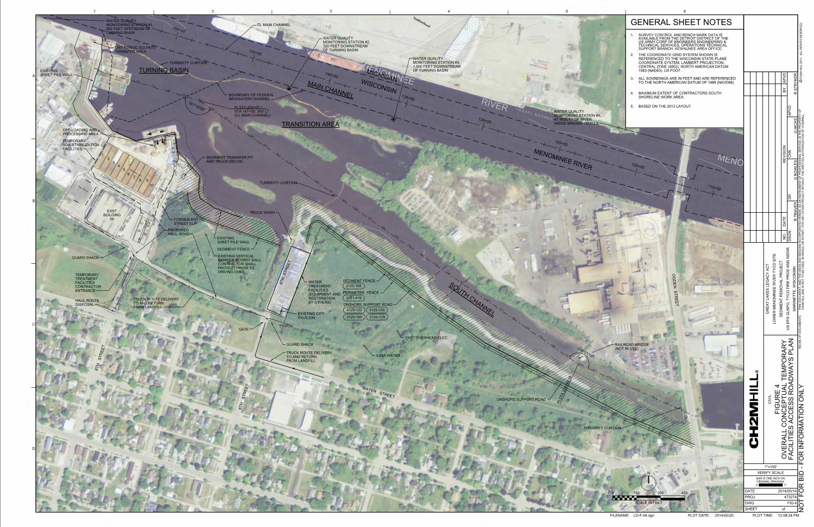
Geotube
Geotube
Geotube
Geotube
Tank
Mix
Trailer
Office
Pavilion
City
Tank
Equalization
Tank
Equalization
Tank
Equalization
Trailer
Filtration
Micro
Tank
Draw & Fill
Trailer
RO
Reject
Filtration
Micro
Tank
Reject
RO
Tank
Water
Reject
VSEP
Ro
Trailer
Secondary
P
P
P
PSu
mp
Injection
Chemical
Wall
Contain
ment
Second
Ra
mp
Drive
way
Ra
mp
Drive
way
Curb
Drive over
Product
Water
RO
&
VESP
PTo
Outfall
Inje
ctio
n
Che
mic
al
P
Frac
Tank
Sedim
ent Pad
Fro
m
Building
VSEP Unit
Water
Reje
ct
Water
Product
Water
Product
P
Tank
Mix
Su
mp
Su
mp
Su
mp
Te
mp.
Fence
Te
mp Fence
football field fe
nce
Te
mp.
Fence
inlet
Te
mp.
Fence
Te
mp.
Fence
C/L Old RR
C/L Old RR
Sidewalk
Sidewalk
inlet
C/L
C/L
Gate
Asphalt
Drive
Asphalt
Drive
Asphalt
Drive
Asphalt
Drive
Football Field fe
nce
Water St.80’ wide
Right of way line
Rig
ht of
way line
David
Wiltzius
Lot
8th St. (66’
wid
e)
David
Wiltzius
Lot
Fd c
ap/pin
SW cor
Wiltzi
us L
ot
66’ wide
V E S S E L M O O R E D
V E S S E L M O O R E D
PIPE
PIPE
TANKS
TANKS
TANKS
TANKS
GAGE BOARD
TANK
PIP
E
WALL
WALL
73-15
73-20
35-L
73-18
73-14
73-17
73-11
N 469000 N 469000
N 470000E 2
585000
E 2
586000
E 2
587000
E 2
588000
89-3
COMPANYCONSTRUCTION
KRYGOSKI
STORAGE AREA
STORAGE AREA
MENOMINEE
RIVER
TANKS
OPEN STORAGE
MENOMINEE
OG
DE
N
OG
DE
NS
TR
EE
T
89-4
89-2
N 468000
N 469000
E 2
589000
V E S S E L M O O R E D
73-7
169°21’12"
161°43’29"
Excavator
Guard Shack
Ramp
Truck Loading Area
Wash Tank
HDPE Pipe for WWTP
Scale
Truck
House
Scale
Wash
Truck
Scale
Truck
Wash
Truck
Truck Route
Sevenson Trailer
Lab Trailer
Office Trailer
Office Trailer
Conf. Trailer
CRZ
Containment Bins
Screen
Screen
Pug
mill
#2
Pug
mill
#1
Silo
Silo
Tank
Tank
Tank
Tank
Pig
Pig
Excavator
Emergency Access
12’
Decon
Truck
Crew Parking
X
X
X
X
X
X
X
X
X
X
X
X
XX
X
X
X
X
X
X
X
X
X
X
X
Widen entrance road
Pig
Tank
Tank
CR
Z
Water
Stora
ge
Tank
Water
Stora
ge
Break Trailer
Health & Safety
0
40
80
120
115+00
120+00
125+00
130+00
135+00
140+00
145+00
150+00
232+00
193+25193+25
194+00
195+00
196+00
197+00
198+00
199+00
200+00
201+00
202+00
203+00
204+00
205+00
206+00
207+00
208+00
209+00
210+00
211+00
212+00
213+00
214+00
215+00
216+00
217+00
218+00
219+00
220+00
221+00
222+00
223+00
224+00
225+00
226+00
227+00
228+00
229+00
230+00
231+00
233+00
234+00
235+00
236+00
237+00
FILENAME: PLOT DATE: PLOT TIME:2014\05\20 12:08:24 PM
CH
2M HIL
L 2
011. A
LL RIG
HTS R
ES
ER
VE
D.
CH
2M HIL
L A
ND IS N
OT T
O B
E U
SE
D, IN W
HO
LE O
R I
N P
AR
T, F
OR A
NY O
TH
ER P
ROJE
CT W
ITH
OU
T T
HE W
RIT
TE
N A
UT
HO
RIZ
ATIO
N O
F C
H2
MHIL
L.
THIS D
OC
UM
EN
T,
AN
D T
HE I
DE
AS A
ND D
ESIG
NS I
NC
OR
PO
RA
TE
D H
ER
EIN,
AS A
N I
NS
TR
UM
EN
T O
F P
RO
FE
SSIO
NA
L S
ER
VIC
E, IS T
HE P
RO
PE
RT
Y O
FR
EU
SE O
F D
OC
UM
EN
TS:
1 2 3 4 5 6
B
C
D
VERIFY SCALE
BAR IS ONE INCH ON
ORIGINAL DRAWING.
1"0
c
PROJ
DATE
DA
TE
NO.
DS
GN
DR
RE
VISIO
N
CH
K
AP
VD
BY
AP
VD
SHEET
DWG
A
of
GR
EA
T L
AK
ES L
EG
AC
Y A
CT
LO
WE
R M
EN
OMIN
EE RIV
ER T
YC
O SIT
E
SE
DIM
EN
T R
EM
OV
AL P
ROJE
CT
MA
RIN
ET
TE,
WIS
CO
NSIN
US E
PA G
LN
PO, T
YC
O FIR
E P
RO
D A
ND W
DN
R
0 150 300 450
N
PI S
TA 2
28+89.3
8
TURNING BASIN
SOUTH C
HAN
NEL
TRANSITION AREA
MAIN CHANNEL
CL MAIN CHANNEL
(CL MAIN CHANNEL)
STA 147+50, 350’ LT
PI STA 200+00 =
MENOMINEE RIVER
NAVIGATION CHANNEL
BOUNDARY OF FEDERAL
473274
CIVIL
1"=150’
2014/05/14
GENERAL SHEET NOTES
2.
3.
1.
1983 (NAD83), US FOOT.
CENTRAL ZONE (4802), NORTH AMERICAN DATUM
COORDINATE SYSTEM, LAMBERT PROJECTION,
REFERENCED TO THE WISCONSIN STATE PLANE
THE COORDINATE GRID SYSTEM SHOWN IS
MICHIGANWISCONSIN
OG
DE
N S
TR
EE
T
WATER STREET
8T
H S
TR
EE
T
6T
H S
TR
EE
T
HAUL ROAD
PROPOSED
R T
RA
VE
R
DISPOSAL
HAUL ROUTE
59
BUILDING
EXST
STREET SLIP
FORMER 8TH
PERIMETER FENCE
GUARD SHACK
GATE
1
23
45
67
8 9
10
3125-155
3125-160 3125-170
ONSHORE SUPPORT ROAD
SEDIMENT FENCE
SHEET PILE WALL
EXISTING
SEDIMENT FENCE
3231-410
3125-165
3125-132
SHEET PILE WALL
EXISTING
OF TURNING BASIN
320 FEET DOWNSTREAM
MONITORING STATION #2,
WATER QUALITY
OF TURNING BASIN
1,000 FEET DOWNSTREAM
MONITORING STATION #3,
WATER QUALITY
SCALE IN FEET
(NOT IN USE)
RAILROAD BRIDGE
FACILITIES
SOIL STABILIZATION
TEMPORARY
INSIDE BREAKER WALLS
AT MOUTH OF RIVER
MONITORING STATION #4,
WATER QUALITY
DRIVING OVER
PROTECT PRIOR TO
CONTRACTOR SHALL
BARRIER SLURRY WALL,
EXISTING VERTICAL
ENTRANCE
CONTRACTOR
FACILITIES
TREATMENT
TEMPORARY
4.
SHORELINE WORK AREA.
MAXIMUM EXTENT OF CONTRACTORS SOUTH
EXST WATER
EXST OVERHEAD ELEC
ONSHORE SUPPORT ROAD
6T
H S
TR
EE
T
FROM LANDFILL
TO AND RETURN
TRUCK ROUTE DELIVERY
FROM LANDFILL
TO AND RETURN
TRUCK ROUTE DELIVERY
G B
OW
LE
S
GUARD SHACK
PAVILION
EXISTING CITY
G HIC
KS
R S
TR
YK
ER
PROCESSING AREA
OFF-LOADING AND
LD-F-04.dgn
FIG 4
OV
ER
ALL C
ON
CE
PT
UA
L T
EM
PO
RA
RY
FA
CILITIE
S A
CC
ES
S R
OA
DW
AY
S P
LA
N
FIG
UR
E 4
TURBIDITY CURTAIN
TURBIDITY CURTAIN
TURBIDITY CURTAIN
TURNING BASIN
800 FEET UPSTREAM OF
MONITORING STATION #1,
WATER QUALITY
TRANSFER AREA
DRY FERIOC SULFATE
AND TRUCK DECON
SEDIMENT TRANSFER PIT
TRUCK WASH
NO
T F
OR BID - F
OR I
NF
OR
MA
TIO
N O
NL
Y
TO THE NORTH AMERICAN DATUM OF 1988 (NAVD88)
ALL SOUNDINGS ARE IN FEET AND ARE REFERENCED
5. BASED ON THE 2013 LAYOUT.
SUPPORT BRANCH, KEWAUNEE AREA OFFICE.TECHNICAL SERVICES, OPERATIONS TECHNICAL US ARMY CORP OF ENGINEERS ENGINEERING & AVAILABLE FROM THE DETROIT DISTRICT OF THE SURVEY CONTROL AND BENCH MARK DATA IS
BY OTHERS)
RESTORATION
(EQUIPMENT AND
FACILITIES
TREATMENT
WATER

54554
5
54555
0
550
550 550
550
550
550
550
550
550
550
550
550
550
550
550
550
550
550
550
550
550
550
550
550
550
550
550
550
550
550
550
550
550
550
550
550
550
550
550
55055
0
550
550
550
550
550
550
550
550
550550
550
550
550
550550
550
550
550
550
550
550
550550
555
555
555
555
555
555
555
555
555
555
555
555
555
555
555
555
555
555
555
555
555
555
555
555
555
555
555
555
555
555
555
555
555
555
555
555
555
555
555
555
555
555
555
555
555
555
555
555555
555
555
555
555
555
555
555
555
555
555
555
555
555
555
555
555
555
555
555
555
555
555
555
555
555
555
555
555
555
555
555555
555
555
555
555
555
555
555555
555
555
555
555
555
555 555
555
555
555
555
555
555
555
555
555
555
555
555
555
555
555
555
555
555 555
555
555
555
555
555
555
555
555
555
555
555
555
555
555
555
555
555
555
555
555
555
555
555
555
555
555
555
555
555
555
555
555
555
555
555
555
555
555
555
555
555
555
555
555
555
555
555
555
555
555
555
555
555
555
555
555
555
555
555
555
555
555
555
555
555
555
555
555
555
555
555
555
555
555
555
555
555
555
555
555
555
555
555
555
555
555
555
555
555
555
555
555
555
555
555
555
555
555
555
555
555
555
555
555
555
555
560
560
560
560
560
560
560
560
560
560
560
560
560
560
560
560
560
560
560
560
560
560
560560
560
560
560
560
560
560
560
560
560
560
560560
560
560
560
560
560
560
560
560
560
560
560
560
560
560
560
560
560
560
560
560
560
560
560
560
560
560
560
560
560
560
560
560
560
560
560
560
560
560
560
560
560
560
560
560
560
560
565
565
565
565
565
565
565
565
565
565
565
565
565
565
565
565
565
565
565
565
565
565
565
565
565
565
565
565
565
565
565
565
565
565
565565
565
565
565
565
565
565
565
565
565
565
565
565
565
565
565
565
565
565
565
565
565
565
565
565
565
565
565
565
565
565
565
565
565
570
570
570
570
570
570
570
570
570
570
570
570
570
570
570
570
570
570
570
570
570
570570
570
570
570
570
570
570
570
570
570
570
570
570
570
570
570
570
570
570
570
570
570
570
570
570
570
570570
570
570
570
57057
0
570
570
570
570
570
570
570
570
570
570
570
570
570
570
570
570
575
575
575
575
575
575
575
575
575
575
575
575
575
575
575
575
575
575
575
575
575
575
575
575
575
575
575
575
575
575
575
575
575
575
575
575
575
575
575
575
575
575
575
575
575
575
575
575
575
575
575
575
575
575
575
575
575
575
575
575
575
575
575
575
575
575
575
575
575
575
575
575
575
575
575
575
575
575
575
575
580
V E S S E L M O O R E D
73-15
35-L
73-14
73-11
89-5
MENOMINEE
73-7
140+00
145+00
150+00
155+00
160+00
4
5
6 7
8
9
10
11
12
13
14
550 552
552
552
552
552
554
554
554
554
554 554
554
554
554
554
556
562
564
566
566
568
570
572
574
576
576
564
566
566
568
568
568
570
570
572
572574
574 576
576
576
578
574
574
574
576
576
576
576
576
576
576
576
576
578
568570
570
570
572
572
574
566
568
568
570
570
570
572
574
2
3
1B2
A2
A3
A4
A5
A6
A7
B3
B4
B5
B6
B7
C2
C3
C4
C5
C6
C7
C8
D2
D3
D4
D5
D6
D7
D8
E2
E3
E4
E5
E6
E7
E8
F2
F3
F4
F5
F6
F7
F8
G1
G2
G3
G4
G5
G6
G7
H1
H2
H5
H6
I1
I2
I6
I7
J3
J4
J6
J7
J8
K5
K6
K8
K9
L10
L11
L6
L8
M10
M12
M6
N11
N12
O12
P12
Q12
R12
R8
S14
S15
S7
VBW001
VBW002
VBW003
VBW004
VBW005
VBW006
VBW007
VBW008
VBW009
VBW010
VBW011
VBW012
VBW013
VBW014
VBW015
VBW016
VBW017
VBW018
VBW019
VBW020
H3-2
H4-2
I3-2
I4-2
I5-2
J5-2
K7-2L7-2
M11-2
M8-2
M9-2
N9-2
Q11-2
S11-1
S12-2
S13-1
H3-1
H4-1
I3-1
I5-1
J5-1
K7-1
L7-1
M7-2
M7-1
M8-1
M9-1
N10-2
L9-1
O11-2
O11-1
P11-2
P11-1
Q11-1
R11-2
S12-1
N
0 200 400 600
Scale In Feet
LEGEND
TOE OF RIPRAP
BULKHEAD
NAVIGATIONAL CHANNEL / TURNING BASIN
LIMITS OF 20ppm SOFT SEDIMENT REMOVAL
1 FOOT CONTOUR
VERTICAL REFERENCE IS TO THE NORTH AMERICAN DATUM OF 1988 (NAVD88).AND PROJECTED ON THE WISCONSIN STATE PLANE COORDINATED SYSTEM (CENTRAL ZONE). FIGURES ARE REFERENCED HORIZONTALLY TO THE NORTH AMERICAN DATUM OF 1983 (NAD83) NOTE:
NOT FOR BID - FOR INFORMATION ONLY
LOWER MENOMINEE RIVER TYCO SITE
GREAT LAKES LEGACY ACT
SOFT SEDIMENT 20ppm DREDGE ELEVATIONS
TURNING BASIN AND TRANSITION AREAS
FIGURE 5A

575
575
575
575
575
575
575
575
575
575
575
575
575
575
575
575
575
575
575
575
575
575
575
575
575
575
575
575
575
575
575
575
575 575
575
575
575
575
575
575
575
575
575
575
575
575
575
575
575
575
575
575
575
575
575
575
575
575
575
575
575
575
575
575
575
575
575
575
575
575
575
575
575
575
575
575
575
575
575
575
575
575
575
575
575
575
575
575
575
575
575
575
575
575
575
575
575
575
575
575
575
575
575
575
575
575
575
575
575
575
575
575
575
575
575
73-17
89-3
MENOMINEE
OG
DE
NS
TR
EE
T
89-4
115+00
120+00
125+00
15
18
19
20
21 22
24
25
576
576
17
16A
16B
16C
16D
574
574
574
574
576
576
576
576
576
572
574
574
574
576
578
574
578
576
576
576
576
576
576
AA02
BB02 CC02
DD02FF01
FF02
GG01
HH01
KK01
KK02
LL01
MM01
MM02
NN02 OO01
OO02 PP02
QQ02
RR01
SS02
TT02
UU01WW01
AA01-2
BB01-2
CC01-2
DD01-2
EE01-2
EE02-2
HH02-3II01-2
II02-2
JJ01-2
JJ02-2
NN01-2
RR02-2 SS01-2
VV01-2
BB01-1
CC01-1
DD01-1EE01-1
EE02-1
II01-1
JJ01-1
JJ02-1
NN01-1
RR02-1
SS01-1
TT01-2
N
0 200 400 600
Scale In Feet
LEGEND
NAVIGATIONAL CHANNEL / TURNING BASIN
LIMITS OF 20ppm SOFT SEDIMENT REMOVAL
1 FOOT CONTOUR
VERTICAL REFERENCE IS TO THE NORTH AMERICAN DATUM OF 1988 (NAVD88).AND PROJECTED ON THE WISCONSIN STATE PLANE COORDINATED SYSTEM (CENTRAL ZONE). FIGURES ARE REFERENCED HORIZONTALLY TO THE NORTH AMERICAN DATUM OF 1983 (NAD83) NOTE:
NOT FOR BID - FOR INFORMATION ONLY
LOWER MENOMINEE RIVER TYCO SITE
GREAT LAKES LEGACY ACT
SOFT SEDIMENT 20ppm DREDGE ELEVATIONS
SOUTH CHANNEL AREA
FIGURE 5B

54554
5
54555
0
550
550 550
550
550
550
550
550
550
550
550
550
550
550
550
550
550
550
550
550
550
550
550
550
550
550
550
550
550550
550
550
550
550
550
550
550
550
550
550
55055
0
550 5
50
550
550
550
550
550
550
550
550
550
550
550550
550
550
550
550
550
550
55055
0
550
555
555
555
555
555
555
555
555
555
555
555
555
555
555
555
555
555
555
555
555
555
555
555
555
555
555
555
555
555
555
555
555555
555
555
555
555
555
555
555
555
555
555
555
555555
555
555
555
555
555
555555
555555
555
555
555
555
555
555
555
555
555
555
555
555
555
555
555
555
555
555
555
555
555
555
555
555
555
555
555
555
555 555
555555
555
555
555
555
555
555
555
555 555
555
555
555
555
555
555
555
555
555
555
555
555
555
555
555
555
555
555 5
55 555
555
555
555
555
555
555
555555
555
555
555
555
555
555
555
555
555
555
555
555
555
555
555
555
555
555
555
555
555
555
555
555
555
555
555
555
555
555
555
555
560
560
560
560
560
560
560
560
560
560
560
560
560
560
560
560
560
560
560
560
560
560
560
560
560
560560
560
560
560
560
560
560560
560
560
560
560
560
560
560
560
560
560
560
560
560
560
560
560
560
560
560
560
560
560
565
565
565
565
565
565
565
565
565
565
565
565
565
565
565
565
565
565
565
565
565
565
565
565
565
565
565
565565565
565
565
565
565
565
565
565
565
565
565
565 565
565
565
565
565
565
565
565
565
565
565
565
565
565
565
565
565
565
570
570
570
570
570
570
570
570
570
570
570
570
570
570
570
570
570
570570
570
570
570
570
570
570
570
570
570
570
570
570
570
570
570
570
570
570
570
570
570
570
570
570
570
570
570
570570
570
570
570
570
570
570
570
570
570
570
570
570
570
570
570
570
570
575
575
575
575
575
575
575
575
575
575
575
575
575
575
575
575
575
575
575
575575575
575
575
575
575
575
575
575
575
575
575
575
575
575
575
575
575
575
575
575
575
575
575
575
575
575
575
575
575
575
575
575
575
575
575575
575
575
575
575
575
575
575
575
575
575
575
575
575
575
575
575
575
575
575
580
V E S S E L M O O R E D
PIPE
PIPE
TANKS
TANKS
TANKS
TANKS
PIP
E
WALL
WALL
35-L
73-11
140+00
145+00
150+00
A
B
C
D
E
F
G
H
550 550
550
550
552
552
552
552
552
552
552
552
552
554
554
556
558
560
562
548
54854
8
550
550
550
550
550
550
550
552
552
552
552
552
552
554
554
554
554
554
554
556
556
556
556
558
560
560
560
562
562
562
562
562
562
564
564
564
564
564
564
566
566 568
570
570
570 572
574
574
576
556
556
558
560
562 564
564
566
566
568
570
B2A2
A3
A4
A5
A6
A7
B3
B4
B5
B6
B7
C2
C3
C4
C5
C6
C7
C8
D2
D3
D4
D5
D6
D7
D8
E2
E3
E4
E5
E6
E7
E8
F2
F3
F4
F5
F6
F7
F8
G1
G2
G3
G4
G5
G6
G7
H1
H2
H5
H6
I1
I2
I6
I7
J3
J4
J6
J7
J8
K5
K6
K8
K9
L10
L11
L6
L8
M10
M12
M6
N11
N12
O12
P12
Q12
R12
R8
S14
S15
S7
VBW001
VBW002
VBW003
VBW004
VBW005
VBW006
VBW007
VBW008
VBW009
VBW010
VBW011
VBW012
VBW013
VBW014
VBW015
VBW016
VBW017
VBW018
VBW019
VBW020
H3-2
H4-2
I3-2
I4-2
I5-2
J5-2
K7-2L7-2
M11-2
M8-2
M9-2
N9-2
Q11-2
S11-1
S12-2
S13-1
H3-1
H4-1
I3-1
I5-1
J5-1
K7-1
L7-1
M7-2
M7-1
M8-1
M9-1
N10-2
L9-1
O11-2
O11-1
P11-2
P11-1
Q11-1
R11-2
S12-1
N
0 150 300 450
Scale In Feet
LEGEND
LIMITS OF SCM REMOVAL
NAVIGATIONAL CHANNEL / TURNING BASIN
BULKHEAD
1 FOOT CONTOUR
TOE OF RIPRAP
VERTICAL REFERENCE IS TO THE NORTH AMERICAN DATUM OF 1988 (NAVD88).AND PROJECTED ON THE WISCONSIN STATE PLANE COORDINATED SYSTEM (CENTRAL ZONE). FIGURES ARE REFERENCED HORIZONTALLY TO THE NORTH AMERICAN DATUM OF 1983 (NAD83) NOTE:
NOT FOR BID - FOR INFORMATION ONLY
LOWER MENOMINEE RIVER TYCO SITE
GREAT LAKES LEGACY ACT
SCM 20ppm DREDGE ELEVATIONS
TURNING BASIN AND TRANSITION AREAS
FIGURE 5C

545
550
550
550
550550550
550
550
550
550
550
550
550
550
550
550
550
550
550
555555
555
555 555
555
555
555
555
555
555
555
555
555
555555
555
555
555
555
555 555
555
555
555
555555
555 555
555 555
555 555
555555
555
555
555
555 555
555
555
555
555
555555
555 555
555
555555
555
555
555
555
555
555
555
555
555
555
560
560
560
560
560
560
560
560
560
560
560
560
560
560
560
560 560 560560 560
565
565
565
565
565
565 565
565
565
565
565
565
565
565
565565
570
570
570
570
570
570
570
570
575
575
575
575
575
575
PIPE
PIPE
TANKS
PIP
E
WALL
35-L
73-11
PIPE
PIPE
TANKS
PIP
E
WALL
35-L
73-11
0
Scale In Feet
100 200 300
N
NAVIGATION CHANNEL
TURNING BASIN
VERIFIED EXPOSED GLACIAL TILL
ELEVATION 553.50
LEGENDSD5
60
SAMPLE LOCATION (2010)
NAVIGATION CHANNEL / TURNING BASIN
VBW WALL
RIPRAP AREA
(SURVEY DATE 10/26/2013)
DREDGE CONTOUR (2’ INTERVAL)
SAMPLE LOCATION (2013)
LIMITS OF POST DREDGE SURVEY
ARSENIC CONCENTRATIONS FOR THE TOP (SURFACE) 12�OF TILL SAMPLE. TABLE LIST ONLY
AREA OF SAND COVER
LIMITS OF TILL COVER
VBW001
CHANNEL (NO COVER 92,493 SF / 2.12 AC)
AUTHORIZED DEPTH IN NAVIGATIONAL
EXPOSED GLACIAL TILL ABOVE
[A][F]
[E]
[D]
[B]
[C]
[C]
FIGURE 6
NAV CHANNEL / TURNING BASIN
COVER ELEVATION 553.50
POTENTIAL GLACIAL TILL
COVER AREA (20ppm)
GREAT LAKES LEGACY ACT
LOWER MENOMINEE RIVER TYCO SITE
NOT FOR BID - FOR INFORMATION ONLY
BASED ON NLW.
FEDERALLY AUTORIZED NAVIGATIONAL CHANNEL. NEW CHANNEL DEPTH
�TOE-BOUNDARY�AND THE 553.5 ELEVATION CONTOUR WITHIN THE
ONCE THE 20PPM EXTENT WAS DETERMINED IT WAS CLIPPED TO THE
TO DETERMINE THE 20PPM CONCENTRATION CONTOUR.
WAS LINEARLY INTERPOLATED USING GEOPAK CAD SOFTWARE
TOTAL ARSENIC DATA PRESENTED WITHIN THE ADJACENT TABLE
150+00155+00 150+00155+00
SD551
SD552
SD500
SD501
SD506HSA
SD510
SD504
SD513
SD512
SD511
SD553
SD514
SD509
SD515
SD516
SD519
SD554SD555
SD517
SD560
SD574
C8
VBW004
A7
VBW002
VBW001
A2
Figure 7. Rip Rap Placement

D
REMOVE TEMPORARY CONSTRUCTION FACILITIES: 1. DECONTAMINATE AND REMOVE ALL TEMPORARY
CONSTRUCTION FACILITIES INCLUDING ACCESS ROADS (STONE AND ASPHAL T),PIPING, JERSEY BARRIERS, WATER CONTAINMENT STRUCTURES, SCALE, DECONTAMINATION FACILITIES,STABILIZATION BAY DIVIDERS AND RELATED STRUCTURES, & GUARD BUILDINGS
2. REMOVE ALL TEMPORARY HAUL ROUTES ALONG RIVER.
3. REMOVE TEMPORARY CATCH BASINS AND RELATED PUMPS AND PIPING.
4. REMOVE TEMPORARY CONSTRUCTION SECURITY FENCING, AND THE 6TH STREET SLIP GATE.
5. REMOVE THE TEMPORARY BLOCKAGE AT THE SALT VAULT OUTLET TO ALLOW STORM WATER FLOW TO THE RIVER. (FOLLOWING SITE DECONTAMINATION)
6. REMOVE TURBIDITY BARRIERS.
1. VEGETATE DISTURBED AREAS PER SPECIFICATIONS AND IN ACCORDANCE WITH APPLICABLE PERMITS.
2. ESTABLISH AND MAINTAIN EROSION CONTROL MEASURES DURING VEGETATION ESTABLISHMENT. SEE DETAILS ( 3125-150 ),( 3125-155 ),( 3125-160 ),( 3125-165 ), AND
( 3125-170).
3. ESTABLISH AND MAINTAIN EROSION CONTROL MEASURES DURING PAVEMENT REMOVAL AND RESTORATION ACTIVITIES. SEE DETAILS ( 3125-150 ).( 3125-155 ), ( 3125-160 ),
( 3125-165 ), ( 3125-170 ) , AND ( 3125-186).
4. AFTER APPROVAL THAT NEW VEGETATION IS SUCCESSFULLY RE-ESTABLISHED, CONTRACTOR SHALL REMOVE REMAINING EROSION CONTROL MEASURES.
5. RESTORE CONCRETE BOAT RAMP AT 6TH STREET SLIP SITE.
6. RESTORE PERMANENT FENCING ALONG SHEETPILE WALL.
3 4 5
\_ REMOVE PERNETER�
CONTAIIMENT
�WATER TREATI.£NTFACILITIES
FILENAME: LD-F-07.dgn
0 Gl 0 m z
� ?fi !!:\
450
r 1 f ,
PLOT DATE: 2014105\20
w t:: CJ) I-
I- 0 0 0
� w
<C � i
«: n. w .... > :;:w ii: .... w 0
CJ) w ::; w z w " :il «::5 0 I-
8z z w w ::; ::;
«: i5 (!) «:
w w CJ)
«: 0
w
z d� Z
O
«: z 0
0 z <C 0 0 «: n. w «: ii:
0
� 6 n. z ....
w CJ)
i � >------� 0 w
,_ __ v_ E_R_I _FY_sc_A_L _E __ _,Cl
�ci��:��: ai
1-_io !!!!!!!!!�1.:_· --IC::: DATE 2014/05114 Q PROJ 473274 LL
DWG FIG? t) SHEET of
z PLOT TIME: 12:26:10 PM
Figure 8. Site Restoration Plan

Remedial Action Completion Report Environmental Quality Management, Inc. Great Lakes Legacy Act Lower Menominee River Tyco Site
December 14, 2015
APPENDIX B
PHOTOGRAPHS

Remedial Action Completion Report Environmental Quality Management, Inc. Great Lakes Legacy Act Lower Menominee River Tyco Site
December 14, 2015
Photo 1. Mobilization of the dredging barge
Photo 2. Dredging at night along the South Channel

Remedial Action Completion Report Environmental Quality Management, Inc. Great Lakes Legacy Act Lower Menominee River Tyco Site
December 14, 2015
Photo 3. Dredging
Photo 4. Dredging

Remedial Action Completion Report Environmental Quality Management, Inc. Great Lakes Legacy Act Lower Menominee River Tyco Site
December 14, 2015
Photo 5. Re-dredging in L8
Photo 6. Post Dredge Confirmation Sampling Crew

Remedial Action Completion Report Environmental Quality Management, Inc. Great Lakes Legacy Act Lower Menominee River Tyco Site
December 14, 2015
Photo 7. Post-Dredging Survey
Photo 8. Post-Dredging Survey

Remedial Action Completion Report Environmental Quality Management, Inc. Great Lakes Legacy Act Lower Menominee River Tyco Site
December 14, 2015
Photo 9. Off-loading Sediment
Photo 10. Off-loading and screening of sediment
Remedial Action Completion Report Environmental Quality Management, Inc. Great Lakes Legacy Act Lower Menominee River Tyco Site
December 14, 2015
Photo 11. Separating into debris pile
Photo 12. Dry ferric being loaded into the hopper

Remedial Action Completion Report Environmental Quality Management, Inc. Great Lakes Legacy Act Lower Menominee River Tyco Site
December 14, 2015
Photo 13. Loading Dry Ferric
Photo 14. Offloading Liquid Ferric

Remedial Action Completion Report Environmental Quality Management, Inc. Great Lakes Legacy Act Lower Menominee River Tyco Site
December 14, 2015
Photo 15. Processing sediment to bin
Photo 16. First load of sediment processed

Remedial Action Completion Report Environmental Quality Management, Inc. Great Lakes Legacy Act Lower Menominee River Tyco Site
December 14, 2015
Photo 17. Curing Process
Photo 18. Curing Process

Remedial Action Completion Report Environmental Quality Management, Inc. Great Lakes Legacy Act Lower Menominee River Tyco Site
December 14, 2015
Photo 19. Loading processed sediment for disposal
Photo 20. Loading processed sediment for disposal

Remedial Action Completion Report Environmental Quality Management, Inc. Great Lakes Legacy Act Lower Menominee River Tyco Site
December 14, 2015
Photo 21. Weighing processed material for disposal
Photo 22. Deploying turbidity curtain for cover placement

Remedial Action Completion Report Environmental Quality Management, Inc. Great Lakes Legacy Act Lower Menominee River Tyco Site
December 14, 2015
Photo 23. Moon Pool used during cover placement
Photo 24. Moon Pool used during cover placement

Remedial Action Completion Report Environmental Quality Management, Inc. Great Lakes Legacy Act Lower Menominee River Tyco Site
December 14, 2015
Photo 25. Cover Placement
Photo 26. Cover Placement activity in Moon Pool
Photo 27a, 27b, 27c. Pan Testing

Remedial Action Completion Report Environmental Quality Management, Inc. Great Lakes Legacy Act Lower Menominee River Tyco Site
December 14, 2015
Photo 28. Truck decontamination during the loading out process
Photo 29. Decontamination of Bin walls

Remedial Action Completion Report Environmental Quality Management, Inc. Great Lakes Legacy Act Lower Menominee River Tyco Site
December 14, 2015
Photo 30. Site Restoration: Hydroseeding at 6th Street
Photo 31. Site Restoration: Wetlands Hydroseeding

Remedial Action Completion Report Environmental Quality Management, Inc. Great Lakes Legacy Act Lower Menominee River Tyco Site
December 14, 2015
Photo 32. Milling Process Pad
Photo 33. Asphalt Paving Complete

Remedial Action Completion Report Environmental Quality Management, Inc. Great Lakes Legacy Act Lower Menominee River Tyco Site
December 14, 2015
Photo 34. QC Survey
Photo 35. QC Survey