Reinforcement to North Shropshire Electricity Distribution ...
79
Reinforcement to North Shropshire Electricity Distribution Network: 132kV Wood Pole Overhead Line from Oswestry to Wem Route Corridor Options Report June 2016
Transcript of Reinforcement to North Shropshire Electricity Distribution ...

Reinforcement to North Shropshire Electricity Distribution Network: 132kV Wood Pole Overhead Line from Oswestry to Wem
Route Corridor Options Report
June 2016

Route Corridor Options Report
PROJECT TITLE DOCUMENT TITLE
North Shropshire Reinforcement Project Route Corridor Options Report
REV DATE DETAIL AUTHOR CHECKED BY APPROVED BY
OO 23.06.2016 First Issue SG JG SE
- - - - - -
- - - - - -
- - - - - -

Route Corridor Options ReportRoute Corridor Options Report
ContentsCONTENTSSECTION 1.0 INTrOduCTION 4
SECTION 2.0 ThE PrOPOSEd PrOjECT dESIgN 7
SECTION 3.0 OuTlINE Of rOuTEINg METhOdOlOgy 10
SECTION 4.0 APPlICATION Of rOuTEINg METhOdOlOgy 15
SECTION 5.0 EvAluATION Of rOuTE COrrIdOr OPTIONS 27
SECTION 6.0 CONSIdErATION Of lOCAlISEd CONSTrAINTS 41
SECTION 7.0 CONCluSION ANd NExT STEPS 46
FIGURES4.1 Initial Study Area
4.2 Reduced Study Area and Areas of Higher Environmental Value
4.3 Technical Considerations
4.4 Location of Proposed Mid Wales 400kV Connection
4.5 Refined Study Area and Areas of Higher Environmental Value
4.6 Additional Environmental Constraints
4.7 National Landscape Character Areas
4.8 Shropshire Landscape Character Areas
4.9 Composite Constraints
4.10 Route Corridor Options
5.1 Red and Blue Route Corridor Options
6.1 Sites of Local Interest
APPENDICESA The Holford Rules
B Data Sources
C Approach to Preliminary Landscape Appraisal
D Landscape Character (Route Corridors Options)
E Consideration of Route Corridor Option 1 and Option 4
F Desk Based Ecology Study

Route Corridor Options Report4
1. INTRODUCTION
BACKGROUND
1.1 This Route Corridor Options Report sets out work carried out in 2015 and early 2016 by MWH (UK) Ltd, environmental consultants based in Cheshire, and SP Energy Networks in considering alternative route corridors for the required upgrade of the electricity supply in North Shropshire.
1.2 For reference, this report first outlines the alternative technological design solutions that have been considered for the level of reinforcement required and the reasons for SP Energy Networks preferring to install a new 132 kilovolt (kV) overhead wood pole line (hereafter referred to as the ‘proposed overhead line’) between Oswestry substation to Wem primary substation (hereafter referred to as ‘Wem substation’).
1.3 Reference is then made to the broad approach to identifying route corridor options, which is referred to below as the Routeing Methodology.
1.4 This report describes how the Routeing Methodology has been applied by first identifying a study area and then considering a range of environmental and technical matters which could constrain possible routeing options. It then explains that from this exercise, four alternative route corridors, which vary between 0.5 to over 1km wide, were identified.
1.5 This report then describes that an initial assessment of the four identified alternative route corridors resulted in two of them being discounted. The remaining two options were then considered further in order to identify a route corridor which could inform the subsequent line routeing process. This is the process which seeks to identify narrower 100m wide line route options within which the proposed overhead line could be installed. It is these line routes that are presented in initial consultations with local communities, landowners, tenants and statutory consultee bodies.
1.6 SP Energy Networks has considered placing the proposed overhead line wholly underground. Government policy acknowledges that overhead lines can generally be introduced into existing landscapes with suitable mitigation and it makes no presumption in favour of undergrounding. In this project, SP Energy Networks considers at this stage that there is no justification for undergrounding given the routeing options available.
1.7 SP Energy Networks accepts that where no suitable route for an overhead line can be identified and there are specific circumstances supporting undergrounding, then this should be considered. These circumstances include where there are technical difficulties or serious concerns about the potential adverse landscape and visual effects of an overhead line, and where the additional cost of undergrounding and any other impacts that might arise from undergrounding are outweighed by the benefits that undergrounding would have. SP Energy Networks will consider this further following the initial consultation and once a preferred line route has been identified and been assessed in more detail as part of a preliminary environmental assessment providing information on the level of any likely concerns.
LEGISLATIVE AND CONSENTING FRAMEWORK
1.8 The routeing work has developed within a context of statutory requirements and national policy referred to below.

5Route Corridor Options ReportRoute Corridor Options Report
THE ELECTRICITY ACT 1989
1.9 SP Energy Networks on behalf of SP Manweb plc, which is the holder of the statutory licence to operate the electricity network area within which this project is located, is required under the Electricity Act 1989 to cause the least disturbance to the environment. Schedule 9 of the Electricity Act 1989 imposes a statutory duty on SPM to take account of the following factors when proposing new overhead transmission lines:
‘(a) to have regard to the desirability of preserving natural beauty, of conserving flora, fauna and geological or physiographical features or special interest and of protecting sites, buildings and objects of architectural, historic or archaeological interest; and,
(b) to do what it reasonably can to mitigate any effects which the proposals would have on the natural beauty of the countryside or any such flora, fauna, features, sites, buildings or objects.’
1.10 In addition, under Section 9(2), the holder of a transmission licence has a statutory duty to develop and maintain an efficient, co-ordinated and economical system of electricity transmission/ distribution.
1.11 SP Energy Networks seeks to comply with its statutory duties by following an established approach to routeing new high voltage overhead lines.
THE PLANNING ACT 2008
1.12 The Planning Act 2008 (the 2008 Act) introduced a new consent regime for Nationally Significant Infrastructure Projects (NSIPs) in England and Wales. NSIPs, as defined in the 2008 Act, are usually large scale developments requiring a Development Consent Order (DCO).
1.13 Under the 2008 Act, electric lines installed above ground with a voltage of 132kV and of 2km or more in length are defined as NSIPs. The proposed 132kV overhead wood pole line falls within this definition and will require an application for a DCO to be submitted to the Planning Inspectorate (PINS) for examination and recommendation to the Secretary of State for a decision. The application for a DCO will include any associated development required as part of the project. The Planning Act 2008 states that such projects will be considered against national planning policies as set out in National Policy Statements.
NATIONAL POLICY STATEMENTS
1.14 National Policy Statements (NPSs) provide the primary basis for decisions taken by PINS. There are two NPSs which are of relevance to a future application for consent to build the proposed overhead line; the Overarching National Energy Infrastructure Policy NPS (EN-1) and the Electricity Network Infrastructure NPS (EN-5).
1.15 EN-1 sets out a number of general principles that should be applied in assessing different types of energy related developments. EN-5 sets out additional considerations relevant to electricity networks infrastructure. Section 2.2 of EN-5 refers to factors influencing site selection and notes that a number of engineering, environmental and landowner factors should be taken into account during

6 Route Corridor Options Report
line routeing. Section 2.3 refers to those requirements that network operators follow under the Electricity Act 1989, and Section 2.4 refers to the need to consider climate change factors such as the project’s resistance to flooding and storms. Section 2.5 then refers to the need for proposals to demonstrate good design in mitigating potential adverse impacts. Sections 2.6, 2.7, 2.8 and 2.9 deal respectively with impacts such as biodiversity, landscape and visual and noise and vibration. Finally Section 2.10 explains how consideration should be given to electro-magnetic fields (EMFs).
1.16 Paragraphs 2.8.8 to 2.8.9 set out the considerations pertaining to the issue of undergrounding.

7Route Corridor Options ReportRoute Corridor Options Report
2. THE PROPOSED PROJECT DESIGN
STRATEGIC OPTIONS APPRAISAL
2.1 As explained in a related project document and summarised below, the Strategic Options Report , SP Energy Networks has considered a number of network options for providing the required level of upgrade of the electricity system in North Shropshire.
2.2 Consideration was initially given to various technical alternatives, starting with whether the network could be upgraded by installing equipment designed to manage customer need requirements within existing substations. This option was discounted because although it would have limited environmental impacts, SP Energy Networks did not consider it would meet the varying customer demands with any certainty and would therefore be contrary to SP Energy Networks’ statutory obligations. Another technology option was to increase the rating of existing lower voltage 33kV circuits to provide additional supply. Although likely to result in minimal environmental impacts, this was discounted as it was unlikely to be able to provide the required supply. A further alternative was to increase the number of 33kV circuits between the substations in Oswestry, Marchwiel, Whitchurch and Wem. This was discounted as it would require a number of new overhead lines/ underground cables, which would increase costs and likely environmental impacts.
2.3 In the Strategic Options Report, SP Energy Networks then explains that consideration was given to a number of design options involving a new 132kV network. These included installing new overhead lines between substations at either Legacy near Wrexham, Marchwiel, Crewe or Shrewsbury and Whitchurch or Wem. These alternatives were discounted due to the length of new circuit required and the consequent costs and likely environmental impacts. A new circuit between Marchwiel and Whitchurch would result in a shorter length of new overhead line, but there would be likely environmental impacts from crossing or passing close to important nature conservation sites.
2.4 Finally, the alternative of taking a supply from the nearby 400kV circuits operated by National Grid plc was considered, but discounted due to the significant cost increases and likely environmental impacts.
2.5 The conclusion of the options appraisal was that the preferred design solution for upgrading the electricity supply in North Shropshire is to install approximately 22km of a new 132kV overhead line from Oswestry substation to Wem substation. Although this would require the installation of a new 132kV transformer at Wem substation, overall this is considered the best technical, environmental and cost option.
2.6 The Strategic Options Report then considered the following alternative design solutions for carrying a 132kV circuit:
• Steel lattice tower (L7 design) approximately 26m high;
• Heavy duty wood pole (with underslung earth wire) approximately 15m high; and
• Trident wood pole (no earth wire) approximately 12m high.
In this case, given the likely environmental, technical requirements and costs of these alternatives as well as the nature of the North Shropshire landscape, SP Energy Networks considers that the proposed overhead line should be based on the Trident wood pole design.

8 Route Corridor Options Report
PROPOSED OVERHEAD LINE
2.7 Oswestry substation is located to the north-east of the town close to the A5 and A495 roundabout, and Wem substation is located to the west of the town on Ellesmere Road. The area between these two substations and through which the proposed overhead line would run is mostly agricultural. The Trident wood pole design, which is lower in height and has a more slender and simple appearance than steel lattice towers or heavy duty wood poles, is a common feature in rural areas. In a landscape with a generous amount of mature tree cover, Trident wood pole structures can be screened by trees and so be less widely visible from the surrounding landscape than heavy duty wood poles and, particularly steel towers. Trident poles are also more flexible in terms of routeing around obstacles, thereby allowing a better landscape ‘fit’. Wood poles have a further advantage in that they require lesser foundations and so construction methods can be less intrusive.
2.8 The Trident line design comprises three conductors supported mainly by single poles. The spacing for these poles gives an average span of 120m. The standard above ground pole height is approximately 12m. However, the poles can be extended or reduced in height, as required, to meet safety clearance requirements or to address factors such as sloping ground. It is anticipated that this project could be delivered using mainly single poles, which have a maximum angle of deviation of 35 degrees.
2.9 Being mostly single wood poles, the design has a very limited land take. Where double poles are required this extends to approximately 3m between the two poles with a further area required for stays.
2.10 The construction phase requires working areas at each end of the line and also every few kilometres. These working areas are also used as ‘pulling points’ where the conductors (overhead wires) needs to be fixed to the wood poles. The construction corridor is typically 5m to 10m wide and access is normally gained via existing roads, farm tracks and field gates. The working area, or limits of development to be applied for in a future application for the necessary planning consents is likely to extend to between approximately 20m to 30m.
2.11 The preferred design requires modifications to Oswestry and Wem substations to connect the proposed overhead line, including the installation of a 60 megavolt amperes (MVA) grid transformer in the Wem substation. This work is permitted development (under the Town and Country Planning (General Permitted Development) (England) Order 2015). Work at Oswestry substation would be inside the existing compound and is also permitted development.
OTHER RECENT TRIDENT LINES INSTALLED IN MID-CHESHIRE AND NORTH SHROPSHIRE
2.12 The proposed wood pole Trident design would be the same as that used by SP Energy Networks in two recent projects which were installed in similar landscapes. The first of these is the Carrington to Lostock overhead line in mid-Cheshire which was installed in 2012 and the second is the Legacy (Wrexham) to Oswestry substation which was installed in 2014.

9Route Corridor Options ReportRoute Corridor Options Report
10 Route Corridor Options Report
3. OUTLINE OF ROUTEING METHODOLOGY
OVERALL APPROACH
3.1 The route corridor selection process is an iterative one which follows a series of steps with the aim of identifying a number of route corridor options that are then taken forward for consultation. The steps, which are listed in the diagram below, are followed sequentially as far as practical with each step requiring a greater level of detail of analysis, assessment and review. Each step is subject to technical review with steps being revisited if necessary as new information becomes available or in response to feedback. Site visits and refinement/ review of collated information enables each route corridor option to be continually refined and developed. During this process, route corridor options may be rejected, modified or studied in further detail.
3.2 The objective of the process is to identify the route corridor which has the least likely environmental effects whilst being technically and economically viable.
3.3 The technical review includes reviewing the route corridors in terms of likely effects on landowners and tenants and SP Energy Networks’ technical requirements for building and operating high voltage circuits.
AREAS OF HIGHEST ENVIRONMENTAL VALUE
3.4 Areas of ‘highest environmental value’ is a term taken from the Holford Rules. The Holford Rules are a series of broad principles for overhead line routeing, which were developed by the late Lord Holford in 1959 for routeing steel lattice tower lines and are generally accepted across the electricity industry as an important tool for routeing new overhead lines. The original rules were reviewed in 1992, 1997 and 2004 and these reviews provided further guidelines referred to as supplementary guidance notes. The principles relating to the routeing of steel lattice tower lines are considered applicable to routeing of smaller scale, wood pole mounted overhead lines as proposed for this project.
3.5 EN-5 refers to the Holford Rules in paragraphs 2.8.5 to 2.8.7, stating in paragraph 2.8.7 that there is a need for the deciding authority to take them into account when considering alternatives and the need for additional mitigation measures.
3.6 The Holford Rules recognise that the most likely effects of an overhead line are visual and that the degree of visual intrusion can be reduced by careful routeing, for example by utilising landform and trees to provide screening and backgrounding and by seeking to retain an appropriate distance from settlements and viewpoints. The Rules also recognise that routeing should take account of other environmental considerations by seeking to avoid the most sensitive and valued natural and man-made features.
3.7 The Holford Rules are listed in the text box. The supplementary guidance notes are contained within Appendix A.
‘Rule 1: Avoid altogether, if possible, the major areas of highest amenity value, by so planning the general route of the line in the first place, even if the total mileage is increased in consequence.

11Route Corridor Options ReportRoute Corridor Options Report
Rule 2: Avoid smaller areas of high amenity value or scientific interest by deviation, provided this can be done without using too many angle towers, i.e. the more massive structures used when lines change direction.
Rule 3: Other things being equal, choose the most direct line, with no sharp changes of direction and thus fewer angle towers.
Rule 4: Choose tree and hill backgrounds in preference to sky backgrounds wherever possible; and where the line has to cross a ridge, secure this opaque background as long as possible, and cross obliquely where a dip in the ridge provides an opportunity. Where it does not, cross directly, preferably between belts of trees.
Rule 5: Prefer moderately open valleys with woods where the apparent height of towers will be reduced, and views of the line will be broken by trees.
Rule 6: In country which is flat and sparsely planted, keep the high voltage lines as far as possible independent of smaller lines, converging routes, distribution poles and other masts, wires and cables, so as to avoid a concentration of ‘wirescape’.
Rule 7: Approach urban areas through industrial zones where they exist; and when pleasant residential and recreational land intervenes between the approach line and the substation, consider carefully the comparative costs of undergrounding, for lines other than those of the highest voltage.’
3.8 The Holford Rules are broadly hierarchical, with Rule 1 deemed the first rule to be considered in routeing. Rule 1 relates to the avoidance, where possible, of ‘major areas of highest amenity value’. In addition, Holford Rule 2 refers to avoiding ‘smaller areas of high amenity value or scientific interest by means of deviation’ i.e. recommends routeing away from smaller sized important features. Whilst the Holford Rules do not define what is meant by ‘major areas of highest amenity value’, SP Manweb interprets these as being ‘areas of highest environmental value’ and includes the following designations:
• Special Areas of Conservation (SAC);
• Special Protection Areas (SPA);
• Ramsar Sites;
• National Parks;
• National Nature Reserves (NNR);
• Sites of Special Scientific Interest (SSSI);
• Scheduled Monuments;
• Listed Buildings Grade I, II and II*;

12 Route Corridor Options Report
• Conservation Areas;
• World Heritage Sites;
• Registered Parks and Gardens; and
• Designated Landscapes.
3.9 The supplementary guidance note to Holford Rule 1 refers to the need to consider the possibility of alternative routes to avoid areas of highest amenity value and supplementary guidance note to Holford Rule 2 refers to selecting where possible routes which minimise the effects on the setting of smaller areas of architectural, historic and archaeological interest including conservation areas, listed buildings, registered parks and gardens and scheduled monuments.
3.10 The supplementary guidance notes also recommend avoiding routeing overhead lines close to residential areas as far as possible on the grounds of general amenity and where possible, choosing routes which minimise effects on areas of landscape value.
3.11 Other Routeing Considerations
3.12 NPS EN-1 and NPS EN-5 highlight that other economic, social and environmental aspects are likely to be of relevance to the project. These have not been included at this stage of the routeing process as they are not considered to be differentiating factors when comparing route corridor options. These topics may, however, be considered at the subsequent detailed routeing and/ or EIA stages of the project and include:
• Air quality and emissions including dust;
• Civil and military aviation and defence interests;
• Land uses including open space, green infrastructure and green belt;
• Noise and vibration;
• Socio-economic issues;
• Traffic and transport;
• Climate change;
• Waste management;
• Water quality and resources; and
• Electric and magnetic fields (EMF).

13Route Corridor Options ReportRoute Corridor Options Report
3.13 Technical considerations in routeing generally comprise ‘build-ability’ and factors such as altitude, slope angle, flood risk, crossing of particular physical features such as bridges, main roads and railways. This can also include land interests, as securing land agreements for installation of the line is also an important part of the design process. SP Energy Networks does not regard these technical considerations as absolute constraints, but instead sees them as a guide to routeing, in that such features may present particular engineering challenges.
3.14 The technical review of the project was undertaken by SP Energy Networks’ engineering adviser’s team.
3.15 The main conclusion was that there were relatively few technical constraints. Whilst the area, being relatively flat is less constrained by topography than some locations, it does fall within the floodplain of the Rivers Perry and Roden. This leads in some areas to poorly drained boggy ground, to be avoided wherever possible.
ECONOMIC CONSIDERATIONS
3.16 The route corridor options must be economically viable which means they should be as direct as possible and avoid areas where technical difficulties would increase construction costs.
3.17 The route corridor options should at this initial routeing stage, avoid areas where environmental and/ or technical concerns indicate that sections of the overhead line should be placed underground and thereby increase project costs.

14 Route Corridor Options Report
OVERARCHING ROUTEING METHODOLOGY
PHASE ONE: STEPS A - E
PHASE TWO: STEPS F - I
PHASE THREE
*Steps denoted in colour are those applied in this Route Corridor Report
Stat
utor
y Co
nsul
tatio
nPr
elim
inar
y Co
nsul
tatio
n
Step E : Evaluation of Route Options
Step E : Evaluation of Route Options
Line Routeing & Line Route Report
Proposed Line Route OptionProgressed to EIA & DCO Application Submitted
15Route Corridor Options ReportRoute Corridor Options Report
4. APPLICATION OF ROUTEING METHODOLOGY
STEP A: IDENTIFICATION OF THE INITIAL STUDY AREA
4.1 In applying the above approach to this project, the first step of the routeing process was to identify an Initial Study Area. This included the two end points of Oswestry substation and Wem substation and extended to Ellesmere to the north and Baschurch to the south. The Initial Study Area provides a sufficiently wide area for consideration, whilst also allowing for route corridor options to be as direct as possible, as guided by Holford Rule 3. The area considered is shown in Figure 4.1: Initial Study Area.
STEP B: IDENTIFICATION OF AREAS OF HIGHEST ENVIRONMENTAL VALUE
4.2 The areas of highest environmental value were obtained from a range of environmental datasets. Appendix B provides a table of the data and sources used in mapping these areas, which are also summarised in Table 4.1 below.
Table 4.1- Data Sources used for Mapping Constraints
SOURCE DESCRIPTION OF INFORMATION
Historic England (via DEFRA)
Geographic information datasets available via Magic.defra illustrating:
• Internationally designated historic environment sites, e.g. World Heritage Sites.
• Nationally designated historic environment sites including scheduled monuments and listed buildings.
Natural England (via DEFRA)
Geographic information datasets available via Magic.defra illustrating:
• Internationally designated nature conservation (Natura 2000 Sites), including Ramsar sites and Special Areas of Conservation).
• Nationally designated nature conservation sites including national nature reserves.
Shropshire Council Conservation areas

16 Route Corridor Options Report
4.3 For clarity, although all of the above datasets are gathered for international and national level designations, they may not be present in the study area for this project and therefore may be absent from the legends of maps and plans produced.
4.4 Areas of highest environmental value were identified in the initial study area in accordance with Holford Rules 1 and 2.
4.5 The mapping exercise shows that in the northern part of the study area, there is a concentration of designated sites around Ellesmere including the Midland Meres and Mosses Phase 1 and 2 Ramsar sites, which cover a sizeable area. In the southern part of the study area, there are fewer designated sites and these are more evenly distributed. Between Oswestry and Wem there are relatively few designated sites.
4.6 Based on this information, the Initial Study Area was refined to exclude the areas of highest environmental value and is now termed the Refined Study Area as shown in Figure 4.2: Reduced Study Area and Areas of Higher Environmental Value.
4.7 Also shown in Figure 4.2 are the areas identified as being of the highest environmental value, including:
NATURE CONSERVATION SITES
• White Mere, Cole Mere, Sweat Mere and Crose Mere SSSI, Brownheath Moss SSSI, in the northern central part of the reduced study area and which form part of the Midland Meres and Mosses Phase 2 Ramsar sites;
• The Montgomery Canal SSSI, a section of canal in the south-west part of the reduced study area;
• Ruewood Pastures SSSI, south-west of Wem; and
• Fernhill Pastures SSSI, north of Whittington.
HISTORIC ENVIRONMENT FEATURES
• Whittington conservation area;
• Whittington Castle scheduled monument;
• Old Oswestry Hillfort and Wat’s Dyke scheduled monument on the northern edge of Oswestry;
• Stanwardine moated site scheduled monument at Standwardine in the Wood;
• Northwood Hall double moated site SM, adjacent to Northwood Hall approximately 2km north-west of Wem; and
• Pradoe registered park and garden, south-east of West Felton village in the south-west of the reduced study area.
4.8 Having identified the areas of highest environmental value in the reduced study area, the routeing progressed to Step C.

17Route Corridor Options ReportRoute Corridor Options Report
STEP C: IDENTIFICATION OF TECHNICAL CONSTRAINTS
4.9 Following on from the above, technical considerations that may prove a constraint to routeing were also mapped, as shown in Figure 4.3: Technical Considerations.
4.10 Where physical constraints cannot be avoided entirely, for example where there is a need to cross a linear feature such as the Montgomery Canal, the aim is to minimise the potential impacts as far as practical by crossing at a perpendicular angle rather than obliquely as this minimises the length of crossing, potential construction effects and extent of visibility.
4.11 The key technical considerations identified on this project include:
• Existing and proposed electrical infrastructure
• Roads, canals and railways;
• Topography and ground conditions;
• Areas of flood risk;
• Construction;
• Landfill sites; and
• Airfields.
EXISTING AND PROPOSED ELECTRICITY INFRASTRUCTURE
4.12 The existing electricity network in the area was mapped using data obtained from SP Energy Networks and National Grid Electricity Transmission.
4.13 The mapped information was used to guide the identification of route corridor options by seeking to ensure that a new 132kV overhead line could be sited at a safe distance beyond the existing overhead lines. This safe distance is typically the ‘falling distance’, which depends partly on the height of the support structure and swing of the conductors, and is approximately 20m either side for Trident wood poles and 30m for 132kV steel lattice towers, and 50m from 400kV/ 275kV steel lattice towers.
4.14 In reviewing the technical information, consideration was given to defining options that would, as far as possible, minimise the need to underground and/ or divert sections of existing overhead lines which would be likely to increase overall costs.
4.15 As shown in Figure 4.3: Technical Considerations, SP Energy Networks’ existing 132kV overhead lines are routed into Oswestry substation in the western part of the reduced study area. The area also includes a number of existing 11kV overhead lines and 33kV overhead lines around the Oswestry and Wem substation sites.
4.16 A section of a former overhead tower line has been mapped using information taken from an OS 1:50,000 sheet produced in 1970. The former steel lattice tower line, which was dismantled about twenty years ago, extended from Oswestry substation in a south-easterly direction toward the area between Grimpo and Haughton.

18 Route Corridor Options Report
4.17 National Grid’s existing 400kV overhead line crosses the western half of the Reduced Study Area in a broadly north-west to south-east direction from the west of Welsh Frankton to Stanwardine in the Fields.
4.18 The proposed National Grid Mid Wales Connection crosses the Reduced Study Area near to Aston Park and Queen’s Head and would connect to an existing 400kV overhead line at Berghill. Whilst there remains some uncertainty concerning National Grid’s proposed Mid Wales 400kV Connection, the project has not been formally cancelled. It is therefore included as a potential constraint which could restrict routeing options in the proposed overhead line in the south-west of the Reduced Study Area. The location of the proposed 400kV connection is shown in Figure 4.4: Location of the Proposed Mid Wales 400kV Connection.
4.19 There are currently no other proposed overhead line projects which could affect this project.
ROADS, CANALS AND RAILWAYS
4.20 Existing main roads, canals and railways in the area were mapped using OS base data. Three A-class roads runs through the reduced study area:
• The A5(T) trunk road is in the west of the Reduced Study Area and links Oswestry and West Felton;
• The A495 runs through the north-west of the Reduced Study Area and links Welsh Frankton with Whittington and Oswestry; and
• The A528 runs through the south-east of the Reduced Study Area and links Cockshutt with Burlton.
4.21 B-class roads in reduced study area include:
• The B5009 which runs north to south through the west of the Reduced Study Area and connects Whittington with Babbinswood, Queen’s Head and West Frankton;
• The B5063 crosses the north-east of the Reduced Study Area, linking Wolverley and Wem; and
• From a point approximately mid-way between Wolverley and Wem, the B5063 runs south-west to Loppington and Burlton.
4.22 Routeing an overhead line in the northern part of the Reduced Study Area is likely to require crossing over the A495 at some point between Oswestry and Welsh Frankton.
4.23 The Montgomery Canal crosses the reduced study area in a broadly south-west to north-east direction between Queen’s Head and Lower Frankton. South of Lower Frankton there is a redundant spur of the canal that extends approximately 1.5km east from Lockgate Bridge (listed structure) to a minor road north of Hordley. The Montgomery Canal towpath is a footpath and cycle route and is also promoted as a regional footpath (by the Long Distance Walkers Association). A section of the Montgomery Canal south of Keeper’s Bridge, west of the village of Woodhouse, is designated as SSSI for its aquatic flora interest. Either side of the canal, there is floodplain associated with tributaries of the River Perry.

19Route Corridor Options ReportRoute Corridor Options Report
4.24 The Llangollen Canal joins the Montgomery Canal north of Frankton Locks at Lower Frankton. The Llangollen Canal extends north-west and north-east toward the villages of St Martin’s and Ellesmere outside of the reduced study area.
4.25 A new overhead line between Oswestry and Wem would need to cross at least one canal. The Montgomery Canal south of Lower Frankton is aligned broadly north to south through the reduced study area. The intention would be for the proposed overhead line to oversail the canal at a suitable location and preferably perpendicularly. The Llangollen Canal is aligned in an east-west direction and crosses the northern part of the reduced study area where other environmental constraints make routeing more challenging. Overall, the southern part of the reduced study area is less constrained by canals and may offer greater opportunity to establish a largely direct route albeit still having to oversail the Montgomery Canal.
4.26 Railway lines in the reduced study area include the Chester to Shrewsbury rail line (operational passenger route), which extends in a south-easterly direction between Gobowen and Whittington and between the villages of Grimpo and Haughton. A heritage railway operated by Cambrian Heritage Railways is in the north-west of the reduced study area and extends between Gobowen and Oswestry crossing the A5 via a level crossing near to Park Hall. A new overhead line adopting an east to west orientation would need to oversail the passenger railway line at a suitable location but could avoid crossing the heritage railway.
4.27 The Crewe to Shrewsbury rail line (operational passenger route) extends south out of Wem town centre. Because this line lies more than 1km from the Wem substation, it doesn’t present a constraint to routeing the proposed overhead line.
TOPOGRAPHY AND GROUND CONDITIONS
4.28 Areas of high ground and steep slopes are technical constraints which inform routeing and have been considered in identifying potential route corridors in accordance with guidance provided by Holford Rules 4 and 5. As it is generally accepted that overhead lines are more visible on higher ground and particularly where they are seen against the sky, such locations have been avoided as far as possible in selecting potential route corridor options.
4.29 This aspect of the work was preliminary, undertaken at an early stage and involved desk based analysis of OS mapping and aerial photography.
4.30 The topography of the reduced study area is typical of the Shropshire Plain, being low lying and relatively flat or gently undulating. There are some areas of higher ground (between 110 - 120mAOD) in the north-west of the reduced study area, close to Oswestry, as well as near Grimpo, Welsh Frankton, Colemere, and English Frankton and between Petton and Kenwick.
4.31 There localised variations in are not considered to present topographical constraints to routeing. As a result SP Manweb concluded that no parts of the reduced study area needed to be excluded due to slope angle and that further work using more detailed terrain data was not required.
4.32 In terms of ground conditions, parts of the reduced study area fall within the floodplain of the Rivers Perry and Roden. As a result there are some areas which are known to be relatively boggy and wet which can present some additional engineering challenges for installing wood poles. One particular area is to the east of Babbinswood either side of the Montgomery Canal.

20 Route Corridor Options Report
AREAS OF FLOOD RISK
4.33 Environment Agency (EA) flood maps were used to provide information in relation to the potential for flooding in the reduced study area. Consideration was given to avoiding areas of land that are identified at highest risk of flooding, flood zone 2 (have a 1:100 - 1:1000 annual probability) and zone 3 (1:100 or greater annual probability) as defined by the EA.
4.34 Whilst it is possible to install overhead lines in flood zones, consideration has to be given to the levels and frequency of flooding. Areas of flood risk have therefore not been ruled out although they remain a potential constraint. Routeing has sought to minimise crossing floodplain areas wherever possible.
CONSTRUCTION
4.35 Consideration was given to the routeing the proposed overhead line without significant changes in direction and in all cases avoiding angles of more than 35 degrees. The aim was to develop as straight a line as possible. Because it is important at the corridor routeing stage to retain some flexibility for routeing line options and for construction, reasonably wide route corridors (up to approximately 1km wide) were identified.
4.36 The reduced study area has a reasonably extensive network of minor roads, farm tracks and accesses including field gates that could be used for construction purposes (subject to negotiations with relevant parties), such that construction should not generally be restricted by access issues.
4.37 The need to provide for temporary working areas and storage compounds aproximately every 500m for construciotn of the proposed overhead line was also a consideration.
LANDFILL SITES
4.38 Landfill sites in the reduced study area are defined by the EA and comprise historic and authorised sites. In the north of the area there is a former opencast sand and gravel extraction site which has been partly restored, a section is now a nature conservation site (Wood Lane nature reserve). There are other landfill sites at Queen’s Head adjacent to the Montgomery Canal, adjacent to Sleap airfield and a small site at Bagley Marsh south of Lower Hordley. These sites are few and relatively small and do not present a constraint to routeing.
AIRFIELDS
4.39 There are two airfields identified in the reduced study area. Rednal airfield, which is located to the south-east of Rednal and north of Haughton is disused and has been redeveloped for industrial and commercial uses. Sleap airfield is in the south-east of the reduced study area, east of Burlton and immediately west of Sleap village. It is home to the Sleap Areo Club and is currently in use.
STEP D: IDENTIFICATION OF ROUTE CORRIDORS
4.40 Identification of environmental and technical constraints, revealed that the northern and southern edges of the study area were more constrained, whilst the middle area was relatively unconstrained. Consideration was therefore given to refining the reduced study area further. In doing so, SP Energy Networks had regard to Holford Rule 3 which, all other things being equal, supports the most direct route between the end points.

21Route Corridor Options ReportRoute Corridor Options Report
4.41 In further refining the reduced study area, the edges of Wem and Oswestry were excluded due to the concentration of built development, main roads and overhead lines, which would preclude overhead line routeing through those areas. Given that the Oswestry and Wem substations are located on the eastern and western edges of the two settlements respectively, areas to the north and south of both substations were also excluded as routeing through these areas would be circuitous and inefficient.
4.42 Other areas excluded were the woodland and clusters of historic features e.g. Aston Hall, parkland south of the A5 and Old Oswestry Fort and areas to the north-eastern edge of the reduced study area (south-east of Ellesmere) where there is a concentration of designated sites, including White Mere and Cole Mere.
4.43 The outcome of reviewing the project study area is shown in Figure 4.5: Refined Study Area and Areas of Highest Environmental Value. This refined study area is hereafter referred to as the study area.
4.44 Prior to progressing to identifying alternative route corridor options, SP Energy Networks considered that, whilst there were relatively few areas of highest environmental value in the (refined) study area, it would be beneficial to identify a number of lesser constraints, such as local plan designations, local landscape character areas, trees and woodlands, and footpaths and local nature sites, as recommended in the Holford Rules 4 to 7.
4.45 This more localised information is mapped in the following figures:
• Relevant local development framework and land allocations plans (Figure 4.6: Additional Environmental Constraints);
• Registered Common Land (Figure 4.6);
• Woodland, including ancient and semi-natural woodland (Figure 4.6);
• Long distance footpaths such as canal towpaths, public rights of way, national cycle routes (Figure 4.6);
• Landscape character (Figure 4.7: National Character Areas and Figure 4.8 : Shropshire Landscape Character Areas); and
• Local level nature conservation designations e.g. County Wildlife Sites, Local Nature Reserves (Figure 4.6).
4.46 The supplementary guidance notes to the Holford Rules state, ‘avoid routeing close to residential areas as far as possible on grounds of general amenity’. As part of the mapping exercise, data was obtained and mapped (Settlement Area 2001 from the Office of National Statistics) to take account of principal settlements and villages. Smaller villages, hamlets and small groups of properties, were identified from the Shropshire Local Development Framework1 (LDF).
4.47 Individual properties were identified from the GIS datasets.
1 The Shropshire Local Development Plan Framework is made up of several planning documents, known as Local Development Documents (LDDS).Two of the key documents which make up the Shropshire LDF are the Core Strategy DPD- adopted 2011 and the Site Allocations and Management of Development Adopted Plan – adopted 2015.

22 Route Corridor Options Report
4.48 Settlement areas and individual properties were taken into account in considering effects on residential visual amenity following guidance in Holford Rule 7 which advises routeing away from individual properties and settlement areas.
4.49 The above level and range of information using mapped constraints was considered proportionate for the purposes of identifying route corridor options and SP Energy Networks considered that this stage of the routeing process did not warrant including additional information such as non-designated assets or protected species records, which would be included in subsequent stages of the routeing process.
ADDITIONAL LOCALISED CONSTRAINTS
4.50 With reference to these smaller, more localised constraints, the following paragraphs outline the main features.
LOCAL DEVELOPMENT PLAN LAND ALLOCATIONS
4.51 Information was gathered from Shropshire Council in relation its LDF. The Council has adopted a draft Site Allocations and Management of Development (SAMDev) Development Plan Document. Data from the SAMDev was obtained and mapped at Step D to identify proposed land allocation/ land uses, such as housing and employment land which could present constraints to routeing an overhead line.
4.52 Settlement data obtained from the Office of National Statistics was also checked against the settlements defined by Shropshire Council and was found to be the same.
4.53 Sites in the SAMDev include:
• Housing – southern edge of Whittington, northern edge of Park Hall, western edge of Wem;
• Employment - east of Oswestry and the A5. This proposal covers a large area of land around Oswestry substation and the A5. The level of proposed development represents a significant constraint for the routeing of the proposed overhead line; and
• Former quarry at Colemere.
4.54 Expansion areas for housing development are also shown in the SAMDev and include areas on the southern edge of Whittington and the western edge of Wem. These were noted in preparing the route corridor options and distances maximised from planned settlement edge.
COMMON LAND
4.55 An area of Common Land was identified at Brown Heath Moss (also SSSI), north-east of English Frankton.

23Route Corridor Options ReportRoute Corridor Options Report
LANDSCAPE CHARACTER
4.56 Reference was made to Natural England’s national character area profiles as shown in Figure 4.7: National Character Areas. With the exception of the north-west corner, which lies within Character Area 63: Oswestry Uplands, most of the study area falls within Character Area 61: Shropshire Cheshire and Staffordshire Plain. There is little difference in these national landscape character types in terms of likely impacts arising from the proposed overhead line therefore they are not considered to be a differentiator when comparing route corridors.
4.57 Reference was also made to landscape character areas in the Shropshire Landscape Typology and these are shown in Figure 4.8: Shropshire Landscape Character Areas.
4.58 Shropshire Council is developing its LDF and has adopted a Core Strategy. There are Core Strategy policies in place which generally seek to preserve landscape character and visual amenity although there is no specific designation for the landscape. The Council has adopted ‘The Shropshire Landscape Typology, September 2006’, published by the Council as part of the evidence base for its Core Strategy. This document combines the landscape character assessment and historic landscape character assessments for Shropshire and forms the primary reference document for considering landscape character in this routeing study. It identifies a number of landscape types present in the study area as shown in Figure 4.8.
4.59 The Shropshire Landscape Typology provides information for considering potential landscape sensitivity at a high level for this stage of the project and will be further considered following site survey and assessment as part of the subsequent landscape and visual impact assessment. The key characteristics noted for each of the landscape character types are included at Appendix C Approach to Preliminary Landscape Appraisal.
4.60 Appendix D Landscape Character provides a summary of landscape character based on information from the Shropshire Landscape Typology and professional judgement regarding aspects including:
• Topography;
• Land use;
• Scale;
• Human influences (including existing infrastructure);
• Scenic quality; and
• Nature of views; and perceptual qualities.
VISUAL AMENITY
4.61 Public Rights of Way (PRoW), including canal towpaths, long distance trails and cycleways have been mapped as these are considered potential receptor locations a as shown in Figure 4.6: Additional Environmental Constraints.
4.62 Aerial photography and OS mapping has been referred to in order to identify properties and potential residential receptors. This exercise supports further work that will be undertaken in future

24 Route Corridor Options Report
detailed studies.
ECOLOGY - COUNTY WILDLIFE SITES
4.63 Further information about ecological considerations is also included at Appendix F. Additional sites of ecological interest identified include:
• Rednal Moss, north and south of the canal, in the south-west of the study area, north-east of Queen’s Head;
• Halston Hall ( a heronry), east of Whittington; and
• Coed-y-Tye, north-east of Whittington.
4.64 It should be noted that, whilst not all County Wildlife Sites have been mapped at this stage of the study, the subsequent routeing stages will consider those additional sites not currently included.
4.65 In summary, the above additional environmental constraints when considered alongside the areas of highest environmental value, supported the identification and evaluation of alternative route corridor options. Figure 4.9 is a composite plan showing all of the identified constraints (see Figure 4.9: Composite Constraints). These constraints were taken into account in identifying route corridor options, which are described in the following section of this report.
IDENTIFYING ROUTE CORRIDOR OPTIONS
4.66 Following on from the above, the next step in the routeing process was to identify alternative route corridor options in the study area.
4.67 Four route corridor options were identified which take into account the various constraints detailed in the previous sections of this report. These are shown in Figure 4.10: Route Corridor Options and are described in turn below:
• Option 1 (the northerly option shown orange in Figure 4.10);
• Option 2 (the middle-northerly option shown red in Figure 4.10);
• Option 3 (the middle-southerly option shown blue in Figure 4.10); and
• Option 4 (the southerly option shown purple in Figure 4.10).
4.68 Measuring an approximate centreline through each of the route corridors reveals the route corridor options to be similar in length:
• Option 1 (Orange Route Corridor)– 23.15km (including and underground section from Oswestry substation);
• Option 2 (Red Route Corridor) - 20.87km;
• Option 3 (Blue Route Corridor) - 21.88km; and
• Option 4 (Purple Route Corridor) - 22.34km.

25Route Corridor Options ReportRoute Corridor Options Report
4.69 Option 1 (Orange) is the longer of the four options and Option 2 (Red) is the shortest and therefore the more direct.
ROUTE CORRIDOR OPTION 1 (ORANGE)
4.70 The Orange Route Corridor commences from a point east of the rail line north-west of Whittington. The area between this start point and Oswestry substation is highly constrained by various features including built development, the A483/ A5 trunk road, Oswestry Show Ground and Park Hall Countryside Park. Given tThese technical and amenity constraints could raise concerns about an overhead line., it has been assumed that the connection to this point would need to be placed underground. From here the route corridor extends in an easterly direction passing north of Whittington and crossing a dismantled railway which intersects land between Whittington and the village of Hindford. It deviates south-east and oversails the Montgomery Canal south of Lower Frankton, before continuing in an easterly direction and passing to the south of the villages of Tetchill and Lee. Further east, the corridor passes between blocks of woodland at Whattall Moss and Pikes End, avoiding Garden Plantation before passing north of Wolverley and south of Newtown. South of Newtown, the corridor heads south-east, passing between settlements at Horton and Lowe and approaching Wem substation from a northerly direction.
ROUTE CORRIDOR OPTION 2 (RED)
4.71 The Red Route Corridor exits the Oswestry substation close to an existing 400kV overhead line and heads south-east to cross the A5. It then continues in a broadly easterly direction and oversails the railway and B5009 to the south of Babbinswood. The corridor avoids property south of Berghill and oversails the Montgomery Canal to the north of the SSSI designation. As it continues east, it maintains a relatively straight route deviating slightly to avoid settlements such as Woodhouse, Lower Hordley and Cockshutt. The route corridor narrows as it runs around the southern edge of Loppington and crosses the B5063 on the approach to Wem substation.
ROUTE CORRIDOR OPTION 3 (BLUE)
4.72 From Oswestry substation the Blue Route Corridor follows a section of an existing tower line in a south-easterly direction to cross the A5. From here it follows a south-easterly route towards Wootton before turning east and narrowing to avoid large areas of woodland, properties and listed buildings at Woodhouse. The corridor also narrows to avoid properties near to Bagley Marsh south of Lower Hordley and continues east in a relatively straight line to the south of Cockshutt. The corridor passes north of a scheduled monument and listed buildings at Standwardine in the Wood. It then deviates slightly northwards to avoid individual properties south-west of Loppington and routes south of this village where there are several listed buildings before continuing east and avoiding settlements at Noneley and Commonwood. The corridor continues in an easterly direction and avoids Ruewood SSSI and before turning north-east on a fairly direct line toward Wem substation. The Blue Route Corridor oversails the B5063 on the approach to the substation from the south across low-lying land.
ROUTE CORRIDOR OPTION 4 (PURPLE)
4.73 The Purple Route Corridor is the most southerly of the four options. It follows the same route as the Blue Route from Oswestry substation to a point west of the B5009 and approximately 800m north-west of Wootton. From here is follows the route of the former tower line to a point near to

26 Route Corridor Options Report
Wootton village where it deviates from the route of the former line to avoid an area of woodland. The corridor in this location is relatively narrow due to it avoiding a number of constraints, including listed buildings, woodland and individual properties. The corridor narrows further to pass between blocks of woodland to the north-east of Queen’s Head then continues in an easterly direction north of Grimpo and south of Rednal airfield. From here the corridor follows a fairly direct easterly line and avoiding Standwardine in the Wood where there is a scheduled monument and listed buildings. It narrows to avoid property and oversails the A528 south of Cockshutt and widens for a section north-west of Sleap airfield. In this location, the route corridor lies of the north of Sleap Brook and approximately 150m north of the airfield. From the airfield, it continues north-east and follows the same path as the Blue Route Corridor from the area south of Commonwood to Wem substation.
PROGRESSING TO STEP E
4.74 The approach taken in the next step of the routeing process was to comparatively appraise these four route corridor options to identify a route corridor between the Oswestry and Wem substations, which would allow for the identification of a route for the proposed overhead line which has the least likely environmental effects whilst being technically and economically viable.

27Route Corridor Options ReportRoute Corridor Options Report
5. EVALUATION OF ROUTE CORRIDOR OPTIONS
STEP E: EVALUATION OF ROUTE CORRIDOR OPTIONS
5.1 Having identified the four alternative route corridor options above, this section sets out the comparative evaluation of these alternatives.
EVALUATION OF ROUTE CORRIDOR OPTIONS 1 AND 4
5.2 In terms of directness, as noted in Holford Rules 2 and 3, the northerly (Orange) and southerly (Purple) route corridor options are both slightly longer and less direct.
5.3 In the earlier part of the study, it was noted that the northern and southern parts of the study area are more constrained by both areas of highest environmental value as well as by lesser constraints such as, local wildlife sites, woodlands and listed buildings. As such, the Orange and Purple Route Corridors which pass through these areas are noticeably more constrained and therefore more likely to result in adverse environmental effects. To confirm this, each of the corridors was comparatively comprised against the defined criteria. This appraisal is described in Appendix E: Potential Routeing in the Refined Study Area: Consideration of Route Corridor Option 1 (Orange) and Route Corridor Option 4 (Purple).
5.4 The topic areas in the consideration of route corridor options in Appendix E include:
Environmental
• Ecology and Woodland;
• Landscape character and visual amenity;
• Historic environment; and
• Settlements and residential amenity.
Technical
• Waterbodies, watercourses and flood risk;
• Topography;
• Existing electrical infrastructure; and
• Railways, roads and airfields.
5.5 The following sections provide a summary of the findings that are noted in Appendix E under the relevant topic headings.

28 Route Corridor Options Report
ECOLOGY AND WOODLANDS
5.6 Option 1 (Orange) is constrained by a concentration of woodland and county wildlife sites in the area north-east of Whittington and near to Halston Hall. Although it avoids the designated areas, the route corridor has to meander and narrow to avoid them. In addition, an area of trees would potentially have to be removed to facilitate a crossing of the disused railway north Coed-y-Tye (south of Hindford).
5.7 Nationally designated sites of substantial size which influence possible routeing are present in the northern part of the study area. These are the Midland Meres and Mosses Phase 2 Ramsar sites at Sweat and Crose Mere near Whattall north of Cockshutt, and Brownheath Moss which lies further east and close to Loppington. Option 1passes north of these designated sites but routeing is particularly constrained in the area close to Pikes End Farm. There are a number of woodland blocks and an area called Garden Plantation which comprises individual roundels of mature trees laid out in a ‘designed’ manner and where there is limited space between trees for routeing.
5.8 Generally there are fewer and smaller designated sites in the southern part of the study area and the nearest SSSIs are more easily avoided than the larger areas in the north. For example, the section of Montgomery Canal (Aston Locks to Keeper’s Bridge) is a narrow linear feature and only extends into a portion of the study area up to Keeper’s Bridge west of Woodhouse.
5.9 Option 4 (Purple) is however constrained by woodland and county wildlife sites alongside the Montgomery Canal and north-east of Queen’s Head, resulting in a narrow section of corridor which routes between features. There is a concentration of woodlands in the area around Tedsmore which means that routeing is limited to land further north and south of Rednal airfield. There is another concentration of woodlands further east around the village of Petton and south of Stanwardine in the Woods. Option 4 extends around the north of this woodland and from there is generally unconstrained by features of ecological interest up to Wem substation. The route corridor option avoids Ruewood SSSI south of Wem (east of Commonwood and north of Ruewood).
LANDSCAPE CHARACTER AND VISUAL AMENITY
5.10 There are no landscape designations in the study area, which is generally considered to be of local landscape value and therefore potentially less sensitive to change. Routeing in any part of the study area would therefore avoid effects on important and sensitive landscapes.
5.11 However, the Shropshire Landscape Typology identifies that there is some complexity to the character of the northern part of the study area with areas of higher ground and low ridges affording longer views. There are a number of different character types present, including rolling agricultural land, shallow river valleys interspersed with small settlements and lowland moors and marshes. There are also some larger areas of woodland. These landscape types are potentially more sensitive to change than the areas further south.
5.12 The south of the study area is generally lower lying and flatter, with short sections of slightly elevated land, for example, near Sutton and Stanwardine. Distinctive large scale linear fields comprising mainly grassland with rough grazing in the wetter areas representative of areas susceptible to flooding are more prevalent in the south of the study area near Baggy Moor and west of Burlton Grange. These landscape types are potentially less sensitive to change.

29Route Corridor Options ReportRoute Corridor Options Report
5.13 In conclusion, Option 4 in the southern part of the study area is less constrained by landscape although there are no significant landscape benefits to routeing further south than other options on a more central and direct route. Option 1 has more likelihood for ‘skylining’ where an overhead line is visible on higher ground against the sky.
HISTORIC ENVIRONMENT
5.14 There are a number of designated historic environment sites in the study area including listed buildings and scheduled monuments that have been avoided through careful routeing.
5.15 Whilst there are listed buildings throughout the study area in clusters and individually, they are slightly more frequent in the northern part of the study area close to Option 1 and include Whittington, Halston Hall, Lower Frankton and the Montgomery Canal with Lockgate Bridge (a listed structure). There are listed buildings around Tetchill village and further eastwards near New Farm and Wolverley Hall and south of a moated site scheduled monument at Northwood. As such, historic sites are fairly continuously spread along the length of the route.
5.16 There are also historic sites in the southern part of the study area close to Option 4, mainly around Sutton, Henbarns, Haughton and near Standwardine Hall.
5.17 Overall, there is no significant differentiation between the two options.
TECHNICAL CONSIDERATIONS
5.18 Technical constraints include those described at Step C such as directness and overall corridor length and width. Although there is not a substantial difference in route corridor length, Options 1 and 4 are the longest.
5.19 Whilst Option 1 is consistently narrower in order to avoid constraints, both Option 1 and Option 4 are restricted in width and potentially present more technical constraints.
SUMMARY OF INITIAL EVALUATION OF OPTIONS 1 AND 4
5.20 The assessment set out in Appendix E indicates that Route Corridor Options 1 (Orange) and 4 (Purple) are the longest and least direct of the four options. There are also more constraints along these options which mean that the corridors become quite narrow in places, which is likely to affect the potential for line routeing during the subsequent stages of the routeing process. SP Energy Networks therefore concluded that there was no benefit in taking these options forward for assessment agianst the more direct options (Options 2 and 3).
EVALUATION OF ROUTE CORRIDORS 2 AND 3
5.21 Having scoped out the northerly and southerly Route Corridor Options 1 and 4, the next stage was to evaluate Option 2 (Red) and 3 (Blue).
5.22 To assist in this evaluation the two route corridor options were divided into sections. These are shown in Figure 5.1 Red and Blue Route Corridor Options and are described in more detail in the following text. Figure 5.1 also includes a summary of some features that have been taken into consideration during the evaluation.

30 Route Corridor Options Report
ROUTE CORRIDOR OPTION 2 (RED)
RED ROUTE: SECTION R1
5.23 From Oswestry substation R1 runs in a south-easterly direction avoiding properties along the A495 and the existing sewage treatment works. It is widened in this area to allow for more flexible routeing to avoid areas of flood risk associated with Common Brook. Further east of the sewage works, the route corridor is relatively straight for approximately 2km before turning south-east to cross a section of flood plain to the west of Brookfield Farm before reaching the B5009 and the Chester – Shrewsbury rail line south of Babbinswood. South of Babbinswood the route corridor narrows to avoid constraints including residential properties, a railway, road bridge and an oil terminal further south of the bridge.
5.24 Beyond Babbinswood the route corridor widens to allow routeing either side (north or south) of an area of plantation woodland. In this area there is also a relatively large area of flood plain associated with the River Perry, much of which could be avoided by routeing north of the woodland.
5.25 The route corridor continues eastwards, crossing the existing 400kV overhead line before narrowing between woodland (Woodhouse Coppice) and properties including Rednal Mill, The Lees Farm and Lower Lee. The route corridor then heads southwards avoiding wooded areas before ending to the west of Lower Hordley.
INTERSECTION AREA 1
5.26 Intersection Area 1 extends south-east from the area between Lower Lee and Bagley Marsh crossing a substantial area of floodplain east of Horley and before connecting with Option 3 (Blue). It is broad enough to allow for a relatively straight line to be taken between the two route corridor options.
RED ROUTE: SECTION R2
5.27 R2 continues north of Haughton and south of Hordley and extends eastwards before finishing at Intersection Area 2 south of English Frankton.
5.28 The section crosses an area of River Perry floodplain before deviating north to avoid Lower Hordley. The route corridor then runs in a north-easterly direction across slightly higher terrain (approximately 125mAOD) to the north-west of Cockshutt, before oversailing the A528.
5.29 North of Cockshutt the corridor narrows between nature conservation sites (Crose Mere and Sweat Mere; part of the Midland Meres and Mosses Ramsar Phase 2 Site) and buildings, including listed buildings to the north of Cockshutt.
INTERSECTION AREA 2
5.30 This intersection extends south of English Frankton where it connects with Option 3 (Blue), avoiding the property Cork Hall.

31Route Corridor Options ReportRoute Corridor Options Report
RED ROUTE: SECTION R3
5.31 R3 is short and direct extending east to Wem substation. The corridor narrows to cross the B4397 between the listed buildings in Loppington and The Shayes (listed buildings north of Noneley). The route corridor crosses a narrow area of floodplain and drainage ditches adjacent to the River Roden and narrows to avoid plantation woodland east of Salters Lane, east of Loppington. There are options to route north or south of Pools Farm approximately 250m south-west of Wem substation.
ROUTE CORRIDOR OPTION 3 (BLUE)
BLUE ROUTE CORRIDOR: SECTION B1
5.32 B1 routes south-east incorporating the route of the former tower line toward the B5009 approximately 1.5km south of Babbinswood. B1 narrows to avoid Yew Tree House east of the B5009 and existing woodland. B1 incorporates sufficient space to either route along the former overhead line (the position shown is approximate and based on information provided by SP Energy Networks), or alternatively provides sections of unconstrained land adjacent should it prove unfeasible to utilise the exact former alignment.
5.33 B1 extends east toward settlements of Rednal and crosses a railway and the Montgomery Canal (which is SSSI in this part). Both sides of the canal are also within the floodplain associated with tributaries of the River Perry.
5.34 There is an estate house (Woodhouse Hall) and significant areas of woodland at Woodhouse. There are also listed buildings in the vicinity which together constrain the route north of Rednal. B1 extends up to Intersection Area 1 which is south-east of The Lees Farm.
BLUE ROUTE CORRIDOR: SECTION B2
5.35 The first part of section B2, narrows to avoid properties at the southern extent of Lower Hordley, then widens and extends across higher and undulating terrain between Stanwardine in the Wood and Stanwardine Grange.
5.36 B2 crosses the A528 to the south of Cockshutt and extends to Intersection Area 2 across an area of floodplain associated with Wackley Brook. The topography in this area slopes gently down towards the brook.
BLUE ROUTE CORRIDOR: SECTION B3
5.37 B3 extends south-east to the north of Coppice Farm off the B4397 and routes away from the southern edge of Noneley, avoiding Sleap airfield and extensive areas of flood zones (which are further south and south-west) associated with Wackley Brook.
5.38 B3 diverts north-east to approach Wem substation from the south-west and routes away from the hamlet of Commonwood, the property at Pearl Farm and also maximises distance from Ruewood SSSI adjacent to the River Roden. B3 crosses a wide floodplain area of the River Roden on approach to the substation and routes to the east of Pools Farm.

32 Route Corridor Options Report
EVALUATION OF OPTIONS 2 AND 3
5.39 The alternative Red and Blue Route Corridor Options, have been evaluated against the following criteria and on a comparative basis by assessing the respective sections.
5.40 The evaluation criteria applied in this assessment are based on those listed in Table 5.1: Evaluation Criteria.
Table 5.1: Evaluation Criteria below.
Criterion Sub-criteria Method for Appraising
Length of corridor Consider the length of the route corridor options compared to the potential direct route as a guide.
Calculate length using Geographical Information Systems (GIS) based on an approximate centre line of the route option/ corridor/ section.
Ecology and Biodiversity
(Holford Rules 1 & 2 & Supplementary Note b.)
NPS EN-1 and NPS EN-5
Ramsar SitesSpecial Protection Area (SPA)Special Area Conservation (SAC)Site of Special Scientific Interest (SSSI)National Nature Reserve (NNR)Wildlife Trust Sites (WTS) (WTNR)Local Wildlife Site (LWS), including Local Nature Reserves (LNR)European Protected Species and Ornithology
GIS based quantitative assessment and qualitative appraisal i.e. descriptive text in relation to potential for a route to be identified to avoid direct and indirect impacts on these designated areas. See Figures 4.2, 4.5, 4.6 and 4.9 and Appendix F.Strategic scale appraisal of European Protected Species and ornithological activity within the study area and professional judgement applied in relation to potential routeing issues.
Landscape Character and Visual Amenity
(Holford Rules 1, 2, 3, 4 & 5 & 7 and Supplementary Note b.)
EN1 and EN5
National ParksAreas of Outstanding Natural Beauty (AONB)
GIS based, gather data and map locations, consider potential for routeing to directly affect designations.
Landscape character and sensitivity:Landform (Holford 4 and 5)Landcover/ Landscape Pattern (Holford 5 and 6)Settlement Pattern Holford 1 and 2)Scenic Quality (Holford 1 and 2)ScaleHuman InfluencePerceptual/Sensory Aspects (Holford 1 and 2)Landscape ConditionSkylines and Settings (Holford 4)Views and Visibility
Desk based and field work undertaken by landscape architect. GIS mapping of landscape character areas and desk based review of published assessments to consider potentially sensitive areas.Application of professional judgement to highlight opportunities and implications for routeing.

33Route Corridor Options ReportRoute Corridor Options Report
Criterion Sub-criteria Method for Appraising
Visitor attractions and setting of attractions e.g. historic sites such as Whittington Castle, tourist routes.Recreational resource including National/Regional trail, cycleways and Public Rights of Way.
Views from key recreational and visitor attractions, e.g. gardens open to the public, national and regional trails, National Trust sites etc. potential visibility of the route from these areas is highlighted through professional judgement.Rights of way are acknowledged to be located throughout the study area and will therefore be considered at the detailed line routeing stage.
Visual amenityPotential extent of visibility and visual effects relating to a new overhead line.
Use of aerial photography and OS mapping to identify potential visual receptor locations and make a preliminary note of baseline views and potential visibility using professional judgement. GIS is used to identify the location of settlements and residential properties within 1km of the corridor.
Historic Environment
(Holford Rules 1 & 2 & Supplementary Note b.)
EN1
Scheduled Monument Listed BuildingConservation AreaRegistered Park and Garden (including essential setting and principal views)
GIS based quantitative assessment and qualitative appraisal i.e. descriptive text in relation to potential for a route to be identified avoiding these designated areas within the corridor. See Figures 4.5 and 4.9.Appraisal to include preliminary assessment of setting/principal views of designations.
Technical considerations
Main RoadsBridgesRailwaysCanalsExisting and proposed electrical infrastructureAirfields
Identify locations OS mapping. GIS based quantitative assessment and qualitative appraisal i.e. descriptive text in relation to potential for a route to be identified avoiding such constraints as far as practical.
Flood Risk – Environment Agency Flood Zones 2 and 3
GIS used to map EA Flood Zones 2 and 3 to consider avoidance of those areas.
Planning and land use considerations
Local development plan land allocations.
Registered Common Land
GIS based quantitative assessment and qualitative appraisal i.e. descriptive text in relation to potential for a route to be identified avoiding these uses.
Forestry and Woodland:Ancient and Semi-Natural WoodlandOther Forestry and Woodland
GIS based qualitative appraisal woodland areas in relation to Ancient and Semi-Natural Woodland data and National Forest Inventory (NFI) data. Reference to field study and aerial photography to identify areas of woodland and tree groups.
Potential cumulative effects Map based, identify concentrations of similar development, existing overhead lines and options to avoid visual clutter and parallel routeing.
34 Route Corridor Options Report
LENGTH AND DIRECTNESS
5.41 In terms of directness, both the Blue and Red Route Corridor options are very similar in route length and this is not a consideration which lends support to either option.
ECOLOGY AND WOODLANDS
R1 and B1
5.42 R1 crosses the Montgomery Canal outside the SSSI designation, although it is closer (<1km) than B1 to Whittington CWS (north-east of Babbinswood).
5.43 B1 crosses the Montgomery Canal SSSI, although it is noted that the special interest is restricted to the water and potential likely effects could be avoided by careful siting of poles and implementation of responsible construction practices.
R2 and B2
5.44 R2 is relatively closer to internationally important sites and there is greater potential for indirect effects than B2.
R3 and B3
5.45 R3 is further from Ruewood Pastures SSSI. B3 is closer to this SSSI although avoids the designated area, the special interest of which is grassland plant species so direct effects would not occur and indirect effects could be avoided by employing responsible construction practices.
5.46 There are few woodlands in either corridor section and both perform well in minimising effects.
LANDSCAPE AND VISUAL AMENITY
R1 and B1
5.47 Generally the landscape in both corridors is low-lying and relatively flat. There a number of shallow and moderately open valleys in the landscape between Oswestry and Wem over which both of the route corridor options cross. Features that can provide screening and backgrounding for an overhead line, as recommended by Holford Rule 4, such as hedges and trees are characteristic in this area. There are some woodlands in this area although overall they are not a significant landscape feature. However, woodlands where they are present offer some opportunities for routeing against tree covered backgrounds.
5.48 There are also no significant differences between corridor sections in terms of landscape character as both route corridor options are in an area which is less sensitive to change due to various existing development and man-made influences on landscape character.
5.49 This distant background of woodland and hills looking northwards in the direction of Welsh Frankton and Tetchill from the areas around Berghill, Hordley and Lower Frankton limits potential visibility of an overhead line for the R1 section.

35Route Corridor Options ReportRoute Corridor Options Report
5.50 There is potential for views of a new overhead line in R1 from PRoWs extending from settlements, south of Whittington and from roads including A5, A495 and B5009.
5.51 Similarly for the B1 section, localised higher ground and woodland toward Rednal and beyond in the southern extents of the study area provide a background in views against which an overhead line in the route corridor would typically be seen and effects limited. It should also be noted that this area has previously accommodated a tower line.
5.52 There are potential views in B1 from the more open sections of the canal towpath, a recreational long distance route.
5.53 R1 is closer to the more significant/ largest settlement (Whittington) in the study area, although still at a reasonable distance away. As a result there are potentially higher numbers of residential receptors who could be affected by constructing an overhead line in this corridor and the railway runs along the south-west edge of the village separating the settlement and countryside. Due to intervening land uses, the railway then needs to be crossed in the R1 option close to Babbinswood.
5.54 B1 is closer to the smaller group of properties around the Woodhouse Estate.
R2 and B2
5.55 The landscape in the area crossed by both R2 and B2 has a less settled character and undulating topography. There are relatively few PRoW and roads and no obvious visitor attractions. In some areas of higher undulating ground there is potential for a new overhead line to appear on the skyline, although there is scope to limit visual effects through careful routeing to use lower slopes and landform and trees for screening/ backgrounding. Some limitations exist due to nature conservation designations north of Cockshutt in R2. While the R2 section is as close to Cockshutt as B2, there are several PRoW extending from the north/ western edges of the village that are intersected by the route corridor and therefore it could be openly viewed from locations in this area. R2 also runs closer to Lower Hordley.
5.56 B2 has potentially more flexibility in identifying alignments to avoid higher ground and landscape and visual effects as the area is not constrained by designations.
5.57 A wooded backdrop would be an advantage in this location to minimise visibility. However, B2 routes south of Cockshutt and although this also oversails the A528 there are potentially better alignment options in this corridor which maximise distance from the settlement in an area which is sparsely populated and largely unconstrained.
5.58 Both R2 and B2 perform reasonably well against criteria for maximising distances from residential properties as the area is sparsely settled and there are wide areas of unconstrained land. The individual property at Cork Hall is omitted from corridor R2. B2 has more potential for maximising distance from villages.
5.59 There are fewer public vantage points such as roads and footpaths intersecting/ in the immediate vicinity of the B2 section between Lower Hordely and Cockshutt than in R2.

36 Route Corridor Options Report
R3 and B3
5.60 R3 and B3 are in a predominantly low-lying landscape and pass through an area of a more rural character than the previous sections. Views are generally filtered by mature field boundary hedges and trees throughout although there is slightly greater potential visibility in terms of the R3 section from public locations such as footpaths closer to Loppington and the B5063 as the landscape is more open and some hedges are low. In R3, land levels rise gently north to a higher point around The Ditches Hall, which would need to be taken into account for future alignments
5.61 Further east toward Wem, the area around Noneley and Commonwood to the south of Loppington is more open in character with slightly larger fields where longer sections of a new overhead line could potentially be more visible. There are similar numbers of ProW in this area as there are in other corridor sections further west and there are minor roads and lanes present.
5.62 Both R3 and B3 perform reasonably well against criteria. Generally few likely effects on settlements are anticipated as there are few properties present in the area. Both corridor sections are wide which provides opportunities to maximise distances from properties. R3 routes closer to the village of Loppington and individual properties on the road extending south-east from the village, where B3 routes further away through a largely unconstrained land.
HISTORIC ENVIRONMENT
R1 and B1
5.63 R1 is closer to Whittington where there is a concentration of listed buildings and a scheduled monument at Whittington Castle. There is therefore the potential to affect the setting of a number of assets, although features are mostly at the centre of the village and surrounded by later development. Beyond Whittington R1 is relatively distant from listed buildings and there are no other important historic features.
5.64 B1 routes away from Whittington but has greater potential for likely effects on listed buildings at a pinch point near to Woodhouse and Rednal. (The Buildings farmhouse and outbuilding).
R2 and B2
5.65 R2 is constrained north of Cockshutt by the settlement, Mere Farmhouse listed buildings which is approximately 100m south of the corridor and ecological designations. B2 performs better in terms of providing opportunities to maximise distance from features in relatively unconstrained areas and wider corridors.
5.66 Shade Oak Farmhouse (approximately 300m south of B2) is part of a stud farm and situated adjacent to farm buildings and open grazing land, is also a site of potential local interest as noted later in this report in Chapter 6.
5.67 Stanwardine Hall is a listed buildings with two other listings within its setting, a sundial and garden terraces, gate piers and walls (approximately 200m south of B2. There is also a scheduled monument on land adjacent to the south comprising a moated site and fishpond. The hall is adjacent to a farm and a small group of houses to the south and east. The gardens are to the south

37Route Corridor Options ReportRoute Corridor Options Report
side of the hall and away from the corridor, which is considered sufficiently wide to allow flexibility to maximise distance from the listed buildings and scheduled monument and therefore minimise effects.
R3 and B3
5.68 R3 routes close to the southern edge of Loppington where there is a concentration of listed buildings and where the corridor narrows due to other constraints, including individual properties, the closest being the former Blacksmiths Arms, now a dwelling, approximately 150m north-east of the corridor. The corridor also routes close to The Shayes listed buildings where the corridor is potentially constrained by individual properties and an existing 33kV overhead line.
5.69 B3 routes further from Loppington. B3 routes relatively close to 4No listed buildings although >100m distant and with scope to maximise distances within a corridor of reasonable width.
TECHNICAL CONSIDERATIONS
Roads, Railways Canals and Airfields (all sections)
5.70 R1 and B1 have similar considerations including oversailing the Montgomery Canal, a railway and a similar numbers of roads. R1 is more constrained in the area to the south of Babbinswood where it would need to cross a railway and road (B5009) in close proximity.
5.71 There are no significant technical constraints relating to other corridor sections.
Directness (All sections)
5.72 Overall, corridor sections achieve a reasonably direct route. There are deviations in each section to avoid environmental and technical constraints although these are regarded as acceptable at this stage given there is flexibility within corridor width for routeing an overhead line.
Existing Electrical Infrastructure
R1 and B1
5.73 In respect of considering the likelihood of the potential for cumulative visual effects with the existing 400kV overhead line, this has been mapped and included as a potential constraint for both corridor options.
5.74 Regard has also been given to the proposed National Grid Mid-Wales project which would cross the proposed overhead line and therefore considered in an assessment of cumulative effects. The proposed programme for this project is not confirmed at present although it seems unlikely that it would be constructed at a similar time.
5.75 R1 avoids potential parallel routeing and or the need to re-route a section of 11kV line south of Woodhouse. Otherwise similar issues are present for R1 and B1 including a number of existing lines in the area around Oswestry substation and an intersection with existing 400kV overhead line north-west of Woodhouse.

38 Route Corridor Options Report
5.76 B1 takes advantage in following a previous route alignment although it is constrained in the area around Woodhouse.
R2 and B2
5.77 Similar issues are present for R2 and B2, both sections intersect a small number of existing 11kV lines. No significant constraints.
R3 and B3
5.78 Both sections intersect a small number of existing 11kV lines. For R3 there is potential for parallel routeing with an existing 33kV overhead line south-west of Wem. B3 intersects two short sections of 33kV line although within a wide corridor for flexibility and scope for perpendicular crossing.
Areas of Flood Risk (all sections)
5.79 Generally, corridors have been sought to minimise crossing areas of flood risk, targeting locations where zones are narrow and/ or fragmented. There are larger areas of flood risk associated with the River Perry in the central part of the study area and the River Roden to the eastern end of the study area.
Planning and Land use
5.80 R1 and B1 both have to cross land allocated for employment adjacent to the A5. Otherwise there are no issues in relation to land use planning for other route sections.
SUMMARY OF FINDINGS
5.81 The main findings arising in the alternative Red and Blue Route Corridor Options relate to ecology, landscape and visual amenity, historic environment, and technical considerations such as existing and proposed electricity networks and flood risk.
ECOLOGY AND WOODLANDS
Red Route Corridor – R1 avoids Montgomery Canal SSSI, R2 closer to local wildlife site
Blue Route Corridor – B1 crosses Montgomery Canal SSSI
Red Route Corridor and Blue Route Corridor – few differences in likely impacts on woodlands.
LANDSCAPE AND VISUAL AMENITY
Red Route Corridor and Blue Route Corridor – few differences in likely impacts on landscape character.
Red Route Corridor – R1 near to Whittington and surrounding properties, R2 closer public footpaths around Cockshutt and R3 generally crosses higher land levels and closer to Loppington.
Blue Route Corridor – B1 closer to smaller group of properties around Woodhouse Estate, B2 and B3 avoid relatively higher ground and provide slightly more scope for line route options.

39Route Corridor Options ReportRoute Corridor Options Report
HISTORIC ENVIRONMENT
Red Route Corridor – R1 near to Whittington Castle and surrounding listed buildings but intervening land uses and modern development, R2 and R3 closer to relatively higher number of listed buildings.
Blue Route Corridor – B1 closer to group of listed buildings at Woodhouse Estate. B2 and B3 generally further from listed buildings.
TECHNICAL CONSIDERATIONS
Red Route Corridor – R3 parallels existing 33kV overhead line
Blue Route Corridor – B1 parallels section of 11kV near Woodhouse and B3 crosses over existing 33kV overhead lines
Red Route Corridor and Blue Route Corridor – few differences in flood risk, directness and crossing roads and railways
CONCLUSION OF EVALUATION
BLUE AND RED CORRIDOR SECTIONS B1 AND R1
5.82 Following the above evaluation, there is little to differentiate between the B1 and R1 sections. On the one hand, the B1 section follows the route of a former overhead line, which is advantageous given the highly constrained land immediately surrounding the substation and the A5, and appears to offer a suitable route. The corridor section is also further away from Whittington to the north and outlying residential properties around the village.
5.83 There is also potential to screen a new overhead line using a number of woodland backgrounds and trees.
5.84 In making use of the previous line route and then heading towards Wem, this does then result in the B1 section passing through the edge of the Woodhouse Estate and a number of listed buildings in the area south of Woodhouse. In avoiding these sites, the route corridor is relatively narrow which limits detailed line route options for routeing away from individual receptors.
5.85 The R1 section, whilst closer to Whittington and a number of listed buildings as well as Whittington Castle (scheduled monument) and outlying properties, is separated by intervening development and the railway embankment, which provides screening and helps to minimises any visual effects. In respect of the castle, it’s setting to the south of Whittington is already compromised by modern housing and agricultural buildings which undermine its historic sight line with Oswestry Castle.
5.86 Whilst R1 just clips the top of the Woodhouse estate, it does not impact on the setting of the group of estate buildings as there is an area of large woodland between the corridor and these buildings.
5.87 Passing through an area east of Oswestry which is generally less constrained, the R1 route corridor is wider than B1. This enables a potential lineroute to be straighter which is technically preferable. Being generally a wider and less constrained corridor the R1 section allows greater scope for balancing technical preferences for a straighter line whilst also avoiding environmental impacts, including visual.

40 Route Corridor Options Report
5.88 In considering the two alternative B1 and R1 sections, overall, R1 is likely to have fewer environmental impacts and so is preferred over B1. R1 is therefore considered preferable to take forward to the line route options stage than B1.
BLUE ROUTE CORRIDOR SECTION B2
5.89 Section B2 is more direct than R2 and routes further away from settlements. B2 performs better against the criteria for ecology as it is significantly further away from international designations at Crose Mere and Sweat Mere and therefore limits the potential for effects on these sites. There is greater flexibility for routeing away from higher ground in order to limit visibility of an overhead line and to maximise distance from residential properties. B2 is therefore considered preferable to take forward to the line route options stage than R2.
BLUE ROUTE CORRIDOR SECTION B3
5.90 Section B3 is reasonably direct and wider than R3 and avoids routeing close to the village of Loppington and an associated concentration of listed buildings. B3 largely avoids listed buildings and settlements as it runs through a more sparsely populated area. The corridor follows lower lying and predominantly flat ground although it involves crossing a wide area of flood zone south-west of Wem. B3 avoids intersecting and potential parallel routeing with an existing 33kV line. B3 is therefore considered preferable to take forward to the line route options stage than R3.
5.91 With regard to undergrounding sections of the route, based on the above appraisal and the likely environmental impacts identified at this stage, SP Energy Networks’ initial view is that there is no justification for placing any sections of the overhead line underground. However, SP Energy Networks recognises that the proposed overhead line will be subject to more detailed environmental assessment during which the significance of any adverse landscape and visual effects will be examined. The outcome of these assessments might indicate that where these effects are very significant, SP Energy Networks should consider a range of mitigation, which could include placing sections underground.

41Route Corridor Options ReportRoute Corridor Options Report
6. CONSIDERATION OF LOCALISED CONSTRAINTS
6.1 Having identified a route corridor for taking forward to the next stage, SP Energy Networks considered that it would be worthwhile to review some of the localised constraints in the study area. Whilst concerns about specific local impacts would not normally be referred to at this stage of the routeing process, SP Energy Networks thought it would be helpful to acknowledge the locations of such sites to show they have been considered.
6.2 These local sites of interest have been identified through site visits, as well as internet searches and studying records of listed buildings. Consideration has also been given to individual sites which may be important in bringing investment into the area. Shropshire Council was also consulted about possible local sites of interest.
6.3 The outcome of this exercise is that a number of local sites were identified. These are listed in Table 6.1 Sites of Local Interest and Figure 6.1 Sites of Local Interest.
Table 6.1 Sites of Local Interest.
Figure Ref. Feature Approximate Distance and Direction from Route Corridor
Options *
Location Coordinates
X Y
1 Park Hall Country Experience. Family visitor attraction.http://www.parkhallfarm.co.uk/
0.9km to the north of the Red Route Corridor (section R1)
330515 331608
2 Whittington Castle, scheduled monument and Grade I listed structure. Visitor attraction managed by local community. http://www.whittingtoncastle.co.uk/
0.7km to the north of the Red Route Corridor (section R1)
332611 331145
3 Halston Hall (Grade I) and estate, 5 listed buildings (Grade II) and gardens associated with Regency eccentric John Mytton. Events and wedding venue
1.7km to the north of the Red Route Corridor (section R1)
333933 331654
4 Hordley Hall (Grade II) – B&Bhttp://www.hordleyhall.co.uk/accommodation.cfm
1.4km to the north of the Red Route Corridor (section R2)
338121 330898
5 Lee Old Hall (Grade II*). Private not open to the public.
2.9km to the north of the Red Route Corridor (section R2)
340325 332431
6 Northwood Hall Double Moated Site scheduled, monument visitor attraction and events venue. http://www.themoatshed.co.uk/the-double-moat
1.8km to the north of the Red Route Corridor (section R3)
349266 331085

42 Route Corridor Options Report
Figure Ref. Feature Approximate Distance and Direction from Route Corridor
Options *
Location Coordinates
X Y
7 Wootton Castle (Grade II)
Private dwelling not open to the public.
0.1km to the south of the Blue Route Corridor (section B1)
334151 327927
8 Montgomery Canalhttps://canalrivertrust.org.uk/enjoy-the-waterways/canal-and-river-network/montgomery-canal
Intersects both Red and Blue Route Corridors.
- -
9 Woodhouse Hall and stables Grade II* and associated structures Grade II. Private dwelling and gardens not open to the public
0.4km to the south of the Red Route Corridor (section R1)
336418 328841
10 The Buildings Farmhouse - Grade II listed, with Grade II listed barn
0.07km from the Blue Route Corridor, situated in a central gap within the Blue Route Corridor (section B1).
336953 328184
11 Rednal airfield (disused) now used as industrial and commercial estate, with leisure and recreational activities.http://www.airfield-site.co.uk/
0.7km to the south of the Blue Route Corridor (section B1)
337319 327579
12 Shade Oak Stud Farm. http://www.shadeoakstud.co.uk/index.html. The farmhouse is a listed building (Grade II)
0.3km to the south of the Blue Route Corridor (section B2)
341121 327681
13 Wycherley Hall (Grade II* listed) Private, not open to the public.
0.8km to the south of the Blue Route Corridor (section B2)
341810 327259
14 Stanwardine Hall (Grade II*) and Stanwardine In The Wood moated site scheduled monument. Gardens noted by Parks & Gardens UK web resource.
0.3km to the south of the Blue Route Corridor (section B2)
342739 327790
15 Malt Kiln Farmhouse, (Grade II). Private, not open to the public.
0.1km to the south of the Blue Route Corridor (section B2)
345544 328107
16 Woodgate House and stables, (Grade II) Private, not open to the public.
0.09km to the north of the Blue Route Corridor (section B3)
346410 328615

43Route Corridor Options ReportRoute Corridor Options Report
Figure Ref. Feature Approximate Distance and Direction from Route Corridor
Options *
Location Coordinates
X Y
17 The Shayes Farmhouse, (Grade II). Private, not open to the public.
0.1km to the south of the Red Route Corridor (section R3)
347820 328325
18 Grafton Farmhouse (Grade II) Private, not open to the public.
0.1km to the north of the Blue Route Corridor (section B3)
348128 327963
19 Noneley Hall Farmhouse (Grade II listed)
0.1km to the north of the Blue Route Corridor (section B3)
347959 327963
20 Sleap Airfield – Shropshire Aero Club http://www.shropshireaeroclub.co.uk/
0.9km to the south of the Blue Route Corridor (section B3)
348118 326526
* measurements are taken to the nearest edge of a corridor
6.4 The following paragraphs provide a short summary of the local features and their interest.
6.5 Park Hall Countryside Experience is an all-weather family visitor attractions, with animal activities, indoor play barns, outdoor play and driving activities. It also hosts children parties and educational activities. It is open daily from the end of March to the end of October, weekends only from the beginning of October to Christmas (except during school holidays, when it is open daily), and is closed between Christmas and mid-February).
6.6 The remains of Whittington Castle date from the 13th century, on the site of a late 11th or 12th century motte and bailey castle. The castle is set in approximately 12 acres of grounds and is the remains of a Norman home. It is managed by the local community (Whittington Castle Preservation Trust), under a 99-year lease, and is open to the public throughout the year (Wed to Sun 10am-4pm in summer, and Fri to Sun 10am-4pm in winter). Civil wedding ceremonies are also held at the castle. Facilities include a tearoom, bookshop and gift area. The castle also hosts wildlife walks, picnics, events throughout the year, birthday parties and functions, a children’s holiday club during holidays, school visits and group tours.
6.7 The grounds at Whittington Castle are not listed in the Historic England National Heritage List for England, or in the list of Sites of Local Importance in the County Compendium for Shropshire (Shropshire Parks and Gardens Trust).
6.8 Halston Hall including attached flanking walls and balustrade to rear is a Grade I country house, dating to c.1690 with later additions and alterations. Other listed structures include the ice house approximately 90m north-east of the hall (Grade Il), the game larder immediately to north of service range to the hall (Grade II), the stable block approximately 10m to north-east of service range, including attached gate piers and west range of farm buildings to east (Grade II) and the domestic chapel approximately 350m south of the hall (Grade I).
6.9 The gardens at Halston Hall are not listed in the Historic England National Heritage List for England, however the Shropshire Parks and Gardens Trust lists them in the Sites of Local Importance in

44 Route Corridor Options Report
the County Compendium for Shropshire. Halston Hall is a privately owned country house but is available for hire as a location for weddings, private or corporate parties, conferences, product launches and film work.
6.10 Hordley Hall is Grade II farmhouse, now house. It probably dates from 1830-40 with later additions and alterations. It is now operated as a B&B.
6.11 Lee Old Hall is a grade II* listed farmhouse, now house, probably dating from c.1550 with later 16th and 17th century extensions, and further 19th century additions and alterations. It is a private house and not open to the public.
6.12 Northwood Hall Double Moated Site is a scheduled monument consisting of medieval moats and possible fishponds surviving as earthworks at Northwood Hall. It is open to the public (Thurs to Mon only) as The Moat Shed. It is free to enter and offers a cafe, heritage, information and visitor centre with elevated viewing deck over the moat. It is also available to hire for functions and events, including weddings receptions.
6.13 Wootton Castle is a Grade II listed farmhouse, now a house, dating from the late 16th century with later additions and alterations. The outbuilding, approximately 15m to the south is also Grade II, and is probably formerly part of a mid-17th century threshing barn. Wotton House, to the south-west of Wootton Castle, is a Grade II farmhouse dating from around 1700 with later additions and alterations. Both properties are privately owned and are not open to the public.
6.14 The Montgomery Canal is a spur of the Llangollen Canal from Frankton Junction. At the point of crossing to Keepers Cottage, it is an SSSI. This length is considered important for aquatic plants, demonstrating aspects of the succession from open water to reed swamp and fen. The section is considered to be complementary to the sections of canal in Powys and also to the meres of north Shropshire, containing some submerged and floating aquatic plants no longer found in the meres. At the point of crossing it is navigable. Fishing is also available along the section of canal between Queen’s Head and Frankton Junction under the canal and River Trust Waterway Wanderers Scheme. Some structures along the canal are listed.
6.15 Woodhouse Hall, built by Robert Mylne in 1773-4. In 1851 it was the seat of William Mostyn Owen, ancestor of Allegra Mostyn-Owen former wife of Mayor of London Boris Johnson. The house and gardens, which are not open to the public, also had close associations with Charles Darwin who wrote “Woodhouse is to me a paradise, about which I am always thinking”. The park was first mapped in the early-19th century, and probably of late-18th or early-19th-century date. It has been suggested that Thomas Leggett, the leading Irish landscape gardener (active 1780-1810) may have worked at Woodhouse. The garden is listed as a sites of local importance in the County Compendium for Shropshire by the Shropshire Parks and Gardens Trust.
6.16 The Buildings includes a Grade II listed farmhouse dating from the late 18th century, possibly incorporating parts of an earlier building, with later additions and an L-shaped barn approximately 10m south of the farmhouse, also listed Grade II. The barn dates from c.1700 with later repairs and alterations.
6.17 Rednal Airfield is a private airfield and closed to aviation. It has industrial areas adjoining its western side (Site A) and a mile to the north (Site B). Businesses present include timber suppliers

45Route Corridor Options ReportRoute Corridor Options Report
and timber-related and craft enterprises, plus hauliers, engineers, mechanics, a stone-polisher, upholsterers and a sign-writer. The runways, taxiways, hardstanding and perimeter roads are still present. Rednal Airfield also hosts a group of activities for leisure and recreation, including go-karts, paintball, laser-shootout, hovercrafts and segways.
6.18 Shade Oak Farmhouse is a Grade II listed farmhouse, probably dating from the early 17th century, with late 17th century extension, and later additions and alterations. It is privately owned and run as Shade Oak Stud.
6.19 Wycherley Hall is a Grade II* manor house, now a farmhouse, dating from c.1400 with late 16th century and early 17th century extensions and later additions and alterations. It is not open to the public.
6.20 Standwardine Hall is a Grade II* Manor house, now farmhouse, dating back to the 16th century. The 19th century sundial, located approximately 10m south of the hall within its gardens is also listed (Grade II), as are the mid-18th century terraces, garden walls and gate piers. All are listed in the Historic England National Heritage List for England. Also adjacent is the Stanwardine moated site and associated fishpond scheduled monument. The gardens at Stanwardine Hall are not listed in the Historic England National Heritage List for England, or by Shropshire Parks and Gardens Trust. It is not open to the public.
6.21 Woodgate House, now a farmhouse, Grade II. Late 18th century with mid to late 19th century additions and alterations. Red brick; plain tile roof with ornamental cresting. Private dwelling. Also associated stables grade II disused approximately 20m north-east of the house.
6.22 Malt Kiln Farmhouse, near Loppington, Grade II. Late 18th century farmhouse with later additions and alterations. Private dwelling.
6.23 The Shayes is a Grade II late 18th century farmhouse with later additions and alterations and is a private dwelling.
6.24 Grafton Farmhouse, Noneley, is Grade II mid to late-17th century farmhouse, remodelled and extended in the late 18th century with later additions and alterations.
6.25 Noneley Hall, Noneley, is a Grade II farmhouse, dating from c.1700, with a mid-19th century extension and later alterations. Private dwelling.
6.26 Sleap Airfield is the home of Shropshire Aero Club, which includes a number of aerobatic pilots who practice aerobatics above the airfield. It is open to the public, and offers flying lessons. Facilities include a café and restaurant, with the café open 7 days a week.
6.27 A number of these sites lie relatively close to the nearest edge of the Red or Blue Route Corridor Options, but there are typically intervening trees and hedgerows which would help screen views of the proposed overhead line from them. There is also the potential to site a line away from the edge of the corridor which would also reduce effects. This information will be relevant to the next stage of line routeing.

46 Route Corridor Options Report
7. CONCLUSION AND NEXT STEPS
7.1 This route corridor options report has been prepared following SP Energy Networks’ review of alternative network and line design options to reinforce the electricity distribution network in North Shropshire, the outcome of which is a preference for installing a new 132kV overhead wood pole line using the Trident design between Oswestry and Wem.
7.2 The purpose of this stage of the routeing process is to identify and comparatively appraise a number of route corridor options for the proposed overhead line using an SP Energy Networks established approach.
7.3 MWH working with SP Energy Networks identified four route corridor options of up to approximately 1km wide. These options were then assessed against a number of environmental criteria with the aim of identifying a route corridor to help guide and inform the next stage of the project, which is identifying suitable 100m wide line route options. Having followed this approach, a route corridor comprising the R1, B2 and B3 route corridor sections was considered to give rise to the least potential environmental effects, whilst being technically and economically efficient. It is this route corridor which SP Energy Networks is proposing to take forward to the next stage of the project.
7.4 It is important to emphasise that the boundaries of R1, B2 and B3 are not absolutely fixed, but are insetad intended as a guide to the line routeing stage of the project. In order to avoid specific lcoalised environmental and technical constraints and as more information is gathered during the routeing stages, there may be occasion to consider a line route corridor option which falls outside of R1, B2 and B3.
7.5 This report is being made available as part of the project consultation to explain how the project design has evolved. It will provide the basis for the next stage of routeing work which has the purpose of identifying more defined, narrower (approximately 100m wide) line route options within the R1, B2, B3 corridor, which will also be presented as part of the project consultation.
7.6 Whilst SP Energy Networks could have consulted on the wider route corridors identified in this report, it is the company’s experience on similar linear projects that people tend to prefer to see the detail of how a new scheme might affect them. As the route corridors are quite broad, SP Energy Networks consider it more appropriate to consult on narrower 100m wide line route options. To ensure that stakeholders can appreciate and comment on the extensive background work which has been carried out to date, however, this report is being made available as part of the consultation process.
7.7 Identifying and assessing alternative line route corridor options is a separate work stage and is reported on in the Line Route Study Report, prepared by Gillespies LLP, an environmental consultancy based in Cheshire with significant experience in line routeing work in the region.

47Route Corridor Options ReportRoute Corridor Options Report

!(
!(
Wre
csam
Pow
ys
OS
WE
STR
Y
WE
M
ELL
ES
ME
RE
BA
SC
HU
RC
H
Initi
al S
tudy
Are
a
!(SP
EN
Sub
stat
ion
Com
poun
d
UK
Uni
tary
Aut
horit
y Bo
unda
ry
Ord
nanc
e S
urve
y da
ta ©
Cro
wn
copy
right
and
dat
abas
e rig
ht 2
014
°
Plea
se s
ee a
ppen
dix
for d
iscl
aim
ers
and
data
sou
rces
INIT
IAL
STU
DY
AR
EA
FIG
UR
E 4.
1
STEP
A0
12
0.5
Kilo
met
ers
SCAL
E 1
:100
,000
DRAF
T O
NLY

##
##
#
##
#
#
#
##
#
##
##
#
# #
#
## #
#
#
#
# #
##
#
##
#
#
#
#
#
#
#
#
#
#
#
##
#
# # ##
#
#
#
# ##
#
#
#
#
#
#
#
##
#### #####
##
# # #
####
## #
## # ##
## #
##
# ##
#### # # # # ## # # # # # ### #
### ## ### #
#
##
# ## #
##
##
#
##
# #
##
##
#
##
# ##
#
#
#
##
##
##
## ###
#
#######
#
#
# #
##
#
###
#
##
#
# ###
# ### #
##
## ##
## #
## # ## ## ## # ### #
#
##
## ## # ### # ## # ##### # ###
# ##
# ###
# ## ##### # #
## ###
# ## # #### ## ## ###### ##
# ## ### # #
##
### #
##
#
#
#
## # #
#
# #
##
#
##
##
# #
##
#
#
##
#
##
##
#
# #
# # #
#
##
#
#
#
## #
#
##
#
# #
# #
#
#
# ## #
# ## # #### ##
#
##
## ## ## # ###
# #
###
#
#
#
#
#
#
#
#
#
#
#
#
#
#
#
#
#
#
#
#
#
#
#
# ## #
#
#
#
##
#
# #
#
##
#
######
#
#
#
#
#
#
#
#
#
#
#
#
#
#
#
#
#
#
# ##
#
##
#
#
#
#
#
##
#
#
##
#
#
##
# #
#
#
#
#
#
#
#
#
#
#
#
#
#
#
#
#
# ##
#
#
#
#
#
#
#
#
#
#
#
#
##
#
#
#
#
#
#
##
##
#
##
##
#
#
# ####
#
#
#
#
# ##
##
#
#
##
##
# # # #
# # ## ##
#
##
#
#
#
# # #
#
#
#
#
#
## #
# #
#
#
# ##
#
#
#
#
#
# ##
#
# ##
#
### #
#
#
#
#
#
#
#
#
#
# #
#
#
#
#
##
#
#
#
#
#
#
##
#
#
#
#
#
#
#
#
#
#
#
#
#
#
#
###
#
#
#
##
#
##
##
##
#
#
#
#
#
#
#
#
#
#
#
#
#
#
#
#
#
### #
#
#
##
#
#
#
#
#
##
##
#
#
##
#
#
#
#
# ##
#
## ## #
#
#
#
#
#
#
#
#
#
##
#
# #
#
##
#
#
##
#
#
#
#
#
#
# #
#
##
# #
#
#
## #
#
#
#
#
#
#
#
##
## #
#
#
#
#
###
#
#
#
# #
#### ##
### #### ####
# # ##
## ##
# # ## #
#
##
####
#
#
##
#
#
#
#
# # #
#
##
#
#
## #
##
#
#
#
##
#
##
#
#
#
#
##
##
##
##
#
##
#
## # # # ## ##
##
#
###
#
#
### #
#
#
# ##
#
#
###
#
#
#
##
###
#
#
#
#
#
#
#
#
##
#
#
#
#
#
#
#
##
#
#
#
#
#
#
#
#
#
!(
!(
Pow
ys
Wre
csam
OS
WE
STR
Y
WE
M
Ord
nanc
e S
urve
y da
ta ©
Cro
wn
copy
right
and
dat
abas
e rig
ht 2
014
Plea
se s
ee a
ppen
dix
for d
iscl
aim
ers
and
data
sou
rces
°
Initi
al S
tudy
Are
a
Red
uced
Stu
dy A
rea
!(SP
EN
Sub
stat
ion
Com
poun
d
Ram
sar
Spec
ial A
rea
of C
onse
rvat
ion
(SAC
)
Site
of S
peci
fic S
cien
tific
Inte
rest
(SSS
I)
Nat
iona
l Nat
ure
Res
erve
s (N
NR
)
Reg
iste
red
Park
s an
d G
arde
ns
#Li
sted
Bui
ldin
g (G
rade
s I,
II an
d II*
)
Sche
dule
d M
onum
ents
Shro
pshi
re N
orth
Con
serv
atio
n A
reas
UK
Uni
tary
Aut
horit
y Bo
unda
ry
RED
UC
ED S
TUD
Y A
REA
AN
D A
REA
S O
F H
IGH
EREN
VIR
ON
MEN
TAL
VALU
E
FIG
UR
E 4.
2
STEP
BSC
ALE
1:1
00,0
000
12
0.5
Kilo
met
ers
DRAF
T O
NLY

"
"
"
"
"
"
"
"
"
"
"
"
"
""
"
""
""
!
!
!
!
!
!
!
!
!
!
!
!
!
!
!
!
!
!
!
!
!
!
!
!
!
!
!
!
!
!
!
!
!
!
!
!
!
!
!!!
!
!
!
!
!
!
!
!
!
!
!
!
!
!
!
!
!
!
!
!
!
!
!
!!!!!!!!!!!!!!
!
!
!
!
!
!
!
!
!
!
!
!
!
!
!
!
!
!
!
!
!
!
!
!
!
!
!
!!!!!
!
!
!
!
!
!
!
!
!
!
!
!
!
!
!
!
!
!
!
!
!
!
! (
! (! (! (! (
! (
! (
! (
! (
! (
! (
! (
! (
! (
! (
! (
! (
! (
! (
! (! (
Plea
se s
ee a
ppen
dix
for d
iscl
aim
ers
and
data
sou
rces
His
toric
Infr
astr
uctu
re
"SP
EN F
orm
er T
ower
SPEN
For
mer
OH
L
SC
ALE 1
:50,
000
00.
51
0.25
Kilo
met
ers
°
FIG
UR
E 4.
4
LOC
ATIO
N O
F TH
EPR
OPO
SED
MID
-WA
LES
400k
V C
ON
NEC
TIO
N
Exis
ting
Infr
astr
uctu
re!
!
Nat
iona
l Grid
400
kV O
HL
SPE
N S
ubst
atio
n C
ompo
und
SPE
N O
HL
11kV
SPE
N O
HL
33kV
SPE
N O
HL
132k
V
Nat
iona
l Grid
Pro
pose
d M
id-W
ales
400
kV C
onne
ctio
n
!(Pr
opos
ed P
ylon
Loc
atio
n
Prop
osed
400
kV O
HL
Prop
osed
Pro
ject
Bou
ndar
y
Prop
osed
Site
Com
poun
d
Ord
nanc
e S
urve
y da
ta ©
Cro
wn
copy
right
and
dat
abas
e rig
ht 2
014
STEP
C
DRAF
T O
NLY
!(!(
!(!(
!(
!(
!(
!(
!(
!(
!(
!(
!(
!(
!(
!(
!(
!(
!(
!(
!(
!(
!(
!(
!(
!(!(!(!(
!(
!(
!(
!(
!(
!(
!(
!(
!(
!(
!(
!(
!(
!(
!(!(
))
)
)
)
)
)))
)))
))
))
))
))
!(
!(
!
!
!
!
!
!
!
!
!
!
!
!
!
!
!
!
!
!
!
!!
!!
!!
!
!
!
!
!
!
!
!!!!!!!!
!
!
!
!
!
!
!
!
!
!
!
!
!!!!
!
!
!
!
!
!
!
!
!
!
OS
WE
STR
Y
WE
M
GR
IMPO
HAU
GH
TON
STAN
WA
RD
INE
IN T
HE
WO
OD
BER
GH
ILL
QU
EEN
'SH
EAD
ASTO
NH
ALL
/ PAR
K
WY
KEY
WE
LSH
FR
ANK
TON
Plea
se s
ee a
ppen
dix
for d
iscl
aim
ers
and
data
sou
rces
Red
uced
Stu
dy A
rea
Dire
ct R
oute
from
Osw
estry
to W
em)
SPE
N F
orm
er T
ower
SPE
N F
orm
er O
HL
SC
ALE 1
:100
,000
01
20.
5Ki
lom
eter
s
°
Nat
iona
l Grid
Pro
pose
d M
id-W
ales
400
kV C
onne
ctio
n!(
Prop
osed
Pyl
on L
ocat
ion
Prop
osed
Ove
rhea
d Li
ne
Prop
osed
Pro
ject
Bou
ndar
y
Auth
oris
ed L
andf
ill S
ite
His
toric
Lan
dfill
Site
Floo
d R
isk
Zone
3 -
Hig
h Pr
obab
ility
Floo
d R
isk
Zone
2 -
Med
ium
Pro
babi
lity
Airfi
eld
FIG
UR
E 4.
3Ex
istin
g In
fras
truc
ture
!!
Nat
iona
l Grid
400
kV O
HL
!(SP
EN
Sub
stat
ion
Com
poun
d
SPE
N 1
1kV
OH
L
SPE
N 3
3kV
OH
L
SPE
N 1
32kV
OH
L
Ord
nanc
e S
urve
y da
ta ©
Cro
wn
copy
right
and
dat
abas
e rig
ht 2
014
STEP
C
TEC
HN
ICA
L C
ON
SID
ERA
TIO
NS

"
"
"
"
"
"
"
"
"
"
"
"
"
""
"
""
""
!
!
!
!
!
!
!
!
!
!
!
!
!
!
!
!
!
!
!
!
!
!
!
!
!
!
!
!
!
!
!
!
!
!
!
!
!
!
!!!
!
!
!
!
!
!
!
!
!
!
!
!
!
!
!
!
!
!
!
!
!
!
!
!!!!!!!!!!!!!!
!
!
!
!
!
!
!
!
!
!
!
!
!
!
!
!
!
!
!
!
!
!
!
!
!
!
!
!!!!!
!
!
!
!
!
!
!
!
!
!
!
!
!
!
!
!
!
!
!
!
!
!
! (
! (! (! (! (
! (
! (
! (
! (
! (
! (
! (
! (
! (
! (
! (
! (
! (
! (
! (! (
Plea
se s
ee a
ppen
dix
for d
iscl
aim
ers
and
data
sou
rces
His
toric
Infr
astr
uctu
re
"SP
EN F
orm
er T
ower
SPEN
For
mer
OH
L
SC
ALE 1
:50,
000
00.
51
0.25
Kilo
met
ers
°
FIG
UR
E 4.
4
LOC
ATIO
N O
F TH
EPR
OPO
SED
MID
-WA
LES
400k
V C
ON
NEC
TIO
N
Exis
ting
Infr
astr
uctu
re!
!
Nat
iona
l Grid
400
kV O
HL
SPE
N S
ubst
atio
n C
ompo
und
SPE
N O
HL
11kV
SPE
N O
HL
33kV
SPE
N O
HL
132k
V
Nat
iona
l Grid
Pro
pose
d M
id-W
ales
400
kV C
onne
ctio
n
!(Pr
opos
ed P
ylon
Loc
atio
n
Prop
osed
400
kV O
HL
Prop
osed
Pro
ject
Bou
ndar
y
Prop
osed
Site
Com
poun
d
Ord
nanc
e S
urve
y da
ta ©
Cro
wn
copy
right
and
dat
abas
e rig
ht 2
014
STEP
C
DRAF
T O
NLY

##
#
##
#
#
#
#
#
#
##
#
#
#
#
## #
#
#
#
##
#
#
#
#
#
#
#
#
#
#
##
# # #
#
#
#
# ##
#
#
#
#
###
#### #####
#
#
# # #
####
#
# #
## ##
## #
##
# ##
###
# # # # # ## # # # # # ### #
### ##### #
####
#
#
# ##
#
## #
# # # ## ## ## # ###
#
#
##
# ## # ### #
### ####
# # # ##
##
### #
##
#
## # #
#
##
##
#
# #
##
#
##
#
#
#
##
#
#
#
#
#
## #
##
#
#
#
# ## #
# ## ##### ##
#
## ## ## # ###
###
#
#
###
#
#
#
#
# #
#
# # # #
#
#
#
##
# #
#
##
#
#
##
#
#
#
#
#
#
# ##
##
#
#
#
#
##
#
#
##
#
#
##
# #
#
##
#
#
#
# #
#
#
#
#
#
#
#
#
##
##
#
##
#
#
#
#
# ##
##
##
# # # #
# # ####
#
#
#
#
#
#
#
#
#
#
#
# ##
# ##
#
#
#
#
#
#
#
#
#
#
#
##
#
#
#
##
#
#
#
#
#
#
###
#
#
#
###
#
#
#
#
#
#
#
#
#
## #
#
#
##
#
##
##
#
#
#
#
# ###### #
#
#
#
#
#
##
#
#
##
#
#
#
#
#
#
#
#
#
# #
#
##
# #
#
#
#
#
#
#
#
#
#
#
#
#
#
##
#
#
#
#
# #
# # #
#####
#
#
#
# # #
#
##
# ## #
#
###
#
#
##
# # ### #
###
#
###
#
#
####
#
# ##
#
#
#
#
##
##
#
#
#
#
#
#
#
#
#
#
#
#
#
#
#
#
#
#
#
#
!(
!(
!
!
!
!
!
!
!
!
!
!
!
!
!
!
!
!
!
!
!
!
!
!
!
!
!!
!
!
!
!
!
!
!
!
!
!
!
!
!
!
!!!!!!!!!
!
!
!
!
!
!
!
!
!
!
!
!
!
!
!
!
!!!!
!
!
!
!
!
!
!
!
!
!
!
!
!
! OS
WE
STR
Y
WE
M
Mid
land
Mer
es a
nd M
osse
sPh
ase
2 - C
rose
& S
wea
t Mer
e
Mid
land
Mer
es a
nd M
osse
sPh
ase
1 - W
hite
Mer
e
Mid
land
Mer
es a
nd M
osse
sPh
ase
2 - C
ole
Mer
e
Mid
land
Mer
es a
nd M
osse
sPh
ase
2 - B
row
nhea
th M
oss
°
Ord
nanc
e S
urve
y da
ta ©
Cro
wn
copy
right
and
dat
abas
e rig
ht 2
014
Plea
se s
ee a
ppen
dix
for d
iscl
aim
ers
and
data
sou
rces
REF
INED
STU
DY
AR
EAA
ND
AR
EAS
OF
HIG
HER
ENVI
RO
NM
ENTA
L VA
LUE
FIG
UR
E 4.
5
STEP
DSC
ALE
1:8
0,00
00
12
0.5
Kilo
met
ers
Ref
ined
Stu
dy A
rea
!(SP
EN
Sub
stat
ion
Com
poun
d
Dire
ct R
oute
from
Osw
estry
to W
em
Ram
sar
Spec
ial A
rea
of C
onse
rvat
ion
(SAC
)
Site
of S
peci
fic S
cien
tific
Inte
rest
(SSS
I)
Nat
iona
l Nat
ure
Res
erve
s (N
NR
)
Reg
iste
red
Park
s an
d G
arde
ns
#Li
sted
Bui
ldin
gs (G
rade
s I,
II an
d II*
)
Sche
dule
d M
onum
ents
Shro
pshi
re N
orth
Con
serv
atio
n A
reas
UK
Uni
tary
Aut
horit
y Bo
unda
ryDR
AFT
ONL
Y

!(
!(
OS
WE
STR
Y
WE
M°
Ord
nanc
e S
urve
y da
ta ©
Cro
wn
copy
right
and
dat
abas
e rig
ht 2
014
Plea
se s
ee a
ppen
dix
for d
iscl
aim
ers
and
data
sou
rces
AD
DIT
ION
AL
ENVI
RO
NM
ENTA
LC
ON
STR
AIN
TS
FIG
UR
E 4.
6
STEP
DSC
ALE
1:8
0,00
00
12
0.5
Kilo
met
ers
Ref
ined
Stu
dy A
rea
!(SP
EN
Sub
stat
ion
Com
poun
d
Dire
ct R
oute
from
Osw
estry
to W
em
Reg
iona
l Tra
il
Nat
iona
l Cyc
lew
ay
Shro
pshi
re C
ounc
il PR
oW
Shro
pshi
re C
ounc
il Lo
cal P
lan
Hou
sing
Prot
ecte
d E
mpl
oym
ent S
ite
Empl
oym
ent
Dev
elop
men
t Bou
ndar
y
Exis
itng
Site
(For
mer
Qua
rry)
Reg
iste
red
Com
mon
Lan
d
Woo
dlan
d (in
c. A
ncie
nt &
Sem
i-Nat
ural
)
Loca
l Nat
ure
Res
erve
Shro
pshi
re C
ounc
il W
ildlif
e Si
te*
*The
Cou
nty
Wild
life
Site
s da
ta w
as s
ourc
edfo
r the
Nat
iona
l Grid
Mid
-Wal
es C
onne
ctio
npr
ojec
t and
doe
s no
t inc
lude
dat
a fo
r the
ent
irest
udy
area
.
DRA FT
ONL
Y
AD
DIT
ION
AL
ENVI
RO
NM
ENTA
L C
ON
STR
AIN
TS

! (
! (
OS
WE
STR
Y
WE
M
Wre
csam
°
Ord
nanc
e S
urve
y da
ta ©
Cro
wn
copy
right
and
dat
abas
e rig
ht 2
014
Plea
se s
ee a
ppen
dix
for d
iscl
aim
ers
and
data
sou
rces
NAT
ION
AL
CH
AR
AC
TER
AR
EAS
FIG
UR
E 4.
7
STEP
D
SCAL
E 1
:80,
000
01
20.
5Ki
lom
eter
s
Ref
ined
Stu
dy A
rea
! (SP
EN
Sub
stat
ion
Com
poun
d
61 -
Shro
pshi
re, C
hesh
ire a
nd S
taffo
rdsh
ire P
lain
63 -
Osw
estry
Upl
ands
DRAF
T O
NLY

!(
!(
OS
WE
STR
Y
WE
M
Wre
csam
°
Ord
nanc
e S
urve
y da
ta ©
Cro
wn
copy
right
and
dat
abas
e rig
ht 2
014
Plea
se s
ee a
ppen
dix
for d
iscl
aim
ers
and
data
sou
rces
SHR
OPS
HIR
ELA
ND
SCA
PEC
HA
RA
CTE
R A
REA
S
FIG
UR
E 4.
8
STEP
D
SCAL
E 1
:80,
000
01
20.
5Ki
lom
eter
s
Ref
ined
Stu
dy A
rea
! (S
PE
N S
ubst
atio
n C
ompo
und
UK
Uni
tary
Aut
horit
y Bo
unda
rySh
rops
hire
Lan
dsca
pe C
hara
cter
Are
a
Prin
cipa
l Set
tled
Farm
land
s
Prin
cipa
l Tim
bere
d Fa
rmla
nds
Sand
ston
e H
ills
Urb
an
Settl
ed P
asto
ral F
arm
land
s
Esta
te F
arm
land
s
Low
land
Moo
rs
DRAF
T
ONL
Y

##
#
#
#
#
#
#
#
#
#
##
#
#
#
#
#
# #
#
#
#
##
#
#
#
#
#
#
#
#
#
#
#
##
#
#
##
##
#
#
#
## #
#
#
# # #
####
#
# #
###
#
###
#
## ## # #
### ##### #
##
##
#
#
# ##
#
## #
# ## ## ## ## #
###
#
# #
# ## # ### #
# # # ####
# # # ##
##
## # #
##
#
## # #
#
#
#
##
#
# #
##
#
#
#
#
#
#
##
#
#
#
#
#
## #
##
#
#
#
#
## #
##
# #
######
#
#
# ## ## # ###
# ##
#
#
## #
#
#
#
#
#
#
#
#
#
#
#
##
#
#
# #
#
#
#
#
#
#
##
#
#
##
#
#
##
# #
#
##
#
#
#
#
#
#
#
#
#
#
#
##
##
#
##
#
#
#
#
# ##
##
##
# # # #
## ## #
#
#
#
#
#
#
#
#
#
#
#
# #
#
# ##
#
#
#
#
#
#
#
#
#
#
#
##
#
#
#
##
#
#
#
#
#
## #
#
#
#
###
#
#
#
#
#
#
#
#
#
## #
#
#
#
##
##
#
#
#
# ##
#
#
#
#
##
#
#
##
#
#
#
#
#
#
#
#
#
#
#
#
##
# #
#
#
#
#
#
#
#
#
#
#
#
#
#
##
#
#
#
#
# #
# # #
##
###
#
#
#
# # #
#
##
# ## #
#
###
#
##
# # #
###
#
#
####
#
# #
#
#
#
#
##
#
#
#
#
#
#
#
#
#
#
#
#
#
#
#
#
#
#
#
#
!
!
!
!
!
!
!
!
!
!
!
!!!!
!
!
!
!
!
!
!
!
!
!
!
!
!
!
!!
)
)
)
)
)
)
)
))
)
)
))
))
)
))
))
!(
!(
!
!
!
!
!
!
!
!
!
!
!
!
!
!
!
!
!
!
!
!
!
!
!
!
!
!
!
!
!
!
!
!
!
!
!
!!
!
!
!
!
!!
!
!
!
!
!
!
!
!
!
!
!
!
!
!
!
!
!!!!!!!!!!!!
!
!
!
!
!
!
!
!
!
!
!
!
!
!
!
!
!
!
!
!
!
!
!
!
!!!!!!
!
!
!
!
!
!
!
!
!
!
!
!
!
!
!
!
!
!
!
Mid
land
Mer
es a
nd M
osse
sP
hase
2 -
Cro
se &
Sw
eat M
ere
Mid
land
Mer
es a
nd M
osse
sP
hase
1 -
Whi
te M
ere
Mid
land
Mer
es a
nd M
osse
sP
hase
2 -
Col
e M
ere
Mid
land
Mer
es a
nd M
osse
sP
hase
2 -
Bro
wnh
eath
Mos
sO
SW
EST
RY
WE
M°
Ord
nanc
e S
urve
y da
ta ©
Cro
wn
copy
right
and
dat
abas
e rig
ht 2
014
FIG
UR
E 4.
9
STEP
D
Ram
sar
Site
of S
peci
fic S
cien
tific
Inte
rest
(SS
SI)
Spec
ial A
rea
of C
onse
rvat
ion
(SAC
)
Nat
iona
l Nat
ure
Res
erve
s (N
NR
)
Loca
l Nat
ure
Res
erve
Reg
iste
red
Com
mon
Lan
d
Shro
pshi
re C
ounc
il W
ildlif
e Si
tes*
Woo
dlan
d (in
c. A
ncie
nt &
Sem
i-Nat
ural
)
01
20.
5Ki
lom
eter
s
Plea
se s
ee a
ppen
dix
for d
iscl
aim
ers
and
data
sou
rces
#Li
sted
Bui
ldin
g (G
rade
I, II
and
II*)
Sche
dule
d M
onum
ent
Reg
iste
red
Par
ks a
nd G
arde
n
Shro
pshi
re N
orth
Con
serv
atio
n A
rea
Shro
pshi
re L
ocal
Pla
n C
onst
rain
ts
Airfi
eld
Burlt
on S
olar
Far
m (I
n C
onst
ruct
ion)
!!
Nat
iona
l Grid
400
kV O
HL
!(SP
EN
Sub
stat
ion
SPE
N 1
1kV
OH
LSP
EN
33k
V O
HL
SPE
N 1
32kV
OH
LSP
EN
For
mer
OH
L)
Ref
ined
Stu
dy A
rea
Nat
iona
l Grid
Pro
pose
dM
id-W
ales
Con
nect
ion
!
Can
al T
owpa
th
Nat
iona
l Cyc
lew
ay
Shro
pshi
re C
ounc
il P
RoW
Land
fill S
ite (A
utho
rised
& H
isto
ric)
Floo
d R
isk
Zone
3 -
Hig
h Pr
obab
ility
SCA
LE:
1:5
5,00
0*T
he C
ount
y W
ildlif
e S
ites
data
was
sou
rced
for t
he N
atio
nal G
ridM
id-W
ales
Con
nect
ion
proj
ect a
nd d
oes
not i
nclu
deda
ta fo
r the
ent
ire s
tudy
are
a.
COMPO
SITE
CONST
RAINTS
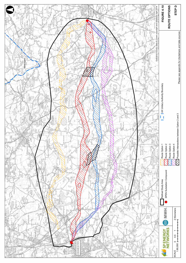
!(
!(
Wre
csam
OS
WE
STR
Y
WE
M°
Ord
nanc
e S
urve
y da
ta ©
Cro
wn
copy
right
and
dat
abas
e rig
ht 2
014
Plea
se s
ee a
ppen
dix
for d
iscl
aim
ers
and
data
sou
rces
FIG
UR
E 4.
10
RO
UTE
OPT
ION
S
STEP
DSC
ALE
1:8
0,00
00
12
0.5
Kilo
met
ers
Ref
ined
Stu
dy A
rea
!(SP
EN
Sub
stat
ion
Com
poun
d
Rou
te O
ptio
n 1
Rou
te O
ptio
n 2
Rou
te O
ptio
n 3
Rou
te O
ptio
n 4
Poss
ible
Inte
rsec
tions
bet
wee
n O
ptio
n 2
and
3
UK
Uni
tary
Aut
horit
y Bo
unda
ry
DRAF
T O
NLY

!(
!(
R1
R2
R3
B1
B2
B3
Wre
csam
OS
WE
STR
Y
WE
M1
2
Nar
row
s to
avoi
d pr
oper
tyan
d w
oodl
and.
Ove
rsai
ls th
era
ilway
& M
ontg
omer
yca
nal (
SS
SI)
Follo
ws
alig
nmen
t of
a fo
rmer
ove
rhea
dto
wer
line
.
Nar
row
s to
avoi
d pr
oper
tyan
d w
oodl
and.
Avoi
ds li
sted
build
ings
and
prop
erty
.
Ove
rsai
ls th
era
ilway
& M
ontg
omer
yca
nal (
SSSI
)
Avoi
ds in
dust
rial
area
/ ai
rfiel
d an
dw
oodl
and
to th
e so
uth.
Nar
row
s to
avo
idin
divi
dual
pro
perti
es.
Nar
row
s to
avo
idlis
ted
build
ings
and
indi
vidu
al p
rope
rties
.
Ove
rsai
lsflo
od z
one.
Avoi
ds S
SSI a
ndov
ersa
ils la
rge
area
of f
lood
zon
e.Av
oids
ham
lets
and
agr
oup
of li
sted
bui
ldin
gs.
Nar
row
s to
avo
idin
divi
dual
pro
perti
es.
Ove
rsai
lsth
e B
5009
.
Nar
row
as
follo
ws
alig
nmen
t of e
xist
ing
tow
er a
nd li
ne
Neg
otia
tes
railw
ay&
road
brid
ge in
clos
e pr
oxim
ity.
Avoi
ds la
rge
bloc
k of
woo
dlan
d.
Ove
rsai
ls M
ontg
omer
yca
nal a
nd a
void
sca
nals
ide
woo
dlan
d.
Avoi
ds p
rope
rty a
ndin
ters
ects
Nat
iona
lG
rid o
verh
ead
line.
Avoi
ds h
amle
t -Lo
wer
Hor
dley
and
prop
ertie
sto
the
north
.
Rel
ativ
ely
unco
nstra
ined
land
resu
lts in
wid
ean
d st
raig
ht s
ectio
n.
Rou
tes
away
from
vill
age
and
narro
ws
to a
void
prop
erty
and
liste
d bu
ildin
g. Rou
tes
sout
h to
avoi
d E
nglis
hFr
ankt
on. Av
oids
prop
erty
.
Inte
rsec
tssh
ort s
ectio
nof
132
kV li
ne. Avoi
ds p
rope
rty a
ndlis
ted
build
ings
.
Avoi
dspr
oper
ty.
Ove
rsai
ls R
iver
Rod
enan
d na
rrow
floo
d zo
ne.
Nar
row
s to
avo
idpr
oper
ty, w
oodl
and
and
Lopp
ingt
on v
illag
e.
Nar
row
s to
avo
idpr
oper
ty, w
oodl
and
and
Lopp
ingt
on v
illag
e.
Rou
tes
sout
h to
avoi
d in
divi
dual
prop
ertie
s.
Rou
tes
sout
h to
avoi
d in
divi
dual
prop
ertie
s.
°
Ord
nanc
e S
urve
y da
ta ©
Cro
wn
copy
right
and
dat
abas
e rig
ht 2
014
Plea
se s
ee a
ppen
dix
for d
iscl
aim
ers
and
data
sou
rces
RO
UTE
OPT
ION
S
FIG
UR
E 5.
1
STEP
ESC
ALE
1:8
0,00
00
12
0.5
Kilo
met
ers
Ref
ined
Stu
dy A
rea
!(SP
EN
Sub
stat
ion
Com
poun
d
Rou
te O
ptio
n R
ed (R
1, R
2 an
d R
3)
Rou
te O
ptio
n B
lue
(B1,
B2
and
B3)
Poss
ible
Inte
rsec
tions
(1 a
nd 2
)
UK
Uni
tary
Aut
horit
y Bo
unda
ry
DRAF
T O
NLY

59Route Corridor Options Report
!(
!(
!O
!O
!O!O
!O
!O
!O
!O !O
!O
!O!O
!O
!O
!O
R1
R2
R3
B1
B2
B3
Wre
csam
OS
WE
STR
Y
WE
M1
2
Woo
tton
Cas
tle g
rade
II li
sted
bui
ldin
g(p
rivat
e no
t ope
n to
the
publ
ic).
Mon
tgom
ery
Can
al
Non
eley
Hal
l Far
mho
use.
List
ed b
uild
ing.
Stan
war
dine
Hal
l lis
ted
build
ings
and
Stan
war
dine
In T
he W
ood
moa
ted
site
sche
dule
d m
onum
ent.
Gar
dens
not
edby
Par
ks &
Gar
dens
UK
web
reso
urce
Shro
pshi
re P
ark
& G
arde
ns T
rust
.
Hal
ston
Hal
l and
est
ate,
5 li
sted
bui
ldin
gs a
ndga
rden
ass
ocia
ted
with
Reg
ency
ecc
entri
cJo
hn M
ytto
n. E
vent
s an
d w
eddi
ng v
enue
.
Red
nal a
irfie
ld (d
isus
ed).
Now
use
d as
indu
stria
l and
com
mer
cial
est
ate.
Shad
e O
ak S
tud.
Stud
Far
m a
nd li
sted
bui
ldin
g.
Whi
tting
ton
Cas
tle,
sche
dule
d m
onum
ent a
nd v
isito
rat
tract
ion
man
aged
by
loca
l com
mun
ity.
Park
Hal
l Cou
ntry
Exp
erie
nce.
Fam
ily v
isito
r attr
actio
n.
Gra
fton
Farm
hous
e B
&B.
List
ed b
uild
ing.
Slea
p A
irfie
ldSh
rops
hire
Aer
o C
lub
Lee
Old
Hal
l gra
de II
* lis
ted
build
ing
(priv
ate
not o
pen
to th
e pu
blic
).
Hor
dley
Hal
l B&
B.Li
sted
bui
ldin
g.
Nor
th w
ood
Hal
l Dou
ble
Moa
ted
Site
,sc
hedu
led
mon
umen
t vis
itor a
ttrac
tion
and
even
ts v
enue
.
Wyc
herle
y H
all,
grad
e II*
list
ed b
uild
ing
(priv
ate
not o
pen
to th
e pu
blic
).
°
Ord
nanc
e S
urve
y da
ta ©
Cro
wn
copy
right
and
dat
abas
e rig
ht 2
014
Plea
se s
ee a
ppen
dix
for d
iscl
aim
ers
and
data
sou
rces
SITE
OF
LOC
AL
INTE
RES
T &
IMPO
RTA
NC
E
FIG
UR
E 6.
1
SCAL
E 1
:80,
000
01
20.
5Ki
lom
eter
s
Ref
ined
Stu
dy A
rea
!(SP
EN
Sub
stat
ion
Com
poun
d
Rou
te O
ptio
n R
ed (R
1, R
2 an
d R
3)
Rou
te O
ptio
n B
lue
(B1,
B2
and
B3)
Poss
ible
Inte
rsec
tions
(1 a
nd 2
)
!OSi
tes
of lo
cal i
nter
est &
impo
rtanc
e
UK
Uni
tary
Aut
horit
y Bo
unda
ryDR
AFT
ONL
Y

60 Route Corridor Options Report
APPENDIX A
THE HOLFORD RULES
The Holford Rules were reviewed circa 1992 by the National Grid Company (NGC) plc (now National Grid Electricity Transmission) as owner and operator of the electricity transmission network in England and Wales, with notes of clarification added to update the Rules. A subsequent review of the Holford Rules (and NGC clarification notes) was undertaken by Scottish Hydro Electric Transmission Limited (SHETL) in 2003. These guidelines for the routeing of new high voltage overhead transmission lines, with the NGC 1992 and SHETL 2003 notes form the basis for routeing the SPEN Oswestry to Wem 132kV Reinforcement Project.
Rule 1: Avoid altogether, if possible, the major areas of highest amenity value, by so planning the general route of the line in the first place, even if the total mileage is somewhat increase in consequence.
Rule 2: Avoid smaller areas of high amenity value, or scientific interest by deviation; provided that this can be done without using too many angle towers, i.e. the more massive structures which are used when lines change direction.
Rule 3: Other things being equal, choose the most direct line, with no sharp changes of direction and thus with few angle towers.
Rule 4: Choose tree and hill backgrounds in preference to sky backgrounds, wherever possible; and when the line has to cross a ridge, secure this opaque background as long as possible and cross obliquely when a dip in the ridge provides an opportunity. Where it does not, cross directly, preferably between belts of trees.
Rule 5: Prefer moderately open valleys with woods where the apparent height of towers will be reduced, and views of the line will be broken by trees.
Rule 6: In country which is flat and sparsely planted, keep the high voltage lines as far as possible independent of smaller lines, converging routes, distribution poles and other masts, wires and cables, so as to avoid a concatenation or ‘wirescape’.
Rule 7: Approach urban areas through industrial zones, where they exist; and when pleasant residential and recreational land intervenes between the approach line and the substation, go carefully into the comparative costs of undergrounding, for lines other than those of the highest voltage.
National Grid has published interpretation notes to the Holford Rules as follows.
GUIDELINES FOR THE ROUTEING OF NEW HIGH VOLTAGE OVERHEAD TRANSMISSION LINES
Rule 1: Avoid altogether, if possible, the major areas of highest amenity value, by so planning the general route of the first line in the first place, even if the total mileage is somewhat increased in consequence.

61Route Corridor Options ReportRoute Corridor Options Report
Note on Rule 1
Investigate the possibility of alternative routes, avoiding if possible the areas of the highest amenity value. The consideration of alternative routes must be an integral feature of environmental statements.
Areas of highest amenity value are:
• Areas of Outstanding Natural Beauty National Parks
• Heritage Coasts World Heritage Sites
Rule 2: Avoid smaller areas of high amenity value, or scientific interests by deviation; provided that this can be done without using too many angle towers, i.e. the more massive structures which are used when lines change direction.
Note on Rule 2
Some areas (e.g. Site of Special Scientific Interest) may require special consideration for potential effects on ecology (e.g. to their flora and fauna).
Where possible choose routes which minimise the effects on the setting of areas of architectural, historic and archaeological interest including conservation areas, listed buildings, registered parks and gardens and ancient monuments.
Rule 3: Other things being equal, choose the most direct line, with no sharp changes of direction and thus with fewer angle towers.
Note of Rule 3
Where possible choose inconspicuous locations for angle towers, terminal towers and sealing end compounds.
Rule 4: Choose tree and hill backgrounds in preference to sky backgrounds wherever possible; and when the line has to cross a ridge, secure this opaque background as long as possible and cross obliquely when a dip in the ridge provides an opportunity. Where it does not, cross directly, preferably between belts of trees.
Rule 5: Prefer moderately open valleys with woods where the apparent height of towers will be reduced, and views of the line will be broken by trees.
Note on Rules 4 & 5
Utilise background and foreground features to reduce the apparent height and domination of towers from pan viewpoints.
Minimise the exposure of numbers of towers on prominent ridges and skylines.
Where possible avoiding cutting extensive swathes through woodland blocks and consider opportunities for skirting edges of copses and woods.

62 Route Corridor Options Report
Protecting existing vegetation, including woodland and hedgerows, and safeguard visual and ecological links with the surrounding landscape.
Rule 6: In country which is flat and sparsely planted, keep the high voltage lines as far as possible independent of smaller lines, converging routes, distribution poles and other masts, wires and cables, so as to avoid a concentration or ‘wirescape’.
Note on Rule 6:
In all locations minimise confusing appearance.
Arrange wherever practicable that parallel or closely related routes are planned with tower types, spans and conductors forming a coherent appearance; where routes need to diverge, allow where practicable sufficient separation to limit the effects on properties and features between the lines.
Rule 7: Approach urban area through industrial zones, where they exist; and when pleasant residential and recreational land intervenes between the approach line and the substation, go carefully into the comparative costs of the undergrounding, for lines other than those of the highest voltage.
Note on Rule 7
When a line needs to pass through a development area, route it so as to minimise as far as possible the effect on development.
Alignments should be chosen after consideration of effects on the amenity of existing development and on proposals for new development.
When siting substations take account of the effects of the terminal towers and line connections that will need to be made and take advantage of screening features such as ground form and vegetation.
SUPPLEMENTARY GUIDANCE NOTES
Residential Areas
Avoid routeing close to residential areas as far as possible on grounds of general amenity.
Designations of County, District and Local Value
Where possible choose routes which minimise the effect on Special Landscape Areas, areas of Great Landscape Value and other similar designations of County, District or Local value.
Alternative Tower Designs
In additional to adopting appropriate routeing, evaluate where appropriate the use of alternative tower designs now available where these would be advantageous visually, and where the extra cost can be justified.

63Route Corridor Options ReportRoute Corridor Options Report
APPENDIX B
DATA SOURCES
Information provider and or source Description of information
Biological Records Centre Shropshire Geographic information datasets illustrating:
• County Wildlife Sites (acquired as part of the National Grid Mid-Wales Connection project – so only covers part of the study area).
Canal & River Trust Geographic information datasets illustrating:
• Canal Centreline.
Available via Geostore.com.
Environment Agency Geographic information datasets illustrating:
Authorised and historic landfills. • Flood Risk Zones 2 and 3. These flood zones are
areas that could be affected by flooding, either from rivers or the sea, if there were no flood defences.
• Flood Zone 2: an area which is likely to be affected by a major flood, with up to a 0.1 per cent (1 in 1000) chance of occurring each year.
• Flood Zone 3: an area which could be flooded from a river by a flood that has a 1 per cent (1 in 100) or greater chance of happening each year.
Available via Gesture.
Forestry Commission Geographic information datasets illustrating:
• Ancient woodland datasets. • Woodlands (national forest inventory).
Available via www.forestry.gov.uk.
Historic England (via DEFRA) Geographic information datasets illustrating:
• Internationally designated historic environment sites, e.g. World Heritage Sites.
• Nationally designated historic environment sites including scheduled monuments and listed buildings.
Available via Magic.defra.
Long Distance Walkers Association Geographic information providing approximate routes of regional walking trails.

64 Route Corridor Options Report
Information provider and or source Description of information
National Grid Electricity Transmission Plc Geographic information datasets illustrating:
• Existing infrastructure including overhead electricity transmission lines and electricity substations.
• Proposed new 400kV overhead line ‘Mid Wales Connection’.
Available via www.nationalgrid.com.
Natural England (via DEFRA) Geographic information datasets illustrating:
• Internationally designated nature conservation (Natura 2000 Sites), including Ramsar sites and Special Areas of Conservation).
• Nationally designated nature conservation sites including national nature reserves.
• Sensitive landscape and public access features, e.g. National Walking Trails, Common Land.
Available via Magic.defra.
Scottish Power Energy Networks Ltd. Geographic information datasets/ route mapping illustrating:
• Existing infrastructure including overhead electricity distribution lines and electricity substations. Also route of a former electricity connection (now removed).
Shropshire Council Documents describing the landscape character of Shropshire:
• Shropshire County Council, ‘The Shropshire Landscape Typology’, September 2006.
• Shropshire County Council, ‘An Introduction to Shropshire’s Landscapes’, August 2006. Both documents are accessed (June 2015) via http://www.shropshire.gov.uk/environment/shropshires-landscape/shropshire-landscape-assessment/.
• Geographic information datasets illustrating: • Conservation Areas • Public Rights of Way • Settlement Areas: ‘Development Area’ • Potential future allocations.
Sustrans Geographic information datasets illustrating:
• National Cycleways and National Cycleway Network.
Available via http://www.sustrans.org.uk/.

65Route Corridor Options ReportRoute Corridor Options Report
COPYRIGHT AND DISCLAIMERS
(applies to all maps and plans in this report)
Background Mapping © Ordnance Survey.
Illustrates information supplied by: SP Energy Networks.
Contains public sector information licensed under the Open Government Licence v1.0.
© Natural England copyright 2015. Contains Ordnance Survey data © Crown copyright and database right 2015.
Contains, or is based on, information supplied by the Forestry Commission. © Crown copyright and database rights 2015. Ordnance Survey 100021242.
© Historic England copyright 2015. Contains Ordnance Survey data © Crown copyright and database right 2015. .
Contains data supplied by Shropshire Council, 2015, © Shropshire Council. The boundaries shown are indicative only, for more detailed information or further advice contact: Development Management, Shropshire Council (01743 252595) or [email protected]. Shropshire Council cannot be held responsible for any inaccuracies or omissions data.
Contains information provided by the Environment Agency 2015. Copyright © and Database rights Environment Agency 2010. All rights reserved. Some of the information within the Flood Map is based in part on digital spatial data licensed from the Centre for Ecology and Hydrology © NERC.
Illustrates information assessed via Data.gov.uk for national cycle routes (2014).
Illustrates information supplied by: © Long Distance Walkers Association
Illustrates information supplied by: © Biological Records Centre Shropshire
Illustrates information supplied by: National Grid
Illustrates information supplied by: SP Eenergy Networks
66 Route Corridor Options Report
APPENDIX C
APPROACH AND PRELIMINARY LANDSCAPE APPRAISAL
High voltage electricity transmission equipment such as overhead lines, can adversely affect both the landscape character and the appearance of the landscape experienced by people. The appraisal undertaken seeks to provide a basis for understanding the potential for these effects to occur and to what extent they could affect landscape character.
EFFECTS ON LANDSCAPE CHARACTER
Effects on the landscape includes physical change to those parts of the landscape that may have to be removed or altered as a result of the proposed development, for example woodlands, trees and hedges. These physical changes may also result in changes to the distinctive character of the landscape and other surrounding landscapes and how they are experienced. In landscapes designated or valued for their scenic or landscape quality, such changes can affect the purpose of the designation or perceived value of the landscape.
The appraisal considers the susceptibility of the landscapes in the route corridor options to a new 132kV Trident overhead line.
Professional judgement was applied with an understanding of the proposed development and how it could affect the landscape given its characteristics and how effects could broadly be mitigated. The analysis was undertaken considering factors including:
• Landform/ topography;
• Land use and land cover;
• Scale;
• Settlement pattern and human influences;
• Perceptual aspects; and
• Views and visibility including settings and skylines.
LANDSCAPE VALUE
There are no landscape designations covering the study area at a national or local level. Consequently the landscape of the study area is of similar value at community level, although acknowledging that there is scope for some areas to have different levels of potential sensitivity e.g. localised highpoints, ridgelines which may form locally valued viewpoints. This would be identified through further analysis at later stages in the project development.
SCALE OF LANDSCAPE EFFECTS
The consideration of the scale of potential effects that a development may have on the landscape is important. The proposed development is linear and would therefore potentially affect more extensive geographic areas and a range of landscape types than a single site-based development. The size of structures and linear nature of overhead lines is an influencing factor. The supporting Trident structures
67Route Corridor Options ReportRoute Corridor Options Report
are on average around 12m high single poles which can make them generally visible over distance depending on the nature of the landscape. However this is not so tall that visual effects cannot be mitigated by generally accepted methods such as new tree planting.
The duration and reversibility of landscape effects is a consideration and the visibility of the supporting structures and conductors would be an enduring long term effect on the receiving landscape. However Trident type supports are of a lower height design and by careful routeing and mitigation adverse effects can be limited. The study of these aspects is undertaken in detail at later stages of a project; at this stage judgements are based on high level general information.
PRELIMINARY FINDINGS – LANDSCAPE CHARACTER
Reference was made to Shropshire Council’s published document on landscape Character Shropshire document ‘The Shropshire Landscape Typology, September 2006’. The key characteristics of landscape character types in the route corridors as recorded in the Shropshire Council document include:
PRINCIPAL TIMBERED FARMLANDS
• Rolling lowland with occasional steep sided hills
• Relic ancient woodland
• Hedged fields with scattered hedgerow trees
• Predominantly dispersed settlement pattern
• Small to medium scale landscapes with filtered views
ESTATE FARMLANDS
• Mixed farming landuse
• Clustered settlement pattern
• Large country houses with associated parklands
• Planned woodland character
• Medium to large scale landscapes with framed views
SETTLED PASTORAL FARMLANDS
• Heavy, poorly drained soils
• Pastoral land use
• Scattered hedgerow trees
• Irregular field pattern
• Small to medium scale landscapes
68 Route Corridor Options Report
PRINCIPAL SETTLED FARMLANDS
• Mixed farming land use
• Varied pattern of sub-regular, hedged fields
LOWLAND MOORS
• Flat, low-lying topography
• Peaty soils
• Wet ditches and drains
• Open, unsettled landscape’
No landscapes of high value were identified in the area between Oswestry and Wem and the landscape of the study area is judged to have some capacity to accommodate a new overhead line without significant adverse effects.
The scale of effects relating to landscape character is anticipated to be limited. This is because, although it is a linear development, the supports are of a height and appearance whereby, if carefully sited, they can in many instances be wholly or partially screened by existing vegetation and buildings.
PRELIMINARY FINDINGS - VISUAL EFFECTS
The assessment of visual effects considers the potential changes in people’s views or visual amenity caused by the appearance of the proposed overhead line.
A desk-based preliminary analysis of potential visual receptors was undertaken which involved identifying residential properties and mapping public rights of way (PRoW), long distance trails and cycleways. Consideration was given to the location of properties and the nature of baseline views in order to make an initial judgement about potential visibility of a new overhead line.
The analysis showed that many of views toward a new overhead line could likely be filtered and or screened by a combination of existing trees and hedges. It noted that whilst there are some areas where views the line would potentially be more visible due to the openness of the views, there would be few areas where a new overhead line could be viewed against the skyline. The landscape is not heavily wooded although there are opportunities to utilise hedgerow and field trees as a background when considering route corridor options.

69Route Corridor Options ReportRoute Corridor Options Report
APPENDIX D
LANDSCAPE CHARACTER
Criteria Red Route Corridor Option Red Route Corridor Option
Shropshire Landscape Character Types (See The Shropshire Landscape Typology, September 2006 and key characteristics noted at Appendix C)
Principal Timbered Farmlands –intersects a small area south of Lower Berghill Farm.Estate Farmlands – majority of the central part of the corridor.Lowland Moors – crosses at the western and eastern end where the LCA is relatively narrow. Also crosses a longer section in the central part near to Baggy Moor and Bagley Marsh. Settled Pastoral Farmlands – areas at either end of the route close to Wem and Oswestry.Principal Settled Farmlands – small area around Oswestry substation at western end of the corridor and larger extent west and south of Wem.
Estate Farmlands - majority of the central part of the corridor.Lowland Moors – narrow sections east of Loppington, near Lower Hordley and wider sections south-east of Berghill and south-west of Wem.Settled Pastoral Farmlands – areas at either end of the corridor between Oswestry and Babbinswood and south-west of Wem.Principal Settled Farmlands – small area around Oswestry substation at western end of the corridor and larger extent west and south of Wem near to Commonwood and Noneley.
Landform, topography Predominantly flat and low-lying landscape, although the central part of the corridor crosses higher ground with gentle undulations and in the area west of Cockshutt and south of English Frankton (highest contours 125m). Some localised high points with potentially greater visibility of an overhead line.
Predominantly flat and low-lying landscape particularly in the central/ eastern part of the route. Some gentle undulations in the central part of the corridor south of Cockshutt.
Land use and land coverForestry Commission
Predominantly agricultural land comprising dairy farming and grazing land interspersed with farms and small settlements. Small blocks of woodland occasionally present although settled farmland types lack significant woodlands. Route largely avoids encroaching up to or oversailing woodland. Route avoids significant areas of woodland at Woodhouse.
Predominantly agricultural land comprising dairy farming and grazing land interspersed with farms and small settlements. Small blocks of woodland occasionally present although settled farmland types lack significant woodlands. Route largely avoids encroaching up to or oversailing woodland. Route is tightly constrained by development and significant areas of woodland at Woodhouse, north of Rednal.
Changes in vegetation cover to scrub sometimes notable in marshy areas, rough grassland with trees and shrubs alongside watercourses in Lowland Moors. Watercourses, ditches and ponds are features in general of this part of Shropshire but particularly of Lowland Moors.
Estate Farmlands have associated large country houses and parklands with veteran and mature specimen trees. Field enlargement and loss of hedgerows through agricultural intensification has in places created a larger scale landscape pattern and more open views. Varied but often irregular field pattern, particularly in Settled Pastoral Farmlands.

70 Route Corridor Options Report
Criteria Red Route Corridor Option Red Route Corridor Option
Settlement pattern, distribution.
Larger settlements of Wem and Oswestry. Settled landscapes in surrounding areas have some urban fringe characteristics.Sparsely settled in the central section - mainly comprising individual farms and properties, small villages and hamlets. Lowland Moors is described as remaining largely devoid of settlements.Potential constraints south of Babbinswood and south of Loppington where there are dispersed properties.
Landscape scale Relatively open medium to large scale landscapes, especially Estate Farmlands.
Human Influences Fewer human influences in Lowland Moors, which is sparsely settled. Development is mainly associated with farms and agricultural buildings feature throughout. Other landscape types contain greater amounts of human influences including railway and canals, large farms particularly closer to Oswestry in the western part of the route.
Rednal airfield (disused) now redeveloped as industrial, business units and leisure uses to the south of the corridor near to settlements of Rednal and Woodhouse.
Fewer influences notable in Lowland Moors, sparsely settled mainly development associated with farms. Agricultural buildings feature throughout.
Other landscape types contain greater amounts of human influences including railway and canals, large farms particularly closer to Oswestry in the western part of the route.
Sleap airfield (in use) is south of the corridor in the area to the south-east of Noneley.
Existing infrastructure Existing network of wood pole mounted 33kV and 11kV overhead lines distributed throughout the area. There are few areas of land where these are absent although predictably fewer lines present in more sparsely settled areas near to Lower Hordley and west of Cockshutt.
Existing 400kV overhead line is present crossing the landscape in a north-westerly to south-easterly direction in the westernmost part of the route. The route intersects the 400kV line south of Lower Lee and The Lees Farm near to a deviation in the route. There is opportunity to maximise distance south of an angle tower to minimise visual effects. The route would also cross the proposed Mid Wales 400kV connection south of Perry Farm.
Existing network of wood pole mounted 33kV and 11kV overhead lines distributed throughout the area, there are few areas of land where these are absent although predictably fewer lines present in more sparsely settled areas near to Stanwardine in the Wood and Bagley.
Existing 400kV overhead line is present crossing the landscape approximately north-west to south-east in the westernmost part of the route. The route intersects the 400kV line south-east of The Lees Farm on a straight section.
Route is narrow to the north of Rednal, route parallels and intersects existing 11kV lines.
Scenic quality The Montgomery Cmontgomeryanal is a recreational route and views from the canal are a consideration through the western part of both corridor options

71Route Corridor Options ReportRoute Corridor Options Report
Criteria Red Route Corridor Option Red Route Corridor Option
Nature of views, skyline and setting
Generally low-lying landscape, infrequent high points, few if any prominent high viewpoints. Views tend to be over short to medium distances and are restricted by field boundary hedges and trees.
Distant hills typically from the background in views north. Some longer distances views possible in more open areas although few/limited viewpoints allowing longer distance views.
Framed views’ typical of Estate Farmlands between mature woodland.‘Lowland Moors’ character type is noted to include open views and a secluded quality.
Perceptual qualities, tranquillity, remoteness
Typically rural character outside the settlements. Potentially more remote feel to the central areas and Lowland Moors – character type is noted to be more remote and noted as having a secluded quality. Other areas typically have greater human influences and settled character. More urban influences and urban fringe character close to Oswestry and Wem which means a generally more settled and development is more frequent. Development in the form of farms and individual dwellings is generally present.
Summary The landscapes in the red route corridor are typically influenced to some degree by human intervention and development. The Settled Pastoral and Farmland and Principal Settled Farmland landscapes are likely to be less susceptible to change as these have an historical association with settlement and development. In these landscapes there is also a relatively high coverage of trees and small woodlands which typically filter views.
Lowland Moors tend to have a sparsely settled character. These areas cover relatively small sections of the corridor and there are often features such as existing overhead lines in these areas which already affect character. It is anticipated that any localised effects could be avoided and or minimised by careful routeing.
The areas around the Montgomery Canal are a consideration and there is likely to be value placed on such views by canal users, visitors and tourists. Effects can be minimised by perpendicular oversailing and avoiding locations where longer sections of the new overhead line could be visible, also avoiding more open sections of canal for locating the crossing and utilisation of existing trees and hedges for screening.
The landscapes in the blue route corridor are typically influenced to some degree by human intervention and development. The corridor crosses slightly larger areas of the Lowland Moors landscape type although the areas concerned are within 500m of settlement south of Wem and west of Noneley. The landscape is sparsely settled but there are existing influences from nearby development as well as existing overhead lines. The areas around the Montgomery Canal are a consideration and there may be some value placed on such views by canal users, visitors and tourists. As noted for the red corridor a route would oversail the canal and in this section it is designated a SSSI.

72 Route Corridor Options Report
APPENDIX E
POTENTIAL ROUTEING IN THE REFINED STUDY AREA: CONSIDERATION OF ROUTE CORRIDOR OPTION 1 (ORANGE) AND ROUTE CORRIDOR OPTION 4 (PURPLE )
Route Corridor Option 1 Orange Route Corridor Option 4 Purple
Ecology and biodiversity. To avoid areas of highest environmental value as far as possible whilst aiming to take a mostly direct route.HR 1, 2 and 3
• The orange route is highly constrained by a cluster of county wildlife sites (CWS) and woodland around Halston Hall and further north. The line would have to run close to woodland and would require the removal of some trees.
• Constraints in the area presented by White Mere (Ramsar) and Cole Mere (Local Nature Reserve) and SSSI and to the north of Crose Mere (Ramsar and SSSI). Sites are of exceptional importance and very sensitive to development generally. Balance of ecology dependent on local ground conditions and hydrology routeing. Routeing is restricted to the unconstrained land in between the sites, routes near but outside designated areas. Potential for indirect effects on designated areas e.g. via ground conditions/ water environment.
• Crosses the Montgomery Canal SSSI, which cannot be avoided in this area. Although special interest is in the canal channel meaning that effects can be minimised whilst oversailing.
• Routes near to but outside Rednal Moss CWS. Limited unconstrained land available between features, potential effects on local designations to achieve flexibility and straightness.
• Near to but outside the designated area of Ruewood Pastures SSSI. As the special interest is within pasture grassland plant species it is anticipated that adverse effects could be minimised or avoided.
• Provides an option further away from the more significant designations to the north of the study area.
• Combination of large number of small wooded areas with other constraints results in a high number of pinch points.
Forestry and WoodlandHR 1, 2.
• Generally more woodland cover in the north of the study area.
• Oversails linear strip of woodland adjacent to a former railway line to the south of Hindford, likely tree loss.
• Constraints including woodland, property and CWS near Coed-y-Tye result in potentially less flexibility for future alignments – more acute angles/ changes in direction required to avoid features and narrowing of the route. Combined distribution of woodland with properties and other designations result in a narrow corridor (some parts <100m) e.g. between Coed-y-Tye and Lower Frankton.
• To avoid woodland generally results in a meandering route
• Pinch point and significant tree constraints in the area near to Pikes End Moss and Garden Plantation. Avoiding mature trees results in potentially sharp change in direction and narrow section of corridor.
• Pinch point to route between woodland and Rednal Moss CWS
• Small woodland groups in the study area, near Tedsmore and Rednal in the west and south-west part of the study area restrict opportunities for routeing to the area south of Haughton.
• Further concentration of small woodlands near Petton directs routeing north of the village to avoid them.
• Eastern section of the route corridor relatively unconstrained by woodland.

73Route Corridor Options ReportRoute Corridor Options Report
Route Corridor Option 1 Orange Route Corridor Option 4 Purple
Landscape Character and visual amenity. Consider potential susceptibility to change and extent of effects on landscape views. (HR all rules, overarching aim to minimise effects on the landscape and minimise visibility)
• There are no landscape designations present therefore avoids effects on important landscapes and indicates that the area is of local value and potentially less susceptibility to change.
• The landscape in the northern part of the study area has some complexity in that there are frequent changes in character identified by the Shropshire Landscape Character Assessment (LCA). This seems to respond to an undulating landform which increases character variation. This pattern of landform also reduces the scale of the landscape and increases potential susceptibility to change due to smaller scale spaces, presence of features such high points, knolls and ridges. Identifying routes in this area would present challenges due to need to minimise visibility and avoid high ground.
• Route meanders to avoid small, regularly dispersed settlements.
• Field patterns tend to be regular with medium to large fields and field boundary hedges and trees offering some opportunity for screening and filtering of views.
• Relatively large blocks of woodland and undulating ground offer opportunities for routeing against these backgrounds and minimising visibility e.g. north of Halston Hall, north of Cockshutt.
• No landscape designations present therefore avoids effects on important landscapes and indicates that the area is of local value and potentially less susceptibility to change.
• Follows the former tower line alignment in the westernmost section of the corridor. Offers the benefit of relatively few constraints and is still remembered being in the landscape by local people.
• The south of the study area presents the opportunity to route through areas of consistent landscape character which is low-lying and of medium scale. However in more open flat landscapes there could be longer sections of an overhead line visible at any one time and it may appear on against the skyline particularly where there are fewer trees. However, distant woodland and higher ground often forms the background of views and this is not considered a significant issue.
• There are groups of woodland which influence routeing north of Petton to avoid them while offering opportunity for some screening and reducing visibility by routeing against a wooded backdrop.
• Some parts of the landscape are more remote and less settled Lowland Moors as identified by the LCA near to Bagley Marsh and south-west of Noneley.
Historic EnvironmentHR 1, 2 and 3
• Routes to the north avoid Whittington (which contains a scheduled monument (Whittington Castle), conservation area and a number of listed buildings.
• Routeing generally maximises distance from listed buildings. Areas where the corridor is relatively close to listed buildings (although generally >100m) are the section south of the Llangollen canal near Hindford, where there are four on the road parallel, to the south of Lee near New Farm and at Lowe further east. There is potential to affect the setting of listed buildings.
• Routes to avoid Northwood Hall double moated site scheduled monument.
• There are listed buildings throughout the southern part of the study area. These tend to be individually dispersed in the landscape although there are some small groups which influence routeing away from Queens Head, Twyford and Burlton in the southernmost parts of the study area.
• Routeing generally maximises distance from listed buildings although there is potential to affect the setting where the corridor is relatively close to listed buildings (although generally >100m) these include, from west to east, near Wootton, Sutton, Henbarns, Wycherley Hall, Wackley Farm and Burlton Grange.

74 Route Corridor Options Report
Route Corridor Option 1 Orange Route Corridor Option 4 Purple
Settlements and Residential AmenityHR 1
• In order to avoid areas of significant constraint including housing and employment areas north-east of Oswestry, the first section of this route is assumed to be underground.
• Routes to avoid larger settlements such as Whittington (part underground) and smaller settlements further east.
• Individual properties constrain the route corridor throughout but particularly around Coed-y-Tye at the western end, Lee Bridges and near Pikes End Farm further east, creating narrow sections of corridor and slight meandering of the route.
• The south of the study area contains fewer settlements, and constraints are typically individual properties which are present throughout the area.
• The route is more tightly constrained by properties at the western end which results in a relatively long section of narrow corridor. This means that there may be less flexibility for detailed routeing and construction in this corridor.
• Pinch points are north of Grimpo, near Henbarns, south of Wackley Lodge (south of Cockshutt).
Waterbodies, watercourses and Flood RiskHR 1, 2
• Due to the other constraints present in the north of the study area, the route crosses a number of areas at risk of flooding, for example to the south of Tetchill. Overall these areas are not extensive (when compared with other areas further south in the study area). Routeing avoids wider sections of flood plain.
• The route crosses the Llangollen Canal close to Lower Frankton Locks so as to also avoid properties in Lower Frankton and to maintain a reasonably direct line. The route runs parallel with the Llangollen Canal east of Hindford it also routes close to a marina south-west of Welsh Frankton where the route is tightly constrained by the marina, woodland and a water utilities site.
• The route crosses the River Perry, Tetchill and Newnes Brook and the River Roden.
• Crosses the Montgomery Canal north-east of Queen’s Head
• Crosses a number of areas of larger areas of flood risk, mainly at the eastern end.
• Cross the River Roden, Back Brook, Sleap Brook, Bromley Brook and the River Perry.
• The Montgomery Canal south of Lower Frankton is broadly aligned north to south through the study area and therefore a new overhead line extending on an east-west alignment could oversail at a suitable location and ideally perpendicularly.
Topography. To avoid routeing on ridges, high ground, steep slopes, choose tree and hill backgrounds rather than sky.HR 3 and 4.
• The terrain in the northern part of the study area is more undulating and this particularly notable in the area around the village of Tetchill and Lower Frankton. However slopes are not very steep and where there are steeper and higher points these can generally be avoided. Topography does not present a significant constraint to routeing.
• The terrain in the southern part of the study area and on this route corridor option is more consistently low lying and relatively flat which is well suited to routeing a new overhead line.

75Route Corridor Options ReportRoute Corridor Options Report
Route Corridor Option 1 Orange Route Corridor Option 4 Purple
Existing Electrical InfrastructureHR 2, 6, 7.
• Intersects a relatively high number of existing 11kV lines (32).
• Intersects and parallel routes with 2No existing 132kV lines south-west of Hindford and north-west of Wem (long section).
• Intersects the existing National Grid 400kV overhead line in a highly constrained part of corridor (south-west of Welsh Frankton close to the canalside marina), potentially limiting flexibility for alignments and technical solutions in this area.
• Routes further north and avoids the proposed National Grid 400kV mid-Wales connection.
• Opportunity to utilise part of the route of a former SP Energy Networks steel tower line.
• Intersects a relatively high number of existing 11kV lines (32).
• Would intersect the proposed Mid-Wales 400kV connection.
• Intersects one 132kV line north of Burlton although the corridor is not restricted in this location and is wide enough to provide options for a suitable crossing point in a perpendicular manner.
Railways, Roads and Airfields
• The orange route assumes a section of undergrounding from Oswestry substation to the east of the railway line, avoiding the need for oversailing.
• Would oversail two main roads. It crosses the A495 at a pinch point south-west of Welsh Frankton and the A528 north of Cockshutt in an area where although the corridor is reasonably wide it could be constrained by routeing over higher and undulating ground which could increase visibility in this area.
• The purple route crosses the railway line in close proximity to the existing 400kV overhead line (to the south of Haugton). The 400kV line changes direction in this area and there is potential to increase visibility of electrical infrastructure at this location. The width of the corridor in this area is also restricted by listed buildings at Henbarns and Haughton, resulting in a narrowing in the corridor (approximately 200m in width) which together may present technical challenges.
• Would oversail the A528 south of Wackley Lodge. The corridor here is narrow and constrained by properties on either side which limits flexibility for future alignments and construction.
• Routes closer to Sleap airfield than other options.

76 Route Corridor Options Report
APPENDIX F
DESK BASED ECOLOGICAL STUDY
DESIGNATED SITES IN THE VICINITY OF THE STUDY AREA
All references to the study area relate to the Refined Study Area as shown at Figure 4.5. There are three internationally designated sites within 10 km of the study area, (also shown at Figure 4.5) these are:
• Midlands Meres and Mosses Phase 1 and 2 Ramsar Sites (also shown at Figure 4.5);
• West Midlands Mosses SAC*, designated for the presence of dystrophic lakes and ponds at Clarepool and Abbots Moss; and,
• Fenn’s, Whixall, Bettisfield, Wem and Cadney Mosses SAC*, designated for its expanse of lowland raised bog, which is one of the largest and southerly lowland raised bogs in the UK.
There are thirteen nationally designated sites within 5 km of the study area, these include:
• Prees Branch Canal SSSI, designated for its variety of wetland habitats and assemblage of plants and animals;
• Fernhill Pastures SSSI, designated for its traditionally managed fen meadows and the diverse range for flora present within the site;
• Crofts Mill Pasture SSSI, designated for the presence of damp peaty grassland and the presence of notable species including; globeflower, marsh-hawk’s beard, pale sedge, wood clubrush and bristle club-rush;
• Grinshill Quarries SSSI, designated for its geological features of the middle Triassic period;
• White Mere SSSI*, designated for its diverse assemblage of aquatic plants including needle spike-rush, shoreweed, small pondweed and grey club-rush;
• Cole Mere SSSI*, designated as it is one of the largest meres in Shropshire with a fringe of woodland surrounding the mere and a diverse assemblage of aquatic plants;
• Clarepool Moss SSSI*, designated for the presence of a basin mere which has developed as a quaking bog;
• Fenn’s, Whixall, Bettisfield, Wem and Cadney Mosses SSSI and NNR (see para. 2.5);
• Fenemere SSSI*, designated for the presence of eutrophic water bodies within a variety of habitats including; reedbeds, alder carr and damp pastures. The site is also home to a diverse assemblage of aquatic invertebrates;
• Morton Pool and Pasture SSSI, designated for its fen and carr vegetation surrounding a small central pool; and,
• Lin Can Moss SSSI, a small quaking bog dominated by recurved peatmoss.

77Route Corridor Options ReportRoute Corridor Options Report
There are four identified locally designated sites within 2 km of the study area, these include:
• Cole Mere LNR* (see para. 2.10);
• Shelfbank LNR, located in the centre of Oswestry, an urban blue site which forms links to a number of urban wildlife corridors;
• Brook Meadows County Wildlife Site (CWS), a species rich wet meadow; and,
• Cupids Ramble CWS, an area comprising of several unimproved and semi-improved wet meadows.
PROTECTED AND NOTABLE SPECIES IN THE STUDY AREA
N.B. Records for notable and legally protected species is taken from National Grid’s 400 kV PEI report and is therefore not representative of the entire Study Area.
Bats All bats and their roosts are protected under Schedule 5 of the Wildlife and Countryside Act 1981 (as amended) and Schedule 2 of the Conservation of Habitats and Species Regulations 2010 (as amended). Some of which are also species of principal importance for the conservation of biodiversity in England (Section 41 Natural Environment and Rural Communities Act (NERC) 2006). There are a variety of habitats in the study area which provide ample roosting, commuting and foraging habitat for a variety of bat species.
AmphibiansAs for bats, great crested newts - Triturus cristatus (GCN) are protected by the Wildlife and Countryside Act 1981 (as amended) and the Conservation (Natural Habitats & c) Regulations 2010 (as amended). It is also a species of principal Importance for the conservation of biodiversity in England (Section 41 (NERC) 2006). Examination of aerial photographs identified that ponds are present in the study area and there are three known populations of GCN within and adjacent to the study area as described below.
• A medium population of GCN is located within Oswestry substation at the north-western corner of the study area. Redevelopment of the site is currently covered by NE Licence EPSM 2011-31829; and
• Two populations of GCN (one small and one medium) to the north of Queen’s Head.
Common ToadCommon toad (Bufo bufo) is listed as a Species of Principal Importance for the conservation of biodiversity in England (Section 41 (NERC) 2006). Suitable habitat for common toad is present in the study area and there are scattered historical records for the species in the locality generally.
Otter Otter (Lutra lutra) is a European Protected Species that is afforded protection by Schedule 2 of the Conservation of Habitats and Species Regulations 2010 (as amended); and Schedule 5 of the Wildlife and Countryside Act 1981 (as amended). The otter is also a species of Principal Importance for the conservation of biodiversity in England (Section 41 (NERC) 2006). The Rivers Perry and Roden and their tributaries and the Montgomery Canal provide suitable commuting and foraging habitat for otter, there are also a number of historical records for otter in the study area.

78 Route Corridor Options Report
Dormouse Dormouse (Muscardinus avellanarius) is a European Protected Species that is afforded protection by Schedule 2 of the Conservation of Habitats and Species Regulations 2010 (as amended); and Schedule 5 of the Wildlife and Countryside Act 1981 (as amended). It is also a species of Principal Importance for the conservation of biodiversity in England (Section 41 (NERC) 2006). The habitats in the study area including; hedgerows, scattered trees, scrub and woodland provide habitat and connectivity corridors for dormice. There is a lack of historical records for the species within the study area possibly due to low population densities, intensive agricultural in the area small areas off woodland blocks and limited ancient woodland.
BirdsAll nesting wild birds are afforded protection under the Wildlife and Countryside Act 1981 (as amended). At this stage detailed information on ornithological interests within the area is not available. However, the Ramsar site and floodplain adjacent to the Rivers Perry and Roden and the Montgomery Canal SSSI and Halston Hall CWS are likely to provide habitat for a number of breeding waders and wintering birds including; swans, geese, ducks, herons, lapwing and curlew. Due to the low lying nature of the landscape within much of the study area it is unlikely that a great variety of raptor species are present. The habitats present including short grazed grassland and arable fields provide suitable foraging habitat for a number of species of owl. There are a range of features present that provide habitats for an assemblage of farmland and grassland bird species.
White-clawed Crayfish White clawed crayfish (Austropotamobius pallipes) are protected by the Wildlife and Countryside Act 1981 (as amended) and are listed as a species of Principal Importance for the conservation of biodiversity in England (Section 41 (NERC) 2006). The Rivers Perry and Roden provide potential habitat for white-clawed crawfish. A single historical record for the species is present in the study area.
Water Vole Water vole (Arvicola amphibius) is afforded protection under Schedule 5 of the Wildlife and Countryside Act 1981 (as amended). The water vole is also a species of Principal Importance for the conservation of biodiversity in England (Section 41 of NERC 2006). The Rivers Perry and Roden and the Montgomery Canal provide suitable habitat for water vole. There are also a number of records for the species throughout the study area.
ReptilesAll native reptiles are protected from intentional killing or injury under the Wildlife and Countryside Act 1981 (as amended) and all are listed as species of Principal Importance for the conservation of biodiversity and England (Section 41 (NERC) 2006). Suitable habitat for reptiles is present in the study area, primarily within the Midlands Meres and Mosses Phase 1 and 2 Ramsar sites.
Hedgehog Hedgehog (Erinaceus europaeus) is afforded protection under Schedule 5 of the Wildlife and Countryside Act 1981 (as amended). The hedgehog is also a species of Principal Importance for the conservation of biodiversity in England (Section 41 (NERC) 2006). Suitable habitat for hedgehog is present within the study area and there are scattered historical records for the species in the wider surrounding area.
Brown HareBrown hare (Lepus europaeus) is a species of Principal Importance for the conservation of biodiversity in England (under Section 41 of the Natural Environment and Rural Communities Act (NERC) 2006). Suitable habitat for brown hare is present within the study area and there are scattered historical records for the species in the wider surrounding area.

Route Corridor Options Report