Rehl Road / I-265 Interchange Feasibility Study Studies and Reports... · project, the Project Team...
8
-
Upload
phungthien -
Category
Documents
-
view
219 -
download
4
Transcript of Rehl Road / I-265 Interchange Feasibility Study Studies and Reports... · project, the Project Team...

Rehl Road / I-265 Interchange Feasibility Study
Gene Snyder Freeway (I-265/KY 841), I-64, Taylorsville Road (KY 155) / Blankenbaker Parkway (KY 913) / Rehl Road
Jefferson County, Kentucky Item No.: N/A
Final Report October 2009
N
Prepared for:
Kentucky Transportation Cabinet:
Division of Planning and District 5, Louisville, Kentucky
Prepared by:
Qk4 815 West Market Street
Louisville, KY 40202


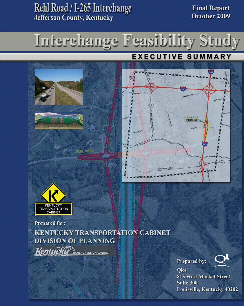
EXECUTIVE SUMMARY This project is a planning study to evaluate the feasibility of constructing an interchange linking I-265 and Rehl Road in eastern Louisville Metro (see Figure ES-1). The area is west of I-265 and south of I-64 and has been identified for a future employment center in the Jefferson County Comprehensive Plan: Cornerstone 2020. It has been rezoned for industrial use, and utilities, including sewers, have been installed. This area for future development is just east of and adjacent to the Bluegrass Industrial Park which surrounds Blankenbaker Parkway (KY 913). The resulting traffic from this development is a top concern for Louisville Metro, the Kentucky Transportation Cabinet (KYTC), and the neighboring public.
Figure ES-1: Project Location Map
The planning-level purpose and need for the project are to accommodate the safe and efficient movement of traffic to and from the future development and the interstate network. Louisville Metro has approved the rezoning for industrial land use, but with a condition that only specified percentages of the proposed developments can occur until the transportation network is improved.
Rehl Road / I-265 Interchange Feasibility Study, Final Report October 2009
Executive Summary-1

Louisville Metro has identified the interchange as a top priority and outlined the anticipated economic benefit from the proposed improved access. The following is excerpted from the letter of support for the interchange:
This proposed development would have an annual net new impact of: • $1.9 million in Kentucky state property tax revenues • $74.9 million in Kentucky State individual income tax revenues • $64.1 million in Kentucky State sales tax revenues • $12.5 million in local occupational tax revenues • $3.4 million in local property tax revenues • an additional 49,000 jobs in our 25-county economic area
Three interstate interchanges exist in the area—Blankenbaker Parkway at I-64, I-64 at I-265, and Taylorsville Road (KY 155) at I-265, and the traffic operates at or above capacity. Likewise, existing traffic volumes and congestion on the two interstates and the I-64/I-265 interchange are substantial. Therefore, the primary objective of this feasibility study is to identify a design concept that would address the traffic needs of the proposed developments without worsening traffic flow on the interstate network.
Study Process
A project study team approach was used, consisting of representatives from the KYTC Central Office, KYTC District 5, the Kentuckiana Regional Planning and Development Agency (KIPDA), Louisville Metro, and Qk4. (The FHWA elected to reserve involvement until the Cabinet begins to prepare a full IJS and NEPA document.)
Two alternatives were considered in this planning study: No-Build Alternative and a new I-265 interchange at Rehl Road and associated improvements to I-265
Traffic forecasts were provided by KIPDA, the Metropolitan Planning Organization (MPO), using the traffic model for the Metro Area. The traffic model incorporated the planned and programmed improvements to the network, including a rebuilt I-64/I-265 interchange and a widened I-265. The preliminary layout of the interchange concept is in concert with these proposed improvements. The traffic merge/diverge/weave analysis for the proposed interchange concept was conducted by Qk4. The future traffic was projected and analyzed for years 2020 and 2038 for both Build and No-Build scenarios. Year 2020 traffic assumed a limited number of the planned roadway improvements would be in place, while year 2038 traffic assumed all planned roadway improvements would be in place. Because the planning-level purpose and need is to accommodate future development, the 2038 No-Build scenario is based on a partial build out of the planned land uses, while the 2038 Build scenario is based on a full build-out of the proposed land uses.
After the traffic projections were developed, Qk4 developed the design concept with the merge/diverge/weave analysis to provide a design that would accommodate the various movements. The resulting design concept includes a compressed diamond interchange with collector/distributor (c/d) lanes. The c/d lanes begin in the south inside the KY 155/I-265 interchange, north of the southern ramps and south of the northern ramps, and extend north to connect with the c/d lanes associated with the proposed long-term redevelopment of the I-64/I-265 interchange. The anticipated
Rehl Road / I-265 Interchange Feasibility Study, Final Report October 2009
Executive Summary-2

cost estimate of this design concept, in 2008 dollars, is as follows: Design, $4.0M; Right-of-Way, $2.0M; Utilities, $2.0M; Construction $47.0M1; Total, $55.0M.
Conclusion
Based on the review of the existing conditions, the cost, the traffic forecasts and analyses, and the planning-level purpose and need for the project, the Project Team concurred that a new interchange with c/d lanes, as described above, would be feasible.
N
Next Steps
The advancement of the interchange will require 1) inclusion of the project into the KIPDA TIP (Transportation Improvement Plan) and the KYTC Six-Year Highway Plan, 2) further detailed design, and 3) an Interchange Justification Study (IJS), and a National Environmental Policy Act (NEPA) analysis and document, both of which will need to be coordinated with and approved by FHWA.
The IJS will require the development of a detailed sub area traffic model for the study area. The traffic study for this feasibility report is based on the multi-county model developed by KIPDA and does not afford the detail to satisfy each element of an IJS. The IJS will require a comparison of two options—a new interchange versus rebuilding the existing roads—as a way to meet the project purpose and need. The sub area traffic analysis would be the basis for that analysis.
The NEPA analysis would include public involvement and some level of indirect and cumulative impact analysis for the induced growth. Because of the lack of known environmental impacts and public controversy, it is anticipated the level of documentation could be a CE-Level 3 or an EA/FONSI rather than an EIS.2
Figure ES-2: Design Concept (See Exhibit 6)
1 The cost estimate is based on a c/d system the terminates inside the KY 155 interchange—between the northern and southern ramps. It was requested that cost estimates be generated for extending the c/d lanes south of the southern KY 155 interchange. The construction cost for such a design is estimated to be $60.5M, in total. 2 CE = Categorical Exclusion (KYTC offers 3 levels, with a Level-3 being the most involved); EA/FONSI = Environmental Assessment/Finding Of No Significant Impact; EIS = Environmental Impact Assessment.
Rehl Road / I-265 Interchange Feasibility Study, Final Report October 2009
Executive Summary-3


Rehl Road / I-265 Interchange Feasibility Study, Final Report October 2009
1