Real-Time Remote Sensing for Early Warning & Mitigation of Disasters & Epidemics: The Kamal Ewida...
32
Real-Time Remote Sensing for Early Warning & Mitigation of Disasters & Epidemics: The Kamal Ewida Earth Observatory (KEEO) SfP 983168 PPD : Prof. Dr. Magdy Abdel Wahab – Cairo University, Egypt NPD : Gilbert L. Rochon, Ph. D.,MPH – Purdue University, USA Presentation before the NATO SfP Expert Panel on Environmental Security- NATO HQ Brussels, Belgium June 2, 2008
-
Upload
ralph-townsend -
Category
Documents
-
view
213 -
download
0
Transcript of Real-Time Remote Sensing for Early Warning & Mitigation of Disasters & Epidemics: The Kamal Ewida...

Real-Time Remote Sensing for Early Warning & Mitigation of Disasters & Epidemics:
The Kamal Ewida Earth Observatory (KEEO)
SfP 983168
PPD: Prof. Dr. Magdy Abdel Wahab – Cairo University, EgyptNPD: Gilbert L. Rochon, Ph. D.,MPH – Purdue University, USAPresentation before the NATO SfP Expert Panel on Environmental Security- NATO HQ Brussels, Belgium June 2, 2008
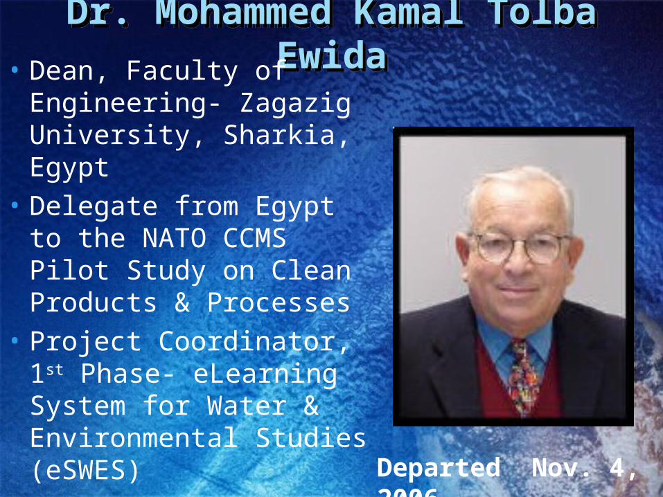
Dr. Mohammed Kamal Tolba EwidaDr. Mohammed Kamal Tolba Ewida• Dean, Faculty of
Engineering- Zagazig University, Sharkia, Egypt
• Delegate from Egypt to the NATO CCMS Pilot Study on Clean Products & Processes
• Project Coordinator, 1st Phase- eLearning System for Water & Environmental Studies (eSWES) Departed Nov. 4, 2006

NATO Science for Peace ProjectNATO Science for Peace Project
• REAL-TIME REMOTE SENSING FOR EARLY WARNING & MITIGATION OF DISASTERS & EPIDEMICS– Geostationary Groundstation at Al Azhar
University – European Space Agency’s Meteosat
– Tracking Groundstation at Cairo University for NOAA AVHRR, NASA Terra MODIS & Aqua MODIS, Chinese Space Agency’s FENG YUN, INPE-Brazil’s CBERS & Egypt-NARSS EgyptSat I

NATO SfP KEEO Project TeamNATO SfP KEEO Project TeamRight to Left:
M.Shokr (Environment Canada)
Magdy Wahab (PPD-Cairo U.)
M. Atef (Aero/Astro-Cairo U.)
Gülay Altay (KOERI)
G.Rochon (NPD-Purdue U.)
Okan Ersoy (Purdue U.)
Gamal El Afandi(COO-Al Azhar U.)

Mitigation Problems to be AddressedMitigation Problems to be Addressed• Natural Disasters
– Earthquakes– Storms & Flooding– Wild Fires– Drought & Desertification– Epidemics & Epizootics– Crop Failure, Famine & Food Insecurity
• Anthropogenic Disasters– Unintentional
• Oil & Chemical Spills• Air Pollution & Water Pollution
– Deliberate• Terrorist Incidents

Disaster Management Stages:Remote Sensing Contributes at each Stage
Disaster Management Stages:Remote Sensing Contributes at each Stage
• Vulnerability Assessment & Remediation
• Disaster Preparedness, Drills & Simulations
• Early Warning
• Emergency Response, Search & Rescue
• Humanitarian Relief
• Recovery
• Post-Disaster Reconstruction

Current Status of TechnologyCurrent Status of Technology
• EgyptSat I• Existing Groundstations• Need for Academic Community Access• Fiber Optic Backbone Among Egyptian
Universities• Archival & Real-Time Data• Collaborative Ties with other Data Providers,
Spatial Data Scientists & End-Users within Governmental Ministries, Multi-Lateral Agencies & Universities

Goals of the ProjectGoals of the Project• To establish two groundstations for real-time satellite
remote sensing in Cairo, Egypt, a geostationary groundstation for ESA Meteosat at Al Azhar University and a tracking groundstation at Cairo University, initially for NOAA AVHRR, NASA MODIS Terra & Aqua and EgyptSat I.
• To provide training for faculty, students and Ministry staff & scientific curricular enhancement for utilization of this technology for disaster mitigation, food security, disease vector habitat monitoring and environmental sustainability.
• To collaborate with end-users in research and in supporting operational disaster management & data product dissemination.

Novel CharacteristicsNovel Characteristics• Provides real-time data from satellite remote sensing
to Egypt’s academic community for the first time.• Establishes critical redundancy during over-flight
conflicts for data acquisition with Egypt’s National Authority for Remote Sensing & Space Sciences
• Enables Research on Vulnerability Assessment & Best Management Practices for Disaster Mitigation, Early Warning, Humanitarian Response & Recovery within the Egyptian & Regional Contexts
• Provides training and career opportunities for faculty & students addressing applications of space-based technologies for sustainable development, food security & public safety at two Egyptian Universities, with a combined total enrollment of 700,000 students.

Scientific ActivitiesScientific Activities• Collaborative research between the NATO SfP
Partnering Universities and the WHO Regional Office, based in Cairo, to integrate real-time remote sensing & meteorological data with medical ecology data and epidemiological data, so as to identify, map and monitor infectious disease vector habitat, for timely intervention.
• Collaborative interdisciplinary research on the contributing causes , potential mitigating factors & best management practices associated with an array of biogenic & anthropogenic disasters & on the optimal use of remote sensing tools.

Deliverables/MilestonesDeliverables/Milestones• Bid Specifications/Solicitation & Installation of
Groundstations in first quarter of 2009.
• Implementation of Data Dissemination & Collaborative Research with Ministries, Multi-Lateral Agencies and Academic Departments.
• Relevant Curricular Enhancement &Training for Faculty, Students & End-Users
• Development of a Hub for Broader Access to Near-Real-Time Data Product Distribution
• Video Documentary on the NATO SfP KEEO Collaboration among institutions in Egypt, Turkey & the USA.

Quantified Criteria for SuccessQuantified Criteria for Success
• Successful Vendor Selection and Installation of 2 Groundstations during First Quarter, 2009.
• Real-Time Acquisition of ESA Meteosat Data 24 hrs./day 7 days/week
• Real-Time Acquisition of data from at least 3 polar orbiting satellites (e.g NASA MODIS Terra & Aqua, NOAA AVHRR, CBERS, Feng Yun & EgyptSat I) & Near-Real-Time Data Transfer
• Operational Data Utilization by 2 Ministries and 1 UN Agency for Disaster Mitigation.

Quantified Criteria for Success ContinuedQuantified Criteria for Success Continued
• Training Established for 5 end-users, 10 faculty and 40 students in application of remote sensing applications for disaster mitigation
• 10-15 minute video documentary completed on the collaboration among NATO sponsored universities in Egypt, Turkey and the USA with their regional end-users of remotely sensed data for disaster early warning & mitigation.
• A Disaster-Mitigation Hub established in FY 2
• Publication of 2 peer reviewed journal articles and presentation at 2 major conferences/year

Institutes Involved & Their ExpertiseInstitutes Involved & Their Expertise• Cairo University – Giza, Egypt
– Meteorology, Storms, Flooding– Aerospace Engineering, Technology & Applications
• Al Azhar University – Nasr City, Egypt– Meteorology, Drought, Desertification– Environmental Hazard Remediation
• Boğaziçi University – Istanbul, Turkey– Kandilli Observatory & Earthquake Research Institute– Disaster Monitoring, Mitigation & In Situ Sensing
• Purdue University – W. Lafayette, Indiana, USA– Purdue Terrestrial Observatory & Public Health Applications– Remote Sensing & High Performance Computing– Sustainable Development & Environmental Sustainability

Cairo UniversityCairo University• Centennial Anniversary on
Dec. 21, 2008
• Student Enrollment 200,000
• Partner Country Project Director-PPD:
Prof. Dr. M. Magdy Abdel Wahab, Chair, Dept. of Meteorology & Astronomy, Faculty of Science

• Al Azhar University was founded 988 A.D.- 1,020 years old in 2008 2nd oldest continuous university after the University of Al Karaouine in Fes, Morocco, [859 A.D.].
• Multi-Campus Student Enrollment: 500,000
• Project Co-Director: Dr. Gamal El Afandi, Dept. of Meteorology & Astronomy, Faculty of Science
• Al Azhar University

Boğaziçi University- Kandilli Observatory
& Earthquake Research Institute (KOERI)
Boğaziçi University- Kandilli Observatory
& Earthquake Research Institute (KOERI)
• Founded in 1868 in Istanbul, Turkey, during the reign of Abdülâziz, the 32nd Sultan of the Ottoman Empire
• Project Co-Director, Prof. Dr. Gülay Altay, Director, KOERI

Purdue University-W. Lafayette, Indiana USAPurdue University-W. Lafayette, Indiana USA
NATO Country Project Director (NPD): Dr. Gilbert Rochon
Co-Director: Dr. Okan Ersoy
• Purdue Terrestrial Observatory
Founded 186969,000 studentsMulti-Campus

Project ManagementProject Management
KEEO ADVISORY BOARD
KEEO ADVISORY BOARD

Collaborators/End-UsersCollaborators/End-Users
• Dr. Mohamed A. Fawzi, Director, Crisis & Disaster Management Sector, Office of the Prime Minister
• Prof. Dr. Ayman El-Dessouki, Chairman
National Authority for Remote Sensing & Space Sciences (NARSS) & Eng. Belal M. Elleithy, Ground Receiving Manager, NARSS
• Prof. Dr. Ayman Abu Hadid, President, Agricultural Research Center

Collaborators/End UsersCollaborators/End Users
• Altaf S. Musani, MPH,Regional Advisor, Emergency Preparedness & Humanitarian Action, WHO
• Babiker Abdalla Ibrahim, Ph.D., Regional Project Coordinator (Egypt, Sudan & Ethiopia) Flood Preparedness & Early Warning-Eastern Nile Technical Office (ENTRO)
• Prof. Dr. Mostafa M. Emara, Director, Science Center for Detection & Remediation of Environmental Hazards (SCDREH) Al Azhar University
• Prof. Dr. Mortada Mourad El-Aref, Director, Basel Convention Regional Training Center & Director, Cairo Univ. Center for Environmental Hazard Mitigation
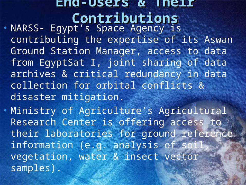
End-Users & Their ContributionsEnd-Users & Their Contributions• NARSS- Egypt’s Space Agency is contributing
the expertise of its Aswan Ground Station Manager, access to data from EgyptSat I, joint sharing of data archives & critical redundancy in data collection for orbital conflicts & disaster mitigation.
• Ministry of Agriculture’s Agricultural Research Center is offering access to their laboratories for ground reference information (e.g. analysis of soil, vegetation, water & insect vector samples).

End-Users/CollaboratorsEnd-Users/Collaborators• Office of the Prime Minister- is committed to fully
integrating data from the NATO SfP KEEO into their disaster planning, simulation, mitigation & response activities & to provide fellowships for junior faculty and internships for students to obtain operational experience and service learning.
• The WHO Regional Office has welcomed the KEEO team to collaborate in research to develop a spatial database incorporating real-time data on disease vector habitat.
• ENTRO will partner with KEEO on its World-Bank supported Nile Flooding project, sharing data & technical personnel.

Distribution of NATO SfP FundingDistribution of NATO SfP Funding
EGYPT: 255K EurosTURKEY: 22.5K EurosUSA: 22.5K EurosTOTAL: 300K Euros
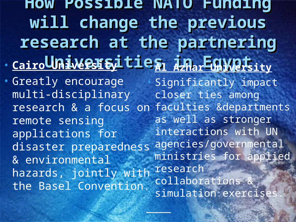
How Possible NATO Funding will change the previous research at the
partnering Universities in Egypt
How Possible NATO Funding will change the previous research at the
partnering Universities in Egypt• Cairo University• Greatly encourage
multi-disciplinary research & a focus on remote sensing applications for disaster preparedness & environmental hazards, jointly with the Basel Convention.
• Al Azhar University
• Significantly impact closer ties among faculties &departments as well as stronger interactions with UN agencies/governmental ministries for applied research collaborations & simulation exercises.
PROJECT STRENGTHS & OPENESS ISSUES
PROJECT STRENGTHS & OPENESS ISSUES
• The project benefits from a coalition of exceptionally strong research universities in Egypt, Turkey & the USA
• The project has established high level commitment from key government ministries in Egypt, regional offices of the UN and established operatives in both the remote sensing & disaster mitigation communities.
• The project is offering its raw data freely to other universities & will develop a hub for wide dissemination of standard data products

PROJECT’S CONTRIBUTION TO STABILITY, SECURITY & PEACEPROJECT’S CONTRIBUTION TO STABILITY, SECURITY & PEACE
• NATO SfP support of this KEEO project will directly enable:– Real-time remote sensing applications for a wide
array of time-critical events, including natural and man-made disasters, public health emergencies, and food security issues
– Closer on-going collaboration between the academic community, governmental ministries and multi-lateral agencies charged with public safety, peaceful resolution of conflict, regional environmental sustainability and sustainable development.

Equal Opportunity Technology: Applications in Africa, Asia & Latin America
Equal Opportunity Technology: Applications in Africa, Asia & Latin America
• Famine Early Warning (FEWS) Project & Food Security• Africa Real-Time Environmental Monitoring Information
System (ARTEMIS)• African Association for Remote Sensing of Environment
(AARSE)• Precision Agriculture & Water Resources Conservation• Coastal Zone Morphology• Regional Impact of Climate Change• Forest Resource Assessment• Biodiversity & Natural Resource Management• Sustainable Industrial Development Infectious Disease
Vector Habitat Identification

http://modland.nascom.nasa.gov/gallery/
?Korea.A2000097.0235.825x1075.jpg
MODIS Image: April 6, 2000
Korea
36 Bands
Moderate Resolution Imaging Spectro-Radiometer (MODIS)

• DOC NOAA- US Dept of Commerce, National Oceanic & Atmospheric Administration
– AVHRR – Advanced Very High Resolution Radiometer
HRPT – High Resolution Picture Transmission
• GAC- Global Area Coverage (4 km)
• LAC- Local Area Coverage (1.1 km)
UN FAO ARTEMIS
NOAA AVHRR- UN FAO- ARTEMISFEWS & Desert Locust-
Schistocerca gregaria
NOAA AVHRR- UN FAO- ARTEMISFEWS & Desert Locust-
Schistocerca gregaria

Egypt from SpaceEgypt from Space

Need for Moderate Resolution & High
Resolution Data
Need for Moderate Resolution & High
Resolution Data