REAL TIME MARINE DATA ACQUISITION: A PROPOSAL FOR A …
4
REAL TIME MARINE DATA ACQUISITION: A PROPOSAL FOR A NEW JOINT COASTAL OCEANOGRAPHIC OBSERVATORY NETWORK IN ADRIATIC SEA Mauro Marini (1) , Mauro Bastianini (2) , Giovanni Bortoluzzi (3) , Paola Focaccia (3) , Elio Paschini (1) , Pierluigi Penna (1) , Alessandra Pugnetti (2) , Mariangela Ravaioli (3) , Fabio Raicich (4) , Federico Spagnoli (1) (1) Istituto di Scienze Marine, CNR, L.go Fiera della Pesca, 60125 Ancona Italy, Email: [email protected] (2) Istituto di Scienze Marine, CNR, Castello1364/a, 30122 Venezia Italy, Email: [email protected] (3) Istituto di Scienze Marine, CNR, Via Godetti,101, 40129 Bologna Italy, Email: [email protected] (4) Istituto di Scienze Marine, CNR, Viale Romolo Gessi, 2, 34123 Trieste Italy , Email: [email protected] ABSTRACT Currently, several operational marine centres issue routine seasonal forecasts produced with coupled ocean- atmosphere models. For good result they require also real-time knowledge of the state of marine area as regard as oceanographic and atmospheric parameters. Effectiveness of marine climate knowledge and predictability resides in fast, reliable, scattered and numerous information on the initial marine and atmospheric conditions. The aim of this work is to present a review of the existing real time stations in the Adriatic sea and a critic state of the arte with the aim to propose a new single and standardized coastal oceanographic observatory network based on previous existing oceanographic buoys set up by different projects and institutions and with various features. The network ISMAR could be based on various oceanographic buoys located along the Adriatic Sea coastal waters transmitting real time data, accessible, after a data quality control and sensor/instrument field calibration validation, on internet by a web site. In this way it will possible to have a single system of real time oceanographic and meteorological standardized data available for regional stakeholders, policy makers, economic operators, environmental safety and tourists. Data will also useful to improve forecast systems active for the Adriatic Sea; finally it will greatly improve the knowledge of the main hydrological and meteorological forcing factors in a Long Term Ecological Research (LTER) study area where decadal time series on ecological studies are collected in a collaborative joint effort to depict trends in the trophic status and biogeochemical proprieties of the basin. 1. INTRODUCTION In the states most advanced in the world, about two decades ago, officials agency of environmental protection and scientists realized that the nation had to integrate the assets of its many sea and coastal observing systems and focus them on providing solutions to societal needs solutions that address the missions of several agencies and organizations. Catastrophic weather events, coastal pollution, harmful algal blooms, declines in living marine resources, climate change all these underscore the importance of creating a more integrated approach to providing data and information needed to manage and mitigate the impacts of human activities, natural disasters, and climate change on goods and services provided by the sea, and coasts. While the nation has developed some of the most sophisticated and comprehensive lakes, estuarine, and marine monitoring programs in the world, these individual programs are not as robust, effective, or comprehensive as they could be in protecting the societal and economic security of the nation, and therefore in providing the quality of life our citizens expect [1, 2]. The Marine Environment and Security for the European Area (MERSEA) Strand-1 Project was established in January 2003 to conduct an 18-month preparatory study of the key issues in setting up the marine elements of the joint European Commission (EC) and European Space Agency (ESA) initiative on Global Monitoring for Environment and Security (GMES). The motivation for the marine element of GMES arises from the wide range of international bodies, treaties, conventions, and organizations at global, regional, and national levels concerned with monitoring and protecting the marine environment in Europe. The United Nations Convention on the Law of the Sea (UNCLOS 1982) provides the regulatory framework at the global level for all activities at sea. Supporting this are the International Convention for the Prevention of Pollution from Ships (MARPOL 1973/1978), the
Transcript of REAL TIME MARINE DATA ACQUISITION: A PROPOSAL FOR A …

REAL TIME MARINE DATA ACQUISITION: A PROPOSAL FOR A NEW JOINT COASTAL OCEANOGRAPHIC OBSERVATORY NETWORK IN ADRIATIC SEA
Mauro Marini(1) , Mauro Bastianini(2), Giovanni Bortoluzzi(3), Paola Focaccia(3), Elio Paschini(1), Pierluigi Penna(1), Alessandra Pugnetti(2), Mariangela Ravaioli(3), Fabio Raicich(4), Federico Spagnoli(1)
(1) Istituto di Scienze Marine, CNR, L.go Fiera della Pesca, 60125 Ancona Italy, Email: [email protected] (2) Istituto di Scienze Marine, CNR, Castello1364/a, 30122 Venezia Italy, Email: [email protected]
(3) Istituto di Scienze Marine, CNR, Via Godetti,101, 40129 Bologna Italy, Email: [email protected] (4) Istituto di Scienze Marine, CNR, Viale Romolo Gessi, 2, 34123 Trieste Italy , Email: [email protected]
ABSTRACT
Currently, several operational marine centres issue routine seasonal forecasts produced with coupled ocean-atmosphere models. For good result they require also real-time knowledge of the state of marine area as regard as oceanographic and atmospheric parameters. Effectiveness of marine climate knowledge and predictability resides in fast, reliable, scattered and numerous information on the initial marine and atmospheric conditions. The aim of this work is to present a review of the existing real time stations in the Adriatic sea and a critic state of the arte with the aim to propose a new single and standardized coastal oceanographic observatory network based on previous existing oceanographic buoys set up by different projects and institutions and with various features. The network ISMAR could be based on various oceanographic buoys located along the Adriatic Sea coastal waters transmitting real time data, accessible, after a data quality control and sensor/instrument field calibration validation, on internet by a web site. In this way it will possible to have a single system of real time oceanographic and meteorological standardized data available for regional stakeholders, policy makers, economic operators, environmental safety and tourists. Data will also useful to improve forecast systems active for the Adriatic Sea; finally it will greatly improve the knowledge of the main hydrological and meteorological forcing factors in a Long Term Ecological Research (LTER) study area where decadal time series on ecological studies are collected in a collaborative joint effort to depict trends in the trophic status and biogeochemical proprieties of the basin.
1. INTRODUCTION
In the states most advanced in the world, about two
decades ago, officials agency of environmental protection and scientists realized that the nation had to integrate the assets of its many sea and coastal observing systems and focus them on providing solutions to societal needs solutions that address the missions of several agencies and organizations. Catastrophic weather events, coastal pollution, harmful algal blooms, declines in living marine resources, climate change all these underscore the importance of creating a more integrated approach to providing data and information needed to manage and mitigate the impacts of human activities, natural disasters, and climate change on goods and services provided by the sea, and coasts. While the nation has developed some of the most sophisticated and comprehensive lakes, estuarine, and marine monitoring programs in the world, these individual programs are not as robust, effective, or comprehensive as they could be in protecting the societal and economic security of the nation, and therefore in providing the quality of life our citizens expect [1, 2].
The Marine Environment and Security for the European Area (MERSEA) Strand-1 Project was established in January 2003 to conduct an 18-month preparatory study of the key issues in setting up the marine elements of the joint European Commission (EC) and European Space Agency (ESA) initiative on Global Monitoring for Environment and Security (GMES). The motivation for the marine element of GMES arises from the wide range of international bodies, treaties, conventions, and organizations at global, regional, and national levels concerned with monitoring and protecting the marine environment in Europe. The United Nations Convention on the Law of the Sea (UNCLOS 1982) provides the regulatory framework at the global level for all activities at sea. Supporting this are the International Convention for the Prevention of Pollution from Ships (MARPOL 1973/1978), the
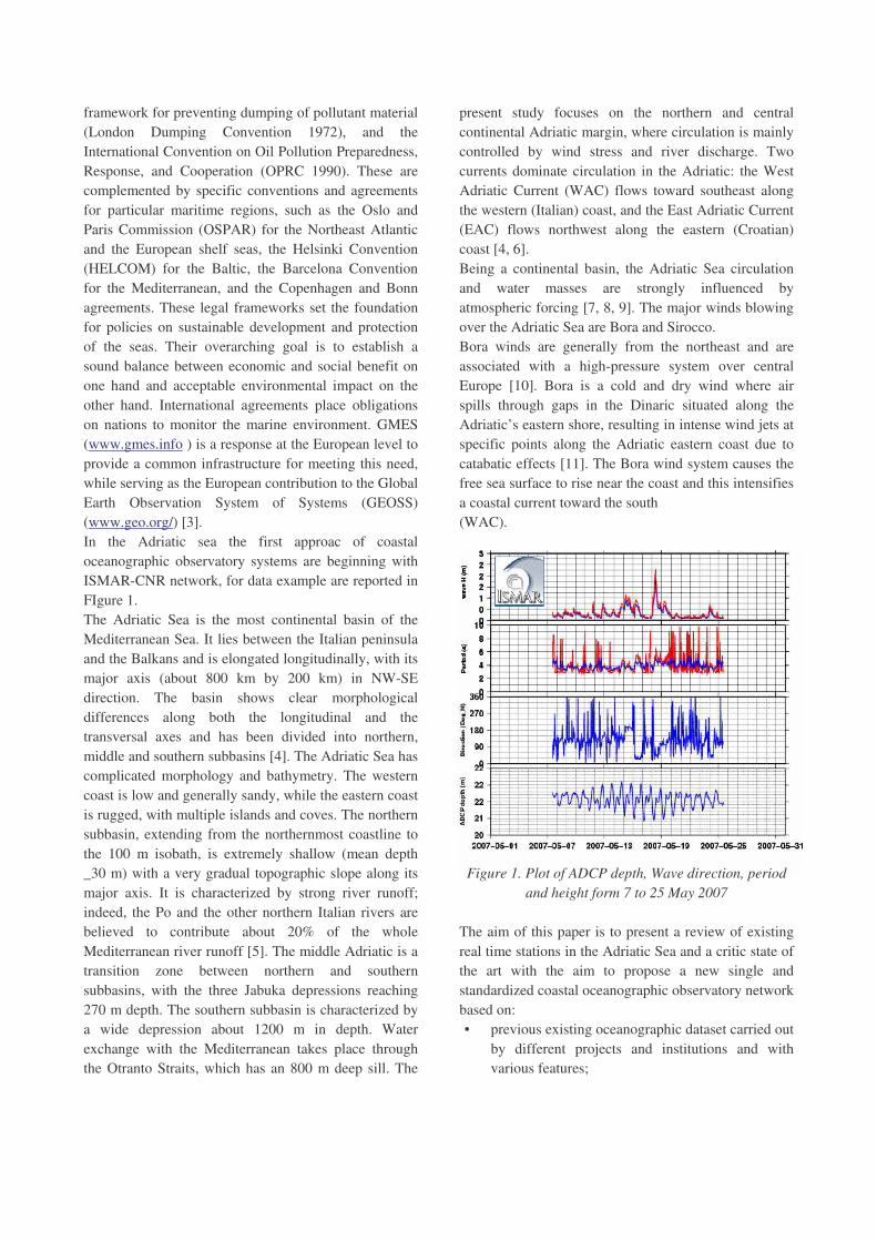
framework for preventing dumping of pollutant material (London Dumping Convention 1972), and the International Convention on Oil Pollution Preparedness, Response, and Cooperation (OPRC 1990). These are complemented by specific conventions and agreements for particular maritime regions, such as the Oslo and Paris Commission (OSPAR) for the Northeast Atlantic and the European shelf seas, the Helsinki Convention (HELCOM) for the Baltic, the Barcelona Convention for the Mediterranean, and the Copenhagen and Bonn agreements. These legal frameworks set the foundation for policies on sustainable development and protection of the seas. Their overarching goal is to establish a sound balance between economic and social benefit on one hand and acceptable environmental impact on the other hand. International agreements place obligations on nations to monitor the marine environment. GMES (www.gmes.info ) is a response at the European level to provide a common infrastructure for meeting this need, while serving as the European contribution to the Global Earth Observation System of Systems (GEOSS) (www.geo.org/) [3]. In the Adriatic sea the first approac of coastal oceanographic observatory systems are beginning with ISMAR-CNR network, for data example are reported in FIgure 1. The Adriatic Sea is the most continental basin of the Mediterranean Sea. It lies between the Italian peninsula and the Balkans and is elongated longitudinally, with its major axis (about 800 km by 200 km) in NW-SE direction. The basin shows clear morphological differences along both the longitudinal and the transversal axes and has been divided into northern, middle and southern subbasins [4]. The Adriatic Sea has complicated morphology and bathymetry. The western coast is low and generally sandy, while the eastern coast is rugged, with multiple islands and coves. The northern subbasin, extending from the northernmost coastline to the 100 m isobath, is extremely shallow (mean depth _30 m) with a very gradual topographic slope along its major axis. It is characterized by strong river runoff; indeed, the Po and the other northern Italian rivers are believed to contribute about 20% of the whole Mediterranean river runoff [5]. The middle Adriatic is a transition zone between northern and southern subbasins, with the three Jabuka depressions reaching 270 m depth. The southern subbasin is characterized by a wide depression about 1200 m in depth. Water exchange with the Mediterranean takes place through the Otranto Straits, which has an 800 m deep sill. The
present study focuses on the northern and central continental Adriatic margin, where circulation is mainly controlled by wind stress and river discharge. Two currents dominate circulation in the Adriatic: the West Adriatic Current (WAC) flows toward southeast along the western (Italian) coast, and the East Adriatic Current (EAC) flows northwest along the eastern (Croatian) coast [4, 6]. Being a continental basin, the Adriatic Sea circulation and water masses are strongly influenced by atmospheric forcing [7, 8, 9]. The major winds blowing over the Adriatic Sea are Bora and Sirocco. Bora winds are generally from the northeast and are associated with a high-pressure system over central Europe [10]. Bora is a cold and dry wind where air spills through gaps in the Dinaric situated along the Adriatic’s eastern shore, resulting in intense wind jets at specific points along the Adriatic eastern coast due to catabatic effects [11]. The Bora wind system causes the free sea surface to rise near the coast and this intensifies a coastal current toward the south (WAC). Figure 1. Plot of ADCP depth, Wave direction, period
and height form 7 to 25 May 2007 The aim of this paper is to present a review of existing real time stations in the Adriatic Sea and a critic state of the art with the aim to propose a new single and standardized coastal oceanographic observatory network based on: • previous existing oceanographic dataset carried out
by different projects and institutions and with various features;
• real time data accessible by web technologies, after a data quality control and sensor/instrument field calibration validation.
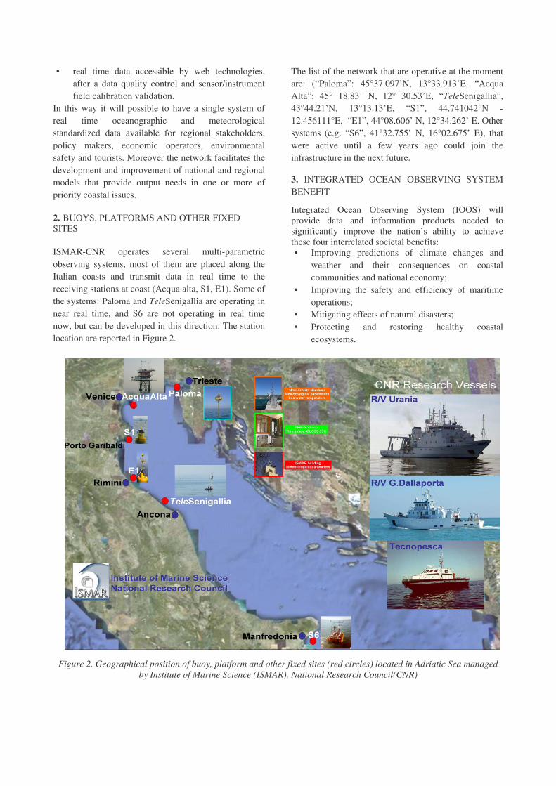
In this way it will possible to have a single system of real time oceanographic and meteorological standardized data available for regional stakeholders, policy makers, economic operators, environmental safety and tourists. Moreover the network facilitates the development and improvement of national and regional models that provide output needs in one or more of priority coastal issues. 2. BUOYS, PLATFORMS AND OTHER FIXED SITES ISMAR-CNR operates several multi-parametric observing systems, most of them are placed along the Italian coasts and transmit data in real time to the receiving stations at coast (Acqua alta, S1, E1). Some of the systems: Paloma and TeleSenigallia are operating in near real time, and S6 are not operating in real time now, but can be developed in this direction. The station location are reported in Figure 2.
The list of the network that are operative at the moment are: (“Paloma”: 45°37.097’N, 13°33.913’E, “Acqua Alta”: 45° 18.83’ N, 12° 30.53’E, “TeleSenigallia”, 43°44.21’N, 13°13.13’E, “S1”, 44.741042°N - 12.456111°E, “E1”, 44°08.606’ N, 12°34.262’ E. Other systems (e.g. “S6”, 41°32.755’ N, 16°02.675’ E), that were active until a few years ago could join the infrastructure in the next future.
3. INTEGRATED OCEAN OBSERVING SYSTEM BENEFIT
Integrated Ocean Observing System (IOOS) will provide data and information products needed to significantly improve the nation’s ability to achieve these four interrelated societal benefits: • Improving predictions of climate changes and
weather and their consequences on coastal communities and national economy;
• Improving the safety and efficiency of maritime operations;
• Mitigating effects of natural disasters; • Protecting and restoring healthy coastal
ecosystems.
Figure 2. Geographical position of buoy, platform and other fixed sites (red circles) located in Adriatic Sea managed by Institute of Marine Science (ISMAR), National Research Council(CNR)

These benefits will be accomplished by efficiently linking observations to modeling via data management and communications to provide services, products, and decision-support tools needed to achieve these goals.
To maximize the societal benefits, IOOS must focus development efforts on ready assets and the greatest opportunities for valuable, synergistic uses. IOOS is a complex system of systems that is best implemented in stages. Phased implementation requires the prioritization of existing assets that monitor variables that are essential and common to more than one societal benefit. The highest priority assets measure these core variables, using both in situ and remote sensing platforms, to provide new or existing products that can be improved by integrating data from more than one program, institution, or agency.
4. THE FUTURE GOALS
• Compare existing ocean observing systems to check the quality and consistency of the products and information;
• Identify and develop high-priority sensors and associated algorithms;
• Production of well-documented, sustainable, reliable, and quality-controlled data streams produced by existing monitoring assets;
• Choice of critical ocean variables and provisioning of high-quality, well-documented data in a timely fashion;
• Integrated data products for more accurate and timely assessment of environmental conditions.
5. REFERENCE
1. Desaubies, Y., (2005). The MERSEA Integrated Project. Ocean Weather Forecasting: An Integrated View of Oceanography, E. Chassignet and J. Verron, Eds., Springer Verlag, 449–453.
2. Anaman, K.A., Lellyett, S.C., Drake, L., Leigh, R.J., Henderson-Sellers, A., Noar, P.F., Sullivan, P.J. and Thampapillai, D.J. (1998). Benefits of meteorological services: evidence from recent research in Australia. Meteorological Applications, 5 (2),103-115.
3. Johannessen, J. A., Le Traon, P.-Y., Robinson, I., Nittis, K., Bell, M. J., Pinardi, N., and Bahurel, P. (2006). Marine Environment and Security for the European Area (MERSEA) - Towards operational oceanography. Bulletin of the American Meteorological Society, pp. 1081-1090.
4. Artegiani, A., Bregant, D., Paschini, E., Pinardi, N., Raicich, F., and Russo, A. (1997a). The Adriatic Sea general circulation. Part I. Air-sea interactions and water mass structure, J. Phys. Oceanogr., 27, 1492– 1514.
5. Hopkins, T. S., A. Artegiani, A., Bignami, F., and Russo, A. (1999). Water-mass modification in the Northern Adriatic: A preliminary assessment from the ELNA data set, in The Adriatic Sea, edited by T. S. Hopkins et al., Ecosyst. Res. Rep 32, pp. 3 – 23, Eur. Comm., Brussels.
6. Artegiani, A., Bregant, D., Paschini, E., Pinardi, N., Raicich, F., and Russo, A. (1997b). The Adriatic Sea general circulation. Part II: Baroclinic Circulation Structure, J. Phys. Oceanogr., 27, 1515– 1532.
7. Orlic, M., Gacic, M., and La Violette, P. E. (1992). The currents and circulation of the Adriatic Sea, Oceanol. Acta, 15(2), 109– 124.
8. Orlic, M., Kuzmic, M., and Pasaric, Z. (1994). Response of the Adriatic Sea to Bora and Sirocco forcings, Cont. Shelf. Res., 14(1), 91– 116.
9. Marini, M., Jones, B. H., Campanelli, A., Grilli, F., and Lee C. M. (2008). Seasonal variability and Po River plume influence on biochemical properties along western Adriatic coast, J. Geophys. Res., 113, C05S90
10. Dorman, C. E., et al. (2007), February 2003 marine atmospheric conditions and the bora over the northern Adriatic, J. Geophys. Res., 112, C03S03,
doi:10.1029/2005JC003134.
11. Poulain P. M. and Raicich F. (2001). Forcings, in Physical Oceanography of the Adriatic Sea, B. Cushman-Roisin et al., Kluwer Acad., Dordrecht, Netherlands, pp. 45-65.