Real Time Management of Bathing Water Quality in Barcelona ...
10
NOVATECH 2010 1 Real Time Management of Bathing Water Quality in Barcelona Gestion en temps réel de la qualité des eaux de baignade à Barcelone Gutiérrez, E.; Malgrat, P.; Suñer, D.; Otheguy, P. CLABSA: [email protected]; [email protected]; [email protected] Lyonnaise des Eaux: [email protected] RÉSUMÉ Les eaux côtières à proximité des zones urbaines sont exposées à des débordements des systèmes d'assainissement. Ces débordements causent des épisodes de contamination de l'eau à court terme, pouvant affecter la qualité des eaux de baignade. La nouvelle directive européenne des eaux de baignade fait appliquer la "gestion active" de la qualité de l'eau au lieu de la simple surveillance. Il faut noter que la contamination à court terme tient une place importante dans la directive. La ville de Barcelone a mis en place cette nouvelle "philosophie", avant même que la directive a été approuvée, avec des procédures de gestion active pendant les épisodes de contamination à court terme et l'utilisation de critères de qualité des eaux de baignade dans sa planification à long terme du réseau d'assainissement. Un protocole spécifique signé par sept organisations différentes a été mis en place pour assurer la bonne gestion de ces courts épisodes de contamination, leur maîtrise, leurs suites et l'information du public. Un système d'information intégré est utilisé pour informer le grand public et les gestionnaires de plages avec différents niveaux d'information. L'information est diffusée au moyen de panneaux électroniques situés sur les plages et par le biais d'Internet, avec un site à accès privé pour les gestionnaires de plages et un site destiné au grand public, relié au site web de la mairie. Le système COWAMA (Gestion des eaux côtières) a été développé pour fournir l'appui technique nécessaire afin d'appliquer les différentes stratégies de gestion. COWAMA est un outil d'aide à la décision utilisant la modélisation intégrée de réseaux d'assainissement et des eaux côtières, alimenté en temps réel par les données provenant de capteurs contrôlés et les prévisions météorologiques, dans le but de fournir des prévisions de la qualité des eaux de baignade jusqu'à 48 heures à l'avance. ABSTRACT Coastal waters near urban areas are exposed to sewer systems overflows. These overflows cause episodes of short term water contamination which may affect the quality of bathing waters. The new European Bathing Water Directive enforces “active management” of water quality instead of simple “monitoring”. It is important to note that short term contamination has a relevant role in this Directive. The city of Barcelona has been implementing this new philosophy even before than the Directive was approved, with active management procedures during short term contamination episodes and the use of bathing water quality standards in its long term sewer network planning. A dedicated protocol signed by seven different organizations has been established to assure proper management of these short contamination episodes for their detention, correction and information to the public. An integrated information system is used to inform the general public and the beach managers with different levels of information. Information is supplied through dedicated beach electronic panels and the internet, with a private access web for beach managers and a general public beach information web linked to the town hall web site. The system COWAMA (COastal WAter MAnagement) has been developed to give the required technological support to implement the different management strategies. COWAMA is a decision making aid tool which uses integrated modelling (sewer and marine models) fed with real time data from controlled sensors and meteorological model predictions, to provide forecast of bathing water quality with a forecast horizon of up to 48 hr. KEYWORDS Integrated modelling, CSO, DWO, bathing water quality prediction, beach management, alert systems, water cycle integrated management.
Transcript of Real Time Management of Bathing Water Quality in Barcelona ...

NOVATECH 2010
1
Real Time Management of Bathing Water Quality in Barcelona
Gestion en temps réel de la qualité des eaux de baignade à Barcelone
Gutiérrez, E.; Malgrat, P.; Suñer, D.; Otheguy, P. CLABSA: [email protected]; [email protected]; [email protected] Lyonnaise des Eaux: [email protected]
RÉSUMÉ Les eaux côtières à proximité des zones urbaines sont exposées à des débordements des systèmes d'assainissement. Ces débordements causent des épisodes de contamination de l'eau à court terme, pouvant affecter la qualité des eaux de baignade. La nouvelle directive européenne des eaux de baignade fait appliquer la "gestion active" de la qualité de l'eau au lieu de la simple surveillance. Il faut noter que la contamination à court terme tient une place importante dans la directive. La ville de Barcelone a mis en place cette nouvelle "philosophie", avant même que la directive a été approuvée, avec des procédures de gestion active pendant les épisodes de contamination à court terme et l'utilisation de critères de qualité des eaux de baignade dans sa planification à long terme du réseau d'assainissement. Un protocole spécifique signé par sept organisations différentes a été mis en place pour assurer la bonne gestion de ces courts épisodes de contamination, leur maîtrise, leurs suites et l'information du public. Un système d'information intégré est utilisé pour informer le grand public et les gestionnaires de plages avec différents niveaux d'information. L'information est diffusée au moyen de panneaux électroniques situés sur les plages et par le biais d'Internet, avec un site à accès privé pour les gestionnaires de plages et un site destiné au grand public, relié au site web de la mairie. Le système COWAMA (Gestion des eaux côtières) a été développé pour fournir l'appui technique nécessaire afin d'appliquer les différentes stratégies de gestion. COWAMA est un outil d'aide à la décision utilisant la modélisation intégrée de réseaux d'assainissement et des eaux côtières, alimenté en temps réel par les données provenant de capteurs contrôlés et les prévisions météorologiques, dans le but de fournir des prévisions de la qualité des eaux de baignade jusqu'à 48 heures à l'avance.
ABSTRACT Coastal waters near urban areas are exposed to sewer systems overflows. These overflows cause episodes of short term water contamination which may affect the quality of bathing waters. The new European Bathing Water Directive enforces “active management” of water quality instead of simple “monitoring”. It is important to note that short term contamination has a relevant role in this Directive. The city of Barcelona has been implementing this new philosophy even before than the Directive was approved, with active management procedures during short term contamination episodes and the use of bathing water quality standards in its long term sewer network planning. A dedicated protocol signed by seven different organizations has been established to assure proper management of these short contamination episodes for their detention, correction and information to the public. An integrated information system is used to inform the general public and the beach managers with different levels of information. Information is supplied through dedicated beach electronic panels and the internet, with a private access web for beach managers and a general public beach information web linked to the town hall web site. The system COWAMA (COastal WAter MAnagement) has been developed to give the required technological support to implement the different management strategies. COWAMA is a decision making aid tool which uses integrated modelling (sewer and marine models) fed with real time data from controlled sensors and meteorological model predictions, to provide forecast of bathing water quality with a forecast horizon of up to 48 hr.
KEYWORDS
Integrated modelling, CSO, DWO, bathing water quality prediction, beach management, alert systems, water cycle integrated management.

SESSION 3.9
2
1 INTRODUCTION
Until the European Water Framework Directive 200/60/EC, it had been very common to forget that to effectively protect the environmental quality of the receiving water bodies it is necessary to coordinate all subsystems which form the water cycle: surface waters, sewer networks, waste water treatment plants (WWTP), ground water and the actual receiving waters. The usual fragmented and uncoordinated approach explained why most countries had devoted most of their efforts in the treatment of waste water, leaving aside the management of storm water. This strategy has proved inefficient from an environmental point of view due to the contamination capacity of storm water (Malgrat, 1995), especially in combined sewer systems in which combined sewer overflows (CSO) under rain events can be responsible for up to 50 % of the pollution that arrives to the receiving waters (Spanish Ministry of Environment, 2001). This problem has now been addressed in several European Directives and National Normatives.
Nowadays, the idea that a sewer network and treatment system cannot be planned and operated without taking into account the receiving waters is well established. In addition to having each part of the system working correctly, there is a need to minimize the impact of the final effluent of the system, both in dry weather and rainy weather conditions. Only an integral management of the full water cycle will lead to a sustainable environment in the XXI century (Malgrat, 2004).
The bathing water directive 76/160/EEC has been replaced in February 2006 by the European Commission Directive 2006/7/CE concerning the management of bathing water quality (bathing water directive or BWD). The main principles of this new directive had already been outlined in a document of the European Commission dated 21/12/2000, “Elaboration of a new policy for bathing water”:
Change in pollution indicators and strengthening of water quality standards. As a result of epidemiologic studies, new indicators have been elected for assessing water quality and also new standards for water quality have been defined.
Evolution from monitoring to an integral management of water quality. The previous bathing water directive required very limited action of member sates, mostly constituted of periodic field surveys. In coherence with the WFD, the new BWD promotes the management of the water cycle as a whole and enforces responses in case of non compliance with directive standards. These responses may be infrastructural, like the building of water detention tanks, or contingent, like beach closures or installation of warning signs for bathers.
Information to the public. According to the new directive, the public must be kept informed of water quality. Moreover, when bathing waters are subjected to short duration pollution events (namely CSO or Combined Sewer Overflows), it requires putting in place alert systems with brief response time.
The new BWD enforces “active management” of bathing water quality instead of simple “monitoring”. Therefore, responsible authorities have an important task ahead to develop bathing water profiles, detect possible sources of contamination and their impact on water quality, and take adequate correction measures. There is a need to compile, analyze and interpret all available data and inform the public. Additionally, they have to react to emergency situations and inform the public if bathing is posses a health risk. The BWD has been transposed to the spanish law with the Real Decreto RD 1341/2007, which not only transposes the European requirements but is also more restrict, with a tighter timetable to implement the different measures.
The following chapters present the experience accumulated by CLABSA and the Barcelona’s City Council in implementing the requirements of the new BWD.
2 THE CONTEXT OF BARCELONA
Barcelona, located in the Mediterranean coast, is the second biggest city in Spain. Barcelona presents an especially complex hydrological context:
Barcelona has a population of 1.6 million inhabitants, and 1.5 million more in the metropolitan area. Barcelona occupies 100 km2, and the metropolitan area is 400 km2 more. Most districts of the city present an extremely high density (16000 inhabit/km2). There is also an intricate network of buried urban services: tunnels for trains, subway, highways, conventional services, etc.) that makes very complex any work in the sewer network, especially if these works have not been

NOVATECH 2010
3
planned before the construction of new tunnels.
The city area has a hilly line parallel to the sea and close to it. This means that in distances of less than 10 km, the slope of the terrain varies from 30% to 40% uphill to slopes around 0.1% to 0.2% close to the sea. For this reason, in rain events, the water runs off very quickly, with higher peaks due to the imperviousity of the urban soil, flooding the low lying areas of the city.
Rain patterns are quite irregular, and although the total annual volume (600 mm) is moderate, the rain events are concentrated in very few days with high intensities (155 mm/h in 20 minutes). Two or three events may add up half of the total annual volume, and even a 15% of it may fall in just one hour. These kind of convective rain events are characteristic of this Mediterranean area.
The city is limited laterally by two rivers, with short and irregular flows and low water quality. The seafront of the city has been transformed, and it is today a key touristic place, with over 4 km of beaches, visited by over 3 million tourists each year.
Barcelona’s sewer system is combined, with coverage of 100% of the population. The sewer network has a length of 1500 km. The cross sections are relatively large, with half of the sewer network length with a cross section of over 1 m2, and very few pipes have a cross section of 400 mm, which is the smallest size allowed in the public sewer network.
Up to the early 90’s, Barcelona faced flooding problems and overflows, causing environmental pollution. The municipality decided to create a new company, a Public-Private-Partnership, with a technological leading strategic partner, Agbar, to build a new model of management (CLABSA).
This management model, called Advanced Urban Drainage Management (GADU) requires a precise and thorough knowledge of the system, integrated planning, coordinated and complete real-time management, and environmental and sustainable focus. Its implementation requires the development of:
an Integrated Sewerage Master Plan, based on a GIS,
a modelling system for the sewer network, the waste water treatment plant and the receiving waters (quality and quantity),
a remote control System (Salamero et al., 2002; Ramón et al., 2004) and,
an emergency operation system, that decides the warning level and activates a coordinated procedure.
The precise integration of all the above-mentioned components is the key for the minimization of flooding and the reduction of environmental impacts. The success of this model has been exported to other cities, small and big, with great success (Montero, 2009).
Figure 1. Advance Urban Drainage Management (“GADU”) asset investment benefit.
3 IMPLEMENTATION OF THE NEW BWD REQUIREMENTS IN BARCELONA
The new BWD implies new requirements both in the short and in the long term, as part of the above mentioned new concept of bathing water quality “management”. Barcelona’s city council, with the collaboration of CLABSA, has been implementing this new philosophy, even before than the actual Directive was approved.
SESSION 3.9
4
3.1 Bathing water quality management in the long term (sewer network long term planning)
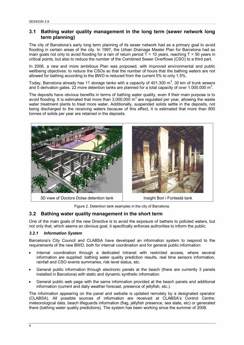
The city of Barcelona’s early long term planning of its sewer network had as a primary goal to avoid flooding in certain areas of the city. In 1997, the Urban Drainage Master Plan for Barcelona had as main goals not only to avoid flooding for a rain of return period T = 10 years, reaching T = 50 years in critical points, but also to reduce the number of the Combined Sewer Overflows (CSO) to a third part.
In 2006, a new and more ambitious Plan was proposed, with improved environmental and public wellbeing objectives: to reduce the CSOs so that the number of hours that the bathing waters are not allowed for bathing according to the BWD is reduced from the current 5% to only 1.5%.
Today, Barcelona already has 11 storage tanks with a capacity of 401.300 m3, 30 km of trunk sewers and 5 derivation gates. 22 more detention tanks are planned for a total capacity of over 1.000.000 m3.
The deposits have obvious benefits in terms of bathing water quality, even if their main purpose is to avoid flooding. It is estimated that more than 3,000,000 m3 are regulated per year, allowing the waste water treatment plants to treat more water. Additionally, suspended solids settle in the deposits, not being discharged to the receiving waters because of this effect, it is estimated that more than 800 tonnes of solids per year are retained in the deposits.
3D view of Doctors Dolsa detention tank
Insight Bori i Fontestà tank
Figure 2. Detention tank examples in the city of Barcelona.
3.2 Bathing water quality management in the short term
One of the main goals of the new Directive is to avoid the exposure of bathers to polluted waters, but not only that, which seems an obvious goal, it specifically enforces authorities to inform the public.
3.2.1 Information System
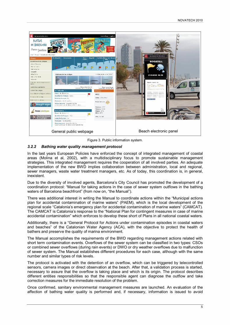
Barcelona’s City Council and CLABSA have developed an information system to respond to the requirements of the new BWD, both for internal coordination and for general public information:
Internal coordination through a dedicated intranet with restricted access, where several information are supplied: bathing water quality prediction results, real time sensors information, rainfall and CSO events summaries, risk level status, etc.
General public information through electronic panels at the beach (there are currently 3 panels installed in Barcelona) with static and dynamic synthetic information.
General public web page with the same information provided at the beach panels and additional information (current and daily weather forecast, presence of jellyfish, etc.).
The information appearing on the panel and website is updated remotely by a designated operator (CLABSA). All possible sources of information are received at CLABSA’s Control Centre: meteorological data, beach lifeguards information (flag, jellyfish presence, sea state, etc) or generated there (bathing water quality predictions). The system has been working since the summer of 2008.
NOVATECH 2010
5
General public webpage Beach electronic panel
Figure 3. Public information system.
3.2.2 Bathing water quality management protocol
In the last years European Policies have enforced the concept of integrated management of coastal areas (Molina et al, 2002), with a multidisciplinary focus to promote sustainable management strategies. This integrated management requires the cooperation of all involved parties. An adequate implementation of the new BWD implies collaboration between administration, local and regional, sewer managers, waste water treatment managers, etc. As of today, this coordination is, in general, inexistent.
Due to the diversity of involved agents, Barcelona’s City Council has promoted the development of a coordination protocol: “Manual for taking actions in the case of sewer system outflows in the bathing waters of Barcelona beachfront” (from now on, “the Manual”).
There was additional interest in writing the Manual to coordinate actions within the “Municipal actions plan for accidental contamination of marine waters” (PAEM), which is the local development of the regional scale “Catalonia’s emergency plan for accidental contamination of marine waters” (CAMCAT). The CAMCAT is Catalonia’s response to the “National Plan for contingent measures in case of marine accidental contamination” which enforces to develop these short of Plans in all national coastal waters.
Additionally, there is a “General Protocol for Actions under contamination episodes in coastal waters and beaches” of the Catalonian Water Agency (ACA), with the objective to protect the health of bathers and preserve the quality of marina environment.
The Manual accomplishes the requirements of the BWD regarding management actions related with short term contamination events. Overflows of the sewer system can be classified in two types: CSOs or combined sewer overflows (during rain events) or DWO or dry weather overflows due to malfunction of sewer system. The Manual establishes different procedures for each case, although with the same number and similar types of risk levels.
The protocol is activated with the detention of an overflow, which can be triggered by telecontrolled sensors, camera images or direct observation at the beach. After that, a validation process is started, necessary to assure that the overflow is taking place and which is its origin. The protocol describes different entities responsibilities so that the responsible agent can diagnose the outflow and take correction measures for the immediate resolution of the problem.
Once confirmed, sanitary environmental management measures are launched. An evaluation of the affection of bathing water quality is performed and, if necessary, information is issued to avoid

SESSION 3.9
6
exposure of bathers to polluted waters. The procedure is characterized by the definition of risk levels, from 0 to 5, depending on the severity of the pollution event and the available information as the event develops.
The risk levels allow the coordination between the Manual and the PAEM. In this sense, once level 4 or 5 are reached, a warning is issued proposing the activation of the PAEM due to a sewer overflow contamination event. Lower risk levels are resolved within the procedures described in the Manual.
Levels 0, 1 and 2 correspond to the phases of detention and validation of the overflow. Levels 3, 4 or 5 are related with the different effects that the overflow may impact on receiving waters quality. Both for CSO or DWO, level 3 implies probable affection of water quality, and therefore a yellow flag is issued at the beach (recommendation of not going in the water). Level 4 implies a certain affection of water quality with the issue of a red flag (bathing is prohibited). Level 5 is reserved for exceptional situations not contemplated in the Manual and are managed through the PAEM.
Agile responses, coordination and collaboration between different affected agents are the key issues in the processes established in the Manual. The COWAMA technological tool becomes a key element in the evaluation in real time, and even prediction, of the affection to bathing water quality due to the sewer system overflows.
EMERGENCY LEVEL ( from 0 to 5 )
INTERVENTION PROCESSES
Detection and validation (0,1,2)
Water level sensors
Environmental sanitary management (3,4,5)
Confirmation
On-line information
Information to swimmers
Real time control system
Modeling system (COWAMA)
Territorial Information System
Centralized Operation System
CSO detection
Rain alert
Detection DSU
DWO detection
Validation
Confirmation
PAEM
Activation
Rain gauges
Meteo forecast
External information
Figure 4. Workflow describing the management procedures outlined in the Manual.
4 THE COWAMA APPLICATION
In order to response to the necessities dictated by the new BWD an adequate technological tool is required. The COWAMA (Coastal Water Management) project has been developed with funds from R+i Alliance by CLABSA with the collaboration of Lyonnaise-des-Eaux, and other international partners (Hidromod and Technical University of Lisbon). It is fully operative in Barcelona, Saint Jean de Luz, Alicante and Sitges (Suñer, 2008; Gutiérrez, E. 2008).
As an instrument of support for beach management entities incorporating the requirements stated in the new BWD, the COWAMA project focuses on two aspects:
the design of infrastructural responses to pollution issues, and the implementation of contingence measures for short duration pollution events (CSO)
4.1 Description
The COWAMA project consists mainly of a computational application that links a sensors network with fluid flow simulations models in order to produce statistics on water quality to be supplied to local
NOVATECH 2010
7
authorities and be published for public information.
The core of the application couples five different fluid flow and quality models, each of them simulating a subsystem: watershed, river basin, urban drainage network, WWTP and receiving waters (may be coastal or inland). Those models are fed either with real time or historical data obtained from sensors (rain gauges, water level sensors, etc.) and large scale forecasts (e.g. meteorological models).
The system is designed to work both online and offline:
Offline mode: simulations based on historical data to reproduce past pollution events and retrieve long term statistics. These statistics allow the definition of beach profiles as required by the new BWD. Indeed, for beaches submitted to short duration pollution events, the directive imposes an evaluation of the estimated frequency and duration of contamination episodes. The same kind of long term simulations may be used to elaborate a cost-benefit analysis or measure the effectiveness of planned modifications of the water collection system or of any relevant coastal infrastructure that may influence polluted masses transport.
Online mode: Real time data on rain and sewer water levels are to be used for fast CSO detention and results from real time models are used for the alert systems and water quality forecasts.
4.2 Input data
The input data may be classified in static and dynamic. The static data is set for each simulation and does not change in the course of a simulation. It includes mostly the relevant physical data of the simulated domain (topography, bathymetry, pipes networks, catchments definition, etc.) and some fixed hydraulic (ocean bottom roughness, capacity curves, infiltration coefficients, etc.) and numerical parameters (advection scheme, turbulence parameterization).
The dynamic data may continuously change during one simulation. An example would be the opening of an operated gate at the inlet of a detention tank. This information needs to be supplied all along the simulation. Dynamic data includes essentially data collected by sensors (in real time or differed in time) and results of other models needed for boundary conditions (sewer model outflows or wind forecasts for the marine model).
Different types of sensors may be used to feed the simulation models, detect pollution events but also to calibrate the models and validate their results: rain gauges, water level gauges, waste water automatic sampling stations, current meters (hydrodynamic coastal model calibration), HF radar data, tidal gauges, multi-parametric sensors for receiving waters quality, pyranometers, etc.
4.3 Numerical models
Each of the simulation models corresponds to one subsystem of the water cycle: catchments, river, collection system, WWTP and receiving waters. These models must be coupled in a single application that allows simulating the flow and the transport of contaminated matter carried by rainfalls, from surface runoff to pollution dispersion in receiving waters. This articulation of models initially thought to work independently constitutes a major difficulty and was one of the tasks accomplished in the framework of the COWAMA project.
The watershed model for surface runoff calculation is based on semi-empirical methods (like the rational method). It gives flow rates at the different inlets of the drainage network and rivers of the studied area. This model is fed in real-time with data from rain gauges (MOUSE runoff module).
The river and sewer network models (MOUSE) are based on a very similar formulation. They solve numerically the Saint-Venant equations in one dimension and one equation for advection and dispersion of polluting substances. Additionally, bio-chemical degradation or production may be incorporated. Boundary conditions are normally provided by the watershed model, but may also be deduced real-time from water level gauges near the inlets of the system.
The WWTP model is used for calculating flow rates and water quality parameters of the WWTP discharges to receiving waters. This model uses the sewers network model results as an input.
The receiving waters model (MOHID) is a three-dimensional coastal model, and may be used for costal zones as well as for estuaries and inland bathing areas. Model forcing (i.e. boundary conditions) includes wind, waves (wave forcing is obtained through SWAN, a dedicated model for
SESSION 3.9
8
wave generation, propagation and breaking) and tides, data that may be historical or forecasted. This model solves numerically the free surface flow equations and the transport equations of relevant physical quantities (temperature, salinity, etc.). Ecological models for polluting substances degradation and production can also be included, in particular for simulating bacteriological mortality. Input data is given by the river, sewers network and WTTP models, in the form of hydrographs and contaminants concentrations curves. Water properties (thus pollution as well) can be modelled with an eulerian or a lagrangian approach, the earlier is indicated for large outflows (e.g. Barcelona) and the latter for smaller point source outflows or submarine outfalls, having the advantage of providing the ability to track pollution sources (lagrangian tracers). The final result is a three-dimensional map of bacteriological concentrations, with ability to obtain statistics at any location within the model domain.
4.4 Calibration of models
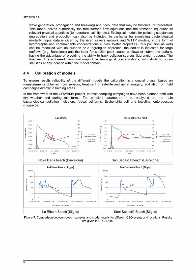
To ensure results reliability of the different models the calibration is a crucial phase, based on measurements obtained from sensors, treatment of satellite and aerial imagery, and also from field campaigns directly in bathing areas.
In the framework of the COWAMA project, intense sampling campaigns have been planned both with dry weather and during rainstorms. The principal parameters to be analyzed are the main bacteriological pollution indicators: faecal coliforms, Escherichia coli and intestinal enterococcus (Figure 5).
0
20
40
60
80
100
120
140
160
1.E‐01
1.E+00
1.E+01
1.E+02
1.E+03
1.E+04
1.E+05
1.E+06
12‐8‐07 18:00 13‐8‐07 6:00 13‐8‐07 18:00 14‐8‐07 6:00 14‐8‐07 18:00
Flow [m3/s]
E. coli [CFU
/100 m
l]
Time
E. coli PSA2
PSA2 model
PSA 2 field data
Ginebra flow
Bogatell flow
Nova Icaria beach (Barcelona)
0
20
40
60
80
100
120
140
160
1.E‐01
1.E+00
1.E+01
1.E+02
1.E+03
1.E+04
1.E+05
1.E+06
1.E+07
12‐8‐07 18:00 13‐8‐07 6:00 13‐8‐07 18:00 14‐8‐07 6:00 14‐8‐07 18:00
Flow [m3/s]
faecal coliform
s [CFU
/100 ml]
Time
Faecal coliforms PSA2
PSA2 model
PSA 2 field data
Ginebra flow
Bogatell flow
San Sebastià beach (Barcelona)
1
10
100
1000
10000
100000
21/10/2009 0:00 21/10/2009 12:00 22/10/2009 0:00 22/10/2009 12:00 23/10/2009 0:00
E. Coli UFC
/ 100 m
l
La Ribera Beach (Sitges)
Model Samples
La Ribera Beach (Sitges)
1
10
100
1000
10000
100000
21/10/2009 0:00 21/10/2009 12:00 22/10/2009 0:00 22/10/2009 12:00 23/10/2009 0:00
E. Coli UFC
/ 100 m
l
Sant Sebastià Beach (Sitges)
Model Samples
Sant Sebastià Beach (Sitges)
Figure 5. Comparison between beach samples and model results for different CSO events and locations. Results are given in UFC/100ml.
NOVATECH 2010
9
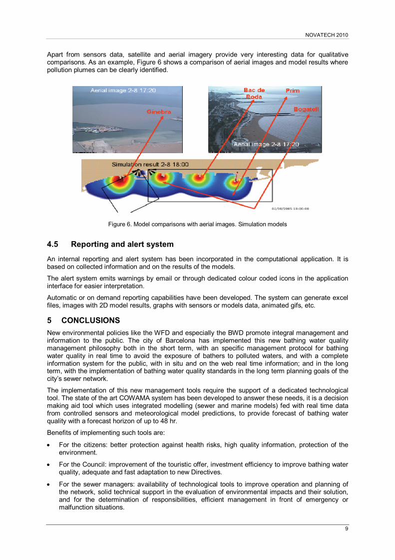
Apart from sensors data, satellite and aerial imagery provide very interesting data for qualitative comparisons. As an example, Figure 6 shows a comparison of aerial images and model results where pollution plumes can be clearly identified.
Figure 6. Model comparisons with aerial images. Simulation models
4.5 Reporting and alert system
An internal reporting and alert system has been incorporated in the computational application. It is based on collected information and on the results of the models.
The alert system emits warnings by email or through dedicated colour coded icons in the application interface for easier interpretation.
Automatic or on demand reporting capabilities have been developed. The system can generate excel files, images with 2D model results, graphs with sensors or models data, animated gifs, etc.
5 CONCLUSIONS
New environmental policies like the WFD and especially the BWD promote integral management and information to the public. The city of Barcelona has implemented this new bathing water quality management philosophy both in the short term, with an specific management protocol for bathing water quality in real time to avoid the exposure of bathers to polluted waters, and with a complete information system for the public, with in situ and on the web real time information; and in the long term, with the implementation of bathing water quality standards in the long term planning goals of the city’s sewer network.
The implementation of this new management tools require the support of a dedicated technological tool. The state of the art COWAMA system has been developed to answer these needs, it is a decision making aid tool which uses integrated modelling (sewer and marine models) fed with real time data from controlled sensors and meteorological model predictions, to provide forecast of bathing water quality with a forecast horizon of up to 48 hr.
Benefits of implementing such tools are:
For the citizens: better protection against health risks, high quality information, protection of the environment.
For the Council: improvement of the touristic offer, investment efficiency to improve bathing water quality, adequate and fast adaptation to new Directives.
For the sewer managers: availability of technological tools to improve operation and planning of the network, solid technical support in the evaluation of environmental impacts and their solution, and for the determination of responsibilities, efficient management in front of emergency or malfunction situations.

SESSION 3.9
10
LIST OF REFERENCES
European Commission (2000). Directive 2000/60/EC of the European Parliament and of the Council of 23 October 2000, establishing a framework for Community action in the field of water policy. CE, Brussels.
European Commission (2006). Directive 2006/7/CE of the European Parliament and of the Council of 15 February 2006 concerning the management of bathing water quality and repealing Directive 76/160/EEC. CE, Brussels.
European Economic Commission (1976). Council Directive 76/160/EEC of 8 December 1975 concerning the quality of bathing water. EEC, Brussels.
Gutierrez, E.; Suñer, D.; Malgrat, P.; Clochard, B.; Galvão, P.; (2008). COWAMA (Coastal Water Management) integrated and real time management system of urban water cycle to protect the quality of bathing waters. International Water Association World Water Congress and Exhibition, Viena.
Malgrat, P. (1995). Control de la contaminación producida en tiempo de lluvia por las Descargas de Sistemas Unitarios de Alcantarillado. Revista Obra Pública (Saneamiento II, nº 33).
Malgrat, P.; Suñer, D.; Escaler, I.; Rivero, F. (2004). La protección racional de la calidad de las aguas costeras en base a la gestión integrada y en tiempo real del medio hídrico. Jornada de la AEAS, Barcelona.
Ministerio de Medio Ambiente (2001). Programa nacional para la medida de la calidad de las descargas de sistemas unitarios a los medios receptores.
Molina, J.; López Vera, F.; García Hernán, O. (2002). Grupo de Trabajo GT6: Gestión integrada de las aguas continentales (superficiales y subterráneas), de transición y costeras. VI Congreso Nacional del Medio Ambiente. Madrid.
Montero, C.; Malgrat, P. (2009). Advanced Urban Drainage: The Case of Barcelona. World City Water Forum 2009, Incheon, Korea.
Ramón, G., Escaler, I., Verdejo, JM. (2004). Data acquisition in a combined sewer system. Real Time Control Seminar. (NOVATECH 2004). Lyon, France.
Real Decreto 1341/2007 (2007). RD 1341/2007, de 11 de octubre, sobre la gestión de la calidad de las aguas de baño. Ministerio de la Presidencia, Madrid.
Salamero, M.; Cembrano, G.; Escaler, I.; Quevedo, J.; Puig, V.; Figueras J. (2002) Real Time Optimization of the No Flooding/ No CSO Binomium. The Barcelona Sewer Network Case. Proceedings of the 9th International Conference on Urban Drainage (ICUD 2002), Portland, Oregon, USA.
Suñer, D.; Malgrat, P.; Gutiérrez, E.; Clochard, B. (2007) COWAMA (Coastal Water Management) Integrated and Real Time Management System of Urban Water Cycle to Protect the Quality of Bathing Waters. 6th international conference on sustainable techniques and strategies in urban water management (NOVATECH 2007), Lyon, France.
Suñer, D.; Malgrat, P.; Leitão, P.; Clochard, B. (2008). COWAMA - Integrated and real time management system of urban drainage to protect the bathing waters. 11th International Conference on Urban Drainage (ICUD), Edinburgh, Scotland.