Ravine Strategy Implementation - Toronto...Ravine Strategy Implementation 2 from nature-based...
45
Ravine Strategy Implementation 1 REPORT FOR ACTION Ravine Strategy Implementation Date: January 8, 2020 To: Executive Committee From: General Manager, Parks Forestry and Recreation; Chief Planner and Executive Director, City Planning; and General Manager, Toronto Water Wards: All SUMMARY In October 2017, City Council adopted the Toronto Ravine Strategy, and directed the General Manager, Parks, Forestry and Recreation (PFR), the Chief Planner and Executive Director, City Planning, and the General Manager, Toronto Water, in consultation with the General Manager, Transportation Services and the Toronto and Region Conservation Authority (TRCA) to establish an interdivisional 10-year implementation strategy and capital plan for the Ravine Strategy. The Ravine Strategy provides, for the first time, an intentional and coordinated vision and approach to managing this natural resource on an ongoing basis through a series of 20 actions under five guiding principles: Protect, Invest, Connect, Partner, and Celebrate. The Strategy guides the management of the ravines and ensures the protection of these irreplaceable lands is balanced with their use and enjoyment, so that they continue to bring nature to people and flourish for the next 100 years and beyond. Toronto’s ravine system extends over 300 km and covers 11,000 hectares, or 17 percent of Toronto’s land area. Over half (5700 hectares) of ravine system land is publicly owned parkland. This includes over 1100 hectares within Rouge National Urban Park that is under Parks Canada jurisdiction. The remaining 40 percent is owned by a patchwork of landowners, including public institutions and private property owners, and includes approximately 30,000 private addresses. Ravines provide an exciting opportunity to connect people in the city with nature. Approximately 30 percent of Toronto’s population lives within 500 metres of ravines, and some areas of the city in close proximity to ravines will see considerable population growth in the coming years, such as Don Mills and Eglinton, the Lower Don, and more. The ravine system provides significant opportunities to reflect the integral connection that continues today between the Indigenous communities that were the original inhabitants of the area and Toronto's natural spaces and waterways. Ravines provide essential access to urban greenspace and opportunities for passive and active recreation which contributes to the physical health, mental health and well- being of residents. Toronto's ravines provide over $800 million in services every year EX12.1
Transcript of Ravine Strategy Implementation - Toronto...Ravine Strategy Implementation 2 from nature-based...
Ravine Strategy Implementation 1
REPORT FOR ACTION
Ravine Strategy Implementation Date: January 8, 2020 To: Executive Committee From: General Manager, Parks Forestry and Recreation; Chief Planner and Executive Director, City Planning; and General Manager, Toronto Water Wards: All
SUMMARY In October 2017, City Council adopted the Toronto Ravine Strategy, and directed the General Manager, Parks, Forestry and Recreation (PFR), the Chief Planner and Executive Director, City Planning, and the General Manager, Toronto Water, in consultation with the General Manager, Transportation Services and the Toronto and Region Conservation Authority (TRCA) to establish an interdivisional 10-year implementation strategy and capital plan for the Ravine Strategy.
The Ravine Strategy provides, for the first time, an intentional and coordinated vision and approach to managing this natural resource on an ongoing basis through a series of 20 actions under five guiding principles: Protect, Invest, Connect, Partner, and Celebrate. The Strategy guides the management of the ravines and ensures the protection of these irreplaceable lands is balanced with their use and enjoyment, so that they continue to bring nature to people and flourish for the next 100 years and beyond.
Toronto’s ravine system extends over 300 km and covers 11,000 hectares, or 17 percent of Toronto’s land area. Over half (5700 hectares) of ravine system land is publicly owned parkland. This includes over 1100 hectares within Rouge National Urban Park that is under Parks Canada jurisdiction. The remaining 40 percent is owned by a patchwork of landowners, including public institutions and private property owners, and includes approximately 30,000 private addresses.
Ravines provide an exciting opportunity to connect people in the city with nature. Approximately 30 percent of Toronto’s population lives within 500 metres of ravines, and some areas of the city in close proximity to ravines will see considerable population growth in the coming years, such as Don Mills and Eglinton, the Lower Don, and more. The ravine system provides significant opportunities to reflect the integral connection that continues today between the Indigenous communities that were the original inhabitants of the area and Toronto's natural spaces and waterways.
Ravines provide essential access to urban greenspace and opportunities for passive and active recreation which contributes to the physical health, mental health and well-being of residents. Toronto's ravines provide over $800 million in services every year
EX12.1
Ravine Strategy Implementation 2
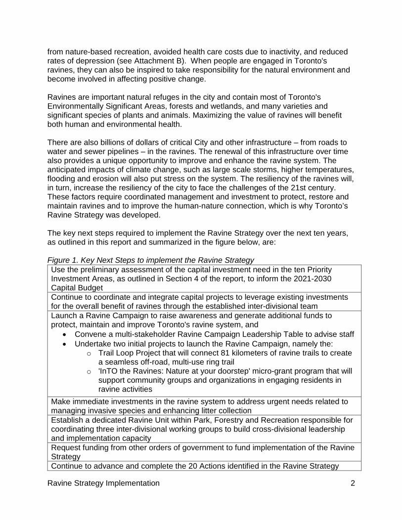
from nature-based recreation, avoided health care costs due to inactivity, and reduced rates of depression (see Attachment B). When people are engaged in Toronto's ravines, they can also be inspired to take responsibility for the natural environment and become involved in affecting positive change. Ravines are important natural refuges in the city and contain most of Toronto's Environmentally Significant Areas, forests and wetlands, and many varieties and significant species of plants and animals. Maximizing the value of ravines will benefit both human and environmental health. There are also billions of dollars of critical City and other infrastructure – from roads to water and sewer pipelines – in the ravines. The renewal of this infrastructure over time also provides a unique opportunity to improve and enhance the ravine system. The anticipated impacts of climate change, such as large scale storms, higher temperatures, flooding and erosion will also put stress on the system. The resiliency of the ravines will, in turn, increase the resiliency of the city to face the challenges of the 21st century. These factors require coordinated management and investment to protect, restore and maintain ravines and to improve the human-nature connection, which is why Toronto’s Ravine Strategy was developed. The key next steps required to implement the Ravine Strategy over the next ten years, as outlined in this report and summarized in the figure below, are: Figure 1. Key Next Steps to implement the Ravine Strategy Use the preliminary assessment of the capital investment need in the ten Priority Investment Areas, as outlined in Section 4 of the report, to inform the 2021-2030 Capital Budget Continue to coordinate and integrate capital projects to leverage existing investments for the overall benefit of ravines through the established inter-divisional team Launch a Ravine Campaign to raise awareness and generate additional funds to protect, maintain and improve Toronto's ravine system, and
• Convene a multi-stakeholder Ravine Campaign Leadership Table to advise staff • Undertake two initial projects to launch the Ravine Campaign, namely the:
o Trail Loop Project that will connect 81 kilometers of ravine trails to create a seamless off-road, multi-use ring trail
o 'InTO the Ravines: Nature at your doorstep' micro-grant program that will support community groups and organizations in engaging residents in ravine activities
Make immediate investments in the ravine system to address urgent needs related to managing invasive species and enhancing litter collection Establish a dedicated Ravine Unit within Park, Forestry and Recreation responsible for coordinating three inter-divisional working groups to build cross-divisional leadership and implementation capacity Request funding from other orders of government to fund implementation of the Ravine Strategy Continue to advance and complete the 20 Actions identified in the Ravine Strategy

Ravine Strategy Implementation 3
Of the twenty Ravine Strategy Actions to date, two have been completed, sixteen are in progress, and the remaining two are not yet started. The work of protecting, managing, and improving the ravine system will always be ongoing, and require leadership and careful attention to balancing the needs of supporting public access to ravine areas, while protecting and restoring ecological areas. This report outlines steps taken by multiple Divisions to engage in that work. In addition to reporting out on the eight council motions, this report responds to a renewed interest and commitment in ravine conservation and engagement both within the City and with stakeholders and the public. The Ravine Strategy Implementation report also outlines a balanced approach to funding the ravine system over the long term. This includes recommending some immediate investments to address urgent needs and to ensure the system does not fall farther behind, including a substantial increase in the service levels of invasive species management and increased ravine litter collection. RECOMMENDATIONS The General Manager, Parks, Forestry and Recreation (PFR), Chief Planner and Executive Director, City Planning, and General Manager, Toronto Water recommend that:
1. City Council adopt the items outlined in Figure 1 of this report as the key next steps to implement the Ravine Strategy over the next ten years.
2. City Council direct that the General Manager, Parks, Forestry and Recreation, request as part of the 2021 Operating Budget process, for consideration, the following: a) The necessary operating funds to support the creation of a dedicated Ravine
Litter Cleanup program, with an estimated annual cost of $0.657 million, including timelines for phasing in this service level increase.
b) Operating funding to support enhanced invasive species management and ecological restoration in ravines, estimated at $2.050 million annually at full implementation.
3. City Council direct the General Manager of Parks, Forestry and Recreation; the
General Manager, Toronto Water; the General Manager, Transportation Services; and the Chief Engineer and Executive Director, Engineering and Construction Services, in consultation with the Toronto and Region Conservation Authority and the Chief Planner and Executive Director, City Planning, to report back as part of the 2021 budget process with a proposed plan, including funding options, to address the capital investment need for service improvements in the initial ten Priority Investment Areas as identified in Figure 4 of this report and other projects as appropriate, any staffing requirements to support the

Ravine Strategy Implementation 4
implementation of the Ravine Strategy and any associated operating impacts of capital.
4. City Council direct the General Manager, Parks, Forestry and Recreation, to advance a Ravine Campaign in consultation with ravine leadership advisors for the purpose of raising additional funds to support and accelerate implementation of the Ravine Strategy.
5. City Council authorize the General Manager, Parks, Forestry and Recreation, in coordination with the General Manager, Transportation Services, to negotiate and enter into the appropriate agreements with Evergreen and the Toronto and Region Conservation Authority regarding the advancement of the Loop Trail project as described in Section 5.1 of this report, on terms satisfactory to the City Solicitor.
6. City Council direct the General Manager of Parks, Forestry and Recreation to develop and implement the 'InTO Ravines: Nature at your doorstep' program, as described in Section 5.2 of this report.
7. City Council direct the General Manager of Parks, Forestry and Recreation in partnership with the General Manager, Toronto Water and General Manager, Transportation Services to seek funding from other levels of government to advance the Ravine Strategy Implementation.
8. City Council direct the General Manager, Parks, Forestry and Recreation, in
consultation with the Chief Planner and Executive Director, City Planning, General Manager, Toronto Water and the Toronto and Region Conservation Authority, to report on the advancement of the Ravine Strategy's objectives every five years.
FINANCIAL IMPACT The ongoing work to implement the Ravine Strategy can be accommodated without new or enhanced funding through the 2020 Staff recommended Operating Budget for Parks, Forestry and Recreation. The new Ravine Unit positions will be established using existing positions and resources within Parks, Forestry and Recreation. The proposed two year pilot 'inTO Ravines: Nature at your doorstep' program will also be funded through the existing PFR budget.
This report recommends phased-in new and enhanced investments, at full implementation, of $2.7 million related to ravine litter collection and invasive species management. The report also identifies an estimated capital investment need of $104.9 million for service improvements in ravines, and recommends that this be considered as

Ravine Strategy Implementation 5
part of the development of the 2021-2030 Capital Plan submission as part of the 2021 Budget process
Operating Parks, Forestry and Recreation currently invests approximately $10.1 million annually from its Operating Budget on forest and natural area management activities in natural areas, which are mostly located within the ravines, including $2.63 million for invasive species management and $0.95 million, through funding provided by Toronto Water, for clearing of watercourses in ravines. This report recommends that City Council direct staff to submit new and enhanced program funding for consideration as part of the 2021 Budget process. Requests for new and enhanced funding will further the implementation of the Ravine Strategy, including through the creation of a dedicated Ravine Litter Cleanup program at an estimated annualized cost of $0.657 million and enhanced invasive species management in ravines at an estimated annualized cost of $2.05 million. The report outlines the service level changes that would result from these investments. The chart below shows the estimated annual financial impacts that will be submitted for consideration as part of future year budget processes. Note that these amounts are calculated using 2019 assumption costs and do not include annual inflation and salary increases. Figure 2. Estimated financial impacts by Budget year. Values are $M.
2021 2022 2023 2024 and ongoing Litter collection 0.657 0.657 0.657 0.657 Invasive species management
0.600 1.140 1.770 2.050
Total 1.257 1.797 2.427 2.707 Capital The City’s 2020-2029 Staff Recommended Capital Budget and Plan includes a total investment of $460.3 million from Parks, Forestry and Recreation, Toronto Water, and Transportation Services in essential services for the ravine system. These investments are primarily infrastructure-related to maintain existing levels of service, including construction and emergency repairs associated with Toronto Water assets, watercourse erosion and slope stability works, bridge rehabilitation, Environmental Assessments and other planning studies, and State of Good Repair for assets such as trails, washrooms, parking lots and cycling facilities. The TRCA also invests approximately $0.2 million every year ($2.0 million investment over ten years) from Environment and Climate Change Canada and the Ministry of Environment, Conservation and Parks in work undertaken towards the Toronto and Region Remedial Action Plan, an intergovernmental program to remediate water quality in the Great Lakes. This report identifies a high level estimate of $104.9 million in capital investment need in the first ten Priority Investment Areas, which together cover twelve of the 105 ravine

Ravine Strategy Implementation 6
segments. The identified work includes ecological restoration, user experience upgrades, and other work to protect existing assets. The remaining 93 ravine areas were not assessed to this level of detail, but will be revisited periodically over time to assess their capital investment need. None of the estimated $104.9 million in capital investments identified in the ten areas is included in the City’s existing 2019-2028 Council Approved Capital Budget and Plan. However, there are opportunities to address some of the investment need for service improvements by coordinating projects with other capital work of Divisions, including Toronto Water, Transportation Services, Parks, Forestry and Recreation, and the TRCA. The work of the Capital and Planning Coordination Working Group will be to assess, on a project by project basis, how to coordinate the planning and design of these projects for the benefit of ravines. In addition, the proposed work toward partnering with an external philanthropic partner has the potential to raise third party funds to support some projects. This report recommends that staff report back through the 2021 Budget process with a proposed plan and funding sources to address the capital investment needs of the system, starting with the initial ten Priority Investment Areas, as well as any operating impacts of capital. This report also identifies a need for investment in wayfinding signage across the ravine system. The financial impacts associated with the development of wayfinding will be considered as part of the 10 Year Capital Budget and Plan for Parks, Forestry, and Recreation through reallocation and prioritization of capital projects during the 2021 Budget process.
Currently, parkland acquisition and improvement is primarily funded through tools in the Planning Act including Section 42 (parkland dedication and alternative rate cash-in-lieu) and Section 37 (density bonusing); and the Development Charges Act. These planning tools represent primary funding sources for park and recreational improvements to support development and new parkland and account for approximately 56 percent or $1,066 million of the 2019-2028 Capital Budget and Plan for Parks, Forestry and Recreation.
The Province's Bill 108, the More Homes, More Choice Act, received Royal Assent on June 6, 2019. Bill 108 proposes to repeal the tools municipalities currently use to secure community infrastructure including Section 37, Section 42, Section 51.1, and the growth-related park and capital infrastructure component of development charges. In its place, the Province proposes to introduce a new consolidated tool, the Community Benefits Charge (“CBC”), essentially blending local and city-wide growth-related tools. The potential impacts of the changes cannot be fully understood until the final regulations are released by the Province. The Province has indicated the CBC tool will be revenue neutral for municipalities to ensure growth continues to pay for growth. City staff will continue to assess the impacts of the proposed legislation and provide additional comments to Council when the regulations have been released. Preliminary comments and analysis were provided to Council on May 15, 2019. Item CC7.3: http://app.toronto.ca/tmmis/viewAgendaItemHistory.do?item=2019.CC7.3

Ravine Strategy Implementation 7
The Chief Financial Officer and Treasurer agrees with the financial impact information and will be provided the financial impacts associated with this program for review through future year budget processes.
EQUITY IMPACT The City of Toronto values social equity and inclusion and aims to improve the quality of life for residents through the provision of a ravine system that is welcoming and accessible. Even a modest increase in good quality greenspace has been proven to improve the health of residents. Evidence suggests that the health benefits of greenspace in areas near vulnerable populations, including those living on low incomes, racialized and Indigenous groups and seniors, are more pronounced. Considering this, the Ravine Strategy applied an equity lens to help determine the ravine Priority Investment Areas. The equity lens considered population growth and social equity relating to the quality of experience, opportunities to animate these spaces and improve social inclusion, and increase the number of access points across the system. As the City of Toronto advances work to implement the Ravine Strategy, it will continue to meet and abide by accessibility design guidelines to ensure spaces where every resident and visitor has improved access and opportunity to experience these wonderful spaces.
The City of Toronto is committed to reducing barriers and ensuring equitable, safe access to ravines for all Toronto residents. The City is also committed to incorporating both western and Indigenous knowledge in protecting and reimagining our ravines and will continue to identify opportunities to create authentic and ongoing relationships with Indigenous communities.
DECISION HISTORY At its meeting on October 2, 2019, City Council considered IE 7.8, Toronto’s Biodiversity Strategy, and requested the General Manager, Parks, Forestry and Recreation, along with the Chief Planner and Executive Director, City Planning, the General Manager, Toronto Water and the Chief Executive Officer, Toronto and Region Conservation Authority, report back on the following issues related to the Ravine Strategy:
a) The review of opportunities and priority sites for restoration in ravines and any associated budget requests.
b) An ecological integrity monitoring and reporting framework for Toronto's natural areas ravines and a review of gaps and opportunities for improvement in implementation of the invasive species management programs through the Ecosystem Services Working Group
c) The vital role Toronto ravines play in stormwater management and in dealing with the impacts of severe weather events caused by climate change.
Ravine Strategy Implementation 8
d) A strategy to align the Biodiversity Strategy, the Ravine Strategy and the Toronto and Region Conservation Authority Trail Strategy
http://app.toronto.ca/tmmis/viewAgendaItemHistory.do?item=2019.IE7.8 At its meeting on May 23, 2019, City Council requested the General Manager of Parks, Forestry and Recreation to meet with Sanofi Pasteur, and other necessary partners, to explore the feasibility of initiating future ravine stewardship programs, and report back to the Infrastructure and Environment Committee by September 9, 2019. http://app.toronto.ca/tmmis/viewAgendaItemHistory.do?item=2019.IE5.12
At its meeting on March 7, 2019, City Council requested the General Manager, Parks, Forestry and Recreation to report back, as part of the Ravine Strategy implementation plan in the second quarter of 2019, on: a) A comprehensive ravine litter pick-up and clean-up campaign in partnership with
school boards, environmental groups and local residents associations; b) Establishing a scientific advisory panel to develop a framework for the removal of
invasive species in Toronto's Ravine System such as: Japanese knotweed, garlic mustard, Norway maple, dog-strangling vine; and
c) Establishing a comprehensive natural species planting program in Toronto's Ravine System.
http://app.toronto.ca/tmmis/viewAgendaItemHistory.do?item=2019.EX2.5
At its meeting on February 26, 2019, City Council requested the City Manager, in consultation with the General Manager, Parks, Forestry and Recreation and any other relevant City staff, to report to the Infrastructure and Environment Committee on the feasibility and possible advantages of establishing a Ravine Protection Conservancy to better enable public engagement and facilitate public and private donations to raise the capital costs necessary to deal with ecological threats in order to rehabilitate and preserve Toronto's Ravines.
http://app.toronto.ca/tmmis/viewAgendaItemHistory.do?item=2019.MM3.13
At its meeting on February 20, 2019, the Budget Committee requested the Chief Financial Officer and Treasurer to submit to Executive Committee at its meeting of March 4, 2019, a corporate report outlining the 2019 Operating Budget and 2019-2028 Capital Budget and Plan, as recommended by the Budget Committee, including the following amendments:
● City Council request the General Manager, Parks, Forestry and Recreation, in consultation with the General Manager, Toronto Water and the Chief Planner and Executive Director, City Planning to report to the Budget Committee on the following for consideration prior to the 2020 Budget Process:
● budget allocated for implementation of Toronto's Ravine Strategy http://app.toronto.ca/tmmis/viewAgendaItemHistory.do?item=2019.BU4.4
At its meeting on October 2, 3, and 4, 2017, City Council adopted the Draft Toronto Ravine Strategy, and directed the General Manager, Parks, Forestry and Recreation, the Chief Planner and Executive Director, City Planning, and the General Manager, Toronto Water, in consultation with the General Manager, Transportation Services and
Ravine Strategy Implementation 9
the Toronto and Region Conservation Authority to establish an interdivisional 10-year implementation strategy and capital plan for the Ravine Strategy. http://app.toronto.ca/tmmis/viewAgendaItemHistory.do?item=2017.EX27.8
At its meeting of May 9, 2017, the Public Works and Infrastructure Committee received a Staff Report titled, 2017 Wet Weather Flow Master Plan Implementation Status Update, which reported on the implementation status of the City's 2003 Wet Weather Flow Master Plan (WWFMP) to the end of 2016 and highlighted implementation priorities over the next five to ten years within the WWFMP's 25 year implementation plan. The Watercourse Management Program protects City infrastructure and private property from watercourse and valley erosion impacts, while also providing aquatic habitat and ecosystem health benefits. http://app.toronto.ca/tmmis/viewAgendaItemHistory.do?item=2017.PW21.6 At its meeting of on June 10 -13, 2014, City Council adopted recommendations in a staff report titled "Coordinated Watercourse Management Plan" that confirmed principles and a framework for watercourse management in Toronto, coordinated with the Toronto and Region Conservation Authority (TRCA). https://www.toronto.ca/legdocs/mmis/2014/pw/bgrd/backgroundfile-68981.pdf
COMMENTS The comments section of this report is organized as follows:
1. Background: The Ravine System 2. Ravine System Challenges 3. Ravine System Roles 4. Priority Investment Areas and the Capital Investment Need 5. Advancing our Partnership and People Opportunities 6. Investing in Ongoing Ravine Management 7. Strengthening Ravine Strategy Leadership and Coordination 8. Update on Ravine Strategy Implementation: 5 Principles, 20 Actions 9. Conclusion
1. Background: The Ravine System Toronto’s ravine system is part of the traditional territory of many nations including the Mississaugas of the Credit, the Anishinabeg, the Chippewa, the Haudenosaunee and the Wendat peoples and is now home to many diverse First Nations, Inuit and Métis peoples. Toronto is covered by Treaty 13 with the Mississaugas of the Credit and the Williams Treaties signed with multiple Mississaugas and Chippewa bands.
Toronto’s ravines have been a site of human activity for millennia. Before European settlers, Indigenous peoples walked these lands and created multiple trails and water routes through the ravine system we cherish today. The name Toronto comes from the Mohawk word Tkaronto, meaning 'where there are trees in the water'. Tkaronto demonstrates a meaningful connection in natural stewardship between the people and land that has existed for generations.
Ravine Strategy Implementation 10
The ravines of Toronto and its shoreline are the two great natural features which enhance and distinguish the city. Toronto’s ravine system extends over 300 km and covers 11,000 hectares, or 17 percent of Toronto’s land area. Over half (5700 hectares) of ravine system land is publicly owned parkland. This includes about 1100 hectares within Rouge National Urban Park and under Parks Canada jurisdiction. The remaining 40 percent is owned by a patchwork of landowners, including public institutions and private property owners, and includes approximately 30,000 private addresses. Ravines provide an exciting opportunity to connect people in the city with nature. Approximately 30 percent of Toronto’s population lives within 500m of ravines, and some areas in close proximity to ravines will see considerable population growth in the coming years, such as Don Mills and Eglinton, the Lower Don, and more. Ravines play a vital role in connecting people with nature and provide essential access to urban greenspace and opportunities for passive and active recreation which contributes to the physical and mental health and well-being of residents. They offer unique tourism destinations, attracting visitors from across the region and elsewhere. A 2017 study found that Toronto's ravines provide over $800 million in services every year from nature-based recreation, avoided health care costs due to inactivity, and reduced rates of depression (see Attachment B). Ravines are also important natural refuges in the city, and contain most of Toronto’s Environmentally Significant Areas, forests, wetlands, floodplains, and many varieties of plants and animals, including significant species. They support biodiversity and provide essential habitat for wildlife, including globally important flyways for migrating birds. When people are engaged in Toronto's ravines, they can be inspired to take responsibility for the natural environment and become involved in affecting positive change. Ravines are a major part of Toronto’s green infrastructure, and along with our tree canopy, gardens, and green roofs, provide environmental, health and recreational benefits. They filter and convey stormwater, and are part of larger watershed systems. They support a resilient city, and also house “grey infrastructure,” such as utilities and sewer lines, which are critical to the functioning of the city. They help to move people through the city on some of the busiest roads and trails, such as the Don Valley Parkway and Lower Don Trail. Together with the requirements related to watercourses, this infrastructure results in a complex legislative and regulatory context that applies to ravine areas.

Ravine Strategy Implementation 11
Figure 3. Map of Toronto's Ravines
2. Ravine System Challenges Toronto is growing, with its population expected to reach 3.4 million by 2041. Some of the new development and intensification will occur near the ravine system, and many people will rely on the ravine system for access to greenspace, outdoor recreation and active transportation routes, including ravine trails. Responding to these trends, ravines must be able to attract and engage increasingly urban and diverse populations. Without investment and protection that increased activity also has the potential to harm natural areas and damage ravine ecosystems. Ravines are subject to increasing pressures from recreational use, encroachments from adjacent private property, and illegal activities such as dumping of waste and off-leash dog activity. In many areas, we are loving our ravines to death. The potential impacts from climate change may compound the problem, increasing the intensity of extreme storm events and bringing more extreme winter and summer temperatures and droughts that could drastically alter the vegetation and river systems in our ravines and impact the infrastructure they contain. Ravines play a crucial role in stormwater management in the city. Stormwater from streets and other hard surfaces are collected into storm sewer systems that discharge directly into the rivers and streams of Toronto's ravines. Increasing volume of runoff from development in watersheds, combined with a forecast of increasing severity and frequency of storms associated with climate change could result in flooding, damage and accelerated erosion in ravines. During periods of high flows, changes in stormwater flows in the watercourses occur rapidly and can have catastrophic consequences. The
Ravine Strategy Implementation 12
city experienced this with the washout of Finch Avenue and with the exposure and eventual destruction of a section of trunk sanitary sewer in the Highland Creek Valley resulting from the August 19, 2005 rainstorm. Other City infrastructure, such as trails and pedestrian bridges, also experience considerable ongoing damage from this flooding and erosion. Invasive species pose a serious threat to the ecological health of Toronto's ravines. Management of invasive exotic species is a concern worldwide and a struggle for all cities, even rural and remote areas, across North America. The city's natural areas and ravines include multiple invasive plant species, and ongoing disturbance by human activity, as well as the changing climate, create conditions for invasive plants to thrive and spread. Urban Forestry has recently completed its second city-wide Tree Canopy Study. The study provides important data with regard to invasive species. Only ten percent of the 179 species found in Toronto's urban forest are identified as invasive species. However, invasive tree cover in parks and ravines has increased from 10 to 14 percent between 2008 and 2018. Additionally, invasive shrub cover has doubled over the ten-year study period, from 15 to 32.5 percent, mostly due to the spread of the invasive common buckthorn. Buckthorn increased from 1.8 percent of the shrub layer of the overall urban forest in 2008 to five percent in 2018, and is now Toronto’s second most common shrub species by leaf area in the urban forest.
3. Ravine System Roles While there has been more attention recently directed toward the value and condition of the city’s ravines, multiple City Divisions, the Toronto and Region Conservation Authority, and other partner organizations have been working for decades to address the challenges outlined above. Together, the City of Toronto invests millions annually to protect natural areas and infrastructure within the system and provide opportunities to connect people to ravines. The City’s 2020-2029 Staff Recommended Capital Budget and Plan includes a total investment of $460.3 million in the ravine system, along with approximately $10.1 million annually from the Operating Budget on forest and natural area management activities. The provincial and federal governments also provide funding to support City and TRCA-led capital work in ravines related to greenhouse gas reduction, nature conservation and resiliency, such as trails and flood protection. The Ravine Strategy implements the Official Plan and supports and aligns with the strategic plans of multiple Divisions, including Toronto Water's Wet Weather Flow Master Plan; Transportation Services' Bikeway Trails Implementation Plan and Cycling Network Plan Update; PFR's Parks Plan and Strategic Forest Management Plan; City Planning's TOcore, and the TRCA's Trail Strategy and Erosion and Hazard Mitigation Strategy, as well as other interdivisional strategies, plans and guidelines, including the Resilience Strategy, the Biodiversity Strategy and the Green Streets Technical Guidelines. The city’s ravine system also benefits from the work of a range of external non-profit partners, resident groups and volunteers who provide a critical link between people, the
Ravine Strategy Implementation 13
City, and ravines, engaging the public in protecting and celebrating ravines, doing public education and outreach, rallying political support at all levels of government, and much more. They also play a critical role as advocates for these special places to all levels of government, but also to the private landowners that own 40 percent of the ravine lands. The work of City Divisions, the TRCA and our partners will continue as the Ravine Strategy is implemented. See Attachment A: Ravine System Roles for more detail about the interests, work and investments of City Divisions, external partners, and the public in the ravine system.
4. Priority Investment Areas and the Capital Investment Need a. The Prioritization Process As part of the Ravine Strategy, Council adopted a Prioritization Framework, and directed that the Framework be used to prioritize and support the development of capital plans for ravine-based projects. This approach recognizes that work cannot be undertaken through the entire ravine system, which includes 105 segments, at once. The Council-approved Ravine Strategy Prioritization Framework (for more detail, see EX 27.8 Toronto Ravine Strategy, Attachment 2, http://app.toronto.ca/tmmis/viewAgendaItemHistory.do?item=2017.EX27.8) includes a number of criteria, including:
• Existing high ecological value, such as Environmentally Significant Areas, interior forest and species of conservation concern
• Substantial existing or planned infrastructure that needs to be maintained, repaired, protected from erosion or upgraded
• Anticipated adjacent population growth • High levels of existing use • Surrounding areas of high need, such as Neighbourhood Investment Areas,
areas of high heat island effect, and low levels of other facilities • Surrounding areas with lower levels of existing access to these spaces and fewer
options for access to greenspace, transit and walkable spaces A landscape architect with an ecology sub-consultant was retained to examine the ravine system and to identify areas that scored high on these criteria. The process included a geospatial analysis of a matrix of data gathered for areas throughout all 105 ravine segments within the ravine system. These segments do not include the ravine system area contained within the Rouge National Urban Park, which is under Parks Canada jurisdiction. Scores were assigned to each ravine area based on a high/medium/low ranking for each criteria in the framework. A long list of segments that had more 'high' level scores than medium and low scores was then developed. This list of segments was then run through a finer-scale assessment of the criteria to identify the final list of Priority Investment Areas.

Ravine Strategy Implementation 14
The process identified a first set of ten Priority Investment Areas across Toronto, which together contain twelve ravine segments in total, as two areas include two abutting segments. In approximate geographic order from northwest to southeast, they are: Figure 4. List of Priority Investment Areas Priority Investment Areas:
Rowntree Mills Park West Humber Parklands Upper Black Creek Lower Mimico Creek High Par Sunnybrook Park Moore Park and Yellow Creek Ravines Lower Don River (includes two abutting segments) East Highland Creek and Morningside Park (includes two abutting segments) Lower Highland Creek
Figure 5. Map of Initial Ravine Priority Investment Areas
Ravine Strategy Implementation 15
As with the city’s parks, the work to protect and maintain Toronto’s ravine system will be ongoing. The Prioritization Framework identified the first ten Priority Investment Areas to focus the work over the medium term. This prioritization process will need to be revisited periodically over time to identify the next set of Priority Investment Areas, as well as address changing conditions, identify emerging priorities, and inform the budgeting and work planning in relation to the ongoing Ravine Strategy implementation. b. Investment Needs in Priority Investment Areas The City has not historically tracked or reported on its capital assets within ravines as a system. Each Division with ravine-based assets has independently tracked and identified investment needs for state of good repair (SOGR) or new and enhanced infrastructure investment as part of their normal capital planning process, which is driven by their service priorities and pressures. Assets have not been tracked based on their location in or impact on ravines. However, as part of the implementation of the Ravine Strategy, the various Divisions have for the first time come together to start to identify their assets and the investment needs of the ravines on a system-wide scale. The first ten Priority Investment Areas were assessed to determine the need for investment in two main categories. The first type of investment was to enhance the people’s access to these natural areas. Investments include building new boardwalks, lookouts and seating areas, improving trails, and formalizing access points. This also includes slope stability and erosion control work to protect these assets. These type of investments also play a critical role in protecting the natural environment by managing and reducing user impacts, especially on sensitive areas. The second area of investment is to protect and restore ecological features, which include creating wetlands, managing invasive species, and restoring forests and riparian areas. This assessment produced a preliminary, high-level estimate of the investment needs throughout all of the first ten Priority Investment Areas of $104.9 million in relation to both access improvements and natural restoration. While this estimate was developed by the consultant using project cost information for similar projects as a reference, the identified projects have not benefited from stakeholder consultation, area planning, or any savings that could be derived from integrating the design and coordinating capital projects across Divisions. A preliminary review of the proposed projects identified that none of these are already within the City’s current capital plan. As a result, the identified projects constitute a capital investment need that is in addition to the City’s existing overall capital program. Staff will continue to review these projects across Divisions to identify future opportunities to integrate them with other planned capital work in the Priority Investment Areas. To address the capital investment need in the first ten Priority Investment Areas, this report recommends that the General Managers, Parks, Forestry and Recreation, Toronto Water, and Transportation Services report back through the 2021 budget process with a proposed plan, including funding options. This timeline will permit further work to refine costing, continue to identify overlapping projects currently in the capital
Ravine Strategy Implementation 16
plan and integrate design of the projects to coordinate savings, and to prioritize those projects within the context of the 2021-2030 Capital Plan. c. Interdivisional Capital Coordination The Ravine Strategy identified the importance of improving capital planning coordination, especially given the numerous cross-divisional investments and programs in ravines. Improved coordination of capital programs is vital for the system's ecological health, for maximizing the experiences of ravine users and provides the potential to identify savings and efficiencies in addressing the ravine capital investment need identified in this report. This capital coordination approach is not new. The 2014 Coordinated Watercourse Management Plan staff report identified that design and construction should be carried out in collaboration with other potentially affected Divisions, and that costs for such work can be shared among Divisions where there are mutual benefits. It also indicated that where stream erosion poses a risk to more than one owner group (Division), the groups will continue the practice of bundling capital works, which has the following benefits to the City and ravines:
• Leveraging investments to realize other benefits for infrastructure, park users, and the environment;
• Improving outcomes for the natural environment by minimizing construction impacts on flora and fauna, and coordinating restoration activities; and
• Accelerating some lower priority works to address the mutual needs of other Divisions.
As an example, as part of Toronto Water's work to restore a segment of the Highland Creek to protect their underground sanitary sewer infrastructure, the project was delivered to allow construction of a multi-use trail by Parks, Forestry and Recreation and Transportation Services. This trail will fill a gap in the existing trail network between Morningside Park and Ellesmere Rd. This integrated planning and design approach minimizes the impact on the natural environment, improves success of the restoration planting that will follow construction, and ultimately brings capital work programs together to achieve larger city-wide strategic goals, as well as divisional priorities. Through the adoption of the Ravine Strategy in 2017, City Council further strengthened the ongoing City-wide approach to coordination by directing the establishment of an interdivisional capital plan for the implementation of the Ravine Strategy. To develop this plan, a ravines Capital Planning and Design Coordination Working Group was established, and has met six times. Using the five-year timeframe of the Major Capital Infrastructure Coordination Office, the first focus was to identify and align potential new work in the ten Priority Investment Areas with other divisional projects. The capital planning and coordination process will ultimately extend to the entire ravine system. By identifying opportunities for collaboration during early planning and before the design phase of capital work, projects can be integrated and designed such that they are more cost-effective and provide the best opportunities to maximize co-benefits,
Ravine Strategy Implementation 17
improve outcomes for residents and visitors and limit impacts on the natural environment. Moving from an approach where coordination means appropriate consecutive scheduling of individual projects to an integrated design approach that addresses the needs of multiple divisions and includes invasive species management and restoration in the process will be more efficient and ultimately improve outcomes for Toronto's ravines. The Capital Planning and Design Coordination Working Group, supported by the proposed Ravine Unit and staff from all Divisions doing capital work in or near ravines, will continue to serve as a vehicle to move toward greater alignment between Divisions, as well as coordinated budget requests. While the coordination process and integrated design approach will provide for some savings, and ultimately there may be resources from external philanthropic partners, the investment of ravine projects will require additional investments for the City to address.
5. Advancing Our Partnerships and People Opportunities Toronto's ravines are extensive, covering 17 percent of Toronto's land area and reaching across the city and into every ward. They are places where people want to be, house critical infrastructure, have significant ecological value and contribute significantly to the resilience of the city. However, the immense size and the varied land ownership, management and uses have created significant complexity in managing these wonderful spaces. The Ravine Strategy presents a long-term, system-based approach to protecting and managing the City’s immense ravine system and while the City and the TRCA are key partners in implementing the Ravine Strategy, we cannot do it alone. Large scale and complex challenges, such as our ravines, demand that we leverage the full range of Toronto’s talent and commitment. Toronto has a long and important history of diverse stakeholders and community members who are deeply committed to enriching our natural areas. For example, the Task Force to Bring Back the Don (1989 to 2010), established by Council and prompted by citizen advocacy, was a catalyzing voice for protecting and restoring ecosystems in a part of the ravine system that had been impacted by urban development for more than 100 years. Organizations with a continuing presence or programming in the ravines, for example the Humber Arboretum, Toronto Botanical Garden, Evergreen, High Park Nature Centre, Friends of the East Don, Toronto Field Naturalists and many others, have an interest in protecting the ravines, leveraging resources and educating the public about the importance of our ecosystems. However, despite efforts, our approach remains fragmented. Unleashing the energies and resources required to achieve sustained impact requires that the City work collectively across diverse sectors including business, other public institutions, non-profit organizations, community groups, Indigenous groups, residents and community volunteers. Broadening partnership opportunities will:
• Deepen and strengthen efforts already in motion;
Ravine Strategy Implementation 18
• Mobilize passion, excitement, and commitment outside government; • Create responsive and responsible leadership; • Coordinate multiple perspectives and resources ; and • Produce previously unimagined solutions.
A key element of the success for any proposed partnership is that they would operate in coordination with the City of Toronto and TRCA. Additionally, it is important to avoid further complicating the already complex governance and operational challenges facing the ravine system. Instead, ravine system partnerships should expand and accelerate the City’s work to implement the Ravine Strategy, with a particular focus of enhancing City investments related to Ravine Strategy action items, including capital projects (e.g. trails or access improvements), ecological protection/restoration (e.g. new or restored wetlands), and ravine engagement, education and celebration (e.g. enhanced Ravine Days program). The Ravine Campaign Across Canada and around the world, there is an intensifying interest in philanthropists investing in parks and the public realm to achieve better outcomes for residents, the environment and the city as a whole. In Toronto, harnessing this philanthropic energy will help us realize the principles and actions of the Ravine Strategy. This report proposes developing a coordinated, multi-faceted philanthropic Ravine Campaign to raise awareness and generate additional funds to protect, maintain and improve Toronto's ravine system. The simple goal is to accelerate implementation of the Ravine Strategy. A Ravine Campaign Leadership Table, comprised of influential, passionate philanthropists, non-profit and foundation leaders will support the Ravine Campaign and act as an advisory body to the General Manager of Parks, Forestry and Recreation. This made-in-Toronto model will bring a coordinated approach to philanthropic support of the ravine system as a whole and will help match philanthropic resources and leadership with projects that address resiliency, access to nature and climate change. The Ravine Campaign Leadership Table will:
• Bring together philanthropic, non-profit and foundation leadership with a demonstrated passion for the ravines and the principles of the Ravine Strategy
• Form the relationships, build the trust and harness the passion Torontonians have for their ravines to generate fundraising opportunities through the Ravine Campaign
• Explore, develop and promote the most promising ideas for immediate philanthropic backing that support the principles and goals of the Ravine Strategy
• Advise on campaign objectives and targets • Investigate and propose a longer-term, sustainable philanthropic model in
support of the ravines to be the legacy of the Campaign.
Ravine Strategy Implementation 19
This partnership approach is emphasized in the Ravine Strategy, and is also a core part of the City's new Corporate Strategic Plan, which recognizes that "Toronto’s success decades from now will be measured on how we work with our partners. Achieving our vision and carrying out our mission requires the City to work with residents, other governments, institutions, the private sector, the not-for-profit sector, and Indigenous peoples." The City of Toronto Act and Official Plan provide authority to establish these kind of funding partnerships for City Council priorities which include unfunded infrastructure initiatives. Additional reports to Council may be required based on Campaign progress, such as Donation Acceptance Reports under the Donations to the City of Toronto for Community Benefit Policy. Guided by the Ravine Campaign Leadership Table, the Ravine Campaign will build the relationships and generate the bold ideas necessary to unlock philanthropic support for the Ravine Strategy. This campaign is the first of its kind for Toronto’s ravines and with it will bring the added flexibility required to pursue new initiatives and innovations. Two initial projects are identified as part of the Ravine Campaign: the Loop Trail project and the 'InTO Ravines: Nature at your doorstep' Community Engagement Program. 1. The Loop Trail In partnership with Evergreen and the TRCA, the Loop Trail project seeks to create a continuous, 81 kilometre off-road, multi-use ring trail, knitting together five Ravine Priority Investment Areas, 22 Neighbourhood Improvement Areas, the Humber River and Don River ravine systems, the Waterfront and neighbourhoods along the Finch corridor. The Loop Trail would also connect to and support the Meadoway, which is the continuous multi-use trail that will ultimately link downtown to the Rouge Urban National Park and allows people to travel between the two without ever leaving nature. The Loop Trail project is a powerful way to harness philanthropic interest and resources to advance actions in the Ravine Strategy, the City’s Cycling Network Plan and the TRCA Regional Trail Strategy. Currently, sixty-six kilometres of the Loop Trail already exists. This project will mobilize municipal, regional, public and philanthropic energy to complete the remaining 15 kilometres and close system gaps to create a seamless trail loop. The Loop Trail will create opportunities for healthy living, with proposed hubs at key moments along the trail to provide access, amenities, and act as places for ravine engagement, education and connections with nature. Additionally, the loop will incorporate unique and inventive spaces that could include projects such as new bridge connections and art installations. This report recommends City Council authorize the General Manager of Parks, Forestry and Recreation, in coordination with the General Manager, Transportation Services, to negotiate and enter into the appropriate agreements with Evergreen and the TRCA to advance the Loop Trail project.

Ravine Strategy Implementation 20
2. 'InTO Ravines: Nature at your doorstep' Community Engagement Program Community engagement at the local level has a critical role to play in the success of Toronto's Ravine Strategy. To amplify existing engagement opportunities, the City of Toronto is working with Park People to develop a two-year pilot program to support community groups and organizations in engaging residents in ravine activities and programming. The 'InTO Ravines: Nature at your doorstep' program will emphasize and bring to life the guiding principles of the Strategy. Through a mix of small grants, events and community programming, it aims to connect the people of Toronto to their ravines and help develop a deeper understanding of ravine ecology, Indigenous knowledge and heritage in ravines and the goals of the Ravine Strategy. It will help reach new communities and build the foundation for a long-term sense of connection and care for Toronto’s ravines. The program will be modelled on other successful community engagement programs run by organizations such as the Greenbelt Foundation, Park People and TD Friends of the Environment Foundation. The program is scoped at $200,000 per year, with $100,000 to be contributed each year from existing resources within PFR, and a targeted $100,000 in matching funds to be secured each year through a funding partner to enhance the budget and program visibility.
6. Investing in Ongoing Ravine Management In addition to the work that is underway to address the capital needs of the ravine system, there is a need to invest in enhanced management of ravine areas, both to address the needs of individuals and communities and to protect and restore the natural environment. This report recommends a substantial increase in the work to manage invasive species in ravines and increasing the service level of ravine litter collection. These investments will not only improve the ecology of our ravines. They will also help to attract new users to connect with nature. New York City has found that well-managed natural areas are more welcoming and that areas that received regular maintenance, including formal trail systems, clear signage, and few invasive species, feel safer and more inviting. a. Invasive Species Management The challenge of managing invasive species continues to grow, and the City of Toronto must target its efforts to where it will have the greatest impact and highest probability of success. Invasive species management decisions are prioritized with this in mind. The goal is to reduce the impact of invasive species while promoting the ecological integrity of native plants and animals. Work focuses on protecting important sites, rather than trying to eradicate individual plant species. As such, the City currently uses the following criteria to prioritize invasive management:
• protect sites with high quality habitat • address areas with low infestation
Ravine Strategy Implementation 21
• prioritize species control based on their level of ecological threat • coordinate management with other park infrastructure and forest management
projects • expand restored sites and increase connectivity with other healthy sites • address safety issues that may result from the presence of invasive plants
Urban Forestry manages 40 species of invasive plants following best practices promoted by the Ontario Invasive Plant Council (OIPC), including using physical (e.g. hand-pulling), mechanical (e.g. cutting or mowing) and chemical (e.g. herbicide) control methods. Pesticide is used as a last resort and spray applications are minimized wherever possible in favour of applying the pesticide directly on individual plants or patches. This selective method of control ensures that damage to other desirable plants is minimized and that small quantities of pesticide are used. Control and application methods have been developed to minimize pesticide use by combining mechanical and chemical control methods. For example, Japanese knotweed is cut down in early summer and the re-sprouts are treated in the fall to deplete energy in the root system. Removal of invasive plants is followed by planting of native species or, in the case of oak savannah sites (such as those found in High Park and Lambton Woods), areas are cleared to prepare for prescribed burns that help encourage the existing seed bank and oak regeneration. Currently, PFR undertakes restoration and invasive species management in 400 hectares of ravine parkland per year at approximately $2.63 million annually, through dedicated crews of specially-trained staff, contracted services for interventions such as large invasive tree removal, and staff that provide technical and professional support for community and volunteer involvement. Volunteer groups and individuals, supported by City staff, play a vital role where management of invasive plants does not require pesticide treatment or where there are fewer concerns about site conditions, such as steep slopes, poisonous plants or where there are no sensitive ecosystems and native species that could be trampled by volunteer groups. This report proposes an additional investment of $2.05 million annually (using 2019 wage rates), phased in over four years, to support restoration and invasive species management in an additional 480 hectares of ravine parkland per year. The phasing would include one additional crew and volunteer management support staff in the first year, then additional planning staff/contractor management staff and a second crew in subsequent years. Fully implemented, this will roughly double the amount of invasive species management work done annually. It will also allow staff to increase volunteer engagement numbers by 10 to 20 percent, add an additional 1-2 Community Stewardship Program sites, assist more 'Friends of Groups', and conduct more stewardship events.
Ravine Strategy Implementation 22
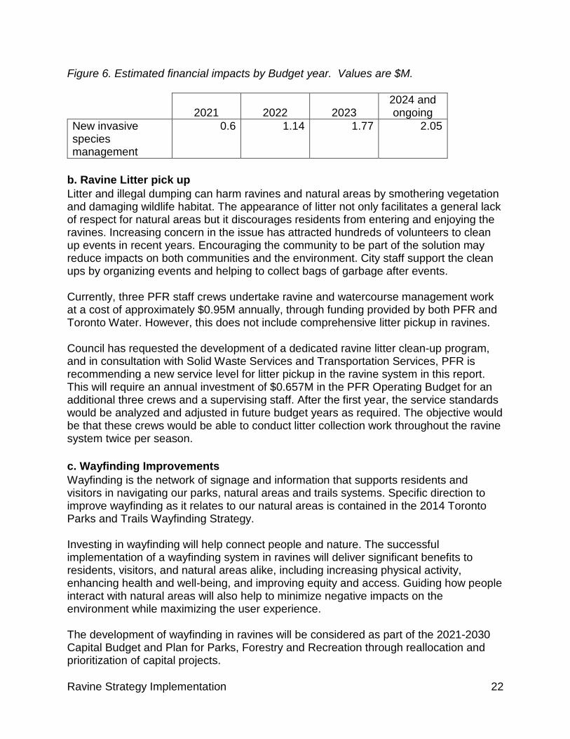
Figure 6. Estimated financial impacts by Budget year. Values are $M.
2021 2022 2023 2024 and ongoing
New invasive species management
0.6 1.14 1.77 2.05
b. Ravine Litter pick up Litter and illegal dumping can harm ravines and natural areas by smothering vegetation and damaging wildlife habitat. The appearance of litter not only facilitates a general lack of respect for natural areas but it discourages residents from entering and enjoying the ravines. Increasing concern in the issue has attracted hundreds of volunteers to clean up events in recent years. Encouraging the community to be part of the solution may reduce impacts on both communities and the environment. City staff support the clean ups by organizing events and helping to collect bags of garbage after events. Currently, three PFR staff crews undertake ravine and watercourse management work at a cost of approximately $0.95M annually, through funding provided by both PFR and Toronto Water. However, this does not include comprehensive litter pickup in ravines. Council has requested the development of a dedicated ravine litter clean-up program, and in consultation with Solid Waste Services and Transportation Services, PFR is recommending a new service level for litter pickup in the ravine system in this report. This will require an annual investment of $0.657M in the PFR Operating Budget for an additional three crews and a supervising staff. After the first year, the service standards would be analyzed and adjusted in future budget years as required. The objective would be that these crews would be able to conduct litter collection work throughout the ravine system twice per season. c. Wayfinding Improvements Wayfinding is the network of signage and information that supports residents and visitors in navigating our parks, natural areas and trails systems. Specific direction to improve wayfinding as it relates to our natural areas is contained in the 2014 Toronto Parks and Trails Wayfinding Strategy. Investing in wayfinding will help connect people and nature. The successful implementation of a wayfinding system in ravines will deliver significant benefits to residents, visitors, and natural areas alike, including increasing physical activity, enhancing health and well-being, and improving equity and access. Guiding how people interact with natural areas will also help to minimize negative impacts on the environment while maximizing the user experience. The development of wayfinding in ravines will be considered as part of the 2021-2030 Capital Budget and Plan for Parks, Forestry and Recreation through reallocation and prioritization of capital projects.
Ravine Strategy Implementation 23
7. Strengthening Ravine Strategy Leadership and Coordination Following the adoption of the Ravine Strategy in October 2017, implementation work began by building on the efforts of staff within various Divisions who were already engaged in ravine work. However, it became apparent that this approach would be challenged to provide the sustained leadership and capacity required to support ongoing implementation of the Ravine Strategy. As a result, PFR identified a Project Manager to lead the work both within PFR and to support the interdivisional collaborations that are key to the implementation. The Project Manager is the first staff person in what is intended to become a dedicated Ravine Unit, which will be committed to overseeing the implementation of the Ravine Strategy, establishing and supporting the three interdivisional working groups, and providing leadership to ongoing interdivisional coordination. A Ravine Unit staff, in addition to the current PFR Project Manager, will be funded within existing resources of Parks, Forestry and Recreation. Additional staff will be funded as and when additional funds are approved for invasive species management, litter pickup, and capital projects, including the service improvements in the Priority Investment Areas. The unit will provide a city-wide central point of contact for addressing ravine issues and provide capacity to support implementation of the Ravine Strategy. The unit will also support the Ravine Campaign, including the Leadership Table, as well as the work of the working groups (outlined below) that were approved by Council as part of the Ravine Strategy and will support key actions within the Ravine Strategy implementation. These staff will provide expertise, leadership, and coordination in the areas of:
• Capital investments through supporting integrated project design and coordination for ravine projects by City Divisions and TRCA;
• Ecological improvements such as supporting ecological integrity monitoring and reporting, identifying and supporting research, and developing and integrating best ecological practices into City work programs; and
• Partnerships through supporting the Ravine Campaign, philanthropy, outreach and the numerous contributions of community and volunteer groups.
Other Divisions, including Toronto Water, Transportation Services and the TRCA, are committed to integrated planning, design and delivery of capital work in ravines and will allocate staff resources, as required, to enhance the planning capacity and coordination across Divisions, while also retaining a connection to their base Division. The Capital Planning and Design Coordination Working Group will work to leverage City divisional resources and identify opportunities to integrate city-wide, interdivisional strategic goals into the planning, design and implementation of capital projects across all key Divisions including PFR, Toronto Water, Transportation Services, Engineering and Construction Services, and Solid Waste, as well as the TRCA. In areas where one Division must go into a ravine to undertake necessary infrastructure repairs or maintenance, a coordinated and ultimately a fully integrated design approach between Divisions can build upon that work to benefit the objectives of others and the
Ravine Strategy Implementation 24
ravine system as a whole. The Capital Planning and Design Working Group will strengthen the collaboration between these entities, and leverage resources, address issues, and identify efficiencies in implementing the City’s and TRCA's capital programs. This system-wide approach to collaboration will help identify opportunities across all participating Divisions earlier, at the project scope and design stages, rather than after design of one component is complete. It will enable a more fulsome integration of projects and alignment of inter-divisional capital plans and align with the foundational principles of the Ravine Strategy.
The Ecosystem Services Working Group will build on the expertise and capacity of the City Divisions by further engaging with experts from the TRCA and academic partners to improve the health and our understanding of ravines. This will include identifying research needs, innovative management techniques and international best practices, and building on existing data and monitoring to refine the concept of Ecological Integrity appropriate for Toronto. Their focus will include monitoring and providing advice to the City on social, environmental, and financial performance, understanding new and expanding threats, such as climate change impacts and invasive species, and international best practices in protecting urban natural areas. This group will develop a made-in-Toronto approach to ecological integrity and a monitoring framework that will recognize the complex and dynamic nature of urban ecosystems, and report back to Council in the fourth quarter of 2020. The group will also support ongoing research needs and opportunities, such as the project underway with the University of Toronto to establish 200 permanent terrestrial ecological monitoring plots to collect data on ravine health and a multi-year research partnership with the Vineland Research and Innovation Centre, along with other municipalities and agencies, to improve restoration following construction. The Partnerships, Outreach and Education Working Group will work to bring external stakeholders together with the City and the TRCA to identify and advance actions related to outreach and community engagement, including developing and coordinating communications to promote and celebrate ravines such as Ravine Days, supporting development and launch of the Ravine Campaign, and identifying opportunities for collaboration on events, activities and programs. The Capital and Planning Coordination Working Group was initiated in 2017. The remaining two working groups will be convened following Council consideration of this report.
8. Update on Ravine Strategy Implementation: 5 Principles, 20 Actions The following sections provide an update on the ongoing work to implement the Ravine Strategy. This includes the status of each Action and the next steps in the implementation process. Overall, two Actions have been completed, sixteen are in progress, and the remaining two are not yet started. Note that the time frame designation in the charts below are presented as they were in the Ravine Strategy and adopted by Council in October 2017. As per that report:
Ravine Strategy Implementation 25
• “Quick wins” refer to actions that can be delivered within five years and have immediate, visible impact
• “Short term” actions can be started and completed within the next five to ten years
• “Ongoing” actions are currently taking place on a small scale and can be expanded within the next five to ten years
• “Long term” actions will take a significant amount of time to complete, although they may be initiated within the next few years.
Principle 1: Protect As a system, ravines provide habitat for numerous flora and fauna species including a number of locally, regionally and provincially sensitive species and species-at-risk, including all of the 18 area-sensitive bird species expected to be present in urban landscapes (as identified by Environment Canada) and 24 of the 30 mammal species found in the TRCA jurisdiction. Therefore, protecting and improving the ecological function and resilience of Toronto's ravines is central to their long-term sustainability. The City of Toronto is recognized as a leader in managing urban natural areas. Together, Parks, Forestry and Recreation and the TRCA work to restore natural areas, manage the threat of invasive species and monitor changes in ecosystem health. For example, the City and TRCA plant over 100,000 trees, shrubs and native plants in Toronto's ravines every year through the efforts of staff, contractors and volunteers, including 12,000 trees planted over the past 10 years that have been propagated from locally-collected seed in partnership with Forests Ontario. Since the adoption of the Strategy, considerable work has happened to advance the protection of ravines, including:
• Partnered with the University of Toronto to establish 200 permanent terrestrial ecological monitoring plots to collect data on ravine health. This work is cost shared between the City and the University of Toronto, and uses the University of Toronto team’s monitoring protocol. The data collected through this pilot will complement the existing data of the TRCA and will support management, planning and policy needs. It will also be integrated into larger sampling throughout southwestern Ontario, which will help compare vegetation quality and success of management techniques across a larger landscape.
• Established and funded a multi-year research partnership (2019-2021) with the Vineland Research and Innovation Centre, along with other municipalities and agencies, to improve restoration following construction.
• Completed sensitivity mapping of vegetation in Environmentally Significant Areas to help focus restoration and invasive plant management within core habitats and high sensitivity zones in order to target preservation of native species.
• Partnered with the University of Toronto Scarborough on a research project examining the benefits to water volume and quality of a low impact design

Ravine Strategy Implementation 26
(Green Streets projects) and construction for Highland Creek at Military Trail near Highcastle Road.
• Completed a climate change vulnerability assessment for the terrestrial system of ravines within TRCA's jurisdiction.
• Adapted the TRCA'S its Integrated Restoration Prioritization (IRP) framework, which prioritizes restoration opportunities within watersheds, to the urban context.
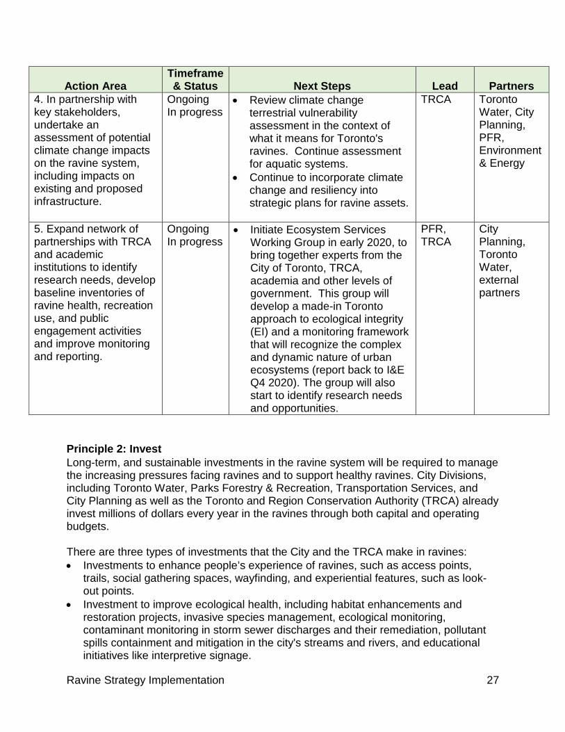
The following table provides updates on the next steps in each of the actions that support the principle of protecting ravines.
Protect Actions
Action Area Timeframe & Status Next Steps Lead Partners
1. Develop and implement Management Plans for three Environmentally Significant Areas (ESAs).
Long-term In progress
• Develop framework for management plans for ESAs in 2020, including piloting the framework through development of plans for two ESAs.
• Determine timeline and cost for development of plans, using this framework, for remaining ESAs in 2020.
PFR City Planning, TRCA
2. Ensure high quality planning, design, construction and maintenance in ravines by continuing to develop and implement best practices for capital projects and on-going maintenance of infrastructure and natural ecosystems.
Ongoing In progress
• Determine best practice guidelines for ESAs as part of ESA management plan project.
• Finalize the TRCA's Invasive Species Strategy and Highland Greening Strategy in 2020.
• Organize work as part of all capital projects advancing in ravines.
PFR, TRCA, Toronto Water
City Planning, Transportation Services
3. Develop tools, including staff training and a set of criteria, for staff to assess requests for appropriate activities, events and temporary installations to ensure protection of ravines.
Ongoing In progress
• Work with staff to identify conflicts between use and protection.
• Develop best practice guidelines, process improvements and training materials for staff to help resolve conflicts.
PFR TRCA
Ravine Strategy Implementation 27
Action Area Timeframe & Status Next Steps Lead Partners
4. In partnership with key stakeholders, undertake an assessment of potential climate change impacts on the ravine system, including impacts on existing and proposed infrastructure.
Ongoing In progress
• Review climate change terrestrial vulnerability assessment in the context of what it means for Toronto's ravines. Continue assessment for aquatic systems.
• Continue to incorporate climate change and resiliency into strategic plans for ravine assets.
TRCA Toronto Water, City Planning, PFR, Environment & Energy
5. Expand network of partnerships with TRCA and academic institutions to identify research needs, develop baseline inventories of ravine health, recreation use, and public engagement activities and improve monitoring and reporting.
Ongoing In progress
• Initiate Ecosystem Services Working Group in early 2020, to bring together experts from the City of Toronto, TRCA, academia and other levels of government. This group will develop a made-in Toronto approach to ecological integrity (EI) and a monitoring framework that will recognize the complex and dynamic nature of urban ecosystems (report back to I&E Q4 2020). The group will also start to identify research needs and opportunities.
PFR, TRCA
City Planning, Toronto Water, external partners
Principle 2: Invest Long-term, and sustainable investments in the ravine system will be required to manage the increasing pressures facing ravines and to support healthy ravines. City Divisions, including Toronto Water, Parks Forestry & Recreation, Transportation Services, and City Planning as well as the Toronto and Region Conservation Authority (TRCA) already invest millions of dollars every year in the ravines through both capital and operating budgets. There are three types of investments that the City and the TRCA make in ravines: • Investments to enhance people’s experience of ravines, such as access points,
trails, social gathering spaces, wayfinding, and experiential features, such as look-out points.
• Investment to improve ecological health, including habitat enhancements and restoration projects, invasive species management, ecological monitoring, contaminant monitoring in storm sewer discharges and their remediation, pollutant spills containment and mitigation in the city's streams and rivers, and educational initiatives like interpretive signage.
Ravine Strategy Implementation 28
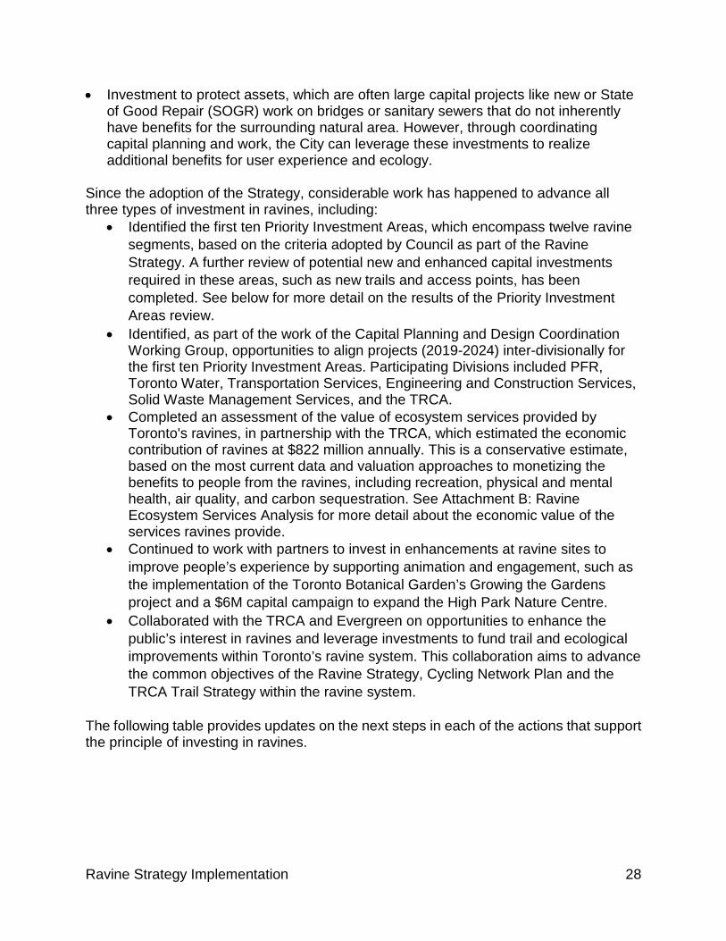
• Investment to protect assets, which are often large capital projects like new or State of Good Repair (SOGR) work on bridges or sanitary sewers that do not inherently have benefits for the surrounding natural area. However, through coordinating capital planning and work, the City can leverage these investments to realize additional benefits for user experience and ecology.
Since the adoption of the Strategy, considerable work has happened to advance all three types of investment in ravines, including:
• Identified the first ten Priority Investment Areas, which encompass twelve ravine segments, based on the criteria adopted by Council as part of the Ravine Strategy. A further review of potential new and enhanced capital investments required in these areas, such as new trails and access points, has been completed. See below for more detail on the results of the Priority Investment Areas review.
• Identified, as part of the work of the Capital Planning and Design Coordination Working Group, opportunities to align projects (2019-2024) inter-divisionally for the first ten Priority Investment Areas. Participating Divisions included PFR, Toronto Water, Transportation Services, Engineering and Construction Services, Solid Waste Management Services, and the TRCA.
• Completed an assessment of the value of ecosystem services provided by Toronto's ravines, in partnership with the TRCA, which estimated the economic contribution of ravines at $822 million annually. This is a conservative estimate, based on the most current data and valuation approaches to monetizing the benefits to people from the ravines, including recreation, physical and mental health, air quality, and carbon sequestration. See Attachment B: Ravine Ecosystem Services Analysis for more detail about the economic value of the services ravines provide.
• Continued to work with partners to invest in enhancements at ravine sites to improve people’s experience by supporting animation and engagement, such as the implementation of the Toronto Botanical Garden’s Growing the Gardens project and a $6M capital campaign to expand the High Park Nature Centre.
• Collaborated with the TRCA and Evergreen on opportunities to enhance the public’s interest in ravines and leverage investments to fund trail and ecological improvements within Toronto’s ravine system. This collaboration aims to advance the common objectives of the Ravine Strategy, Cycling Network Plan and the TRCA Trail Strategy within the ravine system.
The following table provides updates on the next steps in each of the actions that support the principle of investing in ravines.
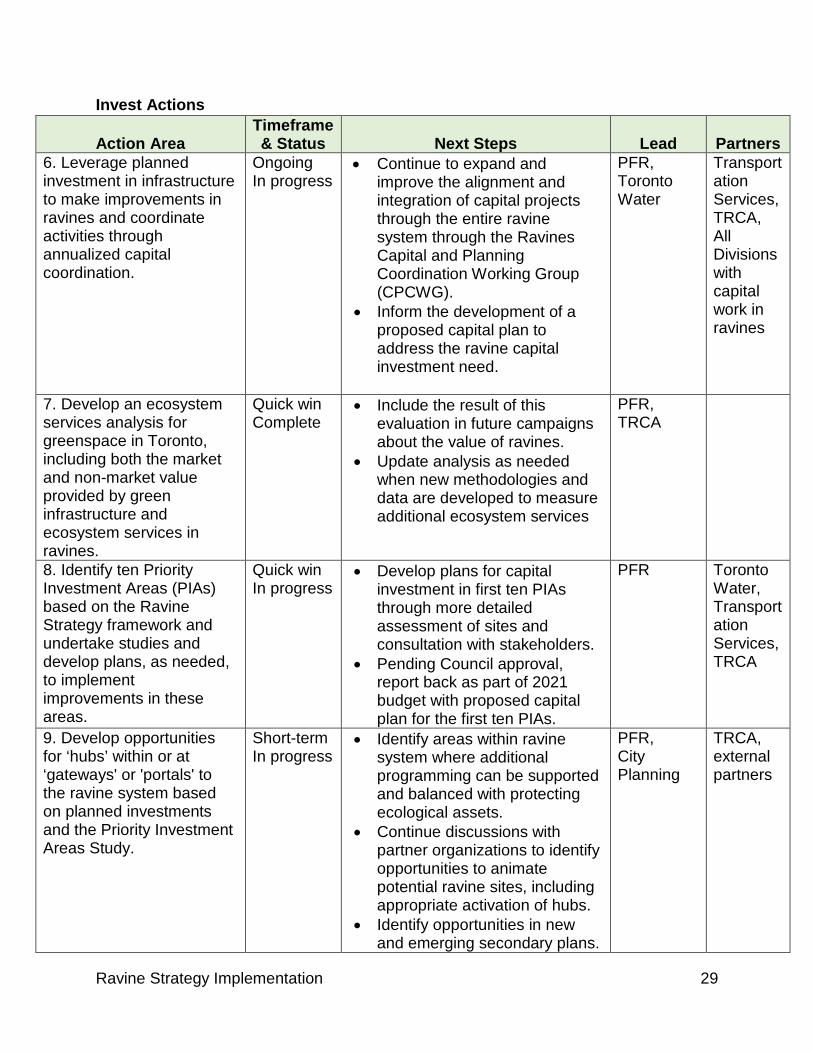
Ravine Strategy Implementation 29
Invest Actions
Action Area Timeframe & Status Next Steps Lead Partners
6. Leverage planned investment in infrastructure to make improvements in ravines and coordinate activities through annualized capital coordination.
Ongoing In progress
• Continue to expand and improve the alignment and integration of capital projects through the entire ravine system through the Ravines Capital and Planning Coordination Working Group (CPCWG).
• Inform the development of a proposed capital plan to address the ravine capital investment need.
PFR, Toronto Water
Transportation Services, TRCA, All Divisions with capital work in ravines
7. Develop an ecosystem services analysis for greenspace in Toronto, including both the market and non-market value provided by green infrastructure and ecosystem services in ravines.
Quick win Complete
• Include the result of this evaluation in future campaigns about the value of ravines.
• Update analysis as needed when new methodologies and data are developed to measure additional ecosystem services
PFR, TRCA
8. Identify ten Priority Investment Areas (PIAs) based on the Ravine Strategy framework and undertake studies and develop plans, as needed, to implement improvements in these areas.
Quick win In progress
• Develop plans for capital investment in first ten PIAs through more detailed assessment of sites and consultation with stakeholders.
• Pending Council approval, report back as part of 2021 budget with proposed capital plan for the first ten PIAs.
PFR Toronto Water, Transportation Services, TRCA
9. Develop opportunities for ‘hubs’ within or at ‘gateways' or 'portals' to the ravine system based on planned investments and the Priority Investment Areas Study.
Short-term In progress
• Identify areas within ravine system where additional programming can be supported and balanced with protecting ecological assets.
• Continue discussions with partner organizations to identify opportunities to animate potential ravine sites, including appropriate activation of hubs.
• Identify opportunities in new and emerging secondary plans.
PFR, City Planning
TRCA, external partners
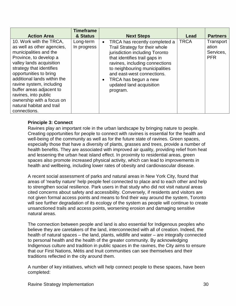
Ravine Strategy Implementation 30
Action Area Timeframe & Status Next Steps Lead Partners
10. Work with the TRCA, as well as other agencies, municipalities and the Province, to develop a valley lands acquisition strategy that identifies opportunities to bring additional lands within the ravine system, including buffer areas adjacent to ravines, into public ownership with a focus on natural habitat and trail connections.
Long-term In progress
• TRCA has recently completed a Trail Strategy for their whole jurisdiction including Toronto that identifies trail gaps in ravines, including connections to neighbouring municipalities and east-west connections.
• TRCA has begun a new updated land acquisition program.
TRCA
Transportation Services, PFR
Principle 3: Connect Ravines play an important role in the urban landscape by bringing nature to people. Creating opportunities for people to connect with ravines is essential for the health and well-being of the community as well as for the future state of ravines. Green spaces, especially those that have a diversity of plants, grasses and trees, provide a number of health benefits. They are associated with improved air quality, providing relief from heat and lessening the urban heat island effect. In proximity to residential areas, green spaces also promote increased physical activity, which can lead to improvements in health and wellbeing, including lower rates of obesity and cardiovascular disease. A recent social assessment of parks and natural areas in New York City, found that areas of 'nearby nature' help people feel connected to place and to each other and help to strengthen social resilience. Park users in that study who did not visit natural areas cited concerns about safety and accessibility. Conversely, if residents and visitors are not given formal access points and means to find their way around the system, Toronto will see further degradation of its ecology of the system as people will continue to create unsanctioned trails and access points, worsening erosion and damaging sensitive natural areas. The connection between people and land is also essential for Indigenous peoples who believe they are caretakers of the land, interconnected with all of creation. Indeed, the health of natural spaces – the land, plants, wildlife and water – are integrally connected to personal health and the health of the greater community. By acknowledging Indigenous culture and tradition in public spaces in the ravines, the City aims to ensure that our First Nations, Métis and Inuit communities can see themselves and their traditions reflected in the city around them. A number of key initiatives, which will help connect people to these spaces, have been completed:

Ravine Strategy Implementation 31
• The TRCA’s recently-approved Trail Strategy guides the development of a network of regional trails that will create opportunities for people to explore and enjoy through hiking and biking, including connections to Toronto’s ravine system.
• Ongoing collaboration between Transportation Services, PFR, TRCA, Toronto Water and external partners to implement elements of the Bikeway Trails Implementation Plan and Cycling Network Plan through construction of new and improvements to existing multi-use trails in ravines, as well as neighbourhood connections. Lower Don Trail improvements included a new pedestrian and cyclist bridge at Pottery Road, trail surface improvements, and the re-alignment and widening of the Belleville Underpass. The Environmental Assessment for the East Don Trail, which will connect the existing East Don Trail near Lawrence Avenue to the Meadoway and the Don Trail system, was completed and construction is currently underway.
• The first two phases of Toronto's Parks and Trails Wayfinding Strategy, including a pilot in the Lower Don Valley, have been completed (see Attachment C). This Strategy created a framework of system principles and style and design guidelines for a signage and information system that is more consistent, accessible and predictable making it easier for people to connect with ravines.
The following table provides updates on the next steps in each of the actions that support the principle of connecting people to ravines. Connect Actions
Action Area Timeframe & Status Next Steps Lead Partners
11. Complete the Toronto Parks & Trails Wayfinding Strategy pilot in the Lower Don Valley and provide recommendations on how to implement wayfinding throughout Toronto's ravine system.
Quick win Complete
• The Pilot Project and evaluation is complete.
• Initiate prioritization of wayfinding needs in the ravine system and begin implementation.
PFR Transportation Services, TRCA
12. Review existing trails and access points and develop an implementation plan to address gaps in our system and connections to adjacent municipalities.
Long-term In progress
• Complete Environmental Assessment to create the Meadoway, a16-kilometre multi-use trail and naturalization project that will create an east-west connection for trail users and nature between the Don, Highland and Rouge Rivers.
• Further refine potential new access points and
TRCA, PFR
Transportation Services, Toronto Water
Ravine Strategy Implementation 32
Action Area Timeframe & Status Next Steps Lead Partners
improvements to existing access points identified in first ten Priority Investment Areas through development of plans for these areas (with stakeholder consultation).
13. Develop opportunities to honour and share stories of historic spaces and ways of relating to the natural environment in collaboration with Indigenous communities, City of Toronto Economic Development, Heritage Services and the City Manager's Office.
Short-term In Progress
• Co-develop with Indigenous leadership programming, place-making and identity programs in our public spaces including ravines, working across Divisions and with other partners.
• Continue consultations with the Indigenous community and the broader public on the Wonscotonach Parklands naming proposal for the Lower Don.
• Use opportunity of the Parks and Trails Wayfinding project to coordinate content development honouring Indigenous stories and traditional knowledge of our shared Treaty 13 and Williams Treaties lands.
PFR, Indigenous Affairs Office (IAO)
Transportation Services, TRCA, external partners
Principle 4: Partner To help address the increasing challenges to these natural areas, the Ravine Strategy identified several opportunities to further develop partnerships with residents, community groups, and other organizations to help with various initiatives such as raising funds to volunteer engagement to promoting and celebrating the ravine lands. The health and protection of Toronto’s ravine system is a shared responsibility between the City of Toronto and the Toronto and Region Conservation Authority (TRCA). As land owner and land manager, respectively, the TRCA and the City of Toronto together have significant scientific and technical expertise and retain the legislative responsibility for natural area planning, management and protection.
Ravine Strategy Implementation 33
This report identifies unique, value-added partnerships to improve access and experience by requests authority to launch a ravine campaign and implement a two-year pilot program to provide support to community groups and organizations to support resident engagement in ravines. It also recommending that the City consult on the proposed mandate and further explore the development of one or more external philanthropic partners to increase investment in the ravine system. This report also requests additional resources to support the efforts of volunteers, “friends of” groups and local communities to protect and preserve local ravines in the management of invasive species. In addition, once the Ravine Unit is established as outlined above, it will provide communities with a central point of contact to working with the City on ravine projects. Since the adoption of the Ravine Strategy, considerable work has taken place to support partnerships in ravines, including:
• Worked with the Humber Arboretum, Toronto Botanical Garden, and High Park Nature Centre to update their plans for work within the ravine system.
• Supported Urban Forestry’s Community Stewardship Program (CSP), which involves volunteers in ongoing maintenance and monitoring through weekly activities from spring to fall every year. This intensive volunteer program take place in seven dedicated sites, six of which are in ravines. New sites in Scarborough were piloted in 2017-2018. This site-intensive program is in addition to ongoing planting and stewardship volunteer events that happen throughout the ravine system every year.
• Collaborated with the TRCA and Evergreen, who operate the Evergreen Brick Works site, through the Lower Don Fundraising and Partnership Agreement. This partnership has succeeded in raising over $1 million through private donors for animation and temporary public art installations, as well as City-led capital projects, throughout the Lower Don Watershed.
• Identified ravine asset and environmental improvements in the first ten Priority Investment Areas, which will provide opportunities for fundraising and partnership. Experiences in other jurisdictions, and with partnership activities in parks, show that local improvement projects provide opportunities to raise funds or find sponsors.
The following table provides updates on the next steps in each of the actions that support the principle of partnering to enhance the ravines.

Ravine Strategy Implementation 34
Partner Actions
Action Area Timeframe & Status Next Steps Lead Partners
14. Build partnership opportunities and capacity to expand the Community Stewardship Program (CSP) in order to include additional sites. Identify candidate sites.
Quick win In progress
• Continue to pursue opportunities for partnerships to support stewardship of ravines, such as with Sanofi-Pasteur.
• Pending Council approval for additional staff to support invasive species management, develop an additional 1-2 CSP sites.
• Complete a review of existing programs and recommend future opportunities for community engagement in ravines and natural areas by the end of 2021.
PFR, TRCA
TRCA, external partners
15. Work with key partners to continue to ensure implementation of best practices for all urban river and reinforcing the importance comprehensive inter-municipal and inter-agency management.
Long-term Not yet started
• Work with the TRCA to identify opportunities for dialogue between municipalities.
TRCA Toronto Water, PFR
16. Establish a framework to support further opportunities to engage volunteer groups, such as “Friends of” groups.
Long-term In progress
• Develop guidelines and best practices for volunteer stewardship as part of the management plan framework for Environmentally Significant Areas in 2020.
• Develop additional capacity to review opportunities and support volunteer groups through the Ravine Unit and, pending Council approval, the proposed additional Forestry staff.
• Pending Council approval, initiate the 'inTo Ravines: Nature at your doorstep' program to support volunteer
PFR TRCA, external partners
Ravine Strategy Implementation 35
Action Area Timeframe & Status Next Steps Lead Partners
and community group engagement in ravines.
17. Identify opportunities to partner with and leverage private philanthropic support to invest in ravine enhancement projects, such as improved access, hubs, and gateways, and natural feature enhancements.
Short-term In progress
• Refine identified PIA opportunities for new and enhanced park assets and environmental improvements, which will support philanthropic asks and opportunities.
• Continue discussions with the TRCA and Evergreen regarding opportunities to enhance investment in the ravine system.
• Pending Council direction, undertake consultation and assess feasibility for proposed Ravine partner organization(s), and report back to Council in Q4 2020 with recommended approach.
PFR TRCA, Toronto Water, Transportation Services, external partners, Toronto Office of Partnerships
Principle 5: Celebrate No other city has a ravine system like Toronto. Expansion of stewardship and celebration activities in ravines are essential to fostering respect and an understanding of these special places. In the last three years, the City of Toronto has worked with partners to run events and coordinate the celebration of ravines through the creation of Ravine Days. The first Ravine Days were held in September 2017 to coincide with the reopening of the Lower Don Trail and with the approval of the City's Ravine Strategy at City Council. The City, along with its partners, held more than 30 events during the Ravine Days, including musical performances, ravine tours and guided walks, and lunch-and-learns that help draw people to ravines. Ravine Days are an important part of the work to encourage Torontonians to connect, engage, enjoy and learn about the city's unique ravine network.
Since the adoption of the Ravine Strategy, considerable work has taken place to celebrate Toronto’s ravines, including:
• Engaged hundreds of residents through successful Ravine Days events in September 2017 and May 2018 and 2019.
• Published the new Homeowner's Guide to Healthy Ravines (2018), which provides residents with an overview of best practices for managing and protecting ravines on their property. The guide is now available in print and on-line at www.toronto.ca/data/parks/pdf/property-owners-guide-to-healthy-ravines.pdf

Ravine Strategy Implementation 36
• Engaged thousands of park users at Don Valley Brick Works Park to educate park users about the history and ecology of this unique restoration site and encourage sustainable use of our sensitive natural areas.
The following table provides updates on the next steps in each of the actions that support the principle of celebrating ravines.
Celebrate Actions
Action Area Timeframe & Status Next Steps Lead Partners
18. Develop campaign and events to engage Torontonians, including children and diverse communities, to celebrate the ravines and foster understanding of and respect for the scope and value of Toronto's ravine system, such as a "Ravine Day".
Quick win In progress
• Continue to work with partner organizations, including the TRCA, to celebrate Ravine Days annually. 2020 celebrations are tentatively planned for May 3-10.
• As part of the development of the public outreach plans, continue to identify additional opportunities to celebrate and foster respect for ravines.
• Pending Council approval, implement the 'inTO Ravines' program to support community and resident engagement and celebrate ravines, including during Ravine Days.
PFR Economic Development & Culture, TRCA, external partners
19. Develop outreach plans to particular population groups including park users, property owners adjacent to ravines, pet owners and underserved communities. Communicate good stewardship practices.
Short-term In progress
• Continue to develop and share signage, educational materials and social media, as well as host events with schools and community groups.
• Initiate Partnerships, Outreach and Education Working Group in 2020 to identify existing campaigns and initiatives, plus gaps and opportunities.
• Pending Council approval, implement the 'inTO Ravines' program to support community and resident engagement and promoting good stewardship practices.
PFR, TRCA
External partners
20. Develop a communications strategy to promote
Long-term Not yet started
• Initiate Partnerships, Outreach and Education Working Group in 2020 to identify existing
PFR External partners

Ravine Strategy Implementation 37
Action Area Timeframe & Status Next Steps Lead Partners
ravines as a natural asset and a key part of Toronto’s identity in collaboration with Tourism Toronto and other key stakeholders.
campaigns and initiatives, plus gaps and opportunities.
• Continue to promote ravines and educate the public through staff and partners and creating public communication assets such as the Homeowners Guide.
8. Conclusion This report outlines the key actions and recommendations required to implement the Ravine Strategy over the next ten years. The work to protect, maintain, and improve Toronto’s ravine system to preserve its irreplaceable ecological functions so that all residents and visitors can connect with and celebrate these special places is ongoing, and can’t be achieved by the City alone. It will take the support of external partners and engaged residents, as well as require the leadership and support of multiple City Divisions. This report seeks to set out the needed resources, staffing, and governance to ensure that the City succeeds in realizing its vision for the ravine system.
CONTACT Wendy Strickland, Project Manager, Parks, Parks, Forestry and Recreation Tel: 416-392-3349 Email: [email protected] Ann-Marie Nasr, Acting Director, Policy and Strategic Planning, Parks, Forestry and Recreation Tel: 416-395-7899 Email: [email protected] Richard Ubbens, Director, Parks, Parks, Forestry and Recreation Tel: 416-392-7911 Email: [email protected] Jane Welsh, Project Manager, Strategic Initiatives, Policy and Analysis, City Planning, [email protected], 416-392-9709 Eleanor McAteer, Director, Water Infrastructure Management, Toronto Water, [email protected], 416-397-4631
Ravine Strategy Implementation 38
SIGNATURE Janie Romoff General Manager Parks, Forestry and Recreation
Gregg Lintern, MCIP, RPP Chief Planner and Executive Director City Planning
Lou Di Gironimo General Manager Toronto Water
ATTACHMENTS Attachment A: Ravine Roles Attachment B: Ravine Ecosystem Services Analysis Attachment C: Wayfinding Pilot

Attachment A – Ravine Roles 1
Attachment A – Ravine Roles
Multiple City Divisions, the Toronto and Region Conservation Authority, and other partner organizations, along with a range of external non-profit partners, resident groups and volunteers, work together to address the challenges facing Toronto's ravines. The City of Toronto and TRCA collectively plan to invest $462.3 million in capital work in ravines over the next ten years.
Parks, Forestry and Recreation invests significantly in Toronto's ravine system on amenities which draw people into the system and align to the Strategy's actions to create more hubs, portals and gateways and to increase the human-nature connection in ways that are both meaningful and beneficial. The 2020-2029 PFR Capital Budget and Plan includes approximately $137.4 million in capital projects that will be implemented within the ravine system. This funding supports new and state of good repair for trails and other projects within ravines, as well as projects under the City Wide Environmental Initiatives Program, such as ravine forest management, erosion control, lookouts and interpretive features. Parks, Forestry and Recreation also spends approximately $10.1 million annually from the Operating Budget on forest and natural area management activities in natural areas, which are mostly ravines, including tree planting, control of invasive plant species and introduced pests (Emerald Ash Borer and others), volunteer stewardship, monitoring, general maintenance, removal of illegally dumped materials and encampments, ravine by-law permit review and enforcement, and other restoration work. Approximately $0.95 million annually of that funding is provided by Toronto Water for watercourse maintenance work undertaken by PFR that clears Toronto Water outfalls in ravines of debris and clears debris in the city's watercourses that can accumulate along bridge abutments and storm sewer intakes and potentially pose a flood risk. Toronto Water makes significant investments to its infrastructure in the ravine system, including combined sewer overflow control works, stormwater management, stream restoration and erosion control. Toronto Water also works in ravines doing state-of-good repair projects to protect and extend the life of key infrastructure elements. Using an engineering approach and working with natural channel systems, stream restoration projects aim to protect City infrastructure from future erosion impacts, improve channel hydraulics, water quality, aquatic and riparian habitat, incorporate stormwater management, and provide an amenity to the local community. The 2020-2029 Toronto Water Capital Budget and Plan includes $131.2 million for investment within areas close to or within watercourses. These efforts include environmental assessment studies, engineering designs, monitoring, and construction and emergency repairs to protect Toronto Water assets, such as water and sewer systems. Toronto Water also indirectly invests in ravines through annual capital budget transfers to the TRCA. The current value of the investment included in the 2020-2029 Capital Budget and Plan is $156.9 million to support the TRCA. This funding is predominantly used by the TRCA used to cover the cost of studies, designs, and construction activities to address watercourse erosion and slope stability impacts on private property, as outlined below.

Attachment A – Ravine Roles 2
The Transportation Services Division builds and maintains roads, bridges, multi-use trails and other structures that are either located in or that cross ravines. The 2020-2029 Transportation Services Staff Recommended Capital Budget and Plan includes $34.8 million in investment in projects in ravines. This funding supports regularly programmed state of good repair bridge rehabilitation projects, state of good repair work on roads within ravines, and cycling facilities including safety and trail access improvements, as well as complete new trails. The interdivisional Green Streets projects, currently led by Transportation Services, also contribute to ravines through green infrastructure, such as trees and low impact development (LID) stormwater infrastructure, which provide places for stormwater to soak into the ground and get filtered by plants and soil before it makes its way into ravines and local waterways. City Planning plays a leading role in developing and implementing land use and environmental policies for the City that help to ensure the City effectively and consistently implements Toronto’s Official Plan – specifically the environmental statements to protect and enhance natural areas and ravines. City Planning regulates development adjacent to ravines, and they advance interdivisional corporate initiatives and work to ensure that city building considerations are reflected in the work of other Divisions. They led the development of the recent Toronto Biodiversity Strategy and have invested considerable resources over the past ten years to identify and designate Environmentally Significant Areas (ESAs) in the Official Plan and assist with developing management priorities for ESAs. Solid Waste Management Services maintains all of the City’s closed (historical) landfills, including many located in ravines, requiring perpetual care. This includes the maintenance of engineered systems, such as those for leachate collection, and the monitoring and reporting on various parameters, including surface and groundwater analysis. The Toronto Region and Conservation Authority owns much of the public land in the ravines and plays an important role in management and engagement in the system. They are a critical partner in monitoring erosion and flooding hazards, as well as watershed health (terrestrial and aquatic), and their watershed-focused activities tie the ravines and rivers of Toronto to their headwaters north of the city. Through their Erosion Risk Management Program (ERMP), the TRCA identifies and remediates shoreline and valley land erosion hazards and encourages proactive prevention, protection, and management of erosion issues on private and public property. This work is done for their own infrastructure (erosion control structures and erosion hazard sites) as well as for City Divisions including Parks, Forestry and Recreation, Transportation Services, and Toronto Water. Their Terrestrial Long-Term Monitoring Program tracks trends on how species and vegetation communities are responding over time to impacts from surrounding land use activities. In addition, the TRCA collects data on vegetation communities, using the Ecological Land Classification system developed by the Ontario Ministry of Natural Resources and Forestry, and
Attachment A – Ravine Roles 3
surveys for bird, plant, mammal, reptile and amphibian Species of Conservation Concern. The TRCA invests approximately $0.2 million every year from Environment and Climate Change Canada and the Ministry of Environment, Conservation and Parks in work undertaken towards the Toronto and Region Remedial Action Plan, an intergovernmental program to remediate water quality in the Great Lakes. Parks Canada is a relatively new partner in Toronto's ravines with the recent establishment of Canada's first national urban park in the Rouge Valley area of Toronto and York and Durham Regions. The City of Toronto, along with other municipal land holders, has agreed to transfer land to Parks Canada for inclusion in the Rouge National Urban Park. The federal government has committed $143.7 million in federal funds over 10 years for park establishment and $7.6 million per year thereafter for ongoing operations. This park contains 1100 ha of ravine land, which was excluded from the Ravine Prioritization process because it is not under City management. The city’s ravine system also benefits from the work of a range of external non-profit partners. These organizations provide a critical link between people, the City, and ravines engaging the public in protecting and celebrating ravines, doing public education and outreach, rallying political support at all levels of government, and much more. In some areas this includes formal lease agreements, such as the Humber Arboretum, the High Park Nature Centre, and the Toronto Botanical Garden. Other groups, such as Evergreen and the Toronto Field Naturalists advocate for these spaces but also undertake educational and unique activities such as tours and art that draw visitors into these spaces to learn the beauty and value. Academic partners, such as University of Toronto, Ryerson University, York University, Humber College, and Sir Sandford Fleming College support ravines by partnering with the City and TRCA to conduct monitoring and research on public land that contributes our understanding and supports ongoing improvement to management practices. Resident groups and volunteers play a critical role as advocates for these special places to all levels of government, but also to the private landowners that own 40 per cent of the ravines. The work of City staff and contractors in ravines is also supported by a robust program of engaged community groups and volunteers who dedicate hundreds of hours a year in stewardship activities in ravines. In 2018, close to 4,000 volunteers worked with City staff to restore Toronto's ravines through planting trees, shrubs, and wildflowers, maintaining natural environment trails, and helping remove invasive species. Litter clean-ups in ravines have also drawn hundreds of volunteers in 2018. Volunteer groups are supported by City and TRCA staff who provide technical expertise and health and safety oversight. It’s important to note that new requirements for staff supervision of volunteers on City-managed land will require additional staff resources to achieve the same level of activity in future years.

Attachment B - Ecosystem Services Analysis 1
Attachment B - Ecosystem Services Analysis

Attachment C - Wayfinding Pilot 1
Attachment C- Wayfinding Pilot Project History In 2014, the Parks, Forestry and Recreation Division (PF&R) initiated the development of a unified wayfinding strategy for Toronto’s parks and trails. The Toronto Parks & Trails (TP&T) Strategy is focused on improving wayfinding in parklands managed by the City. The aim of this ambitious project is to implement a signage system for parks and trails that:
• Provides consistent identification, orientation and navigation in and around parks and trails;
• Encourages visiting, exploring and appreciation of Toronto’s natural assets; • Serves all park and trail users regardless of their abilities; • Reduces clutter and redundant infrastructure within parks and on trails, thereby
enhancing the natural environment; and • Is economically sustainable and viable in the long term.
PF&R has adopted a three-phased approach for the entire program roll-out of wayfinding:
• Phase 1 – TP&T Wayfinding Strategy development and conceptual design (completed 2014)
• Phase 2 – Detailed design, pilot implementation and pilot evaluation (completed 2019)
• Phase 3 – City implementation/roll out (upcoming) Lessons learned during the Phase 2 pilot which consisted of a new family of wayfinding signage implemented in the Lower Don Trail and Riverdale Parks, informed refinements to the signage products and graphics. The sign family has since been revised, expanded and consolidated into the Toronto Parks and Trails Wayfinding System Guidelines (2019) in preparation for the Phase 3 citywide roll out.
In preparation for Phase 3, PF&R commissioned Steer to prepare an implementation strategy identifying a rollout approach, priority areas and delivery methods, and anticipating product full-life cost assumptions including manufacturing, installation, maintenance and system upkeep.
The Toronto Parks and Trails Wayfinding System
The Toronto Parks and Trails wayfinding system consists of a family of identification, directional, map and interpretation signs ranging in size and mounting methods to respond to the variety of conditions found across parklands. Signs are grouped into three categories defined by the environment into which they will be placed: parks, natural areas and trails.

Attachment C - Wayfinding Pilot 2
Park signs
Implementation of park signs will generally occur on a park-to-park basis, covering the complete site and including removals of any redundant and/or obsolete wayfinding structures. It is recommended that clusters of parks in close proximity (e.g. Etienne Brule Park and Magwood Park), those connected through a trail (e.g. Parks along Taylor Creek), and/or those thematically related (e.g. Garrison Creek parks) are implemented at the same time to deliver a consistent visitor experience.
As a minimum, every park should receive one identification sign. Larger, more complex parks could require over 60 signs. As a general rule, parks with an area greater than 14ha (equivalent to Trinity Bellwoods) will require map signs and hence, the preparation of map artwork.
Natural Area signs
Natural Areas include ravines, non-manicured parklands and Natural Environment Trails. As a general rule, only areas that are formally accessible and are promoted for visiting will receive signs. Signs on Natural Environment Trails should be implemented as a whole, covering all trails in a given area and, where applicable, any other park assets within which the Natural Environment Trails sit (e.g. Crothers Woods).
Trail signs
Implementation of signs on Multi-Use Trails should either cover the entire trail or a significant stretch of it. The implementation should include signs at trail heads and access ways to trails that may be in or facing the City right-of-way, and repeater signs along the trail at intervals of 500m or less.
Implementation process
Once a site has been identified, implementation schemes will follow the same five general steps: scoping, planning, implementation, delivery and maintenance.

Attachment C - Wayfinding Pilot 3