Rapport de la France à la 15 conférence de la … · DRH (Directorate of Human Resources) DQMN...
14
…/… Rep.: F:\RHCS\MBSHC\15th Meeting\National Reports\fRANCE.doc SHOM BP 8 29240 BREST ARMEES Direction du SHOM CS 52817 – 29228 BREST CEDEX2 Saint-Mandé, le 10 octobre 2007 N° 23 SHOM/DSPRE/REX/NP SERVICE HYDROGRAPHIQUE ET OCEANOGRAPHIQUE DE LA MARINE Directorate of Policy, Plans & External Relations Dossier suivi par Yves Guillam ( : 33 1 53 66 97 80 (…...77) Fax : 33 1 41 74 94 25 E-mail : [email protected] Rapport de la France à la 15 ème conférence de la commission hydrographique de la Méditerranée et de la mer Noire (CHMMN) French national report to the 15 th Mediterranean and Black Sea Hydrographic Commission (MBSHC) meeting 1. Service hydrographique / Hydrographic Office Since the 11 th of May 2007 SHOM, whilst keeping its name, has become an Établissement Public, i.e. a national establishment endowed with a legal personality independent from the French Government. SHOM’s new organisational chart is as follows: CHIEF EXECUTIVE OFFICER (Hydrographer) DEPUTY DIRECTOR MGS (Support Services) MIP (Digital Information and Mixed Products) NAU (Nautical Charts and Publications) HOM (Military Hydrography, Oceanography & Meteorology) DRH (Directorate of Human Resources) DQMN (Directorate of Quality, Methods, Standardisation and Auditing DSPRE (Directorate of Policy, Plans and External Relations DO (Directorate of Operations) GHO (Survey Units) SG General Secretary
Transcript of Rapport de la France à la 15 conférence de la … · DRH (Directorate of Human Resources) DQMN...

…/…
Rep.: F:\RHCS\MBSHC\15th Meeting\National Reports\fRANCE.doc
SHOM BP 8 29240 BREST ARMEESDirection du SHOM CS 52817 – 29228 BREST CEDEX2
Saint-Mandé, le 10 octobre 2007
N° 23 SHOM/DSPRE/REX/NP
SERVICE HYDROGRAPHIQUE ETOCEANOGRAPHIQUE DE LA MARINE
Directorate of Policy, Plans &External Relations
Dossier suivi par Yves Guillam( : 33 1 53 66 97 80 (…...77)Fax : 33 1 41 74 94 25E-mail : [email protected]
Rapport de la France à la 15ème conférence de la commissionhydrographique de la Méditerranée et de la mer Noire
(CHMMN)
French national report to the 15th Mediterranean and Black SeaHydrographic Commission (MBSHC) meeting
1. Service hydrographique / Hydrographic Office
Since the 11th of May 2007 SHOM, whilst keeping its name, has become an Établissement Public, i.e. anational establishment endowed with a legal personality independent from the French Government.
SHOM’s new organisational chart is as follows:
CHIEF EXECUTIVE OFFICER (Hydrographer)
DEPUTY DIRECTOR
MGS(Support Services)
MIP(Digital Information and Mixed Products)
NAU(Nautical Charts and Publications)
HOM(Military Hydrography, Oceanography & Meteorology)
DRH(Directorate of Human
Resources)
DQMN(Directorate of Quality,
Methods, Standardisationand Auditing
DSPRE(Directorate of Policy,
Plans and ExternalRelations
DO(Directorate of Operations)
GHO(Survey Units)
SGGeneral Secretary
- 2 / 14 -
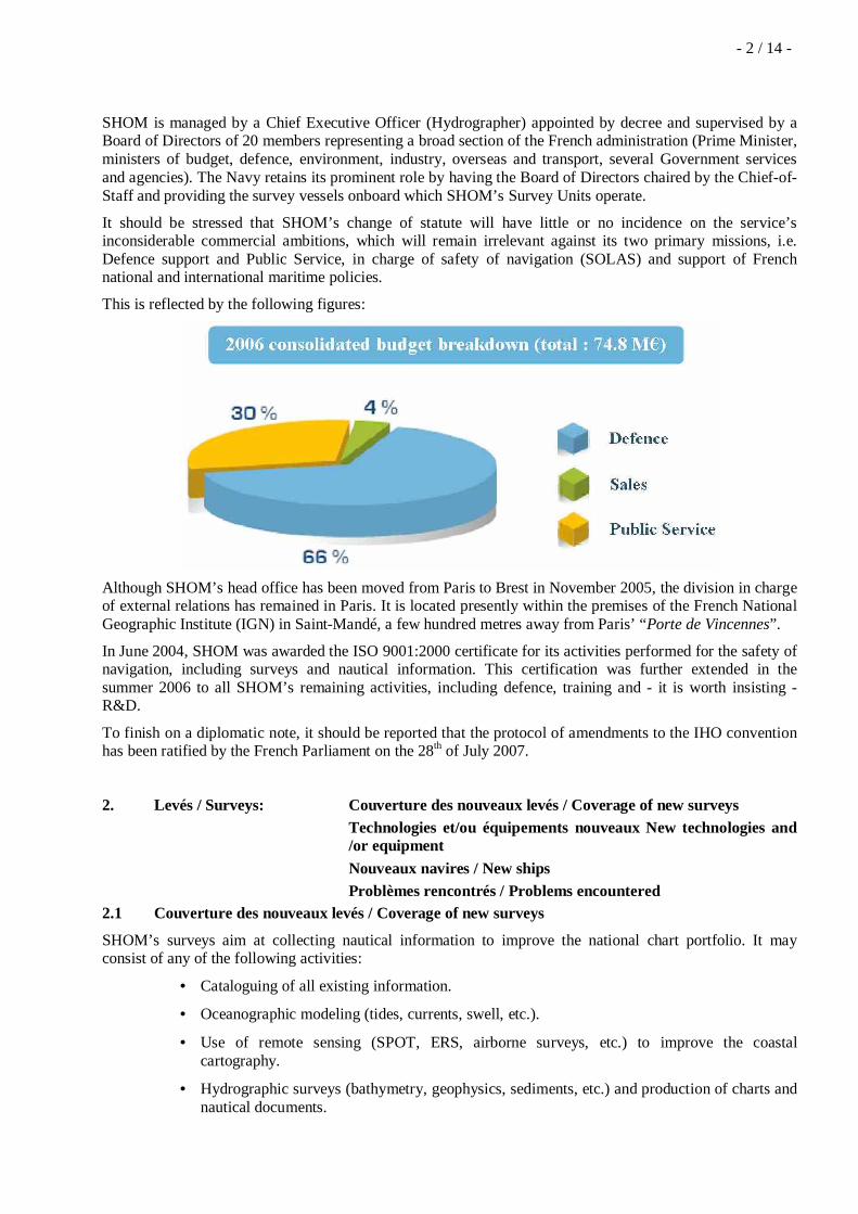
SHOM is managed by a Chief Executive Officer (Hydrographer) appointed by decree and supervised by aBoard of Directors of 20 members representing a broad section of the French administration (Prime Minister,ministers of budget, defence, environment, industry, overseas and transport, several Government servicesand agencies). The Navy retains its prominent role by having the Board of Directors chaired by the Chief-of-Staff and providing the survey vessels onboard which SHOM’s Survey Units operate.
It should be stressed that SHOM’s change of statute will have little or no incidence on the service’sinconsiderable commercial ambitions, which will remain irrelevant against its two primary missions, i.e.Defence support and Public Service, in charge of safety of navigation (SOLAS) and support of Frenchnational and international maritime policies.
This is reflected by the following figures:
Although SHOM’s head office has been moved from Paris to Brest in November 2005, the division in chargeof external relations has remained in Paris. It is located presently within the premises of the French NationalGeographic Institute (IGN) in Saint-Mandé, a few hundred metres away from Paris’ “Porte de Vincennes”.
In June 2004, SHOM was awarded the ISO 9001:2000 certificate for its activities performed for the safety ofnavigation, including surveys and nautical information. This certification was further extended in thesummer 2006 to all SHOM’s remaining activities, including defence, training and - it is worth insisting -R&D.
To finish on a diplomatic note, it should be reported that the protocol of amendments to the IHO conventionhas been ratified by the French Parliament on the 28th of July 2007.
2. Levés / Surveys: Couverture des nouveaux levés / Coverage of new surveysTechnologies et/ou équipements nouveaux New technologies and/or equipmentNouveaux navires / New shipsProblèmes rencontrés / Problems encountered
2.1 Couverture des nouveaux levés / Coverage of new surveys
SHOM’s surveys aim at collecting nautical information to improve the national chart portfolio. It mayconsist of any of the following activities:
• Cataloguing of all existing information.
• Oceanographic modeling (tides, currents, swell, etc.).
• Use of remote sensing (SPOT, ERS, airborne surveys, etc.) to improve the coastalcartography.
• Hydrographic surveys (bathymetry, geophysics, sediments, etc.) and production of charts andnautical documents.

- 3 / 14 -Since the last meeting (October 2005), no extensive survey has been conducted in SHOM’s MBSHC area ofresponsibility, however, routine checks have been performed in the ports of Toulon, Marseille and vicinity.
A REA survey was conducted by Beautemps-Beaupré along the coast of Croatia in September 2007 as partof the NATO exercise Noble Midas 07.
In addition, the Sailing Directions of Corsica have been updated and the RONIM national tidal network hasbeen completed in the ports of Nice and Toulon.Further calibrations have been conducted in Corsica and the Marseille region with a view to extend to theMediterranean the Litto3D ® national programme (see § below and annex).
2.2 Technologies et/ou équipements nouveaux / New technologies and /or equipment
The Litto3D ® project
As mentioned at § 2.1 above, SHOM is making extensive use of remote sensing, both satellite and airborne,to improve its chart portfolio. One of its current developments is the Litto3D ® project presented at theannex. The main objective of Litto3D ® is to develop a high resolution DTM foundation for integratedcoastal management applications. It is carried out by SHOM and the National Geographic Institute (IGN).
The most tangible consequence of this project is that, from 2007 onward, French public should have accesson the national Geoportal to the historical seamless database covering the entire French coastal areas. Thedetailed coastline is already accessible to the public while the “Histolitt” database should be made availablethrough the same portal, before the end of 2007.
The historical data will be gradually improved by new, more accurate surveys, as the project unfolds over thenext 10 years.
Orthoimage draping on the Morbihan DTM
2.3 Nouveaux navires / New ships
To complete the French previous national report, a photograph of the new ocean research vessel Pourquoi-pas? has been posted below.
Pourquoi-pas? was admitted to active service in September 2005. She is a 6 500 t multi-purpose ship fundedjointly by the Ministry of Defence (45%) and the Ministry of Research (55%) and shared almost equallybetween SHOM and Ifremer (the French research institute for the exploitation of the Ocean). SHOM isentitled to 150 days per year, which started in the 2nd semester 2006 by a maiden cruise in the Caribbean.

- 4 / 14 -
The Ocean Survey ship Pourquoi pas ?
2.4 Problèmes rencontrés / Problems encountered
As many other IHO member states, France is tasked with collecting nautical information and surveyinginternational waters that would otherwise remain uncharted.
Although SHOM is kept informed through diplomatic channels of Maritime Scientific Research clearancein the waters placed under France national jurisdiction, it is important to keep in mind that it is in theinterest of the international maritime community that survey results are automatically communicated to theIHO recognised charting authority (ref. M-11).
In addition, provision should be made in all contracts awarded by private survey companies thathydrographic data pertinent to the safety of navigation have to be communicated to the IHO (recognisedcharting authority).
3. Cartest et ouvrages / Charts and Publications:
a. Nouvelles cartes et mises à jour / New charts & updates ENCs RNCs Cartes INT / INT charts Cartes imprimées nationales / National paper charts Autres cartes (par exemple pour plaisanciers) / Other charts e.g. for pleasure cr Distribution des ENC / ENC Distribution method Problèmes rencontrés / Problems encountered
The following paper charts have been produced since the 14th conference (4-5 October 2005):
N°National
N°INT
Nlle pub. (NC)ou nlle éd.(NE)
New chart(NC) or newedition (NE)
Echelle 1/Scale 1:
Date Titre / Title
3975 / NE 500 000 May 2007 Mer Adriatique – Partie Nord (change ofTraffic Scheme)

- 5 / 14 -3987 / NE 175 000 May 2007 Des bouches du Pô à Ancône (change of
Traffic Scheme)4718 / NE 247 000 Nov 2006 De la Pointe del Sabinal à Carthagène
(change of Traffic Scheme)5700 / NE 10 000 March
2006Port du Pirée et baie de Phalère – PortHéraclée
6569 / NE 200 000 Nov 2006 Mer d’Alboran – Feuille Nord (change ofTraffic Scheme)
6963 / NE 100 000 June 2006 De San rossore au canal de piombino – Ilesd’Elba, Capraia et Gorgona (Fs IT 4)
7019 / NE 100 000 Dec 2006 De Imperia à Portofino (Fs IT 2)7020 / NE 10 000 –
5 000Nov 2005 Ports du Golfe de Gènes (Genova) – Insert A :
Porto di Imperia – Insert B : Porto diPortofino – Insert C : Porto di SantaMargherita Ligure – Insert D : porto di SestriLevante
7042 3150 NE 100 000 June 2007 Détroit de Gibraltar (Fs ES 105)7046 3185 NE 12 500 Aug 2007 Puerto de Barcelona (Fs ES 4891)7074 3754 NE 50 000 June 2006 De Yesilkôy à Yelkenkaya Burnu – Approches
sud du Bosphore (Fs TR 2923)7103 / NE 20 000 May 2006 Kolpos Elevsinas7189 / NE 25 000 June 2007 Golfes d’Olbia et d’Aranci – Iles Tavolara et
Molara (Fs IT 322)7228 / NE 50 000 June 2007 Abords de Venise – De Porto Levante à Porto
di Lido (change of Traffic Scheme) (Fs IT222)
7244 3410 NE 250 000 June 2007 De Porto Corsini à Velebitski Kanal – Golfede Venise (change of Traffic Scheme)(Fs YU3410)
7290 3362 NE 10 000 May 2007 Porto de Genova – Partie Est (Fs IT 55)7433 1972 NC 22 500 Apr 2007 Abords du port de Tanger-Med7506 3361 NE 10 000 May 2007 Porto de Genova – Partie Ouest (FS IT 54)7524 3216 NE 500 000 Nov 2006 De Cap Afrique à Mi tah (Fs GB 3403)7539 3414 NC 250 000 June 2006 De Dubrovnik à Durrës (Fs HR 3414)
The following paper charts are planned in 2007:
N°National
N°INT
Nlle pub. (NC)ou nlle éd.(NE)
New chart(NC) or newedition (NE)
Echelle 1/Scale 1:
Titre / Title
6907 / NE 25 000 Etang de Berre7390 3196 NE 10 000 Port de Marseille7391 / NE 12 500 Abords Sud de Marseille- Des Iles du Frioul à l’Ile de Jarre
The following paper charts are planned in 2008-2010:

- 6 / 14 -N°
NationalN°
INTNlle pub. (NC)ou nlle éd.(NE)
New chart(NC) or newedition (NE)
Echelle 1/Scale 1:
Titre / Title
6961 3364 NE 25 000 Italie – Golfe de la Spézia (Fs IT 115).7093 3198 NE 10 000 Rade de Toulon7528 3392 NE 30 000 Abords de Palermo (Fs IT 255 et IT 256).7534 3365 NC 10 000 Italie – Rade de la Spézia (Fs IT 60).7535 / NC 5 000 Port de la Spézia (Fs IT 59).7543 3548 NC 25 000 Bur Saïd (Fs UK 240)7544 3549 NC 50 000 Bur Saïd (Fs UK 241)
XXXX / NC 50 000 Golfo di Palmas (Fs IT 298).XXXX / NC 25 000 Canale di San Pietro (Fs IT 294). Replaces 5345XXXX / NC 5 000 Iraklion (Fs GR 443 et GR 4431). Replaces 6709
ENCsOn the 1st of October 2007, SHOM had produced some 231 ENCs at an approximate rate of 40 to 50 peryear. The full collection should eventually reach a figure of the order of 700 ENCs.
Europe approaches are well covered, on account of commercial and passengers sailing requirements.Production in non European waters (areas of international responsibilities, overseas territories) isprogressing.
In accordance with the WEND principles, France produces its small scale ENC cells as closely as possible toINT chart schemes.
To date, the Metropolitan France ENC coverage is depicted in the chart below, where High Speed Craftsroutes are represented in red:

- 7 / 14 -
However, there is a need for improved coordination with Italy to avoid gaps/data overlaps in the productionof usage band 3 ENCs in the Menton and Bonifacio areas.
The production of the following cells should be completed in 2007:
Zone / Area Gammed’utilisationUsage Band
N° carte impriméeFR
Fr paper chart Nr
Observations
Accès port Popriano 5 6851Accès port Bonifacio 5 7096
Accès port Porto Vecchio 5 6911
Corse Sud - Bouches de Bonifacio 4 6942, 7162, 7024,6929, 6855
Accès port Tanger 4 7433 Abords du port de Tanger-Med (Apr 2007)
Liban 5 7514 (Insert D) Tyr
The production of the following cells has been planned in 2008-2010:
Zone / Area Gammed’utilisationUsage Band
N° carte impriméeFR
Fr paper chart Nr
Observations
Côtes Méditerranée est 4 7408
Côtes Méditerranée est 5 7205, 6838, 7267,6616, 6615, 7282

- 8 / 14 -Côtes Méditerranée est 6 7200, 7205, 7267
Corse ouest 4 7050Côtes Méditerranée ouest 4 6693, 7053
Corse est 4 6823, 6855Corse nord 4 6969, 6822
Côtes Méditerranée est 5 6610, 6612, 7393
Ports de plaisance - Méditerranée 67205, 6838, 7267,6616, 6615, 7282,6610, 6612, 7393
Due to IMO regulations on ECDIS carriage requirements, France will ensure that all HSC lines in Frenchwaters are covered with ENC by 2008.
b. Ouvrages / Publications Nouvelles publications / New publications
Mises à jour - Editions / Updated publications - Editions Distribution (papier et numérique) / Means of delivery e.g. paper, digital Problèmes rencontrés / Problems encountered
Type Nr Titre / Title
IN D22-INA France (côte Sud) : du Cap Croisette à la frontière italienne (Edition2006)
LL DC--FNA Méditerranée occidentale – partie Nord (Edition 2007)
LL DE--FNA Méditerranée orientale – Mer Noire (Edition 2005)
RSX 91--RNA Radionavigation maritime (Edition 2006)
RSX 922-RNA Radiocommunications maritimes – Volume 2 : Afrique – Asie – Australie(Edition 2005 – DMS le 05/05/2005)
RSX 932-RNA Radiocommunications pour la surveillance du trafic et le pilotage –Volume 2 : Europe occidentale – Méditerranée (Edition 2006)
DIV 961--RNA Stations radiométéorologiques – Volume 1 : Europe, Afrique et Asie(Edition 2005 - DMS le 24/12/2005)
DIV 99--RNA Répertoire des radiosignaux à l’usage du petit cabotage, de la pêche etde la plaisance – Côtes européennes, Méditerranée, Mer Noire,Madère/Canaries/Açores, Petites Antilles (Edition 2007)
DIV 085-MAA Annuaire des marées 2008, tome 1 – Ports de France
DIV 075-MAA Annuaire des marées 2007, tome 1 – Ports de France
DIV 001DNOA Symboles, abréviations et termes utilisés sur les cartes marines (Edition2006)
DIV 021-PIG Naviguer en sécurité (Edition 2006 – Ce document ne concerne que lanavigation de plaisance)
DIV 004-ZKA Catalogue des cartes marines et des ouvrages nautiques (Edition 2007)
DIV 008-ZKI Le petit catalogue (Edition 2007)
IN : Instructions nautiques / Sailing directions
RSX : Radiosignaux / Radio stations

- 9 / 14 -LL : Livre des feux et signaux de brume / List of Lights
DIV : Divers / Miscelleanous
Distribution (papier et numérique) / Means of delivery e.g. paper, digital
SHOM aims at generating by digital means its entire paper production. This should be achieved by usinginternational standards such as XML and following closely the recommendations of experts such as theNSHC’s WG on standardisation of digital exchange of NtMs.
All ENCs are distributed through PRIMAR ® RENC.
Problèmes rencontrés / Problems encountered
An important regulation corpus has been developed for the establishment and use of ENCs while theequivalent standardisation for digital nautical books is still lagging. As a result, the rules of use of thesedocuments are not clearly established.
4. RSM / MSI Infrastructures de transmission existantes / Existinginfrastructure for transmission
Nouvelles infrastructures dans le cadre du SMDSM / Newinfrastructure in accordance with GMDSS Master Plan
Problèmes rencontrés / Problems encountered
Rien à signaler / NTR
5. Création de capacities / Capacity Building
Offre / demande pour la création de capacité / Offer of and/ordemand for Capacity Building
Formations reçues, requises, offertes / Training received, needed,offered
Projets de développements bilatéraux, multilatéraux, régionauxavec composante hydrographique (en cours, prévu, en coursesd’évaluation ou de faisabilité) Status of national, bilateral,multilateral or regional development projects with hydrographiccomponent. (In progress, planned, under evaluation or study)
5.1 Offre / demande pour la création de capacité / Offer of and/or demand for Capacity Building
France participates in the IHO Capacity Building committee and supports the IHO Regional HydrographicCommissions of which SHOM is a member, especially the SAIHC and the Eastern Atlantic HydrographicCommission (EAtHC), and to a lesser extent the South-West Pacific Hydrographic Commission (SWPHC),the North Indian Ocean Hydrographic Commission, the MESO American and Caribbean Sea HydrographicCommission (MACHC) & the Mediterranean and Black Sea Hydrographic Commission (MBSHC).
5.2 Formations reçues, requises, offertes / Training received, needed, offered
Initial training capabilities provided by SHOM are described in its yearly report available on www.shom.fr .
5.3 Projets de développements bilatéraux, multilatéraux, régionaux avec composantehydrographique (en cours, prévu, en courses d’évaluation ou de faisabilité) / Status of national,bilateral, multilateral or regional development projects with hydrographic component. (In progress,planned, under evaluation or study)
- 10 / 14 -
5.3.1 Transfert de responsabilité en application de la convention Solas / Transfer of responsibility in linewith the SOLAS convention
France has implemented a mechanism of transfer of responsibility in the fields of hydrography andcartography, based on training programs and on-the-job tasks.
These are detailed in the agreements likely to be signed with Morocco (DTHOC) and Algeria (STFN) at theend of 2007 or early 2008.
Another co-operation programme with Tunisia (CHOMT) has been initiated, that might eventually lead to anagreement in 2008.
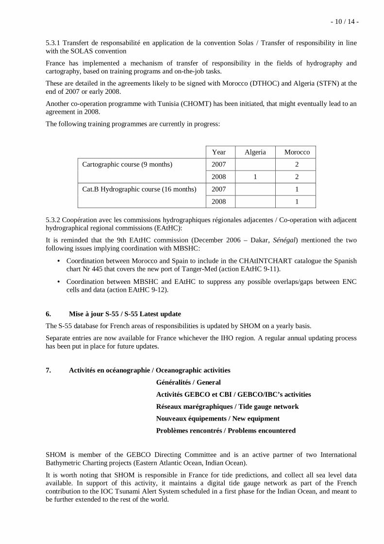
The following training programmes are currently in progress:
Year Algeria Morocco
2007 2Cartographic course (9 months)
2008 1 2
2007 1Cat.B Hydrographic course (16 months)
2008 1
5.3.2 Coopération avec les commissions hydrographiques régionales adjacentes / Co-operation with adjacenthydrographical regional commissions (EAtHC):
It is reminded that the 9th EAtHC commission (December 2006 – Dakar, Sénégal) mentioned the twofollowing issues implying coordination with MBSHC:
• Coordination between Morocco and Spain to include in the CHAtINTCHART catalogue the Spanishchart Nr 445 that covers the new port of Tanger-Med (action EAtHC 9-11).
• Coordination between MBSHC and EAtHC to suppress any possible overlaps/gaps between ENCcells and data (action EAtHC 9-12).
6. Mise à jour S-55 / S-55 Latest update
The S-55 database for French areas of responsibilities is updated by SHOM on a yearly basis.
Separate entries are now available for France whichever the IHO region. A regular annual updating processhas been put in place for future updates.
7. Activités en océanographie / Oceanographic activities
Généralités / General
Activités GEBCO et CBI / GEBCO/IBC’s activities
Réseaux marégraphiques / Tide gauge network
Nouveaux équipements / New equipment
Problèmes rencontrés / Problems encountered
SHOM is member of the GEBCO Directing Committee and is an active partner of two InternationalBathymetric Charting projects (Eastern Atlantic Ocean, Indian Ocean).
It is worth noting that SHOM is responsible in France for tide predictions, and collect all sea level dataavailable. In support of this activity, it maintains a digital tide gauge network as part of the Frenchcontribution to the IOC Tsunami Alert System scheduled in a first phase for the Indian Ocean, and meant tobe further extended to the rest of the world.

- 11 / 14 -Two digital tide gauges have been installed in Morocco with an expertise and a training assumed by SHOM
8. Conclusions / Conclusions
Rien à signaler / NTR
Ingénieur en chef Yves GuillamHead of Policy, Plans and External Relations

- 12 / 14 -
Annexe / Annex
Le projet Litto3D ®The Litto3D® project
Conducted jointly by SHOM and IGN, the French National Institute of Geography, the Litto3D projectaims at creating a reference national database covering the French’s and French Overseas’ coastal regionsby merging hydrographic soundings, land heights and water levels generated by highly precise tidemodels.
Starting with the “Histolitt” historical data, which should be available as early as 2007, the Litto3D fulldatabase will be released through the appropriate information portal to the Authorities in charge of theintegrated management of the French coastal domain. The detailed coastline is already accessible to thepublic on the Geoportal.
Gestion intégrée des zones côtières: simulation d’une onde de tempête centenaire
Integrated coastal management : simulation of a centennial tidal surge

- 13 / 14 -After conducting a thorough examination of the existing data against modern requirements, SHOM andIGN concluded first that the historical database would fall short of the public expectations in terms ofquality, precision, density and coverage.
From then on, the project concentrated on identifying a system capable of delivering land and sea heightswith a precision better than 30 centimetres. It finally came to the conclusion that the desired informationcould be obtained by means of a combination of hydrographic multibeam soundings (MBES) and laser airsurveys (Bathytopo lidar).
During the Spring of 2005, extensive testing was conducted in Golfe du Morbihan, a large South Brittanyinlet known of French surveyors for being a Hydrographer’s nightmare.
Un cauchemar pour les hydrographes : les 14 zones de marée du golfed u Morbihan
A Hydrographer’s nightmare : the Golfe du Morbihan s 14 tidal zones
Further experiments have been conducted on the French Mediterranean coast in the summer of 2007.
Le démonstrateur en Méditerranée
The Mediterranean demonstrator
The first results confirmed the validity of the method chosen and paved the way for further deployment ofthe new techniques over the entire French coastal domain.
The Litto3D project has been approved at the Government’s highest level during the InterdepartmentalCommittee of the Sea (CIMER) of 29 April 2003, and confirmed again during the Interdepartmental

- 14 / 14 -Committee for the Management of the Territory (CIADT) of 13 September 2004. This project shouldengage IGN and SHOM for the next decade.