Rapid needs assessment of the agricultural sector · Rapid needs assessment of the agricultural...
45
Project: TCP/SRB/3501 Rapid needs assessment of the agricultural sector Floods 2016 - Serbia Dragan ANGELOVSKI Emergency response specialist FOOD AND AGRICULTURE ORGANIZATION OF THE UNITED NATIONS Belgrade, 2016
Transcript of Rapid needs assessment of the agricultural sector · Rapid needs assessment of the agricultural...
Project: TCP/SRB/3501
Rapid needs assessment of the agricultural sector Floods 2016 - Serbia Dragan ANGELOVSKI Emergency response specialist
FOOD AND AGRICULTURE ORGANIZATION OF THE UNITED NATIONS
Belgrade, 2016
The designations employed and the presentation of material in this information product do not imply the expression of any opinion whatsoever on the part of the Food and Agriculture Organization of the United Nations (FAO) concerning the legal or development status of any country, territory, city or area or of its authorities, or concerning the delimitation of its frontiers or boundaries. The mention of specific companies or products of manufacturers, whether or not these have been patented, does not imply that these have been endorsed or recommended by FAO in preference to others of a similar nature that are not mentioned. The views expressed in this information product are those of the author(s) and do not necessarily reflect the views or policies of FAO. I5906E/1/07.16 FAO encourages the use, reproduction and dissemination of material in this information product. Except where otherwise indicated, material may be copied, downloaded and printed for private study, research and teaching purposes, or for use in non-commercial products or services, provided that appropriate acknowledgement of FAO as the source and copyright holder is given and that FAO’s endorsement of users’ views, products or services is not implied in any way. All requests for translation and adaptation rights and for resale and other commercial use rights should be made via www.fao.org/contact-us/licence-request or addressed to [email protected]. FAO information products are available on the FAO website (www.fao.org/publications) and can be purchased through [email protected].
Rapid needs assessment of the agricultural sector- Serbia – Floods 2016
iii
Abbreviations and acronyms
BBB Build Back Better DaLA Damage and Loss Assessment FAO Food and Agriculture Organization GDP Gross Domestic Product GFDRR Global Facility for Disaster Risk Reduction HRNA Human Recovery Needs Assessment MDGs Millennium Development Goals NDRMP National Disaster Risk Management Program NEMH National Emergency Management Headquarters
OG Official Gazette PIMO Public Investment Management Office PDNA Post Disaster Needs Assessment RNA Rapid Needs Assessment RSD Serbian Dinars USD United States Dollar

Rapid needs assessment of the agricultural sector- Serbia – Floods 2016
iv
Contents
ABBREVIATIONS AND ACRONYMS..........................................................................................III
EXECUTIVE SUMMARY....................................................................................................................V
1. BACKGROUND........................................................................................................................1
1.1 Country profile and agriculture of Serbia ............................................................................... 1
1.2 Vulnerability to natural disasters .............................................................................................. 3
1.3 Description of the national framework ................................................................................... 5 1.3.1 Institutional framework .................................................................................................................. 5 1.3.2 Legal framework ............................................................................................................................. 6 1.3.3 Practices related to emergencies and damage and losses assessment ...................... 7 1.3.4 Risk assessments related to the agricultural sector ............................................................... 8
1.4 General description of the event and immediate response ............................................... 9
1.5 Rapid Needs Assessment ........................................................................................................ 10 1.5.1 Assessment process ..................................................................................................................... 10 1.5.2 Assessment scope ........................................................................................................................ 11 1.5.3 Assessment methodology .......................................................................................................... 11 1.5.4 Institutional setups, municipal practices and limitations ................................................... 12
2 EFFECTS (DAMAGE AND LOSSES)..................................................................................15 2.1 Background of agricultural production in the affected areas ......................................... 15 2.2 General description of the disaster, population and areas affected ............................ 16 2.3 Impact of the Disaster ................................................................................................................. 18
2.3.1 Damages ........................................................................................................................................ 18 2.3.2 Losses ............................................................................................................................................... 19 2.3.3 Effects on Infrastructure and Physical Assets ........................................................................ 20 2.3.4 Effects on Service Delivery disruption of service delivery .................................................. 21 2.3.5 Effects on Production .................................................................................................................. 21 2.3.6 Effects on Governance .............................................................................................................. 23 2.3.7 Effects on Risk and Vulnerabilities ............................................................................................ 23
2.4 Role of the agricultural insurance ........................................................................................................ 24
3 THE SOCIO ECONOMIC IMPACT...................................................................................26
4 CONCLUSIONS......................................................................................................................28
5 RECOVERY RECOMENDATONS.......................................................................................29
6 ANNEXES.................................................................................................................................38
Rapid needs assessment of the agricultural sector- Serbia – Floods 2016
v
Executive summary Affirmation This report was prepared on behalf of FAO Serbia by a team consisting of Dragan Angelovski (author), Aleksandar Mentov, Dragan Terzic, Alexandar Swanwick, Vlado Pijunovic and Ljiljana Isic. Our thanks for the excellent collaboration go especially to Boban Djordjevic and Aleskandar Glisic, whose support and contributions were crucial to the successful realization of the research. A very special thank you goes to the Municipal Authorities and flood affected respondents who were willing to share their experiences and to openly discuss the barriers and obstacles they face in their daily lives. Country profile and agriculture in Serbia Agriculture is a very important economic sector in Serbia, as it accounts for some 9 percent of the total gross national income. Agricultural products account for more than 20 percent of national exports. More than half of the country’s territory is classified as agricultural land (4 867 000 ha), which defines Serbia as an agrarian country. The number of persons employed in the agricultural sector amounts to a fifth of the working age population. In some regions, agriculture is a core economic activity for most residents. The average holding owns about three hectares, while 25 percent of households farm more than five hectares. The most common field crop is maize, which makes up a half of the sown area. It is followed by wheat, sunflowers, alfalfa and soya. Vulnerability to natural disasters Serbia is highly exposed and vulnerable to natural hazards and ranks 87 on the world vulnerability list, with the highest score in the region. Mean damage, mainly to agricultural production caused by disasters, are estimated to reach USD 500 million per year. Floods are the main hydro-meteorological hazard in the country. River floods in the major river basins are caused by rainfall and/or intensive snow melt. Flood protection is the most important aspect of defence. However, long–term/multiannual investment reduction in the maintenance of facilities and riverbeds, has led to a reduction in the security and level of protection from the destructive water. Due to climate change, the frequency and intensity of flood is rising. Agriculture is one of the sectors that is most vulnerable to climate change, followed by energy, water management and air traffic. Description of the national framework The Government has established the National Emergency Management Headquarters (NEMH), which acts as international focal point for the National Platform for Disaster Risk Reduction. There is a relatively comprehensive legislative base supporting the field of disaster risk reduction and management. In July 2014, The Law on Post-Flood Rehabilitation was adopted in order to speed up the reconstruction in the aftermath of the floods and landslides on May 2014.
Rapid needs assessment of the agricultural sector- Serbia – Floods 2016
vi
The government has defined a methodology for the multi-hazard national risk assessment which should be used by the Municipalities. However, only six units of local government have made the required Risk Assessment. Current disaster related practices The Law on Reconstruction Following Natural and Other Hazards regulates the reconstruction efforts and provides for state aid allocation due to natural and other disasters, when damages exceeds 10 percent of the gross domestic product in a local self-government unit and in events declared as emergencies by the Government. The local self-government unit establishes committees to assess the damage, in line with the Act on a single methodology for assessing damage from natural and other disasters. Most local governments are not trained on how to use this methodology. The currently prescribed methodologies – beyond collecting data on the damages – do not provide for further estimations of macroeconomic and socio-economic impacts. General description of the event and immediate response On 7 March 2016, due to heavy rainfall and threats of flooding, an emergency situation was declared for 14 cities and municipalities in central and western parts of Serbia. As of 8 March, 118 persons had been evacuated by fire and rescue units of the Ministry of Interior. Additionally, 710 households had been flooded while around 500 may have been affected. The disaster was a reoccurrence of relatively well known flooding pattern; namely, swollen small rivers and streams, caused flash floods in hilly areas. Inundation was caused by larger rivers, which due to lack of – or damage to – embankments, flooded the land along the river. Assessment scope and methodology The Government decided to perform a Rapid Needs Assessment for the Agricultural Sector (RNA). The Government asked FAO to assist in the implementation of the RNA. FAO responded positively to the request from the government and a task team was fielded. This RNA was conducted following the principles of a Post-disaster Needs Assessment (PDNA). Institutional setups, municipal practices and limitations All of the Municipal Damage Assessment Commissions on Agriculture verified, listed and mostly quantified the damage and losses. Approximately half of the municipalities engaged in activities beyond the preparation of the requested lists and calculated the value of the damage and losses. Very few municipalities produced reports in accordance to the Single Methodology prescribed by the legislations. Rather they used improvised methodologies. Also, most of the municipalities did not collect comprehensive data on damage and losses related to assets and equipment, they did not quantify losses and mostly used approximations and generalizations in the data. Virtually all of the municipalities seem to lack the capacity to address significant agricultural disasters. Some municipalities enlisted assistance from other state institutions based on good interpersonal relations. Some municipalities enlisted the support of commercial service providers (at a considerable cost to the municipality). Results In total, approximately 10 000 ha of arable land was flooded. Damage from the floods was reported on roughly 8 300 ha of arable land, out of which some 3 720 ha had standing crops. The affected municipalities include some 184,455 households. Forty eight percent of the rural population is agriculturally active, cultivating approximately 317 692 ha of arable land.
Rapid needs assessment of the agricultural sector- Serbia – Floods 2016
vii
On average, the flooded area represents 2.62 percent of the total arable land of the affected municipalities, and a negligible share of the arable land on regional and national level. On average 23 percent of the land used by the average farmer was flooded. A total of 7,121 households were reported as affected, representing 8 percent of the total agricultural households in the affected municipalities. On average, 65.5 percent of the affected farming households rely solely on agricultural activities for their incomes and livelihoods. On average, 47.6 percent of the affected crops a were cash crops, which farmers sell to contribute to their household incomes, or to which farmers add value (fodder to milk) and sell on. On average, for 59 percent of the affected farmers the cash crops that were affected are their main source of income. The floods occurred at a quite significant time in the agricultural calendar and affected standing crops at various stages of development. The overall damage and losses of the flood event are about USD 2.892 million, of which 34 percent represented the destruction of physical assets (mainly damage to agricultural land) in the affected areas, and 66 percent represented losses in production and economic flows. Most of the losses related to standing crops although lost future revenues and increased production costs were also considered. A significant value was classified as “conditional losses”, which may occur in the months after the floods. The overall share of damage and losses to crops was assessed as “mild to moderate” in most instances, and “severe” in a limited number of affected farmers/communities. It is expected that most of the crops will reshoot, regrow and in due course produce yields, albeit lower than what would be expected in a floodless year. There are approximately 1,000 farming households whose high value production was devastated and the poorest farmers engaged in high value crops will be the most affected by the disaster. In particular, poor, small-scale farmers engaged in high value crops will be affected, as they will experience reduced incomes and face increased recovery costs. Subsistence farmers will experience some increase in costs and spending, in order to meet their consumption needs. The likelihood of food insecurity is very low and the levels of rural poverty – and in particular debts – are likely to increase in the affected areas. Most insurance companies do not insure against floods in principle, significantly reducing farmers’ resilience to floods. The proposed recovery measures address the agricultural sector, as well as Disaster Risk Reduction and Management Sector. In the agricultural sector the measures aim to restore livelihoods and to provide immediate support, as well as recovery and development assistance to the disaster affected population. Sustainability is achieved through addressing the limited institutional capacity on central and local level and through addressing climate change and disaster risk reduction on all levels. In the Disaster Risk Reduction and Management Sector, the proposed measures address the outdated and underdeveloped disaster response systems, the limited disaster risk assessment and planning, the lack of support to farmers living in disaster prone areas and the limited DRR capacities’ in terms of prevention, mitigation and preparedness.
Rapid needs assessment of the agricultural sector- Serbia – Floods 2016
1
1. BACKGROUND
1.1 Country profile and agriculture of Serbia Agriculture is a very important economic sector in Serbia, as it accounts for some 9 percent of the total gross national income. In comparison, in the 27 EU countries the percentage of agricultural production lies below 3 percent of the gross national product. Projections for Serbia indicate that the share of agricultural contribution to the GDP will continue to decline, as sectors of the economy continue to develop. Agricultural products account for a substantial share of national exports, contributing more than 20 percent. The number of people employed in the agricultural sector amounts to a fifth of the working age population. In some regions of Serbia, agriculture is a core economic activity and most of the residents depend on it for their basic livelihoods. The natural potential for development of agricultural production is significant. Climatic conditions are favourable and Serbia has considerable water resources for further development of the production. More than half of the country’s territory is classified as agricultural land (4 867 000 ha), which helps explain the high share of agriculture in the overall exports and defines Serbia as an agrarian country. Policy reform of the agricultural sector is ongoing. In parallel, the rural areas are plagued by persistent depopulation, poverty of parts of the farming community and weakening of farmers’ competitiveness, as well as insufficient development and maintenance of rural infrastructure. The average farming holding owns about three hectares, while only 25 percent of agricultural households farm more than five hectares. Small farm size delays the development of the agricultural sector and reduces the competitiveness of agricultural producers. However, there is little capacity for commercial production and farmers remain vulnerable to all kinds of shocks, even without taking into account the impact of natural disasters and climate change. With a share of about 60 percent in Serbia’s agricultural production, arable farming is dominant, followed by animal husbandry with about 30 percent, pomiculture with 8 percent and, viniculture with almost 2 percent. The most common field crop is maize, which makes up a half of the sown area. It is followed by wheat, sunflower, alfalfa and soya. Orchards make up almost 5 percent of total arable land (approximately 250 000 ha), and the most common cultures are apples, plums, sour cherries and raspberries. In the last several years, a relatively steady production level has been observed.

Rapid needs assessment of the agricultural sector- Serbia – Floods 2016
2
Livestock production has also been facing a decline in recent decades. The number of livestock has been declining for many years starting with cattle and most strikingly in sheep breeding. Pig breeding remains the most common livestock activity.
Rapid needs assessment of the agricultural sector- Serbia – Floods 2016
3
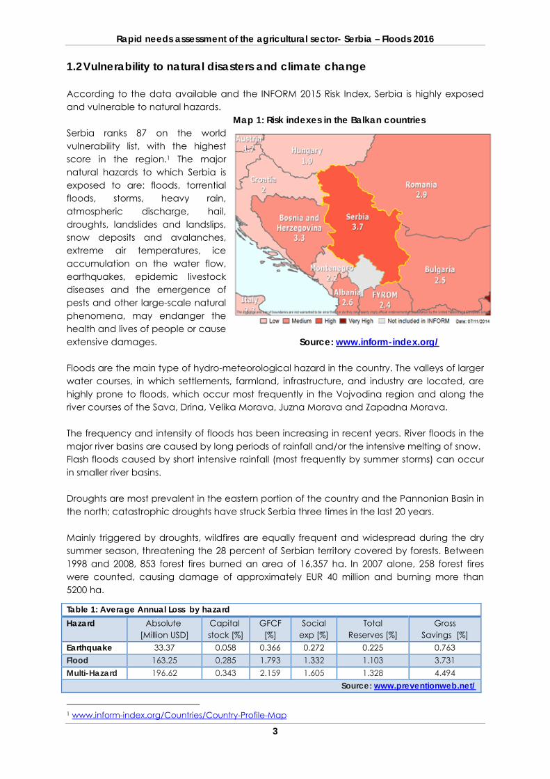
1.2 Vulnerability to natural disasters and climate change According to the data available and the INFORM 2015 Risk Index, Serbia is highly exposed and vulnerable to natural hazards.
Map 1: Risk indexes in the Balkan countries Serbia ranks 87 on the world vulnerability list, with the highest score in the region.1 The major natural hazards to which Serbia is exposed to are: floods, torrential floods, storms, heavy rain, atmospheric discharge, hail, droughts, landslides and landslips, snow deposits and avalanches, extreme air temperatures, ice accumulation on the water flow, earthquakes, epidemic livestock diseases and the emergence of pests and other large-scale natural phenomena, may endanger the health and lives of people or cause extensive damages. Source: www.inform-index.org/ Floods are the main type of hydro-meteorological hazard in the country. The valleys of larger water courses, in which settlements, farmland, infrastructure, and industry are located, are highly prone to floods, which occur most frequently in the Vojvodina region and along the river courses of the Sava, Drina, Velika Morava, Juzna Morava and Zapadna Morava. The frequency and intensity of floods has been increasing in recent years. River floods in the major river basins are caused by long periods of rainfall and/or the intensive melting of snow. Flash floods caused by short intensive rainfall (most frequently by summer storms) can occur in smaller river basins. Droughts are most prevalent in the eastern portion of the country and the Pannonian Basin in the north; catastrophic droughts have struck Serbia three times in the last 20 years. Mainly triggered by droughts, wildfires are equally frequent and widespread during the dry summer season, threatening the 28 percent of Serbian territory covered by forests. Between 1998 and 2008, 853 forest fires burned an area of 16,357 ha. In 2007 alone, 258 forest fires were counted, causing damage of approximately EUR 40 million and burning more than 5200 ha.
1 www.inform-index.org/Countries/Country-Profile-Map
Table 1: Average Annual Loss by hazard Hazard
Absolute [Million USD]
Capital stock [%]
GFCF [%]
Social exp [%]
Total Reserves [%]
Gross Savings [%]
Earthquake 33.37 0.058 0.366 0.272 0.225 0.763 Flood 163.25 0.285 1.793 1.332 1.103 3.731 Multi-Hazard 196.62 0.343 2.159 1.605 1.328 4.494
Source: www.preventionweb.net/
Rapid needs assessment of the agricultural sector- Serbia – Floods 2016
4
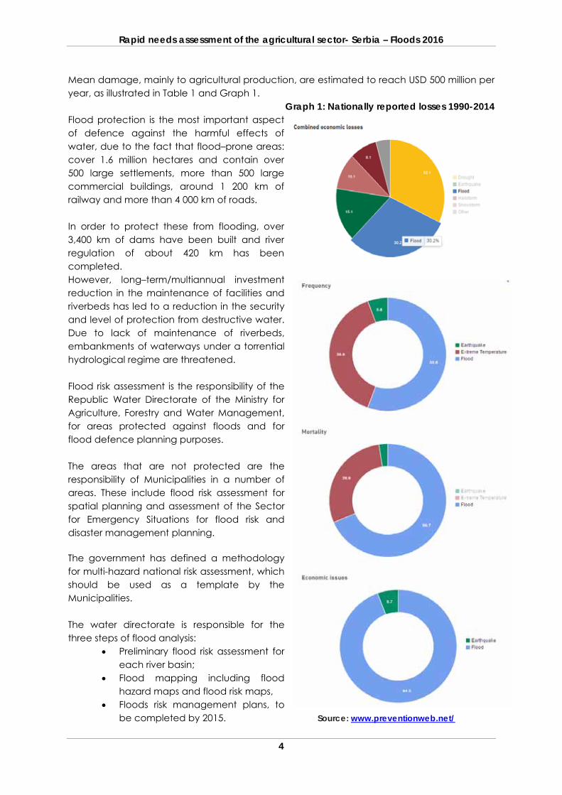
Mean damage, mainly to agricultural production, are estimated to reach USD 500 million per year, as illustrated in Table 1 and Graph 1.
Graph 1: Nationally reported losses 1990-2014 Flood protection is the most important aspect of defence against the harmful effects of water, due to the fact that flood–prone areas: cover 1.6 million hectares and contain over 500 large settlements, more than 500 large commercial buildings, around 1 200 km of railway and more than 4 000 km of roads. In order to protect these from flooding, over 3,400 km of dams have been built and river regulation of about 420 km has been completed. However, long–term/multiannual investment reduction in the maintenance of facilities and riverbeds has led to a reduction in the security and level of protection from destructive water. Due to lack of maintenance of riverbeds, embankments of waterways under a torrential hydrological regime are threatened. Flood risk assessment is the responsibility of the Republic Water Directorate of the Ministry for Agriculture, Forestry and Water Management, for areas protected against floods and for flood defence planning purposes. The areas that are not protected are the responsibility of Municipalities in a number of areas. These include flood risk assessment for spatial planning and assessment of the Sector for Emergency Situations for flood risk and disaster management planning. The government has defined a methodology for multi-hazard national risk assessment, which should be used as a template by the Municipalities. The water directorate is responsible for the three steps of flood analysis:
Preliminary flood risk assessment for each river basin;
Flood mapping including flood hazard maps and flood risk maps,
Floods risk management plans, to be completed by 2015. Source: www.preventionweb.net/
Rapid needs assessment of the agricultural sector- Serbia – Floods 2016
5
The water directorate is also responsible for the flood risk assessment and for the preparation of the national plan for flood protection (every five years), as well as the annual plans in collaboration with other stakeholders. The plans identify the roles and responsibility of different actors in flood protection and management. Climate change is expected to significantly affect water resources. A preliminary assessment on these effects indicates that a decrease in water flow at national level is to be expected in the forthcoming period, caused by a decrease in annual precipitation. It should also be taken into consideration that projections show that climate change will cause intense flood and drought episodes, increasing both in scope and duration as result of increasing fluctuations of water flows, due to climate variability and extreme weather events. A substantial number of studies predict increase in intensity and frequency of flooding, particularly in the winter season. Different economic sectors show different levels of vulnerability to natural disasters and extreme weather events. Weather-dependent sectors are critical to the national economy (high GDP share). The share of sectors that depend on weather conditions in the gross national product of Serbia is considerably substantial, amounting to almost 50 percent. One of the most vulnerable sectors is agriculture, followed by energy, water management and air traffic. It is expected that climate change will affect agricultural production, especially plant production. Apart from the direct impact reflected in temperature and precipitation regime changes, production may be endangered by various types of diseases and parasites whose incidence and spread may alter due to climate change. The prolonged vegetation seasons due to higher temperatures in winter and early spring could lead to a higher incidence of certain diseases and pests. On the other hand, it is to be expected that there will be lower incidence of certain types of insects, particularly those that depend on the soil moisture, due to prolonged dry periods. Another adverse phenomenon that will be enhanced is soil erosion caused by higher frequency of floods and water levels. 1.3 Description of the national framework
1.3.1 Institutional framework The Serbian Government appointed the members of the National Emergency Management Headquarters (NEMH) on 12 May 2011. The National Platform for Disaster Risk Reduction was proclaimed on 24 January 2013. The NEMH acts as the international focal point for the National Platform for Disaster Risk Reduction. The NEMH is an operational and expert governmental body formed with the aim of coordinating and managing protection and rescue activities in emergencies, as well as mainstreaming Disaster Risk Reduction policies.
Rapid needs assessment of the agricultural sector- Serbia – Floods 2016
6
The Chairperson of NEMH is the Minister of the Interior and the Head of Sector for Emergency Management is the Head of National Emergency Management Headquarters. Other members include: All Ministers in the government; Experts from the Ministry of the Interior, the Army, the Red Cross and the Mountain Rescue
Service; Directors of the special governmental organisations responsible for seismology,
hydrology, meteorology, water management and forestry; Directors of public companies, business associations and other legal entities, media,
humanitarian organisations, citizens’ associations and other institutions, which, based on their portfolio, may be part of the protection and rescue system in the event of an emergency.
The NEMH is responsible for: Coordinating activities in the protection and rescue system in terms of organization,
planning, preparations and implementation of measures and activities related to disaster risk prevention and reduction, protection and rescue, including the exchange of information, knowledge and technologies;
Coordinating activities and measures included in the Serbian National Strategy for Protection and Rescue in Emergencies;
Deliberating and giving its opinion on the Draft Long-term Plan of Protection and Rescue System Development;
Monitoring and coordinating the implementation of measures included in the Long-term Plan of Protection and Rescue System Development;
Deliberating and giving its opinion on the Draft Natural and Other Hazards Vulnerability Assessment;
Deliberating and giving its opinion on the Draft National Emergency Protection and Rescue Plan;
Regularly informing the population about risks and threats as well as about the measures for disaster risk reduction;
1.3.2 Legal framework
There are a number of strategic and legal documents that can be considered important in the field of disaster risk reduction and management: National Sustainable Development Strategy, which is valid for the 2009-2017 period and
harmonized with the relevant international strategies and the MDGs, as well as with the national strategies and regulation. Devoting chapter 10.2.7 to “Natural disasters – floods, landslides, fires, earthquakes”.
National Strategy for DRR Protection and Rescue in Emergency Situation, which was adopted in 2011. The five priorities defined in the Strategy are consistent with the Hyogo Framework for Action (HFA) 2005-2015 and include: 1. Ensure that Disaster Risk Reduction becomes a national and local priority with a
strong institutional basis for implementation. 2. Identify, assess and monitor disaster risk and enhance early warning. 3. Use knowledge, innovation and education to build a culture of safety and resilience
at all levels. 4. Reduce the underlying risk factors.
Rapid needs assessment of the agricultural sector- Serbia – Floods 2016
7
5. Strengthen disaster preparedness or disaster response at all levels.
Law on Emergency Situation ("Official Gazette (OG) RS", 111/09; 92/2011; 93/2012). This was adopted in 2009, with amendments introducing risk reduction aspects in 2011 and 2012 and it defines responsibilities, rights and obligations of all the actors in the system of protection and rescue. It prescribes Roles of local level bodies, the Local disaster management team (DMT), and of other organizations, including the civil protection trusties and citizens, mainly covering rescue phase of emergency management. The Law defines the need to develop Risk assessment and, based on this, Disaster risk reduction plans for local government, provinces, and republic level.
Law on Water ("OG RS", 30/10). This regulates risks and threats to communities arising
from waters. It defines measures for protection of watercourses, as well as criteria for determining flood prone and erosion zones. It recognizes “watercourses of first and second level”, identifies responsibilities for their protection (public water management enterprises for first level and local government units for second level), and defines the two relevant documents to be developed at each governance level: general and operational flood protection plans. The core responsibility for flood protection and water management at national level resides with the Ministry of Agriculture and Environmental Protection - Directorate for Waters, for level one water courses. Flood defences are implemented by public water management companies, and companies entrusted with maintenance of flood defences. Water and flood management of level two watercourses are within the mandate of local governments. The Republic Hydro meteorological Service holds the main responsibility for monitoring, forecasts and early warning of extreme meteorological and hydrological events.
Law on Local Self-Government ("OG RS", 123/07). This defines that one of the major
responsibilities of local government is to assure the safety of all citizens. More directly, the Law relates to DRR and emergency management only in one of its articles, stating that the municipality is “…obliged to organize, through its units, and in accordance with the Constitution and legislation, protection from hazards and other threats as well as fire protection, providing mechanisms for its reduction and mitigation of its consequences” (Article 20).
In July 2014, The Law on Post-Flood Rehabilitation in the Republic of Serbia and several
other legislations were developed in order to speed up the reconstruction of areas which were affected by the floods and landslides of May 2014.
1.3.3 Practices related to emergencies and damage and loss assessments The Law on Reconstruction Following Natural and Other Hazards regulates the reconstruction and aid allocation to citizens and business entities that have sustained pecuniary damage due to natural and other disasters.
Rapid needs assessment of the agricultural sector- Serbia – Floods 2016
8
Natural and other disasters are defined as: events caused by the impact of natural forces or human activity, resulting in pecuniary damage which exceeds 10 percent of the gross domestic product in a local self-government unit and events declared as such by the Government. The Government may declare a natural or other hazard and allocate state aid for damage that amounts to less than 10 percent of the budget of a local self-government unit, when justified. No later than within 15 days following the declaration of the cessation of a natural or other disaster, local self-governments invite citizens to report what damage has been sustained, within a timeframe of 15 to 60 days following the invitation announcement. Local self-government units establish a required number of committees to assess the damage, in line with the Act on a single methodology for assessing damage from natural and other disasters. Guidelines for the methodology include forms and templates for different types of sectors (construction, equipment, agriculture, etc.) and instructions on how to use the templates. Most local governments are not trained on how to use this methodology. The Public Investment Management Office (PIMO) is expected to verify damage assessments provided by the committees of the local self-government units. Verification represents an expert procedure, including confirmation of the validity and accuracy of a damage assessment, conducted on the basis of the Single Methodology for natural and other hazard damage assessment, by the committees of the local self-government units. If there are large-scale deficiencies, PIMO will take over the organization of damage assessment at the expense of the local self-government unit. The currently prescribed methodologies – beyond collecting data on damages – do not provide for further estimation of macroeconomic impacts of the disaster at national and provincial level, on the basis of the established disaster effects. The impact of disasters on socio-economic status and human development,2 is not estimated as part of the Single Methodology, or taken in account during the recovery planning. Ultimately, a specific recovery strategy is not produced for disasters at local, regional or national levels. A Government Decision on allocation of funds for recovery actions is being prepared by PIMO and circulated for opinion among the relevant institutions (including the Ministry of Agriculture), and support provided to the affected population is based on the available funds, which are distributed in accordance to priority needs. The current setup limits the possibilities for addressing the causes of disasters as it does not provide for estimation of the full recovery and reconstruction needs (type and cost). Prevention and mitigation are usually considered as lower priority to relief and key infrastructure and are thus often underfunded, resulting in limited sustainability and reoccurrence of disaster cycles. 1.3.4 Risk assessments related to the agricultural sector Currently in Serbia there is an underdeveloped system for Risk Assessment both at local and National Level. The Government has developed regulations and instructions for Guideline for 2 Inclusive of 1) Impact on poverty (particularly rural poverty), 2) Impact of the disaster on household and personal incomes and loss of employment and incomes, 3) Impact on debts and access to finance, and 4) Impact on Food security)
Rapid needs assessment of the agricultural sector- Serbia – Floods 2016
9
Risk Assessment on Municipality Level.3 In the last few years, the Government has adopted all of the necessary implementing regulations for the development and adoption of risk assessments. However, most competent authorities have not yet acted in accordance with these regulations. The timeline for adopting bylaws for the development of risk assessment of natural disasters and other disasters is as follows:
1. Regulation on the content and the method of preparing plans for protection and rescue in emergency situations (entered into force 2011);
2. Instruction on the methodology for the development of risk assessment and plans for protection and rescue in emergency situations (entered into force in 2012);
3. Rules on the program, manner and costs of taking professional exams, the process of issuing the license and the appearance of a risk assessment (which came into force in 2013).
The Law on emergency situations regulates that the local governments, through their bodies, should prepare and adopt risk assessments within their jurisdiction. Ministries, administrative authorities within ministries, Republic Hydro-meteorological Service and other special organization are responsible for risk assessments at national level in their scope of work. All entities are also required to develop plans for protection and rescue. In accordance to the available data, only six units of Local Government have made the required Risk Assessment. There are no indications on the development and availability of plans for protection and rescue. Most stakeholders agree that slow development is due to the limited capacity of local governments (human resources and funds), and due to the absence of any penal provisions in the legislation.
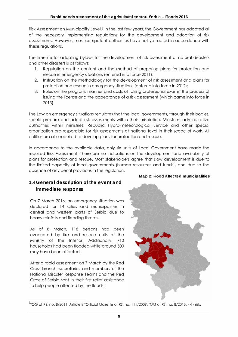
Map 2: Flood affected municipalities 1.4 General description of the event and
immediate response On 7 March 2016, an emergency situation was declared for 14 cities and municipalities in central and western parts of Serbia due to heavy rainfalls and flooding threats. As of 8 March, 118 persons had been evacuated by fire and rescue units of the Ministry of the Interior. Additionally, 710 households had been flooded while around 500 may have been affected. After a rapid assessment on 7 March by the Red Cross branch, secretaries and members of the National Disaster Response Teams and the Red Cross of Serbia sent in their first relief assistance to help people affected by the floods.
3"OG of RS, no. 8/2011: Article 8 "Official Gazette of RS, no. 111/2009. "OG of RS, no. 8/2013. - 4 - risk.
Rapid needs assessment of the agricultural sector- Serbia – Floods 2016
10
On the 30 March, in accordance with the needs expressed by the Red Cross branches, a final aid delivery was sent to the population affected by floods in the municipalities of Lučani, Čačak, Novi Pazar, Raska, Kraljevo and Gornji Milanovac. In total, over 1,110 families received support from the Red Cross of Serbia in this emergency response operation. 1.5 Rapid Needs Assessment
1.5.1 Assessment process The Government of the Republic of Serbia decided on performing of a Rapid Needs Assessment for the Agricultural Sector (RNA). The aim of this was to assess the full extent of disaster impact on the country, and based on the findings, to produce an actionable and sustainable Recovery Strategy for mobilizing financial and technical resources. For this purpose, the Government requested cooperation and assistance from FAO for the RNA implementation. FAO responded positively to the request from the government and a task team was fielded. The task team consisted of FAO staff and local consultants, and started its activities on 23 March 2016. The multi-disciplinary team worked in liaison with the PIMO, the Ministry of Agriculture and with the local authorities, in the process of taking stock, tabulating damage and losses, gathering information and analysing results. In order to achieve an overview of the situation on the field, the Task team held meetings with the local governments and the relevant local institutions, in each affected municipality. The RNA includes data from reports from all stakeholders relevant to the agricultural sector. A damages and losses recording template was designed for the agricultural sector and provided to the local governments. With aim to assist the filling of the templates, communication has been maintained with the nominated representatives from the local self-governments and institutions involved in the process, and constant guidance was provided. The nominated representatives from the municipalities have been informed on the RNA methodology and process, the directions for data filling as well as the forthcoming activities for completing of the assessment process.
Main task of the Rapid Needs Assessment
To address underlying risks and vulnerabilities so as to reduce risk and build back better (BBB),
To identify the damage and loss caused by the disaster to physical infrastructure, productive sectors and the economy, including an assessment of its macro-economic consequences
To identify all recovery and reconstruction needs
To develop the Recovery Strategy outlining priority needs, recovery interventions, expected outputs and the cost of recovery and reconstruction which would form the basis for a comprehensive Recovery Framework
To provide the basis for mobilizing resources for recovery and reconstruction through local, national and international sources.
Rapid needs assessment of the agricultural sector- Serbia – Floods 2016
11
The assessment form was sent to all affected municipalities and by 20 April 2016, all municipalities had sent the completed forms back to the Task team. 1.5.2 Assessment scope The assessment covers overall damage and losses caused by heavy rainfalls, rivers, floods and landslides in the period February-March 2016. The assessment included 16 municipalities in South-West Serbia and covered most of the agricultural sector.
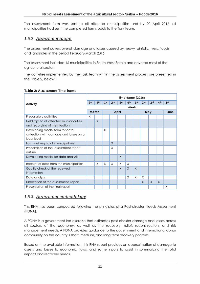
The activities implemented by the Task team within the assessment process are presented in the Table 2, below:
Table 2: Assessment Time frame
Activity
Time frame (2016) 3rd 4th 1st 2nd 3rd 4th 1st 2nd 3rd 4th 1st
Week March April May June
Preparatory activities X Field trips to all affected municipalities and recording of the situation
X
Developing model form for data collection with damage and losses on a local level
X
Form delivery to all municipalities X Preparation of the assessment report outline
X
Developing model for data analysis X
Receipt of data from the municipalities X X X X X Quality check of the received information
X X X
Data analysis X X X Finalization of the assessment report X X X Presentation of the final report X
1.5.3 Assessment methodology This RNA has been conducted following the principles of a Post-disaster Needs Assessment (PDNA). A PDNA is a government-led exercise that estimates post-disaster damage and losses across all sectors of the economy, as well as the recovery, relief, reconstruction, and risk management needs. A PDNA provides guidance to the government and international donor community on the country’s short, medium, and long term recovery priorities. Based on the available information, this RNA report provides an approximation of damage to assets and losses to economic flows, and some inputs to assist in summarizing the total impact and recovery needs.
Rapid needs assessment of the agricultural sector- Serbia – Floods 2016
12
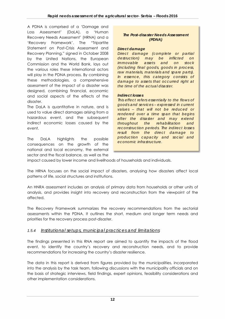
A PDNA is comprised of a ‘Damage and Loss Assessment’ (DaLA), a ‘Human Recovery Needs Assessment’ (HRNA) and a ‘Recovery Framework’. The “Tripartite Statement on Post-Crisis Assessment and Recovery Planning,” signed in October 2008 by the United Nations, the European Commission and the World Bank, lays out the various roles these international actors will play in the PDNA process. By combining these methodologies, a comprehensive assessment of the impact of a disaster was designed, combining financial, economic and social aspects of the effects of the disaster. The DaLA is quantitative in nature, and is used to value direct damages arising from a hazardous event, and the subsequent indirect economic losses caused by the event. The DaLA highlights the possible consequences on the growth of the national and local economy, the external sector and the fiscal balance, as well as the impact caused by lower income and livelihoods of households and individuals. The HRNA focuses on the social impact of disasters, analysing how disasters affect local patterns of life, social structures and institutions. An HNRA assessment includes an analysis of primary data from households or other units of analysis, and provides insight into recovery and reconstruction from the viewpoint of the affected. The Recovery Framework summarizes the recovery recommendations from the sectorial assessments within the PDNA. It outlines the short, medium and longer term needs and priorities for the recovery process post-disaster. 1.5.4 Institutional setups, municipal practices and limitations The findings presented in this RNA report are aimed to quantify the impacts of the flood event, to identify the country’s recovery and reconstruction needs, and to provide recommendations for increasing the country’s disaster resilience. The data in this report is derived from figures provided by the municipalities, incorporated into the analysis by the task team, following discussions with the municipality officials and on the basis of strategic interviews, field findings, expert opinions, feasibility considerations and other implementation considerations.
The Post-disaster Needs Assessment (PDNA)
Direct damage Direct damage (complete or partial destruction) may be inflicted on immovable assets and on stock (including final goods, goods in process, raw materials, materials and spare parts). In essence, this category consists of damage to assets that occurred right at the time of the actual disaster. Indirect losses This effect refers essentially to the flows of goods and services – expressed in current values – that will not be reduced or rendered over a time span that begins after the disaster and may extend throughout the rehabilitation and reconstruction periods. The indirect losses result from the direct damage to production capacity and social and economic infrastructure.
Rapid needs assessment of the agricultural sector- Serbia – Floods 2016
13
As some of the damage assessments and analyses on municipal level were still ongoing during the RNA and the preparation of this report, the figures presented in this report should be considered as the best estimate possible, given available data and time constraints, consolidated to guide the recovery and reconstruction efforts. During the preparation of this report, the commissions of a few municipalities were still collecting data on the field. Their lack of capacity to quickly and efficiently react to disasters and to record damage and losses, raised concerns about the ability of municipalities to implement the Single Methodology for assessing damage from natural and other disasters and about the effect this would have on the introduction of a PDNA like methodology. The decision to prepare a damage and loss assessment prescribed by the Single Methodology Act has been adopted by the Mayor and the municipal councils, on the basis of recommendations received from the Government, the relevant Ministry, or the Municipal Department for Emergency Situations (where it exists). Once a decision has been made, the commission on Agriculture begins its work. In the case of the 2016 floods the Government declared a national emergency situation, while PIMO sent a request to the Municipalities to provide lists of affected farmers eligible for state support (eligibility including incurred damages and registration as commercial farmers). All of the Municipal Damage Assessment Commissions on Agriculture verified, listed and mostly quantified the damage and losses. Approximately half of the municipalities engaged in activities beyond the preparation of the requested lists and calculated the value of the damage and losses. Very few of the municipalities calculated damage and losses in accordance with the Single Methodology prescribed by the legislation, or in accordance with their own improvised methodologies. Most of the municipalities did not collect comprehensive data on damage and losses related to assets, and equipment and have not quantified losses on agricultural land and mostly used approximations and generalizations in the data. No municipality provided a summarised report describing the damage and losses. Virtually all of the municipalities seem to lack the capacity to address significant agricultural disasters, as the number of employees with agricultural backgrounds mostly ranges between one and three. This directly limits the number of assessment commissions which can be established using municipal resources. It also limits the time in which a damage and loss report could be produced. Some municipalities enlisted assistance from other state institutions (Agricultural inspectorate, Extension services, Research stations etc.). However, the cooperation offered and provided was based on good relations (often personal). Some municipalities enlisted the support of commercial service providers, at a considerable cost. In some cases the municipalities argued that they spent more on the assessment, than the state would provide as support to farmers. Making a decision to implement a full-fledged damage and losses assessment is a daunting task to most municipalities, due to the
Rapid needs assessment of the agricultural sector- Serbia – Floods 2016
14
associated costs and the need to dedicate a sizable part of the municipal administration to processing damage claims. None of the municipalities included (or used) local companies and state institutions in the list of mandatory responders mobilized in the event of disasters. Companies and institutions on these lists are bound by law to assist local authorities in emergency response and damage assessments. The announcement of the government for provision of support resulted in a significant number of damage claims submitted to the municipalities, overloading many of the commission for damages to agriculture.
Rapid needs assessment of the agricultural sector- Serbia – Floods 2016
15
2 EFFECTS (DAMAGE AND LOSS) 2.1 Background of agricultural production in the affected areas The affected municipalities include some 184,455 households, out of which 59,618 households or 48 percent of the rural population is agriculturally active, cultivating approximately 317,692 ha of arable land. On average, agricultural households cultivate 3.82 ha of land, ranging from 0.5 ha to 9 ha per municipality. Approximately 67 percent of farming households are registered in accordance to the legal provisions and recognised as commercial farmers. In terms of agricultural production patterns the affected municipalities can be divided into roughly three types, represented in different shares in various municipalities, depending on the geographical and topographical characteristics. 1. Hilly areas with relatively small water flows are dominated by high value crops planted
along the slopes of the hills. Economically, raspberry production is the most important agricultural activity. In some
municipalities (such as Arilje and Ivanjica), up to 95 percent of family farms are involved in raspberry production on small plots. In others (such as Raska) high value crops are still being developed gradually.
As a labour-intensive crop, raspberry production has a major impact on local employment.
Orchards are the second most important subsector. Livestock production is limited and is experiencing a decline. Annual crops are largely used for livestock production, with the production of grain
dominating the production. Some municipalities produce more significant quantities of potatoes although
vegetable production is mostly limited.
2. Municipalities along larger rivers (South, West Morava) have significant shares of fertile arable land around them. Farmers in various municipalities have specialized in different production subsectors
accounting for significant production surpluses, such as Trstenik, which specializes in grafting materials, fruit saplings and ornamental plants, and Cacak, which specializes in potato production.
Most represented are combinable crops, including cereals and forages (in terms of area) and vegetable and fruit production (in terms of value). A significant number of greenhouses are also evident.
In some areas livestock production is relevant due to the production of animal feed. 3. Elevated plateaus form most of the topography of some Municipalities, with limited
watercourses, formed from melting snow (rush rivers). In such municipalities (Novi Pazar) rain fed cereal production is the most common agricultural practice, complemented by more significant livestock production, utilizing the highland pastures.
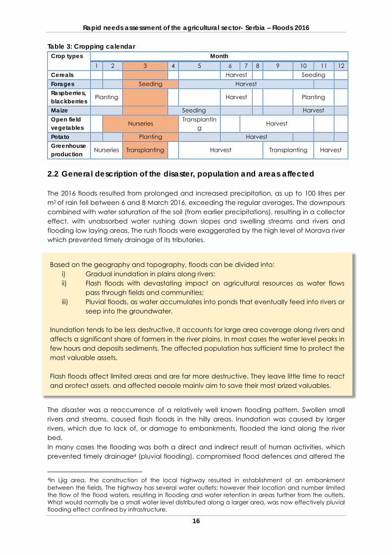
The cropping calendar for the main crops produced in the flood affected municipalities is provided in Table 1, indicating the various vegetative stages of the affected crops.
Rapid needs assessment of the agricultural sector- Serbia – Floods 2016
16
Table 3: Cropping calendar Crop types Month
1 2 3 4 5 6 7 8 9 10 11 12 Cereals Harvest Seeding Forages Seeding Harvest Raspberries, blackberries Planting Harvest Planting
Maize Seeding Harvest Open field vegetables Nurseries
Transplanting
Harvest
Potato Planting Harvest Greenhouse production Nurseries Transplanting Harvest Transplanting Harvest
2.2 General description of the disaster, population and areas affected The 2016 floods resulted from prolonged and increased precipitation, as up to 100 litres per m2 of rain fell between 6 and 8 March 2016, exceeding the regular averages. The downpours combined with water saturation of the soil (from earlier precipitations), resulting in a collector effect, with unabsorbed water rushing down slopes and swelling streams and rivers and flooding low laying areas. The rush floods were exaggerated by the high level of Morava river which prevented timely drainage of its tributaries.
The disaster was a reoccurrence of a relatively well known flooding pattern. Swollen small rivers and streams, caused flash floods in the hilly areas. Inundation was caused by larger rivers, which due to lack of, or damage to embankments, flooded the land along the river bed. In many cases the flooding was both a direct and indirect result of human activities, which prevented timely drainage4 (pluvial flooding), compromised flood defences and altered the
4In Ljig area, the construction of the local highway resulted in establishment of an embankment between the fields. The highway has several water outlets; however their location and number limited the flow of the flood waters, resulting in flooding and water retention in areas further from the outlets. What would normally be a small water level distributed along a larger area, was now effectively pluvial flooding effect confined by infrastructure.
Based on the geography and topography, floods can be divided into: i) Gradual inundation in plains along rivers; ii) Flash floods with devastating impact on agricultural resources as water flows
pass through fields and communities; iii) Pluvial floods, as water accumulates into ponds that eventually feed into rivers or
seep into the groundwater. Inundation tends to be less destructive. It accounts for large area coverage along rivers and affects a significant share of farmers in the river plains. In most cases the water level peaks in few hours and deposits sediments. The affected population has sufficient time to protect the most valuable assets. Flash floods affect limited areas and are far more destructive. They leave little time to react and protect assets, and affected people mainly aim to save their most prized valuables.
Rapid needs assessment of the agricultural sector- Serbia – Floods 2016
17
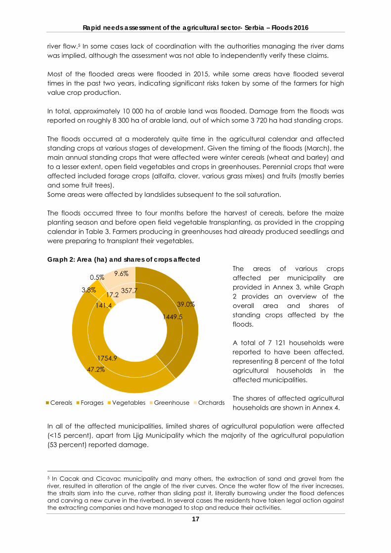
river flow.5 In some cases lack of coordination with the authorities managing the river dams was implied, although the assessment was not able to independently verify these claims. Most of the flooded areas were flooded in 2015, while some areas have flooded several times in the past two years, indicating significant risks taken by some of the farmers for high value crop production. In total, approximately 10 000 ha of arable land was flooded. Damage from the floods was reported on roughly 8 300 ha of arable land, out of which some 3 720 ha had standing crops. The floods occurred at a moderately quite time in the agricultural calendar and affected standing crops at various stages of development. Given the timing of the floods (March), the main annual standing crops that were affected were winter cereals (wheat and barley) and to a lesser extent, open field vegetables and crops in greenhouses. Perennial crops that were affected included forage crops (alfalfa, clover, various grass mixes) and fruits (mostly berries and some fruit trees). Some areas were affected by landslides subsequent to the soil saturation. The floods occurred three to four months before the harvest of cereals, before the maize planting season and before open field vegetable transplanting, as provided in the cropping calendar in Table 3. Farmers producing in greenhouses had already produced seedlings and were preparing to transplant their vegetables. Graph 2: Area (ha) and shares of crops affected
The areas of various crops affected per municipality are provided in Annex 3, while Graph 2 provides an overview of the overall area and shares of standing crops affected by the floods. A total of 7 121 households were reported to have been affected, representing 8 percent of the total agricultural households in the affected municipalities. The shares of affected agricultural households are shown in Annex 4.
In all of the affected municipalities, limited shares of agricultural population were affected (<15 percent), apart from Ljig Municipality which the majority of the agricultural population (53 percent) reported damage.
5 In Cacak and Cicavac municipality and many others, the extraction of sand and gravel from the river, resulted in alteration of the angle of the river curves. Once the water flow of the river increases, the straits slam into the curve, rather than sliding past it, literally burrowing under the flood defences and carving a new curve in the riverbed. In several cases the residents have taken legal action against the extracting companies and have managed to stop and reduce their activities.
1449.5
1754.9
141.417.2 357.7
39.0%
47.2%
3.8%
0.5% 9.6%
Cereals Forages Vegetables Greenhouse Orchards
Rapid needs assessment of the agricultural sector- Serbia – Floods 2016
18
Although the overall affected area is relatively small, and the impact on farming households was limited, a small number of households have lost a significant part of their high value production and their livelihoods. 2.3 Effects of the disaster
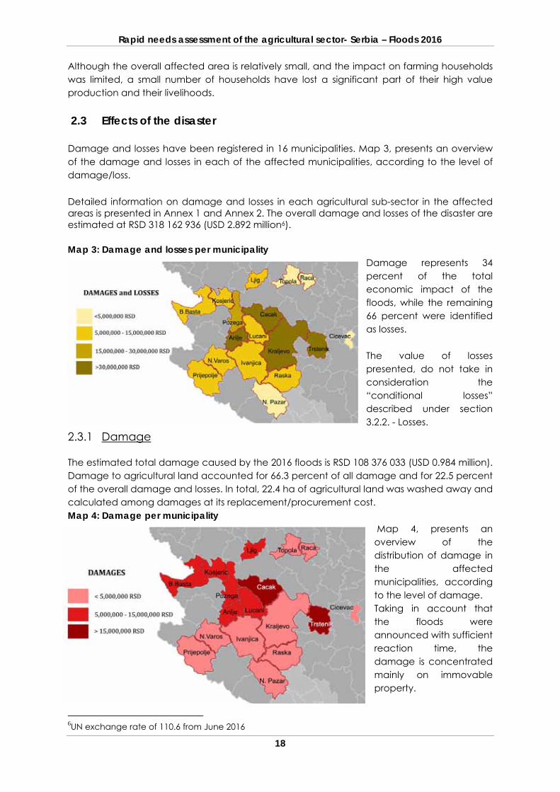
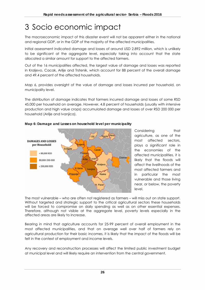
Damage and losses have been registered in 16 municipalities. Map 3, presents an overview of the damage and losses in each of the affected municipalities, according to the level of damage/loss. Detailed information on damage and losses in each agricultural sub-sector in the affected areas is presented in Annex 1 and Annex 2. The overall damage and losses of the disaster are estimated at RSD 318 162 936 (USD 2.892 million6). Map 3: Damage and losses per municipality
Damage represents 34 percent of the total economic impact of the floods, while the remaining 66 percent were identified as losses. The value of losses presented, do not take in consideration the “conditional losses” described under section 3.2.2. - Losses.
2.3.1 Damage The estimated total damage caused by the 2016 floods is RSD 108 376 033 (USD 0.984 million). Damage to agricultural land accounted for 66.3 percent of all damage and for 22.5 percent of the overall damage and losses. In total, 22.4 ha of agricultural land was washed away and calculated among damages at its replacement/procurement cost. Map 4: Damage per municipality
Map 4, presents an overview of the distribution of damage in the affected municipalities, according to the level of damage. Taking in account that the floods were announced with sufficient reaction time, the damage is concentrated mainly on immovable property.
6UN exchange rate of 110.6 from June 2016
Rapid needs assessment of the agricultural sector- Serbia – Floods 2016
19
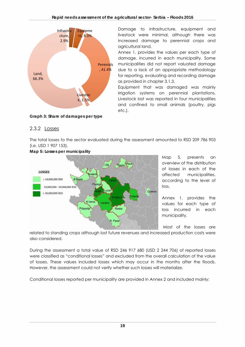
Damage to infrastructure, equipment and livestock were minimal, although there was increased damage to perennial crops and agricultural land. Annex 1, provides the values per each type of damage, incurred in each municipality. Some municipalities did not report valuated damage due to a lack of an appropriate methodology for reporting, evaluating and recording damage as provided in chapter 3.1.3. Equipment that was damaged was mainly irrigation systems on perennial plantations. Livestock lost was reported in four municipalities and confined to small animals (poultry, pigs etc.).
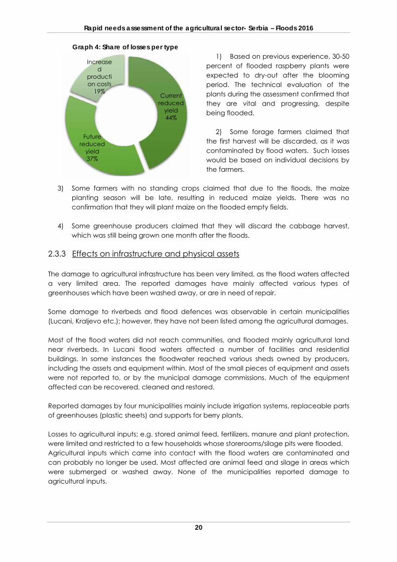
Graph 3: Share of damages per type 2.3.2 Losses The total losses to the sector evaluated during the assessment amounted to RSD 209 786 903 (i.e. USD 1 907 153). Map 5: Losses per municipality
Map 5, presents an overview of the distribution of losses in each of the affected municipalities, according to the level of loss. Annex 1, provides the values for each type of loss incurred in each municipality. Most of the losses are
related to standing crops although lost future revenues and increased production costs were also considered. During the assessment a total value of RSD 246 917 680 (USD 2 244 706) of reported losses were classified as “conditional losses” and excluded from the overall calculation of the value of losses. These values included losses which may occur in the months after the floods. However, the assessment could not verify whether such losses will materialize. Conditional losses reported per municipality are provided in Annex 2 and included mainly:
Infrastructure, 2.9%
Equipment, 4.3%
Perenials, 41.4%
Livestock, 1.5%
Land, 66.3%
Rapid needs assessment of the agricultural sector- Serbia – Floods 2016
20
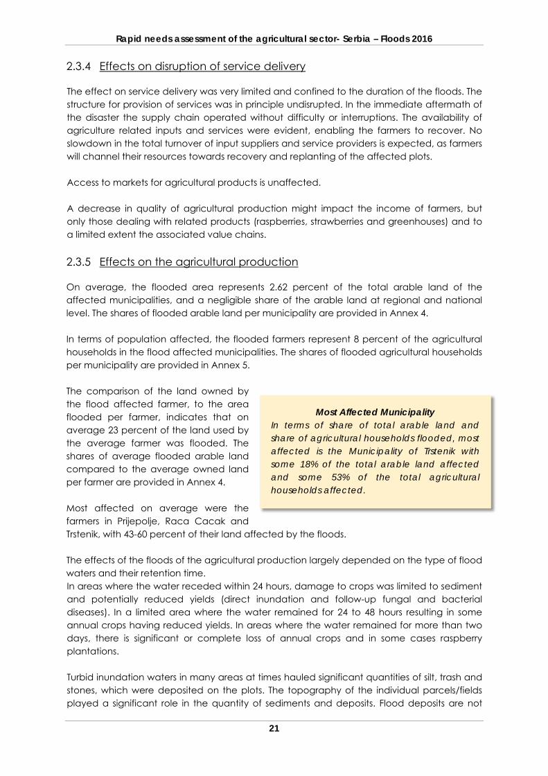
Graph 4: Share of losses per type 1) Based on previous experience, 30-50
percent of flooded raspberry plants were expected to dry-out after the blooming period. The technical evaluation of the plants during the assessment confirmed that they are vital and progressing, despite being flooded.
2) Some forage farmers claimed that the first harvest will be discarded, as it was contaminated by flood waters. Such losses would be based on individual decisions by the farmers.
3) Some farmers with no standing crops claimed that due to the floods, the maize planting season will be late, resulting in reduced maize yields. There was no confirmation that they will plant maize on the flooded empty fields.
4) Some greenhouse producers claimed that they will discard the cabbage harvest,
which was still being grown one month after the floods.
2.3.3 Effects on infrastructure and physical assets The damage to agricultural infrastructure has been very limited, as the flood waters affected a very limited area. The reported damages have mainly affected various types of greenhouses which have been washed away, or are in need of repair. Some damage to riverbeds and flood defences was observable in certain municipalities (Lucani, Kraljevo etc.); however, they have not been listed among the agricultural damages. Most of the flood waters did not reach communities, and flooded mainly agricultural land near riverbeds. In Lucani flood waters affected a number of facilities and residential buildings. In some instances the floodwater reached various sheds owned by producers, including the assets and equipment within. Most of the small pieces of equipment and assets were not reported to, or by the municipal damage commissions. Much of the equipment affected can be recovered, cleaned and restored. Reported damages by four municipalities mainly include irrigation systems, replaceable parts of greenhouses (plastic sheets) and supports for berry plants. Losses to agricultural inputs; e.g. stored animal feed, fertilizers, manure and plant protection, were limited and restricted to a few households whose storerooms/silage pits were flooded. Agricultural inputs which came into contact with the flood waters are contaminated and can probably no longer be used. Most affected are animal feed and silage in areas which were submerged or washed away. None of the municipalities reported damage to agricultural inputs.
Current reduced
yield 44%
Future reduced
yield 37%
Increased
production costs
19%
Rapid needs assessment of the agricultural sector- Serbia – Floods 2016
21
2.3.4 Effects on disruption of service delivery The effect on service delivery was very limited and confined to the duration of the floods. The structure for provision of services was in principle undisrupted. In the immediate aftermath of the disaster the supply chain operated without difficulty or interruptions. The availability of agriculture related inputs and services were evident, enabling the farmers to recover. No slowdown in the total turnover of input suppliers and service providers is expected, as farmers will channel their resources towards recovery and replanting of the affected plots. Access to markets for agricultural products is unaffected. A decrease in quality of agricultural production might impact the income of farmers, but only those dealing with related products (raspberries, strawberries and greenhouses) and to a limited extent the associated value chains. 2.3.5 Effects on the agricultural production On average, the flooded area represents 2.62 percent of the total arable land of the affected municipalities, and a negligible share of the arable land at regional and national level. The shares of flooded arable land per municipality are provided in Annex 4. In terms of population affected, the flooded farmers represent 8 percent of the agricultural households in the flood affected municipalities. The shares of flooded agricultural households per municipality are provided in Annex 5. The comparison of the land owned by the flood affected farmer, to the area flooded per farmer, indicates that on average 23 percent of the land used by the average farmer was flooded. The shares of average flooded arable land compared to the average owned land per farmer are provided in Annex 4. Most affected on average were the farmers in Prijepolje, Raca Cacak and Trstenik, with 43-60 percent of their land affected by the floods. The effects of the floods of the agricultural production largely depended on the type of flood waters and their retention time. In areas where the water receded within 24 hours, damage to crops was limited to sediment and potentially reduced yields (direct inundation and follow-up fungal and bacterial diseases). In a limited area where the water remained for 24 to 48 hours resulting in some annual crops having reduced yields. In areas where the water remained for more than two days, there is significant or complete loss of annual crops and in some cases raspberry plantations. Turbid inundation waters in many areas at times hauled significant quantities of silt, trash and stones, which were deposited on the plots. The topography of the individual parcels/fields played a significant role in the quantity of sediments and deposits. Flood deposits are not
Most Affected Municipality In terms of share of total arable land and share of agricultural households flooded, most affected is the Municipality of Trstenik with some 18% of the total arable land affected and some 53% of the total agricultural households affected.
Rapid needs assessment of the agricultural sector- Serbia – Floods 2016
22
always negatively associated with productivity, as they can improve the composition of the soil. In some cases the crops were completely buried and lost. However, in most instances consequential precipitation will wash the plants and remedy the situation. The effect of flash flooding is limited in size but profound in terms of damage, especially on foothills and along rapid water flows. Crops were completely swept away, often with the top soil of affected plots. In other cases, sediment such as gravel were deposited up to half a meter in depth, completely destroying the crops and rendering the production plots unusable. Where the water receded, farmers were scrambling to clean and re-cultivate the affected area. The flood waters prevented the replanting in a few plots from one week to one month after the disaster. Farmers involved in greenhouse production will have some delay in getting lower prices later in the season and from the procurement of extra seedlings. Based on field inspections and feedback from the municipality officials and other stakeholders, the overall share of damage and losses to crops has been assessed as “mild to moderate” in most instances, and “severe” in a limited number of affected farmers/communities. There is an expectation that most of the crops will reshoot, grow and in due course produce yields. However, these may be reduced compared to a floodless year. Also, the timeline for recovery depends on the type of crop, and varies from one month for forages to a few years for berry crops. Losses to cereal crops (mainly wheat and barley) and fodder crops (mainly alfalfa, clover and meadows) are mild to moderate. On average, yields fell from between 10 and 20 percent, partially due to retention of the water and partly due to sediments. Damage to fodder crops might further increase, depending on the varietal tolerance of excess water. Losses of open field vegetable production, strawberries, greenhouses and in particular specialized producers of saplings, grafting materials, and ornamental plants, were more extensive, averaging 50 percent. Most of the vegetable production can be replanted with some extension in the production deadlines. Losses of berry fruits (raspberries, blackberries etc.) were limited and confined to the areas in immediate proximity of the river beds, which suffered some physical damage. In such cases, the farmers had to re-establish the plant supports, irrigation systems and manually clean the accumulated debris. Most of the orchards were in good condition and did not display signs of stress or diseases; however, based on previous experiences farmers quoted “conditional” losses, as elaborated in chapter 3.3.2. Young orchards (planted in the previous year) were often swept away and had to be replanted. Losses of animals were limited, affecting mainly small and enclosed animals (poultry, pigs etc.).
Rapid needs assessment of the agricultural sector- Serbia – Floods 2016
23
2.3.6 Effects on governance No significant disruption to governance was noted in the agricultural sector. The government reacted rapidly to the crisis. Animal evacuations were conducted in a timely and damage assessment teams got to the scene quickly. Through the municipalities the Government prepared a list of flood affected farmers that would receive RSD 12 000 per ha. Most of the effort of the municipal damage commissions/resources was focused on this task. 2.3.7 Effects on risk and vulnerabilities On average, 65.5 percent of the affected farming households rely solely on agricultural activities for their incomes and livelihoods. The remaining farmers obtain additional incomes from agricultural production and their main livelihoods depend on other/non-agricultural income sources. The shares of farmers whose main activity is agriculture (per municipality) are provided in Annex 6. The size of these shares directly depends on the local employment opportunities, as well as on the type of crops produced (cash crops or subsistence crops). On average, 47.6 percent of the affected crops are cash crops, which farmers sell for household incomes, or to which farmers add value (fodder to milk) and sell on. The remaining differences are crops which the farmers use for their own consumption or livestock production. On average, for 59 percent of the affected farmers, the cash crops affected their main source of income. The shares of farmers for whom cash crops are the main income (per municipality) are provided in Annex 6. The largest shares of professional farmers that produce cash crops and depend on the income from their sale are noted in municipalities where high value crops (raspberries) and specialized production (saplings, grafting materials, vegetables) exists. There are approximately 1 000 farming households whose high value production was devastated. There will be no increase of food prices locally on account of the floods. The poorest farmers engaged in high value crops will be the most affected by the disaster. In particular poor, small-scale farmers engaged in high value crops will be affected, as they will experience reduced incomes and will face increased recovery costs. Subsistence farmers will experience some increase in costs and spending in order to meet their consumption needs. The development of all affected farmers will decline and stagnate for 1-3 years, as they aim to recover and re-establish their production. The likelihood of food insecurity is very low, as very few farmers rely solely on their production to meet their consumption needs. In addition, the state welfare system will easily provide support to those in need. The levels of rural poverty – and in particular debts – are likely to increase in the affected areas. Some of the affected farmers use commercial credits, and they will find it harder to pay back their creditors and will have to restructure their loans. With reduced yields and less financial stability, many farmers will face challenges to further invest in future seasons.
Rapid needs assessment of the agricultural sector- Serbia – Floods 2016
24
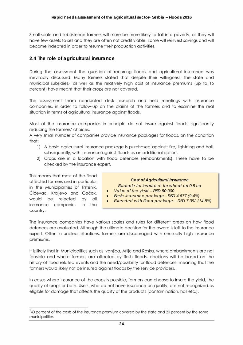
Small-scale and subsistence farmers will more be more likely to fall into poverty, as they will have few assets to sell and they are often not credit viable. Some will reinvest savings and will become indebted in order to resume their production activities. 2.4 The role of agricultural insurance During the assessment the question of recurring floods and agricultural insurance was inevitably discussed. Many farmers stated that despite their willingness, the state and municipal subsidies,7 as well as the relatively high cost of insurance premiums (up to 15 percent) have meant that their crops are not covered. The assessment team conducted desk research and held meetings with insurance companies, in order to follow-up on the claims of the farmers and to examine the real situation in terms of agricultural insurance against floods. Most of the insurance companies in principle do not insure against floods, significantly reducing the farmers’ choices. A very small number of companies provide insurance packages for floods, on the condition that:
1) A basic agricultural insurance package is purchased against: fire, lightning and hail, subsequently, with insurance against floods as an additional option,
2) Crops are in a location with flood defences (embankments). These have to be checked by the insurance expert.
This means that most of the flood affected farmers and in particular in the Municipalities of Trstenik, Ćićevac, Kraljevo and Čačak, would be rejected by all insurance companies in the country. The insurance companies have various scales and rules for different areas on how flood defences are evaluated. Although the ultimate decision for the award is left to the insurance expert. Often in unclear situations, farmers are discouraged with unusually high insurance premiums. It is likely that in Municipalities such as Ivanjica, Arilje and Raska, where embankments are not feasible and where farmers are affected by flash floods, decisions will be based on the history of flood related events and the need/possibility for flood defences, meaning that the farmers would likely not be insured against floods by the service providers. In cases where insurance of the crops is possible, farmers can choose to insure the yield, the quality of crops or both. Users, who do not have insurance on quality, are not recognized as eligible for damage that affects the quality of the products (contamination, hail etc.).
740 percent of the costs of the insurance premium covered by the state and 20 percent by the some municipalities
Cost of Agricultural Insurance Example for insurance for wheat on 0.5 ha
Value of the yield – RSD 50 000 Basic insurance package - RSD 4 677 (9.4%) Extended with flood package – RSD 7 392 (14.8%)
Rapid needs assessment of the agricultural sector- Serbia – Floods 2016
25
It is unlikely that the situation with the chronic floods and damages to the agricultural sector in Serbia will improve in the near future for the following reasons: Flood defences are the responsibility of the Government for level one watercourses and
of the Municipalities for level two watercourses, The fact that investments in flood defences are slow and very costly and the Government and municipalities are failing to allocate budgets for flood defences for
decades; Knowing this, many municipalities and farmers stated that if possible, they would opt out of support payments on household level and would instead prefer investment of the allocated support for flood defences in their areas.
Rapid needs assessment of the agricultural sector- Serbia – Floods 2016
26
3 Socio economic impact The macroeconomic impact of this disaster event will not be apparent either in the national and regional GDP, or in the GDP of the majority of the affected municipalities.
Initial assessment indicated damage and losses of around USD 2.892 million, which is unlikely to be significant at the aggregate level, especially taking into account that the state allocated a similar amount for support to the affected farmers.
Out of the 16 municipalities affected, the largest value of damage and losses was reported in Kraljevo, Cacak, Arilje and Trstenik, which account for 88 percent of the overall damage and 49.4 percent of the affected households. Map 6, provides oversight of the value of damage and losses incurred per household, on municipality level. The distribution of damage indicates that farmers incurred damage and losses of some RSD 45,000 per household on average. However, 4.8 percent of households (usually with intensive production and high value crops) accumulated damage and losses of over RSD 200 000 per household (Arilje and Ivanjica). Map 6: Damage and Losses on household level per municipality
Considering that agriculture, as one of the most affected sectors, plays a significant role in the economies of the affected municipalities, it is likely that the floods will affect the livelihoods of the most affected farmers and in particular the most vulnerable and those living near, or below, the poverty level.
The most vulnerable – who are often not registered as farmers – will miss out on state support. Without targeted and strategic support to the critical agricultural sectors these households will be forced to compromise on daily spending as well as on other essential expenses. Therefore, although not visible at the aggregate level, poverty levels especially in the affected areas are likely to increase. Bearing in mind that agriculture accounts for 25-99 percent of overall employment in the most affected municipalities, and that on average well over half of farmers rely on agricultural production for their basic incomes, it is likely that the impact of the floods will be felt in the context of employment and income levels. Any recovery and reconstruction processes will affect the limited public investment budget at municipal level and will likely require an intervention from the central government.
Rapid needs assessment of the agricultural sector- Serbia – Floods 2016
27
On the positive side, any reconstruction processes will present an employment opportunity for local communities, which can be used to compensate for the decreased income from agricultural activities. Given the fact that the Government has already allocated considerable support to the affected farmers, it is unlikely that more support will be provided. Therefore, it is a question to be examined if the concentration of the support has matched the concentration of the damages in terms of farmers or geographical areas. As a small share of the farmers absorbed most of the damage and losses, the flat rate compensation provided will coverer a very limited share of the damage of the most affected. Unregistered farmers have not been supported, increasing the chances of negative effects to their livelihoods and agricultural production.
Rapid needs assessment of the agricultural sector- Serbia – Floods 2016
28
4 Conclusions The main conclusions from the RNA are the following: The flood event in March 2016 caused damage and losses to 16 municipalities. Based on
an initial impact assessment, the flood event resulted in total damage and losses of about USD 2.892 million, of which 34 percent represented the destruction of physical assets (mainly damage to agricultural land) in the affected areas, and 66 percent represented losses in production and economic flows.
National and local institutions reacted fast and managed to localize and minimize the impact successfully. With no casualties, the affected population and livestock were evacuated and first aid and humanitarian assistance were provided to the endangered areas.
The macroeconomic impact of this disaster event may not be apparent in the national
GDP, as the damage was largely localized. However, the flood will likely affect the livelihoods of affected farmers and particularly those living near or below the poverty level.
Property disaster insurance is very limited in the affected region, due to number of
subjective constraints which should be addressed at national level. The capacity of Local Governments to quickly conduct Damage and Loss Assessments is
limited, both in terms of knowledge (technical8 and legal9), as well as in terms of manpower and funds. Their capacity should be strengthened, as the probability that resilience building and preventive measures (flood defenses) will be significantly addressed in medium and long term is low.
Although the Government made significant efforts to localize and minimize the impact of
the 2016 flood event, additional assistance is needed from International organizations and donors, in order to effectively address the short, medium and long term interventions necessary for recovery from the effects of the floods. The recovery framework provides for recommendations on specific actions to be undertaken, however with a general remark that activities need to shift from reactive response oriented to proactive disaster risk reduction interventions which prevent and mitigate the adverse impacts of natural disasters, should predominate over actions that only address the effects of the natural disasters.
8 Understanding of the prescribed methodologies for assessment of damages and losses as well as understanding of proper methods of analysis of the received data. 9 Understanding of the current legal requirements connected to collection of data on damages and losses, as well the options for inclusion of other relevant institutions.
Rapid needs assessment of the agricultural sector- Serbia – Floods 2016
29
5 RECOVERY RECOMENDATONS According to the PDNA guidelines, the Recovery Framework includes activities required to restore normality to the affected areas and communities, consisting of:
1 Repairing utility infrastructure and restoring livelihoods.
2 Addressing problems related to the economic recovery of the inhabitants of the affected regions. The recovery measures most helpful to affected communities are those that allow victims to return to work, help create new jobs, restart production, reduce debts and improve access to credit.
3 Conducting activities designed to rearrange and enable allocation of resources in
accordance with the priorities arising from the effects of the disaster.10 4 Activities strengthening the Disaster Risk Reduction and Management system of the
country, increasing resilience and improving the activities of the relevant stakeholders.
The Recovery Framework based on the findings of this Rapid Needs Assessment, responding to the floods in 2016 in Serbia, is presented below. It includes activities required for:
1 Recovery of the agricultural livelihoods in the affected Municipalities, and for 2 Improvement of the Disaster Risk Reduction and Management Sector of Serbia.
The Report outlines the short, medium and long term needs, recommendations and (where applicable) estimated budgets related to the priorities for the recovery post-disaster process. The proposed measures address the agricultural sector, as well as Disaster Risk Reduction and Management Sector. In the agricultural sector the measures aim to restore livelihoods and to provide immediate support, as well as recovery and development assistance to the disaster affected population. Sustainability is achieved through addressing the limited institutional capacity on central and local level and through addressing climate change and disaster risk reduction on all levels. In the Disaster Risk Reduction and Management Sector, the proposed measures address the outdated and underdeveloped disaster response systems, the limited disaster risk assessment and planning, the lack of support to farmers living in disaster prone areas and the limited capacities and response practices. The proposed measures and amounts of finances in the Recovery framework do not include costs for investment in flood defence infrastructure. The measures and costs for flood defence investments are well known to the central and local governments, as they stem from the National and the Municipal Annual Flood Risk Assessments, which are part of the legislative obligations. In addition, overcoming the problems with river basins of larger rivers (Ibar, Morava) requires national level intervention, which is well beyond the scope of this report. 10 Handbook for Estimating The Socio-economic and Environmental Effect of Disaster
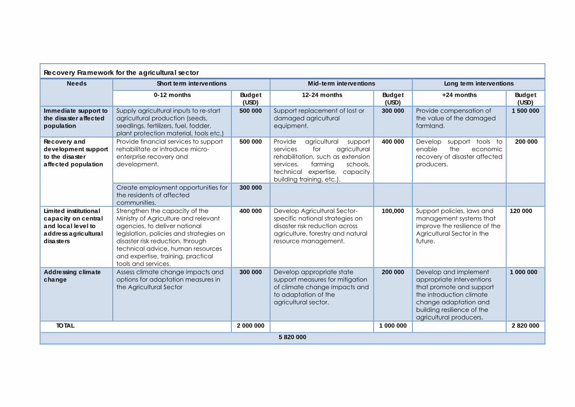
Recovery Framework for the agricultural sector Needs Short term interventions Mid-term interventions Long term interventions
0-12 months Budget (USD)
12-24 months Budget (USD)
+24 months Budget (USD)
Immediate support to the disaster affected population
Supply agricultural inputs to re-start agricultural production (seeds, seedlings, fertilizers, fuel, fodder, plant protection material, tools etc.)
500 000 Support replacement of lost or damaged agricultural equipment.
300 000 Provide compensation of the value of the damaged farmland.
1 500 000
Recovery and development support to the disaster affected population
Provide financial services to support rehabilitate or introduce micro-enterprise recovery and development.
500 000 Provide agricultural support services for agricultural rehabilitation, such as extension services, farming schools, technical expertise, capacity building training, etc.).
400 000 Develop support tools to enable the economic recovery of disaster affected producers.
200 000
Create employment opportunities for the residents of affected communities.
300 000
Limited institutional capacity on central and local level to address agricultural disasters
Strengthen the capacity of the Ministry of Agriculture and relevant agencies, to deliver national legislation, policies and strategies on disaster risk reduction, through technical advice, human resources and expertise, training, practical tools and services.
400 000 Develop Agricultural Sector-specific national strategies on disaster risk reduction across agriculture, forestry and natural resource management.
100,000 Support policies, laws and management systems that improve the resilience of the Agricultural Sector in the future.
120 000
Addressing climate change
Assess climate change impacts and options for adaptation measures in the Agricultural Sector
300 000 Develop appropriate state support measures for mitigation of climate change impacts and to adaptation of the agricultural sector.
200 000 Develop and implement appropriate interventions that promote and support the introduction climate change adaptation and building resilience of the agricultural producers.
1 000 000
TOTAL 2 000 000 1 000 000 2 820 000
5 820 000
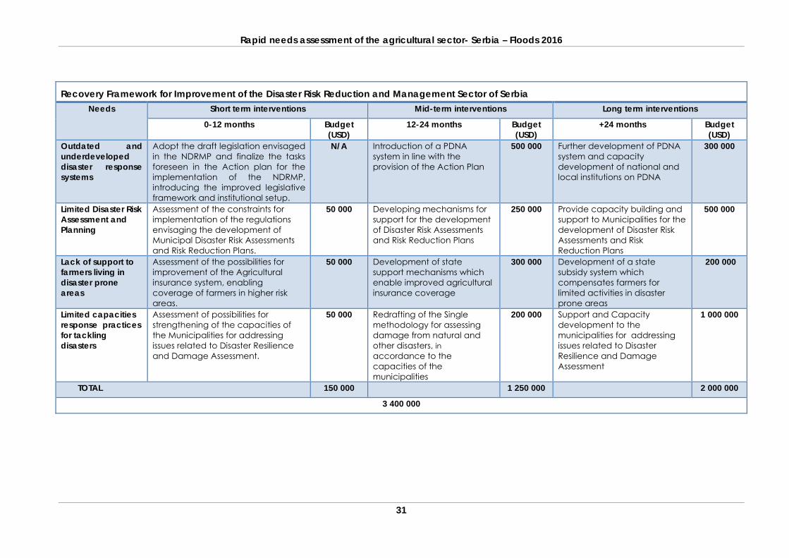
Rapid needs assessment of the agricultural sector- Serbia – Floods 2016
31
Recovery Framework for Improvement of the Disaster Risk Reduction and Management Sector of Serbia Needs Short term interventions Mid-term interventions Long term interventions
0-12 months Budget (USD)
12-24 months Budget (USD)
+24 months Budget (USD)
Outdated and underdeveloped disaster response systems
Adopt the draft legislation envisaged in the NDRMP and finalize the tasks foreseen in the Action plan for the implementation of the NDRMP, introducing the improved legislative framework and institutional setup.
N/A Introduction of a PDNA system in line with the provision of the Action Plan
500 000 Further development of PDNA system and capacity development of national and local institutions on PDNA
300 000
Limited Disaster Risk Assessment and Planning
Assessment of the constraints for implementation of the regulations envisaging the development of Municipal Disaster Risk Assessments and Risk Reduction Plans.
50 000 Developing mechanisms for support for the development of Disaster Risk Assessments and Risk Reduction Plans
250 000 Provide capacity building and support to Municipalities for the development of Disaster Risk Assessments and Risk Reduction Plans
500 000
Lack of support to farmers living in disaster prone areas
Assessment of the possibilities for improvement of the Agricultural insurance system, enabling coverage of farmers in higher risk areas.
50 000 Development of state support mechanisms which enable improved agricultural insurance coverage
300 000 Development of a state subsidy system which compensates farmers for limited activities in disaster prone areas
200 000
Limited capacities response practices for tackling disasters
Assessment of possibilities for strengthening of the capacities of the Municipalities for addressing issues related to Disaster Resilience and Damage Assessment.
50 000 Redrafting of the Single methodology for assessing damage from natural and other disasters, in accordance to the capacities of the municipalities
200 000 Support and Capacity development to the municipalities for addressing issues related to Disaster Resilience and Damage Assessment
1 000 000
TOTAL 150 000 1 250 000 2 000 000
3 400 000
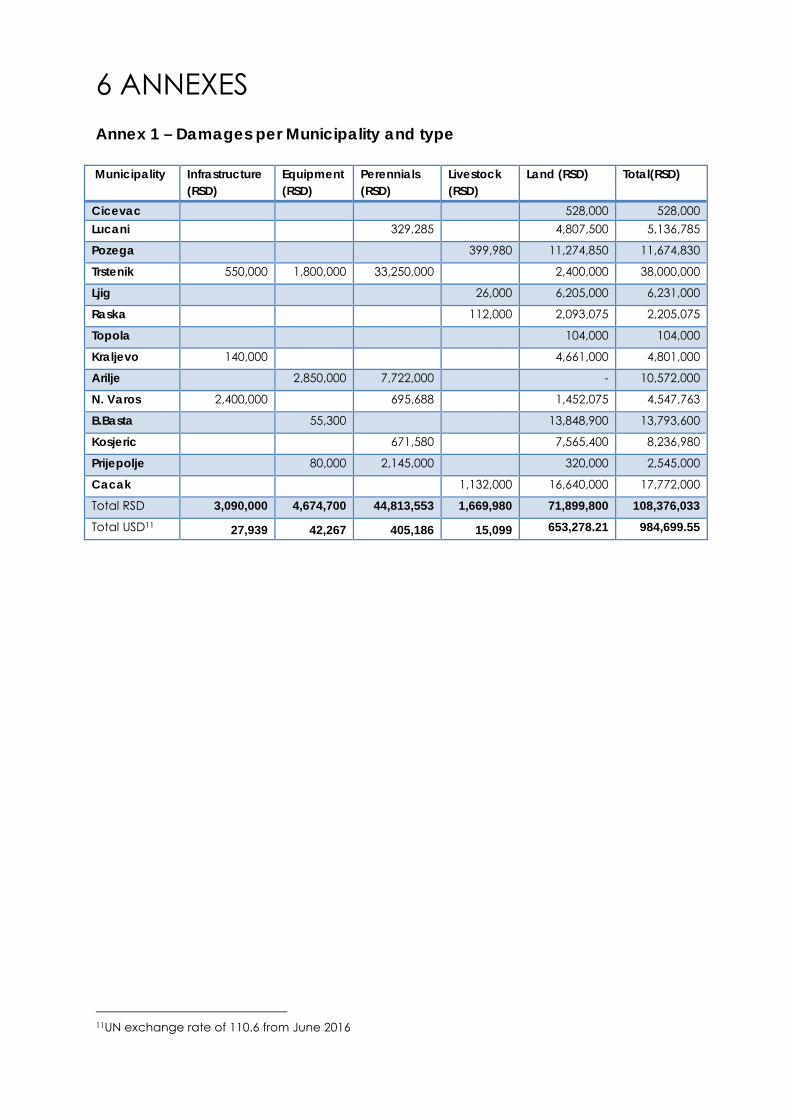
6 ANNEXES Annex 1 – Damages per Municipality and type
Municipality Infrastructure (RSD)
Equipment (RSD)
Perennials (RSD)
Livestock (RSD)
Land (RSD) Total(RSD)
Cicevac 528,000 528,000 Lucani 329,285 4,807,500 5,136,785
Pozega 399,980 11,274,850 11,674,830
Trstenik 550,000 1,800,000 33,250,000 2,400,000 38,000,000
Ljig 26,000 6,205,000 6,231,000
Raska 112,000 2,093,075 2,205,075
Topola 104,000 104,000
Kraljevo 140,000 4,661,000 4,801,000
Arilje 2,850,000 7,722,000 - 10,572,000
N. Varos 2,400,000 695,688 1,452,075 4,547,763
B.Basta 55,300 13,848,900 13,793,600
Kosjeric 671,580 7,565,400 8,236,980
Prijepolje 80,000 2,145,000 320,000 2,545,000
Cacak 1,132,000 16,640,000 17,772,000
Total RSD 3,090,000 4,674,700 44,813,553 1,669,980 71,899,800 108,376,033 Total USD11 27,939 42,267 405,186 15,099 653,278.21 984,699.55
11UN exchange rate of 110.6 from June 2016
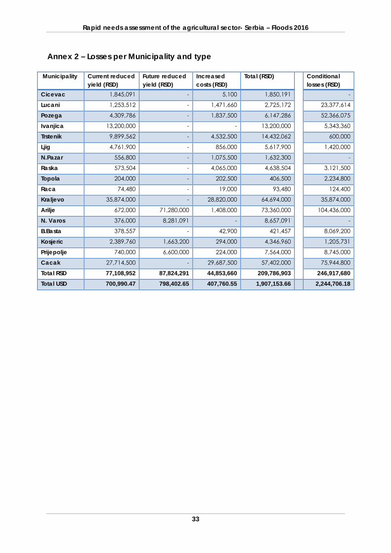
Rapid needs assessment of the agricultural sector- Serbia – Floods 2016
33
Annex 2 – Losses per Municipality and type
Municipality Current reduced yield (RSD)
Future reduced yield (RSD)
Increased costs (RSD)
Total (RSD)
Conditional losses (RSD)
Cicevac 1,845,091 - 5,100 1,850,191 -
Lucani 1,253,512 - 1,471,660 2,725,172 23,377,614
Pozega 4,309,786 - 1,837,500 6,147,286 52,366,075
Ivanjica 13,200,000 - - 13,200,000 5,343,360
Trstenik 9,899,562 - 4,532,500 14,432,062 600,000
Ljig 4,761,900 - 856,000 5,617,900 1,420,000
N.Pazar 556,800 - 1,075,500 1,632,300 -
Raska 573,504 - 4,065,000 4,638,504 3,121,500
Topola 204,000 - 202,500 406,500 2,234,800
Raca 74,480 - 19,000 93,480 124,400
Kraljevo 35,874,000 - 28,820,000 64,694,000 35,874,000
Arilje 672,000 71,280,000 1,408,000 73,360,000 104,436,000
N. Varos 376,000 8,281,091 - 8,657,091 -
B.Basta 378,557 - 42,900 421,457 8,069,200
Kosjeric 2,389,760 1,663,200 294,000 4,346,960 1,205,731
Prijepolje 740,000 6,600,000 224,000 7,564,000 8,745,000
Cacak 27,714,500 - 29,687,500 57,402,000 75,944,800
Total RSD 77,108,952 87,824,291 44,853,660 209,786,903 246,917,680 Total USD 700,990.47 798,402.65 407,760.55 1,907,153.66 2,244,706.18
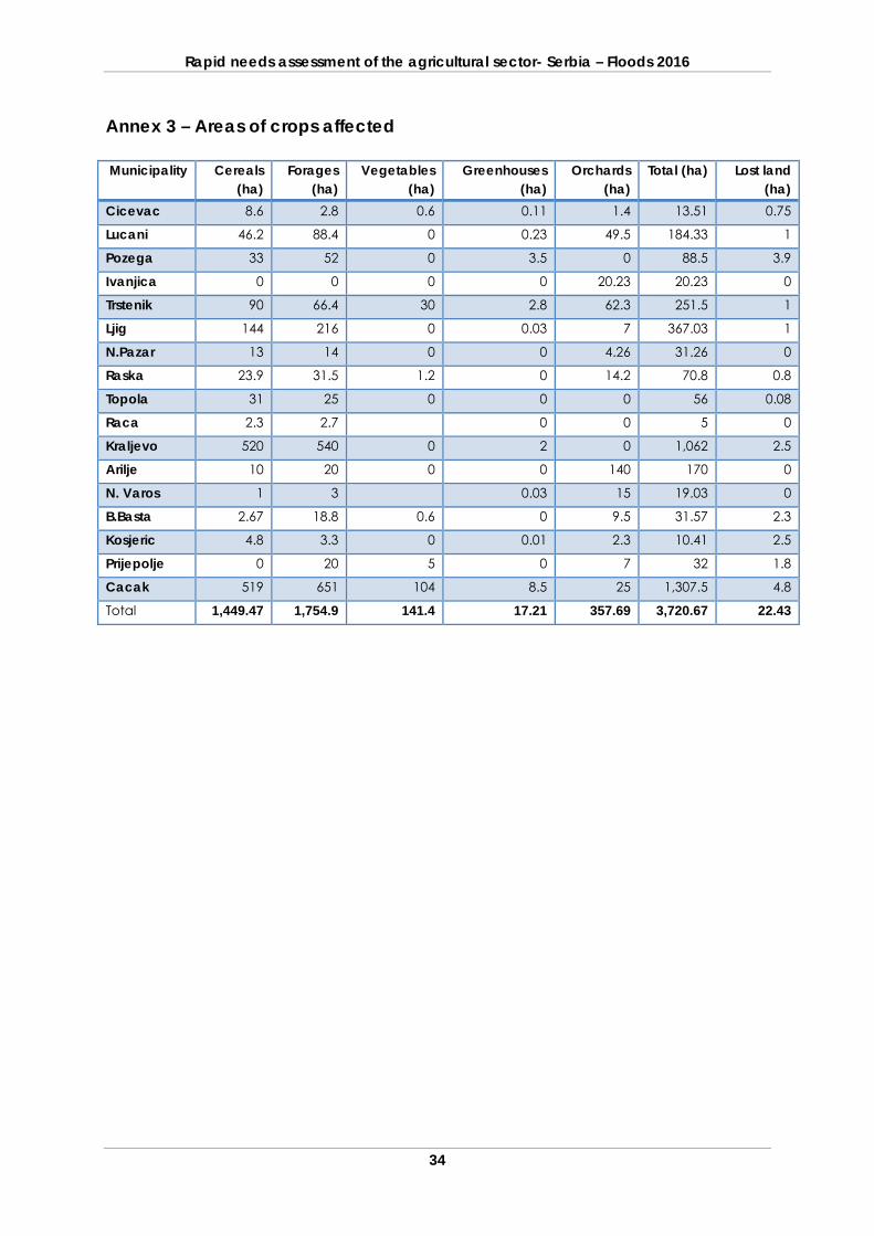
Rapid needs assessment of the agricultural sector- Serbia – Floods 2016
34
Annex 3 – Areas of crops affected Municipality Cereals
(ha) Forages
(ha) Vegetables
(ha) Greenhouses
(ha) Orchards
(ha) Total (ha) Lost land
(ha) Cicevac 8.6 2.8 0.6 0.11 1.4 13.51 0.75
Lucani 46.2 88.4 0 0.23 49.5 184.33 1
Pozega 33 52 0 3.5 0 88.5 3.9
Ivanjica 0 0 0 0 20.23 20.23 0
Trstenik 90 66.4 30 2.8 62.3 251.5 1
Ljig 144 216 0 0.03 7 367.03 1
N.Pazar 13 14 0 0 4.26 31.26 0
Raska 23.9 31.5 1.2 0 14.2 70.8 0.8
Topola 31 25 0 0 0 56 0.08
Raca 2.3 2.7 0 0 5 0
Kraljevo 520 540 0 2 0 1,062 2.5
Arilje 10 20 0 0 140 170 0
N. Varos 1 3 0.03 15 19.03 0
B.Basta 2.67 18.8 0.6 0 9.5 31.57 2.3
Kosjeric 4.8 3.3 0 0.01 2.3 10.41 2.5
Prijepolje 0 20 5 0 7 32 1.8
Cacak 519 651 104 8.5 25 1,307.5 4.8
Total 1,449.47 1,754.9 141.4 17.21 357.69 3,720.67 22.43
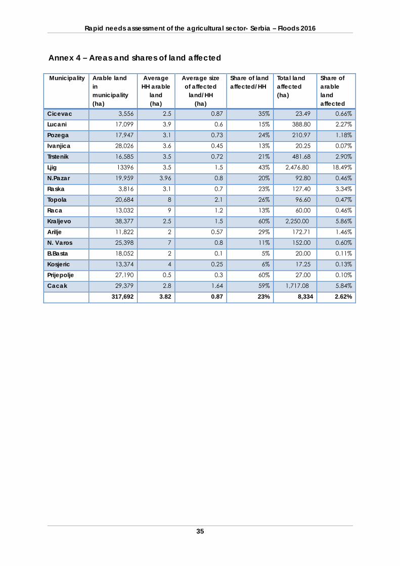
Rapid needs assessment of the agricultural sector- Serbia – Floods 2016
35
Annex 4 – Areas and shares of land affected Municipality Arable land
in municipality (ha)
Average HH arable
land (ha)
Average size of affected
land/HH (ha)
Share of land affected/HH
Total land affected (ha)
Share of arable land affected
Cicevac 3,556 2.5 0.87 35% 23.49 0.66%
Lucani 17,099 3.9 0.6 15% 388.80 2.27%
Pozega 17,947 3.1 0.73 24% 210.97 1.18%
Ivanjica 28,026 3.6 0.45 13% 20.25 0.07%
Trstenik 16,585 3.5 0.72 21% 481.68 2.90%
Ljig 13396 3.5 1.5 43% 2,476.80 18.49%
N.Pazar 19,959 3.96 0.8 20% 92.80 0.46%
Raska 3,816 3.1 0.7 23% 127.40 3.34%
Topola 20,684 8 2.1 26% 96.60 0.47%
Raca 13,032 9 1.2 13% 60.00 0.46%
Kraljevo 38,377 2.5 1.5 60% 2,250.00 5.86%
Arilje 11,822 2 0.57 29% 172.71 1.46%
N. Varos 25,398 7 0.8 11% 152.00 0.60%
B.Basta 18,052 2 0.1 5% 20.00 0.11%
Kosjeric 13,374 4 0.25 6% 17.25 0.13%
Prijepolje 27,190 0.5 0.3 60% 27.00 0.10%
Cacak 29,379 2.8 1.64 59% 1,717.08 5.84%
317,692 3.82 0.87 23% 8,334 2.62%
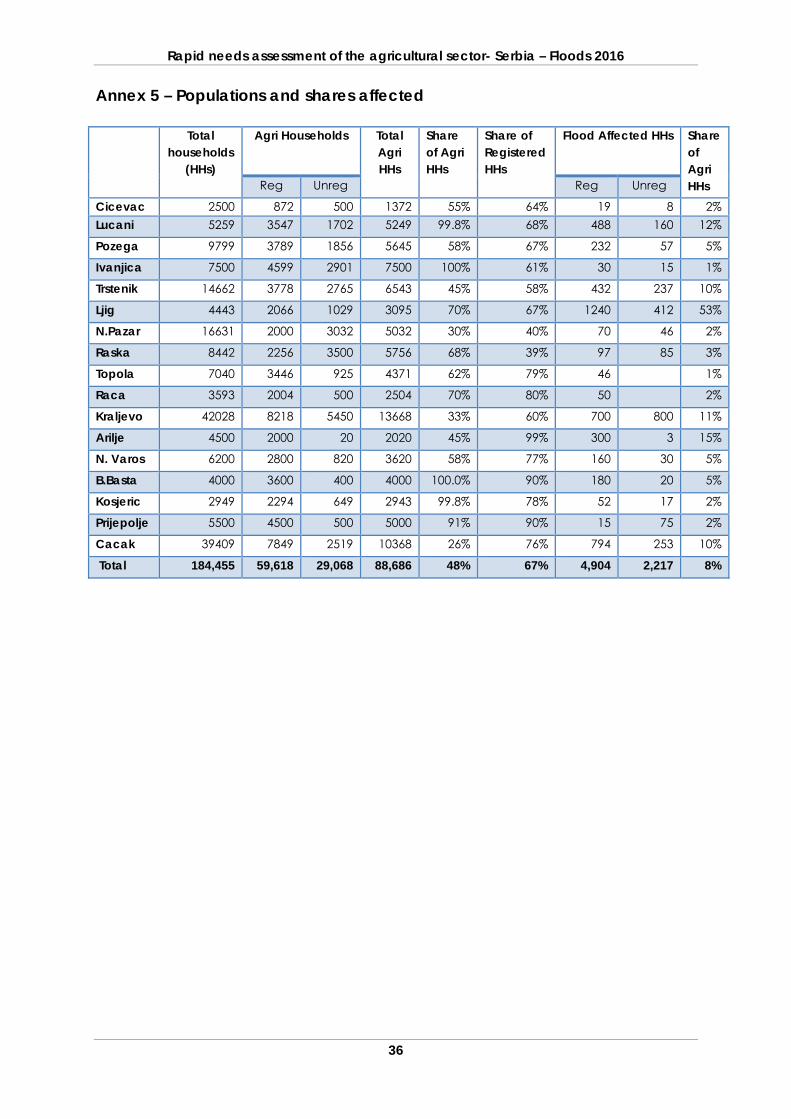
Rapid needs assessment of the agricultural sector- Serbia – Floods 2016
36
Annex 5 – Populations and shares affected
Total households
(HHs)
Agri Households Total Agri HHs
Share of Agri HHs
Share of Registered HHs
Flood Affected HHs Share of Agri HHs Reg Unreg Reg Unreg
Cicevac 2500 872 500 1372 55% 64% 19 8 2% Lucani 5259 3547 1702 5249 99.8% 68% 488 160 12%
Pozega 9799 3789 1856 5645 58% 67% 232 57 5%
Ivanjica 7500 4599 2901 7500 100% 61% 30 15 1%
Trstenik 14662 3778 2765 6543 45% 58% 432 237 10%
Ljig 4443 2066 1029 3095 70% 67% 1240 412 53%
N.Pazar 16631 2000 3032 5032 30% 40% 70 46 2%
Raska 8442 2256 3500 5756 68% 39% 97 85 3%
Topola 7040 3446 925 4371 62% 79% 46 1%
Raca 3593 2004 500 2504 70% 80% 50 2%
Kraljevo 42028 8218 5450 13668 33% 60% 700 800 11%
Arilje 4500 2000 20 2020 45% 99% 300 3 15%
N. Varos 6200 2800 820 3620 58% 77% 160 30 5%
B.Basta 4000 3600 400 4000 100.0% 90% 180 20 5%
Kosjeric 2949 2294 649 2943 99.8% 78% 52 17 2%
Prijepolje 5500 4500 500 5000 91% 90% 15 75 2%
Cacak 39409 7849 2519 10368 26% 76% 794 253 10%
Total 184,455 59,618 29,068 88,686 48% 67% 4,904 2,217 8%
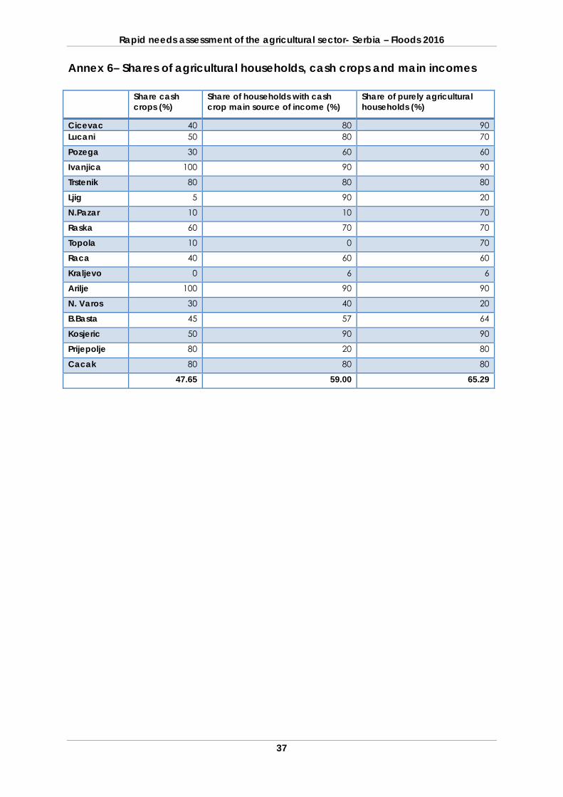
Rapid needs assessment of the agricultural sector- Serbia – Floods 2016
37
Annex 6– Shares of agricultural households, cash crops and main incomes
Share cash crops (%)
Share of households with cash crop main source of income (%)
Share of purely agricultural households (%)
Cicevac 40 80 90 Lucani 50 80 70
Pozega 30 60 60
Ivanjica 100 90 90
Trstenik 80 80 80
Ljig 5 90 20
N.Pazar 10 10 70
Raska 60 70 70
Topola 10 0 70
Raca 40 60 60
Kraljevo 0 6 6
Arilje 100 90 90
N. Varos 30 40 20
B.Basta 45 57 64
Kosjeric 50 90 90
Prijepolje 80 20 80
Cacak 80 80 80
47.65 59.00 65.29
I5906E/1/07.16
Food and Agriculture Organization of the United Nations (FAO) Emergency Operations Team, Serbia
Regional Office for Europe and Central Asia (REU) Benczur utca 34, H-1068 Budapest, Hungary
Tel: (+36-1) 8141-243