
RAFA EXAM INSTRUMENT - Redstone Arsenal Flying … EXAM INSTRUMENT – AIRPLANE Rev 10/2012 Page 1...
16
RAFA EXAM INSTRUMENT – AIRPLANE Rev 10/2012 Page 1 of 16 References: AIM, Federal Aviation Regulations, Enroute Low Altitude Charts, Instrument Approach Procedures. (Applicable instrument approach procedures and enroute chart extracts are located at the end of the questions). 1. According to FAR Part 61, a pilot who has not performed and logged six instrument approaches, holds, and course intercepts under actual or simulated instrument conditions in the past six calendar months a. may not fly in VFR conditions with a safety pilot. b. May not fly IFR as PIC, and must, in the next 6 months regain currency or successfully complete an IPC. c. is still current to act as PIC under IFR during the grace period but needs to fly the required flight time and approaches before the end of the 12th calendar month. d. is restricted to enroute IFR only. 2. Prior to flight under IFR when VOR navigation will be used, the VOR receiver(s) must have been operationally checked, found to be within specifications, and an appropriate record made a. by an FAA-approved avionics repair station within the past year. b. within the past 10 hours of flight time. c. within the past 30 days. d. within the past 24 months. 3. To operate in controlled airspace under IFR, an aircraft must have a sensitive-pressure altimeter that has been calibrated by an FAA-approved test station within the past a. 12 months. c. 24 months. b. 36 months. d. 48 months. 4. According to FAR Part 91, which flight instrument is not required for flight under IFR? a. attitude indicator. b. turn coordinator. c. Vertical speed indicator. d. airspeed indicator.
Transcript of RAFA EXAM INSTRUMENT - Redstone Arsenal Flying … EXAM INSTRUMENT – AIRPLANE Rev 10/2012 Page 1...

RAFA EXAM INSTRUMENT – AIRPLANE Rev 10/2012
Page 1 of 16
References: AIM, Federal Aviation Regulations, Enroute Low Altitude Charts, Instrument Approach
Procedures. (Applicable instrument approach procedures and enroute chart extracts are located at the
end of the questions).
1. According to FAR Part 61, a pilot who has not performed and logged six instrument approaches,
holds, and course intercepts under actual or simulated instrument conditions in the past six
calendar months
a. may not fly in VFR conditions with a safety pilot.
b. May not fly IFR as PIC, and must, in the next 6 months regain currency or successfully
complete an IPC.
c. is still current to act as PIC under IFR during the grace period but needs to fly the required
flight time and approaches before the end of the 12th calendar month.
d. is restricted to enroute IFR only.
2. Prior to flight under IFR when VOR navigation will be used, the VOR receiver(s) must have been
operationally checked, found to be within specifications, and an appropriate record made
a. by an FAA-approved avionics repair station within the past year.
b. within the past 10 hours of flight time.
c. within the past 30 days.
d. within the past 24 months.
3. To operate in controlled airspace under IFR, an aircraft must have a sensitive-pressure altimeter
that has been calibrated by an FAA-approved test station within the past
a. 12 months. c. 24 months.
b. 36 months. d. 48 months.
4. According to FAR Part 91, which flight instrument is not required for flight under IFR?
a. attitude indicator.
b. turn coordinator.
c. Vertical speed indicator.
d. airspeed indicator.

RAFA EXAM INSTRUMENT – AIRPLANE Rev 10/2012
Page 2 of 16
5. A pilot is planning an IFR flight back to Huntsville International Airport (KHSV). The weather is
forecast to be 600 BKN, 1 1/2 -RA BR at the time of arrival (+ or - 1 hour). Based on the above,
the pilot should determine that
a. no alternate airport must be filed since the forecast ceiling is well above the DH for the ILS at
KHSV.
b. no alternate airport must be filed because the rule says 600 feet for a precision approach.
c. an alternate airport must be filed because the forecast visibility is below minimums for the ILS
approach.
d. an alternate airport must be filed because the forecast visibility is less than 3 miles and ceiling
is less than 2000 ft.
6. While enroute on an IFR flight in instrument conditions, the pilot notices that one of the
Nav/Com receivers has failed. She/he must then
a. declare an emergency and request vectors to the nearest airport.
b. descend to visual conditions and land as soon as possible.
c. notify ATC that this equipment is no longer operational.
d. continue with the flight as no action is required for a failed receiver if another is available.
7. The difference between MOCA and MEA altitudes as published on a low-altitude enroute chart is
a. always 1000 feet.
b. The MEA provides assurance of acceptable navigation signal reception for the full route
segment.
c. a safety factor for altimeter errors.
d. the minimum separation used by ATC for aircraft along that route.
8. A pilot operating in visual conditions on an IFR flight plan discovers that the VHF
communication radio(s) have failed. She/he should then
a. squawk 7600, remain in visual conditions, land as soon as practical, and notify ATC.
b. squawk 7500 and continue the flight in accordance with the last clearance received from ATC.
c. return to the airport of departure.
d. squawk 7700, proceed to the nearest airport with a published IFR approach, and land.
9. Non-WAAS GPS receivers will provide RAIM messages to alert the pilot that
a. there are not enough satellites available, or an accuracy degradation has been detected.
b. the pseudo-range and position information supplied by a satellite are correct.

RAFA EXAM INSTRUMENT – AIRPLANE Rev 10/2012
Page 3 of 16
c. The acronym for Read Airman Information Manual (RAIM) - specific paragraph noted.
d. the mask angle needs to be reinitialized.
10. A pilot receives the following clearance: "Cleared localizer runway 27 approach, circle to land
runway 9”. At what point may the pilot descend from the published circling MDA?
a. as soon as the pilot breaks out and has runway 27 in sight.
b. at midfield on downwind for runway 9.
c. upon passing the missed approach point.
d. when the runway 9 environment is clearly in sight, the aircraft is in a position to land using
normal maneuvers, and a descent at a normal rate can be accomplished and required visibility
is met.
11. While conducting an ILS approach at decision height without the runway in sight, a pilot
a. may continue to land.
b. may continue to within 10 feet of the touchdown zone elevation.
c. must immediately execute a missed approach; follow the missed approach procedure, and
announce “missed” to ATC.
d. must call the tower and advise of weather conditions.
12. What is the “3000G” indicate on V245 southwest of Bigbee (See L18 excerpt legend)
a. GPS MEA. c. Minimum Crossing Altitude.
b. Ground Clearance. d. Distance to Golf course
13. The words "RADAR REQUIRED" on an instrument approach procedure mean that
a. the aircraft must be equipped with airborne radar to fly this approach.
b. the approach requires operational ATC radar coverage.
c. this is either a PAR or ASR approach.
d. a 4096-code transponder with altitude encoding capability will be required.
14. While planning a trip to Miami, a C-182 pilot receives a weather briefing indicating low ceilings
along the entire route of flight. Tops are expected to be 22,000 with possible embedded
thunderstorms. Based on this information the pilot
a. continues knowing ATC radar can provide radar vectors through the worst of the weather.
b. determines to monitor HIWAS for convective SIGMET bulletins, which will report the
position of all thunderstorms.
RAFA EXAM INSTRUMENT – AIRPLANE Rev 10/2012
Page 4 of 16
c. carefully reconsiders his priorities and options for this trip, knowing ATC radar may not
accurately depict the embedded storms.
d. could easily make the trip using an IFR approved handheld GPS with downlink weather.
15. A pilot executes the missed approach at the destination airport due to fog. The pilot must then
a. initiate the missed approach, inform ATC of intentions, i.e., alternate airport, route of flight,
another approach, etc.
b. proceed to the alternate airport as previously filed.
c. request special VFR and enter a tight circling approach to landing.
d. hold at the missed approach holding point until advised by ATC of additional procedures to be
followed.
16. A pilot flying a C-182 on a straight-in localizer approach to runway 18R at Huntsville (HSV)
must execute the missed approach if the runway environment is not in sight at (see IAP chart at
end)
a. 2:12 minutes past FEKER intersection at 120 knots.
b. 3.9 NM past JASEX intersection.
c. 2:12 minutes past GETEC intersection at 120 knots.
d. 829 feet MSL and 2:56 minutes past GETEC at 90 knots.
17. You are departing a runway that does not have a published obstacle departure procedure (ODP),
in low IMC. After your wheels leave the runway surface, what, if anything, should you do
before turning on course? (Aim Chapter 5)
a. No published ODP means there are no obstacle issues and you can turn at will.
b. Cross the Departure End of the Runway (DER) at 35 feet AGL or higher, continue climbing
runway heading at a minimum gradient of 200 feet per nautical mile to 400 feet above DER.
c. Climb to the circling MDA appropriate for your category of aircraft.
d. Climb to the minimum safe altitude (MSA).
18. You are flying an IAP to a circling approach to landing at 90 knots indicated airspeed. At what
point in the approach may you initiate the circle to landing, and when can you descend below MDA?
a. As soon as the runway environment is in sight, and when you can make a normal decent to
landing.
RAFA EXAM INSTRUMENT – AIRPLANE Rev 10/2012
Page 5 of 16
b. As soon as you are within 1.3 miles of the runway, and when you are continuously in a
position to make a normal decent, using normal maneuvers, to a landing.
c. Only after reaching the MDA, and can land in visual conditions.
d. Only upon reaching the missed approach point, and can land in visual conditions.
19. The airway marking (open-headed arrow) northwest of MASHA intersection on V325 at JUVLO
indicates
(see the enroute chart excerpt #1 at the end)
a. the published MEA applies only for southeast bound traffic.
b. a minimum crossing altitude.
c. a DME fix.
d. an MEA, MAA and/or MOCA change point.
20. The symbol northeast of Birmingham’s Vulcan VORTAC, on V115, approximately 5 nm
northeast of GESTS intersection indicates a (see the enroute chart excerpt #1 at the end)
a. minimum crossing altitude.
b. VOR changeover point.
c. VOR airway course change.
d. compulsory reporting point.
21. Regarding obstruction clearance when departing Redstone under IFR,
a. the “T” within the triangle on the approach plate indicates existence of nonstandard takeoff
minima and/or Obstacle Departure Procedure.
b. Huntsville ATC will provide obstruction clearance at any altitude.
c. Huntsville ATC expects the instrument pilot to adhere to published takeoff procedures.
d. both a. and c.
22. The number east of Huntsville on the L18 Low Altitude Chart that reads ‘48’ is
a. ATC minimum vectoring altitude.
b. the area MOCA.
c. minimum area radio reception altitude.
d. Off route obstruction clearance altitude (OROCA).

RAFA EXAM INSTRUMENT – AIRPLANE Rev 10/2012
Page 6 of 16
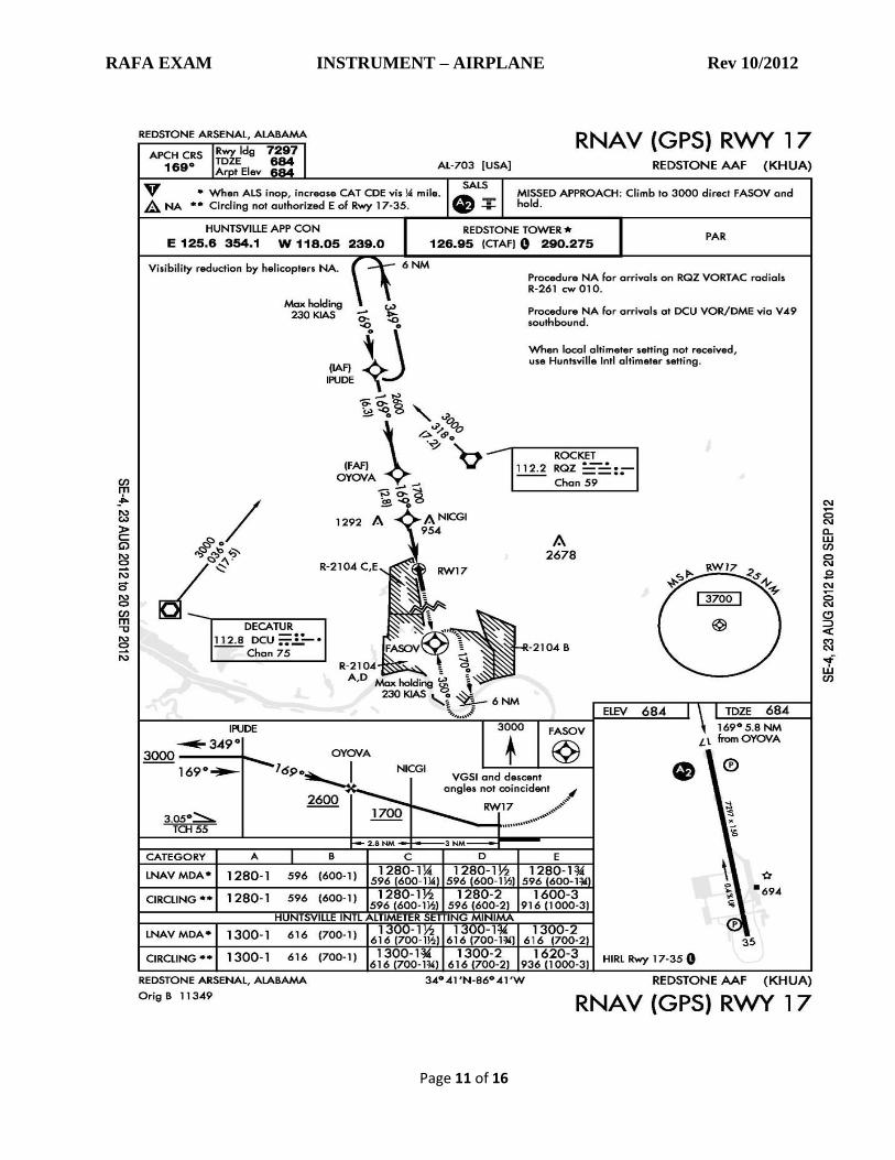
23. During an IFR arrival at Redstone Army Airfield a pilot receives the following clearance:
"Cleared RNAV 17 approach, circle to land runway 35”. The pilot fixes his position passing
over NICGI intersection then, upon breaking out of the clouds, he should (see IAP chart at the
end)
a. circle to enter right downwind for runway 35, maintain 1280 feet MSL until in a position to
land.
b. circle to enter left downwind for runway 35, maintain 1280 feet MSL until in a position to
land.
c. circle to enter left downwind for runway 35, maintain 855 feet MSL until in a position to land.
d. circle to enter right downwind for runway 35, maintain 855 feet MSL until in a position to
land.
(NOTE: For purposes of this test only, ignore NOTAMs concerning IFR operations at KHUA.)
24. You are flying a GPS approach, and at 2300 MSL and one mile before reaching the FAF (or
FAWP), the GPS receiver gives a “RAIM/Loss of Integrity” warning. You decide to abort the
procedure and execute a missed approach. The missed approach procedure calls for a straight-
ahead climb to 2000 then a climbing right turn to 4000 intercepting a course to a holding
waypoint. What do you do?
a. Start a climb straight ahead to 4000 immediately and hold at the MAP.
b. Fly straight ahead to MAP, do not descend, join missed approach procedure and contact ATC.
c. Start a climbing right hand turn immediately.
d. Climb straight ahead, start a right hand turn on reaching 4000.
25. The intersection marking at CRAND east of Chattanooga’s Choo Choo (GQO) VOR on V54
indicates a (See Low Altitude Enroute Chart Excerpt #2 at end)
a. compulsory reporting point.
b. VOR changeover point.
c. minimum reception altitude.
d. minimum crossing altitude.

RAFA EXAM INSTRUMENT – AIRPLANE Rev 10/2012
Page 7 of 16
26. When either R-2104A or R-2104C is active, Huntsville Approach will not clear you for a
published instrument approach into KHUA under IFR, without prior coordination with and
permission from Redstone Tower. If R-2104A only is active, and you arrive in daytime under
marginal VFR conditions, with Redstone Tower open, what are your options to get into
Redstone?
a. Fly an approach into KHSV and land or if conditions allow fly VFR to Redstone.
b. Request a visual or contact approach to KHUA.
c. There is no way.
d. Declare an emergency and request a PAR/GCA approach into KHUA.
27. An instrument approach procedure having LPV or LNAV/VNAV minima requires what kind of
equipment to use those minima?
a. a Phase II ILS receiver
b. a WAAS-certified GPS receiver
c. a TSO C129a-certified GPS receiver
d. Transponder Landing System (TLS) airborne component
28. An RNAV STAR procedure is identified on the chart as an RNAV 1 procedure. Under what
conditions can you fly that procedure?
a. Your aircraft must be equipped with GLS (GNSS Landing System)
b. Your aircraft must be equipped with an IFR-Certified WAAS or non-WAAS GPS installation.
c. Your aircraft must be equipped with a certified Radar NAV (RNAV) receiver Type 1, and the
procedure can be flown only at small airports having Simplified Terminal Approach Radar
(STAR)
d. The pilot must have an RNAV endorsement.
29. If during a circling maneuver, visual reference to the runway is lost, what should the pilot do?
a. Continue downwind and climb to a safe altitude.
b. Fly the approach to the opposite runway backwards until above MDA.
c. Establish yourself on the published missed approach course by initiating a climbing turn
towards the landing runway.
d. Circle back to the missed approach point and hold at MDA, make a new plan, inform ATC.
30. Forecast conditions at your destination require you to file an alternate airport. Your preferred
alternate has only a VOR/DME approach. Your airplane is not equipped with DME. Can you

RAFA EXAM INSTRUMENT – AIRPLANE Rev 10/2012
Page 8 of 16
file that airport as the alternate if (1) your airplane is equipped with a non-WAAS IFR GPS, and
(2) your airplane is equipped with a WAAS-certified IFR GPS?
a. No, No. b. No, Yes. c. Yes, No. d. Yes, Yes.
31. You are on the ILS approach to RWY 18L at KHSV. Upon reaching DA, you have the required
flight visibility and the localizer and glideslope needles are centered. You look down and can
see and identify the approach lights and the Runway End Identifier Lights (REIL), but you
cannot yet see the runway or any other lights or markings associated with it. Can you descend
below the DA down to 100 ft HAT based on seeing only the approach lights? (See IAP chart
and approach lighting chart at end)
a. Yes b. No
32. You are filing for an alternate airport because your destination airport does not meet the
minimum weather requirements (‘123’ rule). You plan to use an RNAV GPS approach at your
destination. If you must use your alternate, can you use an RNAV GPS approach?
a. Yes if the alternate airport meets alternate minimum requirements.
b. No. Once you’ve attempted a GPS approach you must select an approach that does not rely
on GPS.
c. Yes, but only if your GPS is a WAAS unit certificated under TSO-C-145/C-146.
d. No but you can substitute your GPS for any DME or VOR requirements of the approach.
33. You have selected an RNAV approach on your GPS WAAS receiver at an airport that offers an
LPV approach. After the FAWP you get a VERTICAL OFF flag on the receiver. According to AIM
Chapter 1, what are your options?
a. You must abandon the approach and fly to the MAWP before continuing the missed
approach procedure.
b. You may elect to continue the approach but only to LNAV minimums.
c. The GPS WAAS receiver will continue to give reliable guidance to complete the LPV.
d. The WAAS GPS will automatically “fail down” and give you the next most accurate
approach.

RAFA EXAM INSTRUMENT – AIRPLANE Rev 10/2012
Page 9 of 16

RAFA EXAM INSTRUMENT – AIRPLANE Rev 10/2012
Page 10 of 16
L
ow-Altitude Enroute Chart Excerpt #1
RAFA EXAM INSTRUMENT – AIRPLANE Rev 10/2012
Page 11 of 16

RAFA EXAM INSTRUMENT – AIRPLANE Rev 10/2012
Page 12 of 16
IFR LOW ALTITUDE ENROUTE CHART EXCERPT #2

RAFA EXAM INSTRUMENT – AIRPLANE Rev 10/2012
Page 13 of 16

RAFA EXAM INSTRUMENT – AIRPLANE Rev 10/2012
Page 14 of 16

RAFA EXAM INSTRUMENT – AIRPLANE Rev 10/2012
Page 15 of 16
L-18 Chart IFR LOW ALTITUDE ENROUTE CHART EXCERPT #3

RAFA EXAM INSTRUMENT – AIRPLANE Rev 10/2012
Page 16 of 16
L18 Legend