Quarterly Report - Fairstar Resources · • As previously disclosed FairStar is continuing to work...
9
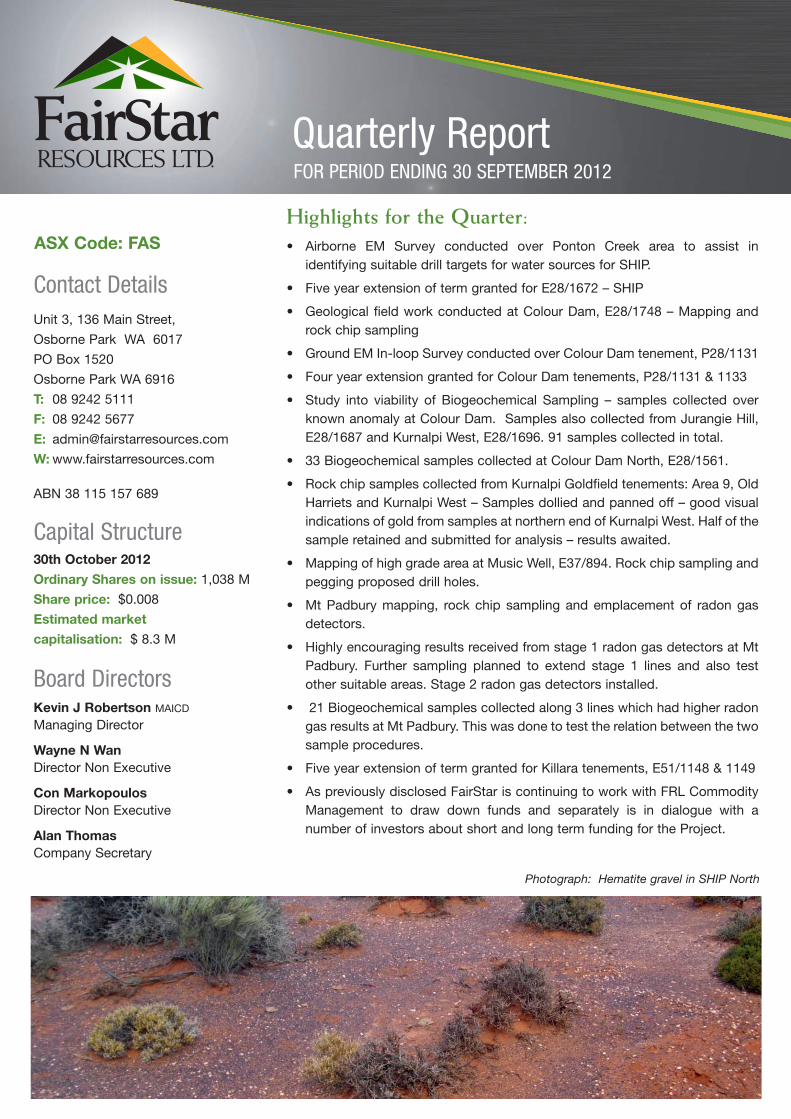
FOR PERIOD ENDING 30 SEPTEMBER 2012 Highlights for the Quarter: • Airborne EM Survey conducted over Ponton Creek area to assist in identifying suitable drill targets for water sources for SHIP. • Five year extension of term granted for E28/1672 – SHIP • Geological field work conducted at Colour Dam, E28/1748 – Mapping and rock chip sampling • Ground EM In-loop Survey conducted over Colour Dam tenement, P28/1131 • Four year extension granted for Colour Dam tenements, P28/1131 & 1133 • Study into viability of Biogeochemical Sampling – samples collected over known anomaly at Colour Dam. Samples also collected from Jurangie Hill, E28/1687 and Kurnalpi West, E28/1696. 91 samples collected in total. • 33 Biogeochemical samples collected at Colour Dam North, E28/1561. • Rock chip samples collected from Kurnalpi Goldfield tenements: Area 9, Old Harriets and Kurnalpi West – Samples dollied and panned off – good visual indications of gold from samples at northern end of Kurnalpi West. Half of the sample retained and submitted for analysis – results awaited. • Mapping of high grade area at Music Well, E37/894. Rock chip sampling and pegging proposed drill holes. • Mt Padbury mapping, rock chip sampling and emplacement of radon gas detectors. • Highly encouraging results received from stage 1 radon gas detectors at Mt Padbury. Further sampling planned to extend stage 1 lines and also test other suitable areas. Stage 2 radon gas detectors installed. • 21 Biogeochemical samples collected along 3 lines which had higher radon gas results at Mt Padbury. This was done to test the relation between the two sample procedures. • Five year extension of term granted for Killara tenements, E51/1148 & 1149 • As previously disclosed FairStar is continuing to work with FRL Commodity Management to draw down funds and separately is in dialogue with a number of investors about short and long term funding for the Project. Quarterly Report Contact Details Unit 3, 136 Main Street, Osborne Park WA 6017 PO Box 1520 Osborne Park WA 6916 T: 08 9242 5111 F: 08 9242 5677 E: [email protected] W: www.fairstarresources.com ABN 38 115 157 689 Capital Structure 30th October 2012 Ordinary Shares on issue: 1,038 M Share price: $0.008 Estimated market capitalisation: $ 8.3 M Board Directors Kevin J Robertson MAICD Managing Director Wayne N Wan Director Non Executive Con Markopoulos Director Non Executive Alan Thomas Company Secretary ASX Code: FAS Photograph: Hematite gravel in SHIP North
Transcript of Quarterly Report - Fairstar Resources · • As previously disclosed FairStar is continuing to work...
FOR PERIOD ENDING 30 SEPTEMBER 2012
Highlights for the Quarter:• Airborne EM Survey conducted over Ponton Creek area to assist in
identifying suitable drill targets for water sources for SHIP.
• Five year extension of term granted for E28/1672 – SHIP
• Geological field work conducted at Colour Dam, E28/1748 – Mapping androck chip sampling
• Ground EM In-loop Survey conducted over Colour Dam tenement, P28/1131
• Four year extension granted for Colour Dam tenements, P28/1131 & 1133
• Study into viability of Biogeochemical Sampling – samples collected overknown anomaly at Colour Dam. Samples also collected from Jurangie Hill,E28/1687 and Kurnalpi West, E28/1696. 91 samples collected in total.
• 33 Biogeochemical samples collected at Colour Dam North, E28/1561.
• Rock chip samples collected from Kurnalpi Goldfield tenements: Area 9, OldHarriets and Kurnalpi West – Samples dollied and panned off – good visualindications of gold from samples at northern end of Kurnalpi West. Half of thesample retained and submitted for analysis – results awaited.
• Mapping of high grade area at Music Well, E37/894. Rock chip sampling andpegging proposed drill holes.
• Mt Padbury mapping, rock chip sampling and emplacement of radon gasdetectors.
• Highly encouraging results received from stage 1 radon gas detectors at MtPadbury. Further sampling planned to extend stage 1 lines and also testother suitable areas. Stage 2 radon gas detectors installed.
• 21 Biogeochemical samples collected along 3 lines which had higher radongas results at Mt Padbury. This was done to test the relation between the twosample procedures.
• Five year extension of term granted for Killara tenements, E51/1148 & 1149
• As previously disclosed FairStar is continuing to work with FRL CommodityManagement to draw down funds and separately is in dialogue with anumber of investors about short and long term funding for the Project.
Quarterly Report
Contact DetailsUnit 3, 136 Main Street,
Osborne Park WA 6017
PO Box 1520
Osborne Park WA 6916
T: 08 9242 5111
F: 08 9242 5677
W: www.fairstarresources.com
ABN 38 115 157 689
Capital Structure30th October 2012
Ordinary Shares on issue: 1,038 M
Share price: $0.008
Estimated market
capitalisation: $ 8.3 M
Board DirectorsKevin J Robertson MAICD
Managing Director
Wayne N WanDirector Non Executive
Con MarkopoulosDirector Non Executive
Alan Thomas Company Secretary
ASX Code: FAS
Photograph: Hematite gravel in SHIP North
Details of Activities during the Quarter
An airborne electromagnetic (EM) survey was flown by Fugro Airborne over a western area of the Eucla Basin, targeting aquifersidentified from the old drillholes in area. This type of EM survey is capable of identifying different lithology units at depth, and fromthe conductivity, the presence of fresh or salty water within rock units. Combined with the mapped geology and the drillhole logs,an interpretation is being made by a Fugro geophysicist to locate thick aquifers of low conductivity which will then be drilled todetermine if fresh – brackish water is present in significant quantities. This water is required for the planned process plant at thedetrital hematite mine at SHIP. Raw data of the airborne EM survey has been received, and the interpretation is awaited.
This airborne EM survey area lies south from the Trans Australia railway line for about 20km, with an east/west extent of 30km. Ifsignificant quantities of fresh to brackish water are located, a borefield will be developed feeding into a buried large diameterpipeline which will run west along the railway reserve to SHIP.
The use of fresh water in processing will allow the hematite product to be low in salt content, and also the waste which can thenbe backfilled into the shallow pit and rehabilitated.
An application for a five year extension of the remaining area of E28/1672, which was not converted to a mining lease, was made,and this application was successful. This tenement area has minor potential for hematite, and could provide additional hematiteresources to the larger hematite resource within the granted mining lease.
Mapping and rock chip sampling were undertaken during a field trip in the quarter, and review of old reports for the area.
Ground Electromagnetic Survey
One historical report for the area provided information on a ground electromagnetic survey which showed a major conductor atdepth in the south west of the tenement, and extending north within the tenement. Analysis results from drillholes at the oldColour Dam Pit show high levels of zinc up to 2.1%, silver up to 240g/t (almost 8 ounces per tonne) and gold up to 20g/t, andit was considered that the ground EM survey anomaly may be related to similar mineralisation. The area is considered to havethe potential for a Volcanogenic massive sulphide (VMS) deposit.
Therefore a new ground EM survey was conducted over most of the tenement area, and results have been received. This rawdata is being forwarded to a geophysicist for interpretation and the report is awaited. Follow up drilling will be planned for anysignificant anomaly.
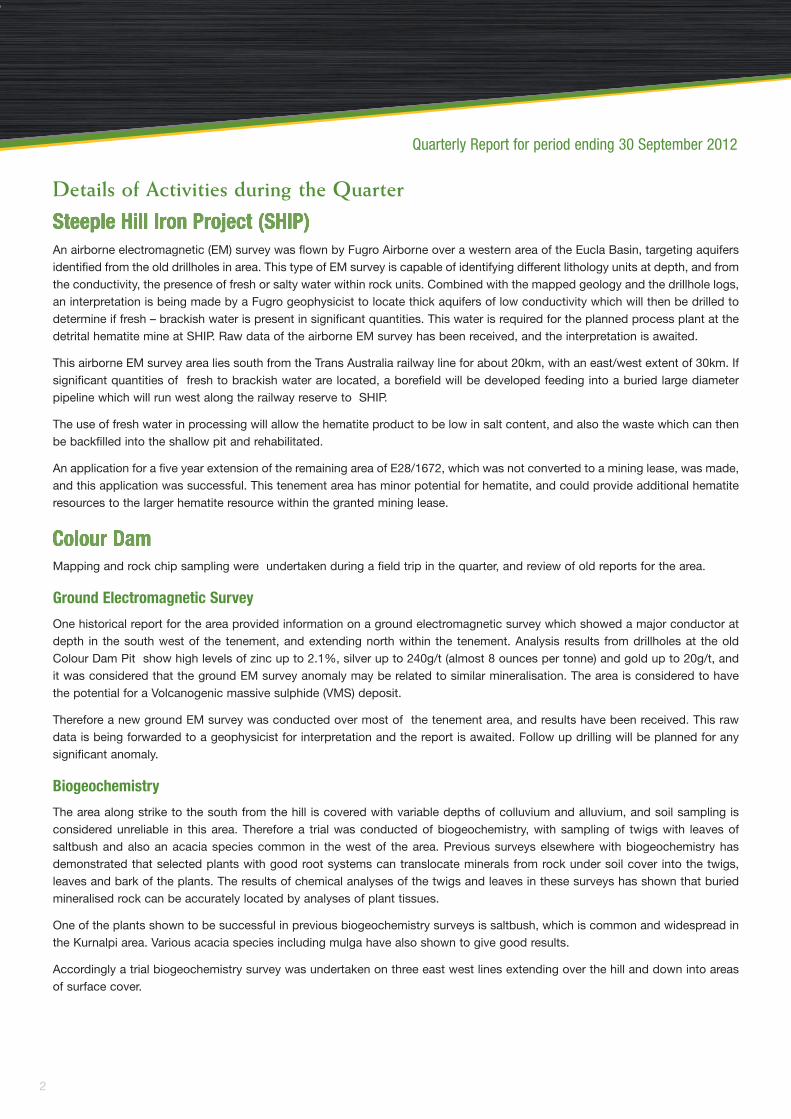
Biogeochemistry
The area along strike to the south from the hill is covered with variable depths of colluvium and alluvium, and soil sampling isconsidered unreliable in this area. Therefore a trial was conducted of biogeochemistry, with sampling of twigs with leaves ofsaltbush and also an acacia species common in the west of the area. Previous surveys elsewhere with biogeochemistry hasdemonstrated that selected plants with good root systems can translocate minerals from rock under soil cover into the twigs,leaves and bark of the plants. The results of chemical analyses of the twigs and leaves in these surveys has shown that buriedmineralised rock can be accurately located by analyses of plant tissues.
One of the plants shown to be successful in previous biogeochemistry surveys is saltbush, which is common and widespread inthe Kurnalpi area. Various acacia species including mulga have also shown to give good results.
Accordingly a trial biogeochemistry survey was undertaken on three east west lines extending over the hill and down into areasof surface cover.
Quarterly Report for period ending 30 September 2012
2

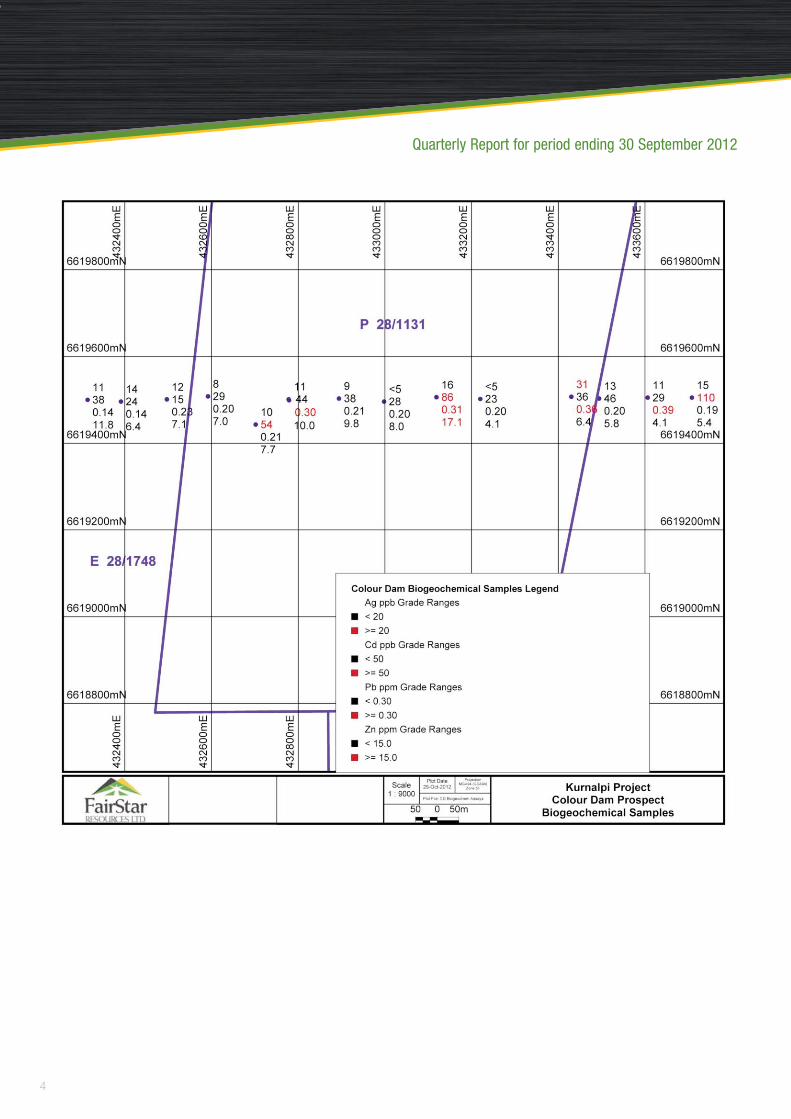
The 15 results received from the analysis of saltbush twigs and leaves of the first line indicates anomalous Ag, Co, Pb and Znvalues, as shown in the map overpage. A reduced suite of elements will now be analysed for the samples for the other two lines.Seven acacia plants adjacent to the first seven saltbush samples were taken for comparison, and the acacia results showedhigher Zn and Sr values, but lower Mo. It is planned to extend the biogeochemical saltbush survey further south into areas ofdeeper cover. This method is faster and cheaper than auger drilling, and the roots sample a much larger volume of rock than anarrow drillhole.
Additional biogeochemical sampling of 33 samples was undertaken at the Colour Dam North tenement, E28/1561, in an areawhere rock chips in silicified rock have returned high Zn values. Results are awaited.
A four year extension of term has been granted for two tenements at Colour Dam to allow them to be explored more fully, andextend the biogeochemistry and the ground EM survey if warranted by the interpretation and follow up drilling.
3
Quarterly Report for period ending 30 September 2012
Photograph: Ground EM Survey being conducted
Quarterly Report for period ending 30 September 2012
4
Biogeochemistry samples of saltbush were takenin the area of two high grade quartz veins, and tothe north of an old mine, which is just outside thelease. The results showed minor anomalies for Ag,Cd, Co and Pb near the quartz veins, andanomalous values for Ag, Cd, Co, Pb and Sr alongstrike from the old mine.
These values will be followed up to extend theareas of the anomalies, and possible drilling afterassessing the geology.
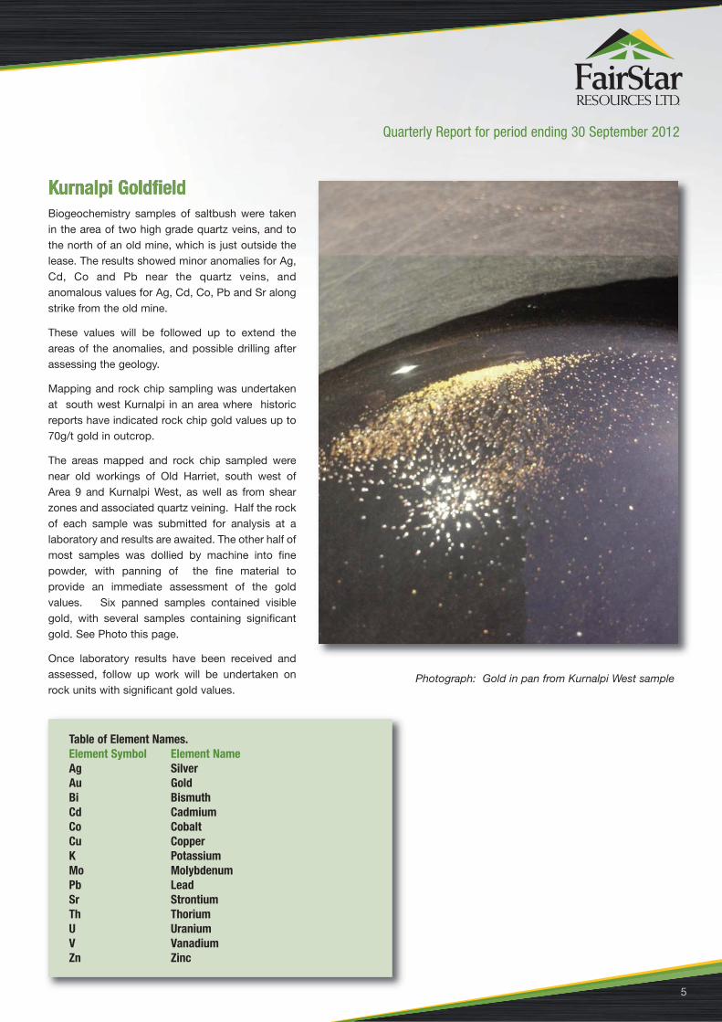
Mapping and rock chip sampling was undertakenat south west Kurnalpi in an area where historicreports have indicated rock chip gold values up to70g/t gold in outcrop.
The areas mapped and rock chip sampled werenear old workings of Old Harriet, south west ofArea 9 and Kurnalpi West, as well as from shearzones and associated quartz veining. Half the rockof each sample was submitted for analysis at alaboratory and results are awaited. The other half ofmost samples was dollied by machine into finepowder, with panning of the fine material toprovide an immediate assessment of the goldvalues. Six panned samples contained visiblegold, with several samples containing significantgold. See Photo this page.
Once laboratory results have been received andassessed, follow up work will be undertaken onrock units with significant gold values.
Quarterly Report for period ending 30 September 2012
5
Photograph: Gold in pan from Kurnalpi West sample
Table of Element Names.Element Symbol Element NameAg SilverAu GoldBi BismuthCd CadmiumCo CobaltCu CopperK PotassiumMo MolybdenumPb LeadSr StrontiumTh ThoriumU UraniumV VanadiumZn Zinc

Quarterly Report for period ending 30 September 2012
6
This tenement has a large area covered by transported surface cover, and salt lake sediments, and biogeochemistry has beenundertaken in an area of drifted sand and soil north of the salt lake. This was undertaken as three east west lines 200m apart,for 2km, with saltbush twigs and leaves sampled at approximately 100m intervals apart along lines, depending on suitable plantlocation. Only mature healthy plants were used, and sampled all around the plant. Each sample location was picked up accuratelyby GPS.
The results reported anomalous Ag, Co, Cd, Mo, Pb and Sr values. These values will be followed up with infill sampling, andintegration with the detailed aeromagnetic survey already flown over the area.
A previous extensive rock chip samplingprogram at Music Well tenement hadidentified two quartz veins with highlyanomalous gold grades of 32g/t and 8g/trespectively. Follow up mapping todetermine the extent of the quartz veinsand associated shear zones wasundertaken with further rock chip sampling.The results were not as high as the initialresults, and the best results are listed inTable 1 next page.
Photograph: Sampling Saltbush
Photograph: Quartz outcrop at Music Well
Quarterly Report for period ending 30 September 2012
7
There is a partial correlation with Ag, Bi andPb.
As the higher grade veins were mappedextending for 300m to the WSW, five pairsof angled RC holes were pegged at 50mintervals along the vein. These proposedholes should intersect the subvertical veinsat shallow and moderate depth. Two holeswere also pegged to intersect the smallerquartz vein of 8g/t at similar depths.
A program of soil radon gas sampling using radon gas detectors was undertaken in the previous quarter , with 157 radiationdetectors placed in plastic tubes and then buried in the ground to 30cm along the banks of a creek with known uranium in calcretein shallow pits. Radon gas is given out by the breakdown of uranium, and makes its way towards the surface, into the soil, andthen into the atmosphere.
After 30 days, the detectors were recovered, and sent for reading. The results were received and plotted and contoured at 20 000Becquerels ( Bq/m3) , as shown in the attached map. This shows significant contiguous anomalous areas along the creek,including around Discovery Pit 1, which has uranium values up to 2400ppm at 2m depth with visible yellow carnotite.
The intention is to delineate areas with significant soil radon gas, as these are probably reflecting the presence of significanturanium minerals in the underlying calcrete at shallow depth. The anomalous areas will then be drilled with shallow aircore holesto verify the presence of uranium minerals, sample the drill chips, and have the samples analysed. This approach should greatlyreduce the amount of drilling required, and the overall cost.
A second batch of 89 radon gas detectorswere installed further upstream anddownstream in the first creek valley, andfurther south around a second larger creekwith calcrete exposed in the creek bed.These will be retrieved shortly and thereadings measured.
As an alternative approach to delineatinguranium at shallow depth, 21 biogeochemicalsamples were collected as twig and leafsamples of Mulga plants from three linesextending across the higher soil radon gasanomalies. These samples were sent foranalysis for U, Th, K. Cu and V. The resultsare awaited. Elsewhere biogeochemistry hasbeen used to successfully delineate uraniummineralisation at shallow depth.
Photograph: Radon Detector
Table 1. Significant Gold Values in Quartz Veins -Music Well
Sample Au Ag Bi PbNumber ppm ppm ppm ppm
MWR100 6.75 7.43 19.333 114.2
MWR104 1.46 0.29 0.092 0.7
MWR111 1.14 <0.05 1.083 2.7
MWR114 2.23 0.07 1.264 5.5
MWR139 1.71 0.87 0.56 17

Quarterly Report for period ending 30 September 2012
8
Mt Padbury Uranium Radon Gas Contours

Quarterly Report for period ending 30 September 2012
9
A five year extension of term for two exploration licences, E51/1148 and E51/1149, has been granted to allow ongoing explorationto occur for uranium and base metals. E51/1148 was reduced by 40% by dropping off the granite area to the southwest. The areahas potential for uranium deposits in the adjacent sandstone, with uranium sourced from groundwater draining from theradioactively ‘hot’ granite to the south.
Anomalous base metal values have been identified in auger holes and diamond core holes into shales to the north, and requirefollow up work to locate possible economic mineralisation.
As previously reported, progress continued with the principal funders for approvals subject to FairStar's and FRL's considerationof closing documents, however, in light on continued delays FairStar has opened discussions with a number of other parties whohave expressed interest in funding SHIP on terms beneficial to the Company and shareholders.
FairStar is currently exploring a range of short and long term funding scenarios from FRL and other parties.
The Board will continue to negotiate with other parties with the sole objective of securing funding and will consider all appropriateproposals in the best interest of FairStar and shareholders.
The information reported herein is based on information compiled by Mr Sheldon Coates who is a member of the AustralasianInstitution of Mining and Metallurgy. He has sufficient experience relevant to the style of mineralisation and deposit type underconsideration, and to the activity which he is undertaking to qualify as a Competent Person as defined in the 2004 Edition of the“Australian Code for the Reporting of Exploration Results, Mineral Resources and Ore Reserves”. Mr. Coates consents to theinclusion of this report of the matters based on his observations in the form and context in which it appears. Mr Coates has aB.Sc.Geology, MBA in Technology Management, and MSc in Mineral Economics. He has 14 years iron ore and 8 years goldexperience. Mr. Coates consents to the inclusion of this report of the matters based on his observations in the form and contextin which it appears.
About FairStar ResourcesBackground, FairStar - A New Horizon:FairStar was listed in October 2006 and is a unique Perth-based uranium and gold explorer; and upon discovering Iron mineralisation at Lindsay’sDam commenced with its major project (SHIP) that is strategically located near existing transport infra-structure with a clear and unencumberedpath to production for relatively low capital expenditure.
FairStar will fast track development and production of its high-value Steeple Hill iron ore project with significant Indicated Resource estimate ofhematite rich gravels, which produces a hematite fraction of Direct Shipping Ore to deliver immediate and substantial cash flows.
Significantly, FairStar believes it will be cash flow positive from its first year of production at SHIP.
This will be used to increase shareholder value and fund further high-value projects such as the gold tenements at Kurnalpi, Duchess of York -Hickmans Find and Music Well, along with uranium and base metals at Mt Padbury and Killara.
FairStar has an extensive portfolio of projects straddling 1624 Km2 and remains committed to an aggressive expansion campaign to bolster itsresource inventory and quickly transition the company from a junior explorer to a highly competitive producer of iron ore, gold and uranium.


![Moduflex FRL Technical[1]](https://static.fdocuments.in/doc/165x107/55cf9335550346f57b9ccbbb/moduflex-frl-technical1.jpg)