Pwalugu Multipurpose Dam Environmental and Social Impact Assessmentvra.com/about_us/images/Pwalugu...
194
Pwalugu Multipurpose Dam Environmental and Social Impact Assessment Final Scoping Report June 2014 Volta River Authority
Transcript of Pwalugu Multipurpose Dam Environmental and Social Impact Assessmentvra.com/about_us/images/Pwalugu...

Pwalugu Multipurpose Dam Environmental and
Social Impact Assessment
Final Scoping Report
June 2014
Volta River Authority


306068 TRD EFR 3 C
MM PIMS 306068 Documents Internally Produced Phase 1 Final ScopingReport RevC
23 June 2014
Pwalugu Multipurpose Dam ESIA
Final Scoping Report
Pwalugu Multipurpose Dam Environmental and Social Impact Assessment
Final Scoping Report
June 2014
Volta River Authority
Mott MacDonald, Victory House, Trafalgar Place, Brighton BN1 4FY, United Kingdom
T +44 (0)1273 365 000 F +44(0) 1273 365 100 W www.mottmac.com
P.O. Box MB 77, Accra, Ghana


Pwalugu Multipurpose Dam ESIA Final Scoping Report
306068/TRD/EFR/3/C June 23, 2014 MM PIMS 306068 Documents Internally Produced Phase 1 Final Scoping Report RevC
Revision Date Originator Checker Approver Description Standard A Nov18, 2013 M.Rowan
P.Ede J. Purseglove T. Ellis A. Monk-Steel V. Sepenu D. Jumpah K.A. DeGraaf Johnson K. Agbogah
D. Jumpah G. Clamp Draft Scoping Report EPA, WB
B May 23, 2014 M. Rowan D. Jumpah G.Clamp Final Scoping Report responding to comments on draft and including consultation results
C June 23, 2014 M.Rowan D. Jumpah G. Clamp Final Scoping Report addressing Project Steering Committee outcomes
Issue and revision record
This document is issued for the party which commissioned it and for specific purposes connected with the above-captioned project only. It should not be relied upon by any other party or used for any other purpose.
We accept no responsibility for the consequences of this document being relied upon by any other party, or being used for any other purpose, or containing any error or omission which is due to an error or omission in data supplied to us by other parties.
This document contains confidential information and proprietary intellectual property. It should not be shown to other parties without consent from us and from the party which commissioned it.


Pwalugu Multipurpose Dam ESIA Final Scoping Report
306068/TRD/EFR/3/C June 23, 2014 MM PIMS 306068 Documents Internally Produced Phase 1 Final Scoping Report RevC
Chapter Title Page
Executive Summary i
Glossary vi
Abbreviations viii
1 Introduction 1
1.1 Overview __________________________________________________________________________ 11.2 Purpose of this Document _____________________________________________________________ 11.3 Background to the Project _____________________________________________________________ 21.4 The Project Proponent________________________________________________________________ 21.5 Pwalugu ESIA Consultants ____________________________________________________________ 31.6 Structure of the ESSD ________________________________________________________________ 4
2 Project Description 4
2.1 Overview of the Project _______________________________________________________________ 42.2 Project Location _____________________________________________________________________ 42.3 Need for the Project __________________________________________________________________ 82.4 Trade-offs among the Multipurpose Objectives ____________________________________________ 102.5 Programme for Development _________________________________________________________ 102.6 Consideration of Alternatives _________________________________________________________ 11
3 Legal, Institutional and Planning Framework 25
3.1 Introduction _______________________________________________________________________ 253.2 National Regulatory Framework _______________________________________________________ 253.3 International Standards and Guidelines _________________________________________________ 263.4 Institutional Arrangements ____________________________________________________________ 30
4 Project Setting 34
4.1 Overview _________________________________________________________________________ 344.2 Socio-economic Context and District Profile ______________________________________________ 344.3 Ethnicity, Languages and Religions ____________________________________________________ 374.4 Infrastructure ______________________________________________________________________ 374.5 Health ___________________________________________________________________________ 414.6 Education _________________________________________________________________________ 424.7 Gender Relations ___________________________________________________________________ 424.8 Cultural Heritage ___________________________________________________________________ 424.9 Livelihoods ________________________________________________________________________ 444.10 Agriculture and Land ________________________________________________________________ 464.11 Ecology and Natural Resources _______________________________________________________ 474.12 Critical Habitat _____________________________________________________________________ 484.13 Water Resources and Flooding ________________________________________________________ 50
Contents
Pwalugu Multipurpose Dam ESIA Final Scoping Report
306068/TRD/EFR/3/C June 23, 2014 MM PIMS 306068 Documents Internally Produced Phase 1 Final Scoping Report RevC
4.14 Fish and Fisheries __________________________________________________________________ 534.15 Climate Resilience __________________________________________________________________ 53
5 Scoping of ESIA 55
5.1 Introduction _______________________________________________________________________ 555.2 Project Study Area __________________________________________________________________ 555.3 Project and Assessment Timeframe ____________________________________________________ 565.4 Potential Impacts Associated with the Project _____________________________________________ 585.5 Potential Primary Issues and Possible Mitigation __________________________________________ 585.6 Summary _________________________________________________________________________ 69
6 Terms of Reference for the ESIA Study 71
6.1 Introduction _______________________________________________________________________ 716.2 The Pwalugu Multipurpose Dam Summary Description _____________________________________ 716.3 Delimitation of the ESIA Study Area ____________________________________________________ 716.4 Deliverables _______________________________________________________________________ 716.5 Regulatory Scope __________________________________________________________________ 726.6 Overview of ESIA Technical Scope of Works _____________________________________________ 726.7 Environmental and Social Management and Monitoring Plan (ESMMP) ________________________ 796.8 Stakeholder Engagement Plan (SEP) ___________________________________________________ 816.9 Resettlement Action Plan (RAP) _______________________________________________________ 816.10 ES Consultancy Team _______________________________________________________________ 836.11 Assessment Methodology Overview ____________________________________________________ 846.12 Biodiversity _______________________________________________________________________ 846.13 Water Resources and Water Quality ____________________________________________________ 886.14 Flooding and Climate Change Resilience ________________________________________________ 906.15 Socio-economics and Community ______________________________________________________ 916.16 Health ___________________________________________________________________________ 956.17 Cultural Heritage and Archaeology _____________________________________________________ 966.18 Noise ____________________________________________________________________________ 986.19 Air Quality ________________________________________________________________________ 996.20 Greenhouse Gases ________________________________________________________________ 1006.21 Land Quality and Waste Management _________________________________________________ 1016.22 Landscape and Visual Amenity _______________________________________________________ 1036.23 Traffic and Transport _______________________________________________________________ 1056.24 Cumulative Impact Assessment (CIA) __________________________________________________ 1076.25 International Waterways and Transboundary Impacts _____________________________________ 107
7 Consultation and Participation 109
7.1 Overview ________________________________________________________________________ 1097.2 Scoping Engagement Objectives _____________________________________________________ 1097.3 Scoping Phase Stakeholder Engagement Activities and Results _____________________________ 109
8 Conclusions and Recommendations 121
9 References 122

Pwalugu Multipurpose Dam ESIA Final Scoping Report
306068/TRD/EFR/3/C June 23, 2014 MM PIMS 306068 Documents Internally Produced Phase 1 Final Scoping Report RevC
Appendices 124Appendix A. Summary Profile of ES Consultants Contributing to the ESSD _______________________________ 125Appendix B. VRA 2013 Revised Corporate Environmental Policy Statement ______________________________ 128Appendix C. Pwalugu ESIA Consultation Strategy __________________________________________________ 130C.1 Introduction ______________________________________________________________________ 130C.2 Guiding Principles and Engagement Objectives __________________________________________ 131C.3 Regulatory Requirements and Standards Relating to Consultation ___________________________ 132C.4 Stakeholder Analysis _______________________________________________________________ 133C.5 Information Disclosure and Consultation Plan ___________________________________________ 135C.6 Media Enquiries ___________________________________________________________________ 138C.7 Managing Dissenting Opinions _______________________________________________________ 138C.8 Stakeholder Engagement Resources and Responsibilities _________________________________ 139C.9 Grievance Mechanism ______________________________________________________________ 139Appendix D. Scoping Consultation Meeting Summaries ______________________________________________ 141
Pwalugu Multipurpose Dam ESIA Final Scoping Report
i 306068/TRD/EFR/3/C June 23, 2014 MM PIMS 306068 Documents Internally Produced Phase 1 Final Scoping Report RevC
Introduction
This report represents the ‘Environmental and Social Scoping Document’ (ESSD) for the proposed Pwalugu Multipurpose Dam (PMD) Project (the ‘Project’) on the White Volta River. It has been prepared as part of the Project’s Environmental and Social Impact Assessment (ESIA) process in accordance with national and international requirements for project scoping. The purpose of the ESSD is to identify the main potential adverse and beneficial impacts associated with the Project that will be assessed in more detail in the ESIA process.
The ESIA will be undertaken in accordance with Ghana national legislation for environmental assessment and related aspects including land, water, energy and labour management. As well, the ESIA will reflect World Bank safeguard and other relevant operational policies and World Bank Group Environment, Health and Safety Guidelines. In conjunction with the ESIA, a Feasibility Consultant is undertaking technical studies. The ESIA and technical studies are anticipated to be completed by mid-2015.
The ESIA will be submitted to the Ghana Environmental Protection Agency which will review the documentation and decide whether to issue an environmental permit for the Project.
A Project Steering Committee with representation from various key government and non-governmental agencies has been set up to provide oversight responsibilities to support VRA. VRA has several departments and policies with staff and systems that will help ensure the Project is designed in a sustainable manner. VRA will coordinate with stakeholders from the community to regional and national levels for the implementation of the Project.
The main objectives of the PMD are to provide hydropower generation, contribute to the development of irrigation, and manage flooding in the Project area. The dam’s construction and operation (and eventual decommissioning) has the potential to negatively impact upon the surrounding environment and community if not adequately assessed and managed. For this reason, a comprehensive assessment of the potential impacts is necessary.
Executive Summary

Pwalugu Multipurpose Dam ESIA Final Scoping Report
ii 306068/TRD/EFR/3/C June 23, 2014 MM PIMS 306068 Documents Internally Produced Phase 1 Final Scoping Report RevC
Project Description
The dam will be along the main White Volta River. The reservoir will inundate the banks along it as well as the White Volta and Red Volta branches coming from the north of the country. Eleven districts in the Upper East and Northern Regions within the main road network linking Walewale, Bolgatanga, Bawku, and Nakpanduri make up the main project area of influence. The irrigation area is within Northern Region, west of Walewale on the left bank of the White Volta River.
The main components are: dam, reservoir, intake, powerhouse, emergency spillway, weir, irrigation canals, transmission line, borrow pits for building materials, access roads and operations support buildings.
For the analysis of alternatives, various options were considered. The main comparisons have been an upstream and a downstream dam site and various supply levels. Taking into consideration the key indicators for hydrology, environmental and social issues, costs and benefits, the Project Steering Committee has identified the downstream dam site at the 170m full supply level to be the preferred option for the full ESIA study.
Environmental and Social Impacts
The ESIA study includes consideration of the: Environmental, social, labour, health, safety, and security risks and impacts Primary Project and related facilities along with associated facilities whose
viability and existence would depend on the Project. This includes reviewing potential cumulative and transboundary impacts as well as unplanned but predictable developments caused by the Project that may occur later or at a different location
Risks and impacts that may arise for each key stage of the project cycle, including pre-construction, construction, operations and decommissioning or closure

Pwalugu Multipurpose Dam ESIA Final Scoping Report
iii 306068/TRD/EFR/3/C June 23, 2014 MM PIMS 306068 Documents Internally Produced Phase 1 Final Scoping Report RevC
Roles and capacity of the relevant parties including government, contractors and suppliers to the extent that they may pose a risk to the Project commensurate with reasonable control and influence that VRA may have
Potential third party impacts including supply chain considerations.
The ESSD identifies the key potential adverse and beneficial environmental and social impacts associated with the development of the proposed Pwalugu project. These are summarised in Table 1.
Table 1: Key potential impacts
Main potential impacts on ecology Main potential impacts on communities
Main potential impacts on the physical environment
Loss of habitat from direct inundation and induced development
Transformation of river to a reservoir
Changes in the hydrological conditions and river habitats
Dam acting as a barrier to fish migration
Changes in water quality and sediment releases
Noise disturbance
Benefits for society in the form of electricity, irrigation potential and flood management
Loss of land and agricultural soils resulting in relocation and economic displacement
Opportunities for employment during construction and operation
Nuisance effects from construction, including traffic movements, noise, dust and exhaust emissions
Occupational and community health risks
Immigration and induced development
Flooding of shrine trees and rocks in the reservoir area
Change in tranquillity of the surrounding landscape.
Changes in the hydrological conditions of the river system
Effects from and for other dams upstream and downstream
Noise during construction from traffic, blasting, drilling and excavation
Emissions and dust related to earthworks, traffic movements, loading and unloading of materials, stockpiling of spoil
Waste generation
Traffic to transport building materials, excavated materials, infrastructure components and plant items
ESIA Detailed Terms of Reference
The ESIA report will be comprised of a non-technical summary, the ESIA main report, and technical appendices. They will be accompanied by the following stand-alone documents: an Environmental and Social Management and Monitoring Plan, a Stakeholder Engagement Plan, and a Resettlement Action Plan.
Each of the potential environmental and social impacts will be assessed following similar procedures. The main steps in the impact assessment procedure are as follows:

Pwalugu Multipurpose Dam ESIA Final Scoping Report
iv 306068/TRD/EFR/3/C June 23, 2014 MM PIMS 306068 Documents Internally Produced Phase 1 Final Scoping Report RevC
Undertake surveys and review other documents to describe the baseline Identify project activities that may change the baseline upstream and
downstream Categorise the significance of the change using magnitude and sensitivity
criteria Recommend ways to avoid, minimise or mitigate adverse impacts and enhance
positive impacts.
The ESSD provides detailed assessment methodologies for each of the specialist issues identified in Table 2.
Table 2: ESIA specialism assessments
Section and Specialism Section and Specialism
Biodiversity Air Quality
Water Resources and Water Quality Greenhouse Gas Emissions
Flooding and Climate Change Resilience Land Quality and Waste Management
Socio-economics and Community Landscape and Visual
Health Traffic and Transport
Cultural Heritage and Archaeology Cumulative Impacts
Noise International Waterways and Transboundary Impacts
All assessments will be undertaken in reference to national legislation, lender requirements, and international good and best practice.
Consultation
A Consultation Strategy has been developed to serve as a management tool to guide information disclosure and consultation during the ESIA study. For scoping, particular emphasis has been placed on: Informing stakeholders about the proposed Project and why an ESIA is being
undertaken Providing consultation opportunities Obtaining local and traditional knowledge to inform the ESIA process Identifying issues of concern to stakeholders so these can be addressed
appropriately within the ESIA process

Pwalugu Multipurpose Dam ESIA Final Scoping Report
v 306068/TRD/EFR/3/C June 23, 2014 MM PIMS 306068 Documents Internally Produced Phase 1 Final Scoping Report RevC
From the beginning of scoping until December 2013, 42 individual meetings with a range of governmental, NGO and local community members were organised. In December 2013, six public consultation meetings were organised at district capitals in the Project area which were attended by 375 people. Between January and June 2014 additional consultations have taken place.
The ESSD summarises the issues that were raised during consultations and indicates how they will be addressed in the ESIA. Consultation comments covered a full range of topics including flooding, health risks, vegetation clearance, erosion control, irrigation benefits, water supply, fisheries, siltation, environment and sensitive biodiversity, land and resettlement including compensation, gender differences, employment, transportation across the river, effects on bridges, cultural heritage, social conflict, safety, Steering Committee composition, links with other dams, and availability of hydrology data.

Pwalugu Multipurpose Dam ESIA Final Scoping Report
vi 306068/TRD/EFR/3/C June 23, 2014 MM PIMS 306068 Documents Internally Produced Phase 1 Final Scoping Report RevC
Baseline Cultural heritage Cumulative impacts Developer Displaced persons Flow Gender analysis Grid Grievance mechanisms Head Impact Intake Integrated water resources management (IWRM) Livelihood Living standards Management plan Management system Mitigation Occupational health & safety (OHS)
A set of measurements, statistics, or conditions used as a basis for later comparison. The baseline refers to the preproject conditions, prior to the initiation of the project, against which post-project changes can be compared. The legacy of physical artefacts and intangible attributes of a group or society that are inherited from past generations, maintained in the present and bestowed for the benefit of future generations. Cumulative impacts are those that result from the incremental impact of the project when added to other past, present, and reasonably foreseeable future actions. The lead entity or consortium of entities investing in the development of a hydropower project. Persons who lose land or the right to use land or access to legally designated parks and protected areas resulting in adverse impacts on livelihoods whether such losses and restrictions are full or partial, and permanent or temporary. Volume of water, expressed as cubic feet or cubic meters per second, passing a point in a given amount of time. The process of assessing the impact that an activity may have on females and males, and on gender relations. A regional or nation-wide network of high-voltage transmission lines. The processes by which stakeholders are able to raise concerns, grievances and legitimate complaints, as well as the project procedures to track and respond to any grievances. Vertical change in elevation, expressed in either feet or meters, between the head water level and the tailwater level. Effect or consequence of an action or event; the degree to which an impact is interpreted as negative or positive depends on context and perspective. The entrance to a turbine unit at a hydroelectric dam. A process which promotes the coordinated development and management of water, land and related resources, in order to maximize the resultant economic and social welfare in an equitable manner without compromising the sustainability of vital ecosystems. The capabilities, assets (stores, resources, claims and access) and activities required for a means of living. The level of material comfort as measured by the goods, services, and luxuries available to an individual, group, or nation; indicators of household well-being; examples include: consumption, income, savings, employment, health, education, nutrition, housing, and access to electricity, clean water, sanitation, health services, educational services, transport, etc. A management plan is a tool used as a reference for managing a particular project issue, and establishes the why, what, how, who, how much, and when for that issue.The framework of processes and procedures used to ensure that an organisation can fulfil all tasks required to achieve its objectives. Moderation, alleviation, and/or relief of a negative impact Protecting the safety, health and welfare of people engaged in work or employment, for example through preventing disease or injury that might arise as a direct result of the workplace activities.
Glossary

Pwalugu Multipurpose Dam ESIA Final Scoping Report
vii 306068/TRD/EFR/3/C June 23, 2014 MM PIMS 306068 Documents Internally Produced Phase 1 Final Scoping Report RevC
Offset Optimisation process Powerhouse Reservoir area Resettlement Relocation River basin Resettlement action plan (RAP) Significant Spill Spillway Stakeholder Substation Tailwater Transboundary agreements Transmission Turbine Vulnerable group Voltage
Measurable conservation outcomes resulting from actions designed to compensate for significant adverse biodiversity impacts arising from project development and persisting after appropriate avoidance, minimization, and restoration measures have been taken. Generally, these are not within the project site. The process by which alternatives have been considered towards determining the best fit The physical structure of an electric generating facility. The area that is inundated when the reservoir is at its maximum expected level and the dry buffer zone above this level. All direct economic and social losses resulting from land taking and restriction of access, together with the consequent compensation and remedial measures. The process of moving people to a different place to live, because due to the project they are no longer allowed to stay in the area where they used to live. The area drained by a river and all its tributaries A document or set of documents specifically developed to identify the actions that will be taken to address resettlement. Important in effect or consequence, or relatively large. The release of water from a dam or hydropower project without passing it through the powerhouse The structure or portion of a larger structure that is used to release excess water over or around a dam. One who is interested in, involved in or affected by the Project. An electrical facility where the voltage of incoming and outgoing circuits is changed and controlled. The water downstream of the powerhouse. Agreements made amongst riparian states about how shared water resources will be utilized by the parties involved, and the processes that will be followed to sustain these understandings. The process of moving electric power at high voltages from the generation facility to local communities. A rotary engine that converts the energy of a moving stream of water, steam or gas into mechanical energy. Social groups who are marginalised or impoverished with very low capacity and means to absorb change. A measure of the electric pressure that pushes electric current through a circuit; measured in volts or kilovolts.

Pwalugu Multipurpose Dam ESIA Final Scoping Report
viii
306068/TRD/EFR/3/C June 23, 2014 MM PIMS 306068 Documents Internally Produced Phase 1 Final Scoping Report RevC
Abbreviations
asl Above sea level
AoI Area of influence
EA Environmental Assessment
EEMC Environ Engineering and Management Consult Limited
EHS Environment Health and Safety
EMS Environmental Management System
EPA Environmental Protection Agency
ES Environmental and Social
ESIA Environmental and Social Impact Assessment
ESMMP Environmental and Social Management and Monitoring Plan
FC Feasibility Consultant
FSL Full Supply Level
GHG Greenhouse Gases
IBA Important Bird Area
ILO International Labour Organisation
IWRM Integrated Water Resource Management
NGOs Non-Governmental Organizations
OHS Occupational Health & Safety
PAPs Project Affected Peoples
PHC Population and Housing Census
PMD Pwalugu Multipurpose Dam
RAP Resettlement Action Plan
RCC Roller compacted concrete
SADA Savannah Accelerated Development Authority
SIA Social Impact Assessment
STI Sexually Transmitted Infections
ToR Terms of Reference
UK United Kingdom
VRA Volta River Authority
WB The World Bank

Pwalugu Multipurpose Dam ESIA Final Scoping Report
306068/TRD/EFR/3/C 23 June 2014 MM PIMS 306068 Documents Internally Produced Phase 1 Final Scoping Report RevC
1
1.1 Overview
The Volta River Authority (VRA) (the Project Proponent) through funding from the French Development Agency has commissioned Environ Engineering and Management Consult (EEMC) and Mott MacDonald Limited (MML) to act as the Environmental and Social Consultant (‘ES Consultant’) to conduct an environmental and social impact assessment (ESIA) for the “The Pwalugu Multipurpose Dam Project”, (hereafter referred to as the PMD Project or Project).
The proposed PMD Project aims at implementing multi-purpose requirements related to power generation, irrigation development, flood control in the northern region and integrated water resource management (IWRM) of the White Volta River basin, which has implications at the regional, national and trans-boundary level. The combined irrigation development and power production requires a specific strategy for the utilization of the stored water.
1.2 Purpose of this Document
This report represents the ‘Environmental and Social Scoping Document (ESSD)’ for the proposed PMD Project. It has been prepared as part of the Project’s Environmental and Social Impact Assessment (ESIA) process in accordance with national and international requirements for project scoping. The purpose of the ESSD is to identify the main potential adverse and beneficial impacts associated with the Project that will be assessed in more detail in the ESIA process.
In accordance with the Environmental Assessment Regulation 1999, the Environmental Protection Agency (EPA) requires a scoping report. The World Bank Operational Policy 4.01 on Environmental Assessment also requires a scoping report. The scoping report sets out the scope or extent of the ESIA to be carried out and includes a draft terms of reference (ToR) with the essential issues to be addressed.
This ESSD has been developed in line with national and international practice for undertaking an ESIA. Scoping is an important step in the process as it provides a method by which key impacts can be identified and appropriate assessment methodologies can be defined for the ESIA process. Scoping also provides an opportunity for stakeholders to be informed about the project and to review and comment on the proposed approach to undertaking the ESIA to ensure it will address their concerns appropriately.
The specific objectives of scoping are to:
Identify key issues of concern Ensure focus on key issues during the ESIA study Facilitate focused specialist studies Determine the assessment methods to be used Identify project affected persons Provide an opportunity for consultation and public participation Facilitate identification of alternatives Facilitate early agreement on contentious issues Ensure efficient use of time/resources
1 Introduction
Pwalugu Multipurpose Dam ESIA Final Scoping Report
306068/TRD/EFR/3/C 23 June 2014 MM PIMS 306068 Documents Internally Produced Phase 1 Final Scoping Report RevC
2
It should be noted that the ESSD is not intended to provide detailed information regarding the Project. Instead it is a preliminary overview of the Project that can inform the process of early engagement with relevant stakeholders and to help identify potential impacts. Further detail will be provided within a suite of additional documents that will be developed during the course of the full ESIA process.
1.3 Background to the Project
In 1993, VRA commissioned Coyne et Bellier to carry out a prefeasibility study of four potential hydropower sites, namely Pwalugu, Kulpawn and Daboya on the White Volta River and Juale on the Oti River. While the 1993 report recommended studying Juale as the first option, they also suggested proceeding with studies of the Pwalugu site because it was considered the most favourable site with regard to cost/benefit ratio, social and environmental impacts, irrigation areas and flood control potential. Hence the Pwalugu scheme has been identified as a multipurpose dam site not just a hydropower site.
The proposed Pwalugu dam site is located on the White Volta River. The river is the boundary between the Upper East Region and the Northern Region of Ghana. The proposed irrigation site is located in the Northern Region. The study area, in contrast to much of Ghana, is very dry and relatively poor. Drought, especially to the north, has been worsened by some deforestation. There is therefore a great need for more irrigated agriculture if this can be achieved sustainably and it will be important to establish whether local geological conditions present a risk of salinity arising from irrigation.
The proposed PMD Project aims at implementing multi-purpose requirements related to power generation, irrigation development, flood management in the Northern and Upper East regions, and integrated water resource management (IWRM) of the White Volta River basin, which has implications at the regional, national and trans-boundary levels. The combined irrigation development and power production requires a specific strategy for the utilization of the stored water. The Project will improve the Ghana power system by increasing its total power and energy generation capability and relieving the stability problem and reducing the losses associated with the transmission line connecting Bolgatanga to the national grid.
The integration of the Pwalugu scheme with the Bagré upstream on the White Volta River in Burkina Faso and the Akosombo and Kpong dams on the river to the south will be important to maintain integrated water resource management objectives.
1.4 The Project Proponent
The Volta River Authority (VRA) was established in 1961 under the Volta River Development Act, Act 46 of the Republic of Ghana, with the core business to generate and supply electrical energy for industrial, commercial and domestic use in Ghana. VRA started with the development of the hydroelectric potentials of the Volta River and the construction and maintenance of a nation-wide grid transmission system. It has expanded into distribution of electricity in the northern part of Ghana and thermal generation to complement inadequate capacity from hydro generation.

Pwalugu Multipurpose Dam ESIA Final Scoping Report
306068/TRD/EFR/3/C 23 June 2014 MM PIMS 306068 Documents Internally Produced Phase 1 Final Scoping Report RevC
3
In 2005, following the promulgation of a major amendment to the VRA Act in the context of the Ghana Government Power Sector Reforms, the VRA’s mandate was changed to focus on generation of electricity. The transmission function has been hived off into a separate entity, designated Ghana Grid Company Ltd. (GRIDCo) to perform the transmission activities. VRA's distribution agency was operationalized into a subsidiary company, the Northern Electricity Distribution Company (NEDCo).
The Volta River Authority supply reliable electricity in a safe manner, to add financial, economic and social values to their operations and assets, to satisfy customers and meet stakeholders' expectations. Table 1-1 provides Volta River Authority company details.
Table 1-1: Project Proponent Contact Details
Project Proponent Information
Name of Company Volta River Authority
Address Electro Volta House, P.O. Box MB 77, 28th February Road, Accra, Ghana
Telephone (+233) 30-2664941-9
Fax (+233) 30-2662610
Department Contact Engineering Services Department (c/o of [email protected])
Web page http://vraghana.com/about_us/pawlugu_multipurpose_dam.php
1.5 Pwalugu ESIA Consultants
Mott MacDonald Limited and Environ Engineering and Management Consult are working in partnership to undertake the environmental and social impact assessment study. Mott MacDonald Limited is a global employee-owned management, engineering and development consultancy serving the public and private sector around the world. Mott MacDonald Limited has a dedicated energy sector environmental and social team which can draw from a wide resource pool of expertise covering all aspects of impact assessments and resettlement planning, with specialists experienced in multipurpose dam schemes.
Environ Engineering and Management Consult Limited (EEMC) provides a whole range of consultancy services to businesses, including small and medium scale enterprises in the field of environmental conservation and natural resources management, business plan development and management, technical assistance and training. For environmental and social assessments, EEMC uses multidisciplinary teams who can work together to characterise the baseline, identify impacts and establish mitigation measures. EEMC is registered to undertake ESIAs in Ghana and knows the local context well. Table 1-2 presents the company details for Mott MacDonald and EEMC.
Table 1-2: Environmental and Social Consultants
Company Contact Details Key Specialists Provided
Environ Engineering and Management Consult (EEMC) Limited
Dyson Jumpah
Trust Towers, Farrar Avenue
Accra, Ghana
Tel: +233-302-235-4053
Project Manager, Ecologist, Fish Specialist, Ornithologist, Botanist, Macroinvertebrate Specialist, Hydrologist

Pwalugu Multipurpose Dam ESIA Final Scoping Report
306068/TRD/EFR/3/C 23 June 2014 MM PIMS 306068 Documents Internally Produced Phase 1 Final Scoping Report RevC
4
Company Contact Details Key Specialists Provided
Mott MacDonald Limited (MML) Marielle Rowan
Victory House, Trafalgar Place, Brighton, BN1 4FY, United Kingdom
Tel: +44-1273 365000
Project Manager, Ecologist, Hydrologist, Biodiversity Specialist, Social and Resettlement Specialist, Hydropower Engineer, Public Health Specialist, Climate Change Specialist, Noise Specialist, GIS Technician
Appendix A provides a summary profile of the consultants involved in producing this scoping report.
1.6 Structure of the ESSD
The report comprises the following sections: Chapter 1 - Introduction (this section) Chapter 2 - Project description Chapter 3 - Legal, institutional and planning framework Chapter 4 - Project scoping Chapter 5 - Scoping of ESIA impacts Chapter 6 - Terms of reference for the detailed ESIA Chapter 7 - Stakeholder consultation process Chapter 8 - Conclusions and recommendations Chapter 9 - References Appendix A: Scoping team qualifications Appendix B: VRA’s 2013 Revised Corporate Environmental Policy Appendix C: Pwalugu Consultation Strategy Appendix D: Scoping consultation results
Pwalugu Multipurpose Dam ESIA Final Scoping Report
306068/TRD/EFR/3/C 23 June 2014 MM PIMS 306068 Documents Internally Produced Phase 1 Final Scoping Report RevC
4
2.1 Overview of the Project
VRA, as part of its mandate to develop hydroelectric potential, has commissioned preparatory studies for the Pwalugu Multipurpose Dam Project. The Project was initially identified at the prefeasibility level in the early 1990s, along with two other schemes on the White Volta River (Kulpawn and Daboya) and one on the River Oti (Juale). At that time, the Project was recommended as a priority for the development of the region. VRA has hired a Feasibility Consultant (FC) to undertake the technical studies which include updating the prefeasibility study and producing the feasibility report. The sections below describe the Project location, components, need for the Project, schedule and design alternatives.
2.2 Project Location
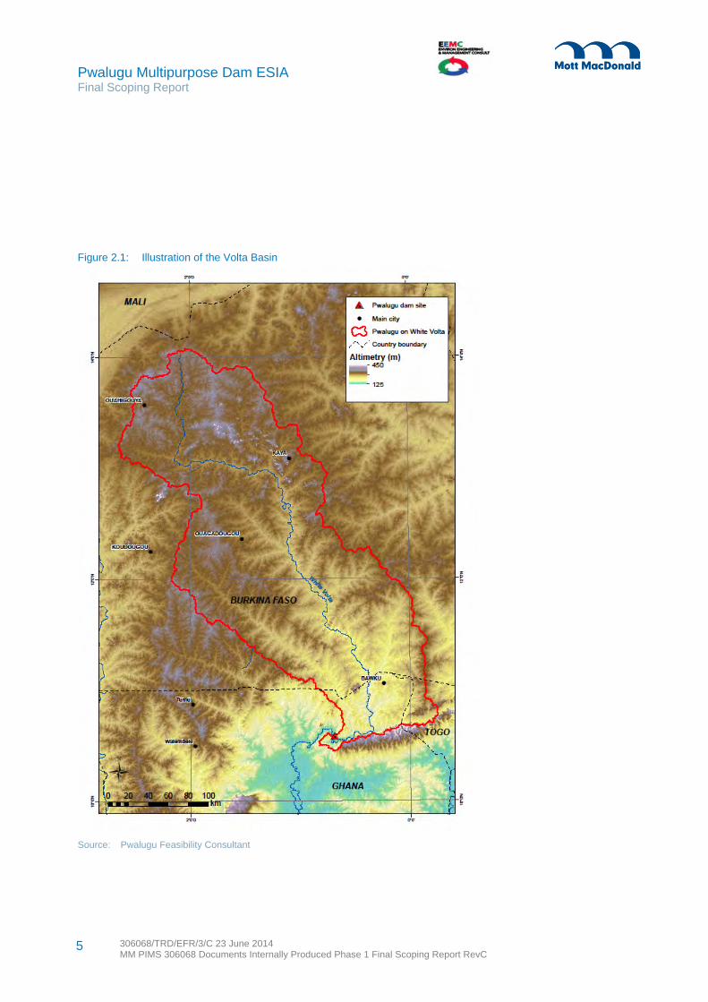
The Project area is located on the White Volta River in Ghana, about 16km east of Pwalugu Bridge on the main Tamale-Bolgatanga road and extending approximately 30km along the river bed. The White Volta River at the dam site is bordered on the southeast by the Gambaga escarpment. The River is the boundary between the Upper East Region and the Northern Region. The proposed irrigation site is located in the Northern Region around the Kulpawn basin. Figures 2.1 and 2.2 show the White Volta River Basin and the ESIA project study area for the proposed dam and irrigation sites. Based on the Feasibility Consultant’s prefeasibility studies, the reservoir does not cross the border with Burkina Faso.
2.2.1 Key project components
The Project is comprised of a hydropower impoundment facility, created by damming the White Volta River, power generation and transmission equipment and a number of associated safety and control features. The main objectives are power generation, irrigation development and flood management. Other benefits being considered are capture fisheries and tourism development. Key project components are described in Table 2.1. The Project details in the table refer to two main options, an upstream dam location with a full supply level (FSL) at 177m above sea level (asl) which is more to the east and a downstream location which is more to the west with a FSL at 172m asl.
Figure 2.1 shows the area covered by the Volta river basin and Figure 2.2 shows the area of largest potential footprint of the proposed reservoir considering both dam location options.
2 Project Description
Pwalugu Multipurpose Dam ESIA Final Scoping Report
306068/TRD/EFR/3/C 23 June 2014 MM PIMS 306068 Documents Internally Produced Phase 1 Final Scoping Report RevC
5
Figure 2.1: Illustration of the Volta Basin
Source: Pwalugu Feasibility Consultant

6 306068/TRD/EFR/3/C 23 June 2014 MM PIMS 306068 Documents Internally Produced Phase 1 Final Scoping Report RevC
Pwalugu Multipurpose Dam ESIA Final Scoping Report
Figure 2.2: Pwalugu Project Zone

Pwalugu Multipurpose Dam ESIA Final Scoping Report
306068/TRD/EFR/3/C 23 June 2014 MM PIMS 306068 Documents Internally Produced Phase 1 Final Scoping Report RevC
7
Table 2.1: Key PMD components
Component Explanation Project detail
Dam A typical dam is a wall of solid, impermeable material built across a river to block the flow of the river thus storing water in the lake that will form upstream of the dam as water continues to flow from the river upstream of the dam.
For both sites, the preferred dam type is a central Roller Compacted Concrete (RCC) combined with a left bank rock fill and Right bank earthfill. The central RCC block will contain a gated spillway and the power intakes.
Reservoir Building a dam across a river results in the creation of a body of water, the reservoir, which stores the water for various purposes, such as hydroelectricity generation, irrigation and potable water supply.
Due to the seasonal variation of the inflows, the Pwalugu reservoir will be used on a seasonal basis. Through dedicated operation rules, aiming mainly at managing the large inflows of the rainy season, the reservoir water level will progressively decrease during the dry season due to the small inflows and the powerhouse higher discharges. The reservoir will be at its lowest elevation (which may reach the Minimum Operating Level for some dry years) at the beginning of the rainy season. The high inflows will then fill the reservoir during the three months of the rainy season.
Given the size of the reservoir and the powerhouse discharge capacity, no significant daily reservoir variation is anticipated.
Intake Water is drawn from a reservoir using an intake structure. This can be a simple diversion channel or tunnel, or a tower enabling water abstraction at different levels of the reservoir.
For PMD, the intake structure is integrated in the central RCC dam body.
Powerhouse The powerhouse will contain the turbines, generators and other equipment needed for the production of electrical power.
The powerhouse will be outdoors located at the immediate downstream toe of the dam. At this early stage, the exact types, sizes and number of turbines which will be used have not been defined.
Emergency spill way
Dams incorporate an emergency spillway system, which protect the dam structure from failure due to sudden large volumes of water, and protect downstream areas from the resultant deluge.
In the preferred design option, the dam will have a gated spillway incorporated in the central RCC block. The downstream face of the dam will act as the spillway chute with a flip bucket to throw the spillage water into a plunge pool located further downstream of the dam.
Weir (irrigation buffer zone)
A channel through which water can be taken for irrigation, either from the reservoir or from the river after reservoir water has been returned to it.
The proposed irrigation scheme currently includes a weir along the White Volta downstream of the dam
Irrigation pipelines or canals
Irrigation pipelines or canals will be required as part of the water conveyance and distribution system.
Irrigation will be by gravity. A primary canal surrounding the irrigation area perimeter will discharge water into secondary and tertiary canals.
Transmission lines Power will need to be exported from the powerhouse to the national grid. To export the
Two options are possible: either connect the Pwalugu Substation to the Bolgatanga

Pwalugu Multipurpose Dam ESIA Final Scoping Report
306068/TRD/EFR/3/C 23 June 2014 MM PIMS 306068 Documents Internally Produced Phase 1 Final Scoping Report RevC
8
Component Explanation Project detail
electricity, it will have to be stepped up (increased in voltage) using a transformer to connect into the national transmission system.
substation or join into the existing Tamale-Bolgatanga transmission line passing nearby the dam site to the Pwalugu Powerhouse
Borrow pits for rock and clay
Areas of land yielding building materials of suitable quality to be used in dam construction.
Rock material including granite is available at the site but is subject to survey. It is assumed that the main borrow area would be within 10km of the dam site and located within the future reservoir.
Access roads To support delivery of equipment and personnel to site, upgrades to existing access roads and creation of new permanent access roads and possibly some temporary access roads will be needed.
Currently, the main haul road will be on the right side along an existing road to be upgraded and extended with new road to be created.
Operations support buildings
Permanent operations support buildings would be set up within reasonable distance of the power house and key dam infrastructure and would include facilities such as offices, workers’ accommodation and a maintenance workshop.
The location of this component has not been finalised at this stage.
Often hydropower schemes have a trailrace which is an outlet of the power house that returns water back to the river once it has been through the turbines. As the PMD powerhouse is located in the river bed downstream of the dam, no major tailrace is foreseen.
To support the main works the following activities are identified as key to the construction phase operations and on-going maintenance requirements:
Land acquisition associated with temporary and permanent structures Development of borrow pits to provide aggregate for road building Temporary workers accommodation Temporary storage and work sites at dam and powerhouse locations Spoil disposal locations required for significant amounts of material to be excavated from tunnels Batching plants for the production of concrete to support foundation works Water boreholes (if not existing supply system).
2.3 Need for the Project
The project developer, Volta River Authority (VRA), is mandated to develop power generation potential to fulfil domestic and industrial needs in Ghana. In addition, VRA supplies electricity to consumers in Togo, Benin and Côte d’Ivoire.
Pwalugu was one of several potential dam sites studied at pre-feasibility level, and was considered the most favourable with regard to its costs, volume of power generation potential, as well as the potential for irrigation development and flood management. The Pwalugu option also had the smallest displacement footprint on local communities and their lands.

Pwalugu Multipurpose Dam ESIA Final Scoping Report
306068/TRD/EFR/3/C 23 June 2014 MM PIMS 306068 Documents Internally Produced Phase 1 Final Scoping Report RevC
9
The Project has government wide interest and is considered a key national project. It is led by a Steering group comprised of representatives from: Water Resources Commission, Savannah Accelerated Development Authority, Environmental Protection Agency, Ghana Irrigation Development Authority, Volta Basin Authority, Ghana Dams Dialogue; and VRA. The Project is also of interest to lenders including the French Development Agency and the World Bank.
The Project is expected to achieve a range of multipurpose development objectives:
Power generation, contributing to filling the electricity capacity gap in Ghana. The Project
location at the northern end of the national grid would reduce energy losses along the existing transmission line.
There are a number of arguments supporting the development of more hydroelectric power capacity in Ghana. While the Ghanaian economy is growing over six per cent annually, the trend of power shortages continues which constrains economic growth. A major power shortage in 2006-2007 was calculated to have cost one per cent of lost GDP1. Projecting from current supply and demand rates, the World Bank predicts 1500MW shortfall in electricity capacity in Ghana by 2022 at peak demand with a 20% margin2. While hydroelectric generation is dependent on sometimes erratic water level, simultaneous development of thermal and gas fired power plants is expected to provide some redundancy in national electricity supply. Hydroelectricity is almost half as cheap as thermal generation at source. VRA transfers these savings to consumers by charging a blended cost of thermal and hydro power.
Develop the irrigation potential of the White Volta plains.
Despite recent advancements in other sectors, such as oil production, one third of Ghana’s economy remains reliant on agriculture, which is dominated by rain fed, small-holder farming. Lack of effective irrigation, namely slow growth of the irrigation sector and underutilisation of the limited existing irrigated areas, is seen as key barrier to agricultural growth3. There is extensive policy support for irrigation schemes since the government expects irrigation to bring multiple benefits: food security, increased export earnings and a reduction in commercial food imports and food aid, job creation, income growth, poverty reduction, and climate change adaptation. While increase in irrigation capacity through large scale projects like PMD is welcomed, the Ghanaian government is also keen for maximum small-holder participation in such schemes, to ensure equitable benefit sharing and to avoid enclave development4.
1 http://www-
wds.worldbank.org/external/default/WDSContentServer/WDSP/IB/2013/07/22/000442464_20130722120043/Rendered/PDF/796560WP0P13140Box0377384B00PUBLIC0.pdf
2 Ibid.
3 Republic of Ghana Ministry of Food and Agriculture and Irrigation Development Agency. Ghana Agricultural Water Management Investment Framework. 2012
4 http://wbi.worldbank.org/sske/case/public-private-partnerships-irrigation

Pwalugu Multipurpose Dam ESIA Final Scoping Report
306068/TRD/EFR/3/C 23 June 2014 MM PIMS 306068 Documents Internally Produced Phase 1 Final Scoping Report RevC
10
Provide flood management in the northern Ghanaian regions of the White Volta basin.
Between 1995 and 2008 Ghana experienced six major floods, each of which affected between 60,000 and two million people. The 2007 flood alone cost the government USD 2.7 million on providing flood relief to victims in the Northern, Central and Western regions of Ghana5. Due to their nature dams can contribute to flood protection by maintaining low water levels in affected rivers and reservoirs before and during a flood event. During scoping stage consultation, Ghana’s National Disaster Management Organisation welcomed the flood management element of the PMD, but emphasised the need for contingency planning and early warning systems.
Additional Project benefits are economic growth and diversification to the area through the development of capture fisheries. There may be some tourism industry benefits, but they are likely to be minor in comparison to the three main objectives. Diversifying away from agriculture is a priority for all the district authorities in the Project area6.
2.4 Trade-offs among the Multipurpose Objectives
The Feasibility Consultant has been undertaking a prefeasibility study focussing on technical issues alongside this ESIA study. Different priorities among the main multipurpose objectives have been considered taking into account the site location. With irrigation as priority, the maximum irrigated area is around 95,000ha and there would be no final energy production. With energy production as priority, the maximum irrigated area is around 47 000ha.
With energy as priority and taking into account the details of the site, the prefeasibility findings are that the optimum FSL should be around 172m asl. For a FSL set at 172m asl, the total power generation at Pwalugu could be 205Gwh/year with an installed capacity around 56MW given a firm power output of around 24MW. However, at this FSL and without irrigation, taking into account Akosomobo and Kpong which are downstream and would still be reliant on the provision of water passing through Pwalugu, the total added energy decreases to 161Gwh/year due to the evaporation loss in Pwalugu reservoir. The total added energy for the three hydropower projects decrease versus the surface of the irrigated areas at a rate of about 3.4 Gwh/year per 1,000ha. There is therefore a large effect on energy production depending on how much land is irrigated. For instance, with 20,000ha irrigated land the overall additional energy production for Pwalugu taking into account Akosombo and Kpong is reduced by 87GWh/year.
2.5 Programme for Development
Table 2.2 presents the development timescales that are currently envisaged.
5 Guidebook on Integrating Climate Change and Disaster Risk into National Development, Policies and Planning in Ghana. Ghana
EPA, UNDP and NADMO Ghana. 2010
6 http://www.ghanadistricts.com/

Pwalugu Multipurpose Dam ESIA Final Scoping Report
306068/TRD/EFR/3/C 23 June 2014 MM PIMS 306068 Documents Internally Produced Phase 1 Final Scoping Report RevC
11
Table 2.2: Project programme
Activity Date
Prefeasibility Study – Completion June 2014
Draft ESIA – Completion August 2014
Draft ESIA – Public Consultation September 2014
Resettlement Action Plan – Completion April 2015
Final Environmental and Social Management Plans – Completion
April 2015
Feasibility Study – Completion April 2015
Tender Preparation and Contract award – 12 months September 2015 – September 2016
Construction – 3-6 years 2017 – 2022
Operation – 50 years 2023 – 2073
2.6 Consideration of Alternatives
2.6.1 Overview
In parallel to the ESIA process, VRA has employed a Feasibility Consultant (FC) to optimise the Project and review the technically feasible options. This includes reviewing the feasibility of options based on safety, technical feasibility, cost and incorporates the findings the ESIA being undertaken in parallel. The Project is currently in very early stages of optimisation and technically feasible sites are still being defined based on the ground truthing of local geological conditions.
2.6.2 Site selection principles and ES constraints
To support the evaluation of alternatives for the PMD, environmental and social principles were identified to guide the technical design and act as criteria for evaluating and decision making on alternatives. Table 2.3 focuses on the dam, Table 2.4 on the transmission lines and Table 2.5 on the roads. These tables also provide insights for siting other Project infrastructure.
Table 2.3: Environmental and social site selection principles for the dam
No. Theme Description
1 Resettlement, ecology, greenhouse gases
Keep the reservoir surface area as small as possible (relative to power generation and/or water stored)
2 Resettlement Avoid, to the extent possible involuntary resettlement of communities and restriction of access to natural resources and means of livelihood, through careful siting of the dam and consideration of the extent of the reservoir
3 Ecology/ biodiversity, cultural heritage
Avoid to the extent possible, the major areas of highest amenity value namely internationally and nationally recognised conservation sites, critical natural habitats and endemic species, and known archaeological sites or sites of cultural significance
4 Ecology/ biodiversity, cultural heritage
Having avoided the major areas of highest amenity, then minimise impacts on areas of lesser amenity value or scientific interest including regionally and locally recognised conservation sites

Pwalugu Multipurpose Dam ESIA Final Scoping Report
306068/TRD/EFR/3/C 23 June 2014 MM PIMS 306068 Documents Internally Produced Phase 1 Final Scoping Report RevC
12
No. Theme Description
5 Water quality Reduce the mean water retention time7 during normal operation as far as possible.
6 Ecology, greenhouse gases, water quality
Minimise flooding of forests with a high biomass content, even if they are cleared before reservoir filling
7 Ecology Minimise the length of river (main stem plus tributaries) impounded by the reservoir (measured during high flow periods)
8 Ecology, livelihoods, water resources, health, safety
Minimise regime change downstream of the facility
9 Ecology/ biodiversity Maximise the number of downstream undammed tributaries.
10 Ecology, livelihoods, water quality
Site dams on upper tributaries if possible as this is often the most environmentally benign option; this should be tested on a case by case basis
11 Ecology Minimise likelihood of reservoir stratification which occurs when the upper part of the lake is thermally divided from the deeper part
12 General Maximise the useful life of the reservoir. In general, reservoirs with the longest useful life are relatively deep and situated on rivers with low sediment loads
13 Livelihoods, water resources, health, safety
Choose sites where impacts on downstream water users are least when compared with power output
14 Economy Avoid inundation of mineral resources
15 Livelihoods and wellbeing Avoid impairment of navigation
16 Social, safety Minimise effects of new infrastructure on communities by having particular regard to safety, noise and construction traffic
Source: Adapted from ‘Good and Bad Dams’ by Ledec and Quintero (2003) and ‘Environmental Criteria for Hydropower Development in the Mekong Region’ by King, Bird and Haas (2007)
Table 2.4: Environmental and social site selection principles for transmission lines
No. Theme Description
1 Ecology/ biodiversity, cultural heritage
Avoid, to the extent possible, the major areas of highest amenity value namely internationally and nationally recognised conservation sites, critical natural habitats and endemic species, and known archaeological sites or sites of cultural significance
2 Resettlement Avoid, to the extent possible relocation of structures and restriction of access to natural resources and means of livelihood, through careful siting of the towers
2 Ecology/ biodiversity, cultural heritage
Having avoided the major areas of highest amenity value, then minimise impacts on areas of lesser amenity value or scientific interest including regionally and locally recognised conservation sites
3 Social, safety Minimise effects of new infrastructure on communities by having particular regard to safety, noise and construction traffic
4 Visual Where possible choose inconspicuous locations for angle towers, terminal tower and sealing end compounds
5 Visual Choose tree and hill backgrounds in preference to sky backgrounds wherever possible. Where the line has to cross a ridge, secure the opaque background as long as possible and cross obliquely
7 This is the number of days it takes for a complete exchange of water in the reservoir

Pwalugu Multipurpose Dam ESIA Final Scoping Report
306068/TRD/EFR/3/C 23 June 2014 MM PIMS 306068 Documents Internally Produced Phase 1 Final Scoping Report RevC
13
No. Theme Description
6 Visual Prefer moderately open valleys with woods where apparent height of towers will be reduced and views of line will be broken by trees
7 Visual, safety Minimise crossings with other high voltage transmission lines
8 Visual In country which is flat and sparsely planted keep the high voltage lines as far as possible independent of smaller lines, converging routes, distribution poles and other masts, wires and cables, so as to avoid concentration of ‘wirescape’
Source: Mott MacDonald
Table 2.5: Environmental and social site selection principles for roads
No. Theme Description
1 Ecology/ biodiversity Minimise the kilometres of road passing through (fragmenting) or near areas of high conservation value or important migration routes for land-based fauna
2 Resettlement Avoid, to the extent possible, involuntary resettlement of communities and restriction of access to natural resources and means of livelihood, through careful alignment of the road
3 Ecology/ biodiversity, cultural heritage
Avoid, to the extent possible, the major areas of highest amenity value namely internationally and nationally recognised conservation sites, critical natural habitats and endemic species, and known archaeological sites or sites of cultural significance
4 Ecology/ biodiversity, cultural heritage
Having avoided major areas of highest amenity value, then minimise areas of smaller amenity value or scientific interest including regionally and locally recognised conservation sites
5 Ecology/ biodiversity Avoid creating access to areas of conservation value
6 Social, livelihoods Avoid fragmenting communities with roads and creating severance
7 Social, safety Minimise effects of new infrastructure on communities by having particular regard to safety, noise and construction traffic
Source: Adapted by Mott MacDonald from ‘Good and Bad Dams’, Ledec and Quintero (2003)
2.6.3 Design alternatives
The Project is currently in the early stages of feasibility, aiming to define available options to achieve a financially feasibly project. As described in Section 10, the multipurpose nature of the Project means there are choices on objectives and water allocation, and scenario analysis can be undertaken. The three main objectives are energy generation, irrigation development and flood management. See Section 2.4 for a discussion on the multipurpose trade-offs between the energy production and irrigation development objectives. Other objectives are related to fishery development and tourism development. The final design will be determined, by the balance of priorities and relative importance accorded to competing uses of the finite amount of water in the reservoir, and the benefit to cost comparison of meeting these objectives.
The ‘base case’ or ‘no Project’ is an alternative. If the Project is not developed, in order to meet demands, electricity could still be generated locally by alternative sources including small scale renewables or thermal power, both of which have government policy support. Large scale irrigation however would require a major initiative and support from the Ghana Irrigation Development Authority. Flood management could be undertaken using traditional river defences. However the economies of scale and integration
Pwalugu Multipurpose Dam ESIA Final Scoping Report
306068/TRD/EFR/3/C 23 June 2014 MM PIMS 306068 Documents Internally Produced Phase 1 Final Scoping Report RevC
14
achievable though the multipurpose Project (an estimated 60MW electricity generation, irrigation of 20,000ha and flood management), could not be realised. There would be no basis for the proposed value addition initiatives of fisheries and community tourism development.
On the contrary, the no Project alternative would avoid the typical adverse impacts associated with large scale hydropower projects in pristine rural contexts: long term changes to river hydrology; habitat and biodiversity loss; physical and economic displacement of communities and risk of community health hazards; risk of dam safety and related hazards.
To date specific design alternatives that have been considered for the PMD project are: Comparison between two potential dam sites (discussed in detail in Table 2.6 and Table 2.7) Comparison between dam heights, which is directly linked to the amount of water available for
electricity generation (see the comparison of dam heights in Table 2.8) Comparison between four types of dam: currently, mixed RCC and rock fill construction is preferred
from a technical perspective Possibility or not, to use an emergency spillway Use and cost of a saddle dam: the current option includes a saddle dam Location for irrigation activities and abstraction point for irrigation water (discussed in more detail in
2.4.5) Location of the transmission line: whether to cut into the existing north-south 161kV line running
parallel to the highway or link to the Pwalugu or Bolgatanga substations
2.6.4 Comparison of dam site options
The main design variables are the two dam axes (upstream and downstream). To store the same amount of water as the downstream dam with an FSL of 172m asl, the upstream dam would need to be at 177m asl. Comparisons of the two dam sites and the FSL heights were looked at in detail against the environmental and social (ES) principles. The results are presented in Table 2.6.
Table 2.6: ES considerations for the dam site alternatives
No. Principle Summary Upstream Dam Site at 177 FSL Downstream Dam Site at 172 FSL
1 Minimise reservoir surface area
509km2 439km2
2 Avoid involuntary resettlement
With an FSL of 177m asl, this dam site affects the relocation of an estimated 229 household compounds based on LIDAR survey data. There are 82 households between the river and 172m of which 45 are concentrated in one village and the rest are scattered. There are140 households between the 172m and 177m contours along the Red Volta and White Volta branches running north south that would be affected. This information needs ground truthing as the ESIA and resettlement planning phases progress.
With an FSL of 172m asl, this dam site affects the relocation of an estimated 296 household compounds based on LIDAR survey data. Of these, 215 are downstream of the upstream location. Of the 215 houses, 75 are in scattered areas and the other 140 are in four villages ranging from 10 to 51 households. This information needs ground truthing as the ESIA and resettlement planning phases progress.
3 Avoid recognised conservation and
Both dam sites intersect nationally designated forest reserves, namely the Gambaga Scarp East and West, the Morago East and West and the Red Volta East and West. The

Pwalugu Multipurpose Dam ESIA Final Scoping Report
306068/TRD/EFR/3/C 23 June 2014 MM PIMS 306068 Documents Internally Produced Phase 1 Final Scoping Report RevC
15
No. Principle Summary Upstream Dam Site at 177 FSL Downstream Dam Site at 172 FSL
cultural sites Gambaga Scarp Forest Reserve which combines the main parts of these is designated an Important Bird Area (IBA)8.
4 Minimise impacts on areas of smaller amenity value or scientific interest
Both dam sites affect areas of nationally designated forest reserve and a designated Important Bird Area. No areas of smaller amenity value or scientific interest are known to be affected so this aspect will be the same for both dam sites.
5 Reduce the mean water retention time during normal operation.
As both reservoirs are compared to have the same volume and will have the same mean river flow, this aspect will be the same for both dam sites.
6 Minimise flooding of forests
An estimated 264km2 of forestry reserve land will be inundated based on the LiDAR survey data, more of it along the Red Volta and White Volta branches.
An estimated 258km2 of forestry reserve land will be inundated based on the LiDAR survey data. In comparison to the upstream dam site at 177 FSL, less forest land along the Red Volta and White Volta branches running north south is affected although there is some forest reserve that is downstream from the upstream dam site that would be affected.
7 Minimise the length of river impounded by the reservoir.
111km. The reservoir of this dam site at an FSL of 177m asl would flow into Burkina Faso.
132km. At an FSL 172m asl, this reservoir does not go into Burkina Faso.
8 Minimise downstream regime change
There is expected to be negligible difference between the two sites with regards to downstream regime change. Both dam sites require water for irrigation to be extracted after it has gone through the power turbines.
9 Maximise the number of downstream undammed tributaries.
The upstream dam site will result in a greater number of undammed downstream tributaries.
10 Site dams on upper tributaries if possible
This aspect will be the same for both dam sites.
11 Minimise reservoir stratification
Using an FSL of 177m asl will create a deeper reservoir overall in some locations than the other site. There could be more stratification of the dam between those two heights as the land is fairly flat.
With an FSL of 172m asl, the reservoir at this site is able to take advantage of an area between the two sites which is the deepest in the Project area.
12 Maximise the useful life of the reservoir
The downstream dam site has a portion of the reservoir which will be deeper and therefore better for its useful life
13 Choose sites where impacts on downstream water users are least when compared with power output
In general, impacts on downstream communities from this type of dam include: changes in river water level, changes in fish population which could in turn affect the livelihoods of fisher folk, increased risks of artificial flooding, changes to water turbidity and quality as well as impacts on groundwater.
Comparative impacts on downstream water users from different dam options will be assessed at a later stage
14 Avoid inundation of mineral resources
There is one mineral concession for this scheme along the White Volta branch towards Bawku.
There are five mineral concessions (three of the same company and one
8 http://www.birdlife.org/datazone/sitefactsheet.php?id=6337

Pwalugu Multipurpose Dam ESIA Final Scoping Report
306068/TRD/EFR/3/C 23 June 2014 MM PIMS 306068 Documents Internally Produced Phase 1 Final Scoping Report RevC
16
No. Principle Summary Upstream Dam Site at 177 FSL Downstream Dam Site at 172 FSL
that is a block for small scale use) at the preparatory stage in the dam site area, including the same one along the White Volta branch.
15 Avoid impairment of navigation
There is no regular navigation in the area and the number of boats is small (a few villages have a few canoes). Navigation will improve for fishermen regardless of the site because of the flood management benefits.
16 Minimise effects of new infrastructure on communities
At 172m, the reservoir for downstream dam site would cover a larger geographical extent and therefore more potential receptors of safety, noise and traffic risks.
From an environmental and social perspective, the downstream dam site with an FSL of 172m asl is preferential because it does not cross the border into Burkina Faso. On the negative side, the area between the upstream and downstream means that four more villages and other homestead compounds as well as some mineral concessionaires would be affected. However, that same location (between the upstream and downstream sites) is best from the perspective of water depth which is beneficial for fisheries development and stratification. Based on LIDAR survey analysis, both dams appear to affect about the same amount of forest reserve land.
The downstream dam site, mainly because of its technical qualities and taking into account the above ES considerations, has been proposed as the preferred site. With that decision, a review of alternative FSLs was undertaken. Table 2.7 and Table 2.8 present the prefeasibility comparison of the upstream and downstream options and then the comparison of three FSLs for the downstream site.

17 306068/TRD/EFR/3/C 23 June 2014 MM PIMS 306068 Documents Internally Produced Phase 1 Final Scoping Report RevC
Pwalugu Multipurpose Dam ESIA Final Scoping Report
Table 2.7: Comparison of upstream and downstream dam sites
Dam Site Indicator Unit Upstream Upstream Downstream Downstream
177 FSL 172 FSL 172 FSL 167 FSL
Hydrology
Reservoir volume at FSL Mm3 5061 3135 5061 3135
Reservoir area at FSL km2 509 368 439 305
Catchment area km2 56800 56800 57000 57000
Mean inflows m3/s 121.3 121.3 121.3 121.3
Ratio Storage / Mean annual inflows - 1.11 0.61 1.11 0.61
Environmental and social issues
Number of affected homesteads - 229 89 296 262
Forest reserve inundated km2 264 217 258 193
Percentage of forest reserve inundated % 28% 23% 19% 14%
Impacted structures - 2 bridges inundated Minor embankments Minor embankments None
Reservoir enters Burkina-Faso - Yes No No No
Costs
Dam cost MUSD 365.3 329.4 216.8 188.2
Transmission line MUSD 15.2 15.2 11.5 11.5
Access road MUSD 14.8 14.8 5.2 5.2
Saddle dam MUSD None None 1.6 None
Total construction costs* MUSD 589.0 535.4 351.1 305.8
Environmental impact mitigation costs MUSD 22.1 19.3 23.4 22.7
Benefits
Added energy generation (without irrigation) **
GWh/yr 128 120 161 138
Added energy generation (with 20000ha irrigated) **
GWh/yr 54 47 87 65
Possibility of implementing 20 000 ha of irrigation
- Yes Yes Yes Yes

18 306068/TRD/EFR/3/C 23 June 2014 MM PIMS 306068 Documents Internally Produced Phase 1 Final Scoping Report RevC
Pwalugu Multipurpose Dam ESIA Final Scoping Report
Dam Site Indicator Unit Upstream Upstream Downstream Downstream
177 FSL 172 FSL 172 FSL 167 FSL
Maximum irrigation development ha 93050 80890 93050 80890
Possibility to manage the 10yr flood - Yes Yes Yes Yes
Possibility to manage the 50yr flood - Yes No Yes No
FSL before rainy season for 50yr flood management
m asl 170.5 - 165.3 -
Statistical analysis - U/S floods not controlled
% 30.4% 39.5% 30.4% 39.5%
Fishery benefits - Same for all alternatives
Tourism / navigation benefits - Same for all alternatives
* including mobilization, miscellaneous, contingencies, engineering and administration costs
** energy added to the whole scheme of Pwalugu + Akosombo + Kpong
Source: Pwalugu Feasibility Consultant

Pwalugu Multipurpose Dam ESIA Final Scoping Report
306068/TRD/EFR/3/C 23 June 2014 MM PIMS 306068 Documents Internally Produced Phase 1 Final Scoping Report RevC
19
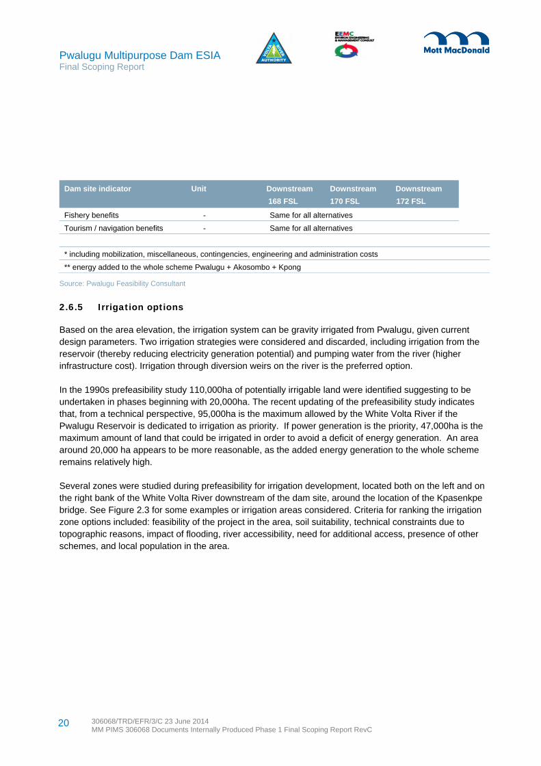
Table 2.8: Comparison of several FSL for the downstream dam site
Dam site indicator Unit Downstream Downstream Downstream
168 FSL 170 FSL 172 FSL
Hydrology
Reservoir volume at FSL Mm3 3516 4237 5061
Reservoir area at FSL km2 335 386 439
Catchment area km2 57000 57000 57000
Mean inflows m3/s 121.3 121.3 121.3
Ratio Storage / Mean annual inflows - 0.71 0.90 1.11
Environmental and social issues
Number of impacted compounds - 281 284 296
Forest reserve inundated km2 214 234 258
Percentage of forest reserve inundated
% 16% 17% 19%
Impacted structures - None None Minor embankments
Reservoir enters Burkina-Faso - No No No
Costs
Dam cost MUSD 194.0 204.8 216.8
Transmission line MUSD 11.5 11.5 11.5
Access road MUSD 5.2 5.2 5.2
Saddle dam MUSD 0.05 0.5 1.6
Total construction costs* MUSD 314.5 330.6 351.1
Environmental impact mitigation costs
MUSD 23.1 23.2 23.4
Benefits
Added energy generation (without irrigation) **
GWh/yr 142 156 161
Added energy generation (with 20000ha irrigated) **
GWh/yr 69 81 87
Possibility of implementing 20 000 ha of irrigation
- Yes Yes Yes
Maximum irrigation development ha 85440 90180 93050
Possibility to manage the 10yr flood - Yes Yes Yes
Possibility to manage the 50yr flood - Yes Yes Yes
FSL before rainy season for 50yr flood management
m asl 157.3 161.7 165.3
Statistical analysis - U/S floods not controlled
% 35.7% 32.1% 30.4%
Pwalugu Multipurpose Dam ESIA Final Scoping Report
306068/TRD/EFR/3/C 23 June 2014 MM PIMS 306068 Documents Internally Produced Phase 1 Final Scoping Report RevC
20
Dam site indicator Unit Downstream Downstream Downstream
168 FSL 170 FSL 172 FSL
Fishery benefits - Same for all alternatives
Tourism / navigation benefits - Same for all alternatives
* including mobilization, miscellaneous, contingencies, engineering and administration costs
** energy added to the whole scheme Pwalugu + Akosombo + Kpong
Source: Pwalugu Feasibility Consultant
2.6.5 Irrigation options
Based on the area elevation, the irrigation system can be gravity irrigated from Pwalugu, given current design parameters. Two irrigation strategies were considered and discarded, including irrigation from the reservoir (thereby reducing electricity generation potential) and pumping water from the river (higher infrastructure cost). Irrigation through diversion weirs on the river is the preferred option.
In the 1990s prefeasibility study 110,000ha of potentially irrigable land were identified suggesting to be undertaken in phases beginning with 20,000ha. The recent updating of the prefeasibility study indicates that, from a technical perspective, 95,000ha is the maximum allowed by the White Volta River if the Pwalugu Reservoir is dedicated to irrigation as priority. If power generation is the priority, 47,000ha is the maximum amount of land that could be irrigated in order to avoid a deficit of energy generation. An area around 20,000 ha appears to be more reasonable, as the added energy generation to the whole scheme remains relatively high.
Several zones were studied during prefeasibility for irrigation development, located both on the left and on the right bank of the White Volta River downstream of the dam site, around the location of the Kpasenkpe bridge. See Figure 2.3 for some examples or irrigation areas considered. Criteria for ranking the irrigation zone options included: feasibility of the project in the area, soil suitability, technical constraints due to topographic reasons, impact of flooding, river accessibility, need for additional access, presence of other schemes, and local population in the area.

21 306068/TRD/EFR/3/C 23 June 2014 MM PIMS 306068 Documents Internally Produced Phase 1 Final Scoping Report RevC
Pwalugu Multipurpose Dam ESIA Final Scoping Report
Figure 2.3: Irrigation options
Source: Pwalugu Feasibility Consultant

Pwalugu Multipurpose Dam ESIA Final Scoping Report
306068/TRD/EFR/3/C 23 June 2014 MM PIMS 306068 Documents Internally Produced Phase 1 Final Scoping Report RevC
22
2.6.6 Technical specifications of the preferred scheme
Now at the end of prefeasibility studies and taking into account the environmental and social issues identified during scoping, the preferred option that is being proposed to take forward is summarised in Table 2.9.
Table 2.9: Summary of the technical characteristics of the recommended option
1 Reservoir characteristics
Maximum Operating Level m asl 170
Minimum Operating Level m asl 154
Storage at Max. OL Mm3 4237
Storage at Min. OL Mm3 761
Live storage Mm3 3476
Reservoir area at Max. OL km2 386
Reservoir area at Min. OL km2 103
Full Supply Level m asl 170
Maximum Water Level (10000yr flood) m asl 170
2 Hydrology
Catchment area km2 57000
Average inflow m3/s 121.3
3880 3959
Peak flood discharge (10 years) m3/s 1411
Peak flood discharge (100 years) m3/s 2285
Peak flood discharge (1 000 years) m3/s 3249
Peak flood discharge (10 000 years) m3/s 4342
Peak flood discharge (PMF) m3/s 6087
Net annual evaporation mm/year 883
Sediment inflow hm3/year 1.07
3 Energy Generation
Installed outflow m3/s 165
Tail water level m asl 133
Max. net head M 36.2
Min. net head M 18.5
Mean head M 32.2
Installed capacity MW 53
Firm capacity MW 23
Turbine type Kaplan
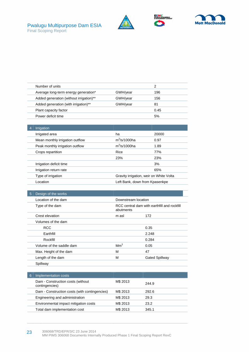
Pwalugu Multipurpose Dam ESIA Final Scoping Report
306068/TRD/EFR/3/C 23 June 2014 MM PIMS 306068 Documents Internally Produced Phase 1 Final Scoping Report RevC
23
Number of units 2
Average long-term energy generation* GWH/year 196
Added generation (without irrigation)** GWH/year 156
Added generation (with irrigation)** GWH/year 81
Plant capacity factor 0.45
Power deficit time 5%
4 Irrigation
Irrigated area ha 20000
Mean monthly irrigation outflow m3/s/1000ha 0.97
Peak monthly irrigation outflow m3/s/1000ha 1.89
Crops repartition Rice 77%
23% 23%
Irrigation deficit time 3%
Irrigation return rate 65%
Type of irrigation Gravity irrigation, weir on White Volta
Location Left Bank, down from Kpasenkpe
5 Design of the works
Location of the dam Downstream location
Type of the dam RCC central dam with earthfill and rockfill abutments
Crest elevation m asl 172
Volumes of the dam
RCC 0.35
Earthfill 2.248
Rockfill 0.284
Volume of the saddle dam Mm3 0.05
Max. Height of the dam M 47
Length of the dam M Gated Spillway
Spillway
6 Implementation costs
Dam - Construction costs (without contingencies)
M$ 2013 244.9
Dam - Construction costs (with contingencies) M$ 2013 292.6
Engineering and administration M$ 2013 29.3
Environmental impact mitigation costs M$ 2013 23.2
Total dam implementation cost M$ 2013 345.1

Pwalugu Multipurpose Dam ESIA Final Scoping Report
306068/TRD/EFR/3/C 23 June 2014 MM PIMS 306068 Documents Internally Produced Phase 1 Final Scoping Report RevC
24
7 Environmental impact
Displaced population households 284
Fishery benefits M$/yr 3.2
Tourism benefits Negligible
* Pwalugu HPP only
** Pwalugu+Akosombo+Kpong scheme
Source: Pwalugu Feasibility Consultant

Pwalugu Multipurpose Dam ESIA Final Scoping Report
306068/TRD/EFR/3/C 23 June 2014 MM PIMS 306068 Documents Internally Produced Phase 1 Final Scoping Report RevC
25
3.1 Introduction
This section identifies the national and international legislation, standards and guidelines that are relevant to the ESIA. It concludes with a brief description of the envisaged institutional arrangements.
3.2 National Regulatory Framework
The Environmental Protection Agency Act 1994 (Act 490) and L.I. 1652 are the main act and legislation respectively for ESIA studies. The Act grants the Environmental Protection Agency (EPA) enforcement and standards-setting powers, and the power to ensure compliance with the Ghana environmental assessment requirements/procedures. Additionally, the EPA is required to create environmental awareness and build environmental capacity among all sectors. The EPA, including its Regional and District Offices, is also vested with the power to determine what constitutes an ‘adverse effect on the environment’ or an activity posing ‘a serious threat to the environment or public health’, to require environmental assessments and environmental management plans of an undertaking, and to regulate and serve enforcement notices for any offending or non-complying undertaking. The EPA is required to conduct monitoring to verify compliance with given approval/permit conditions, required environmental standards and mitigation commitments.
The Environmental Assessment (EA) Regulations combine both assessment and environmental management systems. The regulations prohibit commencing an undertaking/activity without prior registration and environmental permit (EP). Undertakings are grouped into schedules for ease of screening and registration and EP. The schedules include undertakings requiring registration and EP (Schedule 1), EIA mandatory undertakings (Schedule 2), as well as Schedule 5-relevant undertakings (located in Environmentally Sensitive Areas).
The EA Regulations also define the relevant stages and actions, including registration, screening, preliminary environmental assessment, scoping and terms of reference, environmental impact assessment, review of EA reports, public notices and hearings, environmental permitting and certification, fee payments, environmental management plan, suspension/revocation of permit and complaints/appeals. Under the EA Procedures it is required that an Environmental Impact Statement is prepared by the proponent to clearly present an assessment of the impacts of the proposed project on the environment based on the terms of reference as stipulated in the scoping report. The EA Procedures requires that potential direct and indirect impacts of the project on the environment covering the pre-construction, construction, operation, decommissioning and post decommissioning stages are addressed.
According to the EA Regulations, and confirmed by the Environmental Protection Agency for the registration process, this Project is classified as a Category A project. Category A projects require public consultation on the draft Terms of Reference (TOR) for the ESIA after which the TOR for the ESIA is finalised, and public consultation on the draft final ESIA report.
Additionally, the proposed PMD project is required to comply with the following key legislations and policies relevant to the ESIA Study:
3 Legal, Institutional and Planning Framework

Pwalugu Multipurpose Dam ESIA Final Scoping Report
306068/TRD/EFR/3/C 23 June 2014 MM PIMS 306068 Documents Internally Produced Phase 1 Final Scoping Report RevC
26
Water Resources Commission Act, 1996 (Act 522) Local Government Act 1993 (Act 462) Fisheries Act, 2002 Wetlands Management (RAMSAR Sites) Regulations, 1999 Energy Commission Act, 1997 Renewable Energy Act, 2011 Minerals Commission Act, 1993 Small Scale Gold Mining Act, 1989 (PNDCL 218) Volta River Development Act, 1961 (Act 61) and Amendment Act , 2005 (Act 692) Economic Plants Protection Act, 1979 (AFRCD 47) Forest Plantation Development Fund Act, 2000 (Act 583) Wild Animals Preservation Act, 1961 (Act 43) Ghana Meteorological Agency Act, 2004 (Act 682) Town and Country Planning Act 1945 (CAP 84) Ghana Tourist Control Authority Act 1973 (NRCD 224) Lands Commission Act 1994 (Act 483) Land Planning and Soil Conservation Act, 1953 (No 32) Irrigation Development Authority Act 1977 (SMCD 85) Rivers Act 1903 (CAP 226) National Irrigation Policies, Strategies and Regulatory Measures, May 2006 National Land Policy, Ministry of Lands and Forestry, June 1999 National Water Policy, June 2007 Labour Act 2003
3.3 International Standards and Guidelines
3.3.1 French Development Agency
The French Development Agency (AFD-Agence Francaise de Développement) works on behalf of the French Government. Its financing activities must comply with the AFD Environmental and Social Responsibility Policy. This ESIA study is being financed by AFD.
The AFD Group fulfills this social responsibility first and foremost by complying with the legislation in force in France and in its countries of operation, the main international conventions, as well as the collective agreements signed with social partners. AFD is a signatory of the UN Global Compact since 2004, and has committed to the French Charter for Sustainable Development of State-Owned Enterprises in 2008. AFD adopts the Environmental and Social Safeguard Policies of the World-Bank for the public sector and the IFC Performance Standards for the private sector.
The following principles and goals guide AFD Group’s environmental, social and governance responsibility policy. Focusing external and internal operations on people improving their living conditions and well-being,
while respecting the fundamental rights and social and cultural diversity of all the Group’s collaborators.
Pwalugu Multipurpose Dam ESIA Final Scoping Report
306068/TRD/EFR/3/C 23 June 2014 MM PIMS 306068 Documents Internally Produced Phase 1 Final Scoping Report RevC
27
Affirming the three-pronged need for economic growth, wealth redistribution, and reduction of both long-term unemployment and globalisation’s work force impact (as defined by the Group of Twenty in Cannes in November 2011). All require specific measures to achieve sustainable and equitable development that alleviates poverty and inequality.
Preserving climate, renewable natural resources, and ecosystems crucial for economic and social development; focusing the greatest efforts on environmental remediation and climate change mitigation and adaptation, in order to decrease the vulnerability of the poorest.
Contributing financing for cultural heritage preservation and appreciation, in accordance with the 2002 World Summit for Sustainable Development in Johannesburg: this summit defined culture as the fourth pillar of sustainable development, alongside social, economic and environmental support.
Adapting aid interventions to the needs of fragile situations in countries affected by violent conflicts, creating effective conditions for dispute resolutions that restore social cohesion and peace.
Giving priority to partnerships and joint actions that exploit the wide range of professionals and organisations dedicated to sustainable and equitable development, while promoting good social, environmental and governance practices among these partners.
Meeting the obligation to use public funding efficiently by ensuring the quality of the Group’s practices and results, and by integrating lessons learned through regular project performance evaluations.
Promoting transparency and stakeholder engagement by improving public access to information about operations, while complying with confidentiality rules and data privacy laws.
3.3.2 International laws and conventions
The following regional or international laws and conventions are considered applicable to this Project.
African Charter on Human and Peoples' Rights African Charter on the Rights and Welfare of the Child African Convention on the Conservation of Nature and Natural Resources Agreement on the Conservation of African-Eurasian Migratory Water birds Convention on the Conservation of Migratory Species of Wild Animals Convention on the Protection and Use of Trans-boundary Watercourses and International Lakes Convention on Wetlands of International Importance International Covenant on Economic, Social and Cultural Rights International Labour Organisation’s (ILO) Core Labour Standards on
Freedom of association and collective bargaining (conventions 87 and 98) Elimination of forced and compulsory labour (conventions 29 and 105) Elimination of discrimination in respect of employment and occupation (conventions 100 and 111) Abolition of child labour (conventions 138 and 182)
Other ILO Conventions that Ghana has ratified or signed Kyoto Protocol to the Convention United Nations Framework on Climate Change Stockholm Convention on Persistent Organic Pollutants United Nations Convention on Biological Diversity United Nations Convention on the Protection of the Rights of All Migrant Workers and Members of Their
Families United Nations Convention on the Rights of the Child United Nations Framework Convention on Climate Change

Pwalugu Multipurpose Dam ESIA Final Scoping Report
306068/TRD/EFR/3/C 23 June 2014 MM PIMS 306068 Documents Internally Produced Phase 1 Final Scoping Report RevC
28
The Volta Basin Convention is especially relevant to this Project and is summarised below.
3.3.2.1 Volta Basin Convention
In order to institute measures for sustainable transboundary water resources management, the ministers in charge of water resources of the riparian countries established the Volta Basin Authority (VBA) in 2006. The ministers approved a draft convention and statutes of the VBA and adopted a roadmap determining the priority preparatory activities to be undertaken for the establishment of the VBA. The Volta Basin Convention was signed by the heads of state of the riparian countries (Republic of Benin, Burkina Faso, Côte D’Ivoire, Ghana, Mali and Togo) at their first assembly held in January 2007 under the auspices of the Government of Burkina Faso. The Convention came into force on 14th August 2009.
The Convention identifies that the VBA’s mandate is to: Promote permanent consultation tools among the parties for the development of the basin Promote the implementation of integrated water resource management (IWRM) and the equitable
distribution of the benefits resulting from their various utilisations Authorise the development of infrastructure and projects planned by the stakeholders and which could
have substantial impact on the water resources of the basin Develop joint projects and works Contribute to poverty alleviation, the sustainable development of the parties in the Volta basin, and for
better socioeconomic integration in the sub-region
3.3.3 World Bank requirements
3.3.3.1 Project Categorisation
The World Bank's Operational Policy 4.01 on Environmental Assessment (EA) requires environmental screening of projects to determine the appropriate extent and type of environmental assessment needed. The World Bank classifies proposed projects into categories depending on the type, location, sensitivity, and scale of the project, as well as the nature and magnitude of its potential environmental impacts.
Using World Bank criteria, this project is considered to be a Category A project because it has the potential to cause adverse impacts on the community and on the environment. The Project will permanently alter a considerable section of the White Volta River. The Project will impact designated forest reserve which is also registered as an important bird area. It will create diverse types of impacts. However, it is considered feasible to mitigate and manage the majority of impacts associated with the project through appropriate environmental and social management together with the monitoring to be specified in the ESMMP and related plans that will be the outcome of this ESIA process.

Pwalugu Multipurpose Dam ESIA Final Scoping Report
306068/TRD/EFR/3/C 23 June 2014 MM PIMS 306068 Documents Internally Produced Phase 1 Final Scoping Report RevC
29
3.3.3.2 World Bank safeguard policies and requirements
International environmental and social safeguard standards are typically embodied by the World Bank environmental and social safeguards operational policies. A summary of the key objectives of relevant safeguards policies are provided in Table 3.1.
Table 3.1: Environmental and social safeguard operational policies
Operational Policy (OP) Description
4.01 – Environmental Assessment (EA) Provides the framework for World Bank environmental safeguard policies and defines the project screening and categorisation in order to determine the level of EA required. For category A projects, like this one, the policy requires public consultation and disclosure to be undertaken as part of the EA process. The Policy sets out requirements to comply and report on implementation of any environmental management plans.
4.04 – Natural Habitats Outlines the World Bank policy on biodiversity conservation taking into account ecosystem services and natural resource management and use by project-affected people. Projects must assess potential impacts on biodiversity. The policy strictly limits circumstances under which conversion or degradation of natural habitats can occur and prohibits projects which are likely to result in significant loss of critical natural habitats.
4.11 – Physical Cultural Resources Sets out the World Bank requirement to avoid or mitigate adverse impacts resulting from project developments on cultural resources.
4.12 – Involuntary Resettlement Provides the World Bank requirements for managing involuntary resettlement including avoidance where possible. Where the acquisition of land or other assets is necessary, the policy sets out requirements for participation in resettlement planning, mandates compensation for assets at replacement cost, and expects to see that incomes and standards of living of affected persons are improved or at least restored to what they were prior to displacement.
4.36 – Forests Describes the World Bank objective to reduce deforestation, enhance the environmental contribution of forested areas, promote afforestation, reduce poverty, and encourage economic development.
4.37 – Safety of Dams Requires competent design and construction supervision to implement dam safety measures through the project cycle. This policy recommends any measures necessary to strengthen the institutional, legislative, and regulatory frameworks for dam safety programs.
7.50 - Projects on International Waterways
Requires notification to other riparians of planned projects that could affect water quality or quantity, sufficiently far in advance to allow them to review the plans and raise any concerns or objections.
There are no groups that meet the criteria of the Bank's Policy on Indigenous Peoples, OP 4.10 in the project area and this aspect is not considered further.
World Bank requirements related to environmental action planning, water resource management and gender analysis will be addressed. Also relevant are the World Bank’s Policy on Access to Information and the World Bank Group’s Environmental, Health, and Safety (EHS) Guidelines, especially the General EHS Guidelines, April 2007 and the EHS Guidelines for Electric Power Transmission and Distribution, April 2007.

Pwalugu Multipurpose Dam ESIA Final Scoping Report
306068/TRD/EFR/3/C 23 June 2014 MM PIMS 306068 Documents Internally Produced Phase 1 Final Scoping Report RevC
30
3.3.4 Other relevant international policy guidance
The ESIA will also consider good international industry practice (GIIP) recommendations of the World Commission on Dams and of the International Hydropower Association’s Hydropower Sustainability Assessment Protocol. Relevant Economic Community of West African States (ECOWAS) policies will also guide the ESIA, for instance the ECOWAS Guidelines for the Development of Water Infrastructure in West Africa. The ECOWAS guidelines require projects to: Affirm the critical role of river basin organisations in developing and implementing transboundary
projects Involve affected populations as project actors, partners and beneficiaries Ensure that all actors involved in project development play their respective roles Assess and optimise the profitability of large water infrastructure in West Africa Capitalise and share existing experiences within the framework of ECOWAS
Adopt a regional framework of reference for the environmental and social assessment of transboundary projects and delivery of their associated plans.
The Volta Basin Authority and its major partners identified the following strategic objectives for the period 2010 to 2014 which PMD will aim to contribute to: Strengthening policies, legislation and institutional framework Strengthening the knowledge base of the basin Coordination, planning and management Communication and capacity building for all stakeholders Effective and sustainable operations.
3.4 Institutional Arrangements
The proposed Pwalugu Multipurpose Dam will be implemented by the Volta River Authority (VRA) with the involvement of government ministries, departments and agencies with major stakeholder interests and relevant responsibilities. As well private sector companies will play a role, especially with regards to construction. Many of the institutional arrangements for this Project will reflect existing relationships and responsibility that VRA has with entities on other dam or hydropower projects. The roles and responsibilities are described below for VRA, the Project Steering Committee and entities that are closely involved with environmental management and permitting, land acquisition and construction and operation.
3.4.1 Volta River Authority (VRA)
VRA is the Project Proponent. VRA’s Environment and Sustainable Development (ESD) Department is responsible for ESIA and the management of environmental and social impacts. The ESD Department's core staff numbers 92 scientists and engineers, technicians, mechanics, boat crews and administrative support involved in environmental assessment, reforestation, dredging, and water quality monitoring. At present, the Environment Section has three specialists involved in environmental assessment and audit.

Pwalugu Multipurpose Dam ESIA Final Scoping Report
306068/TRD/EFR/3/C 23 June 2014 MM PIMS 306068 Documents Internally Produced Phase 1 Final Scoping Report RevC
31
The ESD Department collaborates on social and environmental management issues with other units in VRA, such as departments of Engineering Planning and Development, Engineering Design and Construction, and Real Estate. The ESD Department oversees preparation of impact statements, liaises with the Environmental Protection Agency and manages VRA's environmental and social legal compliance.
VRA has in place a range of policies and procedures which will guide and support the implementation of the Project. In 2005 VRA formulated a Corporate Environmental Policy Statement and revised it in 2013. See Appendix B for a copy. The statement requires VRA to: Make environmental considerations a priority in all business planning and decision-making and comply
with relevant national and international environmental protection regulations Take reasonable steps to mitigate the impact of its actions with regard to the development, operation
and management of its assets.
Linked to the policy are a variety of plans and procedures. In 2009, VRA began revising its environmental management plan (EMP) to address environmental and health effects in the catchment areas of the Akosombo and the Kpong dams to meet national and international standards. In 2013, the EMP was signed off and serves as a useful corporate plan that can orient Project activities. During 2011, VRA developed an Emergency Preparedness Plan (EPP) which is being updated. Since 2011, VRA has been sensitising districts on EPP. The Plan and awareness creation experience are relevant for the Project.
VRA’s Local Content Policy requires VRA, its contractors, suppliers and stakeholders involved in any projects, operations, activities or transactions in Ghana to consider local content as an important element in their project development and management. A schedule requiring tenderers to deliver a minimum level of local content (in percentage terms) and measures to develop the capabilities and competitiveness of producers of Ghanaian goods, works and services is to be included in tendering documents for new projects. In response the contractor is expected to submit a Local Content Plan demonstrating compliance with the provisions of the policy.
VRA also has a Community Social Responsibility Plan that is implemented by General Services Communication Unit. There will need to be coordination of ESIA identified enhancement measures with the CSR Plan. VRA has a draft Framework for Aquaculture Development on the Volta Lake which is relevant to the Project.
3.4.2 Project Steering Committee
As part of the organizational structure to ensure the successful planning and implementation of the Pwalugu Multipurpose Dam, a Project Steering Committee has been constituted. Its core function is to provide oversight responsibilities to support VRA. The Project Steering Committee is to serve as a formal link with key government entities. The Project Steering Committee is composed of the following institutions: National Disaster Management Organization (NADMO) Environmental Protection Agency (EPA) Ghana Irrigation Development Authority (GIDA) Volta River Authority (VRA)
Pwalugu Multipurpose Dam ESIA Final Scoping Report
306068/TRD/EFR/3/C 23 June 2014 MM PIMS 306068 Documents Internally Produced Phase 1 Final Scoping Report RevC
32
Ghana Dams Dialogue Ministry of Energy and Petroleum (MoEP) Volta Basin Authority (VBA) Water Resource Commission (WRC) Savannah Accelerated Development Authority (SADA)
3.4.3 Environmental management and permitting
The Environmental Protection Agency (EPA) is responsible for regulating the environment and ensuring the implementation of government policies on the environment. The EPA reviews ESIA documentation to ensure compliance with the Ghana environmental assessment requirements and procedures. Using its regional and district based staff; EPA can monitor implementation of environmental management plans (EMP). As necessary, EPA conducts monitoring to verify compliance with given approval or permit conditions, required environmental standard and mitigation commitments. EPA has regional offices in the Northern and Upper East regions.
The Water Resources Commission (WRC) regulates and manages the country’s water resources and co-ordinate government policies in relation to them. The WRC administers the Water Use Regulations and is responsible for issuing permits to major water users. In Ghana there is no single authority responsible for the safety of dams, however WRC has set up of a National Dam Safety Unit to regulate and coordinate all relevant activities related to dam design, construction, operations and maintenance, and decommissioning.
The Forestry Commission is responsible for the regulation of utilization of forest and wildlife resources, the conservation and management of those resources, and the coordination of policies related to them. Because the Project will impact on forestry reserve land, consultation with this commission has been initiated and will continue throughout the ESIA.
3.4.4 Land acquisition
Various entities are involved in land acquisition. The ES Consultant will identify the lands and communities where the PMD project may create physical and economic displacement in the Resettlement Action Plan (RAP). To produce the RAP, consultation with tindanas, chiefs, local community leaders, affected persons and government authorities is necessary. The ESIA team will aim to identify legitimate representatives for the acquisition of community lands. Surveys with the affected persons will be undertaken and their preferences will be reflected in the RAP. Compensation for trees and crops to reflect the current market rates of the Ministry of Food and Agriculture and that of the Land Valuations Board.
Alongside the RAP process there is the legal administration of land acquisition that must be undertaken. This entails the Project proponent (in this case VRA) communicating with the Ministry of Lands and Natural Resources to apply for land for a specific project. Then the Public and Vested Lands Management Divisions (PVLMD) in the region initiates proceedings by establishing a committee which reviews the site and advises if land chosen conflicts with any existing developments or land transaction underway. With
Pwalugu Multipurpose Dam ESIA Final Scoping Report
306068/TRD/EFR/3/C 23 June 2014 MM PIMS 306068 Documents Internally Produced Phase 1 Final Scoping Report RevC
33
approval of the land and an interim valuation certificate to estimate compensation, the Ministry will formally notify authorisation to acquire the designated lands in the public interest.
3.4.5 Construction and operation
The most common way of constructing a dam is for the project proponent to place a bid tender for an engineering, procurement and construction (EPC) contractor. VRA currently intends to have a competitive process for an EPC contractor to manage the construction activities. The EPC contractor will be responsible for procuring and subcontracting the required services, equipment and products required to complete the construction of the dam and associated facilities. The EPC contract will detail a full range of specific clauses the various national and international standards which construction must meet. The EPC contractor will be expected to have “back-to-back” contracts, meaning they pass on their quality related obligations to any subcontractors or service providers.
In addition to the EPC contractor, it is common for a proponent like VRA to have an owner’s engineer. VRA will need to supervise the performance of the EPC contractor through its various departments. The owner’s engineer is a third party entity that helps with monitoring and supervision to protect the proponent’s interest and ensure those contracted for construction are meeting their contractual requirements. For this Project, the owner’s engineer would also be responsible for ensuring that good international industry practice is being followed during construction. In addition to an owner’s engineer, it is possible that a lender’s engineer could be contracted to provide an additional monitoring role.
The operation of the dam is currently anticipated to be managed by the VRA. The ESIA will provide more details on the management of the dam once the EPC contract is completed.

Pwalugu Multipurpose Dam ESIA Final Scoping Report
306068/TRD/EFR/3/C 23 June 2014 MM PIMS 306068 Documents Internally Produced Phase 1 Final Scoping Report RevC
34
4.1 Overview
The proposed Project area is located in two of Ghana’s northernmost regions, the Upper East Region and Northern Region. Northern Ghana has historically always had disproportionately high levels of poverty and generally, the further north one gets, the higher the levels of poverty. The north-south development divide in Ghana provides a most compelling justification for the construction of the proposed Pwalugu Multipurpose Dam.
The Project directly affects eleven districts in the Upper East and Northern Regions within the main road network linking Walewale, Bolgatanga, Bawku, and Nakpanduri. The irrigation area is within Northern Region, west of Walewale on the main Tamale-Bolgatanga highway at the Kalpawn basin. See Table 4.1 for details of the districts.
Table 4.1: Districts in the project area of influence
Northern Region Districts and Capital Upper East Region Districts and Capital
West Mamprusi (Walewale) Talensi (Tongo)
East Mamprusi (Gambaga) Nabdam (Nangodi)
Bunkpurugu-Yunyoo ( Bunkpurugu) Bawku West ( Zebilla)
Mamprugu Moaduri (Yagaba) Binduri (Binduri)
Bawku Municipality (Bawku)
Pusiga (Pusiga)
Garu Tempane (Garu)
Source: EEMC
The sections below provide regional data, and district data where it is available.
4.2 Socio-economic Context and District Profile
4.2.1 Northern Region districts
The Northern Region, which occupies an area of about 70,384 km2, is the largest in Ghana in terms of land area. It comprises 26 districts, including three metropolitan areas. The Region shares boundaries with the Upper East and the Upper West Regions to the north, the Brong Ahafo and the Volta Regions to the south, and two neighbouring countries, the Republic of Togo to the east, and La Cote d’ Ivoire to the west.
West Mamprusi District was created in 1988 under the Government’s decentralization and local government reform policy. The Bunkpurugu-Yunyoo District was created in 2004 as part of the government’s efforts to further decentralize governance. Mamprugo Moaduri District was carved from West Mamprusi in 2012.
District populations range from 70-80% rural dwellers. Bunkpurugu-Yunyoo District has five urban settlements with population of 5,000 or above: Bunkpurugu, Nakpanduri, Binde, Bimbagu and Nasuan.
4 Project Setting

Pwalugu Multipurpose Dam ESIA Final Scoping Report
306068/TRD/EFR/3/C 23 June 2014 MM PIMS 306068 Documents Internally Produced Phase 1 Final Scoping Report RevC
35
East Mamprusi has five urban settlements with population of 5,000 or above, namely Nalerigu, Gambaga, Langbinsi, Nakpanduri, and Bunkprugu.
The Northern Region districts have a population growth rate of about three per cent per annum (2010 Population and Housing Census-PHC). High dependent populations (more than 50%) strain low household incomes in the region. The average household size in the region is just under ten and the regional population density is 35.2persons/km2. Demography of the Northern Region is summarised in Table 4.2.
Table 4.2: Northern Region demography
District* Household
Size # of
Households Population Male Female Population
Density
Bunkpurugu-Yunyoo
6.9 17,621 121,315 60,240 62,351 50
East Mamprusi
8.6 13,895 119,596 59,453 61,556 57
West Mamprusi
8.4 19,646 164,755 83,005 85006 24**
Source: 2010 PHC & 2013 District Composite Budget Reports; *Information not readily available for Mamprugu Moaduri; **2000 data
4.2.2 Upper East districts
Upper East in the most north-eastern corner of the country is bordered to the north by Burkina Faso and to the east by the Republic of Togo. It has 13 districts, four which were newly created in 2012. The total land area is about 8,842km2, just less than three per cent of the total land area of the country. The regional population is 1,046,545 (2010 PHC), representing 4.2% of Ghana’s population. The population growth rate at 1.2 per cent per annum is the lowest regional growth rate recorded. The region’s population density of 104.1 persons per square kilometre is higher than the national density of 79.3persons/km2. Demography of the Upper East Region is summarised in Table 4.3.
Table 4.3: Upper East Region demography
District Household
Size # of
Households Population Male Female Population
Density
Talensi 5.3 21,716 114,188 57,702 57,318 N/A
Nabdam N/A N/A 31,843 15.794 16.044 110.6
Binduri 7 N/A 80,000 N/A N/A 160
Bawku West 6.1 15,169 93,028 45,114 48,920 N/A
Bawku Municipality
6.8 31,814 215,179 104,382 113,409 169
Pusiga 7 N/A 75,540 N/A N/A N/A
Garu Tempane
7.3 17,520 128,623 62,025 67,978 118.4
Source: 2010 PHC and 2013 District Composite Budget Reports *N/A – Not available in the District Reports

Pwalugu Multipurpose Dam ESIA Final Scoping Report
306068/TRD/EFR/3/C 23 June 2014 MM PIMS 306068 Documents Internally Produced Phase 1 Final Scoping Report RevC
36
Rural-urban migration for both districts is a common phenomenon, especially for the 15-24 age group. Reasons for outmigration include a lack of jobs; infertile farmlands; lack of social amenities such as light, potable drinking water and good roads; and lack of schools for young people wanting more education.
4.2.3 Directly affected villages
The “GIS Assessment of Pwalugu Reservoir Site in Northern Ghana” undertaken by Bechtold (2012) on behalf of the World Bank, identified six villages as resettlement affected. These include four villages south of the preferred dam site (Kulunga, Kparikpiri, Nungu, and Suhuluya), a village on the Red Volta branch (nominated as P8) and a village where the reservoir would pass under the bridge on the road from Nakpanduri to Bawku (nominated as P2). During scoping, the ESIA team was able to visit areas where physical resettlement is likely to occur. As well, LIDAR survey data was analysed.
Table 4.3 provides several estimates of the potentially affected population. The table does not reflect that there will also be economic displacement where households lose land but not residences or structures.
Table 4.3: Estimates for population likely to affected by physical displacement
Name of Village
Bechtold’s village-based 2000 census with official
regional extrapolation for 2010
Bechtold estimate of village population based
on GIS 2012 recent imagery
ESIA team estimate of number of affected homestead compounds based
on LIDAR data analysis
Kulunga 168 56 10
Kparikpiri 56 250 33
Nungo 224 46
Suhulya 56 60
Gubiu Not identified by Bechtold 51
P2 56 The LiDAR survey does not identify compounds at the eastern end of the
reservoir being affected
P8 56 45 compounds identified from LIDAR as being near the P8 village location
A site visit suggests that some of the compounds identified on the LIDAR as
north of P8 could be in a recently created mining village called Komilah
Other An additional 51 homesteads are identifiable on the LiDAR survey between the river and the 172m contour, including
22 along the Red Volta.
When the proposed preferred dam site is confirmed, field visits will be made to the affected villages to initiate discussions about land acquisition and the management of resettlement impacts.
The directly affected villages are subsistence based relying on mainly farming with sometimes fishing to contribute to food security. Many of the women rely on sheanut collection to support household income, especially for school fees. Typical crops in the area are rice, maize, millet, soya, leafy greens, groundnut,
Pwalugu Multipurpose Dam ESIA Final Scoping Report
306068/TRD/EFR/3/C 23 June 2014 MM PIMS 306068 Documents Internally Produced Phase 1 Final Scoping Report RevC
37
and pepper. Local habitat is also used to collect medicinal products. The villages are quite small and tend to rely on district level markets for trade.
4.3 Ethnicity, Languages and Religions
The Upper East Region and the northernmost part of the Northern Region are home to a number of different ethnic groups (World Bank, 2012). The primary ethnic groups are the Kusasi, Talensi, Nabdam, Fra Fra, and Mamprusi. Kusasis are the dominant ethnic group in the eastern-most part of the upstream area and make up a majority of the population in Bawku West. Mamprusis are highly concentrated in the adjacent areas of West Mamprusi and East Mamprusi. Talensi and Nabdam mainly reside in districts with the same name. In Bunkpurugu-Yunyoo,the main ethnic groups are Bimobas, the Konkombas and the Mamprusis. Other ethnic groups present in the Project zone include Moshi, Talensi, Hausa, Fulani, Dagombas, Ewes, Chokosi, and Busanga. Fulanis are a nomadic West African group who seasonally migrate into the Project affected area. They tend to settle in similar areas annually where they have already established contacts with the Chiefs.
There are significant linguistic and cultural overlaps among the ethnic groups in the affected areas (World Bank 2012). In the upstream area, the languages spoken are classified as ‘Oti-Volta’ and include Frafra-Nankani, Talni, Nabit and Kusaal. In the downstream area, the languages classified as ‘Dabgani-Nanuni’ are spoken by the Dagomba, Mamprusi and Nanumba people.
The upstream area exhibits a remarkable amount of religious diversity and the downstream is less religiously heterogenous (World Bank, 2012).Traditional religion plays an important role in the social lives of many people and there are significant Muslim and Christian minorities in the upstream area. Downstream the districts are prominently Islam although there are a number of Christians and Traditional religion worshippers.
4.4 Infrastructure
Most of the Project area is dominated by rural communities. Villages tend to have a number of compounds owned by a number of households, scattered around farmlands. Compounds made of mud and land crete bricks or sand crete blocks with thatch or corrugated sheets are common. Many houses lack basic facilities such as toilets and bathrooms. The residents' ethnic group can often be determined by the type of roofing and style of compound entrance. See Figure 4.1 and Figure 4.2 for pictures of houses in the Project area.

Pwalugu Multipurpose Dam ESIA Final Scoping Report
306068/TRD/EFR/3/C 23 June 2014 MM PIMS 306068 Documents Internally Produced Phase 1 Final Scoping Report RevC
38
Figure 4.1: A typical household compound in the Upper East Region
Source: All pictures in this chapter sourced by Mott MacDonald during scoping field visits
Figure 4.2: A health worker’s house with solar lighting in the Project area of influence
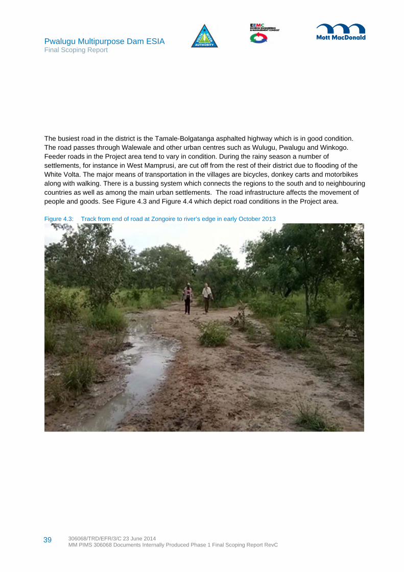
Pwalugu Multipurpose Dam ESIA Final Scoping Report
306068/TRD/EFR/3/C 23 June 2014 MM PIMS 306068 Documents Internally Produced Phase 1 Final Scoping Report RevC
39
The busiest road in the district is the Tamale-Bolgatanga asphalted highway which is in good condition. The road passes through Walewale and other urban centres such as Wulugu, Pwalugu and Winkogo. Feeder roads in the Project area tend to vary in condition. During the rainy season a number of settlements, for instance in West Mamprusi, are cut off from the rest of their district due to flooding of the White Volta. The major means of transportation in the villages are bicycles, donkey carts and motorbikes along with walking. There is a bussing system which connects the regions to the south and to neighbouring countries as well as among the main urban settlements. The road infrastructure affects the movement of people and goods. See Figure 4.3 and Figure 4.4 which depict road conditions in the Project area.
Figure 4.3: Track from end of road at Zongoire to river’s edge in early October 2013

Pwalugu Multipurpose Dam ESIA Final Scoping Report
306068/TRD/EFR/3/C 23 June 2014 MM PIMS 306068 Documents Internally Produced Phase 1 Final Scoping Report RevC
40
Figure 4.4: Wildlife corridor sign near Tilli on unpaved segment along the Bolgatanga and Bawku highway
The northern regions generally have unfavourable natural conditions with huge water deficits during the dry season and excess water in the rainy season. Potable water supply is limited to the urban areas leaving the greater majority of the people without good drinking water. The result of this is the numerous water-borne diseases like guinea worm infections. The main sources of water in the urban areas are mechanized boreholes (pipe borne) and in the rural areas, hand pumps and hand dug wells are used.
Some households have electricity but in the rural areas, many rely on kerosene lamp for lighting with a small number using gas lamps and solar energy. When fuel wood availability becomes a problem, people may use millet and maize stalks, gas and charcoal for cooking purposes. The high percentage of charcoal and fuel wood usage leads to some vegetation depletion.
The northern regions have a limited number of scattered tourist destinations, including for instance the Mysterious Golinga Springs, the Hippo Ponds at Zanwara, Terracotta Figurines at Yikpabongu the Buyuori Caves, the Togo Hills, Shrine for the Mole Dagbani leader in Pusiga and local architecture especially a
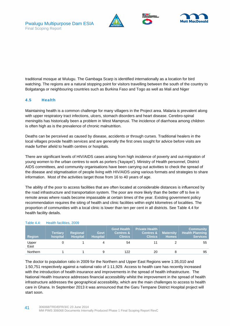
Pwalugu Multipurpose Dam ESIA Final Scoping Report
306068/TRD/EFR/3/C 23 June 2014 MM PIMS 306068 Documents Internally Produced Phase 1 Final Scoping Report RevC
41
traditional mosque at Wulugu. The Gambaga Scarp is identified internationally as a location for bird watching. The regions are a natural stopping point for visitors travelling between the south of the country to Bolgatanga or neighbouring countries such as Burkina Faso and Togo as well as Mali and Niger
4.5 Health
Maintaining health is a common challenge for many villagers in the Project area. Malaria is prevalent along with upper respiratory tract infections, ulcers, stomach disorders and heart disease. Cerebro-spinal meningitis has historically been a problem in West Mamprusi. The incidence of diarrhoea among children is often high as is the prevalence of chronic malnutrition.
Deaths can be perceived as caused by disease, accidents or through curses. Traditional healers in the local villages provide health services and are generally the first ones sought for advice before visits are made further afield to health centres or hospitals.
There are significant levels of HIV/AIDS cases arising from high incidence of poverty and out-migration of young women to the urban centres to work as porters (‘kayayei’). Ministry of Health personnel, District AIDS committees, and community organisations have been carrying out activities to check the spread of the disease and stigmatisation of people living with HIV/AIDS using various formats and strategies to share information. Most of the activities target those from 16 to 40 years of age.
The ability of the poor to access facilities that are often located at considerable distances is influenced by the road infrastructure and transportation system. The poor are more likely than the better off to live in remote areas where roads become impassable at certain times of the year. Existing government policy recommendation requires the siting of health and clinic facilities within eight kilometres of localities. The proportion of communities with a local clinic is lower than ten per cent in all districts. See Table 4.4 for health facility details.
Table 4.4: Health facilities, 2009
Region Tertiary hospital
Regional Hospital
Govt Hospital
Govt Health Centres &
Clinics
Private Health Centres &
Clinics Maternity
Homes
Community Health Planning
Services
Upper East
0 1 4 54 11 2 55
Northern 1 1 9 122 20 8 95
The doctor to population ratio in 2009 for the Northern and Upper East Regions were 1:35,010 and 1:50,751 respectively against a national ratio of 1:11,929. Access to health care has recently increased with the introduction of health insurance and improvements in the spread of health infrastructure. The National Health Insurance addresses financial accessibility whilst the improvement in the spread of health infrastructure addresses the geographical accessibility, which are the main challenges to access to health care in Ghana. In September 2013 it was announced that the Garu Tempane District Hospital project will start soon.

Pwalugu Multipurpose Dam ESIA Final Scoping Report
306068/TRD/EFR/3/C 23 June 2014 MM PIMS 306068 Documents Internally Produced Phase 1 Final Scoping Report RevC
42
4.6 Education
Education access (measured in terms of gross enrolment rate and net enrolment rate) and education performance (measured in terms of Senior Secondary School Certificate Examination (SSSCE) pass rates) have a regional dimension in Ghana. See Table 4.5.
Table 4.5: Regional education access and performance status
Region Gross Enrolment
Rate Net Enrolment Rate SSSCE Math pass SSSCE English pass
Upper East 22.0 6.2 15.5 11.6
Northern 19.5 6.6 30.1 17.1
National Level 30.2 10.6 31.6 34.8
Source: SRIMPR Division, Ministry of Education, Science and Sports, EMIS Project;
Districts have witnessed improvements in enrolment of school children but there is a gender dimension with male enrolment outnumbering female enrolment in all three levels of education. There is also a high level of out-of school children in the districts of the northern regions. The proportion of the population aged three years and over that has no schooling or attended only pre-school is 75.7% in the region compared to 47.7% in the country as a whole. When educational attainment is restricted to the population aged six years and over, the proportion in the region which has never attended school is 71.8%.The education sector in the regions struggle with challenges related to educational infrastructure, teacher accommodation and teacher training especially in rural communities. Existing policy recommends the siting of primary schools within five kilometres of localities. There are still a number of schools without standard structures and some classes are still held under trees.
4.7 Gender Relations
The Northern and Upper East regions are characterized by gender disparities in levels of education, illiteracy, access to productive resources, and involvement in decision making. Women suffer discrimination and nutritional restrictions. Females can be subjected to harmful socio-cultural practices Women have limited access to land, labour and credit, earn lower incomes than men, have a higher incidence of poverty, bear a disproportionate burden of care giving to children, the aged and people living With HIV/AIDS, and are more vulnerable to HIV/AIDS and numerous other health problems. More girls than boys drop out of schools. Women farmers are less organized. They carry out the bulk of the household subsistence activities such as planting, weeding, harvesting and selling, as well as such chores as cooking and fetching water.
4.8 Cultural Heritage
The Project area has a long history and the cultural heritage comprises natural resources embodied with spirits and cultural meaningfulness as well as buildings and festivals. In Bawku West, there is a waterfall in Zongoire and the Abaa Kugit Water Pond. In Binduri, the Yarigungu Crocodile Pond is a pond in a tributary of the White Volta that is well known to be inhabited by a large number of crocodiles. In West Mamprusi

Pwalugu Multipurpose Dam ESIA Final Scoping Report
306068/TRD/EFR/3/C 23 June 2014 MM PIMS 306068 Documents Internally Produced Phase 1 Final Scoping Report RevC
43
there are the Mysterious Golinga Springs, the Hippo Ponds at Zanwara, Terra Cotta Figurines at Yikpabongu the Buyuori Caves, and a traditional mosque at Wulugu. Further east, Nalerigu is the historical capital of Mamprusi kingdom with its ancient wall. The defence wall, which dates back to the 15th century, was built by a powerful Mamprusi Chief with mortar of mud blood and honey. Nearby is the grave of Naa Attabian, a great Mamprusi King. In Pusiga, the Chief ancestor of the Mole Dagbani group is located in a fenced area for tourists. Also at Pusiga, a bust of Dr Nkrumah marks the Naa Gbewaa Shrine. In Nabdam there is a Spiritual Renewal Centre at Kongo. Tourist attractions in Bunkpuru Yunyoo include a dwarf centaury, a natural stone Africa map, and bentitu scenic and historical sites. In East Mamprusi, there is also the Naa Jeringa Wall, the Gambaga Scarp and the Nakpanduri waterfall. Tongo Hills and the Tenzug Shrine (depicted in Figure 4.6) which is also a location for archaeological surveys is near to the dam site but will not be affected because it is on higher ground.
The regions celebrate myths and legends with festivals accompanied by traditional dance and music. An important traditional festival is the Damba, which has its legacy in Islamic belief and began as a celebration of the birthday of Prophet Mohammed.
In the reservoir area there will be sacred trees and rocks likely to be directly affected. For instance two very large sacred trees, locally called ‘Samparino’ with clear signs of worship are at the river banks in Nungo and Zongoiri (see Figure 4.5). Localised graves and burial grounds will likely be found and require appropriate ceremonies for relocation.
Figure 4.5: Shrine tree at Zongoiri with ribbon, feathers and animal tail

Pwalugu Multipurpose Dam ESIA Final Scoping Report
306068/TRD/EFR/3/C 23 June 2014 MM PIMS 306068 Documents Internally Produced Phase 1 Final Scoping Report RevC
44
Figure 4.6: Tongo Hills and Tengzug Shrines are in the Project area but will not be impacted
4.9 Livelihoods
Natural resources play a large role in the Project area as the basis for livelihoods, income generation and household food security. Most of the households rely on subsistence farming although there is some fishing. Figure 4.7 and Figure 4.8 depict these activities. FAO (2010) characterised the Upper East Region with West Mamprusi, East Mamprusi and Bunkpurugu-Yunyoo as a ‘NorthEast Millet/Sorghum/Rice/ Legumes/Small Ruminants/Guinea Fowl Livelihood Zone’. Livestock and cattle grazing is an important livelihood. Some households also fish but generally they do it alongside small scale farming. Shea nut collection is an important income source especially for women. Forests and the savannah are used for foraging and contribute to household food security. Rock breaking, sand digging and artisanal mining also occur in the Project area. Pito brewing is common. There is some craft development from natural resources. Along the roads, there are a range of kiosks, stalls, small enterprises, projects and institutions.

Pwalugu Multipurpose Dam ESIA Final Scoping Report
306068/TRD/EFR/3/C 23 June 2014 MM PIMS 306068 Documents Internally Produced Phase 1 Final Scoping Report RevC
45
Figure 4.7: Typical fisherman’s boat in the Project area
Figure 4.8: Some farmers have access to tractors

Pwalugu Multipurpose Dam ESIA Final Scoping Report
306068/TRD/EFR/3/C 23 June 2014 MM PIMS 306068 Documents Internally Produced Phase 1 Final Scoping Report RevC
46
4.10 Agriculture and Land
The Project zone geological formation is Middle Lower Voltaian comprised of sandstone, arkose, mudstone and shale. The soil is well suited for a wide range of crops although soil conservation is imperative as the land is erosion prone. The sandy loams are quite permeable with moderately good water retention capacity and are suitable for the cultivation of cereals and legumes. The clay loams which occur in the low slopes and valleys are used for the cultivation of rice, sorghum and dry season vegetable cultivation such as onions and tomatoes. In areas where fertility of soils is low, there is application of organic manure and chemical fertilizer to support cropping.
Cultivated agriculture takes place around the villages in the Project area, on the proposed irrigation area at Kulpawn and in scattered patches within the savanna. This cultivation takes place largely in the wet season between July and September following burning at the end of the dry season. An average farm size is between 0.5 – 2.4 hectares. Main crops are maize, beans and sorghum with the addition of ground nuts, okra, cotton, yams, soya bean, water melon, gourds and vegetables. A number of trees with practical uses are cultivated around settlements notably mango, neem and tamarind. In the wettest areas rice is grown and the proposed irrigation area largely consists of the abandoned rice fields of the old government farm.
Shea butter has long been exported to Europe for soap, candle making and the fillings for chocolate creams. It is now increasingly fashionable in cosmetics. The chief in Kulugu village confirmed that a 50kg bag of the nuts now sells for about 50 GHC. A firm in Tamale processes and packages the butter for soap and hand cream although nuts are also exported directly.
Grazing is another important agricultural use of the savanna. The villages graze herds of Ghana short horn cattle on the grassland which provides very lush grazing in the wet season. In the dry season cattle also come down from Burkina Faso and even Mali and stay for as long as six months a year. The intrusion of cattle herders into areas traditionally considered farmlands is a problem for both men and women. Other livestock normally reared in the Project area are pigs, cattle, sheep and goats. Poultry especially guinea fowls production is common.
Land tenure is a complex subject for the Project area where access to land is shaped by Ghana’s inheritance systems, tenure arrangements and land-use patterns. Most of the land in the reservoir affected areas is held under customary land tenure systems. Community land is generally not considered for sale
as it belongs to those living there, their ancestors and their progeny. Land ownership and transfer processes vary from community to community. Land is largely owned by families, and an individual is appointed by each family to administer any transfers. Input from the land owners and users, Tindanas, and the Divisional and Paramount Chiefs. Women tend to have limited access to and control over land which can restrict their agricultural production capacity. In the extended Project study area, there are on-going land and territorial disputes. The conflicts can have gender impacts as they can limit areas where women can go to collect water or to trade at certain markets.
Gold has been found in stockwork and quartz veins in the Project area. At Nangodi, a private company is undertaking gold mine explorations. Illegal mining takes place sometimes with complicity and sometimes
Pwalugu Multipurpose Dam ESIA Final Scoping Report
306068/TRD/EFR/3/C 23 June 2014 MM PIMS 306068 Documents Internally Produced Phase 1 Final Scoping Report RevC
47
with denouncements. As recent as April 2013, the Chief of Nangodi complained that illegal mining, known as "galamsey," which is undertaken by local residents destroys their farm lands which are the main source of livelihood, rendering them poor. Recent information from the Mineral Commission indicates that three mineral concessionaires could be potentially affected by the creation of the reservoir.
4.11 Ecology and Natural Resources
In addition to cultivated areas mostly near villages and the actual watercourses of the Volta system there are two key habitats within the study area savanna and riverine forest. Savanna is the most dominant vegetation type within the study area and probably comprises at least 80% of the entire land use in the region. It is directly impacted by the proposed irrigation area where it comprises most of the existing land use and it also comprises the area to be flooded within the most westerly end of the reservoir between the downstream and upstream dam sites. Riverine forest appears to be far scarcer habitat in northern Ghana and appears to occur within the remaining area of the proposed reservoir. The Gambaga Scarp Forest Reserve largely consists of this forest habitat and it is of varying quality (see section 48).
Savanna also covers most of northern Ghana within the one peak rainfall zone. The vegetation zone was traditionally known as guinea savanna woodland. The zone is typically composed of short branching trees scattered across continuous grassland dominated by Hyparrhenia sp, and Imperata cylindrica. Dominant trees are sheanut (Vitellaria paradoxa), Terminalia sp, Parkia biglobosa and Acacia nigrescens. North of the Volta the climate becomes steadily drier and here the baobab trees Adansonia digitata are increasingly abundant.
The acacia is an important fodder provider while the sheanut is an important commercial tree. It is mainly wild although sometimes planted and often inherited. Seedlings germinate from the fallen nuts and the corky bark is resistant to the regular fires. Seedlings are difficult to transplant due to their fire resistant tap root. The trees which are very long lived take at least 15 years to fruit while taking 30 years to mature. For this reason planting is less satisfactory than harvesting the wild trees. The yellow flowered shrub Cochleospermum tinctorium which is abundant beneath the trees is sometimes used for giving a yellow tint to the shea butter.
The savanna is an ‘arrested climax’ vegetation due to regular fires which create the open cover and a relatively small number of species all of which are relatively fire resistant. The true climax habitat in this region if undisturbed would probably be riverine forest comprising the Gambaga Forest Reserve woodland which occurs close to the river and up the steep scarp at Gambaga. This contains most of the species within the savanna but with the addition of other species, larger specimen trees and with the vegetation still fairly open but denser than the savanna. Notable tree species include silk cotton (Ceiba pentandra), mahogany (Khaya senegalensis), Zizyphus mauretiana, Anogeisus leiocarpus, Celtis integrifolia, Gardenia erubescens, Strychnos cocculoides and Brachystegia sp. Ground flora includes Amorphophallus abyssinicus and Tinnea barteri.
Relics of the climatic vegetation in the guinea savanna zone are found in the sacred or fetish groves attached to many villages in the region which are partially protected from man-made disturbance for
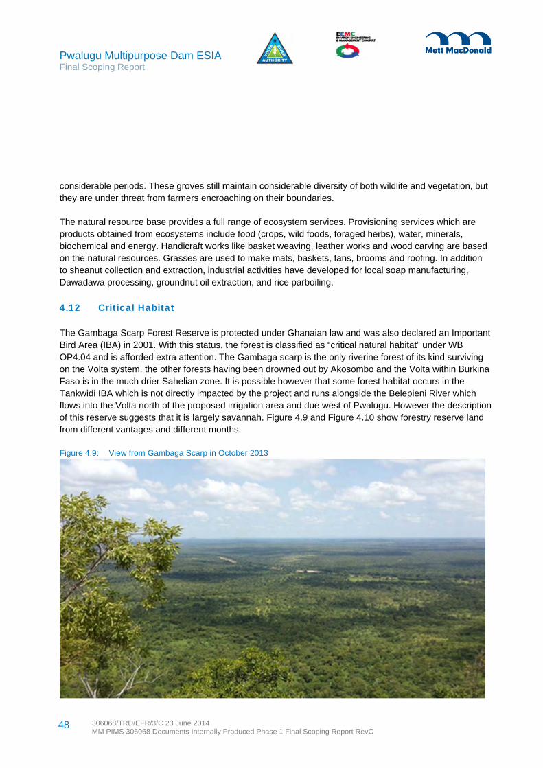
Pwalugu Multipurpose Dam ESIA Final Scoping Report
306068/TRD/EFR/3/C 23 June 2014 MM PIMS 306068 Documents Internally Produced Phase 1 Final Scoping Report RevC
48
considerable periods. These groves still maintain considerable diversity of both wildlife and vegetation, but they are under threat from farmers encroaching on their boundaries.
The natural resource base provides a full range of ecosystem services. Provisioning services which are products obtained from ecosystems include food (crops, wild foods, foraged herbs), water, minerals, biochemical and energy. Handicraft works like basket weaving, leather works and wood carving are based on the natural resources. Grasses are used to make mats, baskets, fans, brooms and roofing. In addition to sheanut collection and extraction, industrial activities have developed for local soap manufacturing, Dawadawa processing, groundnut oil extraction, and rice parboiling.
4.12 Critical Habitat
The Gambaga Scarp Forest Reserve is protected under Ghanaian law and was also declared an Important Bird Area (IBA) in 2001. With this status, the forest is classified as “critical natural habitat” under WB OP4.04 and is afforded extra attention. The Gambaga scarp is the only riverine forest of its kind surviving on the Volta system, the other forests having been drowned out by Akosombo and the Volta within Burkina Faso is in the much drier Sahelian zone. It is possible however that some forest habitat occurs in the Tankwidi IBA which is not directly impacted by the project and runs alongside the Belepieni River which flows into the Volta north of the proposed irrigation area and due west of Pwalugu. However the description of this reserve suggests that it is largely savannah. Figure 4.9 and Figure 4.10 show forestry reserve land from different vantages and different months.
Figure 4.9: View from Gambaga Scarp in October 2013

Pwalugu Multipurpose Dam ESIA Final Scoping Report
306068/TRD/EFR/3/C 23 June 2014 MM PIMS 306068 Documents Internally Produced Phase 1 Final Scoping Report RevC
49
Figure 4.10: View from 172m contour near river back to Scarp in January 2014
The nine bird species cited in the designation for the Gambaga scarp IBA are in the IUCN category of ‘least concern’ and none of them are likely to be restricted to the site. One of the more spectacular species on the list, the violet turaco was observed on the proposed irrigation site during a scoping visit.
The central section of the reserve along the Red Volta is known as an important wildlife migration corridor between Burkina Faso (Nazinga Reserve) and the Gambaga area and Northern Togo. Buffalo are known and elephants are regular but in small numbers. Some were killed at Tilli in 1972 and a few were present in the study area in 2011. It is said that they are less regular nowadays due to development of habitat in Burkina around the Ziga and Bagré reservoirs. Discussion with villagers has established that other resident animals include warthog, crocodile, green monkey, common duiker and bushbuck. Birds observed include red headed lovebird and Viellot’s barbet.
Scoping visits identified that there is substantial riverine forest surviving on the right bank of the Volta at proposed downstream dam site and south of Zongoiri between the Red and White Voltas. But in the vicinity of Nungo the forest has been largely reduced to savanna. Initial observation from the Gambaga scarp suggests that some of the richest and most botanically diverse forest is on the scarp and so this would be a very important area excluded from the reservoir. Aerial photographs from Google Earth also

Pwalugu Multipurpose Dam ESIA Final Scoping Report
306068/TRD/EFR/3/C 23 June 2014 MM PIMS 306068 Documents Internally Produced Phase 1 Final Scoping Report RevC
50
suggest that some of the densest forest occurs within the footprint of the proposed reservoir between the Red Volta and the White Volta.
4.13 Water Resources and Flooding
The White Volta River (incorporating the Red Volta) provides substantial water resources to the project area and areas adjacent to the river downstream as far as Lake Volta. It also makes a significant contribution to the basin as a whole, including for power generation at Akosombo and Kpong. The river shows a clear seasonal pattern, with peak flows occurring in September.
Flows in the river in the project area broadly reflected natural conditions up to about 1990, but since then have been influenced by Bagré dam which is on the White Volta in Burkina Faso, a short distance upstream of the border with Ghana. Bagré dam was designed primarily to supply irrigation water, but to date has been operated substantially for power generation. Stored water is released on a generally steady basis during the dry season, with increased amounts during the wet season. Substantial flood flows only occur in years when Bagré reservoir reaches its full capacity. The change in average flows due to Bagré is illustrated in Figure 4.11. In current conditions there is some flow throughout the year, whereas previously the river could dry up completely in the dry season. In the period up to 1990 the monthly average flow was less than 10 m3/s in 44% of months (average more than 5 months per year), whereas since 1991 the comparable figure is 1%.
Figure 4.11: Average river flow at Pwalugu
Source: Raw data provided through Feasibility Consultant
0
100
200
300
400
500
600
700
Mar Apr May Jun Jul Aug Sep Oct Nov Dec Jan Feb
Ave
rag
e F
low
(m
3/s
)
to 1990
from 1991

Pwalugu Multipurpose Dam ESIA Final Scoping Report
306068/TRD/EFR/3/C 23 June 2014 MM PIMS 306068 Documents Internally Produced Phase 1 Final Scoping Report RevC
51
Within Ghana there is significant concern about the risk of floods caused by releases from Bagré. Since Bagré has a gated spillway the operators do have a degree of control on downstream flows, and it is in theory possible that poor operation could lead to the flood peak downstream of the dam being larger than the peak inflow to the reservoir. However, this is an unlikely scenario, and reservoir operation is much more likely to reduce flood peaks downstream, perhaps by a substantial margin. Based on available dataand interviews with local people it is clear that the magnitude and frequency of flood events has reduced since Bagré came into use.
Rainfall also contributes to available water resources. The average rainfall pattern at Bolgatanga is illustrated in Figure 4.12; the wet season peak occurs in August, slightly earlier than peak river flows. For ease of comparison this uses the same water year as the flow graph, starting in March. Figure 4.13 and Figure 4.14 illustrate differences in Red Volta River levels at different times of the year.
Figure 4.12: Average rainfall at Bolgatanga
Source: Raw data from Ghana Met Department
0
50
100
150
200
250
300
Mar Apr May Jun Jul Aug Sep Oct Nov Dec Jan Feb
Ave
rag
e M
on
thly
Rai
nfa
ll (m
m)

Pwalugu Multipurpose Dam ESIA Final Scoping Report
306068/TRD/EFR/3/C 23 June 2014 MM PIMS 306068 Documents Internally Produced Phase 1 Final Scoping Report RevC
52
Figure 4.13: View looking north at the Red Volta from the bridge along the Bolgatange Bawku highway in Oct 2013
Figure 4.14: View looking south at the Red Volta from the bridge along the same highway in January 2014

Pwalugu Multipurpose Dam ESIA Final Scoping Report
306068/TRD/EFR/3/C 23 June 2014 MM PIMS 306068 Documents Internally Produced Phase 1 Final Scoping Report RevC
53
4.14 Fish and Fisheries
The Volta River system is rich in fish fauna. Roberts (1967) recorded 112 fish species and Denyoh, (1969) reported 108 species. Dankwa et al. (1999) recorded 121 species of both commercial and non-commercial value. Some species are well adapted to lake conditions; others show preference to the riverine areas due to their food and feeding habits. During the Volta lake formation in 1964, little riverine forest was cleared. This led to rapid deoxygenation and the change from riverine to a lacustrine condition led to the death of a variety of fishes, especially Chrysichthys spp. which are very sensitive to oxygen depletion. (Petr,1968).
The northern parts of the lake, namely the White Volta arm, kept its more riverine character and during the flood season serves as an important migratory, breeding and feeding place for many commercial species of fish such as Hydrocynus, Labeo, Mormyrids, Schilbeids, Brycinus, Alestes, Citharinus and Odaxothrissa. The ecological changes from the lake brought about substantial changes in the fish community structure. Riverine species especially, Mormyridae almost completely disappeared. During floods, turbid waters induce fish to spawn and potamodromous fish species Alestes, Citharanus, Distichodus and Labeo move up into inflowing rivers in the wet season. Tilapias avoid such turbid currents and are very rare in catches during floods.
The basic trend, during lake formation, was towards the development of a community of fish species which had vegetarian food habits such as the Tilapias (mostly, Sarotherodon galilaeus, Oreochromis niloticus and Tilapia zillii). This led to their explosion as well as other fish which were able to adapt. Tilapias became the most dominate species soon after the lake stabilization. Less common were Citharinus, Labeo, Distichodus and some Synodontis species. The predominance of insectivorous feeders e.g. Alestes, Brycinus, Schilbe, Chrysichthys and Synodontis decreased (Petr, 1969).
Thirty-six years after the formation of the Volta Lake, the commercial fish landings were still dominated by tilapiine species in the lacustrine south and throughout. Dankwa et. al. 2008 (unpublished) reported that Chrysichthys has become the dominant fish species in the lake.
From the Volta Lake experience, fish resources can attract a lot of fishers which puts pressure on the resources. As well illegal fishing gears and methods which catch only gravid fish (e.g., bamboo pipes) or destroy fish eggs, nests and larvae such as beach seine negatively affect resources. There can be conflicts between fishers who consider their gear as authorized or legal and those using destructive gear. The main types of legal fishing gears are gillnets, line fishing, traps castnets, spears and atigya (brushparks). Gears introduced in recent years which are mostly unauthorized include: drive-in gear (locally known as Wangara), bamboo pipes (specifically for gravid Chrysichthys spp.), combined gill nets and traps (nifa nifa) and some active gears, such as beach seines (adranyi), purse seines (winch nets) and other forms of encircling gears. Poisons are also used.
4.15 Climate Resilience
Ghana’s climate is tropical and strongly influenced by the West African monsoon. In northern Ghana, the wet season occurs between May and November and the prevailing wind is south-westerly. The dry season

Pwalugu Multipurpose Dam ESIA Final Scoping Report
306068/TRD/EFR/3/C 23 June 2014 MM PIMS 306068 Documents Internally Produced Phase 1 Final Scoping Report RevC
54
occurs between December and March, when the harmattan9 wind blows north-westerly. The Volta Basin’s climate is characterised by the rain-bearing south-westerly tropical maritime air mass and the dry, north-easterly tropical continental air mass. Annual mean temperatures are between 27°C and 30°C, although maximum day and minimum night temperatures can reach 44°C and 15°C respectively. Ghana is exposed to floods, specifically in the north and faces the associated risks of landslides. The 2007 floods in Ghana affected more than 300,000 people, resulting in loss of lives and impacts to infrastructure, livelihoods and food security. The northern region also experiences long spells of drought.
Since 1960 a number of changes in the climate have been observed, including10:
Mean annual temperature has increased by 1-3°C at an average rate of 0.21°C per decade (2010). The rate of increase has been higher in the northern regions of the country than in the south.
The average number of ‘hot’ days per year increased by 48 (2003). An overall decreasing trend in annual rainfall was observed (2006), although annual rainfall in Ghana is
highly variable and long-term trends are difficult to identify. In the Volta Basin, increased temperatures and shorter rainy seasons have been observed.
In the future, Ghana is projected to become hotter and wetter during the wet season and drier during the dry season11:
Mean annual temperature is projected to increase by 1-3.0°C from baseline (1961-1990) by the 2060s and 1.5-5.2°C by the 2090s, with higher rates of warming projected in the northern regions.
Total annual rainfall is projected to decline by 1.1%, and 2.5% in 2020 and 2080, respectively. By the middle of the twenty-first century, the Volta Basin’s annual rainfall, mean annual runoff and mean groundwater recharge is expected to decline. For instance, groundwater recharge is expected to reduce between 5% and 22% by 2020 and between 30% and 40% by 2050.
Although annual average rainfall will decrease, the magnitude of heavy rainfall could increase influencing flood risk.
Water is vital to Ghana’s socio-economic growth. Changes in the variability of precipitation, the frequency and severity of droughts, floods, and heat waves will greatly affect water resources and sectors that rely on it, such as agriculture and energy production12. Climate change is also expected to affect irrigation water demand.
9 The harmattan winds are hot, dry winds from the Sahara, that usually carry large amounts of dust which it transports hundreds of
kilometres over the Atlantic Ocean. The harmattan dust has a great impact on the agriculture, micro-climate, health, visibility and the ecosystem of a large area of West Africa, and even on the global environment.
10 World Bank (2011). Vulnerability, Risk Reduction, and Adaptation to Climate Change: Ghana. Climate Risk and Adaptation Country Profile.
11 Ibid
12 About two-thirds of electricity generation in Ghana is from hydropower

Pwalugu Multipurpose Dam ESIA Final Scoping Report
306068/TRD/EFR/3/C 23 June 2014 MM PIMS 306068 Documents Internally Produced Phase 1 Final Scoping Report RevC
55
5.1 Introduction
This section presents the approach which has been adopted in scoping the ESIA and how each of the environmental and social aspects will be addressed in the form of specialist studies. In accordance with national and international requirements for environmental and social appraisal, the setting of the scope of works for the ESIA includes consideration of the:
Environmental, social, labour, health, safety, and security risks and impacts Primary Project and related facilities along with associated facilities that are not directly part of the
Project but whose viability and existence would depend on the project. This includes reviewing potential cumulative and transboundary impacts as well as unplanned but predictable developments caused by the Project that may occur later or at a different location
Risks and impacts that may arise for each key stage of the project cycle, including pre-construction, construction, operations and decommissioning or closure
Role and capacity of the relevant parties including government, contractors and suppliers to the extent that they may pose a risk to the Project commensurate with reasonable control and influence that VRA may have
Potential third party impacts including supply chain considerations.
The ESIA will identify negative and positive, direct and indirect, cumulative and transboundary impacts of
the Project related to the bio-physical and the socio-economic environment.
5.2 Project Study Area
There is a restricted study area and an extended study area. The restricted study area encompasses the dam, related infrastructure, the potential reservoir area and adjacent lands, sites for associated infrastructure and their corridors as well as the potential irrigation area. Within the restricted study area, the ESIA will refer to the:
Project Affected Area (PAA): as the area notified by the Project Authority or where land is acquired for construction of any component of the Project where construction and ground works are undertaken13, including resettlement sites.
Project Area of Influence (AoI): as the PAA plus the surrounding vicinity where the Project can affect people’s wellbeing even if there is no direct project activity taking place. The distances will depend on the aspect being assessed but generally for the reservoir it will be a 10km radius and for other project activity sites (such as transmission lines, roads, borrow pits, irrigation area, acquired resettlement areas), it will be a 500m radius. These typical distances are selected because generally it is unlikely for receptors to experience significant impacts beyond them.
The currently known project affected area is summarised in Table 5.1.
13 This footprint is expected to include all the components listed in the Project description in chapter 2.
5 Scoping of ESIA

Pwalugu Multipurpose Dam ESIA Final Scoping Report
306068/TRD/EFR/3/C 23 June 2014 MM PIMS 306068 Documents Internally Produced Phase 1 Final Scoping Report RevC
56
Table 5.1: Project affected area
Villages District Region
Nungo, Kulunga, Kulinga, Village P8, scattered homesteads east of White Volta
Talensi Upper East
Kparikpiri, Suhuluya, Gubiu West Mamprusi Northern
The AoI will affect sections of the eleven districts in the Upper East and Northern Regions described in Chapter 414, within the main road network linking Walewale, Bolgatanga, Bawku, and Nakpanduri. See Figure 5.1.
The extended study area encompasses the White Volta River basin upstream of Lake Volta. It includes:
The White Volta River upstream of the Pwalugu site in Ghana and into Burkina Faso15 up to the Bagré dam (to understand the characteristics and infrastructure of the Bagré dam on water flow, sediment load and water quality in the project area) and any effects on Togo
The White Volta River downstream of Pwalugu and upstream of Lake Volta, with associated flood plains and surrounding uplands
The floodplains of the White Volta around Nawuni as well as the Nabogo, and Nasia valleys that have flooded recurrently in recent years.
5.3 Project and Assessment Timeframe
The Feasibility Consultant has estimated the construction duration to be four years including access and mobilisation. Dam construction is likely to only be two years but the construction of the powerhouse which requires the hydro-mechanical equipment to be studied, manufactured, transported, erected and commissioned will take longer. Commissioning of the dam and the first filling would occur on the fifth year after the beginning of the works. The life of the scheme is estimated at 50 years.
The ESIA assignment for scoping, detailed assessment and production of management plans is intended to be 20 months in duration, ending around mid- 2015. The assessments will take into account the construction, operation and a decommissioning period as well as peak activities when impacts could be most significant during those periods. The ESIA is based on the general assumption that baseline conditions are unlikely to change significantly between its completion and the beginning of construction.
14 They are Talensi, Nabdam, Bawku West, Binduri, Bawku Municipality, Pusiga and Garu-Tempane in the Upper East Region and
Bunkpurugu-Yunyoo, East Mamprusi, West Mamprusi and Mamprugu Moaduri in the Northern Region.
15 Based on LIDAR survey data, it is not anticipated that the reservoir will reach into Burkina Faso but it will go up close to the border.

57 306068/TRD/EFR/3/C 23 June 2014 MM PIMS 306068 Documents Internally Produced Phase 1 Final Scoping Report RevC
Pwalugu Multipurpose Dam ESIA Final Scoping Report
Figure 5.1: Area of Influence for the dam and associated facilities
Pwalugu Multipurpose Dam ESIA Final Scoping Report
306068/TRD/EFR/3/C 23 June 2014 MM PIMS 306068 Documents Internally Produced Phase 1 Final Scoping Report RevC
58
5.4 Potential Impacts Associated with the Project
The environmental and social aspects potentially associated with the Project and which are commonly associated with similar large dam projects are presented in Table 5-2.
Table 5-2: ESIA specialist assessments
Proposed ESIA Assessment chapters
Biodiversity Air Quality
Water Resources and Water Quality Greenhouse Gas Emissions
Flooding and Climate Change Resilience Land Quality and Waste Management
Socio-economics and Community Landscape and Visual
Health Traffic and Transport
Cultural Heritage and Archaeology Cumulative Impacts
Noise International Waterways and Transboundary Impacts
In the context of the PMD Project, these issues are elaborated on throughout the next sections.
5.5 Potential Primary Issues and Possible Mitigation
Initial descriptions of the key potential beneficial and adverse impacts that are likely to arise as a result of the Project are discussed in the following sections.
5.5.1 Biodiversity
Within the ESIA a detailed assessment of potential impacts on flora and fauna will be performed, impact mitigation and damage compensation measures will be suggested. Potential biodiversity impacts related to the Project are expected to be as follows:
Habitat loss arising from direct inundation and also from induced development Transformation from river to a reservoir (from a lotic system into a lentic system) Changes in the hydrological conditions of the river systems and consequent effects on river habitats
and communities The dam acting as a barrier to fish migration Increase in reptiles Changes in water quality and sediment releases Noise disturbance
A problem in relation to the potential biodiversity impact of reservoirs is the regular drawdown which at low water creates a permanent band of mud. Hence the area where vegetation and water meet, which is the key element in any aquatic system where invertebrates form the basis of the food chain, is lost to a sterile band of mud.

Pwalugu Multipurpose Dam ESIA Final Scoping Report
306068/TRD/EFR/3/C 23 June 2014 MM PIMS 306068 Documents Internally Produced Phase 1 Final Scoping Report RevC
59
There will be loss of some savanna within the footprint of the reservoir notably in the deep basin between the downstream and upstream dam sites. The project will affect forest reserve in different areas including Gambaga Scarp East, Gambaga Scarp West, Morago East, Morago West, Red Volta East, and Red Volta West. See Figure 2.2 in the project description chapter which depicts the forest reserve area. This is likely to be the most significant ecological impact and possibly the most significant environmental impact in the Project. However savanna is the dominant habitat throughout the north of Ghana so the main potential impact will be related to ecosystem services benefit, in particular the loss of sheanut trees.
Throughout the reservoir area the Volta River will be replaced by a lake. This means that a particular fisheries habitat will be replaced by a different one but especially in the first decade after inundation there could be a large increase in fish biomass. The introduction of cages for aquaculture should be programmed and the need for fish passes requires additional details and attention. More fish may bring in birds such as osprey and heron which predate upon them. The other major species associated with the river is the Nile crocodile and crocodiles thrive in reservoirs.
Potential impacts on downstream flows will need to be carefully assessed. Steps will need to be taken to protect the periodically flooded lagoons observed north of the river near Pwalugu bridge and minimum flows during the dry season. The proposed irrigation area is either abandoned rice fields or savannah and so replacement of these by more intensive agriculture in the dry season is unlikely to be a problem in biodiversity terms.
The inundation of the Gambaga East Forest Reserve and presence of the Gambaga Important Bird Area (IBA) means that critical natural habitat is affected according to the WB OP 4.04. Scoping suggests that around 17% of the total area of the 1360km2 designated forest reserve/IBA could potentially be inundated. Even with proposed mitigations it is likely the loss of such a large proportion of forest would be considered major adverse in biodiversity terms.
The presence of critical natural habitat within the study area is not an automatic environmental fatal flaw for lenders like the World Bank but there must be details in the assessment to identify whether there is significant conversion or degradation of critical natural habitats. More surveys are required to determine the quality of the forest which is classified as critical natural habitat and to know whether the conversion to inundation is likely to be significant degradation.
During detailed assessment there will be nine days of Rapid Biodiversity Assessment (RBA) for gathering data on birds, mammals, fish, plants and macro-invertebrates at areas considered ‘hotspots’ or representative. See section 6.12 for details on specific methodologies being used during the RBA. The RBA will be supported by follow up visits for the identification of seasonally constrained species and habitats or where more data is required for noteworthy features. As well market surveys which review ecosystem services will contribute to the assessment.
The identification of critical natural habitat puts particular emphasis on the need for mitigations and offsetting. It is impossible to automatically replace forest which has been flooded out by a reservoir. However a strategy will need to be developed to enhance and further protect the surviving areas of the forest reserve and offset the losses. It may be possible to extend through purchase or negotiation the

Pwalugu Multipurpose Dam ESIA Final Scoping Report
306068/TRD/EFR/3/C 23 June 2014 MM PIMS 306068 Documents Internally Produced Phase 1 Final Scoping Report RevC
60
boundaries of the reserve in areas where there is relatively little pressure from existing settlements notably between Zongoiri and Binaba and the Red Volta and along the west side of the White Volta between the river and Binaba. Any offsetting strategy will need to be created in liaison with stakeholders, particularly the Forestry Commission, to provide more resources to the surviving forest area in terms of combatting encroachment, charcoal burning, poaching, fires and other pressures.
5.5.2 Water Resources and Water Quality
The construction of the reservoir will have potential significant impacts on the flow pattern in the river, and hence on water resources in the study area and further downstream. The flow releases will need to be managed to protect key aspects of the river flow pattern. Many of the potential water impacts are likely to be broadly beneficial, as the river flow is regulated so that it can be used more effectively and to the benefit of a larger number of people. In addition, the creation of the reservoir will provide potential local water resource over a wider area than the existing rivers.
The reservoir will be affected by the Bagré Dam operating regime upstream and clear communication channels between the two projects will be required. The Pwalugu reservoir will have some potential impact on water resources in Lake Volta, through reduced average flows due to evaporation and increased water consumption, and temporal changes due to reservoir operation. However, in the context of the overall flow into Lake Volta such changes will not be significant.
Reservoirs can lead to water quality problems which might be related to factors such as algae growth and stratification. There will be reduced sediment load in the river downstream of the dam, which might have adverse and/or beneficial impacts. The management plan will need to consider such issues and develop procedures to minimise or avoid risks. There is also potential for water quality problems during the construction period, for example from fuel spillage or sediment disturbed during earth-moving works.
Consideration of environmental flows at relevant locations will be needed. There is no agreed definition of environmental flows that is consistently used amongst the scientific community. For the purpose of this study, environmental flows describe the quantity, timing and quality of water flows required to sustain freshwater and estuarine ecosystems and the human livelihoods and well-being that depend upon the ecosystems. It is recognised that setting arbitrary minimum flows is inadequate as the structure and function of riverine ecosystem and adaptation of biota are determined by patterns of temporal variation in flows. Therefore, setting environmental flows is a key element of integrated water resources management.
To help with the more detailed assessment and identification of mitigation measures, there will be river quality sampling at regular intervals, water sampling of wells and inclusion of water use questions in the household survey and some of the focus groups. See the detailed assessment methodology for hydrology in section 6.13.

Pwalugu Multipurpose Dam ESIA Final Scoping Report
306068/TRD/EFR/3/C 23 June 2014 MM PIMS 306068 Documents Internally Produced Phase 1 Final Scoping Report RevC
61
5.5.3 Flooding and Climate Resilience
Dam schemes, such as the proposed Project, will be vulnerable to changes in river hydrology and evapotranspiration16 affecting operational efficiency; and the risk of structural damage from extreme events17. Dam schemes also have the potential to affect the wider environment’s vulnerability to climate impacts, and capacity to adapt to changes in climate. For example, any reductions in water quality resulting from the scheme may exacerbate associated potential impacts from climate change. Conversely, dams if properly managed can also provide a degree of climate resilience by reducing downstream vulnerability to flooding through controlled release of flows; and the storage of water in a reservoir during higher flow periods can provide a buffer against droughts.
Climate change is expected to have significant implications for both existing and proposed new infrastructure assets, particularly those with long design lifetimes. This makes such assets sensitive not only to the existing climate at the time of their construction, but also to climate variations over the decades of their use. Decisions made now will shape the resilience of design and development of infrastructure systems. Action is therefore needed to ensure that new infrastructure is efficient, robust and resilient to climate conditions in the long term, through considered planning and design.
The Upper East and Northern Regions have a history of flood and drought. If not adequately investigated and understood there is a risk that the construction activities and planned engineering could contribute to vulnerability to these natural hazards. In addition to floods and drought, construction can destabilise river banks and contribute to erosion.
A main objective of the Project is to help flood management. The assessment will consider how flood management can be best achieved, and will plan Project activities with mitigation measures to minimise the risks. However, it should be noted that requirements for flood management can conflict with other uses of a multipurpose dam – the reservoir level needs to be kept low to maximise flood management downstream, while it needs to be high to maximise power production and to provide security of irrigation supplies.
The type of spillway proposed for Pwalugu dam is not yet known. If it is a gated spillway then there would (as at Bagré) be a theoretical risk that operators could inadvertently cause downstream peak flow to be higher than upstream peak flow, but this can be avoided through sensible management. Regardless of the type of spillway, it is likely that the size of the reservoir will lead to substantial attenuation of flood peaks. This can be reviewed by routing typical flow hydrographs through the reservoir.
Although reservoirs generally reduce flood risk, they do introduce the possibility of a catastrophic flood due to dam failure, and although this is not entirely a natural hazard it is convenient to consider it in this section alongside more “normal” flood risks. There are a number of potential causes of dam failure, including natural hazards such as earthquakes, inadequate design/construction, poor operation (of a gated spillway), 16 A projected reduction in rainfall could reduce basin-wide actual evapotranspiration by as much as15%. Alternatively, increasing
temperatures may actually lead to increased evapotranspiration.
17 Such as temperature extremes (thermal expansion, buckling and stresses) and flooding

Pwalugu Multipurpose Dam ESIA Final Scoping Report
306068/TRD/EFR/3/C 23 June 2014 MM PIMS 306068 Documents Internally Produced Phase 1 Final Scoping Report RevC
62
and overtopping due to a flood of greater magnitude than considered during the design. In the case of Pwalugu, dam failure could be caused by prior failure of Bagré. The Feasibility Consultant will be undertaking a simplified dam break analysis. The ESIA will recommend emergency preparedness measures, including community notification procedures, if such are warranted. See section 6.14 for the flooding and climate resilience methodology to be used during the detailed ESIA.
5.5.4 Socio-economics and Community
A social impact assessment (SIA will be undertaken) to determine the effects of the Project on people, households, communities and social network. Some of the key potential impacts are identified below.
The Project will create benefits for society in the form of electricity, irrigation potential and flood management over a fairly large geographical area which needs further definition. To get the full benefit of potential positive impacts such as job creation and induced economic development, a local content strategy focussing on skills development and procurement processes will need to be developed.
Labour and working conditions will be regulated in compliance with Ghanaian labour laws, the ILO requirements and international safeguard policies. Compliance with occupational health and safety standards in the construction phase will be the responsibility of all Project employers. Labour rights will be protected and transparent processes for the recruitment of staff will be identified.
A main adverse impact will be involuntary resettlement. The inundation of the reservoir will require the relocation of households. As well, people are likely to be impacted by loss of access to cultivable land. Once prefeasibility design decisions have been made regarding the dam axis location and dam height, there will be more certainty regarding the households and villages that would need to be relocated.
As outlined in Table 2.6 in the dam site comparisons, LIDAR survey analysis suggests that the preferred option will require the relocation of about 284 households. See Figure 5.2 for the homesteads identified for both dam site options (upstream at 177m and downstream at 172m). The list of potentially affected communities is presented in section 4.2.3. More people will be resettlement affected because of economic displacement, the loss of land or restriction of access to natural resources. Economic displacement will result from the reservoir as well as other Project components such as the transmission line and access roads.
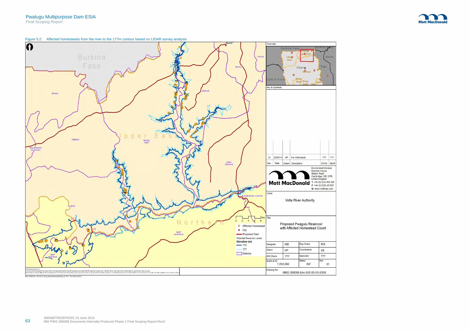
63 306068/TRD/EFR/3/C 23 June 2014 MM PIMS 306068 Documents Internally Produced Phase 1 Final Scoping Report RevC
Pwalugu Multipurpose Dam ESIA Final Scoping Report
Figure 5.2: Affected homesteads from the river to the 177m contour based on LIDAR survey analysis

Pwalugu Multipurpose Dam ESIA Final Scoping Report
306068/TRD/EFR/3/C 23 June 2014 MM PIMS 306068 Documents Internally Produced Phase 1 Final Scoping Report RevC
64
Understanding the complex socio-economic, biophysical and cultural issues related to land tenure and land acquisition will be essential. Resettlement planning is part of the ESIA study. The Resettlement Action Plan (RAP) will be developed to meet the requirements of WB OP 4.12. This will entail undertaking asset census surveys with all project affected people and socio-economic surveys with some of the households. The RAP will include an entitlement matrix, describe valuation and compensation for losses and propose livelihood restoration measures. Consultation with those affected will be an essential part of the RAP process. To support the production of the RAP, a land market review and soil sample of possible relocation sites will be undertaken. Resettlement and livelihood restoration activities will be formulated as sustainable development activities that at least restore but aim to improve the standards of living and long term well-being of the affected persons. See Appendix 6.9 for the RAP terms of reference.
Nuisance effects from construction, including traffic movements, noise, dust and exhaust emissions are not considered likely to comprise a long term impact but will be assessed. Potential impacts will be identified and reported within the relevant subject specific chapters (i.e. air quality, noise, traffic and transport) with relevant mitigation measures proposed, in particular procedures for blasting, safe driving at appropriate speeds, and dust management.
Construction operations may represent additional health and safety risks to the local community from the influx of workers and followers. Typically, for large scale construction projects, there is potential for disease and or community tensions to be introduced by any non-local workforce. Construction will require a large workforce for several years. The skills development programme will aim to support a majority of the workforce recruited from the local population, which would mitigate to some extent the risk of the spread of communicable diseases and minimise the likelihood of worker and community conflict. Nonetheless other measures will be required to prevent outbreaks of disease, support targets of zero time lost accidents, and contribute to amicable community relations. At a minimum, a worker’s code of conduct, health protection and awareness and occupational health and safety training programmes will be needed. Any workers’ camps will need to have a plan to address structural and management issues, including in regards to worker behaviour.
To support community health and safety, an emergency response plan will be required. Procedures will also be required to safeguard property and materials and to guide security personnel recruitment, management and activities.
Assessment of the needs of vulnerable people, especially those affected by resettlement, will be required. Scoping identified that there are families living with extreme poverty. Other vulnerable groups likely to have special needs are people with disabilities or long term illnesses, widows and female-headed households, and orphans. There is a deaf school at Winkogo where discussions regarding blasting should be planned.
To address these issues, the SIA will be undertaken using various survey instruments. Village life sampling will comprise focus group discussions and village meeting using participatory rural appraisal techniques (sorting ranking, visualising, seasonal calendars). Key community infrastructure and services will be mapped. A socio-economic baseline survey questionnaire will be administered. Village market surveys will be used to gather data on species, product availability and produce values. For details on the SIA methodology, see section 6.15.
Pwalugu Multipurpose Dam ESIA Final Scoping Report
306068/TRD/EFR/3/C 23 June 2014 MM PIMS 306068 Documents Internally Produced Phase 1 Final Scoping Report RevC
65
5.5.5 Health
A permanent change in water flows in the river and the creation of the reservoir has the potential to have a significant impact on disease incidences in the local region, specifically vector borne diseases. Ways of minimising the spread of diseases such as malaria, bilharzia, trypanosomiasis, guinea and intestinal worms, goiter and onchocerciasis will be need to be identified.
The loss of land and forest resources will result in the destruction of medicinal plants which could potentially affect the prevention and treatment of ailments at the local level. These ecological changes may also have a potential negative impact on the nutritional resources of the affected populations.
In-migration of workers and followers will affect public health temporarily and possibly over the long term. During construction, occupational health and safety risks (OHS) as well as community health will need to be considered. There are many ways to manage OHS risks for a project like Pwalugu. Similarly there are measures for protecting community health, safety and security.
Important life changes such as moving create stress and opportunities for potential exposure to health risks such as mental disorders, HIV/AIDS and other sexually transmitted infections. The ESIA and RAP will need to address this, especially for vulnerable groups who are more likely to suffer from pre-existing health problems than other community members.
Health survey data will be collected via the household surveys. As well, mapping of health infrastructure and services, along with sample interviews of health personnel are planned for the detailed ESIA phase. See section 6.16 for details.
5.5.6 Cultural heritage and archaeology
Potential impacts posed by the Project on cultural heritage assets are:
Partial or full demolition Inundation by flood waters Damage to a property or the integrity of its foundations Localised air quality impacts during construction which can lead to the deterioration of buildings and any
associated parks/gardens Noise and disturbance during construction which can lead to a loss of amenity Changes in the setting due to the presence of Project structures in proximity to the asset.
Archaeological impacts on large dams can be caused by unearthing and exposing remains to erosion or the elements; damage from inundation or during excavation as part of the construction process, and removal of remains. Another issue may be quarrying: blasting of rocks should not affect stones or other physical structures that comprise a shrine.
Scoping suggests that natural resources and burial grounds are cultural heritage assets that could be affected. Two sacred trees have been identified within the proposed inundation area. They are both very
Pwalugu Multipurpose Dam ESIA Final Scoping Report
306068/TRD/EFR/3/C 23 June 2014 MM PIMS 306068 Documents Internally Produced Phase 1 Final Scoping Report RevC
66
large specimens of Celtis integrifolia growing close to the right bank of the White Volta with evidence of offerings around them. It is assumed that they will not be felled but they will slowly die once they are regularly inundated. If graves are identified in the inundation zone, procedures for their culturally appropriate transfer will need to be identified.
Tangible and intangible culture will be addressed through the village life sampling and community infrastructure mapping during the detailed ESIA phase. Details of the cultural heritage assessment methodology can be reviewed in section 6.17.
5.5.7 Noise
Noise issues are most likely to arise during the construction period from activities such as construction of the Project infrastructure, truck movements and access roads. Noise effects for the most part will be localised and are likely to include traffic, explosions and blasting, drilling and excavation using heavy plant. Noise issues during the operational phase are not expected to be significant; however there may be some noise issues associated with the turbines, tailrace and discharge. This will be assessed within the ESIA.
The likely effects of noise will depend mainly on:
Distance from source to receiver Sound power level of the activity Duration of the works Operating times of the powerhouse Nature and extent of mitigation measures
Operational noise impacts will potentially be limited to turbines within powerhouse, most of which will be located below ground or within enclosed buildings. In addition there will be some maintenance work however this will be limited to a small number of transport movements. No survey or sampling is foreseen for noise during the detailed assessment. See section 6.18 for details of the noise methodology.
5.5.8 Air quality
The main source of emissions to the atmosphere during construction will include dust related to earthworks, traffic movements, loading/unloading of materials, stockpiling of spoil. Dust emissions may also be generated at inert material borrow pits and processing sites as well as during operation of concrete plant. In addition, air quality will be affected by exhaust emissions from vehicles and machinery as well as by welding gases. There are general conditions that are non-Project related sources of particulates (such as bush fires and the harmattan winds) that the air quality baseline will describe.
The source, location, duration and intensity of emissions (dust, exhaust fumes) generated by construction activities will be assessed in terms of their potential impact on sensitive receptors, including residential/commercial properties and ecology. Mitigation measures will be developed to minimise impacts and will include standard good practice techniques to minimise construction emissions.

Pwalugu Multipurpose Dam ESIA Final Scoping Report
306068/TRD/EFR/3/C 23 June 2014 MM PIMS 306068 Documents Internally Produced Phase 1 Final Scoping Report RevC
67
During the operational phase, potential impacts to air quality will be minimal and may occur as a result of routine maintenance and/or rehabilitation of Project related infrastructure. No survey or sampling is foreseen for air quality during the detailed assessment. See section 6.19 for the air quality methodology.
5.5.9 Greenhouse gas emissions
Reservoirs associated with hydropower projects are potential sources of GHG emissions. An interim technical note published by The World Bank in 2013 “Greenhouse Gas Emissions from Reservoirs Caused by Biochemical Processes” reviewed the available information on fluxes of GHG emissions and provides a framework for assessing these emissions. Based on the current information the technical note suggests that a qualitative assessment of potential emissions from the reservoir is undertaken as quantitative methods are not yet sufficiently robust. Therefore, a qualitative assessment will be undertaken to establish whether emissions from the reservoir could be significant. See section 6.20 for details.
The Project will also generate electricity and the potential for avoiding emission will be considered as part of the assessment against a counterfactual case.
5.5.10 Land quality and waste management
Potential impacts on land quality include:
Loss of agricultural soils due to construction of Project infrastructure and associated facilities Loss of mineral concessionaire land Contamination during construction works Localised contamination during maintenance activities
The risks during the construction phase are localised, can be clearly identified and adequately mitigated by good design and good construction practices. Risks during the operational phase can be mitigated by good environmental management and appropriate waste disposal.
Recent information obtained from the Mineral Commission indicates some land that is part of existing concessions will be in the reservoir area. Additional data and consultation will need to be undertaken to know whether there is active exploration and the potential for existence of highly valued minerals.
The construction and subsequent use of the project infrastructure has the potential to create several impacts resulting from the management of wastes. However, most of these such as traffic, noise and dust generation will be addressed in other sections of the ESIA. As a result, this section will concentrate on the waste management options for construction and operation phases, particularly management of wastes such as used oil.
The most significant waste disposal issue will be the suitable disposal and storage of spoil material as a result of construction activities. Excavated materials will need to be disposed of in accordance with an agreed disposal plan at pre-identified locations and suitably landscaped. The ESIA will identify necessary reinstatement measures as well as suitable locations and any associated potential impacts associated with
Pwalugu Multipurpose Dam ESIA Final Scoping Report
306068/TRD/EFR/3/C 23 June 2014 MM PIMS 306068 Documents Internally Produced Phase 1 Final Scoping Report RevC
68
waste spoil disposal requirements. Section 6.21 provides details on the methodology which will be used for assessing impacts related to land quality and waste management.
5.5.11 Landscape and visual amenity
The Project will change the existing landscape setting and will result in visual impacts as a consequence. The construction of the Project is likely to result in the following landscape and visual impacts:
Removal of the existing vegetation Temporary construction compounds and presence of plant and associated equipment Localised light pollution Power lines Presence of temporary access roads Change in tranquillity of the surrounding landscape
Since construction impacts are of a temporary duration and localised in extent it is considered that their potential impact on landscape character and visual amenity would not be significant. The more significant impacts are likely to be the on-going presence of the dam and transmission line. Landscape is generally less of an urgent issue than biodiversity and in visual terms replacing a river with a lake could be considered a slight adverse or even neutral impact. However the existing landscape is exceptionally tranquil, remote and rural and so construction and operation impacts will certainly have an adverse impact.
Landscape context is one of ten indicators collected for the Habitat Hectare Assessment method which will be used during the rapid biodiversity assessment. As well, other qualitative landscape baseline observations will be collected during field visits. See the methodology for landscape and visual amenity in section 6.22.
5.5.12 Traffic and transport
The Project will have potential impacts on the existing road network during the construction phase. The major sources of potential impacts are expected to be as follows:
Two way truck movements to transport building materials (e.g. aggregates and concrete) Two way truck movements to dispose of excavated spoil material Delivery of dam, powerhouse and related infrastructure components (abnormal loads) Delivery of plant items (e.g. for construction of access tracks and line stringing)
As part of the project design, the most appropriate routes for all project phases will be determined. The ES principles will help the site selection of new access roads and for upgrading existing roads. It is important that traffic associated with the Project use roads which have the required capacity and are suitably engineered to cater for expected vehicle movements.
There are likely to be minor and possibly negligible traffic related impacts during the operational phase for routine deliveries, staff and personnel responsible for operating the site and equipment and parts during maintenance activities and outages.

Pwalugu Multipurpose Dam ESIA Final Scoping Report
306068/TRD/EFR/3/C 23 June 2014 MM PIMS 306068 Documents Internally Produced Phase 1 Final Scoping Report RevC
69
Primary and secondary traffic data will be collected during the detailed ESIA. Traffic scheme surveys, road junction surveys and road conditions surveys will be used. See details for the field work in the traffic and transport methodology in section 6.23.
5.5.13 Cumulative impact assessment (CIA)
The assessment will address potential cumulative impacts that may arise from incremental effects of the proposed Project when added to other closely related past, present and probable future projects. Such projects will include hydropower and dam schemes upstream (the Bagré Dam) and downstream (the Akosombo and Kpong schemes). Other projects in the general vicinity, for instance the tomato factory in Pwalugu which is sometimes rumoured to be restarting, and the Sisili Kulpawn irrigation scheme on an adjacent tributary will be considered. The cumulative assessment will also need to reflect activities that may contribute to or compete for local human resources such as the Tamale international airport construction.
Potential cumulative impacts associated with the development of the Project are likely to be combined effects and induced growth and spatial and temporal crowding. Combined effects occur at areas where there is a concentration of activity. The main construction impacts with combined effects are likely to include: land take, traffic, waste management, landscape and visual effects, and community health and safety. Strategic induced growth refers to the greater demand and availability of electricity and irrigation which will be an inevitable outcome. Spatial and temporal crowding occurs when many activities are carried out in too small an area at the same time. These effects will be considered in the siting of labour accommodation and layby areas particularly to minimise the need for economic displacement. See section 6.24 for the CIA terms of reference.
5.5.14 Transboundary impacts and international waterways
A consideration for this Project design is the potential transboundary impacts in Burkina Faso and Togo. Although the prefeasibility design indicates the reservoir will avoid crossing the Burkina Faso border along the White Volta branch, the extended study area recognises that the scheme will be affected by and will affect other dams. The reduction or interruption of flows by a hydropower scheme located on a waterway in one country can result in water resource impacts for a country located downstream, particularly if flow impediments occur at times of the year when water demand is at its highest. In extreme cases this can potentially become a source of international political conflict.
Key stakeholders have been consulted in Burkina Faso and outreach to other relevant organisations is planned. An effective communication programme during the ESIA and future phases is essential.
5.6 Summary
Table 5.3 summarises the key characteristic of the potential impacts identified for each environmental and social aspect under consideration as discussed in the sections above. These considerations form the basis of the terms of reference for the ESIA.

Pwalugu Multipurpose Dam ESIA Final Scoping Report
306068/TRD/EFR/3/C 23 June 2014 MM PIMS 306068 Documents Internally Produced Phase 1 Final Scoping Report RevC
70
Table 5-3: Summary of potential impacts
E&S Impact Likelihood Magnitude Positive / Negative Temporal
Direct / indirect
Cumulative impact
Trans boundary
Biodiversity High Major Negative Short & long term
Direct & Indirect
Yes Possibly
Water Resources and Water Quality
High Major Negative Short & long term
Direct & Indirect
Yes Yes
Flooding and Climate Change
High Major Positive for flood
management
Long term Direct Yes No
Socio-economic and Community
High Major Positive for societal
benefits, negative resettle-
ment
Short & long term
Direct & Indirect
Yes No
Health High Moderate Positive and
negative
Short term Direct & Indirect
No No
Cultural Heritage High Moderate Negative Long term Direct No No
Noise High Moderate Negative Short term Direct Yes No
Air Quality High Minor Negative Short term Direct Yes No
Greenhouse Gas Emissions and Climate Change Adaptation
High Minor Negative during
construction Positive
compared to other energy
generation options
Short & long term
Direct & Indirect
Yes Yes
Land Quality and Waste Management
High Moderate Negative Short and long term
Direct and indirect
Yes No
Landscape and Visual
High Moderate Negative Short and long term
Direct Yes No
Traffic and Transport
High Moderate Negative Short term Direct Yes No
Cumulative Impact Assessment
Medium Moderate Positive & negative
Short and long term
Direct and indirect
N/A Yes
International Waterways
High Moderate Can be managed to be positive
Long term Direct Yes Yes
Source: Mott MacDonald
Pwalugu Multipurpose Dam ESIA Final Scoping Report
306068/TRD/EFR/3/C 23 June 2014 MM PIMS 306068 Documents Internally Produced Phase 1 Final Scoping Report RevC
71
6 Terms of Reference for the ESIA Study
6.1 Introduction
The purpose of this Terms of Reference (TOR) is to set out the technical approach and methodology for addressing specific environmental and social aspects in the Environmental and Social Impact Assessment (ESIA) study for the Pwalugu multipurpose dam scheme on the White Volta River. The project implementing agency is the Volta River Authority. The financing agency for the above studies is the Agence Française de Développement.
The proposed Pwalugu Multipurpose Dam project (PMD or “the Project”) three main objectives are to provide hydropower generation, contribute to the development of irrigation, and manage flooding in the Project area. The PMD will allow fisheries development and may contribute to tourism development.
Concurrent to the environmental and social studies described in this TOR, technical studies will be carried out separately. The Environmental and Social (ES) Consultant and the Feasibility Consultant (FC) will work closely to integrate outputs and to ensure a sustainable project.
6.2 The Pwalugu Multipurpose Dam Summary Description
The Pwalugu multipurpose dam comprises the following components: dam, hydropower plant, outlet works, irrigation scheme and ancillary works. The potential dam site is located on the White Volta River, in the Upper East Region, approximately 30km Southwest of Bolgatanga and 15km East of Pwalugu Bridge on the main Tamale-Bolgatanga road. The White Volta River at the dam site is bordered on the Southeast by the Gambaga escarpment, culminating at 450m. The width of the river bed is approximately 80m with banks up to 10m high. The potential irrigation area is situated from Kpasenkpe Bridge for about 40km downstream, on the left bank of the White Volta River.
6.3 Delimitation of the ESIA Study Area
The study area will comprise the restricted study area and an extended study area. See section 5.2 for the detailed description and a map of the ESIA study area.
6.4 Deliverables
The ESIA report will contain the following separately bound volumes: Volume I: Non-technical Summary Volume II: ESIA Main Report Volume III: ESIA Technical Appendices.
The ESIA report will also be supported by the following stand-alone documents:

Pwalugu Multipurpose Dam ESIA Final Scoping Report
306068/TRD/EFR/3/C 23 June 2014 MM PIMS 306068 Documents Internally Produced Phase 1 Final Scoping Report RevC
72
Environmental and Social Management and Monitoring Plan (ESMMP) Stakeholder Engagement Plan (SEP) Resettlement Action Plan (RAP).
6.5 Regulatory Scope
The ESIA will be undertaken in accordance with national standards and guidelines and with reference to regional and international best practice requirements. The ESIA and RAP will be completed in accordance with the requirements of the following, whichever is more stringent, ensuring at all times consistency with national legislation: Ghana national legislation World Bank Safeguard operational policies18 and relevant World Bank Group environment, health and
safety (EHS) guidelines
6.6 Overview of ESIA Technical Scope of Works
6.6.1 Volume I Non-technical summary
A non-technical summary (NTS) will be produced. This will provide a high level overview for identifying the scope and nature of the Project and predicted environmental and social impacts. The NTS will be used as a tool to aid consultation and information disclosure. The NTS will also be available in French for stakeholders in Burkina Faso and Togo.
6.6.2 Volume II ESIA Report
Table 6-1 summarises the sections of the ESIA Report.
Table 6-1: ESIA main sections
No. ESIA Chapter Description of Content
1 Introduction Presents a brief overview of the Project, description of the developer stage of Project preparation, extent of ESIA Study, brief outline of contents of the report, etc.
2 Project Description Describes the Project, its main elements and activities for construction and operation, location, planned development schedule, construction activities and methods, process description, operational use of raw materials, ancillary facilities, dedicated infrastructure and operational releases. Details on the construction programme, timing and sequencing as well as associated activities will be provided.
3 Project Justification and Analysis of Alternatives
Presents the Project needs case, purpose and rationale. Examines alternatives to the proposed project site, technology, design and operation, including the no project alternative. To be developed with existing reports and in coordination the Feasibility Consultant.
4 Policy, Legal and Institutional and
Defines key national legislation, national and regional institutional framework and international Lender standards and guidelines applicable to the Project.
18 OP 4.01, 4.04, 4.11, 4.12, 4.36, 4.37, and 7.50 are considered applicable. OP4.10 has been scoped out. See details on the WB
OPs in section 3.3.2.2 of the main Scoping Report.

Pwalugu Multipurpose Dam ESIA Final Scoping Report
306068/TRD/EFR/3/C 23 June 2014 MM PIMS 306068 Documents Internally Produced Phase 1 Final Scoping Report RevC
73
No. ESIA Chapter Description of Content
Planning Framework
5 Information Disclosure, Consultation and Participation
Provides an overview of the consultation processes and results including specific reference to comments arise and how they were addressed in the ESIA.
6 Defining the Assessment
Sets out the stages of the ESIA, key assumptions and methodologies for undertaking the work and the scope of works as defined in Phase 1 scoping.
7 Baseline Characterisation
Provides an overview of the physical, biological, and socio-economic characteristics of the study area. Specific baseline observations relevant to the assessment of specific impacts would also be noted in the relevant specialist chapters.
8-18
Impact Assessment Each impact assessment chapter would contain the following sub-headings:
Introduction
Overview of specific relevant legislation and guidelines
Description of impact and methodology and assessment criteria
Description of the baseline environment
Identification of impacts and assessment of impact significance based on magnitude and sensitivity
Mitigation and enhancement measures
Residual impacts and conclusions.
19 Cumulative and Transboundary Assessment
Analyses cumulative impacts of the projects interaction with known generation activities and induced development.
20 Environmental and Social Management System (ESMS)
Provides a brief introduction to proposed structure of the ESMS, related responsibilities particularly for the Project sponsor and contractor(s), and associated plans and sub-plans for construction, operations and decommissioning
21 Summary and Conclusion
Presents residual impacts and conclusions of the ESIA Study.
Source: All tables in this Terms of Reference by Mott MacDonald
6.6.2.1 Overview of the assessment approach
Each of the environmental and social aspects identified in the Scoping Report will be assessed following similar procedures. The main steps in the impact assessment procedure are as follows: Baseline description and surveys will be carried out to provide a description of the environmental and
social character of the project zone of influence and wider area of influence likely to be affected by the development.
Relevant natural and manmade processes which may change the character of the site will be identified. The possible interactions between the proposed development and both existing and future conditions
will be considered. Direct and indirect, address adverse, beneficial short- and long-term impacts as well as cumulative and
transboundary impacts will be identified and their significance evaluated.
Pwalugu Multipurpose Dam ESIA Final Scoping Report
306068/TRD/EFR/3/C 23 June 2014 MM PIMS 306068 Documents Internally Produced Phase 1 Final Scoping Report RevC
74
Recommendations will then be made to avoid, minimise or mitigate adverse impacts and enhance positive impacts. Alterations to the design can then be reassessed and the effectiveness of mitigation proposals determined.
Any uncertainties inherent in the methods used, impact predictions made and conclusions drawn will be identified during the course of the assessment process.
The approach is iterative and involves a close working partnership between those undertaking the ES Consultant and the FC. The whole approach will include consideration of public consultation results and stakeholder comments.
6.6.2.2 Environmental and social baseline characterisation
A characterisation of the environmental and social baseline conditions will be presented to the extent necessary to adequately evaluate all potential impacts associated with the Project. The baseline reports will focus on identifying: The environmental and social protection objectives and standards relevant to the approval and
implementation of the development Any existing environmental and social constraints and problems in the study areas which may be
affected by development Any gaps or limitations encountered in compiling the information
Baseline data will be used in the assessment of potential impacts. The baseline tasks will involve collecting and reviewing available environmental and social information via consultation and the use of existing databases, aerial photographs, satellite imagery, and documents held by relevant authorities, universities, non-governmental organisations existing reports and the internet. As necessary, data will be collected or analysed using GIS and advanced mapping software (such as MapInfo).
The ES Consultant will carry out the necessary investigations to gather, review and compile all relevant data and to consult relevant stakeholders. Stakeholders will be consulted. The ES Consultant will carry field investigations to gather primary data as per Table 6-2.
Table 6-2: ESIA surveys
Baseline Survey Detail
Ecological Surveys -- Rapid Biodiversity Assessments and Environmental Site Visits
A rapid biodiversity assessment (RBA) will be undertaken upstream, dam location and downstream. The locations for the detailed rapid biodiversity assessment correspond with areas of greatest potential impact as defined during the scoping phase and through consultation, in particular the forest reserve.
The objective of the RBA will be to characterise the habitat types that would be affected by the Project, in particular those in areas that would be lost as a result of the reservoir. RBA will focus on identifying the likelihood/presence of protected species.
On the basis of the RBA assessments, additional surveys focussing on any critical habitats identified will be targeted for further flora and fauna surveys. As well, team environmentalists will visit the site area to view key design locations to gather flora and fauna details using checklists, photographs, and sampling as well as consultation

Pwalugu Multipurpose Dam ESIA Final Scoping Report
306068/TRD/EFR/3/C 23 June 2014 MM PIMS 306068 Documents Internally Produced Phase 1 Final Scoping Report RevC
75
Baseline Survey Detail
Aquatic Baseline Assessment / Determination of Environmental Flows
Studies will be undertaken to identify fish, aquatic mammal, aquatic invertebrate and amphibian presence. Laboratory analysis for water quality, invertebrates and macro benthos will be carried out.
An Initial rapid habitat classification survey of the river area to be inundated and downstream of the dam will be undertaken. Data will be gathered at different existing flow levels. Multimetre water probes and current meters will be used to obtain on site measurements as well as collecting samples for laboratory analysis.
Water quality sampling will also contribute to the health statement and compare with secondary data regarding water borne disease prevalence.
Hydrological Assessment and Hydro Census
Chemical sampling of soil and water will be undertaken. Parameters of the hydrological studies will include:
Inventory and GPS locations of boreholes, springs, wetlands, and surface water bodies within the reservoir area (this would also be used as part of the social asset census survey in any case).
Surface water flow regime and velocity.
Identification of downstream users.
Collection of existing data and information where available information on borehole depths and yield as well as spring location and yields (interview based).
Field testing of water quality parameters, namely conductivity, temperature and pH measurements as well as field site measurements of suspended solid load.
It has been assumed that a majority of the hydrological data would be obtained from the Feasibility Consultant. The main aim of the hydro census will be to characterise water resource users within the anticipated impact area (reservoir and downstream) from changes to flow regime or reservoir inundation.
Natural Risks No survey or sampling is foreseen for geology or natural risks. Natural risks will be determined using secondary data analysis of historical trends, availability of risk warning systems and data, structural and climatic vulnerability focussing on flooding and drought. In addition, National Disaster Management Organization (NADMO) will be consulted. Information provided by the Feasibility Consultant (FC) will support the analysis. The FC will produce a simplified dam break analysis based on the topographic model, which will be used for the downstream flood management study
Socio-economic and Community Context
Field visits will be carried out in the dam area, downstream area and upstream area. The initial visits will collect general socio-economic data using checklists and undertaking initial key informant interviews and focus groups. During the initial site visits, Governmental authorities responsible for education, health, agriculture, cadastral services, environmental protection, forest conservation, economic development and other services in the Project area will be visited.
Focus groups will be undertaken involving men, women, fisher folk, boat owners, youth, agriculturalists (both land owners and land users), nomadic peoples (if possible), miners, small business owners in the area, and others. Key informants for interviewing would include local government leaders, extension workers, health and education staff, community group leaders, ethnic and religious leaders, and others with specific relevant knowledge of the area such as development workers, academics, tourism agents, real estate agents, mining and company representatives, and utility company workers.
As appropriate village meetings in up to four key locations would be organised. For both focus groups and village meetings, participatory rural appraisal techniques (sorting, ranking,

Pwalugu Multipurpose Dam ESIA Final Scoping Report
306068/TRD/EFR/3/C 23 June 2014 MM PIMS 306068 Documents Internally Produced Phase 1 Final Scoping Report RevC
76
Baseline Survey Detail
visualising, mapping, seasonal calendars) will be used.
Based on the resettlement scoping results, there would be an estimate of the number of resettlement affected households. 25% of that number of households in the area will be surveyed using a questionnaire to establish a socio-economic baseline. Questionnaires will cover household characteristics, structure details, land ownership and use, agriculture patterns, assets, income, livelihoods, expenditures, access to social surveys, and social networks.
Based on readily available soil mapping, the Survey and Sample Strategy will identify a suitable number of samples for each type of soil categorisation within two main areas namely: where households that need to be resettled are currently living and at the main locations proposed as relocation host sites. Soil sampling will be used to help ascertain agriculture productivity and land farmability. Sampling of normal agriculture parameters such as organic content, ph balance and key nutrients will be undertaken.
Public Health The public health survey and sampling will be closely aligned with socioeconomic sampling and surveys. The household census survey will include questions about health determinants. Health services & facilities mapping and rapid assessment will be undertaken by walkover, collection of GPS coordinates and a sample of services at facilities. Water quality sampling at wells will be undertaken.
Cultural heritage and Heritage
This will include a desk-top review of the project area of influence and a field visit to key areas of concern to identify any local areas of cultural significance such as graveyards or sacred sites. It will be supplemented with random informal interviews with local people. The objective will be to identify the presence and potential of sites of cultural significance and to identify appropriate mitigation techniques.
Traffic and Transportation Potential traffic and transportation impacts will be assessed using a basic traffic scheme surveys, road junction surveys and road condition surveys at key intersection location along with review of existing traffic and transportation survey data and road traffic accidents and safety statistics.
Landscape, noise, air quality, waste and general observations
No survey or sampling is foreseen for geology, natural risks, waste, air quality, and noise. The site drive-overs in the Project area will allow us to complete a qualitative visual impact assessment and identify other potential sensitive receptors, geo-referenced as appropriate. Waste infrastructure will be mapped. We will supplement observations from field visits with desk based data and consultation results for these aspects..
6.6.2.3 Evaluation of impacts
The assessment of Project impacts will be undertaken prior to the inclusion of mitigation and enhancement measures. Assessment of the significance of any residual impacts will then be carried out taking account of any incorporated measures adopted by the Project. The criteria for determining significance are specific for each environmental and social aspect but generally for each impact the magnitude is defined (quantitatively where possible) and the sensitivity of the receptor is defined. Generic criteria for defining magnitude and sensitivity are summarised below.
Pwalugu Multipurpose Dam ESIA Final Scoping Report
306068/TRD/EFR/3/C 23 June 2014 MM PIMS 306068 Documents Internally Produced Phase 1 Final Scoping Report RevC
77
6.6.2.4 Magnitude criteria
The assessment of magnitude will be undertaken in two steps. Firstly the key issues associated with the Project are categorised as beneficial or adverse. Secondly, impacts will be categorised as major, moderate, minor or negligible based on consideration of the parameters such as: Duration of the impact - ranging from temporary with no detectable impact to impacts still present
beyond decommissioning Spatial extent of the impact - for instance, within the site, boundary to regional, national, and
international Reversibility - ranging from permanent requiring significant intervention to return to baseline to no
change Likelihood - ranging from occurring regularly under typical conditions to unlikely to occur Compliance with legal standards and established professional criteria - ranging from substantially
exceeds national standards and limits / international guidance to meets or exceeds minimum standards or international guidance
Table 6-3 presents generic criteria for determining magnitude.
Table 6-3: Criteria for determining magnitude
Magnitude Categorisation (Beneficial or Adverse)
Determination
Major Fundamental change to the specific conditions assessed resulting in long term or permanent change, typically widespread in nature, and requiring significant intervention to return to baseline; exceeds national standards and limits.
Moderate Detectable change to the specific conditions assessed resulting in non-fundamental temporary or permanent change
Minor Detectable but minor change to the specific condition assessed
Negligible No perceptible change to the specific condition assessed
6.6.2.5 Sensitivity criteria
Sensitivity is generally site specific and criteria have been developed from baseline information gathered. The sensitivity of a receptor will be determined based on review of the population (including proximity/ numbers/vulnerability) and presence of features on the site or the surrounding area. Criteria for determining sensitivity of receptors are outlined in Table 6-4. Each detailed assessment will define sensitivity in relation to the specific topic.
Table 6-4: Criteria for determining sensitivity
Sensitivity Categorisation Determination
Very High Vulnerable receptor (human or terrestrial) with little or no capacity to absorb proposed changes or minimal opportunities for mitigation.
High Vulnerable receptor (human or terrestrial) with little or no capacity to absorb proposed changes or limited opportunities for mitigation.
Medium Vulnerable receptor (human or terrestrial) with some capacity to absorb proposed changes or moderate opportunities for mitigation

Pwalugu Multipurpose Dam ESIA Final Scoping Report
306068/TRD/EFR/3/C 23 June 2014 MM PIMS 306068 Documents Internally Produced Phase 1 Final Scoping Report RevC
78
Sensitivity Categorisation Determination
Low / Negligible Vulnerable receptor (human or terrestrial) with good capacity to absorb proposed changes or and good opportunities for mitigation
6.6.2.6 Impact evaluation and determination of significance
Impacts will be identified and significance will be attributed taking into account the interaction between magnitude criteria and sensitivity criteria as presented in the significance matrix in Table 6-5.
Table 6-5: Significance matrix
Sensitivity
Magnitude Low/Negligible Medium High Very High
Negligible Negligible Negligible Negligible Negligible
Minor Negligible Slight Moderate Moderate
Moderate Negligible Moderate Substantial Substantial
Major Negligible Moderate Substantial Critical
Only impacts of moderate, substantial or critical will be considered to be significant. Impacts of moderate/slight, slight/negligible or negligible will be considered insignificant. The significance of impacts will be discussed before and after mitigation.
6.6.2.7 Uncertainty
Any uncertainties associated with impact prediction or the sensitivity of receptors due to the absence of data or other limitation will be explicitly stated. Where applicable, the ESIA will make recommendations concerning measures that should be put in place with monitoring and/or environmental or social management plans to deal with the uncertainty.
6.6.2.8 Mitigation and enhancement measures
Where both negative and positive impacts are identified, the ESIA will recommend possible mitigation measures to reduce or eliminate the negative impacts and enhancement measures to increase, to create new, or to share more equitably positive impacts. Each recommended mitigation measure will be described in detail and the possible degree of attenuation identified. The ESIA will also assess whether residual impacts, either beneficial or adverse, remain after mitigation.
It will be important to clearly link mitigation measures to significant environmental and social impacts and to ensure they are developed in close consultation with technical contractors to ensure that measures are practical, cost effective, culturally appropriate, and achieve their objectives.
Pwalugu Multipurpose Dam ESIA Final Scoping Report
306068/TRD/EFR/3/C 23 June 2014 MM PIMS 306068 Documents Internally Produced Phase 1 Final Scoping Report RevC
79
6.6.3 Volume III technical appendices
The technical appendices will provide supplementary information related to baseline characterisation relevant for impact identification and evaluation.
6.7 Environmental and Social Management and Monitoring Plan (ESMMP)
6.7.1 Overview
Health, safety, environmental and social and security management and mitigation requirements will be identified during the ESIA process and collated in the ESMMP. The ESMMP will include: Summary of legislative requirements Proponent Environmental Health and Safety Management Roles and Responsibilities Summary of key requirements of Environmental Management System Framework Environmental and Social Management and Monitoring Plans
The mitigation requirements identified during the ESIA process will be required to be implemented within a formal Environmental Management System (EMS) aligned to ISO 14001:2006, the international standard for EMS or equivalent. To support the development of the EMS for construction and operation phases, a framework ESMMP will be produced which summarises the key requirements for the construction and operation phases.
The ESMMP will form the basis of environmental and social protection provided by the Construction Contractor/Site Operator to support delivery of EHS performance in accordance with international standards and best practice. The framework ESSMP will guide the main Contractor’s and Operator’s production of more detailed ESMMPs based on their specific scopes of work.
The ESMMP produced during the ESIA will aim to deliver a framework for the following: Compliance - all work carried out on the construction of the Project will comply with national and
international environmental legislative and regulatory requirements Minimisation of environmental and social risk - Project specific procedures will assist to identify
environmental and social risk and implement management requirements Delivery of best practicable environmental and social performance - all work undertaken on the Project
will endeavour to prevent pollution and social conflict, minimise negative environmental and social effects wherever practicable and use materials efficiently through the use of best practice
6.7.2 ESSMP structure
The primary aim of formulating and implementing the ESMMP is to safeguard the environment, site staff and the local population against site activity which may cause harm or nuisance. For the purposes of the ESMMP, “management” will be the control or mitigation measures and procedures required in managing key environmental and social effects and “monitoring” will be defined as monitoring, measurement, site inspection and audit. The ESMMP will:

Pwalugu Multipurpose Dam ESIA Final Scoping Report
306068/TRD/EFR/3/C 23 June 2014 MM PIMS 306068 Documents Internally Produced Phase 1 Final Scoping Report RevC
80
Set out the institutional framework for implementing the measures including where further strengthening is required or where VRA may be required to put additional measures in place.
Describe the proposed measures, including their estimated costs, timing and implementation arrangement.
Definite responsibilities for implementing the proposed measures, including for monitoring and evaluation.
Present the standards, guidelines and legal requirements that should be adopted during construction and operation (including any additional environmental permitting requirements).
Establish the environmental and social monitoring and evaluation plan for construction and operation phases.
Identify monitoring activities and key performance indicators that the Project should aim to achieve. As far as practical this would be based upon existing management plans and procedures implemented by VRA and would identify where additional strengthening may be required.
Present construction guidelines that address how contractors should incorporate environmental and social considerations in their overall work. These would be presented as an Environmental and Social Checklist during the construction phase. It is important to note that the contractors would be required to prepare a detailed work specific construction ESMP based on the outcome of the Project management plans. The scope of this Proposal does not include the preparation of contractors’ ESMPs.
Provide a framework for the management of emergency situations during construction, operation and decommissioning.
Present a health and safety impact statement detailing measures to mitigate risks to public health and safety.
Identify dam safety requirements.
Specific issues anticipated to require social and environmental protection measures in the ESMMP are: Workers’ rights and responsible labour behaviour Induced development, both short term during construction and long term, from the Project Boom and bust for local workers and companies The need for workers’ accommodation and guidelines for preparing a workers’ accommodation plan Occupational health and safety requirements for works, including HIV/AIDS awareness strategy Project related accidents such as traffic and public safety Waste management, including sanitary waste, rehabilitation waste, hazardous waste storage and
disposal Security issues including material and equipment storage and potential vandalism Removal of vegetation and measures for inundation Wildlife and ecological protection, especially in regards to forestry reserves Environmental flow Archaeological/cultural protection Potential soil/water pollution Construction material sourcing On-going information disclosure, consultation and engagement in next project phases.

Pwalugu Multipurpose Dam ESIA Final Scoping Report
306068/TRD/EFR/3/C 23 June 2014 MM PIMS 306068 Documents Internally Produced Phase 1 Final Scoping Report RevC
81
6.8 Stakeholder Engagement Plan (SEP)
A Consultation Strategy has been prepared to guide stakeholder engagement throughout the ESIA process. A SEP will be produced at the end of the ESIA process to guide on-going stakeholder engagement activities throughout the construction and operation of the project. Both the Consultation Strategy and the SEP are strategic documents for planning a comprehensive and culturally appropriate approach to consultation and disclosure for the lifecycle of the project. They are underpinned by the principles that community engagement should be free of external manipulation, interference, coercion and intimidation, and conducted on the basis of timely, relevant, understandable and accessible information, in a culturally appropriate manner.
Consultation activities undertaken during the ESIA will be reported on, with details such as participants of consultations, issues discussed during the consultation, nature of information disseminated at consultations, concerns raised and responses to concerns. Demographic information on stakeholder participants (such as gender, age, and representation of special interest groups) will also be gathered and reported.
The RAP will outline the specific stakeholder engagement and consultation requirements related to land acquisition, physical and economic displacement, and livelihood restoration.
6.9 Resettlement Action Plan (RAP)
Potential resettlement impacts are being taken into account during the Project design process. Efforts to avoid and minimise physical and economic resettlement will be described in the RAP. The reservoir will necessitate some land acquisition and both physical and economic displacement. It is hoped that physical displacement for associated facilities can be avoided. However, some land acquisition and economic displacement is anticipated for the rights of way (ROW) for the transmission line and access roads.
To undertake the RAP, there needs to be a project design with a reasonable level of detail and certainty. The main objective of the RAP will be to ensure that project affected persons (PAPs) are identified and compensated in a transparent and standard way for their losses. The RAP will outline the Project provided assistance to improve, or at least maintain, pre-Project living standards and income earning capacity. The RAP will be based on the principles of: Minimising adverse resettlement impacts Conceiving the resettlement and livelihood restoration activities as sustainable development activities Giving PAPs opportunities to participate in the design and implementation of resettlement activities At a minimum restoring PAPs’ standard of living to the pre-project levels, and preferably improving their
conditions by using better housing standards and identifying benefit sharing opportunities
As part of the preparation of the RAP, potential areas for resettlement will be identified and assessed. Site selection criteria will be elaborated and there would be a discussion of the potential impacts on host communities receiving the displaced population. A census survey of displaced households will be carried out along with detailed measurement of affected assets. The census will profile those affected, define the magnitude of the expected loss, provide information on vulnerable groups or persons and detail displaced

Pwalugu Multipurpose Dam ESIA Final Scoping Report
306068/TRD/EFR/3/C 23 June 2014 MM PIMS 306068 Documents Internally Produced Phase 1 Final Scoping Report RevC
82
people's livelihoods and standards of living. The field work will be used to establish a cut-off date to exclude subsequent inflows of people from eligibility for compensation and resettlement assistance.
Mapping of land ownership and use will be produced, accompanied by sketches or photos when appropriate. The RAP will present recommendations for ensuring that displaced persons livelihoods’ are restored, in real terms, to pre-displacement levels or to levels prevailing prior to the beginning of project implementation, whichever is higher. The RAP will include an assessment of impacts on populations and a review of possible costs and benefits. Recommendations will be made on practical alternatives for sharing project benefits with the affected population in the short and medium term.
A Grievance Redress Mechanism (GRM) to address conflicts, concerns, and questions from communities to the project management team and vice versa will be established. The GRM design will reflect the need for affordable and accessible procedures, third-party involvement in the settlement of disputes arising from resettlement taking into account the availability of judicial recourse and community and traditional dispute settlement mechanisms; equal access to systems for women, youth, migrants, and other vulnerable populations; community perceptions of fairness and justice of existing systems; and capacity of non-state actors to facilitate grievance redress.
A monitoring and evaluation system to support the resettlement process will be devised considering both the internal monitoring process and an external evaluation. Monitoring will emphasize the need to collect gender disaggregated data and ensure that vulnerable peoples’ needs are being met.
See Table 6-6 for a list of the RAP content.
Table 6-6: RAP table of contents
No. RAP Chapter Description of Content
1 Introduction Presents a brief overview of the Project, developer, stage of Project preparation, and contents of the Plan
2 Project Description Describes the Project elements that create land acquisition and resettlement impacts as well as the area of impact.
3 Potential impacts of the project
Describes the anticipated land acquisition and resettlement impacts, alternatives considered to avoid or minimize resettlement, and mechanisms established to minimize resettlement during project implementation.
4 Objectives Presents the objectives and principles guiding the management of resettlement impacts
5 Findings of socioeconomic studies
Includes the census survey, the mapping of land tenure and land use, the livelihood restoration study and other field investigations.
6 The legal framework Outlines the legal and policy framework related to land ownership, land use, resettlement, eminent domain, valuation of assets, compensation and timing of payment, and dispute resolution, including customary laws, national laws and international lender requirements.
7 Institutional framework Identifies organisation responsible for resettlement activities and their capacity to undertake RAP implementation
8 Eligibility Defines the displaced persons and criteria for determining their eligibility for compensation and other resettlement assistance, including relevant cut-off dates.
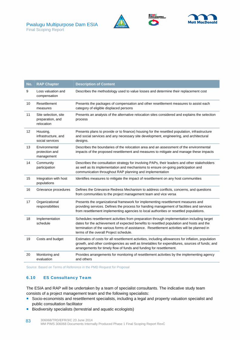
Pwalugu Multipurpose Dam ESIA Final Scoping Report
306068/TRD/EFR/3/C 23 June 2014 MM PIMS 306068 Documents Internally Produced Phase 1 Final Scoping Report RevC
83
No. RAP Chapter Description of Content
9 Loss valuation and compensation
Describes the methodology used to value losses and determine their replacement cost
10 Resettlement measures
Presents the packages of compensation and other resettlement measures to assist each category of eligible displaced persons
11 Site selection, site preparation, and relocation
Presents an analysis of the alternative relocation sites considered and explains the selection process
12 Housing, infrastructure, and social services
Presents plans to provide or to finance) housing for the resettled population, infrastructure and social services and any necessary site development, engineering, and architectural designs.
13 Environmental protection and management
Describes the boundaries of the relocation area and an assessment of the environmental impacts of the proposed resettlement and measures to mitigate and manage these impacts
14 Community participation
Describes the consultation strategy for involving PAPs, their leaders and other stakeholders as well as its implementation and mechanisms to ensure on-going participation and communication throughout RAP planning and implementation
15 Integration with host populations
Identifies measures to mitigate the impact of resettlement on any host communities
16 Grievance procedures
Defines the Grievance Redress Mechanism to address conflicts, concerns, and questions from communities to the project management team and vice versa
17 Organizational responsibilities
Presents the organizational framework for implementing resettlement measures and providing services. Defines the process for handing management of facilities and services from resettlement implementing agencies to local authorities or resettled populations.
18 Implementation schedule
Schedules resettlement activities from preparation through implementation including target dates for the achievement of expected benefits to resettled population and hosts and the termination of the various forms of assistance. Resettlement activities will be planned in terms of the overall Project schedule.
19 Costs and budget
Estimates of costs for all resettlement activities, including allowances for inflation, population growth, and other contingencies as well as timetables for expenditures, sources of funds; and arrangements for timely flow of funds and funding for resettlement.
20 Monitoring and evaluation
Provides arrangements for monitoring of resettlement activities by the implementing agency and others
Source: Based on Terms of Reference in the PMD Request for Proposal
6.10 ES Consultancy Team
The ESIA and RAP will be undertaken by a team of specialist consultants. The indicative study team consists of a project management team and the following specialists: Socio-economists and resettlement specialists, including a legal and property valuation specialist and
public consultation facilitator Biodiversity specialists (terrestrial and aquatic ecologists)

Pwalugu Multipurpose Dam ESIA Final Scoping Report
306068/TRD/EFR/3/C 23 June 2014 MM PIMS 306068 Documents Internally Produced Phase 1 Final Scoping Report RevC
84
Hydrologists An agricultural economist A public health specialist and occupational health specialist A GIS specialist An energy economist A hydropower engineer ESIA specialists for waste, noise, air quality and carbon, traffic, archaeology ESIA and RAP surveyors.
The ES Consultant will use the specialist methodologies in the sections below for the ESIA.
6.11 Assessment Methodology Overview
The ESIA will include specialist studies and chapters on the aspects in Table 6-7.
Table 6-7: ESIA specialism assessments
Section and Specialism Section and Specialism
6.12 Biodiversity 6.19 Air Quality
6.13 Water Resources and Water Quality 6.20 Greenhouse Gas Emissions
6.14 Flooding and Climate Change Resilience 6.21 Land Quality and Waste Management
6.15 Socio-economics and Community 6.22 Landscape and Visual
6.16 Health 6.23 Traffic and Transport
6.17 Cultural Heritage and Archaeology 6.24 Cumulative Impacts
6.18 Noise 6.25 International Waterways and Transboundary Impacts
All assessments will be undertaken in reference to national legislation, lender requirements and international good and best practice. See the legal and policy framework section in the scoping report for details.
For each aspect identified in Table 6-7 the sections below provide comment on the type of assessment and potential impacts, surveys to be undertaken, how the impacts will be evaluated and the approach to mitigation and enhancement.
6.12 Biodiversity
The biodiversity assessment will characterise the overall environment within the project area, focusing on project structures, but aiming to understand the wider ecosystem functions. The guiding principles for the Project biodiversity impact assessment are: Aim for conservation and “no net loss” of biodiversity (positive planning for biodiversity) Take an ecosystems approach (framework for biodiversity conservation) Seek sustainable use of biodiversity resources Ensure equitable sharing (traditional rights and uses of biodiversity are important to local livelihoods
and requires benefits from commercial use of biodiversity to be shared fairly)
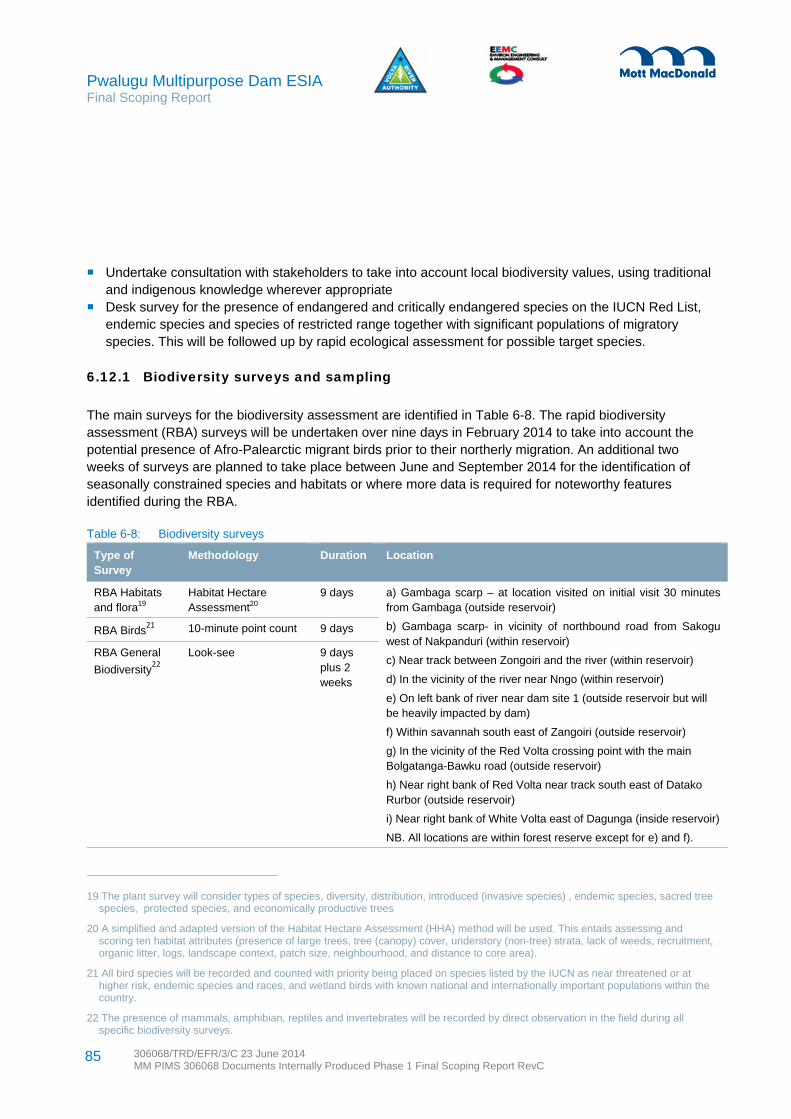
Pwalugu Multipurpose Dam ESIA Final Scoping Report
306068/TRD/EFR/3/C 23 June 2014 MM PIMS 306068 Documents Internally Produced Phase 1 Final Scoping Report RevC
85
Undertake consultation with stakeholders to take into account local biodiversity values, using traditional and indigenous knowledge wherever appropriate
Desk survey for the presence of endangered and critically endangered species on the IUCN Red List, endemic species and species of restricted range together with significant populations of migratory species. This will be followed up by rapid ecological assessment for possible target species.
6.12.1 Biodiversity surveys and sampling
The main surveys for the biodiversity assessment are identified in Table 6-8. The rapid biodiversity assessment (RBA) surveys will be undertaken over nine days in February 2014 to take into account the potential presence of Afro-Palearctic migrant birds prior to their northerly migration. An additional two weeks of surveys are planned to take place between June and September 2014 for the identification of seasonally constrained species and habitats or where more data is required for noteworthy features identified during the RBA.
Table 6-8: Biodiversity surveys
Type of Survey
Methodology Duration Location
RBA Habitats and flora19
Habitat Hectare Assessment20
9 days a) Gambaga scarp – at location visited on initial visit 30 minutes from Gambaga (outside reservoir)
b) Gambaga scarp- in vicinity of northbound road from Sakogu west of Nakpanduri (within reservoir)
c) Near track between Zongoiri and the river (within reservoir)
d) In the vicinity of the river near Nngo (within reservoir)
e) On left bank of river near dam site 1 (outside reservoir but will be heavily impacted by dam)
f) Within savannah south east of Zangoiri (outside reservoir)
g) In the vicinity of the Red Volta crossing point with the main Bolgatanga-Bawku road (outside reservoir)
h) Near right bank of Red Volta near track south east of Datako Rurbor (outside reservoir)
i) Near right bank of White Volta east of Dagunga (inside reservoir)
NB. All locations are within forest reserve except for e) and f).
RBA Birds21
10-minute point count 9 days
RBA General
Biodiversity22
Look-see 9 days plus 2 weeks
19 The plant survey will consider types of species, diversity, distribution, introduced (invasive species) , endemic species, sacred tree species, protected species, and economically productive trees
20 A simplified and adapted version of the Habitat Hectare Assessment (HHA) method will be used. This entails assessing and scoring ten habitat attributes (presence of large trees, tree (canopy) cover, understory (non-tree) strata, lack of weeds, recruitment, organic litter, logs, landscape context, patch size, neighbourhood, and distance to core area).
21 All bird species will be recorded and counted with priority being placed on species listed by the IUCN as near threatened or at higher risk, endemic species and races, and wetland birds with known national and internationally important populations within the country.
22 The presence of mammals, amphibian, reptiles and invertebrates will be recorded by direct observation in the field during all specific biodiversity surveys.

Pwalugu Multipurpose Dam ESIA Final Scoping Report
306068/TRD/EFR/3/C 23 June 2014 MM PIMS 306068 Documents Internally Produced Phase 1 Final Scoping Report RevC
86
Type of Survey
Methodology Duration Location
Ecosystem Market Surveys
Village market surveys to gather data on species, availability, production and transformation, value and seasonality
2-4 hours per market survey
Kwanka, Kpasenpke, Wulugu, Winkogo, Tongo, Zuarungu, Nangode, Tilli, Kugri, Pwalugu
Any rare, endemic, relic and other plants discovered during the surveys will be included the botanic baseline description. The major types of vegetation complexes, their composition, structure, distribution, dominant species, and sensitivity of biomes and the commercial significance of discovered flora shall be described. Particular attention in the studies shall be paid to the species protected by the law (National Red List of Ghana or Red List IUCN) as well as the species which are of great importance for local communities (e.g. for industrial, fishery, tourism and other purposes).
The level of modification/disturbance of communities found within the various survey locations will assessed according to the following grading: Relatively stable or undisturbed communities (e.g. old growth, ungrazed forest) Late successional or lightly disturbed communities (e.g. old growth forest that was selectively logged in
recent years) Mid-successional or moderately to heavily disturbed communities (e.g. young to mature secondary
growth forest) Early successional or severely disturbed communities (e.g. severely grazed forest of any age), and; Very early successional or very severely disturbed communities (e.g. cropland)
The surveying of mammals will be carried out by analysing any evidence of them utilising the area (dig outs, dens, gnaws on nut culture, spoor). Birds will be identified through visual observation and call identification. Nests and concentration spots (such as important food trees) for any protected and rare species will be recorded. The number of the birds shall be defined through various standard methods, including call identification (separately for forest landscapes and open landscapes). Route observation for reptiles and amphibians will focus on shelter areas, rocky landscapes and bank areas. The local community will be interviewed regarding any observations related to certain species using pictures. Study areas and observations of significance will be photographed.
To determine the presence of fish species, especially rare or protected species, as well as significant sensitive habitats such as spawning and nursery sites on the potential reservoir site, local fisher folk will be interviewed. These interviews will also provide information on how socio-economically important fishing is to the local community. The fishers will be provided with a map with the location of the Project, so that they can clearly mark the preferred areas for certain species (including upper and lower territorial limits) and sensitive areas. Market surveys will be undertaken at different times in the programme to review fish availability. It is anticipated that some of the RBA surveys will include surveys of the river by boat which may lead to some observations regarding fish presence. Biological information on fish species considered relevant includes fish species, numbers, individual lengths, age class and any signs of disease. River site

Pwalugu Multipurpose Dam ESIA Final Scoping Report
306068/TRD/EFR/3/C 23 June 2014 MM PIMS 306068 Documents Internally Produced Phase 1 Final Scoping Report RevC
87
characterisation for any fish data will include the sampling date, start and finish survey time (total duration), reach and sampling site name, length of the reach and sampling site area, width and depth of the sampling site channel, altitude, slope, substrate, flow type (slow, medium or fast), habitat present (% vegetation cover, species), distance from bank and temperature of water.
Mollusc and aquatic macro-invertebrate communities can be useful indicators of aquatic biodiversity and stress (for example, poor water quality or low flows) as they are sensitive to environmental change and are a vital component in the aquatic food chain. An ‘aquatic invertebrate’ refers only to benthic (sediment dwelling) macro-invertebrate larger than 1mm. Baseline information for aquatic invertebrates generally includes an indication of water quality using standard scoring systems and an assessment of whether rare or notable species are present. Secondary data will be used to assess impacts on aquatic communities.
An approach that combines the WB group standards with the guidelines of the Institute of Ecology and Environmental Management Guidelines for Ecological Impact Assessment in the United Kingdom (IEEM, 2006) will be used. See Table 6.9 and Table 6.10 for sensitivity and magnitude criteria respectively.
Table 6.9: Sensitivity criteria for biodiversity impacts
Sensitivity Categorisation Determination Examples
Very high High importance and rarity, international scale and limited potential for substitution
Internationally designated sites, such as Ramsar Sites.
High High importance and rarity, national scale, or regional scale with limited potential for substitution
Nationally designated sites. Regionally important sites with limited potential for substitution
Medium High or medium importance and rarity, local or regional scale, and limited potential for substitution
Locally designated sites. Regionally important sites with potential for substitution.
Low Low or medium importance and rarity, local scale
Non-designated sites/areas of some local biodiversity
Negligible Very low importance and rarity, local scale Other sites with little or no local biodiversity and earth heritage interest
Table 6.10: Magnitude criteria for biodiversity impacts
Magnitude Categorisation Determination
Major negative The proposal would affect the integrity of the site, in terms of the coherence of its ecological structure and function, across its whole area, which enables it to sustain the habitat, complex of habitats and/or the population levels of species of interest.
Moderate negative The site's integrity will not be affected, but the effect on the site is likely to be significant in terms of its ecological objectives. However if, in the light of full information, it cannot be clearly demonstrated that the proposal will not have an effect on integrity, then the impact should be assessed as major.
Minor negative Neither of the above applies, but some minor impact is evident.
Negligible No observable impact in either direction.

Pwalugu Multipurpose Dam ESIA Final Scoping Report
306068/TRD/EFR/3/C 23 June 2014 MM PIMS 306068 Documents Internally Produced Phase 1 Final Scoping Report RevC
88
6.12.2 Approach to biodiversity mitigation and enhancement
Mitigation and enhancement measures will be developed around the following key principles in accordance with international best practice: Aim for conservation and “no net loss” of biodiversity (positive planning for biodiversity) Take an ecosystems approach (framework for biodiversity conservation) Seek sustainable use of biodiversity resources Ensure equitable sharing of biodiversity resources Apply the precautionary principle Take a participatory approach
Depending on the nature of the potential impacts, biodiversity offsets will be considered. Biodiversity offsets are measurable conservation outcomes resulting from actions designed to compensate for significant adverse biodiversity impacts arising from project development and persisting after appropriate avoidance, minimization and restoration measures have been taken.
6.13 Water Resources and Water Quality
Given the nature of the construction activities and subsequent operation of the Project infrastructure (dam, reservoir creation, powerhouse, transmission lines and access roads), the scheme has the potential to impact water resources within the Project area of influence. The water resources assessment will cover the potential impacts on groundwater and surface waters including the potential impacts of flooding.
The key changes which may result in potential impacts on water resources are associated with changes in the existing flow regime as a result of the scheme. The scheme will convert a portion of the White Volta River including the Red Volta Branch and the White Volta Branch from river channel to reservoir, and will change the existing flow regime of the White Volta from the dam site to Lake Volta. The scope of the water resources assessment is focused on reviewing potential impacts associated with changes in the flow regime on direct water resources users (irrigation, drinking water, sanitary waste disposal), aquatic biodiversity (specifically fisheries), and sediment transport. Historic data will be used to assess potential impacts as well as additional baseline surveys to be undertaken during low flow periods.
6.13.1 Hydrology surveys and sampling
Hydrology sampling and data collection will give sufficient information to allow assessment of the flows, yield, quantity and potential impacts of the scheme on the hydrology of the area. See Table 6-11.
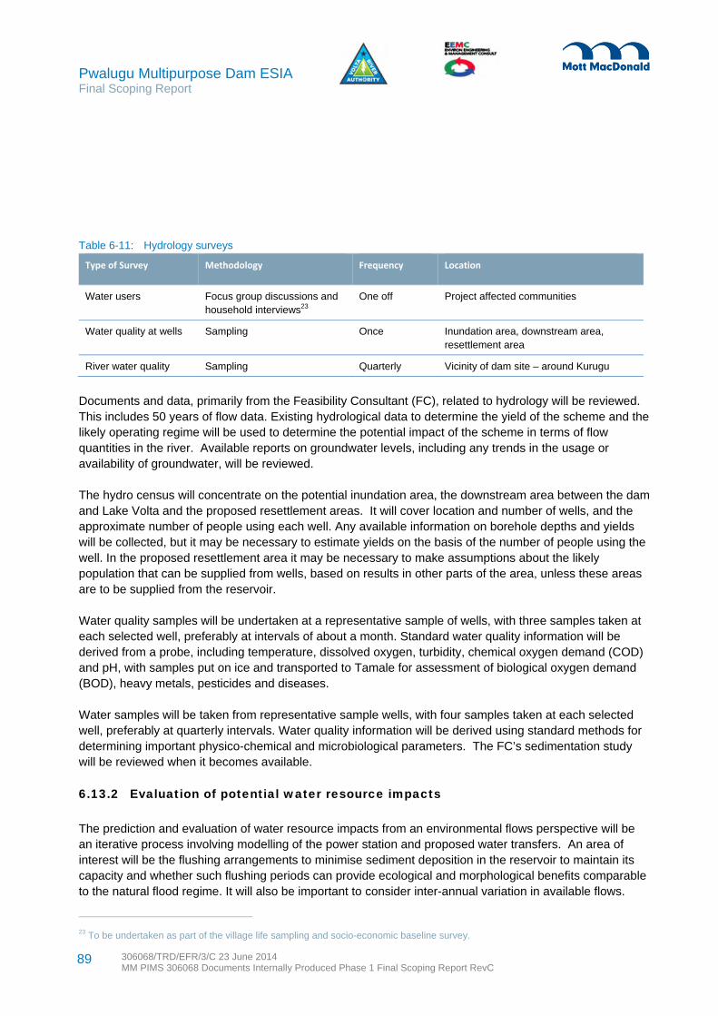
Pwalugu Multipurpose Dam ESIA Final Scoping Report
306068/TRD/EFR/3/C 23 June 2014 MM PIMS 306068 Documents Internally Produced Phase 1 Final Scoping Report RevC
89
Table 6-11: Hydrology surveys
Type of Survey Methodology Frequency Location
Water users Focus group discussions and household interviews23
One off Project affected communities
Water quality at wells Sampling Once Inundation area, downstream area, resettlement area
River water quality Sampling Quarterly Vicinity of dam site – around Kurugu
Documents and data, primarily from the Feasibility Consultant (FC), related to hydrology will be reviewed. This includes 50 years of flow data. Existing hydrological data to determine the yield of the scheme and the likely operating regime will be used to determine the potential impact of the scheme in terms of flow quantities in the river. Available reports on groundwater levels, including any trends in the usage or availability of groundwater, will be reviewed.
The hydro census will concentrate on the potential inundation area, the downstream area between the dam and Lake Volta and the proposed resettlement areas. It will cover location and number of wells, and the approximate number of people using each well. Any available information on borehole depths and yields will be collected, but it may be necessary to estimate yields on the basis of the number of people using the well. In the proposed resettlement area it may be necessary to make assumptions about the likely population that can be supplied from wells, based on results in other parts of the area, unless these areas are to be supplied from the reservoir.
Water quality samples will be undertaken at a representative sample of wells, with three samples taken at each selected well, preferably at intervals of about a month. Standard water quality information will be derived from a probe, including temperature, dissolved oxygen, turbidity, chemical oxygen demand (COD) and pH, with samples put on ice and transported to Tamale for assessment of biological oxygen demand (BOD), heavy metals, pesticides and diseases.
Water samples will be taken from representative sample wells, with four samples taken at each selected well, preferably at quarterly intervals. Water quality information will be derived using standard methods for determining important physico-chemical and microbiological parameters. The FC’s sedimentation study will be reviewed when it becomes available.
6.13.2 Evaluation of potential water resource impacts
The prediction and evaluation of water resource impacts from an environmental flows perspective will be an iterative process involving modelling of the power station and proposed water transfers. An area of interest will be the flushing arrangements to minimise sediment deposition in the reservoir to maintain its capacity and whether such flushing periods can provide ecological and morphological benefits comparable to the natural flood regime. It will also be important to consider inter-annual variation in available flows.
23 To be undertaken as part of the village life sampling and socio-economic baseline survey.

Pwalugu Multipurpose Dam ESIA Final Scoping Report
306068/TRD/EFR/3/C 23 June 2014 MM PIMS 306068 Documents Internally Produced Phase 1 Final Scoping Report RevC
90
Other potential water resources impacts will be evaluated taking into consideration of the sensitivity of the receptor and magnitude of impact to evaluate the overall significance.
Water quality samples taken during the low flow periods will be used to determine whether there are any existing pollution issues within the project area, and should provide an estimation of worst case pollution. This information will be used to assess the likely impacts associated with further reduced flows and the assimilative capacity of the river to dilute any existing pollution issues.
6.13.3 Approach to water resource mitigation
Mitigation measures will be proposed where significant potential impacts are found. Throughout the design process, advice will be given on the constraints imposed by the water features present. Sound environmental management of construction operations should include appropriate selection of construction sites, and bunding of operations and permanent facilities which could create surface water or groundwater pollution. These together with other principles of best practice will be covered in the ESMMP. Mitigation will focus on addressing the following key issues: Alterations to water courses or flow patterns with concomitant impacts on flows Pollution from spills or as the result of major flood events Competition for dry season supplies having an adverse impact on existing users, including
environmental requirements
6.14 Flooding and Climate Change Resilience
Flooding has historically been a significant problem in the White Volta catchment within Ghana, and flood management is a significant element of the project. The potential impact of the Project on flood risk will be assessed, taking account of the proposed dam and spillway. The risk of dam failure should be considered, taking account of both natural and man-induced hazards (such as poor design and/or operation).The nature of the review will be influenced by the type of dam that is proposed. With a concrete dam then it may be possible to tolerate overtopping, but this would not be the case with an earthfill dam.
Climate change is expected to have significant implications for both existing and proposed new infrastructure assets, particularly those with long design lifetimes. This makes such assets sensitive not only to the existing climate at the time of their construction, but also to climate variations over the decades of their use. Decisions made now will shape the resilience of design and development of infrastructure systems. Action is therefore needed to ensure that new infrastructure is efficient, robust and resilient to climate conditions in the long term, through considered planning and design.
6.14.1 Climate change risk assessment
The ESIA process has an important role in ensuring that future developments respond to the issue of climate change. This includes the scheme’s climate resilience as well as its potential impact on the wider environment’s vulnerability to climate effects and its capacity to adapt to changes in climate. As part of the ESIA, a Climate Change Risk Assessment (CCRA) will be undertaken. This process will:

Pwalugu Multipurpose Dam ESIA Final Scoping Report
306068/TRD/EFR/3/C 23 June 2014 MM PIMS 306068 Documents Internally Produced Phase 1 Final Scoping Report RevC
91
Identify and appraise the Project’s resilience to current and projected climate risks and capacity to realise potential opportunities
Determine the potential impact of the Project on the wider environment’s vulnerability to climate impacts, and its capacity to adapt to changes in climate
Outline recommendations for improving climate resilience over the Project’s operational lifetime
6.14.2 Approach to climate change mitigation
Climate change adaptation measures are available to reduce vulnerability of the Project to climate risks or enable it to exploit opportunities. Planning and design responses can include identification of robust design standards and materials selection, strategic placement of vulnerable assets, building flexibility into responses, and use of appropriate construction codes. Operation and maintenance responses are likely to include monitoring and evaluation of resilience/adaptation measures, maintenance of structures and surfaces and the removal of silt and sediment build-up which will provide a degree of resilience to climate risks and possibly implementing initiatives in support of wider sustainability that also improve the schemes climate resilience, such as sustainable land management in upstream agriculture.
6.15 Socio-economics and Community
Social impact assessment (SIA) includes the processes of analysing, monitoring and managing the intended and unintended social consequences, both positive and negative, of planned projects such as the PMD and any social change processes invoked by those interventions. The primary purpose of a social impact assessment is to bring about a more sustainable and equitable biophysical and human environment.
A main impact will be land acquisition and resettlement from the reservoir inundation. The most sensitive groups will be households who practice subsistence lifestyles in the area that will be inundated. There will be significant employment generation during construction and operation and the related influx of job seekers. Health risks and potential issues related to public health, community safety and security as well as occupational health and safety need to be explored. The SIA will review where communities may be affected by several effects, for instance construction disturbances.
6.15.1 SIA surveys
The main surveys for the social impact assessment are identified in Table 6-12. Observation of communities, human activities, land tenure and cultural practices will be on-going during all site visits. Consultation results will be essential to inform the SIA.
The SIA will address changes in social, cultural and economic patterns relating to decline in existing or potential use of valued resources arising from direct or indirect employment generation; immigration and resultant demographic changes; provision of infrastructure such as roads, schools and health facilities; local economy; cultural changes including possible conflict arising from immigration and tourism; and potential land use in the area of the proposed undertaking.
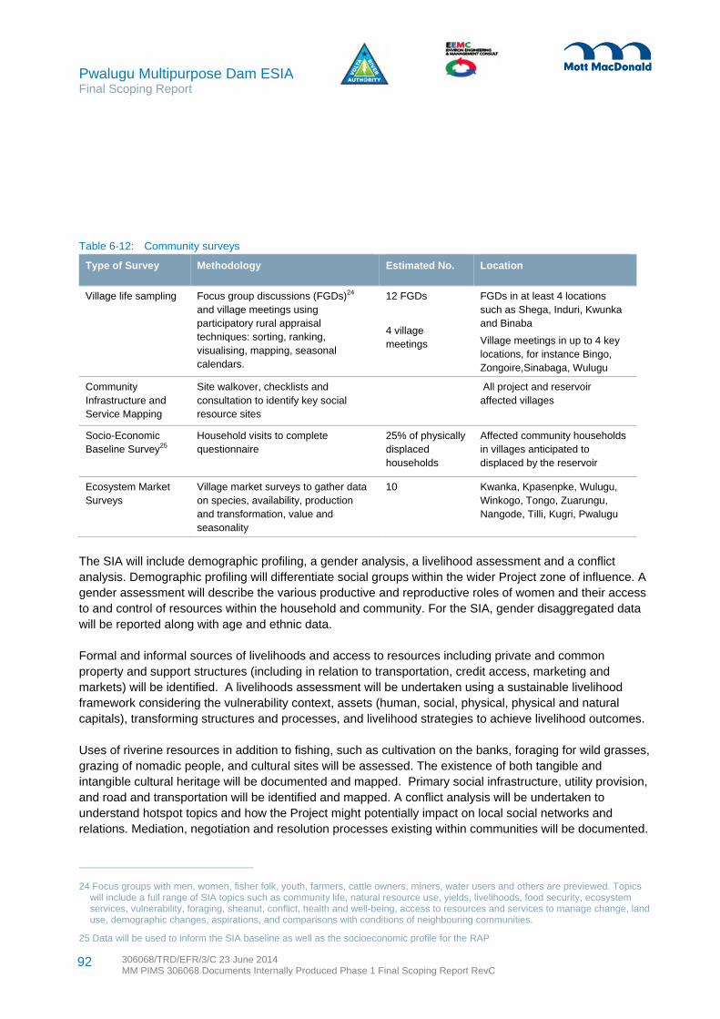
Pwalugu Multipurpose Dam ESIA Final Scoping Report
306068/TRD/EFR/3/C 23 June 2014 MM PIMS 306068 Documents Internally Produced Phase 1 Final Scoping Report RevC
92
Table 6-12: Community surveys
Type of Survey Methodology Estimated No. Location
Village life sampling Focus group discussions (FGDs)24
and village meetings using participatory rural appraisal techniques: sorting, ranking, visualising, mapping, seasonal calendars.
12 FGDs
4 village meetings
FGDs in at least 4 locations such as Shega, Induri, Kwunka and Binaba
Village meetings in up to 4 key locations, for instance Bingo, Zongoire,Sinabaga, Wulugu
Community Infrastructure and Service Mapping
Site walkover, checklists and consultation to identify key social resource sites
All project and reservoir affected villages
Socio-Economic Baseline Survey25
Household visits to complete questionnaire
25% of physically displaced households
Affected community households in villages anticipated to displaced by the reservoir
Ecosystem Market Surveys
Village market surveys to gather data on species, availability, production and transformation, value and seasonality
10 Kwanka, Kpasenpke, Wulugu, Winkogo, Tongo, Zuarungu, Nangode, Tilli, Kugri, Pwalugu
The SIA will include demographic profiling, a gender analysis, a livelihood assessment and a conflict analysis. Demographic profiling will differentiate social groups within the wider Project zone of influence. A gender assessment will describe the various productive and reproductive roles of women and their access to and control of resources within the household and community. For the SIA, gender disaggregated data will be reported along with age and ethnic data.
Formal and informal sources of livelihoods and access to resources including private and common property and support structures (including in relation to transportation, credit access, marketing and markets) will be identified. A livelihoods assessment will be undertaken using a sustainable livelihood framework considering the vulnerability context, assets (human, social, physical, physical and natural capitals), transforming structures and processes, and livelihood strategies to achieve livelihood outcomes.
Uses of riverine resources in addition to fishing, such as cultivation on the banks, foraging for wild grasses, grazing of nomadic people, and cultural sites will be assessed. The existence of both tangible and intangible cultural heritage will be documented and mapped. Primary social infrastructure, utility provision, and road and transportation will be identified and mapped. A conflict analysis will be undertaken to understand hotspot topics and how the Project might potentially impact on local social networks and relations. Mediation, negotiation and resolution processes existing within communities will be documented.
24 Focus groups with men, women, fisher folk, youth, farmers, cattle owners, miners, water users and others are previewed. Topics will include a full range of SIA topics such as community life, natural resource use, yields, livelihoods, food security, ecosystem services, vulnerability, foraging, sheanut, conflict, health and well-being, access to resources and services to manage change, land use, demographic changes, aspirations, and comparisons with conditions of neighbouring communities.
25 Data will be used to inform the SIA baseline as well as the socioeconomic profile for the RAP

Pwalugu Multipurpose Dam ESIA Final Scoping Report
306068/TRD/EFR/3/C 23 June 2014 MM PIMS 306068 Documents Internally Produced Phase 1 Final Scoping Report RevC
93
Resettlement surveys will provide data necessary to produce a Resettlement Action Plan that adheres to the following principles: Minimising adverse resettlement impacts Conceiving the resettlement and livelihood restoration activities as sustainable development activities Giving affected persons (APs) opportunities to participate in the design and implementation of
resettlement activities At a minimum restoring APs’ standards of living to the pre-project levels, and preferably improve their
conditions through better housing and via provision of benefit sharing opportunities
Many of the SIA desk-top studies and site visit consultations will inform the resettlement planning and ground truth the resettlement surveys which will be undertaken. See Table 6-13 for survey details.
Table 6-13: Land acquisition and resettlement sampling and surveys
Type of Survey Methodology Estimated Number
Land Market Review Interviews with at least five key informants26 to gather information on land values
Once
Socio-Economic Baseline Survey
Household visits to complete questionnaire 25% of physically displaced households
Affected Household (AH) Survey
Household questionnaires with 100% AHs Once, but with up to 3 follow-ups to identify absent AHs
Asset Census and Detailed Measurement Survey (DMS)
Household and land plot walkovers to record and measure27 100% of assets, accompanied by AH head who must verify findings
Once, but with up to 3 follow-ups to identify absent AHs
Resettlement site soil survey Collection of samples 12 locations
6.15.2 Evaluation of potential socio-economic and community impacts
Determining the significance of potential socio-economic and community impacts and their effects is one of the main purposes of an SIA. In order to describe the significance of an impact, the interaction between the magnitude of the impact and the sensitivity of receptors will be assessed.
The assessment of magnitude will be categorised as major, moderate, minor or negligible based on consideration of the impact parameters such as duration, spatial extent, number of people or groups affected and likelihood, taking into account professional judgement. Table 6-14 summarises the typical varying degrees of impact magnitude.
26 For instance, Land Commission, Agriculture Department, WIENCO, SADA (which recently commissioned a study on land ownership), real estate agents, and NGOs.
27 The DMS will include the physical measurement and recording of GPS coordinates of all structures and land plots. Photographic evidence will also be obtained. For structures the construction materials, number of floors and building use will be recorded. The structure area will be determined by the external perimeter wall. Smaller structures such as wells or animal housing will also be recorded. When recording details of crops and trees, information will be collected about maturity and whether the trees are productive (fruit bearing or other uses, such as timber or firewood), or used for decorative purposes.

Pwalugu Multipurpose Dam ESIA Final Scoping Report
306068/TRD/EFR/3/C 23 June 2014 MM PIMS 306068 Documents Internally Produced Phase 1 Final Scoping Report RevC
94
Table 6-14: Criteria for determining magnitude of socio-economic and community impacts
Magnitude Categorisation Determination
Major adverse / beneficial A probable impact that affects the wellbeing of groups of many people or business entities within a widespread area beyond the project life.
Moderate adverse / beneficial A possible impact that will likely affect either the wellbeing of a group of people or business entities beyond the local area of influence into the wider area of influence or continue beyond the project life.
Minor adverse / beneficial An impact that may affect the wellbeing of a small number of people and/or households or businesses, or occurs exceptionally, mostly within the project area of influence and does not extend beyond the life of the project.
Negligible An impact that is localised to a specific location within the project’s site boundary and is temporary or unlikely to occur with no detectable effect on the wellbeing of people or a business entity so that the socio-economic baseline remains consistent.
The sensitivity of receptors is related to their socio-economic vulnerability, measured by their capacity to cope with social impacts that affect their access to or control over additional or alternative social resources of a similar nature, ultimately affecting their well-being. Very sensitive or vulnerable socio-economic receptors generally have less means to absorb adverse changes or to replicate beneficial changes to their resource base than non-sensitive or non-vulnerable receptors.
Activities that increase impoverishment risks28 including landlessness, joblessness, homelessness, marginalisation, increased morbidity and mortality, food insecurity, loss of access to common property resources, and social disarticulation contribute to vulnerability. Table 6-15 presents SIA sensitivity criteria.
Table 6-15: Sensitivity criteria for social receptors
Sensitivity Categorisation Determination
Very High An already vulnerable receptor with very little capacity and means to absorb proposed changes or with very little access to alternative similar sites.
High An already vulnerable receptor with some capacity and means to absorb proposed changes or with little access to alternative similar sites.
Medium A non-vulnerable receptor with limited capacity and means to absorb proposed changes and with some access to alternative similar sites.
Low A non-vulnerable receptor with plentiful capacity and means to absorb proposed changes and with good access to alternative similar sites.
6.15.3 Approach to socio-economic and community mitigation and enhancement
Mitigation and enhancement measures will be identified to address negative impacts and increase the benefits or distribute them more widely or equitably where possible. The assessment will also make recommendations related to social indicators to be included in environmental monitoring and management
28 Michael M. Cernea has written extensively on impoverishment risks.
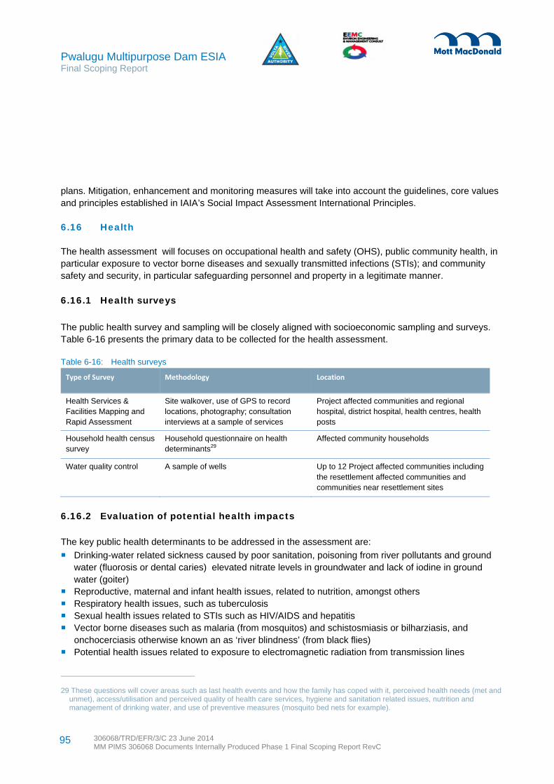
Pwalugu Multipurpose Dam ESIA Final Scoping Report
306068/TRD/EFR/3/C 23 June 2014 MM PIMS 306068 Documents Internally Produced Phase 1 Final Scoping Report RevC
95
plans. Mitigation, enhancement and monitoring measures will take into account the guidelines, core values and principles established in IAIA’s Social Impact Assessment International Principles.
6.16 Health
The health assessment will focuses on occupational health and safety (OHS), public community health, in particular exposure to vector borne diseases and sexually transmitted infections (STIs); and community safety and security, in particular safeguarding personnel and property in a legitimate manner.
6.16.1 Health surveys
The public health survey and sampling will be closely aligned with socioeconomic sampling and surveys. Table 6-16 presents the primary data to be collected for the health assessment.
Table 6-16: Health surveys
Type of Survey Methodology Location
Health Services & Facilities Mapping and Rapid Assessment
Site walkover, use of GPS to record locations, photography; consultation interviews at a sample of services
Project affected communities and regional hospital, district hospital, health centres, health posts
Household health census survey
Household questionnaire on health determinants29
Affected community households
Water quality control A sample of wells Up to 12 Project affected communities including the resettlement affected communities and communities near resettlement sites
6.16.2 Evaluation of potential health impacts
The key public health determinants to be addressed in the assessment are:
Drinking-water related sickness caused by poor sanitation, poisoning from river pollutants and ground water (fluorosis or dental caries) elevated nitrate levels in groundwater and lack of iodine in ground water (goiter)
Reproductive, maternal and infant health issues, related to nutrition, amongst others Respiratory health issues, such as tuberculosis Sexual health issues related to STIs such as HIV/AIDS and hepatitis Vector borne diseases such as malaria (from mosquitos) and schistosmiasis or bilharziasis, and
onchocerciasis otherwise known an as ‘river blindness’ (from black flies) Potential health issues related to exposure to electromagnetic radiation from transmission lines
29 These questions will cover areas such as last health events and how the family has coped with it, perceived health needs (met and unmet), access/utilisation and perceived quality of health care services, hygiene and sanitation related issues, nutrition and management of drinking water, and use of preventive measures (mosquito bed nets for example).

Pwalugu Multipurpose Dam ESIA Final Scoping Report
306068/TRD/EFR/3/C 23 June 2014 MM PIMS 306068 Documents Internally Produced Phase 1 Final Scoping Report RevC
96
Health issues related to alcohol consumption and substance abuse Access to health-care service providers, medicine and technology.
OHS factors to be addressed include:
Noise, vibration, illumination and other physical factors Security arrangements, including fire safety, storage and handling of hazardous materials and waste Worksite housekeeping, equipment conditions & maintenance, including personal protective equipment On and off site traffic, including safety signage Working near water, in confined spaces, and with electricity (electromagnetic radiation exposure) Workplace violence, harassment and stress Exposure to heat and natural resource risks (for instance snakes, crocodiles).
6.16.3 Approach to health mitigation and enhancement
The health assessment will support the affected population and workers to make well-informed decisions with regards to prevention of diseases and appropriate actions during an outbreak. Efforts to supporting coordination and the efficient use of communication resources among local, national and international public health partners in the Project area will made. Channels for providing relevant Project related public health information to stakeholders will be identified.
6.17 Cultural Heritage and Archaeology
The assessment will consider how the Project will potentially impact on cultural heritage and archaeology with a focus on tangible sites. Although a design principle is to avoid cultural heritage features, there will be potential impacts for instance on shrine trees and possibly graves or burial grounds.
The nature, location, extent and importance of any cultural heritage assets and/or archaeological resources which have the potential to be impacted either directly or indirectly by the Project will be identified and described. An appraisal of the existing cultural heritage and archaeological baseline will be initially performed using a desk based assessment, site observations and consultation. It is not proposed to undertake any archaeological field investigations; information will be limited to available data sources and walk over survey.
In undertaking the desk based assessment, should potentially significant cultural heritage assets be identified, consideration will be given to undertaking additional field based surveys so as to further understand their importance. The scope of any field surveys will need to be agreed with the relevant government department prior to being undertaken. Techniques such as geophysical surveying, site walkover, test pitting, machine trenching, and earthwork surveys could be considered where relevant.
6.17.1 Evaluation of potential cultural heritage and archaeology impacts
To evaluate the impact significance, the interaction between the magnitude of the impact and the value of the cultural heritage asset or archaeological remains will be assessed. Table 6-17 summarises the typical varying degrees of impact magnitude.
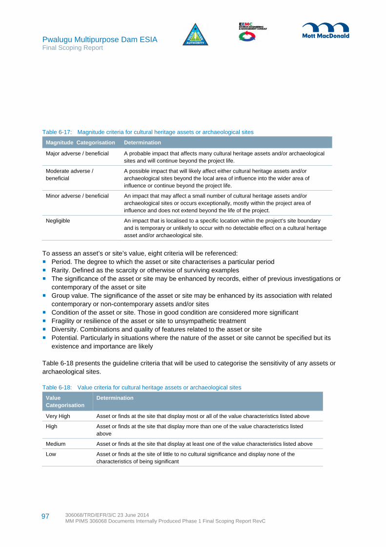
Pwalugu Multipurpose Dam ESIA Final Scoping Report
306068/TRD/EFR/3/C 23 June 2014 MM PIMS 306068 Documents Internally Produced Phase 1 Final Scoping Report RevC
97
Table 6-17: Magnitude criteria for cultural heritage assets or archaeological sites
Magnitude Categorisation Determination
Major adverse / beneficial A probable impact that affects many cultural heritage assets and/or archaeological sites and will continue beyond the project life.
Moderate adverse / beneficial
A possible impact that will likely affect either cultural heritage assets and/or archaeological sites beyond the local area of influence into the wider area of influence or continue beyond the project life.
Minor adverse / beneficial An impact that may affect a small number of cultural heritage assets and/or archaeological sites or occurs exceptionally, mostly within the project area of influence and does not extend beyond the life of the project.
Negligible An impact that is localised to a specific location within the project’s site boundary and is temporary or unlikely to occur with no detectable effect on a cultural heritage asset and/or archaeological site.
To assess an asset’s or site’s value, eight criteria will be referenced: Period. The degree to which the asset or site characterises a particular period Rarity. Defined as the scarcity or otherwise of surviving examples The significance of the asset or site may be enhanced by records, either of previous investigations or
contemporary of the asset or site Group value. The significance of the asset or site may be enhanced by its association with related
contemporary or non-contemporary assets and/or sites Condition of the asset or site. Those in good condition are considered more significant Fragility or resilience of the asset or site to unsympathetic treatment Diversity. Combinations and quality of features related to the asset or site Potential. Particularly in situations where the nature of the asset or site cannot be specified but its
existence and importance are likely
Table 6-18 presents the guideline criteria that will be used to categorise the sensitivity of any assets or archaeological sites.
Table 6-18: Value criteria for cultural heritage assets or archaeological sites
Value Categorisation
Determination
Very High Asset or finds at the site that display most or all of the value characteristics listed above
High Asset or finds at the site that display more than one of the value characteristics listed above
Medium Asset or finds at the site that display at least one of the value characteristics listed above
Low Asset or finds at the site of little to no cultural significance and display none of the characteristics of being significant
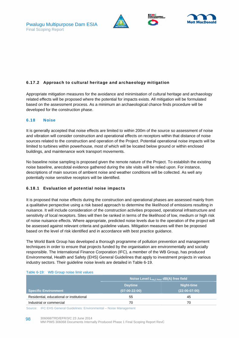
Pwalugu Multipurpose Dam ESIA Final Scoping Report
306068/TRD/EFR/3/C 23 June 2014 MM PIMS 306068 Documents Internally Produced Phase 1 Final Scoping Report RevC
98
6.17.2 Approach to cultural heritage and archaeology mitigation
Appropriate mitigation measures for the avoidance and minimisation of cultural heritage and archaeology related effects will be proposed where the potential for impacts exists. All mitigation will be formulated based on the assessment process. As a minimum an archaeological chance finds procedure will be developed for the construction phase.
6.18 Noise
It is generally accepted that noise effects are limited to within 200m of the source so assessment of noise and vibration will consider construction and operational effects on receptors within that distance of noise sources related to the construction and operation of the Project. Potential operational noise impacts will be limited to turbines within powerhouse, most of which will be located below ground or within enclosed buildings, and maintenance work transport movements.
No baseline noise sampling is proposed given the remote nature of the Project. To establish the existing noise baseline, anecdotal evidence gathered during the site visits will be relied upon. For instance, descriptions of main sources of ambient noise and weather conditions will be collected. As well any potentially noise sensitive receptors will be identified.
6.18.1 Evaluation of potential noise impacts
It is proposed that noise effects during the construction and operational phases are assessed mainly from a qualitative perspective using a risk based approach to determine the likelihood of emissions resulting in nuisance. It will include consideration of the construction activities proposed, operational infrastructure and sensitivity of local receptors. Sites will then be ranked in terms of the likelihood of low, medium or high risk of noise nuisance effects. Where appropriate, predicted noise levels due to the operation of the project will be assessed against relevant criteria and guideline values. Mitigation measures will then be proposed based on the level of risk identified and in accordance with best practice guidance.
The World Bank Group has developed a thorough programme of pollution prevention and management techniques in order to ensure that projects funded by the organisation are environmentally and socially responsible. The International Finance Corporation (IFC), a member of the WB Group, has produced Environmental, Health and Safety (EHS) General Guidelines that apply to investment projects in various industry sectors. Their guideline noise levels are detailed in Table 6-19.
Table 6-19: WB Group noise limit values
Specific Environment
Noise Level Leq,1 hour dB(A) free field
Daytime
(07:00-22:00)
Night-time
(22:00-07:00)
Residential, educational or institutional 55 45
Industrial or commercial 70 70
Source: IFC EHS General Guidelines: Environmental – Noise Management

Pwalugu Multipurpose Dam ESIA Final Scoping Report
306068/TRD/EFR/3/C 23 June 2014 MM PIMS 306068 Documents Internally Produced Phase 1 Final Scoping Report RevC
99
Ghana ambient noise level standards specify permissible noise levels for a wider range of receptors, which are more stringent in some cases (but less so in residential areas at night) and assessed over slightly different time periods. See Table 6-20.
Table 6-20: Ghana ambient noise level standards
Specific Environment
Permissible Noise Level in dB(A)
Daytime (06:00-22:00) Night-time(22:00-06:00)
Zone A – Residential areas with low or infrequent transportation
55 48
Zone B1 – Educational (school) and health (hospital, clinic) facilities
55 50
Zone B2 – Areas with some commercial or light industry 60 55
Zone C1 – Areas with some light industry, places of entertainment or public assembly and places of worship located in this zone
65 60
Zone C2 – Predominantly commercial areas 75 65
Zone D – Light industrial areas 70 60
Zone E – Predominantly heavy industrial areas 70 70
6.18.2 Approach to noise mitigation
Mitigation will be identified when there is potential to exceed the stringent of the noise standards presented above. Appropriate construction phase mitigation measures will be identified for inclusion within the ESMMP and are likely to include: Restricted general hours of working to avoid sensitive periods Positioning of temporary site compounds as far as reasonably practicable from sensitive receptors Undertaking construction activities in accordance with good practice Maintaining equipment in good working order and fitting with appropriate noise control at all times Using site terrain, material stockpiles and suitable work locations so as to screen work locations and
maximise the distance between work activities and receptors
Where potential cumulative noise effects may occur, the assessment will consider the combined effects and identify applicable mitigation measures as necessary.
6.19 Air Quality
Air quality is not considered to have likely long term impacts and is largely associated with the construction phase only. Construction air quality effects may arise from the construction of power plants, dams/weirs, access roads, transport of spoil material, transmission lines, and new substations. Potential effects will be localised and are likely to include: Oxides of nitrogen (NOX) emissions associated with on-site plant and vehicles (combustion of fuel) NOX emissions associated with construction traffic on the local road network (combustion of fuel)

Pwalugu Multipurpose Dam ESIA Final Scoping Report
306068/TRD/EFR/3/C 23 June 2014 MM PIMS 306068 Documents Internally Produced Phase 1 Final Scoping Report RevC
100
On-site dust emissions (including fine particulates known as ‘PM10’) arising from construction activities. Dust can be mechanically transported (either by wind or re-suspension by vehicles). It can also arise from wind erosion on material stock piles and earth moving.
As such only a qualitative assessment will be undertaken within the ESIA to assess potential air quality impacts, no modelling of emissions is deemed to be required for the construction phase or operational phase. The current situation, where PM10 is likely to be high at certain periods of the dry season, for instance when bush fires and harmattan winds are prevalent, will be documented.
6.19.1 Evaluation of potential air quality impacts
It is proposed that air quality effects during the construction phase are assessed qualitatively using a risk based approach to determine the likelihood of dust emissions causing nuisance or health effects. Consideration will be given to the construction activities proposed, basic meteorological conditions and sensitivity of local receptors. Sites will be ranked according whether there is a low, medium or high risk of dust effects and mitigation measures will be proposed based on the level of risk identified and in accordance with best practice guidance. Consideration will also be given to likely traffic movements required for the removal of excavated material.
6.19.2 Approach to air quality mitigation
Appropriate construction phase mitigation measures for the minimisation of air quality effects will be identified for inclusion within the ESMMP. Where there is the potential for aspects of the Project to cause cumulative air quality effects, or where other existing or proposed developments may lead to cumulative effects, the assessment will consider the combined effects and identify applicable mitigation measures.
6.20 Greenhouse Gases
Emissions of greenhouse gases (GHGs) will arise during the construction of the Project infrastructure (the dam, powerhouses, transmission line tower foundations, and access roads) as well as during the inundation of the reservoir. There will be embodied GHGs in construction materials (from their manufacture) and plant and vehicular emissions used for construction. Where possible, the GHG emissions will be quantified based on available data and/or assumptions and using standard published emissions factors for the construction period. Indirect emissions associated with the key materials to be used in the project will be estimated based on estimated quantities if they are available and depending on the final design and reservoir size and type of operation. The Project will also generate renewable energy which will have no direct emissions compared to fossil-fuel based power generation.
The Project will be designed to operate for several decades, during which time the climate in Ghana could be subject to change. This has potential implications on the design of the Project should climate change scenarios not be factored in to the design process. This includes possible changes in rainfall amounts and possible changes in temperature, both of which could affect the performance of the project.

Pwalugu Multipurpose Dam ESIA Final Scoping Report
306068/TRD/EFR/3/C 23 June 2014 MM PIMS 306068 Documents Internally Produced Phase 1 Final Scoping Report RevC
101
No surveys are foreseen. Readily available published data relating to emissions from the energy sector, the regions within which the Project is located and national emissions for Ghana will be sourced and will enable the contextualisation of GHG emissions attributable to the Project as per the indirect benefits that the scheme will offer through the generation of renewable energy.
6.20.1 Evaluation of potential GHG emission impacts
Calculation of emissions from the construction and operational phases (apart from the reservoir sources), as identified above, will be made based on the available project data and published emission factors. Information sources such as the World Bank and the GHG Protocol will be used in order to determine the appropriate emissions factors. Available data and information relating to the proposed construction schedule, construction activities (vehicle movements and plant) and infrastructure/materials to be installed will be used in combination with published emissions factors to estimate emissions.
The potential for emissions from the reservoir will be assessed qualitatively based on the method outlined in the World Bank’s 2013 “Greenhouse Gas Emissions from Reservoirs Caused by Biochemical Processes” interim advice note. The assessment will consider the various factors that contribute to fluxes in emissions, and crucially any net increases, from the reservoirs ability to generate carbon stock, to create GHG emissions from that stock and from the ability to release those emissions. Each parameter will be considered based on the available project information.
Factors that will be considered in the assessment include:
The size, shape and depth of the reservoir including seasonal variability The types and areas of inundated vegetation Whether the reservoir has the ability to generate emissions based on potential temperatures and
retention times.
There are no established methods or criteria for the assessment of significance of GHG emissions from operation or construction. The emissions will be contextualised against the national emissions profile established in the baseline, as well as by comparison with other sources of power generation that would alternatively be developed to meet the electricity generation of the project.
6.20.2 Approach to mitigation of GHG emissions
Appropriate construction phase mitigation measures for the minimisation of release of emissions will be identified for inclusion within the ESMMP in consultation with the design process and alternatives proposed where feasible.
6.21 Land Quality and Waste Management
Potential impacts on land quality include loss of agricultural soils due to Project infrastructure construction, contamination during construction works and localised contamination during maintenance activities. The construction and subsequent use of the Project infrastructure has the potential to create several impacts resulting from the management of wastes. Most of these such as traffic, noise and dust generation will be

Pwalugu Multipurpose Dam ESIA Final Scoping Report
306068/TRD/EFR/3/C 23 June 2014 MM PIMS 306068 Documents Internally Produced Phase 1 Final Scoping Report RevC
102
addressed in other sections of the ESIA. As a result, this impact assessment will concentrate on inert, non-hazardous and hazardous waste management options for construction and operational phases.
It can be expected that during the construction the following wastes will be generated: Significant quantities of excavated material from tunnel construction General construction waste including inert construction materials and packaging materials Welfare wastes from employee and office facilities Commercial waste from site office, canteen and work facilities, such as food waste, paper, plastics,
drinks containers and office consumables.
Soil sampling to determine the agricultural productivity of affected villages and potential resettlement sites will be undertaken. That, along with FC soil sampling, will inform this land quality assessment.
6.21.1 Evaluation of potential land quality and waste impacts
The main potential impacts will be related to loss of agriculture soils, land take, erosion, pollution, construction waste and operational waste. The assessment will involve identification of potential impacts of proposed engineering options on land quality, including existing contamination if any, taking into account good practice measures during construction and operation, by the evaluation of the sensitivity of the receptor, magnitude of impact and overall significance. An overall assessment of each option taking into account the proposed mitigation measures
When describing the magnitude of impacts from waste generation, reference will be made to the following parameters based on the types and volumes of wastes materials generated: High – Contaminated or Hazardous waste materials produced Moderate – Non- Hazardous materials Low – Inert materials
Waste management resources and receptors will include waste receiving facilities, waste transportation providers and waste disposal facilities.
6.21.2 Approach to land quality and waste mitigation
Throughout the design process, advice will be given to the designers on any constraints imposed by the land quality. A key issue for this Project will be the management of waste spoil material (largely from tunnel excavations but also dam sites). Significant quantities of inert spoil material may need to be disposed of depending on the final engineering solutions. The design will need to consider as far as possible the re-use of spoil material in construction of dam structures and access roads required. However, there is still likely to be a significant quantity of spoil material that will need to be adequately disposed of. The ESIA will assess various economically feasible disposal options. This will include recommendations for stabilising, restoration and landscaping works where large amounts of spoil are disposed of within the Project area.

Pwalugu Multipurpose Dam ESIA Final Scoping Report
306068/TRD/EFR/3/C 23 June 2014 MM PIMS 306068 Documents Internally Produced Phase 1 Final Scoping Report RevC
103
Potential pollution impacts will need to be mitigated during the construction phase and over the operational lifetime for the Project. Waste streams will be identified with waste process flow diagrams to identify solutions. Pollution prevention will be covered in the ESMMP. Good practice measures will be related to: Appropriate selection of construction sites and work camps to minimise potential for pollution Bunding of tanks for fuel and fluid storage Management of site activities to minimise the impact of leaks and spills, especially of hydrocarbons
The scope for re-use of materials will need to be fully explored, based on the facilities available in Ghana and applicable waste legislation. A preferred option is to re-use excavation materials in-situ; this would reduce the volume of waste requiring disposal. Opportunities for recycling metal, vegetation and timber materials, and clean hardcore will need to be explored. Any significantly contaminated materials will be disposed of appropriately and in accordance with local laws, although only very small volumes of contaminated waste are anticipated.
6.22 Landscape and Visual Amenity
The zone of visual influence is the extent of potential visibility to or from a specific area or feature. However, the large scale of the proposed Project, its general remoteness and lack of access roads create difficulties in identifying the real extent of visual influence and therefore a qualitative assessment of the potential impacts on the existing landscape character and visual amenity is proposed.
Potential landscape and visual impacts may arise from the construction of the Project including the construction of the dam and associated works such as the tower foundations and transmission lines and access roads. Landscape and visual effects are likely to include: Removal of the existing vegetation Temporary construction compounds and presence of plant and associated equipment Localised light pollution Presence of temporary access roads Change in tranquillity of the surrounding landscape
Potential construction impacts will be of a temporary duration and localised extent. However given the height and structure of the dam and the reservoir creation, there will be potential operational landscape and visual impacts including permanent removal of the existing vegetation, inundation and changes to the environmental setting, and new infrastructure changing the wilderness character and creating dominant visual elements.
An appraisal of the landscape character and visual amenity will be undertaken through desk study and fieldwork to provide sufficient information against which to accurately predict levels of potential impact and assess their significance.
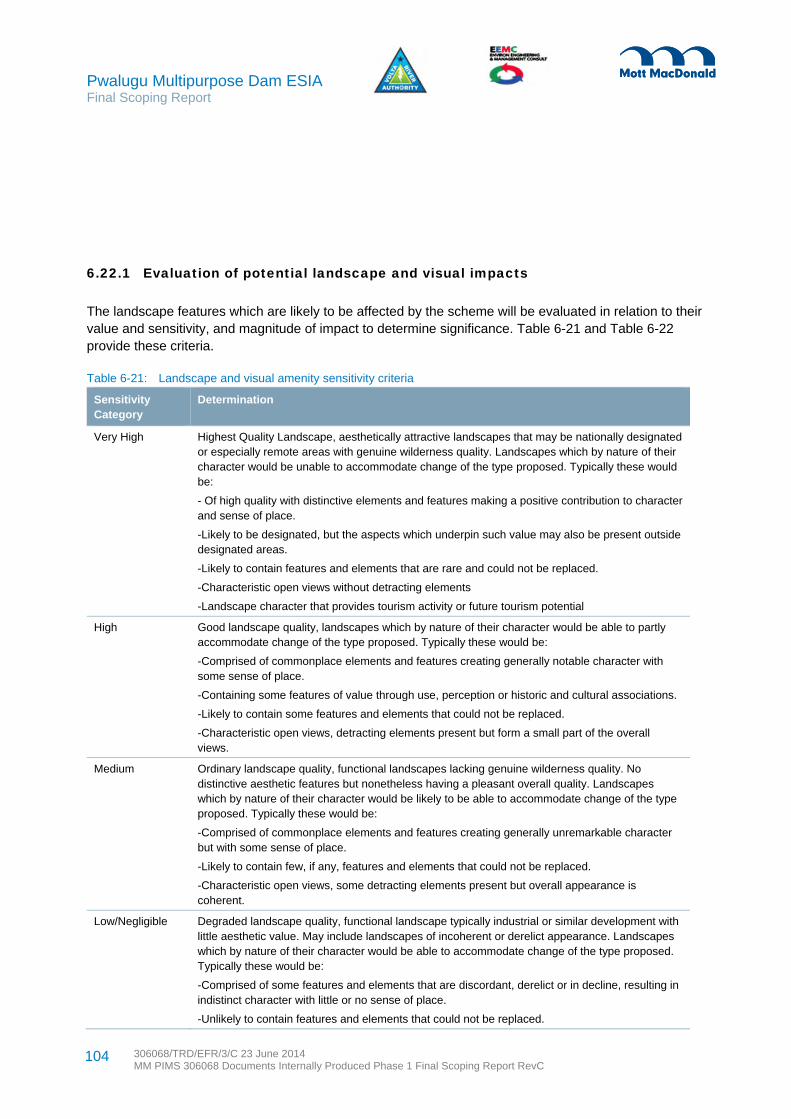
Pwalugu Multipurpose Dam ESIA Final Scoping Report
306068/TRD/EFR/3/C 23 June 2014 MM PIMS 306068 Documents Internally Produced Phase 1 Final Scoping Report RevC
104
6.22.1 Evaluation of potential landscape and visual impacts
The landscape features which are likely to be affected by the scheme will be evaluated in relation to their value and sensitivity, and magnitude of impact to determine significance. Table 6-21 and Table 6-22 provide these criteria.
Table 6-21: Landscape and visual amenity sensitivity criteria
Sensitivity Category
Determination
Very High Highest Quality Landscape, aesthetically attractive landscapes that may be nationally designated or especially remote areas with genuine wilderness quality. Landscapes which by nature of their character would be unable to accommodate change of the type proposed. Typically these would be:
- Of high quality with distinctive elements and features making a positive contribution to character and sense of place.
-Likely to be designated, but the aspects which underpin such value may also be present outside designated areas.
-Likely to contain features and elements that are rare and could not be replaced.
-Characteristic open views without detracting elements
-Landscape character that provides tourism activity or future tourism potential
High Good landscape quality, landscapes which by nature of their character would be able to partly accommodate change of the type proposed. Typically these would be:
-Comprised of commonplace elements and features creating generally notable character with some sense of place.
-Containing some features of value through use, perception or historic and cultural associations.
-Likely to contain some features and elements that could not be replaced.
-Characteristic open views, detracting elements present but form a small part of the overall views.
Medium Ordinary landscape quality, functional landscapes lacking genuine wilderness quality. No distinctive aesthetic features but nonetheless having a pleasant overall quality. Landscapes which by nature of their character would be likely to be able to accommodate change of the type proposed. Typically these would be:
-Comprised of commonplace elements and features creating generally unremarkable character but with some sense of place.
-Likely to contain few, if any, features and elements that could not be replaced.
-Characteristic open views, some detracting elements present but overall appearance is coherent.
Low/Negligible Degraded landscape quality, functional landscape typically industrial or similar development with little aesthetic value. May include landscapes of incoherent or derelict appearance. Landscapes which by nature of their character would be able to accommodate change of the type proposed. Typically these would be:
-Comprised of some features and elements that are discordant, derelict or in decline, resulting in indistinct character with little or no sense of place.
-Unlikely to contain features and elements that could not be replaced.

Pwalugu Multipurpose Dam ESIA Final Scoping Report
306068/TRD/EFR/3/C 23 June 2014 MM PIMS 306068 Documents Internally Produced Phase 1 Final Scoping Report RevC
105
Sensitivity Category
Determination
-Detracting elements dominate views.
Table 6-22: Magnitude criteria for landscape and visual effects
Magnitude Category Determination
Major adverse/beneficial Where the scheme would cause an immediately apparent feature (or improvement) in landscape character and quality. Or where the scheme would cause a significant deterioration (or improvement) in the existing view.
Moderate adverse/beneficial Where the scheme would cause a noticeable deterioration (or improvement) in landscape character and quality. Or where the scheme would cause a noticeable perceptible deterioration (or improvement) in the existing view.
Minor adverse/beneficial Where the scheme would cause a barely perceptible deterioration (or improvement) in landscape character and quality. Or where the scheme would cause a barely perceptible deterioration (or improvement) in the existing view.
Negligible No discernible deterioration or improvement in landscape character or quality. Or where the scheme would cause no discernible deterioration or improvement in the view.
6.22.2 Approach to landscape and visual mitigation
Areas of sensitive landscapes will be identified as part of the ESIA and avoided where possible. A significant portion of the forestry reserve is likely to be inundated. The forestry reserve will need mitigation and enhancement to help protect the remaining reserve from direct Project impacts and to offset the portion that is affected.
The scale of the proposed Project implies that tree planting or earth bunds would not be appropriate general measures to mitigate the potential impacts from the dam, transmission lines and access roads on landscape character and visual amenity of the surrounding areas, however where appropriate the ESIA will seek to identify areas where localised vegetative screening may provide mitigation opportunities.
6.23 Traffic and Transport
The traffic and transport assessment will focus on the issues associated with the construction phase of the Project only and the long term advantages to communities for operational roads. The most probable traffic routes to be used for the construction, operational and decommissioning phases of the development will be determined. These are typically those routes which link construction worksites to significant generators of traffic. The dam site will need to be accessed from both the north and south.
6.23.1 Traffic and transport surveys
Existing traffic and transportation survey data and road traffic accidents and safety statistics will be reviewed. Traffic surveys to be undertaken are summarised in Table 6-23. During the surveys vehicle

Pwalugu Multipurpose Dam ESIA Final Scoping Report
306068/TRD/EFR/3/C 23 June 2014 MM PIMS 306068 Documents Internally Produced Phase 1 Final Scoping Report RevC
106
types ((bicycle, tricycle, donkey cart, motorcycle, car, van, bus, lorry) will be identified and counted passing through the observation point in both directions. Photographic evidence of roads conditions such as maintenance status, pot holes, and presence of water (ponds) will be gathered.
Table 6-23: Traffic surveys
Type of
Survey
Duration Location Schedule
Traffic Scheme Survey
Ideally during 24 hr. Minimum 2 sets of 3 hours observation and number annotations during peak time and during normal traffic flow, both during day time.
For 2 non consecutive days
On each road link leading to and from the Project Site that could be affected by the traffic scheme.
For Winkogo and highway, Zuranguru and Bolga/Bawku road, Walugu and highway, Walewale and highway Gambaga and Walewale/Nakpanduri road, Nangode and Bolga/Bawku, Tilli and Bolga/Bawku junctions (7 in total)
Preferably on a Monday or Friday (with higher expected levels of traffic) and on a Wednesday (when traffic volumes are considered normal). Holidays will be avoided.
Road Junction Survey
Ideally during 24 hr. Minimum 2 sets of observation and number annotations during 2 hours of peak time and 2 hours on normal traffic flow.’
For 2 non consecutive days
Peak hour count of critical junctions that could be affected by the scheme traffic. Locations as above
Preferably on a Monday or Friday (with higher expected levels of traffic) and on a Wednesday (when traffic volumes are considered normal).
Holidays will be avoided.
Road Condition Survey
During Traffic Scheme Survey and the Road Junction Survey
On each road link and at critical junctions. Locations as above.
During Traffic Scheme Survey and the Road Junction Survey
6.23.2 Evaluation of potential traffic and transport impacts
The assessment will include: Forecasting the number and profile of two-way vehicle movements during each phase and percentage
increases in traffic flow Assessment of increases as a percentage of baseline flows against criteria from recognised guidance30 Appraisal of potential environmental and social effects arising from the increased traffic on road network
(e.g. increased dust) Assessment of cumulative traffic effects arising from other readily known developments in construction
phase
For each potential transport impact, significance will be attributed taking into account the magnitude of the impact and the sensitivity of the receptor. The magnitude of transport impacts is, to a degree, subjective. Determination of magnitude will therefore be based upon professional judgement taking into account the
30 In the absence of local guidance, the sensitivity of the routes will be assessed with due regard to IEMA Guidelines for the Environmental Assessment of Road Traffic (1993) on receptors/locations and stakeholder perceptions.

Pwalugu Multipurpose Dam ESIA Final Scoping Report
306068/TRD/EFR/3/C 23 June 2014 MM PIMS 306068 Documents Internally Produced Phase 1 Final Scoping Report RevC
107
sensitivity of the receiving environment. Sensitive receptors will include the settlements and communities adjacent to traffic routes to be used by construction vehicles.
6.23.3 Approach to traffic and transport mitigation
Construction phase mitigation measures for the minimisation of traffic and transport related effects will be identified. Where there is the potential for the Project to cause cumulative traffic and transport related effects, the assessment will consider the combined effects and identify applicable mitigation measures. Driver training for Project and pedestrian awareness programmes are anticipated to be necessary.
6.24 Cumulative Impact Assessment (CIA)
The assessment will address potential cumulative impacts that may arise from the incremental impact of the proposed Project when added to other closely related past, present and probable future projects.
Potential cumulative impacts associated with the development of the Project are likely to be combined effects and induced growth and spatial and temporal crowding. The CIA assessment will use the following approach:
Identify future activities within the directly and indirectly impacted areas and specify those that are considered relevant to this Project including those affects that might interact with the proposed Project (e.g. other planned major infrastructure projects in the region)
Identify potential sensitive receptors (human and flora and fauna) that may be affected Document, with quantities where available, predicted environmental and social changes to the
environment that might be reasonably anticipated from a proposed activity in combination with other identified activities
Recommend mitigation measures to guide the sustainable development of the Project and associated projects where activities are likely to conflict
Environmental and social effects of any other development that is already built and operational are effectively included within the ESIA baseline so they are excluded from the CIA to avoid double counting. The CIA will consider projects that are in the planning process and try to ascertain which if any are likely to become operational prior to the Project. Schemes that are substantially further back in the planning process and are unlikely to be submitted or get consent until after the Project, will be disregarded based on the assumption that the developers of those projects will need to take the Project into account in carrying out their own ESIA.
6.25 International Waterways and Transboundary Impacts
Transboundary impacts are impacts that extend to multiple countries, beyond the host country of the project, but are not global in nature. Table 6-24 explains how the nature of the Project triggers a transboundary impact assessment in light of the World Bank’s safeguard policy OP 4.03/World Bank PS 1 and IFC PS1. Some potential local impacts, such as migration, economic growth and land use change may directly and indirectly affect nearby upstream and downstream communities on the White Volta, possibly across international borders. The reservoir will not extend into Burkina Faso.
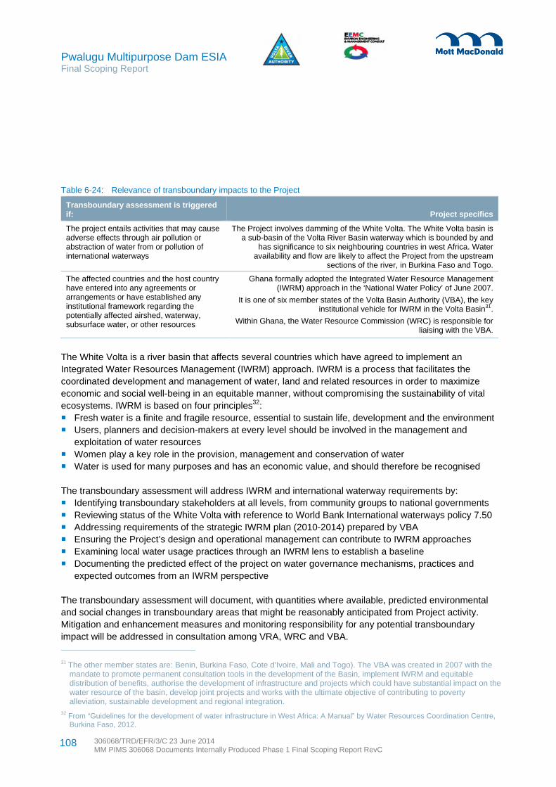
Pwalugu Multipurpose Dam ESIA Final Scoping Report
306068/TRD/EFR/3/C 23 June 2014 MM PIMS 306068 Documents Internally Produced Phase 1 Final Scoping Report RevC
108
Table 6-24: Relevance of transboundary impacts to the Project
Transboundary assessment is triggered if: Project specifics
The project entails activities that may cause adverse effects through air pollution or abstraction of water from or pollution of international waterways
The Project involves damming of the White Volta. The White Volta basin is a sub-basin of the Volta River Basin waterway which is bounded by and
has significance to six neighbouring countries in west Africa. Water availability and flow are likely to affect the Project from the upstream
sections of the river, in Burkina Faso and Togo.
The affected countries and the host country have entered into any agreements or arrangements or have established any institutional framework regarding the potentially affected airshed, waterway, subsurface water, or other resources
Ghana formally adopted the Integrated Water Resource Management (IWRM) approach in the ‘National Water Policy’ of June 2007.
It is one of six member states of the Volta Basin Authority (VBA), the key institutional vehicle for IWRM in the Volta Basin31.
Within Ghana, the Water Resource Commission (WRC) is responsible for liaising with the VBA.
The White Volta is a river basin that affects several countries which have agreed to implement an Integrated Water Resources Management (IWRM) approach. IWRM is a process that facilitates the coordinated development and management of water, land and related resources in order to maximize economic and social well-being in an equitable manner, without compromising the sustainability of vital ecosystems. IWRM is based on four principles32: Fresh water is a finite and fragile resource, essential to sustain life, development and the environment Users, planners and decision-makers at every level should be involved in the management and
exploitation of water resources Women play a key role in the provision, management and conservation of water Water is used for many purposes and has an economic value, and should therefore be recognised
The transboundary assessment will address IWRM and international waterway requirements by: Identifying transboundary stakeholders at all levels, from community groups to national governments Reviewing status of the White Volta with reference to World Bank International waterways policy 7.50 Addressing requirements of the strategic IWRM plan (2010-2014) prepared by VBA Ensuring the Project’s design and operational management can contribute to IWRM approaches Examining local water usage practices through an IWRM lens to establish a baseline Documenting the predicted effect of the project on water governance mechanisms, practices and
expected outcomes from an IWRM perspective
The transboundary assessment will document, with quantities where available, predicted environmental and social changes in transboundary areas that might be reasonably anticipated from Project activity. Mitigation and enhancement measures and monitoring responsibility for any potential transboundary impact will be addressed in consultation among VRA, WRC and VBA.
31 The other member states are: Benin, Burkina Faso, Cote d’Ivoire, Mali and Togo). The VBA was created in 2007 with the mandate to promote permanent consultation tools in the development of the Basin, implement IWRM and equitable distribution of benefits, authorise the development of infrastructure and projects which could have substantial impact on the water resource of the basin, develop joint projects and works with the ultimate objective of contributing to poverty alleviation, sustainable development and regional integration.
32 From “Guidelines for the development of water infrastructure in West Africa: A Manual” by Water Resources Coordination Centre, Burkina Faso, 2012.

Pwalugu Multipurpose Dam ESIA Final Scoping Report
306068/TRD/EFR/3/C 23 June 2014 MM PIMS 306068 Documents Internally Produced Phase 1 Final Scoping Report RevC
109
7.1 Overview
This section explains the stakeholder engagement process followed during the ESIA scoping study to date. A Consultation Strategy (CS) was developed to serve as a management tool to guide stakeholder engagement during the ESIA study. The CS aims promote communication among VRA and stakeholders including the public, non-governmental organisations (NGOs) and project affected persons. After a review of the CS guiding principles, this chapter describes scoping engagement activities and results.
7.2 Scoping Engagement Objectives
Stakeholder engagement during scoping has been well planned and based on the principles of respectful and meaningful dialogue outlined in the CS (see Appendix D). The scoping phase engagement activities sought stakeholder opinions on the potentially significant environmental and social issues relating to the implementation, operation, and decommissioning of the Pwalugu Multipurpose Dam and related activities that need to be addressed as part of the ESIA. A list of specific objectives for stakeholder engagement is in the CS.
For scoping, particular emphasis has been placed on:
Informing stakeholders about the proposed Project and why an ESIA is being undertaken Providing engagement opportunities to ensure that the benefits of the Project are maximised and that
no major potential impacts have been overlooked Providing engagement opportunities for stakeholders to influence project design in a positive manner Obtaining local and traditional knowledge to inform the ESIA process Reducing conflict through the early identifications of contentious issues and finding acceptable solutions Creating a sense of Project ownership or involvement in the minds of stakeholders Identifying issues of concern to stakeholders so these can be addressed appropriately within the ESIA
process Managing expectations and misconceptions regarding the Project Scoping stakeholder engagement activities have been undertaken in compliance with Ghana environmental law and related requirements as well as applicable World Bank Safeguard Policies and the Convention on the Protection and Use of Trans-boundary Watercourses and International Lakes. The legal and regulatory framework makes adequate provisions for public consultation and disclosure. The legal requirements provide the entry points for effective stakeholder engagement throughout the ESIA process and subsequent Project implementation. See the CS in Appendix C for details regarding legal requirements.
7.3 Scoping Phase Stakeholder Engagement Activities and Results
As part of the CS a stakeholder identification exercise was undertaken to identify key stakeholder groups, and organizations. Throughout the scoping phase, the database of stakeholders was expanded to include additional organisations and individuals identified which have an interest in the Project or knowledge that would provide insight into Project issues. The sections below provided results from individual meetings with
7 Consultation and Participation
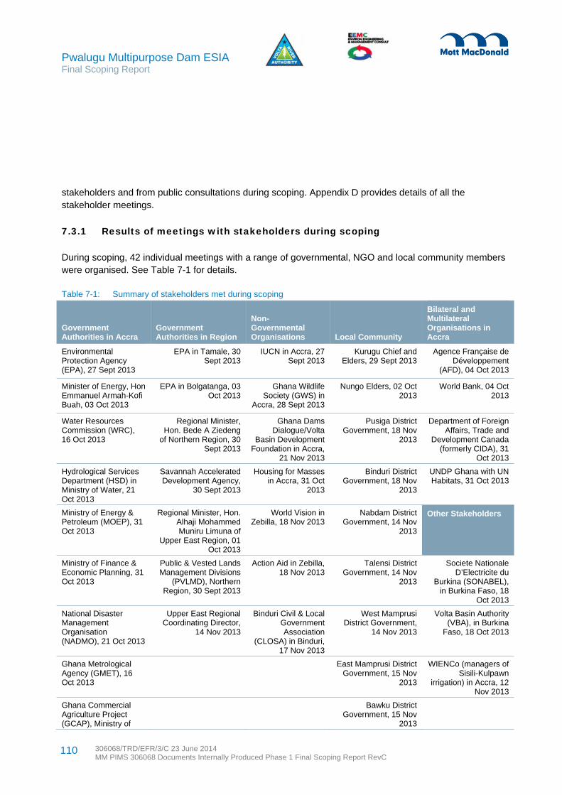
Pwalugu Multipurpose Dam ESIA Final Scoping Report
306068/TRD/EFR/3/C 23 June 2014 MM PIMS 306068 Documents Internally Produced Phase 1 Final Scoping Report RevC
110
stakeholders and from public consultations during scoping. Appendix D provides details of all the stakeholder meetings.
7.3.1 Results of meetings with stakeholders during scoping
During scoping, 42 individual meetings with a range of governmental, NGO and local community members were organised. See Table 7-1 for details.
Table 7-1: Summary of stakeholders met during scoping
Government Authorities in Accra
Government Authorities in Region
Non- Governmental Organisations Local Community
Bilateral and Multilateral Organisations in Accra
Environmental Protection Agency (EPA), 27 Sept 2013
EPA in Tamale, 30 Sept 2013
IUCN in Accra, 27 Sept 2013
Kurugu Chief and Elders, 29 Sept 2013
Agence Française de Développement
(AFD), 04 Oct 2013
Minister of Energy, Hon Emmanuel Armah-Kofi Buah, 03 Oct 2013
EPA in Bolgatanga, 03 Oct 2013
Ghana Wildlife Society (GWS) in
Accra, 28 Sept 2013
Nungo Elders, 02 Oct 2013
World Bank, 04 Oct 2013
Water Resources Commission (WRC), 16 Oct 2013
Regional Minister, Hon. Bede A Ziedeng
of Northern Region, 30 Sept 2013
Ghana Dams Dialogue/Volta
Basin Development Foundation in Accra,
21 Nov 2013
Pusiga District Government, 18 Nov
2013
Department of Foreign Affairs, Trade and
Development Canada (formerly CIDA), 31
Oct 2013
Hydrological Services Department (HSD) in Ministry of Water, 21 Oct 2013
Savannah Accelerated Development Agency,
30 Sept 2013
Housing for Masses in Accra, 31 Oct
2013
Binduri District Government, 18 Nov
2013
UNDP Ghana with UN Habitats, 31 Oct 2013
Ministry of Energy & Petroleum (MOEP), 31 Oct 2013
Regional Minister, Hon. Alhaji Mohammed Muniru Limuna of
Upper East Region, 01 Oct 2013
World Vision in Zebilla, 18 Nov 2013
Nabdam District Government, 14 Nov
2013
Other Stakeholders
Ministry of Finance & Economic Planning, 31 Oct 2013
Public & Vested Lands Management Divisions
(PVLMD), Northern Region, 30 Sept 2013
Action Aid in Zebilla, 18 Nov 2013
Talensi District Government, 14 Nov
2013
Societe Nationale D’Electricite du
Burkina (SONABEL), in Burkina Faso, 18
Oct 2013
National Disaster Management Organisation (NADMO), 21 Oct 2013
Upper East Regional Coordinating Director,
14 Nov 2013
Binduri Civil & Local Government Association
(CLOSA) in Binduri, 17 Nov 2013
West Mamprusi District Government,
14 Nov 2013
Volta Basin Authority (VBA), in Burkina
Faso, 18 Oct 2013
Ghana Metrological Agency (GMET), 16 Oct 2013
East Mamprusi District Government, 15 Nov
2013
WIENCo (managers of Sisili-Kulpawn
irrigation) in Accra, 12 Nov 2013
Ghana Commercial Agriculture Project (GCAP), Ministry of
Bawku District Government, 15 Nov
2013

Pwalugu Multipurpose Dam ESIA Final Scoping Report
306068/TRD/EFR/3/C 23 June 2014 MM PIMS 306068 Documents Internally Produced Phase 1 Final Scoping Report RevC
111
Government Authorities in Accra
Government Authorities in Region
Non- Governmental Organisations Local Community
Bilateral and Multilateral Organisations in Accra
Food & Agriculture (MOFA)
Land Commission, 21 Nov 2013
Bawku West District Government, 16 Nov
2013
GaruTempane District Government, 16 Nov
2013
Table 7-2 contains a summary of the issues raised by stakeholders during the scoping phase.
Table 7-2: Summary of issues raised by stakeholders during scoping
Issues raised Main comments How they will be addressed in the ESIA
Sensitive biodiversity Stakeholders voiced concern regarding impact on forest reserve, the Important Bird Area (IBA) and on habitats. The reservoir with the nationally designated Gambaga Scarp Forest Reserve which is a hotspot for birds.
The rapid biodiversity assessment has several study locations at the Reserve
Livelihoods Stakeholders informed about dependency on agrarian life and fishing. Trees, in particular sheanut, are also important. Pwalugu is known for tomato farming. Water is a major determinant of agriculture in the north and currently villages only get one seasonal harvest. Gender issues and land tenure affect family well-being.
A livelihood assessment will be undertaken
Benefits of the ‘Project’ Most stakeholders supported the Project and generally there was interest in the three main objectives. It was noted that sometimes with these types of projects there is limited investment in the communities which must be addressed.
Benefit sharing opportunities will be reviewed
Link with other dams Bagré will affect water availability for Pwalugu. Need to learn from the Akosombo and Bui experiences. Important to coordinate with Sisili-Kulpawn irrigation project and any dams they may build.
Hydrology data from Bagré, Akosombo and Kpong will inform the ESIA. Interviews with those familiar with Bui will be undertaken. Stakeholder engagement with Wienco and SADA on Sisili-Kulpawn has been initiated and will continue
ESIA process, regulatory/permit issues
A full ESIA process is required before a permit is issued. A scoping exercise to know the baseline information is needed in the EPA format. Copies of the Scoping Report should be sent to District Assemblies for comments and to EPA to post on its website, offices and libraries. At least one public hearing maybe more, sometimes smaller hearings at all the districts, can be required for large projects.
The ESIA will be produced to meet EPA and international lender ESIA process standards.
Transboundary issues Consultation with Burkina Faso (BF) needs to take place. Initial meetings were held in BF and regional stakeholders were
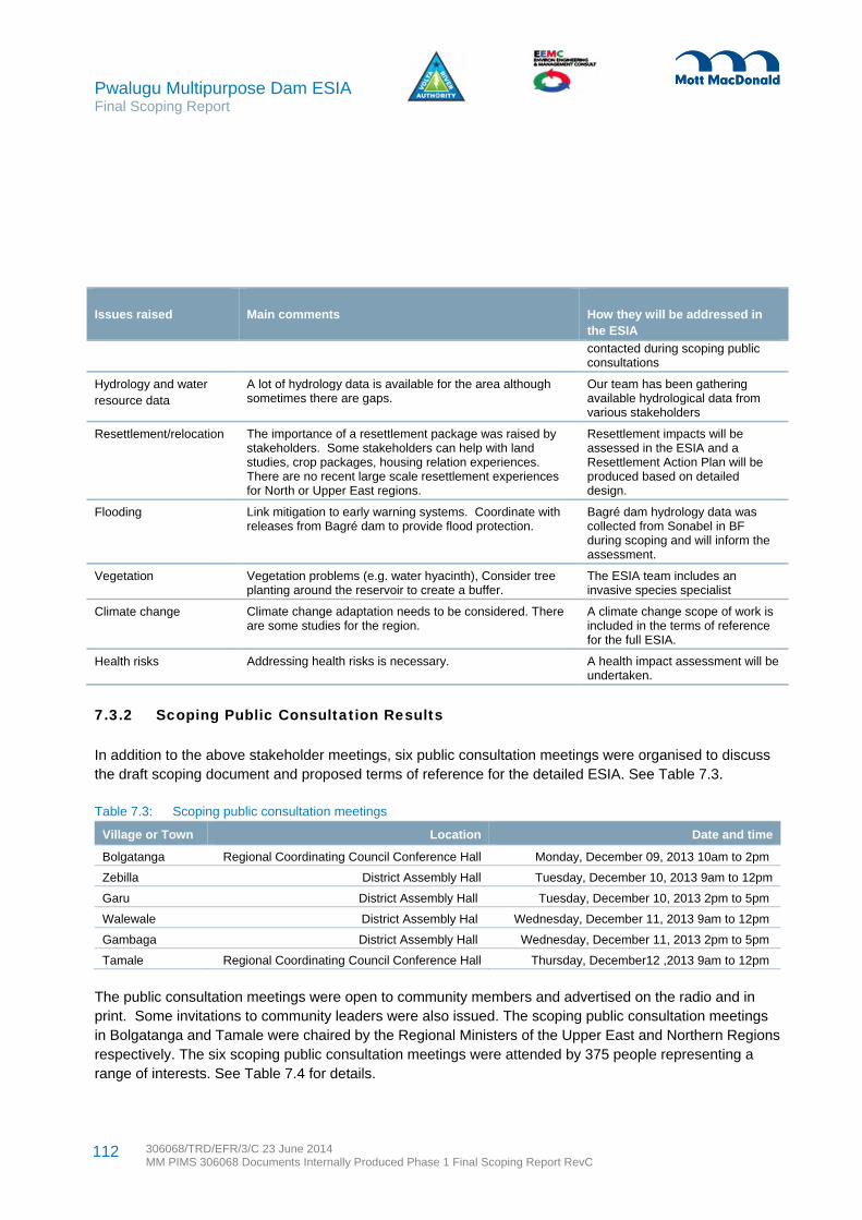
Pwalugu Multipurpose Dam ESIA Final Scoping Report
306068/TRD/EFR/3/C 23 June 2014 MM PIMS 306068 Documents Internally Produced Phase 1 Final Scoping Report RevC
112
Issues raised Main comments How they will be addressed in the ESIA
contacted during scoping public consultations
Hydrology and water resource data
A lot of hydrology data is available for the area although sometimes there are gaps.
Our team has been gathering available hydrological data from various stakeholders
Resettlement/relocation The importance of a resettlement package was raised by stakeholders. Some stakeholders can help with land studies, crop packages, housing relation experiences. There are no recent large scale resettlement experiences for North or Upper East regions.
Resettlement impacts will be assessed in the ESIA and a Resettlement Action Plan will be produced based on detailed design.
Flooding Link mitigation to early warning systems. Coordinate with releases from Bagré dam to provide flood protection.
Bagré dam hydrology data was collected from Sonabel in BF during scoping and will inform the assessment.
Vegetation Vegetation problems (e.g. water hyacinth), Consider tree planting around the reservoir to create a buffer.
The ESIA team includes an invasive species specialist
Climate change Climate change adaptation needs to be considered. There are some studies for the region.
A climate change scope of work is included in the terms of reference for the full ESIA.
Health risks Addressing health risks is necessary. A health impact assessment will be undertaken.
7.3.2 Scoping Public Consultation Results
In addition to the above stakeholder meetings, six public consultation meetings were organised to discuss the draft scoping document and proposed terms of reference for the detailed ESIA. See Table 7.3.
Table 7.3: Scoping public consultation meetings
Village or Town Location Date and time
Bolgatanga Regional Coordinating Council Conference Hall Monday, December 09, 2013 10am to 2pm
Zebilla District Assembly Hall Tuesday, December 10, 2013 9am to 12pm
Garu District Assembly Hall Tuesday, December 10, 2013 2pm to 5pm
Walewale District Assembly Hal Wednesday, December 11, 2013 9am to 12pm
Gambaga District Assembly Hall Wednesday, December 11, 2013 2pm to 5pm
Tamale Regional Coordinating Council Conference Hall Thursday, December12 ,2013 9am to 12pm
The public consultation meetings were open to community members and advertised on the radio and in print. Some invitations to community leaders were also issued. The scoping public consultation meetings in Bolgatanga and Tamale were chaired by the Regional Ministers of the Upper East and Northern Regions respectively. The six scoping public consultation meetings were attended by 375 people representing a range of interests. See Table 7.4 for details.

Pwalugu Multipurpose Dam ESIA Final Scoping Report
306068/TRD/EFR/3/C 23 June 2014 MM PIMS 306068 Documents Internally Produced Phase 1 Final Scoping Report RevC
113
Table 7.4: Participation at the scoping public consultation meetings
Location Total
# Male Female
Local reps from
national govt
Regional govt
Local govt
Chiefs or
their reps
Private sector
NGOs or Research Media
Members of the public
Bolgatanga 54 49 5 14 6 7 4 1 13 7 2
Zebilla 45 43 2 8 31 1 4 1
Garu 116 96 20 25 56 8 16 1 10
Walewale 80 75 5 13 39 15 3 7 1 2
Gambaga 34 29 5 10 14 5 5
Tamale 46 42 4 12 4 9 4 17
Subtotals 375 334 41 82 10 156 33 4 49 26 15
Table 7-5 presents a summary of issues raised by stakeholders during the scoping consultation.
Table 7-5: Summary of issues raised during scoping public consultations
Issues raised Main comments How they will be addressed in the ESIA
Flooding More explanation on how PMD would control flooding is needed since not much was said about the extent to which the PMD will control flooding.
Because of concerns about disasters associated with flooding, involvement of NADMO was recommended.
The Scoping Report now includes more analysis of the three main objectives. Flood control will not be possible but there will be flood management.
The Feasibility Consultant is looking at the hydrology data available and rainfall pattern. The ESIA will use the data and their reservoir simulation results in the determination of impacts and significance.
NADMO is a key player in the ESIA exercise and part of the Project Steering Committee. They have been consulted during scoping and will be consulted more during the ESIA phase.
Health When the dam is constructed and water is impounded it will facilitate breeding of mosquitoes resulting in malaria. How is the proponent of the Project going to deal with this issue?
Sanitation related issues were identified, particularly water quality.
Distance between the Project site and communities will help minimise impact on the affected persons
When Bagré Dam opens its spillways, communities along the White Volta get flooded and destroy water points which serve as a source of drinking water, livestock, crops farmlands, dams, and roads.
There will be health related issues, including HIV/AIDS, from presence of construction workers including expatriates. Will there be family health education? There is the likelihood of an increase in STDs due to influx of people.
A chapter on health impacts will be produced based on the terms of reference available in Appendix C. It will address water borne/related diseases including malaria and river blindness. For instance, a malaria control plan may be required which would be aligned to the national malaria control programme. Buffer zone where there will be prohibitions of human activities will be considered. HIV/AIDs and STDs will be addressed in management plans, including occupational health plans which contractors and the operator will be required to have in place.
VRA Health and Sanitation Department will take water samples to conduct water analysis to ensure that the water quality is not compromised at its dam. This type of monitoring is likely to be required.
Vegetation clearance and tree stumps
Water weeds and tree stumps can affect the dam’s lifespan.
After the construction of the Akosombo Dam
The environmental management plans will include guidelines for vegetation clearance in areas where land is inundated.

Pwalugu Multipurpose Dam ESIA Final Scoping Report
306068/TRD/EFR/3/C 23 June 2014 MM PIMS 306068 Documents Internally Produced Phase 1 Final Scoping Report RevC
114
Issues raised Main comments How they will be addressed in the ESIA
there have been disasters due to stumps in the river. This should be avoided.
Erosion control Erosion control needs to be in place to help preserve the catchment areas.
Erosion control measures will be considered in the environmental management plan.
Irrigation There is an irrigation site located downstream far away from Garu Temapane which is upstream. How are people upstream going to benefit from the irrigation facilities?
A dam was constructed in Deogo and Yarigu to irrigate about 500ha of lands and it is close to the White Volta. Wihen the PMD is constructed will the Deogo and Yarigo irrigation projects will be flooded and destroyed?
More information on irrigation capacities is needed.
The construction of the PMD should not lead to shortage of water supply which will affecting farming
The ESIA will describe the analysis process for choosing the preferred irrigation location. All the irrigation locations are on the west side of the Tamale-Bolgatanga highway.
Other dams and irrigation systems in the Project zone will be mapped. Any affected lands will be compensated.
The ESIA will update the defined amount of irrigation benefits.
Water Supply Contact the hydrological department to get the water flow rate data for further analysis to prevent water supply shortages
The Nawuli and Danlo water treatment plants get water supply from the White Volta. In Greater Accra Region, social activities of residents of Nsawam have been affected the Weija Dam.
Siltation should be avoided
Communities that will be resettled are likely to face water problem so they need to be provided them with potable water.
The hydrology of the White Volta is being studied to ensure that water flowing downstream is not disturbed. The hydrology studies will also cover water flow to Akosombo and Kpong Dams. The ESIA uses. We have hydrology data from the 1936s to date for our studies.
Existing water supply systems and needs will be captured in the ESIA so that they remain in operation. Consultation with GWCL will be undertaken to maintain existing services.
Fisheries In-migration of fishers (who are not indigenous) and its related social problems is a concern
The ESIA will suggest ways to help the dam designers provide adequate water flow downstream to support he natural ecosystem. Fish passes and other measures to support fish migration will be considered.
The SIA will need to address in-migration and help local fishermen with fish capture skills.
Siltation Because of the continuous flooding of basin and farming along basin, there is a lot of silt in the basin. Is there going to be dredging to make the basin deeper?
The ESIA will discuss sedimentation effects and identify how silt content will be monitored and managed.
Environment Construction of the PMD will affect our ecosystem including wildlife. For example, the Morago West and Red Volta East forest reserves are going to be inundated by water and wildlife would be seriously affected. The area is rich in specie. It has black monkey and African crocodile
Measures need to be put in place to regenerate the vegetation.
Deforestation and forestation are related issues. If part of the forest is cut away without proper reforestation it would contribute to climate change. This project is going to contribute to
The ESIA will map the land areas and forest reserve areas that will be inundated. Ways of compensating for lost habitat will be identified.
A forest programme will be needed to replace lost reserve. Procedures will be identified for relocating any endangered species which will be directly affected by construction activities.
Flood management is an objective of the Project

Pwalugu Multipurpose Dam ESIA Final Scoping Report
306068/TRD/EFR/3/C 23 June 2014 MM PIMS 306068 Documents Internally Produced Phase 1 Final Scoping Report RevC
115
Issues raised Main comments How they will be addressed in the ESIA
Climate Change.
The water from the Bagré dam spreads to Binduri, where there are a lot of settlers along the banks of the White Volta. If the water floods, what are you going to do for affected people?
Land and resettlement including compensation
Migrant farmers may lose their lands because of the project
Some districts that the river passes through have been left out as affected districts, for example Binduri and Bawku Municipal Assemblies
Compensation should be not only for land owners but also people living along the river.
People along the river bank should be consulted as they may provide information that we cannot.
Resettlement of the communities could also affect the development work, particularly of NGOs, and lead to donors withdrawing funding.
Compensation to landowners is challenging when areas are under dispute.
There should be a paradigm shift when it comes to payment of compensation. It is often paid when the project is completed. Delays in payment of compensation often negatively affect the people because the people are poor. Compensation package should be paid before commencement of the project
Government should document the lands to avert a situation where a new Chief will come and argue that the land was not properly compensated for.
Land is owned by the Chief so would money be paid to the Chief. What about other land users?
People living upstream will need to be compensated if their farmlands are inundated. They should have the option of going downstream to continue their farming in the proposed irrigation site.
At the local level, we do not demarcate our land before building. We do not have documents but we should still be compensated.
The compensation to be carried out will have to actually save the inhabitants, not like the people of Bui who have all not received their compensations.
Project Managers sometimes do not follow the Environmental Social Management Plans prepared by Consultants. In the case of the Bui Dam, the people complained that the resettlement houses built were not spacious.
Part of the scarp that would be flooded has economic trees, like shea trees. The tree does not belong to anybody but there should be
The resettlement action plan will aim to identify all land users, including seasonal farmers. Field surveys with affected people will be undertaken. Consultations with the legitimate representatives of affected communities, with NGOs and CBOs working in the villages, and with male and female household members will be organised. See Appendix 6.9 for the terms of reference for producing the Resettlement Action Plan in line with WB OP 4.12 requirements.
The resettlement plan will include an entitlement matrix with categories of affected persons and type of losses. Effects on host communities will be considered in the resettlement plan. The Resettlement Action Plan will include a provision for a grievance redress mechanism.
International lenders require compensation payment prior to land acquisition. However spreading payments can contribute to household management of expenses.
All land transactions will be documented.
The resettlement plan will recognise those living in the affected place for considerable amount of time. The Resettlement Action Plan is guided by World Bank operational policies for various means are possible to establish ownership or eligibility. Having no land documents does not disqualify affected people from compensation.
The resettlement plan will include monitoring and evaluation activities.
Farmland, trees and crops compensation will be detailed in the RAP and in contracts with affected people. The value of economic trees will be established in consultation with the Ministry of Agriculture.
Financial management training will be considered when large sums of compensation are likely to be paid.
The resettlement planning process will be used to establish a cut-off date. Once the cut-off date is established it will be widely announced After the cut-off date undertaking new activities in the Project affected area will not be recognised.
VRA has Real Estate Department. In the construction of Akosombo and Kpong Dams prototype houses were built in consultation with the people. This approach will be considered.
The RAP will build on Bui Dam experience.

Pwalugu Multipurpose Dam ESIA Final Scoping Report
306068/TRD/EFR/3/C 23 June 2014 MM PIMS 306068 Documents Internally Produced Phase 1 Final Scoping Report RevC
116
Issues raised Main comments How they will be addressed in the ESIA
compensation.
Roads in the catchment area that may be destroyed need compensation.
There is an experience whereby in previous projects affected persons who were compensated for lost houses misapplied the monetary compensation made to them. Measures to avoid this are needed.
Those whose houses will be affected need to be assisted to have their new homes
Likelihood of speculation: people knowing that the area around the river will be inundated rush there to build houses in anticipation for compensation.
Regarding compensation, the proper people i.e. property owners in addition with the Chiefs should be involved at beginning and every stage of the consultations. They should not only deal the Chiefs
On issues of compensation and community entry, the proponent of the project should pass through the District Assemblies
Concerning speculation and sprinkling of houses, if the consultant undertaking the feasibility could provide information on the affected areas or demarcation for the affected areas, the DAs can prevent people from building in such places.
Allowing affected people to build their own houses will create problem for VRA and delay the project. The PMDP should put a scheme in place to build the houses and resettle the affected persons.
Property owners may be affected by the PMDP. In the Vea Dam there were difficulties because affected persons were not considered.
There has been no mention of social amenities and essential services for the affected communities. There is likelihood of group settlement so they need portable water
Traditional areas have boundaries and it is not always easy to resettle people in another Traditional area boundary.
If the land affected is ancestral lands and compensation is paid to the living, what happens to the generations unborn?
Gender Women in this part of the country do not own land. Normally farmlands are given to them by their husbands and other relatives. Once the dam is constructed the lands will be inundated so our husbands would lose their lands. It will be difficult for women to get land to continue with their farming. Handle women’s compensation issues separately from the men. If you are going to build
The ESIA will include a gender assessment and there will be focus groups with women. Both the ESIA and resettlement plan will aim to contribute to increased gender equality in the Project area.
The skills development programme will include training for women in non-traditional fields.
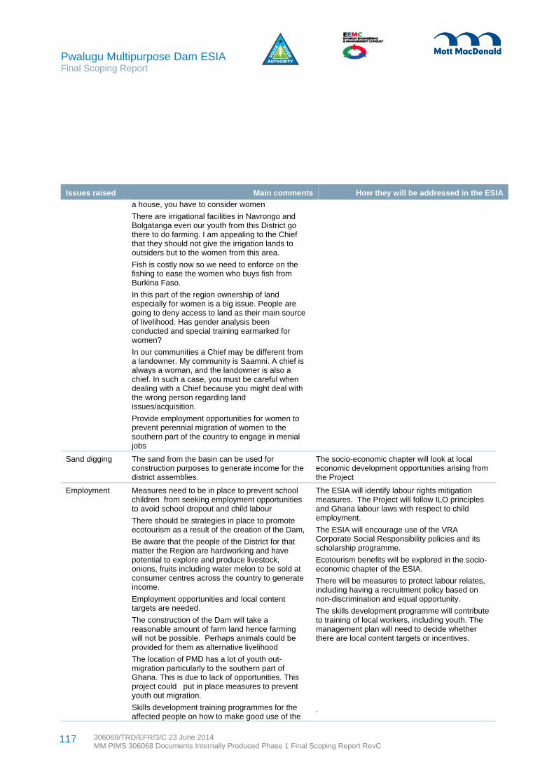
Pwalugu Multipurpose Dam ESIA Final Scoping Report
306068/TRD/EFR/3/C 23 June 2014 MM PIMS 306068 Documents Internally Produced Phase 1 Final Scoping Report RevC
117
Issues raised Main comments How they will be addressed in the ESIA
a house, you have to consider women
There are irrigational facilities in Navrongo and Bolgatanga even our youth from this District go there to do farming. I am appealing to the Chief that they should not give the irrigation lands to outsiders but to the women from this area.
Fish is costly now so we need to enforce on the fishing to ease the women who buys fish from Burkina Faso.
In this part of the region ownership of land especially for women is a big issue. People are going to deny access to land as their main source of livelihood. Has gender analysis been conducted and special training earmarked for women?
In our communities a Chief may be different from a landowner. My community is Saamni. A chief is always a woman, and the landowner is also a chief. In such a case, you must be careful when dealing with a Chief because you might deal with the wrong person regarding land issues/acquisition.
Provide employment opportunities for women to prevent perennial migration of women to the southern part of the country to engage in menial jobs
Sand digging The sand from the basin can be used for construction purposes to generate income for the district assemblies.
The socio-economic chapter will look at local economic development opportunities arising from the Project
Employment Measures need to be in place to prevent school children from seeking employment opportunities to avoid school dropout and child labour
There should be strategies in place to promote ecotourism as a result of the creation of the Dam,
Be aware that the people of the District for that matter the Region are hardworking and have potential to explore and produce livestock, onions, fruits including water melon to be sold at consumer centres across the country to generate income.
Employment opportunities and local content targets are needed.
The construction of the Dam will take a reasonable amount of farm land hence farming will not be possible. Perhaps animals could be provided for them as alternative livelihood
The location of PMD has a lot of youth out- migration particularly to the southern part of Ghana. This is due to lack of opportunities. This project could put in place measures to prevent youth out migration.
Skills development training programmes for the affected people on how to make good use of the
The ESIA will identify labour rights mitigation measures. The Project will follow ILO principles and Ghana labour laws with respect to child employment.
The ESIA will encourage use of the VRA Corporate Social Responsibility policies and its scholarship programme.
Ecotourism benefits will be explored in the socio-economic chapter of the ESIA.
There will be measures to protect labour relates, including having a recruitment policy based on non-discrimination and equal opportunity.
The skills development programme will contribute to training of local workers, including youth. The management plan will need to decide whether there are local content targets or incentives.
.

Pwalugu Multipurpose Dam ESIA Final Scoping Report
306068/TRD/EFR/3/C 23 June 2014 MM PIMS 306068 Documents Internally Produced Phase 1 Final Scoping Report RevC
118
Issues raised Main comments How they will be addressed in the ESIA
project irrigation facility is essential.
Be ready to identify arrangement to support youth education and prevent them from going into fishing at early age. What sponsorship scheme does VRA have in place?
We are already in deprived areas and we are looking for interventions that will help solve our poverty problem. The Project will create employment and to a large extent reduce the poverty of the people.
What is the fate of Pwalugu tomato factory under the PMDP?
Transportation across the river
Bupei River, a big river, facilitates transportation of people from the Northern region to Upper East regions.
In Garu Tempane District Assembly (GTDA) the shortest route linking the District to Bawku West District is through Kugri across the White Volta at Binaba
From Kugri one can access Bawku west and Tamale. From Garu you can access Binaba but with the construction of the dam it will be difficult to access such places, we need steel bridges to facilitate our movement to the nearby communities/towns
We are talking about how the expanded water will destroy bridges but we can also think about how the water can facilitate water transportation between Kugri and Garu, it would be cheaper and easier than road transportation.
The ESIA will need to assess access issues. There may be opportunities to improve river transportation
Infrastructure The Project should ensure that education does not suffer.
Roads linking the Northern Region have a possibility of getting flooded thus cutting off communities
Looking at the Upper East Region, there are two bridges Kobori and Pwalugu which could be affected. Considering the volume of water that is likely to pass under these bridges, they may collapse and affect transportation system.
There is an irrigation project at Tami on the tributary of the White Volta River; I want to know whether this project will still be relevant with the construction of the PMD?
There are fears that the PMD will make the rivers expand their volumes and make the bridges inundated.
Once people will lose their farmlands due to the inundation and also because people will not be allowed to farm close to the reservoir, is it possible to construct natural canals from the reservoir to farm lands in the upstream areas so that in the dry season people can continue with
If schools are to be inundated or access restricted, plans would be put in place to ensure the continuity of services. Such issues will be addressed in the socio-economic chapter or in the resettlement plan.
The resettlement plan will include spatial planning principles and consider access standards to social services and infrastructure.
The traffic and transportation chapter will review access and road infrastructure, including bridge issues.
The environmental management plan will address borrow pit management and reclamation after use. It is likely that most borrow pits created as a result of the construction of the Dam will constitute part of the reservoir and so they will be covered by the water.

Pwalugu Multipurpose Dam ESIA Final Scoping Report
306068/TRD/EFR/3/C 23 June 2014 MM PIMS 306068 Documents Internally Produced Phase 1 Final Scoping Report RevC
119
Issues raised Main comments How they will be addressed in the ESIA
farming and also engage in aquaculture.
Have you considered the likely impact of PMD on the proposed construction of eastern corridor road?
Will the bridge on the White Volta on the Bolga-Bawku road be inundated when the Dam is completed?
When the Dam is completed and there is need to spill water what will be the impact on the downstream bridges?
Have you assessed the strength of the bridges in respect of haulage of heavy equipment?
Affected communities will need to access social services (market places, schools and health facilities) and inundation should not cut them off from these facilities.
One of the problems that we are likely to face is borrow pits. When the work is about to begin the EPA is involved to avoid indiscriminate opening of pits
Project Location
The engineers should consider moving the PMD closer to the Burkina Faso’s border order to minimise the impacts on Ghana when the Bagré Dam in Burkina Faso is open.
This scoping report provides details on the key site selection issues. The ESIA will include a project description with an analysis of alternatives.
Other (disasters, reckless drivers)
There have been other projects which are not big such as the PMD but the project drivers were disrespectful. Conduct of drivers of trucks moving heavy equipment to the project sites could be reckless at certain times thereby destroying properties. Educate project drivers before the commencement of the project
Any proposal to blast rocks for the PMDP should involve the communities and District Assembly
The PMD could consider links with the Community Resilient through Early Warning System with has funding from Norway.
The environmental management plan will include traffic management measures and driver training.
The environmental management plan will address blasting permitting procedures and high standards of operation observed.
The ESIA team will consult with the Project.
Project Steering Committee organisation
Co-opt the RCCs into the Steering Committee
Is it possible to expand the membership of the Steering Committee for the project to include representation from Traditional Rulers or the District Assemblies?
Conspicuously missing in the membership of the Steering Committee is National Security
Looking at dam construction, disaster can occur at any time, before and after the construction. NADMO should be part of Steering Committee
VRA is responsible for setting up the Project Steering Committee. The role of the Steering Committee will be identified in the ESIA documentation. NADMO is part of the Project Steering Committee
Social issues (social conflict, safety issues, consultation)
During the construction of such project there is pollution in the environment by truck drivers and this often leads to attacks on the truck drivers by the youth.
Engaging local security agencies could assist in
The ESMS will include a traffic management plan.
National security agencies will be consulted throughout the life of the Project. Some representatives attended scoping public consultation. In particular an emergency
Pwalugu Multipurpose Dam ESIA Final Scoping Report
306068/TRD/EFR/3/C 23 June 2014 MM PIMS 306068 Documents Internally Produced Phase 1 Final Scoping Report RevC
120
Issues raised Main comments How they will be addressed in the ESIA
case of unforeseen problems.
Are there plans or measures in place for the people to assess the impact of the project on livelihoods?
Chiefs are landlords. It is important to involve them in these kinds of consultations
Potential conflict can arise between the people of Northern Region and Upper East Region since the dam traverses the two regions.
The opening of the Bagre Dam without notice is a problem. Lack of information about spillage of water has resulted in loss of lives of the people. Are you taking into consideration of loss of lives?
There is the likelihood of agitations between the Chiefs and the youth due to improper disclosure
It is necessary to develop a communication strategy detailing how to consult the people
There will be migration to the project area – how are you going to deal with late migrants?
What measures or steps have been taken to sensitise the youth of the affected communities about the positive impact of the project and their involvement in decision making, in order to prevent future agitations and demonstrations which are likely to delay or halt the project?
What are the plans for managing likely conflict situations that may arise with claims of compensations between owners of lands, Chiefs and Heads of families?
preparedness response is expected to be required and relevant agencies (such as police, fire department, hospital representatives) would have an opportunity to comment on drafts and help with any simulations of emergencies.
A livelihood assessment is anticipated in the detailed ESIA phase. Focus groups will be held to discuss various livelihoods.
Local chiefs are being consulted throughout the ESIA process. Results will be documented. Many chiefs and their representatives attended scoping public consultation meetings.
During detailed analysis a conflict assessment will be undertaken. Ways to prevent conflict will be identified as mitigation measures.
This scoping report includes the consultation strategy in Appendix D. The consultation strategy includes communication activities.
Cultural heritage
Protection of cultural heritage is important. A project like this must take note of graves and sacred places. For smooth take-off we will like to perform rituals in Talensi Traditional Area.
Cultural traditions and rites in the project area must be held and required rites performed.
A chapter assessing the impacts on cultural heritage will be in the ESIA. The TORs for it are in Appendix C.
No expatriate on the ESIA Study will come to the project area without a Ghanaian counterpart.
Accidents from water transportation
After the construction of the Akosombo Dam there have been disasters due to stumps in the river. How different would PMDP be?
Tree stumps in the River are likely to cause deaths.
A vegetation clearance plan is anticipated that will consider tree stumps.

Pwalugu Multipurpose Dam ESIA Final Scoping Report
306068/TRD/EFR/3/C 23 June 2014 MM PIMS 306068 Documents Internally Produced Phase 1 Final Scoping Report RevC
121
The analysis carried out to produce this Scoping Report and ESIA terms of reference shows that the two main potential adverse impacts, namely loss of forest and resettlement, need more analysis to determine how significant they will be for the Project’s acceptance. National laws and regulations and international standards will be adhered to in the identification of mitigation, management and enhancement measure for these and the rest of the identified potential impacts.
The needs case for the Project is the three main multipurpose objectives that stakeholders to date generally agree are needed: power generation, irrigation development and flood management. To date the benefits of future fisheries development and tourism development while positive seem to be minor. The main outputs of electricity, agriculture production and less losses through flooding will be a source of revenue for the regions and country.
8 Conclusions and Recommendations

Pwalugu Multipurpose Dam ESIA Final Scoping Report
306068/TRD/EFR/3/C 23 June 2014 MM PIMS 306068 Documents Internally Produced Phase 1 Final Scoping Report RevC
122
9 References
Bechtold, G. 2012. GIS Assessment of Pwalugu Reservoir Site in Northern Ghana. For World Bank.
Bird Life International. Data accessed on: http://www.birdlife.org/datazone/sitefactsheet.php?id=6337 p.13
Cernea, M.M. (undated) Impoverishment Risks, Risk Management, and Reconstruction: A Model for Population Displacement and Resettlement. The World Bank.
Composite Budget Reports for districts, accessed at: www.ghanadistricts.com
Dankwa, H. R., Abban, E. K. & Teugels, G. G. (1999). Freshwater fishes of Ghana: Identification, Distribution, Ecological and Economic Importance. Annales Sciences Zoologiques 283, 53 p.
Denyoh, F. M. K. (1969). Changes in fish populations and gear selectivity in Volta Lake. In Obeng L. E. Man-made Lakes, the Accra symposium. (pp. 206-219).
Districts of Ghana (2013). Accessed on: http://www.ghanadistricts.com/
Equator Principles (2013). The Equator Principles.
FAOWater (2010). Livelihood Zone Analysis. A tool for planning agricultural water management investiments: Ghana.
Ghana EPA, UNDP and NADMO Ghana (2010). Guidebook on Integrating Climate Change and Disaster Risk into National Development, Policies and Planning in Ghana.
Ghana Statistical Service – National Data Archive (NADA) (2012). Population and Housing Census 2010 - Ghana
Institute of Ecology and Environmental Management (IEEM) (2006). Guidelines for Ecological Impact Assessment in the United Kingdom.
International Finance Corporation (IFC) World Bank Group (2007). Environmental, Health and Safety (EHS) General EHS Guidelines.
International Finance Corporation (IFC) World Bank Group (2007). Environmental, Health and Safety Guidelines for Electric Power Transmission and Distribution.
International Finance Corporation (IFC) World Bank Group (2007). Environmental, Health and Safety (EHS) Guidelines. General EHS Guidelines: Environmental. Noise Management.
King, P. and Bird, J. and Haas, L. (2007). Environmental Criteria for Hydropower Development in the Mekong River. WWF.
Ledec, G. and Quintero, J.D. (2003) Good and Bad Dams: Environmental Criteria for Site Selection of Hydroelectric Projects. The World Bank.
Ministry of Food and Agriculture and Irrigation Development Agency (2012). Ghana Agricultural Water Management Investment Framework.
Petr, T. (1968). The establishment of lacustrine fish populations in the Volta Lake in Ghana during 1964-1966. Bulletin de l’I.F.A.N. 1 (Serie A)
Petr, T. (1969). Fish population changes in the Volta Lake over the period January 1965-september 1966. In Obeng L. E. Man-made Lakes, the Accra symposium. (pp. 220-235).
Pwalugu Multipurpose Dam ESIA Final Scoping Report
306068/TRD/EFR/3/C 23 June 2014 MM PIMS 306068 Documents Internally Produced Phase 1 Final Scoping Report RevC
123
Roberts, T. (1967). A preliminary checklist of the freshwater fishes of the Volta Basin, with notes on species of possible economic importance. Volta Basin Research Project Tech. Report, 10 p.
The World Bank (2013). Energizing Economic Growth in Ghana: Making the Power and Petroleum Sectors Rise to the Challenge. The Energy Group, Africa Region,
The World Bank (2013). Public Private Partnerships in Irrigation, accessed at: http://wbi.worldbank.org/sske/case/public-private-partnerships-irrigation
The World Bank (2012). Draft of “The Pwalugu Multipurpose Project: A Pre-Implementation Political Economy Analysis”
The World Bank (2011). Vulnerability, Risk Reduction, and Adaptation to Climate Change: Ghana. Climate Risk and Adaptation Country Profile.

Pwalugu Multipurpose Dam ESIA Final Scoping Report
306068/TRD/EFR/3/C 23 June 2014 MM PIMS 306068 Documents Internally Produced Phase 1 Final Scoping Report RevC
124
Appendices
Appendix A. Summary Profile of ES Consultants Contributing to the ESSD _______________________________ 125Appendix B. VRA 2013 Revised Corporate Environmental Policy Statement ______________________________ 128Appendix C. Pwalugu ESIA Consultation Strategy ___________________________________________________ 130Appendix D. Scoping Consultation Meeting Summaries ______________________________________________ 141

Pwalugu Multipurpose Dam ESIA Final Scoping Report
306068/TRD/EFR/3/C 23 June 2014 MM PIMS 306068 Documents Internally Produced Phase 1 Final Scoping Report RevC
125
Appendix A. Summary Profile of ES Consultants Contributing to the ESSD
The table below identifies the key staff involved in the scoping exercise and production of the ESSD.
Table A.1: Main ESIA team members involved in scoping
Name and Title Address Tel No Email Key Qualifications
Mott MacDonald Limited (international staff)
Marielle Rowan - Project Manager
Mott MacDonald Canada Home based c/o Energy Unit, Victory House, Trafalgar Place, Brighton BN1 4FY, United Kingdom
+16134223963
MSc in Rural Extension Studies and more than twenty years of experience focusing on social sustainability and community development issues. Principal social Scientist for the Environment and social sustainability Team in the Energy Unit of Mott MacDonald. Lived in East Africa for 10+ years working on rural development. Key areas of expertise: social impact assessments (SIA), social management plans, social safeguards, stakeholder engagement, benefit enhancement for Energy, water and transportation infrastructure projects.
Jeremy Purseglove - Senior Ecologist
Mott MacDonald Limited 20 Station Road Cambridge CB1 2RN United Kingdom
+441223463614
35-year post-graduate career as an environmentalist and ecologist, Pioneered environmental standards, particularly in relation to civil engineering schemes affecting rivers and wetlands, which are now accepted throughout the UK and elsewhere. He has broadcast extensively and has presented a three-part series on television based on his definitive book on rivers and wetlands. He lectures and tutors at Cambridge University on interdisciplinary design and has lectured widely throughout the UK and overseas. Key areas of expertise: terrestrial ecology, plant species, landscape impacts, iterative design
Peter Ede - Senior Hydrologist
Mott MacDonald Limited 20 Station Road Cambridge CB1 2RN United Kingdom
+441223463690
Chartered Engineer with over 25 years’ experience of all aspects of hydrology in the UK and in over 20 countries worldwide. Works on studies for both large and small dams, including flood studies and the assessment of environmental flow requirements in order to define compensation release profiles. Undertook a dam safety study in Ghana which considered design floods and yields for 15

Pwalugu Multipurpose Dam ESIA Final Scoping Report
306068/TRD/EFR/3/C 23 June 2014 MM PIMS 306068 Documents Internally Produced Phase 1 Final Scoping Report RevC
126
Name and Title Address Tel No Email Key Qualifications
dams throughout the country. Key areas of expertise: catchment yield studies, reservoir operation and water resources management modelling, assessing the impact of climate change on water resources.
Tom Streather - Senior Social Scientist
Mott MacDonald Limited Victory House Trafalgar Place Brighton BN1 4FY United Kingdom
+441273365133
MA qualified social scientist with ten years’ professional experience who currently leads Mott MacDonald’s Social Sustainability Team. Undertook volunteer work in Ghana prior to joing Mott MacDonald Key areas of expertise: Specialises in social and poverty impact assessment, management and monitoring; consultation and stakeholder engagement planning; resettlement and livelihood restoration; labour rights management; benefit sharing and enhancement; and, bio-energy sustainability.
Helen Pickard - GIS Specialist and Trainer
Mott MacDonald Limited 20 Station Road Cambridge CB1 2RN United Kingdom
+441223463586
MSc educated and holds the position as Lead Geographic Information System (GIS) specialist for the Environment Division in Mott MacDonald Cambridge. Eight years’ experience providing geospatial data management and geographic information system analysis and mapping solutions for environmental management services both in the UK and internationally. Key areas of experience: management of geo-spatial data, processing and mapping for environmental and social scoping, baseline and impact assessments; site characterisations; ecology surveys and landscape character assessments; development optioneering/route selection
Environ Engineering and Management Consult (local staff)
Dyson Jumpah - Deputy Project Manager
EEMC Limited, Environmental Engineering and Management Consultants, 7th Floor, Trust Towers, Farrar Avenue, Adabraka, Accra.
T: +233 302- 235403
M: +233 244-649873
Managing Consultant of Environ Engineering and Management Consult Executive MBA in Finance and B.Sc.(Hons) Chemical Engineering Degree. 15 years working experience in Environmental Assessment and Management. Key areas of expertise: World Bank safeguard policies, preparation of resettlement planning documents, strategic environmental assessment, environmental sanitation, preparation of corporate environmental management plans, cleaner production assessment, air quality monitoring, industrial pollution control.
Kweku Amoako DeGraft
EEMC Limited, Environmental Engineering and
T: +233 302-235403
[email protected] Post graduate diploma related to environmental management and surface water resources.
Pwalugu Multipurpose Dam ESIA Final Scoping Report
306068/TRD/EFR/3/C 23 June 2014 MM PIMS 306068 Documents Internally Produced Phase 1 Final Scoping Report RevC
127
Name and Title Address Tel No Email Key Qualifications
Johnson - Senior Ecologist
Management Consultants, as above
M: +233 208157728
Over thirty five years working experience in hydro-botanical, ecological, environmental, waterweeds and watershed management and research; teaching in tertiary institutions and consultancy work including environmental impact assessments. Key areas of expertise: environmental and integrated aquatic weeds control and management, field skills in aquatic resource identification and especially aquatic weeds and invasive plants
Kofi Agbogah - Senior Ecologist
EEMC Limited, Environmental Engineering and Management Consultants, as above
T: +233 302-235403
M: +233 244-678007
MSc Environmental Science and Management and has many years of experience Key areas of expertise: field work including plant and animal identification, fisheries development, invasive species management, tree planting, project planning and implementation, data and statistical analysis.
Vincent Emefa Sepenu - Public Consultation Specialist
EEMC Limited, Environmental Engineering and Management Consultants, as above
T: +233 302-235403
M: +233 244896418
[email protected] MSc in Development Policy & Planning and 10 years’ experience in planning. Key areas of expertise: community and district development planning/policy-related research, capacity building, facilitation, project monitoring and evaluation, and preparation of business/strategic/structure/land-use plans.
Charles Tsagli - Project Coordination
EEMC Limited, Environmental Engineering and Management Consultants, as above
T: +233 302 -235403
M:+233 -264-471603
MBA in Project Management and is EEMC's Operations and Logistics manager. He has provided such support for several ESIAs, resettlement planning assignments and Environmental and Social Management Frameworks.
Pwalugu Multipurpose Dam ESIA Final Scoping Report
306068/TRD/EFR/3/C 23 June 2014 MM PIMS 306068 Documents Internally Produced Phase 1 Final Scoping Report RevC
128
Appendix B. VRA 2013 Revised Corporate Environmental Policy Statement
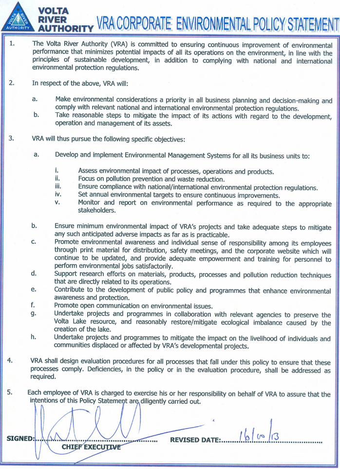

Pwalugu Multipurpose Dam ESIA Final Scoping Report
306068/TRD/EFR/3/C 23 June 2014 MM PIMS 306068 Documents Internally Produced Phase 1 Final Scoping Report RevC
130
C.1 Introduction
The Pwalugu Multipurpose Dam Project (the Project) is proposed to be built along the White Volta River in the Upper East and Northern Regions. The Project implementing agency is the Volta River Authority (VRA). Multipurpose benefits are proposed to include power generation, irrigation, flood control, and fisheries development among others. An environmental and social impact assessment (ESIA) is being undertaken of the preferred design.
The ESIA is a consultative and iterative process. Effective dialogue and exchange amongst the full range of stakeholders is a critical element to the success of the ESIA exercise, the Pwalugu Multipurpose Dam and related activities, and the subsequent realisation of Project objectives. Stakeholder engagement is a tool for two-way communication between VRA (including its project managers/team, consultants and contractors) and the public. The goal of stakeholder engagement is to improve decision-making and build understanding by actively involving individuals, groups and organisations with a stake in the Project. This involvement should help ensure realisation of the Project’s objectives and thereby enhance its benefits to the locally affected people and other stakeholders. Communication with stakeholders is already an important part of VRA’s on-going approach to doing business. The ESIA Consultant as well as the VRA is thus committed to active and on-going communication with all communities, organisations, groups and individuals with an interest in the proposed Project. It is to put this commitment into effect that the Consultation Strategy has been prepared.
This Consultation Strategy (CS) outlines the approach for stakeholder engagement during the ESIA. Stakeholders are also referred to as interested and affected parties (IAPs). Specifically, it is envisaged that the implementation of the CS will enable the VRA to:
Ensure that the public understands that their concerns are important to the VRA Keeps IAPs informed of activities related to the Project and ESIA process in a timely manner Provide IAPs an opportunity to review and comment on the proposed alternatives Provide information and comments regarding the Project that can be used for scoping, ESIA studies and preparation of management plans Stay informed and sensitive to changes in community concerns, attitudes, information needs, and
activities that arise throughout the ESIA process Effectively serve the public’s information needs and address citizens’ inquiries through meetings, fact
sheets, and other information dissemination techniques Effectively respond to the needs of the media by providing timely responses to inquiries and requests
for interviews and briefings Provide a unified channel for dissemination of information about the progress of the ESIA process and
management of environmental and socio-economic issues Identify issues and potential areas of concern to avoid and/or resolve conflict Provide a mechanism for expressing grievances and resolving conflicts.
This CS focuses on the information disclosure and consultation requirements for the ESIA process. A Stakeholder Engagement Plan for Project phases following the ESIA will be prepared as part of the Phase 3 Management Plan activities.
Appendix C. Pwalugu ESIA Consultation Strategy
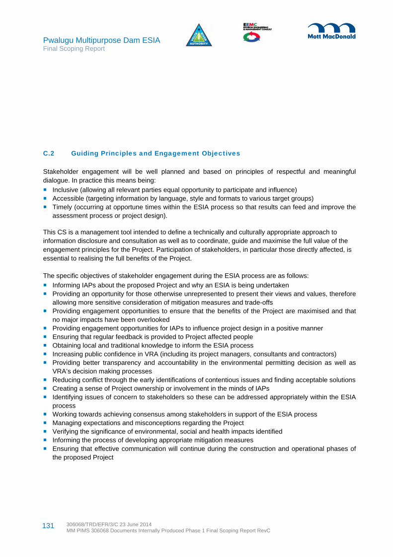
Pwalugu Multipurpose Dam ESIA Final Scoping Report
306068/TRD/EFR/3/C 23 June 2014 MM PIMS 306068 Documents Internally Produced Phase 1 Final Scoping Report RevC
131
C.2 Guiding Principles and Engagement Objectives
Stakeholder engagement will be well planned and based on principles of respectful and meaningful dialogue. In practice this means being:
Inclusive (allowing all relevant parties equal opportunity to participate and influence) Accessible (targeting information by language, style and formats to various target groups) Timely (occurring at opportune times within the ESIA process so that results can feed and improve the
assessment process or project design).
This CS is a management tool intended to define a technically and culturally appropriate approach to information disclosure and consultation as well as to coordinate, guide and maximise the full value of the engagement principles for the Project. Participation of stakeholders, in particular those directly affected, is essential to realising the full benefits of the Project.
The specific objectives of stakeholder engagement during the ESIA process are as follows:
Informing IAPs about the proposed Project and why an ESIA is being undertaken Providing an opportunity for those otherwise unrepresented to present their views and values, therefore
allowing more sensitive consideration of mitigation measures and trade-offs Providing engagement opportunities to ensure that the benefits of the Project are maximised and that
no major impacts have been overlooked Providing engagement opportunities for IAPs to influence project design in a positive manner Ensuring that regular feedback is provided to Project affected people Obtaining local and traditional knowledge to inform the ESIA process Increasing public confidence in VRA (including its project managers, consultants and contractors) Providing better transparency and accountability in the environmental permitting decision as well as
VRA’s decision making processes Reducing conflict through the early identifications of contentious issues and finding acceptable solutions Creating a sense of Project ownership or involvement in the minds of IAPs Identifying issues of concern to stakeholders so these can be addressed appropriately within the ESIA
process Working towards achieving consensus among stakeholders in support of the ESIA process Managing expectations and misconceptions regarding the Project Verifying the significance of environmental, social and health impacts identified Informing the process of developing appropriate mitigation measures Ensuring that effective communication will continue during the construction and operational phases of
the proposed Project

Pwalugu Multipurpose Dam ESIA Final Scoping Report
306068/TRD/EFR/3/C 23 June 2014 MM PIMS 306068 Documents Internally Produced Phase 1 Final Scoping Report RevC
132
C.3 Regulatory Requirements and Standards Relating to Consultation
C.3.1 Overview
Stakeholder engagement activities will be undertaken in compliance with Ghana environmental law and related requirements as well as applicable World Bank Safeguard Policies and the Convention on the Protection and Use of Trans-boundary Watercourses and International Lakes. The legal and regulatory framework makes adequate provisions for public consultation and disclosure. The legal requirements provide the entry points for effective stakeholder engagement throughout the ESIA process and subsequent Project implementation.
C.3.2 National requirements
ESIA consultation in Ghana is governed by the Environmental Assessment Regulations of 1999. The Regulations require consultation with members of the public, especially people and communities that are likely to be affected by the Project, to be undertaken as part of the environmental impact statement. The developer must:
Deliver notice of the proposed Project to relevant ministries, government departments and organisations as well as relevant metropolitan, municipal and district assemblies
Advertise in at least one national and one local newspaper the locality of the proposed project Make copies of the scoping and ESIA reports accessible in the locality of the proposed Project for
inspection by the general public
EPA can choose to hold a public hearing for projects where there appears to be great adverse public reaction to the commencement of the proposed undertaking; the undertaking will involve the dislocation, relocation or resettlement of communities; or the EPA considers that the undertaking could have extensive and far reaching effect on the environment.
C.3.3 World Bank requirements
The World Bank (WB), in its Environmental Assessment policy (OP 4.01, January 1999), has requirements related to information disclosure, consultation and engagement throughout all project phases, from planning to operation. Meaningful consultation must be undertaken about a project’s environmental and social aspects with relevant stakeholders in order to take their views into account.
For Category A projects such as this one, project-affected people (PAPs) and groups as well as local non-governmental organizations (NGOs) must be consulted at least twice: shortly after environmental and social scoping and before the terms of reference for the environmental assessment are finalised and once a draft ESIA report is prepared.
For initial consultation, a summary of the proposed project’s objectives, description and potential impacts is to be shared with stakeholders. During scoping, public consultation introduces the project to ensure that the ESIA takes full account of the priority concerns of PAPs and accurately identifies the full range of

Pwalugu Multipurpose Dam ESIA Final Scoping Report
306068/TRD/EFR/3/C 23 June 2014 MM PIMS 306068 Documents Internally Produced Phase 1 Final Scoping Report RevC
133
potential project impacts. For consultation after the draft ESIA is prepared, public notification of the report and making it available at a public place readily accessible to PAPs and local NGOs is required. A non-technical summary of the report’s findings is to be distributed to local stakeholders. ESIA reports are to be made available to a wider public through the proponent’s (the VRA’s) website. Throughout the construction and operation phases and as part of the annual reporting and stakeholder engagement activities, the WB requires projects to report on on-going information disclosure, consultations and engagement.
WB guidance for undertaking public consultation and disclosure encourages: Written and oral communication in local languages and readily understandable formats Accessibility by relevant stakeholders to both written information and to the consultation process Use of oral or visual methods to explain information to non-literate people Respect for local traditions or discussion, reflection and decision-making Care in assuring groups being consulted are representative, with adequate representation of women,
vulnerable groups, ethnic or religious minorities, and separate meetings for various groups, where necessary
Clear mechanisms to respond to people’s concerns, suggestions and grievances.
C.3.4 Convention on the Protection and Use of Trans-boundary Watercourses
The main objective of this convention is to prevent, control or reduce any trans-boundary impact resulting from the pollution of trans-boundary waters caused by human activity. Article 16 of the convention requires that information is made available to the public free of charge on the condition of trans-boundary waters, on measures taken to control, reduce and mitigate trans-boundary water pollution and on the effectiveness of these measures. Specifically, information that has to be made available to the public includes: Water quality objectives Permits issued and the conditions required to be met Results of analysis of water sampling carried out for monitoring and assessment, and results of
checking compliance with water quality objectives
C.4 Stakeholder Analysis
Large dam projects with an expansive geographical area of influence draw in wide groups of stakeholders. Carefully planned stakeholder engagement is needed to increase general project support because different stakeholders will have different interests in the Project’s activities. IAPs will be identified from the following stakeholder groups: Local communities and businesses located in the Project vicinity Community groups who will host people and households displaced by the Project Government administrators at various levels of sectors with interests that may be affected or may
benefit from the Project Planners, investors, potential role players in Project implementation Beneficiaries, consumers and competitors of water and energy, and Environmental and social development organizations interested in protecting the interests of local
communities, biodiversity and related issues.

Pwalugu Multipurpose Dam ESIA Final Scoping Report
306068/TRD/EFR/3/C 23 June 2014 MM PIMS 306068 Documents Internally Produced Phase 1 Final Scoping Report RevC
134
Categorising stakeholders assists the organisers of public participation processes to ensure inclusion of all relevant individuals and organisations, to provide appropriate levels of detail for each stakeholder category, and to ensure that concerns and issues raised by stakeholder groups are given the necessary and appropriate consideration in project design and implementation. The interests within and among stakeholder groups may be multiple: recognising this helps to analyse how to productively work with them to achieve successful project outcomes.
Stakeholders identified to date are presented in Table C.1. A database on identified stakeholders has been established. This database will be refined and updated continually as the ESIA progresses. The database serves as a tool to decide what party to consult based on the understanding of: Who will be affected by the negative and positive environmental and social impacts Whose cooperation, expertise, or influence would be helpful to the success of the Project Who are the most vulnerable, least visible, and voiceless for whom special consultation efforts have to
be made Who supports or opposes the changes that the Project will bring Whose opposition could be detrimental to the success of the Project Who has not been involved up to now but should be involved in the future
Table C.1: Stakeholder identification
Stakeholder Groups Stakeholders
Local Communities Families with compounds in the Project area
District Assemblies, Local Chiefs
Host communities, i.e. those who serve as host for displaced populations
Local minorities and marginalised groups
Fisher folk, cattle grazers, and farmers using land in the Project area
Governmental Authorities (central and local)
Regional Ministers and Regional Coordinating Councils
Environmental Protection Agency (Accra, Tamale, Bolgatanga)
Community Water and Sanitation Agency (CWSA)
Ministries (Energy; Water Resources, Works and Housing; Food and Agriculture; Environment; Local Government and Rural Development; Health; Education; Foreign Affairs, Finance and Economic Planning, Roads and Highways; Culture and Chieftaincy Affairs, Science & Innovation, Foreign Affairs & Regional Integration, Trade and Industries, Fisheries and Aquaculture, and Women, Children & Social Protection)
Savannah Accelerated Development Authority(SADA)
Lands Commission
Forestry Commission
Energy Commission
Water Resources Commission
Community Water and Sanitation Agency (CWSA)
Ghana Highways Authority
Ghana Irrigation Development Authority (GIDA)
Ghana Water Company Limited (GWCL)
Hydrological Services Department (HSD)
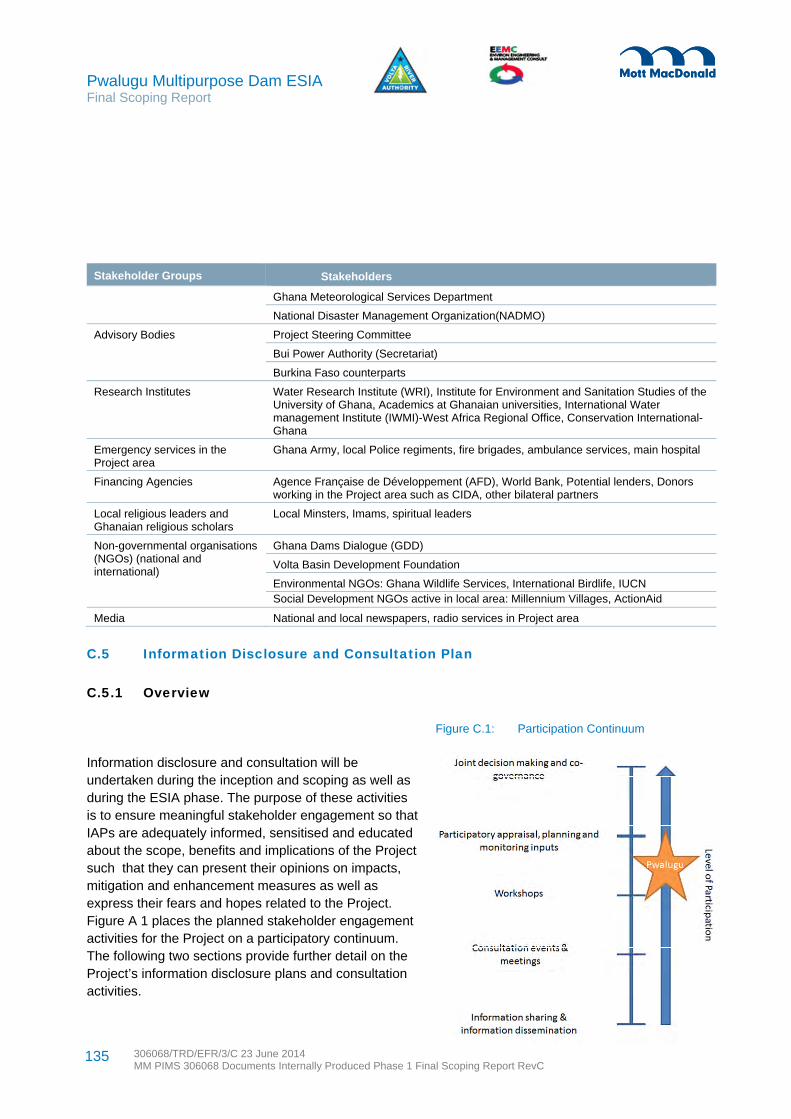
Pwalugu Multipurpose Dam ESIA Final Scoping Report
306068/TRD/EFR/3/C 23 June 2014 MM PIMS 306068 Documents Internally Produced Phase 1 Final Scoping Report RevC
135
Stakeholder Groups Stakeholders
Ghana Meteorological Services Department
National Disaster Management Organization(NADMO)
Advisory Bodies Project Steering Committee
Bui Power Authority (Secretariat)
Burkina Faso counterparts
Research Institutes Water Research Institute (WRI), Institute for Environment and Sanitation Studies of the University of Ghana, Academics at Ghanaian universities, International Water management Institute (IWMI)-West Africa Regional Office, Conservation International- Ghana
Emergency services in the Project area
Ghana Army, local Police regiments, fire brigades, ambulance services, main hospital
Financing Agencies Agence Française de Développement (AFD), World Bank, Potential lenders, Donors working in the Project area such as CIDA, other bilateral partners
Local religious leaders and Ghanaian religious scholars
Local Minsters, Imams, spiritual leaders
Non-governmental organisations (NGOs) (national and international)
Ghana Dams Dialogue (GDD)
Volta Basin Development Foundation
Environmental NGOs: Ghana Wildlife Services, International Birdlife, IUCN Social Development NGOs active in local area: Millennium Villages, ActionAid
Media National and local newspapers, radio services in Project area
C.5 Information Disclosure and Consultation Plan
C.5.1 Overview
Figure C.1: Participation Continuum
Information disclosure and consultation will be undertaken during the inception and scoping as well as during the ESIA phase. The purpose of these activities is to ensure meaningful stakeholder engagement so that IAPs are adequately informed, sensitised and educated about the scope, benefits and implications of the Project such that they can present their opinions on impacts, mitigation and enhancement measures as well as express their fears and hopes related to the Project. Figure A 1 places the planned stakeholder engagement activities for the Project on a participatory continuum. The following two sections provide further detail on the Project’s information disclosure plans and consultation activities.

Pwalugu Multipurpose Dam ESIA Final Scoping Report
306068/TRD/EFR/3/C 23 June 2014 MM PIMS 306068 Documents Internally Produced Phase 1 Final Scoping Report RevC
136
C.5.2 Information disclosure plan
Information disclosure will begin early in the process at inception. Project disclosure will include details regarding the Project components, the ESIA process and environmental permitting requirements, the multi-purpose Project objectives, the identification of environmental and social impacts, and mitigation and enhancement measures. Information disclosure is aimed at helping IAPs to understand the Project so that expectations can be managed.
Table C.2 provides an overview of the different channels through which information will be disclosed throughout the study.
Table C.2: Information Disclosure Activities by Project Phase
The social media website Facebook will be used to advertise the availability of ESIA documentation, to provide links to the documents on the Project website, and to publish relevant news of interest to the public
Phase Disclosure Activities Indicative Timeframes
Phase 1: Project Inception and Scoping
September – December 2013
One pager introduction Inception
Establishment of Pwalugu ESIA email address Inception
Scoping phase main messages for team (an internal information guidance leaflet)
Inception
Press release in relevant local newspapers inviting the public to participate in the scoping phase
Inception
Establishment of Project page on the VRA website October 2013
Statutory public notices in relevant newspapers to announce scoping public consultation meetings
End of November 2013
Local radio notices to announce scoping public consultation meetings
December 2013
Scoping Report Non-Technical Summary (NTS) in English and French
At scoping public consultation
Provision of Scoping Report and NTS in District Assemblies administration offices, VRA offices in Accra, Northern Region and Upper East Region, VRA website
November and December 2013
Phase 2: ESIA
February– November 2014
Establishment of Project Facebook page Up to five weeks (three before, two after) around draft ESIA public consultation
Statutory public notices in relevant newspapers to announce ESIA draft public consultation meetings
Two weeks prior to meetings
Local radio notices to announce draft ESIA public consultation meetings and discuss project
Around meeting times
Project brochure At public consultation
Provision of NTS in English and French At public consultation
Provision of Draft ESIA Report, NTS, Project Brochure in District Council administration office, VRA offices in Accra, Northern Region and Upper East Region, VRA website
July and August 2014
Pwalugu Multipurpose Dam ESIA Final Scoping Report
306068/TRD/EFR/3/C 23 June 2014 MM PIMS 306068 Documents Internally Produced Phase 1 Final Scoping Report RevC
137
about the Project. This aims to include younger populations with internet access in the consultation process. The Facebook page will be advertised using contacts from the stakeholder database.
Lenders have their own disclosure requirements and VRA will be able make the Scoping Report, draft ESIA, final ESIA, and resettlement action plan available to them.
C.5.3 Consultation plan
Both stakeholder consultation and public consultation are foreseen during scoping and the detailed ESIA phases. Stakeholder consultation refers to meetings including key information interviews, focus group discussions, and village meetings. During stakeholder consultation, IAPs (either individually or in groups) will exchange information and ideas related to the project activities, baseline conditions, potential impacts, and mitigation and enhancement options. The emphasis of these discussions is on providing facts and encouraging the exchange of ideas and opinions on issues that would affect the ESIA findings.
Public consultation refers to the formal meetings held at the end of the scoping and ESIA stages (Phase 1 and 2 respectively) as a requirement of the national EIA Regulations and World Bank social safeguard policies. At public consultation meetings, a panel involving the ESIA Consultant, VRA and the technical consultant provides study results to date and asks for feedback and comments.
Table C.3 provides an overview of planned consultation activities and tentative timeframes.
Table C.3: Consultation activities by project phase
Phase Consultation Activities Indicative Timeframes
Phase 1: Project Inception and Scoping
Stakeholder consultations and interviews in Accra, Northern Region, Upper East Region, and Project vicinity to understand the key environmental and social issues to be studied in greater detail during Phase 2
September to November 2013
Scoping public consultations in Municipal and District Assemblies (MDAs) in Tamale, Bolgatanga, Walewale, Gambaga, Tongo and Zebilla
Week commencing December 9th, 2013
Scoping report presentation to Project Steering Committee in Accra Week commencing December 16th, 2013
Phase 2: ESIA Stakeholder consultations and interviews in Accra, Northern Region, Upper East Region, and Project vicinity to identify impact significance and mitigation and enhancement measures
Throughout Phase 2
Focus group meetings, as appropriate with women and men separately, including population segments that may be particularly affected (e.g. fisher folk) and with groups who may be underrepresented in normal consultation activities
As part of social impact assessment
Four village meetings to address neighbouring community issues (currently planned for Bingo, Zongoire, Sinabaga, Wulugu but subject to change).
As part of social impact assessment
Draft ESIA public consultations in a minimum of three Project affected locations
August 2014

Pwalugu Multipurpose Dam ESIA Final Scoping Report
306068/TRD/EFR/3/C 23 June 2014 MM PIMS 306068 Documents Internally Produced Phase 1 Final Scoping Report RevC
138
Minutes covering all consultation activities and demographic information on the participants will be recorded, for instance gender, general age group and representation of special interest groups. Evidence such as attendance lists and photographs of stakeholder workshops and public participation meeting will be included in appendices of the scoping and ESIA reports.
Prior to public consultation meeting, key affected Regions, Municipal and District Assemblies would be informed about the current Project status in order to solicit appropriate assistance for the scoping phase public meetings. Scoping phase public consultation meetings will describe the Project, its rationale and importance, the legislative framework, and the proposed terms of reference for the full ESIA process. Draft ESIA public consultation will present the study findings.
Announcement of disclosure and the period for comment and feedback will be delivered to stakeholders registered throughout the ESIA process inviting their participation by personal contact, letter, fax, email and to the general public through the newspapers and radio announcements. Feedback collection will in principle stay open for one month after announcement of disclosure. Responses will be provided to each interested party presenting questions as soon as is reasonably possible depending on the complexity of the issue and source of information needed to provide the answer.
Resettlement planning will require targeted consultation with project affected persons (PAPs). The RAP will have its own consultation and participation strategy. Consultation and engagement on resettlement impacts and issues with project affected communities, PAPs and stakeholders will be addressed in Phase 3.
C.6 Media Enquiries
All media enquiries that occur throughout the ESIA study phase will be directed to the ESIA Consultant Project Manager or Deputy Project Manager. The ESIA Consultant will liaise with the VRA Project team, and with their corporate media section, as appropriate to provide a response. A target date of responding within five days will be set.
C.7 Managing Dissenting Opinions
Large projects such as this one, even with the best consultation strategies, cannot expect that all IAPs will agree with the implementation of planned project activities. Stakeholder engagement results will help identify the level of broad community support and social license to operate. The ESIA Consultant’s analysis
33 Consultation for resettlement issues and planning will be elaborated in the Resettlement Action Plan
Draft ESIA presentation to Project Steering Committee in Accra September 2014
Phase 3: Management Planning33
Stakeholder consultations and interviews on mitigation and enhancement measures
Throughout Phase 3
Draft management plan presentation to Project Steering Committee in Accra

Pwalugu Multipurpose Dam ESIA Final Scoping Report
306068/TRD/EFR/3/C 23 June 2014 MM PIMS 306068 Documents Internally Produced Phase 1 Final Scoping Report RevC
139
of the general level of consent for the Project will be included in the ESIA chapter reporting on stakeholder engagement.
The ESIA Consultant will follow up with individuals and organisations who express dissent. Efforts to ensure dissenters have facts and correct Project information related to their area of concern will be documented. Even with a full range of information, some IAPs may not agree with the Project or ESIA findings. IAPs and individuals still known to dissent after draft ESIA public consultation will be given the option to provide up to a page of text explaining their position and opinion. The dissenters’ pages will be included in the appendices with other stakeholder results and minutes of meetings for EPA’s review and consideration.
C.8 Stakeholder Engagement Resources and Responsibilities
The ES Consultant has helped VRA develop this consultation strategy and will implement it. The ESIA Consultant is responsible not only for documenting stakeholder engagement activities and results but also for how consultation feedback informs the ESIA study results.
Both the ESIA Consultant’s and VRA’s contacts will be made public during the information disclosure periods for stakeholders to make contact with the consultant. Grievance redress channels for the ESIA phase are identified below.
Both the ESIA Consultant and VRA have identified staff with time and logistical resources available for carrying out information dissemination and consultation. The ESIA Consultant includes local language speakers to support communication efforts at the community and district levels. Technical specialists from VRA and the Feasibility Consultant are expected to attend the public consultation meetings to respond to technical issues (to the greatest extent possible taking into consideration locations, dates and concurrent scheduling), particularly in the ESIA phase where issues will be dealt with in more detail than the scoping phase.
VRA will be required to approve public domain documents including notices, press releases, the NTSs, the project brochure, and reports made available to the public.
The Project Steering Committee is composed of VRA, Water Resources Commission, Savannah Accelerated Development Authority, Environmental Protection Agency, Ghana Irrigation Development Authority, Volta Basin Authority, and Ghana Dams Dialogue. The Project Steering Committee will play a key role in advising the ESIA Consultant and ensuring important government authorities are on board to cooperate with the ESIA study activities.
C.9 Grievance Mechanism
The need to establish functional and acceptable communication channels for redressing grievances is a priority in order to build trust and understanding among VRA, Project consultants and IAPs. It is also a key

Pwalugu Multipurpose Dam ESIA Final Scoping Report
306068/TRD/EFR/3/C 23 June 2014 MM PIMS 306068 Documents Internally Produced Phase 1 Final Scoping Report RevC
140
international lender requirement. The Project will have grievance mechanisms to address Project performance, resettlement and labour issues.
Grievances are complaints or claims related to wrong-doing that could have financial implications. They rarely occur during an ESIA process. In comparison to grievances, comments and opinions (both negative and positive) will be routinely solicited throughout the ESIA process. If a grievance related to the ESIA process was to be raised, it can be submitted in writing to the contacts shown in Table A.4 throughout the ESIA study process. The contact details will be made available in Project public domain information.
Table C.4: Contacts for comments on Project performance or grievances
VRA – Project Proponent EEMC – ESIA Consultant
c/o Charles Addo
Volta River Authority – Project Manager
Akusi, Ghana
Tel.: +233-30-2664941-9
Fax: +233 302660040
Email: [email protected]
c/o Dyson Jumpah
Environ Engineering Management and Consult (EEMC) - Manager
Accra, Ghana
Tel: +233-302-235403
Email: [email protected]
All grievances and redress actions related to the management of the ESIA process will be documented according to date of receipt, by whom, what method, action for resolution and closing out date of grievance. Responses to grievances will be addressed within 10 days from the date of presentation, within which a response or action is guaranteed.
The establishment of Project grievance mechanisms for on-going Project phases will be completed during management planning. For instance, a fully detailed project performance grievance mechanism for future phases, such as construction and operation, will be addressed in the Stakeholder Engagement Plan. A resettlement grievance mechanism will be included in the resettlement action plan. A labour grievance mechanism will be included in the environmental and social management plans. ESIA Stakeholder Engagement Reporting and Feedback
Results and feedback from stakeholder engagement activities and how feedback has informed the ESIA study will be summarised in chapters in the Scoping Report and final ESIA report. Minutes of meetings or summaries of individual or informal discussions will be kept and included along with attendance lists and photographic evidence as appendices.

Pwalugu Multipurpose Dam ESIA Final Scoping Report
306068/TRD/EFR/3/C 23 June 2014 MM PIMS 306068 Documents Internally Produced Phase 1 Final Scoping Report RevC
141
Table D.1 provides a summary of information disclosed and feedback received during stakeholder meetings. There are individual reports for each meeting that can be made available on request. Tables D.2 to E.7 are the minutes of meeting for the public consultation meetings. A photo from each meeting is provided at the end in Figures D1 to D6. More photos of stakeholder and public consultation meetings can be made available upon request.
Appendix D. Scoping Consultation Meeting Summaries

142 306068/TRD/EFR/3/C 23 June 2014 MM PIMS 306068 Documents Internally Produced Phase 1 Final Scoping Report RevC
Pwalugu Multipurpose Dam ESIA Final Scoping Report
Table D.1: Summary of scoping stakeholder meetings
Stakeholders, Location and Date (2013)
Purpose and information disclosed Feedback
IUCN, Accra
27 September
Introduce project, and seek information
One-page summary provided
Important issues are riverine forest and elephant corridor. The birds on IBA list are likely to be resident. Likely animals in forest would include green monkey, red patas monkey, baboon, bush buck, warthog, and crocodile. Elephants certainly present along the Red Volta corridor moving south in the dry season. View is that unless there are some highly protected species it would be possible to accommodate the partial loss of riverine forest.
There should be re-afforestation programme along both Red Volta and White Volta especially Red Volta which is a game corridor. For further forest protection talk to Forest Service and chiefs. First step is to talk to community and forest guards. Proposals should also include water resources management.
Land tenure is family and clan based in north. Compensation payments to landowners may sometimes be needed. Charcoal burning is a typical problem. Another issue will be shrines (often rocks) and sacred trees.
Surface mining is very damaging to topsoil and so leads to loss of cover, shifting cultivation and food scarcity. Considerable ‘illegal’ mining is tolerated by the chiefs.
Ghana Wildlife Society (GWS)
Accra
27 September
Introduce project, and seek information Project
General outline of the project, One-page summary provided
GWS haven’t seen the full literature to know why the area is an important bird area (IBA)
Re-establishing forest is important. A key mitigation option is offset. Could think about rescuing and relocating. Need to look at the legal implications – if inundated then would it remain designated or need to be redesignated. The scarp goes to Togo so the protected area is not just around the river.
Royal Society for Protection of Birds (RSPB) has a project in the Scarp with field scoping. They go to Burkina Faso and follow the birds to gather data on habitat preference of species, vegetation dynamics. RSPB project is main contact for works on international birds migrant.
Livelihoods – dependency on agrarian life is necessary to look at. Pwalugu is known for tomatoes. Want to look at downstream benefits. Sometimes after power generation you do not see investment in community. Water is a major determinant of agriculture in the north.
Environmental Protection Agency, Accra, Tamale, Bolgatanga
27, 30 Sept, 1 October
Introduce PMD ESIA study
Role players, VRA, EEMC, Mott MacDonald, FC, study timing
One-page summary provided
EPA knows VRA is familiar with their requirements. A full ESIA is needed for permit. Lots of implications on the community side. Registration is started. EPA will request a scoping exercise.
The nature of the Project suggests at least one public hearing, maybe more.
Please try and visit the site with regional EPA staff
Chief, Kurugu with Elders
Project area
1 October
Introduce PMD ESIA study, request to enter area, discuss community life
Team, gathering information to inform Project design
Mainly farmers, different crops, seasonal faming
Some fishing, 9 canoes
Importance of sheanut. Could farm along banks without fertiliser use
Dry season is education time
Village is informed when Burkina will open waters

143 306068/TRD/EFR/3/C 23 June 2014 MM PIMS 306068 Documents Internally Produced Phase 1 Final Scoping Report RevC
Pwalugu Multipurpose Dam ESIA Final Scoping Report
Stakeholders, Location and Date (2013)
Purpose and information disclosed Feedback
Malaria almost cleared up with dipped nets, guinea worm is a problem
Regional Minister, Hon. Bede A Ziedeng of Northern Region, Tamale
30 September
Introduce PMD ESIA study
Team, multipurpose objectives, study timing
Project known in Northern Region for quite some time, Need to understand clearly the project objectives to explain them when questioned
Concerned about people - need to learn from the past eg. construction of Akosombo
We welcome the Project and are here to support
Savannah Accelerated Development Agency, Tamale
30 September
Introduce PMD ESIA study and request information and collaboration
Team, multipurpose objectives, study timing
Would like SADA constituents to benefit from PMD
SADA has an irrigation project close to PMD irrigation area
Consultant is undertaking a land ownership study to produce a blue print for facilitating access without too much conflict
SADA has comprehensive baseline for the study area
Regional Minister, Hon. Alhaji Mohammed Muniru Limuna of Upper East Region in Bolgatanga
1 October
Introduce PMD ESIA study
Team, multipurpose objectives, study timing
We welcome the multi-purpose benefits it can bring, especially 60MW. Our farmers only have 1 season so irrigation is helpful. Ours is a flood prone area.
Community entry can be challenging, can’t ignore local culture.
We are here to help coordinate. Please provide 1993 report so we can know more about the Project This has been provided and the Hon Minister has acknowledged receipt.
Elders, Nungo
Project area
2 October
Introduce PMD ESIA study, request to enter area, discuss community life
Team, gathering information to inform project design
Chief passed away on 12th Feb 2012, new chief not yet confirmed. Yidana Moari, the Regent is acting.
They are farmers, various crops, and fishermen. People sometimes come and buy food from village, or villages use donkey carts to take to sell. They go to Bolga or across to Gambaga when sick. Can go 3 years without going to Bolga
Land is more fertile in Nungo than in Bingo or Tongo. 3 boreholes, 3 wells, 1 school, About 35 households
Minister of Energy, Hon Emmanuel Armah-Kofi Buah, Accra
3 October
Introduce PMD ESIA study
Team, multipurpose objectives, study timing
Pwalugu is very important because it has several uses. We are waiting for the study to be finished. Ministry is ready to support and will have a point person for the Project. Accordingly, Ing Stephen Doku nominated Mr Solomon Adjetey as the key contact person in the Ministry of Energy and Petroleum to be responsible for the PMD project.
AFD and WB
Accra
4 October
Introduce team, request information, summarise findings from kick off
Important to work closely with Tractebel and review all Project alternatives
OP 4.04 Natural Habitats and understanding critical habitats will be essential. Should consider offsetting as well as other mitigation
Consultation activities need to be well documented. Ghana Dams Dialogue important stakeholder
Reflect IFC Performance Standards
Resettlement is sensitive, skills development program would be useful, consider health centre, map ethnic groups

144 306068/TRD/EFR/3/C 23 June 2014 MM PIMS 306068 Documents Internally Produced Phase 1 Final Scoping Report RevC
Pwalugu Multipurpose Dam ESIA Final Scoping Report
Stakeholders, Location and Date (2013)
Purpose and information disclosed Feedback
Provision of mapping, studies, ECOWAS documents
Ghana Dams Dialogue/Volta Basin Development Foundation (SADA)
Accra
9 October
Introduce PMD ESIA study to be undertaken
Planned consultation slated for December
Gather lessons learned regarding ESIA studies for big dams
Indicated that there is a Political and Economy Study report on the project area. This will be made available.
Read a report on Comparative Study on Dams Built by the Chinese Intimated that Bui Dam consultation with project affected persons/communities was poor. A community that is to be relocated was not informed. The case is now in court.
The Bui Dam ESIA study did not look at the benefits to the entire region. The focus was only limited to the immediate project area.
Powerful Chiefs in the project area/region should be identified and consulted.
Ghana Metrological Agency (GMET)
Accra
16 October
Introduction /Data enquiry
General outline based on one-page summary sent with letter requesting the meeting
Rainfall stations of interest are found in Bolgatanga, Gambaga and Bawku. The Bolgatanga station was installed in 1975 but there are many gaps in their data. The Gambaga station was also installed in 1975 but has many gaps in the data particularly in the 1980s. Bawku has two stations with fairly good data.
Main concerns are control procedures, particularly for flooding.
Another proposed dam on the Kulpawn river that would impact flows downstream to Lake Volta planned by Wienco, for irrigation.
Water Resources Commission (WRC)
Accra
16 October
Project introduction
General outline of the project (one-page summary handed over)
Introduction of hydrologists
The WRC has been involved in the Pwalugu Project from the beginning and it is represented on the project steering committee. WRC office at Bolgatanga houses the White Volta Basin Board.
WRC’s concerns are flooding and proper use of water resources
Impact of other potential projects which are likely to come on board in the White Volta Basin, i.e. the Kulpawn dam by WIENCO for irrigation
Siltation and sedimentation
Due to other projects within the Volta Basin, there must be agreement between the Riparian Countries and the VBA has to give approval.
Societe Nationale D’Electricite du Burkina (SONABEL), Burkina Faso
18 October
Project introduction
General outline of the project (one-page summary handed over)
Introduction of project hydrologists
Bagré dam has a hydro capacity of 16MW. It generates all year, but at reduced rate of 8MW in dry season (and maybe only at peak hours). At present, there is no decision yet and no plans to increase the height of the dam. It was built primarily for irrigation and water is taken directly from the reservoir before power generation.
The dam has spilled about 8 times the last was in 2013. In the dry season, the water is used mainly for irrigation and there are no flows downstream.
An EIA for the Bagré irrigation projected targeting 3.000 ha of land but when fully developed the area under irrigation will be about 30,000 ha as part of the Bagré Growth Pole Project which aims at attracting people and investment into the area by providing infrastructure such as roads, schools, markets, hospitals, banks, and factories for agro-processing.

145 306068/TRD/EFR/3/C 23 June 2014 MM PIMS 306068 Documents Internally Produced Phase 1 Final Scoping Report RevC
Pwalugu Multipurpose Dam ESIA Final Scoping Report
Stakeholders, Location and Date (2013)
Purpose and information disclosed Feedback
SONABEL has plans to build another dam on the White Volta mainly for electricity generation (12mw) downstream of Bagré. Feasibility studies are being undertaken by an International firm.
The Pwalugu dam very good because it will reduce flooding in Ghana and stopped Bagré getting the blame.
Volta Basin Authority (VBA), Burkina Faso
18 October
Project introduction
General outline of the project (one-page summary handed over)
Interest in the Bagré Dam and impacts on Pwalugu Project
VBA aware of the Project and a member of steering group.
Other countries may see Pwalugu as a concern for development (as expected for Bagré Growth Pool). Other issues could be shifting of wildlife, increased malaria, perhaps even crime.
Important to sensitize neighbouring countries particularly Togo and Burkina Faso. Need to recognise wider areas of possible impact, including transboundary, UN Convention on pollution mentioned and UN Convention on non-navigable issues related to international rivers.
Need to increase involvement of local people. Need for coordination of irrigation development projects downstream of Pwalugu ie Sissli-Kulpawn dam viz impact on flow downstream
Objectives ranking: Hydro very important, flood control probably second. Illegal settlements should not be included in benefit assessment but should be addressed by Ghana authorities first. Irrigation next, but what about aquaculture? Tourism will be an issue – development must be controlled, learn the lessons of Akosombo.
Need to address climate change. Upstream part of White Volta is a hydrological paradox. Land degraded but flows seem to be increasing despite reduction in rainfall. Small reservoirs in the upper basin.
National Disaster Management Organisation (NADMO)
Accra
21 October
Project introduction
General outline of the project (one-page summary handed over)
Flooding is likely to result in resettlement/relocation issues. Think how to cater for livelihoods. Need to learn from Akosombo experience. There could be socio-cultural problems like resettling by antagonistic tribes or clans from displaced settlement into resettlement communities that need consideration.
Consider conflicts. These could arise from farming communities coming close to the water body or fishing communities being resettled far from the water body, hence the need for alternative livelihood training.
Controlled spillage from the dam could avoid disruption of livelihood. There should be appropriate early warning systems for the spillage and an effective system of information dissemination.
Impact of the project on health, water borne/water related diseases should be considered (malaria, bilharzias, onchosachiasis, guinea worn)
Provide package for resettlement, i.e. fertiliser, provision of high yielding crop varieties. NADMO can help in this respect. Create a buffer zone around the dam to avoid direct contact of people with the dam or reservoir. Consider local content, opportunities for displaced people for jobs, training. Need contingency plans in case of dam break
Hydrological Services Department (HSD)
Accra
21 October
Project introduction
General outline of the project (one-page summary handed over)
HSD is aware of the project. They are responsible for gauging stations, hoping for equipment/station upgrading through World Bank project
Stations marked on tributaries are Garu and Nakpanduri. It will still be necessary to monitor the tributaries. Also maintain/enhance rainfall/evaporation station network.
Data quality is variable. Pwalugu probably best station, followed by Yarugu (upstream White Volta)

146 306068/TRD/EFR/3/C 23 June 2014 MM PIMS 306068 Documents Internally Produced Phase 1 Final Scoping Report RevC
Pwalugu Multipurpose Dam ESIA Final Scoping Report
Stakeholders, Location and Date (2013)
Purpose and information disclosed Feedback
Missing data is a problem. Database (HYDATA) calculates monthly average if 20 or more days have data, otherwise monthly is missing. Not sure about Pwalugu series.
Ghana Commercial Agriculture Project, Ministry of Food & Agriculture
Accra
30 October
Introduce the project and to seek agricultural information.
The Project area is in the SADA zone with particular emphasis on the Nasia-Nabogo valley near Pwalugu
Currently identifying 20,000 hectares of land that could be used for land development and water management. to build small dams along the bottom of the valley drawing water from adjourning streams to irrigate land for farming so farmers could improve yields. Targeted crops are maize, rice, soya, beans. Focus is on enhancement of agriculture value chain- inputs, storage and marketing. Transplant nucleus and small holder farmers into commercial farmer whilst supporting out growers with farming inputs.
Studies being undertaken on land diagnostic studies, LiDAR survey of the specific area as well as the three northern regions, and demarcation of the 20,000 hectares through a feasibility study
Ministry of Finance & Economic Planning, Accra
31 October
Brief about the Project, its location and components
Provided one-page summary
MoEF not yet aware about the Project.
Requested formal communication
Department of Foreign Affairs, Trade and Development Canada (formerly CIDA), Accra
31 October
Brief about the Project, its location and components
Provided one-page summary of the project, explanation and contact information
CIDA has two main divisions: Food security and land and water and sanitation and three cross cutting divisions: environment, gender and governance. CIDA is currently supporting desertification impacts and risk in the North to develop EPA capacity and provide funds for community initiatives aimed at sustainable land management practices inc. soil fertility, vegetation cover management, energy resource use, water resource management, alternative livelihoods. EPA in the region has developed manuals for sustainable land management practices.
Consider climate change risk and adaptation requirements
Past instances where irrigation projects have had adverse health consequences e.g. increased risk of malaria.
UNDP and UN Habitats and Housing for Masses
Accra
31 October
Brief about the Project, its location and component.
Provided one-page summary of the project, explanation and contact information
Following flooding in the North, UNDP and UN Habitats was involved in a recovery programme for those displaced from flood water; through this they implemented a housing relocation activity.
UNDP and UN Habitats a sustainable housing project with an objective to train locals in use of sustainable materials for building housing projects and to train people to do this to improve livelihood opportunities.
Irrigation will be welcomed and need for irrigation has been brought up in their livelihood surveys as it would allow year round farming.
Ministry of Energy & Petroleum, Accra
31 October
Brief about the Project, its location and components
Provided one-page summary
The Project could have potential interfaces with on-going rural electrification projects. MOEP is currently working with other organisations to identify communities to benefit from rural electrification initiatives and have some infrastructure in place
Wienco
Accra
12 November
Intro to the Project, its key objectives and role of ESIA consultant
Wienco is a commercial agriculture company supporting smallholder farmers with agricultural extension services. Inputs include seeds and fertiliser, tool maintenance, chemical use management.
In northern regions, mainly supports cotton and maize. Cotton is challenging as people prefer food crops therefore

147 306068/TRD/EFR/3/C 23 June 2014 MM PIMS 306068 Documents Internally Produced Phase 1 Final Scoping Report RevC
Pwalugu Multipurpose Dam ESIA Final Scoping Report
Stakeholders, Location and Date (2013)
Purpose and information disclosed Feedback
they sell off the inputs..
All farms are currently rain-fed, but looking at irrigation potential in the North. Wienco has pilot scheme for 400 ha of irrigated land for small holder farmers. Farmers will pay for water – will this be the same? Pwalugu project should focus putting irrigation on the farmer agenda by targeting programmes to women and the youth.
Public & Vested Lands Management Divisions (PVLMD) of Northern Region, Tamale
13 November
Intro to the Project, its key objectives and role of ESIA consultant
PVLMD is one of four divisions of Lands Commission charged with acquiring land in the public interest. The role of resettling communities is undertaken by Lands Valuation Division (LVD).
Ownership of the land varies, in some areas Chieftancies (‘skins’) are the custodians of the land and in other areas land is owned by families (‘customary’ land). Typical compensation prices were discussed which for 2012 was 800-1000 cedis/acre of farmland. Tree prices were also discussed for mango (15 cedis/tree), dawa dawa (20 cedis/tree) and Teak (25 cedi/tree). Others do not have a fixed price and must be estimated and justified by the valuer. Tenant farmers are compensated on the basis of values for crops and do not receive any disturbance allowance.
There is currently no experience of working on projects in accordance with international standards but they are keen to do this in the future.
Upper East Regional Government (Regional Coordinating Director), Bolgatanga
14 November
Intro to the Project, its key objectives and role of ESIA consultant
Conflict has arisen previously through acquisition process where economic displacement had not been adequately compensated for. Current Chieftancy dispute in the Tongo area regarding jurisdiction.
It was suggested that the government offices in Bolgatanga would be a suitable location for the regional scoping consultation meeting.
Greatest development challenge in the region is the reduced rainfall in the dry season where people leave to farm elsewhere.
Upper East Regional Security Coordinator, Bolgatanga
14 November
Intro to the Project, its key objectives and role of ESIA consultant
Importance of engaging with all potentially affected Chieftancies at an early stage to avoid raising conflicts. Little resistance would be expected if meaningful consultation is carried out from the start of the process.
Nabdam District Government, Nangoudi
14 November
Intro to the Project, its key objectives and role of ESIA consultant
This district was established one year ago from the former Talensi Nabdam District. The main challenges will relate to agricultural livelihood impacts as well as personal attachment to ancestral lands and potential resistance to resettlement and population influx.
Land in this area is mainly owned by ‘families’ and the Chief acts as the ‘Tendana’ governing land transfers. Hope that improved irrigation and employment would prevent outward migration to Southern regions during the dry season.
West Mamprusi District Government, Walewale
14 November
Intro to the Project, its key objectives and role of ESIA consultant
A map was shown demonstrating four further villages likely to be affected; Gubiu, Digari, Suhuluya and Kpiripiri.
The first step in land acquisition would be to approach the landowner and they will then approach the appropriate level of the chieftancy. The district is generally peaceful with no known boundary disputes. Women are generally economically empowered and there are women’s cooperatives in operation.

148 306068/TRD/EFR/3/C 23 June 2014 MM PIMS 306068 Documents Internally Produced Phase 1 Final Scoping Report RevC
Pwalugu Multipurpose Dam ESIA Final Scoping Report
Stakeholders, Location and Date (2013)
Purpose and information disclosed Feedback
Talensi District Government, Tongo
14 November
Intro to the Project, its key objectives and role of ESIA consultant
One of the main challenges associated with resettlement is likely to be that people will not want to move to higher ground, instead there is a preference to live along the river. The most vulnerable villages within the floodplain are Sartiri, Yinduri, Pwalugu and Arigu. Shia and Balungu are less vulnerable. There are some sacred sites and cemeteries in the District.
The main Custodians of land in the District are the ‘Tendanas’ who negotiate the process. In some cases the Tendana and the Chief are the same person but this is not always the case eg in Santin Village.
Assembly members are important stakeholders to be consulted but consultation must reach out beyond elected representatives. It is also important to distinguish between migrant/settler communities mainly found in Pwalugu and traditional sedentary communities that are found in all the other villages. There is some tension between these groups.
There are land disputes over boundaries between the communities of Pwalugu and Balungu, Pwalugu and Arigu and Shia and Bulungu. These conflicts have strong implications for women in the area.
East Mamprusi District Government, Gambaga
15 November
Intro to the Project, its key objectives and role of ESIA consultant
The National Disaster Management Organisation (NDMO) is a key stakeholder for the project.
A number of new communities were identified on the map and a list was provided including population sizes and whether land/houses fall within the floodplains along the river.
Some land in the area is owned by the Chieftancies and some by families, no awareness of previous conflicts. The livelihood is mostly dependant on agriculture; rice, maize and vegetables. There are migrant communities during the wet season.
Bawku West District Government, Zebilla
16 November
Intro to the Project, its key objectives and role of ESIA consultant
Twenty-five communities in the district are usually affected by flooding and these are sub-divided by 10 electoral areas along the White Volta. Further details were provided on these communities. In summary 80% of losses will be farmland and 20% households. The communities are very spread out and motorbike access will be best for household surveying.
The land boundaries of most areas are well defined, however there are some absentee landlords which will make identifying landowners problematic. There are also underlying tensions between indigenous communities and settlers who come in the wet season – the former may be annoyed at the later receiving compensation on what they consider to be ‘traditional’ land.
Garu Tempane District Government, Garu Town
16 November
Intro to the Project, its key objectives and role of ESIA consultant
Communities are very dispersed in the area and not easily accessed by road. It appears that the most affected areas will be Kugi and Sinabaga. Another dam ‘Tamne’ has also been proposed in the district.
Preferred location for resettlement will be in or near to Songo town where the main market is located. Burial areas are generally near to houses and people won’t expect graves to be relocated.
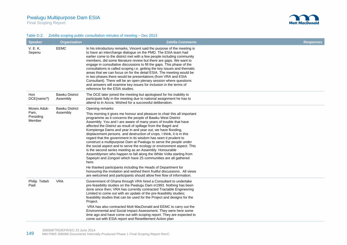
149 306068/TRD/EFR/3/C 23 June 2014 MM PIMS 306068 Documents Internally Produced Phase 1 Final Scoping Report RevC
Pwalugu Multipurpose Dam ESIA Final Scoping Report
Table D.2: Zebilla scoping public consultation minutes of meeting – Dec 2013
Speaker Organisation Zebilla Comments Responses
V. E. K. Sepenu
EEMC In his introductory remarks, Vincent said the purpose of the meeting is to have an interchange dialogue on the PMD. The ESIA team had earlier come to the district met with a few people including community members, did some literature review but there are gaps. We want to engage in consultative discussions to fill the gaps. This phase of the consultations is called scoping i.e. getting the key issues and thematic areas that we can focus on for the detail ESIA. The meeting would be in two phases there would be presentations (from VRA and ESIA Consultant). There will be an open plenary session where questions and answers will examine key issues for inclusion in the terms of reference for the ESIA studies.
Hon DCE(name?)
Bawku District Assembly
The DCE later joined the meeting but apologised for his inability to participate fully in the meeting due to national assignment he has to attend to in Accra. Wished for a successful deliberation.
Moses Aduk-Pam, Presiding Member
Bawku District Assembly
Opening remarks:
This morning it gives me honour and pleasure to chair this all important programme as it concerns the people of Bawku West District Assembly. You and I are aware of many years of trouble that have affected the District as result of spillage from the Bagré and Kompienga Dams and year in and year out, we have flooding, displacement persons and destruction of crops. I think, it is in this regard that the government in its wisdom has seen it prudent to construct a multipurpose Dam at Pwalugu to serve the people under the social aspect and to serve the ecology or environment aspect. This is the second series meeting as an Assembly. Honourable Assemblymen who happen to fall along the White Volta starting from Sapeiyiri and Zongoiri which have 25 communities are all gathered here.
He thanked participants including the Heads of Department for honouring the invitation and wished them fruitful discussions. All views are welcomed and participants should allow free flow of information.
Philip Tetteh Padi
VRA Government of Ghana through VRA hired a Consultant to undertake pre-feasibility studies on the Pwalugu Dam in1993. Nothing has been done since then; VRA has currently contracted Tractable Engineering Limited to come out with an update of the pre-feasibility studies; feasibility studies that can be used for the Project and designs for the Project.
VRA has also contracted Mott MacDonald and EEMC to carry out the Environmental and Social Impact Assessment. They were here some time ago and have come out with scoping report. They are expected to come out with ESIA report and Resettlement Action plan

150 306068/TRD/EFR/3/C 23 June 2014 MM PIMS 306068 Documents Internally Produced Phase 1 Final Scoping Report RevC
Pwalugu Multipurpose Dam ESIA Final Scoping Report
Speaker Organisation Zebilla Comments Responses
Dyson Jumpah
EEMC ESIA presentation focused on:
Identifying associated direct and indirect impacts
Cumulative effects from existing projects, anticipated projects and the PMD
Transboundary effects – Burkina Faso and Togo
Social context in respect of effects on the people or area, how will the people impact on the project
Mitigation, enhancement and management measures
Consultation process provides platform for them to participate and voice their concerns so that they can be taken on board or considered in the design of the project and its construction operation and maintenance -45 held so far; 2nd consultation for the ESIA study results to be presented to stakeholders
Time frame for the project and its components and the rationale for its commencement, particularly reducing the shortfall in power generation
Resettlement action plan to deal with issues arising from displacement of people, loss of lands/farm lands and crops, compensation and livelihoods restoration
Principles governing selection of dam site and design
Mechanisms for benefit sharing
Avoidance of restriction to access to resources
Yussif Suleman
MoFA Because of continued flooding of basin and farming along basin, we have a lot of silt in the basin. Is there going to be dredging to make the basin deeper?
The sand from the basin can be used for construction purposes to generate income for the district assemblies.
The FS Consultant explained that we are at the feasibility stage and are currently studying sedimentation of the White Volta. As part of the study the silt content of the river will be investigated. There is a lot of siltation due to farming activities along the banks of the river. After the study a decision will be taken.
VRA, siltation may take place like the Kpong Dam. Indicated that there is company dredging the Dam and making money. Thus, it could be revenue generation opportunity for the affected District Assemblies.
Awuni David L.
Saka Electoral Area
Explain more how PMD can control flood?
We have an irrigation project in Kobori community that stretches to Yarigu thereabout, we will be getting 200ha of irrigation lands and it is close to the White Volta. My fear is that if the Pwalugu Dam is constructed these irrigation projects will be flooded.
In 2004, a Dam was constructed in Deogo and Yarigu to irrigate about 500ha of lands. It is GIDA project with funding from ADB. Concerns are that if the PMD is constructed then Deogo and Yarigo irrigation projects will be flooded and destroyed.
FS Consultant: When the Dam is created, the reservoir will hold the water and finally control flooding. Thus, the perennial flood will end.
ES Consultant: we are happy that this information is coming up and we know our technical Consultant has noted it. We wish you could give us more information on the irrigation projects. We will contact GIDA

151 306068/TRD/EFR/3/C 23 June 2014 MM PIMS 306068 Documents Internally Produced Phase 1 Final Scoping Report RevC
Pwalugu Multipurpose Dam ESIA Final Scoping Report
Speaker Organisation Zebilla Comments Responses
Abdul Aziz Abubakar
Information Service Department (ISD)
In your presentation you mentioned some District that the river passes through but I think that Binduri and Bawku Municipal are among of the affected Districts
ES Consultant: we have already identified some of the districts and they are being considered.
Thomas Ayamweogo
Boya Electoral Area
Construction of the PMD will bring mosquitoes
Construction of the PMD will affect our ecosystem including wildlife.
The project is good but more sensitisation (project awareness) needs to be done.
ES Consultant: good point raised, we have comprehensively looked at the health issues, measures will be put in place to address all water borne/related diseases including malaria, river blindness.
That is certainly going to happen. A portion of the forest belt will be flooded and the animals will be forced to migrate. Under the project we are looking at the possibility of creating biodiversity offset. We will look at the possibility of enhancing the management and protection of the forest that is left to serve as homes for the wildlife. The boundary of the Dam will have a sufficient buffer where people are expected not to undertake any activities. This will address the wildlife issue. At the ESIA stage whatever proposal that would be made will be discussed.
VRA: in Akosombo there is less mosquito problem. However, there are mosquitoes problem in Kpong. It is because of the landscape of the area. The area is also swampy that is why there is a lot of mosquitoes.
As part of VRA’s Corporate Social Responsibilities, it has over the years invested in health facilities for its workers and communities. VRA has invested a lot of funds into disease control. People often fetch water directly from the river to drink, VRA provide water for the affected communities
Naaba I Achebelongo
Chief Chiefs are landlords, it is important to involve them in this kind of consultations
Roads linking the Northern Region have a possibility of getting flooded, thus, cutting off communities
ES Consultant: consultations would be at various levels. We will be making arrangement with the District Assemblies and Regional House of Chiefs to meet them at their Traditional Councils
There are principles for the Dam creation; one of the principles is that we should avoid denying people access to farmlands, sacred sites. We are in constant conversation with the Ghana Highway Authority.
Ayendago Faisal
GIDA /Galaka The problem is about the location of the PMD. Why is it not located close to the Burnika Faso’s border in order to minimise the impacts on Ghana when the Bagre Dam in Burkina Faso is open?
ES Consultant: the flooding in the upper east and northern regions cannot be absolutely attributed to the Bagré dam. Few days of continuous heavy rainfall without the opening of the Bagré Dam can get the two regions flooded. There are several criteria and transboundary issues being considered with respect to the Dam site location and creation of the Dam.
VRA explained that the Bagré is a very small dam and any spills from the dam cannot cause flood as it is being alleged.
VRA added that Ghana like any country with water bodies that share boundaries with other countries are bound by international laws so cannot construct Dam anyhow and anywhere without observing the international laws governing the establishment of Dams.
FS Consultant: at the beginning of this project Tractebel visited Bagré Dam

152 306068/TRD/EFR/3/C 23 June 2014 MM PIMS 306068 Documents Internally Produced Phase 1 Final Scoping Report RevC
Pwalugu Multipurpose Dam ESIA Final Scoping Report
Speaker Organisation Zebilla Comments Responses
and the Authority there are interested in the PMDP as well, because PMD will help control flood in Burkina Faso so they are also interested in getting the Dam constructed.
The White Volta River is found in both Ghana and Burkina Faso. The Volta Basin Authority is responsible for any activities on the White Volta River. To do anything permission is sought from the Volta Basin Authority to ensure that no country is adversely affected.
Following consultations, Pwalugu is the best location for the Dam.
Benjamin Nuodio
BWD Is compensation meant for only land ownership and people living along the river? Are you considering the owners of the land or people living there?
We have another river called the Red Volta. Would something be done about Red Volta because it also feeds into the White Volta?
ES Consultant: land ownership issues are something that we are looking at. We will prepare an entitlement matrix to indicate all categories of affected persons and type of losses and determine the compensations due them appropriately. There will be a Resettlement Action Plan where the varied interest groups in the areas that will be inundated would be identified and compensated.
VRA has a policy, we do not look at only the location, we consider host communities and affected communities. They are all considered affected communities and are compensated accordingly.
ES Consultant: where the Red Volta enters into the White Volta is a design issue. There are other water bodies or the tributaries that enter into the lake, we will look at it.
Alhaji Haruna Potential conflict arising between the people of Northern Region and Upper East Region since the Dam traverses the two regions.
ES Consultant: Conflict is not inevitable and we do not expect it to happen. This project is a national project and ownership resides in all Ghanaians. This not a project for Bolgatanga or Tamale. It is our prayer that these consultations we are having (here in the Upper East same and the Northern Region) help to educate the people and make them see the project as belonging to all Ghanaians and not just for the affected Regions
FS Consultant: the Dam will not be at one place. Some part of the Dam will be at Upper East Region and other part in the Northern Region
Theresa Azure DCD Are you consulting with the people along river bank? There is information that they may give you that we cannot provide you.
ES Consultant: we have started the consultations with the potential affected Districts and communities. Some have been identified for resettlement.
Douglas K Diimi
MoFA MoFA has done a lot of work concerning farming along the river basin. A lot of farming is on-going along the river basin. There is no law regulating farming. I am aware water resources commission are working on the law
VRA: there are bye-laws for water bodies. For example, VRA has laws governing the River Volta. There is prohibition to farming along the slope on along the river bank. If we find someone farming we destroy the farm and grow trees like mangoes and acacia trees. It is important to educate the people about the importance of the trees to the river so that they will not be cutting the trees for fire wood
Braimah William
GES Relocation /resettlement of the affected communities FS Consultant: the ESIA consultant will investigate that; Tractebel will provide information of the area that will be inundated. Anyone who would be displaced will be compensated following assessments and consultations with affected persons.

153 306068/TRD/EFR/3/C 23 June 2014 MM PIMS 306068 Documents Internally Produced Phase 1 Final Scoping Report RevC
Pwalugu Multipurpose Dam ESIA Final Scoping Report
Speaker Organisation Zebilla Comments Responses
ES Consultant: resettlement is a major component of the ESIA studies. We will not just recommend that people are resettled. The demarcation of the area is on-going. Before any resettlement takes place the people will be consulted and involved in the decision making process. Key issues to be considered under relocation will include livelihoods, cultural lands, socio economic issues, alternative houses. We need your availability and active participation to discuss these issues. We have met some of the communities but we will come again to meet all the likely affected communities for more detail discussions.
VRA: in the event of relocation/resettlement a number of factors will be taken into consideration for example, culture, language, livelihoods. It is difficult to just be moving people around.
Abigail Azuna World Vision Looking at the vegetation are there any measures being put in place to regenerate the vegetation?
Resettlement of the communities could also affect the developmental work particularly the NGOs and lead to donors withdrawing funding.
For every problem there is an opportunity. Vegetation will be destroyed in certain areas but there will be recommendations for afforestation programmes and protection of existing forests
VRA has department that deals with various issues
ES Consultant: development workers would have to be innovative and explore new challenges and opportunities as a result of the resettlement of the communities they had been working with. This issue will be further examined so your organisation would be contacted.
Audou Benjamin
Planning Department
Are there strategies in place to promote ecotourism as a result of the creation of the Dam
ES Consultant: detail ESIA studies will be conducted and ecotourism related issues would be looked at.
Moses Aduk-Presiding Member
Bawku District Assembly
Closing Remarks
This meeting has helped us to resolve some of the issues bothering the minds of the people with respect to the PMD.
Key issues bothering us include displacement of the people, water borne diseases, and the kind of alternative livelihoods that would be put in place for the affected people, the ecosystem and co-habitation between the animals and human beings. The fact that Upper East Region is located in the upstream part of project and is perceived to be the supplier of the water and the Northern Region beneficiary of the irrigation project.
Some of the benefits we are looking forward to apart from the flood control, power generation and irrigation are river transportation, supply of good drinking water, water for our cattle (as you know in this part of Ghana, cattle is used to measure wealth of people)
On behalf of Bawku West Assembly, I want to thank VRA and the Consultants for coming and explaining issues to us. Our knowledge has been enhanced through this meeting. I want to allay the fears of the Chiefs that they will not be left out and that the Assembly also represent the Chiefs interest.
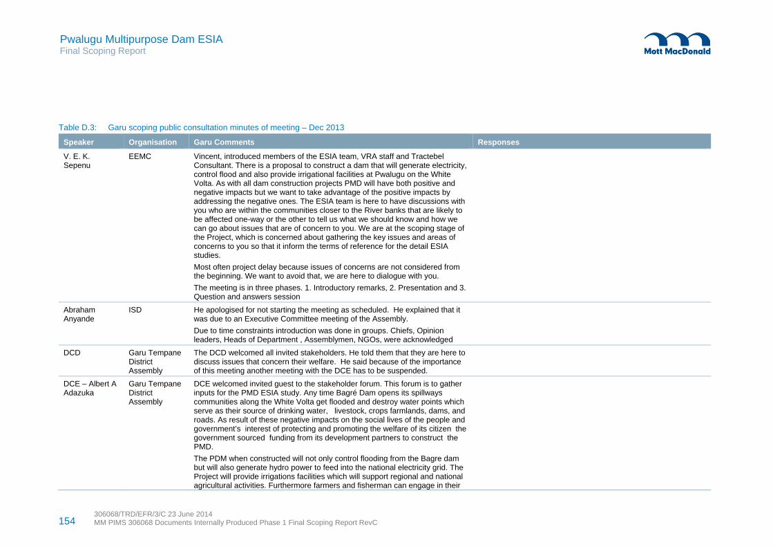
154 306068/TRD/EFR/3/C 23 June 2014 MM PIMS 306068 Documents Internally Produced Phase 1 Final Scoping Report RevC
Pwalugu Multipurpose Dam ESIA Final Scoping Report
Table D.3: Garu scoping public consultation minutes of meeting – Dec 2013
Speaker Organisation Garu Comments Responses
V. E. K. Sepenu
EEMC Vincent, introduced members of the ESIA team, VRA staff and Tractebel Consultant. There is a proposal to construct a dam that will generate electricity, control flood and also provide irrigational facilities at Pwalugu on the White Volta. As with all dam construction projects PMD will have both positive and negative impacts but we want to take advantage of the positive impacts by addressing the negative ones. The ESIA team is here to have discussions with you who are within the communities closer to the River banks that are likely to be affected one-way or the other to tell us what we should know and how we can go about issues that are of concern to you. We are at the scoping stage of the Project, which is concerned about gathering the key issues and areas of concerns to you so that it inform the terms of reference for the detail ESIA studies.
Most often project delay because issues of concerns are not considered from the beginning. We want to avoid that, we are here to dialogue with you.
The meeting is in three phases. 1. Introductory remarks, 2. Presentation and 3. Question and answers session
Abraham Anyande
ISD He apologised for not starting the meeting as scheduled. He explained that it was due to an Executive Committee meeting of the Assembly.
Due to time constraints introduction was done in groups. Chiefs, Opinion leaders, Heads of Department , Assemblymen, NGOs, were acknowledged
DCD Garu Tempane District Assembly
The DCD welcomed all invited stakeholders. He told them that they are here to discuss issues that concern their welfare. He said because of the importance of this meeting another meeting with the DCE has to be suspended.
DCE – Albert A Adazuka
Garu Tempane District Assembly
DCE welcomed invited guest to the stakeholder forum. This forum is to gather inputs for the PMD ESIA study. Any time Bagré Dam opens its spillways communities along the White Volta get flooded and destroy water points which serve as their source of drinking water, livestock, crops farmlands, dams, and roads. As result of these negative impacts on the social lives of the people and government’s interest of protecting and promoting the welfare of its citizen the government sourced funding from its development partners to construct the PMD.
The PDM when constructed will not only control flooding from the Bagre dam but will also generate hydro power to feed into the national electricity grid. The Project will provide irrigations facilities which will support regional and national agricultural activities. Furthermore farmers and fisherman can engage in their

155 306068/TRD/EFR/3/C 23 June 2014 MM PIMS 306068 Documents Internally Produced Phase 1 Final Scoping Report RevC
Pwalugu Multipurpose Dam ESIA Final Scoping Report
Speaker Organisation Garu Comments Responses
activities alongside the irrigation.
Aware that the people of the District for that matter the Region are hardworking and have potential to explore and produce livestock, onions, fruits including water melon to be sold at consumer centres across the country to generate income.
As a local government institution which believes in participation, we pledge to bring all stakeholders on board to ensure successful implementation of the Project
Philip VRA Government of Ghana through VRA hired a Consultant to undertake prefeasibility studies on the Pwalugu Dam in1993. Nothing has been done since then; VRA has currently contracted Tractebel Engineering Limited to come out with an updated the pre-feasibility studies, feasibility studies that can be used for the Project and designs for the Project.
VRA has also contracted Mott MacDonald and EEMC to carry out the Environmental and Social Impact Assessment. They were here some time ago and have come out with scoping report. They are expected to come out with ESIA report and Resettlement Action plan
Dyson Jumpah EEMC Dyson welcomed participants especially the Chiefs and made the ESIA presentation.
Ndeyaaba Atampuni
Chief of Kugri The water is collected from the Bagré dam and spread up to Binduri, where there are a lot of settlers along the banks of the White Volta. In case the water floods this area, what are you going to do for affected people?
ES Consultant: as we are doing the demarcation, what you see is on paper; pillars would be mounted on the ground. We will discuss the compensation issues with the chiefs, land owners and property owners before final compensations are given.
There are various levels of compensation that would be given to affected people. We will cost lost property and make sure that people get enhanced compensation.
The key issue is to cooperate and help us to identify the communities and properties that will be affected. The ESIA Team is going to undertake a detailed baseline study (social and ecological studies) to enumerate properties, houses and properties that would be affected and provide solutions collectively.
VRA: About two weeks ago, we sent a team to Bagré to look at what is actually happening. There are two dams in Burkina Faso, Batinga on the Oti River and Bagré on the White Volta River. There has not been spillage from the two dams yet Bunpurugu area was flooded
We have pleaded with Sonabel that they should not wait for the dam to peak before they spill, Two weeks ago when Bagre did spill, it was steady flow and there was no flooding
ES Consultant: like Akosombo, when the lake is created it will

156 306068/TRD/EFR/3/C 23 June 2014 MM PIMS 306068 Documents Internally Produced Phase 1 Final Scoping Report RevC
Pwalugu Multipurpose Dam ESIA Final Scoping Report
Speaker Organisation Garu Comments Responses
promote fishing activities.
Tempanenaba Chief of Tempane
The opening of the Bagré Dam without notice is a problem. . Lack of information with respect of spillage of water has resulted in loss of lives of the people. Are you taking into consideration of loss of lives? What are you saying about loss of lives, you cannot pay live back?
ES Consultant: the situation as it is today is worse than it is going to be with the construction of PMD. Bagré dam is not the only cause of the flooding in the Upper East and Northern regions. If it rains continuously in these two regions the whole area will go underwater. So when water from Bagré is blocked, we will still experience flooding. The PMD will help us control floods up to a certain point. We will not be able to absolutely control flood
As part of design of the PMD after the boundaries have been established, a buffer zone would be created where communities would be prevented from staying there with the aim of protecting human lives.
Saibu Amadu Reagent Kpatia If you look at the Map, the irrigation site is on the left downstream far away from Garu Temapane which is upstream on the right. How are we going to benefit from the irrigation facilities?
ES Consultant: we are at prefeasibility stage so everything is a proposal. The actual feasibility will be done that is why we are consulting key stakeholders. It will not make sense to develop an irrigation facility that will not benefit the people.
The Technical Consultant or Design Team are here and has taken note of the concern, so that at the feasibility stage your concerns would be addressed.
Grace Nkaw Government Appointee GTDA/ NADMO
Women in this part of the country do not own land. Normally farmlands are given to them by their husband and other relatives. Once the dam is constructed the lands will be inundated so our husbands would lose their lands. It will be difficult for women to get land to continue with their farming. I suggest that you handle women compensation issues separately from the men. If you are going to build a house for affected person, you have to consider women
Considering that the Project is Dam construction. There are risks of disasters associated with flooding. NADMO should be part of the Steering Committee.
ES Consultant: on housing compensation, we are going to follow processes. We will look at the land issues and get alternative lands so that they can continue their farming activities. Together with the women, we will look at other economic activities that the women can engage in.
ES Consultant: as part of the studies we will ensure gender policy framework is put in place. Together with the women we will came out with measures that will enhance their livelihood.
NADMO is a key player in this whole ESIA exercise. So there is no attempt to relegate them to the background. All the regions and districts that we are going NADMO is part of us.
Rose Adakudugu
Assemblywoman
There are irrigational facilities in Navrongo and Bolgatanga even our youth from this District go there to do farming. I am appealing to the Chief that they should not give the irrigation lands to outsiders but to the women from this area
ES Consultant: we are appealing to the Chiefs to ensure that whatever benefits the Project brings the area women are not left out or lose out.
uliana W Awiah Social Welfare Department
You said the PMD would create jobs, what measures are you putting in place to prevent school children from seeking employment opportunities to avoid school dropout and child labour
VRA: child education is critical so VRA will follow ILO principles and Ghana labour laws with respect to child employment. VRA ensures that its hired contractors follow labour laws.
Under VRA CSR policies have instituted scholarship schemes not only down South but all our operational and impacted areas including Upper East Region. Our scholarships are for secondary level of education but we are thinking of extending it to University education

157 306068/TRD/EFR/3/C 23 June 2014 MM PIMS 306068 Documents Internally Produced Phase 1 Final Scoping Report RevC
Pwalugu Multipurpose Dam ESIA Final Scoping Report
Speaker Organisation Garu Comments Responses
We also urge Polytechnic and university students in this area to apply to VRA for attachment programme.
Halidu Abodiba GTDA My concern is transportation, looking at the Upper East Region, there are two bridges Kobori and Pwalugu. Looking at the volume of water that is likely to pass under these bridges, I fear they will collapse and affect transportation system.
FS Consultant: currently, we are at the feasibility stage of the Project. We will do surveys to measure the levels of the bridges. I don’t think we will over top the bridges.
Also the Pwalugu Bridge, the initial threat is when we spill as per the early design where the spillways were before the bridge. This design option has been discarded.
Currently, the spillways are on the Dam itself and so the spilled water will pass at the back of the power house and redirected into the White Volta River. By the time the water gets to the Pwalugu bridge the level would have dropped so the bridge will not be affected.
The roads are international and so they cannot be closed
Solomon Awuni GTDA There is an irrigation project at Tami on the tributary of the White Volta River; I want to know whether this project will still be relevant with the construction of the PMD?
I also fear that the PMD will make the rivers expand their volumes and make the bridges inundated.
FS Consultant: this project started in the 1950s and areas have been proposed for irrigation. Again, Studies were done to develop Northern part of Ghana, and sites were proposed for irrigation.
In 1993 VRA conducted a study and irrigation sites were also proposed. We are updating the 1993 prefeasility study and currently, the proposal is to locate the irrigation facility in the following areas Kunkwa, Kunpon and Pasingbe areas. Consultations are on-going; final decision is yet to be taken.
James K. Bukari
Government Appointee ass, GTDA
Employment opportunities or local content: What percentage of local people will be employed?
Those communities that will be resettled are likely to face water problem so provide them with potable water.
Thomas Akasire
Kpatia E/A In GTDA the shortest route linking the District to Bawku West District is through Kugri across the White Volta at Binaba. With the construction of the reservoir, there is going to be a lot of water upstream, I am wondering if the bridges will not be affected
Once people will lose their farmlands due to the inundation and also because people will not be allowed to farm close to the reservoir, is it possible to construct natural canals from the reservoir to farm lands in the upstream areas so that in the dry season people can continue with farming and also engage in aquaculture.
FS Consultant: this is an engineering problem that we need to look at. It is not prudent because if you want to pump water to high grounds, you need powerful pumps. We need to consider if we can get irrigational site upstream for use by people to farm
Solomon Alebua
Songo/Senebaga Assemblyman
At the local level, we don’t demarcate our land before building. At the time that they will remove some of us to some places and we don’t have these kinds of documents, how are we going to be taken care of when it comes to compensations?
ES Consultant: this Project is required to comply with EPA requirement, World Bank environmental and social safeguards requirements and IFC standards. Under the World Bank environmental and social safeguards requirement, when it comes to issues of compensation we have eligibility criteria that we will
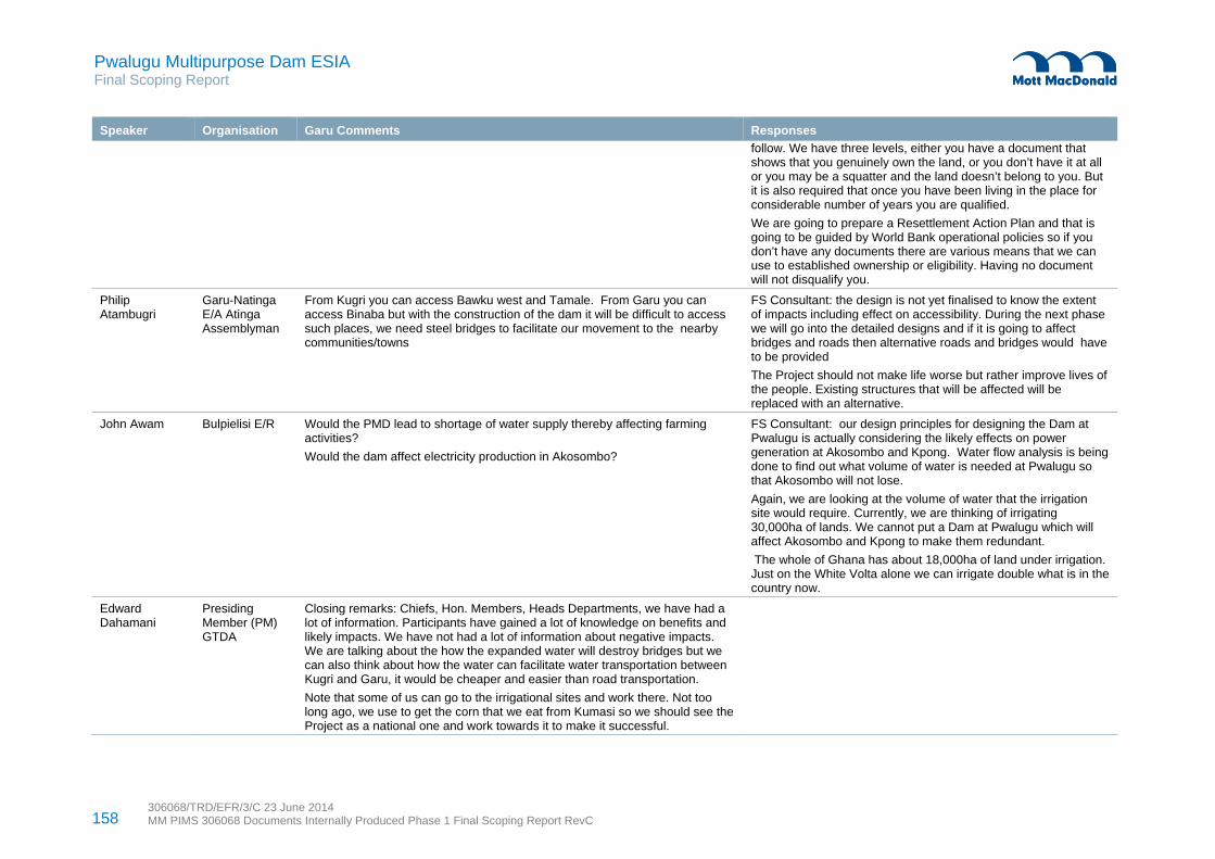
158 306068/TRD/EFR/3/C 23 June 2014 MM PIMS 306068 Documents Internally Produced Phase 1 Final Scoping Report RevC
Pwalugu Multipurpose Dam ESIA Final Scoping Report
Speaker Organisation Garu Comments Responses
follow. We have three levels, either you have a document that shows that you genuinely own the land, or you don’t have it at all or you may be a squatter and the land doesn’t belong to you. But it is also required that once you have been living in the place for considerable number of years you are qualified.
We are going to prepare a Resettlement Action Plan and that is going to be guided by World Bank operational policies so if you don’t have any documents there are various means that we can use to established ownership or eligibility. Having no document will not disqualify you.
Philip Atambugri
Garu-Natinga E/A Atinga Assemblyman
From Kugri you can access Bawku west and Tamale. From Garu you can access Binaba but with the construction of the dam it will be difficult to access such places, we need steel bridges to facilitate our movement to the nearby communities/towns
FS Consultant: the design is not yet finalised to know the extent of impacts including effect on accessibility. During the next phase we will go into the detailed designs and if it is going to affect bridges and roads then alternative roads and bridges would have to be provided
The Project should not make life worse but rather improve lives of the people. Existing structures that will be affected will be replaced with an alternative.
John Awam Bulpielisi E/R Would the PMD lead to shortage of water supply thereby affecting farming activities?
Would the dam affect electricity production in Akosombo?
FS Consultant: our design principles for designing the Dam at Pwalugu is actually considering the likely effects on power generation at Akosombo and Kpong. Water flow analysis is being done to find out what volume of water is needed at Pwalugu so that Akosombo will not lose.
Again, we are looking at the volume of water that the irrigation site would require. Currently, we are thinking of irrigating 30,000ha of lands. We cannot put a Dam at Pwalugu which will affect Akosombo and Kpong to make them redundant.
The whole of Ghana has about 18,000ha of land under irrigation. Just on the White Volta alone we can irrigate double what is in the country now.
Edward Dahamani
Presiding Member (PM) GTDA
Closing remarks: Chiefs, Hon. Members, Heads Departments, we have had a lot of information. Participants have gained a lot of knowledge on benefits and likely impacts. We have not had a lot of information about negative impacts. We are talking about the how the expanded water will destroy bridges but we can also think about how the water can facilitate water transportation between Kugri and Garu, it would be cheaper and easier than road transportation.
Note that some of us can go to the irrigational sites and work there. Not too long ago, we use to get the corn that we eat from Kumasi so we should see the Project as a national one and work towards it to make it successful.

159 306068/TRD/EFR/3/C 23 June 2014 MM PIMS 306068 Documents Internally Produced Phase 1 Final Scoping Report RevC
Pwalugu Multipurpose Dam ESIA Final Scoping Report
Table D.4: Gambaga Scoping Public Consultation Minutes of Meeting
Speaker Organisation Gambaga Comments Responses
V. E. K. Sepenu
EEMC Vincent gave an overview of the meeting. He said the purpose of the meeting is to have dialogue on the PMD. As a development project it is likely to be associated with positive and negative impacts. We are here to identify the key issues with respect to the PMD both negative and positive impacts and find appropriate mitigations measures and also prepare the affected communities. PMD when constructed will change the local economy.
PM Tia Sanda
EMDA Opening remarks: The Presiding Member welcomed participants and informed the meeting that the DCE is in Accra on an official assignment. DCD is also in another meeting. He urged participants to feel free to express their concerns and opinions.
Philip Tetteh Padi
VRA On behalf of VRA Management, I welcome you to this meeting. We are here to hear and know your concerns about the PMD
From 1990 - 1993, VRA contracted a Consultant to undertake a prefeasibility studies on the Oti and the White Volta rivers to find out the best site where a Dam can be constructed, Pwalugu was selected for the best site for Dam
VRA has contracted Tractebel engineering to come out with an updated the pre-feasibility studies, feasibility studies and designs for the project.
VRA has also contracted Mott MacDonald and EEMC to carry out the Environmental and Social Impact Assessment and come out with Scoping Report, ESIA report and resettlement action plan.
Benefits include energy generate up to 50-60MW, irrigations, fisheries i.e. aquaculture, transportation, and flood control
Dyson Jumpah
EEMC Made ESIA presentation
Alitu mohammed Issa
EMDA staff Suggestion: the presentation is good, however, the language used did not help the Chiefs
Compensation to landowners, what measures are in place in instances where the land earmarked for compensation is under dispute?
ES Consultant: As part of the Resettlement Action Plan that would be put in place there will be a provision for grievance redress mechanism. A Committee will be constituted, and membership will include: prominent persons in the area, Chiefs, and the District Assemblies among others. Where the grievance redress committee is unable to resolve a land dispute, the parties involved may seek redress from the law courts. Entitlement will only be paid when all conflicts related issues have been resolved. Until then any monies due will be with the Land Commission/Land Valuation Board.
Compensation payment to various affected persons will be done differently. Users of the affected land and owners of the lands will also be compensated.
VRA: currently we are at the scoping phase. The Technical Team will map out the areas and list properties and lands that would be
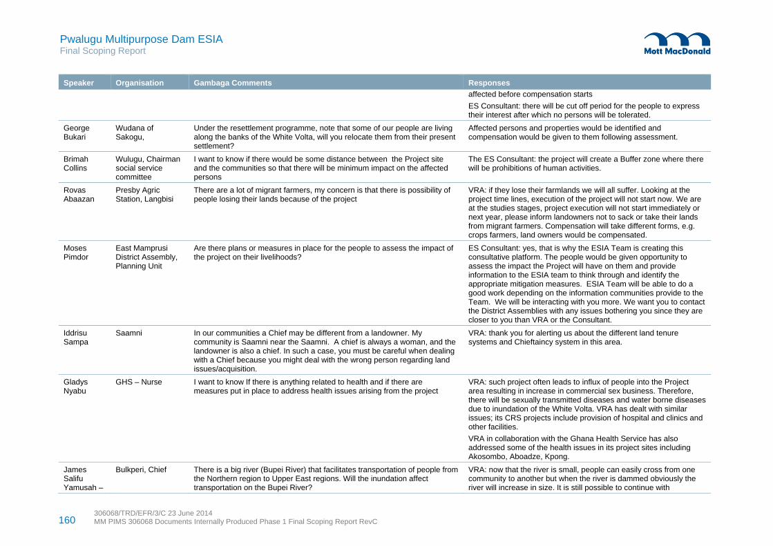
160 306068/TRD/EFR/3/C 23 June 2014 MM PIMS 306068 Documents Internally Produced Phase 1 Final Scoping Report RevC
Pwalugu Multipurpose Dam ESIA Final Scoping Report
Speaker Organisation Gambaga Comments Responses
affected before compensation starts
ES Consultant: there will be cut off period for the people to express their interest after which no persons will be tolerated.
George Bukari
Wudana of Sakogu,
Under the resettlement programme, note that some of our people are living along the banks of the White Volta, will you relocate them from their present settlement?
Affected persons and properties would be identified and compensation would be given to them following assessment.
Brimah Collins
Wulugu, Chairman social service committee
I want to know if there would be some distance between the Project site and the communities so that there will be minimum impact on the affected persons
The ES Consultant: the project will create a Buffer zone where there will be prohibitions of human activities.
Rovas Abaazan
Presby Agric Station, Langbisi
There are a lot of migrant farmers, my concern is that there is possibility of people losing their lands because of the project
VRA: if they lose their farmlands we will all suffer. Looking at the project time lines, execution of the project will not start now. We are at the studies stages, project execution will not start immediately or next year, please inform landowners not to sack or take their lands from migrant farmers. Compensation will take different forms, e.g. crops farmers, land owners would be compensated.
Moses Pimdor
East Mamprusi District Assembly, Planning Unit
Are there plans or measures in place for the people to assess the impact of the project on their livelihoods?
ES Consultant: yes, that is why the ESIA Team is creating this consultative platform. The people would be given opportunity to assess the impact the Project will have on them and provide information to the ESIA team to think through and identify the appropriate mitigation measures. ESIA Team will be able to do a good work depending on the information communities provide to the Team. We will be interacting with you more. We want you to contact the District Assemblies with any issues bothering you since they are closer to you than VRA or the Consultant.
Iddrisu Sampa
Saamni
In our communities a Chief may be different from a landowner. My community is Saamni near the Saamni. A chief is always a woman, and the landowner is also a chief. In such a case, you must be careful when dealing with a Chief because you might deal with the wrong person regarding land issues/acquisition.
VRA: thank you for alerting us about the different land tenure systems and Chieftaincy system in this area.
Gladys Nyabu
GHS – Nurse I want to know If there is anything related to health and if there are measures put in place to address health issues arising from the project
VRA: such project often leads to influx of people into the Project area resulting in increase in commercial sex business. Therefore, there will be sexually transmitted diseases and water borne diseases due to inundation of the White Volta. VRA has dealt with similar issues; its CRS projects include provision of hospital and clinics and other facilities.
VRA in collaboration with the Ghana Health Service has also addressed some of the health issues in its project sites including Akosombo, Aboadze, Kpong.
James Salifu Yamusah –
Bulkperi, Chief There is a big river (Bupei River) that facilitates transportation of people from the Northern region to Upper East regions. Will the inundation affect transportation on the Bupei River?
VRA: now that the river is small, people can easily cross from one community to another but when the river is dammed obviously the river will increase in size. It is still possible to continue with

161 306068/TRD/EFR/3/C 23 June 2014 MM PIMS 306068 Documents Internally Produced Phase 1 Final Scoping Report RevC
Pwalugu Multipurpose Dam ESIA Final Scoping Report
Speaker Organisation Gambaga Comments Responses
transportation but it should be done with care, if you have your life jackets you are safe.
Iddrisu Kelly
EMDA/Planning Unit
How will people living upstream be compensated if their farmlands are inundated? Would they be allowed to go downstream to continue their farming in the proposed irrigation site?
The ES Consultant: this question has been coming up in most of the places we visited. It is possible for people to move downstream to engage in agricultural activities.
We will subject this to critical analysis. The irrigable land is about 110,000ha out of which 30,000ha is proposed to be irrigated under the PMDP. The constraint we face is the water supply. It is therefore possible.
ASP Attaban Quarshie
District commander, Ghana Police
During the construction of such project there is pollution in the environment by truck drivers and this often leads to attacks on the truck drivers by the youth. Do you have plans to engage local security agencies so that in case of unforeseen problems like that we can assist?
The ES Consultant: the National Security is involved in this Project. The Environmental Social Management plan will address security issues. Of course, Ghana Police would be involved
Drivers would be educated as well and would be expected to follow safety standards. The district Assemblies will help monitor safety.
Imoro Issaka
Nyingari, Chief What are the measures for fishermen near the Gambaga Scarp? The ES Consultant: when the reservoir is created, it will bring multiple benefits including fishing. We would engage the fishermen on fishing opportunities. We have a fisheries expert in the ESIA Team whose job is to engage the fisher folks and find solution to address any fishing problems.
A.D. Abugri Education service How will the project affect education VRA: if schools are inundated new schools will be provided by VRA.
EMDA, DCD What is the capacity of the Dam in terms of energy production?
Capacities in term of irrigation, what capacity are we thinking about?
Impact of the Dam on our roads and bridges. Impact of spillage of water on the communities
FS Consultant:50-60MW is the provisional estimate. We are studying everything about the Volta River so that it does not affect Akosombo or the Kpong Dam.
We are still doing analysis of water from the White Volta to determine how many hectares of land can be irrigated. For now the estimate is between 20-30,000ha of lands.
The design of the Dam will create a spillway in the dam itself so that water will pass through the back of the power house to the White Volta. It is expected that by the time it gets to the bridge the water level will reduced considerably.
Tia Sanda Presiding Member (PM), EMDA
Closing remarks: In East Mamprusi, we depend on the rivers so come out with mitigations measures that will minimise the impacts on the people. Let us not politicise the project. We are all interested in development.
Participants must endeavour to pass on the information to the people. East Mamprusi District Assembly will give your maximum cooperation.

162 306068/TRD/EFR/3/C 23 June 2014 MM PIMS 306068 Documents Internally Produced Phase 1 Final Scoping Report RevC
Pwalugu Multipurpose Dam ESIA Final Scoping Report
Table D.5: Walewale scoping public consultation minutes of meeting – Dec 2013
Speaker Organisation Walewale Comments Responses
V. E. K. Sepenu
EEMC Vincent gave an overview of the meeting. He said the purpose of the meeting is to have dialogue on the PMD. As a development project it is likely to be associated with positive and negative impacts. We are here to identify the key issues with respect to the PMD both negative and positive impacts and find appropriate mitigation measures and also prepare the affected communities, Districts to take advantage of the positive impacts once the project commenced.
The programme will be in three sessions Statement by DCD, VRA a presentation on ESIA, and a plenary session with questions and answer time
Abubakar Inusah
DCD Welcome Statement: DCE is in Accra and cannot be part of the meeting. When the Consultant met us about two weeks ago and briefed us about this Project, we were happy because our understanding was that the Project will create employment and to a large extent reduce the poverty of the people. The DA is well prepared and positioned to support the Consultant and VRA to implement this Project. All the other consequences that are likely to come with the Project, we are prepared to dialogue to find appropriate solutions. On that note, I welcome you the participants and wish you a fruitful deliberation.
Philip Tetteh Padi
VRA On behalf of VRA Management, I welcome you to this meeting. We are here to hear and know your concerns about the PMDP
From 1990 - 1993, VRA contracted a Consultant to undertake a prefeasibility studies on the Pwalugu Dam
VRA has contracted Tractebel engineering to come out with updated prefeasibility studies, feasibility studies and designs for the project.
VRA has also contracted Mott MacDonald and EEMC to carry out the Environmental and Social Impact Assessment studies and prepare ESIA report and resettlement action plan.
Benefits include energy generation up to 50-60MW, irrigations, fisheries i.e. aquaculture, transportation, and flood control
Hon Sagre Mohammed Bambangi
MP-Walewale He apologised for being late and then explained that he arrived in Walewale this morning from Accra. According to him, he was glad to hear that there are some efforts in place towards construction of the PMD.
He disclosed that the PMDP was included in a proposals brought to Parliament by MOFA.
We are already in deprived areas and we are looking for interventions that will help solve our poverty problem.
We have not experienced a project of this kind so we are relying on your expertise and advise to ensure success of the project. Obviously there will be resettlement issues. We have not gone on any excursions to similar Dam projects areas to enable us know the extent of the environmental and social issues associated with Dam and irrigation projects.
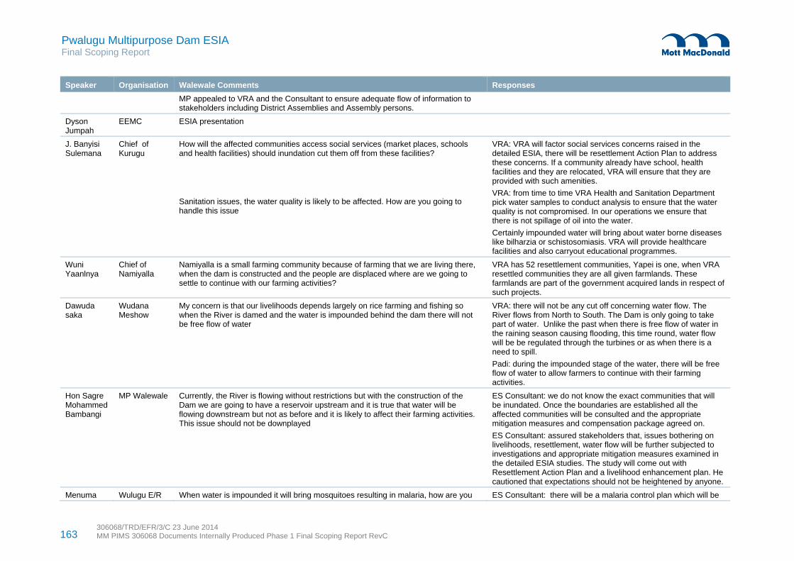
163 306068/TRD/EFR/3/C 23 June 2014 MM PIMS 306068 Documents Internally Produced Phase 1 Final Scoping Report RevC
Pwalugu Multipurpose Dam ESIA Final Scoping Report
Speaker Organisation Walewale Comments Responses
MP appealed to VRA and the Consultant to ensure adequate flow of information to stakeholders including District Assemblies and Assembly persons.
Dyson Jumpah
EEMC ESIA presentation
J. Banyisi Sulemana
Chief of Kurugu
How will the affected communities access social services (market places, schools and health facilities) should inundation cut them off from these facilities?
Sanitation issues, the water quality is likely to be affected. How are you going to handle this issue
VRA: VRA will factor social services concerns raised in the detailed ESIA, there will be resettlement Action Plan to address these concerns. If a community already have school, health facilities and they are relocated, VRA will ensure that they are provided with such amenities.
VRA: from time to time VRA Health and Sanitation Department pick water samples to conduct analysis to ensure that the water quality is not compromised. In our operations we ensure that there is not spillage of oil into the water.
Certainly impounded water will bring about water borne diseases like bilharzia or schistosomiasis. VRA will provide healthcare facilities and also carryout educational programmes.
Wuni Yaanlnya
Chief of Namiyalla
Namiyalla is a small farming community because of farming that we are living there, when the dam is constructed and the people are displaced where are we going to settle to continue with our farming activities?
VRA has 52 resettlement communities, Yapei is one, when VRA resettled communities they are all given farmlands. These farmlands are part of the government acquired lands in respect of such projects.
Dawuda saka
Wudana Meshow
My concern is that our livelihoods depends largely on rice farming and fishing so when the River is damed and the water is impounded behind the dam there will not be free flow of water
VRA: there will not be any cut off concerning water flow. The River flows from North to South. The Dam is only going to take part of water. Unlike the past when there is free flow of water in the raining season causing flooding, this time round, water flow will be be regulated through the turbines or as when there is a need to spill.
Padi: during the impounded stage of the water, there will be free flow of water to allow farmers to continue with their farming activities.
Hon Sagre Mohammed Bambangi
MP Walewale Currently, the River is flowing without restrictions but with the construction of the Dam we are going to have a reservoir upstream and it is true that water will be flowing downstream but not as before and it is likely to affect their farming activities. This issue should not be downplayed
ES Consultant: we do not know the exact communities that will be inundated. Once the boundaries are established all the affected communities will be consulted and the appropriate mitigation measures and compensation package agreed on.
ES Consultant: assured stakeholders that, issues bothering on livelihoods, resettlement, water flow will be further subjected to investigations and appropriate mitigation measures examined in the detailed ESIA studies. The study will come out with Resettlement Action Plan and a livelihood enhancement plan. He cautioned that expectations should not be heightened by anyone.
Menuma Wulugu E/R When water is impounded it will bring mosquitoes resulting in malaria, how are you ES Consultant: there will be a malaria control plan which will be

164 306068/TRD/EFR/3/C 23 June 2014 MM PIMS 306068 Documents Internally Produced Phase 1 Final Scoping Report RevC
Pwalugu Multipurpose Dam ESIA Final Scoping Report
Speaker Organisation Walewale Comments Responses
Sandow going to deal with this issue?
There is the likelihood of an increase in STDs due to influx of people. How is this going to be handled?
aligned to the national malaria control programme. Malaria is sanitation related so we have to deal with our insanitary conditions in our communities
Generally, our sisters and brothers who are involved in commercial sex business will always take advantage of construction projects and come here. The ESIA study will look at the current HIV/AIDs situation in the project affected districts and communities and come out with an HIV/AIDs Action Plan targeting construction workers and their clients. HIV/AIDs education programmes will also proposed to be rollout with the active involvement of the community members, construction workers and the contractors.
Adiga Doris Kperiga E/R Provide employment opportunities for women to prevent perennial migration of women to the southern part of the country to engage in menial jobs
ES Consultant: the ESIA study will explore current employment opportunities available to the women and make a proposal in consultation with women leadership in the communities.
Salifu Alhassan Mohammed
Nasia E/R Is it possible to expand the membership of the Steering Committee for the project to include representation from Traditional Rulers or the District Assemblies?
ES Consultant: suggestion is well noted and it will be communicated to the VRA
Ben Adam Dimise E/R Traditional Areas have boundaries; if affected persons are resettled in another Traditional Area boundary what happens to the owner of that land?
VRA: this is a social issue that have to be handled carefully so that the affected people and Traditional rulers will be consulted before any resettlement takes place to avoid any social tension.
Hon Wini Sazugu Naaba
Dun Electoral Area
If the land affected is ancestral lands and compensation is paid to the living, what happens to the generations unborn?
ES Consultant, the Constitutions and the Lands Act enjoin government to acquire land and use it for development and pay appropriate compensations. This would be done in consultations with the affected persons and landowners. We will learn from the Bui Dam experience.
Abubakar Inusah
DCD Conspicuously missing in the membership of the Steering Committee is National Security
ES Consultant: Suggestion noted
J W Brimah NADMO Looking at Dam construction, disaster can occur at any time, before and after the construction of the Dam. NADMO should be part of Steering Committee
ES Consultant: Suggestion noted
Musah Adam Jafari
EPA One of the problems that we are likely to face is borrow pits. I suggest that when the work is about to begin the EPA is involved to avoid indiscriminate opening of pits
ES Consultant: we want to say that the involvement and participation of the potentially affected District Assemblies is crucial when it comes to carting of raw materials (rocks); the DAs have a role to play. The District Assemblies should therefore liaise with the EPA and the Chiefs to control the creation of borrow pits.
Jacob Tumulbuto: borrow pits must be filled
FS Consultant: borrow pits created as a result of the construction of the Dam will constitute part of the reservoir and so they will be covered by the water.

165 306068/TRD/EFR/3/C 23 June 2014 MM PIMS 306068 Documents Internally Produced Phase 1 Final Scoping Report RevC
Pwalugu Multipurpose Dam ESIA Final Scoping Report
Speaker Organisation Walewale Comments Responses
Gyimah Lawrence
EPA Happy that the EPA has been involved from the onset in the PMDP.
Energy projects will bring impacts so we are likely to have environmental impacts, I suggest that you think about the life span of the Dam because of the following water users, water weeds and tree stumps can affect the Dam’s lifespan.
ES Consultant: Suggestion noted
Abudul-Rahamani Yussif
Ghana red cross
What is the relationship between the PMD and Community Resilient through Early Warning System with funding from Norway which is also considering the construction of a Dam
ES Consultant: thanks for the information. We wish that you can give us their contact. Under the ToR of ESIA, climate change issue is part of the issues under consideration. Though, we are going to create a hydro dam anticipating that it will rain so that we can capture enough water in the reservoir, there is also the possibility that it will not rain. So we need to look at the two extremes. We are looking at other projects within the zones that will also have a cumulative impact vis-a- vis the PMD.
Dan Sandow
FARANAY –ABC (Presby Agric)
Tree stumps in the River are likely to cause deaths. Tree stumps, the ESIA will look at it. Either trees are harvested or cut
Busia Adawumi
IWAD Not much was said about the extent to which the PMD will control flooding. VRA: Tractebel Engineering is looking at the hydrology data available and rainfall pattern. As much as possible a large portion of the flooded area will be covered by the Dam
ES Consultant: preliminary data available show that the reservoir volume is about 5500cubic metres in volume at leading to a full supply level at 172m above sea level for the Downstream dam axis and 117m asl for the upstream dam axis.
Jacob Tumulbuto
Water Basin Bagre will often wait till the Dam gets filled before opening its spillways. Hope that this will not be the case with PMD?
The issue of water flow should not limit natural conditions. In Senegal sometimes they allow water to flow to downstream for agriculture activities.
VRA: VRA do not wait for the Dam to get filled before opening their spill gates. The same measures will be applied in the PMD case
ES Consultant: the Dam designers will ensure waterflow downstream to preserve the natural ecosystem and also create fish pass to allow fish migration.
General question
How are the irrigation lands going to be shared?
Politicisation of the project
The ES Consultant: this will be done through consultative process and lessons from other irrigation projects.
FS Consultant: Irrigation aspect of the project is big targeting various level of farmers
This project should not be used to advance individual political interest.
Abubakar Inusah
DCD Closing remarks: Upon receipt and reading the invitation letter for this meeting, I instructed that a new file be opened for the PMD. Following this meeting, I will ensure that a desk is created for the project. Thank you for participating in this meeting.
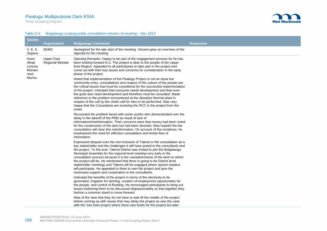
166 306068/TRD/EFR/3/C 23 June 2014 MM PIMS 306068 Documents Internally Produced Phase 1 Final Scoping Report RevC
Pwalugu Multipurpose Dam ESIA Final Scoping Report
Table D.6: Bolgatanga scoping public consultation minutes of meeting – Dec 2013
Speaker Organisation Bolgatanga Comments Responses
V. E. K. Sepenu
EEMC Apologised for the late start of the meeting. Vincent gave an overview of the Agenda for the meeting
Hoon Alhaji Limuna Mohammed Muniru
Upper East Regional Minister
Opening Remarks: Happy to be part of the engagement process for he has been looking forward to it. The project is dear to the people of the Upper East Region. Appealed to all participants to take part in the project and come out with their key issues and concerns for consideration in the early phase of the project.
Noted that implementation of the Pwalugu Project is not an issue but community entry, consultations and respect of the culture of the people are the critical issues that must be considered for the successful implementation of the project. Intimated that everyone needs development and that even the gods also need development and therefore must be consulted. Made reference to the problem encountered at the Aboadze thermal plant in respect of the call by the chiefs call for rites to be performed. Was very happy that the Consultants are involving the RCC in the project from the onset.
Recounted the problem faced with some youths who demonstrated over the delay in the takeoff of the PMD as result of lack of information/misinformation. Their concerns were that money had been voted for the construction of the dam but had been diverted. Was hopeful the the consultation will clear this misinformation. On account of this incidence, he emphasised the need for effective consultation and timely flow of information.
Expressed disquiet over the non-inclusion of Talensi in the consultation as a key stakeholder and the challenges it will have posed to the consultants and the project. To this end, Talensi District was invited to join the Bolgatanga Municipal Assembly for the regional level meeting very early in the consultation process because it is the caretaker/owner of the land on which the project will be. He mentioned that there is going to be District level stakeholder meetings and Talensi will be engaged where opinion leaders will participate. He appealed to them to own the project and give the necessary support and cooperation to the consultants.
Indicated the benefits of the project in terms of the electricity to be generated, irrigation for farming, creation of employment opportunities for the people, and control of flooding. He encouraged participants to bring out issues bothering them to be discussed dispassionately so that together they fashion a common stand to move forward.
Was of the view that they do not have to wait till the middle of the project before coming up with issues that may delay the project as was the case with the Vea Dam project where there was funds for the project but later

167 306068/TRD/EFR/3/C 23 June 2014 MM PIMS 306068 Documents Internally Produced Phase 1 Final Scoping Report RevC
Pwalugu Multipurpose Dam ESIA Final Scoping Report
Speaker Organisation Bolgatanga Comments Responses
issues emerged and by the time the issues were fully addressed funds was not available for implementation of the project. Additional funding is now being sourced to complete the project
Philip Padi He welcomed participants to the meeting and informed them that the meeting is to provide them with information on the PMD, and also listen and note their concerns about the PMD.
Touched on the project site selection process. In the year 1993, VRA contracted a Consultant to undertake prefeasibility studies in Pwalugu, Daboya, Juale and Kulpawn. They concluded that Pwalugu and Juale are the best sites for Dam construction.
For the PMD, VRA is envisaging a number of benefits including hydro power, fishing, transportation, irrigation, flood control
VRA contracted Tractebel engineering to update the 1993 pre-feasibility studies to see if those benefits considered in the pre-feasibility studies in 1993 are still relevant. Thus, Tractebel is looking at the technical component of the project. Tractebel is expected to come out with an updated pre –feasibility studies, detailed design of the hydro dam as well as the irrigation dam which will initially focus on 20,000 to 30,000ha
There is the need to conduct Environmental and Social Impact Assessment. VRA contracted Mott MacDonald and EEMC to come out with ESIA report and Resettlement Action Plan.
Dyson Jumpah
EEMC ESIA presentation
Martha Fuseini Atago
Bongo, Nagodi, Bongo, Tongo - BONABONTO
Congratulated Mr Dyson Jumpah for the excellent ESIA Scoping presentation made. She said the presentation comprehensively addresses all the relevant environmental and social issues of concern.
She highlighted the practice whereby in previous projects affected persons who were compensated for lost houses misapplied the monetary compensation made to them. She asked how this will be avoided under the PMDP.
What happens to those whose houses will be affected and how will they be assisted to have their new homes?
What is the compensation arrangement for the affected people?
The ES Consultant: In our previous work related to date some of these issues have come up. It is not only houses that would be affected but farmlands and crops. The issue is whether to give them monies or put the money into an investment or put it into a project that will have a regular income to sustain them.
There are options:
1) The easy option is to cost the facilities and pay monies directly to affected people. We have been engaging NGOs who are working in communities with similar situations. Whatever the solution to be decided upon we always need the cooperation and understanding of the people. Their interest is supreme. Package will be agreed upon by affected persons
2) Develop a model where alternative houses will be provided under a housing scheme. A contractor or a community team of workers will be engaged to undertake the construction.

168 306068/TRD/EFR/3/C 23 June 2014 MM PIMS 306068 Documents Internally Produced Phase 1 Final Scoping Report RevC
Pwalugu Multipurpose Dam ESIA Final Scoping Report
Speaker Organisation Bolgatanga Comments Responses
Consultation with the people and other NGOs is very important to ensure acceptance of whatever recommendations and proposals made.
3) Under the resettlement action plans, there will be an entitlement matrix where we are going to identify the kind of loss that the affected people are going to suffer. Those who are going to lose farmlands and other livelihoods such as grazing lands and economic trees will be identified, together quantify the losses and decide what is appropriate and acceptable for compensation.
Alhaji M.E Siam
VRA/NEDCO Likelihood of speculation: people knowing that the area around the river will be inundated rush there to build houses in anticipation for compensation.
Social problem as result of the lake with respect to people who might come to do fishing activities who are not the indigenes. (in-migration of fishers)
ES Consultant: thanked Alhaji M.E Siam for the information and local knowledge. We are engaging the Lands Commission and the District Assemblies on this matter. One major issue is to establish a cut-off date. Once the cut-off date is established it will be widely announced so that anyone with interest must disclose it. Beyond the cut-off date anyone who undertakes any activities will not be recognised. As at now no development is being stalled because no boundaries have been established yet.
John Mowark
Ghana Health Service -GHS
Health related issues particularly HIV/AIDs increasing due to influx of people to the project area and commercial sex activities.
Dust generation as result of blasting
The ES Consultant: we intend to propose in our study, health and safety risk measures that will be put in place. So far, in some of the areas we have visited, we observe that community health is already a challenge.
The Project will make a good provision for Occupation Health and Safety -OHS issues in the environmental and social management plan that will have an aspect that will addressed OHS issues including HIV/AIDS of people migrating to the area to work
We also have arrangement to look at the labour issues. The PMDP is an international project and we are expected to follow the international labour requirements and national labour requirements, e.g. how much people are paid.
Emphasis will be on local content where capacity and skills development programmes will be put in place to prevent bringing artisans from far away to compete with the local people.
Most of the issues can be found in the scoping report which is on the website of VRA.
These issues will be examined in detail during the ESIA study
Francis Atintono
BONABONTO Regarding compensation, the proper people i.e. property owners in addition with the Chiefs should be involved at beginning and every stage of the consultations. They should not only deal the Chiefs
Juliet Abajong
Integrated Water Agricultural
The Dam construction is likely to be in Upper East Region and the Irrigation will be in the Northern Region. With regards to the irrigation activities priority
ES Consultant explained that this will be done

169 306068/TRD/EFR/3/C 23 June 2014 MM PIMS 306068 Documents Internally Produced Phase 1 Final Scoping Report RevC
Pwalugu Multipurpose Dam ESIA Final Scoping Report
Speaker Organisation Bolgatanga Comments Responses
Development should be given to those affected people upstream.
William Gana
Talensi District Assembly
ESIA Scoping issues raised are very good. Compensation arrangements are good.
On issues of compensation and community entry. He suggested that the proponent of the project should pass through the District Assemblies
Any proposal to blast rocks for the PMDP should involve the communities and District Assembly
ES Consultant explained that the proper permitting procedures will be followed to ensure that necessary permits are acquired and high standards of operation observed.
FC: explained that there will be various materials that will be required for the construction of the Dam. These materials include clay, gravels and rocks.
The quarry maybe behind the Dam and that whole area will part of the reservoir and will not been seen again. The quarry will be far away from the communities. It is around Nungo.
The contractor will be expected to follow international standards making sure that rocks don’t fly in the nearby towns, dust control. The contract will go through the processes for permitting before mining. The contractor will contact the appropriate stakeholders including DAs, Chiefs and Mineral Commission
Patrick Kweku Awuni
Town Planner-Talensi District Assembly
Concerning speculation and sprinkling of houses, if the consultant under taking the feasibility could provide information on the affected areas or demarcation for the affected areas, the DAs can prevent people from building in such places.
Allowing affected people to build their own houses will create problem for VRA and delay the project. The PMDP should put a scheme in place to build the houses and resettle the affected persons.
ES Consultant: we are now trying to identify the exact Areas that will be inundated by the Project. We are doing it with Land Commission both at the national and district levels. Once this is done we will know districts to be affected, acreage of lands and properties that will be affected. This is the area where the DAs and the town and country planning Departments will assist the Project.
ES Consultant explained that PMDP will consider various options for providing resettlement entitlements.
Alhaji M.E Siam said VRA has Real Estate Department. In the construction of Akosombo and Kpong, prototype houses were built in consultation with the people. Bui resettlement houses were put up with some modifications. Normally, VRA will look for lands for such activities.
VRA: VRA houses provided for affected persons in Akosombo and Kpong were model houses. But the people failed to rehabilitate them. In the case of Bui Dam the houses are good, however, we are waiting for 30-40years to draw conclusions.
Naaba Awuni A. John
Yorogo Chief Transportation of heavy equipment
There have been other projects which are not big such as the PMD but the project drivers were disrespectful. Conduct of drivers of trucks moving heavy equipment to the project sites could be reckless at certain times thereby destroying properties. How will this be avoided under the PMDP?
Please educate project drivers before the commencement of the project
After the construct of the Akosombo Dam there have been disasters due to stumps in the river. How different would PMDP be?
ES Consultant: under the Project there would be specification, good construction practices that will be stipulated and haulage of equipment and standard construction practices will be applied. Observation of speed limits
We are still at design stage, and the areas we have surveyed we have seen big trees and the area will be inundated where we have the forest we have the issue of the biomass that will decay into the water and affect the water quality. We have also identified this issue and it is being considered.
ES Consultant explained that the issue of inundation of trees or cutting of

170 306068/TRD/EFR/3/C 23 June 2014 MM PIMS 306068 Documents Internally Produced Phase 1 Final Scoping Report RevC
Pwalugu Multipurpose Dam ESIA Final Scoping Report
Speaker Organisation Bolgatanga Comments Responses
trees before the creation of the reservoir will critically examined and decision taken during the detailed impact assessment stage.
Achibald S. Dery
Ghana Highway Authority - GHA
Bridge on the White Volta on the Bolga-Bawku road, it will be inundated when the Dam is completed. It is estimated that there will be the need to provide 2km bridge
When the Dam completed and the need to spill water what will be the impact on the downstream bridges.
Have you assessed the strength of the bridges in respect of haulage of heavy equipment?
Erosion control activities what are you putting in place to ensure activities along the Dam catchment areas is preserved.
ES Consultant: we see GHA as a major stakeholder. This qualifies under property that would be affected by the Project. As part of the mitigating measures damages to existing infrastructure have to be assessed and factored into the project cost.
ES Consultant welcome the concerns raised by Mr Dery and requested that the ES Consultant would be happy to have further engagement with the Ghana Highway Authority on the concerns being raised so that the potential impacts could clearly identified and subjected to detailed assessment and development of mitigation measures.
FS Consultant: concerning the bridge on Bawku-Bolgatanga road levels has been taken, the reservoir will go up to parts of the bridge but I don’t think it will over top the bridge
On the Pwalugu Bridge, in the early design the spillways were before the bridge that has been discarded. Currently, the spillways are on the Dam itself and the spill water will pass at the back of the power house and redirected into the White Volta; by the time the water gets to the bridge the level would have dropped so the bridge will not be affected
We are doing sedimentation analysis – we need seven months to do it; we realised that the White Volta has a lot of silt
Albert W. Nyeteng
GWCL Expressed concerns of property owners who may be affected by the PMDP. He made reference to the Vea Dam where difficulties arose because affected persons were not considered.
No mention of social amenities and essential services for the affected communities. There is likelihood of group settlement so they need portable water
Nawuli and Danlo water treatment plants get water supply from the White Volta. We note that in Greater Accra, social activities of residents of Nsawam affect the Weija Dam. There is the need to Educate the people so that siltation will be avoided
ES Consultant: we have resolved to consult all stakeholders. There is more work being done to identify areas that will be inundated by the Project. All affected stakeholders will be consulted
We will partner with GWCL. The Dam will be assessed to see how water supply system could be enhanced.
FS Consultant: there will be reduction in water flow but it will not affect water supply to Nawuli and Dalon water treatment. The FC consultant explained that they will meet Ghana water to discuss the implications of the PMDP to water intake at the Darlong Water Treatment facility
Ernest B. Aayel
Centre for Rural Empowerment
Gender issue, in this part of the region ownership of land especially for women is a big issue. People are going to deny access to land their main source of livelihood. Has gender analysis been conducted and special training earmarked for women?
What is the commitment on the part of the proponent of the project and other stakeholders in the implementation of the PMDP?
ES Consultant: made reference to the draft scoping report posted on VRA website. In section 4.5, page 25 of the report, we identify this gender concern in the Upper East and Northern Regions. There is high gender disparity. We will work with you at local level on this issue when we are putting together the mitigation measures
ES Consultant: so far the key stakeholders have demonstrated high commitment. ESIA Consultants will meet Steering Committee for the Project on December 16 and 17 to brief them
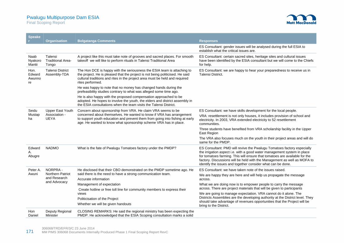
171 306068/TRD/EFR/3/C 23 June 2014 MM PIMS 306068 Documents Internally Produced Phase 1 Final Scoping Report RevC
Pwalugu Multipurpose Dam ESIA Final Scoping Report
Speaker Organisation Bolgatanga Comments Responses
ES Consultant: gender issues will be analysed during the full ESIA to establish what the critical issues are.
Naab Nyakoro Mantii
Talensi Traditional Area-Tongo
A project like this must take note of grooves and sacred places. For smooth takeoff we will like to perform rituals in Talensi Traditional Area
ES Consultant: certain sacred sites, heritage sites and cultural issues have been identified by the ESIA consultant but we will come to the Chiefs for help.
Hon. Edward Awunnore
Talensi District Assembly-TDA
The Hon DCE is happy with the seriousness the ESIA team is attaching to the project. He is pleased that the project is not being politicised. He said cultural traditions and rites in the project area must be held and required rites performed.
He was happy to note that no money has changed hands during the prefeasibility studies contrary to what was alleged some time ago.
He is also happy with the proposed compensation approached to be adopted. He hopes to involve the youth, the elders and district assembly in the ESIA consultations when the team visits the Talensi District.
ES Consultant: we are happy to hear your preparedness to receive us in Talensi District.
Seidu Mustapha
Upper East Youth Association - UEYA
Concern about sponsorship from VRA. He claim VRA seems to be concerned about themselves. He wanted to know if VRA has arrangement to support youth education and prevent them from going into fishing at early age. He wanted to know what sponsorship scheme VRA has in place.
ES Consultant: we have skills development for the local people.
VRA: resettlement is not only houses, it includes provision of school and electricity. In 2003, VRA extended electricity to 52 resettlement communities.
Three students have benefited from VRA scholarship facility in the Upper East Region
The VRA also focuses much on the youth in their project areas and will do same for the PMDP.
Edward A. Abugre
NADMO What is the fate of Pwalugu Tomatoes factory under the PMDP? ES Consultant: PMD will revive the Pwalugu Tomatoes factory especially the irrigation aspect i.e. with a good water management system in place for tomatoes farming. This will ensure that tomatoes are available for the factory. Discussions will be held with the Management as well as MOFA to identify the issues and together consider what can be done.
Peter A. Awuni
NORPRA -Northern Patriot and Research and Advocacy
He disclosed that their CBO demonstrated on the PMDP sometime ago. He said there is the need to have a strong communication team.
Accurate information
Management of expectation
Create hotline or free toll line for community members to express their views
Politicisation of the Project
Whether we will be given handouts
ES Consultant: we have taken note of the issues raised.
We are happy they are here and will help us propagate the message across.
What we are doing now is to empower people to carry the message across. There are project materials that will be given to participants
We are going to manage expectation. VRA cannot do it alone. The Districts Assemblies are the developing authority at the District level. They should take advantage of revenues opportunities that the Project will be bring to the District.
Hon Daniel
Deputy Regional Minister
CLOSING REMARKS: He said the regional ministry has been expecting the PMDP. He acknowledged that the ESIA Scoping consultation marks a solid

172 306068/TRD/EFR/3/C 23 June 2014 MM PIMS 306068 Documents Internally Produced Phase 1 Final Scoping Report RevC
Pwalugu Multipurpose Dam ESIA Final Scoping Report
Speaker Organisation Bolgatanga Comments Responses
Syme beginning for the PMDP.
He stressed that the PMDP is a project high on Government development agenda and it has been discussed at very high levels. It shall see actual construction.
He said information about the PMDP must be disseminated.
RCC will caution the media not to heighten expectation of the people
Table D.7: Tamale scoping public consultation minutes of meeting – Dec 2013
Speaker Organisation Tamale Comments Responses
V. E. K. Sepenu
EEMC Vincent gave an overview of the meeting. He said the purpose of the meeting is to have dialogue on the PMD. As a development project it is likely to be associated with positive and negative impacts. We are here to identify the key issues with respect to the PMD both negative and positive impacts and find appropriate mitigations measures and also prepare the affected communities, Districts to take advantage of the positive impacts once the project commenced.
Procedures for the programme will be the following session
Statement by Minister, VRA and presentation on ESIA, There will be a plenary session with questions and answer time
Bed Ziedeng
Regional Minister
The Minister expressed excitement about the PMD. According to the Minister, he met ESIA Team about a month ago in his office and was briefed on the Project. His understanding is that the Project when completed will bring benefits. We are ready to support it. However, we know this project could also bring social and economic problems to the people.
The proponent of the project should ensure that the problems are reduced to the barest minimum. For example, the Akosombo Dam project was not properly assessed. Although it has brought benefits to the nation as a whole, the communities closer to the Dam have also been negatively impacted. This should be avoided in PMD.
The people must be able to tell the ESIA Consultant early enough what are they likely to lose and gain. For example, displacement and compensation issue, the environmental situation after construction of the PMD to enable the Consultant look for the appropriate measures to mitigate those effects
The Minister emphasised that the Consultants are not very conversant
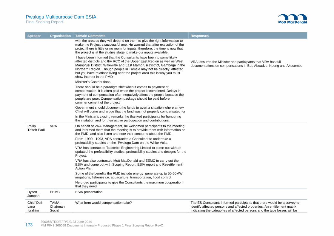
173 306068/TRD/EFR/3/C 23 June 2014 MM PIMS 306068 Documents Internally Produced Phase 1 Final Scoping Report RevC
Pwalugu Multipurpose Dam ESIA Final Scoping Report
Speaker Organisation Tamale Comments Responses
with the area so they will depend on them to give the right information to make the Project a successful one. He warned that after execution of the project there is little or no room for inputs, therefore, the time is now that the project is at the studies stage to make our inputs available.
I have been informed that the Consultants have been to some likely affected districts and the RCC of the Upper East Region as well as West Mamprusi District, Walewale and East Mamprusi District, Gambaga in the Northern Region. Though people in Tamale may not be directly affected but you have relations living near the project area this is why you must show interest in the PMD
Minister’s Contributions
There should be a paradigm shift when it comes to payment of compensation. It is often paid when the project is completed. Delays in payment of compensation often negatively affect the people because the people are poor. Compensation package should be paid before commencement of the project
Government should document the lands to avert a situation where a new Chief will come and argue that the land was not properly compensated for.
In the Minister’s closing remarks, he thanked participants for honouring the invitation and for their active participation and contributions.
VRA: assured the Minister and participants that VRA has full documentations on compensations in Bui, Aboadze, Kpong and Akosombo
Philip Tetteh Padi
VRA On behalf of VRA Management, he welcomed participants to the meeting and informed them that the meeting is to provide them with information on the PMD, and also listen and note their concerns about the PMD.
From 1990 - 1993, VRA contracted a Consultant to undertake a prefeasibility studies on the Pwalugu Dam on the White Volta
VRA has contracted Tractebel Engineering Limited to come out with an updated the prefeasibility studies, prefeasibility studies and designs for the Project.
VRA has also contracted Mott MacDonald and EEMC to carry out the ESIA and come out with Scoping Report, ESIA report and Resettlement Action Plan.
Some of the benefits the PMD include energy generate up to 50-60MW, irrigations, fisheries i.e. aquaculture, transportation, flood control
He urged participants to give the Consultants the maximum cooperation that they need
Dyson Jumpah
EEMC ESIA presentation
Chief Duli Lana Ibrahim
TAMA –Chairman Social
What form would compensation take?
The ES Consultant: informed participants that there would be a survey to identify affected persons and affected properties. An entitlement matrix indicating the categories of affected persons and the type losses will be

174 306068/TRD/EFR/3/C 23 June 2014 MM PIMS 306068 Documents Internally Produced Phase 1 Final Scoping Report RevC
Pwalugu Multipurpose Dam ESIA Final Scoping Report
Speaker Organisation Tamale Comments Responses
Yussif Service Land is owned by the Chief so would money be paid to the Chief only what about other users of the land?
prepared based upon compensation payments will be made.
The ES Consultant said, this subject has come up in many places we visited during our public consultations meetings. Yes, compensation will be given to the affected people. There will be categorisation of the affected people being landowners or users and the appropriate compensation paid them. Various stakeholders including Lands Commission, District Assemblies, Chiefs and of course the affected people will be involved in determining the compensations packages.
Adjoa Ouku Dept of urban Roads
My concern is protection of cultural heritage
Health related issues – construction workers including expatriates, HIV/AIDs. Are there going to be family health education
ES Consultant: ESIA Team consider cultural heritage as a very important issue, hence we have local representative who accompanies the Team everywhere we go. No expatriate on the ESIA Study will come to the project area without a Ghanaian counterpart. We have Archaeologist who is a native assisting with the ESIA studies. This time around, we are going to do things differently.
ES Consultant: the study will examine health related situation including HIV/AIDs. Ghana Health Services will be prevailed upon to step up health education particularly in the project affected areas once the boundaries are established by the feasibility Consultant.
Ahmed Yusif Dadzie
PWD The location of PMD has a lot of youth out migration particularly to the Southern part of Ghana this is due to lack of opportunities. What measures are being put in place to prevent youth out migration?
ES Consultant: one of the justifications for the project is to prevent youth outmigration from the regions. This project would provide capacity and skills trainings for the affected people including the youth for them to benefits from employment opportunities during the implementation of the project
Edward Agyekum
GWCL GWCL in the Northern Region gets water from the White Volta, would the construction of PMD affect water supply to GWCL
I would like to suggest that the Consultants should contact the hydrological department and get the water flow rate data for further analysis to prevent water supply shortages to situation depriving supply
FS Consultant: we are studying the hydrology of the White Volta to ensure that water flow downstream is not disturbed. The hydrology studies cover water flow to Akosombo and Kpong Dams. We have hydrology data from the 1936s to date for our studies.
ES Consultant, GWCL is a very important stakeholder and we are looking forward to working with you on the Project.
Project Managers sometimes do not follow the Environmental Social Management Plans prepared by Consultants. In the case of the Bui Dam, the people complained that the resettlement houses built were not spacious.
There is the likelihood of agitations between the Chiefs and the youth due to improper disclosure
ES Consultant: this project is not only proposing mitigation measures but would have monitoring plan in place to ensure contractors and project managers comply with the standards set.
ES Consultant: transparency is the hallmark of the project.
Paul Kwodor
GNA What is the estimated cost of the project?
Have you considered the likely impact of PMD on the proposed construction of eastern corridor road
ES Consultant: The cost of the PMDP is not yet known. Pre-feasibility studies are being updated and a detailed feasibility study will be prepared. Upon completion of the feasibility studies with inputs from the ESIA costs of mitigation measures the cost of the PMDP cannot be provided now. We are also in touch with Ghana Highways Authority on the impacts of the PMDP on major roads in the project area. Tractebel is looking at the designs related road networks and would advise accordingly.

175 306068/TRD/EFR/3/C 23 June 2014 MM PIMS 306068 Documents Internally Produced Phase 1 Final Scoping Report RevC
Pwalugu Multipurpose Dam ESIA Final Scoping Report
Speaker Organisation Tamale Comments Responses
Musah A. Jafaru
EPA Conduct programme and project profiling
The area is rich in species – the area has black monkey and African crocodile
Develop a communication strategy detailing how to consult the people
Co-opt the RCCs in the Regions into Steering Committee
ES Consultant: we are aware of some of the ecological issues you have mentioned and will look at it during the ESIA studies.
ES Consultant: We already have in place a communication strategy detailing various levels and forms of consultations with the various stakeholders.
ES Consultant: suggestions to co-opt the UE and NR RCCs noted and will be given serious considerations
Abudulai Jacobs Iddris
GHA There will be migration to the project area – how are you going to deal with late migrants
Part of the scarp that would be flooded has economic trees (Shea Tree), these tree does not belong to anybody. How will compensation be done?
Fuseini Mohammed
GES How are you going to ensure that education does not suffer ES Consultant: where school buildings are inundated, new school buildings will be provided
VRA: resettlement is not only houses, it includes provision of infrastructure including schools

Pwalugu Multipurpose Dam ESIA Final Scoping Report
306068/TRD/EFR/3/C 23 June 2014 MM PIMS 306068 Documents Internally Produced Phase 1 Final Scoping Report RevC
176
Figure D.1: Zebilla scoping public consultation participants
Figure D.2: Garu scoping public consultation meeting
Source: EEMC Source: EEMC
Figure D.3: Gambaga scoping public consultation meeting
Figure D.4: Walewale scoping public consultation meeting
Source: EEMC Source: EEMC
Figure D.5: Bolgatanga scoping public consultation participants
Figure D.6: Tamale scoping public consultation meeting
Source: EEMC Source: EEMC