Published by ParksWatch-Bolivia, San Miguel, Bloque D ... · Published by ParksWatch-Bolivia, San...
83
Transcript of Published by ParksWatch-Bolivia, San Miguel, Bloque D ... · Published by ParksWatch-Bolivia, San...


Published by ParksWatch-Bolivia, San Miguel, Bloque D, Calle Capriles, N°13, La Paz, Bolivia Author: Stéphane Pauquet: [email protected]
ParksWatch was created in 1999 as a program of Duke University’s Center for Tropical Conservation to document the state of protected areas throughout the Tropics, many of which present a dearth of information concerning their biological riches and the problems they face.
Through partnerships with in-country NGOs and individuals, ParksWatch conducts on-the-ground evaluations of protected areas, which analyze threats to their conservation viability, identify strategies for overcoming those threats, and help government agencies, NGOs and community groups succeed at the ultimate goal of strengthening parks in their role as the world’s primary instrument for the protection of biodiversity.
The publication of this report was made possible by a grant from the Critical Ecosystems Partnership Fund (CEPF) and the contributions of anonymous donors.
ParksWatch-Bolivia is member of the ParksWatch network of NGOs, headquartered at Duke University, North Carolina, USA. ParksWatch has other active programs in Mexico, Guatemala, Venezuela, Peru, Brazil, and Argentina, and plans to initiate new programs in other countries and continents.

© All rights reserved. Reproduction of this publication for educational or other non-commercial purposes is authorized without prior written permission from the copyright holder provided the source is fully acknowledged.
Citation: Pauquet, S. 2005. Diagnosis of Madidi National Park and Integrated Management Natural Area. ParksWatch Park Profile Series [http://www.parkswatch.org/parkprofiles/pdf/mdnp_eng.pdf].
An interactive version of this report is available in two languages (English and Spanish) at the following URL: http://www.parkswatch.org/parkprofile.php?l=eng&country=bol&park=mdnp
Designed by: Stéphane Pauquet
Photo credits: When not expressly indicated: ParksWatch archive. When initials are used: MSD: Menuka Scetbon-Didi; SP: Stéphane Pauquet.
October 2005
Acknowledgements
This Park Profile was written by Stéphane Pauquet, Research Associate at ParksWatch. Data collection was undertaken by a team composed of Mr. Pauquet, Dimitri de Boissieu (Ecologist), Stéphane Doizon (Geographer), Pierrick Jean (Agronomist), and Menuka Scetbon-Didi (Photographer and Ethnologist).
In parallel to our field observations, this report is based primarily on interviews and discussions with the staff and managers of Madidi National Park and Integrated Management Natural Area and the Bolivian park administration (SERNAP) in La Paz, as well as individuals assisting the park independently or as employees of non-governmental organizations.
The author is extremely grateful to all the above-mentioned persons for the information, views and insights that they shared and for their comments on the draft report. Informants were speaking in their personal capacity and their views may not be the official policy of the organizations they represent. Many other individuals have kindly contributed information included in the report and the author would like to extend his thanks to them as well. The author has made his best effort to ensure the accuracy of the information contained in this report and apologizes for any inadvertent errors.

Table of Contents
List of Acronyms and Abbreviations 1
Objectives and Methods 4
The National System of Protected Areas of Bolivia 7
Madidi National Park and Integrated Management Natural Area
9
Summary 10
Description 12
Geographic location 12
Access 12
Physical description 12
Hydrography 15
Climate 15
Biodiversity 16
a) Flora 16
b) Fauna 18
Management 19
Background 19
Administration and staff 20
Participation 22
Zoning 23
Infrastructure 24
Human Landscape 25
Human occupation 25
Social characteristics and organizational aspects 26
Economic activities and use of natural resources 27
a) Hunting and fishing 30
b) Timber extraction 30
c) Collection of non-timber forest products 31
Tourism 32
Conservation and Research Programs 34
Current projects 35
Pressures and Threats 39

Pressures 40
Construction of the Apolo-Ixiamas road 40
Agricultural frontier expansion and colonization processes 44
Box N°1: The colonization of the “Northern Corridor” 45
Gold mining 48
Illegal logging 50
Poaching and fishing 52
Uncontrolled tourism 52
Threats 54
Oil exploration and drilling 54
Construction of the Ixiamas-Puerto Chivé road 54
Recommended Solutions 56
Construction of the Apolo-Ixiamas road 56
a) Scenario 1: the road is constructed 56
b) Scenario 2: the project is abandoned 58
Agricultural frontier expansion and colonization processes 59
a) San Buenaventura-Alto Madidi colonization area 60
b) Agricultural frontier expansion between Apolo and Azariamas 61
Gold mining 63
Illegal logging 64
Poaching and fishing 65
Uncontrolled tourism 66
Oil exploration and drilling 68
Construction of the Ixiamas-Puerto Chivé road 69
Conclusion 70
References 71
APPENDIX 1 - Institutional Framework of the SERNAP 73
APPENDIX 2 - Objectives of Madidi NP-IMNA 75
APPENDIX 3 - Vegetation Map of Madidi NP-IMNA 77

ParksWatch • Diagnosis of Madidi National Park and Integrated Management Natural Area
List of Acronyms and AbbreviationsACCA Asociación para la Conservación de la Cuenca Amazónica
AOS Ayuda Obrera Suiza
asl Above Sea Level
ASL Agrupación Social del Lugar
BIAP Biodiversidad y Áreas Protegidas
BiRD Biodiversity and Regional Development
BOLFOR Sustainable Forest Management Project
CABS Center for Applied Biodiversity Science
CI Conservation International
CIPLA Central Indígena del Pueblo Leco de Apolo
CIPTA Consejo Indígena del Pueblo Tacana
CITES Convention on the International Trade of Endangered Species
CORDEPAZ Corporación de Desarrollo Regional de La Paz
CSUTCB Confederación Sindical Unica de Trabajadores Campesinos de Bolivia
DNCB Dirección Nacional de Conservación de la Biodiversidad
DS Decreto Supremo
EEPE Ecología en el Patio de la Escuela
EIA Environmental Impact Analysis
FDC Fondo de Desarrollo Campesino
FESPAI Federación Sindical de Productores Agroecológicos
FODA Fuerzas, Oportunidades, Debilidades, Amenazas
GEF Global Environment Fund
GTZ Gesellschaft für Technische Zusammenarbeit
ha Hectare or hectares
IADB Inter-American Development Bank
ICIB Instituto para la Conservación e Investigación de la Biodiversidad
IMNA Integrated Management Natural Area
1

ParksWatch • Diagnosis of Madidi National Park and Integrated Management Natural Area2
INE Instituto Nacional de Estadísticas
INRA Instituto Nacional de Reforma Agraria
ITTO International Tropical Timber Organization
KfW Kreditanstalt für Wiederaufbau (German International Cooperation Bank)
LIDEMA Liga de Defensa del Medio Ambiente
MAPZA Manejo de Áreas Protegidas y Zonas de Amortiguación
MAS Movimiento Al Socialismo
MDSP Ministerio de Desarrollo Sostenible y Planificación
MNHN Museo Nacional de Historia Natural de Bolivia
MHNNKM Museo de Historia Natural Noel Kempff Mercado
MIP Movimiento Indígena Pachacuti
MOBOT Missouri Botanical Garden
MST Movimiento Sin Tierra (Landless Peasants Movement)
NGO Non-governmental organization
NP National Park
OAS Organization of American States
PAIPB Programa de Acción Integrado Peruano-Boliviano
PAHS Programa de Asentamientos Humanos
PASNAPH Proyecto de Apoyo al Sistema Nacional de Áreas Protegidas - Holanda
PILCOL Pueblos Indígenas Lecos de las Comunidades Originarias de Larecaja
POP Plan de Ordenamiento Predial
PRISA - Bolivia Proyecto de Implementación de Sistemas Agroecológicos en Bolivia
RB Reserva de Biosfera o Reserva Biológica
RGAP Reglamento General de Áreas Protegidas
RNFF Reserva Nacional de Fauna y Flora
SAN-SIM Saneamiento Simple
SEPCAM Servicio Prefectural de Caminos
SERGEOMIN Servicio Geológico de Minas
SERNAP Servicio Nacional de Áreas Protegidas

ParksWatch • Diagnosis of Madidi National Park and Integrated Management Natural Area
SETMIN Servicio Nacional Técnico de Minas
SISCO Sistema de Cobro al Turista
SNAP Sistema Nacional de Áreas Protegidas
TAM Transporte Aereo Militar
TCO Tierra Comunitaria de Origen (Communal Lands)
TREX Tropical Research and Exploration
UMSA Universidad Mayor de San Andrés
USAID United States Agency for International Development
VAIPO Vice Ministerio de Asuntos Indígenas y Pueblos Originarios
WCS Wildlife Conservation Society
WHO World Health Organization
3

ParksWatch • Diagnosis of Madidi National Park and Integrated Management Natural Area
Objectives and MethodsParksWatch is a non-profit organization headquartered at Duke University’s Center for Tropical Conservation in Durham, North Carolina, USA. Its mission is to protect biological diversity by collecting, analyzing, and disseminating up-to-date information on the state of protected areas.
ParksWatch works through partnerships with individuals and local organizations in seven Latin American countries (Mexico, Guatemala, Venezuela, Peru, Brazil, Bolivia and Argentina) to conduct on-the-ground evaluations of protected areas, assessing their levels of implementation and identifying threats. Results of each evaluation are compiled into cross-disciplinary diagnostic reports called “Park Profiles.”
Each Park profile prescribes actions to abate or remove the most serious threats and lists recommendations to improve each area’s management. These reports are posted on our website (www.parkswatch.org) and printed copies provided to government agencies, conservation organizations, and other stakeholders involved in the park’s management. Based on the results of our findings, our partners undertake a variety of activities to support park management and raise awareness among conservation specialists and the general public. Such activities may include the organization of forums, meetings, and workshops or involvement in media campaigns, production of video documentaries and the publication of newspaper articles.
With their journalistic style, widespread distribution, and photographic documentation, our park profiles are also meant to inform citizens of existing threats to their nation’s protected areas. Our ultimate goals are to help improve political support, foster adaptive management, promote the adoption of best practices, and instigate the level of implementation needed to guarantee effective biodiversity conservation inside protected areas.
Along with other studies, our reports contribute to the baseline information available for each protected area, against which future evaluations and monitoring activities can be compared in order to measure conservation outcomes. Furthermore, the use of a standardized methodology allows us to draw comparisons between different protected areas within one country or between different countries. Alas, we intend to revisit each park every three or four years to update our database and measure changes in conservation status from a selection of key indicators.
Description of this evaluationThis evaluation began with the compilation of all the available reference material in the libraries of the Bolivian Park Service (Servicio Nacional de Areas Protegidas, SERNAP), Conservation International, LIDEMA (Liga de Defensa del Medio Ambiente), Trópico, MHNNKM (Museo Noel Kempff Mercado) and FAN (Fundación Amigos de la Naturaleza) (databases, technical and scientific reports, journal and newspaper articles, etc.).
After this first revision, a series of interviews and field visits to the park’s most relevant sites were organized with the successive park directors (Luis Fernando Terceros in 2003; Robert Salvatierra, temporary director, in 2004; and Osvaldo Aramayo in 2005), after which most of the field work
4
ParksWatch • Diagnosis of Madidi National Park and Integrated Management Natural Area
was carried out in company of park rangers, investigators and/or local residents.
The interviews (mostly semi-structured) made to these and other stakeholders were based on ParksWatch’s standardized survey form, a Scorecard-based questionnaire that considers a broad range of aspects related to park management and focuses on both direct threats (such as land invasions, deforestation, and oil exploration) and indirect threats (such as budget shortfalls, lack of personnel, political interests, and macroeconomic forces). The data obtained in this way were incorporated to the ParksWatch database (available to interested parties) and were summed to the results of our literature review for the elaboration of the present report.
Below is a brief description of description of the interviews conducted and sites visited, in chronological order�:
2003-2004
- Apolo Liaison Office: Interview with the person in charge of the liaison office and assessment of facilities. At that time the new office was still in construction. Interview with the managers of CARE-Bolivia’s Project in the area (‘Support to the Management of Madidi NP-IMNA ’), which concluded in late 2004.
- Machua Station and Azariamas: Interview with the park rangers on duty and assessment of facilities. Visit of the road leading to Azariamas and surrounding areas.
- San Buenaventura: Visit of the park’s central office and interview with the director of the time, Oscar Loayza. Series of meetings with the head of the local CARE-Bolivia offices, Conservation International y the institution in charge of managing the Chalalán Jungle Lodge. Interview with Horacio Lorini, a biologist in charge of a study funded by Conservation International on the natural resource use patterns of three communities of distinct origins (colonists, mestizos and natives) in the Ixiamas-El Tigre colonization area.
- Andino station: Interview with the two park rangers on duty and assessment of facilities. On the way back to Rurrenabaque, visit of the San Miguel del Bala cultural ecotourism Project, promoted by CARE-Bolivia, Conservation International and the UNDP. The residents of this community, located near the park’s boundaries, request a revision of the park limits so as to be include within the protected area and increase the success of their ecotourism project.
- San Buenaventura: Interview with the park director, and later with José Ayala, consultant for Conservation International (CI). Revision of the bibliographic material available in the libraries of CI and the park’s central office.
- Sadiri Station: Interview with the park ranger on duty and assessment of facilities. Brief visit of the CIPTA headquarters in Tumupasa and interview with a representative.
� Madidi National Park and Integrated Natural Management Area (NP-IMNA) and Pilón Lajas Biosphere Reserve and Communal Lands (BR-TCO) are contiguous, and their main offices are close to one another (in Rurrenabaque and San Buenaventura respectively, towns that are just separated by the Beni river). These two areas were thus evaluated simultaneously, according to the availability of their respective directors and park guards.
5

ParksWatch • Diagnosis of Madidi National Park and Integrated Management Natural Area
2004- San Buenaventura: Interview with the interim park director (Evelio Romay).
- Ixiamas-El Tigre colonization area: Visit of the area of influence of the road bordering the northeastern limit of the park until Alto Madidi station and detailed assessment of the agricultural frontier pattern (surface of individual plots, crop types, age and proportion of fallow lands, etc) between Río Undumo and El Tigre. Interviews with several groups of colonists from the country’s highlands (essentially from the La Paz and Potosí departments). Observation of the illegal extraction of mahogany boards in Río Undumo and encounter of technicians of CARE-Bolivia’s cacao production project. In the community of El Tigre, interview with a dozen villagers on their experience since arrival in 2000, their expectations, their hunting patterns and their agricultural practices.
- San Buenaventura: Second interview with the interim park director and meeting with the person in charge of the “ranking” ecotourism operators in Rurrenabaque.
2005 - San Buenaventura: Encounter with the new park director, Ivan Arnold, for a data update.
Panoramic view of Madidi NP-IMNA’s eastern mountain range, from the Beni river. Photo: SP
6

ParksWatch • Diagnosis of Madidi National Park and Integrated Management Natural Area
The National System ofProtected Areas of Bolivia
Despite the creation of the first protected area in �939 (Sajama National Park), Bolivia’s National System of Protected Areas (SNAP) is one of the youngest in Latin America. Established in �992 through the Law of the Environment, its fundamental objectives are the conservation of representative samples of the country’s major ecosystems and it is administered by the Servicio Nacional de Áreas Protegidas (SERNAP), under the jurisdiction of the Ministry of Sustainable Development and Planning (MDSP). The SERNAP is responsible for defining and enforcing the laws and regulations pertaining to the management of the country’s genetic and biological resources, as well as to administer and implement the Convention of Biological Diversity signed by Bolivia at the Rio Conference (�992) and ratified in �994.
Although generally supportive of the creation of protected areas, the Bolivian government does not support them financially. As a matter of fact, the management of the SNAP relies almost entirely on international funding (GEF, Dutch government, KfW, IADB, etc.) and on the manpower and additional resources provided by non-governmental organizations (NGOs) (CI, WCS, GTZ, TNC, CARE, WWF, FAN, Trópico, etc).
At present the SNAP is composed of twenty nationally recognized protected areas, covering approximately �6.8 million hectares (�5.3% of the national territory) and divided into National Parks, National Reserves, Biosphere Reserves (a category still not recognized by the national legislation), Wildlife Reserves and Integrated Management Natural Areas (equivalent to Multiple-Use Zones). In parallel to the SNAP, there is a growing contingent of protected areas of lesser hierarchy, such as Forest Reserves, Watershed Protection Areas, and Departmental, Regional, and Municipal Parks and Reserves. Another important zoning category is the Reserva Natural de Inmovilización, which corresponds to a temporary ordinance until a final status is defined based on the area’s values and characteristics.
Each national or departmental protected area must form a Management Committee inviting spokesmen of the various cultural groups inhabiting its territory or surrounding area to participate in the decision-making process.
Since the creation of the Bolivian SNAP, significant achievements have been made in the following management areas:
(i) planning;
(ii) design and implementation of a monitoring and evaluation system;
(iii) establishment of operational protection corps;
(iv) development of a training program for both park rangers and administrative staff;
(v) adoption of a set of policies for the public use of protected areas, and;
(vi) participation of local stakeholder groups in park decision-making.
7

ParksWatch • Diagnosis of Madidi National Park and Integrated Management Natural Area
Protected Areas of Bolivia
SERNAP’s policies and strategic agenda are presented in Appendix �.
8
Management Category Number Area (Ha) National Park 5 2,592,029National Park and Integrated Management Natural Area 6 7,133,336
National Park and Indigenous Territory (or Communal Lands)
1 1,236,296
National Reserve 4 1,887,332Biosphere Reserve 2 535,170Integrated Management Natural Area 3 3,450,217
TOTAL 21 16,834,380

ParksWatch • Diagnosis of Madidi National Park and Integrated Management Natural Area
Date of last field evaluation April 2005
Name Madidi
Category National Park and Integrated Management Natural Area*
Year created 1995
Area 1,880,996 ha**
Main objectives - Conservation of biological diversity;
- Protection of the area’s cultural diversity and archeological resources;
- Promotion of the sustainable use of natural resources by the indigenous populations (see Appendix 2)
Location In the northeast of the La Paz department, in the Franz Tamayo, Abel Iturralde and Bautista Saavedra provinces
Ecoregions Montane Moist to Perhumid Evergreen Forest, Seasonally Moist Lowland Tropical Forest, Palm Savannas, Puna, and Dry Inter-Andean Valleys
Habitats High-Andean ecosystems, Puna grasslands, Matorrals, Yugas paramos, cloud forests, Sub-Andean rain forests, Montane forests, Pluvial piedmont forests, Moist lowland forests, Flooded savannas, and Swampland palm groves
Madidi National Park and Integrated Management Natural Area
* See definition in Appendix 2
** According to data from the Wildlife Conservation Society (WCS), obtained during the elaboration of the Management Plan. The surface indicated in the park’s creation decree (D.S. N°24,123) of September 9, 1995 is 1,895,750 ha.
9

ParksWatch • Diagnosis of Madidi National Park and Integrated Management Natural Area
SummaryDescriptionMadidi NP-IMNA occupies the entire northeastern corner of the La Paz department, against the Peruvian border. It is bordered by four other protected areas and an indigenous territory. It is one of Bolivia’s flagship parks, and with a surface of no less than �,880,996 ha, one of the key components of the Vilcabamba-Amboró Biological Corridor (VABC), considered the most biologically diverse hotspot on the planet.
BiodiversityThe park’s high latitudinal range and rugged topography ensures a large variety of habitats, with �,875 plant described to date out of an estimated total of 5,000. This is matched by an exceptional animal diversity composed of at least �,370 vertebrate species, including �56 mammal, 867 bird, between �92 and 296 fish, between 79 and �09 reptile, and between 84 and 88 amphibian species (more than 30 of which are endemic to the protected area). In fact, Madidi NP-IMNA could be the most biodiverse protected area in the world.
ThreatsThe major structural and functional threat to Madidi NP-IMNA is the construction of roads in the area, in particular the project to open a road across the IMNA between the towns of Apolo and Ixiamas. This would make the entire park extremely vulnerable to colonization and resource extraction processes, which are already exerting heavy pressures on the park in two main areas (referred to as Apolo and Ixiamas colonization zones in this report). Illegal logging, hunting and fishing are also creating problems in the most accessible areas, and the recent rise in visitor numbers without a concurrent increase in staffing has led to a rather chaotic situation with respect to touristic activities. Given the magnitude of the threats implied by the construction of the Apolo-Ixiamas road, Madidi NP-IMNA is considered threatened, and urgent solutions are needed to ensure its long-term viability and and the protection of its outstanding biological diversity.
10

ParksWatch • Diagnosis of Madidi National Park and Integrated Management Natural Area 11

ParksWatch • Diagnosis of Madidi National Park and Integrated Management Natural Area
Description
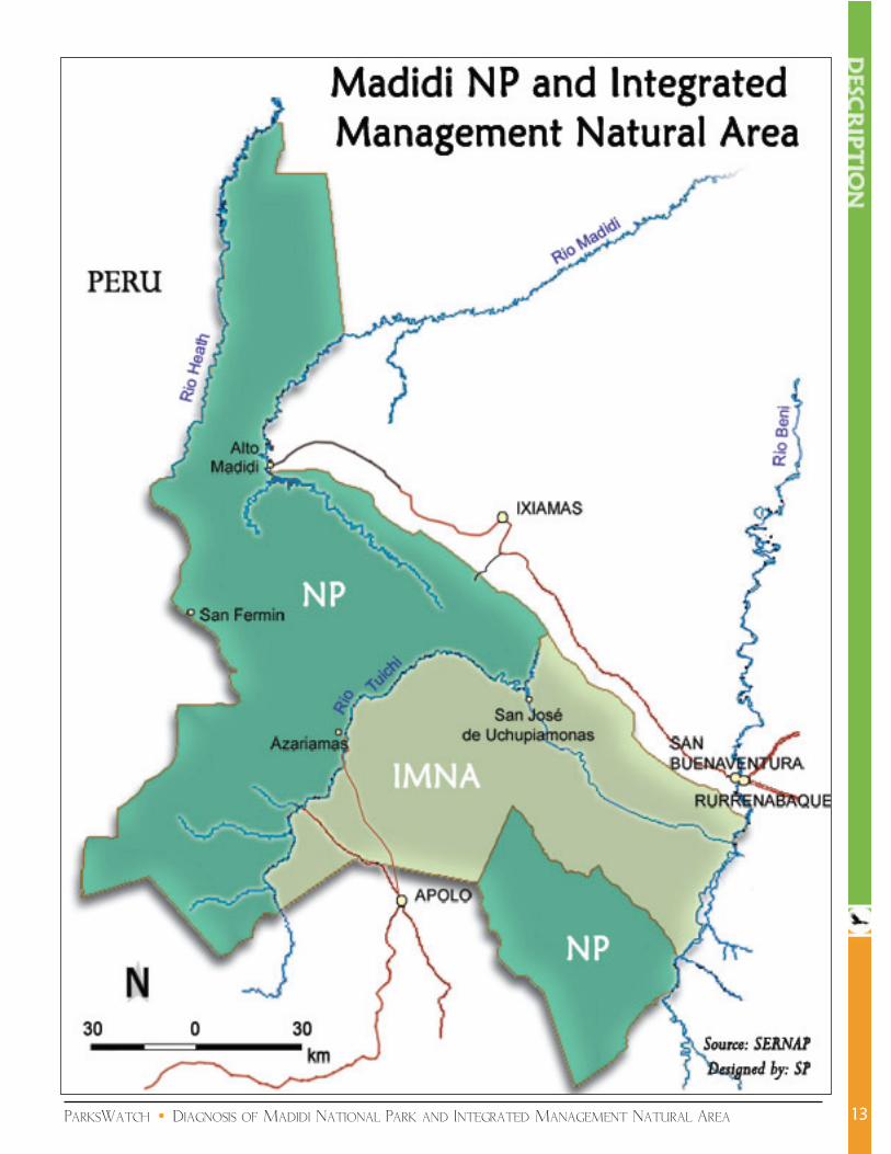
Geographic locationMadidi NP-IMNA is located in the northeastern corner of the La Paz department, in the Franz Tamayo, Abel Iturralde, and Bautista Saavedra provinces. Five municipalities have jurisdiction over the area: Apolo, San Buenaventura, Ixiamas, Curva, and Pelechuco. It is bordered by other protected areas in the south (Apolobamba IMNA and the Pilón Lajas Biosphere Reserve and Communal Lands), and in the east (Tambopata Natural Reserve and Bahuaja Sonene National Park, both in Peru). It is also surrounded by indigenous territories and indigenous land claims (TCO Tacana I to the east; TCO Tacana II to the north and demands for the declaration of the Lecos Apolo and Lecos Larecaja TCOs in the south). This places Madidi NP-IMNA at the heart of the Vilcabamba-Amboró Conservation Corridor (VACC).
With an extension of �,880,996 ha (NP: �,277,075 ha; IMNA: 603,92� ha), Madidi is one of the country’s largest protected areas. Its limits are between latitudes �2°30’ and �4°44’ south and longitudes 67°30’ and 69°5�’ west.
AccessThe main access points to the area are Apolo and Pelechuco in the south and southwest, Rurrenabaque in the east, Tumupasa in the northeast and the Madre de Dios river to the north. All those towns are accessible from La Paz by terrestrial transport, but via precarious and relatively dangerous roads. There are five weekly flights from La Paz to Rurrenabaque with the TAM airline. The town of Apolo has a landing strip, but at present there is no regular flight service. The landing strip in Ixiamas is not yet fully equipped.
Physical descriptionFrom the summits of the Altuncama mountains to the savannas of the Heath and Madidi rivers, the park harbors an impressive altitudinal range of nearly 5,500 m (between 5,760 and �80 m asl). Its topography is mainly mountainous, with abrupt relief and deep canyons, which determines a great variety of ecological zones.
The area is located at the meeting point of the Oriental Cordillera, Sub-andine Cordillera and Oriental Lowlands physiographic provinces. Biogeographically, it overlaps with the Puna, Humid Montane Cloud Forest, and Humid Madeira Forest subregions (SERNAP, 200�).
In the mountains and valleys of the Oriental Cordillera, a glaciation landscape characterized by steep slopes, natural landslides, and rocky crests. These have a general northwest-southeast orientation and their substrate is composed of orthoquartzites, clays and sand deposits from the Ordovician, Devonian, and Cretaceous. The Sub-Andine region, characterized by mid-
12
ParksWatch • Diagnosis of Madidi National Park and Integrated Management Natural Area 13

ParksWatch • Diagnosis of Madidi National Park and Integrated Management Natural Area
elevation mountains (2,000 m asl on average) running parallel to the Cordillera, are covered by Quaternary, principally colluvio-alluvial deposits represented by conglomerates, rounded stones, sands, limestone and clay (OAS, 2000). The low-lying hills of the Piedmont area are characterized by Quaternary sediments with neutral to highly acidic nutrient-poor soils, only suited for limited forestry use. The predominantly finely textured soils of the Lowlands are generally deeper, compact, poorly drained, neutral to highly acidic, and nutrient-poor (Euroconsult, �999).
The Oriental Cordillera was the origin of important fluvio-glacial and alluvial gold deposits, the former located in the highlands and the latter found in the beds of the various rivers taking their source in these mountains.
3D satellite view of Madidi NP-IMNA (EarthSat/Google Earth)
14

ParksWatch • Diagnosis of Madidi National Park and Integrated Management Natural Area
HydrographyDue to its topography, Madidi NP-IMNA is composed of a large number of watersheds, in particular headwaters located in areas of elevated rainfall and soils fragilized by steep inclinations. The area’s main water courses are the Tuichi, Madidi, and Quendeque rivers (Beni river basin) and the Heath river (Madre de Dios river basin), which drain six sub-watersheds: Heath, Beni, Madidi, Tuichi, Enapurera, and Tumupasa-Beni.
The park’s most important water course is the Madidi river, which over the millennia has created a wide alluvial fan with an average elevatin of 400 m asl (OAS, 2000).
ClimateThe area’s climate is as diverse as its topography, from cold in the Cordillera’s upper reaches to temperate at mid-altitude and warm in the northeastern lowlands. Annual rainfall reaches an astounding 5,000 mm in the Alto Madidi area, but generally oscillates between 700 mm in the driest parts and �,800 mm in the seasonally humid lowland areas (CABS, 2002).
In the region of San Buenaventura and Rurrenabaque (the most important populated center) annual rainfall reaches approximately 2,000 mm (rainy season between October and February), with an average temperature of 25 °C, varying from 33° C between October and January and �0-20°C between March and June (CARE-WCS, 2003).
Aerial view of the Tuichi river in the dry forest valley of Azariamas. Photo: Willy Kenning
15

ParksWatch • Diagnosis of Madidi National Park and Integrated Management Natural Area
BiodiversityOf the country’s �7 ecoregions, Madidi NP-IMNA harbors no less than 5: Montane Moist to Perhumid Evergreen Forest, Seasonally Moist Lowland Tropical Forest, Palm Savannas, Puna, and Dry Inter-Andean Valleys.
More than a third of the montane moist to perhumid evergreen forests protected in Bolivia are found in this park. Only 5.64% of the country’s dry inter-andean valleys are represented within the Nacional System of Protected Areas, a fifth of which is found within Madidi
NP-IMNA, corresponding to one of the largest (89,939 ha) and best conserved patches of the continent (CARE-WCS, 2003; Kessler, �993).
Thanks to its ample altitudinal range, Madidi NP-IMNA features an extraordinary diversity of habitats: High-Andean ecosystems, Puna grasslands, Matorrals, Yungas paramos, Montane cloud forests, Sub-Andean rain forests, Montane forests, Moist piedmont forests (one of the last well-conserved samples in the entire country), Moist lowland forests, Flooded savannas, and Swampland groves of Mauritia flexuosa and Mauritiella aculeata palms. A vegetation map of the area is provided in Appendix 3.
a) FloraThis important habitat heterogeneity determines a great plant diversity. �,875 species have been reported to date, but the area’s is believed to harbor no less than 5,000 (Kessler, �993).
The dense forests, which cover more than 80% of the area, range from the montane to lowland ecological floors, where they alternate with alluvial ecosystems characterized by fast-growing herbaceous species such as the river alder (Tessaria integrifolia) and Salix humboldtiana (sauce), as well as tree species such as Ochroma pyramidale (balsa), and Cecropia membranacea (ambaibo). In the montane forests, the predominant species are Cyathea sp., Nectandra sp., Weinmannia glabra, Myrsine coriacea, Clusia sp., Oreopanax sp., Schefflera pentandra, Iriartea deltoidea and Podocarpus oleifolius.
Butterfly aggregations on the sandy river banks can group more than 15 different species. Photo: SP
16
The park’s montane forests are among the most biologically diverse in the world. Photo: SP
ParksWatch • Diagnosis of Madidi National Park and Integrated Management Natural Area
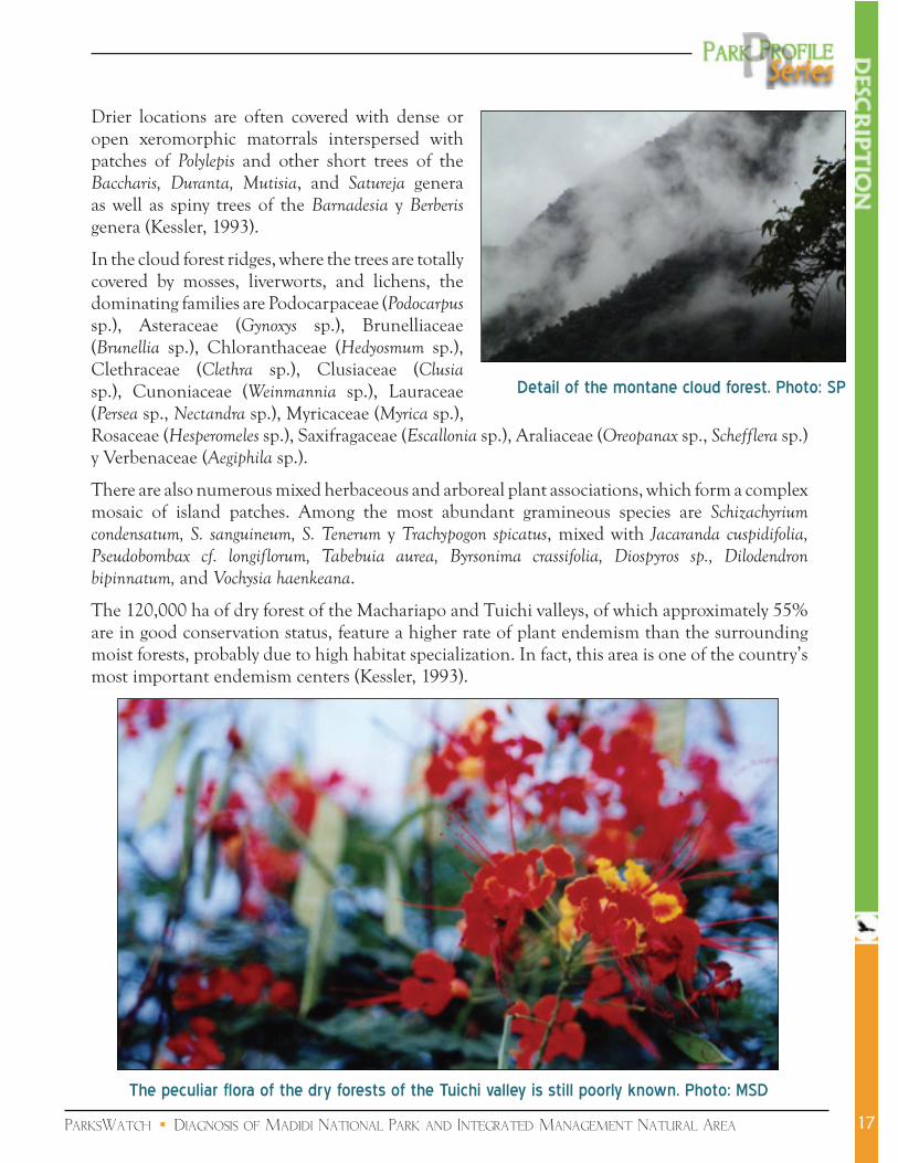
Drier locations are often covered with dense or open xeromorphic matorrals interspersed with patches of Polylepis and other short trees of the Baccharis, Duranta, Mutisia, and Satureja genera as well as spiny trees of the Barnadesia y Berberis genera (Kessler, �993).
In the cloud forest ridges, where the trees are totally covered by mosses, liverworts, and lichens, the dominating families are Podocarpaceae (Podocarpus sp.), Asteraceae (Gynoxys sp.), Brunelliaceae (Brunellia sp.), Chloranthaceae (Hedyosmum sp.), Clethraceae (Clethra sp.), Clusiaceae (Clusia sp.), Cunoniaceae (Weinmannia sp.), Lauraceae (Persea sp., Nectandra sp.), Myricaceae (Myrica sp.), Rosaceae (Hesperomeles sp.), Saxifragaceae (Escallonia sp.), Araliaceae (Oreopanax sp., Schefflera sp.) y Verbenaceae (Aegiphila sp.).
There are also numerous mixed herbaceous and arboreal plant associations, which form a complex mosaic of island patches. Among the most abundant gramineous species are Schizachyrium condensatum, S. sanguineum, S. Tenerum y Trachypogon spicatus, mixed with Jacaranda cuspidifolia, Pseudobombax cf. longiflorum, Tabebuia aurea, Byrsonima crassifolia, Diospyros sp., Dilodendron bipinnatum, and Vochysia haenkeana.
The �20,000 ha of dry forest of the Machariapo and Tuichi valleys, of which approximately 55% are in good conservation status, feature a higher rate of plant endemism than the surrounding moist forests, probably due to high habitat specialization. In fact, this area is one of the country’s most important endemism centers (Kessler, �993).
Detail of the montane cloud forest. Photo: SP
17
The peculiar flora of the dry forests of the Tuichi valley is still poorly known. Photo: MSD

ParksWatch • Diagnosis of Madidi National Park and Integrated Management Natural Area
b) FaunaThe local fauna matches this exceptional plant diversity with similarly high species diversity patterns: �,370 species of vertebrate have been registered, and experts estimate that future studies should reveal the presence of many more CARE-WCS, 2003).
Among the �56 reported mammal species, the most remarkable are the spectacled bear (Tremarctos ornatus), Andean cat (Oreailurus jacobita), puma (Felis concolor), jaguar (Panthera onca), tiger cat (Felis pardalis), Andean deer
(Hippocamelus antisensis), white-lipped peccary (Tayassu pecari), marsh deer (Blastocerus dichotomus), giant otter (Pteronura brasiliensis), and a great variety of primates: spider monkey (Ateles paniscus), red howler monkey (Alouatta seniculus), white-fronted capuchin (Cebus albifrons), black-capped capuchin (Cebus apella), and owl monkey (Aotus sp.), among others. In addition to these, a new primate species of the Callicebus genus has been encountered, whose species name (aureipalatii) was recently established through an international online auction in benefit of the park.
With respect to birds, the park harbors such charismatic species as the green-winged macaw (Ara chloroptera), ash-breasted Tit-Tyrant (Anairetes alpinus), cock of the rock (Rupicola peruviana), crested eagle (Oroatus isidori), harpy eagle (Harpia harpyia) and various endangered species such Grallaria erythrotis, endemic to the region. 867 species have been registered inside the area, but estimations place the total number of bird species living within the park at more than �,�50, which amounts to 83% of the country’s bird diversity.
The numbers are equally eloquent for the other taxonomic groups:
Amphibians: with 84 registered species and 88 more believed to live inside the park (�72 in total), Madidi harbors 85% of the country’s amphibian fauna. More than 30 species are believed to endemic to the area;
Reptiles: 7� registered species and �09 probable (�80 in total), or 70% of Bolivia’s reptile diversity. Many populations of the large-sized species such as the boas, colubrids, caimans and aquatic and terrestrial turtles are placed under heavy hunting pressure (for both subsistence and commercial purposes, including the sale of their skins on the black market);
Fish: �92 registered species and �04 probable (296 in total), which corresponds to 5�% of the country’s ichtyofauna.
18
White-fronted capuchin (Cebus albifrons). Photo: M.SD
Pair of green-winged macaws (Ara chloroptera). Photo: C. Sekercioglu

ParksWatch • Diagnosis of Madidi National Park and Integrated Management Natural Area
Management
BackgroundIn �990, the Madidi region was recognized by Conservation International’s first Rapid Environmental Evaluation (Rapid Assessment Program - RAP) as the area with the country’s richest humid forests (Parker and Bailey, �99�). In �992, the Nacional Directorate for Biodiversity Conservation (Dirección Nacional de Conservación de la Biodiversidad - DNCB), the institution in charge of the country’s protected areas at the time (renamed SERNAP in �996), promoted a biological and socioeconomical diagnosis in an effort to determine the boundaries and surface of the projected protected area, which had the support of the resident communities. The team responsible for these studies recommended the establishment of a �8,000 km2 reserve.
In �993, consultants contracted by the World Bank designated the Madidi region as one of the nine priority areas for conservation in Bolivia, recognizing it as the country’s most important natural area.
Madidi NP-IMNA was finally formally created on September 2�, �995, with a surface of �,880,996 ha (D.S. N°24,�23), divided in three distinct zones: two National Parks (one of �,052,325 ha to the west and one of 224,750 ha to the southeast, for a total of �,277,075 ha) and an Integrated Management Natural Area (603,92� ha), which dual conservation and sustainable development objectives.�
The funds raised at the time (essentially through the GEF-I Project and PASNAPH program) allowed to set up a management team by the next year (�996). However, the funds did not suffice for the elaboration of a Management Plan, and the protection corps has had to work with Annual Operative Plans for nearly 8 years. During all this period the funds available only allowed law enforcement and surveillance activities.2
If the growing NGO support provided since �997 to the park has significantly improved the
� SERNAP’s institutional framework and the park’s objectives are detailed in Appendix 2.
2 Without considering the funds destined to infrastructure, land titling and equipment, the 2003 budget only amounted to US$ 2.�5/km2.
19
The Madidi region is among the areas with highest conservation value in the entire country. Photo: SP

ParksWatch • Diagnosis of Madidi National Park and Integrated Management Natural Area
effectiveness of its control operations, full implementation of the entire management apparatus remains to be achieved.
Between mid-200� and December 2003, a multi-disciplinary team composed of technical staff from CARE-Bolivia and WCS took charge of the elaboration of the area’s Management Plan, with a clear participative focus which involved a large number of community workshops. However, due to a divergence of goals and expectations among local stakeholders3 and to the belligerent attitude adopted by the Municipal Council of Apolo concerning the projected road, the approval of this document was delayed by nearly two years. Tensions finally eased towards the beginning of 2005, when the government authorities (SERNAP, the relevant ministry and the Prefecture of La Paz) and the institutional actors of Apolo, San Buenaventura, and Ixiamas signed a series of agreements acknowledging the road construction project, but stipulating that any future road would have to be constructed in a region of the protected area resulting in the minimum possible damage (through the IMNA, southeast of the Tuichi river, without affecting its banks). However, the fact that the Prefecture of La Paz did not respect its engagements led to a new interruption of the dialogue, which has placed the park in the line of fire again, with threats of invasions and arson if local demands are not rapidly attended. At the time of writing (August 2005), a new resolution was being expected for the coming months.
Administration and staffIn spite of being one of the country’s flagship areas and to be supported by a constellation of NGOs
and cooperation agencies providing financial assistance, human resources, and expertise, the protection corps is only composed of 24 rangers instead of the 60 judged necessary to achieve an adequate protection of the area. Even with the arrival of five new park guards with ACCA and WCS support, the park remains severely understaffed.
The management team is composed of a director, a chief ranger, an administrator, a secretary, an accountant and three technicians (two in environmental education and one in support of the protection corps).
This critical lack of personnel is
3 The mistrust of significant part of the local population for the park - in spite of the intense promotion and communication efforts made in recent years by its administration and the supporting NGOs - has been used as a pretext for several local leaders motivated by economic interests to fuel a general rejection of the park.
20
Sadiri Station, in the environs of Tumupasa (eastern sector). Photo: MSD

ParksWatch • Diagnosis of Madidi National Park and Integrated Management Natural Area
restricting enforcement and surveillance activities to a mere �5-20% of the park (CARE-WCS, 2003), and in those areas patrols are generally only occasional. Many infractions occur when the park rangers leave their stations or between their patrols. This situation is very worrisome considering the high accessibility of the entire eastern border of the park from the roads linking San Buenaventura with Alto Madidi.
Investment costs of the Protection, Natural Resource Management, Research and Monitoring, Tourism, and Environmental Interpretation programs are partially covered by via the Biodiversity and Protected Areas (BIAP) project, funded by the German International Cooperation Bank (KfW). In addition, several international NGOs such as WCS, CI and ACCA are providing support in several key management aspects, including staff training, equipment, community outreach, research, planning, education and sustainable resource use. In order to harmonize investments and activities by these and other groups, an Interinstitutional Coordination Committee was recently formed.
Although Madidi NP-IMNA acts as a catalyst for sustainable development funding in the region,4 the complete implementation of the Management Plan will require additional support, which leads the park administration to invest a lot of time and effort in fundraising and in particular trying to augment the revenues generated by tourism through the recently instituted entrance fee collection system (Sistema de Cobro - SISCO). Having registered a significant increase since its implementation in 2002 (due to ever higher visitor numbers, a better control and the doubling of the foreign visitor fee - from 5 to �0 US$), this system still essentially covers recurrent costs (9�%), but is starting to provide some surplus for investments (such as the construction of tourist cabins in 2003) and has recently allowed the hiring of a couple of additional park rangers.
Notwithstanding these strengths, Madidi NP-IMNA is still lacking resources, and due to the irregular payment installments of important funds such as the PASNAPH, which covers a third of the staff and the majority of operational expenses, management activities may be paralyzed or considerably reduced for several weeks in a row.
4 The funds presently available come from a variety of sources, support both conservation and development activities, and are either administered by the park, such as PASNAPH (Dutch government), German Trust Fund, BIAP project (KfW) and entrance fees (SISCO), or by third parties, such as the funds provided by GEF-II (World Bank), WCS, CI, ICIB, AOS, ACCA, etc.
21
Sign listing some of the numerous development institutions with active programs in the area. Photo: SP

ParksWatch • Diagnosis of Madidi National Park and Integrated Management Natural Area
ParticipationSince the early days of its implementation, the park has functioned with a Management Committee (MC) composed of a representative roster of local stakeholders, which, in contrast to many other protected areas in the country, has fostered effective local participation. However, the absence of a Management Plan setting objectives and defining a medium- to long-term conservation strategy has not allowed the park administration to take full advantage of this favourable situation (Silva et al, 2002). Reorganized in 2002 to achieve a better representation of the stakeholder community, the MC has regular meetings, maintains a permanent communication with the park director and organizes training workshops for its members.
Below is a list of its present participants:
Indigenous communities: CIPTA (Abel Iturralde province), San José de Uchupiamonas (Abel Iturralde province), CIPLA (Franz Tamayo province), and PILCOL (Larecaja province).
Peasant/Colonist organizations: FESPAI (Abel Iturralde prvince), Los Altos and Mohima Agrarian Federations, Federación Provincial Unica de Trabajadores Campesinos de Apolo, Atén Federation (Franz Tamayo province), Federación Agraria Especial de Colonizadores y Campesinos de Larecaja Tropical (Larecaja province);
Sub-prefectures and Municipal governments: Sub-prefectures of the Franz Tamayo and Abel Iturralde provinces, municipalities of San Buenaventura, Guanay, Ixiamas and Pelechuco;
Civic committees: Apolo, Ixiamas, San Buenaventura;
SERNAP: park direction and central administration in La Paz.
Adding to this the numerous workshops organized for the elaboration of the park’s Management Plan, there is no doubt that the park administration is actively trying to involving local communities in its management and planning activities.
Notwithstanding these efforts, a significant fraction of the local population remains strongly opposed to conservation and any of its advocates, which it views as undesirable governmental control and the intromission of foreign interests into domestic affairs. Although this is largely due to the disinformation campaign led by certain leaders and other notables with economic interests in the opening of a road across the park, this situation reveals a general lack of information on the protected area and the potential opportunities its existence generates. As a matter of fact, the environmental education strategy has had very limited progress due to a lack of resources, and lack of logistical support is restraining the meetings of the MC.
22

ParksWatch • Diagnosis of Madidi National Park and Integrated Management Natural Area
ZoningThe Zoning Plan of the park’s Management Plan proposes seven categories, but its implementation will require the incorporation of new recruits to the protection corps. In parallel to the approval of the Management Plan, the SERNAP and collaborating NGOs are trying to obtain the promulgation of a new Supreme Decree redefining the area’s limits. In order to complete the area’s biological representativeness and strengthen its ecological viability, the proposal advocates the extension of the park in the Alto Madidi and El Tigre areas (eastern sector) and a revision of its current division between NP and IMNA categories in favour of one NP and two IMNAs (in comparison with two NPs and one IMNA at present) (see map).
23
Zoning Map of Madidi NP-IMNA. Source: WCS-Bolivia, 2004

ParksWatch • Diagnosis of Madidi National Park and Integrated Management Natural Area
InfrastructureThe diagnosis carried out for the elaboration of the park’s Management Plan concluded in a lack of ranger stations in strategic locations, and until recently the majority of existing stations were set in rented houses and often in run-down. Although the BIAP project resulted in a significant improvement of this situation with the construction and overhaul of �4 guard stations and temporary refuges, the construction of a new central office in San Buenaventura and the provision of office equipment, the park infrastructure is still insufficient for an adequate management. This also applies to transport equipment, which is remains deficient in spite of recent investments. At the time of writing, the management team of this nearly 2 million-hectare protected area relied on a pick-up truck, two Jeeps, a quad, seven motorcycles and two small river boats.
The �4 ranger stations and refuges composing the park’s current sur-veillance infrastructure are:
Alto Madidi
Machua
Quendeque
Andino
Tumupasa
Puerto Chivé
San Fermín
Santa Cruz del Valle Ameno
Río Hondo, Sadiri
Cocos
Puina
Uaratumo
Asunta.
24

ParksWatch • Diagnosis of Madidi National Park and Integrated Management Natural Area
Human Landscape
Human occupation There are many indications that humans had settled the area well before colonial times. Precolombian communities might actually have been larger than the present resident population, represented by a great variety of ethnic and linguistic groups. During the Spanish conquest, various military and religious incursions led to the introduction of the Spanish language and the establishment of a network of missions (Apolo, Tumupasa, Moxos, San José de Uchupiamonas, San Buenaventura, etc.) in an effort to regroup and “reduce” the dispersed native communities to Christianity.5 Warfare and diseases, as well as the entire reorganization of the territorial occupation (with the concentration of the local population along two axes: Apolo, San José, Tumupasa and Ixiamas on the one side and Santa Cruz del Valle Ameno, Pata, Mojos and Pelechuco on the other), had a profound impact on the indigenous population and led to the disappearance of several ethnic groups. The Tacana culture, predominant in the eastern part of the area, is believed to have originated in this period from the fusion of distinct groups (Silva et al, 2002).
The history of the region’s occupation since the �9th century, characterized by a series of economic booms and rushes is dicscussed in the section below. In more recent times, population increase in the area has been largely determined by the arrival of large contingents of Quechua and Aymara migrants to the region, lured in the �970’s by government-sponsored colonization programs in the San Buenaventura area, and towards the end of the �980’s by the habilitation of the road to Ixiamas (which also attracted the children of the families who colonized the Yucumo-Rurrenabaque area two decades earlier) (Miranda, �998).
At present, the population living inside the park or very close to its border reaches approximately 3,900 individuals, distributed in 3� communities (9 in the National Park and 22 in the IMNA), mainly located along the major roads or close to the major population centers, listed in the table below.
5 The Jesuits were convinced that the Indians had once known the true faith, but had been led astray by Satan. These missions then, were to “lead back” or “reduce” the Indians to the True Word.
25
General view of Rurrenabaque and San Buenaventura, on both sides of the Beni river. The road to Ixiamas can be distinguished at the center of the picture, and in the background, the park’s eastern mountain
range is apparent. Photo: SP

ParksWatch • Diagnosis of Madidi National Park and Integrated Management Natural Area
Most of the people living inside the park (approx. 2,000 people, 25 communities) are concentrated in the north of Apolo, in the northeast of Azariamas (towards the border with Peru), and in the surroundings of San José de Uchupiamonas (in the eastern sector), while the western highlands and the northeastern lowlands are virtually empty. The latter part of the park is only inhabited by a few families occupying old barracks of past extraction booms along the Tuichi, Hondo and Madre de Dios rivers.
Although the population of the Apolo region has remained relatively stable over the last decades, the recent (and illegal) opening of the road to Azariamas has stimulated a certain internal growth via migrations from neighbouring communities (MHNNKM, 2000). In turn, the San Buenaventura-Alto Madidi colonization zone presents a sustained population growth and conditions which are likely to determine even higher growth rates in the future, in particular an elevated number of children per family. Land appropriation in this area responds to both planned and spontaneous processes and responds to the goal of populating this development axis, pursued for more than 20 years by the prefecture of the La Paz department in its ‘March to the North’ (Marcha hacia el Norte) program (Locklin and Haack, 2003).
Social characteristics and organizational aspectsAccording to Bolivia’s Poverty Map (INE, �992), 96% and 93% of the families in the Franz Tamayo and Iturralde provinces live below the poverty line, respectively. And although the resources made available by the government’s Coparticipation policy6 led to an increase in the budgets of municipal governments, the weaknesses inherent to their management and the complexity of the problems faced by the municipalities precluded the formulation of proposals which would have allowed making significant steps in the resolution of these problems (Lehm et al, 2002).
Inside the protected area, only 37% of the communities have access to potable water and 30% to latrines (CARE-WCS, 2003). Health services are incipient in most communities, and the few sanitary centers are generally out of use due to the lack of resources. The majority of schools only offer courses through the primary level, leaving those parents who want their children to take secondary classes no other option than to send them to the larger towns: Apolo, San Buenaventura and Ixiamas. These precarious living conditions determine an elevated migration rate (3�%) to
6 The Popular Participation Law of �994 return the equivalent to 20% of national tax revenues to the municipalities, in proportion to the number of inhabitants.
26
Population center Number of Inhabitants
Rurrenabaque 4,959San Buenaventura 1,670
Apolo 2,123
Ixiamas 1,890

ParksWatch • Diagnosis of Madidi National Park and Integrated Management Natural Area
cities of La Paz, Cochabamba, and Santa Cruz. Among those who stay in the area, 73% end up constantly migrating from community to community in search of work opportunities.
In the park’s area of influence, there are three distinct social groups, each with its own form of political organization (Lockling and Haack, 2003):
Leco and Tacana indigenous communities, represented by the CIPTA, CIPLA and PILCOL organizations;
Native peasants (campesinos originarios) - who parents or grandparents settled in the area more than a generation ago - represented by the Federación de Colonizadores y Comunarios de Larecaja Tropical and the Federación Sindical Única de Trabajadores Campesinos de la Provincia Franz Tamayo;
Quechua and Aymara colonists - who migrated in the last three decades - also represented by the Federación de Colonizadores y Comunarios de Larecaja Tropical and by the Federación de Trabajadores Agropecuarios de Abel Iturralde.
Finally, Madidi NP-IMNA is surrounded by Communal Lands (Tierra Comunitaria de Origen - TCO) and indigenous territorial claims, a situation which could deeply affect the management of the park in the future: to the east is the TCO Tacana I, declared on July 4, 2003 with a surface of 325,327 ha and containing 20 communities (2,9�4 inhabitants), and the San José de Uchupiamonas TCO (declared in April 2005 and totally comprised within the area), with 406 inhabitants. In the south of the IMNA (Apolo region), 2,303 Leco Indians are actively seeking the titling of their own TCO, partially overlapping with the protected area. Other TCO demands concern the Lecos Larecaja TCO to the south (5,373 inhabitants) and the Tacana II TCO to the northeast (675 inhabitants) (see map on next page).
Economic activities and use of natural resources The two populated areas around Madidi NP-IMNA feature two different socioeconomic scenarios, determined as much by climatic factors and soil conditions as by sociocultural aspects:
�. In the east is the San Buenaventura-Ixiamas colonization zone, a lowland area (average altitude: 300 m asl) with rainfall levels superior to 2,000 mm annually where the Tacana people and later colonist migrants from the country’s highlands have successively lived of hunting and gathering, agriculture, rubber, skins, cattle, timber and gold mining. The relative wealth generated by the timber boom in the �980’s
27
San Buenaventura-Ixiamas road. Photo: SP

ParksWatch • Diagnosis of Madidi National Park and Integrated Management Natural Area28
Existing and projected Communal Lands(TCOs) around Madidi NP-IMNA. Fuente: WCS, 2004

ParksWatch • Diagnosis of Madidi National Park and Integrated Management Natural Area
introduced new needs among the local population, and with the exception of the few people who managed to convert to tourism, the ban on logging activities associated with the creation of the protected area has forced most families (both Tacana and colonist) to clear agricultural land and establish themselves as small-scale farmers along the few existing roads. This is how agriculture became the most important activity in the Abel Iturralde province after a series of economic booms which depleted the region of most of its commercially valuable natural resources.
The main crops are rice, maize, plantains, yucca roots and citrus fruits, essentially destined to the markets of Rurrenabaque and Caranavi, and sugarcane, peanuts, beans, chili, soybeans and lime grown for personal consumption. Slash-and-burn agriculture is the most widely used technique among the colonists.
The remnant cattle-raising activity from the ‘Era of the Haciendas’ (�9�7-�964), which registered a dramatic decline with the logging boom, is mainly restricted to the natural savannahs surrounding the town of Ixiamas (extending in recent years to the Undumo river in the north), remains extensive in nature and practiced without appropriate management techniques (pastureland delimitation, parcel rotation, controlled burnings, breeding assistance, etc.). The most frequent and often unique management technique is the annual and uncontrolled burning of pastures.
2. The other main populated area around the park is the Apolo region, located south of the IMNA at an average altitude of �,600 m asl and with less than �.000 mm of annual rainfall. This savanna-dominated landscape has been shaped by centuries of man-induced fires set to renew pastures for cattle-raising. Principally composed of Quechua peasant communities, this region is the most densely populated part of the park’s entire area of influence, probably due its relatively favourable soil conditions and climate. However, its level of isolation (determined by the precarity of the Apolo-La Paz road) precludes nearly all trade of perishable products with external markets. Nonetheless, due to the technical and financial assistance provided by NGOs such as CARE-Bolivia, the largely dominant maize fields are progressively giving way to comercial crops such as coca leaves and coffee. The other crops grown (yucca roots, plantains, papaya, citrus fruits, etc.) are generally produced for self-consumption.
Despite the existence of appropriate conditions, cattle-raising is relatively undeveloped due to the afore-mentioned unreliability of the road network and the time needed to reach the markets. However, the use of inappropriate pasture management techniques has resulted in the severe plant cover degradation and soil erosion of approximately 45,000 ha of the IMNA and surrounding areas (CARE-Bolivia, 200�).
29
The anthropogenic savannas of Apolo. Photo: MSD

ParksWatch • Diagnosis of Madidi National Park and Integrated Management Natural Area
a) Hunting and fishingHunting by both native and colonist populations is mainly limited to the production of charque (dried meat) for sale on local markets, and therefore does not exert a significant pressure on the native fauna, except around certain communities such as San José de Uchupiamonas.
Hunting is generally practiced at night with makeshift rifles (owned by nearly all families), and principally affects spider monkeys (Ateles paniscus), red-howler monkeys (Alouatta seniculus), black-capped capuchins (Cebus apella), owl monkeys (Aotus sp.), squirrel monkeys (Saimiri sciureus boliviensis), red brocket deer (Mazama americana), collared and white-lipped peccaries (Tayassu tajacu and Tayassu pecari), giant armadillos (Priodontes maximus), agoutis (Agouti paca), brown agoutis (Dasyprocta variegata), tapirs (Tapirus terrestris), and marsh deer (Blastocerus dichotomus). Among bird species, preferred preys are curassows and guans (Cracidae), tinamous (Tinamidae), and macaws (Ara sp.). Hunters living outside of the park generally hunt outside of its boundaries, but as we will see in the ‘Pressures’ section certain parts of the National Park and IMNA are still subjected to hunting pressure. Some of the preys which are essentially captured inside the protected area are terrestrial and aquatic turtles (Geochelone sp. and Podocnemis unifilis, respectively), which are used for both their meat and eggs (Miranda, �998).
Fishing is another important subsistence alternative for the communities located along the rivers, such as San Miguel, Villa Alcira, and San José de Uchupiamonas. Most commonly caught species are the barred surubim (Pseudoplatystoma sp.), pacú (Colossoma macroponum), sábalo (Prochilodus nigricans), belea (Salminus maxillosus), bentón (Hoplias malabariscus) and palometa (Serrasalmus
sp.). Two species providing income as ornamental fish and whose populations are locally affected in the park’s area of influence are Papilichromis altispinosa and Agoniates anchovia, the latter presenting naturally low abundance levels.
Related with this activity is the threat represented by the introduction of an exotic predator species, Arapaima gigas (locally known as paiche), whose propagation is ocurring at the expense of the native ichtyofauna.
b) Timber extractionSince the mid-�980’s, the region - including the area now covered by the park - has been the scene of an important logging boom based essentially on the presence of abundant reserves of bigleaf mahogany (Swietenia macrophylla). This led to the disappearance of this species in nearly all the areas accessible from the roads and the main rivers. At the time of the park’s creation, two logging companies had active concessions on its territory: one was returned to the State and the other (Hauser) transferred to a nearby area with a considerable compensation managed by Conservation International. If the illegal chainsaw activity which ensued was considerably reduced with the
30
A barred surubim (Pseudoplatystoma sp.) caught inside the protected area (near the Torewa community) by a colonist living in the park’s area of influence. Photo: MSD

ParksWatch • Diagnosis of Madidi National Park and Integrated Management Natural Area
enactment of the new Forestry Law in �997 and the implementation of the park’s protection program, the pressure for timber extraction remains very high in the area of influence and certain parts of the IMNA (in particular Sipia, in the Apolo region) and according to the park director represents one of the major threats to its integrity.
Some of the preferred species for use as construction material are jatata and asaí palms (Geonoma deversa and Euterpe precatoria, respectively), cedar (Cedrela odorata), balsa (Ochroma lagopus), Astronium sp., and Sloanea guyanensis.
c) Use of non-timber forest products (NTFPs)The NTFPs traditionally collected by the Tacana communities, as well as by an increasing number of colonists, serve three principal functions: nutrition, medication, and house-building. Palm fruits and/or hearts of Bactris gasipaes, Jessenia bataua, Scheelea princeps, Euterpe precatoria, and Attalea phalerata are frequently used for the former purpose, along with semi-domesticated species such as achachairú (Rheedia sp.), taruma (Vitex cymosa), guava (Psidium guajava), papaya (Carica papaya), pineapple (Ananas comosus), avocado (Persea americana), and mangoes (Mangifera indica) (DNCB, �995).
The park’s residents also collect motacú and majo palms (Scheelea princeps and Jessenia bataua, respectively), cat’s claw bark (Uncaria tormentosa), Brazil nut (Bertholletia excelsa), and breadfruit (Artocarpus altilis) for sale on communal fairs. In the Apolo region, incense (Clusia sp.) and copal (Protium sp.) resins have been used for medecinal and other purposes for centuries.
Many colonists remember having browsed or occupied what is today Madidi NP-IMNA to obtain Peruvian bark, hides, skins, cocaine or wood. Most of these consider that they have proprietary rights over the area, and tend to disregard both the protected area and indigenous land titling requests as usurpations of their natural right to mine the forests (Silva et al, 2002).
31
Tractor transporting timber in the park’s area of influence (near Tumupasa). Photo: Pierrick Jean

ParksWatch • Diagnosis of Madidi National Park and Integrated Management Natural Area
TourismMadidi’s exceptional scenic beauty, good accessibility, relatively developed infrastructure, and the substantial promotion from which it has benefited have placed this park high up on the list of nationally and internationally most coveted ecotourism destinations.
Tourism in the region was launched in the �970’s, when a tourism agency called TAWA built a lodge and two landing strips on the banks of the Santa Rosa lake, selling the area as a sport hunting and fishing paradise to a rapidly growing crowd of wealthy visitors.
But the real tourism boom did not start before the �980’s, when the book “Back to the Tuichi” written by Israeli author Jossi Ginsberg, which relates his adventures in the headwaters of this river when he got lost during a trek in �979 started attracting hordes of young travelers in search of a similar experience (Caballero, 2003). Two decades later, the cover article of the March 2000 National Geographic issue turned the Madidi area into one of the continents must-see ecotourism destinations.
In response to the rapid increase in visitor affluence, several campgrounds and lodges were constructed on the lower part of the Tuichi river. Although these relatively precarious installations are determined by a predominantly low-budget tourist population, in �998 an upper class establishment known as the Chalalán Ecological Lodge, was also inaugurated. This Amazon lodge, which was promoted by Conservation International and constructed with a significant investment from the IADB, is now operated by the residents of the nearby San José de Uchupiamonas village. An alternative eco-lodge model is currently being experimented in the San Miguel del Bala community, just one hour upstream of Rurrenabaque on the Beni river, for a fraction of Chalalán’s budget.
There is another promising ecotourism project in the Torewa community, also located on the banks of the Beni river. It consists in the construction of communitarian cabins and the provision of a range of services, for which a seed fund is being actively sought. An interesting aspect is that in order to attract visitors, the residents of this community have started to regulate their hunting and fishing activities and declared themselves willing to collaborate with the protection corps in the control of outsider hunting activities.
The Tacaso, 7 de Diciembre (both affiliated with the FESPAI Federation), El Tigre communities
32
Madidi NP-IMNA has become the country’s major ecotourism destination. Photo: SP

ParksWatch • Diagnosis of Madidi National Park and Integrated Management Natural Area
are also busy trying to build ecotourism infrastructure, and yet another group is planning the construction of an Eco-Lodge on the Quendeque river. In the park’s southern region, in spite of a reduced number of visitors, some local entrepreneurs are preparing themselves for a potential tourist boom. An ecotourism project involving seven communities (among which Pelechuco, Apolo, and Azariamas) is even being funded by the BIAP program, this time focusing on recreation infrastructure such as trails and signalization. Another project is being promoted by a company called Eco-Fluvial, involving a river transportation service provided by Leco communities.
Word about the exceptional biological diversity and scenic beauty of Madidi NP-IMNA is rapidly spreading out through a myriad of specialized tourism agencies in La Paz and around the world, and with approximately �5,000 visitors (of which more than 7,500 pay park entrance fees) annually injecting 2 million dollars in the local economy, this region now occupies the second position in tourism growth in the entire country, just after the Uyuni salt flats (La Prensa, 2003).
However, this promising sce-nario is not without its perils and drawbacks, on the con-trary: the lack of regulation and control which has char-acterized tourism activities in-side the park until today has resulted in significant distur-bances of the mostly visited sites, and is placing yet others under serious strain. This is-sue is discussed in more de-tail in the ‘Pressures’ Section below.
In an effort to improve this situation, the park administra-tion recently started to apply the park’s Tourism Policy Act (Reglamento de Turismo) and is currently strating to imple-ment the Management Plan’s Tourism program, which aims at distributing visitors over a larger number of sites than the ones currently exploited by tourism operators. This is meant to both “decongest” saturated areas such as the lower parts of the Tuich river and spread the benefits of tourism over a larger share of the local population. As a matter of fact, this tourism program is promoting a “social” form of tourism besides the ecotourism activities that have developed rather spontaneously (Rivera, 2003). In order to achieve this, it actively promotes the involvement of the various stakeholders (municipalities, TCOs, and the private sector) in the development of a common vision. Proposed projects include eco-lodges, visitor centers, and cultural centers.
In addition to controlling and orienting the local tourism offer, one of the tourism program’s primary objectives is also to generate income for the park with the collection of entrance fees (still rare in the country). It also includes an important and ambitious coordination component
33
As currently conceived, “ecotourism” activities in Madidi NP-IMNA and surroundings are as destructive as any extractivist activity

ParksWatch • Diagnosis of Madidi National Park and Integrated Management Natural Area
with surrounding protected areas:
Bahuaja-Sonene NP to the north (Peru) via a binacional agreement;
the municipality of Santa Rosa del Yacuma to the east (Beni department, destination of most of the tours organized to the local savannas);
the Pilón Lajas Biosphere Reserve and TCO to the southeast, and; (iii) the Apolobamba IMNA to the southwest (and in particular the Kallawaya cultural center in Charazani).
In turn, the Policy Act defines the minimum requirements to obtain the right to perform tourism activities inside the park, whereas until now tourism agencies had been left free to operate at their will. By the end of 2004, �4 agencies had presented their documentation to acquire this authorization, all from the Rurrenabaque-San Buenaventura area. This act also contains provisions for the leasing of tourism concessions, but so far there have been very few operations of this sort in the entire country.
Conservation and Research Programs The first mammal, fish, and amphibian inventories of the north of the La Paz department were conducted Mann and Pearson in �92�-�922 with the Mulford Expedition around the Ixiamas and Tumupasa communities (Iturralde province). In �975, Freese et al. studied the primate populations of the Ixiamas region, and toward the end of the �980’s Anderson inventoried mammals while Fugler collected reptiles (Freese et al, �982; Anderson, �997; Fugler, �990).
In �990, a Rapid Assessment Program (RAP) by Conservation International identified Madidi’s humid evergreen forests as some of the most biologically diverse in the world, with a particularly elevated concentration of species in the Alto Madidi area (Parker and Bailey, �99�).
This sparked a wave of scientific investigations in the region aimed at both establishing a comprehensive baseline on the region’s flora and fauna and determining its conservation status and social dynamics. The results of the numerous expeditions organized at the time formed the basis for the development of Madidi NP-IMNA
34
Fresh jaguar (Panthera onca) footprint. Photo: SP

ParksWatch • Diagnosis of Madidi National Park and Integrated Management Natural Area
Creation Project by the National Biodiversity Conservation Directorate (Dirección Nacional de Conservación de la Biodiversidad - DNCB), made public by the end of �992.
It is interesting to note that the prolific activity of the numerous institutions that have been supporting the administration of the park since its creation in �995, which is exemplary in the country, is gradually resulting in a real impulse for the development of the local economy (Lehm et al, 2002). Although most projects to date have essentially focused on informing the public on the importance of conservation and promoting a series of sustainable resource management initiatives (see below), the Madidi is presently serving as a laboratory for other parts of the country and parks in other countries set in a similar context. In other words, the success or failure of the series of efforts and initiatives deployed in and around Madidi NP are likely to influence the management of many other protected areas.
Current projects
Wildlife Conservation Society (WCS)In the framework of its “Living Landscapes Program” (which spans over Madidi NP-IMNA, Pilón Lajas BR-TCO and Apolobamba IMNA), WCS is executing a wide range of projects aimed at consolidating Madidi NP-IMNA and strengthening its management. These activities, which are mostly conducted with the Institute of Ecology of the University of San Andrés of La Paz, revolve around three main axes: i) park management; ii) natural resources management, and; iii) scientific research.
a) Park management
After participating in the elaboration of the park’s first Management Plan in collaboration with CARE-Bolivia (with EU funding), WCS is providing support in the implementation of the its Research, Monitoring, Regional Integration and Tourism programs through the organization of workshops, the publication of reports and technical manuals, and the design of ecotourism projects and interpretation centers (with CI and ICIB), among others.
WCS was also responsible for the elaboration of the park’s financial strategy, and has participated in the evaluation of the environmental impacts of the construction of illegal roads in the area.
b) Management of natural resources
WCS is promoting various natural resources management projects with a strong focus on community participation and the generation of economic alternatives.
Besides the establishment of specific regulations concerning the access and use of natural resources, its capacity-building efforts focus on land use planning, the adoption and implementation of natural resources management projects by the municipal governments (bushmeat, fish, caimans, honey, forestry, cacao, incense, etc.), and the mitigation of the human-animal conflicts in the area.
35

ParksWatch • Diagnosis of Madidi National Park and Integrated Management Natural Area
c) Scientific research
The Living Landscapes program currently includes the following research activities:
Standardized botanical inventories of non-documented and/or threatened areas of the Madidi Landscape (in collaboration with the National Herbarium);
Study of the distribution, abundance and ecology of a selection of species, called landscape species (Andean condor, jaguar, peccary, barred surubim, vicuña, spectacled bear);
Ornithological studies;
Evaluation of the abundance and structure of the large and medium-sized mammals of the Hondo, Tuichi and Quendeque rivers;
Socio-economic analysis of the human footprint on the landscape.
In addition to providing technical assistance to graduate and undergraduate students with thesis projects in the area, WCS also collaborates in research activities conducted by other institutions, such as the botanical inventories conducted by a consortium composed of the Natural History Museum, the National Herbarium of Bolivia, the Noel Kempff Mercado Natural History Museum, the Missouri Botanical Garden (MOBOT), Conservation International, the Madrid Botanical Garden, and the University of Aarhus in Danemark.
36
WCS team members and young scientists of the Bolivian Fauna Collection in charge of forming a Fishermen’s Association among users of the Beni river’s fish resources. Photo: SP
In spite of the numerous botanical expeditions that were carried out inside the park, extensive areas
remain completely unknown to science. Photo: P. Jørgensen

ParksWatch • Diagnosis of Madidi National Park and Integrated Management Natural Area
Conservation International (CI-Bolivia)Another important member of the park’s network of supporting institutions is Conservation International (CI), which has a local office in Rurrenabaque. As previously mentioned, in the framework of an IADB-funded project, in �995 CI-Bolivia initiated a sustainable development and ecotourism program with the San José de Uchupiamonas community, which culminated with the construction of the Chalalán Lodge. A few years later, between �999-200�, CI-Bolivia implemented the “Biodiversity in Regional Development” Project (BiRD) with USAID funding. Resides promoting the park through the publication of distribution of a CD-ROM, the objective of this project was to improve and complete knowledge on the area through a series of biological inventories and a threat analysis.
In response to the �995 proposal, promoted by the Secretary General of the Organization of American States (OAS) in the framework of its Peruvian-Bolivian Integrated Action Program (PAIPB), to establish a transboundary protected area between Madidi NP-IMNA and Bahuaja-Sonene NP in Peru7, a few years ago the International Tropical Timber Organization (ITTO) funded a bination project aimed at the strengthening the two protected areas and promoting the sustainable development of their resident communities. In Madidi NP-IMNA, this project focused on the following components:
a) Legal aspects
Support and follow-up of the park’s legal and administrative processes (approval of the Management Plan, land titling, and revision of the area’s protection categories and limits through the promulgation of a new Supreme Decree), support in the drafting and approval of specific regulations concerning access and use of natural resources, tourism, scientific research, functioning of the Management Committee, interinstitutional relationships, promotion of services, etc.
b) Communication
Compilation and communication of the proceedings of the meetings of the park’s Management and Interinstitutional Coordination Committees, dissemination of the results of the protection and scientific research activities carried out in the protected area, publication of a quarterly newsletter, maintenance of the park’s webpage, and preparation of radio and video material.
c) Natural resources management:
Feasibility studies and development of non-timber forest products and support to agroecological and handicraft projects through the offer of competitive grants (in collaboration with the BIAP project).
d) Ecotourism
Identification of opportunities for the development of ecotourism projects in the park’s southern and eastern sectors.
7 Technically, the most biologically diverse protected area in the world, with an extension of 2,864,000 ha.
37

ParksWatch • Diagnosis of Madidi National Park and Integrated Management Natural Area
CARE-BoliviaCARE-Bolivia is another international NGO that has provided significant support to the implementation of Madidi NP-IMNA. Active in the Iturralde province since April �997 with a pilot project titled “Development and Conservation in the Area of Influence of Madidi NP-IMNA” funded by the Danish government, this organization’s initial work focused on improving the sanitary infrastructure of a selection of communities (installation of drinking water collection and storage systems and provision of basic services) while raising local awareness on the importance of watershed protection), and on the promotion of sustainable agricultural practices with a series of experimental plots.
In 2000, while its activities along the San Buenaventura-Ixiamas-El Tigre colonization zone had shifted to ecotourism, fire prevention, the development of cacao plantations in 20 communities with PRISA (a local NGO), and the production of handicrafts with the Tacana people, CARE extended its service coverage to 45 communities of the Apolo region, with agroforestry (coffee and incense) and beekeeping projects and reforestation campaigns.
In the framework of its “Support to the Management of Madidi NP-IMNA” project, funded by the EU and completed in June 2003, CARE-Bolivia collaborated with WCS on the elaboration of the park’s Management Plan, organized specific training courses for park rangers (e.g. fire management), supported the strengthening of the Management Committee, and donated basic management equipment.
BIAP projectThe “Biodiversity and Protected Areas” (BIAP) project, executed by the TRÓPICO - COBODES (Bolivia) and GFA-Terra Systems (Germany) consortium with funds from the German Cooperation Bank (KfW), participates since 200� in the park’s consolidation with the construction of ranger stations, adquisition of equipment and land titling. This project, which supports three other protected areas in the country, also trains and advises local communities in the formulation of ecotourism and agroforestry projects (cacao plantations, coffee growing, collection of Brazil nut, etc.).
OtherOther significant sources of funding or logistical support to Madidi NP-IMNA are the Swiss Workers Aid (Ayuda Obrera Suiza - AOS) and the Institute for Biodiversity Conservation and Research (Instituto para la Conservación e Investigación de la Biodiversidad - ICIB). While the former focuses its work on the strenthening of the park’s Management Committee (training, logistical support in the organization of meetings, improvement of the members’ representation capacity, support in the formulation of a sustainable development plan of the region) and the promotion of dialogue among the park’s various stakeholders, the latter is in charge of an environmental education program in the Rurrenabaque area (including training courses to park rangers, environmental projects with schools, the creation of a network of environmentally-aware school teachers and the construction of nature interpretation and visitor information centers in the region).
38

ParksWatch • Diagnosis of Madidi National Park and Integrated Management Natural Area
Pressures and ThreatsThe prevailing pressures and threats to Madidi NP-IMNA are:
Pressures Construction of the Apolo-Ixiamas road
Extension of the agricultural frontier and encroachment
Gold mining
Illegal logging
Hunting and fishing
Uncontrolled tourism
Threats Oil exploration and extraction
Construction of the Ixiamas-Puerto Chivé road
39

ParksWatch • Diagnosis of Madidi National Park and Integrated Management Natural Area
Pressures
Construction of the Apolo-
Ixiamas roadWithout a doubt, the single major pressure, threat and challenge to Madidi NP-IMNA is the strong determination of an influential sector of the local population to build a road across the park between the towns of Apolo and Ixiamas.
Although the exact route remains to be determined, recent events tend to indicate that the construction of this road will take place regardless of the protected area regulations.8 Depending on the alternative selected, the road will either cross the National Park and its
complex topography characterized by steep slopes and fragile soils, or only affect the IMNA by making a loop around the mountain range (see map below). In both cases, this would leave the protected area divided in two and open its interior to individuals claiming ownership on its natural resources and who never accepted the restrictions imposed on their exploitation.9 Among these resources, which are at the heart of a heated and violent confrontation between the local population, the park administration and government authorities in La Paz, are purportedly significant gold deposits and extensive stands of bigleaf mahogany (Swietenia macrophylla).
Along with loggers and miners, other groups who would benefit from such subsidized access to the park’s interior are the land speculators and landless peasants in search of new territories to colonize, and who, according to various sources, are already preparing to invade the area.�0
8 The so-called “Consensual Route”, of approximately �70 km and following the Apolo-Azariamas-Tuichi Norte-Cruce Ixiamas (8 km from Ixiamas) route, was not defined according to technical or environmental criteria and does not coincide with any of the alternatives assessed by the CONTEGRAL SID construction company in its �997 Feasibility Study.
9 Many Apolo residents have interests in the Tuichi valley and strongly oppose any restriction to its development. As a matter of fact, the loggers have repeatedly declared themselves willing to fund the construction of the road with their own resources.
�0 The opening of a road between Apolo and the community of Azariamas inside the IMNA already resulted in the migration of an entire village to the Sipia area and in the expansion of Azariamas towards the bank of the Tuichi river, where the projected road is supposed to pass.
40
The La-Paz-Caranavi-Yucumo-Rurrenabaque road is currently the only viable route between the La Paz department and the north of the country. Photo: SP

ParksWatch • Diagnosis of Madidi National Park and Integrated Management Natural Area
Using a “development” and “market opening” rhetoric, over the years a reduced number of people has managed to convince a large share of the local population of the utter importance of a road connection between Apolo and Ixiamas, and from there to the north of the country and the borders with Peru and Brazil. Considering that a “northern outlet” is nearly indispensable to solve the serious tensions affecting the town of Apolo (whose population has grown weary of more
41
Roads projected in Madidi NP-IMNA and its area of influence. The map presents the two alternatives considered to connect Azariamas and Ixiamas. Source: WCS, 2004

ParksWatch • Diagnosis of Madidi National Park and Integrated Management Natural Area
than 20 years of unfulfilled promises concerning municipal road infrastructure investments��), the construction of this road has become the number one issue of all local political agendas and, due to the obstacle it represents, has led to concerted efforts to disrupt the protected area.
Faced with this growing social pressure, in 2002 the Prefecture of the La Paz department, in consensus with the Apolo and Ixiamas municipal governments, decided to start construction before satisfying the preliminary technical requirements (geological and topographical studies, prescription of environmental mitigation measures, public consulting, etc.). For the Prefecture’s planners, the absence of a road connecting the highland region with the lowlands and the northern part of the country is a serious deficiency within the departmental road network.�2 The Prefecture is thus planning the construction of five roads: Pelechuco-Pata-Apolo, Azariamas-San José de Uchupiamonas, Azariamas-San Fermín, Azariamas-Ixiamas, and El Tigre-Alto Madidi-Puerto Chivé (Treviño Paredes et al, 2003).
However, in the feasibility study it conducted in �997 (in which attention to the logging interests was diverted by a discussion on the economic potential of the Brazil nut and palm hearts), the same Prefecture had to acknowledge that there were serious obstacles to the viability of the (Apolo)- Azariamas-Ixiamas road, in particular a strong discordance between the project’s substantial investment costs and the reduced number of beneficiaries. Nonetheless, the conclusions of this report provided their full support to this investment in the name of “long-term development”, the “multiplier effect” of roads and a “complementarity between investments,” leaving little doubt about the stakes of its authors in the execution of this project. Other financially motivated stakeholders are naturally the powerful public works contractors who would be hired for this project and the various consulting firms responsible of the technical and environmental impact evaluations, which have already charged important sums of money for rather poorly objective and obsolete studies.�3
In �999, John Reid, a researcher from the Conservation Strategy Fund in charge of analyzing the development projects overlapping with Madidi NP-IMNA, reached the same conclusions as the Prefecture, but presented them from an independent point of view:
elevated construction and maintenance costs due to the challenging topographical and geological conditions prevailing along most of the proposed route (on top of crossing a mountain range, the road would cross at least �6 rivers, including the Tuichi river, which would require a bridge of a minimum width of �00 m);
low number of inhabitants in the communities connected by the road (between 3,000 and 3,500): at present there is practically no human presence between the community of
�� There is no doubt that the municipality’s development is largely limited by the precarity of its road infrastructure. The road to Mapiri has not received any maintenance in many years and the road to La Paz is regularly closed by landslides, which, as in 2000-200�, isolated Apolo from the rest of the country during an entire five months.
�2 One of the strategies outlined in the �998-2002 Economic and Social Plan of the La Paz department is the promotion of “integration corridors” (i.e. road networks), considered vectors for development.
�3 The �997 feasibility study conducted by the CONTEGRAL SID consortium for the Prefecture of La Paz must be reconsidered due to important changes in the local population’s demands since that date.
42

ParksWatch • Diagnosis of Madidi National Park and Integrated Management Natural Area
Azariamas and the limits of the protected area near Ixiamas.
Added to this is the fact that this road would actually increase the distance traveled between La Paz and Ixiamas in comparison to the existing road through San Buenaventura (682 km and 55� km, respectively), a difference of �3� km which given the predicted travel speed would result in an additional 5 hours of travel, a significant detail for the transportation of both goods and passengers (Treviño Paredes et al, 2003).
However, Reid’s study did not reject the probability of the road’s construction in spite of these structural problems.
Without considering the inevitable harms generated by the actual road building process (installation of worker camps, use of heavy machinery and explosives, etc.) or the productive and extractive activities that would flourish with the opening of the area to vehicular access, among the numerous direct and long-term impacts associated with the construction of a road across the area - and particularly across the mountain range located north of the Tuichi river - are: soil erosion, increased turbidity of water courses, modification of hydrological regimes and interruption of migration routes of several fish species, landslides, destruction of fragile habitats (such as the dry montane forest of the Tuichi valley, unique in the world and of high conservation value).
In the light of these very serious potential impacts, in August 2003 an Interinstitutional Comission�4 was sent out on an expedition to appraise the viability of the route consensuated with the leaders of Apolo and Ixiamas. The conclusion of the SERNAP’s spokesperson (Evelio Romay, the park’s chief ranger) after this ground verification corroborated the results of earlier studies by concluding that, beyond the substantial environmental impacts suffered by the fragile ecosystems directly affected by the road construction, the project is absolutely not viable given the country’s current economic situation (Treviño Paredes et al, 2003). Based on this reconnaissance work, the SERNAP recommended the revision of the proposed route for an alternative that would avoid the National Park category altogether.
Shortly thereafter, a series of meetings were organized to define a technically, financially and environmentally viable route which would satisfy local demands without compromising the park’s conservation objectives. This led to an alternative (Apolo-Machua-Tres de Mayo-Mamacona-San José de Uchupiamonas-Ixiamas) which does not penetrate the National Park�5 and follows a pathway traditionally used by villagers between the community of San José de Uchupiamonas and Apolo.
But this fragile consensus collapsed when in May 2004 residents of Ixiamas and Apolo, led by a handful of influential individuals driven by economic interests, decided to put an end to the endless wait and entered the park with machetes and chainsaws so as to open the road “with their own hands.” �40 people in Apolo and 40 in Ixiamas thus started to cut a straight road through
�4 Composed, among others, of the Subprefect of the La Paz department, a representative of the Prefectoral Roads Service (Servicio Prefectural de Caminos - SEPCAM), three consultants, four soldiers, the park’s ranger chief and three rangers.
�5 According to the present Zoning Plan. With the zoning proposed in the Management Plan, any route between Apolo and Ixiamas would cross the National Park.
43

ParksWatch • Diagnosis of Madidi National Park and Integrated Management Natural Area
the area, the latter with bulldozers provided by the Municipal government, headed by a mayor with logging and mining interests.�6 Although this initiative was rapidly stifled by the lack of resources in front of the rugged topography. The turbulent climate that has set in since then is being taken advantage of by other individuals or families with eyes on the park’s resources, resulting for example in the two-day sequestration of the park director in mid-2004 and the destruction of the Machua ranger station near Apolo.
Fortunately, the position of the new Prefect of the La Paz department, apparently more attentive to the law
and ponderated than his predecessor, has allowed government officials and local stakeholders to sit at the negotiation table. In his own words, “By virtue of the the laws and regulations we are bound to observe and comply with, we cannot authorize the opening of a road through Madidi National Park; it is therefore necessary to agree on a new route, which is what we are currently working on with the SERNAP and other entities.” In February 2005, agreements were indeed signed between the Prefecture, the relevant ministries, the SERNAP and the Municipal governments of Apolo, San Buenaventura and Ixiamas defining the area through which the road would preferably be built and establishing each institution’s respective responsibilities.
At the date of writing, the Prefecture, one of the agreement’s key protagonists, was failing its engagements towards its local counterparts, generating a new wave of tensions which led the Municipal governments to request to be given the right to coadminister the park, argument which loses ground when considering the level of technical and human capacity required to assume this role.
Extension of the agricultural frontier and colonization processesAlthough the Apolo region has a relatively good agricultural potential, several decades of inadequate practices have resulted in acute soil degradation over a large proportion of the area’s arable lands. The erosional processes triggered by the indiscriminate logging and pasture burning for cattle-
�6 Tierramérica. June 22, 2004. Motosierras amenazan reserva natural. Online news service (http://www.tierramerica.org/2004/06�9/articulo.shtml).
44
Road leading towards the protected area illegally opened in May 2004 (environs of Ixiamas). Photo: SP

ParksWatch • Diagnosis of Madidi National Park and Integrated Management Natural Area
raising and the constant habilitation of new lands for agricultural purposes are leading to a progressive desertification of the area forcing the local residents to move closer and closer to the protected area in search of new lands, having already encroached on its borders in many parts.
Organized by the CSUTCB union group and the country’s indigenous party, MIP (Movimiento Indigenista Pachakuti), the colonists are one of the major force behind the Apolo-Ixiamas road building project.
Equally worrisome is the situation in the San Buenaventura-Alto Madidi colonization area, which extends along the park’s entire eastern border, and where the general lack of official land tenure �7nd the speculation generated by the announced land titling process implies a constant risk of invasion.
Box N°1: The colonization of the “Northern Corridor” In order to promote its “March to the North” development strategy, which among others envisioned the creation of an agricultural development center in the Northern Corridor to Peru and Brazil based on large-scale sugarcane plantations (with a refinery in San Buenaventura), in 1971 the government created the Regional Development Corporation of La Paz (Corporación de Desarrollo Regional de La Paz - CORDEPAZ). This scheme relied on the preliminary building of an extensive road network and the promotion of human settlements along the main transport routes.
However, this development policy failed to achieve its goals and the road infrastructure was never completed. Nonetheless, this led to the non-negligible building of the main access roads to the country’s northern region: La Paz-Caranavi-Palos Blancos-Yucumo-San Borja-Rurrenabaque and San Buenaventura-Ixiamas roads (CARE-WCS, 2003).
In compliance with the INRA Law (N°1,715) on land titling, and with the intention to attend the claims made to the government on public lands, between 1997 and 1999 the National
�7 In spite of the progress made in the municipalities of San Buenaventura and Ixiamas, a large part of the protected area and its area of influence remains without proper land titling.
Cattle grazing in the southern part of the IMNA, near the Machua Station. Photo: SP
45

ParksWatch • Diagnosis of Madidi National Park and Integrated Management Natural Area
Agrarian Reform Institute - with funding from the World Bank - initiated a land titling process in the Iturralde province focused on those lands overlapping with the protected area. The area initially identified comprised 170,018 ha, of which - after concertation with national and local authorities - 18,417 ha were destined to the region’s first two Human Settlement Programs within the new legal regime (6,205 and 12,212 ha), at approximately 65 km from Ixiamas on the road to Alto Madidi (CI, 2000).
The first Human Settlement Program (in the 6,205 ha block, called El Tigre - see photo) was distributed to 138 rural
families from the north of the Potosí department (36 ha per family), the first 60 of which arrived in November 1999. Another 120 to 200 families from the Chuquisaqua, Potosí and Tarija departments came to colonize the second block (12,212 ha) in May 2000.
The Farmer Development Fund (Fondo de Desarrollo Campesino - FDC) and the Human Settlement Program organized in situ training courses, teaching colonists low impact land habilitation techniques and best practices in the growing of high productivity species such as rice, soybean and others (Cáceres Vega, 2000). However, due to funding shortages this technical assistance was of short duration and the colonists rapidly diverged from the recommended management practices and projected development schemes (agroforestry systems, maintenance of ecological services, etc.). Moreover, many families arrived at the onset of the rainy season, which impeded them to produce a satisfying crop and forced them to leave after having sold their land to third parties, in contradiction with the planning established by INRA.
The country’s lowland colonization program became rapidly politicized. As an example, the period between July and August 2003 saw the arrival of 20 families from the Landless Peasants’ Movement (Movimiento Sin Tierra - MST), which is tightly linked to the MAS, the powerful coca producers’ political party whose leader Evo Land cleared for cattle raising towards the borders of the
National Park near the town of Ixiamas. Photo: SP
Communal works in the new El Tigre colonist settlement. Photo: SP
46

ParksWatch • Diagnosis of Madidi National Park and Integrated Management Natural Area
Morales nearly declared war on protected areas for being, as he affirms, impositions of foreign governments. The hostility demonstrated to these new migrants by the colonists affiliated with the CSUTCB, led to a certain division between the region’s different farmer and colonist federations, which, associated with a general rejection of nature conservation initiatives and the titling of Communal Lands (TCOs),18 jeopardizes both the development of the province and the management of Madidi NP.
A few years, the region between the Undumo and Alto Madidi rivers was also the scene of a colonization program “planned” by Alto Beni19 union leaders (without any legal backing), who had collected money from 450 families to negotiate land titlings with the INRA. If both the INRA and Municipal government of Ixiamas joined forces to repel the families which settled without waiting for the results (Cáceres Vega, 2000), ParksWatch observed that there are still people from Alto Beni living in the area, some of which are involved in illegal logging activities inside the national park.
With respect to the land titling process, all the land claims overlapping with Madidi NP-IMNA within the Ixiamas municipality have been resolved, while the Lecos Communal Lands (TCO) is currently being titled, with difficulties arising due to an overlap with non-indigenous settlements.
�8 Leading to upheavals staged by the Civic Committee of San Buenaventura in 2003 against the park and all NGOs in the area, during which the offices of the SERNAP and CARE-Bolivia were invaded and the latter institution forced to relocate to Rurrenabaque.
�9 Alto Beni is a colonist community located south of the Pilón Lajas Biosphere Reserve, on the road between La Paz and Rurrenabaque.
Along the San Buenaventura-Alto Madidi colonization axis (east of the park), two develop-ment and land-use intensity stages can be distinguished: south of Ixiamas (left), land was
cleared more than a decade ago and most of the plots are dedicated to cattle raising or left fallow; north of Ixiamas (right), colonists arrived a few years ago with governmental
incentives are still in the first steps of the land conversion process. Photos: SP
47

ParksWatch • Diagnosis of Madidi National Park and Integrated Management Natural Area
Another type of colonization in the vicinity of Ixiamas is related to recent land purchases by foreign families, in particular orthodox Russians from Brazil who grow rice, soybean, wheat and maize with highly mechanized techniques and on large surface areas.
Since the land use in colonist settlements is determined by such factors as transportation costs, distance to markets and crop prices, to date the deforestation levels have remained relatively low (Lockling and Haack, 2003). However, the region presents all the characteristics of an agricultural frontier, and the deforestation rate is likely to increase as road conditions improve and as the local and regional population grows.
In the assessment of threats to Madidi NP-IMNA conducted as part of its BiRD project, Conservation International concluded that making the principal access road usable year-round (at present traffic is seriously hampered during the rainy season by the lack of asphalt coating) would be the single most important factor of change in the region and would lead to a dramatic population increase throughout the road’s area of influence.20 According to this study, the building of a road between Ixiamas and Puerto Chivé (providing access to Peru and Brazil) would result in the conversion of all the natural savannas and wetlands located in a radius of several kilometres for agriculture and cattle-raising, in addition to extensive primary and secondary forests (approximately 97,000 ha), for an estimated total surface of more than 220,000 ha in 20�5.
It should be noted that cattle-raising is probably one of the most damaging activities for the region’s ecosystems. Due to a lack of forage during the dry season, cattle are forced to consume the lowest grasses and young tree saplings, thereby impeding the regeneration of both palatable grasses and valuable timber species. As a result, pastureland is exhausted after just a few years and new lands need to be constantly cleared to maintain production. And even on newly habililtated pastures, cattle densities are hardly superior to �.5-2 animals per hectare. Before the introduction of cattle farms in the area, the indigenous groups used to periodically burn the pastures to facilitate hunting. These wildfires favored the growth of gramineous species, which were highly abundant in the Ixiamas savannas (Cáceres Vega, 2000).
Gold miningA large share of the problems and impacts related with gold mining, discussed in another ParksWatch profile,2� originate in the Apolobamba IMNA, a protected located upstream of Madidi NP-IMNA and one of the area’s primary pollution sources. As a matter of fact, both Madidi NP-IMNA and the Pilón Lajas BR-TCO are located downriver of the country’s major alluvial gold mining area (on the Beni river near the town of Guanay and in the Kaka river watershed).
20 For the Iturralde province, the estimate runs at 7.6 times the population expected for 20�5 in case of no improvements to the road.
2� Available at the following URL: http://www.parkswatch.org/parkprofiles/pdf/apna_eng.pdf
48
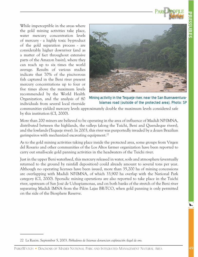
ParksWatch • Diagnosis of Madidi National Park and Integrated Management Natural Area
While imperceptible in the areas where the gold mining activities take place, water mercury concentration levels of mercury - a highly toxic by-product of the gold separation process - are considerably higher downriver (and as a matter of fact throughout extensive parts of the Amazon basin), where they can reach up to six times the world average. Results of various studies indicate that 70% of the piscivorous fish captured in the Beni river present mercury concentrations up to four or five times above the maximum levels recommended by the World Health Organization, and the analysis of 80 individuals from several local riverside communities yielded mercury levels approximately double the maximum levels considered safe by this institution (CI, 2000).
More than 200 miners are believed to be operating in the area of influence of Madidi NP-IMNA, distributed between the highlands, the valleys (along the Tuichi, Beni and Quendeque rivers), and the lowlands (Tequeje river). In 2003, this river was purportedly invaded by a dozen Brazilian garimpeiros with mechanized excavating equipment.22
As to the gold mining activities taking place inside the protected area, some groups from Virgen del Rosario and other communities of the Los Altos farmer organization have been reported to carry out small-scale gold panning activities in the headwaters of the Tuichi river.
Just in the upper Beni waterhsed, this mercury released in water, soils and atmosphere (eventually returned to the ground by rainfall deposition) could already amount to several tons per year. Although no operating licenses have been issued, more than 35,200 ha of mining concessions are overlapping with Madidi NP-IMNA, of which 33,900 ha overlap with the National Park category (CI, 2000). Sporadic mining operations are also reported to take place in the Tuichi river, upstream of San José de Uchupiamonas, and on both banks of the stretch of the Beni river separating Madidi IMNA from the Pilón Lajas BR-TCO, when gold panning is only permitted on the side of the Biosphere Reserve.
22 La Razón. September 5, 2003. Pobladores de Ixiamas denuncian explotación ilegal de oro.
Mining activity in the Tequeje river, near the San Buenaventura-Ixiamas road (outside of the protected area). Photo: SP
49

ParksWatch • Diagnosis of Madidi National Park and Integrated Management Natural Area
Illegal loggingAs mentioned earlier, the park’s wealth in commercially valuable timber species, which have been extirpated from most of their range outside protected areas, represents one of the major threats to its integrity. Unless a sufficiently robust social and political support can be secured for its long-term and stict protection, it is only a matter of time until interest groups manage to lay their hands on these resources. This risk would be considerably increased if the route chosen for the projected road facilitated access to them.
The park’s implementation was based on the premise that a certain level of forest exploitation would be permitted
in the IMNA (essentially a multiple-use zone), but more than �0 years after its creation, a final Zoning Plan remains to be approved and put into effect. Although all forest concessions overlapping with Madidi NP-IMNA were cancelled several years ago, each year the Forest Service (Superintendencia Forestal - SIF) receives numerous solicitations from timber companies operating in the area, such as San Ignacio - whose concession is located northeast of the park - and the Local Forest Users’ Associations (Asociaciones Sociales del Lugar - ASLs)23 active in the Ixiamas Municipal Forest Reserve and the Tacana Communal Lands.
A study carried out in 2000 on the impacts of the various immigration waves to the park found that the logging activities of the �990s, due to their high selectivity (almost exclusively concentrated on mahogany, cedar and roble - Amburana cearensis) and total neglect of technical management criteria, have been the most important single source of degradation of the area’s natural ecosystems (Cáceres Vega, 2000). This indiscriminate exploitation led to the complete exhaustion of these three species in all logged areas. In the Iturralde province, where most of the logging took place, more than 35,000 ha of forests have thus been degraded and lost all economic interest, especially between Ixiamas and Alto Madidi. Large parts of the Tuichi river basin were also intensely exploited.
Now that all timber companies have been evicted from the protected areas and their concessions bought out, the park administration’s next challenge will be to repel the illegal chainsaw operators that have replaced commercial logging in recent years, and who reach into ever more remote areas as accessible resources become depleted (accessibility being generally a function of the
23 Farmer or indigenous cooperatives, which, according to art.°25 a) of the General Regulations of the new Forestry Law, are entitled to 20% of the total public land area set aside for permanent timber production in each municipality.
During the logging boom of the 1990s, a large number of forest roads were opened across the area, such as this one, which leaves the San Buenaventura-Ixiamas road in direction of the protected area. Photo: SP
50

ParksWatch • Diagnosis of Madidi National Park and Integrated Management Natural Area
distance to the nearest river). In spite of the seizure and sanction risks that the protection corps is trying to create by means of regular and special patrols, lack of personnel and deficiencies in its legal and penal proceedings grant the infractors a quasi total impunity. In addition, chainsaw operators are frequently helped by natives (known as rumbeadores) willing to indicate them the location of valuable forest patches for a modest compensation and purportedly helped in their contraband trade by corrupt employees of the local Forest Service office in Rurrenabaque (Treviño Paredes et al, 2003). Even the Prefecture of La Paz, generally a soft voice on this issue, admits that important volumes of timber are being illegally extracted and exported to Peru.
In the Apolo region and the dry forest of the Tuichi valley, road building has always resulted in an dramatic increase in logging activities, partly to meet the area’s strong demand for fuel (in the form of both firewood and coal), and partly to serve as construction wood.
Between Apolo and Azariamas, the most threatened species are Anadenanthera colubrina, Astronium urundeuva, Schinopsis brasiliensis and Hura crepitans, as well as mahogany and roble.
Between Azariamas and Ixiamas, the most valued timber species are Cedrela sp., Juglans sp., Podocarpus sp., in addition to the extraction of Clusia sp., Cinchona sp., Croton sp., Protium sp. for non-timber purposes.
Logging activity in the park’s direct area of influence. Left.: Río Undumo; Right: Sawmill in the environs of Tumupasa. Photos: SP and MSD
Illegal chainsaw operators in Río Undumo, a few kilometers downstream from the protected area. Photo: SP
51

ParksWatch • Diagnosis of Madidi National Park and Integrated Management Natural Area
Poaching and illegal fishingA large proportion of the park’s edge faces indiscriminate poaching and fishing pressure from colonists and other groups settled near its borders, which rely heavily on bushmeat for their protein intake. The park’s area of influence is also the scene of commercial hunting and fishing for the markets of Rurrenabaque, San Buenaventura, Ixiamas, Guanay and Apolo, as well as of a relatively minor pet trade (e.g. macaws and monkeys). The major problems are located around the community of San José de Uchupiamonas and in the incense forests, where animals are being hunted to feed the workers. Hunting pressure is also reported towards the border with Peru, where the soldiers of the small in San Fermín military camp kill apparently large numbers of tapirs for their personal consumption.
Preferred preys are primates, agoutis, tapirs, deer, peccaries, guans, and river turtles (Podocnemis unifilis), which are apparently hunted by Brazilian nationals sailing all the way to the Beni river from the border town of Riberalta (WCS, 2002). Fishing predominantly affects barred surubims (Pseudoplatystoma fasciatum and P. tigrinum), pacus (Colossoma macropomum), and sabalos (Prochilodus nigricans).
Hunters and fishermen use tourist and other existing trails, generally working at night to evade park ranger patrols. Since they cannot use dynamite, colonist fishermen often resort to a powerful natural poison locally called barbasco, which kills many more fish than are being harvested.
Since even the indigenous people of the Pilón Lajas BR-TCO (in particular community members of Asunción del Quiquibey) have taken to hunting in Madidi, the nearby communities have started collaborating with the protection corps and now report infractions. When hunters are caught, their loot is seized and a fine is issued, but it is rarely possible to take the violator to the San Buenaventura office for payment.
Although the current hunting pressure does not seem to threaten any particular species, the sustained population growth in the park’s area of influence and inside the protected area announces a significant increase of this pressure in the future.
Uncontrolled tourismParksWatch field observations and the SWOT analysis carried out in Madidi NP-IMNA by Rivera Rodríguez in 2003 identified the following problems:
Uncontrolled and unsustainable tourism activities proposed by the tourist agencies from Rurrenabaque (non-compliance with regulations and basic functioning rules, such as garbage collection, use of latrines, avoidance of extractive uses, etc.);
Poor communication between the park administration and the tourist agencies;
Concentration of most tourist activities (95%) in the lower part Tuichi river;
Promotion of destructive and disruptive activities, such as cutting vines and palms, touching and feeding wild animals, disposing solid waste in inadequate locations, cutting wood to build rafts, widening trails, etc.). These practices are meant to please the tourists
52

ParksWatch • Diagnosis of Madidi National Park and Integrated Management Natural Area
and provide them a more “adventurous” experience. Although some of them may reject these types of practices, others bring their own machetes and use them even more candidly than the guides;
Concentration of tourism revenues in the town of Rurrenabaque. A good example of this situation is the Chalalán lodge, whose managers buy their supplies almost exclusively on the markets of Rurrenabaque instead of favoring their community’s producers (San José de Uchupiamonas is located three hours upriver and market prices are identical);
The local tourism offer is almost exclusively concentrated on ecotourism, to the detriment of the social and cultural tourism which could thrive due to the variety of Andean-amazonian cultures found in the area, from the Kallawaya Aymara Indians in the western highlands to the Tacana and Lecos people in the lowlands);
Fierce price competition (US$ �2 to �4/day) between tourist operators, limiting revenues and leading to a general degradation of the quality of service;
High competition between communal ecotourism projects and structural flaws in their design, which puts their future into question;
National political instability since the year 2000, which translates into repeated strikes and road blocks and could be the reason for the recent drop in tourism growth;
Finally, there are visitor groups entering the area in parts still not equipped with any tourism infrastructure: to the east, from Ixiamas to Alto Madidi walking along the Tequeje and Madidi rivers on 8 to�4-day expeditions and to the west, rafting down the Tuichi river between Virgen del Rosario and Rurrenabaque or walking 8 to 9 days from Pelechuco to Apolo.
Because of all these shortcomings, tourism represents as much a threat as an opportunity for the park, although it should be noted that in comparison to the other afore-mentioned pressures, it currently only affects a quite reduced proportion of the area. Without the enforcement of a a strict tourism ordinance plan, this situation could rapidly change.
53

ParksWatch • Diagnosis of Madidi National Park and Integrated Management Natural Area
ThreatsOil exploration and drillingPermitted inside the IMNA, oil exploration and drilling operations are prohibited inside the National Park.
In spite of the number of studies documenting the impacts of the unregulated oil exploration activities that took place in the area in �970 and TOTAL’s failure to find gas in the Tuichi river in �994-95, in �997 two large oil concessions overlapping with Madidi NP-IMNA were granted to REPSOL Exploration Secure S.A. and Pérez Companc S.A: the Tuichi block (�,000,000 ha) and the Rurrenabaque block (426,200 ha), respectively (CI, 2000). In February 200�, the Rurrenabaque block was officially returned to the Vice-Ministry of Energy and Hydrocarbons and the next year REPSOL returned �95,000 ha of the Tuichi block (WCS, 2002).
At the time of writing, three oil concessions overlapped with the protected area: the Río Hondo block (�,000,000 ha, PETROBRAS) of which 598,000 ha are located within Madidi NP-IMNA, Pilón Lajas BR-TCO and Isiboro Sécure NP, the Tuichi block (805,000 ha, REPSOL), 557,�93 ha of which are located within Madidi NP-IMNA and Pilón Lajas BR-TCO, and the Tequeje block. The two latter have recently been explored, with some positive results towards their southern portions.
PETROBRAS, REPSOL and TOTAL are currently in the process of obtaining environmental licenses to execute 2D sismical explorations in common, under a shared risk arrangement. They have already received permits to operate outside of the protected areas.
These tests, which are projected to be run along 9 lines of a total length of 2�3.5 km (WCS, 2002), will generate very well-known and documented impacts: infrastructure construction (roads and heliports), presence of numerous workers, use of chemicals, fuel and explosives, solid waste generation, water use and pollution, destruction of fauna and habitats, among others. What is more, granting oil exploration rights in areas closed to local extractive uses is likely to generate resentment in the local population and to pave the way for reprisals, including land invasions.
Construction of the Ixiamas-Puerto Chivé roadA fundamental objective of Bolivia’s successive governments is to improve the national road network, considering that at present 70% of the economic activity and development is concentrated around the three major cities (La Paz, Santa Cruz y Cochabamba), and the country’s enormous tourism potential is seriously limited by the lack of transport infrastructure (only 5% of roads are asphalted). In this context, the construction of a road from Ixiamas to Puerto Chivé (border with Peru) and Cobija (border with Brazil), as projected in the “Northern Corridor” development plan, would aim at connecting a large part of the Bolivian Amazon, including �7 significant population centers, among which: Caranavi, Yucumo, Quiquibey (La Paz department), Rurrenabaque, Santa Rosa, El Choro, Guayaramerín (Beni department), Conquista, Puerto Rico, Porvenir y Cobija (Pando department).
54

ParksWatch • Diagnosis of Madidi National Park and Integrated Management Natural Area
As a result of its popularity, this age-old project is brought back to the limelight with each new electoral campaign (municipal, departmental, and presidential), and were it not for the institutional pressure against this project, the works would likely already have started, even in the absence of sufficient funding for building the entire stretch. It is nonetheless reasonable to assume that this road will be constructed one day or another, and it is probably with this in mind that IADB officials decided to invest in 2004 in a million-dollar strategic environmental study.24
Although jungle roads such as this projected route may eventually end up benefitting the local populations - provided they do not lead to the consolidation of large landholdings, such as cattle ranches - in a first step the main beneficiaries of this project will most likley be the region’s commercial loggers, colonists, land speculators, and, as a matter of fact, large cattle ranchers, who will have faster means to export their primary products (Reid, �999).
The most predictable consequences of the Ixiamas-Puerto Chivé road are spontaneous colonization processes, land-use intensification in the current colonization zone, and a dramatic expansion of the agricultural frontier throughout the region. The impacts associated with these processes will have inevitable effects on Madidi NP-IMNA, which is located in the road’s direct area of influence, and which even stands in the middle of one of its proposed routes (with a length or approximately �20 km). In particular, the extension of the existing colonization zone further north threatens an extensive savanna and wetland area (Alto Madidi-Puerto Chivé region) of exceptionally good conservation status.
24 La Razón. July ��, 2004. El norte amazónico decide planificar su desarrollo (http://www.la-razon.com/Ejecutivo/Julio/ejec0407��a.html).
55

ParksWatch • Diagnosis of Madidi National Park and Integrated Management Natural Area56
Recommended solutions
Construction of the Apolo-Ixiamas roadThe most frequently used argument in favor of the construction of the Apolo-Ixiamas road is the total lack of any vehicular transport infrastructure inside Madidi’s IMNA, movements being restricted to footpaths and waterways. This resticts the development of resident communities by impeding them to take their agricultural products to the markets and, according to promoters of the project, is the cause of social strife and poverty inside and around the park.
However, reading between the lines of the official discourse, the real motive of these development advocates seems to be facilitated access to the park’s remnant mahogany stands and gold deposits, an opinion expressed by nearly all the residents interviewed in the environs of both Apolo and Ixiamas when asked about the project’s background. It is thus important to make a clear distinction between the argument invoking legitimate community development aspirations and the economic interests of a few groups and individuals with access to external capital, and, for the most part, outsiders to the area.
And beyond this recognition, it is urgent to start an open debate between all the stakeholder groups concerned by this project in order to evaluate its real benefits, how they will be shared, and how they compare to the road’s estimated financial and environmental costs. Without pretending to consider the entire range of possible scenarios in which this still unresolved conflict might unravel, we will analyze and provide some prescriptions for the two most plausible outcomes:
a) Scenario 1: the road is constructedRoads in unsettled tropical areas are known to attract a large number of people, among which landless peasants, large landholders in search of new investment options, and land speculators who live out of the colonization process. In this scenario, the challenge for the park administration will be to contain a dramatically increased pressure on both land and natural resources (timber, minerals, NTFPs).
One inevitable task will be to establish control posts at the road’s two access points to the protected area (assuming there are only two) and ensure the surveillance of the road on its entire length. Considering the difficulty of controlling such an extensive area and
In case the projected road across the protected area gets built, the challenge for the park administration will be to control all vehicular access and transit through the area, such as this truck which came to load sand and firewood. in the AMNI (near Machua). Photo: MSD
ParksWatch • Diagnosis of Madidi National Park and Integrated Management Natural Area
the protection corps’ severe limitations, it will be important to not only hire new park rangers but to seek community participation (alerting park rangers of illegal activities and denouncing perpetrators). Establishing this cooperative network will require intensive communication, training, organizational strengthening, and environmental awareness-raising efforts which the park administration should already start planning and implementing, as results will take time to materialize.
In order to avoid damaging pristine and wilderness areas, the final route - which remains to be defined - should avoid the National Park protection category and the mountainous areas (in particular the dense forests located between Azariamas and the Tutumo mountains) and stay out of the Silianas valley and its mahogany stands as well as the area’s known gold deposits. The alternative which seems to conjugate the highest social benefits and the least environmental costs is that which passes through San José de Uchupiamonas, reaching Ixiamas via the community of Tumupasa. This may imply revising the zoning proposed in the park’s Management Plan, which, by uniting the two blocks formerly designated as intangible areas, makes the avoidance of the National Park category impossible.
From an environmental perspective, it is of utmost importance that the road building be carried out in full compliance of the regulatory framework, in particular with the dispositions of the Environmental Law (Nº �,333) and associated regulations (Reglamento de Prevención y Control Ambiental), after conducting the public consulting process required for public works projects of this type. It should be noted that the so-called “consensual” route did not take account of the appropriate technical and environmental criteria. It thus needs to be revised based on serious topographic, geological, lithological, edaphic, biological, hydrological, and geomorphological stability studies ensuring the minimum possible impacts on this very fragile area.
In addition, it is highly urgent that the SERNAP and other competent authorities put a halt to the general state of lawlessness surrounding the construction of this road, which was already partially opened through illegal means and threatens to throw the entire region into a spiral of violence and useless environmental degradation. Many people in Apolo and Ixiamas are already using threats to the park’s biological resources as arguments to pressure the government into providing financial resources and logistics for construction works. Setting fire to the mountain range is a menace frequently proferred by the local peasantry, manipulated by their leaders and generally unaware or not concerned by the likely consequences of such an act. Unfortunately, this problem is compounded by the fact that this radical discourse is met with apparent governmental neglect due to the lack of funds (the funding of an environmentally compliant road project in this area has yet to attract any investor). The organizers of the illegal actions perpetrated in recent months (destruction of park infrastructure, park administration taken hostage, illegal road building and logging, among others) should be tried and punished, but there the government currently lacks the institutional capacity in the area to make the necessary arrests. ParksWatch believes that the influence exerted by these law-breaking leaders can only be reduced by addressing the local population’s development requests with sound but tangible economic alternatives, which will require a substantial amount of financial support and technical assistance. In other words, the park may need to “buy” its way out of a damaging road option. Further support for environmental awareness-raising campaigns and the adoption of environmental criteria in municipal planning is also highly necessary (building on existing efforts).
57

ParksWatch • Diagnosis of Madidi National Park and Integrated Management Natural Area
Considering that road construction is likely to attract a significant migrant population, it is also extremely important to complete the titling of the IMNA, which presently relies on BIAP funding.
b) Scenario 2: the project is abandonedThis scenario considers the possibility that the road construction project is finally abandoned due to a lack of funding or economic justification25 or the choice of a different development option. It also relies on the assumption that the absence of vehicular transport infrastructure across the park does not necessarily imply that local populations will have to forego the living condition improvements they so urgently desire.
At the national level, one reasonable alternative investment seems to be the improvement of the existing road between La Paz and Ixiamas, which passes through Santa Barbara, Caranavi, Yucumo, Rurrenabaque-San Buenaventura, and Tumupasa. This will require the asphalting of extensive stretches (at least all those affected by rains) and a much more frequent maintenance than is currently provided. It seems that this alternative will only be viable once funding is secured for the construction of a bridge over the Beni river so as to reduce travel time and allow a permanent flow of vehicles. This would not, however, resolve the problem of Apolo’s isolation, and economic support for this region will still need to be sought.
Many residents of Ixiamas have relatives in Apolo, which they haven’t seen since they migrated in the framework of the “March to the North” colonization program promoted by the government in the �970s and 80s. Considering that the natural desire to visit relatives not seen in more than
25 In its BiRD publication, Conservation International estimated that this road project would result in a net loss of US$ 60 million for the country.
58
Critical deficiencies in the existing transport infrastructure - the propensity of roads to become impracticable during the rainy season and the lack of bridges, such as here on the Beni river - are a considerable hindrance to the region’s economic development. Photos: SP
ParksWatch • Diagnosis of Madidi National Park and Integrated Management Natural Area
20 years is an important factor in the local population’s support for the road, it is important to investigate the options by which family members could periodically reunite without the need to open a road across the park. One feasible solution could be to sponsor an occasional flight service or regular bus service (via La Paz) whose cost would result minimal in comparison with the political support achieved for the park in case this measure is associated with adequate information about the importance of protecting Madidi NP-IMNA.
Independently from what finally happens, through their participation in environmental impact studies and in the various consultation and negotiation meetings that still need to take place around this project, especially between its promoters and the SERNAP, the conservation groups with active projects in the area should work at generating a public conscience, and, as a result, foster an increased caution on the part of the government and other influential sectors towards road construction projects in remote areas, disseminating - through all the available media - information on the unwanted and irreversible environmental and social impacts that they often produce. In this context, it is of utmost importance to help the Prefecture of La Paz incorporate sustainability criteria in its development planning, and in particular in the planning of its road infrastructure.
On another front, the position of Madidi NP-IMNA at the heart of a conservation complex composed of four other protected areas (Apolobamba IMNA, Pilón Lajas BR-TCO, Tambopata-Candamo Reserved Zone, and Bahuaja-Sonene NP) calls for a close coordination between the respective park administrations. In order to optimize management efforts and achieve a stronger voice againt large and disruptive development projects (such as the construction of a gas pipeline between the Camisea gas field in Peru and the Bolivian gas fields - not imminent but possible), it is indispensable to establish better communication and integration mechanisms concerning the initiatives developed in each protected area. This prescription is part of the park’s Management Plan’s recommendations. Following-up on the work initiated by the CI-ITTO project, managers should aim at forming a veritable transboundary protected area.
Expansion of the agricultural frontier and colonization processesThe main argument invoked in support of land claims in Bolivia is the need to increase the land area under agricultural production. However, given that all the colonization policies and programs implemented to date have lacked instruments to prevent or mitigate the disastrous consequences of the slash-and-burn agricultural practices of the migrant farmers, most colonization processes in Madidi’s area of influence have resulted in widespread deforestation and an uncontrolled expansion of the agricultural frontier, which is already reaching the park’s borders in several areas.
An aggravating factor is the insecurity associated with the absence of clear land tenure rights throughout most of the region (including the IMNA) as a consequence of a slow land-titling process, which incites colonists to exploit natural resources as fast as possible in order to avoid losing them to someone else.
Given their specific dynamics, we will discuss the two different colonization zones (San Buenaventura-Alto Madidi and Apolo-Azariamas) separately:
59

ParksWatch • Diagnosis of Madidi National Park and Integrated Management Natural Area
a) San Buenaventura-Alto Madidi colonization zoneThe arrival of successive waves of colonists from the Andean highlands since the �970s without proper technical assistance determined the generalized adoption of improper agricultural practices which lead to the destruction of extensive natural ecosystems and the displacement of native (Tacana) communities, impacts which were compounded by intense logging activities and the progressive exhaustion of the bushmeat and non-timber resources these communities depend upon for their survival.26 Now that the children of the first generation of colonists are becoming adults in need of their own agricultural plot, the colonist settlements are already starting to experience land shortages and the need to migrate further.
In order to stifle the growing land access conflict, a priority of conservation and development organizations with active projects in this area should be to seal strategic partnerships with the farmer and colonist organizations for the formulation of a coordinated regional development
26 As a means to create a buffer zone around the park against logging activities by both commercial companies and Local Forest Users’ Associations (ASL), the Management Plan proposes to support the Indigenous Communal Lands titling requests - which encompass samples of the alluvial floodplain and savannas (Pampas del Heath). ParksWatch is in favor of this approach, but with the observation that the non-attendance of colonist demands will inevitably lead to land-related conflicts, such as the ones resulting from the titling of the Tacana TCO over agricultural plots cleared by colonists settled along the Ixiamas-Alto Madidi road.
60
MODIS/TERRA satellite view of the San Buenaventura-Alto Madidi colonization zone, colindant with the eastern border of Madidi NP-IMNA.

ParksWatch • Diagnosis of Madidi National Park and Integrated Management Natural Area
and assistance program based on agro-ecological and sustainability principles, including the promotion of agroforest and alternative land-use practices as well as the commercial use of non-timber forest resources in the framework of wood lot management plans (Planes de Ordenamiento Predial - POPs). Another recommendation is to foster the development of higher added-value activities ensuring stable and long-term income, such as ecotourism, forest plantations and the on-site industrialization of primary products. In the case of ecotourism, special attention will need to be paid to the adoption of best practices and the protection of the sites dedicated to this activity. More guidelines are provided in the relevant section below.
With respect to cattle-raising, which has traditionally been practiced extensively and with little economic investment and, as a consequence, low productivity, future financial support and technical assistance efforts should promote the adoption of intensive management systems and the sowing of pasture species on fallow lands. This would not only preserve their cattle-raising potential for subsequent years, but also avoid the severe soil wash-off affecting denuded lands in the area, thereby abating the land conversion pressure on primary forests.
When monitoring the region’s land-use dynamics, which WCS has already started with the analysis of time series of satellite images, it is recommended to analyze the agricultural potential of the new areas proposed for colonization and to share this information with the different institutions in charge of the land distribution and titling processes (INRA, Forest Service, Agrarian Service, Ministry of Rural Affairs, Vice Ministry of Indigenous Affairs - VAIPO, etc.). Since a sound ordinance plan is dependent upon a comprehensive assessment of natural resources, relevant institutions should also dedicate resources to their systematic inventory. Detailed knowledge about forest composition and dynamics will allow decision-makers to make more appropriate decisions concerning the assignment of land to either development or conservation purposes.
Finally, the park administration and ICIB have initiated environmental education activities in Rurrenabaque and surroundings. Additional resources should be sought to extend this initiative to the park’s entire area of influence, targeted to both farmers and residents of urban centers (San Buenaventura, Tumupasa and Ixiamas), and aimed at raising the environmental awareness of institutional actors, such as the afore-mentioned governmental agencies, municipal councils, civic committees, farmer, colonist and indigenous organizations, etc.). Schoolchildren should be exposed to formal environmental education at school through programs such as the “Schoolyard Ecology Teaching” program (Enseñanza de Ecología en el Patio de la Escuela - EEPE), an international teaching program which has been successfully implemented in the Coroico area (Nor Yungas province). Considering their impact, these programs should include the production of audio, video and print material to be disseminated via local radios and during local fairs or other social events.
b) Expansion of the agricultural frontier in the Apolo-Azariamas areaThe colonization pressure in this region is essentially orchestrated by the CSUTCB, the indigenous MIP party, and affiliated groups, which refuse to acknowledge the protected area designation and incite other sectors to reject it as well. This situation is partly determined by the critical soil degradation and impoverishment problem affecting nearly 40,000 ha in the Apolo area, which forces farmers to search for new lands inside the park.
61

ParksWatch • Diagnosis of Madidi National Park and Integrated Management Natural Area
This continuous agricultural expansion, characterized by indiscriminate logging and pasture burning, is leading to a gradual desertification of the region. The rainfall regime (approximately �,000 mm/per year, mostly in the form of torrential downpours) causes extremely high levels of soil erosion, in particular on denuded slopes (CARE-Bolivia, 200�). As a consequence, in spite of their relatively good agricultural potential under certain conditions, soils cultivated with annual species rarely yield more than seven or eights crops, needing a fallow period of more than years before they can be newly put to productive use.
Considering that this problem is largely due to the use of inadequate agricultural practices, the park’s Management Plan calls for the urgent introduction of soil conservation measures.
Below are some of the key practices that need to be adopted to improve the productive capacity of agricultural plots:
a) preserve the vegetation cover of river headwaters in order to avoid soil erosion and maintain their water retention capacity (follow-up on CARE-Bolivia’s work);
b) maintain a strict spatial separation between agricultural, cattle-raising and forestry activities, so as to:
i) increase agricultural output through the installation of efficient irrigation systems in the lower lying areas;
ii) improve pastures through the fertilization and controlled burning of areas of confirmed cattle-raising potential;
iii) protect the forest regeneration areas from cattle.
c) promote a gradual transition towards perennial crops compatible with agroforestry systems (such as citric fruits, cacao, and coffee) in order to reduce soil degradation and diminish the risk of uncontrolled fires;
d) allow reforestation of unproductive lands, such as the large extensions of weed-infested former pastures, by protecting them from fire and by planting woody species.
As in the San Buenaventura-Ixiamas region, it is highly necessary to complete the land-titling process as rapidly as possible. This will require getting access to the BIAP funds destined to this purpose and seek complementary funding with the institutions susceptible to support this process.
62
Decade after decade, the annual burning of pastures in the Apolo region has led to a highly eroded landscape with highly degraded soils. Photo: P. Jørgensen

ParksWatch • Diagnosis of Madidi National Park and Integrated Management Natural Area
ParksWatch agrees with the authors of the Management Plan on the importance of redefining the protected area’s limits. We recommend adapting the straight borders defined during the park’s creation (without precise geographical references) to the topographic reality of the area, adapting them to natural features and avoiding the inclusion of human communities within the National Park designation.27 The limits of the park should be extended to include all the northern savanna grasslands, which do not warrant to be categorized as a forest concession given their lack of timber resources, and which will be very difficult to protect if cattle-raising is authorized in certain areas (CABS, 2002). The limits of the future San José de Uchupiamonas Communal Lands also need to be revised in order to ensure access of its inhabitants to their ancestral lands. One proposal formulated by park stakeholders would be to have the park’s border follow the course of the Tuichi and Madidi rivers once out of the mountain range.
Gold miningAs exposed earlier, the high mercury contents measured in fish and in the local residents who feed essentially on fish are in large part due to gold mining activities taking place upriver from the park, specifically in the Apolobamba IMNA and the Guanay-Caranavi region, which is one of the country’s most important gold mining areas. However, some illegal gold miners are also reported to operate within the protected area on the Tuichi and Beni rivers.
In order to determine appropriate measures against this pollution problem, it is necessary to acquire more detailed information on the gold mining operations carried out inside the park and in the afore-mentioned areas. The relevant institutions for conducting such a survey and the subsequent monitoring work are the Mining Service and the Geological and Mining Survey (SERGEOMIN), but these most probably lack the human capacity to do so. Some support is therefore needed at this level.
Another important measure is to establish dialogue with the gold miners and sensitize them to the regulations established by the Mining Code, the Environment Law and the Protected Areas Act. This aims at formalizing their status and making them responsible for their actions. Ideally, this environmental awareness raising work would be associated with technical training on less polluting mining techniques based on the recovery and reuse of mercury.
Considering that the National Technical Mining Service (SETMIN) continues to grant mining rights inside the protected area, it is of utmost importance to achieve the promulgation of the Protected Areas Law in replacement of the weak Protected Areas Act (Reglamento General de Areas Protegidas - RGAP, D.S. N°24,78�), which systematically yields to industrial interests backed by actual laws. Meanwhile, we recommend the elaboration of a mining ordinance plan compatible with the protected area’s sensitivity, which implies the establishment and enforcement of strict zoning rules. It is only with such rules that the park administration will be in a position to sanction violators.
27 The Participative Rural Diagnosis workshop conducted by CARE in Apolo concluded on the need to redefine the limits between the IMNA and the NP.
63
ParksWatch • Diagnosis of Madidi National Park and Integrated Management Natural Area
In addition, it is necessary to strengthen the environmental management capacity of Municipal and Departmental governments as well as local grassroots organizations. The environmental planning approach used by WCS in a series of workshops with the municipal councils of the Apolobamba IMNA (Pelechuco, Charazani, Curva) should be applied to the area of influence of both Madidi NP-IMNA and the Pilón Lajas BR-TCO. This technical advising could also benefit from the experience and logistical capacity of GTZ’s MAPZA project. Alas, it is important to consolidate the Management Committee (approve and apply its internal regulations and statutes) in order to legitimize its decisions in relation to mining activities.
Illegal loggingLarge volumes of timber are being extracted daily from the park’s area of influence, and there’s a mounting pressure on the park’s timber resources as these external areas get exhausted. Achieving an effective control over this activity will necessarily imply a significant increase in the number of park rangers, which is not a realistic option in the short term due to the park’s funding limitations.
One solution adopted in other protected areas facing related resource extraction problems (in particular the Apolobamba IMNA with the poaching of vicuña) is the formation of community watch groups in charge of reporting illegal activities to the park administration or other relevant institutions. Since loggers depend upon the existing road network, these could be organized along the Ixiamas-Alto Madidi and Apolo-Azariamas roads. Ideally, beyond reporting infractions, in the future these community vigils would be assigned the task to supervise the compliance of logging companies and individual landholders with Forest Law regulations, such as the respect of the projected wood lot management plans. As a first step, this approach could be tested with a pilot community, such as one of the communities of the Tuichi valley, whose dry forests are being aggressively exploited for fuel and building material.
Similarly, it is necessary to promote the coordination of the various institutions in charge of supervising forestry activities, such as the Forest Service and the USAID-funded BOLFOR sustainable forestry project, and to enhance their control, monitoring and enforcement capacities.
With respect to the Forest Service, in order to achieve better efficiency and discourage corruption, investigations will first need to be conducted so as to identify and suspend all personnel shown to have collaborated with loggers. However, any significant progress in the control exerted by this institution will require the hiring of additional staff. Mahogany is listed in Appendix II of the CITES Convention, so that legal instruments exist to sanction violators. Reducing the demand for precious tropical woods in consumer countries is a long-term effort that should be started without further delay.
It is also important to analyze the current network of forestry roads in the sector and to put a halt to its further anarchic development. Strict supervision needs to be exercized by the Forest Service on the logging concessions operating towards the north of the park in order to ensure that its limits are respected and to avoid the aperture of new access roads. Control and monitoring should also be applied to the logging activities carried out by the Local Forest Users’ Association
64

ParksWatch • Diagnosis of Madidi National Park and Integrated Management Natural Area
(ASL) of Ixiamas, the companies and individuals operating on the Tacana Communal Lands, and the colonist settlements along the San Buenaventura-Alto Madidi road.
In the Apolo region, it is important to reestablish control at the park’s gate (formerly by the Machua station) and to sensitize communities as to the need to conserve forest resources. In the most degraded areas, reforestation with native species should be promoted.
Finally, it is recommended to carry out a comprehensive assessment of the region’s forest resources and promote the establishment of commercial tree plantations for use by future generations. In parallel to taking advantage of the emerging market for certified timber, this initiative should consider exploiting niche markets of lesser known timber species and consider the incorporation of valuable non-timber species in the understory (for the production of essential oils, cosmetics, drugs, etc).
Poaching and illegal fishingThe fact that the development assistance and improved living conditions expectations generated with the creation of the IMNA remain beyond the present capacity of the park administration has lead many frustrated local residents to question the legitimacy of the protected area and to simply ignore its existence (in spite of the public consultation process that took place during its creation).
Considering that both resident and adjacent communities live in utter poverty due to a lack of economic opportunities, they rely heavily on bushmeat to satisfy their protein needs, leading to high hunting pressure in certain areas. Considering the projected population growth, it is therefore indispensable to stimulate domestic livestock production and to provide the technical and financial assistance for its widespread adoption, in particular in the most densely populated areas. In this respect, coordination between the various local support organizations is urgently needed in order to achieve an appropriate level of resources. This is a concern expressed by the local residents themselves, which demonstrate a strong apprehension towards the favoritism that frequently accompanies development programs (favouring certain communities and ethnic groups over others). The main players in this field (the BIAP project, WCS, CI, USAID, and the Natural Resources Management component of the GEF-II fund, among others) should thus create a common platform aiming at a more balanced assistance throughout the region.
Since the poaching and illegal fishing activities taking place inside the park are essentially due to a lack of control capacity, support institutions should direct some of their financial support towards hiring additional park rangers, building new ranger stations in strategic locations and acquiring the necessary field equipment (GPS, binoculars, radios, etc.). As a first step, in order to stop commercial fishing on the Quendeque river, it is important to reestablish the Río Hondo ranger station. Part of the revenues generated by the park entrance fee collection system (SISCO) could be dedicated to organizing community watch groups (e.g., the same as the ones proposed
65

ParksWatch • Diagnosis of Madidi National Park and Integrated Management Natural Area
above against illegal logging activities).28
With respect to the hunting and fishing problems reported around San José de Uchupiamonas, it is necessary to develop a sustainable resource use strategy similar to the work carried out in the park’s area of influence with the Tacana communities, which are taking part in an auto-monitoring program aimed at adapting hunting and fishing practices to resource availability. At any rate, measures need to be taken to reduce hunting pressure on primates, tapirs, and guans, and secondly on agoutis, deer and peccaries.
With respect to fishing, in case of positive results, the auto-diagnosis workshops and auto-monitoring activities promoted by WCS (including the formation of a Fishermen’s Association among the communities located on the bank of the Beni river: Carmen del Emero, Tequeje, Cachichira, San Miguel, Rurrenabaque, and San Buenaventura), this strategy should be applied to other sectors of the park.
In the IMNA, hunting and fishing activities should be regulated by means of a zoning plan based on the identification and demarcation of each community’s hunting grounds. It is also necessary to acquire detailed information on the biological and ecological characteristics of the most frequently captured species, including abundance, breeding periods and habitats, local migrations, and feeding habits, among others. In the light of this information, the park administration, in collaboration with the communities, will be able to establish strict protection zones, maximum sustainable yields, and seasonal hunting and fishing bans.
Uncontrolled tourismControlled, regulated and sensitive ecotourism is by all accounts one of the strongest allies of in situ nature conservation, in particular in comparison with other economic activities often promoted within protected areas to alleviate local poverty and social strife.
International promotion of Madidi’s extraordinary scenic beauty and a growing attraction for jungle tours in general have led to a considerable increase in the number of tourists visiting the park each year. However, this unique economic opportunity could become a curse for both the protected area and its adjacent indigenous communities if tourism activities are not rapidly regulated and closely monitored. Below is a list of prescriptions which should help improve the present situation, complementing those formulated in the Management Plan’s tourism program:
Implement the permanent monitoring of animal and plant species sensitive to tourism activities, comparing touristic sites with disturbance-free control sites. Information on pre-tourism species abundances can also be used as baseline data, but it is rarely available.
Establish and communicate regulations and behavioral rules for both tourist guides and
28 The communities which are already collaborating with the protection corps, such as Torewa, lack radios to inform the park administration of the illegal activities they witness. In order to ensure their continued participation, it is important to provide them this type of basic equipment.
66

ParksWatch • Diagnosis of Madidi National Park and Integrated Management Natural Area
visitors during their stays inside the park, and organize training courses for guides and tourism operators.
Improve coordination between tourism agencies, NGOs, local and national authorities, and the local population.
Improve tourism signalization to communicate rules and regulations and provide other types of useful information.
Improve the park’s strategic access infrastructure in order to provide more choices to visitors while channelizing visitor access.
Diversify the tourism offer: offer is currently almost exclusively concentrated on natural attractions in the rainforest and savannas (pampas).29 However, the region has a rich cultural heritage determined by the presence of several Andean and Amazonian ethnic groups, from the Kallawaya Quechua indians in the western highlands to the Tacana and Lecos indians in the eastern plains. This cultural richness should be more emphasized in the materials promoting the park and region to potential tourists. The communication and promotion effort initiated by CI in the framework of its ITTO project should be pursued and completed with a strong dissemination in the travel agencies of La Paz as well foreign agencies specialized in cultural and social tourism.
Develop controlled tourism along the banks of the Tuichi river, which are a very good place for animal observations (in particular river turtles and caimans). However, since riverbeds constitute primary habitat and breeding grounds for many animal species, it is important to minimize the presence of tourists by avoiding to open long walking trails in those areas. River crossings and short distances on river banks are generally acceptable. However, it may be necessary to restrict access to these trails during the breeding season(s).
Promote the visit of national tourists: the low percentage of national tourists in comparison to the total number of visitors (approximately 5%) is essentially due to the high travel costs involved, but also to the lack of promotion of the park in places frequented by Bolivian city dwellers.
Promote tourism in the Ixiamas area:30 in spite of a long history of logging and cattle raising, there are still plenty of tourist attractions near the town (forests, lakes, wetlands, and savannas teeming with wildlife), very similar to those proposed to tourists near Cusco, the Upper Madre de Dios, the Manu, Puerto Maldonado, Río Las Piedras and various sites in Peru. The main limitation is the still incipient accomodation capacity, which ran at less than 40-50 beds at the time of writing. However, one potentially determinant factor in the area’s tourism potential is the existence of an asphalted landing strip (Caballero, 2003).
Increase tourism in the Apolo region: Apolo currently serves as the backdoor of tourism
29 The pampas tourism package, the most successful of all the packages currently offered, essentially favours the tourism agencies of Rurrenabaque, while bringing no direct benefits to the park.
30 With a population of approximately �,890 inhabitants, Ixiamas is the most important population center in the park’s eastern area of influence.
67

ParksWatch • Diagnosis of Madidi National Park and Integrated Management Natural Area
activities in both Madidi NP-IMNA and Apolobamba IMNA, when it could actually be one of its most popular access points. Ecotourism could represent an interesting income source for local residents (and has even the potential to boost the local economy as a whole), which could reduce the colonization pressure and foster acceptance of the park, as well as even reduce support for the road construction if it can be shown that the success of ecotourism in the area highly depends upon its conservation status.
Considering air transport, the conditions set by Amaszonas airlines in order to resume its La Paz-Apolo-Rurrenabaque-La Paz flight service are:
i) the repair and maintenance of the Apolo landing strip;
ii) a minimum of four passengers per flight for a fare of Bs. 500 (US$ 60) one-way, or;
iii) a minimum of six passengers per flight for a fare Bs. 4�0 (US$ 50) one-way.
With support from various organizations and sufficient promotion in tourism agencies in La Paz, these goals are easily achievable (CARE-WCS, 2003).
Oil exploration and drillingParksWatch’s first recommendation is to launch a joint lobbying process between the SERNAP and conservation and development organizations active in the area to convince REPSOL to abandon its remaining concession rights on the Tuichi block (805,000 ha) and to avoid the granting of any future oil concession rights overlapping with the protected area by the Vice-Ministry of Energy and Hydrocarbons
In case oil exploration activities were to be authorized inside the Río Hondo block, funds should be requested from REPSOL to set up an independent technical team in charge of helping the SERNAP to control and monitor activities and ensure the compliance of environmental regulations. At present, the SERNAP has only one technician with expertise in this field.
The Environment Law (Nº�,333) includes provisions for the specific case of protected areas. Article 6� states that these should be managed according to their category designation, zoning and specific regulations. However, when invoking this article against oil exploration requests within strict conservation zones (which are clearly unsuited for this kind of activity), oil companies find a convenient recourse in the fact that protected areas in Bolivia are currently only backed by a weak Protected Areas Act (Reglamento General de Areas Protegidas - RGAP, D.S. N°24,78�), referring instead to the provisions made in the stronger Hydrocarbons Law.
This clearly denotes an insufficient legal framework for the long-term viability of protected areas in the country, which can theoretically be subjected to a whole range of mining activities. In the absence of an actual Protected Areas Law, the only effective obstruction that can be presented to such activities is the request of a preliminary environmental impact analysis (EIA) as required by the Environment Law. However, in practice, there are many shortfalls in the application and effectiveness of prescribed proceedings and instruments. For example, some of the proposed methodological guidelines for these studies are simply not adapted to the environmental sensitivity of protected areas. Until the promulgation of a real Protected Areas Law, it is therefore
68

ParksWatch • Diagnosis of Madidi National Park and Integrated Management Natural Area
fundamental that the SERNAP define specific terms of reference for EIAs of oil-related activities within protected areas.
Other recommendations relative to this threat are listed in the Pilón Lajas park profile.3�
Construction of the Ixiamas-Puerto Chivé roadGiven the high level of uncertainty associated with this relatively distant threat, the only recommendation that we consider relevant to formulate is to follow the design of the Alto Madidi-Puerto Chivé stretch so as to ensure the respect of the agreement signed with the Prefecture of La Paz to avoid the protected area altogether.
In order to ensure the sustainable development of the region, it will be necessary to establish stronger ties between the NGO community and the government, which under the current social pressure is still likely to authorize or even promote large-scale colonization programs without the proper technical and financial support. The support provided by development organizations should focus on the promotion of agricultural products destined to the Peruvian and Brazilian markets which will be made accessible with the new road(s), discouraging extensive cattle-raising, which threatens to convert the area into another enormous expanse of impoverished pasturelands.
3� Available online at the following URL: http://www.parkswatch.org/parkprofiles/pdf/plbr_spa.pdf
69

ParksWatch • Diagnosis of Madidi National Park and Integrated Management Natural Area
ConclusionConsidering its location at the heart of the Vilcabamba-Amboró Biological Corridor, its size (nearly 2 million hectares) and the exceptional diversity of habitats and species it harbors, Madidi NP-IMNA is undisputably one of the country’s most biologically relevant protected areas, which places it among the most important protected areas in the world.
This makes the risk of road construction in its interior (Apolo-Ixiamas) and direct area of influence (Ixiamas-Puerto Chivé) a very serious problem. As a matter of fact, the decisions that will be taken with respect to these roads will largely determine the fate of this yet undeveloped part of the Amazon basin.
At the time of taking a stand betwen a pragmatic approach favourable to the legitimate development aspirations of the local inhabitants and an intransigent position based on previous experiences and a long-term vision, the national and international conservation community is divided. On the one side, the advocates of the “controlled road” theory lack tangible proposals as to how to achieve effective enforcement and surveillance over the expected vehicular traffic across the park, while on the other hand the opponents of this type of infrastructure inside a protected area of this importance remain in search of acceptable alternatives for local communities which have been lured by the idea of a “northern outlet” for more than two decades.
Meanwhile, it is the future of Madidi NP-IMNA as a significant wilderness area that is at stake. Although the construction of a road should not undermine this status per se, it will be extremely difficult to repel the rampant colonization a land conversion pressure that is known to accompany this type of project in the Tropics. However, this challenge could help crystallize and channel efforts to consolidate the protected area and integrate it within the sociopolitical context of this remote but potentially dynamic region of the country.
70
Panorámic view of the eastern mountain range of Madidi NP-IMNA, from the Beni river. Photo: SP

ParksWatch • Diagnosis of Madidi National Park and Integrated Management Natural Area
ReferencesAllgoewer, K. 2003. Propuesta de plan de desarrollo turístico para la RB-TCO Pilón Lajas. On behalf of Agroecología Sierra y Selva and Conservation International.
Anderson, S. 1997 Mammals of Bolivia, taxonomy and distribution. Bulletin of the American Museum of Natural History 231:1-652.
Caballero, J. 2003. Diagnóstico del turismo en el Parque Nacional Madidi, Área Natural de Manejo Integrado y área de influencia. On behalf of WCS, Living Landscapes Project. 45 pp.
Cabanillas Núñez, J. 2000. Madidi en peligro
CABS. 2002. Informes de las evaluaciones biológicas Pampas del Heath, Perú, Alto Madidi, Bolivia y Pando, Bolivia. In RAP Bulletin of Biological Assessment. J. Montambault (ed.). 82 pp.
Cáceres Vega, F. 2000. Estudio de los impactos actuales y potenciales debido a inmigración reciente a la zona de influencia del PN-ANMI Madidi.
CARE. 2001. Proyecto de desarrollo agrosilvopastoril con énfasis en economía de pasturas para comunidades asentadas en el Área Natural de Manejo Integrado (ANMI), del Parque Nacional Madidi (Los Altos, Santa Cruz, Raviana, Machua, San Marcos). Description of the project.
CARE-WCS. 2003. Plan de Manejo del Parque Nacional y Área Natural de Manejo Integrado Madidi. With support from the European Commission.
DNCB. 1995. Propuesta para el establecimiento de un área binacional que comprenda el PN y ANMI Madidi en Bolivia y la Zona Reservada Tambopata Candamo-Santuario Pampas del Heath en el Perú.
CI. 2000. Análisis de amenazas al Parque Nacional Madidi y área de influencia. Proyecto Biodiversidad y Desarrollo Regional (BiRD). Conservation International. 35 pp.
Euroconsult. 1999. In CARE-WCS. 2003. Plan de Manejo del Parque Nacional y Área Natural de Manejo Integrado Madidi. With support from the European Commission.
Freese, C. et al. Primate communities: their structure and role in tropical ecosystems. Plenum Publishing Corporation.
Fugler, C. and I. De la Riva. 1990. Herpetología boliviana: Lista provisional de las serpientes conocidas en el país. Museo Nacional de Historia Natural (Bolivia). Comunicación 9: 22-53.
Helme, N., M. Kessler, and A. Perry. 1993. Conservation Assessment. In “TREX Field Report 1: Biological survey and conservation assessment of inter-andean dry tropical forest of the central Río Tuichi valley, proposed Madidi National Park, La Paz Department, Bolivia”.
INE. 1992. Mapa de pobreza de Bolivia. Instituto Nacional de Estadísticas. La Paz, Bolivia.
Kessler, M. 1993. Biogeography and Endemism. En Biological survey and conservation assessment of inter-andean dry tropical forest of the central Río Tuichi valley, proposed Madidi National Park, La Paz Department, Bolivia. TREX field report 1.
La Prensa. 2003. El Madidi, pobreza en el paraíso de la biodiversidad. June 15, 2003.
71

ParksWatch • Diagnosis of Madidi National Park and Integrated Management Natural Area
La Razón. 2003a). Pobladores de Ixiamas denuncian explotación ilegal de oro. September 5, 2003.
La Razón. 2003b). Rutas ilegales en el Madidi conducen a los árboles de mara (http://www.la-razon.com/Ejecutivo/Julio/ejec040711a.html)
Lehm, Z., H. Salas, E. Salinas, I. Gomez, and K. Lara. 2002. Diagnóstico de actores sociales - PN-ANMI Madidi. CARE/WCS. 177 pp.
Locklin, C. and B. Haack. 2003. Roadside Measurements of Deforestation in the Amazon Área of Bolivia. Environmental Management Vol. 31, No. 6, pp 774–783.
MHNNKM. 2000. Análisis de la situación social e institucional y sistema de información geográfico de las áreas protegidas de la Amazonia Boliviana. Agroecología Bosque y Selva. 180 pp.
Miranda, C. 1998. Estudio de prefactibilidad para la implementación de un subprograma binacional de manejo de áreas protegidas fronterizas en el marco del Programa de Acción Integrado Peruano-Boliviano (PAIPB). Secretary General of the Organization of American States. 184 pp.
Monjeau, J., M. Lilienfeld, J. Marquez, I. Goetting, E. Corrales, C. Danklmeier, J. Ramos, and C. Ugarte. 2003. Sistema de Monitoreo de Áreas Protegidas en Bolivia. SERNAP-GEF II. Report to the World Bank. 529 pp.
OAS. 2000. Programa de Acción Integrado Peruano Boliviano (PAIPB) - Diagnóstico Regional Integrado. Secretary General of the Organization of American States - Department of Sustainable Development and Environment. 148 pp.
Treviño Paredes, A., J. Sarmiento, H. Cabrera, and E. Romay. 2003. Evaluación de la factibilidad ambiental de los tramos propuestos por la Prefectura del departamento de La Paz para vincular Apolo con Ixiamas en el Parque Nacional Madidi. WCS/National Herbarium of Bolivia, La Paz. 114 pp.
Parker, T. and B. Bailey. 1991. A biological assessment of the Alto Madidi Region and adjacent areas of northwest Bolivia May 18-June 15, 1990. RAP Working Papers 1:1-108.
Prefectura de La Paz. 1997. Estudio de factibilidad y diseño final Apolo-Ixiamas. Final report. Vol. 1.
Rivera, J. 2003. Programa de turismo del PN-ANMI Madidi y su área de influencia. CARE/WCS.
Reid, J. 1999. Two Roads and a Lake: An economic analysis of infrastructure development in the Beni river watershed. 39 pp.
Rivera Rodríguez, J. 2003. Programa de turismo del PN-ANMI Madidi y su área de influencia. CARE/WCS.
SERNAP. 2001. Sistema Nacional de Áreas Protegidas de Bolivia. 2° Edición. 218 pp.
Silva, R., D. Robison, S. McKean, and P. Alvarez. 2002. La historia de la ocupación del espacio y el uso de los recursos en el PNANMI Madidi y su zona de influencia. CARE/WCS/Agroecología Bosque y Selva, Rurrenabaque, Bolivia. 102 pp.
Tierramérica. 2004. Motosierras amenazan reserva natural. Periódico en internet (http://www.tierramerica.org/2004/0619/articulo.shtml). June 22, 2004.
WCS. 2002. Prioridades y acciones para la conservación a nivel paisaje - El complejo Madidi-Apolobamba-Pilón Lajas-Tacana. First edition. 79 pp.
72

ParksWatch • Diagnosis of Madidi National Park and Integrated Management Natural Area 73
APPENDIX 1
Institutional Framework of the SERNAP
1/ PoliciesThe following outlines SERNAP’s political framework, which forms the basis for establishing its objectives and selecting and implementing actions directed at meeting those objectives:
o Consolidate the SERNAP as an institution.
o Achieve financial sustainability for protected area management.
o Conserve biological and cultural diversity in the protected areas.
o Strengthen public participation in protected area management.
o Promote protected area management integration in national economic and social policies.
o Contribute to improving the living conditions of local residents.
o Guide personal and collective values, attitudes and practices towards protected area conservation.
o Promote protected area integration at the international level.
2/ Strategic agendaThe 2003-2004 Activity Report lists the following advancements in relation to the actions outlined in the 2004-2007 strategic agenda:
o Strengthening of public participation via co-administration agreements with associations of municipalities (mancomunidades) and farmer organizations.
o Joint establishment, among all SNAP stakeholders, of an effective, efficient, and transparent management model focusing on “Parks with People”.
o Promotion and implementation of tourism strategies, policies, and activities in protected areas, with tangible benefits for local people and communities.
o Development of a conflict management and resolution system for preventive action against emerging conflicts within the SNAP.
o Launching of a national gap analysis to guarantee representation of the country’s ecosystems within the SNAP and as a principal input for the design of its Master Plan.

ParksWatch • Diagnosis of Madidi National Park and Integrated Management Natural Area
o Laying the foundations for the achievement of financial sustainability and adoption of financial management policies for donor funds or internal revenues.
o Strengthening SERNAP’s interinstitutional and intersectorial relations through establishment of crosscutting principles, policies, and strategic management plan.
o Implementing productive uses (sustainable use of natural resources, tourism, etc.) and land titling in protected areas.
Future work includes:
o Continue the prevention, management, and resolution of social conflicts related to protected areas.
o Implement the agenda of the Constitution of the National Consultative Council as a starting point for a social pact with grassroots organizations.
o Ensure the continuity of technical and financial support provided by such organizations as MAPZA-GTZ, GEF-World Bank, BIAP-KfW and other technical/financial aid agencies, in accordance with the SERNAP policies and strategic agenda and based on the harmonization and complementation of processes.
o Propose and approve a Supreme Decree for the institutional reorganization of the SERNAP in accordance with the reality and conditions determining the institution’s current restructuring.
o Start the elaboration of a Master Plan for the SNAP.
o Conclude, adjust and initiate the elaboration of Management Plans in at least eight protected areas.
o Adjust and improve public and institutional participation mechanisms in protected area management.
74

ParksWatch • Diagnosis of Madidi National Park and Integrated Management Natural Area
APPENDIX 2
Objectives of the Madidi NP-IMNA
Legal basis:
D.S. N°24,123 of September 21, 1995
Madidi NP-IMNA is part of the National System of Protected Areas of Bolivia (SNAP), and as such its main objective is the “conservation of biological diversity through community participation in benefit of the present and future generations” (D.S. Nº 24,78� - General Protected Areas Regulations).
Art° 4.- The general objectives of Madidi National Park and Integrated Management Natural Area are:
�.- The permanent protection of significant samples of pristine and extremely biodiverse ecosystems representative of the Amazon and Yungas cloud forests and of important genetic resources and individual species.
2.- The protection of geomorphological formations and singular landscapes of the Cordillera Real, sub-Andine mountain ranges, piedmont and alluvial plains.
3.- The protection of watersheds, in particular their headwaters, considering the area’s elevated rainfall levels and complex topography characterized by steep slopes and extremely fragile soils.
4.- The protection and recovery of the cultural values of old colonial populations and of the area’s archeological sites.
5.- Promote the sustainable use of natural resources and the improvement of living conditions of the local populations, as well as access to the benefits derived from the area’s conservation.
6.- Contribute to the protection of the nation’s cultural heritage and to the preservation of the native peoples’ traditional practices and production systems.
7.- Promote the use and revival of traditional practices and production systems as well as alternative practices destined to enhance productivity and improvement the living conditions of the local population.
8.- Promote, in the IMNA, productive activities compatible with the area’s conservation and sustainable development objectives and which are demonstrably benign for the local ecosystems and their ecological processes.
75

ParksWatch • Diagnosis of Madidi National Park and Integrated Management Natural Area
9.- Provide a wide range of opportunities for recreation, ecotourism, and environmental interpretation and education.
�0.- Promote scientific research and the monitoring of ecological processes.
What is a National Park and Integrated Management Natural Area?
D.S. N° 24,781, 07.31.1997
Art° 20.- The National Park (NP) category is aimed at the strict and permanent protection of representative samples of ecosystems or biogeographic provinces and the plant and animal species, as well as the geomorphological, scenic or landscape values that they harbor. A national park is a relatively large area which ensures the continuity of ecological and evolutionary processes of its ecosystems.
Art° 23.- Extractive or consumptive use of renewable or non-renewable natural resources is strictly forbidden, just as the construction of infrastructure - to the exception of scientific research, ecotourism, and environmental education purposes as well as the susbistence activities of native people, once expressly defined and authorized, so as to provide the population with tourism, recreational, environmental monitoring, nature interpretation, environmental education, and ecological awareness opportunities, in accordance with the park’s zoning, management plan, and regulations.
Art° 25.- The Integrated Management Natural Area (IMNA) category is meant to harmonize the conservation of biological diversity with the sustainable development of the local population. It constitutes a mosaic of land uses, including representative samples of ecoregions, biogeographic provinces, natural communities or plant and animal species of special importance, traditional land use systems, multiple-use zones, and strict protection zones (Art. 25) (CARE-WCS, 2003).
76

ParksWatch • Diagnosis of Madidi National Park and Integrated Management Natural Area 77
APPENDIX 3
Vegetation Map of Madidi NP-IMNA
Vegetation map of Madidi NP-IMNA. Source: WCS-Bolivia, 2004