PUBLIC SPACE AND URBAN LANDSCAPE - POLITesi · Architettura – MI, Sustainable Architecture of...
13
Politecnico di Milano, I Facolta di Architettura MI Architettura – MI, Sustainable Architecture of Multi-Scale Project (PC) AA 2013 / 2014 ` Author: Gergana Feodorova Marks Supervisor: Laura Daglio Co – supervisor: Marco Trisciuoglio PUBLIC SPACE AND URBAN LANDSCAPE URBAN STRATEGY RECONNECTION, REGENERATION, REDEVELOPMENT OF PRE-FABRICATED HOUSING NEIGHBOURHOOD - PANEL COMPLEX. TRAKIA QUARTER, PLOVDIV, BULGARIA
Transcript of PUBLIC SPACE AND URBAN LANDSCAPE - POLITesi · Architettura – MI, Sustainable Architecture of...
Politecnico di Milano, I Facolta di Architettura MI Architettura – MI, Sustainable Architecture of Multi-Scale Project (PC) AA 2013 / 2014
`
Author: Gergana Feodorova Marks
Supervisor: Laura Daglio
Co – supervisor: Marco Trisciuoglio
PUBLIC SPACE AND URBAN LANDSCAPE URBAN STRATEGY
RECONNECTION, REGENERATION, REDEVELOPMENT
OF PRE-FABRICATED HOUSING NEIGHBOURHOOD - PANEL COMPLEX. TRAKIA QUARTER, PLOVDIV, BULGARIA
ABSTRACT
The project is looking to develop a possible solution to one of the most painful problems in the urban realm of
the big Bulgarian cities, i.e. the redevelopment and regeneration of the so called panel complexes. It takes as a
case study Trakia neighbourhood in the City of Plovdiv, Bulgaria - the third largest panel complex in the country.
The current work is focusing mainly on the open spaces regeneration, reconnection and redevelopment. This is
due to the fact that 95% of the buildings in the panel complexes are privately owned, and the initiative for their
regeneration and energy efficiency is taken both by the inhabitants and the municipality. On the other hand the
maintenance of the open spaces, and their general purpose with few exceptions, is left entirely to the
municipality, but is highly discussed by the society.
The project is developed in different scales with large research on different levels and in different aspects. First a
general setting of the problem of the panel complexes in Bulgaria is made, showing that there are very common
problems of disconnection, alienation from the city fabric, lack of identity and maintenance of the public open
spaces.
There are three general scales on which the project is carried out: city scale, neighbourhood scale and detailed
local scale. The separation of scales corresponds both to the different stakeholders and their demands, and to
the staging and the model of execution. These strategies can be carried out in different periods of time and in
different order, but during the research I came to the conclusion that an intervention only on local level, which
deals simply with the immediate design of Trakia’s open spaces, will definitely contribute to the qualities of the
public spaces, but will be insufficient to solve greater problems inherited by the general structure of Trakia.
The decision to reach a large city scale of intervention came from the fact that the initial study of Trakia showed
that the problems of general isolation, “dead brunch” phenomena and linear structure of the neighbourhood,
are due not only to the neighbourhood structure, but also to the lack of connections with the city centre and the
rest of the city fabric. Any intervention in the general structure of Trakia is impossible without rethinking of the
city structure. Furthermore, the morphological studies of Plovdiv show that Trakia together with the adjacent
former military area to the north and brownfields to the west, are completely alien to the historical structure of
Plovdiv. This structure consists of two more or less perpendicular elements, i.e. two general barriers in the
direction east – west, i.e. Maritza River and the transport barrier of the main railway line; and a bridging system
in the north-south direction both of transportation and pedestrian public promenades. Diagonal connections
between them also exist. Thus the strategy of reconnection of Trakia with the city and within itself takes as a
general example the above described structure. New streets and slow mobility green corridors are created in a
perpendicular system in order to activate the bordering boulevards of Trakia and complement the interrupted
structure of public and commercial promenades. Also these “paths” are to be the connection of Trakia to the
north with the future Educational and High-Tech Park foreseen in the Integral Plan for City Recovery and
Development 2020, which can serve as an activation point for the problematic area of the forest park.
Furthermore the “paths” with direction east – west are to connect Trakia with the adjacent neighbourhood
Kichuk Paris – another isolated quarter in the southern part of the city. Such general changes can be executed
only with a top-down approach and with a strong support by the Municipality of Plovdiv.
As an extension on the next level as comes the neighbourhood strategy focusing on overcoming the linear
structure of public and commercial functions in the quarter and its general mono-functionality. This strategy
proposes a reconnection with existing but isolated to the neighbourhood functions of sport and leisure in the
west and north-west part, using as a backbone the already defined in the larger scale “paths”.
A number of former military and industrial buildings are foreseen for re-use and restructuring in cultural,
commercial, educational and leisure facilities, as well as, zones for urban agriculture. A focus is made over the
definition of cultural nodes, redevelopment of parks, paths, etc. The slow mobility “paths” are defined in greater
detail. This strategy is possible in public – private partnerships, where the top-down meets the bottom-up
approach in order to answer the economic demand and protect public interest.
Unlike the first two levels, which try to create a general and concept solution, the third level concerns the design,
maintenance and redevelopment of the immediate surroundings of the existing buildings in the neighbourhood.
It has more of a design and detailed focus and is based on the evaluation of the immediate qualities of the urban
environment. The study showed that these qualities depend both on the hard elements defined by the initial
planning of Trakia and by the way people inhabited, dealt and intervened within the space. The first are related
to scale and positioning of the buildings and streets, the distances between them, their location and the type or
presence of surrounding functions. The latter are related to the perception of the inhabitants and their
acceptance or unacceptance of the pre-defined situation. Often informal paths are created, also informal
markets, local small services nodes in relation to transport nodes such as bus stops, self-organized meeting
places appear. Informal borders and zoning are also present, although not always materialized.
The idea is to de-marginalize these tendencies, by finding morphological and design solutions, creating a sort of
abacus of solutions.
Another aspect of the project parallel to these already discussed is the actual nature of the vast open spaces
within Trakia and how to deal with it. Some portions of them can be considered public space in its general term,
some very big portion leave the impression of no-man’s-land, with small islands witnessing people’s presence.
The general impression is of an “urban landscape”, where the nature is not exactly nature, the public space is to
vast and open to be public, and the difference between the human scale and the neighbourhood scale is huge
and materialized by the small informal additions of the inhabitants. At the same time these characteristics are in
the core of Trakia’s identity, and often a valued by its inhabitants.
On the other hand, the idea that all can be designed and everything will be executed is completely unthinkable.
It simply requires enormous resources, and might change the identity completely.
Thus in the context of the above defined strategies I tried to find balance by defining exact areas of intervention,
and clear limits for it. At the basis of this approach came a classification of the open space structure by a
methodology find in “Handbuch zum Stadtrand: Gestaltungsstrategien für den suburbanen Raum”, mainly
coming from the way the open space is used due to its perception.
Structure of the open space in Trakia:
1. Spaces surrounding public buildings – schools, kindegardens, medical centres, stores, university
2. Spaces in direct relation with the residential buildings – “yards”
3. Parks:
- Parks to be with no high vegetation
- Forest park
- Executed parks
4. Agricultural fields
5. Brownfields
6. Greenery surrounding transport connections
7. Greenery around sport facilities
8. Abundant areas overtaken by nature

Interventions based on the structure of the open spaces:
1. Spaces surrounding public buildings – no intervention (taken care by the institutions)
2. Spaces in direct relation with the residential buildings – “yards” – design solutions in the context of the
third level strategy
3. Parks – second level strategy development connected system of slow mobility paths
4. Agricultural fields – no intervention
5. Brownfields – activation in the context of the first level strategy
6. Greenery surrounding transport connections – redesign in the context of the second level strategy
system of slow mobility paths
7. Greenery around sport facilities - second level strategy development connected system of slow mobility
paths, intervention in the style of Gilles Clement, “Manifeste du Tiers Paysage”
8. Abundant areas overtaken by nature - second and third level strategies - development connected
system of slow mobility paths, intervention in the style of Gilles Clement, “Manifeste du Tiers Paysage”
Methodology:
Stakeholder /demand/
Plovdiv Municipality
Strategic planning for the development of the City of Plovdiv
Legislative base
Private commercial interest / store chains, large investors in real estate, etc. /
Vocal public interest /NGOs, associations, etc./
Immediate neighbourhood dwellers
Scale
City Scale
Neighbourhood Scale
Local Detailed Scale
Analysis
Basic morphology:
Historical development with focus over the panel complexes
Pans for Strategic development:
Integral Plan for City Recovery and Development General City Plan
Meaningful nodes and promenades
Accessibility /transport systems and slow mobility Public Spaces & Promenades Parks & Green Zones
Space syntax studies
comparison of Trakia with the city centre and an adjacent panel complex
Internal connectivity and functions
Internal accessibility : - Predefined by the initial planning - Spontaneous - Space syntax studies
Evaluation of functions:
- Predefined by the initial design - Spontaneously emerged - Public promenades
Classification of open spaces
Open space structure based on the way of dwelling
Public Space. Evaluation of the
qualities of the urban environment
Hard elements VS. Soft Elements
Exiting buildings Boundaries Streets Paths Predefined Landmarks Markers Predefined Zones Zones
Evaluation criteria: dimensions and scale, sense of ownership, maintenance
Classification of open spaces
Open space structure base on the way of dwelling Recognition of urban wildscapes /brounfields, no-man’s-land areas/
Conclusion Synthesis
Problems:
Limited connection to the city centre and the rest of the city, due to the isolated
peripheral position and linear organization of the transport system Transport barriers Natural barriers - the forest park to the north The existing slow mobility paths are informal and lack maintainance The structure of Trakia is completely alien to the structure of the city fabric of
Plovdiv “Dead brunch” phenomena
Problems:
Island with extremely low or extremely high accessibility
Lack of cultural functions Linear structure of the functions Focus on commercial and residential functions
Large portions of “no-man’s-land” areas
Problems:
Problems of orientation, scale, identity Need of clear definition including morphological of the different informally defined portions of the
open space Need of design elements and urban furniture
PUBLIC SPACE AND URBAN LANDSCAPE
Urban Strategy for Reconnection, Regeneration, Redevelopment
of Pre-Fabricated Housing Neighbourhood - Panel Complex. Trakia quarter, Plovdiv, Bulgaria
1
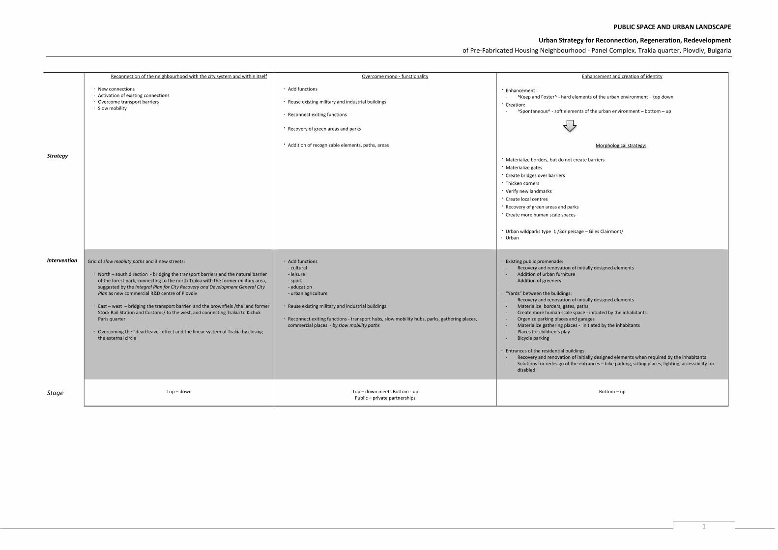
Strategy
Reconnection of the neighbourhood with the city system and within itself
New connections Activation of existing connections Overcome transport barriers Slow mobility
Overcome mono - functionality
Add functions
Reuse existing military and industrial buildings
Reconnect exiting functions
Recovery of green areas and parks
Addition of recognizable elements, paths, areas
Enhancement and creation of identity
Enhancement : - ^Keep and Foster^ - hard elements of the urban environment – top down
Creation: - ^Spontaneous^ - soft elements of the urban environment – bottom – up
Morphological strategy:
Materialize borders, but do not create barriers Materialize gates Create bridges over barriers Thicken corners Verify new landmarks Create local centres Recovery of green areas and parks Create more human scale spaces
Urban wildparks type 1 /3dr peisage – Giles Clairmont/ Urban
Intervention
Grid of slow mobility paths and 3 new streets:
North – south direction - bridging the transport barriers and the natural barrier of the forest park, connecting to the north Trakia with the former military area, suggested by the Integral Plan for City Recovery and Development General City Plan as new commercial R&D centre of Plovdiv
East – west – bridging the transport barrier and the brownfiels /the land former
Stock Rail Station and Customs/ to the west, and connecting Trakia to Kichuk Paris quarter
Overcoming the “dead leave” effect and the linear system of Trakia by closing
the external circle
Add functions
- cultural - leisure - sport - education - urban agriculture
Reuse existing military and industrial buildings
Reconnect exiting functions - transport hubs, slow mobility hubs, parks, gathering places, commercial places - by slow mobility paths
Existing public promenade:
- Recovery and renovation of initially designed elements - Addition of urban furniture - Addition of greenery
“Yards” between the buildings:
- Recovery and renovation of initially designed elements - Materialize borders, gates, paths - Create more human scale space - initiated by the inhabitants - Organize parking places and garages - Materialize gathering places - initiated by the inhabitants - Places for children’s play - Bicycle parking
Entrances of the residential buildings: - Recovery and renovation of initially designed elements when required by the inhabitants - Solutions for redesign of the entrances – bike parking, sitting places, lighting, accessibility for
disabled
Stage
Top – down
Top – down meets Bottom - up
Public – private partnerships
Bottom – up
PUBLIC SPACE AND URBAN LANDSCAPE
Urban Strategy for Reconnection, Regeneration, Redevelopment
of Pre-Fabricated Housing Neighbourhood - Panel Complex. Trakia quarter, Plovdiv, Bulgaria
2
Panel Complexes - General Considerations, History and Problem definition
The project is looking to develop a possible solution to one of the most painful problems in
the urban realm of the big Bulgarian cities, i.e. the redevelopment and regeneration of the
so called panel complexes, by taking as a case study Trakia neighbourhood in the City of
Plovdiv, Bulgaria. The current work is focusing mainly on the open spaces regeneration,
reconnection and redevelopment. This is due to the fact that 95% of the buildings in the
panel complexes are privately owned, and the initiative for their regeneration and energy
efficiency is taken both by the inhabitants and the municipality. On the other hand the
maintenance of the open spaces, and their general purpose with few exceptions, is left
entirely to the municipality, but is highly discussed by the society.
Mostly residential neighbourhoods, the panel complexes were built in the years after the
WWII in order to meet the housing demand of the fast industrializing and growing Bulgarian
cities. The name panel complex comes from the construction system with which these vast
neighbourhoods were executed, namely a system of pre-fabricated concrete wall units –
panels.
According to official statistics by the Bulgarian Ministry of Public Works, one third of the
residential buildings in the cities – regional centres in Bulgaria are constructed with such
system. At the level of the individual city the percentage gets even higher, e.g. the share of
panel housing in Sofia is 42.7%, Plovdiv – 43.2%, Varna -41.4%, Burgas - 44.2%. The panel
complexes occupy very large portions of the city area, often more than the historical
centres and the new latter city developments, put together.
Although the panel complexes were a product of social governmental policy for provision of
affordable housing which started at the beginning of the 1960s and finished by the late
1970s, they are in no case social housing in the western meaning of this term. This is due to
their population structure - more than one third of the entire Bulgarian population lives and
owns apartments in such quarters. This population with some exceptions is in no case a
socially segregated portion. The other significant difference is that more than 95% of the
building stock is privately owned, hence the land is owned by the municipalities.
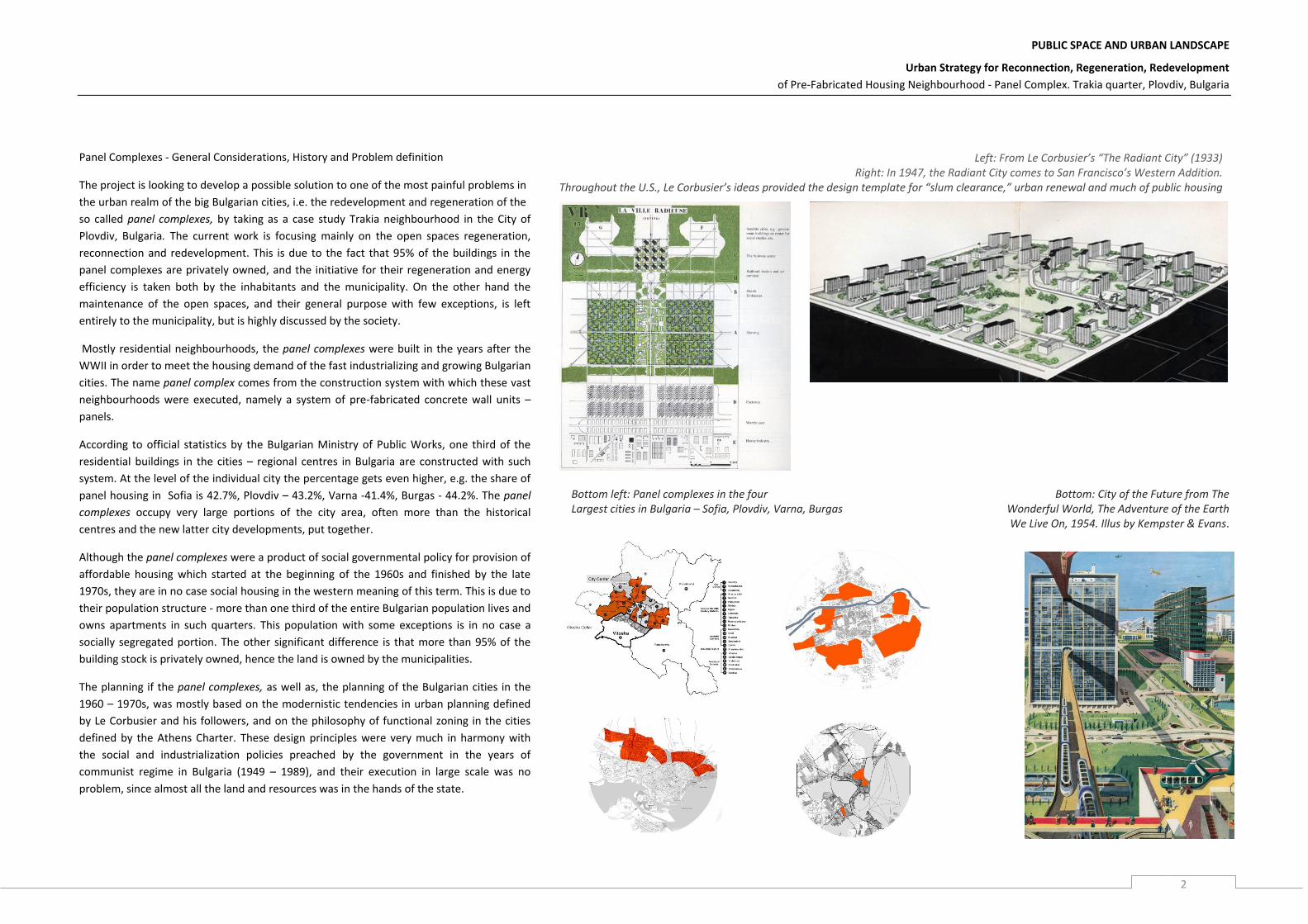
The planning if the panel complexes, as well as, the planning of the Bulgarian cities in the
1960 – 1970s, was mostly based on the modernistic tendencies in urban planning defined
by Le Corbusier and his followers, and on the philosophy of functional zoning in the cities
defined by the Athens Charter. These design principles were very much in harmony with
the social and industrialization policies preached by the government in the years of
communist regime in Bulgaria (1949 – 1989), and their execution in large scale was no
problem, since almost all the land and resources was in the hands of the state.
Left: From Le Corbusier’s “The Radiant City” (1933) Right: In 1947, the Radiant City comes to San Francisco’s Western Addition.
Throughout the U.S., Le Corbusier’s ideas provided the design template for “slum clearance,” urban renewal and much of public housing
Bottom left: Panel complexes in the four Largest cities in Bulgaria – Sofia, Plovdiv, Varna, Burgas
Bottom: City of the Future from The Wonderful World, The Adventure of the Earth
We Live On, 1954. Illus by Kempster & Evans.
PUBLIC SPACE AND URBAN LANDSCAPE
Urban Strategy for Reconnection, Regeneration, Redevelopment
of Pre-Fabricated Housing Neighbourhood - Panel Complex. Trakia quarter, Plovdiv, Bulgaria
3
Thus the design was very much focused on the idea of meeting the needs for proper
ventilation and sunlight distribution. The variety of functions was extremely limited, only
the unavoidable public services were executed – mainly schools, kindergardens, a medical
point, a post office, a few general stores, almost informal public market. The public services
were not enough to answer the demand, and the working places were concentrated in the
industrial areas of the cities, which quickly turned the panel complexes into bedroom
neighbourhoods.
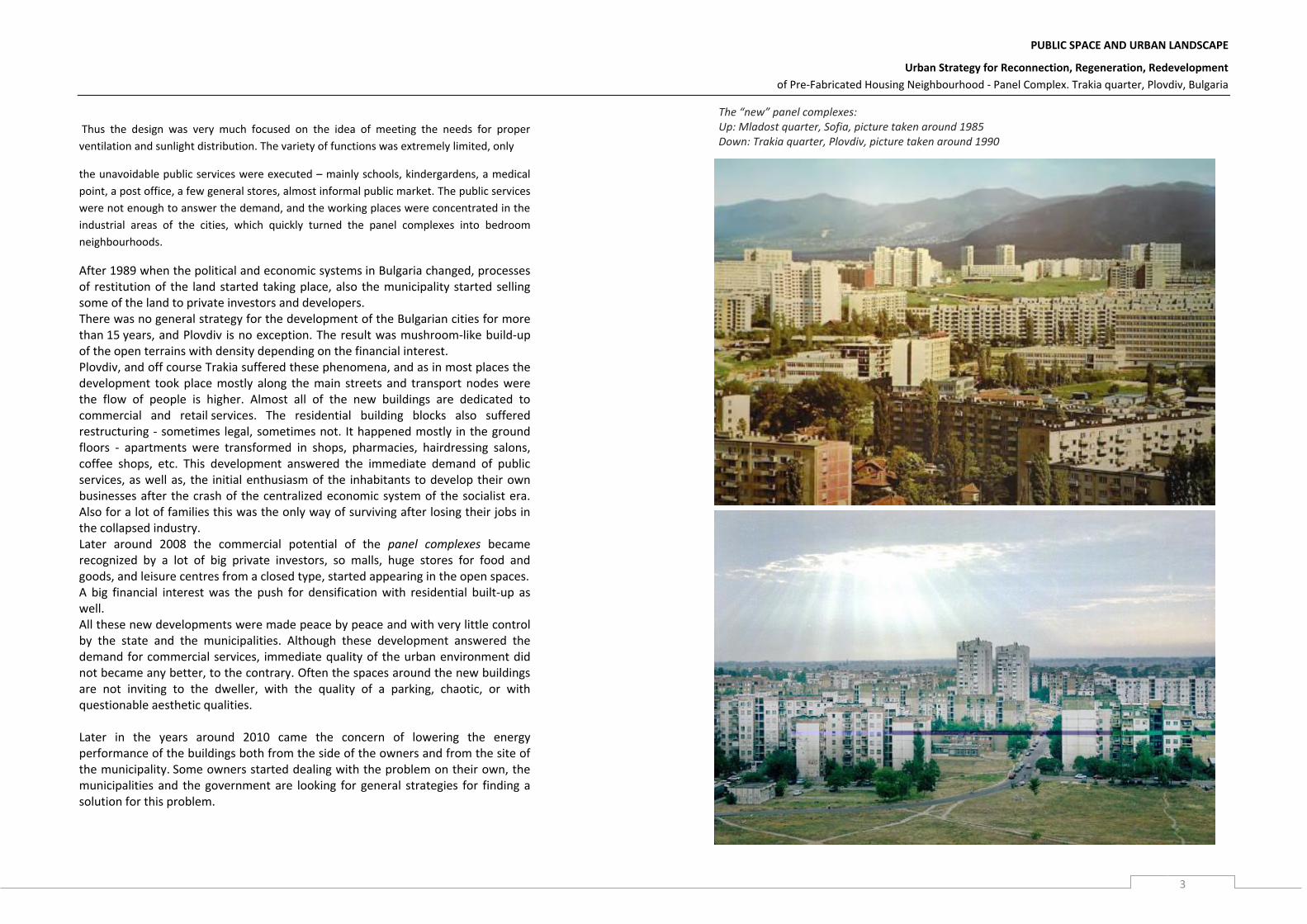
After 1989 when the political and economic systems in Bulgaria changed, processes of restitution of the land started taking place, also the municipality started selling some of the land to private investors and developers. There was no general strategy for the development of the Bulgarian cities for more than 15 years, and Plovdiv is no exception. The result was mushroom-like build-up of the open terrains with density depending on the financial interest. Plovdiv, and off course Trakia suffered these phenomena, and as in most places the development took place mostly along the main streets and transport nodes were the flow of people is higher. Almost all of the new buildings are dedicated to commercial and retail services. The residential building blocks also suffered restructuring - sometimes legal, sometimes not. It happened mostly in the ground floors - apartments were transformed in shops, pharmacies, hairdressing salons, coffee shops, etc. This development answered the immediate demand of public services, as well as, the initial enthusiasm of the inhabitants to develop their own businesses after the crash of the centralized economic system of the socialist era. Also for a lot of families this was the only way of surviving after losing their jobs in the collapsed industry. Later around 2008 the commercial potential of the panel complexes became recognized by a lot of big private investors, so malls, huge stores for food and goods, and leisure centres from a closed type, started appearing in the open spaces. A big financial interest was the push for densification with residential built-up as well. All these new developments were made peace by peace and with very little control by the state and the municipalities. Although these development answered the demand for commercial services, immediate quality of the urban environment did not became any better, to the contrary. Often the spaces around the new buildings are not inviting to the dweller, with the quality of a parking, chaotic, or with questionable aesthetic qualities. Later in the years around 2010 came the concern of lowering the energy performance of the buildings both from the side of the owners and from the site of the municipality. Some owners started dealing with the problem on their own, the municipalities and the government are looking for general strategies for finding a solution for this problem.
The “new” panel complexes: Up: Mladost quarter, Sofia, picture taken around 1985 Down: Trakia quarter, Plovdiv, picture taken around 1990
PUBLIC SPACE AND URBAN LANDSCAPE
Urban Strategy for Reconnection, Regeneration, Redevelopment
of Pre-Fabricated Housing Neighbourhood - Panel Complex. Trakia quarter, Plovdiv, Bulgaria
4
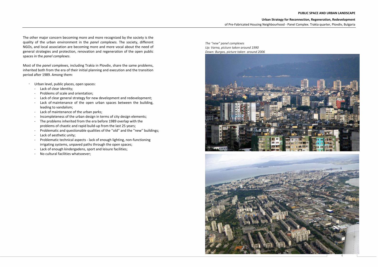
The other major concern becoming more and more recognized by the society is the quality of the urban environment in the panel complexes. The society, different NGOs, and local association are becoming more and more vocal about the need of general strategies and protection, renovation and regeneration of the open public spaces in the panel complexes. Most of the panel complexes, including Trakia in Plovdiv, share the same problems, inherited both from the era of their initial planning and execution and the transition period after 1989. Among them:
Urban level, public places, open spaces: - Lack of clear identity; - Problems of scale and orientation; - Lack of clear general strategy for new development and redevelopment; - Lack of maintenance of the open urban spaces between the building,
leading to vandalism; - Lack of maintenance of the urban parks; - Incompleteness of the urban design in terms of city design elements; - The problems inherited from the era before 1989 overlap with the
problems of chaotic and rapid build-up from the last 25 years; - Problematic and questionable qualities of the ''old'' and the ''new'' buildings; - Lack of aesthetic unity; - Problematic technical aspects - lack of enough lighting, non-functioning
irrigating systems, unpaved paths through the open spaces; - Lack of enough kindergadens, sport and leisure facilities; - No cultural facilities whatsoever;
The “new” panel complexes Up: Varna, picture taken around 1990 Down: Burgas, picture taken around 2006

PUBLIC SPACE AND URBAN LANDSCAPE
Urban Strategy for Reconnection, Regeneration, Redevelopment
of Pre-Fabricated Housing Neighbourhood - Panel Complex. Trakia quarter, Plovdiv, Bulgaria
5
Additions in the urban fabric Trakia
PUBLIC SPACE AND URBAN LANDSCAPE
Urban Strategy for Reconnection, Regeneration, Redevelopment
of Pre-Fabricated Housing Neighbourhood - Panel Complex. Trakia quarter, Plovdiv, Bulgaria
6
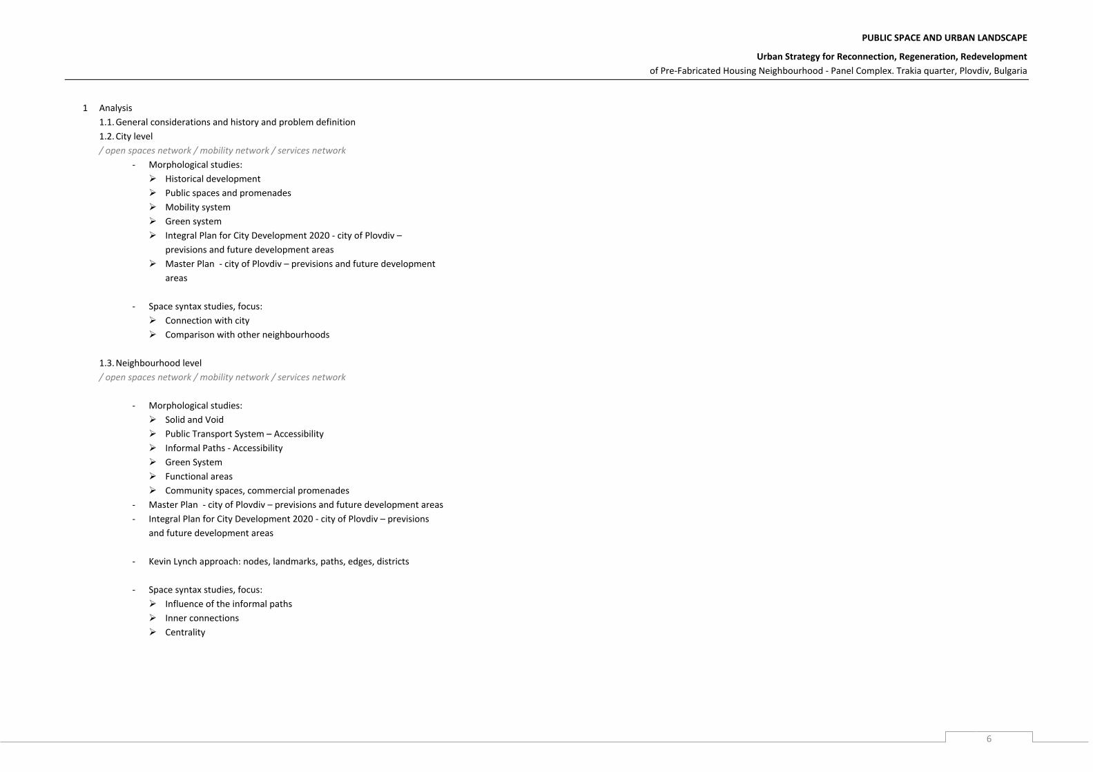
1 Analysis
1.1. General considerations and history and problem definition
1.2. City level
/ open spaces network / mobility network / services network
- Morphological studies:
Historical development
Public spaces and promenades
Mobility system
Green system
Integral Plan for City Development 2020 - city of Plovdiv –
previsions and future development areas
Master Plan - city of Plovdiv – previsions and future development
areas
- Space syntax studies, focus:
Connection with city
Comparison with other neighbourhoods
1.3. Neighbourhood level
/ open spaces network / mobility network / services network
- Morphological studies:
Solid and Void
Public Transport System – Accessibility
Informal Paths - Accessibility
Green System
Functional areas
Community spaces, commercial promenades
- Master Plan - city of Plovdiv – previsions and future development areas
- Integral Plan for City Development 2020 - city of Plovdiv – previsions
and future development areas
- Kevin Lynch approach: nodes, landmarks, paths, edges, districts
- Space syntax studies, focus:
Influence of the informal paths
Inner connections
Centrality

PUBLIC SPACE AND URBAN LANDSCAPE
Urban Strategy for Reconnection, Regeneration, Redevelopment
of Pre-Fabricated Housing Neighbourhood - Panel Complex. Trakia quarter, Plovdiv, Bulgaria
7
1.4. Public spaces. Evaluation of the qualities of the urban environment
- survey with Google View
- Urban elements influencing the perception of quality of the urban
environment:
HARD Elements VS. SOFT Elements
Urban planning VS. Arrangements of the community
Buildings Boundaries
Streets Paths
Predef. Markers Markers
Predef. Zones Zones
1.5. Typologies of open / public spaces classification (based on 1.4.)
Classification factors:
- Scale, morphology
- Location
- Public facilities in the initial plan
- Level of maintenance
- Quality of design elements
- Ownership
1.6. Activities in the public spaces – studies and mapping. Open space structure.
2 Conclusion of the analysis
Space typology
Reasons
Scale / Morphology
Location Public facilities
Level of maintenance
Quality of design elements
Sense of ownership
% of the total area
Possible interventions
Entrance space
10 – 15m diameter
Next to the block
--- Adequate - With whatever materials possible
-Residents
initiative
Basic / self-made
+ + +
“Local Yards”
Distance btw. the blocks 30 – 70 m
Along the internal streets
--- Existing, not enough -With whatever materials possible
-Residents +
public initiative
Very low Lack of design elements
++
Public nuclei /small scale services/
10 – 15m diameter
Along the main streets, next to the bus stops
--- Adequate / good -Only in the diameter of the nuclei
- initiative by the
owners of the nuclei
Adequate Eclectic design elements
-
+++
Public commercial promenades / New commercial build-up
Width/diameter max 25m incl. the buildings
Along mains streets, Transport junctions
Adequate / good
Bad / Adequate Eclectic design elements
+ -
Transition spaces
Distance btw. the blocks 145 - 200 m
Periphery Open spaces btw. blocks
--- Abandoned Very low Lack of design elements, no functions
---
New residential built-up
Distance btw. the buildings 15 - 25 m High density
Periphery
Existing, not enough
Very low Lack of design elements, no green spaces
+ -

PUBLIC SPACE AND URBAN LANDSCAPE
Urban Strategy for Reconnection, Regeneration, Redevelopment
of Pre-Fabricated Housing Neighbourhood - Panel Complex. Trakia quarter, Plovdiv, Bulgaria
8
3 Strategy development
KEYWORDS:
IDENTITY
RE – DENSIFICATION
SMALL SCALE SERVICES
RISING DESIGN QUALITY
EVENTS
OWNERSHIP – LEVELS OF PRIVATISATION
3.3. City level
Reconnection: open spaces network / mobility network / services network
Using as a basis the Master Plan 2020 - city of Plovdiv – previsions
and future development areas
- Creation of a circular connection of most important nuclei
gates, main streets;
- Structural changes – function, scale, re-densification (?)
- Slow mobility network
- Cultural events?
3.4. Neighbourhood level
Reconnection: open spaces network / mobility network / services network
- Defining types of opportunity areas: school yards, mall surroundings,
informal markets, commercial areas …
- Structural changes – function, scale, re-densification (?)
- Creating a network of public spaces and services linked with the
mobility network
- Cultural events – network ?
- Slow mobility network
3.5. Possible interventions – small scale according to space typologies
Types of possible interventions:
- Entrance areas:
defining catalogue of design solutions
enhancing the connection between the building and the open space
- Local yards:
defining catalogue of design solutions
implementation of new functions and small scale services

PUBLIC SPACE AND URBAN LANDSCAPE
Urban Strategy for Reconnection, Regeneration, Redevelopment
of Pre-Fabricated Housing Neighbourhood - Panel Complex. Trakia quarter, Plovdiv, Bulgaria
9
- Transition spaces:
Finding new functions
Landscape?
Re – densification?
Events?
- Public commercial promenades:
Fighting the chaos
Rising design quality
Events?
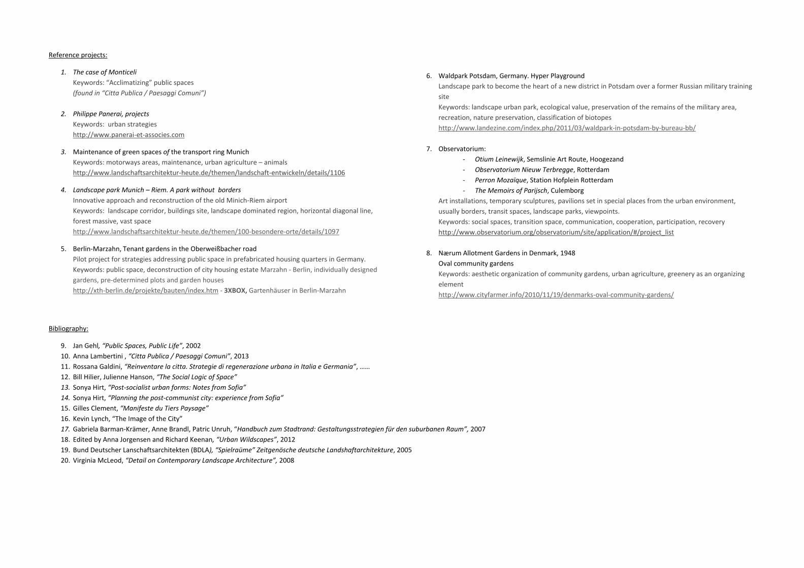
Reference projects:
1. The case of Monticeli
Keywords: “Acclimatizing” public spaces
(found in “Citta Publica / Paesaggi Comuni”)
2. Philippe Panerai, projects
Keywords: urban strategies
http://www.panerai-et-associes.com
3. Maintenance of green spaces of the transport ring Munich
Keywords: motorways areas, maintenance, urban agriculture – animals
http://www.landschaftsarchitektur-heute.de/themen/landschaft-entwickeln/details/1106
4. Landscape park Munich – Riem. A park without borders
Innovative approach and reconstruction of the old Minich-Riem airport
Keywords: landscape corridor, buildings site, landscape dominated region, horizontal diagonal line,
forest massive, vast space
http://www.landschaftsarchitektur-heute.de/themen/100-besondere-orte/details/1097
5. Berlin-Marzahn, Tenant gardens in the Oberweißbacher road
Pilot project for strategies addressing public space in prefabricated housing quarters in Germany.
Keywords: public space, deconstruction of city housing estate Marzahn - Berlin, individually designed
gardens, pre-determined plots and garden houses
http://xth-berlin.de/projekte/bauten/index.htm - 3XBOX, Gartenhäuser in Berlin-Marzahn
6. Waldpark Potsdam, Germany. Hyper Playground
Landscape park to become the heart of a new district in Potsdam over a former Russian military training
site
Keywords: landscape urban park, ecological value, preservation of the remains of the military area,
recreation, nature preservation, classification of biotopes
http://www.landezine.com/index.php/2011/03/waldpark-in-potsdam-by-bureau-bb/
7. Observatorium:
- Otium Leinewijk, Semslinie Art Route, Hoogezand
- Observatorium Nieuw Terbregge, Rotterdam
- Perron Mozaïque, Station Hofplein Rotterdam
- The Memoirs of Parijsch, Culemborg
Art installations, temporary sculptures, pavilions set in special places from the urban environment,
usually borders, transit spaces, landscape parks, viewpoints.
Keywords: social spaces, transition space, communication, cooperation, participation, recovery
http://www.observatorium.org/observatorium/site/application/#/project_list
8. Nærum Allotment Gardens in Denmark, 1948
Oval community gardens
Keywords: aesthetic organization of community gardens, urban agriculture, greenery as an organizing
element
http://www.cityfarmer.info/2010/11/19/denmarks-oval-community-gardens/
Bibliography:
9. Jan Gehl, “Public Spaces, Public Life”, 2002
10. Anna Lambertini , “Citta Publica / Paesaggi Comuni”, 2013
11. Rossana Galdini, “Reinventare la citta. Strategie di regenerazione urbana in Italia e Germania”, ……
12. Bill Hilier, Julienne Hanson, “The Social Logic of Space”
13. Sonya Hirt, “Post-socialist urban forms: Notes from Sofia”
14. Sonya Hirt, “Planning the post-communist city: experience from Sofia”
15. Gilles Clement, “Manifeste du Tiers Paysage”
16. Kevin Lynch, “The Image of the City”
17. Gabriela Barman-Krämer, Anne Brandl, Patric Unruh, “Handbuch zum Stadtrand: Gestaltungsstrategien für den suburbanen Raum”, 2007
18. Edited by Anna Jorgensen and Richard Keenan, “Urban Wildscapes”, 2012
19. Bund Deutscher Lanschaftsarchitekten (BDLA), “Spielraüme” Zeitgenösche deutsche Landshaftarchitekture, 2005
20. Virginia McLeod, “Detail on Contemporary Landscape Architecture”, 2008