Public Drought Plan 2022
23
Yorkshire Water |Drought Plan 2022| 1 PUBLIC PUBLIC Drought Plan 2022 APPENDIX 4 (draft) Yorkshire Water 31/03/2021 Public
Transcript of Public Drought Plan 2022
Yorkshire Water |Drought Plan 2022|
1
PUBLIC
PUBLIC
Drought Plan 2022 APPENDIX 4 (draft)
Yorkshire Water
31/03/2021
Public
Yorkshire Water |Drought Plan 2022| 31/03/2021
2
PUBLIC
PUBLIC
In accordance with Drought Plan guidance, this statement certifies that Yorkshire Water’s Drought Plan has been reviewed by our security team. Some information has been redacted or edited in this published version for reasons of national security.

Yorkshire Water |Drought Plan 2022| 31/03/2021
3
PUBLIC
PUBLIC
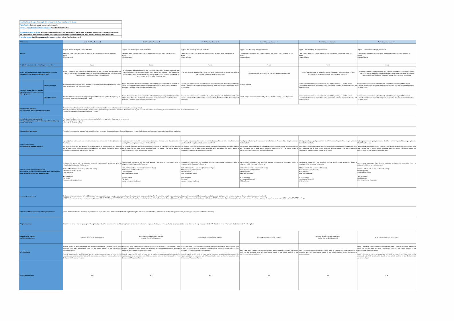
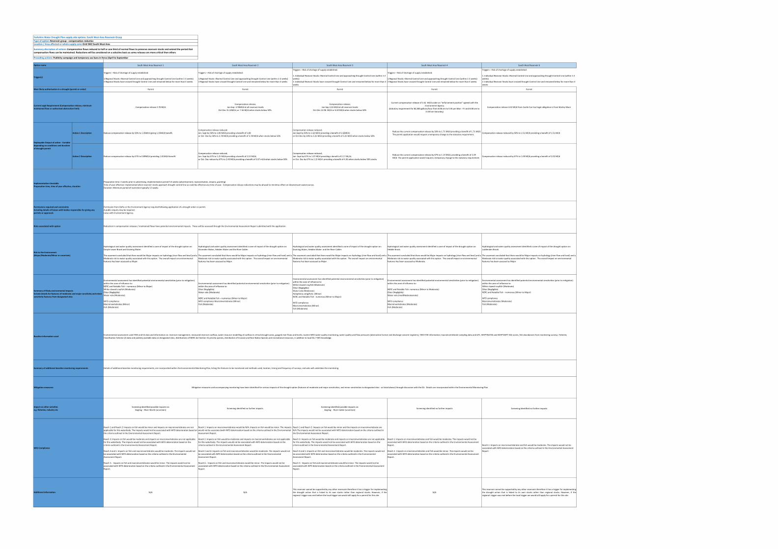
Yorkshire Water Drought Plan supply side options: North Area Reservoir GroupType of option: Reservoir group ‐ compensation reductionLocation / Area affected or whole supply zone: Grid SWZ North Area
Preceding actions: Publicity campaign and temporary use bans in force (April to September)
North Area Resevoir 1 North Area Resevoir 2 North Area Resevoir 3 North Area Resevoir 4 North Area Resevoir 5
Triggers – Risk of shortage of supply established:
1.Regional Stocks <Normal Control Line and approaching Drought Control Line (within 1‐2 weeks) 2.Regional Stocks have crossed Drought Control Line and remained below for more than 4 weeks
See further information below on downstream river users.
Triggers – Risk of shortage of supply established:
1.Regional Stocks <Normal Control Line and approaching Drought Control Line (within 1‐2 weeks) 2.Regional Stocks have crossed Drought Control Line and remained below for more than 4 weeks
Triggers – Risk of shortage of supply established:1. Regional Stocks <Normal Control Line and approaching Drought Control Line (within 1‐2 weeks) orScargill Reservoir is below 25% (as per the temporary Local Enforcement Position (LEP)),
2.Regional Stocks have crossed Drought Control Line and remained below for more than 4 weeks
Triggers – Risk of shortage of supply established:
1.Regional Stocks <Normal Control Line and approaching Drought Control Line (within 1‐2 weeks) 2.Regional Stocks have crossed Drought Control Line and remained below for more than 4 weeks
See further information below on downstream river users.
Triggers – Risk of shortage of supply established:
1. Individual Resevoir Stocks <Normal Control Line and approaching Drought Control Line (within 1‐2weeks)2. Individual Resevoir Stocks have crossed Drought Control Line and remained below for more than 4weeks
Permit PermitAction 1: LEP for duration of flow trial. Post formalisation of trial a permit will be required
Action 2: permit Permit Permit
Compensation release 13.66 Ml/dCompensation release 0.46 Ml/d
(or 100,000 gallons per day as stated in the authorising Act)Group compensation of 0.75 Ml/d
Compensation release 18.19 Ml/d(authorising Act defines release as a quantity of water not being less than 2,778 gallons per minute)
16 November – 15 April compensation release 16.90Ml.d: 16 April ‐ 15 May and 16 October – 15 November compensation release 8.20 Ml/d
16 May‐15 October 3.90Ml/d
Action 1 Description Reduce compensation release by 50% to 6.83 Ml/d providing 6.83 Ml/d benefit Reduce compensation release by 50% to 0.23 Ml/d providing 0.23 Ml/d benefitLEP states 50% reduction in group compensation (to 0.38 Ml/d). Currently for the duration of the trial (till Sept 2024) this would go through the LEP not a permit. But after Sept 2024, once formalised, YW
would require a pemit for this action.Reduce compensation release by 50% to 9.10 Ml/d providing 9.10 Ml/d benefit
Depending on the time of year reduce compensation by 50% to:8.45 Ml/d between 16 November – 15 April 4.10 Ml/d providing a benefit of 8.45 Ml/d;
or 4.10 Ml/d between 16 April ‐ 15 May providing a benefit of 4.10 Ml/d;or 1.95Ml/d providing a benefit of 1.95 Ml/d
Action 2 Description Reduce compensation release by 67% to 4.51 Ml/d providing 9.15 Ml/d benefit Reducecompensation release by 67% to 0.15 Ml/d providing 0.31 Ml/d benefitDroguth Permit required: Reduce compensation release by 67%: group compensation reduced to
0.25Ml/d; Reduce compensation release by 67% to 6.00 Ml/d providing 12.19 Ml/d benefit
Depending on the time of year reduce compensation by 67% to:5.58Ml/d providing a benefit of 11.30 Ml/d2.71Ml/d providing a benefit of 5.49 Ml/d1.29Ml/d providing a benefit of 2.60Ml/d
Hydrological and water quality assessment identified a zone of impact of the drought option on: PottBeck, the River Burn and the River Ure.
The assement concluded that there would be Major impacts on hydrology (river flow and level) and aMajor risk to water quality associated with this option. The overall impact on environmental featureshas been assessed as Major.
Hydrological and water quality assessment identified a zone of impact of the drought option on:Holborn Beck and River Laver.
The assement concluded that there would be Major impacts on hydrology (river flow and level) and aMinor risk to water quality associated with this option. The overall impact on environmental featureshas been assessed as Major.
Hydrological and water quality assessment identified a zone of impact of the drought option on: OakBeck and Oak Brook.
The assement concluded that there would be Major impacts on hydrology (river flow and level) and aModerate risk to water quality associated with this option. The overall impact on environmentalfeatures has been assessed as Major.
Hydrological and water quality assessment identified a zone of impact of the drought option on: RiverWashburn.
The assement concluded that there would be Major impacts on hydrology (river flow and level) and aMajor risk to water quality associated with this option. The overall impact on environmental featureshas been assessed as Major.
Hydrological and water quality assessment identified a zone of impact of the drought option of: RiverWashburn.
The assement concluded that there would be Major impacts on hydrology (river flow and level) and aMinor risk to water quality associated with this option. The overall impact on environmental featureshas been assessed as Major.
Environmental assessment has identified potential environmental sensitivities (prior to mitigation)within the zone of influence to:WFD compliance •Macroinvertebrates (Moderate) •Fish (Moderate)NERC and notable fish ‐ numerous species (minor to Major)White‐clawed crayfish (Moderate)Riolus subviolaceus (Minor)Water vole (Moderate)Ripon Parks SSSI (neligible)
Environmental assessment has identified potential environmental sensitivities (prior to mitigation)within the zone of influence to:WFD compliance •Macroinvertebrates (Moderate) •Fish (Minor)NERC and notable fish ‐ numerous species (Minor to Major)Graptodytes flavipes (Minor) White‐clawed Crayfish (Moderate)Priority Habitat 453047‐ no main habitat but additional habitats present (Minor)
Environmental assessment has identified potential environmental sensitivities (prior to mitigation)within the zone of influence to:WFD compliance •Macroinvertebrates (Moderate) •Fish (moderate)
NERC and notable fish – numerour species (Moderate to Major)White‐clawed crayfish (Moderate)Hydraena palustris (Minor)Priority Habitat 413440 ‐ lowland fens (Minor)
Environmental assessment has identified potential environmental sensitivities (prior to mitigation)within the zone of influence to:WFD compliance •Macroinvertebrates (Moderate) •Fish (Minor)
NERC and notable fish – numerous (Moderate to major)White‐clawed crayfish (Major)Psychomyia fragili s (Minor)Water vole (Major)
Environmental assessment has identified potential environmental sensitivities (prior to mitigation)within the zone of influence to:WFD compliance •Macroinvertebrates (Moderate) •Fish (Moderate)
NERC and notable fish – numerous (Moderate to Major)Water vole (Major)Prioirity habitat 412935‐ lowland fens (Minor)
Screening identified possible impacts on:Angling on River Burn (uncertain)Further assessment is required on Nosterfield LNR to confirm the sensitivity.
Screening identified no potential impacts. Screening identified no potential impacts.Screening identified possible impacts on:Angling on River Washburn (uncertain)
Screening identified no potential impacts.
Reach 1: Impacts on macroinvertebrates and fish would be moderate. The impacts would not beassociated with WFD deterioration based on the criteria outlined in the Environmental AssessmentReport.
Reach 2: Impacts on macroinvertebrates and fish would be moderate. The impacts would notassociate with WFD deterioration based on the criteria outlined in the Environmental AssessmentReport.
Reach 3: Impacts on macroinvertebrates and fish would be negligible. The impacts would notassociate with WFD deterioration based on the criteria outlined in the Environmental AssessmentReport.
Reaches 1 and 2: Impacts on macroinvertebrates and fish would be minor. The impacts would not beassociated with WFD deterioration based on the criteria outlined in in the Environmental AssessmentReport.
Reach 1: Impacts on macroinvertebrates and fish would be moderate. The impacts would not beassociated with WFD deterioration based on the criteria outlined in the Environmental AssessmentReport.
Reach 1: Impacts on macroinvertebrates would be moderate. Impacts on fish would be minor. Theimpacts would not be associated with WFD deterioration based on the criteria outlined in theEnvironmental Assessment Report.
Reach 1: Impacts on macroinvertebrates and fish would be moderate. The impacts would not beassociated with WFD deterioration based on the criteria outlined in the Environmental AssessmentReport.
N/A N/AThe compensation from this reservoir is currently operated under a flow trial agreement held withthe Environment Agency. The flow trial is expected to be formalised by 2025 and we will revise thedrought option to reflect the conditions of the trial if required.
N/A
This reservoir cannot be supported by any other reservoirs therefore it has a trigger for implementingthe drought action that is linked to its own stocks rather than regional stocks. However, if theregional trigger was met before the local trigger we would still consider applying for a permit for thissite. This action will require a drought permit following formalisation of the current flow trial in 2020.
WFD Compliance
Most likely authorisation in a drought (permit or order)
Preparation time: 4 weeks prior to advertising, implementation period 5‐6 weeks (advertisement, representation, enquiry, granting)
Time of year effective: implemented when reservoir stocks approach drought control line so could be effective any time of year. Compensation release reductions may be phased to minimise effect on downstream watercourses.
Duration: Minimum period of restriction typically 12 weeks
Permission from Defra or the Environment Agency required following application of a drought order or permit. A public enquiry may be required. Liaise with Environment Agency.
Reduction in compensation releases / maintained flows have potential environmental impacts. These will be assessed through the Environmental Assessment Report submitted with the application.
Environmental assessment used YWS and EA data and information on: reservoir management, measured reservoir outflow, water resource modelling of outflow in critical drought years, gauged river flows and levels; routine WFD water quality monitoring, water quality and flow pressures (abstraction licence and discharge consent registers), YWS STW information; macroinvertebrate sampling data and LIFE, WHPTNATXA and WHPTASPT EQI scores, fish abundances from monitoring surveys, Fisheries Classification Scheme (2) data and publicly available data on designated sites, distributions of NERC Act Section 41 priority species, distribution of Invasive and Non‐Native Species and recreational resources, in addition to local EA / YWS knowledge.
Details of additional baseline monitoring requirements are incorporated within the Environmental Monitoring Plan, listing the features to be monitored and methods used; location, timing and frequency of surveys; and who will undertake the monitoring.
Mitigation measures and accompanying monitoring have been identified for serious impacts of the drought option (features of moderate and major sensitivities, and minor sensitivities to designated sites ‐ as listed above) through discussion with the EA. Details are incorporated within the Environmental Monitoring Plan
Permissions required and constraints Including details of liaison with bodies responsible for giving any permits or approvals
Risks associated with option
Risk to the Environment (Major/Moderate/Minor or uncertain)
Summary of likely environmental impacts Include details for features of moderate and major sensitivity and minor sensitivity features from designated sites
Baseline information used
Summary of additional baseline monitoring requirements
Additional information
Mitigation measures
Impact on other activities e.g. fisheries, industry etc
Implementation timetable Preparation time, time of year effective, duration
Summary discription of actions: Compensation flows reduced to half or one third of normal flows to preserve reservoir stocks and extend the period that compensation flows can be maintained. Reductions will be considered on a selective basis as some releases are more critical than others
Deployable Output of action ‐ Variable depending on conditions and duration of drought permit
Option name
Trigger(s)
Current Legal Requirement (Compensation release, minimum maintained flow or authorised abstraction limit)
Yorkshire Water |Drought Plan 2022| 31/03/2021
4
PUBLIC
PUBLIC
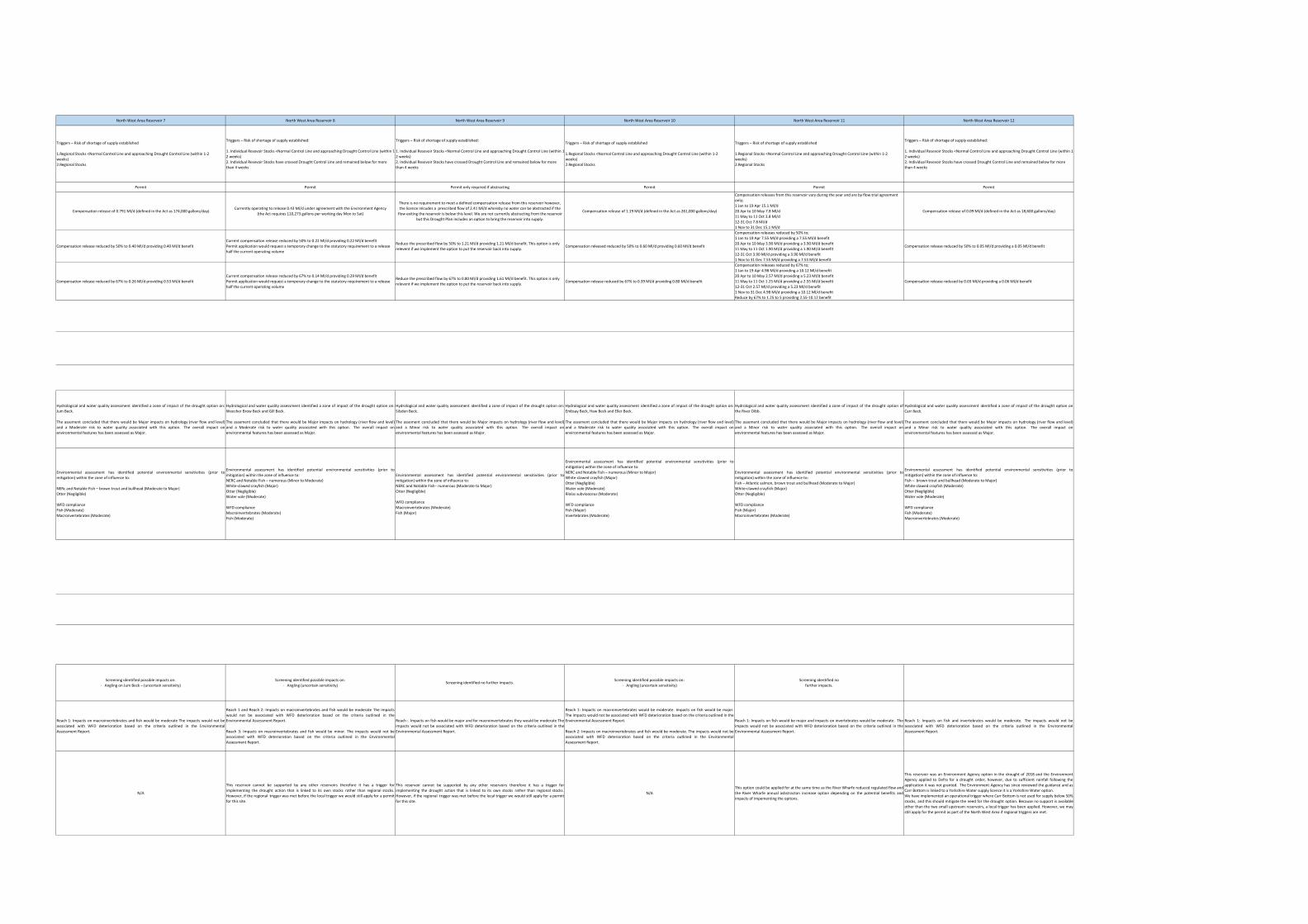
Yorkshire Water Drought Plan supply side options: North West Area Reservoir Group
Type of option: Reservoir group ‐ compensation reduction
Location / Area affected or whole supply zone: Grid SWZ North West Area
Preceding actions: Publicity campaign and temporary use bans in force (April to September)
North West Area Reservoir 1 North West Area Reservoir 2 North West Area Reservoir 3 North West Area Reservoir 4 North West Area Reservoir 5 North West Area Reservoir 6
Triggers – Risk of shortage of supply established
1.Regional Stocks <Normal Control Line and approaching Drought Control Line (within 1‐2 weeks)
2.Regional Stocks
Triggers – Risk of shortage of supply established
1.Regional Stocks <Normal Control Line and approaching Drought Control Line (within 1‐2 weeks)
2.Regional Stocks
Triggers – Risk of shortage of supply established
1.Regional Stocks <Normal Control Line and approaching Drought Control Line (within 1‐2 weeks)
2.Regional Stocks
Triggers – Risk of shortage of supply established
1.Regional Stocks <Normal Control Line and approaching Drought Control Line (within 1‐2 weeks)
2.Regional Stocks
Triggers – Risk of shortage of supply established
1.Regional Stocks <Normal Control Line and approaching Drought Control Line (within 1‐2 weeks)
2.Regional Stocks
Triggers – Risk of shortage of supply established
1.Regional Stocks <Normal Control Line and approaching Drought Control Line (within 1‐2 weeks)
2.Regional Stocks
Permit Permit Permit Permit Permit Permit
Ensure a maintained flow of 6.00 Ml/d when the combined flow from North West Area Reservoirs 2 and 3 is 8.00 Ml/d, or 8.00 Ml/d whenever the combined compensation flow from North West
Area Reservoirs 2 and 3 reduces from 8.00 to 6.00 Ml/d
4.00 Ml/d when both the North West Area Reservoirs 2 and 3 levels are above the control lines defined in the licences, or 5.25 Ml/d when the North West Area Reservoir 2 level is above the control line and North West Area Reservoir 3 level is below the control line, or 3.25 Ml/d when
both reservoir levels are below the control lines
4.00 Ml/d when the reservoir level is above the control line defined in the licence, or 2.750 Ml/d when the reservoir level is below the control line
Compensation flow of 3.60 Ml/d, or 1.80 Ml/d when below control lineCurrently operating under an agreement with the Environment Agency to release 6.3 Ml/d
(compensation in the authorising Act is at mill owners discretion)
Currently operating under an agreement with the Environment Agency to release 1.00 Mll/dThe authorising Act requires 2/5 of the average daily inflow to the reservoir to be released
between 05:00 and 20:00 every day except Sunday, Christmas Day & Good Friday
Action 1 DescriptionMaintained flow reduced to 4.0 Ml/d, providing a 2.0 Ml/d or 4.0 Ml/d benefit depending on the levels of North West Area Reservoirs 2 and 3
Reduce the compensation release required by 50% to 2.63 Ml/d providng a 2.63 Ml/d benefit or 1.63 Ml/d providing a 1.63 Ml/d benefit dependng on whether the levels in North West Area Reservoirs 2 and 3 are above or below their control lines
Compensation release reduced by 50% to 2.00 Ml/d providing a benefit of 2.00 Ml/d or 1.38 M/d proving a benefit of 1.38 Ml/d dependiong on whether North West Reservoir 3 is above or below its control line
No action requiredCurrent compensation release reduced by 50% to 3.15 Ml/d providing a 3.15 Ml/d benefitA permit application may be required due to the specification in the Act to compensate at the mill owners discretion
Current compensation release reduced by 50% to 0.50 Ml/d providing 0.50 Ml/d benefitA drought permit may be required to temporarily suspend the statutroy requirement to release 2/5 of the inflow
Action 2 DescriptionMaintained flow reduced to 2.67 Ml/d providing a 3.33 Ml/d or 5.33 Ml/d benefit depending on the levels of North West Area Reservoirs 2 and 3
Reduce the compensation release required by 67% to 1.73 Ml/d providing a 3.52 Ml/d benefit or 1.07 Ml/d provding a 2.18 Ml/d benefit dependng on whether the levels in North West Area Reservoirs 2 and 3 are above or below their control lines
Compensation release reduced by 67% to 1.32 Ml/d providing a benefit of 2.68 Ml/d or 0.91 M/d proving a benefit of 1.84 Ml/d depending on whether North West Reservoir 3 is above or below its control line
Current compensation release reduced by 67% to 1.20 Ml/d providing a 2.40 Ml/d benefitCurrent compensation release reduced by 67% to 2.08 Ml/d providing a 4.22 Ml/d benefitA permit application may be required due to the specification in the Act to compensate at the mill owners discretion
Current compensation release reduced by 67% to 0.33 Ml/d providing 0.67 Ml/d benefitA drought permit may be required to temporarily suspend the statutroy requirement to release 2/5 of the inflow
Hydrological and water quality assessment identified a zone of impact of the drought option on:River Worth.
The assement concluded that there would be Major impacts on hydrology (river flow and level)and a Moderate risk to water quality associated with this option. The overall impact onenvironmental features has been assessed as Major.
Hydrological and water quality assessment identified a zone of impact of the drought option on:Leeming Water, Bridgehouse Beck, and the River Worth.
The assement concluded that there would be Major impacts on hydrology (river flow and level)and a Minor risk to water quality associated with this option. The overall impact onenvironmental features has been assessed as Major.
Hydrological and water quality assessment identified a zone of impact of the drought option on:Moorhouse Beck, Bridgehouse Beck, and the River Worth.
The assement concluded that there would be Major impacts on hydrology (river flow and level)and a Moderate risk to water quality associated with this option. The overall impact onenvironmental features has been assessed as Major.
Hydrological and water quality assessment identified a zone of impact of the drought option on:Denholme Beck.
The assement concluded that there would be Major impacts on hydrology (river flow and level)and a Moderate risk to water quality associated with this option. The overall impact onenvironmental features has been assessed as Moderate.
Hydrological and water quality assessment identified a zone of impact of the drought option on:Hewenden/Harden Beck.
The assement concluded that there would be Major impacts on hydrology (river flow and level)and a Moderate risk to water quality associated with this option. The overall impact onenvironmental features has been assessed as Moderate.
Hydrological and water quality assessment identified a zone of impact of the drought option on:Eldwick/ Loadpit Beck.
The assement concluded that there would be Major impacts on hydrology (river flow and level)and a Minor risk to water quality associated with this option. The overall impact onenvironmental features has been assessed as Major.
Environmental assessment has identified potential environmental sensitivities (prior tomitigation) within the zone of influence to:
NERC and Notable Fish – numerous (Moderate to Major)White‐clawed crayfish (Major)Otter (Negligible)
WFD compliance Fish (Major)Macroinvertebrates (Moderate)
Environmental assessment has identified potential environmental sensitivities (prior tomitigation) within the zone of influence to:
NERC and Notable Fish – numerous (Moderate to Major)White‐clawed crayfish (Moderate)Otter (Negligible)Riolus subviolaceus (Minor)
WFD compliance Fish (Major) Macroinvertebrate (Moderate)
Environmental assessment has identified potential environmental sensitivities (prior tomitigation) within the zone of influence to:
NERC and Notable Fish – numerous (Moderate)White‐clawed crayfish (Moderate)Otter (Negligible)Water vole (Moderate)
WFD Compliance Invertebrates (Moderate)Fish (Moderate)
Environmental assessment has identified potential environmental sensitivities (prior tomitigation) within the zone of influence to:
NERC and Notable Fish – numerous (Minor to Major)Otter (Negligible)Water vole (Moderate)
WFD complianceFish (Moderate)Macroinvertebrates (Moderate)
Screening identified no further impacts. Screening identified possible impacts on:Angling ‐ River Worth (uncertain)
Screening identified no further impacts. Screening identified no further impacts. Screening identified possible impacts on:Angling ‐ Harden Beck (uncertain)
Screening identified no further impacts.
Reach 1: Impacts on macroinvertebrates and fish would be moderate. The impacts would not beassociated with WFD deterioration based on the criteria outlined in the EnvironmentalAssessment Report.
Reach 2: Impacts on fish would be major and for macroinvertebrates would be moderate. Theimpacts would not be associated with WFD deterioration based on the criteria outlined in theEnvironmental Assessment Report.
Reach 1 and Reach 2: Impacts on macroinvertebrates would be moderate. Impacts on fish wouldbe major. The impacts would not be associated with WFD deterioration based on the criteriaoutlined in the Environmental Assessment Report.
Reach 3: Impacts on fish would be major and for macroinvertebrates would be moderate. Theimpacts would not be associated with WFD deterioration based on the criteria outlined in theEnvironmental Assessment Report.
Reach 1 and Reach 2: Impacts on macroinvertebrates and fish would be moderate. The impactswould not be associated with WFD deterioration based on the criteria outlined in theEnvironmental Assessment Report.
Reach 1: Impacts on macroinvertebrates and fish would be moderate. The impacts would not beassociated with WFD deterioration based on the criteria outlined in the EnvironmentalAssessment Report.
Reach 1 and Reach 2: Impacts on macroinvertebrates and fish would be moderate. The impactswould not be associated with WFD deterioration based on the criteria outlined in theEnvironmental Assessment Report.
Reach 3: Impacts on macroinvertebrates and fish would be minor. The impacts would not beassociated with WFD deterioration based on the criteria outlined in the EnvironmentalAssessment Report.
N/A N/A N/A N/A N/A N/A
Impact on other activities e.g. fisheries, industry etc
WFD Compliance
Preparation time: 4 weeks prior to advertising, implementation period 5‐6 weeks (advertisement, representation, enquiry, granting)Time of year effective: implemented when reservoir stocks approach drought control line so could be effective any time of year. Compensation release reductions may be phased to minimise effect on downstream watercourses.Duration: Minimum period of restriction typically 12 weeks
Permission from Defra or the Environment Agency required following application of a drought order or permit. A public enquiry may be required. Liaise with Environment Agency.
Reduction in compensation releases / maintained flows have potential environmental impacts. These will be assessed through the Environmental Assessment Report submitted with the application.
Environmental assessment used YWS and EA data and information on: reservoir management, measured reservoir outflow, water resource modelling of outflow in critical drought years, gauged river flows and levels; routine WFD water quality monitoring, water quality and flow pressures (abstraction licence and discharge consent registers), YWS STW information; macroinvertebrate sampling data and LIFE, WHPTNATXA and WHPTASPT EQI scores, fish abundances from monitoring surveys, Fisheries Classification Scheme (2) data and publicly available data on designated sites, distributions of NERC Act Section 41 priority species, distribution of Invasive and Non‐Native Species and recreational resources, in addition to local EA / YWS knowledge.
Details of additional baseline monitoring requirements, are incorporated within the Environmental Monitoring Plan, listing the features to be monitored and methods used; location, timing and frequency of surveys; and who will undertake the monitoring.
Additional information
Deployable Output of action ‐ Variable depending on conditions and duration of drought permit
Implementation timetable Preparation time, time of year effective, duration
Permissions required and constraints Including details of liaison with bodies responsible for giving any permits or approvals
Mitigation measures and accompanying monitoring have been identified for serious impacts of the drought option (features of moderate and major sensitivities, and minor sensitivities to designated sites ‐ as listed above) through discussion with the EA. Details are incorporated within the Environmental Monitoring Plan
Summary of additional baseline monitoring requirements
Mitigation measures
Risks associated with option
Risk to the Environment (Major/Moderate/Minor or uncertain)
Summary of likely environmental impacts Include details for features of moderate and major sensitivity and minor sensitivity features from designated sites
Baseline information used
Summary discription of actions: Compensation flows reduced to half or one third of normal flows to preserve reservoir stocks and extend the period that compensation flows can be maintained. Reductions will be considered on a selective basis as some releases are more critical than others
Option name
Trigger(s)
Most likely authorisation in a drought (permit or order)
Current Legal Requirement (Compensation release, minimum maintained flow or authorised abstraction limit)
North West Area Reservoir 7 North West Area Reservoir 8 North West Area Reservoir 9 North West Area Reservoir 10 North West Area Reservoir 11 North West Area Reservoir 12
Triggers – Risk of shortage of supply established
1.Regional Stocks <Normal Control Line and approaching Drought Control Line (within 1‐2 weeks)
2.Regional Stocks
Triggers – Risk of shortage of supply established:
1. Individual Resevoir Stocks <Normal Control Line and approaching Drought Control Line (within 1‐2 weeks)2. Individual Resevoir Stocks have crossed Drought Control Line and remained below for more than 4 weeks
Triggers – Risk of shortage of supply established:
1. Individual Resevoir Stocks <Normal Control Line and approaching Drought Control Line (within 1‐2 weeks)2. Individual Resevoir Stocks have crossed Drought Control Line and remained below for more than 4 weeks
Triggers – Risk of shortage of supply established
1.Regional Stocks <Normal Control Line and approaching Drought Control Line (within 1‐2 weeks)
2.Regional Stocks
Triggers – Risk of shortage of supply established
1.Regional Stocks <Normal Control Line and approaching Drought Control Line (within 1‐2 weeks)
2.Regional Stocks
Triggers – Risk of shortage of supply established:
1. Individual Resevoir Stocks <Normal Control Line and approaching Drought Control Line (within 1‐2 weeks)2. Individual Resevoir Stocks have crossed Drought Control Line and remained below for more than 4 weeks
Permit Permit Permit only required if abstracting Permit Permit Permit
Compensation release of 0.791 Ml/d (defined in the Act as 174,000 gallons/day)Currently operating to release 0.43 Ml/d under agreement with the Environment Agency
(the Act requires 110,273 gallons per working day Mon to Sat)
There is no requirement to meet a defined compensation release from this reservoir however, the licence inlcudes a prescribed flow of 2.41 Ml/d whereby no water can be abstracted if the flow exiting the reservoir is below this level. We are not currently abstracting from the reservoir
but this Drought Plan includes an option to bring the reservoir into supply.
Compensation release of 1.19 Ml/d (defined in the Act as 261,000 gallons/day)
Compensation releases from this reservoir vary during the year and are by flow trial agreement only;1 Jan to 19 Apr 15.1 Ml/d20 Apr to 10 May 7.8 Ml/d11 May to 11 Oct 3.8 Ml/d12‐31 Oct 7.8 Ml/d1 Nov to 31 Dec 15.1 Ml/d
Compensation release of 0.09 Ml/d (defined in the Act as 18,600 gallons/day)
Compensation release reduced by 50% to 0.40 Ml/d providing 0.40 Ml/d benefitCurrent compensation release reduced by 50% to 0.22 Ml/d providing 0.22 Ml/d benefitPermit application would request a temporary change to the statutory requirement to a release half the current operating volume
Reduce the prescribed flow by 50% to 1.21 Ml/d providing 1.21 Ml/d benefit. This option is only relevent if we implement the option to put the reservoir back into supply.
Compensation released reduced by 50% to 0.60 Ml/d providing 0.60 Ml/d benefit
Compensation releases reduced by 50% to;1 Jan to 19 Apr 7.55 Ml/d providing a 7.55 Ml/d benefit20 Apr to 10 May 3.90 Ml/d providing a 3.90 Ml/d benefit11 May to 11 Oct 1.90 Ml/d providing a 1.90 Ml/d benefit12‐31 Oct 3.90 Ml/d providing a 3.90 Ml/d benefit1 Nov to 31 Dec 7.55 Ml/d providing a 7.55 Ml/d benefit
Compensation release reduced by 50% to 0.05 Ml/d providing a 0.05 Ml/d benefit
Compensation release reduced by 67% to 0.26 Ml/d providing 0.53 Ml/d benefitCurrent compensation release reduced by 67% to 0.14 Ml/d providing 0.29 Ml/d benefitPermit application would request a temporary change to the statutory requirement to a release half the current operating volume
Reduce the prescribed flow by 67% to 0.80 Ml/d providing 1.61 Ml/d benefit. This option is only relevent if we implement the option to put the reservoir back into supply.
Compensation release reduced by 67% to 0.39 Ml/d providing 0.80 Ml/d benefit
Compensation releases reduced by 67% to;1 Jan to 19 Apr 4.98 Ml/d providing a 10.12 Ml/d benefit20 Apr to 10 May 2.57 Ml/d providing a 5.23 Ml/d benefit11 May to 11 Oct 1.25 Ml/d providing a 2.55 Ml/d benefit12‐31 Oct 2.57 Ml/d providing a 5.23 Ml/d benefit1 Nov to 31 Dec 4.98 Ml/d providing a 10.12 Ml/d benefitReduce by 67% to 1.25 to 5 providing 2.55‐10.12 benefit
Compensation release reduced by 0.03 Ml/d providing a 0.06 Ml/d benefit
Hydrological and water quality assessment identified a zone of impact of the drought option on:Jum Beck.
The assement concluded that there would be Major impacts on hydrology (river flow and level)and a Moderate risk to water quality associated with this option. The overall impact onenvironmental features has been assessed as Major.
Hydrological and water quality assessment identified a zone of impact of the drought option on:Weecher Brow Beck and Gill Beck.
The assement concluded that there would be Major impacts on hydrology (river flow and level)and a Moderate risk to water quality associated with this option. The overall impact onenvironmental features has been assessed as Major.
Hydrological and water quality assessment identified a zone of impact of the drought option on:Silsden Beck.
The assement concluded that there would be Major impacts on hydrology (river flow and level)and a Minor risk to water quality associated with this option. The overall impact onenvironmental features has been assessed as Major.
Hydrological and water quality assessment identified a zone of impact of the drought option on:Embsay Beck, Haw Beck and Eller Beck.
The assement concluded that there would be Major impacts on hydrology (river flow and level)and a Moderate risk to water quality associated with this option. The overall impact onenvironmental features has been assessed as Major.
Hydrological and water quality assessment identified a zone of impact of the drought option ofthe River Dibb.
The assement concluded that there would be Major impacts on hydrology (river flow and level)and a Minor risk to water quality associated with this option. The overall impact onenvironmental features has been assessed as Major.
Hydrological and water quality assessment identified a zone of impact of the drought option onCarr Beck.
The assement concluded that there would be Major impacts on hydrology (river flow and level)and a Minor risk to water quality associated with this option. The overall impact onenvironmental features has been assessed as Major.
Environmental assessment has identified potential environmental sensitivities (prior tomitigation) within the zone of influence to:
NERc and Notable Fish – brown trout and bullhead (Moderate to Major)Otter (Negligible)
WFD complianceFish (Moderate)Macronvertebrates (Moderate)
Environmental assessment has identified potential environmental sensitivities (prior tomitigation) within the zone of influence to:NERC and Notable Fish – numerous (Minor to Moderate)White‐clawed crayfish (Major)Otter (Negligible)Water vole (Moderate)
WFD compliance Macroinvertebrates (Moderate)Fish (Moderate)
Environmental assessment has identified potential environmental sensitivities (prior tomitigation) within the zone of influence to:NERC and Notable Fish– numerous (Moderate to Major)Otter (Negligible)
WFD compliance Macroinvertebrates (Moderate)Fish (Major)
Environmental assessment has identified potential environmental sensitivities (prior tomitigation) within the zone of influence to:NERC and Notable Fish – numerous (Minor to Major)White‐clawed crayfish (Major)Otter (Negligible)Water vole (Moderate)Riolus subvioaceus (Moderate)
WFD compliance Fish (Major)Invertebrates (Moderate)
Environmental assessment has identified potential environmental sensitivities (prior tomitigation) within the zone of influence to:Fish – Atlantic salmon, brown trout and bullhead (Moderate to Major)White‐clawed crayfish (Major)Otter (Negligible)
WFD complianceFish (Major)Macroinvertebrates (Moderate)
Environmental assessment has identified potential environmental sensitivities (prior tomitigation) within the zone of influence to:Fish – brown trout and bullhead (Moderate to Major)White‐clawed crayfish (Moderate)Otter (Negligible)Water vole (Moderate)
WFD complianceFish (Moderate)Macroinvertebrates (Moderate)
Screening identified possible impacts on:∙ Angling on Jum Beck – (uncertain sensitivity)
Screening identified possible impacts on:∙ Angling (uncertain sensitivity)
Screening identified no further impacts. Screening identified possible impacts on:∙ Angling (uncertain sensitivity)
Screening identified no further impacts.
Reach 1: Impacts on macroinvertebrates and fish would be moderate The impacts would not beassociated with WFD deterioration based on the criteria outlined in the EnvironmentalAssessment Report.
Reach 1 and Reach 2: Impacts on macroinvertebrates and fish would be moderate The impactswould not be associated with WFD deterioration based on the criteria outlined in theEnvironmental Assessment Report.
Reach 3: Impacts on macroinvertebrates and fish would be minor. The impacts would not beassociated with WFD deterioration based on the criteria outlined in the EnvironmentalAssessment Report.
Reach :. Impacts on fish would be major and for macroinvertebrates they would be moderate Theimpacts would not be associated with WFD deterioration based on the criteria outlined in theEnvironmental Assessment Report.
Reach 1: Impacts on macroinvertebrates would be moderate. Impacts on fish would be major.The impacts would not be associated with WFD deterioration based on the criteria outlined in theEnvironmental Assessment Report.
Reach 2: Impacts on macroinvertebrates and fish would be moderate. The impacts would not beassociated with WFD deterioration based on the criteria outlined in the EnvironmentalAssessment Report.
Reach 1: Impacts on fish would be major and impacts on invertebrates would be moderate. Theimpacts would not be associated with WFD deterioration based on the criteria outlined in theEnvironmental Assessment Report.
Reach 1: Impacts on fish and invertebrates would be moderate. The impacts would not beassociated with WFD deterioration based on the criteria outlined in the EnvironmentalAssessment Report.
N/A
This reservoir cannot be supported by any other reservoirs therefore it has a trigger forimplementing the drought action that is linked to its own stocks rather than regional stocks.However, if the regional trigger was met before the local trigger we would still apply for a permitfor this site.
This reservoir cannot be supported by any other reservoirs therefore it has a trigger forimplementing the drought action that is linked to its own stocks rather than regional stocks.However, if the regional trigger was met before the local trigger we would still apply for a permitfor this site.
N/AThis option could be applied for at the same time as the RiverWharfe reduced regulated flow andthe River Wharfe annual asbstracton increase option depending on the potential benefits andimpacts of impementing the opitons.
This reservoir was an Environment Agency option in the drought of 2018 and the EnvironmentAgency applied to Defra for a drought order, however, due to sufficient rainfall following theapplication it was not granted. The Environment Agency has since reviewed the guidance and asCarr Bottom is linked to a Yorkshire Water supply licence it is a Yorkshire Water option. We have implemented an operational trigger where Carr Bottom is not used for supply below 50%stocks, and this should mitigate the need for the drought option. Because no support is availableother than the two small upstream reservoirs, a local trigger has been applied. However, we maystill apply for the permit as part of the North West Area if regional triggers are met.
Yorkshire Water |Drought Plan 2022| 31/03/2021
5
PUBLIC
PUBLIC
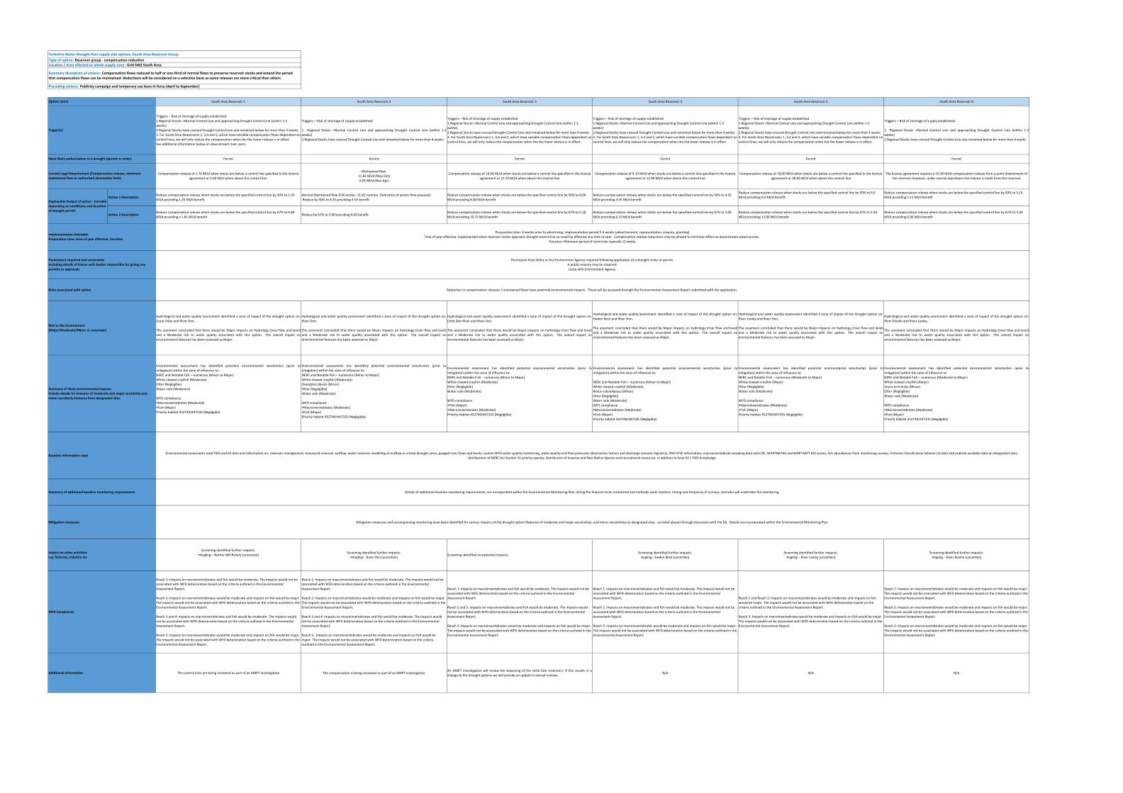
Yorkshire Water Drought Plan supply side options: South Area Reservoir GroupType of option: Reservoir group ‐ compensation reductionLocation / Area affected or whole supply zone: Grid SWZ South Area
Preceding actions: Publicity campaign and temporary use bans in force (April to September)
South Area Reservoir 1 South Area Reservoir 2 South Area Reservoir 3 South Area Reservoir 4 South Area Reservoir 5 South Area Reservoir 6
Triggers – Risk of shortage of supply established 1.Regional Stocks <Normal Control Line and approaching Drought Control Line (within 1‐2
weeks) 2.Regional Stocks have crossed Drought Control Line and remained below for more than 4 weeks
3. For South Area Reaservoirs 1, 3,4 and 5, which have variable compensation flows dependent on control lines, we will only reduce the compensation when the the lower release is in effect.See additional information below on downstream river users.
Triggers – Risk of shortage of supply established:
1. Regional Stocks <Normal Control Line and approaching Drought Control Line (within 1‐2weeks)
2.Regional Stocks have crossed Drought Control Line and remained below for more than 4 weeks
Triggers – Risk of shortage of supply established 1.Regional Stocks <Normal Control Line and approaching Drought Control Line (within 1‐2
weeks) 2.Regional Stocks have crossed Drought Control Line and remained below for more than 4 weeks
3. For South Area Reaservoirs 1, 3,4 and 5, which have variable compensation flows dependent on control lines, we will only reduce the compensation when the the lower release is in effect.
Triggers – Risk of shortage of supply established:
1. Regional Stocks <Normal Control Line and approaching Drought Control Line (within 1‐2weeks)
2.Regional Stocks have crossed Drought Control Line and remained below for more than 4 weeks
Permit Permit Permit Permit Permit Permit
Compensation release of 2.70 Ml/d when stocks are below a control line specified in the licence agreement or 4.00 Ml/d when above this control line.
Maintained flow:11.82 Ml/d (May‐Oct)9.09 Ml/d (Nov‐Apr)
Compensation release of 16.00 Ml/d when stocks are below a control line specified in the licence agreement or 21.70 Ml/d when above this control line
Compensation release of 9.10 Ml/d when stocks are below a control line specified in the licence agreement or 12.00 Ml/d when above this control line
Compensation release of 18.00 Ml/d when stocks are below a control line specified in the licence agreement or 28.00 Ml/d when above this control line
The licence agreement requires a 10.30 Ml/d compensation release from a point downstream of the reservoir however, under normal operations the release is made from the reservoir
Action 1 DescriptionReduce compensation release when stocks are below the specified control line by 50% to 1.35 Ml/d providing 1.35 Ml/d benefit
Normal Maintained flow 9.09 winter, 11.82 summer. Reduction of winter flow assessed. Reduce by 50% to 4.55 providing 4.55 benefit
Reduce compensation release when stocks are below the specified control line by 50% to 8.00 Ml/d providing 8.00 Ml/d benefit
Reduce compensation release when stocks are below the specified control line by 50% to 4.55 Ml/d providing 4.55 Ml/d benefit
Reduce compensation release when stocks are below the specified control line by 50% to 9.0 Ml/d providing 9.0 Ml/d benefit
Reduce compensation release when stocks are below the specified control line by 50% to 5.15 Ml/d providing 5.15 Ml/d benefit
Action 2 DescriptionReduce compensation release when stocks are below the specified control line by 67% to 0.89 Ml/d providing a 1.81 Ml/d benefit
Reduce by 67% to 3.00 providing 6.09 benefitReduce compensation release when stocks are below the specified control line by 67% to 5.28 Ml/d providing 10.72 Ml/d benefit
Reduce compensation release when stocks are below the specified control line by 67% to 3.00 Ml/d providing 6.10 Ml/d benefit
Reduce compensation release when stocks are below the specified control line by 67% to 5.94 Ml/d providing 12.06 Ml/d benefit
Reduce compensation release when stocks are below the specified control line by 67% to 3.40 Ml/d providing 6.90 Ml/d benefit
Hydrological and water quality assessment identified a zone of impact of the drought option on:Scout Dyke and River Don.
The assement concluded that there would be Major impacts on hydrology (river flow and level)and a Moderate risk to water quality associated with this option. The overall impact onenvironmental features has been assessed as Major.
Hydrological and water quality assessment identified a zone of impact of the drought option on:River Don.
The assement concluded that there would be Major impacts on hydrology (river flow and level)and a Moderate risk to water quality associated with this option. The overall impact onenvironmental features has been assessed as Major.
Hydrological and water quality assessment identified a zone of impact of the drought option on:Little Don River and River Don.
The assement concluded that there would be Major impacts on hydrology (river flow and level)and a Moderate risk to water quality associated with this option. The overall impact onenvironmental features has been assessed as Major.
Hydrological and water quality assessment identified a zone of impact of the drought option on:Ewden Beck and River Don.
The assement concluded that there would be Major impacts on hydrology (river flow and level)and a Moderate risk to water quality associated with this option. The overall impact onenvironmental features has been assessed as Major.
Hydrological and water quality assessment identified a zone of impact of the drought option on:River Loxley and River Don.
The assement concluded that there would be Major impacts on hydrology (river flow and level)and a Moderate risk to water quality associated with this option. The overall impact onenvironmental features has been assessed as Major.
Hydrological and water quality assessment identified a zone of impact of the drought option on:River Rivelin and River Loxley.
The assement concluded that there would be Major impacts on hydrology (river flow and level)and a Moderate risk to water quality associated with this option. The overall impact onenvironmental features has been assessed as Major.
Environmental assessment has identified potential environmental sensitivities (prior tomitigation) within the zone of influence to:NERC and Notable Fish – numerous (Minor to Major)White‐clawed crayfish (Moderate)Otter (Negligible)Water vole (Moderate)
WFD compliance •Macroinvertebrates (Moderate) •Fish (Major)
Priority habitat 452749/447335 (Negligible)
Environmental assessment has identified potential environmental sensitivities (prior tomitigation) within the zone of influence to:NERC and Notable Fish – numerous (Minor to Major)White‐clawed crayfish (Moderate)Oreodytes davisii (Minor)Otter (Negligible)Water vole (Moderate)
WFD compliance •Macroinvertebrates (Moderate) •Fish (Major)
Priority habitat 452749/447335 (Negligible)
Environmental assessment has identified potential environmental sensitivities (prior tomitigation) within the zone of influence to:NERC and Notable Fish – numerous (Minor to Major)White‐clawed crayfish (Moderate)Otter (Negligible)Water vole (Moderate)
WFD compliance •Fish (Major) •Macroinvertebrates (Moderate)
Priority habitat 452749/447335 (Negligible)
Environmental assessment has identified potential environmental sensitivities (prior tomitigation) within the zone of influence to:
NERC and Notable Fish – numerous (Minor to Major)White‐clawed crayfish (Moderate)Riolus subviolaceus (Minor)Otter (Negligible)Water vole (Moderate)WFD compliance •Macroinvertebrates (Moderate) •Fish (Major)
Priority habitat 452749/447335 (Negligible)
Environmental assessment has identified potential environmental sensitivities (prior tomitigation) within the zone of influence to:NERC and Notable Fish – numerous (Moderate to Major)White‐clawed crayfish (Major)Otter (Negligible)Water vole (Moderate)
WFD compliance •Macroinvertebrates (Moderate) •Fish (Major)
Priority habitat 452749/447335 (Negligible)
Environmental assessment has identified potential environmental sensitivities (prior tomitigation) within the zone of influence to:NERC and Notable Fish – numerous (Moderate to Major)White clawed crayfish (Major)Sisyra terminalis (Minor)Otter (Negligible)Water vole (Moderate)
WFD compliance •Macroinvertebrates (Moderate) •Fish (Major)
Priority habitat 452749/447335 (Negligible)
Screening identified further impacts: •Angling – Nether Mill fishery (uncertain) Screening identified further impacts:
•Angling – River Don (uncertain)Screening identified no potential impacts. Screening identified further impacts:
Angling ‐ Ewden Beck (uncertain)Screening identified further impacts:Angling – River Loxley (uncertain)
Screening identified further impacts:Angling – River Rivelin (uncertain)
Reach 1: Impacts on macroinvertebrates and fish would be moderate. The impacts would not be associated with WFD deterioration based on the criteria outlined in the Environmental Assessment Report.
Reach 2: Impacts on macroinvertebrates would be moderate and impacts on fish would be major. The impacts would not be associated with WFD deterioration based on the criteria outlined in the Environmental Assessment Report.
Reach 3 and 4: Impacts on macroinvertebrates and fish would be moderate. The impacts would not be associated with WFD deterioration based on the criteria outlined in the Environmental Assessment Report.
Reach 5: Impacts on macroinvertebrates would be moderate and impacts on fish would be major. The impacts would not be associated with WFD deterioration based on the criteria outlined in the Environmental Assessment Report.
Reach 1: Impacts on macroinvertebrates and fish would be moderate. The impacts would not be associated with WFD deterioration based on the criteria outlined in the Environmental Assessment Report.
Reach 2: Impacts on macroinvertebrates would be moderate and impacts on fish would be major. The impacts would not be associated with WFD deterioration based on the criteria outlined in the Environmental Assessment Report.
Reach 3 and 4: Impacts on macroinvertebrates and fish would be moderate. The impacts would not be associated with WFD deterioration based on the criteria outlined in the Environmental Assessment Report.
Reach 5:. Impacts on macroinvertebrates would be moderate and impacts on fish would be major. The impacts would not be associated with WFD deterioration based on the criteria outlined in the Environmental Assessment Report.
Reach 1: Impacts on macroinvertebrates and fish would be moderate. The impacts would not be associated with WFD deterioration based on the criteria outlined in the Environmental Assessment Report.
Reach 2 and 3: Impacts on macroinvertebrates and fish would be moderate. The impacts would not be associated with WFD deterioration based on the criteria outlined in the Environmental Assessment Report.
Reach 4: Impacts on macroinvertebrates would be moderate and impacts on fish would be major. The impacts would not be associated with WFD deterioration based on the criteria outlined in the Environmental Assessment Report.
Reach 1: Impacts on macroinvertebrates and fish would be moderate. The impacts would not be associated with WFD deterioration based on the criteria outlined in the Environmental Assessment Report.
Reach 2: Impacts on macroinvertebrates and fish would be moderate. The impacts would not be associated with WFD deterioration based on the criteria outlined in the Environmental Assessment Report.
Reach 3: Impacts on macroinvertebrates would be moderate and impacts on fish would be major. The impacts would not be associated with WFD deterioration based on the criteria outlined in the Environmental Assessment Report.
Reach 1 and Reach 2: Impacts on macroinvertebrates would be moderate and impacts on fish would be major. The impacts would not be associated with WFD deterioration based on the criteria outlined in the Environmental Assessment Report.
Reach 3: Impacts on macroinvertebrates would be moderate and impacts on fish would be major. The impacts would not be associated with WFD deterioration based on the criteria outlined in the Environmental Assessment Report.
Reach 1: Impacts on macroinvertebrates would be moderate and impacts on fish would be major. The impacts would not be associated with WFD deterioration based on the criteria outlined in the Environmental Assessment Report.
Reach 2: Impacts on macroinvertebrates would be moderate and impacts on fish would be major. The impacts would not be associated with WFD deterioration based on the criteria outlined in the Environmental Assessment Report.
Reach 3: Impacts on macroinvertebrates would be moderate and impacts on fish would be major. The impacts would not be associated with WFD deterioration based on the criteria outlined in the Environmental Assessment Report.
The control lines are being reviewed as part of an AMP7 investigation The compensation is being reviewed as part of an AMP7 investigationAn AMP7 investigation will review the balancing of the Little Don reservoirs. If this results in achange to the drought options we will provide an update in annual reviews. N/A N/A N/A
Impact on other activities e.g. fisheries, industry etc
WFD Compliance
Preparation time: 4 weeks prior to advertising, implementation period 5‐6 weeks (advertisement, representation, enquiry, granting)Time of year effective: implemented when reservoir stocks approach drought control line so could be effective any time of year. Compensation release reductions may be phased to minimise effect on downstream watercourses.
Duration: Minimum period of restriction typically 12 weeks
Permission from Defra or the Environment Agency required following application of a drought order or permit. A public enquiry may be required. Liaise with Environment Agency.
Reduction in compensation releases / maintained flows have potential environmental impacts. These will be assessed through the Environmental Assessment Report submitted with the application.
Environmental assessment used YWS and EA data and information on: reservoir management, measured reservoir outflow, water resource modelling of outflow in critical drought years, gauged river flows and levels; routine WFD water quality monitoring, water quality and flow pressures (abstraction licence and discharge consent registers), YWS STW information; macroinvertebrate sampling data and LIFE, WHPTNATXA and WHPTASPT EQI scores, fish abundances from monitoring surveys, Fisheries Classification Scheme (2) data and publicly available data on designated sites, distributions of NERC Act Section 41 priority species, distribution of Invasive and Non‐Native Species and recreational resources, in addition to local EA / YWS knowledge.
Details of additional baseline monitoring requirements, are incorporated within the Environmental Monitoring Plan, listing the features to be monitored and methods used; location, timing and frequency of surveys; and who will undertake the monitoring.
Baseline information used
Additional information
Deployable Output of action ‐ Variable depending on conditions and duration of drought permit
Implementation timetable Preparation time, time of year effective, duration
Permissions required and constraints Including details of liaison with bodies responsible for giving any permits or approvals
Mitigation measures and accompanying monitoring have been identified for serious impacts of the drought option (features of moderate and major sensitivities, and minor sensitivities to designated sites ‐ as listed above) through discussion with the EA. Details are incorporated within the Environmental Monitoring Plan
Summary of additional baseline monitoring requirements
Mitigation measures
Risks associated with option
Risk to the Environment (Major/Moderate/Minor or uncertain)
Summary of likely environmental impacts Include details for features of moderate and major sensitivity and minor sensitivity features from designated sites
Current Legal Requirement (Compensation release, minimum maintained flow or authorised abstraction limit)
Summary discription of actions: Compensation flows reduced to half or one third of normal flows to preserve reservoir stocks and extend the period that compensation flows can be maintained. Reductions will be considered on a selective basis as some releases are more critical than others
Option name
Trigger(s)
Most likely authorisation in a drought (permit or order)

Yorkshire Water |Drought Plan 2022| 31/03/2021
6
PUBLIC
PUBLIC
Yorkshire Water Drought Plan supply side options: South West Area Reservoir GroupType of option: Reservoir group ‐ compensation reductionLocation / Area affected or whole supply zone: Grid SWZ South West Area
Preceding actions: Publicity campaign and temporary use bans in force (April to September)
South West Area Reservoir 1 South West Area Reservoir 2 South West Area Reservoir 3 South West Area Reservoir 4 South West Reservoir 6
Triggers – Risk of shortage of supply established:
1.Regional Stocks <Normal Control Line and approaching Drought Control Line (within 1‐2 weeks) 2.Regional Stocks have crossed Drought Control Line and remained below for more than 4 weeks
Triggers – Risk of shortage of supply established:
1.Regional Stocks <Normal Control Line and approaching Drought Control Line (within 1‐2 weeks) 2.Regional Stocks have crossed Drought Control Line and remained below for more than 4 weeks
Triggers – Risk of shortage of supply established:
1. Individual Resevoir Stocks <Normal Control Line and approaching Drought Control Line (within 1‐2 weeks)2. Individual Resevoir Stocks have crossed Drought Control Line and remained below for more than 4 weeks
Triggers – Risk of shortage of supply established:
1.Regional Stocks <Normal Control Line and approaching Drought Control Line (within 1‐2 weeks) 2.Regional Stocks have crossed Drought Control Line and remained below for more than 4 weeks
Triggers – Risk of shortage of supply established:
1. Individual Resevoir Stocks <Normal Control Line and approaching Drought Control Line (within 1‐2 weeks)2. Individual Resevoir Stocks have crossed Drought Control Line and remained below for more than 4 weeks
Permit Permit Permit Permit Permit
Compensation release 2.70 Ml/dCompensation release;
Jan‐Sep‐ 3.78Ml/d at all reservoir levelsOct‐Dec 15.12Ml/d, or 7.56 Ml/d when stocks below 50%.
Compensation release;Jan‐Sep 3.24 Ml/d at all reservoir levels
Oct‐Dec 12.96 Ml/d or 6.50 Ml/d when stocks below 50%
Current compensation release of 3.42 Ml/d under an "enforcement position" agreed with the Environment Agency
(statutory requirement for 82,500 gallons/hour from 6:00 am to 5:45 pm Mon ‐ Fri and 6:00 am to 11:00 am Saturday)
Compensation release 3.02 Ml/d from Castle Carr but legal obligation is from Warley Moor
Action 1 Description Reduce compensation release by 50% to 1.35Ml/d giving 1.35Ml/d benefit.Compensation release reduced; Jan‐ Sept by 50% to 1.89 Ml/d providing a benefit of 1.89or Oct‐ Dec by 50% to 3.78 Ml/d providing a benefit of 3.78 Ml/d when stocks below 50%
Compensation release reduced; Jan‐Sept by 50% to 1.62 Ml/d providing a benefit of 1.62Ml/d; or Oct‐Dec by 50% to 3.25 Ml/d providing a benefit of 3.25 Ml/d when stocks below 50%
Reduce the current compensation release by 50% to 1.71 Ml/d providing a benefit of 1.71 Ml/d. The permit application would request a temporary change to the statutory requirement.
Compensation release reduced by 50% to 1.51 Ml/d providing a benefit of 1.51 Ml/d
Action 2 Description Reduce compensation release by 67% to 0.89Ml/d providing 1.81Ml/d benefitCompensation release reduced; Jan‐ Sept by 67% to 1.25 Ml/d providing a benefit of 2.53 Ml/d;or Oct‐ Dec reduce by 67% to 2.49 Ml/d providing a benefit of 5.07 ml/d when stocks below 50%
Compensation release reduced; Jan‐ Sept by 67% to 1.07 Ml/d providing a benefit of 2.17 ML/d; or Oct‐ Dec by 67% to 2.15 Ml/d providing a benefit of 4.36 when stocks below 50% stocks
Reduce the current compensation release by 67% to 1.13 Ml/d, providing a benefit of 2.29 Ml/d. The permit application would request a temporary change to the statutory requirement.
Compensation release reduced by 67% to 1.00 Ml/d providing a benefit of 2.02 Ml/d
Hydrological and water quality assessment identified a zone of impact of the drought option on: Gorple Lower Brook and Graining Water.
The assement concluded that there would be Major impacts on hydrology (river flow and level) and a Moderate risk to water quality associated with this option. The overall impact on environmental features has been assessed as Major.
Hydrological and water quality assessment identified a zone of impact of the drought option on: Alcomden Water, Hebden Water and the River Calder.
The assement concluded that there would be Major impacts on hydrology (river flow and level) and a Moderate risk to water quality associated with this option. The overall impact on environmental features has been assessed as Major.
Hydrological and water quality assessment identified a zone of impact of the drought option on: Graining Water, Hebden Water and the River Calder.
The assement concluded that there would be Major impacts on hydrology (river flow and level) and a Moderate risk to water quality associated with this option. The overall impact on environmental features has been assessed as Major.
Hydrological and water quality assessment identified a zone of impact of the drought option on: Hebble Brook.
The assement concluded that there would be Major impacts on hydrology (river flow and level) and a Moderate risk to water quality associated with this option. The overall impact on environmental features has been assessed as Moderate.
Hydrological and water quality assessment identified a zone of impact of the drought option on: Luddenden Brook.
The assement concluded that there would be Major impacts on hydrology (river flow and level) and a Moderate risk to water quality associated with this option. The overall impact on environmental features has been assessed as Major.
Environmental assessment has identified potential environmental sensitivities (prior to mitigation) within the zone of influence to:NERC and Notable Fish – numerous (Minor to Major)White‐clawed crayfish (Moderate)Otter (Negligible)Water vole (Moderate)
WFD compliance Macroinvertebrates (Minor)Fish (Moderate)
Environmental assessment has identified potential environmental sensitivities (prior to mitigation) within the zone of influence to:Otter (Negligible)Water vole (Moderate)
NERC and Notable Fish – numerous (Minor to Major)WFD compliance Macroinvertebrates (Minor)Fish (Moderate)
Environmental assessment has identified potential environmental sensitivities (prior to mitigation) within the zone of influence to:White‐clawed crayfish (Moderate)Otter (Negligible)Water vole (Moderate)Helophorus strigifrons (Minor)NERC and Notable Fish ‐ numerous (Minor to Major)
WFD compliance Macroinvertebrates (Minor)Fish (Moderate)
Environmental assessment has identified potential environmental sensitivities (prior to mitigation) within the zone of influence to:
NERC and Notable Fish‐ numerous (Minor to Moderate)Otter (Negligible)Water vole (modModerateerate)
WFD compliance Macroinvertebrates (Moderate)Fish (Moderate)
Environmental assessment has identified potential environmental sensitivities (prior to mitigation) within the zone of influence to:White‐clawed crayfish (Moderate)Otter (Negligible)NERC and Notable Fish – numerous (Minor to Major)
WFD compliance Macroinvertebrates (Moderate)Fish (Moderate)
Screening identified possible impacts on:Angling – River Worth (uncertain)
Screening identified no further impacts.Screening identified possible impacts on:
Angling ‐ River Calder (uncertain)Screening identified no further impacts Screening identified no further impacts
Reach 1 and Reach 2: Impacts on fish would be minor and impacts on macroinvertebrates are not applicable for this waterbody. The impacts would not be associated with WFD deterioration based on the criteria outlined in the Environmental Assessment Report.
Reach 3: Impacts on fish would be moderate and impacts on macroinvertebrates are not applicable for this waterbody. The impacts would not be associated with WFD deterioration based on the criteria outlined in the Environmental Assessment Report.
Reach 4 and 5: Impacts on fish and macroinvertebrates would be moderate. The impacts would not be associated with WFD deterioration based on the criteria outlined in the Environmental Assessment Report.
Reach 5:. Impacts on fish and macroinvertebrates would be minor. The impacts would not be associated with WFD deterioration based on the criteria outlined in the Environmental Assessment Report.
Reach 1: Impacts on macroinvertebrates would be N/A. Impacts on fish would be minor. The impacts would not be associate dwith WFD deterioration based on the criteria outlined in the Environmental Assessment Report.
Reach 2: Impacts on fish would be moderate and impacts on macroinvertebrates are not applicable for this waterbody. The impacts would not be associated with WFD deterioration based on the criteria outlined in the Environmental Assessment Report.
Reach 3 and 4: Impacts on fish and macroinvertebrates would be moderate. The impacts would not be associated with WFD deterioration based on the criteria outlined in the Environmental Assessment Report.
Reach 4:. Impacts on fish and macroinvertebrates would be minor. The impacts would not be associated with WFD deterioration based on the criteria outlined in the Environmental Assessment Report.
Reach 1 and Reach 2: Impacts on fish would be minor and the impacts on macroinvertebrate are N/A.The impacts would not be associated with WFD deterioration based on the criteria outlined in the Environmental Assessment Report.
Reach 3: Impacts on fish would be moderate and impacts on macroinvertebrates are not applicable for this waterbody. The impacts would not be associated with WFD deterioration based on the criteria outlined in the Environmental Assessment Report.
Reach 4 and 5: Impacts on fish and macroinvertebrates would be moderate. The impacts would not be associated with WFD deterioration based on the criteria outlined in the Environmental Assessment Report.
Reach 5: Impacts on fish and macroinvertebrates would be minor. The impacts would not be associated with WFD deterioration based on the criteria outlined in the Environmental Assessment Report.
Reach 1: Impacts on macroinvertebrates and fish would be moderate. The impacts would not be associated with WFD deterioration based on the criteria outlined in the Environmental Assessment Report.
Reach 2: Impacts on macroinvertebrates and fish would be minor. The impacts would not be associated with WFD deterioration based on the criteria outlined in the Environmental Assessment Report.
Reach 1: Impacts on macroinvertebrates and fish would be moderate. The impacts would not be associated with WFD deterioration based on the criteria outlined in the Environmental Assessment Report.
N/A N/AThis reservoir cannot be supported by any other reservoirs therefore it has a trigger for implementingthe drought action that is linked to its own stocks rather than regional stocks. However, if theregional trigger was met before the local trigger we would still apply for a permit for this site.
N/AThis reservoir cannot be supported by any other reservoirs therefore it has a trigger for implementingthe drought action that is linked to its own stocks rather than regional stocks. However, if theregional trigger was met before the local trigger we would still apply for a permit for this site.
Summary discription of actions: Compensation flows reduced to half or one third of normal flows to preserve reservoir stocks and extend the period that compensation flows can be maintained. Reductions will be considered on a selective basis as some releases are more critical than others
Option name
Trigger(s)
Deployable Output of action ‐ Variable depending on conditions and duration of drought permit
Implementation timetable Preparation time, time of year effective, duration
Most likely authorisation in a drought (permit or order)
Preparation time: 4 weeks prior to advertising, implementation period 5‐6 weeks (advertisement, representation, enquiry, granting)Time of year effective: implemented when reservoir stocks approach drought control line so could be effective any time of year. Compensation release reductions may be phased to minimise effect on downstream watercourses.Duration: Minimum period of restriction typically 12 weeks
Current Legal Requirement (Compensation release, minimum maintained flow or authorised abstraction limit)
Summary of additional baseline monitoring requirements
Reduction in compensation releases / maintained flows have potential environmental impacts. These will be assessed through the Environmental Assessment Report submitted with the application.
Details of additional baseline monitoring requirements, are incorporated within the Environmental Monitoring Plan, listing the features to be monitored and methods used; location, timing and frequency of surveys; and who will undertake the monitoring.
Permission from Defra or the Environment Agency required following application of a drought order or permit. A public enquiry may be required. Liaise with Environment Agency.
Permissions required and constraints Including details of liaison with bodies responsible for giving any permits or approvals
Risks associated with option
Environmental assessment used YWS and EA data and information on: reservoir management, measured reservoir outflow, water resource modelling of outflow in critical drought years, gauged river flows and levels; routine WFD water quality monitoring, water quality and flow pressures (abstraction licence and discharge consent registers), YWS STW information; macroinvertebrate sampling data and LIFE, WHPTNATXA and WHPTASPT EQI scores, fish abundances from monitoring surveys, Fisheries Classification Scheme (2) data and publicly available data on designated sites, distributions of NERC Act Section 41 priority species, distribution of Invasive and Non‐Native Species and recreational resources, in addition to local EA / YWS knowledge.
Mitigation measures
Impact on other activities e.g. fisheries, industry etc
Risk to the Environment (Major/Moderate/Minor or uncertain)
Summary of likely environmental impacts Include details for features of moderate and major sensitivity and minor sensitivity features from designated sites
Additional information
Mitigation measures and accompanying monitoring have been identified for serious impacts of the drought option (features of moderate and major sensitivities, and minor sensitivities to designated sites ‐ as listed above) through discussion with the EA. Details are incorporated within the Environmental Monitoring Plan
Baseline information used
WFD Compliance
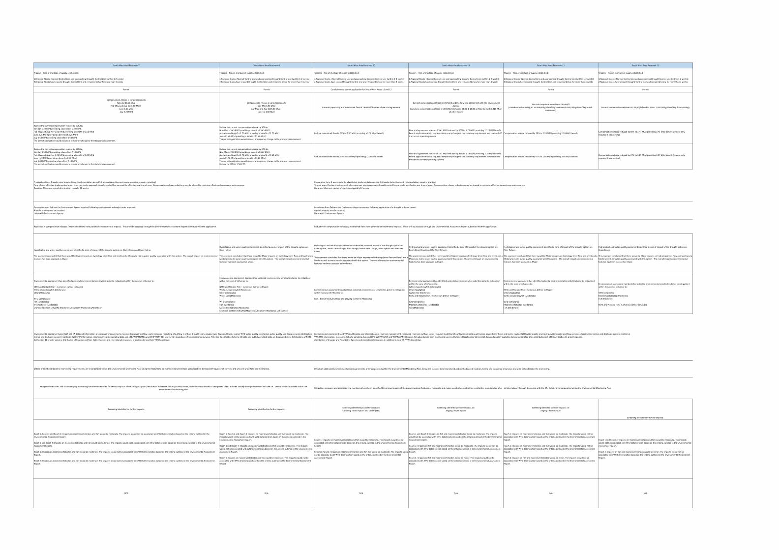
South West Area Reservoir 7 South West Area Reservoir 8 South West Area Reservoir 10 South West Area Reservoir 11 South West Area Reservoir 12 South West Area Reservoir 13
Triggers – Risk of shortage of supply established:
1.Regional Stocks <Normal Control Line and approaching Drought Control Line (within 1‐2 weeks) 2.Regional Stocks have crossed Drought Control Line and remained below for more than 4 weeks
Triggers – Risk of shortage of supply established:
1.Regional Stocks <Normal Control Line and approaching Drought Control Line (within 1‐2 weeks) 2.Regional Stocks have crossed Drought Control Line and remained below for more than 4 weeks
Triggers – Risk of shortage of supply established:
1.Regional Stocks <Normal Control Line and approaching Drought Control Line (within 1‐2 weeks) 2.Regional Stocks have crossed Drought Control Line and remained below for more than 4 weeks
Triggers – Risk of shortage of supply established:
1.Regional Stocks <Normal Control Line and approaching Drought Control Line (within 1‐2 weeks) 2.Regional Stocks have crossed Drought Control Line and remained below for more than 4 weeks
Triggers – Risk of shortage of supply established:
1.Regional Stocks <Normal Control Line and approaching Drought Control Line (within 1‐2 weeks) 2.Regional Stocks have crossed Drought Control Line and remained below for more than 4 weeks
Triggers – Risk of shortage of supply established:
1.Regional Stocks <Normal Control Line and approaching Drought Control Line (within 1‐2 weeks) 2.Regional Stocks have crossed Drought Control Line and remained below for more than 4 weeks
Permit Permit Condition on a permit application for South West Areas 11 and 12 Permit Permit Permit
Compensation release is varied seasonally;Nov‐Jan 10.60 Ml/d
Feb‐May and Aug‐Nov5.80 Ml/dJune 4.50 Ml/dJuly 3.20 Ml/d
Compensation release is varied seasonally;Nov‐Mar 6.90 Ml/d
Apr‐May and Aug‐Oct5.40 Ml/dJun ‐Jul 4.80 Ml/d
Currently operating at a maintained flow of 18.00 Ml/d under a flow trial agreement
Current compensation release is 3.41Ml/d under a flow trial agreement with the Environment Agency
(statutory compensation release is 18.01 Ml/d between 06:00 & 18:00 on Mon to Sat & 3.410 Ml/d all other hours)
Normal compensation release 5.90 Ml/d(stated on authorisaing Act as 898,000 gallons/day to stream & 400,000 gallons/day to mill
continuous) Normal compensation release 6.82 Ml/d (defined in Act as 1,500,000 gallons/day if abstracting)
Reduce the current compensation release by 50% to;Nov‐Jan 5.30 Ml/d providing a benefit of 5.30 Ml/dFeb‐May and Aug‐Nov 2.90 Ml/d providing a benefit of 2.90 Ml/dJune 2.25 Ml/d providing a benefit of 2.25 Ml/dJuly 1.60 Ml/d providing a benefit of 1.60 Ml/dThe permit application would request a temporary change to the statutory requirement.
Reduce the current compensation release by 50% to;Nov‐March 3.45 Ml/d providing a benefit of 3.45 Ml/dApr‐May and Aug‐Oct 2.70 Ml/d providing a benefit of 2.70 Ml/dJun‐Jul 2.40 Ml/d providing a benefit of 2.40 Ml/dThe permit application would request a temporary change to the statutory requirement.
Reduce maintained flow by 50% to 9.00 Ml/d providing a 9.00 Ml/d benefitFlow trial agreement release of 3.41 Ml/d reduced by 50% to 1.71 Ml/d providing 1.71 Ml/d benefitPermit application would request a temporary change to the statutory requirement to a release half the current operating volume
Compensation release reduced by 50% to 2.95 Ml/d providing 2.95 Ml/d benefitCompensation release reduced by 50% to 3.41 Ml/d providing 3.41 Ml/d benefit (release only required if abstracting)
Reduce the current compensation release by 67% to;Nov‐Jan 3.50 Ml/d providing a benefit of 7.10 Ml/dFeb‐May and Aug‐Nov 1.91 Ml/d providing a benefit of 3.89 Ml/dJune 1.49 Ml/d providing a benefit of 3.0 Ml/dJuly 1.06 Ml/d providing a benefit of 2.14 Ml/dThe permit application would request a temporary change to the statutory requirement.
Reduce the current compensation release by 67% to;Nov‐March 2.28 Ml/d providing a benefit of 4.62 Ml/dApr‐May and Aug‐Oct 1.78 Ml/d providing a benefit of 3.62 Ml/dJun‐Jul 1.58 Ml/d providing a benefit of 3.22 Ml/dThe permit application would request a temporary change to the statutory requirement. Reduce by 67% to 1.58‐2.28
Reduce maintained flow by 67% to 6.00 Ml/d providing 12.00Ml/d benefitFlow trial agreement release of 3.41 Ml/d reduced by 67% to 1.13 Ml/d providing 2.28 Ml/d benefitPermit application would request a temporary change to the statutory requirement to release one third of the current operating volume
Compensation release reduced by 67% to 1.95 Ml/d providing 3.95 Ml/d benefitCompensation release reduced by 67% to 2.25 Ml/d providing 4.57 Ml/d benefit (release only required if abstracting)
Hydrological and water quality assessment identified a zone of impact of the drought option on: Digley Brook and River Holme.
The assement concluded that there would be Major impacts on hydrology (river flow and level) and a Moderate risk to water quality associated with this option. The overall impact on environmental features has been assessed as Major.
Hydrological and water quality assessment identified a zone of impact of the drought option on: River Holme.
The assement concluded that there would be Major impacts on hydrology (river flow and level) and a Moderate risk to water quality associated with this option. The overall impact on environmental features has been assessed as Major.
Hydrological and water quality assessment identified a zone of impact of the drought option on: River Ryburn , Booth Dean Clough, Butts Clough, Booth Dean Clough, River Ryburn and the River Calder.
The assement concluded that there would be Major impacts on hydrology (river flow and level) and a Moderate risk to water quality associated with this option. The overall impact on environmental features has been assessed as Moderate.
Hydrological and water quality assessment identified a zone of impact of the drought option on: Booth Dean Clough and the River Ryburn.
The assement concluded that there would be Major impacts on hydrology (river flow and level) and a Moderate risk to water quality associated with this option. The overall impact on environmental features has been assessed as Major.
Hydrological and water quality assessment identified a zone of impact of the drought option on: River Ryburn .
The assement concluded that there would be Major impacts on hydrology (river flow and level) and a Moderate risk to water quality associated with this option. The overall impact on environmental features has been assessed as Major.
Hydrological and water quality assessment identified a zone of impact of the drought option on: Cragg Brook.
The assement concluded that there would be Major impacts on hydrology (river flow and level) and a Moderate risk to water quality associated with this option. The overall impact on environmental features has been assessed as Major.
Environmental assessment has identified potential environmental sensitivities (prior to mitigation) within the zone of influence to:
NERC and Notable Fish – numerous (Minor to Major)White‐clawed crayfish (Moderate)Otter (Moderate)
WFD ComplianceFish (Moderate)Inverterbates (Moderate)Cromwell Bottom LNR/LWS (Moderate), Southern Washlands LNR (Minor)
Environmental assessment has identified potential environmental sensitivities (prior to mitigation) within the zone of influence to:
NERC and Notable Fish – numerous (Minor to Major)White‐clawed crayfish (Moderate)Otter (Moderate)Water vole (Moderate)
WFD ComplianceFish (Moderate)Macroinvertebrates (Moderate)Cromwell Bottom LNR/LWS (Moderate), Southern Washlands LNR (Minor)
Environmental assessment has identified potential environmental sensitivities (prior to mitigation) within the zone of influence to:
Fish – brown trout, bullhead and grayling (Minor to Moderate)
Environmental assessment has identified potential environmental sensitivities (prior to mitigation) within the zone of influence to:White‐clawed crayfish (Moderate)Otter (Negligible)Water vole (Moderate)NERC and Notable Fish – numerours (Minor to Major)
WFD compliance Macroinvertebrates (Moderate)Fish (Moderate)
Environmental assessment has identified potential environmental sensitivities (prior to mitigation) within the zone of influence to:
NERC and Notable Fish – numerous (Minor to Major)Otter (Negligible)White‐clawed crayfish (Moderate)
WFD compliance Macroinvertebrates (Moderate)Fish (Moderate)
Environmental assessment has identified potential environmental sensitivities (prior to mitigation) within the zone of influence to:
WFD compliance Macroinvertebrates (Moderate)Fish (Moderate)
NERC and Notable Fish –numerous (Minor to Major)
Screening identified no further impacts. Screening identified no further impacts.Screening identified possible impacts on:Canoeing ‐River Ryburn and Calder (TBC)
Screening identified possible impacts on:Angling ‐ River Ryburn
Screening identified possible impacts on:Angling ‐ River Ryburn
Screening identified no further impacts.
Reach 1, Reach 2 and Reach 3: Impacts on macroinvertebrates and fish would be moderate. The impacts would not be associated with WFD deterioration based on the criteria outlined in the Environmental Assessment Report.
Reach 3 and Reach 4: Impacts on macroinvertebrates and fish would be moderate. The impacts would not be associated with WFD deterioration based on the criteria outlined in the Environmental Assessment Report.
Reach 5: Impacts on macroinvertebrates and fish would be moderate. The impacts would not be associated with WFD deterioration based on the criteria outlined in the Environmental Assessment Report.
Reach 6: Impacts on macroinvertebrates and fish would be moderate. The impacts would not be associated with WFD deterioration based on the criteria outlined in the Environmental Assessment Report.
Reach 1, Reach 2 and Reach 3: Impacts on macroinvertebrates and fish would be moderate. The impacts would not be associated with WFD deterioration based on the criteria outlined in the Environmental Assessment Report.
Reach 3 and Reach 4: Impacts on macroinvertebrates and fish would be moderate. The impacts would not be associated with WFD deterioration based on the criteria outlined in the Environmental Assessment Report.
Reach 6: Impacts on macroinvertebrates and fish would be moderate. The impacts would not be associated with WFD deterioration based on the criteria outlined in the Environmental Assessment Report.
Reach 1: Impacts on macroinvertebrates and fish would be moderate. The impacts would not be associated with WFD deterioration based on the criteria outlined in the Environmental Assessment Report.
Reaches 2 and 3: Impacts on macroinvertebrates and fish fish would be moderate. The impacts would not be associate dwith WFD deterioration based on the criteria outlined in the Environmental Assessment Report.
Reach 1 and Reach 2: Impacts on fish and macroinvertebrates would be moderate. The impacts would not be associated with WFD deterioration based on the criteria outlined in the Environmental Assessment Report.
Reach 3: Impacts on fish and macroinvertebrates would be moderate. The impacts would not be associated with WFD deterioration based on the criteria outlined in the Environmental Assessment Report.
Reach 4: Impacts on fish and macroinvertebrates would be minor. The impacts would not be associated with WFD deterioration based on the criteria outlined in the Environmental Assessment Report.
Reach 1: Impacts on macroinvertebrates and fish would be moderate. The impacts would not be associated with WFD deterioration based on the criteria outlined in the Environmental Assessment Report.
Reach 2: Impacts on macroinvertebrates and fish would be moderate. The impacts would not be associated with WFD deterioration based on the criteria outlined int he Environmental Assessment Report.
Reach 3: Impacts on fish and macroinvertebrates would be minor. The impacts would not be associated with WFD deterioration based on the criteria outlined in the Environmental Assessment Report.
Reach 1 and Reach 2: Impacts on macroinvertebrates and fish would be moderate. The impacts would not be associated with WFD deterioration based on the criteria outlined in the Environmental Assessment Report.
Reach 3: Impacts on fish and macroinvertebrates would be minor. The impacts would not be associated with WFD deterioration based on the criteria outlined in the Environmental Assessment Report.
N/A N/A N/A N/A N/A N/A
Reduction in compensation releases / maintained flows have potential environmental impacts. These will be assessed through the Environmental Assessment Report submitted with the application. Reduction in compensation releases / maintained flows have potential environmental impacts. These will be assessed through the Environmental Assessment Report submitted with the application.
Environmental assessment used YWS and EA data and information on: reservoir management, measured reservoir outflow, water resource modelling of outflow in critical drought years, gauged river flows and levels; routine WFD water quality monitoring, water quality and flow pressures (abstraction licence and discharge consent registers), YWS STW information; macroinvertebrate sampling data and LIFE, WHPTNATXA and WHPTASPT EQI scores, fish abundances from monitoring surveys, Fisheries Classification Scheme (2) data and publicly available data on designated sites, distributions of NERC Act Section 41 priority species, distribution of Invasive and Non‐Native Species and recreational resources, in addition to local EA / YWS knowledge.
Environmental assessment used YWS and EA data and information on: reservoir management, measured reservoir outflow, water resource modelling of outflow in critical drought years, gauged river flows and levels; routine WFD water quality monitoring, water quality and flow pressures (abstraction licence and discharge consent registers), YWS STW information; macroinvertebrate sampling data and LIFE, WHPTNATXA and WHPTASPT EQI scores, fish abundances from monitoring surveys, Fisheries Classification Scheme (2) data and publicly available data on designated sites, distributions of NERC Act Section 41 priority species, distribution of Invasive and Non‐Native Species and recreational resources, in addition to local EA / YWS knowledge.
Preparation time: 4 weeks prior to advertising, implementation period 5‐6 weeks (advertisement, representation, enquiry, granting)Time of year effective: implemented when reservoir stocks approach drought control line so could be effective any time of year. Compensation release reductions may be phased to minimise effect on downstream watercourses.Duration: Minimum period of restriction typically 12 weeks
Preparation time: 4 weeks prior to advertising, implementation period 5‐6 weeks (advertisement, representation, enquiry, granting)Time of year effective: implemented when reservoir stocks approach drought control line so could be effective any time of year. Compensation release reductions may be phased to minimise effect on downstream watercourses.Duration: Minimum period of restriction typically 12 weeks
Permission from Defra or the Environment Agency required following application of a drought order or permit. A public enquiry may be required. Liaise with Environment Agency.
Permission from Defra or the Environment Agency required following application of a drought order or permit. A public enquiry may be required. Liaise with Environment Agency.
Mitigation measures and accompanying monitoring have been identified for serious impacts of the drought option (features of moderate and major sensitivities, and minor sensitivities to designated sites ‐ as listed above) through discussion with the EA. Details are incorporated within the Environmental Monitoring Plan
Mitigation measures and accompanying monitoring have been identified for serious impacts of the drought option (features of moderate and major sensitivities, and minor sensitivities to designated sites ‐ as listed above) through discussion with the EA. Details are incorporated within the Environmental Monitoring Plan
Details of additional baseline monitoring requirements, are incorporated within the Environmental Monitoring Plan, listing the features to be monitored and methods used; location, timing and frequency of surveys; and who will undertake the monitoring. Details of additional baseline monitoring requirements, are incorporated within the Environmental Monitoring Plan, listing the features to be monitored and methods used; location, timing and frequency of surveys; and who will undertake the monitoring.
South West Area Reservoir 14 South West Area Reservoir 15 South West Area Reservoir 16 South West Area Reservoir 17 South West Area Reservoir 18 South West Area Reservoir 19 South West Area Reservoir 20
Triggers – Risk of shortage of supply established:
1.Regional Stocks <Normal Control Line and approaching Drought Control Line (within 1‐2 weeks) 2.Regional Stocks have crossed Drought Control Line and remained below for more than 4 weeks
Triggers – Risk of shortage of supply established:
1.Regional Stocks <Normal Control Line and approaching Drought Control Line (within 1‐2 weeks) 2.Regional Stocks have crossed Drought Control Line and remained below for more than 4 weeks
Triggers – Risk of shortage of supply established:
1.Regional Stocks <Normal Control Line and approaching Drought Control Line (within 1‐2 weeks) 2.Regional Stocks have crossed Drought Control Line and remained below for more than 4 weeks
Triggers – Risk of shortage of supply established:
1.Regional Stocks <Normal Control Line and approaching Drought Control Line (within 1‐2 weeks) 2.Regional Stocks have crossed Drought Control Line and remained below for more than 4 weeks
Triggers – Risk of shortage of supply established:
1.Regional Stocks <Normal Control Line and approaching Drought Control Line (within 1‐2 weeks) 2.Regional Stocks have crossed Drought Control Line and remained below for more than 4 weeks
Triggers – Risk of shortage of supply established:
1.Regional Stocks <Normal Control Line and approaching Drought Control Line (within 1‐2 weeks) 2.Regional Stocks have crossed Drought Control Line and remained below for more than 4 weeks
Triggers – Risk of shortage of supply established:
1.Regional Stocks <Normal Control Line and approaching Drought Control Line (within 1‐2 weeks) 2.Regional Stocks have crossed Drought Control Line and remained below for more than 4 weeks
Permit Permit Permit In agreement with Canal and Rivers Trust Permit Permit Permit
Compensation release of 2.64 Ml/d (defind in Act as 580,000 gallons per day)Compensation release of 3.49 Ml/d
(defined in Act ass 768,000 gallons/day continuous) Compensation release of 1.36 Ml/d
(defined in Act as 300,000 gallons/day continuous) Current compensation release is 3.48 Ml/d average (9.09Ml/d maximum)
(average value defined in Act as 280 million gallons/year)
Current compensation release is 8.07 Ml/d under an "enforcement position" agreed with the Environment Agency;
(statutory requirement is 2,000 galls/minute between 06:00 & 18:00. 465 galls/minute between 18:00 & 06:00)
Maintained flow requirement of 7.274Ml/d (defined in the Act as as 1,600,000 gallons/day maintained flow)
Current compensation release is 2.66 Ml/d under an "enforcement position" agreed with the Environment Agency (the statutory requirement is 951 galls/minute between 06:00 & 18:00 Mon –
Sat)
Compensation release reduced by 50% to 1.32 Ml/d providing 1.32 Ml/d benefit Compensation release reduced by 50% to 1.75 Ml/d providing 1.75 Ml/d benefit Compensation release reduced by 50% to 0.68 Ml/d providing 0.68 Ml/d benefit Compensation release reduced by 50% to 1.74Ml/d providing up to 1.74 Ml/dCurrrent compensation release reduced by 50% to 4.04 Ml/d providing 4.04 Ml/d benefitPermit application would request a temporary change to the statutory requirement to a release half the current operating volume
Compensation release reduced by 50% to 3.64 Ml/d providing 3.64 Ml/d benefitCurrent compensation release reduced by 50% to 1.33 Ml/d providing 1.33 Ml/d benefitPermit application would request a temporary change to the statutory requirement to a release half the current operating volume
Compensation release reduced by 67% to 0.87 Ml/d providing 1.77 Ml/d benefit Compensation release reduced by 67% to 1.15 Ml/d providing 2.34 Ml/d benefit Compensation release reduced by 67% to 0.45 Ml/d providing 0.91 Ml/d benefit Compensation release reduced by 67% to 1.16 Ml/d providing up to 2.32 Ml/dCurrent compensation release reduced by 67% to 2.66 Ml/d providing 5.41 Ml/d benefitPermit application would request a temporary change to the statutory requirement to release a third of the current operating volume
Compensation release reduced by 67% to 2.40 Ml/d providing 4.87 Ml/d benefitCompensation release reduced by 67% to 0.88 Ml/d providing 1.78 Ml/d benefitPermit application would request a temporary change to the statutory requirement to a release one third the current operating volume
Hydrological and water quality assessment identified a zone of impact of the drought option on: Elphin Brook and Turvin Clough.
The assement concluded that there would be Major impacts on hydrology (river flow and level) and a Moderate risk to water quality associated with this option. The overall impact on environmental features has been assessed as Moderate.
Hydrological and water quality assessment identified a zone of impact of the drought option on: Black Brook.
The assement concluded that there would be Major impacts on hydrology (river flow and level) and a Moderate risk to water quality associated with this option. The overall impact on environmental features has been assessed as Major.
Hydrological and water quality assessment identified a zone of impact of the drought option on: Bradshaw Clough.
The assement concluded that there would be Major impacts on hydrology (river flow and level) and a Minor risk to water quality associated with this option. The overall impact on environmental features has been assessed as Moderate.
Hydrological and water quality assessment identified a zone of impact of the drought option on: Huddersfield Narrow Canal.
The assement concluded that there would be Major impacts on hydrology (river flow and level) and a Minor risk to water quality associated with this option. The overall impact on environmental features has been assessed as Moderate.
Hydrological and water quality assessment identified a zone of impact of the drought option on: Wessenden Brook, River Colne and River Colne.
The assement concluded that there would be Major impacts on hydrology (river flow and level) and a Moderate risk to water quality associated with this option. The overall impact on environmental features has been assessed as Major.
Hydrological and water quality assessment identified a zone of impact of the drought option on: River Colne.
The assement concluded that there would be Major impacts on hydrology (river flow and level) and a Moderate risk to water quality associated with this option. The overall impact on environmental features has been assessed as Major.
Hydrological and water quality assessment identified a zone of impact of the drought option on: Hall Dike and Brow Grains Dyke.
The assement concluded that there would be Major impacts on hydrology (river flow and level) and a Moderate risk to water quality associated with this option. The overall impact on environmental features has been assessed as Major.
Environmental assessment has identified potential environmental sensitivities (prior to mitigation) within the zone of influence to:Otter (Negligible)Water vole (Moderate)NERC and Notable Fish – numerous (Minor to Moderate)
WFD compliance Macroinvertebrates (Moderate)Fish (Moderate)
Environmental assessment has identified potential environmental sensitivities (prior to mitigation) within the zone of influence to:White‐clawed crayfish (Major)Otter (Moderate)Water vole (Major)NERC and Notable Fish – numerous (Moderate to Major)
WFD compliance Macroinvertebrates (Moderate)Fish (Major)
Environmental assessment has identified potential environmental sensitivities (prior to mitigation) within the zone of influence to:
White‐clawed crayfish (Moderate)Water vole (Moderate)Otter (Moderate)WFD compliance Macroinvertebrates (Minor) and Fish (Moderate)
Environmental assessment has identified potential environmental sensitivities (prior to mitigation) within the zone of influence to:
White‐clawed crayfish (Moderate)Water vole (Minor)
Environmental assessment has identified potential environmental sensitivities (prior to mitigation) within the zone of influence to:NERC and Notable Fish – numerous (Minor to Major)Water vole (Moderate)White‐clawed crayfish (Major)Otter (Moderate)
WFD Compliance Fish (Major)Macroinvertebrates (Moderate)
Environmental assessment has identified potential environmental sensitivities (prior to mitigation) within the zone of influence to:NERC and Notable Fish – numerous brown trout, bullhead and grayling (Minor to Major)White‐clawed crayfish (Moderate)Otter (Moderate)Water vole (Moderate)
WFD ComplianceFish (Major)Macroinvertebrates (Moderate)Cromwell Bottom LNR/ LWS (Moderate), Southern Washlands LNR (Minor)
Environmental assessment has identified potential environmental sensitivities (prior to mitigation) within the zone of influence to:NERC and Notable Fish – numerous (Moderate to Major)Otter (Moderate)White‐clawed crayfish (Moderate)Water vole (Moderate)
WFD ComplianceFish (Moderate)Invertebrates (Moderate)
Screening identified no further impacts. Screening identified no further impacts. Screening identified no further impacts.Screening identified possible impacts on:
Angling and navigation on the canal (uncertain)Screening identified possible impacts on:
Angling and navigation on the River Colne (uncertain) Screening identified no further impacts. Screening identified no further impacts.
Reach 1 and Reach 2: Impacts on macroinvertebrates and fish would be moderate. The impacts would not be associated with WFD deterioration based on the criteria outlined in the Environmental Assessment Report.
Reach 3: Impacts on fish and macroinvertebrates would be minor. The impacts would not be associated with WFD deterioration based on the criteria outlined in the Environmental Assessment Report.
Reach 1: Impacts on fish would be major and impacts on macroinvertebrates would be moderate. The impacts would not be associated with WFD deterioration based on the criteria outlined in the Environmental Assessment Report.
Reach 1: Impacts on macroinvertebrates would be moderate. Impact on fish would be major. The impacts would not associate with WFD deterioration based on the criteria outlined in the Environmental Assessment Report.
WFD Status is not determined for canals therefore no risk of deterioration for environmental features has been identified.
Reach 1: Impacts on macroinvertebrates would be moderate. Impacts on fish are N/A. The impacts would not be associated with WFD deterioration based on the criteria outlined in the Environmental Assessment Report.
Reach 1: Impacts on fish would be major and for macroinvertebrates would be moderate. The impacts would not be associated with WFD deterioration based on the criteria outlined in the Environmental Assessment Report.
Reaches 2 and 3: Impacts on fish would be major and for macroinvertebrates would be moderate. The impacts would not be associated with WFD deterioration based on the criteria outlined in the Environmental Assessment Report.
Reach 4: Impacts on fish and macroinvertebrates would be moderate. The impacts would not be associated with WFD deterioration based on the criteria outlined in the Environmental Assessment Report.
Reach 5: Impacts on macroinvertebrates and fish would be moderate. The impacts would not be associated with WFD deterioration based on the criteria outlined in the Environmental Assessment Report.
Reaches 1 and 2: Impacts on macroinvertebrates and fish would be moderate. The impacts would not be associated with WFD deterioration based on the criteria outlined the Environmental Assessment Report.
N/A N/A N/AThe cannal cannot be supported by any other reservoirs. Implementation of the drought action willbe done in consultation with the Canal and Rivers Trust.
N/A N/A N/A
Reduction in compensation releases / maintained flows have potential environmental impacts. These will be assessed through the Environmental Assessment Report submitted with the application.
Reduction in compensation releases / maintained flows have potential environmental impacts. These will be assessed through the Environmental Assessment Report submitted with the application.
Environmental assessment used YWS and EA data and information on: reservoir management, measured reservoir outflow, water resource modelling of outflow in critical drought years, gauged river flows and levels; routine WFD water quality monitoring, water quality and flow pressures (abstraction licence and discharge consent registers), YWS STW information; macroinvertebrate sampling data and LIFE, WHPTNATXA and WHPTASPT EQI scores, fish abundances from monitoring surveys, Fisheries Classification Scheme (2) data and publicly available data on designated sites, distributions of NERC Act Section 41 priority species, distribution of Invasive and Non‐Native Species and recreational resources, in addition to local EA / YWS knowledge.
Environmental assessment used YWS and EA data and information on: reservoir management, measured reservoir outflow, water resource modelling of outflow in critical drought years, gauged river flows and levels; routine WFD water quality monitoring, water quality and flow pressures (abstraction licence and discharge consent registers), YWS STW information; macroinvertebrate sampling data and LIFE, WHPTNATXA and WHPTASPT EQI scores, fish abundances from monitoring surveys, Fisheries Classification Scheme (2) data and publicly available data on designated sites, distributions of NERC Act Section
41 priority species, distribution of Invasive and Non‐Native Species and recreational resources, in addition to local EA / YWS knowledge.
Preparation time: 4 weeks prior to advertising, implementation period 5‐6 weeks (advertisement, representation, enquiry, granting)Time of year effective: implemented when reservoir stocks approach drought control line so could be effective any time of year. Compensation release reductions may be phased to minimise effect on downstream watercourses.Duration: Minimum period of restriction typically 12 weeks
Preparation time: 4 weeks prior to advertising, implementation period 5‐6 weeks (advertisement, representation, enquiry, granting)Time of year effective: implemented when reservoir stocks approach drought control line so could be effective any time of year. Compensation release reductions may be phased to minimise effect on downstream watercourses.Duration: Minimum period of restriction typically 12 weeks
Permission from Defra or the Environment Agency required following application of a drought order or permit. A public enquiry may be required. Liaise with Environment Agency.
Permission from Defra or the Environment Agency required following application of a drought order or permit. A public enquiry may be required. Liaise with Environment Agency.
Mitigation measures and accompanying monitoring have been identified for serious impacts of the drought option (features of moderate and major sensitivities, and minor sensitivities to designated sites ‐ as listed above) through discussion with the EA. Details are incorporated within the Environmental Monitoring PlanMitigation measures and accompanying monitoring have been identified for serious impacts of the drought option (features of moderate and major sensitivities, and minor sensitivities to designated sites ‐ as listed above) through discussion with the EA. Details are incorporated within the Environmental Monitoring Plan
Details of additional baseline monitoring requirements, are incorporated within the Environmental Monitoring Plan, listing the features to be monitored and methods used; location, timing and frequency of surveys; and who will undertake the monitoring.Details of additional baseline monitoring requirements, are incorporated within the Environmental Monitoring Plan, listing the features to be monitored and methods used; location, timing and frequency of surveys; and who will undertake the monitoring.

South West Area Reservoir 21 South West Area Reservoir 22
Triggers – Risk of shortage of supply established:
1.Regional Stocks <Normal Control Line and approaching Drought Control Line (within 1‐2 weeks) 2.Regional Stocks have crossed Drought Control Line and remained below for more than 4 weeks
Triggers – Risk of shortage of supply established:
1.Regional Stocks <Normal Control Line and approaching Drought Control Line (within 1‐2 weeks) 2.Regional Stocks have crossed Drought Control Line and remained below for more than 4 weeks
Permit Permit
Current compensation release is 0.612 Ml/d under an "enforcement position" agreed with the Environment Agency (the statutory requirement is 156,960 gallons/day, 6/7 between 06:00 & 18:00
Mon ‐ Sat and 1/7 between 18:00 & 06:00 Mon – Sat)
Current compensation release is 1.40 Ml/d under an "enforcement position" agreed with the Environment Agency (the statutory requirement is Badgergate Clough 50,606 gpd continuous, Badger Hey 4,320 gpd continuous, Lingards Wood 4,320 gpd continuous, Chain 4,320 gpd continuous, Cellars
Clough 37,029 gpd continuous, Gatehead Clough 8,640 gpd continuous, Ellen Clough 22,217 gpd continuous, Binn House 27,154 gpd continuous, Bradley Brook 85 galls/minute between 06:00 and
18:00 Mon – Sat, Crowhill Clough 156 galls/minute between 06:00 & 18:00 Mon ‐ Sat)
Current compensation release reduced to 0.31 Ml/d providing 0.31 Ml/d benefitPermit application would request a temporary change to the statutory requirement to a release half the current operating volume
Current compensation release reduced by 50% to 0.70 Ml/d providing 0.70 Ml/d benefit Permit application would request a temporary change to the statutory requirement to a release half the current operating volume
Current compensation release reduced to 0.20 Ml/d providing 0.41 Ml/d benefitPermit application would request a temporary change to the statutory requirement to a release one third the current operating volume
Current compensation release reduced by 67% to 0.46 Ml/d providing 0.94 Ml/d benefitPermit application would request a temporary change to the statutory requirement to a release one third the current operating volume
Hydrological and water quality assessment identified a zone of impact of the drought option on: Hoyle House Clough.
The assement concluded that there would be Major impacts on hydrology (river flow and level) and a Moderate risk to water quality associated with this option. The overall impact on environmental features has been assessed as Major.
Hydrological and water quality assessment identified a zone of impact of the drought option on: Bradley Brook.
The assement concluded that there would be Major impacts on hydrology (river flow and level) and a Moderate risk to water quality associated with this option. The overall impact on environmental features has been assessed as Major.
Environmental assessment has identified potential environmental sensitivities (prior to mitigation) within the zone of influence to:White‐clawed crayfish (Moderate)Water vole (Moderate)Otter (Moderate)NERC and Notable Fish – numerous (Moderate to Major)
WFD compliance Macroinvertebrates (Moderate) Fish (Moderate)
Environmental assessment has identified potential environmental sensitivities (prior to mitigation) within the zone of influence to:NERC and Notable Fish – numerous (Minor to Major)White‐clawed crayfish (Moderate)Otter (Moderate)Water vole (Moderate)
WFD compliance Macroinvertebrates (Moderate)Fish (Moderate)
Screening identified no further impacts. Screening identified no further impacts.
Reach 1, Reach 2 and Reach 3: Impacts on macroinvertebrates would be minor. Impacts on fish would be moderate. The impacts would not be associated with WFD deterioration based on the criteria outlined in the Environmental Assessment Report.
Reach 4: Impacts on macroinvertebrates and fish would be moderate. The impacts would not be associated with WFD deterioration based on the criteria outlined in the Environmental Assessment Report.
Reach 5: Impacts on macroinvertebrates and fish would be moderate. The impacts would not be associated with WFD deterioration based on the criteria outlined in the Environmental Assessment Report.
Reach 1: Impacts on macroinvertebrates would be minor. Impacts on fish would be moderate. The impacts would not be associated with WFD deterioration based on the criteria outlined in the Environmental Assessment Report.
Reach 2 and Reach 3: Impacts on macroinvertebrates would be moderate. Impacts on fish would be major. The impacts would not be associated with WFD deterioration based on the criteria outlined in the Environmental Assessment Report.
Reach 4: Impacts on macroinvertebrates and fish would be moderate. The impacts would not be associated with WFD deterioration based on the criteria outlined in the Environmental Assessment Report.
Reach 5: Impacts on macroinvertebrates and fish would be moderate. The impacts would not be associated with WFD deterioration based on the criteria outlined in the Environmental Assessment Report.
N/A N/A
Yorkshire Water |Drought Plan 2022| 31/03/2021
7
PUBLIC
PUBLIC
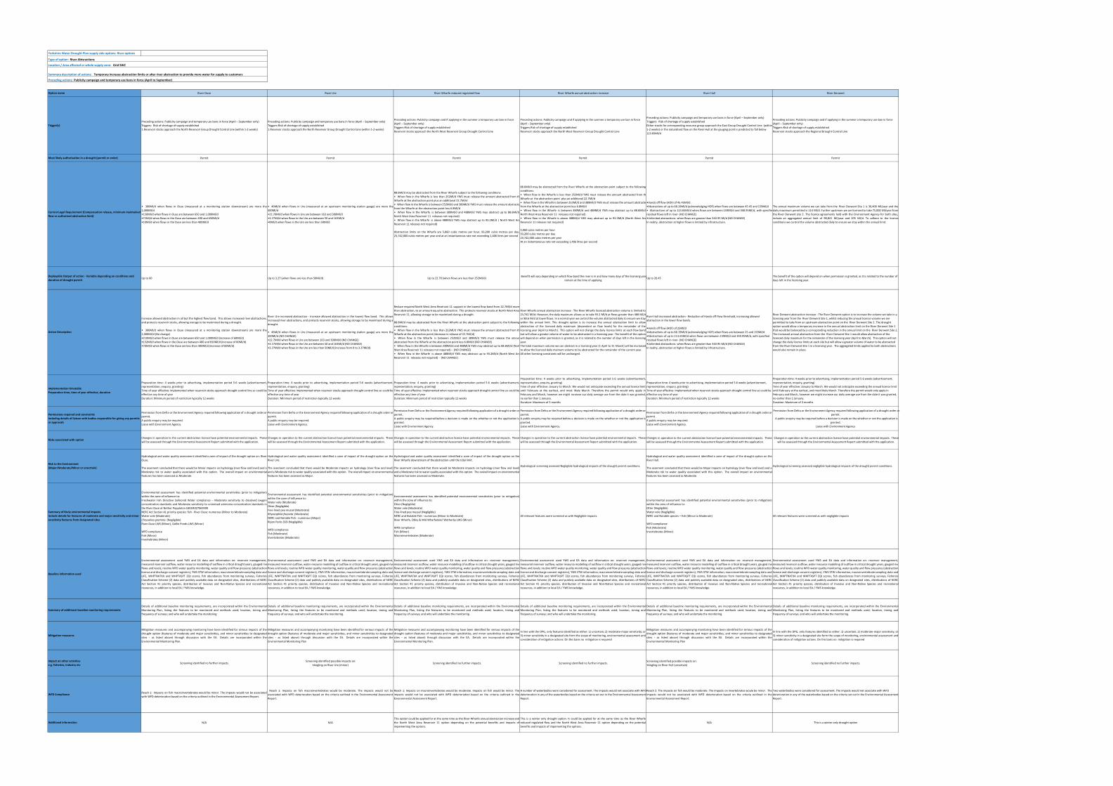
Yorkshire Water Drought Plan supply side options: River options
Type of option: River Abtsractions
Location / Area affected or whole supply zone: Grid SWZ
Preceding actions: Publicity campaign and temporary use bans in force (April to September)
River Ouse River Ure River Wharfe reduced regulated flow River Wharfe annual abstraction increase River Hull River Derwent
Preceding actions: Publicity campaign and temporary use bans in force (April – September only) Triggers: Risk of shortage of supply established
1.Reservoir stocks approach the North Reservoir Group Drought Control Line (within 1‐2 weeks)
Preceding actions: Publicity campaign and temporary use bans in force (April – September only) Triggers:Risk of shortage of supply established
1.Reservoir stocks approach the North Reservoir Group Drought Control Line (within 1‐2 weeks)
Preceding actions: Publicity campaign and if applying in the summer a temporary use ban in force (April – September only)
Triggers:Risk of shortage of supply establishedReservoir stocks approach the North West Reservoir Group Drought Control Line
Preceding actions: Publicity campaign and if applying in the summer a temporary use ban in force (April – September only)
Triggers:Risk of shortage of supply establishedReservoir stocks approach the North West Reservoir Group Drought Control Line
Preceding actions: Publicity campaign and temporary use bans in force (April – September only)Triggers: Risk of shortage of supply establishedEither stocks for corresponding resource group approach the East Group Drought Control Line (within 1‐2 weeks) or the naturalised flow on the River Hull at the gauging point is predicted to fall below 113.65Ml/d
Preceding actions: Publicity campaign and if applying in the summer a temporary use ban in force (April – September only)
Triggers:Risk of shortage of supply establishedReservoir stocks approach the Regional Drought Control Line
Permit Permit Permit Permit Permit Permit
• 300Ml/d when flows in Ouse (measured at a monitoring station downstream) are more than1,000Ml/d •150Ml/d when flows in Ouse are between 650 and 1,000Ml/d •72Ml/d when flows in the Ouse are between 400 and 650Ml/d •10Ml/d when flows in the Ouse are less than 400Ml/d
• 46Ml/d when flows in Ure (measured at an upstream monitoring station gauge) are more tha300Ml/d •22.70Ml/d when flows in Ure are between 163 and 300Ml/d •3.27Ml/d when flows in the Ure are between 50 and 163Ml/d •0Ml/d when flows in the Ure are less than 50Ml/d
88.6Ml/d may be abstracted from the River Wharfe subject to the following conditions:• When flow in the Wharfe is less than 252Ml/d YWS must release the amount abstracted from thWharfe at the abstraction point plus an additional 22.7Ml/d • When flow in theWharfe is between252Ml/d and 389Ml/d YWSmust release the amount abstractefrom the Wharfe at the abstraction point less 6.8Ml/d • When flow in the Wharfe is between 389Ml/d and 488Ml/d YWS may abstract up to 88.6Ml/dNorth West Area Reservoir 11 releases not required)• When flow in the Wharfe is above 488Ml/d YWS may abstract up to 93.2Ml/d ( North West AreReservoir 11 releases not required)
Abstraction limits on the Wharfe are 5,060 cubic metres per hour, 93,200 cubic metres per day,23,742,000 cubic metres per year and at an instantaneous rate not exceeding 1,406 litres per second
88.6Ml/d may be abstracted from the River Wharfe at the abstraction point subject to the followingconditions:• When flow in the Wharfe is less than 252Ml/d YWS must release the amount abstracted from thWharfe at the abstraction point plus an additional 22.7Ml/d • When flow in theWharfe is between252Ml/d and 389Ml/d YWSmust release the amount abstractefrom the Wharfe at the abstraction point less 6.8Ml/d • When flow in the Wharfe is between 389Ml/d and 488Ml/d YWS may abstract up to 88.6Ml/dNorth West Area Reservoir 11 releases not required)• When flow in the Wharfe is above 488Ml/d YWS may abstract up to 93.2Ml/d (North West AreReservoir 11 releases not required)
5,060 cubic metres per hour93,200 cubic metres per day23,742,000 cubic metres per yearAt an instantaneous rate not exceeding 1,406 litres per second
•Hands off flow (HOF) of 45.45Ml/d •Abstrac ons of up to 68.19Ml/d (acknowledging HOF) when flows are between 45.45 and 159Ml/d• Abstractions of up to 113.65Ml/d when flows are between 159Ml/d and 340.95Ml/d, with specifieresidual flows left in river‐ (NO CHANGE) •Unlimited abstrac ons when flows are greater than 340.95 Ml/d (NO CHANGE)In reality, abstraction at higher flows is limited by infrastructure.
The annual maximum volume we can take from the River Derwent Site 1 is 30,400 Ml/year and thedaily maximum permitted is 114 Ml/d. Further upstream we are licensed to take 75,000 Ml/year fromthe River Derwent site 2. The licence agreements held with the Environment Agency for both sites,include an aggregated annual limit of 98,841 Ml/year and 205 Ml/d. To adhere to the licenceconditions we control the volume abstracted daily to ensure we stay within the annual limit.
Up to 60 Up to 3.27 (when flows are less than 50Ml/d) Up to 22.70 (when flows are less than 252Ml/d)Benefit will vary depending on which flow band the river is in and how many days of the licensing year
remain at the time of applyingUp to 20.45
The benefit of the option will depend on when permission is granted, as it is related to the number of days left in the licensing year.
Increase allowed abstraction in all but the highest flow band. This allows increased river abstractions,and protects reservoir stocks, allowing storage to be maximised during a drought.
• 300Ml/d when flows in Ouse (measured at a monitoring station downstream) are more than1,000Ml/d (No change) •210Ml/d when flows in Ouse are between 650 and 1,000Ml/d (increase of 60Ml/d) •132Ml/d when flows in the Ouse are between 400 and 650Ml/d (increase of 60Ml/d) •70Ml/d when flows in the Ouse are less than 400Ml/d (increase of 60Ml/d)
River Ure increased abstraction ‐ Increase allowed abstraction in the lowest flow band. This allowsincreased river abstractions, and protects reservoir stocks, allowing storage to be maximised during adrought.
• 46Ml/d when flows in Ure (measured at an upstream monitoring station gauge) are more tha300Ml/d (NO CHANGE) •22.7Ml/d when flows in Ure are between 163 and 300Ml/d (NO CHANGE) •3.27Ml/d when flows in the Ure are between 50 and 163Ml/d (NO CHANGE) •3.27Ml/d when flows in the Ure are less than 50Ml/d (increase from 0 to 3.27Ml/d)
Reduce required North West Area Reservoir 11 support in the lowest flow band from 22.7Ml/d morethan abstraction, to an amount equal to abstraction. This protects reservoir stocks at North West AreaReservoir 11, allowing storage to be maximised during a drought.
88.6Ml/d may be abstracted from the River Wharfe at the abstraction point subject to the followingconditions:• When flow in the Wharfe is less than 252Ml/d YWS must release the amount abstracted from thWharfe at the abstraction point (decrease in release of 22.7Ml/d)• When flow in the Wharfe is between 252Ml/d and 389Ml/d YWS must release the amounabstracted from the Wharfe at the abstraction point less 6.8Ml/d (NO CHANGE) • When flow in theWharfe is between 389Ml/d and 488Ml/d YWS may abstract up to 88.6Ml/d (NortWest Area Reservoir 11 releases not required) ‐ (NO CHANGE) • When flow in the Wharfe is above 488Ml/d YWS may abstract up to 93.2Ml/d (North West AreReservoir 11 releases not required) ‐ (NO CHANGE)
River Wharfe annual abstraction increase ‐ The River Wharfe licenced abstraction volume is limited to23,742 Ml/d. However, the daily maximum allows us to take 93.2 Ml/d at flows greater than 488 Ml/dor 88.6 M/d at lower flows. In a normal year we control the volume abstracted daily to ensure we staywithin the annual limit. This drought option is to increase the annual abstraction limit to allowabstraction of the licenced daily maximum (dependent on flow levels) for the remainder of thelicensing year (April to March). This option will not change the daily licence limits at each flow bandbut will allow a greater volume of water to be abstracted in a licensing year. The benefit of the optionwill depend on when permission is granted, as it is related to the number of days left in the licensingyear. The total maximum volume we can abstract in a licensing year (1 April to 31 March) will be increasedto allow the licenced daily maimum volume to be abstracted for the remainder of the current year.All other licensing constraints will be unchanged.
River Hull increased abstraction ‐ Reduction of Hands off Flow threshold, increasing allowed abstraction in the lower flow bands.
•Hands off flow (HOF) of 25Ml/d •Abstrac ons of up to 68.19Ml/d (acknowledging HOF) when flows are between 25 and 159Ml/d •Abstrac ons of up to 113.65Ml/d when flows are between 159Ml/d and 340.95Ml/d, with specified residual flows left in river‐ (NO CHANGE) •Unlimited abstrac ons when flows are greater than 340.95 Ml/d (NO CHANGE)In reality, abstraction at higher flows is limited by infrastructure.
River Derwent abstraction increase ‐ The River Derwent option is to increase the volume we take in a licensing year from the River Derwent Site 1, whilst reducing the annual licence volume we are permitted to take from an upstream abstraction point on the River Derwent Site 2. The drought option would allow a temporary increase in the annual abstraction limit on the River Derwent Site 1 that would be balanced by a corresponding reduction in the annual limit on the River Derwent Site 2. The increased annual abstraction from the River Derwent Site 1 would allow abstraction of the licenced daily maximum for the remainder of the licensing year (April to March). This option will not change the daily licence limits at each site but will allow a greater volume of water to be abstracted from the River Derwent Site 1 in a licensing year. The aggragated limits applied to both abstractions would also remain in place.
Preparation time: 4 weeks prior to advertising, implementation period 5‐6 weeks (advertisement,representation, enquiry, granting)Time of year effective: implemented when reservoir stocks approach drought control line so could beeffective any time of yearDuration: Minimum period of restriction typically 12 weeks
Preparation time: 4 weeks prior to advertising, implementation period 5‐6 weeks (advertisement,representation, enquiry, granting)Time of year effective: implemented when reservoir stocks approach drought control line so could beeffective any time of yearDuration: Minimum period of restriction typically 12 weeks
Preparation time: 4 weeks prior to advertising, implementation period 5‐6 weeks (advertisement,representation, enquiry, granting)Time of year effective: implemented when reservoir stocks approach drought control line so could beeffective any time of yearDuration: Minimum period of restriction typically 12 weeks
Preparation time: 4 weeks prior to advertising, implementation period 5‐6 weeks (advertisement,representation, enquiry, granting)Time of year effective: January to March. We would not anticipate exceeding the annual licence limituntil February at the earliest, and most likely March. Therefore the permit would only apply inFebruary and March, however we might increase our daily average use from the date it was granted,no earlier than 1 January.Duration: Maximum of 3 months
Preparation time: 4 weeks prior to advertising, implementation period 5‐6 weeks (advertisement, representation, enquiry, granting)Time of year effective: implemented when reservoir stocks approach drought control line so could be effective any time of yearDuration: Minimum period of restriction typically 12 weeks
Preparation time: 4 weeks prior to advertising, implementation period 5‐6 weeks (advertisement, representation, enquiry, granting)Time of year effective: January to March. We would not anticipate exceeding the annual licence limit until February at the earliest, and most likely March. Therefore the permit would only apply in February and March, however we might increase our daily average use from the date it was granted, no earlier than 1 January.Duration: Maximum of 3 months
Permission from Defra or the Environment Agency required following application of a drought order orpermit. A public enquiry may be required. Liaise with Environment Agency.
Permission from Defra or the Environment Agency required following application of a drought order orpermit. A public enquiry may be required. Liaise with Environment Agency.
Permission from Defra or the Environment Agency required following application of a drought order orpermit. A public enquiry may be required before a decision is made on the whether or not the application isgranted. Liaise with Environment Agency.
Permission from Defra or the Environment Agency required following application of a drought order orpermit. A public enquiry may be required before a decision is made on the whether or not the application isgranted. Liaise with Environment Agency.
Permission from Defra or the Environment Agency required following application of a drought order orpermit. A public enquiry may be required. Liaise with Environment Agency.
Permission from Defra or the Environment Agency required following application of a drought order or permit.
A public enquiry may be required before a decision is made on the whether or not the application is granted.
Liaise with Environment Agency.
Changes in operation to the current abstraction licence have potential environmental impacts. Thesewill be assessed through the Environmental Assessment Report submitted with the application.
Changes in operation to the current abstraction licence have potential environmental impacts. Thesewill be assessed through the Environmental Assessment Report submitted with the application.
Changes in operation to the current abstraction licence have potential environmental impacts. Thesewill be assessed through the Environmental Assessment Report submitted with the application.
Changes in operation to the current abstraction licence have potential environmental impacts. Thesewill be assessed through the Environmental Assessment Report submitted with the application.
Changes in operation to the current abstraction licence have potential environmental impacts. Thesewill be assessed through the Environmental Assessment Report submitted with the application.
Changes in operation to the current abstraction licence have potential environmental impacts. These will be assessed through the Environmental Assessment Report submitted with the application.
Hydrological and water quality assessment identified a zone of impact of the drought option on: River Ouse.
The assement concluded that there would be Minor impacts on hydrology (river flow and level) and aModerate risk to water quality associated with this option. The overall impact on environmentalfeatures has been assessed as Moderate.
Hydrological and water quality assessment identified a zone of impact of the drought option on theRiver Ure.
The assement concluded that there would be Moderate impacts on hydrology (river flow and level)and a Moderate risk to water quality associated with this option. The overall impact on environmentalfeatures has been assessed as Major.
Hydrological and water quality assessment identified a zone of impact of the drought option on theRiver Wharfe downstream of the abstraction until the tidal limit.
The assement concluded that there would be Moderate impacts on hydrology (river flow and level)and a Moderate risk to water quality associated with this option. The overall impact on environmentalfeatures has been assessed as Moderate.
Hydrological screening assessed Negligible hydrological impacts of the drought permit conditions.
Hydrological and water quality assessment identified a zone of impact of the drought option on theRiver Hull.
The assement concluded that there would be Major impacts on hydrology (river flow and level) and aModerate risk to water quality associated with this option. The overall impact on environmentalfeatures has been assessed as Moderate.
Hydrological screening assessed negligible hydrological impacts of the drought permit conditions.
Environmental assessment has identified potential environmental sensitivities (prior to mitigation)within the zone of influence to:Freshwater Fish Directive Salmonid Water compliance – Moderate sensitivity to dissolved oxygenconcentration standards and Moderate sensitivity to unionised ammonia concentration standards inthe River Ouse at Nether Poppleton GB104027069590NERC Act Section 41 priority species: fish ‐ River Ouse: numerous (Minor to Moderate)Water vole (Moderate)Chrysolina graminis (Negligible)River Ouse LWS (Minor), Gollie Ponds LWS (Minor)
WFD compliance Fish (Minor)Invertebrates (Minor)
Environmental assessment has identified potential environmental sensitivities (prior to mitigation)within the zone of influence to:Water vole (Moderate)Otter (Negligible)Fine‐lined pea mussel (Moderate)Rhyacophila fasciata (Moderate)NERC and Notable Fish ‐ numerous (Major) Ripon Parks SSSI (Negligible)
WFD complianceFish (Moderate)Invertebrates (Moderate)
Environmental assessment has identified potential environmental sensitivities (prior to mitigation)within the zone of influence to:Otter (Negligible)Water vole (Moderate)Fine‐lined pea mussel (Negligible)NERC and Notable Fish ‐ numerous (Minor to Moderate)River Wharfe, Otley & Mid Wharfedale/ Wetherby LWS (Minor)
WFD complianceFish (Minor)Macroinvertebrates (Moderate)
All relevant features were screened as with Negligible impacts.
Environmental assessment has identified potential environmental sensitivities (prior to mitigation)within the zone of influence to:Otter (Negligible)Water vole (Negligible)NERC and Notable species – fish (Minor to Moderate)
WFD complianceFish (Moderate)Invertebrates (Minor)
All relevant features were screened as with negligible impacts
Environmental assessment used YWS and EA data and information on: reservoir management,measured reservoir outflow, water resource modelling of outflow in critical drought years, gauged riveflows and levels; routineWFD water quality monitoring, water quality and flow pressures (abstractionlicence and discharge consent registers), YWS STW information; macroinvertebrate sampling data andLIFE, WHPTNATXA and WHPTASPT EQI scores, fish abundances from monitoring surveys, FisheriesClassification Scheme (2) data and publicly available data on designated sites, distributions of NERCAct Section 41 priority species, distribution of Invasive and Non‐Native Species and recreationalresources, in addition to local EA / YWS knowledge.
Environmental assessment used YWS and EA data and information on: reservoir management,measured reservoir outflow, water resource modelling of outflow in critical drought years, gauged riveflows and levels; routineWFD water quality monitoring, water quality and flow pressures (abstractionlicence and discharge consent registers), YWS STW information; macroinvertebrate sampling data andLIFE, WHPTNATXA and WHPTASPT EQI scores, fish abundances from monitoring surveys, FisheriesClassification Scheme (2) data and publicly available data on designated sites, distributions of NERCAct Section 41 priority species, distribution of Invasive and Non‐Native Species and recreationalresources, in addition to local EA / YWS knowledge.
Environmental assessment used YWS and EA data and information on: reservoir management,measured reservoir outflow, water resource modelling of outflow in critical drought years, gauged riveflows and levels; routineWFD water quality monitoring, water quality and flow pressures (abstractionlicence and discharge consent registers), YWS STW information; macroinvertebrate sampling data andLIFE, WHPTNATXA and WHPTASPT EQI scores, fish abundances from monitoring surveys, FisheriesClassification Scheme (2) data and publicly available data on designated sites, distributions of NERCAct Section 41 priority species, distribution of Invasive and Non‐Native Species and recreationalresources, in addition to local EA / YWS knowledge.
Environmental assessment used YWS and EA data and information on: reservoir management,measured reservoir outflow, water resource modelling of outflow in critical drought years, gauged riveflows and levels; routineWFD water quality monitoring, water quality and flow pressures (abstractionlicence and discharge consent registers), YWS STW information; macroinvertebrate sampling data andLIFE, WHPTNATXA and WHPTASPT EQI scores, fish abundances from monitoring surveys, FisheriesClassification Scheme (2) data and publicly available data on designated sites, distributions of NERCAct Section 41 priority species, distribution of Invasive and Non‐Native Species and recreationalresources, in addition to local EA / YWS knowledge.
Environmental assessment used YWS and EA data and information on: reservoir management,measured reservoir outflow, water resource modelling of outflow in critical drought years, gauged riveflows and levels; routineWFD water quality monitoring, water quality and flow pressures (abstractionlicence and discharge consent registers), YWS STW information; macroinvertebrate sampling data andLIFE, WHPTNATXA and WHPTASPT EQI scores, fish abundances from monitoring surveys, FisheriesClassification Scheme (2) data and publicly available data on designated sites, distributions of NERCAct Section 41 priority species, distribution of Invasive and Non‐Native Species and recreationalresources, in addition to local EA / YWS knowledge.
Environmental assessment used YWS and EA data and information on: reservoir management,measured reservoir outflow, water resource modelling of outflow in critical drought years, gauged riveflows and levels; routineWFD water quality monitoring, water quality and flow pressures (abstractionlicence and discharge consent registers), YWS STW information; macroinvertebrate sampling data andLIFE, WHPTNATXA and WHPTASPT EQI scores, fish abundances from monitoring surveys, FisheriesClassification Scheme (2) data and publicly available data on designated sites, distributions of NERCAct Section 41 priority species, distribution of Invasive and Non‐Native Species and recreationalresources, in addition to local EA / YWS knowledge.
Details of additional baseline monitoring requirements, are incorporated within the EnvironmentalMonitoring Plan, listing the features to be monitored and methods used; location, timing andfrequency of surveys; and who will undertake the monitoring.
Details of additional baseline monitoring requirements, are incorporated within the EnvironmentalMonitoring Plan, listing the features to be monitored and methods used; location, timing andfrequency of surveys; and who will undertake the monitoring.
Details of additional baseline monitoring requirements, are incorporated within the EnvironmentalMonitoring Plan, listing the features to be monitored and methods used; location, timing andfrequency of surveys; and who will undertake the monitoring.
Details of additional baseline monitoring requirements, are incorporated within the EnvironmentalMonitoring Plan, listing the features to be monitored and methods used; location, timing andfrequency of surveys; and who will undertake the monitoring.
Details of additional baseline monitoring requirements, are incorporated within the EnvironmentalMonitoring Plan, listing the features to be monitored and methods used; location, timing andfrequency of surveys; and who will undertake the monitoring.
Details of additional baseline monitoring requirements, are incorporated within the EnvironmentalMonitoring Plan, listing the features to be monitored and methods used; location, timing andfrequency of surveys; and who will undertake the monitoring.
Mitigation measures and accompanying monitoring have been identified for serious impacts of thedrought option (features of moderate and major sensitivities, and minor sensitivities to designatedsites ‐ as listed above) through discussion with the EA. Details are incorporated within theEnvironmental Monitoring Plan.
Mitigation measures and accompanying monitoring have been identified for serious impacts of thedrought option (features of moderate and major sensitivities, and minor sensitivities to designatedsites ‐ as listed above) through discussion with the EA. Details are incorporated within theEnvironmental Monitoring Plan
Mitigation measures and accompanying monitoring have been identified for serious impacts of thedrought option (features of moderate and major sensitivities, and minor sensitivities to designatedsites ‐ as listed above) through discussion with the EA. Details are incorporated within theEnvironmental Monitoring Plan.
In line with the DPG, only features identified as either: 1) uncertain; 2) moderate‐major sensitivity; or3) minor sensitivity in a designated site form the scope of monitoring, environmental assessment andconsideration of mitigation actions. On this basis no mitigation is required
Mitigation measures and accompanying monitoring have been identified for serious impacts of thedrought option (features of moderate and major sensitivities, and minor sensitivities to designatedsites ‐ as listed above) through discussion with the EA. Details are incorporated within theEnvironmental Monitoring Plan
In line with the DPG, only features identified as either: 1) uncertain; 2) moderate‐major sensitivity; or3) minor sensitivity in a designated site form the scope of monitoring, environmental assessment andconsideration of mitigation actions. On this basis no mitigation is required
Screening identified no further impacts.Screening identified possible impacts on:
•Angling on River Ure (minor)Screening identified no further impacts. Screening identified no further impacts.
Screening identified possible impacts on: •Angling on River Hull (uncertain) Screening identified no further impacts.
Reach 1: Impacts on fish macroinvertebrates would be minor. The impacts would not be associatedwith WFD deterioration based on the criteria outlined in the Environmental Assessment Report.
Reach 1: Impacts on fish macroinvertebrates would be moderate. The impacts would not beassociated with WFD deterioration based on the criteria outlined in the Environmental AssessmentReport.
Reach 1: Impacts on macroinvertebrates would be moderate. Impacts on fish would be minor. Theimpacts would not be associated with WFD deterioriation based on the criteria outlined in theEnvironmental Assessment Report.
A number of waterbodies were considered for assessment. The impacts would not associate with WFD deterioration in any of the waterbodies based on the criteria set out in the Environmental Assessment Report.
Reach 2: The impacts on fish would be moderate. The impacts on invertebrates woule be minor. Theimpacts would not be associated with WFD deterioration based on the criteria outlined in theEnvironmental Assessment Report.
Two waterbodies were considered for assessment. The impacts would not associate with WFD deterioration in any of the waterbodies based on the criteria set out in the Environmental Assessment Report.
N/A N/AThis option could be applied for at the same time as the RiverWharfe annual abstraction increase andthe North West Area Reservoir 11 option depending on the potential benefits and impacts ofimpementing the opitons.
This is a winter only drought option. It could be applied for at the same time as the River Wharfereduced regulated flow and the North West Area Reservoir 11 option depending on the potentialbenefits and impacts of impementing the opitons.
N/A This is a winter only drought option
Risk to the Environment (Major/Moderate/Minor or uncertain)
Implementation timetable Preparation time, time of year effective, duration
Permissions required and constraints Including details of liaison with bodies responsible for giving any permits or approvals
Risks associated with option
Action Description
Deployable Output of action ‐ Variable depending on conditions and duration of drought permit
Current Legal Requirement (Compensation release, minimum maintained flow or authorised abstraction limit)
Summary description of actions: Temporary increase abstraction limits or alter river abstraction to provide more water for supply to customers
Option name
Trigger(s)
Most likely authorisation in a drought (permit or order)
Summary of likely environmental impacts Include details for features of moderate and major sensitivity and minor sensitivity features from designated sites
Baseline information used
Summary of additional baseline monitoring requirements
Additional information
Mitigation measures
Impact on other activities e.g. fisheries, industry etc
WFD Compliance
Yorkshire Water |Drought Plan 2022| 31/03/2021
8
PUBLIC
PUBLIC
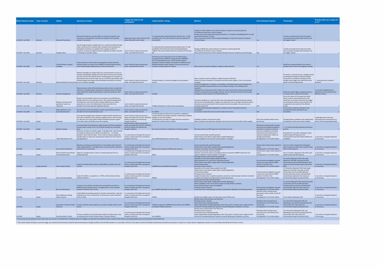
Water Resource Zone Type of action Option Summary of action Trigger for action to be considered* Likely benefit / saving Barriers Environmental impacts Timescales Priority order (on a scale of 1
to 3)**
Grid SWZ + East SWZ Demand Removal of exceptions
Removal of temporary use ban (TUBs) non‐statutory exceptions and concessions so that greater restrictions are applied and to a greater number of customers.
Regional reservoir stocks forecast to fall below 20% within next 4 weeks
It is assumed total combined demand reduction due to TUBs and NEUB is 6%. This action would increase the potential of achieving 6%.
Changes to TUBs conditions may create confusion or impact on customer good will.The additional restrictions may be marginal. Savings may only be achieved during peak demands i.e. hosepipes and paddling pools are used excessively during hot, dry days.Many commercial business will be impacted although it is noted that statutory exceptions would still apply. n/a
2 weeks to provide formal notice but would raise awareness through media channels once the trigger reached 1
Grid SWZ + East SWZ Demand Drought orders
Use full range of powers available with non‐ essential use (NEU) drought orders. Removal of non‐statutory NEU exceptions and concessions so that greater restrictions are applied and to a greater number of customers. Assumes all supply‐side permit applications (where a benefit is achieved) are already in place.
Level 3 actions in place and reservoir stocks one week from the DCL
It is assumed total combined demand reduction due to TUBs and NEUB is 6% of demand at time of implementing (50‐75Ml/d). This action would increase the potential of achieving 6%.
Changes to NEUB may create confusion or impact on customer good will.The additional restrictions may be marginal. Many commercial business will be impacted although statutory exceptions would still apply. N/A
2 weeks to provide formal notice but would raise awareness through media channels once the trigger reached 1
Grid SWZ + East SWZ DemandYorkshire Water customer campaign
Create awareness of the situation and appeal for extreme demand reduction action e.g. reduce use to 50Ml/d. All media channels will be used including regular appearances on local news channels.
Level 3 actions in place and reservoir stocks one week from the DCL
Assumed up to 5% of demand at time of implementing (e.g.approximately 70Ml/d if average demand 1300Ml/d).This is unprecedented action. If all of Yorkshire Water's domestic customers reduced consumption to 50l/h/d around 400 Ml/d would be saved. However, we cannot assume all customers would achieve this volume. Many customers may be unwilling or unable to reduce demand. n/a
Would be a continual process from onset of drought with the level of messaging increasing 1
Grid SWZ + East SWZ Demand National Media & Communicatio
National campaigns to change culture (e.g. excessive water use seen as socially unacceptable), keeping customers aware of the current situation and risks if do not take extreme action. Produce guides for customers to demonstrate how to restrict water use e.g. to 50 litres/ person/day. Hard hitting messages and images will be developed and publicity increased by use of national campaign.
Level 3 actions in place and reservoir stocks one week from the DCL
As above however, a national campaign may have greater success.
Many customers may be unwilling or unable to reduce to 50 l/h/d.Requires all water companies to contribute and Government support to be a true national campaign. N/A
0‐6 weeks. It is assumed such a campaign would be developed through the National Drought Group prior to companies reaching extreme dorught action triggers but could take several weeks to be fully implemented.
1 ‐ assuming many companies impacted
Grid SWZ + East SWZ Demand Pressure management
Reduce pressure while still maintaining essential services e.g. night time reductions. Pumping stations and pressure reduction valves controling water distribution would be optimised to a level that would just meet standards.
Level 3 actions in place and reservoir stocks one week from the DCL 0‐2Ml/d
Pressure management in Yorkshire is controlled at a level that meets service standards and further achievable savings would be very low without creating a risk of failing service standards.Redeployment of operational staff to deliver this action would reduce other key operational activities including enhancing leakage reduction. We may therefore prioritise other drought management actions based on the likely benefits and N/A
Would start when trigger reached but take up to several weeks to achieve full benefits.
1, but only if redeployment of operational staff considered most effective measure
Grid SWZ + East SWZ Demand
Request commercial and agricultural water use reductions
Request non‐households reduce use for purposes not prohibited by a drought order for a non‐essential use ban. This could be by agreement with large users who may be able to operate differently e.g. reduce production at a site in the affected area if they have other sites elsewhere that could cope with additional demand.
Level 3 actions in place and reservoir stocks one week from the DCL 0‐5Ml/d estimated as no data to base assumptions.
This action would be on a voluntary basis only and an agreement would need to be reached with the non‐households able to support such reductions. Due to the high commercial impact alternative sources would need to be found and may not be available. Any costs incurred would be paid by YW. N/A
Due to the nature of the request we would expect to take several weeks/months. We would start to consider at the point the trigger was reached but would not see a benefit until an agreement was made with the affected parties. 3
Grid SWZ + East SWZ DemandWater efficiency in non‐household properties
We will seek to work with retailers to deliver water efficiency devices and advice to non‐household water users.
Level 3 actions in place and reservoir stocks one week from the DCL 0 to 2Ml/d
The yield achieved would be dependent on retailers and non‐household customers’ participation.A contractor would need to be recruited to deliver the service. N/A
6‐12 months to allow for contractor to be recruited and service delivered to non ‐households. 2
Grid SWZ + East SWZ Supply Tankering
In an extreme drought water could be transferred within Yorkshire and from other companies if any customers supplies were at risk of running out. We may use in areas where network limitations prevent support from other assets and WTWs across the company.
Level 3 actions in place and reservoir stocks one weeks from the DCL. Would be linked to network and need during drought conditions.
If tankering within Yorkshire there would be no additional resource benefit, the benefit would be re‐distribution available supplies to any areas of deficit. If tankering from out‐side our supply area there would be a benefit but insufficient data to define.
Availbility of tankers may limit this action.Other companies may experience drought at the same time and not be able to offer supplies.
N/A as this would be within licence permissions.
Provided tankers available can be implemented immediately to those areas where needed.
3 (although some small scale tankering may be required prior to level 3 actions being implemented)
Grid SWZ + East SWZ Supply Network changes
As an alternative to tankering our supply network could be extended to transfer water to areas at risk. This could be through use of overlands pipes.
Level 3 actions in place and reservoir stocks one weeks from the DCL. Would be linked to network and need during drought conditions. No resource benefit as re‐distribution of existing supplies. Planning consents and DWI apporvals would need to be sort.
Abstraction would be within existing permissions but additional pipelines would have an impact on the land.
3 ‐ 12 months assuming necessary permissions granted 3
Grid SWZ Supply North West Reservoir 10
Reservoir currently not used for supply. A drought order / permit would be needed to abstract up to 3 Ml/d, to be piped into an existing aqueduct, when yield ava ilable. There is also an ordinary supply‐side drought option to reduce the compensation release from the reservoir (see Appendix 5).
In a second year of drought and reservoir stocks six weeks away from crossing the drought control line. Up to 3Ml/d depending on reservoir stocks
Assumes permit/order would be granted.Would need to meet Water Supply (Water Quality) Regulations.Water availability in the reservoir may be limited in a drought.
Low risk as making use of exsiting infrastructure but could require a reduced compensation release via drought permit/order.See Appendix 4.7 for further details.
Estimated 6 to 12 months, allowing for water quality testing, DWI approvals and Environmental Assessment Report (EAR) to be completed.
1, but only in a drought lasting two or more years
Grid SWZ Supply East Yorkshire Borehole 2
Relocate an existing unused borehole to a new location with improved water qaulity potential. A drought order or permit would be required to abstract from a new location.
In a second year of drought and reservoir stocks six weeks away from crossing the drought control line. 6Ml/d annual average and 9Ml/d daily maximum
Assumes permit/order would be granted.Would need to meet Water Supply (Water Quality) Regulations.Hydraulic connectivity requires investigation.
Surface water impact study required to assess.See Appendix 4.7 for further details.
Up to 12 months, allowing for hydrological impact assessment (HIA), water quality testing, EAR, and DWI approval.
1, but only in a drought lasting two or more years
Grid SWZ SupplyNorth Yorkshire Groundwater increased abstraction
Apply for a drought permit / order to increase abstracton from an existing borehole.
In a second year of drought and reservoir stocks six weeks away from crossing the drought control line. 2Ml/d
Assumes permit/order would be granted.Hydraulic connectivity requires investigation (this has started for WRMP scheme but may require escalation if volume needed in a drought).
Surface water impact study required to assess.See Appendix 4.7 for further details.
Up to 12 months, allowing for HIA, EAR, water quality testing and DWI approval.
1, but only in a drought lasting two or more years
Grid SWZ Supply (transfer) Tees to Swale transferImport from Northumbrian Water Limited (NWL) via pieline then river transfer.
In a second year of drought and reservoir stocks six weeks away from crossing the drought control line. 0‐28Ml/d (assuming 40Ml/d discharged)
Discharge consents woud need to be approved.Dependent on the water being available from NWL.High pontential for en route losses reducing the benefit.Would need to meet Water Supply (Water Quality) Regulations.Environmental impact.Planning consents required.
Environmental investigation required.Invasive non‐native species (INNS) present in the River Tees. See Appendix 4.7 for further details.
18 months allowing for EAR, bulk supply agreement with NWL, planning consents, construction and EA and DWI apporvals. May require an Environmental Impact Assessment (EIA).
1, but only in a drought lasting two or more years
Grid SWZ Supply (transfer) Tees to Derwent pipelineImport from NWL via a pipeline to a WTW via River Derwent Water Treatment Works 1.
In a second year of drought and reservoir stocks six weeks away from crossing the drought control line. 40Ml/d
Dependent on the water being available from NWL.Would need to meet Water Supply (Water Quality) Regulations.Environmental impact.Planning consents required.Lengthy timescales due to significant pipeline contruction. Overland pipes would be considered to speed up the delivery but dependent on planning consents.
Environmental investigation required.Invasive non‐native species (INNS) present in the River Tees. See Appendix 4.7 for further details.
12‐18 months allowing for EAR, bulk supply agreement with NWL, planning consents, construction and EA and DWI approvals.Assumes planning consents and potentially overland pipes approved. May require an Environmental Impact Assessment (EIA).
1, but only in a drought lasting two or more years
Grid SWZ Supply River Aire abstraction
Construct a new intake on the River Aire and piepline to transfer to Bradford water treatment works. A drought permit / order would be required to abstract from the Aire.
In a second year of drought and reservoir stocks six weeks away from crossing the drought control line. up to 50Ml/d dependent on water availability
Assumes permit/order would be granted.Would need to meet Water Supply (Water Quality) Regulations.Water availability in the river would be subject to hands off flow conditions. Environmental impacts require investigation.Planning consents required. Construction time overland pipes would be considered but dependent on planning consents.
Environmental investigation required.See Appendix 4.7 for further details.
12 months allowing for EAR, planning consents, construction and EA and DWI approvals.Assumes planning consents and potentially overland pipes approved. May require an Environmental Impact Assessment (EIA).
1, but only in a drought lasting two or more years
Grid SWZ SupplyOuse additional pumping station capacity
Install additional pumping capacity to transfer increased flow, under the existing licence, from an abstraction on the Ouse to a water treatment works in Leeds.
In a second year of drought and reservoir stocks six weeks away from crossing the drought control line. 10Ml/d Benefit only available when river flow above hands off flow level
Would be within existing licence permissions which include a hands off flow level.See Appendix 4.7 for further details. 6 to 9 months allowing for EAR
1, but only in a drought lasting two or more years
Grid SWZ SupplyOuse Water Treatment Works extension
Increase treatment works capacity to use water available under current licence.
In a second year of drought and reservoir stocks six weeks away from crossing the drought control line.
22Ml/d average (up to 60Ml/d licence maximum but 40Ml/d considered usuable maximum)
Benefit may be reduced when river flows low.Planning consents required.Construction time could delay benefit.Water Supply (Water Quality) Regulations. River Ouse water is already used in supply and the risk that an increased abstraction would not meet drinking water standards is very low.
Would be within existing licence permisisons but new infrastructure constructed.See Appendix 4.7 for further details.
12 to 18 months allowing for EAR and depending on permissions being granted and construction time. May require an Environmental Impact Assessment (EIA).
1, but only in a drought lasting two or more years
Grid SWZ Supply Ouse Raw Water TransferConstruct a pipeline at Ouse abstraction intake to transfer water using an existing licence to River Derwent Water Treatment Works 1.
In a second year of drought and reservoir stocks six weeks away from crossing the drought control line. Up to 60Ml/d
Benefit may be reduced when river flows low.Planning consents required.Construction time could delay benefit.Water Supply (Water Quality) Regulations. River Ouse water is already used in supply and the risk that an increased abstraction would not meet drinking water standards is very low.
Would be within existing licence permisisons but new infrastructure constructed.See Appendix 4.7 for further details.
12 to 18 months allowing for EAR and depending on permissions being granted and construction time. May require an Environmental Impact Assessment (EIA).
1, but only in a drought lasting two or more years
* As the timescales for delivery of each option type vary and can not be defined for individual options the triggers is at the point we would first start to consider which options we would develop and not at the point we would implement.
** We would consider all options oncew the trigger was reached and prioritisation would be determined based on drought conditions and the likely benefits. It is most likely a slection of the options would be devloped simultaneously therefore prioritisation is scaled 1 to 3 where options categorised as priority 1 are most likely to be delivered first then 2, then 3.
Yorkshire Water |Drought Plan 2022| 31/03/2021
9
PUBLIC
PUBLIC
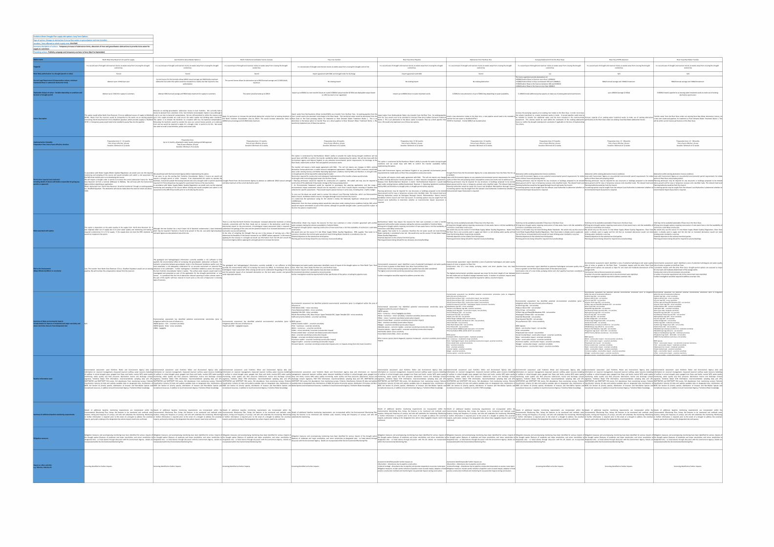
Yorkshire Water Drought Plan supply side options: Long Term Options
Type of option: Changes to abstraction from surface waters or groundwater and river transfers
Location / Area affected or whole supply zone: Grid SWZ
Preceding actions: Publicity campaign and temporary use bans in force (April to September)
North West Area Reservoir 10 used for supply East Yorkshire Groundwater Option 2 North Yorkshire Groundwater licence increase Tees river transfer River Tees Direct Pipeline Abstraction from the River Aire Increased abstraction from the River Ouse River Ouse WTW extension River Ouse Raw Water Transfer
In a second year of drought and reservoir stocks six weeks away from crossing the drought control line.
In a second year of drought and reservoir stocks six weeks away from crossing the drought control line.
In a second year of drought and reservoir stocks six weeks away from crossing the drought control line.
In a second year of drought and reservoir stocks six weeks away from crossing the drought control line.In a second year of drought and reservoir stocks six weeks away from crossing the drought
control line. In a second year of drought and reservoir stocks six weeks away from crossing the drought
control line In a second year of drought and reservoir stocks six weeks away from crossing the drought
control lineIn a second year of drought and reservoir stocks six weeks away from crossing the drought
control lineIn a second year of drought and reservoir stocks six weeks away from crossing the drought
control line
Permit Permit Permit Import agreement with NWL and drought order for discharge Import agreement with NWL Permit n/a N/A N/A
Abstract up to 10 Ml/d per yearCurrent licence for this borehole allows 6Ml/d annual average and 9Ml/d daily maximum abstraction but under this option would be relocated to a nearby site that required a new
authorisation
The current licence allows for abstraction up to 8Ml/d annual average and 12.5Ml/d daily maximum.
No existing import No existing import No existing abstraction
The licence agreemnt permits abstractions of; •300Ml/d when flows in Ouseare more than 1,000Ml/d •150Ml/d when flows in Ouse are between 650 and 1,000Ml/d •72Ml/d when flows in the Ouse are between 400 and 650Ml/d •10Ml/d when flows in the Ouse are less than 400Ml/d
96M/d annual average and 130Ml/d maximum 96M/d annual average and 130Ml/d maximum
Abstract up to 3 Ml/d for supply to customers Abstract 6Ml/d annual average and 9Ml/d daily maximum for supply to customers. This option would provide up to 2Ml/dImport up to 40Ml/d via river transfer (losses en route) 0‐28Ml/d (actual transfer 40 Ml/d and deployable output based
on 30% loss due to river regulation)Import up to 40Ml/d direct to water treatment works 0‐50Ml/d A new abstraction of up to 50Ml/d day depending on water availability 0‐10Ml/d Install additional pump capacity to make use of existing abstraction permissions
up to 40Ml/d (average 22 Ml/d) 0‐60Ml/d Install a pipeline to an existing water treatment works to make use of existing abstraction permissions
This option would utilise North Area Reservoir 10 as an additional source of supply to BrdafrodWTW1. Water from the reservoir would be transported to the works via an existing pipelineconnecting North Area Reservoir 10 to a Bradford aqueduct, which provides supply to BradfordWTW 1. A temporary pump would need to be installed to pump flow into the pipeline.
Relocate an existing groundwater abstraction licence in East Yorkshire. We currently hold alicence to abstract from a borehole in the East Yorkshire Groundwater Option 2 area although itis not in use due to bacterial contamination. We are still permitted to utilise the resource andput it into supply provided we could ensure the water quality met drinking water standards.This option is to relocate the borehole to a location with less risk bacterial contamination.Relocating the borehole would be outside the area our current licence permits us to abstractfrom and we would be required to apply for a drought order or permit to do this. We wouldalso need to install a new borehole, pumps and contact tank.
Apply for permission to increase the permitted abstraction volume from an existing borehole inthe North Yorkshire Groundwater area by 2Ml/d. This would increase abstraction limits to10Ml/d annual average and 14.5Ml/d daily maximum.
Import water from Northumbrian Water Limited (NWL) via a transfer from the River Tees. An existing pipeline from theTees t would need to be extended to discharge to the River Swale. The transferred water would be abstracted from theRiver Ouse at the Ouse pumping station for treatment at River Derwent Water Treatment Works 1. This is analternative to the below option to transfer flow via a direct pipeline to River Derwent Water Treatment Works 1. Wewould only implement one of these two options.
Import water from Northumbrian Water via a transfer from the River Tees. An existing pipelinefrom the Tees would need to be extended to transport flow direct toRiver Derwent TreatmentWorks 1. This is an alternative to the above option to transfer flow via a short pipeline thenrivers. We would only implement one of these two options.
Install a new abstraction intake on the River Aire, a new pipeline would need to be installed totransfer the river water to Bradford WTW 2 WTW for treatment. In total 50Ml/d can be abstracted.
Increase the pumping capacity at an existing river intake on the River Ouse in order to increasethe volume transfered to a water treatment works in Leeds. A second pipeline could need tobe installed to transfer the additional water and has been included in the environemntalassessment. This scheme would be used within the constraints of the existing abstractionlicence or within the drought order/permit constraints if applicable at the time of implementingthe scheme.
Increase capacity of an existing water treatment works to make use of existing abstractionpermissions on the River Ouse under our existing Ouse Raw Water abstraction licence.
Transfer water from the River Ouse under our existing Ouse Raw Water abstraction licence, viaa new river intake and pipeline, for treatment at River Derwent Water Treatment Works 1. Thiswill be within current licence permissions on the River Ouse
Preparation time: 6 – 12 monthsTime of year effective: All yearDuration: Minimum of 12 weeks
Preparation time: Up to 12 months, allowing for water quality testing and DWI approval
Time of year effective: All yearDuration: Minimum of 12 weeks
Preparation time: 12 monthsTime of year effective: All yearDuration: Minimum of 12 weeks
Preparation time; 18 monthsTime of year effective: all yearDuration: Minimum of 12 weeks
Preparation time: 12‐18 months Time of year effective: all year Duration: Minimum of 12 weeks
Preparation time: 12 months Time of year effective: all year Duration: Minimum of 12 weeks
Preparation time: 6‐9 months Time of year effective: all year Duration: Minimum of 12 weeks
Preparation time: 12 ‐ 18months Time of year effective: all year Duration: Minimum of 12 weeks
Preparation time: 12 ‐ 18months Time of year effective: all year Duration: Minimum of 12 weeks
In accordance with Water Supply (Water Quality) Regulations we would carry out the requiredmonitoring and sampling of this source and would complete and submit a risk assessment tothe DWI three months prior to re‐introducing this source.We will require a drought order or permit to increase the current abstraction licence for NorthArea Reservoir 10 from a nominal 10Ml/year to 3Ml/day. We will liaise with the EnvironmentAgency before submitting an application.Water abstracted from North Area Reservoir 10 will be transferred through an existing pipelineto a Bradford Aqueduct. The abstraction will only be made when the reservoir stocks are above 55Ml.
We would liaise with the Environment Agency before implementing this option. If we were to use the existing East Yorkshire Groundwater Option 2 licence we would notrequire a drought permit or order. However, if we implemented this option to relocate theborehole, it would be outside the existing licensed area and a drought order or permit would berequired. Or if time allowed we may apply for a permanent licence at the new location.In accordance with Water Supply (Water Quality) Regulations we would carry out the requiredmonitoring and sampling of this source before utilising and would complete and submit a riskassessment to the DWI three months prior to re‐introducing this source.
Drought Permit from the Environment Agency to abstract an additional 2Ml/d annual averageand daily maximum at the current abstraction point.
This option is constrained by Northumbrian Water’s ability to provide the water during drought conditions and wewould liaise with NWL to confirm the transfer availability before implementing the option. We will also liaise with theEnvironment Agency and Natural England on any potential environmental permit requirements for discharge to theRiver Swale, intake works on River Tees and pipeline construction works.
The transfer will require a bulk supply agreement with NWL. This will not require any changes to NWL’s existingabstraction licence permissions or water resource management agreements. Releases from NWL's reservoirs would takeplace under existing licences and Kielder Operating Agreement conditions held by NWL and therefore no drought orderor drought permit will be required for abstracting the water.Permissions required for construction and subsequent implementation of the transfer scheme would include: •A drought order to discharge piped water into the River Swale
• Planning permission would be required for construction of a pipeline, the outfall and may also be required foconstruction of the additional (7 day) water storage at the Ouse pumping station• An Environmental Statement would be required to accompany the planning applications and the scope oenvironmental impact assessment (should one be required) is such that it would require revisiting of baseline datacollection for specific assessments. These would require species licences in some cases, including otter, crayfish, badger
To carry out the above we would need to contact the relevant Local Planning Authorities, which are RichmondshireDistrict Council, Hambleton District Council, Harrogate Borough Council and York City Council.It is noted that the operational rating for the scheme is below the Nationally Significant infrastructure threshold(>100Mm3/y).Abstractions from the Ouse pumping station would also take place under existing licence conditions held by YWS, whichwould not require amendment as part of this scheme, although it is possible drought order / permit could be in place atthe time the option is implemented.
This option is constrained by Northumbrian Water’s ability to provide the water during droughtconditions and we would liaise with NWL to confirm the transfer availability beforeimplementing the option.
Liaise with Environment Agency and Natural England on any potential environmental permitrequirements for intake works on River Tees and pipeline construction works.
The transfer will require a bulk supply agreement with NWL. This will not require any changesto NWL’s existing abstraction licence permissions or water resource management agreements.Releases from Northumberland Reservoir 2 and/or Northumberland Reservoir 1 would takeplace under existing licences andNorthumberland Reservoir 1 Operating Agreement conditionsheld by NWL and therefore no drought order or drought permit will be required.
Planning permission may be required for any structures or buildings proposed to be erectedabove ground and for new or temporary accesses onto classified roads. The relevant lead LocalPlanning Authorities would be Darlington Borough Council, Richmondshire District Council,Hambleton District Council and York City Council. A screening opinion may be sought from therelevant Local Authorities to determine whether an Environmental Impact Assessment isrequired.
Drought Permit from the Environment Agency for a new abstraction from the River Aire for upto 50 Ml/d. Liaise with Environment Agency on any potential environmental permit requirements for intakeworks on River Aire and pumping station and pipeline construction works near to watercourses. Planning permission may be required for any structures or buildings proposed to be erectedabove ground and for new or temporary accesses onto classified roads. The relevant lead LocalPlanning Authorities would be Leeds City Council and Bradford Metropolitan Borough Council.A screening opinion may be sought from the relevant Local Authorities to determine whether anEnvironmental Impact Assessment is required.
Abstraction within existing abstraction licence conditions Liaise with Environment Agency on any potential environmental permit requirements for intakeworks on River Ouse and pumping station. Planning permission may be required for any structures or buildings proposed to be erectedabove ground and for new or temporary accesses onto classified roads. The relevant lead LocalPlanning Authorities would be Harrogate Borough Council and Leeds City Council. A screening opinion may be sought from the relevant Local Authorities to determine whether anEnvironmental Impact Assessment is required.
Abstraction within existing abstraction licence conditions Liaise with Environment Agency on any potential environmental permit requirements for intakeworks on River Ouse and pumping station. Planning permission may be required for any structures or buildings proposed to be erectedabove ground and for new or temporary accesses onto classified roads. The relevant lead LocalPlanning Authority would be York City Council. A screening opinion may be sought from the relevant Local Authorities to determine whether anEnvironmental Impact Assessment is required.
Abstraction within existing abstraction licence conditions Liaise with Environment Agency on any potential environmental permit requirements for intakeworks on River Ouse and pumping station. Planning permission may be required for any structures or buildings proposed to be erectedabove ground and for new or temporary accesses onto classified roads. The relevant lead LocalPlanning Authority would be York City Council. A screening opinion may be sought from the relevant Local Authorities to determine whether anEnvironmental Impact Assessment is required.
This option is dependent on the water quality of the supply from North Area Reservoir 10. Itwas originally taken out of supply due to its poor water quality and monitoring and testing isrequired to determine if it is fit for supply. If this supply does not meet the DWI standards wewould not implement the option.
Although the new location has a much lower risk of bacterial contamination a bacti treatmentplant may be required if bacteria is found to be present at the site. Low yield, high drawdownand sand ingress are also potential risks at this site.
There is a risk that the North Yorkshire Groundwater increased abstraction borehole is in directhydraulic connectivity with the River Swale and an increase in the abstraction could have adetrimental impact on the environment. A hydrological impact assessment (HIA) is required tounderstand the geology of the area and the potential impact of an increased abstraction on thelocal water courses and wetlands.At the time of compiling this Drought Plan we are in the process of carrying out a HIA todetermine the feasibility of the licence increase for our WRMP options appraisal. In the event ofapplying for this increase in a drought we would use information from the HIA and consult theEnvironment Agency before applying for a drought permit to increase the licence.
Northumbrian Water may require the resource for their own customers or enter a transfer agreement with anotherwater company making the scheme unavailable to Yorkshire Water. All long‐term drought options requiring construction of new assets have a risk that availability of contractors could delayconstruction.We would only use this source if it met Water Supply (Water Quality) Regulations. NWL supplies Tees water to itscustomers, therefore the risk that water would not meet Drinking Water standards is considered a low risk.Potential objections to the scheme from third parties.Planning permission being refused for any necessary structures/buildings
Northumbrian Water may require the resource for their own customers or enter a transferagreement with another water company making the scheme unavailable to Yorkshire Water. All long‐term drought options requiring construction of new assets have a risk that availability ofcontractors could delay construction.NWL supplies Tees water to its customers therefore the risk water would not meet DrinkingWater standards is considered a low risk. We would only use this source if it met Water Supply(Water Quality) Regulations. Potential objections to the scheme from third parties.Planning permission being refused for any necessary structures/buildings
Yield may not be available/sustainable if flows low in the River Aire.All long‐term drought options requiring construction of new assets have a risk that availability ofcontractors could delay construction.We would only use this source if it met Water Supply (Water Quality) Regulations. Water fromthe River Aire is not currently used in supply and there is a risk drinking water quality will notmeet the Drinking Water Inspectorate standards Potential objections to the scheme from third parties.Planning permission being refused for required structures/buildings
Yield may not be available/sustainable if flows low in the River Ouse.All long‐term drought option requiring construction of new assets have a risk that availability ofcontractors could delay construction.There is a risk water may not meet Drinking Water Standards. We would only use this source ifit met Water Supply (Water Quality) Regulations. River Ouse water is already used in supply and the risk that an increased abstraction would not meet drinking water standards is very low . Potential objections to the scheme from third parties.Planning permission being refused for required structures/buildings
Yield may not be available/sustainable if flows low in the River Ouse.All long‐term drought options requiring construction of new assets have a risk that availability ofcontractors could delay construction.We would only use this source if it met Water Supply (Water Quality) Regulations. River Ousewater is already used in supply and the risk that an increased abstraction would not meetdrinking water standards is very low. Potential objections to the scheme from third parties.Planning permission being refused for required structures/buildings
Yield may not be available/sustainable if flows low in the River Ouse.All long‐term drought options requiring construction of new assets have a risk that availability ofcontractors could delay construction.We would only use this source if it met Water Supply (Water Quality) Regulations. River Ousewater is already used in supply and the risk that an increased abstraction would not meetdrinking water standards is very low. Potential objections to the scheme from third parties.Planning permission being refused for required structures/buildings
Low. The transfer from North Area Reservoir 10 to a Bradford Aqueduct would use an existingpipeline. We will maintain the compensation release from the reservoir.
The geological and hydrogeological information currently available is not sufficient to fullyquantify the environmental effect of increasing the groundwater abstraction at Brayton. Thehydraulic connectivity between groundwater levels in the Sherwood Sandstone aquifer and thelocal waterbody is not adequately understood for an accurate assessment on potential flowreduction to be undertaken. Further investigation is therefore needed to assess the impact ofthe East Yorkshire Groundwater Option 2 option. The surface water impacts would need to beinvestigated and presented as part of the application for the drought permit/order or newlicence. It is predicted that the risk of abstraction induced upconing of saline connate water inthis part of the aquifer will have reduced in recent years as the cone of depression is showingsigns of recovery.
The geological and hydrogeological information currently available is not sufficient to fullyquantify the environmental effect of increasing the licence by 2Ml/d. As mentioned above, ahydrological impact assessment (HIA) is being carried out to understand the geology of the areaand the potential impact of an increased abstraction on the local water courses and groundwater depended wetlands.
Hydrological and water quality assessment identified a zone of impact of the drought option on: River North Tyne, RiverTyne , River Tees, River Swale, the River Ure, and the River Ouse Construction impacts of a 16km pipeline have also been considered.Environmental sensitivity is assessed as minor/uncertain.Further investigation would be required with further specification of the option, including the pipeline route.
Environmental assessment report identified a zone of potential hydrological and water qualityrisks of minor or greater on River North Tyne, River Tyne and River Tees.Construction risks of a new pumping station and pipeline have also been considered. The highest environmental sensitivity assessed was minor/uncertain.
Further investigation would be required to address uncertain risks.
Environmental assessment report identified a zone of potential hydrological and water qualityimpacts of minor or greater on River Aire Construction risks of a new intake, pumping station and short pipeline have also beenconsidered.
The highest environmental sensitivity assessed was major for the short length of river betweenthe new intake and our Bradford sewage treatment works. A number of uncertain impacts wereidentified. Further investigation would be required to address uncertain impacts.
Environmental assessment report identified no potential hydrological and water quality risks ofminor or greater on the River Ouse downstream of the abstraction point. Construction risks of a new intake, pumping station and short pipeline have been considered asminor or uncertain.
Environmental assessment report identified a zone of potential hydrological and water qualityrisks of minor or greater on the River Ouse. Cumulative impacts with the other River Ousedrought permit options are assessed as major for one reach and moderate downstream of thesewage works Construction risks to the environment are uncertain. A number of uncertain operational risks to the environment were identified. Further investigation would be required to address uncertain risks.
Environmental assessment report identified a zone of potential hydrological and water qualityrisks of minor or greater on the River Ouse.Cumulative impacts with the other River Ouse drought permit options are assessed as majorfor one reach and moderate downstream of the sewage works. Construction risks to the environment are uncertain. A number of uncertain operational risks to the environment were identified. Further investigation would be required to address uncertain risks.
N/A
Environmental assessment has identified potential environmental sensitivities (prior tomitigation) within the zone of influence to: •NERC Species – Fish – uncertain sensi vity •NERC Species ‐ Birds ‐ minor sensi vity •INNS ‐ negligible
Environmental assessment has identified potential environmental sensitivities (prior tomitigation) within the zone of influence to: •Swale Lake SSSI – negligible impacts
Environmental assessment has identified potential environmental sensitivities (prior to mitigation) within the zone ofinfluence to: •Hell Ke les (SSSI) – minor sensi vity •Tyne Watersmeet (SSSI) – minor sensi vity •Appleby Fells SSSI ‐ minor sensi vity •North Penine Moors SAC, Moor House‐ Upper Teesdale SAC, Upper Teesdale SSSI ‐ minor sensi vity •LWS and prioirity habitats ‐ uncertain sensi vity.
NERC species: •White clawed crayfish – uncertain sensi vity •Fish – numerous ‐ uncertain sensi vity •Birds – numerous – uncertain sensi vity •O er – minor sensi vity / uncertain (construc on impact) •Great crested newt – uncertain sensi vity (construc on impact) •Bats ‐ uncertain sensi vity (construc on impact) •Badger ‐ uncertain sensi vity (construc on impact) •Common rep les ‐ uncertain sensi vity (construc on impact) •Signal Crayfish ‐ uncertain sensi vity (construc on impact) •Invasive Species ‐ uncertain sensi vity (construc on impacts and / or impacts arising from inter basin transfers)
Environmental assessment has identified potential environmental sensitivities (prior tomitigation) within the zone of influence to: •NERC species: •Fish – numerous ‐ minor/negligible sensi vity •Birds – numerous – minor sensi vity / uncertain sensi vity (construc on impact) •O er – minor / uncertain sensi vity (construc on impact) •Great Crested Newt ‐ uncertain sensi vity (construc on impact) •Bats ‐ uncertain sensi vity (construc on impact) •Badger ‐ uncertain sensi vity (construc on impact) •Notable species – common rep les ‐ uncertain sensi vity (construc on impact) •Invasive species – signal crayfish ‐ uncertain sensi vity (construc on impact) •Hell Ke les (SSSI)– minor sensi vity •Tyne Watersmeet (SSSI) –minor sensi vity
Other invasive species (Giant Hogweed, Japanese knotweed) ‐ uncertain sensitivity (constructionimpact)
Environmental assessment has identified potential environmental sensitivities (prior to mitigation)within the zone of influence to:
•South Pennine Moors SAC – construc on impact, low sensi vity •South Pennine Moors SPA ‐ construc on impact, low sensi vity •South Pennine Moors SSSI ‐ construc on impact, low sensi vity •Leeds & Liverpool Canal SSSI – hydrological impact: uncertain /sensi vity •Mickletown Ings SSSI – minor sensi vity •Fairburn and Newton Ings SSSI‐ uncertain sensi vity •Bingley South Bog SSSI – construc on impact, low sensi vity •Trench Meadows SSSI – not sensi ve •Townclose Hills SSSI‐ not sensi ve •Roach Lime Hills SSSI‐ not sensi ve •Miles Rough Co ngley LWS ‐low sensi vity •Chellow Dean Woods and Reservoir LWS ‐ low sensi vity •Noon Nick LWS ‐ low sensi vity •Nab Wood Shipley LWS ‐ low sensi vity •Hirst Wood LWS ‐ low sensi vity •Priority Habitat 466865 purple moor grass‐ not sensi ve •Prioirity Habitat 39956, 44749, 40119‐ not sensi ve
NERC species: Freshwater White‐clawed Crayfish – moderate sensitivity Fish – numerous – moderate to major sensitivity Birds – hydrological impact: minor sensitivity /construction impact: uncertain sensitivityGreat crested newt: uncertain sensitivityBats – uncertain sensitivityOtter ‐ uncertain sensitivityCommon reptiles ‐ uncertain sensitivityBadger ‐ uncertain sensitivityInvasive species ‐ uncertain sensitivity
Environmental assessment has identified potential environmental sensitivities (prior tomitigation) within the zone of construction influence: •Fulford Ings SSSI ‐ not sensi ve •Naburn Marsh SSSI ‐ not sensi ve •Church Ings ‐ not sensi ve •Cli on Ings and Rawcliffe Meadows SSSI ‐ not sensi ve •Heslington Tillmere SSSI ‐ not sensi ve •Hetchell Wood SSSI ‐ not sensi ve •East Keswick Fi s SSSI ‐ not sensi ve •Eccup Reservoir SSSI – minor sensi vity
NERC Species: •Birds – construc on impact ‐ not sensi ve •Fish‐ not sensi ve •Depressed river mussel ‐ not sensi ve •Great Crested Newt ‐ construc on impact ‐ uncertain sensi vity •Bats – construc on impact ‐ uncertain sensi vity •O er ‐ construc on impact ‐ uncertain sensi vity •Common rep les ‐ construc on impact ‐ uncertain sensi vity •Badger ‐ construc on impact ‐ uncertain sensi vity •Invasive species ‐ construc on impact ‐ uncertain sensi vity
Environmental assessment has identified potential environmental sensitivities (prior to mitigation)within the zone of construction influence:
•Fulford Ings SSSI – not sensi ve •Naburn Marsh SSSI ‐ not sensi ve •Church Ings SSSI ‐ not sensi ve •Acaster South Ings SSSI ‐ not sensi ve •Cli on Ings and Rawcliffe Meadows SSSI ‐ not sensi ve •River Ouse LWS‐ not sensi ve •Rawcliffe Ings Dyke LWS ‐ not sensi ve •Archbishops Palace Grounds LWS ‐ not sensi ve •Bishopthorpe Ings LWS ‐ not sensi ve •Church Ings LWS ‐ not sensi ve •Cli on Ings LWS ‐ not sensi ve •Cli on Bridge LWS ‐ not sensi ve •Fulford Ings Village Green LWS ‐ not sensi ve •Gollie Ponds LWS ‐ not sensi ve •Middlethorpe Crematorium LWS (4‐3) ‐ not sensi ve •Middlethorpe Ings LWS (4‐1) ‐ not sensi ve •Naburn Hall Meadow / Ings LWS ‐ not sensi ve •Poppleton Ings South ‐ Ditch LWS ‐ not sensi ve •NERC Prioirity Habitats (numerous) ‐ not sensi ve
NERC Species: •Birds – construc on impact – minor/uncertain sensi vity •Fish ‐ construc on impact – uncertain sensi vity •Depressed river mussel – nto sensi ve •Great crested newt ‐ uncertain sensi vity •Bats – construc on impact ‐ uncertain sensi vity •O er ‐ construc on impact ‐ uncertain sensi vity •Common rep les ‐ construc on impact ‐ uncertain sensi vity •Badger ‐ construc on impact ‐ uncertain sensi vity •Invasive species ‐ construc on impact ‐ uncertain sensi vity
Environmental assessment has identified potential environmental sensitivities (prior to mitigation)within the zone of construction influence:
•Fulford Ings SSSI – minor sensi vity •Naburn Marsh SSSI ‐ minor sensi vity •Church Ings SSSI ‐ minor sensi vity •Cli on Ings and Rawcliffe Meadows SSSI ‐ not sensi ve •Acaster South Ings SSSI ‐ minor sensi vity •Cli on Backies LNR ‐ ucertain sensi vty •Hob Moor LNR ‐ uncertain sensi vity •River Ouse LWS‐ moderate sensi vity •Rawcliffe Ings Dyke LWS ‐ not sensi ve •Archbishops Palace Ground LWS ‐ not sensi ve •Bishopthorpe Ings LWS ‐ minor sensi vity •Church Ings LWS ‐ not sensi ve •Cli on Bridge LWS ‐ not sensi ve •Cli on Ings LWS ‐ moderate sensi vity •Fulford Ings Village Green LWS ‐ not sensi ve •Gollie Ponds LWS ‐ low sensi vity •Middlethorpe Cremaorium LWS (4‐3) ‐ moderate sensi vity •Middlethorpe Ings LWS (4‐1) ‐ not sensi ve •Naburn Hall Meadow/ Ings LWS ‐ moderate sensi vity •Poppleton Ings South ‐ Ditch LWS ‐ not sensi ve •NERC Priority Habitats (numerous)‐ not sensi ve
NERC Species: •Birds – construc on impact – not sensi ve /uncertain sensi vity •Fish ‐ construc on impact – moderate sensi vity •Depressed river mussel – moderate sensi vity •Great crested newt ‐ uncertain sensi vity •Bats – construc on impact ‐ uncertain sensi vity •O er ‐ construc on impact ‐ uncertain sensi vity •Common rep les ‐ construc on impact ‐ uncertain sensi vity
Environmental assessment used Yorkshire Water and Environment Agency data andinformation on: reservoir management, measured reservoir outflow, water resource modellingof outflow in critical drought years, gauged river flows and levels; routine WFD water qualitymonitoring, water quality and flow pressures (abstraction licence and discharge consentregisters), Yorkshire Water STW information; macroinvertebrate sampling data and LIFE,WHPTNATXA and WHPTASPT EQI scores, fish abundances from monitoring surveys, FisheriesClassification Scheme (2) data and publicly available data on designated sites, distributions ofNERC Act Section 41 priority species, distribution of Invasive and Non‐Native Species andrecreational resources, in addition to local Environment Agency / Yorkshire Water knowledge.
Environmental assessment used Yorkshire Water and Environment Agency data andinformation on: reservoir management, measured reservoir outflow, water resource modellingof outflow in critical drought years, gauged river flows and levels; routine WFD water qualitymonitoring, water quality and flow pressures (abstraction licence and discharge consentregisters), Yorkshire Water STW information; macroinvertebrate sampling data and LIFE,WHPTNATXA and WHPTASPT EQI scores, fish abundances from monitoring surveys, FisheriesClassification Scheme (2) data and publicly available data on designated sites, distributions ofNERC Act Section 41 priority species, distribution of Invasive and Non‐Native Species andrecreational resources, in addition to local Environment Agency / Yorkshire Water knowledge.
Environmental assessment used Yorkshire Water and Environment Agency data andinformation on: reservoir management, measured reservoir outflow, water resource modellingof outflow in critical drought years, gauged river flows and levels; routine WFD water qualitymonitoring, water quality and flow pressures (abstraction licence and discharge consentregisters), Yorkshire Water STW information; macroinvertebrate sampling data and LIFE,WHPTNATXA and WHPTASPT EQI scores, fish abundances from monitoring surveys, FisheriesClassification Scheme (2) data and publicly available data on designated sites, distributions ofNERC Act Section 41 priority species, distribution of Invasive and Non‐Native Species andrecreational resources, in addition to local Environment Agency / Yorkshire Water knowledge.
Environmental assessment used Yorkshire Water and Environment Agency data and information on: reservoirmanagement, measured reservoir outflow, water resource modelling of outflow in critical drought years, gauged riverflows and levels; routine WFD water quality monitoring, water quality and flow pressures (abstraction licence anddischarge consent registers), YWS STW information; macroinvertebrate sampling data and LIFE, WHPTNATXA andWHPTASPT EQI scores, fish abundances from monitoring surveys, Fisheries Classification Scheme (2) data and publiclyavailable data on designated sites, distributions of NERC Act Section 41 priority species, distribution of Invasive and Non‐Native Species and recreational resources, in addition to local Environment Agency / Yorkshire Water knowledge.
Environmental assessment used Yorkshire Water and Environment Agency data andinformation on: reservoir management, measured reservoir outflow, water resource modellingof outflow in critical drought years, gauged river flows and levels; routine WFD water qualitymonitoring, water quality and flow pressures (abstraction licence and discharge consentregisters), Yorkshire Water STW information; macroinvertebrate sampling data and LIFE,WHPTNATXA and WHPTASPT EQI scores, fish abundances from monitoring surveys, FisheriesClassification Scheme (2) data and publicly available data on designated sites, distributions ofNERC Act Section 41 priority species, distribution of Invasive and Non‐Native Species andrecreational resources, in addition to local Environment Agency / Yorkshire Water knowledge.
Environmental assessment used Yorkshire Water and Environment Agency data andinformation on: reservoir management, measured reservoir outflow, water resource modellingof outflow in critical drought years, gauged river flows and levels; routine WFD water qualitymonitoring, water quality and flow pressures (abstraction licence and discharge consentregisters), Yorkshire Water STW information; macroinvertebrate sampling data and LIFE,WHPTNATXA and WHPTASPT EQI scores, fish abundances from monitoring surveys, FisheriesClassification Scheme (2) data and publicly available data on designated sites, distributions ofNERC Act Section 41 priority species, distribution of Invasive and Non‐Native Species andrecreational resources, in addition to local EA / YWS knowledge.
Environmental assessment used Yorkshire Water and Environment Agency data andinformation on: reservoir management, measured reservoir outflow, water resource modellingof outflow in critical drought years, gauged river flows and levels; routine WFD water qualitymonitoring, water quality and flow pressures (abstraction licence and discharge consentregisters), Yorkshire Water STW information; macroinvertebrate sampling data and LIFE,WHPTNATXA and WHPTASPT EQI scores, fish abundances from monitoring surveys, FisheriesClassification Scheme (2) data and publicly available data on designated sites, distributions ofNERC Act Section 41 priority species, distribution of Invasive and Non‐Native Species andrecreational resources, in addition to local Environment Agency / Yorkshire Water knowledge.
Environmental assessment used Yorkshire Water and Environment Agency data andinformation on: reservoir management, measured reservoir outflow, water resource modellingof outflow in critical drought years, gauged river flows and levels; routine WFD water qualitymonitoring, water quality and flow pressures (abstraction licence and discharge consentregisters), Yorkshire Water STW information; macroinvertebrate sampling data and LIFE,WHPTNATXA and WHPTASPT EQI scores, fish abundances from monitoring surveys, FisheriesClassification Scheme (2) data and publicly available data on designated sites, distributions ofNERC Act Section 41 priority species, distribution of Invasive and Non‐Native Species andrecreational resources, in addition to local Environment Agency / Yorkshire Water knowledge.
Environmental assessment used Yorkshire Water and Environment Agency data andinformation on: reservoir management, measured reservoir outflow, water resource modellingof outflow in critical drought years, gauged river flows and levels; routine WFD water qualitymonitoring, water quality and flow pressures (abstraction licence and discharge consentregisters), Yorkshire Water STW information; macroinvertebrate sampling data and LIFE,WHPTNATXA and WHPTASPT EQI scores, fish abundances from monitoring surveys, FisheriesClassification Scheme (2) data and publicly available data on designated sites, distributions ofNERC Act Section 41 priority species, distribution of Invasive and Non‐Native Species andrecreational resources, in addition to local Environment Agency / Yorkshire Water knowledge.
Details of additional baseline monitoring requirements are incorporated within theEnvironmental Monitoring Plan, listing: the features to be monitored and methods used;location, timing and frequency of surveys; and who will undertake the monitoring. Monitoringor further information is required prior to the onset of a drought to address the uncertainimpacts, particularly relating to the designated sites where impacts need to be confirmed.
Details of additional baseline monitoring requirements are incorporated within theEnvironmental Monitoring Plan, listing: the features to be monitored and methods used;location, timing and frequency of surveys; and who will undertake the monitoring. Monitoringor further information is required prior to the onset of a drought to address the uncertainimpacts, particularly relating to the designated sites where impacts need to be confirmed.
Details of additional baseline monitoring requirements are incorporated within theEnvironmental Monitoring Plan, listing: the features to be monitored and methods used;location, timing and frequency of surveys; and who will undertake the monitoring. Monitoringor further information is required prior to the onset of a drought to address the uncertainimpacts, particularly relating to the designated sites where impacts need to be confirmed.
Details of additional baseline monitoring requirements, are incorporated within the Environmental Monitoring Plan,listing the features to be monitored and methods used; location, timing and frequency of surveys; and who willundertake the monitoring.
Details of additional baseline monitoring requirements are incorporated within theEnvironmental Monitoring Plan, listing: the features to be monitored and methods used;location, timing and frequency of surveys; and who will undertake the monitoring. Monitoringor further information is required prior to the onset of a drought to address the uncertainimpacts, particularly relating to the designated sites where likely negligible impacts need to beconfirmed.
Details of additional baseline monitoring requirements are incorporated within theEnvironmental Monitoring Plan, listing: the features to be monitored and methods used;location, timing and frequency of surveys; and who will undertake the monitoring. Monitoringor further information is required prior to the onset of a drought to address the uncertainimpacts, particularly relating to the designated sites where likely negligible impacts need to beconfirmed.
Details of additional baseline monitoring requirements are incorporated within theEnvironmental Monitoring Plan, listing: the features to be monitored and methods used;location, timing and frequency of surveys; and who will undertake the monitoring. Monitoringor further information is required prior to the onset of a drought to address the uncertainimpacts, particularly relating to the designated sites where impacts need to be confirmed.
Details of additional baseline monitoring requirements are incorporated within theEnvironmental Monitoring Plan, listing: the features to be monitored and methods used;location, timing and frequency of surveys; and who will undertake the monitoring. Monitoringor further information is required prior to the onset of a drought to address the uncertainimpacts, particularly relating to the designated sites and species.
Details of additional baseline monitoring requirements are incorporated within theEnvironmental Monitoring Plan, listing: the features to be monitored and methods used;location, timing and frequency of surveys; and who will undertake the monitoring. Monitoringor further information is required prior to the onset of a drought to address the uncertainimpacts, particularly relating to the designated sites and species.
Mitigation measures and accompanying monitoring have been identified for serious impacts ofthe drought option (features of moderate and major sensitivities, and minor sensitivities todesignated sites ‐ as listed above) through discussion with the Environment Agency. Details areincorporated within the Environmental Monitoring Plan
Mitigation measures and accompanying monitoring have been identified for serious impacts ofthe drought option (features of moderate and major sensitivities, and minor sensitivities todesignated sites ‐ as listed above) through discussion with the Environment Agency. Details areincorporated within the Environmental Monitoring Plan
Mitigation measures and accompanying monitoring have been identified for serious impacts ofthe drought option (features of moderate and major sensitivities, and minor sensitivities todesignated sites ‐ as listed above) through discussion with the Environment Agency. Details areincorporated within the Environmental Monitoring Plan
Mitigation measures and accompanying monitoring have been identified for serious impacts of the drought option(features of moderate and major sensitivities, and minor sensitivities to designated sites ‐ as listed above) throughdiscussion with the Environment Agency. Details are incorporated within the Environmental Monitoring Plan
Mitigation measures and accompanying monitoring have been identified for serious impacts ofthe drought option (features of moderate and major sensitivities, and minor sensitivities todesignated sites ‐ as listed above) through discussion with the EA. Details are incorporatedwithin the Environmental Monitoring Plan.
Mitigation measures and accompanying monitoring have been identified for serious impacts ofthe drought option (features of moderate and major sensitivities, and minor sensitivities todesignated sites ‐ as listed above) through discussion with the Environment Agency. Details areincorporated within the Environmental Monitoring Plan.
Mitigation measures and accompanying monitoring have been identified for serious impacts ofthe drought option (features of moderate and major sensitivities, and minor sensitivities todesignated sites ‐ as listed above) through discussion with the Environment Agency. Details areincorporated within the Environmental Monitoring Plan.
Screening identified no further impacts. Screening identified no further impacts. Screening identified no further impacts. Screening identified no further impacts.
Assessment identified possible further impacts on: •Recrea on – disturbance due to pipeline construc on. •Cultural heritage – disturbance due to pipeline construc on dependent on precise route taken.
Mitigation measures include careful selection of pipeline route to avoid impact, adoption of bestpractice construction methods and monitoring for any potential impacts during construction.
Screening identified no further impacts. Screening identified no further impacts. Screening identified no further impacts.
Baseline information used
Summary of additional baseline monitoring requirements
Mitigation measures
Impact on other activities e.g. fisheries, industry etc
Implementation timetable Preparation time, time of year effective, duration
Permissions required and constraints Including details of liaison with bodies responsible for giving any permits or approvals
Risks associated with option
Risk to the Environment (Major/Moderate/Minor or uncertain)
Summary of likely environmental impacts Include details for features of moderate and major sensitivity and minor sensitivity features from designated sites
Summary discription of actions: Temporary increase of abstraction limits, alteration of river and groundwater abstractions to provide more water for supply to customers
Option name
Trigger(s)
Deployable Output of action ‐ Variable depending on conditions and duration of drought permit
Action Description
Most likely authorisation in a drought (permit or order)
Current Legal Requirement (Compensation release, minimum maintained flow or authorised abstraction limit)
Yorkshire Water |Drought Plan 2022| 31/03/2021
10
PUBLIC
PUBLIC
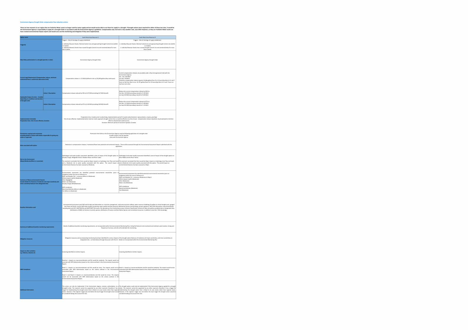
Environment Agency Drought Order compensation flow reduction actions
South West Area Reservoir 5 South West Area Reservoir 9
Triggers – Risk of shortage of supply established:
1. Individual Resevoir Stocks <Normal Control Line and approaching Drought Control Line (within 1‐2 weeks)2. Individual Resevoir Stocks have crossed Drought Control Line and remained below for more than 4 weeks
Triggers – Risk of shortage of supply established:
1. Individual Resevoir Stocks <Normal Control Line and approaching Drought Control Line (within 1‐2 weeks)
2. Individual Resevoir Stocks have crossed Drought Control Line and remained below for more than 4 weeks
Environment Agency Drought Order Environment Agency Drought Order
Compensation release is 1.33 Ml/d (defined in Act as 293,000 gallons/day continuous)
Current compensation releases are provided under a flow trial agreement held with the Environment Agency;Oct ‐ Dec 4.00 Ml/d Jan‐Sep 1.98 Ml/d(statutory compensation release requires 19,266 gallons/hour for 12 hours/day Mon to Fri and 7 hours on Sat from Nov to Jun. 22,797 gallons/hour for 12 hours/day Mon to Fri and 7 hours on Sat from Jul to Oct)
Action 1 Description Compensation release reduced by 50% to 0.67 Ml/d providing 0.67 Ml/d benefitReduce the current compensation release by 50% to;Oct‐Dec 2.00 Ml/d providing a benefit of 2.00 Ml/dJan‐Sep 0.99 Ml/d providing a benefit of 0.99 Ml/d
Action 2 Description Compensation release reduced by 67% to 0.44 Ml/d providing 0.89 Ml/d benefit
Reduce the current compensation release by 67% to;Oct‐Dec 1.32 Ml/d providing a benefit of 2.68 Ml/dJan‐Sep 0.65 Ml/d providing a benefit of 1.33 Ml/d
Hydrological and water quality assessment identified a zone of impact of the drought option on:Gorpley Clough, Midgelden Brook, Walsden Water and River Calder.
The assement concluded that there would be Major impacts on hydrology (river flow and level)and a Moderate risk to water quality associated with this option. The overall impact onenvironmental features has been assessed as Moderate.
Hydrological and water quality assessment identified a zone of impact of the drought option on: River Ribble and the River Holme.
The assement concluded that there would be Major impacts on hydrology (river flow and level) and a Moderate risk to water quality associated with this option. The overall impact on environmental features has been assessed as Major.
Environmental assessment has identified potential environmental sensitivities (prior tomitigation) within the zone of influence to:NERC and Notable Fish – numerous (Minor to Moderate)White‐clawed crayfish (Moderate)Otter (Negligible)Water vole (Moderate)Gorpley Clough LNR (Moderate)
WFD compliance Macroinvertebrates (Minor to Moderate)Fish (Minor to Moderate)
Environmental assessment has identified potential environmental sensitivities (prior to mitigation) within the zone of influence to:NERC and Notable Fish ‐ numerous (Moderate to Major)White‐clawed crayfish (Moderate)Otter (Moderate)Water vole (Moderate)
WFD compliance Macroinvertebrates (Moderate)Fish (Moderate)
Screening identified no further impacts. Screening identified no further impacts.
Reaches 1: Impacts on macroinvertebrates and fish would be moderate. The impacts would notassociate with WFD deterioration based on the criteria outlined in the Environmental AssessmentReport.
Reach 2:. Impacts on macroinvertebrates and fish would be minor. The impacts would not beassociated with WFD deterioration based on the criteria outlined in the EnvironmentalAssessment Report.
Reach 3 and Reach 4: Impacts on macroinvertebrates and fish would be minor. The impactswould not be associated with WFD deterioration based on the criteria outlined in theEnvironmental Assessment Report.
Reach 1: Impacts on macroinvertebrates and fish would be moderate. The impacts would not be associated with WFD deterioration based on the criteria outlined in the Environmental Assessment Report.
This action can only be implmented if the Environment Agency recieves auhtoridation via adroughth order. The reservoir cannot be supported by any other reservoirs therefore it has atrigger for implementing the drought action that is linked to its own stocks rather than regionalstocks. However, if the regional trigger was met before the local trigger the drought action wouldbe considered taking into account the risks.
This drought option could only be implemented if the Environment Agency applied for a droughtorder. This reservoir cannot be supported by any other reservoirs therefore it has a trigger forimplementing the drought action that is linked to its own stocks rather than regional stocks.However, if the regional trigger was met before the local trigger the drought action would beconsidered taking into account the risks.
Current Legal Requirement (Compensation release, minimum maintained flow or authorised abstraction limit)
Deployable Output of action ‐ Variable depending on conditions and duration of drought order
Option name
Trigger(s)
Additional information
There are two resevoirs in our region that are Yorkshire Water assets no longer used for water supply and we would not be able to use them for supply in a drought. If drought actions were required for either of these two sites, it would be the Environment Agency's responsbility to apply for a Drought Order in accordance with the Environment Agency's guidelines Compensation only reservoirs in dry weather note, June 2019. However, as they are Yorkshire Water assets we have created environmental impact reports and would carry out the monitoring and mitigation if they were implemented.
Mitigation measures
Summary of additional baseline monitoring requirements
Risk to the Environment (Major/Moderate/Minor or uncertain)
Summary of likely environmental impacts Include details for features of moderate and major sensitivity and minor sensitivity features from designated sites
Baseline information used
Risks associated with option
Permissions required and constraints Including details of liaison with bodies responsible for giving any orders or approvals
Implementation timetable Preparation time, time of year effective, duration
Most likely authorisation in a drought (permit or order)
Preparation time: 4 weeks prior to advertising, implementation period 5‐6 weeks (advertisement, representation, enquiry, granting)Time of year effective: implemented when reservoir stocks approach drought control line so could be effective any time of year. Compensation release reductions may be phased to minimise
effect on downstream watercourses.Duration: Minimum period of restriction typically 12 weeks
Permission from Defra or the Environment Agency required following application of a drought order A public enquiry may be required. Liaise with Environment Agency.
Reduction in compensation releases / maintained flows have potential environmental impacts. These will be assessed through the Environmental Assessment Report submitted with the application.
Environmental assessment used YWS and EA data and information on: reservoir management, measured reservoir outflow, water resource modelling of outflow in critical drought years, gauged river flows and levels; routine WFD water quality monitoring, water quality and flow pressures (abstraction licence and discharge consent registers), YWS STW information; macroinvertebrate
sampling data and LIFE, WHPTNATXA and WHPTASPT EQI scores, fish abundances from monitoring surveys, Fisheries Classification Scheme (2) data and publicly available data on designated sites, distributions of NERC Act Section 41 priority species, distribution of Invasive and Non‐Native Species and recreational resources, in addition to local EA / YWS knowledge.
Mitigation measures and accompanying monitoring have been identified for serious impacts of the drought option (features of moderate and major sensitivities, and minor sensitivities to designated sites ‐ as listed above) through discussion with the EA. Details are incorporated within the Environmental Monitoring Plan
Details of additional baseline monitoring requirements, are incorporated within the Environmental Monitoring Plan, listing the features to be monitored and methods used; location, timing and frequency of surveys; and who will undertake the monitoring.
Impact on other activities e.g. fisheries, industry etc
WFD Compliance

@yorkshirewater
facebook.com/yorkshirewater
yorkshirewater.com