Hawaii Drought Planfiles.hawaii.gov/dlnr/cwrm/planning/HDP2017.pdf · 9.1.4 Public Education...
139
Hawaii Drought Plan 2017 UPDATE Prepared for: State of Hawaii Department of Land & Natural Resources Commission on Water Resource Management Prepared by: One World One Water, LLC Connecting Engineering and Policy May, 2017
-
Upload
vuonghuong -
Category
Documents
-
view
216 -
download
1
Transcript of Hawaii Drought Planfiles.hawaii.gov/dlnr/cwrm/planning/HDP2017.pdf · 9.1.4 Public Education...

Hawaii Drought Plan
2017 UPDATE
Prepared for: State of Hawaii Department of Land & Natural Resources Commission on Water Resource Management
Prepared by: One World One Water, LLC
Connecting Engineering and Policy
May, 2017

Hawaii Drought Plan 2017
(This page intentionally left blank)
Hawaii Drought Plan 2017
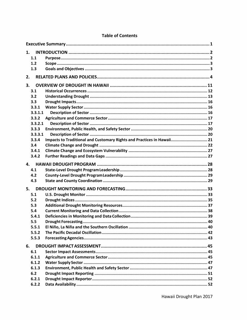
Table of Contents
Executive Summary ............................................................................................................... 1
1. INTRODUCTION ............................................................................................................. 2 1.1 Purpose ........................................................................................................................... 2 1.2 Scope .............................................................................................................................. 3 1.3 Goals and Objectives ....................................................................................................... 3
2. RELATED PLANS AND POLICIES ....................................................................................... 4
3. OVERVIEW OF DROUGHT IN HAWAII ........................................................................... 11 3.1 Historical Occurrences ................................................................................................... 12 3.2 Understanding Drought ................................................................................................. 13 3.3 Drought Impacts ............................................................................................................ 16 3.3.1 Water Supply Sector ...................................................................................................... 16 3.3.1.1 Description of Sector ................................................................................................. 16 3.3.2 Agriculture and Commerce Sector .................................................................................. 17 3.3.2.1 Description of Sector ................................................................................................. 17 3.3.3 Environment, Public Health, and Safety Sector ............................................................... 20 3.3.3.1 Description of Sector ................................................................................................. 20 3.3.4 Impacts to Traditional and Customary Rights and Practices in Hawaii.............................. 21 3.4 Climate Change and Drought ......................................................................................... 22 3.4.1 Climate Change and Ecosystem Vulnerability ................................................................. 27 3.4.2 Further Readings and Data Gaps .................................................................................... 27
4. HAWAII DROUGHT PROGRAM ..................................................................................... 28 4.1 State-Level Drought Program Leadership ........................................................................ 28 4.2 County-Level Drought Program Leadership ..................................................................... 29 4.3 State and County Coordination ...................................................................................... 29
5. DROUGHT MONITORING AND FORECASTING ............................................................... 33 5.1 U.S. Drought Monitor .................................................................................................... 33 5.2 Drought Indices ............................................................................................................. 35 5.3 Additional Drought Monitoring Resources ...................................................................... 37 5.4 Current Monitoring and Data Collection ......................................................................... 38 5.4.1 Deficiencies in Monitoring and Data Collection ............................................................... 39 5.5 Drought Forecasting ....................................................................................................... 40 5.5.1 El Niño, La Niña and the Southern Oscillation ................................................................. 40 5.5.2 The Pacific Decadal Oscillation ....................................................................................... 42 5.5.3 Forecasting Agencies ...................................................................................................... 43
6. DROUGHT IMPACT ASSESSMENT .................................................................................. 45 6.1 Sector Impact Assessments ............................................................................................ 45 6.1.1 Agriculture and Commerce Sector .................................................................................. 45 6.1.2 Water Supply Sector ...................................................................................................... 47 6.1.3 Environment, Public Health and Safety Sector ................................................................ 47 6.2 Drought Impact Reporting ............................................................................................. 51 6.2.1 Drought Impact Reporter ............................................................................................... 52 6.2.2 Data Availability ............................................................................................................ 52

Hawaii Drought Plan 2017
6.2.3 Drought Impact Studies ................................................................................................. 54
7. DROUGHT RISK AND VULNERABILITY IN HAWAII .......................................................... 55 7.1 The Drought Risk and Vulnerability Assessment and GIS Mapping Project ........................ 61 7.1.1 Background and Purpose ............................................................................................... 61 7.1.2 Findings and Results ...................................................................................................... 62 7.1.3 Drought Risk Areas: City and County of Honolulu ........................................................... 62 7.1.4 Drought Risk Areas: County of Hawaii ............................................................................ 62 7.1.5 Drought Risk Areas: County of Maui ............................................................................... 63 7.1.6 Drought Risk Areas: County of Kauai ............................................................................... 63
8. DROUGHT COMMUNICATION AND RESPONSE ACTIONS .............................................. 64 8.1 Drought Communication Protocol .................................................................................. 64 8.2 Declaration of Drought Conditions ................................................................................. 64 8.2.1 Drought Conditions ....................................................................................................... 67 8.3 Communication and Coordination Guidelines ................................................................. 68 8.3.1 General Communication and Coordination Guidelines .................................................... 68 8.3.2 Specific Communication Responsibilities......................................................................... 68 8.4 Drought Response Actions ............................................................................................. 72 8.4.1 Drought Response Versus Drought Mitigation ................................................................ 72 8.4.2 State Agency Response Actions ...................................................................................... 73 8.4.3 County Drought Response Actions ................................................................................. 79 8.4.4 Water Suppliers Response Actions ................................................................................. 79 8.5 Water Use During Drought ............................................................................................. 80 8.6 Post Drought Evaluation ................................................................................................ 81
9. DROUGHT MITIGATION AND PREPAREDNESS ............................................................... 83 9.1 State Mitigation Strategies ............................................................................................ 83 9.1.1 Statewide Water Resources Monitoring, Drought Forecasting, and Impact Assessment ... 83 9.1.2 Development of Water Sources ..................................................................................... 85 9.1.3 Increasing Conservation, Reuse and Recharge ................................................................ 86 9.1.4 Public Education Awareness and Outreach ..................................................................... 88 9.1.5 Watershed Protection Partnerships ............................................................................... 89 9.1.6 Legislation ..................................................................................................................... 90 9.1.7 Land Use Planning ......................................................................................................... 90 9.2 Previous Drought Projects.............................................................................................. 91 9.3 State and County Multi-Hazard Mitigation Plan .............................................................. 92 9.4 County Drought Mitigation Strategies ............................................................................ 92
10. RECOMMENDATIONS AND IMPLEMENTATION ACTIONS.............................................. 95 10.1 Priority Implementation Actions .................................................................................... 95 10.2 Drought Monitoring and Forecasting Recommendations ................................................ 96 10.3 Drought Impact Assessment Recommendations ............................................................. 97 10.4 Drought Risk and Vulnerability Recommendations ......................................................... 97 10.5 Drought Communication and Response Recommendations ............................................ 97 10.6 Drought Mitigation and Preparedness Recommendations .............................................. 97 10.7 Additional Drought Planning Recommendations ............................................................ 98 10.8 Future Hawaii Drought Plan Updates and Revisions ........................................................ 98

Hawaii Drought Plan 2017
List of Figures
Figure 1. Hawaii Water Plan Components .................................................................................... 6 Figure 2. Sequence of drought occurrence and impacts for commonly accepted drought types.
All drought originates from a deficiency of precipitation or meteorological drought but other types of drought and impacts cascade from this deficiency. Source: Drought Mitigation Center, University of Nebraska- Lincoln, U.S.A. ................................................ 15
Figure 3. Hawaii’s Agricultural Land Utilization (1937). Source: Statewide Agricultural Land Use Baseline 2015....................................................................................................................... 18
Figure 4. Hawaii’s Agricultural Land Utilization (1980). Source: Statewide Agricultural Land Use Baseline 2015....................................................................................................................... 19
Figure 5. Hawaii’s Agricultural Land Utilization (2015). Source: Statewide Agricultural Land Use Baseline 2015....................................................................................................................... 19
Figure 6. Wildfire Incidents for the 6 Main Hawaiian Islands, 2014. Created by Hawaii Wildfire Management Organization.................................................................................................. 21
Figure 7. Future projections of drought based on historical data and future climate projections. Source: Climate change and Pacific islands: Indicators and impacts (2012), figure courtesy of Oliver Elison Tim. ............................................................................................................. 25
Figure 8. Percent Change in Rainfall. Created by Abby Frazier. Source: Elison Timm, O., T. W. Giambelluca, and H. F. Diaz (2015), Statistical downscaling of rainfall changes in Hawai‘i based on the CMIP5 global model projections, Journal of Geophysical Research: Atmospheres, 120(1), 92-112. ............................................................................................. 25
Figure 9. U.S. Drought Monitor for Hawaii and Drought Severity Classification ........................ 34 Figure 10. 12- Month SPI. Source: NOAA, National Weather Service......................................... 34 Figure 11. Oceanic Nino Index (ONI). Red bars indicate warm conditions in the equatorial
Pacific, blue bars indicate cool conditions in equatorial waters. Large and prolonged El Niño events are indicated by large, positive values of the index. Source: NOAA. .............. 42
Figure 12. Maps showing patterns of sea surface temperatures during El Niño in the Pacific Ocean. Created by Steve Albers and NOAA. ....................................................................... 42
Figure 13. Phases of the Pacific Decadal Oscillation from 1970 to 2016. Each bar represents one month. Red bars show positive (warm) phase and blue indicates negative (cool) phase. Source: NOAA. .......................................................................................................... 43
Figure 14. Communities at Risk from Wildfires. Created by HWMO. ......................................... 48 Figure 15. Hawaii Statewide Wildfire Ignitions. Created by University of Hawaii and Pacific Fire
Exchange .............................................................................................................................. 49 Figure 16. Wildfire Incidents for the 6 Main Hawaiian Islands, 2014. Created by Hawaii Wildfire
Management Organization.................................................................................................. 50 Figure 17. Drought Impact Reporter Hawaii ............................................................................... 52 Figure 18. Water Supply Drought Risk. Created by OWOW. ...................................................... 57 Figure 19. Agricultural Drought Risk. Created by OWOW. ......................................................... 58 Figure 20. Communities at Risk from Wildfires. Created by HWMO. ......................................... 59 Figure 21. Percent of State of Hawaii with No Drought .............................................................. 65 Figure 22. Percent of State of Hawaii with Drought D1-D4 ........................................................ 65

Hawaii Drought Plan 2017
Figure 23. Drought Plan Role in the State Hazard Mitigation Plan. ............................................ 93
List of Tables
Table 1. Hawaii Water Plan Document Status .............................................................................. 5 Table 2. History of Most Severe Droughts .................................................................................. 13 Table 3. Hawaii Drought Program Tasks and Descriptions ......................................................... 31 Table 4. Drought Indices ............................................................................................................. 37 Table 5. Drought Resources ........................................................................................................ 38 Table 6. USDA Risk Management Agency Crop Insurance Data ................................................. 46 Table 7. Farm Service Agency Historical Payouts; *=Estimated ................................................. 47 Table 8. Potential Drought Impacts. Adapted from Western Drought Coordination Council,
How to Reduce Drought Risk, March 1998. ........................................................................ 51 Table 9. Drought Severity Classification, Drought Monitor ........................................................ 68 Table 10. Communication Actions and Guidelines ..................................................................... 72 Table 11. Drought Response Actions Versus Drought Mitigation Actions ................................. 73 Table 12. Recommended State Agency Drought Response Actions, Department of Agriculture
............................................................................................................................................. 75 Table 13. Recommended State Agency Drought Response Actions, Commission on Water
Resource Management ....................................................................................................... 76 Table 14. Recommended State Agency Drought Response Actions, Department of Land and
Natural Resources ............................................................................................................... 77 Table 15. Recommended State Agency Drought Response Actions, Hawaii Emergency
Management Agency ........................................................................................................... 78 Table 16. Local Contacts for State Agencies ............................................................................... 78 Table 17. Hawaii Department of Agriculture and County Water Suppliers ................................ 80 Table 18. Assistance Received by Hawaii Drought Programs ..................................................... 92 Table 19. Act 238, SLH 2007 Project Implementation ................................................................ 94 Table 20. Example of Drought Stage Characteristics .................................................................. 96 Table 21. Local Contacts for Federal Agencies ............................................................................ 99
List of Appendices
Appendix A: Federal Drought Assistance Programs
Appendix B: Hawaii Drought Leadership
Appendix C: State Agency Index
Appendix D: Potential Risk Reduction Actions
Appendix E: Drought Resources Review
Appendix F: Early Drought Plan Implementation Actions
Appendix G: Annual Rainfall- Main Airports
Appendix H: Full Links

Hawaii Drought Plan 2017
Appendix I: References
List of Acronyms
ASR Aquifer Storage and Recovery BWS Board of Water Supply (Honolulu, Oahu) CD Civil Defense (State or County) CLDC County/Local Drought Committee CPC Climate Prediction Center CWPP Community Wildfire Protection Plans CWRM State Commission on Water Resource Management DBEDT State Department of Business, Economic Development and Tourism DLNR State Department of Land and Natural Resources DOA State Department of Agriculture DOFAW State Division of Forestry and Wildlife DOH State Department of Health DOW Department of Water (Kauai) DWS Department of Water Supply (Maui or Hawaii) ENSO El Niño Southern Oscillation EPA Environmental Protection Agency FCIC Federal Crop Insurance Corporation FEMA Federal Emergency Management Agency FSA Farm Service Agency FWS U. S. Fish and Wildlife Service HACD Hawaii Association of Conservation Districts HAR Hawaii Administrative Rules HASS Hawaii Agricultural Statistics Service HDC Hawaii Drought Council HDP Hawaii Drought Plan HFO Honolulu Forecast Office HRS Hawaii Revised Statutes IPCC Intergovernmental Panel on Climate Change IWFMP Integrated Wildland Fire Management Plan LFP Livestock Forage Disaster Program NAP Noninsured Crop Disaster Assistance Program NDMC National Drought Mitigation Center NIDIS National Integrated Drought Information System NOAA National Oceanic and Atmosphere Agency NPS National Park Service NRCS Natural Resources Conservation Service NWS National Weather Service PDO Pacific Decadal Oscillation
PDSI Palmer Drought Severity Index PSA Public Service Announcement PUC State Public Utility Commission

Hawaii Drought Plan 2017
RAWS Remote Automated Weather Station RMA USDA Risk Management Agency SBA Small Business Administration SDC State Drought Coordinator SDWB Safe Drinking Water Branch SOI Southern Oscillation Index SPI Standardized Precipitation Index SWCD Soil and Water Conservation Districts T&C Traditional and Customary UH University of Hawaii USDA U. S. Department of Agriculture USGS U. S. Geological Survey WRC Water Resources Committee WUI Wildland Urban Interface

Hawaii Drought Plan 2017
1
Executive Summary
The Hawaii Drought Plan (HDP) has been updated for use by the Hawaii Drought Council to improve coordination and implementation of drought management strategies for the State of Hawaii. The revised plan is intended to serve as a “framework” through which State and local entities can work together to proactively implement mitigation measures and appropriate response actions during periods of drought. Effective coordination of these activities can help reduce and minimize the effects upon the people and natural resources of Hawaii. The HDP was designed as an informative guide to help reduce the negative impacts that drought conditions cause for the State of Hawaii. It addresses an overview of drought in Hawaii along with the threat of future droughts, the coordination of Hawaii’s Drought Program, methods for drought monitoring, forecasting, and impact assessment, and strategies for drought planning and mitigation. Drought mitigation has been emphasized in this plan as a proactive approach to lessen the intensity of dry periods. Since the initial HDP in 2000, much progress has been made with drought planning, particularly with regard to implementation of specific recommended actions. In the future, continued implementation of recommended plan provisions will remain a key challenge to the Hawaii Drought Council and its member agencies and stakeholder representatives. Appropriate government and private sector resources will need to be identified to address the recommended priority mitigation actions identified in the plan. The success of the plan will ultimately be measured by the ability of government agencies, stakeholders, and the general public to function as a team in achieving the necessary goals and objectives for successful mitigation of drought impacts for the state. This plan has been designed as a dynamic “living” document, which should be utilized and updated to reflect changing conditions, new information, and an evolving leadership structure encompassing the Hawaii Drought Council, Hawaii Drought Monitor Author, and the County/Local Drought Committees. The plan will be made available on the Hawaii Drought Website to facilitate public access and the review of future plan updates.

Hawaii Drought Plan 2017
2
1. INTRODUCTION Drought, which occurs from prolonged periods of abnormally low rainfall, has the potential to severely affect communities and the environment in a variety of ways. The impacts of drought include decimation of crops and livestock, the creation of dustbowls and erosion of landscapes, damage to terrestrial and aquatic wildlife habitats, enhanced wildfires, and economic damage. For years, farmers, ranchers, scientists, economists, small business owners, environmentalists, wildlife managers, and county, state, and federal agencies have grappled with the far-reaching consequences of drought. Drought can lead to tough decisions regarding allocation of water, stringent water-use limitations in large urban areas, and problems in ensuring safe drinking water and adequate water supplies for firefighting efforts. In Hawaii, there are additional issues such as growing conflicts between agricultural uses of surface water and instream uses, surface and ground water interrelationships, and the effects of growing water demands on traditional and cultural uses of water. In the past, drought was addressed as a temporary emergency and actions were taken in response to impacts, in a reactionary fashion. The most important lesson learned in recent years is that the best time to reduce the impacts of drought is before they occur. Therefore, it is important to develop a plan that advocates a proactive drought management approach. The Hawaii Drought Plan has been developed with the intent of providing a strong proactive approach to drought, along with outlining responses and appropriate communication actions for when drought occurs.
1.1 Purpose
Droughts and wildland fires threaten all islands of the State of Hawaii in any given year. As recently as the spring of 2016 Hawaii was threatened by extreme drought on parts of Hawaii Island, causing severe impacts including cattle deaths and shortened crop seasons. Parts of Oahu, Maui, and Kauai were also impacted by drought in 2016, with wildfire on the slopes of Diamond Head on Oahu and voluntary water reductions in certain locations on Maui. With continued economic growth and development in the wildland urban interface (WUI) areas, along with increased dry periods caused by a changing climate, the occurrence of drought throughout the State of Hawaii is bound to increase in the future. Drought planning, including aggressive preparedness and mitigation measures and regular updating of the Hawaii Drought Plan, will be effective in reducing property losses and in enhancing public safety. The Hawaii Drought Plan, in addition to serving as a compendium of drought-related information, also identifies two key activities: 1) short-term, immediate response actions to address specific, imminent drought impacts, and 2) long-term, ongoing mitigation actions that will help prepare for future drought occurrences.
The purpose of this plan is to provide a coordinated and consistent program and a framework for integrating federal, state, county, and private sector actions to reduce the impact of human suffering and to minimize property losses due to drought. The plan is intended to serve as a

Hawaii Drought Plan 2017
3
working guide for those agencies that have the capabilities and resources to develop effective response and mitigation programs within their areas of jurisdiction. The success of this plan is heavily dependent upon coordination and commitment from all levels of government, as well as the private sector. Effective drought planning and mitigation programs can reduce the need for extensive federal, state, and county emergency relief expenditures to rebuild local economies, and to reduce conflicts over competition for water during drought.
1.2 Scope
The HDP includes a description of historical occurrences, climatological statistics, risk assessments of susceptibility and vulnerability to drought, as well as the identification of potential impacts related to specific geographical locations. The HDP also emphasizes the identification of pre- and post-drought preparedness and mitigation measures for implementation by government agencies, stakeholders, and the general public. The Hawaii Drought Plan establishes the following leadership structure:
Hawaii Drought Council (HDC)
State Drought Coordinator (SDC)
Hawaii Drought Monitor Author (HDMA)
County/ Local Drought Committees (CLDCs) Participation in these groups is designed to include, but not be limited to, individuals and/or organizations that can best share their knowledge and experience regarding local issues, resources, and priorities for drought response and mitigation.
1.3 Goals and Objectives
The objective of the Hawaii Drought Plan is to be prepared for and mitigate against the impacts of future drought events in Hawaii. With that in mind the key components of the plan include:
An overview of drought in Hawaii
Details on Hawaii’s drought program
Monitoring and forecasting o Timely predictions and monitoring of drought conditions
Impact assessments
Risk and vulnerability o Risk assessment of drought-related impacts to the (1) agriculture and commerce
(2) municipal water supply, and (3) environment, public health and safety sectors
Communication and response actions o Detailed response measures for state and county agencies
Mitigation and preparedness o Mitigation of drought impacts through effective planning actions during non-
drought periods
Recommendations and implementation actions

Hawaii Drought Plan 2017
4
2. RELATED PLANS AND POLICIES
This section provides information on various State and County mandates and responsibilities that influence the design and application of the Hawaii Drought Plan. Hawaii has numerous plans and policies in place that provide comprehensive water security planning for the state. This section provides brief descriptions of these strategies as a background for subsequent chapters. Statewide collaboration on water planning is a key aspect of preparing Hawaii for future drought incidents.
Hawaii Water Plan The Hawaii Water Plan consists of five constituent parts: 1) Water Resource Protection Plan which is prepared by the Commission on Water Resource Management, 2) Water Quality Plan which is prepared by the Department of Health, 3) State Water Projects Plan which is prepared by the Engineering Division of the Department of Land and Natural Resources, 4) Agricultural Water Use and Development Plan which is prepared by the Department of Agriculture, and 5) Water Use and Development Plans prepared by each separate county. The Water Resource Protection Plan (WRPP) and the Water Quality Plan (WQP) provide the overall legal and policy framework that guide the development, conservation, and use of water resources. The State Water Projects Plan (SWPP) and Agricultural Water Use and Development Plan (AWUDP) provide information on State and agricultural water needs and development plans. All this information is then integrated into the County Water Use and Development Plans (WUDP), which set forth the broad allocation of water to land use within each county. Figure 1 illustrates the integration of the various components of the Hawaii Water Plan. Each component of the Hawaii Water Plan focuses on a specific objective and assesses elements summarized in Table 1. The Hawaii Water Plan is a living document and many of these components are currently being updated. Please see the Hawaii Water Plan website for more information.
Hawaii Water Plan Component
Objectives Elements Assessed Status
Water Resource Protection Plan (WRPP) Responsible Agency: CWRM
To protect and sustain statewide groundwater and surface water resources, watersheds and natural stream environments.
Aquifer Sustainable Yield Instream Flow Standards Water Sources Water Use Water Rights Water Resource Monitoring Water Management and
Regulations Resource Conservation and
Augmentation
Original: 2008 Update in Progress.
Water Quality Plan (WQP)
To protect the public health and sensitive ecological
Water Quality Standards Water Quality Monitoring
Original: 1990 Updated: 2014 (Draft)

Hawaii Drought Plan 2017
5
Responsible Agency: DOH
systems by preserving, protecting, restoring and enhancing the quality of ground and surface water throughout the State of Hawaii.
Wellhead Protection Wastewater Treatment Recycled Water Use Compliance and
Enforcement
State Water Projects Plan (SWPP) Responsible Agency: DLNR
To provide a framework for planning and implementation of water development programs to meet projected water demands for State projects.
State Water Sources State Water Needs
2003 Update Update in Progress.
Agricultural Water Use and Development Plan (AWUDP)
To assess State and private agricultural water use, supply and irrigation water systems through a long-range management plan.
Irrigation Systems, Reservoirs
Agricultural water needs
Original: 2003/2004 Update in Progress.
County Water Use and Development Plan (WUDP)
To set forth the allocation of water to land use through the development of policies and strategies to guide the County in its planning, management, and development of water resources to meet projected demands
Assessment of land use plans and policies
Current and future water demands
Water systems Resource and facility
options, including supply sources, transmission, storage and conservation
Watershed protection
Kauai Original: 1990 Oahu Original: 1990 Maui Original: 1990 Hawaii Update: 2010 Updates in Progress.
Table 1. Hawaii Water Plan Document Status

Hawaii Drought Plan 2017
6
Figure 1. Hawaii Water Plan Components
State Water Code The State Water Code, Chapter 174C, Hawaii Revised Statutes (HRS) was passed by the Hawaii State Legislature in July 1987 for the purposes of protecting and managing Hawaii's water resources. It is administered by the Commission on Water Resource Management (CWRM) and provides for the legal basis and establishment of the CWRM and its authorities and responsibilities.
Specified in the Water Code, the Code shall be liberally interpreted to obtain maximum beneficial use of the waters of the State for purposes declared to be in the public interest, such as domestic uses, aquaculture uses, irrigation and other agricultural uses, power development, and commercial and industrial uses. The Code also specifies that adequate provision shall be made for the protection of traditional and customary Hawaiian rights, the protection and procreation of fish and wildlife, the maintenance of proper ecological balance and scenic beauty, and the preservation and enhancement of waters of the State for municipal uses, public recreation, public water supply, agriculture, and navigation.
State Multi-Hazard Mitigation Plan Hazard mitigation is an action or number of actions taken to reduce or eliminate long-term risk to people and their property from the effects of natural hazards. The purpose of hazard

Hawaii Drought Plan 2017
7
mitigation is twofold: 1) to protect people and structures from harm and destruction; and 2) to minimize the costs of disaster response and recovery. Hazard mitigation planning is the process that analyzes a community’s risk from natural hazards, coordinates available resources, and implements actions to reduce risks. The Federal Disaster Management Act of 2000 requires each state and territory to conduct hazard mitigation planning and to implement projects to reduce hazard impacts prior to a disaster occurrence. As of 2004, states are required to have an approved Standard State Mitigation Plan in order to receive additional Pre-Disaster Mitigation funds for state or local mitigation projects. These mitigation plans are also required for non-emergency assistance provided under the Stafford Act. The Hawaii State Hazard Mitigation Forum, composed of county, State, federal agency representatives, and private individuals, agreed that the Hawaii State Hazard Mitigation Plan should be a multi-hazard plan. For the purposes of the plan, the term “multi-hazard” is not limited to discrete natural hazards, and will include anthropogenic activities that could exacerbate hazard event impacts and potentially threaten the life and safety of the citizens of the State of Hawaii. The goal of the plan is to mitigate the impact of such potential disasters. The State Multi-Hazard Mitigation Plan encompasses the broadest possible scope of disaster occurrences, focusing on nine natural hazards: hurricanes, tsunami, earthquakes, floods, volcanic eruptions and lava flow, coastal erosion, landslides, wildfire, and drought. Several of these hazard categories have current advisory boards or task forces that will be developing recommendations and strategies.
County Multi-Hazard Mitigation Plans Hazard mitigation is the use of long-term and short-term policies, programs, projects, and other activities to alleviate the death, injury, and property damage that can result from a natural disaster. County hazard mitigation plans are available for Maui, Hawaii, Kauai, and Honolulu in order to reduce risks from natural disasters. These plans comply with hazard mitigation planning requirements to maintain eligibility for funding under Federal Emergency Management Agency (FEMA) grant programs. The mitigation actions outlined in these plans are designed to reduce or eliminate losses resulting from natural hazards.
Rather than create separate plans for each type of hazard, the County Multi- Hazard Mitigation Plans have been designed as multi-hazard plans. A multi-hazard plan has several advantages:
1. Certain hazards cause cascading hazard effects (e.g., earthquakes may cause landslides, local tsunami, or dam break flooding; hurricanes cause wind damage and flooding)
2. Priorities can be established to allocate limited resources to areas susceptible to the most severe or frequent hazards
3. Areas identified as susceptible to multiple types of risks may require special attention 4. Common responses often apply to different hazards

Hawaii Drought Plan 2017
8
5. Resources or mitigation measures can be leveraged where they can benefit multiple hazards; for example, proposed changes to building design standards could consider both wind-loading (hurricane) and ground-shaking (earthquake).
County Drought Mitigation Strategies Drought mitigation strategies were prepared for each of the four counties in 2004 with projects updated in 2012. County Drought Mitigation Strategies will be updated through a series of county meetings involving agencies and stakeholders that have a role in drought mitigation and response. Projects identified through this process are integrated within the County Hazard Mitigation Plans, and the strategies developed shall incorporate the necessary coordination between government agencies and affected stakeholders. County mitigation projects are implemented through the County/Local Drought Committees in coordination with the Hawaii Drought Council and the State Drought Coordinator.
DOA Water Rules and Regulations The DOA Agricultural Resource Management Division (ARMD), along with the DOA Agribusiness Development Corporation (ADC) manage reservoirs and irrigation water systems. The rules governing irrigation water service to customers are available online.
County Water Rules and Regulations For each county’s department of water, there are rules and regulations pertaining to customers in each water service area. These provide direction, guidance, and procedures for resolution of problems regarding water services. Each county’s rules and regulations are available online:
Honolulu Board of Water Supply: http://www.boardofwatersupply.com/about-us/rules-and-regulations
Kauai Department of Water Supply: http://www.kauaiwater.org/cp_rules®s.asp
Maui Department of Water Supply: http://www.co.maui.hi.us/205/Rules-Regulations
Hawaii Department of Water Supply: http://www.hawaiidws.org/3%20about%20water/3d%20rules/Rules%20and%20Regulations%20Effective%2010-21-04.pdf
Water Conservation Plan The Hawaii Water Conservation Plan was prepared for the CWRM and United States Army Corps of Engineers in 2013. The purpose of this plan is to identify and implement water use and delivery efficiency measures to conserve the fresh water resources of Hawaii. It is intended to be a guiding document for the CWRM as they develop and implement water efficiency measures that can be implemented across the state by various water user groups. Since the CWRM is not a water purveyor, participation and implementation of the measures outlined in this plan will be dependent on the participation of water users. This plan primarily focuses on

Hawaii Drought Plan 2017
9
the “demand side” measures of water use and delivery efficiency measures and programs to implement them. The Hawaii Water Conservation Plan was developed with representation from a variety of water industry professionals and experts from across the state with knowledge or interest in water efficiency and conservation. Integrated Wildland Fire Management Plan (IWFMP) Developed by the U.S. Army of Hawaii, the Integrated Wildland Fire Management Plan presents a comprehensive approach to reduce the frequency of wildfire and the associated costs and damages. This plan contains details on pre-suppression, fire suppression, post-fire actions, and detailed area descriptions. The goal of this plan is to convey the methods and protocols necessary to minimize fire frequency, severity, and size in Hawaii. Community Wildfire Protection Plans (CWPPs) CWPPs, developed by Hawaii Wildfire Management Organization, are created with input from community members, resource management and firefighting agencies, and a variety of other parties. They are a useful planning tool for communities and have become a prerequisite for receiving federal funding for wildfire protection projects. These plans help communities identify and prioritize areas for hazardous fuel reduction treatments. CWPPs assess values at risk including safety, natural resource protection, recreation, scenic values, and economic assets. CWPPs are increasingly important in Hawaii, which faces unique wildfire threats that are becoming more challenging due to increasing ignitions, drought episodes, and land use changes. Hawaii Wildfire Management Organization is prioritizing developing Community Wildfire Protection Plans for high priority areas with the vision of eventually covering the entire State of Hawaii. Land Fire Protection Law Chapter 185 of Hawaii Revised Statutes, this law mandates DLNR (State Department of Land and Natural Resources) to “take measures for the prevention, control, and extinguishment of wildland fires within forest reserves, public hunting areas, wildlife and plant sanctuaries, and natural area reserves.” DLNR is also statutorily required to cooperate with established county and federal government fire control agencies “in developing plans and programs and mutual aid agreements for assistance for the prevention, control, and extinguishment of fires on forest, grass, brush, and watershed lands not within the department’s fire protection responsibilities.” More information is available on online under DOFAW’s Forestry Programs. A Blueprint for Action: Water Security for an Uncertain Future The Hawaii Fresh Water Initiative was launched in 2013 to bring together diverse parties to develop strategies to increase water security for the Hawaiian Islands. Organized by Hawaii

Hawaii Drought Plan 2017
10
Community Foundation, the Hawaii Freshwater Blueprint initiative provides Hawaii policy and decision-makers with a set of solutions that should be adopted to help Hawaii reach 100 million gallons per day in additional, reliable water capacity by 2030. To achieve this goal, three water strategy areas have been outlined to reach this statewide goal: Conservation, Recharge, and Reuse.

Hawaii Drought Plan 2017
11
3. OVERVIEW OF DROUGHT IN HAWAII
Drought is a significant problem in the State of Hawaii and drought conditions affect some part of the State frequently. Hawaii’s isolated land mass as an island chain results in limited water resources, making it highly sensitive to reductions in water availability. Growing populations are putting added pressure on Hawaii’s water supply, and increased water demands may lead to water shortages and stresses to major aquifer systems. Drought conditions are compounded by the lack of adequate water supply infrastructure in certain parts of the State. Increasing water consumption and demand can lead to shortages, as water distribution systems in some cases are neither flexible nor sufficient to accommodate the shortfall without exercising extraordinary emergency actions and measures. Inadequate source development without appropriate planning for future climatic changes will result in short- and long-term impacts to existing water resources. The water supply sector has further pressure from agricultural water needs. Around the turn of the 20th century plantation agriculture was booming and an extensive network of plantation irrigation systems were developed to provide water from the wet windward mountains to the fertile leeward plains. Plantations started to decline due to various factors in the late twentieth century with the last plantation shutting down operations in 2016. As plantations closed, the irrigation infrastructure no longer had a steward to maintain and make improvements to the system. Currently, the capacity to oversee, manage and maintain varies from system to system. It is especially critical when facing drought to invest in the maintenance and rehabilitation of these systems to support the water needs of various agricultural communities. If these systems fail to provide agriculture water, the groundwater will be further strained by agricultural uses, especially in times of drought.
Droughts have been prevalent in the past and will continue to adversely affect the environment, economy, and the citizens of the State. Historical patterns indicate that Hawaii will continue to suffer damaging droughts, and the loss potential will only increase as the need for economic growth and revitalization amplify pressures upon the State’s limited water supply. Rising temperatures and reduced precipitation levels due to the added pressure of climate change have the potential to increase the intensity and frequency of droughts in Hawaii, resulting in added stress to Hawaii’s water supply. Additionally, there is pressure from the loss of upland forest, degraded soil, and large developed areas with impervious surfaces that decrease the opportunity for our lands to recharge aquifers and retain critical moisture that cycles back into rainfall. Aggressive planning, active drought mitigation, and the utilization of alternative resources is necessary. Failure to execute appropriate actions may result in a situation where future populations and economic growth cannot be sustained due to insufficient quantity and quality of water resources. The effective planning and management of water resources is critical to the long-term sustainability of our island communities.

Hawaii Drought Plan 2017
12
3.1 Historical Occurrences
Droughts have been prevalent in the past (See Table 2) and preceding patterns indicate that Hawaii will continue to suffer damaging droughts. Historically, droughts in Hawaii have caused extensive economic damage through crop and livestock losses along with prevalent wildfire impacts. Examples of drought impacts include the drought from December 1980 to February 1981 that resulted in over $1.4 million in damages from both agricultural and cattle losses, and the more recent drought in 2016 that resulted in a fire on the slopes of Diamond Head on Oahu. As the risk of climate change continues to increase, Hawaii will likely see a rise in extreme weather conditions. Weather patterns such as El Niño will continue to correlate with drier wet seasons, such as with the 2010 drought that caused all four counties to be designated as Primary Natural Disaster Areas. Drought mitigation actions, including water conservation measures and water efficient designs, are a key component to making Hawaii as resilient to drought as possible in order to reduce future negative impacts.
Year Areas Remarks
1901 North Hawaii Severe drought, destructive forest fires.
1905 Kona, Hawaii Serious drought and forest fires.
1908 Hawaii and Maui Serious drought.
1912 Kohala, Hawaii Serious drought and severe sugarcane crop damage for two years.
1952 Kauai Long, severe dry spell.
1953 Hawaii, Kauai, Maui, and Oahu
Water rationing on Maui; water tanks in Kona almost empty; 867 head of cattle died; pineapple production on Molokai reduced by 30%; rainfall in the islands 40% less than normal.
1962 Hawaii and Maui State declared drought disaster for islands of Hawaii and Maui; crop damage, cattle deaths, and severe fire hazards; losses totaled $200,000.
1965 Hawaii State water emergency declared; losses totaled $400,000.
1971 Hawaii and Maui Irrigation and domestic water users sharply curtailed.
1975 Kauai and Oahu Worst drought for sugar plantations in 15 years.
1977-1978 Hawaii and Maui State declared drought disaster for islands of Hawaii and Maui.
1980-1981 Hawaii and Maui State declared drought disaster; heavy agricultural and cattle losses; damages totaling at least $1.4 million.
1983-1985 Hawaii El Niño effect; State declared drought disaster; crop production reduced by 80% in Waimea/Kamuela area; $96,000 spent for drought relief projects.
1996 Hawaii, Maui, and Molokai
Declared drought emergency; heavy damages to agriculture and cattle industries; losses totaling at least $49.4 million.

Hawaii Drought Plan 2017
13
1998 Hawaii and Maui State declared drought emergency for Maui; County declared emergency for Hawaii due to water shortages.
2000-2002 Hawaii, Maui, Molokai, Oahu, Kauai
Counties declare drought emergencies; Governor proclaims statewide drought emergency; Secretary of Agriculture designates all Counties as primary disaster areas due to drought (2000); east Maui streams at record low levels; Statewide cattle losses alone projected at $9 million.
2003 Hawaii, Maui, Molokai, Oahu, Kauai
Secretary of Agriculture designates all Counties as primary disaster areas due to drought (2003); Governor proclaims statewide drought emergency.
2006 Maui Maui County designated a Primary Natural Disaster Area due to drought.
2007 Hawaii USDA designates all Hawaii Counties as Primary Natural Disaster Areas due to losses caused by drought.
2008-2009 Hawaii D0 (Abnormally dry) to D3 (Extreme drought) covered the entire state; D3 conditions on Maui, Big Island, and Oahu; 2008 all four counties are designated as Primary Natural Disaster Areas due to drought; 2009 USDA implements Livestock Disaster Assistance Programs.
2010 Hawaii, Honolulu, Kauai, and Maui
El Niño drought conditions cause all four counties to be designated as Primary Natural Disaster Areas due to losses caused by drought; All four counties designated as farm disaster areas due to economic losses; Hawaii has the worst drought conditions in the country for 2010.
2011 Maui, Molokai, Lanai
USDA implements Livestock Forage Disaster Program.
2012 Hawaii, Kauai, Maui
Primary Natural Disaster Area due to drought declared for Maui, Kauai, and Hawaii Counties.
2013-2014 Hawaii, Maui Maui and Hawaii Counties Designated Drought Disaster Areas due to drought.
2015 Hawaii Island Hilo and Hawaii Island in moderate drought, receiving less than one-fifth the normal average of rainfall at Hilo Airport.
2016 Oahu, Maui, and Kauai
Wildfire on the slopes of Diamond Head on Oahu and voluntary water reductions in certain locations on Maui.
Table 2. History of Most Severe Droughts
3.2 Understanding Drought
Drought is defined by the National Weather Service as “a deficiency in precipitation over an extended period, usually a season or more, resulting in a water shortage causing adverse impacts on vegetation, animals, and/or people”. Unlike aridity, drought is a temporary aberration from climatic conditions and is not a permanent feature of a region’s climate.

Hawaii Drought Plan 2017
14
Droughts can have profound environmental, economic, and social impacts on the region affected. Environmental impacts can include diminished natural stream flows, depletion of the soil and subsoil moisture, damaged fish and wildlife habitats, and an increased probability of wildfires. As for economic impacts, droughts can negatively affect farmers and ranchers which might result in reduced yields and costlier food prices. Both environmental and economic impacts from drought can result in negative social impacts including anxiety or depression from economic losses, increased threats to public safety from wildfires, and health problems from reduced clean water supplies.
According to the National Drought Mitigation Center (NDMC), drought definitions can be broken down into two main categories: conceptual and operational. Conceptual definitions are generic in description and generally define the boundaries of a drought concept. Conceptual definitions are useful at describing drought but are not specific enough to detect the onset of drought, an example being “Drought is a protracted period of deficient precipitation which causes extensive damage to crops, resulting in loss of yield”. Operational definitions of drought attempt to identify precise characteristics and thresholds to define the onset, severity, and duration of a drought in a specific situation. Although conceptual definitions may also be philosophically important in establishing drought policy, operational definitions are more useful in recognizing and planning for drought. The operational definitions of drought, as described by the NDMC, are summarized below and visualized in Figure 2.
i. Meteorological Drought Meteorological drought occurs when there is a prolonged period of below average rainfall that creates a shortage of water. These measurements are usually the first indicator of drought and are defined by the degree of dryness when compared to the average or normal amount of precipitation. Meteorological drought is region-specific since the atmospheric conditions that result in deficiencies of precipitation are highly variable for each region. See Figure 2 for additional factors that influence meteorological drought.
ii. Agricultural Drought The onset of agricultural drought occurs when there isn't enough soil moisture to meet the needs of a particular crop or pastureland at a particular time, resulting in reduced crop or grass growth and production (See Figure 2). Agricultural drought is identified by linking characteristics of a meteorological drought to agricultural impacts. Assessing the drought susceptibility of crops depends on weather conditions, the biological characteristics of the plant species, the stage of growth, pests, and the properties of the soil. Agriculture is usually the first economic sector to be affected by drought.
iii. Hydrological Drought Hydrological drought refers to deficiencies in surface and subsurface water supplies, reflected in declining surface and ground water levels. This type of drought is usually visible after meteorological and agricultural drought since it takes longer for precipitation deficiencies to show up in components of hydrological systems (See Figure 2). There is a time lag between a

Hawaii Drought Plan 2017
15
lack of rainfall and the observed decrease of water levels in streams, rivers, lakes, reservoirs, and aquifers. Hydrological drought is often exacerbated by human activities and changes in land use and land degradation can affect the magnitude and frequency of hydrological droughts. The first stage of hydrological drought impacts surface water and can be measured in streamflow and reservoir levels. The second stage of hydrological drought, extreme hydrological drought, impacts the groundwater levels and can be measured by aquifer levels.
iv. Socioeconomic Drought Socioeconomic drought is defined when the supply or demand of a good or service is reduced or threatened by a shortage in water supply caused by meteorological, agricultural, or hydrological drought conditions. Growing populations can exacerbate socioeconomic drought by putting additional pressure on water supplies. Assessments on socioeconomic drought can be very complex, and possible data sets for consideration include human and animal population and growth rates; water and feed requirements; agricultural drought impacts; and industry types and their respective water requirements.
Figure 2. Sequence of drought occurrence and impacts for commonly accepted drought types. All drought originates from a deficiency of precipitation or meteorological drought but other types of drought and impacts cascade from this deficiency. Source: Drought Mitigation Center, University of Nebraska- Lincoln, U.S.A.

Hawaii Drought Plan 2017
16
3.3 Drought Impacts
The impacts of drought on environment and community are specific to a region’s unique geographic location and the practices of the land. Understanding the specific impacts of drought on a region can help provide a better understanding of the consequences which in turn can aid in preparing for future drought conditions. Drought impacts can be both direct or indirect, and can be categorized into environmental, economic, or social impact categories, as shown in Figure 2. Environmental drought impacts refer to the losses incurred as direct or indirect results of drought, such as wildfire damage to plant and animal species. Direct and indirect negative impacts can include degradation of wildlife habitat, air and water quality, landscape quality, loss of biodiversity, and soil erosion. Economic drought impacts are often related to agriculture, since the agricultural sector is reliant on rainfall and surface or groundwater supplies. Losses in crop and livestock production can have direct impacts on farmer incomes, which can cause a ripple of effects throughout a region’s economy. Social issues, which can often be the hardest to measure, can include impacts on public safety, health, water use conflicts, quality of life issues, and socio-spatial inequities in the distribution of impacts and disaster relief. Oftentimes economic and environmental effects can generate negative social impacts as well. The Hawaii Drought Plan describes three drought impact sectors that are critical to the health and welfare of Hawaii in terms of environmental, economic, and social aspects. These impact sectors include the Water Supply Sector, the Agriculture and Commerce Sector, and the Environment, Public Health and Safety Sector. These sectors are not mutually exclusive and impacts in one sector may result in secondary or cumulative impacts in other sectors. It is important to note that each of the impact sectors will be further impacted by climate change, which will be further discussed in Section 3.4.
3.3.1 Water Supply Sector
The Water Supply Sector encompasses public/private urban and rural drinking water systems, agriculture water systems, and rainwater catchment systems. Since the availability of freshwater is crucial to human survival in both direct and indirect ways, minimizing the impact of drought to Hawaii’s fresh water supplies is a significant mitigation priority.
3.3.1.1 Description of Sector
A public water system (PWS) is defined by the EPA as a system that provides water to the public for human consumption through pipes or other constructed conveyances. To be considered a PWS, the system must support at least fifteen service connections or regularly serve at least twenty-five individuals. Across the four counties of Hawaii, there are 52 public water systems administered by the County Water Departments, 72 private water systems, and 11 military systems. Most of the systems are supplied by groundwater sources, but there are also 7 surface
Hawaii Drought Plan 2017
17
water systems and four catchment water systems that are considered public water systems by the Department of Health. Hawaii’s long history of plantation agriculture would not be possible without the numerous agricultural irrigation systems that were constructed in the late 19th and early 20th century on all main Hawaiian Islands. These irrigation systems were mainly built to supply sugar cane’s prodigious demand for water. No sugar plantations exist today but remnants of the irrigation systems still exist and some continue to serve agricultural and other needs. There were over 20 major irrigation systems constructed and many are in need of rehabilitation. Some of these agricultural irrigation systems are extremely vulnerable to drought due their dilapidated and inefficient conditions.
3.3.2 Agriculture and Commerce Sector
The Agriculture Sector experiences severe negative drought impacts due to the dependence upon both surface water and rainfall. Rainfall shortage-induced impacts are often exacerbated by the limits placed on ground-water pumping or reduced natural stream flows during drought periods. A persistent rainfall shortage and the resultant lack of soil moisture can result in reduced ground cover and lower agricultural crop yields. Reduced ground cover and pasture can result in the reduction of livestock herd sizes and is also associated with increased incidence of erosion. Drought impacts to the agriculture sector are highly dependent on whether or not the crops are irrigated since un-irrigated pasture, orchards, or other fields are most vulnerable to droughts. Irrigated agricultural areas become more vulnerable when water supplies become more threatened. Commerce sectors such as tourism will also experience negative drought impacts since tourism directly depends on healthy, thriving Hawaiian ecosystems. Future studies are needed to quantify the extensive impacts that drought has on Hawaii’s tourism, hospitality, and retail sectors.
3.3.2.1 Description of Sector
Hawaii has a long history of agriculture, from the first Polynesian settlers bringing taro to the first Europeans introducing western crops that would thrive in Hawaii’s climate. Several key points in history mark the beginnings of Hawaii’s plantation and ranching agricultural activities. The Parker Ranch had its beginnings in 1809, when John Palmer Parker began domesticating wild cattle and horses on the Island of Hawaii. The first successful sugarcane plantation began in 1835 at Koloa, Kauai. The first documented plantings of pineapple in Hawaii took place in 1813, and in 1882 pineapple was commercially canned in Kona. Hawaii’s land use has seen dramatic shifts in the past 35 years as the amount of agricultural use has dropped by almost sixty percent. According to the Statewide Agricultural Land Use Baseline 2015, in 1980 Hawaii had 350,830 acres in cropland and 1.1 million acres in pasture use which

Hawaii Drought Plan 2017
18
have dropped considerably to 151,830 acres in cropland and 760,430 acres in pastureland as of 20151. These changes have occurred as sugar cane plantations and pineapple plantations have gradually been phased out. 2016 has marked the end of the sugar industry’s era in Hawaii with the shutting down of the Hawaiian Commercial and Sugar Company on Maui. The changes in Hawaii’s agricultural sector can also be shown by comparing Hawaii’s Agricultural Land Utilization 1937 map (See Figure 3), the 1980 Land Utilization map (See Figure 4), and the most recent 2015 Land Utilization map (See Figure 5). These extensive land changes have resulted in a number of new smaller farmers and operators who need to be engaged in drought mitigation. Climate change will also influence Hawaii’s agricultural future since reduced levels of precipitation, higher temperatures, and increased incidents of severe weather have the ability to substantially alter crop yields.
Figure 3. Hawaii’s Agricultural Land Utilization (1937). Source: Statewide Agricultural Land Use Baseline 2015.
1 Melrose, J., Perroy, R., and Cares, S. “Statewide agricultural land use baseline 2015”. Hawaii Department of Agriculture (2015).

Hawaii Drought Plan 2017
19
Figure 4. Hawaii’s Agricultural Land Utilization (1980). Source: Statewide Agricultural Land Use Baseline 2015.
Figure 5. Hawaii’s Agricultural Land Utilization (2015). Source: Statewide Agricultural Land Use Baseline 2015.

Hawaii Drought Plan 2017
20
As for Hawaii’s commerce sector, tourism makes up approximately 21% of Hawaii’s economy. Hawaii is known for ideal temperatures, rugged landscapes, waterfalls, tropical landscapes, and beautiful beaches. The Island of Maui was named as the #1 Best Summer Vacation Spot by U.S. News Travel in 2015, Kauai ranked #2 for best beaches, Hawaii Island was 14th for best islands, and Honolulu ranked as fifth for best family vacations. According to Hawaii Tourism Authority, 8.3 million visitors came to Hawaii in 2014 with expenditures at $14.7 billion. Tourism is reliant on Hawaii’s abundant natural resources, meaning both drought and climate change are potential hazards.
3.3.3 Environment, Public Health, and Safety Sector
The Environment, Public Health, and Safety Sector mainly focuses on the increased incidence of wildfires due to drought conditions. Annually, 0.5% of Hawaii’s total land area is burned by wildfires, which is on average greater than the proportion of land burned in the 12 western US states. An increase of nonnative, fire-prone grasses and shrubs and a warming, drier climate are increasing Hawaii’s frequency of wildfires. Wildfires not only endanger human lives in the wildland urban interface, they also affect infrastructure, drinking water, agricultural production, cultural resources, native forests, threatened and endangered species, watersheds, and coral reefs. The environmental impacts of drought conditions are also an important component of this sector. Stressed water supplies exacerbate already vulnerable island ecosystems and can result in impacts to wildlife habitats, water quality, land quality, biodiversity, and can contribute to erosion.
3.3.3.1 Description of Sector
The Environment, Public Health and Safety Sector’s primary concern is the vulnerability of human settlements to wildland fire. Drought is one of many factors contributing to the complexity of more frequent forest fires, but other factors include wildland fuels, overcrowded tree stands, and the overgrowth of brush and grasses mixing with urban fuels in the wildland urban interface. There are multiple primary and secondary impacts of wildfires. Steep slope areas become potential hazard areas for debris, mud, and rock flows during periods of torrential rains. During intense wildland fire, all vegetation may be destroyed and the organic material in the soil may be burned away or may decompose into water-repellent substances that prevent water from percolating through the soil. As a result, even normal rainfall may result in unusual erosion or flooding below a burned area, and heavy rain can produce destructive debris flows. Water supplies are also affected by fire: the loss of ground and surface cover, such as needles and small branches, and the chemical transformation of burned soils hinder the watershed recharge rate, especially during heavy rainfall events. Drought and subsequent wildland fires can have indirect impacts to nearshore waters and coral reef ecosystems. Erosion and sediment from burned and denuded watersheds during post drought conditions (i.e., intense rainfall events)

Hawaii Drought Plan 2017
21
can result in polluted runoff into streams and end up on our coral reefs. The State Division of Forestry and Wildlife is statutorily mandated by the Land Fire Protection Law, Chapter 185, Hawaii Revised Statutes, as the primary responder for wildfires on lands managed by DOFAW (which accounts for 26% of the land statewide). DOFAW co-responds with county fire departments and federal agencies to an additional 31% which is dictated by mutual aid agreements and memoranda of agreement or understanding. All in all, DOFAW is responsible for fire response for nearly 60% of land in Hawaii. Risk reduction programs (including prevention and mitigation measures) along with post-fire restoration and recovery projects are also implemented by DOFAW. Hawaii Wildfire Management Organization also helps prevent wildfires and mitigate impacts through a proactive approach of education, outreach, project implementation, and research. The map (See Figure 6) below was created by Hawaii Wildfire Management Organization to help track the occurrence of wildfires throughout the state.
Figure 6. Wildfire Incidents for the 6 Main Hawaiian Islands, 2014. Created by Hawaii Wildfire Management Organization.
3.3.4 Impacts to Traditional and Customary Rights and Practices in Hawaii
Traditional and customary rights and practices in Hawaii (T&C rights) are defined as those

Hawaii Drought Plan 2017
22
customarily and traditionally exercised for subsistence, cultural and religious purposes and possessed by ahupua`a tenants who are descendants of native Hawaiians who inhabited the Hawaiian Islands prior to 1778, subject to the right of the State to regulate such rights. Some of these rights are dependent on the availability of stream flows. T&C rights are protected under the Hawaii State Constitution, Hawaii Revised Statutes, and upheld by Hawaii case law. Hawaiian water rights include T&C rights of ahupua'a tenants who are descendants of native Hawaiians who inhabited the Hawaiian Islands prior to 1778. Such traditional and customary rights shall include, but not be limited to, the cultivation or propagation of taro on one's own kuleana and the gathering of hihiwai, opae, o'opu, limu, thatch, ti leaf, aho cord, and medicinal plants for subsistence, cultural, and religious purposes. During drought, reduced rainfall and streamflow can impact affect these T&C rights by reducing available water (stream) for domestic uses and irrigation, and degrading aquatic habitats where stream flora and fauna are gathered. Reduced stream flow may impact other cultural and religious practices. Drought may also impact terrestrial plants causing water stress.
3.4 Climate Change and Drought
Climate change researchers have recognized that islands in the Pacific are at great risk of being negatively affected by the onset of climate change. According to the Intergovernmental Panel on Climate Change (IPCC) 2013 Report, global temperatures have risen over the past 100 years and these changes have led to a more frequent occurrence and higher severity of extreme weather and climate events. Climate change is already influencing Hawaii with long-term temperatures rising, temperatures increasing higher than national averages at higher elevations2, and precipitation showing long term declines which are further exacerbated in leeward areas3. As climate change persists, already fragile freshwater resources in Hawaii will become even more vulnerable. Climate change has the ability to affect each of the previously discussed sectors (water supply, agriculture and commerce, and environment, public health, and safety). The various impacts of climate change that are likely to threaten Hawaii’s already vulnerable systems are as follows4:
Increased frequency and intensity of tropical cyclones
Increased risk of diseases, pests, and invasive species
Increased risk to human health from heightened temperatures and reduced freshwater availability
Ocean acidification
2 Takahashi, M., O. Elison Timm, T.W. Giambelluca. H.F. Diaz, and A. G. Frazier. “High and Low Rainfall Events in Hawaii in Relation to Large-Scale Climate Anomalies in the Pacific: Diagnostics and Future Projections”. Poster presentation GC51D-1024, presented at the fall meeting of the American Geophysics Union, San Francisco, CA (2011). 3 Frazier & Giambelluca. “Spatial trend analysis of Hawaiian rainfall from 1920 to 2012”, International Journal of Climatology (2016). 4 “Climate Change Impacts in Hawaii”. University of Hawaii at Mānoa Sea Grant College Program (2014).

Hawaii Drought Plan 2017
23
Increased sea surface temperatures
Thermal stress and coral bleaching on coral reefs and nearshore habitats Along with altering ecosystems and increasing vulnerability, climate change affects a variety of factors associated with drought. According to the IPCC 5th Assessment Report, freshwater-related risks of climate change increase significantly as greenhouse gas concentrations increase5. Climate change poses a threat to both the quality and quantity of available freshwater. Increased temperatures, increased nutrient and sediment loading due to heavy rainfall, and reduced dilution of pollutants during droughts are all threats to freshwater availability that are projected to increase with climate change. Hawaii is also at risk from rising temperatures, rising seas threatening the contamination of freshwater with saltwater, and changes in rainfall. Over the past 30 years, rainfall has steadily declined in Hawaii by about 25%6. A steady reduction in rainfall levels impact the baseflow of streams, and diminished baseflows indicate a reduced volume and rate of water that is available during a drought. Since the 1940’s, baseflow has declined in Hawaii most likely because of reduced rainfall levels7. Periods of intense rainfalls will also be more frequent as climate change persists, triggering flash floods, mudslides, and infrastructure damage. These heavy rainfalls are not as beneficial as steady rainfall patterns since the rain rate exceeds the infiltration rate, causing runoff that flows into the ocean rather than recharging the aquifer. According to the IPCC (2013) Report, climate change is likely to increase the frequency of both meteorological and agricultural droughts which in turn will increase the frequency of short hydrological droughts, and the likelihood of a long hydrological drought. The added threat of climate change to the Hawaiian Islands makes drought mitigation efforts even more essential in order to prepare for the potential of more frequent and severe drought occurrences. Figure 7 shows the potential for increased drought risk in Hawaii based on historical drought and future projections of climate change. Figure 8 shows precipitation projections for 2071-2100 wet and dry seasons in Hawaii based on statistical downscaling methods.
5 IPCC. “Climate change 2013: Fifth assessment report: Climate change 2013”. IPCC, Geneva, Switzerland (2013). 6 Frazier A.G., T.W. Giambelluca, H.F. Diaz, and H.L. Needham. “Comparison of geostatistical approaches to spatially interpolate month-year rainfall for the Hawaiian Islands”. International Journal of Climatology (2016). Vol. 36:1459–1470. 7 Oki, D.S. “Trends in Streamflow Characteristics at Long-Term Gaging Stations, Hawaii”. U.S. Geological Survey Scientific Investigations Report 2004-5080 (2004).

Hawaii Drought Plan 2017
24
(This page intentionally left blank)

Hawaii Drought Plan 2017
25
Figure 7. Future projections of drought based on historical data and future climate projections. Source: Climate change and Pacific islands: Indicators and impacts (2012), figure courtesy of Oliver Elison Tim.
Figure 8. Percent Change in Rainfall. Created by Abby Frazier. Source: Elison Timm, O., T. W. Giambelluca, and H. F. Diaz (2015), Statistical downscaling of rainfall changes in Hawai‘i based on the CMIP5 global model projections, Journal of Geophysical Research: Atmospheres, 120(1), 92-112.

Hawaii Drought Plan 2017
26
(This page intentionally left blank)

Hawaii Drought Plan 2017
27
3.4.1 Climate Change and Ecosystem Vulnerability
Hawaii’s fragile flora and fauna, which have relatively small population sizes and ranges due to natural conditions, are at risk of becoming even more vulnerable due to the added pressure of climate change. Hawaii has approximately 14,000 native terrestrial species, 100 native freshwater species, and 6,500 native marine taxa8, making it one of the most biodiverse places in the world. Even slight changes in temperature or precipitation put Hawaii’s unique species at risk while creating ideal conditions for invasive species to thrive. Watersheds are another aspect of Hawaii’s environment that are at risk from climate change. Watersheds are critical for both water management and drought resilience. Watersheds recharge Hawaii’s water supply, delivering clean air and water while providing habitat for native flora and fauna. Studies have shown that climate change has the potential to negatively impact watersheds by significantly affecting sediment loading, nutrient loading, and streamflow9, all of which are critical environmental services. Wildfires also have the potential of becoming more frequent and long lasting as climate change persists. According to the National Wildfire Federation, the frequency of wildfires and the total area burned have been increasing steadily as precipitation levels fall, temperatures rise, and drier conditions result in more fuel load. Greater probability of forest fires threaten the health of both Hawaii’s ecosystems and communities.
3.4.2 Further Readings and Data Gaps
More information on the threats and impacts of climate change in Hawaii can be found in Climate Change and Pacific Islands: Indicators and Impacts and Climate Change Impacts in Hawaii. Written in 2012 for the Pacific Islands Regional Climate Assessment, this report contains information on the specific impacts of climate change on the Pacific Islands along with information on adaptive capacity. Over 100 climate scientists and practitioners compiled this report and it is revised every four years. Climate Change Impacts in Hawaii (2014) is a summary of climate change specifically for Hawaii including the impacts to ecosystems and communities. While projections on climate change have been conducted as they relate to rainfall patterns, data gaps still exist including studies on the social and socioeconomic impacts of climate change in Hawaii. Specifically, the threat of climate change on Hawaii’s agricultural and tourism community should be examined further for a better understanding of how Hawaii will be affected if climate change persists. A better understanding of how a changing climate might alter Hawaii will allow the state to better mitigate and adapt to adverse impacts.
8 Conry, Paul, and Ronald Cannarella. "Hawaii Statewide Assessment of Forest Conditions and Resource Strategy 2010." Department of Land and Natural Resources (2010). 155-77. 9 Marshall, Eric, and T. Randhir. “Effect of Climate Change on Watershed System: A Regional Analysis”. Climatic Change, 89(3-4), 263-280 (n.d.). doi:10.1007/s10584-007-9389-2.

Hawaii Drought Plan 2017
28
4. HAWAII DROUGHT PROGRAM
The Hawaii Drought Program was established to mitigate and plan for the long-term effects of drought after a statewide drought declaration by the Governor in 2000. The program was developed in partnership with state, federal and county agencies, private organizations, and drought related stakeholders. The State Commission on Water Resources Management, a division of the Department of Land and Natural Resources, assumed the role of lead agency in the drought program. The CWRM continues to serve as the lead agency for the State’s overall drought program and the update/implementation of the Hawaii Drought Plan. The drought program has grown since 2000, resulting in the solidification of agency coordination, communication, and involvement at both the State and county levels. The following sections describe the drought program leadership structure for the State of Hawaii. The purpose, responsibilities, and involvement of agency and stakeholder representatives on the various drought committees can be found in Table 3. It is important to note that there is no State or County statutory authority requiring the establishment of a task force or committee to address the issues of drought across the State of Hawaii. The current drought leadership structure functions on an ad-hoc volunteer basis. Implementation of any actions pursued by the Hawaii Drought Council and its committees is dependent upon public-private partnerships, interagency cooperation and, ultimately, upon the solidification and fortification of strong stakeholder-government relationships.
4.1 State-Level Drought Program Leadership
The implementation of an effective drought plan is a dynamic process requiring government agencies and private entities to coordinate monitoring, assessment, response, and mitigation actions from the onset of drought through recovery. The Hawaii Drought Plan seeks to establish a clear hierarchy of leadership to coordinate the actions of government agencies and private entities. At the State level, drought mitigation and response efforts are guided by the Hawaii Drought Council (HDC) and State Drought Coordinator (SDC), while drought assessments are made by the Hawaii Drought Monitor Author (HDMA). Detail on the state level council and drought positions can be found in Table 3. Generally, at the state level, drought stakeholders work with state leadership to evaluate drought conditions statewide, coordinate communications across sectors and counties, and disseminate information through websites and other outlets as needed. In addition, the HDC and SDC identify and provide access to resources for drought mitigation and response including funding opportunities, potential programmatic enhancements, and regulatory revisions. For a full list of responsibilities at the state level for the HDC, SDC and HDMA, refer to Table 3.

Hawaii Drought Plan 2017
29
4.2 County-Level Drought Program Leadership
The Hawaii Drought Plan emphasizes local drought response, mitigation, and organizational efforts at the county level. This is organized through the County Level Drought Committees (CLDCs), see Table 3 for details on CLDCs. Generally, the county level drought stakeholders are the first to respond to and manage public health, safety and fire-related issues. Local drought committees can also engage in long-term activities to prepare for and address droughts, including water conservation education, recommendation of appropriate water use ordinances, and public service announcements. Participants in the county level drought committees are called upon to share local knowledge and information about current drought conditions, past experiences in dealing with drought, and are asked to collectively develop local and regional drought mitigation strategies to minimize the effects of drought upon the domestic and municipal water supply, fire suppression activities, agricultural water uses, and the environment. In September 2004, the CLDCs in each county developed locally based drought mitigation and response strategies. Workshops were held to identify and describe drought mitigation projects. Mitigation strategies were re-visited in 2012 to prioritize mitigation projects. As new CLDC drought mitigation strategies are developed, they will be posted on the Hawaii government drought preparedness page.
4.3 State and County Coordination
The Hawaii Drought Plan is intended to serve as a “framework” through which State and local entities can work together to proactively implement mitigation measures and appropriate response actions during periods of drought. State and county coordination within the established drought leadership structure provide for timely and effective implementation of such measures. A key element of this coordination is communication: sharing of drought-related information monitored and collected by the respective State and county entities.
The CLDCs monitor and assess current and potential impacts of impending or ongoing drought, focusing upon the local economy, environment, and natural resources. The CLDCs initiate any and all appropriate drought responses within the capabilities of local government agencies, and advise the HDC of any statewide partnership needs. Post-drought evaluation and the findings therein (e.g., impact assessments generated by the CLDCs) assist in the documentation of statewide drought impacts and the appraisal of effectiveness realized from the specific response and mitigation measures implemented at both the State and county level. More discussion regarding the communication of drought related actions and information sharing is presented in Section 7. More discussion regarding drought impact reporting is presented in Section 5.
The State Drought Coordinator coordinates the exchange of information between the HDC, HDMA and the CLDCs. The HDC and CLDCs will rely heavily on the HDMA to provide drought

Hawaii Drought Plan 2017
30
monitoring and forecasting information. In similar fashion, the HDC will depend upon the CLDCs to monitor and assess local impacts within each county during periods of drought. The CLDCs are uniquely qualified (and in many respects, serve as the “front line” source) to provide information on crop and livestock impacts, reservoir water levels, stream conditions, ground water levels, and other drought impacts. State efforts to establish a drought plan have been undertaken in recognition of and in coordination with the various federal agencies that administer drought assistance programs, including the Bureau of Reclamation, Federal Emergency Management Agency, Farm Service Agency, Risk Management Agency, Natural Resources Conservation Service, Forest Service, and Small Business Administration. A summary of the drought assistance programs administered by these federal agencies and contact information are provided in Appendix A.

Hawaii Drought Plan 2017 31
HAWAII DROUGHT PROGRAM
Hawaii Drought Council (HDC) State Drought Coordinator (SDC) County Level Drought Committees (CLDCs)
Hawaii Drought Monitor Author (HDMA)
Purpose Coordination at the highest levels of government to develop drought policy and implement the Hawaii Drought Plan.
Supports preparation and successful implementation of the Hawaii Drought Plan.
The first to identify, implement and respond to drought at a local level and to establish localized strategies and projects to implement county drought mitigation.
Collects and coordinates the dissemination of drought-related information, provides technical assessments, and analyzes drought forecast information. Provides input to the U.S. Drought Monitor Hawaii maps.
Membership/ Position Description
Governor’s Office State DLNR (Co-Chair) State Department of Agriculture (Co-Chair) State Department of Defense Four (4) County Government Officials HI Association of Conservation Districts (Ex-Officio) Hawaii Farm Bureau (Ex-Officio) Hawaii Cattleman’s Council (Ex-Officio) East Maui Irrigation Co., Ltd. (Ex-Officio) NOAA National Weather Service (Unofficial member)
This position resides within the Commission on Water Resource Management (CWRM) and provides coordination on other CWRM programs and projects.
Each CLDC should include representation from appropriate county government agencies, stakeholders, and the private sector. (See Appendix B for committee member list.) Members should also represent the three drought impact sectors.
The HDMA is currently an unfunded position provided in-kind by NWS. This position should be institutionalized to prevent lapse of this function if or when current staff transition. The administrator coordinates with HDC, CLDC, USGS, Water Utilities, CWRM, Emergency Management Agencies, Farm Bureau and others to assess drought conditions and impacts.
Responsibilities Informs Governor on drought related issues Implements and maintains Hawaii Drought Plan Supports and facilitates CLDCs Reports drought monitoring information Coordinates drought impact assessments Promotes activities to mitigate impacts and reduce
drought vulnerability Proposes legislation to State and County legislative
bodies for drought program activities Facilitates access towards federal, State, and local
assistance programs and assists with acquiring funding for program implementation
Acts as coordinating entity for application and disbursement of emergency aid/funding obtained from available sources
Promulgation of statutes and/or rules as necessary to implement mitigation measures
Maintains the Hawaii Drought Plan and Hawaii Drought website
Provides coordination with Federal, State and local assistance programs and acquires funding for program implementation
Develops and implements projects to facilitate drought mitigation
Provides administrative support to the Hawaii Drought Council and County Level Drought Committees
Ensures timely distribution of drought forecasts to agencies, organizations and the public
Enhances public awareness and drought education
Monitors, assesses, and reports drought conditions
Reports drought impacts Executes drought mitigation and
response actions Identifies and prioritizes (in advance)
emergency drought assistance projects
Develops long-term drought mitigation strategies to minimize the effects/impacts of drought.
Contributes local knowledge and drought conditions to the Hawaii Drought Monitor based on monitoring of available data and drought impacts on a weekly basis
Communicates with local drought stakeholders and CLDCs to collect real time observations of drought conditions and impacts
Updates the Drought Information Statement as needed on the NWS website
Frequency Meets at least once a year and more frequently during periods of drought or if drought funding becomes available.
Coordinates year-round/ facilitates meetings at least once a year for HDC and CLDC. More frequent communication during drought or as funding becomes available.
Meets at least once a year and more frequently during periods of drought or if drought funding becomes available.
Evaluates drought condition weekly and updates site as conditions change.
Table 3. Hawaii Drought Program Tasks and Descriptions

Hawaii Drought Plan 2017 32
(This page intentionally left blank)

Hawaii Drought Plan 2017 33
5. DROUGHT MONITORING AND FORECASTING Drought is a regional phenomenon with characteristics differing from one climate regime to another, making drought monitoring and forecasting important components of preparing and mitigating for drought in Hawaii. Through monitoring drought indicators, scientists are able to describe drought consistently through different times, locations, and impacts. Being able to forecast drought allows for advance warnings that help prepare sectors for the adverse effects of drought. The following sections describe available drought monitoring and forecasting systems in Hawaii.
5.1 U.S. Drought Monitor
The U.S. Drought Monitor is an operational drought monitoring tool produced through a partnership with the National Drought Mitigation Center and the University of Nebraska-Lincoln, the United States Department of Agriculture, and the National Oceanic and Atmospheric Administration. The U.S. Drought Monitor is a composite of indicators that classifies areas of the United States into drought categories (See Figure 9). D1 represents the least intense drought conditions, with D4 being the most intense and D0 as drought watch areas that are abnormally dry. The drought monitor relies on local observations for localized information that is as site specific as possible, making it a unique tool that provides the best available data. The U.S. Drought Monitor - Hawaii has been publically available since 2000 and is released every Thursday morning at 8:30am Eastern Time. The HDMA submits drought maps based on drought indices (Standardized Precipitation Index, See Figure 10), hydrologic data, reports from local informants, and other drought impact information. The U.S. Drought Monitor is updated every week by one of the partner agencies (weekly rotation), and the U.S. Drought Monitor – Hawaii is updated as conditions change or as new data becomes available. The most current U.S. Drought Monitor - Hawaii can be accessed at dlnr.hawaii.gov/drought.

Hawaii Drought Plan 2017 34
Figure 10. 12- Month SPI. Source: NOAA, National Weather Service.
Figure 9. U.S. Drought Monitor for Hawaii and Drought Severity Classification

Hawaii Drought Plan 2017 35
5.2 Drought Indices
There are various drought indices used to gauge the severity of drought conditions. Many states use a combination of indices depending on an area’s unique climate and physical characteristics. The following table shows commonly used drought indices along with whether they are used in Hawaii for drought monitoring.
Drought Index Description Available for Hawaii?
Percent of Normal Rainfall Index (PNRI)
PNRI is one of the simplest methods of comparing current precipitation amounts to historical averages and is most effective when used for a single region or a single season. PNRI is calculated by dividing the actual precipitation by normal precipitation- typically a 30-year mean- and multiplying by 100%. This index can be calculated for a variety of time scales.
Yes; The network of rain gauges in Hawaii and the history of precipitation data available make the PNRI a useful indicator for Hawaii. It is also easily understood by the general public, giving it an advantage over other indices. Percent of normal is available under the National Weather Service’s Climate Prediction Center.
Standardized Precipitation Index (SPI)
The SPI is based on the probability of precipitation for a given time scale by measuring the precipitation deviation from the long-term mean. The SPI can quantify the precipitation deficit over multiple time scales – typically three, six, twelve, and twenty-four month periods, depending on the impact sector. Positive SPI values indicate above average precipitation, while negative values indicate below normal precipitation.
Yes; SPI has the ability to assess the wide range of rainfall conditions across the state (See Figure 10). The ability to generate SPI values for multiple time scales is also extremely useful for monitoring purposes because of the varying effects of drought upon the different sectors/uses over a given drought period. Additionally, since the SPI uses standard statistical principles, it can also be used to monitor other data such as stream flow, reservoir levels, and ground water levels.

Hawaii Drought Plan 2017 36
Soil Moisture Content U.S. Climate Reference Network
(USCRN) and Soil Climate Analysis Network (SCAN) are a collection of climate monitoring stations which track, among other things, soil moisture and temperature at a series of depths.
Yes, but limited; Hawaii is limited to two Climate Reference Network stations on Hawaii Island, and eight Soil Climate Analysis Network stations on Hawaii Island. Soil moisture outlooks and soil moisture changes are not available for Hawaii.
Keetch-Byram Drought Index (KBDI)
KBDI identifies drought in the early stages using a method specific to each region. KBDI is the net effect of evapotranspiration and precipitation in producing a moisture deficiency in the upper layers of the soil and indicates how much precipitation is needed to eliminate drought stress.
Yes, but limited; KBDI is only available for Honolulu Airport and is used in the issuance of NWS Red Flag Warnings. KBDI data for Honolulu AP is available on the NWS Hawaiian Fire Weather Products webpage.
Crop Moisture Index Depicts short term (up to 4 weeks) abnormal dryness or wetness affecting agriculture. This index is not generally indicative of long-term droughts or wet spells.
No; Crop Moisture Index data is available for the continental United States but not for the State of Hawaii.
Palmer Drought Severity Index (PDSI)
Based on the supply and demand of soil moisture, including temperature, soil moisture, evapotranspiration rates, and recharge rates. PDSI is useful for determining long-term droughts, but is not a good indicator of determining drought conditions
No; Hawaii has insufficient data available on soil moisture and evapotranspiration to calculate the PDSI. Also, PSDI is more applicable to broad climate areas and is

Hawaii Drought Plan 2017 37
over a matter of weeks. not well suited to representing Hawaii’s micro-climate conditions.
Surface Water Supply Index (SWSI)
SWSI is a predictive indicator of the surface water available in a basin compared to historic supply.
No; There is no snowpack component or streamflow forecast available for the Hawaiian Islands.
Table 4. Drought Indices
5.3 Additional Drought Monitoring Resources
Resource Description Available for Hawaii?
National Integrated Drought Information System
NIDIS is an interagency mandate operated by NOAA to coordinate and integrate drought research, building upon existing federal, tribal, state, and local partnerships in support of creating a national drought early warning information system. NIDIS provides various drought monitors, outlooks, data, maps, and tools for understanding the current and predicted status of drought.
Yes; The primary drought reports and monitors and available for Hawaii including the U.S. Drought Monitor, US Seasonal Drought Outlook, Drought Impacts Report, and Wildfire Risks. There are, however, various indicators and tools listed by NIDIS that are not available for the State of Hawaii.
US Drought Monitor The US Drought Monitor is a synthesis of multiple indices that provides a map representing areas that are D0 (Abnormally Dry) to D4 (Exceptional Drought).
Yes; Hawaii has institutionalized the Drought Monitor as the primary source for monitoring drought conditions. The Hawaii Drought Monitor informs federal disaster declarations that provide relief assistance to the agriculture sector.
National Weather Service Drought Information Statement
The National Weather Service Honolulu Forecast Office issues drought information statements as necessary on a monthly basis. These statements summarize hydrologic conditions and reported drought impacts from across the State of Hawaii.
Yes; a synopsis of weather events and a summary of impacts is released as a drought information statement for Hawaii. This report is released monthly when conditions are D2 or

Hawaii Drought Plan 2017 38
worse, or as needed in response to significant changes.
Rainfall Atlas of Hawaii This Rainfall Atlas was organized by the Geography Department at University of Hawaii at Mānoa. It includes a set of maps of the spatial patterns of rainfall for the major Hawaiian Islands.
Yes; This atlas was created specifically for Hawaii and can be used as a reference for historic rainfall data.
Drought Risk Atlas This atlas is intended to provide a wide range of decision makers with historical drought information and a web-based tool to visualize and assess risk to drought. This tool is intended to give users a broad menu of options to study and investigate drought for each region to find which indicators and time steps are ideal for each specific location.
No; The Drought Risk Atlas only compiles datasets for the contiguous United States.
Table 5. Drought Resources
5.4 Current Monitoring and Data Collection
Taking a proactive approach to drought management requires continuous monitoring of factors that may indicate the onset and extent of drought conditions. This approach serves to lessen the element of surprise and allows time for planning and implementing drought mitigation strategies. During a drought, monitoring activities are increased as warranted by drought conditions, and continue until normal conditions reappear. Monitoring also provides continuous feedback to decision makers and helps determine short-term actions and response measures. The Hawaii Drought Monitor Author monitors drought conditions, evaluates data, and makes predictions and forecasts of drought. Local authors collaborate with the U.S. Drought Monitor to post drought declarations for Hawaii. View the U.S. Drought Monitor online. The monitoring of physical and hydrological conditions can be grouped into three categories: climate and weather monitoring, surface water monitoring, and ground water monitoring. A fourth monitoring category includes data on the social and economic impacts of drought, however, this type of data is minimally collected, and any data that is collected is not readily disseminated. There are many ongoing hydrologic monitoring efforts and data collection activities carried out by various federal, State, and county agencies, and private entities in Hawaii. The most central monitoring datasets for drought management include the following: Climate Monitoring:
National Weather Service –Climate http://www.cpc.ncep.noaa.gov
National Weather Service – Rainfall

Hawaii Drought Plan 2017 39
http://www.prh.noaa.gov/hnl/pages/hydrology.php
Remote Automatic Weather Stations http://www.raws.dri.edu/wraws/hiF.html
USGS Current Conditions Data http://hi.water.usgs.gov/
Surface and Ground Water Monitoring:
DOA- State Irrigation Systems http://hdoa.hawaii.gov/arm/irrigation-systems/
CWRM- Groundwater, Surface Water, Stream Gauges http://dlnr.hawaii.gov/cwrm/
USGS- Current Conditions Data https://hi.water.usgs.gov/
Water Supply Sector- Private Groundwater Monitoring for Water Utility Source Water Internal monitoring only.
5.4.1 Deficiencies in Monitoring and Data Collection
Although a number of agencies and private entities are involved in data collection and drought monitoring, additional resources can improve our current ability to gauge the onset and severity of drought conditions. Supplementary maps, models, and indices including Crop Moisture Index, Drought Risk Atlas, Groundwater and Soil Moisture Conditions are available for the continental United States but not for the Hawaiian Islands. Research regarding soil moisture content under varying rainfall conditions, for example, should be conducted throughout the state. This type of information would be especially beneficial to agricultural stakeholders as it could help predict the impact of drought conditions on crops and pastures. The Crop Moisture Index is a valuable resource since it depicts short term abnormal dryness or wetness affecting agriculture which could be useful in Hawaii to assess field conditions. Another area where additional monitoring and data collection is for surface water sources – including stream diversions, ditch systems, and reservoirs. Although the USGS, CWRM, State DOA, and county water departments presently fund and/or collect data for some surface water resources, data collection efforts should be expanded and such data should be shared with stakeholders to further the understanding of hydrological drought impacts. Additionally, the existing network of rain gauges and stream and ditch flow monitoring gauges should be evaluated and additional gauges should be installed where gaps exist. In order to do this, a cooperative data repository should be formed to collect climate related data for the state of Hawaii. Being able to assess climate statistics from multiple sources would allow for a better understanding of gaps as well as overlaps in data.

Hawaii Drought Plan 2017 40
Lastly, but arguably one of the most important, is the need for coordinated drought impact assessments between government and the private sector. The current lack of accurate and quantifiable empirical drought impact data makes it difficult to determine the economic, social, and environmental losses due to droughts. Examples of drought impact data needed include crop and livestock losses, type and amount of assistance provided through federal programs, number of wildland fires and acres burned, the fire suppression costs associated with each wildland fire event, etc. Collection of this type of impact data should be given high priority by each of the CLDCs.
5.5 Drought Forecasting
Drought forecast models can be important tools for the mitigation of drought impacts. Accurate forecasts can give valuable lead-time to implement mitigation and preparedness activities. From a meteorological perspective, drought in Hawaii has been a subject of intense research since the 1970s. According to the National Climate Assessment (2014), average precipitation, stream discharge, and stream baseflow have seen downward trends for nearly a century, but high variability has been caused by cyclical climate patterns such as ENSO (El Niño-Southern Oscillation) and PDO (Pacific Decadal Oscillation)10. Over the past several decades, research has been conducted on the correlation between drought in Hawaii and climate phenomena.
5.5.1 El Niño, La Niña and the Southern Oscillation
The El Niño and La Niña cycles are correlated to drought occurrence in Hawaii and are one of the few early warning indicators that could predict drought. There is an approximately 70% chance of Hawaii experiencing a drier-than-normal wet season (October through April) following the onset of an El Niño event. El Niño is a quasi-periodic large-scale oceanic/atmospheric phenomenon defined by unusually warm sea surface temperatures and weakened surface westerly winds in the equatorial Pacific Ocean. The presence/absence of conditions resulting from El Niño has been gauged by the Oceanic Nino Index (See Figure 11). The return period of El Niño events vary from two to seven years. The intensity and duration of El Niño events also vary and are hard to predict, but they typically last anywhere from 14 to 22 months. Since the strength and impacts of El Niño vary greatly, monitoring and awareness are extremely important for preparedness. In Hawaii, the impacts of El Niño often include more rain in the beginning of the dry season, then rapidly less with a drier wet season, weaker trade winds, warmer ocean conditions at and below the ocean surface, and an increased risk of tropical cyclones. El Niño was especially strong during Hawaii’s 2015-2016 winter season, with drier-than-usual conditions causing severe droughts on Hawaii Island and Maui. The dry El Niño
10 Finucane, Melissa, T. Giambelluca, M. Merrifield, S. Miller, J. Polovina and E. Shea. “National Climate Assessment: Hawaii and Pacific Islands”. Global Change (2014).

Hawaii Drought Plan 2017 41
conditions paired with a wet 2015 summer and fall created abundant fuel loads that contributed to an increase in wildland fires on both islands. Forecasting El Niño events is difficult and often imprecise, and as a result there is disparity between climate scientists as to how shifts in global weather patterns will impact El Niño events. A study published by Nature, “Increasing Frequency of Extreme El Niño Events Due to Greenhouse Warming” (2014) suggests that extreme El Niño events could double in the future due to climate change11. The study looked at 20 climate change models to examine possible changes over the next 100 years, and it showed that extreme El Niño events could occur every 10 years rather than every 20 years. Predicting El Niño is difficult because of its variability and because climate models often have limitations in their representation of El Niño. Observational evidence of El Niño is also limited since records only go back a few decades, and as a result there is little agreement between scientists as to how El Niño will be affected by an altered, warmer climate. Some studies suggest that El Niño cycles will become more intense, while other researchers suggest that there will be little change. Research is continuously being conducted on this topic with the hopes of better understanding how different physical processes influence the variability of El Niño events over decades. Closely linked to El Niño, the Southern Oscillation (SO) is a seesaw pattern observed in atmospheric pressure that centers between the equatorial Pacific and Indo-Australian area. The SO is measured by an index called the Southern Oscillation Index (SOI) where high negative values of the SOI represent an El Niño event, or “warm event”. ENSO events are those in which both a Southern Oscillation extreme and an El Niño event occur together. High positive values of the Southern Oscillation Index indicate an event, or “cold event”. La Niña is the counterpart of El Niño and represents the other extreme of the cycle (See Figure 12). La Niña years often follow El Niño years and historically bring wetter than normal rainfall events.
11 Cai, W., Borlace, S., Lengaigne, M., Rensch, P. V., Collins, M., Vecchi, G., . . . Jin, F. “Increasing Frequency of Extreme El Niño Events Due to Greenhouse Warming”. Nature Climate Change Nature Climate Change, 4(2), 111-116 (2014). doi:10.1038/nclimate2100.

Hawaii Drought Plan 2017 42
Figure 11. Oceanic Nino Index (ONI). Red bars indicate warm conditions in the equatorial Pacific, blue bars indicate cool conditions in equatorial waters. Large and prolonged El Niño events are indicated by large, positive values of the index. Source: NOAA.
Figure 12. Maps showing patterns of sea surface temperatures during El Niño in the Pacific Ocean. Created by Steve Albers and NOAA.
5.5.2 The Pacific Decadal Oscillation
Rainfall in Hawaii is not only affected by inter-annual climate variations such as ENSO, but also by a longer time scale variation known as the Pacific Decadal Oscillation (PDO). The PDO is observed as long-term variations of the North Pacific sea-surface temperatures and may be regarded as a slowly varying mean climate state with a period of 30 to 40 years (See Figure 13).

Hawaii Drought Plan 2017 43
The PDO, like ENSO, consists of a warm and cool phase which alters upper level atmospheric winds. In a study published in the Journal of Climate, the Hawaiian Rainfall Index was compared to the Pacific Decadal Oscillation and it was speculated that low rainfall tends to occur from October to May in a positive PDO phase, with higher rainfall trends during a negative PDO phase12. During 1946-1977 when the PDO was in the negative (cool) phase, rainfall was above normal in Hawaii. Conversely, since 1977, the PDO has been in the positive (warm) phase, and Hawaii rainfall has tended to be below normal.
Figure 13. Phases of the Pacific Decadal Oscillation from 1970 to 2016. Each bar represents one month. Red bars show positive (warm) phase and blue indicates negative (cool) phase. Source: NOAA.
5.5.3 Forecasting Agencies
National Weather Service Honolulu Forecast Office The Honolulu Forecast Office (HFO) of the National Weather Service (NWS) has a number of weather forecast and monitoring programs, including programs relating to drought. The NWS HFO generates rainfall summaries, monthly precipitation summaries, precipitation forecasts, drought information statements and standardized precipitation index maps for Hawaii. This office also contributes to the production of the U.S. Drought Monitor and the U.S. Seasonal Drought Outlook.
12 Chu, P., and Chen, H. “Interannual and Interdecadal Rainfall Variations in the Hawaiian Islands*”. Journal of Climate, 18(22), 4796-4813 (2005). doi:10.1175/jcli3578.1

Hawaii Drought Plan 2017 44
National Weather Service Climate Prediction Center The National Weather Service Climate Prediction Center (CPC) produces forecasts that assess short-term climate variability. Applicability of current drought forecasting products by the National Weather Service Climate Prediction Center is limited with respect to Hawaii. However, the CPC produces a U.S. Drought Monitor, U.S. Monthly Drought Outlook, and U.S. Seasonal Drought Outlook to show regional drought conditions. El Nino is one of the few drought early warning signals for Hawaii. It is important to note that the CPC also produces a suite of El Nino/Southern Oscillation products, which provide current ENSO conditions, evolution and outlooks/predictions. These can be found online here. Fire Weather Planning Forecast The Fire Weather program, organized by NOAA, is used by land management personnel primarily for input in decision-making related to pre-suppression and other planning. In Hawaii, a Fire Weather Planning Forecast is issued once a day to provide information that might impact firefighter safety, protection of the public and property, and resource allocation. These forecasts provide information on trade winds, moisture, temperatures, and humidity. Fire Weather Planning Forecasts are available on NOAA’s website. Hawaii Fire Potential Outlook North Ops produces monthly/ seasonal fire outlook publications that discuss highlights and any significant fire potential in Hawaii. National Significant Wildland Fire Potential Outlook Produced by Predictive Services, National Interagency Fire Center, this product (available here) seeks to improve information available to fire management decision makers. Assessments are designed to inform decision makers for proactive wildland fire management in order to better protect lives and property, reducing firefighting costs and improving firefighting efficiency.
National Integrated Drought Information System (NIDIS) Under NOAA, this information system coordinates and integrates drought research, building upon existing federal, tribal, state, and local partnerships in support of creating a national drought early warning information system. NIDIS’s goal is to improve the nation’s capacity to manage drought-related risks by providing the best available information and tools to assess the potential impacts of drought, and to prepare for and mitigate the effects of drought. Various drought monitors, reports, and statistics are available on the NIDIS website.

Hawaii Drought Plan 2017 45
6. DROUGHT IMPACT ASSESSMENT
Drought events can have varying effects on different sectors and stakeholder groups. For example, a severe but short drought may have little impact on ground water resources and the operations of the county water departments, but the same drought may have a significant effect on farmers and ranchers. The more common types of drought impacts are listed in Table 8, and for practical purposes, have been classified into the Water Supply, Agricultural and Commerce, and Environment, Public Health and Safety Sectors. It should be noted that certain impacts may span more than one sector and are thus listed accordingly. Impact assessments are important in that they examine and attempt to quantify the consequences of a given event. For example, in the Agriculture and Commerce sector, direct impacts such as reduced crop yields, livestock losses, and reservoir depletion often lead to secondary and cumulative impacts, such as reduced profits, increased feed costs, forced sale of land or assets, and physical and emotional stress. The following sections explain drought with regard to the major impact sectors of agriculture and commerce, water supply, and environment, public health and safety.
6.1 Sector Impact Assessments
6.1.1 Agriculture and Commerce Sector
The agriculture and commerce sector is usually the first sector to be affected by drought conditions. Farmers and ranchers who depend on rainfall for irrigation may be severely affected by even short-term moderate drought events. In the event of a drought, ranchers lose pasture and forage lands and need to buy expensive supplemental feed. High costs often reduce herd sizes, and depleted stock water availability provides additional pressure. For the commerce sector, ecotourism can suffer if drought negatively impacts popular destinations and electrical utilities can suffer from reduced stream flows used for hydroelectric power production. Further drought impacts in the agriculture and commerce sector can be found in Table 8. Indicators that can be used to evaluate severity in this sector include reservoir storage levels, surface water and ditch flow levels, soil moisture, impacts to crops and livestock, and pasture/ forage conditions. Drought impact data is available for the agriculture sector, but only from reported losses recorded by the US Department of Agriculture Farm Service Agency and Risk Management Agency as part of relief programs. Impact data for agriculture other than for relief purposes is extremely limited for the State of Hawaii. Agricultural Impacts Table 6 details the crop indemnity, or payouts, due to drought losses based on USDA Risk Management Agency insurance data. As shown, macadamia nuts are a high value crop with the most insurance taken out in recent years. There have been no payments dispersed since 2014. Table 7 shows drought payouts from Farm Service Agency for each county, including funding from the Noninsured Crop Disaster Assistance Program (NAP) and the Livestock Forage Disaster

Hawaii Drought Plan 2017 46
Program (LFP). NAP provides financial assistance to producers of noninsurable crops when low yields, loss of inventory, or prevented planting occurs due to natural disasters. LFP provides compensation to eligible livestock producers who have suffered grazing losses due to qualifying drought conditions during the normal grazing period for the county. Crop Year Crop Acres Insured Total Indemnity Indemnity Due
to Drought % Due to Drought
2013 Coffee 3,670 $264,962 $140,533 53%
2013 Macadamia Nuts
12,488 $590,030 $586,462 99%
2014 Adj. Gross Revenue- Lite
0 $1,072 $1,072 100%
2014 Coffee 3,832 $168,117 $149,612 89%
2014 Macadamia Nuts
11,934 $1,522,509 $1,458,292 96%
Table 6. USDA Risk Management Agency Crop Insurance Data
County Noninsured Crop Disaster Assistance Program Ranchers
Livestock Forage Disaster Program Ranchers
Hawaii Island
2008 $162,114 17 0 0
2009 $1,081,231 40 0 0
2010 $2,906,489.03 123 $2,722,590.00 181
2011 $2,477,499.00 150 $2,870,842.00 190
2012 $2,500,000.00 173 $4,560,087.00 253
2013 $2,544,485.00 192 $5,026,310.00 253
2014 $2,596,749.00 205 $4,560,413.00 253
2015 0 0 0 0
2016 Ongoing $2,580,261.81 166
Kauai
2006 $14,000 5*
2007 $88,377 13
2009 $9,105 1
2010 $162,004 53
2014 $918,705 61
2015 $25,000 5* $159,435 49
2016 $15,000 5* $382,268 52
Maui
2005 $10,688 3
2007 $153,853 13
2008 $213,897 15 $374,925 47

Hawaii Drought Plan 2017 47
2009 $195,767 21 $504,716 51
2010 $393,896 21 $501,727 71
2011 $341,254 20 $135,512 71
2012 $561,729 20
2014 $2,642,304 310
2015 $134,770 80
2016 $310,977 60 Table 7. Farm Service Agency Historical Payouts; *=Estimated
6.1.2 Water Supply Sector
The water supply sector is typically affected by long sustained periods of drought that affect ground and surface water resources. Indicators that can be used to evaluate drought severity for the water supply sector include ground water levels, streamflow levels, ground water chloride concentrations, and reservoir storage levels. In the water supply sector, especially on the Island of Hawaii, an estimated 30,000 to 60,000 residents rely on rainwater catchment for drinking water13. These residents are mostly located in the Puna, Ka‘u and Hamakua districts. If residents in these locations experience consecutive days of low or no rainfall, they are likely to run out of water and are forced to haul in water to fill their catchment tanks. This water is primarily drawn from the county-owned water spigots. Customers of surface water systems can also be affected if water restrictions are implemented. Rainwater Catchment Impacts could be calculated from this sector in the future by metering the amount of water withdrawn from county spigots and/or reaching out to the water haulers to see if it is feasible to document the number of truckloads of water hauled.
6.1.3 Environment, Public Health and Safety Sector
Drought can have a number of effects on the environment, public health, and safety sector. Prolonged periods of drought can create dry landscapes that are vulnerable to wildfire hazard, but short drought periods also have the ability to increase the risk of wildfire hazards. One potential positive impact of drought on the environment, public health, and safety sector is the reduction of mosquito borne diseases since vectors have fewer opportunities to reproduce. A negative impact includes the cultural effects of drought, including reduced stream flows
13 Macomber, Patricia. “Guidelines on Rainwater Catchment Systems for Hawaii”. College of Tropical Agriculture and Human
Resources, University of Hawai‘i at Mānoa (2010).

Hawaii Drought Plan 2017 48
impacting cultural practices (see Section 3.3.4 for more information). Section 6.1.3.1 describes indices specifically for wildfire, including communities at risk from wildfire. Additional impacts to the environment, public health, and safety sector are listed in Table 8. Wildfire Impacts According to Hawaii Wildfire Management Organization (HWMO), some communities in Hawaii are at a heightened risk of wildfire due to unmitigated fuels, limited community engagement, insufficient water and firefighting resources, and under addressed pre- and post-fire planning and preparedness. In order to better understand the wildfire hazard potential for various locations, HWMO (with partner assistance) conducted hazard assessments and created a map of communities at risk (See Figure 14). This map enables a better understanding of the threat wildfires poses to Hawaiian communities. Additionally, the College of Tropical Agriculture and Human Resources of University of Hawaii in collaboration with Pacific Fire Exchange created Wildfire Ignition Density maps for Hawaii (See Figure 15). These maps illustrate where ignitions are most likely to occur and are key resources for assessing wildfire risks and prioritizing areas for wildfire preparedness and prevention. Data for these maps are based on the location of past wildfires. Access the entire study here.
Figure 14. Communities at Risk from Wildfires. Created by HWMO.

Hawaii Drought Plan 2017 49
Figure 15. Hawaii Statewide Wildfire Ignitions. Created by University of Hawaii and Pacific Fire Exchange
Wildfire Statistics Being able to track fire statistics in Hawaii is helpful for assessing wildfire patterns and trends that could lead to better protecting property and the environment. Wildfire data is used to justify existing and proposed fire protection programs and helps identify various factors that constitute problem fire areas. Land managers, firefighters, communities, decision makers, and fire scientists are all better positioned with available data on wildfire behavior. State of Hawaii, Division of Forestry and Wildlife (DOFAW) has kept data records since 1975. The information compiled includes:
Fire number
Island
Fire start
Day of Year
Census Tract
Lat./ Long. Of Fire
Acres burned- commercial forest
Acres burned- non- commercial
Acres burned- non-forested
Total acres burned
Ownership
Size class
General cause
Fuel model
Burning Index
Ignition component
Spread component
Fire agency taking initial action
Time fire was reported
Response time
Time to contain
Time to control
DOFAW Suppression Cost
Damage
Acres Damages

Hawaii Drought Plan 2017 50
Prior to 2014, comprehensive fire histories existed for every state except Hawaii. Fortunately, the Hawaii Wildfire Management Organization, in collaboration with University of Hawaii, collected records from federal, state, and local fire agencies to log wildfire history. This data was used by HWMO to create fire history maps for each major Hawaiian island, see Figure 16. HWMO also organizes wildfire and drought outreach programs, including Wildfire Action Guides, Firework Safety brochures, and Wildfire and Drought Look Out! that provides steps to take to prepare for wildfire. HWMO products and research are available at http://www.hawaiiwildfire.org/.
Figure 16. Wildfire Incidents for the 6 Main Hawaiian Islands, 2014. Created by Hawaii Wildfire Management Organization.
Further Research In order to best prepare Hawaii for the hazards of wildfire, further research on fuel load availability and soil moisture should be conducted. Fuel load is measured by the amount of available fuel per unit area, usually tons per acre. A small fuel load causes a fire to burn and spread slowly, with low intensity, while a large fuel load will burn more intensely, causing the fire to spread quickly. Currently, the Carnegie Institute for Science has organized a Hawaii Vegetation Fire Risk web tool to show moist and dry vegetation for Hawaii Island, but this information is not available for other Hawaii islands. This tool is available at Online. Soil moisture is also a valuable signal for wildfires, since soil moisture information can be used to

Hawaii Drought Plan 2017 51
predict wildfires and determine prescribed burning conditions.
Water Supply
Agriculture & Commerce Environment, Public Health & Safety
Increased ground water depletion
Reservoir and lake draw-down
Reduced flow from springs
Water quality (chloride concentration, water temperature, pH, dissolved oxygen, turbidity)
Disruption of water supplies
Decline in revenue for water suppliers
Increased surface water depletion
Increased conflicts over water use
Mental and physical stress
Reduced quality of life/change in lifestyle
Depleted rainwater catchment and storage for residents without water service
Increased cost for water hauling for residents without water service
Loss from crop production
Loss from dairy and livestock production
Loss from timber production
Loss from fishery production
Income loss for farmers
Unemployment from drought-related production declines
Loss to recreational and tourism industry
Loss to manufacturers and sellers of recreational equipment
Increased energy demand and reduced supply from drought-related power curtailment
Decline in food production
Reduced tax base
Loss of impaired navigability of streams, rivers and canals
Cost of water transport
Reduction of economic development
Decreased land prices
Mental and physical stress
Reduced quality of life/change in lifestyle
Population migration
Increased wind and water erosion
Damaged crops and irrigation lines due to encroachment of deer onto agriculture fields
Mental and physical stress
Health-related low flow problems (cross connection contamination, diminished sewage flows, increased pollutant concentrations, reduced firefighting capability)
Loss of property
Public safety from forest and range fires
Increased number and severity of fires
Increased respiratory ailments due to fires
Increased disease caused by wildlife concentrations
Increased conflicts over water use
Disruption of cultural belief systems
Loss of cultural sites
Reduction or modification of recreational activities
Loss of aesthetic values
Reduced quality of life/change in lifestyle
Population migration
Damage to animal and plant species
Loss of wetlands
Estuarine impacts
Loss of biodiversity
Increased wind and water erosion
Terrestrial and aquatic wildlife habitat degradation
Table 8. Potential Drought Impacts. Adapted from Western Drought Coordination Council, How to Reduce Drought Risk, March 1998.
6.2 Drought Impact Reporting
Being able to detect drought impacts in the early stages can help prevent the situation from turning into a crisis. In addition, having documented drought impacts can help support funding

Hawaii Drought Plan 2017 52
requests for mitigation projects that will reduce the impacts of future events. Drought impact assessments can be accomplished through the careful collection and documentation of anecdotal impact data. Anecdotal data, combined with indices (forecasts or technical information), can create a more comprehensive understanding of drought-induced losses. This type of qualitative information is available from a variety of sources, including newspapers, personal interviews, government agencies, and photographs.
6.2.1 Drought Impact Reporter
In order to compile and display impact information from multiple sources, the National Drought Mitigation Center developed an interactive web-based mapping tool called the Drought Impact Reporter. This site is open to the public and makes submitting drought impact reports simple through an online form. The Drought Impact Reporter also trawls media sources for drought articles, and all inputs are compiled into the interactive web-based map (See Figure 17).
Figure 17. Drought Impact Reporter Hawaii
6.2.2 Data Availability
Regardless of the Drought Impact Reporter’s easy to use format, there are limited drought impact recordings in Hawaii. Currently, the few reports that have been submitted are from

Hawaii Drought Plan 2017 53
media outlets based on information from Hawaii’s Drought Monitor Author. Anecdotal information about drought impacts can be challenging to gather even with an easy, publically available tool like the Drought Impact Reporter. Businesses, farm families, agricultural workers, and others are sometimes reluctant to share information about how drought is affecting them, either for competitive or personal reasons14. In Hawaii, ranchers are often the first to be impacted by drought, but it is unlikely that they will self-report on drought impacts online. Fortunately, there are organizations such as the Farm Service Agency (FSA), under USDA, who have established relationships with Hawaii ranchers to gather anecdotal drought impact information. Ranchers are incentivized to communicate drought impacts to FSA since FSA can provide funding during disaster drought declarations. When the Hawaii Drought Monitor shows signs of drought, NOAA National Weather Service connects with FSA to acquire information about localized drought impacts. These relationships have been a critical component in both assessing drought impacts and evaluating drought conditions in Hawaii. Drought impacts are also under-reported for the water-supply and the environment, public health, and safety sectors. For water-supply, the impacts of drought on those relying on rainwater catchment for potable water has not been well documented. Severe enough drought can cause residents to haul in water to fill catchment tanks, yet the extent of these impacts in the past has not been reported. A potential opportunity for gathering drought impacts on rain catchment systems would be to collect data from local water haulers. As for the environment, public health, and safety sector, the impacts of drought have not been documented in terms of the impacts to biodiversity, habitat loss, or soil quality in Hawaii. Other drought plans, such as the Alabama Drought Management Plan, discuss the environmental impacts of drought along with identifying environmentally sensitive areas and developing strategies for mitigating the environmental effects of drought15. The impacts of drought on public health have also been under-reported, partially because social impacts are hard to quantify and document. Research on the connection between health and drought has shown that health impacts may include respiratory ailments, increased stress, compromised food and nutrition, and diminished living conditions16. While there is limited data availability, Hawaii is well connected and has strong networks. This strength can help fill the drought impacts data gap. There are other organizations besides the Farm Service Agency that could play a connecting role for communities and land-owners, including Hawaii Cattlemen’s Council, USDA, Hawaii Farm Bureau Federation, and Soil and
14 Drought- Ready Communities. National Drought Mitigation Center (2010). 15 “Alabama Drought Management Plan”. Alabama Office of Water Resources (2013). 16 Center for Disease Control and Prevention, (2016).

Hawaii Drought Plan 2017 54
Water Conservation Districts. It is recommended that that these agencies (and others like them) are encouraged to continue to play an active role in the County Local Drought Committees.
6.2.3 Drought Impact Studies
In 2012 the Hazards, Climate, and Environment Program of University of Hawaii conducted a socioeconomic assessment on the impacts of drought using key informant interviews, surveys, and social mapping in the agricultural sector. The objective of this study was to analyze the full impacts of drought including impacts on communities, culture, and livelihoods surrounding the drought affected community. According to the study, the key findings included17:
1. The effects of drought exacerbate a tenuous land management system for the agricultural community
2. Localized impacts are not merely financial and economic, but have emotional, legal, cultural, political, and social implications
3. Primary impacts to agricultural producers extend throughout the community and approaches to address drought risk requires local community engagement
4. Recovery periods, which may be several years, are not reflected in agricultural, relief assistance, and land use planning
5. Recovery and resilience are hampered by cascading hazards and cumulative impacts from extreme events that are considered separately rather than cyclically
6. Survivor stories provide key lessons for preparing and mitigating future drought risk Solutions to help mitigate these impacts were listed in this report, including changing land use and lending policies, improving access to water, developing functional cooperatives through effective community organizing, creating access to training and technical support, and supporting innovative solutions. It is recommended that more research should be conducted on the impacts caused by drought in Hawaii. By an improved understanding of drought impacts, Hawaii will be better suited to mitigate and prepare for future drought conditions.
17 Anderson, C., Piscolish, M., and Henly-Shepard, S. “Outcomes for Integrating Socioeconomic Assessments to Build Community Resilience in Mitigating Drought in Hawaii”. NOAA Sectoral Applications Research Program (2012).

Hawaii Drought Plan 2017 55
7. DROUGHT RISK AND VULNERABILITY IN HAWAII
The identification of areas that are vulnerable to drought impacts is especially difficult in the State of Hawaii due to the variations in microclimates and impact sectors. Understanding the threats from potential drought hazards on population, infrastructure, and the environment along with understanding the vulnerabilities of drought allows for improved statewide planning in advance of drought scenarios. If areas at risk to drought are recognized, specific projects can be implemented prior to the onset of a drought to mitigate potential impacts. A better understanding of areas that are at risk of drought impacts will assist in proactive drought management practices that are more effective than reactive, crisis based methods18. The following maps were created to show general risks to the water supply sector, agriculture and commerce sector, and the environment, public health and safety sector. For water supply, residents who rely primarily on rainwater catchment are at the highest risk to drought (see red regions in Figure 18) since they could run out of water from a week or two of reduced rainfall. High-risk regions are estimated, further efforts to map areas utilizing rainwater catchment would be needed to accurately reflect all rainwater supplied areas. Water supply service areas that are supplied in part from surface water or rely on a vulnerable groundwater sources are at a medium risk to drought (see orange regions in Figure 18). These sources will only become more vulnerable with climate change, refer to Figure 8 in Section 3.4 for projected rainfall changes over the next century. The lowest risk to drought are those water supply areas that have adequate groundwater sources. Only a severe extended period of drought would affect these sources. For agriculture, cultivated land and pastures were overlaid with agricultural water supply to identify agricultural areas that are more vulnerable to drought conditions (see Figure 19). If the water supply source for the region is groundwater, it has a lower risk during time of drought as it can most likely still withdraw from the groundwater to irrigate crops. Areas with surface water have a medium drought risk as they typically have some ability to store water, although sources can run out in an extended drought scenario. Unirrigated areas, mostly pastures, are at the highest risk to drought since they rely directly on rainfall for productivity. Note that Figures 18 and 19 were developed with the best available data and that drought risk may change in the future due to changes in land use and water access. Finally, for the environment, public health, and safety sector HWMO’s map “Communities at Risk from Wildfires” (See Figure 20) is beneficial for understanding areas at risk from the environmental hazards of drought.
18 Wilhite, Donald, M.V. Sivakumar and R. Pulwarty. “Managing Drought Risk in a Changing Climate: The Role of National Drought Policy”. Weather and Climate Extremes, 3, 4-13 (2014). doi:10.1016/j.wace.2014.01.002

Hawaii Drought Plan 2017 56
(This page intentionally left blank)

Hawaii Drought Plan 2017 57
Figure 18. Water Supply Drought Risk. Created by OWOW.

Hawaii Drought Plan 2017 58
Figure 19. Agricultural Drought Risk. Created by OWOW.

Hawaii Drought Plan 2017 59
Figure 20. Communities at Risk from Wildfires. Created by HWMO.
Hawaii Drought Plan 2017 60
(This page intentionally left blank)

Hawaii Drought Plan 2017 61
In an effort to better understand areas at risk to drought, the CWRM completed a geographic and sector-based risk assessment and vulnerability analysis for the State of Hawaii. This project, completed in 2003, was on behalf of the Hawaii Drought Council and was part of the priority implementation actions recommended in Phase I of the 2000 Hawaii Drought Plan. The following sections discuss the findings of this project along with the implications on statewide drought mitigation planning. If areas at risk to drought are recognized, specific projects can be implemented prior to the onset of a drought to mitigate potential impacts.
7.1 The Drought Risk and Vulnerability Assessment and GIS Mapping Project
The Drought Risk and Vulnerability Assessment and GIS Mapping Project (2003) was designed to provide a comprehensive drought risk and vulnerability assessment for the State of Hawaii. This study included GIS-based risk assessment of drought impact areas, drought frequency analyses, and an integration of these components to form a vulnerability analysis. In addition to discussion and analysis, the report contains maps of at-risk areas by county and recommendations for both mitigation actions and future studies. The following sections summarize the areas identified in each county as potentially at-risk to drought within each impact sector.
7.1.1 Background and Purpose
The Drought Risk and Vulnerability Assessment and GIS Mapping Project used Geographic Information System (GIS) mapping techniques to identify areas of meteorological, hydrologic, and agricultural drought along with environmental and socioeconomic impacts during drought conditions19. This study relies on the assumptions that drought risk is a product of both the frequency and severity of drought and the corresponding vulnerability20, where:
Risk: The potential adverse effects of drought as a product of both the frequency and severity of the hazard and corresponding vulnerability
Vulnerability: Characteristics of populations, activities, or the environment that make them susceptible to the effects of drought. The degree of vulnerability depends on the environmental and social characteristic of the region.
Frequency: Intermittence of drought occurrences and the rate of the recurrence
Severity: The geographic and temporal extent of the drought and the relative degree of abnormally dry weather experienced.
This project, completed in September 2003, includes maps of at-risk areas and recommendations for both mitigation actions and future studies. The maps have been prepared for public dissemination and can be used by the counties to assist in the development of mitigation strategies and projects. Access the entire study here. The following sections briefly describe the findings and results of this study.
19 “Drought Risk and Vulnerability Assessment and GIS Mapping Project”. State of Hawaii, Department of Land and Natural Resources, Commission on Water Resource Management (2003). 20 Knutson, Cody, M. Hayes, and T. Phillips. “How to Reduce Drought Risk”. Western Drought Coordination Council (1998).

Hawaii Drought Plan 2017 62
7.1.2 Findings and Results
Drought risk maps were prepared for each county for the water supply, agriculture and commerce, and public health and safety sectors for 3- and 12-month SPI timescales for moderate, severe, and extreme drought conditions. In this project, the adverse effects of drought are expressed conceptually as a product of drought frequency and corresponding drought vulnerabilities. Risk areas are identified for each county within each sector. Although this approach is sound and viable, results from this project should be verified independently with future studies that may be based on other parameters. Furthermore, farmers, ranchers, public safety officials, water supply managers, and other stakeholders may have additional information regarding drought risk, and gathering such information may provide a means to assess the validity of the results of this project.
7.1.3 Drought Risk Areas: City and County of Honolulu
Drought risk and vulnerability to the extent found on the islands of Hawaii and Maui does not exist on Oahu. With an integrated water system, a service area that covers the majority of the island, and groundwater as the primary source for potable water, the public water supply sector is not as vulnerable to minor drought conditions. If a severe drought persists for several years, the ground-water supply may be depleted to a large extent and the entire island could be affected despite the extensive ground-water integrated public water system. Other problems include the growing population occurring in the leeward or central portion of the island where rainfall is low.
In terms of risk to the agriculture and commerce sector, there is some risk within the central portion of the island near Kunia for moderate and severe drought stages. The Island of Oahu does not have as many lands devoted to this sector compared to other islands, making it less vulnerable.
The environment, public health and safety sector is somewhat different from the other two sectors since fire is often human caused on Oahu. Based on the analysis, the area near the Mililani/Waipio region seems to be at high risk for moderate and severe drought stages. This area is in a wildland urban interface where the highway passes through acres of open scrub land, creating a potential threat to the developed land and public transportation system in the area.
7.1.4 Drought Risk Areas: County of Hawaii
Most of the areas of concern for Hawaii County are on the western side, coinciding with low rainfall zones. For the water supply sector, all stages produce significant risk on the western side of the island. The southern part of the island is also vulnerable to drought risk. The potential risk to this sector is clearly illustrated by applying the 12-month SPI.
In terms of the agriculture and commerce sector, the western side of the island is at most risk,

Hawaii Drought Plan 2017 63
but the severe drought stage coincides with low rainfall areas on the west and southwest ends of the island, where various kinds of agricultural activities thrive. The use of a 3-month SPI shows well the potential risk to this sector. Note that agriculture lands in production have changed since the publication of this report in 2003.
For the environment, public health and safety sector, the moderate stage for the 12-month SPI interval in conjunction with the vulnerability analysis for this sector provides the best representation of risk, as areas of relatively high drought frequency coincide with past wildfire burn areas.
7.1.5 Drought Risk Areas: County of Maui
For Maui, the area of greatest risk to the public water supply and environment, public health and safety sectors is within the Kula region. This was shown to exist throughout all stages from moderate, severe, and extreme drought. Additionally, Central Maui, the Lahaina Coast, and Hana have an elevated risk to the water supply sector based on the relatively high frequency of drought combined with other vulnerability criteria. The southern area of Lanai is characterized by a relatively high percentage of severe drought frequency and low annual rainfall, posing a great risk to the water supply and environment, public health and safety sectors. The central area of Molokai has a high percentage of drought frequency and is particularly vulnerable to fire hazards. For the agriculture and commerce sector, this analysis did not indicate where the risk may be the greatest. Because this analysis was based on the assumption that conditions and characteristics in examining each sector remained constant across each county, there was little room for individual adjustments within a county, such as for the islands of Molokai and Lanai.
7.1.6 Drought Risk Areas: County of Kauai
Nearly the entire island of Kauai is served by municipal or private water systems. Many of these systems are not interconnected, thereby increasing drought vulnerability due to the inability to transfer water between systems. Additionally, the majority of Kauai’s developed lands coincide with low rainfall zones, suggesting that these lands are susceptible to drought risk. Surprisingly, only a few of these lands fall in the zones of maximum drought frequency. For agriculture and commerce, the vulnerable areas that coincided with high drought frequency regions were very few. For both moderate and severe drought stages, Anahola region is of concern along with areas near Lihue. When examining the environment, public health and safety sector of Kauai only a small area in the Lihue/Poipu region contained severe drought stages that greatly increase the risk of wildfire. Based on this study, the County of Kauai appears to have little risk in terms of wildland fires.

Hawaii Drought Plan 2017 64
8. DROUGHT COMMUNICATION AND RESPONSE ACTIONS Since droughts can occur with unpredictable frequency, intensity, and duration, it is important that drought communications and response actions are well organized and understood so that reactions appropriately address drought conditions. The following sections describe drought communication actions, protocol for drought declarations, drought condition classifications, communication and coordination actions and guidelines, and drought responses to be taken by state agencies in Hawaii. Please see County Drought Mitigation Strategies for more specific drought emergency responses to be taken at the county level.
8.1 Drought Communication Protocol
Successful implementation of the Hawaii Drought Plan depends in large part on the timely dissemination of clear and precise information to affected agencies and the public for periods preceding, during, and following a drought event. Four entities in the drought leadership structure are identified as having key communication responsibilities during normal, drought, and recovery periods. These entities are: The Hawaii Drought Council (HDC), the State Drought Coordinator (SDC), the Hawaii Drought Monitor Author (HDMA) and the County/Local Drought Committees (CLDCs).
Each of these entities has specific roles within the recommended communication protocol, which provides for the necessary coordination and dissemination of drought information to agencies, stakeholders, and the general public. The Drought Communication Protocol described in this section incorporates the following three elements:
Declaration of Drought Conditions
General Coordination Guidelines
Specific Communication Responsibilities.
These communication guidelines, set forth to effectuate the coordination and sharing of interagency and public information, are described more fully in the following sections.
8.2 Declaration of Drought Conditions
The declaration of drought in Hawaii helps provide relief assistance for those suffering from drought conditions. In Hawaii, these declarations can be broken down into five major categories:
USDA Secretarial Disaster Designations: This is the most common drought disaster declaration for the State of Hawaii. USDA Secretarial disaster designations must be requested of the Secretary of Agriculture by a Governor or the Governor’s authorized representative, or by an FSA State Executive Director. Based on these designations, USDA offers technical and financial assistance to farmers and ranchers to cope with drought. USDA declarations are based on the status of U.S. Drought Monitor-Hawaii, and disaster designations are assigned when any portion of a county meets the D2 drought (Severe Drought) intensity value for eight consecutive weeks

Hawaii Drought Plan 2017 65
or any other higher intensity. See Figures 21 and 22 for historical data on drought monitor declarations for Hawaii. Notices: USDA issues News Releases with a description of the designated area along with any programs made available to assist the drought-stricken community.
Figure 21. Percent of State of Hawaii with No Drought
Figure 22. Percent of State of Hawaii with Drought D1-D4

Hawaii Drought Plan 2017 66
County Drought Proclamations/ Declarations: Formal proclamations of drought can originate from the Office of the Mayor in each county. County-based drought proclamations may be done independently or based upon information/data from the Hawaii Drought Monitor Author and/or recommendations from the County/Local Drought Committee. These proclamations should be designed to address county-specific impacts and to raise public awareness of local drought conditions. Declarations may be issued for purposes of seeking voluntary water conservation and/or implementation of mandatory water conservation measures at the county/local level. Maui County Department of Water Supply and Honolulu Board of Water Supply have rules and regulations to address drought and lowering groundwater levels, respectively, and may restrict customer water use or impose penalties for violation of these rules. Kauai Department of Water and Hawaii County Department of Water Supply may restrict use of water to forestall a water shortage or emergency.
Notices: The appropriate county agency, in cooperation with the CLDC, should coordinate the release of drought status reports or issuance of county drought declarations with the State Drought Coordinator. Each county declaration of drought should be accompanied by a drought press release targeting the general public, media outlets, Hawaii’s congressional delegation, and affected federal, state, and county agencies. This information should be posted on the Hawaii Drought Monitor website. Statewide Proclamations of Drought Emergency: The issuance of a Statewide Proclamation of Drought shall be based upon a recommendation from the Hawaii Drought Council to the Office of the Governor. Recommendations for this proclamation shall be preceded by the evaluation of current and forecasted climate and other drought- related conditions. Upon concurrence by the Governor, a formal proclamation of drought shall be issued through the Office of the Governor. Proclamations may be issued for purposes of seeking appropriate federal and/or State assistance to impacted stakeholders (e.g., federal relief assistance through the U.S. Department of Agriculture). Statewide proclamations have been rare in Hawaii, and are generally issued due to extraordinary drought conditions that create significant economic loss.
Notices: The Statewide Proclamation of Drought shall be posted onto the Hawaii Drought Website, and a drought press release originating from the Office of the Governor shall be issued to the general public, media outlets, Hawaii’s congressional delegation, and affected federal, State, and county agencies. Declaration of Water Shortage: CWRM may declare a water shortage when insufficient water is available to meet permitted uses or when temporary reductions in use are needed to protect water management areas resources from harm. There are several water management areas in the State of Hawaii. Ground water management areas include the North, Windward, Honolulu, Pearl Harbor and Central Sectors of Oahu, all of Molokai and the Iao System on Maui. Surface water management areas are limited to Na Wai Eha on the island of Maui (Waihee, Waiehu, and Waikapu Streams and the Iao River). Within these water management areas, water use permits are required for the withdrawal and use of water resources. During a period of extreme hydrological drought, upon declaration of a water shortage, CWRM may impose restrictions on

Hawaii Drought Plan 2017 67
one or more classes of permits. When conditions no longer require a temporary reduction in water use, the declaration of water shortage is rescinded. Notices: Upon the declaration of a water shortage, CWRM publishes notices in local newspapers. In addition, CWRM also notifies each permittee by regular mail of any change in the conditions of the permittee's permit, any suspension thereof, or of any other restriction on the use of water for the duration of the water shortage. CWRM Water Emergency: The State Water Code gives the CWRM emergency powers that can be exercised statewide during periods of water shortages stemming from drought or other causes. This is an emergency declaration and has never been exercised due to drought conditions. CWRM’s decision is based on emergency conditions arising due to water shortages within any area (whether within or outside of a water management area).
Notices: When a CWRM Water Emergency is declared, notices are published in local newspapers. Any actions that the commission deems necessary to meet the emergency are sent in the mail to those affected.
8.2.1 Drought Conditions
Drought conditions in Hawaii are described using the simple and practical drought severity stages of the U.S. Drought Monitor, from normal conditions (no classification) to D4 (exceptional drought). Drought intensity categories are based on the indicators submitted to the U.S. Drought Monitor - Hawaii, see Chapter 5: Drought Monitoring and Forecasting for more information. Although SPI is a primary indicator of drought classifications, the Hawaii Drought Monitor Author can override SPI with other relevant impacts or indicators. Table 9 describes the drought categories along with potential impacts. During drought, the National Weather Service issues Drought Information Statements, or DGTs, detailing hydrologic conditions in each county as well as any reported drought impacts received. This statement is updated monthly or as necessary and provides an archive of drought in Hawaii.
Category Description Possible Impacts Standard
Precipitation Index
D0 Abnormally Dry Going into drought: Short term dryness slowing planting and growth of crops or pastures
Going out of drought: Some lingering water deficits, pastures or crops not fully recovered
-0.5 to –0.7
D1 Moderate Drought Some damage to crops, pastures
Streams, reservoirs, or wells low,
-0.8 to -1.2

Hawaii Drought Plan 2017 68
some water shortages developing or imminent
Voluntary water-use restrictions requested
D2 Severe Drought Crop or pasture losses likely
Water shortages common
Water restrictions imposed
-1.3 to -1.5
D3 Extreme Drought Major crop/ pasture losses
Widespread water shortages or restrictions
-1.6 to -1.9
D4 Exceptional Drought Exceptional and widespread crop/ pasture losses
Shortages of water in reservoirs, stream, and wells creating water emergencies
-2.0 or less
Table 9. Drought Severity Classification, Drought Monitor
8.3 Communication and Coordination Guidelines
8.3.1 General Communication and Coordination Guidelines
The following points provide general guidelines for the coordination of drought information sharing and the release of drought status information:
Drought-related information should be shared on a timely basis with all affected agencies, organizations, and impacted stakeholders. To the extent possible, dissemination of drought-related information between agencies and with the general public should be coordinated with the Hawaii Drought Council through the State Drought Coordinator. Coordination through the HDC will ensure timely notification of the Office of the Governor and the other member organizations regarding critical drought information/data. Priority shall be given to the dissemination of drought information that pertains to restrictions and assistance or other drought-related services required by individuals and/or organizations.
The release of any State drought status report or response information should be coordinated with the Office of the Governor through the HDC. To the extent possible, county drought-related announcements should be coordinated with the HDC through the State Drought Coordinator.
The issuance of Drought Press Releases or Public Service Announcements for use by radio and/or television media in drought-affected counties should be coordinated with the SDC. Such coordination will facilitate dissemination of pertinent drought-related information, including the posting by the SDC of critical information/announcement on the Hawaii Drought Monitor website (www.hawaiidrought.com).
8.3.2 Specific Communication Responsibilities
As described in the preceding sections, Hawaii Drought Council, State Drought Coordinator,

Hawaii Drought Plan 2017 69
Hawaii Drought Monitor Author, and County/ Local Drought Committees form the communication (and implementation) core of the Hawaii Drought Plan. Table 10 discusses the communication protocol for these organizations, expressed in terms of actions associated with normal, monitoring developing drought conditions, drought, the rescinding of drought conditions, and recovery conditions.
Communication Actions and Guidelines
Normal Conditions
Hawaii Drought Council (HDC)
Convene annually to assess drought conditions statewide. The Office of the Governor shall be updated annually on current conditions through its representative on the HDC and/or the SDC.
As drought conditions warrant or as drought-related funding becomes available, more frequent HDC meetings may be convened.
State Drought Coordinator (SDC)
Based on the status of the Hawaii Drought Monitor and consultations with the Local Drought Monitor Author, the SDC shall provide annual reports to the HDC (and CLDCs) on current climate conditions.
Regularly update and post current climate data/information on the Hawaii Drought Website.
In the event of forecasted drought conditions, the SDC shall notify the HDC and CLDCs and convene additional meetings as necessary.
Serve as principal point of contact and reference for drought-related information.
Serve as legislative liaison for communication of drought-related information to the legislature.
Hawaii Drought Monitor Author
Convene at least annually to review/evaluate current statewide climate and other hydrologic conditions and report to the SDC.
Continue reporting data to the Hawaii Drought Monitor.
As conditions warrant, more frequent meetings may be convened.
County/ Local Drought Committees
Convene at least annually to review/evaluate local climate conditions and report to the SDC.
CLDC should communicate and notify the SDC, local members/agencies regarding forecasted drought conditions.

Hawaii Drought Plan 2017 70
(CLDCs) Monitor county hydrologic conditions and other local indicators for the onset of drought conditions. Such information should be communicated to CLDC members and the SDC.
Reports of any local drought impacts should be reported to the SDC and Drought Impact Reporter.
As conditions warrant, more frequent CLDC meetings may be convened.
Monitoring Developing Drought Conditions
Hawaii Drought Council
If necessary, recommend Governor’s issuance of a Statewide Proclamation of Drought; such recommendation shall be based upon evaluation of current and forecasted drought conditions by the Hawaii Drought Monitor Author/CLDCs.
Counties shall be consulted in the formulation of any statewide drought-related recommendation.
County consultation may be effectuated through communication with each Mayor’s representative on the HDC.
Declare drought conditions for affected areas based on Hawaii Drought Monitor
State Drought Coordinator
The SDC shall assimilate information/data received from the Hawaii Drought Monitor/CLDCs, and shall report such findings to the HDC.
Priority shall be given to the reporting of imminent or existing statewide, county, or local drought conditions to the HDC.
Maintain close contact with HDC, U.S. Drought Monitor-Hawaii Author, CLDCs, and stakeholders to convene meetings as necessary.
Hawaii Drought Monitor Author
Evidence of the immediate onset or existence of statewide and/or local drought conditions shall be reported to the SDC.
Recommend that the HDC issue a drought declaration for affected areas.
Continue reporting data to the Hawaii Drought Monitor.
County/ Local Drought Committees
Issue county drought declarations as necessary, which may include countywide, island-specific, or regional declarations of drought conditions.
County drought declarations may originate from the Office of the Mayor or the County Water Department.
County declarations may be issued independently or upon recommendations by the County/Local Drought Committee.
Issuance of any county drought-related declarations should be coordinated with the SDC and the CLDCs.
Drought
Hawaii Drought Council
If necessary, recommend Governor’s issuance of a Statewide Proclamation of Drought; such recommendation shall be based upon evaluation of current and forecasted drought conditions by the Hawaii Drought Monitor Author/CLDCs.
Counties shall be consulted in the formulation of any statewide drought-related recommendation.
The Office of the Governor shall be updated quarterly on current conditions through its representative on the HDC and/or the SDC.
As conditions warrant, more frequent HDC meetings may be convened.
HDC State agency members (e.g., Department of Agriculture) may issue Public Service Announcements (PSA), water conservation and/or other Public Notices, as appropriate.
Issuance of State agency PSAs and/or Public Notices should be coordinated with the SDC.
State Drought Coordinator
Based on the Hawaii Drought Monitor, the SDC shall provide semi-annual updated reports to the HDC (and CLDCs) on current and forecasted drought conditions.

Hawaii Drought Plan 2017 71
If drought conditions worsen, monthly drought reports shall be submitted to the HDC and CLDCs.
SDC shall update and post current and forecasted drought information onto the Hawaii Drought Website.
Initiate regular monthly (and if necessary, weekly) communication and coordination with the Hawaii Drought Monitor Author and CLDCs via email, fax, phone, or meetings.
Hawaii Drought Monitor Author
Convene at least semi-annually to review/ evaluate current and forecasted statewide drought conditions and report to the SDC
Evaluate and incorporate CLDC drought information within reports to the SDC.
As conditions warrant, more frequent meetings may be convened. In this event, monthly drought reports shall be made to the SDC.
Continue reporting data to the Hawaii Drought Monitor.
County/ Local Drought Committees
Convene at least semi-annually to review/evaluate local drought conditions and report to the SDC.
As conditions warrant, more frequent CLDC meetings should be convened.
CLDC shall communicate and notify local members regarding current and forecasted drought conditions.
Reports of drought impacts should be solicited from local stakeholders and reported to the SDC.
CLDC agency members (e.g., county water departments) may issue Public Service Announcements (PSA), water conservation and/or other Public Notices, as appropriate.
Issuance of county PSAs and/or Public Notices should be coordinated with the SDC.
Rescinding of Drought Conditions
Hawaii Drought Council
Convene annually or more frequently as necessary.
A formal notice, if necessary, rescinding a statewide drought proclamation may be issued by the Office of the Governor upon recommendation by the HDC.
Actions to rescind a statewide drought proclamation should be coordinated with the CLDCs and the County Mayors.
HDC coordination requirements shall be carried out by the SDC.
State Drought Coordinator
Information concerning current drought conditions, particularly forecasted cessation of statewide or county/ local drought conditions shall be reported to the HDC and the CLDCs by the SDC.
Hawaii Drought Monitor Author
Continue to monitor current and forecasted drought conditions and other available drought information.
Evidence of improving conditions shall be reported to the HDC and CLDCs through the SDC.
County/ Local Drought Committees
The CLDC shall monitor local drought conditions and report to the SDC regarding improving drought conditions.
A formal notice rescinding County Drought Declarations may be issued by the Office of the Mayor or the County Department of Water.
Actions to rescind a County drought declaration should be coordinated with the SDC.
Recovery
Hawaii Drought Council
Maintain annual schedule of HDC meetings to review and evaluate impact assessment data provided by the CLDCs.
Review and evaluate drought response and mitigation strategies implemented at the state and county level, and report back to the Governor.
Resume annual HDC meeting schedule as recommended by the SDC.

Hawaii Drought Plan 2017 72
State Drought Coordinator
Evaluate effectiveness of statewide drought response and mitigation actions, and report back to the HDC and CLDCs.
Update and post current and forecasted drought information onto the Hawaii Drought Website.
Maintain (at least initially) regular monthly communication and coordination with the Hawaii Drought Monitor Author and CLDCs via email, fax, phone, or meetings.
Resume normal annual reporting to the HDC and CLDCs.
Hawaii Drought Monitor Author
Maintain annual schedule of meetings to review and evaluate statewide and local monitoring data provided by the CLDCs.
Review and evaluate efficacy and sufficiency of drought monitoring data and forecast information at the state and county level, and issue report back to the HDC and CLDCs through the SDC.
Resume annual meeting schedule as recommended by the SDC.
County/ Local Drought Committees
Maintain annual schedule of CLDC meetings to evaluate and assess local conditions and monitoring data.
Continue to monitor current and forecasted climate conditions and other available drought related information to ascertain emergence from Recovery to Normal conditions.
Review and evaluate efficacy and sufficiency of drought response and mitigation actions taken at the county level, and issue report back to the HDC through the SDC.
Conduct county/local impact assessments and report findings to the HDC and Hawaii Drought Monitor Author through the SDC.
Evidence of improving conditions shall be reported to the HDC and Hawaii Drought Monitor Author through the SDC.
Resume annual CLDC meeting schedule as recommended by the SDC. Table 10. Communication Actions and Guidelines
8.4 Drought Response Actions
8.4.1 Drought Response Versus Drought Mitigation
This section provides specific actions that may be undertaken by State agencies in response to drought conditions. For the purposes of this report, “drought response” refers to emergency actions that are implemented directly in response to drought conditions. In contrast, drought mitigation is defined as short- and long-term actions and/or programs that may be implemented prior to, during, and after drought events to reduce the degree of risk to human life, property, and the economy. Examples of drought response versus drought mitigation actions are presented in Table 11.
Drought Response:
Alert appropriate agencies of emerging rainfall deficits.
Implement agency coordination actions enumerated in the framework.
Alert appropriate agencies of declining
Drought Mitigation:
Expand current network of rain gages to improve rainfall monitoring.
Develop a framework to coordinate drought response between agencies.
Enhance current monitoring of ground- and

Hawaii Drought Plan 2017 73
ground- and surface-water storage.
Implement voluntary and/or mandatory water use restrictions.
Seek available funding and authorization to mobilize contractors to truck water to ranches without sources.
Seek authorization to convert and utilize monitor wells to provide emergency sources of water.
Utilize models and monitoring data to assess drought recovery or escalation of drought conditions.
Implement pre-determined response measures for impacted areas.
Provide for regular and timely media advisories.
Initiate requests for federal drought assistance (See Appendix A)
surface-water levels.
Establish alert procedures for declining water level conditions.
Establish conservation programs to reduce water consumption.
Establish contingency water-hauling programs for livestock.
Seek authorization and funding for development of new water supply sources.
Identify areas at risk to drought and plan for regional response actions and strategies.
Develop additional storage and/or alternative sources of water supply.
Develop and implement drought-related public awareness programs.
Develop incentive programs for drought- resistant practices.
Table 11. Drought Response Actions Versus Drought Mitigation Actions
8.4.2 State Agency Response Actions
Under the current drought leadership structure, the Hawaii Drought Council, Hawaii Drought Monitor Author, and State Drought Coordinator take on lead roles in coordinating and responding to drought at the State level. As part of this effort, the Hawaii Drought Plan identifies a number of specific State agencies that have individual responsibilities for drought-related response actions within their respective program areas. An index of these agencies is included as Appendix C. These recommended response actions are summarized in Tables 12 through 15 and represent a “menu” of recommended response measures that should be considered for implementation at the discretion of the agency. Consultation and coordination of response actions should be carried out while notifying the HDC and SDC.
Recommended State Agency Drought Response Actions
Department of Agriculture (DOA)
Normal Drought Recovery Monitor reservoir levels
along with stream levels at existing diversion locations
Report any observed change in resource and ground-water aquifer conditions for
Implement more frequent monitoring of reservoir, stream, and well levels.
Continue notification of system users regarding storage and supply
Continue frequent monitoring of reservoir, stream, and well levels.
Continue periodic notification of system users regarding storage and supply

Hawaii Drought Plan 2017 74
irrigation source wells.
Notify system users of low reservoir conditions.
Notify the Hawaii Drought Monitor Author, CLDCs, and SDC of declining reservoir levels.
Advise all users to prepare for possible implementation of voluntary and/or mandatory water conservation plans.
Advise and encourage water users to implement appropriate water conservation measures, wherever possible (e.g., voluntary reduction of water use for equipment/vehicle wash-down).
Prepare for the use of pre-identified alternative sources (equipment preparation, staging area identification, notification to users, etc.).
Participate in CLDC activities and provide agriculture related information as appropriate.
Propose legislation to state and county in support of drought mitigation and response actions.
Act as recipient for federal grants and direct appropriations in support of agriculture-related drought assistance.
conditions.
Implement more frequent updates to the Hawaii Drought Monitor Author, CLDCs, and the SDC regarding storage and supply conditions, and emerging drought impacts.
Document supply conditions and drought impacts, and use this information to prepare emergency drought relief requests for submittal to the HDC.
Implement voluntary and/or mandatory water restrictions for system users.
Implement available water conservation and cut-backs as appropriate.
Seek authorization and available funding to mobilize contractors to truck water to ranches without sources.
Seek authorization to convert and utilize nearby wells for emergency water use.
Seek authorization for use of private reservoir sources and coordinate installation and use of standpipes for ranchers for livestock drinking water.
Advise farmers and ranchers regarding required documentation and data collection for federal assistance and disaster relief programs.
Coordinate and facilitate access to federal assistance programs, low interest State loans, federal crop loss programs and agriculture loans.
Seek authorization for use of
conditions.
Continue regular updating of the Hawaii Drought Monitor Author, CLDCs, and the SDC regarding storage and supply conditions, improving drought conditions.
Conduct post-drought impact assessments and data collection on economic losses.
Evaluate the effectiveness of drought response and mitigation measures implemented by the agency pursuant to the drought episode.
Re-evaluate the adequacy of source and storage facilities.
Evaluate the quantity of water use for large agricultural water users.
Evaluate the effectiveness of aid and loan programs accessed by agricultural stakeholders.
Evaluate the effectiveness of water conservation programs implemented during the drought episode.
Advise farmers and ranchers to submit appropriate documentation for federal assistance and disaster relief programs.
Continue facilitating access to federal assistance programs, low interest State loans, federal crop loss programs and agriculture loans.

Hawaii Drought Plan 2017 75
military surplus equipment to transport equipment and/or water to drought stricken areas.
Make recommendations, where applicable, for deferral of State land lease rent and taxes.
Brief the Board of Agriculture and the Board of the Agribusiness Development Corporation on the status of drought conditions and the impact to producers.
Table 12. Recommended State Agency Drought Response Actions, Department of Agriculture
Commission on Water Resource Management (CWRM)
Normal Drought Recovery Maintain communication
with HDC, Hawaii Drought Monitor Author, and CLDCs and convene regular meetings through the SDC.
Consult with county water departments regarding water supply status and resource conditions.
Promote and facilitate implementation of statewide water conservation measures.
Propose legislation to state and county legislative bodies in support of drought mitigation and response actions.
Facilitate access to federal, state and local assistance programs and assist with acquiring funding for program Implementation.
Continue refinement of statewide drought risk and vulnerability assessment.
Monitor (in consultation with the Hawaii Drought Monitor
Seek (on behalf of the HDC) available emergency drought assistance and coordinate disbursement of aid/funding.
Implement State drought response projects as directed by the HDC and in coordination with the CLDCs.
Assist CLDCs with coordination of local drought response strategies developed and implemented by individual county agencies.
Consult with county water departments regarding water supply status and low ground water conditions/levels.
Advise water use permittees within designated water management areas of existing drought conditions, as appropriate. Such notification may be issued in the CWRM’s Monthly Bulletin.
Implement voluntary water conservation measures for
Coordinate compilation of post- drought impact assessment data.
Evaluate (in consultation with the Hawaii Drought Monitor Author and CLDCs) impact data, drought “triggers” and sufficiency of monitoring data.
Evaluate the effectiveness of drought mitigation and response actions implemented by State agencies.
Convene CLDC meetings to evaluate the effectiveness of county drought mitigation and response actions.
Subject to available data, review and evaluate the effectiveness of conservation programs and mandatory restrictions, if any.
Refine drought mitigation and response strategies, as appropriate, in consultation with the CLDCs.
Notify water use permittees

Hawaii Drought Plan 2017 76
Author) climatological and hydrologic data, reservoir storage levels, weather forecasts and other pertinent information necessary to assess and forecast drought conditions.
Coordinate (through the SDC) dissemination of drought-related information to pertinent agencies and the general public.
Continue update and refinement of the HDP and the county drought mitigation strategies.
Authorize agency staff to provide technical assistance to the CLDCs.
Serve (on behalf of the HDC) as the principle agency and initial contact person (SDC) for statewide drought-related issues.
Alert water use permittees within designated water management areas, appropriate agencies and stakeholders of impending drought conditions.
water use permittees within designated water management areas.
Implement regional water shortage plans for designated water management areas upon CWRM declaration of a water shortage (ref. 174C-62, HRS)
On behalf of the HDC, submit requests to the media to run drought/water conservation public service announcements.
Coordinate with the DLNR Communications Office to issue drought-related news/press releases
within designated water management areas of rescindment of water shortage declarations.
Table 13. Recommended State Agency Drought Response Actions, Commission on Water Resource Management
Department of Land and Natural Resources (DLNR)
Normal Drought Recovery Authorize agency staff to
provide technical assistance to agencies responsible for developing state and county drought and hazard mitigation plans to ensure accuracy of wildfire-related information included in these plans.
Maintain existing firebreak and access roads into DLNR managed lands, especially remote areas.
Consider closures of forest reserves, public hunting areas, natural area reserves, and wildlife sanctuaries to public access or restrict their use during dry periods when necessary to reduce fire risk pursuant to Chapter 185, Hawaii Revised Statutes.
Make pre-arrangements for access ways for fire engines, water tenders, and helicopter assets (e.g., water
Assess and document drought-related ecological damages, if any.
Assess and document damage caused by wildfires.
Review and evaluate effectiveness of agency wildfire prevention, mitigation, and response strategies (e.g., review and evaluate the sufficiency of existing wildland firefighting resources).

Hawaii Drought Plan 2017 77
Review and update fire response and mobilization plans for DLNR managed lands.
Monitor areas where vegetative growth may constitute a significant threat for fire and conduct routine thinning, grazing, pruning, and limited use of prescribed burning to reduce fuel loading.
Post hiker, hunter, and other recreationist education and awareness information regarding prevention of wildland fires.
Fill existing reservoirs and holding tanks dedicated to fire suppression activities and develop plan for increased water to drought-impacted areas.
Consult with county land use planners regarding an analysis of land use and population growth trends to avoid new residential development in drought prone areas that are high-risk for wildfires.
Collaborate with researchers on drought research and potential impact analysis in regards to wildfire risk.
Participate in county Fire Department annual wildfire mitigation meetings – if convened.
sources, heliports, helispots, etc.).
Maintain close coordination among fire service agencies.
Encourage private landowners and stakeholders to participate in voluntary mitigation measures and landowner assistance programs to reduce or modify fuel in high threat areas.
Conduct wildfire and drought awareness campaign and disseminate awareness information to the HDC, CLDCs, and the general public.
Aggressively check the NWS fire forecast on a daily basis.
Improve initial attack capacity by allocating/staging firefighting resources commensurate with threat levels.
Assess the response of vegetative growth to annual climatic conditions and post-fire regrowth.
Implement erosion control measures and reforestation programs, including seed collection and storage as well as increasing nursery capacity for post-fire replanting on lands affected by wildfire.
Assess and document fire occurrence and fire behavior in collaboration with partners.
Coordinate communication protocols with HDC and CLDCs to determine if drought-related information is adequate for relief activities.
Table 14. Recommended State Agency Drought Response Actions, Department of Land and Natural Resources
Hawaii Emergency Management Agency
Normal Drought Recovery Maintain communication and
coordination with the HDC, Hawaii Drought Monitor Author, and CLDCs. The SDC
Upon appropriate disaster declaration (Chapter 127, HRS), facilitate access to available emergency
Request assistance from FEMA and other Federal agencies.
Implement action items

Hawaii Drought Plan 2017 78
shall be the primary point of contact for HI-EMA regarding statewide drought status.
Coordinate and serve as the primary liaison for access to FEMA funding/assistance for drought mitigation and response.
Maintain and administer federal wildland fire programs.
Update the pertinent sections of the State Hazard Mitigation Plan
assistance. (Such assistance may include emergency loans and access to military aid.)
Coordinate with FEMA and other federal agencies for assistance.
May recommend a State Emergency Proclamation from the governor if a disaster response effort exceeds the capabilities of a county.
listed in the State Hazard Mitigation Plan.
Table 15. Recommended State Agency Drought Response Actions, Hawaii Emergency Management Agency
State of Hawaii Department of Agriculture
Agriculture Resource Management Division
1428 S. King Street, Honolulu HI 96814
E-mail: [email protected]
Phone: (808) 973-9473 / 973-9467 (Fax)
State of Hawaii Commission on Water Resource Management
State Drought Coordinator
1151 Punchbowl Street, Room 227
Honolulu, Hawaii 96813
E-mail: [email protected]
Phone: (808) 587-0214 / (808) 587-0219 (Fax)
State of Hawaii Department of Land and Natural Resources
Division of Forestry and Wildlife 1151
Punchbowl Street, Room 325
Honolulu, Hawaii 96813
Phone: (808) 587-0166 / (808) 587-0160 (Fax)
State of Hawaii Department of Defense
Hawaii Emergency Management Agency
Address: 3949 Diamond Head Road, Honolulu HI 96816
Phone: (808) 733-4300 / (808) 733-4287 (Fax)
Table 16. Local Contacts for State Agencies
While the State actions in Tables 12-15 help address some drought emergencies, it is often at the county/local level where the greater part of emergency response will occur. These actions will be developed and executed by the County/Local Drought Committees in coordination with the HDC and SDC. State Agency contact information is available in Table 16.

Hawaii Drought Plan 2017 79
8.4.3 County Drought Response Actions
County/ local response actions, which by jurisdiction may be undertaken independently from State sponsored actions, should be implemented in coordination with the Hawaii Drought Council and affected State agencies to achieve maximum efficiency and best use of government resources. A key role of the State Drought Coordinator shall be to achieve the highest level of interagency and stakeholder communication/coordination at both the State and county level. The County Drought Mitigation Strategies (available for all four counties) include a section discussing the appropriate county-level response actions to be taken during drought periods. For each county these include:
Meet annually (or more frequently) to discuss drought impacts and planned response actions
Monitor drought impacts and communicate this information to the Hawaii Drought Council via the State Drought Coordinator
Make recommendations as necessary for the issuance of county/local drought declarations in coordination with the Hawaii Drought Council and other county offices and agencies
Provide for outreach activities targeting affected stakeholders with the purpose of determining needs, identifying detailed emergency assistance response actions or projects, and requesting relief funding from the appropriate source with assistance from the SDC.
8.4.4 Water Suppliers Response Actions
Water suppliers each have their own set of rules and regulations that outline conservation measures, voluntary and mandatory cutbacks in times of water shortage and drought. These are put into effect at the discretion of the water supplier. The following list references the rules for the Department of Agriculture and the County water suppliers (See Table 17 for contact information). Note that there are other smaller water suppliers throughout the state that have their own set of actions for water shortages.
Department of Agriculture: Hawaii Administration Rules Chapter 4-157 o Section 4-157-4 discusses the conservation measures and interruption of water
supply controlled by DOA. It includes special conservation measures and a bracket of surcharges assessed during the declaration of emergency conditions.
Maui Department of Water Supply: Rules and Regulations No. 4 - Control of Water Usage During Drought
o Section 4-1 discusses the communication of drought occurrences and the structure of water conservation measures.
o Section 4-2 describes the penalties of violating the schedules of measures established by the director.
Honolulu Board of Water Supply: Chapter III Protection, Development and Conservation of Water (Sections 3-318 through 3-323)
o Sec. 3-318 Low Groundwater Level Conditions: Describes actions by the BWS

Hawaii Drought Plan 2017 80
during low ground water conditions o Sec. 3-319 Mandatory Restrictions Related to Alert Low Groundwater Condition:
Mandatory Restrictions for BWS Consumers and private wells. o Sec. 3-320 Mandatory Restrictions Related to Critical Low Groundwater
Condition o Sec 3-321 Penalties o Sec. 3-322 Procedures for Control of Water Use During Low Groundwater Level
Conditions o Sec. 3-323 Exemption of Private Wells Within Designated Groundwater Control
Areas o Conservation Program: Describes simple ways for consumers to conserve water,
including a leak detection program, rain barrel catchment program, and toilet rebate program.
Kauai Department of Water Supply: Press Releases o Conservation notices will be available as press releases depending on drought
severity.
Hawaii Department of Water Supply: Water Conservation and Restriction Notices o Water conservation and restriction notices are available on the County of Hawaii
Department of Water Supply website. This includes water conservation notices per district.
Hawaii Department of Agriculture Agricultural Resource Management Division
Address: 1428 S. King Street, Honolulu, HI 96814 Phone: (808) 973-9560
Kauai Department of Water Address: 4398 Pua Loke St., Lihue HI, 96766 Phone: (808) 245-5442
Honolulu Board of Water Supply Address: 630 S. Beretania St., Honolulu, HI 96843 Phone: (808) 748-5000
Maui Department of Water Supply Address: 200 South High Street, Wailuku, HI 96793 Phone: (808) 270-7730
Hawaii Department of Water Supply Address: 345 Kekuanaoa St., Suite 20, Hilo, HI 96720 Phone: (808) 961-8060
Table 17. Hawaii Department of Agriculture and County Water Suppliers
8.5 Water Use During Drought
During extended drought periods, conflicts concerning water uses may arise due to increased demand and reduced supply. Ground and surface water supplies may become threatened by drought and measures must be taken to balance protection of these water resources and meeting demands for water. There are several state and county government entities in Hawaii that have authority over water systems in specific political jurisdictions. Privately owned water systems have control over their water supply and customers. The prioritization of uses of water

Hawaii Drought Plan 2017 81
during drought will be determined on a case-by-case basis by the appropriate government agency or private water purveyor. Coordinated efforts should be made to develop guidelines for prioritization of water use in advance of drought or water shortage conditions. Government agencies and municipalities have existing statutes, rules, and plans for water conservation and cutbacks, both voluntary and mandatory. The Commission on Water Resource Management (CWRM) has statewide authority and responsibility for water resource management and protection which provides for specific regulatory and planning measures to address water shortage conditions, which may affect the State’s ground and surface water resources. HRS §174C-62 authorizes the Commission to develop a water shortage plan and outlines provisions for the declaration of a water shortage in water management areas and gives authority to the Commission to impose restrictions on permitted uses in these areas, see section 8.2 Declaration of Drought Conditions and 3.2 Understanding Drought for more information. Further, the Commission may declare a water emergency and take actions (such as restrictions on a case-by- case basis) to meet such emergencies both within and outside a water management area. The Department of Agriculture and the County’s Departments of Water Supply have related jurisdictional authority/responsibilities established for agricultural and municipal water systems as noted in Section 8.4.4. Four Public Trust purposes of water resources have been established through case law in Hawaii. These purposes are listed below and are equally protected under the law:
Maintenance of waters in their natural state;
Domestic water use of the general public, particularly drinking water;
The exercise of Native Hawaiian and traditional and customary rights, including appurtenant rights; and
Reservation of water for Hawaiian Home Lands’ current and foreseeable development and use.
If there is conflict or competition for scarce water supply, preference will be given to Public Trust uses of water (however, this does not necessarily preclude other water uses).
8.6 Post Drought Evaluation
One essential component of a successful drought plan is the post-drought evaluation. A post-drought evaluation documents the assessment methods and response actions taken by government and private sector organizations, as well as individuals and other stakeholders. The evaluation analyzes the effectiveness of these drought response actions and makes recommendations for improvement or other changes. Only by developing a post-drought evaluation can the affected organizations and stakeholders learn from the past successes and mistakes.
Post-drought evaluations should include a thorough drought impact assessment, which should

Hawaii Drought Plan 2017 82
allow for accurate estimates of economic losses, as well as climatic, environmental, and social impacts due to drought. Post-drought evaluations should also analyze the efficacy of pre-drought mitigation planning and projects and identify areas where improvements can be made. Besides identifying deficiencies in the system, the post-drought evaluation should also point out situations where drought mitigation and response were effective and successful. The post-drought evaluation should be documented in a post-drought report, which should be coordinated by the State Drought Coordinator and completed with the cooperation of the drought leadership structure.

Hawaii Drought Plan 2017 83
9. DROUGHT MITIGATION AND PREPAREDNESS
Mitigation can be defined as actions or activities that reduce the overall risk to drought and ultimately reduce the severity of drought impacts. Drought mitigation should be executed prior to the onset of drought conditions. Moreover, mitigation activities should be ongoing and continually funded if the benefits of such efforts are to be fully realized. Unlike emergency or short-term actions to alleviate drought crises, activities such as legislative actions, drought plan updates, and the development of water conservation and other public awareness programs are considered actions with a longer-term emphasis. In Hawaii, State and county agencies have been actively involved with drought mitigation projects such as seeking alternative water sources, imposing conservation practices as required, and improving municipal water systems.
Drought mitigation comprises a broad range of proactive measures. “Risk management,” or using a proactive approach to drought management, is preferable to the usual reactive or “crisis management” approach. The key element to reducing drought impacts for individuals, communities, and the environment is having a coordinated drought preparedness program. If progress is to be made towards improving our ability to manage drought, it will require an integrated approach within and between levels of government, and appropriate involvement of local organizations and the private sector. An effective drought mitigation plan should thoroughly examine and address the needs of each of the drought impact sectors through risk assessment and prioritization of mitigation activities within each impact sector, and plan accordingly. Mitigation is most effective when there are strong commitments for implementing a variety of strategies.
Recommended mitigation actions have been divided into the following categories:
Statewide Water Resources Monitoring, Drought Forecasting and Impact Assessments
Development of Water Sources
Increasing Freshwater Security
Public Education Awareness and Outreach
Watershed Protection Partnerships
Legislation
Land Use Planning
The sections below describe specific State mitigation strategies that address each of the mitigation categories listed above. An additional list of potential mitigation strategies is provided in Appendix D.
9.1 State Mitigation Strategies
9.1.1 Statewide Water Resources Monitoring, Drought Forecasting, and Impact Assessment
A proactive approach to drought management requires thorough planning that takes into consideration impact assessments from previous droughts. This requires continuous monitoring

Hawaii Drought Plan 2017 84
of the onset and extent of drought conditions as well as any resulting impacts. A proactive approach serves to lessen the element of surprise and allows time for planning and implementing drought mitigation strategies. As shown in Chapters 5 and 6, there are numerous government agencies monitoring drought conditions across the State, and such information can be accessed and shared between agencies. The monitoring and assessment of drought impacts to stakeholders, society, the environment, and the economy is currently limited. Examples of impact data includes crop and livestock loss estimates, the number of applications for drought-relief assistance, number of incidents and areas burned by wildland fire and their associated loss estimates, and revenue losses in the recreation and tourism industry. Besides data from disaster relief funds, impact information is not easily compiled, making it difficult to quantify the socio-economic effects of drought. Economic impacts and dollar cost equivalents are, therefore, often underestimated or unreported.
In consideration of the above, the statewide strategy for drought monitoring and impact assessment includes the following recommended actions: Drought Monitoring
Continue the hydrologic monitoring efforts and data collection carried out by Federal, State, and County agencies, and private entities in Hawaii. Monitoring activities are essential to preparing drought forecasts, evaluating drought conditions, and for correlating drought conditions with drought impacts.
Expand Hawaii’s water resource monitoring networks and update data from existing monitoring stations. The existing network of rain gauges and stream and ditch flow monitoring gauges should be evaluated and additional gauges should be installed where gaps exist. Additionally, a cooperative data repository should be formed to collect water resources monitoring related data for the state. This would enhance data dissemination between federal, State, and county agencies. Being able to assess precipitation, reservoir levels, stream flow and other water resource data from multiple sources would allow for a better understanding of what mitigation projects need to be implemented.
Drought Forecasting
Monitor the development and occurrence of El Niño/La Niña events.
Support research on climate change impacts to drought in Hawaii.
Support research on short term and seasonal drought forecasting in Hawaii.
Monitor Climate Prediction Center drought/rainfall forecasting tools.
Explore the use of new technologies to develop improved drought forecasting tools tailored to Hawaii.
Data Collection and Dissemination
Maintain active involvement with the National Integrated Drought Information System (NIDIS). This will facilitate access to, and the sharing of, nationwide drought information.

Hawaii Drought Plan 2017 85
Encourage future analyses of drought patterns and severity during anomalous ocean/atmosphere events (e.g., El Nino, La Nina, Pacific Decadal Oscillation) as well as the effects of climate change in Hawaii.
A statewide program to gather soil moisture content should be considered. This information would be especially beneficial to agricultural stakeholders as it could help predict the impact of drought conditions on crops and pastures.
Explore the feasibility of determining the paleoclimatology for Hawaii.
Develop a standardized system and methodology to collect and analyze data regarding social/ economic impacts of drought.
Explore the use of new technologies to develop improved drought forecasting tools tailored to Hawaii.
9.1.2 Development of Water Sources
In several areas of the State, increasing demands are approaching the sustainable yield of the ground water supply, and competition is growing for surface water to support environmental and cultural needs. In certain regions of the counties of Hawaii and Maui, below normal rainfall combined with the inflexible nature of existing water distribution systems can exacerbate the situation and cause water shortages. Developing new surface and ground water sources can mitigate impacts in the event of a drought. Entities that should work with county water departments and agricultural water users to develop new water sources include the Department of Agriculture, the Department of Land and Natural Resources and the Commission on Water Resources Management.
Increasing water storage capacity can also help to prevent adverse impacts associated with drought, especially for the water supply and agricultural sectors. Increasing water storage capacity can be especially beneficial for shorter drought periods as it can help to ensure that normal practices can continue. Water storage projects may include constructing water reservoirs that are part of a potable water supply system, as well as open reservoirs for agricultural use. Reservoirs are an important component of agricultural operations in Hawaii since they are the primary source of irrigation. Reservoirs can also be used for emergency wildfire fighting purposes. Increasing water storage capacity of reservoirs in the state will help mitigate any future drought impacts on Hawaii’s local food system. Implementing alternative water supplies such as recycled water and graywater can also increase Hawaii’s resilience to drought impacts.
The statewide strategy for the development of water sources includes the following recommended actions:
Encourage counties to develop and maintain a water supply inventory and map that can be used during drought-related emergencies, such as for fire suppression. The inventory should include existing and alternate sources of water such as dams, reservoirs, and public and private water systems.
Encourage counties to develop policies allowing emergency access to standby water

Hawaii Drought Plan 2017 86
sources and/or storage facilities in drought prone regions for public and private use during a declared drought emergency.
Identify private water system issues and available response/mitigation measures.
Work with impacted entities to seek necessary agreements with landowners, operators and purveyors for access (interconnectivity) and use of neighboring water systems, wells, and reservoirs during emergency drought conditions.
Encourage county water departments to develop their own drought plan.
Encourage counties to use reuse water for new sources of irrigation when feasible, as it is a drought resistant water source. See 9.1.3 for more reuse measures.
9.1.3 Increasing Conservation, Reuse and Recharge
An aggressive water conservation program is an essential component of drought mitigation. To ensure that an adequate supply of water is available throughout the year, potable and non-potable water must be used wisely year-round and especially during the dry and/or summer months. Water conservation should be promoted statewide and practiced within all water use sectors. In 2013, the Hawaii Water Conservation Plan was prepared for the CWRM and the US Army Corps of Engineers. This plan was devised in order to identify and implement water use and delivery efficiency measures to conserve the fresh water resources of Hawaii. This plan was intended as a guiding document for the CWRM as they develop and implement water efficiency measures to be implemented across the state by various water groups. This plan focuses primarily on the demand side of water conservation, some measures are policy or regulation oriented and others invite voluntary participation by different user groups for awareness, demonstration, or to receive dedicated funding for water conservation. The underlying premise of the plan is to build upon existing water conservation efforts where they exist and to establish partnerships to encourage voluntary participation by public water suppliers, agricultural, and other water users in CWRM‐sponsored water conservation programs to foster understanding and support for water efficiency21. Water reuse currently plays a significant role in sustaining Hawaii’s freshwater resources. Through developing and expanding water reuse projects in the state, Hawaii will be better positioned to manage the impacts of drought and reduced freshwater availability. Reusing gray water reduces the amount of wastewater entering sewers or other wastewater systems, reduces demands to use potable water for other residential uses (such as irrigation), and helps preserve limited water supplies22. Planned and potential expansion of water reuse projects in Hawaii are listed in the 2013 Update of the Hawaii Water Reuse Survey and Report. Hawaii’s A Blueprint for Action: Water Security for an Unsure Future, organized by the Hawaii Community
21 “Hawaii Water Conservation Plan”. State of Hawaii, Department of Land and Natural Resources and US Army Corps of
Engineers (2013). 22 “Guidelines for the Reuse of Gray Water.” Hawaii State Department of Health: Wastewater Branch 2009.

Hawaii Drought Plan 2017 87
Foundation, also discusses various conservation, reuse, and recharge opportunities for increasing water security in Hawaii. A summary of conservation, recharge, and reuse strategies for the State of Hawaii are as follows: Water Conservation Measures
Continue to implement the Hawaii Water Conservation Plan
Encourage the county water departments to develop their own water conservation plan
All levels of government, the private sector, and stakeholders should be involved in conservation activities and should actively develop new water conservation programs where needed.
Development of coordinated plans to implement water restriction practices, voluntary and mandatory, if a drought is either imminent or exists.
o Complete the development of facility water conservation plans for each State agency and provide recommendations for timely plan updates.
o Establish regional water shortage provisions (e.g., water shortage plans for designated water management areas) and policy for future guidance and implementation during drought-related emergencies.
Dissemination of information to the public about water conservation measures.
Continued development of media campaigns to solicit public support and cooperation for the effective and prudent use of water.
Development of incentive programs or tax credits for installing water saving fixtures. Offer free inspections to identify leaking toilets and plumbing fixtures.
Continue implementation of the Hawaii Water Audit Validation Effort to identify cost-effective strategies for the reduction of water supply system losses.
Support and encouragement of water-conserving irrigation systems, irrigation water management practices, and other water conservation practices, such as windbreaks and cover crops.
Encourage use of rainwater catchment for outdoor water uses and irrigation.
Continue to encourage source water use reporting and end use metering.
Water Reuse Measures
Promote the expanded use of greywater and dual water systems.
Support the revision of reuse codes and regulations including the plumbing code and water reuse guidelines to allow for expanded use of reuse water.
Support the development of stormwater utilities
Support planned and potential expansion of reuse water sources in Hawaii
Increase water reuse for large landscaped areas. See 2013 Update of the Hawaii Water Reuse Survey and Report.
Water Recharge Measures
Direct recharge improvement through watershed protection and restoration over key

Hawaii Drought Plan 2017 88
aquifers. See 9.1.5 Watershed Protection Partnerships.
Support the development of stormwater utilities
Facilitate new codes and policies that encourage pervious surfaces, low impact development, green infrastructure, and stormwater collection.
9.1.4 Public Education Awareness and Outreach
A key element of successful drought preparedness is public education. Educational programs such as workshops, newsletters, public service announcements, press releases, community meetings, school curricula, bill stuffers for utilities, and interactive participatory decision-making processes can increase awareness of the value of preparing and planning for droughts. As part of this effort, the Hawaii Drought Council developed several public service announcements on drought awareness.
Hands-on training and technical assistance programs can help stakeholders formulate and implement plans that incorporate drought planning and mitigation processes. Such programs can help farmers in Hawaii decide whether to include drought-resistant crops, on-farm wells, crop insurance, conservation systems, restoration of wetlands and wildlife habitat, and other important factors into their risk-management strategies. These measures can help farmers implement water management practices and gain a better understanding of the soils and climate conditions in their areas and the types of crops and plants suitable to mitigating adverse changing conditions. Such assistance can also help them understand (and plan for) complicated marketing options and other methods to manage risks.
Training and technical assistance programs can also help Hawaii communities as they determine their own priorities for incorporating drought concerns, protection of environmental resources, and land-use and community planning into comprehensive water management plans. USDA Natural Resources Conservation Service has several programs available to assist the agricultural sector in developing conservation plans for farmers and ranchers.
The statewide strategy for promoting public education and awareness includes the following specific near-term and long-term actions:
Continue to encourage and promote wildland fire awareness through the Firewise Program and the Wildfire and Drought Lookout Campaign. Continue cooperation with the county water departments and support public education, outreach, and awareness activities as appropriate (e.g., Halawa Xeriscape Garden Annual Unthirsty Plant Sale Event).

Hawaii Drought Plan 2017 89
Seek partnerships with private entities and community organizations to support and
augment government outreach activities and to access different target audiences (e.g., Earth Day Event at the Waikiki Aquarium).
Seek cooperative opportunities with agricultural agencies and organizations, such as the USDA Farm Services Agency and the Hawaii Farm Bureau, to develop educational workshops and training on technical assistance programs. Farmers should also continue to be provided with information to further their understanding of marketing options and other methods to manage risks, including conservation planning through the USDA Natural Resources Conservation Service.
Help stakeholders formulate and implement plans that incorporate drought mitigation processes, such as the use of drought-resistant crops, crop insurance, conservation systems, grazing programs, restoration of wetlands and wildlife habitat, and other important factors into their risk-management strategies.
Develop drought educational exercise and learning tools that may be incorporated into school science curriculums.
Incorporate emerging natural resource conservation approaches, such as watershed-based management, into drought-related outreach activities. Promote the importance of considering drought risk at the local level in watershed-based planning activities.
9.1.5 Watershed Protection Partnerships
Protecting watersheds, specifically in the upland forests, is a cost effective and efficient way to replenish groundwater. Forests absorb mist and fog, increasing water capture up to 50 percent more than rainfall alone23. The trend of declining rainfall in Hawaii makes it even more pressing to protect watersheds. Because the watershed, including surface and groundwater resources, typically span across multiple private land holdings and agency jurisdictions, partnerships are an effective means to manage these resources. Partnerships have been developed between
23 “The Rain Follows the Forest Fact Sheet”. Hawaii Department of Land and Natural Resources (n.d.).

Hawaii Drought Plan 2017 90
federal, State, and county governments and large private landowners. The Hawaii Association of Watershed Partnerships comprises eleven island-based Watershed Partnerships that work collaboratively with more than 74 public and private partners on five islands to protect over 2.2. million acres of vital forested watershed lands. In addition to protection, these partnerships could specify response actions to be taken in the event of a drought.
Within State government, the Department of Land and Natural Resources is taking the lead in managing watershed protection partnerships between federal and county agencies and large private landowners. The following actions continue to be needed for watershed protection partnerships in the state:
Seek dedicated, long term, core funding for expanding watershed protection areas and providing for watershed maintenance.
Support forest stewardship programs as appropriate.
9.1.6 Legislation
New legislation may be required to fund and implement mitigation and response actions. Examples of possible actions include:
Development of additional water supply and storage for agricultural and livestock purposes.
Provision of tax credits for agricultural losses due to drought.
Expansion of current data collection at the State and local level.
Development of improved forecasting and monitoring tools at the state and local level.
Creation of incentives to facilitate waste water recycling. Updating State and County plumbing codes to incorporate green standards.
The Hawaii Drought Council and the State Drought Coordinator should work with State and county agencies to develop legislation to facilitate the implementation of drought mitigation projects and activities. Such legislation could include: Drought mitigation appropriation to implement projects in the County Drought Mitigation Strategies.
Agricultural loans or grants covering drought impacts, damages, or losses.
Further clarification regarding the use of reclaimed water over potable water sources, including the use of greywater for agricultural and livestock purposes during drought declaration emergency.
9.1.7 Land Use Planning
Because drought risk is directly related to land use, the link between land use planning and drought management should be carefully considered in the review and approval of State land use district designations, county general plans, county zoning ordinances, community plans, and development plans. Where opportunities exist, county plans and zoning ordinances should be amended to incorporate drought management principles.
The following practices may be employed by the counties to encourage drought management in land use planning:

Hawaii Drought Plan 2017 91
Delineate areas on each island where reuse and saline water can be used for fire suppression purposes and, inversely, where non-potable water should not be used for fire suppression (due to the environmental concerns, such as the presence of native or endangered species).
Consider an area’s vulnerability to drought (i.e., water shortages, etc.) when reviewing general and community plan and zoning amendments.
Analyze land use and population growth trends to avoid new residential development in drought prone areas that are high-risk for wildfires.
Require developers to incorporate Community Wildfire Protection Plan (CWPP) recommendations as part of new subdivision approvals for communities in the wildland urban interface.
Require developers to use available non-potable water for landscape irrigation.
Require developers to practice xeriscaping in landscaped common areas.
Incentivize holistic management practices on farms and ranches to enhance soil moisture storage capacity to sustain through periods of low rainfall. Practices could include rotational grazing and planting of cover crops.
Continue to ensure that new developments can demonstrate sufficient water supply and storage facilities.
Initiate rezoning applications or amend existing ordinances to protect water recharge areas and encourage appropriate uses in areas at risk to drought.
Carefully review water supply development plans that deviate from county water system standards.
9.2 Previous Drought Projects
The following table shows assistance received by Hawaii Drought Programs from 2000 to 2010, with projects ranging from updating the Hawaii Drought Plan to emergency drought relief projects.
Year Project Funding Source Amount
2010 Emergency drought relief request Bureau of Reclamation Request Declined
2008 Emergency drought relief request Bureau of Reclamation Request Declined
2007 Hawaii statewide drought mitigation projects
State of Hawaii Legislative Appropriation 2007 (Act 238, SLH 2007)
$4,000,000
2007-08 Emergency drought relief project – back-up well pump installation, Waimanalo Irrigation System
Bureau of Reclamation Emergency Drought Assistance Grant where Reclamation procures directly with vendor
$200,000
2005 Hawaii Drought Plan, 2005 Update Bureau of Reclamation Grant
$50,000
2004 Establish statewide county drought committees and county drought
Federal Emergency Management Agency
$50,000

Hawaii Drought Plan 2017 92
mitigation strategies reports Grant
2003 Emergency drought relief projects 2003 drought: irrigation guns; plastic stock water tanks; diesel for emergency well pumping; water hauling
Bureau of Reclamation Emergency Drought Assistance Grant where Reclamation procures directly with vendor
$150,000
2003 Drought Risk and Vulnerability Assessment and GIS Mapping Project
Federal Emergency Management Agency Grant
$75,000
2001 Emergency drought relief projects 2001 drought: plastic stock water tanks; water hauling; portable water pumps; emergency well pump installation
Bureau of Reclamation Emergency Drought Assistance Grant where Reclamation procures directly with vendor
$210,000
2000 Hawaii Drought Plan, Phase 1 Bureau of Reclamation Technical Assistance
Table 18. Assistance Received by Hawaii Drought Programs
9.3 State and County Multi-Hazard Mitigation Plan
The Disaster Mitigation Act of 2000 required states and counties to have approved hazard mitigation plans to maintain eligibility for mitigation and disaster recovery funding. Hazard mitigation is action taken to permanently reduce or eliminate long-term risks from the effects of natural disasters. The purpose of multi-hazard mitigation planning is primarily to protect people and structures from harm and destruction and to minimize the costs of disaster response and recovery. The State Multi-Hazard Mitigation Plan identifies the hazards and risks posed by natural and technological disasters, identifies actions and activities to reduce losses from hazards, and established priorities and a long-term process to implement those actions. Both Hawaii’s State and County Hazard Mitigation Plans include detailed sections about drought in Hawaii, including hazard descriptions, vulnerability, and drought-related issues. Federal rules require that these plans are updated every five years. Representatives from each county collaborate with the lead contractor to decide on plan elements and specific hazards to include. The State and County Multi-Hazard Mitigation Plans serve as integral components of an overall mitigation strategy, and together with the Hawaii Drought Plan, comprises a comprehensive strategy calling for a shift from emergency drought assistance to aggressive drought mitigation. Specific drought mitigation projects have been developed and will be updated by the CLDCs for future incorporation within each County Multi-Hazard Mitigation Plan (see Figure 22).
9.4 County Drought Mitigation Strategies
Completed in 2004 with projects updated in 2012, the four County Drought Mitigation Strategies are part of the statewide effort to address and mitigate the effects of natural hazards. These reports present drought mitigation strategies developed by the Hawaii Drought

Hawaii Drought Plan 2017 93
Committee as a result of a series of workshops that established County/ Local Drought Committees (CLDCs). Committees provide directives and allow for stakeholder representation at the county/local level. Included in these strategies are existing drought response and mitigation activities, gaps in drought mitigation, mitigation needs, and methodologies for project prioritization. Along with the acknowledgement of prioritized drought mitigation needs, developing these county-based mitigation strategies has also provided leadership and stakeholder representation at the local level, improved coordination and implementation of drought mitigation and response actions, identification of existing data gaps in local drought planning and information, and a transition from “emergency response” to “proactive” mitigation. The county-based strategies/projects have been developed for appropriate local implementation by the respective members of the CLDCs, and will be designed as stand-alone planning documents to be maintained and updated by each of the CLDCs. The centerpiece of these strategies is the list of prioritized drought mitigation projects. See Figure 23 for the relationship between County Drought Mitigation Strategies and the Hawaii Drought Plan. Act 238: Drought Mitigation Project Funding In 2007 the Hawaii State Legislature passed House Bill 400 (HD1, SD2, CD1) appropriating $4,000,000 for drought mitigation projects and measures in each county. Table 19 shows a breakdown of projects that this funding was allocated towards.
Figure 23. Drought Plan Role in the State Hazard Mitigation Plan.

Hawaii Drought Plan 2017 94
Sponsoring Agency County Sector Project Cost
Kauai DOW Kauai Water Supply Facility testing, Evaluation, and Reporting: Kekaha Amfac Shaft renovation and replacement pipeline.
$530,000
Kauai DOW Kauai Water Supply County-wide conservation and education program.
$170,000
Honolulu BWS Oahu Env. Pub. Health & Safety
Inventory, maintain, and expand firefighting water sources (helicopter pads for dip tanks).
$350,000
Honolulu BWS Oahu Water Supply Drive By Leak Logger $110,000
Honolulu BWS Oahu Water Supply Toilet Rebate Program $100,000
Central Maui SWCD Maui Agriculture Maui County Storm Water Capture Planning and Engineering Study (Kula)
$200,000
Maui Office of Economic Development
Maui Agriculture Kula Agricultural Park Water System Improvements
$800,000
West Oahu SWCD Oahu Agriculture Lower Kawailoa Drought Mitigation Planning Study
$45,000
DHHL Kauai Env. Pub. Health & Safety
Maintain and expand fire breaks at Anahola
$50,000
State CD Hawaii Agriculture Improvements to Kohala Ditch Irrigation System
$502,000
CWRM Oahu Water Supply Ala Wai Boat Harbor water conservation
$100,000
CWRM Oahu ALL Documenting agricultural and other commercial losses due to drought
$100,000
DOFAW Kauai Env. Pub. Health & Safety
Roadside fuel treatments $150,000
DOFAW Kauai ALL Installation of Remote Automated Weather Stations
$100,000
DOFAW Oahu Env. Pub. Health & Safety
Fuel hazard reduction in the wildland urban interface
$100,000
DOFAW Oahu ALL Installation of Remote Automated Weather Stations
$50,000
DOFAW Hawaii ALL PuuWaawaa reservoir relining $250,000
DOFAW Hawaii Env. Pub. Health & Safety
Big Island Drought/ Wildland Fire Mitigation
$248,000
DOFAW Oahu Env. Pub. Health & Safety
Fuel Reduction Equipment Purchase
$45,000
Total $4,000,000 Table 19. Act 238, SLH 2007 Project Implementation

Hawaii Drought Plan 2017 95
10. RECOMMENDATIONS AND IMPLEMENTATION ACTIONS The purpose of this plan is to provide a coordinated and consistent program and a framework for integrating federal, state, county, and private sector actions to reduce the negative impacts of drought and to minimize property losses due to drought. The plan is intended to serve as a working guide for those agencies that have the capabilities and resources to develop effective response and mitigation programs within their areas of jurisdiction. The success of this plan is heavily dependent upon coordination and commitment from all levels of government, as well as the private sector. Throughout each chapter, various recommendations and implementation actions have been listed in order for Hawaii to continuously mitigate and prepare for drought. The following sections summarize these suggestions.
10.1 Priority Implementation Actions
1. Institutionalize the role of the Hawaii Drought Monitor Author in drought monitoring and declarations in replacement of the Water Resources Committee. Currently the Author is the Senior Service Hydrologist at the NOAA/NWS Honolulu Forecast Office. The work on the Drought Monitor is not institutionalized at NOAA/NWS so as personnel change in the future there is a strong possibility that this capacity would be lost.
2. Ensure funding for existing key monitoring sites with long baseline records and to
reactivate appropriate discontinued monitoring sites with long baseline records. Consider a cooperative data repository to better organize and display this information.
3. Encourage the use of the Drought Impact Reporter to gather valuable anecdotal
information about the impacts of drought.
4. Encourage continued relationship building and information collection from rural community assistance programs who could translate drought impacts from multiple land owners (e.g. NRCS, Hawaii Farm Bureau, Soil and Water Conservation Districts).
5. Seek cooperative opportunities with agricultural agencies and organizations, such as the
USDA Farm Services Agency, Soil and Water Conservation Districts, and the Hawaii Farm Bureau, to develop educational workshops and training on technical assistance programs. Farmers should also be provided with information to further their understanding of marketing options and other methods to manage risks, including conservation planning through the USDA Natural Resources Conservation Service.
6. Support water conservation, reuse, and recharge measures in Hawaii as part of
increasing freshwater security.
7. Support legislation on agricultural loans covering drought impacts and losses, tax credits for farming losses, funding for priority mitigation activities, and establishing a water security fund.

Hawaii Drought Plan 2017 96
8. Ensure continued involvement of the Farm Service Agency, Hawaii’s Cattlemen’s
Council, USDA, Soil and Water Conservation Districts, Hawaii Farm Bureau Federation, and large land owners and farms in the County Local Drought Committees.
9. Continue to encourage networking through drought committees to build strong
collaboration across agencies and communities.
10. To keep mitigation projects moving forward regardless of current drought conditions,
consider establishing or identifying a sustained source of funding to continue project
planning and group collaboration around drought projects annually.
10.2 Drought Monitoring and Forecasting Recommendations
Support enhanced monitoring, data collection, and research for various drought related indices. Explore the use of new technologies to develop improved drought forecasting tools tailored to Hawaii.
Coordinate communication between government and the private sector on drought impact assessments.
All water suppliers should establish Emergency Response Plans (See Templates Here) along with developing triggers based on available water supply for prompting water restrictions.
Support a research project that connects the impact on drought sectors with standard precipitation index (SPI). This will provide additional tools when evaluating drought severity for the drought impact sectors. See Table 20 for an example.
For more information on Hawaii’s Drought Monitoring and Forecasting Recommendations, please see Chapter 5.
Drought Stage SPI Time Interval and Value
Water Supply
Sector
Agriculture & Commerce Sector
Environment, Public Health & Safety Sector
Normal
12-month SPI 0.99 to –0.99
3-month SPI 0.99 to –0.99
3-month SPI 0.99 to –0.99
Moderate
12-month SPI -1.00 to –1.49 for two consecutive months
3-month SPI -1.00 to –1.49 for two consecutive months
3-month SPI -1.00 to –1.49 for two consecutive months
Severe
12-month SPI -1.50 to –1.99 for two consecutive months
3-month SPI -1.50 to –1.99 for two consecutive months
3-month SPI -1.50 to –1.99 for two consecutive months
Extreme
12-month SPI less than –2.00 for two
consecutive months
3-month SPI less than – 2.00 for two
consecutive months
3-month SPI less than – 2.00 for two
consecutive months Table 20. Example of Drought Stage Characteristics

Hawaii Drought Plan 2017 97
10.3 Drought Impact Assessment Recommendations
Support further research on the indicators of wildfire hazards, the environmental impacts of drought, and the health impacts of drought.
Develop a standardized system to collect and analyze data regarding the social and economic impacts of drought.
Encourage collaboration with University of Hawaii to organize drought impact reports, such as a project evaluating specific drought stage characteristics for drought impact sectors given the existing U.S Drought Monitor severity classifications and Standard Precipitation Index values.
Catchment Impacts could be calculated from metering the amount of water withdrawn from spigots and documenting the increase in water hauling.
For more information on Hawaii’s Drought Impact Assessment Recommendations, please see Chapter 6.
10.4 Drought Risk and Vulnerability Recommendations
Update water supply coverages for ground and surface water.
For more information on Hawaii’s Drought Risk and Vulnerability Recommendations, please see Chapter 7.
10.5 Drought Communication and Response Recommendations
State agencies should follow the communication, coordination, and response actions outlined in Chapter 8.
The SDC should work towards a better-defined response matrix that is calibrated to the level of drought that is occurring.
Post-drought evaluations should be documented in reports, coordinated by the State Drought Coordinator and completed with the cooperation of the drought leadership structure.
Update the County Drought Mitigation Strategies as priority projects are completed or changed.
For a complete list of drought communication and response actions, please see Chapter 8.
10.6 Drought Mitigation and Preparedness Recommendations
Strategize for the development and management of new water sources in Hawaii.
Encourage future analyses of drought patterns, severity during anomalous ocean/atmosphere events, the effects of climate change in Hawaii, and potentially a paleoclimatology study for the State.
Continue to encourage and promote wildland fire awareness through the Firewise Program. Continue to cooperate with the county water departments and support public education, outreach, and awareness activities as appropriate.

Hawaii Drought Plan 2017 98
Help stakeholders formulate and implement plans that incorporate drought mitigation processes, such as the use of drought-resistant crops, crop insurance, conservation systems, grazing programs, restoration of wetlands and wildlife habitat, and other important factors into their risk-management strategies.
Develop drought educational exercise and learning tools that may be incorporated into school science curriculums. Incorporate emerging natural resource conservation approaches into drought-related outreach activities.
Encourage drought management in land use planning. For more information on Drought Mitigation and Preparedness Recommendations,
please see Chapter 9.
10.7 Additional Drought Planning Recommendations
Tie drought mitigation and response into Hawaii’s delegation as one of the 100 Resilient
Cities.
Establish a grazing program using cattle for wildland fire fuel reduction with
coordination from the Hawaii Cattlemen’s Association, the Hawaii Wildfire Management
Organization, and affected landowners.
10.8 Future Hawaii Drought Plan Updates and Revisions
The Hawaii Drought Plan should undergo timely updates and revisions at least every five years. This plan has been designed as a dynamic “living” document, which should be utilized and updated to reflect changing conditions, new information, and an evolving leadership structure. Additional public and private sector resources should be continually sought, and the participation of all appropriate agencies and stakeholder representatives should be expanded and fortified. The net effect of the HDP implementation will be the effective coordination of people and resources to reduce and minimize drought impacts to the State of Hawaii.

Hawaii Drought Plan 2017 99
APPENDIX A FEDERAL DROUGHT ASSISTANCE PROGRAMS
Federal agencies provide several types of assistance to those adversely affected by drought. The following sections provide information on Federal agencies and their divisions and programs that are related to drought planning, relief, and mitigation. Table 21 provides contact information for federal agencies. Federal Emergency Management Agency
800-621-FEMA (3362)
USDA Risk Management Agency USDA Risk Management Agency Davis California Regional Office 430 G Street #4168
Davis, CA 95616-4168 www.rma.usda.gov/aboutrma/fields/ca_rso Phone: (530) 792-5870
USDA Natural Resources Conservation Service
NRCS Hawaii State Office Prince Kuhio Federal Building, 300 Ala Moana Blvd #4, Honolulu, HI 96850 Phone (808) 541-2600
USDA Farm Service Agency USDA Farm Service Agency Hawaii State and Pacific Basin Office 300 Ala Moana Blvd Rm 5-108 Honolulu, HI 96850 www.fsa.usda.gov/HI (808) 541-2600
Table 21. Local Contacts for Federal Agencies
1. U.S. Department of Homeland Security, Federal Emergency Management Agency In 1988, the Robert T. Stafford Disaster Relief and Emergency Assistance Act, 42 U.S.C. §§ 5121-5206, was enacted to support state and local governments and their citizens when disasters overwhelm them. This law, as amended, establishes a process for requesting and obtaining a Presidential disaster declaration, defines the type and scope of assistance available from the Federal government, and sets the conditions for obtaining that assistance. The Federal Emergency Management Agency (FEMA), now part of the Emergency Preparedness and Response Directorate of the Department of Homeland Security, is tasked with coordinating the response. FEMA provides disaster assistance to states, local governments and nonprofit organizations when the President declares an emergency. FEMA also provides unemployment insurance, temporary housing, and crisis counseling to individuals and families adversely affected by disasters or emergencies. FEMA’s Mitigation Division manages the National Flood Insurance Program and oversees FEMA's mitigation programs. It includes organizational activities to promote protection,

Hawaii Drought Plan 2017 100
prevention, and partnerships at the Federal, state, local, and individual levels. FEMA also provides grants to states for the suppression of forest and grassland fires. The Mitigation Division’s overall mission is to protect lives and prevent the loss of property from natural hazards. National programs focus on the protection of life and property and the prevention of future losses through partnerships with governments at the State and local levels as well as the private sector. The Mitigation Division administers the following nationwide, risk-reduction programs and congressionally authorized efforts:
The National Flood Insurance Program The National Dam Safety Program The National Earthquake Hazards Reduction Program The National Hurricane Program The Hazard Mitigation Grant Program Flood Mitigation Assistance Program, and Pre-Disaster Mitigation authorized by the Disaster Mitigation Act of 2000
As noted under “State Multi-Hazard Mitigation Plan” in Chapter 2, the Federal Disaster Management Act of 2000 requires each state and territory to conduct hazard mitigation planning and to implement projects to reduce hazard impacts prior to a disaster occurrence. Federal laws have provided pre-disaster mitigation project funding and mitigation planning. However, future funding for public assistance subsequent to disasters will be largely contingent upon the completion of Mitigation Plans and updates at least every five years. States are required to have a FEMA-approved Standard State mitigation plan in order to receive additional Pre-Disaster Mitigation funds for state or local mitigation projects after November 1, 2004. For more information about FEMA’s State Mitigation Plan, see their 2015 Revised Guide. The Standard State Mitigation Plan will also be required for non-emergency assistance provided under the Stafford Act, including Public Assistance restoration of damaged facilities and Hazard Mitigation Grant Program funding. A state with a FEMA-approved Enhanced State Mitigation Plan at the time of a disaster declaration is eligible to receive increased funds under the Hazard Mitigation Grant Program, based on 20 percent of the total estimated eligible Stafford Act assistance. Therefore, the development of state and local hazard mitigation plans is key to maintaining eligibility for future FEMA mitigation and disaster recovery funding. 2. U.S. Department of Agriculture Within Federal government programs, water supply and droughts are considered together. A number of programs within the U.S. Department of Agriculture (USDA) provide assistance for actions that can lead to drought mitigation. The Small Watershed Act, for example, gives the USDA authority to help rural communities address natural resource concerns in small watersheds. Eligible purposes include watershed management, emergency watershed restoration, water conservation, municipal and industrial water supply, recreation, and fish and wildlife protection. In 1964, Congress passed the Resources Conservation and Development Act to assist local units of government address erosion problems, water management problems, and economic

Hawaii Drought Plan 2017 101
development needs. This program provides technical and financial assistance, but available funding has been limited to technical assistance for local Resource Conservation and Development Councils. USDA Farm Service Agency The USDA Farm Service Agency (FSA) provides emergency grant programs during periods of drought to eligible producers that are suffering losses due to drought. FSA also provides guaranteed and direct loans to assist family farmers, ranchers, and aquaculture operators in recovering from losses resulting from droughts. FSA Disaster Assistance Programs are described below. FSA Disaster Assistance Programs The FSA provides the following Disaster Assistance Programs:
Emergency Conservation Program (ECP). This program provides emergency funding for farmers and ranchers to rehabilitate farmland damaged by wind erosion, floods, hurricanes, or other natural disasters, and for carrying out emergency water conservation measures during periods of severe drought.
Livestock Forage Program (LFP). Provides compensation to eligible livestock producers that have suffered grazing losses due to drought or fire on land that is native or improved pastureland with permanent vegetative cover or that is planted specifically for grazing.
Noninsured Crop Disaster Assistance Program (NAP). This program provides financial assistance to eligible producers affected by natural disasters. This federally funded program covers non-insurable crop losses and planting prevented by disasters.
Emergency Loans. The FSA provides emergency loans to help producers recover from production and physical losses due to drought, flooding, other natural disasters, or quarantine. Emergency loan funds may be used to restore or replace essential property; pay all or part of production costs associated with the disaster year; pay essential family living expenses; reorganize the farming operation; and refinance certain debts. Emergency loans may be made to farmers and ranchers who own or operate land located in a county declared by the President as a disaster area or designated by the Secretary of Agriculture as a disaster area or quarantine area.
Emergency Haying and Grazing Assistance. Emergency haying and grazing of certain Conservation Reserve Program acreage may be made available in areas suffering from weather-related natural disaster. Harvesting of hay and/or livestock grazing can be approved on cropland that has been removed from production of annual program crops, such as wheat and feed grains, and devoted to a long-term resource-conserving cover. To protect wildlife during the primary nesting season, other limits also may be imposed.
The U.S. Drought Monitor will be used to determine which counties are eligible, and eligibility will be re-evaluated to ensure the program is targeted to producers in greatest need.

Hawaii Drought Plan 2017 102
USDA Risk Management Agency The USDA Risk Management Agency (RMA) promotes, supports, and regulates sound risk management solutions to preserve and strengthen the economic stability of America's agricultural producers. Buying a crop insurance policy is one risk management option. Producers should always carefully consider how a policy will work in conjunction with their other risk management strategies to insure the best possible outcome each crop year. Crop insurance agents and other agribusiness specialists in the private and public sectors can assist farmers in developing a good management plan. RMA provides policies for more than 100 crops. RMA is also currently conducting studies to determine the feasibility of insuring many other crops and is conducting pilot programs for some new crop policies in selected states and counties. Federal crop insurance policies typically consist of the Common Crop Insurance Policy, the specific crop provisions, and the policy endorsements and special provisions. Farmers may select from various types of policies. Multiple Peril Crop Insurance (MPCI) policies are available for most insured crops. Other plans may not be available for some insured crops in some areas. Some of the policies described below are not available nationwide as they are being tested in pilot programs and are only available in selected states and counties.
Yield-based Insurance Coverage Actual Production History (APH). These policies insure producers against yield losses due to natural causes such as drought, excessive moisture, hail, wind, frost, insects, and disease. The farmer selects the amount of average yield he or she wishes to insure, and also selects the percent of the predicted price he or she wants to insure. If the harvest is less than the yield insured, the farmer is paid an indemnity based on the difference. Indemnities are calculated by multiplying this difference by the insured percentage of the established price selected when crop insurance was purchased. Group Risk Plan (GRP). These policies use a county index as the basis for determining a loss. When the county yield for the insured crop, as determined by the National Agricultural Statistics Service (NASS), falls below the trigger level chosen by the farmer, an indemnity is paid. Payments are not based on the individual farmer's loss records. Yield levels are available for up to 90 percent of the expected county yield. GRP protection involves less paperwork and costs less than the farm-level coverage described above. However, individual crop losses may not be covered if the county yield does not suffer a similar level of loss. This type of insurance is most often selected by farmers whose crop losses typically follow the county pattern. Dollar Plan. The dollar plan provides protection against declining value due to damage that causes a yield shortfall. The amount of insurance is based on the cost of growing a crop in a specific area. A loss occurs when the annual value of the crop is less than the amount of insurance. The maximum dollar amount of insurance is stated on the actuarial document. The insured may select a percent of the maximum dollar amount equal to CAT (catastrophic level of coverage), limited, or additional coverage levels. The dollar plan is available for several crops,

Hawaii Drought Plan 2017 103
including fresh market tomatoes, strawberries, and cherries (on a pilot program basis in limited areas only). Revenue Insurance Plans All revenue-based options determine revenue differently. Each policy includes provisions for their definition of revenue.
Group Risk Income Protection (GRIP). GRIP makes indemnity payments only when the average county revenue for the insured crop falls below the revenue chosen by the farmer.
Adjusted Gross Revenue (AGR). AGR insures the revenue of the entire farm rather than an individual crop by guaranteeing a percentage of average gross farm revenue, including a small number of livestock revenue. The plan uses information from a producer's Schedule F tax forms to calculate the policy revenue guarantee.
Crop Revenue Coverage (CRC). CRC provides revenue protection based on price and yield expectations by paying for losses below the guarantee at the higher of an early-season price or the harvest price.
Income Protection (IP). IP protects producers against reductions in gross income when either a crop's price or yield declines from early-season expectations. To determine coverage, see the policy provisions.
Revenue Assurance (RA). RA provides dollar-denominated coverage by the producer selecting a dollar amount of target revenue from a range defined by 65-75 percent of expected revenue. To determine coverage, see the policy provisions.
USDA Natural Resources Conservation Service The Natural Resources Conservation Service (NRCS) provides leadership in a partnership effort to help people conserve, maintain, and improve our natural resources and environment. Local, state and federal agencies and policymakers also rely on NRCS expertise. NRCS provides technical assistance that is suited to a customer's specific needs and based on sound science. Cost shares and financial incentives are available in some cases. Most NRCS work is executed with local partners, and NRCS partnerships with local conservation districts serves almost every county in the nation, and the Caribbean and Pacific Basin. Participation in NRCS programs is voluntary. NRCS is responsible for preparing monthly Surface Water Supply Index (SWSI) reports and monitoring soil moisture conditions in the continental U.S. In Hawaii, NRCS does not currently prepare water supply forecasts. NRCS provides technical assistance to the agricultural community on matters such as farm conservation practices, water conservation, water quality improvement, and diversion of irrigation water. Technical assistance for grazing land management is also available for ranchers. NRCS conducts soil surveys and soil suitability studies, together with conservation partners, to provide cost-shared financial assistance for the implementation of conservation practices. NRCS programs that are directly related to drought are described in the following sections.

Hawaii Drought Plan 2017 104
Defending Against Drought With good planning, good management, and good information, farms and ranches can reduce the impacts of drought. The Department of Agriculture’s Joint Agricultural Weather Facility and the NRCS’s National Water and Climate Center, along with the U.S. Department of Commerce and Interior, and the National Drought Mitigation Center at the University of Nebraska, Lincoln, help people prepare for and deal with drought. These partnerships make a variety of drought information available on the Internet, as well as ideas on water, land, and crop management for farmers and ranchers to consider while creating drought plans for their operations. Emergency Watershed Protection The purpose of the Emergency Watershed Protection (EWP) program is to undertake emergency measures, including the purchase of flood plain easements, for runoff retardation and soil erosion prevention to safeguard lives and property from floods, drought, and the products of erosion on any watershed whenever fire, flood or any other natural occurrence is causing or has caused a sudden impairment of the watershed. It is not necessary for a national emergency to be declared for an area to be eligible for assistance. The program objective is to assist sponsors and individuals in implementing emergency measures to relieve imminent hazards to life and property created by a natural disaster. Activities include providing financial and technical assistance to remove debris from streams, protect destabilized streambanks, establish cover on critically eroding lands, repair conservation practices, and purchase of flood plain easements. The program is designed for installation of recovery measures. In 1996, Congress consolidated several of the USDA’s cost-share programs and created the Environmental Quality Incentive Program. The primary purpose of this program is to help farmers address their water quality problems, but it also provides technical and financial assistance for the installation of water conservation measures, as well as livestock watering facilities. Cost-share is provided through long-term agreements that address and entire farm’s resource needs. However, this program sometimes limits the public’s ability to obtain financial assistance to install drought mitigation measures, such as cross fencing and livestock water development. USDA Forest Service The USDA Forest Service manages public lands in national forests and grasslands. The mission of the USDA Forest Service is to sustain the health, diversity, and productivity of the Nation’s forests and grasslands to meet the needs of present and future generations. The Fire and Aviation Management part of the USDA Forest Service seeks to advance technologies in fire management and suppression, maintain and improve mobilization and tracking systems, and reach out in support of federal, state, and international fire partners. The program assists states with wildland fire fighting and fire planning activities. The forest service also maintains current national wildfire occurrence maps and seasonal wildfire outlook maps

Hawaii Drought Plan 2017 105
to assist local entities in fire management. 3. U.S. Department of the Interior Bureau of Reclamation The Bureau of Reclamation (Reclamation) is one of nine bureaus within the U.S. Department of Interior. The mission of the Bureau of Reclamation is to manage, develop, and protect water and related resources in an environmentally and economically sound manner in the interest of the American public. These projects provide water supplies for agricultural, municipal, industrial, and domestic uses. Fish and wildlife protection is also an additional benefit provided by the Reclamation projects. Reclamation, in concert with states, tribes, water users, and others, provides assistance to develop drought management contingency plans and implements effective drought management measures and activities. Although Hawaii is not a “Reclamation State” under the Reclamation Act of 1902, the Bureau of Reclamation has provided assistance in helping address Hawaii’s water resource issues. In 1954, Congress authorized the Secretary of the Interior to investigate water resources on the islands of Hawaii, Oahu, and Molokai. In the Hawaii Omnibus Act of 1960, various existing statutes, including the Small Reclamation Project Act, were made to apply to the new state of Hawaii. Under the small loan provisions of that Act, Hawaii completed a water storage project on the island of Molokai in 1965. In 1998, Hawaii requested Reclamation assistance in addressing emerging water resource needs. Reclamation representatives visited some of the projects in need of rehabilitation, but funding did not become available to proceed. In 2000, Congress passed the Hawaii Water Resources Act of 2000 (Title I of P.L. 106-566), which authorized the Department of the Interior to complete a water resource study in Hawaii. The Act also included Hawaii in Title XVI of the Reclamation Wastewater and Groundwater Study and Facilities Act. Title II of P.L. 106-566 extended the Reclamation States Emergency Drought Relief Act of 1991 and included the State of Hawaii within its authority. Title XVI Water Reclamation and Reuse Program Title XVI provides authority for the Bureau of Reclamation’s water recycling and reuse program. It is focused on identifying and investigating opportunities to reclaim and reuse wastewaters and naturally impaired ground and surface water in the 17 Western States and Hawaii. Under the program, Bureau of Reclamation makes available cost-shared funding for planning, design, and construction of water recycling projects, as well as research and demonstration projects.
For the purposes of this program, a water reuse project is a project (including the necessary facilities and features) that reclaims and reuses municipal, industrial, domestic, or agricultural wastewater and naturally impaired groundwater and/or surface waters. Consistent with State law, reclaimed water can be used for a variety of purposes, such as environmental restoration, fish and wildlife, groundwater recharge, municipal, domestic, industrial, agricultural, power

Hawaii Drought Plan 2017 106
generation, or recreation. Title XVI projects develop and supplement urban and irrigation water supplies through water reuse, thereby improving efficiency, providing flexibility during water shortages, and diversifying the water supply.
Drought Program Enacted through the Reclamation States Drought Relief Act of 1991 (P.L. 250), Reclamation’s Drought Program supports planning and emergency needs of its constituents. The Act authorizes emergency response and planning assistance to minimize and mitigate losses and damages resulting from drought conditions. The program makes available a process for supporting requests for our partners’ needs to plan for and respond to drought situations. Constituents of the Drought Program include federal, state, tribal, and local entities. Reclamation States Emergency Drought Relief Act of 1991 (P.L. 250), 106, Stat. 53, as amended, is the authority for the Drought Program. Title I assistance allows for undertaking activities to minimize or mitigate drought damages or losses within the 17 Reclamation States, tribes within those states, and Hawaii. Any construction activities undertaken under Title I is limited to temporary facilities, with the exception of well construction. Title II authorizes planning assistance to the 50 U.S. States and territories and to tribal and local government entities. Reclamation has experience in the development of drought plans and can provide assistance to entities seeking such help. Although local entities normally take responsibility for implementation of water conservation actions, Reclamation can provide technical support in the areas of plan execution, contracting, and environmental compliance. WaterSMART Based on significant climate change-related impacts on waters supplies being well documented in scientific literature and the forecast for changes in hydrologic cycles, Congress passed the SECURE Water Act. This law authorizes federal water and science agencies to work together with state and local water managers to plan for climate change and other threats to water supplies, and to take action to secure water resources for the communities, economies, and the ecosystems they support.
To implement the SECURE Water Act, and ensure that the Department of the Interior is positioned to meet these challenges, Secretary Salazar established the WaterSMART program in February 2010. WaterSMART allows all bureaus of the Department to work with States, Tribes, local governments, and non-governmental organizations to pursue a sustainable water supply for the Nation by establishing a framework to provide federal leadership and assistance on the efficient use of water, integrating water and energy policies to support the sustainable use of all natural resources, and coordinating the water conservation activities of the various Interior offices.
4. U.S. Small Business Administration The U.S. Small Business Administration (SBA) maintains and strengthens the nation's economy by aiding, counseling, assisting and protecting the interests of small businesses and by helping

Hawaii Drought Plan 2017 107
families and businesses recover from national disasters. The SBA administers the economic injury loan program for small businesses, including agricultural cooperatives, which are adversely affected by community agricultural losses. Businesses that depend on the business of agricultural producers affected by drought are eligible is an SBA disaster declaration is in effect in the state.

Hawaii Drought Plan 2017 108
APPENDIX B HAWAII DROUGHT LEADERSHIP
Hawaii Drought Council County of Hawaii Department of Water Supply County of Maui Department of Water Supply East Maui Irrigation Company Hawaii Association of Conservation Districts Hawaii Cattlemen’s Council Hawaii Farm Bureau Federation Hawaii DLNR (Co-Chair) Hawaii DOA (Co-Chair) Honolulu Board of Water Supply County of Kauai Department of Water State of Hawaii Emergency Management Agency County of Maui Drought Committee County of Maui Department of Water Supply DLNR, Division of Forestry and Wildlife DOW Chemical East Maui Irrigation Company Hana Soil and Water Conservation District Hawaii Department of Agriculture Lanai Utility Company Maui County Emergency Management Maui Farm Bureau Maui Gold Pineapple Company Mycogen National Weather Service UH College of Tropical Agriculture and Human Resources UH Extension Service UH Maui Community College Ulupalakua Ranch USDA, Farm Service Agency USDA, Natural Resources Conservation Service City and County of Honolulu Drought Committee Agribusiness Development Corporation City and County of Honolulu Department of Emergency Management DLNR, Division of Aquatic Resources DLNR, Division of Forestry and Wildlife Hawaii Association of Conservation Districts Hawaii Cattlemen’s Council

Hawaii Drought Plan 2017 109
Hawaii Department of Agriculture Hawaii Department of Health Honolulu Board of Water Supply National Weather Service The Nature Conservancy UH College of Tropical Agriculture and Human Resources UH Geography UH Meteorology USDA, Farm Service Agency USDA, Natural Resources Conservation Service US Geological Survey County of Kauai Drought Committee County of Kauai Department of Water County of Kauai Emergency Management Agency County of Kauai Department of Water DLNR Division of Forestry and Wildlife East Kauai Water Users Cooperative Gay and Robinson Hawaii Cattlemen’s Council Hawaii DOA Kauai Coffee Co. Kauai Fire Department National Weather Service Pioneer Hi-Bred Soil and Water Conservation District UH College of Tropical Agriculture and Human Resources USDA, Farm Service Agency USDA, National Resource Conservation Service County of Hawaii Drought Committee County of Hawaii Department of Water Supply County of Hawaii Civil Defense Agency Department of Hawaiian Home Lands DLNR, Division of Forestry and Wildlife Federal Fire Department Hawaii Farm Bureau Hawaii Department of Agriculture Hawaii Wildfire Management Organization Kahua Ranch National Weather Service Pacific Fire Exchange Parker Ranch Ponoholo Ranch

Hawaii Drought Plan 2017 110
UH College of Tropical Agriculture and Human Resources UH Hilo USDA, Natural Resources Conservation Service

Hawaii Drought Plan 2017
111
APPENDIX C STATE AGENCY INDEX
The following agencies/organizations of the State of Hawaii are responsible for specific response actions and for implementing certain recommended drought plan provisions during drought and non-drought periods. Department of Agriculture
Chapter 141, HRS: Department of Agriculture (DOA) powers: act to conserve and protect agricultural lands, promote diversified agriculture, increase agricultural self-sufficiency, and ensure availability of agriculturally suitable lands.
Chapter 152, HRS: DOA duties: maintain constant vigilance for incipient infestation of specific noxious weeds...and shall use those procedures and methods to control or eradicate the infestations of noxious weeds.
Chapter 155, HRS: DOA powers and duties provide relief to farmers in times of
emergencies. Department of Defense
Hawaii Emergency Management Agency: Hawaii Revised Statutes (HRS), Chapter 26-21, establishes the Department of Defense who “shall be responsible for the defense of the State and its people from mass violence, originating from either human or natural causes.” Further, HRS, Chapter 128, delineates the functions and responsibilities of civil defense to include disasters and emergencies.
The Governor’s Memo 90-13, State of Hawaii Plan for Emergency Preparedness, Volume III, Disaster Response and Assistance, September 21, 1990, provides State and county governments a basis for disaster planning, preparedness, and training. Also, the plan establishes relationships among agencies, fixes responsibility and accountability, and sets forth the actions to be taken by departments and agencies of the State and each county government. Disaster is defined as “any destructive event resulting in significant physical loss or destruction and social disruption caused by natural or man-caused hazards or disaster agents. Natural disasters include storms, high winds, flash floods, high surf, hurricanes, tornadoes, droughts, earthquakes, tsunamis, volcanic eruptions, landslides, mudslides, and fires.” The mission of the State and counties are defined as follows: Prevent or minimize loss of life Alleviate suffering Reduce damage or destruction to property Provide for public safety, health and welfare

Hawaii Drought Plan 2017
112
Restore disrupted public systems and services Expedite recovery and rehabilitation
Specific responsibilities of the Hawaii Emergency Management Agency include the following:
Coordinate warning procedures and warning dissemination
Collect, collate, evaluate, and disseminate damage assessment information and organize State Disaster Field Teams to assist with damage assessment
Administer the State’s Major Disaster Fund
Coordinate requests for support of disaster operations Coordinate disaster assistance programs administered by the State, Federal, and private
agencies Department of Health
Chapter 11-19, HAR, Emergency Plan for Safe Drinking Water: Identifies drought as a "Type B" emergency; authorizes the Dept. of Health to coordinate with other governmental agencies and the private section to provide water to affected areas; prescribe appropriate procedures to be undertaken by water suppliers and consumers to minimize health risks resulting from contamination of drinking water; notify customers regarding the seriousness of the emergency and measures to undertake to minimize health risks; determine whether alternative water supplies are safe and whether the means to transport or deliver the water may have adverse impact on the water quality.
Chapter 11-20, HAR, Potable Water System: Regulate all public water systems which provide water for human consumption through pipes or other constructed conveyances if the system has 15 or more service connections, or regularly serves an average of at least 25 persons daily at least 60 days out of the year.
Department of Land and Natural Resources Commission on Water Resource Management: The Commission on Water Resource Management is the state agency charged with the management of all water resources. The Commission’s mandate is set forth in Chapter 174C, Hawaii Revised Statutes (“State Water Code”). The declaration of policy set forth in the State Water Code recognizes the “need for a program of comprehensive water resources planning to address the problems of supply and conservation of water.” The policy further states that “the state water code shall be liberally interpreted to obtain the maximum beneficial use of the waters of the State for purposes such as domestic uses, aquaculture uses, irrigation and other agricultural uses, power development, and commercial and industrial uses.” Efforts to implement this policy have included preparation of a multi-component Hawaii Water Plan (HWP). The HWP consists of the following elements: 1) Water Resources Protection Plan; 2) Water Quality Plan; 3) State Water Projects Plan; 4) Agricultural Water Use and Development

Hawaii Drought Plan 2017
113
Plan; and 5) County Water Use and Development Plans prepared by each of the four counties. These plans which collectively form the basis of the HWP serve to protect against potential threats to water resources and are intended to formulate an integrated program for the protection, conservation, and management of the waters in each County. Accordingly, certain elements from each of these plans should be considered and, where appropriate, integrated during the development of any statewide drought mitigation plan. The State Water Code (Section 174C-62, HRS) also requires that CWRM formulate a plan for implementation during periods of water shortage. As part of this plan, the CWRM shall adopt a reasonable system of permit classification according to source of water supply, method of extraction or diversion, use of water, or a combination thereof. The CWRM, by rule, may declare a water shortage when insufficient water is available to meet the requirements of the permit system or when conditions are such to require a temporary reduction in total water use to protect water resources from serious harm. However, such declaration of water shortages may only occur within designated water management areas. If the CWRM finds that the restrictions imposed are not sufficient to protect public health, safety or welfare, or the health of animals, fish, or aquatic life, or a public water supply, or recreational, municipal, agricultural, or other reasonable uses, the CWRM may declare the existence of a water emergency. Declaration of a water emergency shall be through the issuance of a CWRM order and may be instituted for any area, whether within or outside of a water management area. During such a water emergency, the CWRM may impose requirements including, but not limited to, apportioning, rotating, limiting, or prohibiting the use of water resources within a given area. Notwithstanding such provisions, appurtenant rights are preserved even during water shortages or designation of a water emergency. It is further envisioned that elements (if not all) of the State Drought Plan should be incorporated within the Water Resources Protection Plan component of the HWP. Accordingly, the Statewide Framework for Updating the Hawaii Water Plan adopted by the CWRM includes provisions requiring the integration of the State Drought Plan upon its eventual completion. The purpose of this Drought Plan is to help identify and provide direction when drought-related water shortages and/or water emergencies arise so that the CWRM may base its orders on such criteria. Division of Forestry and Wildlife: The Division of Forestry and Wildlife provides fire protection to forest reserves, natural area reserves, wildlife and plant sanctuaries, and public hunting areas. DOFAW cooperates with established fire agencies for the protection of other wildlands not within department protection areas.
During periods of high fire danger or drought, DOFAW has the statutory authority to restrict access to, or close any lands within its jurisdiction. It can also restrict outdoor burning. DOFAW has adopted a Fire Management Handbook, which specifies its standards for prevention, pre-

Hawaii Drought Plan 2017
114
suppression and suppression. The Document provides a structured approach in providing for public/firefighter safety and minimizing damage to Hawaii’s environment. Funding for the fire management program is provided by the State’s general fund and federal cost share programs through the USDA Forest Service. Additionally, DOFAW is a key agency within the State who can trigger provisions of the Stafford Act (Fire Suppression Assistance) which provides for Federal Emergency Management Agency (FEMA) funding assistance in situations where forest and grass fires on public or private lands threaten a major disaster to communities and economies. DOFAW has existing mutual aid agreements with all county fire departments statewide. These mutual aid agreements identify the responsibilities of each party as well as other fire management activities such as joint participation in prevention, training and equipment acquisition.
Chapter 185, Sec. 185-3 (c3 & c4), HRS, Land Fire Protection Law: Authorizes the administrator of the Division of Forestry and Wildlife to issue fire warning notices during dry periods; gives authority to the administrator to close forest reserves, public hunting areas, wildlife and plant sanctuaries, and natural area reserves to public access or restrict their use during dry periods when necessary, to reduce fire risk.
Soil and Water Conservation Districts: Hawaii has 16 Soil and Water Conservation Districts (SWCD) authorized under Chapter 180, Hawaii Revised Statutes. The SWCDs encourage soil and water conservation, ground and surface water protection, and soil erosion and sediment control through farm conservation practices and other means. The SWCD partners with the U.S. Department of Agriculture, Natural Resources Conservation Service and participates in NRCS conservation programs. The SWCDs are organized under the Hawaii Association of Conservation Districts.
Chapter 180, HRS: Soil and Water Conservation Districts powers provide for and encourage demonstrations relative to control and prevention of erosions and conservation of soil and water resources; and develop plans for conservation of soil and water resources and control and prevention of erosion.
Chapter 180C, HRS: County governments, in cooperation with SWCD, enact county ordinances for the purpose of controlling soil erosion and sediment.
University of Hawaii State Climatology Office: The Hawaii State Climatology Office (HSCO) at the University of Hawaii at Mānoa provides climate data and information to the general public. The HSCO collects and archives historical climate (rainfall, temperature, wind, etc.) data for Hawaii and provides scientific advice regarding physical mechanisms leading to drought. Given available funding in the near future, the HSCO is working towards developing drought prediction models, taking into account both windward and leeward locations and the Pacific Decadal Oscillation. An evaluation of the models’ performance would be completed to assess the reliability of resulting long-lead drought forecasts expressed in a probabilistic manner.
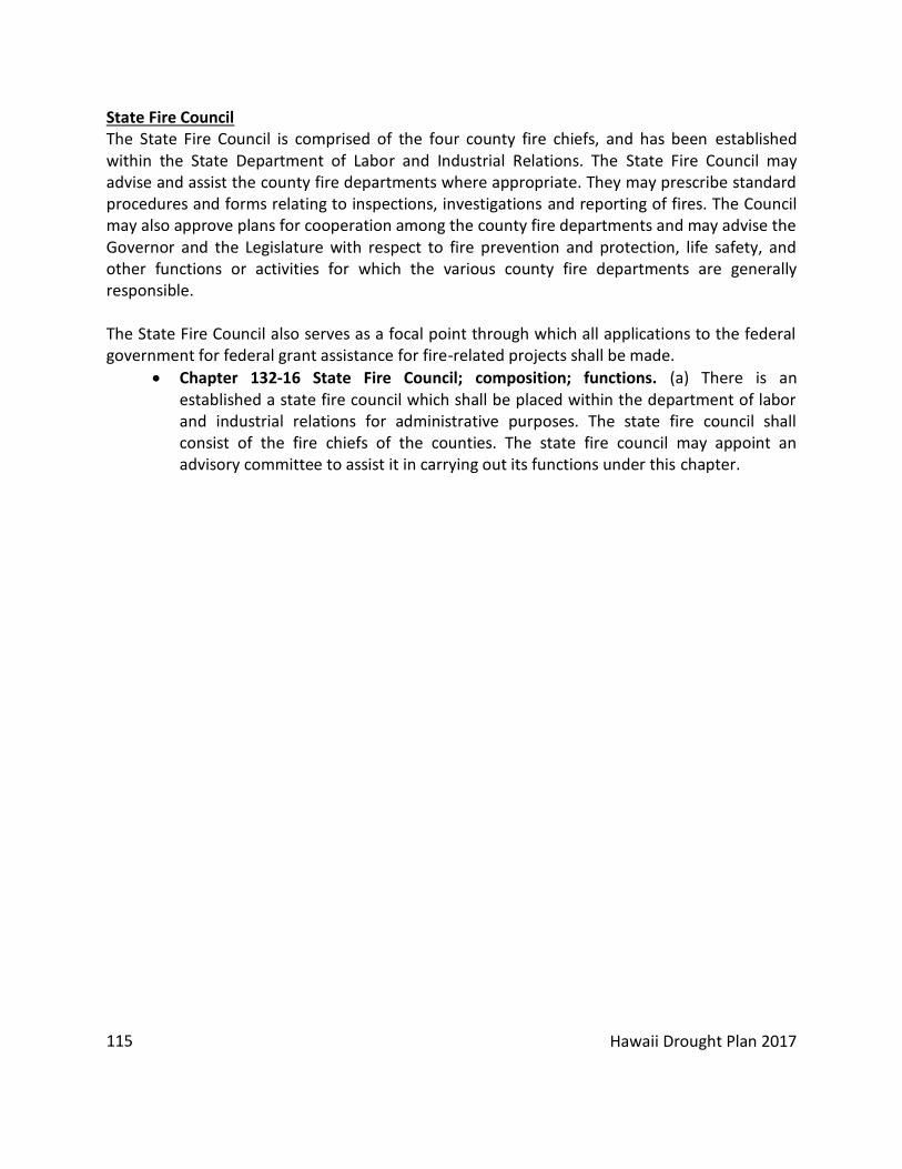
Hawaii Drought Plan 2017
115
State Fire Council The State Fire Council is comprised of the four county fire chiefs, and has been established within the State Department of Labor and Industrial Relations. The State Fire Council may advise and assist the county fire departments where appropriate. They may prescribe standard procedures and forms relating to inspections, investigations and reporting of fires. The Council may also approve plans for cooperation among the county fire departments and may advise the Governor and the Legislature with respect to fire prevention and protection, life safety, and other functions or activities for which the various county fire departments are generally responsible. The State Fire Council also serves as a focal point through which all applications to the federal government for federal grant assistance for fire-related projects shall be made.
Chapter 132-16 State Fire Council; composition; functions. (a) There is an established a state fire council which shall be placed within the department of labor and industrial relations for administrative purposes. The state fire council shall consist of the fire chiefs of the counties. The state fire council may appoint an advisory committee to assist it in carrying out its functions under this chapter.

Hawaii Drought Plan 2017
116
APPENDIX D POTENTIAL RISK REDUCTION ACTIONS
The following is a list of potential drought mitigation measures adapted from Appendix E of the handbook “How to Reduce Drought Risk” prepared by the Western Drought Coordination Council. This list is intended to provide government agencies and private entities with ideas that can be implemented to reduce drought risk. Water Conservation Projects
Establishing economic incentives for private investment in water conservation
Encouraging voluntary water conservation
Requiring water users to decrease reliance on ground water and implement conservation practices
Improving water use and conveyance efficiencies
Implementing water metering and leak detection programs
Modifying rate structures to influence consumer water use
Encouraging the use of water conserving plumbing fixtures
Encouraging xeriscaping and using drought-tolerant plants for landscaping
Conduct water conservation education at local schools
Line irrigation canals or install piping to control seepage
Use sprinkler and drip irrigation systems
Schedule irrigation by demand
Use soil-moisture monitoring
Improve tillage practices
Use evaporation suppressants
Use lower-quality groundwater for agricultural use
Grow drought and salinity tolerant crops Water Storage Projects
Implement programs to rehabilitate reservoirs to operate at design capacity
Construct new water reservoirs in areas at risk to drought
Inventory and review reservoir operational plans
Use ground-water banking concepts to allocate and store surplus, inactive, or reclaimed water
Source Development
Develop potable groundwater wells where excess sustainable yields are available
Develop brackish water supply sources for uses that do not require potable water
Implement minor structural measures to obtain temporary water supplies from

Hawaii Drought Plan 2017
117
inactive or dead storage or from ground water sources
Undertake water supply vulnerability assessments
Undertake stream restoration projects that may improve stream flow and thereby increase available water supply
Inventory self-supplied water users for possible use of their supplies for emergency public water supplies
Develop aquifer storage and recovery (ASR) projects in areas of seasonal water supply surplus
Development of Alternative Sources
Construct desalination plants to provide potable water
Clarify policies to allow the use of reclaimed water for irrigation, industrial and other non-potable uses
Develop projects to reclaim and reuse (store) storm water runoff in urban and undeveloped areas
Construct new wastewater treatment reclamation facilities
Construct distribution facilities for reclaimed water systems
Establish policies to allow for the use of grey water for non-potable uses
Public Education Awareness
Establish a public advisory committee
Include public participation in drought planning
Organize drought information meetings for the public and the media
Implement water conservation awareness programs
Publish and distribute pamphlets on water conservation techniques and drought management strategies
Organize workshops on special drought-related topics
Prepare a sample ordinance on water conservation
Establish a drought information center
Set up a demonstration of on-site technology at a visitor center
Include the media in drought planning
Establish tuition assistance for farmers to enroll in farm management classes
Develop training material in several languages
Provide education on different cultural perspectives of water resources
Consult a marketing firm for strategies to draw public attention
Employ public participation and public information specialist Land Use Planning
Consider an area’s vulnerability to drought when reviewing general and community plan and zoning amendments

Hawaii Drought Plan 2017
118
Require developers to use non-potable water for landscape irrigation
Require developers to practice xeriscaping in landscaped common areas
Establish policy and guidelines to match the quality of water supply to an appropriate demand preventing potable uses where lower quality water would suffice (e.g., require only non-potable water for irrigation uses)
Ensure that new developments have sufficient water storage facilities Initiate rezoning applications or amend existing ordinances to protect water recharge
areas and encourage appropriate uses in areas at risk to drought Watershed Protection and Management
Engage and coordinate with the Division of Forestry and Wildlife and watershed partnerships across the state to develop best management practices in the forested areas
Implement watershed protection and management plans (e.g., construct fencing to keep out unwanted animals, control invasive species and weeds, prescribed burns, maintain access roads and fire breaks, reforestation, etc.)

Hawaii Drought Plan 2017
119
APPENDIX E DROUGHT RESOURCES REVIEW
National Drought Mitigation Center (NDMC): The NDMC was developed to help people and institutions develop and implement measures to reduce societal vulnerability to drought, stressing preparedness and risk management rather than crisis management. As for drought monitoring tools, the NDMC produces the U.S. Drought Monitor, Drought Impact Reporter, VegDRI, Standardized Precipitation Index (SPI), Monthly Drought and Impact Summary, and Groundwater and Soil Moisture maps based on data from NASA’s GRACE satellites. The U.S. Drought Monitor, referenced frequently in other state plans, provides a summary of drought conditions using a variety of drought-based indices and indicators but has no forecast component. The Drought Impact Reporter shows the number of impacts from drought that have occurred in various time periods. The Drought Impact Reporter was not referenced in the 2005 Hawaii Drought Plan. The VegDRI, or Vegetation Drought Response Index, does not provide information for the State of Hawaii. Standard Precipitation Index (SPI) has been adopted to monitor drought conditions and rainfall deficits for Hawaii. This index is based only on precipitation and is flexible enough to be used in short-term and long-term applications. As for the Monthly Drought and Impact Summary, information is updated monthly for Hawaii. This overview of drought shows the US Monthly Drought Outlook along with regional overviews and impact summaries. The Groundwater and Soil Moisture maps are still being evaluated and improved, and are not yet a viable resource for Hawaii’s drought monitoring. If completed, this index could be used to help fill Hawaii’s data gap of limited soil moisture and evapotranspiration information. Also available on the NDMC website is a comparison of major drought indices, which could be helpful for drought plan research: http://drought.unl.edu/. National Integrated Drought Information System (NIDIS): NIDIS was developed by NOAA to coordinate and integrate drought research and provide the best available information and tools to assess the potential impacts of drought and to prepare for as well as mitigate the effects of drought. The data, maps, and tools publically available on the NIDIS website include information on current conditions, outlooks & forecasts, impacts, soil moisture, vegetation, fire, temperature & precipitation, agriculture, and water supply. For Outlooks & Forecasts, a US Monthly Drought Outlook is available that shows where drought persists and where development is likely. Weather data is also available, including graphical forecasts for Hawaii. Unfortunately, many of the maps and indices only include mainland United States, excluding data for Hawaii. Many of the tools available on NIDIS are from the NDMC website.

Hawaii Drought Plan 2017
120
APPENDIX F EARLY DROUGHT PLAN IMPLEMENTATION ACTIONS (PRIOR TO 2005)
Since the development of the Hawaii Drought Plan, Phase I in 2000, the State has completed several actions toward the implementation of the Plan and further development of the Hawaii drought program:
Requested and received Emergency Drought Assistance from the Bureau of Reclamation under Title I of the Reclamation States Emergency Drought Relief Act of 1991, in addition to technical/planning assistance under Title II of the same Act;
Participation as a member of the Western Governors Association’s, Drought Working Group, to help draft the proposed National Drought Preparedness Act of 2003 for submission to the U.S. Congress;
Established through successful legislative authorization, a permanent State Drought Coordinator position in 2002 within the Commission on Water Resource Management;
Applied for and received a FEMA Pre-Disaster Mitigation grant to develop a Statewide Drought Risk and Vulnerability Assessment and GIS Mapping analysis in support of the Hawaii Drought Plan and the State/County Hazard Mitigation Plans;
Developed public outreach and education tools including the completion of the Hawaii Drought Monitor Website and the production and distribution of drought awareness public service announcements in both radio and television media formats;
Establishment of County/Local Drought Committees, starting with the County of Kauai in 2001 with the Kauai Department of Water in a leadership role;
Applied for and received funding to undertake the development of the Agricultural Water Use and Development Plan component of the Hawaii Water Plan;
Development of a DLNR prototype State agency water conservation plan with assistance from the U.S. Bureau of Reclamation that may be applied across State government agencies.

Hawaii Drought Plan 2017
121
APPENDIX G ANNUAL RAINFALL- MAIN AIRPORTS
0
5
10
15
20
25
30
35
40
45
19
40
19
43
19
46
19
49
19
52
19
55
19
58
19
61
19
64
19
67
19
70
19
73
19
76
19
79
19
82
19
85
19
88
19
91
19
94
19
97
20
00
20
03
20
06
20
09
20
12
20
15
Ra
infa
ll (I
nch
es)
Year
Honolulu Annual Rainfall
0
10
20
30
40
50
60
70
80
1950
1952
1954
1956
1958
1960
1962
1964
1966
1968
1970
1972
1974
1976
1978
1980
1982
1984
1986
1988
1990
1992
1994
1996
1998
2000
2002
2004
2006
2008
2010
2012
2014
Rai
nfa
ll (I
nch
es)
Year
Lihue Annual Rainfall
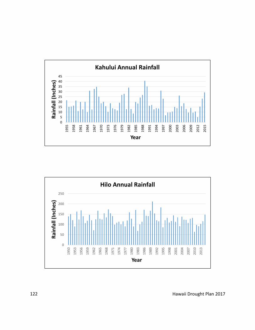
Hawaii Drought Plan 2017
122
0
5
10
15
20
25
30
35
40
45
19
55
19
58
19
61
19
64
19
67
19
70
19
73
19
76
19
79
19
82
19
85
19
88
19
91
19
94
19
97
20
00
20
03
20
06
20
09
20
12
20
15
Rai
nfa
ll (I
nch
es)
Year
Kahului Annual Rainfall
0
50
100
150
200
250
19
50
19
53
19
56
19
59
19
62
19
65
19
68
19
71
19
74
19
77
19
80
19
83
19
86
19
89
19
92
19
95
19
98
20
01
20
04
20
07
20
10
20
13
Rai
nfa
ll (I
nch
es)
Year
Hilo Annual Rainfall

Hawaii Drought Plan 2017
123
APPENDIX H FULL LINKS
Executive Summary
Hawaii Drought Website: http://dlnr.hawaii.gov/drought/planning/ Related Plans and Policies
Hawaii Water Plan Website: http://dlnr.hawaii.gov/cwrm/planning/hiwaterplan/ Original Water Resource Protection Plan, 2008: http://files.hawaii.gov/dlnr/cwrm/planning/wrpp2008update/FINAL_WRPP_20080828.pdf Water Quality Plan, 1990: http://files.hawaii.gov/dlnr/cwrm/planning/wqp1990.pdf Water Quality Plan, 2014 Draft: http://health.hawaii.gov/water/files/2014/09/2014-DOH-DRAFT-Water-Quality-Plan.pdf State Water Projects Plan, 2003 Update: http://files.hawaii.gov/dlnr/cwrm/planning/swpp2003_vol1_tech.pdf Agricultural Water Use and Development Plan, 2003/2004: http://files.hawaii.gov/dlnr/cwrm/planning/awudp2004.pdf Water Use and Development Plan, Kauai Original 1990: http://files.hawaii.gov/dlnr/cwrm/planning/wudpka1990.pdf Water Use and Development Plan, Oahu Original 1990: http://files.hawaii.gov/dlnr/cwrm/planning/wudpoa1990.pdf Water Use and Development Plan, Maui Original 1990: http://files.hawaii.gov/dlnr/cwrm/planning/wudpma1990.pdf Water Use and Development Plan, Hawaii Update 2010: http://files.hawaii.gov/dlnr/cwrm/planning/wudpha2012.pdf
State Water Code: http://www.hawaii.edu/ohelo/statutes/HRS174C/HRS174C.html DOA Irrigation Systems: http://hdoa.hawaii.gov/arm/irrigation-systems/ Honolulu Board of Water Supply Rules and Regulations: http://www.boardofwatersupply.com/about-us/rules-and-regulations

Hawaii Drought Plan 2017
124
Kauai Department of Water Supply Rules and Regulations: http://www.kauaiwater.org/cp_rules®s.asp Maui Department of Water Supply Rules and Regulations: http://www.co.maui.hi.us/205/Rules-Regulations Hawaii Department of Water Supply Rules and Regulations: http://www.hawaiidws.org/3%20about%20water/3d%20rules/Rules%20and%20Regulations%20Effective%2010-21-04.pdf Hawaii Water Conservation Plan: http://files.hawaii.gov/dlnr/cwrm/planning/hwcp2013.pdf Integrated Wildland Fire Management Plan: https://www.garrison.hawaii.army.mil/sbcteis/documents/FMP/fmp.htm Community Wildfire Protection Plans: http://www.hawaiiwildfire.org/cwpps/ DLNR Land Fire Protection Law: http://dlnr.hawaii.gov/forestry/fire/land-fire-protection-law/
Hawaii Fresh Water Blueprint: https://www.hawaiicommunityfoundation.org/file/cat/Fresh_Water_Blueprint_FINAL_062215_small.pdf
Overview of Drought in Hawaii Climate Change Impacts in Hawaii: http://seagrant.soest.hawaii.edu/sites/default/files/publications/smfinal-hawaiiclimatechange.pdf Climate Change and Pacific Islands: Indicators and Impacts: http://www.cakex.org/sites/default/files/documents/NCA-PIRCA-FINAL-int-print-1.13-web.form_.pdf
Hawaii Drought Program
Hawaii Government Drought Preparedness Page: http://dlnr.hawaii.gov/drought/planning/preparedness/
Drought Monitoring and Forecasting U.S. Drought Monitor – Hawaii: http://dlnr.hawaii.gov/drought U.S. Climate Reference Network: https://www.ncdc.noaa.gov/crn/

Hawaii Drought Plan 2017
125
Soil Climate Analysis Network: https://www.wcc.nrcs.usda.gov/scan/about_scan.html National Weather Service Hawaiian Fire Weather Products: http://www.prh.noaa.gov/hnl/pages/firewx.php Rainfall Atlas of Hawaii: http://rainfall.geography.hawaii.edu/ U.S. Drought Monitor Online: http://droughtmonitor.unl.edu/ National Weather Service –Climate: http://www.cpc.ncep.noaa.gov
National Weather Service – Rainfall: http://www.prh.noaa.gov/hnl/pages/hydrology.php Remote Automatic Weather Stations: http://www.raws.dri.edu/wraws/hiF.html USGS Current Conditions Data: https://hi.water.usgs.gov/ Climate Prediction Center El Nino/Southern Oscillation products: http://www.cpc.ncep.noaa.gov/products/precip/CWlink/MJO/enso.shtml#forecast
DOA- State Irrigation Systems: http://hdoa.hawaii.gov/arm/irrigation-systems/
CWRM- Groundwater: http://dlnr.hawaii.gov/cwrm/groundwater/
CWRM- Surface Water: http://dlnr.hawaii.gov/cwrm/surfacewater/
CWRM- Stream Gauges: http://dlnr.hawaii.gov/cwrm/surfacewater/ifs/
CWRM: http://dlnr.hawaii.gov/cwrm/
USGS- Current Conditions Data: https://hi.water.usgs.gov/ NWS CPC Products: http://www.cpc.ncep.noaa.gov/products/precip/CWlink/MJO/enso.shtml#forecast Hawaii Fire Potential Outlook: https://gacc.nifc.gov/oncc/predictive/outlooks/Outlook_HI.pdf
National Significant Wildland Fire Potential Outlook: https://www.predictiveservices.nifc.gov/outlooks/outlooks.htm

Hawaii Drought Plan 2017
126
NIDIS Website: https://www.drought.gov/drought/
Drought Impact Assessment CTAHR Wildfire Ignition Density Maps for Hawaii: https://www.ctahr.hawaii.edu/oc/freepubs/pdf/RM-21.pdf
Hawaii Wildfire Management Organization: http://www.hawaiiwildfire.org/ Hawaii Vegetation Fire Risk Online: http://hawaiifire.dge.carnegiescience.edu/ Drought Impact Reporter: http://droughtreporter.unl.edu/map/
Drought Risk and Vulnerability in Hawaii Drought Risk and Vulnerability Assessment GIS Mapping Project: http://files.hawaii.gov/dlnr/cwrm/planning/drva2003.pdf
Drought Communication and Response Actions Water Management Areas: http://dlnr.hawaii.gov/cwrm/groundwater/gwma/ Drought Information Statements: http://www.prh.noaa.gov/hnl/pages/DGT.php Hawaii Drought Monitor: www.hawaiidrought.com Department of Agriculture: Hawaii Administration Rules Chapter 4-157: http://hdoa.hawaii.gov/wp-content/uploads/2012/12/AR-157.pdf Maui Department of Water Supply: Rules and Regulations No. 4- Control of Water Usage During Drought: http://www.co.maui.hi.us/210/Control-of-Water-Usage-During-Drought Honolulu Board of Water Supply Sections 3-318, 319, 320, 321, 322, 323: http://www.boardofwatersupply.com/about-us/rules-and-regulations/chapter-iii
Honolulu BWS Conservation Program: http://www.boardofwatersupply.com/conservation/bws-conservation-program Kauai Department of Water Supply: Press Releases: http://www.kauaiwater.org/press122000.asp
Hawaii Department of Water Supply: Water Conservation and Restriction Notices: http://www.hawaiidws.org/5%20events%20news%20notices/5a%20conservation/conservation.htm

Hawaii Drought Plan 2017
127
Drought Mitigation and Preparedness Hawaii Water Conservation Plan: http://files.hawaii.gov/dlnr/cwrm/planning/hwcp2013.pdf 2013 Update of the Hawaii Water Reuse Survey and Report: http://files.hawaii.gov/dlnr/cwrm/planning/hwrsr2013.pdf A Blueprint for Action [Hawaii’s Freshwater Blueprint]: https://issuu.com/hcfhawaii/docs/fresh_water_blueprint_final_062215__46c6615e6e60a5?e=1137810/33103441 Wildfire and Drought Lookout Campaign: http://www.hawaiiwildfire.org/fire-resource-library-blog/lookout Hawaii Association of Watershed Partnerships: http://hawp.org/
Recommendation and Implementation Actions
Emergency Response Plan Templates Available Here: http://smallwatersupply.org/Blog/tabid/38/ctl/ArticleView/mid/390/articleId/2351/Templates-for-an-Emergency-Response-Plan.aspx
Appendix FEMA’s 2015 State Mitigation Plan Revised Guide: https://www.fema.gov/media-library/assets/documents/101659 USDA Farm Service Agency: https://www.usda.gov/topics/disaster/drought/usda-drought-programs-and-assistance FSA Disaster Assistance Programs: https://www.fsa.usda.gov/programs-and-services/disaster-assistance-program/index National Drought Mitigation Center: http://drought.unl.edu/

Hawaii Drought Plan 2017
128
APPENDIX I REFERENCES
“Agricultural Water Use and Development Plan”. State of Hawaii Department of Agriculture (2003). “Alabama Drought Management Plan”. Alabama Office of Water Resources (2013). Anderson, C., Piscolish, M., and Henly-Shepard, S. “Outcomes for Integrating Socioeconomic Assessments to Build Community Resilience in Mitigating Drought in Hawaii”. NOAA Sectoral Applications Research Program (2012). “A Blueprint for Action”. Hawaii Community Foundation (2016). Cai, W., Borlace, S., Lengaigne, M., Rensch, P. V., Collins, M., Vecchi, G., . . . Jin, F. “Increasing Frequency of Extreme El Niño Events Due to Greenhouse Warming”. Nature Climate Change Nature Climate Change, 4(2), 111-116 (2014). doi:10.1038/nclimate2100. Center for Disease Control and Prevention, (2016). Chu, P., and Chen, H. “Interannual and Interdecadal Rainfall Variations in the Hawaiian Islands*”. Journal of Climate, 18(22), 4796-4813 (2005). doi:10.1175/jcli3578.1 Chu, P.-S., Chen, Y. R. and Schroeder, T. “Changes in Precipitation Extremes in the Hawaiian Islands in a Warming Climate”. Journal of Climate, 23(18), 4881-4900 (2010). doi: 10.1175/2010JCLI3484.1 “City and County of Honolulu Drought Mitigation Strategies”. State of Hawaii, Department of Land and Natural Resources, Commission on Water Resource Management (2004). “Climate Change Impacts in Hawaii”. University of Hawaii at Mānoa Sea Grant College Program (2014). “The Colorado Drought Mitigation and Response Plan”. State of Colorado (2014). Conry, Paul, and Ronald Cannarella. "Hawaii Statewide Assessment of Forest Conditions and Resource Strategy 2010." Department of Land and Natural Resources (2010). 155- 77. “County of Hawaii Drought Mitigation Strategies”. State of Hawaii, Department of Land and Natural Resources, Commission on Water Resource Management (2004).

Hawaii Drought Plan 2017
129
“County of Kauai Drought Mitigation Strategies”. State of Hawaii, Department of Land and Natural Resources, Commission on Water Resource Management (2004). “County of Maui Drought Mitigation Strategies”. State of Hawaii, Department of Land and Natural Resources, Commission on Water Resource Management (2004). “Creating a Drought Early Warning System for the 21st Century, The National Integrated Drought Information System”. Western Governors’ Association (2004). “Drought- Ready Communities”. National Drought Mitigation Center (2010). “Drought Risk and Vulnerability Assessment and GIS Mapping Project”. State of Hawaii, Department of Land and Natural Resources, Commission on Water Resource Management (2003). Elison Timm, O., T. W. Giambelluca, and H. F. Diaz. “Statistical downscaling of rainfall changes in Hawai‘i based on the CMIP5 global model projections”. Journal of Geophysical Research: Atmospheres (2015). 120(1), 92-112, doi:10.1002/2014jd022059. Finucane, Melissa, T. Giambelluca, M. Merrifield, S. Miller, J. Polovina and E. Shea. “National Climate Assessment: Hawaii and Pacific Islands”. Global Change (2014). Frazier A.G., T.W. Giambelluca, H.F. Diaz, and H.L. Needham. “Comparison of geostatistical approaches to spatially interpolate month-year rainfall for the Hawaiian Islands”. International Journal of Climatology (2016). Vol. 36:1459–1470. Frazier & Giambelluca. “Spatial trend analysis of Hawaiian rainfall from 1920 to 2012”, International Journal of Climatology (2016). “Guidelines for the Reuse of Gray Water.” Hawaii State Department of Health: Wastewater Branch 2009. “Hawaii Drought Plan, Phase 1.” State of Hawaii, Department of Land and Natural Resources,
Commission on Water Resource Management (2000). “Hawaii Water Conservation Plan”. State of Hawaii, Department of Land and Natural
Resources and US Army Corps of Engineers (2013). Hayes, Michael. “Drought Indices”. National Drought Mitigation Center (1998). Hayes, Michael and Tom Phillips. “How to Reduce Drought Risk”. Western Drought

Hawaii Drought Plan 2017
130
Coordination Council, Preparedness and Mitigation Working Group (1998). “History of Agriculture in Hawaii”. State of Hawaii Department of Agriculture (2013). “Integrated Wildland Fire Management Plan”. United States Army (n.d.). IPCC. “Climate change 2013: Fifth assessment report: Climate change 2013”. IPCC, Geneva, Switzerland (2013). Keener, Victoria, J. Marra, and M. Finucane. “Climate change and Pacific islands: Indicators and Impacts”. Washington, DC: Island Press (2012). Knutson, Cody, M. Hayes, and T. Phillips. “How to Reduce Drought Risk”. Western Drought Coordination Council (1998). Macomber, Patricia. “Guidelines on Rainwater Catchment Systems for Hawaii”. College of Tropical Agriculture and Human Resources, University of Hawai‘i at Mānoa (2010). Marshall, Eric, and T. Randhir. “Effect of Climate Change on Watershed System: A Regional Analysis”. Climatic Change, 89(3-4), 263-280 (n.d.). doi:10.1007/s10584-007-9389-2. Melrose, J., Perroy, R., and Cares, S. “Statewide Agricultural Land Use Baseline 2015”. Hawaii Department of Agriculture (2015). “Montana Drought Response Plan”. State of Montana, Department of Natural Resources and
Conservation (1995). “Navajo Nation Drought Contingency Plan”. Navajo Nation Department of Water Resources, (2002). Oki, D.S. “Trends in Streamflow Characteristics at Long-Term Gaging Stations, Hawaii”. U.S. Geological Survey Scientific Investigations Report 2004-5080 (2004). “The Rain Follows the Forest Fact Sheet”. Hawaii Department of Land and Natural Resources (n.d.). Takahashi, M., O. Elison Timm, T.W. Giambelluca. H.F. Diaz, and A. G. Frazier. “High and Low Rainfall Events in Hawaii in Relation to Large-Scale Climate Anomalies in the Pacific: Diagnostics and Future Projections”. Poster presentation GC51D-1024, presented at the fall meeting of the American Geophysics Union, San Francisco, CA (2011).

Hawaii Drought Plan 2017
131
Timm, Oliver and Henry F. Diaz. “Synoptic-statistical Approach to Regional Downscaling of IPCC Twenty-first Century Climate Projections: Seasonal Rainfall Over the Hawaiian Islands”. Journal of Climate (2009). Vol. 22:4261-4280.
Trauernicht, Clay and Matthew Lucas. “Wildfire Ignition Density Maps for Hawaii”. Forest and Natural Resource Management (2016). Wairiu, M., M. Lal, and V. Lese. “Ch. 5: Climate Change Implications for Crop Production in Pacific Islands Region”. Food Production - Approaches, Challenges and Tasks (2012).
Wilhite, Donald, M. Hayes, C. Knutson and K Helm Smith. “The Basics of Drought Planning: A
10-Step Process”. National Drought Mitigation Center (1999). Wilhite, Donald, M.V. Sivakumar and R. Pulwarty. “Managing Drought Risk in a Changing Climate: The Role of National Drought Policy”. Weather and Climate Extremes, 3, 4-13 (2014). doi:10.1016/j.wace.2014.01.002