Protection of groundwater dependent ecosystems in Canterbury, New Zealand… · 2018-06-20 ·...
10
ORIGINAL ARTICLE Protection of groundwater dependent ecosystems in Canterbury, New Zealand: the Targeted Stream Augmentation Project Brett Painter 1 Received: 3 November 2016 / Accepted: 27 August 2017 / Published online: 12 September 2017 Ó The Author(s) 2017. This article is an open access publication Abstract In Canterbury, New Zealand, native aquatic species habitat has significantly declined over the last century due primarily to land use change and climatic influences. The Canterbury Water Management Strategy (CWMS) aims to improve such habitat while also meeting other economic, environmental, social and cultural objec- tives. The focus of this paper will be on the Targeted Stream Augmentation (TSA) Project in the Selwyn-Waihora Zone in Canterbury. The semi-arid climate, significant demand for irrigation water and the up-gradient aquifer pressure provided by a coastal lake provide significant aquifer management challenges in this zone. In response to these challenges the local CWMS committee recommended that managed aquifer recharge trials to improve groundwater dependent ecosystems start in a highly targeted manner before gradually increasing the distance from recharge site to the target spring/s. A highly targeted pilot trial has shown the flow, temperature and nutrient concentration benefits for the target surface ecosystem. The implementation of two larger scale concepts combining surface and groundwater ecosystem benefits is now progressing. Lessons learned to date include the importance of keeping engagement pro- cesses ahead of technical assessments, and the benefits of high level scoping assessments before committing to detailed investigations and pilot projects. Keywords Native species habitat Á Targeted recharge and discharge Á New Zealand Abbreviations CPW Central Plains Water scheme CWMS Canterbury Water Management Strategy MAR Managed aquifer recharge TSA Targeted Stream Augmentation Introduction Aim The aim of this paper is to introduce the Selwyn-Waihora Zone (in New Zealand), investigations to assess the potential role of managed aquifer recharge (MAR) con- cepts in the zone, and the current status of ‘next steps’ MAR implementation. This zone has complexities in geology, water cycle processes and decision-making pro- cesses. The Canterbury Water Management Strategy (CWMS) has provided an opportunity for a wide variety of water stakeholders to develop a collective understanding of system complexities and agree on water management changes. The construction of the Central Plains Water irrigation scheme has provided opportunities to add infrastructure for MAR at much lower cost than for a stand- alone scheme. Cost and technology improvements in solar powered pumping have also enabled a highly targeted recharge concept to be progressed. Study area Canterbury is New Zealand’s largest region comprising approximately 17% of the country’s land area. The region currently accounts for approximately 60% of all water allocated for consumptive use in New Zealand and 70% of the nation’s irrigated land. The Selwyn-Waihora Zone in This article is part of the special issue on Managed Aquifer Recharge. & Brett Painter [email protected] 1 Canterbury Regional Council, Christchurch, New Zealand 123 Sustain. Water Resour. Manag. (2018) 4:291–300 https://doi.org/10.1007/s40899-017-0188-2
Transcript of Protection of groundwater dependent ecosystems in Canterbury, New Zealand… · 2018-06-20 ·...

ORIGINAL ARTICLE
Protection of groundwater dependent ecosystems in Canterbury,New Zealand: the Targeted Stream Augmentation Project
Brett Painter1
Received: 3 November 2016 / Accepted: 27 August 2017 / Published online: 12 September 2017
� The Author(s) 2017. This article is an open access publication
Abstract In Canterbury, New Zealand, native aquatic
species habitat has significantly declined over the last
century due primarily to land use change and climatic
influences. The Canterbury Water Management Strategy
(CWMS) aims to improve such habitat while also meeting
other economic, environmental, social and cultural objec-
tives. The focus of this paper will be on the Targeted Stream
Augmentation (TSA) Project in the Selwyn-Waihora Zone
in Canterbury. The semi-arid climate, significant demand
for irrigation water and the up-gradient aquifer pressure
provided by a coastal lake provide significant aquifer
management challenges in this zone. In response to these
challenges the local CWMS committee recommended that
managed aquifer recharge trials to improve groundwater
dependent ecosystems start in a highly targeted manner
before gradually increasing the distance from recharge site
to the target spring/s. A highly targeted pilot trial has shown
the flow, temperature and nutrient concentration benefits for
the target surface ecosystem. The implementation of two
larger scale concepts combining surface and groundwater
ecosystem benefits is now progressing. Lessons learned to
date include the importance of keeping engagement pro-
cesses ahead of technical assessments, and the benefits of
high level scoping assessments before committing to
detailed investigations and pilot projects.
Keywords Native species habitat � Targeted recharge and
discharge � New Zealand
Abbreviations
CPW Central Plains Water scheme
CWMS Canterbury Water Management Strategy
MAR Managed aquifer recharge
TSA Targeted Stream Augmentation
Introduction
Aim
The aim of this paper is to introduce the Selwyn-Waihora
Zone (in New Zealand), investigations to assess the
potential role of managed aquifer recharge (MAR) con-
cepts in the zone, and the current status of ‘next steps’
MAR implementation. This zone has complexities in
geology, water cycle processes and decision-making pro-
cesses. The Canterbury Water Management Strategy
(CWMS) has provided an opportunity for a wide variety of
water stakeholders to develop a collective understanding of
system complexities and agree on water management
changes. The construction of the Central Plains Water
irrigation scheme has provided opportunities to add
infrastructure for MAR at much lower cost than for a stand-
alone scheme. Cost and technology improvements in solar
powered pumping have also enabled a highly targeted
recharge concept to be progressed.
Study area
Canterbury is New Zealand’s largest region comprising
approximately 17% of the country’s land area. The region
currently accounts for approximately 60% of all water
allocated for consumptive use in New Zealand and 70% of
the nation’s irrigated land. The Selwyn-Waihora Zone in
This article is part of the special issue on Managed Aquifer Recharge.
& Brett Painter
1 Canterbury Regional Council, Christchurch, New Zealand
123
Sustain. Water Resour. Manag. (2018) 4:291–300
https://doi.org/10.1007/s40899-017-0188-2

Canterbury is named after the intermittent Selwyn River
(with hill-fed flow in the upper catchment and groundwa-
ter-fed lowland flow), and Te Waihora/Lake Ellesmere
which is a large coastal lake that is no longer the ‘food
basket’ that previous generations enjoyed (see Fig. 1). The
aquifer underlying this zone primarily comprises glacial
and postglacial outwash gravels of up to 600 m thickness,
except in the lower catchment where layers of sediment
create more defined aquifer layers, with the shallow aquifer
feeding lowland streams (and the lake directly through its
bed). Most lowland streams between the Selwyn and
Rakaia Rivers (e.g., Boggy Creek) are fed by springs
within 10 km of the lake. The Selwyn River also flows in
its mid-reaches when groundwater levels are sufficient (or
in large floods) and feeds the upper reaches of the Irwell
River during these circumstances through preferential
underground channels (from an old river course).
Te Waihora (meaning ‘‘spreading waters’’) has spent
less than 5000 years in its current state as a brackish bar-
lagoon. In this time period lake depth could reach 4 m
before over-topping the sea barrier. Early Maori settlers
manually opened the lake at approximately 2 m depth to
maximise its potential as a natural ‘food basket’. Since
1947 the lake depth has been managed by mechanical
opening to the sea when sea conditions permit and lake
depth reaches 1.05 m (summer) or 1.13 m (winter). The
combination of this lower lake opening regime and a
drainage scheme in the lower plains (see Fig. 2) has kept
the lake area to approximately 200 km2 and enabled
increased agricultural use near the lake edge. Flooding risk
to the lakeside community is heightened during sustained
rainfall combined with rough sea conditions that delay lake
opening. As well as surface flooding, a high lake also backs
up the shallow aquifer system, causing flooding further up-
catchment. The lakebed was legally vested in Te Runanga
o Ngai Tahu (local Maori tribe) under the Ngai Tahu
Claims Settlement Act 1998. Te Waihora/Lake Ellesmere
was then subject to a Joint Management Plan (2005)
between the Department of Conservation and Te Runanga
o Ngai Tahu and the National Water Conservation (Te
Waihora/Lake Ellesmere) Order 1990 was amended in
2011 to recognize the indigenous vegetation and cultural
values of the lake. In 2012 a co-governance agreement for
the zone was signed between Canterbury Regional Council,
Te Runanga o Ngai Tahu and Te Waihora Management
Board. Selwyn District Council and Christchurch City
Council also have resource management responsibilities.
Progressing water management concepts in the Selwyn-
Waihora Zone, therefore, requires significant consultation
and collaboration.
The lower catchment has a coastal island climate, with
approximately 650 mm/year rainfall (but ranging from 300
to 1000 mm/year) and 800–900 mm/year evapotranspira-
tion. Rainfall increases to approximately 1000 mm/year in
the foothills and 4000 mm/year at the headwaters of the
alpine rivers (e.g., Rakaia River) in the Southern Alps.
Evapotranspiration also decreases as rainfall increases up
the catchment. Periods of low rainfall in the coastal zone
are often accompanied by high rainfall in the alps from
westerly weather systems. Future climate analyses
Fig. 1 Selwyn-Waihora Zone,
New Zealand with key
waterways and TSA sites (1–3)
292 Sustain. Water Resour. Manag. (2018) 4:291–300
123
(Zammit and Woods 2011; Bright 2011) suggest that the
plains (and underlying aquifer) and lowland catchment are
likely to continue getting drier, while the alpine area is
likely to get wetter (especially late winter and early spring
with less rain staying as snow in the alps). Natural recharge
from the alpine rivers into the connected plains aquifer
system doesn’t seem to change much with river flow;
however, the alpine rivers also provide MAR opportunities
where there is existing distribution infrastructure. For the
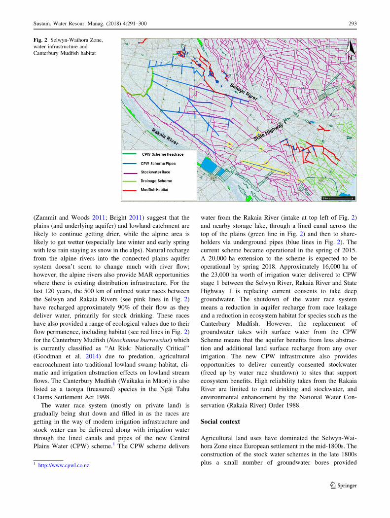
last 120 years, the 500 km of unlined water races between
the Selwyn and Rakaia Rivers (see pink lines in Fig. 2)
have recharged approximately 90% of their flow as they
deliver water, primarily for stock drinking. These races
have also provided a range of ecological values due to their
flow permanence, including habitat (see red lines in Fig. 2)
for the Canterbury Mudfish (Neochanna burrowsius) which
is currently classified as ‘‘At Risk: Nationally Critical’’
(Goodman et al. 2014) due to predation, agricultural
encroachment into traditional lowland swamp habitat, cli-
matic and irrigation abstraction effects on lowland stream
flows. The Canterbury Mudfish (Waikaka in Maori) is also
listed as a taonga (treasured) species in the Ngai Tahu
Claims Settlement Act 1998.
The water race system (mostly on private land) is
gradually being shut down and filled in as the races are
getting in the way of modern irrigation infrastructure and
stock water can be delivered along with irrigation water
through the lined canals and pipes of the new Central
Plains Water (CPW) scheme.1 The CPW scheme delivers
water from the Rakaia River (intake at top left of Fig. 2)
and nearby storage lake, through a lined canal across the
top of the plains (green line in Fig. 2) and then to share-
holders via underground pipes (blue lines in Fig. 2). The
current scheme became operational in the spring of 2015.
A 20,000 ha extension to the scheme is expected to be
operational by spring 2018. Approximately 16,000 ha of
the 23,000 ha worth of irrigation water delivered to CPW
stage 1 between the Selwyn River, Rakaia River and State
Highway 1 is replacing current consents to take deep
groundwater. The shutdown of the water race system
means a reduction in aquifer recharge from race leakage
and a reduction in ecosystem habitat for species such as the
Canterbury Mudfish. However, the replacement of
groundwater takes with surface water from the CPW
Scheme means that the aquifer benefits from less abstrac-
tion and additional land surface recharge from any over
irrigation. The new CPW infrastructure also provides
opportunities to deliver currently consented stockwater
(freed up by water race shutdown) to sites that support
ecosystem benefits. High reliability takes from the Rakaia
River are limited to rural drinking and stockwater, and
environmental enhancement by the National Water Con-
servation (Rakaia River) Order 1988.
Social context
Agricultural land uses have dominated the Selwyn-Wai-
hora Zone since European settlement in the mid-1800s. The
construction of the stock water schemes in the late 1800s
plus a small number of groundwater bores provided
Fig. 2 Selwyn-Waihora Zone,
water infrastructure and
Canterbury Mudfish habitat
1 http://www.cpwl.co.nz.
Sustain. Water Resour. Manag. (2018) 4:291–300 293
123

sufficient water most years until a multi-year dry spell in
the late 1960s and further dry spells in the 1980s and
1990s. Landowner response to the dry conditions was a
dramatic increase in applications to take and use ground-
water in the 1990s. This created a classic ‘‘tragedy of the
commons’’ (Hardin 1968) situation where the cumulative
effects of a drying climate and increased abstraction were
particularly tragic for the freshwater species that relied on
sufficient length of flowing waterways (Painter and Memon
2007; Painter 2009). As adversarial water allocation pro-
cesses became the norm (Weber et al. 2011), central and
local government led early research into water storage and
distribution opportunities2 and local researchers led a
project with local water stakeholders to identify more
equitable and sustainable water management options
(Painter and Bright 2006; Memon et al. 2010). These
projects were followed by confirmation of the CWMS3 in
2009.
The CWMS set up ten zone committees and a regional
committee, empowering them to work collaboratively to
develop effective water management solutions that deliver
economic, social, cultural and environmental outcomes
defined by their local community. Initial investigations to
assist CWMS committee deliberations included a prelimi-
nary assessment of MAR concepts against the CWMS
Principles and Targets (PDP 2010) and initial MAR fea-
sibility studies (SKM 2010, Golder Associates 2013).
With the delicate balance between too little water and
too much water in the lower catchment and the large dis-
tance between potential recharge areas and the lowland
streams, the Selwyn-Waihora CWMS Zone Committee
recommended that a series of pilot studies be undertaken,
starting with recharge very close to the target stream, then
an aquifer recharge experiment slightly further up-gradient
from the target stream/s. The Zone Committee named the
project the Targeted Stream Augmentation (TSA) Project,
a title and concept similar to ‘‘targeted near-stream
recharge’’ (e.g., Lacher et al. 2014).
Materials and methods
Managed aquifer recharge has been described as the pur-
poseful recharge of water to aquifers for subsequent
recovery or environmental benefit (e.g., Dillon et al. 2009).
Assessing the feasibility of MAR requires the integration of
many types of data and information from many disciplines.
Overviews of the basic requirements and feasibility
guidelines for MAR have previously been described (e.g.,
Dillon et al. 2009; Gutteridge et al. 2011; Rawluk et al.
2012; Arshad et al. 2014). These requirements include:
• Stakeholder engagement and social acceptance
assessments;
• Hydrology and hydrogeology assessments;
• Environmental risk assessments;
• Engineering method assessments;
• Regulatory and institutional assessments;
• Financial and economic assessments.
The order of assessments and engagement processes as
well as the staging of assessment details were found to be
important factors in progressing the MAR concept for the
Selwyn-Waihora Zone. The scope of the project was
defined by Recommendation 1.8(a) of the Selwyn-Waihora
Zone Implementation Programme Addendum4:
‘‘The Sub-regional Chapter will support use of MAR
or other methods of augmentation to increase base
flows in lowland streams subject to a source of water
being available, feasibility, and acceptability from a
cultural viewpoint about mixing of waters, and other
issues such as groundwater mounding in the lower
catchment.’’
With no specific future funding source tied to imple-
mentation of MAR concepts, key considerations in pro-
gressing the project were developing stakeholder
relationships, maximizing use of existing infrastructure,
and identifying current and potential future funding ave-
nues. Addressing the water source availability recommen-
dation required:
• Reference to a recent ecological assessment of the
water race system (EOS Ecology 2011) and updated
assessments to identify Canterbury Mudfish habitat
target areas.
• Legal analysis of the National Water Conservation
(Rakaia River) Order 1988 to determine whether MAR
was a legitimate alternative use of currently consented
stockwater (not subject to minimum flow rules);
• On-going discussion with Central Plains Water
scheme developers and analysis of potentially spare
capacity in their infrastructure at different times of the
year;
• On-going discussion with Selwyn District Council and
their committee responsible for management of the
water race network;
• On-going discussion with landowners who have water-
way ecosystems on their property that could benefit
from more reliable flow;2 http://ecan.govt.nz/publications/Pages/CanterburyStrategicWater
Study.aspx.3 http://ecan.govt.nz/get-involved/canterburywater/pages/default.
aspx.
4 http://ecan.govt.nz/publications/General/zip-addendum-at-150613-
v6.pdf.
294 Sustain. Water Resour. Manag. (2018) 4:291–300
123

• On-going discussion with landowners who have current
water races on their property that could be required for
delivery of recharge water; and
• Analysis of resource management rules regarding
consents for take and use of groundwater in the
Selwyn-Waihora Zone.
Addressing the feasibility and groundwater mounding
considerations required:
• Coupled ground and surface water modelling to under-
stand the potential long term effects of different MAR
concepts;
• Engineering and land ownership assessments of current
water races that could be required for delivery of
recharge water;
• Water quality analysis of source and receiving waters;
before, during and after all experiments;
• Analysis of existing geology and hydrogeology infor-
mation, including LIDAR surveys and cores taken from
relevant groundwater bores; and
• Design, assessment of environmental effects, consent-
ing, construction, implementation, and analysis of pilot
experiments.
Addressing the cultural and social acceptance consid-
erations required:
• On-going discussions with Te Taumutu Runanga (the
local sub-tribe of Ngai Tahu) regarding source and
receiving waters, their characteristics, methods of
mixing and any required mitigations;
• On-going discussions with other project partners (e.g.,
Selwyn-Waihora Zone Committee, Selwyn District
Council, Department of Conservation, affected
landowners) to ensure their input into and acceptance
of each step of the project; and
• On-going communication with a range of potentially
interested parties.
Results
Initial assessments
Ecosystem values
The aim of the TSA Project is to provide targeted flow
support for a range of ecosystem values. Determining
currently present species along with their current and future
potential habitat were key initial assessments. An assess-
ment of ecological values of the current water race system
was carried out in 2011 (EOS Ecology 2011). Of the 31
sites surveyed, 12 were classified as HIGH ecological
value, 7 were classified as MODERATE ecological value
and 12 were classified as LOWER ecological value. Key
species included Canterbury Mudfish (a native galaxiid
with ‘‘At Risk: Nationally Critical’’ status), freshwater
mussels, freshwater crayfish and aquatic snails. The only
nationally significant race system for ecosystem values
(primarily Mudfish value) was an area immediately up-
gradient from Boggy Creek.
Follow-up studies (e.g., O’Brien 2015) have tracked the
status of known Mudfish populations and temporary habitat
has been found for populations most at risk of extinction
due to the lack of water supplying their habitat over the last
few summers. Sites prioritized for future flow support
either contain Mudfish populations with risk of future
reduced inflows (e.g., due to future water race closures) or
sites with potentially suitable habitat if sufficient flow
could be provided. Canterbury Mudfish prefer slow-flow-
ing, meandering swampy streams disconnected from the
habitat of their main predators (e.g., trout and eels). When
surface flow disappears they burrow into the bed of the
waterway where they have been found to survive for up to
3 months without flowing water (e.g., O’Brien 2015).
Figure 2 shows historical Canterbury Mudfish habitat to
2014. By late summer 2015 the upper Selwyn River pop-
ulation had all but disappeared due to trout predation in
connected reaches and a combination of drought and
habitat destruction in the disconnected reaches. The lower
catchment population had survived on flow through the
stockwater race system, but this flow is not guaranteed into
the future as the races are gradually shut down. New
populations were found nearby in the 2014/15 survey fed
by springs of the Irwell and a lower Selwyn River tributary,
and a 2014 Irwell River flow survey under high ground-
water conditions identified additional potential habitat in
disconnected reaches further up the Irwell system. This
prioritized tributaries near the Irwell and Selwyn Rivers
and water races up-gradient from Boggy Creek for TSA
Project pilot studies.
Water supply
Potential water supply analysis considered groundwater
and surface water options. Although the Canterbury Land
and Water Regional Plan5 provides significant constraints
to allocating consumptive groundwater in the Selwyn-
Waihora Zone, the conjunctive management of ground and
surface water systems along with specific rules to support
MAR/TSA provides strong support for MAR/TSA
Projects.
5 http://www.ecan.govt.nz/our-responsibilities/regional-plans/lwrp/
Pages/plan-decisions-version.aspx.
Sustain. Water Resour. Manag. (2018) 4:291–300 295
123

The most promising surface water supply identified was
currently consented stockwater from the Rakaia River. This
flow is exempt from minimum flow restrictions and the
demand for the allocated flow is reducing as the leaky
stockwater race system is gradually being shut down. A
legal opinion concluded that an additional use (MAR/TSA)
for the currently consented stock water was not contrary to
the minimum flow exemption rules in the National Water
Conservation (Rakaia River) Order 1988. This meant that
stockwater could be delivered for MAR/TSA, initially via
current stockwater races, and could in future (with consent
amendments) also be delivered by CPW infrastructure.
732 l/s is currently consented to be taken from the upper
Rakaia stockwater intake and 500 l/s from the lower
Rakaia intake. CPW consented water for irrigation has also
been confirmed as another potential supply source. This
water is consented all year round so that winter flows can
be stored in a lake near the Rakaia River Gorge. CPW have
offered excess consented water for TSA Projects connected
to their infrastructure. Pre-construction analysis of the
CPW stage 1 potential demand and distribution sizing
suggested that average pipe capacity utilization in the
height of the irrigation season would reach approximately
85%. This figure will be updated over the coming years to
understand where supply capacity could match TSA
demand. Confirmation of CPW stage 2 design in recent
months has also provided near river recharge opportunities,
particularly where the new main pipeline is expected to
travel under the Selwyn River (Site 3 on Fig. 1). The
operational cost of delivering this MAR/TSA water is not
significant provided only the gravity-fed sections of the
scheme are used.
Initial computer modelling
The water quantity computer model utilized by the Selwyn-
Waihora Zone Committee to develop their future planning
recommendations was also used for the initial TSA concept
scenarios. Separate water quality modelling of the con-
ceptual TSA scenarios was undertaken to estimate the
potential nitrate reduction in groundwater from managed
recharge of low nitrate source water. Distributed recharge
(using stockwater races) across the upper plains and basin
(or dry tributary) recharge near Boggy and Harts Creek
were modelled. The water quantity modelling showed that
the majority of shallow aquifer flow (natural plus TSA)
moves through the areas of high permeability alluvial
gravels and around the swampy areas near the lower Irwell
and Boggy Creek. This is good news for Harts Creek
recharge but not so good for Boggy Creek or Irwell River
unless the recharge site is close to a target spring. As
improved aquifer levels from the CPW scheme were also
expected to mainly benefit Harts Creek, the area from the
Selwyn River to Boggy Creek was prioritized for pro-
gressing TSA. The water quantity modelling also showed
that the greatest benefits to the target groundwater-fed
waterways occurred during low to medium flows. Potential
contribution to flooding in lower catchment waterways was
shown to be very small. This was an important positive
message for lower catchment landowners. The water
quality modelling showed Nitrate–Nitrogen concentration
reduction of up to 10% for target waterways from the
modelled scenarios. The message that TSA would improve
water quality but not replace land use and on-farm nutrient
management as the key water quality management tool was
also received positively by the communities of interest.
Existing distribution infrastructure
The next set of assessments considered capacity, infras-
tructure and land ownership for water races between
potential recharge sites and CPW scheme main distribution
pipes. Assessments included required infrastructure to
connect to the CPW pipe, potential distribution losses,
channel capacity and culvert capacity. A survey assessment
to identify the sections of water race on private land versus
public land was also undertaken.
The channel and culvert assessment of the current
stockwater race feeding native fish habitat between Boggy
Creek and the lower Irwell River concluded that current
supply was limited to approximately 50 l/s immediately
up-gradient from the target race/recharge area with
120–150 l/s restrictions further up-gradient to the main
railway line. The modelled concept was for 500 l/s. Annual
cleaning costs for the supply race were estimated at NZD
20,000 per year by the district council. Race losses (aquifer
recharge and evaporation) were assessed at 5–10 l/s/km up-
gradient from Main South Road, with lower losses expec-
ted in the down-gradient section. This would mean that at
least 100 l/s additional flow would need to be supplied to
the race in addition to the TSA flow, though most of this
flow would still provide distributed benefit to the lowland
streams via aquifer recharge.
Based on the above analyses, it was recommended that
the district council keep the current supply race open for
direct support to the native fish habitat until alternatives
had been fully assessed. A TSA experiment in the vicinity
of the Boggy Creek system was also recommended, with
already consented groundwater (available out of the irri-
gation season) as the supply source.
Boggy Creek TSA experiment using groundwater
Lowland stream ecosystem habitat is placed under signif-
icant pressure during dry periods with stable low (or no)
flows, elevated nutrients and elevated temperatures. The
296 Sustain. Water Resour. Manag. (2018) 4:291–300
123

purpose of the Boggy Creek TSA experiment (Site 1 on
Fig. 1) using deep groundwater was to understand the
benefits and challenges of highly targeted flow support for
these systems. The reason for using groundwater from the
third aquifer (*60 m below ground level) was to minimise
the stream depletion effects that would occur with utilizing
shallower groundwater. Future aquifer storage benefits
from the CPW scheme are also expected to be most
noticeable in the deeper (third and fourth) aquifers. The
cost of drilling a deep well for the pilot experiment was not
financially viable, so a member of the Zone Committee
(and chair of the local drainage committee) offered their
existing irrigation well provided the experiment was run
outside the irrigation season.
With reduced lowland stream flows following a dry
2014/15 summer, the key factors that could be investigated
from an experiment during the winter of 2015 were flow,
nutrient concentration and dissolved oxygen. The chosen
reach is groundwater-fed during normal groundwater
levels, but can also lose to groundwater when groundwater
levels are low. Losses to groundwater will generally feed
the same tributary further down-gradient or the lake itself
through springs in the lake bed. Groundwater in this part of
the catchment is highly connected to lake level in Te
Waihora, so can be changed by opening the lake to the sea
as well as local runoff and upper catchment influences.
Groundwater recharge effects were therefore not consid-
ered directly for this experiment.
Figure 3 presents the monitoring sites and median water
quality measurements for the Boggy Creek experiment.
Boggy Creek used to meander in multiple spring-fed
channels at this point but is now channelized to follow the
roads from the top of the figure to the lower right hand
corner. The two meandering reaches in the figure usually
only flow now when the shallow groundwater table is high
or following rain events. These reaches were dry prior to
the TSA experiment. Flow direction for all Fig. 3 reaches
is shown by the black arrows. Sampling site BSC1 is
upstream from all flow augmentation and site BCS5
downstream. Site BCS2 is immediately upstream from
discharge point 1 (DP1) and site BCS3 immediately
downstream from DP1 (but upstream from the main
channel). Site BCS4 is upstream from discharge point 2
(DP2). The supply water for both discharge points is pro-
vided by well M36/4513. Comparison of the well and
surface water median measurements shows the ground-
water to be slightly higher in temperature, but significantly
lower in dissolved oxygen (DO) and Nitrate-N.
A comparison of all dissolved oxygen (DO) measure-
ments in Fig. 3 shows that the supply mechanism (perfo-
rated pipe over cobbles) successfully mitigated the low
groundwater oxygen levels. A comparison of all tempera-
ture measurements shows a 3.2 �C increase, which was
found to be within the normal range of variation for the
time of year. It was, however, noted that the temperature
difference is expected to be greater in the summer (with
groundwater cooler than surface water during this period).
A comparison of all Nitrate-N concentrations shows a
significant concentration decrease due to the TSA experi-
ment, with the downstream concentration of 2.2 g/m3 not
Fig. 3 Median water quality
measurements during the Boggy
Creek TSA experiment
Sustain. Water Resour. Manag. (2018) 4:291–300 297
123
far above the 95% species protection level of 1.7 g/m3
NO3-N.
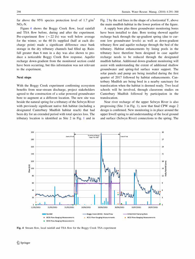
Figure 4 shows the Boggy Creek flow, local rainfall
and TSA flow before, during and after the experiment.
Pre-experiment flow (*22 l/s) was well below average
for the winter, so the 60 l/s supplied (half at each dis-
charge point) made a significant difference once bank
storage in the dry tributary channels had filled up. Rain-
fall greater than 6 mm in a day was also shown to pro-
duce a noticeable Boggy Creek flow response. Aquifer
recharge down-gradient from the monitored section could
have been occurring, but this information was not relevant
to the experiment.
Next steps
With the Boggy Creek experiment confirming ecosystem
benefits from near-stream discharge, project stakeholders
agreed to the construction of a solar powered groundwater
bore to augment at a different location. The new site was
beside the natural spring for a tributary of the Selwyn River
with previously significant native fish habitat (including a
designated Canterbury Mudfish habitat reach) that had
been dry for an extended period with total species loss. The
tributary location is identified as Site 2 in Fig. 1 and in
Fig. 2 by the red lines in the shape of a horizontal Y, above
the main mudfish habitat in the lower portion of the figure.
A supply bore plus three groundwater monitoring bores
have been installed to date. Bore testing showed aquifer
recharge back through the up-gradient spring (due to cur-
rent low groundwater levels) as well as down-gradient
tributary flow and aquifer recharge through the bed of the
tributary. Habitat enhancements by lining pools in the
tributary have therefore been designed in case aquifer
recharge needs to be reduced through the designated
mudfish habitat. Additional down-gradient monitoring will
assist with understanding the extent of additional shallow
groundwater and spring-fed surface water support. The
solar panels and pump are being installed during the first
quarter of 2017 followed by habitat enhancements. Can-
terbury Mudfish are being bred in a nearby sanctuary for
translocation when the habitat is deemed ready. Two local
schools will be involved, through classroom studies on
Canterbury Mudfish followed by participation in the
translocation.
Near river recharge of the upper Selwyn River is also
progressing (Site 3 in Fig. 1), now that final CPW stage 2
design is confirmed. New monitoring is in place around the
upper Irwell spring to aid understanding of the local ground
and surface (Selwyn River) connections to the spring. The
Fig. 4 Stream flow, local rainfall and TSA flow for the Boggy Creek TSA experiment
298 Sustain. Water Resour. Manag. (2018) 4:291–300
123

recharge concept involves connection to a high pressure
irrigation pipe, pressure reduction infrastructure, an initial
recharge area beside the flood plain of the Selwyn River,
then direction of the recharge flow into the flood plain of
the river.
Previous research (Larned et al. 2007) concluded that
the Selwyn River loses approximately 500 l/s to ground-
water in the target reach for every kilometer of river bed.
This means that a significant flow can be discharged to the
bed of the river without any direct mixing with the main
Selwyn River channel. Commissioning would start small
with key cultural and environmental outcomes monitored.
The Larned et al. study showed that a significant portion
(approximately 50%) of the river losses in this reach feeds
the Haldon Springs (upper plains mudfish habitat in Fig. 2),
which flow into the Hororata River and then back into the
Selwyn River system. The native and recreational fish
values of the Haldon/Hororata reaches will, therefore,
benefit as will the values of the connected groundwater
system which supports the Irwell River and lower Selwyn
River systems.
Discussion and conclusion
Investigations and on-going consultation with project
stakeholder representatives have identified challenges and
opportunities for TSA/MAR throughout the southern sec-
tion of the Selwyn-Waihora Zone. The key opportunities
are the wide community involvement in the CWMS and the
construction of the CPW irrigation scheme. The key
challenges are balancing investigations and community
buy-in with construction schedules as well as confirming
sufficient funding for public good projects in tight time-
frames. A staged and collaborative approach to developing
and testing concepts has been utilized in response to con-
cerns raised about progressing catchment scale MAR
concepts while the connected ground and surface water
system is currently changing due to the new CPW scheme,
gradual shutdown of the stockwater race network and cli-
matic effects. This approach has encouraged on-going co-
learning and collaboration between project stakeholder
representatives. Recent dry summers and loss of habitat for
the endangered Canterbury Mudfish have provided short
term goals, while the longer term outcomes identified by
the Selwyn-Waihora Zone Committee will assist with
project longevity.
Flow support solutions are now in place or underway for
the three key Canterbury Mudfish areas shown in Fig. 2.
Stockwater race distribution is confirmed in the medium
term for supplying habitat in the large area of historical
swamp up-gradient from Boggy Creek, with solar powered
pumping a future back up. A solar powered pump and
habitat improvements are under construction for the lower
Selwyn River tributary and a near river recharge concept is
in the detailed design phase for the upper Selwyn River.
These solutions are based on development of a collective
understanding of the connected climate, human, surface
and groundwater systems, then testing tailor-made man-
agement concepts for each situation. The importance of the
CWMS in this achievement cannot be understated. It pro-
vides a politically approved process for community col-
laboration and an imperative to jointly progress economic,
environmental, social and cultural objectives in every
situation.
Acknowledgements Significant assistance with field work and
reporting has been provided by Pattle Delamore Partners and with
computer modelling by Aqualinc Research.
Compliance with ethical standards
Funding Primary funding for this project has been provided by the
Canterbury Water Management Strategy (funded through a region-
wide rate). Secondary funding has been provided by a targeted rate to
the Selwyn-Waihora Zone.
Conflict of interest The author declares no conflict of interest.
Open Access This article is distributed under the terms of the
Creative Commons Attribution 4.0 International License (http://crea
tivecommons.org/licenses/by/4.0/), which permits unrestricted use,
distribution, and reproduction in any medium, provided you give
appropriate credit to the original author(s) and the source, provide a
link to the Creative Commons license, and indicate if changes were
made.
References
Arshad M, Guillaume JHA, Ross A (2014) Assessing the feasibility of
managed aquifer recharge for irrigation under uncertainty. Water
6:2748–2769
Bright J (2011) Projected effects of climate change on the proposed
Lees Valley Irrigation scheme as part of the Canterbury Water
Management Strategy. Aqualinc Research client report
Dillon P, Pavelic P, Page D, Beringen H, Ward J (2009) Managed
aquifer recharge. In: An introduction waterlines report series no.
13. National Water Commission, Canberra, Australia
EOS Ecology (2011) Sites of ecological value within the Malvern and
Ellesmere water race schemes, EOS Ecology report no. 10016—
SDC01-02, 18p
Golder Associates (2013) Selwyn-Te Waihora land and water
planning: managing groundwater replenishment using managed
aquifer recharge (MAR). Environment Canterbury report no.
R13/114. Available online: http://files.ecan.govt.nz/public/lwrp/
variation1/managing-groundwater-replenishment-using-mana
ged-aquifer-recharge.pdf. Accessed 22 Mar 2016
Goodman JM, Dunn NR, Ravenscroft PJ, Allibone RM, Boubee JAT,
David BO, Griffiths M, Ling N, Hitchmough RA, Rolfe JR
(2014) Conservation status of New Zealand freshwater fish,
2013. In: New Zealand threat classification series 7. Department
of Conservation, Wellington, 12p
Gutteridge AG, Haskins G, Davey GI; Australian Groundwater
Technologies (2011) Feasibility of managed aquifer recharge for
Sustain. Water Resour. Manag. (2018) 4:291–300 299
123

agriculture, waterlines report 45, National Water Commission,
Canberra, Australia
Hardin G (1968) The tragedy of the commons. Science
162(3859):1243–1248
Lacher LJ, Turner DS, Gungle B, Bushman BM, Richter HE (2014)
Application of hydrologic tools and monitoring to support
managed aquifer recharge decision making in the Upper San
Pedro River, Arizona, USA. Water 6:3495–3527
Larned ST, Hicks DM, Schmidt J, Davey AJH, Dey K, Scarsbrook M,
Arscott DB, Woods RA (2007) The Selwyn River of New
Zealand: a benchmark system for alluvial plain rivers. River Res
Appl. doi:10.1002/rra.1054. Published online in Wiley InterS-
cience (http://www.interscience.wiley.com). Accessed 12 Mar
2016
Memon PA, Painter BDM, Weber E (2010) Enhancing potential for
ICM in NZ: a multi-scalar strategic perspective. Australas J
Environ Manag 17:35–44
O’Brien L (2015) Canterbury mudfish in the Irwell River and
Killinchy Swamp: Spring 2014—Summer 2015. Ichthyo-niche
client report for Whakaora Te Waihora Project, 7p
Painter BDM (2009) Sustainable water allocation for families, fish
and farming: a wicked problem or a wicked solution? In:
Proceedings of 53rd Annual Conference of International Society
for the Systems Science (ISSS), University of Queensland,
Brisbane, Australia
Painter BDM, Bright JC (2006) Adaptive management of groundwa-
ter allocation: a NZ case study. In: Proceedings of AWRA
Summer Specialty Conference, Montana
Painter BDM, Memon A (2007) Enhancing the potential for
integrated water management in NZ through adaptive gover-
nance. In: Pahl-Wostl C, Kabat P, Moltgen J (eds) Adaptive and
integrated water management: coping with complexity and
uncertainty. Springer, Berlin
PDP (Pattle Delamore Partners) (2010) Preliminary strategic assess-
ment of water infrastructure option 4: managed aquifer recharge;
80p. Available online: http://ecan.govt.nz/publications/Plans/
cwms-strategic-assessment-mar.pdf. Accessed 8 Mar 2016
Rawluk A, Curtis A, Sharp E, Kelly BFJ, Jakeman AJ, Ross A,
Arshad M, Brodie R, Pollino CA, Sinclair D et al (2012)
Managed aquifer recharge in farming landscapes using large
floods: an opportunity to improve outcomes for the Murray–
Darling Basin? Australas J Environ Manag 20:1–15
SKM (Sinclair Knight Merz) (2010) Managed aquifer recharge
feasibility study, 89p. Available online: http://ecan.govt.nz/
publications/Plans/cw-managed-aquifer-recharge-feasibility-
study-draft-v4.pdf. Accessed 8 Mar 2016
Weber EP, Memon PA, Painter BDM (2011) Science, society, and
water resources in New Zealand: recognizing and overcoming a
societal impasse. J Environ Policy Plan 13(1):49–69
Zammit C, Woods R (2011) Projected climate and river flow for the
Waimakariri catchment for 2040s and 2090s. Prepared for
Aqualinc Research Ltd. NIWA client report CHCH2011-025
300 Sustain. Water Resour. Manag. (2018) 4:291–300
123