PROTECTING WATERWAYS MANUAL
65
PROTECTING WATERWAYS MANUAL Superseded/repealed from 1 November 2021 – refer to https://www.dit.sa.gov.au/standards/environment
Transcript of PROTECTING WATERWAYS MANUAL
PROTECTING WATERWAYS MANUAL
Superseded/repealed from 1 November 2021 – refer to
https://www.dit.sa.gov.au/standards/environment

DEPARTMENT OF PLANNING
TRANSPORT AND INFRASTRUCTURE
PROTECTING WATERWAYS MANUAL
Version 5, July 2016 First Published July 2002 Knet# 3476572
ISBN 978-0-7590-0159-6
Prepared by the Environment Group and the Stormwater Group, Projects Directorate, with the assistance of the Urban Water Resources Centre of the University of South Australia.
Copyright Department of Planning, Transport and Infrastructure 77 Grenfell St, Adelaide, SA 5000.

Protecting Waterways Manual
i
Foreword
Our State's surface waters, groundwater, marine waters and aquatic ecosystems are vital
resources on which we all depend. These have been significantly degraded by past practices
adversely affecting aquatic habitat, water re-use and recreational use of these waterways. It
is increasingly recognised that as a community we need to reduce adverse effects on these
water bodies and restore their ecological values.
Water for Good and the Natural Resources Management Plans provide strategic direction to
the community on measures to protect the State’s water resources. The Environment
Protection Act 1993 requires a “duty of care” to prevent or minimise environmental harm. As
a transport agency we need to ensure that during construction and operation of transport
infrastructure these water resources are protected.
This manual provides a guide to staff and contractors on ways to minimise impacts on water
resources from transport infrastructure by application of best management practices.

Protecting Waterways Manual
ii
Acknowledgments
The Department would like to thank all of the people who contributed to and provided
editorial comment on this publication, including the Urban Water Resources Center,
University of SA, Mike Hammer and Dr Rob Fitzpatrick of CSIRO Land and Water.
Some of the photographs and figures included in this manual have been reproduced, with
permission from a range of sources. We wish to thank the City of Salisbury, the Land
Information Unit of PIRSA, the Environment Protection Authority, Ecosol Pty Ltd, CDS Pty
Ltd, Ribloc Pty Ltd, Michael Hammer, Peter Canty, David Pezzaniti (University of SA),
Associate Professor Dr Tony H. F. Wong of Monash University and Dr Rob Fitzpatrick of
CSIRO Land and Water.

Protecting Waterways Manual
iii
Contents
FOREWORD ........................................................................................................................... I
ACKNOWLEDGMENTS ........................................................................................................ II
1 INTRODUCTION ............................................................................................................. 1
2 PROTECTING WATERWAYS: IMPACTS, PRINCIPLES AND OBJECTIVES ............... 3
2.1 INTRODUCTION .................................................................................................................. 3
2.2 PHYSICAL IMPACTS ............................................................................................................ 3
2.2.1 Physical Disturbance ................................................................................................ 3
2.2.2 Changes in Hydrology .............................................................................................. 3
2.3 POLLUTION FROM OPERATIONAL USE OF ROAD INFRASTRUCTURE ........................................ 4
2.3.1 Vehicle Pollutants ..................................................................................................... 5
2.3.2 Accidental Spills from Vehicles ................................................................................. 5
2.3.3 Road Shoulders and Verges .................................................................................... 5
2.3.4 Landscaping ............................................................................................................. 6
2.4 POLLUTION FROM CONSTRUCTION SITES ............................................................................ 6
2.5 ACID SULFATE SOILS ......................................................................................................... 6
2.6 LAND CONTAMINATION ....................................................................................................... 9
2.7 IMPACTS ON FISH ............................................................................................................... 9
2.7.1 Native Fish in South Australia................................................................................... 9
2.7.2 Potential Impacts on Fish and Aquatic Habitat ....................................................... 11
2.8 MANAGEMENT PRINCIPLES ............................................................................................... 12
2.8.1 Runoff from Operational Use .................................................................................. 12
2.8.2 Construction Sites .................................................................................................. 13
2.9 POLLUTANT TRAPPING: A TREATMENT TRAIN APPROACH ................................................... 14
3 LEGISLATIVE RESPONSIBILITIES ............................................................................. 15
3.1 POLICIES AND STRATEGIES .............................................................................................. 15
3.2 LEGISLATION ................................................................................................................... 16
3.2.1 Natural Resources Management Act, 2004 ............................................................ 16
3.2.2 Local Government (Stormwater Management) Amendment Act, 2007 ................... 17
3.2.3 Environment Protection Act, 1993 .......................................................................... 17
3.2.4 River Murray Act, 2003 ........................................................................................... 18
3.2.5 Highways Act, 1926 ................................................................................................ 19
3.2.6 Rail Commissioner Act, 2009 ................................................................................. 20
3.2.7 Fisheries Management Act, 2007 ........................................................................... 20
3.2.8 Native Vegetation Act, 1991 ................................................................................... 20
3.2.9 Commonwealth Environment, Protection and Biodiversity Conservation Act, 1999 20

Protecting Waterways Manual
iv
4 PROCEDURES - OVERVIEW ....................................................................................... 21
5 PROJECT PLANNING AND ENVIRONMENTAL ASSESSMENT ................................ 23
5.1 INTRODUCTION ................................................................................................................ 23
5.2 RISK MANAGEMENT ......................................................................................................... 24
5.2.1 Risk Management Framework ................................................................................ 24
5.2.2 Establish the context .............................................................................................. 26
5.2.3 Identify risks ........................................................................................................... 26
5.2.4 Analyse risks .......................................................................................................... 30
5.2.5 Evaluate risks ......................................................................................................... 30
5.2.6 Treat risks .............................................................................................................. 31
5.3 APPLICATION OF WSUD TARGETS TO DPTI PROJECTS...................................................... 33
5.4 DEVELOPMENT OF MITIGATION MEASURES ........................................................................ 34
5.4.1 Operational Phase Mitigation Measures ................................................................. 34
5.4.2 Construction Phase Mitigation Measures ............................................................... 35
5.5 WATER QUALITY MONITORING .......................................................................................... 39
5.6 DOCUMENTATION............................................................................................................. 39
5.6.1 Planning Report or Environmental Impact Assessment Report (EIAR) ................... 39
5.7 ENVIRONMENTAL CLEARANCE .......................................................................................... 40
6 DESIGN ........................................................................................................................ 41
7 CONSTRUCTION .......................................................................................................... 45
7.1 PREPARATION OF CONTRACT ........................................................................................... 45
7.1.1 Documentation ....................................................................................................... 45
7.1.2 Issues to be considered .......................................................................................... 45
7.2 CONTRACTORS OBLIGATIONS ........................................................................................... 46
7.3 SOIL EROSION & DRAINAGE MANAGEMENT PLAN (SEDMP) ............................................... 47
7.3.1 SEDMP for Sites of Low Erosion Risk .................................................................... 47
7.3.2 SEDMP for Sites of Moderate Erosion Risk ............................................................ 47
7.3.3 SEDMP for Sites of High Erosion Risk ................................................................... 48
8 OPERATION AND MAINTENANCE ............................................................................. 51
8.1 PROJECT HANDOVER ....................................................................................................... 51
8.2 EXISTING INFRASTRUCTURE NETWORK ............................................................................. 51
9 BIBLIOGRAPHY ........................................................................................................... 52
10 GLOSSARY .................................................................................................................. 57

Protecting Waterways Manual
i
LIST OF TABLES
TABLE 2.1 – AUSTRALIAN ROAD RUN-OFF QUALITY ......................................................................... 5
TABLE 5.1 – QUALITATIVE RISK ANALYSIS MATRIX ......................................................................... 31
TABLE 5.2 – INDICATION OF RISK BASED TREATMENT RESPONSE ................................................... 32
TABLE 5.3 – EXAMPLE – SITE RISK MANAGEMENT MEASURES ........................................................ 33
TABLE 5.4 – INITIAL SITE EROSION RISK ASSESSMENT ................................................................... 37
TABLE 5.5 – SITE EROSION RISK SCORE AND PROPOSED ACTION ................................................... 38
LIST OF FIGURES
FIGURE 2.1 – LOCATION OF ACID SULFATE SOILS IN SOUTH AUSTRALIA............................................ 8
FIGURE 3.1 – ROAD MAINTENANCE RESPONSIBILITIES (URBAN) ..................................................... 19
FIGURE 4.1 – STAGES OF THE PROJECT WHERE PROTECTION OF WATERCOURSES SHALL BE
ADDRESSED ........................................................................................................... 22
FIGURE 5.1 – RISK MANAGEMENT PROCESS ................................................................................. 25
FIGURE 6.1 – EXAMPLE OF SEDMP PLAN IN DESIGN DRAWINGS ................................................... 42
FIGURE 6.2 – EXAMPLE OF SEDMP PLAN IN DESIGN DRAWINGS ................................................... 43
FIGURE 7.1 – AN EXAMPLE OF A CONTRACTOR SOIL EROSION & DRAINAGE MANAGEMENT PLAN SITE
PLAN ..................................................................................................................... 50
APPENDIX A – IDENTIFYING APPROPRIATE OPERATIONS PHASE TREATMENT MEASURES
APPENDIX B – OPERATIONS PHASE TREATMENT MEASURES
B1 Porous Paving
B2 Infiltration Trenches
B3 Kerbline Turf Strips
B4 Filter Strips
B5 Vegetated Swales
B6 Oil/Grease Separators
B7 Catch Basins and Litter Baskets
B8 Infiltration Basins (Dry Ponds)
B9 Sand Filters
B10 Bioretention & Reed Bed Systems
B11 In-line Gross Pollutant Traps
B12 Dry Extended Detention Basins
B13 Wet Detention Basins
B14 Trash Racks and Booms
B15 Constructed Wetlands
B16 Outlet Protection (Energy Dissipaters)

Protecting Waterways Manual
ii
B17 Waterway and Bank Protection
B18 Street Sweeping
APPENDIX C – CONSTRUCTION PHASE TREATMENT MEASURES
C1 Soil Erosion and Drainage Management Plan Checklist
C2 Minor Sediment Traps
C3 Earth Banks and Catch Drains
C4 Sediment Settling Basins and Ponds
C5 Site Exits
C6 Stockpiles
C7 Revegetation
C8 Mulches
C9 Erosion Control Mats
C10 Soil Binders
C11 Temporary Waterway Crossings
C12 Stabilised Drainage Lines
C13 Utility Construction
APPENDIX D – MAINTAINING FISH PASSAGE – DESIGN CONSIDERATIONS
APPENDIX E – WATER QUALITY RISK ASSESSMENT TEMPLATE

Protecting Waterways Manual
1
1 INTRODUCTION
This manual provides guidance on assessing the impacts on water quality and aquatic
environments from the construction, operation and maintenance of transport infrastructure. It
provides a guide to planners, designers, construction managers and asset managers on
addressing the issues, undertaking risk assessment and selecting suitable management practices
for transport infrastructure projects. The objective is:
“where feasible and practicable, there should be no short- or long-term
degradation of water quality or the aquatic environment from transport
infrastructure.”
Transport infrastructure can affect our waterways through changes to landform, drainage, flow
patterns, sediment and pollution. The infrastructure contributes to the area covered by impervious
surfaces in a catchment, which, particularly in urban areas, greatly reduces the amount of water
infiltrating the soil resulting in most rainfall being converted to runoff. Increased run-off and
changes in peak flows and stream hydrology can increase scour and turbidity causing ecological
disturbances to downstream environments.
In addition, the activities associated with transport infrastructure are a significant source of
pollutants including sediment, trace metals from vehicles, hydrocarbons, a variety of pollutants
from vehicle spills as well as runoff and atmospheric deposition from adjoining land-uses, general
litter, and leaf litter from landscaping and adjoining vegetation. Although pollutant loads may be
diluted through a runoff event, these physical changes and pollutants have the potential to affect
water quality and the environmental quality of downstream aquatic habitats.
Water is a vital resource for our future prosperity and critical for attaining a secure future.
Sustaining our natural resource base is a cornerstone of ecologically sustainable development and
essential to meet the needs of current and future generations. Because of this, the South
Australian Government is seeking to integrate Water sensitive Urban Design (WSUD) into all urban
and infrastructure development in South Australia through the Department of Environment, Water
and Natural Resources’ Water Sensitive Urban Design Policy.
WSUD provides for the sustainable use and re-use within
developments of water from various sources including rainwater,
stormwater, groundwater, mains water and wastewater (including
‘greywater’ and ‘blackwater’). WSUD is a philosophy and methodology
which when applied to design and development integrates the
complete urban water cycle within urban development.
The key objectives that WSUD seeks to achieve are:
To move towards a natural flow regime (for example: lower flows to
reduce erosion of creeks and improve / maintain ecological value);
To manage risk in relation to drought, flood, climate change and
public health;
To protect, enhance, value and conserve water resources;
Sediment and pollutants in the marine environment from
stormwater, Field River, Hallett Cove

Protecting Waterways Manual
2
To encourage leading practice in the use and management of water resources to increase
water efficiency, reduce reliance on imported water and apply at-source reduction of impacts
on water quality, flooding, erosion and sedimentation;
To raise awareness and catalyse change in the design, construction and management of urban
development and urban infrastructure; and
To recognise and foster the significant environmental, social and economic benefits that result
from sustainable and efficient use of water resources.
Urban stormwater reuse schemes, which capture, treat and store stormwater for irrigation and
industry use can be found across Adelaide. The Urban Stormwater Options Study, published in
June 2009 identified that approximately 60 gigalitres per annum (GL/a) of stormwater could be
harvested across the greater Adelaide Metropolitan area, 18 gigalitres per annum of this is from
existing or proposed schemes.
Water Sensitive Road Design (WSRD) is the application of the principles of WSUD to the road
network. While the application of these principles is essentially the same, the linear nature and
often narrow and restricted site characteristics of a road project, which may also traverse many
smaller sub-catchments, results in the need to be innovative and practical in applying WSRD.
Long term sustainability can only be achieved if the community works together. The Department is
committed to taking its part in responsible stormwater management by the application of WSUD
and WSRD and the construction and operation of transport infrastructure in a manner that is
sensitive to the environment.
This manual covers the following aspects:
Section 2 – Protecting Waterways: Impacts, Principles and Objectives, provides background
information in relation to the forms and sources of water quality impacts, and general stormwater
pollution control objectives and principles.
Section 3 - Legislative Responsibilities, outlines DPTI legislative responsibilities.
Sections 4 to 8 - Project Planning and Delivery Procedures, describes the procedures for
planning, designing, tendering, constructing, operating and maintaining DPTI infrastructure projects
in a way which protects water quality and aquatic environments.
Appendices A to C - provide information relating to the selection of treatment measures for
protection of water quality during the operational and construction phases of transport
infrastructure.
Appendix D – describes design measures to maintain fish passage.
Appendix E – provides a template to assist in preparing a Water Quality Risk Assessment.
The manual provides advice on the issues to be considered for effective environmental
management of stormwater and protection of waterways. Detailed design of treatment measures is
not covered in this manual.

Protecting Waterways Manual
3
2 PROTECTING WATERWAYS: IMPACTS, PRINCIPLES AND OBJECTIVES
2.1 Introduction
Transport infrastructure can impact on water quality and aquatic ecological systems through:
Hydrologic disturbance - disruption in surface and sub-surface flows, alteration of the volume or
timing of water flows either on a temporary or long term basis.
Physical disturbance – by altering landforms, realigning or altering creek lines, lining of channels
etc.
Pollutants – from construction or operation of transport infrastructure.
In addition work may potentially disturb acid sulfate soils or land contamination and impact on fish and
aquatic habitat. The incorporation of water quality management principles will help minimise short and
long-term impacts on water quality and aquatic environments. These impacts, hydrologic and ecological
disturbances need to be addressed when planning for new or upgraded infrastructure and maintaining
the transport network.
2.2 Physical impacts
2.2.1 Physical Disturbance Transport infrastructure may physically alter landforms, drainage lines and waterways. It may involve
realigning of creeks and infill of, or embankments across, swamps or low lying areas. This physical
alteration, as well as possible resulting changes to flows, may have an impact on the area directly
affected as well as areas down-stream.
2.2.2 Changes in Hydrology
Transport infrastructure may also impact on waterways by the alteration of
stream hydrology and water flow patterns. The impermeable surfaces and
alteration to landform reduce infiltration, change flow and flood patterns,
may reduce local recharge of groundwater and cause increased turbidity.
These changes can result in more frequent high flow events in receiving
waters, reduced time lag between rainfall occurring and runoff reaching a
waterway and reduced groundwater recharge. Increased peak flows may
result in downstream erosion, turbidity and sedimentation that may alter
the nature of the habitat and the aquatic species composition downstream.
Alteration to drainage patterns through either an increase, or decrease in
natural flow regimes, may also affect the local vegetation that may depend
on the water source.
Downstream flow capacity and flood characteristics as well as the
potential impact on the aquatic ecology and adjacent vegetation needs to
be evaluated during the planning and design process.
Installation of a culvert in the road embankment to maintain
wetland flow patterns -Blanchetown Bridge

Protecting Waterways Manual
4
2.3 Pollution from Operational Use of Road Infrastructure
Stormwater pollutants originate from a variety of sources, including, motor vehicles, erosion and surface
degradation, adjoining land uses, atmospheric deposition, and miscellaneous surface deposits – such as
leaf litter. Sources of pollutants in road runoff during operational use include:
Operational factors
Vehicle generated pollutants – from fuel emissions or general wear of engine, tyre, brake and other mechanical components. These levels are influenced by traffic type and traffic volumes.
Accidental spills from vehicle accidents. Pavement and verge materials – wear of pavement materials and wash-off of road shoulder and
verge materials. Roadside vegetation and landscape plantings – in urban areas because of the extensive paved and
sealed areas, roadside plantings contribute significant leaf litter load to waterways. Litter. Maintenance factors
Maintenance practices such as herbicide use, mowing, road surface cleaning or reparation. Other factors - pollutants from other sources which drain to the transport infrastructure network such as atmospheric deposition and runoff from adjoining land uses, buildings, houses, or roads which enters the drainage system managed by DPTI.
Pollutants that originate from these activities are usually grouped as:
Gross pollution and litter (solid matter > ~4 mm diameter)
Sediment and suspended solids
Nutrients (mainly phosphorus and nitrogen)
Oils and surfactants
Toxic organic compounds, including herbicides, and trace metals
Leaf Litter is a significant contributor to gross pollutants
Street Sweeping waste, Mt Gambier
Protecting Waterways Manual
5
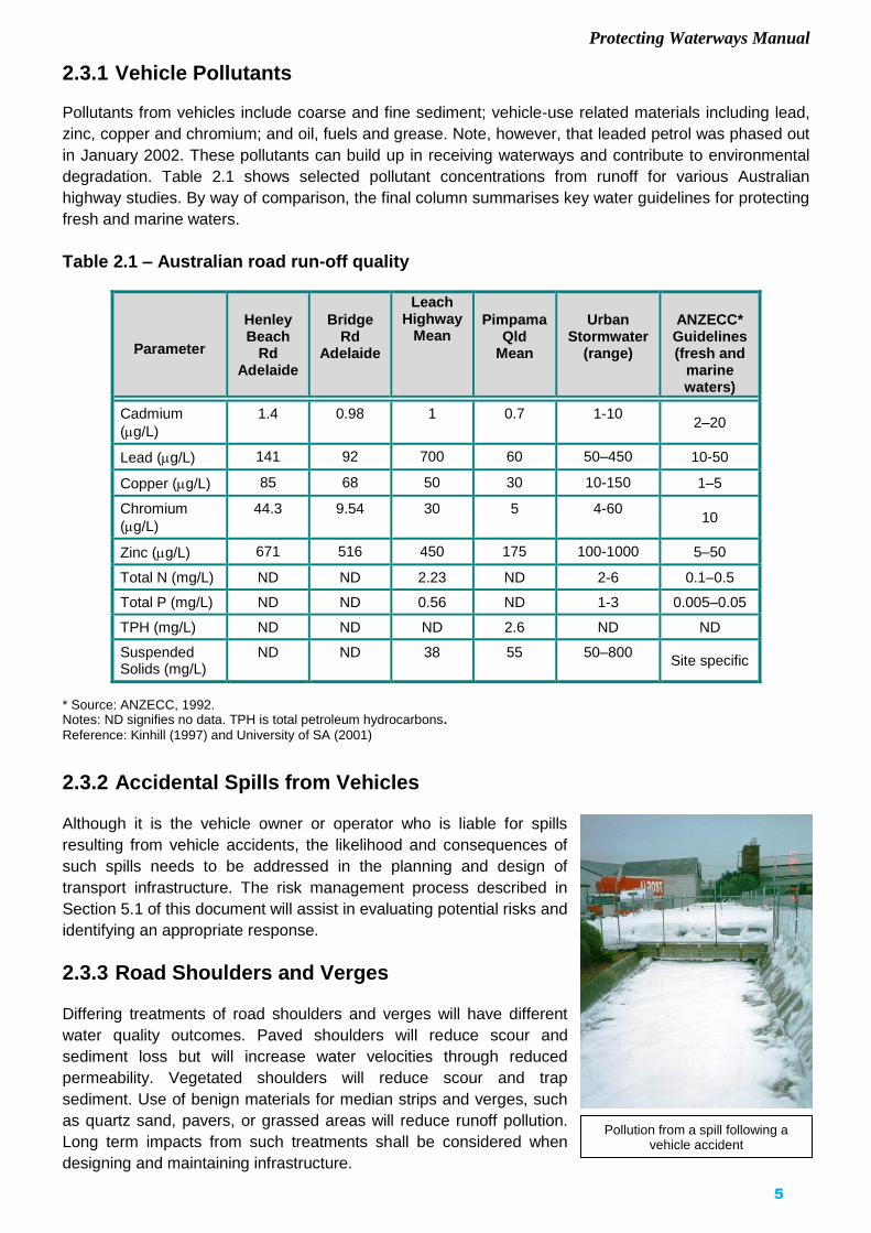
2.3.1 Vehicle Pollutants Pollutants from vehicles include coarse and fine sediment; vehicle-use related materials including lead,
zinc, copper and chromium; and oil, fuels and grease. Note, however, that leaded petrol was phased out
in January 2002. These pollutants can build up in receiving waterways and contribute to environmental
degradation. Table 2.1 shows selected pollutant concentrations from runoff for various Australian
highway studies. By way of comparison, the final column summarises key water guidelines for protecting
fresh and marine waters.
Table 2.1 – Australian road run-off quality
Parameter
Henley Beach
Rd Adelaide
Bridge Rd
Adelaide
Leach Highway
Mean
PimpamaQld
Mean
Urban Stormwater
(range)
ANZECC* Guidelines (fresh and
marine waters)
Cadmium
(g/L)
1.4 0.98 1 0.7 1-10 2–20
Lead (g/L) 141 92 700 60 50–450 10-50
Copper (g/L) 85 68 50 30 10-150 1–5
Chromium
(g/L)
44.3 9.54 30 5 4-60 10
Zinc (g/L) 671 516 450 175 100-1000 5–50
Total N (mg/L) ND ND 2.23 ND 2-6 0.1–0.5
Total P (mg/L) ND ND 0.56 ND 1-3 0.005–0.05
TPH (mg/L) ND ND ND 2.6 ND ND
Suspended Solids (mg/L)
ND ND 38 55 50–800 Site specific
* Source: ANZECC, 1992. Notes: ND signifies no data. TPH is total petroleum hydrocarbons.
Reference: Kinhill (1997) and University of SA (2001)
2.3.2 Accidental Spills from Vehicles Although it is the vehicle owner or operator who is liable for spills
resulting from vehicle accidents, the likelihood and consequences of
such spills needs to be addressed in the planning and design of
transport infrastructure. The risk management process described in
Section 5.1 of this document will assist in evaluating potential risks and
identifying an appropriate response.
2.3.3 Road Shoulders and Verges Differing treatments of road shoulders and verges will have different
water quality outcomes. Paved shoulders will reduce scour and
sediment loss but will increase water velocities through reduced
permeability. Vegetated shoulders will reduce scour and trap
sediment. Use of benign materials for median strips and verges, such
as quartz sand, pavers, or grassed areas will reduce runoff pollution.
Long term impacts from such treatments shall be considered when
designing and maintaining infrastructure.
Pollution from a spill following a vehicle accident

Protecting Waterways Manual
6
For more information on road shoulder treatments refer to ARRB Transport Research (1999) ESD
Assessment of Road Shoulder Management Options.
2.3.4 Landscaping A range of issues need to be considered in the selection of landscape species in urban areas including
integration with surrounding areas, amenity, durability, access to sunlight, etc. The impact on water
quality shall also be included in the selection process. Deciduous plants have a large leaf drop in autumn
compared to the more even spread for non-deciduous and native species.
This large leaf drop contributes to organic pollution and increases
the risk of blockages in stormwater conduits as well as contributing
to biological oxygen demand in receiving waters. In urban areas
both the aesthetic and water quality considerations need to be
taken into account in selection of species.
The effectiveness of water quality management measures such as
the frequency of street sweeping and the availability of downstream
gross pollutant traps, shall be considered in the evaluation of
suitable options.
2.4 Pollution from Construction Sites
Erosion from construction sites has the potential to contribute large sediment loads to downstream
areas. High turbidity reduces the penetration of light through the water, can impact on feeding and
respiration of aquatic fauna and the resulting sedimentation can alter the nature of downstream habitats.
To effectively manage this issue consideration needs to be given to measures to manage the impacts in
the planning and design phases, as well as the construction phase.
Water supplies may be needed during construction for controlling dust and other purposes. Depending
on the quantities required and the source of the water, this may have potential impacts on users of the
water resource and aquatic fauna and flora. The taking of water and activities in waterways are
controlled under the Natural Resources Management Act 2004 and permits may be required.
2.5 Acid Sulfate Soils Acid sulfate soils are the common name given to soils containing
iron sulfides. As long as the sulfide soils remain under the water
table, oxidation cannot occur and the soils are quite harmless and
can remain so indefinitely.
When sulfides are exposed to air, oxidation takes place and sulfuric
acid is produced, which is toxic to plant and animal life. The acid
moves through the soil and acidifies soil, groundwater and surface
water. Figure 2.1 indicates the location of potential acid sulfate soils
in South Australia. For full details refer to the Australian Resource
Information System www.asris.csiro.au/ .
As sulfuric acid moves through the soil, it strips iron, aluminium and
sometimes manganese from the soil and may also in some cases
dissolve heavy metals such as cadmium.
Iron sulfide soils are typically dark grey and wet.
(Source: Fitzpatrick, R & Thomas, B, CSIRO)
Protecting Waterways Manual
7
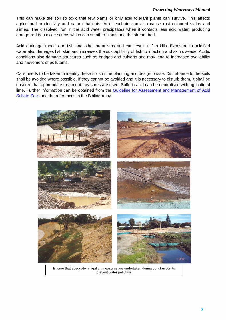
This can make the soil so toxic that few plants or only acid tolerant plants can survive. This affects
agricultural productivity and natural habitats. Acid leachate can also cause rust coloured stains and
slimes. The dissolved iron in the acid water precipitates when it contacts less acid water, producing
orange-red iron oxide scums which can smother plants and the stream bed.
Acid drainage impacts on fish and other organisms and can result in fish kills. Exposure to acidified
water also damages fish skin and increases the susceptibility of fish to infection and skin disease. Acidic
conditions also damage structures such as bridges and culverts and may lead to increased availability
and movement of pollutants.
Care needs to be taken to identify these soils in the planning and design phase. Disturbance to the soils
shall be avoided where possible. If they cannot be avoided and it is necessary to disturb them, it shall be
ensured that appropriate treatment measures are used. Sulfuric acid can be neutralised with agricultural
lime. Further information can be obtained from the Guideline for Assessment and Management of Acid
Sulfate Soils and the references in the Bibliography.
.
Ensure that adequate mitigation measures are undertaken during construction to prevent water pollution.

Protecting Waterways Manual
8
Figure 2.1 – Location of acid sulfate soils in South Australia
(Source: www.asris.csiro.au)
Protecting Waterways Manual
9
2.6 Land Contamination
Land acquired for infrastructure projects may be contaminated from past land uses or work practices,
such as spillage or disposal of waste, leakage from fuel tanks, use of pesticides, herbicides and other
chemicals. The potential for contamination shall be investigated by preparation of a Land Contamination
Site History Report and the need for any site remediation identified (refer to DPTI Managing
Contamination Services Workflow Procedure).
The potential impacts on surface, ground-waters and aquatic environments from any project activities
affecting the contaminated land, shall be identified. This shall be included in the project risk assessment
(Section 5.2) and appropriate management measures identified.
Any water quality monitoring of the land contamination shall be integrated into the water monitoring
program for the project.
2.7 Impacts on Fish
Transport infrastructure and watercourse crossings have the potential to impact both directly and
indirectly on fish and fish habitat during their construction and subsequent use. Although many
waterways are degraded and many species of aquatic flora and fauna are under stress due to a range of
factors including habitat loss, introduction of exotic species, restriction of fish passage and over fishing;
significant steps are being undertaken to restore and enhance waterways by Natural Resources
Management (NRM) Boards, Councils and community groups.
In planning work affecting an aquatic environment or designing watercourse crossings such as bridges,
causeways and culverts, consideration needs to be given to the impact of these works on aquatic fauna.
2.7.1 Native Fish in South Australia Many South Australian native freshwater fish species
have adapted to a mobile life style due to the seasonal
nature of water flow with most watercourses drying up
to a series of pools in summer. A number of our native
species are diadromous (capable of life stages in both
fresh and saltwater) and therefore have migratory
stages as adults and/or juveniles. Therefore, fish need
to be able to move up and down streams in order to
access food, shelter and breeding grounds.
Flood conditions and / or seasonal changes can trigger
fish migration and breeding. Fish also need to move
during low flow periods to access food and shelter. It is
important to ensure that watercourse crossings are
designed to allow fish passage in streams and across
flood plains during both high and low flow conditions so
that options for movement are maximised.
Fish habitats in South Australia can be divided into the
following regions:
Lake Eyre Basin
Lake Eyre Basin and its tributaries including Cooper
Creek – in these areas fish breeding is intermittent and
triggered by major flood events, such as flooding of the
Silver Catfish (Porochilus argenteus). Native migratory species found in SA deserts. Source: M.Hammer
The Diamantina River in flood. Source: P.Canty

Protecting Waterways Manual
10
Where streams are intermittent fish depend on being able to move during high flows to feed
and breed.Meadows Creek, Adelaide Hills.
channel country and lake Eyre.
Most waterways will be dry for long periods of time and only fill during flood events. Fish must move
between ephemeral waters to survive by recreating a mosaic of populations each time it floods.
Mound springs – the fish in the mound springs in the Great Artesian Basin are isolated from other areas
and are unique species.
River Murray Drainages
River Murray – the large flows and permanent water means
that the river provides habitat for our largest freshwater native
fish. There are approximately 37 species of freshwater fishes
in the South Australian portion of the Murray Darling Basin.
Six are introduced and eight are diadromus (move between
fresh and saltwater) (Kahrimanis, Carruthers, Opperman &
Inns (2001)).
Eastern tributaries of Mt Lofty Ranges - climatic conditions
result in intermittent streams restricted to a series of pools in
summer and free flowing streams in winter. As a
consequence native fish are generally small (less than 35cm)
and are diadromous (capable of life stages in both fresh and
salt water) and often migrate up and down streams in order to
access food, shelter and breeding grounds. Only a select few
species are capable of completing their life cycle wholly in
freshwater.
South Australian Gulf Division
Western Mt Lofty Ranges, York and Eyre Peninsulas -
streams are intermittent and native fish are generally small.
As a consequence native fish are generally small (less than
35cm) and are diadromous (capable of life stages in both
fresh and salt water) and often migrate up and down streams
in order to access food, shelter and breeding grounds. Only a
select few species are capable of completing their life cycle
wholly in freshwater.
South Eastern
Freshwater aquatic environments consist of coastal streams
and the south-east drainage system, as well as
limestone/karst sink holes and ponds. Bool Lagoon is a
wetland of international significance.
Estuarine
In estuarine areas samphire, mangroves and seagrass
provide important nursery areas for juvenile fish and aquatic
fauna.
Information on native fish species can be obtained from the
NRM Boards; or Native Fish Australia (SA) (www.nativefish.asn.au).
Mountain Galaxias (Galaxias olidus). Native species found in small streams in Mt Lofty
Ranges. Source: M.Hammer
Dwarf Galaxias (Galaxiella pusilla). Endangered native species found in the SE in
swampy areas (male top, female below). Source: M.Hammer

Protecting Waterways Manual
11
Additional information is available in the Upper River Torrens Landcare Group Data Sheet series
Freshwater Fishes of the Mount Lofty Ranges: part (a) SA Gulf division (2000), (b) Murray Drainages
(2001) and (c) Exotic Species (2001). A sheet covering the fishes of SE South Australia is also available
from Native Fish Australia – SA (2002).
Native fish are protected under the Fisheries Management Act, 2007 and the Commonwealth
Environment Protection and Biodiversity Conservation Act, 1999 (EPBC Act). For more details refer to
Section 3 of this manual.
2.7.2 Potential Impacts on Fish and Aquatic Habitat Transport infrastructure and in-stream works such as bridges and culverts can impact on fish in a
number of ways.
Barriers to fish passage Fish passage can be impeded or prevented by a crossing structure in the following ways:
Changes to water velocity or turbulence - crossings may
alter the natural velocity and local hydraulics of a stream
by changing the cross-sectional area and invert level of the
watercourse. Increased velocity can create a barrier to
upstream migration of fish as they may be unable to swim
upstream against the flow.
Physical barrier – a drop between the culvert and the
stream bed or construction of an embankment across a
drainage or flood channel can restrict the movement of
fish. It also concentrates fish, making them susceptible to
predation and disease.
Water pollution Pollution from a range of sources may affect fish.
Sedimentation – many freshwater fish species lay eggs
on the river bed in areas which provide some shelter from
water flow and predators. Sedimentation can smother the
eggs and other aquatic flora and fauna, and infilling of
gravel beds and deep pools can reduce areas for shelter.
Turbidity – turbid water harms fish by irritating their gills.
Organic matter – organic matter which enters waterways
from leaf litter, wastes and general litter is broken down
by bacteria and in the process uses up the dissolved
oxygen in the water. Low levels of dissolved oxygen may
lead to sediment desorption of phosphorous and metals
and can lead to stressing of the aquatic community and
fish kills.
Floodways can create barriers to fish movement. Coopers Creek
A drop between the culvert and the stream bed can restrict the movement of fish.
Brookman Rd, Meadows

Protecting Waterways Manual
12
Acid sulfate soils – fish kills and fish diseases can occur through disturbance and release of acidic
runoff from these soils.
Oils and heavy metals – these and other pollutants in road runoff can reduce water quality and impact upon the health of aquatic organisms.
Loss or changes to fish habitat Alterations to stream alignments and hydrology can impact on fish habitat. Riparian vegetation provides
shelter to aquatic fauna from flow and sunlight and should be maintained or restored. Stream bed
irregularities and snags can provide important spawning grounds for native fish.
In estuarine areas mangroves and seagrasses provide important nursery areas for juvenile fish species
and are an important part of the food chain.
Project impacts on aquatic habitat shall be avoided where possible, or if unavoidable, habitat
rehabilitation or environmental compensation shall be undertaken to mitigate the impact. Habitat
rehabilitation involves repairing damage caused by past activities, and environmental compensation is
the creation of aquatic habitat or enhancement of fish resources in order to compensate for the impacts
of the project.
Design and construction methods to minimise impacts on water quality are outlined in Appendices B and
C and design considerations in maintaining fish passage are in Appendix D.
2.8 Management Principles In planning, designing, building and maintaining transport infrastructure, impacts on water quality and the
aquatic environment need to be avoided or minimised as far as practical. The potential impact of
changes to waterways from transport infrastructure will depend on the nature of the receiving
environment. Where feasible and practical, there should be no short or long-term degradation of water
quality and aquatic environments from transport infrastructure.
In addressing water quality and impacts on aquatic ecosystems, the following principles shall be applied:
Reducing pollution at source – minimising as far as practical sources of pollution such as sediment from construction sites, wastewater, vehicle wash-down water, litter or other contaminants.
Where feasible, treatment at or close to, the source of pollution is preferred ahead of downstream pollution control management.
Treating, in an appropriate manner, those pollutants that cannot be avoided.
Minimising, as far as practical, any increase in the volume of stormwater to be conveyed off-site and the peak runoff, by retention and infiltration. This will facilitate recharge to local aquifers and reduce scour from increased flows downstream. Options that facilitate use of the stormwater or recharge to local aquifers shall be investigated.
2.8.1 Runoff from Operational Use
As runoff from transport infrastructure is only a small part of the total catchment runoff, and as there is
often limited space for treatment measures in transport corridors in urban areas, addressing water
quality and achieving effective treatment may require partnerships with other stakeholders and
landowners. In urban areas, runoff from operational use of the road may be more effectively treated by

Protecting Waterways Manual
13
Assess the risks to downstream users. Chain of Ponds Bridge over Millbrook Reservoir
larger catchment management measures downstream of the transport infrastructure as part of a total
catchment approach, rather than any edge of kerb solution.
Where appropriate, partnerships should be sought with
NRM Boards and Councils in achieving the most cost
effective and efficient solutions.
An assessment of the potential impact and a risk
management approach shall be used to determine the
level of desirable treatment. For example, some
receiving waters may be used for drinking water
supplies while other receiving waters may already be
treated by stormwater pollution management measures
such as constructed wetlands
Treatment measures need to be cost effective, with
greater effort undertaken where there is greater impact or risk. Section 5.1 provides a guide to the risk
management process.
2.8.2 Construction Sites Water quality management on the construction site needs to be incorporated at all stages of
infrastructure development including planning, design and construction. A “best management practice”
approach shall be adopted, utilising the best available methods, technologies and designs to achieve the
goal of pollution minimisation in a practical and cost-effective manner.
Site management needs to be in compliance with the EPA Stormwater Pollution Prevention Code of
Practice for Local, State and Federal Government and the Code of Practice for the Building and
Construction Industry. These codes inform organisations of their ‘general environmental duty’ with
respect to stormwater under the Environment Protection Act, and the best management practice
approach to stormwater pollution prevention.
The provisions of these Codes are reflected in the principles and processes outlined for DPTI staff and
contractors in this manual.
Constructed wetlands or treatment measures may protect some receiving waters
Stormwater wetland Gross pollutant trap

Protecting Waterways Manual
14
2.9 Pollutant Trapping: A Treatment Train Approach A range of physical, chemical and biological processes for
trapping and/or transforming pollutants found in road runoff
are available. These include physical screening or skimming,
sedimentation, filtration, adsorption by fine particulates, (e.g.
clay soil particles), biological transformation and vegetative
uptake. Each process is suited to removing particular
pollutants, but may have negligible effect on removing
others. For example, grass filter strips are a physical filtering
system with some capacity to filter and trap sediment and
associated sediment-bound pollutants, but with limited
effectiveness in removing dissolved pollutants in runoff.
Where it is necessary to remove or reduce a range of
stormwater pollutants (gross litter, organic matter, coarse
and fine sediment-associated pollutants, soluble pollutants
etc.), it will usually be necessary to employ a variety of treatment measures in series, each effective in
trapping and removing particular pollutants. Using treatment measures “in-series” will also be necessary
to protect the integrity and performance of some specific treatment measures.
For example, a constructed wetland designed for stormwater quality control will require upstream
treatments such as a gross pollutant trap and a sediment basin, to remove incoming gross pollutants and
coarse sediment which would otherwise impair the wetland.
The process of siting treatment measures in series is referred to as the “treatment-train” approach. On a construction site, a treatment train approach refers to treating site runoff by placing treatment controls in series, such as straw bales, cut off drains, sediment fences and sediment basins. This helps to reduce flow velocities and provides a number of opportunities for capturing sediment in the runoff.
Use a treatment train approach – straw bale, gabion lined channel and sediment basin.
Adelaide/ Crafers Project.

Protecting Waterways Manual
15
3 LEGISLATIVE RESPONSIBILITIES
This Chapter outlines the policy and legislative requirements for water resource protection and protection
of aquatic flora and fauna.
3.1 Policies and Strategies
The State Strategic Plan has a vision that we value and protect our water resources, and a target that
our water resources are managed within sustainable limits. The main agencies involved in the
management of stormwater and surface water quality in South Australia are:
Department of Environment, Water and Natural Resources
Natural Resources Management Boards
Environment Protection Authority
Local Government.
The key policy documents in relation to the management of stormwater and protection of water
resources are as follows:
Water for Good (2009) is South Australia’s water security plan which outlines the directions for water
management in South Australia to ensure our water future to 2050 and beyond. The plan outlines a
range of actions to make sure the state’s water supplies are secure, safe, diverse, reliable and able to
sustain a growing population and a growing economy in a changing climate. It can be accessed
from https://www.environment.sa.gov.au/files/sharedassets/public/water/water-for-good-full-plan.pdf
The SA Water Sensitive Urban Design Policy 2013 outlines objectives and guiding principles for
water sensitive urban design including to support the sustainable use of natural water resources; to
protect the health of water bodies and ecosystems; to maintain or improve water quality, manage and
control runoff quantity and encourage integrated planning and design. It also sets performance targets
for reductions in pollutant load from stormwater runoff.
The Department of Environment, Water and Natural Resources administers the Natural
Resources Management Act 2004, which provides for the development of a hierarchy of
natural resources management plans.
The Natural Resources Management Boards (NRM Boards) have responsibility for overseeing
the protection and maintenance of natural resources, including water, in their area and preparing
NRM Plans. These plans provide the policy framework for animal, plant, soil and water resource
management and use throughout the State. They include the State Natural Resources Management
Plan 2012-17, and the regional NRM Plans prepared by the NRM Boards.
NRM Boards fund some pollution treatment measures such as installation of wetlands and trash
racks, and support improvement measures such as stream restoration.
The NRM Boards are also responsible for preparation of Water Allocation Plans where there is
a prescribed water resource. Information on Water Allocation Plans can be obtained from the link below
or the Natural Resources Management Boards websites, https://www.environment.sa.gov.au/topics/water/planning/water-allocation-plans.

Protecting Waterways Manual
16
3.2 Legislation
3.2.1 Natural Resources Management Act, 2004
The Department of Environment, Water and Natural Resources administers the Natural Resources
Management Act, 2004, which provides for the protection and maintenance of natural resources,
including water resources.
Certain water resources (including watercourses, lakes, wells and surface water areas) may be declared
a prescribed water resource. Any diversion, collection or taking of water in a prescribed water resource
requires a permit or a licence.
Relevant sections of the Natural Resource Management Act are:
Section 127 (1) prohibits taking of water from a prescribed watercourse, lake or well or surface water
from a surface water prescribed area, unless authorised to do so by a water licence.
Section 127 (2) prohibits taking of water from a watercourse, lake or well that is not prescribed, or
surface water from land that is not in a surface water prescribed area, in contravention of an NRM plan.
Section 127 (3) prohibits undertaking any of the following activities unless authorised to do so by a
water licence or permit granted by the relevant authority:
(c) draining or discharging water directly or indirectly into a well;
(d) the erection, construction or enlargement of a dam, wall or other structure that will collect or divert –
(i) water flowing in a prescribed watercourse; or
(ii) water flowing in a watercourse in the Mt Lofty Ranges Watershed that is not prescribed; or
(iii) surface water flowing over land in a surface water prescribed area or in the Mt Lofty Ranges
Watershed;
(e) an activity of a kind referred to in subsection (5) that is identified in an NRM plan that applies in the
area in which the activity is to be undertaken as being an activity for which a permit is required under this
subsection;
(f) an activity prescribed by regulations
Section 127 (5) prohibits activities contrary to an NRM plan including construction of structures in a
water course; discharge to a watercourse; depositing material or obstructing a watercourse; destroying
vegetation growing in a watercourse; and excavating or removing rock, sand or soil from a watercourse
or lake, or the floodplain of a watercourse.
Section 129 indicates a permit is not required to undertake an activity that is authorised under the
Development Act 1993.
Section 130 enables the relevant authority to require the owner or occupier of the land to rectify the
effects of an unauthorised activity.
Section 133 it is the duty of the owner or occupier of land on which a watercourse or lake is situated, to
take reasonable steps to prevent damage to the bed and banks of the watercourse or lake and to the
ecosystems that depend on the watercourse or lake.

Protecting Waterways Manual
17
Under sections 127 (3) and (5) of the Natural Resources Management Act a permit is required for
activities affecting a watercourse unless works are approved under another Act, such as the
Development Act, 1993 or the Environment Protection Act, 1993. DPTI has a Water Affecting Activities
Standard Operating Procedure that has been endorsed by several of the NRM Boards. This Best
Practice Operating Procedure is based on the level of risk associated with the project, with only projects
identified as having a higher level of risk requiring a separate permit.
3.2.2 Local Government (Stormwater Management) Amendment Act, 2007
This amendment of the Local Government Act provided for the formation of the Stormwater Management
Authority. Stormwater management plans developed by local government and accepted by the Authority
may impact on DPTI activities in two ways. Firstly, any works carried out must be in accordance with the
overall stormwater management strategy in the plan, and secondly the plan may contain local targets for
water quality.
The Stormwater Management Authority’s role is to co-ordinate and facilitate stormwater management
planning by Councils, including the formulation of stormwater management plans. The Authority
administers the Stormwater Management Fund, which may be used for:
the preparation of stormwater management plans;
the carrying out of works or the acquisition of land (including by a council or some other
entity) in accordance with an approved stormwater management plan or otherwise for the
purpose of stormwater management;
community education and awareness programmes related to stormwater management;
projects or measures relating to water quality or pollution abatement;
investigations, research, pilot programmes or other projects relating to stormwater
management.
Further details of the Stormwater Management Authority, including annual reports that detail Stormwater
Management Plans that have been accepted by the Authority can be found at the website
https://www.sma.sa.gov.au/about/annual-reports
3.2.3 Environment Protection Act, 1993
The Environment Protection Authority (EPA) administers the Environment Protection Act which regulates
polluting activities and requires a “duty of care”. The EPA promotes good practice through
measures such as the EPA Stormwater Pollution Prevention Code of Practice for Local, State
and Federal Government, and the Stormwater Pollution Prevention Code of Practice for the
Building and Construction Industry which covers infrastructure contractors.
The Environment Protection (Water Quality) Policy uses codes of practice such as these to describe
how a person undertaking a particular activity can comply with the requirements of the Water Quality
Policy (and other Environmental Protection Policies where appropriate), and the Environment
Protection Act. The Water Quality Policy also covers discharges to the marine environment and the
mechanisms for marine and coastal water protection.
The sections of the Environment Protection Act relevant to the Department are as follows:

Protecting Waterways Manual
18
Section 25 states that: “A person must not undertake an activity that pollutes, or might pollute, the
environment unless the person takes all reasonable and practical measures to prevent or minimise any
resulting environmental harm.” Section 25(2) of the Act specifies that regard must be given, amongst
other things, to the nature of pollution or potential pollution, the sensitivity of the receiving environment,
the financial implications of various measures, and the current state of technical knowledge in
considering the application of various devices.
Section 36 Construction projects with the potential for sedimentation require a license under the Act.
Section 36 states that a person must not undertake a “prescribed activity of environmental significance”
except as authorised by an environmental authorisation in the form of a license. Prescribed activities
include dredging and earthworks drainage covered in Schedule 1 of the Act:
Dredging – “Removing solid matter from the bed of any marine waters or inland waters by any digging or
suction apparatus, but excluding works carried out for the establishment of a visual aid to navigation and
any lawful fishing or recreational activity”.
Earthworks Drainage - “The conduct of earthworks operations in the course of which more than 100
kilolitres of wastewater containing suspended solids in a concentration exceeding 25 milligrams per litre
is discharged directly or indirectly to marine or inland water”.
Section 79, 80 and 82 respectively, create an offence if a person causes serious environmental harm,
material environmental harm or environmental nuisance by polluting the environment.
Section 83 requires the notification to the Authority of incidents causing threatening, serious or material
environmental harm from pollution.
Section 93 enables the provisions of the Act to be enforced by issue of an Environmental Protection
Order.
Section 99 enables the provisions of the Act to be enforced by issue of a Clean-up Order.
Section 124 It is a defence under the Act if proper workplace systems and procedures designed to
prevent a contravention of this Act are in place, whereby any contravention or risk of contravention of the
Act, is required to be reported promptly; and the employer actively and effectively promoted and
enforced compliance with the Act.
Section 129 indicates that in relation to an offence against this Act, a person who is an officer of a body
corporate can be held guilty of an offence.
Also refer to the Environment Protection (Water Quality) Policy, available at the South Australian
Government legislation site http://www.legislation.sa.gov.au/index.aspx .
3.2.4 River Murray Act, 2003 The River Murray Act provides for the protection and enhancement of the River Murray and other related
areas and ecosystems; and for other purposes. The Act outlines measures to maintain and improve the
environmental health of the River Murray, maintain the environmental flow requirements, maintain water
quality in the system and human dimension objectives. The Act is administered by the Department of
Environment, Water and Natural Resources.
At present the Act applies to certain activities under the Development Act 1993, the Fisheries
Management Act 2007, the Harbors and Navigation Act 1993 and any mining Act.
Protecting Waterways Manual
19
Under the Act:
Section 23 (1) “A person must take all reasonable measures to prevent or minimise and any harm to the
River Murray through his or her activities.” Harm include risk of harm and future harm and anything
declared by regulation to be harm to the River Murray.
Section 24 (1) The Minister of the River Murray may issue a protection order for the purpose of securing
compliance with the general duty of care, a management agreements or any other requirement imposed
under the Act.
3.2.5 Highways Act, 1926 The Commissioner of Highways operates under the provisions of the Highways Act 1926. The
Commissioner may assume care, control and management of a road in a Council area under section
26(3) of the Act.
When the Commissioner assumes care, control and management of a road in a Council area, the
Commissioner assumes the powers and duties of a Council under Part 2 of Chapter 11 of the Local
Government Act, 1999 and the Council may not exercise these powers except to the extent that the
Commissioner may approve otherwise. The Commissioner may, therefore, carry out “roadwork” on a
road under the care, control and management of the Commissioner which includes “the construction of
drains and other structures for the drainage of water from a road”.
In general, on roads under the care, control and management of the Commissioner, the Commissioner
constructs and maintains drainage works if they are an integral part of the roadwork, and if they function
primarily to ensure the structural integrity of the road or necessary surface drainage. For details of the
drainage responsibilities assumed by the Commissioner, refer to the DPTI Operational Instruction 20.1
Care, Control and Management of Roads (Highways) by the Commissioner of Highways (Section 26 of
the Highways Act) (available at http://www.dpti.sa.gov.au/documents/tass).
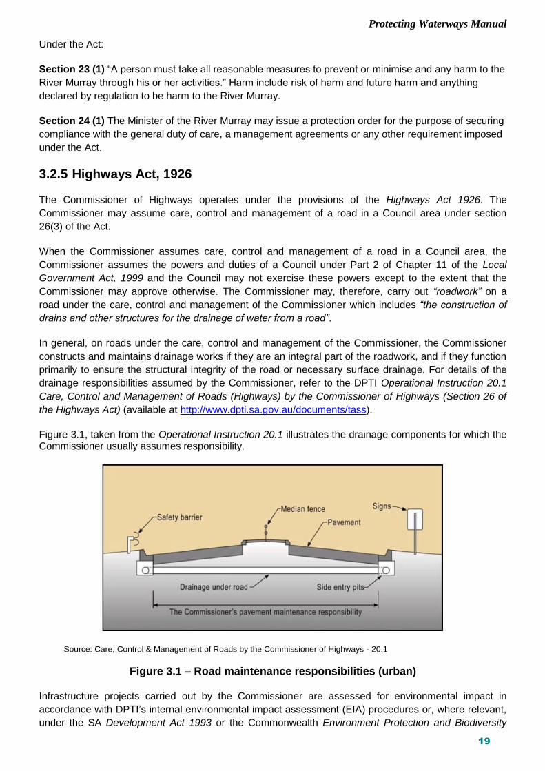
Figure 3.1, taken from the Operational Instruction 20.1 illustrates the drainage components for which the Commissioner usually assumes responsibility.
Source: Care, Control & Management of Roads by the Commissioner of Highways - 20.1
Figure 3.1 – Road maintenance responsibilities (urban) Infrastructure projects carried out by the Commissioner are assessed for environmental impact in
accordance with DPTI’s internal environmental impact assessment (EIA) procedures or, where relevant,
under the SA Development Act 1993 or the Commonwealth Environment Protection and Biodiversity

Protecting Waterways Manual
20
Conservation Act 1999 (refer to the Environmental Approvals Environmental Instruction 21.1). The
evaluation and mitigation of impacts on water quality and aquatic environments are part of the
environmental assessment process.
3.2.6 Rail Commissioner Act, 2009 DPTI rail infrastructure operates under the Rail Commissioner Act, 2009. The Rail Commissioner is
responsible for operation of the metro rail network and is able to construct, maintain and operate rail
infrastructure in accordance with the Act.
3.2.7 Fisheries Management Act, 2007 Native fish and aquatic fauna are protected under the Fisheries Management Act 2007. Approval under
the Act is required where DPTI will enter or affect an aquatic reserve. Some rare and endangered fish
and other aquatic species are protected under the Commonwealth Environment Protection and
Biodiversity Conservation Act 1999 (EPBC Act).
3.2.8 Native Vegetation Act, 1991
Native vegetation including aquatic flora such as reeds, samphire and mangroves are protected under
the Native Vegetation Act 1991. Clearance of native vegetation will require approval under the Act.
DPTI’s Vegetation Removal Policy is a standard operating procedure approved by the Native Vegetation
Council for vegetation removal approval for transport activities.
3.2.9 Commonwealth Environment, Protection and Biodiversity Conservation Act, 1999
Rare flora, fauna, ecological communities and Ramsar wetlands are “Matters of National Significance”
protected under the EPBC Act. For a listing of species protected under the Act refer to the
Commonwealth Department of the Environment website http://www.environment.gov.au/epbc/ .
If “Matters of National Significance” under the EPBC Act are affected by infrastructure works, approval
may be required under the Act. For details of the approval process, refer to the DPTI Guide to the
Environment Protection and Biodiversity Conservation Act 1999, or the Commonwealth Department of
the Environment website.
South Australian freshwater fish species currently protected under the EPBC Act can be identified via the Department of the Environment’s Protected Matters Search Tool (http://www.environment.gov.au/webgis-framework/apps/pmst/pmst.jsf).

Protecting Waterways Manual
21
4 PROCEDURES - OVERVIEW
The following chapters outline the procedures for addressing the impact of transport infrastructure on
water quality and aquatic environments, and ensuring a ‘duty of care’ when planning, constructing,
operating and maintaining transport assets. For transport infrastructure to be delivered in a sustainable
way, the environmental, economic and social values of the state’s water resources need to be protected
in the development and operation of the transport asset.
Objectives of water management include:
protection of water quality to maintain maximum options for
its reuse
protection of aquatic ecological systems, both terrestrial
and marine
enhancing multiple use riverine corridors and maintaining
amenity
flood protection to adjoining land uses.
Protection of water quality and aquatic environments shall be
incorporated into the evaluation of all projects as part of the
Department’s planning and environmental impact assessment
(EIA) procedures and shall be addressed at the following
project stages:
Concept Planning
Consideration of project options – The potential impact on water quality shall be one of the factors
taken into account in the consideration of project options and selection of the preferred option.
Project Planning
Assessment of potential impacts and development of the preferred option – The impact of the project
on water quality during both the operational phase and the construction phase of the project shall be
addressed. This shall be documented in the Planning Report or Environmental Impact Assessment
Report (EIAR) and the management and mitigation measures included in the contract documents.
Solutions shall consider the most cost effective approach and seek to maximise the social and
environmental benefits that can be built into the solution.
Design – Detailed design of the operational phase treatment options as well as any significant
temporary construction phase treatment facilities, such as sediment detention basins, need to be
incorporated into the design of the infrastructure, where appropriate.
Construction –Soil erosion and water quality management measures, including the Soil Erosion and
Drainage Management Plan (SEDMP), need to be incorporated into the contract provisions. On high
risk sites, the contractor must prepare an appropriate Contractor’s Environmental Management Plan
(CEMP) and detail the way they will implement the SEDMP prior to the commencement of work.
Where required, an Earthworks Drainage Licence under the Environment Protection Act, 1993 shall
be obtained.
Maintenance – The on-going maintenance requirements shall be considered as part of the selection
and design of any water quality management measures. At handover, the Department’s asset
maintenance area shall be advised of any on-going maintenance or monitoring requirements as part
Protect and enhance the amenity of water courses

Protecting Waterways Manual
22
of the project and shall incorporate them into the maintenance contracts. Maintenance work shall be
undertaken in a manner that minimises impact on water quality and complies with the DPTI
Environmental Management Workbook for Roadside Maintenance Activities and the Maintenance
Contract Specification. Figure 4.1 shows the key stages where protection of watercourses shall be
considered within a project.
Figure 4.1 – Stages of the project where protection of watercourses shall be addressed
Concept Planning
Section 5
Scope & potential impacts
Project Planing & Environmental Assessment
Section 5
Data collection
Assessment of site constraints and project impacts
Risk assessment
Development of mitigation measures for operational and construction phases
Documented in EMP and SEDMP
Environmental clearance
EMP & Draft SEDMP
Environmental Clearance
Design
Section 6
Detailed design of treatment measures
WSUD documentation as required in DD300
Construction
Tender Documentation; Award Contract
Section 7
Relevant clauses in Contract Documentation
Contractor’s obligations
SEDMP
CEMP
Water quality monitoring
Environmental Auditing
CEMP, SEDMP & Site Auditing
Maintenance Inclusion in Maintenance contracts
Section 8
Maintenance of treatment measures and rehabilitation of any scour problems
Maintenance work in compliance with Environmental Management Workbook for Roadside Maintenance Activities and relevant contract clauses

Protecting Waterways Manual
23
5 PROJECT PLANNING AND ENVIRONMENTAL ASSESSMENT
5.1 Introduction
The impact of the project on water quality and aquatic ecosystems during construction and operation
shall be evaluated in the planning phase, and mitigation measures identified.
Concept Planning The potential impact on waterways shall be considered when evaluating and scoping options and the
cost of mitigation measures should be included in budget estimates.
Project Planning An evaluation of the impact of the project on water quality, quantity and aquatic environments shall be
undertaken as part of the EIA of the project. This consideration shall be included when evaluating
alternatives and selecting the preferred option.
The following steps shall be undertaken:
Assess and document the nature of the receiving environment affected by the project.
Assess and document the potential impacts of the project both during construction and operation on
the receiving environment.
Identify potential mitigation measures.
Undertake a risk assessment to evaluate risks and identify most appropriate risk treatments and
mitigation measures, and;
Where appropriate, set WSUD targets for pollutant loads based on the Water Sensitive Urban Design
Policy.
These impacts and any mitigation measures shall be addressed in the following documents where
relevant, according to the scale and impacts of the project.
Planning Report or Environmental Impact Assessment Report (EIAR)
Contract specific requirements – on medium and high risk sites this may include the draft Soil
Erosion and Drainage Management Plan (SEDMP)
Supporting documentation shall be kept in project files as evidence of the process followed and options
considered. This documentation will not only demonstrate a ‘duty of care’ in a legal sense, but will
provide the opportunity for review of the appropriateness and effectiveness of the measures taken.
Design and Construct Projects Where a project places a significant level of responsibility on the contractor to select and design water
quality treatment measures the Department shall undertake a draft water quality risk assessment to
guide the formulation of the contract specific clauses.

Protecting Waterways Manual
24
It should then be a requirement that the contractor undertakes an update of the water quality risk
assessment to provide a final risk assessment. This shall also include a residual risk assessment.
5.2 Risk Management
5.2.1 Risk Management Framework Risk management is applied to all spheres of organisational planning and management, including
environmental management to ensure that key risks are being addressed. Risk assessment addresses
the causes and effects of potential environmental harm and evaluates risk treatments so that the most
appropriate measures are identified and expenditure can be prioritised.
It is important to be able to demonstrate, that a ‘duty of care’ is being observed through the rigour of the
process and documentation of the outcomes.
A risk assessment shall be undertaken to determine the potential nature, scale and likelihood of any
impacts during both the construction phase and the operational use of the infrastructure. Consideration
shall be given to the potential impacts of staged earthworks; of altered surface or groundwater hydrology
and drainage paths; to the pollutants in road runoff; and the likelihood and potential impact of any spills
of hazardous materials.
The process used for environmental risk assessment follows the generic framework in AS/NZS
4360:1999 Risk Management and as further developed by Austroads (2001) in Environmental Risk
Management Guidelines and Tools for Road Projects.
The main steps in the risk management process (as illustrated in Figure 5.1) are:
Establish the context
Identify risks
Analyse risks
Evaluate risks
Treat risks. Figure 5.1 shows that there is some iteration in the process, or feedback loops that are required to
ensure that the overall project can proceed with an acceptable level of risk.
The effectiveness of the risk treatment plan, strategies and the management system set up to control
implementation must also be monitored through this iterative process. Ongoing review is essential to
ensure that the management plans remain relevant.
Each main step is discussed in the following sections.

Protecting Waterways Manual
25
Figure 5.1 – Risk management process

Protecting Waterways Manual
26
5.2.2 Establish the context The nature of projects varies widely. A 'scan' should be undertaken for each project, to help define the
scope of the risk management process. Things that should be considered include:
The purpose and nature of the project. This will include a consideration of the potential of inclusion of
WSRD measures and the need for the inclusion of WSUD targets.
Legislative compliance requirements - for example, some activities are prescribed in legislation and
are subject to approvals and licence conditions:
- Discharge of sediment laden wastewater from earthworks (sec 36 Environment Protection Act
1993)
- Discharge of stormwater through bores (Natural Resources Management Act 2004). Road
drainage in some areas, such as some towns in the South East of the state and some areas in
metropolitan Adelaide, drains directly into groundwater bores.
Legislative obligations are outlined in Section 3.
The water quality objectives or strategic directions for the catchment. These will be documented in
Natural Resources Management Plans, Council Water Management Plans and Stormwater
Management Plans (where available) as well as the provisions of the Development Act, 1993.
Stormwater drainage design shall be in accordance with such plans so as to integrate the design with
the total catchment objectives.
Particular environmental concerns raised by the local community.
Criteria for acceptance of risk shall be understood or determined. These will involve considerations of
cost as well as opportunities. What measures can be included with little expense? How much effort
does the potential scale of impacts of the project warrant? What are community expectations?
5.2.3 Identify risks This step is applied to all projects, large or small and may need to be an iterative process as more
information becomes available or adjustments to the project are made. It can be undertaken as a
brainstorming exercise. Every conceivable environmental risk arising from the project should be
recorded, as prompted by answers given to the key questions:
What can happen?
How and why can it happen?
The risk shall be identified as a potential impact or event caused by the construction or operation of the
project. In the case of road projects this will generally be caused by the export of pollutants, for instance
heavy metals, nutrients or sediment.
For the export of sediment the risk is the smothering of downstream environments. The risk of increases
in runoff peak flow or volumes is the flooding of downstream properties, or erosion of watercourses.
Nutrient export may cause algal blooms.
To carry out this step, a thorough understanding of the local environment in the area of the project is
required. Knowledge of the methods to be used in the project's construction and of the ongoing
operational characteristics will also be needed. Information gathered shall be documented to a level of
detail appropriate to the likely scale of potential environmental impact of the project.

Protecting Waterways Manual
27
Relevant expertise shall be used where necessary and advice obtained from the Stormwater and
Environmental Discipline Specialists, or specialist consultants as appropriate.
All risks should be documented. Remember that if a risk is not identified at this stage, it cannot be further
assessed by the process.
Risk identification may require input from many areas and other agencies or stakeholders. Various tools
are available to obtain input to the process, ranging from consultation to risk management workshops.
An appropriate tool for risk identification and management during the remainder of the process shall be
selected to suit the scale and potential environmental impact associated with the project.
The ‘owners’ of risks identified during this process shall be documented together with the names of those
considered to be accountable and responsible for the management of the risk. These may or may not be
the same.
Consideration shall be given to who ‘owns’ the risk and who is accountable for its effective management.
Documentation of specific names (organisations or individuals) reduces the likelihood of avoidance
through ignorance.
For example, a risk might be identified during planning, a treatment developed during design, and
responsibility for ongoing operation and review transferred to a maintenance contractor or Council on
completion of the project.
The aspects listed below shall be considered in identifying risks. A water quality risk assessment
template is contained in Appendix E.
Site Characteristics
The topography of the site.
The nature and erodibility of the soils (including potential acid sulfate soils).
Climate and rainfall patterns.
The drainage pattern and size of catchments. Where necessary hydrological modelling of the drainage systems affected shall be undertaken in accordance with the Australian Rainfall and Runoff, A Guide to Flood Estimation, Volume 1 (Institution of Engineers, Australia 1987).
The quality and nature of receiving waters e.g. a water supply reservoir, recreational water body, or protected marine area.
The quality and depth to groundwater and any pollution transport mechanisms. (In parts of the South East of the state, stormwater is directed into groundwater bores and therefore pollutants are likely to be easily transported into groundwater.)
The vegetation and ecology of the site and surrounding area, including the downstream aquatic environment for example important wetlands, aquatic habitat, rare or endangered flora or fauna, or other significant area.
The land use of the adjacent and downstream areas. Any sensitive land and water uses that may be affected by soil erosion or water quality impacts from the project including downstream water users must be identified, as well as any existing stormwater management treatment measures or reuse of the water resource in place, or planned, downstream of the project.
The nature and capabilities of any water quality treatment measures already in place downstream of the project area.

Protecting Waterways Manual
28
Mt Compass wetland – habitat for the nationally endangered Mt
Lofty Ranges Southern Emu Wren
Scour treatment incorporated a fish ladder for native fish.
Tookyerta Creek
Project Characteristics
The timing and scale of the project.
Any proposed staging of the project (extent of area under construction at any one time), particularly
the area exposed to erosion during high rainfall or potential storm event periods.
The extent of cut and fill.
The volume and nature of traffic, extent of commercial vehicles or hazardous loads.
Potential traffic accident characteristics.
Concentration or dispersion of stormwater, changing the nature, timing and location and quality of
flows or altering flood patterns.
The extent to which risks can be avoided by management measures.
The effect of the project on any water quality treatment measures already in place downstream of the
project area.
Impediments to achieving any water quality objectives for the catchment. Impacts on water quality from scouring and erosion of the project site, with consequent siltation of
downstream watercourses, will need to be addressed. Other risks, such as harm to biota and
downstream users through changes in flow regime, volumes and peak flows, spilling or leakage of toxic
substances used on site, or operational pollutants (sediments, nutrients, heavy metals) shall also be
considered.

Protecting Waterways Manual
29
Additional Information – Factors in Assessing Soil Erosion
Parameters for assessing site erosion risk are :
Erosivity – this term refers to the erosive power of rainfall. It varies from meteorological region to region across the state but is generally consistent within each region. It is measured numerically by the erosivity factor, R-factor. Erosivity varies between 300 to 500 in Adelaide, lower South East and Mid North, and from 400 to 250 in the Riverland, Western Agricultural and Upper South East.
Slope – this is a primary factor in erosion potential. Increased slope length and grade will increase the likelihood of erosion.
Soil Type – soil parameters such as soil structure, particle size and dispersivity potential influence the risk of sediment erosion. Ideally these parameters should be measured, although this can prove costly for small construction sites and in such cases the Universal Soil Classification System should be used. For larger and high risk projects laboratory soil tests including dispersivity testing shall be undertaken. The following information shall be obtained.
Laboratory analysis of soil particle distribution : percentages of particles in the
following ranges : less than 0.002 mm, 0.002 to 0.02 mm, 0.2 to 2 mm and 2 to 75
mm (this data can also be used to indicate the potential suitability of sediment
detention structures)
Laboratory determination for soil dispersivity
Soil profiling to 1.5 metres depth, or maximum depth of proposed disturbance,
whichever is lesser
Other constraints – for example, soil hydraulic conductivity, wet soil strength, mass
soil movement hazard
The information shall be plotted on a topographical site plan(s) and appropriate soil
erosion risk levels (ie. low, moderate, high or extreme) determined for different locations
within the site.
Duration of risk of soil erosion during the project – the duration of works affects the potential quantity of soil loss. The risk can be regarded as linear: doubling the construction period will double the potential soil loss.
Largest area exposed to soil erosion risk during the project – the area of soil disturbed will impact on the potential for soil loss from a construction site. The potential loss increases in linear relation with the increase in disturbed area.
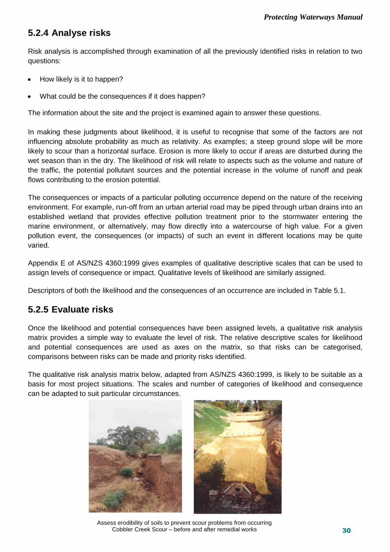
Protecting Waterways Manual
30
5.2.4 Analyse risks Risk analysis is accomplished through examination of all the previously identified risks in relation to two
questions:
How likely is it to happen?
What could be the consequences if it does happen? The information about the site and the project is examined again to answer these questions.
In making these judgments about likelihood, it is useful to recognise that some of the factors are not
influencing absolute probability as much as relativity. As examples; a steep ground slope will be more
likely to scour than a horizontal surface. Erosion is more likely to occur if areas are disturbed during the
wet season than in the dry. The likelihood of risk will relate to aspects such as the volume and nature of
the traffic, the potential pollutant sources and the potential increase in the volume of runoff and peak
flows contributing to the erosion potential.
The consequences or impacts of a particular polluting occurrence depend on the nature of the receiving
environment. For example, run-off from an urban arterial road may be piped through urban drains into an
established wetland that provides effective pollution treatment prior to the stormwater entering the
marine environment, or alternatively, may flow directly into a watercourse of high value. For a given
pollution event, the consequences (or impacts) of such an event in different locations may be quite
varied.
Appendix E of AS/NZS 4360:1999 gives examples of qualitative descriptive scales that can be used to
assign levels of consequence or impact. Qualitative levels of likelihood are similarly assigned.
Descriptors of both the likelihood and the consequences of an occurrence are included in Table 5.1.
5.2.5 Evaluate risks Once the likelihood and potential consequences have been assigned levels, a qualitative risk analysis
matrix provides a simple way to evaluate the level of risk. The relative descriptive scales for likelihood
and potential consequences are used as axes on the matrix, so that risks can be categorised,
comparisons between risks can be made and priority risks identified.
The qualitative risk analysis matrix below, adapted from AS/NZS 4360:1999, is likely to be suitable as a
basis for most project situations. The scales and number of categories of likelihood and consequence
can be adapted to suit particular circumstances.
Assess erodibility of soils to prevent scour problems from occurring Cobbler Creek Scour – before and after remedial works

Protecting Waterways Manual
31
Table 5.1 – Qualitative risk analysis matrix
Likelihood
Consequence
Low Minor adverse social or environmental impact.
Medium Measurable adverse environmental or social impact. Will result in annoyance or nuisance to community
High Significant damage or impact on environmental systems and local community.
Low The event could occur only rarely, or is unlikely to occur
Low Risk Low Risk Medium Risk
(could be High)
Medium The event will occur occasionally or could occur
Low Risk Medium Risk High Risk
High The event will occur often or is most likely to occur
Medium Risk High Risk High Risk
(Critical)
There may be difficulties in achieving consistency in the application of qualitative scales. When allocating
risk categories, it is advisable to involve a range of people with suitable expertise.
5.2.6 Treat risks The risk assessment process indicates which risks to water quality require priority attention, during both
the operational and construction phases. Table 5.2 provides a general indication of the efforts in
treatment and mitigation that would typically be warranted for the risk levels indicated by the process.

Protecting Waterways Manual
32
Table 5.2 – Indication of risk based treatment response
Level of Risk
Proposed Level of Treatment
Critical Ensure appropriate treatment methods adopted and/ or consider alternative project options or alignments to reduce the level of risk.
Cost of treatment shall not be the primary consideration.
High Ensure an integrated stakeholder approach and risk management plan in place.
Cost of treatment shall not be the primary consideration.
A range of treatments shall be applied to the site (see Section 2.8 “treatment train” approach).
Design of treatments shall be based on a judicious, conservative application of design procedures.
Medium
Cost of treatments may be considered. Select in conjunction with the most suitable measures for the site constraints.
A range of treatments shall be applied to the site (see Section 2.8 “treatment train” approach).
Design sizing of treatments, may be at a lower standard than those under the “high” risk descriptor if substantial cost reduction will result for a small increase in potential risk. For example, if reducing the capacity of a detention basin results in significant cost savings for a small increased sediment loss or pollution risk.
Low
Only low cost operational treatments to be applied.
Use standard construction site management practices, comply with DPTI Environmental Code of Practice for Construction – Road Rail and Marine Facilites
Detailed consideration of specific treatment measures to address risks requires answers to the following
questions:
How effective are any existing mitigation measures? Are the criteria set in the first step - 'establish
the context' satisfied by them?
If not, what additional treatments are available and how effective would they be in reducing the risk to
an acceptable level?
Are the additional measures reasonable and practicable?
Are the criteria set in the first step - 'establish the context' satisfied by the measures?
Appendices A to D outline a range of treatment measures available. For example, pollutants in the runoff
may be able to be captured in grassed swale drains. If, in addition, there is a low risk from spills, the
impacts on water quality may be low and no further site mitigation measures may be required.
Alternatively a road may cross an aquatic or wetland area of significance or a stream which contributes
to a local or regional water supply. Road runoff or spills in such a location may be a significant pollutant
risk. Investigation of mitigation measures where feasible, would be warranted.
The logical sequence of the risk management process explained above can be adapted to suit the
nature of each project and its risks. With an understanding of, and confidence in the use of the process,
it is possible to combine the documentation of many of the steps in one table, as in the following
example.

Protecting Waterways Manual
33
Table 5.3 – Example – Site risk management measures
Risk Identification
Likelihood Potential Consequence
Level of Risk Response
Ch1500 – Ch2500 soil loss from batter
High - during construction due to soil type and slope
High - sensitive downsteam environment
Critical Sediment basins during construction phase
Progressive revegetation
Regular site audits
Erosion matting
Increase in peak flow in downstream creek
High – due to increased paved area
High – creek is already under capacity. Increased flooding in downstream urban area
Critical Install flood control basin
Ch1500 – Ch2500 operational pollutant load
High – due to traffic volumes
Low – Minor impact on receiving environment
Medium Convert sediment basins to mini wetlands at end of construction period
Ch1500 – Ch2500, spills, sensitive receiving environment
Low High – sensitive downstream environment
High Ensure that spills can be captured in wetlands – must be automatic system
Ch00 – Ch1500, spills, urban environment with the ability to catch spills downstream
Low Low Low Accept risk (no treatment measures)
5.3 Application of WSUD Targets to DPTI Projects
The draft pollutant reduction targets developed for Water Sensitive Urban Design - Greater Adelaide
Region 2010 are relevant to, but in many cases not directly applicable to DPTI projects. The targets are
being updated as part of the State Government’s WSUD implementation project. In addition they may be
superseded by targets developed by local government as part of a stormwater master plan for an
individual catchment.
The following targets may be used as a basis for the targets set for individual projects:
80% reduction in average annual total suspended solids load;
45% reduction in annual average total nitrogen load;
45% reduction in average annual total phosphorus load;
retention of litter greater than 50 mm for flows up to the 3 months ARI peak flow; and
no visible oils for flows up to the 3 months ARI peak flow.

Protecting Waterways Manual
34
The opportunity for retrofitting WSUD features within existing urban arterial road corridors (WSRD) is
very limited, but for large scale road projects, particularly in new corridors, and other projects such as the
development of park and ride facilities there is scope for the inclusion of WSUD features. In these cases
targets shall be set with reference to the targets listed above, or any catchment scale target set by an
urban stormwater master plan.
The need for setting WSUD targets shall be determined at the time a water quality risk analysis is carried
out.
5.4 Development of Mitigation Measures
5.4.1 Operational Phase Mitigation Measures The range of potential mitigation measures suitable for addressing stormwater pollution management for
the operational phase are described in Appendices A and B. In addition the technical manual for Water
Sensitive Urban Design for Greater Adelaide is available on line at:
https://www.sa.gov.au/topics/housing-property-and-land/industry-professionals/planning-professionals/water-sensitive-urban-design Information obtained during the site assessment and the risk analysis will help in the selection of
appropriate measures. The documentation of the nature and source of the pollutants from the project as
well as site constraints, opportunities, or any existing treatment measures downstream of the site will
enable appropriate treatment measures to be identified.
As runoff from transport infrastructure is only a small part of total catchment runoff and there is often
limited space for treatment measures in transport corridors in urban areas, addressing water quality may
require partnerships with other stakeholders, NRM Boards and Councils.
Preliminary screening of operations-phase treatment alternatives shall be undertaken on the basis of the
broad-based selection screening procedure in Appendix A. Additional screening shall be made of the
suitability of the treatment measures on the basis of information provided in Appendix B.
Social acceptance of
treatment measures as
well as health and safety
issues and secondary
environmental issues
shall also be considered.
Systems that impact
least in terms of space
requirements,
construction time and
maintenance frequency
and cost shall be
preferred, if other
performance factors are
equal.
Maintenance issues may include the need for adequate on-going access or the ability to use mechanical
equipment for cleaning of the structure. Construction considerations include suitable locations and space
for installation of treatment measures and access requirements.
Bridge drainage in a sensitive receiving environment, captured and treated in a detention basin. Blanchetown Bridge, River Murray.

Protecting Waterways Manual
35
Some treatment measures will require a complementary treatment measure to be in place in order to
treat water quality effectively. In such cases this is indicated in Appendix B.
A ‘treatment train’ approach shall be considered in the selection of reasonable and practicable
measures. As different treatment measures treat different pollutants a series of treatment measures may
need to be put in place to achieve effective pollutant removal. This is called a ‘treatment train’ approach.
Treatment measures shall be capable of removing silt, organic matter and litter and where feasible,
hydrocarbons, accidental spills and excess nutrients.
Where practical and reasonable to do so, treatment measures shall be sited as close to the source of
runoff as possible, rather than larger, downstream measures. However, the practicality and cost of
maintaining a relatively large number of small-scale treatment measures, compared with a single or a
few larger-scale treatment measures will require consideration. In Appendix B treatment measures have
been arranged in a general order, from at-source, to more source-distant measures.
Appendix B also lists references and other sources for additional information.
If water quality targets have been identified for the
project, the compliance with these targets will have to
be demonstrated by the application of the MUSIC
model. The MUSIC model is an industry standard
model that uses a continuous simulation of catchment
rainfall and runoff to predict the pollutant loads, and
the percentage reduction that is achieved by
treatment measures.
Further details can be found at the website http://www.ewater.com.au/products/ewater-toolkit/urban-tools/music/ Refer to the Asset Management Stormwater, Environment and Heritage Unit for further detail.
5.4.2 Construction Phase Mitigation Measures During the planning phase consideration should be given to the potential impacts from construction
phase activities on water quality, aquatic ecology and downstream users. The objective is to avoid,
where possible, or minimise impacts from construction. Appropriate management measures should be
identified in the planning phase and documented where relevant, in the contract specific requirements,
Construction Environmental Management Plan and Soil Erosion and Drainage Management Plan.
Permits or Licences It shall be determined if any approvals or licenses will be required for the project, for example, under the
Environment Protection Act or the Natural Resources Management Act (refer to Section 3). An EPA
license will be required for the project if it meets the criteria for a prescribed activity i.e.: "earthworks
operations in the course of which more than 100 kilolitres of wastewater containing suspended solids in
a concentration exceeding 25 milligrams per litre is discharged directly or indirectly to marine or inland
water”.
A Water Affecting Activities Permit or a water licence may also be required for work within a watercourse
under the Natural Resources Management Act 2004. (Refer to DPTI Water Affecting Activities Standard
Operating Procedure).
Wetland on Southern Expressway treats road runoff prior to discharge to
the Field River

Protecting Waterways Manual
36
Soil Erosion and Drainage Management Plan (SEDMP) A Soil Erosion and Drainage Management Plan (SEDMP) is the document used to manage erosion,
sedimentation and water quality on the construction site. It shall identify the drainage flows on the site
and the treatment measures required to manage them. It needs to be a living document and able to be
modified as construction progresses and able to predict and respond to changes on the site. The
Environment Protection Authority’s Stormwater Pollution Prevention Code of Practice for Local, State
and Federal Government provides a guide to the preparation of a SEDMP.
Appendix C1 of this document provides a checklist of issues the Contractor shall take into consideration
when preparing a SEDMP.
On very minor works, such as regular maintenance activities, or the installation of minor services, the
SEDMP may be represented by standard drawings prepared by the contractor as part of an in-house
Code of Practice. The key intent is to ensure that appropriate consideration is given to erosion and
sediment control requirements before works commence. The Contractor shall refer to the contract
specific requirements for information on the level of SEDMP required.
The requirements for a SEDMP are given below and in Chapter 7 (Construction).
On sites with a risk of soil erosion in the construction phase, the Contractor shall consider staging of
works; progressive stabilisation of areas of cut and fill and exposed surfaces; any major treatment
measures required such as sediment detention basins; and defining the major soil erosion and drainage
management works required. These considerations shall be documented in the SEDMP.
Issues that shall be taken into account include:
Extent of cut and fill
The slope of the site
The type and erodibility of soils exposed
Extent of exposed soil areas at any one time
Rainfall and season(s) construction will be carried out
Topography
Off-site stormwater which may cross or extend down the site Appendix C includes a checklist of issues for the Contractor to consider when preparing a SEDMP and
the range of treatment measures available for management of soil erosion and sedimentation on
construction sites. The Contractor shall undertake standard site management measures for prevention of
waste waters from entering drainage lines and waterways.
A simple SEDMP shall be prepared for low risk sites and a more comprehensive SEDMP shall be
prepared for all medium and high risk sites or activities (the Contractor shall refer to the contract specific
requirements for information on the level of SEDMP required). The DPTI Environment Officer, or the
Contractor (refer to the contract specific requirements to see who undertakes the risk assessment) shall
use Table 5.4 to conduct a risk assessment of a project. Table 5.5 indicates the nature of documentation
and management of the site required during the construction phase based on the score obtained by
adding the individual factors from Table 5.4.

Protecting Waterways Manual
37
Table 5.4 – Initial site erosion risk assessment
Parameter Ranges Score
Location (for determining erosivity)
Areas over 500mm rainfall 2
Other areas 1
Average slope before construction works (from topographical maps of the site)
Not greater than 2 percent 1
Greater than 2 to 5 percent 2
Greater than 5 to 10 percent 4
Greater than 10 percent 8
Soil type by Universal Soil Classification (where there is more than one type, select the highest score)
Sandy soil or gravel 0
Sandy loam 1
Clay loam 2
Clay soil 3
Expected duration of risk undertaken at any one time
3 months or less 1
3 to less than 6 months 2
6 to less than 12 months 4
Longer than 12 months 8
Expected area disturbed at any one time
Less than 500 m2
More than 500 m2 but not exceeding 1000 m2
More than 1000 m2 but not exceeding 2500 m2
More than 2500 m2
1
2 4 8
Sensitivity of receiving environment
Low 0
Medium 2
High 4
Adapted from EPA Draft Risk Assessment for building and construction projects. (ID&A, 2000)
Temporary detention basin. Devils Elbow
Silt fencing. Gray Street, Pt Noarlunga

Protecting Waterways Manual
38
Table 5.5 – Site erosion risk score and proposed action
Score from Table 4.1
Level of Risk Site Assessment Requirements
Over 20 Extreme Detailed site soil assessment
Detailed SEDMP
Monitoring for soil and water loss, with third party auditing
16 to 20 High Detailed site soil assessment for sites where expected disturbance will exceed 1 ha at any time
Detailed SEDMP
High level of site management
Self-auditing with regular (eg fortnightly or monthly) reporting to EPA for compliance with plan
10 to 15 Moderate Medium level SEDMP
0 to 9 Low Simple SEDMP
Adapted from the Draft EPA Risk Assessment for Building and Construction Projects (ID&A, 2000)
Required Details in a Soil Erosion and Drainage Management Plan (SEDMP)
Subsequent to the risk assessment process and the determination of the level of SEDMP required (i.e.
simple, medium or detailed), the Contractor shall include the following details into the SEDMP,
depending upon the level determined via risk assessment.
Simple SEDMP:
North point and plan scale;
Site and easement boundaries and adjoining roadways;
Construction access points;
Site office, car park and location of stockpiles;
Proposed construction activities and limits of disturbance;
Retained vegetation including protected trees;
General soil information and location of problem soils;
Location of critical environmental values (where appropriate);
Existing site contours (unless the provision of these contours adversely impacts the clarity of the SEDMP);
Final site contours including locations of cut and fill;
General layout and staging of proposed works;
Location of all drainage, erosion and sediment control measures;
Site revegetation requirements (if not contained within separate plans); and
Any other relevant information the Regulatory authority may require to properly assess the SEDMP.
In additional to the details listed in the Simple SEDMP above, a Medium SEDMP shall include:
Construction Drainage Plans for each stage of earthworks, including land contours for that stage of construction, sub-catchment boundaries and location of watercourses;
Site Monitoring and Maintenance Program, including the location of proposed water quality monitoring stations;

Protecting Waterways Manual
39
Calculation sheets for the sizing of any SEDM measures; and
A completed Soil Erosion and Drainage Management Plan checklist.
In additional to the details listed in the Simple and Medium SEDMPs above, a Detailed SEDMP
shall include:
Full design and construction details (e.g. cross-sections, minimum channel grades, channel linings,) for all drainage and sediment control devices, including Diversion Channels and Sediment Basins;
Construction specifications for adopted Soil Erosion Drainage Management (SEDM) measures (as appropriate);
Technical notes relating to:
site preparation and land clearing,
extent, timing and application of erosion control measures,
temporary SEDM measures installed at end of working day,
temporary SEDM measure in case of impending storms, or emergency situations;
installation sequence for SEDM measures,
site revegetation and rehabilitation requirements,
application rates (or at least the minimum application rates) for mulching and revegetation measures, and
legend of standard symbols used within the plans; and
Refer to Section 7.3 Soil Erosion and Drainage Management Plan for additional details.
5.5 Water Quality Monitoring
Water quality monitoring of the construction site shall be undertaken to detect pollution discharges and to
assess the potential impact of the discharge on the aquatic environment.
During the construction phase of a project, monitoring must be undertaken to determine if site
management practices and mitigation measures are successful in preventing sediment, waste waters or
pollution from entering drainage lines and waterways. The level and duration of monitoring required is
determined by a number of factors, including an evaluation of the nature of a threat from a discharge and
the level of protection required for the environment. Generally the greater the potential environmental
risk posed by a project, the more rigorous and complex the monitoring requirements become. The
contract requirements shall identify the level and duration of monitoring required, which shall be
addressed in the CEMP.
For further information on water quality monitoring requirements during construction refer to the DPTI
Water Quality Monitoring Manual for Construction Sites.
5.6 Documentation
Where measures to manage water quality or protect aquatic environments on the project are required,
the measures shall be documented in the following manner.
5.6.1 Planning Report or Environmental Impact Assessment Report (EIAR) The impact of the project on water quality, aquatic ecology and downstream users shall be incorporated
into the environmental impact assessment of the project and documented in the Planning Report on
major projects or the Environmental Impact Assessment Report (EIAR) on minor projects. For further
information on environmental impact assessment and documentation refer to the DPTI Environmental
Approvals Environmental Instruction 21.1.
The Planning Report or EIAR shall include information on the existing drainage system, water quality,
aquatic habitats and downstream users. The changes and potential impacts caused by the project shall

Protecting Waterways Manual
40
be evaluated and any mitigation measures described and where appropriate, documented on the
drawings.
5.7 Environmental Clearance
In accordance with the relevant environmental approval process for the project, the environmental
assessment of the project incorporating the information on the stormwater pollution management shall
be forwarded to the relevant approving authority. For details on the environmental approval process refer
to the Environmental Approval Environmental Instruction 21.1.
Advice on the environmental approval process can be obtained from the environmental staff in the Asset
Management, Technical Services Section.

Protecting Waterways Manual
41
6 DESIGN
In the design phase, detailed calculations and design of the operations phase treatment measures, and
any critical construction phase treatment measures as documented in the Planning Report, Project
Definition Report and the Water Quality Risk Assessment shall be undertaken, and engineering drawings
prepared and documented in accordance with DD300. Refer to Appendices A to D of this manual, and
the South Australian Government Water Sensitive Urban Design Technical Manual for further
information on design of treatment measures.
https://www.sa.gov.au/topics/housing-property-and-land/building-and-development/land-supply-and-
planning-system/water-sensitive-urban-design
Further details and advice can be obtained from the Stormwater, Environment and Heritage Unit, Asset
Management.
Where water quality targets have been set for the project as part of the water quality risk assessment,
modeling shall be carried out to demonstrate that the targets will be met. The use of the MUSIC model
(http://toolkit.ewater.com.au/) is recommended.
If no formal planning phase is included in the project, the
designer shall:
undertake the assessment of the impact of the
project, on water quality and the aquatic
environment,
undertake the risk assessment process as outlined
in Section 5, and
identify suitable management and mitigation
measures.
Any significant operational and construction phase
treatment measures shall be identified in the planning or
design phase, and the designer shall incorporate
protection measures for scour, erosion, water quality and aquatic ecology into the design of the drainage
works.
For example, velocity dissipaters should be placed at the exit of all concentrated stormwater discharge
points to reduce the likelihood of erosion in the downstream watercourse.
Watercourses shall be stabilised immediately downstream of stormwater outlets to allow for transitions of
flow to non-erodible velocities. Where appropriate, level spreaders shall be used to convert concentrated
stormwater flows into shallow sheet flows that discharge across stable vegetated areas.
Designs shall incorporate measures to improve water
quality where feasible and practicable, and when they
are identified as a requirement from the planning
phase. These may include measures such as swale
drains, detention basins, gross pollutant traps, etc. In
developing water quality protection measures liaison
shall be undertaken with councils and Natural
Resources Management Boards.
Velocity dissipater on culvert, Field River, Southern Expressway
Modified Grass Swale with low-flow drain on South-Eastern Freeway, Stirling

Protecting Waterways Manual
42
An example of soil erosion and drainage management measures documented in the project design
drawings are included in Figure 6.1 and 6.2.
Figure 6.1 – Example of SEDMP Plan in Design drawings

Protecting Waterways Manual
43
Figure 6.2 – Example of SEDMP Plan in Design drawings

Protecting Waterways Manual
44
The designer shall look for opportunities for optimising, with appropriate
temporary amendments, the joint use of any treatment measures during both
construction and operation. Consider the potential for incorporating concepts
such as:
Sediment basins that can be employed in post construction as a gross pollutant trap or sediment basin upstream of a constructed wetland.
Runoff diversion drains on shallow grades may be converted to grass swales with or without infiltration trenches or check dams, after construction.
Drainage features shall be designed to maintain or enhance, where possible,
the aesthetics and aquatic ecology of the watercourse.
For example, a meandering drainage line lined with aquatic vegetation will
provide a better aquatic habitat, will be more effective in improving water
quality and is more attractive aesthetically, than a straightened, rock lined
drain.
Water quality treatment measures can also be incorporated as an aesthetic or urban design feature in an
urban area.
The DPTI Asset Management, Stormwater, Environment and Heritage Unit or a qualified consultant
should be engaged to design sedimentation basins and erosion control measures. For advice on design
and landscaping of WSUD features, consult with Landscape Architects in the Office for Design and
Architecture SA (ODASA).
On high risk sites the contract specific requirements and Erosion and Sediment Control Plan shall be
reviewed and a final Erosion and Sediment Control Plan shall be produced, with reference to the detailed
soil and design information. For details of the
soil analysis for high risk sites, refer to Section 5.2.3.
Where feasible, create ‘natural’ drainage lines.
Mt Lofty
Landscaped wetland in an urban park in Melbourne.
Photo courtesy of Associate Professor Tony H F Wong, Monash University.
Ensure effective scour protection at drainage outfalls
Grassed swale drain. Hackney Road Rock lined drain. Adelaide/Crafers project

Protecting Waterways Manual
45
7 CONSTRUCTION
7.1 Preparation of Contract
7.1.1 Documentation
On moderate and high risk construction sites stormwater and erosion management will have been
addressed and broad management measures identified through the planning and design phase and
documented in the contract documents. The contract manager shall review this information and identify
the most appropriate ways of incorporating the management requirements into the contract and contract
management process. The contract documentation shall contain a clear articulation of the contractors
responsibility to minimise harm and restore any damage and it shall clarify the roles and responsibilities
of both DPTI, the contractors and any subcontractors. Part CH50 and the Detail Schedules of the Master
Specification should be modified to suit the project and any project specific environmental requirements
included.
For design and construct, or design, construct and maintain projects, relevant environmental clauses
shall be included in the contract to ensure environmental outcomes are met. For advice on appropriate
contract clauses refer to the Asset Management, Stormwater, Environment and Heritage Unit.
The contract manager shall also ensure that any relevant licences or permits under the Environment
Protection Act, 1993 and the Natural Resources Management Act, 2004 have been obtained (refer to
Section 3).
On sites with low risk, it is expected that the contract manager and contractor will manage the site in a
way that avoids or minimises pollution from construction activities in compliance with legislation, the EPA
Stormwater Pollution Prevention Code of Practice and the contract requirements.
Sufficient information should be provided to tenderers to enable them to address the issues in the
contract requirements and prepare, where appropriate, a Contractor’s Environmental Management Plan
(CEMP), including a SEDMP.
7.1.2 Issues to be considered When preparing specifications, regard shall be given to the following aspects: Site Management
Planning and scheduling the work to manage the erosion risk and minimising the area of site open to erosion at any one time.
Ensuring the site is appropriately managed and suitable protection measures are used.
Ensuring that off-site drainage and site drainage is diverted away from disturbed areas or carried through the site in a manner that avoids erosion and sedimentation.
Ensuring rehabilitation of disturbed areas and landscaping is integrated into the construction work and is undertaken as soon as possible.
Contract issues
Ensure that the successful tenderer is familiar with the relevant environmental legislation.

Protecting Waterways Manual
46
Do not allow waste waters to enter drainage lines.
On high and medium risk sites, ensure that the CEMP and SEDMP are prepared at post tender
stage prior to work commencing on-site. On large projects the SEDMP may be staged to allow for
changing site conditions throughout the construction period.
Ensure that the CEMP and SEDMP are living documents which are effectively used to manage
impacts on the site during the project life. The documents shall be able to be amended to reflect audit
comments and issues on managing the sites. Any proposed alterations by the contractor of the
CEMP will first need to be cleared by the Department’s project or contract manager.
Ensure that environmental audits and worksite surveillance is undertaken in line with the quality and
environmental requirements of the contract. On high risk sites a project specific environmental audit
schedule for the site shall be prepared.
Ensure consideration of the past environmental record of the tenderers in the contract selection, particularly on high risk sites.
For high risk sites, ensure suitable on-site expertise in soil erosion and drainage management is
required as part of the contractors team. The site expert shall be on the site on a regular basis and
able to ensure that the contract manager undertakes appropriate management works.
Ensure that contractors are responsible and directly accountable for all their personnel,
subcontractors, or ancillary personnel relating to their work (for example, material suppliers visiting
the construction site).
This includes a requirement that the contractor informs all such persons of environmental
management practices and their individual responsibilities, both generally and as they relate to their
specific duties.
Ensure that the contractors are accountable for breaches of environmental legislation and the
contract. Ensure that the contractor will make good any damage caused during or after construction
that results from inadequate work standards or failure by the contractor to inform personnel of their
specific responsibilities.
7.2 Contractors Obligations On all sites the contractor is responsible for managing the site in a way
which will avoid or minimise erosion and impacts on water quality and
meet their legislative and contractual responsibilities. Environmental
management shall be included in the project costs with any specific or
high cost items separately costed if stated by the Specification.
On medium and high risk sites the major management measures will
have been identified in the contract specific requirements at the planning
and design stage.
Through the CEMP and the SEDMP, contractors shall provide information on the way they will manage
soil erosion and water quality protection on the site and, where required, the implementation of any EPA
licence conditions and water quality monitoring. On such sites, the contractor shall provide site staff with
suitable expertise and responsibilities to manage day to day site soil erosion and drainage management
operations.

Protecting Waterways Manual
47
The contractor’s CEMP and SEDMP shall describe the range of measures proposed for managing the
site and responses to the issues raised in the contract specific requirements. For example, it shall
include a plan of the high risk areas on the site and identify the proposed management measures such
as use of silt fences, temporary stabilisation, straw bales, sand bags, cut off drains etc (refer to Section
5.4.2 Construction Phase Mitigation Measures for details of simple, medium and detailed SEDMP
requirements). The contractor shall look for opportunities to utilise any operations phase treatment
measures during construction, with appropriate temporary modification. The SEDMP shall be a live
document and be modified and updated as the activities on the project site change. An example of
project plans incorporating management of soil erosion and drainage aspects in the contractors SEDMP
are included in Figures 6.1 and 6.2, which document key soil erosion and drainage management
measures in the design drawings, and in Figure 7.1 which documents these measures in the project’s
progressive environmental control plan used to manage the day to day activities on the site.
The CEMP shall also include reference to any emergency response plans to deal with extreme or
accidental events and procedures for reporting breaches of legislative compliance.
The contractor shall ensure that their CEMP addresses all aspects of the contract specific requirements
and any SEDMP measures specified by the Department.
The requirements below, based on the EPA Stormwater Pollution Prevention Code of Practice (EPA
(SA) 1997), outline the SEDMP requirements. Contractors may wish to contact the EPA for additional
advice. Appendix C1 provides a checklist of issues to consider when preparing a SEDMP.
7.3 Soil Erosion & Drainage Management Plan (SEDMP)
7.3.1 SEDMP for Sites of Low Erosion Risk A formal SEDMP will not be required for sites with a low level of erosion risk, however, contractors shall indicate the following:
Responsibilities for and frequency of site monitoring to ensure environmental protection.
What erosion management and water quality protection measures they will utilise, if required, for
example silt fences, hay bales, water diversion systems (i.e. to divert clean water away from
disturbed areas), stockpile protection measures and sediment traps.
Plans identifying the location of potential higher risk areas on the site.
7.3.2 SEDMP for Sites of Moderate Erosion Risk The details required for projects identified as posing a moderate level of erosion risk are documented in
Section 5.5.2. The contractor shall address the issues identified in the contract documents and any other
measures required to achieve the environmental objectives, and document how these issues will be
managed on site. In addition to the requirements above, the plan shall include:
The means of addressing any specific environmental risk issues on the project including those identified by DPTI.
Taking into account the staging of the project, update the SEDMP and document the site management measures to be deployed, including the location, size and type of all construction-phase treatment measures

Protecting Waterways Manual
48
For the construction treatment measures that will not be deployed throughout the full period of construction, the stages at which various measures will be deployed.
Details of water quality monitoring and reporting procedures.
Emergency response measures.
Responsibilities for site environmental management.
The nature and frequency of site inspection and monitoring.
The nature and frequency of site reporting.
7.3.3 SEDMP for Sites of High Erosion Risk The following information shall be required for projects identified as posing a high level of erosion risk:
How the issues identified in the contract documents and SEDMP will be managed on site. This may
include situations where off-site conditions may either affect the management of the site during
construction, or be adversely affected by soil loss from the site. Appropriate operations-phase
treatment measures will need to be incorporated into the site design.
Update the SEDMP to take into account staging of the construction works and to document the site
management measures. The plan shall be similar to that described above for moderate-risk sites, but
shall be accompanied by calculations and schedules showing how construction-activity treatment
measures have been sized, and how they will be maintained.
The submission shall include a major drainage plan, at a suitable scale showing:
The location of proposed stormwater discharge point(s) from the site, both during and following completion of construction.
Limits of site disturbance including areas of cut and fill volumes at each disturbance location and proposed stockpile areas.
Areas of existing vegetation, highlighting vegetation areas to remain undisturbed and proposed protection measures.
The location of temporary and permanent access points and sediment control measures at these points.
The location, size and type of all temporary, semi-permanent and operations-phase treatment measures.
The site rehabilitation proposals including location of all temporarily vegetated areas, and the type of temporary and permanent vegetation.
The submission shall also contain a report providing:
Details of the impact that construction will have on the existing drainage pattern within and adjacent to the site and the way this will be addressed.
A description of all treatment measures deployed to control erosion and sediment during construction, why they have been selected in preference to other treatment measures, how they have been located, and how they were sized.

Protecting Waterways Manual
49
A description of how the site will be stabilised during construction.
A construction schedule including the phasing of land disturbance, staging of rehabilitating disturbed areas and the implementation of treatment measures.
A schedule for inspecting, cleaning and repairing all erosion and sediment control structures during construction.
The nature and frequency of site reporting including an environmental inspection form that will be used during construction to document inspections, cleanouts and repairs for all treatment measures.
Details of water quality monitoring and reporting procedures.
Responsibilities for site environmental management.
Emergency response measures.
Vehicle washdown facilities. M5 Project, Sydney

Protecting Waterways Manual
50
Figure 7.1 – An example of a Contractor Soil Erosion & Drainage Management Plan Site
Plan

Protecting Waterways Manual
51
Undertake maintenance practices with care to avoid water pollution – avoid runoff or
drift from weed spraying
8 OPERATION AND MAINTENANCE
8.1 Project Handover
At completion of the project and project handover, all the project soil erosion and water quality
management measures shall be operating effectively. Sediment basins and sediment traps shall be
cleaned out prior to handover.
If on-going maintenance or monitoring is required this shall be documented in the handover document
and incorporated into the DPTI Stormwater Treatment Infrastructure Maintenance Manual and into the
Maintenance contracts as appropriate.
If permanent water treatment measures have been installed, inspection and maintenance requirements
and accountabilities shall be identified. A schedule for periodic clean out of detention basis shall be
established based on the size and nature of the catchment area upstream. Testing of the basin
sediments for heavy metals and other pollutants shall be undertaken prior to future clean out to
determine the level of pollutants and appropriate disposal sites.
Project landscaping shall be adequately maintained via the maintenance contracts, to ensure effective
establishment and soil erosion protection. Cut and fill slopes and drainage channels shall continue to be
monitored via the Maintenance contract for erosion and scour, and any problems addressed.
At handover, a project review shall be undertaken to evaluate the effectiveness of the management of
soil erosion, water quality and protection of the aquatic ecology on the project, to capture any learnings
and provide feedback to the project team, planners and designers and maintenance personnel.
8.2 Existing Infrastructure Network On-going maintenance activities shall incorporate environmental
management in accordance with the DPTI Environmental
Management Workbook for Roadside Maintenance Activities and
the environmental provisions in the Maintenance Contracts.
Care shall be taken with weed spraying, drain clearance, waste
disposal, washdown of vehicles and spray bars and other
maintenance activities to avoid impact on water quality and
aquatic environments.
Water quality and erosion problems on the existing network shall
be assessed on a case by case basis. The risk management
process described in Section 5.1 can assist in prioritising sites for
mitigation works.

Protecting Waterways Manual
52
9 BIBLIOGRAPHY
ANZECC (2002) Australian and New Zealand Guidelines for Fresh and Marine Water Quality. Published
under the National Water Quality Management Strategy (NWQMS)
ARRB Transport Research (1997) Biological diversity in transport corridors. Research Report ARR 302.
Prepared by J. McRobert for Austroads.
ARRB Transport Research (1998) Draft Manual: Biodiversity and Road Drainage Issues, Practical Rules
to Reduce Impacts of Drainage on Ecosystems and Applications for Improved Drainage Management.
Prepared by J. McRobert for Austroads. TE 9708 (RC 7019).
ARRB Transport Research (1999). ESD Assessment of Road Shoulder Management Options.
Australian Standard (2009) Risk Management - Principles and Guidelines AS/NZS ISO 31000:2009.
Austroads (2001) Environmental Risk Management Guidelines and Tools for Road Projects.
Austroads (2002) Guidelines for the Treatment of Road Runoff.
CSIRO (1999) Victorian Stormwater Committee. Urban Stormwater: Best Practice Environmental
Management Guidelines (electronic edition 2006).m
Department of Environment and Climate Change, New South Wales (2008) Managing Urban
Stormwater.
Environment Australia (2003) Waterwatch Australia National Technical Manual www.waterwatch.org.au
Environment Protection Authority - NSW (1997) Managing Urban Stormwater Treatment Techniques.
Environment Protection Authority - SA (1998) Stormwater Pollution Prevention Code of Practice for
Local, State and Federal Government.
Environment Protection Authority - SA (1999) Stormwater Pollution Prevention Code of Practice for the
Building and Construction Industry.
Environment Protection Authority - SA (2003) Environment Protection (Water Quality) Policy.
Government of South Australia (2011) State Strategic Plan

Protecting Waterways Manual
53
Government of South Australia (2012) Our Place, Our Future, State Natural Resources Management Plan South Australia 2012-2017
Government of South Australia (2010) Water Sensitive Urban Design - Greater Adelaide Region
Technical Manual.
Government of South Australia (2013) Water Sensitive Urban Design – Creating more liveable and water
sensitive cities in South Australia
ID&A (2000) Risk Assessment for building and construction projects. Draft. Prepared for Environment
Protection Authority – SA.
International Erosion Control Association (2008) Best Practice Erosion and Sediment Control.
Institution of Engineers, Australia (1999) Australian Rainfall and Runoff, A Guide to Flood Estimation.
Volume 1.
Kinhill (2000) South East Arterial Road Stormwater Management Plan.
Kumar A, University of SA (2001) The Toxicity of Arterial Road Runoff in Metropolitan Adelaide.
Prepared for DPTI.
Main Roads – Queensland (1999) Analysing Road Runoff Water Quality in South-East Queensland.
Prepared by Darren Draper, School of Environmental Engineering, Griffith University.
Tomerini D.M (1997) Predicting the Impacts of Road Transport on Urban Water Quality. School of
Environmental Studies, Faculty of Environmental Sciences, Griffith University.
Tonkin Engineering (2000) Implementation Plan for Management of Water Quality from DPTI Roads in
Adelaide Catchments.
DPTI (2008) Environmental Audit Guidelines for Construction – Road, Bridge and Marine Facilities.
DPTI (1997) Environmental Code of Practice for Construction – Road, Bridge and Marine Facilities.
DPTI (2009) Environmental Management Workbook for Roadside Maintenance Activities.
DPTI (2009) Contractor’s Environmental Management Plan Guidelines for Construction – Road, Bridge
and Marine Facilities.
DPTI (2012) Environmental Approval Procedures Environmental Instruction 21.1.

Protecting Waterways Manual
54
DPTI (2012) Guideline for the Assessment and Management of Acid Sulfate Soils
DPTI (2012) DPTI Guide to Matters of National Environmental Significance. Commonwealth
Environment Protection and Biodiversity Conservation Act 1999.
DPTI (2014) Roadworks Stormwater Design DD300
DPTI (2010) Water Affecting Activities Permits Standard Operating Procedure
DPTI (2012) Water Quality Monitoring Manual for Construction Sites.
DPTI (2012) Vegetation Removal Policy.
University of SA (2000) An Environmental Investigation to Assess the Effectiveness of Stormwater
Detention Basins in Improving Road Runoff for DPTI.
University of SA (1999) Arterial Road Runoff – Quality, Effects and Control: A Literature Review.
Prepared for DPTI.
Waters and Rivers Commission, Western Australia (1998) A Manual for Managing Urban Stormwater
Quality in Western Australia.
Wong T.H.F, Lloyd S.D & Breen P.H (2000) Water Sensitive Road Design – design options for improving
stormwater quality of road runoff. Technical Report 00/1. Melbourne: Cooperative Research Centre for
Catchment Hydrology, Cooperative Research Centre for Freshwater Ecology, Austroads, Australian
Road Research Board.
Aquatic Fauna
Boulton & Brock (1999) Australian Freshwater Ecology: Processes and Management. Gleneagles
Publishing, SA.
Cotterel, E. Queensland Department of Primary Industries (1998) Fish Passage in Streams – Fisheries
Guidelines for Design of Stream Crossings.
Fairfull, S. and Witheridge, G. NSW Fisheries, (2003) Why do Fish Need to Cross the Road? Fish Passage Requirements for Waterway Crossings.
Kapitzke, I.R. (2010) Culvert Fishway Planning and Design Guidelines, James Cook University,
Townsville, Australia, See: http://www.jcu.edu.au/fishpassagedesign/

55
Protecting Waterways Manual
Koen & O’Connor (1990) Biological Information for management of native freshwater fish in Victoria.
Department of Conservation and Environment, Melbourne.
McDowall (ED) (1996) Freshwater Fishes of South Eastern Australia. Reed Books, Sydney.
Myres R (1995) Watercourse Management – a Field Guide. URTLG Inc. Birdwood SA. 2nd Edition.
Native Fish Australia – SA (2001) Data Sheet: Freshwater Fishes of South Eastern South Australia.
Native Fish Australia – SA (2004) The Eastern Mount Lofty Ranges Fish Inventory – Distribution and
conservation of freshwater fishes of tributaries to the Lower River Murray, South Australia. Hammer, M
New South Wales Fisheries (1999) Policy and Guidelines for Bridges, Roads, Causeways, Culverts, and
similar structures.
Rutherford, Jerie and Marsh (1999) A Rehabilitation Manual for Australian Streams. LWRRDC and
CRC for Catchment Hydrology, Canberra. See: https://www.rivers.gov
Upper River Torrens Landcare Group (2000) Data Sheet: Freshwater Fishes of the Mount Lofty Ranges.
Part A – South Australian Gulf Division
Upper River Torrens Landcare group (2001) Data Sheet: Freshwater Fishes of the Mount Lofty Ranges.
Part B - Murray Drainages.
Upper River Torrens Landcare group (2001) Data Sheet: Freshwater Fishes of the Mount Lofty Ranges.
Part C – Exotic Fish.
Wager and Jackson (1993) The Action plan for Australian Freshwater Fishes. Australian Nature
Conservation Agency, Canberra. See: www.biodiversity.environment.gov.au.
Acid Sulfate Soils
Department for Urban Affairs and Planning – NSW (1988) Acid Sulfate Soils Manual. Prepared by
ASSMAC. www.duap.nsw.gov.au
DPTI (2012) Guideline for the Assessment and Management of Acid Sulfate Soils
Environment Protection Agency, Victoria (1999) Acid Sulfate Soil and Rock. Publication 655. –
www.epa.vic.gov.au
Environment Protection Authority, SA (2007) EPA 638/07 Guideline – Site Contamination – Acid Sulfate
Soil Material

Protecting Waterways Manual
56
Environment Protection and Heritage Council and the Natural Resource Management Ministerial Council
(2011) National Guidance for the Management of Acid Sulfate Soils in Inland Aquatic Systems.
Fitzpatrick, R & Thomas, B (2001) Acid Sulfate Soils and Stormwater Management: Case studies from
South Australia where poor stormwater management has contributed to problems associated with acid
sulfate soils. A Case study for DPTI. CSIRO Land & Water Division.
National Working Party on Acid Sulfate Soils (2000) National Strategy for the Management of Coastal
Acid Sulfate Soils.
Sammut, J & Lines-Kelly, R (2000) An Introduction to Acid Sulfate Soils. National Heritage Trust &
Environment Australia.
Biodiversity & Conservation
Department of Sustainability, Environment, Water, Population and Communities (Commonwealth) web
site www.environment.gov.au/epbc/
Natural Resources Management Boards http://www.nrm.sa.gov.au/
Adelaide and Mt Lofty Ranges
Alyintjara Wilurara
Eyre Peninsula
Kangaroo Island
Northern and Yorke
SA Arid Areas
SA Murray Darling Basin
South East

Protecting Waterways Manual
57
10 GLOSSARY
CEMP Contractor’s Environmental Management Plan
DPTI SA Department of Planning, Transport and Infrastructure
EIA
EPA
Environmental Impact Assessment
Environment Protection Authority
NRM Natural Resources Management
ODASA Office for Design and Architecture SA
SEDMP Soil Erosion and Drainage Management Plan
USMPS Urban Stormwater Master Plans
WSRD Water Sensitive Road Design
WSUD Water Sensitive Urban Design