Georg A. Grell (NOAA / ES R L/GSD) and Saulo R. Freitas (INPE/CPTEC)

CAS/WWRP/JSC5/Doc. 4.2 : p. 1
WORLD METEOROLOGICAL ORGANIZATION COMMISSION FOR ATMOSPHERIC SCIENCES
(CAS) 5th Joint Science Committee of the World
Weather Research Programme WMO
Geneva, Switzerland (11-13 April 2012)
CAS/WWRP/JSC5/DOC4.2
(27 January 2012)
Item: 4.2
Proposal on Research and Development Project for improving the
prediction of heavy precipitating systems over La Plata Basin LPB-RDP
This document includes mostly the work done by Celeste Saulo (UBA, Argentina) and Christopher Cunningham (CPTEC, Brazil), as well as Alice Grimm inputs (UFPR, Brazil). Proposers Names and Institutions (tentative and still incomplete): Dr. Celeste Saulo (UBA/CIMA - Argentina) Dr. Christopher Cunningham (CPTEC/INPE - Brazil) Dr. Alice Grimm (Universidade Federal do Parana - Brazil) Dr. Jose Paulo Bonatti (CPTEC/INPE - Brazil) Dr. Osvaldo Moraes (CPTEC/INPE - Brazil) Dr. Dirceu Herdies (CPTEC/INPE) Dr. Pedro Leite da Silva Dias (LNCC/MCT - Brazil) Dr. Claudia Campetella (UBA/CIMA - Argentina) Lic. Martina Suaya (SMN- Argentina) Dr. Juan Ruiz (CIMA/UBA - Argentina) Dr. Paola Salio (CIMA/UBA Argentina) Paraguay (Serv. Meteorológico de Paraguay)? Uruguay (Univ. de la República)? Bolivia (Met. Service)? ?= Needs still to be contacted BACKGROUND The idea of a research project focused on the La Plata Basin is not new. In 2005, a La Plata Basin Continental Experiment (http://www.atmos.umd.edu/~berbery/lpb/) was approved under the auspices of WCRP-GEWEX Programme, hence oriented to climate variability and hydrology. During the CAS-XV (2009) the Commission noted the very early planning stages of a Heavy Rainfall RDP for the Plata River Basin in South America. Recently, during the workshop on sub-seasonal to seasonal prediction, in Exeter, 1-3 December 2010, a proposal for a demonstration project was presented, stressing the importance of developing a seamless approach to weather and climate. This early proposal was revisited and presented during the 9th GIFS-TIGGE meeting, when the recommendation was to submit a formal application for a WWRP FDP/RDP. This plan is motivated mainly by the lack of comprehensive understanding about the processes that determine severe weather events in the La Plata Basin, and our limitation to provide skillful forecasts which would contribute to minimize their impacts. Severe storms, leading to floods, wind gusts, land-slides are frequent on this region,

CAS/WWRP/JSC5/Doc. 4.2 : p. 2
causing material damages and loss of lives. Increasing knowledge about such systems is vital for improving quality of early predictions and warnings, in order to mitigate their effects.
Figure 1: The La Plata Basin
The La Plata Basin (Figure 1) is the fifth largest in the world and second only to the Amazon Basin in South America in terms of geographical extent. The principal sub-basins are those of the Paraná, Paraguay and Uruguay Rivers. The La Plata Basin (LPB) covers parts of five countries: Argentina, Bolivia, Brazil, Paraguay and Uruguay, with a population surpassing 200 millions. It accounts for the generation of most of the electricity, the food and the exports of those five countries totalizing about 70% of their joint total gross national product. One of the main mechanisms that support severe storms formation over LPB is the interaction between large-scale cold fronts moving from the extratropics and moisture advection from the Amazon. This interaction gives rise to explosive convective complexes that are amongst the largest and strongest (in terms of depth, lighting, etc.) in the world (Zipser et al., 2006). They are more frequent during the spring and summer seasons, but have been observed all year round. Several aspects of such systems, including their life cycle, microphysical processes and scale interactions are not yet fully understood. In addition, state of the art models still fail to characterize well enough the initiation, position, intensity and duration of synoptic features leading to severe weather events, including Mesoscale Convective Systems, cyclogenesis and blocking, among others. Consequently, this project aims to fill a gap in our knowledge and in the development of forecasting tools adequate for high-impact weather events, as well as to establish a network among countries and institutions in the region. It should be

CAS/WWRP/JSC5/Doc. 4.2 : p. 3
mentioned that the topics identified in this proposal are fully contained in the Southern Hemisphere THORPEX Implementation Plan (version revised in August 2011). RDP PRELIMINARY PROPOSAL Why do we believe that a RDP would be beneficial for the region? As stated before, heavy precipitating events are frequent in this region. Although there is not a complete review of heavy precipitating events over LPB, it is well known that they are mostly associated with cyglogenesis (Vera et al 2002, Seluchi and Saulo, 1998, Gan and Rao, 1996), cut off lows (Godoy et al., 2010), mesoscale convective systems (Salio et al., 2007) and also occur when the South Atlantic Convergence Zone (SACZ) remains stationary over the same region. While some of the synoptic systems that cause heavy precipitation can be reasonably well forecasted, the associated amount of precipitation is usually underpredicted (e.g. Suaya et al, 2010, Paegle et al., 2004), and lack of accuracy for location and timing is a common problem in current forecasts. Experiments using an enhanced network of observations obtained during SALLJEX (Vera et al., 2006) suggest that when low level moisture flux is better represented, precipitation forecasts over LPB can be substantially improved (Herdies et al., 2007). These results suggest that we need to improve our knowledge of the physics underlying heavy precipitating events and also improve the representation of the initial state in order to provide better forecasts over the region. In what follows, current state of predictions and some scientific questions that should be addressed to improve predictions over LPB are summarized. They represent the main motivation for a RDP. Prediction of extreme rainfall events: Current state
Up to this moment, each operational center uses its own models to forecast at diverse ranges (see, for example, www.cptec.inpe.br or smn.gov.ar), but there is a lack of documentation about their actual skill for predicting heavy precipitating events. Some studies, however, clearly demonstrate that many heavy precipitating systems are not well captured by state-of the art models. Annex I (Cunningham and Escobar, 2011) shows an analysis of a recent failure in forecasting a heavy precipitating event on August 2011. Figure 2, shows another example (from Suaya et al., 2010) when different models were unable to predict the amount of precipitation associated with diverse events occurring during February 2010 (note that the event on February 5 reached 240 mm in one day).
Focusing on the use of ensemble systems, works by Ruiz and Saulo (2011) and Cardazzo et al. (2010) show that despite the combination of different forecasts, there is very low skill for predicting precipitation thresholds above 25 mm, even with only 1 day in advance.
It should also be noticed that, although available, ensemble prediction systems (EPS) are not fully used by the operational community and even less by other potential users (water resources agencies, civil defense, and agricultural sectors, among others). Besides ensemble prediction done at CPTEC, there is, for instance, the Super Model Ensemble System (SMES - http://intercomparacaodemodelos1.cptec.inpe.br/phps/ ), coordinated by the IAG at the University of Sao Paulo (Brazil), which is the basis for an experimental probabilistic precipitation forecast done by CIMA (Centro de Investigaciones del Mar y la Atmósfera - Argentina- http://wrf.cima.fcen.uba.ar/new_htm/index_smes.html ). However, most of the products

CAS/WWRP/JSC5/Doc. 4.2 : p. 4
derived from these systems do not concentrate on intense precipitation. It is clear that the advantage of ensemble forecasting applied to severe weather has to be demonstrated through, for example, the development of specific products. We expect that an RDP could aid in this specific issue.
Figure 2: 12-36 hr accumulated precipitation forecasts obtained with different models compared against observations (first row). (a) 2/Feb/2010, (b) 5/Feb/2010 and (c) 19/Feb/2010 (From Suaya et al. 2010). Besides forecasting techniques based on dynamical models, there are diverse techniques suitable for heavy rainfall precipitation, mainly related with the use of

CAS/WWRP/JSC5/Doc. 4.2 : p. 5
remote sensing. A radar network is available over Brazil and part of Argentina (Figure 3), but they not share common algorithms/systems to exchange timely information that could help to provide specific alerts. In this context, it should be highlighted that there is an ongoing project called CHUVA (Cloud processes of tHe main precipitation systems in Brazil: A contribUtion to cloud resolVing modeling and to the GlobAl Precipitation Measurement, (http://chuvaproject.cptec.inpe.br/portal/en/index.html ), that involves scientists from Brazil and Argentina who, among several other tasks, will work towards the coordination of both radar networks.
Figure 3: Operational radar network over Southeastern South America. Courtesy of Paola Salio Finally, it should be noted an increasing involvement in nowcasting techniques. The National Weather Service of Argentina is starting to work on a nowcasting system, which is currently on its development phase. In Brazil, nowcasting techniques have been available and used, but more systematic and coordinated use would be desirable.
Through this brief review of the current status of heavy rainfall prediction over the region, many interesting scientific issues can be identified. Below there is a preliminary list that shows possible issues to be included, but that needs to be discussed in a workshop with the experts of the countries involved:
1. How early can we predict extreme precipitating events, in a probabilistic sense?
2. Which factors determine such predictability? (Some potential factors: time of the year, soil moisture, low frequency variability (such as ENSO, Grimm and Tedeschi 2009), wave interactions.)
3. How well are the mechanisms leading to heavy precipitation understood/ represented by current models?
4. How much of the forecast skill can be attributed to the resolution and convective parameterizations used?

CAS/WWRP/JSC5/Doc. 4.2 : p. 6
5. How much can an enhanced network of observations improve the forecast of extreme events?
6. What is the most convenient way to combine the information from different ensemble members, so that it becomes useful for predicting extreme precipitating events?
7. What and how can we learn from model errors diagnostics? Diagnostic techniques help enhancing our understanding of the climate system, identifying problems and improving the models.
8. What is the role of wetlands areas (e.g. Pantanal) in the occurrence/ maintenance of extreme precipitation events and extensive flooding risk?
9. What is the role of biomass burning and megacity emissions in the precipitation?
The main objectives of the proposed RDP are:
1. To improve the assessment of state-of-art models ability to anticipate extreme weather conditions and to quantify their skill;
2. To analyze the sources of model errors in order to feedback the development of models itself;
3. To evaluate the impact of extra data in the quality of forecasts;
4. To use TIGGE outputs and other available ensemble systems to develop products/tools adequate for extreme weather forecast in the region and evaluate them in the operational context;
Before structuring a complete proposal, there are two main “ACTIONS” identified:
1. It is necessary to carry out a workshop for discussion of the research that should be undertaken in the RDP. Some issues to be discussed:
• use of ensemble forecast information for mitigation of severe weather impacts;
• techniques of ensemble forecasting applied to severe weather;
• forecast experiments using an enhanced network of observations;
• other research and methods to achieve the objectives.
This workshop could happen at the end of July-beginning of August 2012. 2. Before this workshop (perhaps some days before) a summer school for
operational forecasters and end-users of the meteorological information is proposed in order to disseminate the basic concepts behind ensemble prediction and evaluation, in order to homogenize the level of knowledge of the users of information. It was noticed that the ensemble prediction is not yet fully understood among the operational forecasters (National Weather Service) and hence still under-used in the operational activities.
RDP MANAGEMENT Scientific Steering Committee: SSC Community Advisory Group: CAG
CAS/WWRP/JSC5/Doc. 4.2 : p. 7
SSC: eight members is few for five countries, we need more: 2-3 from Argentina, 3-4 from Brazil, 1 from Paraguay, 1 from Uruguay, 1 from Bolivia. CAG: Argentina (1 from Weather Service, 1 from Water Resources, 1 from Agriculture), Brazil (perhaps three, one of them from the National Operator for the Electric System - ONS), 1 from Paraguay, 1 from Uruguay. SOCIETAL IMPACTS It is expected that an RDP like the one proposed here, will have immediate impacts through the implementation of state-of-the art prediction techniques at the operational services. Given that the focus will be on heavy precipitating events, and through the involvement of water resources/water administration/alert systems agencies, it is also expected that this project will help to articulate and facilitate the communication between weather/forecasts community and the users of forecasts. A regional virtual center for monitoring and forecasting severe weather for Southeastern South America could be established and maintained in the future, so as to strengthen and optimize regional networks.
LINKS WITH OTHER PROJECTS/INITIATIVES
The CHUVA project (Cloud processes of tHe main precipitation systems in Brazil: A contribUtion to cloud resolVing modeling and to the GlobAl Precipitation Measurement) aims to progress in the knowledge of the cloud processes to reduce the uncertainties in the precipitation estimation, and consequently, to improve the knowledge of the water and energy budget and the cloud microphysics. Several important questions arise from the potential results of this experiment. Improved cloud microphysics models, constructed using results from CHUVA, could be used to improve forecasts of severe rainfall events? What would be the impact of cloud data collected in CHUVA field experiments into the quality of forecast? During November and December 2012 a field experiment will be taking place in a hot spot in the La Plata Basin: Santa Maria at the extreme southern Brazil. The possibility to extend the field campaign to other locations of interest in the La Plata basin is being considered.
FORECAST DEMONSTRATION PROJECT A FDP could occur simultaneously with part of CHUVA (December 2012?)

CAS/WWRP/JSC5/Doc. 4.2 : p. 8
REFERENCES Cardazzo, S., J. Ruiz and C. Saulo, 2010. Calibración de los pronósticos
probabilísticos de precipitación derivados de un super ensemble de modelos utilizando diferentes metodologías. Meteorologica, vol 35, nro2, 41-51.
Gan, M.A.; V. B. Rao, 1996: Case Studies Of Cyclogenesis Over South America. Meteorological Applications, 3, 359-368.
Grimm, A. M. and R. G. Tedeschi, 2009: ENSO and extreme rainfall events in South America. J. Climate, 22, 1589–1609. DOI: 10.1175/2008JCLI2429.1
Herdies, D. L. Kousky, V., Ebisuzaki, W., 2007: The Impact of High-Resolution SALLJEX Data on Global NCEP Analyses, J. Climate, 20, 5765-5783.
Paegle, J., and Coauthors, 2004: Modeling studies related to SALLJEX. CLIVAR Exchanges, Vol. 9, No. 1, International CLIVAR Project Office, Southampton, United Kingdom, 20–23.
Rozante, J. R.; Moreira, D. S.; de Goncalves, L. G. G.; Vila, D. A. 2011: Combining TRMM and Surface Observations of Precipitation: Technique and Validation over South America, Weather and Forecasting, 25, 885-894.
Ruiz, J. and C. Saulo, 2011. How sensitive are probabilistic precipitation forecasts to the choice of calibration algorithms and the ensemble generation method? Part I: Sensitivity to calibration methods. Meteorological Applications, 1-12, DOI: 10.1002/met.286.
Salio, P., M. Nicolini, and E. J. Zipser, 2007: Mesoscale convective systems over Southeastern South America and their relationship with the South American Low Level Jet, Mon. Weather Rev., 135, 1290– 1309.
Seluchi, M., and A. C. Saulo, 1998: Possible mechanisms yielding an explosive coastal cyclogenesis over South America: Experiments using a limited area model. Aust. Meteor. Mag., 47, 309–320.
Vera,C., P. Vigliarolo and H. Berbery, 2002: Cold season synoptic-scale waves over subtropical South America. Mon. Wea. Rev. 130, 684-699.
Vera C. S., and Coauthors, 2006. The South American Low-Level Jet Experiment. Bulletin of the American Meteorological Society 87: 63–77.
Zipser, E. J., D. J. Cecil, C. Liu, S. W. Nesbitt, and D. P. Yorty, 2006: Where are the most intense thunderstorms on earth? Bull. Amer. Meteor. Soc., 87, 1057-1071.

CAS/WWRP/JSC5/Doc. 4.2 : p. 9
ANNEX I: A SEVERE WEATHER CASE STUDY During 18th and 19th August 2011 the western Parana State and other locations in the Southern Region of Brazil have been struck by an episode of severe weather that affected more than 17,000 people. Figure 1 (upper panel) shows the 24h accumulated precipitation over South America. It can be seen that the central and southwestern portions of the Parana State received amounts of rainfall surpassing 50 mm in 24 hours. The climatological monthly totals are about 100-150 mm for this region; hence, they received one half to one third of the monthly totals in 24 hours. Those excessive rainfalls caused floods that affected more than 300 homes. Strong winds associated with the thunderstorms ruined seven towers used for energy transmission. It was estimated that 15 to 20 days were necessary to recover such structures. Due to the destructive power of such phenomena, it is clear that increasing the ability to anticipate them can result in enormous benefits for society.
Figure 1 – Left: precipitation accumulated in the last 24 hours calculated according to Rozante (2010). Valid for 08/19/2011. Right: satellite image for valid for 201108190600.
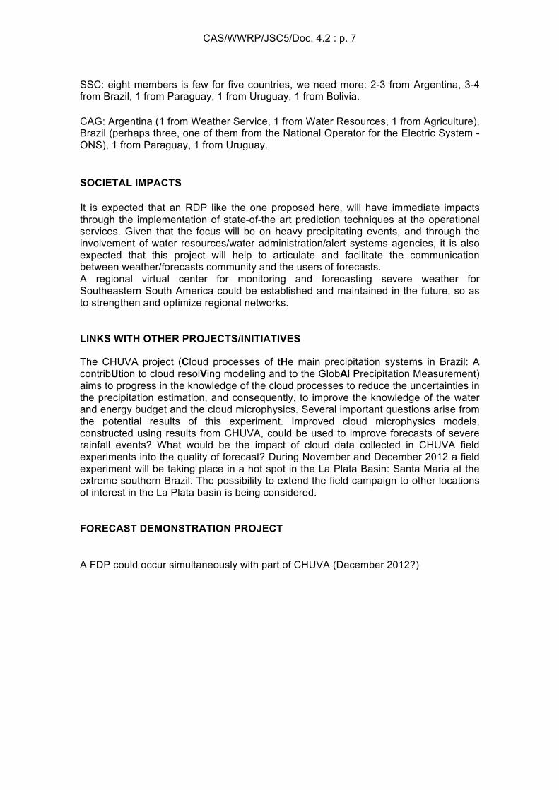
The surface chart (Figure 2) shows the synoptic situation associated with the excessive rainfalls observed in the western and southwestern Paraná State: an intense cold front across South Brazil, especially on the south of Paraná State. A cyclogenesis process caused this frontal system, with the extratropical cyclone located in the Atlantic Ocean at the east of Buenos Aires.
CAS/WWRP/JSC5/Doc. 4.2 : p. 10
Figure 2 - Surface analysis
The cold front crossed Parana State during 20 August 2011; however the most important rainfalls occurred during the day before (19 August). The 850 hPa level represents the lower troposphere and permits to quantify the contributions of the heat and moisture advection. The presence of the Low Level Jet (LLJ) can be seen extending southeastward from the Amazon basin to the South Region of Brazil (Figure 3).
Figure 3 – Synoptic chart at 850 hPa
This LLJ produced a strong advection of heat and moisture over Parana State, generating ideal environmental conditions for convection. Finally, the 500 hPa level is also analyzed, as it represents the middle troposphere. At this upper level, a long-wave trough can be observed (Figure 3), with its axis extending northwestward from Buenos Aires State to the central and northern part of Chile. This baroclinic system produced

CAS/WWRP/JSC5/Doc. 4.2 : p. 11
strong cyclonic vorticity advection over South Brazil, including Parana State. This synoptic analysis demonstrates that the interaction of de LLJ and the long-wave trough generated ideal environmental conditions for intense convection over western and southwestern Paraná State.
Figure 4 – Synoptic chart at 500 hPa.
Presently, the main tool used by forecasters to predict severe weather events is the atmospheric model. Those models emulate the motions and energy exchanges of the atmospheric fluid. However, due to misrepresentation of the physical processes in the atmosphere and interface, and errors in the initial conditions, the models often present defficiencies representing position and intensity of weather systems. This was exactly the case during the event in 19th August 2011. Figure 5 shows the 48h precipitation forecast for 19th August 2011 made by the operational Ensemble Prediction System (EPS) from CPTEC/INPE. It is clear that the model failed to capture both position and intensity of this severe weather event. While the main rainfall nucleus has occurred in the western portions of the Parana, Santa Catarina and Rio Grande do Sul States, the EPS positioned a region of high rates of precipitation over the Atlantic Ocean.

CAS/WWRP/JSC5/Doc. 4.2 : p. 12
Figure 5 – Precipitation forecast from Ensemble Prediction System at 48 h lag.
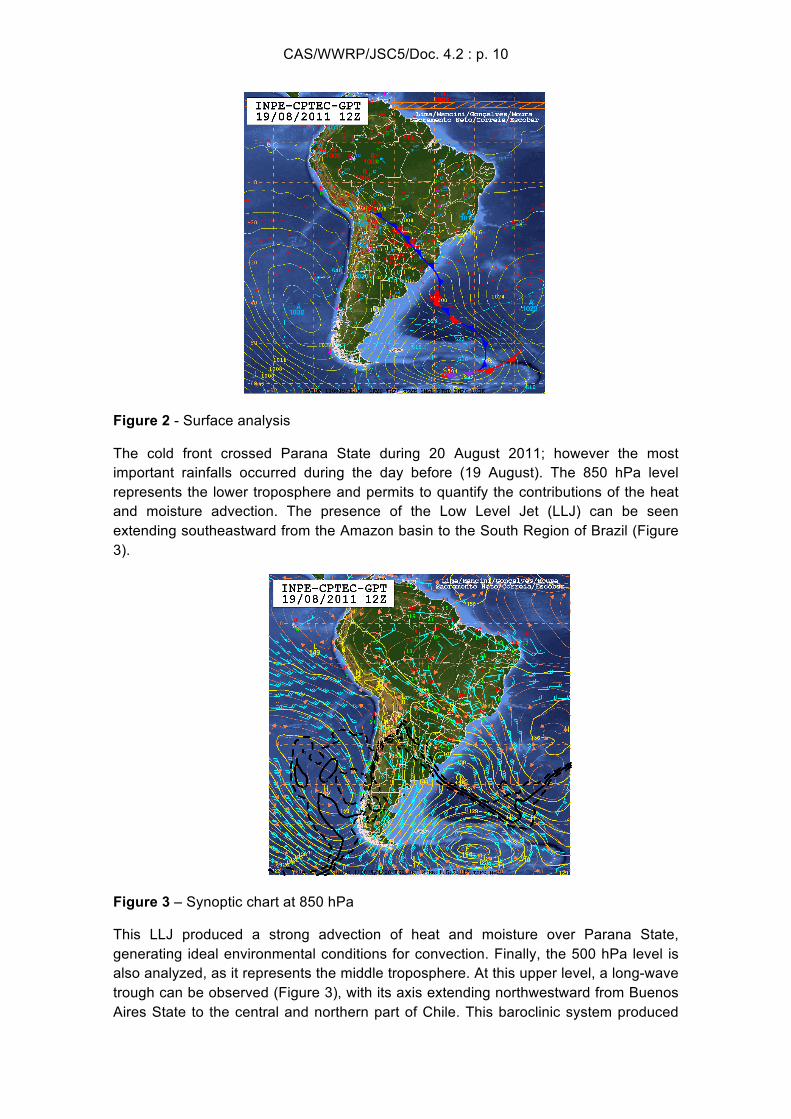
The EPS CPTEC was not the unique model to misrepresent this severe event. Figure 6 shows the probability of detection score (POD) for several models. The score is presented as a monthly mean (Aug/2011) averaged over the southern portions of South America, hence includes the region where the severe weather event occurred. This analysis demonstrates that the higher the precipitation thresholds are, the lower the scores are, exposing the model’s deficiencies in representing events with high precipitation rates.
CAS/WWRP/JSC5/Doc. 4.2 : p. 13
Figure 6 – Probability of detection of a precipitation event for several thresholds. All curves display 48h forecast. Each curve displays one model of the CPTEC suite. T126_L28 is the AGCM with 100km of horizontal resolution approximately and 28 layers in the vertical. T213_L42 is the AGCM with 63km of horizontal resolution approximately and 42 layers in the vertical. T299_L64 is the AGCM with 40km of horizontal resolution approximately and 64 layers in the vertical. Acoplado is the ocean-atmosphere coupled model; the atmosphere is integrated at a T126L28 resolution. RPSAS_40 is the limited area model integrated at 40km of horizontal resolution and initiated with CPTEC’s regional analysis. GPSAS213 is the CPTEC AGCM integrated at 40km of horizontal resolution and initiated with CPTEC’s global analysis. ENS_GLOB is the Ensemble Prediction System integrated at T126L28 resolution.