Project Initiation and Set-up · Web viewCoordinate with NCDOT Community Studies Review project...
74
NARRATIVE COMMUNITY IMPACT ASSESSMENT GUIDANCE NCDOT Environmental Analysis Unit Community Studies Group February 2018
Transcript of Project Initiation and Set-up · Web viewCoordinate with NCDOT Community Studies Review project...
NARRATIVECOMMUNITY IMPACT ASSESSMENT
GUIDANCE
NCDOT Environmental Analysis UnitCommunity Studies Group
February 2018

NCDOT ENVIRONMENTAL ANALYSIS UNIT COMMUNITY STUDIES
Narrative Community Impact Assessment (CIA) Guidance
CONTENTS
A. PROJECT INITIATION AND SET-UP.........................................................................................................................4
1) Coordinate with NCDOT Community Studies............................................................................................4
2) Define the Direct Community Impact Area.................................................................................................4
B. CONDUCT PRELIMINARY DATA GATHERING....................................................................................................4
1) Assess Community Context................................................................................................................................4
2) Collect and Analyze Demographic Data........................................................................................................5
3) Gather Stakeholder Input & Field Data.........................................................................................................5
C. PROJECT DESCRIPTION................................................................................................................................................6
1) Existing Conditions................................................................................................................................................ 6
2) Proposed Modifications....................................................................................................................................... 6
3) Regional/Community Context..........................................................................................................................6
4) Community Study Areas...................................................................................................................................... 7
D. DOCUMENT COMMUNITY CHARACTERISTICS, IMPACTS, AND RECOMMENDATIONS.................7
1) Presence..................................................................................................................................................................... 7
2) Impacts........................................................................................................................................................................ 8
3) Recommendations................................................................................................................................................. 8
4) Checklist Items........................................................................................................................................................ 8
5) Additional Recommendations........................................................................................................................22
6) Indirect and Cumulative Effects....................................................................................................................22
E. PREPARE THE EXECUTIVE SUMMARY...............................................................................................................22
1) Project Information............................................................................................................................................ 22
2) Notable Community Characteristics...........................................................................................................22
3) Potential Project Impacts.................................................................................................................................24
4) Recommendations...............................................................................................................................................24
F. COMPILE REPORT SOURCES...................................................................................................................................24
G. REPORT APPENDICES................................................................................................................................................ 25
APPENDICES............................................................................................................................................................................ 26
2

NCDOT ENVIRONMENTAL ANALYSIS UNIT COMMUNITY STUDIES
Narrative Community Impact Assessment (CIA) Guidance
APPENDIX A: Mapping Guidance............................................................................................................................... 27
APPENDIX B: Analysis Practices & Standard Language Guidance..............................................................29
APPENDIX C: Guidance for Completing the NRCS Farmland Conversion Impact Rating..................46
3

NCDOT ENVIRONMENTAL ANALYSIS UNIT COMMUNITY STUDIES
Narrative Community Impact Assessment (CIA) Guidance
A. PROJECT INITIATION AND SET-UP
1) Coordinate with NCDOT Community Studies
a) Review project information, define the regional context of the project and review online resources for trends and initiatives in the area.
b) Obtain the current Narrative CIA Template, Demographic Tool, and other pertinent guidance and tools from the Connect NCDOT website or Community Studies staff before starting the data-gathering process.
2) Define the Direct Community Impact Area
a) Define the Preliminary Direct Community Impact Area
Define the preliminary Direct Community Impact Area (DCIA) and create a polygon GIS shapefile for the study area. The DCIA will include all properties that could be directly affected by the project. The boundaries of the DCIA will run along natural features, parcel lines, roads, railroads, and other manmade boundaries where possible. The DCIA will not include commuting and detour routes. The DCIA should comprise roughly a 1000’ buffer from centerline to each side. It may be necessary to expand the buffer for some projects, such as proposed changes to Y-lines, multiple new location alternatives, and multiple interchange design alternatives.
b) Forward to Community Studies Staff for Review and Approval
Map the proposed draft DCIA and forward it to Community Studies staff for their review and approval before further analysis is conducted.
B. CONDUCT PRELIMINARY DATA GATHERING
1) Assess Community Context
a) Prepare a Vicinity Map
Create a vicinity map that shows the project location in relation to nearby cities or within the county. The STIP map can be used for this purpose.
b) Prepare a Community Context Map
Identify and map all key community features. See Appendix A for details about what to include.
4

NCDOT ENVIRONMENTAL ANALYSIS UNIT COMMUNITY STUDIES
Narrative Community Impact Assessment (CIA) Guidance
2) Collect and Analyze Demographic Data
a) Determine a Demographic Study Area
i. Determine the bounds of the Demographic Study Area (DSA) based on DCIA boundaries. The DSA generally represents all Block Groups that overlap with the DCIA and contains the population group for which demographic data will be analyzed. A block group should be left out of the DSA if: (1) the portion of the block group within the DCIA has no residents; or (2) the block group is within a military base.
ii. Map the proposed draft DSA and forward it to Community Studies staff for their review and approval before further analysis is conducted.
iii. Prepare a DSA Map that displays the DSA boundary and Census Tract Block Groups within the boundary. The Block Groups should be shaded different colors to easily differentiate them and labeled with “CT XXX, BG XX.” Include the DCIA boundary for reference.
b) Pull Demographic Data
i. Use the most recent Demographic Tool (available from the Connect NCDOT website or by request from Community Studies staff) to access and analyze Decennial Census and American Community Survey data for the populations within the DSA and compare them to the applicable county and the state.
ii. Document the demographic data in Appendix A of the report. Tables from the Demographic Tool should be copied and pasted into Appendix A; these tables are minority, race, Hispanic or Latino population, poverty, zero-car households, Limited English Proficiency (LEP), and population change.
3) Gather Stakeholder Input & Field Data
a) Conduct a Field Visit to the Direct Community Impact Area
At least five (5) working days prior to the field visit, send an e-mail with the STIP project number, names and contact information for staff, as well as the location to be visited and purpose of the visit, to NCDOT Division staff, and copy Community Studies staff on the email. During the field visit, drive and/or walk the DCIA and any other areas pertinent to the study, taking photographs to document the presence of all notable resources or community characteristics. Include site photos in Appendix B of the report. Photos should illustrate the resources and characteristics in the DCIA such as Environmental Justice (EJ), LEP or other special population presence;
5

NCDOT ENVIRONMENTAL ANALYSIS UNIT COMMUNITY STUDIES
Narrative Community Impact Assessment (CIA) Guidance
agricultural lands, operations or signage; land development activity; multimodal activity and facilities; school bus commercial nodes; business parks; industrial or manufacturing facilities and traffic; community resources (schools, places of worship, medical facilities, community centers, etc.); and recreational resources. For point projects (bridges, interchanges, intersections) the focus of the field visit and photos should be on the land uses and resources in each quadrant surrounding the project, not on the bridge or roadway itself. Notify Community Studies if the field visit or additional research suggests that expanded community coordination may be appropriate.
b) Contact Local Official(s) or Stakeholder(s)
Contact local official(s) via telephone, email or in person to collect input and comment regarding the nature of community resources located in the project study areas and potential project impacts on the local community. The Local Input Forms (available from the Connect NCDOT website or by request from Community Studies staff) should be sent to Emergency Management Services (EMS), local planners, and school transportation staff, and a reasonable effort made to solicit responses. There may be additional local officials or stakeholder(s) who should be contacted for comment or expertise, depending on the presence of a particular resource or potential impact of a given project. In such cases, use the same procedure to reach those other points of local contact.
C. PROJECT DESCRIPTION
Provide a quick description of the project. Quote the adopted Purpose and Need.
1) Existing Conditions
Describe the existing route, including the number of lanes, sidewalks, worn paths, etc. Provide information about the street network, including why people are likely using the roadway.
2) Proposed Modifications
Provide as much detail possible about the proposed modifications. Note the beginning and the end of the project, the number of lanes proposed, the preferred amount of right-of-way, etc. Identify and summarize all project alternatives that are being considered.
3) Regional/Community Context
The purpose of the Regional/Community Context section is to provide a narrative context of the area surrounding the project. It is not necessary to repeat information
6

NCDOT ENVIRONMENTAL ANALYSIS UNIT COMMUNITY STUDIES
Narrative Community Impact Assessment (CIA) Guidance
found elsewhere in the report (i.e., standard project information or resources/conditions). The length of this section will vary depending on the project and the number of notable conditions surrounding the project. Generally, it should provide a brief description of where the project is located relative to nearby municipalities or other population centers that may affect development trends in and around the project area. A brief description of the surrounding community should also be provided, including any notable demographic or socio-economic trends affecting the area (if applicable). A brief description of the area immediately surrounding the project (i.e., topography, nature of development, volume and nature of traffic on the road) should also be provided in this section. See Table 1 in the section “Prepare the Executive Summary” for guidance on which characteristics and features, if present, should be included in this narrative.
4) Community Study Areas
a) Direct Community Impact Area
Include the Community Context Map.
b) Demographic Study Area
Include the DSA Map.
c) Community Context Map
Include the Community Context Map.
D. DOCUMENT COMMUNITY CHARACTERISTICS, IMPACTS, AND RECOMMENDATIONS
1) Presence
The purpose of this section is to document the presence of specified community characteristics along with their general location relative to the project, which is an important factor in assessing the nature of potential impacts. Characteristics within the DCIA should always be documented. Notable characteristics that are outside the DCIA should be documented if they may be impacted by the project. Impacts should be noted separately within the impacts section. When a characteristic is found in the vicinity of the project, its presence should be documented and the descriptive details should be provided. When applicable, provide the associated standard language (Appendix B). If a characteristic is not present, then state “None.”
Photographs of notable characteristics may be placed in the narrative, as appropriate.
7

NCDOT ENVIRONMENTAL ANALYSIS UNIT COMMUNITY STUDIES
Narrative Community Impact Assessment (CIA) Guidance
2) Impacts
Identify notable community impacts that are anticipated given the project design. Explain the nature, likelihood and degree of impact (a low, moderate, or high negative impact; or a positive impact) in as much detail as possible, and differentiate between permanent and temporary (construction or detour) impacts. If more than one project alternative is under consideration, describe the impacts of each alternative. When applicable, provide the associated standard language (Appendix B). Impacts should only be assessed when the corresponding characteristic is determined to be present. If no impact is anticipated, then state “None.” If no impact is anticipated, then state “None.” If a characteristic is not present, then delete the impacts section for that characteristic.
3) Recommendations
Provide recommendations when certain characteristics are present or conditions are met, or where impacts are anticipated. Other recommendations, including temporary on-site detours and alternative construction work schedules, are captured in the Additional Recommendations section. Standard recommendation language for specific characteristics is available in Appendix B. If there is no recommendation, then state “None.” If there is no impact to a characteristic, then delete the recommendations section for that characteristic.
4) Checklist Items
a) Recreational Resource(s) or Activity
Presence
Public recreational resources in the DCIA should be identified. Such resources may or may not be Section 4(f) public recreational resources dependent upon the type of resources and project funding.
If the project is state-funded, Section 4(f) does not apply. Note the presence of any other public recreational activity (or evidence of such activity) observed in the DCIA. Documentation should include the exact location and nature of the activity or resource, ownership of the resource and mode(s) of access to it, as well as all physical observations.
If the project is federally-funded, Section 4(f) applies to any publicly owned park, recreation area, or wildlife and waterfowl refuge and any land from an historic site of national, state or local significance. Community Studies’ reports look only at recreational resources that fall under Section 4(f); historic resources are assessed separately by the Historic Architecture group at NCDOT.
8

NCDOT ENVIRONMENTAL ANALYSIS UNIT COMMUNITY STUDIES
Narrative Community Impact Assessment (CIA) Guidance
Based on GIS data, field visit observations and local input, document the presence of potential Section 4(f) public recreational resources located in the DCIA. When private institutions, organizations or individuals own parks, recreational areas or wildlife and waterfowl refuges, Section 4(f) does not apply to these properties, even if such areas are open to the public. If a governmental body has a permanent proprietary interest in the land (such as fee simple ownership or easement), it is considered "publicly owned" and thus, Section 4(f) may be applicable. If a potential Section 4(f) resource is found, inform the NCDOT Community Studies Project Manager and the Project Planning Engineer as soon as possible to initiate FHWA review, independent of the completion and distribution of the report.
Use standard language (Appendix B) to describe the presence or absence of public recreational resources. The descriptive narrative should include the property owner(s) and administrator(s), a description of property uses, and any other notable traits.
Impacts
Consider whether the project is likely to impact identified public recreational resources. Impacts may include right-of-way acquisition, access, or change in use and may be temporary or permanent. If Section 4(f) applies, use the applicable standard language provided in Appendix B.
Recommendation
If "Yes," provide the associated standard language, and include a narrative description as appropriate. Otherwise, state “None.”
b) Section 6(f) Land & Water Conservation Fund Resources
Presence
Based on GIS data, document the presence of Section 6(f) protected public resources located in the DCIA. Section 6(f) applies to resources wholly or partially funded by grants issued from the Land and Water Conservation Fund. Use the Section 6(f) GIS data to screen for presence of these properties, and reference the LWCF online index for NC counties, available here: http://waso-lwcf.ncrc.nps.gov/public/index.cfm.
If a Section 6(f) resource is found in the DCIA, inform the NCDOT Community Studies Project Manager and the Project Planning Engineer as soon as possible, and determine who will coordinate with NCDENR about the resource, independent of
9

NCDOT ENVIRONMENTAL ANALYSIS UNIT COMMUNITY STUDIES
Narrative Community Impact Assessment (CIA) Guidance
the completion and distribution of the report. Use standard language (Appendix B) to describe the presence of a Section 6(f) resource.
Impacts
Consider whether the project is likely to impact identified Section 6(f) LWCF resources. Use the applicable standard language provided in Appendix B.
Recommendation
If "Yes," provide the associated standard language, and include a narrative description as appropriate. Otherwise, state “None.”
c) Farmland Soils
Presence
If the project is state-funded, the Farmland Protection Policy Act (FPPA) does not apply.
If the project is federally-funded, first determine whether the project is subject to FPPA using the guidelines in Appendix D. A project is not subject to FPPA if the project footprint is within a municipal boundary, in an Urbanized Area, or the adjacent area is already in urban use. If it is subject to FPPA guidelines, follow the steps in the screening process in Appendix D to identify FPPA soil types in the project footprint. The project footprint is defined as the area that will physically be altered or impacted. For functional designs, this is slope stakes plus 40 feet. For preliminary designs, this is slope stakes plus 25 feet. If no FPPA soils are located in the project footprint, then no further action is necessary. If FPPA soils are located in the project footprint, then an NRCS Farmland Conversion Impact Rating must be completed to include the NRCS Farmland Figure and Part VI of the appropriate NRCS Farmland Conversion Impact Rating Form (CPA-106 for corridor/linear projects and AD-1006 for point projects). Standard language for farmland is available in Appendix B.
Impacts
If the project is state-funded, calculate the number of acres of farmland that will be permanently converted to non-farmland.
If the project is federally-funded, determine whether notable farmland conversion impacts are anticipated based on the NRCS Farmland Conversion Impact Rating Form. A total score (Parts III and VI) that exceeds the 60-point threshold suggests that notable project impacts to eligible soils are anticipated. Use the applicable
10

NCDOT ENVIRONMENTAL ANALYSIS UNIT COMMUNITY STUDIES
Narrative Community Impact Assessment (CIA) Guidance
standard language provided in Appendix B. A degree of impact does not need to be noted for farmland soils.
Recommendation
If "Yes," provide the associated standard language, and include a narrative description as appropriate. Otherwise, state “None.”
d) Voluntary & Enhanced Voluntary Agricultural Districts (VAD & EVAD)
Presence
Based on GIS data and/or information provided by local officials, determine whether or not any properties are held within a local Voluntary Agriculture District (VAD) or Enhanced Voluntary Agriculture District (EVAD) in the Direct Community Impact Area. If VAD/EVAD properties are present, describe their location in relation to the project and include a summary of all potentially applicable regulatory requirements under the local VAD/EVAD Ordinance. This summary should include an explicit description of the causal actions that may trigger such requirements, e.g., “Prior to initiating condemnation of property in a VAD, an agency must request that the VAD Advisory Board hold a public hearing on the proposed action.” Use standard language (Appendix B) to describe the presence of VAD/EVADs.
Impacts
Consider whether the project is likely to impact designated VADs or EVADs. Permanent impacts are limited to a taking or conversion of land, but there may also be temporary impacts from the use of construction easements. Use the applicable standard language provided in Appendix B.
Recommendation
If "Yes," provide the associated standard language, and include a narrative description as appropriate. Otherwise, state “None.”
e) Agricultural Resources and Activity
Presence
Based on field visit observations, document the presence of land that is actively being used or managed for agricultural purposes in the Direct Community Impact Area. These may include land cultivated for crops, used for livestock, or managed for timber. Land that has been left to grow up to native vegetation without management should be considered abandoned and therefore not farmed. Provide a concise
11

NCDOT ENVIRONMENTAL ANALYSIS UNIT COMMUNITY STUDIES
Narrative Community Impact Assessment (CIA) Guidance
description, including the nature of the operation, its location, and any other notable physical observations made.
Impacts
Consider whether the project is likely to impact identified agricultural operations. Impacts to agricultural operations can include taking of land, but may also include access to fields, or whether large equipment, trucks carrying agricultural products, or employees are able to get to and from the operation.
Recommendation
If "Yes," provide the associated standard language, and include a narrative description as appropriate. Otherwise, state “None.”
f) Bicycle, Pedestrian and/or Greenway Facilities and Active Transportation
Presence
Based on GIS information and field visit observations, determine whether existing routes in the Direct Community Impact Area have sidewalks, worn paths, state or locally designated bicycle routes, or greenway paths. Future plans for bike/pedestrian facilities should be included here. Summarize the nature of the facility, or plans for the facility.
Impacts
Consider whether the project is likely to result in impacts to bicycle and pedestrian facilities. These may be permanent impacts, like adding bike lanes, or temporary impacts, like construction detours or temporary closures of facilities.
Recommendation
If "Yes," provide the associated standard language, and include a narrative description as appropriate. Otherwise, state “None.”
g) Bicycle/Pedestrian Activity
Presence
Based on field visit observations or information provided by local officials, document any existing bicycle or pedestrian activity in the DCIA. The general location of bike/pedestrian activity, its apparent nature (i.e., recreational or other trip purpose) and volume, as well as proximity to bike/pedestrian traffic generators, should be addressed in this section.
12

NCDOT ENVIRONMENTAL ANALYSIS UNIT COMMUNITY STUDIES
Narrative Community Impact Assessment (CIA) Guidance
Impacts
Consider whether the project is likely to result in impacts to bicycle and pedestrian activity, such as to the nature and volume, as well as to the level of connectivity of the existing bike/pedestrian facility infrastructure to bike/pedestrian traffic generators.
Recommendation
If "Yes," provide the associated standard language, and include a narrative description as appropriate. Otherwise, state “None.”
h) Transit Routes, Facilities, and/or Activity
Presence
Document the location of a fixed transit route or transit stop in the DCIA. Include information regarding the frequency and service area of the route as well as any physical observations made regarding the volume of passengers or special users.
Impacts
Consider whether the project is likely to result in impacts to transit facilities or use. These may be permanent impacts, like relocating a transit stop, or temporary impacts, like construction detours or temporary closures of facilities.
Recommendation
If "Yes," provide a narrative description as appropriate. This may include coordination with local transit representatives, riders, and other stakeholders. Otherwise, state “None.”
i) Local Area Plans, Goals, and Development Activity
Presence
Describe in detail existing land use plans, goals, or zoning initiatives that may affect future growth and development patterns in the DCIA. Local area plans may include: local zoning ordinances and regulations, land use plans and development management plans; local economic development goals; local aesthetic or character goals; recreational infrastructure plans; transit plans; small area plans; long-range growth plans; or area Rural and Metropolitan Planning Organization comprehensive transportation and thoroughfare plans. State and local bicycle, pedestrian, and greenway plans should be listed in the “Bicycle, Pedestrian and/or Greenway Facilities and Active Transportation” section, not here. The description provided
13

NCDOT ENVIRONMENTAL ANALYSIS UNIT COMMUNITY STUDIES
Narrative Community Impact Assessment (CIA) Guidance
will include the nature and goals of existing plans, pursuant to providing a clear, corollary explanation of how future growth or development may affect the evaluation of project alternatives.
Based on information provided by local officials or obtained through local area research, document in appropriate detail any known plans for public and private development in the DCIA. Public development should be reasonably foreseeable and included on a capital improvement plan with a clear funding stream. Documentation will include the exact location of the development, the nature and size of the development, the source that provided information regarding the development, and all known information regarding the timeline for development.
Impacts
Consider whether the project is consistent or not consistent with existing plans, regulations, and policies at the local, regional, or state level. This may include compatibility with aesthetic goals, local plans for bicycle and pedestrian connections, and/or recommendations with long-range development or transportation plans. Note any documents with which the project is inconsistent and describe the manner in which the project is not consistent.
Recommendation
If “not consistent,” provide a narrative description as appropriate. This may include coordination with local officials and other stakeholders pursuant to the accommodation of private construction schedules and access to development sites. Otherwise, state “None.”
j) Driveways and Cross Streets
Presence
Based on field visit observations, document the presence of paved or unpaved points of access to a residence, agricultural operation, recreational resource, industrial facility, commercial or institutional structure, etc., located in the DCIA. Note whether there are any intersections or interchanges located along the project corridor. The description may include the density of access points and connectivity of street intersections. For intensively developed corridors the CIA should not simply note what can be observed from maps or driving down the street but should note those driveways and cross streets that generate notable levels of truck traffic, customer traffic, or commuter traffic. Driveways may be grouped by type (residential, convenience business, etc.) instead of by location.
14

NCDOT ENVIRONMENTAL ANALYSIS UNIT COMMUNITY STUDIES
Narrative Community Impact Assessment (CIA) Guidance
Impacts
Assess whether the project is likely to result in impacts to driveways and cross streets, including closure, access management (such as conversion to right-in, right-out), and alternative access points available for the property.
Recommendation
If "Yes," provide a narrative description as appropriate. Otherwise, state “None.”
k) Business and Economic Resources and Transportation Activity
Presence
Note the presence of any business and/or economic resources in the DCIA, such as business parks, distribution centers, manufacturing facilities, etc. Describe these resources in detail, including the location, name, business types, associated traffic, and points of access. For intensively developed corridors the CIA should not simply note the presence of businesses that generate notable levels of truck traffic, customer traffic, or commuter traffic. For access management projects the relative mix of convenience commercial to specialty and destination commercial should be noted to help gauge effects.
Based on field visit observations and/or comment(s) provided by local officials, document the presence of any transportation activity related to goods movement in the DCIA. This may include, but is not limited to: tractor trailers, logging trucks, tractors or other agricultural equipment, or industrial traffic. Provide all pertinent details about this activity in this section.
Impacts
Consider whether the project may result in direct impacts on area businesses or other economic resources in the area. Impacts may relate to direct property effects or access issues but should be addressed here if related to an area business.
Recommendation
If "Yes," provide a narrative description as appropriate. Otherwise, state “None.”
l) Emergency Management Services (EMS) Operations
Presence
From the local input provided by the EMS official, note whether there are any emergency services operations within the DCIA that may be affected by the project,
15

NCDOT ENVIRONMENTAL ANALYSIS UNIT COMMUNITY STUDIES
Narrative Community Impact Assessment (CIA) Guidance
such as stations and corridors that are primary response routes (e.g., highways, roads near hospitals, etc.). If there are no operations within the DCIA beyond general response to residences and businesses, there is no need to note anything in this section. Any impacts to response time should be noted in the impacts section.
Impacts
From the local input provided by the EMS official, note whether any impacts and their degree (no impact, low, moderate, high) to response routes or times have been identified. Consider potential impacts of road closures, detour routes, or lane reductions during construction, as well as any long-term effects of the project and alternatives on EMS operations.
Recommendation
If "Yes," provide a narrative description as appropriate. Otherwise, state “None.”
m) School Bus Routes
Presence
From the local input provided by the school transportation official, note whether there are any school bus routes within the DCIA that may be affected by the project. If relevant, include the number of buses and/or number of trips made through the project corridor.
Impacts
From the local input provided by the school transportation official, note whether any impacts and their degree (no impact, low, moderate, high) to school buses during construction have been identified.
Recommendation
If "Yes," provide a narrative description as appropriate. Otherwise, state “None.”
n) Community Resources
Presence
Document the presence of any notable socio-economic resources within the DCIA. This may include, but is not limited to: community centers, places of worship, private or public schools, daycares, cemeteries, community gardens, private or public social services agencies and training facilities, community facilities, etc. Provide an appropriately detailed description of the resource in this section,
16

NCDOT ENVIRONMENTAL ANALYSIS UNIT COMMUNITY STUDIES
Narrative Community Impact Assessment (CIA) Guidance
including the name, location, and any physical observations or background information obtained through research regarding users or services provided.
Impacts
Consider whether the project is likely to impact an identified community resource (e.g., recreational (private, socio-economic, etc.). Impacts may include direct property effects, altering access, or causing a change in use.
Recommendation
If "Yes," provide a narrative description as appropriate. This may include additional coordination with local officials or stakeholders, evaluation of alternatives using an on-site detour, or targeted public involvement due to community controversy. Otherwise, state “None.”
o) Community Cohesion
Presence
Based on field visit observations, information provided by local officials, community data and other resources, describe any existing signs or indicators of community cohesion. Community cohesion reflects a variety of factors including the degree to which people have a sense of belonging to their neighborhood or community; are connected by social, work or other relationships; share values or a common vision for their community; or share other bonds linking individuals to one another or to their community as a whole. Communities may have varying degrees of cohesiveness. Indicators of cohesion may include, but are not limited to: signs of residential stability, signs of economic stability, signs of safety/health stability, evidence of community connections, evidence of a common perception of the area and its history among residents, and observed community interactions.
Impacts
If community cohesion indicators were documented in the previous section of the report, consider whether the project is likely to alter the overall functioning of an identifiable neighborhood or district that exhibited community cohesion. This may include interactions between, or isolation of, persons and groups, or a change in the physical makeup of the community. Impacts may relate to direct property effects or access issues but should be addressed here if related to the overall functioning of an identified district. Project activities with the potential to affect or influence community cohesion include but are not limited to the following:
17

NCDOT ENVIRONMENTAL ANALYSIS UNIT COMMUNITY STUDIES
Narrative Community Impact Assessment (CIA) Guidance
Relocation/removal of key community facilities (places of worship, parks, childcare, groceries, local businesses)
Widened or new roadway facility that serves as a physical barrier
Addition or removal of pedestrian or bicycle facilities (sidewalk, crosswalk, median, bike lane)
Relocation/removal of residential areas
Grade separation of a road, pedestrian facility, or railroad
Impacts to crossing distances/times
Economic impacts that affect key local resources
Adding landscaping, streetscaping, lighting, and/or aesthetic treatments
Recommendation
If "Yes," provide a narrative description as appropriate. This may include coordination with other local officials or stakeholders, or public involvement due to community concerns. Otherwise, state “None.”
p) Community Health and Safety
Presence
Complete the Health Indicators Table in Appendix D of the report with DSA-level and county data. If the DSA covers more than one county, add columns to the table as needed for each additional county. Based on the indicators and a comparison of DSA-level rates compared to county and state rates, describe any notable characteristics related to community health. This could include a high number or specific clusters of pedestrian or bicyclist crashes in the DCIA or project corridor, high physical inactivity rates, or low access to exercise opportunities. These measures may indicate access or safety issues that negatively affect community health. There may be relationships among several indicators that are notable, even if the individual indicators are not notable on their own. Input from local officials or public comments may also provide information about community health.
Note whether there are any existing or perceived crime or safety issues in the DCIA. This information may be provided by field visit observations, local official input, or public comments, and may include high bicycle or pedestrian crash rates, unsafe facilities, inadequate lighting, and/or isolated areas. Do not include EMS operations in this section.
18
NCDOT ENVIRONMENTAL ANALYSIS UNIT COMMUNITY STUDIES
Narrative Community Impact Assessment (CIA) Guidance
Impacts
Consider whether the project will impact any community health issues that were identified, perhaps by affecting bicycle and pedestrian safety, or affecting access to recreational facilities or healthy food.
Consider whether the project will interact with any existing or perceived crime or bicycle/pedestrian safety issues, perhaps by increasing or decreasing isolation for particular areas, changing lighting facilities in the area, increasing the safety of facilities for users, or affecting access to recreational facilities. Do not include impacts to EMS operations in this section.
Recommendation
If "Yes," provide a narrative description as appropriate. Otherwise, state “None.”
q) Area/Community Concerns
Presence
Based on information provided by local officials and public comments, summarize all known community concerns or controversy relative to the project. If concerns were voiced during Public Involvement activities, please attach the relevant comment sheets in the Appendix of the report.
Impacts
Consider whether the project is incompatible with or will not address expressed community concerns.
Recommendation
If "Yes," provide a narrative description as appropriate. This may include coordination with other local officials or stakeholders, or public involvement due to community concerns. Otherwise, state “None.”
r) Other Impacts
List any potential project impacts not otherwise listed.
Recommendation
If "Yes," provide a narrative description as appropriate. Otherwise, state “None.”
19

NCDOT ENVIRONMENTAL ANALYSIS UNIT COMMUNITY STUDIES
Narrative Community Impact Assessment (CIA) Guidance
s) Recurring Effects
Impacts
Consider whether the project is likely to result in recurring effects on any populations and communities within the DCIA. Recurring effects, both public and private, may be individually minor but cumulatively notable. This information may come from knowledge of the effects of past projects, local official input, or community input from Public Involvement activities.
Recommendation
If "Yes," provide a narrative description as appropriate. Otherwise, state “None.”
t) Environmental Justice and Title VI Populations
Presence
Using ACS data, field visit observations, and/or input from local officials, document the presence of populations that meet the EJ thresholds defined in Appendix B. Do not rely solely on ACS data, as EJ populations within or near the project footprint may not be evident at the block group level of ACS data. From field visit observations and/or input from local officials, note the presence of any non-EJ Title VI populations, such as concentrations of people with disabilities, elderly, children or similar populations – group homes, retirement centers or schools, for example. Use standard language to describe the presence or absence of EJ and Title VI populations.
Impacts
Consider whether the project is likely to have a disproportionately high and adverse impact on identified EJ and Title VI populations in the project area and whether the benefits and burdens of the project will be equitably shared among all populations. Impacts may be permanent (such as relocation) or temporary (such as long detour routes or access to homes and businesses during construction). Adverse impacts may result from notably severe impacts or from a group of individually minor but cumulatively significant effects. Use the applicable standard language provided in Appendix B.
Recommendation
If "Yes," provide the associated standard language, and include a narrative description as appropriate. Otherwise, state “None.”
20

NCDOT ENVIRONMENTAL ANALYSIS UNIT COMMUNITY STUDIES
Narrative Community Impact Assessment (CIA) Guidance
u) Limited English Proficiency (LEP) or Language Assistance Populations
Presence
Using ACS data, document the presence of a Limited English Proficiency (LEP) population whenever the thresholds defined in Appendix B are met or exceeded. Document the presence of any populations that do not meet the LEP threshold but do meet the criteria for Language Assistance (LA) based on Census data, field visit observations, and/or input from local officials and other Language Assistance Resource Contacts (LARC), particularly noting these populations’ proximity to the DCIA. Use standard language to describe the presence or absence of LEP and LA populations.
Recommendation
If "Yes," provide the associated standard language, and include a narrative description as appropriate. Otherwise, state “None.”
v) Notable Population Growth or Decline
Presence
Document the presence of notable recent population growth or decline in the Demographic Study Area based on US Census population data. Population growth between 0 and 1.5% is not considered notable. Any population decline is considered notable. If the average annualized population growth is higher than 1.5%, also note the growth in the county and how it compares. As an example, a 1.9% growth rate of a DSA within Wake County is relatively slow compared to the 3.7% overall growth rate of the county.
w) STIP Projects
Presence
If the project is managed by Central, list any reasonably foreseeable STIP projects that are within three miles of the project and/or that have the potential to affect or be affected by the project. Description should include STIP number, project extent, and ROW and construction dates. An example appears below.
R-1234: NC 99 from SR 1111 to SR 2222, ROW May 2019, construction May 2021
If the project is Division-managed or locally-administered, then skip.
21

NCDOT ENVIRONMENTAL ANALYSIS UNIT COMMUNITY STUDIES
Narrative Community Impact Assessment (CIA) Guidance
x) Traffic Generating Facility or Node
Presence
Based on field visit observations and input from local officials, document the presence of a node or facility that may generate notable levels of vehicular or pedestrian traffic located in the DCIA. This may include, but is not limited to: commercial developments, employment centers, industrial nodes, high-density residential developments, large recreational complexes, or schools. Nodes and/or facilities will be described in detail in this section, including the exact location, name, observations regarding the volume and nature of traffic, directional or temporal patterns of traffic, etc.
5) Additional Recommendations
a) Evaluate Alternative(s) That Utilize a Temporary On-Site Detour
Provide a narrative description as appropriate.
b) Evaluate Alternative Construction Work Schedules
Provide a narrative description as appropriate. For example, the days and times of construction-related road closures may be scheduled to avoid school start and dismissal times, thereby minimizing impacts to school transportation.
c) Other Recommendations
Provide a narrative description as appropriate.
6) Indirect and Cumulative Effects
Include the applicable standard language here.
E. PREPARE THE EXECUTIVE SUMMARY
1) Project Information
Document basic information including: project location, type and description; document type; existing and proposed transportation conditions (lanes, access control, medians); project manager; and staff preparing the CIA.
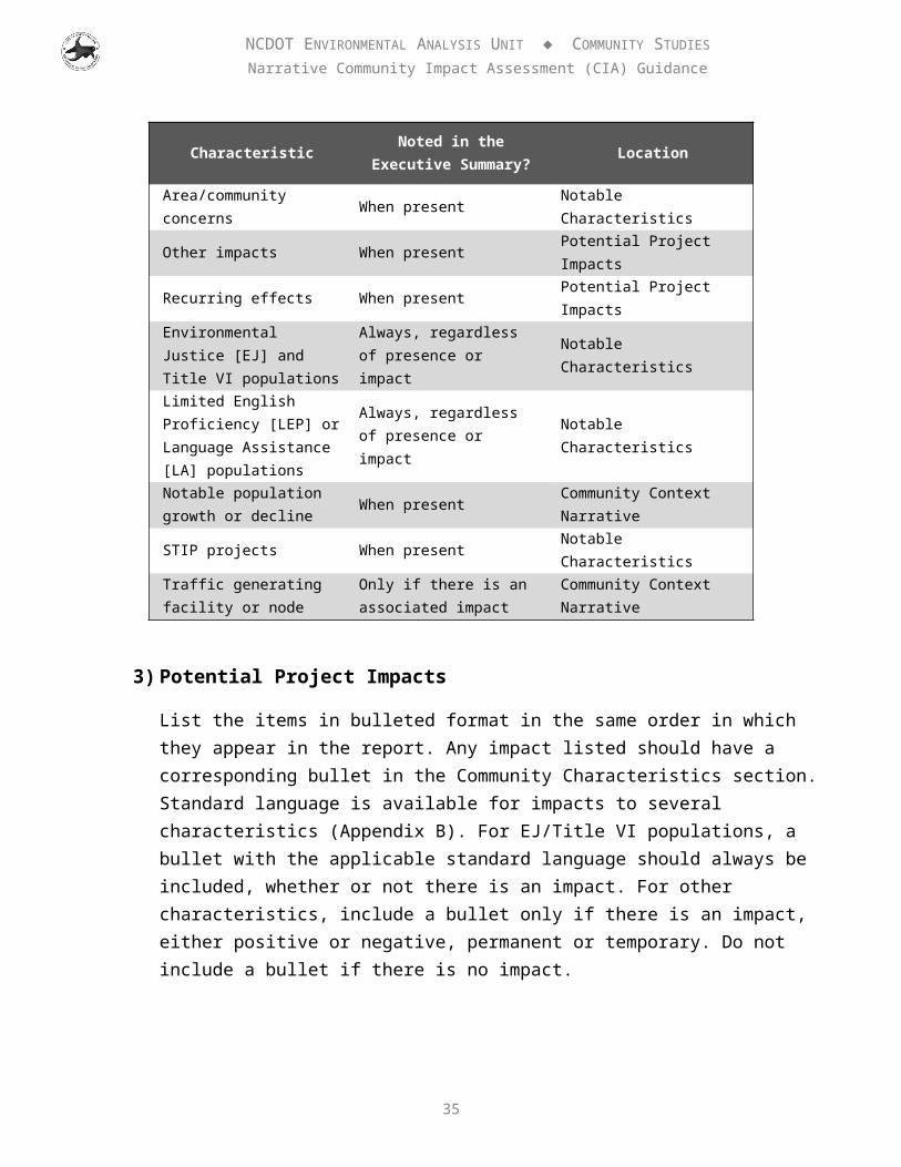
2) Notable Community Characteristics
Generally, list the items in bulleted format in the same order in which they appear in the report. The table below provides guidance on which characteristics should be noted
22

NCDOT ENVIRONMENTAL ANALYSIS UNIT COMMUNITY STUDIES
Narrative Community Impact Assessment (CIA) Guidance
in the executive summary. EJ/Title VI populations and LEP/LA populations are always noted, regardless of presence or impact, using appropriate standard language. Some characteristics are noted whenever present, and others are noted only if there is an associated impact. Bullets should provide no more than a brief summary of findings; do not just copy and paste lengthy sections from the report. Use standard language as applicable, drawing from standard language statements found in Appendix B, and adding additional relevant information.
CharacteristicNoted in the Executive
Summary?Location
Recreational resource(s) or activity
Only if there is an associated impact
Notable Characteristics
Section 6(f) LWCF resourcesOnly if there is an associated impact
Notable Characteristics
Farmland soilsOnly if there is an associated impact
Notable Characteristics
Voluntary & Enhanced Voluntary Agricultural Districts (VAD/EVAD)
Only if there is an associated impact
Notable Characteristics
Agricultural resources and activity
Only if there is an associated impact
Notable Characteristics
Bicycle, pedestrian and/or greenway facilities and active transportation
Only if there is an associated impact
Notable Characteristics
Bicycle/pedestrian activityOnly if there is an associated impact
Notable Characteristics
Transit routes, facilities, and/or activity
Only if there is an associated impact
Notable Characteristics
Local area plans/goals and development activity
Only if there is an associated impact
Community Context Narrative
Driveways and cross streetsOnly if there is an associated impact
Notable Characteristics
Business and economic resources and transportation activity
Only if there is an associated impact
Notable Characteristics
Emergency Management Services (EMS) operations
Only if there is an associated impact
Notable Characteristics
School bus routesOnly if there is an associated impact
Notable Characteristics
Community resourcesOnly if there is an associated impact
Notable Characteristics
Community cohesionOnly if there is an associated impact
Notable Characteristics
23

NCDOT ENVIRONMENTAL ANALYSIS UNIT COMMUNITY STUDIES
Narrative Community Impact Assessment (CIA) Guidance
CharacteristicNoted in the Executive
Summary?Location
Community health and safetyOnly if there is an associated impact
Notable Characteristics
Area/community concerns When present Notable CharacteristicsOther impacts When present Potential Project ImpactsRecurring effects When present Potential Project ImpactsEnvironmental Justice [EJ] and Title VI populations
Always, regardless of presence or impact
Notable Characteristics
Limited English Proficiency [LEP] or Language Assistance [LA] populations
Always, regardless of presence or impact
Notable Characteristics
Notable population growth or decline
When present Community Context Narrative
STIP projects When present Notable CharacteristicsTraffic generating facility or node
Only if there is an associated impact
Community Context Narrative
3) Potential Project Impacts
List the items in bulleted format in the same order in which they appear in the report. Any impact listed should have a corresponding bullet in the Community Characteristics section. Standard language is available for impacts to several characteristics (Appendix B). For EJ/Title VI populations, a bullet with the applicable standard language should always be included, whether or not there is an impact. For other characteristics, include a bullet only if there is an impact, either positive or negative, permanent or temporary. Do not include a bullet if there is no impact.
4) Recommendations
Generally, list the items in bulleted format in the same order in which they appear in the report. Any impact listed in the previous section should have a corresponding recommendation listed in this section. Standard language is available for several possible recommendations (Appendix B).
F. COMPILE REPORT SOURCES
Prepare a comprehensive list of sources used to produce the report, including Local Official Input Form contacts. All sources should have the information, including telephone numbers, email addresses and web addresses, needed to return to the original source of the information if required.
24

NCDOT ENVIRONMENTAL ANALYSIS UNIT COMMUNITY STUDIES
Narrative Community Impact Assessment (CIA) Guidance
G. REPORT APPENDICES
Include all additional and supplemental information as Appendix items in the report.
1) Demographic Tables: Paste demographic tables from the Demographic Tool into Appendix A of the report. The Demographic Tool and associated guidance can be downloaded from the Connect NCDOT website.
2) Site Photographs: Include any additional photographs, if not already placed within the narrative, of notable resources located in the DCIA in Appendix B of the report.
3) Local Official Input Forms: Include the completed local input forms as Appendix C of the report in the following order: EMS, Planner, School Transportation Staff, other (LARC, other local officials, etc.). If two or more individuals in the same office are present during the same in-person or phone interview, one form may be used. If an in-person or phone interviewee gives more than one answer when asked about the project’s overall impact level (No Impact, Low, Moderate, High), check only the box with the highest impact level given by the interviewee. If a response is not received, indicate “No response received” on the page where the completed form for that contact is supposed to go. The consultant should contact Community Studies staff about the possibility of submitting a draft CIA for review prior to receiving all of the responses from local officials. Document the results of local official contacts using the tables provided in Appendix C of the report.
4) Health Indicator Table: Include the completed health indicator table as Appendix D of the report.
5) Public Comment Forms (when applicable): Include the public comment forms from Public Involvement activities that note any community concerns or controversy relative to the project as Appendix E of the report.
6) NRCS Farmland Conversion Impact Rating (when applicable): Include the NRCS Farmland Figure and preliminary screening as Appendix F of the report.
7) Other Supplemental Information (when applicable): The consultant will contact Community Studies staff to discuss the possible inclusion of additional information in the CIA. This may include, but is not limited to: a figure detailing the location of EJ, Title VI and/or LEP communities in the project area; a figure detailing potential 4(f) public resources in the DCIA; and additional information or mapping that details local area plans or ordinances affecting the project area. Supplemental information should be provided as Appendix G of the report.
25

NCDOT ENVIRONMENTAL ANALYSIS UNIT COMMUNITY STUDIES
Narrative Community Impact Assessment (CIA) Guidance
APPENDICES
Appendix A: Mapping Guidance
Appendix B: Analysis Practices & Standard Language Guidance
Appendix C: Guidance for Completing the NRCS Farmland Conversion Impact Rating
26

NCDOT ENVIRONMENTAL ANALYSIS UNIT COMMUNITY STUDIES
Narrative Community Impact Assessment (CIA) Guidance
APPENDIX A: Mapping Guidance
Community Context Map
Layers that should be displayed (in the following order, top to bottom): STIP Points and Roads. Display and label with STIP number all STIP projects located in
the map window. DCIA Boundary in a solid, colored line (not black). Any notable route features (bike routes, hurricane evacuation routes, strategic
transportation corridors, etc.) All Roads. Use Highway Shield symbols with embedded route numbers as the label for
Interstate, US and NC routes, and the local names (not SR numbers) of other state maintained secondary roads and local roads.
Bicycle and pedestrian routes and trails. Points indicating the location of schools, hospitals, major traffic nodes (interchanges,
dense commercial development centers). Shaded parcels for any active farm operations (all shaded the same color). Individual
labels are not necessary unless a particular operation is especially notable (e.g., large commercial operation, named farm).
Shaded parcels for any VAD or EVADs. Shaded parcels indicating the location of any other notable features/characteristics
discussed in the report including a label. Hydrologic features. Potential 4(f) and 6(f) recreational resources (shaded or patterned polygon). Any other property managed for conservation, preservation or recreational purposes
(shaded or patterned polygon). State, county, municipal boundaries (outline states and counties, shade municipal
polygons). Be sure to include a scale bar and north arrow.
DSA Map
Layers that should be displayed (in the following order, top to bottom): TIP Points and Roads. Display and label with TIP number all TIP projects located in the
map window. DCIA Boundary in a solid, colored line (not black). DSA Boundary and Census Block Groups within the boundary. The Block Groups should be
shaded different colors to easily differentiate them and labeled with “CT XXX, BG XX”.
27

NCDOT ENVIRONMENTAL ANALYSIS UNIT COMMUNITY STUDIES
Narrative Community Impact Assessment (CIA) Guidance
All Roads. Use Highway Shield symbols with embedded route numbers as the label for Interstate, US and NC routes, and the local names (not SR numbers) of other secondary roads and local roads.
Hydrologic features. State, county, municipal boundaries (outline states and counties, shade municipal
polygons). Be sure to include a scale bar and north arrow.
28

NCDOT ENVIRONMENTAL ANALYSIS UNIT COMMUNITY STUDIES
Narrative Community Impact Assessment (CIA) Guidance
APPENDIX B: Analysis Practices & Standard Language Guidance
Demographic Analysis Practices
I. Environmental Justice and Title VI
The analyst will use the NCDOT Demographic Tool to initially review the most recent 5-year ACS data to determine whether the DSA contains any notable Environmental Justice (EJ) populations at the Block Group level.
Minority populations include all races that are non-white and Hispanic populations that are also white. Therefore, use the Minority table in the NCDOT Demographic Tool. There are two thresholds that can result in an EJ determination for minority populations:
Any Block Group where 50% or more of the population is minority, or “majority minority,” is considered to have a notable EJ presence.
Any Block Group with a minority population at least ten percentage points higher than the county average would also have a notable EJ presence.
An EJ low-income population is present if at least one of the following criteria is met:
Any Block Group where the percentage of the population in any of the poverty categories – Below Poverty Level, Very Poor or Near Poor equals or exceeds 25% of the total population of that Block Group.
Any Block Group where the percentage of the population in any of the poverty categories – Below Poverty Level, Very Poor or Near Poor exceeds the county average by five percentage points or more.
As an example, if the county minority average is 10%, any Block Group with a minority population of 20% or greater would have a notable EJ presence. In cases where there is more than one county, compare the Block Group data to its corresponding county.
Census data is only a “first cut” view of project area demographics. Local officials, field visits, satellite imagery and other sources may reveal EJ populations that are too small to be noted at the Census geography level. These sources may also indicate that EJ populations noted at the Census geography level are located at a distance from the project itself. Field visit observations and input from local officials can also suggest the presence of additional non-EJ Title VI populations, which should be described in narrative form.
The following field indicators may suggest the presence of EJ or Title VI populations:
29

NCDOT ENVIRONMENTAL ANALYSIS UNIT COMMUNITY STUDIES
Narrative Community Impact Assessment (CIA) Guidance
Resources serving elderly residents, youth, persons with disabilities, and minorities
Places of worship or businesses serving minority and/or non-English speaking persons
Social service organizations
Targeted community events
Public/subsidized housing
Retirement communities
Mobile homes
Vacant buildings
Distressed properties/dilapidated structures
Graffiti/vandalism
Poor infrastructure conditions (streets, sidewalks)
High pedestrian volumes
Transit stops/service
Signage in other languages
Minority and non-English newspapers and other media
Thus, the EJ and Title VI analysis should record the findings of both the Census analysis and more local data. This dual analysis is illustrated in the Standard Language Guidance.
II. Limited English Proficiency / Language Assistance
The analyst will use the NCDOT Demographic Tool to initially review the most recent 5-year ACS data to determine whether the DSA as a whole meets the threshold for LEP. The federal threshold for LEP is met when there is a language group that speaks English less than very well and that either has 1,000 adults or makes up 5% of the aggregate DSA population (with at least 50 adults). Meeting or exceeding the LEP threshold requires the written translation of vital documents for public outreach.
If the LEP threshold is not met for a language group, the analyst will review the ACS data to determine whether any Block Groups within the DSA meet the threshold for LA for that language group. NCDOT’s threshold is more than 50 adults of a Block Group’s population
30

NCDOT ENVIRONMENTAL ANALYSIS UNIT COMMUNITY STUDIES
Narrative Community Impact Assessment (CIA) Guidance
within a language group who speak English less than very well. Meeting or exceeding this threshold indicates the possible need for oral interpreters at meetings, targeted media advertising and other actions to be taken by Public Involvement. It does not require the written translation of vital documents for public outreach.
In addition to the Census data, conduct a field review, which may confirm the Census data findings or may identify any LA populations not identified through the data screening. Relevant field indicators may include:
Places of worship, social service organizations and businesses serving non-English speaking persons
Targeted community events
Signage in other languages
Non-English language newspapers
If the field visit indicates there may be non-English speaking populations that were not identified by the Census data, conduct interviews with Language Assistance Resource Contacts (LARCs) to understand how large the population is, if it is located near the project, and what the language assistance needs might be. These contacts may include community organization leaders and community liaisons (such as social service coordinators or family outreach coordinators at local schools). Use the LARC Community Leader Input Form, provided by Community Studies, to conduct these interviews.
The most commonly encountered LEP or LA language group is Spanish. When this group is found, no additional documentation effort is needed. When other language groups are found, the actual language spoken must be determined. At the LEP level, a consultant pre-qualified for LEP should be retained to research, according to Public Involvement standard practices, which specific languages are to be translated. At the LA level, a consultant may be retained or PI and CS staff consulted about how to determine which languages may qualify for assistance.
31

NCDOT ENVIRONMENTAL ANALYSIS UNIT COMMUNITY STUDIES
Narrative Community Impact Assessment (CIA) Guidance
Standard Language Guidance
I. Environmental Justice and Title VI
A. Regulatory Applications Inventory & Screening
Check appropriate box and provide a narrative description of the demographic data, observations, and local input used to determine presence. For Options 3 and 4, while demographic details are documented in Appendix A, Executive Summary language may be expanded as deemed necessary to identify specific areas and locations of concern, both for impact assessment and so that outreach to EJ populations may be more focused. Minority and low-income populations may be discussed separately for clarity, especially when these populations do not share geographies.
i. Not present according to Census data and observation/local input
Leave the narrative blank; include standard language in ES
Census data does not indicate a notable presence of populations meeting the criteria for Environmental Justice within the Demographic Study Area (DSA), nor were minority, low-income, or non-EJ Title VI communities observed within the Direct Community Impact Area (DCIA) during the field visit and/or were noted by local planners (use one or both as applicable).
ii. Present; Census data indicates presence but no observation/local input to confirm
Provide a description in the narrative; include standard language in ES
Census data indicates a notable presence of populations meeting the criteria for Environmental Justice [and/or populations protected by Title VI and related statutes] within the Demographic Study Area (DSA), but no minority or low-income communities [or the specific group that was identified] were observed within the Direct Community Impact Area (DCIA) during the field visit and/or were noted by local planners (use one or both as applicable).
iii. Present; Census data does not indicate presence but communities were observed
Provide a description in the narrative; include standard language in ES
While Census data does not indicate a notable presence of populations meeting the criteria for Environmental Justice or protected by Title VI and related statutes within the Demographic Study Area (DSA), minority and/or low-income
32

NCDOT ENVIRONMENTAL ANALYSIS UNIT COMMUNITY STUDIES
Narrative Community Impact Assessment (CIA) Guidance
communities [use one or both or the specific Title VI/related group as applicable] were observed within the Direct Community Impact Area (DCIA) during the field visit and/or were noted by local planners (use one or both as applicable).
iv. Present according to Census data and observation/local input
Provide a description in the narrative; include standard language in ES
Census data indicates a notable presence of minority and/or low-income populations meeting the criteria for Environmental Justice [and/or populations protected by Title VI and related statutes] within the Demographic Study Area (DSA), and minority and/or low-income communities [use one or both or the specific Title VI/related group as applicable] were observed within the Direct Community Impact Area (DCIA) during the field visit and/or were noted by local planners (use one or both as applicable).
B. Impacts
Check the appropriate box, provide the associated standard language, and in the narrative briefly describe and qualify adverse impacts (low, moderate, high), any offsetting positive effects and any differences in how impacts affect EJ/Title VI and non-EJ/Title VI populations. Note whenever negative impacts came up at a public meeting and whether offsetting benefits were deemed sufficient or not by the affected public. When notable project impacts are found to affect EJ/Title VI populations, state whether or not these impacts are disproportionately high and adverse. Be clear whether this means the EJ/Title VI population may be impacted disproportionately by population, by impact severity or both.
In the Executive Summary, use the following standard language as appropriate. If there are no community impacts or if all will be minor, individually and cumulatively, use “No impacts” language. If there are moderate or high community impacts, individually or cumulatively, use “Impacts” language. When Notable Characteristics Option 1 or Option 2 are found, use “No EJ or Title VI population present” language. When Notable Characteristics Option 3 or Option 4 are found, use “EJ and/or Title VI population present” language.
i. No impacts; No EJ or Title VI population present
Leave the narrative blank; include standard language in ES
No notably adverse community impacts are anticipated with this project and no Environmental Justice populations appear to be affected; thus, impacts to minority and low-income populations do not appear to be disproportionately high and
33

NCDOT ENVIRONMENTAL ANALYSIS UNIT COMMUNITY STUDIES
Narrative Community Impact Assessment (CIA) Guidance
adverse. Benefits and burdens resulting from the project are anticipated to be equitably distributed throughout the community, and no denial of benefit is expected. No disparate impacts are anticipated under Title VI and related statutes.
ii. No impacts; EJ and/or Title VI population present
Leave the narrative blank; include standard language in ES
While [minority, low-income, etc.] populations are present in the DCIA, no notably adverse community impacts are anticipated with this project; thus, impacts to minority and low-income populations do not appear to be disproportionately high and adverse. Benefits and burdens resulting from the project are anticipated to be equitably distributed throughout the community. No disparate impacts are anticipated under Title VI and related statutes.
iii. Impacts; no EJ or Title VI population present
Provide a description in the narrative; include standard language in ES
While notably adverse community impacts are anticipated with this project, no Environmental Justice populations appear to be affected; thus, impacts to minority and low-income populations do not appear to be disproportionately high and adverse. Benefits and burdens resulting from the project are anticipated to be equitably distributed throughout the community. No disparate impacts are anticipated under Title VI and related statutes.
iv. Impacts; EJ and/or Title VI population present; “No” finding
Provide a description in the narrative; include standard language in ES
Notably adverse community impacts are anticipated with this project but appear to affect all populations equivalently; thus, impacts to minority and low-income populations do not appear to be disproportionately high and adverse. Benefits and burdens resulting from the project are anticipated to be equitably distributed throughout the community. No disparate impacts are anticipated under Title VI and related statutes.
v. Impacts; EJ and/or Title VI population present; “Yes” finding
Provide a description in the narrative; include standard language in ES
Notably adverse community impacts are anticipated with this project and these effects appear to [pick one or both] affect [Title VI and/or] EJ populations notably more than the general population [and/or other specific potentially affected
34
NCDOT ENVIRONMENTAL ANALYSIS UNIT COMMUNITY STUDIES
Narrative Community Impact Assessment (CIA) Guidance
communities] [and/or] have higher adverse effects on the EJ population than on the general population [and/or other specific potentially affected communities]; thus, impacts to minority and low-income populations appear to be disproportionately high and adverse. Benefits and burdens resulting from the project are not anticipated to be equitably distributed throughout the community. Disparate impacts are anticipated under Title VI.
C. Recommendations
In addition to checking appropriate boxes, for all “Yes” answers specifically note whenever an action is required to offset EJ [and/or Title VI] impacts. For example, when recommending pedestrian improvements to minimize barrier effects, add “which will also address EJ [and/or disparate impact] concerns,” and conclude the statement with “Public involvement and outreach activities must ensure full and fair participation of all potentially affected communities in the transportation decision-making process.” Bring all recommendation language forward to the Executive Summary.
II. Limited English Proficiency (LEP) and Language Assistance (LA)
A. Regulatory Applications Inventory & Screening
Check appropriate box and provide a narrative description of the demographic data used to determine presence. While demographic details are documented in Appendix A, ES language may be expanded here as deemed necessary to identify specific areas and locations where LEP and/or LA outreach may need to be focused. The most commonly encountered language group is Spanish. When notable populations of other language groups are present, note both the language group (Asian, Other Indo-European) and list the most predominant language spoken (Hmong, Russian, etc.).
i. No LEP or LA
Leave the narrative blank; include standard language in ES
Census data does not indicate Limited English Proficiency (LEP) populations meeting the US Department of Justice LEP Safe Harbor threshold or a notable presence within the Demographic Study Area.
ii. No LEP, but LA population is present
Provide a description in the narrative; include standard language in ES
Census data does not indicate Limited English Proficiency (LEP) populations meeting the US Department of Justice LEP Safe Harbor threshold, but does indicate
35

NCDOT ENVIRONMENTAL ANALYSIS UNIT COMMUNITY STUDIES
Narrative Community Impact Assessment (CIA) Guidance
a [insert language group/s] language-speaking population exceeding 50 persons within the Demographic Study Area that may require language assistance. This population is [within/outside] the Direct Community Impact Area, approximately [give approximate distance] from the project.
iii. LEP population present [and LA population present]
Provide a description in the narrative; include standard language in ES
Census data indicates a [insert language group/s] language-speaking population that meets or exceeds the US Department of Justice Limited English Proficiency (LEP) Safe Harbor threshold within the Demographic Study Area.
a. [when applicable] Census data also indicates another [insert language group/s] language-speaking population that exceeds 50 persons within the Demographic Study Area that may require language assistance. This population is [within/outside] the Direct Community Impact Area, approximately [give approximate distance] from the project.
B. Impacts
Potential project impacts are not documented for LEP or LA populations, so no language is needed in this section.
C. Recommendations
Check the appropriate box (“Yes” or “No”) and include the applicable standard language. If both LEP and LA populations are present, then include both ii and iii.
i. No recommendation; No LEP or LA populations
Leave the narrative blank; do not include standard language in ES
[no recommendation required because no notable population is present]
ii. Recommendation; LA population present
Include standard language in narrative and ES
Because notable Spanish language-speaking populations requiring language assistance are located within the DCIA, the NCDOT Project Planning Engineer should consult with NCDOT Public Involvement to determine appropriate measures assuring meaningful public involvement to satisfy the requirements of Executive Order 12898.
36

NCDOT ENVIRONMENTAL ANALYSIS UNIT COMMUNITY STUDIES
Narrative Community Impact Assessment (CIA) Guidance
Or
Because notable [insert language group/s] language-speaking populations are located within the DCIA, with (insert languages spoken) being the most common and thus requiring language assistance, the NCDOT Project Planning Engineer should consult with NCDOT Public Involvement to determine appropriate measures assuring meaningful public involvement to satisfy the requirements of Executive Order 12898.
iii. Recommendation; LEP population present
Include standard language in narrative and ES
Because LEP populations within the DSA exceed the Department of Justice’s Safe Harbor thresholds, written translations of vital documents should be provided for Spanish language-speaking populations, in addition to other measures assuring meaningful language access, as determined by NCDOT Public Involvement to satisfy the requirements of Executive Order 13166.
Or
Because LEP populations within the DSA exceed the Department of Justice’s Safe Harbor thresholds, written translations of vital documents should be provided for [insert language group/s] language-speaking populations, with (insert languages spoken) being the most common, in addition to other measures assuring meaningful language access, as determined by NCDOT Public Involvement to satisfy the requirements of Executive Order 13166.
III. Potential Section 4(f) Public Recreational Resources
A. Regulatory Applications Inventory & Screening
i. Present; adjacent to/is accessed from the project corridor
Include standard language in narrative; include standard language in ES only if an impact is anticipated
[Resource name], a potential Section 4(f) resource, is [located adjacent to/is accessed from the project corridor or similar appropriate description]. [Resource name] is located [description]. [Note resource’s functions, any seasonal/day of week/time of day use characteristics, and whether it is a community/city/regional resource]
37

NCDOT ENVIRONMENTAL ANALYSIS UNIT COMMUNITY STUDIES
Narrative Community Impact Assessment (CIA) Guidance
ii. Not present; present in DCIA but not adjacent to or accessed from the project corridor
Include standard language in narrative; do not include standard language in ES
[Resource name], a potential Section 4(f) resource, is located within the DCIA but is not [located adjacent to/is accessed from the project corridor or similar appropriate description]. Therefore, it is considered “not present” and impacts do not need to be assessed.
iii. Not present within DCIA
(No language needed)
B. Impacts
i. Impact anticipated; resource present
Provide a description in narrative; include standard language in ES
Additional right-of-way may require acquisition of all/a portion of the Section 4(f) resource and/or The project may temporarily impact access to the Section 4(f) resource during construction and/or The project may impact use of the Section 4(f) resource by [describe potential impacts] and/or The project may require temporary use of the Section 4(f) resource during construction and/or [appropriate description of temporary or permanent impact].
ii. No impact anticipated; resource present
Include standard language in narrative; do not include standard language in ES
While a potential Section 4(f) resource is [located adjacent to/is accessed from the project corridor or similar appropriate description], impacts to [the use and/or access to] this resource are not anticipated.
iii. De minimis impact anticipated; resource present
Include standard language in narrative only after formal determination by FHWA; do not include standard language in ES
While a potential Section 4(f) resource is [located adjacent to/is accessed from the project corridor or similar appropriate description], the impacts have been determined to be de minimis.
38

NCDOT ENVIRONMENTAL ANALYSIS UNIT COMMUNITY STUDIES
Narrative Community Impact Assessment (CIA) Guidance
iv. No impact anticipated; no resource present
(No language needed)
C. Recommendations
i. Recommendation; impact anticipated
Include standard language in narrative and ES
Coordinate with FHWA and the property owner to determine the classification of, and level of impacts to, [resource name] as a potential Section 4(f) resource.
ii. Recommendation; determined to be de minimis
Include standard language in narrative; do not include standard language in ES
Given that a Section 4(f) resource was identified and the impacts were found to be de minimis, the NCDOT Project Planning Engineer should document the agreement needed for project commitments.
iii. No recommendation; no impact anticipated
(If a resource is present but impacts are not anticipated, no further action is needed.)
IV. Section 6(f) Land & Water Conservation Fund Resources
A. Regulatory Applications Inventory & Screening
i. Present within DCIA
Include standard language in narrative; include standard language in ES only if an impact is anticipated
[Resource name] is/contains a Section 6(f) resource. [Resource name] is located [description]. [Note resource’s functions, any seasonal/day of week/time of day use characteristics, whether it is a community/city/regional resource and, if only a portion of the larger resource is 6(f), identify the boundaries of this portion]
ii. Not present within DCIA
(No language needed)
39

NCDOT ENVIRONMENTAL ANALYSIS UNIT COMMUNITY STUDIES
Narrative Community Impact Assessment (CIA) Guidance
B. Impacts
i. Impact anticipated; resource present
Provide a description in narrative; include standard language in ES
Additional right-of-way may require acquisition of all/a portion of the Section 6(f) resource and/or The project may impact use of the Section 6(f) resource by [describe potential impacts] and/or The project may require temporary use of the Section 6(f) resource during construction and/or [appropriate description of temporary or permanent impact].
ii. No impact anticipated; resource present
Include standard language in narrative; do not include standard language in ES
While a Section 6(f) resource is located within the DCIA, [property acquisition of all/a portion of the resource] and/or [impacts to the use and/or access to this resource] are not anticipated.
iii. No impact anticipated; no resource present
(No language needed)
C. Recommendations
i. Recommendation; impact anticipated
Include standard language in narrative and ES
The NCDOT Project Planning Engineer should continue coordination and consultation with North Carolina Division of Parks and Recreation and [local parks and recreation agency] regarding possible or likely impacts to the [resource name and/or description] Section 6(f) resource.
ii. No recommendation; no impact anticipated
(If a resource is present but impacts are not anticipated, no further action is needed.)
40

NCDOT ENVIRONMENTAL ANALYSIS UNIT COMMUNITY STUDIES
Narrative Community Impact Assessment (CIA) Guidance
V. Farmland Soils
A. Regulatory Applications Inventory & Screening
i. NEPA - Are present in the project footprint
Include standard language in narrative; include standard language in ES only if an impact is anticipated
Farmland soils eligible for protection under FPPA are present within the project footprint. If a new location alternative is considered that is outside of the project footprint, then NCDOT must reassess the impacts to farmlands.
ii. SEPA – Are present in the project footprint
Include standard language in narrative; include standard language in ES only if an impact is anticipated
Prime agricultural and forest land is present within the project footprint.
iii. Are present in the DCIA but not in the project footprint
(If there are no soils in the project footprint designated as prime farmland, farmland of statewide importance, or farmland of unique importance, they are considered “not present.”)
B. Impacts
i. NEPA - Are present in the project footprint and exceed threshold
Include standard language in narrative and ES
A preliminary screening of farmland conversion impacts in the project area has been completed (NRCS Form AD-1006 for point projects or CPA-106 for corridor projects, Part VI only) and a total score of __ out of 160 points was calculated for the ______ project site (see Appendix __ ). Since the total site assessment score exceeds the 60-point threshold established by NRCS, notable project impacts to eligible soils are anticipated.
ii. NEPA - Are present in the project footprint but do not exceed threshold
Include standard language in narrative and ES
A preliminary screening of farmland conversion impacts in the project area has been completed (NRCS Form AD-1006 for point projects or CPA-106 for corridor
41

NCDOT ENVIRONMENTAL ANALYSIS UNIT COMMUNITY STUDIES
Narrative Community Impact Assessment (CIA) Guidance
projects, Part VI only) and a total score of __ out of 160 points was calculated for the ______ project site (see Appendix __). Since the total site assessment score does not exceed the 60-point threshold established by NRCS, farmland conversion impacts may be anticipated, but are not considered notable.
iii. SEPA – Are present in the project footprint
Include standard language in narrative and ES
Approximately __ acres of prime agricultural and forest land are expected to be converted into non-farmland.
C. Recommendations
i. NEPA - Are present in the project footprint and exceed threshold
Include standard language in narrative and ES
Given that notable project impacts to eligible soils may be anticipated, the NCDOT Project Planning Engineer should coordinate completion of the NRCS farmland conversion form post-design and submission to NRCS for further evaluation.
ii. NEPA - Are present in the project footprint and do not exceed threshold
(If the soils are present but do not exceed threshold, notable impacts are not anticipated, and no further action is needed.)
iii. SEPA
Include standard language in narrative and ES
Given that notable project impacts to prime agricultural and forest land may be anticipated, the NCDOT Project Planning Engineer should consider measures to minimize these impacts.
VI. Voluntary & Enhanced Voluntary Agricultural Districts (VAD/EVAD)
A. Regulatory Applications Inventory & Screening
i. Present within DCIA
Include standard language in narrative; include standard language in ES only if an impact is anticipated
[Number of] farms within the DCIA participate in the [County] Voluntary Agricultural District/Enhanced Voluntary Agricultural District program.
42

NCDOT ENVIRONMENTAL ANALYSIS UNIT COMMUNITY STUDIES
Narrative Community Impact Assessment (CIA) Guidance
ii. Not present within DCIA
(No language needed)
B. Impacts
i. Impact anticipated; resource present
Provide a description in narrative; include standard language in ES
[Identify all potentially impacted VAD/EVADs] may be impacted by right-of-way acquisition and/or Land within [identify all potentially impacted VAD/EVADs] may be temporarily converted to non-agricultural use as part of a temporary construction easement.
ii. No impact anticipated; resource present
Include standard language in narrative; do not include standard language in eS
Right-of-way acquisition is not expected to impact any VAD or EVAD within the DCIA.
iii. No impact anticipated; no resource present
(No language needed)
C. Recommendations
i. Recommendation; impact anticipated
Include standard language in narrative and ES
If right-of-way will need to be acquired from the [VAD/EVAD property/ies] through eminent domain, the [County] Voluntary Agricultural District Ordinance requires [that the Agricultural Advisory Board hold a public hearing on the proposed condemnation before condemnation may be initiated, or other specific provision of that county’s enabling ordinance]. And/or Any VAD/EVAD lands converted to non-agricultural use as part of a temporary construction easement must be returned to farmable condition by the project’s completion.
ii. No recommendation; no impact anticipated
(If a resource is present but impacts are not anticipated, no further action is needed.)
43

NCDOT ENVIRONMENTAL ANALYSIS UNIT COMMUNITY STUDIES
Narrative Community Impact Assessment (CIA) Guidance
VII. Indirect and Cumulative Effects [Transportation Impact-Causing Activities (TICAs)]
A. TICA Summary
i. Absence of TICA(s)
Include standard language in narrative and ES
The project will not alter travel patterns, reduce travel time, affect access to properties in the area, or open areas for development or redevelopment. Due to its minimal transportation impact-causing activities, this project will neither influence nearby land uses nor stimulate growth. Therefore, a detailed indirect and cumulative effects study will not be necessary.
ii. NEPA - Presence of TICA(s)
Include standard language in narrative and ES
The project may [include the following that apply: alter travel patterns, reduce travel time, affect access to properties in the area, or open areas for development or redevelopment]. Due to the potential transportation impact-causing activities, this project may influence nearby land uses or stimulate growth. Therefore, a detailed indirect and cumulative effects (ICE) study was completed. The ICE report was submitted in [Month, Year].
iii. SEPA, federal permits required – Presence of TICA(s)
Include standard language in narrative and ES
The project may [include the following that apply: alter travel patterns, reduce travel time, affect access to properties in the area, or open areas for development or redevelopment]. Due to the potential transportation impact-causing activities, this project may influence nearby land uses or stimulate growth. Although a SEPA document is being prepared for this project, federal permits are anticipated. Therefore, a detailed indirect and cumulative effects study is recommended.
iv. SEPA, no federal permits – Presence of TICA(s)
Include standard language in narrative and ES
Although the project may [include the following that apply: alter travel patterns, reduce travel time, affect access to properties in the area, or open areas for development or redevelopment], a SEPA document is being prepared for this
44
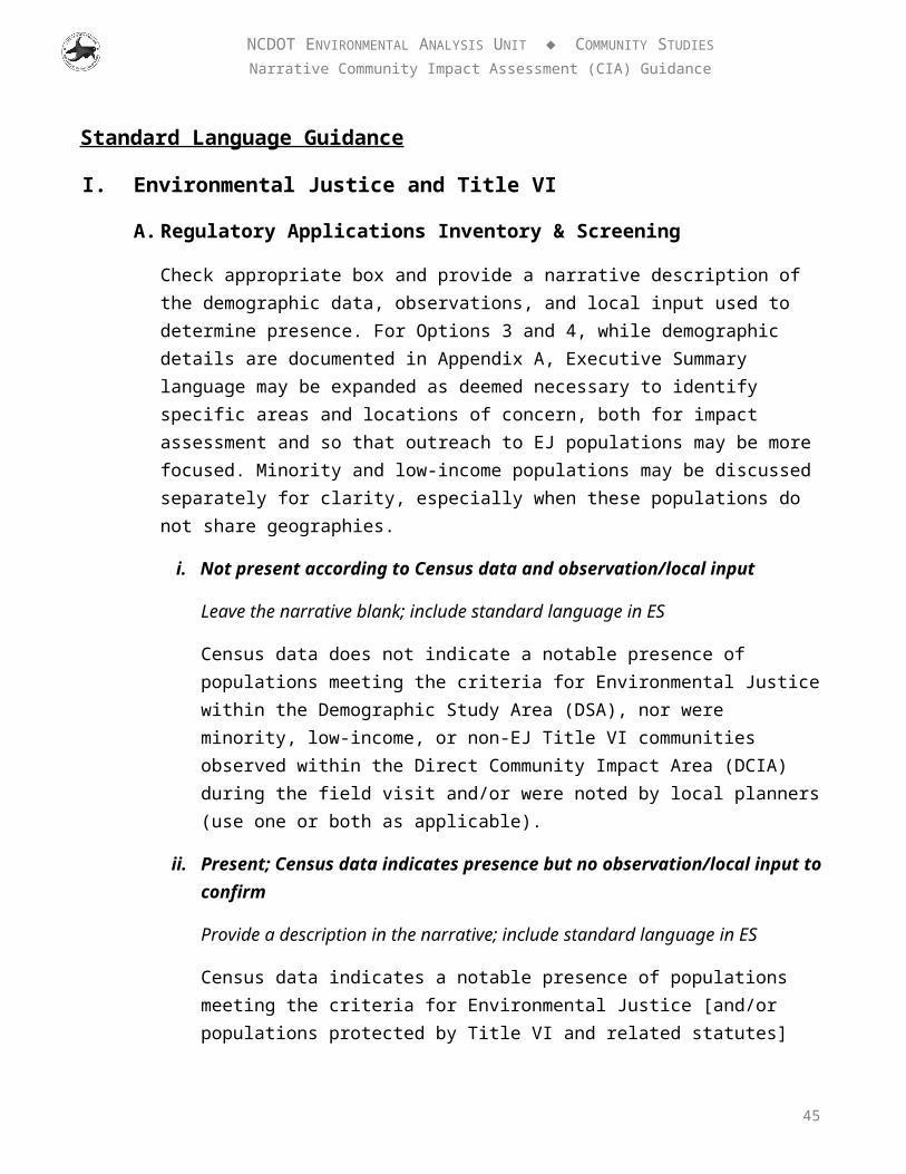
NCDOT ENVIRONMENTAL ANALYSIS UNIT COMMUNITY STUDIES
Narrative Community Impact Assessment (CIA) Guidance
project. Therefore, a detailed indirect and cumulative effects study is not required, unless the project becomes subject to a federal permit or federal approval.
VIII. Other Recommendations
Use the recommendations below when the applicable resource or community characteristic is determined to be present.
A. Maintain access for farm equipment & minimize impacts to agricultural operations
The NCDOT Project Planning Engineer should ensure that access is maintained for farm equipment and impacts to agricultural operations are minimized during construction.
B. Coordination with NCDOT Division of Bicycle and Pedestrian Transportation regarding bicycle and pedestrian facilities or activity
The NCDOT Project Planning Engineer should coordinate with NCDOT Division of Bicycle and Pedestrian Transportation to evaluate the inclusion of bicycle/pedestrian facilities in [project design, project type], as well as the necessary level of bicycle/pedestrian access accommodation during construction.
C. Public Involvement due to the presence of Notable Community Concerns
The NCDOT Project Planning Engineer should coordinate with NCDOT Public Involvement to develop a public involvement outreach plan that incorporates the necessary local stakeholders and is in accordance with all necessary FHWA and NCDOT guidelines.
45

NCDOT ENVIRONMENTAL ANALYSIS UNIT COMMUNITY STUDIES
Narrative Community Impact Assessment (CIA) Guidance
APPENDIX C: Guidance for Completing the NRCS Farmland Conversion Impact Rating
The NRCS Farmland Conversion Impact Rating should be completed only for a CIA, once design is available. Farmland does not need to be assessed for a CCR.
First determine whether the project is subject to FPPA:
a. Does the project receive Federal funding? If “NO,” no Farmland Conversion Impact Rating is required. If “YES,” continue on to next question.
b. Does the land in the project footprint fall into any of the following categories of land not subject to the provisions of FPPA? Project footprint is defined as the area that will physically be altered or impacted, including right-of-way, cut and fill, slopes and ditches, permanent easements (e.g., drainage), etc. For functional designs, this is slope stakes plus 40 feet. For preliminary designs, this is slope stakes plus 25 feet. Lands that receive a combined score of less than 160 points from the land evaluation
and site assessment (LESA) criteria; Lands identified as “urbanized area” (UA) on Census Bureau maps;
o http://www.census.gov/geo/maps-data/maps/2010ua.html Land within a municipal boundary;
o Areas shown as white (not farmland) on USDA important farmland maps. These are
sites that do not contain prime, unique, statewide, or locally important farmland;o http://www.rurdev.usda.gov/IA_env_Class1_farmlands.html
Areas shown as “urban built-up” (areas 10 acres or larger without structures are not considered urban built-up and are subject to FPPA);
Land in water storage; Lands that are used for national defense purposes
If “YES,” no Farmland Conversion Impact Rating is required. If “NO,” continue on to complete the Farmland Conversion Impact Rating.
46

NCDOT ENVIRONMENTAL ANALYSIS UNIT COMMUNITY STUDIES
Narrative Community Impact Assessment (CIA) Guidance
NRCS Farmland Conversion Impact RatingScreening Process Overview
47

NCDOT ENVIRONMENTAL ANALYSIS UNIT COMMUNITY STUDIES
Narrative Community Impact Assessment (CIA) Guidance
NRCS Farmland Conversion Impact RatingStep 1: Screen for FPPA soil types using GIS
Step 2a: Create the NRCS Farmland Figure
1. Turn on the following layers: Parcels All Roads (Labeled) Water Bodies, Streams Farmland Soils Municipal Boundaries (labeled)
2. Ensure the Farmland GIS layer is properly displayed. Only the “Prime farmland,” “Farmland of statewide importance,” “Farmland of unique importance” and “Prime farmland if drained” soil classifications need to be visible. (Remove “Not prime farmland” from the display.)
3. Create the 1-mile buffer. For a bridge project, establish a point in the center of the bridge. For a corridor project, select the centerline of the corridor. Use the buffer tool to draw a 1-mile buffer. This will be used for calculations for question 1 on the NRCS forms and should be shown on the farmland figure.
4. Establish a polygon for the project footprint. For functional designs, this is slope stakes plus 40 feet. For preliminary designs, this is slope stakes plus 25 feet. This will be used for calculation purposes and should be shown on the farmland figure.
5. Insert a title box, legend, scale, and north arrow.
48

NCDOT ENVIRONMENTAL ANALYSIS UNIT COMMUNITY STUDIES
Narrative Community Impact Assessment (CIA) Guidance
6. Export the map and insert it into the report appendix.
See the next page for an example.
49

NCDOT ENVIRONMENTAL ANALYSIS UNIT COMMUNITY STUDIES
Narrative Community Impact Assessment (CIA) Guidance
50

NCDOT ENVIRONMENTAL ANALYSIS UNIT COMMUNITY STUDIES
Narrative Community Impact Assessment (CIA) Guidance
Step 2b: Complete Part VI of the appropriate NRCS form.
a. Use form AD-1006 for point projects.b. Use form CPA-106 for corridor projects.
Sources Needed:
1. USDA Census of Agriculture:
http://www.agcensus.usda.gov/Publications/2012/Full_Report/Volume_1,_Chapter_2_County_Level/North_Carolina/ (Table 1. County Summary Highlights: 2012)
2. GIS parcel data for the county the project is located in.
3. Aerial imagery for the county the project is located in (Google Maps or Bing are acceptable where the GIS aerial imagery data is unavailable).
4. Completed local planner input form for the project.
5. Completed field visit notes containing enough detail to determine which properties located in the DCIA are currently being farmed and if those properties contain on-farm investments.
6. If additional guidance on completing Part VI is needed, please reference the Site Assessment Scoring for the Twelve Factors Used in FPPA guidance, available from NRCS: http://www.rurdev.usda.gov/SupportDocuments/AD1006.pdf
51

NCDOT ENVIRONMENTAL ANALYSIS UNIT COMMUNITY STUDIES
Narrative Community Impact Assessment (CIA) Guidance
52