PREPARATION OF FLOOD HAZARD MAP FOR KOTA TINGGI TOWN
59
Feb 2007 PREPARATION OF FLOOD HAZARD MAP PREPARATION OF FLOOD HAZARD MAP FOR KOTA TINGGI TOWN FOR KOTA TINGGI TOWN Presented by Presented by Paridah Paridah Anun Anun bt bt . . Tahir Tahir and and Anuar Anuar Md. Ali Md. Ali Department of Irrigation and Drainage Department of Irrigation and Drainage Malaysia Malaysia EAST AND SOUTH EAST REGIONAL SEMINAR ON FLOOD HAZARD MAPPING
Transcript of PREPARATION OF FLOOD HAZARD MAP FOR KOTA TINGGI TOWN

Feb
2007
PREPARATION OF FLOOD HAZARD MAP PREPARATION OF FLOOD HAZARD MAP FOR KOTA TINGGI TOWNFOR KOTA TINGGI TOWN
Presented byPresented byParidahParidah AnunAnun btbt. . TahirTahir and and AnuarAnuar Md. AliMd. Ali
Department of Irrigation and DrainageDepartment of Irrigation and DrainageMalaysiaMalaysia
EAST AND SOUTH EAST REGIONAL SEMINAR ON
FLOOD HAZARD MAPPING

Feb
2007
Contents
1. Flood Situation in Malaysia2. Flood Management in Malaysia3. Preparation of Kota Tinggi town
Flood Hazard Map4. Progress5. Challenges

Feb
2007Flooding in Kuala Lumpur in 1971Flooding in Kuala Lumpur in 1971
Feb
2007 Kuala Lumpur, January 1971

Feb
2007
Shah Alam, February 2006

Feb
2007

Feb
2007
S. Rej ang
S. Sadong
S. Rej ang
S. Sadong
S. Sar awakS. Sar awakKuci ngKuci ng
SARAWAK
S. Bar amS. Bar am
LABUAN
Kot a Ki nabal uKot a Ki nabal u
SABAH
S. Ki nabat anganS. Ki nabat angan
LumpurKuala
S.Linggi
KELANTAN
Ipoh
Shah Alam
S.Perak
S.Bernam
Seremban
S.Klang
SELANGOR
Kangar
Alor Setar
George Town
PINANGPULAU
LANGKAWIPULAU
S.Muda
KEDAH
PERLIS
PERAK
THAILAND
S.Rompin
SINGAPORE
Kuantan
S.Pahang
S.Cukai
S.Muar
S.Batu PahatS.Benut
PAHANG
SEMBILANNEGERI
MELAKAMelakaS.Melaka
JOHOR
S.Kuantan
S.Johor
BahruJohor
S.Endau
S.Dungun
Kuala Terengganu
Kota Bharu
TERENGGANU
S.Kelantan
S.Terengganu
FLOODS IN MALAYSIAClimate:
Annual Average RainfallPeninsular Malaysia 2,500 mmSabah 3,000 mmSarawak 3,500 mm
Extreme Events600 mm in 24 hours,100 – 200 mm in 1-2 hours
•Heavy Rainfall during North East Monsoon affecting East Coast Stat (Widespread floods)
•Intense rainstorms during inter monsoon periods of April-May and August-October (causing flash floods in major towns)
Topography
• Hilly upper reaches• Normal sloping middle reaches (1 in 2,000)• Gentle sloping lower reaches
(less than 1 in 5,000)• Mostly subject to tidal influence downstream
Shallow river bed in flood plain due to sedimentationHigh tidal influence can cause flooding in coastal areas

Feb
2007
Annual Flood DamageAnnual Flood Damage -- RM 915 MillionRM 915 MillionFlooded areas Flooded areas -- 29,720 km29,720 km²²No. of People Affected No. of People Affected -- 4.84 million4.84 million
* * Based on the study Based on the study ‘‘Updating of Flooding ConditionsUpdating of Flooding Conditions’’(2002)(2002)

Feb
2007
Management of Floods
• Curative measures• Preventive measures• Flood emergency response

Feb
2007
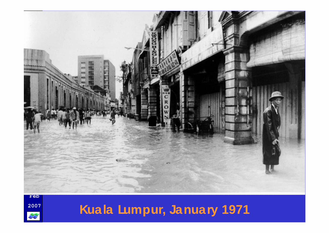
Curative Measures (structural measures)Curative Measures (structural measures)
Feb
2007
Flood Retention Pond
Flood Control Structure

Feb
2007
• Policies, Guidelines,Laws• Urban Stormwater Manual
(MSMA)• IRBM• Controlled development• Enforcement
• Policies, Guidelines,Laws• Urban Stormwater Manual
(MSMA)• IRBM• Controlled development• Enforcement
Preventive measures
Preventive measures
Prog
ram
Teb
atan
Ban
jir

Feb
2007
NOV

Feb
2007
MASMA PRINCIPLE

Feb
2007
Landscaped Retention Pond

Feb
2007
Underground Tanks

Feb
2007 River Basin Master Plan

Feb
2007
DAM(JPS)DAM(JPS)
IRRIGATION (JPS)
IRRIGATION (JPS)
FLOOD MITIGATION(JPS)
FLOOD MITIGATION(JPS)
DRAINAGE(JPS)
DRAINAGE(JPS)
RECREATIONRECREATION
RIVER CONSERVATION & REHABILITATIONS
RIVER CONSERVATION & REHABILITATIONS
WATER QUALITYWATER QUALITY
RIVER CORRIDOR DEVELOPMENT
RIVER CORRIDOR DEVELOPMENT
NAVIGATIONNAVIGATION
Integrated management

Feb
2007
National Water Resources Council at its meeting on 29 July 2003 agreed to the preparation of
River Basin Master Plans

Feb
2007
FLOOD EMERGENCY RESPONSE
� INVOLVES AN ORGANISEDAPPROACH
� AIMED AT MINIMISING DAMAGEDURING FLOODS
� THE KEY IS PREPAREDNESS (FHM??)

Feb
2007
i) Before Flood
ii) During Flood
iii) After Flood
Best Practice in Flood Best Practice in Flood PreparednessPreparedness

Feb
2007
a) Rivers and drain should be obstacle free through regular maintenance and supervision
b) Rivers and coastal bunds checked.
c) Infrastructural set up checked such as dams, pump stations, flood monitoring stations, communication facilities, boats, mobile pumps, and flood-fighting materials like rocks, sandbags and others
d) Inventory updating of flood forecasting and warning monitoring system, flood prone areas and aid facilities.
e) Preparation of the DID flood emergency response mechanism such as set up of emergency/flood surveillance teams, Flood Operation Manual, District/State/Federal Flood Operation Centre,flood emergency operation training.
Before Flood

Feb
2007
a) Continuous Flood Operation
b) Flood fighting
c) Collection, dissemination and documentation of flood information such as flooded areas, number of people and roads affected, alternative roads, flood mitigation measures.
After flood
a) Physical restoration such as repair of facilities
b) Compilation of Flood Information
c) Flood analysis- causes of flooding, identify possible measures
d) Flood assessment
During Flood

Feb
2007
District Operation Room
District ControlCentre (Police)
State Operation Room
Contingent ControlCentre (Police)
Operation RoomNational Security
Division
Malaysian Control Centre
District DID
State DID
DID Headquarters
River Level Reader
Telemetric System
DID’S OPERATIONAL STANDING ORDER FOR DISSEMINATION OF CURRENT RIVER LEVEL INFORMATION
(I)
(I)
(I)
(II)
(II)(I) : When river level exceeds
Warning Level(II) : When river level exceeds
Danger Level

Feb
2007
International BoundaryState boundaryRiverTelemetry system
TELEMETRIC SYSTEMPeninsular Malaysia

Feb
2007
Flood Warning Siren Station
Flood Warning Boards
Sg.Kinabatangan diBalat is at 10.49m, exceeded the alert level by 0.49m on 24/09/2003
08:00
SMS sent to JPSINFO-BANJIR
http://infobanjir.moa.myINFO-BANJIR
http://infobanjir.moa.my

Feb
2007
For residents(1) Hazard maps offer information on flood damage prior to a
disaster, raise awareness of disaster prevention among the residents and encourage residents in normal times to be aware ofthe need to prepare for voluntary evacuation.
(2) Hazard maps ensure that residents smoothly and promptly evacuate at the time of a warning and the occurrence of a disaster, resulting in a reduction in the damage.
Administrative bodies (persons in charge of disaster prevention)
(3) Through the preparation of flood hazard maps, administrative bodies promote administrative disaster prevention measures on a routine basis.
(4) By using flood hazard maps, administrative bodies can respond quickly and efficiently at the time of a warning and the occurrence of a disaster.
Roles of flood hazard map

Feb
2007
INTRODUCTION TOKOTA TINGGI DISTRICT
INTRODUCTION TOKOTA TINGGI DISTRICT
Located on the east of Johorstate
65 % surrounded by the seaIn the Johor River Basin Kota Tinggi as the
administrative centreDeveloping rapidly

Feb
2007
Areas frequently flooded in Johor River Basin
• Bandar Kota Tinggi• Kampung Sg. Telor• Kampung Tembioh• Batu 1, Jalan Mawai• Taman Mawai• Kg. Sg. Berangan• Kg Semangar Dalam• Kg Semangar Luar• Kg Jawa
• Kg. Kelantan• Kg. Sg Sembilang• Kg Sri Jaya• Kg Rantau Panjang• Kg Panti• Kg Batu Empat

Feb
2007
Population
41,662 (1995)
Projected in 2010
57,976

Feb
2007
LANDUSE (Area -2000 Ha)*
Agricultural 51.83% (Minimum)
Housing 20.6% (47.475)
Commercial 3.15% (38%)
Industry 3.16 (2%)
Institution 0 (7%)
*Kota Tinggi Local Plan Study (1998)

Feb
2007
Main drainage system in the Kota Tinggi town is Johor river which flows from Linggiu/Sayong Kluang river basin.
JohorJohor River ( Kota River ( Kota TinggiTinggi town):town):
•• SungaiSungai PermandiPermandi•• SungaiSungai KemangKemang•• SungaiSungai Kg Kg KelantanKelantan•• SungaiSungai BangBang•• SungaiSungai TembiohTembioh•• SungaiSungai DamarDamar

Feb
2007
Reasons for Flooding
• Lack of drains• Inadequate capacity of waterways and rivers• Infrastructure crossing waterways• Tidal effects• Debris which impede free flow• Rapid urbanisation• Areas of low elevation

Feb
2007
Overflowing of Johor River

Feb
2007
December 1948December 1969November 1979December 1982December 1983November 1989December 1991December 2003January 2004 March 2004
FLOOD RECORDS

Feb
2007

Feb
2007

Feb
2007
Flood occurrence inDecember 2006

Feb
2007
High rainfall between 17/12/2006 – 20 /12/2006 ( 1900 hrs )
TARIKH LAYANG-LAYANG ULU SIBOL B/BESAR BNDR. K/TINGGI
17/12/2006 66.00mm 33.00mm 29.00mm 48.00mm
18/12/2006 52.00mm 23.00mm 47.00mm 43.00mm
19/12/2006 176.00mm 219.00mm 200.00mm 157.00mm
20/12/2006 73.00mm 78.00mm 69.00mm 39.00mm
367.00mm 353.00mm 345.00mm 287.00mm
AVERAGE MONTHLY RAINFALL : 200.00MM

Feb
2007

Feb
2007Highest level at 5.0m on 21/12/06

Feb
2007
Flood occurrence in January 2007 (second wave)

Feb
2007
1.65 1.
812.
1 2.15 2.
3 2.52 2.
62 2.69 2.72 2.78
2.77
2.78
2.8 2.88
2.88
2.9 3 3.
02 3.1 3.19 3.24
3.26 3.
42 3.45
3.46 3.52 3.6 3.68 3.77
3.77 3.
97 4.08
4.35 4.
5 4.6 4.
7 4.82 4.86 4.92 4.95 5 5.01 5.
12 5.18 5.23 5.26 5.3 5.34
5.36
5.37
5.38
5.38
5.39
5.39
5.39
5.4
5.4
5.38
5.38 5.42 5.45
5.45
5.43
5.43
5.43 5.45
5.45
5.38
5.33
5.31
5.28
5.26
5.21
5.18
5.14
5.1
5.05
5.01
4.98
4.88
4.85
4.82
4.78
4.74
4.71
4.65
4.6
4.58
4.52
4.47
4.43
4.38
4.33
4.29
4.26
0.5
1.2
0.5
1.45
0.3
1.55
0.4
1.3
0.6
1.55
0.69
1.45
0.5
1.8
0.75
1.74
0.62
1.77
0.8
1.86
0.9
1.89
0.93
1.91
0.7
1.99
12
0.69
1.78
0.79
1.88
0.85
1.54
0.9
1.64
1.11
1.78
0.91
1.84
0.78
1.79
0.86
1.8
0.9
1.69
1.25
1.9
1.3
1.77
1.2
1.66
1.25
1.54
1.19
1.84
0.8
1.78
0.9
1.77
1.2
1.99
1.1
1.88
0.98
1.66
0.86
1.78
0.9
1.81
0.6
0.5
1.6
1.2
1.79
0.86
1.98
0.9
1.94
1.25
1.84
0.65
1.56
0.4
1.6
0.9
1.85
1.11
1.81
0.91
1.85
0.87
1.98
0.79
1.6
0
1
2
3
4
5
6
7
paras sungai masa banjir
paras normal
PARAS SUNGAI JOHOR DI BANDAR KOTA TINGGI12/1/2007 hingga 15/1/2007
masa
paras
Highest level at 5.45m on 14/1/07
Feb
2007
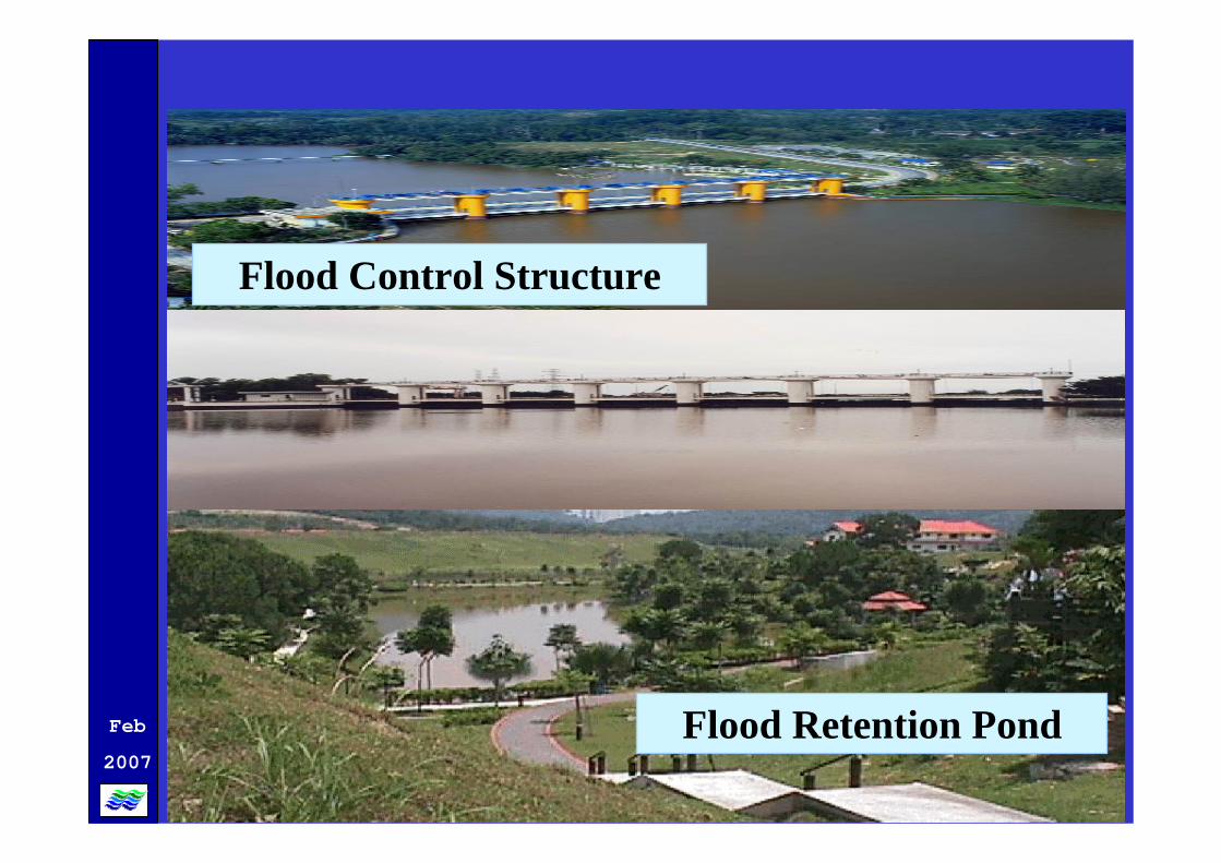
RAINFALL READING FROM11/1/2007 TO 15/1/2007
373125752111141KOTA TINGGI
43333548213134BUKIT BESAR
51154682255123ULU SIBOL34521787106133
LAYANG-LAYANG
JUMLAH15/1/0714/1/0713/1/0712/1/0711/1/07STATION

Feb
2007
Johor , January 2007

Feb
2007
AT KG. BATU 25

Feb
2007

Feb
2007
KOTA TINGGI BRIDGE ACROSS SUNGAI JOHOR
NORMAL CONDITION FLOOD ON JAN 2007

Feb
2007
KOTA TINGGI BRIDGE ACROSS SUNGAI JOHOR
NORMAL CONDITION FLOOD ON 1968
FLOOD ON DEC 2006 FLOOD ON JAN 2007

Feb
2007
FLOODING IN KOTA TINGGI
NORMAL SITUATION DEC 2006
DEC 2006 JAN 2007

Feb
2007

Feb
2007
Islam
Cina
Islam
KG. PANTI
KOTA JAYAKOTA JAYATAMAN
KG. JAWA
KOTA TINGGI
KG.
ROAD
RIVER
INUNDATION
LEGEND
7
1
3
5
4
8
10
TO K
LUA
NG
TO M
ERSI
NG
TO DESARU
TO J
OH
OR
BAH
RU
69
1
4
3
2
FLOODCOMMAND
CENTRE
ROYALMALAYSIA
POLICE
FIRE ANDRESCUE
DEPARTMENT
HOSPITAL
DISTRICTSOCIAL
WELFAREOFFICE
07-889312207-889312307-889312407-8893125
07-883122207-883122307-883686007-883673307-8831221
07-8831444
07-8831320
07-8835536
LEGEND DESCRIPTION CONTACT NO.
1
2
3
4
5
LEGEND DESCRIPTION CONTACT NO.
Assembly HallNew Kota PrimarySchool, Kota Kechil
Community HallKota Kechil
Community HallTaman Kota Jaya
Community CentreTaman Sri Lalang
Arabic SecondarySchool, TamanKota Jaya
Assembly Hall TunHabab SecondarySchool
Assembly HallTechnical SecondarySchool
Community Hall,Kampung Makam
Assembly Hallof LaksamanaSecondary School
Sultan IbrahimCommunity Hall
019-7704930013-7610783019-7460736019-7781200
016-7220701013-7734896012-7406695
019-7422717019-7773748019-7135090
019-7084545019-7366748
019-7422717019-7773748
019-7084545019-7366748
016-7220701013-7734896
019-7781200019-7304464
019-7473981019-7422515
019-7200505019-7073275
1
2
3
4
5
7
8
9
10
6
CAPACITY
1000
700
800
100
200
1000
1000
400
1000
1000
(PEOPLE)
LIST AND LOCATION OF RELIEF CENTRE
5
+_
+_
+_
+_
+_
+_
+_
+_
+_
+_RIVER
SERIKG.
MAKAM
TAMAN SRIi LALANG
KELANTAN
LALANG
KOTAKECIL
Rancangan S. JohorSINGAPURA
LEMBAGA KEGUNAAN AWAM
3.60
4.50
2
29
23
2
Jk
Jb
Jb
Jb
Jb
Jb
Jb
Jb
Jb
S. Bang
S. B
edil
S. Kemang
S. Tok
Endok
S. J
ohor
Tg. Putus

Feb
2007± 1000019-7200505
019-7073275Sultan Ibrahim Community Hall
± 1000019-7473981 019-7422515
Assembly Hall of LaksamanaSecondary School
± 400019-7781200019-7304464
Community Hall, KamapungMakam
± 1000016-7220701013-7734896
Assembly Hall Technical Secondary School
± 1000019-7084545019-7366748
Assembly Hall Tun HababSecondary School
± 200019-7422717019-7773748
Arabic Secondary School, Taman Kota Jaya
± 100019-7084545019-7366748
Community Centre, Taman Sri Lalang
± 800019-7422717019-7773748
Community Hall, Taman Kota Jaya
± 700016-7220701013-7734896
Community Hall, Kota Kechil
± 1000019-770 4930013-761 0783
Assembly Hall New Kota Primary School, Kota Kechil
CAPACITY(PEOPLE)
CONTACT NODESCRIPTIONLEGEND
2
1
3
4
5
6
7
8
9
10
FLOOD RELIEF CENTRES

Feb
2007

Feb
2007
INFORMATION ON EVACUATION CENTRE
MUKIM BANDAR ZONE
1 Name of Evacuation centre : Dewan Serbaguna Taman Kota Jaya
2. Area : 55m x 28m 3. Capacity : ± 800 4. Sanitary facilities : 5 male 5 female 5. Electricity : Available6. Cooking facilities : Taman Kemang resident association 7. Praying facilities : Bilik Solat Dewan 8. Name of village head : Tuan Haji Rahman
9. Zone officer : 1. Encik Hairudin bin Hj Aripin - 019-74227172. Encik Prasadh a/l K.V. Pillay - 019-7773748
3. Puan Murukasvary a/p Thanarajan - 019-7135090 4. Tn. Hj Mohd Amin @ Hasnat bin Sulaiman - 07-
88317195. Tn. Hj Abd. Latip bin Ali - 019-7435159
10. Assistant Zone officer : 1. Encik Md Khisban bin Abu Yamin - 017-7163444 2. Encik Azman bin Hj Abdul Rahman -3. Encik Soffian bin Mohd Yassin - 013-79804744. Cik Halina binti Hussine - 019-7666286

Feb
2007
INFORMATION ON EVACUATION CENTRE
MUKIM BANDAR ZONE
1. Name of Evacuation Centre : Sekolah Menengah Agama ( Arab ) Taman Kota Jaya
2. Area : 42m x 7m 3. Capacity : ± 200 4. Sanitary facilites : 3 male 3 female 5. Electricity : Available6. Cooking facilites : Jawatankuasa Taman Kemang7. Praying facilites : Surau Taman Kota Jaya 8. Name of village head : Tuan Haji Rahman
9. Zone officer : 1. Encik Hairudin bin Hj Aripin - 019-74227172. Encik Prasadh a/l K.V. Pillay - 019-7773748 3. Puan Murukasvary a/p Thanarajan - 019-7135090 4. Tn. Hj Mohd Amin @ Hasnat bin Sulaiman - 07-88317195. Tn. Hj Abd. Latip bin Ali - 019-7435159
10. Assistant ZoneOfficer : 1. Encik Md Khisban bin Abu Yamin - 017-7163444
2. Encik Azman bin Hj Abdul Rahman -3. Encik Soffian bin Mohd Yassin - 013-79804744. Cik Halina binti Hussine - 019-7666286

Feb
2007
Procedure on preparation of flood hazard Procedure on preparation of flood hazard mapsmaps
Not yet. Promotion neededUse of the flood hazard map by residents and administrative bodies
Through local authority (not yet)Dissemination of the flood hazard map for residents
DonePreparation of a basic plan for the flood hazard map
Can be raised through the Flood Commission
Systematization of issues related to disaster prevention
To discuss furtherReview of an outline plan for the flood hazard map
DoneReview of information on evacuationTo carry out modellingReview of information on inundation
To be reviewedEstablishment of preparation conditions
Data and information need to be updated
Collection of data
DoneEstablish location for a flood hazard map based on certain criterias

Feb
2007
Challenges
• Acceptance of local authorities• Acceptance of residents• Continuous programme on flood awareness
and preparedness

Feb
2007
THANK YOUTHANK YOU