preliminary assessmenT oF poTenTial hydrauliC FraCTure ...
58
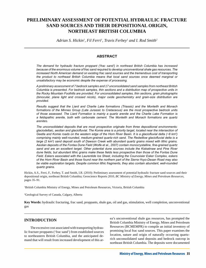
Ministry of Energy, Mines and Petroleum Resources 35 PRELIMINARY ASSESSMENT OF POTENTIAL HYDRAULIC FRACTURE SAND SOURCES AND THEIR DEPOSITIONAL ORIGIN, NORTHEAST BRITISH COLUMBIA Adrian S. Hickin 1 , Fil Ferri 1 , Travis Ferbey 1 and I. Rod Smith 2 ABSTRACT The demand for hydraulic fracture proppant (‘frac sand’) in northeast British Columbia has increased because of the enormous volume of frac sand required to develop unconventional shale gas resources. The increased North American demand on existing frac sand sources and the tremendous cost of transporting the product to northeast British Columbia means that local sand sources once deemed marginal or unsatisfactory may be economic despite the expense of processing. A preliminary assessment of 7 bedrock samples and 17 unconsolidated sand samples from northeast British Columbia is presented. For bedrock samples, thin sections and a distribution map of prospective units in the Rocky Mountain Foothills are provided. For unconsolidated samples, thin sections, grain photographs (binocular, plane light and crossed nicols), major oxide geochemistry and grain-size distribution are provided. Results suggest that the Liard and Charlie Lake formations (Triassic) and the Monteith and Monach formations of the Minnes Group (Late Jurassic to Cretaceous) are the most prospective bedrock units of those assessed. The Liard Formation is mainly a quartz arenite and the Charlie Lake Formation is a feldspathic arenite, both with carbonate cement. The Monteith and Monach formations are quartz arenites. The unconsolidated deposits that are most prospective originate from three depositional environments: glaciodeltaic, aeolian and glaciofluvial. The Komie area is a priority target, located near the intersection of Geetla and Komie roads on the western edge of the Horn River Basin. It is a glaciofluvial delta (~8 km 2 ) comprising mainly well-rounded, medium-grained quartz-rich sand. The Redwillow glaciofluvial delta is a large (2 km 2 ) sand deposit south of Dawson Creek with abundant quartz grains mixed with lithic grains. Aeolian deposits of the Fontas Dune Field (Wolfe et al., 2007) contain monocrystalline, fine-grained quartz sand and are an excellent target. Other potential dune sources include the Kiskatinaw and Pine River dune fields, but abundant lithic grains make these fields less prospective than those of the Fontas Dune Field. Eskers associated with the Laurentide Ice Sheet, including the Courvoisier Esker Complex, eskers of the Horn River Basin and those found near the northern part of the Sierra-Yoyo-Desan Road may also be viable exploration targets. Despite common lithic fragments, they also contain abundant, well-rounded quartz grains. Hickin, A.S., Ferri, F., Ferbey, T. and Smith, I.R. (2010): Preliminary assessment of potential hydraulic fracture sand sources and their depositional origin, northeast British Columbia; Geoscience Reports 2010, BC Ministry of Energy, Mines and Petroleum Resources, pages 35–91. 1 British Columbia Ministry of Energy, Mines and Petroleum Resources, Victoria, British Columbia 2 Geological Survey of Canada, Calgary, Alberta Key Words: hydraulic fracturing, frac sand, proppants, shale gas, oil and gas, stimulation, well completion, unconventional gas INTRODUCTION The excessive cost associated with transporting hydrau- lic fracture proppants (‘frac sand’) from established sources to northeastern British Columbia, and the anticipated de- mand that will result from increased development of this ar- ea’s unconventional shale gas resources, has prompted the British Columbia Ministry of Energy, Mines and Petroleum Resources (BCMEMPR) to compile an initial inventory of promising local frac sand sources. This paper examines the location, nature and origin of naturally occurring quartz- rich unconsolidated sand deposits and bedrock outcrop in northeast British Columbia. The deposits were documented
Transcript of preliminary assessmenT oF poTenTial hydrauliC FraCTure ...
Ministry of Energy, Mines and Petroleum Resources 35
preliminary assessmenT oF poTenTial hydrauliC FraCTure sand sourCes and Their deposiTional oriGin,
norTheasT briTish Columbia
Adrian S. Hickin1, Fil Ferri1, Travis Ferbey1 and I. Rod Smith2
AbstrAct
The demand for hydraulic fracture proppant (‘frac sand’) in northeast British Columbia has increased because of the enormous volume of frac sand required to develop unconventional shale gas resources. The increased North American demand on existing frac sand sources and the tremendous cost of transporting the product to northeast British Columbia means that local sand sources once deemed marginal or unsatisfactory may be economic despite the expense of processing.
A preliminary assessment of 7 bedrock samples and 17 unconsolidated sand samples from northeast British Columbia is presented. For bedrock samples, thin sections and a distribution map of prospective units in the Rocky Mountain Foothills are provided. For unconsolidated samples, thin sections, grain photographs (binocular, plane light and crossed nicols), major oxide geochemistry and grain-size distribution are provided.
Results suggest that the Liard and Charlie Lake formations (Triassic) and the Monteith and Monach formations of the Minnes Group (Late Jurassic to Cretaceous) are the most prospective bedrock units of those assessed. The Liard Formation is mainly a quartz arenite and the Charlie Lake Formation is a feldspathic arenite, both with carbonate cement. The Monteith and Monach formations are quartz arenites.
The unconsolidated deposits that are most prospective originate from three depositional environments: glaciodeltaic, aeolian and glaciofluvial. The Komie area is a priority target, located near the intersection of Geetla and Komie roads on the western edge of the Horn River Basin. It is a glaciofluvial delta (~8 km2) comprising mainly well-rounded, medium-grained quartz-rich sand. The Redwillow glaciofluvial delta is a large (2 km2) sand deposit south of Dawson Creek with abundant quartz grains mixed with lithic grains. Aeolian deposits of the Fontas Dune Field (Wolfe et al., 2007) contain monocrystalline, fine-grained quartz sand and are an excellent target. Other potential dune sources include the Kiskatinaw and Pine River dune fields, but abundant lithic grains make these fields less prospective than those of the Fontas Dune Field. Eskers associated with the Laurentide Ice Sheet, including the Courvoisier Esker Complex, eskers of the Horn River Basin and those found near the northern part of the Sierra-Yoyo-Desan Road may also be viable exploration targets. Despite common lithic fragments, they also contain abundant, well-rounded quartz grains.
Hickin, A.S., Ferri, F., Ferbey, T. and Smith, I.R. (2010): Preliminary assessment of potential hydraulic fracture sand sources and their depositional origin, northeast British Columbia; Geoscience Reports 2010, BC Ministry of Energy, Mines and Petroleum Resources, pages 35–91.
1British Columbia Ministry of Energy, Mines and Petroleum Resources, Victoria, British Columbia
2Geological Survey of Canada, Calgary, Alberta
Key words: hydraulic fracturing, frac sand, proppants, shale gas, oil and gas, stimulation, well completion, unconventional gas
inTroduCTion
The excessive cost associated with transporting hydrau-lic fracture proppants (‘frac sand’) from established sources to northeastern British Columbia, and the anticipated de-mand that will result from increased development of this ar-
ea’s unconventional shale gas resources, has prompted the British Columbia Ministry of Energy, Mines and Petroleum Resources (BCMEMPR) to compile an initial inventory of promising local frac sand sources. This paper examines the location, nature and origin of naturally occurring quartz-rich unconsolidated sand deposits and bedrock outcrop in northeast British Columbia. The deposits were documented

36 Geoscience Reports 2010
during bedrock and surficial geology mapping activities by the BCMEMPR in partnership with the Geological Survey of Canada. Some of the samples collected during these map-ping programs are evaluated here for frac sand potential.
Northeast British Columbia has become a focus for the development of unconventional shale gas resources. Over the last few years, this interest has resulted in a significant increase in the amount of land sold as well as the price per hectare of petroleum and natural gas rights (Adams et al., 2008). Recent exploration activity has been focused in the Fort St John, Dawson Creek (Montney) and Fort Nelson (Horn River, Cordova Embayment and Liard River) areas, where shale gas is the target. The production of natural gas from organic-rich shale, a rock previously considered as a gas source or reservoir seal, is possible because of advances in directional drilling and production stimulation. To liber-ate gas from relatively impermeable shale, long horizontal sections are drilled into the formation of interest and the rock fractured, thereby providing conduits (through in-creased permeability) for gas to move from the rock to the well bore. Fracturing (‘frac’ing’) is achieved by pumping water at high pressure into the horizontal section and out into the rock. Fractures in the rock are prevented from clos-ing by forcing proppants such as frac sand into the fractures (Figure 1).
A simulation by Kerr (2009) predicts that over the next 20 years, the demand for frac sand in the Horn River Basin, under pessimistic and optimistic drilling scenarios, to be approximately 8.8–19.7 million tons, respectively. At
a cost of $100–$200 per ton, the expense associated with this component of well-completion costs could range from $880 million to $3.4 billion. As the number of fracs per well increases, along with a shift to higher-tonnage fracs, this demand and the associated cost will also increase.
There are three major sources of frac sand in North America (Dumont, 2007; Zdunczyk, 2007): 1) Middle–Late Ordovician St. Peter sandstone of the Ancell Group (com-mercially referred to as ‘Ottawa’ or ‘White’ sand) from the northeast United States; 2) the Cambrian Hickory Member of the Riley Formation (‘Brown’ or ‘Brady’ sand) from Texas; and 3) the Middle Ordovician Black Island Member of the Winnipeg Formation around Hanson Lake, Saskatch-ewan. There are also a number of smaller frac sand pro-ducers in Canada, of which the closest to northeast British Columbia is the Cretaceous Paddy Member sandstone of the Peace River Formation (Fort St John Group) in Peace River, Alberta (Alberta Geological Survey, 1989).
Sand, used as a frac proppant, has rigid engineering standards, as outlined in American Petroleum Institute (API) report numbers API RP 56 (American Petroleum In-stitute, 1995a), API RP 60 (American Petroleum Institute, 1995b) and International Organization for Standards (ISO) report number ISO 13503-2 (International Organization for Standards, 2006). Critical characteristics include grain-size distribution, average particle sphericity and rounding, acid solubility, crush resistance and particle mineralogy. Most northeast British Columbian quartzite, sandstone and un-consolidated sand deposits, in raw form, fail to meet these
Figure 1. Simplified example of a typical frac’ing operation in northeast British Columbia. Frac’ing is performed on the horizontal section of production wells. Water is pumped into the well bore at high pressure and forced into the rock, causing it to fracture. Proppant is intro-duced into the fractures to keep them from closing, thereby permitting the gas to travel from the shale back to the well bore.

Ministry of Energy, Mines and Petroleum Resources 37
requirements. However, given that the transportation of frac sand to northeast British Columbia represents a signifi-cant cost, it may be economically beneficial to process local sources to meet these stringent frac sand guidelines.
meThods
Sample Collection
bedroCK
Bedrock samples are from the Rocky Mountain Foot-hills physiographic region (Holland, 1976) and are part of a representative suite of samples from outcrop documented during a regional 1:50 000 scale bedrock mapping program in the Halfway River map area (094B/02 and 07; Ferri, 2009). This area encompasses clastic rocks of Carbonifer-ous to Cretaceous age and includes the Carboniferous to Permian Stoddart Group; Triassic rocks of the Toad, Liard and Charlie Lake formations; and Jurassic to Cretaceous rocks of the Fernie, Minnes and Bullhead groups. Results presented are limited to units with >80% quartz grains, which include only the Cretaceous Monach and Monteith formations of the Minnes Group and the Triassic Charlie Lake and Liard formations.
unConsolidaTed
Sand samples collected from known and recently dis-covered sand deposits identified during surficial geology and aggregate potential mapping programs were evaluated for their frac sand potential. Samples are from a variety of genetic deposits including aeolian dunes, subglacial gla-ciofluvial (eskers) and proglacial glaciofluvial deposits, and deltaic glaciofluvial deposits.
Laboratory
bedroCK
Thin sections were prepared and qualitatively evalu-ated to estimate proportions of matrix to grains and the quantity of quartz, feldspar and lithic grains for use within the classification scheme of Dott (1964) and Williams et al. (1982; Figure 2).
unConsolidaTed
Grain-size distribution was established by wet sieving raw samples using the Wentworth grain-size classification (Wentworth, 1922). The weight proportion of the sample retained in >2.0 mm, >1.0 mm, >0.5 mm, >0.25 mm,
>0.125 mm and >0.063 mm sieves, and the proportion <0.063 mm is plotted both as histograms and cumulative percent charts. A split of the sand-sized fraction (<2.0 mm to >0.063 mm) was washed and separated from each raw sample for imaging and analysis. A photomicrograph was taken of the grains using a binocular microscope. Thin sec-tions were made and imaged under plane light and cross nicols. Part of the sand split was milled to <0.063 mm and then analyzed for major oxide geochemistry by inductively coupled plasma–emission spectroscopy (ICP-ES) follow-ing a lithium metaborate/tetraborate fusion and dilute nitric digestion.
resulTs
Bedrock
Forty-four samples were collected and evaluated; seven promising samples are presented in Table 1 and Ap-pendix 1. The high-potential samples are from the Liard and Charlie Lake formations and the Minnes Group (Mon-teith and Monach formations) (Figure 3). Liard and Charlie Lake rocks record marine environments, although the latter also documents sabkha environments. The Minnes Group represents a westward-thickening foreland wedge, with the Monteith and Monach formations deposited in deltaic set-tings.
Unconsolidated
Seventeen unconsolidated sand samples were collected from eleven distinct areas (Table 2; Appendix 2). These ar-eas are shown in Figure 4 and include Bear Lake (aeolian; area 1), Lower Pine River (aeolian; area 2), Kiskatinaw Dune Field (aeolian; area 3), Redwillow River (deltaic; area 4), Fort Nelson Airport (glaciofluvial; area 5), Fontas Dune Field (aeolian; area 6), KM 176 — SYD (esker; area 7),
Percent Matrix (<0.03 mm) 50
50
Arenites
Wackes
Mudrocks
Lithic wacke
Feldspathic wacke90%
F
L
QQuartz Arenite
Quartz wacke
Feldspathic arenite Lithic arenite
Figure 2. Classification diagram for sandstones used in this report, modified from Dott (1964) and Williams et al. (1982).

38 Geoscience Reports 2010
Crooked
River
River
Parsnip
Murray
River
PineRiver
River
Peace
River
Halfway
Williston
Lake
River
Beatton
FortSt John
DawsonCreek
Hudson'sHope
Chetwynd
Mackenzie
Prince George
A L B E
R T A
120°W
120°W
122°W
122°W
124°W
124°W57
°N 57°N
54°N 54
°N
Legend Geological FormationsMinnes Group undifferentiated
Cadomin and Gething formations
Liard and Charlie Lake formations
Cadomin Formation
Sulphur Mountain Formation
Whitehorse Formation
Figure 3a. Distribution within the Rocky Mountain Foothills of outcropping bedrock units discussed in this report: a) Fort St John area; b) Fort Nelson area; Modified from Massey et al., 2005.

Ministry of Energy, Mines and Petroleum Resources 39
Halfway
River
ProphetMuskwa
Riv
er
Sikanni
Chi
ef
River
Fi
nlay
River
River
Liard
FortRiver
Nelson
Fort Nelson
N. W. T.
122°W
122°W
124°W
124°W
126°W
126°W
60°N
60°N
57°N
57°N0 50 10025
kilometres
Figure 3b. Distribution within the Rocky Mountain Foothills of outcropping bedrock units discussed in this report: a) Fort St John area; b) Fort Nelson area; Modified from Massey et al., 2005.

40 Geoscience Reports 2010
2
3
4
6
7
8
9
5
1
10
11
SYD Road
Hay River Delta
Petitot
River
River
Fort
Liard
River
Kechika
River
Muskwa
River
Fontas
River
Sikanni
Chief
River
Halfw
ay
River
RiverPeace
River
Wil l iston
Lake
Pine River Murray
River
Parsnip
CrookedR
.
Prop
het
Riv
er
RiverFinlay
Kutcho Lake
Ne ls on
FortNelson
FortSt John
DawsonCreek
Mackenzie
Chetwynd
Hudson'sHope
120°W
120°W
124°W
124°W60
°N
60°N
57°N
57°N
0 50 10025
Kilometres
Unconsolidated sand areas
No. Area Name
1 Bear Lake2 Lower Pine River Dune Field3 Kiskatinaw Dune Field4 Redwillow River5 Fort Nelson Airport6 Fontas Dune Field7 KM 176 - SYD8 Lower Komie Road9 Komie10 Courvoisier Creek11 Horn River Basin
Figure 4. Location of the areas where preliminary evaluation of unconsolidated deposits indicates potential to host a frac sand source.

Ministry of Energy, Mines and Petroleum Resources 41
Lower Komie Road (esker; area 8), Komie (deltaic; area 9), Courvoisier Creek (esker; area 10) and Horn River Basin (esker; area 11).
disCussion
Several deposits are excellent candidates for further evaluation, as processing may upgrade the deposits to a usable frac sand product (i.e., meeting API and ISO stand-ards). The following is a discussion of the most promising of these deposits.
Bedrock units that show the most potential for use as frac sand are the Liard, Charlie Lake, Monteith and Monach formations. Outcrops of the Liard and Charlie Lake forma-tions (and their southern equivalents, the Sulphur Mountain and Whitehorse formations) can be traced throughout the entire length of the inner and western parts of the Rocky Mountain Foothills and therefore represent an extensive target (Figure 3; Gibson, 1975). Although these sandstones can be high in carbonate cement (up to 15%), they are medium to coarse grained and rich in well-rounded quartz (>80%). The carbonate cement in these rocks would make the disassociation of these rocks easier than the disasso-ciation of quartz-cemented sandstone. Charlie Lake rocks record sabkha environments indicating arid conditions in northeast British Columbia for much of the Triassic. The well-rounded nature of the grains in these rocks is probably, in part, a reflection of aeolian transport. Aeolian deposits are considered highly prospective because abrasion due to wind can be 100–1000 times more effective at round-ing grains than transport by water (Kuenen, 1959, 1960). A coastal aeolian environment has been suggested for the St Peter sandstone (Mazzullo and Ehrlich, 1983), which is a major source of frac sand in the United States.
Rocks of the Minnes Group can be traced along the entire length of the outer Rocky Mountain Foothills of Brit-ish Columbia. These fluvial-deltaic rocks form a westward-thickening package formed as a result of Jura-Cretaceous mountain building, which occurred in response to terrane accretion. The two thickest coarse clastic sequences within the Minnes Group belong to the Monteith and Monach formations (Figure 5). Both units are rich in medium- to coarse-grained quartz sand (>90%) and are typically quartz
a)
b)
c)
~1m
~1m
Figure 5. Photographs of the a) Monteith, b) Monach and c) Liard formations from the Halfway River map area (NTS 094B).
Table 1. Summary of bedrock frac sand samples.Sample Easting Northing Classification Formation % Quartz % Feldspar % Lithic08DFM063 519797 6222783 Quartz Arenite Monteith 95 0 508FFE125 521738 6224224 Quartz Arenite Monteith 95 0 508FFE220A 527687 6231355 Quartz Arenite Monach 95 0 508FFE205A 526315 6236536 Quartz Arenite Monach 95 0 508FFE021B 510894 6217773 Feldspathic Arenite Charlie Lake 80 15 508FFE309 522190 6235343 Quartz Arenite Liard 90 5 508FFE114 507488 6221073 Quartz Arenite Liard 90 2 8
TABLE 1. SuMMARy OF BEDROCk FRAC SAND SAMPLES.

42 Geoscience Reports 2010
cemented or show compactional welding of grain contacts. The stratigraphically higher Monach Formation tends to contain coarser-grained sandstone with well-rounded grains. Sandstone in this unit also displays higher porosity in sur-face exposures (up to 15%), which may make mechanical disaggregation easier than Monteith sandstone. The Minnes Group is absent in the north because these units have been eroded at the sub-Cretaceous unconformity. A more thor-ough description of the Minnes Group and its distribution is given by Stott (1998).
Geologically young deposits are not traditionally considered good sources of frac sand (Zdunczyk, 2007); however, some of the unconsolidated deposits sampled in this study show potential. These are Quaternary deposits that were emplaced during, or shortly after, the glaciation of northeast British Columbia in the Late Wisconsinan (ca. 22 000–10 000 years ago; Mathews 1978, 1980; Clague, 1989; Liverman et al., 1989; Catto et al., 1996; Dyke et al., 2003; Wolfe et al., 2004; Bednarski and Smith, 2007; Bednarski, 2008). The area was affected by three glacial systems: 1) lo-cal montane glaciers, 2) the Cordilleran Ice Sheet (CIS) and 3) the continental Laurentide Ice Sheet (LIS). Preliminary evaluation of unconsolidated samples suggests that those associated with the LIS are more likely to host material with favourable properties for use as frac sand than those derived from the CIS or montane glacial deposits.
One of the most prospective landforms is a glaciofluvial delta located in the Komie area (area 9; Figures 4, 6). This feature formed in a shallow proglacial lake (T. Demchuk, pers comm 2009) and has been extensively mapped and evaluated for aggregate potential (Blyth et al., 2003; Dewer and Polysou, 2003; Levson et al., 2004; Demchuk et al., 2005; Ferbey et al., 2005). Although originally targeted as part of gravel resource investigations, volumetrically, much of the granular material encountered is sand. A sample (TFE0704-03) collected from a sandy portion of this feature consists of 89.99% SiO2, with 79.38% of the grains falling within the medium-sand–sized fraction. A large proportion of the quartz grains are rounded to well-rounded and have
TFE0704-03
6x Vertical Exaggeration
2.0 km
Kom
ie Road
Cab
in R
oad
Figure 6. The komie delta, shown in a high-resolution LiDAR im-age, consists of a series of incised lobes. Several of the lobes host active gravel mines, while others consist of up to 14 m of sand (location 9 in Figure 4).
Table 2. Summary of preliminary unconsolidated frac sand targets in northeast British Columbia.
Sample General Area Areas (Figure 4) Easting Northing NTS Map
SheetsDepositional
OriginDominant Grain Size % Silica
ASH080616-01 Bear Lake 1 519588 6040819 093J/10 Aeolian Fine/Medium Sand 85.55ASH080623-02 Lower Pine River Dune Field 2 614822 6207694 094A/03 Aeolian Fine Sand 88.49ASH080711-03 Kiskatinaw Dune Field
3686542 6140750 093P/08 Aeolian Very Fine Sand 89.43
ASH080711-01A Kiskatinaw Dune Field 671684 6134020 093P/08 Aeolian Fine Sand 90.15ASH080710-03 Kiskatinaw Dune Field 670194 6133138 093P/08 Aeolian Fine Sand 86.34ASH080923-01 Redwillow River 4 685093 6099906 093P/01 Glaciofluvial Fine Sand 88.44TPAP03-32 Fort Nelson 5 522972 6520875 094J/15 Glaciofluvial Fine Sand 81.10SUV05302 Fontas Dune Field
6621520 6456212 094I/02 Aeolian Fine Sand 91.42
SUV05303 Fontas Dune Field 621098 6456288 094I/02 Aeolian Fine Sand 90.96SUV05309 Fontas Dune Field 611404 6460199 094I/06 Aeolian Fine Sand 90.62TFE0704-01 KM 176 - SYD 7 628362 6566463 094P/02 Glaciofluvial Medium Sand 85.01TFE0704-02 Lower Komie Road 8 581274 6540078 094I/13 Glaciofluvial Medium Sand 83.89TFE0704-03 Komie 9 569040 6573180 094P/05 Glaciofluvial Medium Sand 89.99TFE0704-04 Courvoisier Creek 10 574987 6560341 094P/04 Glaciofluvial Medium Sand 87.01TDE05-04 Courvoisier Creek 575001 6559192 094P/04 Glaciofluvial Medium Sand 85.97TFE0711-08 Horn River 11 501341 6641887 094O/15 Glaciofluvial Very Fine Sand/Silt 80.57TFE0711-06 Horn River 500943 6642203 094O/15 Glaciofluvial Fine Sand 80.41
TABLE 2. SuMMARy OF PRELIMINARy uNCONSOLIDATED FRAC SAND TARGETS IN NORTHEAST BRITISH COLuMBIA.
moderate to well-developed sphericity. The maturity of the sand in this deposit suggests that despite the glacial origin of the deposit, the sand fraction may have been transported a significant distance or is recycled from older sediments. The deposit is well situated to service the mounting demand for frac sand in the emerging Horn River Basin shale gas play. The feature is located near the intersection of Geetla and Komie roads, providing year-round access to the area.
Another glaciofluvial delta evaluated in this study is situated in the Redwillow River area south of Dawson Creek (area 4; Figure 7). This feature forms a well-defined sand plain that is interpreted to be a delta, subaqueous fan or subaqueous sand plain. The delta was deposited in gla-cial Lake Peace from sand-laden water flowing from the melt of westerly derived ice (montane or CIS). Sample

Ministry of Energy, Mines and Petroleum Resources 43
minution and subglacial erosion of Dunvegan Formation sandstone, which may account for its relative maturity. The Hay River fan-delta itself represents an uninvestigated sand source of immense size (~181 km2, up to 30 m thick at its apex; Smith, 2009). The dunes are excellent targets for frac sand evaluation because they represent an additional cycle of transport and deposition, thereby extending their matu-rity. All three samples from the Fontas Dune Field contain over 90% SiO2 and the majority of the sand grains fall within the fine-sand–sized fraction. The grains are angular to well-rounded with poor to well-developed sphericity. There is currently no all-season road access to these de-posits; however, there is an abundance of seismic cut lines intersecting the deposits and a winter road that crosses the northwesternmost portion of the dune field.
Another aeolian dune field is located south of Daw-son Creek in the Kiskatinaw River area (Figure 9). These dunes are highly elongated parabolic dunes that are similar in morphology to the so-called ‘Cree Lake–type’ dunes described by David (1981). The dunes formed from winds blowing from the west to east, transporting sediment from sandy glaciolacustrine deposits associated with an early
ASH080923-01 is dominated by fine- to medium-grained sand with SiO2 content over 88%. A thin section of the sand grains shows that although quartz grains are common, there are abundant polycrystalline quartz grains that are likely chert and fine-grained mudstone with high quartz content. Although the high proportion of lithic fragments reduces the potential of this deposit, the large volume of sand as-sociated with it and the abundance of quartz grains in the smaller size fraction (see Appendix 2) suggest that this de-posit may be prospective.
As mentioned earlier, aeolian deposits are considered highly prospective because of grain attrition (which causes the reduction of unstable grains, such as lithic fragments) and enhanced grain rounding (Kuenen, 1959, 1960). The types of grains in an aeolian deposit will be inherited from the types of grains in the source sediments, but will become more mature with distance travelled from the source area. Deposits derived from compositionally mature sediments (high proportion of stable framework grains) will be more prospective, as will deposits that have travelled farther from the source sediment. Four dune fields were sampled in this study, including the Fontas Dune Field (area 6), the Kiskat-inaw Dune Field (area 3), the Lower Pine River Dune Field (area 2) and the Bear Lake Dune Field (area 1).
Three samples (SUV05302, SUV05303 and SUV05309) were collected from the Fontas Dune Field near Dazo Creek (area 6; Figures 4, 8–10). Dunes in this field are compound parabolic forms and have been described by Wolfe et al. (2007) and mapped by Trommelen and Smith (2007) and Smith (2009). These dunes formed from glacial outwash and glaciolacustrine sediments associated with distal deposits of the large Hay River fan-delta (Figure 4) described by Levson et al. (2004) and Smith (2009). The delta formed where subglacial drainage and water from gla-cial Lake Peace incised a spillway channel across the divide north of the Clear Hills in Alberta and emptied into glacial Lake Hay, a proglacial lake of the LIS. It is speculated that the fan-delta sands are derived directly from glacial com-
6x Vertical Exaggeration
1.0 km
ASH080923-01
Figure 7. The Redwillow River delta, shown in a high-resolution LiDAR image, forms an extensive plain and consists of up to 10 m of uniform sand (location 4 in Figure 4).
SUV05302
SUV05303
0.5 km
SUV05309
0.5 km
a
b
Dazo Creek
Figure 8. The Fontas Dune Field, shown in a 1:20 000 scale colour orthophoto, consists of several related fields including the north section of the main dune field a) straddling Dazo Creek and b) the northwestern dune field. The dunes are compound parabolic sand dunes derived from sandy glaciolacustrine and glacial outwash sediments (location 6 in Figure 4).

44 Geoscience Reports 2010
ice where closed-channel hydraulics result in sediments that are typically poorly sorted. Nonetheless, results from samples TFE0704-04 and TDE05-04 (area 10; Figures 4, 11) collected from a sandy portion of an extensive esker complex near the Courvoisier Creek area (the Courvoisier Esker Complex; Ferbey et al., 2005; T. Demchuk, pers comm 2009), indicate well-sorted sand with SiO2 values of 87.01% and 85.97%, respectively. Furthermore, despite an abundance of lithic fragments, there is a substantial popula-tion of well-rounded, moderately spherical, monocrystal-line quartz grains that would be excellent for frac sand. As mentioned earlier, the ability to process out the undesirable grains will be critical in determining the suitability and economics of these deposits. Other eskers were sampled (TFE0704-01, area 7; TFE0704-02, area 8; and TFE0711-06 and TFE0711-08, area 11). All of these glaciofluvial features have a high proportion of well-rounded grains with moderate to well-developed sphericity, and warrant addi-tional evaluation. Ongoing aggregate mapping in northeast British Columbia is showing that sediments associated with subglacial deposits (e.g., eskers) are more likely to host sand-sized material than gravel-sized material. Given the promising results discussed here and the abundance of esk-ers near the Horn River Basin, these features may represent a local frac sand exploration target.
Sample TPAP03-32 is from a sand-dominated gla-ciofluvial deposit (likely subglacial) located at the Fort Nelson Airport. The deposit was tested during a detailed granular aggregate assessment conducted by BCMEMPR for the Northern Rockies Regional District (Ferbey et al.,
stage of glacial Lake Peace (Mathews, 1980). Much of the glaciolacustrine sediments are associated with sediments derived from the Rocky Mountains. Samples ASH080710-03, ASH080711-01A and ASH080711-03 contained SiO2 proportions of 86.34%, 89.43% and 90.15%, respectively. There is a high proportion of well-rounded monocrystal-line quartz in these samples, which indicates that there is potential for these dunes to serve as a frac sand source. Un-fortunately, thin sections show that there is an abundance of quartz-rich mudstone fragments and some chert, making these dunes less prospective than those in the Fontas Dune Field. Three other samples from dunes on the proximal side of the field (west; upwind) are not included in this report because their SiO2 content is below 80%. This suggests that the distal dunes (east; downwind) have a higher proportion of quartz grains and are therefore more prospective. Regard-less, the abundance of lithic fragments in all samples would necessitate extensive processing before this sand could be considered for use as a proppant.
Two other dune fields that were sampled returned relatively poor results. The Lower Pine River Dune Field is approximately 6 km long and consists of well-developed parabolic dunes (Figure 10). These dunes are likely derived from glaciofluvial and glacial diamict (till) sediments asso-ciated with the CIS. The dunes formed from valley-parallel winds blowing from southwest to northeast. Despite high SiO2 content in sample ASH080623-02 (88.49%), the thin section reveals a large proportion of angular grains, of which quartz-rich mudstone grains make up a significant portion. This deposit, therefore, has only limited prospectivity. The sample was, however, collected from the proximal end of the dune field in a relatively poorly developed dune; there-fore, additional sampling downwind of this sample may show more promising results. The dune field at Bear Lake (area 1; Figure 4) also has a relatively high SiO2 content (85.55%), but an abundance of lithic fragments and poor rounding and sphericity render this deposit marginal.
Several eskers associated with the LIS show promising results. This is very encouraging as depositional environ-ments associated with glaciofluvial deposits are not gen-erally well suited for frac sands. Eskers form in or under
One Island Lake
One
Lake R
oad
Isla
nd
6x Vertical Exaggeration
0.5 km
ASH080710-03
ASH080711-01A
Figure 9. A high-resolution LiDAR image of one of the elongated sand dunes of the kiskatinaw Dune Field (location 3 in Figure 4).
Figure 10. The Pine River Dune Field, shown in a 1:20 000 scale colour orthophoto, consists of well-developed parabolic dunes (location 2 in Figure 4).

Ministry of Energy, Mines and Petroleum Resources 45
2004; Johnsen et al., 2004). This deposit consists entirely of moderately sorted fine-grained sand that contains 81.1% SiO2. There are abundant lithic grains, but a population of well-rounded, monocrystalline quartz grains dominates. With processing, this deposit may also have the potential to be a frac sand source.
ConClusion
Preliminary evaluation of bedrock units suggests the Liard and Charlie Lake formations (Triassic) and the Mon-teith and Monach formations of the Minnes Group (Late Jurassic to Cretaceous) are the most encouraging bedrock units for a potential frac sand source in northeast British Columbia. The Liard Formation is a quartz arenite that con-tains 90% quartz grains in carbonate cement. The Charlie Lake Formation is a feldspathic arenite with well-rounded grains, also in carbonate cement. These units are present throughout the Rocky Mountain Foothills from Williston Lake north to the Liard River. The Monteith and Monach formations of the Minnes Group are classified as quartz arenite and consist of more than 95% quartz grains. The Minnes Group is present in the foothills south of the Profit River on the eastern edge of the deformed belt.
The unconsolidated deposits that are most prospec-tive are associated with three depositional environments: deltaic, aeolian and glaciofluvial. In the Komie area, a gla-ciofluvial delta consists of sand and gravel. A sample from this feature mainly consists of well-rounded, well-sorted, medium-grained quartz sand. The deposit is located on the western rim of the Horn River Basin and is an excellent tar-get for further evaluation. Another deltaic feature of inter-est occurs in the Redwillow River valley. This large sandy glaciofluvial delta has a significant proportion of lithic frag-ments, but does contain an abundance of quartz grains in the finer sand-sized fraction; therefore, is a potential frac sand exploration target.
Another highly prospective target is the Fontas Dune Field near Dazo Creek. This dune field includes three dis-tinct subfields consisting of either parabolic or compound parabolic sand dunes. Three samples from different dunes contain mostly monocrystalline fine-sand quartz grains. Other dunes were investigated from the Kiskatinaw and Pine River dune fields, but abundant lithic grains make these fields less prospective.
Several eskers associated with the LIS are prospective. The Courvoisier Esker Complex consists of sand and grav-el, with portions hosting well-sorted, medium-grained sand with a population of well-rounded, moderately spherical quartz grains. Several other eskers in the Horn River Basin and around KM 176 – SYD Road also show encouraging results. Although lithic fragments are common in these deposits, abundant, well-rounded quartz grains make LIS eskers a target for evaluation.
6x Vertical Exaggeration
1.5 km
Courvoisier Road Komie Road
TFE0704-04
TDE05-04
Figure 11. Courvoisier Ridge, a long esker complex that hosts sand and gravel, is outlined from high-resolution LiDAR imagery (location 10 in Figure 4).

46 Geoscience Reports 2010
aCKnowledGmenTs
We acknowledge the excellent work of the many ge-ologists, field assistants and students that have participated in the Surficial Geology and Aggregate Mapping Program and the bedrock mapping program. We thank EnCana Corporation, ConocoPhillips and EOG Resources for pro-viding LiDAR data and field logistics. Acme Laboratories (Vancouver, British Columbia) conducted the major oxide geochemical analyses and Vancouver Petrographics pro-duced the thin sections. This project has benefitted from the excellent collaborative relationship established between the Geological Survey of Canada and BCMEMPR. The authors would like to thank Tania Demchuk for providing samples from the Komie and Courvoisier deposits and data from her M.Sc. research currently in progress.
reFerenCes
Adams, C., McPhail, S. and Walsh, W. (2008): Summary of shale gas activity in northeast British Columbia 2007; BC Ministry of Energy, Mines and Petroleum Resources, Petroleum Geology Open File 2007-1, 10 pages.
Alberta Geological Survey (1989): Frac sand evaluation Peace River silica sand deposit final report; Alberta Research Coun-cil, Open File Report 1998-08, 105 pages.
American Petroleum Institute (1995a): Recommended practices for testing sand used in hydraulic fracturing operations; Ameri-can Petroleum Institute, API RP 56, 12 pages.
American Petroleum Institute (1995b): Recommended practices for testing high-strength proppants used in hydraulic fractur-ing operations; American Petroleum Institute, API RP 60, 14 pages.
Bednarski, J.M. (2008): Landform assemblages produced by the Laurentide Ice Sheet in northeastern British Columbia and ad-jacent Northwest Territories – constraints on glacial lakes and patterns of ice retreat; Canadian Journal of Earth Sciences, Volume 45, Number 5, pages 593–610.
Bednarski, J.M. and Smith, I.R. (2007): Laurentide and montane glaciation along the Rocky Mountain Foothills of northeastern British Columbia; Canadian Journal of Earth Sciences, Vol-ume 44, Number 4, pages 445–457.
Blyth, H., Levson, V.M. and Savinkoff, P. (2003): Sierra-Yoyo-Desan aggregate potential mapping; BC Ministry of Energy, Mines and Petroleum Resources, 14 maps at 1:50 000 scale.
Catto, N., Liverman, D.G.E., Bobrowsky, P.T. and Rutter, N. (1996): Laurentide, Cordilleran, and montane glaciations in the western Peace River – Grande Prairie region, Alberta and Brit-ish Columbia, Canada; Quaternary International, Volume 32, pages 21–32.
Clague, J.J. (1989): Quaternary geology of the Canadian Cordill-era, Chapter 1; in Quaternary Geology of Canada and Green-land, Fulton, R.J., Editor, Geological Survey of Canada, pages 17–96.
David, D.P. (1981): Stabilized dune ridges in northern Saskatch-ewan; Canadian Journal of Earth Sciences, Volume 18, pages 286–310.
Demchuk, T.E., Ferbey, T., Kerr, B.J. and Levson, V.M. (2005): Surficial geology and aggregate potential mapping in north-east British Columbia using LiDAR imagery; in Summary of Activities 2005, BC Ministry of Energy, Mines and Petroleum Resources, pages 51–59.
Dewer, D. and Polysou, N. (2003): Area 10 (Kotcho East) gravel investigation –– Sierra-Yoyo-Desan Road area, north eastern British Columbia; AMEC Earth and Environmental Limited, Report Number KX04335, 13 pages.
Dott, R.H., Jr. (1964) Wacke, graywacke, and matrix: what approach to immature sandstone classification; Journal of Sedi-mentary Petrology, Volume 34, pages 625–632.
Dumont, M. (2007): Silica/quartz; in Canadian Mineral Year-book, Godin, E., Editor, Natural Resources Canada, pages 47.1–47.12.
Dyke, A.S., Moore, A. and Robertson, L. (2003): Deglaciation of North America; Geological Survey of Canada, Open File 1574, CD-ROM.
Ferbey, T., Hickin, A.S., Demchuk, T.E. and Levson, V.M. (2005): Northeast British Columbia aggregate mapping program: a summary of selected aggregate occurrences northeast of Fort Nelson; in Summary of Activities 2005, BC Ministry of Energy, Mines and Petroleum Resources, pages 65–74.
Ferbey, T., Levson, V.M. and Johnsen, T. (2004): Preliminary re-port on aggregate potential investigation of Fort Nelson airport area, Fort Nelson, British Columbia; BC Ministry of Energy, Mines, and Petroleum Resources, 41 pages.
Ferri, F. (2009): Geology of the Jones Peak area (NTS 94B/02 and 07), Halfway River map sheet (94B); in Geoscience Reports 2009, BC Ministry of Energy, Mines and Petroleum Resources, pages 5–23.
Gibson, D.W. (1975): Triassic rocks of the Rocky Mountain foot-hills and front ranges of northeastern British Columbia and west-central Alberta; Geological Survey of Canada, Bulletin 247, 61 pages.
Holland, S.S. (1976): Landforms of British Columbia, a physi-ographic outline; BC Department of Mines and Petroleum Re-sources, Bulletin 48, 138 pages.
International Organization for Standards (2006): Petroleum and natural gas industries – completion fluids and materials – part 2: measurement of properties of proppants used in hydraulic fracturing and gravel-packing operations; International Organ-ization for Standards, Report Number ISO 13503-2, 28 pages.
Johnsen, T., Ferbey, T., Levson, V.M. and Kerr, B. (2004): Quater-nary geology and aggregate potential of the Fort Nelson airport area; in Summary of Activities 2004, BC Ministry of Energy, Mines and Petroleum Resources, pages 19–27.
Kerr, B. (2009): Looking to the future: development in the Horn River Basin; in Unconventional Gas Technical Forum 2009 presentations; BC Ministry of Energy, Mines and Petroleum Resources, Petroleum Geology Information Circular 2009-02.
Kuenen, P.H. (1959): Experimental abrasion, part 3: fluviatile ac-tion on sand; American Journal of Science, Volume 257, pages 172–190.

Ministry of Energy, Mines and Petroleum Resources 47
Kuenen, P.H. (1960): Experimental abrasion, part 4: eolian action; Journal of Geology, Volume 68, pages 427–449.
Levson, V.M., Ferbey, T., Kerr, B., Johnsen, T., Bednarski, J., Smith, I.R., Blackwell, J. and Jonnes, S. (2004): Quaternary geology and aggregate mapping in northeast British Columbia: applications for oil and gas exploration and development; in Summary of Activities 2004, BC Ministry of Energy, Mines and Petroleum Resources; pages 29–40.
Liverman, D.G.E., Catto, N.R. and Rutter, N.W. (1989): Lauren-tide glaciation in west-central Alberta: a single (Late Wiscon-sinan) event; Canadian Journal of Earth Sciences, Volume 26, Number 2, pages 266–274.
Massey, N.W.D., MacIntyre, D.G., Desjardins, P.J. and Cooney, R.T., (2005): Digital geology map of British Columbia, BC Ministry of Energy, Mines and Petroleum Resources, Open File 2005-2, DVD.
Mathews, W.H. (1978): Quaternary stratigraphy and geomor-phology of Charlie Lake (94A) map-area, British Columbia; Geological Survey of Canada, Paper 76-20, 25 pages.
Mathews, W.H. (1980): Retreat of the last ice sheets in northern British Columbia and adjacent Alberta; Geological Survey of Canada, Bulletin 331, 33 pages.
Mazzullo, J.M. and Ehrlich, R. (1983): Grain shape variations in the St. Peter sandstone: a record of eolian and fluvial sedimen-tation of early Paleozoic cratonic sheet sand; Journal of Sedi-mentary Research, Volume 53, pages 105–119.
Smith, I.R. (2009): Surficial geology, Kahntah River, British Co-lumbia; Geological Survey of Canada, Open File 5540, BC Ministry of Energy, Mines and Petroleum Resources, Surficial Geology Map 2009-5, scale 1:100 000.
Stott, D.F. (1998): Fernie Formation and Minnes Group (Jurassic and lowermost Cretaceous), northern Rocky Mountain Foot-hills, Alberta and British Columbia; Geological Survey of Can-ada, Bulletin 516, 516 pages.
Trommelen, M. and Smith, I.R. (2007): Surficial geology, Dazo Creek, British Columbia; Geological Survey of Canada, Open File 5527 and BC Ministry of Energy, Mines and Petroleum Resources, Surficial Geology Map 2007-1, scale 1:100 000.
Wentworth, C.K. (1922): A scale of grade and class terms for clas-tic sediments; Journal of Geology, Volume 30, pages 377–392.
Williams, D.F., Turner, F.J. and Gilbert, C.M. (1982): Petrogra-phy, 2nd Edition; W.H. Freeman, San Francisco, 626 pages.
Wolfe, S.A., Huntley, D.J. and Ollerhead, J. (2004): Relict Late Wisconsinan Dune Fields of the northern Great Plains, Canada; Géographie physique et Quaternaire, Volume 58, Number 2–3, pages 9019–9032.
Wolfe, S.A., Paulen, R.C., Smith, I.R. and Lamothe, M. (2007): Age and paleoenvironmental significance of Late Wisconsinan Dune Fields in the Mount Watt and Fontas River map areas, northern Alberta and British Columbia; Geological Survey of Canada, Current Research 2007-B4, 10 pages.
Zdunczyk, M. (2007): The facts of frac; Industrial Minerals, January 2007, pages 58–61.

48 Geoscience Reports 2010
Ministry of Energy, Mines and Petroleum Resources 49
appendix one - bedroCK samples

50 Geoscience Reports 2010
Crossed Nicols
Plane Light
Sample 08DFM063
Easting 519797
Northing 6222783
% Quartz 95
% Feldspar 0
% Lithic 5
Comment:
Medium to coarse grained sandstone.Sub-angular.Quartz cement.Lithics consist of chert, polycrystalline quartz and hornblende.
% Matrix <5
% Grai sn >95
Classification
Quartz Arenite
Group Minnes Group
Formation Monteith Formation
Age Early Cretaceous
Origin
Deltaic
Ministry of Energy, Mines and Petroleum Resources 51
Crossed Nicols
Plane Light
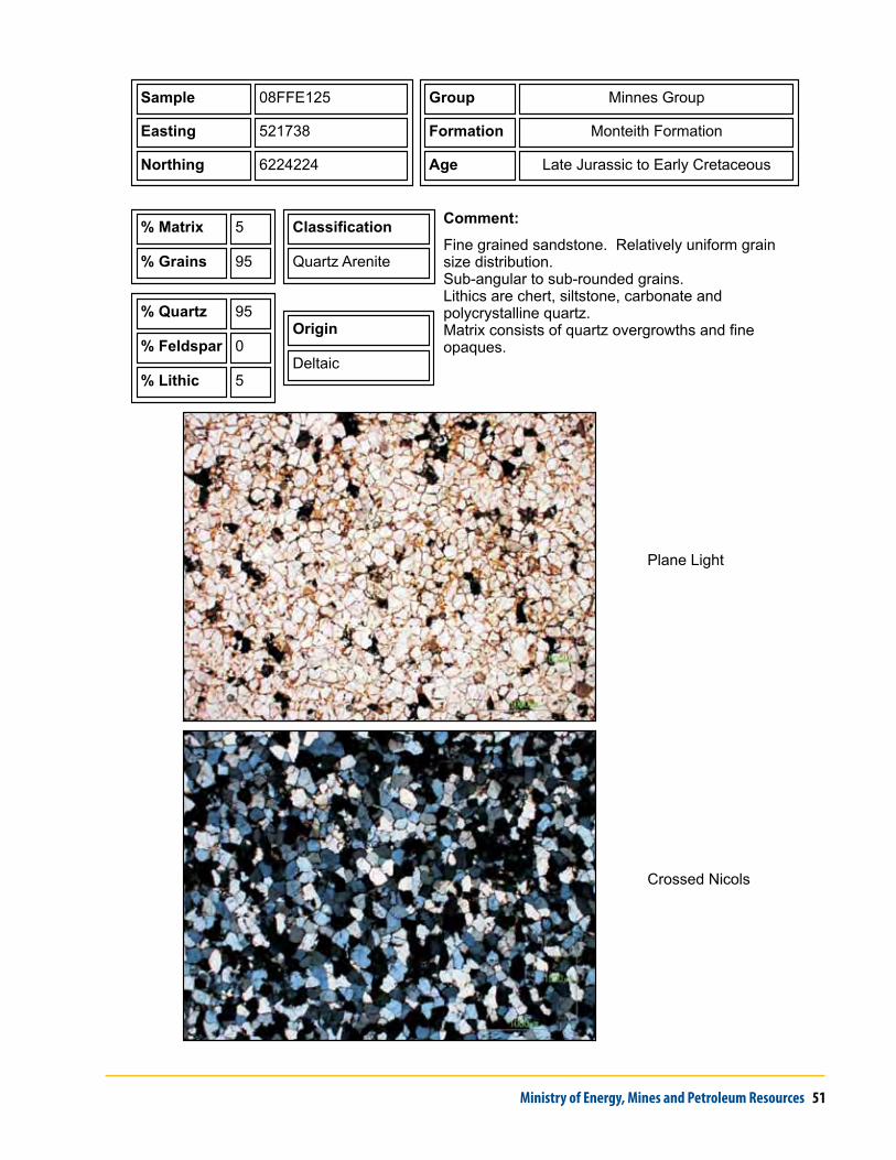
Sample 08FFE125
Easting 521738
Northing 6224224
% Quartz 95
% Feldspar 0
% Lithic 5
Comment:
Fine grained sandstone. Relatively uniform grain size distribution.Sub-angular to sub-rounded grains.Lithics are chert, siltstone, carbonate and polycrystalline quartz.Matrix consists of quartz overgrowths and fine opaques.
% Matrix 5
% Grai sn 95
Classification
Quartz Arenite
Group Minnes Group
Formation Monteith Formation
Age Late Jurassic to Early Cretaceous
Origin
Deltaic

52 Geoscience Reports 2010
Crossed Nicols
Plane Light
Sample 08FFE220A
Easting 527687
Northing 6231355
% Quartz 95
% Feldspar 0
% Lithic 5
Comment:
Medium to coarse grained sandstone.Spherical, sub-rounded to rounded.Very little matrix, quartz plus opaques.Lithics consist of chert and polycrystalline quartz.
% Matrix <2
% Grai sn 98
Classification
Quartz Arenite
Group Minnes Group
Formation Monach Formation
Age Early Cretaceous
Origin
Deltaic

Ministry of Energy, Mines and Petroleum Resources 53
Crossed Nicols
Plane Light
Sample 08FFE205A
Easting 526315
Northing 6236536
% Quartz 95
% Feldspar 0
% Lithic 5
Comment:
Bimodal size distribution consisting of coarse to granule conglomerate with matrix of fine to coarse sandstone.Spherical and rounded grains (60 to 70%) with sub-rounded matrix (30-40%).Lithics are chert and polycrystalline quartz.5-10% porosity.
% Matrix <2
% Grai sn 98
Classification
Quartz Arenite
Group Minnes Group
Formation Monach Formation
Age Early Cretaceous
Origin
Deltaic

54 Geoscience Reports 2010
Crossed Nicols
Plane Light
Sample 08FFE021B
Easting 510894
Northing 6217773
% Quartz 80
% Feldspar 15
% Lithic 5
Comment:
Fine to medium sandstone. Relatively good grain size distribution.Clasts are oblate to spherical, well- to sub-rounded.Lithic fragments include chert, sitlstone and calcite.Cement is calcite.
% Matrix <1
% Grai sn 99
Classification
Feldspathic Arenite
Group
Formation Charlie Lake Formation
Age Late Triassic
Origin
Intertidal (Marine)
Ministry of Energy, Mines and Petroleum Resources 55
Crossed Nicols
Plane Light
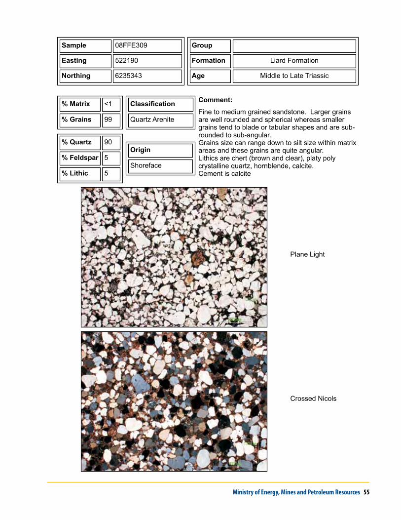
Sample 08FFE309
Easting 522190
Northing 6235343
% Quartz 90
% Feldspar 5
% Lithic 5
Comment:
Fine to medium grained sandstone. Larger grains are well rounded and spherical whereas smaller grains tend to blade or tabular shapes and are sub-rounded to sub-angular.Grains size can range down to silt size within matrix areas and these grains are quite angular.Lithics are chert (brown and clear), platy poly crystalline quartz, hornblende, calcite.Cement is calcite
% Matrix <1
% Grai sn 99
Classification
Quartz Arenite
Group
Formation Liard Formation
Age Middle to Late Triassic
Origin
Shoreface

56 Geoscience Reports 2010
Crossed Nicols
Plane Light
Sample 08FFE114
Easting 507488
Northing 6221073
% Quartz 90
% Feldspar 2
% Lithic 8
Comment:
Fine to medium grained sandstone. Fairly uniform grain size distribution. Some coarser grains.Sub-rounded to sub-angular and spherical grains, larger grains tend to be well rounded.Lithics include chert, siltstone, hornblende, calcite and fossil material.Cement is calcite.
% Matrix <1
% Grai sn 99
Classification
Quartz Arenite
Group
Formation Liard Formation
Age Middle to Late Triassic
Origin
Shoreface

Ministry of Energy, Mines and Petroleum Resources 57
appendix Two - unConsolidaTed samples

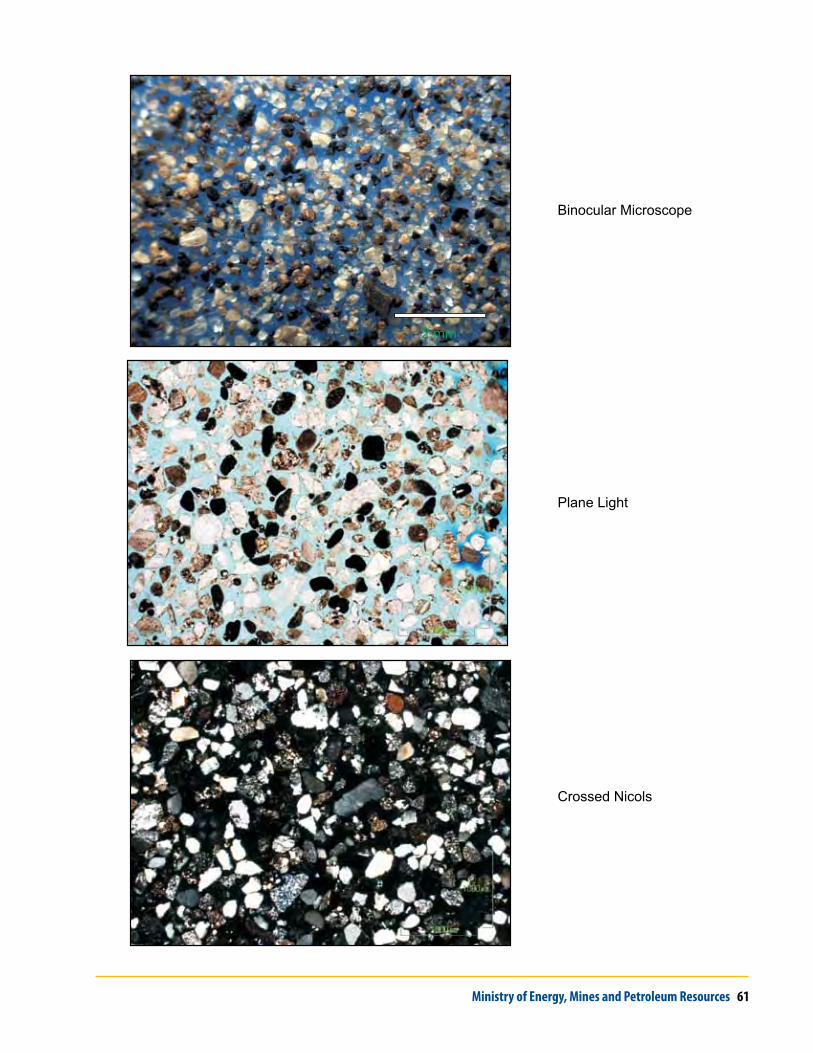
58 Geoscience Reports 2010
Sample ASH080616-01
Easting 519588
Northing 6040819
Genetic Origin Aeolian Dune
Comment:
This sample was collected from an excavation in an aeolian sand dune along Highway 97 near Bear Lake, British Columbia, west of the Rocky Mountains.
Sieve
SizeMass
Percent
Retained
Cummulative
Frequency
4.0 0.0 0.00 100.00
2.0 0.0 0.00 100.00
1.0 0.4 0.08 99.92
0.500 6.4 1.23 98.69
0.250 222.2 42.84 55.85
0.125 220.8 42.57 13.28
0.063 33.4 6.44 6.84
<0.063 35.5 6.84 0.00
Element Percent
SiO2 85.55
Al2O3 6.02
Fe2O3 2.66
MgO 0.77
CaO 0.77
Na2O 1.17
K2O 1.17
TiO2 0.34
P2O5 0.09
MnO 0.04
Cr2O3 0.013
LOI 1.3

Ministry of Energy, Mines and Petroleum Resources 59
Crossed Nicols
Plane Light
2 mm
Binocular Microscope

60 Geoscience Reports 2010
Sample ASH080623-02
Easting 614822
Northing 6207694
Genetic Origin Aeolian Dunes
Comment:
Sample was collected from well-developed parabolic sand dunes on a terrace of the lower Pine River. Dunes are up to 10 metres high, several hundred metres long, and are derived from glaciofluvial outwash and glacial Lake Peace sediments.
Sieve
SizeMass
Percent
Retained
Cummulative
Frequency
4.0 0.0 0.00 100.00
2.0 0.1 0.02 99.98
1.0 0.2 0.04 99.94
0.500 2.4 0.51 99.43
0.250 139.4 29.68 69.74
0.125 234.0 49.83 19.91
0.063 45.7 9.73 10.18
<0.063 47.8 10.18 0.00
Element Percent
SiO2 88.49
Al2O3 3.61
Fe2O3 3.18
MgO 0.33
CaO 0.67
Na2O 0.17
K2O 0.74
TiO2 0.20
P2O5 0.19
MnO 0.03
Cr2O3 0.005
LOI 2.3
Ministry of Energy, Mines and Petroleum Resources 61
Crossed Nicols
Plane Light
Binocular Microscope
2 mm

62 Geoscience Reports 2010
Sieve
SizeMass
Percent
Retained
Cummulative
Frequency
4.0 0.0 0.00 100.00
2.0 0.0 0.00 100.00
1.0 0.0 0.00 100.00
0.500 0.6 0.14 99.86
0.250 20.9 4.97 94.89
0.125 168.2 39.96 54.93
0.063 206.8 49.13 5.80
<0.063 24.4 5.80 0.00
Sample ASH080711-03
Easting 686542
Northing 6140750
Genetic Origin Aeolian Dune
Comment:
Sample was taken from the arm of a elongate parabolic sand dune on the distal side (east; downwind) of the Kiskatinaw Dune Field south of Dawson Creek.
Element Percent
SiO2 89.43
Al2O3 4.23
Fe2O3 2.22
MgO 0.28
CaO 0.35
Na2O 0.59
K2O 0.90
TiO2 0.19
P2O5 0.14
MnO 0.02
Cr2O3 0.005
LOI 1.5

Ministry of Energy, Mines and Petroleum Resources 63
Crossed Nicols
Plane Light
2 mm
Binocular Microscope

64 Geoscience Reports 2010
Sample ASH080711-01A
Easting 671684
Northing 6134020
Genetic Origin Aeolian Dune
Comment:
This samples was collected from the head of a sand dune in the Kiskatinaw Dune Field south of Dawson Creek. These dunes are more distal from source and appear to have a higher proportion of silica than more proximal dunes.
Sieve
SizeMass
Percent
Retained
Cummulative
Frequency
4.0 0.0 0.00 100.00
2.0 0.1 0.02 99.98
1.0 0.1 0.02 99.96
0.500 1.4 0.30 99.66
0.250 81.0 17.14 82.52
0.125 244.7 51.78 30.74
0.063 116.6 24.67 6.07
<0.063 28.7 6.07 0.00
Element Percent
SiO2 90.15
Al2O3 3.62
Fe2O3 2.33
MgO 0.31
CaO 0.31
Na2O 0.28
K2O 0.77
TiO2 0.22
P2O5 0.17
MnO 0.02
Cr2O3 0.004
LOI 1.7

Ministry of Energy, Mines and Petroleum Resources 65
Crossed Nicols
Plane Light
Binocular Microscope
2 mm

66 Geoscience Reports 2010
Sieve
SizeMass
Percent
Retained
Cummulative
Frequency
4.0 0.0 0.00 100.00
2.0 0.0 0.00 100.00
1.0 0.2 0.04 99.96
0.500 1.2 0.23 99.73
0.250 74.5 14.25 85.48
0.125 270.6 51.77 33.71
0.063 145.6 27.86 5.85
<0.063 30.6 5.85 0.00
Sample ASH080710-03
Easting 670194
Northing 6133138
Genetic Origin Aeolian Dune
Comment:
This sample was collected from an elongate parabolic dune in the Kiskatinaw Dune Field south of Dawson Creek. The dunes are 3 to 20 metres high, can extend for over a kilometre, and my be several hundred metres across at the dune head.
Element Percent
SiO2 86.34
Al2O3 3.47
Fe2O3 2.33
MgO 0.59
CaO 2.32
Na2O 0.27
K2O 0.76
TiO2 0.21
P2O5 0.19
MnO 0.02
Cr2O3 0.005
LOI 3.4

Ministry of Energy, Mines and Petroleum Resources 67
Crossed Nicols
Plane Light
2 mm
Binocular Microscope

68 Geoscience Reports 2010
Sample ASH080923-011
Easting 685093
Northing 6099906
Genetic Origin Glaciofluvial (Delta?)
Comment:
This sample was collected from a large sandy terrace near the Redwillow River. The material is up to 5 metres thick and consists of uniform medium sand. The feature may be a delta associates with glacial Lake Peace.
Sieve
SizeMass
Percent
Retained
Cummulative
Frequency
4.0 0.3 0.00 100.00
2.0 0.2 0.04 99.96
1.0 0.3 0.06 99.89
0.500 5.7 1.21 98.69
0.250 123.7 26.23 72.46
0.125 260.8 55.30 17.15
0.063 44.6 9.46 7.70
<0.063 36.3 7.70 0.00
Element Percent
SiO2 88.44
Al2O3 4.59
Fe2O3 2.41
MgO 0.35
CaO 0.28
Na2O 0.54
K2O 0.95
TiO2 0.24
P2O5 0.12
MnO 0.03
Cr2O3 0.005
LOI 2.0

Ministry of Energy, Mines and Petroleum Resources 69
Crossed Nicols
Plane Light
Binocular Microscope
2 mm

70 Geoscience Reports 2010
Sample TPAP03-32
Easting 522972
Northing 6520875
Genetic Origin Glaciofluvial
Comment:
This sample was collected from a 5 metre deep test pit on a sandy hill near the Fort Nelson Airport.
Sieve
SizeMass
Percent
Retained
Cummulative
Frequency
4.0 0.7 0.00 100.00
2.0 1.1 0.25 99.75
1.0 2.5 0.58 99.17
0.500 12.1 2.80 96.37
0.250 106.5 24.62 71.75
0.125 232.8 53.81 17.94
0.063 39.5 9.13 8.81
<0.063 38.1 8.81 0.00
Element Percent
SiO2 81.1
Al2O3 4.58
Fe2O3 2.04
MgO 0.84
CaO 4.38
Na2O 0.89
K2O 1.23
TiO2 0.15
P2O5 0.11
MnO 0.03
Cr2O3 <0.002
LOI 4.5

Ministry of Energy, Mines and Petroleum Resources 71
Crossed Nicols
Plane Light
Binocular Microscope
2 mm

72 Geoscience Reports 2010
Sample SUV05302
Easting 621520
Northing 6456212
Genetic Origin Aeolian Dunes
Comment:
This samples was collected from a compound parabolic dune from the main dune field north of Dazo Creek in the Fontas River Dune Field, east of Fort Nelson. Dune crests are up to 7 m high, with average sand thicknesses across the field estimated to be 10 m.
Sieve
SizeMass
Percent
Retained
Cummulative
Frequency
4.0 0.0 0.00 100.00
2.0 0.0 0.00 100.00
1.0 0.0 0.00 100.00
0.500 0.5 0.37 99.63
0.250 25.1 18.80 80.82
0.125 94.7 70.94 9.89
0.063 10.7 8.01 1.87
<0.063 2.5 1.87 0.00
Element Percent
SiO2 91.42
Al2O3 3.58
Fe2O3 2.22
MgO 0.18
CaO 0.44
Na2O 0.74
K2O 0.93
TiO2 0.11
P2O5 0.07
MnO 0.03
Cr2O3 0.002
LOI 0.2

Ministry of Energy, Mines and Petroleum Resources 73
Crossed Nicols
Plane Light
2 mm
Binocular Microscope

74 Geoscience Reports 2010
Element Percent
SiO2 90.96
Al2O3 3.51
Fe2O3 2.49
MgO 0.22
CaO 0.48
Na2O 0.74
K2O 0.85
TiO2 0.16
P2O5 0.08
MnO 0.03
Cr2O3 0.003
LOI 0.4
Sample SUV05303
Easting 621098
Northing 6456288
Genetic Origin Aeolian Dune
Comment:
This samples was collected from a compound parabolic dune from the main dune field north of Dazo Creek in the main Fontas River Dune Field, east of Fort Nelson. Dune crests are up to 7 m high, with average sand thicknesses across the field estimated to be 10 m.
Sieve
SizeMass
Percent
Retained
Cummulative
Frequency
4.0 0.0 0.00 100.00
2.0 0.0 0.00 100.00
1.0 0.0 0.00 100.00
0.500 0.8 0.57 99.43
0.250 41.9 29.76 69.67
0.125 88.7 63.00 6.68
0.063 7.8 5.54 1.14
<0.063 1.6 1.14 0.00

Ministry of Energy, Mines and Petroleum Resources 75
Crossed Nicols
Plane Light
2 mm
Binocular Microscope

76 Geoscience Reports 2010
Sample SUV05309
Easting 611404
Northing 6460199
Genetic Origin Aeolian Dune
Comment:
This sample was collected from a parabolic sand dune in the northwestern sub-field of the Fontas Dune Field. Dunes are up to 4 m high large parabolic forms several hundreds of metres in length, with only thin sand cover in the inter-dune regions.
Sieve
SizeMass
Percent
Retained
Cummulative
Frequency
4.0 0.0 0.00 100.00
2.0 0.0 0.00 100.00
1.0 0.0 0.00 100.00
0.500 1.5 1.19 98.81
0.250 28.0 22.28 76.53
0.125 84.2 66.98 9.55
0.063 10.9 8.67 0.88
<0.063 1.1 0.88 0.00
Element Percent
SiO2 90.62
Al2O3 3.83
Fe2O3 2.36
MgO 0.19
CaO 0.45
Na2O 0.78
K2O 0.99
TiO2 0.13
P2O5 0.08
MnO 0.03
Cr2O3 0.002
LOI 0.5

Ministry of Energy, Mines and Petroleum Resources 77
Crossed Nicols
Plane Light
2 mm
Binocular Microscope

78 Geoscience Reports 2010
Sample TFE0704-01
Easting 628362
Northing 6566463
Genetic Origin Glaciofluvial (Esker)
Comment:
The sample was collected from an esker that crosses Sierra-Yoyo_Desan road at kilometre 176. The sample was taken approximately 2 metres below the surface where an excavation has exposed the interior of the esker.
Sieve
SizeMass
Percent
Retained
Cummulative
Frequency
4.0 0.0 0.00 100.00
2.0 1.1 0.04 99.96
1.0 3.4 0.12 99.84
0.500 87.7 3.08 96.76
0.250 1886.6 66.32 30.43
0.125 707.6 24.88 5.56
0.063 60.5 2.13 3.43
<0.063 97.6 3.43 0.00
Element Percent
SiO2 85.01
Al2O3 4.86
Fe2O3 1.70
MgO 0.60
CaO 2.30
Na2O 0.85
K2O 1.35
TiO2 0.13
P2O5 0.10
MnO 0.02
Cr2O3 <0.002
LOI 3.0

Ministry of Energy, Mines and Petroleum Resources 79
Crossed Nicols
Plane Light
2 mm
Binocular Microscope

80 Geoscience Reports 2010
Sample TFE0704-02
Easting 581274
Northing 6540078
Genetic Origin Glaciofluvial (Esker)
Comment:
This sample was collected from the top of an esker (ridge) located west of the Komie Road. The esker is approximately 10 metres high, consisting mainly of sand with a thin 20 centimetre gravel lag at the surface.
Sieve
SizeMass
Percent
Retained
Cummulative
Frequency
4.0 0.0 0.00 100.00
2.0 18.2 0.94 100.00
1.0 11.2 0.58 99.06
0.500 171.5 8.82 98.49
0.250 906.4 46.61 89.67
0.125 352.7 18.14 43.05
0.063 62.3 3.20 24.92
<0.063 422.2 21.71 21.71
Element Percent
SiO2 83.89
Al2O3 6.08
Fe2O3 2.45
MgO 0.53
CaO 1.35
Na2O 0.96
K2O 1.51
TiO2 0.17
P2O5 0.08
MnO 0.03
Cr2O3 0.003
LOI 2.9

Ministry of Energy, Mines and Petroleum Resources 81
Crossed Nicols
Plane Light
2 mm
Binocular Microscope

82 Geoscience Reports 2010
Sample TFE0704-03
Easting 569040
Northing 6573180
Genetic Origin Glaciofluvial
Comment:
The sample was taken from a borrow pit in the Komie area east of the Geetlah Road. This is interpreted as a a glaciofluvial delta that formed in a shallow glacial lake. There are several active and past producing sand and gravel pits in the area.
Sieve
SizeMass
Percent
Retained
Cummulative
Frequency
4.0 0.0 0.00 100.00
2.0 1.3 0.10 99.90
1.0 2.6 0.19 99.71
0.500 65.3 4.87 94.84
0.250 1065.1 79.38 15.46
0.125 156.0 11.63 3.83
0.063 12.0 0.89 2.94
<0.063 39.4 2.94 0.00
Element Percent
SiO2 89.99
Al2O3 4.26
Fe2O3 2.00
MgO 0.23
CaO 0.43
Na2O 0.90
K2O 1.25
TiO2 0.10
P2O5 0.06
MnO 0.02
Cr2O3 <0.002
LOI 0.7

Ministry of Energy, Mines and Petroleum Resources 83
Crossed Nicols
Plane Light
Binocular Microscope
2 mm

84 Geoscience Reports 2010
Sample TFE0704-04
Easting 574987
Northing 6560341
Genetic Origin Glaciofluvial (Esker)
Comment:
Sample was collected from a recontoured borrow pit north of Courvoisier Creek, west of the Komie Road. The feature that hosts this deposit is an esker complex.
Sieve
SizeMass
Percent
Retained
Cummulative
Frequency
4.0 0.0 0.00 100.00
2.0 25.6 0.78 99.22
1.0 75.8 2.32 96.89
0.500 727.5 22.28 74.61
0.250 1929.0 59.08 15.53
0.125 224.0 6.86 8.67
0.063 35.0 1.07 7.59
<0.063 247.9 7.59 0.00
Element Percent
SiO2 87.01
Al2O3 5.70
Fe2O3 2.28
MgO 0.31
CaO 0.52
Na2O 1.14
K2O 1.65
TiO2 0.13
P2O5 0.08
MnO 0.03
Cr2O3 <0.002
LOI 1.1

Ministry of Energy, Mines and Petroleum Resources 85
Crossed Nicols
Plane Light
Binocular Microscope
2 mm

86 Geoscience Reports 2010
Sample TDE05-04
Easting 575001
Northing 6559192
Genetic Origin Glaciofluvial (esker)
Comment:
This sample was collected from a borrow pit near Courvoisier Creek. The pit is in an esker complex that contains sand and gravel.
Sieve
SizeMass
Percent
Retained
Cummulative
Frequency
4.0 0.0 0.00 100.00
2.0 0.0 0.00 100.00
1.0 0.0 0.00 100.00
0.500 8.2 1.84 98.16
0.250 339.2 76.11 22.06
0.125 68.7 15.41 6.64
0.063 6.1 1.37 5.27
<0.063 23.5 5.27 0.00
Element Percent
SiO2 85.97
Al2O3 4.16
Fe2O3 2.84
MgO 0.51
CaO 2.05
Na2O 0.84
K2O 1.16
TiO2 0.13
P2O5 0.09
MnO 0.02
Cr2O3 0.002
LOI 2.1

Ministry of Energy, Mines and Petroleum Resources 87
Crossed Nicols
Plane Light
Binocular Microscope
2 mm

88 Geoscience Reports 2010
Sample TFE0711-06
Easting 500943
Northing 6642203
Genetic Origin Glaciofluvial (Esker)
Comment:
The sample was collected from a 4 metres high esker west of the Liard Highway (Highway 77). The material in this deposit consist of a range of grain sizes ranging from pebble gravel to fine sand.
Sieve Size MassPercent
Retained
Cummulative
Frequency
4.0 0.0 0.00 100.00
2.0 1.3 0.10 99.90
1.0 2.6 0.19 99.71
0.500 65.3 4.87 94.84
0.250 1065.1 79.38 15.46
0.125 156.0 11.63 3.83
0.063 12.0 0.89 2.94
<0.063 39.4 2.94 0.00
Element Percent
SiO2 80.41
Al2O3 4.51
Fe2O3 1.66
MgO 0.97
CaO 5.00
Na2O 0.97
K2O 1.26
TiO2 0.12
P2O5 0.08
MnO 0.02
Cr2O3 <0.002
LOI 4.9

Ministry of Energy, Mines and Petroleum Resources 89
Crossed Nicols
Plane Light
2 mm
Binocular Microscope
90 Geoscience Reports 2010
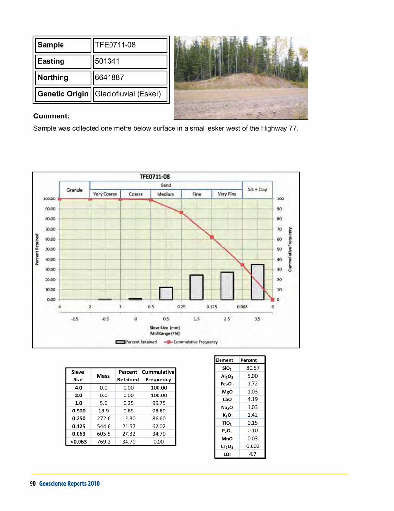
Sample TFE0711-08
Easting 501341
Northing 6641887
Genetic Origin Glaciofluvial (Esker)
Comment:
Sample was collected one metre below surface in a small esker west of the Highway 77.
Element Percent
SiO2 80.57
Al2O3 5.00
Fe2O3 1.72
MgO 1.03
CaO 4.19
Na2O 1.03
K2O 1.42
TiO2 0.15
P2O5 0.10
MnO 0.03
Cr2O3 0.002
LOI 4.7
Sieve
SizeMass
Percent
Retained
Cummulative
Frequency
4.0 0.0 0.00 100.00
2.0 0.0 0.00 100.00
1.0 5.6 0.25 99.75
0.500 18.9 0.85 98.89
0.250 272.6 12.30 86.60
0.125 544.6 24.57 62.02
0.063 605.5 27.32 34.70
<0.063 769.2 34.70 0.00
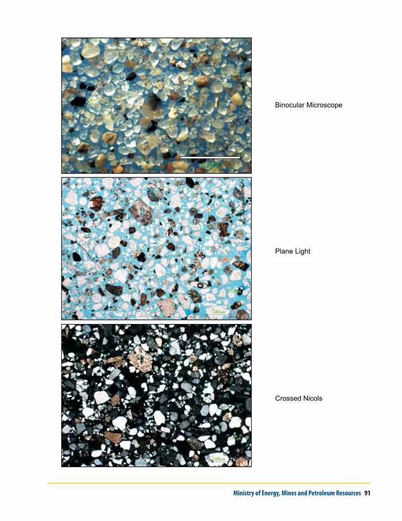
Ministry of Energy, Mines and Petroleum Resources 91
2 mm
Crossed Nicols
Plane Light
Binocular Microscope

92 Geoscience Reports 2010