Preliminary Assessment of Community Values
48
Preliminary Assessment of Community Values A Values-Driven Approach to Updating the Comprehensive Plan As stated in the State of the Land Use Report, the holistic revision to the Land Use Element presents an opportunity to bring together a values-driven and data-informed approach to updating the Comprehensive Plan. A values-driven approach to comprehensive planning focuses on issues and values expressed by citizens as the basis for developing the goals, policies, and implementation strategies of the plan. Engrained in the values-driven approach is the goal that planning for future growth and development should be guided by the things that people value about the place where they live and the ways in which they would like to see that place change for the better in the future. A values-driven approach to comprehensive planning will incorporate relevant data, including historic trends and current demographic and socio-economic statistics, with the purpose of informing the development of objectives and policies that implement the values-based vision and goals. Values-based Planning Approach - Phases • Values: Structured program of citizen involvement designed to identify community issues and values and build consensus • Vision: Articulation of an overarching concept or vision for the future of the community based on existing values and informed by locally relevant data and analysis • Formation of Goals, Objectives, and Policies: Translation of the overarching vision into specific policy direction supported by data Values Vision Goals, Objectives, & Policies 1
Transcript of Preliminary Assessment of Community Values

Preliminary Assessment of Community Values
A Values-Driven Approach to Updating the Comprehensive Plan As stated in the State of the Land Use Report, the holistic revision to the Land Use Element presents an opportunity to bring together a values-driven and data-informed approach to updating the Comprehensive Plan. A values-driven approach to comprehensive planning focuses on issues and values expressed by citizens as the basis for developing the goals, policies, and implementation strategies of the plan. Engrained in the values-driven approach is the goal that planning for future growth and development should be guided by the things that people value about the place where they live and the ways in which they would like to see that place change for the better in the future. A values-driven approach to comprehensive planning will incorporate relevant data, including historic trends and current demographic and socio-economic statistics, with the purpose of informing the development of objectives and policies that implement the values-based vision and goals.
Values-based Planning Approach - Phases
• Values: Structured program of citizen involvement designed to identify community issues and values and build consensus
• Vision: Articulation of an overarching concept or vision for the future of the community based on existing values and informed by locally relevant data and analysis
• Formation of Goals, Objectives, and Policies: Translation of the overarching vision into specific policy direction supported by data
Values Vision Goals,
Objectives, & Policies
1

Proposed Approach to Identifying Community Values During the Joint City/County Public Hearing on April 12, 2016, the County and City Commissions voted to accept the State of the Land Use Element report and directed staff to:
a. Move forward with a comprehensive revision to the Land Use Element to address the issues identified in the report, but maintain and expand on strong policies that continue to implement community goals for responsible growth and development
b. Utilize a values-based and data-informed planning approach to updating and revising the Land Use Element
c. First bring recommendations of action to the Joint Commission prior to seeking public input d. Integrate the Land Use and Mobility elements into a single element that jointly addresses land
use and transportation
Based on this direction, the proposed approach to identifying community values involves the following steps:
• Review recent and relevant planning and visioning efforts • Identify preliminary community values • Obtain feedback from the local planning agency • Obtain feedback from the City Commission and County Commission • Refine preliminary community values • Host a series of workshops across the community to gain input and feedback • Refine identified community values • Workshop identified community values with the Local Planning Agency • Workshop identified community values with the County Commission and City Commission
Review of Recent Visioning Efforts The State of the Land Use Element report included recommendations to “utilize recent community visioning efforts to identify current community values, priorities, and trends” and to “compile the findings of these analyses and integrate the results into the community outreach activities for the Comprehensive Plan Update project.” The following community visioning efforts were reviewed for current community values, priorities, and trends:
• County Commission Strategic Plan • City Commission Key Priorities for 2016 • 2016 Work Plan for Sense of Place Districts • 2035 Regional Mobility Plan • 2040 Regional Mobility Plan • Imagine Tallahassee • Leon County Sales Tax Committee Final Recommendations Regarding the Continuation of the
Local Government Infrastructure Surtax
2

• Blueprint 2000 and Beyond Report • Apalachee Ridge Estates Neighborhood Renaissance Plan • Providence Neighborhood Renaissance Plan • Capital Cascades Sector Plan • Lake Bradford Sector Plan • Oak Ridge Sector Plan • South Monroe Sector Plan • West Pensacola Sector Plan • Southern Strategy Area Report • South City Technical Assistance Panel Report
Summaries of these community visioning efforts are included as Appendix A.
National Guidance for Addressing Sustainability A common theme found in each of the recent community visioning efforts is sustainability. The community visioning efforts address the need to balance environment, economy, and equity in a coordinated way. These themes are consistent with the American Planning Association’s Sustaining Places Initiative. According to Sustaining Places: The Role of the Comprehensive Plan, published in 2012:
Planning for sustaining places is a dynamic, democratic process through which communities plan to meet the needs of current and future generations without compromising the ecosystems upon which they depend by balancing social, economic, and environmental resources, incorporating resilience, and linking local actions to regional and global concerns.
The Sustaining Places Initiative includes a set of standards capturing the various aspects of sustainability that communities should incorporate into their comprehensive plans. These standards include the following principles, processes, and attributes:
Principles • Livable Built Environment • Harmony with Nature • Resilient Economy • Interwoven Equity • Healthy Community • Responsible Regionalism
Processes • Authentic Participation • Accountable Implementation
3

Attributes • Consistent Content • Coordinated Characteristics
The Sustaining Places Initiative recognizes that there is no “one size fits all” solution and that communities across the nation have different development concerns and needs based on whether they are large or small, growing or declining, or urban or rural. The Sustaining Places Initiative standards can be adapted to the specific development concerns and needs of Tallahassee and Leon County to capture the various aspects of sustainability and incorporate them into the Tallahassee-Leon County Comprehensive Plan.
4

Identification of Preliminary Community Values Based on a review of recent visioning efforts, the following preliminary community values were identified:
Equity – The community values fairness and equity in providing services, safety, housing opportunities, economic opportunities, education, justice, and other elements that contribute to a high quality of life for all residents.
Livability – The community values fostering a safe, sustainable built environment that offers distinct, vibrant urban activity centers, nodes, neighborhood centers, key corridors, and green places for living, working, and recreating in the Capital Region.
Choice – The community values having lifestyle options and opportunities, and the freedom to make informed choices and decisions.
Opportunity – The community values having access to opportunities to flourish as individuals and as a community, and to improve our individual and collective lifestyles.
Stewardship – The community values the responsible management of our resources and assets.
Equity Livability Choice Opportunity Stewardship
City Commission Key Priorities for 2016 X X X X
County Commission Strategic Plan X X X X X
2016 Work Plan for Sense of Place Districts X X X X X
Regional Mobility Plans (2035 and 2040) X X X X
Imagine Tallahassee X X X X X
Sales Tax Extension Report X X X X X
Blueprint 2000 and Beyond X X X X XApalachee Ridge Estates Neighborhood Renaissance Plan X X X X
Providence Neighborhood Renaissance Plan X X X X
Capital Cascades Sector Plan X X
Lake Bradford Sector Plan X X X X
Oak Ridge Sector Plan X X X
South Monroe Sector Plan X X X X
West Pensacola Sector Plan X X X
Southern Strategy Area Report X X X X
ULI South City Plan X X X X
Preliminary Community Values
Rece
nt V
isio
ning
Eff
orts
5

Principles The application of the preliminary community values to land use and mobility is summarized in the following principles:
A healthy environment comes first – Ensuring that all parts of our community have access to clean water, clean air, and healthy blueways and green spaces is vital to the overall health and well-being of everyone in our community. The preservation of natural areas, including conservation areas, environmentally sensitive features, and water resources, is the top priority when making land use and transportation decisions. Environmental stewardship and economic development are not mutually exclusive values. Values: Equity, Livability, Opportunity, Stewardship
Maintain the distinction between rural and urban areas – Maintaining the distinction between rural and urban areas provides for more diversity in lifestyle choices while reducing sprawl, promoting efficient development patterns, lowering infrastructure costs, and emphasizing growth that pays for itself. Maintaining the distinction between rural and urban areas also supports the protection of areas used for agriculture, silviculture, and natural resource-based activities, the preservation of natural systems and ecosystem functions, and the protection of scenic vistas and pastoral development patterns. Values: Livability, Choice, Stewardship
Value and invest in mobility choices – Investments in mobility and transportation options should be made in ways that allow residents to make choices about how they travel through the provision of a network of roadways, trails, sidewalks, bicycle facilities, and transit service. Values: Equity, Livability, Choice, Opportunity, Stewardship
Housing diversity and choice for all – Having diversity of the housing stock offers greater choice, provides opportunities to people with varying income levels, and allows more flexibility to people in different stages of life. Land use decisions should allow for a greater diversity of housing and should specifically address Missing Middle Housing, including duplexes, fourplexes, bungalow courts, and mansion apartments that are not bigger than a house. Land Use decisions should also specifically address density to transit and non-motorized forms of transportation. Values: Equity, Livability, Choice, Opportunity
Human scale neighborhoods and places – Neighborhoods, activity centers, and nodes (such as Bradfordville and rural communities) should be designed and built at a human scale to achieve lively, safe, sustainable, and healthy places. Walkability, density, and a diverse mix of land uses are characteristic of human scaled places. Values: Livability, Choice, Stewardship
Economic Opportunity – Economic opportunity and access to economic opportunity should be achieved by growing the local economy, promoting innovation, expanding access to training and job
6

opportunities, incubating local businesses, and attracting new businesses. Values: Equity, Livability, Choice, Opportunity
Respect regional interconnectedness – Leon County and the City of Tallahassee serve a specific role as the economic hub and urban center in the region. Additionally, factors such as natural features and resources, wildlife habitats, and transportation networks do not fit solely within political boundaries. Land use and mobility decisions should reflect the importance of context and scale at the neighborhood, sector, city, county, and regional level. Values: Equity, Livability, Stewardship
Healthy Communities – Land use and mobility decisions should provide for access to recreational opportunities, healthy food, and health services, while ensuring environmental justice and safe neighborhoods. Values: Equity, Livability, Opportunity
7
Proposed Next Steps Based on direction from the City and County Commissions, Planning Department Staff will facilitate a discussion of the community values and vision with both Commissions prior to seeking public input. This Preliminary Assessment of Community Values is intended to serve as the beginning point for the discussion and not a final list of community values. The preliminary list of community values will evolve as the County Commission, the City Commission, the Local Planning Agency, and the public provide input and feedback. Based on this approach, the following next steps are proposed:
1. Facilitate a discussion of community values and vision with the City Commission on May 18, 2016 and Board of County Commissioner on May 24, 2016 prior to seeking public input
2. Refine and revise the list of preliminary community values based on direction from the City Commission and County Commission
3. Using the revised list of community values, develop a public participation plan to outline an approach to gaining public feedback on community values
8

Appendix A Summaries of Recent Visioning Efforts
9

Summary of the Leon County Board of County Commissioners Strategic Plan for Fiscal Years 2012 to Fiscal Year 2016
Completed by the Leon County Board of County Commissioners and updated in January 2016, the Strategic Plan identifies a vision, core values, and strategic priorities. The Strategic plan also includes strategic initiatives that relate to the strategic priorities and core practices that put the core values into action.
Vision The Strategic Plan includes the following Vision for Leon County:
As home to Florida’s capitol, Leon County is a welcoming, diverse, healthy, and vibrant community, recognized as a great place to live, work and raise a family. Residents and visitors alike enjoy the stunning beauty of the unspoiled natural environment and a rich array of educational, recreational, cultural and social offerings for people of all ages. Leon County government is a responsible steward of the community’s precious resources, the catalyst for engaging citizens, community, business and regional partners, and a provider of efficient services, which balance economic, environmental, and quality of life goals.
Core Organizational Values The Strategic Plan identifies the following core organizational values as the foundation for the County’s people focused, performance driven culture:
• Service • Relevance • Integrity • Accountability • Respect
• Collaboration • Stewardship • Performance • Transparency • Vision
Strategic Priorities The Strategic Plan outlines the following strategic priorities for Leon Count for FY 2012-2016:
• Economy - To be an effective leader and a reliable partner in our continuous efforts to make Leon County a place which attracts talent, to grow and diversify our local economy, and to realize our full economic competitiveness in a global economy.
• Environment - To be a responsible steward of our precious natural resources in our continuous efforts to make Leon County a place which values our environment and natural beauty as a vital component of our community’s health, economic strength and social offerings.
A-1
• Quality of Life - To be a provider of essential services in our continuous efforts to make Leon County a place where people are healthy, safe, and connected to their community
• Governance - To be a model local government which our citizens trust and to which other local governments aspire.
Core Practices The Strategic Plan lists the following core practices that Leon County employees commit to in order to put the Core Values into practice:
• Delivering the “Wow” factor in Customer Service • Connecting with Citizens • Demonstrating Highest Standards of Public Service • Accepting Accountability • Exhibiting Respect • Employing Team Approach • Exercising Responsible Stewardship of the Community’s Resources • Living our “People Focused, Performance Driven” Culture
Summary The Strategic Plan, most recently updated in January 2016, describes the vision the Leon County Board of County Commissioners has for Leon County. The Strategic Plan also describes the core organizational values, strategic priorities with strategic initiatives, and core practices for County employees to realize the vision.
A-2

Summary of the City of Tallahassee Commission Key Priorities for 2016 At the City Commission retreat in January 2016, the City of Tallahassee Commission identified four priorities for the year to keep the positive momentum in the City moving forward.
Priorities for 2016
The following priorities were established for 2016:
• Southside - There will be a continued focus on enhancing quality of life on the Southside, with an emphasis on decreasing crime through community oriented public safety programs, early childhood development, the Community Human Service Partnership program and identifying additional resources.
• Housing and Health - Opportunities to enhance affordable housing options and the overall health of our community with a focus on our aging population will be explored.
• Sense-of-place - Efforts to create more walkable, attractive areas that draw visitors and residents to key districts around Tallahassee will continue to be a focus. Incorporating public art will be a significant piece of this effort.
• Blueprint - Prioritize City projects and initiatives that will be funded with 2020 Blueprint sales tax dollars.
Commission Workshops
To discuss and address the identified priorities, the Commission scheduled subsequent workshops throughout the year. Specific workshops were scheduled to address:
• Southside initiatives • Sense-of-Place • Budget • Community Safety • Blueprint • Sense-of-place/Arts
Additionally, updates at regularly scheduled Commission meetings on the following topics will be provided throughout the year:
• Convention center • Partnerships with local universities and state government • The Tallahassee Innovation Partnership • Community safety and gun violence • Development of a community school • A strategic five-year plan for WCOT that includes more community content
A-3

Summary of the 2016 Sense of Place Work Plan Consistent with the City of Tallahassee Commissions 2016 Key Priorities, the City Commission approved a 2016 Sense of Place Work Plan in February 2016.
2016 Sense of Place Work Plan
Following a presentation from staff, the Commission unanimously approved a 2016 work plan that includes:
• Development and implementation of the Gaines Street area parking plan and parking wayfinding signs
• Completion of planning and installation of wayfinding signage for Downtown Phase 2 and Midtown
• Support for the Midtown Merchants second annual Taloofa Festival in May 2016 and expend the remaining events and promotions funds allocated for Midtown
• Continuation of Underground Utilities' efforts on the Maclay Boulevard Stormwater Facility • Completion of Miccosukee Community Sense of Place Study (County Strategic Initiative) • Exploration of expanded parking options in Midtown • Exploration of possibilities for pet-friendly pocket parks in urban areas
A-4

Summary of 2035 Regional Mobility Plan Visioning The 2035 Regional Mobility Plan (RMP) currently serves as the Long Range Transportation Plan for the Capital Region Transportation Planning Agency (CRTPA). The 2035 RMP will be replaced by the 2040 RMP when adopted.
While primarily focused on transportation, the 2035 RMP did address the connection between land use and transportation.
Guiding Principles Of the multiple guiding principles for the 2035 RMP, the following specifically acknowledge the link between transportation and land use:
• The Regional Mobility Plan should be based on a principle of sustainability that will serve all citizens in the region in the future through an interconnected, safe and secure network. The integrated transportation network will support a prosperous regional economy and help conserve the region’s natural and recreational assets.
• The plan should support economic competitiveness and prosperity for the Capital Region through active consideration of both transportation and land use policies.
• The plan should identify the important local and regional land use policies and connections to the regional transportation system, plan and investments and seek to promote policies that will enhance the quality of life in communities of the region.
• The plan should consider the impact of new communication technologies and infrastructure on transportation choices, seek to enhance the opportunities for utilizing technology for promoting regional mobility, support green strategies for energy efficiency, provide stewardship of the region’s natural system and anticipate the impact of climate changes for the regional transportation system.
Smart Growth Principles In addition to the guiding principles, the 2035 RMP project team identified a series of smart growth principles to address sustainability in the plan. The following smart growth principles address the land use connection with sustainability:
• Create Walkable Neighborhoods: Walkable communities are desirable places to live, work, learn, worship and play, and therefore a key component of smart growth.
• Foster Distinctive, Attractive Communities with a Strong Sense of Place: Smart growth encourages communities to craft a vision and set standards for development and construction which respond to community values of architectural beauty and distinctiveness, as well as expanded choices in housing and transportation.
• Mix Land Uses: Smart growth supports the integration of mixed land uses into communities as a critical component of achieving better places to live.
• Preserve Open Space, Farmland, Natural Beauty and Critical Environmental Areas: Open space preservation supports smart growth goals by bolstering local economies, preserving critical
A-5

environmental areas, improving our community’s quality of life, and guiding new growth into existing communities.
• Strengthen and Direct Development Towards Existing Communities: Smart growth directs development towards existing communities already served by infrastructure, seeking to utilize the resources that existing neighborhoods offer, and conserve open space and irreplaceable natural resources on the urban fringe.
• Take Advantage of Compact Building Design: Smart growth provides a means for communities to incorporate more compact building design as an alternative to conventional, land consumptive development.
Goals and Objectives Based on the guiding principles and smart growth principles, Goals and Objectives were established for the 2035 RMP. These Goals and Objectives addressed access, connectivity, coordination, economic development, financial feasibility, land use, multimodalism, natural resource protection/conservation, public participation, safety and public health, and security. While many of the goals and objectives addressed land use, the specific Land Use Goals and Objectives were:
Land Use Goal: Coordinate transportation and land use systems to foster vibrant communities with compact urban forms throughout the region.
Objectives:
1. Provide for the development of compact, mixed use, walkable neighborhoods and neighborhood centers to minimize travel distances and enhance pedestrian and bicycle mobility and transit accessibility.
2. Support compatible infill development and the redevelopment of existing employment and activity centers, under-utilized commercial lands, and transit corridors to efficiently use existing infrastructure, enhance accessibility, and support transit services.
3. Improve the interconnectivity of streets, sidewalks, trails, and other transportation system components to enhance the grid network and provide safe and convenient pedestrian, bicycle, and motor vehicle mobility.
4. Develop context sensitive design standards for transportation facilities to protect and enhance community character, contribute to attractive and safe “complete streets,” and encourage the use of multiple modes of transportation.
5. Minimize the amount of land devoted to automobile parking. 6. Work with local governments to develop comprehensive plans that support compact, mixed use
development and enable the use of multiple modes of transportation including walking, biking, and transit.
7. Establish performance standards and report on the coordination of transportation and land use systems.
A-6
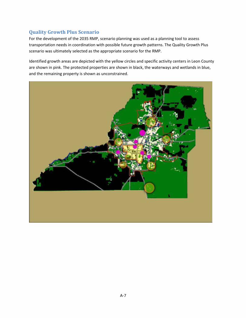
Quality Growth Plus Scenario For the development of the 2035 RMP, scenario planning was used as a planning tool to assess transportation needs in coordination with possible future growth patterns. The Quality Growth Plus scenario was ultimately selected as the appropriate scenario for the RMP.
Identified growth areas are depicted with the yellow circles and specific activity centers in Leon County are shown in pink. The protected properties are shown in black, the waterways and wetlands in blue, and the remaining property is shown as unconstrained.
A-7

Summary of 2040 Regional Mobility Plan Visioning While the 2040 RMP is not complete and, therefore, has not been adopted, the majority of the visioning for the plan is finished.
2040 RMP Goals The CRTPA Board adopted nine goals for the 2040 RMP. These goals are: Economic Development, Multimodalism, Land Use, Natural Resource Protection/Conservation, Safety, Public Health, Security, Access, and Connectivity.
The Land Use Goal is:
Land Use - Coordinate Transportation Strategies and Investments with local and regional land use initiatives in an effort to foster vibrant communities throughout the region.
Public Participation Results In addition to the adopted goals, visioning was completed for the 2040 RMP through a series of public workshops held in each of the counties in the CRTPA Region. Summaries of the public workshops are available on the project website.
Community Priorities During the Public Workshops held in May 2014, the public throughout the CRTPA Region expressed that their top priority is livability and safety. Participants at the Leon County workshops specifically expressed that their priorities are:
1. Livability & Safety 2. Mobility Options 3. Environmental Stewardship 4. Traffic & Roads 5. Economic vitality & Tourism 6. Barriers & Constraints
While most of the comments from participants at the public workshop in Leon County were focused on transportation, the following public comments address land use:
• “We need to continue and accelerate our improvements to alternative transit, while creating the dense mixed-use living areas that support use of alternative transit.”
• “Integration of land use and transportation with focus on sustainable (compact) patterns of development.”
• “Encourage more diverse mode choice and dense development patterns by changing the system of mode choice incentive/disincentive.”
A-8

Community Connections The public input provided at the October 7, 2014 public workshop in Leon County reiterated the need to link transportation and land use. Specifically, the public noted that the following locations are the most important locations to connect in the community:
• Tallahassee Regional Airport • Downtown Tallahassee • Parks • Midtown Tallahassee • University Campuses • Thomasville Road Corridor • Schools in the region
Summary of 2035 and 2040 RMP Vision When considered together, the visioning and public input for the 2035 RMP and the 2040 RMP indicate that land use and transportation are linked and that our community should consider them in concert. These efforts also indicate that land uses should be arranged in a manner that promotes walking and bicycling as viable forms of transportation. Land uses should also allow for density that supports transit. Environmentally significant and environmentally sensitive lands should be conserved, and historically and culturally significant places should be protected.
When developing goals, objectives, and strategies for the Future Land Use Element, consideration should be given to how they will be implemented. Future plans, including the next update to the Regional Mobility Plan, as well as future amendments to other comprehensive plan elements should reflect the vision established in the Future Land Use Element. The Regional Mobility Plan is scheduled to be updated again in five years.
A-9

Summary of Imagine Tallahassee Completed in 2013, Imagine Tallahassee was a grassroots public/private partnership financed with private funds and supported by County and City staff to conduct a visioning exercise to provide citizens an opportunity to identify a vision for their community and set a course toward economic development. The vision is intended to serve as an overall goal in order to guide economic developments strategies, capital investment decisions, and ensure Tallahassee’s success for generations to come. The Imagine Tallahassee visioning process included an open house, two community forums, and a series of “meetings in a box.” With direction from the Vision Plan Steering Committee, the input received during the visioning process was used to develop the Vision Statement: IMAGINE TALLAHASSEE, inspired by our unique heritage and beauty, empowers and rewards entrepreneurship and innovation to create and sustain a vibrant community where businesses, individuals and families thrive. Our success will be achieved through targeted initiatives and investments on three fronts, setting in motion progress to ensure that:
TALLAHASSEE WORKS with a vibrant, diversified economy and quality employment;
TALLAHASSEE INSPIRES
with a unique character, natural beauty, vibrantly diverse culture and energy, warm hospitality and
TALLAHASSEE CONNECTS with a balanced and sustainable pattern of development and supporting infrastructure, a range of
mobility choices and effective and efficient governance.
Vision Themes Consistent with the Vision Statement, Imagine Tallahassee includes the following Vision Themes:
Tallahassee Works: Tallahassee will strengthen and diversify its economy, reduce its reliance on state government; grow local businesses and attract new businesses by leveraging and marketing its assets and through the strategic use of sales tax funds on focused economic development initiatives.
• Grow Local Business • Attract New Investment and Industries
Tallahassee Inspires: Tallahassee will offer a unique spirit and vibe, a combination of a special place with unique character and caring people. It will be a community that is fertile ground for creativity and innovation, making Tallahassee a multi-faceted destination and community of choice.
• Retain and Enhance Our Identity, Spirit, and Connectedness • Become a Destination • Value and Invest In Our People • Retain and Enhance Our Unique Community Character
A-10

Tallahassee Connects: Tallahassee’s physical development pattern will promote livability and wise resource use along with infrastructure systems that support sound growth by providing for multi-modal mobility for the effective management of sustainable development.
• Improve Regional Accessibility • Improve Local Mobility • Pattern of Growth and Development that Supports Livability
Strategic Directions Following the development of the Vision Statement, the Vision Plan Steering Committee identified Strategic Directions focused specifically on economic development. The Strategic Directions are:
• Creating & Sustaining an Entrepreneurial Ecosystem • Becoming and Competing as an Economic Hub • Growing Our Destination Product for Travel and Tourism • Supporting a Creative Culture and Urban Lifestyle • Investing in Our Human Assets
Summary Imagine Tallahassee establishes a vision that is intended to serve as an overall goal in order to guide economic developments strategies, capital investment decisions, and ensure Tallahassee’s success for generations to come. This vision encourages the diversification of our economy, integrating both land use and transportation into economic development initiatives, promoting multimodal transportation, acknowledging the role Tallahassee has in the overall Capital Region, retaining and enhancing our identity, and investing in our people.
A-11

Summary of Leon County Sales Tax Committee Final Report The Leon County Sales Tax Committee Final Recommendations Regarding the Continuation of the Local Government Infrastructure Surtax report outlines advisory feedback on the projects considered by the Sales Tax committee for funding by the extension of the penny sales tax, which was approved by referendum on November 4, 2014. The Sales Tax Committee was appointed by the Leon County Board of County Commissioners and City of Tallahassee Commissioners and represented a broad cross section of our community, including representatives from the Greater Tallahassee Chamber of Commerce, Capital City Chamber of Commerce, Blueprint Citizen Advisory Committee, and the Economic and Environmental Consensus Committee. The Committee held its first meeting in January 2012 and spent its first year gathering information and receiving public input. Throughout this process, the Committee was committed to engaging the public and reserved the first portion of each meeting to allow the community time to voice their comments, recommendations, or preferred projects for consideration. During the second year, the Committee engaged in a thorough evaluation process of all the projects brought forth for its consideration. The Committee completed its charge on January 30, 2014.
Themes and Action Statements These themes and action statements served as a guide throughout the Committee’s project evaluation process: Regional Mobility/Transportation: Projects that create an integrated regional multimodal network that considers air, mass transit, automobile, bike, and pedestrian transportation modes. This holistic transportation network provides the most options for moving people and goods economically, effectively, and safely while protecting the environment, promoting economic development, and maintaining a high quality of life with sustainable development patterns. Sense of Community: Projects that create special urban places which foster a sense of community and inspire a creative class that builds relationships to solve local problems with local solutions in an inclusive environment. Water Quality: Projects that protect our natural environment through sensitive land acquisitions and by providing the appropriate infrastructure. Connectivity: Projects that link current amenities, neighborhoods, and/or multi-modal nodes through sidewalks, multi-use paths, bike lanes, transit, and roadway improvements. Economic Vitality: Projects that encourage quality development/redevelopment within our community that will promote the creation of new employment opportunities, sustain and enhance economic vitality, and promote the quality of life in our community. Parks/Ecotourism: Projects that promote public recreation and eco-tourism while protecting and preserving the community’s environment and natural resources.
A-12

Vertical Infrastructure: Projects that are fixed capital assets associated with the construction, reconstruction, or improved public facility with a life expectancy of five years or more in accordance with Florida Statute. Gateways: Projects that develop distinct community entryways that showcase the character and beauty of Tallahassee and foster a unique sense of place.
Summary The Leon County Sales Tax Committee’s Final Report, developed through a process that engaged the public, established themes and action statements representing community priorities. The Final Report outlines advisory feedback on the projects considered by the Sales Tax committee. With the projects identified, voters approved the sales tax extension through a referendum in 2014.
A-13

Summary of Blueprint 2000 and Beyond Report The Blueprint 2000 and Beyond report was developed in 1999 by a group of citizens representing a broad spectrum of the community including business, environmental and neighborhood interests, called the Economic and Environmental Consensus Committee (EECC). Their guide to an effective and efficient infrastructure and natural resource management is the basis of the proposed sales tax extension with 80% of future sales tax proceeds being committed to Blueprint 2000 projects. The remaining 20% would be split 10% each to the County and the City for other high priority sales tax eligible projects. The report identified five interrelated and interconnected community challenges and five initiatives to address the challenges. The report outlines recommendations based on each of the five initiatives. Community Challenges Challenge 1: Improvements to our mobility and transportation systems to include locally acceptable transit, mobility, and roadway choices Challenge 2: Protection, enhancement, and improved utilization of floodplains and natural water resources Challenge 3: Implementation of Joint Comprehensive Water Resource Plan that emphasizes non-structural solutions and retro-fitting of stormwater facilities in urban areas Challenge 4: Stimulate investment and activity in the southern Strategy Area by expanding employment and housing choices Challenge 5: Usher in a new era of cooperation and collaboration regarding land use, transportation, and watershed planning Initiatives
• Initiative 1: Watershed and Sector level planning processes • Initiative 2: Holistic infrastructure development approaches • Initiative 3: Corridor level implementation of projects • Initiative 4: Southern Strategy Area focus and incentives • Initiative 5: Fiscal resources and management
A-14

Summary of the Apalachee Ridge Estates Neighborhood Renaissance Plan
In December 2001, the City adopted the Apalachee Ridge Estates Neighborhood Renaissance Plan, the first neighborhood plan prepared under the Community Neighborhood Renaissance Partnership Program (CNRP).
THE PLAN The Plan was written by the neighborhood for the neighborhood. The plan was the result of an extensive collaborative and holistic community effort which engaged neighborhood residents, City and County staff, members of the Community Neighborhood Renaissance Partnership and staff from membership organizations, Covenant Partners, and other interested citizens in the Tallahassee-Leon County community. All residents and property owners in the neighborhood were invited to participate in some manner in the plan development process. The Plan identified neighborhood and community issues, which were of major concerns to the neighborhood, and how the neighborhood proposed to address them. The purpose of the plan, therefore, was to provide direction for future development, City and County programs as well as programs offered by Community Renaissance Partnership and non-partnership institutions as they affect or will affect Apalachee Ridge Estates. The plan provides a clear vision of the neighborhood’s priorities, needs, goals and desired outcomes as well as consensus on how things should be done. The plan advises businesses, governmental and non-profit agencies, and the neighborhood of what future activities will be supported and endorsed by the neighborhood. The plan addresses the following issues:
1) Neighborhood Safety; 2) Recreation Facilities and Services; 3) Flooding & Drainage; 4) Neighborhood Clean Up; 5) Public Transportation; 6) Homeownership; 7) Home Retention, Rehabilitation and Modernization; 8) Rental Housing Rehabilitation; 9) Neighborhood Character & Beautification; 10) Economic Development; 11) Students Skills/Performance; 12) Improved School Facilities; and 13) Adult and Community Education.
Below are brief summaries, for each of the above issue area.
Neighborhood Safety: This section of the neighborhood plan identified strategies and implementing tasks to address cut-through traffic and speeding, crime, the wall along Orange Avenue, poorly lit streets, and fire protection. Projects such as the construction of sidewalks, bikeways, pedestrian crossings, traffic calming devices, additional street lights, fire hydrants and new wall along Orange Avenue were included in the plan.
A-15

Recreational Facilities & Services: The main project identified by the plan to address the recreational needs of the residents was the construction and operation of a neighborhood center with a swimming pool at the Jack McLean, Jr., Park. In 2002, the City advanced funded the construction of the center and construction commenced in 2003. Flooding and Drainage: Flooding was identified as the neighborhood’s number one priority issue. The construction of a new drainage system to handle stormwater run-off in both the eastern and western sections of the neighborhood was one of the desired outcomes of the plan. The residents also desired to have the berm in the Jack McLean Park properly maintained to reduce flooding in the neighborhood. To address the flooding in the western part of the neighborhood (west of Webster Street) and in the neighborhood west of the Apalachee Ridge Estates, the City’s Stormwater Division constructed a stormwater facility on Tartary Drive. As part of this stormwater project, larger storm sewers were laid in the neighborhood west of Webster Street. Neighborhood Clean Up: As part of its renaissance efforts, the ARENA wanted to increase recycling of household trash and to improve the general appearance of the neighborhood and surrounding areas. ARENA has held several amnesty days in the neighborhood in conjunction with the Solid Waste Department. Public Transportation: The plan recommended that TALTRAN (now Starmetro) evaluate the need for changes in its route within the neighborhood. Starmetro held meetings on this matter with the residents but residents opposed the route change and Starmetro decided not to proceed with any route changes until a consensus could be developed within the neighborhood as to where the bus route should go. Homeownership: Homeownership is one of the keys to effective neighborhood revitalization. One of the stated goals of the Apalachee Ridge Estates Neighborhood Renaissance Plan is a 15% increase in the rate of homeownership. In 1998, there were 209 owner-occupied homes in the neighborhood. In 1999, when the Community Neighborhood Renaissance Program began in the neighborhood, owner-occupied units had declined to 197. Home Retention, Rehabilitation and Modernization: In 2001, several homes in the neighborhood, especially those in the northern section of the neighborhood, were starting to show signs of deterioration. The neighborhood plan included strategies to help homeowners make minor repairs to their homes as well as to modernize their homes. Among other things, the plan called for the creation of a mini-loan/grant program, which would provide grants to income-eligible homeowners and small loans to others to make curb-appeal improvements to their homes and yards. Rental Rehabilitation: Approximately 33 percent of the neighborhood’s housing is non owner-occupied. Currently, there is no public assistance available to owners of the rental housing for rehabilitation efforts. Residents have suggested increase code-enforcement to address care of premise issues with rental properties. Neighborhood Beautification: The neighborhood’s objectives under this section of the plan is to maintained the single family nature of the neighborhood and to create a sense of community among the residents through neighborhood beautification projects. The neighborhood has implemented many projects in this area, including the annual Holiday Lights Competition and encouraging residents to plant gardens in the spring.
A-16

Economic Development: This section of the neighborhood’s plan addressed access to job training, the establishment of a learning center to provide educational opportunities, attracting new businesses to south side Tallahassee, and supporting existing businesses. Through a collaborative partnership, a learning center was opened in the neighborhood in 2002. The learning center provides the residents of Apalachee Ridge Estates, especially children and youths, with Internet access, after school tutorial and online academic resources. Education & Community Involvement: One of the objectives of the neighborhood plan is a new or updated elementary school. The neighborhood association participated in the selection of a site for a new elementary school for the southside but was unable to persuade the School Board to select the Fairgrounds site for the school.
A-17

Summary of the Providence Neighborhood Renaissance Plan The Providence neighborhood is located in the southwest quadrant of the City. The CSX Railroad lines bound the neighborhood on the north, Hutchinson and Levy Avenues on the south, Iamonia and Hillsborough Streets on the west and Lake Bradford Road on the east. When the Plan was developed, the population of the neighborhood was 1,423, with a significant African American population (87%). The neighborhood’s population was relatively young with approximately 29% of the population children under the age of 17 and 30% between the ages of 18-24 (college-age cohort). Thirty-three (33) % of the neighborhood’s population was college students. Also at the time of the development of the Providence Plan, there were 890 dwelling units in the Providence neighborhood. Homeownership, however, was only 10.3%, which means the majority of the housing units in the neighborhood were held for rental purposes. The vacancy rate in the neighborhood was 22%, which was almost three times the citywide vacancy rate and could have been attributed to the substandard quality of the housing stock and the perception that the area was a crime/drug hot spot. Most of the single-family homes in the neighborhood were built in the 1940’s and the 1950’s while most of the apartments were built during the 1970’s. The conditions of the homes in the neighborhood range from well-kept homes to abandoned, boarded-up and vacant homes. THE PLAN The Providence Neighborhood Renaissance Plan was written by neighborhood resident for the neighborhood. The plan addressed 14 issues grouped under five major themes: Themes Getting Everyone
Involved Keeping the Neighborhood Clean & Safe
Taking Care of our People
We must own our Neighborhood
A Face for the Future
I S S
U E
S
Neighborhood Involvement/Outreach Neighborhood Pride
Neighborhood Cleanup Neighborhood Safety Crime
Neighborhood Center Human Development Landlord/Tenant Issues
Homeownership Neighborhood Ownership Housing Rehabilitation (owner-occupied) Housing Rehabilitation (rental housing)
Zoning Streetscape
For each of the above issue areas, the neighborhood plan identified goals and desired outcomes. The “desired outcomes” provided the measurable criteria that were to be used to determine the effectiveness of the plan. In addition, the plan included strategies and implementing tasks to address these issues. Below are the highlights of the plan based on the neighborhood priority issue areas.
A-18

Priority Issues
a) Community Center Among the residents of Providence, the development of a neighborhood center in or adjacent to the neighborhood to serve neighborhood residents was consistently listed as the number one issue for this community. The adopted neighborhood plan calls for the establishment of a planning committee to further evaluate the issue of the community center with regard to:
1) Facility type and size; 2) Facility siting; 3) Funding; 4) Programming (programs and services to be provided by the center); 5) Management & Sustainability (who will run and sustain the center); and 6) Coordination with community partners (keeping others involved).
On September 12, 2012, this priority issue materialized with the grand opening of the Delta Kappa Omega/Providence Community Center on 1908 Highland Street.
b) Crime
Crime prevention and reduction was another top concern for the Providence neighborhood. The neighborhood plan identifies a number of strategies and tasks to help prevent and reduce crime in the neighborhood. These strategies included fostering a positive relationship between law enforcement officers and neighborhood residents, especially children; strengthening the existing neighborhood crime watch program; and the improvement of safety awareness. In terms of implementing tasks, the plan called for the development of incentives for law enforcement officers to live in the neighborhood through the “Officer Next Door Program”; recruiting additional residents to join the neighborhood crime watch and requesting the Tallahassee Police Department to set up a pilot program to help landlords screen prospective tenants.
c) Neighborhood Cleanup
One of the issues facing the Providence neighborhood was its image and appearance. Sixty percent (60%) of the respondents to the Providence Community Action Survey felt that their neighborhood was unkempt and had a litter problem. Seventy percent (70%) felt that the
A-19

houses in the neighborhood were unattractive. There was no consensus on the issue regarding whether landlords took good care of their properties. Forty-one percent (41.2) % of those surveyed agreed, 42.6% disagreed while 16.2% did not know. When residents were asked where effort should be concentrated in the neighborhood cleanup projects, the majority felt that the most effort should be spent on aggressive code enforcement and the implementation of the neighborhood beautification plans.
d) Streetscape
The Providence Community Action Survey Report (FSU 2002) shows that most residents (85%) want sidewalks on the streets in the neighborhood. Residents also identified the lack of sidewalks as one of the things they disliked about the neighborhood. Other streetscape improvements identified by residents include additional streetlights, closure of open ditches, and landscaping. Approximately 65% of the survey respondents agreed with the statement that their neighborhood is in need of additional streetlights.
Of the strategies proposed by the neighborhood plan to address this issue, residents wanted to see most effort spent on rebuilding neighborhood streets to meet present safety standards. Six of the streets in the neighborhood were included in the Neighborhood Infrastructure Enhancement Capital Improvement Project for various types of improvements projecting to cost approximately $6,069,320.
e) Housing Issues
The Providence Neighborhood Renaissance Plan also addressed a variety of housing issues. Specifically, the plan addressed housing rehabilitation, homeownership, neighborhood ownership, infill housing, and a pattern book to guide future development and redevelopment activities. In prioritizing housing strategies, residents identified the following strategies as key to resolving some of the housing issues in their neighborhood:
1) Provision of financial assistance to homeowners to assist with making repairs to their homes;
A-20

2) Professional assessment of the housing rehabilitation needs in the neighborhood;
3) Provision of incentives for the renovation and retention of affordable housing rental housing stock;
4) Consistent and fair enforcement of the City’s housing code; 5) The acquisition of homes in the neighborhood for the sole purposes of resale
to potential homebuyers for occupancy as their primary residence; and 6) The establishment of a resident landlord program.
f) Zoning
Lastly, to address land uses that many residents felt were incompatible with the neighborhood; how the neighborhood was zoned was an issue in the Providence Plan. At the time of the Plan development, the neighborhood was zoned Residential Preservation 1 south of Levy Avenue and Central Urban north of Levy. To address zoning a neighborhood committee was established to work with Planning Department staff on the issue. To address the neighborhood zoning issues, the Plan also included the following strategies:
1) Developing a land use plan that protects the neighborhood from incompatible land uses, and
2) Formulating and adopting design standards to guide the development and redevelopment of the neighborhood.
A-21

Summary of the Capital Cascade Sector Plan
The overarching purpose of the Capital Cascade Sector Plan was to develop a vision and a set of implementation recommendations for the project area including: recommending appropriate land uses surrounding the Capital Cascade Trail (formerly known as Old Saint Augustine Branch Redesign) and developing a holistic land planning approach to complement the amenity being proposed under this stormwater improvement and greenway development project; coordinating with the community to identify concerns and opportunities in the entire project area and identify potential solutions; and ensuring compatibility of the area’s vision with adjacent planning initiatives including Blueprint 2000, the Southern Strategy, the Gaines Street Revitalization Plan, FAMU Master Plan and Development Agreements, and the Franklin Boulevard Improvements.
The sector planning process began by asking the community how they wanted their local community to function and look based on the unique characteristics and resources currently in the sector and the resident’s needs and desires for the future of the community. During the first community workshop held on August 24, 2004, citizens from the sector voiced their ideas and opinions about the sector and hundreds of comments were categorized into five priority issue areas:
• Infrastructure;
• Land Use / Urban Design;
• Neighborhood Aesthetics / Quality of Life;
• Community Safety; and
• Education. Through public input processes and Planning Department staff analysis a set of recommendations was developed. The Sector Plan provides general recommendations that will require an implementation plan and additional work over the next year. Several of these recommendations are related to the Southern Strategy initiative and are neighborhood specific or not directly related to the Capital Cascade Trail and Greenway. However, many of the recommendations included within the Plan specifically considered the development of the trail. An overarching principle that was predominant in the sector planning process was the use of the Capital Cascade Trail and Greenway as part of the Southern Strategy initiative. This infrastructure enhancement project provides recreational opportunities to the Southern Strategy Area as well as enhanced aesthetics, making the project itself a contribution towards fulfilling the goals of the Southern Strategy initiative. The challenges of utilizing the trail and greenway as a major catalyst for redevelopment are very real, however. These challenges include neighborhood issues, incompatible land uses, public safety, and general blight in the more southern areas the trail transverses. In order for this truly wonderful infrastructure project to be a success that is enjoyed by many of our citizens the surrounding land use, safety and compatibility issues must be addressed through sector planning or considered during the design of the trail. These recommendations also
A-22
provide the link between the development of the trail and its surrounding environment that was part of the initial Blueprint 2000 and Beyond vision. The following summarizes the recommendations contained in the Plan:
• Infrastructure Priority Issue Area o Recommendation #1 Continue to fund City stormwater projects o Recommendation #2 Co-locate a City Park at Pineview Elementary School o Recommendation # 3 Trail Linkages: Implementation of the Dr. Charles Billings
Greenway as identified in the Tallahassee - Leon County Greenways Master Plan. This two-mile long trail will connect the Capital Cascade Greenway Trail east through Jake Gaither Golf Course and Four Points Park to the St. Marks Trail and connection of the Georgia-Florida-Alabama (GFA) trail to the Capital Cascade Trail
o Recommendation #4 Recommend roadway and design related improvements to Orange Avenue west of Monroe Street
o Recommendation #5 Recommend traffic calming on Eugina Rd. o Recommendation # 6 Mass Transit stop improvements within the Sector Plan
Area
• Urban Design Priority Issue Area o Recommendation #1 Promote commercial opportunities along Lake Bradford
Road and Orange Avenue o Recommendation # 2 Encourage redevelopment along the Capital Cascade Trail
through the implementation of a Capital Cascade Trail Overlay District o Recommendation # 3 Relocate the Florida Department of Corrections Road
Prison and Work Release Center or Design Trail to Compensate for this Land Use o Recommendation # 4 Facilitate the redevelopment of former downtown state
office buildings to residential or mixed use developments o Recommendation # 5 Continue to enforce USA boundary to encourage
redevelopment and new development in the South side o Recommendation #6 Work with the Gaines Street Committee and the Community
Redevelopment Agency to facilitate a new vision and the redevelopment of the Stearns Mosely area north of the rail road near Coal Shute Park.
• Neighborhood Aesthetics / Quality of Life Priority Issue Area o Recommendation # 1 Continue neighborhood level planning within the City of
Tallahassee, especially within the Sector Plan areas.
• Community Safety Priority Issue Area o Recommendation # 1 Utilize Crime Prevention Through Environmental Design
(CEPTD) principles on trail design and fund additional policing o Recommendation #2 Improve street lighting in trail neighborhoods
A-23

• Education Priority Issue Area o Recommendation #1 Integrate the trail into the FAMU Master Plan once
completed o Recommendation # 2 Continue to require the development of the English property
school
A-24

Summary of the Lake Bradford Sector Plan
The Lake Bradford Sector Plan was created in 2004 with the intent of uniting neighborhoods, universities, Innovation Park and the Regional Airport under a single vision. The plan was intended to address community identified priorities including:
1. Protection of Lake Bradford and the Chain of Lakes;
2. Restoration of lands impacted by landfills/sandmines;
3. Development of a balanced future land use pattern;
4. Provision of a functioning transportation system that does not degrade the environment or quality of life; and
5. Reduction in crime and blighted areas.
The purpose of the Lake Bradford Sector Plan was to identify strategies in each of the issue areas to address community needs and concerns. These strategies were then incorporated into a workplan for the sector area.
At the time the plan was being developed, citizens had a major concern with regard to the location of the alignment for the roadway widening of Capital Circle NW. Participants identified a number of potential negative impacts to neighborhoods.
Stakeholders included in the development of the Lake Bradford Sector Plan included commercial property interests, neighborhood associations, concerned citizens as well as local service and religious organizations.
Priority Issues
The Lake Bradford Sector Plan Addresses the Following Priority Issues:
• Lake Protection Strategies: The Lake Bradford Sector Plan includes several recommended strategies such was water quality monitor, additional sewer lines, a backflow gate at Grassy Lake, and restoration of Black Swamp and Grassy Lake. Other recommendations included creating a Lake Bradford protection zone and using the Golden Aster area as a passive park.
• Restoration Strategies (areas impacted by sand mines/landfills): To restore impacted areas, the workplan included rezoning areas that are M-1 to more compatible districts and also addressing publicly owned areas through restoration and rezoning as well.
A-25

• Land Use Approaches: The work plan recommended addressing 4 separate areas. Zone A would be the Lake Bradford protection area. Zone B north of Orange Avenue near Rankin Road would be encouraged for research and university housing (with appropriate rezonings from M-1). Zone C near the airport would be targeted for additional commercial development, and Zone D near innovation park would be executive or student oriented housing.
• Transportation System: Residents in the area were concerned about the new roadway alignment. Recommendations included having a “Springhill Gateway” and providing community comments with regard to proposed alignments.
• Crime and Blight Reduction: Lake Bradford residents identified the best ways to reduce crime and blight were to establish additional neighborhood associations that communicate between each other and with the city departments.
Summary of the Lake Bradford Sector Plan The Lake Bradford Sector Plan identifies a workplan to unify multiple neighborhoods under a vision intended to protect Lake Bradford and the chain of lakes, restore areas impacted by sand mines/landfills, develop a land use pattern that respects neighborhoods, provide housing and eliminate undesired uses, assist in establishing a north-south road that benefits surrounding neighborhoods, and reduce crime and blight through more neighborhood and City involvement.
https://www.talgov.com/Uploads/Public/Documents/planning/pdf/sectorplans/lake_brad/lbworkplanweb.pdf
A-26

Summary of the Oak Ridge Sector Plan The Oak Ridge Sector is unlike the other sector planning areas of South Monroe, West Pensacola, Capital Cascade, and Lake Bradford—about 70% of the Oak Ridge Sector lies outside City limits, even though nearly 75% of the Southern Strategy Area is within City limits. The City areas consist of several irregular portions that are connected to the rest of the City outside the Oak Ridge Sector boundary. Purpose of the Oak Ridge Sector Plan The Oak Ridge Sector Plan was produced from the various interests of the neighborhoods to clarify a set of common goals and aspirations for the community. At the initial community meeting, the participants were asked to identify their desires for the future of the Oak Ridge Sector. Citizens at the initial workshop prioritized these topics into two categories: Primary Issues 1. Make the policies in the Comprehensive Plan work without the need for annexation. This relates mainly to the sewer extension policy. 2. Construct more site-built homes and fewer apartments and mobile homes. 3. Streamline permitting to reduce red tape (the codes are too restrictive and exceptions should be made for the Southside). 4. Get the City and County to work together. 5. Locate City, County, and State buildings on the Southside. Secondary Issues 1. More homeowners associations are needed and neighborhoods need to be protected. 2. Code enforcement (too much in some places, too little in others). 3. The need for jobs on the Southside. 4. The lack of retail commercial in the area. 5. Sidewalks are needed. 6. Existing roads need to be paved. 7. There is a need for parks in the area. 8. Areas of isolated flooding need review. The Oak Ridge Sector includes a diverse mixture of single-family (SF) and multifamily (MF) residential, mobile home (MH), and industrial park (IP) subdivisions: Alameda Heights (SF) Landmark (SF) Annawood (SF) Novey Industrial Park (IP) Belair (SF, retail, office) Oak Crest (SF, MH) Blackjack Ridge (MH) Oak Ridge South (small lot SF) Bonanza Park (MH) Pine Lakes (MH, SF)
A-27

Capital City Estates (SF, MF) Rainbow Acres (MH, SF) Crawfordville Trace (small lot SF) Rainbow Road (MH, SF) Crossway Industrial Park (IP) Scenic Meadows (MH, SF) Crown Ridge Estates (MH, SF) Southfork (MH, SF) Holland (SF) Vekoske Acres (large lot MH) Hollandale (SF, MF) Woodside Heights (SF, retail, comm.) Lakewood (SF) Annexation was a controversial subject within the Oak Ridge Sector. In 2002, a City-initiated referendum was held in the Oak Ridge Sector regarding the potential wholesale annexation of the “Southern Triangle” (the area bordered by Crawfordville Road, Woodville Highway, and Capital Circle Southeast). Voters rejected the measure by a margin of almost 3:1. At that time, only about 12% of the area within the Southern Triangle was within City limits. However, since the referendum voluntary annexations have enlarged this proportion so that about 45% of the acreage within the Southern Triangle is now within City limits. Community involvement The 2,200 property owners in the sector were sent invitations to participate in the first community meeting. The initial community meeting for the sector plan was held in November 2002, shortly after the annexation referendum. There were five additional meetings conducted during 2003–04. In all, these meetings involved approximately 100 individuals from the community. The meetings included pertinent discussions by staff of various City and County departments: County Parks and Recreation, City Public Works (regarding alignment of Capital Circle SE), County Growth and Environmental Management (permitting process, mobile home replacement policy, code enforcement), and City Water and Sewer Utilities. Following the series of meetings, a questionnaire was sent to all prior participants of the Oak Ridge Sector Plan effort to allow individuals the chance to respond anonymously on the topics collectively identified in the meetings. The response rate was 22%, half from City residents and half from County residents. The serpentine City/County division within the Oak Ridge community causes differentiation in standards and rules. This separation appears especially acute regarding regulations for providing public facilities. However, the division has allowed greater diversity for residents to opt for higher or lower levels of service (and costs) for various public facilities. As a result, there are several vicinities where developments with sewer mains and paved roads are adjacent to developments with septic systems and unpaved roads. The terms of sewer provision are such that:
• For existing residential areas outside City limits, sewer service can be provided at the request and expense of the applicant. • Sewer cost is 37½% greater outside City limits. • The City does not give subsidies or rebates outside City limits. • If sewer becomes available to an area outside City limits, a household does not have to connect until the existing septic system fails. If there is septic system failure and sewer is available, the household will be required to connect.
A-28

There was agreement among Oak Ridge Sector residents and merchants advocating the City and County governments to work more cooperatively together in the community, especially near the City/County boundary.
A-29

Summary of the South Monroe Sector Plan
On November 12, 2003, the City Commission approved the South Monroe Sector Implementation Plan. The South Monroe Area is a critical redevelopment corridor in the Southside of Tallahassee. Obstacles to redevelopment include site contamination, fragmented ownership, diverse stakeholders, and historical properties in need of restoration and reuse. The corridor offers an opportunity for a mixed-use, mixed-income urban community, linking the downtown, Florida A & M, historic neighborhoods and the North Florida Fairgrounds.
The following summarizes the general recommendations from the Plan:
Image
• Establish a walkable community with streetscape (landscaping and sidewalks) especially along major roadways (Adams, Monroe, Paul Russell and Orange), transit transfer stations with connecting sidewalks, and improved maintenance of private and public property including stormwater ponds and removal of fences around ponds
Streetscape
• Improve walkability of sector including sidewalks, landscaping (trees and planters; Crepe Myrtles), use of transit, design, signage and slowing traffic. Improvements recommended along both sides of Monroe, Adams, Magnolia, Paul Russell and Orange Avenue
Appearance of Neighborhoods
• Improve the appearance and entrances to the South Monroe area neighborhoods. Business
• Establish destination points within the South Monroe sector through revitalizing businesses and shopping centers
• Establish funding sources to assist businesses Enhance the area’s position as a location for trade services and small businesses
Regulation
• Analyze codes to identify impediments to redevelopment • Identify government funding sources and incentives • Coordinate with City, County, State and Federal for investment in South Monroe
Security
• Address Trouble Spots in South Monroe area through additional patrols and increased lighting
A-30

• Eliminate symbols of crime such as razor wire around properties Transit
• Improve transit service in sector including the construction of a transit transfer stations with sidewalk connections
Flooding
• Make stormwater areas more people areas (parks, foundations, attractive) Fix Flooding
Fairgrounds
• Integrate fairgrounds with the surrounding area either through relocation and development of a mixed use development or improving the use and look of the site
There was strong consensus for solutions to 1) improve the image of the sector by creating destination points and integrate the corridor with the downtown, Florida A & M and the surrounding neighborhoods, 2) establish a desirable streetscape by adding sidewalks, trees, design, slowing traffic, and identifying safe areas for crossing traffic on the major roadways within the sector (Monroe, Adams, Orange, and Paul Russell), and 3) improve the appearance of the businesses and neighborhoods. All of these recommendations attempted to address the perception of South Monroe as the other side of the tracks.
The Plan also included design standards to improve the sector’s image. The standards were developed during the South Monroe Sector Design Charrette, which was conducted with much public input. The guidelines recommended the following principles be followed in new development and redevelopment where possible:
1. Orient buildings to the street 2. Place landscaping along the street 3. Park at the rear or side of buildings
Planning Department staff created a brochure that identifies the recommended design guidelines for the South Monroe Sector area.
A-31
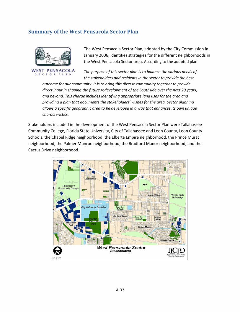
Summary of the West Pensacola Sector Plan
The West Pensacola Sector Plan, adopted by the City Commission in January 2006, identifies strategies for the different neighborhoods in the West Pensacola Sector area. According to the adopted plan:
The purpose of this sector plan is to balance the various needs of the stakeholders and residents in the sector to provide the best
outcome for our community. It is to bring this diverse community together to provide direct input in shaping the future redevelopment of the Southside over the next 20 years, and beyond. This charge includes identifying appropriate land uses for the area and providing a plan that documents the stakeholders’ wishes for the area. Sector planning allows a specific geographic area to be developed in a way that enhances its own unique characteristics.
Stakeholders included in the development of the West Pensacola Sector Plan were Tallahassee Community College, Florida State University, City of Tallahassee and Leon County, Leon County Schools, the Chapel Ridge neighborhood, the Elberta Empire neighborhood, the Prince Murat neighborhood, the Palmer Munroe neighborhood, the Bradford Manor neighborhood, and the Cactus Drive neighborhood.
A-32

Priority Issues The West Pensacola Sector Plan addresses three priority issues:
• Land use: The West Pensacola Sector Plan addresses the future development of the sector. Many of the comments received were from two general views. Resident-owners (people who reside in the sector) expressed concerns about the apartments, traffic, noise, loss of families in the sector and other impacts of high-density development and an urbanizing area, and their desire for neighborhood protection. Rental-owners (people who own rental homes or investment property in the sector) expressed a desire for all or portions of the sector to be redeveloped to permit higher density housing, retail and other supporting uses. All parties generally agreed with directing the highest density/intensity development to the corridors and moving industrial/government operation uses from the old Dale Mabry lands. Rental-owners and Resident-owners generally disagreed with the level of density to apply away from the corridors.
• Quality of Life: Resident-owners and Rental-owners in the West Pensacola sector were concerned about the factors diminishing the quality of the sector. Student impacts were the main reason mentioned for this deterioration. Participants identified the following specific concerns:
o Noise o Garbage o Public Safety o Flooding
• Transportation: With Florida State University and Tallahassee Community College forming bookends to the Sector, area roadways are often clogged with commuter traffic. When combined with standard workday travel along the major corridors of West Tennessee Street, West Pensacola Street, and Lake Bradford Road, congestion in the area presents challenges which need to be addressed. Throughout the community workshops, citizens in the community have recognized the existing high-density development along major corridors, a prerequisite for successful mass transit. Support has been expressed for additional bike lanes and creating connections to the existing Greenways System. Recognizing the close proximity of numerous daily services, ideas were also put forward for improving pedestrian facilities to achieve connectivity.
Summary of the West Pensacola Sector Plan The West Pensacola Sector Plan identifies strategies and recommendations to shape the future of the West Pensacola sector area. These strategies and recommendations focus on land use, quality of life, and transportation. The Sector Plan demonstrates the need to consider both transportation and land use together in the future development of the area, supports protecting stable neighborhoods, and acknowledges that land use and transportation needs change when a neighborhood transitions to a rental neighborhood or an urban community.
A-33

Summary of the Southern Strategy
The Southern Strategy Area was adopted into the comprehensive plan in 1998 to establish a guiding framework for land use and community activities. The Southern Strategy Area (SSA) covers about 17½ square miles, or nearly 11% of the area inside the Urban Service Area boundary. Policies reflected a strategy to encourage a growth pattern in the southern part of the City of Tallahassee as well as adjacent portions of unincorporated Leon County as a counterbalance to the rapid growth pattern in the northern and eastern areas of the community.
The goal of the Southern Strategy is to encourage quality land development and redevelopment which results in increased population growth toward the southern part of the Tallahassee urban area, to retain and increase employment opportunities, and to attain an income mix in the Southern Strategy Area that is comparable to the remainder of the urbanized County. This goal is to be achieved through considered land redevelopment decisions, capital investments, and policies by all levels of government so as to serve as a catalyst for private sector investment in the area. Such decisions are to be based on a sound balance of social, economic, and physical development criteria that are designed to make better use of the available resources to the south, while lessening development pressure in the north and east.
The Southern Strategy spurred the development of several sector plans including those for South Monroe, Capital Cascades, Oak Ridge, Lake Bradford, and West Pensacola.
A-34

Stakeholders included in the development of the Southern Strategy Area included southside residents and businesses, City Departments and the City Commission.
The Comprehensive Plan requires the Planning Department to prepare the State of the Southern Strategy Report every three years. The latest evaluation was completed in 2013 and revealed mixed results. The population is showing steady growth but continues to lag behind the City and County as a whole. SSA schools as evaluated by the state FLDOE and district are performing at B, C and D levels; three schools, Bond, Oak Ridge and Nims, lost ground in the 2012/2013 year. Crime within the southside reflects increases as a percentage of the City’s overall crime rate. Housing values are continuing to recover after the recent recession and the southside has a slightly reduced percentage of overall permits. The 2016 report may show a number of gains in property value and development activity as the area continues to recover from the recent economic downturn.
Priority Issues The Southern Strategy expressed as a framework in the comprehensive plan includes the following priority issues, but also indicates that it is to be carried out through sector plans:
• Affordable Housing: The Southern Strategy for housing is to preserve existing stock and procure quality new stock over time. Funding housing rehabilitation and supporting non-profits are both strategies for this effort.
• Surface Water Quality: The Southern Strategy for restoring and maintaining water quality is to implement water studies to identify pollution and to formulate plans for resolving issues.
• Attraction of Development: To spur development within the urban core and southside Tallahassee area, the Southern Strategy has as an objective, greater density (2 dwelling units per acre) and greater intensity (10,000 square feet per acre) for development. General approaches also include additional transportation improvements, a tax increment financing district, landscape and streetscape programs, stormwater retrofits, and better schools. It is worth noting that a part of the Southern Strategy Area is identified as a transportation concurrency exception area.
• Institutional Land Uses: As a general strategy, large institutions and heavy infrastructure land uses (like waste water treatment plants) would be diverted from southside areas. For existing institutions, the plan calls for landscaping and visual enhancements to improve the aesthetics of existing facilities.
• Economic Assets: General strategies include marketing to private and educational facilities to locate in the southside of Tallahassee including small businesses. Health care facilities are specifically identified as desired target businesses in the southside.
A-35

Summary of the Southern Strategy Area The Southern Strategy Area as reflected in the comprehensive plan is meant to establish a framework to energize the southside of Tallahassee for additional development and redevelopment activities. Sector Plans for South Monroe, Capital Cascades, Oak Ridge, Lake Bradford, and West Pensacola, are meant to further implement the Southern Strategy.
https://www.talgov.com/planning/planning-npss-npsp.aspx
A-36

Summary of the ULI Southside Report
The Urban Land Institute (ULI) Southside report was commissioned by the City and remains an advisory plan for the southside of Tallahassee. The purpose of the study was to address specific issues of crime and health. The intent was to foster improved public health through changes to the built environment that promote more active lifestyles. After a two-day charrette in May, the panel made these recommendations for immediate implementation
The purpose of the study was to develop a collective vision for the area that addresses the challenges faced by South City residents in keeping with ULI’s Building Healthy Places initiative, which acknowledges the impact of the built environment on health and provides 10 principles of planning that can foster healthy outcomes.
The stakeholders were the ULI Technical Assistance Panel (TPA) consisting of local attorneys, a few local residents and consulting staff of ULI (i.e., Thomas Murphy, ULI’s senior resident fellow and a former mayor of Pittsburgh). Stakeholders involvement consisted of participation in a 2-day charrette and production of a report with recommendations to the City.
A-37
Priority Issues The ULI Southside report identified short and long-term items to be implemented through a variety of mechanisms. The priorities identified by the report included:
• Revitalization Plan: The ULI report recommended a broad-based task force to prepare a strategic plan to revitalize South City, replacing multiple uncoordinated ad hoc activities. Stronger ties between FAMU and the southside community were suggested.
• Infrastructure/Pedestrian Safety: The ULI report addressed infrastructure calling for improvements of pedestrian facilities in the study area by installing sidewalks and energy-efficient streetlights with improved pedestrian street crossings, signage and way-finding. Additionally, the report recommended giving construction priority to phases of the planned Magnolia Drive Multi-Use Trail that will connect South City to the nearby campus of Florida A&M University (FAMU). Another recommendation included creating a pedestrian-pathway from South City through the adjacent FAMU campus for a direct walking route to Bond Elementary School for South City youngsters, avoiding the need for them to cross busy arterial roads. For recreation, the report recommended converting an old drainage ditch through the neighborhood into a Greenway Trail that would also connect South City to FAMU.
• Healthy Foods: To address general health issues, the ULI report recommended working with nonprofits to promote a mobile farmer’s market to provide better access to healthy foods in South City until creation of a permanent farmer’s market. FAMU was asked to establish some baseline health metrics.
• Education: The ULI report recommended establishing a “community school” like Evans Community School in Orlando and similar schools in other parts of the U.S. Such schools bring together educational, public health, and community services under one roof and become a community hub. They can provide one-stop shopping for whole families that need easy access to a wide range. Evans school was created in 2012; academic performance there has soared, raising it from an F-rated to a B-rated school.
• Economic Development: The report recommended additional approaches to commercial retail and jobs. In partnership with the Community Redevelopment Agency, the community should seek opportunities to secure private investment along the Adams and Monroe Street corridors. It also recommended identifying potential catalytic retail sites in South City, including under-utilized shopping centers; and pursuing financial incentives for expansion of existing businesses, such as New Market Tax Credits, and work with local lenders to direct capital investments to South City under the Community Reinvestment Act. For job, establishing a partnership with Tallahassee Community College to promote adult education opportunities and workforce development would be a strategy.
A-38
Summary of the ULI Southside Report The ULI southside report includes recommendations to facilitate the creation of a healthier community and includes short and long-term plans to address strategic planning, infrastructure/pedestrian safety, community health, education, and economic development.
http://hgslaw.com/article/uli-issues-report-on-tallahassees-south-city-neighborhood-by-panel-led-by-hgs-lawyers/
A-39