
Power Surge - BankTrack Study Eight: Xekaman 1 and Xekaman 3 Hydropower Projects .....67 Case Study...
92
September 2008 Power Surge THE IMPACTS OF RAPID DAM DEVELOPMENT IN LAOS
-
Upload
trinhthien -
Category
Documents
-
view
217 -
download
1
Transcript of Power Surge - BankTrack Study Eight: Xekaman 1 and Xekaman 3 Hydropower Projects .....67 Case Study...

P O W E R S U R G E | I September 2008
Power Surge THE IMPACTS OF RAPID DAM DEvELOPMENT IN LAOS

About International Rivers International Rivers is a non-governmental organization that protects rivers and defends the rights of communities that depend on them. International Rivers opposes destructive dams and the development model they advance, and encourages better ways of meeting people’s needs for water, energy and protection from damaging floods.
AcknowledgmentsThis report was coordinated and edited by Shannon Lawrence, with significant support and contributions from Aviva Imhof, Carl Middleton, David Blake, Nok Khamin, Ernesto Cavallo, Maurice Campello and Berklee Lowrey-Evans, and assistance from Orawan Yafa, Katy Yan and Joyce Chu. Useful comments and suggestions were provided by Andrew Bartlett and Glenn Hunt. The experiences and insights from other organizations and individuals, many of whom cannot be named here, also proved invaluable. Special thanks to Marcus Rhinelander for permission to use his photos.
This report was made possible by the generous support of the McKnight Foundation and the Richard and Rhoda Goldman Fund.
This report and additional supporting materials can be downloaded at internationalrivers.org
Copyright © 2008 by International Rivers
ISBN: 978-0-9718858-7-5
Shannon Lawrence [email protected]
Published by International Rivers1847 Berkeley WayBerkeley, CA 94703 USATel: +1 510 848 1155Fax: +1 510 848 1008
internationalrivers.org
Design by Design Action CollectivePrinting by Wanida Printing, Thailand
Cover photo: Girls playing in the Hinboun River, Laos. Photo: David J.H. Blake

P O W E R S U R G E | 1
Contents
Abbreviations and Acronyms .........................................................................................................................2
Executive Summary ...........................................................................................................................................3
Table: Summary of Project Impacts ........................................................................................................7
Map: Key Existing and Proposed Hydropower Projects in Laos .................................................. 10
Introduction ...................................................................................................................................................... 11
Hydropower Development in Laos: An Overview ................................................................................... 13
Box: Thailand’s Role in the Lao Hydropower Sector ....................................................................... 14
Box: The ADB: Bankrolling Lao Hydropower .................................................................................... 16
Poverty Reduction in Laos: An Alternative Approach ............................................................................. 18
Case Study One: Nam Tha 1 Hydropower Project ............................................................................... 25
Case Study Two: Nam Theun 1 Hydropower Project ............................................................................ 29
Case Study Three: Theun-Hinboun Hydropower Project and Theun-Hinboun Expansion Project ......................................................................................................... 35
Map: Key Existing and Proposed Dams in the Nam Theun Basin ................................................39
Case Study Four: Nam Theun 2 Hydropower Project ........................................................................... 41
Case Study Five: Nam Ngum River Basin ............................................................................................... 47
Map: Key Existing and Proposed Dams in the Nam Ngum Basin ................................................48
Box: Nam Song and Nam Leuk ...........................................................................................................50
Case Study Six: Sekong 4 and Sekong 5 Hydropower Projects ........................................................ 55
Map: Key Existing and Proposed Dams in the Sekong Basin .......................................................56
Case Study Seven: Nam Kong 1 Hydropower Project ......................................................................... 63
Case Study Eight: Xekaman 1 and Xekaman 3 Hydropower Projects .............................................. 67
Case Study Nine: Houay Ho Hydropower Project ................................................................................. 73
Case Study Ten: Xekatam Hydropower Project ...................................................................................... 76
Case Study Eleven: Don Sahong Hydropower Project ........................................................................80
Map: Proposed Don Sahong Dam ...................................................................................................... 81
Box: Known Fish Migrations through the Hou Sahong Channel .................................................. 83
Box: Mekong Mainstream Dams .........................................................................................................86
Conclusions and Recommendations ........................................................................................................ 87

2 | I N T E R N AT I O N A L R I v E R S
ADB Asian Development Bank
AFD Agence Française de Développement
BOT Build-Operate-Transfer
CA Concession Agreement
CIA Cumulative Impact Assessment
CNMC Cambodian National Mekong Committee
COD Commercial Operation Date
CSG China Southern Power Grid
EdL Electricité du Laos
EdF Electricité de France
EGAT Electricity Generating Authority of Thailand
EGCO Electricity Generating Company of Thailand
EIA Environmental Impact Assessment
EMMP Environmental Management and Monitoring Plan
GDP Gross Domestic Product
GEF Global Environment Facility
GoL Government of Laos
GTZ German Bilateral Development Agency
GXED Guangxi Electric Power Industry Investigation Design and Research Institute
ha Hectares
IEE Initial Environmental Examination
IFC International Finance Corporation
JBIC Japan Bank for International Cooperation
kg Kilogram
km Kilometer
kV Kilovolt
LHSE Lao Holding State Enterprise
LNMC Lao National Mekong Committee
m Meters
m3/s Cubic meters per second
MDB Multilateral Development Bank
MFCB Mega First Corporation Berhard
MIGA Multilateral Investment Guarantee Agency
MoU Memorandum of Understanding
MRC Mekong River Commission
MW Megawatt
NEXI Nippon Export and Investment Insurance
NGO Non-governmental organization
NNRB Nam Ngum River Basin
NPA National Protected Area
NTFP Non-timber forest product
NTPC Nam Theun 2 Power Company
OECD Organization for Economic Cooperation and Development
PDA Project Development Agreement
PoE Panel of Experts
PPA Power Purchase Agreement
PSIA Poverty and Social Impact Assessment
RAP Resettlement Action Plan
REMDP Resettlement and Ethnic Minority Development Plan
RMR Resource Management and Research
SAP Social Action Plan
SIA Social Impact Assessment
SMEC Snowy Mountains Engineering Corporation
STEA Science, Technology and Environment Agency
THPC Theun-Hinboun Power Company
UNDP United Nations Development Program
WCS Wildlife Conservation Society
WWF World Wide Fund for Nature
WREA Water Resources and Environment Agency
All dollar amounts cited are in US dollars.
Abbreviations and Acronyms

P O W E R S U R G E | 3
Executive Summary
The small country of Laos is undergoing some big changes. As it tries to become the “battery of Southeast
Asia,” Laos’ hydropower industry is booming. Increasing power demand from neighboring Thailand and
Vietnam and new investors from Thailand, China, Russia, Vietnam and Malaysia are driving this expansion. Six
large dams are officially under construction in Laos and at least 12 more are at advanced planning stages. Laos
is also proposing six dams for the mainstream Mekong River.
Most of power produced by these hydro projects will be exported to countries like Thailand and Vietnam, as well as to Cambodia and China. If favorable contracts are negotiated with the buyers of Laos’ hydropower, the Lao government could earn substantial revenue over the next few decades. But in a country with low government capacity to monitor the impacts of dam projects, where freedoms are restricted, transparency is low, and corruption is high, this “flood” of new high-risk hydro projects raises important concerns. Hundreds of thousands of Lao villagers are likely to lose land, fisheries and other resources when these large dams are constructed and Laos does not have a good track record of managing the social and environmental impacts of big dams.
The few large hydropower projects now in operation, such as the Houay Ho and Theun-Hinboun dams, have increased poverty for tens of thousands of Laotians. Villagers who have been resettled have not had their incomes restored to previous levels. Other villagers have lost important fisheries, rice fields and riverbank gardens, but have not received sufficient compensation or replacements.
Laos’ largest dam, Nam Theun 2, is nearing the end of its construction phase. This project was supposed to help raise the environmental and social standards applied across the Lao hydro sector. But Nam Theun 2 itself has experienced resettlement and compensation problems, and its program to address the impacts on villagers living downstream has significant shortcomings. Furthermore, the new dam projects that have been approved since Nam Theun 2 actually indicate a regression in environmental and social performance. It does not seem that Nam Theun 2 is leading to improvements in the design and management of Lao dam projects so that impacts on communities and the environment are addressed.
Though Lao environmental and social laws, regulations and policies are good on paper, the companies building dams in Laos are not following these rules. The Lao government also does not seem to be enforcing the laws and policies that it has adopted. The 11 case studies of dam projects included in this report tell troubling stories of poor planning, inadequate compensation and mitigation measures, and broken promises to affected villagers (see table on pages 7-9).
Dam developers, consulting firms and construction companies are benefiting from the lack of resources, capacity and authority of the Lao Water Resources and Environment Agency (WREA). WREA is supposed to ensure that dams built in Laos comply with the country’s social and environmental laws and policies. However, WREA often has not approved the social and environmental plans for these dams before their construction begins, and dam builders are not being required to provide sufficient funding to address their projects’ negative impacts on Lao villagers. Since WREA does not have the funding or staff to monitor dams during their construction or operation phases, many dam companies will be able to reduce their costs by violating Lao regulations and the commitments they made to affected communities. Finally, because WREA does not have the authority to say no to a project, some of the most harmful dams will still be built.
Furthermore, no genuine strategic planning process or river basin-wide management approach is informing how the Lao government selects and approves dam projects. Although studies have been done in recent years to help prioritize projects in terms of costs, benefits and environmental and social impacts, the recommendations of these studies are not being followed. It seems that any company that wants to build a dam in Laos is allowed to do so. This dam disorder increases the costs and the negative impacts of hydropower development, both for the government and for Lao people.
Since most of Laos’ large dams export their electricity across national borders, their primary benefit is the revenue that is generated in taxes, royalties, dividends and other payments to the government. Laos is one of the poorest countries in the region, and these revenues should be used to help reduce poverty in the country. This was the commitment made for the revenue that will be generated when Nam Theun 2 begins operating at the end of 2009. However, money alone will not be enough to reduce poverty in Laos if a number of harmful policies and initiatives continue to be supported by the government and donors. These initiatives include the eradication of swidden agriculture, internal resettlement, and the rapid awarding of hydro, mining and plantation concessions, which are undermining food security and income opportunities for rural people.

4 | I N T E R N AT I O N A L R I v E R S
There are alternative development and poverty-reduction options for Laos, a number of which are already being studied and implemented by Lao government agencies in cooperation with donors and non-governmental organizations. These approaches would improve the ability of lowland and upland farmers to adapt to change, safeguard their natural resources, and help them take advantage of new income-generating opportunities. Bottom-up strategies, such as developing markets for niche agricultural products and ensuring community land rights, combined with top-down strategies to improve government transparency and revenue collection and management capacity, need to be prioritized and scaled-up.
While the Lao government has declared hydropower to be a national priority, Laos will gain few long-term benefits from these projects if serious consideration is not given to when, how and if they should be built in the first place. Rushing to meet its neighbors’ power demands or the profit-seeking motives of investors will likely do Laos more harm than good. A selective, cautious approach would allow the government to use revenues from the next few dams to improve its regulatory capacity and its ability to negotiate favorable contracts with power purchasers.
Large dams that do not meet Lao laws, regulations and policies, or that would cause widespread, irreversible environmental and social harm, should not be built.
Overall recommendations for the Lao hydropower sector include:n Better assess the development options for
Laos. The Lao government and donors should comprehensively assess, through a broad-based participatory process, all poverty reduction and revenue generation options for Laos and evaluate their costs and benefits.
n Slow the flood of new dam projects. The Lao government should slow the pace of new hydro projects and consider a moratorium on the signing of Concession Agreements for new dams until comprehensive assessments and basin-wide planning are used to prioritize hydropower developments.
n Minimize the costs/maximize the benefits. Donors and the Lao government should work together to increase the capacity, authority and resources of the Water Resources and Environment Agency of Laos. The government’s capacity to negotiate favorable agreements with power purchasers should also be strengthened.
The Mekong River at Vientiane, Laos. Photo: Shannon Lawrence

P O W E R S U R G E | 5
n Improve environmental and social assessments. The Lao government and dam developers should ensure the timely disclosure of feasibility studies and draft environmental and social assessments in Lao and English languages and in multiple venues, including through the internet. Comprehensive consultations should be conducted to identify gaps and weaknesses in these studies.
n Support rural livelihoods. The Lao government should reject any resettlement plan that does not include detailed documentation of the availability of productive agricultural land and resources in the proposed resettlement sites. The government should not proceed with any dam project unless the assessments include baseline data and a comprehensive evaluation of upstream and downstream fisheries impacts. Compensation for fisheries losses for all
affected communities should be provided for the life of the project. Performance bonds, or other legally binding mechanisms to ensure that dam developers provide sufficient funding to address the impacts of their projects, should be required.
n Share the benefits directly with affected people. The Lao government should establish clear, enforceable mechanisms to guarantee that dam-affected communities receive a share of project revenue or other benefits for the life of the project. Benefit sharing must be additional to compensation for people’s losses.
n Protect critical resources. Based on their considerable environmental, social, economic and cultural value, some rivers—such as the Mekong River mainstream—simply should not be dammed.
Children near Khongpat Village on the Hinboun River. Photo: David J.H. Blake

6 | I N T E R N AT I O N A L R I v E R S

P O W E R S U R G E | 7
ProjectDevelopers
(+ GoL)Market Status
EIA Disclosed?
Main Issues
Don Sahong240-360 MW
(p. 80)
Mega First Thailand Proposed; PDA signed
No First dam proposed for the lower Mekong •mainstreamBlock main fish migration channel in •Khone Falls area; severe fisheries impacts for Laos, Cambodia and regionThreaten last Irawaddy Dolphin population •in LaosJeopardize tourism value of Khone Falls •area and potential RAMSAR statusAffected villagers not properly informed; •no consultations in Cambodia
Houay Ho150 MW(p. 73)
Suez Energy-
Tractebel,MCL
Thailand Operation;1999
No Resettled about 2,500 mainly ethnic •minorities to area with insufficient agricultural land and affected others downstream; adequate compensation still not provided
Nam Kong 1150 MW(p. 63)
Region Oil vietnam or Thailand
Proposed;PDA signed
No villagers already displaced from project •areaImpact about 1,612 ethnic minorities •downstream; no compensation proposed/budgetedAffected villagers not properly informed•
Nam Leuk 60 MW(p. 50)
EdL Laos Operation;1999
Yes More than 9,500 people downstream •affected by fisheries losses and clean water shortages; adequate compensation still not providedBuilt in Phou Khao Khouay NPA•
Nam Ngum 2 615 MW(p. 47)
Ch Karnchang, Ratchaburi, Bangkok
Expressway, TEAM,
PT Construction and
Engineering Co, Shlapak Group
Thailand Construction;COD 2013
No Resettle 6,000 mainly ethnic minorities; •questionable land availability and livelihood proposals; apparent lack of RAPImpact fishery of Nam Ngum 1 reservoir, a •source of food and income for more than 9,000 peopleTransmission line constructed through •Phou Khao Khouay NPA
Nam Ngum 3 440 MW(p. 47)
GMS Power, Ratchaburi, Marubeni
Thailand Proposed;CA/PPA
under negotiation
No Resettle 523 people within their village •territoryAffect at least 2,455 people downstream •and unknown numbers upstreamRoad construction before EIA approval•
Nam Ngum 5 120 MW(p. 47)
Sinohydro Laos Construction;COD 2011
Yes Affect paddy land of 49 households; •questionable livelihood proposalsEIA/SAP underestimate impacts; lack •of baseline data or assessment of downstream impactsConstruction before EIA approval•
Summary of ImpactsFOR DAMS FEATURED IN Power Surge CASE STUDIES

8 | I N T E R N AT I O N A L R I v E R S
Nam Song(p. 50)
EdL Laos Completed;1996
No About 1,000 families affected by fisheries •losses, flooding/erosion impacts, clean water shortages; adequate compensation still not provided
Nam Tha 1168 MW(p. 25)
China Southern
Power Grid
Thailand/ Laos
Proposed;CA under
negotiation
No Resettle 8,000 mainly ethnic minorities; •questionable land availability and livelihood proposalsAffect more than 4,600 downstream; •unknown numbers upstreamRoad construction before EIA approval•Impact Bokeo Reserve and Nam Ha NPA•
Nam Theun 1 523 MW(p. 29)
Gamuda, EGCO
Thailand Proposed; CA/PPA
under negotiation
No Resettle 3,700 mainly ethnic minorities•Significant fisheries impacts affect at least •32,000 people upstream and downstreamBisect regionally significant Nam Kading •NPARoad construction before EIA approval•Questionable economic viability•
Nam Theun 2 1,070 MW
(p. 41)
Electricité de France,
EGCO, Ital-Thai
Thailand/ Laos
Construction;COD 2009
Yes Program to deal with downstream impacts •on 120,000 people behind schedule and under-fundedSome livelihood programs for 6,200 •resettlers and other affected villagers of questionable viabilityCompensation for more than 10,000 •people affected by construction paid more than a year after land and assets taken; apparently not enough land to provide most of 200 significantly affected households with critical land-for-land replacement
Sekong 4600 MW(p. 55)
Region Oil vietnam or Thailand
Proposed No Resettle more than 5,000 mainly ethnic •minorities; questionable livelihood proposals; many villagers already moved out of reservoir areaCause an estimated $6.25 million in •fisheries losses annually in Lao part of basin, potentially affecting more than 190,000 people in Laos and unknown numbers in Cambodia; no compensation proposedAffected villagers not properly informed; no •assessment of impacts in Cambodia
Sekong 5400 MW(p. 55)
Region Oil vietnam or Thailand
Proposed No Resettle unknown numbers of mainly ethnic •minorities; many villagers already displaced from reservoir areaExacerbate fisheries losses and water •quality problems caused by Sekong 4 Bisect Xesap NPA•
Theun- Hinboun
Expansion 280 MW(p. 35)
GMS Power, Statkraft
Thailand/Laos
Proposed: CA/PPA signed
Yes Resettle 4,360 mainly ethnic minorities; •questionable land availability and livelihood proposalsAffect 48,411 people downstream, on •project lands and in host villagesExacerbate flooding and erosion in Hai and •Hinboun basins
ProjectDevelopers
(+ GoL)Market Status
EIA Disclosed?
Main Issues

P O W E R S U R G E | 9
Nam Song(p. 50)
EdL Laos Completed;1996
No About 1,000 families affected by fisheries •losses, flooding/erosion impacts, clean water shortages; adequate compensation still not provided
Nam Tha 1168 MW(p. 25)
China Southern
Power Grid
Thailand/ Laos
Proposed;CA under
negotiation
No Resettle 8,000 mainly ethnic minorities; •questionable land availability and livelihood proposalsAffect more than 4,600 downstream; •unknown numbers upstreamRoad construction before EIA approval•Impact Bokeo Reserve and Nam Ha NPA•
Nam Theun 1 523 MW(p. 29)
Gamuda, EGCO
Thailand Proposed; CA/PPA
under negotiation
No Resettle 3,700 mainly ethnic minorities•Significant fisheries impacts affect at least •32,000 people upstream and downstreamBisect regionally significant Nam Kading •NPARoad construction before EIA approval•Questionable economic viability•
Nam Theun 2 1,070 MW
(p. 41)
Electricité de France,
EGCO, Ital-Thai
Thailand/ Laos
Construction;COD 2009
Yes Program to deal with downstream impacts •on 120,000 people behind schedule and under-fundedSome livelihood programs for 6,200 •resettlers and other affected villagers of questionable viabilityCompensation for more than 10,000 •people affected by construction paid more than a year after land and assets taken; apparently not enough land to provide most of 200 significantly affected households with critical land-for-land replacement
Sekong 4600 MW(p. 55)
Region Oil vietnam or Thailand
Proposed No Resettle more than 5,000 mainly ethnic •minorities; questionable livelihood proposals; many villagers already moved out of reservoir areaCause an estimated $6.25 million in •fisheries losses annually in Lao part of basin, potentially affecting more than 190,000 people in Laos and unknown numbers in Cambodia; no compensation proposedAffected villagers not properly informed; no •assessment of impacts in Cambodia
Sekong 5400 MW(p. 55)
Region Oil vietnam or Thailand
Proposed No Resettle unknown numbers of mainly ethnic •minorities; many villagers already displaced from reservoir areaExacerbate fisheries losses and water •quality problems caused by Sekong 4 Bisect Xesap NPA•
Theun- Hinboun
Expansion 280 MW(p. 35)
GMS Power, Statkraft
Thailand/Laos
Proposed: CA/PPA signed
Yes Resettle 4,360 mainly ethnic minorities; •questionable land availability and livelihood proposalsAffect 48,411 people downstream, on •project lands and in host villagesExacerbate flooding and erosion in Hai and •Hinboun basins
Theun- Hinboun210 MW(p. 35)
GMS Power, Statkraft
Thailand Operation; 1998
Yes About 30,000 villagers lost fisheries, •rice fields, gardens and drinking water as a result of the project; adequate compensation not provided
Xekaman 1322 MW(p. 67)
vietnam-Laos Joint Stock Electricity
Investment and Development
vietnam Proposed; PDA signed
No Resettle about 800 ethnic minorities; many •others already displaced from reservoir areaAffect up to 10,000 people downstream •through water quality changes, fisheries losses and erosionImpact Dong Amphan NPA•
Xekaman 3250 MW(p. 67)
vietnam-Laos Joint Stock Electricity
Investment and Development
vietnam/Laos
Construction; COD 2010
No At least 7 ethnic minority villages •downstream and 40 villages upstream may be affectedInundate one village•EIA not completed before construction•Impact Dong Amphan NPA•
Xekatam61 MW(p. 76)
Kansai Laos Proposed; PDA signed
No Resettle 235 mainly ethnic minorities; •questionable land availability and livelihood proposalsAffect unknown numbers downstream; no •compensation proposed/budgetedEIA/SIA underestimate impacts and •numbers of affected people; villagers not properly informed
Xepian- Xenamnoi390 MW(p. 73)
SK Engineering & Construction, Korea Western
Power,Ratchaburi
Thailand Proposed; PDA
complete
No Would be built on former village land of •Houay Ho resettlers that was supposed to be a nature reserve; possibly built in conjunction with large bauxite mining projectResettle at least 4 villages and affect at •least 8 other villagesImpact Xepian River downstream•
ProjectDevelopers
(+ GoL)Market Status
EIA Disclosed?
Main Issues
CA—Concession Agreement
COD—Commercial Operation Date
EIA—Environmental Impact Assessment
PDA—Project Development Agreement
PPA—Power Purchase Agreement
SAP—Social Action Plan
SIA—Social Impact Assessment

1 0 | I N T E R N AT I O N A L R I v E R S
Key Existing and Proposed Dams in Laos

P O W E R S U R G E | 1 1
Introduction
I nternational Rivers is a non-governmental organization (NGO) that protects rivers and defends the rights of
communities that depend on them. International Rivers’ Southeast Asia Program has been working with its
partners in the Mekong Region for more than a decade, challenging destructive projects and advocating for
better compensation and mitigation measures for dam-affected communities. International Rivers works with local
researchers to make regular field visits to dam projects in Laos, produces detailed information about proposed
and existing hydropower projects, and advocates for better energy planning processes and the implementation of
strong standards to safeguard people’s rights and their natural resource base.
The majority of Lao people are subsistence farmers who rely on rainfed rice farming, wild-capture fisheries and non-timber forest products to feed their families. International Rivers is concerned that the dependence of Lao people on their rivers for all aspects of their lives —including fresh water, fish, irrigation and fertilization of crops, transportation, and recreation—renders them highly vulnerable to the changes in river ecosystems caused by large dams.
Existing Lao hydropower projects have created a legacy of uncompensated losses and unmitigated impacts. Poor planning and implementation, combined
with a lack of capacity and will on the part of the Lao government and dam developers, have meant that dams have exacerbated poverty amongst affected villagers. In a country where government criticism is rarely tolerated, press freedoms are curtailed, independent civil society organizations are restricted, and corruption is high, dam-affected communities have limited information about their rights, and even less ability to demand that those rights be protected. International Rivers tries to bridge this gap by disseminating independent information obtained directly from affected communities.
This report presents the challenges that hydropower
The Nam Mouan and Nam Theun-Kading Rivers are used for bathing, washing and drinking water. Photo: David J.H. Blake

1 2 | I N T E R N AT I O N A L R I v E R S
development poses to rural livelihoods and fragile ecosystems, and details the specific impacts caused by Lao dam projects. It also suggests alternatives and provides recommendations for minimizing the costs of hydropower development while sharing the benefits. The report considers questions such as:n What does the Lao hydro boom mean for Lao people,
and for the rural and river-dependent communities who will be most affected by these developments?
n What laws exist to ensure that the rights of dam-affected communities and their livelihoods are respected and protected, and how are these laws being implemented?
n What procedures are in place to ensure the strategic development of Laos’ hydro resources and the pro-poor use of the revenues these projects will generate?
n What needs to be done to prevent the impoverishment of rural communities, economic losses and widespread environmental devastation that can result from large dams?
n What income-generating alternatives to large dams exist for the people of Laos?
The report focuses on 11 case studies of large hydropower projects which produce or will produce electricity primarily for export. These case studies were chosen to provide an overview of projects at various stages of development, including dams that are in operation, under construction and proposed, projects of different
sizes, and dams in locations throughout Laos (organized geographically from north to south). The case studies were primarily based on first-hand research supplemented by a review of available project information, news reports, and related studies by NGOs and academics. They focus largely on the dams’ social and environmental impacts and provide brief information regarding each project’s developers, funders, status and design.
The case studies illustrate some of the recurring problems in the Lao dam development process, such as poor quality environmental and social assessments, a lack of transparency, and the failure to conduct comprehensive consultations with all stakeholders, including those in neighboring countries. These weaknesses exacerbate the often significant impacts these projects have had, are having, and will have on affected communities. Notable threats include the lack of suitable agricultural land and income-earning opportunities in resettlement sites, particularly for ethnic minorities, and the major downstream impacts—from fisheries losses to flooding and erosion—that are almost always underestimated, uncompensated or even ignored.
The report also includes overview articles on the Lao hydropower sector and poverty reduction strategies in Laos, and a number of brief boxes that examine issues such as the roles of Thailand and the Asian Development Bank in Laos’ hydropower sector, and plans to dam the lower Mekong River mainstream.
Wing-trap fishing gear in the Hou Nok Kasoum channel of the Khone Falls area. Photo: Carl Middleton

P O W E R S U R G E | 1 3
Today, Laos is undergoing a renewed hydropower boom. Growing regional demand for electricity and new sources of financing from countries such as China, Vietnam, Thailand and Malaysia finally promise to turn the GoL’s hydro dream into reality. While new dams may bring wealth to the upper echelons of Lao society, profit for the developers, and in theory, wider benefits if project revenues are invested well, they are likely to decrease food security and increase poverty for hundreds of thousands of affected Lao people.
LAOS’ HyDRO BOOM AND BUSTThe 1990s were a golden age for Laos’ hydropower ambitions. The GoL signed Memoranda of Understanding (MoUs) with the Thai and Vietnamese governments to export a total of 5,000 MW of power by 2010. Hydro developers rushed to Laos to seize this opportunity, and by 1995 23 MoUs had been signed with Korean, Australian, European and North American corporations to build 6,676 MW of new hydropower capacity.1
But when the Asian financial crisis hit in 1997, Thailand’s energy demand plummeted and the country faced a huge supply glut, which meant it no longer needed Lao hydropower. Vietnam also seemed to lose interest in Lao power imports and instead focused on developing its domestic hydro capacity. One by one, the foreign investors packed their bags and left, leaving behind only two completed hydro-for-export projects: the Theun-Hinboun Hydropower Project (see Case Study Three) and the Houay Ho Hydropower Project (see Case Study Nine).
The Nam Theun 2 Power Company (NTPC) was one of the few foreign consortia that remained. Led by Electricité de France, the Nam Theun 2 consortium bided their time, waiting for a Power Purchase Agreement (PPA) to be signed with the Electricity Generating Authority of Thailand (EGAT). When the PPA was finally signed in November 2003, the project developers, the World Bank and other financial institutions kicked the project into high gear, finally approving it in early 2005.
The signing of Nam Theun 2’s PPA—after a period of
strong growth in Thailand—marked EGAT’s willingness to reconsider additional power purchases from Laos. In December 2007, Thailand and Laos signed their latest MoU for delivery of 7,000 MW by 2015. Vietnam also renewed its interest in Lao power, and signed an MoU in December 2006 to import 3,000 MW by 2015. In January 2008, this was increased “in principle” to 5,000 MW by 2020.2
Foreign hydropower developers have also rushed back to Laos in search of lucrative profits. But today, these companies hail from Thailand, Vietnam, China, Russia and Malaysia. In a complex interplay of political support, commercial interest, development aid, and entrepreneurial spirit, these proponents have led the renewed push for widespread hydropower exploitation in Laos, often backed by export credit agencies and commercial financiers from their own countries. The new developers are able to move quickly, and have picked up many projects that were abandoned by Western corporations during the Asian financial crisis and its aftermath. These companies seem to be more attractive partners for the GoL, thanks to their access to financing with no social and environmental strings attached.
Companies and financing from Thailand now dominate the Lao hydro sector (see box on page 14), but corporations from Vietnam and China are not far behind. Chinese companies are involved in three hydropower projects currently under construction—the Xeset 2, Nam Ngum 5 and Nam Lik 1-2 projects—and have signed MoUs to evaluate at least 10 more dams. Sinohydro Corporation has spearheaded this push with five MoUs, including a 1,100 MW cascade on the Nam Ou River, the Nam Ngum 5 project (see Case Study Five), and the controversial Pak Lay Dam proposed for the Mekong River mainstream.
The Vietnam-Laos Joint Stock Electricity Investment and Development Company began construction of the 250 MW Xekaman 3 project in southern Laos in 2006, with plans to export the electricity to Vietnam (see Case Study Eight). Financing for the project was
Hydropower Development in Laos: An OverviewBy Aviva Imhof, Shannon Lawrence and Carl Middleton
Becoming the “battery of Southeast Asia” through exploiting its hydropower potential has been a longtime
dream of the Government of Laos (GoL) and its backers. The country’s rivers contribute around 35% of
the Mekong’s flow and have an estimated 18,000 MW of exploitable hydropower potential. Modest domestic
electricity demand makes Laos a prime candidate for power exports to neighboring countries. These exports could
generate millions of dollars in foreign exchange for the GoL. However, these plans have continually been thwarted:
in the 1970s and 1980s by war and political instability, and in the 1990s by the Asian financial crisis.

1 4 | I N T E R N AT I O N A L R I v E R S
largely provided by Vietnamese financial institutions. The company is presently studying four more hydropower projects in the Sekong and Xekaman basins.
The new hydro companies and their backers are fast displacing the Western corporations and multilateral development banks (MDBs) that previously dominated Laos’ power sector. While the Asian Development Bank (ADB) will soon consider financing for two new hydropower projects in Laos, Nam Ngum 3 and Nam Ngiep 1, most of the ADB’s upcoming support will back transmission infrastructure for a new generation of hydropower projects (see box on page 16). For the World Bank Group, only its Multilateral Investment Guarantee
Agency (MIGA) is actively considering support for a hydropower project, with a pending guarantee for Sinohydro’s Nam Ngum 5 project. The World Bank is, however, financing a feasibility study for the proposed Houay Lamphan Gnai project in southern Laos and transmission infrastructure between Laos, Cambodia and Thailand.
The World Bank and ADB promised that Nam Theun 2 would pave the way for environmentally and socially sustainable hydropower projects in Laos. And while Nam Theun 2 did help usher in a new wave of hydropower development, the latest projects can hardly be considered sustainable. In fact, some post-Nam Theun 2 large dams
Faced with rising fossil fuel prices, a need to diversify its energy mix, and resistance at home to the construc-tion of new energy projects, Thailand’s electric utility, EGAT, increasingly favors importing hydropower from countries like Laos. At the same time, EGAT is export-ing the social and environmental costs of its energy production to its poorer neighbors, where opposition to these projects is largely stifled.
Thailand’s 2007 Power Development Plan includes 4,000 MW of power imports from Laos between 2008 and 2015, and an additional 8,700 MW from unspeci-fied neighboring countries by 2021.1 Thailand’s energy and construction companies, backed by the Thai government, financial institutions and investors, are also developing many of the new cross-border hydro projects that will feed into Thailand’s grid.
While Thailand has been importing power from Laos since the 1970s, Thai investors and developers entered the Lao hydropower market in the 1990s. GMS Power, a subsidiary of M.D.X., holds a 20% stake in the Theun-Hinboun Hydropower Project, and MCL holds a 20% stake in the Houay Ho Dam. Both projects, which have been operating for almost a decade, have had seri-ous impacts on local communities that have yet to be resolved (see Case Studies Three and Nine).
Although Thailand’s interest in Lao hydropower waned during the Asian financial crisis, as the economy recov-ered so did the country’s involvement in the Lao dam business. Thailand’s major independent power pro-ducer, the Electricity Generating Company (EGCO), joined forces with Ital-Thai Development Plc., Thai-land’s largest construction company, to develop the
Nam Theun 2 Hydropower Project with Electricité de France and the GoL. Along with the World Bank, the ADB, and other international funders, Thai financiers were key backers of the dam; seven Thai commercial banks and Thailand’s export credit agency, the Export-Import Bank of Thailand, provided loans for the project.
The construction of the 615 MW Nam Ngum 2 Hydro-power Project, which broke ground in 2006, marked an important transition for the Lao hydro sector (see Case Study Five). In contrast to earlier projects funded mostly by international financial institutions, Nam Ngum 2 was financed mainly by Thai commercial banks and the Export-Import Bank of Thailand. The Nam Ngum 2 consortium’s shareholders are primarily Thai construction companies, including Ch. Karn-chang, which is also building the project, as well as Ratchaburi, another major Thai independent power producer.
This trend of regional dam builders backed by regional investors seems poised to continue in Laos. Thai en-ergy and construction companies, in partnership with companies from Malaysia, Japan and Korea, are now conducting studies on at least 15 new hydropower schemes in Laos, including two controversial projects on the Mekong mainstream. Thailand’s commercial banks and Export-Import Bank have indicated their willingness to support these projects.
Unfortunately, Thailand’s energy companies and commercial banks have yet to commit to international best practice standards. In fact, none of Thailand’s commercial banks have adopted the social and envi-ronmental standards known as the Equator Principles.2
Thailand’s Key Role in Laos’ Hydropower Sector
continued

P O W E R S U R G E | 1 5
actually seem to represent a significant step backward in terms of environmental and social performance. Furthermore, Nam Theun 2 is the only existing or planned Lao dam in which revenue management commitments have been proposed to help direct GoL earnings towards poverty reduction expenditures.
LACK OF STRATEGIC SECTOR PLANNINGThe GoL has signed MoUs to develop about 55 new large dams.3 Six projects are in operation, at least six projects are officially under construction, and Project Development Agreements have been finalized for another 12 dams. This rapid pace of hydropower developments and the apparent lack of any overall sector planning is cause for concern.
In 2004, prior to Nam Theun 2’s approval, the World Bank supported Maunsell Limited and Lahmeyer International to develop a Power System Development Plan for Laos.4 The study short-listed and ranked proposed hydropower projects on the basis of their economic performance, determined in part by their estimated average generation cost and their environmental and social impacts.
Unfortunately, this ranking exercise and the report’s recommendations have generally not been followed in the pursuit of new hydro opportunities. Strategic environmental assessments are not being conducted. Basin-wide planning is not occurring, which ultimately results in more dams being built (to help fill the reservoirs of those
where new dams have been constructed upstream) and greater impacts on land, rivers, fisheries and the people who depend upon them.
Hydro concessions seem to be given out to any interested developer on a first-come, first-served basis, with little apparent concern for basin planning processes or the reputation of the company involved. Furthermore, it is unclear whether the GoL critically reviews each project‘s feasibility study, or has a threshold at which it would deem a dam’s economic, social or environmental costs to be too high to proceed. This lack of planning is unlikely to maximize electricity production or revenue generation for the GoL, or for developers and investors.
Rushing to sign more MoUs with neighboring countries for power exports or developing scores of new hydropower projects does not seem to be in Laos’ best interests. The country’s hydropower potential and export markets will remain. It would make more sense to allow time for strategic sectoral planning, project review, and capacity-building to ensure that the dams that are built maximize the benefits for the Lao people and avoid costly mistakes.
By starting small and building up, the GoL could invest in sound planning and implementation processes that would avoid many of the problems detailed in the case studies of this report. There are, after all, economic costs of unsustainable hydro development as well as environmental and social ones. For example, wild-capture
While a number of Thailand’s energy companies have developed Corporate Social Responsibility policies, their narrow interpretation of environmental and social governance practices provides limited safeguards for affected communities.
As a result of the partial privatization that occurred in the late 1990s, EGAT remains the largest shareholder in several of Thailand’s “independent” power produc-ers, holding a 45% stake in Ratchaburi and a 25% stake in EGCO, both of which are listed on Thailand’s stock exchange.3 EGAT’s conflict of interest threatens to favor its associated companies’ profits over the wider public interest, and has led Thai civil society groups to question EGAT’s Power Development Plan. Over the past 13 years, all of EGAT’s “base case” power demand forecasts have overestimated actual demand, sometimes by as much as 48%. EGAT’s cur-rent “cost plus” incentive structure works to prioritize new large-scale power plants over energy efficiency programs and decentralized renewable technologies. This has encouraged over-investment in new large power plants, the cost of which is ultimately passed onto Thailand’s electricity consumers.4
Compounding these concerns, until the new Energy Act was approved in December 2007, EGAT was es-sentially self-regulated and had a monopoly on power transmission in Thailand, a dominant role in power generation, and overarching responsibility for the prep-aration of Thailand’s Power Development Plan, with little public accountability. Thai civil society groups have been calling for a more accountable and partici-patory planning process that would incorporate social and environmental — as well as economic — consid-erations. Whether the newly established independent regulator will be willing and sufficiently empowered to reform Thailand’s power planning process remains to be seen.
NOTES
1 EGAT, Thailand Power Development Plan 2007-2021: Revision 1, published by Systems Planning Division (Jan 2008).
2 See http://www.equator-principles.com/index.shtml.
3 Greacen, C.S. and Greacen, C. “Thailand’s Electricity Reforms: Privatization of Benefits and Socialization of Costs and Risks” Asian and Pacific Migration Journal 13 (1) (2004), pp. 517-542.
4 Greacen, C. and Footner, J. Decentralizing Thai Power: Towards a Sustainable Energy System, Greenpeace Southeast Asia, (Nov 2006).

1 6 | I N T E R N AT I O N A L R I v E R S
fisheries contribute approximately 6-8% to Laos’ Gross Domestic Product (GDP).5 Eco-tourism also generates significant revenue for the GoL and has the potential to increase substantially in the future. Both of these sectors would be undermined by poorly conceived hydropower development.
LAWS AND REGULATIONS: STRONG ON PAPER, WEAK IN PRACTICEIn the lead-up to Nam Theun 2’s approval, the World Bank, the ADB and other donors worked with the GoL to establish social and environmental laws and policies to guide hydropower development in the country. While some laws pre-dated Nam Theun 2, such as the Environmental Protection Law (1999), others, including the Decree on Compensation and Resettlement of the Development Project and the National Policy on the Environmental and Social Sustainability of the Hydropower Sector (National
Hydropower Policy), were adopted in 2005 and were meant to incorporate some of Nam Theun 2’s standards to ensure sector-wide implementation.
Many of these laws, regulations and policies contain important provisions to ensure participation, consultation, information disclosure, compensation, and resettlement with livelihood restoration for affected communities. However, in practice, these provisions are often not followed, or are implemented on an ad-hoc, case-by-case basis depending on the will, expertise and resources of the environmental and social consultants and the dam developer.
These implementation failures are most evident during the development and review of the Environmental Impact Assessments (EIAs) and Resettlement Action Plans (RAPs) for hydropower projects, which have typically not been disclosed to the general public and are often of questionable quality. This was recognized
Although the Lao hydro playing field is currently domi-nated by investors and developers from the region, the multilateral development banks are still on the scene. The ADB in particular continues to be a key player in the Lao energy sector, providing technical assistance, loans and guarantees for a number of dam projects and transmission lines in Laos. Although ADB-backed operations are supposed to comply with the institu-tion’s social and environmental policies and contribute to poverty reduction, there is little evidence that ADB’s involvement has raised Lao hydro standards.
The ADB has provided considerable support to the hydropower sector in Laos over the last 15 years, backing the Nam Song, Nam Leuk and Theun-Hinboun projects. As documented in this report, there are a number of unresolved problems with these ADB-fund-ed dams, and few indications that ADB’s involvement in these projects improved their design or minimized their negative impacts on the environment and af-fected communities. In addition, ADB’s commitment to donors and investors that Nam Theun 2 would help improve the social and environmental performance of the hydropower sector in Laos has not been met.
Soon the ADB will consider financing for the Nam Ngum 3 and Nam Ngiep 1 projects, as well as techni-cal assistance and loans for a number of substations and transmission lines, such as the Na Bong-Udon Thani line from northern Laos to Thailand and the Ban Sok-Pleiku line from southern Laos to vietnam. ADB
financing for transmission line interconnections will facilitate the development of a number of hydropower projects in Laos, such as Nam Theun 1, Xekaman 1 and Xekaman 3, which do not meet the country’s regulatory standards or ADB safeguard policies. In its Lao Country Strategy Program for 2007-2011, ADB pledged to “continue to incorporate sound environ-mental management in all its operations through application of its environmental and social safeguard policies, and, through policy dialogue, will encourage the Government to adopt similar standards for all large natural-resource intensive projects.” However, it seems the ADB will not even oblige the hydropower projects connected to the proposed transmission lines to com-ply with ADB safeguard policies.
The ADB should require all associated hydropower projects that use ADB-funded transmission lines or substations to meet ADB standards. Furthermore, before the ADB provides additional assistance for the Lao hydropower sector, critical outstanding issues with existing ADB-funded hydropower projects should be addressed. Finally, the ADB should require that the Lao government demonstrate substantial progress in implementing the National Hydropower Policy before new dams and transmission lines receive ADB support. Failure to take action on these issues sends a signal to the GoL and private dam developers that the ADB will continue to subsidize the hydropower sector, regardless of whether its standards are adhered to or commit-ments to the people affected by its projects are kept.
The ADB: Bankrolling Lao Hydropower

P O W E R S U R G E | 17
by the consultants who prepared the Cumulative Impact Assessment for the Nam Ngum 3 Hydropower Project in 2008. Their report states:
Two areas of concern in this respect are public participation in decision-making, and transparency in information management. It is very clearly stated in many legal documents that public disclosure of project-related information is mandatory for all projects, but in practice this has not functioned very well. The same could be said for participation, which is variable, but often lacking in quality and extent. The quality of the [EIA] documents we have reviewed as part of this study is highly variable, good examples are mixed with poor ones…. There are examples of when hydropower projects with large dams, significant stretches of dry river beds etc., have been stated as yielding “no significant impacts.”6
In its National Hydropower Policy, the GoL recognizes the “right of all project-affected people to sustainable livelihood options and services at least at the level previously enjoyed.”7 The GoL committed to bring all existing hydropower projects into compliance with the policy, starting with the development of “costed plans and timelines” by the end of 2007. However, tens of thousands of people continue to experience negative impacts from existing dam projects in Laos, and developers and the GoL have largely failed to ensure that villagers’ livelihoods are at least restored. As illustrated in the case studies of this report, there has been no evidence of the development of any such plans and timelines for projects such as Theun-Hinboun (see Case Study Three) or Houay Ho (see Case Study Nine).
The GoL’s environmental regulator, the Water Resources and Environment Agency (WREA), lacks the authority, staff and resources to comprehensively review the significant number of proposed hydro projects and monitor them during construction and operation to ensure compliance with Lao laws and regulations.8 At the project review stage, the dam’s feasibility study is finalized and the environmental and social budget is often agreed upon before WREA gets involved. Decisions about whether or not to proceed with a project appear to be made exclusively by the Ministry of Energy and Mines and the Ministry of Planning and Investment. Finally, unlike in many other countries, WREA does not visit projects during and after the construction phase to determine if regulations have been followed. Strengthening WREA’s mandate in the project review process and ensuring ongoing supervision
and monitoring—combined with requirements for renewal of environmental licenses during a project’s operation stage—would improve dam developers’ responsibility for their projects’ social and environmental impacts and their compliance with Lao law.
CONCLUSION Laos’ current hydro boom will continue to be a bust for villagers and the environment until and unless the GoL makes serious efforts to improve planning processes, slow the pace of new developments, strengthen its capacity to review and monitor hydropower projects, and guarantee that dam revenues benefit affected communities and the country more broadly. More needs to be done to improve the implementation of these projects—including Nam Theun 2—to ensure that commitments made on paper translate into action on the ground. The case studies in this report demonstrate how the latest round of hydropower developments have failed to meet Nam Theun 2’s standards or even to comply with Lao law, regulations and policy. While parts of the GoL may have found the Nam Theun 2 process to be too time-consuming and costly, attempts to circumvent adequate participation, disclosure, compensation, resettlement, and revenue management procedures for hydro projects will be even more expensive in the long-run.
NOTES
1 Khaommone Phonekeo, Country Paper: National Hydropower Sector, Lao PDR, prepared for the Hydropower Forum, Vietnam (16-19 July 1996).
2 Xaypaseuth Phomsoupha, “Hydropower Development Progress and Outlook,” Government of Lao PDR Department of Energy Promotion and Development (May 2008).
3 GoL Hydropower projects greater than 10 MW as listed in Power Projects in Lao PDR, Lao National Committee for Energy, http://www.powering-progress.org/updates/news/press/2008/Electric%20Power%20Plants%20in%20Laos%20as%20July%202008.pdf (7 July 2008).
4 Maunsell and Laymeyer International, Power System Development Plan for Lao PDR, Final Report—Vol. A: Main Report (August 2004), 224 pp.
5 “Don Sahong Dam, Khone Falls, southern Lao PDR,” TERRA (October 2007), available at: http://www.terraper.org/articles/Don%20Sahong%20-%20TERRA%20Oct07.pdf.
6 Vattenfall Consultants AB, Ramboll Natura AB, and Earth Systems, Lao People’s Democratic Republic: Preparing the Cumulative Impact Assessment for the Nam Ngum 3 Hydropower Project, Technical Assistance Consultant’s Report, Asian Development Bank (Feb 2008), p. 44.
7 Lao PDR National Policy on the Environmental and Social Sustainability of the Lao Hydropower Sector, available at: http://www.poweringprogress.org/energy_sector/pdf_files/National_Policy_on_Sustainable_Development.pdf.
8 Vattenfall Consultants AB, Ramboll Natura AB, and Earth Systems, pp. 74-75.

1 8 | I N T E R N AT I O N A L R I v E R S
INTRODUCTIONLaos’ poverty reduction strategies, developed by the GoL with assistance from bilateral and multilateral donors, are focused on transforming a largely traditional, subsistence-oriented rural economy into a modernized, market-oriented, agribusiness system.1 The GoL aims to eradicate shifting or swidden agriculture, alter community access to land and forests through land allocation, and relocate villages from upland to lowland areas while aggressively promoting new income-generating opportunities, such as cash crop production through contract farming.
The impacts of these policies are exacerbated by rapid hydropower, mining and plantation development which reduce the availability of fertile lowlands to support people’s livelihoods, as well as undermine the riverine and forest resources upon which they depend. In some areas, communities affected by these concession projects have already suffered the impacts of swidden eradication or resettlement and are still struggling to restore their food security and income sources.
Imposing these changes on rural communities over a short period of time can especially overwhelm the capacity of poor households to manage the transition. Abrupt transitions can be disastrous for local people’s livelihood systems, particularly for ethnic minority communities living in upland areas where poverty is most heavily concentrated.2
This article outlines some of the specific GoL and donor-supported policies and initiatives that may be exacerbating rather than alleviating poverty amongst rural communities in Laos. It then provides recommendations for alternative approaches to improve the security, resilience and sustainability of rural livelihoods, and the management of the Lao economy as a whole.
THE IMPACTS OF GOVERNMENT POLICIES AND DONOR PRACTICES IN LAOS
Involuntary resettlementWhile resettlement and movements of people have been
prominent features of Laos’ pre- and post-war history, internal, involuntary resettlement during the last 10-15 years has been increasingly aimed at eradicating shifting cultivation and opium production; improving the access of ethnic minorities in remote upland areas to markets and government services by moving them into “focal sites” or consolidating villages; and facilitating the integration of ethnic minorities into “mainstream society,” by which the GoL means lowland Lao populations.3
A recent European Union/World Bank Poverty and Social Impact Assessment (PSIA) survey4 found that the displacement of upland populations to the lowlands has resulted in loss of land, forest resources, and livestock (through diseases) and higher mortality rates for resettled villagers. It has increased the vulnerability of people who were already at risk, rather than being a catalyst for their economic and social development. Over the past decade, tens of thousands of vulnerable ethnic minority people have died or suffered due to impacts associated with resettlement, with many more expected to be impoverished long into the future.5
In some cases, communities such as the Brao living in the Nam Kong 1 Dam area (see Case Study Seven) that have been affected by these government resettlement schemes are being doubly impacted by hydropower development. In other areas, such as in the Xekaman 1 and Sekong 4 and 5 hydropower projects, villagers were resettled as part of these GoL initiatives but also to pave the way for future dam development (see Case Studies Six and Eight).
Elimination of shifting cultivation and promotion of cash cropsThe GoL has argued that shifting cultivation or swidden agriculture (rotational farming) is a backwards agricultural system and an inefficient, destructive use of upland resources.6 GoL policy is to replace swidden agriculture with lowland wet rice, cash crop or plantation production, although swidden agriculture continues to be practiced throughout Laos and particularly in the poorest districts.
Poverty Reduction in Laos: An Alternative ApproachBy Ernesto Cavallo*, with contributions from Shannon Lawrence and Aviva Imhof
From the point of view of villagers in the assessment it is clear that poverty in the Lao PDR is “new poverty,”
not an endemic condition. Poverty is the result of events external to the villager over which he or she has
no control, especially weather, war, resettlement, livestock diseases, and poorly implemented development
programs. And, because of the externality of causality, poverty is thus associated with calamity, misfortune,
fate, karma etc., and hence its substance is both physical and spiritual (GoL State Planning Committee, National
Statistic Center and Asian Development Bank, Participatory Poverty Assessment: Lao PDR, 2001).
* To protect the identity of the author, Ernesto Cavallo is a pseudonym.
P O W E R S U R G E | 1 9
Nonetheless, the restriction of swidden agriculture through land allocation procedures has contributed to acute food shortages in many parts of the country.7
In many cases, the impacts of swidden eradication are exacerbated by a lack of adequate training, credit and markets for cash crop production, increasingly eroding villagers’ livelihood opportunities. The European Union/World Bank PSIA survey shows that while commercial crop production, such as rubber in Luang Namtha Province, maize in Huaphan Province or coffee in Sekong Province, may open opportunities for some farmers, it brings risks and uncertainties for others. Cash crop cultivation often benefits the better-off and better connected farmers who can afford the necessary investments and can make use of market connections. The poor, on the other hand, often go into debt to establish cash crop production only to find the market price decline or a lack of buyers for their produce.8 If monoculture cash crop cultivation is promoted, as is the case with many resettlement and village consolidation initiatives, villagers’ livelihoods will become wholly dependent on one commodity with uncertain future returns.
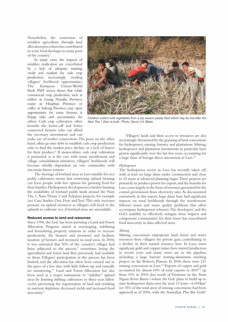
The shortage of lowland areas in Laos suitable for rice paddy cultivation means that restricting upland farming can leave people with few options for growing food for their families. Hydropower development is further limiting the availability of lowland paddy lands around the Nam Tha 1, Nam Theun 2 and Xekatam projects, for example (see Case Studies One, Four and Ten). This only increases pressure on upland resources as villagers will head to the uplands to cultivate rice if lowland areas are unavailable.
Reduced access to land and resourcesSince 1996, the GoL has been pursuing a Land and Forest Allocation Program aimed at rearranging, stabilizing and formalizing property relations in order to increase productivity (by farmers and investors) and facilitate taxation (of farmers and investors) in rural areas. In 2004, it was estimated that 50% of the country’s villages had been subjected to the process,9 sometimes losing the agricultural and forest land they previously had available to them. Villagers’ participation in the process has been limited, and the allocation has often been carried out in the space of a few days with little follow-up and virtually no monitoring.10 Land and Forest Allocation has also been used as a major instrument to “stabilize” upland areas by limiting shifting cultivation to three-year fallow cycles, preventing the regeneration of land and resulting in nutrient depletion, decreased yields and increased food insecurity.11
Villagers’ lands and their access to resources are also increasingly threatened by the granting of land concessions for hydropower, mining, forestry and plantations. Mining, hydropower and plantation investments in particular have grown significantly over the last five years, accounting for a large share of foreign direct investment in Laos.12
HydropowerThe hydropower sector in Laos has recently taken off, with at least six large dams under construction and close to 15 more at advanced planning stages. These projects are primarily to produce power for export, and the benefits for Laos come largely in the form of revenues generated for the central government from electricity sales. As documented extensively in this report, large dams have had significant impacts on rural livelihoods through the resettlement, fisheries losses and water quality problems that often accompany hydropower schemes. The developers’ and the GoL’s inability to effectively mitigate these impacts and compensate communities for their losses has exacerbated food insecurity in dam-affected areas.
MiningMining concessions expropriate land, forest and water resources from villagers for private gain, contributing to a decline in their natural resource base. In Laos, some significant gold and copper mines have started production in recent years and many more are in the pipeline, including a large bauxite mining-aluminum smelting project on the Bolaven Plateau. In 2006, there were 121 mining concessions in Laos.13 Exports of copper and gold accounted for almost 60% of total exports in 200714 up from 10% in 2004. Just north of Vientiane in the Nam Ngum River Basin—where the GoL plans to build up to nine hydropower dams over the next 13 years—6,000km2 (or 35% of the total area) of mining concessions had been approved as of 2006, with the Australian Phu Bia Gold/
Children collect wild vegetables from a dry season paddy field which may be lost after the Nam Tha 1 Dam is built. Photo: David J.H. Blake

2 0 | I N T E R N AT I O N A L R I v E R S
Copper Mining Ltd. occupying more than half of the area. Mining concessions and sites of future hydropower reservoirs are partly overlapping in the Nam Ngum Basin, posing significant threats to water quality and villagers’ lands (see Case Study Five).
Logging and plantation developmentWhile the GoL says it plans to increase forest cover in Laos from 40% to 70% by the year 2020,15 logging of the remaining native forests by primarily Lao and Vietnamese military-owned companies continues unabated.16 Logging often has links to hydropower development: it occurs in particular in reservoir areas for proposed dams, and when it takes place in watershed areas, logging threatens the viability of existing and proposed hydropower projects.
The increase in forest cover is intended to come from large-scale plantations with fast-growing, industrial tree species. Through logging and plantation expansion, local communities are being robbed of non-timber forest products (NTFPs), which contribute 40% of total rural income.17 Provincial authorities have granted significant tracts of land to primarily Chinese, Japanese, Indian, Vietnamese and Thai companies for industrial tree plantations, such as rubber, eucalyptus and acacia for paper production, and jatropha, sugarcane, oil palm, and cassava to meet the growing international demand for biofuels.18
It is estimated that more than 1 million ha of land (about 4% of Laos’ land area) have been granted as plantation concessions.19 Recent studies20 have shown that plantation development has caused people to lose access to some or even all of their livelihood resources, including upland swidden areas, community forests, NTFPs, wildlife, fuel wood and construction materials, as well as their spiritual environment.
Increasingly, villagers are being hit from all sides. For example, communities living along the lower Hinboun River, whose livelihoods have been severely damaged by the flooding and erosion caused by the Theun-Hinboun Hydropower Project, have had to resort to upland rice cultivation to feed their families. Yet the land available for upland cultivation is increasingly being taken for industrial tree plantations owned by Oji Pulp and Paper (see Case Study Three). As a result, villagers have few opportunities for sustaining their livelihoods.
Implications of these policiesThe resettlement and land expropriation resulting from the government and donor policies mentioned above have caused a breakdown of traditional cultures and belief systems, loss of community identity, disorientation, and food and income insecurity. The loss of traditional livelihood constitutes more that just an economic blow; it involves the weakening of family and communal structures of labor and governance that revolve around that livelihood. It also results in the erosion of cultural and spiritual frameworks that provide the psychological foundation by which people interpret daily events. While these experiences are more traumatic for ethnic minority upland populations than for lowland Lao farmers who have more opportunities to
adapt their traditional livelihood to the requirements of a modern market economy,21 they have negatively affected all Lao ethnic groups to some degree.
ALTERNATIVE APPROACHESHuman well-being depends upon access to a sustainable livelihood, including food security and income generation. In Laos, as in many other countries of the developing world, a sustainable rural livelihood requires the practice of sustainable agriculture and access to common resources such as land, forests and rivers. Given the specific context of most rural communities in Laos’ poorest districts, the most important factor is food security. Therefore, protecting local food security where it exists, and assisting communities to attain food security where it does not, must be central to the task of supporting the rural poor. Community resilience also needs to be strengthened through local grassroots organizations and the provision of basic services that better reflect local needs and aspirations.
In this context, the concept of sustainable livelihoods includes: a) ecological sustainability; b) financial sustainability that avoids dependence on external support; c) secure tenure over resources (land, forest, rivers); d) appropriate technologies that build on existing knowledge systems; and e) freedom of expression and organization to allow space for collectively expressed needs and aspirations for a fair and equitable community management of resources.
With access to sustainable livelihoods, local organization and basic services, communities’ vulnerability to externally induced changes will be reduced. From such a position, villagers are better empowered to face change and take advantage of new opportunities that may be available. Following are some recommendations for the GoL and donors for ways to promote and support sustainable livelihoods in Laos. Many, if not all, of these approaches are in fact already being studied or tested by various projects in cooperation with GoL agencies.
Considering opportunities for small-scale farmers’ commercial crop productionIn order to minimize economic and environmental risks, cash crop production should be considered as only one component of a diversified, smallholder livelihood system. Opportunities for commercial production in the diverse ecological and geographical contexts of the uplands can be found in niche items such as NTFPs and agro-forestry products, organically-farmed produce, handicrafts, and livestock. The United Nations Development Program (UNDP) recognizes in its National Human Development Report for Laos that “dynamic growth of agriculture has direct effects on the incomes of rural families and indirect effects on the rest of the economy.” The report cites sustainable export of NTFPs, Arabica coffee, organic jasmine rice and unprocessed products as some of the crops that could significantly contribute to improving rural incomes in Laos.22
The GoL should ensure the provision of organizational and institutional support—such as in extension/research,

P O W E R S U R G E | 2 1
credit systems, transportation, and marketing—to villagers cultivating new crops that come with unfamiliar cultivation techniques. Furthermore, Laos would be wise to follow the example of neighboring countries and establish programs that support farmers during periods of crop price declines.
Smallholder farmer groups, organized by farmers themselves or with support from the GoL, should be developed to strengthen cultivation, harvesting, processing and marketing of new crops. These independent farmer associations could assist with the dissemination of information, knowledge sharing and protection of farmers’ rights.
Legal mechanisms in Laos are currently inadequate and agreements for contract farming are often incomplete (with no specifications on the value of land, quotas or prices), unenforceable under Lao law, and generally to the disadvantage of small-scale farmers. Strengthening legal protections for Lao farmers would help ensure that they benefit from cash crop production rather than being left in debt. Agricultural extension workers should help farmers negotiate better contracts rather than acting as the agents of the traders or investors. The GoL should establish clear investment policies and improve its supervision of contracts and concessions to maximize potential economic returns and create advantages for farmers.
Reducing involuntary resettlement There is a compelling and growing volume of evidence demonstrating that involuntary resettlement caused by focal site development and hydropower projects, for example, is having a major and generally negative impact on the social systems, livelihoods and cultures of many communities.23
To avoid the possibility of being drawn into support for involuntary resettlement, donor organizations need to take a more critical and culturally and ethnically sensitive approach to their rural development work in Laos. This includes attempting to better understand local people’s livelihood strategies from their perspectives, to recognize their basic rights of freedom of movement and residence, and their entitlement to productive land. Donors and NGOs that have not developed a “code of conduct” for use when confronted with the prospect of supporting involuntary resettlement should do so.
There is an urgent need for further research into the costs and benefits of promoting development in the uplands versus the resettlement of upland communities to lowland areas and along roads. There is also a need to critically examine the local and national benefits of hydropower, mining and plantations projects
compared with their costs, including the resettlement of lowland villages and impacts on valuable paddy fields, forests and fisheries.
Where space for negotiations with local authorities exist, donor organizations and international NGOs should make use of their influence and facilitate discussions between local authorities and communities on these issues. These negotiations could help to prevent resettlement through, for example, the provision of rural infrastructure or alternative siting of concession areas.
Protecting individual farmers’ and communities’ lands In most villages, community resources, such as forests, shrubland and rivers, are collectively owned, while paddy land and housing lots are individually owned. Swidden plots hold one or the other status according to local customs and land availability. In areas where livelihoods continue to be dependent on swidden agriculture, villagers should be encouraged to identify “agricultural use zones” within their village lands where rotational swidden agriculture would be permitted for selected families in areas large enough to maintain locally-adapted rotation periods of at least seven to ten years to avoid degradation of the natural resources.
Population and land capacity assessments should be carried out ahead of any land-use planning and land allocation process, while agro-ecological zoning needs to be done together with villagers to identify land-use potential. If farmers are asked to move away from upland rice cultivation, processes should be established to enable a gradual shift to other—and multiple—income-generating options.
Fishing near Thonglom Village on the Hinboun River. Photo: David J.H. Blake

2 2 | I N T E R N AT I O N A L R I v E R S
With growing demand for land from farming communities and from private companies, the rights of communal land use and access to forests and rivers are the most vulnerable. There is a need for a fundamentally different approach to the “ownership” of natural resources, one that recognizes the rights of local communities to their resources. These resources should not be taken from communities without a negotiation process that arrives at their consent and provides just compensation. Providing communities with legal recognition of these ownership rights would likely boost incomes and security. There is an urgent need to better recognize and protect communal land rights through consideration of forms of community land title, as is common in other countries.
Improving government accountabilityLaos is characterized by a decentralized intergovernmental system, where a high degree of provincial autonomy exists alongside poor regulatory mechanisms and a lack of transparency, rule of law and popular participation. The argument for decentralization asserts that efficiencies arise when local governments are able to plan their expenditures in accordance with local priorities. However, although the Lao political system includes some community consultation, it is governed by a largely top-down decision-making process; there are no bottom-up mechanisms through which local preferences can be expressed and translated into expenditure priorities, meaning that the benefits of decentralization are lost.
While policies are centrally decreed, provincial governors enjoy great autonomy in the administration and implementation of these policies (referred to as “autonomy without accountability”). In Laos, the priorities of provincial authorities have often moved away from espoused national goals.24 This constrains economic growth, limits more equal development throughout the country, undermines attempts to improve the fiscal position of the central government, jeopardizes user-friendly, pro-poor service delivery, and perpetuates governance weaknesses. Reforming the intergovernmental structure is thus one of the key conditions for improving the country’s performance in these areas, and for reducing poverty as a general development goal. Greater controls need to be put in place to ensure that provinces spend their revenues in line with the GoL’s overall poverty reduction goals, emphasizing expenditures in areas such as health, education and road construction.
Laos is also plagued by endemic corruption. In spite of GoL policies and repeated campaigns to stamp out corruption and nepotism, corrupt practices still frustrate attempts to improve the living standards of Lao citizens.25 In the 2007 corruption index published by Transparency International, Laos ranks 168 out of 179 countries, between Guinea and Afghanistan. Such a high level of corruption makes it unlikely that revenues from projects such as dams, mines and plantations will actually trickle down to the poor.
Critical steps towards a more sustainable development path for Laos include:1) reforming the intergovernmental fiscal system; 2) directing export revenues and government expenditures to those most in need; 3) redistributing resources from richer to poorer provinces; 4) ensuring direct benefit sharing with communities negatively affected by industrial projects; and 5) enhancing accountability at all levels of government. Until government capacity has been significantly improved, explicit revenue management frameworks should be developed for hydropower and mining projects to more effectively direct GoL proceeds to the poor.
Reducing reliance on revenue-generation projects that increase rural povertyGiven the challenges the GoL faces in promoting pro-poor revenue management, large-scale hydropower and mining projects with significant economic, social and environmental costs should be reconsidered as a primary means of generating export revenue and promoting development. In addition to undermining rural livelihoods, these projects degrade other important economic resources, such as wild-capture fisheries, forests, agricultural land, and tourism sites.
Capital-intensive hydropower and mining projects generate only limited employment26 and are not the best means of promoting broad-based growth or improving human development. The UNDP’s Human Development Report states that the export of minerals, timber and electricity has “lower potential for human development” as these sectors are “capital intensive, use much less labour, and may damage the environment, local livelihoods and other exports.”27 Since mining and hydropower concessions reduce the availability of cultivatable land—a major cause of poverty, according to a 2007 poverty assessment28—the trade-offs that these projects involve need to be more closely examined.
Instead, an expansion of the agriculture sector is critical for raising living standards and creating employment opportunities. The UNDP’s Human Development Report also lists the export of garments, wood products, processed foods, handicrafts, international tourism, and labor to Thailand as means to more directly contribute to human development. These sectors rely less on government policy or the redistribution of export revenues, create greater employment opportunities, increase the incomes of rural families and women, and are more likely to reduce poverty by directly benefiting rural communities.29
Capital-intensive hydropower and mining projects generate only limited
employment and are not the best means of promoting broad-based growth or
improving human development.
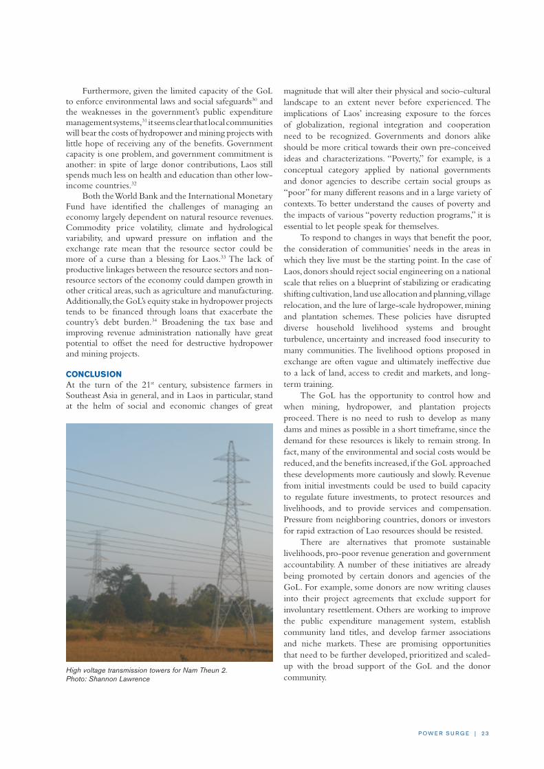
P O W E R S U R G E | 2 3
Furthermore, given the limited capacity of the GoL to enforce environmental laws and social safeguards30 and the weaknesses in the government’s public expenditure management systems,31 it seems clear that local communities will bear the costs of hydropower and mining projects with little hope of receiving any of the benefits. Government capacity is one problem, and government commitment is another: in spite of large donor contributions, Laos still spends much less on health and education than other low-income countries.32
Both the World Bank and the International Monetary Fund have identified the challenges of managing an economy largely dependent on natural resource revenues. Commodity price volatility, climate and hydrological variability, and upward pressure on inflation and the exchange rate mean that the resource sector could be more of a curse than a blessing for Laos.33 The lack of productive linkages between the resource sectors and non-resource sectors of the economy could dampen growth in other critical areas, such as agriculture and manufacturing. Additionally, the GoL’s equity stake in hydropower projects tends to be financed through loans that exacerbate the country’s debt burden.34 Broadening the tax base and improving revenue administration nationally have great potential to offset the need for destructive hydropower and mining projects.
CONCLUSIONAt the turn of the 21st century, subsistence farmers in Southeast Asia in general, and in Laos in particular, stand at the helm of social and economic changes of great
magnitude that will alter their physical and socio-cultural landscape to an extent never before experienced. The implications of Laos’ increasing exposure to the forces of globalization, regional integration and cooperation need to be recognized. Governments and donors alike should be more critical towards their own pre-conceived ideas and characterizations. “Poverty,” for example, is a conceptual category applied by national governments and donor agencies to describe certain social groups as “poor” for many different reasons and in a large variety of contexts. To better understand the causes of poverty and the impacts of various “poverty reduction programs,” it is essential to let people speak for themselves.
To respond to changes in ways that benefit the poor, the consideration of communities’ needs in the areas in which they live must be the starting point. In the case of Laos, donors should reject social engineering on a national scale that relies on a blueprint of stabilizing or eradicating shifting cultivation, land use allocation and planning, village relocation, and the lure of large-scale hydropower, mining and plantation schemes. These policies have disrupted diverse household livelihood systems and brought turbulence, uncertainty and increased food insecurity to many communities. The livelihood options proposed in exchange are often vague and ultimately ineffective due to a lack of land, access to credit and markets, and long-term training.
The GoL has the opportunity to control how and when mining, hydropower, and plantation projects proceed. There is no need to rush to develop as many dams and mines as possible in a short timeframe, since the demand for these resources is likely to remain strong. In fact, many of the environmental and social costs would be reduced, and the benefits increased, if the GoL approached these developments more cautiously and slowly. Revenue from initial investments could be used to build capacity to regulate future investments, to protect resources and livelihoods, and to provide services and compensation. Pressure from neighboring countries, donors or investors for rapid extraction of Lao resources should be resisted.
There are alternatives that promote sustainable livelihoods, pro-poor revenue generation and government accountability. A number of these initiatives are already being promoted by certain donors and agencies of the GoL. For example, some donors are now writing clauses into their project agreements that exclude support for involuntary resettlement. Others are working to improve the public expenditure management system, establish community land titles, and develop farmer associations and niche markets. These are promising opportunities that need to be further developed, prioritized and scaled-up with the broad support of the GoL and the donor community.
High voltage transmission towers for Nam Theun 2. Photo: Shannon Lawrence
2 4 | I N T E R N AT I O N A L R I v E R S
NOTES
1 See for example, the National Growth and Poverty Reduction Strategy (NGPES), Government of Lao PDR (Vientiane, Laos: 2003), and the Sixth National Socio-Economic Development Plan 2006-2010 (NSEDP), Government of Lao PDR, Committee for Planning and Investment (Vientiane, Laos: October 2006).
2 Poverty and Social Impact Assessment: Impact of Public Expenditures on Ethnic Groups and Women, Final Report, European Union and the World Bank (Vientiane, Laos: March 2007).
3 Baird, I.G. and Shoemaker, B., “Unsettling Experiences: Internal Resettlement and International Aid Agencies in Laos,” Development and Change 38:5 (2007), pp. 865-888.
4 Poverty and Social Impact Assessment: Impact of Public Expenditures on Ethnic Groups and Women, 2007.
5 Baird and Shoemaker, 2007.
6 The Rural Development Programme 1998-2002, The Focal Site Strategy: Outline of an Approach Programme Support and Investment Requirements, Sixth Round Table Follow-Up Meeting, Government of Laos, (Vientiane, Laos: 13 May 1998); and National Rural Development Program 1996-2000, Government of Laos (Vientiane, Laos: 1996).
7 See for example, Ducourtieux, O., Laffort, J.R., and Sacklokham, S., “Land Policy and Farming Practices in Laos,” Development and Change 36:3 (2005), pp. 499-526; 2005 Poverty Reduction and Shifting Cultivation Stabilisation in the Uplands of Lao PDR: Technologies, Approaches and Methods for Improving Upland Livelihoods Vol 2, National Agriculture and Forestry Research Institute (NAFRI) (Vientiane, Laos: 2005); and Participatory Poverty Assessment, Lao PDR State Planning Committee, National Statistic Center and Asian Development Bank (Vientiane, Laos: 2001).
8 In Xiengkhor District, Huaphan Province, resettled communities forced to grow maize for Vietnamese food companies were facing depressed farm gate prices due to Lao traders who set up a monopoly and, in cooperation with local authorities, prevented Vietnamese traders (who offered a much better price) from entering the country.
9 Study on Land Allocation to Individual Households in Rural Areas of Lao PDR, GTZ (Vientiane, Laos: 2004), p. 1.
10 Ducourtieux et al., 2005; Alton, C. and Houmphanh Rattanavong, Livelihoods and Forest Resources in Katu Villages in Sekong, NAFRI (Vientiane, Laos: 2005).
11 Thomas, D.E., Review of Policies and Practices in Upland Areas of the Lao PDR, NAFRI (Vientiane, Laos: 2005).
12 World Bank Lao PDR Economic Monitor (April 2008), pp. 21-22.
13 Hanssen, C.H., “Lao Land Concessions, Development for the People?” Paper presented to the International Conference on Poverty Reduction and Forests: Tenure, Market and Policy Reform (Bangkok, Thailand: 3-7 September 2007).
14 Asian Development Outlook 2008, Asian Development Bank (Manila: Nov 2007), p. 206.
15 National Socio-Economic Development Plan (2006-2010), Government of Lao PDR, Committee for Planning and Investment (Vientiane, Laos: 2006).
16 Borderlines: Vietnam’s Booming Furniture Industry and Timber Smuggling in the Mekong Region, Environmental Investigation Agency and Telepak (March 2008).
17 Rigg, J.D., “Forests, Marketization, Livelihoods and the Poor in the Lao PDR,” Land Degradation and Development 17 (2006), pp. 123-133.
18 According to Hanssen (2007, p 3) at present the area under cultivation for biofuel is estimated at about 50,000 ha with plans to extend this by including ‘idle’ land to 2 million ha by 2020.
19 Hanssen, 2007.
20 See for example, Barney, K., Power, Progress and Impoverishment: Plantations, Hydropower, Ecological Change and Community Transformation in Hinboun District, Lao PDR (2006); Hunt, G., Regional Linkages. Plantations Investments and Land Alienation in the Theun and Hinboun Basin, Paper presented at AMRC/AusAid Greater Mekong Conference (Sept 2007), pp. 26-27; and Schumann, G. et al., Study on State Land Leases and Concessions in Lao PDR, Land Policy Study Number 4 Under LLTP II, GTZ and Lao-German Land Policy Development Project (Vientiane, Laos: 2006).
21 Cornford, J., “Globalisation and Change in southern Laos,” Focus on the Global South Occasional Papers 1, CUSRI (Bangkok, Thailand: 2006).
22 National Human Development Report: International trade and human development, UNDP (2006), p. 74.
23 In addition to references listed earlier, this has been documented in the following: Daviau, S., Follow-up study on Relocation of Khamu and Rmeet Communities in Nalae District, Luang Namtha Province, Lao PDR, Final Report for the Lao-German Programme on Integrated Rural Development in Mountainous Areas of Northern Lao PDR on behalf of GTZ (Vientiane, Laos: 2006); Romagny, L., Resettlement: An Alternative for Upland Development? NAFRI (2005); Evrard, O. and Goudineau, Y., “Planned Resettlement, Unexpected Migrations and Cultural Trauma in Laos,” Development and Change 35:5 (2004), pp. 937–962; and Vandergeest, P., “Land to Some Tillers: Development-induced Displacements in Laos,” International Social Science Journal 55:1 (2003), pp. 47-56.
24 Poverty and Social Impact Assessment: Impact of Public Expenditures on Ethnic Groups and Women, 2007.
25 Renowned Lao scholar Martin Stuart-Fox, in an article published by the Asian Studies Review (March 2006, Vol 30, pp. 59-75) examines the politi-cal culture of corruption that has developed in Laos since its inauguration in 1975, showing how under authoritarian, single-party political regimes, where freedom of expression and organization is banned, a culture of corruption can prosper.
26 2007-2011 Country Strategy Program for Lao PDR, Asian Development Bank (2006), p. 16; Asian Development Outlook 2008, p. 208.
27 National Human Development Report: International trade and human development, p. 89.
28 Asian Development Outlook 2008, p. 208.
29 National Human Development Report: International trade and human development, p. 45.
30 2007-2011 Country Strategy Program for Lao PDR, p. 34.
31 Lao PDR Public Expenditure Review and Integrated Fiduciary Assessment, World Bank, IMF, ADB and the European Commission (May 2007).
32 Lao PDR Public Expenditure Review and Integrated Fiduciary Assessment, p. 25.
33 World Bank Lao PDR Economic Monitor, 2008 and Lao People’s Democratic Republic: Selected Issues and Statistical Appendix, International Monetary Fund (Washington, D.C.: Nov 2007).
34 Lao People’s Democratic Republic: Selected Issues and Statistical Appendix, 2007.

P O W E R S U R G E | 2 5
MAIN CONCERNSn Nam Tha 1 would require the resettlement of almost
8,000 people from 1,379 households in 34 villages, most of whom are ethnic minority people. The local terrain will make it impossible to provide new rice paddy fields for resettled villagers, and the main alternative livelihood option appears to be growing rubber and upland rice after extensive forest clearance. Villagers’ basic food security would be compromised, and they are likely to suffer impoverishment in the resettlement villages.
n The construction of an access road for Nam Tha 1 has reportedly already begun, before adequate steps have been taken to study and report on the dam’s environmental and social impacts as required by Lao law and regulations.
n Nam Tha 1’s environmental and social impact assessments underestimate the scale and magnitude of the impacts that can be expected from such a major dam project. The documents’ findings and conclusions are flawed and biased. At local consultations, participants are presented with a pro-project argument which basically asserts “the project has clear benefits to the economy, society and environment”1 and claims that any environmental impacts are minor and can be mitigated.
BACKGROUND AND DESCRIPTIONThe Nam Tha 1 Hydropower Project is being developed by CSG, a Chinese state-owned company formed in December 2002 that now ranks 266 in the Fortune Global 500 list.2 While CSG is the main shareholder, the GoL is expected to hold a stake of 15- 25%, and the
operating company would run the project for 30 years on a build-own-transfer (BOT) basis.3 The project feasibility study, design and development have been undertaken by Guangxi Electric Power Industry Investigation Design and Research Institute (GXED), a Chinese state-owned enterprise with a long history of involvement in hydropower.4
The Nam Tha 1 project has been under consideration since the early 1990s, but was previously regarded as a low priority for development due to high costs and low potential returns on investment. In August 2006, CSG and the GoL signed an MoU for the project and engaged GXED to conduct a pre-feasibility study, which was approved in late November 2006 by CSG.
The project’s installed capacity would be 168 MW with a total project cost of $340 million. Construction is expected to be completed in four years and power
CASE STUDy ONE: Nam Tha 1 Hydropower ProjectBy David J.H. Blake
The Nam Tha 1 Hydropower Project in the mountainous far northwest of Laos was first proposed in the early
1990s, but has only recently been taken forward by the Chinese company China Southern Power Grid
(CSG). Rushed environmental and social studies were completed and pre-construction has started, but uncertainty
about the project’s economics and market for its power remain. Most important are concerns surrounding the
resettlement of thousands of people and the downstream impacts on communities along the Nam Tha River and
the mainstream Mekong. A researcher visited communities in the upper inundation zone of the reservoir and
spoke with local people in Luang Namtha Province during February 2008.
A Khmu community on the banks of the Nam Tha in Luang Namtha Province.Photo: David J.H. Blake

2 6 | I N T E R N AT I O N A L R I v E R S
generation is planned to commence in 2012. The developers expect the project to supply electricity to the power grid in northern Laos and also to export power to Thailand, although no PPAs have been signed.
The 93-meter-high dam would create a reservoir of 62km2 that would stretch back as a narrow body of water 90km from the dam face. The reservoir would fluctuate in height seasonally by 12.5m, creating a large drawdown zone with the surface area shrinking to 26km2. The reservoir would flood parts of Pha Oudom District, Bokeo Province and Nalae District, Luang Namtha Province, requiring the resettlement of an estimated 7,979 people from 34 villages. The dam site is reportedly 62km upstream of the Nam Tha confluence with the Mekong River in Pak Tha District, Bokeo Province.
In January 2008, it was reported that work on a 40km access road crossing mountainous terrain from National Route No. 3 was due to start.5 The road is expected to take about six months to complete.6 Detailed information on the project is scarce and little documentation has been made publicly available to date.
PROJECT ISSUES AND ANALySISThe initial EIA and SIA for Nam Tha 1 were sub-contracted by GXED to an environmental consultancy firm called Earth Systems Lao,7 which conducted rapid field studies from February to September 2007 before their contract was cut short for undisclosed reasons. The EIA and SIA reports eventually produced by GXED have been combined into a single document that has yet to be publicly released, even though a leaked report shows it was completed in August 2007. The report fails to identify many of the main anticipated impacts on both the environment and communities situated upstream, downstream and in the inundation zone of the reservoir. In particular, it fails to identify expected impacts on water quality and living aquatic resources, both of which are well documented in reports from other hydropower projects in the region. It incorrectly assumes that most of the project’s impacts will occur during the construction phase and underestimates the challenges that will arise from the forced resettlement of almost 8,000 people in the upland terrain of northern Laos, where few suitable resettlement sites exist.
In January 2008, GXED held one local consultation in Luang Namtha Province and one in Huay Sai Town of Bokeo Province to which a small section of affected villagers (only from communities to be resettled) and government officials were invited. Some international development organizations working in the area were barred from attending these meetings. The summary of the EIA/SIA and RAP presented by GXED demonstrate a strong pro-project bias while ignoring, downplaying or missing many of the most serious impacts that would result from this project. Local people have been led to believe that the project will not have serious negative impacts, but instead would provide substantial benefits if it proceeds.
Resettlement IssuesThere are 34 villages threatened with resettlement, including 10 in Pha Oudom District and 24 in Nalae District. Many of these villages have received considerable external aid support during recent years, including from GTZ, Action Contre le Faim, the World Bank, the ADB, the European Commission and Concern. GTZ has a particularly large and visible program presence in Nalae District. They have invested funds directly and indirectly in the villages to be inundated through both infrastructure projects and livelihood assistance over the past decade. This includes the construction of roads, schools, health clinics, piped water systems and wells, and the establishment of numerous local institutions such as micro-finance facilities. Many of the villages in the valley have received resettled villagers from upland areas in the past, a process during which the GoL requested international assistance to ease their resettlement transition. Thus there are understandable doubts amongst the foreign donor and development community about the wisdom of moving the recently resettled villagers again, as well as those long-settled in the river valley, back up the mountainside to an uncertain future.
The exact locations for resettlement sites are not yet clear. The topography of the area is such that the only realistic option for resettlement of most villages is into hill country above the reservoir, where slopes are steep and living conditions far more difficult than on the flat and fertile valley floor. Data in the report suggests there are two options being considered. The first is moving villages to a higher elevation near their existing village or along the reservoir shores.8 The second option involves resettling
A Khmu woman returning from a fishing trip in the Nam Tha, during which she caught fish, insects and shrimps that will largely disappear if the dam is built. Photo: David J.H. Blake

P O W E R S U R G E | 2 7
them in areas outside of their traditional village lands in the upstream watershed, including possible settlement within the Nam Ha National Protected Area (NPA),9 along roads traversing the mountains between the Nam Tha Basin and Houn District of Oudomsay Province, or along the new dam access road in Pha Oudom District.
The dam would force people to adapt to new locations and livelihoods irrespective of their previous houses and situations. Thirty-four villages would be consolidated into just 27 new villages. Oustees would receive 0.02ha per person, plus 400m2 per family to build a homestead, as part of a formulaic compensatory package which would clearly under-compensate for expected actual losses.10 The main alternative livelihood system proposed in the RAP is the allocation of 4ha of upland to each family, on which they would be expected to plant 3ha of upland rice and one hectare of rubber trees. Experience over the last few years suggests that villagers prefer to intercrop rice between the rubber seedling rows, which means they get a few years of rice harvest until the rubber canopy closes over.
Of the 55km2 of land assumed to be inundated, 29km2 are estimated to be privately owned, most of which is upland rice land and teak and rubber plantations. There is a small area of lowland paddy land cultivated in many villages, but this type of land use is not included in the list of land categories to be flooded11—a serious oversight given its economic importance to the owners as both a valuable asset and a livelihood source.
The people living along the Nam Tha Valley, both upstream and downstream of the dam site, are mostly members of ethnic minority groups, including Lue, Khmu and Lamet, as well as lowland Lao. Little consideration appears to have been devoted to the particular social, economic and cultural impacts that these various ethnic groups would experience.
The Nam Tha River has for centuries been the focal point of the lives of the people who live near it, especially the Lao and Lue villagers. These communities fish and bathe in the river, as well as use the water for household consumption, drinking and irrigation of dry season vegetable crops on river terraces. They have traditionally relied on the river for transportation between villages with an active trade in rice, agricultural produce and NTFPs. The ownership of boats and engines is remarkably high, although river transportation has declined in recent years as roads have been developed.There has been an increase in income-earning opportunities from transporting tourists between Luang Namtha and Pak Tha in recent years, which fits in with the attempts by many organizations and provincial agencies to raise the profile of the area as an eco-tourism destination. It is unlikely that tourism built on the thrill of floating down an untamed river with plenty of rapids will continue to prosper after the dam is built.
Downstream and Upstream ImpactsMore than 4,600 people in 16 villages downstream of the dam will be affected by changes in flows, water quality, sediment and nutrient transport, and declines in fisheries and other aquatic resources that will affect their livelihoods. Developers have set a minimum downstream release of 20m3/s during construction, but the impacts of this fundamental change to the natural flow pattern have not been considered.12 The power station is anticipated to operate for 16 hours a day, with rapid fluctuations in water level expected to have safety and erosion-related implications as far downstream as the Mekong confluence. Average dry season flows will be significantly higher and wet season flows will be significantly lower than at present. The EIA/SIA underestimates the downstream impacts and as a result provides inadequate compensation measures for downstream villagers.
Villagers living upstream of the reservoir would not receive compensation, despite the fact that they will face a loss of food and income caused by the dam’s blocking of fish migrations. Similar to other large dam projects in Laos, the EIA/SIA document includes an unfounded assumption that the reservoir will become a productive fishery for villagers to exploit.13 The river will be changed to an unstable lake environment with large operating height fluctuations and relatively few shallow areas where fish might thrive. Additionally, there will likely be poor water quality in the early years following impoundment.
Other ConcernsSignificant questions remain about the project’s impacts on forest and wildlife resources. Although only a relatively small area of forest will be inundated by the reservoir (estimated to be 12.69km2), part of the Bokeo Reserve and the Nam Ha NPA will be directly and indirectly impacted by the Nam Tha 1 project through losses of aquatic resources, increased hunting pressure, increased likelihood of logging and NTFP collection, loss of forest
“The villagers around here only know fishing. We can catch fish almost any time
of the year, but it’s best in June and July when the big fish run up from the Mekong
and we can catch pba kheung, pba daeng, pba tawng and pba pia. I’m sure none of these fish will come anymore if there’s a
dam downstream.” — Fisherman interviewed in Awm Village, Nalae District, which is
supposedly upstream of the reservoir impact zone, but which villagers fear will be affected by backwatering.

2 8 | I N T E R N AT I O N A L R I v E R S
to roads and power transmission lines, and the possible resettlement of villages into the Nam Ha NPA. The EIA fails to adequately assess the biodiversity value of the Nam Tha Basin and the threats posed by a large hydropower project within it.
The developers have apparently budgeted almost $2.5 million for the “Environmental and Social Management and Monitoring Plan,” according to the EIA/SIA report,14 but figures given in the text are contradictory and unclear. The planned expenditure is only for the four years up to project completion, after which there are no plans or budget given for ongoing compensation and mitigation costs that will clearly occur for many years into the future. The budget planned for the RAP in total is just over $31 million, of which $21.3 million is for “compensation” costs.
CONCLUSION AND RECOMMENDATIONSThe Nam Tha 1 Hydropower Project is being sold to local people in Bokeo and Luang Namtha as an overwhelmingly positive development economically, socially and environmentally. The EIA/SIA report concludes that, “Generally speaking, the hydroelectric power station will bring significant economic benefits and social benefits. Apart from the inundation caused by the reservoir is irreversible; other environmental impacts adversely could be reduced and prevented by taking environmental protection measures.”15 The EIA/SIA shows a very limited understanding of the implications of resettling nearly 8,000 people to poorer quality land with little chance of livelihood restoration, while potential impacts are either underestimated or not identified at all. River-based livelihood options (e.g. fishing, river trade, transport, collection of wetland products) and lowland forest and land resources are irreplaceable and nearly impossible to compensate for without signficant sums of money.
Recommendationsn The GoL should immediately stop any construction
work on the access road and plans to implement the Nam Tha 1 project until the project’s compliance with the National Hydropower Policy and other Lao law and regulations has been demonstrated.
n The GoL should require a comprehensive, independent study of the actual economic and technical feasibility of the Nam Tha 1 project, and a participatory social and environmental impact study by a credible institution—
undertaken at the developer’s expense—to inform any future decision regarding the the Nam Tha 1 project.
n The Nam Tha 1 EIA, SIA and RAP should not be approved until and unless the availability of adequate agricultural land and other livelihood opportunities in proposed resettlement sites has been demonstrated and sufficient compensation for downstream and upstream villagers has been incorporated.
NOTES
1 Main conclusion of final slide of powerpoint presentation in Lao language by GXED on the summary of findings of the EIA and SIA presented to local community leaders and government officials in Bokeo and Luang Namtha provinces.
2 Maps of the World, NA Media Service, http://finance.mapsoftheworld.com/company/c/china-southern-power-grid.html (Accessed 14 July 2008).
3 “Work to start on Nam Tha 1 hydropower dam,” Vientiane Times, 14 Jan 2008.
4 Brief Introduction, Guangxi Electric Power Industry Investigation Design and Research Institute (GXED), http://www.gxed.com/en/intro.asp (Accessed 14 July 2008).
5 National Route No. 3 traverses northern Laos from Huay Sai on the Lao-Thai border to Muang Sing on the Lao-China border and is part of the ADB-GMS North-South Economic Corridor linking Yunnan with Thailand.
6 “Work to start on Nam Tha 1 hydropower dam,” Vientiane Times.
7 Earth Systems Lao is an Australian company with offices in China and Laos that has been involved with many controversial projects. See: http://earthsys-temslao.com/project.php (Accessed 14 July 2008).
8 Table 2.3-1, Environmental and Social Impact Assessment Report: Nam Tha 1# Hydropower Station Project, GXED, Nanning, Guangxi, China (Aug 2007), p. 21.
9 The 220,000ha Nam Ha NPA is “one of the largest wilderness areas in Laos and is inscribed on the list of ASEAN Heritage Parks,” according to a Lao National Tourist Authority brochure. See: http://www.ecotourismlaos.com (Accessed 14 July 2008).
10 Data extracted from powerpoint presentation for local officials and com-munity leaders in Lao language summarizing RAP, compiled by GXED.
11 Table 5.3-1, “Asset loss due to reservoir inundation of Nam Tha 1# proj-ect,” Environmental and Social Impact Assessment Report: Nam Tha 1# Hydropower Station Project, GXED (Nanning, Guangxi, China: Aug 2007), p. 117.
12 Section 5.1, Environmental and Social Impact Assessment Report: Nam Tha 1# Hydropower Station Project, p. 76.
13 For example, “The reservoir area created by the Nam Tha project has the potential to become a significant fishery available for local communi-ties.” Environmental and Social Impact Assessment Report: Nam Tha 1# Hydropower Station Project, p. 175.
14 This figure of $2.48 million is quoted on p.166 of the EIA/SIA, but is imme-diately contradicted by the table appearing beneath it, which shows monetary units in “million dollars” and is incomplete.
15 Section 8.2 Conclusions, Environmental and Social Impact Assessment Report: Nam Tha 1# Hydropower Station Project, p. 175.

P O W E R S U R G E | 2 9
MAIN CONCERNSn The Nam Theun 1 project would negatively affect at
least 32,000 people, both upstream and downstream of the dam site. The dam would have serious impacts on the fisheries and agriculture-dependent livelihoods of thousands of people living downstream in Pak Kading District. Many of these people are already suffering uncompensated losses caused by the Theun-Hinboun Hydropower Project upstream. Nam Theun 1 would forcibly displace more than 3,700 villagers, most of whom are ethnic minorities, from the proposed reservoir area. Resettlement plans rely on unproven strategies and inadequate investment to restore villagers’ livelihoods.
n The Nam Theun 1 project would be located almost entirely within the Nam Kading NPA, a conservation area of global biodiversity significance and home to a number of endangered wildlife species. The reservoir would increase access to the area, destroy animal habitat and forest resources, and jeopardize the livelihoods of surrounding communities who rely on the NPA for subsistence and income.
n The Nam Theun 1 project would be disastrous for fish populations that migrate seasonally between the Mekong River and the Nam Kading and Nam Mouan rivers for spawning and feeding. These migration routes would be entirely blocked by the dam and reservoir. The reservoir is unlikely to develop a significant lake fishery in the future and will be characterized by poor water quality in the early years as vegetation decomposes.
n There are questions about the Nam Theun 1 project’s economic viability and its compliance with Lao law and regulations. Construction activities began in late 2007 before an EIA had been approved by the GoL, and before a PPA or a Concession Agreement (CA) had been signed. An earlier Power System Development Plan screened out Nam Theun 1 because it was not considered economically viable.
BACKGROUND AND DESCRIPTIONThe Nam Theun 1 Dam is a proposed 523 MW hydropower project situated on the lower Theun-Kading River1 in Bolikhamsay Province, east of Vientiane. The dam site is located about 33km upstream from the confluence with the Mekong River, at a point where the river emerges from a long gorge section within the Nam Kading NPA. The 180-meter-high dam will create an 81km2 reservoir.
The Nam Theun 1 project was originally identified in 1985 by the Mekong Secretariat in its pre-feasibility study of the “Hydroelectric Development of the Nam Theun Basin,” out of which also emerged the Theun-Hinboun and Nam Theun 2 hydropower projects. After various changes in ownership and implementation delays, the Nam Theun 1 project was resurrected by the Malaysian company Gamuda Berhad,2 which became the main shareholder with a 45% stake in 2004. The two other partners are EGCO,3 with a 35% share, and the GoL’s Lao Holding State Enterprise (LHSE), with a 20% stake.
Nam Theun 1 marks the first foray into the Mekong sub-region for Gamuda, a construction giant in Malaysia with little international dam-building experience. Gamuda has apparently only built one other large dam project—the controversial Sungai Selangor Dam in Malaysia4—which reportedly ran into major engineering difficulties soon after completion and had to be repaired due to safety concerns.
The project’s estimated cost is approximately $800 million. While Nam Theun 1’s financial backers have not been confirmed, it is generally assumed that the developers are seeking loans from private and public banks in Malaysia and Thailand, including the Thailand Export-Import Bank. However, doubts have been expressed about the economic viability of the project. A 2004 Power System Development Plan by Maunsell and Lahmeyer International studied the financial viability of 33 proposed hydro projects.5 Nam Theun 1 (using an assumed installed capacity of 400 MW) was calculated to cost 5.68 cents/kWh, which was above what was considered viable, even without factoring in the loss in power production that would result from the Theun-Hinboun Expansion Project’s development upstream.6
CASE STUDy TWO: Nam Theun 1 Hydropower ProjectBy David J.H. Blake
The Nam Theun 1 Hydropower Project is one of the larger hydropower projects planned to supply energy to
Thailand by 2015, despite its questionable economic viability and its significant impacts. The Malaysian and
Thai consortium developing the project commissioned environmental and social impact studies, but construction
has commenced at the dam site before these documents have been approved by the GoL. A researcher visited
the project’s downstream area in February 2008 and interviewed local stakeholders who would be affected by
Nam Theun 1.

3 0 | I N T E R N AT I O N A L R I v E R S
The Nam Theun 1 project developers have commissioned a number of social and environmental studies since signing the Project Development Agreement (PDA) in November 2004. The finalization of a CA has yet to be announced, even though preliminary construction began in November 2006, according to a Gamuda press release.7 The status of the environmental and social safeguard documents—which have not been disclosed—is not entirely clear. The EIA, SIA, EMMP and RAP were said to have been finalized, but the GoL’s WREA has reportedly called for more detailed information from the developer.8
Furthermore, a March 2008 Malaysian news report states that Nam Theun 1 “is currently being reviewed on higher costs of project implementation, which could result in a 20% increase in tariffs.”9 In July 2008, news reports confirmed that the GoL and Nam Theun 1’s developers had approached EGAT to increase the purchasing rate from the agreed 6 cents/kWh to 8 cents/kWh, due to the project’s higher construction costs caused by rising fuel prices. The project’s planned operation date has been postponed to 2014.10
PROJECT ISSUES AND ANALySISThe Nam Theun 1 project would be built at the lower end of a river basin in which two trans-basin diversion hydropower projects, Theun-Hinboun and Nam Theun 2, are located upstream. These projects reduce the water flows available downstream for hydropower generation, and thus compromise the energy-production potential of the Nam Theun 1 project. Once Nam Theun 2 (see Case Study Four) is completed in 2009, it is anticipated that the average flow in August in the Theun-Kading River below the Nam Theun 2 dam site will be reduced by 87%.11 If the Theun-Hinboun Expansion Project is built (see Case Study Three),12 it will divert more water out of the Theun-Kading River into the Hai-Hinboun Basin, further threatening the viability of the Nam Theun 1 project. Downstream communities will experience significant social and environmental impacts during the construction phase of the Nam Theun 2, Theun-Hinboun Expansion and Nam Theun 1 projects. These losses will be exacerbated as each upstream project becomes operational.
Impacts on FisheriesAccording to the Nam Theun 1 RAP, “All groups harvest fish in rivers and streams in the project area. Fish is the most important source of (cheap) protein, and for many poor settlements it is the only source of daily protein for most of the year.”13 Due to changes in water flow, water quality, sediment levels, riverine habitat and the blockage of fish migrations, the Nam Theun 1 RAP predicts a future reduction in fish catch
downstream of the dam on the order of 80–90%.14 As the 9,381 people in 10 downstream villages and over 23,000 people in upstream areas presently rely heavily on fish consumption, this change will have a serious impact on food security in a relatively short space of time, with the poorest families being hardest hit.
In some villages, fisheries also provide a significant source of income, with up to 27% of total cash income derived from fisheries in Phon Ngam Village, for example.15 Many deep pools, which form important dry season habitat for some rare, endangered and commercial species of fish, would effectively be lost if the Nam Theun 1 Dam is built. Ironically, the Nam Theun 1 Dam would be built just below the upstream section of a 35ha Fish Conservation Zone established by Pak Kading District authorities. WWF Laos has been coordinating a community-based fisheries project (ComFish16) in several villages of Pak Kading and Vieng Thong Districts nearby. Construction impacts and dam operation will affect this project and three others downstream that have been recently established by the communities with support from Pak Kading District authorities and ComFish.17
In July 2007, WWF wrote to the GoL’s WREA expressing concern about the potential impacts of the Nam Theun 1 project on fishery resources, as well as the failure of the EMMP to identify risks and establish an adequate fisheries management and monitoring program. There is no indication that Gamuda and EGCO have established a fisheries monitoring program to assess the baseline situation before commencing construction activities.
Water Quality ProblemsFundamental changes in water quality will take place in the Theun-Kading River during the construction and operation phases, which will be harmful to both aquatic ecology and to human health. It is likely that the reservoir will be anoxic, or oxygen deficient, for long periods in its deeper parts, partly due to the inundation and decomposition of 4,400ha of dense forest vegetation. This will also produce hydrogen sulfide, ammonia and methane gases that will be released into the water column and atmosphere. Gamuda and EGCO have proposed only a limited vegetation clearance plan, which relies on burning the cut biomass. Burning the biomass will release
“Since they started work on the dam project, blasting rocks and building the road, the wildlife has disappeared. There used to be quite a lot of wildlife,
but now it is really hard to find. There are more people going hunting and the animals are more
timid than before. Fish have declined too.” —A 19-year-old from Phon Si Village, who has grown up next to the
Theun-Kading River.
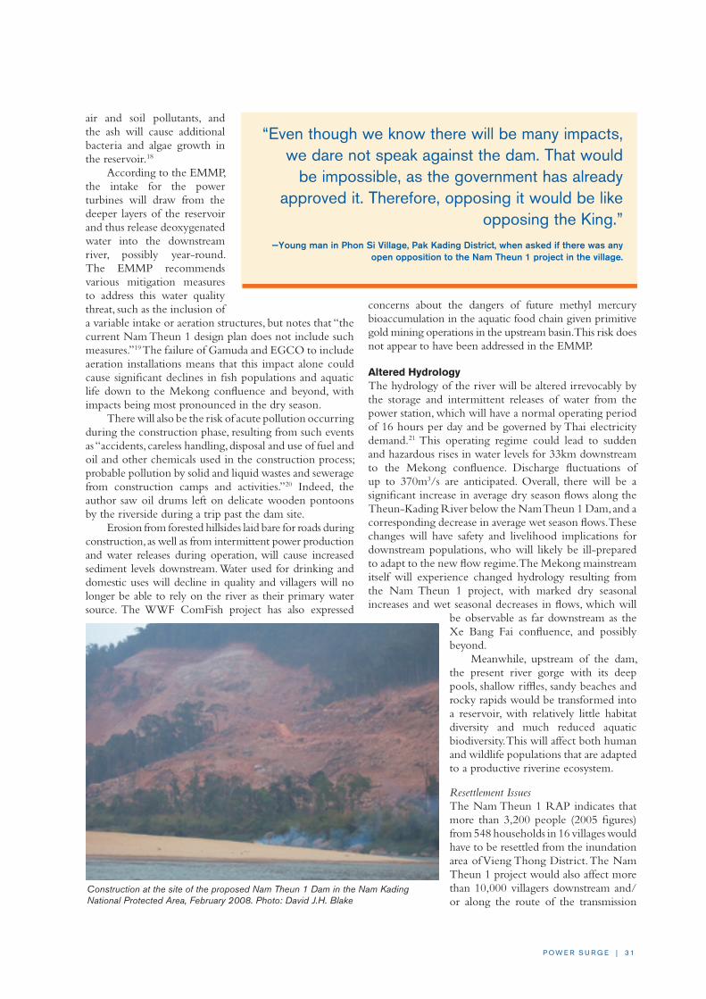
P O W E R S U R G E | 3 1
air and soil pollutants, and the ash will cause additional bacteria and algae growth in the reservoir.18
According to the EMMP, the intake for the power turbines will draw from the deeper layers of the reservoir and thus release deoxygenated water into the downstream river, possibly year-round. The EMMP recommends various mitigation measures to address this water quality threat, such as the inclusion of a variable intake or aeration structures, but notes that “the current Nam Theun 1 design plan does not include such measures.”19 The failure of Gamuda and EGCO to include aeration installations means that this impact alone could cause significant declines in fish populations and aquatic life down to the Mekong confluence and beyond, with impacts being most pronounced in the dry season.
There will also be the risk of acute pollution occurring during the construction phase, resulting from such events as “accidents, careless handling, disposal and use of fuel and oil and other chemicals used in the construction process; probable pollution by solid and liquid wastes and sewerage from construction camps and activities.”20 Indeed, the author saw oil drums left on delicate wooden pontoons by the riverside during a trip past the dam site.
Erosion from forested hillsides laid bare for roads during construction, as well as from intermittent power production and water releases during operation, will cause increased sediment levels downstream. Water used for drinking and domestic uses will decline in quality and villagers will no longer be able to rely on the river as their primary water source. The WWF ComFish project has also expressed
concerns about the dangers of future methyl mercury bioaccumulation in the aquatic food chain given primitive gold mining operations in the upstream basin. This risk does not appear to have been addressed in the EMMP.
Altered HydrologyThe hydrology of the river will be altered irrevocably by the storage and intermittent releases of water from the power station, which will have a normal operating period of 16 hours per day and be governed by Thai electricity demand.21 This operating regime could lead to sudden and hazardous rises in water levels for 33km downstream to the Mekong confluence. Discharge fluctuations of up to 370m3/s are anticipated. Overall, there will be a significant increase in average dry season flows along the Theun-Kading River below the Nam Theun 1 Dam, and a corresponding decrease in average wet season flows. These changes will have safety and livelihood implications for downstream populations, who will likely be ill-prepared to adapt to the new flow regime. The Mekong mainstream itself will experience changed hydrology resulting from the Nam Theun 1 project, with marked dry seasonal increases and wet seasonal decreases in flows, which will
be observable as far downstream as the Xe Bang Fai confluence, and possibly beyond.
Meanwhile, upstream of the dam, the present river gorge with its deep pools, shallow riffles, sandy beaches and rocky rapids would be transformed into a reservoir, with relatively little habitat diversity and much reduced aquatic biodiversity. This will affect both human and wildlife populations that are adapted to a productive riverine ecosystem.
Resettlement IssuesThe Nam Theun 1 RAP indicates that more than 3,200 people (2005 figures) from 548 households in 16 villages would have to be resettled from the inundation area of Vieng Thong District. The Nam Theun 1 project would also affect more than 10,000 villagers downstream and/or along the route of the transmission
“Even though we know there will be many impacts, we dare not speak against the dam. That would
be impossible, as the government has already approved it. Therefore, opposing it would be like
opposing the King.” —Young man in Phon Si Village, Pak Kading District, when asked if there was any
open opposition to the Nam Theun 1 project in the village.
Construction at the site of the proposed Nam Theun 1 Dam in the Nam Kading National Protected Area, February 2008. Photo: David J.H. Blake

3 2 | I N T E R N AT I O N A L R I v E R S
line. In total, the RAP estimates that 14,500 people in 2,590 households from 103 villages would be negatively impacted by Nam Theun 1.22 The affected villages include people from several ethnic groups, including Upland Tai groups (e.g. Tai Meuy, Tai Kang), Phong, Hmong, and Khmu, with lowland Tai-Lao mainly situated in the lower Theun-Kading and Mekong villages.
Like other resettlement plans, the Nam Theun 1 RAP displays an unjustified optimism that the serious impacts resulting from the dam can be adequately mitigated and compensated for by using largely conventional development strategies. The livelihood restoration methods proposed in the RAP have a mixed record of adoption and success at best, especially amongst poorer households. For example, it is assumed that 635 households23 will be relocated to just four host villages in Vieng Thong District and will find sufficient irrigated land for agriculture, grazing land for livestock, and resources to support other livelihood activities for them and the host villagers.
The livelihood model assumes that there will be enough water to supply one hectare of irrigated rice per family, despite the fact that the irrigation systems will be located on small streams with intermittent flows. It also assumes that villagers will be able to afford the agricultural inputs required to achieve the desired yields. Experience from the Theun-Hinboun project’s Mitigation and Compensation Plan suggests otherwise (see Case Study Three).
Like other hydropower projects in the region, Nam Theun 1 has failed to compile a household-by-household profile of affected persons. The RAP itself admits “[t]here is insufficient data on fish catch, either for consumption or sale, to make a judgment on the effects that will be felt by the upstream populations…All families do fish,
so their future is partly dependent on answers to those questions.”24 The RAP assumes that impacted households will be able to adopt aquaculture to replace the lost protein and income derived from capture fisheries, but it shows little understanding of the practical challenges involved in ensuring that nearly all of the fisheries-dependent population will be able to make such a significant transition.25
The proposed total budget for the RAP is $28.4 million for a 12-year period.26 Almost $6 million of this sum will be consumed by staffing costs, and another $1 million will be spent on monitoring and evaluation. The main budget line item is $13.7 million for “Resettlement and Infrastructure,” most of which will be spent on rebuilding inundated infrastructure in the resettlement villages. Less than $3.5 million is proposed for “Livelihood Restoration and Improvement,” of which $3.2 million is to be spent before dam operation starts. Therefore, there is a mere $300,000 available after dam construction for restoring the livelihoods of a conservatively estimated 2,600 households. This sum amounts to $20 per affected person for five years, which is not enough to sustain even the most paltry livelihood program.
Nam Kading NPA and Biodiversity ThreatsBefore the Theun-Hinboun project began operating in 1998, the Nam Kading NPA was described by the Lao National Tourism Administration as “the most pristine lowland riverine habitat in Laos.”27 The extensive tracts of broadleaf evergreen forest stretching back from either side of the Theun-Kading River are noteworthy for their quality, protected as much by their inaccessibility as by any dedicated effort by authorities.
The Kaeng E-dtat rapids, just upstream of the dam site, will be lost to the Nam Theun 1 reservoir. Photo: David J.H. Blake

P O W E R S U R G E | 3 3
Within these thick forest-cloaked mountains and valley are wildlife species listed as “endangered,” “vulnerable” or “globally threatened,” such as tiger, elephant, gibbons, and various rare bird species. The Nam Kading NPA has been the focus of a joint Wildlife Conservation Society (WCS) and Bolikhamsay Provincial conservation project, funded by the World Bank and the Global Environment Facility (GEF). However, due to the annexation of the WCS Training Centre by the Nam Theun 1 project— constructed at the exact location where Gamuda and EGCO are now building their base camp and access road —research, training and ecotourism activities for the NPA had been delayed as of the time of this writing.28
The multiple impacts of Nam Theun 2, Nam Theun 1 and the Theun-Hinboun Expansion projects will soon cause irreparable damage to this remarkable stretch of river and surrounding forest resources. In addition to the direct loss of 4,400ha of inundated forest and critical wildlife habitat, the dam and reservoir will lead to more encroachment, hunting and logging beyond the flooded area as a result of improved access by road and water.
According to WCS, “Currently the river is unnavigable, but the long branching reservoir will make much of the NPA easily accessible from the north and east. Over-exploitation of natural resources to meet regional demand is already a big problem in the NPA, and this could make the situation worse if not managed well.”29 These threats will be exacerbated by the influx of thousands of workers during the construction period. Additionally, the Nam Theun 1 project’s power transmission line is projected to pass Na Village, Thapabath District—home to one of the largest elephant herds in Laos and site of an eco-tourism project.30
Impacts on the Mekong BasinA Cumulative Impact Assessment (CIA) was conducted by the same consultancy companies (Norplan and EcoLao) that completed the social and environmental assessments for Nam Theun 1, reportedly according to ADB guidelines. The desktop study considered developments in a number of key sectors (e.g. hydropower, irrigation, transport, fisheries) and examined their influence over 6- and 13-year time horizons on the various identified impact zones of the Nam Theun 1 project.
Relatively little attention was paid to the effect of the Nam Theun 1 Dam on the Mekong River even though the study predicts there will be a cumulative impact on hydrology (taking into account upstream hydropower developments) that will lead to an 8% decrease in peak Mekong flows during August, and a 3–4% increase in dry season flows in the 6-year scenario. There will be further cumulative seasonal changes in the Mekong River downstream of the Nam Hinboun and Xe Bang Fai confluences as each tributary’s flow is altered by the Theun-Hinboun Expansion Project and by Nam Theun 2 respectively.
The CIA authors believe the impacts of these significant flow changes on fisheries and aquatic biodiversity will be “difficult to predict,”31 especially
those in deep pools. However, the CIA fails to consider the full cumulative impacts that Nam Theun 1 would have. If the Nam Theun 1 project contributes to an 8% decrease in wet season Mekong flows as far downstream as the Nam Hinboun confluence, this would have a profound influence on the flood levels of the Lower Nam Songkhram River Basin in Thailand,32 which has a highly valuable and productive fishery largely dependent on Mekong water levels, flows and fish migration patterns.33 Just a small decrease in wet season levels would cause a large decrease in inundated floodplain. This would in turn result in decreased productivity of the fishery and aquatic ecosystem, a sector known to be more valuable than agriculture on the floodplain in the rainy season.34
The trans-boundary impacts of Nam Theun 1 should be fully investigated before a decision is made to proceed. At present, downstream populations on the Mekong River or along tributaries like the Nam Songkhram are not considered to be “affected persons” in the RAP, EMMP or CIA, yet an unknown number will suffer reduced fish catches, lost riverbank gardens, and decreased agricultural productivity due to loss of sediments and nutrients as a result of Nam Theun 1.
CONCLUSION AND RECOMMENDATIONSThe Nam Theun 1 project is one of the most ill-conceived projects amongst the large number of dams currently on the drawing board in Laos. The impacts on fisheries, fishery-dependent livelihoods and on the area’s critical biodiversity will be especially severe. The hurried and non-transparent manner in which this project has been planned and executed to date—with non-disclosure of key documents and suspect economic analysis and
Riverbank vegetable gardens along the lower Theun-Kading River. Photo: David J.H. Blake

3 4 | I N T E R N AT I O N A L R I v E R S
decision-making—would suggest that Nam Theun 1 would be an extremely costly project for Lao villagers and the environment.
Recommendationsn Given the Nam Theun 1 project’s questionable
economic viability and the major and irreversible impacts it would have on fisheries and biodiversity, plans to build Nam Theun 1 should be reconsidered and alternatives sought.
n Construction work on the Nam Theun 1 project should be halted immediately until a full and independent public inquiry is held into the environmental and social impacts of this project on all stakeholders, including those living upstream and downstream along the mainstream Mekong River in Laos and Thailand. If the project proceeds, all parties need to be made fully aware of the potential impacts they face and allowed to negotiate with the project developers for fair compensation, in line with international agreements on shared rivers, including the 1995 Mekong Agreement of the Mekong River Commission (MRC).
NOTES
1 For the purposes of this report, the author refers to the Theun-Kading River to help situate it geographically and mentally as one and the same river that, upstream from the Theun-Hinboun Dam, is referred to as Nam Theun, but in its lower reaches is generally referred to as Nam Kading.
2 Gamuda describes itself on its own website as “Malaysia’s leading infra-structure group,” and with regards to dam construction says, “Gamuda’s record in this area has been excellent,” despite the fact it has only built one dam that reportedly had multiple problems. See: http://www.gamuda.com.my/GAMUDA05/projects_dams.htm (Accessed 14 July 2008) and http://www.magickriver.net/bulletin.htm (Accessed 14 July 2008).
3 EGAT holds a 25.41% stake in EGCO according to following article: “Thailand’s EGCO in Hydro Deal with Malaysians,” Bangkok Post, 17 Oct 2005 (http://www.newsmekong.org/thailands_egco_in_hydro_deal_with_malaysians).
4 The Sungai Selangor Dam was completed ahead of schedule in April 2003, despite strong opposition by civil society and local people who were concerned about the environmental impacts the dam would cause and the poor enforce-ment of environmental guidelines and regulations by the government itself.
5 Maunsell and Laymeyer International, Power System Development Plan for Lao PDR, Final Report—Vol. A: Main Report (August 2004), 224 pp.
6 Ibid., p. 113.
7 Signing of Tariff Memorandum of Understanding with Electricity Generating Authority of Thailand for the Nam Theun 1 Hydroelectric Power Project (‘NT1 Project’), Gamuda Berhad, http://www.bursamalaysia.com/website/bm/listed_companies/company_announcements/announcements/historical.jsp (18 Dec 2006).
8 “Deputy PM visits Nam Theun sites,” Vientiane Times, 16 Jan 2008.
9 “Gamuda: No delay in double-tracking project,” The Star Online, 22 March 2008 (http://biz.thestar.com.my/news/story.asp?file=/2008/3/22/business/20724400&sec=business).
10 “Rising oil prices increase value of energy exports,” Vientiane Times, 30 July 2008.
11 Norplan & EcoLao, Nam Theun 1 HPP: Cumulative Impact Assessment, Final Report, Gamuda Bhd and EGCO (Sept 2007). Unpublished document.
12 For a good overview of the Theun-Hinboun Hydropower Project, please refer to: http://www.mekong.es.usyd.edu.au/publications/briefs/mekong_brief3.pdf (July 2006).
13 Norplan & EcoLao, p. 14.
14 Ibid., p. 23.
15 Table 28.9, Ibid., Draft “Final Resettlement Action Plan—Part 4,” p. 11.
16 Further details of this project can be found at: http://www.panda.org/about_wwf/where_we_work/project/projects/index.cfm?uProjectID=LA0035 (Accessed 14 July 2008).
17 Personal communication with Roger Mollot, Chief Technical Advisor of ComFish Project, 12 April 2008.
18 Personal communication, Dr. Guy Lanza to Aviva Imhof, International Rivers, 14 Feb 2008.
19 Norplan & EcoLao, p. 82.
20 Norplan & EcoLao, 2007.
21 Presently the forecast is for 10.5–13.5 hours of operation per day, six days per week, hence causing dramatic daily flow variations. For comparison, one could look at Theun-Hinboun, which has an operating schedule defined by EGAT demands and is known to be switched on and off at unpredictable times, creating dangerous conditions downstream that have led to drownings of children and adults caught unaware by the rising waters. For further details see: http://www.internationalrivers.org/en/node/2311 (27 Nov 2007).
22 However, it is thought these figures are on the conservative side. According to an inside source, due to faulty surveys, a village on the Nam Mouan that was originally thought to require the resettlement of only 4 households is in fact going to be totally flooded, but has not been included in the RAP at Gamuda’s insistence. This situation, if true, raises questions about not only the devel-oper’s intent, but the possibility that actual flood extent may be more serious than has so far been admitted.
23 This is the 2010 population estimate.
24 Norplan and EcoLao, “Section 41.1 Livelihood Resoration and Improvement Plan,” p. 31.
25 For a description of why historically aquaculture development has been promoted over capture fisheries, see: Bush S., “ ‘Give a man a fish’: Contextualising Living Aquatic Resources Development in the Lower Mekong Basin,” Working Paper No. 8, Australian Mekong Resource Centre, University of Sydney (August 2003). While for a more specific critique of the “Fish for Fish” mentality common amongst hydropower proponents in the region and being applied at Nam Theun 2 Hydropower Project, see: Blake D.J.H., “A Review of the Adequacy of Compensation Measures for Communities Living along the Xe Bang Fai River, Nam Theun 2 Hydropower Project, Lao PDR,” Report prepared for International Rivers Network, Berkeley, California (2005).
26 Table ES-8, Norplan and EcoLao, “Executive Summary,” p. ixi.
27 “Nam Kading NBCA,” Ecotourism Laos, http://www.ecotourismlaos.com/directory/protected_areas/namkading.htm (Accessed 14 July 2008).
28 Personal communication, email from Mike Hedemark, WCS to Shannon Lawrence, International Rivers, 17 March 2008.
29 Personal communication, email from Mike Hedemark, WCS to Shannon Lawrence, International Rivers, 17 March 2008.
30 For further details see: http://www.trekkingcentrallaos.com/html/ele-phants.html (Accessed 14 July 2008).
31 Norplan & EcoLao, “Executive Summary,” p. xxii.
32 The Lower Songkhram River Basin was the subject of a GEF/UNDP-MRC-IUCN wetlands conservation project, and has been well-documented for its regional importance and high ecosystem values, details of which can be downloaded at: http://www.mekongwetlands.org/Demonstration/Thailand/description.htm (Accessed 14 July 2008).
33 Blake D.J.H., “The Songkhram River Wetlands—A critical floodplain ecosys-tem of the Lower Mekong Basin,” Paper presented at the International River Symposium (Brisbane, Australia: 4–7 Sept 2006). Available at: http://www.riversymposium.com/index.php?element=06BLAKEDavid.
34 Blake D. and Pitakthepsombut R., “Situation Analysis: Lower Songkhram River Basin, Thailand,” Mekong Wetlands Biodiversity Conservation and Sustainable Use Programme (Bangkok, Thailand: 2006), 121 pp.

P O W E R S U R G E | 3 5
MAIN CONCERNSn The Theun-Hinboun Hydropower Project has
had serious impacts on the lives and livelihoods of approximately 30,000 people living downstream and upstream of the dam who have lost fish, rice fields, vegetable gardens and drinking water as a result of the project.
n The project has caused erosion and flooding in the Hai and Hinboun river basins. Many villagers have abandoned wet season rice fields because the floods have made rice cultivation unviable. The flooding has also caused water contamination, livestock deaths and other hardships for villagers living downstream. Water fluctuations have reportedly resulted in the deaths of several people.
n The Theun-Hinboun Mitigation and Compensation Program started too late and has done too little to address these impacts. More than a decade since dam operations began, the program has still not restored villagers’ livelihoods.
n THPC is now planning an expansion project that would displace 4,360 people and affect another 48,441 living downstream, on project construction lands, and in host villages. The Theun-Hinboun Expansion Project resettlement plan and environmental impact assessment are wholly inadequate in proposing measures to manage the project’s impacts and to adequately compensate affected communities.
BACKGROUND AND DESCRIPTIONThe 210 MW Theun-Hinboun Hydropower Project is a trans-basin diversion project that diverts water from the Theun-Kading River into the Hai and Hinboun river basins. Ninety-five percent of its power is exported to Thailand. The Theun-Hinboun project is owned by the GoL, the Norwegian state-owned company Statkraft and GMS Power of Thailand, who together comprise THPC. The ADB provided $60 million in loans for the GoL’s equity share, and the Nordic Development Fund contributed another $7.3 million for the $260 million dam. Financing was also provided by a consortium of commercial banks and Scandinavian public export credit agencies.
CASE STUDy THREE: Theun-Hinboun Hydropower Project and Theun-Hinboun Expansion Projectby Aviva Imhof
The Theun-Hinboun Hydropower Project was Laos’ first major public-private partnership in hydropower
development. Funded by the ADB, the Nordic Development Fund and a host of other financial institutions,
the project was completed in 1998 and immediately hailed as a success. While Theun-Hinboun has been earning
substantial revenues for the private investors and the GoL, it has thrust around 30,000 Laotians deeper into poverty
by depriving them of the natural resources upon which they depend. Yet instead of resolving these problems, the
Theun-Hinboun Power Company (THPC) will exacerbate them by building an additional dam upstream.
The Theun-Hinboun Dam.

3 6 | I N T E R N AT I O N A L R I v E R S
When the Theun-Hinboun project was first proposed, groups in Thailand, Norway and other countries warned that it would have significant negative impacts on affected communities. Yet these warnings were ignored. In 1997, the ADB went so far as to proclaim the project a “winner” with “little for the environment lobby to criticize.”1 But soon after project operations began, NGOs uncovered a different story. About 25,000 people from 57 villages downstream and upstream of the dam had experienced declines in fish catches of 30–90%, the destruction of vegetable gardens and dry-season drinking water sources, loss of fishing nets, and increased difficulties with transportation.2 Today the number of affected people has risen to 30,000 in at least 66 villages along the Hai, Hinboun and Theun-Kading rivers.3
After several years of sustained pressure from NGOs, in 2000 THPC admitted the impacts caused by the project and promised to spend up to $4.5 million on a Mitigation and Compensation Program. While the program has been successful in meeting some of the infrastructure needs of the affected communities, it has failed to restore lost livelihoods. In 2004, an independent review of the Mitigation and Compensation Program raised concerns about its long-term sustainability and issued a series of recommendations, most of which were ignored by THPC.4
Although the Theun-Hinboun project has made affected villagers poorer, it has generated windfall profits for its shareholders. Located downstream from the Nam Theun 2 Hydropower Project (see Case Study Four), Theun-Hinboun’s earnings were boosted by the long delays in Nam Theun 2’s implementation. According to the Vientiane Times, THPC has earned approximately $570 million over the project’s 10 years of operations.5
To make up for the reduced water flows caused by Nam Theun 2 and to increase profits, THPC plans to build a new 65-meter-high dam on the Nam Gnouang River, a tributary of the Theun-Kading River, to store water in a reservoir for release in the dry season. The new project—known as the Theun-Hinboun Expansion Project—would displace 4,360 people and double diversions down the Hai and Hinboun rivers, causing more flooding, erosion, fisheries losses and resettlement.
The Theun-Hinboun Expansion Project is expected to start construction in 2008 and be completed in 2011. For the $485 million project, THPC is reportedly seeking financing from Thai and international commercial banks, including ANZ Investment Bank, Bank of Tokyo-Mitsubishi UFJ, Calyon, Fortis Bank, ING Bank and KBC Bank,6 all of whom have adopted a set of international social and environmental standards known as the Equator Principles.
PROJECT ISSUES AND ANALySIS
The Theun-Hinboun Hydropower ProjectThe Theun-Hinboun project has affected approximately
30,000 people living in at least 66 villages along the Hai, Hinboun and Theun-Kading rivers. Impacts have included decimation of fisheries, particularly downstream along the Hai and Hinboun Rivers and in the headpond area, increased flooding leading to rice paddy abandonment, inability to cultivate dry season riverbank gardens, and impairments to domestic water supply. These impacts have been documented in numerous reports and field visits since 1998.7
In 2007, Norwegian NGO FIVAS commissioned two researchers to undertake field surveys in a sample of affected downstream communities along the Hai and Hinboun rivers. The research team interviewed numerous people in five villages over 10 days. Their report, Ruined Rivers, Damaged Lives, documents increasingly severe impacts caused by the Theun-Hinboun project since 1998.8
Downstream ImpactsFluctuating water levels and stronger flows have caused erosion along the Hai and Hinboun rivers leading to the loss of fertile agricultural land, riverbank gardens and vegetation. Resource Management and Research (RMR)—a consulting firm originally contracted to conduct the EIA for the proposed expansion project—estimated that as of 2005, the original Theun-Hinboun project had caused the Nam Hai channel to widen by about 45m, leading to the loss of around 68ha of land.9 RMR estimated the value of this land to be between $100,000 and $136,000, but villagers have not received any compensation for these land losses.
Flooding has become increasingly severe as a result of water releases from the dam and increased sedimentation. Villagers have experienced recurring losses of wet season rice crops, leading to widespread paddy field abandonment. RMR estimated that at least 820ha of rice paddy have been abandoned, but no compensation has been paid to villagers.10 The destruction of paddy fields has forced villagers to rely on upland rice cultivation. However, a large eucalyptus plantation project owned by Japanese company Oji is taking over villagers’ upland forests, impeding their ability to grow upland rice and collect NTFPs. As a result, food security is becoming an issue for thousands of households.11
The increased flooding has also caused water contamination and skin diseases, drinking water scarcity, death of livestock from drowning and disease, loss of fruit trees and other trees and plants, temporary food shortages and loss of income, and difficulties with access and mobility for many families. The fluctuating water levels in the Nam Hai appear to have led to the deaths of
“Nyom! Bor mee pha leua!”—“I accept defeat! There are no fish left.”
— Fisherman living at the confluence of the Hai and Hinboun rivers.

P O W E R S U R G E | 37
several people in recent years, including that of a young child. Villagers sometimes lose boats or fishing gear due to sudden water releases, losses for which they have not been compensated.
The researchers found that fish and aquatic resources have continued to decline in the Hai and Hinboun rivers. No compensation has been paid for lost fish productivity, and small communal fish ponds built in a few villages have not had any measurable impact as replacement for lost protein and income.
Downstream of the dam site along the Theun-Kading River, where there is less water than before, villagers have also suffered from decreased fisheries and problems with their dry season water supply. Ten villages have been affected in this area and have received little compensation from THPC. The 2004 independent review of the THPC Mitigation and Compensation Program concluded that these villages had not benefited from the program and recommended that activities be extended to the Nam Kading villages. However, these recommendations were ignored. A visit to the area in 2006 confirmed that the only assistance the Nam Kading villages have received from THPC was a small amount of compensation for lost rice crops following a major flood in 2000.
The Mitigation and Compensation Program that was developed to resolve the Theun-Hinboun project’s impacts has had few successes after six years of implementation. The program has focused on promotion of dry season irrigated rice in the Hinboun Valley, replacement vegetable gardens, a livestock program, and a health promotion program. The health promotion program has built latrines and provided mosquito nets and other supplies, and THPC has constructed wells to replace lost dry season drinking water. However, the efforts to restore lost livelihoods have not been successful.
By their own admission, THPC has had difficulties ensuring the profitability of the dry season rice program due to the high costs of pumping water and of inputs such as fertilizer.12 Villagers have reported declining yields over the five years since the program was introduced, and a corresponding increase in debt to the village Savings and Credit Funds.13 The Theun-Hinboun Expansion Project resettlement plan admits that only 872 families were still involved in the program as of 2007, out of approximately 5,000 families living in the downstream area. THPC’s dry season vegetable garden program has also run into problems due to a lack of markets for the produce, the additional labor required of villagers, pump breakdown, fence failure, crop disease, and a loss of fruit trees from flooding. Furthermore, there has been virtually no effort made to compensate for or replace lost protein from fisheries.
Ten years into project operation, local communities are worse off than before the Theun-Hinboun Hydropower Project was built.
The Theun-Hinboun Expansion ProjectThe proposed Theun-Hinboun Expansion Project will displace 4,360 mostly ethnic minority people and negatively affect another 48,441 people living
Pa Hang village is located along the middle reaches of the Hinboun River. According to vil-lagers who were interviewed in 2006, there were plenty of fish in the river before the dam, and they had a surplus they could sell at the market. But today there are fewer fish in the river, and even in the dry season only small fish are available. Since the dam was built, the water is deep and flows very fast, whereas it used to be shallow in the dry season, making it easier to catch fish. Before there were deep pools for the fish to live in during the dry season, but these have been filled with sediment. THPC has built a fishpond across the river for the village to harvest fish, but it doesn’t provide enough for everyone.
Many families lose their rice crops every wet season because of the flooding. Although it used to flood before the dam, the flood didn’t last so long. The flooding used to continue for 15 to 20 days, but now it lasts 20 to 30 days. Before the dam, flooding occurred 1 to 3 times per year, but now it happens 5 to 6 times per year.
villagers are concerned about the erosion along the Nam Hinboun, which they said was caused by the fluctuating water levels and the higher year-round water levels in the river. They said they can no longer grow vegetables along the riverbanks. Two years ago, the villagers planted mango, longan, and orange trees along the river as part of THPC’s fruit orchard program. villagers said the mangoes were sour and too small to eat.
When asked about the Theun-Hinboun Expansion Project, villagers said they had been informed about the project by THPC. THPC told them that the water flows would double, but did not explain whether or not villagers would have to move. vil-lagers are afraid of more flooding and are worried about the future. Most people in the village want to stop the dam but they cannot speak to either the company or the government about this.
“They (the government) don’t care about us,” a 93-year-old grandfather exclaimed before he was hushed by his daughter.
“They don’t care about us.”

3 8 | I N T E R N AT I O N A L R I v E R S
downstream, on project construction lands, and in host villages. The project involves a storage dam on the Nam Gnouang River and a doubling of capacity at the existing Theun-Hinboun power plant, resulting in a doubling of the amount of water diverted into the Hai and Hinboun rivers. The extra erosion, sedimentation and aggravated flooding from additional flows in the Hai and Hinboun rivers could be disastrous for downstream villagers and result in widespread displacement.
Resettlement IssuesIn the proposed reservoir area, a fundamental problem is the lack of adequate and productive replacement land for the displaced villagers. Reservoir villages will be moved into three host communities where land and resources, such as forest products and fish, are already scarce. The consequent quadrupling of the population in the host villages will lead to fierce competition for natural resources. The entitlements for resettlers include “replacement land of at least the same size and equal productive value at a location acceptable to the [project affected people],” but it is unclear where this land will come from.14
A second problem is the inadequacy of the proposed livelihood restoration measures, which are unclear, unproven and under-funded. The Theun-Hinboun Expansion Project’s RAP recommends activities that have become the standard mitigation package for any hydropower project in Laos: aquaculture to replace fisheries; dry season irrigated rice to replace wet season rice production; vegetable and fruit gardens to replace riverbank agriculture; investment in livestock management; and the always vague, and rarely successful, “non-farm employment” and “cottage industry.” Despite their popularity with resettlement and environmental impact assessment consultants, these measures have never
restored—let alone increased—income levels for dam-affected communities in Laos.
The RAP only provides for direct compensation for losses of fixed assets, such as land, fruit trees and housing. There is no commitment to provide land-for-land, so many people will end up with cash compensation instead of land of equally productive value. The plan fails to quantify the damages that will be sustained from the loss of common property resources, as well as to determine acceptable levels of compensation based on those losses. Instead, the resettlement plan proposes replacing lost resources with livelihood restoration programs.
The problem with this approach is that the proposed measures have already been tried, with limited success, in villages affected by the existing Theun-Hinboun project. The RAP fails to draw lessons from the successes and failures of
the mitigation and compensation program of the existing project, or from the experiences at the nearby Nam Theun 2 Hydropower Project (see Case Study Four). As such, the Theun-Hinboun Expansion Project is poised to repeat past mistakes.
Downstream ImpactsThe Theun-Hinboun Expansion Project will significantly increase the frequency and duration of flooding, cause even greater erosion along the riverbanks, and almost completely decimate fisheries in the Hinboun River, with the exception of a few species adapted to very turbid waters.15
Some of these impacts could be mitigated with an enlargement of the surge pond downstream of the powerhouse to accommodate the additional flows. The EIA claims that the existing pond can “accommodate” a doubling of flows without major modifications. In reality, the tailrace channel and surge pond are already too small to fulfill their purpose, and further live volume has since been lost through sedimentation. The refusal to make any modifications to increase the pond’s storage volume and thus reduce water fluctuations downstream appears to be a cost-cutting measure by THPC.
The increased flooding along the Hai and Hinboun rivers will make life unbearable for many residents. As a result of the additional flooding, the RAP admits that some villages or village households will need to be “relocated.” According to the plan, the relocation will be “voluntary,” yet the plan states that “in the event that [project affected persons] do not wish to relocate,…they may continue to remain in their current location but will not be eligible for future compensation for flood damage or be provided any infrastructure improvement.”16 This is an extraordinary statement, and it indicates that relocation is by no means
Erosion along the Hinboun River. Photo: Vinya Sysamouth

P O W E R S U R G E | 3 9
voluntary. Indeed, if villagers do not “choose” to relocate, they will be provided with no assistance for the aggravated flooding that will occur as a result of the Theun-Hinboun Expansion Project.
Between 1,000 and 2,000ha of paddy land “have been or will need to be abandoned for wet season production in the Recipient River area,” according to the resettlement plan.17 Clearly, THPC does not know exactly how much paddy land will be affected by the Theun-Hinboun Expansion Project. There is no paddy land available in the Hinboun Valley with which to replace the paddy land
lost to flooding. Villagers will instead be forced to rely on irrigated dry season rice production or upland rice cultivation. Yet along the lower Hinboun River, the land available for upland cultivation is increasingly being taken for large-scale industrial tree plantations owned by Oji Pulp and Paper.18
The Theun-Hinboun Expansion Project’s EIA underestimates the risks of poor water quality episodes during construction and operation of the new reservoir, especially in the early years of biomass decomposition. The release of water low in dissolved oxygen could cause
TheunHinbounDam Nam
Theun 2 Dam
powerhouse
powerhouse
downstream channel
Xe B
ang
Fai
Nam Hinboun
Nam Kading
Nam
Hai
Nam Theun
Mekong River o Thakek
THAILAND
LAO PDR
VIETNAMo
Pak KadingNam Gnouang 8 Dam
Nam Theun 1 Dam
(Theun-Hinboun Expansion
Project)
0 1 0 2 0 3 0 4 0 5 0 k m
Key Existing and Proposed Dams in the Nam Theun Basin

4 0 | I N T E R N AT I O N A L R I v E R S
fish kills downstream of the project in the Theun-Kading River and the Hai and Hinboun rivers.
THPC does plan to clear the above-ground biomass from the reservoir area before inundation, but the current plan calls for burning the biomass, which will cause air pollution, release toxic mercury, and accelerate the release of nutrients trapped in the biomass. These nutrients, which will be concentrated in the ash, will support the sudden growth of excess algae and bacteria in the reservoir water, which in turn will trigger a cascade of water quality problems including greatly reduced dissolved oxygen, fish kills, and the release of toxic chemicals from the reservoir sediments.19 To avoid additional water quality impacts caused by burning, the biomass should be cut and removed where it could ideally be mulched for use in the area.20
CONCLUSION AND RECOMMENDATIONSGiven the unresolved problems of the Theun-Hinboun project and the uncompensated losses for tens of thousands of affected villagers, it is irresponsible to compound these impacts by building the Theun-Hinboun Expansion Project and increasing flows into the Hai and Hinboun rivers. Food security for thousands of households, already compromised by the present water releases from the Theun-Hinboun project, would likely become an issue of critical magnitude and lead to massive out-migration from the affected downstream communities.
Recommendationsn THPC should abandon its plans for the expansion
project until full and satisfactory compensation for existing losses has been paid to all people affected by the Theun-Hinboun project.
n The Theun-Hinboun Expansion Project should only proceed if: 1) adequate measures to address the ongoing social and environmental impacts in the downstream areas are successfully adopted; 2) the proposed RAPs are replaced with viable programs for compensating villagers and restoring their livelihoods; and 3) the EIA and the EMMP are rewritten in a way that adequately recognizes the magnitude of problems that the project will pose for downstream communities and proposes viable measures for mitigating those impacts.
NOTES
1 Gill, I., “Theun-Hinboun gamble pays off: Hydropower project to increase Lao PDR’s GDP by 7 percent,” ADB Review (Nov/Dec 1997), p. 8.
2 Shoemaker, B., Trouble on the Theun-Hinboun, International Rivers Network (Berkeley, California: April 1998).
3 Norplan, Part 3, Theun-Hinboun Expansion Project Draft Final Resettlement Action Plan (August 2007), pp. 16–18.
4 Blake D., Carson B. and Tubtim N., Review of the Environmental Management Division, Theun-Hinboun Power Company Ltd. (31 March 2004).
5 “Laos profits from Theun Hinboun hydropower,” Vientiane Times, 2 April 2008.
6 “Laos promises a deluge of offshore project financings,” International Financing Review Asia, 2 February 2008.
7 See for example, Trouble on the Theun-Hinboun—A field report on the socio-economic and environmental effects of the Nam Theun-Hinboun Power Project in Laos, 1998 and Warren T., A monitoring study to assess the localized impacts created by the Nam Theun-Hinboun Hydro-scheme on Fisheries and Fish Populations, prepared for the Theun-Hinboun Power Company (June 1999).
8 Ruined Rivers, Damaged Lives: The Impacts of the Theun-Hinboun Hydropower Project on Downstream Communities in Lao PDR, FIVAS (Oslo, Norway: 2007) 35 pp.
9 Theun Hinboun Expansion Project Social Action and Environmental Management Plans, Draft, Resource Management and Research (20 Nov 2006) pp. 2–24.
10 Ibid, pp. 2–147.
11 Barney, K., Power, Progress and Impoverishment: Plantations, Hydropower, Ecological Change and Community Transformation in Hinboun District, Lao PDR, A Field Report, York Centre for Asian Research (June 2007), 139 pp.
12 This is noted in Part 3 of the RAP which states that for irrigated agriculture “marginal benefit was obtainable overall but many villages lose money on this activity.”
13 Ruined Rivers, Damaged Lives, p. 47.
14 Norplan RAP, Part 2, p. 8.
15 These are outlined in Norplan RAP, Part 2, pp. 7-9.
16 Norplan RAP, Part 3, p. 36.
17 Norplan RAP, Part 3, p. 37.
18 Power, Progress and Impoverishment, 2007.
19 Personal communication, email from Dr. Guy Lanza to Aviva Imhof, International Rivers, 11 Sept 2006.
20 Personal communication, email from Dr. Guy Lanza to Aviva Imhof, International Rivers, 14 Feb 2008.

P O W E R S U R G E | 4 1
MAIN CONCERNSn Nam Theun 2 will significantly increase flows in the
Xe Bang Fai River and cause fisheries losses, increased flooding, water quality problems, erosion, and loss of riverbank gardens for over 120,000 people.1 The proposed compensation and mitigation measures and budget are inadequate to deal with the scale and severity of these impacts.
n Livelihood restoration programs for more than 6,200 resettled ethnic minority villagers on the Nakai Plateau, as well as for downstream villagers, are behind schedule. In some cases, approaches are still being tested and defined. The incomes of villagers in all areas affected by Nam Theun 2 are likely to decrease, at least initially, once the reservoir is flooded and water diversions to the Xe Bang Fai River begin.
n More than 10,000 people affected by the construction of the downstream channel and other project infrastructure did not receive compensation before their land and other assets were taken, in violation of World Bank policy and the CA. It is unclear if there will be enough land to provide most of 200 significantly affected households with critical land-for-land replacement.
n The Nam Theun 2 Power Company (NTPC) failed to clear sufficient vegetation from the reservoir area before it was flooded, which is likely to result in poor water quality on the Nakai Plateau and downstream, as well as greater greenhouse gas emissions from the 450km2 reservoir.
BACKGROUND AND DESCRIPTIONNam Theun 2 is a $1.45 billion hydropower project currently under construction in the Khammouane Province of central Laos. When it begins operations in 2009, Nam Theun 2 will export most of its 1,070 MW of power to Thailand. By the time Nam Theun 2 secured project financing in 2005, the dam had already been in the GoL’s and the World Bank’s sights for about two decades.2 During that time, Nam Theun 2 attracted
significant criticism from international environmental and human rights groups. A number of the concerns raised by NGOs—particularly regarding the viability of the project’s livelihood restoration programs—now prove to have been justified.
Nam Theun 2 is being developed by NTPC, a consortium headed by Electricité de France International. Other shareholders include EGCO with a 25% stake, Ital-Thai Development with a 15% stake, and the GoL with a 25% share. In March and April 2005, the Boards of Directors of the World Bank and the ADB approved loans and guarantees for Nam Theun 2 totaling $270 million and $107 million respectively. The United States was the only MDB shareholder that did not support the project, citing concerns about environmental and social risks, the macroeconomic environment in Laos, and the lack of potential recourse measures.3
With the World Bank’s and the ADB’s endorsement, other lenders—such as the European Investment Bank, the Nordic Investment Bank, the Swedish, Norwegian, French and Thai export credit agencies, Agence Française de Développement (AFD), and a number of private banks—committed to finance the project. Construction had already commenced a year earlier, in 2004.
Nam Theun 2 is a trans-basin diversion which will dramatically alter not one, but two Mekong River tributaries. A 39-meter-high dam has blocked the Theun River to form a 450km2 reservoir on the Nakai Plateau where 6,200 predominantly ethnic minority people have been resettled. Habitat for the endangered Asian elephant and other wildlife is being inundated by the Nam Theun 2 reservoir. Downstream from the dam, only 2m3/s of water will be released, which is not enough to sustain the fisheries that are a source of food and income for approximately 40 villages.
Water will be diverted down a 350m escarpment to the power station, before being transferred to the Xe Bang Fai River via a 27km downstream channel. With construction nearing completion, Nam Theun 2 seems to be on track to start power production by December 2009.
CASE STUDy FOUR: Nam Theun 2 Hydropower ProjectBy Shannon Lawrence
The Nam Theun 2 Hydropower Project, the largest dam in Laos, was billed by project proponents as a means
to reduce poverty and demonstrate best practice in socially and environmentally responsible dam building.
But instead of being a “model,” Nam Theun 2 has become another example of a two-speed infrastructure project
in which social and environmental programs fall behind while construction proceeds on schedule. The failure to
ensure that promises to villagers are met in a timely manner raises doubts about whether commitments will be
met to use Nam Theun 2’s revenues to benefit the poor.

4 2 | I N T E R N AT I O N A L R I v E R S
Through the $250 million (net present value) in revenues that Nam Theun 2 would generate for the GoL over the 25-year concession, the World Bank and the ADB asserted that the Nam Theun 2 project would help reduce poverty in Laos. Given the weaknesses in Laos’ public expenditure management system, the World Bank insisted on a revenue management framework to direct the GoL’s Nam Theun 2 revenues to poverty reduction expenditures. However, the revenues will still be channeled through the Lao Treasury and the allocation, monitoring and reporting on the use of Nam Theun 2 revenues will be primarily left to the Lao Finance Ministry and the State Audit Organization. There will be no independent oversight body or external independent auditing of Nam Theun 2 revenues.
PROJECT ISSUES AND ANALySISSoon after Nam Theun 2’s construction was initiated, it became clear that social and environmental programs—often more challenging and time-consuming than engineering works—were falling behind schedule. Dated covenants have been missed, and provisions of the World Bank’s policies and the CA violated, without penalty for NTPC or the GoL.
Resettlement IssuesAll 17 villages on the Nakai Plateau were initially to be resettled by the 2006–2007 dry season. But due to delays in permanent housing construction,4 this deadline was not met. Instead, the first villages were relocated in mid-2006. They, and many of those that followed, moved into temporary houses in their new village sites. It was expected that villagers would remain in these temporary houses for just a few months, and they were instructed to build their houses with that in mind. In the end, many villagers had to spend two rainy seasons in this temporary, substandard housing. It wasn’t until February 2008, when the Panel of Experts (PoE)—one of Nam Theun 2’s external monitoring bodies—warned that reservoir filling could be delayed, that rapid progress was made on housing construction. By June 2008, nearly all the 1,272 houses had been completed.5
Villagers in the resettlement sites have been primarily surviving on rice and protein support from the company, income earned from the project for land clearance and other work,6 fishing, and NTFP collection. Many villagers say they are pleased with their new houses, improved
“In the old village it was easy to find food. We were close to the river and there was lots of rattan
and other forest products. But now we have to take a motorbike to find food. We have to travel 3
to 5km to the forest. Our field is 1.5km away.” — Young woman in new Sop Hia Village.
water supply and sanitation, electricity, and roads to the new villages. Health improvements, particularly as a result of access to safe water and better sanitation, were quickly noted by the PoE and other monitors. The income from project-related jobs has contributed to initial increases in villagers’ living standards.
However, the greatest challenge for Nam Theun 2
continues to be developing and implementing sustainable livelihood programs for Nakai Plateau villagers. Resettlers have been moved to what will become the reservoir shores so that they can remain, by their request, on their traditional lands. However, soil quality is generally poor on the Nakai Plateau, and two-thirds of the land that villagers once used for farming, grazing livestock, and collecting NTFPs will be flooded by the large reservoir. The water buffalo and cattle populations on the Nakai Plateau can no longer be maintained, and the total herd will need to be reduced by approximately half.7
NTPC has committed to raise resettlers’ income to the national poverty level within five years. To this end, resettled villagers will be provided with: 1) house gardens, 2) 0.66ha plots (to be irrigated by the end of 2009) for growing some rice, fodder and vegetables, 3) use of the reservoir drawdown zone for rice cultivation and grazing land, 4) a community forest area for collecting NTFPs and sustainable timber extraction (some of which will also be used for grazing and fodder cultivation), and 5) boats for fishing in the reservoir, an area to which they’ve been granted exclusive access rights for 10 years.
Shortcomings in the livelihood restoration plans have been pointed out by NGOs since before project approval, and many of these problems have not been addressed. Villagers will be expected to grow cash crops on poor quality land to sell in an as yet unidentified market. They were originally promised 10,000ha of production forest, but the area has since been reduced by at least 40% and is further threatened by illegal logging. The forest area will be difficult for some villages to access, and important NTFPs such as bamboo will be flooded by the reservoir. Villagers were promised bountiful fish in the new reservoir, but it is likely to have initial poor water quality, thereby threatening the development of a productive fishery. While exact numbers are still unclear, as many as 2,000 buffaloes may need to be sold, which will weaken a critical safety net for villagers.
In early 2007, the PoE warned that “for a range of reasons, the forestry and agricultural livelihood programs are unlikely to meet their originally planned targets before impoundment.”8 A more recent PoE report indicates that after an initial boost from project jobs and other support, resettlers’ living standards are likely to decline once the reservoir is flooded.9 Finally, the July 2008 World Bank-ADB Update notes that while “encouraging progress” is

P O W E R S U R G E | 4 3
being made on the various livelihood programs, significant challenges remain. 10
Villagers Affected by Project ConstructionMore than 10,000 people11 have been affected by the construction of Nam Theun 2’s transmission lines, roads, and project facilities, losing land, assets, and access to natural resources. Households in Gnommalat District near the Nam Theun 2 power station, regulating pond and downstream channel have been the most severely affected.
The downstream channel is 27km long and approximately 100m wide, cutting through paddy fields and other village land. The channel also blocks access to the forest and villagers’ gardens and rice paddies on the other side. Villagers in the area have lost paddy land, houses, gardens, fruit trees, fisheries, irrigation water supply, and other assets to varying degrees.
According to the CA, villagers who lose less than 10% of their productive assets are entitled to cash compensation, and those who lose more than 10% are entitled to replacement land. Compensation payments only began in mid-2006, more than a year after Nam Theun 2 construction activities had started to impact villagers’ land and resources, and it was not until January 2008 that most compensation payments were finally made.12 The taking of land and assets before paying compensation is a violation of the Concession Agreement and of the World Bank’s involuntary resettlement policy.
There have also been problems with the assessment of entitlements and the delivery of compensation; nearly 400 grievances have been submitted to the District Grievance Committee.13 It is unclear if the situation for the 20014 households who are entitled to replacement land has been resolved. Only six households had received land-for-land replacement as of late 2007, and NTPC and project backers have said there is a shortage of available paddy land in the area.15
In late 2007 and 2008, villagers indicated to International Rivers and to the PoE that replacement land was indeed available. Following more detailed investigations by the PoE, NTPC committed to work with villagers to identify and purchase adequate replacement land. While it was recommended that “significant progress on land-for-land issues” should be made by the end of 2008, the PoE also noted that the CA requirement to restore villagers’ incomes within 18 months had not been complied with in many cases.16
Biomass ClearanceOne of the major threats to downstream villages once Nam Theun 2 starts operating is the quality of water that will pass from the reservoir down through the power station, into the downstream channel, and then to the Xe Bang Fai before eventually reaching the Mekong. Experience with tropical reservoirs, including some in Laos and Thailand, indicates that biomass should be removed before the area is
Sluice gates under construction at the Nam Theun 2 Dam. Photo: © Marcus Rhinelander

4 4 | I N T E R N AT I O N A L R I v E R S
flooded to prevent the rotting vegetation from polluting the stored water.17 The failure to do so poses significant risks to the livelihood programs proposed for both Nakai Plateau resettled villagers and villagers living downstream.
The CA, the PoE, the World Bank, the ADB and other experts recommended that as much biomass as possible be cleared from the 80km2 of the reservoir that will be permanently under water.18 However, it wasn’t until December 2007—six months before scheduled reservoir impoundment—that NTPC and the GoL agreed on a biomass clearance plan to be funded by NTPC. As a result, NTPC cleared and burned only 18km2 of vegetation from the section of the reservoir that will be permanently inundated.19 While biomass clearance was a welcome development, it was likely too little too late to prevent significant water quality problems.20
NTPC has committed to a two-year fill-and-flush plan for the reservoir that it says will have more of an impact on water quality than the selective vegetation removal.21 However, the lack of a flush valve at the lowest levels of the reservoir—where water quality problems are expected to be most significant—means that the anoxic water is likely to remain in the reservoir. NTPC says it will continue to monitor water quality levels throughout the 25-year concession period, as well as monitor greenhouse gas emissions from the reservoir.22 It is still unclear how and if those monitoring results will be disclosed, and whether any effective mitigation measures will be implemented if water quality is proven to be poor.
Downstream ImpactsNam Theun 2 will affect more than 120,000 villagers23 living in the Xe Bang Fai River Basin. Xe Bang Fai villagers can expect more frequent and severe floods, decimated fisheries, and inundated riverbank gardens. About 40 villages that fish in the Theun River will also experience declines in fisheries and aquatic resources due to the reduced river flow downstream from the dam site.
In an attempt to mitigate Nam Theun 2’s impacts and compensate villagers in the Xe Bang Fai area, NTPC has developed a Downstream Livelihood and Asset Restoration Program (Downstream Program). This program will be implemented in approximately 220 villages, including nearly 90 riparian villages. In violation of World Bank and ADB involuntary resettlement and information disclosure policies, the Downstream Program Implementation Plan had still not been publicly disclosed as of this writing, although information has been provided to affected villagers.
The Downstream Program focuses on micro-credit funds to support agriculture, aquaculture and
livestock projects. NTPC is also supporting water and sanitation improvements, and in some villages, water gate rehabilitation or mini-polder flood protection. As of mid-2008, projects had been initiated in less than 20% of the total villages in the Xe Bang Fai Basin that are likely to be affected when NT2’s operations begin.24
The World Bank, the ADB and the PoE agree that the Downstream Program is behind schedule, which poses risks to affected villagers. The PoE February 2008 report states: “While the formulation of the draft [Downstream Implementation] plan has gone on its leisurely way the construction program has forged ahead. As a result many impacts felt below the powerhouse will occur before the remedial or compensatory measures are in place” (emphasis in original).25
The PoE also points to the Downstream Program’s short and long-term funding gap, noting that the $16 million budget “was never going to be sufficient funds to complete the tasks envisaged” to at least restore the livelihoods of affected people, as required by the CA.26 NTPC has provided no additional funding, but the World Bank approved a $9 million Khammouane Development Project in June 2008 that will support irrigation development along the Nam Theun 2 downstream channel and lower Xe Bang Fai River. The PoE urged the ADB and AFD to commit additional resources to support irrigation and flood management.27
The affected Xe Bang Fai villages will receive approximately 2 million kip/household (about $200) from NTPC through a village savings fund. These funds can then be borrowed for various livelihood projects, ranging from fish ponds to pig-raising to tomato cultivation. However, villagers reported to International Rivers that they have to pay back the loans to the village savings fund, with monthly interest ranging from one to three percent, whether or not the projects succeed or fail. Those people with unsuccessful projects have been forced to sell buffalo and other assets to repay the village savings fund. Some villagers report that they have already stopped participating in the fund or will no longer borrow for livelihood projects. The reliance on a micro-credit scheme to deliver compensation creates a cycle of debt if projects fail or if repayment terms are too demanding.
“If we say something wrong against them they’re going to use power against us later. Every time
the company comes, they tell us that villagers have to say they already got their compensation. The
project told us, if someone asks, even if you don’t have your compensation money, say you do.”
— Villager in Sangkeo Village, along the downstream channel.

P O W E R S U R G E | 4 5
Flooding is a major concern for Xe Bang Fai villagers, some of whom lose rice crops and other assets every two to three years as a result. Nam Theun 2 is expected to increase the frequency and the duration of floods in the Xe Bang Fai area, even if power production is stopped as promised when the river reaches bank full level at Mahaxai Town. At the nearby Theun-Hinboun Hydropower Project (see Case Study Three), recent research has shown that flooding along the Hinboun River has become increasingly severe over the past decade, leading to large-scale abandonment of rice paddy fields.28 While Nam Theun 2 and Theun-Hinboun vary in some technical specifications, there are important lessons to be learned from the Theun-Hinboun experience. NTPC should prepare for a worst-case scenario where wet season rice production is no longer viable along sections of the Xe Bang Fai due to protracted annual flooding.
Most of the flood-prone villages visited by International Rivers in December 2007 said they had requested flood protection works (such as dikes, mini-polders or water-gate rehabilitation) from NTPC, but in many cases were told that funding is not available. However, as of July 2008, 15 flood gates had been rehabilitated and work on an additional four gates was under consideration.29 While it appears that the PoE’s recommendation to allocate more resources to flood-protection works before power production starts has been followed,30 the total funds available will likely still be insufficient to mitigate Nam Theun 2’s flooding impacts.
CONCLUSION AND RECOMMENDATIONSNam Theun 2 has done better than most projects to include independent monitoring, project reporting during implementation, and revenue management requirements, but it still has significant shortcomings. For example, provisions of the CA and of World Bank and ADB policies, particularly regarding resettlement and information disclosure, have been violated. But
despite numerous monitoring missions, the MDBs have not taken strong enough stances—including withholding loan and grant disbursements—to correct Nam Theun 2’s problems and minimize negative impacts on affected people. Fewer than 18 months remain before power production and revenue generation begins, at which time the World Bank, the ADB and other lenders’ leverage in the project will decline significantly. The MDBs, the GoL and NTPC should use the time left before power production begins to ensure that the social and environmental programs receive priority attention.
Recommendationsn Nam Theun 2’s Downstream Program’s savings and
credit scheme should be revised to ensure that villagers are not bearing the risks of livelihood restoration pilot projects.
n NTPC should commit to developing and implementing an interim compensation scheme to address the impacts of Nam Theun 2 operations on downstream villagers until livelihood restoration programs yield sustainable results. The Downstream Program budget should be increased to an amount considered adequate by the PoE.
n NTPC should commit to regularly disclose, via its website, data from its water quality, fisheries and greenhouse gas emissions monitoring programs.
n NTPC and the GoL should urgently provide replacement land to all villagers that have been
“The company gave us about 1,000 small frogs, built a pen and gave us frog feed. All the frogs
died. Last year the company tried large frogs, but they didn’t have any offspring. The company gave
me seeds for pineapple and mango trees and some vegetables. Because there isn’t any water,
most of the crops died. I want the company to provide irrigation for that land. I want money to
buy new land for rice paddy. The company keeps telling me next month, next month.”
— Woman in Sangkeo Village, along the downstream channel.
View from the Thalang Bridge of the Nam Theun 2 reservoir filling, July 2008.

4 6 | I N T E R N AT I O N A L R I v E R S
significantly affected by project construction, and ensure that they receive full compensation for years of lost productivity. Income support should also be provided until livelihood programs restore villagers’ incomes to pre-Nam Theun 2 levels.
n NTPC and the GoL should provide rice support to resettled villagers on the Nakai Plateau until they are self-sufficient in rice, and ensure that rice and protein support continues for vulnerable households until they attain and sustain the household income target.
NOTES
1 Shoemaker, S., Baird, I. and Baird, M., The People and their River: A Survey of River-Based Livelihoods in the Xe Bang Fai River Basin in Central Lao PDR, Lao PDR/Canada Fund for Local Initiatives (Vientiane, Laos: 15 Nov 2001), p. xi. The Nam Theun 2 Power Company asserts that only 75,000 people in the Xe Bang Fai area will be affected by Nam Theun 2.
2 “Nam Theun 2 Project—Lao PDR,” Donor Roundtable Presentation, July 2002.
3 Official remarks from US Treasury Department on abstention on Nam Theun 2 Hydropower Project, 1 April 2005.
4 Nam Theun 2 Trip Report and Project Update, International Rivers Network (Berkeley, CA: May 2007) p. 23 and Nam Theun 2 Trip Report and Project Update, International Rivers (Berkeley, CA: Feb 2008), p. 16.
5 Personal communication, William Rex and Nanda Gasparini, World Bank to Shannon Lawrence, International Rivers during meeting in Vientiane, 17 June 2008.
6 According to NTPC, in the first year after resettlement, most households can earn up to $762 from land clearance, fence building, fertilizer application and other activities associated with preparing the resettlement sites. NTPC says that sometimes small delays occur, but that the company tries to pay as quickly as possible.
7 Specific E&S Action Plans for Reservoir Impoundment, NTPC (Feb 2008, disclosed April 2008), p. 29.
8 Lao PDR Nam Theun 2 Multipurpose Project, Eleventh Report, International Environmental and Social Panel of Experts (PoE) (Feb 2007), p. 9.
9 Lao PDR Nam Theun 2 Multipurpose Project, Thirteenth Report [to be read with reference to the Fourteenth Report], International Environmental and Social Panel of Experts (PoE) (Feb-April 2008), p. 11.
10 Update on Lao PDR: Nam Theun 2 Hydroelectric Project, World Bank-ADB (July 2008), p. 6.
11 Update on Lao PDR: Nam Theun 2 Hydroelectric Project, World Bank-ADB (Dec 2007), pp. 12-13. According to the World Bank, the numbers for significantly affected households have been revised downward to approxi-mately 200. Therefore, 2,200 households multiplied by the average house-hold size in Laos (6) means that an estimated13,200 villagers have been affected by construction activities.
12 Personal communication, NTPC response to International Rivers, Jan 2008.
13 Update on Lao PDR: Nam Theun 2 Hydroelectric Project, World Bank-ADB (July 2008), p. 13.
14 Resettlement Action Plan 3—Mahaxay and Gnommalath District, NTPC (Oct 2007), says 377 households. NTPC’s response to International Rivers states: “Note that number of significantly impacted PAPs has been revised down from this figure following very close revision of the impact assess-ment, the final designs of the constructions sites as well as the PAPs assets as registered during the baseline studies prior to land hand over.” This was confirmed by the World Bank in June 2008.
15 Personal communication, NTPC response to International Rivers, Jan 2008.
16 Lao PDR Nam Theun 2 Multipurpose Project, Thirteenth Report [to be read with reference to the Fourteenth Report], International Environmental and Social Panel of Experts (PoE) (Feb 2008–April 2008), p.16.
17 Independent Technical Reviews (International Rivers and Environmental Defense): David Blake, “Downstream Fisheries Impacts on the Xe Bang Fai River” (Jan 2005); Guy Lanza, “Review of the Water Quality Assessment (EAMP), Proposed Nam Theun 2 Hydroelectric Project” (Jan 2005), and Eric Theiss, “Reservoir Fisheries Predictions for the Nam Theun 2 Hydroelectric Project” (Feb 2005). Available at: http://www.internationalrivers.org/en/southeast-asia/laos/nam-theun-2/summary-nam-theun-2-independent-technical-reviews.
18 Update on Lao PDR: Nam Theun 2 Hydroelectric Project, Interim Progress Report, World Bank-ADB (Feb 2008), p. 3; Lao PDR Nam Theun 2 Multipurpose Project, Thirteenth Report [to be read with reference to the Fourteenth Report], (Feb-April 2008), pp. 18–19, 42.
19 Update on Lao PDR: Nam Theun 2 Hydroelectric Project, World Bank-ADB (July 2008), p. 13.
20 Nam Theun 2 Trip Report and Project Update, International Rivers (Berkeley, CA: Feb 2008), p. 11.
21 Personal communication, NTPC response to International Rivers, Jan 2008.
22 Ibid.
23 NTPC’s Downstream Program covers the 75,000 people that it estimates will be affected by Nam Theun 2.
24 Update on Lao PDR: Nam Theun 2 Hydroelectric Project, World Bank-ADB (July 2008), p. 14
25 Lao PDR Nam Theun 2 Multipurpose Project, Thirteenth Report [to be read with reference to the Fourteenth Report], (Feb-April 2008), p. 26.
26 Ibid. p. 35.
27 Ibid. p. 42.
28 Ruined Rivers, Damaged Lives: The Impacts of the Theun-Hinboun Hydropower Project on Downstream Communities in Lao PDR, FIVAS (Oslo, Norway: Printhouse, 2007) 35 pp.
29 Update on Lao PDR: Nam Theun 2 Hydroelectric Project, World Bank-ADB (July 2008), p. 13.
30 Lao PDR Nam Theun 2 Multipurpose Project, Thirteenth Report [to be read with reference to the Fourteenth Report], (Feb-April 2008), p. 42.
Woman fishing in the Xe Bang Fai.

P O W E R S U R G E | 47
MAIN CONCERNSn Blocked migration routes, destruction of riverine
habitat, and water quality problems caused by the proposed dams will affect the NNRB’s fisheries, including the productive fishery of the existing Nam Ngum 1 reservoir. The proposed dams on the Nam Lik will permanently cut off the most critical fish migration route from the Mekong River to the Nam Ngum Basin.
n A number of NNRB dams have reached the advanced planning—and even construction stages—before the CIA and other environmental and social studies have been finalized and disclosed. Uncoordinated development and poor basin management pose risks to local communities, as well as to investors.
n Although the Nam Ngum 2 Dam’s construction is more than halfway complete, no EIA or RAP has been disclosed for the project, in violation of GoL policy. The ongoing resettlement process for Nam Ngum 2 has been widely criticized. Villagers from different ethnic groups are being grouped into one “focal site,” with insufficient land to support their livelihoods.
n Dam construction and reservoir logging has already commenced for the Nam Ngum 3 project although environmental and social assessments have not been completed. Key questions remain about the project’s impacts on water quality and fisheries and the proposed livelihood restoration measures for up to 100,000 potentially affected people.
n Further upstream, the Nam Ngum 5 project is already under construction, despite the poor quality of its environmental and social assessments. These assessments claim that the project will have no impacts on fisheries or aquatic resources and include vague and unrealistic livelihood restoration programs for affected communities.
BACKGROUND AND DESCRIPTIONThe NNRB covers a large area in north-central Laos, cutting across the administrative borders of Vientiane
Province, Vientiane Municipality, Xieng Khouang Province, and small parts of Luang Prabang and Bolikhamxay provinces. In 2006, the Xaisomboon Special Zone, which is also part of the NNRB, was dissolved, and most of its districts added to Vientiane Province.
The NNRB is home to almost 10% of Laos’ popuation (500,000 people), including some of its poorest communities, mainly ethnic minorities in the middle and upper reaches of the basin.1 About 40% of the NNRB’s population reports annual rice shortages of four months or longer, and more than 65% of the population lives below the poverty line. The population is approximately 70% ethnic Lao-Tai, 18% Hmong/Iu-Hmien, and 10% Khmu.2
The NNRB is also rich in mineral resources, with 39 mines operating officially and a total of 6,000km2 of approved mining concessions as of 2006. The largest of these mines is the Phu Bia Gold Mine, operated by Pan Australian Resources, which began production at the end of 2005.
For many years, parts of the NNRB—such as Xaisomboon Special Zone and neighboring districts —have also been the scene of forced displacement and human rights violations caused largely by the conflict between the Lao military and the Hmong population.3 The area was, until recently, under military rule and off-limits for outside visitors.4 According to Médecins Sans Frontières,5 many of the Hmong refugees living in the Petchabun refugee camp in Thailand—at the center of the controversy regarding their mistreatment and forced deportation to Laos6—claim to have fled areas of Xieng Khouang, Bolikhamxay and Xaisomboon provinces.
The NNRB is considered by many to be the most important river basin in Laos, contributing over 10% of the country’s total water flow into the Mekong River, accounting for 34% of Laos’ total dry season rice production, and supporting the largest reservoir and oldest hydropower scheme (Nam Ngum 1) in the country.7 But with the Nam Ngum 2 Dam halfway through its construction phase and up to nine others8 starting construction or proposed for development, hydropower
CASE STUDy FIVE: Nam Ngum River BasinBy Shannon Lawrence and Maurice Campello*
The Nam Ngum River Basin (NNRB) is the first large river basin in Laos to be affected by hydropower, flood
control and irrigation operations. Up to nine hydropower projects have been proposed for the area, some of
which are already under construction. These projects, combined with irrigation and mining developments, threaten
the river ecosystem and the livelihoods of tens of thousands of people. This case study briefly examines overall
issues and highlights three of the dams under construction in the NNRB, based primarily on a review of available
project documents as well as information provided by researchers familiar with the area.
* To protect the identity of the author, Maurice Campello is a pseudonym.

4 8 | I N T E R N AT I O N A L R I v E R S
dams will play a major role—along with mining, irrigation, and water diversion projects—in transforming the NNRB. According to the CIA for the area, installed hydropower generating capacity—excluding inter-basin transfer projects—is likely to increase from the existing 255 MW to between 1,500 and 1,800 MW by 2020.9
Nam Ngum 2The $832 million Nam Ngum 2 Hydropower Project is situated on the Nam Ngum River, 35km northeast of the existing Nam Ngum 1 Dam. It consists of a 181-meter-high dam and a 122km2 reservoir. When Nam Ngum 2 becomes operational in 2013, it will produce 615 MW of
National Capital
Hydropower Reservoir
National Road
Provincial Road
River
Sub-watershed Boundary
District Boundary
Provincial Boundary
International Boundary
Boundaries are not necessarily authoritative.
07-0014 RM
V IE NT IA NE
L A O P E OP L E ’SDE MOC R AT IC
R E P UB L IC
106 00'Eo
106 00'Eo102 00'E
20 00'No20 00'No
102 00'Eo
16 00'No16 00'No
BORIKHAMXAI
LOUANGPHRABANG
XIANGKHOUANGXAIGNABOURI
HOUAPHANBOKEO OUDOMXAI
VIENTIANE
VIENTIANEMUNICIPAL
PHONGSALI
LOUANGNAMTHA
ATTAPU
CHAMPASAK
KHAMMOUAN
SAVANNAKHET
SARAVAN
XEKONG
Nam Gnong
Nam
Man
g
Nam
Nya
m
Nam Xan
Nam Leuk
Nam Ngum Mekong River
Nam
Ngum
Nam Lik Nam
Son
g
Nam Ti
ng
Nam Ngum 1
Nam Ngum 2
Nam Ngum 3
Nam Ngum 5
Nam Lik 1
Nam Lik 2 Nam SongNam Bak 1
Nam Bak 2
Nam Mang 3
Nam Leuk
Key Existing and Proposed Dams in the Nam Ngum Basin
Based on vattenfall Consultants AB, Ramboll Natura AB, and Earth Systems, Lao People’s Democratic Republic: Preparing the Cumulative Impact Assessment for the Nam Ngum 3 Hydropower Project, Technical Assistance Consultant’s Report, Asian Development Bank (Feb 2008), Figure 3.1.1: Nam Ngum catchment with existing and planned hydropower plants.

P O W E R S U R G E | 4 9
electricity for export to Thailand. The project is being developed as a BOT project
by Thailand’s Ch. Karnchang Public Company Limited (28.5%), Ratchaburi Generating Company (25%), and Bangkok Expressway PCL (12.5%), as well as the GoL (25%) and a few other Thai and American investors with shares under 5%. The project is largely financed by Thai commercial banks and the GoL’s equity share is covered by financing from Thailand’s Export-Import Bank. A CA was signed in March 2006 and construction started at the end of that year.
Nam Ngum 3The Nam Ngum 3 Hydropower Project will also be located on the mainstream of the Nam Ngum River, approximately 35km upstream of the Nam Ngum 2 Dam. The 220-meter-high dam will flood a 27.5km2 area. The $780 million project will generate 440 MW of power for export to Thailand. In July 2008, news reports confirmed that the GoL and Nam Ngum 3’s developers had approached EGAT to increase the purchasing rate from the agreed 6 cents/kWh to 8 cents/kWh, due to the project’s higher construction costs caused by rising fuel prices. The project’s planned operation date has been postponed to 2014.
The Nam Ngum 3 project is being developed as a BOT project by a consortium consisting of GMS Power of Thailand (27.5%), Ratchaburi of Thailand (25%), Marubeni Corporation of Japan (25%) and the GoL. The GoL’s equity stake in the project is expected to be financed all or in part by the ADB. Reports also indicate that AFD, the World Bank’s International Finance Corporation (IFC) and/or the Japan Bank for International Cooperation (JBIC) may consider providing loans or guarantees for the project. The ADB is also expected to finance the construction of the Nam Ngum 3 transmission line and the substation that will be used to export power to Thailand.
Feasibility studies were conducted by the Snowy Mountains Engineering Corporation (SMEC) and
SEATEC between 1994 and 1996, and further social and environmental management plans were completed by RMR in 2001. In 2007, Norplan and EcoLao were contracted to carry out a revision of the earlier plans, in particular an update of the Environmental and Social Impact Assessment. According to the ADB, the documents are still under preparation and will be disclosed in early 2009.10 Although these documents have not been completed or approved, construction of access roads and tunneling for the power station is reportedly underway at the Nam Ngum 3 site.11
Nam Ngum 5The Nam Ngum 5 Hydropower Project would be built on the Nam Ting, a tributary of the Nam Ngum River in Luang Prabang and Xieng Khouang provinces. The 104.5-meter-high dam would flood an area of nearly 15km2. The Nam Ngum 5 project would be located approximately 10km upstream from the Nam Ngum 3 reservoir.
In 2008, Sinohydro announced that it had signed a CA and a PPA with the GoL for the project. The project would provide 120 MW of electricity for domestic use, starting in 2011. Construction reportedly began in April 2008,12 although the project did not receive environmental clearance from WREA until June 2008. The World Bank’s MIGA is considering a political risk guarantee for Nam Ngum 5, and financing for the approximately $200 million project is expected to come primarily from the National Bank of China.13
PROJECT ISSUES AND ANALySISUncoordinated hydropower developments in the NNRB threaten the area’s fisheries, tourism potential, and water quality, as well as the livelihoods and culture of tens of thousands of vulnerable ethnic minority people. According to the CIA carried out as part of the Nam Ngum 3 project, “For some of [the ethnic minorities], these projects are likely to accelerate the on-going process of integration
and assimilation into mainstream Lao culture, while others will face social disintegration and marginalisation, if special ethnic-minority development and poverty reduction programmes are not designed and implemented.”14
The consequences of transforming the riverine environment of the NNRB into a series of reservoirs will also be grave for the basin’s fisheries, and for the people who depend on them. While the hope is that reservoir fisheries will be created, the CIA warns that benefits from wild-capture fisheries “are often considerably more equitable than those of reservoir fisheries. Subsistence farmers, the poor, the landless, ethnically and otherwise marginalised groups reap significant benefits from aquatic resources. With few alternatives … the
Land preparations in Fuang District for the resettlement of 6,000 people for the Nam Ngum 2 Dam.
5 0 | I N T E R N AT I O N A L R I v E R S
The Nam Song Diversion Dam and the Nam Leuk Hydropower Project were funded by the ADB and constructed in the 1990s. Both are small projects that were built primarily to divert additional water into the Nam Ngum reservoir, which never had as much water as predicted. Both Nam Song and Nam Leuk highlight how relatively small projects can have significant im-pacts, particularly for downstream communities. Both projects also illustrate the ADB’s failure to ensure that people are adequately compensated for the losses caused by the projects it has supported.
Completed in 1996, Nam Song diverts water from the Song River to the Nam Ngum reservoir through a major diversion channel. After an investigation by the Australian Mekong Resource Centre in 2000 exposed water supply and food security problems faced by Nam Song villagers, the ADB hired consultants to do a follow-up impact analysis and action plan.
The report found that Nam Song had “caused severe impacts on aquatic ecosystems and human use by 13 villages…downstream of the Diversion Weir.”1 These impacts included declines in fisheries for more than 1,000 families, the loss of boats and fishing nets, agricultural lands washed away by flooding or erosion, and clean water shortages. Eight people had died due to sudden releases of water from the project. The report found that the Nam Song Dam had also inundated land and separated people from their fields in three other villages living along the diversion canal. The ADB consultants estimated villagers’ total losses to be worth nearly $2 million.
For years, the ADB refused to publicly release the findings of this investigation. It also failed to ensure that the GoL adopted the report’s recommendations or made funding available to pay compensation to all affected villages.
Nearby, the 60 MW Nam Leuk Hydropower Project was completed in 1999 with funding from the ADB and the Japanese government. The project, located within the Phou Khao Khouay NPA, diverts water from the Nam Leuk River to the Nam Xan River, which in turn feeds into the Nam Ngum reservoir.
More than 9,500 people living downstream along the Nam Leuk and the Nam Xan have suffered livelihood losses and health impacts as a result of the Nam Leuk Dam. The project has caused declines in fish popula-
tions, submerged riverbank vegetable gardens, and affected dry season water supplies.
After years of inaction, the ADB and the GoL finally agreed to an environmental mitigation plan for Nam Leuk and Nam Song in January 2007.2 The plan al-located $200,000 to pay for fish ponds, enhanced dry season water supply, and health and sanitation measures in the 29 villages affected by the projects. Based on estimates of the number of people affected by the projects, the assistance amounts to less than $11 per person.3
A researcher visited the affected villages in March 2008 to determine the adequacy of the mitigation activities. The researcher found that while water sup-ply and fish ponds had been constructed as promised, many problems remain. One small demonstration fish pond and one large fish pond had been constructed per village, and most villages had received training in how to manage the ponds. However, the fish ponds were too small to replace the fisheries lost to the dam projects, most of the fish ponds were dry, and none of the villages had received fish fingerlings or information on how they were supposed to obtain them.
One villager affected by Nam Leuk Dam said “we are not happy with the fishpond provided by the project because the ponds are small and not able to replace the losses from the dam. We have asked for a larger and sturdier pond but the project did not meet the demand of the villagers.”
In some villages, the wells and water supply systems installed by the project have alleviated their dry season water shortages, but in other villages shortages remain. Whether or not the ADB and the GoL will provide more money to repair the damages from their dam projects remains to be seen. In the meantime, the villagers continue to bear the large costs of these small dams.
Notes1 Schouten, R. and Watson, S., Nam Song Diversion Project ADB TA 5693—Draft Impact Analysis Report and Action Plan, Asian Development Bank, (Manila: Oct 2001).
2 Suwanmontri, M., “Environmental Mitigation Implementation Plan, Nam Song and Nam Leuk Hydropower Projects,” prepared for EdL, (Vientiane: Jan 2007).
3 Based on the number of Nam Song affected-people included in Dr. Montri’s report and International Rivers’ estimate of 9,500 people affected by Nam Leuk, for a total of 18,101 people affected by the two projects.
Nam Song and Nam Leuk: Small Dams with Big Impacts

P O W E R S U R G E | 5 1
most vulnerable people are likely to be hit hardest by any impact on habitats and wild capture fisheries.”15
The NNRB’s hydrology will be altered and water quality will worsen. The CIA warns of the cumulative impacts of multiple hydropower developments on flow rates, water levels, sediment loads and water quality, which will also affect the Mekong River mainstream.16 These problems will only be aggravated by mining operations in the area. The CIA concludes that both the probability and the consequences of accidents at mines are high enough that this should be treated as a major environmental management concern in the basin.17 At least one major cyanide spill has already occurred at the NNRB’s largest mine, Phu Bia, which is owned by Pan Australian Resources.
The plan to build two dams on the Nam Lik River is one example of the uncoordinated approach to developments in the NNRB. The Nam Lik is critical for the migration of fish from the Mekong mainstream to the lower Nam Ngum and Nam Lik-Nam Xong basins, and forms the only remaining unregulated connecting channel in the NNRB. According to the CIA, more than 30,000 people are highly dependent on the Nam Lik’s fisheries. Although the CIA recommends protection of the Nam Lik River “as a key priority,” the consultants bemoan that at the end of their study period “the Nam Lik 2 project was cleared for construction, effectively making our prioritised approach impossible to implement.”18 Despite their significant economic, social and environmental costs, the Nam Lik 1 and 2 projects would generate only 160 MW of power.
The following section examines three of the NNRB’s hydropower projects that are under construction or for which pre-construction activities have been initiated in more detail.
Nam Ngum 2Although construction on the Nam Ngum 2 project is more than halfway complete, no information about the project—including its environmental and social
assessments—has been publicly disclosed, despite repeated requests over a two-year period from NGOs and the ADB.19 This is a violation of GoL regulations and policy, and has likely contributed to the problems being experienced at the project site to date.
Resettlement IssuesThe Nam Ngum 2 project will result in a considerable loss of productive land and associated infrastructure, loss of income and livelihoods, and loss of community resources and cultural sites. More than 6,000 Lao-Tai, Khmu and Hmong people from 16 villages are being resettled to make way for the Nam Ngum 2 reservoir. They will reportedly be moved by mid-2008 to a resettlement site in Fuang District, Vientiane Province, approximately 120km to the west of their present villages.
Resettlers from the 14 Khmu and Lao-Tai villages will be clumped together in three neighboring “focal sites” where existing communities already live, while Hmong residents, according to one account, have already been resettled elsewhere. Villagers reportedly were unable to participate in the design of their “traditional” houses. They have expressed concerns about not having a say in where they will move and the threats to their diverse religious and cultural practices.20
The total production area for the resettlers is estimated by local authorities to consist of 700ha of upland areas (about 0.7ha per household). Local officials acknowledge that this will not be enough for the 1,090 households to support themselves, and would like to find another 300ha of land. However, even one hectare of upland per family is insufficient to guarantee food security. No survey has so far been made public on the land suitability, water access and irrigation potential of the area. There does not appear to be a resettlement plan to guide the process of relocation, including the development of the resettlement site, transitional arrangements, housing, livelihoods, food security, infrastructure and services such as health and education. The two small rivers running alongside the future resettlement area are said to dry out during the hot season.
The Nam Ngum 2 project will reportedly compensate host communities for lost land and for one year of production losses. Compensation will apparently be paid only in cases where upland areas were used on a permanent basis, not for swidden fallows. The CIA warns that if the shortcomings in the Nam Ngum 2 resettlement and compensation process are not adjusted in time, the livelihood schemes will likely fail, leading to conflicts between resettled and host communities, and further marginalizing vulnerable groups.21
Downstream ImpactsThe Nam Ngum 2 project is likely to severely impact the water quality in the Nam Ngum 1 reservoir, as well as block key fish migration routes. The Nam Ngum 2 reservoir will act as a sediment trap, and water released downstream will have less sediment and lower levels of dissolved oxygen.22 These impacts threaten the productive
Logs from the NNRB piling up in Phonehong Town.

5 2 | I N T E R N AT I O N A L R I v E R S
Nam Ngum 1 reservoir fishery, which provides food and income for more than 1,700 households from 30 villages. Unfortunately, the Nam Ngum 2 reservoir is expected to have only moderate potential for reservoir fisheries development.23
Transmission LineWhile very little information is available, the transmission line for the Nam Ngum 2 project is being constructed through the Phou Khao Khouay NPA. The transmission line will affect the protected area for approximately 30km with a 50m right-of-way, contributing to the fragmentation of the park.24
Nam Ngum 3As with Nam Ngum 2, it is difficult to access information about the proposed Nam Ngum 3 Dam. A “public consultation” workshop was organized on short notice in February 2008 in Vientiane, but draft environmental and social documents were not made available for this meeting. As a result, the information below is based primarily on the brief presentations delivered at the workshop. Only the final EIA and SIA—not draft versions for comment—will eventually be disclosed, according to the ADB.
Reservoir Area ImpactsOne village at the northern end of the reservoir, Xiengdet, will be resettled to make way for the Nam Ngum 3 reservoir. An estimated 523 people from 90 households will be moved within their village territory because their paddy fields, forest, grazing land, and fishery will be affected. According to Norplan’s presentation, the flooding of paddy fields will make wet season rice farming “uncertain,” so dry season irrigation from the Nam Chit and Nam Ting rivers is recommended.25 However, the viability of these plans seems questionable as the Nam Ting would be blocked by the Nam Ngum 5 Dam upstream. Comprehensive land and forest use planning for the area has apparently not yet been carried out.
Five villages around the reservoir will also experience impacts on fisheries, forest and grazing areas. These 2,321 people will apparently be compensated for the loss of productive assets and the loss of livelihood with replacement land, livelihood development or cash, depending on the severity of impact. Fish farming, forest management and livestock-raising are the proposed livelihood improvement projects,26 but detailed information is not available to determine just how feasible these programs would be.
Logging in the Reservoir AreaThe valuable timber is already being cleared from the reservoir, destroying the area’s natural resource base even before the dam has been approved by the GoL, and further increasing the inevitably of the project before its social, environmental and economic costs have been fully assessed. The logging concession is reportedly held by LVT International of Thailand, whose owner acknowledged bribing the GoL and the Lao military to obtain these contracts.27
Downstream and Upstream ImpactsSignificant water quality problems are predicted in the reservoir, including anoxic deep water, eutrophication and algal blooms. Only one m3/s of water will be released as an “environmental flow.” Downstream, periods of oxygen deficiency are anticipated, as well as major declines in aquatic resources and fisheries between the Nam Ngum 3 and Nam Ngum 2 reservoirs. Fish catch decreases of about 80% are predicted for the seven villages or 2,455 people in that area.28 While “livelihood improvement” projects focused on fish farming, forest management, NTFP domestication and livestock-raising are proposed, no information is available to indicate that these options are viable livelihood restoration strategies, and direct compensation for fisheries losses does not appear to have been recommended.
One of the main concerns about the Nam Ngum 3 project is the potential impact on upstream fisheries and the related impacts on as many as 150 villages. Currently, there is no baseline data, so Norplan has recommended a monitoring program to evaluate the impact and determine what mitigation and compensation activities would be necessary.29 However, given that the social and environmental budgets will have been agreed before the monitoring work is completed, there is a real risk that the developers will use the “uncertainty” of impacts as a justification for their failure to allocate funding for mitigation and compensation.
Project Construction ImpactsThe Nam Ngum 3 project will affect another 9,030 people primarily as a result of construction activities such as road widening and the construction of the transmission line. The transmission line will likely follow the route of the Nam Ngum 2 line through the Phou Khou Khouay NPA. Construction of the two parallel transmission lines with large rights-of-way will increase access to the park and
Site of the proposed Nam Lik 1 Dam.

P O W E R S U R G E | 5 3
degrade wildlife habitat. A large number of the villages that would be affected by the transmission line are Hmong.
Budget and MonitoringThe Nam Ngum 3 project would negatively affect 12,789 people living in the village to be resettled, the area around the reservoir (“peri-reservoir”), downstream, and on project construction lands. If villagers upstream are included, the number of people affected by Nam Ngum 3 could potentially climb to about 100,000.30 Given these significant figures and the scope of anticipated environmental impacts, the proposed budgets for the EMMP and the Resettlement and Ethnic Minority Development Plan (REMDP) seem inadequate.
For example, the draft EMMP budget totals only $2,327,057—approximately half of which will go to staff the project’s environmental unit. Potential compensation activities and monitoring plans are not included, so the budget would likely need to be increased to address the project’s impacts. The REMDP budget is $22,357,334 over 10 years. Only $500,000 has so far been allocated for upstream villages (presumably for monitoring), where potentially the greatest number of affected people live. Nearly half of the budget is reserved for staffing costs.31
Nam Ngum 5According to recent news reports,32 the Nam Ngum 5 project is already under construction. However, the environmental and social documents that have been produced by the Dongsay Company are filled with gaps and provide little confidence that the project’s impacts have been adequately assessed, or that proposed mitigation measures are sufficient.
Poor Quality AssessmentsThe EIA, EMMP and SAP posted on MIGA’s website do not meet basic professional standards. If these documents are used as the basis for project mitigation and compensation strategies, the Nam Ngum 5 project is likely to result in impacts greater than its size would indicate.
The EIA does not include baseline data for the aquatic resources and fisheries assessments. It draws the unbelievable conclusion—with no evidence to back up the claim—that the Nam Ngum 5 project will not have “any significant impact on aquatic habitats.”33 Although the EIA states that there is significant wildlife and wildlife habitat surrounding the proposed powerhouse, it concludes—without providing data to support this assertion—that since the construction site is small it will have only a minimal disturbance on wildlife.34
The impact matrix provided in the EIA assesses all identified potential impacts on wildlife, wildlife habitats, aquatic habitats and water quality as insignificant without explaining how these conclusions were drawn. For example, the downstream dewatering effect of the diversion of the Nam Ting to the powerhouse (approximately 26km) is identified as insignificant for water quality, fish species diversity or migration. The EIA claims that there is no requirement for water—either for irrigation, fisheries or other uses—downstream from the dam site to the Nam Ngum River, so presumably no environmental flow is being considered. However, the EIA states there will be a beneficial increase in fish population in this same stretch of water through the Community Promotion Plan, without providing further information.35
The SAP asserts that only 50ha of rice paddy used by 49 families will be flooded. Due to limited availability of suitable paddy land, the SAP recommends providing compensation in the form of cattle, buffalo and “wire
fencing.” Cash crop plantations are also recommended.36 There is no assessment of available land for cash crop production or livestock grazing, the accessibility of markets, or villagers’ experiences with these types of activities. It is also not clear how villagers would provide rice for their families beyond the five years of rice support offered by the project.
The SAP and the EIA acknowledge that fishing provides the main source of protein for villagers and that both fishing and NTFPs are critical sources of income for affected communities. There is no assessment of how the Nam Ngum 5 project will affect these activities, nor are there provisions in the budget for compensation for potential fisheries and NTFP losses. The SAP merely recommends that the GoL Fisheries Department conduct monitoring for five years with the financial support of the project.37
Villagers who will be relocated to Fuang District for Nam Ngum 2. Photo: Siengxay Sengkham

5 4 | I N T E R N AT I O N A L R I v E R S
CONCLUSION AND RECOMMENDATIONSThe Nam Ngum River Basin is a microcosm of how hydropower development is proceeding across Laos. New projects are being planned and built in an uncoordinated and haphazard fashion, and in contravention of Lao law, regulations and policy. While a cumulative impact assessment has been prepared that considers developments in the NNRB—an important step forward for river basin management in Laos—the recommendations appear to be having little or no impact on how or if dams proceed. Environmental and social plans are generally of poor quality and are not being disclosed, insecurity in the NNRB is still of concern, and the livelihoods of hundreds of thousands of people are in jeopardy. In this context, it is surprising that a number of MDBs—including the ADB, MIGA and the IFC—are reportedly considering support for hydropower development in the NNRB.
Recommendationsn Construction on Nam Ngum 2 should be stopped until
its environmental and social assessments are disclosed in line with GoL policy, and until the outstanding problems with its resettlement process—including the consolidation of villages and lack of available land—have been addressed to the satisfaction of affected communities as verified by an independent monitor.
n Construction on the Nam Ngum 3 and Nam Ngum 5 projects should be immediately halted until the environmental and social assessments are revised to meet Lao regulations and international standards. Financial institutions should not support these projects unless the mitigation and compensation plans fully comply with their own safeguard policies.
n The recommendations of the CIA should be carefully reviewed by the GoL and donors active in the NNRB, and efforts should be made to coordinate developments in line with these recommendations.
NOTES
1 Vattenfall Consultants AB, Ramboll Natura AB, and Earth Systems, Lao People’s Democratic Republic: Preparing the Cumulative Impact Assessment for the Nam Ngum 3 Hydropower Project, Technical Assistance Consultant’s Report, Asian Development Bank (Feb 2008), p. B-1.
2 Vattenfall Consultants AB, Ramboll Natura AB, and Earth Systems, p. 14.
3 See, for example: http://www.europarl.europa.eu/meetdocs/2004_2009/documents/fd/hmong_ruhi_hamid_020905_/hmong_ruhi_hamid_020905_en.pdf (Accessed 14 July 2008).
4 Today, limited access is possible. Reportedly foreign experts can receive occasional permissions for daytime passage through to Phu Bia Mine, Xaisomboon and Longchan District Town with military escort, but with no opportunities for stops along the way or overnight stays in villages.
5 The Situation of the Lao Hmong Refugees in Petchabun Thailand, Médecins Sans Frontières (MSF), http://www.msf.org/source/countries/asia/thailand/2007/hmong/hmong_briefing_paper.pdf (31 October 2007).
6 “Thailand: End Mistreatment and Deportation of Lao Hmong,” Human Rights News, http://hrw.org/english/docs/2008/07/11/thaila19340.htm (11 July 2008).
7 Vattenfall Consultants AB, Ramboll Natura AB, and Earth Systems, p. B-1.
8 Ibid., p. 6.
9 Ibid., p. vi.
10 Personal communication, email from John Cooney, ADB to Shannon Lawrence, International Rivers, 9 May 2008.
11 Report from USAID mission to Laos to Tuesday Group, May 2008.
12 “Nam Ngum 5 hydropower project begins,” Vientiane Times, 20 April 2008; confirmed by Ministry of Energy and Mines presentation, May 2008.
13 “China, Laos Jointly Invest in Nam Ngum 5 Dam Project,” Voice of America, 3 April 2007.
14 Vattenfall Consultants AB, Ramboll Natura AB, and Earth Systems, p. 53.
15 Ibid., p. xx.
16 Ibid., p. 46.
17 Ibid., p. viii-ix
18 Ibid., p. xx.
19 See for example, International Rivers’ Letters to WREA: http://www.internationalrivers.org/files/Letter%20to%20WREA_MEM%20Nov07.pdf (9 Nov 2007) and http://www.internationalrivers.org/files/Xaypaseuth%20letter%20Aug%2006.pdf (11 Sept 2006); and Response from the ADB to International Rivers: http://www.internationalrivers.org/files/IRN%20NN3%20Response%2017.10.07.pdf (17 Oct 2007).
20 Sengkham, S., “An ‘Earthrights’ abuse: the poorly planned Nam Ngum 2 resettlement,” 2007.
21 Vattenfall Consultants AB, Ramboll Natura AB, and Earth Systems, p. ix.
22 Ibid., p. 58.
23 Ibid., p. vii.
24 Ibid., pp. xxi, 82.
25 Norplan, “Nam Ngum 3 Hydropower Project,” Powerpoint presentations on the Environmental Impact Assessment and Environmental Management and Monitoring Plan, the Social Impact Assessment and the Resettlement and Ethnic Minority Development Plan, the Social Management Plan, the Gender Action Plan and the Consultation Report, Public Consultation Workshop, 8 Feb 2008.
26 Norplan presentations.
27 Borderlines: Vietnam’s Booming Furniture Industry and Timber Smuggling in the Mekong Region, Environmental Investigation Agency and Telepak http://www.eia-international.org/files/reports160-1.pdf (March 2008) pp. 16-17.
28 Norplan presentations.
29 Ibid.
30 Taken from Norplan presentation “People affected by NN3” (2008). Includes 12,789 people plus the 15,200 households that live in the catchment area that could be affected by fish catch losses, multiplied by 6 (the average Lao household size).
31 Norplan presentations.
32 “Nam Ngum 5 hydropower project begins,” Vientiane Times.
33 Sinohydro Corporation Ltd. and Dongsay Company Ltd., Nam Ngum 5 Hydropower Project: Update on Environmental Impact Assessment, (Sept 2007), pp. 5-25.
34 Nam Ngum 5 Hydropower Project: Update on Environmental Impact Assessment, p. 7-3.
35 Ibid., p. 5-14.
36 Sinohydro Corporation Ltd. and Dongsay Company Ltd., Nam Ngum 5 Hydropower Project: Update of Social Action Plan, (Sept 2007), p. 12.
37 Ibid., p. 17.

P O W E R S U R G E | 5 5
MAIN CONCERNSn The Sekong 4 project’s EIA predicts downstream
fisheries losses of approximately $6.25 million per year in the Lao part of the basin, affecting hundreds of thousands of people. These losses have likely been underestimated, since the impacts of poor water quality were not fully considered. Although the EIA acknowledges that fish migrations will be completely blocked by the Sekong 4 Dam, leading to upstream and downstream fisheries declines, it astoundingly fails to recommend compensation for fisheries losses.
n The negative downstream impacts of the Sekong 4 and 5 Dams would be immense, leading to declines in aquatic resources in Laos and downstream areas of Cambodia, and even as far away as the mainstream Mekong River in Cambodia, Laos, Thailand and Vietnam. However, there have been insufficient cross-border investigations and dialogue about the dams, and no fieldwork or investigations have taken place in Cambodia, even along the lower Sekong River. The Sekong 4 project would require the resettlement of more than 5,000 people from at least 18 villages along the Sekong River, with inadequate measures for livelihood restoration. In both projects, people have already been moved out of the reservoir area, partly due to anticipated dam development, and have become impoverished as a result.
n The Sekong 5 project would inundate part of the Xesap NPA and open up access to a much larger area through road access to the dam. Part of the reservoir would also bisect the protected area, causing further negative impacts on wildlife.
BACKGROUND AND DESCRIPTIONThe Sekong 4 and Sekong 5 Hydropower Projects are the largest dams planned for the Sekong River Basin, and
are the only dams currently under consideration on the Sekong River. The projects are both being developed by the Region Oil Company of Russia, and the agreement to investigate these dams was signed during the visit of the Russian Deputy Foreign Minister Alexander Alekseev to Laos in April 2006. The presumed market for power from Sekong 4 and 5 is Vietnam or possibly Thailand. However, according to Electricité du Laos (EdL), construction of Sekong 4 and 5, as well as of the Xekaman 1 and Xepian-Xenamnoi dams, is being held up because there are no firm commitments from Laos’ neighbors to buy power from these projects.
The Sekong 4 DamThe Sekong 4 Dam would be built upriver from the Chang Rapids near Ta-neum Village, Lamam District, approximately 300km from the confluence of the Sekong River with the Mekong. The 180-meter-high dam would flood an estimated 170km2 of land—including important wildlife habitat—with its narrow and deep 95km long reservoir. With an installed capacity of 600 MW, the project is now larger than originally envisioned.2
In 2003, the Vietnamese government announced its intention to support the building of the dam.3 By 2006, the Vientiane Times reported that Region Oil Company had signed an MoU to conduct an 18-month feasibility study on the Sekong 4 project.4 In June 2007, Norconsult completed an Initial Environmental Examination (IEE) of the Sekong 4 Dam. Six months later, the feasibility study and the EIA for the project were submitted to the GoL’s WREA for approval.5 It is not clear if the documents have been approved yet, but in June 2008 the GoL signed an agreement with Region Oil to develop the Sekong 4 project.6 This agreement states that the GoL would not own more than a 20% share in the project, and that the dam would be operated on 30-year BOT terms.The
CASE STUDy SIX: Sekong 4 and Sekong 5 Hydropower ProjectsBy Nok Khamin*
The Sekong 4 and Sekong 5 Hydropower Projects would be two of the largest dams ever built in Laos, and
the first dams built on the mainstream Sekong River,1 the largest sub-basin of the Mekong River. These
dams would cause negative impacts both upstream and downstream, including in the Xekaman and Xexou rivers,
and in the Sekong and other rivers in northeastern Cambodia. The effects of these dams would be felt as far
as the mainstream Mekong River in Cambodia, Laos, Thailand and Vietnam. Most of the hundreds of thousands
who would lose fisheries, land and water sources are vulnerable ethnic minority people. A researcher with a long
interest in these projects reports on the situation as of early 2008.
* To protect the identity of the author, Nok Khamin is a pseudonym.

5 6 | I N T E R N AT I O N A L R I v E R S
Key Existing and Proposed Dams in the Sekong Basin
Based on “Existing or Proposed Hydropower Sites in the Sekong Basin – Project Status,” Oxfam America East Asia Regional Office, 2005.

P O W E R S U R G E | 57
access road for the dam site is scheduled to be constructed in 2008, with major construction beginning in 2009. Reservoir filling is expected to begin two years later, and power production is slated for 2014.
The Sekong 5 DamFew details are available about the Sekong 5 Dam. It would reportedly be built on the Sekong River in Kaleum District, upstream from Don Village, at the 20 to 30-meter-high Tat Kalang waterfall. The Sekong 5 Dam would be located in a remote area, over 100km upstream from the proposed Sekong 4 site.
In December 2005, Region Oil signed an MoU with the GoL to conduct an 18-month feasibility study on Sekong 5. A representative of the company reported that if the project proceeded, some of its power would be sold domestically but most would be exported to Vietnam. The Russian ambassador to Laos, Yuri Andreevich Raikov, was quoted by the Vientiane Times as saying, “These projects [Sekong 4, Sekong 5 and Nam Kong 1] would contribute to socio-economic development and would help improve transport infrastructure and living conditions for the people of Laos.”7
Region Oil has completed a feasibility study for Sekong 5 and has increased the planned capacity of the dam from 300 to 400 MW. It is unclear when construction might begin. At the end of 2007, an IEE for the Sekong 5 Dam was completed, and the full EIA was expected to be finished around mid-2008.
PROJECT ISSUES AND ANALySIS
The Sekong 4 DamA young boy looked over an old bamboo sheet, on top of which were dozens of sticks of mushy, wet plastic explosives. “We collected them from the Sekong River, near the dam site,” explained a villager from the small Kriang (Nye) village of Ta-neum located less than a kilometer
downstream from the proposed site for the Sekong 4 Dam. “We want to show them to the government and the company so that more care is taken in the future. Someone must have tossed the unused explosives into the water. What about the fish, and the people who have to drink the water downstream?” he said in dismay. Unused explosives in the water are probably the least of the villagers’ problems, as the area where they live may soon be completely transformed by the largest dam ever built in southern Laos.
Resettlement IssuesThe Sekong 4 project would require the resettlement of more than 5,000 people from at least 18 villages along the Sekong River,8 according to the EIA. Ninety-eight percent of
those who would be resettled are ethnic minority people, predominantly Kriang (Nye), Harak (Alak), and Katu. The EIA affirms that “under Lao law [resettled people] have to be fully compensated for any losses so that they have an equivalent or higher standard of living.” The reality in Laos, however, is that people affected by large dams have never been properly compensated for their losses. Those who would be resettled are reportedly unhappy with the prospects of moving, fearing that they, like others before them, will be made poorer in the process.
Some resettlement, at least partially in anticipation of the Sekong 4 Dam, actually began several years ago. In 2002, the ethnic Harak (Alak) village of Pakayom was moved 30km downstream to its present location. While the village was moved from the area of the proposed Sekong 4 project, villagers were only told that they needed to move in order to stop “slash-and-burn agriculture.” The resettlement has failed to restore villagers’ livelihoods. WWF quoted one community leader as saying:
I don’t want to criticize the government, but we do have problems. Our production of rice is very low here. We have a lot of land, but it is not suitable for rice cultivation. I proposed to the government to help us with livestock, but they do not have any funds. We do have a school now, which is good. But many times when we are hungry, the children have to go to the forest instead of going to school.9
Norconsult recommended against the GoL’s proposal to resetttle the 18 villages in a single resettlement site and instead proposed that the villages be relocated to five or six different locations in Lamam and Kaleum districts. The district center of Kaleum would be moved near the Vak Village. Norconsult’s IEE states:
The proposed resettlement sites are not suited to
Logging around the Sekong 4 project area. Photo: © Marcus Rhinelander

5 8 | I N T E R N AT I O N A L R I v E R S
permanent subsistence agriculture because of the management and fertiliser requirements of the soil for intensive use.Two areas would be suitable for plantations of rubber, oil palm, sugar cane and tea. Employment for the resettled families could come from work on these plantations and later in local processing plants. This would require substantial capital investment and research/trials with a long transition period between initial resettlement and the establishment of a viable new system of livelihood.10
Many of the people who would be resettled are indigenous Kriang whose livelihoods are particularly closely integrated with the Sekong River. It will undoubtedly be difficult for them to adjust to a life of plantation farming and the risks that that entails, far from the river they have depended upon for generations.
Norconsult organized district, provincial and national level consultation meetings on the Sekong 4 EIA. During the consultations, it was reported that each ethnic minority village requested two buffaloes for every household that would be resettled for the Sekong 4 Dam. This was because each family would need to sacrifice one buffalo before moving, and another after arriving at their new location. Otherwise, spirits might cause family members to become ill or suffer other misfortune. It is not, however, expected that Region Oil will agree to provide this sort of compensation, although it is a legitimate and important request from the villagers’ animist perspective.
The Sekong 4 project, and the changes in water levels and erosion it would cause downstream, would negatively affect riverbank gardening, an important livelihood activity for local people. The dam would also reduce the availability of wild vegetables that grow along the river. These vegetables are an important source of food and should be carefully considered as part of any downstream compensation program.
Impacts on FisheriesThe Sekong River supports a high diversity of aquatic life, including approximately 300 to 350 fish species, a significant proportion of which migrate long distances. In addition, there are a number of endemic fish species in the Sekong River that have only recently become known to science, including the giant goramy, Osphronemus exodon (pa men) and the loach Botia splendid (pa mou). There are many large fish species in the Sekong River, such as sting-
rays and Luciocyprinus striolatus (pa sak), an increasingly rare species that reaches 70-100kg in weight, and is found in the upper reaches of the river. These species would all be threatened by the construction of the Sekong 4 Dam.
The Sekong 4 EIA11 estimates that 85,000 people in Sekong Province and
105,000 people in Attapeu Province rely on the Sekong River for fish, both for local consumption and to generate income. The EIA considers the total annual fish production for the Sekong in Attapeu and Sekong provinces to be close to 10,000 tonnes, with a market value of about $18.7 million per annum.
Norconsult’s IEE states that the Sekong 4 project would impact the Sekong River all the way to its confluence with the Mekong. At Attapeu, dry season flows are expected to be 84% more than at present, with rainy season water levels generally reduced. Since the dam would produce electricity 8-16 hours per day, Norconsult says that “the daily flows and downstream river levels would change significantly.” The EIA recommends trying to mimic
The Sekong 4 EIA expects that 3,307 tonnes of fish would be lost per year, or about one-third of the
total fish production of the Lao part of the basin. The value of this loss has been estimated to be
$6.25 million per year.
Fisherman from the Sekong 4 area. Photo: Nok Khamin

P O W E R S U R G E | 5 9
hydrological patterns downstream of the project, including minimum releases to ensure that flows are never less than one-third of average pre-project conditions. However, it is unclear how and if this recommendation will be followed given the dam’s proposed operating regime. The project would also cause considerable downstream hydrological disruption while the reservoir is filled—a process that will likely take several years.
In the IEE, Norconsult predicts that “fish that undertake long distance migrations up the Se Kong from the Mekong will be blocked by the dam and may lack the necessary triggers for migration such as the early wet season flood.” Many of these species migrate from as far away as the Mekong Delta in Vietnam and the Tonle Sap Lake in Cambodia, including several species of catfish and dozens of species of small and medium cyprinids.12
The Sekong 4 EIA, like the IEE, predicts serious negative impacts to fisheries, both above and below the dam, as a result of blocked migrations, changes in downstream water hydrology and quality from sedimentation, anoxic water from the reservoir, and other effects. However, while the EIA acknowledges that downstream water quality problems would negatively affect migratory fish, it does not appear to fully consider the extent of these impacts. Dams on the Sesan River in Vietnam have, for example, caused water quality problems right down to the confluence of the Sekong River with the Mekong in northeastern Cambodia, a distance farther than that
between the Sekong 4 Dam and the Mekong River.The EIA estimates that 50% of the fisheries resources
downstream from the dam to Attapeu would be lost as a result of Sekong 4. It also predicts declines of 17.5% for fisheries in the Xekaman and Xexou rivers, including 25% of migratory species, as well as the same proportion of fish losses in the Sekong River between Attapeu and the Cambodian border.13 For the approximately 5,000 people who would be resettled from the dam’s reservoir area, it is estimated they would lose 190 tonnes of fish annually based on an average per capita consumption rate of 38.3kg per person per year, totalling about $700,000 per year. In total, the EIA expects that 3,307 tonnes of fish would be lost per year, or about one-third of the total fish production of the Lao part of the basin. The value of this loss has been estimated to be $6.25 million per year.14
The EIA also expects that fisheries in the lower Sekong River in Cambodia would decline by 10% as a direct result of the construction and operation of the Sekong 4 Dam, including a 15% impact on migratory species. The EIA is less clear about the total impact of the changes in Cambodia, as the authors did not gather population statistics in Cambodia or conduct any field research there. They do, however, tentatively suggest that about 350,000kg of fish could be lost (10% of total fish production), valued at $661,500 per annum.
Despite the significant anticipated fisheries losses, the EIA does not recommend direct compensation for
Fishing in the Sekong River, Cambodia. Photo: © Marcus Rhinelander

6 0 | I N T E R N AT I O N A L R I v E R S
villagers. Only monitoring is prescribed, with no guarantee of—or budget for—fisheries compensation once fisheries declines are detected by the monitoring program. In fact, it seems unlikely that the fisheries monitoring program will be conducted as recommended, as presently no efforts are being made to collect baseline data in preparation for this work.
Reservoir Fisheries PredictionsThe EIA uses fish-catch statistics from the Nam Ngum Dam to predict the average reservoir fish catch to be 20kg per person per year, or about 275 tonnes, valued at $520,000.15 But the authors seem to underestimate the critical differences between the two reservoirs: Nam Ngum 1 is a reservoir that is relatively wide and shallow, whereas the Sekong 4 reservoir would be deep and narrow. The EIA appears to overlook the fact that the Sekong 4 reservoir, because of its size and depth, would be largely anoxic, greatly reducing its potential to support substantial fish populations. The EIA’s recommendations for stocking and managing the reservoir also appear to overestimate the reservoir’s potential for fisheries development based on experiences with other reservoirs in the region. In reality, the fish catch could be less than half of what the EIA predicts.
Impacts on Other Key SpeciesThe Sekong 4 Dam would cause severe impacts on wildlife. The dry season sandbars in the Sekong are important habitat for a number of species of river birds, such as River Tern, River Lapwing, Small Pratincole, Great Thick-knee, Little-ringed Plover and Mekong Wagtail. Changes in downstream hydrological patterns in the Sekong River caused by the construction of Sekong 4 and other upstream dams could have negative impacts on river bird populations by flooding sandbar nesting habitat and increasing young bird mortality in the dry season due to higher water levels. Various other species would be negatively affected by the Sekong 4 project, including the soft-shelled turtle and the Irawaddy Dolphin, which currently swims to areas upstream from the proposed Sekong 4 Dam site.
Information Dissemination and ConsultationRegion Oil is an opaque company. They have no website and it has proven difficult to find information about their operations. When one of the EIA consultants asked to learn more about Region Oil, the Managing Director in
charge of the Sekong and Nam Kong projects reportedly told him that the company’s background is “secret.”
Despite the acknowledged transboundary impacts of Sekong 4, no fieldwork was conducted in Cambodia for either the IEE or the EIA. Norconsult apparently asked the Lao National Mekong Committee (LNMC) to notify Cambodia about the expected negative impacts from the Sekong 4 Dam after the IEE was completed. However, the LNMC declined, stating that it was not yet time to inform their Cambodian counterparts. In May 2008, the Cambodian National Mekong Committee (CNMC) said they had still not received any “detailed reports about Laos’ hydropower plans for the Sekong,”16 even though the EIA has been completed.
Consultations in the project area appear to have presented a false view of the project, one that does not acknowledge the significant negative impacts the Sekong 4 Dam will have on villagers’ resources and livelihoods. Sekong provincial officials remain unrealistically hopeful that the project would assist in achieving poverty alleviation goals, indicating that they have not heard about the problems the dam would cause. In late January 2008, the Deputy Governor, Lieng Khamphoune, was quoted as saying that hydropower plants not only supplied water for irrigation, but also provided a regular long-term source of fish for local people. An abundance of fish would provide the people of Kaleum with additional income and raise them above the poverty line.17 He was apparently unaware that the Sekong 4 Dam does not include an irrigation component, and that the dam would greatly reduce fisheries in the province, not increase them.
The Sekong 5 DamLittle information about the Sekong 5 Dam has been made available to the public. In 1999, a study by Halcrow
“We are unsure of the fate of our village. We have been told that we might have to move, but maybe
we will only have to move away for a few years, while construction is underway. It is the same for
Songkhone village downstream from us. We would be sorry to leave here, as development projects
have helped us plant a lot of trees, which have only recently begun bearing fruit. We also now have teak
plantations. We are people who are used to living next to the river. We don’t want to live elsewhere.
But we have only heard that if they need us to move, we would just be told and then be moved.”
– Villager from Ta-neum Village, Lamam District.

P O W E R S U R G E | 6 1
determined that 135km2 of habitat would be flooded by the project’s reservoir, threatening biodiversity in the area. The reservoir is now expected to be larger than what Halcrow originally predicted, as well as long and narrow, thereby affecting a significant stretch of the Sekong River. According to Halcrow, there is a 90% chance that it would take more than three years to fill Sekong 5’s reservoir.18
The Sekong 5 Dam would also exacerbate the downstream impacts caused by the Sekong 4 Dam. Like its predecessor, Sekong 5 would damage the ecology and the fisheries of the Sekong River both upstream and downstream from the project site. The reservoir would be largely anoxic and therefore unlikely to support substantial fish populations. This would also negatively affect water quality in the Sekong 4 reservoir directly downstream.
Re-regulation of dam releases would be required in order to reduce the most serious downstream risks, including those presented by water releases into the narrow downstream passages below the dam. The people impacted by the Sekong 5 Dam would also require special consideration since most are from vulnerable ethnic minority groups, such as the Katu.
Halcrow had a difficult time accessing population statistics for the proposed reservoir area of the Sekong 5 Dam, with the company’s numbers varying from 789 to 1,728 people. Some villages that were previously located in the reservoir area have been resettled in recent years, although some have since moved back to where they came from. About one-third of the people evicted from one village in the reservoir area of the Sekong 5 Dam
died within a year, mainly from malaria.19 As with the Sekong 4 Dam, all those resettled from the project area since the early 1990s should be fully compensated by the GoL and the project developers, as they were resettled at least partially in anticipation of the dam.
In 1995, the Xesap NPA was ranked third in terms of conservation importance in all of Laos. But the Sekong 5 Dam would undermine the area’s conservation value by opening up access to the Xesap NPA via project roads and the accompanying influx of construction workers. A small part of the NPA would be inundated and one of the arms of the reservoir would essentially bisect the protected area. The Sekong 5 Dam would also likely forcibly displace an undetermined number of people living in the reservoir area near the park.20
CONCLUSION AND RECOMMENDATIONSThe Sekong 4 and 5 dams would cause a multitude of impacts, devastating the way of life and resource base of the largely ethnic minority peoples living both upstream and downstream from the dams. These projects would cause major fisheries declines in the Sekong River Basin in Laos and Cambodia, and would also negatively affect fisheries in other parts of Cambodia, as well as in the mainstream Mekong River and tributaries in Laos, Cambodia, Thailand and Vietnam. However, despite these serious and widespread impacts, the Deputy Governors of Sekong and Attapeu provinces recently told the Vientiane Times that, “Overall, these hydropower projects would improve the living conditions of local communities over time, and would
Typical Ta-neum house, located less than a kilometer from the Sekong 4 dam site. Photo: Nok Khamin

6 2 | I N T E R N AT I O N A L R I v E R S
contribute to the country’s poverty alleviation strategy.”21 This naïve optimism indicates just how unprepared the Region Oil Company, government officials and local people are to deal with the problems and face the consequences of the Sekong 4 and Sekong 5 projects.
Recommendations n Those resettled from the reservoir areas of the Sekong
4 and 5 projects since the beginning of the 1990s should be eligible for full compensation from the GoL and the dam developers, as they were resettled at least partially in anticipation of the development of these dams.
n Given the potentially devastating effects these projects would have on fisheries in the Sekong River and its tributaries, plans to build Sekong 4 and Sekong 5 should be reconsidered and alternatives sought.
n The GoL and the dam developer should enter into serious dialogue with Cambodia and other countries in the region about the transboundary impacts of the Sekong 4. If the Sekong 4 Dam is built, the negative impacts should be mitigated to the extent possible through the negotiation of an environmental flows management strategy. Full compensation for those who would be affected—both in Laos and in Cambodia—should be guaranteed.
n Baseline fisheries data should be collected in advance of any construction activities, and then post-construction monitoring should be done to determine the extent of fisheries declines and compensate villagers accordingly. The overly optimistic projected productivity of the reservoir fishery for the Sekong 4 Dam should be recalculated to accurately assess resettlers’ predicted net fisheries losses.
NOTES
1 Sekong is also spelled Xekong.
2 Norconsult, Environmental Impact Assessment (EIA) of the reservoir impoundment for the Se Kong-4 HEP, Synopsis of the initial environmental examination (Vientiane: 2007) 17 pp.
3 “Viet Nam to join Laos in building hydropower plant,” Vietnam News Agency, 30 June 2003.
4 “Russian investors ink Xekong agreement,” Vientiane Times, 13 March 2006.
5 “Hydropower projects under consideration,” Vientiane Times, 16 Jan 2008.
6 “Govt gives the green light to hydropower projects in Sekong and Attapeu,” KPL Lao News Agency, 26 June 2008.
7 “Russia to develop Lao hydropower,” Vientiane Times, 23 Dec 2005.
8 Ibid.
9 Development comes at a cost: Conserving the Xe Kong River basin in Lao PDR in the face of rapid modernization, Living Documents, DGIS-TMF Program, WWF (Gland, Switzerland: 2005) 23 pp.
10 Norconsult, p. 13.
11 Norconsult, Environmental Impact Assessment, Sekong 4 Hydropower Project (2008). The document has not been disclosed but excerpts were seen by the author.
12 Some fish species that would be affected include Pangasius krempfi, a large catfish that migrates from as far away as the Mekong Delta in Vietnam (see Hogan, Z., Baird, I.G., Radtke, R. and Vander Zander, J., “Long distance migration and marine habitation in the Asian catfish, Pangasius krempfi,” Journal of Fish Biology 71 (2007), pp. 818-832); as well as various other species of catfish; dozens of species of small cyprinids, especially the very important Henicohynchus lobatus and Paralaubuca typus which migrate from the Tonle Sap River and Great Lake in Cambodia (see Baird, I.G., Flaherty, M.S. and Phylavanh, B., “Rhythms of the river: lunar phases and migrations of small carps (Cyprinidae) in the Mekong River,” Natural History Bulletin of the Siam Society 51:1 (2003), pp. 5-36); and other medium-sized cyprinids, like Scaphognathops bandanensis and Mekongina erythrospila, which migrate between the Sekong River and the mainstream Mekong River in Cambodia, Laos and Thailand (see Baird, I.G. and Flaherty, M.S., “Beyond national bor-ders: important Mekong River medium sized migratory carps (Cyprinidae) and fisheries in Laos and Cambodia,” Asian Fisheries Science 17:3-4 (2004), pp. 279-298).
13 Norconsult, 2008.
14 Ibid.
15 Ibid.
16 Nette, A., “Cambodia: Wave of dam projects calls for new approaches,” InterPress Service, 9 June 2008.
17 “Xekong 4 dam aims to alleviate poverty,” Vientiane Times, 2 Feb 2008.
18 Sir William Halcrow and Partners, “Se Kong, Se San and Nam Theun River Basins’ hydropower study,” Final report, ADB (Manila, Philippines: 1999).
19 Lang, C., “Laos: Vietnamese consortium plans to build six dams in Laos,” World Rainforest Bulletin, No. 74 (2007).
20 Steinmetz, R., Stones, T. and Chan-Ard, T., “An ecological survey of habi-tats, wildlife, and people in Xe Sap National Biodiversity Conservation Area, Saravan Province, Lao PDR,” WWF (Bangkok, Thailand: 1999).
21 “Xekong 4 dam aims to alleviate poverty,” Vientiane Times.

P O W E R S U R G E | 6 3
MAIN CONCERNSn The ethnic Brao people who
live in the project area were resettled by the GoL over the last decade as part of Laos’ swidden agriculture eradication project, and in preparation for the Nam Kong 1 Dam. This resettlement has not gone well, and the resettled people are still having a difficult time adjusting to the location and livelihood changes. There is concern that they would not receive adequate compensation from the Nam Kong 1 project developers and see their livelihoods further eroded.
n Approximately 1,612 ethnic Brao people live downstream from the proposed dam site along the Nam Kong River. No mitigation or compensation measures have been proposed to deal with Nam Kong 1’s downstream impacts. The EIA recommends fish-catch monitoring, but no baseline fisheries data are being collected in advance of project development.
n The Brao people living in the Nam Kong 1 project area have not received adequate information about the dam’s likely impacts. They have only been told that the dam will provide them with electricity.
n The downstream impacts of the Nam Kong 1 Dam on the Sekong River in northeastern Cambodia have not been adequately assessed, and no compensation has been proposed for Cambodian affected communities. The Cambodian government has not been included in the planning process, nor has it received sufficient notification from the GoL regarding the Nam Kong 1 project.
BACKGROUND AND DESCRIPTIONThe Nam Kong 1 Dam would be constructed on the Nam Kong River in Phouvong District, Attapeu Province, near
the Lao border with Cambodia. The principal market for Nam Kong 1’s electricity has long been expected to be Vietnam or Cambodia, although Thailand has recently been added to the list of possible consumers. Just 10% of Nam Kong 1’s electricity is expected to be consumed in Laos. 1
In 2003, the Lao National Committee for Energy reported that Nam Kong 1 was only marginally viable,2
but that the project was considered attractive because no resettlement was expected. In December 2005, the Russian Region Oil Co. Ltd. signed an MoU with the GoL to conduct an 18-month feasibility study on the Nam Kong 1 and 3 Dams.3 Subsequently, in October 2006, the company signed an MoU with the GoL to proceed with construction of the 240 MW Nam Kong 1 Dam.4 There are presently no specific plans to develop the Nam Kong 3 Dam, but an MoU to investigate the Nam Kong 2 project was signed with the Vietnamese investor, Cavico, in April 2008.5
In June 2007, the Norwegian consulting company, Norconsult, completed an IEE for the Nam Kong 1 project. The project would consist of an 80-meter-high dam with 150 MW of installed capacity. The reservoir is expected to flood 21.8km2, but will extend for 30km behind the dam, creating a long, deep, stratified, and anoxic reservoir where few fish will be able to survive.6
In January 2008, Norconsult completed the draft feasibility study and EIA for the project, and Region
CASE STUDy SEVEN: Nam Kong 1 Hydropower ProjectBy Nok Khamin
The Nam Kong 1 Hydropower Project would be the first dam built on the Nam Kong River. It would affect
the river right down to its confluence with the Sekong and would also negatively impact the Sekong River in
Laos and Cambodia. Ethnic minority people living near the Nam Kong River would suffer fisheries losses, water
quality problems and flooded riverbank gardens. Although this project is considered by some to be relatively
benign, investigations conducted in early 2008 show that it would actually cause substantial hardship for local
villagers.
“We have not heard about any negative impacts of the dam to the Nam Kong River. The
company just told us that we should be happy that a development project is coming to our
area. We have not heard about receiving any compensation for losses.”
— Brao woman living downstream from the project along the Nam Kong River.

6 4 | I N T E R N AT I O N A L R I v E R S
Oil submitted the documents to the GoL. At the time of this writing, the investor is waiting for GoL approval to proceed with the construction phase, which it hopes to begin by November 2008. The project is expected to be completed by 2013.7
PROJECT ISSUES AND ANALySISLittle resettlement is expected to occur for Nam Kong 1, because most of the Brao villagers who used to live in the area were resettled over the last decade. They now live downstream from the proposed dam site where they can expect water quality problems, fisheries losses, and flooded riverbank gardens during the construction and operation periods of Nam Kong 1. However, these villagers—as well as local officials—have not received information about the dam’s expected negative impacts during project “consultations.”
The Brao in the area have, however, worked as laborers for the project developer. Those who work for the project receive 50,000 kip (around $6) a day, but few are satisfied and many have quit working at the dam site due to the heavy work and long hours required. One former Brao laborer said, “They are clearing the dam site and drilling holes in rocks in the area. However, I no longer want to work for the dam. The work is too heavy. We had to move large boulders all day until almost sundown. The pay is too low for the work required. Only those who have no rice
and are desperate to make money to buy food are willing to work for the project.”
According to the Norconsult IEE for Nam Kong 1, four villages are located downstream from the dam site, together totaling 358 households or 1,612 people. The livelihoods of these people are closely linked to the Nam Kong River:
All villages in the reservoir flooding area have robust fisheries primarily for subsistence, contributing a large part of the protein in their diet. The fisheries downstream of the dam both before the river reaches the [Sekong] and in the [Sekong] flood plain through to the Cambodian border and beyond are significant both for subsistence and trade.8
The IEE acknowledges that fish migrations will be blocked by the dam and that “[t]he release of poor quality water from the reservoir will have an effect upon the aquatic flora and fauna in the first stretches of the river below the dam, tending to reduce both diversity and populations.”9 Additionally, riverbank vegetable gardening downstream along the Nam Kong River will be negatively affected, as changes in river hydrology will make gardens adjacent to the river vulnerable to flooding when large amounts of water are released from the dam’s reservoir.
Referring to the past resettlement of these villages from the uplands, Norconsult declares that “[t]he resettlement is
Workers’ camp at the Nam Kong 1 site. Photo: © Marcus Rhinelander
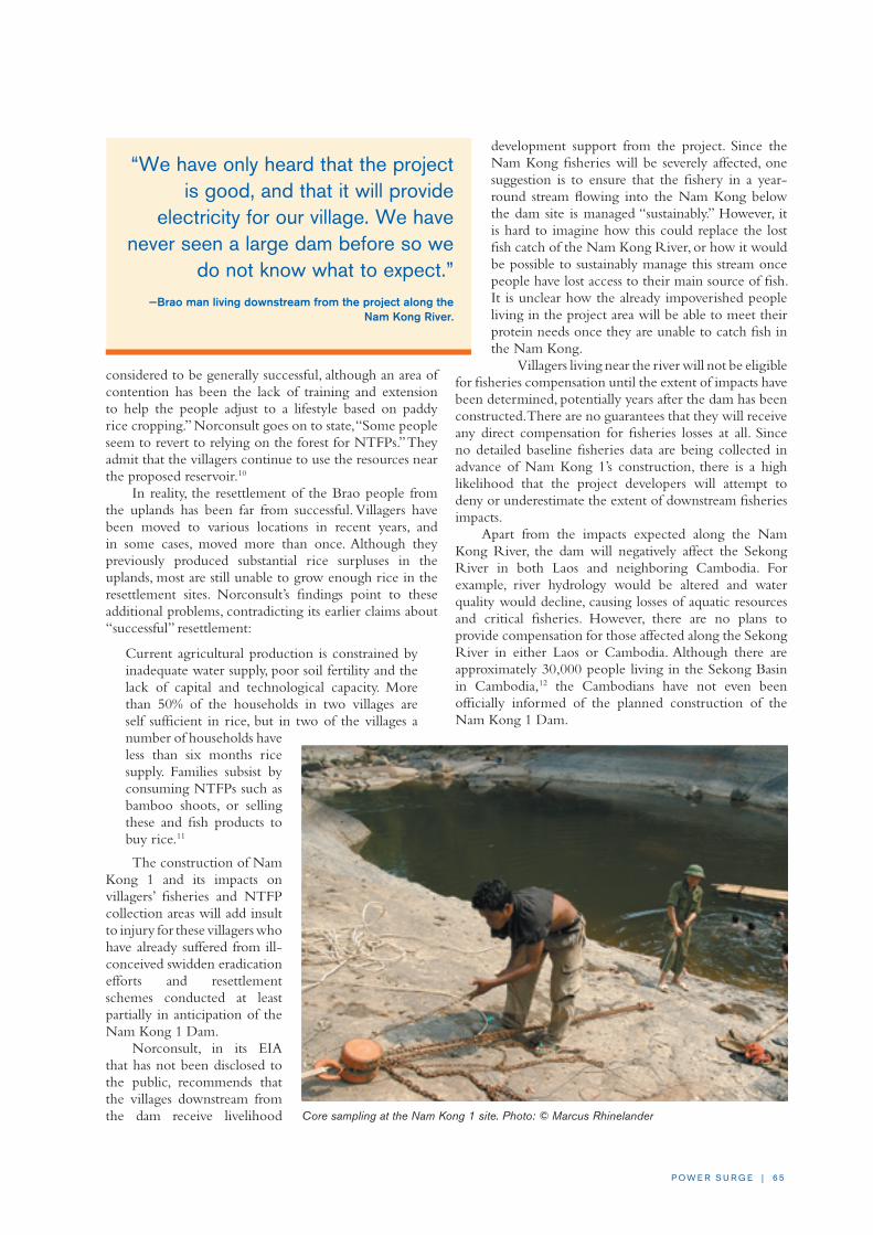
P O W E R S U R G E | 6 5
considered to be generally successful, although an area of contention has been the lack of training and extension to help the people adjust to a lifestyle based on paddy rice cropping.” Norconsult goes on to state, “Some people seem to revert to relying on the forest for NTFPs.” They admit that the villagers continue to use the resources near the proposed reservoir.10
In reality, the resettlement of the Brao people from the uplands has been far from successful. Villagers have been moved to various locations in recent years, and in some cases, moved more than once. Although they previously produced substantial rice surpluses in the uplands, most are still unable to grow enough rice in the resettlement sites. Norconsult’s findings point to these additional problems, contradicting its earlier claims about “successful” resettlement:
Current agricultural production is constrained by inadequate water supply, poor soil fertility and the lack of capital and technological capacity. More than 50% of the households in two villages are self sufficient in rice, but in two of the villages a number of households have less than six months rice supply. Families subsist by consuming NTFPs such as bamboo shoots, or selling these and fish products to buy rice.11
The construction of Nam Kong 1 and its impacts on villagers’ fisheries and NTFP collection areas will add insult to injury for these villagers who have already suffered from ill-conceived swidden eradication efforts and resettlement schemes conducted at least partially in anticipation of the Nam Kong 1 Dam.
Norconsult, in its EIA that has not been disclosed to the public, recommends that the villages downstream from the dam receive livelihood
development support from the project. Since the Nam Kong fisheries will be severely affected, one suggestion is to ensure that the fishery in a year-round stream flowing into the Nam Kong below the dam site is managed “sustainably.” However, it is hard to imagine how this could replace the lost fish catch of the Nam Kong River, or how it would be possible to sustainably manage this stream once people have lost access to their main source of fish. It is unclear how the already impoverished people living in the project area will be able to meet their protein needs once they are unable to catch fish in the Nam Kong.
Villagers living near the river will not be eligible for fisheries compensation until the extent of impacts have been determined, potentially years after the dam has been constructed. There are no guarantees that they will receive any direct compensation for fisheries losses at all. Since no detailed baseline fisheries data are being collected in advance of Nam Kong 1’s construction, there is a high likelihood that the project developers will attempt to deny or underestimate the extent of downstream fisheries impacts.
Apart from the impacts expected along the Nam Kong River, the dam will negatively affect the Sekong River in both Laos and neighboring Cambodia. For example, river hydrology would be altered and water quality would decline, causing losses of aquatic resources and critical fisheries. However, there are no plans to provide compensation for those affected along the Sekong River in either Laos or Cambodia. Although there are approximately 30,000 people living in the Sekong Basin in Cambodia,12 the Cambodians have not even been officially informed of the planned construction of the Nam Kong 1 Dam.
Core sampling at the Nam Kong 1 site. Photo: © Marcus Rhinelander
“We have only heard that the project is good, and that it will provide
electricity for our village. We have never seen a large dam before so we
do not know what to expect.” —Brao man living downstream from the project along the
Nam Kong River.

6 6 | I N T E R N AT I O N A L R I v E R S
CONCLUSION AND RECOMMENDATIONSThe Nam Kong 1 Dam will cause serious negative impacts downstream along the Nam Kong River, including the loss of important fisheries. This is not the benign project that some of its supporters claim.13 The indigenous Brao people who used to live in the reservoir area were resettled from the mountains over the last decade and are already suffering from food insecurity. If the Nam Kong 1 project is built, it will worsen the hardship the Brao villagers face as their fisheries and other aquatic resources are decimated. Although some support may be provided to these communities, the extent of assistance is still uncertain. Judging from past experience, compensation is far from guaranteed and unlikely to be sufficient to replace what they will lose.
Recommendationsn People living along the Nam Kong River should be
guaranteed compensation for fisheries losses before a decision is taken to develop the Nam Kong 1 Dam.
n Compensation for fisheries losses along the Sekong River in both Laos and Cambodia should be planned for at the outset, and consultations with Cambodia regarding compensation and possible mitigation measures related to the Nam Kong 1 project should be initiated immediately.
n The GoL should work with the developers to ensure that those previously resettled from the Nam Kong 1 project
area receive full compensation for being moved to the lowlands at least partially in anticipation of the dam.
NOTES
1 Power Sector Strategy Study, Lao National Committee for Energy, Ministry of Industry and Handicrafts (Vientiane, Laos: 2003).
2 Ibid.
3 “Russia to develop Lao hydropower,” Vientiane Times, 23 Dec 2005.
4 “Power stations surge forward,” Vientiane Times, 24 Oct 2006.
5 “Cavico gets green light for Nam Kong 2,” Water Power Magazine, 23 April 2008.
6 Norconsult, Environmental Impact Assessment (EIA) of the reservoir impoundment for the Nam Kong-1 HEP, Synopsis of the Initial Environmental Examination (June 2007).
7 “Hydropower project awaits permission,” Vientiane Times, 18 Dec 2007.
8 Norconsult, p. 9.
9 Ibid., p. 12.
10 Ibid., p. 9.
11 Ibid., p. 9.
12 Sekong River-Based Livelihood Study in Northeast Cambodia, Culture and Environment Preservation Association (CEPA) (Phnom Penh, Cambodia: 2007), 144 pp.
13 According to “Hydropower project awaits permission,” Vientiane Times, 18 Dec 2007, the Deputy Head of WREA in Vientiane, Mr. Noulinh Sinhbandhit, said, “According to the study, we can see that the impacts will be less signifi-cant than those of other hydropower projects.”
Brao people who will be impacted by the Nam Kong 1 Dam playing traditional gong music. Photo: Nok Khamin

P O W E R S U R G E | 67
MAIN CONCERNSn The Xekaman 1 and Xekaman 3 Hydropower
Projects are expected to cause serious negative impacts along the Xekaman River, and even further downstream along the Sekong River. While water quality has already been affected by the Xekaman 3 Dam, the most serious problems will be caused by the Xekaman 1 project, including significant changes in river hydrology, fisheries losses and a decline in water quality affecting tens of thousands of people.
n None of the villagers affected by changes in the Xekaman River caused by the Xekaman 3 Dam construction were warned about the impacts, let alone offered compensation for the losses they have suffered. Although the Xekaman 3 Dam is at an advanced stage of construction, there have apparently been no measures taken to mitigate the erosion, sedimentation and downstream water-release problems caused by the project.
n Construction on the Xekaman 3 Dam began before the EIA was even completed. Site clearance and road construction for the Xekaman 1 project have also already begun, even though social and environmental assessments have not yet been completed or approved by the GoL, in violation of Lao law. No project documentation, including feasibility studies or environmental and social assessments in English or Lao, has been released to the public.
n Many of the ethnic minority people who previously lived in the reservoir area of the Xekaman 1 Dam were relocated from the dam’s reservoir area over the last decade or so. Preparation for the Xekaman 1 Dam was one of the main reasons they were moved, and they should receive full livelihood restoration as part of project resettlement plans.
BACKGROUND AND DESCRIPTION
The Xekaman 3 DamThe Xekaman 3 Dam is currently under construction and is the first dam to be built in Sekong Province, southern Laos. The project is located near the border with Vietnam on the Nam Poag-O River, a tributary of the Xekaman River. The dam site is surrounded by high-altitude pine forests and large mountains, and is located 25km from the district center of Dakcheung.
Xekaman 3 will generate 250 MW of power for export to Vietnam. Although no official information has
CASE STUDy EIGHT: Xekaman 1 and Xekaman 3 Hydropower ProjectsBy Nok Khamin
The Xekaman 3 Hydropower Project is the first dam to be built in the Xekaman River Basin. Currently under
construction, Xekaman 3 is already causing downstream hydrology and water quality problems, and is possibly
affecting upstream water quality as well. The Xekaman 1 Hydropower Project would be an even larger dam, and
would cause more serious impacts as far downstream as the Sekong River in Laos and in northeastern Cambodia.
So far, there has been virtually no information disclosed to the public regarding these projects. Studies have
either not been completed or have been finalized with insufficient information, and no compensation for affected
villagers downstream has been proposed. A researcher visited Sekong and Attapeu provinces in early 2008 to
investigate the current situation.
Swing fishing in the Xekaman River. Photo: Nok Khamin

6 8 | I N T E R N AT I O N A L R I v E R S
been released, the dam will apparently be 100m high with a 5.2km2 reservoir. Vietnamese workers at the dam site acknowledged that site preparation began in 2003. However, in November 2005, EdL reported that negotiations regarding the CA were ongoing and that full-scale construction of Xekaman 3 had not begun. Later that year, the social and environmental assessments for the dam were still under review by the GoL with WREA having issued a conditional certificate for the project.1
In December 2005, International Water Power and Dam Construction reported that the Vietnam-Laos Joint Stock Electricity Investment and Development Company had invested $273 million in the project.2 The consortium is reportedly comprised of six Vietnamese businesses, including Electricity of Vietnam and the Song Da Corporation, which together are reported to hold 60% of the equity in the new company. The GoL has a 15% stake in the project. In June 2008 it was announced that the Austrian engineering group Andritz AG’s VA TECH Hydro unit had been awarded a €42 million contract to supply the electro-mechanical equipment for the project.3
The Xekaman 3 Dam is Vietnam’s largest-ever investment in a foreign country, and is a 25-year BOT project.4 Reports claim that $203 million is being provided by the Vietnam government’s “Development Assistance Fund” and by commercial banks.5 In August 2007, it was reported that two Vietnamese banks—Vietcombank and the Bank for Investment Development of Vietnam—had also agreed to provide $66 million for the project. By August 2008, the estimated cost of Xekaman 3 had increased to $312 million.6
On December 20, 2007, the Xekaman 3 Dam was officially “closed” during a ceremony attended by the President of Laos.7 The dam was initially scheduled to be operational by 2008 or by 2009. However, in February 2008, the completion date for the project was set back to 2010.8
The Xekaman 1 DamThe Xekaman 1 Dam has been in the planning stages since the early 1990s,9 but full-scale construction has not yet begun. In 2004, the LNMC listed the project as “postponed,” but recent activity near the proposed dam site in Attapeu Province suggests that the Vietnamese builders of the Xekaman 3 project intend to begin construction of the Xekaman 1 Dam soon.
Xekaman 1 would be located about 85km upstream of the Xekaman River’s confluence with the Sekong, and well downstream from the Xekaman 3 Dam. The dam is
expected to be 184m tall. While Thailand was considered the main market for Xekaman 1’s power in the 1990s, Vietnam has recently emerged as the more likely buyer.
In August 2007, Vietnam News Agency reported that the Vietnam-Laos Joint Stock Electricity Investment and Development Company had signed an MoU for the development of the Xekaman 1 Dam, priced at $380 million.10 Song Da Corporation was reported to own 49% of the company, while the Bank for Investment and Development of Vietnam and the PetroVietnam Financial Company each own 11%, and the Vietnam Oil and Gas Company holds 10%.
In December 2007, AFP reported that Vietnamese companies in Laos would begin building the Xekaman 1 Dam in 200811 with its capacity pegged at 322 MW and the price tag set at $400 million. In April 2008, it was announced that the GoL had approved Xekaman 1’s construction.12 Construction is expected to begin late 2008 or early 2009, according to provincial government officials, and the project’s expected completion date has been pushed back to 2013.
PROJECT ISSUES AND ANALySIS
The Xekaman 3 DamNo information has been released to the public about the impacts of the Xekaman 3 project on local communities or the environment, both upstream and downstream from the dam site. The social and environmental assessments for Xekaman 3 are not publicly available, and nobody has visited downstream villages in Attapeu Province to collect data or provide information about downstream impacts. Even worse, it appears that construction began before the EIA was even completed.
The Xekaman 3 Dam is already altering the downstream hydrology and water quality of the Xekaman River, right down to its confluence with the Sekong in Attapeu Province and beyond. The changes are evident to anyone who visited the mouth of the Xekaman River during the dry seasons of 2007 and 2008. The Xekaman River used to be clearer than the Sekong River, but that is no longer the case. The river is now filled with sediment due to severe upstream erosion.
“Nobody living along the Xekaman River in Sanxay District has been officially informed about the
changes in the Xekaman River, even though everyone can see that the hydrology and water
quality of the river has changed. We’ve noticed the changes for two years.”
— An agriculture and forestry official in Sanxay District, Attapeu Province, which is also downstream from the Xekaman 3 Dam.

P O W E R S U R G E | 6 9
As water from the Xekaman River flows into the Sekong River, the contrast between the two is stark. Locals from Xekaman Neua Village in Attapeu Province —which is located at the confluence of the Xekaman River—are well aware of the changes. Some people are not allowing their children to swim in the river, as those who do frequently have eye irritations caused by the poor water quality. The people are upset about what is happening but most dare not speak out, as the Xekaman 3 Dam is considered to be “a government project,” and thus above any criticism. Despite these problems, no one from the project or the government has visited any of the affected villages in Attapeu Province, either to explain what is happening or to warn about possible problems with swimming in or drinking water from the river.
In Phoxay Village, a woman complained that she used to collect drinking water from the clear Xekaman River during the dry season, but now that the water is too turbid to drink, she has had to dig shallow wells along the riverbank. A fisherman from Vat Louang Village said that the river is also shallower now, making it more difficult to catch fish. These problems are likely caused by the failure to release sufficient water downstream as the reservoir fills behind the Xekaman 3 Dam. However, nobody knows for sure, as downstream along the Xekaman River in Attapeu Province is not considered to be part of the Xekaman 3 project-affected area.
While changes in the Xekaman River are already evident to those who use the river on a daily basis, there are many questions about what the future will bring since the Xekaman 3 Dam is still not complete. For example, it is unclear how much downstream erosion will occur during the operations phase of the project and what, if any, mitigation measures will be implemented.
There are seven ethnic Dak Ye villages downstream from the dam site. They depend heavily on the Xekaman River for fishing, vegetable collection, and other purposes. According to Dakcheung District officials, central level authorities responsible for the project approached the people from Dak Charang Nyai, just below the dam site, sometime in 2005 to ask them to relocate. The villagers strongly resisted since they are able to produce enough food in their current location and have good access to land and natural resources. They also expect
their village to have easier access to electricity once the dam is built. The villagers knew little about potential negative impacts from the dam. It is unknown if Dak Charan Nyai village has been forcibly displaced yet.
Additionally, Dakcheung District officials report that over 40 ethnic Taliang and Dak Ye villages situated upstream from the Xekaman 3 Dam will be negatively affected, even though most are not in the dam’s inundation area. The GoL plans to reduce the number of villages in the area through “village consolidation,” which will require the relocation of a large number of people to more accessible areas, where they will be expected to live together. The dam project is providing the GoL with further justification for stopping swidden agriculture and
Transporting logs near the Xekaman 1 site. Photo: © Marcus Rhinelander
“The river isn’t like it was before. It was never as turbid as it has been for the last
two dry seasons. The water levels are also fluctuating like never before. Previously, the river generally rose after a big rain upriver,
but now it goes up even when there are no clouds in the sky, and sometimes it goes
down after a big rain. Nobody has come to tell us why the water is acting so crazy. I
heard that a dam is being built upriver, but I am not sure where it is.”
—An elderly woman in Phoxay Village.

70 | I N T E R N AT I O N A L R I v E R S
consolidating villages in the area, much as was the case with the Houay Ho Dam (see Case Study Nine).
The Xekaman 3 reservoir is expected to inundate one village, Mang Ha Noi, which had 172 inhabitants in 1999. The livelihoods of the people there are closely linked to the river, in which they fish daily to generate one of their main sources of income. According to a 1999 study by Halcrow and Partners and funded by the ADB, most fish in the upper Xekaman River Basin are likely to be highland species, with some probably endemic and as yet unknown to science.13 These fish are also important for local livelihoods.
Halcrow wrote that the Xekaman 3 project would threaten the Dong Ampham NPA, as improved roads to the dam site will facilitate access to the most sensitive sites on the northern boundary of the protected area. Xekaman 3’s transmission lines will also cross large expanses and provide easier access to these remote areas.
The Xekaman 1 DamThe construction and operation of the Xekaman 1 project is expected to result in many negative impacts, including fisheries losses, water supply problems and biodiversity threats. It is unclear how much these issues have been considered, as the social and environmental assessments for the Xekaman 1 project have not been disclosed. Although these documents have reportedly not received GoL approval yet, road construction and land preparation is underway near the dam site. These activities are occurring in violation of Lao regulations, which require that all project documentation be completed and approved by the GoL before construction begins.
Resettlement Issues The 1994 IEE for the Xekaman 1 Dam estimated that 2,000 people from 400 families would need to be
resettled for the project.14 However, many communities in the proposed reservoir area had already been officially resettled in the early 1990s in line with the GoL’s swidden agriculture eradication policy. In its ADB-funded study, Halcrow was clearly concerned that the GoL was moving people out of potentially dam-affected areas to increase the dam’s attractiveness to investors.15 In response, Halcrow recommended that all people relocated from the area after 1993 should be considered to have been resettled in preparation for the Xekaman 1 Dam and therefore eligible for compensation from the dam’s developers.16 But Halcrow’s recommendations were ignored, as the ADB and the GoL
estimated in 2004 that only about 800 people would need to be relocated for the Xekaman 1 Dam. If people who were forcibly displaced from the area since 1993 are included, this number would be much higher.17
Logging and Protected Area ThreatsThe Xekaman 1 reservoir is expected to flood 224km2
of land, part of which falls in the Dong Ampham NPA,18
an area renowned for its important wildlife populations, including a number of globally threatened and endangered species. Halcrow stated that the dam would cause serious negative impacts to Dong Ampham NPA by flooding all low-lying habitats along the park’s northwest border, as well as all the tributaries draining into the protected area.19
The Xekaman 1 Dam area was estimated to include 2,200,000m3 of valuable standing timber. The dam’s inundation area alone was estimated to contain 420,000m3 of logs.20 In recent years, extensive logging has occurred in the reservoir area in preparation for the Xekaman 1 Dam’s construction, despite the fact that the project’s social and environmental documents have not yet been approved.
Downstream and Fisheries ImpactsMore than 10,000 people live along the Xekaman River downstream from the Xekaman 1 Dam site. The hydrological changes that would be caused by the project threaten to disrupt the Sekong plains, one of Laos’ most important wetland areas.
The large and deep reservoir that the dam will create makes the project particularly problematic. Earlier projections were that the reservoir would take seven years to fill, causing “permanent damage”21 to the downstream ecology and wiping out fisheries and the livelihoods of communities dependent upon them. More recent estimates indicate that just over three years will be needed to fill the reservoir. Little water is expected to be released
The Xekaman River, downstream from the Xekaman 3 dam site, photographed on March 9, 2004. Photo: © Marcus Rhinelander

P O W E R S U R G E | 7 1
The same area of the Xekaman River, downstream from the Xekaman 3 dam site, photographed on March 24, 2008. Local officials and local people believe these water quality changes have been caused by the dam construction where blasting at the valley wall is causing rocks and sediment to flow into the river. The water quality is visibly bad as far downstream as the confluence with the Sekong River in Attapeu Province.Photo: © Marcus Rhinelander
downstream during this period.Changes in hydrology and
the resulting erosion would badly impact the seasonal cycles of riverbank vegetable gardening that have developed over generations. Downstream erosion would also damage natural habitats along the Xekaman River, where vegetation supports important fisheries. Villagers have adapted specific fishing techniques and tools for these areas, including bundle-basket traps (kha) and scoop nets (sving) to catch small fish and shrimp in the dry season. The loss of riverside vegetation and associated impacts on fisheries and people’s fishing methods—as experienced on the Sesan River in northeastern Cambodia following the construction of the Yali Falls Dam in Vietnam22—would jeopardize local livelihoods along the lower Xekaman River.
Apart from the negative impacts on downstream fisheries, many fish species will be prevented from migrating up the Xekaman River. These include a number of the same species that will be affected by the Sekong dams, including several species of catfish and dozens of cyprinid species.23 The Sekong and Xekaman projects combined will together devastate many of the fish species that migrate between these rivers and the Mekong mainstream in Thailand, Laos, Cambodia and Vietnam.
When the Xekaman 1 Dam was first being considered in the early 1990s, few people living downstream were aware of the project’s likely negative impacts. These villagers are now, however, much more aware of Xekaman 1 Dam, even though they have not received any official information. Many local people oppose the dam, although most dare not speak out openly. The people in the area report that many wells would need to be installed once the dam’s reservoir starts to fill, as they fear there will not be enough water in the river to meet their domestic needs. However, one man from Sisao Village commented, “Wells may be necessary for drinking water, but we can’t catch fish in wells.”
CONCLUSION AND RECOMMENDATIONSThe Xekaman 3 and Xekaman 1 projects will impact the areas where the projects are being constructed and downstream along the Xekaman and Sekong Rivers. Mekong River fisheries in Laos and Cambodia—and even as far as Vietnam and Thailand—will also be negatively affected due to the loss of migratory species that move between the Xekaman River and the Mekong. However, insufficient measures have thus far been developed to
address these impacts and compensate those who have been or will be affected. Environmental and social planning for both projects appears to be amongst the worst of any dams in Laos, with no transparency and in violation of Lao law. If the full costs of the Xekaman 3 and Xekaman 1 were considered—instead of externalizing the environmental and social costs and leaving local people to pay the price—the dams would most likely not be economically viable.
Recommendationsn All those resettled from the reservoir area of the
Xekaman 1 Dam after 1993 should be fully compensated by the GoL and the dam developers, as these villagers were relocated at least partially in anticipation of the dam’s construction. Given the significant impacts that the Xekaman 1 project is likely to have, the dam plans should be reconsidered and alternatives sought.
n The Vietnamese developers for both the Xekaman 1 and 3 dams should ensure that an independent assessment of the downstream impacts of the projects is undertaken urgently. The developers should commit to implement recommended mitigation measures, and to compensate all affected villagers for their losses— including those along the Sekong River in Laos or Cambodia. The projects should also be operated to reduce downstream impacts.
n The MRC should initiate genuine dialogue and negotiations amongst the different countries in the region to help reduce the impacts of these dams and ensure that natural resources and people’s livelihoods are not lost without proper compensation.

72 | I N T E R N AT I O N A L R I v E R S
NOTES
1 “Song Da Corp. to build hydropower project in Laos,” Vietnam News Agency, 4 March 2006.
2 “Vietnam to invest in Laos,” International Water Power and Dam Construction, 8 December 2005.
3 “RPT Andritz’s VA TECH unit wins Laos hydro order worth 42 million euros,” Thomas Financial, 3 June 2008 (http://www.finanznachrichten.de/nachrich-ten-2008-06/artikel-10961826.asp).
4 “Song Da Corp. to build hydropower project in Laos,” Vietnam News Agency.
5 “Xekaman 1 agreement signed,” International Water Power and Dam Construction, 2 Nov 2006.
6 “Xekaman 3 construction costs rise,” Vientiane Times, 14 Aug 2008.
7 “Petro Vietnam arm to build Luang Prabang hydro project,” Vietnam News Agency, 21 Dec 2007.
8 “Xekong 4 dam aims to alleviate poverty,” Vientiane Times, 2 Feb 2008.
9 Power Struggle: The Impacts of Hydro-Development in Laos, International Rivers Network (Berkeley, California: 1999).
10 “Business join hands for electricity production in Laos,” Vietnam News Agency, 6 Aug 2007.
11 Ibid.
12 “Vietnamese investor interested in cement plant and hydropower invest-ment,” KPL Lao News Agency, 4 April 2008.
13 Sir William Halcrow and Partners, “Se Kong, Se San and Nam Theun River Basins’ hydropower study,” Final report, ADB (Manila, Philippines: 1999).
14 Gutteridge, Haskins and Davey Pty, Ltd. (GHD), Initial environmental examination of the Xekaman No.1 and Southern transmission project, Draft, Australian-Lao Hydro and Transmission Projects, Hydroelectric Commission Enterprises Corp. (Vientiane, Laos: 1994).
15 Halcrow, 1999.
16 As of 2004, the villages of Dak Kleup, Done Khen, Vang Khen, Vang Hin Dam, Phieng Se, and Ton Chouy had been relocated from the future reservoir area of the dam and villagers from Dak Bou Nyai (52 households and 300 people), Dak Bou Noi (13 households and 87 people) and Dak Kouk Noi (42 families and 230 people) had been told to prepare to relocate, and have since been moved despite their objections.
17 Cumulative impact analysis: Nam Theun 2, Asian Development Bank and Government of Lao (Manila and Vientiane: 2004).
18 Halcrow, 1999.
19 Ibid.
20 Power Struggle: The Impacts of Hydro-Development in Laos, 1999.
21 Gutteridge, Haskins and Davey Pty, Ltd., 1994.
22 Baird, I.G., Flaherty, M.S. and Phylavanh, B., “Rhythms of the river: lunar phases and migrations of small carps (Cyprinidae) in the Mekong River,” Natural History Bulletin of the Siam Society 51:1 (2003), pp. 5-36.
23 Some fish species that would be affected include Pangasius krempfi, a large catfish that migrates from as far away as the Mekong Delta in Vietnam (see Hogan, Z., Baird, I.G., Radtke, R. and Vander Zander, J., “Long distance migration and marine habitation in the Asian catfish, Pangasius krempfi,” Journal of Fish Biology 71 (2007), pp. 818-832); as well as various other species of catfish; dozens of species of small cyprinids, especially the very important Henicohynchus lobatus and Paralaubuca typus which migrate from the Tonle Sap River and Great Lake in Cambodia (see Baird, I.G., Flaherty, M.S. and Phylavanh, B., “Rhythms of the river: lunar phases and migrations of small carps (Cyprinidae) in the Mekong River,” Natural History Bulletin of the Siam Society 51:1 (2003), pp. 5-36); and other medium-sized cyprinids, like Scaphognathops bandanensis and Mekongina erythrospila, which migrate between the Sekong River and the mainstream Mekong River in Cambodia, Laos and Thailand (see Baird, I.G. & M.S. Flaherty, “Beyond national borders: important Mekong River medium sized migratory carps (Cyprinidae) and fisheries in Laos and Cambodia,” Asian Fisheries Science 17:3-4 (2004), pp. 279-298).

P O W E R S U R G E | 73 P O W E R S U R G E | 73
MAIN CONCERNSn The Heuny and Jrou ethnic minority people resettled
more than 10 years ago for the Houay Ho Hydropower Project were not given sufficient agricultural or forest lands to support themselves and their families. While resettled villagers have received some assistance, their food security is still at risk.
n Local people living near the powerhouse in Sanamxay District, Attapeu Province lost agricultural land, forests and fisheries as a result of the Houay Ho Dam. They have not received sufficient compensation.
n Another hydropower project on the Bolaven Plateau —the Xepian-Xenamnoi Dam—may be revived in conjunction with a large bauxite mine and aluminum smelter. These projects threaten to displace the remaining Heuny population from their land.
BACKGROUND AND DESCRIPTIONThe Houay Ho Hydropower Project is located on the eastern part of the Bolaven Plateau in Champassak and Attapeu Provinces. The 76-meter-high dam blocks the Houay Ho stream and diverts the water to the Xekong River via a 980m concrete-lined channel.
Houay Ho was the first privately financed joint venture BOT hydropower project in Laos. Korea’s Daewoo Engineering Corporation, Ltd. financed the bulk of the construction and commissioning costs for the 150 MW dam, which includes a 32-37.5km2 reservoir. The total project cost has been estimated at $220-$250 million.
The Houay Ho project was rapidly developed despite the fact that the Korean and Thai firms involved had little experience building large dams. According to a GoL observer from the former Ministry of Industry and Handicrafts, “It had a bad smell. We never got to see any studies for the project. I don’t think any were done.”1 The main dam and headrace tunnel shaft were completed in April 1997, and the project started producing power at the end of 1998.
The Daewoo Corporation was hit hard by the Asian financial crisis in the late 1990s. As a result, in 2001, Daewoo and their Thai partner, Loxley Company, sold their 80% stake in the Houay Ho Power Company to the Belgium-based multinational Tractebel S.A.2 and its Thai partner MCL (Tractebel’s Thai unit) for $140 million.3
The GoL maintains a 20% holding in the project.
PROJECT ISSUES AND ANALySISCritics both inside and outside of Laos have noted that the Houay Ho Dam was developed with little transparency and that the GoL received a poor deal, reportedly due to its lack of adequate legal representation during negotiations. The project is paying little in taxes or royalties to the GoL. Furthermore, EdL will not receive any project dividends until 2010, despite the fact that it has had to make annual interest payments of $1.8 million since 2000 to cover its $10 million equity loan. The CA did not stipulate responsibility for resettlement or other social and environmental impacts. As a result, Daewoo made a single payment of $230,000 and left the GoL to deal with resettlement issues.4
Resettlement IssuesOne village had to be moved from the reservoir area, and one other village downstream from the dam site was recommended for relocation. Despite this, the GoL relocated approximately 2,500 people from 11 villages in the Houay Ho and Xepian-Xenamnoi watershed areas. Most villagers were sent to a resettlement site near Houay Kong Village in Paksong District.
The vast majority of the resettled villagers were from a small Mon-Khmer language speaking ethnic group, the Heuny (Nya Heun). A large percentage of the 5,552 ethnic Heuny people in Laos in 1995 were relocated as part of the scheme, threatening the cultural survival of the entire Heuny ethnic group.5
CASE STUDy NINE: Houay Ho Hydropower Project By Nok Khamin
The Houay Ho Hydropower Project was one of the first dams in Laos to be built using the BOT model. A
large number of ethnic minority Heuny people were resettled for the project and are still suffering more
than a decade after they were moved. Others located downstream from the dam have not received adequate
compensation. The Belgian company Tractebel S.A. purchased the majority stake in the Houay Ho project
from Daewoo Corporation in 2001. Tractebel has denied its responsibility for the resettlement failures of the
project, leaving a vacuum of accountability and affected villagers without recourse. A researcher who has been
monitoring the dam’s impacts since construction returned to the project area in early 2008 to investigate the
current situation.

74 | I N T E R N AT I O N A L R I v E R S
The fundamental problem with the Houay Ho resettlement is the lack of available agricultural land. Resettled villagers were not provided with sufficient land or access to natural resources—such as forests and streams for NTFP collection, hunting, and fishing—to allow them to rebuild their livelihoods. Only about 20% of the land originally allocated to the resettled people turned out to be available for use; the rest was already claimed by neighboring villages. This land and resources shortage has resulted in an ongoing food security crisis for resettled villagers.
The Houay Ho resettlement plan depended upon a strategy to convert subsistence-oriented swidden farmers to cash-crop coffee growers over a short period of time. This would have been a difficult task in the best of circumstances. However, in addition to receiving inadequate land, training, or other support, coffee prices fell dramatically soon after people were resettled. It was therefore never feasible for farmers to rely on coffee bean sales as their only source of income.
Many people have unofficially abandoned the resettlement site, choosing to return to their former agricultural and village areas, where some have developed new swidden fields. In 2006, it was estimated that up to 70% of families had left the resettlement area. In early 2008, approximately the same percentage of the population was still living away from the resettlement site. Officially, the GoL does not allow people to return to live near their old villages, so people have been forced to go there covertly or to request permission to return “temporarily.” Sometimes these “temporary” trips last for months, followed by short trips back to the resettlement area, before returning once again to their old villages. This has caused on-going disruptions to the lives of resettled villagers.
Downstream ImpactsThe Houay Ho project has also caused hardship for villagers living downstream. Ethnic Heuny people from
Khoum Kham Village suffer from floods caused by water releases from the powerhouse. Riverbanks have been eroded, livestock drowned, and lowland rice fields have been affected by flooding attributed to the dam. No compensation has been provided for these impacts.
The ethnic Sok people, a sub-group of the Oy ethnic group who inhabit Sok Village, have been indirectly affected by the Houay Ho project. Much of their land was confiscated to create a protected area surrounding the project. No compensation was provided to villagers for their losses. The ethnic minorities in Khoum Kham, Mixay, Km 52 and Nam Han villages have also lost much of their agricultural land to the dam-associated protected area. Farming is now restricted near the powerhouse, but again, no compensation has been paid.
Since acquiring the majority stake in the Houay Ho project in 2001, Tractebel has made little effort to address the unresolved
problems related to resettlement or the dam’s downstream impacts on local people and the environment.
OECD Guidelines and TractebelTractebel purchased its stake in the Houay Ho project with financing from export credits provided by the Government of Belgium. This subjected the company to the Organization for Economic Cooperation and Development’s (OECD) Guidelines for Multinational Enterprises. In 2004, concerned groups in Belgium learned of the problems facing the resettled villagers and realized that Tractebel appeared to be violating OECD guidelines. The Belgian NGO Proyecto Gato subsequently filed a formal complaint with Belgium’s National Contact Point against Tractebel. This case marks the first attempt to force a private company involved in a Lao hydropower project to follow the international investment standards set out by the OECD.
Proyecto Gato argued that Tractebel should be held responsible for the problems facing local people in the resettlement area. Tractebel and its powerful owner Suez responded that the NGO should sue Daewoo and the GoL, not them, for the problems facing affected communities. After many months, Belgium’s National Contact Point ruled that Tractebel was not responsible for the project impacts that occurred before it purchased the Houay Ho Power Company in 2001. Remarkably, the National Contact Point did not accept Proyecto Gato’s argument that Tractebel bought both the company’s assets as well as its liabilities.
In an effort to improve its image, Tractebel has, however, supported repairs to the old school in the resettlement area, and the construction of a new school valued at $30,000. The company also refurbished the health center in the resettlement area and the 3.5km road between Houay Kong Village and the resettlement site, at
Heuny villagers living in the Houay Ho resettlement site who often return to their old village.

P O W E R S U R G E | 7 5
a cost of $50,000. Finally, Tractebel fixed the broken wells in the resettlement area and constructed six toilets in six villages, at a total cost of $15,600.
Proyecto Gato’s OECD complaint increased the attention paid to the resettled communities by both Tractebel and the provincial government, encouraging the provision of some assistance. However, little has been done to address the lack of access to land and natural resources for the resettled villagers or Houay Ho’s impacts on people living downstream.
The Return of Xepian-Xenamnoi Hydropower ProjectThe Xepian-Xenamnoi Dam—which the Korean company Dong Ah started to develop in the late 1990s but abandoned in 1999—is about to be revived. According to the latest information from the GoL, the 390 MW project would be developed by Korean companies SK Engineering and Construction and Korea Western Power with the Thai company Ratchaburi. The PDA is complete and power production is proposed for 2015.
Rumor has it that the dam will be built in conjunction with a large bauxite mine being developed in the eastern part of the Bolaven Plateau by the Australian mining company Ord River Resources and its Chinese partner, China Nonferrous Metals. The goal of the mining companies is to develop a “world class aluminum industry” on the Bolaven Plateau.6 Aluminum production requires a large amount of electricity, and often has negative effects on the environment and local livelihoods.7
Many Heuny people are upset about this concession, as it is being developed in the area where they lived before being resettled for the Houay Ho Dam. At the time they were resettled, people were told that the area would become a nature reserve. Now, a decade later, their land has been given away to the Australian and Chinese companies, adding insult to injury for the Heuny. Local people report that many craters can now be found on their land, made by those testing for bauxite deposits.
Apart from the villages already displaced by the Houay Ho Dam, four other villages are expected to be resettled for the Xepian-Xenamnoi project. Villagers from Nong Panouan and Houay Chote have been resisting resettlement for years, but it now appears that they will be moved. They have been told that they will receive $5,500 per family for their losses.
In addition, eight other villages resettled in the 1990s are expected to receive some compensation from the Xepian-Xenamnoi project. The 410 families from Xenamnoi, Latsaxin, Don Khong, Nam Leng, Nam Kong, Houay Soi, Keokhounmuang and Nam Tiang villages have been told that they will receive $800 each from the dam developers.
The Xepian-Xenamnoi Dam will also cause downstream impacts along the Xepian River in Attapeu Province, as most of its flow will be diverted into the Xenamnoi River. These impacts include fisheries losses for thousands of villagers who fish in the Xepian River, as well as threats to the Xepian NPA.8
CONCLUSION AND RECOMMENDATIONSMore than a decade after they were forcibly displaced, Houay Ho resettlers are still facing food insecurity with few prospects of improving their lives in the near future. While Tractebel has provided some funds over the last few years to support resettled villagers, the fundamental problem of the lack of agricultural land has not been resolved. This desperate situation has forced 70% of the population in the resettlement area to return to their old settlements to live and farm, despite the lack of official permission to do so. Actions to address the problems caused by Houay Ho are long overdue.
Recommendationsn Tractebel should provide additional compensation to
resettled and downstream affected villagers. Options for allowing at least some of the resettled people to move back to the area near their old villages should be seriously considered, as there is not enough land for most to subsist on around the resettlement site.
n The Xepian-Xenamnoi project and associated bauxite mine and aluminum smelter should not go forward until a comprehensive economic, social and environmental impact assessment has been carried out and the project is proven to be economically feasible as well as socially and environmentally sustainable. Those villagers who will lose land to the project should receive land of equal value and quality and a guaranteed and sustainable source of livelihood.
NOTES
1 Wyatt, A. B., “Infrastructure development and BOOT in Laos and Vietnam: A case study of collective action and risk in transitional developing economies,” PhD dissertation, Division of Geography, School of Geosciences, University of Sydney (Sydney, Australia: 2004), 316 pp.
2 On 31 October 2003, Tractebel S. A. merged with Société Générale de Belgique S. A. The name of the company created as a result of the merger is Suez-Tractebel S. A., a wholly owned subsidiary of Suez. It includes Suez International Energy and Tractebel Engineering.
3 “Tractebel buys into Laos hydro project,” Tractebel Press Release, Brussels, 13 Sept 2001 (http://www.suezenergyint.com/content/newsroom/pressre-leases/pressarchives/010913_Laos.pdf).
4 Wyatt, 2004.
5 Khamin, N., “More trouble for the Heuny,” Indigenous Affairs 4 (2000): pp. 22-29.
6 Vaughan, M., “Ord River awash with Lao bauxite,” Mining News, 28 Feb 2006 (http://www.miningnews.net/storyView.asp?StoryID=66067); Riseborough, J., “Ord river flags Lao bauxite project potential,” Mining News, 16 Nov 2006 (http://www.miningnews.net/storyView.asp?StoryID=68947).
7 See, for example, Foiling the aluminum industry: a toolkit for communities, activists, consumers and workers, International Rivers Network, http://www.internationalrivers.org/en/node/1327 (2005).
8 Roberts, T. R. and Baird, I. G., “Rapid assessment of fish and fisheries for the Xenamnoi-Xepian hydroscheme in southern Lao PDR,” Unpublished report for the Wildlife Conservation Society (Vientiane, Laos: 1995).

76 | I N T E R N AT I O N A L R I v E R S
MAIN CONCERNSn The Xekatam Hydropower Project would directly
impact a large number of ethnic minority people, including many Heuny (Nya Heun) villagers and others from the Jrou (Laven) ethnic group. The Heuny people are of particular concern, as they belong to a small ethnic group found only on the Bolaven Plateau. A large proportion of the Heuny population has already been resettled for the Houay Ho Dam. Those people have still not been adequately compensated for their losses, and they fear that the Xekatam Dam would bring similar hardship and cultural destruction.
n It would be difficult to replace the lowland rice paddy fields that would be flooded by the Xekatam Dam, as there is no additional paddy land available in the area. A proposed one-time cash payment is unlikely to compensate for long-term losses or create opportunities to restore villagers’ livelihoods.
n Despite the fact that the project would have significant impacts on fisheries—a critical food and income source for downstream communities—the Xekatam project’s environmental and social assessments fail to recommend compensation for downstream fisheries losses.
n Hydrological and water quality changes caused by the construction and operation of the Xekatam project would result in negative impacts extending at least to the confluence of the Xenamnoi River with the Sekong River. However, there are no plans to compensate villagers who use the Xekatam and Xenamnoi rivers downstream from the dam.
n Villagers and other observers have been provided with only limited information about the project, despite the various “consultations” that have been organized. Those who would be negatively affected have not been provided any real opportunities to voice their objections or other concerns about the Xekatam Dam. As with other hydropower projects in Laos, villagers have been given the impression that the dam
is a government priority; objecting to it is therefore not an option.
PROJECT BACKGROUND AND DESCRIPTIONThe Xekatam River in Champasak Province in southern Laos flows into the Xenamnoi, which is a tributary of the Sekong River. Japanese engineers have been interested in developing dams on the Xekatam River since the early 1990s. In 2004, the World Bank contracted Maunsell and Lahmeyer to investigate the possibilities for damming the Xekatam and other Lao rivers.1 Estimating that the Xekatam project’s installed capacity could be between 12 and 100 MW, Maunsell and Lahmeyer specifically examined the 12 MW option, which it admitted would not maximize economic benefits, but would preserve the natural beauty of the Xekatam waterfalls, an important “eco-tourism and cultural tourism site” in Laos.2
In 2004, Kansai Electric Power Company of Japan signed an MoU with the GoL to investigate the potential for the project. The dam’s 2006 Feasibility Study,3 which was conducted by Kansai Electric Power with Japanese government funding, recommends the construction of a 40-meter-high dam at a cost of about $120 million. The project’s capacity would be 61 MW,4 indicating that any concerns for the dam’s social impacts or the preservation of the Xekatam waterfalls have been abandoned. It was expected that virtually all of Xekatam’s power would be exported to Thailand via the transmission line used for the Houay Ho Hydropower Project,5 but the most recent GoL Power Development Plan lists Laos as the planned market.
The dam would be constructed on the Xekatam River between Nam Houng and Thong Houng villages (both ethnic Heuny villages), and would inundate stretches of the Xekatam Noi and Xekatam Nyai Rivers for the dam’s 7.6km2 reservoir. A section of the Xekatam River would become dry once the river is dammed, as the water from the reservoir would be channelled through a tunnel to the powerhouse and then into the Nam Houng River, which flows into the Xekatam River downstream.
CASE STUDy TEN: Xekatam Hydropower ProjectBy Nok Khamin
The Xekatam Hydropower Project would be the second large dam—following the Houay Ho Hydropower
Project—to threaten the livelihoods and cultural survival of the indigenous Heuny (Nya Heun) people on the
Bolaven Plateau in Champasak Province, southern Laos. The dam would inundate important agricultural land
and displace at least one village. The Xekatam Dam’s downstream impacts have been underestimated by project
proponents. Local consultations have been problematic and project documentation has not been released to the
public as required by Lao law. A researcher visited Champasak, Sekong and Attapeu Provinces in early 2008 to
investigate the current situation.

P O W E R S U R G E | 77
The project is being developed on a BOT basis over a 30-year period. The GoL would hold a 25% stake in the project,6 but it is unclear how it would finance this share, or what its return on investment would be. In December 2007, a new agreement between Kansai and the GoL was signed. Site preparation has not yet begun, but the Champasak Province WREA office claims that construction will begin around mid-2008.7 Kansai is reportedly seeking finance and guarantees from JBIC or Nippon Export and Investment Insurance (NEXI).
PROJECT ISSUES AND ANALySISThe people living in the Xekatam project area are mainly indigenous Heuny (Nya Heun), but some ethnic Jrou (Laven) would also be affected, as would people from other ethnic groups living downstream. The feasibility and subsequent studies appear to underestimate the negative impacts that the Xekatam project would have and the number of villages that would be affected.
Resettlement Issues and Land Losses for Ethnic MinoritiesIn 2006, MEK Consultants and NEWJEC Inc. produced an EIA, SIA, and RAP for the Xekatam project. Although the GoL’s WREA approved these documents in September 2007,8 they have not been publicly released to date. The SIA identified just six villages—Nam Houng, Nong Mek, Nong Hin, Nong Theuam, Nam Touat and Tayeukseua—with 1,569 people in 265 families, as part of the “project area.”
The SIA claims that the project would require the expropriation of 763ha, including mixed forests, lowland rice paddy, coffee plantations, swidden agriculture land, orchards and NTFP gardens. Most of this land would be flooded by the project.9 A second option for the dam site that would have reduced the impact to agricultural land was ultimately rejected due to the high costs involved.
Two hundred and twenty-five people in 36 families from the Heuny village of Nam Houng would be relocated for the dam.10 According to villagers, the project developers told them that they would be moved to the Thong Kalong area in Paksong District. As of early 2008, the villagers from Nam Houng Village were refusing to move. They are comparing their own circumstances with those of the people resettled a decade ago for the Houay Ho Dam. They claim that those who were resettled are very poor and are still facing significant difficulties many years after they were resettled. From the villagers’ perspective,
there seem to be few prospects for Houay Ho resettlers to improve their livelihoods (see Case Study Nine). Those from Nam Houng say they already have a good life, with lowland paddy fields, small coffee plantations and places to raise domestic animals.
The SIA acknowledges that the dam is likely to impact the ethnic minority peoples in the project area, including damaging sacred sites located along the edges of roads that are slated to be upgraded. Compensation for these losses has been recommended, but it would not be possible to compensate for many of the social and cultural impacts.
The company would be given control of approximately 90,000ha for the dam concession area, according to district government sources. This includes a large amount of the traditional territories and common property resources of a number of villages. No compensation is expected for their losses.
The 12-km-long transmission line for the project would run between Nam Touat and Tayeukseua villages. The villagers are expected to lose 28ha of coffee plantations, 43ha of upland fields, and 29ha of other gardens and orchards for construction of the transmission towers.11 Tayeukseua was itself resettled for the Houay Ho Dam, so this would be the second time that a large dam has affected the village.
According to villagers, people from a number of other villages12 in Paksong District would also lose lowland paddy fields. The SIA fails to even mention that Nam Tang and Houay Kong would be affected. These two ethnic Jrou villages both lost agriculture and forest land when villages were resettled for the Houay Ho Dam. Although the project SIA claims that all lost lowland paddy land would be replaced by other land of similar quality13, according to villagers, the company has recently stated that each
Heuny people whose grazing lands, paddy fields and upland rice fields will be flooded by the Xekatam Dam.

78 | I N T E R N AT I O N A L R I v E R S
family would only receive $6,000 cash compensation for the loss of their paddy land. It is unclear how people would be able to grow or purchase enough rice to live on in the future, especially with the recent significant increases in rice prices.
Finally, the project would open up previously remote areas to increased hunting. There are reportedly 30-35 wild elephants in the vicinity of the project that would be particularly vulnerable.
Downstream ImpactsKansai’s 2006 IEE for the Xekatam Dam acknowledges the importance of fisheries to local people, but greatly underestimates the impact that the dam would have on aquatic biodiversity. So far no detailed surveys of fish biodiversity in the Xekatam River have been conducted, but studies in other upland rivers in the Sekong River Basin have revealed many endemic and previously unknown fish species. The IEE also fails to mention the likely hydrological and water quality impacts downstream from the dam which would affect both the Xekatam and Xenamnoi rivers.
No compensation has been proposed for affected communities located downstream from the dam. Even for those living in the designated “project area,” no compensation for fisheries losses has been recommended. The reservoir, with its anoxic bottom, cannot be expected to support a substantial fishery. However, managing reservoir fisheries and building four fish ponds appear to be the extent of the company’s plans to deal with this crucial issue.14
The project EIA acknowledges that some villages would be negatively affected along the Xekatam River. Villagers from Nong Theuam, Nong Mek, Nong Hin, and Nam Houng all use the river for drinking and bathing water, as well as for fishing. Since the project is a diversion dam, there will be lower flows downstream along the Xekatam and greater flows in the Nam Houng, the river to which water will be diverted. However, once the Nam Houng reenters the Xekatam, there will be greater flows in the Xekatam in the dry season. These changes will result in the destruction of vegetation, aquatic habitat, and vulnerable fish species.15
The EIA states that water quality downstream from the dam may be poor, and cautions that care would need to be taken in managing water releases. Water flows downstream would generally decline, and water with low dissolved oxygen content would be released from the reservoir for an estimated three months a year. The bottom six to eight meters of the reservoir would be largely anoxic, but the EIA asserts that it would not affect downstream water quality since the outtake is above this poisonous water. The EIA consultants recommend that additional
oxygenation structures be incorporated into the project’s design, but it is unclear whether this recommendation will be followed. The EIA acknowledges that the water quality situation downstream would be complex, and it seems likely that releases of anoxic water would cause negative impacts downstream during some seasons.
Serious impacts can also be expected downstream along the Xekatam and Xenamnoi rivers at least to the confluence of the Sekong River, although the EIA ignores this threat. Soil erosion directly downstream from the dam is likely to be significant, affecting water quality during both the construction and operation phases of the project. The villages of Xenoi, in Attapeu Province’s Samakhixay District, and Dan and Nong Chan in Lamam District, Sekong Province, would be negatively affected by the water quality and hydrology changes downstream. In addition, people from other villages travel to the Xekatam and Xenamnoi rivers to fish, but they are not considered to be “affected” by the Xekatam project.
Information Dissemination and ConsultationVery little information about the Xekatam Dam has been released to villagers or to international observers. Despite the fact that the project has been studied since 2004, villagers were not officially informed about the Xekatam Dam plans until mid-2007, and those living along the Xenamnoi were still unaware of the project in mid-2008 after the project EIA had been approved. Furthermore, those who would be affected have not received any information about the potential downstream impacts of irregular water releases from the project or the water quality threats to the Xenamnoi and Sekong Rivers.
The company claims that “public consultations” were held in villages in July 2005 when the IEE was prepared, as well as in Vientiane in January 2006. There were also EIA consultations in Pakse in September 2006 and Vientiane in January 2007 to discuss the draft SIA, EIA and RAP. Yet locals feel that they have had no real opportunity to express their concerns. Community representatives attended one of the consultations at the Champasak Palace Hotel and even though they were very concerned,
“We wanted to speak out and say that we oppose the dam, but we were afraid that we
would get into a lot trouble if we said what we thought. Most of us had never been in such a
luxurious hotel before or in a meeting that was so formal and with so many senior government
officials. Nobody dared say anything negative about the project.”
— Villager who attended the consultation workshop for the Xekatam Dam.
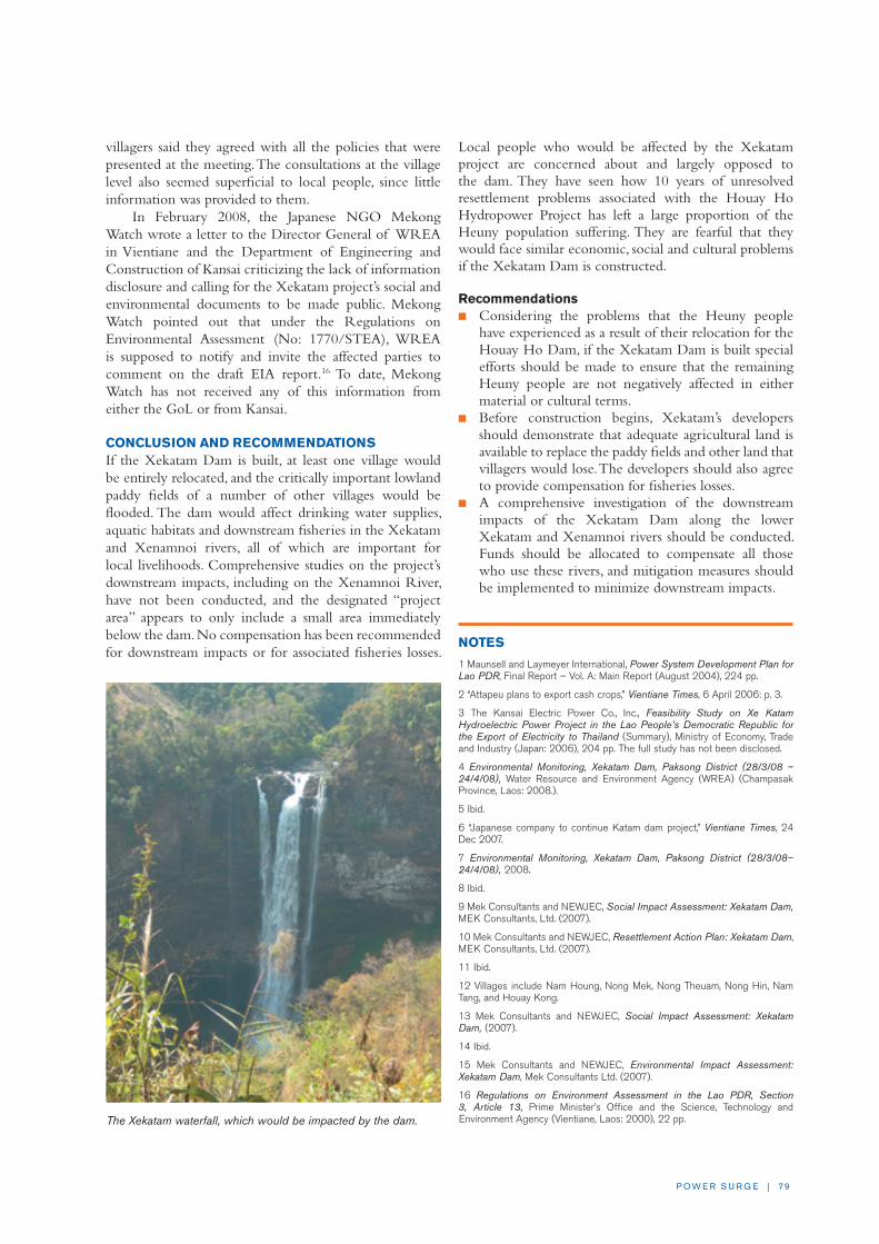
P O W E R S U R G E | 79
villagers said they agreed with all the policies that were presented at the meeting. The consultations at the village level also seemed superficial to local people, since little information was provided to them.
In February 2008, the Japanese NGO Mekong Watch wrote a letter to the Director General of WREA in Vientiane and the Department of Engineering and Construction of Kansai criticizing the lack of information disclosure and calling for the Xekatam project’s social and environmental documents to be made public. Mekong Watch pointed out that under the Regulations on Environmental Assessment (No: 1770/STEA), WREA is supposed to notify and invite the affected parties to comment on the draft EIA report.16 To date, Mekong Watch has not received any of this information from either the GoL or from Kansai.
CONCLUSION AND RECOMMENDATIONSIf the Xekatam Dam is built, at least one village would be entirely relocated, and the critically important lowland paddy fields of a number of other villages would be flooded. The dam would affect drinking water supplies, aquatic habitats and downstream fisheries in the Xekatam and Xenamnoi rivers, all of which are important for local livelihoods. Comprehensive studies on the project’s downstream impacts, including on the Xenamnoi River, have not been conducted, and the designated “project area” appears to only include a small area immediately below the dam. No compensation has been recommended for downstream impacts or for associated fisheries losses.
Local people who would be affected by the Xekatam project are concerned about and largely opposed to the dam. They have seen how 10 years of unresolved resettlement problems associated with the Houay Ho Hydropower Project has left a large proportion of the Heuny population suffering. They are fearful that they would face similar economic, social and cultural problems if the Xekatam Dam is constructed.
Recommendationsn Considering the problems that the Heuny people
have experienced as a result of their relocation for the Houay Ho Dam, if the Xekatam Dam is built special efforts should be made to ensure that the remaining Heuny people are not negatively affected in either material or cultural terms.
n Before construction begins, Xekatam’s developers should demonstrate that adequate agricultural land is available to replace the paddy fields and other land that villagers would lose. The developers should also agree to provide compensation for fisheries losses.
n A comprehensive investigation of the downstream impacts of the Xekatam Dam along the lower Xekatam and Xenamnoi rivers should be conducted. Funds should be allocated to compensate all those who use these rivers, and mitigation measures should be implemented to minimize downstream impacts.
NOTES
1 Maunsell and Laymeyer International, Power System Development Plan for Lao PDR, Final Report – Vol. A: Main Report (August 2004), 224 pp.
2 “Attapeu plans to export cash crops,” Vientiane Times, 6 April 2006: p. 3.
3 The Kansai Electric Power Co., Inc., Feasibility Study on Xe Katam Hydroelectric Power Project in the Lao People’s Democratic Republic for the Export of Electricity to Thailand (Summary), Ministry of Economy, Trade and Industry (Japan: 2006), 204 pp. The full study has not been disclosed.
4 Environmental Monitoring, Xekatam Dam, Paksong District (28/3/08 – 24/4/08), Water Resource and Environment Agency (WREA) (Champasak Province, Laos: 2008.).
5 Ibid.
6 “Japanese company to continue Katam dam project,” Vientiane Times, 24 Dec 2007.
7 Environmental Monitoring, Xekatam Dam, Paksong District (28/3/08–24/4/08), 2008.
8 Ibid.
9 Mek Consultants and NEWJEC, Social Impact Assessment: Xekatam Dam, MEK Consultants, Ltd. (2007).
10 Mek Consultants and NEWJEC, Resettlement Action Plan: Xekatam Dam, MEK Consultants, Ltd. (2007).
11 Ibid.
12 Villages include Nam Houng, Nong Mek, Nong Theuam, Nong Hin, Nam Tang, and Houay Kong.
13 Mek Consultants and NEWJEC, Social Impact Assessment: Xekatam Dam, (2007).
14 Ibid.
15 Mek Consultants and NEWJEC, Environmental Impact Assessment: Xekatam Dam, Mek Consultants Ltd. (2007).
16 Regulations on Environment Assessment in the Lao PDR, Section 3, Article 13, Prime Minister’s Office and the Science, Technology and Environment Agency (Vientiane, Laos: 2000), 22 pp. The Xekatam waterfall, which would be impacted by the dam.

8 0 | I N T E R N AT I O N A L R I v E R S
MAIN CONCERNS n The Don Sahong project would block the main
channel that is passable by migratory fish year-round in the Khone Falls area. This threatens the migration, feeding, and breeding patterns of a diverse number of fish species, including major commercial fish migrations between Laos and Cambodia, with devastating consequences for fisheries and fishery-based livelihoods locally and throughout the wider Mekong region.
n By jeopardizing the Khone Falls area’s two main tourist attractions—the Irrawaddy Dolphins and the Khone Phapheng waterfalls—the Don Sahong project would undermine the GoL’s strategy to promote Laos as an international ecotourism destination. The Don Sahong Dam also threatens the Khone Falls area’s eligibility for nomination to the RAMSAR Convention on Wetlands of International Importance.
n The Don Sahong Dam threatens the survival of the last remaining permanent population of Irrawaddy Dolphins in Laos, located immediately downstream of Khone Falls.
n The Don Sahong Dam threatens to change the hydrology of the Mekong River downstream from the dam, leading to erosion that could cause some islands in Laos and Cambodia to change drastically or even disappear entirely.
n Local people living in the Don Sahong project area have received misleading and incomplete information about the likely negative impacts of the dam. People in Cambodia have received even less information about the project and how it would affect them.
BACKGROUND AND DESCRIPTION The proposed Don Sahong Hydropower Project is located in the Khone Falls area of the Mekong River mainstream, in Khong District, Champasak Province, less than 2km
upstream of the Laos-Cambodia border. At the spectacular cataract of the Khone Falls, the Mekong River drops some 20-30m through a maze of narrow braided channels and rapids that weave amongst the area’s many islands. Khone Falls’ other local name, “Siphandone”—or 4,000 islands—is an appropriate epithet for the area.
The Don Sahong Dam would be built at the downstream end of the Hou Sahong channel, which runs about 7km between the major islands of Don Sahong and Don Sadam and is approximately 100m wide. The dam
CASE STUDy ELEVEN: Don Sahong Hydropower ProjectBy Nok Khamin and Carl Middleton
The Don Sahong Hydropower Project, sponsored by the Malaysian company Mega First Corporation Berhad
(MFCB), is the first of the dams proposed for the lower Mekong River mainstream. The Don Sahong Dam
would be located in the Khone Falls area of southern Laos. If built, it would block the main channel passable by
fish year-round in the Khone Falls area, threatening subsistence and commercial fisheries locally and, for some
fisheries, throughout the wider Mekong region. The project would have serious repercussions for food security
as well as for the region’s economy. Furthermore, by jeopardizing the last remaining population of Irrawaddy
Dolphins in Laos and diverting water from the spectacular Khone Phapheng waterfall, the Don Sahong Dam
could undermine the increasing popularity of the Khone Falls area as an international tourist destination.
Woman from Don Sahong Island. Photo: © Marcus Rhinelander

P O W E R S U R G E | 8 1
would be 30-32m high, and have an installed generating capacity of between 240 and 360 MW. The Don Sahong project would cost approximately $300 million, and is planned to generate electricity for export and, to a lesser extent, domestic use.1 The 240 MW version of the project was first proposed in 1994 by the MRC Secretariat as part of a broader Mekong mainstream dam cascade, a plan that was widely criticized at the time and subsequently shelved (see box on page 86).
While the Don Sahong project’s final design has not yet been made public, the dam would reportedly form a barrage across the entire Hou Sahong channel. In doing so, the project would flood the channel, submerge part of the adjacent islands, and necessitate some relocation from the villages of Don Sahong and Hou Sadam. Most importantly, the dam would prevent fish migrations along the Hou Sahong channel. This is the project’s single greatest impact, and has implications for fish and fisheries locally and throughout the Mekong region.
The project developer, MFCB, is a Malaysian engineering and construction company registered on the Kuala Lumpur stock exchange. In March 2006, MFCB signed an MoU with the GoL to prepare feasibility studies for the Don Sahong project. Subsequently, in February 2008, a PDA was signed which, according to MFCB, confirms “the feasibility and social/environmental studies of the proposed Don Sahong Project to be technically and financially viable.”2 Reportedly, however, the GoL has
requested MFCB to undertake further environmental and social studies. The PDA authorizes MFCB to enter into negotiations on key project documents, such as the CA and the PPA, to be concluded by September 2009. The project’s planned COD is 2013.
According to MFCB, the project would be developed under a BOT arrangement with a 30-year CA. In June 2008, MFCB announced a partnership with IJM Corporation Berhad, which would take up to a 30% stake in the Don Sahong project.3 The GoL would also hold a 20% share of the project.4 MFCB reportedly views the Don Sahong project as a catalyst for further investments in Laos.5,6
PROJECT ISSUES AND ANALySIS
Impacts on FisheriesThe Khone Falls is renowned for its rich fisheries, with at least 201 species present in the area recognized for their high commercial value. In response to the highly variable seasonal conditions and diversity of species, local fishers have devised an ingenious array of fishing techniques.7 Scientists consider the Khone Falls area to be a critical year-round bottleneck for fish migrating throughout the lower Mekong Basin which enables local villagers to harvest an abundant fish catch.
The Hou Sahong is by far the most important channel in the Khone Falls for fish migration, especially in the dry
Proposed Don Sahong Dam

8 2 | I N T E R N AT I O N A L R I v E R S
season.8 The Don Sahong Dam would block Hou Sahong, the only deep channel that allows fish to migrate through the Khone Falls between Vietnam, Cambodia, Laos, and Thailand in all seasons. This threatens the migration, feeding, and breeding patterns of a diverse number of species—including major migrations between Laos and Cambodia—which would seriously impact most of the major fisheries of southern Laos (see box on page 83). A May 2007 letter from concerned scientists to the GoL states: “the location of this proposed dam is probably the worst possible place to site a 240 MW project since it is the point of maximum concentration of fish migration in the river that supports the world’s largest freshwater fishery.”9
The Don Sahong project’s impact on fish and fisheries could affect hundreds of thousands of people living along the Mekong River and its tributaries throughout southern and central Laos, as well as in Cambodia, Vietnam and Thailand. Fishing communities living at or near Khone Falls would be especially affected. The dam would inevitably undermine food security, reduce the incomes of fishing-dependent villages, and affect the region’s economy through its impacts on commercial fishing operations.
Additionally, the Mekong River’s most prized and endangered fish species could be driven to extinction by the Don Sahong Dam. It has recently been discovered that mature Giant Catfish are caught in the Hou Sahong every year, although they have not been caught in any other channels in the Khone Falls area. These fish are believed to be migrating upstream from Tonle Sap Lake in Cambodia to northern Laos and Thailand.
While the Don Sahong Dam would not create a large storage reservoir, it would impound some water within the Hou Sahong channel. In doing so, and through its operation, it would change the hydrological dynamics of water flows throughout the Khone Falls area. Altered flows could disrupt the triggers that instigate fish migrations through Hou Sahong, as well as have unknown impacts on migration in other channels.
While design details have not been disclosed to the public, potential fisheries mitigation options include a fish pass structure or the deepening of neighboring channels through blasting. The likelihood of success of either of these options, however, is small. Citing ecological factors and the intensity of fish migration, the WorldFish Center states: “In the Mekong basin there are no examples of effective [fish] passes.”10 This view is shared by other
concerned scientists, who assert “[t]here is no prospect that a fish pass could make a significant difference to the blocking effects of this dam.”11 Local fishers agree: “The dam builders have visited us many times. They told us that they will build a fish ladder for the fish to go up, but I don’t believe that the fish will go up.”
The second option of deepening nearby channels entails major risks, given the hydrological complexity of the Khone Falls area and the uncertainty that fish would successfully locate and navigate the new channel. The necessary blasting would likely cause extensive ecological damage to the Khone Falls area, as well as the Stung Treng RAMSAR site downstream. Furthermore, managing the altered water flows between a deepened channel and the dam—as would be necessary to ensure viable fish migration and electricity production—represents a significant engineering challenge with a low probability of success.
Indicative of the devastating impacts on Mekong fisheries that the Don Sahong dam is expected to have, as well as the lack of viable mitigation options, the final report on fisheries impacts prepared for the Don Sahong EIA reportedly recommended the “no-project option” or at least that a different channel be dammed instead of Hou Sahong. However, that report has not been released to the public, and there are concerns that its findings have been changed to meet the developers’ objectives. Some villagers have also suggested that, if the dam must be built, it should be relocated to another channel that is not as essential to fish migration. MFCB is reportedly reluctant to consider other site options due the significant investment it has already made in studying the Hou Sahong site.
Some fishers have also complained about losing traditional fishing spots that have been handed down from generation to generation, and are considered by locals to be private property, just like rice paddy fields. One fisher said, “We are not sure how they will calculate our losses, but these trap sites have been used for generations, and we do
One fisherman said that the company has collected information about the number of large
wing traps for catching fish in the Khone Falls area, and proposed to exchange traps for free
electricity. He commented, “The problem is that we eat fish, not electricity.”
Another fisher said that the company only planned to compensate people with large fish traps for a
single year. “The problem is,” he said, “that we don’t eat fish for just one year.”

P O W E R S U R G E | 8 3
not want to lose them.” He continued, “We don’t want the dam, but what can we do? We have to accept it because the high authorities have decided that they want it.”
RAMSAR StatusRecognizing the global value of the Khone Falls’ unique island-river habitat, the relevant GoL agencies are considering proposing Khone Falls’ accession to the RAMSAR International Convention on Wetlands of International Importance. Endangered species documented in the Khone Falls area include birds such as the White-rumped Vulture, fish such as the Giant Mekong Catfish, and reptiles such as the Asian Giant Soft-Shell Turtle. A RAMSAR designation would support efforts to protect the area and promote tourism, bringing substantial economic benefit to the local communities and the national economy. Just across the border in Stung Treng Province, Cambodia, the northern-most stretch of the Mekong River was designated a RAMSAR site in 1999.12
Although several RAMSAR sites around the world include existing dams, none have been proposed for
nomination as a dam is under development in the area. This would likely be viewed as contrary to the spirit of the RAMSAR Convention which seeks to promote the conservation and wise use of wetlands.13 Furthermore, the Don Sahong project’s construction and operation could negatively impact the Stung Treng RAMSAR site immediately downstream.
Irrawaddy DolphinsThe Veun Nyang/Anlong Cheuteal deep pool, just downstream of Khone Falls at the Laos-Cambodia border, is home to approximately 10 Irrawaddy Dolphins. In the dry season, they live in the deep pools where fish prey exists. In the wet season, the dolphins disperse from the deep pools, moving within just a few hundred meters of the proposed dam site. The Mekong’s Irrawaddy Dolphin population is endangered,14 and fewer than 100 individuals remain. The school just below the Khone Falls is the only permanent Irrawaddy Dolphin population in Laos.15
The Don Sahong Dam would threaten the survival of the Irrawaddy Dolphin. According to WWF, threats from
The following are the main fish migrations in the Khone Falls area, all of which would be partially or fully blocked by the Don Sahong Dam. There are other less significant migrations that would also be affected.
December to February: A number of important spe-cies of medium-sized cyprinid fishes migrate from the Sekong, Sesan and Srepok rivers in Cambodia and Laos to the Mekong River at Stung Treng, Cambo-dia and then upriver to Laos. They pass through the Khone Falls area via Hou Sahong and then migrate past Pakse and up the Mekong River to the border be-tween Laos and Thailand. These fish migrations would be blocked by the Don Sahong Dam. Other fisheries in the Sekong River in Laos would also be affected, since the fish migrate back and forth between the area upstream of Khone Falls and the Sekong.
January to March: very large and important schools of small species of cyprinid fishes, especially Henico-rhynchus lobatus (pa soi), migrate upriver from Tonle Sap Lake in Cambodia to Laos via Khone Falls and the Hou Sahong channel. Those fish—which like those described above, are very important to the livelihoods of people living along the Mekong River in southern and central Laos—would be blocked from entering Laos by the Don Sahong Dam.
April: The important large cyprinid fish species, Cir-rihnus microlepis (pa phone), migrates up the Mekong River from Cambodia to Laos, passing through the Hou Sahong channel.
April to May: The small Pangasiidae catfish, Pan-gasius macronema (pa nyone thamada), migrates up the Mekong River from Cambodia into Laos via the Hou Sahong channel each year.
May to June: Catfish in the Pangasiidae family migrate up the Mekong River in Cambodia to Laos via the Khone Falls area and the Hou Sahong channel. One of these fishes, Pangasius krempfi (pa souay hang leuang), even migrates all the way up the Me-kong River from the Mekong Delta in vietnam.
October to January: Threatened large carps, Proba-bus jullieni (pa eun ta deng) and Probarbus labeama-jor (pa eun khao) spawn in the Khone Falls area, near the proposed Don Sahong Dam site.
Adapted from: Baird, I.G. (1996) Khone Falls Fishers, Catch and Culture, Mekong River Commission, 2(2):1-3.
Known Fish Migrations through the Hou Sahong Channel

8 4 | I N T E R N AT I O N A L R I v E R S
the project include: the potential loss of dolphin habitat due to alterations in daily flow patterns caused by the dam’s operation; reduced food availability due to a reduction in the dolphin’s fish prey supply; and construction-related stress, such as disturbances from blasting, which would affect dolphin breeding and foraging habits.16
The Lao and Cambodian governments have placed a high priority on dolphin conservation. WWF notes that, given this commitment and the Irrawaddy Dolphin’s critically endangered status, “the possibility for effective mitigation of the proposed Don Sahong dam appears low.” WWF concludes: “There is a risk that the proposed Don Sahong Dam, when added to existing threats, would contribute to the extinction of the Irrawaddy dolphin in Lao PDR.”17
TourismTourism is Laos’ second largest source of revenue and the Khone Falls is one of the most popular destinations in Laos. WWF estimated the Khone Falls area’s total tourist revenues for 2005 to be around $8.2 million, which provides an important source of income for many nearby communities.18 The governments of Cambodia and Laos both regard tourism development as a high priority for the area. The Don Sahong Dam would undermine this objective.
The Don Sahong Dam would threaten the area’s two main tourist attractions – the Irrawaddy Dolphins and the Khone Phapheng waterfalls. The project would reduce the flows to the Khone Phapheng falls by diverting water to the dam for electricity generation. There would also be significant short-term disturbance to the area during project construction and a lasting aesthetic impact caused by the dam’s infrastructure, which would also detract from the area’s tourist appeal.
ElectricityOne key justification put forward for the Don Sahong project is that it would bring electricity to the Khone Falls area. However, many of the tourist facilities already have electricity and villages in the area are expected to be electrified in 2009. One government official in Khong District said, “People say that electricity is going down to the Khone Falls area from Khong Island. Now there is no longer any reason to build a dam as destructive to migrating fish as the Don Sahong Dam.”
Controversy Surrounding the Don Sahong ProjectThe proposal to develop the Don Sahong project has generated considerable concern amongst NGOs, academics, development
professionals, and the general public within the Mekong Region and internationally.19 In April 2007, as plans for the project first came to light, 28 NGOs sent an open letter to the GoL, the MRC and its member governments calling for the project to be reconsidered.20 In May 2007, 34 scientists sent a letter to the GoL urging decision-makers “to consider the weight of scientific evidence that will show the Don Sahong project to be hugely destructive, such that even the economic (including livelihood) costs outweigh the net benefits—even before the environmental impacts are taken into consideration.”21 The WorldFish Center and WWF subsequently released science briefs highlighting concerns about the project’s threat to fisheries and Irrawaddy Dolphins.
In November 2007, 201 organizations and individuals from 30 countries around the world—including 126 citizens’ groups from Mekong countries—sent a letter to the MRC raising objections to the revival of plans to build dams on the Mekong mainstream, with Don Sahong identified as a project of special concern.22 The letter questioned whether the project developers and the GoL were abiding by the 1995 Mekong Agreement, which requires timely notification to the MRC’s member governments for projects proposed on the Mekong mainstream.
Downstream in Cambodia, the Don Sahong project has rankled both government officials and civil society groups. Several representatives of the CNMC, including its Chairman, H.E. Lim Kean Hor, have publicly expressed concerns about the dam.23 At a public meeting in Phnom Penh in May 2008, Mr. Chheang Hong, Head of the Water Resources Department in the CNMC, stated that they had not received the Don Sahong project documents, despite having requested them from the GoL twice, most recently in March 2008. Previously, in November 2007, the Rivers Coalition of Cambodia—an alliance of civil society organizations working to protect and restore river ecosystems and river-based livelihoods in Cambodia—
Collecting fish from a Tone trap. Photo: Ian Baird

P O W E R S U R G E | 8 5
highlighted the threat that Mekong mainstream dams, including the Don Sahong Dam, represent to rural livelihoods.
Local people have not been provided sufficient and accurate information about the proposed design of the Don Sahong Dam. Many villagers are under the impression that the Hou Sahong channel would only be partially blocked, thus allowing fish to migrate through it. But those who have worked on the Don Sahong project report that there is no such plan. The misinformation that villagers have received has caused many of them to underestimate the dam’s likely impacts.
Despite repeated requests from the wider public, almost no information has been disclosed by the GoL or MFCB about the Don Sahong Dam. The project’s draft EIA and SIA, prepared by Australian Power and Water Pty Ltd., and reportedly submitted to the GoL in July 2007, have yet to be publicly released. No consultations have been held at the national level. There is a general concern that the environmental and social documents will fail to adequately account for the anticipated impacts to fisheries and livelihoods, due to the pressure to deliver favorable reports to Don Sahong’s developers.
CONCLUSION AND RECOMMENDATIONSThe Don Sahong Dam would destroy a key part of Laos’ natural heritage, undermine critical sources of revenue, threaten local culture and jeopardize fisheries-based livelihoods—all for only 240 MW of electricity. Despite these serious threats, very little information has been released to the public or to the Cambodian government even though the project would be located less than 2km from the Cambodian border. Approval of the Don Sahong Dam would set a dangerous precedent for the seven other risky projects under consideration for the lower Mekong mainstream. These projects will cause irreparable social, environmental and economic losses that likely far outweigh any revenue or electricity benefits they would provide.
Recommendationsn The public, including local people and those in
neighboring countries, should be provided with full information about the Don Sahong Dam and its predicted impacts. This is a necessary first step towards a transboundary public process that would honestly and openly evaluate the costs and benefits of the Don Sahong Dam.
n The GoL should use the results of the public participation process, as well as the considerable body of local and scientific knowledge, to evaluate the Don Sahong project. Based on the existing evidence of the irreparable harm that the Don Sahong project would cause, as outlined in this case study, the GoL should reconsider its plans to build the Don Sahong Dam.
n The GoL should move forward with plans to designate and develop the Khone Falls as a RAMSAR site, and continue to promote the development of ecotourism in the area to provide regional, national and local benefits.
NOTES
1 Mega First Corporation Berhad, Signing of Project Development Agreement with the Government of Lao People’s Democratic Republic for the devel-opment of the Don Sahong Hydropower Project, Announcement, Bursa Malaysia, http://www.bursamalaysia.com/website/bm/listed_companies/company_announcements/announcements/ (12 Feb 2008).
2 Ibid.
3 Shareholders’ Agreement to Develop Don Sahong Hydropower Project, Announcement, IJM Corporation Berhad, http://www.ijm.com/announ_080610.htm (10 June 2008).
4 Power Projects in Lao PDR, Lao National Committee for Energy, http://www.poweringprogress.org/updates/news/press/2008/Electric%20Power%20Plants%20in%20Laos%20as%20July%202008.pdf (7 July 2008).
5 “Mega First eyes more Laos deals,” Business Times (Malaysia) 14 May 2007.
6 Dali, S., “Mega First, The Undiscovered Gem,” HotStocks, http://hotstocks.com.my/post.php?counter=MFCB&tag=pt200707241544312800 (24 July 2007).
7 See Baran, E., Baird, I.G. and Cans, G., Fisheries Bioecology at the Khone Falls, WorldFish Center (2005).
8 Baird, I.G., “Khone Falls Fishers,” Catch and Culture 2:2, Mekong River Commission (1996), pp. 1-3.
9 Letter from Scientists concerned for the sustainable development of the Mekong River to Government and international agencies responsible for managing and developing the Mekong River Re: Concerns about the Don Sahong Dam planned for the mainstream Mekong River in the Khone Falls area, Khong District, Champasak Province, southern Lao PDR (University of Sydney), http://www.internationalrivers.org/files/Don%20Sahong%20scien-tists%20May%202007.pdf (25 May 2007).
10 Baran, E. and Ratner, B., The Don Sahong Dam and Mekong Fisheries, Science Brief, WorldFish Center, http://www.terraper.org/articles/DonSahong%20science%20brief.pdf (June 2007).
11 Letter from Scientists, 2007.
12 Try, T. & Chambers, M., Situation Analysis: Stung Treng Province, Cambodia, Mekong Wetlands Biodiversity Conservation and Sustainable Use Programme (2006).
13 The Ramsar Convention in Lao PDR, IUCN briefing paper (2008).
14 Baird, I.G. and Beasley, I.L., “Irrawaddy dolphins (Orcaella brevirostris) in the Mekong River in Cambodia: an initial survey,” Oryx 39:3 (2005), pp. 301-310.
15 Baird, I.G. and Mounsouphom, B. , “Distribution, mortality, diet and conser-vation of Irrawaddy Dolphins (Orcaella brevirostris Gray) in Lao PDR,” Asian Marine Biology 14 (1997), pp. 41-48.
16 The Don Sahong Dam and the Irrawaddy Dolphin, WWF science brief (2007).
17 Ibid.
18 Ibid.
19 See: http://www.searin.org./Th/Mekong/sub_lowerdam.html (Accessed 14 July 1008) for a comprehensive record of media coverage.
20 Open letter calling for plans for the Don Sahong Dam to be abandoned, International Rivers Network. http://www.internationalrivers.org/en/south-east-asia/southeast-asia/southeast-asia/southeast-asia/thailand/mekong-regional-initiatives/lao (30 April 2007).
21 Letter from Scientists, 2007.
22 Letter to MRC re dams on the Mekong Mainstream and Responses, Foundation for Ecological Recovery, http://www.terraper.org/what_new_view.php?id=25 (Accessed 16 July 2008).
23 “Cambodia Raps Laos Over Mekong Dams,” Bangkok Post (via DPA), 15
Nov 2007.

8 6 | I N T E R N AT I O N A L R I v E R S
While China is midway through the construction of a controversial cascade of dams on the upper Mekong (Lancang), the lower stretch of the river—shared by Thailand, Cambodia, Laos, and vietnam—has so far escaped hydropower development. For the 60 million people living in the lower Mekong Basin whose food, income, and other needs are provided for in part by the “mother of all rivers,” this has been good news. Yet as the region’s economies continue to expand and electricity demand grows, plans for a series of dams on the lower Mekong River have recently resurfaced.
Since mid-2006, the governments of Cambodia, Laos, and Thailand have granted approval to Thai, Malaysian, vietnamese, and Chinese companies to investigate eight dams on the Mekong mainstream. The projects are located at Pak Beng, Xayabouri, Pak Lay and Luang Prabang in northern Laos; Don Sahong in southern Laos; Ban Koum on the Thai-Lao border; Pa Mong (Pak Chom) in Loei Province, Thailand; and Sambor in Kratie Province, Cambodia. The dams are being examined under a veil of secrecy, despite the massive environmental, social, and economic costs that the projects would inevitably inflict.
Plans to dam the Mekong River mainstream are not new. In the late 1950s, a cascade of seven multi-pur-pose projects was proposed by the Mekong Commit-tee. With a combined reservoir capacity of more than one-third of the Mekong’s annual flow, the dams were conceived to provide hydropower, flood control, irriga-tion, and improved navigation. However, war and geo-political dynamics caused the plans to be abandoned.
Subsequently, in 1994, the Mekong Secretariat (the precursor to the MRC) published a study for a cascade of nine “run-of-river” dams on the lower Mekong main-stream. It proposed a series of dams 30-60m high with reservoirs extending over more than 600km of the river. Fortunately, this plan was also dropped due to reduced electricity demand caused by the 1997 Asian financial
crisis and the scheme’s high cost, as well as public condemnation of the projects’ predicted severe impacts on fisheries and local livelihoods.
By changing the river’s hydrology and ecology and blocking fish migrations, the construction of dams on the lower Mekong mainstream would have repercus-sions throughout the entire basin. The dams would threaten the livelihoods of millions of people who depend on a healthy Mekong River. China’s dam construction on the upper Mekong has already caused impacts downstream, especially along the Thai-Lao border where communities have suffered from declin-ing fisheries, changing water levels, and impacts on riverbank agriculture.1 The effects from dams built on the lower Mekong would be even more severe.
Reflecting these concerns and citing the lack of open debate about these projects, in November 2007, 201 organizations and individuals from 30 countries around the world, including 126 civil society groups from Mekong countries, sent a letter to the MRC to raise objections to the revival of plans to dam the lower Mekong River.2 Noting the serious ecological and economic implications of these schemes, the let-ter declared the MRC’s silence to be “an extraordinary abdication of responsibility.” Recognizing that the Me-kong River is a vast international resource and not the sole domain of any one riparian government, the letter called on the MRC to defend the ecological integrity of the river, and, at the very least, to undertake techni-cal assessments of the proposed dams, including a participatory review of each project’s feasibility study.
Notes
1 “Downstream Impacts and Hydropower Development on an International River: A Case Study of Lancang Mekong,” SEARIN, http://www.livingriversiam.org/mk/mek_down_im-pact_en.pdf (2004).
2 See: http://www.terraper.org/what_new_view.php?id=25 (Accessed 16 July 2008).
Mekong Mainstream Dams

P O W E R S U R G E | 87
As the 11 case studies in this report detail, the hydro boom has not been good news for Lao villagers. Tens of thousands of people are already experiencing negative impacts from hydro projects that are under construction, and hundreds of thousands of people stand to be affected by proposed dams. Thousands of mainly ethnic minorities are being forcibly displaced for dam development, some of whom have already been resettled by other GoL initiatives. Often these resettlers face land shortages and a lack of feasible livelihood opportunities in their new sites. Downstream, even larger numbers of people are being affected by major fisheries losses, flooding and erosion, and water quality problems. Many of these communities are not included in compensation proposals for hydro projects, especially those living across the border in Cambodia. Laos’ protected areas, critical wildlife habitat and regionally significant biodiversity are also being degraded by dam developments.
There are alternatives to this scenario. Hydropower may not be the best means for the GoL to meet its development goals, and will very likely be counter-productive to improving the food security and incomes of rural villagers. Other poverty reduction approaches—with fewer costs—should be prioritized and scaled up. These approaches would strengthen the resilience of subsistence farmers, safeguard their natural resource base, and provide a foundation for them to benefit from new income-generating opportunities.
Additionally, there are better ways to approach hydropower development, based on basin-wide sector planning and strategic environmental assessments. Dams and developers that cannot meet social and environmental standards—and Lao law and policy at a minimum—should be dropped. Laos’ environmental regulator, WREA, needs to be sufficiently empowered, staffed with qualified personnel, and backed with adequate resources to review proposed projects, challenge poor quality EIAs, and ensure that dam developers have identified feasible programs
with sufficient budgets to actually mitigate impacts and compensate affected people. WREA should also have the resources and mandate to conduct regular monitoring visits during projects’ construction and operation phases.
While in principle the revenue from hydropower projects could be directed to nationwide poverty reduction expenditures, the net impact of large dams will continue to be negative until those who bear the costs of these developments are guaranteed—as a minimum, non-negotiable requirement—that they will be compensated and their livelihoods improved. Projects that aim to restore or raise villagers’ incomes only to the poverty line can hardly be called development initiatives. Tragically, Lao dam developers and the GoL still have a long way to go to meet even this basic standard.
Looking forward—and learning from the mistakes of the past—mechanisms should be established to ensure that affected communities receive a share of the benefits from hydropower projects in line with international best practice as identified by the World Commission on Dams. There are a number of examples from various countries in which local villagers have been guaranteed a percentage of revenues for the life of a hydropower project.1 These mechanisms vary widely and can range from discounted electricity rates to an equity share in the project.2
In Laos, hydropower projects are supposed to contribute a percentage of revenues to the Environment Protection Fund,3 which would then distribute the funding to environmental programs. While it is unclear if these transfers are occurring in practice, this mechanism could potentially serve as a model for direct benefit sharing with affected communities. Concession Agreements should require that a percentage of annual project revenue be contributed to the fund specifically for the benefit of communities affected by that project. As part of the planning process for the dam, local communities should be empowered to identify which type of benefit-sharing arrangements best meets their needs and development aspirations.
Conclusions and Recommendations
Laos is experiencing an unprecedented hydro boom, driven by power demand from neighboring countries
and eager investors mainly from Thailand, China, Vietnam, Russia and Malaysia. While these projects will
provide revenue for the GoL from electricity exports, how those revenues will be used remains an open question.
Although the GoL has adopted social and environmental laws and regulations, these sound policies are not
being implemented. Strategic planning is not guiding hydropower development in the country, and the result is
an apparent dam disorder. The GoL’s emphasis on hydropower, mining and plantations development and policies
such as swidden eradication and internal resettlement have created poverty amongst rural Lao villagers rather
than alleviated it.

8 8 | I N T E R N AT I O N A L R I v E R S
Finally, the responsibility of developers to ensure that the impacts of their projects are adequately mitigated and that communities are compensated for their losses must be enforced. Developers should be required to set aside funds in performance bonds to address environmental and social impacts for the life of the project.
Until these important conditions are firmly in place, the GoL should consider a moratorium on new hydropower projects as the best way to ultimately achieve its poverty reduction goals.
OVERALL RECOMMENDATIONS n Better assess the development options for Laos.
The GoL and donors should comprehensively assess, through a broad-based participatory process, all the poverty reduction and revenue generation options for Laos in a way that honestly evaluates the trade-offs and costs of hydropower development.
n Slow the flood of new dam projects. The GoL should slow the pace of new hydro projects and consider a moratorium on new Concession Agreements until comprehensive strategic environmental assessments, cumulative impact assessments, and basin-wide planning are used to prioritize dam developments.
n Minimize the costs/maximize the benefits. Donors and the GoL should work together to increase the capacity, authority and resources of WREA to enforce laws and regulations and to reject projects that cannot meet these standards. WREA should establish a well-resourced unit that is responsible for conducting regular monitoring of projects during the construction and operation phases. The GoL’s capacity to negotiate favorable agreements with power purchasers should also be strengthened.
n Improve environmental and social assessments. The GoL and dam developers should ensure the timely disclosure of feasibility studies and draft environmental and social assessments in both Lao and English languages, in the project area, at information centers in the provincial and national capital, and on the internet. Comprehensive consultations with affected people and interested organizations should be conducted so that
gaps and weaknesses in these studies can be identified and addressed.
n Support rural livelihoods. The GoL should reject any resettlement plan that does not include detailed documentation of the availability of adequate land and resources to support agriculture and other livelihood programs in proposed resettlement sites. The GoL should not proceed with any dam project unless the assessments include baseline data and a comprehensive evaluation of upstream and downstream fisheries impacts. Compensation for fisheries losses for all affected communities should be provided for the life of the project. Performance bonds, or other legally binding mechanisms to ensure that dam developers provide sufficient funding to address the impacts of their projects, should be required.
n Share the benefits directly with affected people. The GoL should establish clear, enforceable mechanisms to guarantee that dam-affected communities receive a share of project revenue or other benefits for the life of the project. In order to promote poverty reduction, benefit sharing must be additional to compensation for losses and livelihood restoration measures.
n Protect critical resources. Based on their considerable environmental, social, economic and cultural value, some rivers and sites simply should not be dammed. For example, dams should not be built on the lower Mekong River mainstream due to the significant and irreversible fisheries losses and other impacts these projects would cause for Laos, Cambodia and other countries in the Mekong region.
NOTES
1 Vattenfall Consultants AB, Ramboll Natura AB, and Earth Systems, Lao People’s Democratic Republic: Preparing the Cumulative Impact Assessment for the Nam Ngum 3 Hydropower Project, Technical Assistance Consultant’s Report, Asian Development Bank (Feb 2008), p. 43.
2 Ibid.
3 http://www.laoepf.org.la/.

Back cover photo: The first dam on the lower Mekong mainstream would be built in the Khone Falls area of southern Laos. Photo: Ian Baird


![Hydro power potentials of water distribution …lejpt.academicdirect.org/A30/287_298.pdfsupply lines as a source of small hydropower in Turkey: A case study in Edremit [9]. Hydropower](https://static.fdocuments.in/doc/165x107/5f45b20f70d9016f3d4815cf/hydro-power-potentials-of-water-distribution-lejpt-supply-lines-as-a-source-of.jpg)

